Embed Size (px)
Citation preview
Sprint Location Services User Guide Summary: Sprint Location Services is a new feature available with some Sprint Mobile Broadband Cards As of Jan 2007, the two connection cards that are compatible with this service are:
1. Novatel Wireless S720 2. Novatel Wireless U720
Additional cards with these capabilities will be added throughout 2007 In order to use this service, the end user must have an updated version of the Sprint Connection Manager which has this feature embedded. To download the latest version, click here www.sprint.com/downloads Step by Step User Experience:
1. Once the Connection Manager is installed and an activated Sprint Mobile Broadband card is connected to the computer/laptop, the user opens the Connection Manager Software:
2. To launch Sprint Location Services click on the Menu>Location & Search Services menu option:
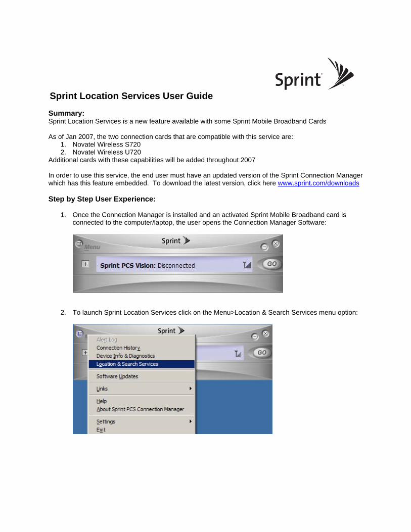
3. The user will be prompted to accept the Privacy Consent Agreement:
4. It is recommended that users disconnect any other Internet connections before using Location
functionality. If you are connected to a LAN you will receive a message similar to the one below:
5. The device connects to the Sprint Nextel CDMA network to request location information:

6. The device automatically requests GPS satellite information from the network:
7. After connecting the device obtains the location coordinates and displays the sub-window presenting the seven finder services:
At this point, the subscriber can either enter the word they want to query on the top option OR select one of the predefined queries. Once the user selects the option they are looking for, the application will launch the user’s web browser (Internet Explorer or similar) and go to the configured mapping service to locate the requested location. Some mapping services may be more up to date than others depending on how often they update their servers. Microsoft Live is the default mapping application that is used, but users have the option to select from other providers (Yahoo! Maps, Google Maps or MapQuest). See Step 13 below for details on how to change the default map service.
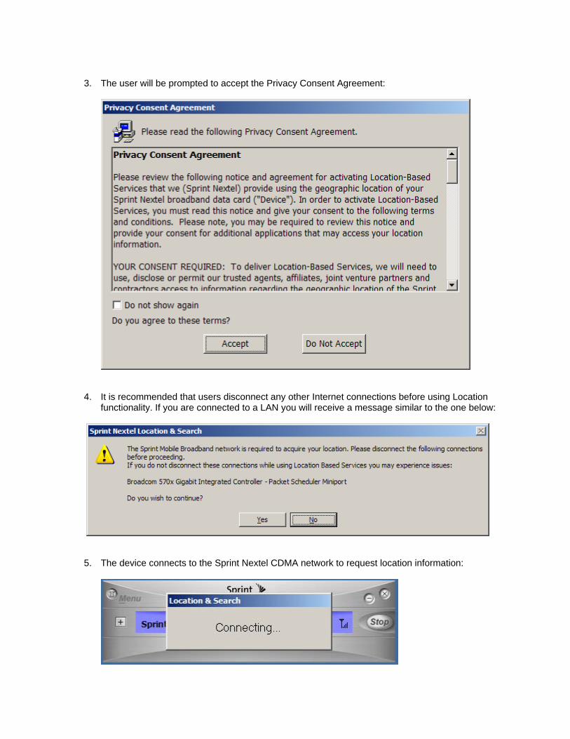
8. The following shows an example of clicking “Find Nearest Hotel” to automatically launch Microsoft Live maps. Users can also ‘right click’ on your location to get driving directions.
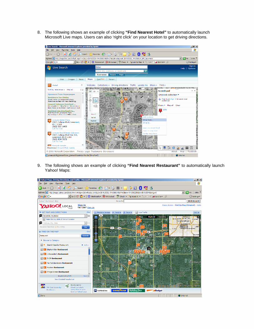
9. The following shows an example of clicking “Find Nearest Restaurant” to automatically launch Yahoo! Maps:
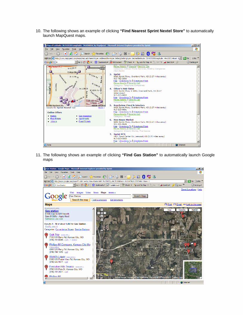
10. The following shows an example of clicking “Find Nearest Sprint Nextel Store” to automatically launch MapQuest maps.
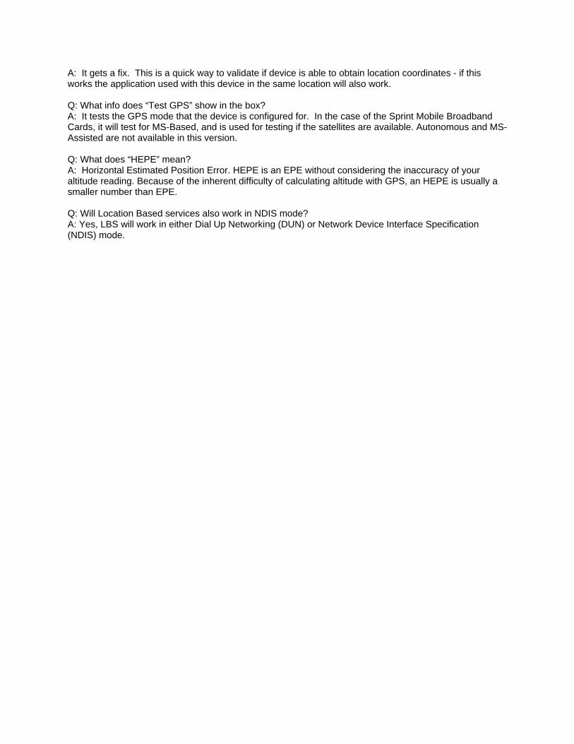
11. The following shows an example of clicking “Find Gas Station” to automatically launch Google maps

12. The user can change the preferred internet mapping services that software uses for queries. This can be changed within the Connection Manager by selecting Menu>Setting>Sprint Location Settings:
13. The setting page will display, and the available optional are listed in the middle of the page. The user can select their preferred option and click on “OK”

14. The recommended settings are listed below. In order for your device to support the new GPS/LBS features it must be in “Automatic Mode” or “1xRTT Only” mode or it will not be able to obtain the location information from the Location Server. EVDO Only Mode will not allow for support of LBS services.

Frequently Asked Questions: Q: What is GPS? A: The Global Positioning System (GPS), is a term used for satellite navigation systems. More than two dozen GPS satellites orbit the Earth, transmitting radio signals which allow GPS receivers to determine their location, speed and direction. Q: What are Location based services (LBS) A: Location Based services are the ability for your device to get its current position from the Location Server on the Sprint network and provide you the ability to find nearby locations such as Gas stations, Hotels, Restaurants, Banks, etc. Q: Do I have to sign up for this service? What do I have to do to use it? A: At this time, Sprint Nextel Location and Search usage is included as part of Sprint’s flexible data and unlimited data connection card plans. Additional terms and restrictions apply. To use this service, the user must accept the Sprint Privacy Consent Agreement. (See item 3 above). Q: How does the first GPS ‘fix’ work? A: Once you connect to the Sprint network you should get a fix within 10 seconds. Q Is there a timer before another fix can be given? A: Fixes are currently cached for 5 minutes. During that time, any queries the user makes will reuse the same GPS location coordinate values. Q: Does this device actually use GPS satellites to calculate its locations? A: It depends. If you are indoors, then the answer is no – instead, AFLT is used. AFLT uses base station triangulation to calculate your location. If you are outside, then it will use MS-Based GPS and actual satellites are used to determine your location. Q: What is AFLT? A: Advanced Forward Link Trilateration. AFLT is a type of device-based position location technology. Unlike A-GPS, AFLT does not use GPS satellites to determine location. To determine location, the phone takes measurements of signals from nearby cellular base stations (towers) and reports the time/distance readings back to the network, which are then used to triangulate an approximate location of the handset. In general, at least three surrounding base stations are required to get an optimal position fix. Q: What is A-GPS? A: Assisted GPS is a technology that uses an assistance server to cut down the time needed to determine a location using GPS. Q: How accurate is AFLT if you are not using real satellites. A: AFLT accuracy is limited to the geometry of the Cell towers surrounding the device requesting location information. The better the triangulation the more accurate the fix. Q: What does MS-Based mean? A: MS-Based GPS is defined as an implementation where assistance data is provided to the MS, by the Location server, such that the MS can calculate its own location estimate. Q: Will my device location services work indoors? A: Yes, but it uses AFLT to determine your location. This version of the service works best when the user is outdoors. Please see the help files of the Connection Manager software for more details. Q: What does the “Test GPS” button do?
A: It gets a fix. This is a quick way to validate if device is able to obtain location coordinates - if this works the application used with this device in the same location will also work. Q: What info does “Test GPS” show in the box? A: It tests the GPS mode that the device is configured for. In the case of the Sprint Mobile Broadband Cards, it will test for MS-Based, and is used for testing if the satellites are available. Autonomous and MS-Assisted are not available in this version. Q: What does “HEPE” mean? A: Horizontal Estimated Position Error. HEPE is an EPE without considering the inaccuracy of your altitude reading. Because of the inherent difficulty of calculating altitude with GPS, an HEPE is usually a smaller number than EPE. Q: Will Location Based services also work in NDIS mode? A: Yes, LBS will work in either Dial Up Networking (DUN) or Network Device Interface Specification (NDIS) mode.