Embed Size (px)
Citation preview
San José State University
Urban and Regional Planning Department page 1 of 13
SAN JOSÉ STATE UNIVERSITY URBAN AND REGIONAL PLANNING DEPARTMENT
ENVS/URBP-179A: FUNDAMENTALS OF GIS FOR URBAN PLANNING URBP 278 – INTRODUCTION TO GIS FOR URBAN PLANNING
SPRING 2016
Instructor: Indu Jeyachandran, PhD
Office location: WSQ 218B
Telephone: (801)869-0540
Email: [email protected] (E-mail preferred for communication)
Office hours: Wednesdays 9:30 am to 11:00 am (Appointments recommended)
Class days/time: Wednesdays 4:30 pm to 7:00 pm
Classroom: Washington Square Hall (WSQ) 208
Prerequisites: Prerequisites specific to URBP/ENVS-179A: Upper division standing or instructor consent (per course catalog). Prerequisites for all students: No prior knowledge of GIS is required to take this course. However, there are a few prerequisites set by the instructor to make this course an enjoyable experience for all the students enrolled. 1. Familiarity with the Windows operating system, including data management; managing and navigating through multiple Windows and applications; and commitment to save work frequently. 2. Familiarity with data entry, sorting, editing and filtering using Microsoft Excel. 3. A strong motivation to learn, explore and have fun with computer applications is essential. This course will require a significant amount of independent work and relies heavily on student initiative. 4. Periodic checking of email to facilitate communication with the instructor
Units: 4
San José State University
Urban and Regional Planning Department page 2 of 13
Course Catalog Description ENVS/URBP-179A: Exploration of Geographic Information Systems (GIS) area analysis techniques for spatial information management in local government: planning support systems, needs analysis, envisioning neighborhoods utilizing multiple maps, charts, photos and the Internet.
URBP-278: Examination of geographic information systems (GIS) applications o urban and regional planning topics. Course may be repeated for credit when topic changes.
Course Description and Course Learning Objectives GIS is a powerful set of tools for collecting, storing and analyzing geographically referenced data. Since urban planners’ work involves the study and planning of cities and towns with inevitable use of spatial data and analysis, today’s employers increasingly expect graduates of urban planning programs to possess a working knowledge of GIS. Environmental Systems Research Institute’s (Esri) suite of GIS software – ArcGIS 10 in particular – has become the industry standard and is used by a majority of government agencies and private firms engaged in GIS activities. Specifically, employers are seeking professionals with geospatial data and analysis skills. By completing this four-unit course students will be equipped with the geospatial knowledge and skills required by many employers currently. San José State University’s Urban and Regional Planning Department offers three courses specifically devoted to GIS: the course you are taking now, a follow-up Advanced GIS course, and a one credit core course, GIS Overview: Urban Planning Applications. In this course, students will be familiarized with using ArcGIS 10.3.2, specifically ArcMap and ArcCatalog. The course begins with introductory class sessions on GIS concepts and getting familiarized with the ArcGIS 10.3.2 menu and tools. Following the introductory sessions, students will work on an urban planning project (Los Angeles river redevelopment project) for about 9 weeks from start to finish, with each week focusing on:
• Framing the problem • Previewing data • Choosing the required data • Building the geodatabase • Editing data • Performing the analysis • Using model builder to automate the analysis • Present analysis results • Share the results online
The last few weeks of the course will be in-class sessions for students to work on independent final projects.
San José State University
Urban and Regional Planning Department page 3 of 13
I am looking forward to helping you learn and master ArcMap 10.3.2. Upon completing this course students will possess the necessary geospatial skills sought by employers. Course Learning Objectives Upon successful completion of the course, you will be able to:
1. Describe how urban planners typically use GIS as a tool for the analysis and display of quantitative data and solve problems
2. Utilize the core components and functionality of ArcGIS 10.3.2 3. Describe and work with variety of geospatial data types (vector and raster data), access various data sources and get an understanding of metadata management techniques 4. Create, analyze and query geospatial data 5. Effectively work with data symbology and classify and categorize geospatial data 6. Implement effective cartographic techniques and produce visually appealing and easily comprehendible maps
Planning Accreditation Board (PAB) Knowledge Components This course partially covers the following PAB Knowledge Components:
2b) Written, Oral and Graphic Communication: ability to prepare clear, accurate and compelling text, graphics and maps for use in documents and presentations. 2c) Quantitative and Qualitative Methods: data collection, analysis and modeling tools for Forecasting, policy analysis, and design of projects and plans.
A complete list of the PAB Knowledge Components can be found at http://www.sjsu.edu/urbanplanning/courses/pabknowledge.html.
Required Course Texts The required textbook for this course is
Harder, C., Ormsby, T., and Balstrom, T. Understanding GIS: An ArcGIS Project Workbook. 2nd ed. Redlands, California: ESRI Press, 2013. ISBN: 9781589482425.
The required textbook may be purchased at the Spartan Bookstore, online (at sites such as Amazon.com) or directly from the publisher. ArcGIS 10.3.2 and Extensions will be used in this course. Each student will receive a free Education Edition of Esri’s ArcGIS 10.3.2 software for use on a personal computer; it is a fully functioning version and will expire one year after installation. Please note that ArcGIS software only runs on the Windows operating system (e.g., XP, Windows 7, Windows 8). In order to run ArcGIS in Windows on an Intel-based Mac, virtualization software is needed such as Apple's BootCamp SWSoft’s Parallels, or VMware Fusion. Students are not required to install ArcGIS on their personal computer since the laboratory in WSQ208 and “mini-lab” (in the Planning Department lounge area) are available to all students to
San José State University
Urban and Regional Planning Department page 4 of 13
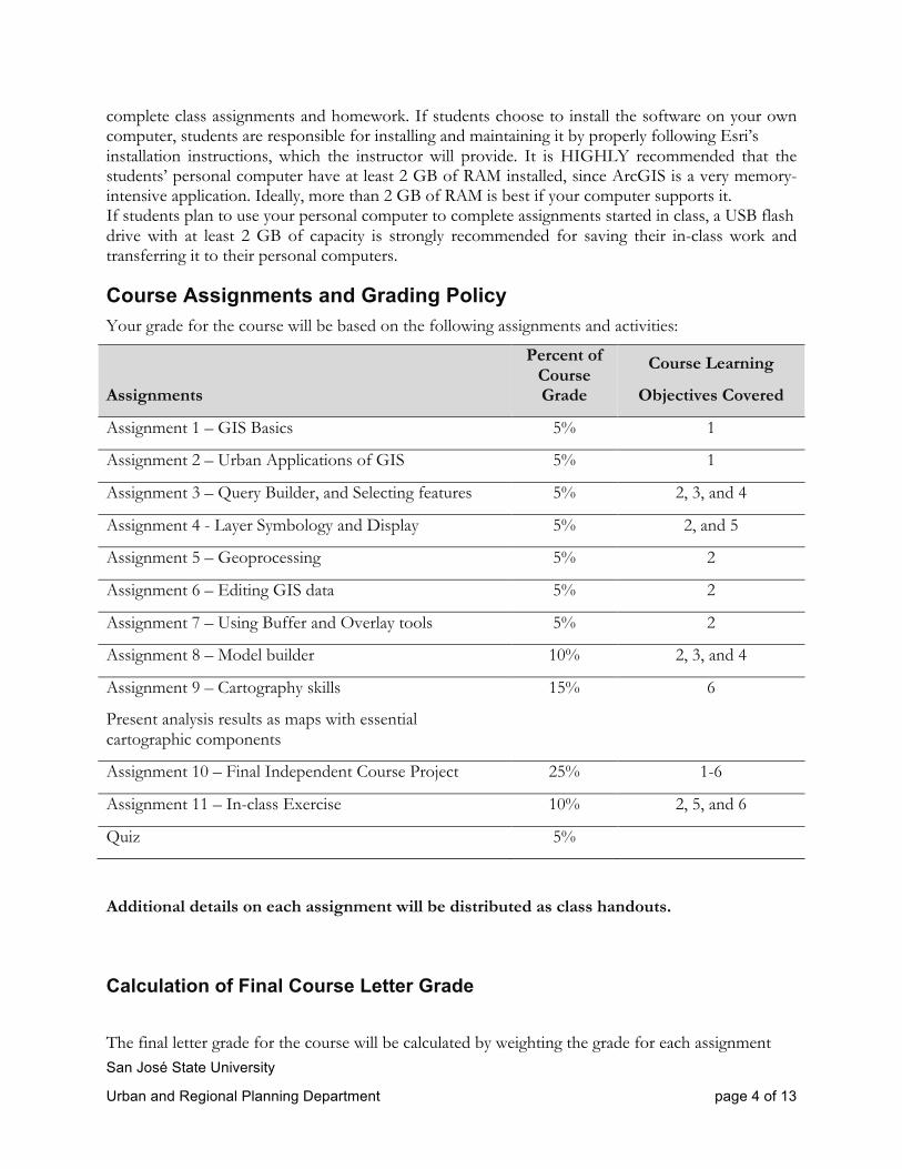
complete class assignments and homework. If students choose to install the software on your own computer, students are responsible for installing and maintaining it by properly following Esri’s installation instructions, which the instructor will provide. It is HIGHLY recommended that the students’ personal computer have at least 2 GB of RAM installed, since ArcGIS is a very memory-intensive application. Ideally, more than 2 GB of RAM is best if your computer supports it. If students plan to use your personal computer to complete assignments started in class, a USB flash drive with at least 2 GB of capacity is strongly recommended for saving their in-class work and transferring it to their personal computers.
Course Assignments and Grading Policy Your grade for the course will be based on the following assignments and activities:
Assignments
Percent of Course Grade
Course Learning
Objectives Covered
Assignment 1 – GIS Basics 5% 1
Assignment 2 – Urban Applications of GIS 5% 1
Assignment 3 – Query Builder, and Selecting features 5% 2, 3, and 4
Assignment 4 - Layer Symbology and Display 5% 2, and 5
Assignment 5 – Geoprocessing 5% 2
Assignment 6 – Editing GIS data 5% 2
Assignment 7 – Using Buffer and Overlay tools 5% 2
Assignment 8 – Model builder 10% 2, 3, and 4
Assignment 9 – Cartography skills
Present analysis results as maps with essential cartographic components
15% 6
Assignment 10 – Final Independent Course Project 25% 1-6
Assignment 11 – In-class Exercise 10% 2, 5, and 6
Quiz 5%
Additional details on each assignment will be distributed as class handouts.
Calculation of Final Course Letter Grade
The final letter grade for the course will be calculated by weighting the grade for each assignment
San José State University
Urban and Regional Planning Department page 5 of 13
according to the percentages in the table above.
The course grade consists of ten assignments and one quiz. The first assignment through seventh assignments are worth 5% of the grade each, and the eighth assignment is worth 10% and ninth assignment is worth 15% of the grade. The final project/assignment 10 is worth 25% of the grade and the quiz is worth 5% of the grade. The eleventh assignment is worth 10% of the grade. The first seven assignments are worth 20 points each, the eighth assignment is worth 25 points, the ninth assignment is worth 30 points, the tenth assignment is worth 60 points, and the quiz is worth 15 points. Eleventh assignment is worth 30 points. If a student named “Joe” obtains 18 points on the first seven assignments, 20 points on the eighth assignment, 25 points on the ninth assignment and 55 points on the tenth assignment, and 25 points on the eleventh assignment, 10 points on the quiz, his final letter grade will be calculated using the following steps:
a) Calculating the weighted score for each assignment.
First assignment: 18/20 times 100 times 0.05 = 4.5
Second assignment: 18/20 times 100 times 0.05 = 4.5
Third assignment: 18/20 times 100 times 0.05 = 4.5
Fourth assignment: 18/20 times 100 times 0.05 = 4.5
Fifth assignment: 18/20 times 100 time 0.05 = 4.5
Sixth assignment: 18/20 times 100 times 0.05 = 4.5
Seventh assignment: 18/20 times 100 times 0.05 = 4.5
Eighth assignment: 20/25 times 100 times 0.10 = 8
Ninth assignment: 25/30 times 100 times 0.15 = 12.5
Tenth assignment: 55/60 times 100 times 0.25 = 22.91
Eleventh assignment: 25/30 times 100 times 0.10 = 8.33
Quiz: 10/15 times 100 times 0.05 = 3.33
b) Adding the weighted score for each assignment to arrive at the final score for the course.
Final score = 4.5+4.5+4.5+4.5+4.5+4.5+4.5+12+12.5+22.91+3.33 = 86.6
The final score will then be converted to a letter grade using the following criteria: A+ (96 and above); A (93 to 95); A- (90 to 92); B+ (87 to 89); B (84 to 86); B- (81 to 83); C+ (78 to 80); C (75 to 77); C- (72 to 74); D+ (69 to 71); D (66 to 68); D- (63 to 65); F (below 63)
San José State University
Urban and Regional Planning Department page 6 of 13
Therefore, the letter grade awarded to Joe for the course would be B+.
Timely Submission of Assignments All assignments are required to be submitted on the assigned due date. After the date and time, late submissions will be subject to a one-letter grade deduction for each day beyond the due date.
Late assignments will be accepted only on extenuating circumstances. If students aren’t able to meet the assignment deadline due to such circumstances, they should contact the instructor through email at least 2 hours prior to the due date and time stating the reason and an anticipated submission date. Late submissions without prior communication with instructor will be assigned a grade of zero.
Course Workload Success in this course is based on the expectation that students will spend, for each unit of credit, a minimum of forty-five hours over the length of the course (normally 3 hours per unit per week with 1 of the hours used for lecture) for instruction or preparation/studying or course related activities including but not limited to internships, labs, clinical practica. Other course structures will have equivalent workload expectations as described in the syllabus.
Because this is a four-unit class, you can expect to spend a minimum of nine hours per week in addition to time spent in class and on scheduled tutorials or activities. Special projects or assignments may require additional work for the course. Careful time management will help you keep up with readings and assignments and enable you to be successful in all of your courses. Students will also be required to undertake additional activities outside the class hours, including preparations for, and execution of, an independent GIS project. Details on how to complete this assignment will be provided in a handout to be distributed in class sometime in mid-semester. About the Instructor and Teaching Philosophy
I have been teaching at San Jose State University since Spring 2015. My research domain is remote sensing, GIS, modeling and observation techniques for sustainable urban infrastructure planning. I completed my PhD in Water Resources Engineering from the University of Utah, preceded by a masters in Remote Sensing & GIS from Anna University, India. I have been working with GIS and remote sensing software and tools for the past 12 years. I am also a provisionally certified mapping scientist- Remote Sensing offered by the American Society of Photogrammetry and Remote Sensing. Most of my past and current work focus has been on using remote sensing and GIS for urban applications.
I have taught URBP 275G - Geographic Information Systems Overview: Urban Planning Applications in Spring and Fall of 2015 at the Department of Urban and Regional Planning at San Jose State University. The five week one unit course involved teaching GIS basics along with teaching browser-based software as well as desktop-based ArcMap 10.3.1. The course involved assignments based on hands-on work with software. Also, a quiz was used to assess student learning and performance.
San José State University
Urban and Regional Planning Department page 7 of 13
I have also taught CE 150 – Introduction to Hydrology and Hydraulics lecture and lab course in Fall 2015 in the Department of Civil and Environmental Engineering at San Jose State University. I will teach CE 150 again in Spring 2016.
In the classroom I seek to engage the student in active learning. In my past teaching experience I have had the opportunity to experiment with active learning techniques, and I have found them to successfully engage students. I intend to encourage active learning in the classroom by using standard classroom questioning techniques during classroom presentations, posing discussion points to stimulate critical thinking, and providing team exercises. To support an active learning environment, each class will be structured to meet carefully crafted learning objectives. The key element will be a stimulating classroom presentation using electronic platforms (PowerPoint) and traditional delivery methods (blackboard or whiteboard), required textbook readings and homework. I will establish a positive classroom atmosphere and build rapport among the students and with me. The classroom presentation will be highlighted by frequent individual and team activities addressing specific learning objectives. Frequent classroom assessment techniques will be implemented to ascertain student learning. I am keenly interested in exploring technology-assisted education platforms including the use of computers in the classroom and the Internet (e.g., blogs). I am well versed in GIS software and tools and I will find ways to provide learning opportunities for state-of-the-practice geospatial software and tools.
Academic Integrity Statement, Plagiarism, and Citing Sources Properly Your commitment, as a student, to learning is evidenced by your enrollment at San Jose State University. The University Academic Integrity Policy S07-2 at http://www.sjsu.edu/senate/docs/S07-2.pdf requires you to be honest in all your academic course work. Faculty members are required to report all infractions to the office of Student Conduct and Ethical Development. The Student Conduct and Ethical Development website is available at http://www.sjsu.edu/studentconduct/.
Plagiarism is the use of someone else's language, images, data, or ideas without proper attribution. It is a very serious offense both in the university and in your professional work. In essence, plagiarism is both theft and lying: you have stolen someone else's ideas, and then lied by implying that they are your own.
Plagiarism will lead to grade penalties and a record filed with the Office of Student Conduct and Ethical Development. In severe cases, students may also fail the course or even be expelled from the university.
If you are unsure what constitutes plagiarism, it is your responsibility to make sure you clarify the issues before you hand in draft or final work.
Learning when to cite a source and when not to is an art, not a science. However, here are some common examples of plagiarism that you should be careful to avoid:
San José State University
Urban and Regional Planning Department page 8 of 13
• Using a sentence (or even a part of a sentence) that someone else wrote without identifying the language as a quote by putting the text in quote marks and referencing the source.
• Paraphrasing somebody else's theory or idea without referencing the source.
• Using a picture or table from a webpage or book without reference the source.
• Using data some other person or organization has collected without referencing the source.
The University of Indiana has developed a very helpful website with concrete examples about proper paraphrasing and quotation. See in particular the following pages:
• Overview of plagiarism at www.indiana.edu/~istd/overview.html
• Examples of plagiarism at www.indiana.edu/~istd/examples.html
• Plagiarism quiz at www.indiana.edu/~istd/test.html
If you still have questions, feel free to talk to me personally. There is nothing wrong with asking for help, whereas even unintentional plagiarism is a serious offense.
Citation style It is important to properly cite any references you use in your assignments. The Department of Urban and Regional Planning uses Kate Turabian’s A Manual for Writers of Research Papers, Theses, and Dissertations, 8th edition (University of Chicago Press, 2013, ISBN 780226816388). Copies are available in the SJSU King Library. Additionally, the book is relatively inexpensive, and you may wish to purchase a copy. Please note that Turabian’s book describes two systems for referencing materials: (1) “notes” (footnotes or endnotes), plus a corresponding bibliography, and (2) in-text parenthetical references, plus a corresponding reference list. In this class, students should use in-text parenthetical references, plus a corresponding reference list.
Accommodation for Disabilities If you need course adaptations or accommodations because of a disability, or if you need to make special arrangements in case the building must be evacuated, please make an appointment with me as soon as possible, or see me during office hours. Presidential Directive 97-03 at http://www.sjsu.edu/president/docs/directives/PD_1997-03.pdf requires that students with disabilities requesting accommodations must register with the Accessible Education Center (AEC) at http://www.sjsu.edu/aec to establish a record of their disability.
Accommodation to Students' Religious Holidays San José State University shall provide accommodation on any graded class work or activities for students wishing to observe religious holidays when such observances require students to be absent from class. It is the responsibility of the student to inform the instructor, in writing, about such holidays before the add deadline at the start of each semester. If such holidays occur before the add deadline, the student must notify the instructor, in writing, at least three days before the date that he/she will be absent. It is the responsibility of the instructor to make every reasonable effort to honor the student request without penalty, and of the student to make up the work missed. See University Policy S14-7 at http://www.sjsu.edu/senate/docs/S14-7.pdf.
San José State University
Urban and Regional Planning Department page 9 of 13
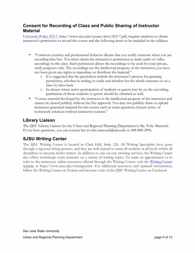
Consent for Recording of Class and Public Sharing of Instructor Material University Policy S12-7, http://www.sjsu.edu/senate/docs/S12-7.pdf, requires students to obtain instructor’s permission to record the course and the following items to be included in the syllabus:
• “Common courtesy and professional behavior dictate that you notify someone when you are recording him/her. You must obtain the instructor’s permission to make audio or video recordings in this class. Such permission allows the recordings to be used for your private, study purposes only. The recordings are the intellectual property of the instructor; you have not been given any rights to reproduce or distribute the material.”
o It is suggested that the greensheet include the instructor’s process for granting permission, whether in writing or orally and whether for the whole semester or on a class by class basis.
o In classes where active participation of students or guests may be on the recording, permission of those students or guests should be obtained as well.
• “Course material developed by the instructor is the intellectual property of the instructor and cannot be shared publicly without his/her approval. You may not publicly share or upload instructor generated material for this course such as exam questions, lecture notes, or homework solutions without instructor consent.”
Library Liaison The SJSU Library Liaison for the Urban and Regional Planning Department is Ms. Toby Matoush. If you have questions, you can contact her at [email protected] or 408-808-2096.
SJSU Writing Center The SJSU Writing Center is located in Clark Hall, Suite 126. All Writing Specialists have gone through a rigorous hiring process, and they are well trained to assist all students at all levels within all disciplines to become better writers. In addition to one-on-one tutoring services, the Writing Center also offers workshops every semester on a variety of writing topics. To make an appointment or to refer to the numerous online resources offered through the Writing Center, visit the Writing Center website at http://www.sjsu.edu/writingcenter. For additional resources and updated information, follow the Writing Center on Twitter and become a fan of the SJSU Writing Center on Facebook.
San José State University
Urban and Regional Planning Department page 10 of 13
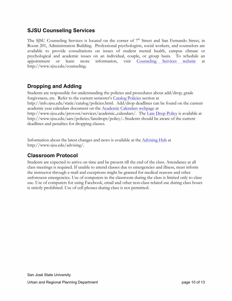
SJSU Counseling Services
The SJSU Counseling Services is located on the corner of 7th Street and San Fernando Street, in Room 201, Administration Building. Professional psychologists, social workers, and counselors are available to provide consultations on issues of student mental health, campus climate or psychological and academic issues on an individual, couple, or group basis. To schedule an appointment or learn more information, visit Counseling Services website at http://www.sjsu.edu/counseling.
Dropping and Adding Students are responsible for understanding the policies and procedures about add/drop, grade forgiveness, etc. Refer to the current semester’s Catalog Policies section at http://info.sjsu.edu/static/catalog/policies.html. Add/drop deadlines can be found on the current academic year calendars document on the Academic Calendars webpage at http://www.sjsu.edu/provost/services/academic_calendars/. The Late Drop Policy is available at http://www.sjsu.edu/aars/policies/latedrops/policy/. Students should be aware of the current deadlines and penalties for dropping classes.
Information about the latest changes and news is available at the Advising Hub at http://www.sjsu.edu/advising/.
Classroom Protocol Students are expected to arrive on time and be present till the end of the class. Attendance at all class meetings is required. If unable to attend classes due to emergencies and illness, must inform the instructor through e-mail and exceptions might be granted for medical reasons and other unforeseen emergencies. Use of computers in the classroom during the class is limited only to class use. Use of computers for using Facebook, email and other non-class related use during class hours is strictly prohibited. Use of cell phones during class is not permitted.
San José State University
Urban and Regional Planning Department page 11 of 13
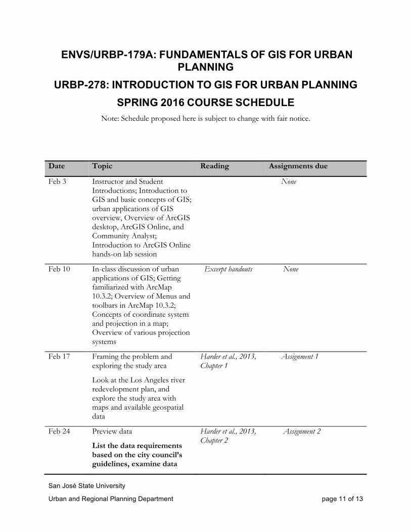
ENVS/URBP-179A: FUNDAMENTALS OF GIS FOR URBAN PLANNING
URBP-278: INTRODUCTION TO GIS FOR URBAN PLANNING SPRING 2016 COURSE SCHEDULE
Note: Schedule proposed here is subject to change with fair notice.
Date Topic Reading Assignments due
Feb 3 Instructor and Student Introductions; Introduction to GIS and basic concepts of GIS; urban applications of GIS overview, Overview of ArcGIS desktop, ArcGIS Online, and Community Analyst; Introduction to ArcGIS Online hands-on lab session
None
Feb 10 In-class discussion of urban applications of GIS; Getting familiarized with ArcMap 10.3.2; Overview of Menus and toolbars in ArcMap 10.3.2; Concepts of coordinate system and projection in a map; Overview of various projection systems
Excerpt handouts None
Feb 17 Framing the problem and exploring the study area
Look at the Los Angeles river redevelopment plan, and explore the study area with maps and available geospatial data
Harder et al., 2013, Chapter 1
Assignment 1
Feb 24 Preview data
List the data requirements based on the city council’s guidelines, examine data
Harder et al., 2013, Chapter 2
Assignment 2
San José State University
Urban and Regional Planning Department page 12 of 13
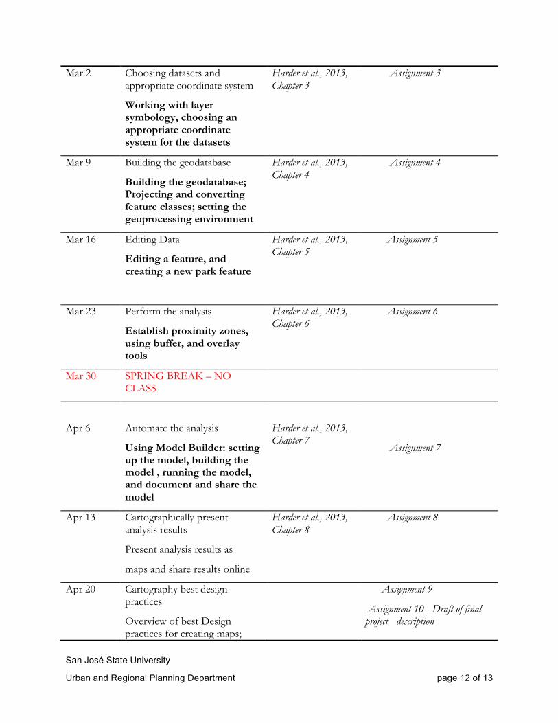
Mar 2 Choosing datasets and appropriate coordinate system
Working with layer symbology, choosing an appropriate coordinate system for the datasets
Harder et al., 2013, Chapter 3
Assignment 3
Mar 9 Building the geodatabase
Building the geodatabase; Projecting and converting feature classes; setting the geoprocessing environment
Harder et al., 2013, Chapter 4
Assignment 4
Mar 16 Editing Data
Editing a feature, and creating a new park feature
Harder et al., 2013, Chapter 5
Assignment 5
Mar 23 Perform the analysis
Establish proximity zones, using buffer, and overlay tools
Harder et al., 2013, Chapter 6
Assignment 6
Mar 30 SPRING BREAK – NO CLASS
Apr 6
Automate the analysis
Using Model Builder: setting up the model, building the model , running the model, and document and share the model
Harder et al., 2013, Chapter 7
Assignment 7
Apr 13 Cartographically present analysis results
Present analysis results as
maps and share results online
Harder et al., 2013, Chapter 8
Assignment 8
Apr 20 Cartography best design practices
Overview of best Design practices for creating maps;
Assignment 9
Assignment 10 - Draft of final project description
San José State University
Urban and Regional Planning Department page 13 of 13
Review few best design maps
In- Class Work Session: Final Project
Apr 27 In – class exercise to produce a series of maps using tools learnt in the previous class sessions
In – Class Work Session: Final
Project
Assignment 11
May 4 Quiz and In- Class Work Session: Final Project
Assignment 10- Final project description
May 11 In- Class Work Session: Final
Project
None
May 18 Final Class Meeting (attendance required) - Final Project Presentations (URBP-278 only) - Final Project Report Due - Final Project Poster Map Due
Assignment 10 - Final Project Report, Map and Class Presentation