Embed Size (px)
Citation preview

i

i
Sponsored by:
Supported By:
Organized by:
CONTENT
ii
Content .................................................................................................................... 1
Welcome Remarks .................................................................................................... 2
About ITS International Geoscience Convention ........................................................ 3
Background .............................................................................................................. 3
Objective .................................................................................................................. 3
Convention Venue Map ............................................................................................ 4
Programme .............................................................................................................. 6
Plenary session ......................................................................................................... 6
Technical session ...................................................................................................... 8
Registration ............................................................................................................ 10
Abstract ................................................................................................................. 11

1
WELCOME REMARKS
Dear all participants of ITS International Geoscience Convention 2017,
It's a big honor for us to welcome you all in Surabaya for attending
IIGC 2017. ITS International Geoscience Convention (IIGC 2017) is one
sub event of Geoscience Atmosphere 2017 or commonly called
Geosphere 2017. This event is organized by Geophysical Engineering
Department ITS, Geomatics Engineering Department ITS, Society of
Exploration Geophysicists ITS SC, and Himpunan Mahasiswa Teknik
Geofisika ITS. This year, IIGC's theme is "Optimizing the Role of
Geoscientist, Efficiency the Energy", from this theme we hope the role
of geoscientist nowadays could make a big impact and play as a main
character to make an efficiency energy in the future. This event aims
to be an annual gathering platform for geoscientists all around the
world to discover and explore more about the development and
innovation of geoscience in the future regarding nowadays energy
issues.
IIGC 2017 has 2 special sessions, Plenary Session and Technical Session. The Plenary Session will
discuss topics or issues that happening nowadays with some keynote speakers who are experts in
their sector such as national regulation, science, and industrial aspect. The Technical Session is a
platform for international journal or research publication. Various topics will be presented and
publicated in technical session such as Oil & Gas Exploration, Geotechnical, Mining, Land & Sea
Monitoring, and Earth Satellite.
The last but not least, i would say thank you in advance for all sponsors and committees that for
all hard work to held this event.
Enjoy the heat and good atmosphere in Surabaya!
Best Regards,
Cevin Ian Agfa
Project Officer of GEOSPHERE 2017

2
ABOUT ITS INTERNATIONAL GEOSCIENCE CONVENTION
Background
This event was named IIGC (ITS International Geoscience Convention) was held by Himpunan
Mahaiswa Teknik Geofisika ITS (Geophysics Engineering Student Association) with a background of
many innovations about the field of geoscience that is still buried in a person. Why can it be? Because
the knowledge about Geoscience is very broad and not many people know even who are experts in
the field.
Special Unit for Upstream Oil and Gas Activities (SKK Migas) recorded the realization of
investment in upstream oil and gas sector of US $ 3.98 billion. The achievement is still far from the
target, due to low world oil prices. Head of SKK Migas, Amien Sunaryadi, said that the realization of
investment in the first semester of 2017 was US $ 3.98 billion or only 29 percent of the target set in
the work plan and budget of US $ 13.8 billion. The small realization of these investments resulted from
the low world oil prices, so the contractors postponed the implementation of the project. In addition,
also due to regulations that have been issued by the previous government.
The General Plan of National Energy, abbreviated as RUEN, is the Central Government's policy
on the national energy management plan which is the elaboration and implementation plan of the
National Energy Policy that is cross-sectoral to achieve the National Energy Policy targets. The
direction of energy policy in the future is based on the paradigm that energy resources are no longer
used as export commodities, but as national development capital. The objectives are to: (a) realize the
independence of energy management, (b) ensure the availability of energy and the fulfillment of
domestic energy needs, (c) optimize the management of integrated and sustainable energy resources,
(d) increase energy efficiency utilization, (e) fair and equitable access to energy, technological
development, energy industry and domestic energy services, (f) creating employment and controlled
impacts of climate change and sustainable environmental functions.
Objective
1. IIGC (ITS International Geoscience Convention) was held to publicize to the public who are
interested in this object in the form of plenary session and technical session.
2. Plenary session is a sub event in IIGC in the form of talk show from experts of this object. So
that the audience can listen and get some knowledge and experience about geoscience
presented by experts in this field.
3. Technical sessions are also a sub event of IIGC but with a form of exposure of papers from
participants. In this session the audience is divided into various rooms and in different time each
of which there is a presentation paper presented by master and doctor of geoscience.
3
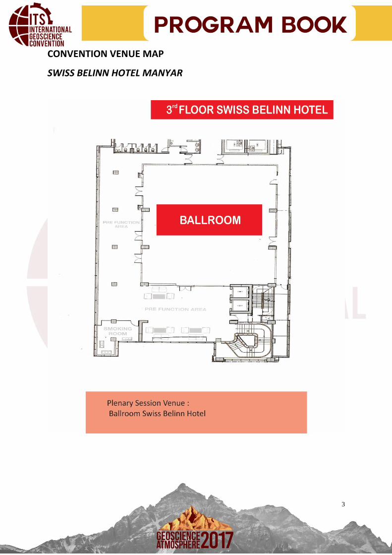
CONVENTION VENUE MAP
SWISS BELINN HOTEL MANYAR

4
CONVENTION VENUE MAP
SWISS BELINN HOTEL MANYAR

5
PROGRAMME
PLENARY SESSION
In plenary session, the proffesionals will give presentations and sit together to talk about the given
topic.
Mr. Nanang Abdul Manaf (Indonesia)
Background:
1. President Director of Pertamina EP (2017-Present)
2. Vice President Exploration of Pertamina EP (2011-2017)
3. General Mananger Pertamina EP Libya (2009-2011)
Mr. Dwi Hari Soeryadi (Indonesia)
Background:
1. Elected Member of National Energy Council Republic of Indonesia (2014-Present)
2. President Director PT. Talang Mas Contractors, Jakarta & Surabaya (2014-Present)
3. Director Teknik & Usaha PD Pasar Surya Surabaya (2010-2013)
4. General Manager, PT Duta Mitra Propertindo & Developer (2008-2013)
Mr. Dicky Rahmadi (Indonesia)
Background:
1. Manager G&G Eastern Indonesia Region (2008-Present)
2. President Himpunan Ahli Geofisika Indonesia (HAGI) (2014-2016)
Mr. How Wei Chen (Taiwan)
Background:
1. Professor at Institute of Geophysics National Central University Taiwan
Specialty:
Computatuonal Seismology, Wave Motion Theory, Electromagnetic Prospecting,
Seismic Data Analysis
Mr. Chao Hung Lin (Taiwan)
1. Professor at Department of Geomatics, National Cheng-Kung University

6
PROGRAMME
October 8th 2017
PLENARY SESSION Venue Ballroom Swiss Belinn Manyar Surabaya
Opening
08.15-08.20 Welcoming remark from Head of Department Geophysics Engineering
Mr. Joni Hermana
08.20-08.25 Welcoming remark from Head Event of ITS International Geoscience Convention
Mr. Cevin Ian Agfa
National Anthem : Indonesia Raya
Plenary Session : “Optimizing Role of Geoscience – Efficiency To Explore the Energy” Moderator : Radifan Hassan
08.30-09.00 Keynote Speech-1 : Role Of
Science To Increase
Efficiency Of Resource
Exploration
Mr. How Wei Chen / Professor at Institute University Taiwan
09.00-09.30 Keynote Speech-2 : The Role Of
National Energy Council To
Increase Efficiency Of Resource
Exploration
Mr. Dwi Hari Soeryadi / Elected Member of the National Energy Council of Indonesia
09.30-10.00 Keynote Speech-3 : Advice For Government About Their Contribution To Increase Efficiency Of Resource Exploration
Mr. Dicky Rahmadi / Senior G&G Eastern Indonesia Region at SKK Migas
10.00-10.15 COFFE BREAK
10.15-10.45 Keynote Speech-4 : Company Point Of View To Increase Efficiency Of Resource Exploration
Mr. Nanang Abdul Manaf / President Director of Pertamina EP
10.45-11.15 Keynote Speech-5 : Multi-
temporal Cloud Cover
processing for Landsat Imagery
Mr. Chao Hung Lin / Professor at Department of Geomatics, National Cheng-Kung University
11.15-11.40 Question-answer
11.40-11.45 Photo Session
11.45-12.30 LUNCH BREAK

7
PROGRAMME
October 8th 2017
TECHNICAL SESSION
In Technical Session, there are oral presentation from the paper making participants who have been
selected. There are 4 sub theme for the technical session which is Hydrocarbon Exploration, Mining
Exploration, Land and Sea Monitoring, and Geotechnical
TECHNICAL SESSION TIME EMERALD 1 EMERALD 2
LAND AND SEA MONITORING : 12.30-14.30
GEOTECHNICAL : 12.30-12.55
MINING EXPLORATION : 14.30-15.25
HYDROCARBON EXPLORATION : 12.55-15.25
12.30-12.55
IIGC0026
Detection Of Land Use
Changes In Batam Island Coastal Using
Remote Sensing
Oktavianto Gustin
IGC0001 Behavior Of Swelling Pressure Of Expansive Soil Within The Active
Zone
Mr. Indarto Dr. Ir
12.55-13.20
IIGC0007
The Utilization Of Mobile Base
Station In Cadastre Surveying
Mr. Achmad Setiawan
IIGC0006
Reservoir Characterization and
Volumetric Calculation Of Hydrocarbons
Reserves in “RRD” Field, Layer Z.2260
Talang Akar Formation, North West Java Basin
Mr. Rizki Rahmandan
i
13.20-
13.45
IIGC0023
Landslide Zoning And Mitigation
Area Clapar, Madukoro
District, Banjarnegara
District, Central Java
Mr. Sugeng Raharjo
IIGC0011
Reverse Time Migration On
Geological Complex Settings : A New
Geophysical Tools In Seismic Migration
Mr. Fuad Aulia Bahriy
13.45-
14.10
IIGC0009
Complete Village
Participatory
Mr. Reza Abdullah
IIGC0017
Early Miocene Carbonate Distribution Analysis Using Spectral
Mr. Krisna Hari Mukti

8
Mapping Based On WEBGIS
Inversion: Case Study In Early Miocene
Carbonate Of Upper Cibulakan Formation,
“KHM” Structure, North West Java Basin,
Indonesia
14.10-
14.35
IIGC0002
Alteration And Ore
Mineralogy Of
Metamorphic Rocks Hosted Hydrothermal Gold Deposit
At Rumbia Mountains, Bombana Regency, Southeast Sulawesi, Indonesia
Mr. Hasria IIGC0020
Waterflooding Development Prediction In
Carbonate Reservoir At Field X Using
Reservoir Simulation
Mr. Novia Fazilani
14.35-
15.00
IGC0003 The Study Of Hydrothermal
Alteration And Type Of Primary Tin
Mineralization In Tsk.
Pengarem, Southern Of
Bangka Island
Mr. Franto
IIGC0024
Seismic Forward Modelling to Reverse-time Migration with Finite-difference Method
Mr. Syauqy Lenterano El Ilhami
15.00-
15.25
IIGC0004
Mineral and Geochemistry
Study of Lower Kutai Basin Coal
East Kalimantan
Mr. Agus Winarno
IIGC0025
Seism geomorphic Interpretation Spectral Decomposition Channel Detection for Hydrocarbon Exploration
Mr. Sunjay
15.30-
16.00
COFFE BREAK
16.00-
17.00
CLOSING CEREMONY

9
REGISTRATION
Via website
1. Prepare the required documents (as specified below):
o A scan of valid Company ID Card/ Student ID card / identity card
o A scan of transfer payment receipt
0536812505 (Aisyah Fairuz S – Bank BNI)
2. Fill The following Google form, and upload all the documents required:
https://intip.in/iigc2017
you can register yourself on the spot (same price)
Fee : IDR 75000 (student)
IDR 100000 (PUBLIC)
Include coffee break + notebook

10
ABSTRACT
Technical Paper Session
Paper ID: IIGC0001
Behavior of Swelling Pressure of Expansive Soil within The Active Zone of Surabaya
Citraland
Indartoa, Denny Hosenb, Adi Prayitnoc aCivil Engineering Infrastructure Department of Vocation Faculty- ITS, Indonesia,
[email protected] bMaster’s Graduate of Post Graduate of Civil Engineering Department of FTSP-ITS, Indonesia,
[email protected] cGraduate of Civil Engineering Infrastructure Department of Vocation Faculty-ITS,Indonesia,
Abstract
The ability of expansive soils to swell and shrink causes damage to the structures, especially for light buildings and pavements. Generally, swells and shrinks this expansive soil due to changes in water content in the active zone. This paper is a study about behavior of swelling pressure of expansive soil within the active zone. This research using undisturbed samples of soil that was taken from Surabaya Citraland. The experiment of swelling pressure was started from the samples with natural water content, furthermore a series of swelling pressure experiments is performed for a series of samples that was added or subtracted by some water to increase or decrease its water content. Repeated swelling pressure experiments were also performed for a sample that has undergone a drying-wetting cycle repetition.The experiment shows that swelling pressure decrease with increasing of water content of soil, in other side the swelling pressure of expansive soil remain constant after sixth repetition of swelling pressure experiment
Key words; expansive soil, swelling pressure, active zone;
11
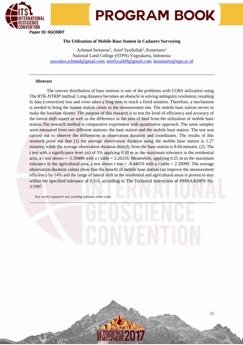
Paper ID: IIGC0007
The Utilization of Mobile Base Station in Cadastre Surveying
Achmad Setiawan1, Arief Syaifullah2, Kusmiarto3
National Land College (STPN) Yogyakarta, Indonesia
[email protected]; [email protected]; [email protected]
Abstract
The uneven distribution of base stations is one of the problems with CORS utilization using
The RTK-NTRIP method. Long distance becomes an obstacle in solving ambiguity resolution, resulting
in data (correction) loss and rover takes a long time to reach a fixed solution. Therefore, a mechanism
is needed to bring the master station closer to the measurement site. The mobile base station serves to
make the baseline shorter. The purpose of this research is to test the level of efficiency and accuracy of
the lateral shift aspect as well as the difference in the area of land from the utilization of mobile base
station.The research method is comparative experiment with quantitative approach. The same samples
were measured from two different stations: the base station and the mobile base station. The test was
carried out to observe the differences in observation duration and coordinates. The results of this
research point out that (1) the average observation duration using the mobile base station is 1.27
minutes, while the average observation duration directly from the base station is 8.84 minutes. (2). The
t test with a significance level () of 5% applying 0.10 m as the maximum tolerance in the residential
area, a t test shows = -1.59488 with a t table = 2.26216. Meanwhile, applying 0.25 m as the maximum
tolerance in the agricultural area, a test shows t test = -8.44019 with a t table = 2.20099. The average
observation duration values show that the benefit of mobile base station can improve the measurement
efficiency by 14% and the range of lateral shift in the residential and agricultural areas is proven to stay
within the specified tolerance of 0,5L according to The Technical Instruction of PMNA/KBPN No.
3/1997.
Key words; expansive soil, swelling pressure, active zone;

12
Paper ID: IIGC0023
Landslide Zoning and Mitigation in Clapar Area,
Madukara District, Banjarnegara Regency, Central Java
Sugeng Raharjoa, Eko Teguh Paripurnoa, Joko Hartadia, Oktavia Dewi Alfiania
Megasari Widyastutib, Muflichatul Mardziahb
aFirst affiliation, lecture at Geological Engineering Dept. UPN “Veteran“, SWK 104 St. Condongcatur Depok Sleman, Yogyakarta 55283, Indonesia
bSecond affiliation, student at Geological Engineering Dept. UPN “Veteran“, SWK 104 St. Condongcatur Depok Sleman, Yogyakarta 55283, Indonesia
Abstract
Landslide disaster is one of the most frequent disasters in Clapar, Banjarnegara. Landslide is a recurring event and there is no suitable method to respond the threat until now, so that preventive stage have not been maximized. The scienstist explains that the movement of land in the area is very active, but the level of activity that can cause landslides can’t be known qualitatively or quantitatively. The method that used to achieving these purposes is geology and landscape morphology mapping in areas that have been and have possibility landslide disaster. Factors that controls the landslide motion are geomorphology, rock type, geological structure and land use, while the triggers are water infiltration and rock fractures. Slope in Clapar is 30 - 70% and the rock type is clay with quarzite and chert fragments from Totogan Formation, volcanic breccia from Tapak Formation, and polimictic breccia from Ligung Formation. Geological structure that found is right slip fault (Rickard, 1972) with the strike and dip of fault is N 359oE/79o. The land usage are pine forest, salak farm, and settlement. Angle of shear strength from direct shear test soil sample in Clapar slope is 27o with safety factor value is 1.045 included in the critical class. According to those existing datas, Clapar included into area that are very vulnerable to landslides. It is because this area was affected by major slip fault and steep angle. The most land usages is salak farms which is the plants has fibrous root that control the properties of soil. It makes the water easily infiltrate into the soil that causes increase the weight of the soil and make the plane become slippery.
Keyword: landslide; land usages; infiltration; Clapar

13
Paper ID: IIGC0009
Completed Participatory Mapping of Village Based on WebGIS
Reza Abdullah, Danang Arief Widianto, Irpan Muhamad Ilham Kosasih,
Ario Aditia Pratama, Hasnim Kaulani, Muhammad Ridwan,
Rangga Agung Chrisnawati, Ruthdiah Aprilia, Shelvi Manurung
National Land College (STPN) Yogyakarta, Indonesia
[email protected]; [email protected]; [email protected]
Abstract
In order to make the land registration, it’s required the land database information in the form of
a basic map that contain information about the land, that has subjects, objects and other information.The
development of land database can create the Government Policy that be a National Map as known as
One Map Policy.The development of based online Geographic Land Information System Application
(WEBGIS) is done by establishing the land database, starting with the preparation of data that be the
land that has been given identification number and the collecting the textual data, then combined and
forming the land database within the scope of one village. The development of WEBGIS focuses on the
development of better spatial data by involving the active role of the village / offices by optimizing the
empowerment of youth organization of the village. The community acts as a land data taker or land data
information giver using Geojot+ Geotagging based on android and Ios- application.Spatial data and
textual data are integrated using the application. The processing Spatial data is using AutoCAD
applications, textual data using Geojot Core., and then will be integrated with ARCGIS with the addition
of attributes based on Geojot Core data.The Using of WEBGIS Applications for village offices and
their usefulness for land and village government offices. The goal is to create better land administration
between agencies so will be formed one map policy. And as a consideration in the proposal draft of
Village Bill, in order to make transition of land have report to the village officers.
Keywords: Completed Participatory Mapping of Village, One Map Policy, WEBGIS

14
Paper ID: IIGC00026
Detection of Land Use Changes In Batam Island Coastal Using Remote Sensing
Oktavianto Gustin, Arif Roziqin, Dwi Ely Kurniawan
Abstract
Batam is one of the fastest growing cities in Indonesia that has resulted in increasing demand for
industrial, commercial and residential areas. However, due to limited land supply there is a process of
transferring existing land functions. By detecting changes in land use, we can find out how much land
use changes are influenced by social, economic and industrial in Batam Island. This research was
conducted on the detection of land use change using Remote Sensing multi-temporal or differentiated
image of the year with a supervised Classification Technique to obtain Land use information and
changes in Batam Island, area percentage of land use change from 2010 and 2016 in Batam Island,
determining the relationship of land use change to conditions in the industry sector presented in to the
maps. The calculation result of classification accuracy test obtained total overall accuracy of 84% where
the classification results can be said good and almost in accordance with the results on the field. The
relationship between land use classification change with industrial condition on the area of non-
agricultural region I can be said to have influence with the number of companies and the workers
number on the data of labor changes from Central Bureau of Statistic/Badan Pusat Statistik (BPS) 2010-
2014 with the assumption of changing function and the many needs of various land uses sector except
agriculture, the area of non-agriculture region II can be said to have influence with the number of
companies and the number of workers in the data of labor changes BPS 2010-2014 with the assumption
of changing function and the many land use needs of various sectors except agriculture, increased
farming can be said to have influence with the number of agriculture companies that also increases in
data of labor changes BPS 2010-2014, the area of the Areas without Vegetation Coverage Class
increased can be said to have influence with the number increased of companies and the number of
manpower on the data labor changes BPS 2010-2014 with the assumption that there are many land use
needs of various sectors except agriculture.
Keywords: Changes of land use, Landsat, Classification, Remote Sensing, Map

15
Paper ID: IIGC0002
Alteration and Ore Mineralogy
Of Metamorphic Rocks Hosted Hydrothermal Gold Deposit at Rumbia Mountains, Bombana
Regency, Southeast Sulawesi
Hasria1, 2*, Arifudin Idrus1 & I Wayan Warmada1
1Department of Geological Engineering, Gadjah Mada University, Indonesia 2Department of Geological Engineering, Halu Oleo University, Indonesia
*Corresponding author: [email protected]
Abstract
In Indonesia, gold is commonly mined from porphyry, epithermal and skarn type deposits that are
commonly found in volcanic/magmatic belts. However, were recently numerous gold prospects
discovered in association with metamorphic rocks. This paper is intended to describe an alteration and
ore mineralogy hosted by metamorphic rocks at Rumbia mountains, Bombana regency, Southeast
Sulawesi province, Indonesia. The study area is found the placer and primary gold hosted by
metamorphic rocks. The placer gold is evidently derived from gold-bearing quartz veins hosted by
Pompangeo Metamorphic Complex (PMC). This study is conducted in three stages, three stages
including desk study, field work and laboratory analysis. Desk study mainly covers literature reviews.
Field work includes mapping of surface geology, alteration and ore mineralization as well as sampling
of representative rocks types, altered rocks and gold-bearing veins. Laboratory analysis includes the
petrologic observation of handspecimen samples, petrographic analysis of the thin section and ore
microscopy for polished section and XRD (X-ray diffraction) analysis. From petrographic observation,
the type of alteration found in the study area can be divided into six types including sericitization,
argillic, inner propylitic, propylitic, carbonization and carbonatization alterations. These quartz veins
are currently recognized in metamorphic rocks at Rumbia mountains. Mineralogically, gold is closely
related to chalcopyrite, pyrite, hematite, cinnabar, stibnite and possibly minor goethite. Based on those
characteristics, it obviously indicates that the primary gold deposit present in the study area is of
orogenic gold deposits type. The orogenic gold deposit is one of the new targets for exploration in
Indonesia.
Keywords : alteration, ore mineralogy, hydrothermal gold deposit, metamorphic rocks, Rumbia mountains, Southeast Sulawesi.
16
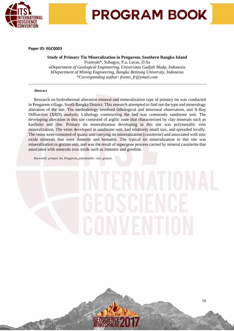
Paper ID: IIGC0003
Study of Primary Tin Mineralization in Pengarem, Southern Bangka Island
Frantoab*, Subagyo, P.a, Lucas, D.Sa
aDepartment of Geological Engineering, Universitas Gadjah Mada, Indonesia
bDepartment of Mining Engineering, Bangka Belitung University, Indonesia
*Corresponding author: [email protected]
Abstract
Research on hydrothermal alteration mineral and mineralization type of primary tin was conducted
in Pengarem village, South Bangka District. This research attempted to find out the type and mineralogy
alteration of the site. The methodology involved lithological and structural observation, and X-Ray
Diffraction (XRD) analysis. Lithology constructing the bed was commonly sandstone unit. The
developing alteration in this site consisted of argilic zone that characterized by clay minerals such as
kaolinite and ilite. Primary tin mineralization developing in this site was polymetallic vein
mineralization. The veins developed in sandstone unit, had relatively small size, and spreaded locally.
The veins were consisted of quartz unit carrying tin mineralization (cassiterite) and associated with zinc
oxide minerals that were ilmenite and hematite. The typical tin mineralization in this site was
mineralization in gozzan unit, and was the result of supergene process carried by mineral cassiterite that
associated with minerals iron oxide such as ilmenite and goethite.
Keywords: primary tin, Pengarem, polymetallic, vein, gozzan.

17
Paper ID: IIGC0004
Mineral and Geochemistry Study of Lower Kutai Basin Coal East Kalimantan
Agus Winarno1,2*, D. Hendra Amijaya1 & Agung Harijoko1 1Department of Geological Engineering, Universitas Gadjah Mada, Indonesia
2Department of Mining Engineering, Mulawarman University, Indonesia
*Corresponding author : [email protected]
Abstract
This study aims to determine the type of mineral and geochemical character of low rank coal. The
coal samples were located at Indominco Mandiri Coal Mine KW 01PB0435 in East Kutai District, East
Kalimantan. This area of research is entered into the Lower Kutai Basin, where in this basin there are
two formations containing coal, namely Pulaubalang and Balikpapan Formation. The methods used are
X-Ray Diffraction (XRD), proximate, and ultimate coal analysis. The results of this study based on X-
Ray Diffraction (XRD) analysis of coal contents are clays minerals (kaolinite, illite), quartz, carbonates
(calcite and dolomite), sulphides (pyrite and chalcopyrite) and oxides (rutile and goethite). While
geochemically coal has a calorific value of 6052.6 cal./gram (Subbitumionus A Coal), moisture 13.3%
(adb), ash 4.0% (adb), volatile matter 41.5% (adb), fixed carbon 41.2% (adb), and sulfur content 1.77%
(adb).
Keywords: X-Ray Diffraction, proximate, and ultimate

18
Paper ID: IIGC0006
Reservoir Characterization and Volumetric Calculation Of Hydrocarbons Reserves in “RRD”
Field, Layer Z.2260 Talang Akar Formation, North West Java Basin
Rizki Rahmandani,a Budi Eka Nurcahya,a Tania Meidiana,b Agung Dwi Alfianto,b aProgram Studi Geofisika, Jurusan Fisika, Fakultas Matermatika dan Ilmu Pengetahuan Alam,
Universitas Gadjah Mada, Sekip Utara, Bulaksumur, Yogyakarta 55281, Indonesia BPT. Pertamina Ep Asset 3, Jalan Patra Raya No.01 Klayan, Cirebon 45151, Indonesia
Abstract
“RRD” field is one of the hydrocarbon prospects in North West Java Basin. One of the potential oil
reserves in this field was found on Talang Akar Formation Z.2260 layer and indicated by the presence
of oil show on drill steam test data. Physical parameters such as acoustic impedance, porosity and
hydrocarbon saturation are essential to determine the distribution of reservoir layer. Acoustic
impedance can distinguish the reservoir and nonreservoir zone, while porosity and hydrocarbon
saturation can be used in the calculation of oil reserves on the layer Z.2260. Model Based Inversion was
performed to find out the lithology distribution determined by acoustic impedance. Porosity distribution
was identified using crossplot acoustic impedance and porosity analysis while hydrocarbon saturation
distribution was determined using cokriging geostatistical analysis. The result shows the existence of
sandstone reservoir with acoustic impedance values ranging from 8500–10.000 (m/s)(g/cc) that spreads
over 2 zones in the research area of anticline zone A and R. Sandstone with such acoustic impedance
range has a porosity value of 8-12% and hydrocarbon saturation 25-50%. The reservoir zone A has
value 0,201 (MMbbl) as well as R area 1,689 (MMbbl).
Keyword: Model Based Inversion, Hydrocarbon Reserve, Cokriging, Z.2260.
19
Paper ID: IIGC0011
Seismic Forward Modelling to Reverse-time Migration with Finite-difference Method
Lenterano, Syauqy*, Alfiat
Department of Geophysics Faculty of Mathematics and Natural Sciences
Universitas Padjadjaran, Raya Bandung Sumedang KM 21, Hegarmanah, Jatinagor, Kabupaten
Sumedang, Jawa barat 45363, Indonesia
*Corresponding author: [email protected]
Abstract
Finite-difference is commons tool to perceive solution of any partial differential equations. In seismic
Exploration, this method is used commonly for seismic migration in oil and gas industry. It is more
well-known called reverse-time migration. Compared with another migration methods, reverse-time
migration is the most accurate migration method despite of its cost. In this paper, we used acoustic wave
equation with finite-difference approach to simulate acoustic wave propagation in 2D velocity model
that we created. We can obtain seimic records from the simulation. The records were wavefiled which
had propagated from particular source through velocity model and received by geophone on the surface.
The records became data that we used to image reflectors in the subsurface. To apply reverse-time
migration algorithm we used two-way wave equation to separate upgoing and downgoing wave ( Baysal
et al, 1984). The records that we had obtained, became time-reversed and boundary condition for
backward-time propagation for upgoing and downgoing wavefield. Computation in this method is the
main difficulty without advanced computation ability to proceed such algorithm such algorithm like
convolution and deconvolution with high amounts of gridpoints is hard to produced detailed image. In
this paper, we used modest computation ability to create fine image of the subsurface from velocity
model that we created with hundreds gridpoints
Keywords: Finite-difference, Acoustic wave equation, reverse-time migration, Two-way wave equation, Seismic forward modelling
20
Paper ID: IIGC0017
Early Miocene Carbonate “G-0” Distribution Analysis Using Spectral Inversion Krisna H Mukti1, Agung D Alfianto 2, O A Pranidhana2, Annisa B3, Dhea R N3, B Dwijatmiko4, D
Pramudito5, E Hartantyo6
1 Student in Geophysics Sub Department, Universitas Gadjah Mada 2 Geophysics Engineer, Paradigm Indonesia 3 Geologist Engineer, Paradigm Indonesia 4 Junior G&G Engineer, Pertamina EP Asset 3 Jatibarang Exploitation 5 G&G Engineer, Pertamina EP Asset 3 Tambun & Subang Exploitation 6 Lecturers in Geophysics Sub Department, Universitas Gadjah Mada
Abstract
“KHM”structure is one of PT. Pertamina EP oil producing field in Subang, Nort West Java Basin. One of the hydrocarbon producers of this structure is located in thin bedded early miocene carbonate reservoir which in Upper Cibulakan Formation. The thin bedded reservoir becomes a challenge because the post stack time migration seismic resolution can’t resolve the each layer. To distinguish and delineates the reservoir’s lateral continuity needed spectral decomposition analysis. This analysis obtained 3 best frequencies to acquire a better imaging which known as tuning cube, they are 15 Hz, 20 Hz, and 25 Hz . Furthermore, these frequencies were blended to get spectral decomposition volume. The volumes have same frequency and amplitude with post stack time migration seismic data, so it can be used for further interpretation. To predict the distribution and depositional facies of early miocene carbonate, performed seismic interpretation by using model based acoustic impedance inverion on spectral decomposition volume and porosity analysis. The result of this study suggest the lateral distribution of early miocene carbonate can be characterized. Acoustic impedance zone that associated with porous carbonate have ranges values of 8050 – 9800 gr/cc m/. This is supported by petrophysics analysis that generates porosity values of 7.4 – 13.9 % in this zone. The relationship of both analysis based on the correlation of well, known that porous carbonate was deposited on a shelf margin facies.
Keywords: Spectral decomposition; acoustic impedance inversion; facies

21
Paper ID: IIGC0020
Waterflooding Development Prediction in Carbonate Reservoir at Field X using Reservoir
Simulation
Novia Fazilani,a Sugiatmo Kasmungin,b
aTrisakti University, Jl. Kyai Tapa No. 1, Grogol, Tomang, Grogol Pertamburan, West Jakarta 11440, Indonesia
bTrisakti University, Jl. Kyai Tapa No. 1, Grogol, Tomang, Grogol Pertamburan, West Jakarta 11440, Indonesia
Abstract
Field X consist of a carbonate reservoir, producing since April 2014 with only 2 existing wells present,
which is well NF-01 and NF-02. Production history of the field was performed from year 2014 until
2016. The original oil in place of Field X is 9.204 MMSTB (volumetric) and 9.0308 MMSTB
(simulation). A method of optimizing Field X is Waterflooding after primary recovery has been done.
In this study, the software used for the development of Field ‘X’ is Computer Modeling Group (CMG)
IMEX Black Oil, by applying waterflooding as a method of optimizing the field, the optimization can
be determined based on the consideration of various development scenarios. Reservoir simulation
process consists of several steps which are; data preparation, model and grid construction, initialisation,
history matching and prediction forecast. All the data up until history matching was given and the focus
of this paper is to evaluate and predict several scenarios. The period of development is done for 19 years
which is until December 2035. Several scenarios predicted were In-fill, conversion of wells, peripheral,
5-spot patterns and pilot studies. As the prediction developments were conducted, recovery from each
scenario varies. These scenarios are then compared to be able to find the optimum result. After
simulating several scenarios of as follows; infill-18 wells, infill-26 wells, infill-horizontal wells, covert
all non-producing wells, peripheral wells, invert and normal 5-spot wells and comparing the recovery
factor, it can be said that waterflooding implementation was insignificant as there were only a slight
increase in recovery factor. The optimum scenario from waterflooding implementation is the peripheral
pattern with a recovery factor of 38.17%.
Keywords: waterflood; injection; carbonate; reservoir; simulation

22
Paper ID: IIGC0024
Reverse Time Migration On Geological Complex Settings : A New Geophysical Tools in
Seismic Migration
Fuad Aulia Bahry, Dwa Desa Warnana aInstitut Teknologi Sepuluh Nopember, Keputih Sukolilo, Surabaya 60111, Surabaya
*Corresponding author: fuadbahri08@gmail,com
Abstract
Reverse time migration is a method that utilizes wave propagation in two directions in forward and reverse. This approach improves previous migration methods, especially in the case of extreme dipping structures and high velocity contrast. Also reverse time migration can handle many waveforms. Despite having more accurate imaging capabilities, reverse time migration is expensive method. One other migration method is Kirchhoff method that based on diffraction summation. This method is commonly used by industry at this time. Experiments have been conducted to compare reverse time and Kirchhoff migration using complex geological settings: Marmousi Models and Salt Dome models. Migration Performed in pre-stack and depth Migration.
From the migration results that have been obtained, reverse time migration method proved to produce a better image than Kirchhoff migration. By producing a clearly data model on the boundary, however reverse time migration requires high computing capabilities. Depends on the case of geology settings and necessity.
Keywords: Reverse Time Migration, Kirchoff Migration, Geological Complex

23
Paper ID: IIGC0025
Seismogeomorphic Interpretation Spectral Decomposition Channel Detection for Hydrocarbon
Exploration
Sunjay
Banara Hindu University, Varanasi – 221 005, India
*Corresponding author: [email protected]
Abstract
Seismogeomorphic Interpretation: Seismic attributes are useful to help the qualitative interpretation of
the seismic data. Seismic attributes are derived from basic seismic measurements. The attributes are
useful to ascertain structure, lithofacies, and reservoir parameters of a field as attribute properties can
vary significantly with variations in lithology, geometry, and structural patterns of deposition for
various lithofacies in an area. The basic poststack attributes may be grouped into the following
classification- Time-derived: provide structural information; Amplitude-derived: provide stratigraphic
and reservoir information; Frequency-derived: provide additional stratigraphic and reservoir
information. While spectral decomposition is a good indicator of channel thickness, coherence and other
edge detectors are good indicators of channel width. Since channels may have different spectral
response than the neighbouring data points, different single frequency volumes will in general delineate
or highlight different thickness channels.Channels filled with porous rock and encased in a nonporous
matrix comprise one of the more important stratigraphic exploration plays. However, detailed mapping
of channels has a much broader impact. By using modern and paleo analogs, mapping channels helps
map the paleo depositional environment, and helps interpret less obvious prospective areas such as fans
and levees. By mapping the width, tortuousity, and spatial relation of meandering channels, avulsions,
braided streams, among others, geomorphologists are able to infer channel depth and fluid velocity
during the time of formation, and thus better risk whether the fill is sand or shale prone. Seismic
coherence and other edge-sensitive attributes are among the most popular means of mapping channel
boundaries. Although these attributes can easily detect channel edges, they cannot indicate the channel’s
thickness. As channels become very thin (well below ¼ wavelength) their waveform becomes constant,
such that coherence measures based on waveform shape cannot see the channel at all. Spectral
decomposition has been used to highlight channels. The spectral decomposition images are
complementary to coherence and edge-detection attribute images in that they are sensitive to channel
thickness rather than to lateral changes in seismic waveform or amplitude. Spectral decomposition
analysis can be done within a fixed sized analysis window (using a short-window discrete Fourier
transform, or SWDFT) following a picked stratigraphic horizon, thereby generating a suite of constant
frequency spectral amplitude maps. Most commonly, the interpreter animates through these maps and
chooses those maps with spatial patterns corresponding to reasonable geological models. There is a
strong correlation between channel thickness and spectral amplitude. For thin beds below the tuning
frequency, the composite seismic amplitude decreases linearly with thickness. Frequency corresponding
to the peak spectral amplitude is an excellent means of summarizing the information content of the full
spectrum, with a low peak frequency corresponding to thick channels, and a high peak frequency
corresponding to thin channels. Even with careful tapering, spectral decomposition using the SWDFT
has window effects. Frequency decomposition methods based on wavelet transforms compute
instantaneous spectral attributes (ISA) in which peak frequency significantly increases with decreasing

24
layer thickness. The instantaneous amplitude gives a measure of reflection strength (magnitude) and
often serves as a lithology identifier.Instantaneous attribute:Instantaneous attributes quantify wavelet
shape at any sample point in a concise manner.Instantaneous attributes are computed sample by sample,
and show instantaneous variations of various parameters. Instantaneous attributes such as trace
envelope, its derivatives, frequency, and phase may be determined from complex trace . Instantaneous
Amplitude:It is a measurement of the complex trace amplitude which may be visualized as the envelope
of the seismic trace.Volumes of instantaneous attribute such as instantaneous amplitude and perigram
are chosen to delineate the reservoir in terms of reflectivity as it gives information about the spatial
distribution of the varied lithologies, both vertically and laterally. The instantaneous frequency,
instantaneous bandwidth, dominant frequency, and response frequency isolate abrupt changes to
characterize reflection zones, bedding, and lithology variation, while marking the unconformities and
highlighting steam. Instantaneous phase delineates and map the unconformities as it is a good indicator
of lateral discontinuities. Moreover, it is independent of seismic amplitude strength, which helps to
analyze both weak and strong reflectors. It helps in mapping the unconformities in low seismic
amplitude zones.
Keywords: Spectral decomposition; Seismogeomorphic, Channel Detection


![Reply to a Mockery · (Surah at-Taubah, 9:66). Reply to a Mockery Response to the booklet entitled Ilhami Girgit [Divine Chameleon] H. Ali Islam International Publications. Reply](https://img.pdfslide.us/doc/110x75/5e26b1ab5b3feb2fee53383d/reply-to-a-mockery-surah-at-taubah-966-reply-to-a-mockery-response-to-the-booklet.jpg)