Embed Size (px)
Citation preview
INSTITUT ZA OCEANOGRAFIJU I RIBARSTVO - SPLITSFR JUGOSLAVIJA
No. 50
v
BILJESKE- NOTES 1983.
MEDALPEX in the North AdriaticPreliminary report
MEDALPEX u sjevernom Jadranu - Preliminarni Izvještaj
Mira Z ore - A r man d a, Vlado D a d i c, Miroslav G aci c,Mira Morovic and Tanja Vucicic
Institute of Oceanography and Fisheries, Split
INTRODUCTION
Coverage of the North Adriatic by intensive meteorological observationsin the frame of the ALPEX programe was us ed as the basis to study theinfluence of atmospheric disturbances on current field variations and condi-tions for deep water formation. This was the main objective of MEDALPEXfor this region.
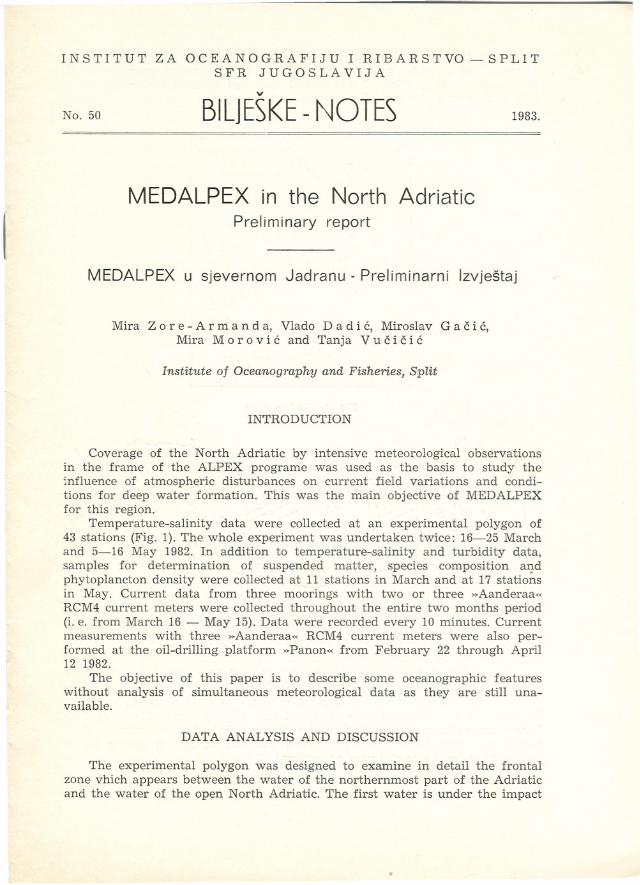
Temperature-salinity data were collected at an experimental polygon of43 stations (Fig. 1). The whole experiment was undertaken twice: 16-25 Marchand 5-16 May 1982. In addition to temperature-salinity and turbidity data,samples for determination of suspended matter, species composition andphytoplancton density were collected at 11 station s in March and at 17 statio~sin May. Current data from three moorings with two or three »Aanderaa«RCM4 current meters were collected throughout the entire two months period(i. e. from March 16 - May 15). Data were record ed every 10 minutes. Currentmeasurements with three »Aanderaa« RCM4 current meters were also per-formed at the oil-drilling platform »Panon« from February 22 through April12 1982.
The objective of this paper is to describe some oceanographic featureswithout analysis of simultaneous meteorological data as they are stiH una-vailable.
DATA ANALYSIS AND DISCUSSION
The experimental polygon was designed to examine in detail the frontalzone vhich appears between the water of the northernmost part of the Adriaticand the water of the open North Adriatic. The first water is under the impact
"
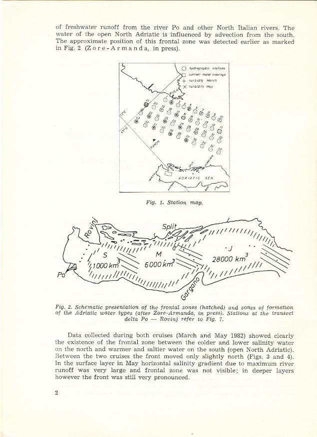
of freshwater runoff from the river Po and other North Italian rivers. Thewater of the open North Adriatic is influenced by advection from the south.The approximate position of this frontal zone was detected earlier as markedin Fig. 2 (Z ore - A r man d a, in press).
Fig. 1. Station map.
Fig. 2. Schematic presen~ation of the fronta.l zones (hatched) and zone s of formatianof the Adriatic water types (after Zore-Armanda, in press). Stations at the transect
delta Po - Rovinj refer to Fig. 7.
Data collected during both cruises (March and May 1982) show ed clearlythe existence of the frontal zone between the colder and lower salinity wateron the north and warmer and saltier water on the south (open North Adriatic).Between the two cruises the front moved only slightly north (Figs. 3 and 4).In the surface lay er in May horizontal salinity gradient due to maximum riverrunoff was very large and frontal zone was not visible; in deeper layershowever the front was stiH very pronounced.
2
~
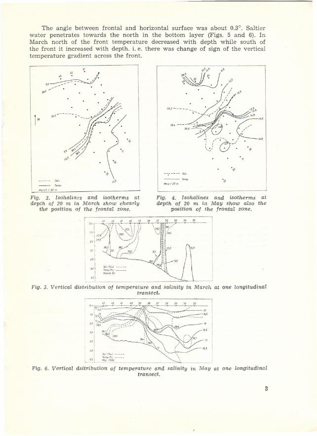
The angle between frontal and horizontal surface was about 0.3°. Saltierwater penetrates towards the north in the bottom layer (Figs. 5 and 6). InMarch north of the front temperature decreased with depth while south ofthe front it increased with depth. i. e. there was change of sign of the verticaltemperature gradient across the front.
"
~,2:'
9,0 . --- . /./ ' . -- ",..o . .
,.,~\.~\\~
~~,22 I 2~~~'!UJ
\~,
. "/1
"., -- :' "'~/'~/
'"
\'~
1N
,o~ \\
\,
---' - 50[.- T.mp.Monh/ ,O m
"p
--, 50[.-T.mp.Moy/lOm '.;>
------ JFig. 3. Isohalines and isotfterms atdepth of 20 m in March show chearly
the position of the frontal zone.
Fig. 4. Isohalines and isotherms atdepth of 20 m in May show also the
position of the frontal zone.
" 33" " "Om,- ::!: 'o, \ i 1':10l / I: \ 0--,:-9\: 1/
137,~/ \?:,O0,,:/ ii20 r37,9 0, ;// !
f J8),./ !JC [ /' J~/.of ' :
l Sc[ 1%.) o.
50I r,mpr,J-t MO"h"
"r
Fig. 5. Vertical distribution of temperature and salinity in March at one longitudinaltransect.
" <2 " " " 3. 37 J6 3s " 33
[5",5
"TJ.S
-TJ
1'.5
Om
i ~- o.,lO~" 0-- --/ o;)Il[2,S",.~;;--, ",. 'I 20' o"! :3<0
I
J~
solI SoIW..) ------
L~oL__;~Pi~1, ~ .--'
Fig. 6. Vertical dsitribution of temperature and salinity in May at one longitudinaltransect.
3
~
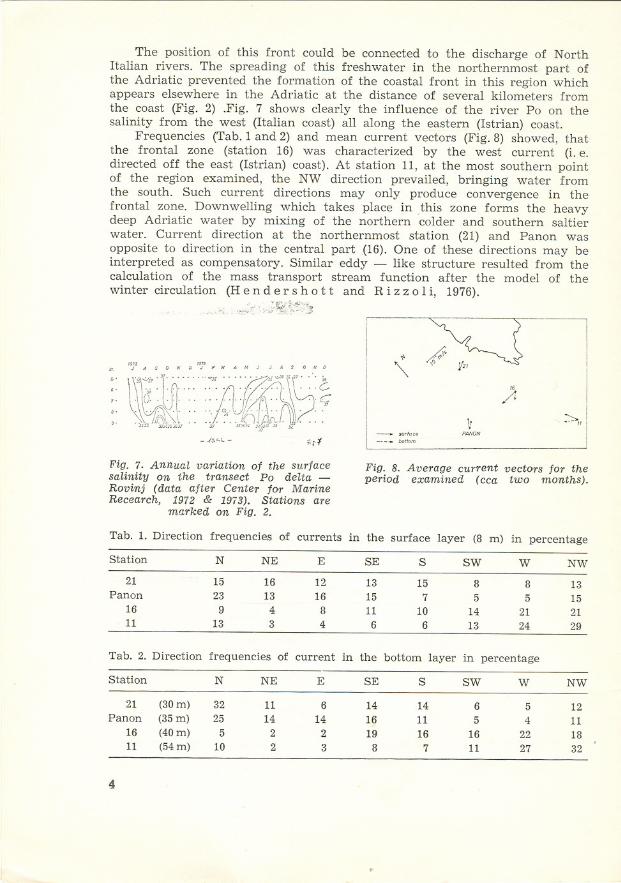
The position of this front could be connected to the discharge of North!talian rivers. The spreading of this freshwater in the northernmost part ofthe Adriatic prevented the formation of the coastal front in this region whichappears elsewhere in the Adriatic at the distance of several kilometers fromthe coast (Fig. 2) .Fig. 7 shows clearly the influence of the river Po on thesalinity from the west (!talian coast) all along the eastern (Istrian) coast.
Frequencies (Tab.1 and 2) and mean current vectors (Fig.8) showed, thatthe frontal zone (station 16) was characterized by the west current (i. e.directed off the east (Istri an) coast). At station 11, at the most southern pointof the region examined, the NW direction prevailed, bringing water fromthe south. Such current directions may only produce convergence in thefrontal zone. Downwelling which takes place in .this zone forms the heavydeep Adriatic water by mixing of the northern colder and southern saltierwater. Current direction at the northernmost station (21) and Panon wasopposite to direction in the central part(16). One of these directions may beinterpreted as compensatory. Similar eddy - like structure resulted from thecalculation of the mass transport stream function after the model of thewinter circulation (H end er s hot t and R i z zoI i, 1976).
- .{'.4C-- ,"',,,,
b''''m
"'" N
~II
"" ""JA'ONOJFUAMJ JA'ONO
" \\'''' "(".., ,, ..~.;.-;;;;"",...t" ,'"
\ 'I\ii.'J~~
':" ::':r:-:U1\l;,:~~l(~ ., .. .., S,!A-!;tPV\\, .."",/I<",~" " ,J, ',,~,j,);~1();/' ~"~, ,
):
VPANON
'i,;-:(
.
Fig. 7. Annual variation of the surface Fig. 8. Average current vectors for thesalinity on the transect Po delta - period examined (cca two months).Rovinj (data after Center for MarineRecearch, 1972 & 1973). Stations are
marked on Fig. 2.
Tab. 1. Direction frequencies of currents in the surface layer (8 m) in percentage
Station N NE E SE S SW W NW
21 15 16 12 13 15 8 8 13Panon 23 13 16 15 7 5 5 15
16 9 4 8 11 10 14 21 2111 13 3 4 6 6 13 24 29
Tab. 2. Direction frequencies of current in the bottom layer in percentage
Station N NE E SE S SW W NW
21 (30m) 32 11 6 14 14 6 5 12Panon (35m) 25 14 14 16 11 5 4 11
16 (40m) 5 2 2 19 16 16 22 1811 (54m) 10 2 3 8 7 11 27 32
4
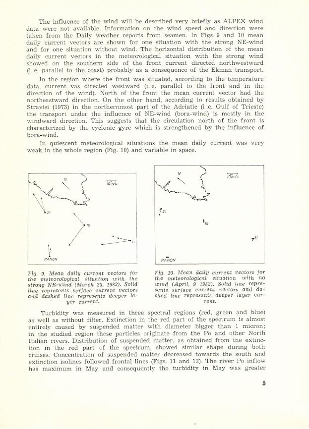
The influence of the wind will be described very briefly as ALPEX winddata were not available. Information on the wind speed and direction weretaken from the Daily weather reports from seamen. In Figs 9 and 10 meandaily current vectors are shown for one situation with the strong NE-windand for one situation without wind. The horizontal distribution of the meandaily current vectors in the meteorological situation with the strong windshowed on the southern side of the front current directed northwestward(i. e. paralleI to the coast) probably as a consequence of the Ekman transport.
In the region where the front was situated, according to the temperaturedata, current vas directed westward (i. e. paralleI to the front and in thedirection of the wind). North of the front the mean current vector had thenortheastward direction. On the other hand, according to resuIts obtained byStravisi (1973) in the northernmost part of the Adriatic (i .e. Gulf of Trieste)the transport und er the influence of NE-wind (bora-wind) is mostly in thewindward direction. This suggests that the circulation north of the front ischaracterized by the cyclonic gyre which is strengthened by the influence ofbora-wind.
In quiescent meteorological situations the mean daily current was veryweak in the whole region (Fig. 10) and variable in space.
~
Nl0!n/5
'\
I'"
12/
',6
~PANON
-.~II
.,"I
..PANON
Fig. 9. Mean dailyeurrent veetors forthe meteorologieal situation with thestrong NE-wind (Ma1"eh 23, 1982). Solidline represents surfaee eurrent veetorsand dashed line represents deeper la-
yer eurrent.
Fig. 10. Mean dailyeurrent veetors forthe meteorologieal situation with nowind (April, 9 1982). Solid line repre-sents surfaee eurrent veetors and da-shed line represents deeper layer eur-
rent.
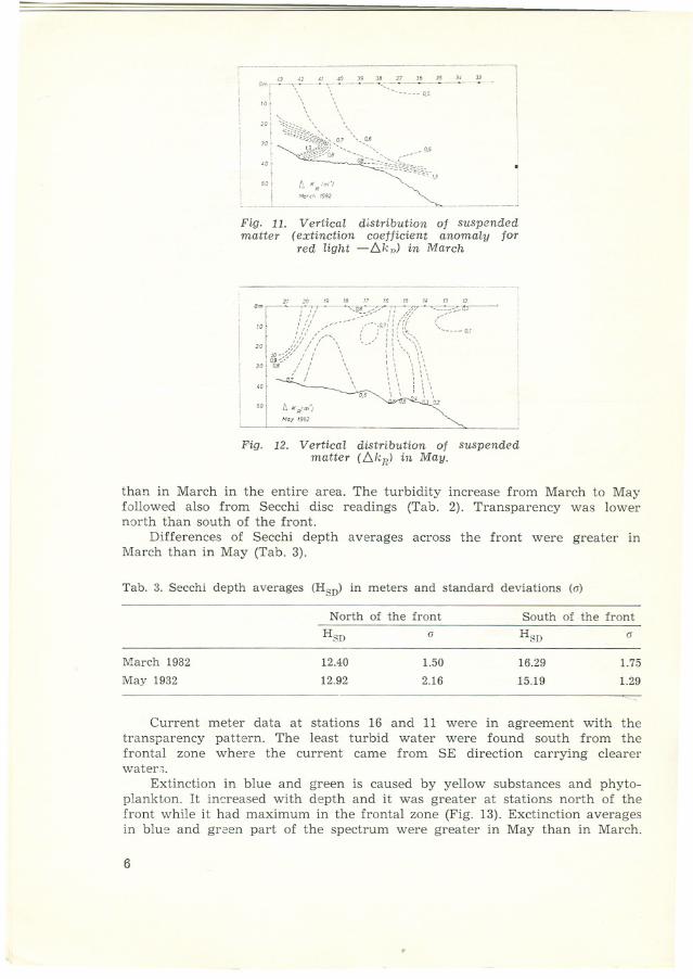
Turbidity was measured in three spectral regions (red, green and blue)as well as without filter. Extinction in the red part of the spectrum is almostentirely caused by suspended matt er with diameter bigger than 1 micron;in the studied region these particles originate from the Po and other North!talian rivers. Distribution of suspended matter, as obtained from the extinc-ti on in the red part of the spectrum, showed similar shape during bothcruises. Concentration of suspended matt er decreased towards the south andextinction isolines followed frontal lines (Figs. 11 and 12). The river Po inflowhas maximum in May and consequently the turbidity in May was greater
5
i-- Om f-:::;~,\~O- 39-- ~,:_3~~~~~-~--:-=~-"-110f \ \ . 'r
'
I \ \, " ' \I20 f ",--', ,
::\ ~;~~~~" !50 f r:. XRim'" ",-. ]
'::~C~~~_. n~- JF igo 11. Vertical distribution of suspendedmatter (extinction coetticient anomaly for
red light -L.k,,) in March
.
v m - . W M MNa u
',: ; //::~":~:::-::~~~sÐ7/(({, (~~O~~:,20tlO-;;;? :' ,/ \ - : \ '\ \\30 l"Bi' / ; \ : '., ... \'..I " , ", "
~"""
,,' 'I I '"Ir' , 0.5 '., \ :, '., '.., , 02ILJO I!.x,.tm",, May lO"
Fig. 12. Vertical distribution of suspendedmatter (L.kR) in May.
than in March in the entire area. The turbidity increase from March to Mayfollowed also from Secchi di sc readings (Tab. 2). Transparency was lowernorth tha n south of the front,
Differences of Secchi depth averages across the front were greater inMarch than in May (Tab. 3).
Current meter data at stations 16 and 11 were in agreement with thetransparency pattern. The least turbid water were found south from thefronta 1 zone where the current came from SE direction carrying clearerwater,>.
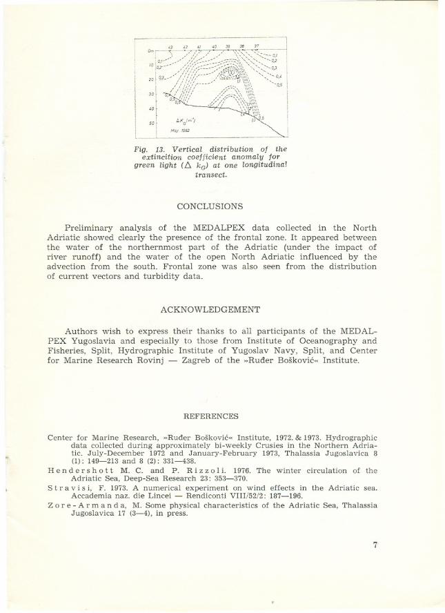
Extinction in blue and green is caused by yellow substances and phyto-plankton. It in ere as ed with depth and it was greater at stations north of thefront while it had maximum in the frontal zone (Fig. 13). Exctinction averagesin blue and green part of the spectrum were greater in May than in Mareh.
6
Tab. 3. Secchi depth averages (HSD) in meters and standard deviations (o)
North of the front South of the front
HSD o HSD o
March 1982 12.40 1.50 16.29 1.75
May 1982 12.92 2.16 15.19 1.29-.-
1--:-' <2 " 'o 39 38 37 'j
! :1:::~:i%fC~~i~~;:-~~:~~~,,!JI,' " ii,;' ,' u \')\\ "- l
I
[ // ;//// /;:-°\, \::::\ -0.5 i30r . 'i"', ,'/_--,,\ \\'" !
f o.o ':ti -;//:/-""''- '~,\\ 'I
f
' .,;- // \'\'1,,,,,,,I 'o -" '""',,, II
' " """ I
'\\\\ I! 50 I l>KG
(m") jO 0.5 I
: I
LMcy 1982
Fig. 13. Vertical distribution of theextincition coefficient anomaly for
green light (!:::..ka) at one longitudinaltransect,
CONCLUSIONS
Preliminary analysis of the MEDALPEX data collected in the NorthAdriatic showed clearly the presence of the frontal zone. It appeared betweenthe water of the northernmost part of the Adriatic (und er the impact ofriver runoff) and the water of the open North Adriatic influenced by theadvection from the south. Frontal zone was also seen from the distributionof current vectors and turbidity data.
ACKNOWLEDGEMENT
Authors wish to express their thanks to all participants of the MED AL-PEX Yugoslavia and especially to those from Institute of Oceanography andFisheries, Split, Hydrographic Institute of Yugoslav Navy, Split, and Centerfor Marine Research Rovinj - Zagreb of the »Ruder Boškovic« Institute.
REFERENCES
~
Center for Marine Research, »Ruder Boškovic« Institute, 1972. & 1973. Hydrographicdata collected during approximately bi-weekly Crusies in the Northern Adria-tic. July-December 1972 and January-February 1973, Thalassia Jugoslavica 8(1): 149-213 and 8 (2): 331-438.
He n der s hot t M. C. and P. R i z zoI i. 1976. The winter circulation of theAdriatic Sea, Deep-Sea Research 23: 353-370.
Str avi s i, F. 1973. A numerical experiment on wind effects in the Adriatic sea.Accademia naz. die Lincei - Rendiconti VIII/52/2: 187-196.
Z ore - A r man d a, M. Some physical characteristics of the Adriatic Sea, ThalassiaJugoslavica 17 (3-4), in press.
7

MEDALPEX U SJEVERNOM JADRANU - PRELIMINARNI IZVJEŠTAJ
Mira Z ore - A r man d a, Vlado D a d i c, Miroslav G aci c,Mira Morovic i Tanja Vucicic
Institut za oceanografiju i ribarstvo, Split
KRATKI SADRŽAJ
Izvršena je preliminarna analiza MEDALPEX podataka prikupljenih usjevernom Jadranu u razdoblju od marta do maja 1982. godine. Podaci otemperaturi i slanosti, prikupljeni na poligonu od 43 postaje, jasno pokazujuprisustvo frontaIne zone izmedu hladnije i slade sjevernije vode i toplije islanije južnije vode. Prisustvo fronte potvrduju i strujomjerni podaci, kao ipodaci o turbiditetu. Dinamicki je frontaIna zona izrazitija uz jaci vjetar.Konvergencija na liniji fronte ukazuje na mogucnost tonjenja vode i formi-ranja teške pridnene vode u frontaInoj zoni.
8


![SFR JUGOSLAVIJA v BILJESKE NOTESjadran.izor.hr/acta/pdf/biljeske_notes/042.pdfSFR JUGOSLAVIJA No. 42 v BILJESKE-NOTES 193] I! Catch of Surrounding net in Salloum Bay L, Lov kružnom](https://img.pdfslide.us/doc/110x75/5e358f83dbcff31ca3623ceb/sfr-jugoslavija-v-biljeske-sfr-jugoslavija-no-42-v-biljeske-notes-193-i-catch.jpg)