Embed Size (px)
Citation preview

APPRAISAL REPORT
Girdwood South Townsite Tracts D-5, E-4, F-3, G-6, and G-7 (Plat 2014-25) Located on Korolius Drive
In Girdwood, Alaska FILE # 15-013
FOR DATE Susie Paine, Land Management Officer
Heritage Land Bank of the Municipality of Anchorage P.O. Box 196650
Anchorage, Alaska 99519-6650
Effective Date of Value February 7, 2015
Report Date
February 27, 2015
BY
Brian Bethard, MAI General Real Estate Appraiser (Cert. #281)
Michael Forsland, Appraiser
BLACK-SMITH, BETHARD & CARLSON, LLC
1199 E. Dimond Blvd., Ste. 200, Anchorage, Alaska 99515
Tract D-5
Tract E-4
Tract G-6
Tract G-7
Tract F-3

2
PART I - INTRODUCTION

February 27, 2015
Client: Heritage Land Bank of the Municipality of Anchorage
P.O. Box 196650
Anchorage, Alaska 99519-6650
Attn: Ms. Susie Paine, Land Management Officer
Re: Girdwood South Townsite Tracts D-5, E-4, F-3, G-6, and G-7 (Plat 2014-25)
(5) tracts of vacant land located on Korolius Drivein Girdwood, Alaska
Dear Ms. Paine,
We are submitting an appraisal report of the properties referenced above. Our opinion(s) of
the as-is market value of the fee-simple interest, as of February 7, 2015 (the date of
inspection) are:
Tract Acres Retail Value Tract D-5 14.363 Ac $1,094,400 Tract G-6 14.838 Ac $995,400 Tract G-7 20.342 Ac $469,600 Tract E-4 34,486 Ac $525,800 Tract F-3 10.456 Ac $82,000
The value opinion is stated in terms of cash or its equivalent and a market exposure period
of one year. Our appraisal is qualified by certain definitions, assumptions, limiting
conditions and certifications.
The report is intended to comply with the reporting requirements set forth under Standards
Rule 2-2(b) of the Uniform Standards of Professional Appraisal Practice (2012-2013) for a
Summary Appraisal Report. As such, it presents only summary discussions of the data,
reasoning, and analyses that were used to develop the appraiser’s opinion of value.
Supporting documentation concerning the data, reasoning, and analyses is retained in the
appraiser’s file. The depth of discussion contained in this report is specific to the client's
intended use.
This narrative appraisal report conforms to and satisfies the requirements of USPAP and
Volume 12, Code of Federal Regulations, Part 34, Subpart C. A copy of the appraisal
instructions is contained in the Addenda.
Sincerely,
BLACK-SMITH, BETHARD & CARLSON, LLC
Brian Z. Bethard, MAI General Real Estate Appraiser (Cert #281)
Michael A. Forsland, Appraiser
BLACK-SMITH, BETHARD & CARLSON, LLC
Appraisers 1199 Dimond Blvd, Suite 200
Anchorage, Alaska 99515 Phone: 907-274-4654
Fax: 907-274-0889 E-mail: [email protected]
Table of TABLE OF CONTENTS
PART I - INTRODUCTION .......................................................................................... 2
CERTIFICATION ........................................................................................................ 5
EXECUTIVE SUMMARY ............................................................................................ 6
PART II – PREMISES OF THE APPRAISAL .............................................................. 8
SUBJECT PHOTOGRAPHS ....................................................................................... 9
IDENTIFICATION OF THE PROPERTY ..................................................................... 12
NATURE OF THE ASSIGNMENT ............................................................................... 13
SCOPE OF THE WORK ............................................................................................. 14
EXTRAORDINARY ASSUMPTIONS AND HYPOTHETICAL CONDITIONS ............... 15
PART III – PRESENTATION OF DATA....................................................................... 16
NEIGHBORHOOD DESCRIPTION ............................................................................. 18
SITE DESCRIPTION................................................................................................... 21
REAL ESTATE TAXES AND ASSESSMENTS ........................................................... 27
MARKET ANALYSIS................................................................................................... 29
HIGHEST AND BEST USE ......................................................................................... 34
VALUATION ............................................................................................................... 36
ADDENDA .................................................................................................................. 45
Addenda
Assumptions and Limiting Conditions Qualifications of Appraisers Girdwood MLS Land Sales

5
CERTIFICATION
We certify that, to the best of our knowledge and belief...
The statements of fact contained in this report are true and correct.
The reported analyses, opinions, and conclusions are limited only by the report assumptions
and limiting conditions, and are our personal, unbiased professional analyses, opinions, and
conclusions.
We have no present or prospective interest in the property that is the subject of this report,
and we have no personal interest or bias with respect to the parties involved.
Our compensation is not contingent upon the reporting of a predetermined value or
direction in value that favors the cause of the client, the amount of the value estimate, the
attainment of a stipulated result, or the occurrence of a subsequent event.
Our analyses, opinions, and conclusions were developed, and this report has been prepared,
in conformity with the Uniform Standards of Professional Appraisal Practice.
This appraisal assignment was not based on a requested minimum valuation or specific
valuation or approval of a loan. Our employment was not conditioned upon the appraisal
producing a specific value or a value within a given range.
The use of this report is subject to the requirements of the Appraisal Institute relating to
review by its duly authorized representatives.
As of the date of this report, Brian Bethard has completed the continuing education
requirements of the State of Alaska as a General Real Estate Appraiser (Certificate No.
281).
Mike Forsland made a personal inspection of the property for this assignment.
Brian Bethard and Mike Forsland have the appropriate knowledge and experience
necessary to complete this appraisal assignment competently.
We have performed no services as an appraiser or in any other capacity regarding the
property that is the subject of this report within the three-year period immediately
preceding acceptance of this assignment.
February 27, 2015
Brian Z. Bethard, MAI General Real Estate Appraiser (Cert #281)
Michael A. Forsland, Appraiser

6
EXECUTIVE SUMMARY Property Appraised Five contiguous, vacant lots located on Korolius Drive, in the Girdwood South Townsite
(Plat 2014-25), in Girdwood, Alaska.
The properties are identified as follows:
Tract MOA Tax ID # Zoning AC SF D-5 075-063-90 GC-5 14.363 625,358 E-4 075-102-44 GCR-1 34.486 1,502,202 F-3 075-101-43 GCR-1 10.456 455,485 G-6 075-062-60 GC-5 14.838 646,325 G-7 075-062-61 GCR-1 20.342 886,080
We developed the appraisal according to the hypothetical condition that the GCR-1 zoned
tracts are re-zoned to GC-5.
Ownership reportedly vests Heritage Land Bank of the Municipality of Anchorage.
Property Rights Appraised: Fee Simple (surface estate) Date of Inspection: Date of Valuation: Report Date:
February 7, 2015
February 7, 2015
February 27, 2015
Tract D-5
Tract E-4 Tract F-3
Tract G-7
Tract G-6

7
Highest & Best Use: Speculation for future residential development Opinions of Value:
Tract Acres Retail Value Tract D-5 14.363 Ac $1,094,400 Tract G-6 14.838 Ac $995,400 Tract G-7 20.342 Ac $469,600 Tract E-4 34,486 Ac $525,800 Tract F-3 10.456 Ac $82,000
The value opinions are stated in terms of cash and a market exposure period (looking
backward) of 1 year.

8
PART II – PREMISES OF THE APPRAISAL

9
SUBJECT PHOTOGRAPHS Photos taken by Mike Forsland on February 7, 2015
Looking SW at Tract G-6 from Egloff Dr. Looking southerly towards Korolius Dr.; from Egloff
Dr. – Tract G-6 is on the right & Tract D-5 is on the left.
Looking easterly along Egloff Dr.; Tract D-5 is on the right.
Looking south Korolius Dr.; Tract G-6 is on the right & Tract D-5 is on the left.
Looking north along Korolius Dr.; Tract G-6 is on the left & Tract D-5 is on the right.
Looking northerly along Korolius Dr. from near the south boundaries of Tract G-6 (left) & D-5 (right).

10
SUBJECT PHOTOS CONT. Photos taken by Mike Forsland on February 7, 2015
Looking southerly along Korolius Dr. from near the north boundaries of Tract E-4 (left) & G-7 (right).
Looking southerly along Korolius Dr. from Silver Fern Ci.; Tract G-7 is on the right & E-4 is on the left. Korolius Dr. terminates at Silver Fern Ci.
Looking northwesterly along Silver Fern Ci. from Korolius Dr.; Tract G-7 is on the left.
Looking south at Tract E-4 from the end of Korolius Dr.
Looking northeast along Korolius Dr (trail); rock ahead in photo represents the start of trail from improved Korolius Dr. Tract G-7 is on the left & E-4 is on the right.
Looking southwest along Korolius Dr. (trail); Tract G-7 is on the right & E-4 is on the left.

11
SUBJECT PHOTOS CONT. Photos taken by Mike Forsland on February 7, 2015
Looking southwest along Korolius Dr. (trail); Tract F-3 is on the right & E-4 is on the left.
Looking southeast at trail from Korolius Dr. (trail) on Tract E-4.
Looking northeast along Korolius Dr. (trail); Tract E-4 is on the right.
Looking north along Korolius Dr. (trail); Tract F-3 & G-7 is on the left.
Typical Alyeska Mountain view from Tract E-4.

12
IDENTIFICATION OF THE PROPERTY
Property Appraised Five contiguous, vacant lots located on Korolius Drive, in the Girdwood South Townsite
(Plat 2014-25), in Girdwood, Alaska.
The properties are identified as follows:
Tract MOA Tax ID # AC SF D-5 075-063-90 14.363 625,358 E-4 075-102-44 34.486 1,502,202 F-3 075-101-43 10.456 455,485 G-6 075-062-60 14.838 646,325 G-7 075-062-61 20.342 886,080
Ownership Ownership reportedly vests Heritage Land Bank of the Municipality of Anchorage. Property History There have been no sales within the three years preceding the date of valuation.

13
NATURE OF THE ASSIGNMENT Client Heritage Land Bank of the Municipality of Anchorage
P.O. Box 196650
Anchorage, Alaska 99519-6650
Attn: Ms. Susie Paine, Land Management Officer
Purpose of the Appraisal and Effective Date of Value The purpose of the appraisal is to estimate the as-is market value1 of the fee simple estate2
as of February 7, 2015, the date of inspection.
The appraisal is developed according to the hypothetical condition that the (3) tracts zoned
GCR-1 (Girdwood Commercial Recreation) are rezoned to GC-5 (New Townsite South
Commercial).
Report Date February 27, 2015
Intended Use of the Appraisal The intended use of the report is to assist the client in the evaluation of the properties.
Intended Users of the Appraisal The intended users include the client (Heritage Land Bank of the MOA), and appropriate
regulatory agencies.
1 “The most probable price, as of a specified date, in cash, or in terms equivalent to cash, or in other precisely revealed terms for which the specified property rights should sell after reasonable exposure in a competitive market under all conditions requisite to a fair sale with buyer and seller each acting prudently, knowledgably, and for self-interest and assuming neither is under undue duress. The Appraisal of Real Estate, Twelfth Edition, Appraisal Institute, 2001, page 22. 2 Absolute ownership unencumbered by any other interest or estate, subject only to the limitations imposed by the governmental powers of taxation, eminent domain, police power, and escheat. Appraisal Institute 2010; Dictionary of Real Estate Appraisal 5
th Edition

14
SCOPE OF THE WORK Property Data Mike Forsland inspected the properties for this assignment on February 7, 2015. Brian
Bethard, MAI, has viewed the property on subsequent occasions and is familiar with the
market area. A tax history, plat/grid maps and zoning maps/regulations were obtained
from MOA. All requested information that was available was provided. Area Data In order to identify significant trends and indicators, we spoke with local property owners,
real estate agents, and appraisers. We also reviewed various publications, reports, and
surveys including the Alaska Dispatch (f/k/a Anchorage Daily News) and Alaska Economic Trends. Market Analysis The Appraisal Institute recognizes two categories of market analysis: inferred and
fundamental. Because the subject is a conventional property type is a relatively stable
market, demand is inferred from general market conditions and the available data.
Market Data Alaska is a non-disclosure state. Comparable data was obtained by searching the local
multiple listing service records, surveying real estate agents/brokers, property managers,
and other appraisers. Market data was confirmed with the property owners, managers or
agents, or parties knowledgeable regarding the transaction, and/or Multiple Listing Service
records.
Appraisal Development Because the lots are vacant, the cost and income approaches to value are not applicable.
We developed our opinions by the sales comparison approach.
Appraisal Reporting The report is intended to comply with the reporting requirements set forth under Standards
Rule 2-2(b) of the Uniform Standards of Professional Appraisal Practice (2012-2013) for a
Summary Appraisal Report. As such, it presents summary discussions of the data,
reasoning, and analyses that were used to develop the appraiser’s opinion of value.
Supporting documentation concerning the data, reasoning, and analyses is retained in the
appraiser’s file. The depth of discussion contained in this report is specific to the client’s
intended use.

15
EXTRAORDINARY ASSUMPTIONS AND HYPOTHETICAL CONDITIONS
General assumptions and limiting conditions are contained in the addenda of the report.
Extraordinary assumptions, 3 hypothetical conditions, 4 and limiting conditions are
summarized as follows:
The appraisal is developed according to the hypothetical condition that the (3)
tracts zoned GCR-1 (Girdwood Commercial Recreation) are rezoned to GC-5
(New Townsite South Commercial).
I developed the appraisal according to the extraordinary assumption that there
are no environmental issues affecting the property.
Effect on the Assignment Results
If any of the conditions or assumptions prove to be false; the value opinion may need
to be revised.
3 "An assumption, directly related to a specific assignment, as of the effective date of the assignment results, which, if found to be false, could alter the appraiser's opinions or conclusions." Uniform Standards of Professional Practice. 4 "A condition, directly related to a specific assignment, which is contrary to what is known by the appraiser to exist on the effective date of the assignment results, but is used for the purpose of analysis." Uniform Standards of Professional Practice.

16
PART III – PRESENTATION OF DATA

17
AREA DATA
The Alaska Department of Labor and Workforce Development’s Research and Analysis
Section predicts Alaska’s employment will continue to grow in 2014, adding 1,500 jobs
statewide. The 2014 forecast reflects an Alaska in transition, with cuts in government jobs
at all levels being offset by increases in the private sector. Alaska’s natural resources will
continue to be a major economic driver.5
Preliminary data show Alaska’s job growth slowed to 0.5 percent in 2013, and the state is
expected to add jobs at a rate of 0.4 percent this year. That would make 2014 the fifth
straight year of employment increases since the 2009 downturn, but the growth will be at a
lower rate than the state’s 10-year average.
Shrinking government employment is a major reason for this tempered forecast.
Government has traditionally provided slow but steady job growth in Alaska, but several
years of cuts —mainly federal — have put a damper on overall job growth.
Predicted declines in federal spending and oil revenue, foundationally important to Alaska’s
economy, make a conservative forecast necessary. An overall decline in employment is not
likely, though, as industries with strong growth — such as health care, natural resource
extraction, and leisure and hospitality — will likely compensate for losses elsewhere.6
Anchorage is Alaska’s largest city. It is a strategic hub for the state’s transportation
industry and the center of commerce. Oil and gas industries, finance and real estate,
communications, and government agencies are also headquartered in Anchorage. The
State of Alaska Department of Labor estimated the 2013 population of Anchorage at
301,134. The total for the nearby Matanuska-Susitna Borough (MSB; a/k/a the Valley) was
96,074.
Like the rest of the state, the region is heavily dependent on the oil industry and
government spending. However; the Anchorage economy has become more diversified in
recent years.
Anchorage’s employment grew by less than 1 percent in 2013 — and with the city’s
economic fundamentals unlikely to change much in the near future, that’s the forecast for
this year as well.
The plus side of the ledger includes a robust oil industry, buoyed by continued high oil
prices, and an ever-expanding visitor industry. After a long dry spell, retail is forecasted to
grow somewhat in 2014, and health care is expected to continue its long contribution to new
Anchorage jobs, though at a slower rate. The biggest losses are expected in government,
and particularly in federal jobs.7
In summary, economic conditions are generally stable. 5 Dianne Blumer, Commissioner, Alaska Department of Labor, Alaska Economic Trends January 2014 6 Carline Schultz Alaska Department of Labor, Alaska Economic Trends January 2014 7 Neal Fried, Alaska Department of Labor, Alaska Economic Trends January 2014

18
NEIGHBORHOOD DESCRIPTION
The general neighborhood is the City of Girdwood. Available utilities include public sewer,
natural gas, electricity and telephone service, with water, generally provided by on-site
systems. Public water is generally available to the Girdwood community area, east of the
New Girdwood Townsite8 (east of Crow Creek Road; area shaded yellow on the following
map).
The infrastructure is limited, with the Alyeska Highway being the main, paved street. All
secondary / neighborhood streets are generally gravel.
Sporadic but steady development over the last 50 years has absorbed most of the privately
owned land. Infill characterizes the growth pattern. While the improvements vary
dramatically in terms of age, quality and condition, they are generally compatible.
There are primarily three commercial areas (colored circles above) within the general
neighborhood. The blue circled area consists of a small retail strip center located at the
8 AWWU Water Distribution Map Nos. 4715, 4814, 4816 and 4915, 2013.
Tract D-5
Tract E-4
Tract F-3
Tract G-7
Tract G-6

19
intersection of the Alyeska Highway and the Seward Highway. Businesses include a
bakery, coffee shop, pizzeria and gas station / convenience store.
The area circled yellow is known as the New Townsite. Land uses include the community’s
primary grocery store, the Girdwood School, a new Post Office, and several small
commercial and residential buildings of various quality and condition. The New Townsite
is somewhat removed from the primary employment and activity centers at the base of
Mount Alyeska (red circle). This district includes the hotel, resort, ski lifts, and specialty
shops. Peripheral uses include single-family residences and condominium projects.
The immediate neighborhood is
referenced as the Girdwood South
Townsite (shaded yellow on adjacent
map), "located south of the Alyeska
Highway between the junctions of
Hightower Road and Girdwood Place,
measuring ±200 acres in extent.
Although otherwise undeveloped, the
area from the highway southward
was zoned for civic an commercial /
recreational used by the Girdwood
Area Plan (GAP), adopted in 1995.
There was a platted residential
subdivision known as the Squirrel
Cages that predated the GAP,
although by 2001, only three
homesites in the subdivision sold and
the unconventional layout was no
longer considered viable." 9
The subject properties are located on
Karolius Drive, a dirt road that
extends ±1,700 feet from Egloff Drive.
Egloff Drive is accessible from the
Alyeska Highway (the main arterial
road providing ingress and egress to
the Girdwood Valley).
Per the Girdwood South Townsite Master Plan, there is no set amount of land that is slated
for public development; it is the general intent to have a healthy mix of both civic,
commercial, recreation/open space, residential and other uses in the South Townsite area.
Specific projects and land uses will be assessed and addressed as interest and need arises.
A proposed map of the immediate area showing phasing is on the following page.
9 Girdwood South Townsite Master Plan – May 2009, prepared by Agnew Beck Consulting.

20
Nearly all of the privately owned land along the highway corridor has been subdivided into
small building sites. While the zoning permits limit commercial uses, the predominant use
is residential. Given current conditions and a limited supply of developable land, the
neighborhood is suitable for owner-occupants, users, and investors.
Tracts D-5 & G-6
Tracts E-4, F-3, & G-7

21
SITE DESCRIPTION
Location: Five contiguous, vacant lots located on Korolius Drive, in the Girdwood South Townsite, in Girdwood, Alaska. California Creek forms the western boundary and Glacier Creek forms the eastern boundary.
Access: Tract D-5 is accessed via Egloff Drive (good gravel road) and Korolius Drive (adequate dirt road). Korolius Drive terminates at Silver Fern Circle, providing direct access to/from Tracts G-6, G-7, and E-4. Beyond Silver Fern Circle, Korolius Drive is a trail, providing access to Tract F-3. Juniper Drive is platted but not improved.
Plat Map: 2014-25
Size: Tract * AC * SF D-5 14.363 625,358 E-4 34.486 1,502,202 F-3 10.456 455,485 G-6 14.838 646,325 G-7 20.342 886,080
* Based on Plat Map No. 2014-25

22
Shape: Each tract is irregular in shape.
Utilities: Underground electric and a sewer main line runs through Korolius Drive from Egloff Drive to the Girdwood wastewater treatment facility located south on Ruane Road. A public water main line and natural gas line is located in the immediate area, ±2,300’ on Egloff Drive.
In summary, electricity and sewer is readily available with water and gas requiring line extensions. The line extensions to Tract D-5 and G-6 would be ±$1,150,000 at $500/LF, per MOA. It appears to be cost prohibitive to extend the lines at this time.
Visibility / Exposure:
N/A
Traffic Count: N/A
Adjacent North: Residential lots located along Alyeska Highway. Properties: South: Vacant MOA land East: Residential subdivision on the east side of Glacier Creek. West: Residential lots located along Alyeska Highway.
Seismic: Most of south-central Alaska is classified in “seismic zone 4”. Permitting agencies typically recognize this zone in its application of the uniform building code.
Topography / Soils:
“The South Townsite area is mostly flat bottomland that is partly forested with thick strands of cottonwood…the dominant species of low shrub and scrub vegetation are alder, willow, and Devil’s Club. The general area is covered by alluvial soils of various depths. The alluvial deposits are primarily composed of sand and gravel, with some layers of silt….alluvial soils drain well and have adequate bearing strength to be considered suitable for building and road foundations.” 10
Portions of Tracts G-6, G-7, and F-3 are designated wetlands, not suitable for improvements. These tracts consist of two distinct components that contribute to the value of the whole at different rates (wetlands and uplands). The uplands appear to be suitable for improvements; however, portions are located within creek setbacks and/or 100 year floodplains which require extraordinary site preparation for improvements. A further description of both wetlands and floodplains are as follows:
Wetlands: “The western and southern margins are substantially impacted by wetlands. Most of the wetlands in this area are considered floodplain wetlands and open meadow bogs. The floodplain wetlands mostly overlie unconsolidated surficial soils, and the open meadow bogs overlie peat deposits commonly found in low-relief depressions on large river terraces.” 11
Portions of Tracts F-3, G-7, and G-6 are designated as class “A” wetlands.
"A" wetlands have the highest wetland resource values. They perform at least two, but typically more, significant wetland functions. "A" wetlands are considered most valuable in an undisturbed state, as most uses or activities, especially those requiring fill, negatively impact known wetland functions. "A" wetlands are generally not to be developed, cleared, or otherwise altered, although wetland fills could occur for actions that enhance or restore a site's functions and values. If a parcel contains part "A" wetlands and other designated wetlands or part uplands, permitting agencies will not entertain a fill project in the "A" portion unless all other portions of
10 Girdwood South Townsite Master Plan, Municipality of Anchorage, May 2009, prepared by Agnew Beck Consulting. 11 Girdwood South Townsite Master Plan, Municipality of Anchorage, May 2009, prepared by Agnew Beck Consulting.
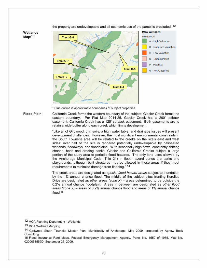
23
the property are undevelopable and all economic use of the parcel is precluded. 12
Wetlands Map:13
* Blue outline is approximate boundaries of subject properties.
Flood Plain: California Creek forms the western boundary of the subject; Glacier Creek forms the eastern boundary. Per Plat Map 2014-25, Glacier Creek has a 200’ setback easement; California Creek has a 125’ setback easement. Both easements are to retain a wide buffer along each creek which limits development.
“Like all of Girdwood, thin soils, a high water table, and drainage issues will present development challenges. However, the most significant environmental constraints in the South Townsite area will be related to the creeks on the site’s east and west sides: over half of the site is rendered potentially undevelopable by delineated wetlands, floodways, and floodplains. With seasonally high flows, constantly shifting channel beds and eroding banks, Glacier and California Creeks subject a large portion of the study area to periodic flood hazards. The only land uses allowed by the Anchorage Municipal Code (Title 21) in flood hazard zones are parks and playgrounds, although built structures may be allowed in these areas if they meet requirements to minimize damage from flooding.” 14
The creek areas are designated as special flood hazard areas subject to inundation by the 1% annual chance flood. The middle of the subject sites fronting Korolius Drive are designated as other areas (zone X) – areas determined to be outside the 0.2% annual chance floodplain. Areas in between are designated as other flood areas (zone X) – areas of 0.2% annual chance flood and areas of 1% annual chance flood.15
12 MOA Planning Department - Wetlands 13 MOA Wetland Mapping. 14 Girdwood South Townsite Master Plan, Municipality of Anchorage, May 2009, prepared by Agnew Beck Consulting. 15 Flood Insurance Rate Maps, Federal Emergency Management Agency, Panel No. 1559 of 1975, Map No. 0200051559D, September 25, 2009.
Tract F-3
Tract G-7
Tract G-6
Tract E-4
Tract D-5

24
Flood Plain Map: 16
16 Girdwood South Townsite Master Plan, Municipality of Anchorage, May 2009, prepared by Agnew Beck Consulting.
Tract F-3
Tract G-7
Tract G-6
Tract D-5
Tract E-4

25
Flood Plain Map Cont.: 17
Flood Plain Map Description: 18
The floodway area is shaded pink. Development is this area is severely restricted. The floodway areas are primarily located within the creek setbacks which already limits development. The yellow area is the flood fringe area where development is allowed but controlled. A separate flood hazard permit is required and there may be specific development requirements. Both the pink and yellow areas are part of the 1% annual chance flood or commonly known as the 100 year flood. The blue area is the 0.2% annual chance flood (500 year flood) as mapped by FEMA. This area is not regulated.
In term of soils and topography, Tracts G-6, G-7, and F-3 consists of two distinct components that contribute to the value of the whole at different rates (wetlands and uplands). For the purpose of the analysis, I roughly allocated the components in the following grid. We further allocated the uplands component by allocating a percentage located within creek setback(s) and/or 100 year floodplain where extraordinary site preparation is required for development.
Tract AC Wetlands Uplands 100 Yr. Flood / Creek Setback G-6 14.838 20% 80% wetland component w/in creek setback G-7 20.342 15% 85% wetland component w/in creek setback F-3 10.456 25% 75% 75% uplands w/in 100 yr. floodplain E-4 34.486 0% 100% 80% uplands w/in 100 yr. floodplain D-5 14.363 0% 100% 50% uplands w/in 100 yr. floodplain
Easements / Encumbrances:
We were not provided with a title report. The following easements are noted on Plat Map No. 2014-25:
200’ stream bank setback from Glacier Creek (Iditarod National Historic Trail and associated setbacks are located entirely within the 200’ Glacier Creek setback)’
125’ California Creek Centerline setback;
Each tract is subject to typical peripheral utility easements (telephone and electricity) ranging in size from 10’ to 20’ wide;
Korolius Drive is an 80’ wide right-of-way. It is a partially improved gravel road which terminates at Silver Fern Circle where it turns into a narrow trail. From
17 Maps provided by Steven Ellis, Flood Hazard Administrator, Watershed Management Services, Public Works 9907-343-8078). 18 Maps provided by Steven Ellis, Flood Hazard Administrator, Watershed Management Services, Public Works 9907-343-8078).
Floodway
100 Yr. Flood
500 Yr. Flood

26
Silver Fern Circle, it is dedicated, but not improved.
Juniper Drive is a 60’ wide dedicated (not improved) right-of-way located between Tracts F-3 and G-7.
While the creek setbacks reduce the useable area and confine development, they are either classified wetlands and/or located within the 100 year floodplain. Regardless, given requirements for set-backs, buffers and open-space, it is likely they can be incorporated into a development as contributory elements.
Zoning / Public Restrictions:
Tracts D-5 and G-6 are zoned GC-5 (New Townsite South Commercial District). This district is intended primarily for commercial development; however, residential and recreational uses are also allowed. No commercial uses currently exist in the South Townsite area, but the intent of this zoning designation is to encourage a blend of commercial, institutional, and recreational uses that will, over time, anchor an active mixed-use core area.
The remaining tracts (Tracts E-4, F-3, and G-7) are zoned GCR-1 (Girdwood Commercial Recreation), with original intent to allow development of a golf course and facilities associated with a golf course. Other possible uses include Nordic ski trails, campground or RV park and other activities related to commercial recreation development.
“No housing or commercial development shall be constructed until after the golf course is constructed”.19
“An 18-hole golf course was proposed for the valley near Alyeska Resort in 1999. However, the development of the golf course was reportedly blocked by environmental groups.” 20
The appraisal is developed according to the hypothetical condition that the (3) tracts zoned GCR-1 (Girdwood Commercial Recreation) are rezoned to GC-5 (New Townsite South Commercial).
Given the setback location, the subject tracts are most suitable for residential use.
Private Restrictions:
None noted.
Environmental Issues:
I developed the appraisal according to the extraordinary assumption that there are no environmental issues affecting the property.
Conclusion: The subject tracts are well-located in Girdwood, south of the New Townsite, with public sewer available. The majority of the tracts have adequate access; Tract F-3 has fair access (trail).
However, the development challenges are significant given the wetland classifications, floodplains, creek setbacks, and distance from existing water and gas lines. Absent a fill permit and the necessary inputs from qualified engineers and contractors, what is possible, permissible and feasible are speculative unknowns.
19 Anchorage, AK Code of Ordinances, 21.09.040 Zoning Districts. 20 A Market Analysis Evaluating Potential for Real Estate Sales Within a New Destination Resort in Girdwood, AK – prepared by Peterson Economics, May 19, 2006.

27
REAL ESTATE TAXES AND ASSESSMENTS
The subject properties are identified as follows:
Tract MOA Tax ID # AC SF D-5 075-063-90 14.363 625,358 E-4 075-102-44 34.486 1,502,202 F-3 075-101-43 10.456 455,485 G-6 075-062-60 14.838 646,325 G-7 075-062-61 20.342 886,080
All tracts are owned by the Municipality of Anchorage and are exempt.
Outstanding taxes or assessments are liens. Verification and reporting is a function of
preliminary title reports. We were not provided with a title report. We develop our value
opinion as if free and clear.

28
PART IV – ANALYSES AND CONCLUSIONS

29
MARKET ANALYSIS MARKET ANALYSIS The Appraisal Institute recognizes two categories of market analysis: inferred and
fundamental. Given the property type and stable market conditions, an inferred demand
analysis is appropriate. Demand is inferred from general market conditions and the data
selected for direct comparison. GIRDWOOD MARKET OVERVIEW “Girdwood’s real estate market is small and modest. It is Anchorage’s premier ski-oriented
second-home community and is a small retirement and/or primary home community.
Nearly all residents and second-home owners have close ties to Anchorage, and some
primary homeowners commute to Anchorage on a daily basis. Girdwood provides a quiet,
peaceful, and scenic refuge for Anchorage residents, who enjoy its proximity and recreation
opportunities.”21
Existing Construction Sales (reported by MLS) Sources of housing demand include population growth and the seasonal 2nd home market. A
10-year history of existing construction in the subject’s area (101 – Girdwood/Turnagain
Arm) is shown as follows:
Year # Sold Avg. List Price Avg. Sold Price % Sold Price of List Price Avg. DOM 2005 13 $304,446 $296,607 97% 35 2006 20 $414,290 $403,078 97% 42 2007 31 $430,883 $413,879 96% 103 2008 13 $433,376 $417,730 96% 127 2009 15 $422,066 $401,845 95% 182 2010 30 $392,230 $381,563 97% 88 2011 24 $355,112 $346,362 98% 105 2012 27 $370,974 $364,903 98% 103 2013 33 $416,951 $406,269 97% 48 2014 33 $397,933 $388,929 98% 74
New Construction Sales (reported by MLS) A 10-year history of new construction in the subject’s area (101 – Girdwood/Turnagain Arm)
is shown as follows:
Year # Sold Avg. List Price Avg. Sold Price % Sold Price of List Price Avg. DOM 2005 2 $572,500 $567,500 99% 0 2006 2 $397,500 $397,500 100% 0 2007 3 $681,000 $669,975 98% 176 2008 4 $604,895 $577,300 95% 117 2009 0 $0 $0 n/a 0 2010 1 $354,900 $345,500 97% 124 2011 1 $595,000 $580,000 97% 1 2012 0 $0 $0 n/a 0 2013 0 $0 $0 n/a 0 2014 0 $0 $0 n/a 0
21 “A Market Analysis Evaluating Potential For Real Estate Sales Within A New Destination Resort In Girdwood, Alaska” prepared for National Development Council, prepared by Peterson Economics, May 19, 2006, Project No. 115.

30
The data shows stable sales volumes but indicate that there is some price resistance.
Mr. Bryan Epley of Remax Alyeska reported that the Alyeska market has remained stable
due to the limited supply. Favorable conditions (primarily for residential properties) are
evidenced by short market exposure times and often multiple offers supporting 100% of
asking prices.22
In general, market conditions for housing (for both primary residences and second homes)
are favorable.
Vacant Land Sales (reported by MLS) A 10-year market history of vacant land sales in the subject's area (101 - Girdwood /
Turnagain Arm) is shown as follows:
Year # Sold Avg. List Price Avg. Sold Price % Sold Price of List Price Avg. DOM 2005 11 $154,154 $147,809 96% 23 2006 10 $178,950 $172,350 96% 78 2007 8 $177,725 $171,112 96% 106 2008 5 $162,180 $166,000 102% 162 2009 15 $166,466 $153,033 92% 249 2010 11 $172,827 $156,740 91% 82 2011 8 $136,250 $130,375 96% 139 2012 6 $129,150 $119,750 93% 342 2013 12 $146,458 $128,468 88% 372 2014 9 $109,500 $99,555 91% 209
* Because the data does not distinguish between different types of vacant land use (commercial, residential, etc.) the average sales prices may be slightly skewed.
Since 2010 +, MLS reported (46) land sales in the Girdwood/Turnagain Arm area (see
Addenda). Of those (46) sales, (8) were > 1 acre in size with the largest being 2.77 acres.
Only (3) were located in Girdwood with the remaining (5) being located in Indian.
Active listings (as of February 11, 2015) in the general area are presented in a table on the
following page:
22 Bryan Epley of Remax Alyeska (907-783-2010).

31
MLS #
Address
Sale Date List $ Sale $ AC SF Ask $/SF DOM 15-677 L15 Seward Indian active $225,000 active 3.31 143,992 $1.56 23 10-11382 L13 B26 Vail Girdwood active $149,000 active 0.36 15,797 $9.43 1,618 11-579 L4 B1 Girdwood Girdwood active $179,000 active 0.15 6,500 $27.54 1,439 12-07632 L12 B25 Timberline Girdwood active $159,000 active 0.41 18,072 $8.80 960 13-7656 L96B Hottentot Girdwood active $115,000 active 0.26 11,373 $10.11 622 14-1867 0 St Moritz Girdwood active $159,000 active 0.44 19,274 $8.25 359 14-3315 L45 Crow Creek Girdwood active $112,500 active 0.35 15,180 $7.41 228 14-3402 L7 Rand Indian active $230,000 active 4.08 177,771 $1.29 318 14-7372 L2 Verbier Girdwood active $334,000 active 0.28 12,054 $27.71 264 14-7373 L3 Verbier Girdwood active $334,000 active 0.28 12,054 $27.71 264 14-7374 L4 Verbier Girdwood active $350,000 active 0.28 12,054 $29.04 264 14-7375 L7 Verbier Girdwood active $365,000 active 0.28 12,054 $30.28 264 14-12507 L43 Crow Creek Girdwood active $349,000 active 1.54 67,082 $5.20 180 14-16635 L22 Rand Indian active $145,000 active 2.62 114,258 $1.27 106 14-16636 L23 Rand Indian active $142,000 active 2.5 109,016 $1.30 85 14-16638 L29 Ledyard Indian active $130,000 active 2.94 128,027 $1.02 85 14-16639 L30 Ledyard Indian active $135,000 active 3.62 157,676 $0.86 85 14-16641 L31 Ledyard Indian active $130,000 active 2.56 111,364 $1.17 85 14-16642 L33 Ledyard Indian active $135,000 active 2.63 114,658 $1.18 85 14-16643 L34 Ledyard Indian active $130,000 active 3.28 142,881 $0.91 100 14-16645 L13 Rand Indian active $153,000 active 2.43 105,719 $1.45 85 14-16647 L14 Rand Indian active $186,000 active 2.57 111,967 $1.66 85 14-16649 L35 Ledyard Indian active $145,000 active 2.57 111,749 $1.30 85 15-1170 L9 Verbier Girdwood active $329,000 active 0.39 17,066 $19.28 14 Avg.
$200,854
72,818 $9.40 321
The data reflects an active market but like the residential market, it suggests there is
market resistance to price. Of the available Girdwood listings, only one is larger than 1 acre
in size (1.54 acres).
However, “...The Girdwood Valley is not large, being only six miles in length. The Girdwood
community will be sharing the valley with the resort / recreational areas. Consequently,
there will be limits to how far each can grow without placing detrimental effects on the
other.”23
"Girdwood is an attractive small town and a resort community surrounded by public land.
As in many other resort communities, privately owned developable land is a scarce
commodity. Girdwood, like the others, has experienced rapid and dramatic increases in
housing prices and a consequent shortage of housing options available to local residents." 24
Given a limited supply, developers have responded with higher density projects – there
have been several condominium projects completed since 2000+.
“The community of Girdwood, as well as the resort, has been built upon public land
disposals of the past. This method of community and resort growth will continue in the
23 Girdwood Area Plan – 1995; Housing, page 28. 24 Girdwood South Townsite Master Plan, Municipality of Anchorage, May 2009 – prepared by Agnew Beck Consulting.

32
future. Most undeveloped/uncommitted (leased or permitted lands are committed) is owned
by the State of Alaska or the Municipality of Anchorage (Heritage Land Bank).”25
The MOA Heritage Land Bank has several active (proposed public land disposal)
development projects in the Girdwood area. The following projects (including the subject)
represent potential additions of supply:
Subject Properties: "The South Townsite area, with its level, buildable terrain and
good access, offers a particularly good location for moderately priced housing.
Housing in this location offers the benefit of proximity to stores, restaurants, and
services, and residents spending will help support those businesses. The master
plan recommends a modest number of residential units (30 - 80 units) at moderate
densities (6 - 14 units per acre). This implies a focus on duplexes and tri-plexes,
cottage-style, single-family detached homes on land held in common and small
multi-family structures (4 - 8 unit buildings). The overall objective of the master
plan is to offer small market rate residences that are within the reach of people with
modest incomes - particularly local employees. Depending on the timing of new civic
and commercial development and the build-out of roads and infrastructure, this
housing would likely be offered in the third phase26 of the project. The issue of the
appropriate amount of housing in the area will be revisited for the southern portions
of the project area (Phase 427). This area is not likely to be served by roads and
therefore be developable for a number of years." 28
Crow Creek Road Parcels – referred as Holton Hills. Planning and development of
this 1,000-acre area was to be developed by the HLB and sold for development.
However, "this project is on hold and has not been recorded, due to the expensive
cost to develop (subdivision agreement, utilities, roads, etc.)."29
Glacier Winner-Creek Pre-Development – Winter Sports and Resort Economic
Feasibility Study. The Glacier-Winner Creek area in the upper-valley has the
potential for expanding new recreational opportunities to the area. As of 2007, an
update to this planning and development study has not been completed.
The subject area (South Girdwood Townsite) is the only upcoming addition to supply of
vacant land.
In general, nearly all of the larger (1 acre +) privately owned land has been subdivided and
recent availability has been rapidly absorbed. Given a limited supply, under-improved
properties are potential sources of developable land but at the current time, the supply is
extremely limited.
25 Girdwood Area Plan – 1995; Current Land Use Pattern, page 40. 26 Per the Girdwood South Townsite Master Plan, the 3rd Phase consists of subject Tracts G-6 and D-5. 27 Per the Girdwood South Townsite Master Plan, the 4th Phase consists of subject Tracts E-4, F-3, and G-7. 28 Girdwood South Townsite Master Plan, Municipality of Anchorage, May 2009 – prepared by Agnew Beck Consulting. 29 Susan Paine of HLB, February 18, 2015.

33
In summary, the demand for properties that are suitable for development exceeds the
supply; market conditions for vacant land are favorable in terms of growth potential.

34
HIGHEST AND BEST USE
Highest and best use is defined as “…the reasonably probable and legal use of vacant land
or an improved property that is physically possible, appropriately supported, and
financially feasible and that results in the highest value.”30
HIGHEST AND BEST USE “AS-VACANT” Permissible Use Legal restrictions, as they apply to the subject, include public restrictions (zoning), private
restrictions (conditions, covenants, & restrictions [CCR’s]), plat notes, and easements.
Public Restrictions Tracts D-5 and G-6 are zoned GC-5 (New Townsite South Commercial District). This
district is intended primarily for commercial development; however, residential and
recreational uses are also allowed. No commercial uses currently exist in the South
Townsite area, but the intent of this zoning designation is to encourage a blend of
commercial, institutional, and recreational uses that will, over time, anchor an active
mixed-use core area.
The remaining tracts (Tracts E-4, F-3, and G-7) are zoned GCR-1 (Girdwood Commercial Recreation), with original intent to allow development of a golf course and facilities
associated with a golf course. Other possible uses include Nordic ski trails, campground or
RV park and other activities related to commercial recreation development.
“No housing or commercial development shall be constructed until after the golf course is
constructed”.31
“An 18-hole golf course was proposed for the valley near Alyeska Resort in 1999. However,
the development of the golf course was reportedly blocked by environmental groups.” 32
The appraisal is developed according to the hypothetical condition that the (3) tracts zoned
GCR-1 (Girdwood Commercial Recreation) are rezoned to GC-5 (New Townsite South Commercial).
Given the setback location and general imbalance in supply-demand for residential building
sites; the most probable use of each tract is for residential cluster housing – subject to
feasibility with regard to public water and gas availability.
Private Restrictions No private conditions, covenants, and restrictions (CCR’s) are recorded.
30 Appraisal Institute, The Appraisal of Real Estate, 13th Edition 31 Anchorage, AK Code of Ordinances, 21.09.040 Zoning Districts. 32 A Market Analysis Evaluating Potential for Real Estate Sales Within a New Destination Resort in Girdwood, AK – prepared by Peterson Economics, May 19, 2006.

35
Plat Notes Peripheral and access street improvements shall be required to abutting streets along the
full tract frontage upon development of individual tracts within this subdivision.
Easements The creek setbacks effectively reduce the useable areas and confine development. However,
given requirements for set-backs, buffers and open-space, it is likely they can be
incorporated into a development as contributory elements.
Possible Uses The subject tracts are well-located in Girdwood, south of the New Townsite, with public
sewer available. Public water, gas, and electricity service would require line extensions.
The majority of the tracts have adequate access; Tract F-3 has fair access (trail). Portions
of tracts are designated wetlands and portions of the uplands are located within the 100
year floodplain and/or creek setbacks.
However, the development challenges are significant given the wetland classifications,
floodplains, creek setbacks, and distance from existing water and gas lines. The challenges
and uncertainties for development hinder marketability.
Feasible Use The feasibility of residential development is evidenced by an active market for lots and
acreage and numerous projects recently completed, underway, and proposed. The subject
parcels are large and have development challenges.
Maximally Productive Use Absent competing permissible and feasible uses, the highest and best use is speculation for
future conforming residential development.
However, the development challenges are significant given the wetland classifications,
floodplains, creek setbacks, and distance from existing water and gas lines. Absent a fill
permit and the necessary inputs from qualified engineers and contractors, what is possible,
permissible and feasible are speculative unknowns. Most Probable Buyer The most probable buyer is a developer.

36
VALUATION
The Appraisal Institute does not define a key lot approach but the concept is often applied
when an assignment requires value opinions for two or more similar sites/parcels in the
same area as of the same date of value. The technique is applied by selecting and
describing a representative “key-lot.” A value opinion is developed by direct sales
comparison. The key-lot value is then correlated to the other lots to develop unique values
based on differences in size, topography, etc.
For purpose of this analysis, Tract D-5 is the representative Key Lot. It is a 14.363 acre
tract that consists of 100% uplands but ±50% is located within the 100 year floodplain. The
tract is closest to public water, gas, and electricity.
Key Lot

37
VALUATION of the KEY LOT (Tract D-5) Sales comparison is the most common technique for valuing land and it is the preferred
method when comparable sales are available. Elements of comparison include:33
Property rights
Financing terms
Conditions of sale (motivation)
Expenditures immediately after purchase
Market conditions (sale date)
Physical characteristics
Zoning
Utility availability
Access
Location
Soils and topography
Size
Shape SUMMARY OF COMPARABLE SALES Data located in the Girdwood market is extremely limited; there are no similar type
properties that have sold since 2010 + (see Market Analysis). We identified recent sales of
similar size parcels suitable for residential uses that are located in the Anchorage market.
Comparable sales and listings selected for comparison are identified in the following table.
No. Address Status Date Sale Price AC SF $/SF DOM ♥
Key Lot Tract D-5, Girdwood South Townsite --- --- --- 14.363 ±625,358 --- ---
2020 1101 Boniface Pkwy Sold Jun-10 $7,150,000 26.12 ±1,137,788 $6.28 436 2506 NWC Muldoon & Creekside Sold Sep-13 $2,000,000 8.539 ±371,938 $5.38 212 2507 3510 E 80th Ave. Sold Jun-13 $915,000 4.38 190,989 $4.79 7 2612 NSN Whisperwood Park Dr. Sold Jun-13 $1,834,650 16.20 705,706 $2.60 0 2687 11240 Birch Rd. Sold Feb-13 $360,000 4.78 208,217 $1.73 222 2688 NSN Jerome Rd. Sold Aug-12 $175,000 4.55 198,050 $0.88 133
♥ Days on market
33 The Appraisal of Real Estate, 13th Edition, Appraisal Institute

38
DESCRIPTION OF THE COMPARABLES The comparables are identified in the previous table and on the map. The property
characteristics are summarized in the following comparison grid. Details are retained in
our work file.
CORRELATION (EXPLANATION OF THE ADJUSTMENTS) All of the comparables reflect arm’s length sales/acquisitions of the fee simple interest
(except where noted). Atypical motivations, if any, are recognized in the reconciliation.
The indicated unit values are already adjusted to a cash equivalent value (if required) and
for expenditures immediately after purchase (e.g. demolition or the cost-to-cure known
defects/deficiencies).
Quantitative Adjustments Market Conditions – After a rapid run-up, market prices for developable acreage peaked in
late 2006 / early 2007. The market does not support an adjustment for time within the
period bracketed by the dates of sale and the date of valuation. We did not apply a
quantitative adjustment for time. The impact of market conditions is recognized
qualitatively.

39
Qualitative Adjustments A sufficient number of paired-sales are not available from which to isolate reliable
adjustments for most inequalities. I correlated physical inequalities with qualitative
adjustments (superior, inferior, approximately equal) according to the following criteria:
Location
General data located in the Girdwood market is extremely limited; there are no similar type
properties that have sold since 2010 +. We identified recent sales of similar size parcels
suitable for residential uses that are located in the Anchorage market. We made no
adjustment for location given the unique characteristics of the Girdwood and various
Anchorage submarkets.
Size
A large lot clearly has an advantage over a smaller site that is otherwise identical. In
contrast, where the market recognizes a $/SF unit of comparison; the data confirms the
general trend - unit price ($/SF) decreases as parcel size increases. In other words; in terms
of unit price, a 20,000 SF parcel is generally superior to a 100,000 SF parcel - all other
characteristics being equal.
Shape/Configuration
The comparative analysis recognizes both the corner/interior lot characteristic as well as
the shape (frontage to depth). In general, a corner lot is superior to an interior lot and
parcels with high ratios of frontage-to-depth are superior to those that are comparatively
narrow and deep. Access, Topography, Soils, Utilities, Restrictions
The qualitative adjustments for other inequalities are based on the observations
summarized in the grid.
COMPARATIVE ANALYSIS I correlated the comparables in the following relative comparison analysis grid. An overall
net adjustment (<, >, ±) is applied to develop value indicators on the bottom line.

40
No. Key Lot #2020 #2506 #2507 #2612 #2687 #2688 Status --- Sold Sold Sold Sold Sold Sold
Address Tract D-5, Girdwood
South Townsite 1101 Boniface Pkwy NWC Muldoon &
Creekside Center Dr. 3510 E. 80th Avenue NSN Whisperwood
Park Drive 11240 Birch Road NSN Jerome Street Sale Price --- $7,150,000 $2,000,000 $915,000 $1,834,650 $360,000 $175,000 Date --- June 2010 September 2013 June 2013 June 2013 February 2013 August 2012 Size 625,358 SF 1,137,788 SF 371,938 SF 190,989 SF (net) 705,706 SF 208,217 SF 198,050 SF Indicated $/SF --- $6.28/SF $5.38/SF $4.79/SF $2.60/SF $1.73/SF $0.88/SF General Location
Neighborhood Girdwood South
Townsite
E Anchorage, mixed quality & condition
residential
E Anchorage, developing mixed use district close to goods
& services Lake Otis East; infill
development
NE Anchorage Residential; infill
development
Lower Hillside- Residential; infill
development
Lower Hillside- Residential; infill
development No adj. No adj. No adj. No adj. No adj. No adj.
Access Adequate; gravel Adequate; paved from
Boniface / Debarr Adequate; paved Adequate; paved Adequate; paved Adequate; paved Adequate; paved Superior Slightly superior Slightly superior Slightly superior Slightly superior Slightly superior
Topography Level, wooded at
grade Partially cleared, fairly
level Wooded, fairly level Wooded; level to moderate slope
Mostly cleared and level
Wooded, level at grade
Wooded, level to gently rolling
Slightly superior Approx. = Slightly inferior Slightly superior Approx. = Approx. =
Soils
50% located w/in 100 year floodplain (creek
setback) Adequate
Adequate; small amount w/in 100 year
floodplain Adequate Appear to be
adequate Adequate Reported as poor Superior Slightly superior Superior Superior Superior Inferior
Utility Availability
Electricity and public sewer available;
public water and gas, service requires line extensions (±2,300’) [cost of ±$1,150,000] All available All available All available All available
Electricity, natural gas nearby; water and
sewer line extensions are reportedly feasible
Electricity, natural gas nearby
Far superior Far superior Far superior Far superior Slightly superior Slightly inferior
Size 625,358 SF 14.363 AC
1,137,788 SF 26.12 AC
371,938 SF 8.539 AC
190,989 SF (net) 4.38 AC (net)
705,706 SF 16.20 AC
208,217 SF 4.78 AC
198,050 SF 4.55 AC
Slightly inferior Slightly superior Superior Approx. = Superior Superior
Shape: Corner/interior
Irregular minor corner lot L shaped
Irregular; minor corner parcel
Rectangular corner parcel
Irregular; minor corner parcel
Rectangular minor corner
Rectangular interior lot
Front to depth Adequate frontage to
depth Adequate High frontage to
depth Adequate Adequate Narrow and deep Adequate Approx. = Slightly superior Slightly superior Approx. = Slightly inferior Slightly inferior
Restrictions Zoning GC-5 R-3 R-3 R-1 R3/R4 R-6 R-6
Suitability Moderate density
(8-20 units/Ac) Medium density (15-40 units/Ac)
Medium density (15-40 units/Ac)
Single Family (< 5 units/Ac
Medium to high density
Low density (1 unit/Ac)
Low density (1 unit/Ac)
Approx. = Approx. = Inferior Superior Inferior Inferior
Amenities Creek; partial ski
resort views None None None None None None Inferior Inferior Inferior Inferior Inferior Inferior
Other Bisected by utility
easements None None Suspect conditions of
sale N/A N/A Slightly inferior Approx. = Approx. = Inferior Approx. = Approx. =
Indicated $/SF --- < $4.79/SF < $5.38/SF < $4.79/SF < $2.60/SF > $1.73/SF > $0.88/SF

Black-Smith, Bethard & Carlson, LLC 41
Reconciliation – Key Lot Value The data generates an overall range of unit values from $0.88 to $5.38/SF. The relative
market position of the subject is isolated in the following table.
Comp. # $/SF Reconciliation
2506 ▼ $5.38 Clearly superior.
2020 ▼ $4.79 Offsetting characteristics; most weight given to soils, utilities, and paved access.
2507 ▼ $4.79 Offsetting characteristics; most weight given to soils, utilities, and paved access.
2612 ▼ $2.60 Clearly superior despite reported conditions of sale. Key Lot
2687 ▲ $1.73 Offsetting characteristics; most weight given to inferior zoning (low density). 2688 ▲ $0.88 Clearly inferior.
Acknowledging the net qualitative adjustments (<, >, and ±), the analysis develops a
narrower range from $1.73 to $2.60/SF.
Giving most weight to the subject’s size and unique set of development challenges, the
value of the key lot is fairly represented nearer the bottom of the range at $1.75/SF.
CORRELATION OF THE KEY LOT
Key Lot (Tract D-5) Tract G-6 Tract G-7 Tract E-4 Tract F-3
Size 14.363 AC 625,358 SF
14.838 AC 646,325 SF
20.342 AC 886,080 SF
34.386 AC 1,502,202 SF
10.456 AC 455,485 SF
--- Approx. = Approx. = Inferior Approx. =
Access
Minor corner lot on Egloff Dr. (gravel) and Korolius Dr.
(dirt); overall, access is adequate
Minor corner lot on Egloff Dr. (gravel) and Korolius Dr.
(dirt); overall, access is adequate
Adequate from Korolius Dr. (dirt)
Adequate from Korolius Dr. (dirt) Trail access
--- Approx. = Slightly inferior Slightly inferior Inferior
Soils No wetlands;±50% is located w/in 100 year
floodplain (creek setback)
20% wetlands (class A); 80% uplands
15% wetlands (class A); 85% uplands
No wetlands; ±80% located w/in 100 year
floodplain (creek setback)
25% wetlands (class A); 75% uplands, of the uplands, 75% is
w/in 100 year floodplain
--- Inferior Inferior Slightly inferior Inferior
Utility Availability
Electricity and public sewer available;
public water and gas service requires line extensions (±2,300’)
Same Line extensions of ±6,300’
Line extensions of ±6,300’
Line extensions of ±10,300’
--- Approx. = Inferior Inferior Far inferior
Indicated $/SF $1.75/SF < $1.75/SF < $1.75/SF < $1.75/SF < $1.75/SF
The correlation of the key lot value indicates that the remaining subject tracts are all less
than the $2.25/SF indicator based on their inferior characteristics. Quantitative
adjustments are suggested by the data on the following pages:

Black-Smith, Bethard & Carlson, LLC 42
Prospective buyers generally evaluate alternatives in terms of the available utility. Where
wetlands are recognized as unusable, they often contribute nothing to the value of
commercial or industrial land. However, the subject is zoned for residential uses and
absent certainty that the wetlands are undevelopable, there is some speculative potential
that:
Permits for fill and a creek crossing could be obtained
They could contribute as an open-space amenity
That mitigation needs would support a price
Absent adequate data, appraisers and users of appraisals generally recognize the value of
low-utility properties (e.g., wetlands, tidelands) at a fraction of the market-supported unit
value of adjacent developable properties. For example; historic paired-sales analyses of
upland-tideland relationships support a general range from 15% to 30%. Fraction/Factor – price for challenged sites as a % of the price of developable sites A wide range of factors from 0% to 50% is suggested by the prospects for development in the
foreseeable future. A zero probability may not be unreasonable but it does not account for
the long term speculative prospects. Where the market accepts the speculative risk but the
unknowns are significant as well as the time and cost of securing entitlements; the
probability of development in the near term is less than 50%. Narrowing the range is aided
by the following comparisons; details are retained in our work file. Comparison 1
Prices for developable multi-family parcels in 2006 generally ranged from $3.42 to
$8.49/SF. MLS #05-106202 (shaded) was an October 2006, open-market acquisition of a 5-
acre parcel zoned for multi-family use. Nearly all of it is within the flood plain and wetland
delineations. It was acquired by Wal-Mart for wetland mitigation. The listing agent
(Andrea Gribbin, Prudential Jack White RE (907-562-6464) reported that it would be
dedicated as park land. The reported price was at $2.53/SF.
Ref. # Location Zoning Status Acres SF CEV $/SF #05-106202 Lore Road R-2A Oct-06 5 217,800 $550,000 $2.53
1218 SEC Arctic & 46th R-3 Mar-06 8.66 377,000 $3,202,000 $8.49
1543 Tract S Independence Park R-3 Jun-06 4.37 190,176 $649,500 $3.42
1501 2921 W. Intl. Airport Rd R-4 Sep-06 2.24 97,738 $740,000 $7.57
1545 7880 Nadine Street R-2M Sep-06 2.17 94,672 $525,000 $5.55
Excluding #1543 (price skewed by poor soils conditions [deep peat]), the price of the wetland
parcel ranged from 30% to 46% of the upland parcels. Comparison 2
The sales of two lots that characterize the in-fill development pattern of older subdivisions
are summarized in the following table.
MLS # Location Zoning Status SF $
11-11874 Southwood Park R-1 Sold: Nov-11 7,000 $55,000
11-11876 Southwood Park R-1 Sold: Nov-11 7,000 $55,000

Black-Smith, Bethard & Carlson, LLC 43
The following properties in the paper-platted subdivisions near Dimond Boulevard and
Minnesota Drive sold at about the same time. The area is classified as “B” wetlands.
Access is not developed and public utilities are not immediately available. Lots in these
subdivisions have been marketed for years as speculative investments.
MLS # Location Zoning Status SF $
10-9957 Laurel Acres R-1 Sold: Aug-10 8,750 $13,500
10-9179 Patricia Sub R-1 Sold: Apr-11 9,580 $11,800
A mid-range price ($12,650) equates to 23% of the prices reflected by the preceding sales
($55,000).
Comparison 3
A 2009 sale of an in-fill lot is summarized in the following table:
MLS # Location Zoning Status SF $
08-15191 Aurora Heights R-1 Sold: Apr-09 9,267 $110,000
The following sales in the paper-platted subdivisions near Dimond Boulevard and
Minnesota Drive are similar in terms of time and size:
MLS # Location Zoning Status SF $
08-8247 Laurel Acres R-1 Sold: Apr-09 9,425 $16,000
08-8246 Laurel Acres R-1 Sold: May-09 9,424 $16,000
A price of $16,000 equates to 15% of the price reflected by the preceding sale ($110,000). Comparison 4
The following sales are similar in location and size. The upper end indicator is reflected by
a lot with paved access and all utilities. The average price ($11,900) of two lots in the same
subdivision with no road or utilities equates to only 10%.
MLS # Location Zoning Status SF $
10-4207 Patricia Sub R-1 Sold: Jun-10 10,250 $119,500
10-9179 Patricia Sub R-1 Sold: Apr-11 9,580 $11,800
10-9178 Patricia Sub R-1 Sold: Jan-14 11,677 $12,000

Black-Smith, Bethard & Carlson, LLC 44
Summary
Comparison Price for challenged sites as a % of developable site
price Notes
1 30 - 46% Because the intended use of the wetland parcel was preservation/conservation, the indicated range of factors is suspect.
2 3 4
23%
15%
10%
These factors are arguably understated because in addition to differences in access and soils/topography, the factor also accounts for the difference in the availability of public water and sewer
Absent a fill permit(s) and the necessary inputs from qualified engineers and contractors,
we applied a factor range from 10% to 40% to recognize the unique sets of challenges to
develop Parcels G-7, E-4, and F-3. For Parcel G-6, the only difference is the wetland ratio.
Therefore, we utilized a blended calculation of wetland / upland components of 88%.
Tract Characteristics % Factor Adj. $/SF Gross AC *
Gross SF **
Retail Value
D-5 (Key Lot)
Adequate access (Egloff & Korolius), no wetlands (50% w/in floodplain), utility ext. ±2,300'
$1.75 $1.75 14.363 625,358 $1,094,400
G-6 20% wetlands; all other characteristics are the same *** 88% $1.54 14.838 646,325 $995,400
G-7 Slightly inferior access, inferior soils (±15% wetlands), and utility ext. (±6,300’)
30% $0.53 20.342 886,080 $469,600
E-4 Larger size with slightly inferior access, soils (80% floodplain), and utility ext. (±6,300')
20% $0.35 34.486 1,502,202 $525,800
F-3 Inferior trail access, wetlands (25%), & utility ext. (±10,300') 10% $0.18 10.456 455,485 $82,000
* SF based on Plat Map No. 2014-25. ** Rounded to nearest $100. *** Blended rate: (20% wetlands x 40% factor = 8%) + (80% uplands x 100% factor = 80%)

Black-Smith, Bethard & Carlson, LLC 45
ADDENDA

Black-Smith, Bethard & Carlson, LLC 46

Black-Smith, Bethard & Carlson, LLC
LIMITING CONDITIONS AND ASSUMPTIONS
This appraisal report has been made with the following general assumptions: 1. No responsibility is assumed for the legal description provided or for matters pertaining to legal or title considerations. Title to the property is assumed to be good and marketable unless otherwise stated. 2. The property is appraised free and clear of any or all liens or encumbrances unless otherwise stated. 3. Responsible ownership and competent property management are assumed. 4. The information furnished by others is believed to be reliable, but no warranty is given for its accuracy. 5. All engineering studies (if any) are assumed to be correct. The plot plans and illustrative material in this report are included only to help the reader visualize the property. 6. It is assumed that there are no hidden or unapparent conditions of the property, subsoil, or structures that render it more or less valuable. No responsibility is assumed for such conditions or for obtaining the engineering studies that may be required to discover them. 7. It is assumed that the property is in full compliance with all applicable federal, state, and local environmental regulations and laws unless the lack of compliance is stated, described, and considered in the appraisal report. 8. It is assumed that the property conforms to all applicable zoning and use regulations and restrictions unless a nonconformity has been identified, described, and considered in the appraisal report. 9. It is assumed that all required licenses, certificates of occupancy, consents, and other legislative or administrative authority from any local, state, or national government or private entity or organization have been or can be obtained or renewed for any use on which the opinion of value contained in this report is based. 10. It is assumed that the use of the land and improvements is confined within the boundaries or property lines of the property described and that there is no encroachment or trespass unless noted in the report. 11. Unless otherwise stated in this report, the existence of hazardous materials, which may or may not be present on the property, was not observed by the appraiser. The appraiser has no knowledge of the existence of such materials on or in the property. The appraiser, however, is not qualified to detect such substances. The presence of substances such as asbestos, urea-formaldehyde foam insulation and other potentially hazardous materials may affect the value of the property. The value estimated is predicated on the assumption that there is no such material on or in the property that would cause a loss in value. No responsibility is assumed for such conditions or for any expertise or engineering knowledge required to discover them. The intended user is urged to retain an expert in this field, if desired.

Black-Smith, Bethard & Carlson, LLC
This appraisal report has been made with the following general limiting conditions: 1. Any allocation of the total value estimated in this report between the land and the improvements applies only under the stated program of utilization. The separate values allocated to the land and buildings must not be used in conjunction with any other appraisal and are invalid if so used. 2. Possession of this report, or a copy thereof, does not carry with it the right of publication. 3. The appraiser, by reason of this appraisal, is not required to give further consultation or testimony or to be in attendance in court with reference to the property in question unless arrangements have been previously made. 4. Neither all nor any part of the contents of this report (especially any conclusions as to value, the identity of the appraiser, or the firm with which the appraiser is connected) shall be disseminated to the public through advertising, public relations, news, sales, or other media without the prior written consent and approval of the appraiser. Additional Assumptions and Limiting Conditions: 1. Any opinions of value provided in the report apply to the entire property, and any proration or division of the total into fractional interests will invalidate the opinion of value, unless such proration or division of interests has been set forth in the report. 2. The client agency provided the area estimates for the larger parcel, area of the acquisition, and the remainder. Design changes, if any, that result in changes to those area estimates will require a modification of the appraisal. 3. The forecasts, projections, or operating estimates contained herein are based on current market conditions, anticipated short-term supply and demand factors, and a continued stable economy. These forecasts are, therefore, subject to changes with future conditions. 4. The Americans with Disabilities Act (ADA) became effective January 26, 1992. The appraiser has not made a specific compliance surveyor analysis of the property to determine whether or not it is in conformity with the various detailed requirements of ADA. It is possible that a compliance survey of the property and a detailed analysis of the requirements of the ADA would reveal that the property is not in compliance with one or more of the requirements of the act. If so, this fact could have a negative impact upon the value of the property. Since the appraiser has no direct evidence relating to this issue, possible noncompliance with the requirements of ADA was not considered in estimating the value of the property.

Black-Smith, Bethard & Carlson, LLC
QUALIFICATIONS OF APPRAISERS
Brian Z. Bethard, MAI
State Certification No. 281
General Education Service High School, Anchorage, Alaska - Graduate 1989 The Colorado College, Colorado Springs, CO - Bachelor of Arts, Economics 1993 University of Alaska, Anchorage, Anchorage, AK - MBA 1996
Employment History Black-Smith, Bethard & Carlson, LLC - Managing Member – 2005 + Black-Smith and Richards, Inc. - Fee Appraiser -1995 to 2005 Randall, Hayes, and Henderson, Inc. - Fee Appraiser -1993 to 1995
Appraisal Courses/Seminars Taken Residential Case Study - University of Alaska Anchorage - 1994 Uniform Residential Appraisal Report - Appraisal Institute - 1993 Standards of Professional Practice, Part A & B - Appraisal Institute - 1996 Advanced Sales Comparison & Cost Approaches - Appraisal Institute - 1997 Appraisal Principles & Procedures - Appraisal Institute - 1998 Highest and Best Use Market Analysis - Appraisal Institute - 1998 Advanced Applications and Market Analysis - Appraisal Institute - 1998 Report Writing and Valuation Analysis - Appraisal Institute, 1998 Advanced Income Capitalization, Course 510 - Appraisal Institute - 2000 Intro to Statistics & Supporting Adjustments - Appraisal Institute - 2002 Market Studies for Affordable Housing - NH&RA - 2002 Standards of Professional Practice - Appraisal Institute – 2002/03/04/05/07/09 Subdivision Analysis - Appraisal Institute – 2004 Rates & Ratios – Appraisal Institute – 2005 Principles of Real Estate Law – IRWA – 2005 Skills of Expert Testimony – IRWA – 2006 Analyzing Distressed Real Estate – AI – 2006 Condemnation Appraising – AI – 2007 Appraisal Challenges in Declining Markets – AI, 2009 Forecasting Revenue – AI, 2009 USPAP Update – AI, 2011 Yellow Book – AI, 2011 Appraisal Curriculum, General – AI, 2011 USPAP Update – AI, 2013 Real Estate Financing, Statistics & Value Modeling – AI, 2013 Certifications Alaska State Certification: General Real Estate Appraiser #281 Affiliations Member Appraisal Institute (Member No. 11857) President: Alaska Chapter Appraisal Institute – 2005 & 2006 Vice Pres: Alaska Chapter Appraisal Institute - 2004

Black-Smith, Bethard & Carlson, LLC
Typical Clients Appraisal Assignments Cook Inlet Housing Authority Various Multifamily, Land and Special Purpose Northrim Bank Attwood Building Rent Study, Anch., AK Alaska Housing Finance Corp. Kenai Senior Housing Market Study, Kenai, AK HDR Engineering Highlands Luxury Apartments, Anch., AK The Municipality of Anchorage The Veco Building, Anch., AK The City of Valdez City of Valdez Assessment, Valdez, AK Alaska Industrial Development & Export Authority Charter North Hospital, Anch., AK Wells Fargo Bank McKay Building, Anch., AK Key Bank Alaska DOT Building, Juneau, AK State of Alaska Department of Natural Resources Alyeska Pipeline Appraisal, Prudhoe - Valdez First National Bank Alaska 15th Avenue Extension ROW Project, Anch., AK Alaska First Bank Saint Paul Health Clinic, St. Paul, AK Denali Alaska Credit Union Residential Mortgage Building, Anch., AK Department of Justice Sprucewood Housing; 300 Units Eielson AFB

Black-Smith, Bethard & Carlson, LLC
QUALIFICATIONS OF APPRAISERS
MICHAEL A. FORSLAND Appraiser GENERAL EDUCATION Sacred Heart University, Fairfield, CT. Bachelor of Science – Business Admin., 2003
Dimond High School, Anchorage, Alaska – Graduate 1997 BUSINESS EXPERIENCE Black-Smith, Bethard and Carlson, LLC, Appraiser, January 2005 + Black-Smith and Richards, Inc., Appraiser, December 2003 – December 2004 Appraisal Courses Taken Course 320 – General Applications, Appraisal Institute, May 2007 Course 420 – Business Practices and Ethics, Appraisal Institute, June 2006 Course 410 – National USPAP 15-Hour Course, Appraisal Institute, June 2006 Course 310 – Basic Income Capitalization, Appraisal Institute, October 2005 Course 120 – Appraisal Procedures, Appraisal Institute, October 2004 Course 110 – Appraisal Principles, Appraisal Institute, October 2004 APPRAISAL EXPERIENCE Typical assignments include the appraisals of commercial retail and office properties,
industrial properties, medical and professional buildings, apartment buildings, remote
properties, vacant land, and subdivisions.

Black-Smith, Bethard & Carlson, LLC
Girdwood Land Sales since 2010 + (reported by MLS)
MLS #
Address
Zoning Sale Date List $ Sale $ AC SF $/SF DOM
09-06153 L3 B2 Muddy Dog/Alpha Girdwood gR-2A 3/4/10 $39,000 $29,000 0.96 41,951 $0.69 293
10-03113 L26 St Johann Girdwood gR-2 4/16/10 $179,000 $160,000 0.48 20,785 $7.70 36 10-04569 Lot 28 Rand Indian R11 4/19/10 $172,600 $165,000 2.71 117,958 $1.40 13 10-08624 L4 B22 Stowe Girdwood gR-4 6/24/10 $159,000 $157,500 0.28 12,384 $12.72 7 10-04480 L1 Indian Indian R11 7/20/10 $223,000 $213,000 2.4 104,650 $2.04 105 10-09557 152 Telemark Girdwood gR-1 7/24/10 $129,000 $110,000 0.2 8,890 $12.37 19 10-03118 201 Donner Girdwood gR-2 9/13/10 $114,500 $95,000 0.22 9,760 $9.73 189 10-12722 L1 Verbier Girdwood GRST-2 10/12/10 $351,000 $315,900 0.28 12,048 $26.22 32 10-11196 L2 B9 Timberline Girdwood gR-2 10/13/10 $185,000 $175,000 0.49 21,386 $8.18 68 10-08626 L5 B22 Stowe Girdwood gR-2 9/20/10 $160,000 $147,000 0.3 12,885 $11.41 78 10-13727 L39 B25 Vail Girdwood gR-2 12/7/10 $189,000 n/a 0.36 15,747 n/a 62 10-14537 L1 B19 Loveland Girdwood gR-2 1/25/11 $220,000 $195,000 0.28 12,274 $15.89 106 10-15101 L5 B11 Alta Girdwood gR-2A 2/25/11 $189,000 $180,000 0.49 21,406 $8.41 101 10-07378 L1 Juniper Girdwood gR-1 5/27/11 $119,000 $110,000 0.39 16,812 $6.54 366 11-03306 L32 Ledyard Indian R11 3/21/11 $185,000 $185,000 2.5 109,036 $1.70 0 11-06321 L6 B3 Crow Creek Girdwood gR-2A 8/6/11 $39,000 $36,000 0.35 15,329 $2.35 82 11-04609 L27 B3 Gold Girdwood gC-3 8/18/11 $59,000 $59,000 0.25 10,800 $5.46 97 11-11240 354 St Johann Girdwood gR-2 8/24/11 $130,000 $138,000 0.39 17,039 $8.10 4 10-14137 297 Echo Ridge Girdwood gR-2 10/14/11 $149,000 $140,000 0.37 16,140 $8.67 361 11-14244 L11 B24 Virgin Creek Girdwood gR-2 1/13/12 $179,000 $170,000 0.4 17,378 $9.78 64 12-08596 L13 B5 Taos Girdwood gR-4 7/6/12 $215,000 $215,000 0.29 12,500 $17.20 16
08-212 L86 Gunnysack Mine Girdwood gR-2 5/5/12 $89,000 $80,000 0.64 27,770 $2.88 1538
12-04650 L7 B1 Annex Girdwood gR-2A 7/4/12 $49,900 $42,000 1.42 61,855 $0.68 76 11-14696 L6 B1 East Girdwood gC-3 10/29/12 $42,000 $31,500 0.14 6,000 $5.25 332 12-14094 186 Loveland Girdwood gR-2 11/7/12 $200,000 $180,000 0.29 12,500 $14.40 26 08-10259 L2B Alyeska Girdwood gR-1 1/14/13 $100,000 $85,000 0.35 15,444 $5.50 1648 12-08302 0 Timberline Girdwood gR-2 2/13/13 $135,000 $135,000 0.3 12,949 $10.43 242
13-4895 L93 Treasure Box Mine Girdwood gR-2 4/17/13 $31,000 $31,000 0.19 8,366 $3.71 0
13-4050 L23 B2 Main Girdwood gC-3 4/2/13 $24,000 $20,000 0.08 3,600 $5.56 2 12-02854 L10 Rand Indian R11 10/16/12 $167,000 $145,000 2.53 110,276 $1.31 129 13-347 L15 Alyeska Girdwood gR-1 2/25/13 $168,000 $155,000 0.77 33,600 $4.61 46 13-6561 0 Doran Girdwood gR-1 5/14/13 $45,000 $44,650 0.11 4,950 $9.02 0 12-12104 L1 B25 Vail Girdwood gR-2 4/7/13 $155,000 $145,000 0.37 15,909 $9.11 225 13-3698 L34 Alyeska Girdwood gR-1 6/27/13 $240,000 $210,000 1.42 61,954 $3.39 93 12-14586 L9 Verbier Girdwood GRST-2 5/9/13 $375,000 $337,500 0.39 17,066 $19.78 190 09-02729 Mi 100.4 Seward Indian R11 11/23/13 $119,500 $105,000 2.5 108,900 $0.96 1719 10-15904 L20 B28 Echo Ridge Girdwood gR-2 12/20/13 $124,500 $105,000 0.53 22,924 $4.58 1092 14-2570 333 Donner Girdwood gR-2 3/3/14 $149,500 $135,500 0.21 9,165 $14.78 18 13-16171 L4 B30 Saint Johann Girdwood gR-2A 3/26/14 $145,000 $137,500 0.34 15,001 $9.17 137 14-2573 L2 B15 Timberline Girdwood gR-2 3/5/14 $149,500 $135,000 0.34 14,945 $9.03 0 14-10618 L4 B2 Muddy Dog Girdwood gR-2A 5/8/14 $20,000 $20,000 1.49 65,017 $0.31 1 14-9003 L27 B3 Gold Girdwood gC-3 8/7/14 $59,000 $59,000 0.25 10,800 $5.46 47 13-1798 L1 Hightower Girdwood gC-6 8/13/14 $189,000 $169,000 0.2 8,589 $19.68 522 14-9015 L93 Hottentot Mine Girdwood gR-2 8/21/14 $49,000 $35,000 0.27 11,880 $2.95 66 14-17429 L102B US Survey Girdwood gR-2 12/16/14 $100,000 $100,000 0.45 19,768 $5.06 0 14-16633 L12 Ledyard Indian R11 1/13/15 $155,000 $155,000 2.66 115,673 $1.34 56 Avg.
$128,734
91,871 $7.68 223


![[013] ass 013 [1880]](https://img.pdfslide.us/doc/110x75/5695d38c1a28ab9b029e54d8/013-ass-013-1880.jpg)