Embed Size (px)
Citation preview
Nascimento & Mantesso-Neto. Speleological heritage in Brazil’s proposed...
Campinas, SeTur/SBE. Tourism and Karst Areas, 6(1), 2013.
27
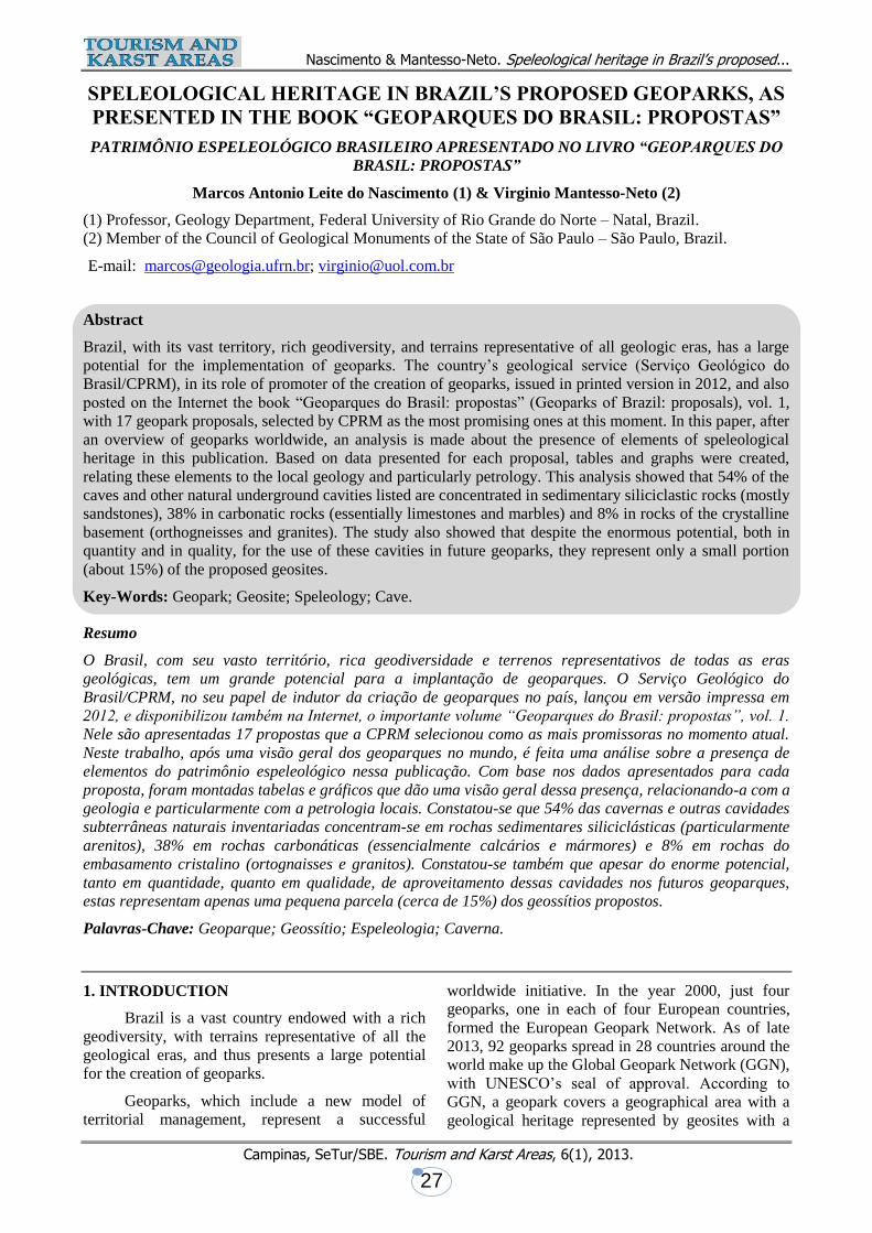
SPELEOLOGICAL HERITAGE IN BRAZIL’S PROPOSED GEOPARKS, AS
PRESENTED IN THE BOOK “GEOPARQUES DO BRASIL: PROPOSTAS”
PATRIMÔNIO ESPELEOLÓGICO BRASILEIRO APRESENTADO NO LIVRO “GEOPARQUES DO
BRASIL: PROPOSTAS”
Marcos Antonio Leite do Nascimento (1) & Virginio Mantesso-Neto (2)
(1) Professor, Geology Department, Federal University of Rio Grande do Norte – Natal, Brazil.
(2) Member of the Council of Geological Monuments of the State of São Paulo – São Paulo, Brazil.
E-mail: [email protected]; [email protected]
Abstract
Brazil, with its vast territory, rich geodiversity, and terrains representative of all geologic eras, has a large
potential for the implementation of geoparks. The country’s geological service (Serviço Geológico do
Brasil/CPRM), in its role of promoter of the creation of geoparks, issued in printed version in 2012, and also
posted on the Internet the book “Geoparques do Brasil: propostas” (Geoparks of Brazil: proposals), vol. 1,
with 17 geopark proposals, selected by CPRM as the most promising ones at this moment. In this paper, after
an overview of geoparks worldwide, an analysis is made about the presence of elements of speleological
heritage in this publication. Based on data presented for each proposal, tables and graphs were created,
relating these elements to the local geology and particularly petrology. This analysis showed that 54% of the
caves and other natural underground cavities listed are concentrated in sedimentary siliciclastic rocks (mostly
sandstones), 38% in carbonatic rocks (essentially limestones and marbles) and 8% in rocks of the crystalline
basement (orthogneisses and granites). The study also showed that despite the enormous potential, both in
quantity and in quality, for the use of these cavities in future geoparks, they represent only a small portion
(about 15%) of the proposed geosites.
Key-Words: Geopark; Geosite; Speleology; Cave.
Resumo
O Brasil, com seu vasto território, rica geodiversidade e terrenos representativos de todas as eras
geológicas, tem um grande potencial para a implantação de geoparques. O Serviço Geológico do
Brasil/CPRM, no seu papel de indutor da criação de geoparques no país, lançou em versão impressa em
2012, e disponibilizou também na Internet, o importante volume “Geoparques do Brasil: propostas”, vol. 1.
Nele são apresentadas 17 propostas que a CPRM selecionou como as mais promissoras no momento atual.
Neste trabalho, após uma visão geral dos geoparques no mundo, é feita uma análise sobre a presença de
elementos do patrimônio espeleológico nessa publicação. Com base nos dados apresentados para cada
proposta, foram montadas tabelas e gráficos que dão uma visão geral dessa presença, relacionando-a com a
geologia e particularmente com a petrologia locais. Constatou-se que 54% das cavernas e outras cavidades
subterrâneas naturais inventariadas concentram-se em rochas sedimentares siliciclásticas (particularmente
arenitos), 38% em rochas carbonáticas (essencialmente calcários e mármores) e 8% em rochas do
embasamento cristalino (ortognaisses e granitos). Constatou-se também que apesar do enorme potencial,
tanto em quantidade, quanto em qualidade, de aproveitamento dessas cavidades nos futuros geoparques,
estas representam apenas uma pequena parcela (cerca de 15%) dos geossítios propostos.
Palavras-Chave: Geoparque; Geossítio; Espeleologia; Caverna.
1. INTRODUCTION
Brazil is a vast country endowed with a rich
geodiversity, with terrains representative of all the
geological eras, and thus presents a large potential
for the creation of geoparks.
Geoparks, which include a new model of
territorial management, represent a successful
worldwide initiative. In the year 2000, just four
geoparks, one in each of four European countries,
formed the European Geopark Network. As of late
2013, 92 geoparks spread in 28 countries around the
world make up the Global Geopark Network (GGN),
with UNESCO’s seal of approval. According to
GGN, a geopark covers a geographical area with a
geological heritage represented by geosites with a
Nascimento & Mantesso-Neto. Speleological heritage in Brazil’s proposed...
Campinas, SeTur/SBE. Tourism and Karst Areas, 6(1), 2013.
28
unique scientific, educational or touristic value,
which are integrated into a holistic concept,
including protection, education and sustainable
development. In this area, various mechanisms are
created for the promotion of educational actions
aiming at the popularization of Geosciences, the
spreading of scientific knowledge, and the
conservation of the geological heritage, but also at
the creation of income-generating jobs. One of the
results of these actions is the development of the
practice of Geotourism, which helps in bringing
means of sustainable economic growth.
According to Schobbenhaus & Silva (2012a),
the Brazilian Geological Service/CPRM could not
be absent from this initiative. Being the most
important generator and holder of the geological
knowledge about Brazil, CPRM has also the role of
stimulating the proposition of new areas with
adequate potential for future geoparks. Based on that
premise, CPRM launched the Projeto Geoparques do
Brasil (Project Geoparks of Brazil) in 2006, and, as
one of its results, in 2012 published the book
“Geoparques do Brasil: propostas - Vol. 1”
(Geoparks of Brazil: proposals - Vol. 1)
(SCHOBBENHAUS & SILVA, 2012a), which
presents 17 geopark proposals already evaluated,
currently under the process of evaluation, or that will
in the near future be evaluated by CPRM itself or in
partnership with other institutions.
In these proposals a number of specific types
of geological interests are presented, being classified
into nine categories: stratigraphic,
geomorphological, tectonic, paleoenvironmental,
metallogenetic, paleontological, igneous,
mineralogical and, of course, speleological. Based
on this last category, the present paper aims at
giving a panoramic set of information about geosites
related to the speleological heritage, represented by
caves formed in different kinds of rocks, creating
unique geomorphological features. Another goal of
this paper is to emphasize the presence of examples
of speleological heritage in Brazilian proposed
geoparks.
2. GEOPARKS IN THE WORLD
Aiming at the reinforcement of projects of
conservation of the geological heritage, UNESCO,
after its 29th General Conference in 1997, started the
development of its Geoparks Program, based on four
European units. In that year, according to
MOREIRA (2011), an important European financing
program, Leader +, allowed the initial
materialization of the geopark concept, in
cooperation with UNESCO, in four countries: the
Natural Geological Reserve of Haute-Provence
(France), the Petrified Forest in Lesvos (Greece), the
Vulkanaifel Geopark (Germany) and the Maestrazgo
Cultural Park (Spain).
The Geoparks Program was presented to the
international scientific community in 1999, with the
characteristic of addressing the specific need for
acknowledgement and conservation of the
geological heritage, with the same kind of approach
that the Biosphere Reserve Program applies in its
dedication to the biological heritage. The program
deals with a series of locations with worldwide
geological interest based on the philosophical
approach expressed in the “Declaration of the Rights
of the Memory of the Earth” issued in Digne-les-
Bains, France, in 1991.
In 2000, the four areas that started the
program founded, under UNESCO’s assistance, the
European Geopark Network. However, in 2001,
UNESCO decided ”not to pursue the development of
a UNESCO geoparks programme, but instead to
support ad hoc efforts within individual Member
States as appropriate”. In this new context, in 2004,
during the 1st International Conference on
Geoparks, in Beijing, China, the Global Geopark
Network (GGN) was officially launched (Martini,
2010). This network was created to establish, with
UNESCO’s endorsement, a common platform for
cooperation and exchanges between specialists and
all those interest in the geological heritage.
According to UNESCO, “A geopark is a territory
with well-defined limits that has a large enough
surface area for it to serve local socio-economic
development. It comprises a certain number of
geological heritage sites (on any scale) or a mosaic
of geological entities of special scientific
importance, rarity or beauty, representative of an
area and its geological history, events or processes.
It may not solely be of geological significance but
also of ecological, archaeological, historical or
cultural value. A geopark serves to foster socio-
economic development that is culturally and
environmentally sustainable. This has a direct
impact on the area by improving human living
conditions and the rural environment, thus
strengthening identification of the population with
their area and triggering cultural renaissance.”
The Global Geopark Network, assisted by
UNESCO, has been spreading throughout the world,
reaching many countries where there is an interest in
the conservation and valuation of the geological
heritage. In its beginning, it had only four geoparks;
when officially created, in 2004, they were already
twenty. Presently (late 2013) it congregates 92
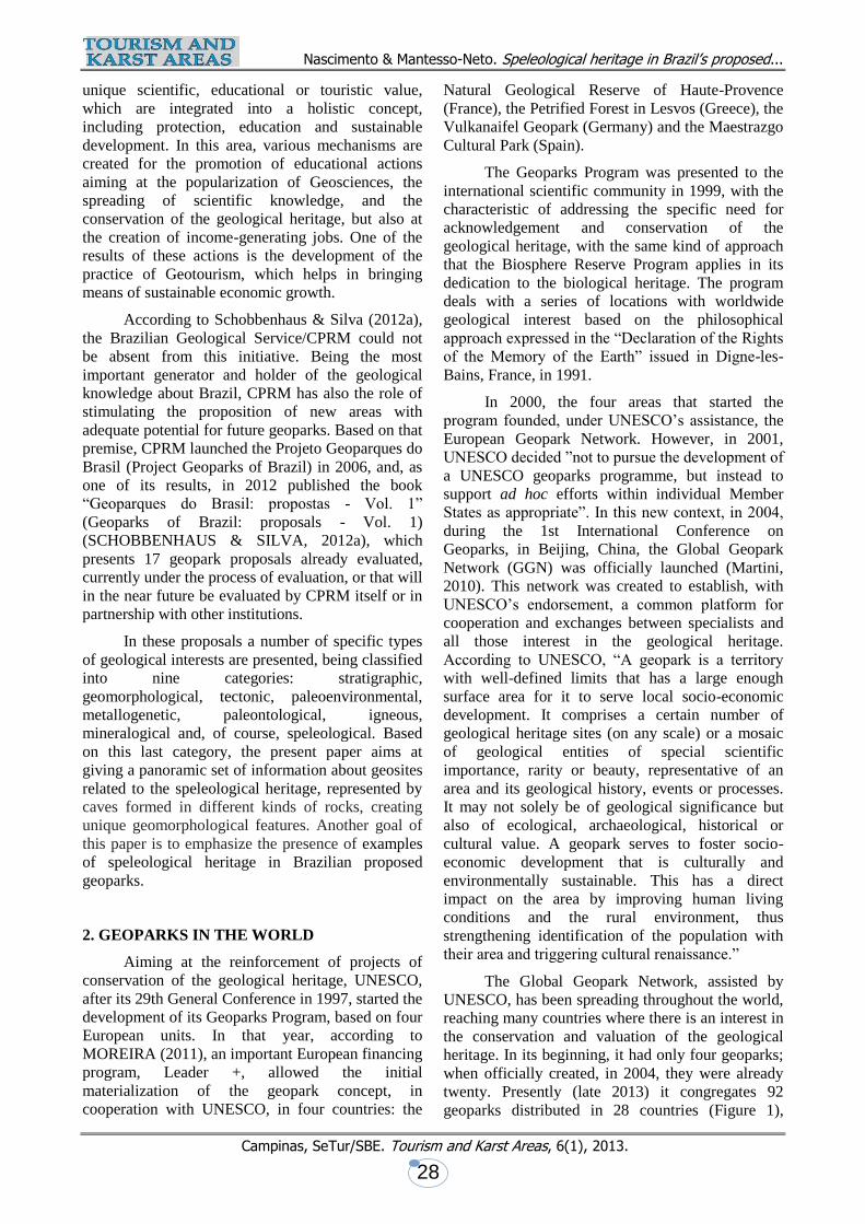
geoparks distributed in 28 countries (Figure 1),
Nascimento & Mantesso-Neto. Speleological heritage in Brazil’s proposed...
Campinas, SeTur/SBE. Tourism and Karst Areas, 6(1), 2013.
29
namely, in alphabetical order: Austria (2); Brazil (1);
Canada (1); China (27); Croatia (1); Czech Republic
(1); Finland (1); France (4); Germany (5 geoparks +
1 binational with Poland); Greece (4); Hungary (1 +
1 binational with Slovakia); Iceland (1); Indonesia
(1); Ireland (2 + 1 binational with Northern Ireland);
Italy (8); Japan (5); Malaysia (1); Northern Ireland
(1 binational with Ireland); Norway (2); Poland (1
binational with Germany); Portugal (3); Romania
(1); Slovakia (1 binational with Hungary); South
Korea (1); Spain (8); United Kingdom (6); Vietnam
(1).
There are 54 geoparks in 23 countries in
Europe, 36 in 6 countries in Asia, and 2 in the
Americas (http://en.globalgeopark.org/), being 1 in
Brazil, the Geoparque Araripe*, the first in the
American continent and also the first in the Southern
hemisphere (http://geoparkararipe.org.br/).
* NOTE: the names of the one existing
geopark and of the proposed ones in Brazil, as well
as the names of the geosites in all of them, will not
be translated, so as to allow searches, both in the
book “Geoparques do Brasil: propostas” and on the
Internet.
According to Brilha (2012), the Global
Geoparks Network has defined as main goals for the
geoparks which participate in it:
1. Conservation of the geological heritage;
2. Provision of education about geosciences and
environmental issues to the common citizen;
3. Sustainable socio-economic and cultural
development;
4. Multicultural cooperation;
5. Promotion of scientific investigation; and
6. Active participation in the network by means of
the development of common activities.
Fig. 1 - Map of the members of the Global Geoparks Network. Source:
http://en.globalgeopark.org/UploadFiles/2012_5_7/GGN%20Distribution%202013.04.23.jpg
Nascimento & Mantesso-Neto. Speleological heritage in Brazil’s proposed...
Campinas, SeTur/SBE. Tourism and Karst Areas, 6(1), 2013.
30
3. GEOPARKS IN BRAZIL
The Brazilian Geological Service/CPRM,
through its Departamento de Gestão Territorial
(Department of Territorial Management), launched
in early 2006 the Projeto Geoparques do Brasil
(Project Geoparks of Brazil) (SCHOBBENHAUS,
2006; SCHOBBENHAUS & SILVA, 2010;
SCHOBBENHAUS & SILVA, 2012a), under the
executive coordination of the geologist Carlos
Schobbenhaus and the regional coordination of the
representatives of the various regional offices of
CPRM. This project plays an important role as
inducer of the creation of geoparks in Brazil, and has
as its main objectives to identify, classify, describe,
catalog, georeference and publicize areas potentially
prone to become geoparks, as well as to contribute
to the definition of guidelines for their sustainable
development. According to SCHOBBENHAUS &
SILVA (2012a) the wealth of geological surveys
existing in the country and the experience
accumulated by the company’s technical body, as
well as the contribution of studies and proposals by
the geoscientific community, favor the development
of this project. In some cases, this inducing activity
in carried out in conjunction with researchers from
universities and other federal, state or municipal
organisms.
Brasil has an enormous potential for the
proposition of geoparks, because in its large
territory, a rich geodiversity - including
representatives from practically the whole geologic
history of the planet - can be found, plus non-
geologic sites of ecological, archaeological,
historical and cultural value. Important records
pertaining to all of these aspects, some absolutely
unique, represent part of the nation’s heritage, and
even of mankind’s heritage, and clearly deserve
being preserved (SCHOBBENHAUS; SILVA,
2012a).
Various proposals of geoparks have already
been evaluated, some are under evaluation, and
others are scheduled to be evaluated in the future as
part of the Projeto Geoparques (Geoparks Project).
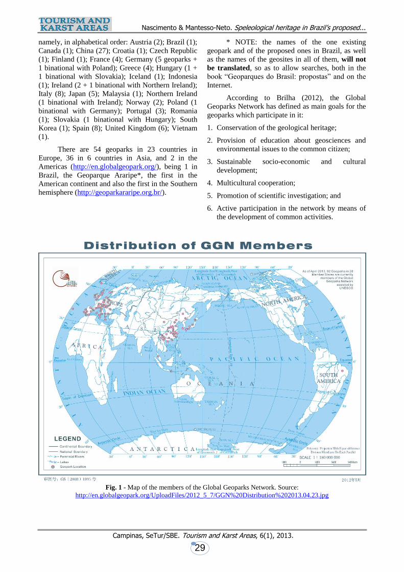
These proposals are indicated in the map in Figure 2
and in the list presented as Table 1. The technical
report of some of these proposals can be found in
digital form (in Portuguese) at
http://www.cprm.gov.br/publique/cgi/cgilua.exe/sys/
start.htm?sid=134. Such activities have been carried
out partly in partnership with federal, state or
municipal institutions, or with universities or private
institutions. Besides those mentioned in that list,
other proposals for geoparks exist: Campos Gerais
(Universidade Estadual de Ponta Grossa e Minérios
do Paraná-Mineropar - Ponta Grossa State
University and Mineropar, the Paraná state
geological service); Ciclo do Ouro (Prefeitura de
Guarulhos, São Paulo - Municipality of Guarulhos,
state of São Paulo); and Costões e Lagunas do Rio
de Janeiro (Serviço Geológico do Estado do Rio de
Janeiro - Diretoria de Recursos Minerais - Rocky
shores and lagoons of the state of Rio de Janeiro -
State of Rio de Janeiro Geological Service -
Department of Mineral Resources).
It is worth pointing out that in this initial stage
(Table 1) there are already proposals of geoparks in
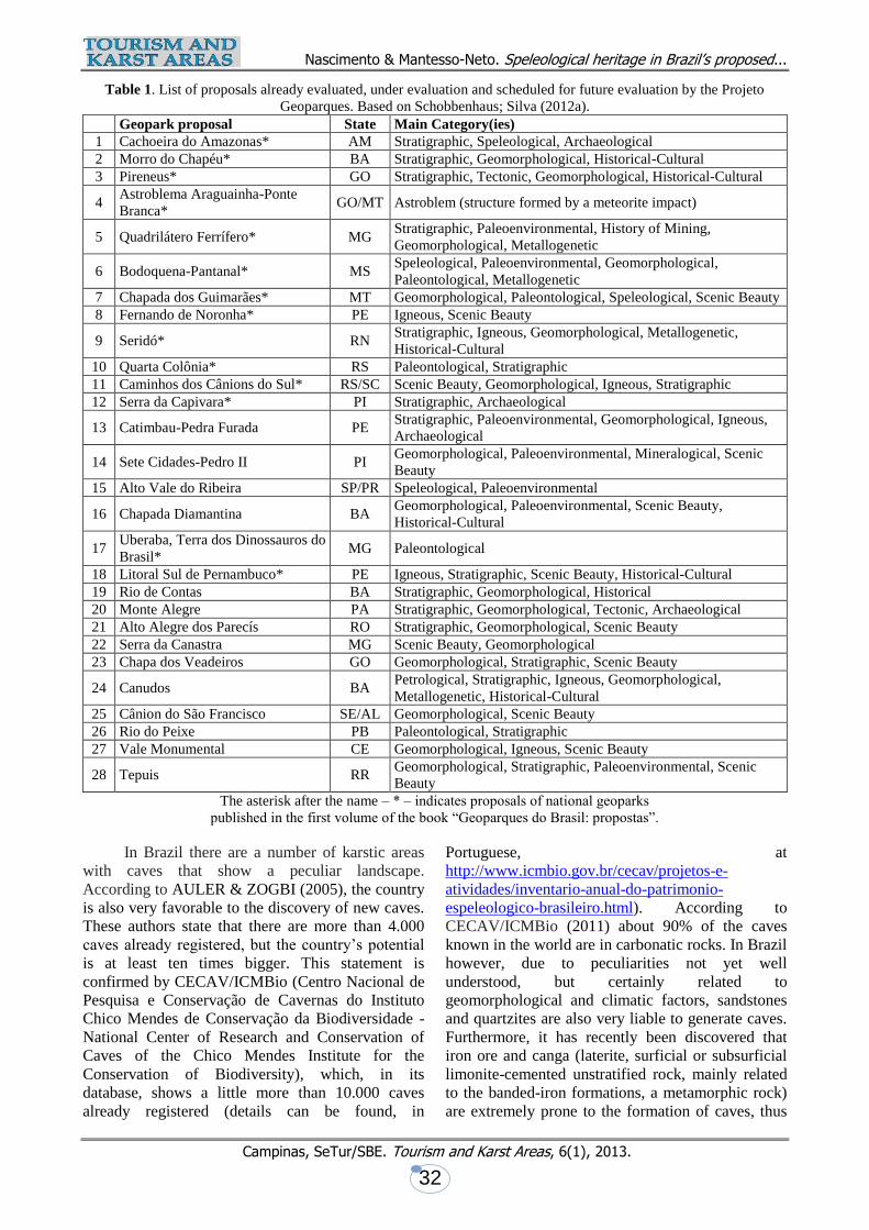
which speleology appears as a main category,
particularly the following: 01. Cachoeira do
Amazonas; 06. Bodoquena-Pantanal; 07. Chapada
dos Guimarães and 15. Alto Vale do Ribeira.
The practice of presenting geopark proposals
has been very well received in the academic
community, as well as in government offices at the
federal, state and municipal levels, in the private
sector of the economy, and by local populations.
These positive reactions allow this community, as
well as other interested groups, to believe that there
will be new geoparks established in Brazil in the
near future.
4. SPELEOLOGICAL HERITAGE
Speleological heritage can be defined as per
Artigo (Article) 5° (5th), inciso (item) I, of the
Brazilian Decreto (Decree) n° 99.556/90 as “the
array of biotical, abiotical, socio-economic and
historic-cultural, subterranean or surficial, elements
represented by natural subterranean cavities or
associated to such cavities”. In its abiotical
components, this kind of heritage is associated to the
geological heritage and usually refers to those
cavities that occur mainly in limestones and marbles,
but occasionally also in banded-iron formations,
sandstones, quartzites and granites.
According to CECAV/ICMBio (2011) the
most commonly used definition for cave is “a natural
opening formed in rock below the terrain’s surface,
large enough to allow a person to enter”. This
definition is adopted by the International Union of
Speleology - UIS, the international body that
congregates the various national institutions
dedicated to speleology and caving. The Brazilian
Decreto (Decree) n° 6.640/08, which partially
modifies the above mentioned Decreto (Decree) n°
99.556/90, theoretically eliminates the expression
“speleological heritage”, but this same expression in
used in its own text. It is clear, then, that there exists
a legal incongruence; that incongruence will not be
discussed here, as it is beyond our goals. As far as
this paper is concerned, since the expression
Nascimento & Mantesso-Neto. Speleological heritage in Brazil’s proposed...
Campinas, SeTur/SBE. Tourism and Karst Areas, 6(1), 2013.
31
“speleological heritage” is of general use by the
scientific and speleologic communities, and is
maintained in the most recent decree, it is considered
by the authors as acceptable. It will be used here, not
in a legal sense, but in the sense that it is normally
used in those communities, meaning, in broad terms,
“elements of speleological environments that
deserve being preserved”.
This same Decreto (Decree) n° 6.640/08
defines natural underground cavities as “any and all
subterraneous spaces, with or without an identified
opening, accessible to a human being, known by the
population as caverna, gruta, lapa, toca, abismo,
furna or buraco [*], including its environment,
mineral and water content, fauna and flora therein
found, and the rocky body in which they are located,
provided they have been formed by natural
processes, regardless of their size or type of rock in
which they occur”. [* these are various Brazilian
non-technical terms used to name natural
underground cavities].
Such cavities tend to be found mostly in
soluble rocks (carbonatic rocks, both sedimentary
and metamorphic), where they are generated
precisely by dissolution by water of some of the rock
components. Most typically, they are formed in
limestone (sedimentary rock) and marble
(metamorphic rock), in whose masses they generate
the karstic morphology. However, nowadays there is
a tendency to include siliceous rocks, particularly
quartzites (metamorphic) and sandstones
(sedimentary) in the group of karstifiable rocks.
Such a trend is the result of recent studies that show
that silica, until recently considered as a mineral of
low solubility, has played a more important role than
previously acknowledged in the generation of
surficial and subterraneous, typically karstic,
morphologies (CECAV/ICMBio, 2011). The
landscape generated in a karstic environment has a
number of characteristic features, some unique to
this environment. Along with the caves proper, large
exposed rock masses, walls, cliffs, valleys, towers,
depressions, dolines, sinkholes, lagoons,
speleothems (stalactites, stalagmites, helictites, cave
pearls, among others) make up a very scenic,
beautiful context.
Fig. 2 - Map with the geopark proposals already evaluated, under evaluation and scheduled for future evaluation by the
Projeto Geoparques. Based on Schobbenhaus; Silva (2012a)
Nascimento & Mantesso-Neto. Speleological heritage in Brazil’s proposed...
Campinas, SeTur/SBE. Tourism and Karst Areas, 6(1), 2013.
32
Table 1. List of proposals already evaluated, under evaluation and scheduled for future evaluation by the Projeto
Geoparques. Based on Schobbenhaus; Silva (2012a).
Geopark proposal State Main Category(ies)
1 Cachoeira do Amazonas* AM Stratigraphic, Speleological, Archaeological
2 Morro do Chapéu* BA Stratigraphic, Geomorphological, Historical-Cultural
3 Pireneus* GO Stratigraphic, Tectonic, Geomorphological, Historical-Cultural
4 Astroblema Araguainha-Ponte
Branca* GO/MT Astroblem (structure formed by a meteorite impact)
5 Quadrilátero Ferrífero* MG Stratigraphic, Paleoenvironmental, History of Mining,
Geomorphological, Metallogenetic
6 Bodoquena-Pantanal* MS Speleological, Paleoenvironmental, Geomorphological,
Paleontological, Metallogenetic
7 Chapada dos Guimarães* MT Geomorphological, Paleontological, Speleological, Scenic Beauty
8 Fernando de Noronha* PE Igneous, Scenic Beauty
9 Seridó* RN Stratigraphic, Igneous, Geomorphological, Metallogenetic,
Historical-Cultural
10 Quarta Colônia* RS Paleontological, Stratigraphic
11 Caminhos dos Cânions do Sul* RS/SC Scenic Beauty, Geomorphological, Igneous, Stratigraphic
12 Serra da Capivara* PI Stratigraphic, Archaeological
13 Catimbau-Pedra Furada PE Stratigraphic, Paleoenvironmental, Geomorphological, Igneous,
Archaeological
14 Sete Cidades-Pedro II PI Geomorphological, Paleoenvironmental, Mineralogical, Scenic
Beauty
15 Alto Vale do Ribeira SP/PR Speleological, Paleoenvironmental
16 Chapada Diamantina BA Geomorphological, Paleoenvironmental, Scenic Beauty,
Historical-Cultural
17 Uberaba, Terra dos Dinossauros do
Brasil* MG Paleontological
18 Litoral Sul de Pernambuco* PE Igneous, Stratigraphic, Scenic Beauty, Historical-Cultural
19 Rio de Contas BA Stratigraphic, Geomorphological, Historical
20 Monte Alegre PA Stratigraphic, Geomorphological, Tectonic, Archaeological
21 Alto Alegre dos Parecís RO Stratigraphic, Geomorphological, Scenic Beauty
22 Serra da Canastra MG Scenic Beauty, Geomorphological
23 Chapa dos Veadeiros GO Geomorphological, Stratigraphic, Scenic Beauty
24 Canudos BA Petrological, Stratigraphic, Igneous, Geomorphological,
Metallogenetic, Historical-Cultural
25 Cânion do São Francisco SE/AL Geomorphological, Scenic Beauty
26 Rio do Peixe PB Paleontological, Stratigraphic
27 Vale Monumental CE Geomorphological, Igneous, Scenic Beauty
28 Tepuis RR Geomorphological, Stratigraphic, Paleoenvironmental, Scenic
Beauty
The asterisk after the name ‒ * ‒ indicates proposals of national geoparks
published in the first volume of the book “Geoparques do Brasil: propostas”.
In Brazil there are a number of karstic areas
with caves that show a peculiar landscape.
According to AULER & ZOGBI (2005), the country
is also very favorable to the discovery of new caves.
These authors state that there are more than 4.000
caves already registered, but the country’s potential
is at least ten times bigger. This statement is
confirmed by CECAV/ICMBio (Centro Nacional de
Pesquisa e Conservação de Cavernas do Instituto
Chico Mendes de Conservação da Biodiversidade -
National Center of Research and Conservation of
Caves of the Chico Mendes Institute for the
Conservation of Biodiversity), which, in its
database, shows a little more than 10.000 caves
already registered (details can be found, in
Portuguese, at
http://www.icmbio.gov.br/cecav/projetos-e-
atividades/inventario-anual-do-patrimonio-
espeleologico-brasileiro.html). According to
CECAV/ICMBio (2011) about 90% of the caves
known in the world are in carbonatic rocks. In Brazil
however, due to peculiarities not yet well
understood, but certainly related to
geomorphological and climatic factors, sandstones
and quartzites are also very liable to generate caves.
Furthermore, it has recently been discovered that
iron ore and canga (laterite, surficial or subsurficial
limonite-cemented unstratified rock, mainly related
to the banded-iron formations, a metamorphic rock)
are extremely prone to the formation of caves, thus
Nascimento & Mantesso-Neto. Speleological heritage in Brazil’s proposed...
Campinas, SeTur/SBE. Tourism and Karst Areas, 6(1), 2013.
33
adding a new component to Brazil’s already
complex speleological matrix. There are also, albeit
in a lesser scale, caves in granites (igneous, plutonic
rocks), gneisses (metamorphic rocks) and other
metamorphic rocks such as micaschists and
phyllites, and even in soils. Table 2 shows, in a
preliminary version, the number of caves hitherto
identified in each lithology and the probable
speleological potential (caves not yet identified, but
considered as probably existent).
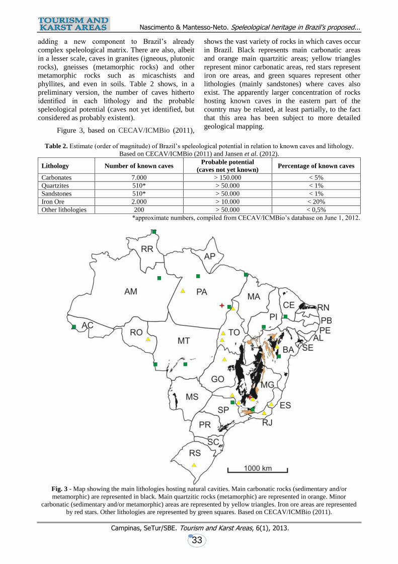
Figure 3, based on CECAV/ICMBio (2011),
shows the vast variety of rocks in which caves occur
in Brazil. Black represents main carbonatic areas
and orange main quartzitic areas; yellow triangles
represent minor carbonatic areas, red stars represent
iron ore areas, and green squares represent other
lithologies (mainly sandstones) where caves also
exist. The apparently larger concentration of rocks
hosting known caves in the eastern part of the
country may be related, at least partially, to the fact
that this area has been subject to more detailed
geological mapping.
Table 2. Estimate (order of magnitude) of Brazil’s speleological potential in relation to known caves and lithology.
Based on CECAV/ICMBio (2011) and Jansen et al. (2012).
Lithology Number of known caves Probable potential
(caves not yet known) Percentage of known caves
Carbonates 7.000 > 150.000 < 5%
Quartzites 510* > 50.000 < 1%
Sandstones 510* > 50.000 < 1%
Iron Ore 2.000 > 10.000 < 20%
Other lithologies 200 > 50.000 < 0,5%
*approximate numbers, compiled from CECAV/ICMBio’s database on June 1, 2012.
Fig. 3 - Map showing the main lithologies hosting natural cavities. Main carbonatic rocks (sedimentary and/or
metamorphic) are represented in black. Main quartzitic rocks (metamorphic) are represented in orange. Minor
carbonatic (sedimentary and/or metamorphic) areas are represented by yellow triangles. Iron ore areas are represented
by red stars. Other lithologies are represented by green squares. Based on CECAV/ICMBio (2011).
Nascimento & Mantesso-Neto. Speleological heritage in Brazil’s proposed...
Campinas, SeTur/SBE. Tourism and Karst Areas, 6(1), 2013.
34
It can be clearly seen that Brazil’s potential
speleological heritage is enormous. The main cave-
bearing areas are situated in an oblong zone, running
from NE to SW, parallel to the coast, with a higher
concentration covering center-W Bahia, eastern
Goiás and two branches running N-S crossing the
central portion of Minas Gerais. These areas are
mostly covered by limestones and dolomites of the
Bambuí Group (Auler & Zogbi, 2005;
CECAV/ICMBio, 2011). One of the most important
clusters, with more than 700 caves already
registered, is the region of Lagoa Santa (MG), which
can be considered as the cradle of Brazilian
speleology. The state of Bahia hosts the five longest
caves in the country (Table 3). Crossing the
easternmost boundary dividing the states of São
Paulo and Paraná there is another important cluster,
with more than 300 caves, formed in limestones and
dolomites of the Açungui Group. Most of those in
the state of São Paulo are situated inside the PETAR
(Parque Estadual Turístico do Alto Ribeira - Alto
Ribeira Touristic State Park), including Caverna
(Cave) Santana, one of the most famous caves in the
country, and Casa de Pedra (Stone House), the
tallest natural rock opening known in the country
(Figure 4); the caves in this region represent a
meaningful portion of the geological heritage of the
state, and of the country (MANTESSO-NETO et al.
2013).
In the NE region of the country, also
corresponding to the NE tip of the above mentioned
oblong zone in which are concentrated the main
cave-bearing areas, many caves exist, but really big
ones haven’t been found yet. In the state of Ceará
one of the best known is the Gruta de Ubajara,
situated in one of the country’s oldest national parks.
In Rio Grande do Norte, most caves are concentrated
between Felipe Guerra and Apodi; among them,
Casa de Pedra de Martins (Martins’ Stone House),
considered one of the biggest marble caves in the
country.
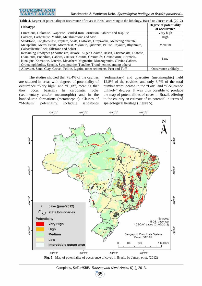
The map of potentiality of occurrence of
caves in Brasil, in the scale 1:2.500.000 was
published in 2012 (JANSEN et al. 2012). It is based
in a new methodology, in which, according to the
lithology, five classes of degree of potentiality are
established: Very high; High; Medium; Low; and
Occurrence unlikely (Table 4).
These classes were identified by the use of the
following criteria: a) data about emplacement of the
main karstic areas in Brazil; b) geological map of
Brazil, scale 1:2.500.000, by the Serviço Geológico
do Brasil/CPRM (Brazilian Geological Service),
with emphasis in the fields Litologia1 (Lithology1),
Litologia2 (Lithology2) and Nome da Unidade
(Name of Unit), of the “Tabela de atributos” (Table
of Attributes); c) geospatialized data from de caves
furnished by CECAV/ICMBio (on June 1st, 2012);
and d) bibliographical revision about the main
lithological formations of the cavities registered in
CECAV/ICMBio’s database.
Fig. 4 - Reaching a height of approximately 220m (720’)
and essentially corresponding to the collapsed descending
limb of a metamorphic limestone fold, Casa de Pedra
(Stone House), is the tallest natural rock opening known
in the country, and is possibly among the tallest in the
world. It is situated in the southern portion of the state of
São Paulo, in the PETAR Parque Estadual Turístico do
Alto Ribeira - Alto Ribeira Touristic State Park.
Photo by Lalo de Almeida.
Table 3. The 10 longest known caves in Brazil, according to CECAV/ICMBio (2011).
By order of length Municipality km / mi
1. Toca da Boa Vista* Campo Formoso (BA) 106,50 / 66.6
2. Toca da Barriguda Campo Formoso (BA) 33,30 / 20.8
3. Lapa Doce II Iraquara (BA) 16,50 / 10.3
5. Gruta do Padre Santana e Santa Maria da Vitória (BA) 16,40 / 10.3
5. Boqueirão Carinhanha (BA) 15,17 / 9.5
6. Lapa do Angêlica São Domingos (GO) 14,10 / 8.8
7. Gruna da Água Clara Carinhanha (BA) 13,88 / 8.7
8. Lapa do São Mateus III São Domingos (GO) 10,61 / 6.6
9. Lapa de São Vicente II São Domingos (GO) 10,13 / 6.3
10. Lapa Doce I Iraquara (BA) 10,00 / 6.3
*The Toca da Boa Vista is considered to be the 18th biggest cave in the world.
Nascimento & Mantesso-Neto. Speleological heritage in Brazil’s proposed...
Campinas, SeTur/SBE. Tourism and Karst Areas, 6(1), 2013.
35
Table 4. Degree of potentiality of occurrence of caves in Brasil according to the lithology. Based on Jansen et al. (2012)
Lithotype Degree of potentiality
of occurrence
Limestone, Dolomite, Evaporite, Banded-Iron Formation, Itabirite and Jaspilite Very high
Calcrete, Carbonatite, Marble, Metalimestone and Marl High
Sandstone, Conglomerate, Phyllite, Shale, Fosforite, Greywacke, Metaconglomerate,
Metapellite, Metasiltstone, Micaschist, Mylonite, Quartzite, Pellite, Rhyolite, Rhythmite,
Calcosilicatic Rock, Siltstone and Schist
Medium
Remaining lithotypes (Anorthosite, Arkose, Augen Gnaisse, Basalt, Charnockite, Diabase,
Diamictite, Enderbite, Gabbro, Gnaisse, Granite, Granitoids, Granodiorite, Hornfels,
Kinzigite, Komatiite, Laterite, Metachert, Migmatite, Monzogranite, Olivine Gabbro,
Orthoamphibolite, Syenite, Syenogranite, Tonalite, Trondhjemite, among others)
Low
Alluvium, Sand, Clay, Gravel, Pellite, Lignite, other sediments, Peat and Tuff Occurrence unlikely
The studies showed that 78,4% of the cavities
are situated in areas with degrees of potentiality of
occurrence “Very high” and “High”, meaning that
they occur basically ln carbonatic rocks
(sedimentary and/or metamorphic) and in the
banded-iron formations (metamorphic). Classes of
“Medium” potentiality, including sandstones
(sedimentary) and quartzites (metamorphic) held
12,8% of the cavities, and only 8,7% of the total
number were located in the “Low” and “Occurrence
unlikely” degrees. It was thus possible to produce
the map of potentialities of caves in Brazil, offering
to the country an estimate of its potential in terms of
speleological heritage (Figure 5).
Fig. 5 - Map of potentiality of occurrence of caves in Brasil, by Jansen et al. (2012)
Nascimento & Mantesso-Neto. Speleological heritage in Brazil’s proposed...
Campinas, SeTur/SBE. Tourism and Karst Areas, 6(1), 2013.
36
5. THE PRESENCE OF THE
SPELEOLOGICAL HERITAGE IN THE
PROPOSALS OF BRAZILIAN GEOPARKS
In late 2012, the Serviço Geológico do
Brasil/CPRM (Brazilian Geological Service)
published the first volume of the book “Geoparques
do Brasil: propostas” (Schobbenhaus; Silva, 2012a -
Geoparks of Brazil: proposals) which presents a
meaningful set of information about 17 geopark
proposals spread throughout the country. Beside
CPRM’s technical staff, these proposals include
among their authors university researchers and
members of other institutions. Some external
proposals were invited by CPRM to participate in
the book, and are also included. Besides the chapters
describing the proposals, there are also two initial
chapters about “O papel do Serviço Geológico do
Brasil na criação de Geoparques e na Conservação
do Patrimônio Geológico” (SCHOBBENHAUS &
SILVA, 2012b - The role of the Geological Service
of Brazil in the creation of Geoparks and in the
Conservation of the Geological Heritage) and “A
Rede Global de Geoparques Nacionais” (BRILHA,
2012 - The Global Network of National Geoparks).
As mentioned in our Introduction, the aim of
this paper is to present the speleological heritage
present in these 17 different geopark proposals,
pointing out their respective characteristics (rock
types, degree of conservation, abundance or rarity,
among others).
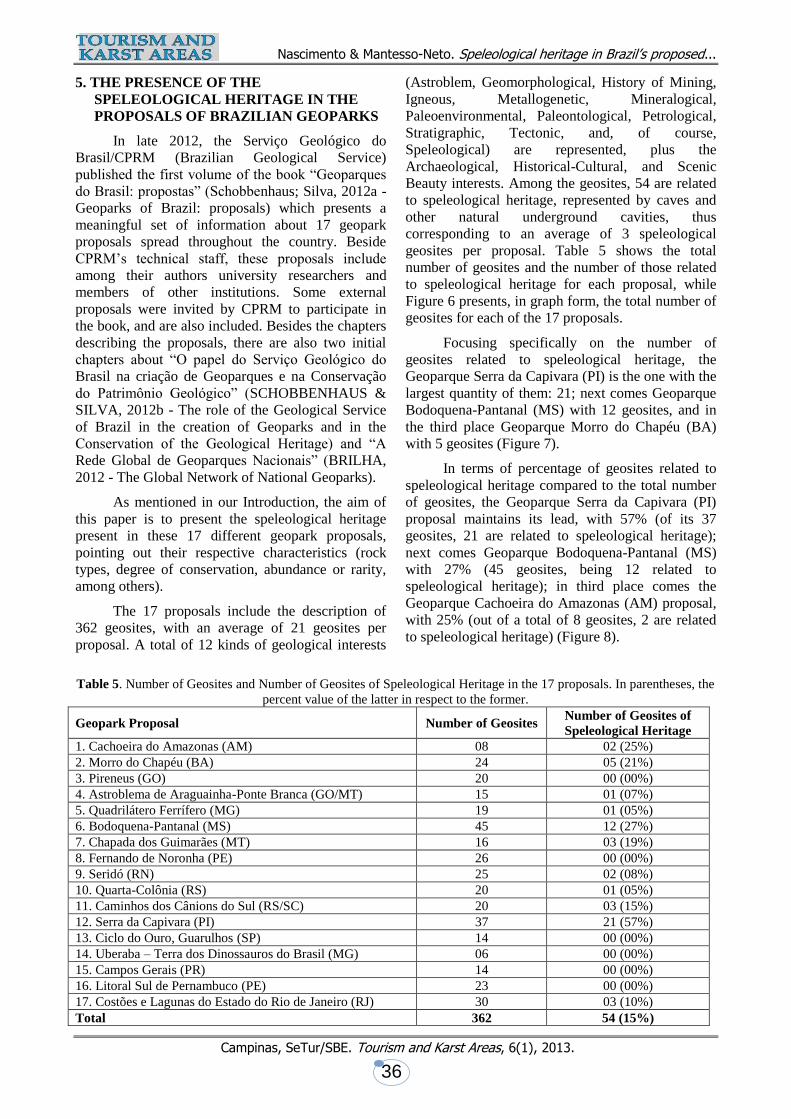
The 17 proposals include the description of
362 geosites, with an average of 21 geosites per
proposal. A total of 12 kinds of geological interests
(Astroblem, Geomorphological, History of Mining,
Igneous, Metallogenetic, Mineralogical,
Paleoenvironmental, Paleontological, Petrological,
Stratigraphic, Tectonic, and, of course,
Speleological) are represented, plus the
Archaeological, Historical-Cultural, and Scenic
Beauty interests. Among the geosites, 54 are related
to speleological heritage, represented by caves and
other natural underground cavities, thus
corresponding to an average of 3 speleological
geosites per proposal. Table 5 shows the total
number of geosites and the number of those related
to speleological heritage for each proposal, while
Figure 6 presents, in graph form, the total number of
geosites for each of the 17 proposals.
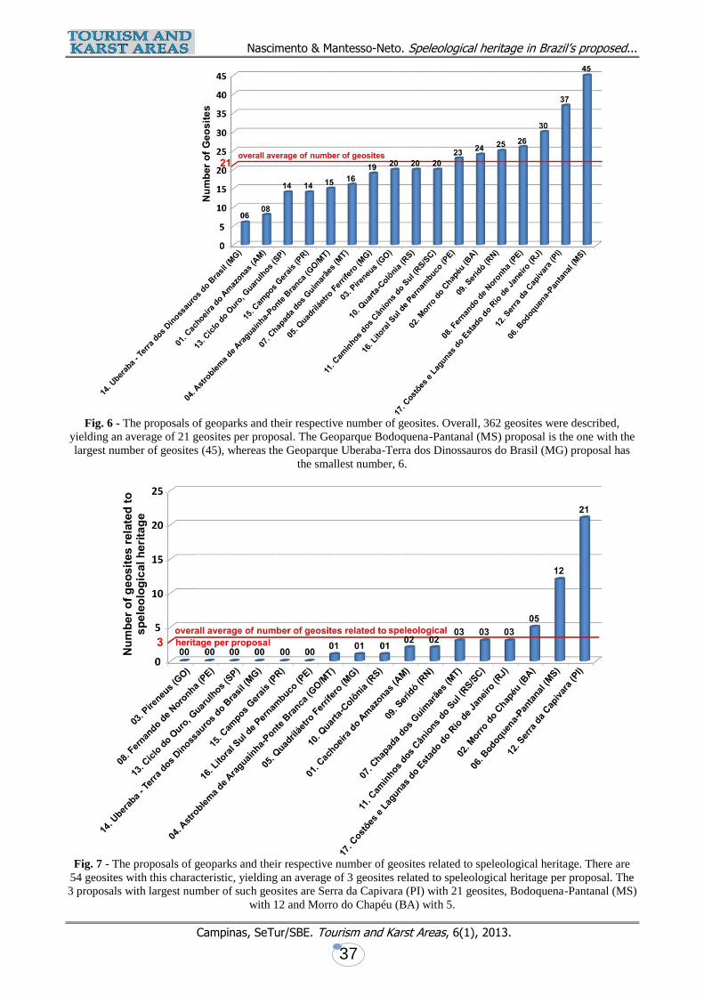
Focusing specifically on the number of
geosites related to speleological heritage, the
Geoparque Serra da Capivara (PI) is the one with the
largest quantity of them: 21; next comes Geoparque
Bodoquena-Pantanal (MS) with 12 geosites, and in
the third place Geoparque Morro do Chapéu (BA)
with 5 geosites (Figure 7).
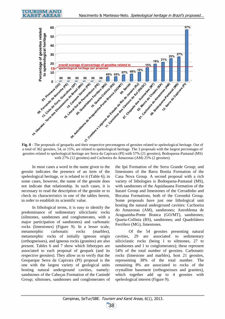
In terms of percentage of geosites related to
speleological heritage compared to the total number
of geosites, the Geoparque Serra da Capivara (PI)
proposal maintains its lead, with 57% (of its 37
geosites, 21 are related to speleological heritage);
next comes Geoparque Bodoquena-Pantanal (MS)
with 27% (45 geosites, being 12 related to
speleological heritage); in third place comes the
Geoparque Cachoeira do Amazonas (AM) proposal,
with 25% (out of a total of 8 geosites, 2 are related
to speleological heritage) (Figure 8).
Table 5. Number of Geosites and Number of Geosites of Speleological Heritage in the 17 proposals. In parentheses, the
percent value of the latter in respect to the former.
Geopark Proposal Number of Geosites Number of Geosites of
Speleological Heritage
1. Cachoeira do Amazonas (AM) 08 02 (25%)
2. Morro do Chapéu (BA) 24 05 (21%)
3. Pireneus (GO) 20 00 (00%)
4. Astroblema de Araguainha-Ponte Branca (GO/MT) 15 01 (07%)
5. Quadrilátero Ferrífero (MG) 19 01 (05%)
6. Bodoquena-Pantanal (MS) 45 12 (27%)
7. Chapada dos Guimarães (MT) 16 03 (19%)
8. Fernando de Noronha (PE) 26 00 (00%)
9. Seridó (RN) 25 02 (08%)
10. Quarta-Colônia (RS) 20 01 (05%)
11. Caminhos dos Cânions do Sul (RS/SC) 20 03 (15%)
12. Serra da Capivara (PI) 37 21 (57%)
13. Ciclo do Ouro, Guarulhos (SP) 14 00 (00%)
14. Uberaba – Terra dos Dinossauros do Brasil (MG) 06 00 (00%)
15. Campos Gerais (PR) 14 00 (00%)
16. Litoral Sul de Pernambuco (PE) 23 00 (00%)
17. Costões e Lagunas do Estado do Rio de Janeiro (RJ) 30 03 (10%)
Total 362 54 (15%)
Nascimento & Mantesso-Neto. Speleological heritage in Brazil’s proposed...
Campinas, SeTur/SBE. Tourism and Karst Areas, 6(1), 2013.
37
Fig. 6 - The proposals of geoparks and their respective number of geosites. Overall, 362 geosites were described,
yielding an average of 21 geosites per proposal. The Geoparque Bodoquena-Pantanal (MS) proposal is the one with the
largest number of geosites (45), whereas the Geoparque Uberaba-Terra dos Dinossauros do Brasil (MG) proposal has
the smallest number, 6.
Fig. 7 - The proposals of geoparks and their respective number of geosites related to speleological heritage. There are
54 geosites with this characteristic, yielding an average of 3 geosites related to speleological heritage per proposal. The
3 proposals with largest number of such geosites are Serra da Capivara (PI) with 21 geosites, Bodoquena-Pantanal (MS)
with 12 and Morro do Chapéu (BA) with 5.
Nascimento & Mantesso-Neto. Speleological heritage in Brazil’s proposed...
Campinas, SeTur/SBE. Tourism and Karst Areas, 6(1), 2013.
38
Fig. 8 - The proposals of geoparks and their respective percentagens of geosites related to speleological heritage. Out of
a total of 362 geosites, 54, or 15%, are related to speleological heritage. The 3 proposals with the largest percentages of
geosites related to speleological heritage are Serra da Capivara (PI) with 57% (21 geosites), Bodoquena-Pantanal (MS)
with 27% (12 geosites) and Cachoeira do Amazonas (AM) 25% (2 geosites).
In most cases a word in the name given to the
geosite indicates the presence of an item of the
speleological heritage, or is related to it (Table 6); in
some cases, however, the name of the geosite does
not indicate that relationship. In such cases, it is
necessary to read the description of the geosite or to
check its characteristics in one of the tables herein,
in order to establish its scientific value.
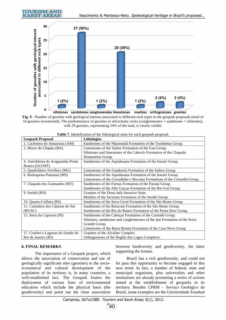
In lithological terms, it is easy to identify the
predominance of sedimentary siliciclastic rocks
(siltstones, sandstones and conglomerates, with a
major participation of sandstones) and carbonatic
rocks (limestones) (Figure 9). In a lesser scale,
metamorphic carbonatic rocks (marbles),
metamorphic rocks of initially igneous origin
(orthogneisses), and igneous rocks (granites) are also
present. Tables 6 and 7 show which lithotypes are
associated to each proposal of geopark (and its
respective geosites). They allow us to verify that the
Geoparque Serra da Capivara (PI) proposal is the
one with the largest variety of geological units
hosting natural underground cavities, namely:
sandstones of the Cabeças Formation of the Canindé
Group; siltstones, sandstones and conglomerates of
the Ipú Formation of the Serra Grande Group; and
limestones of the Barra Bonita Formation of the
Casa Nova Group. A second proposal with a rich
variety of lithologies is Bodoquena-Pantanal (MS),
with sandstones of the Aquidauana Formation of the
Itararé Group and limestones of the Cerradinho and
Bocaina Formations, both of the Corumbá Group.
Some proposals have just one lithological unit
hosting the natural underground cavities: Cachoeira
do Amazonas (AM), sandstones; Astroblema de
Araguainha-Ponte Branca (GO/MT), sandstones;
Quarta-Colônia (RS), sandstones; and Quadrilátero
Ferrífero (MG), limestones.
Of the 54 geosites presenting natural
cavities, 29 are associated to sedimentary
siliciclastic rocks (being 1 to siltstones, 27 to
sandstones and 1 to conglomerates); these represent
54% of the total number of geosites. Carbonatic
rocks (limestone and marbles), host 21 geosites,
representing 38% of the total number. The
remaining 8% are associated to rocks of the
crystalline basement (orthogneisses and granites),
which together add up to 4 geosites with
speleological interest (Figure 9).
Nascimento & Mantesso-Neto. Speleological heritage in Brazil’s proposed...
Campinas, SeTur/SBE. Tourism and Karst Areas, 6(1), 2013.
39
Table 6. Names of geosites related to speleological heritage in the 11 proposals of national geoparks in which there is
(are) one or more natural underground cavity(ies).
Geopark Proposal Name of Geosite = type of rock to which it is associated
1. Cachoeira do Amazonas (AM) Geosite 03 – Cachoeira da Iracema = sandstone
Geosite 08 – Gruta do Maroaga = sandstone
2. Morro do Chapéu (BA) Geosite 07 – Buraco Possidônio = limestone
Geosite 08 – Gruta Barrocão = limestone
Geosite 09 – Buraco do Alecrim = limestone
Geosite 13 – Gruta do Cristal = limestone
Geosite 21 – Gruta dos Brejões = limestone
4. Astroblema de Araguainha-
Ponte Branca (GO/MT)
Geosite 09 – Caverna da Gota Santa = sandstone
5. Quadrilátero Ferrífero (MG) Geosite 18 – Gruta Nossa Senhora da Lapa = limestone
6. Bodoquena-Pantanal (MS) Geosite 11 – Gruta do Lago Azul = limestone
Geosite 12 – Gruta Nossa Senhora Aparecida = limestone
Geosite 13 – Gruta São Miguel = limestone
Geosite 14 – Abismo Anhumas = limestone
Geosite 15 – Grutas do Mimoso = limestone
Geosite 16 – Lagoa Misteriosa = limestone
Geosite 17 – Buraco das Araras = sandstone
Geosite 34 – Buraco das Abelhas = limestone
Geosite 35 – Gruta do Urubu Rei = limestone
Geosite 41 – Nascentes e Grutas Ceita Corê = limestone
Geosite 42 – Buraco do Japonês/dos Fósseis = limestone
Geosite 43 – Gruta e Nascente do Rio Formoso = limestone
7. Chapada dos Guimarães (MT) Geosite 03 – Casa de Pedra = sandstone
Geosite 14 – Caverna Aroe Jari = sandstone
Geosite 15 – Caverna Aroe Jari – Lagoa Azul = sandstone
9. Seridó (RN) Geosite 01 – Serra Verde = granite
Geosite 13 – Gruta da Caridade = marble
10. Quarta-Colônia (RS) Geosite 08 – Gruta do Índio = sandstone
11. Caminhos dos Cânions do Sul (RS/SC) Geosite 01 – Furnas de Sombrio = sandstone
Geosite 04 – Furnas Índios Xocleng = sandstone
Geosite 06 – Morro dos Conventos = sandstone
12. Serra da Capivara (PI) Geosite 05 – Toca do Sítio do Meio = siltstone
Geosite 08 – Toca da Entrada do Pajaú = sandstone
Geosite 09 – Toca do Pajaú = sandstone
Geosite 10 – Toca do Barro e Toca do Inferno = conglomerate
Geosite 11 – Toca da Entrada do Baixão da Vaca = sandstone
Geosite 12 – Trilha do Boqueirão e Toca do Paraguaio = sandstone
Geosite 17 – Toca do Caboclinho = sandstone
Geosite 18 – Toca do Vento, Capim, Dedo e Castiçal = sandstone
Geosite 19 – Toca do Cabloco da Serra Branca = sandstone
Geosite 20 – Toca da Extrema = sandstone
Geosite 21 – Toca da Passagem = sandstone
Geosite 22 – Toca do Olho D´Água da Serra Branca = sandstone
Geosite 23 – Toca da Mangueira do João Paulo = sandstone
Geosite 25 – Toca do Estevo ou da Onça = sandstone
Geosite 26 – Circuito da Pedra Caída/Toca da Invenção = sandstone
Geosite 27 – Toca do Alexandre = sandstone
Geosite 28 – Toca da Ema do Sítio do Brás I = sandstone
Geosite 29 – Toca da Roça do Sítio do Brás I = sandstone
Geosite 30 – Toca da Janela da Barra do Antonião = limestone
Geosite 31 – Serrote do Tenente Luiz = limestone
Geosite 32 – Toca dos Pilões = limestone
17. Costões e Lagunas do Estado do Rio de
Janeiro (RJ)
Geosite 01 – Costão de Ponta Negra = orthogneisse
Geosite 03 – Promontório Igreja de N.S. de Nazaré = orthogneisse
Geosite 07 – Ilha do Cabo Frio = granite
Nascimento & Mantesso-Neto. Speleological heritage in Brazil’s proposed...
Campinas, SeTur/SBE. Tourism and Karst Areas, 6(1), 2013.
40
Fig. 9 - Number of geosites with geological interest associated to different rock types in the geopark proposals (total of
54 geosites inventoried). The predominance of geosites in siliciclastic rocks (conglomerates + sandstones + siltstones),
with 29 geosites, representing 54% of the total, is clearly visible.
Table 7. Identification of the lithological units for each geopark proposal.
Geopark Proposal Lithologies
1. Cachoeira do Amazonas (AM) Sandstones of the Nhamundá Formation of the Trombetas Group.
2. Morro do Chapéu (BA) Limestones of the Salitre Formation of the Una Group.
Siltstones and limestones of the Caboclo Formation of the Chapada
Diamantina Group.
4. Astroblema de Araguainha-Ponte
Branca (GO/MT)
Sandstones of the Aquidauana Formation of the Itararé Group.
5. Quadrilátero Ferrífero (MG) Limestones of the Gandarela Formation of the Itabira Group.
6. Bodoquena-Pantanal (MS) Sandstones of the Aquidauana Formation of the Itararé Group.
Limestones of the Cerradinho e Bocaina Formations of the Corumbá Group.
7. Chapada dos Guimarães (MT) Sandstones of the Furnas Formation of the Paraná Group.
Sandstones of the Alto Garças Formation of the Rio Ivaí Group.
9. Seridó (RN) Granites of the Dona Inês Intrusive Suite.
Marbles of the Jucurutu Formation of the Seridó Group.
10. Quarta-Colônia (RS) Sandstones of the Serra Geral Formation of the São Bento Group.
11. Caminhos dos Cânions do Sul
(RS/SC)
Sandstones of the Botucatu Formation of the São Bento Group.
Sandstones of the Rio do Rastro Formation of the Passa Dois Group.
12. Serra da Capivara (PI) Sandstones of the Cabeças Formation of the Canindé Group.
Silstones, sandstones and conglomerates of the Ipú Formation of the Serra
Grande Group.
Limestones of the Barra Bonita Formation of the Casa Nova Group
17. Costões e Lagunas do Estado do
Rio de Janeiro (RJ)
Granites of the Alcaline Complex.
Orthogneisses of the Região dos Lagos Complexo.
6. FINAL REMARKS
The importance of a Geopark project, which
allows the association of conservation and use of
geologically significant sites (geosites) to the socio-
economical and cultural development of the
population of its territory is, in many countries, a
well-established fact. The Geopark fosters the
deployment of various lines of environmental
education which include the physical basis (the
geodiversity) and point out the close association
between biodiversity and geodiversity, the latter
supporting the former.
Brazil has a rich geodiversity, and could not
let pass this opportunity to become engaged in this
new trend. In fact, a number of federal, state and
municipal organisms, plus universities and other
institutions are already promoting a series of actions
aimed at the establishment of geoparks in its
territory. Besides CPRM – Serviço Geológico do
Brasil, some examples are the Universidade Estadual
Nascimento & Mantesso-Neto. Speleological heritage in Brazil’s proposed...
Campinas, SeTur/SBE. Tourism and Karst Areas, 6(1), 2013.
41
de Ponta Grossa and Minérios do Paraná-Mineropar;
Prefeitura de Guarulhos, São Paulo; and Serviço
Geológico do Estado do Rio de Janeiro - Diretoria
de Recursos Minerais.
The geosites in the geopark proposals address
different interests: stratigraphic, geomorphological,
tectonic, paleoenvironmental, metallogenetic,
paleontological, igneous, mineralogical and
speleological. Focusing on this last interest, an
analysis shows that out of the 17 proposals, at least
11 of them have one or more geosite(s) related to
speleological heritage. Among those, a few stand
out, like the Serra da Capivara/PI (with 21 geosites
related to speleological heritage, in a total of 37
geosites), Bodoquena-Pantanal/MS (12 in a total of
45) and Morro do Chapéu/BA (5 in a total of 24).
Percentagewise, Serra da Capivara/PI is the leader,
with 57% of geosites with speleological interest,
followed by Bodoquena-Pantanal/MS with 27%, and
in third position comes Cachoeira do
Amazonas/AM, with 25%. Of the total of 362
geosites listed in the 17 geopark proposals, about
15% are related to speleological interest. This is a
low percentage, brought about mainly by the fact
that six proposals - Pireneus/GO; Fernando de
Noronha/PE; Ciclo do Ouro, Guarulhos/SP;
Uberaba-Terra dos Dinossauros do Brasil (MG);
Campos Gerais/PR e Litoral Sul de Pernambuco/PE
- do not have any geosites of this kind. Overall, with
54 geosites of speleological interest in 17 proposals,
the average comes to a little more than 3 geosites
related to speleological heritage per proposal, a low
value if the enormous potential that Brazil has in this
kind of heritage is taken into account.
Regarding the lithological type to which these
cavities are associated, in the 17 proposals, and
limiting the analysis to those 54 geosites related to
speleological heritage, 29, or 54% of them are
related to sedimentary siliciclastic rocks (mainly
sandstones); 21, or 38% are related to carbonatic
rocks (limestones and marbles), and the remaining 4,
or 8%, to the crystalline basement (orthogneisses
and granites).
It must be pointed out that the speleological
potential presented in these geopark proposals,
according to the Brazilian law, must be initially
protected by strategic actions for conservation. Only
after these actions are implemented, can these areas
be used for tourism and educational activities.
BIBLIOGRAPHICAL REFERENCES
AULER, A.; ZOGBI, L. 2005. Espeleologia: noções básicas. 1a. ed., São Paulo: Redespeleo Brasil, 104 p.
BRILHA, J. A. 2012b. Rede Global de Geoparques Nacionais: um instrumento para a promoção
internacional da geoconservação. In SCHOBBENHAUS, C.; SILVA, C.R. Geoparques do Brasil:
propostas. CPRM – Serviço Geológico do Brasil, Vol. 1, p.29-38. Available at
http://www.cprm.gov.br/publique/media/GEOPARQUESdoBRASIL_propostas.pdf, accessed 25 May
2013
CECAV/ICMBio. 2011. III Curso de Espeleologia e Licenciamento Ambiental. Brasília: CECAV.
Available at:
http://www.icmbio.gov.br/cecav/images/download/Apostila%20Curso%20de%20Espeleologia%20e%
20Licenciamento%20Ambiental.pdf, accessed 25 May 2013.
JANSEN, D.C.; CAVALCANTI, L.F.; LAMBLÉM, H.S. 2012. Mapa de potencialidade de ocorrência de
cavernas no Brasil, na escala 1:2.500.000. Revista Brasileira de Espeleologia, v.2, n.1, p.42-57.
MANTESSO-NETO, V.; RIBEIRO, R.R.; GARCIA, M.G.M.; DEL LAMA, E.A.; THEODOROVICZ, A.
2013. Patrimônio geológico no estado de São Paulo. Bol. Paranaense Geociências, vol. 70, p.53-76.
Available at: http://ojs.c3sl.ufpr.br/ojs/index.php/geociencias/article/view/32741/21562, accessed 17
December 2013.
MARTINI, G. 2010. Desenvolvimento regional: o papel dos geoparques. Palestra. Salão do Turismo, 5, São
Paulo, Available at:
http://www.salao.turismo.gov.br/salao/nucleo_conhecimento/Apresentacoes_2010/, accessed 25 May
2013.
MOREIRA, J.C. 2011. Geoturismo e Interpretação Ambiental. Ponta Grossa: Editora UEPG, 157p.
Nascimento & Mantesso-Neto. Speleological heritage in Brazil’s proposed...
Campinas, SeTur/SBE. Tourism and Karst Areas, 6(1), 2013.
42
SCHOBBENHAUS, C. 2006. Projeto Geoparques: proposta. Brasília: CPRM, 9 p., mapa.
SCHOBBENHAUS, C & SILVA, C.R. 2010. O papel indutor do Serviço Geológico do Brasil na criação de
geoparques. Brasília: CPRM. Available at
http://www.cprm.gov.br/publique/media/schobbenhaus_Silva%20_2010.pdf, accessed 25 May 2013.
SCHOBBENHAUS, C.; SILVA, C.R. 2012a. Geoparques do Brasil: propostas. São Paulo: CPRM –
Serviço Geológico do Brasil. Vol. 1, 745p. Available at
http://www.cprm.gov.br/publique/media/GEOPARQUESdoBRASIL_propostas.pdf, accessed 25 May
2013.
SCHOBBENHAUS, C.; SILVA, C.R. 2012b. O papel do Serviço Geológico do Brasil na criação de
geoparques e na conservação do geological heritage. In. SCHOBBENHAUS, C.; SILVA, C.R.
Geoparques do Brasil: propostas. CPRM – Serviço Geológico do Brasil, Vol. 1, p.11-28. Available
at http://www.cprm.gov.br/publique/media/GEOPARQUESdoBRASIL_propostas.pdf, accessed 25
May 2013
UNESCO. Geoparks Workshop. n/d. Available at http://portal.unesco.org/en/ev.php-
URL_ID=22630&URL_DO=DO_TOPIC&URL_SECTION=201.html, accessed 28 May 2013.
Editorial flow/Fluxo editorial: Received/Recebido em: 25.jun.2013
Accepted/Aprovado em: 18.dec.2013
TOURISM AND KARST AREAS
(formely/formalmente: Pesquisas em Turismo e Paisagens Cársticas) Brazilian Speleological Society / Sociedade Brasileira de Espeleologia (SBE)
www.cavernas.org.br/turismo.asp