Embed Size (px)
Citation preview

Special Provisions - Section 3.3.4.6.2 and 3.3.4.3
2829 W. Howard Place Denver, CO 80204-2305 P 970.210.5913 www.codot.gov
1. Term #116 - Rule 3.3.4.6.2 - CDOT Utility as-constructed/Out of Service requirements, data content and accuracy
1.1. All utility installations and out of service lines, within CDOT Right of Way (ROW), shall be collected using CDOT’s mobile application (PointMan). If required please contact CDOT at [email protected] to obtain login and password information. Download the PointMan mobile application through the Apple Store (iOS) or Google Play (Android). Finally, watch the following quick start guide, the video can be found at the following link: https://youtu.be/X-tMvnK7vZw
1.2. High accuracy equipment requirement:
Supported GNSS Receivers Supported Software
Trimble DA1 (Catalyst)
Trimble R2 (RTK)
Trimble R8 (current version is R8s) Supported Software
Trimble R10 Android 7.1
Trimble R12 iOS 12 & Up
Trimble SPS985 (current version is SPS986)
HTML Web Browser
Blue Star RTK or Emlid Reach RS2 RTK
One of the following GNSS receivers is acceptable to use at this time with CDOT’s mobile application. Deviation from CDOT’s list of accepted GNSS receivers must be requested and approved by the department in writing prior to submission of as-built data.
2829 W. Howard Place Denver, CO 80204-2305

Special Provisions - Section 3.3.4.6.2 and 3.3.4.3
2829 W. Howard Place Denver, CO 80204-2305 P 970.210.5913 www.codot.gov
1.3. Projections and Coordinate Systems
Horizontal Datum: The North American Datum of 1983, 2011 Adjustment (NAD 83) and the Geodetic Reference System of 1980, (GRS80), select EPSG 6318 within the PointMan settings menu.
Vertical Datum: The North American Vertical Datum of 1988, (NAVD 88) RTK GPS is an acceptable method to derive NAVD 88 elevations and is the Vertical Datum that is used for all projects performed for CDOT. Select the latest Geoid model from the PointMan mobile application in order to compute orthometric heights (ground corrected elevations). The latest Geoid model that is acceptable is Geoid18 and available within the PointMan settings menu.
1.4. Positional Accuracy Specification
CDOT requires positional accuracy 1, 2 or 3 for all utilities installed within CDOT ROW. The designated Accuracy Level designation shown in Table1 below. Utilizing CDOT’s mobile application pedigree (survey record) will assist in determining the accuracy levels assigned to the specific permitted installation by the utility companies’ representative responsible for collection of as-built data.

Special Provisions - Section 3.3.4.6.2 and 3.3.4.3
2829 W. Howard Place Denver, CO 80204-2305 P 970.210.5913 www.codot.gov
Table 1. Positional Accuracy Requirements
Positional Accuracy Level Positional Accuracy1 (English Units)
Positional Accuracy1,2 (SI Units)
1 0.1 feet 25 mm 2 0.2 feet 50 mm 3 0.3 feet 100 mm 4 1 foot 300 mm 5 3 feet 1000 mm 0 Indeterminate Indeterminate
1 At the 95% confidence level, using the root-mean-square error (RMSE) in accordance with FGDC-STD-007.3-1998. “Positional Accuracy” is in direct reference to the actual geodetic positional coordinates as referenced to the National Spatial Reference System (NSRS) maintained by the National Oceanic and Atmospheric Administration (NOAA) National Geodetic Survey (NGS). Geodetic positional coordinates (latitude, longitude, and orthometric heights) reference to the official U.S. datums, currently, the North American Datum of 1983 (NAD 83) and the North American Vertical Datum of 1988 (NAVD 88).
Rigid aboveground features are subject to the same positional accuracy requirements as underground features. The positional accuracy of suspended aerial cables and wires is variable due to environmental factors and therefore shall be classified as Level 0, except at the points where they are anchored to support structures such as poles.
For linear features, the depicted position must meet the tolerances as specified in Table 1 at every position along the length of the feature in order to be designated at the appropriate accuracy level.

Special Provisions - Section 3.3.4.6.2 and 3.3.4.3
2829 W. Howard Place Denver, CO 80204-2305 P 970.210.5913 www.codot.gov
2.0 Utility Type Feature Codes – Table 2
Utility Type
Feature Code
Description of Utilities
Test hole Photo Test hole
5950 17
Point - Test hole physically locating X,Y,Z underground facility location.
Proposed running line
6001 or
6075
Line segment code 6001 – Surface elevation of proposed HDD bore. Point - 6075 location bore log depth required for each observed point.
Communication
4210 4410 4211
Line segment - All communication facilities, including fiber optic (4211), copper (4210), coaxial (4410), including appurtenances within defined size parameter
Gas 4510 4511
Line segment – Low pressure (4510) High pressure (4511) Natural gas transmission, distribution, service lines, and appurtenances within defined size parameter.
Electric 4310 Line segment - Secondary electric or higher voltage
Pipe (Oil) 4610 or 4611
Line segment - Pipeline facilities, including crude oil, refined oil, or all other types of oil pipeline transmission, distribution, service lines, and appurtenances within defined size parameter.
Propane 4512 Line segment - Propane transmission, distribution and service lines, and appurtenances within defined size. .parameter
Sanitary Sewer 4811 Line segment - Sanitary sewer facilities including all mains, collection system, forcemains, services and leads, including appurtenances within defined size parameter. (Combined sewer is classified as sanitary sewer).
Surface Elevation
6075 Point – X,Y,Z single observation for surface elevation.
Storm Sewer 2712
Line segment - Storm sewer facilities including all mains and collection system, including appurtenances within defined size parameter. (Excludes underdrain)
Water 4710 Line segment - Water transmission, distribution, service lines, and appurtenances within defined size parameter. (Excludes irrigations systems)
Unknown 6075 or 6001
Point and Line segment - This designation can be used for those facilities not covered by the above feature codes, including but not limited to industrial facilities of all types and discovered utilities where the type of utility is unknown.

Special Provisions - Section 3.3.4.6.2 and 3.3.4.3
2829 W. Howard Place Denver, CO 80204-2305 P 970.210.5913 www.codot.gov
2.1 - General Observations Standards
1. All active and out of service transmission, distribution and collector system main lines a. Start and end points b. Minimum of every 25 feet with the following additional points
i. Deviations in installation alignment (horizontal and vertical) including but not limited to the following: a. Intentional changes in geometry such as changing direction to avoid
obstacles b. Fittings such as elbows (horizontal and vertical)
ii. Changes in facility characteristics (e.g. Change in size, material, number or pair, encasement size, material, etc...)
iii. Start and end point for vaults
2. Appurtenances installed concurrently with new main installations, whereas appurtenances are defined as service leads and stubs. a. Tap-in at the main and at (near) the right of way line
3. New appurtenances from existing mains a. All size and material types shall be recorded for each utility type b. Tap-in at main and at (near) the right of way line
4. Transverse utility crossings installed via trenchless methods a. All qualified utilities crossing roads as described in Section 2.4 b. 25 foot intervals across pavement sections when safely achievable

Special Provisions - Section 3.3.4.6.2 and 3.3.4.3
2829 W. Howard Place Denver, CO 80204-2305 P 970.210.5913 www.codot.gov
2.2 Direct Observations (Figure 2) In a direct observation, a field technician places the surveying instrument directly on the utility and records the X, Y, Z position. This type of observation is commonly achievable if utilities are installed via open excavation methods, or at bore pits and tie in locations where trenchless technologies are used. Data collection of directly observed utilities yield the highest level of confidence, but requires daily coordination with construction activities so the field surveyor can physically observe the utility at the required locations prior to backfilling.
Figure 2

Special Provisions - Section 3.3.4.6.2 and 3.3.4.3
2829 W. Howard Place Denver, CO 80204-2305 P 970.210.5913 www.codot.gov
2.3 Indirect Observations (Figure 3)
Common installation methods include various trenchless technologies, which prevent the direct observation of installed utilities. The following are common methods of coordination of data collection aimed at producing high-level data collection results. Field Witnessing: For trenchless installation methods, observe and survey all tie-in locations, bore pits, or any other areas where the utility is directly exposed. Construction crews must witness the location and depth of the installed utility during mainline trenchless operations. Field witnessing needs to consist of physical marks in the field so that a field surveyor can record a survey observation at the centerline of the utility on the ground, then compute the elevation of the utility by subtracting the field-witnessed depth from the ground elevation. Figure 3 is an example of field witnessing a trenchless utility installation. A horizontal directional drilled (HDD) fiber optic line is documented with a mark on the centerline of the utility with the ground surface depth recorded within CDOT’s mobile application. The reading from the bore head is also required to be documented within CDOT’s mobile application (Use Table 2 for Proposed running line point code that corresponded with the type of utility being observed, for example use 4211 for Fiber Optic to record bore head depth). Utility companies must record a spatial position (X, Y, Z location) at the ground surface, and then compute the elevation of the top of the utility. Figure 3
25 ft.,

Special Provisions - Section 3.3.4.6.2 and 3.3.4.3
2829 W. Howard Place Denver, CO 80204-2305 P 970.210.5913 www.codot.gov
Indirect as-constructed observations with tracer wire must include an Active signal (Transmitter and Receiver). The Receiver/Locator must be paired with PointMan and an approved GNSS antenna, see list Section 1.2. Instructions as to pair locators and GPS antennas can be found at the following link: https://support.prostarcorp.com/index.php?title=PointMan and refer to sections “Pairing GPS Tools” and “Pairing a Locator”.
25 ft.,
from the locator and GPS unit combined.

Special Provisions - Section 3.3.4.6.2 and 3.3.4.3
2829 W. Howard Place Denver, CO 80204-2305 P 970.210.5913 www.codot.gov
2.4 Simple Transverse Utility Crossings Certain transverse utility crossings may require deviation from the standards in order to maintain a safe work environment. If there are no safe methods of field witnessing the boring location and depth within a pavement section, collect a survey observation at or near the edge of pavement before crossing the pavement section. Then continue by collecting a survey observation at or near the opposite edge of pavement and continue per the normal observation procedures previously described, see Figure 4 below: Figure 4
2.5 Unique Requirements for Trenchless Installations on Transverse Utility Crossings All other transverse utility crossings that are installed using methods conducive to a direct survey observation require survey observations to be collected at safe intervals when crossing a pavement section. Additionally, all utilities will be directly observed when installed using a method that support direct observation. All utilities installed by trenchless technologies must be observed directly above the installed utility with the elevation computed from the best available depth readings (typically depths read from bore head during installation or tracer wire and EM locating device). The accuracy of the depth readings to the installed utility will vary depending on the type of equipment used during installation.

Special Provisions - Section 3.3.4.6.2 and 3.3.4.3
2829 W. Howard Place Denver, CO 80204-2305 P 970.210.5913 www.codot.gov
Direct survey observations are required where utilities are exposed; including tie-in locations, bore pits, hand holes, and manholes. Alignment and depth will be documented during boring operations at the required interval. Some form of field witnessing must be used to mark the horizontal location and depth of the utility based on readings from the equipment being used. Then, the utility company can survey each marked location and compute the elevation of the installed facility based on the recorded depth readings at each surveyed location. At a minimum, alignment and depths must be physically documented at an interval of not more than 100 feet and at all changes in horizontal and vertical alignment.
The more survey observations collected along a utility line will increase the accuracy of the true three-dimensional alignment. For example, long and deep bores could create a parabolic curve shaped utility that will not be accurately represented with point spacing at 50 feet. Use professional judgement and collect additional points at a closer interval to generate a more representative geometry of the utility. Figure 5 depicts a complex transverse crossing and Figure 6 depicts a Typical HDD Installation.
Figure 5
Figure 6

Special Provisions - Section 3.3.4.6.2 and 3.3.4.3
2829 W. Howard Place Denver, CO 80204-2305 P 970.210.5913 www.codot.gov
PDF as-built submittal process: Geospatially referenced as-built drawing files shall be uploaded through CDOT’s mobile application (PointMan). While the mobile application is open, select a new place mark within your project limits and choose “File As built Plans”. This will allow a the establishment of geospatial as-built location on the map. Step 2 provide the Permit No. and any miscellaneous notes regarding the project description. Step 3 – select “OK” and processed to the select the stored location of the as-built PDF file. Step 4 select “OK” and allow the file to upload to CDOT’s database. Step 1 and 2 Step 3 Step 4

Special Provisions - Section 3.3.4.6.2 and 3.3.4.3
2829 W. Howard Place Denver, CO 80204-2305 P 970.210.5913 www.codot.gov
Term # 112 - Rule 3.3.4.3 Guidance for Plan and Profile Test Hole and Existing Utility data collection
Test hole data either during construction or during pre-construction activities are subject to the following data collection protocols:
1. All test hole data shall meet the positional accuracy requirements listed in Section 1.4, Positional Accuracy Specification, unless otherwise directed by CDOT. Capture the surface elevation and Meta data for the test hole utilizing the Feature Code 5950 as shown in the screen capture example to the right.
During test hole data collection, it may be advantageous to locate positions identifiable features, such as measuring the depth from existing ground surface or depth of pavement. All such relative positioning measurements shall be reduced to actual absolute coordinate positions by utilizing CDOTs mobile application. All positions shall be based on coordinate standards identified in Section 1.3 (Positions and Coordinate Systems) including Geoid derived elevations. All test hole observations captured under feature code 5950 shall include the following information:
a. Test hole number b. Permit Number c. Utility Owner d. Utility Depth e. Size of Utility f. Material Type g. Depth measure to h. Depth of pavement i. Sub-grade material
Special Provisions - Section 3.3.4.6.2 and 3.3.4.3
2829 W. Howard Place Denver, CO 80204-2305 P 970.210.5913 www.codot.gov
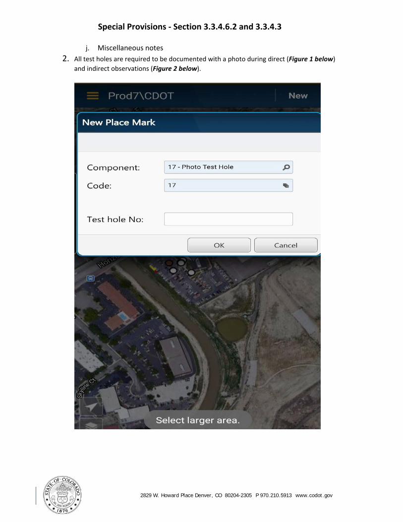
j. Miscellaneous notes 2. All test holes are required to be documented with a photo during direct (Figure 1 below)
and indirect observations (Figure 2 below).

Special Provisions - Section 3.3.4.6.2 and 3.3.4.3
2829 W. Howard Place Denver, CO 80204-2305 P 970.210.5913 www.codot.gov
2.2 Direct Observations (Figure 1) Test hole photo documentation example: Direct observation of the top of conduit.

Special Provisions - Section 3.3.4.6.2 and 3.3.4.3
2829 W. Howard Place Denver, CO 80204-2305 P 970.210.5913 www.codot.gov
2.3 Indirect Observation (Figure 2)
Document test hole observations and include surface makings as shown in the example below:
Special Provisions - Section 3.3.4.6.2 and 3.3.4.3
2829 W. Howard Place Denver, CO 80204-2305 P 970.210.5913 www.codot.gov
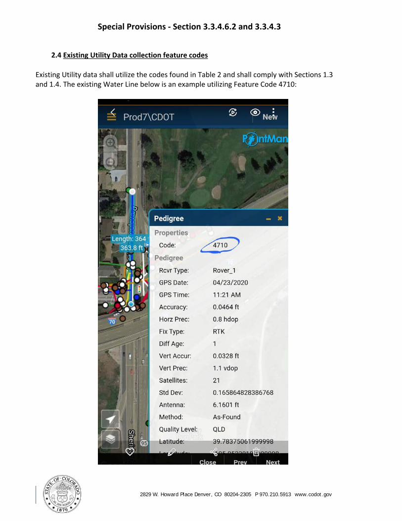
2.4 Existing Utility Data collection feature codes
Existing Utility data shall utilize the codes found in Table 2 and shall comply with Sections 1.3 and 1.4. The existing Water Line below is an example utilizing Feature Code 4710:

Special Provisions - Section 3.3.4.6.2 and 3.3.4.3
2829 W. Howard Place Denver, CO 80204-2305 P 970.210.5913 www.codot.gov