Embed Size (px)
Citation preview

International Review for Environmental Strategies Vol. 6, No. 2, pp. 307 – 328, 2006
© 2006 by the Institute for Global Environmental Strategies. All rights reserved.
307
Special Feature on Groundwater Management and Policy
Land Subsidence: A Consequence of Groundwater Over-Exploitation
in Bangkok, Thailand
Mukand S. Babel,a Ashim Das Gupta,b and Niña Donna Sto. Domingoc The various negative impacts on the environment and society caused by land subsidence have been a
problem in Bangkok, Thailand, since the 1970s. Intensive groundwater extraction for industrial and domestic purposes since the 1950s, which led to a decline of groundwater levels, has been identified by various studies as the primary cause of the phenomenon of land subsidence. This paper gives an overview of the occurrence of land subsidence in Bangkok. The history, characteristics, identified causes, and measures for mitigation of land subsidence in the area are discussed. Efforts to alleviate the problems and studies that have been conducted to understand the problem are presented and analyzed.
Keywords: Land subsidence, Groundwater development, Groundwater over drafting, Groundwater quality, Bangkok.
1. Introduction
Land subsidence in Bangkok, Thailand, has been an ongoing problem for the past four decades. The city and its six neighboring provinces have been identified by the Department of Groundwater Resources (DGR)—the government agency responsible for groundwater resources management in Thailand—as Critical Groundwater Zones where groundwater-related activities have resulted in alarming rates of land subsidence and decline of piezometric levels (level at which water in a borehole is stabilized). Since the late 1960s, many studies have been conducted to better understand, assess, and propose solutions to land subsidence and other problems caused by groundwater over-exploitation in the area. The occurrence of land subsidence has been attributed to an extensive decline in groundwater levels, which in turn is due to excessive groundwater extraction rates that came about to satisfy mounting demand for water for the industrial sector in order to foster economic growth. Various measures to mitigate the negative impacts have been proposed and implemented, but these have been largely unsuccessful and lacking in effectiveness and enforceability. Monitoring data show that land subsidence is still occurring in Bangkok now, although to lesser degrees than before.
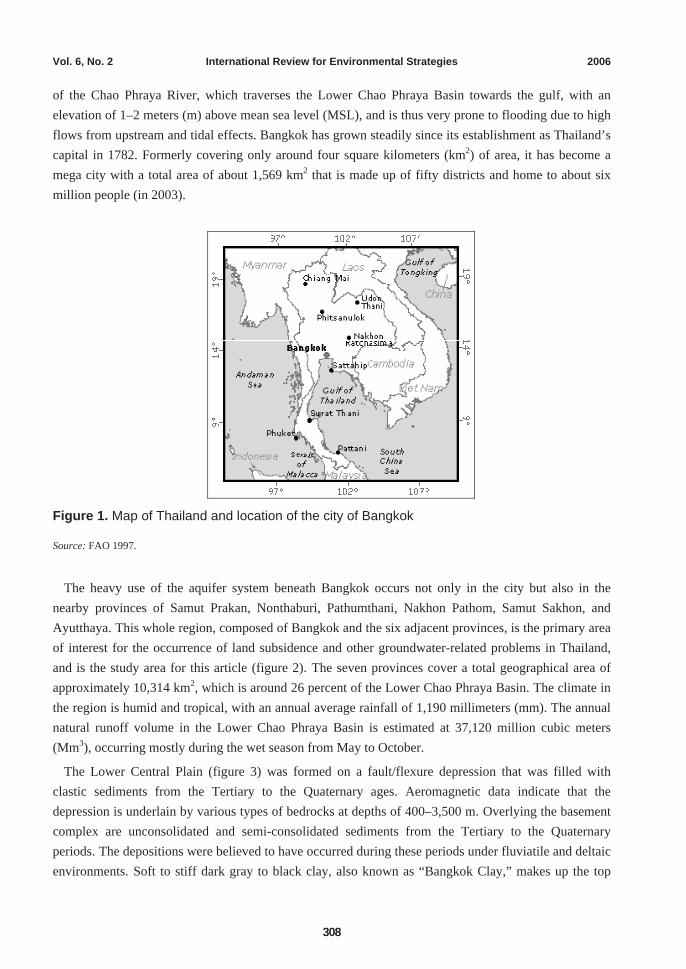
The city of Bangkok, Thailand’s capital city as well as economic and political center, is located in the Lower Central Plain of the country near the Gulf of Thailand (figure 1). The city sits on the flood plain
a. Associate Professor, Water Engineering and Management, School of Civil Engineering, Asian Institute of Technology,
Thailand. b. Professor, Water Engineering and Management, School of Civil Engineering, Asian Institute of Technology, Thailand. c. Research Associate, Water Engineering and Management, School of Civil Engineering, Asian Institute of Technology,
Thailand.
Vol. 6, No. 2 International Review for Environmental Strategies 2006
308
of the Chao Phraya River, which traverses the Lower Chao Phraya Basin towards the gulf, with an elevation of 1–2 meters (m) above mean sea level (MSL), and is thus very prone to flooding due to high flows from upstream and tidal effects. Bangkok has grown steadily since its establishment as Thailand’s capital in 1782. Formerly covering only around four square kilometers (km2) of area, it has become a mega city with a total area of about 1,569 km2 that is made up of fifty districts and home to about six million people (in 2003).
Figure 1. Map of Thailand and location of the city of Bangkok
Source: FAO 1997.
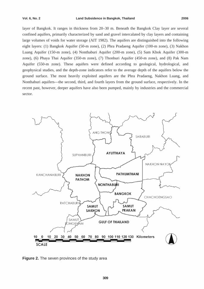
The heavy use of the aquifer system beneath Bangkok occurs not only in the city but also in the nearby provinces of Samut Prakan, Nonthaburi, Pathumthani, Nakhon Pathom, Samut Sakhon, and Ayutthaya. This whole region, composed of Bangkok and the six adjacent provinces, is the primary area of interest for the occurrence of land subsidence and other groundwater-related problems in Thailand, and is the study area for this article (figure 2). The seven provinces cover a total geographical area of approximately 10,314 km2, which is around 26 percent of the Lower Chao Phraya Basin. The climate in the region is humid and tropical, with an annual average rainfall of 1,190 millimeters (mm). The annual natural runoff volume in the Lower Chao Phraya Basin is estimated at 37,120 million cubic meters (Mm3), occurring mostly during the wet season from May to October.
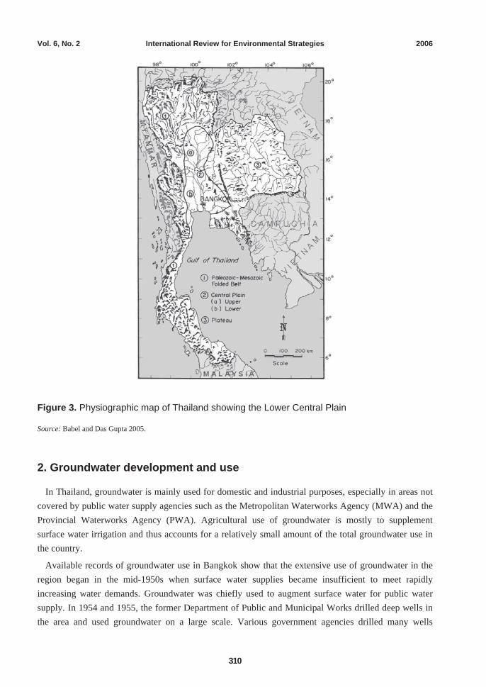
The Lower Central Plain (figure 3) was formed on a fault/flexure depression that was filled with clastic sediments from the Tertiary to the Quaternary ages. Aeromagnetic data indicate that the depression is underlain by various types of bedrocks at depths of 400–3,500 m. Overlying the basement complex are unconsolidated and semi-consolidated sediments from the Tertiary to the Quaternary periods. The depositions were believed to have occurred during these periods under fluviatile and deltaic environments. Soft to stiff dark gray to black clay, also known as “Bangkok Clay,” makes up the top
Vol. 6, No. 2 Land Subsidence in Bangkok, Thailand 2006
309
layer of Bangkok. It ranges in thickness from 20–30 m. Beneath the Bangkok Clay layer are several confined aquifers, primarily characterized by sand and gravel intercalated by clay layers and containing large volumes of voids for water storage (AIT 1982). The aquifers are distinguished into the following eight layers: (1) Bangkok Aquifer (50-m zone), (2) Phra Pradaeng Aquifer (100-m zone), (3) Nakhon Luang Aquifer (150-m zone), (4) Nonthaburi Aquifer (200-m zone), (5) Sam Khok Aquifer (300-m zone), (6) Phaya Thai Aquifer (350-m zone), (7) Thonburi Aquifer (450-m zone), and (8) Pak Nam Aquifer (550-m zone). These aquifers were defined according to geological, hydrological, and geophysical studies, and the depth-zone indicators refer to the average depth of the aquifers below the ground surface. The most heavily exploited aquifers are the Phra Pradaeng, Nakhon Luang, and Nonthaburi aquifers—the second, third, and fourth layers from the ground surface, respectively. In the recent past, however, deeper aquifers have also been pumped, mainly by industries and the commercial sector.
Figure 2. The seven provinces of the study area
Vol. 6, No. 2 International Review for Environmental Strategies 2006
310
Figure 3. Physiographic map of Thailand showing the Lower Central Plain
Source: Babel and Das Gupta 2005.
2. Groundwater development and use
In Thailand, groundwater is mainly used for domestic and industrial purposes, especially in areas not covered by public water supply agencies such as the Metropolitan Waterworks Agency (MWA) and the Provincial Waterworks Agency (PWA). Agricultural use of groundwater is mostly to supplement surface water irrigation and thus accounts for a relatively small amount of the total groundwater use in the country.
Available records of groundwater use in Bangkok show that the extensive use of groundwater in the region began in the mid-1950s when surface water supplies became insufficient to meet rapidly increasing water demands. Groundwater was chiefly used to augment surface water for public water supply. In 1954 and 1955, the former Department of Public and Municipal Works drilled deep wells in the area and used groundwater on a large scale. Various government agencies drilled many wells
Vol. 6, No. 2 Land Subsidence in Bangkok, Thailand 2006
311
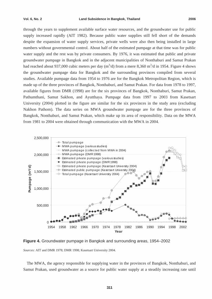
through the years to supplement available surface water resources, and the groundwater use for public supply increased rapidly (AIT 1982). Because public water supplies still fell short of the demands despite the expansion of water supply services, private wells were also then being installed in large numbers without governmental control. About half of the estimated pumpage at that time was for public water supply and the rest was by private consumers. By 1976, it was estimated that public and private groundwater pumpage in Bangkok and in the adjacent municipalities of Nonthaburi and Samut Prakan had reached about 937,000 cubic meters per day (m3/d) from a mere 8,360 m3/d in 1954. Figure 4 shows the groundwater pumpage data for Bangkok and the surrounding provinces compiled from several studies. Available pumpage data from 1954 to 1976 are for the Bangkok Metropolitan Region, which is made up of the three provinces of Bangkok, Nonthaburi, and Samut Prakan. For data from 1978 to 1997, available figures from DMR (1998) are for the six provinces of Bangkok, Nonthaburi, Samut Prakan, Pathumthani, Samut Sakhon, and Ayutthaya. Pumpage data from 1997 to 2003 from Kasetsart University (2004) plotted in the figure are similar for the six provinces in the study area (excluding Nakhon Pathom). The data series on MWA groundwater pumpage are for the three provinces of Bangkok, Nonthaburi, and Samut Prakan, which make up its area of responsibility. Data on the MWA from 1981 to 2004 were obtained through communication with the MWA in 2004.
Figure 4. Groundwater pumpage in Bangkok and surrounding areas, 1954–2002
Sources: AIT and DMR 1978; DMR 1998; Kasetsart University 2004.
The MWA, the agency responsible for supplying water in the provinces of Bangkok, Nonthaburi, and Samut Prakan, used groundwater as a source for public water supply at a steadily increasing rate until
0
500,000
1,000,000
1,500,000
2,000,000
2,500,000
1954 1958 1962 1966 1970 1974 1978 1982 1986 1990 1994 1998 2002 Year
Pum
page
(m3 /
d)
Total pumpageMWA pumpage (various studies) MWA pumpage (collected from MWA in 2004)MWA pumpage (DMR 1998) Estimated private pumpage (various studies)Estimated private pumpage (DMR 1998)Estimated private pumpage (Kasetsart University 2004)Estimated public pumpage (Kasetsart University 2004)Total pumpage (Kasetsart University 2004)
Vol. 6, No. 2 International Review for Environmental Strategies 2006
312
1981. Groundwater use by the MWA peaked in 1981 at about 500,000 m3/d, after which it slowly declined after the earnest implementation of control measures. In 1983, through the government’s cabinet resolution, titled the Mitigation of Groundwater Crisis and Land Subsidence in Bangkok Metropolis, the program to phase out the MWA’s use of deep wells was initiated, which targeted total abandonment of MWA wells by 1987 (Babel and Das Gupta 2005). This goal was not achieved as planned, however, but groundwater abstraction was reduced considerably nevertheless. From 500,000 m3/d in 1981, groundwater use by the MWA went down to 62,000 m3/d in 1990 to only 6,502 m3/d in 2003, and further to 589 m3/d in 2004.
Because the extension of piped-water supply services by waterworks agencies lags behind urban development and expansion, private usage of groundwater has generally continued to increase (Das Gupta and Babel 2005). The private sector is currently the most significant groundwater user in the Bangkok Metropolitan Region, with the resource being used largely for industrial/commercial purposes.
Recent estimates of groundwater use in the study area indicate that the total withdrawal by registered private wells has been around 2 Mm3/d since 1997, varying from 2.2 Mm3/d in 1997 to 2 Mm3/d in 2001, and decreasing to 1.7 Mm3/d in 2003. Groundwater use for public supply, which is comprised of groundwater use not only by waterworks agencies but also by various other government agencies, was estimated at about 155,000 m3/d from 1997 to 2003. In 2003, the total registered groundwater use in the seven provinces of Bangkok, Nonthaburi, Samut Prakan, Pathumthani, Nakhon Pathom, Samut Sakhon, and Ayutthaya was approximately 1.8 Mm3/d, 92 percent of which was by private users (Kasetsart University 2004).
3. Piezometric level decline
Excessive use of groundwater resources is the main cause of some major environmental problems, such as rapid groundwater depletion, water quality deterioration, and land subsidence, which also have dire repercussions for society and the economy. In the city of Bangkok and its surrounding provinces, the negative effects of uncontrolled and careless groundwater use have led to the considerable lowering of the ground (land subsidence) in many places over the last fifty years, and observations from monitoring wells across the region indicate substantial declines in water levels in the various pumped aquifers.
Information on groundwater quantity and quality in Bangkok has been collected since as early as 1965 (Ramnarong 1999), but it was in 1978 that the groundwater-monitoring network in Bangkok was first established. With a network of monitoring stations across the region, information on water levels, ground surface elevations, and concentrations of several water quality parameters have been continuously recorded by the government agency responsible for groundwater development and management in Thailand, which was the Department of Mineral Resources (DMR) before 2002, and at present is the Department of Groundwater Resources (DGR) formed under the public sector reform undertaken by the government in 2002. Monitoring data have shown that in Bangkok and surrounding provinces, excessive groundwater use has resulted in significant sinking of the ground in many places, substantial decline in aquifer water levels, and deterioration of groundwater quality.
Vol. 6, No. 2 Land Subsidence in Bangkok, Thailand 2006
313
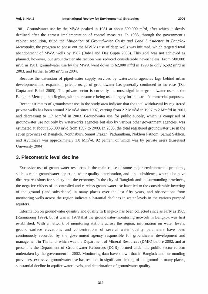
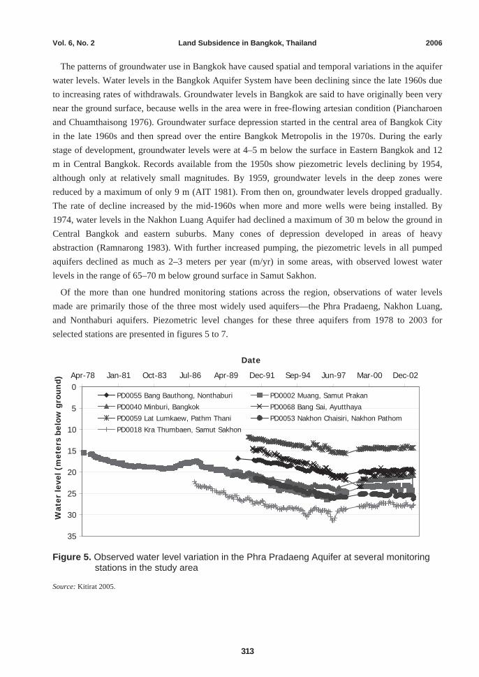
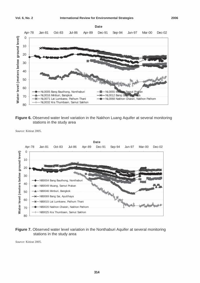
The patterns of groundwater use in Bangkok have caused spatial and temporal variations in the aquifer water levels. Water levels in the Bangkok Aquifer System have been declining since the late 1960s due to increasing rates of withdrawals. Groundwater levels in Bangkok are said to have originally been very near the ground surface, because wells in the area were in free-flowing artesian condition (Piancharoen and Chuamthaisong 1976). Groundwater surface depression started in the central area of Bangkok City in the late 1960s and then spread over the entire Bangkok Metropolis in the 1970s. During the early stage of development, groundwater levels were at 4–5 m below the surface in Eastern Bangkok and 12 m in Central Bangkok. Records available from the 1950s show piezometric levels declining by 1954, although only at relatively small magnitudes. By 1959, groundwater levels in the deep zones were reduced by a maximum of only 9 m (AIT 1981). From then on, groundwater levels dropped gradually. The rate of decline increased by the mid-1960s when more and more wells were being installed. By 1974, water levels in the Nakhon Luang Aquifer had declined a maximum of 30 m below the ground in Central Bangkok and eastern suburbs. Many cones of depression developed in areas of heavy abstraction (Ramnarong 1983). With further increased pumping, the piezometric levels in all pumped aquifers declined as much as 2–3 meters per year (m/yr) in some areas, with observed lowest water levels in the range of 65–70 m below ground surface in Samut Sakhon.
Of the more than one hundred monitoring stations across the region, observations of water levels made are primarily those of the three most widely used aquifers—the Phra Pradaeng, Nakhon Luang, and Nonthaburi aquifers. Piezometric level changes for these three aquifers from 1978 to 2003 for selected stations are presented in figures 5 to 7.
Figure 5. Observed water level variation in the Phra Pradaeng Aquifer at several monitoring stations in the study area
Source: Kitirat 2005.
0
5
10
15
20
25
30
35
Apr-78 Jan-81 Oct-83 Jul-86 Apr-89 Dec-91 Sep-94 Jun-97 Mar-00 Dec-02 Date
Wat
er le
vel (
met
ers
belo
w g
rou
nd)
PD0055 Bang Bauthong, Nonthaburi PD0002 Muang, Samut Prakan PD0040 Minburi, Bangkok PD0068 Bang Sai, Ayutthaya PD0059 Lat Lumkaew, Pathm Thani PD0053 Nakhon Chaisiri, Nakhon Pathom PD0018 Kra Thumbaen, Samut Sakhon
Vol. 6, No. 2 International Review for Environmental Strategies 2006
314
Figure 6. Observed water level variation in the Nakhon Luang Aquifer at several monitoring stations in the study area
Source: Kitirat 2005.
Figure 7. Observed water level variation in the Nonthaburi Aquifer at several monitoring
stations in the study area
Source: Kitirat 2005.
0
10
20
30
40
50
60
70
80
Apr-78 Jan-81 Oct-83 Jul-86 Apr-89 Dec-91 Sep-94 Jun-97 Mar-00 Dec-02 Date
Wat
er le
vel (
met
ers
belo
w g
rou
nd
leve
l)
NL0005 Bang Bauthong, Nonthaburi NL0055 Muang, Samut PrakanNL0016 Minburi, Bangkok NL0012 Bang Sai, AyutthayaNL0071 Lat Lumkaew, Pathum Thani NL0068 Nakhon Chaisiri, Nakhon Pathom NL0032 Kra Thumbaen, Samut Sakhon
0
10
20
30
40
50
60
70
80
Apr-78 Jan-81 Oct-83 Jul-86 Apr-89 Dec-91 Sep-94 Jun-97 Mar-00 Dec-02 Date
Wat
er le
vel (
met
ers
belo
w g
rou
nd
leve
l)
NB0004 Bang Bauthong, Nonthaburi
NB0049 Muang, Samut Prakan NB0046 Minburi, Bangkok
NB0069 Bang Sai, Ayutthaya NB0015 Lat Lumkaew, Pathum Thani NB0020 Nakhon Chaisiri, Nakhon Pathom
NB0025 Kra Thumbaen, Samut Sakhon
Vol. 6, No. 2 Land Subsidence in Bangkok, Thailand 2006
315
Groundwater monitoring records for several stations show that water levels went down about 5–10 m from the late 1970s to around the early 1980s. Some recovery is observed after serious enforcement of the regulations in 1983, after which water levels started to decline once again. Groundwater levels continued to decline until the late 1990s, especially in the Phra Pradaeng, Nakhon Luang, and Nonthaburi aquifers. From 1992 to 1994, the rate of decline for these three aquifers was estimated at 1–3 m/yr (JICA 1995). The lowest groundwater levels were reached around 1997, recovering afterwards, although not up to previous levels as in the late 1980s.
4. Land subsidence
Extensive groundwater use from the late 1950s up to the present has caused the decline of piezometric levels in the aquifers and clay layers beneath the Bangkok Region, resulting in significant subsidence of the ground. The lowering of the ground surface because of land subsidence increases the vulnerability of some areas to flooding. Near the city of Bangkok, in some coastal areas along the Gulf of Thailand, subsidence has resulted in tides moving into low-lying areas that were previously above high-tide levels. In addition to prolonged and extended river/seawater flooding, land subsidence also causes damage to infrastructure; disturbance and deterioration of drainage systems due to changes in the elevation and slope of streams, canals, drains, sanitary sewers, and levees; and protrusion of wells and failure of well casings.
In the case of Bangkok, the occurrence of widespread land subsidence has been primarily attributed to the decline of aquifer pressure heads brought about by groundwater extraction. The withdrawal of groundwater reduces the hydraulic head in the tapped aquifer and increases the grain-to-grain load borne by the aquifer matrix (Poland 1969). With the aquifer characterized by a series of sand and clay layers, land subsidence caused by groundwater extraction is brought about by the compression of both sand and clay layers. The compression of the aquifer layers may be determined from the variation of the piezometric heads and knowing the compression characteristics of the clay and sand layers.
The magnitude of land subsidence may be measured in terms of absolute subsidence, compression of the soil layers, and pore water pressure. Measurement of absolute subsidence through surface leveling that can show variation in elevation of points with respect to a permanent point is the most common subsidence monitoring technique. Compression indicators, which come in different types, are installed to measure the compression of soil layers. Pore water pressure can be monitored with water level readings from observation wells for aquifers and piezometer readings for clay layers.
For Bangkok, it was in 1978 when absolute subsidence was determined through a leveling survey by the Royal Thai Survey Department (RTSD) to measure the magnitude of land subsidence in the area. In the RTSD project, Surface Leveling of the Bangkok Area for the Determination of Land Subsidence, leveling was performed with respect to a stable point outside the subsiding areas. The first-order leveling survey was conducted in 1978, and re-leveling of surface elevations in Bangkok in half-year intervals was carried out (AIT 1981).
Cox (1968) first envisaged the possible occurrence of land subsidence in Bangkok when in the Asian Institute of Technology (AIT) research report, A Review of Engineering Properties of the Recent Marine
Vol. 6, No. 2 International Review for Environmental Strategies 2006
316
Clays in Southeast Asia, it was pointed out that the hydrogeological properties of Bangkok were similar to those of Tokyo—a city known to have had land subsidence problems for many years. Around 1969, the phenomenon was finally given widespread attention when many indications were being observed in the Bangkok area (AIT 1982).
From as early as 1968, the AIT, through various research studies, has analyzed and projected the occurrence of land subsidence in Bangkok. In 1978, through research studies and investigation projects, attempts were made to quantitatively determine the degree of land subsidence in the Bangkok area, including research projects by the DMR, AIT, and RTSD on the management of groundwater and mitigation of land subsidence in Bangkok. From mid-1978 to 1982, the RTSD conducted runs of first-order surface leveling at half-year intervals to monitor the movement of benchmarks in the region. The cause and extent of land subsidence occurring in the Bangkok Metropolitan Region was clarified by studies conducted by the AIT and DMR from 1978 to 1982 and the surface leveling performed by the RTSD in 1978.
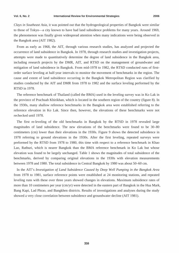
The reference benchmark of Thailand (called the BMA) used in the leveling survey was in Ko Lak in the province of Prachuab Khirikhan, which is located in the southern region of the country (figure 8). In the 1930s, many shallow reference benchmarks in the Bangkok area were established referring to the reference elevation in Ko Lak. Since then, however, the elevations of these benchmarks were not rechecked until 1978.
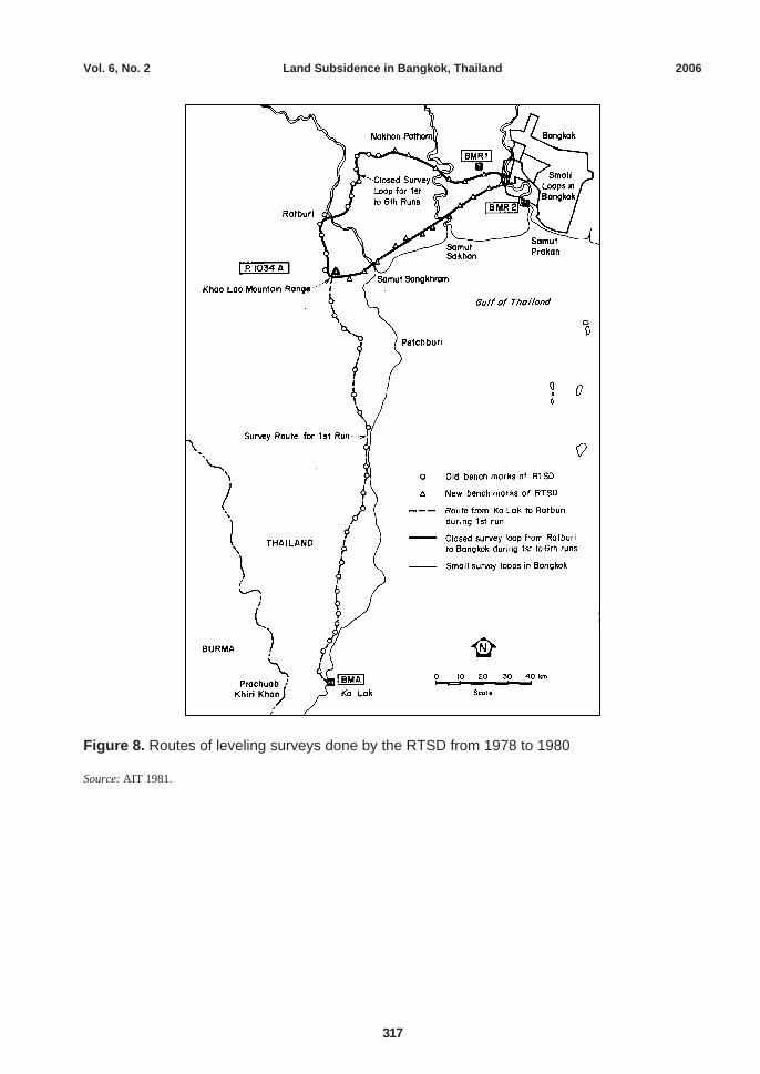
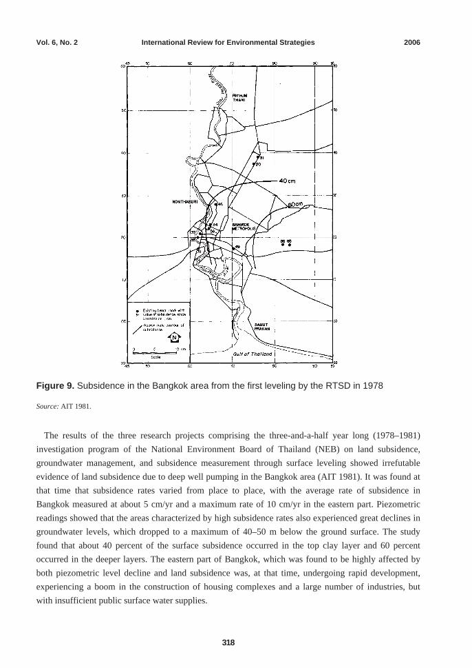
The first re-leveling of the old benchmarks in Bangkok by the RTSD in 1978 revealed large magnitudes of land subsidence. The new elevations of the benchmarks were found to be 30–80 centimeters (cm) lower than their elevations in the 1930s. Figure 9 shows the detected subsidence in 1978 referring to ground elevations in the 1930s. After the first leveling, repeated surveys were preformed by the RTSD from 1978 to 1980, this time with respect to a reference benchmark in Khao Lao, Ratburi, which is nearer Bangkok than the BMA reference benchmark in Ko Lak but whose elevation was found to be largely unchanged. Table 1 shows the magnitudes of total subsidence of the benchmarks, derived by comparing original elevations in the 1930s with elevation measurements between 1978 and 1980. The total subsidence in Central Bangkok by 1980 was about 50–60 cm.
In the AIT’s Investigation of Land Subsidence Caused by Deep Well Pumping in the Bangkok Area from 1978 to 1981, surface reference points were established at 24 monitoring stations, and repeated leveling runs with these over three years showed changes in elevations. Maximum subsidence rates of more than 10 centimeters per year (cm/yr) were detected in the eastern part of Bangkok in the Hua Mark, Bang Kapi, Lad Phrao, and Bangkhen districts. Results of investigations and analyses during the study showed a very close correlation between subsidence and groundwater decline (AIT 1981).
Vol. 6, No. 2 Land Subsidence in Bangkok, Thailand 2006
317
Figure 8. Routes of leveling surveys done by the RTSD from 1978 to 1980
Source: AIT 1981.
Vol. 6, No. 2 International Review for Environmental Strategies 2006
318
Figure 9. Subsidence in the Bangkok area from the first leveling by the RTSD in 1978
Source: AIT 1981.
The results of the three research projects comprising the three-and-a-half year long (1978–1981) investigation program of the National Environment Board of Thailand (NEB) on land subsidence, groundwater management, and subsidence measurement through surface leveling showed irrefutable evidence of land subsidence due to deep well pumping in the Bangkok area (AIT 1981). It was found at that time that subsidence rates varied from place to place, with the average rate of subsidence in Bangkok measured at about 5 cm/yr and a maximum rate of 10 cm/yr in the eastern part. Piezometric readings showed that the areas characterized by high subsidence rates also experienced great declines in groundwater levels, which dropped to a maximum of 40–50 m below the ground surface. The study found that about 40 percent of the surface subsidence occurred in the top clay layer and 60 percent occurred in the deeper layers. The eastern part of Bangkok, which was found to be highly affected by both piezometric level decline and land subsidence was, at that time, undergoing rapid development, experiencing a boom in the construction of housing complexes and a large number of industries, but with insufficient public surface water supplies.
Vol. 6, No. 2 Land Subsidence in Bangkok, Thailand 2006
319
Table 1. Total subsidence at old RTSD benchmarks with respect to original elevation in the 1930s (1978–1980)
Old elevation (1930s)
Observed elevations of benchmarks from RTSD leveling surveys (m MSL)
Average subsidence rate (1978–1980)
Total subsidence by 1980
Benchmark Location
m MSL mid-1978
end of 1978
early-1979
end of 1979
early 1980 cm/yr cm
P. RTSD Royal Thai Survey Department
2.79 2.45 2.45 2.43 2.42 2.41 2.0 38
P. RTSD School
RTSD School, Rajdamnern School
2.35 1.99 1.98 1.97 1.95 1.94 2.5 36
P. BM Royal Palace Raiway Station
3.35 2.81 2.79 2.77 2.75 2.73 4.0 62
P. IA Klong Sam Sen Railway Bridge
4.67 4.35 4.33 4.32 4.30 4.28 3.5 39
P. IIIA Bang Son Railway Bridge
2.38 1.94 1.91 1.90 1.87 1.85 4.5 53
P. 236 King Tak Sin Monument, Wong Wian Yai
2.52 2.23 2.22 2.21 2.20 2.19 2.0 33
P. 386 Meteorological Dept., Bang Kapi
2.31 1.83 1.81 1.79 1.77 1.74 4.5 57
S. 2269 Front of Bhumiphol Hospital, Don Muang
2.47 2.17 2.19 2.15 2.14 2.11 3.0 36
S. 2271 Nakseni Bridge (Sapanmai), Don Muang
4.41 4.22 4.24 4.20 4.19 4.18 2.0 23
S. 135 Khlong Lao 2.43 1.59 1.59 84*
S. 136 Khlong Hua Mark
2.37 1.70 1.70 67*
Source: AIT 1981. *Total subsidence in 1978.
The relatively moderate subsidence rate of around 5 cm/yr was found in the central part of Bangkok, wherein groundwater level declines were also not too intense. Central Bangkok is where main government offices and business areas are situated, and it is adequately covered by public water supply systems. The observed spatial occurrence of subsidence in the Bangkok area indicated that deep well pumping was truly the primary cause of the problem. Surface loading of the ground as a main reason was inconsistent with findings that compression of the top ground layer made up only a small fraction of the observed total subsidence. Moreover, the locations of high-subsidence areas coincided with areas of heavy groundwater use and water level declines, not highly built-up areas with numerous high buildings and heavy traffic.
Various types of benchmarks in Bangkok for use in leveling surveys to measure and monitor land subsidence have been contracted by several government agencies through the years. The NEB has land
Vol. 6, No. 2 International Review for Environmental Strategies 2006
320
subsidence measuring stations, called CI Stations, each having two to five benchmarks at different depths beneath the ground. The RTSD conducts yearly leveling surveys of these NEB CI Stations. The RTSD also has its own benchmarks, which are of two types—primary benchmarks (BMP) and secondary benchmarks (BMS). The Bangkok Metropolitan Authority (BMA) also occasionally conducts leveling surveys with benchmarks that the agency constructed around Bangkok Metropolis. Some of these BMA benchmarks are also used by the RTSD in annual leveling surveys. The DMR constructed benchmarks near its groundwater monitoring stations and conducted leveling surveys through its Survey Division. The Japan International Cooperation Agency (JICA), in the Study on Management of Groundwater and Land Subsidence in the Bangkok Metropolitan Area and its Vicinity in 1995 constructed land subsidence and groundwater level monitoring stations in three sites in the Bangkok Metropolitan Region (JICA 1995).
According to the study by Kasetsart University from 1996 to 2003, maximum subsidence in the Bangkok Metropolitan Region occurred in the Samut Sakhon area, reaching magnitudes of more than 0.35 m (Kasetsart University 2004). In other parts of the region, land subsidence occurred in several areas of the surrounding provinces such as northern Bangkok, the eastern coastal areas, Samut Prakan, and northwestern Nonthaburi. Cumulative land subsidence derived from available data from the DGR indicates four levels of land subsidence observed from 1996 to 2003, as shown in table 2 (Kasetsart University 2004).
Table 2. Subsidence levels from 1996 to 2003 based on 1-m deep benchmarks
Cumulative subsidence Affected areas Greater than 0.35 m Samut Sakhon area: The inner part of Muang Samut Sakhon District 0.25–0.35 m Samut Sakhon area: The outer part of Muang Samut Sakhon District and some
parts of Krathum Baen District; some parts of Bang Khunthien District of Bangkok
The eastern coastal areas: Bang Phli and Muang Samut Prakan districts of Samut Prakan; some parts of Phra Khanong District of Bangkok
0.20–0.25 m The western coastal areas: Bang Khun Thien and Nong Khaem districts of Bangkok Metropolis; Krathum Baen District of Samut Sakhon; some parts of Sam Phran District of Nakhon Pathom
The eastern coastal areas: Bang Phli and Bang Bo districts of Samut Prakan; Lad Krabang, Nong Chok, and some parts of the Prawet and Phra Khanong districts of Bangkok
0.15–0.20 m The western coastal areas: Bang Khun Thien and Nong Khaem districts of Bangkok; Krathum Baen District of Samut Sakhon; the large part of Sam Phran District of Nakhon Pathom
The areas of Nong Chok, Minburi, Prawet, and some parts of Lad Krabang districts of Bangkok; Muang, and Bang Phli districts of Samut Prakan
Bangkok area: Two continuous areas, from the area between Chatuchak and Lad Phrao districts to that between Bang Khen and Don Muang districts
Pathumthani area: Bang Bua Thong and Sai Noi districts Source: Kasetsart University 2004.
Vol. 6, No. 2 Land Subsidence in Bangkok, Thailand 2006
321
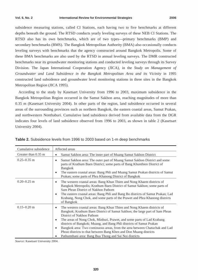
Land subsidence maps generated through the investigations and surveys of various government agencies show that land subsidence still occurs throughout the Bangkok Metropolitan Region, although at lesser magnitudes, especially in the previously designated critical zones in the city. Subsidence rates of around 1 cm/yr exist in most parts of the region. In the central, east, and southeastern parts of Bangkok, categorized as critical zones in 1983, and where from 1978 to 1999 land subsidence was from half a meter to more than one meter, much improvement in the land subsidence problem has been observed in recent years (figures 10–13). From 2001 to 2003, land subsidence in these areas has been reduced to about 1 cm/yr.
Figure 10. Map showing land subsidence in 1997
Source: DGR 2005.
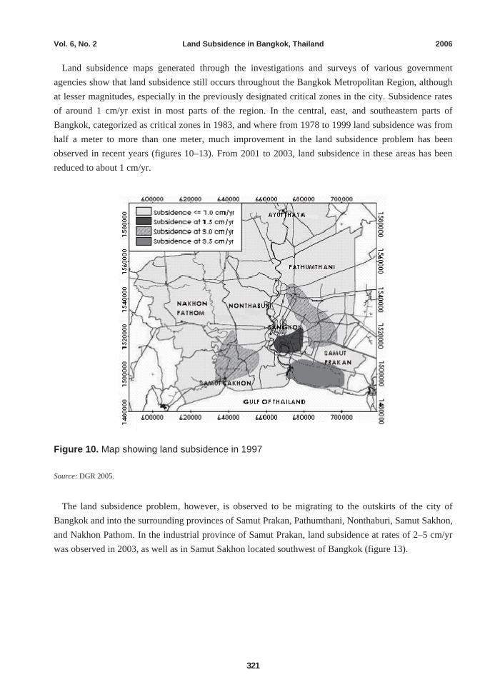
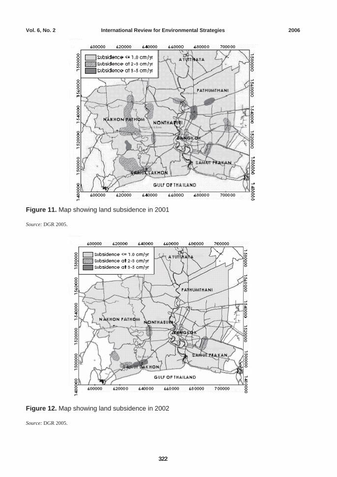
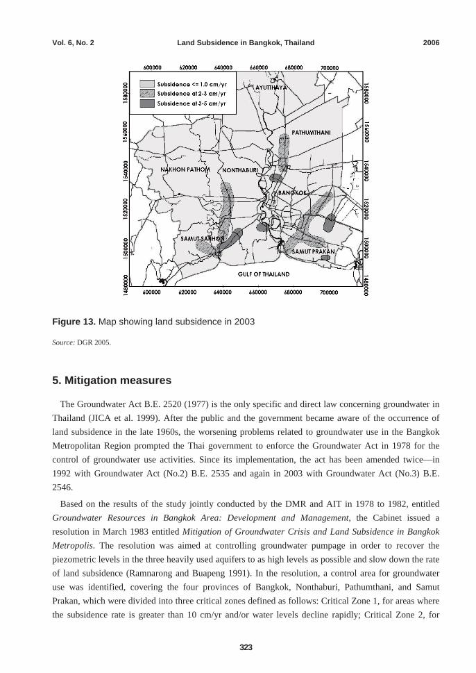
The land subsidence problem, however, is observed to be migrating to the outskirts of the city of Bangkok and into the surrounding provinces of Samut Prakan, Pathumthani, Nonthaburi, Samut Sakhon, and Nakhon Pathom. In the industrial province of Samut Prakan, land subsidence at rates of 2–5 cm/yr was observed in 2003, as well as in Samut Sakhon located southwest of Bangkok (figure 13).
Vol. 6, No. 2 International Review for Environmental Strategies 2006
322
Figure 11. Map showing land subsidence in 2001
Source: DGR 2005.
Figure 12. Map showing land subsidence in 2002
Source: DGR 2005.
Vol. 6, No. 2 Land Subsidence in Bangkok, Thailand 2006
323
Figure 13. Map showing land subsidence in 2003
Source: DGR 2005.
5. Mitigation measures
The Groundwater Act B.E. 2520 (1977) is the only specific and direct law concerning groundwater in Thailand (JICA et al. 1999). After the public and the government became aware of the occurrence of land subsidence in the late 1960s, the worsening problems related to groundwater use in the Bangkok Metropolitan Region prompted the Thai government to enforce the Groundwater Act in 1978 for the control of groundwater use activities. Since its implementation, the act has been amended twice—in 1992 with Groundwater Act (No.2) B.E. 2535 and again in 2003 with Groundwater Act (No.3) B.E. 2546.
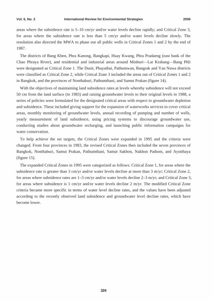
Based on the results of the study jointly conducted by the DMR and AIT in 1978 to 1982, entitled Groundwater Resources in Bangkok Area: Development and Management, the Cabinet issued a resolution in March 1983 entitled Mitigation of Groundwater Crisis and Land Subsidence in Bangkok Metropolis. The resolution was aimed at controlling groundwater pumpage in order to recover the piezometric levels in the three heavily used aquifers to as high levels as possible and slow down the rate of land subsidence (Ramnarong and Buapeng 1991). In the resolution, a control area for groundwater use was identified, covering the four provinces of Bangkok, Nonthaburi, Pathumthani, and Samut Prakan, which were divided into three critical zones defined as follows: Critical Zone 1, for areas where the subsidence rate is greater than 10 cm/yr and/or water levels decline rapidly; Critical Zone 2, for
Vol. 6, No. 2 International Review for Environmental Strategies 2006
324
areas where the subsidence rate is 5–10 cm/yr and/or water levels decline rapidly; and Critical Zone 3, for areas where the subsidence rate is less than 5 cm/yr and/or water levels decline slowly. The resolution also directed the MWA to phase out all public wells in Critical Zones 1 and 2 by the end of 1987.
The districts of Bang Khen, Phra Kanong, Bangkapi, Huay Kwang, Phra Pradaeng (east bank of the Chao Phraya River), and residential and industrial areas around Minburi—Lat Krabang—Bang Phli were designated as Critical Zone 1. The Dusit, Phayathai, Pathumwan, Bangrak and Yan Nawa districts were classified as Critical Zone 2, while Critical Zone 3 included the areas out of Critical Zones 1 and 2 in Bangkok, and the provinces of Nonthaburi, Pathumthani, and Samut Prakan (figure 14).
With the objectives of maintaining land subsidence rates at levels whereby subsidence will not exceed 50 cm from the land surface (in 1983) and raising groundwater levels to their original levels in 1988, a series of policies were formulated for the designated critical areas with respect to groundwater depletion and subsidence. These included giving support for the expansion of waterworks services to cover critical areas, monthly monitoring of groundwater levels, annual recording of pumping and number of wells, yearly measurement of land subsidence, using pricing systems to discourage groundwater use, conducting studies about groundwater recharging, and launching public information campaigns for water conservation.
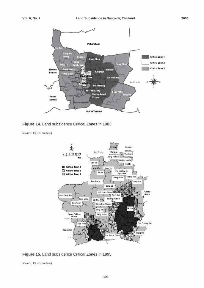
To help achieve the set targets, the Critical Zones were expanded in 1995 and the criteria were changed. From four provinces in 1983, the revised Critical Zones then included the seven provinces of Bangkok, Nonthaburi, Samut Prakan, Pathumthani, Samut Sakhon, Nakhon Pathom, and Ayutthaya (figure 15).
The expanded Critical Zones in 1995 were categorized as follows: Critical Zone 1, for areas where the subsidence rate is greater than 3 cm/yr and/or water levels decline at more than 3 m/yr; Critical Zone 2, for areas where subsidence rates are 1–3 cm/yr and/or water levels decline 2–3 m/yr; and Critical Zone 3, for areas where subsidence is 1 cm/yr and/or water levels decline 2 m/yr. The modified Critical Zone criteria became more specific in terms of water level decline rates, and the values have been adjusted according to the recently observed land subsidence and groundwater level decline rates, which have become lower.
Vol. 6, No. 2 Land Subsidence in Bangkok, Thailand 2006
325
Figure 14. Land subsidence Critical Zones in 1983
Source: DGR (no date).
Figure 15. Land subsidence Critical Zones in 1995
Source: DGR (no date).
Vol. 6, No. 2 International Review for Environmental Strategies 2006
326
6. Conclusions
Extensive groundwater use in Bangkok has resulted in the continual decline of piezometric levels, leading to adverse environmental consequences of land subsidence and water quality deterioration. A number of studies have been conducted to gather information on hydrogeological conditions, understand the dynamics of the complex multi-aquifer system, assess the behavior of the system when different conditions of pumping and storage augmentation are adopted, and to come up with guidelines for operating the system in order to improve the situation.
Groundwater authorities are seriously considering lessening the continual decline of piezometric levels by reducing groundwater pumping in critical areas, especially by the industrial sector, and/or by increasing groundwater storage through artificial recharge. To mitigate land subsidence, authorities believe that industrial estates should be built away from the critically affected areas of subsidence and that factories heavily dependent on groundwater resources should be relocated. But this would only be possible if alternative water supplies that are reliable and adequate in terms of quantity and quality are available to meet the needs of these industries. Perhaps demand management approaches through improved technology and recycling and reuse of water to reduce demand for freshwater may also be implemented. Addressing groundwater issues from the technical perspective alone is not sufficient. One also needs to emphasize management approaches involving groundwater users and stakeholders in developing a variety of instruments to regulate groundwater use and institute effective aquifer management.
Currently, there is an ongoing research project in Asia, called Sustainable Water Management Policy (SWMP), which was initiated by the Institute for Global Environmental Strategies (IGES) in collaboration with institutions from several Asian countries such as China, Indonesia, Sri Lanka, Thailand, and Vietnam. The SWMP project aims to propose integrated policy options for sustainable water resources management in the urban and peri-urban areas of Asia with a focus on freshwater resources and concentrating on groundwater resources in the first phase. Through case studies regarding policies on water resources management in urban areas of Asian countries, the project aims to propose better policy options for sustainable water resources management. The Bangkok Case Study in Thailand is being carried out by the AIT.
Sincere efforts have been exerted to enforce regulatory measures, but lack of institutional thrust and lack of proper legislation have hindered effective implementation. Furthermore, dedicated efforts are needed to carry out a socioeconomic assessment involving the affected stakeholders in the feasibility of any mitigation measures, which might include a combined approach of restriction of pumping through demand-side management, and groundwater storage augmentation through artificial recharge, in order to alleviate groundwater overdraft problems.
Vol. 6, No. 2 Land Subsidence in Bangkok, Thailand 2006
327
References
Asian Institute of Technology. 1981. Investigation of land subsidence caused by deep well pumping in the Bangkok area: Comprehensive report 1978–1981. Research report no. 91. Submitted to the Office of the National Environment Board. Bangkok: Division of Geotechnical and Transportation Engineering, Asian Institute of Technology.
———. 1982. Groundwater resources in Bangkok area: Development and management study. Comprehensive report 1978–1982. AIT research report no. 137. Submitted to the Office of the National Environment Board. Bangkok: Asian Institute of Technology.
Asian Institute of Technology (AIT) and Department of Mineral Resources (DMR). 1978. Groundwater resources in Bangkok area: Development and management study. Phase 1: Final report. AIT research report no. 98. Submitted to the Office of the National Environment Board. Bangkok: AIT and DMR.
Babel, M. S., and A. Das Gupta. 2005. Policy analysis and options for improved groundwater resources management in Bangkok, Thailand. Paper presented at JSCE Meeting, January 21, 2005, at Tokyo, Japan.
Cox, J. B. 1968. A review of engineering properties of the recent marine clays in Southeast Asia. AIT research report no. 6. Bangkok: Asian Institute of Technology.
Das Gupta, A., and M. S. Babel. 2005. Challenges for sustainable management of groundwater use in Bangkok, Thailand. International Journal of Water Resources Development 21 (3): 453–464.
Department of Groundwater Resources (DGR). 2005. Groundwater crisis and land subsidence in Bangkok, http://conserve.dgr.go.th/landsub_bkk.pdf (accessed February 12, 2006).
———. No date. Map of critical groundwater areas in Bangkok in 1983 and 1995 (in Thai). http://www.dgr.go.th/dangerlocal.html (accessed February 12, 2006).
Department of Mineral Resources (DMR). 1998. Critical groundwater and land subsidence. DMR report no. 3/1998. Bangkok: Department of Mineral Resources.
Food and Agriculture Organization (FAO). 1997. Thailand. FAO’s information system on water and agriculture, http://www.fao.org/ag/agl/aglw/aquastat/countries/thailand/index.stm (accessed February 12, 2006).
Japan International Cooperation Agency (JICA). 1995. The study on management of groundwater and land subsidence in the Bangkok Metropolitan Area and its vicinity. Report submitted to the Department of Mineral Resources. Bangkok: JICA.
Japan International Cooperation Agency (JICA), Department of Energy Development and Promotion (DEDP), and Japanese Institute of Irrigation and Drainage (JIID). 1999. Water resources laws in Thailand. Bangkok: JICA, DEDP, and JIID.
Kasetsart University. 2004. Effect of groundwater over-pumping mitigation: Mathematical model study. Final project report. Submitted to the Department of Groundwater Resources. Bangkok: Kasetsart University.
Kitirat, M. 2005. Sustainable groundwater resources management for the Bangkok aquifer system. Master’s thesis no. WM-04-10. Bangkok: Asian Institute of Technology.
Piancharoen, C., and C. Chuamthaisong. 1976. Groundwater of Bangkok Metropolis, Thailand. Proceedings of the International Hydrogeological Conference, Budapest.
Poland, J. F. 1969. Land subsidence and aquifer system compaction, Santa Clara Valley, California, U.S.A. In Proceedings of Tokyo Symposium on Land Subsidence, Tokyo, 1: 285–294.
Ramnarong, V. 1983. Environmental impacts of heavy groundwater development in Bangkok, Thailand. In Proceedings of International Conference on Groundwater and Man, at Sydney, 2: 345–350.
———. 1999. Evaluation of groundwater management in Bangkok: Positive and negative. In Groundwater in the urban environment: Proceedings of the XXVII IAH Congress on Groundwater in the Urban Environment, ed. John Chilton, 51–62. Rotterdam: A. A. Balkema.
Ramnarong, V., and S. Buapeng. 1991. Mitigation of groundwater crisis and land subsidence in Bangkok. Journal of Thai Geosciences (2): 125–137.