Embed Size (px)
Citation preview
Regional Science and Urban Economics 21 (1991) 201-224. North-Holland
Spatial transformation in cities of the developing world Multinucleation and land-capital substitution in Bogoth, Colombia*
David E. Dowall and P. Alan Treffeisen
Institute of Urban and Regional Development, University of California, Berkeley, CA 94720, USA
Received October 1990, fnal version received January 1991
Bogotl has undergone a significant spatial transformation in recent years. Subcenters of employment and commerce have formed at peripheral locations, and these have become surrounded by high-density residential activity. This paper uses several large data sets to describe and analyze these changes. We estimate multicentric density and land value gradients for the years 1973 and 1985, and then explore how housing producers respond to changes in land prices, by calculating a land+zapital substitution elasticity. The results show clearly the declining relevance of the monocentric model over time. and also provide an explanation for the densification of the city.
1. Introduction
It has long been a matter of debate whether developing countries have their own unique set of dynamics, or whether the experiences of poorer nations only reflect those of their more affluent counterparts in an earlier stage of development. It is obvious that cities of developing countries will never replicate exactly the patterns and processes of older urban areas in the developed world, which had their peak under very different technological conditions, and in most cases evolved much more gradually than the exploding metropolises of the Third World. This paper examines the spatial
*An earlier version of this paper was presented at the October 1990 TRED Conference, sponsored by the Lincoln Institute of Land Policy. The other version was also published as Working Paper 525, Institute of Urban and Regional Development, University of California, Berkeley. Financial support for this research was provided by the Lincoln Institute. The authors wish to acknowledge the valuable assistance of Drs Jo& Fernando Pineda and Alvaro Pach6n of Bogoti, Colombia, with whom we are currently carrying out joint research. Access to the World Bank BogotL land price data was made possible through the assistance of Mr Harold Dunkerley and Dr Gregory Ingram, to whom also many thanks are due. Finally, we gratefully acknowledge the helpful comments and suggestions of William Wheaton, Roy Bahl, and the other participants in the 1990 TRED Conference.
0166+$62/91/$03.50 0 1991-Elsevier Science Publishers B.V. (North-Holland)
202 D.E. Dowall and P.A. Treffeeisen, Spatial transformation in cities
changes occurring in Bogota, Colombia, in an effort to understand both the uniqueness and the universality of the developing megacity’s experiences.
The classic Alonso-Mills-Muth type of models of urban spatial structure, along with the more recent formulations of the New Urban Economics (NUE), help to explain observed patterns of land use and land values. These models provide insights into questions such as how land values change as we move away from centers of employment and/or commerce, the kinds of tradeoffs households make between ‘space’ and accessibility, and how capital is substituted for land in housing production as the latter input becomes more expensive. These models have their limitations, however. In the first place, they have been formulated primarily in the context of cities in the developed world. Second, they generally rely on a monocentric paradigm. This prevents an analysis of subcenters, ‘perhaps the most fascinating and the most neglected topic in urban economics’ [Richardson (1977)]. Finally, many of these models fail to consider the implications of capital durability and/or myopic behavior on the part of developers. As Anas (1978) Wheaton (1983) and others have shown, once one or both of these phenomena are introduced into a model of urban spatial structure, there no longer has to be a consistent relationship between current patterns of land use and current land values.
This paper is an effort to describe the spatial change occurring in Bogota, and to interpret it in the light of both the traditional and the more dynamic economic views of spatial structure. We begin with a brief descriptive analysis of Bogota’s transition to a denser, polycentric city, followed by an examination of multicentric density and rent gradients. We then look more specifically at the role of land and land prices in the production of new, formal sector housing in Bogota. By combining two large data sets, we are able to calculate landxapital substitution elasticities and examine how they vary across housing types and zones of the city. We then look more carefully at the housing quality dimension of ‘capital’. We conclude the paper with some suggestions for future research.
2. Spatial change in BogotB: A descriptive analysis
With a population now exceeding 30 million, Colombia has surpassed Argentina to become the third-largest Latin American country, after Brazil and Mexico. Colombia is unusual among developing countries in that its largest city, Bogota, is only about two-and-one-half times as large as the next two cities in the urban hierarchy, Medellin and Cali. Bogota’s population in 1985, according to adjusted figures from the census of that year, was around 4.2 million. Using a demographic model, the Bogota Chamber of Commerce has predicted an annual increase in population of 2.6 percent for the period 1985-2000. This rate of increase would given the city a population approach-
D.E. Dowall and P.A. Treffeisen, Spatial transformation in cities 203
ing six million by the year 2000. In theory, this additional population can easily be accommodated through a combination of increased densification of already-urbanized areas, and settlement of new areas with low agricultural potential [Bogota, Alcaldia Mayor (1987)].
While the rate of population growth in Bogota has actually been declining, the city has been undergoing a major spatial transformation. Almost a decade ago, an article by Ingram and Carroll (1981) noted the dispersion of employment and especially population that was occurring in Bogota and other large cities of Latin America. Lee (1981) further documented the spatial decentralization of manufacturing employment in the Colombian capital. The new spatial structure that is emerging in Bogota is one in which population and employment are increasingly decentralized in relation to the Central Business District, with subcenters of employment and commerce forming in more peripheral locations. These trends are reflected in the changing pattern of population densities and land values in Bogota. A more complete discussion of these changes is found in Pachbn and Hernandez (1989), FEDELONJAS (1988), and Dowall and Treffeisen (1990).
According to the calculations of Pachon and Hernandez, the overall residential density in Bogota increased from 78 to 122 persons per hectare between 1973 and 1985. This densification of the city has had three components: the intill of previously vacant areas, the development of newly- urbanizing areas at greater densities over time, and the redevelopment at higher densities of already-urbanized areas. With Bogota divided into six rings emanating from the CBD, the density pattern changed from single- peaked to double-peaked from 1973 to 1985. Only the innermost ring (the CBD itself) lost population. In both years the ring immediately adjoining the CBD had the city’s highest residential densities. However, by 1985 Ring 4 had replaced the downtown core as the second most dense area of the city.
The shifting pattern of land prices is best seen by examining what has happened over time along Bogota’s main north-south corridor. The available data show that real land prices in the downtown area reached their highest levels in the early 1970s. Since then, prices in and near the CBD have declined, and more pronounced peaks in land values have developed farther to the north. This process has proceeded to the point that land prices in the traditional CBD are now substantially below those in the commercial districts of affluent north Bogota [FEDELONJAS (1988)].
The increased density of Bogota is reflected in the changing characteristics of the housing stock. Apartments are replacing row houses as the predomi- nant form of dwelling for middle and upper-class residents, and households of all income classes are occupying smaller dwelling units. Kang (1980) and Pachon (1980) reported that in 1978, 85 percent of housing units in Bogota were single-family. By 1985, it was estimated that 28 percent of the city’s households occupied apartments [Bogota, Alcaldia Mayor (1987)]. Between
204 D.E. Dowall and P.A. Treffeisen, Spatial transformation in cities
1984 and 1989, less than 15 percent of the new formal sector housing developments reviewed by the newspaper El Tiempo in its architectural supplement consisted of single-family dwellings. The shift to multifamily units is of course gradual, because of the immense size of the existing housing stock. However, in numerous established neighborhoods of Bogota, particu- larly in the affluent north, single-family dwellings have been demolished and replaced by apartment buildings.
The reduction in the amount of space occupied by each household cuts across income groups. A 1978 housing survey found that the average floorspace per dwelling unit in Bogota was almost 150 square meters, and that the average size of units in unauthorized subdivisions was 72 meters [Hamer (1985)]. In contrast, the new housing developments reviewed in the newpaper El Tiempo between 1984 and 1989 had an average size ranging form only 59 square meters per dwelling unit in the poorer south of Bogota, to 89 square meters in the combined central-north-northeast area of the city. Housing units built under various self-help options have also declined in size since the 1978 survey. The standard lot size in new pirate subdivisions is now around 75 square meters, implying a floorspace, at least initially, of no more than 50 square meters. Minimum norm lots offered by private developers average between 60 and 72 square meters in size. The Instituto de Credit0 Territorial, a national government agency dedicated to sheltering the poor, offers a minimum housing ‘solution’ consisting of a basic structure with only 26 square meters of floorspace, on a lot 60 square meters in area [Molina (1989)].
The reduction in space per dwelling unit is undoubtedly influenced strongly by changes in household structure. Pachon and Hernandez (1989) report a decline in average household size of 18 percent, from 5.19 to 4.26, in Bogota between 1973 and 1985. The trend is for couples to have fewer children, for these increasingly to leave home before marrying, and for fewer middle-class households to have live-in domestic help. As has occurred in many other countries, the economic transformations taking place in Colombia have raised the opportunity cost of having children and provided employment alternatives for women who would otherwise have entered domestic service. Ceterus paribus, these changes lead households to demand less space. In this context, rising incomes are likely to have a greater impact on the quality of the housing demanded than on the quantity (i.e., the amount of floorspace).
3. Multinucleation: A closer look
It has long been recognized that the monocentric paradigm is an inadequate tool for the analysis of urban spatial structure. In urban areas throughout the world, the dominance of the Central Business District in
D.E. Dowall and P.A. Treffeisen, Spatial transformation in cities 205
employment and commerce is being challenged by auxiliary centers of activity. The continued use of monocentric models can best be understood as a function of their tractability rather than their realism. The literature on multinucleation in urban areas includes Fales and Moses (1967), Lave (1970), Solow and Vickrey (1971), Papageorgiou and Casetti (1971), Echenique et al. (1974), Romanos (1975), von Boventer (1976), Greene (197Q Odland (1978), Miron (1978), Ogawa and Fujita (1980), Griffith (1981), Gordon, Richardson and Wong (1986), McDonald (1987), Richardson (1988), and Heikkila, Richardson et al. (1989).
In reviewing the literature, the most general principle that one finds is that subcenters are an outcome of two opposing sets of forces: those favoring concentration (loosely called ‘agglomeration economies’), and those favoring dispersion (congestion costs). The article by Greene (1978) presents three scenarios for multinucleation:
1. Firms establish themselves at or outside the urban periphery, in search of lower land and/or transport costs (these firms will tend to be export- oriented). Residential activity is attracted to the area, as workers try to save on commuting costs. 2. Fleeing the high housing costs of already-developed urban areas, workers move to new residential developments at or outside the urban periphery. Shopping centers and eventually ofice developments follow. 3. Small urbanized areas are engulfed by larger ones.
By definition, a subcenter is a zone characterized by greater population densities, employment levels, or commercial activity than surrounding areas. There appear to be no standard criteria for identifying subcenters, although McDonald (1987) has suggested that gross employment density (employment divided by total land area) and the employment/population ratio are the best measures of the spatial concentration of jobs. Residential densities in the employment center itself are likely to be low. However, if land use regulations are not overly restrictive, and the negative environmental impacts of the employment sources not too great, the desire to live close to work should lead to high densities in adjacent areas, and then a decline over some range of distances. Because accessibility to subcenters has value, their locations should be characterized by local peaks in the land price surface. Clearly, then, rent and density gradients, measures of how land values and the intensity of residential land use vary with distance from a particular point or set of points, are important tools for identifying and analyzing a polycentric spatial structure.
4. Density and rent gradients in a multicenter framework
Density and/or rent gradients have been studied in an explicit multicenter
206 D.E. Dowall and P.A. Treffeisen, Spatial transformation in cities
framework in Los Angeles [Heikkila et al. (1989), Gordon, Richardson and Wong (1986)], Baltimore [Dubin and Sung (19X7)], Toronto [Griffith (1981)], and Nairobi [Kahimbaara (1986)]. Except for the articles by Heikkila et al. and Dubin and Sung, the functional forms used in these studies are variations of the familiar negative exponential equation. Muth (1969) has shown that under a set of simplifying assumptions, negative exponential models of densities and land values are consistent with the equilibrium of utility-maximizing households and profit-maximizing housing producers. In a multicentric framework, we posit the following relationship:
D,(or V,) = i fli exp ridi,, i=l
where V’ and D, are the land values and density per hectare at location X, di, is the distance from subcenter i to location x, the a,s are constants, and ri is the density or land value gradient emanating from subcenter i.
Eq. (1) requires a non-linear estimation technique. Alternatively, we can formulate the model with just one intercept term:
D,(or VJ =u exp i ridi,. i=l
(2)
This form has the advantage that it can be linearized, but with it we lose information about the magnitude of land values at the separate peaks.
5. Subcenters in Bogoth: A tentative analysis
Here we report on a preliminary analysis of subcenters in Bogota, using the functional form of eq. (2) above. We are aware that eq. (1) is a more meaningful form, and are currently using it to develop additional estimates of density and rent gradients in Bogota. This work, which involves the use of non-linear least squares, will be presented in a future paper. Our justification for presenting results calculated from eq. (2) is that here we are solely interested in seeing if simple models of residential densities and land values using a multicentric framework give a marked improvement in statistical lit over monocentric models.
We have estimated density and rent gradients in Bogota using data from
D.E. Dowall and P.A. Treffeisen, Spatial transformation in cities 207
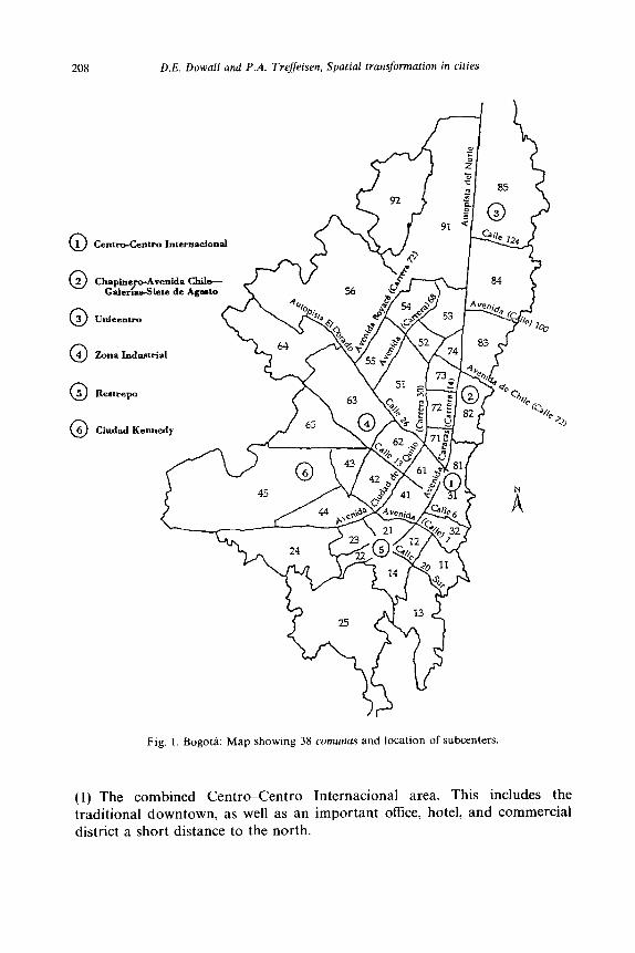
three sources. A constant source of frustration for researchers of urban issues in Colombia has been that spatially disaggregated population data for the large cities are generally not available. Fortunately, Pachon and Hernindez (1989) have developed estimates of the population of each of Bogota’s more than 500 sectores cartogrhficos, for 1973 and 1985. The sectores cartograficos, also known simply as barrios, are subdivisions of the 38 larger zones of the city known as commas (see fig. 1). The data set prepared by Pachon and Hernandez, and generously made available to the authors of this paper, also contains the land area of each barrio, as well as an (X, Y) coordinate representing the location of each barrio centroid on a grid. This data set can thus be used to calculate density gradients.
The locational information can be combined with land value data to calculate rent gradients as well. We have two excellent sources of information on land values in Bogota. The first is the data set consisting of information on sales of vacant land for years 1955-1978, and used by Mohan and Villamizar (1982) and Villamizar (1982) in their respective studies. The second source is a comprehensive research report issued by FEDELONJAS, the Colombian Federation of Real Estate Boards. This document [FEDELONJAS (1988)] covers the period 1959-1978, and represents the most exhaustive study of land prices in Bogota done to date. The data for the years 1979-1988 come primarily from market assessments done by realtors rather than actual transactions. However, because of the large number of observations, and the fact that they come from 41 different realty firms, we have considerable confidence in the reliability of the data.
Unfortunately, existing employment data for Bogota are neither current enough nor spatially disaggregated enough to use an approach such as McDonald’s to identify subcenters. However, while it may not be possible to show in a rigorous fashion what the most important subcenters in the Colombian capital are, certain areas are obvious candidates to those familiar with the city in its present form. Because our interest lay principally in examining how the emergence of a multinucleated urban structure has affected the patterns of land use and land values in the Colombian capital, we felt that an a priori specification of subcenters was not inappropriate. Thus, our procedure was as follows. We first chose a set of eleven barrios which corresponded to local peaks in employment, commerce, and/or land values. We then defined a set of variables (d,,, dzx,. . . , d, Ix) which referred to the straight-line distance between individual barrio centroids and the cen- troids of the proposed subcenters. Not surprisingly, we discovered that there was a high degree of spatial multicollinearity between some of the subcenters. This problem was treated by combining some subcenters that were adjacent to each other, and eliminating others whose influence on land values and residential densities was likely to be overwhelmed by that of other, larger centers nearby. The final result was a model with six centers:
208 D.E. Dowall and P.A. Treffeisen, Spatial transformation in cities
Chaphero-Avenidn Gnle&-Siete de
Ciudad Kennedy
Fig. 1. Bogoti: Map showing 38 comunus and location of subcenters.
(1) The combined Centro-Centro International area. This includes the traditional downtown, as well as an important office, hotel, and commercial district a short distance to the north.
D.E. Dowall and P.A. Treffeisen, Spatial transformation in cities 209
(2) The ChapinereAvenida Chile-Galerias-Siete de Agosto area. This is a large zone between four and six kilometers from downtown, with consider- able residential activity but also some of the city’s most important commer- cial districts. (3) Unicentro. This is Bogoti’s largest US-style shopping center. Opened in 1976, it has become surrounded by high-income residential, commercial, and oflice activity. (4) The industrial zone (Zona Industrial) located in an area between four and six kilometers west of downtown, along the important Calle 13 corridor. Even though it is true, as Lee (1981) has pointed out, that manufacturing employment in Bogoti has become more dispersed over time, this area still represents one of the largest concentrations of blue-collar jobs in the Colombian capital. (5) Restrepo. This area is a commercial area to the south of downtown which serves primarily the sprawling southeast zone of the city. (6) Ciudad Kennedy. This is a vast high-density zone in southwest Bogoti. Our subcenter is the barrio which contains the area’s main commercial district.
The location of these centers is shown in fig. 1. The results reported here come from the simple multicentric formulation of
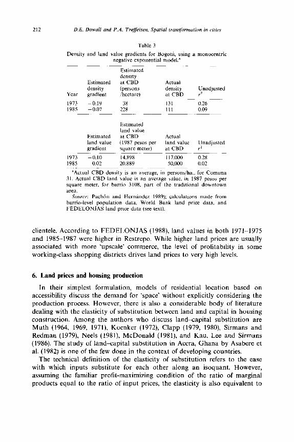
eq. (2). Our models of density and land values were first estimated with all six subcenters, and were then reestimated using a stepwise regression routine. The distance coefficients and their t values are listed in tables 1 and 2. The gradients may be compared with those of table 3, calculated by Pachbn and Hern6ndez using a model with the traditional downtown as the only center.
The use of a multicenter framework for estimating density gradients does not improve the rz values over those obtained by Pach6n and Hernindez (1989) in their monocentric models. In addition, the stepwise procedure accepts only one center for each of the years 1973 and 1985.
In contrast with the density gradients, the goodness-of-fit of the land value models is greatly improved when a multicentric framework is used. All of the distance variables have the expected negative sign, excpet that in 1984, land values appear as a positive function of the distance from the zona industrial. One possible explanation would be that even though there is a peak in land values in the industrial area itself, negative externalities from industrial activity depress land values in immediately adjacent areas.
Why is it that our efforts to model land values in a multicentric framework are more successful than similar work for densities? One reason is that while residential densities are high in areas adjacent to the subcenters, the centers themselves correspond more to peaks in land value, commercial activity, and employment than to peaks in residential density. Another reason is that capital is durable and developers do not have perfect foresight. Wheaton
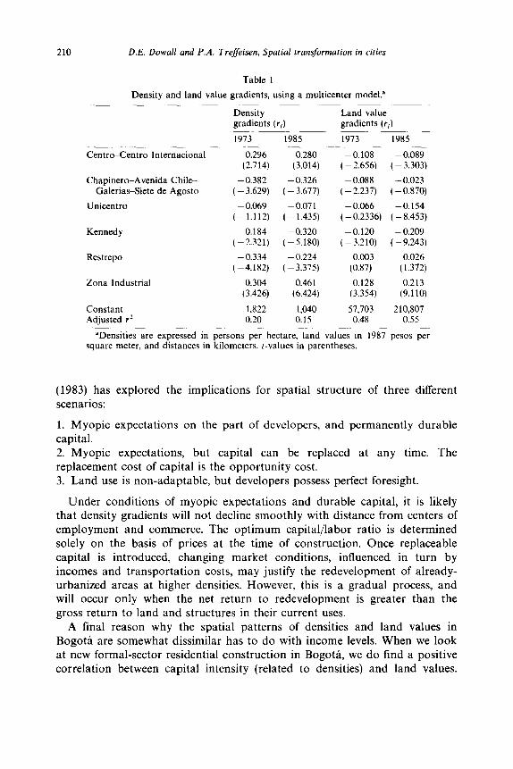
210 D.E. Dowall and P.A. Treffeisen, Spatial transformation in cities
Table 1
Density and land value gradients, using a multicenter model.
Density gradients (ri)
1973 1985
Land value gradients (rJ
1973 1985
Centro-Centro International 0.296
Chapinero-Avenida Chile- Galerias-Siete de Agosto
Unicentro
Restrepo
Zona Industrial
Constant 1.822 Adjusted rz 0.20
(2.714)
-0.382 ( - 3.629)
- 0.069 (-1.112)
-0.184 (-2.321)
- 0.334 (-4.182)
0.304 (3.426)
0.280 -0.108 - 0.089 (3.014) ( - 2.656) ( - 3.303)
- 0.326 - 0.088 - 0.023 - 3.677) (-2.237) (-0.870)
-0.071 - 0.066 -0.154 - 1.435) ( -0.2336) ( 8.453) -
- 0.320 -0.120 - 0.209 - 5.180) (-3.210) (-9.243)
- 0.224 0.003 0.026 - 3.375) (0.87) (1.372)
0.461 0.128 0.213 (6.424) (3.354) (9.110)
1,040 57.703 210,807 0.15 0.48 0.55
‘Denstttes are expressed m persons per hectare, land values in 1987 pesos per square meter, and distances in kilometers. t-values in parentheses.
(1983) has explored the implications for spatial structure of three different scenarios:
1. Myopic expectations on the part of developers, and permanently durable capital. 2. Myopic expectations, but capital can be replaced at any time. The replacement cost of capital is the opportunity cost. 3. Land use is non-adaptable, but developers possess perfect foresight.
Under conditions of myopic expectations and durable capital, it is likely that density gradients will not decline smoothly with distance from centers of employment and commerce. The optimum capital/labor ratio is determined solely on the basis of prices at the time of construction. Once replaceable capital is introduced, changing market conditions, influenced in turn by incomes and transportation costs, may justify the redevelopment of already- urbanized areas at higher densities. However, this is a gradual process, and will occur only when the net return to redevelopment is greater than the gross return to land and structures in their current uses.
A final reason why the spatial patterns of densities and land values in Bogota are somewhat dissimilar has to do with income levels. When we look at new formal-sector residential construction in Bogota, we do find a positive correlation between capital intensity (related to densities) and land values.
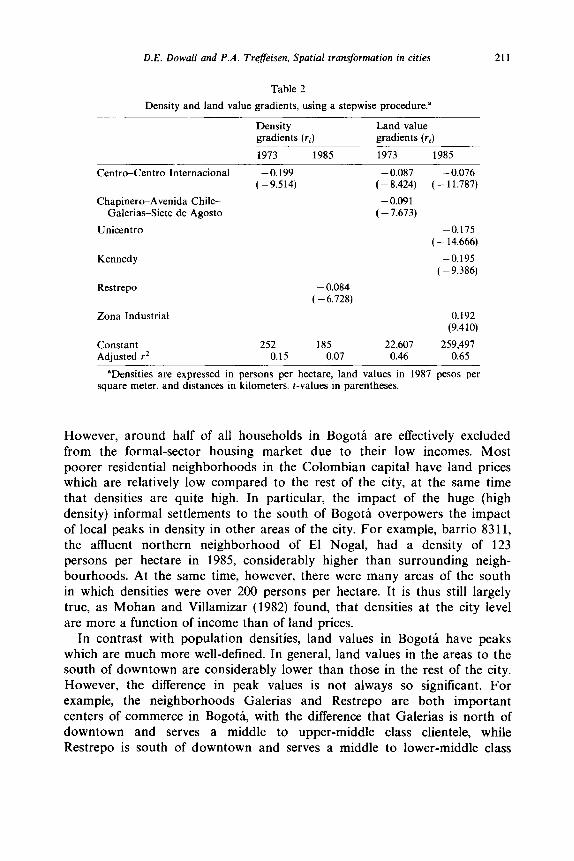
D.E. Dowall and P.A. Treffeisen, Spatial transformation in cities 211
Table 2
Density and land value gradients, using a stepwise procedure.”
Density gradients (ri)
1973 1985
Land value gradients (ri)
1973 1985
Centro-Centro International
Chapinero-Avenida Chile- Galerias-Siete de Agosto
Unicentro
Kennedy
Restrepo
Zona Industrial
Constant 252 185 22,607 Adjusted r2 0.15 0.07 0.46
-0.199 -0.087 (-9.514) (- 8.424)
-0.091 (-7.673)
- 0.084 ( - 6.728)
- 0.076 ( - 11.787)
-0.175 ( - 14.666)
-0.195 ( - 9.386)
0.192 (9.410)
259,497 0.65
“Densities are expressed in persons per hectare, land values in 1987 pesos per square meter, and distances in kilometers. t-values in parentheses.
However, around half of all households in BogotL are effectively excluded from the formal-sector housing market due to their low incomes. Most poorer residential neighborhoods in the Colombian capita1 have land prices which are relatively low compared to the rest of the city, at the same time that densities are quite high. In particular, the impact of the huge (high density) informal settlements to the south of Bogoti overpowers the impact of local peaks in density in other areas of the city. For example, barrio 8311, the aflluent northern neighborhood of El Nogal, had a density of 123 persons per hectare in 1985, considerably higher than surrounding neigh- bourhoods. At the same time, however, there were many areas of the south in which densities were over 200 persons per hectare. It is thus still largely true, as Mohan and Villamizar (1982) found, that densities at the city level are more a function of income than of land prices.
In contrast with population densities, land values in Bogota have peaks which are much more well-defined. In general, land values in the areas to the south of downtown are considerably lower than those in the rest of the city. However, the difference in peak values is not always so significant. For example, the neighborhoods Galerias and Restrepo are both important centers of commerce in BogotL, with the difference that Galerias is north of downtown and serves a middle to upper-middle class clientele, while Restrepo is south of downtown and serves a middle to lower-middle class
212 D.E. Dowall and P.A. Treffeisen, Spatial transformation in cities
Table 3
Density and land value gradients for Bogota, using a monocentric negative exponential model.”
Estimated density
Estimated at CBD Actual density (persons density Unadjusted
Year gradient /hectare) at CBD rz
1973 -0.19 38 131 0.26 1985 -0.07 228 111 0.09
Estimated land value
Estimated at CBD Actual land value (1987 pesos per land value Unadjusted gradient square meter) at CBD r2
1973 -0.10 14,898 117,000 0.28 1985 ~ 0.02 20.889 50,000 0.02
aActual CBD density is an average, in persons/ha.. for Comuna 31. Actual CBD land value is an average value. in 1987 pesos per square meter. for barrio 3108, part of the traditional downtown area.
Source: Pachon and Hernandez 1989); calculations made from barrio-level population data, World Bank land price data, and FEDELONJAS land price data (see text).
clientele. According to FEDELONJAS (1988), land values in both 1971-1975 and 1985-1987 were higher in Restrepo. While higher land prices are usually associated with more ‘upscale’ commerce, the level of profitability in some working-class shopping districts drives land prices to very high levels.
6. Land prices and housing production
In their simplest formulation, models of residential location based on accessibility discuss the demand for ‘space’ without explicitly considering the production process. However, there is also a considerable body of literature dealing with the elasticity of substitution between land and capital in housing construction. Among the authors who discuss land<apital substitution are Muth (1964, 1969, 1971), Koenker (1972), Clapp (1979, 1980) Sirmans and Redman (1979), Neels ( 1981), McDonald (1981), and Kau, Lee and Sirmans (1986). The study of land%apital substitution in Accra, Ghana by Asabere et al. (1982) is one of the few done in the context of developing countries.
The technical definition of the elasticity of substitution refers to the ease with which inputs substitute for each other along an isoquant. However, assuming the familiar profit-maximizing condition of the ratio of marginal products equal to the ratio of input prices, the elasticity is also equivalent to
D.E. Dowall and P.A. Treffeisen, Spatial transformation in cities 213
the percentage change in the ratio of input quantities, divided by the percentage change in the ratio of input prices. In symbols:
ES = d(lKIL)l(KIL)ld(r/n)Mr/n)
= d In (K/L)/d In (r/n), (3)
where
K = the non-land input (‘capital’), L =land, n = the per-unit price of capital, r = the per-unit price of land, In = the natural logarithm.
The elasticity of substitution is measured empirically by equations that derive either directly from the definition, or from the conditions of competi- tive equilibrium in input and product markets. By rearranging terms in the above definition, we obtain the very simple constant elasticity of substitution formulation
In (K/L) = a + b In (r/n), (4)
in which the coefficient b is the (constant) elasticity of substitution. Most work on land-capital substitution has used CES forms equivalent or
similar to the one above. As Kau, Lee and Sirmans (1986) point out, however, it is reasonable to suppose that the elasticity will not be the same at all points on a given isoquant. With the variable elasticity of substitution (VES) functional form, the elasticity varies with the capital/land ratio. We present only CES results here, as our VES computations did not alter our basic conclusions regarding land-capital substitution in Bogota.
It is frequently the case that land enters directly into the consumer’s utility function. If so, the calculated land-capital substitution elasticity reflects more than a technical production relationship. In the case of Bogota, however, there are compelling reasons to believe that housing consumers do not place a high value on land per se. There is certainly not a tradition of large yards and gardens among middle- and upper-class urban dwellers. Anecdotal evidence is frequently cited to the effect that among middle- and upper-class households in the Colombian capital, there is now a preference for apart- ments over houses, primarily for security reasons. We have estimated hedonic
214 D.E. Dowall and P.A. Treffeisen, Spatial transformation in cities
price models for new housing in the Colombian capital, and the coefticient for our dummy variable (0 = multifamily, 1 = single-family) is consistently negative and statistically highly significant. It is unlikely that consumers actually do prefer apartments to houses, all other things (including security) being equal. However, it appears that middle- and upper-income households are at least not strongly averse to multifamily housing. Given current low levels of household size and space consumption, apartments are more feasible to build than row houses.
7. The data
Our analysis of landxapital substitution in BogotL combines information on new, formal sector housing with data on land values. From the architectural supplement of the Colombian newspaper El Tiempo we have obtained data on the price and physical characteristics of a large sample of new housing developments, for the period 1984-1989. The almost 700 observations in the data set represent different stages and sizes of units of over 500 projects. This data set reports prices for the land and structure together, and do not include explicit information on land values. Because of our interest in studying land and capital as two separate inputs in the housing production process, we have estimated a per-square meter land value for each housing development by consulting the FEDELONJAS study (1988), one of our sources of information for calculating land value gradients.
8. Calculation of the land-capital substitution elasticity
One does not find in the literature a uniform treatment of the variables used to calculate the elasticity of substitution between land and capital. In this review article, McDonald (1981) discusses two sources of measurement error in elasticity studies: errors in computing the value of land (e.g., by using assessed values instead of the true cost), and errors in calculating the amount of capital (e.g., by using a purely physical measure of capital intensity and assuming a uniform quality of structure).
Our separation of land and structure values is made possible by the simplifying assumption that usable dwelling space covers 80 percent of the land area of a building or subdivision. The choice of 80 percent for the proportion of the lot or parcel covered by usable structure is somewhat arbitrary, but is by no means inconsistent with observed construction trends in Bogota. In any case, the calculated value of the elasticity is insensitive to changes in the adjustment factor, as long as it is constant across all
D.E. Dowall and P.A. Treffeisen, Spatial transformation in cities 215
observations. Thus, the adjustment factor is useful mostly for computing input shares. Admittedly, the percentage of a land parcel not devoted to dwelling space is likely to vary according to whether the project consists of one apartment building, a complex of several multifamily buildings, or a series of row houses. We do not have sufficient information to assign separate adjustment factors to different types of housing, and in any case, simulations that we have conducted indicate that the results would not be greatly affected by the use of different factors.
As mentioned above, our data on housing prices include both land and structure. Studies of land-capital substitution done for the United States have usually taken the entire dwelling unit as the appropriate unit of analysis. However, we measure structure value by looking at the price per square meter rather than the total cost of the unit. This decision has been made strictly for ease in computation and in comparing prices for different housing developments. Computational results are unaffected by using the alternative formulation.
Observations from 1984 and 1985 use an average land price for those two years, inflated to 1987 pesos. Observations from 1986 to 1989 use a 1986- 1987 average land price, again in 1987 pesos.
The procedure for separating land and structure is as follows. For each ‘complete’ observation, consisting of a typical unit of an apartment building or subdivision, we know the total selling price (i.e., land plus structure) of the unit, the floor space, an estimated land price per square meter, and the number of floors contained in the building or buildings. By definition, we have the following relationship:
H=P*A=nK+rL,
where
H = the total value of housing services provided by the house or apartment, in 1987 pesos.
P = the gross price of housing (structure plus land) per square meter of built space, in 1987 pesos.
A = the total area of the housing unit, in square meters. K = the amount of capital contained in the housing unit. For purposes of the
present study, this is defined as the value of the structure in 1987 pesos. L = the amount of land which can be imputed to the housing unit, in square
meters. n = the price of a unit of capital. Because of the way we have defined capital
above, its price is unity. Therefore, this variable may be eliminated from the equation.
r = the price per square meter of land, calculated from the land price maps prepared by FEDELONJAS, the Colombian realtors’ association.
216 D.E. Dowall and P.A. Trefleisen, Spatial transformation in cities
For ease in computation, we may divide both sides of eq. (5) by A:
P = K/A + rL/A. (6)
The above equation separates the price of one square meter of housing into capital and land components. Rearranging terms, we have
K/A= P-rLJA. (7)
The quantity on the left-hand side is the value of a square meter of structure only. We know P and A, and have an estimate for r. The value of L, the amount of land to be imputed to the housing unit, is calculated using our assumption that 80 percent of the land area is covered by dwelling space. We have the following relationship:
A/L =0.80F or L/A = 1.25/F, (8)
where F is the number of floors contained by the structure. Eq. (7) thus becomes
KfA= P-r(1.25/F). (9)
Eqs. (8) and (9) provide us with our separate estimates for land and structure values per square meter of structure. We need only multiply by A
to obtain separate structure and land values for the entire dwelling unit. The K/L ratio now becomes
K=KIA_P-41.25/F) PF
L L/A (1.25/F) - 1.25 r. (10)
Our elasticity calculations are made using the 587 observations in our data set for which we know the number of floors, and can thus separate land and structure values.
9. The CES form
The estimated Constant Elasticity of Substitution equation is
ln(K/L) = 5.9O-tO.69 In(r), (0.330)(0.033) (11)
adjusted r* = 0.42 (standard errors in parentheses).
D.E. Dowall and P.A. Treffiisen, Spatial transformation in cities 217
The calculated value for the elasticity, 0.69, is significantly different from one, an indication that the Cobb-Douglas formulation would not be appropriate. Our estimate is also consistent with the upper ranges of the results reported on by McDonald (1981) in his review article. Obtaining this higher value offers some support for our view that housing producers in BogotB are better able than their counterparts in the U.S. to respond to higher land prices by building more intensely. We believe that this more flexible response in the Colombian case is due both to less strict land use controls, and to the relatively little weight given to land in the household utility function. It is interesting to note that the elasticity estimate for Accra, Ghana calculated by Asabere et al. using the CES form, was 0.53. This figure is consistent with the low end of the range reported by McDonald in his review of elasticity studies. The authors attribute this low value to ‘the limited range of technological opportunities available for housing production’ (p. 195). However, the authors themselves recognize that a number of objections can be raised to their measure of capital intensity, which is simply square feet of living space. We have greater confidence in our elasticity calculation for Bogoti, as it takes into account the role of construction quality in land<apital substitution.
10. Variations in elasticity across housing types and zones
It is of interest to explore whether one equation is adequate to explain capital-land substitution, or whether elasticities differ according to the type of housing and the area of the city where it is located. Separate CES regressions for single- and multifamily housing, and for the four zones of Bogot& are listed in table 4.
Upon inspection, there do appear to be substantial differences between the equations. The differences in intercepts reflect the fact that the mean capital/ land ratio varies considerably across housing types and zones. The differ- ences in slopes imply varying degrees of flexibility of the production process in response to changing input prices. Our interest is primarily in the slope,
Table 4
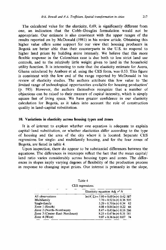
CES regressions.
All observations In (K/L) = 5.90+0.69 In (r) 0.42 587 Multifamily 7.70+ 0.52 In(r) 0.36 505 Single-family 5.20+ 0.70 In(r) 0.34 82 Zone 1 (South) 4.08 + 0.84 In (r) 0.22 66 Zone 2 (North-Northwest) 8.47+0.43 In(r) 0.16 266 Zone 3 (Center-East-Northeast) 8.25+0.47In(r) 0.31 181 Zone 4 (West) 9.07 + 0.36 In(r) 0.07 74
Elasticity equation Adj. r* N
218 D.E. Dowall and P.A. Trefleisen, Spntial transformation in cities
i.e., the elasticity. The elasticity is highest for single-family housing and in the south. Because single-family units and dwellings in the south of Bogota are relatively land - intensive (i.e., have low capital/land ratios), when the price of land increases relative to that of capital, there is greater potential for substitution away from the former input.
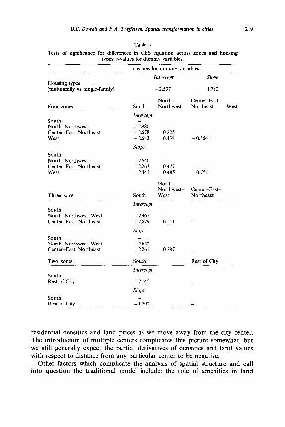
To test for the statistical significance of the differences in slopes and intercepts, we have used both the analysis of covariance technique [see Chow (1960)], and the simpler technique of dummy variables, as outlined by Pindyck and Rubinfeld (1976). Table 5 lists the results of our dummy variable tests. For the two housing types, the difference in the intercepts of the elasticity equation is highly significant, but the dummy variable for the difference in the slopes has a t-value of only 1.78. For now we choose not to reject the null hypothesis of equal elasticities for single-family and multi- family housing. The implication is that capital and land substitute for each other in similar ways across the two housing types.
Our analysis of variations in the elasticity of substitution across zones of the city gives results similar to those discussed above. While there are significant differences in intercepts between individual pairs of zones, it is only when the number of zones is reduced to two (south Bogota versus the rest of the city) that all differences are significant. With the city divided into two zones, the t-value of the dummy variable for slope differences is - 1.79. Once again, the differences in elasticities are not highly significant, and we choose not to reject the null hypothesis of equal elasticities across zones.
Earlier in this paper, we expressed the view that households participating in the formal sector housing market in Bogota do not have strong inherent preferences for a particular housing type. The picture that emerges from our study is that whether they occupy houses or apartments will largely be a function of land prices, which in turn are positively correlated with income. Poorer families occupy small, low quality houses, usually on inexpensive land, while more affluent households choose small but high-quality apart- ments located on expensive land. Land values are ultimately influenced by ‘assessibility’ in the broadest sense of the word, but accessibility to the traditional CBD is of relatively minor importance. There are many poor neighborhoods with low land values within a very short distance of downtown.
11. Land-capital substitution, housing quality, and spatial structure
Economic models of urban spatial structure emphasize the role that accessibility to centers of attraction play in determining land values. The higher land prices found in more central locations in turn have a two-sided impact: producers substitute capital for land in housing production, and consumers trade ‘space’ for accessibility. We expect to find declines in both
D.E. Dowall and P.A. Treffeisen, Spatial transformation in cities 219
Housing types (multifamily vs. single-family)
Four zones
South North-Northwest Center-East-Northeast West
South North-Northwest Center-East-Northeast West
Three zones
Tests of significance for differences in CES equation across zones and housing types: t-values for dummy variables.
t-values for dummy variables
Intercept Slope
- 2.537 1.780
North- Center-East South Northwest Northeast West
Intercept _
-2.980 - - 2.678 0.225 - 2.683 0.438 -0.554
Slope
South North-Northwest-West Center-East-Northeast
_
2.640 - 2.263 -0.477 _
2.441 0.485 0.751
North- Northwest- Center-East-
South West Northeast
Intercept _
-2.965 - -2.679 0.111 _
Slope
South North-Northwest-West Center-East-Northeast
Two zones
South Rest of City
_
2.622 - 2.261 -0.387 _
South Rest of City
Intercept
-2.145
Slope
_
South Rest of City
_
- 1.792 _
Table 5
residential densities and land prices as we move away from the city center. The introduction of multiple centers complicates this picture somewhat, but we still generally expect the partial derivatives of densities and land values with respect to distance from any particular center to be negative.
Other factors which complicate the analysis of spatial structure and call into question the traditional model include: the role of amenities in land
220 D.E. Dowall and P.A. Treffeisen. Spatial transformation in cities
values and residential location; the existence of housing stocks of different vintages and physical conditions, as well as the related problems of capital duarability and myopic development; and the wide differences in incomes and preferences across households. Finally, a much-neglected dimension of spatial structure is the role of construction quality in housing supply and demand. Theoretical models and empirical observation show that the amount of capital per unit of land used in housing production is an increasing function of the price of land. However, the capital/land ratio conceals more intricate relationships. On the one hand, there is the density dimension; as Bender (1981) has discussed, housing services per unit of land are the product of housing services per dwelling unit and number of dwellings per unit of land. Of greater interest to us here is the fact that capital can be devided into ‘space’ and quality components. Most studies of land-capital substitution do correctly measure capital as structure value, but they do not explore the space vs. quality dimension.
The K of this paper, the amount of capital in a given housing unit, can be reformulated as A * q, where A is again the area or floor space of the housing unit, and q is a quality index, expressed in monetary terms. Both CES and VES forms of the elasticity of substitution incorporate the ratio K/L in the dependent variable. With capital disaggregated into its space and quality dimensions, this ratio becomes A * q/L = (A/L) * q. Clearly, calculating the elasticity of substitution using only A/L (built space per unit of land) as a measure of K will give a biased estimate. The direction of this bias will depend on the sign of dq/dr. If q is a positive function of the land value r (the normal expectation), the estimated elasticity will be biased downward.
The relative impact of rising land prices on the separate components of the capital/land ratio has important implications for spatial structure, as we discuss below. Fortunately, since the space and quality components are multiplicative, their logarithms are additive. By running separate regressions for ln(A/L) and In(q) or r, we are able to decompose the elasticity of substitution in eq. (4) into space and quality components. Using the same data set as earlier in this paper, we calculate:
ln(A/L)= -1.21+0.25lnr In(q)= 7.11+0.44lnr
ln(A/L)+ln(q)=ln(K/L)= 5.90+0.69lnr (12)
Eq. (12) is identical to eq. (4). We conclude that in the context of new, formal-sector housing in Bogota, both space and structure quality are positive functions of land prices. Using the CES formulation, we expect a one percent rise in the price of land to lead to a 0.44 percent increase in the structure quality index, and a 0.25 percent increase in the built area per unit
D.E. Dowall and P.A. Treffeisen, Spatial transformation in cities 221
of land. Of course, some of what we are calling ‘construction quality’ is actually the increased cost of building taller buildings. However, one still finds large variations in the per-square-meter cost of structure between buildings of similar height.
We stated earlier that the relatively high value of the capital-land substitution elasticity in Bogoti could be due to less strict land use controls. The disaggregation of capital into space and quality components gives us a further reason for the high elasticity. Although the elasticity is defined in terms of a production function, the calculated value reflects the intersection of housing supply and demand. If households are willing to accept higher structure quality in exchange for smaller dwelling units, the elasticity of substitution will be high even with controls on structure height or bulk.
Theories of spatial structure formulated in the U.S. context must necess- arily give great importance to the phenomenon of suburbanization, which is in large part explained by the desire of more affluent households to consume more ‘space’ where space (actually, land) is cheaper. We see a very different pattern in BogotL, where more well-off households occupy more expensive land, and adapt to rising land prices by consuming less land, less built space, and higher-quality dwellings.
12. Conclusions and directions for further research
It is tempting to draw parallels between the spatial change occurring in cities of the developing world such as BogotB, and the transformations which urban areas in the United States are undergoing. However, in Bogoti the decline of the CBD has been more relative than absolute, and the formation of subcenters has been accompanied by an overall densification of the city rather than U.S.-style suburbanization. We believe that the reasons for this more compact development in Bogoti include the low rate of automobile ownership and the absence of rail rapid transit, and the acceptance by the population of high-density living. Land use regulations play a double role in encouraging a more intensive use of this input: the ultimate boundaries of the city are being regulated in order to prevent encroachment on agricultural land, and restrictions on residential densities and heights are much less strict than in U.S. cities.
The static theory of spatial structure develops a model in which both densities and land values fall as we move away from centers of attraction. However, once durable capital and/or myopic behavior by developers are introduced, densities and land values are not as closely related. We have seen that in Bogod the static model does not hold up well. This is due in part to the reasons listed above, but also due to the fact that the city level, densities are a function more of income than accessibility. Land values are in turn
222 D.E. Dowall and P.A. Treffeisen, Spatial transformation in cities
very heavily influenced by a combination of income and amenity effects which are separate from accessibility to employment.
We have documented Bogota transition to a multicentric city, but more work is needed before we can have a theory of subcenters. While we know what some of the factors behind multinucleation are, we do not have an integrated theory which relates specific economic and institutional conditions to particular spatial forms. Ultimately, the particular form that multinuclea- tion takes would seem to result from the interaction of institutional decisions (including land use regulations) and the transportation system. Developing a theory or typology of polycentric urban areas should be a top priority for future research.
References
Anas, Alex, 1978, Dynamics of urban residential growth, Journal of Urban Economics 5, 6687. Asabere. Paul K., C.F. Sirmans and Peter F. Colwell, 1982, The intensity of residential land use
in Accra, Ghana, Journal of Urban Economics 11, 19&198. Bender, Bruce, 1981, Urban housing density and the price of housing services, Journal of Urban
Economics 9, 8&84. Bogota, Alcaldia Mayor, 1987, Bogota para todos, 1987-1990 (Editorial Presencia, Bogota). Chow, G.C., 1960, Tests of equality between two sets of coefficients in two linear regressions,
Econometrica 28, 591-605. Clapp, John M., 1979. The substitution of urban land for other inputs. Journal of Urban
Economics 6, 122-134. Clapp, John M.. 1980, Production with land and nonland factors: Which functional form?,
Journal of Urban Economics 8, 3246. Dowall, David E. and P. Alan Treffeisen, 1990, Urban development and land and housing
market dynamics in Bogota, Colombia. Monograph no. 38 (Institute of Urban and Regional Development, University of California at Berkeley, Berkeley, CA).
Dubin, R.A. and C.H. Sung, 1987, Spatial variation in the price of housing: Rent gradients in non-monocentric cities. Urban Studies 24, June, 193-204.
Echenique, Marcia1 et al., 1974. A disaggregated model of urban spatial structure: Theoretical framework, Environment and Planning A 6, 33-63.
Editorial America, 1987, Almanaque Mundial, 1987 (Editorial America, Panama). Fales, Raymond R. and Leon N. Moses, 1967, Land-use theory and the spatial structure of the
nineteenth-century city, Papers of the Regional Science Association 28, 49-80. FEDELONJAS (Federation Colombiana de Lonjas de Propiedad Raiz). 1988, El valor de1 suelo
urban0 en Bogota y sus implicaciones en el desarrollo de la ciudad (FEDELONJAS, Bogota).
Gordon, P., H.. Richardson and H.L. Wong, 1986, The distribution of population and employment in a policentric city: The case of Los Angeles, Environment and Planning A 18, 161-173.
Greene, David Lloyd, 1978, Multinucleation in urban spatial structure. Ph.D. dissertation (Johns Hopkins University, Baltimore, MD).
Griffith, Daniel A., 1981, Modelling urban population density in a multi-centered city, Journal of Urban Economics 9, 2988310.
Hamer, Andrew Marshall, 1985, Bogota’s unregulated subdivisions: The myths and realities of incremental housing construction, World Bank Staff working paper no. 734 (World Bank, Washington, DC).
Heikkila, Eric, Harry W. Richardson et al., 1989, What happened to the CBD-distance gradient?: Land values in a policentric city, Environment and Planning A 21, no. 2, Feb., 221-232.
Ingram, Gregory and Alan Carroll, 1981, The spatial structure of Latin American cities, Journal of Urban Economics 9. 2577273.
D.E. Dowall and P.A. Treffeisen, Spatial transformation in cities 223
Johnston, J., 1963, 1972, Econometric methods (McGraw-Hill, New York). Kahimbaara, J.A., 1986, The population density gradient and the spatial structure of a third
world city: Nairobi, a case study, Urban Studies 23. 307-322. Kang, Sungyong 1980, Housing stock in Bogotk A descriptive study, Mimeo. (The World Bank,
Washington, DC). Kau, James B., C.F. Lee and C.F. Sirmans, 1986, Urban econometrics: Model developments and
empirical results. Research in Urban Economics, Vol. 6 (JAI Press, Greenwich, CT, London). Koenker, Roger, 1972, An empirical note on the elasticity of substitution between land and
capital in a monocentric housing market, Journal of Regional Science 12, no. 2, 299-305. Lave, Lester B., 1970, Congestion and urban location, Papers of the Regional Science
Association 25, 133-150. Lee, Kyu Sik, 1981, Intra-urban location of manufacturing employment in Colombia, Journal of
Urban Economics 9, 222-241. McDonald, John F., 1981, The substitution of land for other inputs in urban areas, Papers of
the Regional Science Association 48, 39-55 (with comments). McDonald, John F., 1987, The identification of urban employment subcenters, Journal of Urban
Economics 21, no. 2. March, 242-258. Miron, John R.. 1978, Nucleated subdivisions in a competitive market economy. Urban Studies
15, 2233229. Mohan, Rakesh, 1986, Work, wages and welfare in a developing metropolis: Consequences of
growth in Bogoti. Colombia (Published for the World Bank by Oxford University Press, New York).
Mohan, Rakesh and Rodrigo Villamizar, 1982, The evolution of land values in the context of rapid urban growth: A case study of Bogoti and Cali, Colombia, in: Matthew Cullen and Sharon Woolery, eds., World congress on land policy, 1980 (Lexington Books, Lexington, MA) 217-253.
Molina, Humberto, 1989, Bogoti: Mercado legal e informal de suelos urbanos, Revista Camacol 2, no. 2, Edition 39, June, 102-116.
Muth, Richard F., 1964, The derived demand curve for a productive factor and the industry supply curve, Oxford Economic Papers 16, July, 221-254.
Muth, Richard F., 1969, Cities and housing: The spatial pattern of urban residential land use (The University of Chicago Press, Chicago, IL).
Muth, Richard F., 1971, The derived demand for urban residential land, Urban Studies 8, 243-254.
Neels, Kevin, 1981, Production functions for housing services, Papers of the Regional Science Association 48, 25-37.
Odland, John, 1978, The conditions for multi-center cities, Economic Geography 54, 234-244. Ogawa, Hideaki and Masahisa Fujita, 1980, Equilibrium land use patterns in a nonmonocentric
city, Journal of Regional Science 20, no. 4, 455475. Pachon, Alvaro, 1980. Automobile ownership. Bogota and Cali, 1972-1978, Intermediate Paper
no. 31, City study project (World Bank, Washington, DC). Pachon Muiioz, Alvaro and Sonia de Hernindez, 1989, La vivienda en Colombia 1973-1985: La
distribution espacial de la poblacion en las Areas metropolitanas, Boletin de Estadistica, Dec., 245-258.
Papageorgiou, George J. and Emilio Casetti, 1971, Spatial equilibrium and residential land values in a multicenter setting, Journal of Regional Science 11, no. 3, 385389.
Pindyck, Robert S. and Daniel L. Rubinfeld, 1976, Econometric methods and economic forecasts (McGraw-Hill, New York).
Revankar, Nagesh S., 1971, A class of variable elasticity of substitution production functions, Econometrica 39, no. 1, Jan., 61-71.
Richardson, Harry W., 1977, The new urban economics, and alternatives (Pion, London). Richardson, Harry W., 1988, Monocentric vs. polycentric models: The future of urban economics
in regional science, The Annals of Regional Science 22, no. 2, July, 1-12. Romanos, Michalis Constas, 1975, Theories and models of residential spatial structure in multi-
center urban areas, Ph.D. dissertation (Cornell University, Ithaca, NY). Sirmans, C.F. and Arnold R. Redman, 1979, Capital-land substitution and the price elasticity of
demand for urban residential land, Land Economics 55, no. 2, May, 167-175.
224 D.E. Dowall and P.A. Treffeisen, Spatial transformation in cities
Solow, Robert M. and William S. Vickrey, 1971, Land use in a long narrow city, Journal of Economic Theory 3, 43&447.
Villamizar, Rodrigo, 1982, Land prices in Bogota between 1955 and 1978: A descriptive analysis, in: J. Vernon Henderson, ed., Research in urban economics, Vol. 2 (JAI Press, Greenwich, CT, London).
von Boventer, Edwin, 1976, Transportation costs, accessibility and agglomeration economies: Centers, subcenters and metropolitan structures, Papers of the Regional Science Association 37, 167-183.
Wheaton, William C., 1983, Theories of urban growth and metropolitan spatial development, in: J. Vernon Henderson, ed., Research in urban economics, Vol. 3 (JAI Press, Greenwich, CT, London).