Embed Size (px)
Citation preview
RESEARCH ARTICLE
Spatial modeling of ecological areas by fitting the limitingfactors for As in the vicinity of mine, Serbia
Dragan Cakmak & Veljko Perovic & Elmira Saljnikov &
Darko Jaramaz & Biljana Sikiric
Received: 14 March 2013 /Accepted: 4 November 2013 /Published online: 27 November 2013# Springer-Verlag Berlin Heidelberg 2013
Abstract Elevated arsenic (As) concentrations in soil areoften found in the vicinity of certain mineral deposits thathave been, or are currently, under exploitation, regardless ofthe target resource. Detailed study of such areas for safeagriculture requires considerable financial costs and long pe-riods of time. Application of an appropriate spatial model thatdescribes the behavior of arsenic in soil and plants can signif-icantly ease the whole investigation process. This paper pre-sents a model of ecological security of an area that, in the past,was an antimony mine and has a naturally high content ofarsenic. For simulation and modeling the geographic informa-tion science (GIS) technology with the inserted predictorsinfluencing the accessibility of As and its content in plantswas used. The results obtained were the following: (1) acategorization of contaminated soils according to soil proper-ties was developed; (2) the proposed methodology allowsfocusing on particular suspect area saving an energy andhuman resource input; and (3) new safe areas for growingcrops in contaminated area were modeled. The application ofthe proposed model of As solubility to various crops grownaround a former antimony mine near the village of Lisa,southwest Serbia showed that significant expansion of theareas suitable for growing potato, raspberry, and pasture waspossible.
Keywords Arsenic .Mine . Safe growing . GIS application .
Spatial modeling
Introduction
Arsenic has achieved close attention because of the toxicproperties of a number of its compounds. Especially in thevicinity of a mining area, arsenic (As) presents a high healthrisk in comparison with other toxic trace elements (e.g., Wanget al. 2010) considering that arsenic has often been used as apathfinding or indicator element when geochemicalprospecting methods have been utilized to indentify mineraldeposits, since it is associated in many minerals includingminerals of antimony (O'Neill 1995). Another reason is itsheightened concentration nearby ore-mining in Serbia (Lisa,Bor), and its low allowed concentrations in soil by law inmany countries. In plowlands, the usual forms of arsenic arearsenates due to the oxidative conditions of upper plow hori-zon, which is less toxic than arestin (Woolson et al. 1971;Takamatsu et al. 1982; O'Neill 1995). The problem of deter-mining the arsenic toxicity and availability in the soil due to itsdifferent bounding has been attempted to be solved in severalways.
One of the ways of determining the environmental toxicityof As in soil is via its total content in soil through defining itslimit values dangerous to human health when consumingfruits from the area with arsenic content over the maximumallowed concentrations (maximum allowed concentrations(MAC), Regulations of the Ministry of the Republic of Serbia1994). Since this method provides only limited values, thereare attempts to give more precise answers about the process ofpollution based on determination of the natural background ofpollutants in specific land (Mrvic et al. 2011).
Another way is the use of different extraction means forisolation ofmobile or available forms of arsenic that are moreor less correlated with its content in the plants. The solventsused were as follows: distilled water, 0,1N NH4OAc, Bray P-solution (0.03N NH4F+0.025N HCl), 0.05N HCl, mixedacid (0.05N NH4Cl+0.025N H2SO4), 0.5N NaHCO3, 0.05
Responsible editor: Michael Matthies
D. Cakmak (*) :V. Perovic : E. Saljnikov :D. Jaramaz : B. SikiricInstitute of Soil Science, Teodora Drajzera 7, 11000 Belgrade, Serbiae-mail: [email protected]
Environ Sci Pollut Res (2014) 21:3764–3773DOI 10.1007/s11356-013-2320-7
N KH2PO4, 0.1N NH4NO3, 0,1N KNO3. But the disadvan-tage of all these methods is that they are related to certain soiltypes, plants, or regions, which causes a large number ofcalibration experiments and the impossibility of perceiving awider area (Adriano 2001).
The third way is using the models based on certain soilparameters that allow establishing the As concentrationexpected in fruits of different plant species (SoilGuideline Values 2009) or soil properties that influencethe solubility of As (Regulation of the Government of theRepublic of Serbia 2010; Sanaterre Environmental DutchList 2000). This method is well applicable, but its draw-back is the need for large numbers of samples and corre-lation with geographic factor, which does not give the fullinsight into the ecological aspect of wider study area.
Analysis of the spatial distribution of harmful traceelements in soils is of fundamental importance in thesustainable development of ecosystems in a particulararea. The high cost of research and the time required tocollect and analyze data in tracking the spatial changes inthe ecosystem present difficulties in assessing pollutionwith harmful trace elements in soils using previously
listed conventional methods. However, these problemscan be overcome by the use of predictive models andusing new technologies that are implemented in moderntechnological solutions. The application of interpolationmethods is more important in describing the spatial vari-ability of soil properties.
In practice, the mapping of harmful trace elements areoften displayed by interpolation of their concentration inthe sampled points and for this purpose geostatisticaltechniques such as kriging are used (McBratney et al.2003; Hengl and Heuvelink 2004; Rodríguez Lado et al.2008; Chowdhury et al. 2010; Hassan and Atkins 2011).
Analyzed digital spatial maps will give the estimates ofunsampled sites and allow the separation of potential areas forthe safe cultivation of agricultural crops.
This paper attempts to present the model of ecolog-ical security of the area that in the past was an antimo-ny mine and have naturally high content of arsenic. Themodel uses geographic information science (GIS) tech-nology platform to predict variables, which influencethe accessibility of arsenic and its concentration inplants.
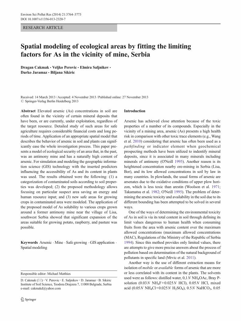
Fig. 1 Location of the investigated site and sampled points
Environ Sci Pollut Res (2014) 21:3764–3773 3765
Materials and methods
Description of study site
The studies were conducted in the area surrounding thevillage Lisa, 6 km away from the city of Ivanjica in the westof Serbia. The studied area occupied an area of 8.6 km2 withgeographic position: 43°37′40″–43°39′8″ latitude and 20°11′22″–20°13′47″ longitude. In this location, the complete soilsurvey was done as a part of the project intended to mine thegold with recommendation of land remediation. Based on allthe studies such as slope, boundaries of soil types, geologicalsubstrate, and vegetation coverage there, 27 representativeprofiles were opened with accompanying semi-profiles, withthe boundaries accurately drawn for each soil types and their
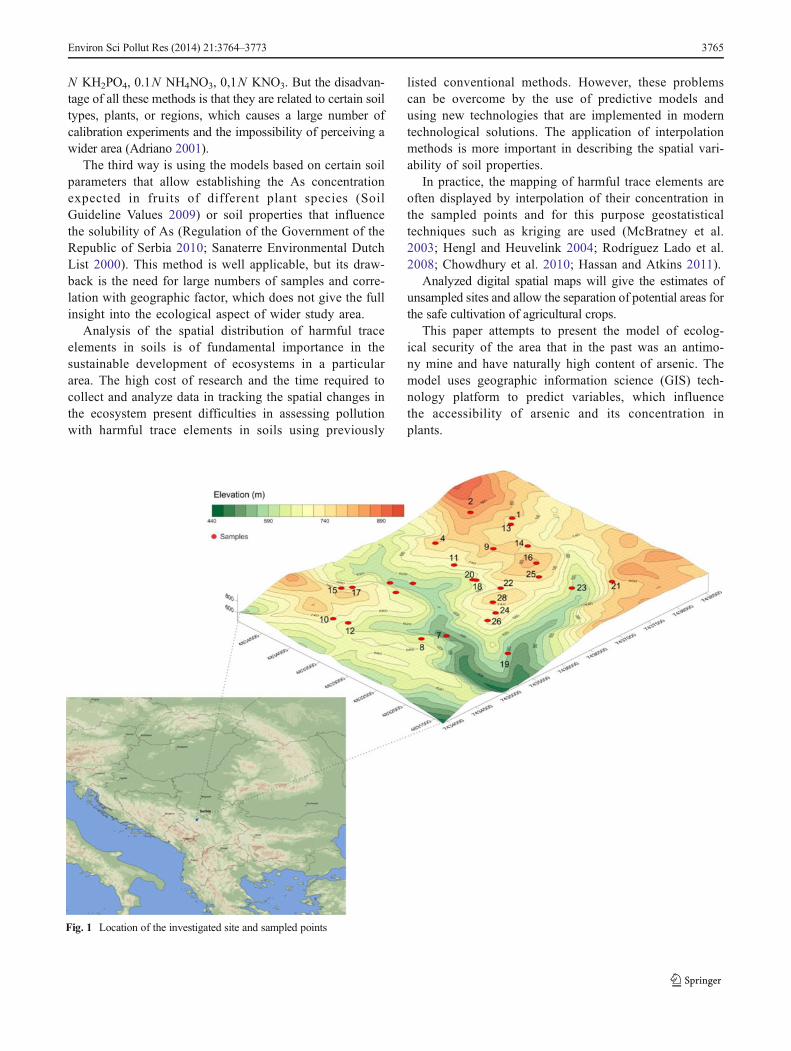
spatial distribution. As a result, the soil pedological map ofscale 1:10000 with all the accompanying elements (maps ofmain agrochemical characteristics, maps of erosion, mapswith total content of microelements, map of soil acidifica-tion, map of content of mobile aluminum, etc.) was created.Analyses of soil samples showed that concentration ofarsenic was above the maximum allowed limit. Therefore,further research was focused on this element in soil sur-face horizon, which is responsible for plant nutrition(Fig. 1). In the study area, the Leptosol and Cambisol soiltypes (WRB classification 2006) on hard limestone andsilicate chlorite schist predominate. The soils are mainlyacidic, with high content of humus, very low in availablephosphorus and satisfactory content of availablepotassium.
Fig. 2 a–c Content of the clay fraction, organic matter, and soil pH in the investigated site
3766 Environ Sci Pollut Res (2014) 21:3764–3773
Analytical methods
After air drying, samples were ground in an inert steelcrusher with 2 mm mesh. Further, for the analysis ofarsenic the sample was sieved through 150 μm mesh.For the analyses of total content of carbon and nitrogen
in CNS analyzer, these samples were further ground topowder in agate mortar.
Soil pH was determined with a glass electrode pHmeter in a1:2.5 water solution. Soil total C was measured with an ele-mental CNS analyzer, Vario model EL III (ElementarAnalysensysteme GmbH, Hanau, Germany; Nelson and
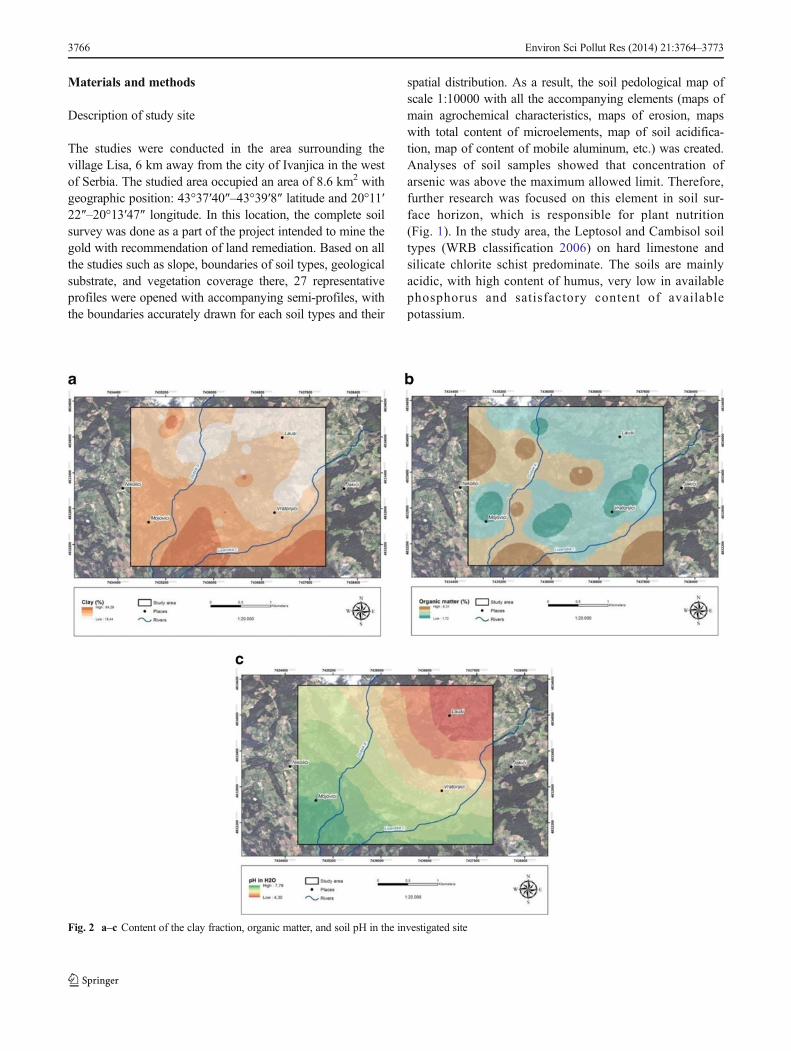
Fig. 3 Areas under the forest, raspberry, potato, and pasture fitting the standard MAC model
Table 1 Classes categorized byAs plant uptake coefficient de-pending from soil pH, for rasp-berry and potato
MAC maximum allowed concen-trations, As arsenic
Maximum allowed concentrations for As pH Groups of soil pH Coefficient of As uptake by plants
<100 <150 >150
Classes
<MAC 4.5–6 1 I
3.5–4 2 II
6.5–7 3 III
>MAC 4.5–6 1 IV
3.5–4 2 V VI
6.5–7 3 V VI
Environ Sci Pollut Res (2014) 21:3764–3773 3767
Sommers 1996). Soil granulometric composition was per-formed using the pipette method (Day 1965).
Total As was determined with ICAP 6300 optical emissionspectrometer (Thermo Electron Corporation, Cambridge,UK), after digestion in aqua regia (L.).
All chemical analyses were performed in two analyticalreplications. For the verification of results, the referent soilwas determined for As (reference ERM-CC141 loam soil,Belgium, with exact concentration of arsenic soluble in aquaregia toward determining the accuracy of measuringapparatus).
Geographic information science based methodologies
To approach the goal of the study each analyzed layer wasindividually designed and organized as a thematic layer. Theinterpolation of the data was performed by the ordinary krigingtechnique (Antunes and Albuquerque 2013). The method isbased on determining the optimal weight coefficients that are
compiled with the known sampled values based on thevariogram.
In the first phase of data analysis, the interpolation of clayand humus content was performed to create the conditions forthe application of Eq. 1 (the model from the Regulation of theGovernment of the Republic of Serbia 2010). The layers ofclay, humus, and soil pH (Fig. 2a, b, and c) represent theinterpolated data in raster format. The raster model can be indifferent formats (e.g., TIFF, GeoTIFF, IMG, EPPL7, etc.).The raster is presented by cell matrix (pixel) organized in rowsand columns that comprise a net, where each cell (pixel)carries an information, in our case, the interpolated value.
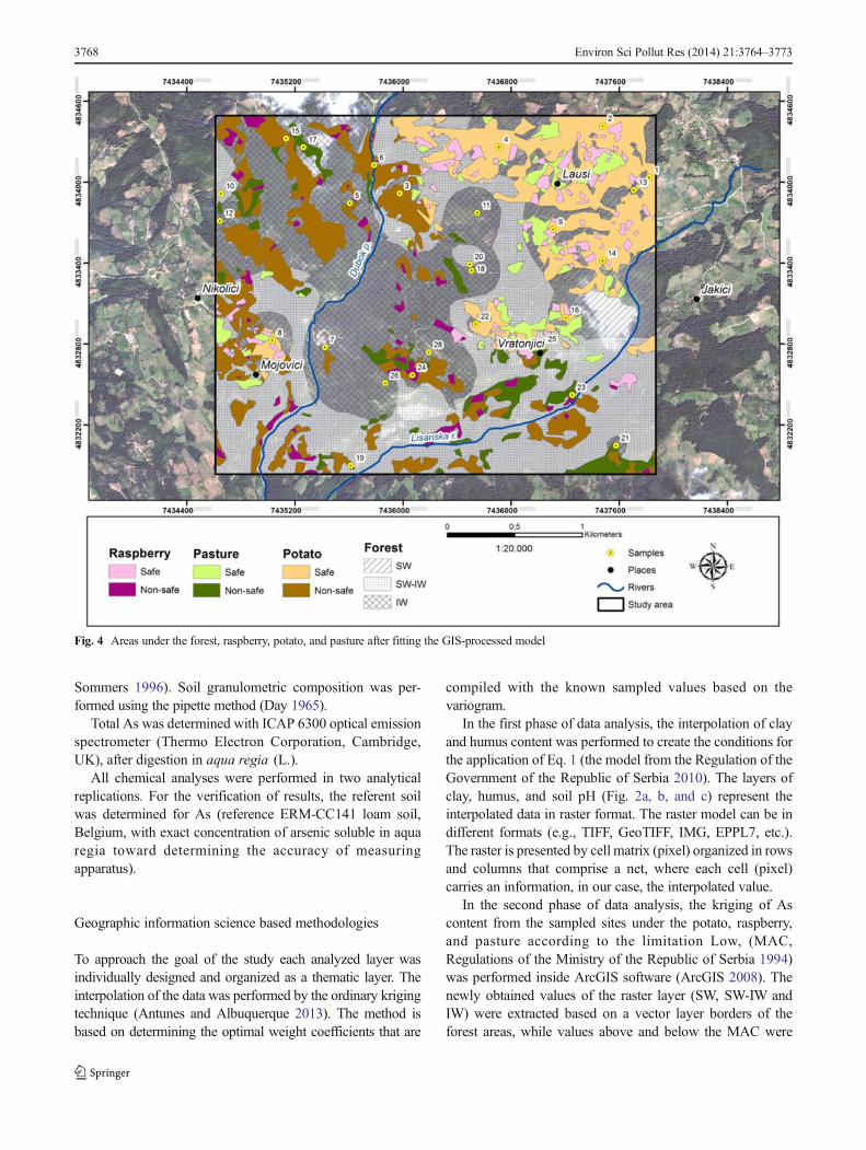
In the second phase of data analysis, the kriging of Ascontent from the sampled sites under the potato, raspberry,and pasture according to the limitation Low, (MAC,Regulations of the Ministry of the Republic of Serbia 1994)was performed inside ArcGIS software (ArcGIS 2008). Thenewly obtained values of the raster layer (SW, SW-IW andIW) were extracted based on a vector layer borders of theforest areas, while values above and below the MAC were
Fig. 4 Areas under the forest, raspberry, potato, and pasture after fitting the GIS-processed model
3768 Environ Sci Pollut Res (2014) 21:3764–3773
extracted based on a vector layer of the areas under pasture,raspberry, and potato (Fig. 3). The vector model isdisplayed using pairs of X and Y coordinates by geomet-rical primitives: points, lines, and polygons, which mightcontain no spatial (attribute) data to describe the spatialoriented objects.
In the third stage, (a) the modified MAC layer dependingon the content of clay and organic matter; (b) the coefficient ofAs uptake by plants (Soil Guideline Values 2009); and (c) pH,were interpolated as a raster model. For raster formats, theresults are transferred into a vector format (geometric primi-tive point), where each pixel of raster model is represented bysingle point in a vector model.
Categorization onto classes
In the vector model, the attribute data were selected from eachpoint based on the corresponding ID number. The attribute
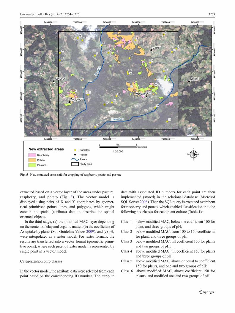
data with associated ID numbers for each point are thenimplemented (stored) in the relational database (MicrosofSQL Server 2008). Then the SQL query is executed over themfor raspberry and potato, which enabled classification into thefollowing six classes for each plant culture (Table 1):
Class 1 below modified MAC, below the coefficient 100 forplant, and three groups of pH;
Class 2 below modified MAC, from 100 to 150 coefficientsfor plant, and three groups of pH;
Class 3 below modified MAC, till coefficient 150 for plantsand two groups of pH;
Class 4 above modified MAC, till coefficient 150 for plantsand three groups of pH;
Class 5 above modified MAC, above or equal to coefficient150 for plants, and one and two groups of pH;
Class 6 above modified MAC, above coefficient 150 forplants, and modified one and two groups of pH.
Fig. 5 New extracted areas safe for cropping of raspberry, potato and pasture
Environ Sci Pollut Res (2014) 21:3764–3773 3769
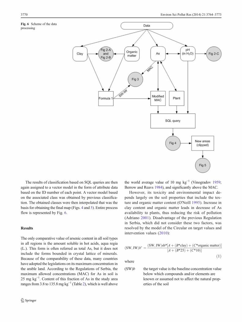
The results of classification based on SQL queries are thenagain assigned to a vector model in the form of attribute databased on the ID number of each point. A vector model basedon the associated class was obtained by previous classifica-tion. The obtained classes were then interpolated that was thebasis for obtaining the final map (Figs. 4 and 5). Entire processflow is represented by Fig. 6.
Results
The only comparative value of arsenic content in all soil typesin all regions is the amount soluble in hot acids, aqua regia(L.). This form is often referred as total As, but it does notinclude the forms bounded in crystal lattice of minerals.Because of the comparability of these data, many countrieshave adopted the legislations on its maximum concentration inthe arable land. According to the Regulations of Serbia, themaximum allowed concentrations (MAC) for As in soil is25 mg kg−1. Content of this fraction of As in the study arearanges from 3.8 to 135.8mg kg−1 (Table 2), which is well above
the world average value of 10 mg kg−1 (Vinogradov 1959;Berrow and Reavs 1984), and significantly above the MAC.
However, its toxicity and environmental impact de-pends largely on the soil properties that include the tex-ture and organic matter content (O'Neill 1995). Increase inclay content and organic matter leads in decrease of Asavailability to plants, thus reducing the risk of pollution(Adriano 2001). Disadvantage of the previous Regulationin Serbia, which did not consider these two factors, wasresolved by the model of the Circular on target values andintervention values (2010):
SW; IWð Þb� ¼ SW; IWð Þsb* Aþ B*clayð Þ þ C*organic matterð Þ½ �Aþ B*25ð Þ þ C*10ð Þ½ �
ð1Þwhere
(SW)b the target value is the baseline concentration valuebelow which compounds and/or elements areknown or assumed not to affect the natural prop-erties of the soil
Fig. 6 Scheme of the dataprocessing
3770 Environ Sci Pollut Res (2014) 21:3764–3773
(IW)b the intervention value is the maximum tolerableconcentration above which remediation is required
(SW,IW)sb
target or remediation value from the table, for As:SWsb=29 mg kg−1; IWsb=55 mg kg−1
% clay analyzed percentage of clay in certain soil type(particle size<2 μm)
% organic matter- analyzed percentage of organicmatter in certain soil type
A , B , C the constants depending on the type of traceelement, are given as tabular values by EuropeanUnion (EU) and Serbia legislations (Regulation ofthe Government of the Republic of Serbia 2010;Sanaterre Environmental Dutch List 2000), forAs: A=15; B =0.4; and C =0.4.
Since this legislation (Eq. 1) refers only to nonagriculturalland, it was applied in the forest areas of the study area.
To obtain a more complete final model of pollution of thestudy area, a calculation of MAC for agricultural land based onthis model was done. The values representing MAC for agri-cultural lands are not flexible, e.g., are not changed dependingon the clay content and soil texture, and refer only to the contentof studying element, such as for As, it is 25 mg kg−1. Therefore,for determination of MAC for agricultural lands, this value of25 mg kg−1 was included into Eq. 1 instead of SWb. Thisapproach allowed obtaining a MAC value that is variabledepending on the content of clay and organic matter in soil.
The contents of arsenic in plants largely depend on the crop,ranging in fresh fruits from 0.21 to 25 μg kg−1 (Kabata-Pendiasand Pendias 2001). For the determination of its approximatecontent, the model from the Soil Guidelines Values (2009) wastaken, where the effect of As pollution was studied on the twomost common crops, potato (Solanum tuberosum , L.) andraspberry (Rubus , L.) for studied area.
The concentrations of As in fruits were obtained by calcu-lating the soil-to-plant factors using the fresh weight of fruitsand dry weight of soil (mg As per kg fresh weight (FW) plant;mg As per kg dry weight (DW) soil). Tuber vegetable pro-duces: FW mg As kg−1=2.3×10⁻⁴×mg As kg−1 DW soil;shrub fruit produces: FW mg As kg−1=2.0×10⁻⁴×mg Askg−1 DW soil (Soil Guideline Values 2009).
Due to the lack of limit contamination values of As inedible parts of plants in EU and Serbia, the comparative valuesfor all studied plant species obtained using the followingformula were taken:
K ¼ FW
0:01 � 100 ð2Þ
where, K is the uptake coefficient of As; FW is the content ofAs in fresh fruits, mg kg−1; 0,01 is the average content of As innon-contaminated plants, mg kg−1
The value 0.01 mg kg−1 was taken as a reference valuebecause, firstly, it appears as average for a variety of plants(Kabata-Pendias and Pendias 2001). Entering this value into
Table 2 Soil limiting characteristics for plant availability of As
Samples As (mg kg−1) Organic matter (%) Clay (%) pH
1 5.32 3.42 22.7 4.5
2 12.83 2.99 21.9 4.5
3 10.52 3.29 22.6 6.4
4 7.97 2.84 23.2 4.4
5 68.20 4.94 18.9 5.3
6 46.88 2.13 26.0 6.2
7 78.95 4.59 34.0 7.9
8 7.245 1.72 38.3 7.8
9 5.66 3.32 32.3 4.6
10 10.75 4.37 19.2 4.5
11 71.25 2.80 25.6 4.2
12 107.45 6.02 40.8 7.6
13 4.08 3.00 25.0 4.2
14 3.76 2.67 23.0 4.7
15 48.61 3.18 23.4 6.3
16 18.64 1.94 20.5 4.8
17 100.75 3.38 50.7 7.5
18 111.6 5.73 48.6 6.7
19 54.10 6.32 42.3 7.4
20 21.36 3.87 18.4 4.9
21 82.60 5.99 64.3 7.7
22 21.04 3.12 25.7 5.4
23 37.72 3.70 33.9 6.8
24 4.915 2.62 28.7 5.0
25 31.84 2.50 27.2 6.3
26 92.25 2.04 62.4 7.4
27 135.85 2.54 41.0 7.1
Average 44.525 3.50 31.87 5.9
Max 135.850 6.32 64.30 7.9
Min 3.765 1.72 18.40 4.2
STD 40.271 1.32 12.89 1.3
MED 31.845 3.18 26.00 6.2
As arsenic, max maximum, min minimum
Table 3 Classes categorized by As plant uptake coefficient dependingfrom soil pH, for hay lands
<MAC >MAC
Soil pH 4.5–6 3.5–4 6.5–7 4.5–6 3.5–4 6.5–7
Classes
I
II III IV V V
V V
As arsenic
Environ Sci Pollut Res (2014) 21:3764–3773 3771
previous model for leafy vegetable (FWleafy vegetabiles=4.3×10⁻⁴×mg As kg−1) and entering the value 25 mg kg−1 of Asfor soil (which represents MAC value according to the legis-lation), we obtain the coefficient 1×100, i.e., coefficient 100.This approach also enables operation with the data in GISenvironment for uniformity and comparability of all thelayers. In addition to the coefficient 100, for the classificationin GIS the category of 150 units was introduced. With a givenvalue of 150, in the formulas for the calculation of As in plantmaterial, the soil must have about 40 mg kg−1 As dependingon plant species. In the case of Eq. 1, it represents middlevalue between SW and IW, which is the border between thesoil that is non-contaminated and the soil that needs additionalinvestigation (Sanaterre Environmental Dutch List 2000).Above this value, the possibility of contamination with Asgreatly increases. The plants can be grown safely in soils withcoefficient above 100, since in some plants the natural contentof arsenic amounts to 0.025 mg kg−1 (Kabata-Pendias andPendias 2001).
These coefficients for the calculation serve as a compara-tive value between crops rather than an absolute value forplants. This approach allows another categorization of the areabased to plants and their ability to absorb arsenic into edibleparts.
One of the soil characteristics that significantly affect themobility of As and an assessment of the contamination risk bythis element is certainly the soil acidity (O'Neill 1995; Adriano2001; Kabata-Pendias and Pendias 2001). There is an appar-ent similarity between the chemistry of As and P as they bothcommonly form oxyanions (arsenate and phosphate) in the +5oxidation state in soils. Arsenic, same as phosphorus has beenassumed to react similarly in soil forming insoluble com-pounds with Al, Fe, and Ca. Maximum sorption of arsenatein soil occurs at pH 4, while by organic matter at about pH 5.5(O'Neill 1995). In the slightly acid and neutral soil the bindingof As is the weakest, especially given its antagonistic relation-ship with the phosphates in soil; while acidic environmentincreases solubility of Fe increasing bioavailability of As(O'Neill 1995). Based on such behavior, the three groups ofsoil pH, which determine the availability of As were identi-fied: the first group is pH 4.5 to 6 (greatest adsorption of As);the second group is 3.5 to 4; and the third group is 6.5 to 7.5(greatest amount of available As), which are included in the
presented model (Tables 1 and 3). Solubility of As graduallychanges depending on pH, while GIS interpolation allowsgradual transition between the three extracted groups and thusavoids the sharp distinction that does not fit the chemism ofarsenic depending on the soil pH.
Based on these characteristics, the six soil classes wereseparated (Table 3). For the border values the following char-acteristics were taken: values below and over the MAC as abasic feature, taking into account the granulometric composi-tion and organic matter content from the defining model(Regulations of the Ministry of the Republic of Serbia 1994;Regulations of the Government of the Republic of Serbia2010); and content of arsenic in potato and raspberry withthe border values of soil and pH of soil (Table 1).
Discussion
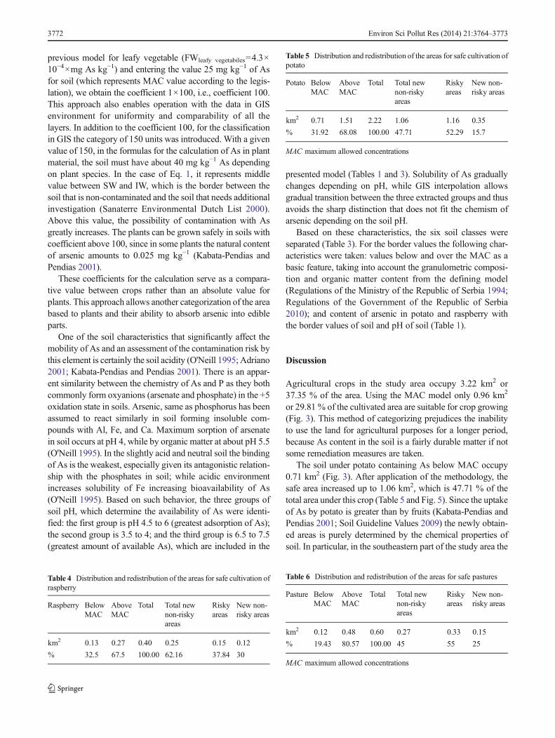
Agricultural crops in the study area occupy 3.22 km2 or37.35 % of the area. Using the MAC model only 0.96 km2
or 29.81 % of the cultivated area are suitable for crop growing(Fig. 3). This method of categorizing prejudices the inabilityto use the land for agricultural purposes for a longer period,because As content in the soil is a fairly durable matter if notsome remediation measures are taken.
The soil under potato containing As below MAC occupy0.71 km2 (Fig. 3). After application of the methodology, thesafe area increased up to 1.06 km2, which is 47.71 % of thetotal area under this crop (Table 5 and Fig. 5). Since the uptakeof As by potato is greater than by fruits (Kabata-Pendias andPendias 2001; Soil Guideline Values 2009) the newly obtain-ed areas is purely determined by the chemical properties ofsoil. In particular, in the southeastern part of the study area the
Table 4 Distribution and redistribution of the areas for safe cultivation ofraspberry
Raspberry BelowMAC
AboveMAC
Total Total newnon-riskyareas
Riskyareas
New non-risky areas
km2 0.13 0.27 0.40 0.25 0.15 0.12
% 32.5 67.5 100.00 62.16 37.84 30
Table 5 Distribution and redistribution of the areas for safe cultivation ofpotato
Potato BelowMAC
AboveMAC
Total Total newnon-riskyareas
Riskyareas
New non-risky areas
km2 0.71 1.51 2.22 1.06 1.16 0.35
% 31.92 68.08 100.00 47.71 52.29 15.7
MAC maximum allowed concentrations
Table 6 Distribution and redistribution of the areas for safe pastures
Pasture BelowMAC
AboveMAC
Total Total newnon-riskyareas
Riskyareas
New non-risky areas
km2 0.12 0.48 0.60 0.27 0.33 0.15
% 19.43 80.57 100.00 45 55 25
MAC maximum allowed concentrations
3772 Environ Sci Pollut Res (2014) 21:3764–3773
clay and humus content determines the appearance of newsafe zones for crops; while, the expansion of the safe area tonorthwest is conditioned by soil acidity and by crop type.
There is obvious overlap of the expanded safe territory forraspberry and potato. Such overlap is due to the identical soilproperties. However, because As uptake by fruit is less than bypotato, the zone for safe growing of raspberry is slightly larger.In Fig. 4, the extracted safe areas for raspberry is within thefields of non-safe growing of potato. This is confirmed by arelative expanding of the areas safe for raspberry, from 32.5 to62.16 %, which is significantly greater than the areas safe forpotato (Tables 4 and 5, Figs. 4 and 5). The expansion of areasfor pasture is mostly due to the fact that herbs are not directlyinvolved in the human diet (Table 6).
Conclusion
Compared to the standard MAC model, the proposed modelmakes possible a considerable expansion of the territory forsafe cultivation of given crops: raspberry for 30 %, potato for15.7 %, and pasture for 25 %. The presented methodologyallows an extraction of critical areas to focus on the densersampling, which allows improvement of the models for spe-cific geographic areas thus saving energy and humanresources.
Acknowledgement This research was supported by the Ministry ofEducation and Science of the Republic of Serbia, project TR 37006(2011–2014).
References
Adriano DC (2001) Trace elements in terrestrial environments. SheridanBooks, Ann Arbor
Antunes IMHR, Albuquerque MTD (2013) Using indicator kriging forthe evaluation of arsenic potential contamination in an abandonedmining area (Portugal). Sci Total Environ 442:545–552
ArcGIS (2008) Version 9.3. ESRI, CABerrow ML, Reavs GA (1984) In Proc, Intl Conf Environmental
Contamination. CEP Consultants, EdinburghChowdhury M, Alouani A, Hossain F (2010) Comparison of ordinary
kriging and artificial neural network for spatial mapping of arseniccontamination of groundwater. Stoch Environ Res Risk Assess 24:1–7
Circular on target values and intervention values for soil remediation(2010) www.anasol.com.br/pdf/11
Day PR (1965) Particle fractionation and particle-size analysis. In: Black
CA (ed) Methods of soil analysis. Part 1. ASA and SSSA, Madison,pp 545–567
Hassan MM, Atkins PJ (2011) Application of geostatistics with indicatorkriging for analyzing spatial variability of groundwater arsenicconcentrations in Southwest Bangladesh. J Environ Sci Health A46(11):1185–1196
Hengl T, Heuvelink GBM (2004) New challenges for predictive soilmapping, Global Workshop on Digital Soil Mapping. AGRO-M/INRA, Montpellier, p 9, September 14–17
Kabata-Pendias A, Pendias H (2001) Trace elements in soils and plants,3rd edn. CRC Press, Boca Raton
McBratney AB, Mendonça Santos ML, Minasny B (2003) On digital soilmapping. Geoderma 117:3–52
Microsof SQL Server (2008)Mrvic V, Lj K-K, Cakmak D, Sikiric B, Brebanovic B, Perovic V,
Nikoloski M (2011) Pedogeochemical mapping and backgroundlimit of trace elements in soils of Branicevo Province (Serbia). JGeochem Explor 109:18–25
Nelson DW, Sommers LE (1996) Total carbon, organic carbon, andorganic matter. In: Sparks DL (ed) Methods of soil analysis. Part3. SSSA, Madison, pp 961–1010
O'Neill P (1995) Arsenic. In: Alloway BJ (ed) Heavy metals in soils.Chapman and Hall, London, pp 105–119
Regulation of the Government of the Republic of Serbia on the programof systematic monitoring of soil quality, indicators for the assess-ment of land degradation and methodology for remediation pro-grams. Government Gazette of the Republic of Serbia (2010) SGRS88/2010 pp 226–231
Regulations of the Ministry of Agriculture, Forestry and Water manage-ment of the Republic of Serbia on allowed amounts of hazardousand noxious substances in agricultural soil and water for irrigationand methods for their testing (1994) Government Gazette of theRepublic of Serbia, SG RS 23/94 pp 553–554
Rodríguez Lado L, Hengl T, Reuter HI (2008) Heavy metals in Europeansoils: a geostatistical analysis of the FOREGS geochemical data-base. Geoderma 148:189–199
Sanaterre Environmental Dutch List (2000) DBO/1999226863, Ministryof Housing, Spatial Planning and Environment Directorate-GeneralFor Environmental Protection, Department of Soil Protection (IPC625), Hague, Netherlands Government Gazette No. 39
Soil Guideline Values for inorganic arsenic in soil Science (2009) ReportSC050021/ arsenic SGV: 1–11. www.environment-agency.gov.uk/static/…/SCHO0409BPVY-e-e.pdf.
Takamatsu Т, Aoki H, Yoshida T (1982) Determination of arsenate,arsenite, monomethylarsonate, and dimethylarsinate in soil pollutedwith arsenic. Soil Sci 133:239–246
Vinogradov AP (1959) The geochemistry of rare and dispersed chemicalelements in soils, 2nd edn. Consultants Bureau, NY
Wang Z, Chai L, Yang Z, Wang Y, Wang H (2010) Identifying Sourcesand Assessing Potential Risk of Heavy Metals in Soils from DirectExposure to Children in a Mine-Impacted City, Changsha, China. JEnviron Qual 39:1616–1623
Woolson EA, Axley JH, Kearney PC (1971) Correlation between avail-able soil arsenic estimated by 6 methods and response of corn (ZeaMays L.). Soil Sci Soc Am Proc 35:101–105
WRB classification (2006) World reference base for soil resources. Foodand Agriculture organization of the United Nations, Rome
Environ Sci Pollut Res (2014) 21:3764–3773 3773


![ROAD DATA - [ ], [ ], [ ], [ ] & VICINITY](https://img.pdfslide.us/doc/110x75/61a4edb5a83d6b4d7a703c9f/road-data-amp-vicinity.jpg)