Embed Size (px)
Citation preview
Purdue UniversityPurdue e-Pubs
Libraries Faculty and Staff Scholarship and Research Purdue Libraries
6-2017
Spatial Information Literacy for DigitalHumanities: The case study of leveraging geospatialinformation for African American historyeducation.Nicole KongPurdue University, [email protected]
Cornelius BynumPurdue University, [email protected]
Chrystal JohnsonPurdue University, [email protected]
Jennifer SdunzikPurdue University, [email protected]
Xiaoyue QinPurdue University
Follow this and additional works at: http://docs.lib.purdue.edu/lib_fsdocs
Part of the Library and Information Science Commons
This document has been made available through Purdue e-Pubs, a service of the Purdue University Libraries. Please contact [email protected] foradditional information.
Recommended CitationKong, Nicole; Bynum, Cornelius; Johnson, Chrystal; Sdunzik, Jennifer; and Qin, Xiaoyue, "Spatial Information Literacy for DigitalHumanities: The case study of leveraging geospatial information for African American history education." (2017). Libraries Faculty andStaff Scholarship and Research. Paper 177.http://docs.lib.purdue.edu/lib_fsdocs/177
1
Spatial Information Literacy for Digital Humanities: The case study of leveraging geospatial information for African American history education
Abstract:
The rise of “digital humanities” and the “spatial turn” in the humanities has generated many
new insights in the study of culture, history, literature, and arts. Within this research trend, the library’s
geospatial service can play an active role by introducing the spatial information literacy and technology.
In this paper, we use the information literacy framework to explore the library’s role in supporting
digital humanities by introducing a successful collaboration involving a librarian and history and
education researchers in hosting a National Endowment for the Humanities (NEH)-funded summer
institute for school teachers. Our results suggest that the framework has opened a new way to facilitate
collaborations between librarians and multidiscipline researchers.
Keywords: African American history, GIS, information literacy, digital humanities
Authors:
Ningning Nicole Kong, Assistant Professor & GIS Specialist, Purdue University Libraries.
Cornelius Bynum, Associate Professor, Department of History, Purdue University.
Chrystal Johnson, Associate Professor, Department of Curriculum and Instruction, Purdue University.
Jennifer Sdunzik, Graduate Assistant, American Studies, Purdue University.
XiaoYue Qin, Graduate Assistant, Social Studies Education, Purdue University.
2
Introduction
In the past decade, academic libraries have been exploring different ways of supporting digital
humanities as indicated by the increase of digital centers, services, and librarian positions (Posner 2013).
Since the emergence of digital scholarship has brought similar challenges to both libraries and traditional
humanities in terms of how to approach research and how to incorporate the digital, collaboration
between the two seems almost natural to overcome these challenges, via digital collection development,
digital publication, etc. (Cunningham 2010). With the recently adopted framework for information
literacy for higher education (Association of College and Research Libraries 2015), we are exploring the
library’s role and opportunities to support digital humanities from the information literacy perspective.
The framework provides richer and contextual concepts to integrate information literacy skills into the
library’s services, including the services for digital humanities. In this article, we discuss the library’s role
in supporting digital humanities from the syllabus design and implementation experiences gained through
a National Endowment for Humanities (NEH) funded summer institute. This institute was a collaboration
among faculty members in history, education, and library science. It was designed to encourage
secondary school teachers to use digital platforms to incorporate African American history, literature, and
culture into their classroom curricula. In this specific project, we explored the library’s geographic
information systems (GIS) service in supporting African Americans’ history and literature education.
The “spatial turn” in the humanities that emerged in the 1990s refers to the movement of
emphasizing places where human actions occur (Warf and Arias 2008). GIS has been instrumental in this
regard because it provides ideal platforms and tools to spatially conceptualize research topics
(Bodenhamer, Corrigan, and Harris 2010). Although the “spatial turn” has become more influential,
barriers continue to exist for the humanists to use GIS in digitizing and visualizing their research
(Griffiths 2013; Bodenhamer, Corrigan, and Harris 2015). These barriers include how to identify and
locate the spatial information, how to organize the digital information, and how to use the information
with appropriate GIS tools. Recognizing these challenges, the library’s GIS specialist has worked with the
3
NEH summer institute directors on designing the syllabus for the institute that integrates spatial
information literacy skills and ensures that the teaching outcomes will serve classroom needs.
Previous Work
Over the past decade, many discussions about how libraries could support digital humanities
arose. Sula (2013) reviewed digital humanities publications within the Library, Information Science &
Technology Abstract (LISTA) database since 2005, and identified five topic areas within these articles:
arts and humanities librarianship, digital infrastructure, digital scholarship, knowledge production and
collaboration, and research communities. Similar results were found in a study by the Council on Library
and Information Resources (CLIR) in 2007 (Zorich 2008). This study reviewed financing, organizational
structure, products, services, and the sustainability of digital humanities centers. It found that digital
collections, tools, technology supports, and community building are the most common support themes.
Yet, as an important component of academic libraries, information literacy is rarely mentioned in the
supporting services for digital humanities – probably due to the constantly growing nature of digital
humanities research. While new data sources and technologies became available in the field, it is difficult
to define the extent of needed information and information literacy competencies for this subject area.
Nevertheless, an information literacy study of students in humanities concluded that both human and
computer-mediated library resources have been the first choice for students in their academic research
(Head 2008). Thus, how to integrate information literacy skills into digital humanities teaching programs
remains an important area to explore.
In 2016, the Association of College and Research Libraries (ACRL) board adopted the
Framework for Information Literacy for Higher Education, which provides a richer, more complex set of
interconnected core concepts, allowing more flexible options for implementation (Association of College
and Research Libraries 2015). Six frames comprise this framework, namely “information creation as a
4
process”, “research as an inquiry”, “information has value”, “authority is constructed and contextual”,
“searching as strategic exploration” , and “scholarship as conversation”. The framework enables librarians
and faculty to design flexible instruction sessions, and it allows for a closer integration of information
across the students’ learning cycle. In our case, this flexibility not only includes the professional
development design for teachers, but it also applies further to the lesson plans designed by our institute
participants. Ever since the framework was adopted, many librarians have found it helpful to design
instructions drawing on the frames and have implemented it in many information literacy instruction
cases, such as government information literacy, hip hop literacy, and first year experience course (“ACRL
Framework for Information Literacy Sandbox” 2017). In our summer institute, we made use of all six
frames in the framework when designing the library instruction to integrate spatial information literacy
into the digital humanities program.
Integrating spatial information literacy skills into the study of humanities topics such as civil
rights and African American history and literature has come to be recognized as an increasingly important
component of effective teaching (Johnson et al. 2016). It has been suggested that teaching spatial
information by using GIS technology in K-12 classrooms can help students use authentic data, enable
them to complete in-depth studies of specific issues, and enhance student interest in a topic (Baker et al.
2012; McClurg and Buss 2007). GIS can provide students with the opportunity to display and interact
with spatial information on a computer-based system that promotes contextually rich student learning and
improves students’ critical thinking and spatial thinking skills (National Research Council 2006). In the
digital humanities, GIS can help to spatially conceptualize the research topics, quantify social, cultural,
and historical information, and analyze the data with gained insights (Bodenhamer, Corrigan, and Harris
2010). Applying GIS technology to teach digital humanities can facilitate inquiry-based learning by
encouraging students to discover location-related information from the reading materials, create new
digital knowledge based on literature, and discuss the socioeconomic background information based on
multiple information sources. Through such a learning experience, students can develop spatial thinking
5
skills and a better understanding about spatial information. Thus, integrating GIS into the digital
humanities teachers’ training program prepared institute participants to redesign their instruction sessions
to incorporate information literacy as well as spatial conceptualizations of the material being taught.
Background
“From Plessy to Brown: The African American Freedom Struggle in the Twentieth Century” is a
2016 NEH summer institute for school teachers. It is designed to help K-12 teachers incorporate African
American history, literature, and culture into their classroom curricula and emphasize the usefulness of
digital information in teaching practice. It is a four-week institute that brought together content experts,
an education researcher, and a library GIS specialist to craft digital tools and other curricular resources to
expand participants’ knowledge of the African American experience and improve their information
literacy skills. By taking advantage of the potentials in digital humanities and GIS to improve information
literacy, this institute also aims at helping teachers to build students’ critical thinking skills and reading
comprehension in ways that align with the recommendations of both the National Council of Teachers of
English’s (NCTE) 21st Century Curriculum and the National Council for Social Studies’ (NCSS) 21st
Century Skills. The summer institute set out to help teachers make African American history and culture
more accessible to their students by exploring topics like the early social activism of black institutions,
African American migration to cities, and the influence and impact of African American writers and arts
on civil rights organizing. Responding to a nationwide call for applications, twenty participants were
accepted for the institute from thirteen different states. The majority of them taught social studies-related
courses, and the average years of teaching experience was about ten.
The program was built upon four major themes in African American studies. Each week, one
theme was highlighted. For each thematic topic, participants read the historical documents and literature
selections recommended by the subject experts, analyzed primary sources, viewed related films and
6
artworks, and visited museums. The library’s GIS instructions were integrated into each week’s topic as
individual workshops to teach the spatial information literacy skills that participants might need in order
to bring the knowledge back to their classroom in a digital format. The education researcher provided
pedagogical methods knowledge to the participants based on the contents and digital tools learned in each
week, and guided the participants through the lesson plan design.
Method
Designing a balanced syllabus to integrate the spatial information and technology into a teachers’
professional development program needs a close examination of the relationships between learning
content, pedagogical goals, and the characteristics of spatial information. Since a good understanding of
spatial information requires learning GIS technology, we adopted the technology, pedagogy, and content
knowledge (TPCK) framework (Mishra and Koehler 2006) to emphasize the intersections of all three
pillars. TPCK can foster successful technology integration, in our case spatial information integration,
when combined with appropriate understanding and strong pedagogy on the part of the teachers. In our
program, the subject topics were well-defined for the four-week period as shown in Table 1. Each week,
experts in African American studies led presentations and discussions, and assigned reading materials for
the participants to understand the culture, literature, and social dynamics of each topic area. On the
pedagogical end, the education researcher provided thirteen workshops throughout the four weeks to
guide participants through lesson plan designs that integrated the institute’s content and spatial
information technology into their classroom. As for the instruction from the library’s GIS service, we
designed five workshops in the four-week period to introduce participants to spatial information as well
as why and how to use it in their teaching. Two workshops occurred in the first week to help participants
learn and understand the concept of spatial information. After that, one workshop was offered in each of
the following weeks to introduce more in-depth knowledge about the spatial information and link GIS
with the content knowledge they were learning during the week. Each workshop took about one and one-
7
half to two hours. This article focuses on the design and the implementation of these GIS workshops and
discusses how information literacy was introduced in the workshops.
Table 1. Learning topics in each week of the summer institute
Content Knowledge Topics
Week1 African Americans, the Progressive Era, and Social Reform, 1895 – 1920
Week2 African American Arts, Letters, and Activism in the 1920s and 1930s
Week3 African Americans and the Economic Decline and Recovery of the Depression through World War II, 1930s and 1940s
Week4 World War II through Brown and Beyond, 1940s – 1960s
Two principles have guided us through the design process for the five library’s GIS workshops.
First, we aimed at closely linking the spatial information and technology introduced in each workshop to
the subject topic in the corresponding weeks, so that the participants could easily understand how spatial
information could help them apply digital humanities research methods to their teaching subjects.
Secondly, we intended to introduce the concept of spatial information and technology from easy to more
in-depth levels progressively. This would allow teachers to learn gradually and make sure that they could
create those digital humanities platforms on their own in order to introduce them in their classrooms.
According to the well-defined subject topics, we have designed the learning objectives in each workshop
as shown in Table 2. Each workshop was a combination of instruction and hands-on practice. The
instruction focused on introducing the information concept, and the hands-on practice reinforced the
concept learned during instruction.
Table 2. Learning objectives of library’s GIS workshop
Spatial information learning objectives
Week1 Understanding spatial information, and working with online maps
Week2 Collecting spatial information and creating digital maps
Week3 Making GIS presentations
Week4 Creating a spatial humanities project for students to contribute spatial information
8
The first library workshop occurred on the first day of the institute. Besides introducing basic
knowledge about spatial information, the workshop emphasized its application for digital humanities with
examples of how it is used in African American studies and in classroom settings. A hands-on exercise
followed the theoretical part to help understanding the spatial information and applying it on a basic level.
In this exercise, we created an easy online platform for participants to create spatial information on their
own without much GIS technology knowledge. Learners just needed to click on the places they were
interested in on a web map, then added information associated with the particular point in the attribute.
Two kinds of spatial information were designed to be created in this exercise: their schools and their
interested places to share. The participants included information on school names, participant names,
descriptions, and even uploaded a picture about the place. Through this exercise, the participants
developed an understanding of creating spatial information, which included both the location information
and other qualitative or quantitative information associated with the place. After the participants
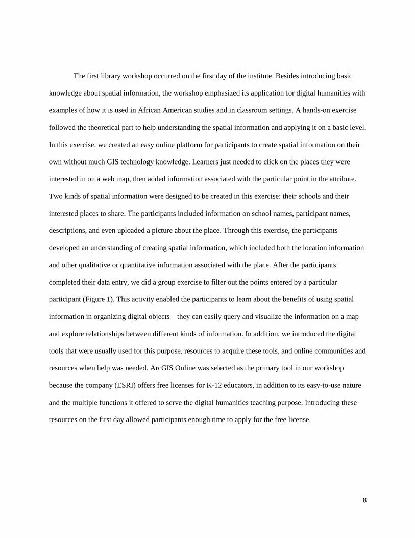
completed their data entry, we did a group exercise to filter out the points entered by a particular
participant (Figure 1). This activity enabled the participants to learn about the benefits of using spatial
information in organizing digital objects – they can easily query and visualize the information on a map
and explore relationships between different kinds of information. In addition, we introduced the digital
tools that were usually used for this purpose, resources to acquire these tools, and online communities and
resources when help was needed. ArcGIS Online was selected as the primary tool in our workshop
because the company (ESRI) offers free licenses for K-12 educators, in addition to its easy-to-use nature
and the multiple functions it offered to serve the digital humanities teaching purpose. Introducing these
resources on the first day allowed participants enough time to apply for the free license.
9
Figure 1. Map created by participants about their schools and interesting places in workshop #1.
The second library workshop was also given in the first week of the institute. This workshop
focused more on linking spatial information with the content knowledge emphasized in the week –
African Americans in the progressive era and social reform between 1895 and 1920. We also introduced
the searching strategies along with the content knowledge. Within several topics covered in this week’s
theme, we selected the topic of lynching as an example to introduce more in-depth levels of spatial
information, which is searching and using online map resources. Considering that the participants were
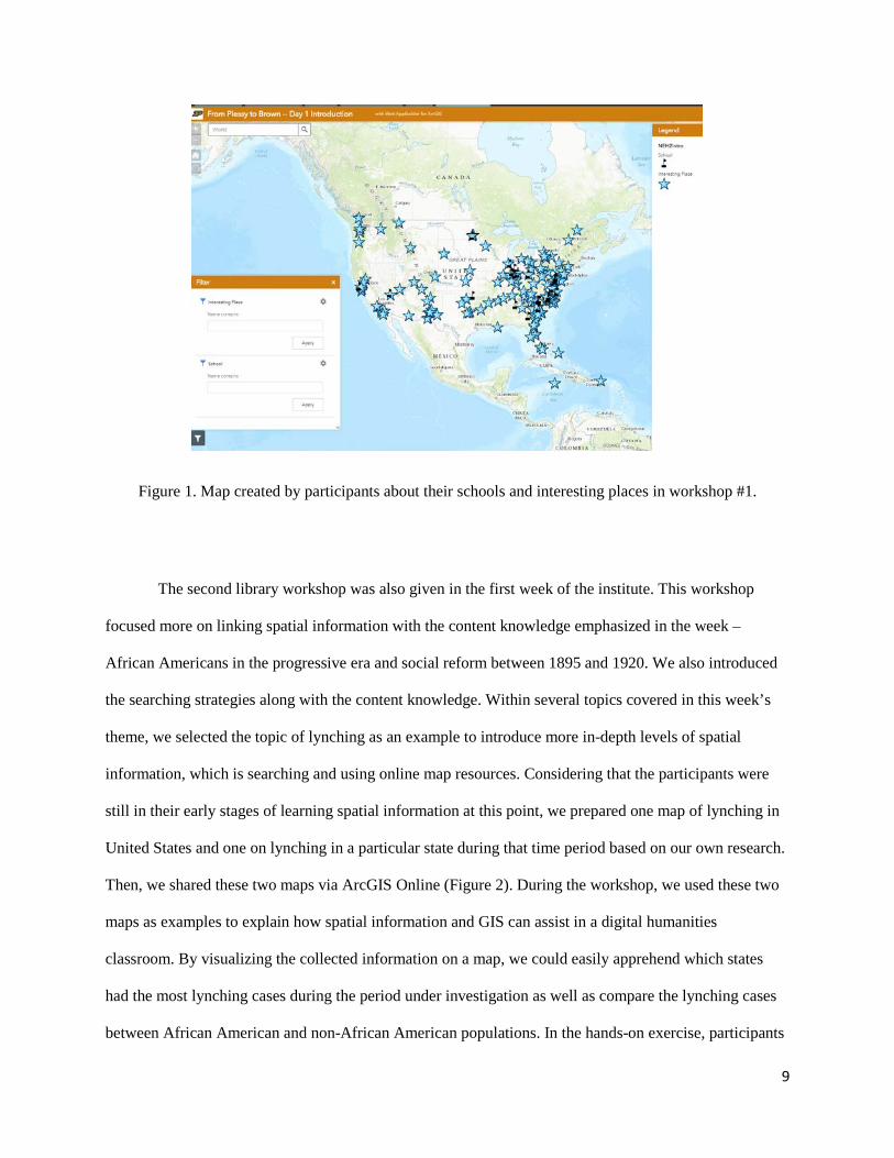
still in their early stages of learning spatial information at this point, we prepared one map of lynching in
United States and one on lynching in a particular state during that time period based on our own research.
Then, we shared these two maps via ArcGIS Online (Figure 2). During the workshop, we used these two
maps as examples to explain how spatial information and GIS can assist in a digital humanities
classroom. By visualizing the collected information on a map, we could easily apprehend which states
had the most lynching cases during the period under investigation as well as compare the lynching cases
between African American and non-African American populations. In the hands-on exercise, participants
10
searched for these two maps on the ArcGIS Online platform. During the searching exercise, the
participants learned how to use keywords and refine keywords, filter the results based on a category, and
reference to the author information in order to find the maps they needed. Then, participants learned how
to customize the maps on their own, such as creating labels on the map, configuring pop-up window
information, and changing the visualization. At the end of the exercise, they were asked to share the maps
they configured with other online information users. In order to share the map, they needed to give the
map a meaningful title and provide descriptive tags so that other users can search and discover these
maps.
Figure 2. The map shows the number of lynching cases in United States between 1895-1920. The legend
indicates the number of African Americans lynching victims, the pop-up window shows information
about state – name, total number of lynching cases, and break down numbers by African American and
non-African American lynching victims.
The third library workshop was in the second week, and it introduced African American arts,
letters, and activism in the 1920s and 1930s. In order to advance the participants’ information skills, the
11
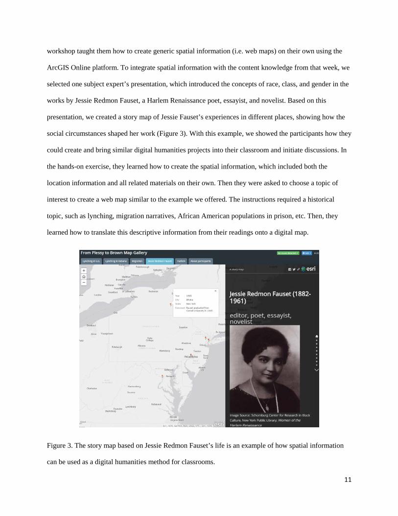
workshop taught them how to create generic spatial information (i.e. web maps) on their own using the
ArcGIS Online platform. To integrate spatial information with the content knowledge from that week, we
selected one subject expert’s presentation, which introduced the concepts of race, class, and gender in the
works by Jessie Redmon Fauset, a Harlem Renaissance poet, essayist, and novelist. Based on this
presentation, we created a story map of Jessie Fauset’s experiences in different places, showing how the
social circumstances shaped her work (Figure 3). With this example, we showed the participants how they
could create and bring similar digital humanities projects into their classroom and initiate discussions. In
the hands-on exercise, they learned how to create the spatial information, which included both the
location information and all related materials on their own. Then they were asked to choose a topic of
interest to create a web map similar to the example we offered. The instructions required a historical
topic, such as lynching, migration narratives, African American populations in prison, etc. Then, they
learned how to translate this descriptive information from their readings onto a digital map.
Figure 3. The story map based on Jessie Redmon Fauset’s life is an example of how spatial information
can be used as a digital humanities method for classrooms.
12
In the first three library workshops, participants learned about spatial information and how to
create it; however, it was not enough to organize and package the information into a valuable teaching
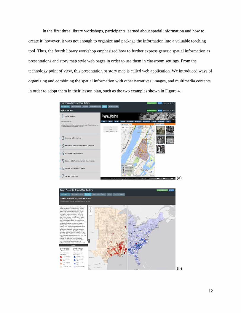
tool. Thus, the fourth library workshop emphasized how to further express generic spatial information as
presentations and story map style web pages in order to use them in classroom settings. From the
technology point of view, this presentation or story map is called web application. We introduced ways of
organizing and combining the spatial information with other narratives, images, and multimedia contents
in order to adopt them in their lesson plan, such as the two examples shown in Figure 4.
(a)
(b)
13
Figure 4. Web map applications that organize spatial information for teaching purpose. (a) A side
accordion layout story map web application which organizes different digital humanities projects about
Harlem. (b) A swipe style story map helps students to learn about the African American migration
between 1910-1920 by swiping between the two layers that recorded the African American population in
1910 and 1920.
In the last library workshop, participants expressed that they were not just satisfied to know how
to create spatial information on their own and present stories using the platform, but rather they were
eager to learn how to assemble a digital humanities project on their own, so that their students could
contribute spatial information as a team project. Consequently, instead of teaching participants how to
link spatial information with this week’s content knowledge, we modified our plan to teach about how to
prepare a template project for their students to contribute information.
Learning GIS and spatial information includes many topic areas and requires different levels of
understanding. During the design of the workshops, our intent was not to introduce participants to every
aspect of this information and technology. Instead, we tailored our workshops to serve for a digital
humanities approach in African American studies for secondary school classrooms. Besides connecting
spatial information to the content knowledge, we also specifically designed our workshops for the
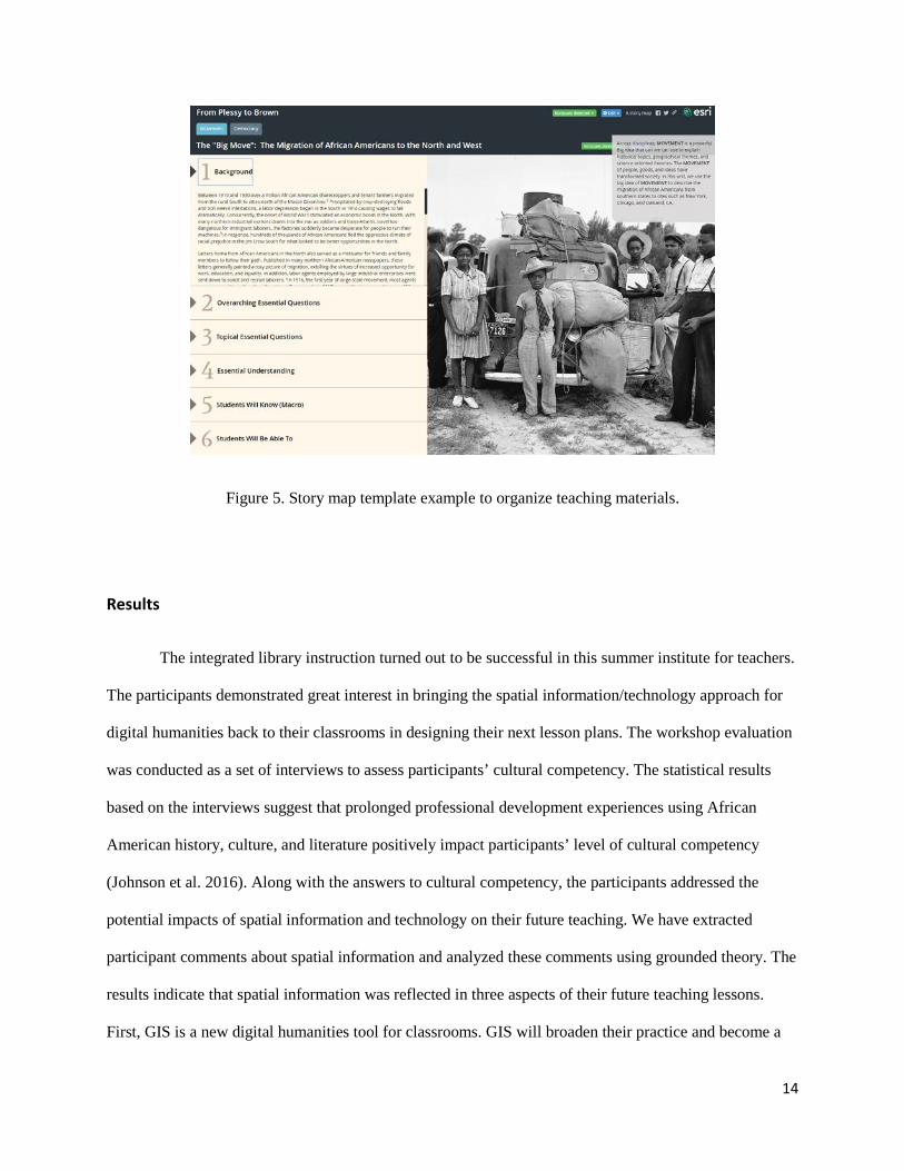
education purpose. Working with the researcher in education, we laid out the institution information in a
pedagogical design. For the theme of migration (Figure 5), for example, we set up a side accordion style
story map template to organize the teaching materials. The template webpage started with background
information, then introduced the overarching essential questions, topical essential questions, essential
understandings, and students will know sections for participants to prepare their lesson plans.
14
Figure 5. Story map template example to organize teaching materials.
Results
The integrated library instruction turned out to be successful in this summer institute for teachers.
The participants demonstrated great interest in bringing the spatial information/technology approach for
digital humanities back to their classrooms in designing their next lesson plans. The workshop evaluation
was conducted as a set of interviews to assess participants’ cultural competency. The statistical results
based on the interviews suggest that prolonged professional development experiences using African
American history, culture, and literature positively impact participants’ level of cultural competency
(Johnson et al. 2016). Along with the answers to cultural competency, the participants addressed the
potential impacts of spatial information and technology on their future teaching. We have extracted
participant comments about spatial information and analyzed these comments using grounded theory. The
results indicate that spatial information was reflected in three aspects of their future teaching lessons.
First, GIS is a new digital humanities tool for classrooms. GIS will broaden their practice and become a
15
helpful tool in their classrooms to explore questions of diversity. Second, spatial information can help
improve the content knowledge in classrooms. It allows teachers to integrate topics in a more meaningful
way. For example, one participant has specifically stated that the spatial literacy skills they learned from
the institute can contribute to designing projects that help their students understand “the richness of
images (visual and narrative) beyond a simple explanation of things like sexism and racism”. Third,
spatial information has the potential for pedagogical enhancement. The resources and tools introduced to
the participants allowed them to design projects that would encourage students’ discussion and
participation. According to our incomplete follow-up interactions with the participants, two of them have
offered professional development workshops to local teachers to teach their peers about how to embed
GIS into their history and English classrooms, which have received many positive feedbacks. We also
heard about two lessons that successfully implemented GIS for teaching history in high school
classrooms.
By integrating the library’s instructions and exercises into a digital humanities teachers’ training
program, we have observed four major learning outcomes in terms of spatial information literacy, as
evidenced by the projects that the participants completed and the active discussions that occurred during
and after the institute. First, the participants have developed a better understanding about spatial
information and how it can be used for digital humanities. With the weekly instruction and exercise,
which linked African American history and culture to a space, participants have learned that spatial
information is connected to events and time and that information can be saved and shared in a digital
format. Second, the participants have learned technology skills to collect and present spatial information,
and to create project templates for their students to add information. These tool skills enabled them to use
the spatial information as they liked, and motivated them to bring the spatial information literacy skills
back to their classrooms. Third, they learned how to organize the digital maps and GIS projects for their
pedagogical design so that they can embed these resources in their lesson plans. Finally, the participants
have learned about resources that they can acquire beyond the summer institute, including software
licenses, support for their schools, related conferences, workshops, and online communities so that they
16
can look for help outside of our training program. Although the five GIS workshops are not long enough
to cover every aspect of GIS for a general audience, through an inquiry-based learning experience, the
teachers acquired skills necessary to teach humanities with a digital platform. More importantly, this
opportunity sparked some participants’ interests to further explore the domain of spatial technology in
supporting humanities education and to create materials and share those with their peers.
Discussion
This summer institute has been our first attempt to integrate the library’s spatial information
literacy instructions into digital humanities training programs using the information literacy framework.
The framework has provided more broad collaboration opportunities for librarians and faculty in multiple
disciplines. During our institute design period, the framework served as a guideline for the collaboration,
which allowed for creative ways of integrating spatial information literacy into the humanities. It has
expanded the traditional information literacy instruction beyond the information sources and tools by
including several key concepts of information, such as the process of information creation, the value of
information, etc. Especially for the GIS services in libraries, this framework provides flexibility to
introduce the spatial information, from its value and search strategies to the process of information
creation, research inquiry, and beyond.
When adapting the framework to digital humanities in our practice, the frame of “information
creation as a process” works well to introduce learners to the concept of digital objects, its application in
humanities, and the extraction of information from various reading/research materials. We used this frame
to guide the participants through the process of recognizing spatial information, understanding the value
of spatial information, and creating the information on their own. Due to the unique format of spatial
information, the process of creating it for teaching in history and culture follows a dual-coding approach
(Sadoski and Paivio 2004). This approach uses both verbal and non-verbal codes representing information
17
and organizes them into a new format (i.e., spatial information) that can then be utilized, kept, and
retrieved for future use. In order to simplify this process for beginners, we divided spatial information into
three major components: where, what, and when. The participants needed to collect information in these
three categories in order to create one complete piece of spatial information. The first two library
workshops introduced the participants to the spatial information concept and digital tools in their
classrooms. As participants learned the content about African American history and culture from lectures,
readings, and other media in the first week, those digital tools provided a comparison between traditional
humanities information sources (mainly documents) and information formats used for digital humanities.
Through this comparison, the participants realized that the information format is a result of different
creation processes, and they became interested in learning about GIS tools that help them create digital
information for humanities. Then in the following weeks, we introduced different ways of creating spatial
information at various technical levels. At the entry level, the participants realized the capabilities and
constraints of the web map developed – for example, the easy mapping option allows users to create a
digital map in a very short amount of time, but it limits the type of information that users can create, the
visualization capability, and editing options. Based on this understanding, in the following week, we
introduced more advanced tools to create information beyond those constraints. Through such a step-by-
step process, the participants developed their understanding of spatial information creation and learned
their GIS skills from easy to more advanced levels.
The frame of “research as inquiry” aligns with the inquiry-based learning concept, which is often
used in GIS classrooms (Favier and Van der Schee 2012). The inquiry-based learning is a learning
process that aims to stimulate learners’ progression in the subject knowledge as well as inquiry and
thinking skills by engaging in research kind of activities. The inquiry is a cyclical process that consists of
identifying problems, collecting data, organizing data, analyzing data, and evaluating a solution (Bryant
and Favier 2015). GIS is an ideal tool for supporting inquiry-based learning because it provides an
abstraction of the reality. It allows teachers to design map-based real world projects in which students
18
explore learning topics, formulate questions about the learning topics, collect spatial information from
various sources, visualize and analyze that information using digital maps, and come up with a
conclusion. In our summer institute, we used the learning topics designed in each week’s syllabus to teach
participants how to define the humanities research projects using GIS, how to collect and organize spatial
information related to the problem, how to integrate information from different sources to understand or
solve the problem, and then translate these projects into their lesson plans. This frame allows the library’s
instructions to go beyond the simple information introduction by providing more opportunities to engage
with learners to integrate spatial information into their actual problem solving process. With this
increased flexibility, librarians can collaborate with humanities researchers in a much broader way to
integrate digital information and technology into their research process.
Along with the process of information creation and research inquiry, the frame of “authority is
constructed and contextual” is integrated into the learning process. As the participants created spatial
information on their own based on either their travel experiences or reading assignments, we started to
introduce the accuracy for spatial information. For example, a historical event location could be estimated
at a city level or connected to a detailed street address. The accuracy of spatial information depends on
the reference map and on the way GIS calculates the information (e.g., geocoding). The reliability of the
reference map depends on the information source. Thus, in digital humanities as much information was
created by scholars from reference data with different levels of authority, it is possible to encounter
conflicting perspectives.
The “information has value” frame was emphasized throughout the institute because our goal was
to help participants develop digital humanities projects (i.e., webpages) for their classroom teaching
purposes. The spatial information and web applications they created serve as a new format of information,
it has its own value as a means of education, and it is up to the participants to share the information
products with either everyone or just their own classrooms. During the information creation process,
proper attribution and citations need to be addressed in order to give credits to the original ideas.
19
The online collaboration nature of several GIS projects taught over the course of the institute
harnessed the “scholarship as conversation” frame. At the beginning of the institute when we introduced
the initial concept of spatial information, we designed a mobile device-based project to allow participants
to enter spatial information about surrounding restaurants, entertainment places, and all other fun places
they found around campus. Since all participants came from different states, this exercise not only taught
them about spatial information collection strategies, but it also worked as a community building
opportunity for them to get to know the surroundings and their peers. Through this activity, the
participants quickly became aware of the nature of information exchange and collaboration. Their
discussions were built around the information and comments contributed by their peers. The participants
considered this a great model to bring digital humanities projects into their classrooms. They can use the
online data collection tool to engage with their students, so that they can contribute information, review
other’s information, and generate a class-wide project based on each individual’s findings. It was really
triggered by the participants’ interests that we modified our original workshop plan and taught them how
to prepare such a platform, so that they can bring the model of information exchange and collaboration
back to their schools.
Last but not least, we also integrated the “searching as strategic exploration” frame into our
workshops. The ArcGIS Online platform provides many reference maps for users to add in their digital
maps, such as topography, street map, and aerial photos. Additionally, users can share their digital maps
with everyone in the system. Thus, ArcGIS Online has a large collection of map resources for users to
search. Users can use keywords to search this information. They can also refine their search by
information categories, such as map, map layer, web application, and tool, or by the search scope – if it is
a piece of information created within their own organization, shared by public users, offered by ArcGIS
Online, etc. We designed exercises for them to find several maps that we prepared and shared on ArcGIS
Online. As they searched, several questions were asked to help them understand how to determine and
20
refine the keywords and searching scope, how to read and evaluate the information retrieved from their
search, and how to modify their search parameters in order to get more relevant search results.
All six frames in the information literacy framework greatly contributed to our experience of
designing and implementing a digital humanities professional training for teachers. The frames allowed
for close collaborations between the librarian and the institute directors to integrate information and
technology for educators in humanities. When introducing spatial information for digital humanities, the
two most helpful frames are “information creation as a process” and “research as inquiry”. These two
frames allowed us to link humanities content with digital objects in the format of spatial information, and
they guided us through the process of identifying problems, collecting and creating new formats of
information for digital humanities, analyzing the information, and reaching our learning outcomes.
The Institute co-directors have conducted culture competency evaluations before and after the
Summer Institute. The statistical results have suggested that our program has greatly improved the
participants’ level of cultural competency (Johnson et al. 2016). Along with this survey, we have
provided open-ended questions for participants to comment about their overall experiences. They have
indicated that the library’s instruction can help them to broaden their teaching practices by using new
tools upon which to explore questions of diversity. By integrating the content knowledge with GIS
technology, they feel more confident to produce information in a new format and apply to classroom
teaching activities. Many participants commented that the institute was organized in a logical and
effective manner that covered many topics with wide range of activities including GIS technology. The
map making skills are “by far the best aspect of the program”, because those allow them to take back
the concept of using spatial information to engage their students.
Conclusion
The experiences we gained through the design and implementation of the summer institute
program suggest that the information literacy framework can provide opportunities for richer and
21
contextual collaboration between librarians and researchers in multiple disciplines. Digital (spatial)
humanities is a constantly growing area with rapid information and technology updates. The framework
can adapt to these changes and allow flexibility for the library’s instruction to integrate the subject
knowledge accordingly. When teaching spatial information literacy for digital humanities, the six frames
are highly connected, although some frames are more relevant than others.
We also learned that spatial information and technology could be an emphasized library service
area for the digital humanities. Introducing GIS and spatial information to the humanities community can
help scholars and practitioners to overcome the barriers encountered in the “spatial turn”, and help them
to get started with their digital projects. Furthermore, through a deliberate design of the instruction,
information literacy skills can be seamlessly integrated into a professional development program, so that
the learners can improve their culture competency and technology skills, as well as acquire information
literacy skills at the same time.
Although four-weeks is a prolonged period for a teachers’ professional development program, it
is not long enough to teach every skill that GIS could bring to the digital humanities. Our experience
suggests that it is possible to tailor digital humanities-related GIS content into five workshops and get
learners started and interested in the topic. The participants have expressed their interests to learn more
and use more GIS in the future. It is our plan to explore further opportunities to offer similar programs.
With the success of our collaboration and interests raised from the participants, we will plan to grow the
library’s instruction to allow for more hands-on time and contextual design of spatial humanities projects
in the future program design.
References
“ACRL Framework for Information Literacy Sandbox.” 2017. Accessed January 14.
http://sandbox.acrl.org/.
22
Association of College and Research Libraries. 2015. “Framework for Information Literacy for Higher
Education,” 18. http://www.ala.org/acrl/standards/ilframework.
Baker, Thomas G., Joseph J. Kerski, Niem T. Huynh, Kathrin Viehrig, and Sarah W. Bednarz. 2012. “Call
for an Agenda and Center for GIS Education Research.” Review of International Geographic
Education Online 2 (3): 254–88.
Bodenhamer, David J., John Corrigan, and Trevor M. Harris, eds. 2010. Spatial Humanities: GIS and the
Future of Humanities Scholarship. Indiana University Press.
http://site.ebrary.com/lib/purdue/reader.action?docID=10767195&ppg=20.
———. , eds. 2015. Deep Maps and Spatial Narratives. Indiana University Press.
Bryant, Lara M.P., and Tim Favier. 2015. “Professional Development Focusing on Inquiry-Based Learning
Using GIS.” In Geospatial Technologies and Geography Education in a Changing World, edited by
Osvaldo Muñiz Solari, Ali Demirci, and Joop van der Schee, 127–41. Japan: Springer.
doi:10.1007/978-4-431-55519-3.
Cunningham, Leigh. 2010. “The Librarian as Digital Humanist : The Collaborative Role of the Research
Library in Digital Humanities Projects.” Faculty of Information Quarterly 2 (2): 1–11.
Favier, Tim. T., and Joop. A. Van der Schee. 2012. “Exploring the Characteristics of an Optimal Design for
Inquiry-Based Geography Education with Geographic Information Systems.” Computers and
Education 58 (1): 666–77.
Griffiths, Sam. 2013. “GIS and Research into Historical ‘Spaces of Practice’: Overcoming the
Epistemological Barriers.” In History and GIS: Epistemologies, Considerations and Reflections,
edited by A. von lunen and C. Travis, 153–71. London: Springer.
Head, Alison J. 2008. “Information Literacy from the Trenches : How Do Humanities and Social Science
23
Majors Conduct Academic Research?” College & Research Libraries, 427–46. doi:
10.5860/crl.69.5.427.
Johnson, Chrystal S., Cornelius L. Bynum, Ningning N. Kong, Jennifer Sdunzik, and Xiaoyue Qin. 2016.
“From Plessy to Brown: Using a Professional Development Experience Centered on African
American History to Enhance Cultural Competence in Educators.” In Annual Meeting of the College
and University Faculty Assembly of the National Council for the Social Studies. Washington, DC.
McClurg, Patricia A., and Alan Buss. 2007. “Professional Development: Teachers Use of GIS to Enhance
Student Learning.” Journal of Geography 106: 79–87.
Mishra, Punya, and Matthew J. Koehler. 2006. “Technological Pedagogical Content Knowledge: A
Framework for Teacher Knowledge.” Teachers College Record 108 (6): 1017–54.
doi:10.1111/j.1467-9620.2006.00684.x.
National Research Council. 2006. Learning to Think Spatially: GIS as a Support System in the K-12
Curriculum. Washington, DC: The National Academies Press. doi:10.17226/11019.
Posner, Miriam. 2013. “No Half Measures: Overcoming Common Challenges to Doing Digital Humanities
in the Library.” Journal of Library Administration 53 (1): 43–52.
doi:10.1080/01930826.2013.756694.
Sadoski, Mark, and Allan Paivio. 2004. “A Dual Coding Theoretical Model of Reading.” In Theoretical
Models and Processes of Reading, edited by R. B. Ruddell and N. J. Unrau, 5th editio, 1329–62.
Newark, DE: International Reading Association.
Sula, Chris A. 2013. “Digital Humanities and Libraries: A Conceptual Model.” Journal of Library
Administration 53 (1): 10–26. doi:10.1080/01930826.2013.756680.
Warf, Barney, and Santa Arias. 2008. The Spatial Turn: Interdisciplinary Perspectives. Edited by Barney
24
Warf and Santa Arias. New York, NY: Routledge.
http://reader.eblib.com.ezproxy.lib.purdue.edu/(S(atxzqvrkm1hx0jd2yxokucki))/Reader.aspx?p=35
6413&o=58&u=JWvGAIMz8bM%3D&t=1430763856&h=1D90639E400C6AB96D982F7DF7281EF697
C95DF2&s=36065559&ut=130&pg=1&r=img&c=-1&pat=n&cms=-1&sd=2#.
Zorich, Diane M. 2008. “A Survey of Digital Humanities Centers in the United States.” Washington, DC.
http://www.clir.org/pubs/reports/pub143/reports/pub143/pub143.pdf.


![Knowing their Place: Improving the Spatial Literacy of Tomorrow’s Workforce [Digimap for Schools]](https://img.pdfslide.us/doc/110x75/54c34c724a795960188b45e9/knowing-their-place-improving-the-spatial-literacy-of-tomorrows-workforce-digimap-for-schools.jpg)