Embed Size (px)
Citation preview
Spatial and temporal variability of sediment transfer L. Schrott, J. Götz, M. Geilhausen, D. Morche 191
Lothar Schrott, Joachim Götz, Salzburg, Martin Geil-hausen, Bonn, David Morche, Halle
1 Introduction
Spatial and temporal sediment flux within alpine sediment cascading systems is still poorly understood. Specific patterns of sediment storage types in alpine environments may be interpreted to be a result of tem-poral and spatial interaction of geomorphic processes. Thus, they can be considered to be geomorphic proc-ess units. Major problems encountered in research in this area appear to be related to the highly variable and changing residence times of stored sediments and to different buffering capacities in alpine catchments (Caine 1986; Fryirs & Brierley 2001; Walling 1999; Slaymaker 2003). This would seem to have a signifi-cant influence on sediment yield and hence on sedi-ment budget (Trimble 1995, 1999; Walling 1999).
To improve the general understanding of alpine land-scape evolution, it is evident that quantitative studies of sediment storage and transfer are necessary (Schrott & Adams 2002). Despite the difficulties of such research at larger spatial and temporal scales, the project described herein aims firstly, at investigating spatial distribution of sediment storage types with respect to their activity and geomorphic coupling, and secondly, at quantifying valley fill deposits using a geomorphometric approach, refraction seismic and geographical information sys-tems (GIS) techniques (Schrott et al. 2002, 2003). The project is embedded within a larger project on sediment cascades in alpine geosystems (Sedimentkaskaden in alpinen Geosystemen - SEDAG).
Of particular interest in this research project are clas-tic sediment fluxes in selected geomorphic process units that show significant sediment transfer activity. The spatial and temporal patterning of active sur-face areas was carried out using geomorphological mapping, orthophoto interpretation, digital elevation models (DEMs) and GIS-tools. The main objectives of the project are(i) to compare active surface areas with regard to recent sediment fluxes by field mapping and bi- temporal orthophoto interpretation;(ii) to differentiate between erosion and accumulation areas on highly active talus slopes by quantifying area and volume of present-day sediment transfer; and
(iii) to assess these short term values (one to four years) with long term values of sediment stores (Late and Postglacial).
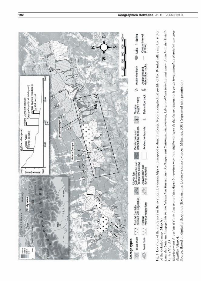
Three different spatial scales are considered in this project. Bi-temporal orthophoto interpretation was carried out for the whole mapping area, comprising all talus slopes and the entire valley floor (3 km²) of the sub-catchment of the Reintal (17 km²) (see Fig. 1). Further, a stretch of several north facing talus slopes in the middle part of the valley (0.37 km²) and a compar-atively small talus sheet/debris cone-complex within this stretch (0.05 km²) were processed in more detail using field measurements and DEM-calculations with regard to debris flow activity and sediment transfer (see Fig. 2).
2 Research area
The catchment of the Reintal valley is located in the Wettersteinmassiv in the Bavarian Alps near the border between Germany and Austria (Fig. 1). The basin is surrounded by some of the highest summits of Germany, including Zugspitze with 2960 m asl. It is drained by the Partnach River, a tributary of the Loisach River.
The Reintal valley has an asymmetrical cross-profile with very steep (> 45°) north-facing rock walls and more gentle, south-facing slopes. The basin has a typi-cal through-shaped morphology due to former, partic-ularly Pleistocene glaciation. The remnants of Lategla-cial moraines to be found along the valley floor speak for this (Hirtlreiter 1992; Schrott et al. 2002).
The geological and lithological settings are dominated by an underlying massive and partially thick bedded Triassic limestone. For this reason, karst features and partially subterranean drainage are to be found in the basin. In addition, several natural rockfall dams and slope-channel decoupling contribute towards clastic sediment output (Schmidt & Morche 2006). Their contribution is, however, negligible.
The total drainage basin with an area of 27 km² is alpine in character with altitudes ranging from 1050 to 2960 m asl. The sub-catchment considered in the SEDAG Project is 17 km2. It comprises the main valley floor, the adjacent talus slopes and the rock walls and hanging valleys above it.
Spatial and temporal variability of sediment transfer and storage in an Alpine basin (Reintal valley, Bavarian Alps, Germany)
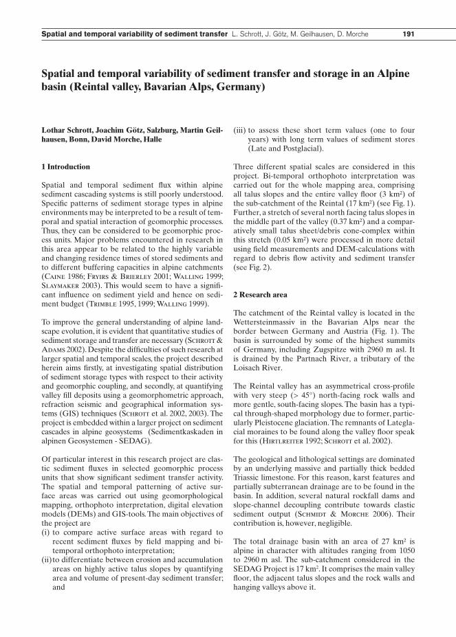
192 Geographica Helvetica Jg. 61 2006/Heft 3
Gol
fpla
tz (f
lood
plai
n)
Obe
rer A
nger
(roc
kfal
l dep
osit)
Hin
tere
Gum
pe (f
lood
plai
n)S
tein
gerü
mpe
l (ro
ckfa
ll de
posi
t)Vo
rder
e G
umpe
(flo
odpl
ain)
Roc
kfal
l dep
osit
Vord
ere
Gum
pe
Hin
tere
Gum
pe
Fig.
1: L
ocat
ion
of th
e st
udy
area
in th
e no
rthe
rn B
avar
ian
Alp
s w
ith
map
ped
sedi
men
t sto
rage
type
s, a
long
itud
inal
pro
file
of th
e R
eint
al v
alle
y an
d th
e se
ctor
of
the
deta
iled
map
(M
ap A
)L
age
des
Unt
ersu
chun
gsge
biet
s in
den
Nör
dlic
hen
Bay
eris
chen
Kal
kalp
en m
it Se
dim
ents
peic
hert
ypen
, Län
gspr
ofil d
es R
eint
als
und
eine
m A
ussc
hnitt
der
Det
ail-
kart
e (M
ap A
)E
mpl
acem
ent d
u se
cteu
r d’
étud
e da
ns le
nor
d de
s Alp
es b
avar
oise
s m
ontr
ant d
iffé
rent
s ty
pes
de d
épôt
s de
séd
imen
ts, l
e pr
ofil l
ongi
tudi
nal d
u R
eint
al e
t une
car
te
déta
illée
(M
ap A
)So
urce
: Bas
ed o
n di
gita
l ort
hoph
otos
(B
ayer
isch
es L
and
esve
rmes
sun
gsam
t, M
ünch
en, 2
003)
(re
prin
ted
wit
h pe
rmis
sion
)
192 Geographica Helvetica Jg. 61 2006/Heft 3 Spatial and temporal variability of sediment transfer L. Schrott, J. Götz, M. Geilhausen, D. Morche 193
The main valley floor and the talus slopes are character-ized by a variety of sediment storage types (talus sheets and cones, debris cones, rockfall deposits, alluvial fans, avalanche deposits, moraines and some more complex landforms) which developed in Postglacial times. Due to natural rockfall dams, three large alluvial plains (Golf-platz, Vordere Gumpe and Hintere Gumpe) were created in the Holocene as almost closed sediment sinks (Fig.1) (Schrott et al. 2002). However, since August 2005, the sediment sink of the Vordere Gumpe no longer exists due to an extreme flash flood event (Morche et al. 2006).
According to Chorley & Kennedy (1971), the basin can be defined as a «sediment cascade» with three subsystems, namely rockwall (I), slope (II) and valley bottom (III). These three subsystems are more or less connected to each other through processes and influ-enced by regulators.
Although subsystem I extends over an area of 14 km², thereby making up more than 82% of the sub-catch-
ment, it is of minor importance with regards to sedi-ment storage. The morphology of this system is charac-terized by steep rock walls, small cirques and hanging valleys with shallow developed talus slopes. In contrast, subsystems II and III are predominantly accumulation areas. They make up about 3 km² or 18% of the total research area and include the main valley floor and adjacent talus slopes (see Fig. 1).
At present, however, many landforms and, in particu-lar, the talus sheets and cones in the lower part of the valley are decoupled from the geomorphic system and no significant clastic sediment input, remobilisation or output appears to occur (Schrott et al. 2002).
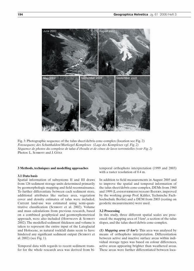
The investigated sub-basin in the middle of the valley is characterized by a relatively strong coupling of subsys-tem I and II through rockfall activity. Sediment output or transfer from subsystem II (slope) to subsystem III (valley bottom) is limited to single landforms, generally occurring during high magnitude rainfall events (Fig. 3).
Accumulation
Erosion
Debris flow A
/ -
Fig. 2: Location of the sub-catchment in the central part of the Reintal valley on the north facing slopes. Active areas are marked, differentiated according to dominating processes of erosion or accumulation. On the right, the talus sheet/debris cone-complex with debris flow A is highlighted.Lage des Subeinzugsgebiets im mittleren, nordexponierten Bereich des Reintals mit den aktiven Bereichen, diffe-renziert nach Erosions- und Akkumulationsflächen. In der rechten Bildhälfte ist der Ausschnitt des Schutthalden/Murkegel-Komplexes mit der rezent aktiven Übermurung A hervorgehoben.Emplacement du sous-bassin dans la zone centrale du Reintal exposée au nord. Les secteurs actifs, différenciés selon la dominance de l’érosion ou de l’accumulation, sont indiqués. A droite, le complexe de talus d’éboulis et de cônes de laves torrentielles et le flux de débris A sont mis en évidence.Source: Based on digital orthophotos (Bayerisches Landesvermessungsamt 2003) (reprinted with permission)
194 Geographica Helvetica Jg. 61 2006/Heft 3
3 Methods, techniques and modelling approaches
3.1 Data basisSpatial information of subsystems II and III draws from 126 sediment storage units determined primarily by geomorphologic mapping and field reconnaissance. To further differentiate between each sediment store, additional attributes like surface area, vegetation cover and density estimates of talus were included. Current land-use was estimated using semi-quan-titative classification (Schrott et al. 2002). Volume and mass calculations from previous research, based on a combined geophysical and geomorphometrical approach, were also included (Hoffmann & Schrott 2002). The modelled sediment thickness and volume is taken to represent the entire input of the Lateglacial and Holocene, as natural rockfall dams seem to have hindered any significant sediment output (Schrott et al. 2002) (see Fig. 1).
Temporal data with regards to recent sediment trans-fer for the whole research area was derived from bi-
temporal orthophoto interpretation (1999 and 2003) with a raster resolution of 0.4 m.
In addition to field measurements in August 2005 and to improve the spatial and temporal information of the talus sheet/debris cone-complex, DEMs from 1960 and 1999 (Landesvermessungsamt Bayern, improved by the working group Prof. Kähler, Technische Fach-hochschule Berlin) and a DEM from 2003 (resting on geodetic measurements) were used.
3.2 ProcessingIn this study, three different spatial scales are proc-essed: the mapping area of 3 km², a section of the talus slopes, and the talus sheet/debris cone-complex.
(1) Mapping area (3 km²): This area was analysed by means of orthophoto interpretation. Differentiation between active and inactive surface areas within indi-vidual storage types was based on colour differences, active areas appearing brighter than weathered areas. These areas were further differentiated between loca-
Fig. 3: Photographic sequence of the talus sheet/debris cone-complex (location see Fig. 2)Fotosequenz des Schutthalden/Murkegel-Komplexes (Lage des Komplexes vgl. Fig. 2)Séquence de photos du complexe de talus d’éboulis et de cônes de laves torrentielles (voir Fig. 2)Photos: L. Schrott and J. Götz
194 Geographica Helvetica Jg. 61 2006/Heft 3 Spatial and temporal variability of sediment transfer L. Schrott, J. Götz, M. Geilhausen, D. Morche 195
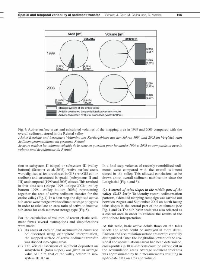
tion in subsystem II (slope) or subsystem III (valley bottom) (Schrott et al. 2002). Active surface areas were digitised as feature classes in GIS (ArcGIS editor toolbox) and structured in spatial (subsystems II and III) and temporal (1999 and 2003) classes. This resulted in four data sets («slope 1999», «slope 2003», «valley bottom 1999», «valley bottom 2003») representing together the area of active sediment transfer for the entire valley (Fig. 4). In a next step, the digitised active sub-areas were merged with sediment storage polygons in order to calculate an area-ratio of active to inactive sub-areas for each sediment storage type (Fig. 5).
For the calculation of volumes of recent clastic sedi-ment fluxes several assumptions and simplifications were made: (i) As areas of erosion and accumulation could not be discerned using orthophoto interpretation, the mapped surface of active sediment transfer was divided into equal areas.(ii) The vertical extension of sediment deposited on subsystem II (talus slopes) was given an average value of 1.5 m, that of the valley bottom in sub- system III, 0.5 m.
In a final step, volumes of recently remobilised sedi-ments were compared with the overall sediment stored in the valley. This allowed conclusions to be drawn about overall sediment mobilisation since the Lateglacial (Fig. 4 and 5).
(2) A stretch of talus slopes in the middle part of the valley (0.37 km²): To identify recent sedimentation patterns, a detailed mapping campaign was carried out between August and September 2005 on north facing talus slopes in the central part of the catchment (see Fig. 1 and 2). The sub-basin scale was also selected as a control area in order to validate the results of the orthophoto interpretation.
At this scale, basic active debris flows on the talus sheets and cones could be surveyed in more detail. Erosion and accumulation surface areas were carefully distinguished. Once the longitudinal extent of the ero-sional and accumulational areas had been determined, cross-profiles in 10 m-intervals could be carried out in the accumulation areas. Average sediment thickness was approximated by field measurements, resulting in up-to-date data on area and volume.
%] %]
%]
%]
%]
%]%] %]
Fig. 4: Active surface areas and calculated volumes of the mapping area in 1999 and 2003 compared with the overall sediment stored in the Reintal valleyAktive Bereiche und berechnete Volumina des Kartiergebietes aus den Jahren 1999 und 2003 im Vergleich zum Sedimentgesamtvolumen im gesamten ReintalSecteurs actifs et les volumes calculés de la zone en question pour les années 1999 et 2003 en comparaison avec le volume total de sédiments du Reintal
196 Geographica Helvetica Jg. 61 2006/Heft 3
The geomorphic coupling of the sediment cascade shows four general types of clastic sediment fluxes:(a) sediment input and output occurs (sediment stor- age aggradation versus degradation)(b) sediment input but no output occurs (sediment storage aggradation)(c) sediment output but no input occurs (sediment storage degradation)(d) neither input nor output occurs (sediment rework- ing).
(3) Talus sheet/debris cone-complex (0.05 km²): At this level, the focus was on temporal changes of sedi-ment transfer (Fig. 2 and 3). Orthophotos from 1999 and 2003, as well as DEMs were used for calculation of the long-term sediment transfer on the talus sheet/debris cone-complex. Additionally, short-term sedi-ment transfer estimation (erosion and accumulation) was made possible with data from geodetic surveys carried out in August 2003 and August 2005. The reso-lution of the official 1999 DEM (© Landesvermes-sungsamt Bayern) was improved from a 5 m grid to a 1-3 m grid. A 1960 DEM was generated by the working group of Prof. Dr. Ing. M. Kähler (Technische Fach-hochschule Berlin, laboratory of photogrammetry) using photogrammetry techniques.
For three different years (1960, 1999, 2003), a surface grid of the talus sheet/debris cone-complex was cal-culated. The changes were expressed in volume, with negative volumes indicating erosion and positive vol-
umes, accumulation. These volumes were converted into masses by using a bulk density of talus sheets of 2 g cm-³.
4 Results
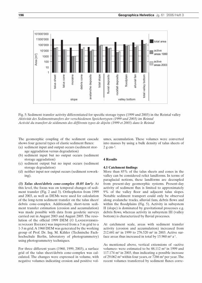
4.1 Catchment findingsMore than 85% of the talus sheets and cones in the valley can be considered relict landforms. In terms of paraglacial notions, these landforms are decoupled from present-day geomorphic systems. Present-day activity of sediment flux is limited to approximately 9% of the valley floor and adjacent talus slopes. Notable sediment transport could only be observed along avalanche tracks, alluvial fans, debris flows and within the floodplains (Fig. 5). Activity in subsystem II (slope) is dominated by gravitational processes e.g. debris flows, whereas activity in subsystem III (valley bottom) is characterized by fluvial processes.
At catchment scale, areas with sediment transfer activity (erosion and accumulation) increased from 212.681 m² in 1999 to 276.520 m² in 2003. Active sur-face areas thus increased in total by 15.960 m² a-1.
As mentioned above, vertical extensions of «active volumes» were estimated to be 88.112 m³ in 1999 and 117.174 m³ in 2003, thus indicating a possible increase of 29.062 m³ within four years, or 7266 m³ per year. The recent volumes transferred by sediment fluxes corre-
total area
active areas 1999
activeareas 2003
slope valley bottom
talu
s sh
eet
talu
s co
ne
mor
aine
debr
is c
one
aval
anch
e de
posi
ts
tota
l slo
pe
fluvi
al d
epos
its
rock
fall
depo
sits
flood
plai
n
allu
vial
fan
tota
l val
ley
botto
m
1
10
100
1000
10’000
100’000
1‘000’000
10’000’000A
rea
[m2 ]
Fig. 5: Sediment transfer activity differentiated for specific storage types (1999 and 2003) in the Reintal valleyAktivität des Sedimenttransfers der verschiedenen Speichertypen (1999 und 2003) im ReintalActivité du transfert de sédiments des différents types de dépôts (1999 et 2003) dans le Reintal
196 Geographica Helvetica Jg. 61 2006/Heft 3 Spatial and temporal variability of sediment transfer L. Schrott, J. Götz, M. Geilhausen, D. Morche 197
spond to 0.17% of the total volume of sediment in the catchment (~0.07 km³). The estimated volumes, how-ever, include both remobilisation and sediment input. Assuming sediment aggradation took place solely in Postglacial times and that after deglaciation, there was an almost «empty basin», the total sediment volume would require a Lateglacial and Holocene (approxi-mately 12.000 years) linear sedimentation rate of 5.833 m³/a, which is considered here to be unrealistic.
4.2 Sub-catchment findings As noted above, in summer 2005 a detailed mapping campaign was carried out on the north facing talus slopes (subsystem II) in the central part of the valley. The area of the sub-basin extends over 366.600 m², correspond-ing to 12% of the mapping area. Sediment transfer is strongly controlled by a total of 19 debris flows (Fig. 2).
In most cases, these active debris flows were decou-pled from the sediment cascade, resulting in scarp, pathway and accumulation area being located within subsystem II (slope) (Fig. 2). However, sediment input from subsystem I (rockwall) occurs more frequently than sediment output into the Partnach creek, output being limited to extreme rainfall events with intense slope-channel interaction (Fig. 3 and 6) (Krautblat-ter 2004; Krautblatter & Moser 2005).
The total accumulation area of the sub-catchment according to field measurements amounts to 11.861 m². The transfer of digital datasets 1999 and 2003 to the area of the sub-catchment indicate active accumula-tion areas of 8.070 m² (1999) and 12.175 m² (2003), respectively. Although the values of the measured and digitised sediment transfer analysis are not directly comparable because they represent different time scales (2005, 2003, and 1999), the orthophoto interpre-tation provides relatively accurate values.
By multiplying the measured areas of accumulation (11.861 m²) with the approximated vertical extends (minimum value: 30 cm, maximum value: 2 m), the total volume of the accumulation areas can be esti-mated to be 14.734 m³.
4.3 Talus sheet/debris cone-complex findingsThis area is a highly active landform complex. The debris cone located within a larger talus sheet com-plex showed until 2002 only moderate erosion and accumulation activity. An extreme rainfall event on June 14, 2003 triggered a debris flow (debris flow A), leaving fresh and large deposits on the older debris cone (Fig. 3). This event was accompanied by a sedi-ment input of 220 tons through rockfalls (Krautblat-ter 2006). A geodetic survey carried out in 2003 indi-cated an accumulated volume of 6.960 tons, under the
assumption of a bulk density of 2 g cm-3. After another extreme rainfall event in summer 2004, measurements taken in August 2005 indicated an accumulated mass of 15.498 tons (Fig. 3). During a high magnitude flood event on August 23, 2005, the River Partnach heavily truncated debris flow A at the distal part of the talus sheet, resulting in a reduced mass of 13.574 tons. Inter-estingly, this last event led to neither sediment input from subsystem I (rockwall) into subsystem II (slope), nor to any sediment remobilisation within subsystem II. This could be due to a reduced sediment availability and/or resistance in the source areas of the cascading system and upper parts of the talus. Fig. 3 illustrates the development of debris flow A in a sequence of photographs from 2002 to 2005.
5 Discussion
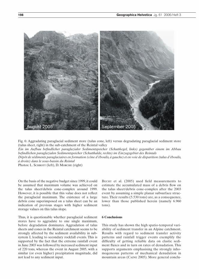
Based on the idea formulated by Ballantyne (2002) that different paraglacial subsystems relax over differ-ent timescales, several assumptions regarding Postgla-cial landform development in the Reintal catchment are discussed below. It seems obvious that currently, some paraglacial sediment storages are experience net erosion while others continue to accumulate. In the research area, both types are found side by side. Two examples are shown in Fig. 6.
Basically, the application of the general steady-state model of paraglacial sediment storage requires four parameters, namely (i) the time elapsed since degla-ciation, (ii) the present volume of stored sediment, (iii) the maximum volume of stored sediment and (iv) the time when maximum volume was achieved. In princi-ple, the model implies that there is an intrinsic change from net accumulation to net erosion for all paragla-cial sediment stores at a time when maximum volume of storage was achieved unless sediment loss is zero (Ballantyne 2003).
For the talus sheet/debris cone-complex recently deg-radated by debris flow A and river undercutting, the first and second parameter can be adequately esti-mated with 12.000 years and 1.01 million m³, respec-tively. However, maximum volume of stored sediment and time of maximum volume remains speculative and is far more difficult to determine.
Geodetic field measurements and calculations using DEMs of 1960 and 1999 indicate that the accumu-lation of sediment is stronger than actual erosion between 1960 and 1999, resulting in a total positive sediment budget of 5.125 m³. In contrast, the period between 1999 and 2003 is characterized by a negative sediment budget of 5.254 m³, with erosion overriding accumulation.
198 Geographica Helvetica Jg. 61 2006/Heft 3
On the basis of the negative budget since 1999, it could be assumed that maximum volume was achieved on the talus sheet/debris cone-complex around 1999. However, it is possible that this value does not reflect the paraglacial maximum. The existence of a large debris cone superimposed on a talus sheet can be an indication of previous stages with higher sediment storage values on this talus slope.
Thus, it is questionable whether paraglacial sediment stores have to aggradate to one single maximum, before degradation dominates. Aggradation of talus sheets and cones in the Reintal catchment seems to be strongly affected by the sediment availability in sub-system I, leading to secondary rockfall events. This is supported by the fact that the extreme rainfall event in June 2003 was followed by increased sediment input of 220 tons, whereas the event in August 2005, with a similar (or even higher) precipitation magnitude, did not lead to any sediment input.
Becht et al. (2005) used field measurements to estimate the accumulated mass of a debris flow on the talus sheet/debris cone-complex after the 2003 event by assuming a simple planar subsurface struc-ture. Their results (5.530 tons) are, as a consequence, lower than those published herein (namely 6.960 tons).
6 Conclusions
This study has shown the high spatio-temporal vari-ability of sediment transfer in an Alpine catchment. Results with regard to sediment transfer activity patterns and rainfall trigger events exemplify the difficulty of getting reliable data on clastic sedi-ment fluxes and in turn on rates of denudation. This supports arguments emphasising the strongly inho-mogeneous patterns of mechanical denudation in mountain areas (Caine 2005). More general conclu-
Fig. 6: Aggradating paraglacial sediment store (talus cone, left) versus degradating paraglacial sediment store (talus sheet, right) in the sub-catchment of the Reintal valleyEin im Aufbau befindlicher paraglazialer Sedimentspeicher (Schuttkegel, links) gegenüber einem im Abbau befindlichen paraglazialen Sedimentspeicher (Schutthalde, rechts) im Einzugsgebiet des ReintalsDépôt de sédiments paraglaciaires en formation (cône d’éboulis, à gauche) et en voie de disparition (talus d’éboulis, à droite) dans le sous-bassin du ReintalPhotos: L. Schrott (left), D. Morche (right)
198 Geographica Helvetica Jg. 61 2006/Heft 3 Spatial and temporal variability of sediment transfer L. Schrott, J. Götz, M. Geilhausen, D. Morche 199
sions that can be drawn from this study are as fol-lows: • At all scales investigated, sediment transfer between 1999 and 2003 in the basin increased.• Compared to remobilisation, sediment input through rockfalls was significantly lower. This is inferred on the basis of current sediment transfer values being unsuitable for long-term averages. The approximated volume of recent sediment transfer (117.174 m3) would lead – if taken as sediment input – to extremely high and unrealistic sedimen- tation rates. In such a scenario, the entire valley fill would be attained within less than 600 years. Thus, it is assumed that recent sediment transfer is main- ly characterised by remobilisation, partly showing talus slope degradation.• In the control area, the orthophoto interpretation led to reliable results regarding active surfaces of sediment transfer. More accurate and intense field measurements are necessary for calculations of ver- tical extension and sediment volume.• Although the main part of talus sheets and cones in the valley is currently inactive, significant sedi- ment transfer can be observed on single landforms. On the highly active talus sheet/debris cone-com- plex, a single rockfall event led to sediment input of 110 m³ , accompanied however, by sediment remobi- lisation of 6270 m³ (Becht et al. 2005). Conse- quently, the ratio of input to remobilisation was in this case 1:57.
AcknowledgementsThis research was supported by a grant from the Deut-sche Forschungsgemeinschaft (DFG, Schr648/1-3). The authors wish to thank M. Krautblatter, Bonn, for data on rockfalls, S. Fuchs, Halle, and the SEDAG team for general assistance in the field.
ReferencesBallantyne, C.K. (2002): Paraglacial geomorphology. – In: Quaternary science reviews 21: 1935– 2017.Ballantyne, C.K. (2003): Paraglacial landform succession and sediment storage in deglaciated mountain valleys. Theory and approaches to calibration. – In: Zeitschrift für Geomorphologie, Supplementband 132: 1-18.Becht, M., Haas, F., Heckmann, T. & V. Wichmann (2005): Investigating sediment cascades using field meas-urements and spatial modelling. – In: IAHS Publication 291 (Sediment Budgets I; Proceedings of Symposium S1 held during the Seventh IAHS Scientific Assembly at Foz do Iguacu, Brazil, April 2005): 206-213.Caine, N. (1986): Sediment movement and storage on alpine slopes in the Colorado Rocky Mountains. – In: Abrahams, A.D. (ed.): Hillslope processes. – London: Allan and Unwin: 115-137.
Caine, N. (2004): Mechanical and chemical denuda-tion in mountain systems. – In: Owens, P.N. & O. Slay-maker (eds): Mountain geomorphology. – London: Arnold: 132-152.Chorley, R.J. & B.A. Kennedy (1971): Physical geog-raphy. A systems approach. – London: Prentice-Hall International.Fryirs, K. & G.J. Brierley (2001): Variability in sedi-ment delivery and storage along river courses in Bega catchment, NSW, Australia. Implications for geomor-phic river recovery. – In: Geomorphology 38, 3-4: 237-265.Hirtlreiter, G. (1992): Spät- und postglaziale Glet-scherschwankungen im Wettersteingebirge und seiner Umgebung. – = Münchener geographische Abhand-lungen, Reihe B, 15.Hoffmann, T. & L. Schrott (2002): Modelling sedi-ment thickness and rockwall retreat in an Alpine valley using 2D-seismic refraction (Reintal, Bavarian Alps). – In: Zeitschrift für Geomorphologie, Supple-mentband 127: 153-173.Krautblatter, M. (2004): The impact of rainfall inten-sity and other external factors on primary and sec-ondary rockfall (Reintal, Bavarian Alps). – Magister thesis, Department of Geology, University of Erlan-gen-Nuremberg, Erlangen, Germany.Krautblatter, M. & M. Moser (2005): Die Implikatio-nen einer vierjährigen quantitativen Steinschlagmes-sung für Gefahrenabschätzung, Risikoverminderung und die Ausgestaltung von Schutzmaßnahmen. – In: Proceedings of the 15th Conference on Engineering Geology, Erlangen, April 6th to 9th: 67-72. Krautblatter, M. (2006): Personal communication, 17.4.2006, Department of Geography, University of Bonn. Morche, D., Katterfeld, C., Fuchs, S. & K.-H. Schmidt (2006): The life-span of a small high mountain lake, the Vordere Blaue Gumpe in the Upper Bavaria, Germany. – In: Rowan, J., Duck, R.W. & A. Werritty (eds): Sediment dynamics and the hydromorphology of fluvial systems. IAHS Publication 306, Wallingford: IAHS Press: 72-81.Schmidt, K.-H. & D. Morche (2006): Sediment output and effective discharge in two small high mountain catchments in the Bavarian Alps, Germany. – In: Geo-morphology 80: 131-145.Schrott, L., Hufschmidt, G., Hankammer, M., Hoff-mann, T. & R. Dikau (2003): Spatial distribution of sediment storage types and quantification of valley fill deposits in an alpine basin, Reintal, Bavarian Alps, Germany. – In: Geomorphology 55: 45-63.Schrott, L. & T. Adams (2002): Quantifying sediment storage and Holocene denudation in an Alpine basin, Dolomites, Italy. – In: Zeitschrift für Geomorphologie, Supplementband 128: 129-145.Schrott, L., Niederheide, A., Hankammer, M., Huf-schmidt, G. & R. Dikau (2002): Sediment storage in a
200 Geographica Helvetica Jg. 61 2006/Heft 3
mountain catchment: geomorphic coupling and tem-poral variability. – In: Zeitschrift für Geomorphologie, Supplementband 127: 175-196.Slaymaker, O. (2003): The sediment budget as concep-tual framework and management tool. – In: Hydrobio-logia 494: 71-82.Trimble, S.W. (1995): Catchment sediment budgets and change. – In: Gurnell, A. & G. Petts (eds): Changing river channels. – London: Wiley: 201-215.Trimble, S.W. (1999): Decreased rates of alluvial sedi-ment storage in the Coon Creek Basin, Wisconsin, 1975-1993. – In: Science 285: 1244-1246.Walling, D.E. (1999): Linking land use, erosion and sediment yields in river basins. – Hydrobiologia 410: 223-240.
Summary: Spatial and temporal variability of sediment transfer and storage in an Alpine basin (Reintal valley, Bavarian Alps, Germany)This paper focuses in particular on clastic sediment fluxes on talus slopes. Using orthophoto interpretation, field measurements and GIS-techniques, a quantifica-tion of areas and volumes of active sediment transfer related to specific landform units was achieved for dif-ferent spatial scales. Closer investigation of a single landform complex, more specifically a talus sheet/debris cone-complex, brought to light that remobilisa-tion can overbalance sediment input by a factor of 57. This could be an indication of what may be expected in the whole catchment. At present, approximately 9% of the research area (3 km²), comprising talus slopes and valley bottom, is characterised by sediment transfer mainly through gravitational and fluvial processes. A comparison of the vast volumes (117.174 m³) derived from these active areas of recent sediment transfer and the volume of the entire valley fill (0.07 km³) indi-cates, however, that the largest part must be related to remobilised sediments and cannot be considered as sediment input from the adjacent rockwalls. This con-clusion is also supported by direct measurements of sediment input.
Zusammenfassung: Raum-zeitliche Variabilität des Sedimenttransfers und der Sedimentspeicherung in einem alpinen Einzugsgebiet (Reintal, Bayerische Alpen, Deutschland)Dieser Aufsatz beschäftigt sich mit Sedimenteinträgen und -umlagerungen auf alpinen Schutthängen. Auf der Grundlage von Orthophotos, Kartierungen (Ver-messungen) und GIS-Techniken wurden Flächen und Volumina des Sedimenttransfers in unterschiedlichen räumlichen Skalen quantifiziert. An einem «Schutthal-den/Murkegel-Komplex» konnte gezeigt werden, dass gegenwärtig die Sedimentremobilisierung den Sedi-menteintrag um den Faktor 57 übertrifft. In ähnlicher Weise trifft dies auch für das gesamte Einzugsgebiet
zu. Derzeit sind ca. 9% der kartierten Fläche (3 km²) – die Hänge und der Talboden – durch aktiven Sedi-menttransfer gekennzeichnet, der hauptsächlich auf gravitative und fluviale Prozesse zurückzuführen ist. Aus diesen Flächen können beträchtliche Volumina (117.174 m³) abgeleitet und in Beziehung zum ermit-telten Gesamtvolumen des Tales (0.07 km³) gesetzt werden. Dieses Verhältnis weist jedoch auf einen sehr hohen Anteil an Remobilisierung hin und kann nicht über den Sedimenteintrag erklärt werden. Dies bele-gen auch Messungen zum direkten Sedimenteintrag.
Résumé: Variabilité spatiale et temporelle du transfert et du stockage sédimentaires dans un bassin des Alpes bavaroises (Reintal, Allemagne)Cet article traite des flux de sédiments sur les talus d’éboulis. A l’aide d’orthophotos, de mesures de ter-rain et de techniques SIG, plusieurs secteurs et volu-mes de transfert de sédiments ont été quantifiés à diffé-rentes échelles géographiques. L’étude d’un complexe de talus d’éboulis et de cônes de laves torrentielles a permis de démontrer que la remobilisation surpasse l’apport actuel de sédiments d’un facteur de 57. D’une manière semblable, ceci est valable pour tout le bassin. Actuellement, près de 9% de ce secteur (3 km²) – com-prenant les talus d’éboulis et le fond de la vallée – sont caractérisés par un transfert de sédiments actif, prin-cipalement dû aux processus fluviaux et gravitaires. Des volumes considérables de sédiments (117’174 m³) sont issus de ces secteurs, cependant le volume total de remplissage de la vallée (0,07 km³) indique une grande part de remobilisation et ne peut pas être expliqué par l’apport de sédiments. Cette conclusion est aussi confirmée par différentes mesures relatives à l’apport direct de sédiments.
Prof. Dr. Lothar Schrott, Dipl.-Geogr. Joachim Götz, Department of Geography and Geology, University of Salzburg, Hellbrunnerstrasse 34, A-5020 Salzburg, Austria.e-mail: [email protected]: [email protected] Geilhausen, Department of Geography, Uni-versity of Bonn, Meckenheimer Allee 166, D-53115 Bonn, Germany.e-mail: [email protected]. David Morche, Department of Geog-raphy, University of Halle-Wittenberg, Von-Secken-dorff-Platz 3-4, D-06099 Halle, Germany.e-mail: [email protected]
Manuskripteingang/received/manuscrit entré le30.1.2006Annahme zum Druck/accepted for publication/accepté pour l’impression: 15.9.2006