Embed Size (px)
Citation preview
Rev Paul Pediatr 2011;29(3):336-40.
Original Article
Spatial analysis of premature delivery in Taubaté, SP, BrazilAbordagem espacial dos partos prematuros em Taubaté, SP
Abordaje espacial de los partos prematuros en Taubaté, São Paulo, Brasil
Ruth Sampaio Paulucci1, Luiz Fernando C. Nascimento2, Carolina Amorim Schulze1
Instituição: Universidade de Taubaté (Unitau), Taubaté, SP, Brasil1Graduanda de Medicina da Unitau, Taubaté, SP, Brasil2Doutor em Saúde Pública pela Universidade de São Paulo (USP); Professor Assistente do Departamento de Medicina da Unitau, Taubaté, SP, Brasil
Endereço para correspondência: Luiz Fernando C. NascimentoRua Durval Rocha, 500 – Vila ParaíbaCEP 12515-710 – Guaratinguetá/SPE-mail: [email protected]
Fonte financiadora: Fundação de Amparo à Pesquisa do Estado de São Paulo (Fapesp), processo 2008/11305-9Conflito de interesse: nada a declarar
Recebido em: 27/7/2010Aprovado em: 24/2/2011
ABSTRACT
Objective: To identify the spatial pattern for prematurity rate in Taubaté, SP Brazil.
Methods: Exploratory ecological study of live births with gestational ages between 22 and 36 weeks, from the city of Taubaté, SP, in 2003. The spatial analysis used the software TerraView, and the of Moran’s index (I
M) for preterm births,
according to mother’s age (younger than 20 years old and over 34 years old) and maternal education (incomplete high school). The cases of premature deliveries were treated by counts for each census sector; thematic maps were built for each situation, the BoxMap identified areas that need health care intervention.
Results: There were 3,914 live births in 2003, and 281 preterm infants (7.2%). The I
M for preterm deliveries was 0.07,
(p=0.02), showing a spatial correlation in certain regions of the municipality. The I
M for maternal age was 0.03, (p=0.20), and
for mother’s education, 0.13 (p=0.01). The BoxMap showed 32 census sectors that require intervention.
Conclusions: The spatial approach has identified a geographic pattern for premature deliveries in the city of Taubaté. The use of this tool may help planning neonatal care.
Key-words: infant, premature; epidemiology; epidemiolo-gic surveillance; risk factors; residence characteristics.
RESUMO
Objetivo: Identificar o padrão espacial para a taxa de pre-maturidade em Taubaté, SP.
Métodos: Estudo ecológico exploratório com dados de na-scidos vivos com idade gestacional entre 22 e 36 semanas do município de Taubaté, SP, no ano de 2003. A análise espacial utilizou o programa TerraView, com abordagem pelo índice de Moran global (I
M) para os nascimentos prematuros, de acordo
com idade da mãe (menores de 20 e maiores de 34 anos) e escolaridade materna (ensino médio incompleto). Os casos de partos prematuros foram tratados sob a forma de contagem para cada setor censitário; construíram-se mapas temáticos para cada situação, além do BoxMap, que identifica as regiões que necessitam de intervenção na assistência à saúde.
Resultados: Foram 3.914 nascidos vivos no ano de 2003, sendo 281 prematuros (7,2%). O I
M para partos prematuros
foi de 0,07, (p=0,02), mostrando uma correlação espacial em determinadas regiões do município. Para a idade materna, ob-teve-se I
M=0,03 (p=0,20); para a escolaridade da mãe, I
M=0,13
(p=0,01). O BoxMap mostrou 32 setores censitários que neces-sitam de intervenção.
Conclusões: A abordagem espacial identificou o padrão geográfico para o parto prematuro no município de Taubaté, tratando-se de ferramenta que permite o planejamento da as-sistência neonatal.
Palavras-chave: prematuro; epidemiologia; vigilância epidemiológica; fatores de risco; distribuição espacial da po-pulação.
RESUMEN
Objetivo: Identificar el estándar espacial para tasa de pre-maturidad en Taubaté, São Paulo, Brasil.
337Rev Paul Pediatr 2011;29(3):336-40.
Ruth Sampaio Paulucci et al
Métodos: Se trata de un estudio ecológico exploratorio con datos de nacidos vivos con edad gestacional entre 22 y 36 semanas de gestación, del municipio de Taubaté, SP, el año de 2003. El análisis espacial utilizó el programa TerraView, cuyo abordaje fue por el índice de Moran global (IM) para los nacimientos prematuros, conforme a la edad de la madre (me-nores de 20 años y mayores de 35 años) y escolaridad materna (secundaria incompleta). Los casos de partos prematuros fueron tratados bajo la forma de recuento para cada sector censitario; se construyeron mapas temáticos para cada situación además del BoxMap, que identifica las regiones que necesitan de in-tervención en la asistencia a la salud.
Resultados: Fueron 3.914 nacidos vivos el año de 2003, siendo 281 prematuros (7,2% del total de nacimientos). La tasa encontrada de Moran global para partos prematuros fue I
M=0,07, (p=0,02), mostrando una correlación espacial en
determinadas regiones del municipio; para la edad materna, se obtuvo I
M=0,03 (p=0,20); para la escolaridad de la madre,
IM=0,13 (p=0,01). El BoxMap mostró 32 sectores censitarios
que necesitan intervención. Conclusiones: El abordaje espacial identificó estándar espa-
cial para el parto prematuro en el municipio de Taubaté, donde los extremos este y oeste fueron los que obtuvieron mayores índices, además de sectores al sur de la ruta Via Dutra y cerca de la Ruta Osvaldo Cruz.
Palabras clave: prematuro; epidemiología; vigilancia epidemiológica; factores de riesgo; distribución espacial de la población.
Introduction
Preterm neonates, born before 37 weeks of gestation, have a mortality risk significantly higher than infants born at term. In Brazil, neonatal mortality, prevalence of low birth weight and prematurity are usually associated with the absence of basic, routine prenatal care procedures(1).
The analysis of perinatal causes of infant mortality reveals that 61.4% are associated with premature birth, respiratory distress syndrome, hypoxia and other respiratory disorders. Prematurity, therefore, has an important role in infant deaths and its control and management may result in potentially ef-fective interventions to reduce mortality(2).
The prevalence of prematurity in Brazil is about 6% and was 6.8% in the state of São Paulo in 2005, and the mortality rate for premature neonates was 6.8/1000 live births(3). Pre-maturity has been associated with unfavorable socioeconomic
conditions, inadequate prenatal care, maternal age younger than 18 or older than 35, high parity, short interval between pregnancies, maternal malnutrition and smoking. Prematurity seems to be more related to neonatal mortality(4), which was confirmed by Almeida et al(5) in a study conducted in the city of São Paulo, Brazil.
Mapping diseases using geoprocessing techniques has become a basic tool in public health. In recent years, several advances in the analytical techniques have been made to pro-duce maps whose construction is free of “random noise” or artifacts associated with the extent of the geographic area and the population in the regions under focus(6).
When a spatial pattern is detected, it is important to trans-late it into objective considerations: is this pattern random, or is there a well-defined cluster? Is this distribution likely to be associated with measurable causes? Are there different patterns of area clusters within the region under study? The purpose of the spatial study of prematurity in the urban space is to detect the geographic areas with high rates of premature births. This approach may also be used to detect factors associated with the event under study.
In the city of Goiânia, Brazil, Morais-Neto et al(7) used spa-tial analysis to evaluate risk areas for neonatal death and drew attention to the importance of their study in the development of possible health care actions; Nascimento et al(8) in a study about the same topic in the Paraíba Valley found spatial clus-ters of neonatal mortality and identified the need of municipal interventions.
The objective of this study was to identify clusters of pre-mature births in the city of Taubaté, in the state of São Paulo, Brazil.
Method
This ecological and exploratory study used data from the State Department of Health of the state of São Paulo for the city of Taubaté in 2003. The city of Taubaté has a population of about 250,000 inhabitants and is located along the Dutra highway in the Paraíba Paulista Valley, 120 km from the city of São Paulo.
Live birth records (LBR) were used for the analyses, and only the births before 37 weeks of gestation were included. LBR provides addresses with street, number, borough and ZIP code, and may be entered in a spreadsheet to be analyzed using the TerraView software (available from http://www.dpi.inpe.br/download). In addition to these data, maternal age and schooling were selected. The variable age was classified as
338Rev Paul Pediatr 2011;29(3):336-40.
Spatial analysis of premature delivery in Taubaté, SP, Brazil
ideal, when the mother was 20 to 34 years old, or non-ideal, for any other age. Schooling was classified in the same way as in the LBR, and one class, that of mothers with eight or fewer years of schooling, was selected for analysis.
TerraView provides tools for spatial analyses using the global Moran’s index (I
m) to estimate spatial autocorrelations, which
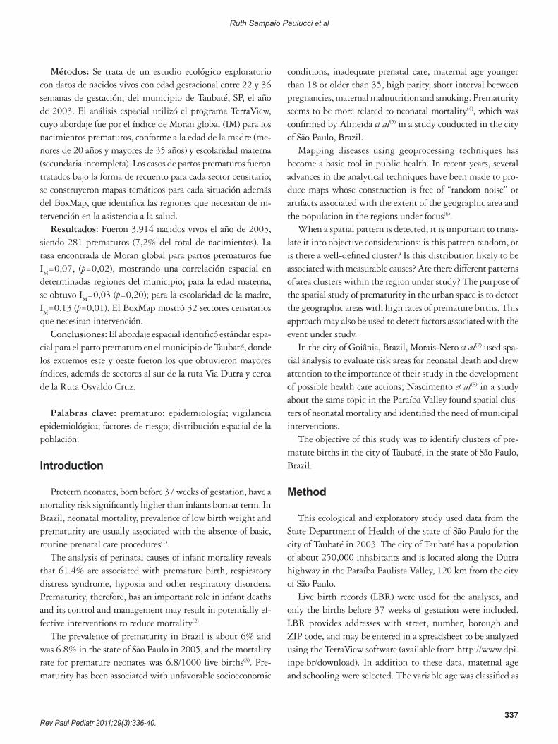
may range from -1 to +1, and to define its statistical significance (p value). Therefore, possible clusters of occurrence of premature births may be detected in the different census sectors. A census sector varies according to population density (inhabitants per area in square meters, or simply demographic density), and a digital map of Taubaté showing the census sectors was obtained from the IBGE site (available from http://www.ibge.gov.br/home/mapa_site/mapa_site.php#download) (Figure 1).
These analyses resulted in thematic maps (choropleths) for the occurrence of premature births, schooling and maternal age for these premature infants. Global Moran’s I was calcu-lated for premature births alone; later, the same procedure was repeated for premature births according to maternal age less than 20 years or more than 35 years and according to maternal schooling of incomplete elementary school. The purpose was to find a possible risk factor associated with premature birth. Choropleths built according to the variables described above showed the absolute number of premature births divided into four categories using the “equal steps” routine of the TerraView software.
The box map for the occurrence of premature birth was built, and the result points out in which quadrant each census sector is located. In quadrant 1, the census sectors have posi-tive values and means. This is the quadrant where the sectors have high attention priority; in quadrant 2, census sectors have negative values and means, and represent a low intervention priority. The other quadrants, 3 and 4, are the census sectors that have positive means and negative values and census sectors that have negative means and positive values. The priority of sectors located in these quadrants is the mean.
This study was approved by the Ethics in Research Com-mittee of Universidade de Taubaté.
Results
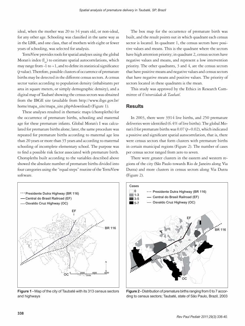
In 2003, there were 3914 live births, and 250 premature deliveries were identified (6.4% of live births). The global Mo-ran’s I for premature births was 0.07 (p=0.02), which indicated a positive and significant spatial autocorrelation, that is, there were census sectors that form clusters with premature births in certain municipal regions (Figure 2). The number of cases per census sector ranged from zero to seven.
There were greater clusters in the eastern and western re-gions of the city (São Paulo towards Rio de Janeiro along Via Dutra) and more clusters in census sectors along Via Dutra (Figure 2).
Figure 1 - Map of the city of Taubaté with its 313 census sectors and highways
Presidente Dutra Highway (BR 116)
Central do Brasil Railroad (EF)
Osvaldo Cruz Highway (OC)
EF
BR 116
OC0 2000
Units4000 6000
S
N
Figure 2 - Distribution of premature births ranging from 0 to 7 accor-ding to census sectors; Taubaté, state of São Paulo, Brazil, 2003
BR 116
OC
EF
Presidente Dutra Highway (BR 116)
Central do Brasil Railroad (EF)
Osvaldo Cruz Highway (OC)
Cases
01-33-55-7
339Rev Paul Pediatr 2011;29(3):336-40.
Ruth Sampaio Paulucci et al
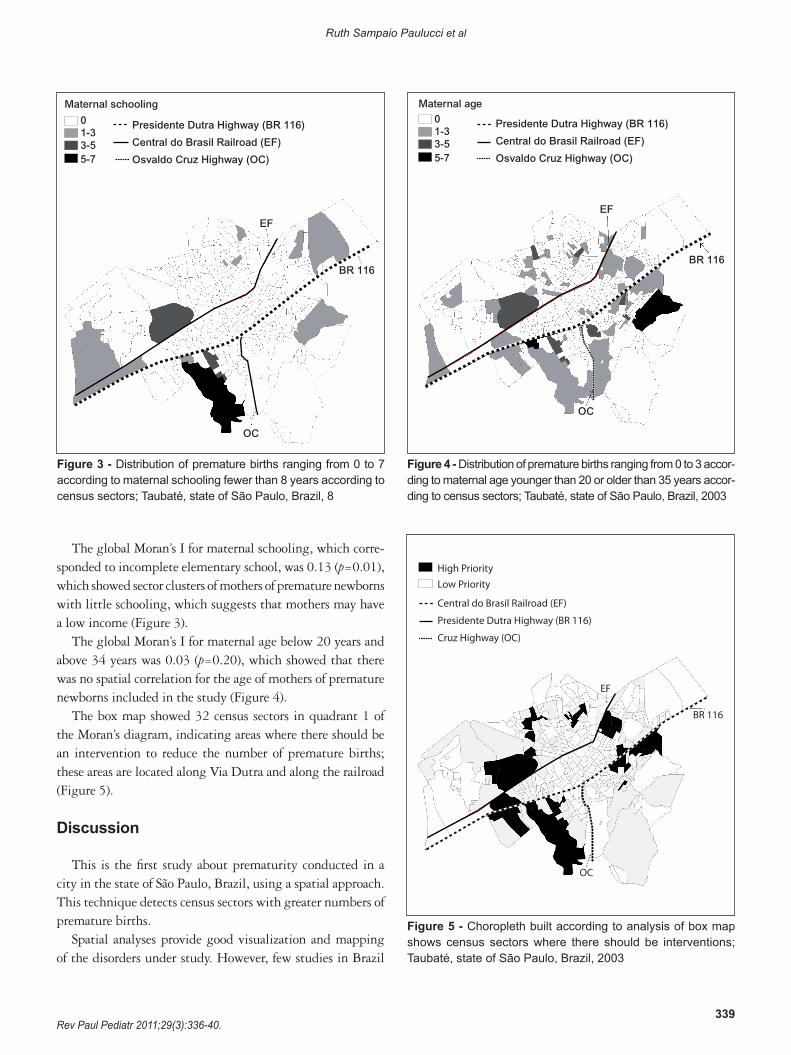
Figure 3 - Distribution of premature births ranging from 0 to 7 according to maternal schooling fewer than 8 years according to census sectors; Taubaté, state of São Paulo, Brazil, 8
BR 116
OC
EF
Presidente Dutra Highway (BR 116)
Central do Brasil Railroad (EF)
Osvaldo Cruz Highway (OC)
Maternal schooling
01-33-55-7
Figure 4 - Distribution of premature births ranging from 0 to 3 accor-ding to maternal age younger than 20 or older than 35 years accor-ding to census sectors; Taubaté, state of São Paulo, Brazil, 2003
OC
EF
Presidente Dutra Highway (BR 116)
Central do Brasil Railroad (EF)
Osvaldo Cruz Highway (OC)
Maternal age01-33-55-7
BR 116
The global Moran’s I for maternal schooling, which corre-sponded to incomplete elementary school, was 0.13 (p=0.01), which showed sector clusters of mothers of premature newborns with little schooling, which suggests that mothers may have a low income (Figure 3).
The global Moran’s I for maternal age below 20 years and above 34 years was 0.03 (p=0.20), which showed that there was no spatial correlation for the age of mothers of premature newborns included in the study (Figure 4).
The box map showed 32 census sectors in quadrant 1 of the Moran’s diagram, indicating areas where there should be an intervention to reduce the number of premature births; these areas are located along Via Dutra and along the railroad (Figure 5).
Discussion
This is the first study about prematurity conducted in a city in the state of São Paulo, Brazil, using a spatial approach. This technique detects census sectors with greater numbers of premature births.
Spatial analyses provide good visualization and mapping of the disorders under study. However, few studies in Brazil
Central do Brasil Railroad (EF)
Presidente Dutra Highway (BR 116)
Cruz Highway (OC)
EF
OC
BR 116
High PriorityLow Priority
Figure 5 - Choropleth built according to analysis of box map shows census sectors where there should be interventions; Taubaté, state of São Paulo, Brazil, 2003
340Rev Paul Pediatr 2011;29(3):336-40.
Spatial analysis of premature delivery in Taubaté, SP, Brazil
References
1. Kilsztajn S, Rossbach A, Carmo MS, Sugahara GT. Assistência pré-natal, baixo peso e prematuridade no Estado de São Paulo, 2000. Rev Saude Publica 2003;37:303-10.
2. Silveira MF, Santos IN, Barros AJ, Matijasevich A, Barros FC, Victora CG. Aumento da prematuridade no Brasil: revisão de estudos de base populacional. Rev Saude Publica 2008;42:957-64.
3. Brasil −Ministério da Saúde. DATASUS [homepage on the Internet].Departamentode InformáticadoSUS [cited2009Oct. 7].Available from:http://www2.datasus.gov.br/DATASUS/index.php
4. Berkowitz GS, Papiernik E. Epidemiology of preterm birth. Epidemiol Rev 1993;15:414-43.
5. Almeida MF, Novaes HM, Alencar GP, Rodrigues LC. Mortalidade neonatal noMunicípiodeSãoPaulo:influênciadopesoaonasceredefatoressócio-demográficoseassistenciais.RevBrasEpidemiol2002;5:93-107.
6. Andrade CL, Szwarcwald CL. Spatial analysis of early neonatal mortality in the municipality of Rio de Janeiro, 1995-1996. Cad Saude Publica 2001;17:1199-210.
7. Moraes-Neto OL, BarrosMB,Martelli CM, Silva SA, Cavenaghi SM,Siqueira Junior JB. Diferenças no padrão de ocorrência da mortalidade neonatal e pós-neonatal noMunicípio deGoiânia, Brasil, 1992-1996:análise espacial para identificação das áreas de risco. Cad Saude Publica 2001;17:1241-50.
8. Nascimento LF, Batista GT, Dias NW, Catelani CS, Becker D, Rodrigues L. Análise espacial da mortalidade neonatal no Vale do Paraíba, 1999 a 2001. Rev Saude Publica 2007;41:94-100.
9. Cascaes AM, Gauche H, Baramarchi FM, Borges CM, Peres KG. Prematuridade e fatores associados no Estado de Santa Catarina, Brasil, no ano de 2005: análise dos dados do Sistema de Informações sobre Nascidos Vivos. Cad Saude Publica 2008;24:1024-32.
10.BezerraLC,OliveiraSM,LatorreMR.Prevalênciae fatoresassociadosàprematuridadeentregestantessubmetidasà inibiçãodetrabalhodepartoprematuro. Rev Bras Saude Matern Infant 2006;6:223-9.
11.HaidarFH,OliveiraUF,NascimentoLF.Escolaridadematerna:correlaçãocom os indicadores obstétricos. Cad Saude Publica 2001;17:1025-9.
have used this technique to study outcomes associated with newborns, and only a few others investigate neonatal mortality, such as the ones conducted in the Paraíba Valley(8), in Goiânia(7), and in the city of Rio de Janeiro(6).
In the study conducted in Taubaté, census sectors with a higher number of premature deliveries were found in the city’s peripheral area, which are low-income areas in the region. Inhabitants in these census sectors probably have inadequate access to the health care network, poor prenatal care, and a lower socioeconomic status because of their geographic distribution, and all these factors may contribute to higher prematurity rates(1,2).
Geographically, the sectors with the larger number of cases are along Dutra highway, in the southern area, and in the extreme eastern and western areas of the city. Although there are Basic Health Care Units in most of these census sectors, they probably do not meet the demands of patients, do not have the necessary support for good prenatal care, or have a less than ideal service quality.
At the same time, regardless of whether maternal age is a risk factor for prematurity, Cascaes et al(9) found an as-sociation between these variables in a study conducted in the state of Santa Catarina, Brazil. Those authors classified maternal age older than 40 years and younger than 20 years as factors that affect prematurity. Bezerra et al(10), however, did not find any association between maternal age and prematurity, and data found in Taubaté corroborate their findings. In our study, maternal age classified as younger than 20 or older than 35 years was included as a risk factor. Spatial distribution of the cases according to age categories did not reveal any spatial autocorrelation, but showed that
only two census sectors had 3 cases of mothers younger than 20 or older than 35 years.
This study detected census sectors where prematurity was associated with low maternal schooling; these sectors are located in the extreme eastern and western areas of the city. Haidar et al(11) found that mothers with fewer than eight years of schooling had 1.5 times greater chances of having low birth weigh newborns.
The box map detected areas where means and values were positive, and health care interventions should be conducted in these sectors, which were primarily located in the peripheral areas of the city, in agreement with other results found in this analysis. It is one more sign of necessary improvement in basic health care.
One of the limitations of this ecological study was the impossibility to identify the possible causes of this outcome. However, spatial analysis may be used by the municipal Health Care Department as a guide to define what places need greater attention. Moreover, this strategy can be used for comparisons of the disease maps at different time points or after the imple-mentation of interventions by municipal health care managers. The visualization of event distribution is the highlight of this type of approach in sectors where interventions should be the priority.
Therefore, spatial analysis detected a spatial pattern of pre-mature births in the city of Taubaté, and the extreme eastern and western areas and the sectors south of Dutra highway and along the Osvaldo Cruz highway had the highest number of occurrences. These spatial distributions will be available for comparisons with others obtained in subsequent years to estimate the efficacy of health care policies.


![(2014-05-24) [Taubaté Perl Mongers] AudioLazy Python DSP (Digital Signal Processing)](https://img.pdfslide.us/doc/110x75/556a7483d8b42a7c758b4608/2014-05-24-taubate-perl-mongers-audiolazy-python-dsp-digital-signal-processing.jpg)