Embed Size (px)
Citation preview
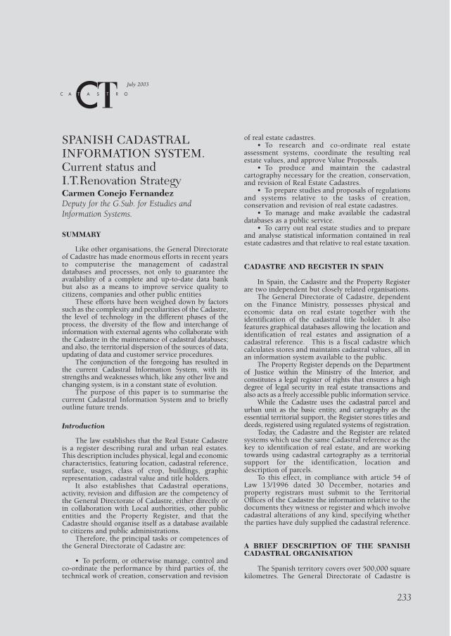
SPANISH CADASTRALINFORMATION SYSTEM.Current status andI.T.Renovation StrategyCarmen Conejo FernandezDeputy for the G.Sub. for Estudies andInformation Systems.
SUMMARY
Like other organisations, the General Directorateof Cadastre has made enormous efforts in recent yearsto computerise the management of cadastraldatabases and processes, not only to guarantee theavailability of a complete and up-to-date data bankbut also as a means to improve service quality tocitizens, companies and other public entities
These efforts have been weighed down by factorssuch as the complexity and peculiarities of the Cadastre,the level of technology in the different phases of theprocess, the diversity of the flow and interchange ofinformation with external agents who collaborate withthe Cadastre in the maintenance of cadastral databases;and also, the territorial dispersion of the sources of data,updating of data and customer service procedures.
The conjunction of the foregoing has resulted inthe current Cadastral Information System, with itsstrengths and weaknesses which, like any other live andchanging system, is in a constant state of evolution.
The purpose of this paper is to summarise thecurrent Cadastral Information System and to brieflyoutline future trends.
Introduction
The law establishes that the Real Estate Cadastreis a register describing rural and urban real estates.This description includes physical, legal and economiccharacteristics, featuring location, cadastral reference,surface, usages, class of crop, buildings, graphicrepresentation, cadastral value and title holders.
It also establishes that Cadastral operations,activity, revision and diffusion are the competency ofthe General Directorate of Cadastre, either directly orin collaboration with Local authorities, other publicentities and the Property Register, and that theCadastre should organise itself as a database availableto citizens and public administrations.
Therefore, the principal tasks or competences ofthe General Directorate of Cadastre are:
• To perform, or otherwise manage, control andco-ordinate the performance by third parties of, thetechnical work of creation, conservation and revision
of real estate cadastres. • To research and co-ordinate real estate
assessment systems, coordinate the resulting realestate values, and approve Value Proposals.
• To produce and maintain the cadastralcartography necessary for the creation, conservation,and revision of Real Estate Cadastres.
• To prepare studies and proposals of regulationsand systems relative to the tasks of creation,conservation and revision of real estate cadastres.
• To manage and make available the cadastraldatabases as a public service.
• To carry out real estate studies and to prepareand analyse statistical information contained in realestate cadastres and that relative to real estate taxation.
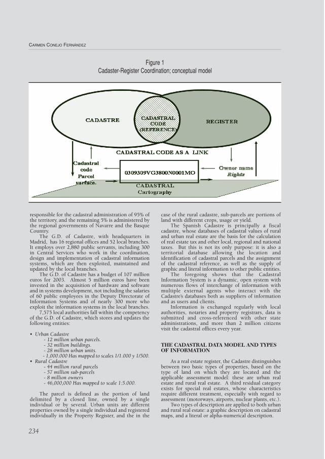
CADASTRE AND REGISTER IN SPAIN
In Spain, the Cadastre and the Property Registerare two independent but closely related organisations.
The General Directorate of Cadastre, dependenton the Finance Ministry, possesses physical andeconomic data on real estate together with theidentification of the cadastral title holder. It alsofeatures graphical databases allowing the location andidentification of real estates and assignation of acadastral reference. This is a fiscal cadastre whichcalculates stores and maintains cadastral values, all inan information system available to the public.
The Property Register depends on the Departmentof Justice within the Ministry of the Interior, andconstitutes a legal register of rights that ensures a highdegree of legal security in real estate transactions andalso acts as a freely accessible public information service.
While the Cadastre uses the cadastral parcel andurban unit as the basic entity, and cartography as theessential territorial support, the Register stores titles anddeeds, registered using regulated systems of registration.
Today, the Cadastre and the Register are relatedsystems which use the same Cadastral reference as thekey to identification of real estate, and are workingtowards using cadastral cartography as a territorialsupport for the identification, location anddescription of parcels.
To this effect, in compliance with article 54 ofLaw 13/1996 dated 30 December, notaries andproperty registrars must submit to the TerritorialOffices of the Cadastre the information relative to thedocuments they witness or register and which involvecadastral alterations of any kind, specifying whetherthe parties have duly supplied the cadastral reference.
A BRIEF DESCRIPTION OF THE SPANISHCADASTRAL ORGANISATION
The Spanish territory covers over 500,000 squarekilometres. The General Directorate of Cadastre is
233
July 2003
CARMEN CONEJO FERNÁNDEZ
234
responsible for the cadastral administration of 95% ofthe territory, and the remaining 5% is administered bythe regional governments of Navarre and the BasqueCountry.
The G.D. of Cadastre, with headquarters inMadrid, has 16 regional offices and 52 local branches.It employs over 2,880 public servants, including 300in Central Services who work in the coordination,design and implementation of cadastral informationsystems, which are then exploited, maintained andupdated by the local branches.
The G.D. of Cadastre has a budget of 107 millioneuros for 2003. Almost 5 million euros have beeninvested in the acquisition of hardware and softwareand in systems development, not including the salariesof 60 public employees in the Deputy Directorate ofInformation Systems and of nearly 300 more whoexploit the information systems in the local branches.
7,575 local authorities fall within the competencyof the G.D. of Cadastre, which stores and updates thefollowing entities:
• Urban Cadastre- 12 million urban parcels.- 32 million buildings.- 28 million urban units.- 1,000.000 Has mapped to scales 1/1.000 y 1/500.
• Rural Cadastre- 44 million rural parcels- 57 million sub-parcels- 8 million owners- 46,000,000 Has mapped to scale 1:5.000.
The parcel is defined as the portion of landdelimited by a closed line, owned by a singleindividual or by several. Urban units are differentproperties owned by a single individual and registeredindividually in the Property Register, and the in the
case of the rural cadastre, sub-parcels are portions ofland with different crops, usage or yield.
The Spanish Cadastre is principally a fiscalcadastre, whose databases of cadastral values of ruraland urban real estate are the basis for the calculationof real estate tax and other local, regional and nationaltaxes. But this is not its only purpose: it is also aterritorial database allowing the location andidentification of cadastral parcels and the assignmentof the cadastral reference, as well as the supply ofgraphic and literal information to other public entities.
The foregoing shows that the CadastralInformation System is a dynamic, open system withnumerous flows of interchange of information withmultiple external agents who interact with theCadastre’s databases both as suppliers of informationand as users and clients.
Information is exchanged regularly with localauthorities, notaries and property registrars, data issubmitted and cross-referenced with other stateadministrations, and more than 2 million citizensvisit the cadastral offices every year.
THE CADASTRAL DATA MODEL AND TYPESOF INFORMATION
As a real estate register, the Cadastre distinguishesbetween two basic types of properties, based on thetype of land on which they are located and theapplicable assessment model: these are urban realestate and rural real estate. A third residual categoryexists for special real estates, whose characteristicsrequire different treatment, especially with regard toassessment (motorways, airports, nuclear plants, etc.).
Two types of description are applied to both urbanand rural real estate: a graphic description on cadastralmaps, and a literal or alpha-numerical description.
Figure 1Cadaster-Register Coordination; conceptual model
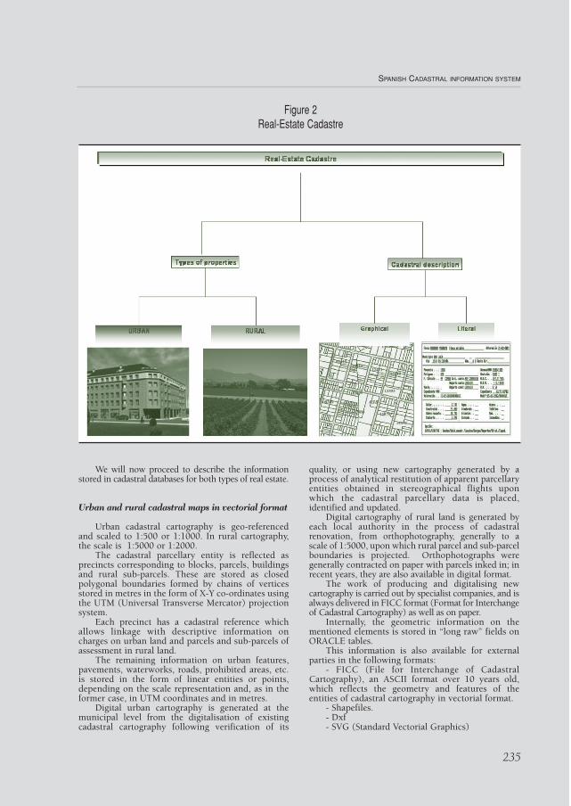
We will now proceed to describe the informationstored in cadastral databases for both types of real estate.
Urban and rural cadastral maps in vectorial format
Urban cadastral cartography is geo-referencedand scaled to 1:500 or 1:1000. In rural cartography,the scale is 1:5000 or 1:2000.
The cadastral parcellary entity is reflected asprecincts corresponding to blocks, parcels, buildingsand rural sub-parcels. These are stored as closedpolygonal boundaries formed by chains of verticesstored in metres in the form of X-Y co-ordinates usingthe UTM (Universal Transverse Mercator) projectionsystem.
Each precinct has a cadastral reference whichallows linkage with descriptive information oncharges on urban land and parcels and sub-parcels ofassessment in rural land.
The remaining information on urban features,pavements, waterworks, roads, prohibited areas, etc.is stored in the form of linear entities or points,depending on the scale representation and, as in theformer case, in UTM coordinates and in metres.
Digital urban cartography is generated at themunicipal level from the digitalisation of existingcadastral cartography following verification of its
quality, or using new cartography generated by aprocess of analytical restitution of apparent parcellaryentities obtained in stereographical flights uponwhich the cadastral parcellary data is placed,identified and updated.
Digital cartography of rural land is generated byeach local authority in the process of cadastralrenovation, from orthophotography, generally to ascale of 1:5000, upon which rural parcel and sub-parcelboundaries is projected. Orthophotographs weregenerally contracted on paper with parcels inked in; inrecent years, they are also available in digital format.
The work of producing and digitalising newcartography is carried out by specialist companies, and isalways delivered in FICC format (Format for Interchangeof Cadastral Cartography) as well as on paper.
Internally, the geometric information on thementioned elements is stored in “long raw” fields onORACLE tables.
This information is also available for externalparties in the following formats:
- FICC (File for Interchange of CadastralCartography), an ASCII format over 10 years old,which reflects the geometry and features of theentities of cadastral cartography in vectorial format.
- Shapefiles.- Dxf- SVG (Standard Vectorial Graphics)
SPANISH CADASTRAL INFORMATION SYSTEM
235
Figure 2Real-Estate Cadastre
Digital orthophotographs in raster format
As well as the vectorial format, in recent years thesystem has incorporated digital orthophotography toscale 1:5000 and 1:2000 for rural land.
Orthophotography combines the precision of ascale map with the wealth of information that aphotograph can offer.
Digital orthophotographs in black and white orin colour are available for towns updated in the lastthree years. Resolution varies between 0,25 and 1metre, although the current trend is to use 0,50mresolution.
Internally, orthophotographic information isstored on files acquired with Mr-SID, and theexchange format is geo-referenced (TIFF+ Twg).
Distribution sketches of buildings by floor;digital CU-1
The CU-1 document is a scaled graphicrepresentation of the properties forming an urbanestate.
Cadastral cartography only represents cadastralparcels or urban estates, while the breakdown offloors and interior spaces is represented on CU.1.CU.1 documents are available for those towns withassessment by property, and only part are in digitalformat.
These documents are stored using SIGCA2 andlink up to parcel data by means of the cadastralreference.
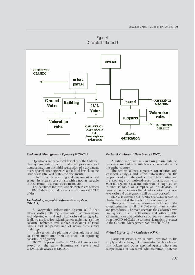
Alpha-numerical information
The alpha-numerical information necessary forcadastral management is stored on ORACLE tables.This system stores information on title holders whomay possess one or several rural or urban properties.In the case of urban land, urban units are groupedinto parcels located on precincts of land with differentassessments, containing buildings and urban units. Inthe case of rural real estate, the unit of property is theparcel, containing one or more sub-parcels assesseddepending on crop, use or yield.
The assessment of urban units is performed basedon the value of the land and the value of the building.In the case of rural parcels, the value of the parcel isthe sum of the values of the sub-parcels it contains.
The link between alpha-numerical information andgraphic data is achieved using the cadastral reference.
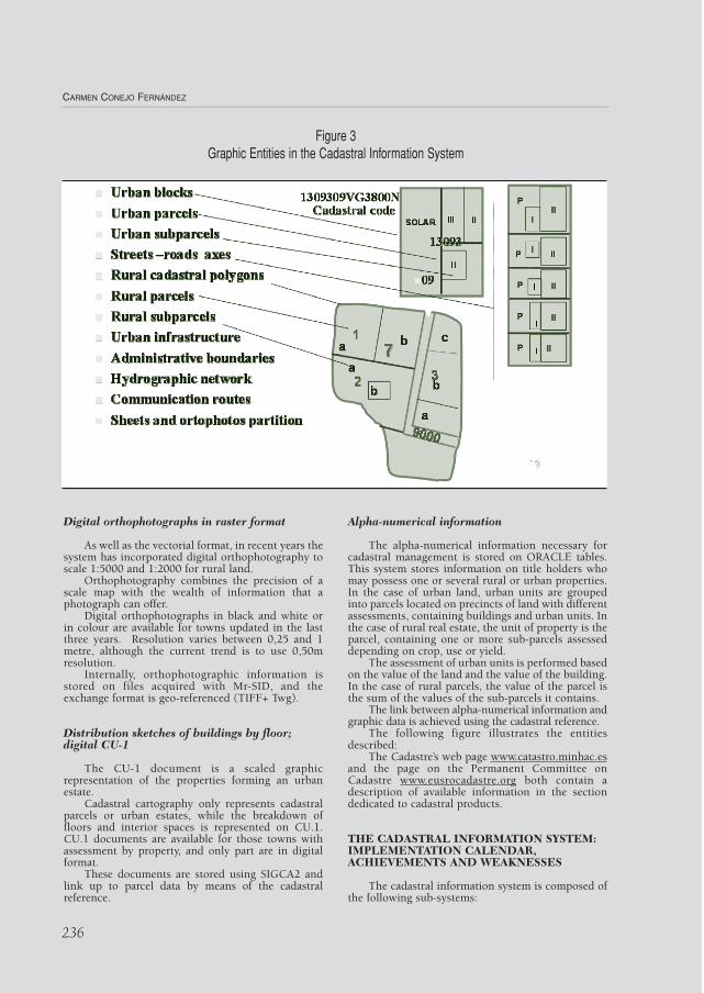
The following figure illustrates the entitiesdescribed:
The Cadastre’s web page www.catastro.minhac.esand the page on the Permanent Committee onCadastre www.eusrocadastre.org both contain adescription of available information in the sectiondedicated to cadastral products.
THE CADASTRAL INFORMATION SYSTEM:IMPLEMENTATION CALENDAR,ACHIEVEMENTS AND WEAKNESSES
The cadastral information system is composed ofthe following sub-systems:
CARMEN CONEJO FERNÁNDEZ
236
Figure 3Graphic Entities in the Cadastral Information System
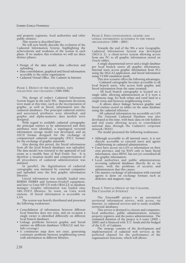
Cadastral Management System (SIGECA)
Operational in the 52 local branches of the Cadastre,this system automates all cadastral processes andtransactions, from the initial registration of a document,query or application presented at the local branch, to theissue of cadastral certificates and documents.
It facilitates the updating and assessment of realestate, the issue of census lists with amounts payablein Real Estate Tax, mass assessment, etc.
The databases that sustain this system are housedon UNIX departmental servers stored on ORACLEtables.
Cadastral geographic information system(SIGCA)
A Geographic Information System (GIS) thatallows loading, filtering, visualisation, administrationand udpating of rural and urban cadastral cartography.It allows the location, identification, assignment of thecadastral reference and surface calculation of ruralparcels and sub-parcels and of urban parcels andbuildings.
It also allows the plotting of thematic maps andcadastral maps and includes tools for updatingcadastral cartography.
SIGCA is operational in the 52 local branches andstored on the same departmental servers andORACLE databases as SIGECA
National Cadastral Database (BDNC)
A nation-wide system containing basic data onreal estate and cadastral title holders, consolidated forthe entire country.
The system allows aggregate consultation andstatistical analysis and offers information on theproperties of an individual all over the country, andthe exchange of national-level information withexternal agents. Cadastral information supplied onInternet is based on a replica of this database. Itcurrently only features literal information, but nextyear cadastral cartography will be incorporated.
BDNC is stored on a UNIX-ORACLE server, incluster, located at the Cadastre’s headquarters.
The systems described above are dedicated to thecomputerisation of all the Cadastre’s administrationand procedures. The main users are the Cadastre’s ownemployees. Local authorities and other publicadministrations that collaborate or require informationfrom the G.D. of Cadastre connect via modem or routerto the Cadastral Management System (SIGECA).
Virtual Office of the Cadastre (OVC)
Cadastral services on Internet, destined to thesupply and exchange of information with cadastraltitle holders and other external agents who sharecompetencies of cadastral administration (notaries
SPANISH CADASTRAL INFORMATION SYSTEM
237
Figure 4Conceptual data model
and property registrars, local authorities and otherpublic entities).
This system is described later. We will now briefly describe the evolution of the
Cadastral Information System, highlighting theachievements and weakness of the system in eachphase. If we analyse this evolution we will see threedistinct phases:
• Design of the data model, data collection anduploading .
• Data consolidation, graphical and literal informationaccessible to the entire organisation.
• Cadastral Virtual Office. The Cadastre in Internet.
PHASE 1. DESIGN OF THE DATA MODEL, DATACOLLECTION AND UPLOADING (1990-1998)
The design of today’s Cadastral InformationSystem began in the early 90s. Important decisionswere made at this time, such as the incorporation ofgraphic, as well as literal, information into thecadastral databases. The principal cadastral entitiesand associated attributes were identified, andgraphic and alpha-numeric data models weredesigned.
With regard to available cadastral cartography,the principal entities to be administered and theirattributes were identified, a topological vectorialinformation storage model was developed, and anASCII format designed for the exchange ofcomputerised cadastral cartography (FICC format)for the exchange of graphic materials.
Also during this period, the literal informationfrom all the local branch databases was uploaded.The data model was oriented to the appraisal of realestate as a taxable base of Real Estate Tax. It istherefore a taxation model and computerisation ofall procedures of cadastral administration wasinitiated.
In parallel, the digitalisation of cadastralcartography was intitiated by external companiesand uploaded onto the first graphic informationlibraries.
Literal information was initially loaded ontoRDBMS DDBB4 and Siemens-Nixdorf equipment,and later to Unix-HP-UX with ORACLE as databasemanager. Graphic information was loaded ontoARC-INFO libraries, by town, on Unix workstations. Al literal information is accessible onLAN.
The system was heavily distributed and presentedthe following weaknesses:
• Consolidation of information between differentlocal branches does not exist, and on occasion asingle owner is identified differently on differentlocal branch databases.
• Linkage problems between graphic and literalentities on different databases (ORACLE and Arc-Info coverage).
• A continuous map does not exist, generatingcontinuity problems between neighbouring townswith information in different libraries.
PHASE 2. DATA CONSOLIDATION, GRAPHIC ANDLITERAL INFORMATION ACCESSIBLE TO THE WHOLEORGANISATION (1998 – 2001)
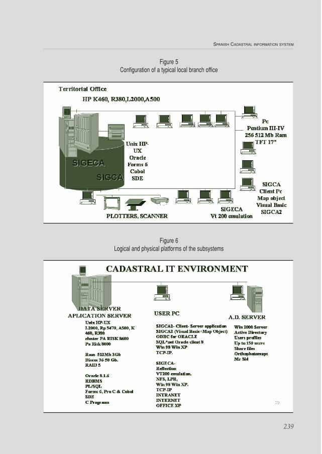
Towards the end of the 90s a new GeographicCadastral Information System was developed(SIGCA 2), a client-server system allowing accessfrom any PC to all graphic information stored onOracle tables.
A single departmental server and a single databaseper local branch stores all graphic information.Internal users access graphic information from PCsusing the SIGCA2 application, and literal informationusing VT200 emulation mode.
This new scenario offers the following advantages:- Cadastral cartography becomes accessible to all
local branch users, who access both graphic andliteral information from the same terminal.
- All local branch cartography is located on asingle table, allowing administration as if it were acontinuous map, for both urban and rural land in asingle town and between neighbouring towns.
- It allows direct linkage between graphic andliteral entities stored on tables on the same databaseusing the cadastral reference
- All cadastral information ins accessible on LANThe National Cadastral Database was also
developed at this time, with basic data on title holdersand real estate allowing access to consolidatednational data through the Cadastre’s corporatenetwork (WAN).
The model presented the following weaknesses:
• Although accessible to all internal users, it is notdirectly accessible to external users and agentscollaborating in cadastral administration.
• Users have access via LAN to information on theirown province, and via WAN only to basic literalinformation, since BDNC has not yet centralised allthe graphic information.
• Local authorities and public administrationsaccessing cadastral databases directly do so viarouter, with the problems of security andadministration that this causes.
• The massive exchange of information with externalagents is done on exchange formats such asdiskettes and magnetic tape.
PHASE 3. VIRTUAL OFFICE OF THE CADASTRE. THE CADASTRE IN INTERNET
The Ensenad@ project is an automatedterritorial information service, with access, viaInternet, to cadastral services and to easily availableterritorial databases.
This service is destined to citizens and companies,local authorities, public administration, notaries,property registers, and the justice administration. Theestimated duration of the project is 6 years (2000 –2006) and is financed with E.U. funds and the budgedof the G.D. of Cadastre.
The strategy consists of the development andimplementation of cadastral web services as thepreferred channel for the performance of theorganisation’s functions, which will allows:
CARMEN CONEJO FERNÁNDEZ
238
SPANISH CADASTRAL INFORMATION SYSTEM
Figure 5Configuration of a typical local branch office
Figure 6Logical and physical platforms of the subsystems
239
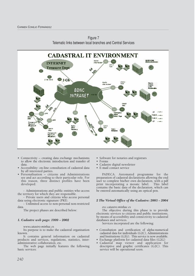
• Connectivity – creating data exchange mechanismsto allow the electronic introduction and transfer ofdata.
• Accessibility: on-line consultation of cadastral databy all interested parties.
• Personalisation – citizens and Administrationssee and act according to their particular role. Forthis reason, three distinct profiles have beendeveloped:
- Administrations and public entities who accessthe territory for which they are responsible.
- Private users and citizens who access personaldata using electronic signature (PKI).
- Unlimited access to non-personal non-restricteddata.
The project phases are described below:
1. Cadastre web page: 1999 – 2002
www.catastro.minhac.esIts purpose is to make the cadastral organisation
known.It contains general information on cadastral
products and services, regulations, statistics, inter-administrative collaboration, etc.
The web page initially features the followingbasic services:
• Software for notaries and registrars • Forms• Cadastre digital newsletter• E-mail contact service
PADECA. Automated programme for thepreparation of cadastral declarations allowing the enduser to complete his/her own declaration, with a pdfprint incorporating a mosaic label. This labelcontains the basic data of the declaration, which canbe entered automatically using an optical pen.
2 The Virtual Office of the Cadastre: 2003 – 2004
ovc.catastro.minhac.esThe objective during this phase is to provide
electronic services to citizens and public institutions,by means of accessibility and connectivity to cadastraldatabases and services.
Services incorprated are the following:
• Consultation and certification of alpha-numericalcadastral data for individuals (G2C), Administrationsand Institutions (G2G). This service is now available.
• Exchange platform for cadastral data files (G2G) • Cadastral map viewer and application for
descriptive and graphic certificates (G2C). Thisservice will be operational soon.
CARMEN CONEJO FERNÁNDEZ
240
Figure 7Telematic links between local branches and Central Services
3. Advanced electronic services: 2005 – 2006
The objective during this phase is to providevalue added services incorporating advancedelectronic certification mechanisms (G2C) such as:
• Sale of cadastral products.• Electronic payment of cadastral duties.• Correction of personal data.• On-line presentation of application forms and
documents.• Case monitoring.• Appointment scheduling for personal visits to
offices of the Cadastre.
The logical and physical platforms that sustainthese services are the following:
• Hw platform:- External area (DMZ)- 2 IIS servers with Windows 2000 Advanced
Server , NLB (Network Load Balanced).- 2 Exchange Front-end servers to access to
Exchange DB with NLB. (W2K AS.)
• Internal area - 2 Exchange DB servers in cluster to manage files
repository.(W2K AS)- 2 Domain Controller servers (DNS) with active
directory to control registered users.- 2 SQL server servers (W2K AS) in cluster.- 2 Unix servers in cluster with ORACLE for
Cadastral db.- An S.A.N for data storage.
• Sw Platform:- Multilevel architecture:- Presentation level
- Thin client using Web browsers to interpretHTML code given by the Web serve
- Presentation logical level - ASP pages including VB scrip, JavaScriptand HTML code, with COM+ (Visula Basic)components
- Application logical level.- SW components to conform the logical ofthe business.
- Data access level.- Components to data access, to insert,modify or data erase.
- Data level- Services related with the DDBB, cadastraldata in Oracle, application data in SQLServer.
- Veritas Sw as back up manager.- Hp-OpenView to manage and control hw and
services.
The cadastral information system is an opensystem which, as we have seen previously, exchangesinformation with multiple external agents acting asclients, or suppliers of information, and sometimes asboth. The new strategy allows direct access to cadastralservices via Internet and will produce a progressivereduction in the number of citizens who visit localcadastral branch offices, prevent direct connections via
modem by other public administrations to ourdatabases, and speed up the process of maintenanceand supply of information, thus optimising the use ofavailable resources.
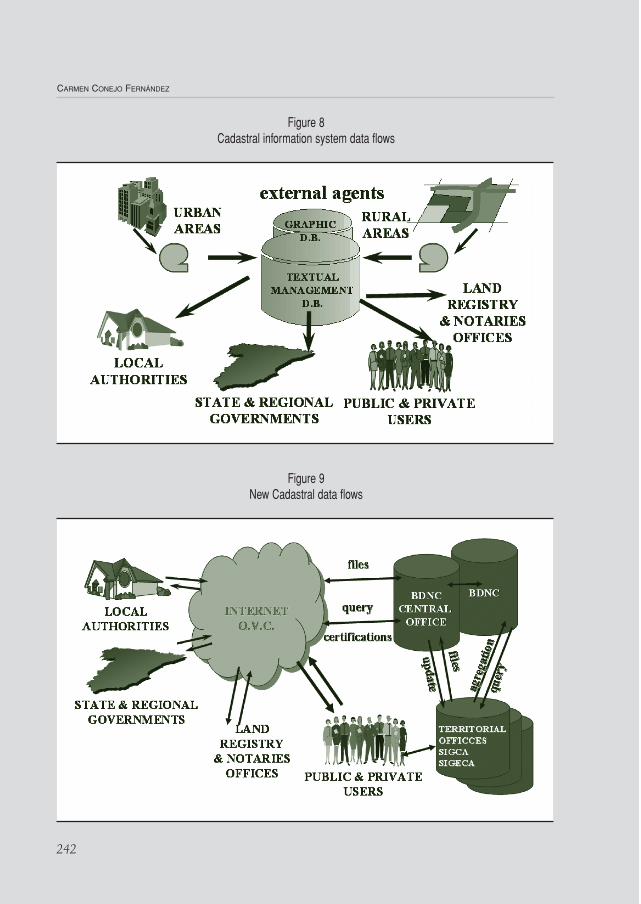
The new scenario has given rise to an increasingcentralisation of distributed databases into aconsolidated national database, using a replica as theInternet data server. The following two figures showthe change in the flow of information generated bythe Virtual Office of the Cadastre.
STRATEGIES FOR THE FUTURE
Having analysed the evolution of the CadastralInformation System in Spain and the services to beincorporated in the next three years, it only remainsto briefly outline the strategic objectives of theorganisation in the context of information systems,which should be accompanied by a series of strategicactions. The achievement of these strategic objectivesand actions should likewise be accompanied by aseries of I.T. objectives and actions which in manycases coincide with those described previously.
Strategic objectives:
• Supply the largest possible quantity of informationto external agents. Not just literal information, butthe possibility of accessing computerised cadastralcartography.
• Prevent the need for citizens to visit cadastraloffices.
• Satisfy the information requirements ofclients/citizens and public administrations.
• Guarantee not just availability, but also up to dateinformation.
• Integrity and consistency between:- Graphic and alpha-numeric information - Owners in all local branches.- Continuous mapping for all towns, betweenneighbouring towns, and between rural andurban land.
Strategic actions for renovation:
• Incorporate information into the OVC.• Incorporate services into the OVC.• Customer information and service:
- In person at our offices.- Via Internet and e-mail.- By telephone via the Cadastre direct line902 37 36 35.
• Improve the updating of data via Internet.- Using Internet and user accounts for theexchange, validation and incorporation intoour databases of exchange files with publicagencies that collaborate in cadastraladministration. - Facilitating the viewing of graphicinformation- Supplying vectorial information on whichto directly incorporate graphic updates.- Supplying tools to cadastral title holders toallow them to correct their data directly .
• Centralisation and consolidation of data.
SPANISH CADASTRAL INFORMATION SYSTEM
241
CARMEN CONEJO FERNÁNDEZ
Figure 8Cadastral information system data flows
Figure 9New Cadastral data flows
242
This requires the achievement of the followingobjectives and actions in the field of I.T. andelectronics:
• Increased information in Internet, not just basicinformation on real estate and title holders, butalso building and urban unit information.
• Incorporation of all graphic information onto Internet. • Consolidation of the current data model. Have a
single, stable and consistent data model for allapplication environments (SIGECA, SIGCA,BDNC, OVC).
• Progressive centralisation of local branchdatabases.
• Optimisation of updating actions and processesbetween local branch databases and the NationalDatabase.
• All applications and services, internal and well asexternal, should operate via Internet/Intranetenvironments.
• Three-tiered applications with lightweight clients,versatile application environments and robust andstable data servers.
• Incorporation of Metadata in line with Europeanstandards and recommendations both for literaland graphic information.
• Interoperability though standards with regard toapplication environments, exchange formats, etc.
SPANISH CADASTRAL INFORMATION SYSTEM
243