Embed Size (px)
Citation preview

Space Weather Effects
on GPS Systems
17 Sep 2012
Joe Comberiate
Michael Kelly
Lars Dyrud
Gregory Weaver

Space Weather Effects on GPS • Solar Radio Bursts
• Relevant Phenomenology • Delay and Total Electron Content
Scintillation • Equatorial Impacts • DMSP/SSUSI Scintillation Maps
IDA4D Data Assimilation
Polar Cap GPS Scintillation
2
Outline

3
Why Care About Space Weather?
Each of the next 5 years is expected to have higher solar activity than any year since 2003. So if you are used to space weather being a non-factor in your operations, that is about to change.
March 7, 2012 – The sun unleashed an X5.4-class solar flare, the largest in 6 years. A warning shot at the beginning of the new solar maximum?

Degraded SATCOM Dual-Frequency GPS Error
Positioning Navigation Timing
Scintillation
SATCOM Interference Radar Interference HF Radio Blackout Geolocation Errors Satellite Orbit Decay
X-Rays, EUV, Radio Bursts
SEP Events Geomagnetic Storms
High Altitude Radiation Hazards Spacecraft Damage Satellite Disorientation Launch Payload Failure False Sensor Readings Degraded HF Comm
(high latitudes)
Spacecraft Charging and Drag Geolocation Errors Space Track Errors Launch Trajectory Errors Radar Interference Radio Propagation Anomalies Power Grid Failures
Space Weather Effects
4
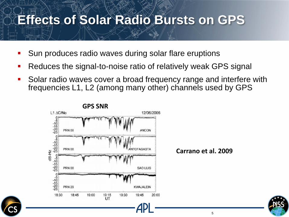
Effects of Solar Radio Bursts on GPS
5
Sun produces radio waves during solar flare eruptions
Reduces the signal-to-noise ratio of relatively weak GPS signal
Solar radio waves cover a broad frequency range and interfere with frequencies L1, L2 (among many other) channels used by GPS
Carrano et al. 2009
GPS SNR

Atmospheric Effects on GPS Ranging
• Refraction lengthens the path of the wave compared to a geometric line of sight

Error-Producing Time Delays
7
ρ= R + c(tu – δt + δtD)
ρ is pseudo-range
R is actual range
c is the speed of light
tu is the receiver clock offset
δt is the satellite clock offset
δtD = δtatm + δtnoise+resolution + δtmp + δthw
Concentrate on δtatm which is a group delay due to the ionosphere and troposphere
Signal information delayed (e.g. PRN code and navigation data)
Carrier phase advanced

Atmospheric Delays
8
δtatm= δttrop + δtiono
Physical reason for delays is refraction due to changes in indices of refraction for ionosphere and troposphere
DS = c*dtatm = ndsSV
User
ò - dlSV
User
ò
ΔS is the path length difference due to refraction by the Ionosphere or troposphere
DS = c*dtiono =w pe
2
w 2ds
SV
User
ò
DS = c*dtiono =40.3
f 2ne ds
SV
User
ò
DS = c*dtiono =40.3
f 2*TEC
ω2pe= plasma frequency
Can be equated with total electron content (TEC)

Ionospheric Total Electron Content Map
Ionospheric TEC maps (left), 60 TECU → 10 m (33 ns delay)
During geomagnetic storms, TEC values can increase by more that 100% (effectively doubling the error)
Ionospheric storms occur within first hours of a geomagnetic storm
TEC “walls” (Dehel, 2004); TEC falls by 130 TECu over 50 km; 30 m GPS delay; walls move 100 to 500 m/s

Ionospheric Scintillation Affects
GPS and Other RF Signals
Scintillations (“twinkling” ) in GPS signals arise from spatial and
temporal variations in the ionosphere.
These ionospheric variations occur under quiet and disturbed
conditions.
They are difficult to forecast accurately.
Loss of lock Loss of information

Scintillation Near Bubbles
11
Lines of sight all pass through regions of depleted ionospheric electron density
Depleted regions known as bubbles (equatorial spread F)

Degraded
SATCOM
Dual-Frequency
GPS Error
Positioning
Navigation
Timing
Scintillation
Equatorial Region Space Weather Impacts
12
South Atlantic Anomaly
Bubbles
Special Sensor Ultraviolet Spectrographic Imager (SSUSI) Daily Summary Image
Orbit gaps
Ionization Arcs

SSUSI imagery shows locations of
irregularities
13
IRI-2001 model SSUSI data 2004 Day 94 (April 3)
•2D tomographic inversion is performed for each altitude vs. longitude slice, 12 combined to make 3D profile •3D grid (12x24x30), 5 deg lat., 0.33 deg lon., 20 km alt. resolution

Mesoscale Ionosphere Model –
Assimilate SSUSI, GPS, SCINDA Data
14
Model assimilates SSUSI, GPS, and SCINDA data using Kalman Filter
20° lat. x 15° lon., available at all longitudes
Background ionospheric physics and propagation model eliminates data gaps
Fixed grid, updates every 15 minutes

Ionospheric Data Assimilation Four
Dimensional (IDA4D)
Global 3D time-evolving imaging of the ionosphere electron density Gauss Markov Kalman Filter predicts forward in time
Solves for log of electron density Guarantees positivity Errors are more log normal distribution
Completely irregular horizontal grid, vector of vertical grid points User selectable High resolution where desired Can be dynamically chosen based on data

Polar Cap GPS Scintillation
Polar cap GPS scintillation is a typical occurrence often caused by ionization patches immersed in convection flow
Interferes with increasing human activity at high latitudes
Present simulated GPS scintillation based on ICI-2 Langmuir probe measurements of F-region density fluctuations
Finding- Scintillation for this case caused primarily but F-region gradient drift waves.
NEW RESULT- Scintillation fluctuations mimic TEC fluctuations which leads to position error and scientific uncertainty

ICI-2 Langmuir Probe Data
ICI-2 sampled F-region density with sufficient resolution (<10 m) for phase screen modeling of GPS scintillation

Summary
Solar max is approaching – ionospheric disturbances will likely increase
interference with GPS (signal fading and precision errors)
Ionosphere affects GPS through time delays associated with TEC gradients
and scintillation associated with ionospheric irregularities
GPS susceptible to scintillation particularly at low latitudes
Satellite UV (SSUSI) imagery can map irregularities
APL data assimilation models (IDA4D) can identify scintillation over regions
of interest
New models at APL reveal sources of polar cap GPS scintillation and
positioning errors

19
Space Environment Applications, Systems, and Operations for National Security (SEASONS) Conference
Purpose: To discuss impacts of space environment on DoD and IC systems, and the applications and requirements for sensors and algorithms to mitigate these impacts and enhance operations
2012 Theme: Operating through solar max Lessons learned from last solar max
Confirmed Keynote Speakers:
Brig. Gen. Coffin (Deputy Commanding General for Operations, USASMDC/ARSTRAT )
Dr. Fred Lewis (Director Air Force Weather)
Ms. Aurea Rivera (Senior Intelligence Engineer, NASIC)
Open to US Citizens with a Secret clearance
SCI sessions
For more information:
Contact Dr. Erin Taylor at 240-228-9525 or [email protected]
Visit the website at https://secwww.jhuapl.edu/SEASONS/