Embed Size (px)
Citation preview

Indian Space Research Organisation
Space Technology and its Applications for National Development
V Bhanumurthy Outstanding Scientist Scientist, Associate Director, NRSC/ISRO
GEO4SDGs THEME: GEO-KNOWLEDGE CONDUIT TO SDGs SUCCESS
Geospatial World Forum, January 18-19, 2018 HICC, Hyderabad

MEGHA-
TROPIQUES
INSAT-3A OCEANSAT-2
SARAL
RISAT-1
RESOURCESAT-2, 2A
RISAT-2
CARTOSAT-2; 2A; 2B; 2S
CARTOSAT-1
KALPANA
INSAT-3D,
3DR
LAND & WATER HIGH RESOLUTION OCEAN WEATHER; CLIMATE
Imaging Capability
Cartosat-3, Oceansat-3, Resourcesat-3, RISAT, GISAT in 2017-18 for continuity of services and new capabilities
SCATSAT-1
0.65 M
1 KM
Ground Infrastructure Comm. devices
Indian EO Missions – Current & Planned

February 2, 2018 3
Satellite Navigation
Coverage area is about 1500 km
beyond Indian territory
• An Indigenous navigation system of 7
satellite constellation - for providing
position, navigation, timing services over
Indian region
GAGAN: GPS Aided Geo Augmented
Navigation
GAGAN has been certified for Approach
with Vertical Guidance (APV) 1.0 aircraft
landing
• Jointly implemented by ISRO & Airports
Authority of India
• GAGAN payloads operational in GSAT-8
(2011), GSAT-10 (2012) and GSAT 15 (2015)
Estimated
positional
accuracy of
10m
NavIC (IRNSS)

4
Over the decades, the Indian Space Programme has progressed through increasing in-house capabilities, industry partnerships and collaborative efforts with academia.
Space applications, derived through synergistic use of earth observation, communication & navigation satellites and complemented with ground based observations play a key role in harnessing the benefits of space technology for
socio-economic security,
sustainable development,
disaster risk reduction and
efficient governance.
The space applications, space infrastructure and space transportation system are realized, sustained and enhanced through
capacity building involving development of skilled human resources,
establishment of state of the art facilities,
industry & academia participation,
development of new technologies and
cooperation with other space-faring nations.
I N D I A N S PA C E P R O G R A M M E
VISION: “HARNESSING SPACE TECHNOLOGY FOR NATIONAL DEVELOPMENT”

Indian Space Research Organisation
February 2, 2018 5
Geo-Spatial Technology Applications
• Monitoring of
dwelling
construction
• Site suitability &
Building typology
• e-health services
• Site suitability for medicinal plants
• Forewarning of vector borne diseases & risk
zone mapping
Socio-
Economic
Security
Food
Water
Energy
Health
Shelter
Infra-structure Information
• Availability of food & fodder
• Improving Production
• Storage & Distribution
• Availability
• Improve Availability
• Distribution
• Renewable energy potential
• Site Suitability
• Near real-time information
• Prospecting
• planning of infrastructure
• Monitoring of infrastructure
• communication & navigation solutions
• Citizen advisories
• Tele-education
• Information Systems
• Secure e-commerce
• SatCom/ Nav applications for
Internet of Things (IoT)

Indian Space Research Organisation
February 2, 2018
Food Security
• Checks area discrepancy
• To identify the potential area
for increasing coverage
Incre
asin
g y
ield
Crop mapping and distribution
• For improving CCE and crop
yield estimation
Composite yield index (yield proxy) (based on rainfall, NDVI, soil water holding
capacity and irrigation)
Crop intensification
(Post kharif rice fallow lands for growing pulse crops in rabi season)
A. Kharif Rice (2015) B. Rabi Cropped Area C. Kharif Rice + Rabi Crop
Suitability Map for Mango Plantation Nuzvid Mandal, A.P.

Indian Space Research Organisation
February 2, 2018 7
Infrastructure Security
Fisheries
• To propose a suitable railway line alignment as per stipulated criteria set by SCR. To achieve this:
• Carry out Geo-technical studies using high-resolution Satellite data.
• Carryout Terrain Analysis using CARTOSAT DEM.
Railway Line Alignment Along Akola-amlakhurd Section
Develop Geospatial
solution
Near real-time Bhuvan
Application for
surveillance .
ROAD SETTLEMENT
DATE OF PASS:07 FEB 2014
Bhuvan-GAIL: Gas Pipe Line Surveillance
•GIS Based Master Plan
•Water Supply Systems
•Sewerage
•Septage
•Storm Water Drainage
•Urban Transport
•Green Space and Parks
•Reforms mgmt & support
•Capacity Building
Amrut Cities - Gis Based Formulation Of Master Plans
• Geospatial Governance
Application for Master Plan
Preparation.
• Geospatial database on Bhuvan
and access to all ULBs / State
Govt. and TCPO/MoUD.
• Operational use of Remote
Sensing and GIS technology in
many ULBs and UDAs for
Master Plan Preparation.
National Urban Information System (NUIS) – 152 Towns

Indian Space Research Organisation
February 2, 2018 8
Water Security
• Seasonal Forecast(3months):2012,13, 14 & 2015
• Short term (16days) forecasts :2013, 2014 & 2015 in 5
Himalayan river basins
• Extension to Eastern Himalayan rivers
Irrigation • 103 projects (2008-2012)
• Dedicated AIBP monitoring system
deployed on BHUVAN
• 150 projects by 2017
• IP Utilisation studies
WR Info. Products • Near real time pan India water &
snow , 3x3 min,15 day products from RISAT-1& AWiFS
• NRT capacity assessment of major reservoirs
• Climate quality databases for NICES
Operational Hydro. Services • Modelling frame work at 9x9 min grids
• Daily basis run (1976-2005) & since June 2014
• Near Real Time Runoff, Soil Moisture, ET products
since June 2014
• Extension to SEA region
SM Runoff Modelling
GL&WB Inventory • Inventory (2009) completed : 2028 GL and WB’s >10Ha .
• Monitoring(Jun-Oct):>50 ha (464 No’s) 2010,11,12,13 & 14
completed .
• GL hazard threats /GLOF Early warning Sys.
Hydrological Modelling & Flood
Forecasting • FF models: Godavari & Mahanadi – developed
• Integration into NRSC-DSC
• Event based modelling
• FF Development for 6 basins
• Dev. of Spatial Flood Early Warning Systems
• Forecasts through BHUVAN
•
Planning New WR Proj.
EO Data utilisation: India’s Sustainable Water Management
WR Project Planning • Feasibility Studies: Riverlinking Projects
Ken-Betwa, Daman Ganga –Pinjal, Par Tapi Narmada
• Similar such feasibility studies & River linking projects
Water Resources Assessment • Basin-wise WR Assessment- 2 basins
Godavari * Baitarani-Brahmani
• Re-assessment of WR in 20 basins
Indian Space Research Organisation
February 2, 2018 9
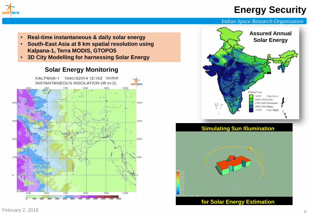
Energy Security
• Real-time instantaneous & daily solar energy
• South-East Asia at 8 km spatial resolution using
Kalpana-1, Terra MODIS, GTOPO5
• 3D City Modelling for harnessing Solar Energy
Simulating Sun Illumination
for Solar Energy Estimation
Solar Energy Monitoring
Assured Annual
Solar Energy

Indian Space Research Organisation
Disaster Management Support
• Disaster Communication Network
• Decision Support Centre
• National Database for Emergency
Management
• North Eastern Regional Node for
Disaster Risk Reduction
Daily Fire Alert
EARTHQUAKE
• Damage Assessment
LANDSLIDE
• Inventory
• Early Warning
FOREST FIRE
• Fire Detection
• Fire Alert (within 30
min. of acquisition)
FLOODS
• Inundation Mapping
• Hazard Zonation
• Early Warning
CYCLONE
• Damage Assessment
• Landfall Prediction
• Early Warning
Kashmir Floods - 2014 Kedarnath - 2013
February 2, 2018 10 February 2, 2018 10

Indian Space Research Organisation
February 2, 2018 11
Sustainable Development
February 2, 2018 11
Sustainable
Development
Urbanization
Bio-resources conservation
Coastal ecosystem
management
Agriculture
Geo-sphere Bio-sphere
interactions
Managing fragile ecosystems
Climate change
induced impacts

Indian Space Research Organisation
February 2, 2018 12
Sustainable Development
Waste Land Development M&E of IWMP Water Shades
Site Suitability Analysis Map For Solid Waste Disposal Monitoring LULC Change Trajectories in Hotspots of India
• Wasteland to solar power generation,
• Charanka solar park Radhanpur,
• one among 44 such projects in Gujarat State
IRS LISS-III 2016 IRS LISS-III 2005
• Mobile App for Geo-tagging
• Web based Change detection & Impact Assessment
D.V.C Thermal
Power Plant
Andal Airport
Sonpur-Bazari
Coal mine Kottadih
Coal mine

Food Security
Energy Security
Infrastructure Security
Health Security
Shelter Security
Water Security
• Crop acreage & production • Crop intensification • Produce management • Seasonal adversaries
management • Crop insurance
• Habitation suitability
• Construction monitoring
• Building typology
• e-health services
• Disease forewarning
• Risk zonation • Control
management
• Planning & site suitability • Route alignment • Monitoring of infrastructure development • Environmental impact assessment
Sustainable Development
Geospatial Governance
• Decision support tools • Geo-Web applications • Technology
institutionalization • Capacity building &
handholding
• Potential renewable & non-renewable resources
• Site suitability
ISRO Vision 2030
Disaster Risk
Reduction
• Water availability (Surface/Ground ) • Water harvesting & conservation • Irrigation management • Conjunctive use, Water quality • Water informatics
• Early warning systems • Near real time geospatial
products and services • Post disaster
management • Long-term management
• Communication & navigation

Indian Space Research Organisation
February 2, 2018 14
Towards Integrated Space Technology Solutions
Ortho Image
Mobile Data
Collection
GAGAN
enabled
solutions
Geo-Platforms - Suite of Applications for National Development
Optical & Microwave
(Multi-Spectral
Multi-Spatial, Multi-Temporal)
Digital Elevation
Model
In-situ
measurements
Thank You