Embed Size (px)
Citation preview

Space - Archaeology’s Final Frontier? An Intercontinental Approach
Edited by
Roderick B. Salisbury and Dustin Keeler
Cambridge Scholars Publishing

Space - Archaeology’s Final Frontier? An Intercontinental Approach, Edited by Roderick B. Salisbury and Dustin Keeler
This book first published 2007 by
Cambridge Scholars Publishing
15 Angerton Gardens, Newcastle, NE5 2JA, UK
British Library Cataloguing in Publication Data A catalogue record for this book is available from the British Library
Copyright © 2007 by Roderick B. Salisbury and Dustin Keeler and contributors
All rights for this book reserved. No part of this book may be reproduced, stored in a retrieval system, or transmitted, in any form or by any means, electronic, mechanical, photocopying, recording or
otherwise, without the prior permission of the copyright owner.
ISBN (10): 1-84718-278-X, ISBN (13): 9781847182784
CHAPTER SIX
PLOTTING SOCIAL CHANGE: BURIAL RITES, SPACE AND STAUS AT THE CEMETERY
OF STATZENDORF (AUSTRIA) IN THE BEGINNING OF THE EARLY IRON AGE
KATHARINA C. REBAY
Introduction The cemetery of Statzendorf is one of the largest and best-known
Early Iron Age cemeteries in Lower Austria. Excavated more than one hundred years ago, the site has contributed greatly to the general understanding of the Hallstatt Culture. Until recently, the cemetery was neither published completely nor studied closely. This discussion of space at the site of Statzendorf emerges from the cemetery analysis finished in 2005 (Rebay 2006). The aim is to point out how closely the use of space within the cemetery site related to social status expressed through differences in grave goods, grave furnishing, and grave constructions. The cemetery is embedded in a rich archaeological landscape, where various burial forms occur together. At the beginning of the Iron Age, the re-introduction of burial mounds of various sizes did not only provide a means to express status, but can also be interpreted as marking space and territory in a new social and political order.
Characteristics of the site and its history of research
The site of Statzendorf is located in the valley of the river Fladnitz, about 20 km south of where the Fladnitz flows into the Danube. Today, the site can be located between the cities of Krems and St. Pölten. The hilly, fertile landscape between the Dunkelsteiner woodland and the Hollenburger hilly region was formed by glaciers. Gravel surfaces and

Space - Archaeology's Final Frontier? An Intercontinental Approach 135
river terraces are typical, and the higher elevations are usually covered with loess (Neugebauer 1993: 9). In prehistoric times, the area was densely occupied. Among the sites of the area the cemeteries of Franzhausen, Gemeinlebarn, and Kuffern are particularly well know. About 25 years of rescue excavations due to recent gravel quarrying in the neighbour river valley of the Traisen revealed more than 2500 Bronze Age and 500 Iron Age graves. Settlements and cemeteries are arranged in close proximity to each other, alongside the rivers leading to the Danube.
The excavated part of the cemetery of Statzendorf is about 130 m
long and 45 m wide, covering an area of approximately 4855 square metres. It is not entirely clear how much of the cemetery remains untouched, but it is likely that over 90 % of cemetery is revealed. The density of the graves decreases towards the east and south. A water-bearing ditch confines the northern edge. A road now limits the western boundary of the cemetery, but no graves were found towards the west of that road (Dungel 1908: 4). The location of the contemporary settlement is not known. It is possible that a settlement was situated near the cemetery, about 500 m to the south, south of the little elevation that accommodates the modern village of Statzendorf. There, building works uncovered a number of Early Iron Age pottery sherds as well as a “burnt layer” (Bayer 1904: 71).
The cemetery was found unexpectedly in 1902 by a local farmer. He
showed some of the finds to the abbot of the monastery Göttweig, A. Dungel, who took great interest in local prehistory and initiated excavations in 1903. In 1908, A. Dungel published the material from 54 graves (Dungel 1908). The biggest part of the excavation was carried out between 1905 and 1925 by members of the Natural History Museum in Vienna, where most of the finds are still on display. Josef Bayer published an outline of the northern part of the cemetery in 1904 (Bayer 1904) (Figure 6-1). A hand-written doctoral theses focusing on the cemetery and the Hallstatt Culture in Lower Austria was lost in the University Library of Vienna during wartimes.
Compared to modern standards, excavation techniques were
questionable. Slides on glass plates documented the proceeding. The excavators dug two to five meter broad trenches parallel to the street, depositing the backfill of one trench to cover up the previous one. In most of the pictures, the site looks like a military trench rather than an excavation, except that the work was carried out thoroughly and

Plotting Social Change: Burial Rites, Space and Status 136
systematically. Pottery assemblages were assumed to represent graves, and differences in soil colour or texture were neither observed nor documented. However, due to accurate recording, drawing and surveying by the excavators, the documentation was amazingly good for its day. The general plan of the cemetery in the scale of 1:100 shows each grave in context to the others (reprint Rebay 2006: supplement). Ceramic vessels are symbolised by a circle and burnt bones recorded by a black dot, while stones were drawn in a naturalistic way. In addition to that, descriptions of all the graves existed. In the course of time, however, a part of the written documentation was lost and therefore some of the finds cannot be traced back to their original graves with any certainty. Despite these disadvantages, it is rewarding to deal with old excavation material, because it provides a data set that is large and restored sufficiently to work with it. After sorting out the documentation and the material, the graves were evaluated in terms of the liability of the documentation to ensure the quality of the further analysis.
Figure 6-1: Cremation burial as illustrated by Josef Bayer in 1904
(Bayer 1904: 51)
Burial forms
In total, the cemetery of Statzendorf contained 373 graves. Most of the individuals were either cremated and placed in urns, or deposited directly in the soil. About 10% of the burials were inhumations. It can be assumed that a community of 60-80 persons buried their dead in the cemetery of Statzendorf. The sequence of the burials begins at the

Space - Archaeology's Final Frontier? An Intercontinental Approach 137
transition from the Late Bronze Age to the Early Iron Age around 800 BC. Most of the graves date to the Early and Middle Hallstatt Culture, and only few complexes can be dated to the Later Hallstatt culture of around 600 BC. Absolute dates are lacking. Radiocarbon dating was not carried out because the chances of getting useful figures are very small between 800 and 600 BC in Central Europe. Therefore, the chronology is established by seriation and comparison of the material with well-dated parallels.
The 38 inhumation burials were distributed over the whole area,
excluding the north-western part, the oldest part of the cemetery. The orientation of the burials obviously did not follow strict rules. Most popular was an east-west orientation, but any other possibility can be found within the cemetery. Most of the inhumations were deposited extended on their backs, nine were found laying on their right side with more or less flexed legs, and a single crouched individual lay on the left side. On the northern, eastern, and southern edges of the graveyard, groups of bodies with similar orientation were revealed. Most striking about the inhumation burials is that half of them were deposited without any grave goods, whereas others are among the best equipped graves of the cemetery. Inhumation is not a phenomenon that concerns only poor people. It is interesting to note, though, that three of the eight inhumations without grave goods could be sexed as male, as opposed to the others that could not be sexed at all.
In case of 338 cremations, placing the burnt bones in urns was more
common than piling them on the ground, and males especially were buried more often inside urns than females. A bowl or a stone frequently covered the urn. The cremated individuals were usually placed towards the north or east of the pottery deposited as grave goods.
There is no simple explanation why either inhumation or cremation
was chosen for the burial of a deceased. Neither gender and age nor social status seemed to have an impact on the decision, but some possibilities can be inferred. Clearly, there is a chronological factor involved. Inhumations do not occur before the second cemetery phase, classified as Early Hallstatt. A group of burials with western grave goods and dress elements underlines relationships with contemporaneous sites along the Danube. In this region, about 200 km towards the west, inhumation burials were much more common than in Statzendorf. The percentage of inhumation burials in Lower Austria remains between 5 and 10% through the course of the

Plotting Social Change: Burial Rites, Space and Status 138
Hallstatt period (Nebelsick 1997: 33), before changing to inhumation in the La Tène period (Neugebauer 1994: 27-34).
The dead were usually equipped with a number of vessels, parts of a
substantial drinking and dining set. The types most frequently found are dishes, cups and bowls, large vessels with cylindrical necks, footed dishes, and pots. Cists, lids, and triplet vessels are rare. Apart from that, animal bones as remains of meat together with iron knives were frequently recovered. Personal objects include fibulae, pins, bracelets, torques, and metal belt plates, as well as glass and bronze beads. Tools and equipment such as whetstones and spindle whorls are distributed more often within the graves than weapons such as axes and lances; horse gear was found only in one grave.
Unfortunately, from the 378 documented burials only 25 skeletons
and 16 burnt bones were sufficiently well preserved for anthropological examination. The others were not collected during the excavation, and the sex of only 22 of the individuals could be determined. For further analyses, gender of burials had to be ascertained archaeologically by grave goods and costume elements. Although gender classification based on grave goods has been criticised often and rightly (Kleibscheidel 1997: 50-63), in Statzendorf it is the only possible way of getting data to compare with social and spatial development of the cemetery. Furthermore, the classic male-female gender division seemed to have been followed strictly in Iron Age Lower Austria. Using a systematic approach starting with the anthropologically sexed burials, types of grave goods and costume elements were tested to determine whether they were exclusively associated with male or female graves. Some of the finds, such as spindle whorls for females and pierced whetstones for males, characterize their respective genders. With the help of the seriation of functional grave good combinations, 93 graves could be gendered: 62 female and 31 male graves. The imbalance is due to the frequent presence of spindles amongst the grave goods, whereas characteristic male grave goods are scarce. A category “child” was not established for the cemetery of Statzendorf, because no evidence could be found that children were treated differently from adults.
Grave structures
Moving from the burial itself to the level of grave structures, the most common form are small pits of round and oval shape. This grave form was

Space - Archaeology's Final Frontier? An Intercontinental Approach 139
commonly used during the Late Bronze age, so it is not surprising that most of the early graves of the cemetery of Statzendorf are designed this way. Although the graves are packed together quite densely, none of the graves actually disturbs each other. This could be a hint that the graves were marked in some way for the community to remember their exact placement. For some graves, the layout in terms of how the vessels were arranged suggests that a wooden grave chamber must have existed. Pottery along the walls outline the extent of the rectangular chambers, which measure from 1 by 1 to 4.4 by 1.8 meters.
According to the cemetery plan, about a quarter of the burials were
related to stone structures. Some were lined with few stones, some were covered, and others had a complete, rectangular stone covering. Inhumation burials were covered more frequently than burials in urns, urns more frequently than ashes without urns. Looking at the cemetery plan, some of the rectangular stone coverings could well be interpreted as stone burial chambers. They usually encircle and cover wooden grave chambers and are widespread in the Iron Age. Despite this, there are no clear written descriptions of burial chambers by the excavators.
Usually, pottery and grave goods were arranged within the graves
almost like on a stage of a theatre: the bigger vessels were placed towards the back, smaller pottery was arranged in front of the vessels, other grave goods are neatly placed around the cremation (Nebelsick 1997: 48). This deliberate arrangement is very clearly visible in most of the Hallstatt burial mounds, for example in Zagersdorf (Rebay 2002: 21). In Statzendorf, the big pieces of pottery frequently line the west side of the wooden or stone burial chamber. The remains of the cremated body are then to be found in an opposite corner or along the opposite wall (Figure 6-2).

Plotting Social Change: Burial Rites, Space and Status 140
Figure 6-2: Grave C049 (circles = vessels, cross = cremated bones)
For most of the graves in Statzendorf there was one obvious side from
which to approach the burial. Presumably, the funerary community arranged the graves this way to give the best possible view of the deceased and accompanying grave goods. Increasingly during the Early Iron Age, the arrangement might have functioned to display the wealth and richness of the grave goods. The arrangement gives us a hint as to the direction from which the individual graves had to be accessed, and therefore how the Iron Age community perceived the cemetery space. Examining the distribution of favoured direction it becomes clear that the concept of display was developed during the course of the Hallstatt culture. The earliest graves in the northwestern part of cemetery do not show the described pattern. The later graves that were added towards the east and west were usually approached from the east or, less commonly, from the south. Burying their dead, the people of the community were facing the already existing part of the cemetery during the performance of funerary rites. The cemetery represents the lowermost point in the area at about 280 m above sea level. There is no obvious landmark the grieving community

Space - Archaeology's Final Frontier? An Intercontinental Approach 141
would looking at, apart from the Fladnitz that runs parallel to the extent of the cemetery from south to north into the Danube. In some distance, the hilly woodlands of the Dunkelsteiner Wald would be visible. Most probably, the settlement they lived in was situated towards their left side.
Social organisation
In order to examine the social organisation of the Hallstatt society in Statzendorf, the individual graves were classified according to the value of grave goods and the effort needed to build the grave structures (Rebay 2006: 199-240). Instead of simply categorizing graves as “poor” or “rich” based on modern ideas about prehistoric values, a social index value was calculated for each complete grave complex. The quantitative and qualitative evaluation is derived from the material itself, is comprehensible and reproducible, and can be statistically analysed with reference to grave architecture including burial type as well as the age and gender of the individuals. In the best case, the social index value represents the social rank of the dead, and the relation of the values can thus help in interpreting prehistoric social structures.
For these studies, it is of course necessary to accept an interpretative
framework that allows drawing conclusions from the world of the dead to the world of the living. The basic assumption is that dress elements, grave goods, and grave structures mirror the social status of the buried person. There are, however, a number of problems with this assumption. Through the burial ritual, ideal rather than real social relationships tend to be reflected. Social relationships can be distorted, hidden, and inverted (Hodder 1982: 139-146). The early Iron Age in Central Europe saw significant changes in burial rites. It is debatable if this change in burial customs reflects increasing social complexity or solely a change of beliefs and burial rites. In the Late Bronze Age, a uniform burial form was spread over a vast area from France to Hungary and from southern Sweden to Italy. Large flat cemeteries with simple cremations in urns were typical, eponymous to the Urnfield Culture or Period. The uniformity of urnfields with no significant differences in equipment and furnishing of the graves creates an impression of a uniform society. There are, however, reasons to believe that this has not been the case. In this period metal objects are found in hoards rather than in graves, and warrior and exceptional elite graves do occur, though rarely and not within the urnfields. In addition to that, the settlement structures indicate a certain level of centralisation and urbanisation (Urban 2000: 189). In the Late Bronze Age, graves are not
Plotting Social Change: Burial Rites, Space and Status 142
used as a means to communicate social status in the same way as it is done in the Early Iron Age. Displaying the body almost as a frozen living person with full attire, accompanying eating and drinking vessels, and goods for every day use becomes important for the ritual act a burial represents in the Hallstatt Culture. This might also indicate a belief in a concrete afterlife. Emphasising status differences in the graves becomes increasingly important in the course of the Early Iron Age. Keeping the chronological factor in mind, we can see that in the cemetery of Statzendorf, variations in the equipment, furnishing, and construction of the graves can help interpret the organisation of the Hallstatt community using the graveyard.
The complete index for Statzendorf was developed on the basis of the
work of Burmeister, Hodson, Müller and Sprenger (Burmeister 2000, Hodson 1990, Müller 1994, Sprenger 1999), but had to be modified considerably. The social index for the cemetery of Statzendorf consists of an index for burial type, an index for the quantity and size of the pottery, an index of the functional types of grave goods, an index of the materials used for grave goods, an index for the number of small finds, an index for weight of metal, and an index for the association of finds. All results were scaled as a number between 0 and 100, 0 representing the smallest, 100 the largest possible value. The overall results indicate a small number of burials with a social index of 0, a basis of 45 % simple graves, 35 % average graves and a small, well differentiated elite.
Social interpretation
The next step is to turn the figures back into a social model of the cemetery of Statzendorf. It is important to point out that the interpretation is only valid for the cemetery itself. The cemetery represents a community of 60-80 people and was embedded in the local Hallstatt society, which consisted of a variety of groups. The people of Statzendorf might have lived together in a small settlement or on a few farms nearby sharing a common burial place. Not all the Hallstatt communities might have been organized the same way, but certainly emphasised different aspects of rank and belief systems in their funerary customs. The regional context of the cemetery will be discussed later.
On the basis of the data it becomes clear that within the cemetery no
clear cut class system existed. The differences are gradual, and the graph of social index distribution does not show any significant breaks (Figure

Space - Archaeology's Final Frontier? An Intercontinental Approach 143
6-3). The assignment of graves into five groups according to their social index value remains artificial, but this way it is possible to interpret the groups and create a population pyramid. At its top is the richest, complete burial, grave C001. The inhumed body of a female lay stretched on her back and was fully covered with stones. Among the dress elements and ornaments were two bronze fibulae, one of them with a big amber bead, a pair of bracelets and several finger rings. The bronze belt was composed of bronze rings and rivets, the belt plate showed heavy traces of use and was repaired at least once. On the left side of the skeleton and towards the feet a large set of pottery was found. Animal bones, the remains of meat deposited in the grave, together with a small iron knife were placed next to the feet of the body.
Figure 6-3: Social index distribution
Among the eleven wealthiest burials, six were female and five male
graves. In the group of the 26 well equipped graves, six could be ascribed to females and eleven to males. Overall the gender distribution seems to be well balanced and there is no evidence that one gender has a higher status than the other in this cemetery. There is hardly any evidence for warriors in the cemetery. Three axes have been found in context with male burials, but they can as well be interpreted as tools or objects with ritual

Plotting Social Change: Burial Rites, Space and Status 144
function. Only one burial, grave A027, contained a pair of horse bits. In the group of average and simple burials, females are predominant because they are easier to identify. Simple graves usually contain not more than the cremated bones and a few pieces of pottery and are placed in small pits. Among the 14 graves with a social index of 0, which means they were found without any grave goods or recognizable grave structures, were eight inhumations and six cremations. Only three burials could be sexed and all of these turned out to be male. There is a high percentage of inhumation burials among the burials without any grave goods, presumably due to the fact that cremations without grave goods or stone structures are easy to overlook. The graves with a social index of 0 are frequently found within the cemetery, but on its edge. This placement might reflect the buried person’s position at the fringe of society.
Space and social status
A remarkable correlation between social development and the use of space within the cemetery can be explored, which evidently is inextricably intertwined with the chronological trajectory of the cemetery. The graves are usually well separated from each other. Paying attention to the spatial patterning of the graves, it becomes clear that the distances between graves reflect chronological changes. In the oldest cemetery phase, the graves were situated close to each other, and through the course of the Hallstatt culture, the distance between the graves increased. Although for years it has been assumed that the graves of Statzendorf were flat graves, the evidence implies the existence of first smaller and later larger tumuli that could not be detected using excavation methods customary more than a hundred years ago. Recent excavations in the river valley of the Traisen show that post and stone circles, as well as circular ditches were likely to have surrounded the graves (Neugebauer 1997: 181). These structures are the remains of burial mounds that became flattened over time probably though natural processes such as erosion. The diameters of these mounds, about four to eight meters, match empty spaces on the cemetery plan of Statzendorf. Some of the graves that are likely to have had a wooden or stone burial chamber and a mound on top of them, seem to cause other graves to be arranged on the mound’s foot. C005, C006, C007, C057 and C058, for example, form a half-circle at what appears to be the base of a low tumulus of C008 (Figure 6-4).

Space - Archaeology's Final Frontier? An Intercontinental Approach 145
Figure 6-4: Grave C008 (grey square = possible extent of the burial chamber,
grey circle = possible extent of the burial mound) The horizontal stratigraphy of the site supports the postulation that
during the usage of the cemetery, the flat cemetery turned into a field of burial mounds. The analysis of horizontal stratigraphy aims to acquire a chronological order of occupation within a cemetery, where no vertical stratigraphy of graves is available. Find combinations from individual graves can be understood as closed finds and therefore used for seriation. The nearest neighbour analysis combines distribution maps of find types and is useful for testing if other graves with the same type occur more often in the close vicinity of that grave than a random distribution would suggest. A matrix of relationships between graves can be seriated and mapped. Groups within the cemetery are then easier to identify and the sequence hints at the order of occupation in the cemetery (Stadler 2005) (Figure 6-5).

Plotting Social Change: Burial Rites, Space and Status 146
Figure 6-5.: Next neighbour analysis (lines link graves with the same find
types)
Space - Archaeology's Final Frontier? An Intercontinental Approach 147
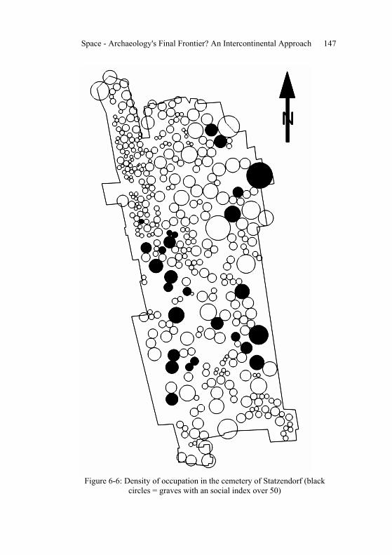
Figure 6-6: Density of occupation in the cemetery of Statzendorf (black
circles = graves with an social index over 50)

Plotting Social Change: Burial Rites, Space and Status 148
Although individual graves cannot be dated via their placement in the cemetery, looking at the horizontal stratigraphy is helpful to check the chronology established using other dating techniques. Exceptions to the general traits for individual graves can always occur (Eggert 2001: 222). In Statzendorf, most of the grave complexes cannot be dated accurately enough to picture details in the sequence of the burials. The general development, however, can be understood through mapping. Even without the application of statistical programs, complexes with exactly the same unusual types are noticeable. The graves A001 and B014, for example, both contain one small vessel, decorated with engraved, anthropomorphic scenes. The graves B138 and B141, two male graves with high social status, are both constructed with rectangular stone chambers. Grave goods are very similar; a pierced, round disc made of antler and decorated with engraved circles was found in both graves. The objects might have served as amulets. The fact that they are usually placed next or in close vicinity to each other support the theory that the distribution of graves was not random, but followed a specific order. Other than chronology, reasons like social relationships, family bonds, or place of residence should be considered.
The oldest graves, dated around 800 BC., are situated in the north-
western part of the graveyard and show a strong Late Bronze Age tradition in the burial rites. At that time, densely arranged, simple cremations in urns were common. The urns were commonly deposited it pits, since graves with stone structures require more free space. Figure 6-6 shows the density map of occupation in the cemetery of Statzendorf. Each circle symbolizes the space exclusive to one single grave; the radius of the circle represents half the distance to the neighbouring grave. The more densely the cemetery is occupied, the smaller the circle appears. This form of representation causes inaccuracies on the edges of the excavated area. In absolute terms, the distribution of stone structures in the cemetery is comparatively even, but since the density of occupation decreases towards the centre and south, the percentage of graves with stone structures is higher. In these parts of the graveyard, the space at one grave’s disposal is about four to fife meters in diameter. By mapping the graves with a social index greater than 50, those graves with more and higher-quality grave goods, it becomes clear that these graves take up the most space. A group of burials in the middle-western part of the graveyard, dated to the second burial phase in Early Hallstatt, demonstrate strong western influences and have high social indices. Some of the individuals with western ornaments and pottery had probably actually migrated from about 200 km further

Space - Archaeology's Final Frontier? An Intercontinental Approach 149
west along the Danube. Isotope analysis planned for the future might be able to prove or refute this theory. In this horizon of innovation, the first inhumation burials appear (Figure 6-7).
Figure 6-7: Horizontal stratigraphy (white = early graves, grey = old graves,
black = middle graves, black and white = late graves, crosses = graves with western find types)

Plotting Social Change: Burial Rites, Space and Status 150
Not only the funerary practice, but also the underlying meaning of funerary customs changed during the course of the Hallstatt period. The grave goods became more personalized, and the burials portray the individual and demonstrate the individual’s social status. This change of burial practices reflects a change of beliefs that is likely to be triggered by a parallel change of the social organisation, in particular concerning power relations. Graves were constructed as burial mounds rather than simple pit graves. In the youngest phase, the graves stretched towards the east and south. The spatial pattern shows the distances between graves became larger and stone structures became more common. In addition to that, the social index values increased. The latest datable grave of the cemetery, grave B148, was again deposited in the north-east, the oldest part of the cemetery. It is possible that at that time, after about 200 years, the location of the oldest graves was not clearly visible any more.
Statzendorf embedded in the archaeological landscape
Statzendorf is embedded in a rich archaeological landscape (Figure 6-8). Thanks to the long research tradition and ongoing rescue excavations (Neugebauer 1988: 85), a large number of contemporary sites are known from the region around the cemetery of Statzendorf, in the Flandnitz and Traisen valleys. Cultural-historically speaking, Statzendorf is situated in the west of the so-called “Kalenderberg” culture, an early Iron Age Hallstatt group in Lower Austria and northern Burgenland. The group is mainly defined by the distribution of the Kalenderbergtopf, a coarsely decorated pot. Metal finds are scarce, and pottery was emphasised instead. Through the Danube, the region had naturally close contacts to the western Hallstatt groups and strong links to contemporaneous sites along the Danube such as Mitterkirchen and Linz. Western dress elements, among them pins and belts, were found in the graves. Certain ceramic types that usually only occur in the west Hallstatt area might have been imported or produced by immigrants from that area. The local pottery tradition, however, makes a very traditional impression.
In the German and Central European research tradition, the concept of
archaeological “cultures”, defined through the distribution of particular artefacts or combinations of artefacts, has been very influential right up to the present. Countless articles have been written to define the boundaries of cultures and culture groups, usually interpreting them as boundaries between peoples. The reasons for the distribution of finds and types, however, are always unknown and were presumably not always the same

Space - Archaeology's Final Frontier? An Intercontinental Approach 151
(Angeli 1991: 200). The culture group labels are better understood through research history and are legitimately used to communicate research results (Müller-Scheeßel 2000: 97), giving an estimate of the time and setting of the subject at one glance.
Figure 6-8: Statzendorf embedded in the Early Iron Age landscape (black dots = cemeteries, grey dots = burial mounds, white squares = settlements)
The “Kalenderberg” culture (Figure 6-9) is an excellent example of
how the new world order after the First World War influenced the definition of archaeological groups. It is interesting to note that in the beginning of scientific archaeological research in the 19th century, most of the eastern Hallstatt area belonged to the Austrian-Hungarian Empire. The administrative structure made it easy for German speaking researchers to carry out excavations in all parts of the empire. Many of the important finds were published in German and were brought to the capital and can still be studied in the vast collection of the Natural History Museum in Vienna. After the collapse of the Austrian-Hungarian Empire, the boundaries of cultural groups tended to be defined along newly delineated national borders. Cooperation across the boundaries of nations, political and ideological systems, and languages became more difficult, although a certain level of communication was maintained.

Plotting Social Change: Burial Rites, Space and Status 152
The area of the “Kalenderberg” group is topographically confined towards the northwest and west, where inhospitable woodlands form a natural settlement barrier and towards the south, where the Alps required different forms of economic and subsistence organisation. The boundaries towards the north and east, however, approximately follow the modern national borders between Austria and the Czech Republic, Slovakia, and Hungary, with the exception of occasional recorded sites at the other side of the border.
Figure 6-9: Statzendorf, the Kalenderberg Culture and national borders Returning to the archaeological evidence, space was used efficiently
in the Fladnitz-Traisen area in the Early Iron Age. The sites, settlements as well as cemeteries, are situated along the rivers, one after the other like beads on a string. In this micro region, the cemeteries seem to have characteristics similar to Statzendorf, although for many sites just a few graves were actually identified. Among the recently excavated cemeteries, Getzersdorf, Wagram ob der Traisen, and Franzhausen are the most important, but so far, only preliminary reports have been published (Neugebauer 1997: 173-185). The settlements reflect the agrarian tradition of the local population. Farms and villages consisted of a couple of houses and workshops, some of which with subterranean floor surfaces or cellars.

Space - Archaeology's Final Frontier? An Intercontinental Approach 153
There is evidence for textile production, pottery, bone and antler work, as well as bronze casting. In some cases, the Early Iron age settlements are enclosed with a ditch or palisade (Neugebauer 1993: 88).
Cemeteries were founded in close vicinity of rural settlements. It is
not entirely clear whether the cemetery represents the population of one household or farm or if people from various settlement units constitute a ritual community that buried their dead within one graveyard. During the course of the Hallstatt period, it became more and more important to express one’s wealth and status through grave goods and burial constructions. This trend was not taken up by all the communities in the same way, but eventually accumulated in the building of large burial mounds. The nearest monumental burial mounds are situated in Gemeinlebarn about 12 kilometers east of Statzendorf (Dungel/Szombathy 1890: 49).
The relationship between the cemeteries and burials mounds in Lower
Austria has yet to be investigated. A number of single, monumental burial mounds are still visible in the landscape, for example the mounds of Großweikersdorf, Niederfellabrunn, or Niederhollabrunn. The most impressive one, Großmugl, is still 18 metres high. Other burial mounds, like Gemeinlebarn and Langenlebarn, come in groups of three or possibly a few more. These impressive landmarks might have been constructed by an emerging elite to mark power over a micro region and control space. The first burial mounds occur next to outstanding settlements (Nebelsick 1997: 54), and the rural periphery soon followed suit.
In the Early Iron Age there was still room for a diverse range of social
organisations and negotiation of status relations. To develop a social model for the Early Iron Age society, Homer’s description of the early Greek society is particularly useful as an analogy. A household or oikos consisted of the head of a household, himself engaged in agriculture, his wife, responsible for domestic work and textile production, their family, and a number of non-related servants and slaves. Whereas in peaceful times the heads of the household maintained loose contact, in times of conflict and warfare, political alliances were built and a basileus was chosen as their leader. The status of a basileus was not yet inherited, but was based on the intellectual ability and practical skills of the individual. Power and prestige had to be justified constantly through outstanding performance. Around the 10th century BC, the social organisation began to change. The justification of power, wealth, and status was increasingly

Plotting Social Change: Burial Rites, Space and Status 154
explained by an individual’s descent. As a result, the grave constructions reflect the veneration of the ancestors (Ulf 1990: 245).
Using this analogy, the data of the cemetery and the surrounding
archaeological landscape can be explained. The size of the community of Statzendorf fits what has to be expected of an agricultural production unit. It is possible that the heads of the households can be found among the high status males and females in Statzendorf. Textile work was important to constitute femininity, as the spindle whorls frequently found in the graves show. The absence of a warrior elite is striking. It is unlikely, however, that there were basilees among the people buried in Statzendorf. They are more likely to be found spatially separated from the community, in the burial mounds. The emergence of an elite that marked power and prestige through burial mounds becomes visible in the Early Iron Age. During the period of developing constituted, stable power relations, not all the societies were organized in the same way, although close contacts between the communities can be taken for granted.
Synopsis and Conclusion
The cemetery of Statzendorf, excavated more than a hundred years ago, serves as a case study to raise issues of space in a cemetery analysis. The archaeological evidence is investigated at different scales, and the placement of pottery and grave goods is used to understand how the Iron Age community of Statzendorf might have perceived their burial space. Exploring the distances between the individual graves unravels social relationships and sheds light on the historical trajectory in the Early Iron Age. While grave goods and grave constructions are increasingly used to demonstrate a person’s position within the society, the use of space plays an important role in expressing wealth and status. Looking at the surrounding landscape, it becomes clear that a single cemetery, even when it is as large as Statzendorf, does not mirror all aspects of Iron Age society in Lower Austria. Power relationships were still negotiable, and as a consequence, a variety of burial forms appears.
Acknowledgements
I would like to thank the following people and institutions for help and support: First, Andreas Lippert for his patience in supervising my PhD, editing my book on the full cemetery analysis, and for ensuring funding for getting it printed. The restoration of finds, drawings, and

Space - Archaeology's Final Frontier? An Intercontinental Approach 155
analysis of human and animal bones was enabled with project money of the Fonds zur Förderung der wissenschaftlichen Forschung (P12520). The analysis of the Statzendorf cemetery material was funded through a research grant from the University of Vienna. The staff of the Museum of Natural History in Vienna gave much of their time and assistance, especially Peter Stadler who assisted me with seriation, nearest-neighbour analysis, and other statistical problems. I would like to acknowledge the Department of Archaeology at the University of Cambridge and the Leverhulme Research Programme on “Changing Beliefs of the Human Body” for the freedom of research and financial support. Marie Louise Stig Sørensen engaged me in many inspiring discussions about funerary archaeology. Finally, I want to thank Roderick Salisbury for the encouragement to contribute this chapter and the corrections of my English.
Works Cited
Angeli, W., 1991, Der ethnologische Ethnosbegriff und seine Anwendung in der Prähistorie. Mitt. Anthr. Ges. Wien 121: 189-202.
Bayer, J., 1904, Das prähistorische Gräberfeld in Statzendorf (N.-Ö.), Jahrb. K. K. Zentralkomm. 2: 45-72.
Burmeister, S., 2000, Geschlecht, Alter und Herrschaft in der Späthallstattzeit Württembergs, Tübinger Schriften zur Ur- und Frühgeschichtlichen Archäologie 4. Rahden, Westfahlen.
Dungel, A., 1908, Die Flachgräber der Hallstattzeit bei Statzendorf in Niederösterreich, Mitt. Prähist. Komm. Österr. Akad. Wiss. 2/1: 1-39.
Eggert, M. 2001, Prähistorische Archäologie. Konzepte und Methoden. Francke, Tübingen.
Hodder, I. 1982, The Present Past: An introduction to anthropology for archaeologists. Batsford, London.
Hodson, F., 1990, Hallstatt. The Ramsauer Graves. Quantification and Analysis, Monographien RGZM 16.
Kleibscheidel, C., 1997, Grundlagen und Methoden traditioneller archäologischer Geschlechterbestimmung in hallstattzeitlichen Gräbern. In: S. Karlisch/S. Kästner/E.-M. Mertens (Eds.), Vom Knochenmann zur Menschenfrau. Feministische Theorie und archäologische Praxis. Frauen – Forschung – Archäologie 3: 50-63.
Müller, J., 1994, Zur sozialen Gliederung der Nachbestattungsgemeinschaft vom Magdalenenberg bei Villingen. Prähistorische Zeitschrift 69/2: 175-221.

Plotting Social Change: Burial Rites, Space and Status 156
Müller-Scheeßel, N., 2000, Die Hallstattkultur und ihre räumliche Differenzierung. Der West- und Osthallstattkreis aus forschungs-geschichtlich-methodologischer Sicht. Tübinger Texte 3. Rahden, Westfahlen.
Nebelsick, L., 1997, Die Kalenderberggruppe der Hallstattzeit am Nordostalpenrand. In: L. D. Nebelsick/A. Eibner/E. Lauermann/J.-W. Neugebauer, Hallstattkultur im Osten Österreichs. Wiss. Schriftenr. Niederösterreich 106–109: 9-128.
Neugebauer, J.-W., 1988, Ergebnisse auf dem Gebiet der Hallstattkultur in Niederösterreich, Rettungsgrabungen des Bundesdenkmalamtes 1970-1987. In: Festschrift 100 Jahre Ausgrabungen im hallstattzeitlichen Gräberfeld Frög, Gemeinde Rosegg in Kärnten. Arch. Alpen Adria 1: 85-120.
—. 1993, Archäologie in Niederösterreich. St. Pölten und das Traisental. St. Pölten, Wien.
—. 1994, Die Kelten im Osten Österreichs. Wiss. Schriftenr. Niederösterreich 92-94. St. Pölten, Wien.
—. 1997, Beiträge zur Erschließung der Hallstattkultur im Zentralraum Niederösterreichs. In: L. D. Nebelsick/A. Eibner/E. Lauermann/J.-W. Neugebauer, Hallstattkultur im Osten Österreichs. Wiss. Schriftenr. Niederösterreich 106–109: 165-190.
Rebay, K., 2002, Die hallstattzeitliche Grabhügelgruppe von Zagersdorf im Burgenland. Wiss. Arb. Burgenland 107. Amt der burgenländischen Landesregierung, Eisenstadt.
—. 2006, Das hallstattzeitliche Gräberfeld von Statzendorf in Niederösterreich, Universitätsforschungen zur prähistorischen Archäologie 135, Rudolf Habelt, Bonn.
Sprenger, S., 1999, Zur Bedeutung des Grabraubes für sozioarchäologische Gräberfeldanalysen. Eine Untersuchung am frühbronzezeitlichen Gräberfeld Franzhausen I, Niederösterreich, Fundber. Österreich, Materialh. A 7. Wien.
Stadler, P., 2005, Quantitative Studien zur Archäologie der Awaren I, Mitt. Prähist. Komm. Österr. Akad. Wiss. 60. Wien.
Szombathy, J., 1890, Die Tumuli von Gemeinlebarn. Mitt. Prähist. Komm. Österr. Akad. 1/2: 49-84.
Ulf, C., 1990, Die homerische Gesellschaft: Materialien zur analytischen Beschreibung und historischen Lokalisierung. Beck, München.
Urban 2000: O. Urban, Der Lange Weg zur Geschichte. Ueberreuter, Wien.