Embed Size (px)
Citation preview
ESCAP Technical Paper
Information and Communications Technology and Disaster Risk Reduction Division
Space Applications for Improving Disaster Management
Prepared by the Space Applications Section, Information and Communications Technology and Disaster Risk Reduction Division, ESCAP,
with assistance from Mr. Syed T. Ahmed, Associate Economic Affairs Officer
December 2013
Disclaimer: The designations employed and the presentation of the material in this paper do not imply the expression of any opinion whatsoever on the part of the Secretariat of the United Nations concerning the legal status of any country, territory, city or area or of its authorities, or concerning the delimitation of its frontiers or boundaries. References and maps obtained from external sources might not conform to the UN Editorial guidelines. The content in this document is the opinions and view points of the author's and not that of ESCAP or IDD
and this publication has been issued without formal editing.

ii
Abbreviations ADRC The Asian Disaster Reduction Center ADB Asian Development Bank ADBI Asian Development Bank Institute ACTED Agency for Technical Cooperation and Development AP Access Point BCPR Bureau for Crisis Prevention and Recovery BNSC British National Space Centre CONAE Argentine Space Agency CNSA China National Space Administration DHNetwork Digital Humanitarian Network DLR German Aerospace Center DMCii DMC International Imaging ESCAP United Nations Economic and Social Commission for Asia and the
Pacific EUMETSAT European Organisation for the Exploitation of Meteorological Satellites FAO The United Nations Food and Agricultural Organisation GDACS Global Disasters Alerts and Coordination System GEO Group on Earth Observations GEOSS Global Earth Observation System of Systems GFMC Global Fire Monitoring Center GIEWS Global Information Early Warning Service GLOF Glacial Lake Outburst Flood HFA Hyogo Framework for Action ICC International Criminal Court IDP Internally Displaced Person IGMASS International Global Monitoring Aerospace System IHL International Humanitarian Law IMO The International Maritime Organisation INPE National Institute For Space Research - Brazilian Institute IP Internet Protocol ISC International Seismological Centre ISRO Indian Space Research Organization JAXA Japan Aerospace Exploration Agency JRC European Commission Joint Research Centre KARI Korea Aerospace Research Institute MOA Memorandum of Agreements MoU Memorandum of Understanding MVV Mobile VSAT Vehicles NGO Non Governmental Organisation NOAA National Oceanic and Atmospheric Administration OCHA The United Nations Office for the Coordination of Humanitarian Affairs PTWC The Pacific Tsunami Warning Center RESAP Regional Space Applications Programme for Sustainable Development ROSCOSMOS Russian Federal Space Agency

iii
SAARC South Asian Association for Regional Cooperation SLA Service Level Agreement SNS Social Networking Service SOPAC Applied Geoscience and Technology Division of the Secretariat of the
Pacific Community SOPs Standard Operating Procedures SPC Secretariat of the Pacific Community SBTF Standby Volunteer Taskforce TSR Tropical Storm Risk TEWS Tsunami Early Warning system UAV Unmanned Aerial Vehicle UKSA UK Space Agency UN-GIMM United Nations initiative on Global Geospatial Information
Management UN-SPIDER United Nations Platform for Space-based Information for Disaster
Management and Emergency Response UNCCD The United Nations Convention to Combat Desertification UNCSD United Nations Conference on Sustainable Development UNDAC United Nations Disaster and Assessment and Coordination UNDP United Nations Development Programme UNEP United Nations Environment Programme UNESCO The United Nations Educational, Scientific and Cultural Organization UNITAR United Nations Institute for Training and Research UNOHCHR United Nations Office of the High Commissioner for Human Rights UNOOSA United Nations Office for Outer Space Affairs UNOSAT The Operational Satellite Applications Programme of the United
Nations Institute for Training and Research USGS The United States Geological Survey V&TC Volunteer and Technical Community VOIP Voice over Internet Protocol WHO World Health Organization WMO World Meteorological Organisation
iv
Contents Abbreviations .................................................................................................................... ii Contents ............................................................................................................................ iv List of figures..................................................................................................................... v
1. Introduction............................................................................................................... 1 1.1. Identified priorities and gaps .............................................................................. 2
2. Frameworks and cooperation mechanisms for disaster management................. 3 2.1. Frameworks and institutional issues ................................................................... 5
2.1.1. International frameworks ............................................................................ 5 2.1.2. Regional frameworks .................................................................................. 6 2.1.3. National frameworks................................................................................... 8 2.1.4. Civil society and informal frameworks for action ...................................... 9
2.2. International and regional cooperation mechanisms........................................... 9 2.2.1. International charter on space and major disasters ................................... 10 2.2.2. Other United Nations initiatives ............................................................... 10 2.2.3. Other international and regional initiatives............................................... 12
3. Operational activities and coordination in the use of space applications .......... 13 3.1. Trends ............................................................................................................... 15 3.2. Operational activities ........................................................................................ 16
3.2.1. Monitoring and early warning .................................................................. 17 3.2.2. Disaster mitigation and preparedness ....................................................... 20 3.2.3. Emergency relief and response ................................................................. 21 3.2.4. Recovery, rehabilitation and long term sustainable development ............ 24
3.3. Coordination and space applications ................................................................ 28 3.3.1. International and regional coordination .................................................... 29 3.3.2. National and institutional coordination..................................................... 30 3.3.3. Local and community coordination .......................................................... 31
4. Recommendations ................................................................................................... 32 4.1. Policy recommendations................................................................................... 32 4.2. Operational recommendations .......................................................................... 32
Bibliography .................................................................................................................... 33
v
List of figures Figure 1 - Microwave imager from NASA’s TRMM satellite of Cyclone Mahasen on 15 May 2013 .......................................................................................................................... 18 Figure 2 - A visible image of Cyclone Mahasen by MODIS on NASA’s Aqua satellite 16 May 2013 .......................................................................................................................... 18 Figure 3 - Rapid production of very high precision maps for Chao Phraya’s catch basin using the latest survey technology for flood protection.................................................... 21 Figure 4 - Imagery before the floods in Southeast India, from the NASA Earth Observatory acquired by MODIS on NASA’s Terra satellite on October 27, 2013 ........ 22 Figure 5 - Imagery after the floods in Southeast India, from the NASA Earth Observatory acquired by MODIS on NASA’s Terra satellite on October 28, 2013 ............................. 23 Figure 6 - IPSTAR MVV Deployment in Southern Thailand .......................................... 23 Figure 7 – ChangeMatters, tools for land-use change monitoring.................................... 25 Figure 8 - ChangeMatters, single map with analytical tools ............................................ 26 Figure 9 - ChangeMatters, user tour ................................................................................. 26 Figure 10 - Identification of areas environmentally sensitive to desertification, Isfahan, IRAN................................................................................................................................. 27 Figure 11 - UNOSAT map of fire damage in the Philippines, 2013 ................................ 28 Figure 12 - GeoDRM portal for the Cook Islands established in collaboration with ESCAP .............................................................................................................................. 30
1
1. Introduction The Asia-Pacific region is by far the most disaster-prone region in the world. A multitude of meteorological and geological hazards have persistently ravaged the region causing, in many cases, devastation, catastrophe and regression to livelihoods, economies and development gains. These hazards can range from extreme weather conditions such as drought, ice, rain, snow, varying temperatures and wind, as well as earthquakes, floods, forest fires, hurricanes, mudslides and volcanic eruptions. There is a growing concern for complex emergencies which can occur as a result of multiple and compound disasters in addition to vulnerable in-country situations which can exacerbate on-going relief and response efforts. The use of space applications can improve disaster management through operational support provided by member States and United Nations entities as well as the development of capacity in monitoring and early warning; disaster mitigation and preparedness; emergency relief and response; and recovery, rehabilitation and long term sustainable development. As of 2012, 88% of people affected by natural disasters reside in the Asia-Pacific region, where nearly 40% of the world’s natural disasters occur (ADB 2013, Chapter 1). The risks faced by populations in Asia and the Pacific over the last four decades are increasing. As an indication, the average number of people exposed to annual floods has increased from 29.5 million to 63.8 million, and population figures in cyclone-prone areas have gone up from 71.8 million to 120.7 million (APDR, 2012). In terms of the economic impact of losses from disasters, much of this is concentrated in the Asia-Pacific region. As an example, the total global annual average loss from earthquakes is estimated at more than US$100 billion. Of this figure, approximately 76% is concentrated in Asia, 9% in Europe, 8% in North America and 5% in Latin America. The global annual average losses from cyclonic winds are estimated to be over US$80 billion. From this figure, approximately 80% is concentrated in Asia, 13% in North America, 4% in Latin America and about 2% in the Caribbean (UNISDR 2013, pp.55). Space applications encompass many different space based technologies, tools and techniques. These can range from the use of Earth Observation (EO) satellites for obtaining satellite imagery, Geospatial Information (GI) or integrated location based data along with socio-economic data, Global Navigation Satellite Systems (GNSS) such as positioning systems, Remote Sensing (RS) and imagery analysis, Unmanned Aerial Vehicles (UAV) for aerial photography etc. This paper will discuss ways to improve disaster management through the use of space applications. The structure of this paper is essentially in two parts, looking at both policy and practice levels within the context of space applications for disaster management. The introductory section will firstly establish the growing need for space applications in addressing disaster management, by highlighting the identified priorities and gaps in disaster risk reduction and disaster management over the last decade, which relate to technologies associated with space applications. Subsequently, in the first section, space applications for improving disaster management will be identified and introduced within the contexts of frameworks and institutional issues. This can help in identifying and leveraging the

2
overarching mandates for pursuing space applications at the policy level and understanding programming motivations. This section will further identify international and regional cooperation mechanisms. This can lead to stakeholder mapping and visualisation of the different actors in space applications and disaster management to better align objectives, identify programming entry points and ensure synergy across the sector and region. The second section, will highlight trends in focus and priorities over the last several years, with a particular focus on operational activities. Consequently, good examples of operational activities in the different phases of the disaster management cycle, for improving disaster management through space applications will be showcased. These examples will cover the areas of monitoring and early warning; disaster mitigation and preparedness; emergency relief and response; and recovery, rehabilitation and long term sustainable development, in both natural disaster and complex emergency contexts. Additionally, the paper will touch on coordination efforts and opportunities, in space applications at the different levels which can feed into regional coordination mechanisms for improving disaster management. Finally, recommendations will be provided at both the policy and practice levels for improving disaster management through the use of space applications.
1.1. Identified priorities and gaps
Over the last decade, numerous studies have attempted to take stock, understand the scope and potential and identify capacities and limitations, of the different aspects of technology and disaster management. The demand and significance of space applications can be better understood in today’s disaster management environment, when considering the recommendations of some of those studies to help identify gaps for improving disaster management. Retrospectively, much of this can be seen as an increasing realisation and the evolution, of the use of space applications in disaster management. Over the years, identified priorities and gaps have shifted accordingly, with overall development thinking and sectoral trends. Strategically, the need to integrate disaster management into long-term sustainable development has always remained but additionally there is now a stronger focus on climate change adaptation within this context, new emerging and compounded threats and sharing the burden of risk and potential for economic value through strengthened public and private commitments. Operationally, the trend has moved from the need to simply extend early warning systems for multi-hazards, identifying national focal points and establishing institutional links, to promoting wider cooperation within and across regions, countries and provincial boundaries, the availability of integrated climate and socio-economic data systems and broader and more seamless information and knowledge sharing networks. The use of space applications for humanitarian response is already well established, integrating space applications into a broader disaster management context remains the challenge. Considering space applications from an information management perspective, the evolution and technological expectations of information management systems or integrated and holistic technology systems, have significantly changed. Such information management systems have now evolved to ultimately serve decision support. This is most

3
evident in the concept of ‘dashboard’ systems, which essentially provide a snapshot view for decision makers at different levels within an organisational hierarchy. One such example is the United Nations Office for the Coordination of Humanitarian Affairs (OCHA) humanitarian dashboard, although this is used as an assessment and coordination tool where information is still gathered and compiled manually, it provides an opportune example of potentially moving such dashboard concepts within an information management and decision support system (UN OCHA, 2013). These concepts can be integrated into a type of disaster dashboard, using space based information as additional inputs into broader systems for disasters managers. Within dashboard decision support systems, decision makers get essential information presented to them, within a personalised view, which is appropriate for their day-to-day and exceptional decision making needs. This eliminates information overload which can become a common problem with any information management system and approaches the use of technology from a user’s perspective. This type of usage scenarios or ‘use cases’ as they are known technically, provide an inward looking perspective to designing and using technology systems, rather than an outward perspective, which is often the case. Technological (information) infrastructure is usually already in place but disparate. The creation of such decision support systems, often becomes much smaller and less complex than anticipated if done from a use case perspective. The task of supporting decisions, from the user perspective, can be broken down into individual decisions. Working backwards, information which is required to support that decision can then be realigned from an information systems perspective, if already existing, additional information systems can be developed for information which does not exist within information management systems, and disparate systems integrated to create the necessary information architecture and information management infrastructure to seamlessly provide ‘dashboard’ decision support to end users.
2. Frameworks and cooperation mechanisms for disaster management
Finding the political motivation for pursuing space applications and disaster management can be achieved through various mandates, frameworks and mechanisms. Looking at the trend of identified priorities and gaps in disaster risk reduction and disaster management, over the last decade, it is clear that key drivers of change have emerged in the area of policy. This is of collective demand through frameworks of governance and action, and collective pressure through cooperation mechanisms. Furthermore, disasters can present a cross-boundary problem. There are no limitations or parameters in terms of responsibility as we know it, or a country’s space technology capabilities. Therefore, managing disasters requires closer cooperation and support from other disaster affected countries, neighbouring countries, countries within a regional coordination mechanism and the international community at large. This is where space applications can play a crucial role, and cooperation can bridge the gaps in capabilities and resources. The following section explores ways in which cooperation can be achieved by leveraging existing frameworks while ensuring mutual benefit.
4
UNDP in its 2011 Global Assessment Report on Disaster Risk Reduction, highlighted the political incentives and challenges of making disaster risk reduction a priority issue (UNDP 2011). By taking an analytical approach, the report looked at the key drivers in the uptake of relevant policy and how these can be strengthened by national and international players. Some considerations include, identification of the right entry points for action, timing of entry and longevity of policy interventions, the selection of suitable financing instruments and incentives created by the relationships and power dynamics of agencies and actors. Conclusions can be drawn from the UNDP 2011 report, which are of particular significance in the context of space applications and disaster management. In identifying the most important political economy drivers for effective disaster risk reduction, the report highlighted “horizontal pressure for disaster risk reduction” as one of the key drivers. Horizontal pressure can be exerted in the form of established demand from sources such as academic institutions, advocacy groups, elite groups, scientific bodies and the media, in terms of their concerns, interests and safety in fulfilling their objectives and continuing their operations. Investigation into the sources of horizontal pressure and the role of horizontal sources within each country’s context has been highlighted as a recommendation in the UNDP report. Such derived demand can be particularly strong, when these groups form coalitions for collective advocacy and action. From a policy and programming perspective, external agencies working in space applications can contribute to horizontal pressure by cooperating with some of these groups (horizontal sources) in identifying, creating and expressing demands for disaster management. Furthermore, horizontal agencies and institutions, can investigate their collective demands further through comparative and joint needs assessments within these cooperative mechanisms. This can eventually lead to the alignment of policies, programmes and initiatives to create synergy and space for potential collaboration and cooperation in space applications for improving disaster management. There are policies, programmes and initiatives as well as stakeholders, which relate to space applications and disaster management. Although it is beyond the scope of this paper to list and highlight all such initiatives and potential cooperation mechanisms, some of the prominent United Nations, international and regional cooperation mechanisms have been listed in this chapter. Furthermore, ESCAP is currently working on a ‘guidebook’ which lists all relevant stakeholders working in the area of space technologies and Geographic Information Systems (GIS), the guidebook is due to be published in 20141 and can provide a more comprehensive list of potential organisations working horizontally. ESCAP is also working on a ‘calendar of events’, to identify all activities amongst these stakeholders, in order to provide a holistic view of space applications related activities, which may potentially fall within its implementation framework. 2 Both the guidebook and the calendar of events can be used as a reference when comparing against the Asia-Pacific Plan of Action for Applications of Space Technology and Geographic Information Systems for Disaster Risk Reduction and
1 Currently being compiled by ESCAP, Space Applications Section, Information and Communications Technology and Disaster Risk Reduction Division. 2 Continually updated by ESCAP, SAS, IDD.

5
Sustainable Development 2012-2017 (Asia-Pacific Plan of Action), in order to strategically plan critical paths for implementation, synergetic activities for collaboration and entry points for wider sustainable development.
2.1. Frameworks and institutional issues
2.1.1. International frameworks
International frameworks for action can provide a global mandate for pursuing development goals, in particular for space applications and disaster management within the disaster risk reduction context. Some of these international frameworks, and potential political drivers, include the United Nations Millennium Development Goals (MDGs), Hyogo Framework for Action (HFA) 2005-2015 and the outcome document from Rio+20, the United Nations Conference on Sustainable Development (UNCSD) held in Rio de Janeiro, Brazil in June 2012. These frameworks can be used to leverage improvements in disaster management through space applications by providing justification for the design and implementation of prospective relevant development programmes and projects. Of the MDGs, which have traditionally dictated development programmes over the last decade, certain goals can provide an overarching umbrella which space applications and disaster management can fall within. If applied creatively, innovations in technology can accelerate many of the specific targets outlined in the MDGs, particularly through the use of space applications, as a complement to, or beyond disaster management as a single focus. As an example, under goal 1, to eradicate extreme poverty and hunger and more specifically targets 1A and 1C. The use of poverty and hunger mapping can highlight achievements as well as remaining inequalities for a more directed approach to achieving such targets. Under goal 5, improving maternal health, and more specifically target 5B, to achieve universal access to reproductive health. Analysing the geographic distribution of health services in relation to population density, may lead to realistically reaching this target. Furthermore, goal 6, to combat HIV/AIDS, malaria and other diseases, and again more specifically all of the targets 6A, 6B and 6C, can be accelerated through the use of health mapping. The same can be applied to achieving other MDGs goals and targets. There is potentially a wide application of space technologies in achieving wider developmental goals, if they are properly understood and innovatively used. The HFA is a more recent framework, which can be more precisely referenced in the area of space applications and disaster management. The Hyogo declaration was established as an outcome of the 2005 World Conference on Disaster Reduction. The international community adopted the framework through General Assembly resolution 60/195.3 The HFA provides a ten year plan for making the world safer from natural hazards and has become one of the key global instruments for implementing disaster risk reduction policies and programmes at all levels. Its goal is to substantially reduce disaster losses by 2015 through building the resilience of nations and communities, by reducing the loss of lives and economic, social and environmental assets at the onset and aftermath of
3 A/RES/60/195 Resolution (22 December 2005)
6
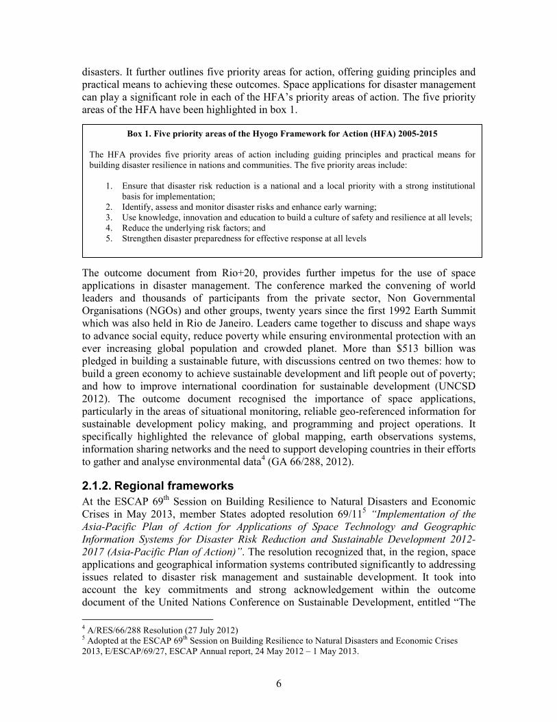
disasters. It further outlines five priority areas for action, offering guiding principles and practical means to achieving these outcomes. Space applications for disaster management can play a significant role in each of the HFA’s priority areas of action. The five priority areas of the HFA have been highlighted in box 1.
The outcome document from Rio+20, provides further impetus for the use of space applications in disaster management. The conference marked the convening of world leaders and thousands of participants from the private sector, Non Governmental Organisations (NGOs) and other groups, twenty years since the first 1992 Earth Summit which was also held in Rio de Janeiro. Leaders came together to discuss and shape ways to advance social equity, reduce poverty while ensuring environmental protection with an ever increasing global population and crowded planet. More than $513 billion was pledged in building a sustainable future, with discussions centred on two themes: how to build a green economy to achieve sustainable development and lift people out of poverty; and how to improve international coordination for sustainable development (UNCSD 2012). The outcome document recognised the importance of space applications, particularly in the areas of situational monitoring, reliable geo-referenced information for sustainable development policy making, and programming and project operations. It specifically highlighted the relevance of global mapping, earth observations systems, information sharing networks and the need to support developing countries in their efforts to gather and analyse environmental data4 (GA 66/288, 2012).
2.1.2. Regional frameworks
At the ESCAP 69th Session on Building Resilience to Natural Disasters and Economic Crises in May 2013, member States adopted resolution 69/115
“Implementation of the
Asia-Pacific Plan of Action for Applications of Space Technology and Geographic
Information Systems for Disaster Risk Reduction and Sustainable Development 2012-
2017 (Asia-Pacific Plan of Action)”. The resolution recognized that, in the region, space applications and geographical information systems contributed significantly to addressing issues related to disaster risk management and sustainable development. It took into account the key commitments and strong acknowledgement within the outcome document of the United Nations Conference on Sustainable Development, entitled “The
4 A/RES/66/288 Resolution (27 July 2012) 5 Adopted at the ESCAP 69th Session on Building Resilience to Natural Disasters and Economic Crises 2013, E/ESCAP/69/27, ESCAP Annual report, 24 May 2012 – 1 May 2013.
Box 1. Five priority areas of the Hyogo Framework for Action (HFA) 2005-2015
The HFA provides five priority areas of action including guiding principles and practical means for building disaster resilience in nations and communities. The five priority areas include:
1. Ensure that disaster risk reduction is a national and a local priority with a strong institutional basis for implementation;
2. Identify, assess and monitor disaster risks and enhance early warning; 3. Use knowledge, innovation and education to build a culture of safety and resilience at all levels; 4. Reduce the underlying risk factors; and 5. Strengthen disaster preparedness for effective response at all levels
7
future we want” (GA 66/288, 2012), related to information and communications technologies, in particular, in the areas of space applications and geographical information systems. It recalled its resolution 68/5 on “the Asia-Pacific Years of Action for Applications of Space Technology and the Geographic Information System for
Disaster Risk Reduction and Sustainable Development, 2012-2017”. It further reiterated key elements from resolution 68/5, recognizing the importance of regional cooperation and the significant impact which space applications and geographic information systems have had in the areas of disaster risk management and sustainable development. As an additional regional framework, ESCAP’s Information and Communications Technology and Disaster Risk Reduction Division, serves the Committee on Disaster Risk Reduction. Meetings are held every two years, bringing together senior government officials to discuss activities implemented, share good practices and agree on regional priorities for disaster risk reduction for the coming years. The Committee addresses the following issues: policy options and strategies on multi-hazard disaster risk reduction and mitigation; regional cooperation mechanisms for disaster risk management, including space and other technical support systems; and multi-hazard assessment, preparedness, early warning and response to disaster risks. The Committee has now had its third session as of November 2013. Outcomes of which, relating specifically to space applications and disaster management, included the appreciation for ESCAP’s efforts in promoting the use of space technology and Geographic Information Systems (GIS), providing timely provision of near real-time satellite data and imagery to member States affected by severe disasters and ESCAP’s efforts in implementing resolution 69/11. The Committee requested that ESCAP continue its efforts in supporting member States in enhancing their capacities for using space technology and GIS applications for addressing disaster risk reduction, and that ESCAP harmonise space applications activities in the region through enhanced collaboration with its strategic partners in the United Nations system and related global/regional organizations. Finally, the Committee commended and endorsed ESCAP’s Regional Cooperative Mechanism for Drought Monitoring and Early Warning initiative. 6 The 17th Session of the Intergovernmental Consultative Committee (ICC) on the Regional Space Applications Programme for Sustainable Development (RESAP) was convened in Bangkok, Thailand during 26-27 November. The ICC provided a brief overview of key activities and achievements in RESAP, as well as discussions on the future plan for RESAP and its 2014-2015 work plan. It outlined the secretariat’s efforts in the implementation of the ‘Asia-Pacific Plan of Action’. Furthermore, it presented critical elements of the regional cooperative mechanism for drought monitoring and early warning proposed by ESCAP, with an opportunity to review and deliberate on the Standard Operating Procedures (SOPs) and operational modalities of the Mechanism.
6 Recommendations from the ESCAP 3rd Committee on Disaster Risk Reduction, Agenda Item 7, Promoting regional cooperation on applications of space technology and geographic information systems for disaster risk reduction.
8
2.1.3. National frameworks
At the national level, frameworks are not standardised when is comes to both the use of space technologies and disaster management in general. There are two main areas of concern for national frameworks, which can provide insight into how seriously a country may be taking space applications and disaster management and potentially how well equipped, or positioned, they may be, in dealing with disasters to limit the loss of lives, mitigate damage, and recover with resilience. Firstly, the positioning of space applications and disaster management amongst the policy hierarchy is very crucial for prioritising at a national level. Secondly, the authority which is assigned to deal with space applications and disaster management is critical in terms of its ability, capacity and scope to coordinate national activities. In most cases, national frameworks are either dictated by the structure of central government and line ministries or they are organised by public administration priorities at the country level. In terms of policy positioning and responsible national authorities, disaster risk reduction plans may in some cases be incorporated into national development plans, hence more mainstream and prevalent in general development policies, programmes and activities. Conversely, disaster risk reduction may only be an afterthought, in response to an intensive natural disaster with devastating effects, with no real mandate to address the root causes of vulnerability to disasters. For example, in some cases disaster management can be a separate office or function of the ‘Office of the Prime Minister’, or other equivalent private office of the head of state. This may provide the highest level of authority during times of disaster, but may not necessarily be as effective when incorporating disaster management practices into cross-cutting government functions. Similarly, policy positioning and responsible national authorities, for the use of space applications, may be mainstreamed and incorporated into the work of various ministries. Either as an autonomous and centralised support function that forms a part of central government i.e. national space agencies, or as individual functions within central government agencies i.e. space applications departments within ministries. Conversely, the use of space applications in general may fall within defence policies or national space laws that prohibit use in other areas or government functions, confining and constricting its innovative application in broader areas. A more concerted effort must be made to disambiguate the traditional policies which relate to the use of space, particularly for peaceful and civilian uses, away from traditional space related laws, and disaster management as a more integrated concept, away from an emergency services perspective. Both of which can either fall within quasi defence policies or confined sustainable development plans respectively. Both space applications and disaster management must be merged, either along the policy hierarchy or at the operational level, through their respective national authorities, in order to create more innovative uses of traditional and existing government functions. Furthermore, the establishment of national focal points and capacity development is crucial, in mainstreaming and improving disaster management through the use of space applications.

9
2.1.4. Civil society and informal frameworks for action
The last few years has seen an increase in the emergence of informal frameworks of action. Such frameworks are centred on collective public action and pressure, often in the form of crowd-based activities such as crowd sourced information; for reporting, verification and dissemination purposes. Often at the civil society and grass roots level, these frameworks or movements can be overlooked and even dismissed by policy makers, or those working within traditional institutional frameworks. However, with an overall global trend of collective citizen engagement sweeping democratised societies, such social movements and frameworks for citizen action must not be ignored. There is a significant increase in public and crowd-sourced activities for space applications. These have gone beyond random, sporadic and isolated activities to become more focussed, structured and coordinated. Many of these public networks have now been recognised by professional organisations working in the area of space applications and disaster management, and accepted and embraced as credible contributors to the field of disaster management. The report ‘Disaster Relief 2.0: The Future of Information Sharing in Humanitarian
Emergencies’ acknowledged and appropriately termed this phenomenon, highlighting the concept of Volunteer and Technical Communities (V&TCs) (Harvard, 2011). One such example of a V&TC is the Standby Volunteer Taskforce (SBTF), which provides live mapping support to humanitarian, human rights, and media organisations. Another example is the Digital Humanitarian Network (DHNetwork), which is a network of networks providing a consortium of V&TCs that can be activated during times of crisis, for performing various specialised time sensitive and time consuming activities. Both SBTF and DHNetwork have been working closely with OCHA to create a request and deployment arrangement, to provide additional support from public networks in times of disaster. In the wider scheme of space applications for disaster management, the use of such public networks by the national authorities of member States, can potentially create an antagonist relationship. Mobilising and utilising such informal networks remains sensitive and must be approached with caution. Although, interaction between civil society and government, for disaster management, remains an area to be explored and defined further, it is essential to recognise and understand such activity at the grass roots level. If applied properly, working with such informal frameworks and civil society movements can provide insight into activities taking place in other areas of the disaster management cycle, especially for the processing of large volumes of geo-spatial data for example. This positive interaction is dependent on whether member States and their respective civil societies can find mutual benefits, build trust and increase capacities in the use of space applications for disaster management. This can ultimately save lives and ensure resilient sustainable development for all.
2.2. International and regional cooperation mechanisms
Many international and regional cooperation mechanisms already exist in the area of space applications and disaster management. From a policy and programming perspective, these can be considered horizontal sources. Sources such as agencies,
10
institutions and mechanisms which can be leveraged through cooperation, for obtaining a critical mass and establishing collective demand for action, in achieving some of the global goals highlighted for international frameworks in section 2.1. These mechanisms can be further utilised for the purposes of space applications and disaster management, to combine and facilitate capacity building efforts, identify and establish data-sharing networks through protocols and SOPs and pursue efficiency in products and services offered by pooling and sharing resources. The initiatives highlighted in this section range from global charters for voluntary support, the United Nations secretariat, agencies, funds and programmes, and other international and regional initiatives such as academic institutions, associations, councils, scientific bodies, forums, working groups, and other specialised agencies.
2.2.1. International charter on space and major disasters
The International Charter on Space and Major Disasters is an international agreement between space agencies around the world. Its purpose is to provide a unified system for accessing and delivering fast and free satellite imagery and space data to those affected by natural or man-made disasters. The charter can only be activated by authorised members during emergencies and each member agency has committed resources to support provisions of the Charter. However, the Charter can be activated for disasters in all countries of the world, for acquisition and dissemination of space data to share with responsible national authorities. Following the Third United Nations Conference on the Exploration and Peaceful Uses of Outer Space (UNISPACE III) held in Vienna, Austria in 1999, the European and French space agencies (ESA and CNES) initiated the International Charter "Space and Major Disasters". The Canadian Space Agency (CSA) signed the Charter on 20 October 2000. Subsequently, the Charter became formally operational on 1 November 2000. The Charter works in collaboration with United Nations entities including UNITAR/UNOSAT and the United Nations Office for Outer Space Affairs (UNOOSA). The following agencies have since joined the Charter as members (in order of membership): National Oceanic and Atmospheric Administration (NOAA), Indian Space Research Organization (ISRO), Argentine Space Agency (CONAE), United States Geological Survey (USGS), Japan Aerospace Exploration Agency (JAXA), UK Space Agency (UKSA) formally British National Space Centre (BNSC), DMC International Imaging (DMCii), China National Space Administration (CNSA), German Aerospace Center (DLR), Korea Aerospace Research Institute (KARI), National Institute For Space Research - Brazilian Institute (INPE), European Organisation for the Exploitation of Meteorological Satellites (EUMETSAT), and Russian Federal Space Agency (ROSCOSMOS).
2.2.2. Other United Nations initiatives
There are various United Nations initiatives relevant to the area of space applications for disaster management. Attempting to coordinate these activities, under the one-UN spirit, may have political, budgetary, and mandatory implications, leading to divergence and disunity rather than convergence and collaboration. However, harmonising activities or

11
identifying potential for synergy, in space applications and disaster management, is very feasible while maintaining the possibility to deliver as ‘one’. The following United Nations initiatives do not constitute a comprehensive list but can provide examples for the basis of such harmonisation, these include (in alphabetical order) the Bureau for Crisis Prevention and Recovery (BCPR) which is a part of UNDP and was established to support innovative approaches to conflict resolution, crisis prevention and early warning, as well as to help bridge the gap between emergency response and long term development. The United Nations Food and Agricultural Organisation (FAO) is focussed on achieving food security, its mandate is to improve nutrition, increase agricultural productivity, raise the standard of living in rural populations and contribute to global economic growth. The International Maritime Organisation (IMO) is the United Nations specialized agency responsible for the safety and security of shipping and the prevention of marine pollution by ships. The United Nations Office for the Coordination of Humanitarian Affairs (OCHA) is responsible for bringing together humanitarian actors to ensure a coherent response to emergencies. The United Nations initiative on Global Geospatial Information Management (UN-GIMM) which aims at playing a leading role in setting the agenda for the development of global geospatial information and to promote its use to address key global challenges. The United Nations Platform for Space-based Information for Disaster Management and Emergency Response (UN-SPIDER) is a part of UNOOSA, which aims to ensure that all countries and international and regional organizations have access to, and develop the capacity to use, all types of space-based information to support the entire disaster management cycle. The United Nations Convention to Combat Desertification (UNCCD) is the sole legally binding international agreement linking environment and development to sustainable land management. United Nations Disaster Assessment and Coordination (UNDAC) is an OCHA coordination tool and forms part of the international emergency response system for sudden-onset emergencies. UNDP’s main areas of work potentially related to space applications and disaster management include crisis prevention and recovery and environment and energy for sustainable development. Additionally, UNDP’s Integrated Drylands Development Programme Phase II is potentially a globally relevant initiative, in the area of drought risk management and information sharing. The United Nations Environment Programme (UNEP) acts as an advocate, catalyst, educator and facilitator to promote the wise use and sustainable development of the global environment. The United Nations Educational, Scientific and Cultural Organization (UNESCO), in addition to being highly regarded for education and culture, also pursues scientific cooperation in the areas of hazard early warning systems or trans-boundary water management agreements. UNITAR/UNOSAT which is a technology-intensive programme providing imagery analysis and satellite solutions to relief and development organisations in the areas of humanitarian relief, human security, and strategic territorial and development planning.
12
The World Health Organization (WHO), is the authority which directs and coordinates health and is responsible for providing global health leadership, shaping the research agenda, setting norms and standards and assessing and monitoring health trends. The World Meteorological Organisation (WMO) is the authoritative voice on the state and behaviour of the Earth's atmosphere, its interaction with the oceans, the climate it produces and the resulting distribution of water resources.
2.2.3. Other international and regional initiatives
There are various international and regional initiatives relevant to the area of space applications for disaster management. Again, attempting to coordinate these activities, in some cases, may be counter productive to their own specific goals and objectives. However, harmonising activities or identifying potential for synergy is very feasible. This is one of the concrete ways of improving disaster management through space applications to ensure efficiency and stronger joint-delivery to a wider audience. In 2012, Asia Pacific countries adopted a historic five year Regional Plan of Action for the application of space technology for addressing natural disasters and achieving sustainable development goals in the region. Terming it the Asia-Pacific Plan of Action for Applications of Space Technology and Geographic Information Systems for Disaster Risk Reduction and Sustainable Development 2012-2017 (Asia-Pacific Plan of Action), countries declared that they were united in their resolve to implement the Plan of Action which provides a roadmap to broaden and deepen the contribution of these technologies to all affected countries and communities. The Plan of Action called on ESCAP, as an inclusive intergovernmental platform in the Asia-Pacific region, to harmonize the myriad of existing regional initiatives and to pool expertise and resources, in order to enhance the effectiveness of these efforts in addressing capacity gaps, especially in high-risk and low capacity developing countries in the region. Furthermore, the Plan of Action called for a ‘Ministerial Conference on Space and Geographic Information Systems (GIS) Applications for Disaster Risk Reduction & Management and Sustainable Development in Asia and the Pacific’ to be held in 2015. Providing an opportunity to evaluate progress made in implementation of the Plan of Action. Additionally, the Plan of Action requested ESCAP to strengthen efforts in its long-standing Regional Space Applications Programme (RESAP) and take measures through RESAP to operationalise an early warning system for drought. Several member States with space technology capabilities offered to share satellite data, space products and services related to disaster risk management and sustainable development with developing countries in the region, during times of disaster and for long term sustainable development. The following is a list of international and regional initiatives working in space applications for disaster management, although not exhaustive, some of these initiatives include (in alphabetical order), the Asian Disaster Reduction Center (ADRC) which works to enhance disaster resilience, build safe communities, and create a society where sustainable development is possible. Asia-Pacific Regional Space Agency Forum (APRSAF) which works to enhance space activities in the Asia-Pacific region. Asia-
13
Pacific Satellite Communications Council (APSCC) which promotes communications and broadcasting via satellite as well as outer space activities for the socioeconomic and cultural welfare of the region. Asia-Pacific Space Cooperation Organization (APSCO) which works to facilitate programs of multilateral space cooperation in the Asia-Pacific region. The Association of Southeast Asian Nations (ASEAN) which can be considered a regional integration mechanism among Southeast Asian countries. Global Earth Observation System of Systems (GEOSS) under the Group on Earth Observations (GEO), which provides decision-support tools to link together existing and planned observing systems around the world. The Global Fire Monitoring Center (GFMC) which provides a global portal for wild fire documentation, information and monitoring. The International Global Monitoring Aerospace System (IGMASS) an initiative to design a ‘system of systems’ for effective early warning on global risks and threats originating from space. The International Seismological Centre (ISC), an academic institution which collects, archives and processes seismic station and network bulletins and prepares and distributes the definitive summary of world seismicity. The Pacific Tsunami Warning Center (PTWC) which is a tsunami early warning system (TEWS) operated by the National Oceanic and Atmospheric Administration (NOAA), a scientific agency within the United States Department of Commerce. The Regional Space Applications Programme for Sustainable Development (RESAP), ESCAP’s regional coordination mechanism for space applications and disaster risk reduction within sustainable development. South Asian Association for Regional Cooperation (SAARC) which can be considered a regional integration mechanism among South Asian countries. The Applied Geoscience and Technology Division (SOPAC) of the Secretariat of the Pacific Community (SPC), which aims to apply geoscience and technology to realise new opportunities for improving the livelihoods of Pacific communities. Sentinel Asia of the Japan Aerospace Exploration Agency (JAXA), which aims to promote international cooperation to monitor natural disasters in the Asia-Pacific region; Tropical Storm Risk (TSR) which offers a leading resource for predicting and mapping tropical storm activity worldwide. The United States Geological Survey (USGS), a scientific organisation that provides impartial and reliable information to minimise loss of life and property from natural disasters, to manage water, biological, energy, and mineral resources and to enhance and protect quality of life.
3. Operational activities and coordination in the use of space applications
As the use of space applications in disaster management is becoming more apparent, putting this into practice can be achieved in both direct and indirect ways. Direct in areas where the use of space applications is recognised and immediately necessary, such as in monitoring and early warning, disaster mitigation and preparedness, and emergency relief and response for natural disasters. Indirect in the case of complex disasters or emergencies, such as ongoing international conflict, political or sectarian violence and other forms of domestic instability that requires a certain political sensitivity to outside intervention. Additionally, recovery, rehabilitation and long term sustainable development can require a more strategic vision, long term focus and lasting
14
commitments. In such cases, the focus and motivations for using space applications must be made very clear, highlighting disaster management and its related functions as an essential tool for early recovery and sustainable development. Furthermore, pursuing in indirect ways is sensible when there are economic and technical barriers, to the essential use of space applications for disaster management, not just political. Such barriers and obstacles can be overcome through a pragmatic approach, by utilising links at the institutional and operational levels to gain political will, pool resources and transfer technical knowledge. Thus political motivations can be set aside, economic burdens can be overcome and technical shortfalls can be addressed collectively through cooperation and practical use. Consequently, space applications for disaster management can provide an opportune entry point to addressing disaster risk reduction within resilient sustainable development and climate change adaptation. There are additional recommendations, which are not immediately apparent through analysis of the current literature and context of space applications and disaster management, but have been highlighted in prominent regional meetings, such as the 2013 ESCAP High Level Decision Makers Meeting. 7 These include highlighting and widely disseminating success stories, particularly joint initiatives which include multiple agencies and cooperation mechanisms in compound and complex disaster settings. Additionally, extending the user or client base for space applications, to not only encompass more downstream functions beyond the space community, but to also make application extremely user friendly and second nature. It is worth noting that the use of space applications, in particular satellite imagery and data, present some legal implications and require the consideration of external factors, which can affect their usage (UNOSAT, 2011). One of which is the availability of satellite imagery, where imagery may not be available due to the timed orbit of satellites, over an affected area, which can vary between two to eight days. Furthermore, selection and procurement of appropriate satellite data can also take a couple of days to obtain or procure. Varying weather conditions over a disaster affected area can also play a part, such as excessive cloud coverage, which may obscure viewing, leading to delays in acquiring appropriate satellite imagery. The use of radar data (when assessing flood damage) can help delineate interference from cloud coverage. The vertical view of airborne data and satellite imagery may present challenges to remote sensing and imagery analysis. In the case of oblique imagery, which is taken at an angle, it may be difficult to precisely geo-reference locations if the imaging device is not directly above an area being photographed, or the geo-location is not precisely triangulated. The margin of error related to quantitative estimation must be taken into account, this can occur due to subjectivity and a lack of high resolution imagery. This may potentially disguise partial, lateral and internal damage to structures, especially in cases where the roof or top side of a structure remains intact. Copyright laws must be strictly adhered to, raw data often comes with restrictions while derived mapping products such as additional layers and analysis are often made freely accessible for the disaster management community. Finally the cost of obtaining satellite imagery must be taken into account, and where possible
7 Held in Bangkok, Thailand 27-28 November 2013.

15
prearranged protocols put in place, in order to ensure agreement for the free use of satellite imagery during times of disaster and emergency. An example of which is the International Charter for Space and Major Disasters.
3.1. Trends
Over the last decade there are various trends which can be observed in the practical use of space applications for disaster management. These trends have coalesced from the types of disasters, due to a changing climate baseline; technological capabilities, as a result of advances in technology; and development priorities as a result of shifting development goals and trends. UNOSAT/UNITAR is one the most historically credible United Nations entities which provides satellite imagery to other United Nations organisations and United Nations member States. It publishes yearly thematic briefs of its operational activities. Observing these briefs over the last three years provides an interesting insight into how the demand and applications for space technologies on the ground, is taking shape and maturing, especially amongst the United Nations entities themselves. For example, the thematic area of UNOSAT’s 2010 brief was on satellite applications for humanitarian aid and emergency response (UNOSAT 2010). It highlighted emerging trends in geospatial information for humanitarian aid in both 2008 and 2009, with an increase in simultaneous requests for support in different emergency response operations. Furthermore, it highlighted the increased exposure of geospatial information use amongst beneficiaries, which impacted the types of requests for advice and geoinformation received by UNOSAT. This enabled more refined and specific requests, challenging UNOSAT’s analytical capacities. In general, 2009 saw a significant increase in activities related to complex emergencies and human rights cases, which ultimately requires more integrated information and contextual analysis beyond traditional satellite imagery for damage assessment. The thematic area of UNOSAT’s 2011 brief was on satellite applications for human security (UNOSAT 2011a). UNOSAT expanded its support to the United Nations Office of the High Commissioner for Human Rights (UNOHCHR), the International Criminal Court (ICC) and several Panels of Experts appointed by the United Nations Secretary General and the United Nations Security Council, while providing the UN system as a whole with analytical and monitoring capacities in highly volatile situations. This extension of support to other UN entities signifies a broadening in focus to include human rights and International Humanitarian Law (IHL). This brief, and subsequently UNOSAT’s work, addressed some more politically sensitive areas for the use of space applications. Some relevant regional examples from the brief include support for situational monitoring and damage assessments, in Sri Lanka in 2009, fact finding and identification of distressed neighbourhoods, in Kyrgyzstan in 2010. 2011 saw a significant increase in the pool of stakeholders for space applications. For UNOSAT, the period focussed on humanitarian rapid mapping services (UNOSAT 2011b). There were stronger interactions with not only United Nations and Non Governmental Organisation (NGO) field staff, but also with regional organizations and interested government experts. Another significant trend was the increase in collaborative
16
mapping of geospatial technology and crowd-sourcing, which became more coordinated and consistent to provide operational applications of credible scale and complexity. UNOSAT explored this notion of collaboration further by providing integrated geo-information from the general public, along with some of its products and services. These trends of wider cooperation and integrated methods of data collection, in gathering more precise geospatial information for emergency response, led to UNOSAT’s acquisition of two UAVs in 2011, one of which was operationally deployed in Haiti. In 2012, the focus remained on humanitarian rapid mapping services (UNOSAT 2012). There was an increase in demand for support to complex emergencies particularly with regard to movement of Internally Displaced Persons (IDPs) and refugees. A further trend was that of the steady appearance of human rights and human security as a focus of rapid mapping, where previously disaster response was almost entirely the focus. UNOHCHR, the Human Rights Council and its Commissions of Inquiry emerged as substantial users in 2012, while requests for support during natural disasters remained just as high as in 2011. Furthermore, the ability to rapidly integrate UNOSAT products into agency specific data, enhanced the quality of rapid thematic assessments for UNOSAT’s sister agencies within the United Nations. From observing the trends in operational activity in the area of space applications, especially within the United Nations, it is clear that the use of such technologies is maturing and well established in its role in supporting management during natural disasters. Furthermore, it is evident that although primarily still focussing on natural disasters, such operational activity is beginning to incorporate complex emergencies as well, particularly in conflict settings with an increased focus on human rights and IHL, encompassing more organisations and broader mandates across the United Nations common system.
3.2. Operational activities
Within the context of operational activities, across the disaster management cycle, it is apparent that space applications can be utilised throughout. This potential use covers the areas of monitoring and early warning; disaster mitigation and preparedness; emergency relief and response; and recovery, rehabilitation and long term sustainable development. The following section provides case study examples which highlight this varied use. In 2012, five out of a total of thirty five UNOSAT activities relating to rapid mapping were for ESCAP member States in the Asia Pacific region (UNOSAT 2012, Table 1). In 2011, 10 activities were for ESCAP member States out of a total of 28 (UNOSAT 2011b, Table 1). As an example of planning and distribution of resources, when considering this with the fact that 80% of global disaster-related economic losses occurred in the Asia and Pacific region, in 2011 (ADB 2013, page 2), it is clear that more must be done in terms of increasing activities to support disaster management in the Asia-Pacific region. Furthermore, the unique way in which UNOSAT operates, in response to country requests through United Nations entities, can provide some insight into potential bottlenecks and obstacles for operational support. Requests for UNOSAT’s operational support for countries must come through regional cooperation mechanisms, one of which
17
includes ESCAP, as well as other United Nations entities operating in the region. The disproportion of UNOSAT activities in the Asia-Pacific region, in comparison to the impact and frequency of disasters in the region, suggests the need to strengthen regional cooperation at the operational level. There is a need to ensure, for such operational support, that demand is adequately recognised and supply is appropriately channelled through these regional cooperation mechanisms. It is important to note, that it may be wise to carefully consider the sharing of space-based information with relevant national authorities beforehand. Such disclosure decisions must be made at the national level, by responsible governments, in order to establish whether to make geospatial information available in the public domain, between relevant ministries or amongst disaster managers, privileged to handle such information. Regional and international organisations providing geospatial information must work with governments in order to appropriately ascertain and analyse space-based information as and when required for disaster management or upon request from governments and member States.
3.2.1. Monitoring and early warning
Historically, early warning to potential disasters has been considered one of the key areas to strengthen and improve through the use of innovative technologies, as indicated in much of the literature8. It can provide the disaster management community with critical time for making preparations and final arrangements before the onset of disasters. This can significantly minimise the massive loss of life and assets during disasters. Once a disaster has struck, ongoing monitoring through situational reports and analysis is key to maintaining situational awareness and planning a response, which can in turn provide information for further early warning of compound and emerging disaster threats, or a deterioration of disaster defence mechanisms already put in place.
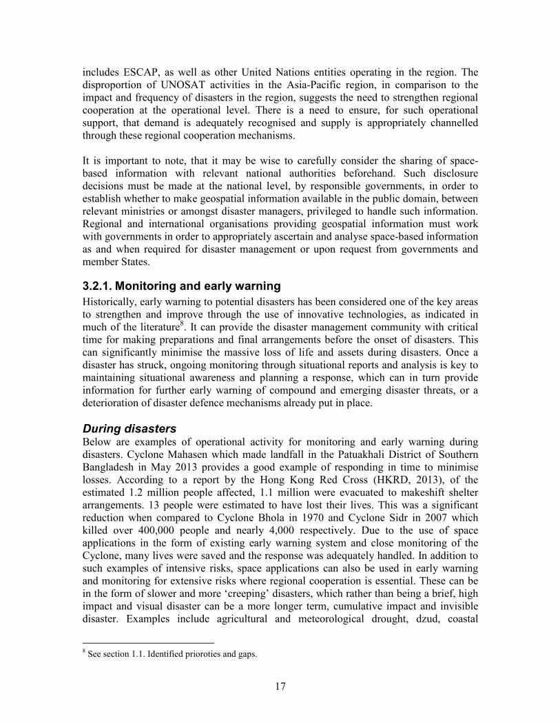
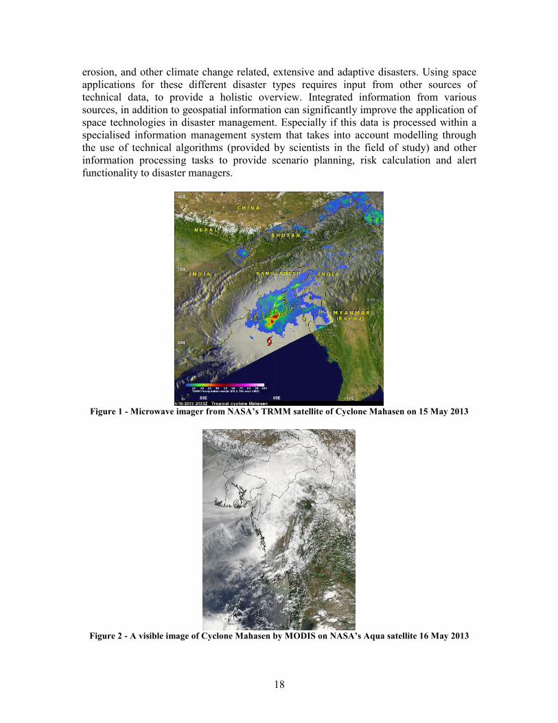
During disasters Below are examples of operational activity for monitoring and early warning during disasters. Cyclone Mahasen which made landfall in the Patuakhali District of Southern Bangladesh in May 2013 provides a good example of responding in time to minimise losses. According to a report by the Hong Kong Red Cross (HKRD, 2013), of the estimated 1.2 million people affected, 1.1 million were evacuated to makeshift shelter arrangements. 13 people were estimated to have lost their lives. This was a significant reduction when compared to Cyclone Bhola in 1970 and Cyclone Sidr in 2007 which killed over 400,000 people and nearly 4,000 respectively. Due to the use of space applications in the form of existing early warning system and close monitoring of the Cyclone, many lives were saved and the response was adequately handled. In addition to such examples of intensive risks, space applications can also be used in early warning and monitoring for extensive risks where regional cooperation is essential. These can be in the form of slower and more ‘creeping’ disasters, which rather than being a brief, high impact and visual disaster can be a more longer term, cumulative impact and invisible disaster. Examples include agricultural and meteorological drought, dzud, coastal
8 See section 1.1. Identified prioroties and gaps.
18
erosion, and other climate change related, extensive and adaptive disasters. Using space applications for these different disaster types requires input from other sources of technical data, to provide a holistic overview. Integrated information from various sources, in addition to geospatial information can significantly improve the application of space technologies in disaster management. Especially if this data is processed within a specialised information management system that takes into account modelling through the use of technical algorithms (provided by scientists in the field of study) and other information processing tasks to provide scenario planning, risk calculation and alert functionality to disaster managers.
Figure 1 - Microwave imager from NASA’s TRMM satellite of Cyclone Mahasen on 15 May 2013
Figure 2 - A visible image of Cyclone Mahasen by MODIS on NASA’s Aqua satellite 16 May 2013

19
Box 2: GPS wave monitoring buoys for the detection of Tsunamis
GPS wave monitoring buoys have been installed by the Ports and Harbors Bureau, MLIT, at 15 sites surrounding Japan which had been found suitable for deployment. The criteria for deployment of the buoys are that the site must be between 100-400m in depth and 20km from the shore. The buoys, made by Hitachi Zosen, consist of equipment capable of detecting or measuring wave height, tide levels, tsunami, wind speed and direction, water temperature, tide speed and direction and atmospheric temperature and pressure. This has proven to be a good supplemental data verification source for Tsunami detection. On 11 March 2011, at about 15:10, earthquake data was sent to Japan Meteorological Agency (JMA). The GPS buoy 20km from Kamaishi city, Iwate detected a Tsunami more than three metres in height. At 15:14, JMA predicted a Tsunami more than ten metres in height in Miyagi, and another, more than six metres in Iwate and Fukushima.
Such technology can be adapted for the detection of a Glacial Lake Outburst Flood (GLOF) and flash floods. Although relatively expensive for widespread deployment at present, given large-scale usage and possible future innovation and enhancements, it is hoped that the price per unit will be more affordable in the near future. There are also limitations on the distance from shore (currently 20km) restricting leading time for early warning of Tsunamis. This can be overcome with advances in technology and signal processing techniques.
The following is an example of real-time monitoring of flood gates during the central Thailand floods, where a large volume of water started flowing southwards in October 2011. The Flood Relief Operations Center (FROC) of the Thai Government started flood monitoring and relief efforts. For effective decision making and water management, FROC needed to keep an eye on the water levels in various canals and rivers distributed throughout several provinces. With request from FROC to help during the disaster, IPSTAR responded with the concept of setting up CCTV cameras at strategic locations such as sluice gates so that real-time images of water levels could be obtained at FROC headquarters. A number of IPSTAR CCTVs cameras were deployed in the provinces of Ayutthaya, Pathum Thani, and Bangkok, with Internet Protocol (IP) camera installations backhauled over IPSTAR satellite service. The sites were based in locations where disaster relief personnel had their local command posts. Along with real-time videos being made available to FROC, the IPSTAR service also provided WiFi Internet connectivity to security personnel present at the sites.
20
3.2.2. Disaster mitigation and preparedness
Disaster mitigation and preparedness is essential for protecting and saving livelihoods. This can come in response to monitoring and early warning to protect communities and assets from emerging, creeping and sudden threats. Mitigation of risks and preparedness for its eventualities, in both extensive and intensive risks, can be achieved through risk mapping and identification of vulnerable groups and areas at risk. There are various tools and techniques, of which remote sensing can provide an initial assessment, followed up by verification through UAV or physical field surveys, for example.
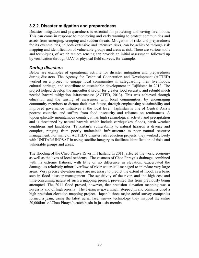
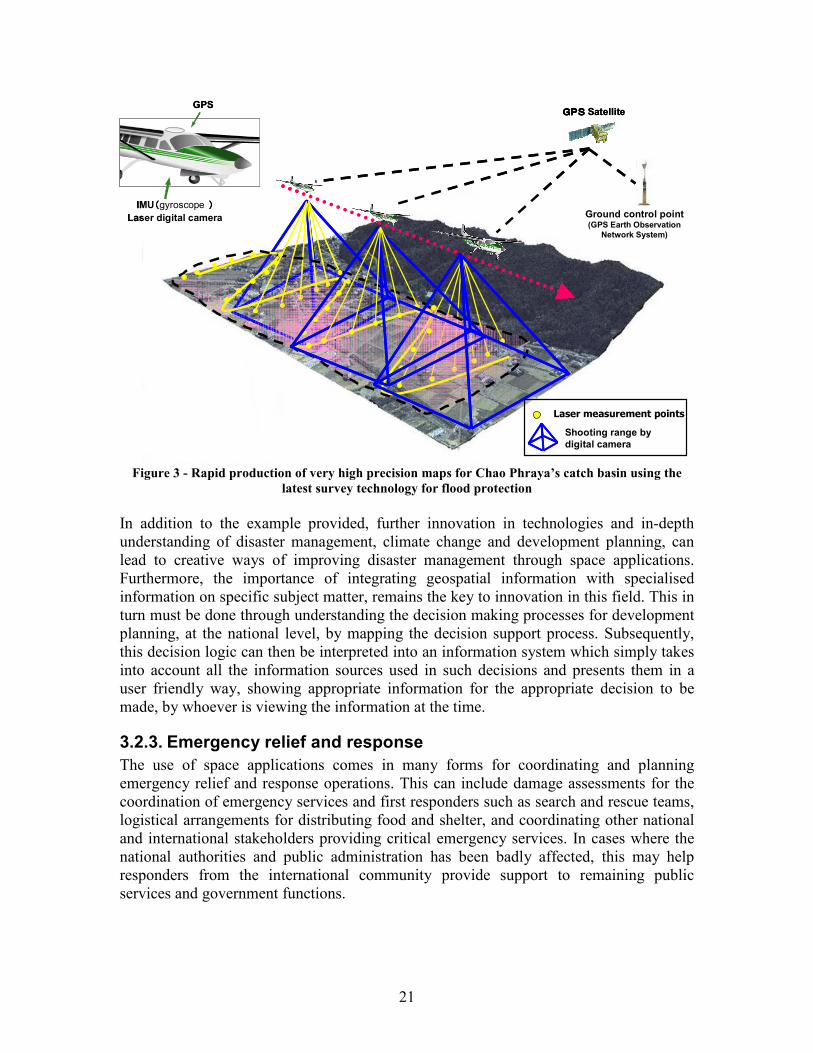
During disasters Below are examples of operational activity for disaster mitigation and preparedness during disasters. The Agency for Technical Cooperation and Development (ACTED) worked on a project to engage local communities in safeguarding their livelihoods, cultural heritage, and contribute to sustainable development in Tajikistan in 2012. The project helped develop the agricultural sector for greater food security, and rebuild much needed hazard mitigation infrastructure (ACTED, 2013). This was achieved through education and the raising of awareness with local communities, by encouraging community members to dictate their own future, through emphasising sustainability and improved governance initiatives at the local level. Tajikistan is one of Central Asia’s poorest countries and suffers from food insecurity and reliance on remittances. A topographically mountainous country, it has high seismological activity and precipitation and is threatened by natural hazards which include earthquakes, floods, harsh weather conditions and landslides. Tajikistan’s vulnerability to natural hazards is diverse and complex, ranging from poorly maintained infrastructure to poor natural resource management. For many of ACTED’s disaster risk reduction projects, they worked closely with UNITAR/UNOSAT in using satellite imagery to facilitate identification of risks and vulnerable groups and areas. The flooding of the Chao Phraya River in Thailand in 2011, affected the world economy as well as the lives of local residents. The vastness of Chao Phraya’s drainage, combined with its extreme flatness, with little or no difference in elevation, exacerbated the damage, as relatively minor overflow of river water still managed to inundate very large areas. Very precise elevation maps are necessary to predict the extent of flood, as a basic step in flood disaster management. The sensitivity of the river, and the high cost and time-consuming nature of such a mapping project, prevented this from previously being attempted. The 2011 flood proved, however, that precision elevation mapping was a necessity and of high priority. The Japanese government stepped in and commissioned a high precision elevation mapping project. Japan’s three major aerial survey companies formed a team, using the latest aerial laser survey technology they mapped the entire 20,000km2 of Chao Phraya’s catch basin in just six months.
21
GPS
IMU((((gyroscope ))))
Laser digital camera
GPSGPSGPSGPS Satellite
Ground control point(GPS Earth Observation
Network System)
Laser measurement points
Shooting range by
digital camera
GPS
IMU((((gyroscope ))))
Laser digital camera
GPSGPSGPSGPS Satellite
Ground control point(GPS Earth Observation
Network System)
Laser measurement points
Shooting range by
digital camera
Figure 3 - Rapid production of very high precision maps for Chao Phraya’s catch basin using the
latest survey technology for flood protection
In addition to the example provided, further innovation in technologies and in-depth understanding of disaster management, climate change and development planning, can lead to creative ways of improving disaster management through space applications. Furthermore, the importance of integrating geospatial information with specialised information on specific subject matter, remains the key to innovation in this field. This in turn must be done through understanding the decision making processes for development planning, at the national level, by mapping the decision support process. Subsequently, this decision logic can then be interpreted into an information system which simply takes into account all the information sources used in such decisions and presents them in a user friendly way, showing appropriate information for the appropriate decision to be made, by whoever is viewing the information at the time.
3.2.3. Emergency relief and response
The use of space applications comes in many forms for coordinating and planning emergency relief and response operations. This can include damage assessments for the coordination of emergency services and first responders such as search and rescue teams, logistical arrangements for distributing food and shelter, and coordinating other national and international stakeholders providing critical emergency services. In cases where the national authorities and public administration has been badly affected, this may help responders from the international community provide support to remaining public services and government functions.
22
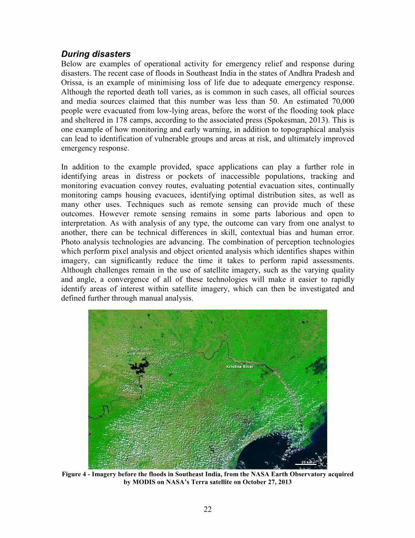
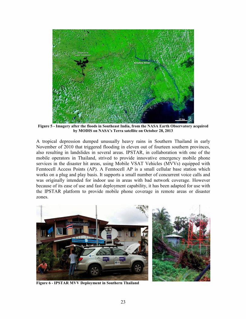
During disasters Below are examples of operational activity for emergency relief and response during disasters. The recent case of floods in Southeast India in the states of Andhra Pradesh and Orissa, is an example of minimising loss of life due to adequate emergency response. Although the reported death toll varies, as is common in such cases, all official sources and media sources claimed that this number was less than 50. An estimated 70,000 people were evacuated from low-lying areas, before the worst of the flooding took place and sheltered in 178 camps, according to the associated press (Spokesman, 2013). This is one example of how monitoring and early warning, in addition to topographical analysis can lead to identification of vulnerable groups and areas at risk, and ultimately improved emergency response. In addition to the example provided, space applications can play a further role in identifying areas in distress or pockets of inaccessible populations, tracking and monitoring evacuation convey routes, evaluating potential evacuation sites, continually monitoring camps housing evacuees, identifying optimal distribution sites, as well as many other uses. Techniques such as remote sensing can provide much of these outcomes. However remote sensing remains in some parts laborious and open to interpretation. As with analysis of any type, the outcome can vary from one analyst to another, there can be technical differences in skill, contextual bias and human error. Photo analysis technologies are advancing. The combination of perception technologies which perform pixel analysis and object oriented analysis which identifies shapes within imagery, can significantly reduce the time it takes to perform rapid assessments. Although challenges remain in the use of satellite imagery, such as the varying quality and angle, a convergence of all of these technologies will make it easier to rapidly identify areas of interest within satellite imagery, which can then be investigated and defined further through manual analysis.
Figure 4 - Imagery before the floods in Southeast India, from the NASA Earth Observatory acquired
by MODIS on NASA’s Terra satellite on October 27, 2013
23
Figure 5 - Imagery after the floods in Southeast India, from the NASA Earth Observatory acquired
by MODIS on NASA’s Terra satellite on October 28, 2013
A tropical depression dumped unusually heavy rains in Southern Thailand in early November of 2010 that triggered flooding in eleven out of fourteen southern provinces, also resulting in landslides in several areas. IPSTAR, in collaboration with one of the mobile operators in Thailand, strived to provide innovative emergency mobile phone services in the disaster hit areas, using Mobile VSAT Vehicles (MVVs) equipped with Femtocell Access Points (AP). A Femtocell AP is a small cellular base station which works on a plug and play basis. It supports a small number of concurrent voice calls and was originally intended for indoor use in areas with bad network coverage. However because of its ease of use and fast deployment capability, it has been adapted for use with the IPSTAR platform to provide mobile phone coverage in remote areas or disaster zones.
Figure 6 - IPSTAR MVV Deployment in Southern Thailand
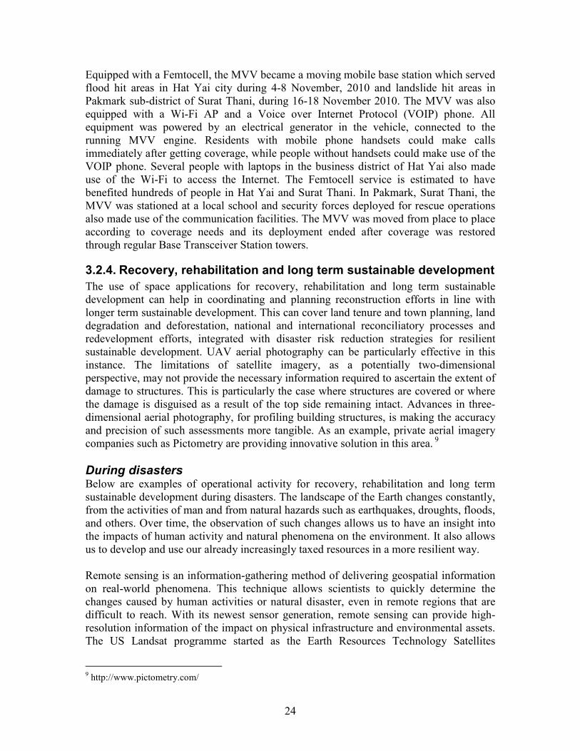
24
Equipped with a Femtocell, the MVV became a moving mobile base station which served flood hit areas in Hat Yai city during 4-8 November, 2010 and landslide hit areas in Pakmark sub-district of Surat Thani, during 16-18 November 2010. The MVV was also equipped with a Wi-Fi AP and a Voice over Internet Protocol (VOIP) phone. All equipment was powered by an electrical generator in the vehicle, connected to the running MVV engine. Residents with mobile phone handsets could make calls immediately after getting coverage, while people without handsets could make use of the VOIP phone. Several people with laptops in the business district of Hat Yai also made use of the Wi-Fi to access the Internet. The Femtocell service is estimated to have benefited hundreds of people in Hat Yai and Surat Thani. In Pakmark, Surat Thani, the MVV was stationed at a local school and security forces deployed for rescue operations also made use of the communication facilities. The MVV was moved from place to place according to coverage needs and its deployment ended after coverage was restored through regular Base Transceiver Station towers.
3.2.4. Recovery, rehabilitation and long term sustainable development
The use of space applications for recovery, rehabilitation and long term sustainable development can help in coordinating and planning reconstruction efforts in line with longer term sustainable development. This can cover land tenure and town planning, land degradation and deforestation, national and international reconciliatory processes and redevelopment efforts, integrated with disaster risk reduction strategies for resilient sustainable development. UAV aerial photography can be particularly effective in this instance. The limitations of satellite imagery, as a potentially two-dimensional perspective, may not provide the necessary information required to ascertain the extent of damage to structures. This is particularly the case where structures are covered or where the damage is disguised as a result of the top side remaining intact. Advances in three-dimensional aerial photography, for profiling building structures, is making the accuracy and precision of such assessments more tangible. As an example, private aerial imagery companies such as Pictometry are providing innovative solution in this area. 9
During disasters Below are examples of operational activity for recovery, rehabilitation and long term sustainable development during disasters. The landscape of the Earth changes constantly, from the activities of man and from natural hazards such as earthquakes, droughts, floods, and others. Over time, the observation of such changes allows us to have an insight into the impacts of human activity and natural phenomena on the environment. It also allows us to develop and use our already increasingly taxed resources in a more resilient way. Remote sensing is an information-gathering method of delivering geospatial information on real-world phenomena. This technique allows scientists to quickly determine the changes caused by human activities or natural disaster, even in remote regions that are difficult to reach. With its newest sensor generation, remote sensing can provide high-resolution information of the impact on physical infrastructure and environmental assets. The US Landsat programme started as the Earth Resources Technology Satellites
9 http://www.pictometry.com/
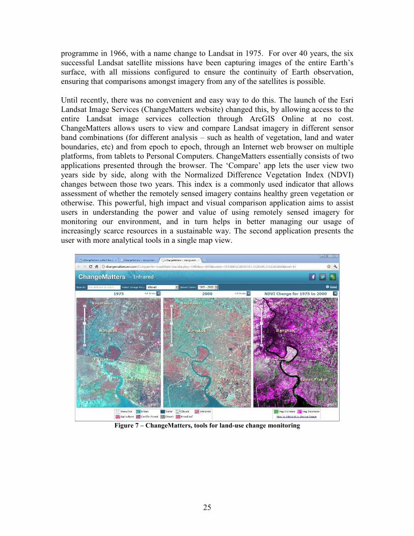
25
programme in 1966, with a name change to Landsat in 1975. For over 40 years, the six successful Landsat satellite missions have been capturing images of the entire Earth’s surface, with all missions configured to ensure the continuity of Earth observation, ensuring that comparisons amongst imagery from any of the satellites is possible. Until recently, there was no convenient and easy way to do this. The launch of the Esri Landsat Image Services (ChangeMatters website) changed this, by allowing access to the entire Landsat image services collection through ArcGIS Online at no cost. ChangeMatters allows users to view and compare Landsat imagery in different sensor band combinations (for different analysis – such as health of vegetation, land and water boundaries, etc) and from epoch to epoch, through an Internet web browser on multiple platforms, from tablets to Personal Computers. ChangeMatters essentially consists of two applications presented through the browser. The ‘Compare’ app lets the user view two years side by side, along with the Normalized Difference Vegetation Index (NDVI) changes between those two years. This index is a commonly used indicator that allows assessment of whether the remotely sensed imagery contains healthy green vegetation or otherwise. This powerful, high impact and visual comparison application aims to assist users in understanding the power and value of using remotely sensed imagery for monitoring our environment, and in turn helps in better managing our usage of increasingly scarce resources in a sustainable way. The second application presents the user with more analytical tools in a single map view.
Figure 7 – ChangeMatters, tools for land-use change monitoring
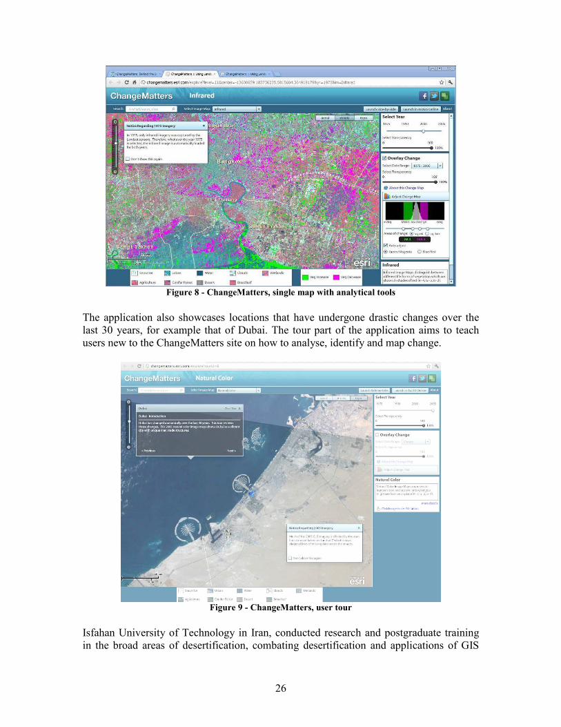
26
Figure 8 - ChangeMatters, single map with analytical tools
The application also showcases locations that have undergone drastic changes over the last 30 years, for example that of Dubai. The tour part of the application aims to teach users new to the ChangeMatters site on how to analyse, identify and map change.
Figure 9 - ChangeMatters, user tour
Isfahan University of Technology in Iran, conducted research and postgraduate training in the broad areas of desertification, combating desertification and applications of GIS
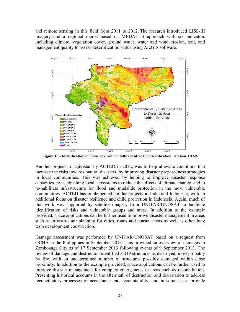
27
and remote sensing in this field from 2011 to 2012. The research introduced LISS-III imagery and a regional model based on MEDALUS approach with six indicators including climate, vegetation cover, ground water, water and wind erosion, soil, and management quality to assess desertification status using ArcGIS software.
Figure 10 - Identification of areas environmentally sensitive to desertification, Isfahan, IRAN
Another project in Tajikistan by ACTED in 2012, was to help alleviate conditions that increase the risks towards natural disasters, by improving disaster preparedness strategies in local communities. This was achieved by helping to improve disaster response capacities, re-establishing local ecosystems to reduce the effects of climate change, and to re-habilitate infrastructure for flood and mudslide protection in the most vulnerable communities. ACTED has implemented similar projects in India and Indonesia, with an additional focus on disaster resilience and child protection in Indonesia. Again, much of this work was supported by satellite imagery from UNITAR/UNOSAT to facilitate identification of risks and vulnerable groups and areas. In addition to the example provided, space applications can be further used to improve disaster management in areas such as infrastructure planning for cities, roads and coastal areas as well as other long term development construction. Damage assessment was performed by UNITAR/UNOSAT based on a request from OCHA in the Philippines in September 2013. This provided an overview of damages in Zamboanga City as of 17 September 2013 following events of 9 September 2013. The review of damage and destruction identified 3,419 structures as destroyed, most probably by fire, with an undetermined number of structures possibly damaged within close proximity. In addition to the example provided, space applications can be further used to improve disaster management for complex emergencies in areas such as reconciliation. Presenting historical accounts in the aftermath of destruction and devastation to address reconciliatory processes of acceptance and accountability, and in some cases provide
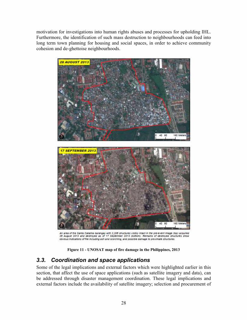
28
motivation for investigations into human rights abuses and processes for upholding IHL. Furthermore, the identification of such mass destruction to neighbourhoods can feed into long term town planning for housing and social spaces, in order to achieve community cohesion and de-ghettoise neighbourhoods.
Figure 11 - UNOSAT map of fire damage in the Philippines, 2013
3.3. Coordination and space applications
Some of the legal implications and external factors which were highlighted earlier in this section, that affect the use of space applications (such as satellite imagery and data), can be addressed through disaster management coordination. These legal implications and external factors include the availability of satellite imagery; selection and procurement of
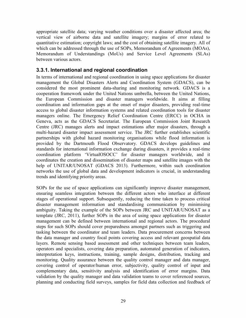
29
appropriate satellite data; varying weather conditions over a disaster affected area; the vertical view of airborne data and satellite imagery; margins of error related to quantitative estimation; copyright laws; and the cost of obtaining satellite imagery. All of which can be addressed through the use of SOPs, Memorandum of Agreements (MOAs), Memorandum of Understandings (MoUs) and Service Level Agreements (SLAs) between various actors.
3.3.1. International and regional coordination
In terms of international and regional coordination in using space applications for disaster management the Global Disasters Alerts and Coordination System (GDACS), can be considered the most prominent data-sharing and monitoring network. GDACS is a cooperation framework under the United Nations umbrella, between the United Nations, the European Commission and disaster managers worldwide. It aims at filling coordination and information gaps at the onset of major disasters, providing real-time access to global disaster information systems and related coordination tools for disaster managers online. The Emergency Relief Coordination Centre (ERCC) in OCHA in Geneva, acts as the GDACS Secretariat. The European Commission Joint Research Centre (JRC) manages alerts and impact estimations after major disasters, through a multi-hazard disaster impact assessment service. The JRC further establishes scientific partnerships with global hazard monitoring organisations while flood information is provided by the Dartmouth Flood Observatory. GDACS develops guidelines and standards for international information exchange during disasters, it provides a real-time coordination platform ‘VirtualOSOCC’ for disaster managers worldwide, and it coordinates the creation and dissemination of disaster maps and satellite images with the help of UNITAR/UNOSAT (GDACS 2013). Furthermore, within such coordination networks the use of global data and development indicators is crucial, in understanding trends and identifying priority areas. SOPs for the use of space applications can significantly improve disaster management, ensuring seamless integration between the different actors who interface at different stages of operational support. Subsequently, reducing the time taken to process critical disaster management information and standardising communication by minimising ambiguity. Taking the example of the SOPs between JRC and UNITAR/UNOSAT as a template (JRC, 2011), further SOPs in the area of using space applications for disaster management can be defined between international and regional actors. The procedural steps for such SOPs should cover preparedness amongst partners such as triggering and tasking between the coordinator and team leaders. Data procurement concerns between the data manager and country focal points covering access and relevant geospatial data layers. Remote sensing based assessment and other techniques between team leaders, operators and specialists, covering data preparation, automated generation of indicators, interpretation keys, instructions, training, sample designs, distribution, tracking and monitoring. Quality assurance between the quality control manager and data manager, covering control of operator/human error, subjectivity, quality control of input and complementary data, sensitivity analysis and identification of error margins. Data validation by the quality manager and data validation teams to cover referenced sources, planning and conducting field surveys, samples for field data collection and feedback of
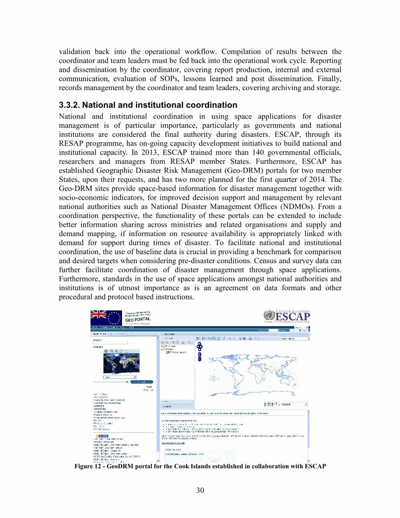
30
validation back into the operational workflow. Compilation of results between the coordinator and team leaders must be fed back into the operational work cycle. Reporting and dissemination by the coordinator, covering report production, internal and external communication, evaluation of SOPs, lessons learned and post dissemination. Finally, records management by the coordinator and team leaders, covering archiving and storage.
3.3.2. National and institutional coordination
National and institutional coordination in using space applications for disaster management is of particular importance, particularly as governments and national institutions are considered the final authority during disasters. ESCAP, through its RESAP programme, has on-going capacity development initiatives to build national and institutional capacity. In 2013, ESCAP trained more than 140 governmental officials, researchers and managers from RESAP member States. Furthermore, ESCAP has established Geographic Disaster Risk Management (Geo-DRM) portals for two member States, upon their requests, and has two more planned for the first quarter of 2014. The Geo-DRM sites provide space-based information for disaster management together with socio-economic indicators, for improved decision support and management by relevant national authorities such as National Disaster Management Offices (NDMOs). From a coordination perspective, the functionality of these portals can be extended to include better information sharing across ministries and related organisations and supply and demand mapping, if information on resource availability is appropriately linked with demand for support during times of disaster. To facilitate national and institutional coordination, the use of baseline data is crucial in providing a benchmark for comparison and desired targets when considering pre-disaster conditions. Census and survey data can further facilitate coordination of disaster management through space applications. Furthermore, standards in the use of space applications amongst national authorities and institutions is of utmost importance as is an agreement on data formats and other procedural and protocol based instructions.
Figure 12 - GeoDRM portal for the Cook Islands established in collaboration with ESCAP
31
3.3.3. Local and community coordination
Although the correlation between space applications at the local and community is not immediately apparent, there are many activities taking place which can help improve disaster management. As mentioned in section 2.1.4, there are various crowd-based activities which are taking shape and V&TCs are becoming more organised, structured and focussed. Coordination of such V&TC activity is being undertaken by various organisations. One of the pioneering technologies which emerged over the last few years was the Ushahidi platform which is a web application that allows the identification and tagging of geo-located information. Information icons are then displayed on a map, users can send multimedia information in the form of reports via email or SMS. Originally set up to map reports of violence in Kenya in 2008 after the post-election fallout, the platform has gone on to become widely used by citizen journalists, volunteers and disaster response practioners, during times of crisis. Ushahidi has moved from being an ad-hoc group of volunteers to a more focused organisation (Ushahidi, 2013). Crowdmap is the Ushahidi alternative for those who can not host the application on their own servers and require webspace. Crowdmap is used for rapid mapping by V&TC in post-disaster and on-going human rights monitoring, as well as other location based information services. Open geospatial technology is critical to preventing and responding to both extensive and intensive disasters. Open geospatial technology includes open data, open source software and open geospatial standards. Their strength is that they can be rapidly used by a wide range of technologists. For example, crisis mapping systems based on Social Networking Service (SNS) and open geospatial technology were launched immediately after earthquakes occurred in Haiti, New Zealand, East Japan, etc. One of the Japanese crisis mapping systems called sinsai.info (http://www.sinsai.info/), which used the Ushahidi platform, was so successful, that it is subsequently received an award by the Japanese Ministry of Economy, Trade and Industry in 2011. Non profit organisations such as Open Street Map Foundation, Open Source Geospatial Foundation and Open Geospatial Consortium, support open geospatial technology. In terms of developing disaster management capacity through space applications, in addition to capacity development for disaster risk reduction, local communities can be educated and trained on the use of space applications. Although local communities and the general public may not be the immediate beneficiaries of operational support through space applications, they can facilitate remote sensing processes, and other space based observation techniques, during disaster assessment. By understanding the observation techniques associated with space applications and how to increase visibility from aerial photography, communities can be better prepared to attract attention to distress. This can be through the use of signals such as ‘SOS’ or other internationally and nationally recognised distress signs for different emergencies, such as the use of colour combinations and patterns, emergency communication equipment, flags, flare, glare or light, global positioning equipment, Morse code, smoke or structural symbols; to signal the condition of their health, number of people distressed or injured, status of their life-saving and emergency supplies etc.

32
4. Recommendations Recommendations for space applications for improving disaster management can be distinguished at levels of policy and operation. The underlying principles for recommendations at the policy level are based on strengthening cooperation and identifying demand. While the underlying principles for recommendations at an operational level are based on communicating successes, increasing regional operational activity, understanding the benefits and considering potential wider opportunities for the application of space technologies.
4.1. Policy recommendations
• Member States, United Nations entities and international and regional mechanisms, working in space applications, should cooperate horizontally to identify, create and express demands for disaster management.
• Horizontal agencies and institutions must investigate their collective demands further through comparative and joint needs assessments within cooperative mechanisms.
• Policies, programmes and initiatives can be aligned to create synergy and space for collaboration and cooperation.
4.2. Operational recommendations
• Success stories in the use of space applications for disaster management should be more widely disseminated, particularly for joint initiatives involving multiple stakeholders for compound or complex disasters.
• Cooperation must be strengthened and operational activities increased to adequately balance supply and demand of operational support in the Asia-Pacific region.
• The client-base of space technologies should be expanded beyond the space community to encompass more downstream communities, making application more user-friendly.
• Economic, political, and technical barriers should be overcome through the practical use of space applications for disaster management.
• Operational use of space applications should be broadened and utilised as an entry point for disaster management and disaster risk reduction.
• Practitioners in the field of space applications and disaster management must investigate additional entry points for resilient sustainable development and climate change adaptation, based on context specific hazards, disasters and in-country situations.
33
Bibliography ACTED, (2013), Tajikistan, [online], accessed 14 December 2013, http://www.acted.org/en/tajikistan ADB, (2013), Disaster Risk Management in Asia and the Pacific, Issues Paper, Chapter 3, Asian Development Bank and Asian Development Bank Institute : Tokyo. APDR, (2012), Reducing Vulnerability and Exposure to Disasters, The Asia-Pacific Disaster Report 2012, ESCAP, UNISDR : Bangkok GDACS, (2013), About GDACS [online], accessed 16 November 2013, http://portal.gdacs.org/about/AboutGDACS/tabid/137/Default.aspx Harvard, (2011), Disaster Relief 2.0: The Future of Information Sharing in Humanitarian Emergencies, Harvard Humanitarian Initiative, Washington, D.C. and Berkshire, UK: UN Foundation & Vodafone Foundation Technology Partnership. HKRD, (2013), Cyclone Mahasen 2013: Information Bulletin 1 [online], accessed 13 December 2013, http://reliefweb.int/report/bangladesh/cyclone-mahasen-2013-information-bulletin-1 JRC, (2011), Standard Operating Procedure, Collaborative Spatial Assessment CoSA, Release 1.0, European Commission Joint Research Centre Institute for the Protection and Security of the Citizen : Luxembourg. Spokesman, (2013), Thousands flee deadly India floods, [online], accessed 10 December 2013, http://www.spokesman.com/stories/2013/oct/27/thousands-flee-deadly-india-floods/ UN OCHA, (2013), Somalia: Humanitarian Dashboard (30 October 2013), Somalia Office, The United Nations Office for the Coordination of Humanitarian Affairs : Somalia UNCSD (2012), About [online], accessed 2 November 2013, http://www.uncsd2012.org/about.html UNDP, (2011), Global Assessment Report on Disaster Risk Reduction, Study on Disaster Risk Reduction, Decentralization and Political Economy, Bureau for Crisis Prevention and Recovery United Nations Development Programme : New York. UNISDR, (2013), Global Assessment Report on Disaster Risk Reduction, From Shared Risk to Shared Value: The Business Case for Disaster Risk Reduction, United Nations Office for Disaster Risk Reduction (UNISDR):Geneva. UNOSAT, (2010), UNOSAT brief, Satellite Applications for Humanitarian Aid & Emergency Response, United Nations Institute for Training and Research: Geneva.
34
UNOSAT, (2011a), UNOSAT brief, Satellite Applications for Human Security, United Nations Institute for Training and Research: Geneva. UNOSAT, (2011b), Overview 2011, UNOSAT Humanitarian Rapid Mapping Service, United Nations Institute for Training and Research: Geneva. UNOSAT, (2012), Activity Report 2012, UNOSAT Rapid Mapping Service, United Nations Institute for Training and Research: Geneva. Ushahidi, (2013), About Us, [online], accessed 15 December 2013, http://www.ushahidi.com/about-us