Embed Size (px)
Citation preview
7/2/15 SP-66-14 The Overture at Crabtree CA 1
CA# 1367 Case File: SP-66-14
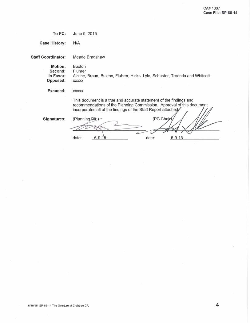
Certified Action of the City of Raleigh Planning Commission
Case File / Name: SP-66-14 / The Overture at Crabtree General Location: Located on the west side of Lead Mine Road, north of the intersection with
Glenwood Avenue, inside the city limits. Owner: Greystar GP II, LLC Designer: McAdams Company CAC: Northwest Nature of Case: The construction of a 4-story, 203 unit apartment building with a 5 level parking
deck containing 282 spaces, on 3.38 acres, located in the Shopping Center CUD and Pedestrian Business Overlay District. This development proposal involves the recombination of eight parcels and the demolition of single-family houses on several of the parcels. This plan requires preliminary approval as this request is in the Pedestrian Business Overlay District with a request to allow increased residential density (proposed density of 60.059 units per acre).
Key Issues: That this site plan exceeds 40 dwelling units per acre density located in the
Pedestrian Business Overlay District in accordance with Code Section 10-2051-(d)(1)c tier 2, providing parking in a deck which meets the standards of 10-2051-(d)(1)c3;
Contact: Andy Padiak, McAdams Company
Location Map
City of Raleigh Development Plans Review Center
One Exchange Plaza Raleigh, NC 27601
(919) 996-2626 www.raleighnc.gov
7/2/15 SP-66-14 The Overture at Crabtree CA 2
CA# 1367 Case File: SP-66-14
Site plan
7/2/15 SP-66-14 The Overture at Crabtree CA 3
CA# 1367 Case File: SP-66-14
SUBJECT: SP-66-14 CROSS- REFERENCE: Z-7-12, SSP-2-12 LOCATION: This site is located on the west side of Lead Mine Road, north of its intersection
with Glenwood Avenue, inside the City Limits. PIN: 796611658, 796611519, 796610449, 796613559, 796613469, 796613480,
796611399, 796610348 REQUEST: The construction of a 4-story, 203 apartment unit building with a 5 level parking
deck containing 282 spaces, on 3.38 acres, located in the Shopping Center CUD and Pedestrian Business Overlay Districts. This development proposal involves the recombination of eight parcels and the demolition of single-family houses on several of the parcels. This plan requires preliminary approval as this request is in the Pedestrian Business Overlay District and includes a request to allow increased residential (proposed density of 60.059 units per acre).
OFFICIAL ACTION: Approval with conditions CONDITIONS OF APPROVAL: As noted on the Staff Report, attached FINDINGS: The Planning Commission finds that with the following conditions of approval,
being met ,this request conforms to Chapter 2, Part 10, Sections 10-2041, 10-2055, 10-2132.2, Chapter 3, Part 10, Unified Development Ordinance Articles 8, 9, & 10. This approval is based on a preliminary plan dated 5/8/15, owned by Greystar GP II, LLC, submitted by McAdams Company.
ADDITIONAL NOTES: A streetscape amendment was approved at the May 5, 2015 City Council
meeting. VARIANCES / ALTERNATES: N/A
7/2/15 SP-66-14 The Overture at Crabtree CA 5
CA# 1367 Case File: SP-66-14
Staff Report
RECOMMENDED ACTION: Approval with Conditions CONDITIONS OF APPROVAL: Planning Commission Actions:
(1) That the Planning Commission finds that this site plan meets the standards
for approval of a residential development exceeding 40 dwelling units per acre density located in the Pedestrian Business Overlay District in accordance with Code Section 10-2051-(d)(1)c tier 2, providing parking in a deck which meets the standards of 10-2051-(d)(1)c3;
(2) That the Planning Commission finds that this site plan meets the standards for approval of a preliminary site plan, Code Section 10-2132.2(d);
Administrative Actions:
Prior to issuance of a land disturbance permit (3) That in accordance with Part 10A Section 9.4.4, a surety equal to of the
cost of clearing, grubbing and reseeding a site, shall be paid to the City;
Prior to approval of a concurrent review of Final Site Review and Infrastructure construction plans, or whichever is applicable:
(4) That a nitrogen offset payment must be made to a qualifying mitigation
bank;
(5) That a stormwater control plan with a stormwater operations and maintenance manual and budget shall be approved by the Stormwater Engineer in compliance with Part 10A Chapter 9 of the Unified Development Ordinance, including the designation of buffer areas and open space areas for stormwater purposes prior to grading or the approval of construction drawings whichever event comes first;
(6) That NCDOT permits for any work within the right-of-way have been
approved;
(7) That the City Attorney approve an off-site water line easement granted by Royal Hills Inc. owner of property to the south described in deed DB 015091 PG 00667 Pin # 796509976 located within Road A and that the easement deed is recorded with the Wake County Register of Deeds Office. A recorded copy of theses documents must be provided to the Planning Department within 14 days from authorization of lot recording. If a recorded copy of the documents are not provided to the Planning Department within this 14 day period, further recordings and building permit issuance may be withheld;
7/2/15 SP-66-14 The Overture at Crabtree CA 6
CA# 1367 Case File: SP-66-14
(8) That the City Attorney approve an off-site drainage easement granted by Crabtree Apartments Association II LLC owner of property to the west described in DB14966 PG 1857 and DB 15618 PG 1441 located on Charles Drive and that the easement deed is recorded with the Wake County Register of Deeds Office. A recorded copy of theses documents must be provided to the Planning Department within 14 days from authorization of lot recording. If a recorded copy of the documents are not provided to the Planning Department within this 14 day period, further recordings and building permit issuance may be withheld
Prior to issuance of building permits:
(9) That the City form document entitled Declaration of Maintenance Covenant and Grant of Protection Easement for Stormwater Control Facilities shall be recorded with the county register of deeds office where the property is located prior to any recordation of a subdivision or recombination plat and a copy of the recorded documents be provided to the Planning Department within the 14-day period, further recordings and building permits authorization will be withheld if the recorded document is not provided to the Planning Department; Required legal documents shall be recorded within 1 day of the approval of a recorded map, if applicable;
(10) That the developer shall establish a property owners association in accordance with G.S. 47 F for the maintenance of the shared stormwater control facility. The legal document shall be recorded with the Wake County Register of Deeds Office, and a recorded copy of this legal document shall be given to the City prior to the issuance of any building permit;
(11) That all stormwater control measures and means of transporting
stormwater runoff to and from any nitrogen and stormwater runoff control measures shall be shown on all plats for recording as private drainage easements and the plats shall contain the following note: “All private storm drainage easements & stormwater measures will be maintained by the property owners association;
(12) That in accordance with Part 10A Section 9.2.2, a surety equal to 125% of
the cost of the construction of a stormwater device is paid to the Public Works Department;
(13) That street names for this development be approved by the Raleigh City Planning Department and by Wake County;
(14) That a recombination map be recorded prior to or in conjunction with the recording of lots, recombining the eight existing lots into a single tract;
(15) That a right of way permit is obtained from the urban forester in the Parks and Recreation Department for landscaping in the public right-of-way;
(16) That a demolition permit be issued for structures on existing parcels and
this building permit number be shown on all maps for recording;
(17) That ½-92' of the required right-of-way for Lead Mine Road is dedicated to the City of Raleigh and a copy of the recorded plat be provided to the City prior to building permit issuance;
7/2/15 SP-66-14 The Overture at Crabtree CA 7
CA# 1367 Case File: SP-66-14
(18) That ½-73' of the required right-of-way for Road A is dedicated to the City of Raleigh and a copy of the recorded plat be provided to the City prior to building permit issuance;
(19) That the City Council approve the right-of-way closure and exchange of
Charles Drive and the resolution number is shown on all maps for recording;
(20) That 64' of the required right-of-way for Charles Drive is dedicated to the
City of Raleigh and a copy of the recorded plat be provided to the City prior to building permit issuance;
(21) That in accordance with Part 10A Section 8.1.3, a surety equal to 125% of
the cost of development related improvements is paid to the Public Works Department;
(22) That infrastructure construction plans be approved by the City of Raleigh;
(23) That street names for this development be approved by the Raleigh GIS
Division and by Wake County;
(24) That a 15' x 20' transit area located on Lead Mine Road be approved by the Transit Planner in the Public Works Transportation Department, be shown on all maps for recording, and that a transit easement deed approved by the City Attorney is recorded with the local County Register of Deeds. That the recorded copy of this transit easement be provided to the Planning Department prior to building permit approval;
(25) That an encroachment agreement for any plantings, planters, awnings,
lighting, streetscape elements or stormwater drainage systems that carry private drainage to be located within the public right-of-way is approved by the City Council by separate action. An application for encroachment into the public right of way for the landscaping located within the right of way as indicated on the preliminary plan, shall be submitted to the City’s Encroachment Coordinator in the Public Works Department for review, and that the City Council approve the encroachment request. Following City Council approval of the encroachment, an encroachment agreement, prepared in accordance with Raleigh City Code Sections 12-1001 and 12-1021(a), shall be filed with the Public Works Department, and the encroachment agreement is to be recorded with the Wake County Register of Deeds. Maintenance of the encroachment shall be the responsibility of the owner; and
(26) That all conditions of Z-7-12 are complied with;
Prior to issuance of any occupancy permit:
(27) That in accordance with Part 10A Section 9.2.2, an as-built plan and certification any stormwater control device shall be reviewed and accepted by the City prior to final stormwater inspection approval or certificate;
7/2/15 SP-66-14 The Overture at Crabtree CA 8
CA# 1367 Case File: SP-66-14
ZONING: ZONING DISTRICTS: Z-9-12. Ordinance (2012) 34ZC671 Effective 4/3/12.
Z-7-12 – Lead Mine Road and Charles Drive located west of Leadmine Road, northwest of its intersection with Glenwood Avenue, being Wake County PINs 0796518795, 0796611658, 0796611519, 0796610449, 0796610348, 0796611399, 0796613559, 0796613469, & 0796613480. Approximately 9.12 acres are requested to be rezoned from R-15 CUD and O&I-1 CUD to SC Conditional with PBOD. Conditions Dated: 03/30/12
Narrative of conditions being requested: 1. The following uses shall be prohibited on the Property:
a. a day care facility, b. custom and specialized manufacturing, c. an airfield, landing strip or heliport, d. orphanage, e. correctional/penal facility f. landfill g. cemetery h. telecommunications tower i. outdoor stadium, outdoor theater, outdoor racetrack, outdoor movie theater j. emergency shelter k. adult establishment l. carwash facility m. retail sales-highway n. shopping area o. shopping center p. Any use with a drive-through
Proposed use is apartments
2. Prior to the issuance of any building permit for the Property or a subdivision of the Property, whichever shall occur first, the owner of the Property shall convey to the City of Raleigh a transit easement measuring twenty (20) feet by fifteen (15) feet with a concrete pad and transit shelter. The location of the easement shall be approved by the Public Works Department, Transit Division of the City and the City Attorney shall approve the transit easement deed prior to recordation. Prior to obtaining a Certificate of Occupancy for any new building on the Property, the owner will construct the concrete pad and shelter referenced in this Condition within such transit easement, unless this requirement is waived by the City
7/2/15 SP-66-14 The Overture at Crabtree CA 9
CA# 1367 Case File: SP-66-14
of Raleigh. A transit easement is proposed on Lead Mine Road
3. Upon redevelopment, there will be a minimum of 2500 square feet of “retail” development as defined in Code Section 10-8002 on the Property; however, total retail development as defined in Code Section 10-8002 on the entire Property shall not exceed a total of 7500 square feet. The total residential density on the Property shall not exceed 533 units. Office uses as defined in Code Section 10-8002 will not be allowed, except as incidental and accessory to residential uses.
No Retail is proposed
4. Prior to the issuance of a building permit, Petitioner will dedicate to the City of Raleigh a right-of-way of a width agreeable to the City of Raleigh, not to exceed 60 feet, for the purpose of roadway construction adjacent to and along the 255 foot southern property line of PIN 0796518795, Deed Book 14289, Page 2645. At the City’s request, and if needed, the Petitioner will also convey a slope easement to the City of a width of no more than 20 feet at the same location. The adjacent property to the South is owned by Joanna Smith Mills and Melissa Smith Mills and the deed for this property is recorded at Deed Book 6693, Page 84 and Deed Book 6693, Page 81. The road will be constructed prior to the issuance of a Certificate of Occupancy for any new building on the Property.
Right-of-way dedication is shown on plans 5. Development shall be made in accordance with the applicable Streetscape and Parking Plan, as it may be amended from time to time.
Conforms to SSP-2-12 6. Exterior building surfaces fronting on, adjacent to and visible from public rights-of-way shall consist of at least 80% brick, stone or masonry veneer, exclusive of roofs, windows, Storefronts (as defined below), doors, cornices and trim; other exterior building surfaces shall consist of at least 50% brick, stone or masonry veneer, exclusive of roofs, windows, Storefronts (as defined below), doors, cornices and trim. No external building surface shall consist of vinyl, wood fiber, utility grade concrete masonry unit, or synthetic stucco.
All exterior building elevations visible from public rights-of-way exceed 80% Use of brick veneer.
7. Building entrance doors (exclusive of hardware and insulation) facing public rights-of-way or internal courtyards shall consist of all wood or a combination of glass and wood.
Will be reviewed at building permit issuance. 8. Above ground portions of parking decks visible from adjoining properties or the public right-of-way shall be clad in the same materials as the principal buildings on site.
The parking deck will be constructed with Stucco. Stucco is a material being used on the building.
7/2/15 SP-66-14 The Overture at Crabtree CA 10
CA# 1367 Case File: SP-66-14
9. Garbage dumpsters/compactors shall be screened from view from adjacent properties and public rights-of-way, provided that any enclosures may have gated openings to be opened when dumpsters/compactors are being emptied. All such enclosures shall be constructed from the same materials as the principal buildings they serve and shall include a wood trellis covering at least 50% of the enclosure. The trash collection area is located inside the parking deck and will not be visible from outside. The trash containers will be wheeled out for pick up on trash day. 10. All retail uses shall be located in buildings which contain at least one other non-retail use. No retail is proposed with this site plan. 11. Exterior surfaces of retail uses between the foundation and 12 feet above ground (“Storefronts”) shall consist of at least 50% glass or glazing. No retail is proposed with this site plan. l2. At least 30 vehicular parking spaces with electrical charging facilities shall be provided on site. 8 spaces are proposed with this development. The remaining electrical charging facilities will be shown and provided on future site plans for the remaining portions of Z-9-12 property 13. Covered parking in bicycle racks shall be provided for at least 100 bicycles.
40 spaces are proposed with this development. The remaining bicycle racks will be shown and provided on future site plans for the remaining portions of Z-9-12 property
SETBACKS / HEIGHT: This plan conforms to all minimum setback standards of the Crabtree North
Streetscape and Parking Plan. Front yard = 1’, rear yard = 1’, front / rear aggregate = 2’, side yard = 10’, side yard aggregate = 20’. This plan conforms to maximum height standards of the Crabtree North Streetscape and Parking Plan. No height shall exceed 115'/5 stories, nor 5 stories or 75' in height along Lead Mine Road. Proposed height of the building is 60' or 4 stories.
PARKING: Off-street parking conforms to minimum requirements: 187 spaces required,
based on 1 parking space per unit exempting the first 16 units. 289 spaces are provided.
LANDSCAPING: Vehicular surface area landscaping in conformity with Section 10-2082.6 is
shown. This is a high density residential use under Section 10-2082.9. The
7/2/15 SP-66-14 The Overture at Crabtree CA 11
CA# 1367 Case File: SP-66-14
property is surrounded by public right-of-way to the east, south, and west. The parcel to the north is a low impact use, not requiring a transitional protective yard.
TREE CONSERVATION: Site is exempt from UDO Article 9.1 due to all trees having been removed from
individual parcels while they were less than 2 acres in size and prior to recombination.
DEVELOPMENT INTENSITY: A density of 60.059 units per acre is proposed. The Pedestrian Business
Overlay District Code Section 10-2055 allows 40 units per acre. The applicants are allowed increases in residential densities in excess of 40 units per acre through the Pedestrian Business Overlay District Code Section 10-2055. For each standard complied with in the Pedestrian Business Overlay District that the Planning Commission finds the plans compliant with, an increase in density of 60 units per acre is allowed. At the proposed density of 60.059 units per acre, the plan would have to meet one standard to achieve the desired density.
Parking Deck: Code Section 10-2051-(d)(1)c tier 2 requires At least eighty (80) per cent of the off-street parking spaces provided are contained
in a multilevel parking structure. Parking decks shall be visually integrated into the principle building. Parking decks shall be designed to be compatible with other buildings on the site by using compatible building materials and architectural designs, as reflected in scale, color, texture, fenestration, width, height, roof lines, and other similar architectural gauges. However, parking decks located within the interior of the property and not visible from any public street, private street, common open space area or adjacent property shall be exempt from this provision. No more than seventy-five (75) feet total of the ground level of the sides of the building or parking deck (measured twenty (20) feet deep from the facade of the building) located on the sides of the lot fronting a public street, private street or common open space area shall be devoted to parking, driveways and/or loading areas. The proposed parking deck has been evaluated by staff and was found to be compliant with these standards.
OPEN SPACE: The Pedestrian Business Overlay District in accordance with Code Section 10-
2055 requires that a minimum of 5% of the total land area of the development be aside as open space. “Open space” is defined to include: greenways; any common
outdoor landscaped and recreation spaces; outdoor decks; roof gardens and other similar outdoor community space accessible to and available for use by visitors
of the development.” The Code calls for open space first to be met by widening the sidewalks to a minimum of 14’ in width. After that is achieved, any deficit in open space can be met with courtyards, roof gardens, outside dining and recreation space so long as ½ of the required open space shall be in one continuous part with a minimum length and width dimension of 20 feet. The required open space of 5% or 7,362 square feet is being met with the construction of a 14' sidewalk being constructed within Road A and Charles Drive, a 14' streetscape section being installed along Lead Mine Road with an 8' sidewalk and 6' planting strip, and a pool and courtyard area totaling 14,220 square feet.
7/2/15 SP-66-14 The Overture at Crabtree CA 12
CA# 1367 Case File: SP-66-14
PHASING: There is one phase with this development. UNITY OF DEVELOPMENT: Unity of development and sign criteria are not required in this development. COMPREHENSIVE PLAN:
GREENWAY: There is no greenway on this site. STREET PLAN MAP: Dedication of right-of-way and construction of the following streets are required
by the Street Plan Map of the Comprehensive Plan. Dedication of right-of-way is required:
Street Name
Designation Exist R/W
Required R/W
Existing street (b to b)
Proposed street (b to b)
Lead Mine Road
Avenue 4-lane, divided
90' ½-92' ½-66'
Road A Main Street N/A ½-73' ½-41' Charles Drive
Avenue 2-lane, undivided
60' 64' 27'
A surety for the required improvements shall be provided in accordance with 8.1
of the UDO. TRANSIT: The following transit-oriented features of this site are incorporated into the
proposed plan: 15' x 20' transit area along Lead Mine Road with the construction of a 4' x 15' transit shelter.
COMPREHENSIVE PLAN: The site is in the Northwest CAC and is identified for Regional Mixed Use on the Future Land Use Map contained in the 2030 Comprehensive Plan. The plan has been reviewed against the following policies: Policy LU 5.1—Reinforcing the Urban Pattern Policy T 5.10 Building Orientation Policy UD 2.3 Activating the Street Policy UD 6.1 Encouraging Pedestrian Oriented Uses
7/2/15 SP-66-14 The Overture at Crabtree CA 13
CA# 1367 Case File: SP-66-14
HISTORIC / DISTRICTS: The existing buildings are not designated Historic Structures. This site is not
located in or adjacent to a designated Historic District. APPEARANCE COMMISSION: The Appearance Commission has made the following comments on this
preliminary plan. Shown below are comments and applicant responses:
Comment Response The Commission recommends additional enhancements to the pedestrian environment on Lead Mine Road. Improvements should include enhancements to the building entrance on Lead Mine Road, highlighting the connection between the building and the street, and consideration of wider sidewalks.
The sidewalk access to the entrance at the corner of Lead Mine and Road A has been enhanced to highlight the connection to the public street.
The Commission encourages the replacement of the surface stormwater detention pond with a more urban type of stormwater treatment in future phases of development nearby. In the meantime, the Commission encourages making the wet pond more of an amenity, including plantings and connection to the site, as it is visible from the residential units in this development.
The surface stormwater management pond will ultimately be replaced with an underground stormwater management device when that parcel develops. A connection to the site is not feasible due to the tall retaining wall located between Charles Drive and the site.
The Commission suggests further screening of north elevation of the parking deck through articulation and the application of additional architectural elements.
The northern elevation has been revised in response to the Commission’s comment.
SUBDIVISION STANDARDS: LOT LAYOUT: The minimum lot size in Shopping Center zoning district is 5,000 square feet.
The minimum lot depth in this zoning district is 70 feet. The minimum lot width of an interior lot in this zoning district is 45 feet. Lots in this development conform to these minimum standards.
PUBLIC UTILITIES: City water and sewer services are available. The developer is responsible for
installation of all lines necessary to provide service to this site. SOLID WASTE: Individual lot service will be provided by a private contractor.
7/2/15 SP-66-14 The Overture at Crabtree CA 14
CA# 1367 Case File: SP-66-14
BLOCKS / LOTS / ACCESS: Block perimeters, lot arrangement and access conform to Chapter 8 of the UDO.
A fee for street signs is required in accordance with the Raleigh Street Design Manual.
STREETSCAPE TYPE: The applicable streetscape conforms to the Crabtree North Streetscape and
Parking Plan. A 14' sidewalk with trees planted within 4' x 6' tree grates is proposed within Road A and Charles Drive. An 8' sidewalk and 6' planting strip is proposed along Lead Mine Road.
PEDESTRIAN: Proposed sidewalk locations conform to the Crabtree North Streetscape and
Parking Plan. A 14' sidewalk is proposed within Road A and Charles Drive. An 8' sidewalk is proposed along Lead Mine Road. Access to the public right of way in addition to internal connection requirements is provided in accordance with 8.3.4 of the UDO.
FLOOD HAZARD: There are no flood hazard areas on this site. STORMWATER MANAGEMENT: This site is subject to stormwater management controls in accordance with
Article 9.2 of the Raleigh UDO. Proposed stormwater control measures are shown in accordance with the Raleigh Stormwater Control and Watercourse Buffer Manual. A Wet Pond is proposed to be located offsite (Crabtree Apartments Association II LLC owner of the property to the west described in DB14966 PG 1857 and DB 15618 PG 1441) and utilized as a shared stormwater control device.
WETLANDS / RIPARIAN BUFFERS: No wetland areas or Neuse River riparian buffers are required on this site. OTHER REGULATIONS: Developer shall meet all other applicable City requirements of Code Part 10 and
10A (Unified Development Ordinance).
Crabtree NorthStreetscape and Parking Plan
Raleigh, North Carolina
Case Number SSP-2-12; Z-7-12
Date: September 16, 2011
Revised: December 2, 2011
March 29, 2012
April 29, 2015
Owner:Crabtree North, LLC
Crabtree Apartments Associates, LLC
Prepared By:
Raleigh/Durham2905MeridianParkwayDurham,NC27713
Charlotte11301CarmelCommonsBlvd,Suite111Charlotte,NC28226
McAdamsCo.com
Designing Tomorrow’s Infrastructure & Communities
Crabtree North – Streetscape and Parking PlanRevised 04/29/2015 Page 2 of 25
Table of Contents
IntroductionLocation Map Page 3Site History Page 4Planning Objective Page 4Zoning/PBOD Boundary Exhibit Page 5Transportation Page 6Streetscape Concept Page 6-7Streetscape Standards Page 8
Streetscape StandardsStreetscape Plans and Sections Pages 9-14Curb and Sidewalk Details Page 15Accent Paver Detail Page 15Utilities Page 16Maintenance Plan Page 16Signage Page 16Canopies and Awnings Page 16Lighting Page 16-17Building Facades Page 18Building Setbacks Page 18Building Heights Page 18Parking Page 18-19Parking Location Diagram Page 19Street Trees Page 20-21Tree Grates Page 22Street Tree Planting Details Page 22Bench, Trash Receptacles and Bike Racks Details Page 23-24Appendix – City Code Section 10-2055 (PBOD) Page 25
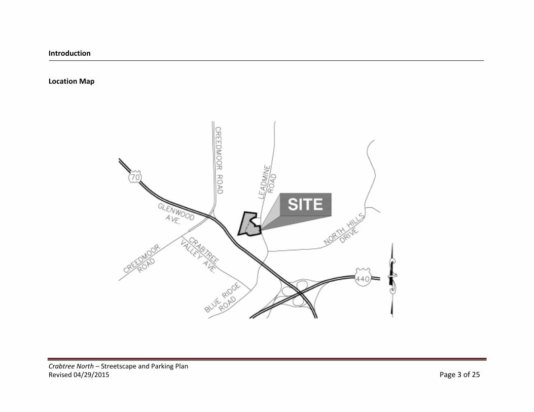
Crabtree North – Streetscape and Parking PlanRevised 04/29/2015 Page 3 of 25
Introduction
Location Map
Crabtree North – Streetscape and Parking PlanRevised 04/29/2015 Page 4 of 25
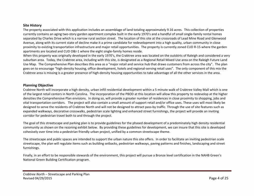
Site HistoryThe property associated with this application includes an assemblage of land totaling approximately 9.16 acres. This collection of propertiescurrently contains an aging two-story garden apartment complex built in the early 1970’s and a handful of small single-family rental homesseparated by Charles Drive which is a narrow rural section street. The location of this site at the crossroads of Lead Mine Road and GlenwoodAvenue, along with its current state of decline make it a prime candidate for redevelopment into a high quality, urban community in closeproximity to existing transportation infrastructure and major retail opportunities. The property is currently zoned CUD R-15 where the gardenapartments are located and CUD O&I-1 where the eight single-family homes reside.When this property was originally developed in the early 1970’s, the Crabtree area was located on the outskirts of Raleigh and considered a verysuburban area. Today, the Crabtree area, including with this site, is designated as a Regional Retail Mixed Use area on the Raleigh Future LandUse Map. The Comprehensive Plan describes this area as a “major retail and service hub that draws customers from across the city”. The plangoes on to encourage “high-density housing, office development, hotels and regional-serving retail uses”. The only component of this mix theCrabtree area is missing is a greater presence of high-density housing opportunities to take advantage of all the other services in the area.
Planning ObjectiveCrabtree North will incorporate a high density, urban infill residential development within a 5 minute walk of Crabtree Valley Mall which is oneof the largest retail centers in North Carolina. The incorporation of the PBOD at this location will allow this property to redevelop at the higherdensities the Comprehensive Plan envisions. In doing so, will provide a greater number of residences in close proximity to shopping, jobs andvital transportation corridors. The project will also contain a small amount of support retail and/or office uses. These uses will most likely bedesigned to serve the residents of Crabtree North and will not be designed to attract pass-by traffic. Through the use of site features such asexpanded walkways, decorative crosswalks, pedestrian scale lighting and enhanced street furnishings, the project will provide an invitingcorridor for pedestrian travel both to and through the project.
The goal of this streetscape and parking plan is to provide guidelines for the phased development of a predominately high density residentialcommunity as shown on the rezoning exhibit below. By providing these guidelines for development, we can insure that this site is developedcohesively over time into a pedestrian friendly urban project, unified by a common streetscape theme.
The streetscape and public spaces are intended to support the urban nature this site offers. In order to facilitate an inviting pedestrian scalestreetscape, the plan will regulate items such as building setbacks, pedestrian walkways, paving patterns and finishes, landscaping and streetfurnishings.
Finally, in an effort to be responsible stewards of the environment, this project will pursue a Bronze level certification in the NAHB Green’sNational Green Building Certification program.
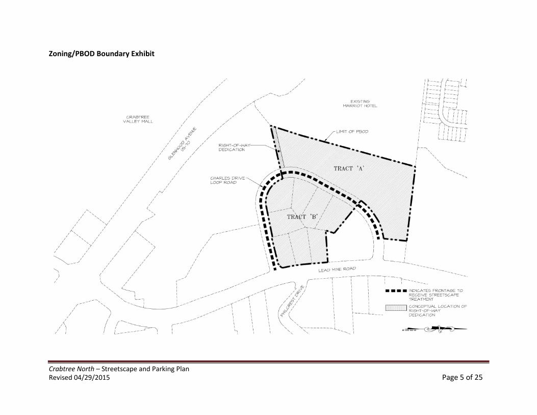
Crabtree North – Streetscape and Parking PlanRevised 04/29/2015 Page 5 of 25
Zoning/PBOD Boundary Exhibit
Crabtree North – Streetscape and Parking PlanRevised 04/29/2015 Page 6 of 25
TransportationThe site is located in the northwest quadrant of Lead Mine Road and Glenwood Avenue, immediately north of Crabtree Valley Mall at a majorcrossroads of activity for vehicular and bus traffic. The Comprehensive Plan identifies Glenwood Avenue as a Principal Arterial (>40,000 trips perday) and Lead Mine Road as a Secondary Arterial (25,000-45,000 trips per day).
In addition to vehicular transportation, there are bus lines currently running along both Glenwood Avenue and Lead Mine Road with a transferstation located within walking distance of the site inside the parking structure of Crabtree Valley Mall. Upon approval of a site plan or plans forthe redevelopment of all or a portion of the property, if requested by the City’s Transit Division, the owner shall dedicate a transit easementalong the Lead Mine Road frontage of a size, nature and location acceptable to such Division and shall provide any improvements, such as abench and/or shelter, specified by such Division that will be in accordance with its standard policies. Once the location of the transit easement isdefined, an entrance to the building will be located so as to assure convenient and comfortable pedestrian access from the building to the transitstop. The project will, at the City’s request, also offer right-of-way dedication in the southwest corner of the site to allow for a future vehicularand pedestrian connection to Marriot Drive which intersects with Glenwood Avenue.
Streetscape ConceptIt is the intent of these guidelines to build streets that are integral components of community design. Streets will be designed as the main publicspaces of the project and will be scaled for pedestrians. Furthermore, buildings will define the streets spatially. Proper spatial definition will beachieved with buildings that make up the street edges aligned in a disciplined manner with an appropriate ratio of height to width. With theseimportant elements in mind, the overall streetscape concept has been designed to provide a pedestrian scale experience for residents andpassersby. The project has less than 300 feet of frontage along Lead Mine Road which carries a great deal of vehicular traffic. As such, it isimportant to incorporate streetscape elements that give the pedestrian a sense of safety as they pass by the property along this frontage.The main focus of the pedestrian streetscape and parking plan will be internal to the project, approximately along the current alignment ofCharles Drive. This loop road connection will allow local vehicular and pedestrian traffic to circulate through the heart of this community. Ourgoal will be to design a streetscape that will function as a pedestrian environment that also handles local vehicular traffic at a very slow speed.One tool for accomplishing this feel is to limit the block length within the project. In no case will the block length exceed 660 feet.
Crabtree North – Streetscape and Parking PlanRevised 04/29/2015 Page 7 of 25
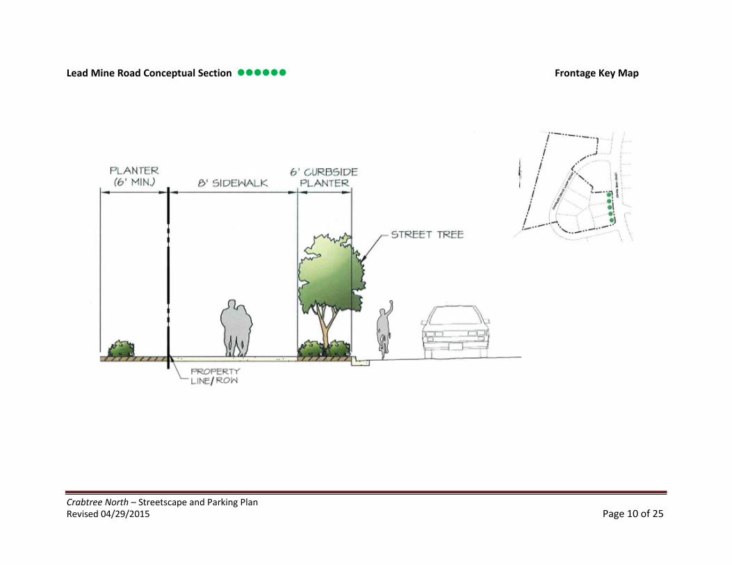
Lead Mine Road FrontageIn order to protect the pedestrian from vehicular traffic, we will provide a continuous curbside planting beds between the sidewalk and curb,allowing for a row of low plantings, street trees and seasonal color. Street trees will be provided along Lead Mine Road at a minimum of 40’ o.c.The pedestrian walkway along this frontage is proposed to consist of mostly broom and smooth finished concrete to tie in with existingdevelopment along the frontage, but will incorporate some decorative brick areas to highlight pedestrian entrances to the building or theproject. We have also incorporated a 6’ wide planting strip along the building in order to break up the façade of the building and soften thestreetscape with additional plantings. This frontage will also form a prominent intersection with Lead Mine Road and Charles Drive Loop Road.In order to strengthen this intersection, an architecturally significant feature of the building will be located at this corner. In addition, no off-street parking will be present at this location. Final location of the brick accents and street furnishing will be finalized at site plan approval. Seesheet 9 and 10 for details and sections.
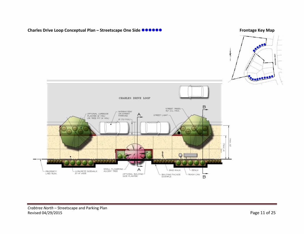
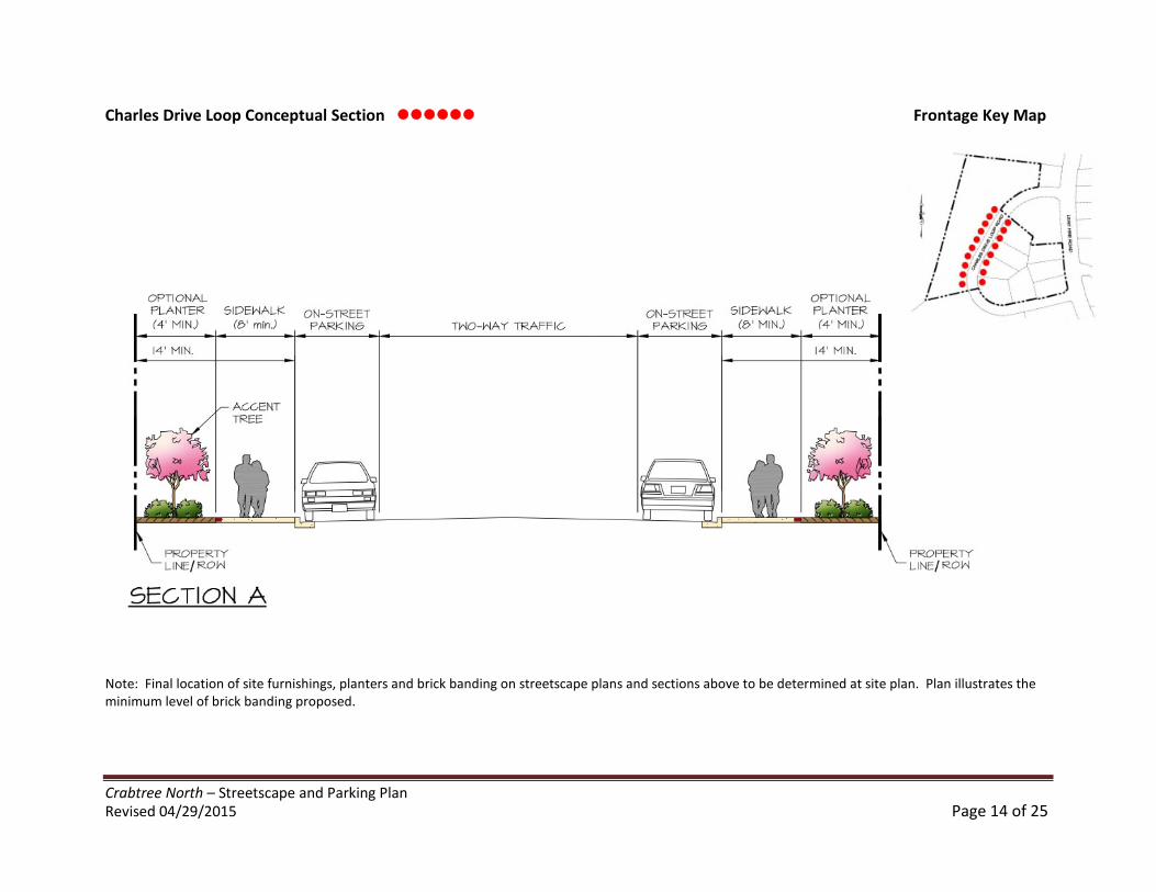
Charles Drive Loop FrontageAs discussed previously, Charles Drive loop will be the main focus of our Streetscape and Parking plan. This internal connection will allow localvehicular and pedestrian traffic to circulate through the heart of this community. Our goal will be to design a streetscape that will act and feellike a pedestrian environment that also accommodates local vehicular traffic, but at a reduced speed.
This streetscape will likely contain multiple access points to the building in the form of stoops and courtyards. As such, we would anticipate thefacade location closer to the street than along the Lead Mine Road frontage. Charles Loop will contain a combination of curbside and building-side planters as well as sections where the entire streetscape is paved to facilitate pedestrian circulation. We also anticipate a variety ofpedestrian gathering spaces along this frontage to accommodate small seating areas or perhaps a private courtyard recessed from the street. Itis also possible that some small support retail such as a coffee shop, restaurant or bookstore could gravitate to this portion of the site providinga place for residents to congregate and spend leisure time without leaving Crabtree North. In order to facilitate pedestrian flow from theresidential located in Tract ‘A’, the project will provide a mid-block pedestrian connection through Tract ‘B’ to Lead Mine Road.
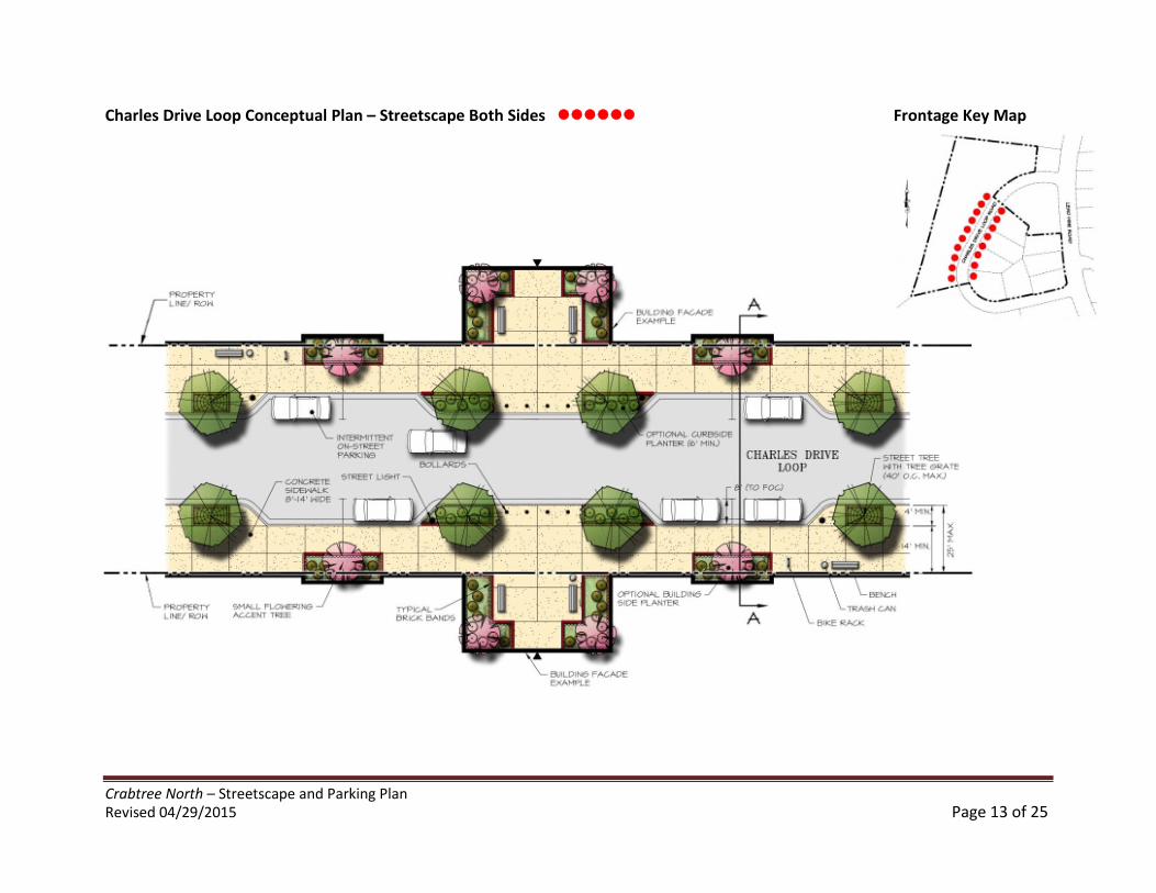
As illustrated in the Zoning and PBOD Boundary Exhibit on page 5, much of Crabtree North will encompass both sides of Charles Drive loop. Assuch, we will incorporate at least one pedestrian crossing to facilitate the flow of pedestrian activity between buildings. Drivers will enter thisinternally focused streetscape with a heightened sense of awareness toward pedestrians and will be inclined to proceed slowly. The CharlesDrive Loop will also incorporate street trees located in tree grates or curbside planters at a minimum of 40’ o.c. with decorative pedestrian scalelighting, benches, trash receptacles and bike racks placed regularly along the streetscape. The actual location of the Charles Drive Loop shown isconceptual and may shift slightly within the confines of our project at the time of site plan approval. In no case will Charles Drive be shiftedwhere adjoining properties front this public street.
Crabtree North – Streetscape and Parking PlanRevised 04/29/2015 Page 8 of 25
Streetscape Standards
Width of Pedestrian WaysThere are currently no existing sidewalks adjacent to the boundary of the proposed PBOD. As required, we will provide new sidewalks inaccordance with the foregoing text and, as applicable, the sections and plans illustrated below.
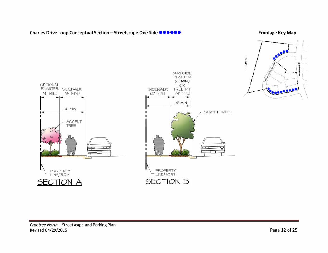
Lead Mine Road Frontage and Charles Drive Loop Frontage – Both of these frontages will be improved with a full 14’ wide streetscape inaccordance with City of Raleigh PBOD standards (see illustrations below).
Site Design / Open SpaceAn important part of any urban living environment is the presence of well designed a situated open space features. To ensure that the proposedopen space elements are well-used, it is essential to locate and design them carefully and with the users in mind. These spaces will be locatedwhere they are visible and easily accessible from public areas (building entrances, sidewalks). They will also be designed to take views and sunexposure into account as well. While the site may contain some private garden areas for use only by the residents, many of the open spacefeatures will take direct access from Charles Loop Drive and permit multiple points of entry from the street and the building. Spaces along thestreetscape will contain active uses and will be visually permeable, allowing passersby to see directly into the space.
Pedestrian Crosswalk locationsPedestrian crosswalks will be provided at the intersection of Charles Drive Loop and Lead Mine Road as well as at any point where a drivewaycrosses the pedestrian travel way. At the time of site plan, additional crosswalks will be added if needed to facilitate the flow of pedestrianactivity across Charles Drive Loop. Crosswalks will be designed in accordance with accessibility requirements. Finally, at the City’s request, theproject will dedicate right-of-way in the southwest corner of the site to allow for a future vehicular and pedestrian connection to Marriot Drivewhich intersects with Glenwood Avenue.
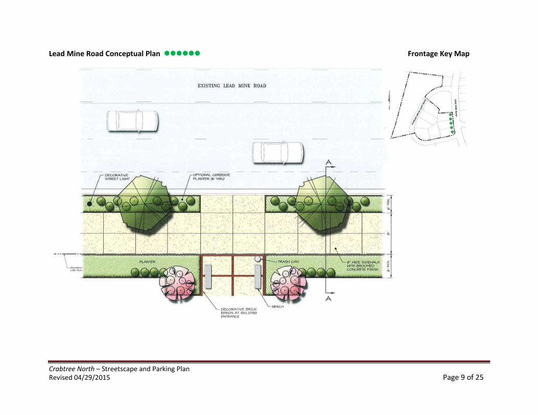
Crabtree North – Streetscape and Parking PlanRevised 04/29/2015 Page 9 of 25
Lead Mine Road Conceptual Plan Frontage Key Map
Crabtree North – Streetscape and Parking PlanRevised 04/29/2015 Page 10 of 25
Lead Mine Road Conceptual Section Frontage Key Map
Crabtree North – Streetscape and Parking PlanRevised 04/29/2015 Page 11 of 25
Charles Drive Loop Conceptual Plan – Streetscape One Side Frontage Key Map
Crabtree North – Streetscape and Parking PlanRevised 04/29/2015 Page 12 of 25
Charles Drive Loop Conceptual Section – Streetscape One Side Frontage Key Map
Crabtree North – Streetscape and Parking PlanRevised 04/29/2015 Page 13 of 25
Charles Drive Loop Conceptual Plan – Streetscape Both Sides Frontage Key Map
Crabtree North – Streetscape and Parking PlanRevised 04/29/2015 Page 14 of 25
Charles Drive Loop Conceptual Section Frontage Key Map
Note: Final location of site furnishings, planters and brick banding on streetscape plans and sections above to be determined at site plan. Plan illustrates theminimum level of brick banding proposed.
Crabtree North – Streetscape and Parking PlanRevised 04/29/2015 Page 15 of 25
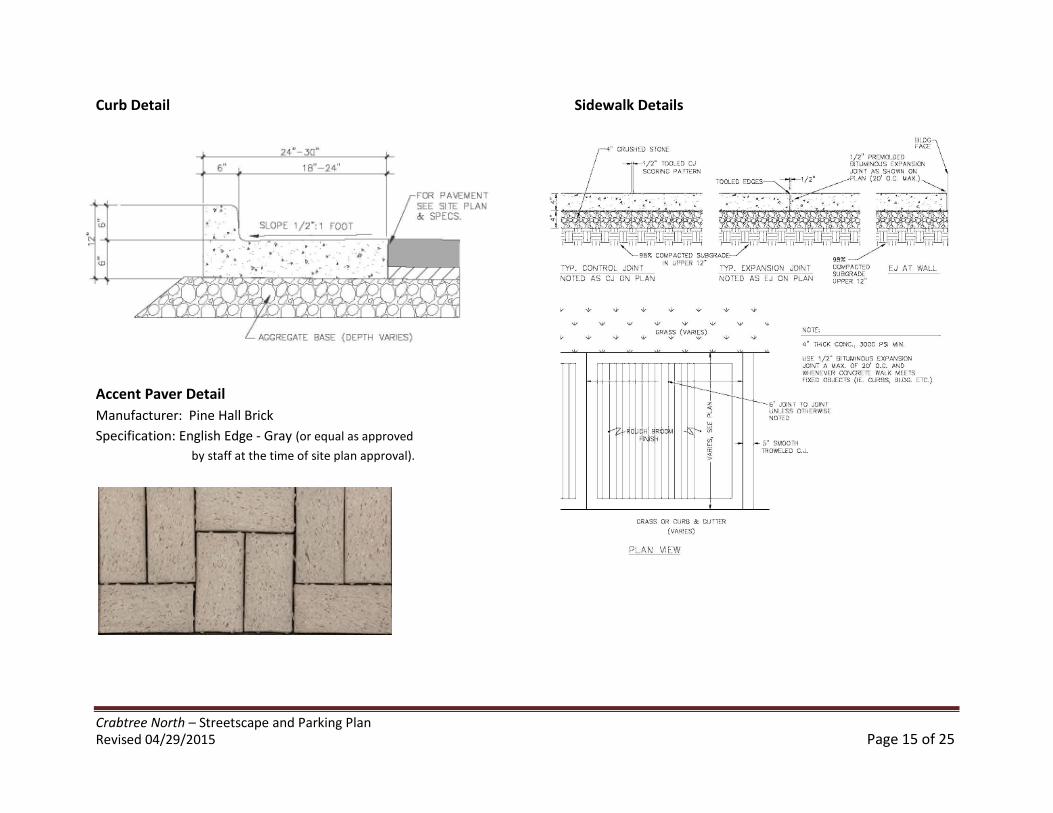
Curb Detail Sidewalk Details
Accent Paver Detail
Manufacturer: Pine Hall Brick
Specification: English Edge - Gray (or equal as approved
by staff at the time of site plan approval).
Crabtree North – Streetscape and Parking PlanRevised 04/29/2015 Page 16 of 25
Streetscape Standards Continued
UtilitiesUtilities are currently in place in the area. Subject to approval by the City of Raleigh and the utility provider, all utilities will be either locatedunderground and behind the back of curb or on poles in the right of way.
Maintenance PlanA maintenance plan will be enforced as part of the PBOD for the care of the streetscape improvements up to the public right-of-way.Maintenance in excess of that customarily provided by the municipality within public right-of-ways will require an encroachment agreement andwill be the responsibility of the individual property owner or property owner’s association. This includes maintenance of sidewalks and plantersand street furnishings required by the PBOD but within the property lines, watering of plant materials and keeping the sidewalks free of debrisand trash. A draft of the maintenance plan will be submitted at the time of site plan approval.
SignageThe design and location of signage will compliment the architectural styles of the structures and will be oriented toward vehicular andpedestrian traffic. The following signage types are encouraged: Awning signs, window stencils and wall signs. Low profile ground signs will alsobe allowed on the property in accordance with the City’s signage code. Paddle signs oriented toward pedestrian traffic will also be permitted inaccordance with the City’s signage code and shall maintain a clear minimum height of 9’-0” above the ground.
Canopies and AwningsIn the event canopies or awnings are incorporated along the streetscape; they will be of sufficient height to accommodate the free flow ofpedestrian traffic. In no case will the awnings be less than 9’-0” above the ground.
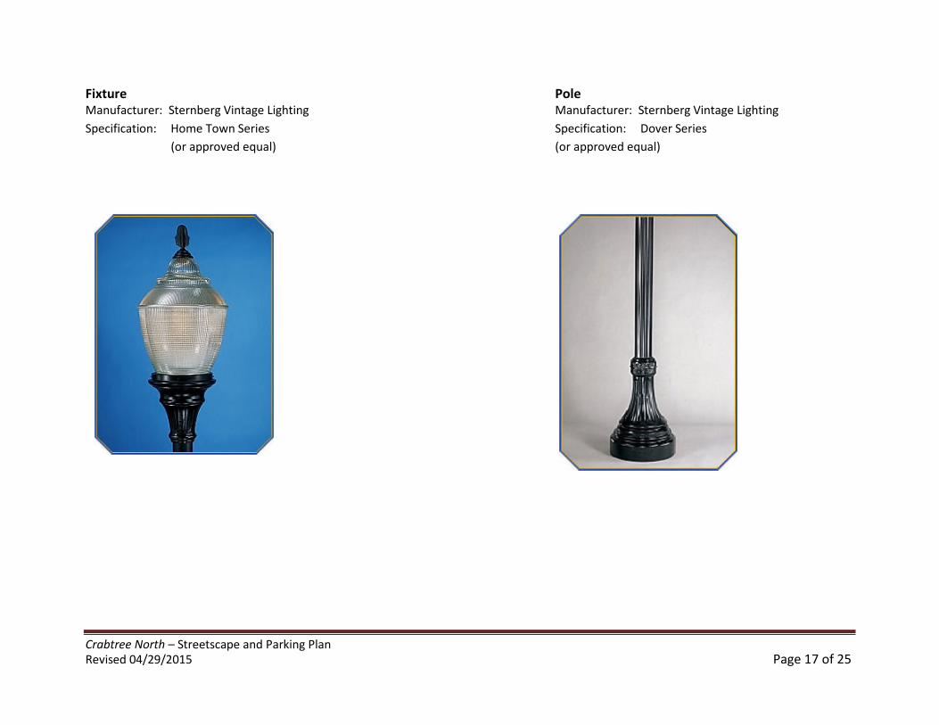
LightingAppropriate light levels along the streetscapes and parking areas are critical in creating a safe and inviting environment for pedestrians. Theproject will provide a mix of low level lighting as well as pedestrian scale lighting similar to the illustrations provided below. Any pole mountedpedestrian scale lighting shall not exceed 16’ in pole height. Lighting shall be provided in accordance with Code Section 10-2089. A lighting planwill be provided at the time of site plan approval.
Crabtree North – Streetscape and Parking PlanRevised 04/29/2015 Page 17 of 25
Fixture PoleManufacturer: Sternberg Vintage Lighting Manufacturer: Sternberg Vintage Lighting
Specification: Home Town Series Specification: Dover Series
(or approved equal) (or approved equal)
Crabtree North – Streetscape and Parking PlanRevised 04/29/2015 Page 18 of 25
Building FacadesStructures will address the public and private rights of ways as allowed by physical constraints and engineering requirements. Primary entrancesto the buildings will be both architecturally and functionally on the front facade of any building facing the primary public street. Such entranceswill be designed to convey their prominence on the fronting facade. In addition to these primary entrances, there will also be secondaryentrances to the structures from within the parking structure and from other points surrounding the buildings. Ground level residential units orretail/office spaces will have one or more of the following elements: doors, balconies, porches, stoops or similar active elements that addressthe street in order to help activate the pedestrian streetscape, especially along Charles Drive Loop.Along the streetscape, the facades will be broken up to provide a pedestrian scale experience by the interspersion of street trees, streetfurnishings, decorative lighting, movement in the sidewalk, changes in paving material as well as other similar elements. No structures shallencroach within the public right of way other than free standing awnings.
Building SetbacksBuilding setbacks from street right of ways within the PBOD shall be a minimum of 0’ and shall accommodate the streetscape plans and sectionsas described and shown on pages 8-14. The building setbacks within the project will be a minimum of 6’-0” from the side and rear lot lines.
Building HeightAt this early stage in the process, it is not clear as to the final configuration of the proposed structures. In no case will the structures exceed115’-0” in height. Along the Lead Mine Road frontage, structures will be limited to five stories and no more than 75’-0” in height. Building heightshall be measured in accordance with Code Section 10-2076.
ParkingParking within the project will be provided through a combination of both surface and structured parking. As required by PBOD, a minimum of80% of the parking will be contained in multi-level structures. All parking structures will be concealed from view from the adjoining propertiesand the public rights-of-way where possible. Where grades permit, structures should be located under buildings with areas visible fromadjoining properties and the public right-of-way clad in the same material as the principal buildings on site. The number of parking stalls withinthe project will meet or exceed the minimum parking requirements of the City of Raleigh. No off-street surface parking (other than drop-off,delivery and temporary (leasing, etc.) parking areas) will be provided between the façade of any building and the right-of-way. Any surfaceparking visible from a public street that is behind buildings or between the façade of a building and the right-of-way will be screened from view.Screening will be accomplished through the installation of either a 30” high decorative fence/wall, the installation of a continuous evergreenhedge reaching a height of 30” tall or a combination of both. As part of our efforts to achieve a Bronze level certification in the NAHB Green’sNational Green Building Certification program, the project will make provisions for electric car charging.As with any urban infill project, parking structures are essential and integral to the design of the project. Every attempt will be made at the timeof site plan to locate structured parking either beneath or behind the residential buildings so as to obscure from view.
Crabtree North – Streetscape and Parking PlanRevised 04/29/2015 Page 19 of 25
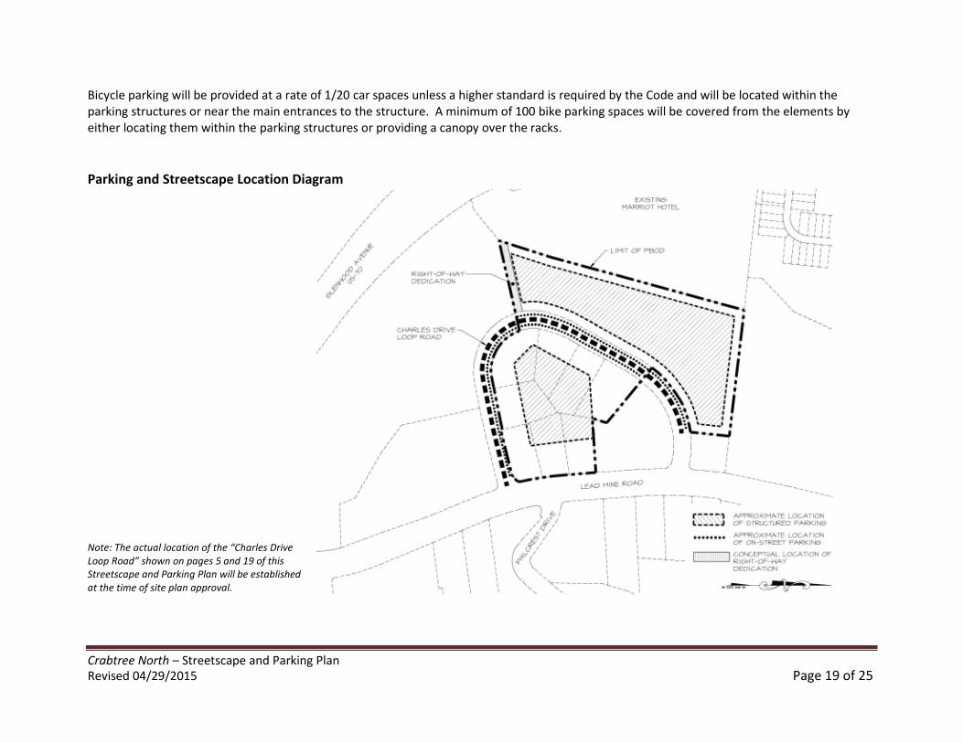
Bicycle parking will be provided at a rate of 1/20 car spaces unless a higher standard is required by the Code and will be located within theparking structures or near the main entrances to the structure. A minimum of 100 bike parking spaces will be covered from the elements byeither locating them within the parking structures or providing a canopy over the racks.
Parking and Streetscape Location Diagram
Note: The actual location of the “Charles DriveLoop Road” shown on pages 5 and 19 of thisStreetscape and Parking Plan will be establishedat the time of site plan approval.
Crabtree North – Streetscape and Parking PlanRevised 04/29/2015 Page 20 of 25
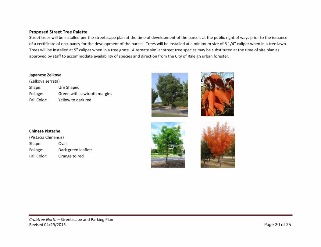
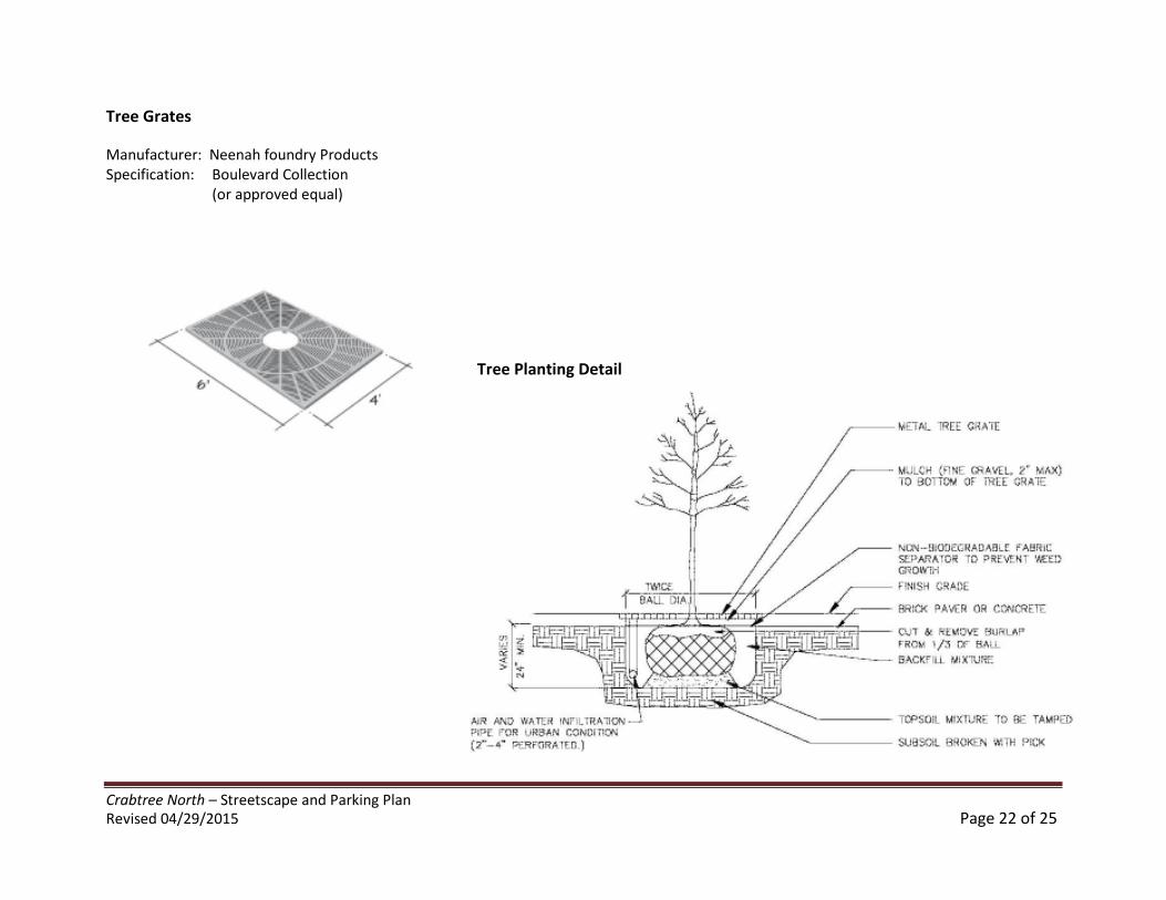
Proposed Street Tree PaletteStreet trees will be installed per the streetscape plan at the time of development of the parcels at the public right of ways prior to the issuance
of a certificate of occupancy for the development of the parcel. Trees will be installed at a minimum size of 6 1/4” caliper when in a tree lawn.
Trees will be installed at 5” caliper when in a tree grate. Alternate similar street tree species may be substituted at the time of site plan as
approved by staff to accommodate availability of species and direction from the City of Raleigh urban forester.
Japanese Zelkova
(Zelkova serrata)
Shape: Urn Shaped
Foliage: Green with sawtooth margins
Fall Color: Yellow to dark red
Chinese Pistache
(Pistacia Chinensis)
Shape: Oval
Foliage: Dark green leaflets
Fall Color: Orange to red
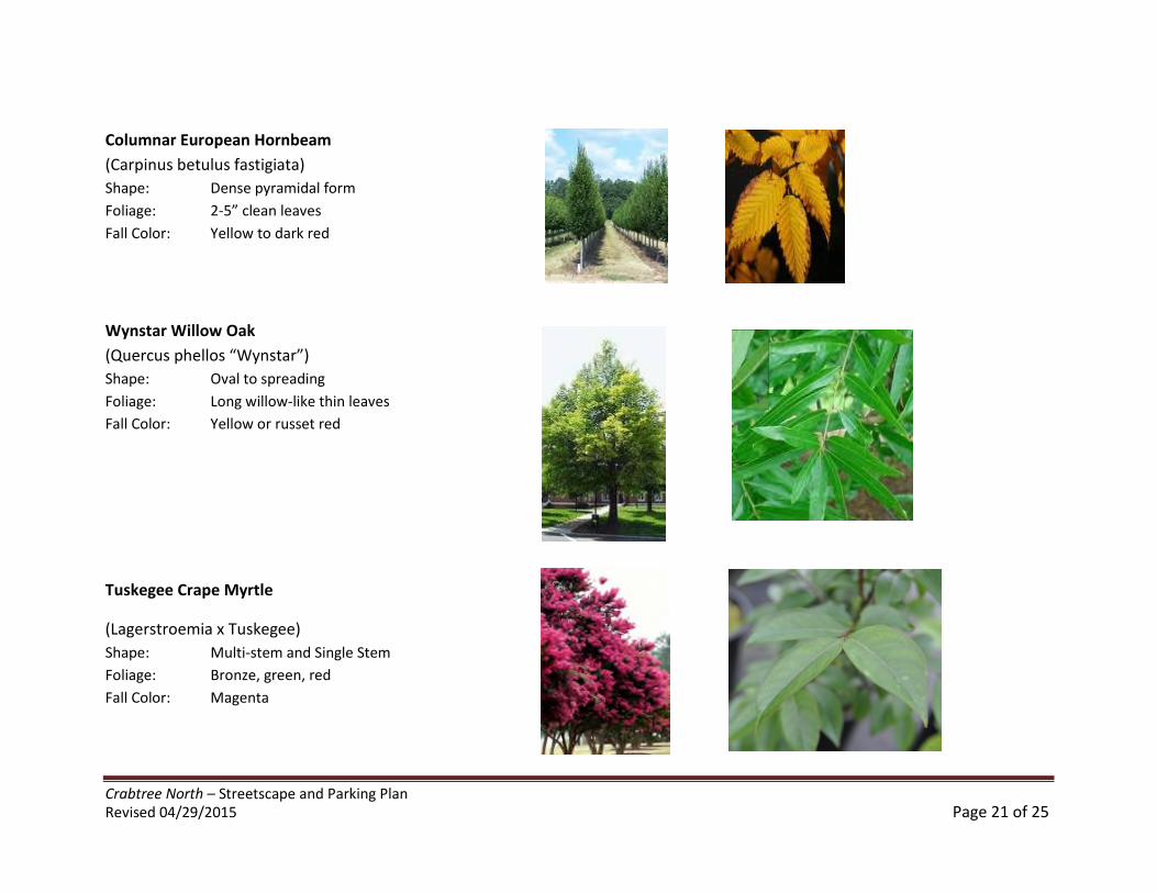
Crabtree North – Streetscape and Parking PlanRevised 04/29/2015 Page 21 of 25
Columnar European Hornbeam
(Carpinus betulus fastigiata)
Shape: Dense pyramidal form
Foliage: 2-5” clean leaves
Fall Color: Yellow to dark red
Wynstar Willow Oak
(Quercus phellos “Wynstar”)
Shape: Oval to spreading
Foliage: Long willow-like thin leaves
Fall Color: Yellow or russet red
Tuskegee Crape Myrtle
(Lagerstroemia x Tuskegee)
Shape: Multi-stem and Single Stem
Foliage: Bronze, green, red
Fall Color: Magenta
Crabtree North – Streetscape and Parking PlanRevised 04/29/2015 Page 22 of 25
Tree Grates
Manufacturer: Neenah foundry ProductsSpecification: Boulevard Collection
(or approved equal)
Tree Planting Detail
Crabtree North – Streetscape and Parking PlanRevised 04/29/2015 Page 23 of 25
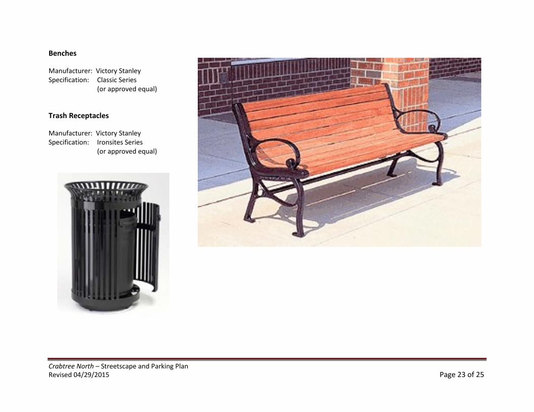
Benches
Manufacturer: Victory StanleySpecification: Classic Series
(or approved equal)
Trash Receptacles
Manufacturer: Victory StanleySpecification: Ironsites Series
(or approved equal)
Crabtree North – Streetscape and Parking PlanRevised 04/29/2015 Page 24 of 25
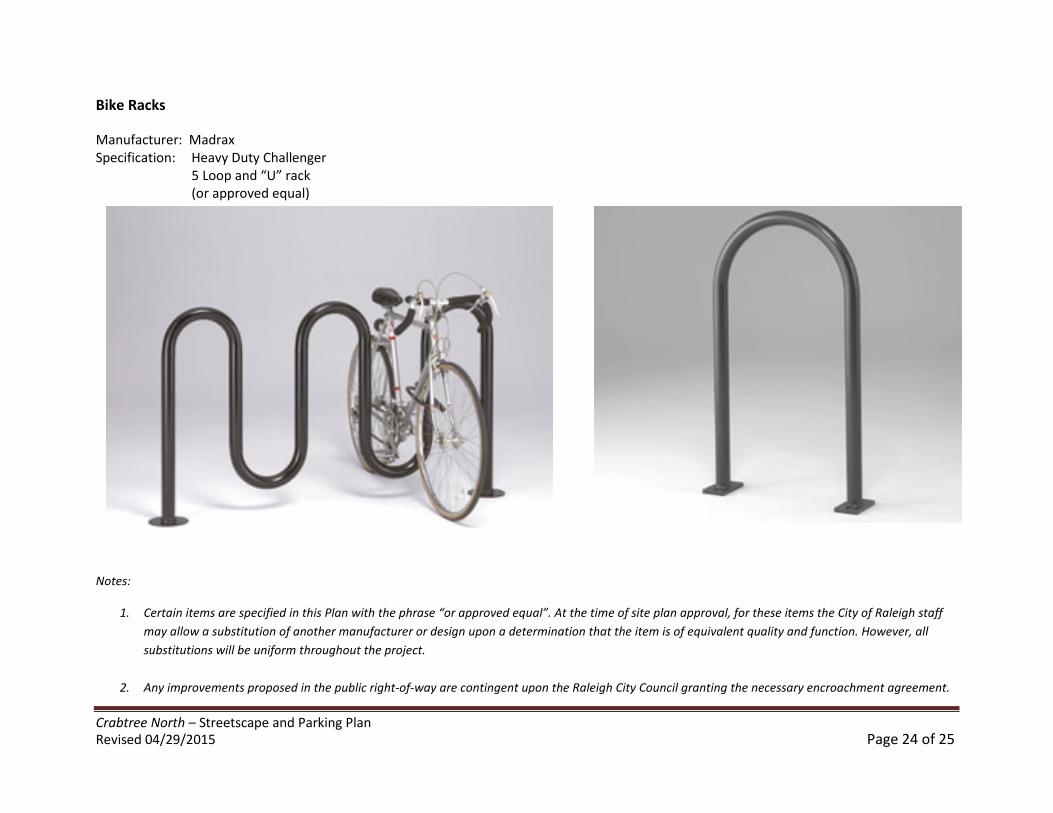
Bike Racks
Manufacturer: MadraxSpecification: Heavy Duty Challenger
5 Loop and “U” rack(or approved equal)
Notes:
1. Certain items are specified in this Plan with the phrase “or approved equal”. At the time of site plan approval, for these items the City of Raleigh staff
may allow a substitution of another manufacturer or design upon a determination that the item is of equivalent quality and function. However, all
substitutions will be uniform throughout the project.
2. Any improvements proposed in the public right-of-way are contingent upon the Raleigh City Council granting the necessary encroachment agreement.
Crabtree North – Streetscape and Parking PlanRevised 04/29/2015 Page 25 of 25
Appendix – City Code Section 10-2055 – Pedestrian Business Overlay District