Embed Size (px)
Citation preview

OPERATIONAL MONITORING OF COASTAL AND MARINE ENVIRONMENT WITHSPACEBORNE SAR SYSTEMS: WHERE ARE WE NOW AND WHERE ARE WE GOING
Christopher Wackerman1 and Johnny Johannessen2
1General Dynamics Advanced Information Systems, P.O. Box 134008, Ann Arbor Michigan, 48113-4008 [email protected]
2Nansen Environmental and Remote Sensing Center, Edvard Griegsvei 3a, 5059 Bergen, [email protected]
ABSTRACT
The 2nd workshop on Coastal and Marine Applicationsof Synthetic Aperture Radar was held in SvalbardNorway on 8-12 September 2003. This conference wasfocused on providing an overview of the tools nowavailable within the international community forutilizing synthetic aperture radar (SAR) systems tocharacterize the marine environment. Applicationswere specifically focused on wind, waves, sea ice, andcurrents. This paper provides an overview of thediscussions from that workshop and proposes the nextsteps along the road of achieving true operational usageof SAR sensors for monitoring the marineenvironment.
1. INTRODUCTION
With the coming of simultaneous flight operations ofthree calibrated spaceborne Synthetic Aperture Radar(SAR) systems (ENVISAT, RADARSAT-2 andALOS) employing wide swath (~500km), multi-frequency and multi-polarization technology, SARapplication will be on the threshold of a new era. Addto this the more focused satellite systems being plannedby individual countries (ESA’s TerraSAR-L,Germany’s TerraSAR-X, Italy’s Cosmo-Skymed, andArgentina’s SAOCOM) and we find that we areentering a period where the availability, coverage, anddiversity of SAR data will be unprecedentedthroughout the world.
After ten years of research into estimation ofenvironmental information from spaceborne imagingSAR, now is the time to demonstrate the operationalcapability of such systems to monitor the marineenvironment. As will be clear from this summary andthe papers in this volume, many of the tools are inplace and much of the research and applications aremature, and as is clear above, data availability hasnever been better. If we do not successfullydemonstrate operational capabilities within the nextfew years, the opportunity to build a sustainableinternational user base in support of imaging SARsystems for marine monitoring will be lost.
To do this will require international collaboration tofacilitate data access and to allow the development andharmonization of uniform systems operatingsimultaneously at different regions around the world.Such uniformity will be essential to build aninternational user base that is familiar with a standardset of SAR-derived marine environmental products, isfamiliar with standard methods to access the products,and routinely uses the products in operational systems.Such standardization is required to make imaging SARtruly an asset for operational marine monitoring.
The first step along this path is to get a snapshot of thecurrent state of the art in operational marine monitoringwith spaceborne SAR systems. Four years ago the 1st
Workshop on Coastal and Marine Applications ofWide Swath SAR was held at the Applied PhysicsLaboratory in Laurel MD where researchers fromfacilities around the world presented a summary of thethen emerging technologies for utilizing wide-swathSAR imaging systems for coastal and marineapplications (Beal & Pichel 2000). The 2nd Workshopon Coastal and Marine Applications of SyntheticAperture Radar was held in Svalbard Norway on 8-12September 2003. The second workshop wasspecifically focused on providing an overview of theoperational tools now available within the internationalcommunity, the new methods and applications thatresearchers were pursuing, and the future directionsthat marine applications may go. This proceedingsprovide that state of the art summary from the 2nd
coastal and marine SAR applications workshop.
This second workshop focused on answering threequestions: (1) What progress has been made since thefirst workshop on operational SAR marineapplications; (2) What are the currently available toolsfor deriving marine environmental products and whatvalidation results have been performed; and (3) Whatare the future directions for marine monitoring. Insteadof the traditional approach of allowing individualresearchers to present summaries of their work, it wasdecided that to facilitate answering these questions theworkshop would be divided into four applicationsareas: Winds, Waves, Sea Ice, and Currents &Features. For each application community andworkshop participants prepared a single summary

presentation of the state of the art in that applicationarea, addressed these questions, and in the processcame to a consensus as to the answers. In thisproceedings are four summary papers from eachapplication which resulted from these presentations andwere contributed to by all the researchers attending theworkshop. Following the summary papers are shortertechnical papers submitted by individual researchersdiscussing their particular application or technique inmore detail.
There are of course other applications areas whereSAR imaging plays a role, three of particular interestbeing ship monitoring, oil spill detection, and shallowwater bathymetry. The former two areas are currentlybeing addressed in two European programs, theOCEANIDES project and the Detection, Classificationand Identification of Marine Traffic from Space(DECLIMS) project. Both of these projects willshortly provide state of the art reports on theseapplications, and so it was decided not to duplicatetheir efforts in these proceedings.
Sections 2 and 3 of this paper provide an overallsummary of the workshop answers to the questionsposed above. These answers are drawn from resultsgenerated by all the researchers working internationallyin these applications areas, and as such they are all co-authors to this summary. The four summary papers aswell as the detailed technical papers that are in theseproceedings provide the background, references, anddetails to support the conclusions we state here. Werefer the reader to the other papers in these proceedingsand to the summary papers in particular. Section 4provides the author’s view of the next steps towardoperational SAR usage, and Section 5 presents asummary and discussion.
2. WHAT PROGRESS HAVE WE MADEOVER THE LAST FOUR YEARS
An important question addressed in this secondworkshop was to summarize what progress has beenmade in operational use of SAR since the firstworkshop. That first workshop focused on emergingtechnologies and initial demonstrations of utilizingSAR images to manually derive information. Out ofthe second workshop it became clear that a large bodyof work has been ongoing to make a number of theseapplications operational, to incorporate SAR imageryroutinely in some operations, and to continue todevelop new approaches for estimating marineenvironmental information.
In the estimation of winds, the accuracy of theextracted wind speeds and directions has beendocumented over the last years by comparison to in situ
buoy observations, winds derived from satellite-basedscatterometer sensors, and model winds by a widerange of researchers [Vachon & Dobson (1996),Wackerman et al. (1996), Fetterer et al. (1998),Horstmann et al. (1998), Kerbaol et al. (1998),Korsbakken & Furevik (1998), Korsbakken et al.(1998), Lehner et al. (1998), Mastenbroek (1998),Vandemark et al. (1998), Furevik & Korsbakken(2000), Horstmann et al. (2000a), Horstmann et al.(2000b), Lehner et al. (2000), Monaldo et al. (2001),Thompson et al. (2001), Furevik et al. (2002),Wackerman et al. (2003)]. These new results supportthat wind speeds can be derived operationally fromSAR imagery with errors (in the sense of a root-mean-squared-error, RMSE) of less than 2 m/s and withspatial resolutions of a few kilometers. This is whetherwind directions are derived from the SAR image itselfor are taken from scatterometer or model data. Winddirections can be derived from SAR imagery directlywith RMSEs of 25 degrees over spatial resolutions of10 to 25 km [Wackerman et al. (1996), Fetterer et al.(1998), Korbakken and Furevik (1998), Vachon andDobson (2000), Horstmann et al. (2002), Du et al.(2002), Fichaux and Rachin (2002)]. Over the past twoyears, operational delivery of wind fields (as well asship location maps) from SAR imagery in under 3hours has been routinely demonstrated as part of theNOAA/NESDIS Alaska SAR Demonstration Project(Pichel & Clemente-Colon, 2000), getting the systemsignificantly closer to delivery times that weatherforecasters require (often within 2 hours). Fig. 1 showsan example wind field product that is automaticallygenerated as part of this project and that combinesresults from two different algorithms. In addition, thewind fields being derived in the Alaska SARDemonstration are being used to determine ferry routesaround Alaska, and have been used in NATOexercises. Finally new techniques for wind estimationfrom SAR continue to be developed; utilizing thesmearing effects in SAR to estimate wind speed andthe cross-spectrum to derive wind vectors [Egen et al.(1998), Kerbaol et al. (1998), Lehner et al. (2000)].
In wave estimation, the use of SAR images (mostlyimagettes; 5 km X 10 km SAR images acquired every100 to 200 km along the satellite orbit) to estimatewave spectra is now running operationally at a numberof meteorological offices (The Met Office UK, MeteoFrance, Norwegian Met Office, and the EuropeanCentre for Medium-range Weather Forecast(ECMWF)) (Loti et al. 2003) using tools based ontransfer functions between SAR image modulationsand wave height modulations [Hasselmann &Hasselmann (1991), Krogstad et al. (1994), Egen &Johnson (1995)] . Fig. 2 shows an example of such aspectrum that was derived by DLR from ERS-2imagery processed to simulate ENVISAT data and
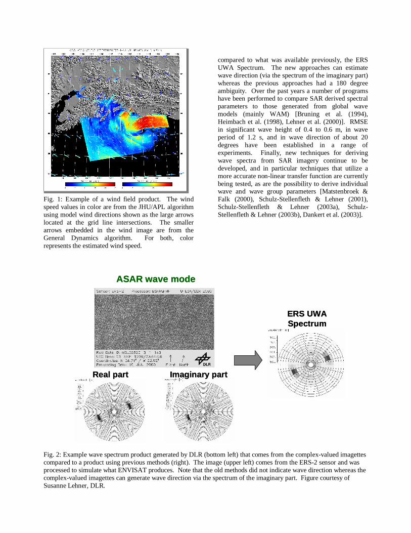
Fig. 1: Example of a wind field product. The windspeed values in color are from the JHU/APL algorithmusing model wind directions shown as the large arrowslocated at the grid line intersections. The smallerarrows embedded in the wind image are from theGeneral Dynamics algorithm. For both, colorrepresents the estimated wind speed.
compared to what was available previously, the ERSUWA Spectrum. The new approaches can estimatewave direction (via the spectrum of the imaginary part)whereas the previous approaches had a 180 degreeambiguity. Over the past years a number of programshave been performed to compare SAR derived spectralparameters to those generated from global wavemodels (mainly WAM) [Bruning et al. (1994),Heimbach et al. (1998), Lehner et al. (2000)]. RMSEin significant wave height of 0.4 to 0.6 m, in waveperiod of 1.2 s, and in wave direction of about 20degrees have been established in a range ofexperiments. Finally, new techniques for derivingwave spectra from SAR imagery continue to bedeveloped, and in particular techniques that utilize amore accurate non-linear transfer function are currentlybeing tested, as are the possibility to derive individualwave and wave group parameters [Matstenbroek &Falk (2000), Schulz-Stellenfleth & Lehner (2001),Schulz-Stellenfleth & Lehner (2003a), Schulz-Stellenfleth & Lehner (2003b), Dankert et al. (2003)].
Fig. 2: Example wave spectrum product generated by DLR (bottom left) that comes from the complex-valued imagettescompared to a product using previous methods (right). The image (upper left) comes from the ERS-2 sensor and wasprocessed to simulate what ENVISAT produces. Note that the old methods did not indicate wave direction whereas thecomplex-valued imagettes can generate wave direction via the spectrum of the imaginary part. Figure courtesy ofSusanne Lehner, DLR.
ASAR wave mode
Imaginary part
ERS UWASpectrum
Real part
ASAR wave mode
Imaginary part
ERS UWASpectrum
Real part

Fig. 3: An ice chart for the east coast of Canada (right) that was generated in part using information from theRADARSAT-1 SAR image shown on the left to derive ice edge information. Figure courtesy of Dean Flett, CanadianIce Service.
In sea ice monitoring, over the past years operationaluse of SAR imagery to manually derive sea ice typehas grown from two centers in 1999 to a number whichnow include centers in the United States, Canada,Denmark, Finland, Germany, Sweden and Norway[Wohl (1995), Vainio et al., (2000), Bertoia et al.,(1999)]. SAR imagery is now fully integrated intooperational data analysis and product generation atthese ice centers is being used routinely to validate iceedge information derived from QuickScatscatterometers and SSM/I radiometers and to helpdetermine ice type. As an example, Fig. 3 shows aRADARSAT SAR image that was utilized to helpdevelop the ice edge information shown in the attachedCanadian East Coast ice chart. Techniques for usingSAR imagery to track drifting ice and to estimate icedeformation have recently been utilized by the icecenters as experimental products [Kwok et al (1990),McConnell et al. (1991), Williams et al. (1999)]. Newtechniques in this field are also being developed,including the use of polarimetric SAR data for iceclassification and ice edge locations. However,automated tools for deriving ice information from SARimagery were identified in the workshop as animportant area for ongoing research in the sea icecommunity [Havercamp et al. (1995), Havercamp &Tsatsoulis (1999), Soh & Tsatsoulis (1999), Weber etal. (2003), Soh et al. (2004)].
Estimating currents from SAR imagery, as well asexploiting other oceanic features, is perhaps the mostresearch-dominated application area addressed by theworkshop. Most of the work over the last years hasbeen in development of improved forward models topredict the SAR signatures of regions with changingoceanic currents [Romeiser et al. (1997), Romeiser &Alpers (1997), Johanessen et al. (1996), Jansen et al.(1998), Chubb et al. (1999), Romeiser & Ufermann(2001), Vogelzang (2001), Kudryavtsev et al. (2003a),Kudryavtsev et al. (2003b)]. Fig. 4 shows an exampleoutput from one such model, comparing actual radarcross section perturbations across a current front tosimulated values. However, operational manual imageanalysis has become incorporated recently for anumber of users, including the Norwegian Navy forlocating fronts and tracking oil, the UK HydrologyOffice for locating current fronts and internal waves,and the Brazilian oil company Petrobras for trackingoil spills and locating oil seeps. In addition, newtechniques for estimating currents based on theDoppler shift in complex-valued SAR imagery arebeing pursued, as well as the use of along-trackinterferometric SAR systems for direct observations ofsurface currents.
East Coast ice chart - March 6, 2000
Labrador coast - ScanSAR Wide, March 6, 2000
© CSA 2000
East Coast ice chart - March 6, 2000
Labrador coast - ScanSAR Wide, March 6, 2000
© CSA 2000

Overall, the workshop successfully focused attentionon a large amount of work that has been ongoingrecently to make SAR marine monitoring moreoperational. Perhaps more importantly, it alsoidentified a wide range of applications that nowroutinely utilize SAR imagery in generating productsboth automatically and manually.
3. WHAT TOOLS ARE CURRENTLYAVAILABLE
A second focus of the workshop was to identify whattools are currently available for extracting marineenvironmental products from SAR imagery. Clearly,for SAR systems to be operational in marinemonitoring, a standardized set of tools for derivinginformation will need to be established and madeavailable to the community. In fact, as discussedbelow, demonstrating such a uniform set of tools willbe the next step in the path to achieve fully operationalutility. For details concerning all of these tools, pleasesee the accompanying summary and detail papers.
In wind vector estimation, a wide range of tools arenow available with various degrees of user interactionrequired, including codes from the German GKSSResearch Center, the Canadian Center for RemoteSensing (CCRS), the Norwegian KSAT, theNorwegian Nansen Environmental and RemoteSensing Center (NERSC), the French BoostTechnologies, General Dynamics in the U.S., the JohnHopkins University Applied Physics Lab in the U.S.,the German Aerospace Center (DLR), and theEuropean Space Agency (ESA) [Wackerman et al.(1996), Kerbaol et al. (1998), Korsbakken et al. (1998),Mastenbroek (1998), Horstmann et al. (2000a), Lehneret al. (2000), Monaldo et al. (2001), Vachon andDobson (2000), Horstmann et al. (2002), Du et al.(2002), Fichaux and Rachin (2002)]. Some of thesetools estimate wind speed and direction, some estimatejust wind speed.
In wave estimation, a number of institutions haveautomated tools to generate wave spectra from SARimage spectra. The Max Planck Institute algorithms(MPI-1 and MPI-2) are the ones currently running atthe meteorological centers (ECMWF, Meteo France,The Met Office UK) [Hasselman & Hasselman (1991),Krogstad et al. (1994)] . In addition there are a rangeof tools requiring differing forms of inputs (e.g. somerequire an a priori wave spectrum and some do not); aEuropean Space Agency (ESA) algorithm developedby NORUT and IFREMER (usually referred to as theESA algorithm) (Egen and Johnsen (1995)), analgorithm from ARGOSS called the Semi-ParametricRetrieval Algorithm (SPRA) (Mastenbroek & Falk(2000)), two algorithms from DLR called the
Fig. 4: Example of the accuracies of the forwardmodels for predicting radar cross section signatures ofcurrent fronts. The SAR image is shown on the top,with the white line indicating where a cut through theimage was taken. The plot on the bottom shows theactual radar cross section values (solid line) versus thesimulated values (dashed line). Figure courtesy of(Kudryavtsev et al. 2003b).
Partitioning Rescale and Shift Algorithm (PARSA) andone referred to as LISE (Schulz-Stellenfleth & Lehner(2003)), and an algorithm from General Dynamics(Lyzenga (2002)). All of them have been comparedagainst combinations of WAM predictions and in situobservations to varying degrees and have reproducedsignificant wave heights with RMSEs of 0.4 to 0.6 m,dominant wave periods with RMSE of 1.2 s, anddominate wave directions with RMSEs of 20 degrees.
In sea ice monitoring, most of the tool development todate has been on user interactive tools for helping theice analysts provide sea ice maps operationally, andthese are utilized at all of the international ice centerscurrently [Wohl (1995), Vainio et al., (2000), Bertoia

et al., (1999)]. The exceptions to these are toolsdeveloped by Jet Propulsion Laboratory (JPL) toautomatically determine ice deformation over time inthe Arctic and automatically track floe motion (bothpart of the Radarsat Geophysical Processing Station(RGPS) running at the Alaska SAR facility) [ Kwok etal., (1990)]. None of the automated tools have yet beenvalidated in the sense of generating RMSEs for specificenvironmental quantities, although as was noted abovea major thrust for the sea ice community is theautomation of more monitoring tools [McConnell et al.(1991), Havercamp et al. (1995), Havercamp &Tsatsoulis (1999), Soh & Tsatsoulis (1999), Williamset al. (1999), Weber et al. (2003), Soh et al. (2004)].
In estimation of currents and other oceanic features,multiple models are being developed to generate SARsignatures from descriptions of the underlyingenvironmental parameters with four models havingreached a level of maturity: the ERIM Ocean Modeldeveloped by what is now General Dynamics [Lyzengaand Bennett (1988)], the model developed by theUniversity of Hamburg [Romeiser et al., (1997),Romeiser & Alpers, (1997)], the Radar Imaging Model(RIM) model developed by Nansen InternationalEnvironmental and Remote Sensing Center (NIERSC)[Krudryavtsev et al. (2003a), Krudryavtsev et al.(2003b)], and the ARGOSS model [Vogelzang (2001)].All of these are still research codes that containdifferent physical assumptions to explain SARsignatures observed in various experiments.Automated algorithms have also been developedrecently to help users interpret image features,including the Bathymetry Assessment System (BAS)by ARGOSS [Calkoen et al. (2001)] as well asalgorithms for automatically locating oceanic featuresin SAR imagery using wavelet analysis [Rodenas&Garello (1998), Wu & Liu, (2003)]. Tools to locateand characterize ocean features have also beendeveloped and or refined under the MARSAIS project[Johannessen et al. (2001)]. Tools which require someuser interaction are estimations of currents using theDoppler centroid shift in complex-valued SAR imagery(developed by Boost Technologies) and estimation ofinternal wave parameters by the University ofHamburg.
In summary, the range of tools available for estimatingcoastal environmental parameters has significantlyincreased over the last few years. A number of thetools are automated (including estimation of windvectors, wave spectra, ice deformation, near-shorebathymetry, location of current features and shipdetection) whereas a number of the tools still requiresome level of user interaction (including other windvector tools, ice type classification, current gradientsand radial currents, and oil spill detection). Perhaps
more importantly for operational use, theenvironmental products are starting to be validated (i.e.generating RMSE values) against in situ observationsand/or models. The most heavily validated to date within situ observations are the wind vector tools. Thewave spectra tools have been validated against some insitu observations but mostly compared against modelresults. However a number of validation campaignswith in situ observations are either on-going or beingplanned. The remaining tools are less mature in theirdevelopment cycle and thus have not yet beenvalidated to the level of the winds and waves tools, buta number of them, estimation of currents in particular,are just coming into validation studies. Overall, thetools that exist right now already span a large range ofthe coastal environmental parameters desired by users.
4. WHERE DO WE GO FROM HERE
The 2nd Workshop on Coastal and Marine Applicationsof SAR has successfully provided a snapshot of thecurrent state of the art in coastal monitoring from SARsystems. Although not specifically addressed in theconference, it is important to also understand where thecommunity could go from here to continue the growthof operational usage of SAR sensors. The authors ofthis overview paper propose that the next step on thepath to achieving operational capability is to provide aninternational demonstration of environmental productsgenerated from SAR sensors at a range of locations.This demonstration must show uniformity in productgeneration from all sites, and post all products on theinternet for interchange between partners. The toolswould be run operationally at each location todemonstrate the timeliness and performance of theproducts to local users, based on the models of theongoing NOAA/NESDIS Alaska SAR DemonstrationProject which automatically posts wind vectors andship locations usually within 3 hours of dataacquisition, and the Norwegian quasi-operationalsystem for oil spill detection, ship locations and waveretrieval. We envision that the tools would be drawnand integrated from a range of international partnersand taken from the set of tools described above, usingthe most robust approach for each product. Such ademonstration would verify the capability of SARsensors to provide uniform, world-wide, coastalproducts, determine the timeliness of the productgeneration, and validate the performance of theproducts.
We envision the demonstration lasting for one year,from mid-2004 to mid-2005. The tools that would beused to generate products would fall into two types;automated and user-interaction. It is clear that theautomated tools currently available would include: (1)

wind fields; (2) wave spectra (include parametersderived from the spectra); (3) ship locations; and (4)ice deformation. The user-interaction tools wouldinclude locating current fronts and generating ice typemaps. The products from each tool would bestandardized, so that all locations would generate thesame format for wind fields, wave spectra, etc. SinceNOAA/NESDIS in the U.S. and NansenEnvironmental and Remote Sensing Center in Norwayare running demonstrations off the coasts of Alaskaand Norway, respectively, we envision at least startingwith these locations, with the possible early additionsof locations off the coasts of Florida, Great Britain, andFrance, since all of these locations have some form ofimage download capability and are generating someform of products now from SAR imagery. Over thecourse of the demonstration, other sites could be added.
Operational access to SAR imagery will be an issue forsuch a demonstration, even though the number ofsatellites flying could be unprecedented. Underexisting cost structures such a demonstration may notbe able to afford running for a full year, so it mayrequire special arrangements for access to, and sharingof, SAR imagery among the sites. In addition,although a number of satellites may be available, it isnot clear what the duty cycle for each will be, and mostimportantly how much of that cycle could be devotedto coastal applications. It would be ironic indeed tohave more satellites than ever before with less marinecollections than ever before.
With the results from such a demonstration in handhowever, it would be time to connect to the usercommunity, which often requires proof of operationalcapability before committing to use a product.Although many, if not all, of the marine environmentalproducts currently being generated were motivated byuser needs (and in fact many products are beingutilized right now by users operationally), it will beessential to actually show that these products can beused. Perhaps more importantly, it will be important toshow that these products are useful, and help users gettheir jobs done better than they would without the SARproducts. If we can demonstrate operational productgeneration, and demonstrate user need and use of theproducts, we will be well on the way to building thesustainable international user base in support of SARimaging systems.
5. SUMMARY AND DISCUSSION
We believe that this summary paper and theseproceedings validate the claim that the 2nd Workshopon Coastal and Marine Applications of SARsuccessfully captured a snapshot of the current state ofthe art on coastal monitoring with SAR systems.
Furthermore, we believe that the snapshot showsexamples of capabilities that are well on their way tooperational levels in winds, waves, sea ice andcurrents, and that are starting to be validated against insitu observations of the environmental parameters.Finally, we believe that the snapshot also contains alarge range of users who right now are utilizing SAR-derived products operationally; including weatherservices, ferry operators, meteorological centers, seaice centers, military organizations, hydrographicoffices, and industry. In addition, we expect to see agrowing need and use of SAR derived products in thecontext of Global Monitoring for Environment andSecurity (GMES); the joint ESA-EU initiative that iscurrently under development with the goal to beimplemented for operational use by 2008. However,much progress still needs to be done before we canclaim a sustainable international user base for imagingSAR sensors, and we have attempted to outline a pathto that goal with milestones along the way.
As the SAR community moves toward operationalcoastal monitoring, the issue of the re-visit time thatany set of imaging radar sensors would be able to attainneeds to be considered. Clearly, the number ofsatellites required for near-real time radar imageacquisition over the globe will never be affordable.Rather, it is incumbent on the application providers todifferentiate between real-time operations which maynever be supportable by imaging satellites (or whichwill only be supported in certain locations), versuslonger-time statistical descriptions of scenes that a fewimaging satellites could readily provide globally. Thisdoes not kill the idea of an operational SAR monitoringsystem, but rather constrains the community to purseusers that can be realistically supported by suchsystems.
The future of marine monitoring from SAR is clearlybright from the researcher point of view, and is clearlybeing embraced from a subset of users right now. Thechallenge for the future is to focus the researchcommunity to provide uniform, consistent products,and educate the user community how best to utilizethese products. Then the argument for sustainableimaging SAR-like sensors can be realistically made.
Finally, plans are underway for the dedicated 3rd
Workshop (of what we hope is an on-going seriesevery two years) sometime in 2005. We wouldanticipate this workshop focusing on user needs and onmaking the connection between the demonstratedcapabilities and helping the users get their jobsperformed effectively. Whereas demonstratedoperational product generation will be a goal after this2nd workshop, validating usage of the products wouldbe the goal after the 3rd workshop.

6. REFERENCES
Beal R.C., Pichel W.G., eds., 2000, Coastal and MarineApplications Of Wide Swath SAR, John Hopkins APLTech. Digest, 21.
Bertoia C., Gineris D., Partington K., Soh L., 1999,Transition from research to operations: ARKTOS – aknowledge-based sea ice classification system, Proc.International Geoscience and Remote SensingSymposium (IGARSS 99), 1573-1575.
Bruning C., Hasselmann S., Hasselmann K., Lehner S.,Gerling T. 1994,, A first evaluation of ERS-1 syntheticaperture radar wave mode data, Global Atmos. AndOcean System, 2, 61-98
Calkoen C.J., hesselmans G.H.F.W., Wensink G.J.,Vogelzang J., 2001, The Bathymetry AssessmentSystem: efficient depth mapping in shallow seas usingradar images, Int. J. Remote Sens., 22, 2973-2998.
Chubb S.R., Cooper A.L., Jansen R.W., Fusina R.A.,Lee J.S., Askari F., 1999, Radar backscatter frombreaking waves in Gulf Stream current convergencefronts, IEEE Trans. Geosci. Remote Sens., 37, 1951-1966.
Dankert H., Horstmann, J., Lehner, S., Rosenthal W.,2003, Detection of wave groups in SAR images andradar-image sequences, IEEE Trans. Geosci. RemoteSens., 41
Du, Y., P. Vachon, J. Wolf, 2002: Wind directionestimation from SAR images of the ocean usingwavelet analysis, Can. J. Remote Sens., 28, 498-509
Engen, G. and H. Johnsen, 1995, SAR-ocean waveinversion using image cross spectra, IEEE Trans.Geosci. Remote Sensing, 33, 1047-1056.
Engen G., Hoegda K.A., Johnsen H., 1998, A newmethod for wind field retrieval from SAR data, In proc.CEOS SAR Workshop, WWP-138, 43-51.
Fetterer, F., D. Gineris, C. Wackerman, 1998:Validating a scatterometer wind algorithm for ERS-1SAR. IEEE Trans. Geosc. Remote Sens., 36, 479-492
Fichaux, N., T. Rachin, 2002: Combined extraction ofhigh spatial resolution wind speed and direction fromSAR images: a new approach using wavelet transform,Can. J. Remote Sens., 28, 510-516
Furevik, B.R., Korsbakken, E. 2000: Comparison ofderived wind speed from synthetic aperture radar and
scatterometer during the ERS tandem phase, IEEETrans. Geosci. Remote Sens., 38, pp.1113
Furevik B.R., Johannessen, O.M., Sandvik A.D. 2002:SAR-derived wind in polar regions – Comparison within situ and atmospheric model output, IEEE Trans.Geosci. Remote Sens.,40, 1720-1732
Hasselmann K., Hasselmann S., 1991, On the nonlinearmapping of an ocean wave spectrum into a syntheticaperture radar image spectrum, J. Geophy. Res., 10713-10729.
Hasselmann S., Bruning C., Hasselmann K., HeimbachP., 1996, An improved algorithm for the retrieval ofocean wave spectra from synthetic aperture radarimage spectra, J. Geophys. Res., 101, 16615-16629.
Havercamp D., leen K., Tsatsoulis C., 1995, Acomprehensive, automated approach to determining seaice thickness from SAR data, IEEE Trans. Geosci.Remote Sens., 33, 46-57.
Havercamp D., Tsatsoulis C., 1999, Information fusionfor estimation of summer MIZ ice concentration fromSAR imagery, IEEE Trans. Geosci. Remote Sens., 37,1278-1291.
Heimbach P., Hasselmann S., Hasselmann K., 1998,Statistical analysis and intercomparison with WAMmodel data of three years of global ERS-1 SAR wavemode spectral retrievals, J. Geophys. Res., 103, 7931-7977.
Horstmann, J. Koch, W., Lehner, S., Rosenthal, W.1998, Ocean wind fields and their variability derivedfrom SAR, Earth Observ. Quart.,59, 8-12.
Horstmann, J., W. Koch, S. Lehner, R. Tonboe, 2000a:Wind retrieval over the ocean using synthetic apertureradar with C-band HH polarization. . IEEE Trans.Geosc. Remote Sens., 38, 2122-2131
Horstmann, J., S. Lehner, W. Koch, R. Tonboe, 2000b:Computation of wind vectors over the ocean usingspaceborne synthetic aperture radar, The John HopkinsUniv. Tech. Dig., 21, 100-107.
Horstmann, J., W. Koch, S. Lehner, R. Toeboe, 2002:Ocean winds from RADARSAT-1 ScanSAR, Can. J.Remote Sens., 28, 524-533
Jansen, R.W., Shen C.Y., Chubb S.R., Cooper A.L.,Evans T.E., 1998, Subsurface, surface and radarmodeling of a Gulf Stream current convergence, J.Geophys. Res., 103, 18723-18743.

Johannessen, J.A., Shuchman R.A., Digranes G.,Lyzenga D.R., Wackerman C., Johannessen O.M.,Vachon P., 1996, Coastal ocean fronts and eddiesimages with ERS-1 synthetic aperture radar, J.Geophys. Res., 101, 6651-6667.
Johannessen, J.A., Garello R., Chapron B., Romeiser,R., Pavlakis P., Robinson I., Connolly N., Nittis K.,Hamre T., Ufermann S., Alpers W., Espedal H.,Furevik B., Cummins V., Tarchi D., 2001, Marine SARanalysis and interpretation system – MARSAIS, Ann.Telecommun., 56, 655-660.
Kerbaol, V., Chapron, B., Queffeulou, P., 1998,Analysis of the wind field during the Vendee Globerace: A kinematic SAR wind speed algorithm,EarthObserv. Quart.,59, pp.16
Korbakken, E., Johannessen, J.A., Johannessen, O.M.,1998, Coastal wind retrievals from ERS syntheticaperture radar, J. Geophys. Res., 103,7857-7874
Korsbakken, E., Furevik, B., 1998, Wind field retrievalfrom SAR compared with scatterometer wind fieldduring the ERS tandem mission, Earth Observ. Quart.,59, p. 23
Krogstad, H., O. Samset, and P. Vachon, 1994,Generalizations of the nonlinear ocean-SAR transformand a simplified SAR inversion algorithm, Atmos.Ocean, 32 , 61-82.
Krudryavtsev, V., Hauser D., Caudal C., Chapron B.,2003a, A semi-empirical model of the normalized radarcross-section of the sea surface. Part 1: Thebackground model, J, Geophys. Res., 108
Krudryavtsev, V., Hauser D., Caudal C., Chapron B.,2003b A semi-empirical model of the normalized radarcross-section of the sea surface. Part 2: radarmodulation transfer function, J, Geophys. Res., 108
Kwok R., Curlander J., McConnell R., Pang S., 1990,An ice-motion tracking systems at the Alaska SARFacility, IEEE J. Oceanic Eng., 15, 44-54.
Lehner, S., J. Horstmann, W. Koch, W. Rosenthal,1998: Mesoscale wind measurements usingrecalibrated ERS SAR images, J. Geophys. Res.,103,7847-7856
Lehner, S., J. Schulz-Stellenfleth, B. Schattler, H.Breit, J. Horstmann, 2000: Wind and wavemeasurements using complex ERS-2 SAR wave modedata, IEEE Trans. Geosc. Remote Sens., 38, 2246-2257
Lotfi A., Lefevre J.M., Hauser D., 2003, Optimizationof the assimilation scheme of directional wave spectrain wave model WAM: Application to real ASAR-ENVISAT wave spectra, Proc. ThirteenthInternational Offshore and Polar EngineeringConference, Honolulu, Hawaii
Lyzenga D., Bennett J., 1988, Full-spectrum modelingof synthetic aperture radar internal wave signatures, J.Geophys. Res., 93, 12345-12354.
Lyzenga, D.R., 2002, Unconstrained inversion ofwaveheight spectra from SAR images, IEEE Trans.Geosc. Remote Sens., 40, 261-270.
Mastenbroek, K., 1998, High resolution wind fieldsfrom ERS SAR, Earth Observ. Quart., 59, pp. 20
Mastenbroek, C., Falk C.F., 2000, A semi-parametericalgorithm to retrieve ocean wave spectra from syntheticaperture radar, J. Geophys. Res., 105, 3497-3516.
McConnell, R., Kwok R., Curlander J., Kober W.,Pang S., 1991, psi-s correlation and dynamic timewarping: two methods for tracking ice floes in SARimages, IEEE Trans. Geosci. Remote Sens., 29, 1004-1012.
Monaldo, F., D.R. Thompson, R.C. Beal, W.G. Pichel,P. Clemente-Colon, 2001: Comparison of SAR-derivedwind speed with model predictions and ocean buoymeasurements, IEEE Trans. Geosc. Remote Sens., 39,2587-2600
Pichel, W., Clemente-Colón, P., 2000, NOAACoastwatch SAR Applications and Demonstration,John Hopkins APL Tech. Dig., 21, 49-57.
Rodenas J.A., Garello R., 1998, Internal wavedetection and location in SAR images using wavelettransform, IEEE Trans. Geosci. Remote Sens., 36,1494-1507.
Romeiser, R., Alpers W., Wismann V., 1997, Animproved composite surface model for radarbackscattering cross section of the ocean surface: 1.Theory of the model and optimization/validation byscatterometer data, J. Geophys. Res., 102, 25237-25250.
Romeiser R., Alpers W., 1997, An improved compositesurface model for the radar backscattering cross sectionof the ocean surface: 2. Model response to surfaceroughness variations and radar imaging of underwaterbottom topography, J. Geophys. Res., 102, 25251-25267.

Romeiser, R., Ufermann S., Alpers W., 2001, Remotesensing of oceanic current features by synthetic , 314-317aperture radar – achievements and perspectives,Ann. Telecommun., 56, 661-671.
Schulz-Stellenfleth J., Lehner S., 2001, Ocean waveimaging using an airborne single pass cross trackinterferometric synthetic aperture radar, IEEE Trans.Geosci. Remote Sens., 39, 38-44.
Schulz-Stellenfleth, J., Lehner S., 2003a, Measurementof two-dimensional sea surface elevation fields usingcomplex synthetic aperture radar data, submitted toIEEE Trans. Geosci. Remote Sens.
Schulz-Stellenfleth, J., Lehner S., 2003b A parametricscheme for ocean wave spectra retrieval from complexsynthetic aperture radar data using prior information,under submission to J. Geophys. Res.Thompson, D.R., R.C. Beal, 2000: Mapping high-resolution wind fields using synthetic aperture radar,The John Hopkins Univ. Tech. Dig., 21, 58-67
Soh L., Tsatoulis C., 1999, Unsupervised segmentationof ERS and RADARSAT sea ice images usingmultiresolution peak detection and aggregatedpopulation equalization, Int. J. Remote Sens., 20, 3087-3109.
Soh L., Tsatsoulis C., Gineris D., Bertoia C., 2004,ARKTOS: An intelligent system for SAR sea iceimage classification, IEEE Trans. Geosci. RemoteSens., 42, 229-248.
Thompson, D.R., Monaldo, F.M., Winstead N.S., PichlW.G., Clemente-Colon P., 2001, Combined estimatesimprove high-resolution coastal wind mapping, EOS,82, 368-374
Vachon, P., F.W. Dobson, 1996: Validation of windvector retrieval from ERS-1 SAR images over theocean, Global Atmos. Ocean Syst., 177-187
Vachon, P., F.W. Dobson, 2000: Wind retrieval fromRADARSAT SAR images: selection of a suitable C-band HH polarization wind retrieval model, Can. J.Remote Sens., 26, 306-313
Vainio J., Simila M., Gronvall H., 2000, Operationaluse of RADARSAT SAR data as aid to winternavigation in the Baltic sea, Can. J. Remote Sens, 26,314-317.
Vandermark, D., P.W. Vachon, B. Chapron, 1998,Assessment of ERS-1 SAR wind speed estimates usingan airborne altimeter, Earth Observ. Quart., 59, 5-8.
Vogelzang, J., 2001, A model comparison study to theimaging of submarine reefs with synthetic apertureradar, International Journal of Remote Sensing, 22,,2509-2536.
Wackerman, C., C.L. Rufenach, R.A. Shuchman, J.A.Johannessen, K.L. Davidson, 1996: Wind vectorretrieval using ERS-1 synthetic aperture radar imagery,IEEE Trans. Geosc. Remote Sens., 34, 1343-1352
Wackerman, C., Pichel, W.G., Clemente-Colon, P.,2003, Automated estimation of wind vectors fromSAR, Proc. 12th Annual Conference on SatelliteMeteorology at the 83rd Annual MeteorologicalAssociation Meeting, Long Beach CA.
Weber F., Nixon D., Hurley J., 2003, Semi-automaticclassification of river ice types on the peace Riverusing RADATSAT-1 synthetic aperture radar (SAR)imagery, Can. J. Civil Eng., 30, 11-27.
Williams R., Rees W., Young N., 1999, Technique foridentification and analysis of icebergs in syntheticaperture radar images of Antarctica, Int. J. RemoteSens., 20, 3183-3199
Wohl, G., 1995, Operational sea ice classification fromsynthetic aperture radar imagery, Photogramm. Eng. &Remote Sens., 61, 1455-1462.
Wu S.Y., Liu A.K., 2003, An automated ocean featuredetection, extraction and classification algorithm forSAR imagery, Int. J. Remote Sens., 24, 935-951.