Embed Size (px)
Citation preview

Southern Peninsula Arterial Corridor Investigation
Traffic Congestion Management Options
Prepared for
Mornington Peninsula Shire
July, 2018 G24836R-01G

Southern Peninsula Arterial Corridor Investigation Traffic Congestion Management Options
Southern Peninsula Arterial Corridor Investigation -July 2018- Rev.docx
Southern Peninsula Arterial Corridor Investigation
Traffic Congestion Management Options
Document Control
Issue No. Type Date Prepared By Approved By
A Initial Issue 04/06/18 R. Thomson A. Coyle
B Revised Issue 12/06/18 R. Thomson A. Coyle
C Revised Issue 19/06/18 R. Thomson A. Coyle
D Draft Final Issue 03/07/18 R. Thomson A. Coyle
E Draft Final Issue 04/07/18 R. Thomson A. Coyle
F Draft Final Issue 05/07/18 R. Thomson A. Coyle
G Final Issue 13/07/18 R. Thomson A. Coyle
Our Reference: G24836R-01G
COPYRIGHT: The ideas and material contained in this document are the property of Traffix Group (Traffix Group Pty Ltd – ABN 32 100 481 570, Traffix
Survey Pty Ltd – ABN 57 120 461 510, Traffix Design Pty Ltd – ABN 41 060 899 443). Use or copying of this document in whole or in part without the
written permission of Traffix Group constitutes an infringement of copyright.
LIMITATION: This report has been prepared on behalf of and for the exclusive use of Traffix Group’s client, and is subject to and issued in connection
with the provisions of the agreement between Traffix Group and its client. Traffix Group accepts no liability or responsibility whatsoever for or in
respect of any use of or reliance upon this report by any third party.
Cost estimates in this report
are indicative only.

Southern Peninsula Arterial Corridor Investigation Traffic Congestion Management Options
Southern Peninsula Arterial Corridor Investigation -July 2018- Rev.docx Page i
Executive Summary
Traffix Group was engaged by Mornington Peninsula Shire to investigate options to manage congestion
within the Southern Peninsula area as a priority transport study. The investigation has been
undertaken on the basis that further comprehensive transport planning will be needed to conclusively
investigate the different options identified.
The investigation responds to a Council resolution from the meeting of 24 April 2018 whereby Council
resolved:
‘That a further and preliminary report be brought to Council within 90 days as to traffic
movement arrangements on the Southern Peninsula as an alternative to the freeway reserve
overlay between Boneo Road and Blairgowrie.’
The investigation has identified and discussed the existing transport routes within the Southern
Peninsula including existing traffic patterns incorporating both traffic volume and travel time
information and shows how traffic patterns vary between the Point Nepean Road and inland routes
and how traffic volumes peak during the summer period.
The initial high-level investigation of traffic congestion within the Southern Peninsula identifies that
the existing Point Nepean Road corridor is operating at its existing capacity during the peak summer
period which is limiting the ability for future residential growth and further economic development
and limits the accessibility for residents and visitors and to safely evacuate the area in the event of an
emergency.
It is noted that Opportunities to address traffic congestion within the Southern Peninsula are fairly
limited due to conflicts with pedestrian and cyclist activity along the existing Point Nepean Road
corridor, the desire to protect the Tootgarook Wetland, the need to provide a route that is sufficiently
direct to shift traffic away from Point Nepean Road and the reality that the area to the west of Dundas
Street and to the north of the Tootgarook Wetland is almost fully developed.
Recommendations to address the traffic congestion issues include:
a) Implementation of a range of low cost measures on both the Point Nepean Road and inland
corridors incorporating minor intersection improvements at known congestion points along
existing traffic routes to deliver targeted improvements in the short-term prior to a decision being
made on a preferred long-term option.
b) Implementation of more significant transport improvements to enhance existing traffic routes in
the medium term including road widening, minor road realignments and major intersection
improvements.
c) Long-term road-based options should be assessed in more detail as part of an Integrated Transport
Plan. Options to be assessed should include duplication of the existing inland route east of Dundas
Street, construction of an arterial road within the western section of the freeway corridor to the
west of Dundas Street and realigning the Mornington Peninsula Freeway to follow the existing Old
Cape Schanck Road reservation. These options should be assessed against the option preferred
by VicRoads of constructing an arterial road along the full length of the Mornington Peninsula
Freeway corridor and a base case consisting of only the short and medium-term treatments.

Southern Peninsula Arterial Corridor Investigation Traffic Congestion Management Options
Southern Peninsula Arterial Corridor Investigation -July 2018- Rev.docx Page ii
d) Preparation of an Integrated Transport Plan for the entire Mornington Peninsula Shire which
identifies the strategic objectives to form the basis of the decision making to identify the preferred
long-term option. Strategic transport modelling, economic modelling and environmental
assessments should be undertaken as part of the Integrated Transport Plan to consider the various
medium to long-term options identified in this assessment.

Southern Peninsula Arterial Corridor Investigation Traffic Congestion Management Options
Southern Peninsula Arterial Corridor Investigation -July 2018- Rev.docx Page iii
Table of Contents
1 Introduction .......................................................................................................................................... 5
2 Study Area ............................................................................................................................................ 5
2.1 Existing Road Network ........................................................................................................................... 6
2.2 Existing Public Transport ........................................................................................................................ 8
2.3 Bicycle Facilities ..................................................................................................................................... 9
2.4 Emergency Management ....................................................................................................................... 9
2.5 Transport Task ......................................................................................................................................10
3 Existing Traffic Conditions ....................................................................................................................11
3.1 Existing Traffic Volumes ........................................................................................................................11
3.2 Traffic Growth ......................................................................................................................................18
3.3 Existing Travel Times .............................................................................................................................18
3.4 Existing Congestion Points ....................................................................................................................22
3.5 Crash Analysis .......................................................................................................................................23
4 Previous Studies ...................................................................................................................................25
4.1 Mornington Peninsula Access and Mobility Study (MPAMS) ..................................................................25
4.2 Point Nepean Road Study .....................................................................................................................26
4.3 Rye Township Plan ................................................................................................................................26
4.4 Southern Peninsula Travel Time Demonstration Project ........................................................................27
4.5 Tootgarook Wetland Management Plan (TWMP) ..................................................................................27
5 Strategic Objectives .............................................................................................................................28
6 Use of Freeway Corridor ......................................................................................................................29
6.1 Project Description ...............................................................................................................................29
7 Alternatives to Freeway Corridor .........................................................................................................31
7.1 Short Term/Low Cost Options ...............................................................................................................31
7.2 Medium Term Options ..........................................................................................................................42
7.3 Long Term Options ...............................................................................................................................47
8 Project Staging .....................................................................................................................................56
9 Long Term Options Assessment ...........................................................................................................56
10 Conclusions ..........................................................................................................................................58
List of Tables
Table 1: Summary of Potential Project Costs ....................................................................................................31
Table 2: Short Term Options Cost Summary .....................................................................................................42
Table 3: Medium Term Option Cost Summary ..................................................................................................47
Table 4: Potential Project Staging.....................................................................................................................56

Southern Peninsula Arterial Corridor Investigation Traffic Congestion Management Options
Southern Peninsula Arterial Corridor Investigation -July 2018- Rev.docx Page iv
List of Figures
Figure 1: Southern Peninsula Study Area ..................................................................................................................................................................... 5
Figure 2: Alternative Routes between Rosebud and Portsea ..................................................................................................................................... 6
Figure 3: Local Street ‘Short Cut’ ................................................................................................................................................................................... 8
Figure 4: Southern Peninsula Bus Routes ..................................................................................................................................................................... 9
Figure 5: Point Nepean Road Weekday Two Way Traffic Volume Profile ................................................................................................................11
Figure 6: Point Nepean Road Westbound Traffic Volume Profile.............................................................................................................................12
Figure 7: Point Nepean Road Eastbound Traffic Volume Profile ..............................................................................................................................12
Figure 8: Browns Road Two Way Traffic Volume Profile, East of Dundas Street.....................................................................................................13
Figure 9: Browns Road Westbound Traffic Volume Profile .......................................................................................................................................14
Figure 10: Browns Road Eastbound Traffic Volume Profile.......................................................................................................................................14
Figure 11: Summer Peak Daily Traffic Volumes (January 2018 Tube Count Data – SCATS data indicated by **) ................................................16
Figure 12: School Term Peak Daily Traffic Volumes (February Weekday 2018 Tube Count Data – SCATS data indicated by **) .......................17
Figure 13: Peak Westbound Travel Times – Rosebud to Sorrento on Point Nepean Rd, January 2018 ................................................................19
Figure 14: Point Nepean Road Westbound Travel Time – Rosebud to Sorrento ....................................................................................................20
Figure 15: Inland Route Westbound Travel Time – Rosebud to Sorrento................................................................................................................21
Figure 16: Mornington Peninsula Freeway Westbound Travel Time – Lonsdale Street to Jetty Road ..................................................................22
Figure 17: Identified Congestion Locations ................................................................................................................................................................23
Figure 18: Casualty Crashes in Southern Peninsula over Last Five Years .................................................................................................................24
Figure 19: Mornington Peninsula Freeway Corridor Option .....................................................................................................................................30
Figure 20: Jetty Road Roundabouts ............................................................................................................................................................................32
Figure 21: Point Nepean Road/Truemans Road .........................................................................................................................................................33
Figure 22: Point Nepean Road/Elizabeth Avenue ......................................................................................................................................................34
Figure 23: Boneo Road/Eastbourne Road...................................................................................................................................................................35
Figure 24: Boneo Road/Browns Road .........................................................................................................................................................................36
Figure 25: Point Nepean Road/Ocean Beach Road/Constitution Hill Road .............................................................................................................37
Figure 26: Melbourne Road/Ocean Beach Road/Ossett Street ................................................................................................................................37
Figure 27: Point Nepean Road/Hotham Road ............................................................................................................................................................38
Figure 28: Point Nepean Road/Esplanade ..................................................................................................................................................................38
Figure 29: Browns Road/Dundas Street Roundabout ................................................................................................................................................39
Figure 30: Recommended Short-Term Measures ......................................................................................................................................................41
Figure 31: Reversable Lane Treatment .......................................................................................................................................................................43
Figure 32: Browns Road Realignment .........................................................................................................................................................................44
Figure 33: Rye Internal Bypass Route .........................................................................................................................................................................45
Figure 34: Inland Route Duplication ............................................................................................................................................................................48
Figure 35: Mornington Peninsula Freeway Realignment via Old Cape Schanck Road ............................................................................................50
Figure 36: Browns Road Western Realignment .........................................................................................................................................................52
Figure 37: Long Term Option 1 – Duplication of Existing Roads ...............................................................................................................................54
Figure 38: Long Term Option 2 – Realignment West of Weeroona Street ..............................................................................................................54
Figure 39: Long Term Option 3 – Western Realignment with Old Cape Schanck Road Diversion .........................................................................55

Southern Peninsula Arterial Corridor Investigation Traffic Congestion Management Options
Southern Peninsula Arterial Corridor Investigation -July 2018- Rev.docx Page 5
1 Introduction
Traffix Group was engaged by Mornington Peninsula Shire to investigate options to manage congestion
within the Southern Peninsula area as a priority transport study. The investigation has been
undertaken on the basis that further comprehensive transport planning will be needed to conclusively
investigate the different options identified.
The investigation responds to a Council resolution from the meeting of 24 April 2018 whereby Council
resolved:
‘That a further and preliminary report be brought to Council within 90 days as to traffic
movement arrangements on the Southern Peninsula as an alternative to the freeway reserve
overlay between Boneo Road and Blairgowrie.’
2 Study Area
For the purposes of this study, the Southern Peninsula is defined as the portion of the Mornington
Peninsula to the west of Jetty Road as presented in the locality plan at Figure 1.
Figure 1: Southern Peninsula Study Area
Key townships located within the Southern Peninsula area include Rosebud, Capel Sound, Tootgarook,
Rye, Blairgowrie, Sorrento and Portsea. Each of these towns are located on the northern side of the
Southern Peninsula along Point Nepean Road.
Study Area

Southern Peninsula Arterial Corridor Investigation Traffic Congestion Management Options
Southern Peninsula Arterial Corridor Investigation -July 2018- Rev.docx Page 6
2.1 Existing Road Network
The majority of vehicles that access the Southern Peninsula arrive via the Mornington Peninsula
Freeway. This freeway currently ends at Jetty Road where a pair of roundabouts are located, with a
further 1.8km extension up to Boneo Road as a two lane, two-way road within the freeway reservation.
To the west of Boneo Road there are effectively two routes that motorists can use to access the
western portion of the Southern Peninsula. These routes include Point Nepean Road which is the
VicRoads arterial route which follows the northern coastline adjacent to Port Phillip Bay and an inland
route along Browns Road and Melbourne Road which are both Council maintained roads.
In addition to the two existing routes, the reservation for the Mornington Peninsula Freeway also
extends further to the west for a distance of 9.9km where it connects into Melbourne Road a short
distance to the west of Canterbury Jetty Road. This unused freeway reservation is currently included
in the Planning Scheme as either Public Use Zone 4 or land that is subject to a Public Acquisition
Overlay.
A diagram highlighting the location of the two existing routes and the unused reservation for the
extension of the Mornington Peninsula Freeway is presented at Figure 2. The figure also highlights a
shortcut that is regularly used by motorists with local knowledge of the area via minor local streets to
reduce the distance along the inland route.
Figure 2: Alternative Routes between Rosebud and Portsea
Both the unused freeway reserve and Browns Road are found to cut through the Tootgarook Wetland
in the section between Boneo Road and Dundas Street, with the freeway reserve cutting through
widest part of the Wetland near its outlet to Chinamans Creek.

Southern Peninsula Arterial Corridor Investigation Traffic Congestion Management Options
Southern Peninsula Arterial Corridor Investigation -July 2018- Rev.docx Page 7
2.1.1 Point Nepean Road Route
The Point Nepean Road route provides an arterial road connection between the end of the Mornington
Peninsula Freeway in Rosebud and Portsea, following the coastline adjacent to Port Phillip Bay. The
distance between the end of the freeway corridor at Boneo Road and the key township of Sorrento is
15.5km and involves travel along Boneo Road, Eastbourne Road and Elizabeth Avenue in addition to
the main section along Point Nepean Road.
The Point Nepean Road route runs through three townships on the way to Sorrento including
Tootgarook, Rye and Blairgowrie in the section between Rosebud and Sorrento, where there is
significant pedestrian activity during the peak summer period. The speed limit along the Point Nepean
Road route is generally 60km/h for the majority of the route apart from a reduction to 50km/h through
the Rye township and in increase to 70km/h through Blairgowrie.
The coastal route contains 10 sets of traffic signals and 2 roundabouts, including pedestrian signals in
Blairgowrie township, three signalised intersections and one set of pedestrian signals in Rye, one set
of pedestrian signals and one signalised intersection in Tootgarook and two sets of signals along
Eastbourne Road. These signals can cause delays during peak summer periods when pedestrian and
traffic volumes are high.
The majority of the Point Nepean Road route contains only a single through traffic lane in each
direction apart from the section through Rye township and along Eastbourne Road and Boneo Road
where two through lanes in each direction are provided.
2.1.2 Browns Road/Melbourne Road Route
Apart from the brief section along Boneo Road connecting the end of the Mornington Peninsula
Freeway to Browns Road, the entire inland route consists of local roads managed by Council. Unlike
the coastal route, the inland route avoids the major townships, however the inland route is 5.1km
longer to reach Sorrento from the end of the Mornington Peninsula Freeway at Boneo Road.
Speed limits along the inland route are generally higher than along Point Nepean Road, with sections
of 80km/h and 100km/h on Boneo Road, 80km/h and 90km/h on Browns Road, 80km/h on Dundas
Street and 70km/h on Melbourne Road.
The inland route contains no traffic signals apart from the access to the Bunnings Warehouse on Boneo
Road, however there are 10 roundabouts located along the route, all of which contain only a single
circulating lane apart from the roundabouts at Jetty Road and at Boneo Road at the end of the
Mornington Peninsula Freeway. The entire route is located on undivided roads where there is only a
single traffic lane in each direction apart from a short section on Boneo Road immediately south of the
freeway.
Although the inland route is intended to run via Browns Road, Dundas Street and Melbourne Road, a
faster alternative utilises the western end of Browns Road west of Dundas Street, Tasman Drive and
Canterbury Jetty Road as illustrated in Figure 3. The faster alternative is 1.6km less distance than the
intended route, but involves travel along minor residential streets, particularly the section along
Tasman Drive which has been extensively traffic calmed with single lane slow points.

Southern Peninsula Arterial Corridor Investigation Traffic Congestion Management Options
Southern Peninsula Arterial Corridor Investigation -July 2018- Rev.docx Page 8
Recent traffic surveys have found that this shortcut route can carry up to 11,900 vehicles per day during
the peak summer period which is well above what would normally be expected for a minor residential
street.
Figure 3: Local Street ‘Short Cut’
2.2 Existing Public Transport
There are four existing bus routes which serve the Southern Peninsula area west of Jetty Road, these
include:
• Route 786 between Rye and St Andrews Beach,
• Route 787 between Safety Beach and Sorrento,
• Route 788 between Frankston and Portsea via Dromana and Rosebud, and
• Route 886 between Rosebud and Chisholm TAFE Rosebud campus.
A diagram showing each of these bus routes from the PTV website is presented at Figure 4.
Local Shortcut Route
Intended Route

Southern Peninsula Arterial Corridor Investigation Traffic Congestion Management Options
Southern Peninsula Arterial Corridor Investigation -July 2018- Rev.docx Page 9
Figure 4: Southern Peninsula Bus Routes
Out of the four bus services identified, only the Route 788 provides a regular service throughout the
week, with 24 services at 40-minute intervals on weekdays and 11 to 13 services at 80-minute intervals
on weekends. None of the other routes operate on Sundays with between only 3 and 8 services
operating on each route on weekdays.
The regular Route 788 bus service operates along the Point Nepean Road corridor which becomes very
congested over summer and therefore travel times can be unreliable depending on the level of other
traffic using the road.
2.3 Bicycle Facilities
On-road bicycle lanes are provided along Point Nepean Road for the majority of its length between
Rosebud and Sorrento apart from some minor gaps at intersections and a 1.5km gap through the Rye
town centre. In addition to the on-road bicycle lanes there is also a shared user trail located adjacent
to the foreshore that stretches most of the way between Rosebud and Sorrento apart from a gap
between Rye and Blairgowrie.
2.4 Emergency Management
There are currently only two specified evacuation routes for the Southern Peninsula for use in an
emergency. These routes involve the coastal route via Point Nepean Road and the inland route via
Browns Road and Melbourne Road.

Southern Peninsula Arterial Corridor Investigation Traffic Congestion Management Options
Southern Peninsula Arterial Corridor Investigation -July 2018- Rev.docx Page 10
In the event that an emergency was to occur in the peak of summer, it is likely to be very difficult for
emergency vehicles to access the area or for motorists to leave the area via the evacuation routes as
both routes are currently prone to congestion.
2.5 Transport Task
The transport task within the Southern Peninsula incorporates three main elements as noted below:
• Travel by local residents including to work, education, shopping and leisure,
• Movement of freight including both local industries and local deliveries, and
• Visitors to the Southern Peninsula including both day trippers and overnight visitors.
ID Consulting notes that the Southern Peninsula area, including all suburbs on the Mornington
Peninsula west of McCrae, incorporates just over 40,000 permanent residents which represents
approximately 25% of all residents living within Mornington Peninsula Shire.
In terms of freight traffic, recent traffic counts undertaken during summer revealed that trucks
represented 4.5% of vehicles travelling along Point Nepean Road and 2% of vehicles travelling along
Browns Road.
A recent Mornington Peninsula Visitor Journey Research Report undertaken by Urban Enterprise in
October 2015 found that there are currently 2.4 million overnight visitors and 1.5 million day trippers
visiting the Southern Peninsula region each year, with approximately 53% of these visitors travelling
via the Mornington Peninsula Freeway.

Southern Peninsula Arterial Corridor Investigation Traffic Congestion Management Options
Southern Peninsula Arterial Corridor Investigation -July 2018- Rev.docx Page 11
3 Existing Traffic Conditions
3.1 Existing Traffic Volumes
3.1.1 Point Nepean Road Traffic Volume
Traffic volumes on Point Nepean Road were obtained from SCATS data for each of the signalised
intersections and pedestrian operated signals located along the route.
The traffic volume varies considerably along the route depending on season, with significantly higher
volumes occurring during the school holiday period over summer compared to the rest of the year.
Analysing traffic data from the pedestrian operated signals located in Tootgarook it was found that
Point Nepean Road currently carries 18,200 vehicles per day during the school term in autumn
compared to 27,800 vehicles per day during summer. This suggests that there is a 53% increase in
traffic volume over the summer period.
Typical warrants for road duplication are within the range of 18,000 to 20,000 vehicles per day. This
suggests that Point Nepean currently operates at close to its capacity for the majority of the year as a
two lane, two-way road, but operates above its operating capacity during summer.
Figure 5 provides an hourly traffic volume profile for Point Nepean Road comparing a typical week
during school term with a week during the peak of summer based on traffic volume through the
pedestrian signals in Tootgarook.
Figure 5: Point Nepean Road Weekday Two Way Traffic Volume Profile
The graph shows that during summer the traffic volume is generally between 1,800 and 2,000 vehicles
per hour for most of the day between 9:30am and 6:00pm, whereas the traffic volume for the typical
weekday during school term is generally less than 1,500 vehicles per hour with peaks occurring during
the normal commuting periods between 8:00am and 9:00am and between 3:00pm and 4:30pm.
0
500
1000
1500
2000
2500
0:00
0:30
1:00
1:30
2:00
2:30
3:00
3:30
4:00
4:30
5:00
5:30
6:00
6:30
7:00
7:30
8:00
8:30
9:00
9:30
10:0
0
10:3
0
11:0
0
11:3
0
12:0
0
12:3
0
13:0
0
13:3
0
14:0
0
14:3
0
15:0
0
15:3
0
16:0
0
16:3
0
17:0
0
17:3
0
18:0
0
18:3
0
19:0
0
19:3
0
20:0
0
20:3
0
21:0
0
21:3
0
22:0
0
22:3
0
23:0
0
Vo
lum
e (
vph
)
Hour Commencing
5 Day Average Traffic Volumes(Source: Intersection SCATS data)
Summer(Mon 01/01/18 to Fri 05/01/18)
School Term(Mon 07/05/18 to Fri 11/05/18)

Southern Peninsula Arterial Corridor Investigation Traffic Congestion Management Options
Southern Peninsula Arterial Corridor Investigation -July 2018- Rev.docx Page 12
A further breakdown of the traffic volume can be provided by direction with the hourly volume profile
for the westbound direction presented in Figure 6 and the eastbound direction presented in Figure 7.
Figure 6: Point Nepean Road Westbound Traffic Volume Profile
Figure 7: Point Nepean Road Eastbound Traffic Volume Profile
In both directions it is found that during the peak summer period the traffic volume in a single direction
is typically between 900 and 1,000 vehicles per hour during standard business hours, with the traffic
volume remaining above 900 vehicles per hour in the westbound direction up to 6pm. Typically, 900
vehicles is considered to represent capacity for a single lane in a mixed operating environment where
there are frequent interruptions due to turning traffic, on-street parking and pedestrian activity.

Southern Peninsula Arterial Corridor Investigation Traffic Congestion Management Options
Southern Peninsula Arterial Corridor Investigation -July 2018- Rev.docx Page 13
Based on the traffic volume analysis it is considered that Point Nepean Road has no capacity to
accommodate additional traffic during the peak summer period. In contrast, it is found that Point
Nepean Road does not reach its operating capacity during the school term.
3.1.2 Browns Road Traffic Volume
With no traffic signals located on the Browns Road route apart from the traffic signals at the Bunnings
Warehouse access on Boneo Road, there is not the same extent of traffic volume data available on this
route. However, as part of a trial of displaying travel time information to motorists over summer,
traffic volumes were recorded on Browns Road during the months of January and February from a site
east of Dundas Street.
Unlike Point Nepean Road which was found to carry 18,200 vehicles per day during the school term,
Browns Road was found to carry only 7,000 vehicles per day during this period. This is well below
capacity for a two lane, two-way road. During the summer traffic volume increases to 13,900 vehicles
per day which is still considered below capacity for a two lane, two-way road but represents a 99%
increase in traffic volumes.
A comparison of traffic volume data between a week during the peak January school holiday period
and a typical week during school term in February is presented in Figure 8.
Figure 8: Browns Road Two Way Traffic Volume Profile, East of Dundas Street
The graph shows that unlike Point Nepean Road, the two-way traffic volume on Browns Road is well
below 1,500 vehicles per hour at all times throughout the day during school term and only reaches up
to 1,400 vehicles per hour for a very short period during the middle of the day in January.
A further breakdown of traffic volume along Browns Road by direction is provided for the westbound
direction in Figure 9 and the eastbound direction in Figure 10.

Southern Peninsula Arterial Corridor Investigation Traffic Congestion Management Options
Southern Peninsula Arterial Corridor Investigation -July 2018- Rev.docx Page 14
Figure 9: Browns Road Westbound Traffic Volume Profile
Figure 10: Browns Road Eastbound Traffic Volume Profile
The graphs show that the traffic volume for Browns Road is well below capacity in each direction during
the school term, but reaches close capacity in the westbound direction during the middle of the day
during the summer peak.

Southern Peninsula Arterial Corridor Investigation Traffic Congestion Management Options
Southern Peninsula Arterial Corridor Investigation -July 2018- Rev.docx Page 15
3.1.3 Traffic Volume Variation
It is important to note that traffic volumes along the coastal and inland routes are not constant
throughout the Southern Peninsula. Traffic volumes along both routes are at their highest at the
eastern end towards Rosebud, gradually reducing towards Sorrento.
During the peak summer period along Point Nepean Road traffic volumes range from 34,000 vehicles
per day in Rye, reducing to 20,000 vehicles per day in Blairgowrie to 15,600 vehicles per day
approaching Sorrento.
Along the inland route there is less variation, ranging from 16,800 vehicles per day on Boneo Road
south of Mornington Peninsula Freeway to 14,600 vehicles per day on Browns Road and 13,700
vehicles near Sorrento.
A diagram illustrating daily traffic volumes at various locations in the Southern Peninsula during the
summer peak is presented at Figure 11. Most of the data presented in this diagram is based on tube
counts apart from two sites indicated which are based on SCATS data.

Southern Peninsula Arterial Corridor Investigation Traffic Congestion Management Options
Southern Peninsula Arterial Corridor Investigation -July 2018- Rev.docx Page 16
Figure 11: Summer Peak Daily Traffic Volumes (January 2018 Tube Count Data – SCATS data indicated by **)
During school term in February when the tube count data was available, the same trend was identified with traffic volumes reducing towards the western end
of the Southern Peninsula, particularly in the areas to the west of Rye. Daily traffic volumes during this period are presented in Figure 12.
13,68219,992 **
33,537
LegendPoint Nepean RouteBrowns Road RouteLocal Cut Throughs

Southern Peninsula Arterial Corridor Investigation Traffic Congestion Management Options
Southern Peninsula Arterial Corridor Investigation -July 2018- Rev.docx Page 17
Figure 12: School Term Peak Daily Traffic Volumes (February Weekday 2018 Tube Count Data – SCATS data indicated by **)
5,66211,174 **
LegendPoint Nepean RouteBrowns Road RouteLocal Cut Throughs
21,829
Southern Peninsula Arterial Corridor Investigation Traffic Congestion Management Options
Southern Peninsula Arterial Corridor Investigation -July 2018- Rev.docx Page 18
3.2 Traffic Growth
By reviewing the SCATS traffic volume data from the pedestrian operated signals on Point Nepean
Road in Tootgarook, it is also possible to identify historical traffic growth by comparing traffic volumes
from the same week in the year over the four-year period between 2014 and 2018.
The data suggests that traffic volumes have grown by an average of 1.28% per annum during the school
term, but by an average of only 0.42% per annum during the summer. The reduced growth observed
during summer is not surprising given that Point Nepean Road is currently operating at capacity at this
time of year and is therefore unable to accommodate additional traffic growth.
By contrast, during the rest of the year the observed rate of traffic growth of 1.28% per annum is in
line with the projected growth rate for Mornington Peninsula Shire as documented in the December
2017 Housing and Settlement Strategy of between 1.1% and 1.3% depending on the model used.
The Housing and Settlement Strategy suggests that the Southern Peninsula area is expected to
accommodate further growth of approximately 4,000 dwellings over the next 20 years which
represents approximately 26% of all growth within the entire Mornington Peninsula Shire.
In addition to housing growth, the Southern Peninsula region is also a significant tourist destination
with many visitors arriving during the peak summer months. This trend is expected to continue in the
future. It is noted that the Searoad Ferries which operate the car ferry service between Sorrento and
Queenscliff are proposing to upgrade their service which is expected to result in a further increase in
passengers travelling through the Southern Peninsula region.
3.3 Existing Travel Times
As part of a trial to assess the impact of displaying travel time information to westbound traffic on
Mornington Peninsula Freeway travelling towards the Southern Peninsula over the 2017/18 summer
period, travel time information was collected between the end of the freeway at Boneo Road and
Sorrento via both the Point Nepean Road (coastal) route and the inland route via Browns Road and
Melbourne Road.
Using this data it is possible to compare westbound travel times on each route between a typical
weekday during the school term in February with the travel times during the peak of summer.
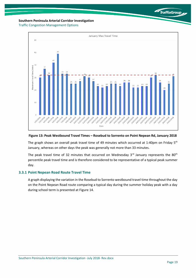
The graph at Figure 13 presents the maximum westbound travel time on Point Nepean Road between
the end of the freeway in Rosebud and Sorrento based on BlueTooth data on each day during January
2018.
Southern Peninsula Arterial Corridor Investigation Traffic Congestion Management Options
Southern Peninsula Arterial Corridor Investigation -July 2018- Rev.docx Page 19
Figure 13: Peak Westbound Travel Times – Rosebud to Sorrento on Point Nepean Rd, January 2018
The graph shows an overall peak travel time of 49 minutes which occurred at 1:40pm on Friday 5th
January, whereas on other days the peak was generally not more than 33 minutes.
The peak travel time of 32 minutes that occurred on Wednesday 3rd January represents the 80th
percentile peak travel time and is therefore considered to be representative of a typical peak summer
day.
3.3.1 Point Nepean Road Route Travel Time
A graph displaying the variation in the Rosebud to Sorrento westbound travel time throughout the day
on the Point Nepean Road route comparing a typical day during the summer holiday peak with a day
during school term is presented at Figure 14.

Southern Peninsula Arterial Corridor Investigation Traffic Congestion Management Options
Southern Peninsula Arterial Corridor Investigation -July 2018- Rev.docx Page 20
Figure 14: Point Nepean Road Westbound Travel Time – Rosebud to Sorrento
The graph shows that whereas the travel time during school term remains relatively constant
throughout the day at approximately 18 to 19 minutes, the travel time during the peak summer period
varies constantly, reaching a peak of 32 minutes around lunchtime, and is regularly in the order of 24
minutes throughout much of the day. This suggests that the during summer the travel time increases
by between 26% to 68%. The wide variability in the travel time during the peak summer period can
also make it difficult to plan trips (e.g. connecting to the Queenscliff ferry) for vehicles travelling along
the Point Nepean Road route.
3.3.2 Inland Route Travel Time
A graph displaying the variation in the Rosebud to Sorrento westbound travel time throughout the day
on the inland route comparing a typical day during the summer holiday peak with a day during school
term in February is presented at Figure 15.
0
5
10
15
20
25
30
35
Trav
el
Tim
e (
min
s)
Time
Hourly Travel Times - Point Nepean Road
Summer(Wednesday - 03/01/18)
School Term(Tuesday - 13/02/18)

Southern Peninsula Arterial Corridor Investigation Traffic Congestion Management Options
Southern Peninsula Arterial Corridor Investigation -July 2018- Rev.docx Page 21
Figure 15: Inland Route Westbound Travel Time – Rosebud to Sorrento
Similar to the Point Nepean Road route there is minimal variation in travel time during the school term,
with the travel time typically sitting at between 19 and 20 minutes, which is approximately 1 minute
slower than the route via Point Nepean Road.
During the peak summer holiday period however, the travel time along the inland route varies
considerably, also reaching up to 32 minutes around lunch time. Apart from the lunchtime peak, the
travel time typically sits around 23 minutes, although there is significant variation.
3.3.3 Freeway Travel Times
A graph displaying the variation in the westbound travel time along the section of the Mornington
Peninsula Freeway between Lonsdale Street and Jetty Road comparing the typical day during the
summer holiday peak with the February day during school term is presented at Figure 16.
0
5
10
15
20
25
30
35
Trav
el
Tim
e (
min
s)
Time
Hourly Travel Times - Browns Road/Melbourne Road
Summer(Wednesday - 03/01/18)
School Term(Tuesday - 13/02/18)
Southern Peninsula Arterial Corridor Investigation Traffic Congestion Management Options
Southern Peninsula Arterial Corridor Investigation -July 2018- Rev.docx Page 22
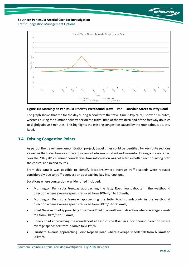
Figure 16: Mornington Peninsula Freeway Westbound Travel Time – Lonsdale Street to Jetty Road
The graph shows that the for the day during school term the travel time is typically just over 3 minutes,
whereas during the summer holiday period the travel time at the western end of the freeway doubles
to slightly above 6 minutes. This highlights the existing congestion caused by the roundabouts at Jetty
Road.
3.4 Existing Congestion Points
As part of the travel time demonstration project, travel times could be identified for key route sections
as well as the travel time over the entire route between Rosebud and Sorrento. During a previous trial
over the 2016/2017 summer period travel time information was collected in both directions along both
the coastal and inland routes.
From this data it was possible to identify locations where average traffic speeds were reduced
considerably due to traffic congestion approaching key intersections.
Locations where congestion was identified included:
• Mornington Peninsula Freeway approaching the Jetty Road roundabouts in the westbound
direction where average speeds reduced from 100km/h to 25km/h,
• Mornington Peninsula Freeway approaching the Jetty Road roundabouts in the eastbound
direction where average speeds reduced from 90km/h to 35km/h,
• Point Nepean Road approaching Truemans Road in a westbound direction where average speeds
fell from 60km/h to 15km/h,
• Boneo Road approaching the roundabout at Eastbourne Road in a northbound direction where
average speeds fell from 70km/h to 20km/h,
• Elizabeth Avenue approaching Point Nepean Road where average speeds fell from 60km/h to
20km/h,

Southern Peninsula Arterial Corridor Investigation Traffic Congestion Management Options
Southern Peninsula Arterial Corridor Investigation -July 2018- Rev.docx Page 23
• Point Nepean Road approaching Sorrento township in a westbound direction where average
speeds fell from 60km/h to 20km/h,
• Point Nepean Road through Rye township in a westbound direction where average speeds fell
from 50km/h to 20km/h,
• Browns Road approaching the roundabout at Boneo Road in an eastbound direction where
average speeds fell from 80km/h to 30km/h, and
• Point Nepean Road approach Elizabeth Avenue in an eastbound direction where average travel
speeds reduced from 60km/h to 30km/h.
A diagram illustrating the location of the identified congestion points is presented in Figure 17.
Figure 17: Identified Congestion Locations
3.5 Crash Analysis
As part of this investigation crash data was obtained from the VicRoads website for the last five years
up to the end of 2017. A heat map diagram showing the location of all crashes resulting in injuries or
fatalities that occurred during this period is presented at Figure 18.
Point Nepean Rd/ Truemans Rd
Point Nepean Rd/ Elizabeth Avenue
Rye Township
Point Nepean Rd Approach to Sorrento
Boneo Rd/ Eastbourne Rd
Boneo Rd/Browns Rd
Jetty Rd Roundabouts

Southern Peninsula Arterial Corridor Investigation Traffic Congestion Management Options
Southern Peninsula Arterial Corridor Investigation -July 2018- Rev.docx Page 24
Figure 18: Casualty Crashes in Southern Peninsula over Last Five Years
From the diagram it is evident that significant crash locations include:
• Jetty Road roundabouts on Mornington Peninsula Freeway,
• Point Nepean Road/Boneo Road intersection,
• Boneo Road/Browns Road intersection,
• Point Nepean Road and Eastbound Road through Tootgarook and Capel Sound, and
• Point Nepean Road through the Rye township.
Overall it was found that there were 50 casualty crashes on the Point Nepean Road route and 36
crashes on the inland route over the last five years between Rosebud and Sorrento.

Southern Peninsula Arterial Corridor Investigation Traffic Congestion Management Options
Southern Peninsula Arterial Corridor Investigation -July 2018- Rev.docx Page 25
4 Previous Studies
4.1 Mornington Peninsula Access and Mobility Study (MPAMS)
In 2007 an access and mobility study was prepared which considered the transport needs of the entire
Mornington Peninsula including both Frankston City and Mornington Peninsula Shire Councils. The
study included a specific section which discussed what was then known as the Rye Bypass which
referred to the western extension of the Mornington Peninsula Freeway beyond Boneo Road.
Four separate scenarios were considered to address traffic congestion in the Southern Peninsula as
part of this study which included:
1. Maintain the existing network,
2. Extend duplication of the Mornington Peninsula Freeway to Boneo Road, upgrade Browns Road
between Boneo Road and Dundas Street and construct a two lane, two-way arterial road within
the freeway corridor between Dundas Street and Melbourne Road, Blairgowrie,
3. Extend duplication of the Mornington Peninsula Freeway to Boneo Road and construct a two lane,
two-way arterial road within the freeway corridor between Boneo Road and Melbourne Road,
Blairgowrie,
4. Extend duplication of the Mornington Peninsula Freeway to Boneo Road and construct a new
divided road within the freeway corridor through to Melbourne Road, Blairgowrie.
Apart from Scenario 1, all scenarios used at least part of the currently unused freeway reserve beyond
Boneo Road.
Traffic modelling was undertaken as part of this exercise which found that the two scenarios that
utilised the full freeway corridor west of Boneo Road were best able to accommodate future traffic
growth, improve safety and reduce congestion along Point Nepean Road.
Whilst Scenario 2 involving the upgrade of Browns Road resulted in a small reduction in traffic along
Point Nepean Road, the traffic reduction was not significant due to the need for traffic to deviate a
significant distance to the south. The study found that the difference in constructing a divided road or
a two-lane arterial within the freeway corridor west of Boneo Road was not significant and therefore
concluded that the preferred option was to duplicate the Mornington Peninsula Freeway between
Jetty Road and Boneo Road and construct a two lane, two-way road within the remainder of the
corridor to Melbourne Road in Blairgowrie.
It should be acknowledged that the MPAMS study is now more than 10 years old and that the transport
modelling undertaken as part of that study would need to be updated to reflect current conditions
including new technologies that are now available such as the wide availability of travel time
information. Accordingly, some of the conclusions from this study may no longer be accurate.

Southern Peninsula Arterial Corridor Investigation Traffic Congestion Management Options
Southern Peninsula Arterial Corridor Investigation -July 2018- Rev.docx Page 26
4.2 Point Nepean Road Study
VicRoads undertook a further study in June 2013 that looked specifically at the future use of the
Mornington Peninsula Freeway corridor west of Boneo Road and investigated operational
performance of the existing road network on the Southern Peninsula including Point Nepean Road.
Similar to the earlier Mornington Peninsula Access and Mobility Study (MPAMS), the VicRoads Study
found that the construction of a new inland arterial road within the existing freeway corridor west of
Boneo Road provides the best opportunity to address future east-west congestion issues. In addition,
the study recommended:
• Short-term measure to widen Point Nepean Road at the Truemans Road intersection to remove a
localised capacity constraint and improve safety for cyclists,
• Develop a proposal to address safety and congestion at the existing Jetty Road roundabouts at
the current end of the divided section of the Mornington Peninsula Freeway,
• Consider reclassification of Point Nepean Road to a local road following construction of the inland
route,
• Upgrading the Jetty Road to Boneo Road section of the Mornington Peninsula Freeway from an
arterial road to a divided freeway, and
• Undertaking a detailed environmental assessment of the unused section of the Mornington
Peninsula Freeway corridor in order to obtain the necessary environmental approvals in order to
undertake road construction within the corridor.
Traffic volumes recorded on Point Nepean Road and Browns Road east of Dundas Street in 2012 as
part of the VicRoads study were 35,000 and 12,000 vehicles per day in the peak of January. This
suggests that traffic volume on Point Nepean Road has decreased marginally since this study was
undertaken, with a volume of 34,000 vehicles per day recorded in January 2018, with the traffic volume
on Browns Road increasing to 14,600.
In terms of travel time, the VicRoads study measured travel times between the Mornington Peninsula
Freeway in Dromana and Portsea via the coastal and inland routes. The start and end points of these
travel time surveys differed from the more recent travel time surveys so it is not possible to make a
direct comparison. However, the earlier VicRoads study identified westbound travel times on the
coastal route increasing from 29 minutes in winter to 42 minutes in summer compared to the inland
route increasing from 30 minutes in winter to 36 minutes in summer.
4.3 Rye Township Plan
Mornington Peninsula Shire Council is in the process of developing a new plan for Rye Township. The
plan will involve a number of changes to the existing streetscape to improve safety and amenity for
pedestrians and cyclists. Some of the changes proposed include:
• Adjusting the configuration of Point Nepean Road to allow for an extended public domain
pavement area including opportunities for street tree planting and improved traffic management.

Southern Peninsula Arterial Corridor Investigation Traffic Congestion Management Options
Southern Peninsula Arterial Corridor Investigation -July 2018- Rev.docx Page 27
• Creating a central tree planted median between Lyons and Hygeia Streets to further assist with
calming and managing traffic.
• Providing a separated Cycle Facility on the southern and northern side of Point Nepean Road with
landscape buffer to provide protection from vehicular traffic.
• Providing additional on-street cycle links to ensure the prioritisation of pedestrians and cyclists
over vehicles in the town centre core, promoting walkability and increasing cycling safety and
amenity.
• Consider downgrading of Point Nepean Road to a 40km/ hour speed limit between Elgan Avenue
and Hygeia Street.
The proposed changes will reduce the existing road space available to traffic, however the intention is
not to significantly reduce existing traffic capacity through the township as existing turn lanes and
auxiliary through lanes are to be maintained through key intersections. It is noted however that the
changes will not allow for any significant future increases in traffic through the Rye town centre.
4.4 Southern Peninsula Travel Time Demonstration Project
This project undertaken over both the 2016/17 and 2017/18 summers investigated the impact of
displaying travel time information on Variable Message Signs towards the western end of the
Mornington Peninsula Freeway to allow motorists to compare the difference in travel times between
the inland and coastal routes.
Overall the investigation found that the travel time on both routes follow similar patterns, however
there is evidence that the use of the Variable Message Signs results in slightly less travel time variability
and more traffic switching to the inland route when the Variable Message Signs suggest that this route
is quicker.
It is desired that the successful outcome of this study will result in the permanent display of travel time
information at the western end of the Mornington Peninsula Freeway.
4.5 Tootgarook Wetland Management Plan (TWMP)
The Tootgarook Wetland Management Plan has been prepared by BMT for Mornington Peninsula Shire
in January 2018, with a draft version of this plan currently displayed on Council’s website. The plan
acknowledges the value and significance of the Tootgarook Wetland and provides a recommended
action plan to ensure its protection moving forward.
The plan notes the threat to the wetland posed by the Mornington Peninsula Freeway corridor and
acknowledges Council’s strategic position that any increase in the east-west capacity of the road
network on the Southern Mornington Peninsula should be provided by a new inland arterial road,
subject to further feasibility analysis and aligned with the Tootgarook Wetland Management Plan
recommendations. To this end the TWMP notes that Council requested at its meeting on 13 June 2017
that the Public Acquisition Overlay for the Mornington Peninsula Freeway extension between Boneo
Road and Melbourne Road be removed from the Planning Scheme. However, this is in direct conflict

Southern Peninsula Arterial Corridor Investigation Traffic Congestion Management Options
Southern Peninsula Arterial Corridor Investigation -July 2018- Rev.docx Page 28
with the recommendation in the VicRoads Point Nepean Road Study which identifies that the preferred
option for an inland route is via the existing freeway reservation.
The TWMP recommends that the potential environmental impacts to the Tootgarook Wetland
resulting from the development of an arterial road within the Mornington Peninsula Freeway corridor
need to be carefully assessed as a high priority.
5 Strategic Objectives
In order to be able to compare the performance of various options it is first necessary to identify an
agreed set of objectives that is important to stakeholders in the area. It is considered that the
development of an Integrated Transport Plan for the entire Mornington Peninsula Shire would be the
appropriate method to achieve this by developing an overarching strategic framework.
For the purposes of this initial investigation, an initial list of objectives has been identified as a means
to undertake a high-level comparison of options, noting that there would be a need to weight certain
objectives as part of a more detailed study:
• Minimise travel time/reduce congestion,
• Reliability of travel times,
• Crash reduction/safety improvements,
• Minimise environmental impact,
• Support sustainable transport options/carbon footprint,
• Emergency access,
• Economic activity/tourism,
• Support growing population,
• Minimise social impacts, and
• Value for money/economic benefit.
It is noted that many of the identified objectives are complimentary as the reduction in congestion and
greater reliability of travel times will be more conducive to increased economic activity and tourism
which are important sectors of the economy in the Mornington Peninsula.
The development of a calibrated transport model will be an important tool to compare options, noting
that the usual transport model (VITM) is designed for typical commuter peak periods rather than
conditions during summer holidays. Accordingly, it will be important to develop a strategic model that
specifically addresses the summer holiday period to ensure that the various options are evaluated at
the time when the network is at its most congested. The strategic transport model would form one of
the key inputs to the Integrated Transport Plan.

Southern Peninsula Arterial Corridor Investigation Traffic Congestion Management Options
Southern Peninsula Arterial Corridor Investigation -July 2018- Rev.docx Page 29
6 Use of Freeway Corridor
The use of the freeway corridor west of Boneo Road to improve transport links into the Southern
Peninsula is not supported by Council due to impacts on the environment and in particular the impacts
on the Tootgarook Wetland.
Nevertheless, it was the preferred solution of both the 2007 Mornington Peninsula Access and Mobility
Study and the 2013 VicRoads Point Nepean Road Study, and it therefore provides an important starting
point to which alternative options can be compared.
It is noted that use of the freeway corridor does not necessarily infer that an at-grade freeway will be
constructed for the entire length of the corridor and that there may be options to construct either a
tunnelled or elevated section to avoid environmentally sensitive areas.
6.1 Project Description
The option to utilise the Mornington Peninsula Freeway Corridor west of Boneo Road would most likely
incorporate the following elements:
• Construction of a grade separated interchange at Jetty Road to replace the existing roundabouts,
• Duplication of the existing single carriageway section within the Mornington Peninsula Freeway
Corridor between Jetty Road and Boneo Road,
• Construction of a single carriageway limited access arterial road in the unused section of the
freeway corridor between Boneo Road and Melbourne Road,
• Construction of sealed shoulders along the route as part of the proposed treatment which could
assist in providing access for emergency vehicles and evacuation of traffic during an emergency,
• Construction of signalised intersections or high capacity roundabouts at the intersections with
Boneo Road, Truemans Road, Dundas Street and Canterbury Jetty Road,
• Truncation of all other roads that currently intersect with or cross the freeway corridor,
• Upgrading Melbourne Road between Canterbury Jetty Road and Ocean Beach Road to provide
dedicated turn lanes at side road intersections, and
• Reclassifying Point Nepean Road as a local road.
A diagram illustrating the above elements is provided at Figure 19.

Southern Peninsula Arterial Corridor Investigation Traffic Congestion Management Options
Southern Peninsula Arterial Corridor Investigation -July 2018- Rev.docx Page 30
Figure 19: Mornington Peninsula Freeway Corridor Option
Whilst the elements described above are considered the most likely scenario for an option within the
freeway corridor, it is noted that there could also be an option to construct a fully grade separated
freeway along the entire corridor. However, this may be difficult to justify economically and would
still result in the freeway transitioning into a two-lane, two-way road where it connects to the existing
alignment of Melbourne Road west of Canterbury Jetty Road. The economic issue is of particular
relevance given that traffic congestion is not a constant issue throughout the year, with congestion
being most significant during the summer holiday period and on long weekends during the remainder
of the year.
Other options could include construction of a tunnel or high bridge structure over the environmentally
sensitive section through the Tootgarook Wetland.
The construction of an arterial road along the existing freeway corridor is expected to reduce the travel
time between Rosebud and Sorrento to approximately 17 minutes, resulting in a travel time saving of
up to 18 minutes in the peak of summer. The 17 minute travel time is based on an average travel
speed of 70km/h along the 15.7km distance to Sorrento, with 30 second delays at each of the major
intersections along the route.
The construction of a road within the existing freeway corridor could range from approximately $150M
for an arterial road to $500M for a full freeway increasing to over $3B if bridge or tunnelling sections
were included to avoid the Tootgarook Wetland. In addition to this cost it could be expected that a
further $25M would be required to upgrade the existing 6.1km section of Melbourne Road west of
Canterbury Jetty Road including improved intersection treatments and improved facilities for
pedestrians.
From Council’s perspective, if the existing freeway reserve were to be utilised, only the bridge or tunnel
option may be acceptable in order to minimise impacts to the environment.
Jett
y R
oad
Bo
neo
Ro
ad
Browns Road

Southern Peninsula Arterial Corridor Investigation Traffic Congestion Management Options
Southern Peninsula Arterial Corridor Investigation -July 2018- Rev.docx Page 31
Table 1: Summary of Potential Project Costs
Option Cost (approx.)
Arterial Road $150 million
Full Freeway $500 million
Full Freeway with Bridge over Wetland $3 billion
Full Freeway with Tunnel under Wetland $5 billion
7 Alternatives to Freeway Corridor
It is evident that use of the existing freeway corridor would result in significant benefits to the
community in terms of reduced travel times and thereby improvements to access and mobility.
However, unless a tunnel or substantial bridge were to be considered, the impacts to the environment
are not acceptable to Council.
The purpose of this report, therefore, is to explore whether there are other alternatives to the freeway
corridor that may offer similar travel time and other benefits.
To this end a number of potential alternatives have been identified and have been grouped into
categories including short term/low cost treatments which involve upgrades of specific intersections,
medium term improvements which include upgrades of existing route sections and long-term
improvements which involve new alignments.
7.1 Short Term/Low Cost Options
Short term/low cost options have been identified to specifically target known congestion locations
which have a proven history of restricting traffic flow during the peak summer period or a poor safety
record.
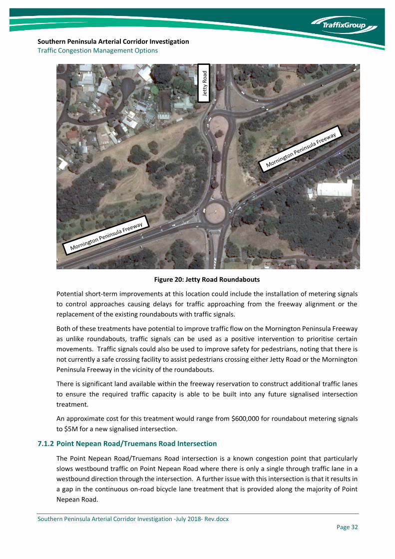
7.1.1 Jetty Road Roundabouts
The Jetty Road roundabouts at the end of the divided section of the Mornington Peninsula Freeway
are known to cause long delays for westbound traffic approaching the end of the freeway section and
also for eastbound traffic approaching Jetty Road from Boneo Road.
Southern Peninsula Arterial Corridor Investigation Traffic Congestion Management Options
Southern Peninsula Arterial Corridor Investigation -July 2018- Rev.docx Page 32
Figure 20: Jetty Road Roundabouts
Potential short-term improvements at this location could include the installation of metering signals
to control approaches causing delays for traffic approaching from the freeway alignment or the
replacement of the existing roundabouts with traffic signals.
Both of these treatments have potential to improve traffic flow on the Mornington Peninsula Freeway
as unlike roundabouts, traffic signals can be used as a positive intervention to prioritise certain
movements. Traffic signals could also be used to improve safety for pedestrians, noting that there is
not currently a safe crossing facility to assist pedestrians crossing either Jetty Road or the Mornington
Peninsula Freeway in the vicinity of the roundabouts.
There is significant land available within the freeway reservation to construct additional traffic lanes
to ensure the required traffic capacity is able to be built into any future signalised intersection
treatment.
An approximate cost for this treatment would range from $600,000 for roundabout metering signals
to $5M for a new signalised intersection.
7.1.2 Point Nepean Road/Truemans Road Intersection
The Point Nepean Road/Truemans Road intersection is a known congestion point that particularly
slows westbound traffic on Point Nepean Road where there is only a single through traffic lane in a
westbound direction through the intersection. A further issue with this intersection is that it results in
a gap in the continuous on-road bicycle lane treatment that is provided along the majority of Point
Nepean Road.
Jett
y R
oad

Southern Peninsula Arterial Corridor Investigation Traffic Congestion Management Options
Southern Peninsula Arterial Corridor Investigation -July 2018- Rev.docx Page 33
An improvement to this intersection was identified as part of the 2013 VicRoads Point Nepean Road
Study.
Figure 21: Point Nepean Road/Truemans Road
A potential solution involves minor widening through the intersection to provide a second westbound
through lane. This will result in a significant boost in westbound traffic capacity and will reduce delays
through the intersection. It is noted that land appears to be available on the foreshore side of the
intersection to accommodate this treatment. It is understood that VicRoads has undertaken initial
development work in relation to this treatment, however has encountered opposition from DELWP in
relation to the use of the foreshore lane for road widening. Further consultation with stakeholders
will be required to progress the development of this treatment.
An approximate cost for this treatment would be in the order of $500,000.
7.1.3 Point Nepean Road/Elizabeth Avenue Intersection
The Point Nepean Road/Elizabeth Avenue intersection is the location where vehicles originating from
the Mornington Peninsula Freeway turn onto Point Nepean Road as part of the route towards
Sorrento. There is currently a high level of capacity for the westbound movement when the
intersection is not blocked due to downstream queues from the Pt Nepean Road/Truemans Road
intersection discussed above, with a continuous slip lane provided for vehicles turning onto Point
Nepean Road. However, the eastbound right turn movement is unsignalised and right turning vehicles
are required to give way to oncoming traffic on Point Nepean Road.

Southern Peninsula Arterial Corridor Investigation Traffic Congestion Management Options
Southern Peninsula Arterial Corridor Investigation -July 2018- Rev.docx Page 34
Figure 22: Point Nepean Road/Elizabeth Avenue
A recommended short-term measure for this site is to signalise the intersection and incorporate a
partially controlled right turn phase to prioritise eastbound traffic turning right onto Elizabeth Avenue
towards the freeway.
An approximate cost for this treatment would be in the order of $800,000.
7.1.4 Boneo Road/Eastbourne Road Roundabout
Vehicles travelling towards Sorrento from the Mornington Peninsula Freeway turn left from Boneo
Road south leg into Eastbourne Road as part of the route via Point Nepean Road.
Although a two-lane roundabout is currently provided at this intersection, delays regularly occur
particularly as vehicles turning left from the south approach of Boneo Road are required to give way
to traffic proceeding straight ahead in a westbound direction along Eastbourne Road. This has the
effect of prioritising traffic that leaves the freeway early at Jetty Road and travels along the local road
section of Eastbourne Road rather than utilising the full extent of the freeway corridor to Boneo Road.
Southern Peninsula Arterial Corridor Investigation Traffic Congestion Management Options
Southern Peninsula Arterial Corridor Investigation -July 2018- Rev.docx Page 35
Figure 23: Boneo Road/Eastbourne Road
The recommended treatment for this site is to install metering signals to meter traffic approaching the
roundabout along Eastbourne Road from the east to create more opportunities to traffic approaching
from the south to turn left into Eastbourne Road.
An approximate cost for this treatment would be in the order of $300,000.
7.1.5 Boneo Road/Browns Road Roundabout
The roundabout at Boneo Road/Browns Road contains only a single circulating lane. This can result in
long queues forming on the north and west approaches in particular at peak times as part of the inland
route between Rosebud and Sorrento.
Eastbourne Road
Bo
neo
Ro
ad

Southern Peninsula Arterial Corridor Investigation Traffic Congestion Management Options
Southern Peninsula Arterial Corridor Investigation -July 2018- Rev.docx Page 36
Figure 24: Boneo Road/Browns Road
With long queues occurring on multiple approaches it is unlikely that the installation of metering
signals by themselves would resolve the existing traffic congestion issues. Accordingly, the
recommended treatment for this site would be to upgrade the roundabout to incorporate two
circulating lanes including minor widening of each of the approaches to incorporate two lanes in each
direction within close proximity of the intersection.
An approximate cost for this treatment would be in the order of $1.5M.
7.1.6 Sorrento Intersections
There are a number of intersections within Sorrento township where traffic congestion is regularly
experienced during peak summer periods. This includes intersections at Point Nepean Road/Ocean
Beach Road/Constitution Hill Road, Melbourne Road/Ocean Beach Road/Ossett Street, Point Nepean
Road/Hotham Road and Point Nepean Road/Esplanade.
All but one of these intersections are currently stop or give-way controlled and are regularly impacted
by slow moving traffic within the township. Peaks in traffic through these intersections can also occur
as a result of the arrival and departure of ferries at the nearby Sorrento ferry terminal.
Images of each of these existing intersections are presented in the figures below.
Bo
neo
Ro
ad
Browns Road

Southern Peninsula Arterial Corridor Investigation Traffic Congestion Management Options
Southern Peninsula Arterial Corridor Investigation -July 2018- Rev.docx Page 37
Figure 25: Point Nepean Road/Ocean Beach Road/Constitution Hill Road
Figure 26: Melbourne Road/Ocean Beach Road/Ossett Street

Southern Peninsula Arterial Corridor Investigation Traffic Congestion Management Options
Southern Peninsula Arterial Corridor Investigation -July 2018- Rev.docx Page 38
Figure 27: Point Nepean Road/Hotham Road
Figure 28: Point Nepean Road/Esplanade
It is recommended that traffic signals or roundabouts should be considered for each of these sites to
prioritise through traffic travelling along the Point Nepean Road and Melbourne Road between
Rosebud and Portsea ahead of traffic accessing the main Sorrento shopping strip along Ocean Beach

Southern Peninsula Arterial Corridor Investigation Traffic Congestion Management Options
Southern Peninsula Arterial Corridor Investigation -July 2018- Rev.docx Page 39
Road. It is understood that Council has already undertaken some initial development work in relation
to potential improvements at these intersections.
The implementation of signals rather than roundabouts would also improve pedestrian safety and
would allow certain movements to be prioritised through strategic implementation of phase splits,
including to manage traffic following the arrival of a ferry.
An approximate cost for this treatment incorporating all four intersections would be in the order of
$6M
7.1.7 Permanent Display of Travel Times
Following the success of the travel time demonstration project, a minor improvement in reliability and
reduction of travel times could be achieved by installing permanent traffic time information associated
with directional signs at the western end of the Mornington Peninsula Freeway to provide information
to motorists relating to the fastest route to Sorrento.
An approximate cost for this treatment would be in the order of $500,000.
7.1.8 Browns Road Traffic Calming
The travel time demonstration project identified that significant traffic volumes were using the
western end of Browns Road and Tasman Drive as a shortcut to reach Melbourne Road rather than the
preferred route along Dundas Street and Melbourne Road.
To discourage use of the non-preferred route it is recommended that in addition to installing upgraded
signage advising of the intended route to Sorrento via Dundas Street, a threshold treatment should be
installed across the Browns Road west leg of the roundabout at Dundas Street and the speed limit
reduced to provide clear indication that this route is not intended for through traffic.

Southern Peninsula Arterial Corridor Investigation Traffic Congestion Management Options
Southern Peninsula Arterial Corridor Investigation -July 2018- Rev.docx Page 40
Figure 29: Browns Road/Dundas Street Roundabout
An approximate cost for this treatment would be in the order of $300,000.
7.1.9 Boneo Road Minor Widening
The 2km section of Boneo Road between Colchester Road and Browns Road is an undivided road with
one lane of traffic in each direction. Currently there are no sealed shoulders and no auxiliary right turn
lanes at the majority of side road intersections and property accesses. This can result in congestion
occurring when a vehicle is required to wait in the traffic lane to undertake a right turn.
A short-term measure to improve traffic flow along this section of road and improve safety by reducing
the potential for rear end collisions would involve constructing sealed shoulders along the length of
the road and providing localised widening to incorporate dedicated right turns lanes at mid-block
intersections and significant property access points.
An approximate cost for this treatment would be in the order of $5M.
7.1.10 Intelligent Parking Management
A significant source of traffic congestion that occurs within the larger townships of Sorrento and Rye
is circulating traffic in search of parking. During peak periods parking can be quite limited in both
townships and a lot of time can be spent by motorists circulating through both townships in search of
available parking spaces.
Intelligent parking systems now exist whereby information can be displayed to motorists advising of
locations where unoccupied parking spaces are available. This information is displayed on large
directional signs which are visible to motorists driving through the township. The display of this
information is intended to reduce the amount of unnecessary travel within the townships in search of
parking and will therefore result in an overall reduction in congestion.
An approximate cost for this treatment would be in the order of $2M.
7.1.11 Short Term Option Summary
As a combined package, the short-term options are expected to result in travel time and reliability
benefits along both the coastal and inland routes. It is expected that overall the travel time savings
are likely to be in the order of 5 minutes in each direction compared to the existing peak travel times
during peak summer periods.
In order to quantify the expected time savings, it would be appropriate to use an intersection modelling
program such as SIDRA Intersection to compare the existing modelled delays with the projected delays
incorporating the recommended treatments.
Full turning movement counts would be required at each of the intersections during the peak summer
period as part of the required inputs to the SIDRA models, noting that for oversaturated approaches
they should be supplemented by queue length observations at the beginning and end of the survey
period to ensure that traffic demand that was unable to enter the intersection during the survey period
is included in the model.

Southern Peninsula Arterial Corridor Investigation Traffic Congestion Management Options
Southern Peninsula Arterial Corridor Investigation -July 2018- Rev.docx Page 41
A map showing the location of each of the short-term measures is presented at Figure 30. It is noted
that the full suite of short term measures includes improvements along both the Point Nepean Road
and inland routes.
Figure 30: Recommended Short-Term Measures
Adopting the full suite of short-term measures is expected to cost in the order of $15 to $20M.
A table summarising the expected costs associated with the short-term measures is presented at Table
2. The treatments are listed in approximate priority order based on the level of congestion currently
occurring in the area where the treatment is proposed.
All the identified short-term treatments are considered to be complimentary with the exception that
there two alternative treatments identified for the Jetty Road intersection at Mornington Peninsula
Freeway. Detailed intersection analysis should be undertaken to determine the preferred treatment
for this site.
Sorrento Intersections
Sorrento Intelligent Parking Management
Rye Intelligent Parking Management
Browns Road Traffic Calming
Pt Nepean Rd/ Elizabeth Av Traffic Signals
Pt Nepean Rd/ Truemans Rd Minor Widening
Boneo Rd/ Eastbourne Rd Metering Signals
Boneo Rd Minor Widening
Jetty Rd/ Morn Pen Fwy Traffic Signals
Morn Pen Fwy Permanent VMS
Boneo Rd/Browns Rd Roundabout Upgrade

Southern Peninsula Arterial Corridor Investigation Traffic Congestion Management Options
Southern Peninsula Arterial Corridor Investigation -July 2018- Rev.docx Page 42
Table 2: Short Term Options Cost Summary
Option Cost (approx.)
Jetty Road Roundabouts $600,000 (metering signals), or
$5 Million (signalised intersection)
Point Nepean/Truemans Road Intersection Upgrade $500,000
Boneo Road/Browns Road Roundabout Upgrade $1.5 Million
Sorrento – Four Intersection Upgrades $6 Million
Permanent Travel Time Displays $500,000
Intelligent Parking Management $2 Million
Boneo Road Widening $5 Million
Boneo Road/Eastbourne Road Roundabout Metering
$300,000
Point Nepean Road/Elizabeth Avenue Intersection Upgrade
$800,000
Browns Road Traffic Calming, West of Dundas Street
$300,000
7.2 Medium Term Options
A number of medium term options have been identified which generally follow existing road corridors
but incorporate widening or more substantial intersection improvements. Due to the limited ability
to provide additional capacity along the Point Nepean Road route, the majority of medium term
options relate to the inland corridor.
7.2.1 Jetty Road Interchange
Whilst a short-term option has been identified to replace the existing Jetty Road roundabouts with
traffic signals or to install roundabout metering signals, a more substantial solution would involve the
intersection of a full freeway interchange incorporating the grade separation of Jetty Road.
This medium-term solution would eliminate existing traffic delays along the freeway corridor through
this intersection but may simply shift the problem to the existing roundabout at Boneo Road if
undertaken in isolation without further improvements in the nearby vicinity.
The expected cost of this treatment is expected to be approximately $30M.
7.2.2 Reversable Traffic Lanes
A medium cost option to improve capacity in along the highest traffic volume sections of the inland
route would involve widening of the single carriageway sections of the Mornington Peninsula Freeway,
Boneo Road and Browns Road east of Truemans Road to incorporate three traffic lanes.

Southern Peninsula Arterial Corridor Investigation Traffic Congestion Management Options
Southern Peninsula Arterial Corridor Investigation -July 2018- Rev.docx Page 43
Overhead gantries would be installed along each of these road sections incorporating a Lane Use
Management System such that the central lane is reversable which would enable two through traffic
lanes to be provided in the peak direction to coincide with peak traffic flows. The recommended
locations for the reversable lane treatment is presented in Figure 31.
Figure 31: Reversable Lane Treatment
The cost of the proposed reversable lane treatment incorporating both widening and LUMS gantries is
expected to be in the order of $35M over a length of approximately 6.5km.
It is noted that whilst providing a similar capacity benefit to duplication in the peak direction, this
treatment would not provide the same level of safety benefit as it would be difficult to provide
separation between opposing traffic flows. Accordingly, it is likely that the speed limit would need to
be restricted to no greater than 80km/h to achieve Safe System principles.
There are also likely to be environmental issues resulting from this treatment as the widening of
Browns Road between Truemans Road and Boneo Road would impact the Tootgarook Wetland.
7.2.3 Browns Road Realignment
To improve the directness of the inland route and eliminate an existing roundabout controlled
intersection, it is recommended that a minor realignment of Browns Road in the vicinity of Truemans
Road should be considered. The realignment would require property acquisition including an existing
golf driving range.

Southern Peninsula Arterial Corridor Investigation Traffic Congestion Management Options
Southern Peninsula Arterial Corridor Investigation -July 2018- Rev.docx Page 44
Figure 32: Browns Road Realignment
The cost of the road realignment including property acquisition is expected to cost in the order of
$10M.
7.2.4 Melbourne Road Safety Upgrade
The 6.1km section of Melbourne Road to the west of Canterbury Jetty Road includes a large number
of unsignalised T-intersections on both sides of the road. Typically, these intersections are provided
without auxiliary left or right turn lanes which means that through traffic can regularly be delayed
behind turning vehicles. At times of high traffic volumes during summer it can also be difficult for
pedestrians to cross Melbourne Road to access the various back beaches due to the need to wait for
gaps in traffic travelling in both directions.
A proposed safety upgrade would involve the widening of Melbourne Road at discrete locations to
include auxiliary left and right turn lanes, with pedestrian refuge islands also provided at some
locations near intersections to provide opportunities for pedestrians to stage their crossing of the road.
The cost of the safety upgrade for Melbourne Road is expected to cost in the order of $25M.
Note that the upgrade is only proposed in the section of Melbourne Road to the west of Canterbury
Jetty Road as Melbourne Road may be downgraded to the east of Canterbury Jetty Road depending
on which long-term option is ultimately implemented.
7.2.5 Rye Internal Bypass
Previously identified treatments have involved improvements either to the Point Nepean Road route
to the north of the freeway corridor or the Browns Road route to the south. A third option which could
also be considered is an internal route within the existing Rye residential area between Point Nepean
Road and the freeway corridor.
A diagram illustrating the potential internal route incorporating sections of Broadway, Truemans Road,
Alma Street, Field Street, Brimble Street, Sullivan Street and Collingwood Street is presented at Figure
33.
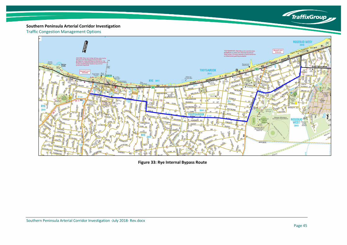
Southern Peninsula Arterial Corridor Investigation Traffic Congestion Management Options
Southern Peninsula Arterial Corridor Investigation -July 2018- Rev.docx Page 45
Figure 33: Rye Internal Bypass Route

Southern Peninsula Arterial Corridor Investigation Traffic Congestion Management Options
Southern Peninsula Arterial Corridor Investigation -July 2018- Rev.docx Page 46
This option would involve minor upgrades to the route to improve throughput. Such changes could
include:
• Roundabout or reverse priority intersections to prioritise the internal bypass route,
• Removal or indentation of kerbside parking, and
• Provision of dedicated right turn lanes to minimise through traffic being obstructed by right
turning vehicles.
It is noted that sections of this route are shared with an existing bus service and the recommended
improvements would assist in minimising delays to buses.
Whilst the internal bypass route could assist in reducing pressure on Point Nepean Road, it is unlikely
that it would ever be considered as an arterial route given that it runs through an existing residential
area and would negatively impact residential amenity. However, it could be upgraded to a standard
of a connector street capable of accommodating up to 7,000 vehicles per day at a speed of 50 to
60km/h.
The cost of implementing this treatment is expected to be up to $5M which would include roundabouts
at the major intersections with Eastbourne Road, Truemans Road and Dundas Street.
7.2.6 Mode Shift
In addition to increasing road capacity for motorists, other methods to reduce traffic congestion can
be realised by achieving mode shift. This could involve boosting the frequency of existing bus services
particularly along the trunk Route 788 service (between Frankston and Portsea), but also by providing
measures to improve bus priority through the provision of bus jump lanes at intersections or by
realigning routes so that they provide a more direct service.
One option could be to provide a direct service along the Mornington Peninsula Freeway corridor, with
buses permitted to run along the emergency lanes to bypass traffic queues on the approaches to the
key intersections at Jetty Road and Boneo Road.
In order to achieve mode shift it is likely that bus improvements will need to be fairly substantial, noting
that there is likely to be a strong preference for travel by car during peak periods to access tourist
destinations. However, bus improvements may result in a mode shift occurring for locally based trips
which will still result in a reduction in the overall traffic volume.
If it were possible to achieve a mode shift of 5% of existing motorists to instead travel via public
transport, with would result in a reduction in the order of 2,100 vehicles per day travelling through Rye
during the summer peak period.
7.2.7 Medium Term Option Summary
Excluding the mode shift option, adopting each of the medium-term treatments could be expected to
result in an overall cost in the order of $100M. Similar to the short-term options, each of the identified
medium-term treatments could be complimentary and would result in an overall reduction in
congestion in the Southern Peninsula.

Southern Peninsula Arterial Corridor Investigation Traffic Congestion Management Options
Southern Peninsula Arterial Corridor Investigation -July 2018- Rev.docx Page 47
Unlike the short-term options, a substantial amount of planning work and consultation would be
required to implement the medium-term treatments, noting that some require property acquisition,
whilst others change the function of existing roads.
A table summarising the expected costs associated with the medium-term measures is presented at
Table 3. It is noted that the costs associated with mode shift are not included in the table as further
work would be required to determine the scope of this project.
Table 3: Medium Term Option Cost Summary
Option Cost
Jetty Road Roundabouts – Upgrade to Full Freeway Interchange with Grade Seperation
$30 Million
Reversible Traffic Lanes $35 Million
Browns Road Realignment $10 Million
Melbourne Road Safety Upgrade $25 Million
Rye Internal Bypass $5 Million
Mode Shift -
7.3 Long Term Options
A small number of long term, more substantial options have been identified which involve either the
significant upgrade of existing routes or new alignments that would serve as alternatives to both the
existing Mornington Peninsula Freeway Reservation and Point Nepean Road.
The long-term options have been identified to address not only existing congestion issues but also
expected future increases in travel demand.
7.3.1 Inland Route Duplication
A long-term treatment option involves duplication of the most congested section of the inland route
incorporating the Mornington Peninsula Freeway between Jetty Road and Boneo Road, Boneo Road
south of the existing duplication through to Browns Road and the section of Browns Road between
Dundas and Boneo Road, including the existing roundabouts at Dundas Street and Truemans Road.
This section of the route has been adopted as it coincides with the location where traffic volumes
across both the coastal and inland routes exceed 40,000 vehicles per day.
A diagram showing the extent of the duplication is presented at Figure 34 and would involve
approximately 10.8km of duplication at a cost of approximately $110M.
An issue with this option is that it would perpetuate the existing indirectness of the inland route and
may not achieve the desirable shift away from the Point Nepean Road to deliver the corresponding
safety and amenity benefits. The duplication of Browns Road through the Tootgarook Wetland may
also present environmental challenges.

Southern Peninsula Arterial Corridor Investigation Traffic Congestion Management Options
Southern Peninsula Arterial Corridor Investigation -July 2018- Rev.docx Page 48
Figure 34: Inland Route Duplication

Southern Peninsula Arterial Corridor Investigation Traffic Congestion Management Options
Southern Peninsula Arterial Corridor Investigation -July 2018- Rev.docx Page 49
7.3.2 Use of Old Cape Schanck Road
An alternative long-term option involves realigning the Mornington Peninsula Freeway corridor to the
south along the existing alignment of Bayview Road and Old Cape Schanck Road to connect directly
into Browns Road to the east of Boneo Road.
This option has a significant advantage over the duplication of the existing inland route in that it will
directly connect with the Browns Road route, with motorists being required to make a conscious
decision to exit the freeway if wishing to continue along the existing alignment towards Boneo Road
to head into Rosebud.
A further advantage of this alignment is that the majority of the route could be constructed as a divided
highway without the need for property acquisition given that the existing reservation width for the
majority of Old Cape Schanck Road is approximately 60m wide.
However, there is existing remanent bushland in sections of this corridor that would be impacted as a
result of the construction of a new roadway which would result in environmental impacts. There are
also a number of residential properties located within close proximity to the existing Old Cape Schanck
Road including some with direct access that would be impacted as a result of realigning the freeway.
It is therefore likely that new service roads would need to be constructed as part of this treatment to
restore access to these properties and that noise walls would also be required. There would also be a
need to undertake a small amount of property acquisition to provide a smooth alignment on the north-
west corner of the existing Old Cape Schanck Road/Browns Road intersection.
The cost of implementing this treatment is expected to be in the order of $150M.
A diagram illustrating the potential realignment of the Mornington Peninsula Freeway to the south via
Old Cape Schanck Road is presented at Figure 35.

Southern Peninsula Arterial Corridor Investigation Traffic Congestion Management Options
Southern Peninsula Arterial Corridor Investigation -July 2018- Rev.docx Page 50
Figure 35: Mornington Peninsula Freeway Realignment via Old Cape Schanck Road
Browns Road
Bo
neo
Ro
ad
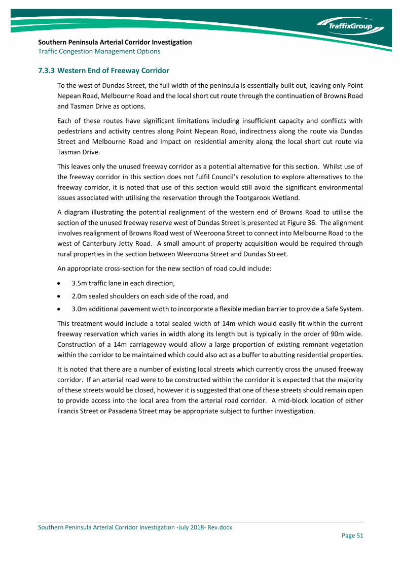
Southern Peninsula Arterial Corridor Investigation Traffic Congestion Management Options
Southern Peninsula Arterial Corridor Investigation -July 2018- Rev.docx Page 51
7.3.3 Western End of Freeway Corridor
To the west of Dundas Street, the full width of the peninsula is essentially built out, leaving only Point
Nepean Road, Melbourne Road and the local short cut route through the continuation of Browns Road
and Tasman Drive as options.
Each of these routes have significant limitations including insufficient capacity and conflicts with
pedestrians and activity centres along Point Nepean Road, indirectness along the route via Dundas
Street and Melbourne Road and impact on residential amenity along the local short cut route via
Tasman Drive.
This leaves only the unused freeway corridor as a potential alternative for this section. Whilst use of
the freeway corridor in this section does not fulfil Council’s resolution to explore alternatives to the
freeway corridor, it is noted that use of this section would still avoid the significant environmental
issues associated with utilising the reservation through the Tootgarook Wetland.
A diagram illustrating the potential realignment of the western end of Browns Road to utilise the
section of the unused freeway reserve west of Dundas Street is presented at Figure 36. The alignment
involves realignment of Browns Road west of Weeroona Street to connect into Melbourne Road to the
west of Canterbury Jetty Road. A small amount of property acquisition would be required through
rural properties in the section between Weeroona Street and Dundas Street.
An appropriate cross-section for the new section of road could include:
• 3.5m traffic lane in each direction,
• 2.0m sealed shoulders on each side of the road, and
• 3.0m additional pavement width to incorporate a flexible median barrier to provide a Safe System.
This treatment would include a total sealed width of 14m which would easily fit within the current
freeway reservation which varies in width along its length but is typically in the order of 90m wide.
Construction of a 14m carriageway would allow a large proportion of existing remnant vegetation
within the corridor to be maintained which could also act as a buffer to abutting residential properties.
It is noted that there are a number of existing local streets which currently cross the unused freeway
corridor. If an arterial road were to be constructed within the corridor it is expected that the majority
of these streets would be closed, however it is suggested that one of these streets should remain open
to provide access into the local area from the arterial road corridor. A mid-block location of either
Francis Street or Pasadena Street may be appropriate subject to further investigation.

Southern Peninsula Arterial Corridor Investigation Traffic Congestion Management Options
Southern Peninsula Arterial Corridor Investigation -July 2018- Rev.docx Page 52
Figure 36: Browns Road Western Realignment
Existing Browns
Road Alignment
Melbourne Road
Pas
aden
a St
reet

Southern Peninsula Arterial Corridor Investigation Traffic Congestion Management Options
Southern Peninsula Arterial Corridor Investigation -July 2018- Rev.docx Page 53
The expected cost of this treatment is $100M incorporating the construction of the new road section
as an arterial road. The safety improvements along Melbourne Road west of Canterbury Road
discussed previously would complement this treatment.
A significant advantage of this option is that it would substantially reduce the attractiveness of the
existing short cut route along the western extension of Browns Road and Tasman Drive and would
result in a significant reduction in traffic volume on this section of road.
7.3.4 Significant Public Transport Investment
Although not investigated significantly as part of this study, significant improvements to public
transport services to the Southern Peninsula could provide alternatives to road upgrades to address
long term travel demand management.
These options could include:
• Introduction of a bus rapid transit potentially using sections of the Mornington Peninsula Freeway
Corridor.
• Heavy rail extension/electrification further south into the Mornington Peninsula with direct
interchange to express bus services.
• Direct ferry service between Melbourne and the Southern Peninsula.
None of these options have been costed, however have been identified as potential long-term
alternatives to long-term road upgrades.
7.3.5 Congestion Charging
Another potential consideration could involve the use of congestion charging to apply only during peak
periods to deter unnecessary travel at peak times. Congestion charging could apply on existing roads
into the Southern Peninsula at peak times during summer to reduce the peak travel demand and
therefore defer the need for investment in new roads.
Careful consideration would be required in devising a congestion charging scheme so as not to
disadvantage local residents, noting that user charges may not be a key consideration to some visitors
to the Southern Peninsula who either are not constrained financially or are not concerned as they only
visit infrequently.
7.3.6 Long Term Option Packages
Unlike the short and medium-term options, the long-term options are not considered to be
complimentary. In particular, it would not be required to duplicate the existing section of the
Mornington Peninsula Freeway between Jetty Road and Boneo Road, and Boneo Road south to Browns
Road, if the inland route were to be realigned via Old Cape Schanck Road.
For the purposes of this assessment, three basic long-term road infrastructure packages have been
identified consisting of a combination of treatment options discussed above. These options include:
1. Duplication of existing roads along the inland route including the existing single carriageway
section of the Mornington Peninsula Freeway, Boneo Road to the south of the Mornington
Peninsula Freeway and Browns Road between Boneo Road and Dundas Street. This option would

Southern Peninsula Arterial Corridor Investigation Traffic Congestion Management Options
Southern Peninsula Arterial Corridor Investigation -July 2018- Rev.docx Page 54
continue to use the existing indirect route via Dundas Street and Melbourne Road which would
be upgraded.
Figure 37: Long Term Option 1 – Duplication of Existing Roads
2. Duplication of existing roads along the inland route east of Weeroona Street and use of the
existing unused section of the Mornington Peninsula Freeway west of Dundas Street to provide a
two-lane arterial road incorporating an upgrade of Melbourne Road to the west of Canterbury
Jetty Road. New road alignments would be required to link Browns Road with the Mornington
Peninsula Freeway corridor between Weeroona Street and Dundas Street and the two sections of
Browns Road either side of the Truemans Road intersection to remove the dog-leg.
Duplicate Existing Roads
Safety Upgrade of Existing Roads
Bo
neo
Ro
ad
Browns Road

Southern Peninsula Arterial Corridor Investigation Traffic Congestion Management Options
Southern Peninsula Arterial Corridor Investigation -July 2018- Rev.docx Page 55
Figure 38: Long Term Option 2 – Realignment West of Weeroona Street
3. Realignment of inland route west of Weeroona Street and diversion of the inland route via Old
Cape Schanck Road. As per the other options this option would also include duplication of Browns
Road between Boneo Road and Weeroona Street and safety upgrades along Melbourne Road to
the west of Canterbury Jetty Road.
Figure 39: Long Term Option 3 – Western Realignment with Old Cape Schanck Road Diversion
New Two-Lane Arterial Road
Safety Upgrade of Existing Road
Divided Road via Old Cape Schanck Road
Bo
neo
Ro
ad
Browns Road
Safety Upgrade of Existing Road
Duplicate Existing Roads
New Two-Lane Arterial Road
Bo
neo
Ro
ad
Browns Road

Southern Peninsula Arterial Corridor Investigation Traffic Congestion Management Options
Southern Peninsula Arterial Corridor Investigation -July 2018- Rev.docx Page 56
Each of the three long-term options will add capacity to the inland route making it comparatively more
attractive to the coastal route via Point Nepean Road. The extent that each of the options achieves
the objective of reducing overall congestion is expected to differ, with Option 2 and particularly Option
3 expected to attract more traffic away from Point Nepean Road by offering a more direct alternative
route option.
Each of the long-term options avoids the environmentally sensitive section of the Mornington
Peninsula Freeway corridor through the Tootgarook Wetland, however Options 2 and 3 utilise the less
sensitive section of the Mornington Peninsula Corridor to the west of Dundas Street. Option 3 also
will have greater social impacts than the other options due to the significant changes to Old Cape
Schanck Road.
Constructing Long-Term Option 3 including the Old Cape Schanck Road connection to Browns Road
will provide a high standard long-term route that is likely to permanently dismiss perceptions that
there is a need to complete the ‘missing link’ along the existing corridor. This contrasts with the option
to upgrade the existing indirect route via Boneo Road and Browns Road which may not stop continued
advocacy for use of the full freeway corridor by some members of the community.
The cost of Long-Term Option 3, including the duplication of Browns Road between Boneo Road and
Weeroona Street is expected to cost in the order of $300M. This compares to lesser costs in the order
of $130M for Option 1 and $230m for Option 2.
8 Project Staging
This report has identified a wide range of potential opportunities to address traffic congestion within
the Southern Peninsula. Some of the treatments identified are relatively low cost which could be
implemented in the short-term irrespective of a decision on a preferred long-term option, whereas
others are significant investment decisions which would require significant consultation and
investigation in order to determine the preferred option.
A potential staging arrangement is provided in Table 4, noting that medium and long-term projects
should not commence until detailed investigations are completed as part of the Integrated Transport
Plan to determine the preferred route alignment.
Table 4: Potential Project Staging
Short-Term (<5 Years) Medium-Term (5-10 Years) Long-Term (10+ Years)
• Implement package of short-term treatments
• Undertake investigations to determine preferred long-term option as part of Integrated Transport Plan
• Implement medium-term treatments that would support preferred long-term option
• Undertake detailed investigations and design for preferred long-term option
• Implement preferred long-term option
In particular, it is considered that decisions to construct the Jetty Road interchange or duplicate Boneo
Road should be deferred until the ultimate long-term treatment is determined as these works may be
redundant if it is decided to realign the Mornington Peninsula Freeway to follow the existing alignment
Southern Peninsula Arterial Corridor Investigation Traffic Congestion Management Options
Southern Peninsula Arterial Corridor Investigation -July 2018- Rev.docx Page 57
of Old Cape Schanck Road. Other medium-term treatments would generally be supportive regardless
of the preferred long-term treatment.
It should be noted that there are many uncertainties in determining transport needs in the very long
term as there may be significant changes in travel patterns due to emerging technologies such as self-
driving vehicles. These potential changes should be considered as part of the Integrated Transport
Plan.
9 Long Term Options Assessment
An assessment of long-term options to address traffic management within the Southern Peninsula
should be undertaken against an agreed set of strategic objectives to be defined as part of a future
Integrated Transport Plan for the overall Mornington Peninsula Shire.
Unlike the short and medium-term measures which are generally complimentary and will not result in
a significant change in travel patterns, the identified long-term measures will involve substantial
investment and will make a significant impact on future travel patterns within the Southern Peninsula.
Accordingly, it is appropriate that detailed assessments be undertaken to compare the various options.
The support of key State Government stakeholders including Transport for Victoria and VicRoads will
be important as part of the assessment process, noting that the State Government is likely to be a
significant source of funding. Accordingly, it is appropriate that the assessment process is collaborative
and that the use of the freeway corridor is included as one of the potential options acknowledging that
it is the route currently preferred by VicRoads, as documented in the 2013 study, despite not being
supported by Council.
The options considered for further investigation are:
• Base case option including only the identified short and medium-term treatments,
• Long-Term Option 1 consisting of duplication of the existing inland route incorporating
Mornington Peninsula Freeway east of Boneo Road, Boneo Road and Browns Road east of Dundas
Street (refer Figure 37),
• Long-Term Option 2 consisting of duplication of the existing inland route incorporating
Mornington Peninsula Freeway east of Boneo Road, Boneo Road and Browns Road east of Dundas
Street, construction of an arterial road along the unused Mornington Peninsula Corridor west of
Dundas Street and safety upgrades of Melbourne Road between Canterbury Jetty Road and Ocean
Beach Road (refer Figure 38),
• Long-Term Option 3 consisting of diversion of the Mornington Peninsula Freeway via Old Cape
Schanck Road, duplication of Browns Road between Boneo Road and Weeroona Street,
construction of an arterial road along the unused Mornington Peninsula Corridor west of Dundas
Street and safety upgrades of Melbourne Road between Canterbury Jetty Road and Ocean Beach
Road (refer Figure 39), and
• Use of existing freeway corridor as an arterial road (refer Figure 19).
Each option would include all the short-term improvements included as part of base case option as
well as complimentary medium-term treatments.

Southern Peninsula Arterial Corridor Investigation Traffic Congestion Management Options
Southern Peninsula Arterial Corridor Investigation -July 2018- Rev.docx Page 58
Although non-road-based infrastructure solutions including the use of congestion charging and
substantial public transport investment have not been considered as separate options for the
purposes of this high-level analysis, it is suggested that these options would be assessed in more
detail as part of the strategic modelling process.
An assessment to compare the above options could be based on the previous listed objectives in this
report including minimising travel times, reducing congestion etc. However, to evaluate each option
based on these objectives will require further data and additional studies to be undertaken. Any
initial attempt at an assessment to compare the options would be very subjective at this stage
without more comprehensive information and more detailed scoping of each option.
It is recommended that key studies needed would include:
• An environmental impact assessment of all affected bushlands, wetlands and woodland areas along the corridors of each of the proposed options.
• Strategic transport modelling to consider the changes in traffic flows and level of congestion that would result from implementing each of the proposed options. The modelling would need to consider the particular characteristics of the Mornington Peninsula incorporating peak conditions during the summer holiday period rather than the typical commuter peak periods observed within suburban Melbourne.
• Economic modelling would need to be undertaken to identify the economic impacts associated with each of the options and to assign an appropriate weighting to each of the strategic objectives.
These studies would ultimately form the basis for developing an Integrated Transport Plan that
ensures a holistic consideration of the transport directions for the entire Mornington Peninsula.

Southern Peninsula Arterial Corridor Investigation Traffic Congestion Management Options
Southern Peninsula Arterial Corridor Investigation -July 2018- Rev.docx Page 59
10 Conclusions
The initial high-level investigation of traffic congestion within the Southern Peninsula identifies that
the existing Point Nepean Road corridor is operating at its existing capacity during the peak summer
period which is limiting the ability for future residential growth and further economic development
and limits the accessibility for residents and visitors and to safely evacuate the area in the event of an
emergency.
It is noted that Opportunities to address traffic congestion within the Southern Peninsula are fairly
limited due to conflicts with pedestrian and cyclist activity along the existing Point Nepean Road
corridor, the desire to protect the Tootgarook Wetland, the need to provide a route that is sufficiently
direct to shift traffic away from Point Nepean Road and the reality that the area to the west of Dundas
Street and to the north of the Tootgarook Wetland is almost fully developed.
Recommendations to address the traffic congestion issues include:
a) Implementation of a range of low cost measures on both the Point Nepean Road and inland
corridors incorporating minor intersection improvements at known congestion points along
existing traffic routes to deliver targeted improvements in the short-term prior to a decision being
made on a preferred long-term option.
b) Implementation of more significant transport improvements to enhance existing traffic routes in
the medium term including road widening, minor road realignments and major intersection
improvements.
c) Long-term road-based options should be assessed in more detail as part of an Integrated Transport
Plan. Options to be assessed should include duplication of the existing inland route east of Dundas
Street, construction of an arterial road within the western section of the freeway corridor to the
west of Dundas Street and realigning the Mornington Peninsula Freeway to follow the existing Old
Cape Schanck Road reservation. These options should be assessed against the option preferred
by VicRoads of constructing an arterial road along the full length of the Mornington Peninsula
Freeway corridor and a base case consisting of only the short and medium-term treatments.
d) Preparation of an Integrated Transport Plan for the entire Mornington Peninsula Shire which
identifies the strategic objectives to form the basis of the decision making to identify the preferred
long-term option. Strategic transport modelling, economic modelling and environmental
assessments should be undertaken as part of the Integrated Transport Plan to consider the various
medium to long-term options identified in this assessment.