Embed Size (px)
Citation preview
1
Table of Contents
PREFACE
How Do Area Plans Relate to Rezoning?---------------------------------------------------------------------------------- 3
INTRODUCTION
Boundaries of the Plan Area------------------------------------------------------------------------------------------------- 5
Demographics----------------------------------------------------------------------------------------------------------------- 9
Existing Land Use------------------------------------------------------------------------------------------------------------ 10
Zoning-------------------------------------------------------------------------------------------------------------------------- 11
Transportation Features------------------------------------------------------------------------------------------------------ 11
Community Facilities--------------------------------------------------------------------------------------------------------- 18
Housing------------------------------------------------------------------------------------------------------------------------- 19
Design and Appearance------------------------------------------------------------------------------------------------------ 19
Historic Resources------------------------------------------------------------------------------------------------------------ 20
Economic Development------------------------------------------------------------------------------------------------------ 21
The Environment-------------------------------------------------------------------------------------------------------------- 21
Annexation Agreements------------------------------------------------------------------------------------------------------ 23
Existing Plans/Studies in the Plan Area------------------------------------------------------------------------------------ 23
SOUTHEAST SUBURBAN AREA PLAN UPDATE RECOMMENDATIONS
Land Use Recommendations------------------------------------------------------------------------------------------------ 25
Residential------------------------------------------------------------------------------------------------------------ 25
Office and Commercial--------------------------------------------------------------------------------------------- 26
Institutional----------------------------------------------------------------------------------------------------------- 27
Parks/Open Space---------------------------------------------------------------------------------------------------- 28
Industrial-------------------------------------------------------------------------------------------------------------- 28
Mixed-Use Land Use Categories---------------------------------------------------------------------------------- 28
Special Land Use Conditions------------------------------------------------------------------------------------------------ 35
Transportation Recommendations------------------------------------------------------------------------------------------ 36
Community Facilities Recommendations---------------------------------------------------------------------------------- 38
Housing and Community Development Recommendations------------------------------------------------------------- 40
Design and Appearance Recommendations------------------------------------------------------------------------------- 41
Historic Preservation Recommendations----------------------------------------------------------------------------------- 45
Economic Development Recommendations------------------------------------------------------------------------------- 45
Environmental Recommendations------------------------------------------------------------------------------------------ 46
IMPLEMENTATION SCHEDULE
APPENDICES
Appendix A: Significant Historic Resources----------------------------------------------------------------------------- 50
Appendix B: Design Guidelines for Multifamily Developments------------------------------------------------------ 51
Appendix C: Guidelines for Conversion of Existing Homes to Office or Commercial Uses---------------------- 52
Appendix D: Guidelines for Activity Centers---------------------------------------------------------------------------- 53
Appendix E: Forsyth County Agricultural and Historic Preservation Tools----------------------------------------- 55
Appendix F: Guidelines for Office/Low-Intensity Commercial Developments------------------------------------- 57
Appendix G: Guidelines for Suburban Business Parks----------------------------------------------------------------- 58
MAPS
Map 1. Planning Area Boundary------------------------------------------------------------------------------------------- 7
Map 2. Growth Management Plan----------------------------------------------------------------------------------------- 8

2
Map 3. Existing Land Use--------------------------------------------------------------------------------------------------- 12
Map 4. Environmental Constraints----------------------------------------------------------------------------------------- 24
Map 5. Proposed Land Use Map------------------------------------------------------------------------------------------- 30
Map 6. Proposed Land Use Change Map--------------------------------------------------------------------------------- 32
Map 7. Existing and Proposed Transportation Features----------------------------------------------------------------- 42
Map 8. Community Facilities----------------------------------------------------------------------------------------------- 44
Map 9. Recognized Historic Resources----------------------------------------------------------------------------------- 47
FIGURES
Figure 1. Area Planning Process-------------------------------------------------------------------------------------------- 6
Figure 2. Union Cross Road/Sedge Garden Road Activity Center---------------------------------------------------- 29
Figure 3. Illustrative Kernersville Road Development Rendering ---------------------------------------------------- 34
Figure 4. Kernersville Road/I-74 Rendering ----------------------------------------------------------------------------- 29
Figure 5. Kernersville Road/I-74 Activity Center----------------------------------------------------------------------- 35
TABLES
Table 1. Population Statistics----------------------------------------------------------------------------------------------- 9
Table 2. Diversity and Age Statistics-------------------------------------------------------------------------------------- 9
Table 3. Existing Land Use Summary------------------------------------------------------------------------------------- 10
Table 4. Road Classifications and Features------------------------------------------------------------------------------- 14
Table 5. Transportation Improvement Projects--------------------------------------------------------------------------- 16, 36
Table 6. Current Transit Routes-------------------------------------------------------------------------------------------- 17
Table 7. Bicycle Routes------------------------------------------------------------------------------------------------------ 17
Table 8. Plan Area Recreation Facilities---------------------------------------------------------------------------------- 18
Table 9. Housing Statistics-------------------------------------------------------------------------------------------------- 19
Table 10. Defined Low-Intensity Commercial Uses--------------------------------------------------------------------- 27
ACKNOWLEDGEMENTS
3
Preface
Under special State enabling legislation, the City-County Planning Board of Forsyth County and Winston-Salem is
responsible for preparing and maintaining a comprehensive plan for Forsyth County. The Legacy 2030 Update, the
current comprehensive plan, was adopted in 2012. Comprehensive plans take a broad, communitywide perspective for
guiding growth and development. Legacy 2030 includes chapters on local trends; growth management; land use;
transportation; economic development; environmental quality and sustainability; healthy, complete, and equitable
communities; community character; Downtown and the Center City; neighborhoods and towns; rural character; area
plans; and key public investments.
The Planning Board prepares a series of urban and suburban area plans for
the city and county in an effort to translate Legacy 2030 into site specific
recommendations. An area plan generally contains information about the plan
area’s existing conditions and recommendations for guiding future growth
and development. Citizen participation is an important part of the area plan
process, and multiple opportunities for public participation exist within the
area planning process.
In 2004, the City-County Planning Board (CCPB) adopted boundaries,
names, and priority rankings for seven urban area plans, a Downtown Plan,
and thirteen suburban/small town area plans. Seven plans cover the Urban
Neighborhoods and Downtown as defined in Legacy 2030. Urban
Neighborhoods are older neighborhoods and commercial, industrial, and
institutional development built mostly before 1940 that surround the Center
City of Winston-Salem. The Urban Neighborhoods Area has been divided
into study areas based on geography and common features. Thirteen plans
cover the Suburban Neighborhoods and Future Growth Area as defined in the
Legacy 2030. These areas have been divided into study areas based on
geography and common features. Suburban Neighborhoods include a large
portion of the county and most of the small towns where suburban
development has occurred in recent decades. It is also the area with the most
undeveloped land where much of the future residential, commercial, and
industrial development should occur. Future Growth Areas do not usually
have sewer or other facilities and services to support urban development.
However, because of their potential to be served efficiently by sewer and
other facilities and services in the future and/or their proximity to towns,
major roads and other public investments, the Growth Management Plan calls
for them to eventually be developed.
As of 2012, all planning areas within Forsyth County have a corresponding area plan which was developed since the 2001
adoption of the original Legacy plan to guide future area development decisions. Area plan updates, such as this one,
replace these older, existing area plans. Updated area plans provide a current picture of area conditions and an up-to-date
set of future development recommendations.
Area plans follow a basic, standardized format that provides for consistent terminology, information, mapping, and land
use colors for all area plans. Consistency between plans is important to city staff, the CCPB, and elected officials as they
use the plans to make zoning, funding, and other decisions based on area plan recommendations.
To facilitate implementation of area plan recommendations, a biennial Area Plan Status Report is prepared which includes
the current status of recommendations of all adopted area plans. The report includes the status of each action/project listed
in the implementation table for each plan. Area plan recommendations are funded in a variety of ways including bonds,
bond referendums, transportation funds, general government funds, the Motor Vehicle Tax, capital improvements, and
How Do Area Plans Relate To Rezoning?
Area plans convey a community vision
and general goals to the Planning Board,
elected officials, and other community
leaders. The land use plan component
does not, however, change the zoning of
an area or force property owners to
develop their land before they choose to
do so. Area plans are simply
recommendations developed using a
public process to help guide future
planning decisions.
Historically, elected and appointed
officials follow the area plan land use
recommendations in most cases.
However, decision makers must also
take into account current site conditions,
community needs and changing
circumstances, as well as other
information which was not apparent
during the initial area planning process.
Officials give serious consideration to
the recommendations of the area plans
but also must take into account all
current and available information to
make the most informed decisions on
future rezoning proposals.

4
Community Development Block Grants. Inclusion of a project in the area plan implementation table does not mean the
recommended project has funding. Area plan projects are prioritized along with other projects and programs by the
elected officials.
5
Introduction
*BOUNDARIES OF THE PLAN AREA
The Southeast Suburban Planning Area encompasses 12,233 acres. The plan area is generally bounded on the north by
Business 40 and portions of West Mountain Street; on the east by the Town of Kernersville and the boundary of the
Southeast Forsyth County Plan Area; on the south by Thomasville Road and the Davidson County line; and on the west
by I-40 and the boundary of the Southeast Area Plan (see Map 1 on page 7). Since the original Southeast Suburban Area
Plan was adopted in 2009, the boundaries of the area have been expanded to include portions of Walkertown and
Winston-Salem, north of Business 40; areas east of Hasting Hill Road; and west of Salem Lake. The plan area includes
land in the City of Winston-Salem, as well as portions of unincorporated Forsyth County and a very small amount of land
area in the towns of Kernersville and Walkertown. Approximately 73% of the land area is in the City of Winston-Salem,
with 52% of the total area in the East Ward and 21% in the Southeast Ward.
*RELATIONSHIP TO LEGACY 2030
Legacy 2030, Forsyth County’s comprehensive plan serves as the framework on which all area plans are built, both
geographically and as a policy guide. The original Southeast Suburban Area Plan was adopted in 2009. The Southeast
Suburban Area Plan Update is intended to translate Legacy 2030 policies into more detailed recommendations for the
Southeast Suburban Plan Area, taking into account changes in the area since the adoption of the original area plan in
2009.
Legacy 2030’s Growth Management Plan defines a series of specialized areas, each having specific characteristics. In the
Growth Management Plan (Map 2 on page 8), roughly 3% of the Southeast Suburban Plan Area is designated as Urban
Neighborhoods, Growth Management Area (GMA) 2; 96% as Suburban Neighborhoods, GMA 3; and less than 1% as
Future Growth Area, GMA 4.
*AREA PLAN PROCESS
Citizen participation is a critical part of the area plan process. Multiple opportunities for public participation exist in the
area planning process. The steps in the development of an area plan are shown in Figure 1. The first step of the planning
process is the assessment of current conditions and the consolidation of existing plans. A summary of this information is
created and given to citizens at the plan kickoff workshop.
The plan kickoff workshop is the first meeting in the area planning process and is an opportunity for citizens who live and
work in the area to share their comments and concerns about the area and its future with planning staff. Staff facilitates
this process to help citizens document their thoughts, which provide the basis for the next step in the process.
Ideas and issues identified at the process kickoff workshop, along with the policies spelled out in Legacy 2030, serve as
the basis for the next step in the process: the formulation of recommendations by Planning staff. These recommendations
primarily focus on proposed land use recommendations, and site specific design recommendations for corridors and
activity centers. Staff works with the citizens on these recommendations to reach a consensus. Staff and citizens refine the
plan recommendations at the meetings which follow the kickoff workshop. The final recommendations are then presented
to the entire community for review at the concluding open house. If no consensus is reached, both sets of
recommendations will be presented to the City-County Planning Board.
The Planning Board reviews the recommendations for consistency with the broad public interest and with Legacy 2030.
The Planning Board holds a public hearing to consider the plan and make amendments, as appropriate, before
recommending adoption of the plan. The document is then forwarded to the Winston-Salem City Council, and the Forsyth
County Board of Commissioners for consideration, amendment, and adoption after a public hearing.
The adopted plan replaces the existing adopted plan for the area and will be used on an ongoing basis by the Planning
Board and City Council to guide land use, infrastructure, and public investment decisions. An implementation schedule is
6
included in the adopted plan to outline tasks and timing needed for each recommendation. Additionally, developers and
neighborhood groups may also use the plan to guide their future business and community development decisions.
Figure 1. Area Planning Process
7
8
9
Existing Conditions
*GENERAL CHARACTER
The Southeast Suburban Plan Area is rich in history and character; and even more diverse in land use. The earliest
settlement within the planning area was called Friedland, which dates back to the 1770s. Friedland was one of the
Moravians’ Country Congregations and was located on the South Fork of Muddy Creek. Country Congregations were
rural settlements with a church and a school house surrounded by farmsteads established to supplement the urban
settlement of Salem. Although there has been significant growth and development in Winston-Salem, portions of the
original Friedland settlement remain the least developed in the planning area.
Segments of the planning area are experiencing the same challenges faced by suburban areas elsewhere in the city and
county including aging building stock and infrastructure, pressure to develop open space/agriculture lands, and conflicts
between land uses.
*DEMOGRAPHICS
Based on the 2010 Census data, 18,380 people live in the Southeast Suburban Planning Area, an increase of 60% - 6%
annually from the 2000 Census. The area’s population accounts for approximately 6.4% of Forsyth County’s total
population. The racial make-up of the planning area is 53% white, 24% African-American/Black and 19% Hispanic (see
Table 1 and Table 2).
Table 1. Population Statistics
Population Statistics
Area
Population
2010 2000
2000-2010 Average Annual Growth
(percent)
2010 Portion of Forsyth County
Population (percent)
2010 Density (Persons per
Acre)
Southeast Suburban Area
Plan 18,380 11,479 6% 5.2% 1.5
Winston-Salem 230,345 185,776 2.3% 65.6% 2.7
Forsyth County 351,798 306,067 1.4% N/A 1.3
Table 2. Diversity and Age Statistics
Diversity Statistics
Area
Diversity (Percent)
African-American White Asian Other Hispanic
2010 Southeast Sub. Area Plan 24 53 1 2 19
2000 Southeast Sub. Area Plan 18 75 <1 6 9
2000-2010 Change +6 -22 NA -4 +10
2010 Winston-Salem 33 48 2 2 14
2000 Winston-Salem 37 56 1 5 9
2000-2010 Change -4 -8 +1 -3 +5
10
Age Statistics
Area
Age (Percent)
Less than 5 years
5 - 17 years
18 - 39 years
40-64 years
65 years and older
2010 Southeast Sub. Area Plan 9 15 33 30 8
2000 Southeast Sub. Area Plan 7 12 32 31 13
2000-2010 Change +2 +2 +1 -1 -5
2010 Winston-Salem 7 17 32 31 13
2000 Winston-Salem 7 17 35 28 14
2000-2010 Change 0 0 -3 +3 -1
Source: 2010 U.S. Census - *Note: "Hispanic" is not a race; it is an ethnic group. Numbers are provided for
comparison purpose.
*EXISTING LAND USE
The existing land uses in the Southeast Suburban Planning Area include residential, office, commercial, institutional,
parks and open space, industrial, utilities, and agricultural uses (see Table 3 and Map 3 on page 12). The majority of the
developed area is single-family residential in character with limited amounts of multifamily residential, commercial and
office development. There still remains a significant amount of undeveloped land throughout the planning area in the
forms of parks/open space and agriculture land, including the Salem Lake Park area in the northern part of the planning
area.
Table 3. Existing Land Use Summary
Land Use Acres % Land Use Acres %
Single-Family 3872.8 31.6 Commercial Recreation 11.4 0.09
Large Lot Residential 904.4 7.4 Parks, Recreation & Open Space 1185.9 9.7
Low-Density Attached Res. 0.9 0.01 Agriculture 1468.6 12
Manufactured Housing 159.3 1.3 Rail & Road Right-of-Ways 1477.9 12.2
Multifamily 100.1 .8 Utilities 37.9 0.31
Total Residential 5037.5 41.1 Total Utilities & ROW 1515.8 12.5
Commercial/Office 56.2 0.5 Total Developed 9,895 80.9
Industrial 298.5 2.4 Undeveloped Land 2338.7 19.1
Institutional 321.1 2.6 Total Area 12233.7 100.0
Source: Survey by City-County Planning Staff, July 2015
RESIDENTIAL The planning area has a variety of housing types ranging from individual large lot homes to high (over 18 du/ac) and
intermediate-density (8 to 18 du/ac) multifamily developments. The predominant land use in the planning area is
residential, which accounts for approximately 41% of the total land area. Single-family residential is the most common of
the residential types, accounting for roughly 31% of land uses. Multifamily (4.9%) and manufactured housing parks
(1.3%) also exist in the planning area.
COMMERCIAL AND OFFICE Approximately 56 acres, about .5% of the planning area, is developed with commercial and office uses. Most of this
areas, 55 acres, is commercial land use. There are small commercial areas scattered throughout the planning area,
primarily along Kernersville, Linville, Union Cross Road and Thomasville Roads. Office uses account for .01% of the
planning area and are found primarily on Kernersville Road.
The planning area lacks a significant retail commercial area. However, retail shopping areas in Kernersville, Winston-
Salem (along Kernersville Road or Union Cross Road) and Davidson County (Thomasville Road) serve the planning area.
11
INSTITUTIONAL Institutional uses are located throughout the planning area. The 321 acres of institutional use accounts for approximately
2.6% of the land in the planning area. This includes both public institutional uses such as schools, fire stations, and
community centers; and private uses such as churches and cemeteries. The most common institutional uses in the
planning area are churches and cemeteries.
INDUSTRIAL Industrial uses comprise 298 acres, 2.4% of the plan area. Most industrial uses are located along Cole, Ridgewood and
Thomasville Roads, with other small pockets located along West Mountain Street and Lowery Street.
PARKS, RECREATION, COMMERCIAL RECREATION AND OPEN SPACE There are two public parks in the planning area, totaling 1,186 acres and accounting for approximately 10% of the land
area. The largest park in the planning area is the southern portion Salem Lake Park, south of Business 40/US 421. Sedge
Garden Park is the only other public park in the area. It includes facilities for conducting baseball, basketball, and
sheltered events/activities. There are also small commercial recreation uses that account for .09% (11 acres) which are
found throughout the planning area. Recreation facilities are discussed in more detail in the Community Facilities section.
UTILITIES AND RIGHTS-OF-WAY Combined together, utilities, road and railroad rights-of-way account for approximately 12% of the land area, 1,515 acres.
AGRICULTURAL Agriculture accounts for 1,469 acres, 12.1% of the plan area, the majority of which is located south of Interstate 40. Sites
designated as agricultural are either enrolled in the Farmland Preservation or Voluntary Agricultural District Programs.
UNDEVELOPED Undeveloped land accounts for 2,338 acres, 19% of the land area. Undeveloped land is distributed throughout the
planning area.
*ZONING
Rezoning petitions since the early 2000s have had some impact on land use patterns in portions of the planning area.
Although the number of rezonings has decreased or remained stagnant in the area, signs are pointing to increased interest
in developing and investing in the planning area. Since the adoption of the original Southeast Suburban Area Plan in
2009, there have been 6 rezoning petitions approved for the plan area. Most rezoning petitions were for commercial and
industrial zoning.
*TRANSPORTATION FEATURES Existing transportation features include roads, bus routes, bicycle routes, sidewalks, and greenways. The location and
function of transportation features have a significant impact on land use decisions (see Map 7 on page 42).
ROADS
Overall Street Pattern The Southeast Suburban Plan Area’s street and highway pattern is dominated by the presence of three different freeway
and Interstate highways (Business 40, US 311 and Interstate 40) that more or less run parallel to each other in an east-west
direction. However, local access to those facilities is relatively limited with only two interchanges within the plan area
and two others just beyond the plan boundary. The future eastern leg of the Northern Beltway will provide the area’s only
major north-south highway or freeway. Connectivity between subdivisions is poor as many residential neighborhoods
have been built with only one external street connection to major roads.
KERN
ERS MIL L CREEK
SWAIM CREEK
BRUS
HYFO
RK CREE
K
LOWERY MILLC
REEK
HINESLAKE BRANCH
SOUTH FORK MUDDY CREEK
FAIRWAY BRANCHFID
DLERS CR EEK SAWMILL B RANCH
SOUTH FORK MUD DY CREEK
DEL IGHT BRANCH
HARMONMILL CREEK
PINETREE BRANCH
DUNAGUNBRANCH
BOULEVARD BRANCH
FRAZ
IER
CREE
K
BRUSHY FORK BRANCH
VERNON BRANCH
FISHERS BRANCH
FIDDLERS CREEK
SALEM CREEK SALEMLAKE
Glenn Hi Road
Willard Road
Linville Road
Reidsvi
lle Road
Kernersville Road
Thomasville Road
Teague Road
Cole Road
Hastings Hill Road
Old Lexington Road
Sedge Garden Road
Gumtree Road
Union Cross Road
High Point Road
Oak Grove Road
Reynolds Park Road
Whicker Road
Old Salem Road
High Point Road
Union
Cro
ss R
oad
W Mountain Street
NewWalk
ertow
n Road
Old Greensboro Road
Old Greensboro Road
Ridgewood Road
Waughtown Street
Hedgecock Road
Waterworks Road
Sprague Street
South Main Street
Wallb
urg Ro
ad
Hopkins Road
US 311 Connector
Norther
n Beltwa
y
Forsyth CountyDavidson County
Map 3.Existing Land Use
2,640 0 2,6401,320Feet
1/6/2016
PlanningBoardDraft
PlanningBoardDraft
FloodwayFloodplain
Ponds, Lakes, RiversStreams
Manufactured Housing ParkOffice
Agriculture Tax DeferredVoluntary Agriculture DistrictLarge-Lot Residential (over 5 Ac)Single-Family Residential (0-8 Du/Ac)Low-Density Attached Residential (0-8 DU/Ac)Intermediate-Density Residential (8.1-18 DU/Ac)High-Density Residential (over 18 DU/Ac)
CommercialIndustrialInstitutionalParkCommercial RecreationUtilitiesUndeveloped

14
NC 109 (Thomasville Road), which defines the area’s southern boundary, Union Cross Road, High Point Road,
Kernersville Road, Linville Road, and Sedge Garden Road are all major thoroughfares in the planning area.
Major north-south road connections within the planning area are limited. Ridgewood Road, Hasting Hill Road, and Oak
Grove Church Road are the primary north-south boulevards in the planning area.
Several other minor thoroughfares, residential collectors and other local streets connect and feed vehicular traffic to the
major thoroughfares for circulation in the planning area. Map 7 (on page 42) and Table 4 show existing streets,
thoroughfares and highways.
Table 4. Road Classifications and Features
Interstate Highways
Description 2013 Average Daily Traffic
2035 Estimated
Volume
Current Road
Capacity
Road Width
Future Cross-Section
Interstate 40 4-6 lanes with
median 59,000 - 89,000 102,000 –
106,200 62,300 –
94,700 48 -
72 8-lane freeway
(8-A) Interstate 74 (US 311) 4 lanes with
grass median 24,000 – 29,000 30,600 –
50,500 61,200 -
62,300 48 4-lane freeway
(4-A) Business 40 (US 158,
421) 4 lanes with
grass median 48,000 – 52,000 41,600 –
56,300 62,300 48 4-lane freeway
(4-A)
Expressways Description 2013 Average Daily Traffic
2035 Estimated Volume
Current Road Capacity
Road Width
Future Cross-Section
Reidsville Road (US
158) Business 40 –
Old
Greensboro
Road
17,000 28,700 49,000 48 4-lane divided with
depressed median,
paved shoulders
Thomasville Road
(NC 109)
2-4 lanes 10,000 – 17,000 27,100 23,600 24 - 44 4-lane divided with
raised median, curb
and gutter, widened
outside lanes with
sidewalks (4-C)
Major Thoroughfares
Description 2013 Average Daily Traffic
2035 Estimated Volume
Current Road Capacity
Road Width
Future Cross-Section
Gumtree Road 2 lanes 6,300 10,600 15,800 22 3-lanes, curb & gutter,
wide outside lanes
with
sidewalks (3-B) High Point Road 2 lanes 2,400 – 6,400 4,500 –
12,900 15,800 –
18,800 20-22 3-lanes, curb & gutter,
wide outside lanes
with
sidewalks (3-B) Kernersville Road 2 lanes 7,800 – 17,000 7,900 –
28,600 15,800 –
18,800 24-26 3-lanes, curb & gutter,
wide outside lanes
with
sidewalks (3-B)
Linville Road 2 lanes 6,800 – 7,200 7,300 – 8,200 15,800
22-24 3-lanes, curb & gutter,
wide outside lanes
with
sidewalks (3-B) Ridgewood Road 2 lanes 2,400 – 6,700 4,700 – 6,900 15,800
22-36 3-lanes, curb & gutter,
wide outside lanes
with
sidewalks (3-B)
15
Sedge Garden Road
(Kernersville Road to
Hastings Hill Road)
2 lanes 4,800 – 9,700 10,800 15,800 21 3 lanes, curb and
gutter, wide outside
lanes, sidewalks (3-B)
Union Cross Road
(NC 109 to Wallburg
Road)
2 lanes 1,800 – 15,000 3,700 – 7,400 15,300 –
15,800 23-24 3-lanes, curb & gutter,
wide outside lanes
with
sidewalks (3-B)
Minor Thoroughfares
Description 2013 Average Daily Traffic
2035 Estimated Volume
Current Road Capacity
Road Width
Future Cross-Section
Cole Road 2 lanes 1,300 – 2,800 3,300- 3,900 13,800 –
15,800 18-40 3 lanes, curb and
gutter, wide outside
lanes with sidewalks
(3-B) Glenn Hi Road 2 lanes 4,700 – 6,300 4,400 – 7,300 15,300 –
15,800 21 3 lanes, curb and
gutter, wide outside
lanes with sidewalks
(3-B) Hastings Hill Road 2 lanes 4,100 – 6,300 3,800 – 6,300 13,800 –
15,300 22-23 3 lanes, curb and
gutter, wide outside
lanes with sidewalks
(3-B) Oak Grove Church
Road 2 lanes 3,500 – 3,600 2,600 – 5,900 15,800 22 3 lanes, curb and
gutter, wide outside
lanes with sidewalks
(3-B) Sedge Garden Road
(Kernersville Road to
Hastings Hill Road)
2 lanes 2,100 400 18,200 22 3 lanes, curb and
gutter, wide outside
lanes with sidewalks
(3-B) Willard Road 2 lanes 1,200 – 3,000 2,200 – 7,900 13,800 –
15,300 23-26 2 widened inside
lanes, curb & gutter,
parking on one side
with sidewalks (2-H) Cole Road 2 lanes 1,300 – 2,800 3,300- 3,900 13,800 –
15,800 18-40 3 lanes, curb and
gutter, wide outside
lanes with sidewalks
(3-B) Glenn Hi Road 2 lanes 4,700 – 6,300 4,400 – 7,300 15,300 –
15,800 21 3 lanes, curb and
gutter, wide outside
lanes with sidewalks
(3-B) Cole Road 2 lanes 1,300 – 2,800 3,300- 3,900 13,800 –
15,800 18-40 3 lanes, curb and
gutter, wide outside
lanes with sidewalks
(3-B) Hastings Hill Road 2 lanes 4,100 – 6,300 3,800 – 6,300 13,800 –
15,300 22-23 3 lanes, curb and
gutter, wide outside
lanes with sidewalks
(3-B) Oak Grove Church
Road 2 lanes 3,500 – 3,600 2,600 – 5,900 15,800 22 3 lanes, curb and
gutter, wide outside
lanes with sidewalks
(3-B)
16
List of Existing Collector Streets
Baden Road
Beeson Park Lane
Charles Street
Fanning Road
Glen Way Drive
Green Oaks Drive
Jubilee Trail
Lowery Street
Martindale Road
Merriweather Road
Motsinger Drive
Robbins Road
New Greensboro
Road
Oak Garden Drive
Oakridge Place
Drive
Old Winston Road
Pecan Lane
Pecan Ridge Circle
Piedmont
Memorial Drive
Plaza Hollow Drive
Presley Drive
Sawmill Road
Solomon Drive
Southland Avenue
Spring Hill Circle
Stewart Road
Sun Valley Lane
Wayside Drive
Weavil Road
Woodbridge Drive
Ridgewood Place Drive
CURRENT PROPOSED STREET AND HIGHWAY IMPROVEMENTS Forsyth County has several long-range transportation plans/processes: the Metropolitan Transportation Plan (MTP),
formerly called the Long Range Transportation Plan (LRTP); the Comprehensive Transportation Plan (CTP); and the
Metropolitan Transportation Improvement Program (MTIP). Details of these plans are available online.
Significant North Carolina Department of Transportation (NCDOT) and Metropolitan Transportation Improvement
Program (MTIP) Projects include (also see Table 4 on page 14):
The Northern Beltway (Eastern Section) (U-2579AA and AB) - 6 lane freeway, from Interstate 74 (US 311) to Business
40 (US 421); right-of-way begins in 2020 with construction in 2022.
Thomasville Road (NC 109) (U-2568C) - 4 lane median divided boulevard, from Interstate 40 to Davidson County;
right-of-way and construction – post 2025.
US 311 Connector - The proposed project is to construct a four lane expressway from the interchange at Business 40/US
421 and US 158 to the interchange at I-40 and I-74. This project is within the 2035 horizon year of the Winston-Salem
Urban Area’s LRTP and is regionally significant. This project lies just outside the planning area, but will have an impact
on the area’s residents when constructed.
COLLECTOR STREETS As properties come in for zoning or subdivision review, the Winston-Salem Urban Area Collector Street Plan will be
consulted for recommended street connections. The Collector Street Plan includes the general location of new collector
streets and recognizes existing streets that function as collector streets.
Table 5. Transportation Improvement Projects
Location Description Current Status Completion
Road Widenings and Improvements
Union Cross Road Widen Road to 4-6 lanes
median divided boulevard
Under construction 2015
Gumtree Road Safety improvements at Reid
Road intersection
Under construction 2015
New Roads
Northern Beltway
(Eastern Section) (U-
2579AA and AB)
6 lane freeway on new
location
Under design; right-of-
way in 2020, construction
in 2022.
2025
Thomasville Road
(NC 109) (U-2568C)
4 lane median divided
boulevard
Planning After 2025
Sources: 2040 Metropolitan Transportation Plan (MTP), the Comprehensive Transportation Plan (CTP), and
the 2016-2025 Metropolitan Transportation Improvement Program (MTIP).
17
PUBLIC TRANSPORTATION
Local Bus Routes The Winston-Salem Transit Authority currently provides limited bus services within the Southeast Suburban Planning
Area. Table 6 describes the routes in more detail.
Table 6. Current Transit Routes
Route Number Route Name Major Stops in North Central Area
29 Inbound/outbound Cole Road, Utah Street, Kernersville Road
30 Inbound/outbound Willard Road, Fanning Road
Regional Transit PART, The Piedmont Authority for Regional Transportation, was authorized in 1997 by the North Carolina General
Assembly as a Regional Transportation Authority. Based on regional cooperation, PART coordinates regional bus service,
vanpools/carpools, and other transportation-related services in the plan area. PART has several service stop and pick-up
locations within and surrounding the planning area including on Kernersville Road/S. Main Street and Thomasville Road
(NC 109).
RAIL The Norfolk Southern K Line (Winston-Salem to Greensboro) is located in the northwest corner of the Southeast
Suburban Planning Area, north of Salem Lake and parallel to Business 40 (US 421).
BICYCLE FACILITIES The Winston-Salem Urban Area Comprehensive Bicycle Master Plan was adopted by the Winston-Salem City Council
and the Winston-Salem Metropolitan Planning Organization’s Transportation Advisory Committee in 2005. This detailed
study evaluates current cycling facilities in Forsyth County including the use of a Bicycle Level of Service (BLOS)
model, and makes recommendations to create a comprehensive bicycle network for the area. The recommended network
includes off-road trails, designated bike lanes, wide shoulders for roads, and bicycle route signage.
Bicycle Routes The plan area has two signed bike routes described in Table 7 and shown on Map 7 (on page 42).
Table 7. Bicycle Routes
Route Name Route Map
Symbol General Route
10 10 From Sprague Street, right at Willard Road, left at Union Cross
road to Ridgewood Road, back along Union Cross Road, right at
Thomasville Road (NC 109), left at Teague Road
Mountains to Sea
Alternate Route
NA From High Point Road, left at Union Cross Road,
right at Thomasville Road (NC 109), left at Teague Road
PEDESTRIAN FACILITIES With the adoption of the multimodal transportation plans, enhancing and improving the pedestrian infrastructure
throughout the City of Winston-Salem has become a transportation priority.
Sidewalks The Winston-Salem Urban Area Sidewalk and Pedestrian Facilities Plan (Pedestrian Plan) adopted by the City Council
in 2007 takes a comprehensive look at pedestrian needs including sidewalks policies, sidewalk standards, existing
sidewalks needing repair, and recommendations for location of new sidewalks.
18
Area plans may make additional recommendations for sidewalks beyond what the Pedestrian Plan currently recommends.
As each area plan is adopted, these additional recommendations become part of the Pedestrian Plan. All proposed
sidewalks in the Pedestrian Plan are evaluated on an annual basis and ranked for future construction. Topography and the
presence of curb and gutter along streets are considered, among other factors, when evaluating projects.
The only existing sidewalks in the area are located in subdivisions such as Thornaby Park, Smith Farm, Robbins Brook
and Vernon Farms; and along Union Cross Road.
The City of Winston-Salem and Forsyth County have adopted street design standards for new developments that include
requirements for sidewalks. Sidewalks are recommended for all thoroughfares and collector streets within growth
management areas other than GMA 5, except for freeways and expressways.
*COMMUNITY FACILITIES
The Southeast Suburban Planning Area has a number of facilities that serve the community including parks, schools,
churches, and other institutional uses (see Map 8 on page 44).
SCHOOLS The Winston-Salem/Forsyth County Board of Education uses a “controlled choice” plan to assign students to schools. The
plan gives parents and students a choice between their residential school and several others within the same zone. There
are three public schools in the planning area. Of these, two are elementary schools (Smith Farm and Sedge Garden
Elementary Schools) and one is a high school (East Forsyth High School). Hall-Woodward Elementary School and Glenn
High School are located just outside the boundaries of the planning area. There is also one private school within the
planning area: Berean Christian School.
RECREATION FACILITIES
Parks The 2015 Parks and Open Space Plan was adopted in 2007. This plan discusses existing parks, community park needs,
existing open space and open space needs, park proposals and recommended facilities. Two public parks are currently
located in the Southeast Suburban Plan Area. Parks are classified based on their size, facilities, and function (see Table 8
and Map 8 on page 44).
Salem Lake Park is a regional park that exists to protect one of Winston-Salem’s drinking water sources. Based on the
service area analysis completed for the 2015 Parks and Open Space Plan, the Southeast Suburban Planning Area is not
adequately served by community parks and recreation center facilities. The 2015 Parks and Open Space Plan
recommended the improvement of facilities at Salem Lake Park and additional facilities at Sedge Garden Recreation
Center. The plan also recommended locating a new Community Park in the planning area.
Table 8. Plan Area Recreation Facilities
Park Type/Name Acreage Major Facilities
Neighborhood Parks: Provide intense recreational activities accessible to neighborhoods. Sedge Garden Park 21 Tennis courts, softball field, fitness course,
playground, picnic shelter and picnic tables,
recreation center
Park Type/Name Acreage Major Facilities
Regional Parks: Large areas for natural resource-based outdoor recreation or very large parks offering a wide array
of recreational opportunities or very specialized recreational activities.
Salem Lake Park 1455 Fishing and boating, playground, picnic shelter,
picnic tables, 6.5 mile trail for pedestrian, horses
and bicyclists.
19
Greenways Greenways are linear open space corridors that can be managed for conservation, recreation, and/or transportation
purposes. Many greenways have paved trails and accompanying land that provide pedestrian and bicycle access to
neighborhoods and community facilities in addition to waterways of Forsyth County.
Currently, there are two existing greenways within the planning area: the Salem Creek Trail and the Salem Lake Trail.
The Salem Creek Trail is 5.2 miles in length and runs from Market Place Mall on Peters Creek Parkway to Salem Lake.
The Salem Lake Trail is a seven mile, unpaved trail around Salem Lake. The unpaved trail is used by walkers, runners,
cyclists and horseback riders.
One of the major initiatives of the Greenway Plan Update is the proposal to construct the Piedmont Regional Greenway
Trail which is intended to link the existing Salem Lake Trail to Triad Park and to the existing Lake Brandt Greenway Trail
in Greensboro. The Piedmont Land Conservancy is spearheading regional efforts to construct the Piedmont Greenway
Trail. Other proposed greenway trails will be discussed in the Community Facilities Recommendations section of this
Update.
Library Facilities There are no library facilities in the Southeast Suburban planning area. Area residents are currently served by three
nearby libraries in Winston-Salem and Kernersville.
Fire Stations There are no fire stations in the Southeast Suburban Planning Area. Portions of the planning area are covered by
Winston-Salem fire stations 5, 11, 17, and 19, the Town of Kernersville and Forsyth County.
*HOUSING
According to the US Census American Community Survey there are 8,309 housing units in the Southeast Suburban
Planning Area. Approximately 66% of the housing units in the planning area are owner-occupied, significantly higher
than the 51% of the housing units citywide that are owner-occupied (see Table 9). Rates of ownership vary by
neighborhood within the plan area. Housing conditions also vary widely in the planning area from neighborhoods where
most homes are well-maintained to neighborhoods with deteriorated structures.
Table 9. Housing Statistics
Housing Tenure
Area Total Housing
Units
Owner-Occupied (Percent)
Renter-Occupied (Percent)
Vacant Units (Percent)
Southeast Suburban
Area Plan 8,309 66 26 8
Winston-Salem 107,915 51 36 13
Forsyth County 158,311 57 31 12
Source: U.S. Census Bureau, 2008-2012 American Community Survey (5 year estimates)
*DESIGN AND APPEARANCE
Urban design can bring order, clarity and pleasing harmony to the network of public spaces, streets, parks, and sidewalks
in a community. The majority of the Southeast Suburban Planning Area was developed after 1940 during a period that
marked the dominance of the automobile. The automobile, combined with the construction of the U.S. Interstate System,
were two major factors that led to suburban residential and then commercial development. With the relatively
inexpensive cost of gasoline, the burden of commuting became less of a factor, and rural areas began to develop with
inexpensive large lot houses. In response to the growing demand for housing, the first homogenous style housing
subdivisions started popping up throughout rural areas nationwide. As a result, newer zoning codes began to
20
inadvertently promote suburban development requiring larger minimum lot sizes, greater setbacks from streets, and wider
streets for public safety purposes. Additionally, commercial centers started developing along highways, road corridors,
and other major intersections near these sprawling area. Unfortunately many of these suburban residential areas and
commercial developments lacked special character and a sense of community that is often found in more urban
neighborhoods. The future design challenge in suburban areas is to integrate housing and commercial/office/institutional
development and encourage aesthetically pleasing, walkable communities with character while attracting the right mix of
development in activity centers to create a mix of uses so residents can choose to live, work, shop and play in the same
area. The Southeast Suburban Planning Area still lacks commercial, office and service developments.
There have been a number of initiatives to improve the appearance and pedestrian orientation of neighborhoods and
commercial areas in Winston-Salem and Forsyth County. City efforts are usually, but not always, undertaken in the right-
of-way and can include: landscaping and tree planting, sidewalks and other pedestrian improvements; benches; trash
receptacles and other street furniture; public art; decorative street lighting; and public spaces. Other design standards have
been adopted as part of the community’s Unified Development Ordinances.
I-40, Business 40/US 421, and US 311 (I-74) are designated as Thoroughfare Overlay Districts (TO Districts). The main
purpose of the TO District is to encourage development and redevelopment that preserves the visual quality and functional
operations of the roadway. All development within the TO District are subject to specific site development standards in
addition to the standards of the underlying zoning district. These additional standards relate mainly to screening outside
storage, shielding of on-site utilities, screening of loading and garage bays, establishing minimum setbacks from the right-
of-way and creating landscaped streetyards.
LEGACY 2030 GROWTH CORRIDORS Growth corridors are recommended in Legacy 2030 as tools for improved utilization of development sites and
infrastructure along major transportation corridors. Legacy’s growth corridor policies are particularly important when
revitalizing older, automobile-oriented strip commercial sites experiencing decline. The redevelopment of these corridors
should include increased residential densities where appropriate, mixed-use development, improved design and
appearance, and more transportation options. Legacy recommendations include:
Develop corridor master plans for improvements taking into account the unique character of each corridor. The
basis for such master plans will be found in the design standards for the growth corridor identified in this plan.
Define the boundaries of growth corridors through area plan updates.
Identify potential locations for redevelopment along growth corridors for transit-oriented, high density, mixed-use
nodes.
Ensure compatibility between commercial and residential land uses and appropriate transitions between higher-
density development and single-family residential areas.
Provide development standards for site planning and design.
Explore the use of zoning overlay districts to ensure good site planning principles and sensitive design, and to
promote continuity in the design of corridors.
Legacy identifies two Growth Corridors in the planning area: NC 109 (Thomasville Road) and Kernersville Road (see
Map 5).
*HISTORIC RESOURCES
The Southeast Suburban Planning Area is home of the Friedland Lower Tier properties. Friedland was settled by
Moravians from Broad Bay, Maine. This area played a vital role in the development of Salem, as the produce and
agriculture grown in this area often supplemented the needs of the larger Salem community. Historic resources in this
area have been impacted by the development and growth of the surrounding urban areas (see Map 9 on page 47).
Forsyth County’s first comprehensive architectural survey was completed in 1980 and an update to that survey was
finalized in 2009. As might be expected, during the intervening years, a number of historic resources were demolished or
removed from their original sites. This was found to be the case throughout all of Forsyth County, including in the
Southeast Suburban area. The updated architectural survey documents properties that are currently designated Local
Historic Landmarks and those listed on the National Register of Historic Places. The survey also includes properties that
21
have been determined eligible for the National Register and those identified as North Carolina Study List properties.
Some properties were simply identified for written and photographic documentary purposes.
Historic Resources Commission staff has reviewed the major historic resources studies/surveys to identify historic
resources located within the planning area. Appendix A (on page 50) includes a list of recognized historic resources in
the Southeast Suburban Planning Area and lists their current designations.
*ECONOMIC DEVELOPMENT
Economic development covers a wide variety of issues in the planning area including health of existing retail, commerce
and industry, strategies for attracting new businesses to the community, small business development, the provision of jobs
for citizens, the revitalization of older business areas and the availability of sites for new businesses.
The Development Office, a division of the City’s Community and Business Development Department, monitors and
promotes economic development opportunities throughout the city. Programs providing concentrated assistance to
targeted areas and groups include:
Small Business Training Program: The City of Winston-Salem offers a eight-week training program to provide
participants with basic skills necessary to become owners/operators of small businesses. Participants learn how to
write a business plan and abut a wide range of issues, including legal, insurance and management/marketing. The
class is free and open to local entrepreneurs, minorities, and women business owners.
NRSA Building Rehabilitation Program: Provides financial assistance to commercial and industrial property
owners for building rehabilitation and site improvements. The Neighborhood Revitalization Strategy Area
(NRSA) covers a majority of the western portion of the plan area.
Small Business Loan Program: Provides financial assistance to businesses unable to secure financing from
conventional sources. The business must be located in the Winston-Salem Neighborhood Revitalization Strategy
Area.
Housing Rehabilitation: Provides financial and technical assistance to qualified owner occupants and investor
owners to repair substandard properties.
Depending on the program selected, funds can be used for buying properties, for site or facility improvements,
rehabilitation of older buildings, purchasing equipment, or starting a new business.
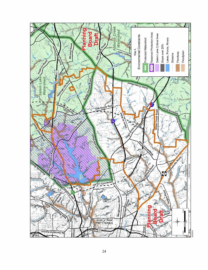
*THE ENVIRONMENT
A number of environmental issues are of concern in the plan area including floodplains, wetlands, topography, and
Natural Heritage sites (see Map 4 on page 24).
FLOODPLAINS
Floodplains are flood-prone lands adjacent to creeks and streams. There are requirements to manage development
activities in these areas. There is more than 1,027 linear feet of floodplain in the Southeast Suburban Planning Area.
Portions of Fiddlers Creek, Sawmill Branch, South Fork Muddy Creek, Kerners Mill Creek, Fisher Branch, St. Delight
Branch. Dunagun Branch and Swaim Creek include identified mapped flood-prone areas.
WATERSHEDS Water-supply watersheds have specific State-mandated protection regulations. These regulations attempt to maintain or
restore the natural storm water infiltration and purification process by:
Limiting housing density by restricting the maximum number of housing units per acre.
Limiting the built-upon area, the amount of land cover by pavement and structures.
Maintaining natural vegetative buffers along streams.
Requiring engineered storm water controls that trap sediments and other pollutants before reaching streams.
22
Salem Lake Watershed Regulations The northern portion of the planning area is in the Salem Lake Watershed (see Map 4, Environmental Constraints on
page 24). Salem Lake is one of the drinking water sources for residents of the City of Winston-Salem and others served
by the City-County Utilities Commission.
Because the Salem Lake Watershed is a relatively small watershed and wholly within Forsyth County, the City of
Winston-Salem and Forsyth County have adopted regulations as part of the Unified Development Ordinances (UDO) that
not only achieve the minimum State requirements, but in some cases exceed the minimums to provide a greater level of
drinking water quality protection.
Under the UDO provisions, development in the Salem Lake watershed can be done under either the low density option or
the stormwater quality option. The stormwater quality option allows higher density development with the use of
engineered methods to control runoff and protect water quality. Development requirements are more stringent closer to
Salem Lake in the defined Reservoir Protection Area (RPA), the area within approximately one mile of the normal pool
elevation of the lake. A minimum 100-foot wide vegetated buffer area is required along all perennial streams in the
watershed.
The Salem Lake regulations in the UDO allow limited areas of intense development under the Special Intense
Development Allocation (SIDA) provisions. A SIDA can be granted by the Winston-Salem City Council or by the
Forsyth County Commissioners to non-single-family projects that provide economic benefits or fulfill community needs
on sites outside the Salem Lake Critical Area.
In addition to the development regulations included in the UDO, the Public Health Department requires new lots to be at
least 40,000 square feet for septic tanks in drinking water supply watersheds, including the Salem Lake Watershed.
NATURAL HERITAGE INVENTORY SITES The State’s Natural Heritage Inventory for Forsyth County identified the occurrence of significant plant and animal
communities, geologic features, historic resources and stream corridors in Forsyth County. A portion of one Natural
Heritage site, Salem Lake Natural Area, is located in the planning area.
The Salem Lake Natural Area is of regional significance and is located in the northern part of the planning area just south
of Business 40/US 421, within Salem Lake Park, a City-owned park managed by the Winston-Salem Recreation and Parks
Department.
WETLANDS Wetlands are defined as areas inundated or saturated, permanently or seasonally, by surface or ground water. Wetlands
can be distinguished from other land forms or water bodies because of the characteristic vegetation that is adapted to its
unique soil conditions. Wetlands have been identified along the same creeks where floodplains have been mapped.
TOPOGRAPHY Most of the land in the plan area consists of slopes that are developable. The majority of the land with slopes greater than
20% is located along the identified creeks and their tributaries.
CONTAMINATED SITES Some sites in the planning area may have environmental contamination due to the presence of a hazardous substance,
pollutant, or other contaminant. Contamination is often found on or near sites that were previously used for industrial, dry
cleaning, fuel sales, or other commercial uses. Often, contamination issues only surface as properties are more closely
examined as they are being developed or redeveloped. For more specific and up-to-date information on contaminated
sites, contact the North Carolina Department of Environment and Natural Resources (NCDENR).
*ANNEXATION AGREEMENTS An annexation agreement is a legal agreement which defines land that each participating municipality may not annex
within a specific timeframe. The agreement sets limits on each municipality’s future annexation into an area, thus
23
establishing its potential future jurisdiction. The agreement, however, does not obligate a municipality to undertake
annexations. Two major benefits from this type of agreements are that:
It promotes the orderly and logical extension of municipal services because communities are not competing to
annex an individual development; and
It reduces uncertainty among property owners and public or private development interests.
North Carolina General Statues authorize municipalities to enter into agreement for up to 20 years. Once adopted,
participating municipalities must both agree to change or terminate the agreement before it expires. A municipality may
unilaterally terminate an agreement after a five-year notification period. Each participating municipality must also notify
the other(s) of all subsequent annexation proposals within the affected area.
The City of Winston-Salem has had annexation agreements in place with several of its surrounding communities for
years. These agreements have fostered positive relationships among our local governments as well as provided enhanced
predictability and stability for development within the county. In 1992, the City of Winston-Salem and the Town of
Kernersville entered into an annexation agreement. The agreement essentially outlined the annexation limits of each
respective municipality along Union Cross Road, US Highway 311, between Hastings Hill and Sedge Garden Roads and
NC Highway 66. Several amendments were made to this agreement prior to its expiration in 2013.
*EXISTING PLANS/ STUDIES IN PLAN AREA
The following studies have been completed for the plan area:
SOUTHEAST SUBURBAN AREA PLAN (2009)
The Southeast Suburban Area Plan, which this document updates, made land use and public investment recommendations
within generally same geographic boundaries as this plan. Major recommendations included continued development of
commercial areas around the proposed Interstate 74/Kernersville Road interchange; continued preservation of existing
historic resources; exploration of adding a community park; and designation of higher density mixed use areas within
activity centers.
FUTURE INTERSTATE 74/KERNERSVILLE ROAD INTERCHANGE STUDY (2008)
The Future Interstate 74/Kernersville Road Interchange Study, completed in 2008, encompassed 170 acres along
Kernersville Road. The study examined land use and transportation issues around the proposed Kernersville Road
Interchange with the Northern Beltway to determine impacts of different land use scenarios on the transportation system.
24

25
Southeast Suburban Area Plan Update
Recommendations
General policies from Legacy 2030 provide the framework for recommendations in all area plans. Specific
recommendations for the Southeast Suburban Area Plan Update were developed through comments heard from citizens at
public meetings in conjunction with the work of the City-County Planning Staff.
*LAND USE RECOMMENDATIONS Land use recommendations serve as a guide for future development and zoning decisions in the planning area. As
directed by Legacy 2030, land use recommendations designate the locations and formulate policies for compatible
residential development, commercial and office uses, industrial uses and activity centers. All future recommendations are
shown on the Proposed Land Use Map (Map 5 on page 30). Additionally, the Proposed Land Use Changes Map (Map 6
on page 32) identifies properties where the Proposed Land use indicated on Map 6 is different than the existing land use
shown on the Existing Land Use Map (Map 3 on page 12). Proposed land use changes may or may not require a change
in zoning. Determinations of the need for rezoning would be evaluated when site-specific development proposals are
submitted for review.
GENERAL RECOMMENDATIONS Planning policies used to develop land use recommendations for the Southeast Suburban Planning Area are:
The highest intensity, mixed use development should be located in proposed activity centers.
Commercial development should be concentrated in designated areas and not allowed to take the form of strip
development along the major roads in the planning area.
Goods and services should be available near where people live and work.
The mix, type, and design of development should facilitate walking and bicycling where feasible.
Industrial development should be concentrated in designated industrial areas.
The revitalization of older/underutilized commercial and industrial sites and buildings is to be encouraged.
Neighborhoods should be protected from inappropriate residential, commercial, industrial, and institutional
encroachment.
Site design should incorporate pedestrian-oriented design elements such as street trees, buildings located close to
the street, building façade articulation and variety, and transparent windows and doors.
Consideration should be given to protecting significant natural features, natural vegetation, historic resources and
open space by clustering development on site.
*RESIDENTIAL Legacy 2030 recommends a variety of housing types throughout the county. Residential recommendations are made for
housing densities, and in some cases, types of housing. Factors such as amount of land available, surrounding land uses,
proximity to major roads and services and access to utilities are all considered in determining recommendations for
residential uses and densities.
The following are general descriptions for categories of residential land uses and specific recommendations for locations
within the planning area suitable for these categories of use. The sites shown on the Proposed Land Use Changes Map and
the overall Proposed Land Use Map (see Maps 5 and 6 on pages 30 and 32, respectively).
Single-Family Residential Single-family residential development consists mostly of single-family, detached units; however, scattered throughout
neighborhoods are duplex, triplex, quadraplex, and a few multifamily developments built before zoning was established
for the City and County. This plan makes no assumption on the legality of these uses. If uses are legally non-conforming,
26
they should be allowed to remain. If they are illegal uses, this plan does not recommend rezoning these properties to
legalize their nonconforming status. Single-family residential development is recommended for:
Existing individual lots and small tracts of land in existing single-family neighborhoods.
Larger parcels of undeveloped residential land in many parts of the planning area, excluding uses within proposed
activity centers and other designated sites. This land is generally located north of US Highway 311 in the planning
area and along Thomasville Road in the southern portion of the planning area.
Low-Density Attached Residential Low-density attached residential development has a density of zero to eight dwelling units per acre. Generally, low-
density attached residential land use is recommended for sites greater than two acres that are most appropriately
developed with duplex, triplex, quadraplex, multifamily, and townhouse uses. Design Guidelines for Multifamily
Developments can be found in Appendix B on page 51. Low-density residential attached residential uses is
recommended for:
Sedge Garden Road within the Union Cross/Sedge Garden Activity Center.
Linville Road, Sedge Garden Road and Old Winston Road within the Kernersville Road/I-74 Beltway Activity
Center.
Intermediate Density Residential Intermediate-density residential development has a density of eight to eighteen dwelling units per acre. Generally
intermediate-density residential land use is recommended for sites greater than two acres that are most appropriately
developed with multifamily or townhouse structures. Design Guidelines for Multifamily Development can be found in
Appendix B on page 51. Intermediate-density residential is recommended for:
Parcels previously approved for intermediate-density residential in the Vernon Farms subdivision.
Parcels on the west side of Plaza Ridge Circle, adjacent to the Plaza South Apartment complex. These parcels
were originally part of the Plaza South Apartments development plan and are already zoned for multifamily,
except the parcel on the southwest corner at the intersection of Plaza Ridge Circle and Ridgewood Place Drive
which is currently zoned for single-family residential.
White Meadow Lane.
A single parcel between the Cole Village Apartments and I-40.
Green Oaks Court.
Green Oaks Drive.
Oak Grove Church Road within the Kernersville Road/I-74 Beltway Activity Center.
*OFFICE AND COMMERCIAL This plan recommends the consolidation of office and commercial uses at existing commercial/office locations, in
designated activity centers, and in Special Land Use Condition Areas. All new and redeveloped commercial and office
uses should be designed and developed to be compatible with nearby residential uses.
Office Office uses typically have few negative impacts on adjacent land uses and can provide services to area residents, making
them an appropriate transitional use between residential uses and more intense uses. Small-scale office development is
recommended for:
Parcels on the east side of Union Cross Road between Shepard Grove Road and Solomon Drive. This area is
currently zoned for single family residential development, but with the changing conditions and improvements
along Union Cross Road, this area would be viable for office development. (See *c in Special Land Use
Conditions on page 36).
Office/Low-Intensity Commercial This land use category includes all office uses as well as commercial uses listed in Table 10. This plan recommends three
areas for new office/low intensity commercial and the conversion of some existing residential structures into office/low
intensity commercial land use. Preserving the existing character of the older historic neighborhoods in the planning area is
27
a priority of the plan; however, at certain locations it may be difficult to retain the existing single-family use on a specific
property. The establishment of a transition between residential uses and commercial uses is recommended at the following
locations:
Along Thomasville Road, east of Devoe Road.
Parcels between Beesons Field Drive and Hastings Hill Road within the Union Cross Road/Sedge Garden Road
Activity Center.
Along Sedge Garden Road and Kernersville Road within the Kernersville Road/I-74 Beltway Activity Center.
Guidelines for Conversion of Existing Homes to Office or Commercial Uses can be found in Appendix C on page 52.
Table 10. Defined Low-Intensity Commercial Uses
Uses* Include:
Adult Day Care Food/Drug store without Drive-through Residential Building, Townhouse
Arts/Crafts Studio Funeral Home Restaurant without
Drive-through Bed and Breakfast Furniture/Home Furnishings
Child Care Drop-in Museum, Art Gallery Services A
Child Day Care Center Post Office Veterinary Services
Combined Use Residential Building, Multifamily Retail Store
Uses* Do Not Include:
Auto-related Uses Convenience Stores Clubs/bars
*Uses defined in the Unified Development Ordinances.
COMMERCIAL This plan calls for the creation of new commercial opportunities and the improvement of existing commercial areas that
blend with existing development and do not negatively impact nearby neighborhoods. Commercial areas should be
compact with limited access to major thoroughfares and should not promote strip development. The reuse of vacant
buildings and the redevelopment of existing undeveloped and underutilized sites is recommended, where possible. New
commercial development and improvements of existing commercial areas are recommended for the following areas:
Undeveloped parcel on the northeast corner of Kernersville Road and Vernon Farms Boulevard, previously
approved as part of the Vernon Farms subdivision.
Commercially zoned parcel on the northwest corner of Hastings Hill Road and Sedge Garden Road.
Parcels located at the southwest corner of Union Cross Road and Sedge Garden Road in the Union Cross
Road/Sedge Garden Road Activity Center.
*INSTITUTIONAL Institutional uses in the planning area are an important aspect of its character, vitality and future. Institutional uses include
schools, churches, government offices and services, community organizations and nonprofit agencies. Existing institutions
should be permitted to grow and expand in a manner that is compatible with surrounding neighborhoods. Because of the
unique nature of institutions (many of which are allowed by right in residential zoning), it is not possible to indicate on the
Proposed Land Use Map all properties for which institutional use would be appropriate.
Many institutional uses found in the planning area are surrounded by single-family residential uses. As these facilities
grow, the potential to tear down single-family structures can be detrimental to the urban fabric of the neighborhood,
particularly in older historic areas. New construction or additions to institutional uses can have a negative effect on
adjacent single-family homes because institutional uses typically have a larger building footprint and massing. This plan
recommends the following:
Retain older single-family structures adjacent to institutional uses.
When converting parcels to parking lots for institutional uses in residential districts, maintain neighborhood
character by buffering lots with street yards.
Encourage institutions owning single-family homes adjacent to their properties to maintain these structures in
good condition.

28
*PARKS/OPEN SPACE The Proposed Land Use Changes Map (Map 6 on page 32) shows proposed parks and open space areas. Open space may
consist of land protected by conservation easements or City-, State- or railroad-owned land (see Community Facilities
Recommendations on page 38, for detailed park recommendations).
*INDUSTRIAL With access to both I-40 and I-74 (US 311), there are several areas suitable for industrial land use in the planning area.
The plan recommends the following:
New and redeveloped industrial uses should be designed in a manner that makes them compatible with nearby
residential uses.
Continue revitalization of vacant or underutilized industrial sites in the planning area. Existing industrial sites
could be converted to other uses compatible with surrounding residential areas.
Specific areas recommended for industrial development include:
Undeveloped parcels along Centre Park Boulevard.
Several large undeveloped parcels along Cole Road between I-40 and US 311.
Several parcels along Ridgewood Road, north of US 311.
Parcel located on the southwest corner of Ridgewood Road and Cole Road.
*MIXED-USE LAND USE CATEGORIES
MIXED-USE DEVELOPMENT Mixed-use development typically includes a mixture of compatible commercial, office, varied residential types and
densities, institutional, and recreational uses. This plan recommends four areas for mixed-use, all within the Kernersville
Road/I-74 Beltway Activity Center and shown on the Proposed Land Use Changes Map (see Map 6 on page 32).
However, the concept of mixing uses is not limited to these areas only. Other locations may be appropriate and will need
to be evaluated individually based on how they are integrated with and compliment the surrounding neighborhoods.
ACTIVITY CENTERS
Activity centers are compact, pedestrian-oriented, neighborhood business areas that provide needed services within
walking distance of residential areas. Activity centers may serve as neighborhood gathering places. Larger activity
centers are envisioned to provide shopping and services meeting the day-to-day needs of nearby residences, and ideally
contain a grocery store and a pharmacy. Activity centers may also include a housing component, especially in suburban
or future growth areas where new activity centers are being proposed. Certain very large activity centers can serve as
compact mixed-use regional centers for retail, office, civic and residential activity. It is important to install sidewalk
connections throughout activity centers to encourage pedestrian connections between uses. The Southeast Suburban Area
Plan Update identifies two activity centers: the Union Cross Road/Sedge Garden Road Activity Center and the
Kernersville Road/I-74 Beltway Activity Center.
Union Cross Road/Sedge Garden Road Activity Center The Union Cross Road/Sedge Garden Road Activity Center contains approximately 32 acres and is located at the
intersection of Sedge Garden Road and Union Cross Road, extending to the west almost to Hastings Hill Road. This
activity center currently contains a mixture of older and new commercial establishments (including a Neighborhood Wal-
Mart and CVS), vacant commercially zoned land and low-density single-family residential development. This area
provides limited commercial services to the northeastern portion of the planning area.
Most of the existing commercially zoned property in this activity center is within the Town of Kernersville’s zoning
jurisdiction.
29
The southern portion of this activity center is in Winston-
Salem and the sections between Bessons Field Drive and
Hastings Hill Road are in Forsyth County’s zoning
jurisdiction. This plan recommends:
Comprehensive redevelopment with a mixture of
neighborhood-scaled commercial and office uses that
complement the surrounding residential area. Buildings
placed close to the intersection of Sedge Garden and Union
Cross Roads with parking located to the rear of the buildings.
Sidewalks should connect this site with other sites in the
activity center.
Low-density attached residential is proposed for a
portion of this activity center to provide a transition from the
commercial area to the more traditional residential areas
along Sedge Garden Road. A fifty-foot buffer should be established along the
northern boundaries of the activity center to provide
substantial buffering to the stable residential neighborhoods
adjacent to the activity center.
Kernersville Road/I-74 Beltway Activity Center The Kernersville Road/I-74 Beltway Activity Center contains approximately 170 acres and is located at the intersection of
Kernersville Road and the proposed Northern Beltway/Future Interstate 74. The proposed activity center is focused
around an existing commercial development that serves the existing residential area, but is in need of redevelopment.
Figure 2. Union Cross Road/Sedge Garden Activity Center
Figure 3. Illustrative Kernersville Road Development Rendering
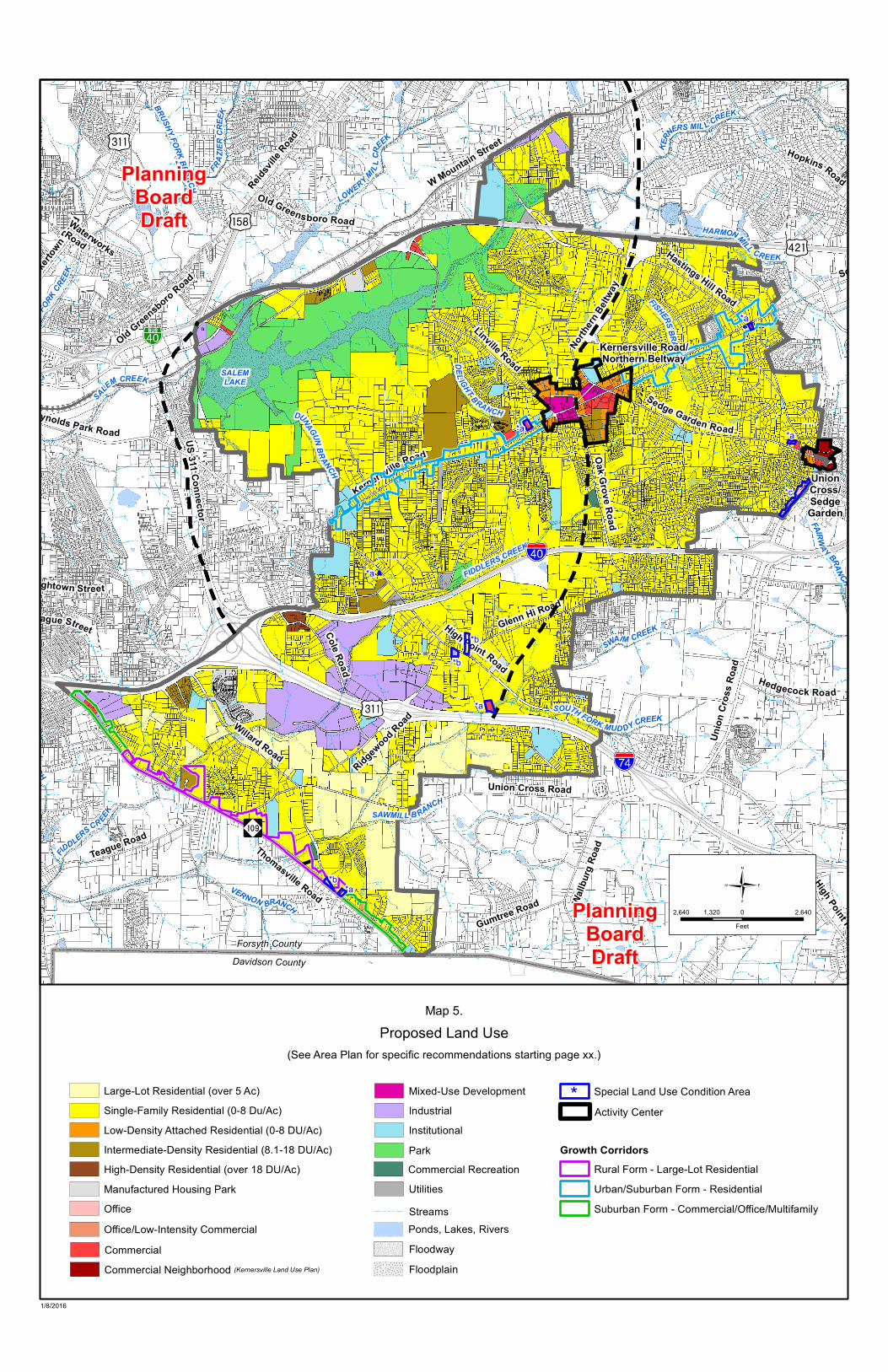
KERN
ERS MIL L CREEK
SWAIM CREEK
BRUS
HYFO
RKCREE
K
LOWERY MILLC
REEK
HINESLAKE BRANCH
SOUTH FORK MUDDY CREEK
FAIRWAY BRANCHFID
DLERSCR EEK SAWMILL B RANCH
SOUTH FORK MUD DY CREEK
DEL IGHT BRANCH
HARMONMILL CREEK
PINETREE BRANCH
DUNAGUNBRANCH
BOULEVARD BRANCH
FRAZIER
CREE
K
BRUSHY FORK BRANCH
VERNON BRANCH
FISHERS BRANCH
FIDDLERS CREEK
SALEM CREEK SALEMLAKE
Glenn Hi Road
Willard Road
Linville Road
Reidsvi
lle Road
Kernersville Road
Thomasville Road
Teague Road
Cole Road
Hastings Hill Road
Old Lexington Road
Sedge Garden Road
Gumtree Road
Union Cross Road
High Point Road
Oak Grove Road
Reynolds Park Road
Whicker Road
Old Salem Road
High Point Road
Union
Cro
ss R
oad
W Mountain Street
NewWalk
ertow
n Road
Old Greensboro Road
Old Greensboro Road
Ridgewood Road
Waughtown Street
Hedgecock Road
Waterworks Road
Sprague Street
South Main Street
Wallb
urg Ro
ad
Hopkins Road
US 311 Connector
Norther
n Beltway
Forsyth CountyDavidson County
Kernersville Road/Northern Beltway
UnionCross/SedgeGarden
*a *a
*c
*b*a
*b
*b
*a
*a
*a
Map 5.Proposed Land Use
2,640 0 2,6401,320Feet
PlanningBoardDraft
PlanningBoardDraft
(See Area Plan for specific recommendations starting page xx.)
1/8/2016
Activity CenterSpecial Land Use Condition Area*
Growth CorridorsRural Form - Large-Lot ResidentialUrban/Suburban Form - ResidentialSuburban Form - Commercial/Office/Multifamily
Office/Low-Intensity Commercial
Manufactured Housing ParkOffice
Large-Lot Residential (over 5 Ac)Single-Family Residential (0-8 Du/Ac)Low-Density Attached Residential (0-8 DU/Ac)Intermediate-Density Residential (8.1-18 DU/Ac)High-Density Residential (over 18 DU/Ac)
Commercial FloodwayFloodplain
Ponds, Lakes, RiversStreams
Mixed-Use DevelopmentIndustrialInstitutionalParkCommercial RecreationUtilities
Commercial Neighborhood (Kernersville Land Use Plan)

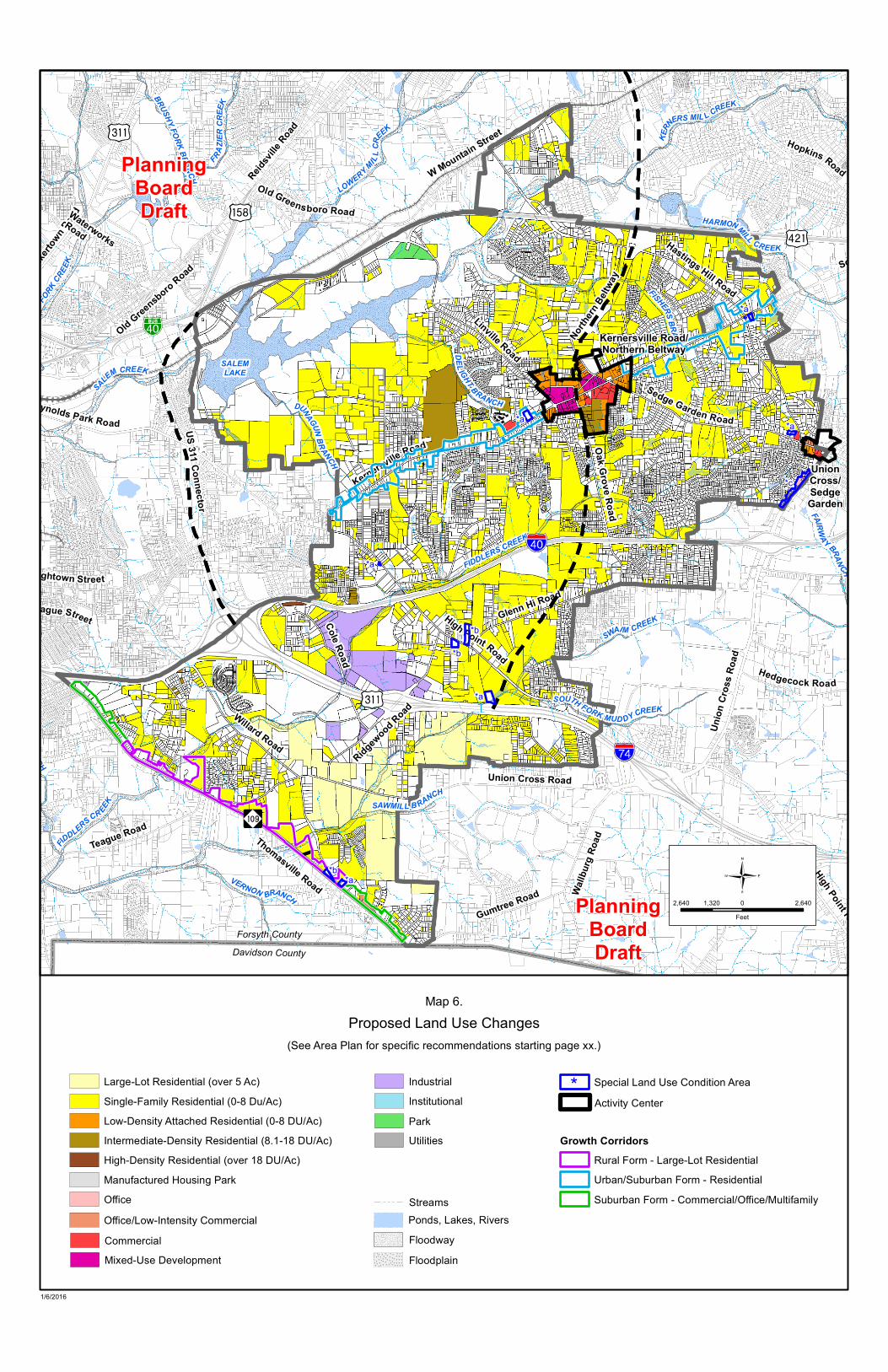
KERN
ERS MIL L CREEK
SWAIM CREEK
BRUS
HYFO
RKCREE
K
LOWERY MILLC
REEK
HINESLAKE BRANCH
SOUTH FORK MUDDY CREEK
FAIRWAY BRANCHFID
DLERSCR EEK SAWMILL B RANCH
SOUTH FORK MUD DY CREEK
DEL IGHT BRANCH
HARMONMILL CREEK
PINETREE BRANCH
DUNAGUNBRANCH
BOULEVARD BRANCH
FRAZIER
CREE
K
BRUSHY FORK BRANCH
VERNON BRANCH
FISHERS BRANCH
FIDDLERS CREEK
SALEM CREEK SALEMLAKE
Glenn Hi Road
Willard Road
Linville Road
Reidsvi
lle Road
Kernersville Road
Thomasville Road
Teague Road
Cole Road
Hastings Hill Road
Old Lexington Road
Sedge Garden Road
Gumtree Road
Union Cross Road
High Point Road
Oak Grove Road
Reynolds Park Road
Whicker Road
Old Salem Road
High Point Road
Union
Cro
ss R
oad
W Mountain Street
NewWalk
ertow
n Road
Old Greensboro Road
Old Greensboro Road
Ridgewood Road
Waughtown Street
Hedgecock Road
Waterworks Road
Sprague Street
South Main Street
Wallb
urg Ro
ad
Hopkins Road
US 311 Connector
Norther
n Beltway
Forsyth CountyDavidson County
Kernersville Road/Northern Beltway
UnionCross/SedgeGarden
*a *a
*c
*b*a
*b
*b
*a
*a
*a
Map 6.Proposed Land Use Changes
2,640 0 2,6401,320Feet
PlanningBoardDraft
PlanningBoardDraft
(See Area Plan for specific recommendations starting page xx.)
1/6/2016
Office/Low-Intensity Commercial
Mixed-Use Development
Manufactured Housing ParkOffice
Large-Lot Residential (over 5 Ac)Single-Family Residential (0-8 Du/Ac)Low-Density Attached Residential (0-8 DU/Ac)Intermediate-Density Residential (8.1-18 DU/Ac)High-Density Residential (over 18 DU/Ac)
Commercial
Activity CenterSpecial Land Use Condition Area*
Growth CorridorsRural Form - Large-Lot ResidentialUrban/Suburban Form - ResidentialSuburban Form - Commercial/Office/Multifamily
FloodwayFloodplain
Ponds, Lakes, RiversStreams
IndustrialInstitutionalParkUtilities

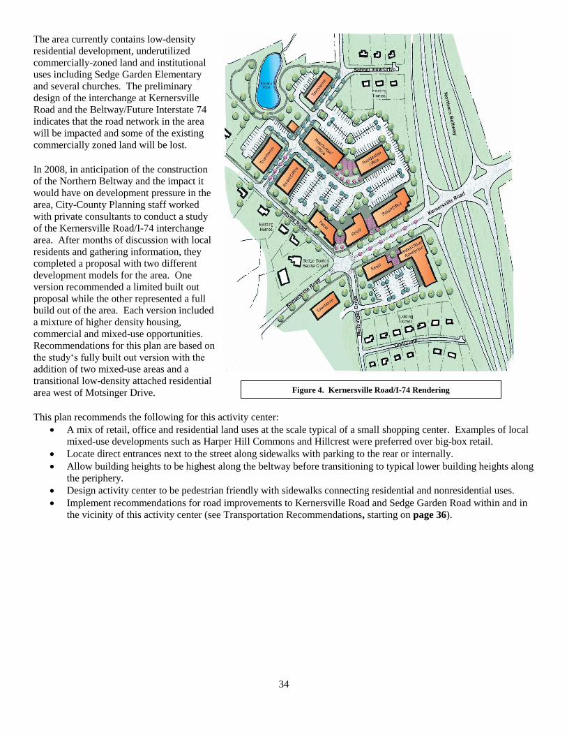
34
The area currently contains low-density
residential development, underutilized
commercially-zoned land and institutional
uses including Sedge Garden Elementary
and several churches. The preliminary
design of the interchange at Kernersville
Road and the Beltway/Future Interstate 74
indicates that the road network in the area
will be impacted and some of the existing
commercially zoned land will be lost.
In 2008, in anticipation of the construction
of the Northern Beltway and the impact it
would have on development pressure in the
area, City-County Planning staff worked
with private consultants to conduct a study
of the Kernersville Road/I-74 interchange
area. After months of discussion with local
residents and gathering information, they
completed a proposal with two different
development models for the area. One
version recommended a limited built out
proposal while the other represented a full
build out of the area. Each version included
a mixture of higher density housing,
commercial and mixed-use opportunities.
Recommendations for this plan are based on
the study‘s fully built out version with the
addition of two mixed-use areas and a
transitional low-density attached residential
area west of Motsinger Drive.
This plan recommends the following for this activity center:
A mix of retail, office and residential land uses at the scale typical of a small shopping center. Examples of local
mixed-use developments such as Harper Hill Commons and Hillcrest were preferred over big-box retail.
Locate direct entrances next to the street along sidewalks with parking to the rear or internally.
Allow building heights to be highest along the beltway before transitioning to typical lower building heights along
the periphery.
Design activity center to be pedestrian friendly with sidewalks connecting residential and nonresidential uses.
Implement recommendations for road improvements to Kernersville Road and Sedge Garden Road within and in
the vicinity of this activity center (see Transportation Recommendations, starting on page 36).
Figure 4. Kernersville Road/I-74 Rendering
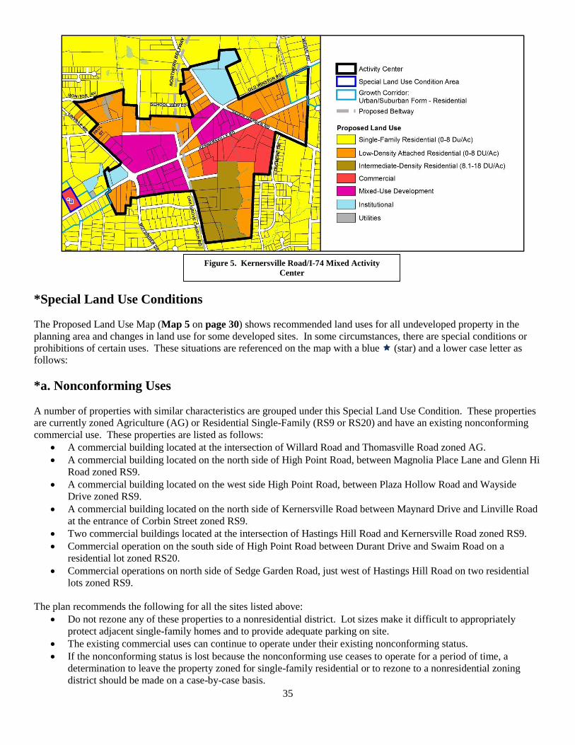
35
*Special Land Use Conditions
The Proposed Land Use Map (Map 5 on page 30) shows recommended land uses for all undeveloped property in the
planning area and changes in land use for some developed sites. In some circumstances, there are special conditions or
prohibitions of certain uses. These situations are referenced on the map with a blue (star) and a lower case letter as
follows:
*a. Nonconforming Uses
A number of properties with similar characteristics are grouped under this Special Land Use Condition. These properties
are currently zoned Agriculture (AG) or Residential Single-Family (RS9 or RS20) and have an existing nonconforming
commercial use. These properties are listed as follows:
A commercial building located at the intersection of Willard Road and Thomasville Road zoned AG.
A commercial building located on the north side of High Point Road, between Magnolia Place Lane and Glenn Hi
Road zoned RS9.
A commercial building located on the west side High Point Road, between Plaza Hollow Road and Wayside
Drive zoned RS9.
A commercial building located on the north side of Kernersville Road between Maynard Drive and Linville Road
at the entrance of Corbin Street zoned RS9.
Two commercial buildings located at the intersection of Hastings Hill Road and Kernersville Road zoned RS9.
Commercial operation on the south side of High Point Road between Durant Drive and Swaim Road on a
residential lot zoned RS20.
Commercial operations on north side of Sedge Garden Road, just west of Hastings Hill Road on two residential
lots zoned RS9.
The plan recommends the following for all the sites listed above:
Do not rezone any of these properties to a nonresidential district. Lot sizes make it difficult to appropriately
protect adjacent single-family homes and to provide adequate parking on site.
The existing commercial uses can continue to operate under their existing nonconforming status.
If the nonconforming status is lost because the nonconforming use ceases to operate for a period of time, a
determination to leave the property zoned for single-family residential or to rezone to a nonresidential zoning
district should be made on a case-by-case basis.
Figure 5. Kernersville Road/I-74 Mixed Activity
Center
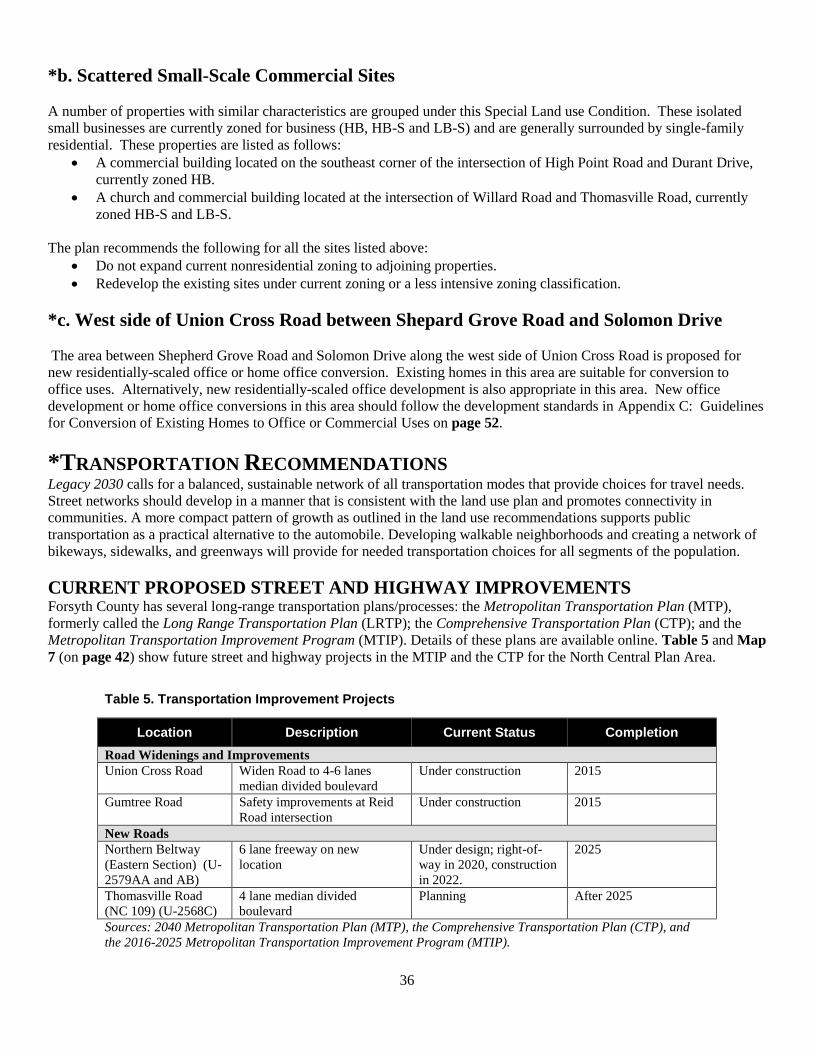
36
*b. Scattered Small-Scale Commercial Sites
A number of properties with similar characteristics are grouped under this Special Land use Condition. These isolated
small businesses are currently zoned for business (HB, HB-S and LB-S) and are generally surrounded by single-family
residential. These properties are listed as follows:
A commercial building located on the southeast corner of the intersection of High Point Road and Durant Drive,
currently zoned HB.
A church and commercial building located at the intersection of Willard Road and Thomasville Road, currently
zoned HB-S and LB-S.
The plan recommends the following for all the sites listed above:
Do not expand current nonresidential zoning to adjoining properties.
Redevelop the existing sites under current zoning or a less intensive zoning classification.
*c. West side of Union Cross Road between Shepard Grove Road and Solomon Drive
The area between Shepherd Grove Road and Solomon Drive along the west side of Union Cross Road is proposed for
new residentially-scaled office or home office conversion. Existing homes in this area are suitable for conversion to
office uses. Alternatively, new residentially-scaled office development is also appropriate in this area. New office
development or home office conversions in this area should follow the development standards in Appendix C: Guidelines
for Conversion of Existing Homes to Office or Commercial Uses on page 52.
*TRANSPORTATION RECOMMENDATIONS Legacy 2030 calls for a balanced, sustainable network of all transportation modes that provide choices for travel needs.
Street networks should develop in a manner that is consistent with the land use plan and promotes connectivity in
communities. A more compact pattern of growth as outlined in the land use recommendations supports public
transportation as a practical alternative to the automobile. Developing walkable neighborhoods and creating a network of
bikeways, sidewalks, and greenways will provide for needed transportation choices for all segments of the population.
CURRENT PROPOSED STREET AND HIGHWAY IMPROVEMENTS Forsyth County has several long-range transportation plans/processes: the Metropolitan Transportation Plan (MTP),
formerly called the Long Range Transportation Plan (LRTP); the Comprehensive Transportation Plan (CTP); and the
Metropolitan Transportation Improvement Program (MTIP). Details of these plans are available online. Table 5 and Map
7 (on page 42) show future street and highway projects in the MTIP and the CTP for the North Central Plan Area.
Table 5. Transportation Improvement Projects
Location Description Current Status Completion
Road Widenings and Improvements
Union Cross Road Widen Road to 4-6 lanes
median divided boulevard
Under construction 2015
Gumtree Road Safety improvements at Reid
Road intersection
Under construction 2015
New Roads
Northern Beltway
(Eastern Section) (U-
2579AA and AB)
6 lane freeway on new
location
Under design; right-of-
way in 2020, construction
in 2022.
2025
Thomasville Road
(NC 109) (U-2568C)
4 lane median divided
boulevard
Planning After 2025
Sources: 2040 Metropolitan Transportation Plan (MTP), the Comprehensive Transportation Plan (CTP), and
the 2016-2025 Metropolitan Transportation Improvement Program (MTIP).
37
Comprehensive Transportation Plan Projects Winston-Salem Northern Beltway, Eastern Section (U-2579AA and AB)
Existing US 52 and Business 40 in Winston-Salem are currently over capacity. The 2012-2018 TIP includes project U-
2579 that is intended to address this problem. The project consists of constructing a four-to-six lane freeway from US 52
north of Winston-Salem to US 311 southeast of Winston-Salem. This project will improve north-south connectivity in
eastern Forsyth County, provide direct connections to US 421, I-40, and Kernersville Road, and provide congestion relief
on local roadways. This project is currently in the project development phase.
Thomasville Rd/NC 109 Improvement Project
NCDOT plans to improve NC 109 between Old Greensboro Rd in Davidson County and I-40/US 311 in Forsyth County.
Those plans include widening the existing highway and adding new roadway. Currently this section of 109 carries as
many as 19,000 vehicles per day. In 2035, that figure is estimated to increase to 30,000 vehicles per day. By improving
the highway, NCDOT will help reduce accidents and congestion. NCDOT, along with federal, state and local officials,
selected Corridor Alternative 6 as the preferred route for the NC 109 Improvement Project in Davidson and Forsyth
counties. Corridor Alternative 6 will involve widening parts of existing road and building sections of new roadway to
create a 10-mile, four lane highway with a median. The project is in development, the let date is FY 2021 and the
completion date is currently undetermined.
Union Cross Road Widening Project
The project will widen 4.2 miles of Union Cross Road in Winston-Salem and Kernersville from Sedge Garden Road north
of I-40 to just south of U.S. 311. It also includes constructing the area’s first diverging diamond interchange at I-40. This
project is scheduled to complete in late January 2016.
Road Realignment at Gumtree and Sawmill Intersection
This project lowers the elevation of Gumtree Road and realigns Sawmill Road to improve sight distance and safety at the
intersection. It was let in September 2014 and completed in August 2015, and is awaiting permanent vegetation.
PEDESTRIAN Construction of sidewalks in the planning area is likely to be achieved through public funding and through private
developments designed to meet street design standards. Sidewalks are recommended in the Sidewalk and Pedestrian
Facilities Plan for all thoroughfares and collector streets except for freeways and expressways. All proposed sidewalks in
the Sidewalk and Pedestrian Facilities Plan are evaluated on an annual basis and ranked for future construction.
Topography and the presence of curb and gutter along streets are considered when evaluating projects. The City of
Winston-Salem and Forsyth County have adopted street design standards for new developments that include requirements
for sidewalks. The Sidewalk and Pedestrian Facilities Plan does not make any recommendations for sidewalks in the
planning area. General sidewalk recommendations for the planning area include:
Identify and recommend locations for pedestrian crossing signals at key intersections
Assure that pedestrian are accommodated in all road and bridge construction and modification projects.
Provide sidewalks on at least one side of all new roads and on both sides of roads that provide access to
institutions and public facilities.
GREENWAYS Greenways serve a dual purpose within a community. Beyond being a residential amenity, greenways play an integral
role in establishing an active transportation network along with sidewalks and bikeways. Two greenways currently exists
in the planning area and four additional greenways have been proposed here. Information and recommendations
pertaining to greenway projects can be found in the Community Facilities section.
BICYCLE
Bicycle Lanes and Shared Lane Markings The City of Winston-Salem has begun installing bicycle lanes and shared lane markings on city streets to provide a
network of bicycle facilities that connect residential areas with key destinations, such as schools, parks, libraries, and
commercial areas. Bicycle lanes provide a separate lane (typically five or six feet wide) on the road for cyclists, while
shared lane markings are placed in the travel lane and indicate to drivers that they should expect to share the lane with
38
cyclists. The City of Winston-Salem Department of Transportation has no proposed bicycle lane projects within the
planning area.
GROWTH CORRIDORS
Growth corridors are identified in Legacy 2030 as major roadways that connect activity centers to each other and
Downtown Winston-Salem. They are often characterized by older automobile-oriented strip commercial areas
experiencing decline. To help improve the function, safety, and appearance of growth corridors, redevelopment should
include mixed-use development, increased residential densities where appropriate, attention to design and appearance, and
multiple transportation options. The Southeast Suburban Planning Area includes the Kernersville Road and Thomasville
Road Growth Corridors. These corridors are proposed to generally include the first tier properties on both sides of these
roads. Design recommendations for growth corridors are outlined on page 43. Transportation recommendations include:
Improve all identified growth corridors by adding pedestrian and bicycle facilities, making landscape
improvements, and reducing lanes where feasible.
Develop minimal and simple standards to preserve design flexibility and creativity in making an urban,
pedestrian-oriented corridor.
*COMMUNITY FACILITIES RECOMMENDATIONS Both public and private community facilities such as schools, parks, medical offices and day care providers should be
easily accessible to all segments of the population. Legacy 2030 promotes the sharing of institutional facilities as a way to
meet the various needs of the community. An important recommendation from Legacy 2030 is the creation of a central
public space in all communities to serve as an urban reference point and the focus of civic and community life. The
Community Facilities Recommendations Map (see Map 8 on page 44) shows existing and proposed community facilities.
GENERAL RECOMMENDATIONS
Encourage schools, churches and recreational facilities to share facilities and work cooperatively to provide
services and host community events.
Provide a high level of maintenance at schools, parks and other facilities on an ongoing basis.
Consider safety and environmental sensitivity when designing community facilities.
Assess the need for additional police and fire services in the planning area based on future growth and
development. Acquire land or obtain easements for parks, recreation facilities, open space and other community facilities.
Actively pursue local, state, federal and private funding for land acquisition and development of these facilities.
Seek cooperation with the school board, non-profit and private organizations, where appropriate, to implement
park and recreation proposals.
Involve residents in master planning for parks, greenways and other community facilities.
SCHOOLS Legacy 2030 calls for quality schools that are assets to the neighborhoods in which they are located. School planning
should be coordinated with parks and other public facilities. Recommendations for schools in the planning area are:
Replace, upgrade or expand existing schools to meet the needs of the planning area as its population grows.
Promote alternative uses for school property that is no longer needed for school facilities.
Consider improved arrangements for using school property and facilities for community events and recreational
activities.
Provide a high level of maintenance at schools on an ongoing basis.
Build new schools that are integrated with surrounding neighborhoods through pedestrian and bicycle
connections.
RECREATION FACILITIES Recommendations for proposed parks, recreation facilities, greenways and open space take into consideration the number,
size and location of existing facilities; the need for updating existing recreational facilities; the anticipated location of
future growth; and the expectations of the community as identified during this planning process. The following are
recommendations for various categories of recreation and open space:
39
Assess usage of the area’s existing parks, recreation facilities and the community’s preferences for facilities and
programs. Modify facilities and programs as needed.
Integrate recreation facilities/open space into design of large-scale residential developments to provide
neighborhood parks, activity areas, focal points, and green spaces.
Consider multi-purpose courts and fields to meet existing and future needs.
Consider the establishment of a new community park to provide for future recreation needs. Consider potential
sites near the Kernersville Road/I-74 Beltway Activity Center where there are no existing parks. The site should
be easily accessible from a main road, designed to serve also as a neighborhood park and connected to a proposed
greenway trail, where possible.
Consider the expansion of Salem Lake Park by the addition of suitable land as it becomes available off New
Greensboro Road and Linville Road.
Complete projects for recreation facilities improvements listed in the 2014 bond package:
o Sedge Garden Recreation Center – Water spray ground, restrooms, and gymnasium addition to existing
structure.
Complete proposed improvements to Salem Lake Park as proposed in the 2012-2013 Salem Lake Master Plan:
o Phase I of the project would consist of an updated and new playground, renovating and expanding
lakefront activities (fishing, walking trails, and picnic shelter), a new multifunctional marina center, new
restroom facilities, water spray ground and parking.
TREES AND OPEN SPACE
The planning area not only contains older neighborhoods and commercial areas, but also has some large acreage tracts
either undeveloped or used for agriculture purposes. Many trees are found in these open areas and throughout the whole
of the Southeast Suburban Planning Area. These trees add aesthetic and financial value and have a positive environmental
impact. Permanent open space is proposed for sites that have significant environmental constraints, streams, floodplains,
and/or steep slopes, making them unsuitable for development. These sites are owned by the City, County, and the State of
North Carolina. Recommendations in the planning area include:
Protect the planning area’s tree canopy as much as possible.
Retain existing large trees on private property whenever possible.
Identify additional areas for planting street trees on public right-of-way.
Explore opportunities to plant street trees in the area on an upcoming Community Roots Day.
GREENWAYS
The Greenway Plan Update shows four future greenways within the plan boundaries. Fiddlers Creek, Salem Lake Trail
North, and South Muddy Fork Creek are proposed greenways, designated as Tier 4 or long range priority projects with
construction not likely to begin for at least fifteen years or more. The Piedmont Regional Greenway Trail is currently in
the preliminary design stage and construction will begin in late 2017 to early 2018. The trail will connect the Salem Lake
Trail to Hastings Hill Road. The greenway recommendations for the planning area are:
Work with area residents and the development community to obtain necessary easements for the construction of
the Fiddlers Creek Greenway and the South Fork Muddy Creek Greenway. Easements should be a minimum of
40 feet in width.
Construct the Piedmont Regional Trail.
Complete a feasibility study of the Fiddlers Creek Greenway to determine potential construction limitations, a
proposed route, and possible neighborhood connections.
Work with the surrounding neighborhood on potential connectors to the Salem Lake and Piedmont Regional
Trails. Connectors can be in the form of either greenway or sidewalk.
Complete improvements to Salem Lake Greenway.
40
*HOUSING AND COMMUNITY DEVELOPMENT RECOMMENDATIONS Legacy 2030 recommends that neighborhoods offer a variety of quality housing types for different income levels, family
sizes and types that reduce the segregation of neighborhoods by race, age, and income. Affordable housing should be
promoted throughout Forsyth County by providing incentives, using cost-effective site design, and permitting accessory
dwellings and congregate-care facilities.
GENERAL RECOMMENDATIONS Maintain and improve the quality of housing stock in the area by promoting home ownership, supporting
rehabilitation of existing homes, and through code enforcement.
Develop a variety of housing types for different income levels, family sizes, and personal preferences.
Promote the Neighborhood Improvement Plan to educate residents and newcomers about the City’s regulations
related to zoning, sanitation ordinances, and minimum housing code, and encourage neighborhood associations to
participate.
Incorporate traditional neighborhood design principles in proposed new neighborhood developments, where
feasible. This could include a mixture of housing types, well-designed neighborhood-serving commercial areas,
and incorporating walkability and connectivity in neighborhoods.
Encourage the design of neighborhoods to allow residents to age in place.
Integrate new developments with existing neighborhoods through careful planning, site design and compatible
architecture.
Install sidewalks and/or traffic calming measures, where feasible, to make neighborhoods more pedestrian
friendly and safe.
Encourage the establishment of neighborhood associations where they do not exist to facilitate citizen
involvement in neighborhood issues.
Plan, locate and design shopping areas, community facilities, parks and open space to make them easily accessible
to neighborhood residents.
Improve connectivity of neighborhood streets to improve accessibility within and between neighborhoods.
AFFORDABLE HOUSING Encourage for-profit developers and nonprofit developers to build affordable housing for different income levels
in the planning area.
Ensure that new affordable housing units are compatible with the existing character of older neighborhoods.
Use existing programs or develop new ones to assist community development and nonprofit housing
organizations in providing affordable housing opportunities.
REHABILITATION AND REDEVELOPMENT EFFORTS Market the City’s programs for rehabilitation of owner-occupied or investor-owned housing units in the planning
area as well as first-time homebuyers programs.
Market/promote the tax credit rehab programs available to National Register properties for building rehabilitation.
Concentrate code enforcement and promotion of conservation/rehabilitation programs in areas in danger of
becoming blighted.
Ensure that redeveloped housing is compatible with the existing character of the neighborhoods.
Encourage investor-owners and renters to participate in neighborhood organization membership and activities.
Work with investor-owners to improve maintenance and management of rental properties, where needed.
Transforming Urban Residential Neighborhoods (TURN) One of the strategies under the City Council’s Strategic Focus Area for Livable Neighborhoods is the development of a
program for targeted residential transformation. This project would provide additional financial assistance to rehabilitate
single-family, owner-occupied or investor-owned properties. Under this program, residential properties must be located
in the targeted focus area within the NRSA (Neighborhood Revitalization Strategy Area), have an active Neighborhood
Association currently listed with the City, and leverage private dollars.
41
*DESIGN AND APPEARANCE RECOMMENDATIONS The creation of attractive gateways, business districts and corridors though the use of regulations or physical
improvements is recommended by Legacy 2030. Design and appearance improvements create a positive visual image and
encourage private investment in an area. The appearance and design of buildings and roadways within the planning area
contribute greatly to the image residents and outsiders have of the community. Many of the recommendations of this plan
have design components that emphasize quality and attractive design.
GENERAL RECOMMENDATIONS Encourage rehabilitation/redevelopment of older and underutilized commercial sites in the planning area with
building façade improvements, street yards and buffer yard plantings, and parking area improvements.
Encourage a mix of restaurants, outdoor cafes, small stores, and services at a pedestrian scale that meet the needs
of all residents of the area.
Encourage residents and neighborhood associations to participate in the different programs offered by Keep
Winston-Salem Beautiful to improve the appearance of the planning area: Adopt-A-Flower Bed; Adopt-A-
Stream; Adopt-A-Park; or Adopt-A-Street.
Encourage high-quality design for new development throughout the planning area.
Ensure that attractive landscaping is integrated into the design of new roads or the improvement of existing roads.
Ensure that housing, sanitation, and weeded lot ordinances are strictly enforced in the planning area to eliminate
blighted and burned down structures and maintain vacant lots.
Develop a planting program that includes street trees throughout the planning area and street yards in commercial
districts. Identify areas in need of screening and areas needing buffers adjacent to residential areas.
Refer to the design Guidelines for Suburban Business Parks, as detailed in Appendix G on page 58, when
reviewing zoning request and site plans within the planning area.
Refer to the Design Guidelines for Multifamily Developments, as detailed in Appendix B on page 51, when
reviewing zoning request and site plans within the planning area.
Refer to the design Guidelines for the Conversion of Existing Homes to Office or Commercial Uses, as detailed in
Appendix C on page 52, when reviewing zoning request and site plans within the planning area.
Refer to the design Guidelines for Office/Low-Intensity Commercial Developments, as detailed in Appendix F
on page 57, when reviewing zoning request and site plans within the planning area.
Promote the use of art that reflects local cultures in public spaces such as parks, recreation centers, and other
public areas where resident gather.
Explore the use of zoning overlay districts to ensure good site planning, sensitive design, and to promote
continuity in the design of growth corridors.
Develop minimal and simple guidelines in growth corridors to preserve design flexibility and creativity in making
a suburban, pedestrian-oriented environment.
Develop growth corridors master plans for improvements taking into account the unique character of each
corridor, or for different segments of the same growth corridor. This basis for such master plans will be the
guidelines for the growth corridor identified in this plan.
42
43
LEGACY GROWTH CORRIDORS While this plan’s land use recommendations help define the types of uses in an area (residential, commercial, industrial,
etc.), growth corridor recommendations help to define the forms those uses should take:
Suburban form growth corridors generally include parking located in the front of buildings and generous
landscaping.
Rural form growth corridors should be less dense than suburban form corridors with buildings and parking set
back from the road corridor to preserve rural visual character.
By their nature of passing through multiple settings, each of the Southeast Suburban Planning Area’s growth corridors–
Kernersville Road and NC 109/Thomasville Road (Maps 5 and 6, or pages 30 and 32 respectively) – have multiple
distinct location-based recommendations:
GENERAL RECOMMENDATIONS Explore the use of zoning overlay districts to ensure good site planning, sensitive design, and to promote
continuity in the design of corridors.
Develop minimal and simple standards to preserve design flexibility and creativity in making an urban,
pedestrian-oriented environment.
Develop corridor master plans for improvements taking into account the unique character of each corridor. The
basis for such master plans will be the design standards for the growth corridor identified in this plan.
Kernersville Road (NC 150) Growth Corridor Guidelines
Develop new commercial, office, and multifamily uses with a suburban form (see guidelines below) between
Linville Road and Sedge Garden Road.
Suburban Form – Commercial, Office, Multifamily Guidelines: Kernersville Road (NC 150) between Linville
Road and Sedge Garden Road
Height: Buildings should generally be no more than 4 stories in height on larger sites; 1 to 2 stories on smaller
sites.
Building Setback: Buildings may be located a reasonable distance behind required street yards.
Building Style: When abutting low-density residential uses, commercial or office buildings 4,000 square feet or
less should follow the Guidelines for Conversion of Existing Homes to Office or Commercial Use (Appendix C
on page 52).
Canopies: Canopies for gas stations or similar uses should not be located immediately adjacent to Kernersville
Road.
Multifamily: Develop multifamily sites in a manner that preserves the integrity of any directly adjacent low-
density residential development.
Driveways: Minimize driveway cuts on Kernersville Road and connect adjacent parcels wherever possible.
Thomasville Road (NC 109) Growth Corridor Guidelines
Develop new commercial, office, and multifamily uses with a suburban form (see guidelines below) between
Baden Road and Interstate 40; and between Willard Road and the Davidson County line.
Develop uses with a large-lot rural residential form (see guidelines below) between Willard Road and Baden
Road.
Suburban Form – Commercial, Office, Multifamily Guidelines: Thomasville Road (NC 109) between Baden Road
and Interstate 40 and between Willard Road and the Davidson County line
Height: Buildings should generally be no more than 4 stories in height on larger sites; 1 to 2 stories on smaller
sites.
Building Setback: Buildings may be located a reasonable distance behind required street yards.
Building Style: When abutting low-density residential uses, commercial or office buildings 4,000 square feet or
less should follow the Guidelines for Conversion of Existing Homes to Office or Commercial Use (Appendix C
on page 52).
44

45
Canopies: Canopies for gas stations or similar uses should not be located immediately adjacent to Thomasville
Road.
Multifamily: Develop multifamily sites in a manner that preserves the integrity of any directly adjacent low-
density residential development.
Driveways: Minimize driveway cuts on Thomasville Road and connect adjacent parcels wherever possible.
Rural Form – Large Lot Residential Guidelines: Thomasville Road (NC 109) between Baden Road and Willard
Road
Building Setback: Buildings should be located 50 feet or more from Thomasville Road to preserve rural
character.
Parking should be screened from Thomasville Road to preserve rural corridor appearance.
*HISTORIC PRESERVATION RECOMMENDATIONS
Legacy 2030 promotes historic preservation because of its contribution to the aesthetic, social, historical, cultural and
environmental quality of neighborhoods as well as its contribution to a community’s economic development. Significant
historic resources have been identified in the planning area as indicated in initial surveys (see Map 9 on page 47 and
Appendix A on page 50). The following are recommendations to ensure that the potential of these resources are fully
explored and that the community takes steps to preserve its historic assets:
Retain historic buildings including houses, commercial storefronts, agricultural buildings, and institutional
structures, when possible.
Recognize buildings, events, and areas of historical, cultural, and architectural significance with signs, plaques, or
markers.
Initiate public outreach programs involving property owners and community organizations on the importance and
economic benefits of preserving historic resources. Examples of potential workshops include:
o How and why to nominate a structure or site to the National Register of Historic Places.
o Issue-related topics such as how to maintain an older or historic building.
Encourage property owners to research and recognize the history and significance of their properties and the area
in which they live.
Use the Forsyth County Agriculture and Historic Preservation Tools included in Appendix E on page 55.
Encourage property owners to research and recognize the history and significance of their properties and the area
in which they live.
Specific historic preservation recommendations for the planning area are:
o Encourage property owners to seek National Register and Local Historic Landmark designation for eligible
properties or districts.
o Encourage property owners to apply for Historic Markers for significant sites.
o Coordinate with organizations such as the Piedmont Land Conservancy to preserve not only the architectural
elements, but also significant farm and open land.
*ECONOMIC DEVELOPMENT RECOMMENDATIONS Economic development can be defined as the creation and/or retention of jobs and increases in the tax base that improve
or enhance the economic welfare of a community and its citizens. Legacy 2030's goal for economic development is to
attract environmentally-sensitive new businesses and expand both large and small businesses to provide a broad range of
employment opportunities and a high quality of life for people living and working in Forsyth County. Economic
development efforts should be compatible with existing development and should include improvements to existing
facilities as well as new businesses. Areas recommended for future commercial and industrial use are shown on the
Proposed Land Use Map (see Map 5 on page 30).
The planning area is likely to see an increase in economic activity during the life of this plan update. The Northern
Beltway Eastern Section, when constructed, will improve access to the planning area and will impact economic
development in the Planning Area and neighboring areas. Future improvements to Union Cross Road will also impact
residents in the planning area. In the interim economic development should focus on the redevelopment, rehabilitation
46
and reuse of underutilized and older commercial development and infilling of existing industrial parks in the planning area
and neighboring areas. Specific economic development recommendations for the planning area are:
Support balanced, compatible economic development by the private and public sector.
Encourage technologically-advanced, high-quality, environmentally-sustainable businesses and industries to
locate or expand in the planning area.
Rezone land for business/industrial development in a manner consistent with the recommended Proposed Land
Use Plan.
Encourage and support the redevelopment/rehabilitation of existing older/underutilized commercial and industrial
sites.
Identify funding sources to implement economic development initiatives including energy-efficient, high-
technology businesses/industries.
Direct public improvements and funding to designated activity centers, industrial sites and to other potential
economic development opportunity areas identified in the plan.
Recognize and support business opportunities associated with the growing diversity of cultures in the area.
Market and hold workshops to promote City business training and building rehabilitation loan programs for the
purchase or rehabilitation of structures to local/potential merchants particularly in the designated activity centers. Promote and encourage agribusiness on the farmlands located throughout the planning area. Explore and encourage economic development opportunities associated with local foods and urban agriculture.
*ENVIRONMENTAL RECOMMENDATIONS The preservation and enhancement of our environmental resources results in a high quality of life for Forsyth County
residents. Legacy 2030 calls for the protection of watersheds, wetlands, natural areas and streams throughout the county.
Clean water, air, and the scenic beauty of the planning area should be maintained. Of particular concern is the loss of the
tree canopy in the area and the need to protect the county’s many creeks from pollution and its floodplains from
inappropriate development.
GENERAL RECOMMENDATIONS
Manage development pressures to preserve environmentally-sensitive areas, forested areas, wildlife habitats, and
scenic areas.
Encourage the donation of easements to preserve and protect high-quality natural and scenic areas.
Encourage land owners to use Best Management Practices for stormwater protection.
Encourage sustainable development of land and buildings.
Improve or preserve the water quality of the creeks by protecting the natural stream corridors.
Support organizations and programs that educate residents on environmental issues.
Support the Voluntary Agriculture District provisions adopted by Forsyth County that identify farms and farmers
who want to keep their land in agriculture.
Carefully evaluate potential sites for development and redevelopment that may have been affected by
environmental contamination in the planning area. This would be particularly appropriate for residential,
institutional, and public gathering uses on sites near current and former heavy industrial or commercial operations
with documented environmental hazards.

47
48
Implementation Schedule
Note: The recommendations of this plan serve as a guide to future action and decision making and are not a commitment
to funding. Funding for specific projects/actions will be allocated by the Winston-Salem City Council or Forsyth County
Commissioners based on the availability of funding and consideration of priorities.
*Timing: Immediate: 1 to 2 years, Short Range: 3 to 5 years, Medium Range: 6 to 10 years, Long Range: 10
years or more, Ongoing: No established completion date
ACTION/PROJECT RESPONSIBLE
AGENCY
TIMING*
Land Use Recommendations
Follow Proposed Land Use Plan, land use policies, and Special Land Use
Condition Areas (pages 25-36). Ensure that future land use changes do not
negatively affect new and existing neighborhoods.
CCPB, WSCC Ongoing
Transportation Recommendations
New Roads
Build proposed new roads in the Transportation Plan:
- Northern Beltway (Eastern Section) (page 36).
- Thomasville Road (page 36).
WSDOT
Long Range
Road and Bridge Improvements
Upgrade road, remove interchange, and/or replace bridges
- Union Cross Road widening (page 36).
- Gumtree Road improvements (page 36).
WSDOT Short Range
Pedestrian
Review identified sidewalk projects under the City’s sidewalk priority
funding system (page 37).
WSDOT Assessed
Annually
Construct sidewalks within residential areas and along designated
thoroughfares and collector streets (page 37).
Private Developers in
conjunction with
WSDOT
Ongoing
Bicycle
Improve bicycle signage along all existing routes (page 38). WSDOT Ongoing
Growth Corridors
Improve all identified growth corridors by adding pedestrian and bicycle
facilities, making landscape improvements, and reducing lanes where
feasible (page 38).
WSDOT Ongoing
Develop activity centers along growth corridors as transit-oriented, high-
density, mixed-use nodes (page 38).
CCPB, WSCC, WSDOT Ongoing
Community Facilities Recommendations
Parks
Complete proposed improvements to Salem Lake Park (page 39). WSRP Short Range
Complete proposed improvements for Sedge Garden Rec. Center (page 39). WSRP Short Range
Greenways
Complete Piedmont Regional Trail (page 39). WSENG, PLC Immediate
Work with area residents and the development community to obtain
necessary easements for the construction of the Fiddlers Creek and South
Fork Muddy Creek Greenways (page 39).
WSENG Short Range
Complete improvements to Salem Lake Greenway (page 40). WSENG Short Range
Housing and Community Development Recommendations Maintain and improve the quality of housing stock in the planning area
(page 40).
CBD, Neighborhood
Associations, Property
Owners
Ongoing/
Immediate
49
Market the City’s programs for rehabilitation and homeownership (page 40). CBD Ongoing/
Immediate
Implement the TURN (Transforming Urban Residential Neighborhoods)
program where feasible (page 41).
CBD Immediate
Design and Appearance Recommendations Encourage site and building improvements in older and underutilized
commercial sites (page 41).
CBD, CCPB, WSCC Ongoing
Ensure that attractive landscaping is integrated into the design of new roads
or the improvement of existing roads (page 41).
WSDOT, CCPB, WSCC Ongoing
Refer to the area plan design guidelines when reviewing zoning requests and
site plans in the Planning Area (page 41).
CCPB, WSCC Ongoing
Promote the use of art that reflects local cultures in public spaces such as
parks, recreation centers, and other public spaces where residents gather
(page 41).
WSCC Ongoing
Explore the use of zoning overlay districts to ensure good site planning,
sensitive design, and to promote continuity in the design of growth corridors
(page 41).
CCPB, WSCC Ongoing
Develop growth corridor master plans for improvements taking into account
the unique character of each corridor, or for different segments of the same
growth corridor (page 43 – 45).
CCPB, WSCC Long Range
Historic Preservation Recommendations Retain existing historic resources (page 45). CCPB, Property Owners Ongoing
Recognize buildings, events or areas of historical, cultural or architectural
significance with signage, plaques or markers (page 45).
CCPB, HRC Ongoing
Initiate public outreach on the benefits of preserving historic resources
(page 45).
CCPB, HRC Ongoing
Encourage property owners to seek National Register and Local Historic
Landmark designation for eligible properties (page 45).
CCPB, HRC Ongoing
Economic Development Recommendations
Support balanced, compatible economic development by the private and
public sector in the Planning Area (page 46).
CBD, CCPB, WSCC Ongoing
Encourage and support the redevelopment/rehabilitation of
older/underutilized commercial sites (page 46).
CBD, CCPB, WSCC Ongoing
Continue the improvement of RUCA areas as City funds become available
(page 46).
WSCC, CBD Ongoing
Environmental Recommendations
Manage development pressures to preserve environmentally-sensitive areas,
forested areas, wildlife habitats, agricultural lands and scenic areas (page
46).
WSRP, CCPB, WSCC Ongoing
Encourage the donation of easements to preserve and protect high-quality
natural and scenic areas (page 46).
PLC, CCPB, WSCC Ongoing
Carefully evaluate potential sites for development and redevelopment that
may have been affected by environmental contamination in the planning
area (page 46).
NCDENR, Nonprofit
and For-profit
Developers
Ongoing
Abbreviations Used:
CBD Winston-Salem Community and Business
Development Department WSCC Winston-Salem City Council
CCPB City-County Planning Board WSDOT Winston-Salem Department of
Transportation
HRC Winston-Salem/Forsyth County Historic
Resources Commission WSENG
Winston-Salem Engineering
Department
NCDENR North Carolina Department of
Environment and Natural Resources WSRP
Winston-Salem Recreation and Parks
Department
PLC Piedmont Land Conservancy
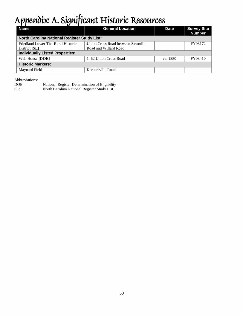
50
Appendix A. Significant Historic Resources Name General Location Date Survey Site
Number
North Carolina National Register Study List:
Friedland Lower Tier Rural Historic
District [SL]
Union Cross Road between Sawmill
Road and Willard Road
FY03172
Individually Listed Properties:
Well House [DOE] 1462 Union Cross Road ca. 1850 FY03410
Historic Markers:
Maynard Field Kernersville Road
Abbreviations:
DOE: National Register Determination of Eligibility
SL: North Carolina National Register Study List
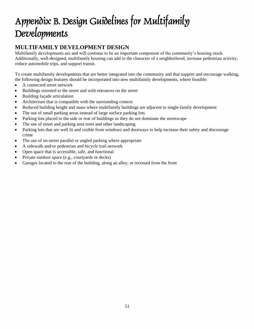
51
Appendix B. Design Guidelines for Multifamily Developments MULTIFAMILY DEVELOPMENT DESIGN Multifamily developments are and will continue to be an important component of the community’s housing stock.
Additionally, well-designed, multifamily housing can add to the character of a neighborhood, increase pedestrian activity,
reduce automobile trips, and support transit.
To create multifamily developments that are better integrated into the community and that support and encourage walking,
the following design features should be incorporated into new multifamily developments, where feasible:
A connected street network
Buildings oriented to the street and with entrances on the street
Building façade articulation
Architecture that is compatible with the surrounding context
Reduced building height and mass where multifamily buildings are adjacent to single-family development
The use of small parking areas instead of large surface parking lots
Parking lots placed to the side or rear of buildings so they do not dominate the streetscape
The use of street and parking area trees and other landscaping
Parking lots that are well lit and visible from windows and doorways to help increase their safety and discourage
crime
The use of on-street parallel or angled parking where appropriate
A sidewalk and/or pedestrian and bicycle trail network
Open space that is accessible, safe, and functional
Private outdoor space (e.g., courtyards or decks)
Garages located to the rear of the building, along an alley, or recessed from the front
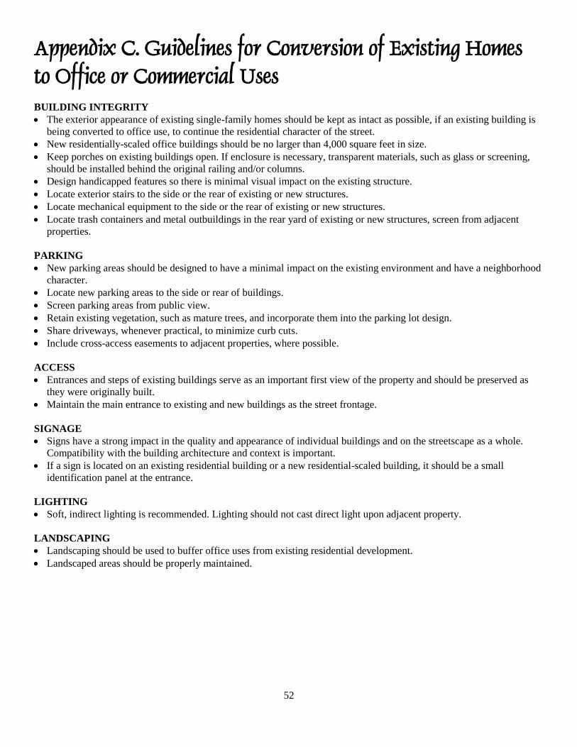
52
Appendix C. Guidelines for Conversion of Existing Homes to Office or Commercial Uses
BUILDING INTEGRITY
The exterior appearance of existing single-family homes should be kept as intact as possible, if an existing building is
being converted to office use, to continue the residential character of the street.
New residentially-scaled office buildings should be no larger than 4,000 square feet in size.
Keep porches on existing buildings open. If enclosure is necessary, transparent materials, such as glass or screening,
should be installed behind the original railing and/or columns.
Design handicapped features so there is minimal visual impact on the existing structure.
Locate exterior stairs to the side or the rear of existing or new structures.
Locate mechanical equipment to the side or the rear of existing or new structures.
Locate trash containers and metal outbuildings in the rear yard of existing or new structures, screen from adjacent
properties.
PARKING
New parking areas should be designed to have a minimal impact on the existing environment and have a neighborhood
character.
Locate new parking areas to the side or rear of buildings.
Screen parking areas from public view.
Retain existing vegetation, such as mature trees, and incorporate them into the parking lot design.
Share driveways, whenever practical, to minimize curb cuts.
Include cross-access easements to adjacent properties, where possible.
ACCESS
Entrances and steps of existing buildings serve as an important first view of the property and should be preserved as
they were originally built.
Maintain the main entrance to existing and new buildings as the street frontage.
SIGNAGE
Signs have a strong impact in the quality and appearance of individual buildings and on the streetscape as a whole.
Compatibility with the building architecture and context is important.
If a sign is located on an existing residential building or a new residential-scaled building, it should be a small
identification panel at the entrance.
LIGHTING
Soft, indirect lighting is recommended. Lighting should not cast direct light upon adjacent property.
LANDSCAPING
Landscaping should be used to buffer office uses from existing residential development.
Landscaped areas should be properly maintained.
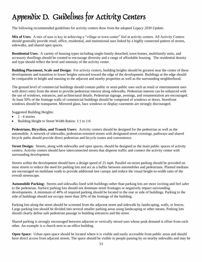
53
Appendix D. Guidelines for Activity Centers
The following recommended guidelines for activity centers draw from the adopted Legacy 2030 Update.
Mix of Uses: A mix of uses is key to achieving a “village or town center” feel at activity centers. All Activity Centers
should generally provide retail, office, residential, and institutional uses linked by a highly connected pattern of streets,
sidewalks, and shared open spaces.
Residential Uses: A variety of housing types including single-family detached, town homes, multifamily units, and
accessory dwellings should be created to encourage diversity and a range of affordable housing. The residential density
and type should reflect the level and intensity of the activity center.
Building Placement, Scale and Design: For activity centers, building heights should be greatest near the center of these
developments and transition to lower heights outward toward the edge of the development. Buildings at the edge should
be comparable in height and massing to the adjacent and nearby properties as well as the surrounding neighborhood.
The ground level of commercial buildings should contain public or semi-public uses such as retail or entertainment uses
with direct entry from the street to provide pedestrian interest along sidewalks. Pedestrian interest can be enhanced with
the use of windows, entrances, and architectural details. Pedestrian signage, awnings, and ornamentation are encouraged.
At least 50% of the frontage walls of commercial buildings should be comprised of windows or doors. Storefront
windows should be transparent. Mirrored glass, faux windows or display casements are strongly discouraged.
Suggested Building Heights:
1 - 4 stories
Building Height to Street Width Ratios: 1:1 to 1:6
Pedestrians, Bicyclists, and Transit Users: Activity centers should be designed for the pedestrian as well as the
automobile. A network of sidewalks, pedestrian-oriented streets with designated street crossings, pathways and shared
bicycle paths should provide direct pedestrian and bicycle routes and convenience.
Street Design: Streets, along with sidewalks and open spaces, should be designed as the main public spaces of activity
centers. Activity centers should have interconnected streets that disperse traffic and connect the activity center with
surrounding development.
Streets within the development should have a design speed of 25 mph. Parallel on-street parking should be provided on
most streets to reduce the need for parking lots and act as a buffer between automobiles and pedestrians. Planted medians
are encouraged on multilane roads to provide additional tree canopy and reduce the visual height-to-width ratio of the
overall streetscape.
Automobile Parking: Streets and sidewalks lined with buildings rather than parking lots are more inviting and feel safer
to the pedestrian. Surface parking lots should not dominate street frontages or negatively impact surrounding
developments. A minimum of 40% of required parking should be located to the rear or side of buildings. Parking to the
side of buildings should not occupy more than 30% of the frontage of the building.
Parking lots along the street should be screened from the adjacent street and sidewalk by landscaping, walls, or fences.
Large parking lots should be divided into several smaller parking areas using landscaping or other means. Parking lots
should clearly define safe pedestrian passage to building entrances and the street.
Shared parking is strongly encouraged between adjacent or vertically mixed uses whose peak demand is offset from each
other. An example is a church next to an office building.
Open Space: Urban open space should be located where it is visible and easily accessible from public areas and should
have direct access from adjacent streets. The space should be visible to people passing by on nearby sidewalks and may be

54
visible from adjacent streets but not wholly exposed to them. Urban open space should be partially enclosed using
building walls, free-standing walls, landscaping, raised planters, or on-street parking to help buffer it and create a
comfortable "outdoor room.”
Sensitive Site Development: Sites for activity centers should be designed with the preservation of natural features in
mind. Building sites within a development should avoid streams, floodplains, wetlands, and steep slopes. Wherever
possible, street locations should account for difficult topographical conditions, paralleling contours to avoid excessive cuts
and fills. Every attempt should be made to preserve large existing trees, 12 inches in caliper or more.
55
Appendix E. Forsyth County Agricultural and Historic Preservation Tools The following is a summary of the zoning districts and other tools for preserving agricultural and historical assets in
Forsyth County.
AG Zoning: The Agricultural (AG) District is primarily intended to accommodate agricultural uses as well as scattered
non-farm residences on large tracts of land. The district is not intended for small-lot residential subdivisions, and
accordingly requires a minimum 40,000 square foot lot size for the development of single-family homes. The district is
intended for use in Growth Management Areas 4 (Future Growth Area) and 5 (Rural Area), and is established to preserve
the rural character of these areas and encourage the continued use of land for agricultural, forest, and open space purposes.
The district is also intended to discourage the establishment of scattered commercial and industrial land uses, prevent
premature conversion of farmland into urban uses, and to limit premature public infrastructure and service demands. AG
zoning would be an appropriate tool for limiting development intensity and conserving agricultural land in the Southeast
Suburban Planning Area. Property owners may initiate rezoning by submitting a rezoning application that would be
considered by the Planning Board and elected body.
Voluntary Agricultural District: The Voluntary Agricultural District (VAD) program adopted by the Forsyth County
Commissioners in January, 2008 is a tool that helps preserve farmland in an increasingly urbanized county. Landowners
receive a set of benefits in exchange for restricting development on their land for a specific time period. Voluntary
Agricultural Districts promote agricultural values as well as the agricultural community and its way of life. The Voluntary
Agricultural District program also provides increased protection from nuisance suits, encourages the economic and
financial health of agriculture, and provides protection from non-farm development and other negative impacts on
properly managed farms. Unlike other agricultural and open space preservation tools which protect farmland, Voluntary
Agricultural Districts protect farmers by making farming more economically viable and helping to preserve farmland.
These farms must participate in the present-use-value taxation program. Further study is necessary to determine the
eligibility of farms in the Southeast Suburban Planning Area for this program.
Forsyth County Farmland Preservation Program: The Forsyth County Farmland Preservation program is a voluntary
program in which Forsyth County purchases from farmers the rights to develop their land for non-farm purposes, such as
subdivisions and shopping centers. The development rights are held in trust assuring that areas with good soils and active
farms will remain in agricultural use. The Forsyth County Board of Commissioners created the program in 1984 and the
first development rights were purchased in 1987. To date, the program has protected over 1600 acres of farmland;
however, it has not been funded in recent years.
Piedmont Land Conservancy Conservation Easements: The Piedmont Land Conservancy (PLC) protects land by
working with landowners who choose to conserve their land. The PLC helps landowners determine which conservation
option will best meet their objectives for the land and themselves. A conservation easement is a legal agreement through
which the landowner gives specific property rights to the PLC. It provides immediate and permanent protection while
keeping the land in private ownership. Each conservation easement is tailored to the specific property. A landowner can
choose to donate the conservation easement, or sell the conservation easement at or below its appraised value. If a
landowner no longer desires to own the property, the PLC can acquire it. In these situations, the PLC must determine if it
is desirable to own the subject property.
Local Historic Landmark Designation: Local historic landmark designation applies to individual properties in Forsyth
County. This designation recognizes the importance of a property to the heritage and character of the community and that
its protection enriches the community’s residents.
Local landmark properties can be of several different types:
Buildings: Houses, churches, office buildings, schools, barns.
Structures: Roads, bridges, fences, silos, kilns, gazebos.
56
Sites: Cemeteries, building ruins, natural features, designed landscapes.
Areas: One or more buildings on a large property, plus a surrounding area.
Objects: Signs, monuments, sculptures, fountains, mileposts.
Once a property has been designated as a historic landmark, the ordinance designating the property provides controls on
the appearance of the designated property and new construction on the property. In addition, the property owner may
apply to the Forsyth County Tax Office for a 50% property tax deferral, which runs with the property in perpetuity (unless
designation is revoked).
Local Historic Districts: Local Historic District designation is a zoning classification that applies to a group of
contiguous properties. The area must have a concentration of properties that are historically, visually, or culturally related
by plan or physical development. A District can include different types of historic properties, but collectively, they must
form a unified body with its own identity. Together the properties must convey a physical sense of the historical
environment. Examples of Historic Districts include residential areas, business districts, industrial complexes, rural
villages, rural landscapes, and college campuses. Once an area has been designated as a Historic District, the zoning
ordinance provides controls on the appearance of existing buildings/property and new construction within the districts
through the Certificate of Appropriateness process. In North Carolina, Historic Districts can be established in one of two
ways:
Historic Overlay District: This type of district does not replace or change the underlying zoning classification. Rather,
it superimposes the Historic District over the existing zoning. This is the most common type of district found in the state.
In 1993, West End, located in Winston-Salem, became the community's first Historic Overlay (HO) District.
Separate Use Historic District: A Separate Use Historic District is an entirely separate zoning classification, with its
own permitted uses, dimensional requirements, and other zoning regulations. This type of District is rarely found. Forsyth
County has the only two such districts in North Carolina. Old Salem and Bethabara are the two Separate Use Historic
Districts. Their classification is listed as "H" zoning in Winston-Salem/Forsyth County Unified Development Ordinance
(UDO).
National Register of Historic Places: The National Register of Historic Places is a list maintained by the National Park
Service of buildings, structures, sites, objects, and districts that are significant in American history, architecture,
archaeology, engineering, and culture, and that meet criteria for evaluation. National Register listing puts no obligation or
restriction on private property owners using private resources to maintain or alter their properties. A private owner of a
National Register property is obligated to follow federal preservation guidelines only if federal funding or licensing is
used in work on the property, or if the owner seeks and receives a special benefit that comes from National Register
designation, such as investment tax credits.
57
Appendix F. Guidelines for Office/Low-Intensity Commercial Developments
Building Placement: New buildings shall front the main road to create a continuity of building facades along the
corridor. The main entrances to all buildings shall be at the street frontage.
Building Scale and Proportion: New structures shall take on the proportions, rhythm, scale, and visual integrity of
existing structures. This does not imply a direct copy of existing structures. It does refer to the use of existing patterns in
the built environment.
Building Materials: Preferred materials brick and wood. Building materials, such as artificial brick or stone, artificial
siding, exposed and/or painted concrete blocks or cinder blocks, and plate glass walls, are not recommended.
Facades: The facade shall enhance the pedestrian environment by use of features such as porches, columns, and cornices.
Solid walls and blank exterior facades are discouraged.
Canopies and Awnings: These features shall complement the streetscape and other structures in the immediate area.
Awnings or other devices may be installed for solar protection and to emphasize the human scale of the ground level
spaces.
Color: Earth tone colors are encouraged, and bright colors shall only be used as accents to overall building.
Outside Storage: Outside storage shall be permitted only if screened from view from the main road. The outside storage
shall not occupy an area larger than one-half of the area covered by the principal use.
Loading/Unloading and Garage Bays: All loading areas and entrances to motor vehicle repair bays shall be screened
from public view from the main road.
Off-Street Parking: Parking shall be located only in the side or rear yards with exceptions noted for each segment. On
corner lots, parking on the street side corner of the lot shall be avoided. New parking lots shall be designed to minimize
their effects on the existing streetscape. Areas of circulation and parking need to be clearly defined using appropriate
markings and materials. Large expanses of paving shall be divided into smaller components with interior planting areas.
On-Site Utilities: All public utilities and related facilities, heating, ventilation and air conditioning (HVAC) units,
including on ground and rooftop mechanical systems, and dumpsters, shall be so located and/or shielded so as to not be
visible from the public right-of-way.
Site Amenities: Include site furnishings such as bollards, seating, trash containers, tree grates, special features, fencing
and any special lighting to enhance pedestrian areas.
Architectural Characteristics: Buildings within this area shall encourage the following additional architectural
characteristics:
Display windows on the street/first level.
Lighting shall be provided in all display windows.
The use of cornice canopies, balconies, and arcades to delineate between the ground/street level and upper levels.
Larger buildings to be broken into smaller scale components at the ground/street level.
58
Appendix G. Guidelines for Suburban Business Parks
Although efforts continue to revitalize Downtown Winston-Salem and other existing employment centers, many
companies still prefer to locate at suburban sites in a campus-like environment. For certain companies, the locational
advantages that initially shaped our downtowns are often not as relevant (i.e., railroad access), or substitutes are readily
available almost anywhere (i.e., nearby access to financial institutions).
These sites, which are referred to here as Suburban Business Parks, can be attractive to companies by offering affordable
land, the ability to build a facility conforming to a company’s specific needs, nearby access to an interstate or an airport,
access to a regional supply of labor, and a campus setting preferred by some employees. Forsyth County needs to provide
a sufficient supply of these sites to help attract new companies or to assist local businesses expanding their operations.
Suburban Business Parks should be integral components when implementing comprehensive economic development
strategies.
Purpose: The purpose of these guidelines is to help create high-quality suburban business parks in a campus-like setting
consisting of attractive buildings, significant natural open space, and formal landscaped areas.
Application: These guidelines will be used by the City-County Planning Board and its staff as a means of organizing
review of master plans for business parks. The guidelines identify important design elements that should be considered.
Because the setting and target market for each business park will be unique, no single formula is ideal for creating an
excellent design. Therefore, where design elements of a master plan vary from these guidelines, their appropriateness will
be judged on how well they address the overall intent of the guidelines and not on strict adherence to particular elements.
Uses: Appropriate uses in these business parks include warehouses, light manufacturing and assembly, scientific and
research laboratories, and corporate offices.
Recommended Overall Site Size: The recommended minimum site size for business parks is 100 acres. This threshold
size will focus business park development at a few appropriate locations, allow for coordinated development and
sufficient land for a campus-like setting, and provide enough space for the effective use of buffers and preservation of
natural areas.
Site Buffers: Site buffers consisting of existing vegetation supplemented by additional plantings and berms should be
located along the periphery of the site to provide a visual screen and functional separation from public streets and
adjoining residential land. The width of these buffers may vary depending on the physical characteristics of a particular
site but in any case should not be less than 50 feet in width.
Access: Access should be on roads of at least minor thoroughfare classification, and streets in the business park should be
designed to both allow access from adjacent neighborhoods but not draw traffic through local residential streets. More
than one major access point should be provided and connectivity of the internal street system is encouraged.
Common Open Space: A minimum of 20 percent common open space consisting of streams or lakes, floodplains,
wetlands, slopes greater than 20 percent, and other open areas should be retained on the site. Common open space should
be connected, where possible, to form a ribbon of green throughout the development. In areas where the site buffers are
more than 50 feet, the area in excess of 50 feet may be counted as part of the common open space requirement if it is
linked to other common open space areas. An existing site resources map should be prepared by the developer as part of
the site planning process showing natural and constructed site features to be included as common open space.
Stream/Wetland Protection: Streams and wetland areas should be protected by requiring riparian buffers to the edge of
the floodway fringe for FEMA regulated streams and 50 foot buffers from each side of streams and wetlands identified in
the Forsyth County soil survey. Exact location and extent of streams and wetlands should be verified during preparation of
the site resources map required to identify common open space elements.
59
Architectural Design: Architecturally unified materials should be selected and emphasized for each structure and
building site. Exposed guideline concrete blocks and prefabricated metal are not recommended but may be acceptable for
the sides and rear of buildings if they are screened from view of external property lines and internal roadways. Offices or
showrooms should be located at the front of the building and facades facing the street should be articulated to distinguish
the building. New developments should explore the use of Leadership in Energy and Environmental Design (LEED)
guidelines to increase energy efficiency and reduce long-term building expenses.
Placement of Structures: All structures should be setback a minimum of 100 feet from the external property lines of the
site. Employee parking may be located in this setback in the 50 feet closest to the building. Buildings on each building site
should face interior streets and be setback a minimum of 60 feet. For large buildings, a larger setback in proportion to
their footprint and height is encouraged to contribute to a campus-like setting. Buildings located on the corner of two
streets shall be considered to have two front faces. Warehouse buildings should be designed and placed on their lots so
that views of loading docks from the street are minimized or prevented.
Storage/Process Areas: Businesses should meet the storage requirements of the "Manufacturing B" use in the Unified
Development Ordinances which allows operations including storage of materials, processing fabrication or assembly of
products and loading and unloading of new materials only within enclosed buildings. Storage trailers or containers should
be located in designated areas and screened from public streets or from the exterior of the business park. No outdoor
processes should be employed in the operation of any business in the business park as stipulated by the requirements of
the "Manufacturing B" use in the Unified Development Ordinances. Any waste and recycling receptacles should be
located within an enclosed structure.
Operation Impacts: Operations at the business park should not produce dust, smoke, odors, fumes, air or water pollution,
noise, gases, or vibrations as required by the requirements of the "Manufacturing B" use in the Unified Development
Ordinances. The use of hazardous materials or volatile chemicals should be in compliance with all federal, State and local
requirements.
Internal Landscaping:
Create attractive medians at major entrance streets into the park.
Highlight public access points to buildings.
Buffer loading and utility areas.
Break up large parking areas.
Provide a transition between neighboring sites.
Compliment building design and materials.
Provide a transition between parking areas and the office portion of a structure.
Fences: Perimeter and chain-link fencing should be prohibited unless a special need can be demonstrated. In cases where
the need is demonstrated, chain-link fencing should be as minimal as possible and its view from public streets or outside
the business park should be screened by landscaping or buffering. Where it is necessary to use chain-link fencing, black,
green, or earthtone vinyl coated fencing is preferred.
Pedestrian Circulation: A system of greenway trails that are part of the open space component of the Business Park and
sidewalks along one side of major streets in the business park are encouraged. At each building site, sidewalks should link
visitor parking areas and front yard parking areas to the main building entrance. Sidewalks should also link building sites
to greenway trails and any sidewalks along major streets in the business park development.
Parking Areas: Parking areas located to the side or rear of buildings are encouraged. Extensive paved areas should be
avoided in favor of smaller multiple lots separated by landscaping and buildings. Parking lots adjacent to and visible from
public streets should be screened from view through the use of natural topography and created earthen berms, low screen
walls, and changes in elevation, landscaping, or combinations of these design techniques.
Signs: A signage plan showing proposed park identification signs and guidelines for building facade and free standing
signs should be provided as part of the master plan for these developments. Park entrance signs should be a monument
type not exceeding 12 feet in height and 54 square feet in area.
60
On-site lighting: All on-site lighting should be designed, located, shielded or deflected so as not to shine into neighboring
property or impair the vision of pedestrians or the driver of any vehicle. For parking lots and other outdoor areas, full
cutoff lighting that conforms to guidelines defined by the Illuminating Engineering Society of North America should be
used. For buildings facades and other lighting surfaces, such as signs, landscaping and fountains, and light fixtures should
be full shielded and aimed accordingly as to not project onto neighboring property or skyward.
Display Areas: No outdoor display areas should be allowed. All display areas should be located within flex-space or
office buildings.
Service Areas: Provision for handling all truck service should be located at the rear or sides of buildings. Loading docks
should be located at least 300 feet from adjacent residential areas. Where there is an intervening public street, the setback
is reduced to 150 feet. Loading docks located on the side of any building should not be nearer than 50 feet from the front
face of the building. Loading docks should be recessed, screened or otherwise designed to be totally buffered from
adjacent properties and public roads.
Exterior Mechanical Devices: Air conditioners, heating, cooling, ventilating equipment, pumps and heaters and all other
mechanical devices including roof-mounted mechanical equipment should be screened from view from the public right-
of-way. All utilities should be placed underground.
Flex-space and multi-tenant uses: Multiuse and "flex-space" buildings designed to accommodate a number of tenants or
a single tenant with needs for office, research, assembly and storage space in the same structure are encouraged to attract
"start-up" operations and entrepreneurs.
61
62