Embed Size (px)
Citation preview
Section 206- Flood Plain Management Services Program
SOUTHEAST AREA DRAINAGE DISTRICT STUDY, EAST PROVIDENCE, RHODE ISLAND
March 1996
US Army Corps of Engineers New England Division
^wpTtf*; ©TT'A!'"
19980206 070
' Approved for public release; Distribution Unlimited
SF 293 (Face)
REPORT DOCUMENTATION PAGE Form Approved
OMB No. 0704-0188
■uDfet Knotting ouroen for Inn collection of information is estimated to average I hour per response, including tne time for reviewing instructions, searching cutting data sources. gathering and maimaining the data needed, and completing and reviewing tne collection ot information lend comments regarding this burden estimate or any other asoea of this coHeftnn of information, including suggestions for reducing inn ouraen. to vvatnington Headauanen Service». Directorate for information Operations and Reports. 1215 Jefferson Devn Hignwev. Suite 120«. Arlington, v* 22201.430]. ana to tne Office of Management and Budget, ••oerwort Reduction 'meet I0704-01U). Washington. DC 20503.
1. AGENCY USE ONLY (Xtave bUnk) 2. REPORT DATE
March 1996 3. REPORT TYPE AND DATES COVERED
?loodplain Management Services Prog. 4, TITLE AND SUBTITLE
Southeast Area Drainage District Study
6. AUTHOR(S)
John Kedzierski David Margolis
7. PERFORMING ORGANIZATION NAME(S) AND ADDRESS(ES) U.S. Army Corps of Engineers New England Division 424 Trapelo Road Waltham, MA 02254-9149
9. SPONSORING /MONITORING AGENCY NAME(S) AND ADDRESS(ES) U.S. Army Corps of Engineers New England Division 424 Trapelo Road Waltham, MA 02254-9149
S. FUNDING NUMBERS
8. PERFORMING ORGANIZATION REPORT NUMBER
10. SPONSORING /MONITORING AGENCY REPORT NUMBER
11. SUPPLEMENTARY NOTES
12«. DISTRIBUTION / AVAILABILITY STATEMENT
Approved for public release; distribution unlimited.
12b. DISTRIBUTION CODE
13. ABSTRACT (Maximum 200 words)
This study has been conducted under the Corps of Engineers' Section 206 Floodplain Management Services Program. The purpose of this investigation is to evaluate surface water flooding problems along the Annawomscutt Brook and perform a hydrologic and hydraulic analysis of the brook for both existing conditions and with proposed drainage improvements.
14. SUBJECT TERMS
Floodplain Management.
17. SECURITY CLASSIFICATION OF REPORT
Unclassified
18. SECURITY CLASSIFICATION OF THIS PAGE
Unclassified
19. SECURITY CLASSIFICATION OF ABSTRACT
Unclassified
15. NUMBER OF PAGES 112
16. PRICE CODE
20. LIMITATION OF ABSTRACT
NSN 7540-01-280-5500 Standard Form 298 (Rev 2-89) Pretended Oy ANSI ltd. Z39-M 29t-t02
Executive Summary
The Corps of Engineers was requested by the City of East Providence, Rhode Island to conduct an investigation of flooding problems in the city's Southeast Area Drainage District, particularly in the area of Annawomscutt Brook. This study was conducted under the Corps of Engineers Flood Plain Management Services (FPMS) program, authorized under Section 206 of the Flood Control Act of 1960 (PL-86-645). A previous study was conducted for the city in 1981 by Camp Dresser & McKee (CDM), Inc., (Southeast Area Drainage District Report on Drainage Improvements. June 1981) which outlined a series of recommendations to address the most immediate and severe street and basement flooding in the area.
The purpose of this study is to evaluate surface water flooding problems along the Annawomscutt Brook and to analyze the improvements previously recommended by CDM. In particular, the City desires a hydrologic and hydraulic analysis of Annawomscutt Brook for both the existing conditions and with the proposed drainage improvements previously recommended in the CDM report.
There are several problems associated with the Southeast Area Drainage District and Annawomscutt Brook including relatively frequent street flooding during and after heavy rains. This includes flooding of backyards, basements, and in some instances road crossings.
The Annawomscutt Brook watershed has a total drainage area of about 1,237 acres (1.94 square miles) at its outlet to Drown Cove. This includes 884 acres in East Providence (72%) and 353 acres in Barrington (28%). The estimated population of the East Providence portion of the watershed is 4,000 people, based on 1990 census data. The watershed for the Annawomscutt Brook was divided into five subareas for the purpose of this analysis (see Plate 1). Complete subarea descriptions are provided in Appendix A.
Appendix A, the hydrologic and hydraulic analysis, describes in detail the approach used to analyze the flooding problems along Annawomscutt Brook. Water surface profiles were developed for the existing channel of the Annawomscutt Brook. A number of adjustments, such as cleaning the channel and increasing culvert sizes were entered into the
model and analyzed for their effects on water surface profiles. In addition, channel improvements and rerouting of surface waters, as proposed by CDM, were analyzed.
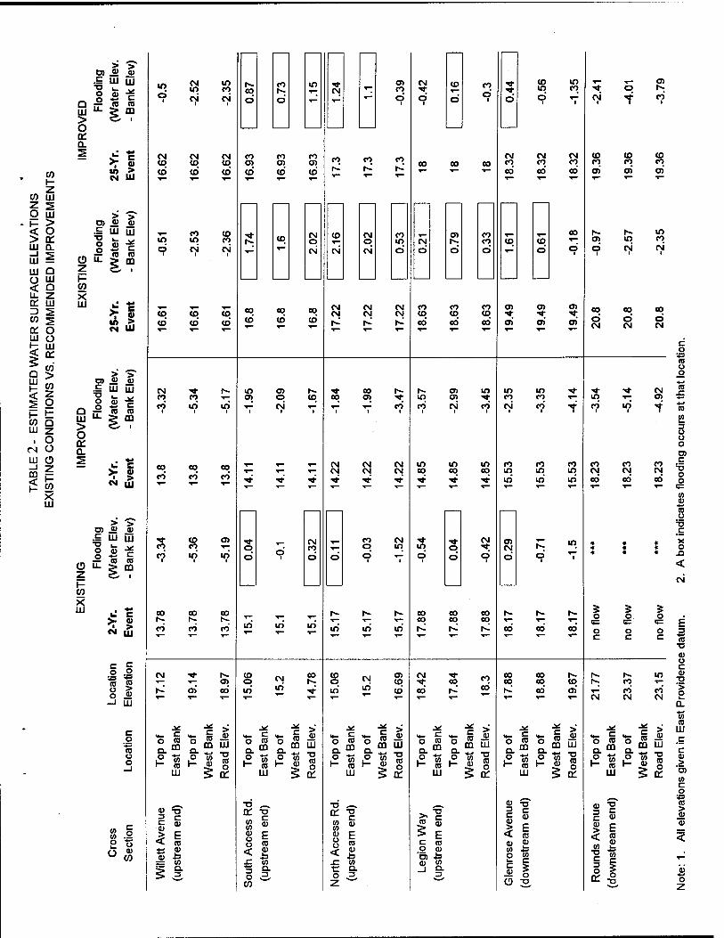
Water surface profiles for the existing and improved conditions of Annawomscutt Brook are shown on Plates 4 and 5, respectively din Appendix A. Table 2 of the main report lists elevations of the channel, structures, top of road crossings along the reach, and water surface elevations. The analysis has determined that most of the culverts along Annawomscutt Brook are undersized. Furthermore, culverts at Haines Park Road and Promenade Street in Barrington, as well as the south access road at the Almac's parking area, Legion Way, Glenrose Drive, and Rounds Avenue in East Providence all have capacities less than the peak runoff from a 2-year event.
Many flow structures along Annawomscutt Brook are undersized and increase the possibility of overtopping of channel banks and roads during rainfall events. Therefore, the alternatives investigated in this study focused on the reduction of overtopping of roads crossing the brook
The most hydraulically effective of the analyzed alternatives appears to be the channel improvements proposed by CDM in conjunction with replacing the culverts at the north and south access roads in the Almac's parking area. Furthermore, although the model does not indicate a significant reduction in water surface elevation due to channel cleaning, it is logical to assume that freeing the channel and culverts from debris and vegetation would aid in the conveyance of flow. Therefore, it is suggested that the city initiate a general maintenance program to mitigate continuing problems.
An updated preliminary cost estimate has also been developed to reflect the original estimate provided in the CDM report of June 1981. These preliminary estimates are for planning purposes only.
The recommended plan is to:
► replace existing culverts with twin 4'x4' reinforced concrete box culverts at the Circuit Drive extension, Rounds Avenue, and the south access road in the shopping plaza north of Willett Avenue;
n
► replace existing culverts with twin 5'x5' reinforced concrete box culverts at Glenrose Drive and Legion Way;
► replace existing culverts with twin 6'x6' reinforced concrete box culverts at the north access road to the shopping plaza nqrth of Willett Avenue.
and, ► reconfigure the existing brook from Meadowcrest School to Willett Avenue by lowering the invert elevation an average of 3.5' and regrading the side slopes. The existing invert elevation at Willett Avenue will remain.
For severe storm events, the improvements modeled do not exhibit a marked reduction of overtopping of the channel banks at the Almac's parking area or from Willett Avenue through Haines Park Road in Barrington. Table 2 shows that for the improved conditions, the flooding problem is completely resolved for rainfall events of a 2-year frequency or smaller. Flooding still occurs for storms greater than the 2-year rainfall event.
The preliminary cost estimate for the recommended plan is $322,000 and is detailed in Table 3 of the main report.
in
Table of Contents
Chapter I: INTRODUCTION
1. Study Background 2. Study Authority 3. Study Purpose and Scope 4. Other Pertinent Studies
Chapter H: PROBLEM IDENTIFICATION
Chapter III: EXISTING CONDITIONS
1. General Watershed Description 2. Annawomscutt Brook Description
Chapter IV: HYDROLOGIC & HYDRAULIC ANALYSIS
1. Introduction 2. Study Procedure 3. Analysis Results
Chapter V: CONCLUSIONS & RECOMMENDATIONS
1. Conclusions 2. Recommendations
Chapter VI: ACKNOWLEDGEMENTS
Page Number
1
1 1 1 2
3
5
5 6
11
11 11 13
19
19 19
23
IV
Table of Contents (continued)
Page Number
LIST OF TABLES
Table 1 - Rainfall Frequency Duration 12
Table 2 - Estimated Water Surface Elevations Existing Conditions Vs. Recommended Improvements 17
Table 3 - Total Estimated Costs of Recommended Improvements 21
LIST OF PLATES
Plate 1 - Study Area Plate 2 - East Providence Photo Location Map Plate 3 - Barrington Photo Location Map
LIST OF PHOTOS
Photo 1 - Griffith Drive access road. Photo 2 - Thurston Street vicinity. Photo 3 - Upstream of Rounds Avenue. Photo 4 - Upstream of Rounds Ave. and Tanglewood Drive. Photo 5 - Vicinity of Rounds Ave. and Tanglewood Drive. Photo 6 - Upstream of Rounds Avenue. Photo 7 - Downstream of Rounds Avenue. Photo 8 - Downstream of Glenrose Drive. Photo 9 - Downstream of Glenrose Drive. Photo 10 - Upstream of Legion Way. Photo 11 - Upstream of Legion Way. Photo 12 - Upstream end of north access road. Photo 13 - Downstream end of north access road. Photo 14 - Downstream end of south access road.
Table of Contents (continued)
LIST OF PHOTOS (coninued)
Photo 15 - Downstream of Willett Avenue. Photo 16 - Upstream of Promenade Street. Photo 17 - Upstream of Promenade Street. Photo 18 - Upstream of Haines Park Road. Photo 19 - Downstream of Haines Park Road. Photo 20 - Downstream of Haines Park Road. Photo 21 - Upstream of bike path.
Photo 22 - Upstream end of bike path. Photo 23 - Upstream of Bay Spring Avenue. Photo 24 - Dam structure at Drown Cove.
APPENDK A - Hydrologie & Hydraulic Analysis
APPENDK B - Culvert Descriptions
APPENDK C - Scope of Studies
VI
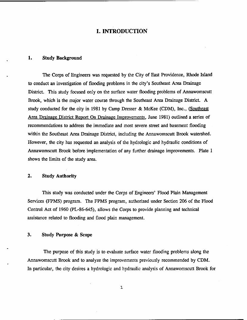
I. INTRODUCTION
1. Study Background
The Corps of Engineers was requested by the City of East Providence, Rhode Island
to conduct an investigation of flooding problems in the city's Southeast Area Drainage
District. This study focused only on the surface water flooding problems of Annawomscutt
Brook, which is the major water course through the Southeast Area Drainage District. A
study conducted for the city in 1981 by Camp Dresser & McKee (CDM), Inc., (Southeast
Area Drainage District Report On Drainage Improvements. June 1981) outlined a series of
recommendations to address the immediate and most severe street and basement flooding
within the Southeast Area Drainage District, including the Annawomscutt Brook watershed.
However, the city has requested an analysis of the hydrologic and hydraulic conditions of
Annawomscutt Brook before implementation of any further drainage improvements. Plate 1
shows the limits of the study area.
2. Study Authority
This study was conducted under the Corps of Engineers' Flood Plain Management
Services (FPMS) program. The FPMS program, authorized under Section 206 of the Flood
Control Act of 1960 (PL-86-645), allows the Corps to provide planning and technical
assistance related to flooding and flood plain management.
3. Study Purpose & Scope
The purpose of this study is to evaluate surface water flooding problems along the
Annawomscutt Brook and to analyze the improvements previously recommended by CDM.
In particular, the city desires a hydrologic and hydraulic analysis of Annawomscutt Brook for
both the existing conditions and with the proposed drainage improvements previously
recommended within the CDM report. The complete Scope of Studies is contained in
Appendix C. All elevations given in this report are referred to the East Providence datum,
which is 2.35' above the National Geodetic Vertical Datum (NGVD).
4. Other Pertinent Studies
1) East Providence Comprehensive Plan: Prepared for the City of East
Providence by BRW, Inc.; 1992
2) Comprehensive Site Assessment Work Plan - East Providence Terminal:
Volumes I and II; Prepared for Mobil Oil Corporation by Roux Associates;
December 1993
II. PROBLEM IDENTIFICATION
The problems associated with the Southeast Area Drainage District and the
Annawomscutt Brook area have been previously documented in the CDM report and in the
East Providence Comprehensive Plan. An outline of these problems is provided below.
There are several problems associated with the Southeast Area Drainage District and
Annawomscutt Brook. These include relatively frequent street flooding from surface runoff
and flow in Annawomscutt Brook and basement flooding of residential areas due to high
groundwater. However, the groundwater issue does not impact the surface water flood
analysis and is not addressed further in this study.
In addition, the East Providence Comprehensive Plan defines a Southeast Drainage
District Critical Area. This Critical Area is actually the northern portion of the Southeast
Drainage District as identified in the CDM report. It extends roughly from Meadowcrest
Drive east to the Wampanoag Trail, and from Forbes Street south to Rounds Avenue. The
Comprehensive Plan also identifies a development strategy which is for very low intensity
development due to both wetlands and the closed Forbes Street Landfill. According to the
Comprehensive Plan, the Critical Area shares the same problems as the rest of the Southeast
Area Drainage District. This includes a high groundwater table, relatively flat terrain, and
overall poor drainage.
The city experiences surface water flooding problems associated with Annawomscutt
Brook, particularly during heavy rainfall events. This includes flooding of backyards and in
some instances road crossings. Hydraulic analyses were performed for three historic rainfall
events - November 18, 1994, August 19, 1991 (Hurricane Bob), and July 17, 1989 and this
information was then provided to the City of East Providence. Flooding areas were
identified by comparing the calculated water levels with the existing bank crest and/or road
elevations. Areas that had calculated water levels higher than the existing bank or road
elevations were considered "flooded". The results of these analyses of Annawomscutt Brook
were found to correlate with reports of flooding maintained by the city. The November 1994
and Hurricane Bob events produced water levels associated with a less than 2-year event with
virtually no flooding. The July 1989 event produced water levels similar to a 5-year
frequency rainfall. Based on calculated water surface elevations at various road crossings in
East Providence, the following areas are flooded during a 2-year rainfall event: (1) the north
and south access roads at the Almac's parking lot; (2) Legion Way; and (3) Glenrose
Avenue. The severity and number of locations of flooding increases for a 25-year rainfall
event. The water surface elevations for 2, 5, 10, and 25-year frequency rainfall events are
shown in Appendix A. The differences between the existing conditions and the
recommended improvment conditions are more fully discussed in Chapter IV.
The city is also concerned about the impacts of further drainage improvements as
recommended in the CDM report of June 1981. Either improving the existing drainage
system or adding to it may change the flow characteristics of the brook. The city wanted to
investigate the hydraulic capacity of the brook and its present ability to receive stormwater
discharges from varying rainfall frequency events.
III. EXISTING CONDITIONS
1. General Watershed Description
The Southeast Area Drainage District is approximately 855 acres in size and is
bordered by Forbes Street on the north, Estrell Drive on the east, Willett Avenue on the west
and Willett Avenue and the East Providence-Barrington municipal boundary on the south.
However, the Southeast Area Drainage District does not cover the entire Annawomscutt
Brook watershed (see Plate 1). This study focuses on the problems associated with surface
water flooding associated with the Annawomscutt Brook. For purposes of conducting the
hydrologic and hydraulic analyses of the brook, the entire Annawomscutt Brook watershed,
extending to Drown Cove in Barrington, was utilized. Therefore, the limit of the model
used for this study is the entire Annawomscutt Brook watershed including about 353 acres in
Barrington and about 96 acres north of Forbes Street in Mobil Oil Corporation's bulk storage
facility. These areas are not specifically within the Southeast Area Drainage District. Plate
1 shows the boundaries of both the Annawomscutt Brook watershed and the Southeast Area
Drainage District. Below is a brief description of the watershed and it's characteristics. A
more detailed description is provided in Appendix A.
The entire Annawomscutt Brook watershed covers about 1,237 acres. This includes
884 acres in East Providence (72%) and 353 acres in Barrington (28%). The estimated
population of the East Providence portion of the watershed is 4,000 people, based on 1990
census data. Land use within the East Providence portion of the watershed is characterized
in the following manner: Residential (43%); Open Space, including parks, the Forbes Street
landfill, and undeveloped portions of the Mobil facility (40%); Public/Semi-Public, including
the Meadowcrest and Waddington Elementary Schools (7%); Commercial, including the
shopping plaza along Willet Avenue (2%); and Industrial, comprising the developed portions
of the Mobil facility (8%).
The Annawomscutt Brook watershed in East Providence is characterized principally
by open space in its northern and central sections with the remaining area primarily single-
family residential dwellings. The majority of residential land usage occurs between Rounds
Avenue and the Barrington town line. The open space includes mostly undeveloped woody
and swampy areas of Mobil Oil Corporation's bulk storage facility and the closed Forbes
Street Landfill. The Forbes Street Landfill was operated by the City of East Providence
between 1969 and 1979 and consists of approximately 67 acres located north and east of the
Meadowcrest Elementary School.
About 96 acres of the Annawomscutt watershed are located in the Mobil facility's
South Operations Area north of Forbes Street. This part of the Mobil property is further
subdivided into four sections: the Storage Tank Farm, the Main Refinery, the Binder
Platform, and the Acid Treatment Area. Portions of each of these sections are located within
the Annawomscutt Brook watershed. This includes many current and former structures
associated with the operation of the refinery. This part of the watershed also includes large
portions of open space and undeveloped land consisting mostly of marshy and wooded land.
These areas drain through natural watercourses to a channel leading into a 30" reinforced
concrete pipe under Forbes Street, eventually becoming part of Annawomscutt Brook.
The portion of the Annawomscutt Brook watershed in Barrington contains a mix of
residential land use, open space (Haines Memorial State Park), and industrial and commercial
areas along Bay Spring Avenue. This area also contains large ponds formed by hydraulic
constrictions such as the stone masonry culvert in the former railroad embankment near Bay
Spring Avenue and a small dam and weir at the brook's outlet into Drown Cove.
2. Annawomscutt Brook Description
Annawomscutt Brook is formed by the wetlands in the northerly section of the
Southeast Area Drainage District in the vicinity of the former Forbes Street Landfill and also
by the wetlands located on Mobil Oil's facility north of Forbes Street (See Plate 1). Two
open channels drain the Forbes Street area which includes the former Forbes Street Landfill
and the portion of the watershed extending north of Forbes Street into Mobil Oil Company's
bulk storage facility. The main channel of Annawomscutt Brook begins east of Abraham
Road and continues south, passing just east of the Meadowcrest Elementary School. At this
point it is joined by a second open channel which originates at Forbes Street and drains the
wetlands located on Mobil's property through a 30" diameter concrete culvert passing under
Forbes Street. This second channel drains the upper portions of the watershed including the
Mobil facility and extends south from Forbes Street to the Meadowcrest Elementary School
Access Road before passing into an 24" diameter concrete inlet pipe. A smaller drainage
ditch also discharges to this channel (see Photo 1) just prior to entering the 24" pipe. This
pipe continues behind the houses on Griffith Drive, eventually discharging to an
approximately 500' long open channel south of the school. The channel continues east
before joining the main Annawomscutt Brook channel. The area through which these
channels pass is primarily undeveloped woody and swampy land south of Forbes Street which
also contains the former landfill.
The brook continues in a southerly direction until reaching the area of Thurston and
MacArthur Streets. At this point the channel is about 8' wide and turns about 90° (see Photo
2) to the east. The City has excavated a secondary channel which extends in a southerly
direction and apparently carries excess surface runoff during periods of heavy precipitation
and snowmelt runoff. However, the invert elevation of this secondary channel is slightly
higher and it appears that during periods of low or normal flow, the brook follows the main
channel to the east. After continuing east for approximately 650', the main channel turns 90°
to the south and flows about 450' to another channel which extends west (at a 90° angle from
the main channel) back towards the secondary flow channel described above. This
configuration can be seen on Plate 1 and Photo 4. However, the brook's low flow path
continues another 400' south before entering a 48" diameter concrete pipe (see Photo 5)
located behind the residence at the corner of Tanglewood Drive and Rounds Avenue.
The secondary flow channel excavated by East Providence proceeds from the
Thurston Street area about 800' south before passing under Rounds Avenue through two 30"
diameter corrugated metal pipes (see Photos 3 and 6). Downstream of these culverts the
channel invert and side slopes are paved with asphalt for approximately 900' (see Photo 7).
This channel continues south eventually entering a 24" diameter culvert under Glenrose
Drive. It then discharges on the south side of Glenrose Drive through a 30" diameter outlet
pipe (see Photo 8).
As previously mentioned, the normal flow path for Annawomscutt Brook enters a 48"
diameter concrete pipe into the local storm drain pipe network. The underground network
proceeds west along the south side of Rounds Avenue and then south behind the residences
on Femcrest Drive to Glenrose Drive. The drainage network eventually discharges through
two 36" diameter concrete pipes at Glenrose Drive (see Photo 9). Approximately 70' south
of Glenrose Drive the main Annawomscutt Brook channel exiting the stormwater pipe
network and the secondary channel recombine. The channel is about 6' wide at this location
and continues south between the houses on Ferncrest Drive and the Waddington Elementary
School (see Photo 10) before passing through a 42" diameter concrete pipe culvert under
Legion Way (see Photo 11).
Annawomscutt Brook then flows south through a shopping plaza and commercial land
use area. The brook runs directly through the plaza's parking lot with two access roads
crossing the brook between both sides of the lot. The channel is about 10' wide in this area.
At the northerly crossing the brook passes through two 72" corrugated metal pipe culverts.
The west culvert is partially blocked by sediment and vegetation (see Photos 12 and 13). At
the southerly access road crossing the brook passes through two 36" pipe culverts. The
western 36" pipe appears to be constructed of different types of pipe. The upstream end is
corrugated metal and the downstream end is reinforced concrete (see Photo 14). The brook
then flows south through a 5' by 12' concrete box culvert under Route 103, Willett Avenue
(see Photo 15) and continues into Barrington. It flows through the backyards of a primarily
residential area with only one street crossing, a 42" diameter concrete pipe culvert at
Promenade Street (see Photo 16).
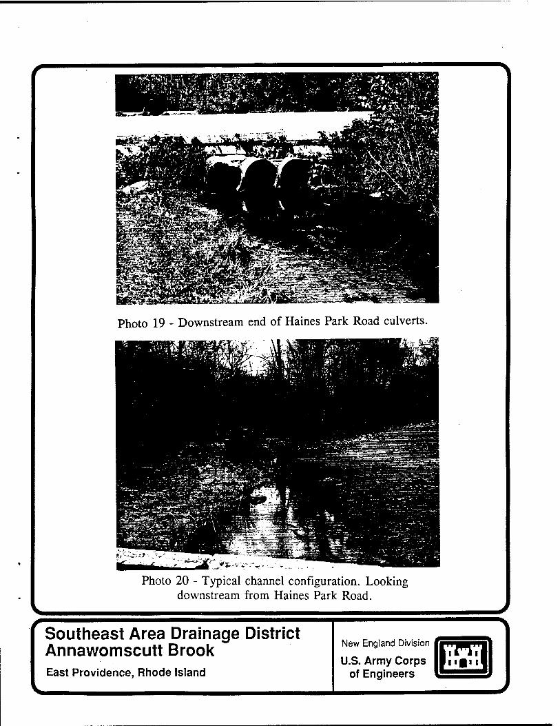
The brook then continues south to Haines Park Road passing through three 24"
diameter corrugated metal pipe culverts (see Photo 19). South of Haines Park Road, the
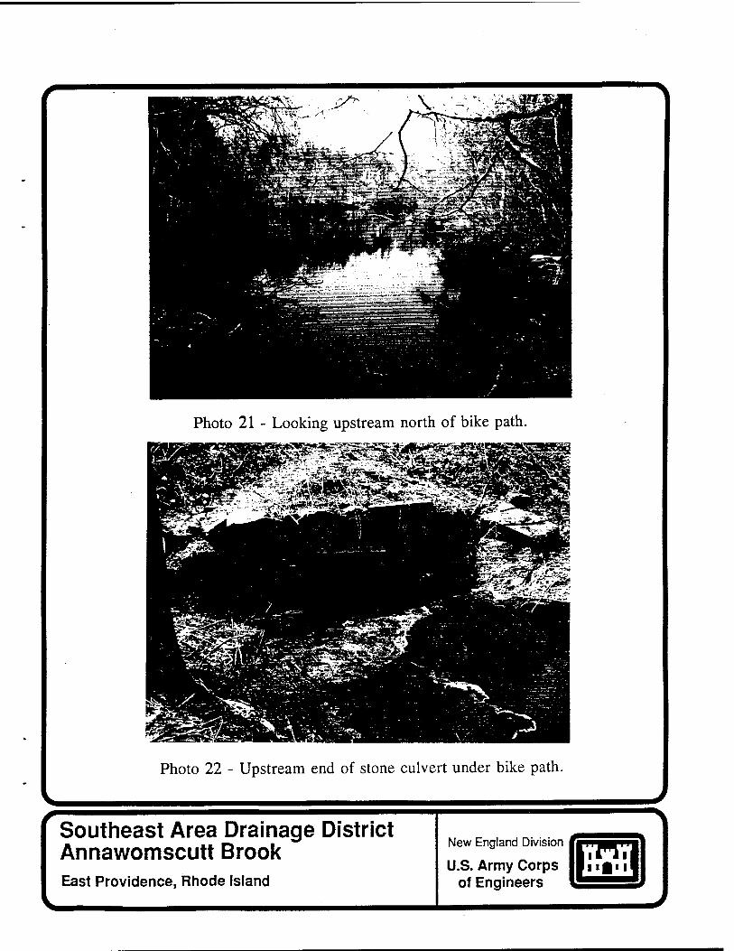
brook enters a large pond within Haines Memorial State Park, northeast of a former railroad
embankment which is now a bike path. The pond's outlet is an approximately 4-foot by 2-
foot stone masonry culvert (see Photos 21 and 22) through the former railroad embankment
leading to another pond just north of Bay Spring Avenue. There is an estimated 60"
diameter corrugated metal pipe culvert under Bay Spring Avenue (see Photo 23) leading to a
pond and small dam/weir outlet structure. The dam structure forms the downstream limit of
Annawomscutt Brook and also appears to be the limit of tidal influence from Narragansett
Bay. The brook passes over this structure and enters Drown Cove in Narragansett Bay (see
Photo 24).
Refer to Appendix B for a general description of each of the major culverts along
Annawomscutt Brook.

10
IV. HYDROLOGIC & HYDRAULIC ANALYSIS
1. Introduction
a. General. The Annawomscutt Brook has a total drainage area of about 1.94 square
miles at the outlet to Drown Cove. Due to the extremely small size of the brook and the
corresponding watershed, there is no recorded hydrologic information pertaining to
Annawomscutt Brook. The watershed for the Annawomscutt Brook was divided into five
subareas for the purpose of this analysis (see Plate 1). The subarea delineation differs
slightly from CDM's analysis and includes a subarea, BA1, in the Town of Barrington.
Complete subarea descriptions are provided in Appendix A.
2. Study Procedure
a. General. Appendix A describes in detail the approach used to analyze the
flooding problems along Annawomscutt Brook. The U.S. Army Corps of Engineers
Hydrologic Engineering Center's HEC-1, "Flood Hydrograph Package", was utilized to
develop flood hydrographs. The peak flows from the hydrographs were subsequently applied
to the Corps' HEC-2, "Water Surface Profiles".
b. Rainfall Runoff Hydrograph Development. Due to the lack of hydrologic
information pertaining to Annawomscutt Brook, peak flow rates in the brook had to be
estimated utilizing the U.S. Department of Agriculture Natural Resources Conservation
Service (NRCS) Runoff Curve Number Method within HEC-1. Drainage areas, curve
numbers, and lag times for the NRCS Method were determined based on U.S. Geological
Survey (USGS) quadrangles, NRCS soil survey of Rhode Island, and information in CDM's
Report on Drainage Improvements.
11
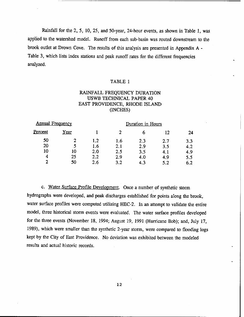
Rainfall for the 2, 5, 10, 25, and 50-year, 24-hour events, as shown in Table 1, was
applied to the watershed model. Runoff from each sub-basin was routed downstream to the
brook outlet at Drown Cove. The results of this analysis are presented in Appendix A -
Table 3, which lists index stations and peak runoff rates for the different frequencies
analyzed.
TABLE 1
RAINFALL FREQUENCY DURATION USWB TECHNICAL PAPER 40
EAST PROVIDENCE, RHODE ISLAND (INCHES)
Annual Frequency Duration in Hours
Percent Year 1 2 6 12 24
50 2 1.2 1.6 2.3 2.7 3.3 20 5 1.6 2.1 2.9 3.5 4.2 10 10 2.0 2.5 3.5 4.1 4.9 4 25 2.2 2.9 4.0 4.9 5.5 2 50 2.6 3.2 4.3 5.2 6.2
c Water Surface Profile Development. Once a number of synthetic storm
hydrographs were developed, and peak discharges established for points along the brook,
water surface profiles were computed utilizing HEC-2. In an attempt to validate the entire
model, three historical storm events were evaluated. The water surface profiles developed
for the three events (November 18, 1994; August 19, 1991 (Hurricane Bob); and, July 17,
1989), which were smaller than the synthetic 2-year storm, were compared to flooding logs
kept by the City of East Providence. No deviation was exhibited between the modeled
results and actual historic records.
12
3. Analysis Results
a. General. Water surface profiles were developed for the existing channel of the
Annawomscutt Brook. A number of adjustments, such as cleaning the channel and
increasing culvert sizes were entered into the model. In addition, channel improvements and
rerouting of surface waters, as proposed by CDM, were analyzed.
b. Existing Conditions. Water surface profiles for the existing conditions of
Annawomscutt Brook are shown in Appendix A - Plate 4 for the 2, 5, 10, and 25 year
synthetic storms. Table 2 lists elevations of the channel, top of road crossings along the
reach, and water surface elevations at the same locations as shown in Appendix A - Plate 4.
The profiles demonstrate that most of the culverts along Annawomscutt Brook are under-
sized. Furthermore, culverts at Haines Park Road and Promenade Street in Barrington, as
well as the south access road at the Almac's parking area, Legion Way, Glenrose Drive, and
Rounds Avenue in East Providence all have capacities less than the peak runoff from a 2-
year event.
The most upstream cross section on the profiles represents a point just north of the
intersection between the easterly bend and the excavated channel. Continuing the HEC-2
model further upstream would not impart any useful information since the brook travels
through woodlands and the Forbes Street Landfill.
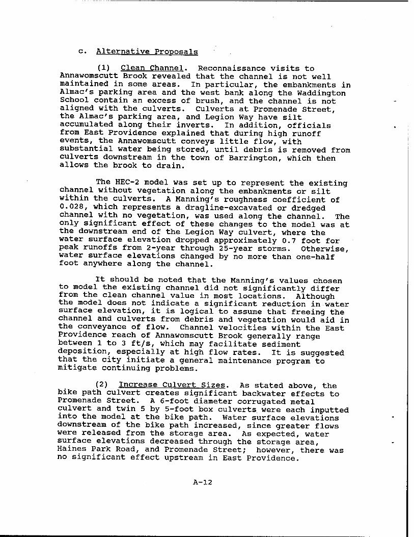
c. Alternative Proposals
(1) Clean Channel
Reconnaissance visits to Annawomscutt Brook revealed that the channel is not well
maintained in some areas. In particular, the embankments in the Almac's parking area and
the west bank along the Waddington School contain an excess of brush, and in some
13
instances, the channel is not aligned with the culverts. The culverts at Promenade Street, the
Almac's parking area, and Legion Way also have silt accumulated along their inverts.
The HEC-2 model was set up to represent the existing channel without vegetation
along the embankments or silt within the culverts. Parameters within the model were
modified to represent a dragline-excavated or dredged channel with no vegetation. In
general, water surface elevations changed by no more than 0.5 foot anywhere along the
channel versus existing conditions.
(2) Increase Culvert Sizes
A series of increased culvert sizes were modeled to evaluate their effectiveness in
reducing water surface elevations, particularly within East Providence. These included the
following scenarios:
i. Resizing the stone masonry culvert at the bike path in Barrington with two
different culvert alternatives was accomplished. A 6-foot diameter corrugated metal culvert
and twin 5-foot by 5-foot box culverts were each input into the model at the bike path.
However, there was no significant effect upstream in East Providence due to increasing the
size of the culvert at the bike path. This is due to hydraulic constrictions at the Promenade
Street crossing.
ii. With the twin box culverts at the bike path, backwater effects to Promenade Street
were now the result of the restriction of the Bay Spring Avenue culvert. Another twin 5-foot
by 5-foot box culvert was placed into the model to replace the Bay Spring Avenue culvert.
Again, minimal effects were observed in East Providence even with new larger culverts at
both the bike path and under Bay Spring Avenue in Barrington. Again this is apparently due
to hydraulic constrictions at Promenade Street.
iii. The model was then setup to investigate possible culvert changes at Promenade
14
Street. Returning the downstream culverts at the bike path and Bay Spring Avenue to their
actual sizes, the Promenade Street culvert was replaced in the model with twin 5-foot by 5-
foot box culverts. The results show that for the 2-year and 5-year rainfall events, there will
be slightly less overtopping of the south access road in the Almac's parking lot. Further
upstream of the parking area, however, there is no impact from enlarging the Promenade
Street culvert.
iv. Due to siltation in the channel, the culvert inverts at the north and south access
roads in the Almac's parking area are located below the stream bed elevation. Also, the twin
36 inch culverts at the south access road are well undersized. The model was run with these
two sets of culverts enlarged and brought up to the stream bed elevation. The south culverts
were replaced by twin 4-foot by 4-foot box culverts, and the north culverts were replaced by
twin 6-foot by 6-foot box culverts. Water surface elevations decreased by about one foot in
the channel for a 2-year event. Water surface elevations for events between the 2-year and
10-year storms were lower than with the existing culverts, by a few inches, and there was no
effect on the 25-year event. Water surface elevations upstream at Legion Way were not
affected by enlarging the north and south access road culverts.
(3) Proposed Channel Reconfiguration and Culvert Resizing
The CDM report of June 1981 recommended lowering and reshaping Annawomscutt
Brook between the Meadow Crest School and Willett Avenue, and constructing twin 4-foot
by 4-foot concrete box culverts near the Circuit Drive extension and at Rounds Avenue, and
5-foot by 5-foot concrete box culverts at Glenrose Drive and Legion Way. The new channel
bottom width would vary between 8 and 10 feet with a side slope of 2 horizontal to 1
vertical. These CDM proposed channel improvements were input into the HEC-2 model.
The CDM report also recommended that the brook be kept in its natural state between the
Meadow Crest School and Forbes Street.
The most significant effects of the proposed changes were the lowering of water
15
surface elevations at Legion Way and Glenrose Drive by as much as 1.5 feet for the 25-year
storm event and 2.5 feet for the 2-year event. The new culverts at these locations prevented
overtopping of these roads in the model.
Because these culvert changes were upstream of the Almac's parking area reach, the
culverts at the access roads were also increased to twin 4-foot and twin 6-foot box culverts as
described in paragraph 3.c.2.iv. Due to these further improvements, the resulting water
surface elevations at Glenrose Drive and Legion Way were lowered by another few inches,
and the water surface elevation between the north and south access roads was lowered by
another 0.8 feet for the 2-year event and half a foot for the 5-year storm. For larger storms,
however, effects of this modification on the model were minimal. Appendix A - Table 8
shows the anticipated effects on the East Providence water surface profile if CDM's
improvements and improvements at the Almac's parking area are constructed. Appendix A -
Plate 5 displays the water surface profiles and the improved brook invert.
Changes in the proposed sizes of box culverts at Legion Way, Glenrose Drive, and
Rounds Avenue were analyzed. For a 25-year storm event and existing topography, the 5-
foot by 5-foot twin box culverts at Glenrose Drive and Legion Way and the 4-foot by 4-foot
twin box culverts at Rounds Avenue appear to be the optimal sizes.
(4) Diversion of Watershed Area EP1
Another alternative suggested by CDM and analyzed in this report involves diverting
stormwater runoff originating from the watershed subarea north of Forbes Street out of the
Annawomscutt Brook watershed and into Willett Pond to the southwest. However, runoff
from subarea EP1 does not appear to contribute significantly to peak flows in Annawomscutt
Brook and was therefore not given further consideration.
16
to
CO UJ
Ul
UJ > o Q.
< 9 U- Z tH UJ
Si ct o UJ O
UJ {£
CO > (0
<
Q Ul
CO Q UJ Z
, O <N O UJ Ü
X UJ
> V ^" •. • ?™ c UJ III
■o o L.
c n (0 CO UJ >
LL ^
CO i
o a: 0. s w c
a> ^~ >r U) > CM UJ
UJ s O U. UJ Q ?
E UJ ED 5 ■- J* o "K £ (0 to
CO
X UJ
$°?
IÖ > CN UJ
.E UJ ED "2 «- .*
UJ "- > 00 > e- ' o a.
CM UJ
> > ra c
CU UJ
a) III
T5 O 0) .*
m m C!) Z
U- t ca i
1- co X III # *■•
b. c >r 0) > CM UJ
r c o o *-» m WJ o > o CU
_J UJ
c .g "co u o
co .2 £ o u CO
o
CM CD
CO
in o
CM W
csi
CM CD
CO
CO m csi
w CO
CM
CM CD
CO
CD CO
CM
CO
CO
CO
CO
CO
CD
CM CO
00 CO
CO
00 CO
1^
iri
00
CO
CO CO O) CO 1-
00 00 r».
00
CM
ai 00
r m " ca UJ °- r: Q- »j T-i
|2?|2| 1 UJ 5 a:
4) =o c CU
CD
§ s
E (D cu
to Q. 3
r>~ CO in •* 00 1^ ^~ CM ' . o o
CO O)
CO
CO
CD
CO O)
CD
CD
00
CD*
00 CD'
00 CD'
m en
a> o CD
*- CM •«-
in
CO o CM
m £ oo
a:
o to o iS m ~ DQ " 00 UJ Q- O- *J -ii
£ I"* J 8 UJ g
K 1 co v
CO CU Ü Ü W
CO a. 3
CO
CO
1^
co 1^
co
CM CM
CM CM
CM CM
oo 1^
t- T- CO
CM CM
CM CM
CM CM
CO O
CM m
O i-
in iri iri
CO o CM
m «>
O) CO
CO*
M_ C M- 5 0J o to o iS m " ca " m ui °- °- *- -i-i
i2|i2| 8 uj § or
T3
co a)
E CO CD
*-» CO Q. 13
CM CD CO *■; o o 1
00 00 00
CO CO
cd
CO CO CO CO
oo' oo'
1^ m
in oo
CM
in oo
m ■*-
co'
m oo
m CM
oo 00
00 00 00 00 1^ I>^
CM
oo'
*- £ O CO
£ 'S •^ CO
Ul
■SB« ° 00 UJ
§ et
5 ro o o
'ro *= CU CO
-1 &
co m
m co
o T-
CM co
CM co oo'
CM co
co oo
CD
ai at
ai en
ai
m CO
CM"
co m
m co co'
co m in
co in in
i>-
oo'
o
od
m
oo'
oo oo oo oo i*-' oo
co
Ö to o iS m ^ oo - oo UJ *" a. — — £ t5 P ^ ^ •" CO
UJ OJ CO
cu -n
< CO cu <u CO o CO
c 5 o
CD ;o.
c 0)
CM
CD CO
o
CO co ai
oo o CM
l>- m CM'
oo ö CM
in co'
co CM
00
5 o o c
5 o cs= o c
CM
co co CM
en
co'
CO co cri
m co CM
oo 6 CM
CO CM
CO CM
00 00
c _o (0 Ü o
<* CM ^ T- en *
«? t to CO k. 3 o Ü o O) c ^ o o I?
CO cu CO u
c X o
5 «2 E 8 I cu Ü
.n |
«' 's CM £ a.
•^r E *r £ e> co
£ •& r~ CO
UJ
3 E
O (0 — CU
> CU
T3 «0 O
CO CO
UJ
UJ ~ c cu >
'ro co c o
"■*-<
CO > cu c « SI E
cu < CO
cu < co .£
■o To E c ^" S 1 cu
c? ■§ *-< o Z

18
V. CONCLUSIONS & RECOMMENDATIONS
1. Conclusions
* Many existing drainage structures along Annawomscutt Brook are undersized and
increase the possibility of overtopping of channel banks and roads during rainfall events.
The alternatives investigated in this study focused on the reduction of overtopping of roads
crossing the brook. Table 2 shows existing top of bank and roadway elevations as well as
water surface elevations for both existing conditions and with the recommended
improvements in place.
The most hydraulically effective of the analyzed alternatives appears to be the channel
improvements proposed by CDM in conjunction with replacing the culverts at the north and
south access roads in the Almac's parking area. For severe storm events, the
improvements modeled do not exhibit a marked reduction of overtopping of the channel
banks at the Almac's parking area or from Willett Avenue through Haines Park Road in
Barrington. Table 2 shows that for the improved conditions, the flooding problem is
completely resolved for rainfall events of a 2-year frequency or smaller. Flooding still
occurs for storms greater than the 2-year rainfall event.
The lowering of the water surface elevation in East Providence due to channel
improvements represents a loss of storage within those improved reaches. Although the
hydraulic model was not run to account for any increase in downstream discharge due to
channel improvements in East Providence, the amount of stage reduction and resulting loss of
storage should not significantly increase discharge rates in the Barrington reach.
19
2. Recommendations
Although the model does not indicate a significant reduction in water surface elevation
due to channel cleaning, it is logical to assume that freeing the channel and culverts from
debris and vegetation would aid in the conveyance of flow. Channel velocities within the
East Providence reach of Annawomscutt Brook generally range between 1 feet per second
(ft/s) to 3 ft/s, which may facilitate sediment deposition, especially at high flow rates. It is
suggested that the city of East Providence consider cleaning the brook channel and
implementing a routine maintenance program for areas of Annawomscutt Brook not already
routinely cleaned. This will improve the conveyance of runoff from small storms as well as
the aesthetic quality of the brook. In summary, the recommended plan is to:
► replace existing culverts with twin 4'x4' reinforced concrete box culverts at the
Circuit Drive extension, Rounds Avenue, and the south access road in the shopping
plaza north of Willett Avenue;
► replace existing culverts with twin 5'x5' reinforced concrete box culverts at
Glenrose Drive and Legion Way;
► replace existing culverts with twin 6'x6' reinforced concrete box culverts at the
north access road to the shopping plaza north of Willett Avenue.
and, ► reconfigure the existing brook from Meadowcrest School to Willett Avenue by
lowering the invert elevation an average of 3.5' and regrading the side slopes. The
existing invert elevation at Willett Avenue will remain.
Table 2 shows water surface elevations resulting from the impementation of these
recommended improvements. Model results indicate that flooding as a result of a 2-year
rainfall event can be eliminated by implementing the recommended improvements. Flooding
from a 25-year rainfall event can also be significantly decreased throughout East Providence
20
through the implementation of the recommended improvements.
An updated preliminary cost estimate has also been developed to reflect the original
estimate provided in the CDM report of June 1981. The construction costs presented here
are based on the preliminary costs developed by CDM in June 1981 and have been updated
to 1995 prices using the October 1995 Engineering News Record (ENR) Construction Cost
Index of 5511. CDM had originally used a Construction Cost Index of 3450 from April
1981. These preliminary estimates are for planning purposes only. The recommended plan
and preliminary cost estimates are presented in Table 3.
TABLE 3 ESTIMATED CONSTRUCTION COSTS OF
RECOMMENDED IMPROVEMENTS
Item Estimated Cost
Lowering Channel Invert between
Meadow Crest School and Willett Avenue $96,000
Twin 4'-0" Concrete Box Culverts
► Circuit Drive extension
► Rounds Avenue
► South access road
$32,000
$32,000
$32,000
Twin 5'-0" Concrete Box Culverts
► Glenrose Drive
► Legion Way
$40,000
$40,000
Twin 6'-0" Concrete Box Culverts
► North access road $50.000
$322,000
21

22
VI. ACKNOWLEDGEMENTS
This report was developed and prepared by John Kedzierski, P.E., Project Manager.
The hydrologic and hydraulic analyses were performed by David Margolis, Water Control
Division. The report was prepared under the supervision and management of the following
New England Division personnel:
Colonel Earle C. Richardson, Division Engineer
Joseph L. Ignazio, Director of Planning
John C. Craig, Chief, Formulation Division
John R. Kennelly, Chief, Special Studies Branch
Information, data, and assistance was provided by the following City of East
Providence personnel: Daniel A. Pennington, City Engineer, and Steven Durfee, Department
of Public Works.
23
2;;
w
"\ /■
-fy
' N0HWJXUV8
CO
V) g
n n en < "J £ "OS 3 •
-a QJ
12
wo a a
2 Q
2 u <
3 o
O
o o u
S3
O o u
PQ Ö 'S *-
3 u E o
es c c
7
0) ■^■1
Q (D O) 03 _*
■D '= o c co o (0
QflQ 0>
(0 *-• o a) tr 9L. 3
x: DC < °
»E c
5 o TJ
£ CO > o a
3 n <-< o n to
(/>< UJ
Plate 1 - Study Area
Mobil Facility II 114
TOWN OF
BARRINGTON
^
Southeast Area Drainage District Annawomscutt Brook
East Providence, Rhode Island
8)— Photo Location
Photo Location Map - East Providence
US Army Corps of Engineers
New England Division pip5#i^lÄ
m -ft?«:- -%'' rn
CITY OF
EAST PROVIDENCE
jMfrWÄl« ; ,",**; ^
N
/-
Southeast Area Drainage District Annawomscutt Brook
East Providence, Rhode Island
& Photo Location
Photo Location Map - Barrington
US Army Corps of Engineers
New England Division
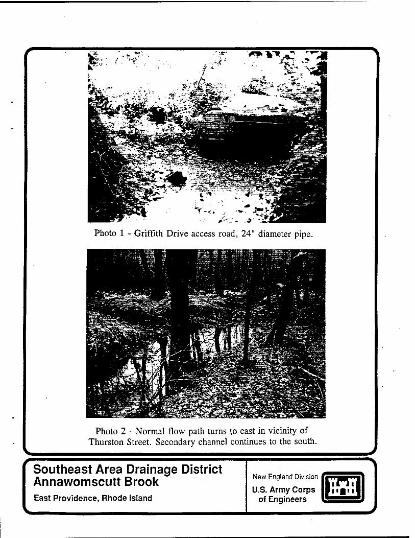
Photo 1 - Griffith Drive access road, 24" diameter pipe.
Photo 2 - Normal flow path turns to east in vicinity of Thurston Street. Secondary channel continues to the south.
Southeast Area Drainage District Annawomscutt Brook East Providence, Rhode Island
New England Division
U.S. Army Corps of Engineers
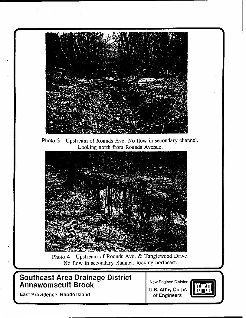
Photo 3 - Upstream of Rounds Ave. No flow in secondary channel. Looking north from Rounds Avenue.
Photo 4 - Upstream of Rounds Ave. & Tanglewood Drive. No flow in secondary channel, looking northeast.
Southeast Area Drainage District Annawomscutt Brook East Providence, Rhode Island
New England Division
U.S. Army Corps of Engineers
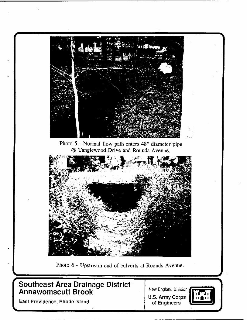
Photo 5 - Normal flow path enters 48" diameter pipe @ Tanglewood Drive and Rounds Avenue.
Photo 6 - Upstream end of culverts at Rounds Avenue.
Southeast Area Drainage District Annawomscutt Brook East Providence, Rhode Island
New England Division
U.S. Army Corps of Engineers
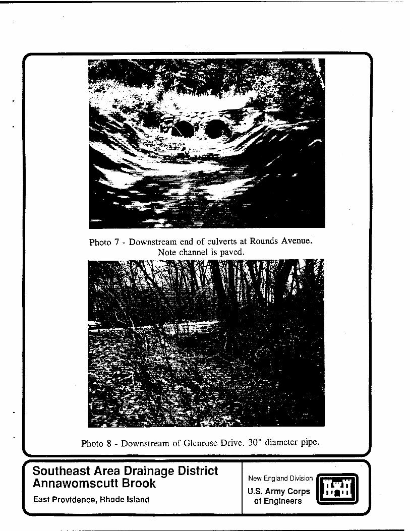
Photo 7 - Downstream end of culverts at Rounds Avenue. Note channel is paved.
II* ^ * ■ ■ [It
^^*t*^j*-i, Wflt Tf^^Ä^ .-- ~z •
- -: » ^äery"S\*«*fJ^Sg&"Jf<t**■ J. "■ "^ -"'^:
■»■• . -
Photo 8 - Downstream of Glenrose Drive. 30" diameter pipe.
Southeast Area Drainage District Annawomscutt Brook East Providence, Rhode Island
New England Division
U.S. Army Corps of Engineers
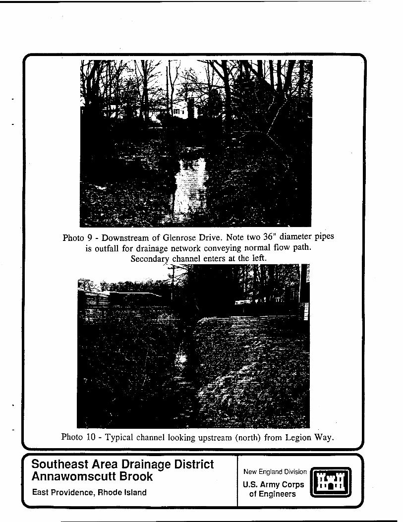
Photo 9 - Downstream of Glenrose Drive. Note two 36" diameter pipes is outfall for drainage network conveying normal flow path.
Secondary channel enters at the left.
Photo 10 - Typical channel looking upstream (north) from Legion Way. J
Southeast Area Drainage District Annawomscutt Brook East Providence, Rhode Island
New England Division
U.S. Army Corps of Engineers
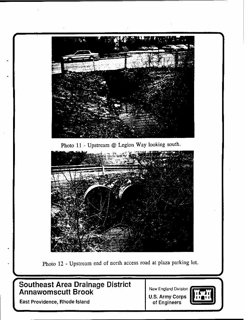
Photo 11 - Upstream @ Legion Way looking south.
^-'' *^^^JfW'.: ._• ; - |Pil^ :' " ' .
Photo 12 - Upstream end of north access road at plaza parking lot.
Southeast Area Drainage District Annawomscutt Brook East Providence, Rhode Island
New England Division
U.S. Army Corps of Engineers
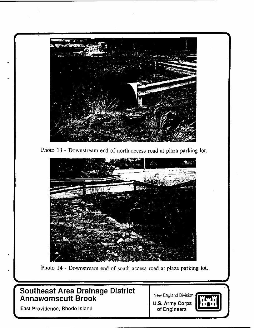
Photo 13 - Downstream end of north access road at plaza parking lot.
Photo 14 - Downstream end of south access road at plaza parking lot.
Southeast Area Drainage District Annawomscutt Brook East Providence, Rhode Island
New England Division
U.S. Army Corps of Engineers
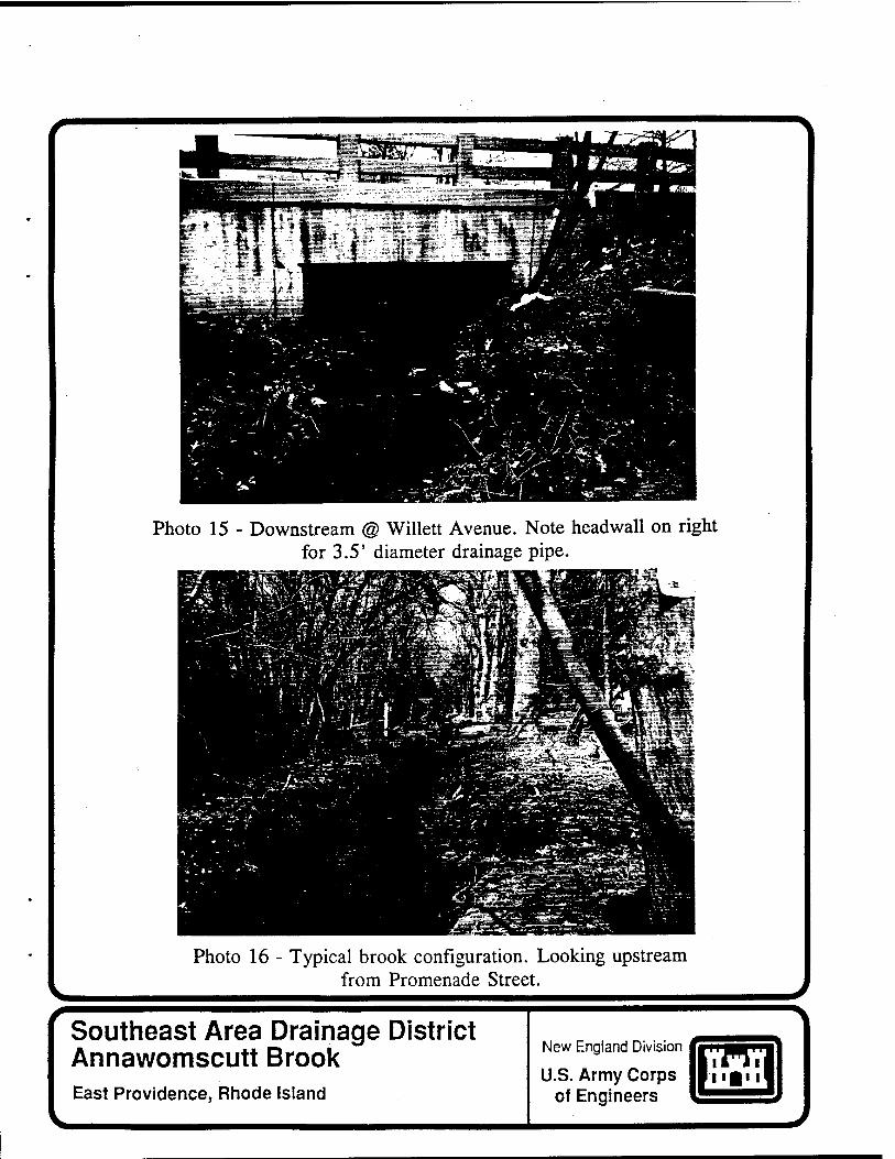
Photo 15 - Downstream @ Wille« Avenue. Note headwall on right for 3.5' diameter drainage pipe.
Photo 16 - Typical brook configuration. Looking upstream from Promenade Street.
Southeast Area Drainage District Annawomscutt Brook East Providence, Rhode Island
New England Division
U.S. Army Corps of Engineers
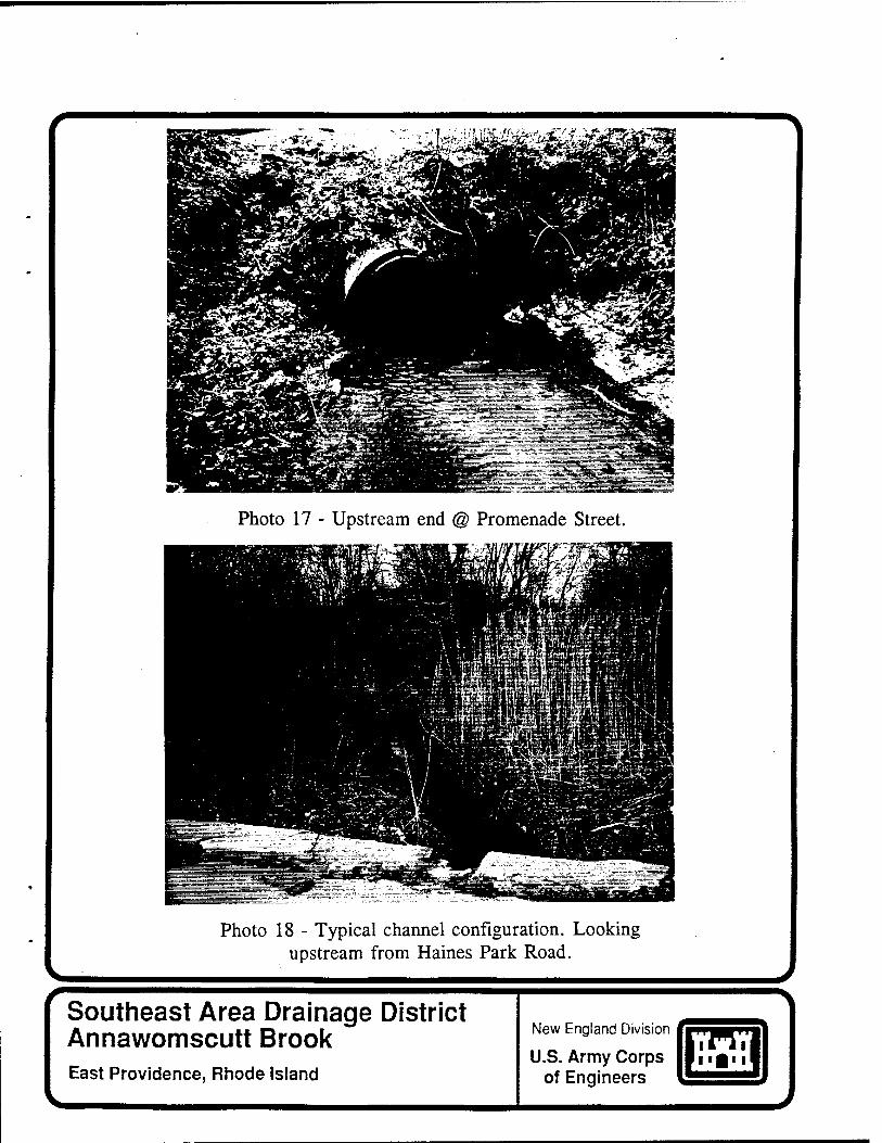
Photo 17 - Upstream end @ Promenade Street.
Photo 18 - Typical channel configuration. Looking upstream from Haines Park Road.
Southeast Area Drainage District Annawomscutt Brook East Providence, Rhode Island
New England Division
U.S. Army Corps of Engineers
V
Photo 19 - Downstream end of Haines Park Road culverts.
Photo 20 - Typical channel configuration. Looking downstream from Haines Park Road.
Southeast Area Drainage District Annawomscutt Brook East Providence, Rhode Island
New England Division
U.S. Army Corps of Engineers
V
Photo 21 - Looking upstream north of bike path.
Photo 22 - Upstream end of stone culvert under bike path.
Southeast Area Drainage District Annawomscutt Brook East Providence, Rhode Island
New England Division
U.S. Army Corps of Engineers
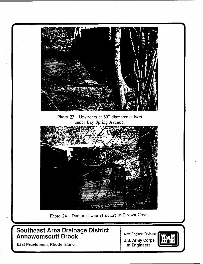
Photo 23 - Upstream at 60" diameter culvert under Bay Spring Avenue.
Photo 24 - Dam and weir structure at Drown Cove.
Southeast Area Drainage District Annawomscutt Brook East Providence, Rhode Island
New England Division
U.S. Army Corps of Engineers

Appendix A
Hydrologie & Hydraulic Analysis
SOUTHEAST AREA DRAINAGE DISTRICT FLOOD PLAIN MANAGEMENT STUDY EAST PROVIDENCE. RHODE ISLAND
HYDROLOGIC AND HYDRAULIC ANALYSIS
TABLE OF CONTENTS
Page
1. PURPOSE A-l
2. WATERSHED DESCRIPTION A-l
a. General A-l b. Watershed Subarea EP1 A-l c. Watershed Subarea EP2 A-2 d. Watershed Subarea EP3 A-2 e. Watershed Subarea EP4 A-2 f. Watershed Subarea BAI A-3
3. CLIMATOLOGY A-4
a. Precipitation A-4 b. Rainfall Frequencies A-5
4. STUDY PROCEDURE A-5
a. General A-5 b. Rainfall Runoff Hydrograph Development A-5 c. Water Surface Profile Development A-7
5. ANALYSIS RESULTS A-9
a. General A-9 b. Existing Conditions A-9 c. Alternative Proposals A-12
(1) Clean Channel A-12 (2) Increase Culvert Sizes A-12 (3) Proposed Channel Configuration A-13 (4) Diversion of Watershed Area EP1 A-16
d. Conclusions A-16
6. REFERENCES A-18
SOUTHEAST AREA DRAINAGE DISTRICT FLOOD PLAIN MANAGEMENT STUDY EAST PROVIDENCE. RHODE ISLAND
HYDROLOGIC AND HYDRAULIC ANALYSIS
LIST OF TABLES
Table Page
1 Monthly Precipitation in Inches Providence, Rhode Island A-4
2 Rainfall Frequency Duration, USWB Technical Paper 40, East Providence, Rhode Island A-5
3 Estimated Peak Flows at Downstream Locations of Subareas A-7
4 Manning's "n" Values Utilized in HEC-2 Analyses A-8
5 Elevations of Existing Structures Along Annawomscutt Brook A-10
6 Estimated Water Surface Profile Elevations Along Existing Channel A-ll
7 Channel Invert Elevations Proposed by CDM A-14
8 Estimated Water Surface Elevations in Existing Channel Versus Channel With Suggested Improvements A-16
9 Estimated Peak Flow Rates Along Existing Channel With and Without Runoff From Subarea EP1 A-17
SOUTHEAST AREA DRAINAGE DISTRICT FLOOD PLAIN MANAGEMENT STUDY EAST PROVIDENCE. RHODE ISLAND
HYDROLOGIC AND HYDRAULIC ANALYSIS
LIST OF PLATES
Plate Title
1 Study Area and Watershed Subareas
2 Drown Cove Dam Rating Curve
3 25-Year Synthetic Storm Hydrographs Along Annawomscutt Brook
4 Water Surface Profiles for Existing Annawomscutt Brook Channel
5 Water Surface Profiles for Improved Annawomscutt Brook Channel
6 Water Surface Profiles for Actual Storm Events
SOUTHEAST AREA DRAINAGE DISTRICT FLOOD PLAIN MANAGEMENT STUDY EAST PROVIDENCE. RHODE ISLAND
HYDROLOGIC AND HYDRAULIC ANALYSIS
1. PURPOSE
The Corps of Engineers was requested by the city of East Providence, Rhode Island to conduct an investigation of flooding problems due to surface water levels in the city's Southeast Area Drainage District. This surface water drainage study presents results of hydrologic and hydraulic analyses of the Annawomscutt Brook in East Providence and Barrington, Rhode Island. The study was conducted under the Corps of Engineers Flood Plain Management Services (FPMS) Program. The FPMS program is authorized under Section 206 of the Flood Control Act of 1960 (PL-86-645).
Although this analysis considers the entire drainage area of the Annawomscutt Brook, the focus of effort is on East Providence, Rhode Island, the local sponsor. This report analyzes several sizes of storm events routed through the brook with and without channel improvements. The improvements include: cleaning the channel, resizing culverts, and channel improvements proposed by Camp Dresser and McKee, Incorporated (CDM) in June 1981.
2. WATERSHED DESCRIPTION
a. General. The Annawomscutt Brook has a total drainage area of about 1.94 square miles at the outlet to Drown Cove (see plate 1). Due to the extremely small size of the brook and the corresponding watershed, there is no recorded hydrologic information pertaining to Annawomscutt Brook. The brook forms south of Forbes Street and east of Riverside Junior High School in East Providence. The brook continues southward, and crosses the county boundary south of Willett Avenue, into the town of Barrington in Bristol County.
The watershed for the Annawomscutt Brook was divided into five subareas for the purpose of this analysis (see plate 1). The subarea delineation differs slightly from CDM's analysis and includes a subarea, BA1, in the town of Barrington.
b. Watershed Subarea EP1. Subarea EP1 contributes runoff from the Mobil Oil Company property north of Forbes Street. There is a large woody and swampy area between the
Mobil tank farm and the 30-inch diameter reinforced concrete culvert, which conveys runoff under Forbes Street and into subarea EP2. This culvert is at the upstream end of one of two main tributaries to Annawomscutt Brook.
c Watershed Subarea EP?. This subarea is just south of subarea EP1. About 12 acres„of the Forbes Street Landfill are incorporated in this 139-acre subarea. The southwestern portion contains about 87 acres of residential land, while the remainder of the subarea is woody with swampy pockets. The tributary from EP1 eventually discharges into a 24-inch reinforced concrete pipe (RCP) located north of Griffith Drive (see photo 1 of main report). The pipe network travels along the west side of Meadowcrest Elementary School and spills into a natural channel, which joins Annawomscutt Brook.
d« Watershed Subarea EP3. The Forbes Street Landfill occupies 49 acres of this 317-acre subarea. Approximately 32 percent of the subarea is.residential, and about 52 per- cent is woody and swampy with patches of dryer open area. A significant portion of the watershed's runoff is stored in a natural depression in topography in the eastern section of the subarea, between the landfill and Estrell Drive.
In the southwest corner of the subarea, the Annawomscutt Brook makes a natural 90 degree bend to the east (see photo 2 of main report). The city of East Providence has excavated a channel to force the brook to continue to flow south towards Rounds Avenue (see photo 3 of main report). During low flows, however, the brook remains on its natural path. The natural channel runs east for approximately 650 feet, and then heads south again. About 450 feet downstream, there is another 90 degree bend to the west (see photo 4 of main report), which reconnects with the excavated reach, but at low flows the brook naturally continues south to a 48-inch diameter RCP (see photo 5 of main report). Flow continues into a drainage system beneath Rounds Avenue and into watershed subarea EP4.
During a reconnaissance trip in April 1995, there was no flow in the secondary channels, but there was storage within the rectangle formed by the channels. The dry channels may carry flow during storm events. At Rounds Avenue, the north-south secondary channel feeds two 30-inch diameter corrugated metal culverts (see photo 6 of main report), located about 750 feet to the west of the 48-inch-diameter RCP.
e- Watershed Subarea EP4. Subarea EP4 encompasses 282 acres. Ninety percent of this subarea is residential and commercial. The two 30-inch diameter culverts crossing
A-2
under Rounds Avenue from watershed subarea EP3 discharge
into an asphalt-lined channel (see photo 7 of main report). The asphalt channel continues approximately 900 feet to a point just south of Robin Hood Drive, where it once again becomes a natural channel. Approximately 300 feet further downstream at Glenrose Drive, the channel reconvenes with the effluent from an underground pipe system (see photo 9 of main report). The channel was dry from Rounds Avenue to Glenrose Drive during reconnaissance visits in late April and early May 1995.
The pipe system begins in watershed subarea EP3 at the 48-inch culvert opening. This culvert feeds two 36-inch pipes, which cross Rounds Avenue and turn west down Rounds Avenue to the right-of-way on the east boundary of the Covenant Congregational Church property. From here, the two 36-inch pipes enter a 48-inch pipe, which flows south along the church boundary to Glenrose Drive. At Glenrose, the 48-inch pipe feeds two 36-inch culverts, which travel under Glenrose and discharge back into the natural channel of Annawomscutt Brook.
From field observations and for purpose of analysis, it was assumed that for 2-year frequency storm events and smaller, the majority of flow traveled through the pipe network. Larger events were split between the pipe network and channel. Based on the assumption that the water surface elevation at the upstream end of the two 30-inch diameter culverts is the same as the water surface elevation at the upstream end of the pipe network, and utilizing the energy equation and losses within the pipes, it was estimated that no more than 50 cfs flow through the pipes.
Approximately 600 feet further downstream, the brook flows through a 42-inch diameter culvert at Legion Way (see photos 10 and 11 of main report). The brook continues about another 900 feet downstream, and crosses through a large strip mall parking area. Two access roads cross over the brook. Beneath the northern access road are twin 72-inch corrugated metal culverts (see photos 12 and 13 of main report), while two 36-inch corrugated metal culverts pass under the south access road (see photo 14 of main report). At the downstream end of the parking area, the brook flows through a 5- by 12-foot opening under Willett Avenue (see photo 15 of main report) and into the town of Barrington, Rhode Island.
f. Watershed Subarea BA1. Forty-two percent of this 403-acre subarea is residential. Annawomscutt Brook flows through culverts at Promenade Street and Haines Park Road (see photos 16 through 20 of main report). A large storage
A-3
area, with an estimated capacity of approximately 170 acre- feet, is located between Haines Park Road and a bike path (see photo 21 of main report). The flow out of the storage area, which consists of a swampy area and a pond, is restricted by a 4- by 2-foot stone masonry culvert (see photo 22 of main report). The culvert passes the brook under the bike path, which was once a Conrail line. The flow then enters another small storage area, passes through an estimated 5-foot diameter culvert (see photo 23 of main report), and travels down a wide channel to a small dam (see photo 24 of main report), where it spills over into Drown Cove.
3. CLIMATOLOGY
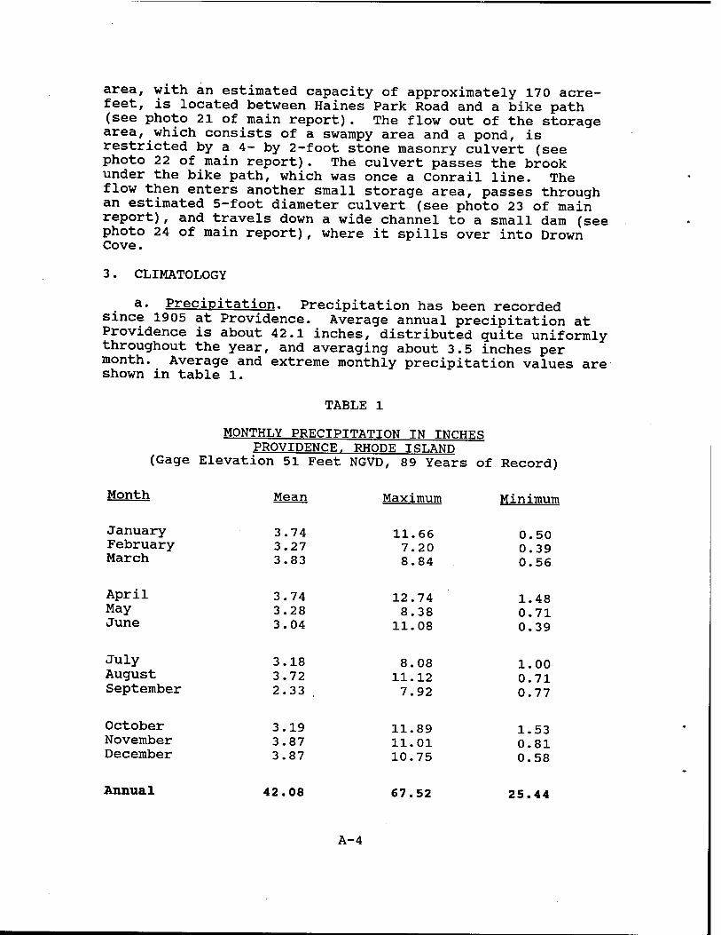
a« Precipitation. Precipitation has been recorded since 1905 at Providence. Average annual precipitation at Providence is about 42.1 inches, distributed guite uniformly throughout the year, and averaging about 3.5 inches per month. Average and extreme monthly precipitation values are shown in table 1.
TABLE 1
MONTHLY PRECIPITATION IN INCHES PROVIDENCE. RHODE ISLAND
(Gage Elevation 51 Feet NGVD, 89 Years of Record)
Month Mean Maximum Minimum
January 3.74 11.66 0.50 February 3.27 7.20 0.39 March 3.83 8.84 0.56
APril 3.74 12.74 1.48 MaY 3.28 8.38 0.71 June 3.04 11.08 0.39
JulY 3.18 8.08 1.00 August 3.72 11.12 0.71 September 2.33 . 7.92 0.77
October 3.19 11.89 1.53 November 3.87 11.01 0.81 December 3.87 10.75 0.58
Annual 42.08 67.52 25.44
A-4
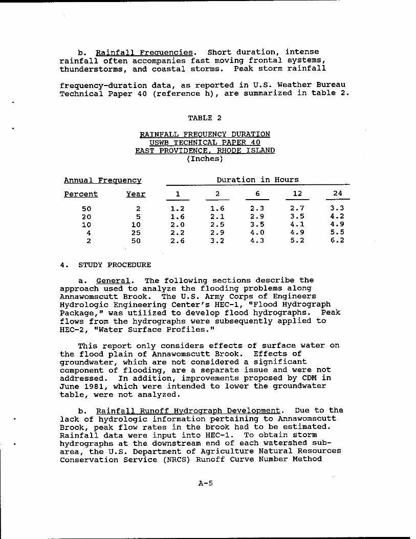
b. Rainfall Frequencies. Short duration, intense rainfall often accompanies fast moving frontal systems, thunderstorms, and coastal storms. Peak storm rainfall
frequency-duration data, as reported in U.S. Weather Bureau Technical Paper 40 (reference h), are summarized in table 2.
TABLE 2
RAINFALL FREQUENCY DURATION USWB TECHNICAL PAPER 40
EAST PROVIDENCE. RHODE ISLAND (Inches)
Annual Frequency
Year
2
Duration in Hours
Percent 1 2 6 12 24
50 1.2 1.6 2.3 2.7 3.3 20 5 1.6 2.1 2.9 3.5 4.2 10 10 2.0 2.5 3.5 4.1 4.9 4 25 2.2 2.9 4.0 4.9 5.5 2 50 2.6 3.2 4.3 5.2 6.2
4. STUDY PROCEDURE
a. General. The following sections describe the approach used to analyze the flooding problems along Annawomscutt Brook. The U.S. Army Corps of Engineers Hydrologie Engineering Center's HEC-1, "Flood Hydrograph Package," was utilized to develop flood hydrographs. Peak flows from the hydrographs were subsequently applied to HEC-2, "Water Surface Profiles."
This report only considers effects of surface water on the flood plain of Annawomscutt Brook. Effects of groundwater, which are not considered a significant component of flooding, are a separate issue and were not addressed. In addition, improvements proposed by CDM in June 1981, which were intended to lower the groundwater table, were not analyzed.
b. Rainfall Runoff Hydrograph Development. Due to the lack of hydrologic information pertaining to Annawomscutt Brook, peak flow rates in the brook had to be estimated. Rainfall data were input into HEC-1. To obtain storm hydrographs at the downstream end of each watershed sub- area, the U.S. Department of Agriculture Natural Resources Conservation Service (NRCS) Runoff Curve Number Method
A-5
within HEC-1 was utilized. Drainage areas, curve numbers, and lag times for the SCS Method were determined, based on U.S. Geological Survey (USGS) quadrangles, SCS soil survey of Rhode Island (reference g), and information within CDM's Report on Drainage Improvements (reference a).
Muskingum-Cunge routing was employed to model the attenuation of upstream subarea hydrographs as they passed through subsequent subareas. Although many gradually sloped, swampy pockets of land exist within the watershed, no attempt was made to model storage during this portion of the analysis. However, only one storage area, which is considered in later portions of this analysis, appears to have significant impact on peak flows within the channel.
Without hydrologic data for the brook, other information had to be obtained to attempt to verify the peak flows obtained in the HEC-1 model. One method of model calibration involves comparison with nearby gaged rivers for a.seTi?s of known storm events. Comparisons were attempted utilizing both the Moshassuck River gage in Providence, Rhode Island and the Runnins River gage in Seekonk, Massachusetts. However, differences in the characteristics of these watersheds did not offer suitable correlation.
The USGS has published several reports with regression equations describing different flow characteristics based on physical watershed features (reference i). Some drawbacks attributed to these empirical equations are the high standard error of regression estimates and the short period of record (6-years for Rhode Island) used to develop the equations. Using a 50-year, 24-hour event, as reported in U.S. Weather Bureau Technical Paper 40 (reference h), the HEC-l model was adjusted with consideration of the results of the regression equations developed for Rhode Island. In addition, the peak flow at Willett Avenue for a 50-year storm, as determined by CDM's 1981 report, was also considered for further calibration.
Rainfall for the 2, 5, 10, 25, and 50-year, 24-hour events, as shown in table 2, was applied to the watershed model. Runoff from each subbasin was routed downstream to the brook outlet at Drown Cove using Muskingum-Cunge routing. The results of this analysis are presented in table 3, which lists index stations and peak runoff rates for each different frequency event analyzed.
A-6
c. Water Surface Profile Development. Once a number of synthetic storm hydrographs were developed, and peak discharges established for points along the brook, water surface profiles were computed utilizing HEC-2. For subcritical flow regimes in HEC-2, profile computations begin with assumed flow rates and starting water surface elevations at a downstream cross section, and proceed upstream. Brook cross sections were obtained by field survey, and the Manning's "n" values adopted are shown in table 4. Starting water surface elevations were obtained from a rating curve developed for the dam at the downstream end of the reach (see plate 2). Profiles were generated for flows associated with the five synthetic storms developed with the HEC-1 analysis. Five additional flow rates were developed by interpolating or extrapolating peak flows from the synthetic storm peak flows, and were analyzed in the HEC-2 model.
TABLE 3
ESTIMATED PEAK FLOWS AT DOWNSTREAM LOCATIONS OF SUBAREAS
Total Drainage Computed Peak Flows in CFS
Location Area
(mi.2)
2-yr 5-yr 10-yr 2 5-yr 50-yr
Forbes St. 0.15 12 22 33 43 53 Thurston St. 0.37 21 40 59 78 97 Rounds Ave. 0.87 49 93 140 191 240 Willett Ave. 1.31 88 159 233 312 387 Drown Cove 1.94 99 190 282 385 483 Drown Cove 1.94 42 53 67 82 95 (w/ storage)
A-7
Ilnll
0 .030 - 0. 040
0 025 - 0. 090
0. 013
0. 028
0. 020
0. 016 - 0. 026
0. 040
0. 014
TABLE 4
MANNING'S "n" VALUES UTILIZED IN HEC-2 ANALYSES
Type of Channel or Surface
Existing Brook Channel
Existing Overbanks
Asphalt Channel
Clean Channel
Improved Channel
Corrugated Metal Pipe
Bike Path Culvert
New Concrete Box Culverts
The ten profiles were considered adequate to estimate the amount of storage between the bike path culvert and Haines Park Road in the town of Barrington. Utilizing methods described in the Hydrologie Engineering Center's Training Document 30 (reference d), HEC-1 was used in conjunction with the HEC-2 model to simulate modified Puls routing through the storage reach. Peak flows from the storage reach outflow hydrograph were then adopted as the Drown Cove peak flows, as shown in table 3, for the final HEC-2 model. It should be noted that attenuation in the storage area accounts for a time to peak 2 to 4 times greater than when storage is not considered, and, as shown in table 3, peak discharges downstream of the storage area are significantly reduced. Plate 3 is an example of hydrographs developed for a 25-year storm. It includes hydrographs at Rounds and Willett Avenues, and the inflow and outflow hydrograph at the Barrington storage area. This hydrograph analysis shows the considerable attenuation and storage effects through the Barrington storage reach.
In an attempt to validate the entire model, three historical storm events were run through the steps described in paragraphs 4b and 4c. The water surface profiles developed for the three events, which were in the order of the synthetic 2-year storm, were compared to flooding logs kept by the city of East Providence. No deviation was exhibited between the modeled results, as exhibited in plate 6, and actual historic records.
A-8
5. ANALYSIS RESULTS
a. General« Water surface profiles were developed for the existing channel of the Annawomscutt Brook. A number of adjustments, such as cleaning the channel and increasing culvert sizes were entered into the model. In addition, channel improvements and rerouting of surface waters, as proposed by CDM were analyzed. Manning's "n" values utilized in the analyses are listed in table 4.
b. Existing Conditions. Water surface profiles for the existing conditions of Annawomscutt Brook were estimated using the methods described in paragraph 4. Plate 4 exhibits profiles for the 2, 5, 10, and 25-year synthetic storms. Table 5 lists elevations of the channel, structures, and top of road crossings along the reach, and table 6 lists water surface elevations at the same locations as shown on plate 4. Invert and top of road elevations were obtained by field surveys and USGS quadrangles.
The most upstream cross section on the profiles represents a point just north of the intersection between the easterly bend and the excavated channel. Continuing the HEC-2 model further upstream would not impart any useful information since the brook travels through woodlands and the Forbes Street Landfill.
The profiles demonstrate that most culverts along Annawomscutt Brook are undersized. The most significant example is the bike path culvert. The limited flow capacity of the 4-foot vertical by 2-foot horizontal culvert appears to govern the water surface elevation upstream through the storage area, Haines Park, and onto Promenade Street. Although the city of East Providence has design criteria based on a 25-year frequency storm, culverts at Haines Park Road, Promenade Street, the south access road at the Almac's parking area, Legion Way, Glenrose Drive, and Rounds Avenue have capacities less than the peak runoff from a 2-year event.
The 2-year storm profile shown on plate 4 ends at the downstream side of Glenrose Drive. All flow from this size storm or smaller is assumed to flow through the pipe network as described in paragraph 2e. For larger storms, where flow is split between the channel and the pipe network, the profile upstream of Glenrose Drive, shown on plate 4, represents flow in the channel only.
A-9
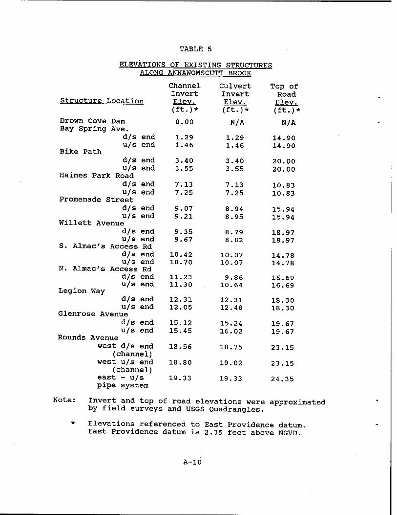
TABLE 5
ELEVATIONS OF EXISTING STRUCTURES ALONG ANNAWOMSCUTT BROOK
Channel Culvert Top of
Structure Location Invert Elev.
Invert Elev.
Road Elev.
(ft.)* (ft.)* (ft.)*
Drown Cove Dam Bay Spring Ave.
0.00 N/A N/A
d/s end 1.29 1.29 14.90 u/s end
Bike Path 1.46 1.46 14.90
d/s end 3.40 3.40 20.00 u/s end
Haines Park Road 3.55 3.55 20.00
d/s end 7.13 7.13 10.83 u/s end
Promenade Street 7.25 7.25 10.83
d/s end 9.07 8.94 15.94 u/s end
Willett Avenue 9.21 8.95 15.94
d/s end 9.35 8.79 18.97 u/s end
S. Almac's Access Rd 9.67 8.82 18.97
d/s end 10.42 10.07 14.78 u/s end
N. Almac's Access Rd 10.70 10.07 14.78
d/s end 11.23 9.86 16.69 u/s end
Legion Way 11.30 10.64 16.69
d/s end 12.31 12.31 18.30 u/s end
Glenrose Avenue 12.05 12.48 18.30
d/s end 15.12 15.24 19.67 u/s end
Rounds Avenue 15.45 16.02 19.67
west d/s end (channel)
west u/s end (channel)
east - u/s
18.56
18.80
19.33
18.75
19.02
19.33
23.15
23.15
24.35 pipe system
Note: Invert and top of road elevations were approximated by field surveys and USGS Quadrangles.
* Elevations referenced to East Providence datum. East Providence datum is 2.35 feet above NGVD.
A-10
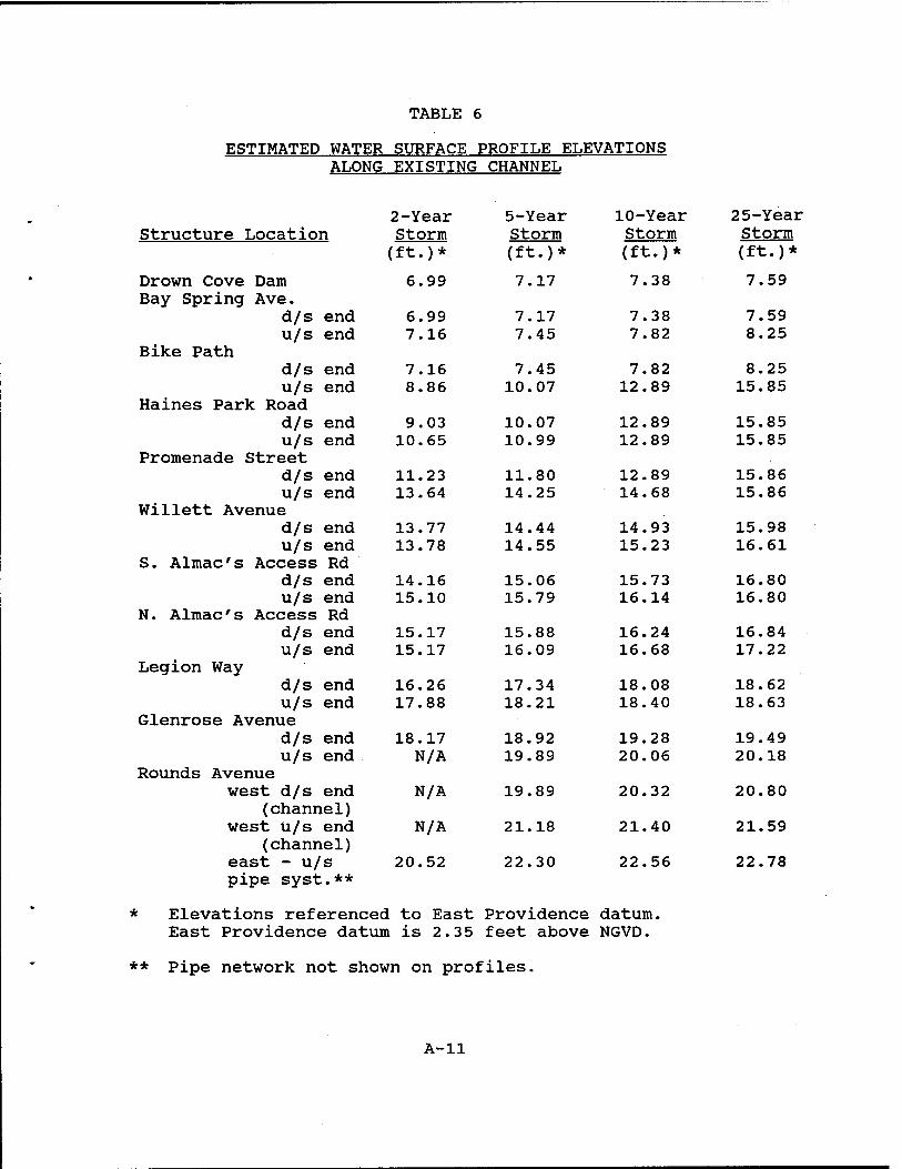
TABLE 6
ESTIMATED WATER SURFACE PROFILE ELEVATIONS ALONG EXISTING CHANNEL
2-Year 5-Year 10-Year 25-Year Structure Location Storm Storm Storm Storm
(ft.)* (ft.)* (ft.)* (ft.)*
Drown Cove Dam 6.99 7.17 7.38 7.59 Bay Spring Ave.
d/s end 6.99 7.17 7.38 7.59 u/s end 7.16 7.45 7.82 8.25
Bike Path d/s end 7.16 7.45 7.82 8.25 u/s end 8.86 10.07 12.89 15.85
Haines Park Road d/s end 9.03 10.07 12.89 15.85 u/s end 10.65 10.99 12.89 15.85
Promenade Street d/s end 11.23 11.80 12.89 15.86 u/s end 13.64 14.25 14.68 15.86
Willett Avenue d/s end 13.77 14.44 14.93 15.98 u/s end 13.78 14.55 15.23 16.61
S. Almac's Access Rd d/s end 14.16 15.06 15.73 16.80 u/s end 15.10 15.79 16.14 16.80
N. Almac's Access Rd d/s end 15.17 15.88 16.24 16.84 u/s end 15.17 16.09 16.68 17.22
Legion Way d/s end 16.26 17.34 18.08 18.62 u/s end 17.88 18.21 18.40 18.63
Glenrose Avenue d/s end 18.17 18.92 19.28 19.49 u/s end N/A 19.89 20.06 20.18
Rounds Avenue west d/s end N/A 19.89 20.32 20.80
(channel) west u/s end N/A 21.18 21.40 21.59
(channel) east - u/s 20.52 22.30 22.56 22.78 pipe syst.**
* Elevations referenced to East Providence datum. East Providence datum is 2.35 feet above NGVD.
** Pipe network not shown on profiles.
A-ll
c. Alternative Proposals
(1) Clean Channel. Reconnaissance visits to Annawomscutt Brook revealed that the channel is not well maintained in some areas. In particular, the embankments in Almac's parking area and the west bank along the Waddington School contain an excess of brush, and the channel is not aligned with the culverts. Culverts at Promenade Street, the Almac's parking area, and Legion Way have silt accumulated along their inverts. In addition, officials from East Providence explained that during high runoff events, the Annawomscutt conveys little flow, with substantial water being stored, until debris is removed from culverts downstream in the town of Barrington, which then allows the brook to drain.
The HEC-2 model was set up to represent the existing channel without vegetation along the embankments or silt within the culverts. A Manning's roughness coefficient of 0.028, which represents a dragline-excavated or dredged channel with no vegetation, was used along the channel. The only significant effect of these changes to the model was at the downstream end of the Legion Way culvert, where the water surface elevation dropped approximately 0.7 foot for peak runoffs from 2-year through 25-year storms. Otherwise, water surface elevations changed by no more than one-half foot anywhere along the channel.
It should be noted that the Manning's values chosen to model the existing channel did not significantly differ from the clean channel value in most locations. Although the model does not indicate a significant reduction in water surface elevation, it is logical to assume that freeing the channel and culverts from debris and vegetation would aid in the conveyance of flow. Channel velocities within the East Providence reach of Annawomscutt Brook generally range between 1 to 3 ft/s, which may facilitate sediment deposition, especially at high flow rates. It is suggested that the city initiate a general maintenance program to mitigate continuing problems.
(2) Increase Culvert Sizes. As stated above, the bike path culvert creates significant backwater effects to Promenade Street. A 6-foot diameter corrugated metal culvert and twin 5 by 5-foot box culverts were each inputted into the model at the bike path. Water surface elevations downstream of the bike path increased, since greater flows were released from the storage area. As expected, water surface elevations decreased through the storage area, Haines Park Road, and Promenade Street; however, there was no significant effect upstream in East Providence.
A-12
With the twin box culverts at the bike path, backwater effects to Promenade Street were the result of the restriction of the Bay Spring Avenue culvert. Another twin 5- by 5-foot box culvert was placed into the model to replace the Bay Spring Avenue culvert. Again, minimal effects were observed in East Providence.
Moving further upstream, the Promenade Street culvert creates considerable energy loss. Returning the downstream culverts to their actual sizes, the Promenade Street culvert was replaced in the model with twin 5- by 5-foot box culverts. This model had some effect on the water surface elevation up to the north access road at the Almac's parking area for events smaller than the 25-year storm. The 2- and 5-year storm water surface elevations at the south access road were estimated to be one-half foot less than the estimated elevation for existing conditions. This denotes slightly less overtopping of the south access road occurring during storm sizes between the 2- and 5-year events. Further upstream of the parking area, however, there is no impact from enlarging the Promenade Street culvert.
Due to siltation in the channel, the culvert inverts at the north and south access roads in the Almac's parking area are located below the streambed elevation. Also, the twin 36-inch culverts at the south access road are well undersized. The model was run with these two sets of culverts brought up to the streambed elevation. The south culverts were replaced by twin 4- by 4-foot box culverts, and the north culverts were replaced by twin 6 by 6-foot box culverts. Unfortunately, the topography restricts the size of the south culverts, so they must be smaller than the north culverts. Additionally, elevations of the access roads had to be increased by approximately one foot to accommodate the new culverts. Again the results were encouraging for storms eguivalent to, or smaller than, the 2-year event, with water surface elevations decreasing by approximately one foot in the channel for a 2-year event. Water surface elevations for events between the 2- and 10-year storms were lower than with the existing culverts by a few inches, and there was no effect on the 25-year event. Water surface elevations at Legion Way were not affected.
(3) Proposed Channel Configuration. In their June 1981 report, CDM recommended a general lowering (i.e., average of 3.5 feet) and reshaping of Annawomscutt Brook between Meadowcrest School and Willett Avenue, and construction of concrete box culverts at Rounds Avenue, Glenrose Drive and Legion Way to increase the hydraulic capacity of the brook. Table 7 displays the proposed channel invert elevations. Lowering the brook also would
A-13
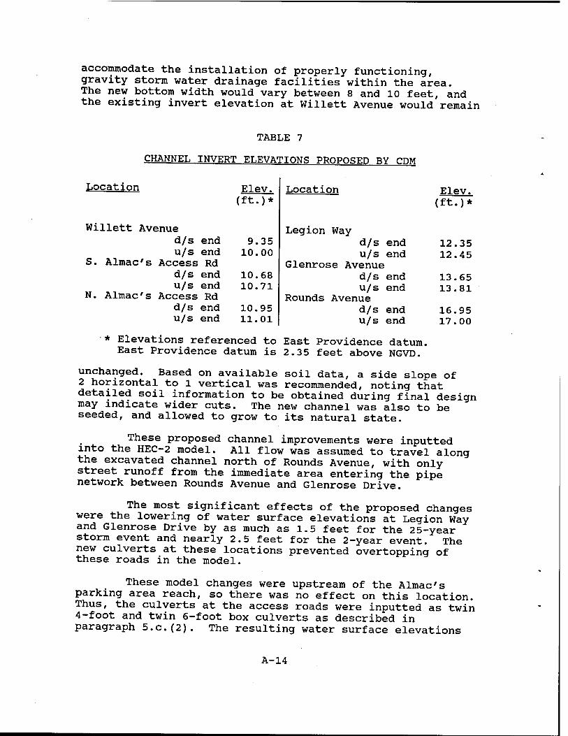
accommodate the installation of properly functioning, gravity storm water drainage facilities within the area. The new bottom width would vary between 8 and 10 feet, and the existing invert elevation at Willett Avenue would remain
TABLE 7
CHANNEL INVERT ELEVATIONS PROPOSED BY CDM
Location Elev. ft •)*
9 .35 10 00
10. 68 10. 71
10. 95 11. 01
Location Elev. (ft.)*
Legion Way d/s end 12.35 u/s end 12.45
Glenrose Avenue d/s end 13.65 u/s end 13.81
Rounds Avenue d/s end 16.95 u/s end 17.00
Willett Avenue d/s end u/s end
S. Almac's Access Rd d/s end u/s end
N. Almac's Access Rd d/s end u/s end
* Elevations referenced to East Providence datum. East Providence datum is 2.3 5 feet above NGVD.
unchanged. Based on available soil data, a side slope of 2 horizontal to 1 vertical was recommended, noting that detailed soil information to be obtained during final design may indicate wider cuts. The new channel was also to be seeded, and allowed to grow to its natural state.
These proposed channel improvements were inputted into the HEC-2 model. All flow was assumed to travel along the excavated channel north of Rounds Avenue, with only street runoff from the immediate area entering the pipe network between Rounds Avenue and Glenrose Drive.
The most significant effects of the proposed changes were the lowering of water surface elevations at Legion Way and Glenrose Drive by as much as 1.5 feet for the 25-year storm event and nearly 2.5 feet for the 2-year event. The new culverts at these locations prevented overtopping of these roads in the model.
These model changes were upstream of the Almac's parking area reach, so there was no effect on this location. Thus, the culverts at the access roads were inputted as twin 4-foot and twin 6-foot box culverts as described in paragraph 5.c.(2). The resulting water surface elevations
A-14
at Glenrose Avenue and Legion Way were lowered by a few inches, but the real effect was observed between the north and south access roads. Here the water surface was lowered by approximately 0.8 foot for the 2-year event and one-half foot for the 5-year storm. For larger storms, however, effects of this modification on the model were minimal.
Table 8 shows the anticipated effects on the water surface profile if CDM's improvements and improvements at the Almac's parking area are performed on the existing channel in East Providence. Plate 5 displays the water surface profile and the improved brook invert. Note that the water surface elevation for the improved channel at the parking area is anticipated to be greater than the water surface elevation in the existing channel for larger events. This is due to raising the access road to accommodate the larger culverts, and, thus, raising the elevation that weir flow can commence.
Changes in the proposed sizes of box culverts at Legion Way, Glenrose Drive, and Rounds Avenue were analyzed. For a 25-year storm event and existing topography, the 5- by 5-foot twin box culverts at Glenrose Drive and Legion Way and the 4- by 4-foot twin box culverts at Rounds Avenue appear to be the optimal sizes.
A-15
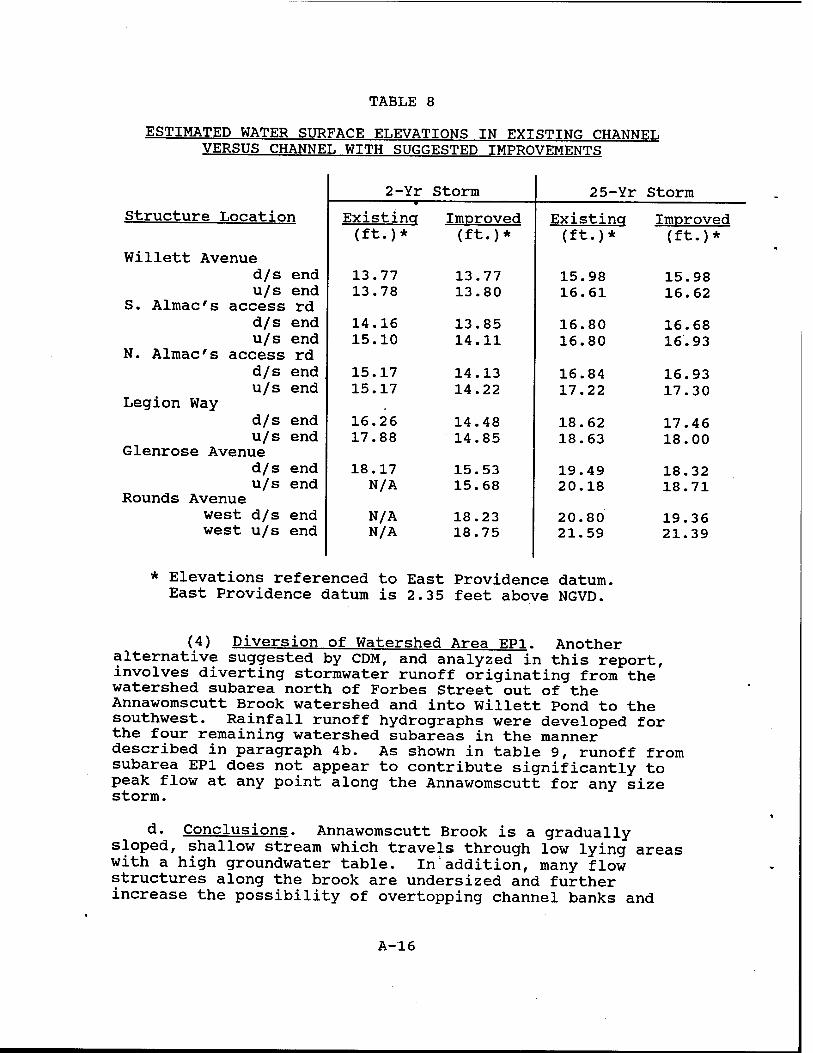
TABLE 8
ESTIMATED WATER SURFACE ELEVATIONS IN EXISTING CHANNEL VERSUS CHANNEL WITH SUGGESTED IMPROVEMENTS
Structure Location
Willett Avenue d/s end u/s end
S. Almac's access rd d/s end u/s end
N. Almac's access rd d/s end u/s end
Legion Way d/s end u/s end
Glenrose Avenue d/s end u/s end
Rounds Avenue west d/s end west u/s end
2-Yr Storm 25-Yr Storm
Existincr (ft.)*
Improved (ft.)*
Existing (ft.)*
Improved (ft.)*
13.77 13.78
13.77 13.80
15.98 16.61
15.98 16.62
14.16 15.10
13.85 14.11
16.80 16.80
16.68 16.93
15.17 15.17
14.13 14.22
16.84 17.22
16.93 17.30
16.26 17.88
14.48 14.85
18.62 18.63
17.46 18.00
18.17 N/A
15.53 15.68
19.49 20.18
18.32 18.71
N/A N/A
18.23 18.75
20.80 21.59
19.36 21.39
* Elevations referenced to East Providence datum. East Providence datum is 2.35 feet above NGVD.
(4) Diversion of Watershed Area EP1. Another alternative suggested by CDM, and analyzed in this report, involves diverting stormwater runoff originating from the watershed subarea north of Forbes Street out of the Annawomscutt Brook watershed and into Willett Pond to the southwest. Rainfall runoff hydrographs were developed for the four remaining watershed subareas in the manner described in paragraph 4b. As shown in table 9, runoff from subarea EP1 does not appear to contribute significantly to peak flow at any point along the Annawomscutt for any size storm.
d. Conclusions. Annawomscutt Brook is a gradually sloped, shallow stream which travels through low lying areas with a high groundwater table. In'addition, many flow structures along the brook are undersized and further increase the possibility of overtopping channel banks and
A-16
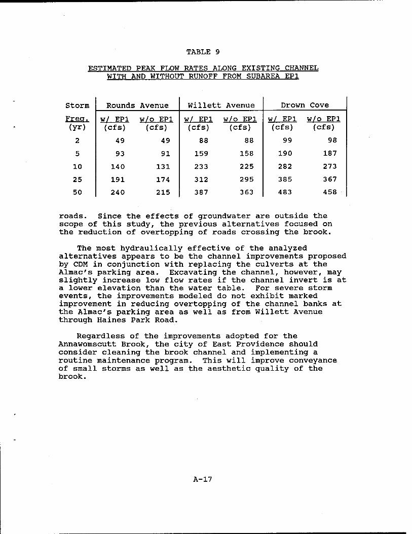
TABLE 9
ESTIMATED PEAK FLOW RATES ALONG EXISTING CHANNEL WITH AND WITHOUT RUNOFF FROM SUBAREA EP1
Storm
Freq. (yr)
2
5
10
25
50
Rounds Avenue Willett Avenue Drown Cove
w/ EP1 w/o EP1 w/ EP1 w/o EP1 w/ EP1 w/o EP1 (cfs) (cfs) (Cfs) (cfs) (cfs) (cfs)
49 49 88 88 99 98
93 91 159 158 190 187
140 131 233 225 282 273
191 174 312 295 385 367
240 215 387 363 483 458
roads. Since the effects of groundwater are outside the scope of this study, the previous alternatives focused on the reduction of overtopping of roads crossing the brook.
The most hydraulically effective of the analyzed alternatives appears to be the channel improvements proposed by CDM in conjunction with replacing the culverts at the Almac's parking area. Excavating the channel, however, may slightly increase low flow rates if the channel invert is at a lower elevation than the water table. For severe storm events, the improvements modeled do not exhibit marked improvement in reducing overtopping of the channel banks at the Almac's parking area as well as from Willett Avenue through Haines Park Road.
Regardless of the improvements adopted for the Annawomscutt Brook, the city of East Providence should consider cleaning the brook channel and implementing a routine maintenance program. This will improve conveyance of small storms as well as the aesthetic quality of the brook.
A-17
6. REFERENCES
a. Camp, Dresser, and McKee, Incorporated, "City of East Providence, Rhode Island, Southeast Area Drainage District, Report on Drainage Improvements," Boston, Massachusetts, June 1981.
b. U.S. Army Corps of Engineers, Hydrologie Engineering Center, "HEC-1 Flood Hydrograph Package," User's Manual, September 1990.
c. U.S. Army Corps of Engineers, Hydrologie Engineering Center, "HEC-2 Water Surface Profiles," User's Manual, September 1990.
d. U.S. Army Corps of Engineers, Hydrologie Engineering Center, "River Routing with HEC-1 and HEC-2," Training Document Number 30, September 1990.
e. U.S. Army Corps of Engineers, New England Division, "Runnins River Watershed Stormwater Management Study," December 1994.
f. U.S. Department of Agriculture, Soil Conservation Service, Technical Release Number 55, "Urban Hydrology for Small Watersheds," June 1986.
g. U.S. Department of Agriculture, Soil Conservation Service, "Soil Survey of Rhode Island," 1991.
h. U.S. Department of Commerce, Weather Bureau, Technical Paper 40, "Rainfall Atlas of the United States for Durations of 30 Minutes to 24 Hours and Return Periods from l to 100 Years," 1961.
i. U.S. Department of the Interior, Geological Survey, Open-File Report 76-883, "Flood Magnitude and Frequency of Small Rhode Island Streams," Boston, Massachusetts, 1976.
A-18
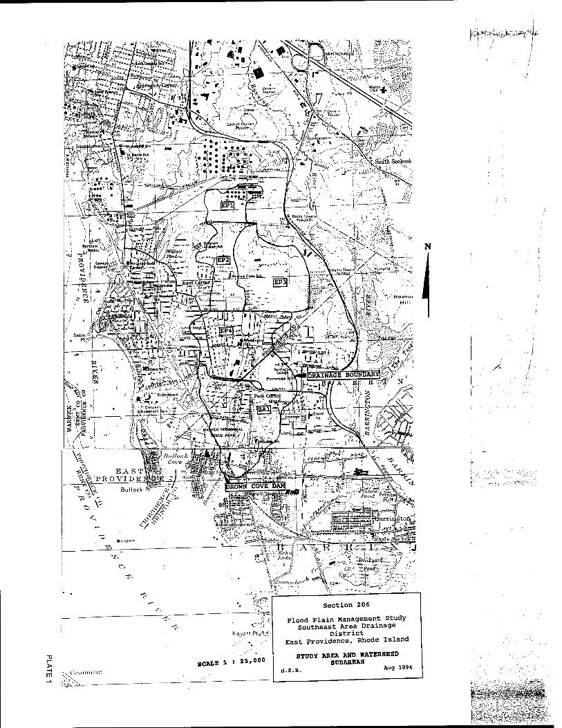
>- -I m
SCALE 1 S 25,000
Section 206
Flood Plain Management Study Southeast Area Drainage
District East Providence, Rhode Island
STUDY AREA AND WATERSHED SUBAREAS
H.E.B. Au9 1994
/*■
}s"r^i':^'^S*':&^'^^^-^^'--
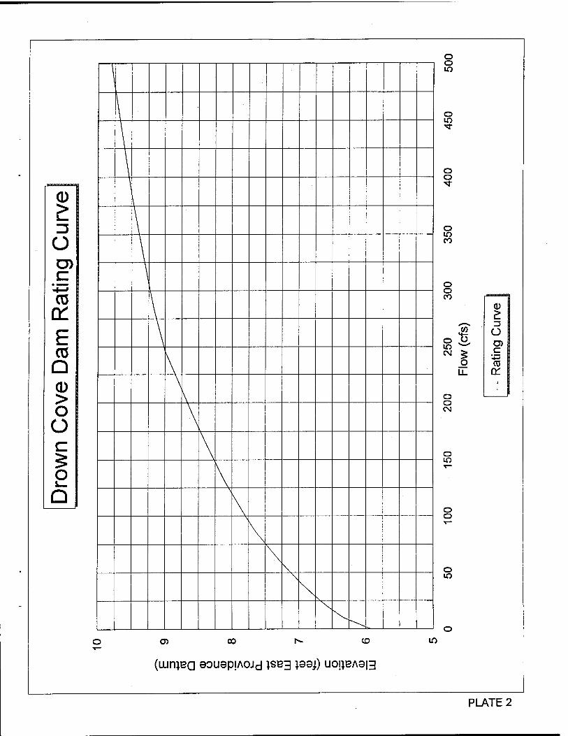
o D)
03 a: E CO Q CD > O O
o Q
\
\ I
\
\
\ 1
\
\ \
\
\ \
\ \
\
\ \
o o
o
o o
o m CO
o o CO
o o lO w
CM £ O LL
O O CM
O lO
O O
O
(0
o lO
O O) CO h» CO
(LUniBQ 90U8piA0Jd JSB3 }99j) U0!}BA8|3
lO
PLATE 2
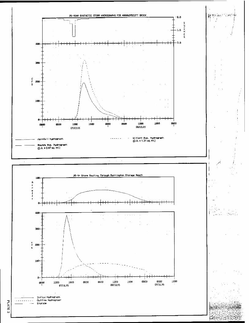
25-YEAR SYNT>€TCC STORM HYOROGRAPHS FOR ANNAWOMSCUTT BROOK
400-
300-
F 200 S
-0.0
-1.5
| I 1 1 1 I I 1 I I I I I I 1 M M 1 I 1 I I I I 1 1 I I I I 1 I ! I i 1 I I
1 I I I I I I I I I 'i I 0B00 1200
07JUL95
1200 1800
08JUL95
^W,-*-4?'.:.-:•% j^i^b
rainfall hyetograph
Rounds five, hydrograph P.A.« 0.87 sq. mi.)
Willett Ave. hydrograph (DA = 1.31 sq. mi.)
/■-
100- 25-Yr Storm Routing Through Barrington Storage Reach
11111 i irrT Ü 111 11111 11111 11111 111 i im 111 1111
300
f 200
100
! -1 •■ ! 1 I 1200 1800
07JUL95
i i i i ! j; i i i ; ! i i i -<■■
1B00 0000 06e0 ß9JUL95
1200
In-flou Hydrograph Outflou Hydrograph
Storage
< LU I- <
V -co CD 2 z O I-
■£OT :< x z w
sisag
S|5i IE
s a: o W a. ss >•
(T rr. O o H t- 10 u> rv IT
IS Si >- >
ift»d«ra
p3A)no ■etp-u}09-l 3AV ßuuds Xeg
o Ü z 5 o a. a s o K u. UJ u z
(lAiniva aoNaaiAoyd isvg) i33d NI NOIIVA313
?&\
UM
*$0ßM^$&^
V
•■*:-
CD
UJ
CL
1 | 1 1 1 ' 11 1111111 ' ' 1 ' 1" -'-Hi H ■ T ZU i 4X~ S 2 1 1 1 - —>- "- _ i O 0 1- H UJ
4-j- , to w K K 5 -j- u— o: o: 3; <; 3 _ < <; uJ üJ 2 T; Q UJ Lü >- >- Q:
i- - - - z >r >r 6 ui H UJ (M in r- (N W - _ 0 :::::::::::::::::::::::: :::::::::::::::: S 1 , |
BffiffB :::::::i:::::::::::::::::::::::::::: f^iä»^;'==ir::::::::::::::=::=:::::::: ::::::
■ t-l | | | | | | | | | | | | | | | | | | | | | | | | IKI |\l |\ |\ 11 1 | 1 || | | vwrovpufa-i ; ! I I [ 1 1 1 1 1 I 1 1 - ■ K-5-5-5: = :;;;— Tstmwmt :r . -- -- —
111 [ 11 1 1 l*i 1 1 [ 1 11 1 1 11 [••■ ' rn - itl
::::::::gü:::::::::::: 1 f \ ;:;::::::::::::::::
iiiii:ii§w::::iiiiin::i::::::::::::p::::t::::::::::::::::::: zm 1 1 1 II 1 II 11 1 1 1 1 1 1 1 11 z r 1 -::-:: in-:::::
< _ -- - j- ---- :__---;_ _- ;___ --- ._ -- - j_ r * „
1 ill V > — i_ 1 11 /^ _ _
^ |_ 11 5 i_ 1 ' 1 5^ 1
.. - jj ^ 1 1 ill — I III - r ■1" ■ *, r 0 ' --■ j« * ~» — ' ^31 - - -
hbis ' -M-H-W — §!■&• - -- u - --44 ------ - "- " ?gf? — —X L--Ü- --- - -- . |> s ig 1- <r _jj __ __
c c -o -n ■ 'II 1 " «gSJS«".- E "" "L ~X~ I t - --
_ -SJKE'S : L t—i. t - - - -- --- - 1 8 & „ __t _ t_ T _ t ... - --- - sSS-äg-4- ' __ i_ _L __ L '
i?5S|L 1 THML^.II Pd V'd S3U.BH -_- ?ET!S 1 " T I , —w-~ j. h --- ~:~j:: " _ __ _ _ _ 0 r
. J *
i 2 ' J_ 1 >5
1 1 I yS. v?£
' t j_ 1 1 5j , J 3k
-_:;__ " " - - - j. - j- j -- - - - —"- ;:;:: ._ r . _ . z\ .. J _. _J _ -
_:: - L_ . _ 1 .. . ± ------ - - .. - - L t ... 31 - L- -- +
L J c
UJ > o u
i 0 K a 2 o or
ÖNOLVa 30iM3QIAOyd 1SV3) 133d Nl N0IJ.VA313
^sT^-Viv^?;
$.--:>:':< mm ü
LU I- <
V
(WniVa 30N3aiAOMd 1SV3) 133J Nl NOU.VA313
^'"-»ift.ii^t,. fi
j^^^Ä^plW^I □ UJ
□.
V
- •' > ■ I
(WniVa 30N3QIAOUd J.SV3) 133J NI NOUVA313
'$$&:&?■&'{;*■*
V
in
HI
y*\*fA>-*
O u z g o o: Q s o Q: u. UJ o z
(WniVQ 30N3C]IA0Hd J.SV3) 133d Nl NOI1VA313
V
ft: •:?-?v i*55**ä':£s. Jf* -]
(IWUVQ 30N3QIA0Hd 1SV3) 133d Nl N0I1VA3H3
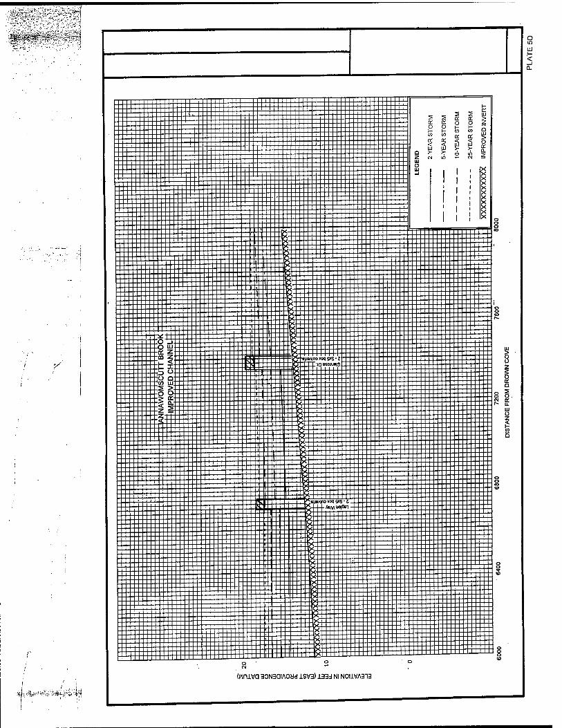
■$0^!M^fi£f£
Q in LU H <
V
:%fOt&***t^f •ilfei,:4'f^
Z------ - :~:::"i"iii H
:::""^::::::::::::::::::::::::::::::::::::::x::::::::::: | 5 jg ::=:::--:::::::::::::::::::::::::::::::::::::::x::::::::::: g § g g § --:-::::::::::±:-: -+- + «> w ^ K £ EEEEEEEEEEEEEEEEEEEEEEEEEEEEEEEEEEEEEEEEEEEEEEEEEEEEEEEEEE3; | | H I Q -7 -T o in ■? Z CM in T- CM Ä
1 Ul "I""II"--~- ° x
EEEEEEEEEEEEEEEEEEEEEEE[EEEEEE|EEE^ E:EEE:E:EE:EE:EEEEE:EEESE^::J:::::+:::::::::=:::=::=":EEE:EEEE::EEEE:EE:E:E
:o "5:::::::::::::::: zzt''--*---'-K.-zzzzzzzz :::::::::::::::::::::::::::::: .0 tu r 1 Sc Z — III ■£ i iiiiiiiiiiii::ti=i]i"=LB:444+44:ff4:-± :::::::::: CD £ J2 3 jö--«j»AinoxoqB!<S-Z """"I" "IIIIIIIIIII "t I IIIIIIIIIIo IIIIIIII^«lOXjaesoiu»io:__II ------
lo a ■"iiiiiiiiiiiiiiiiir-iij-- ^IKIIIIIIIII------"1 I_::Iin 11111 'comill E ■--•&< HIHI S > H fcllllllllllllllllllllllHII
■O O r j jfillll •> a. imiiiiiiiii ::::&: — 11 :f &:::::::::::::: .H |::SIIIIIIIIIIIIIIIIII::::: :: :"" =:: :::i •Z & T lllllb. + - ;ZTt;:;;;;:::;ilIIIIIIII 1 Q- ::iII""I"IIIIIIIIIIIIIIIIII--:IIIIHltl
;H!n|H!H!HHHHHy:!pMH|HHiyhHH!iHHHH!!n!n!ünn!!HH
I""I""EI C«J"Ni» <oqS»8-c; :iiiiiiiiiiiiiiin-ii-iicI......-.-Q--(-j-<'M"°i°»i iiiiiiiiiiiiiiiiiiiiii-------
o u
o K a 5 O. K U.
IU ü z
5
(WlUVa 30N3QIAOcJd 1SV3) ±33d Nl N0I1VA313
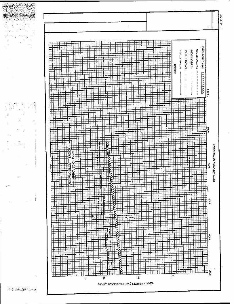
■*&jög&---& A
(iwuva aoNaaiAoad isva) i33d NI NOUVA313
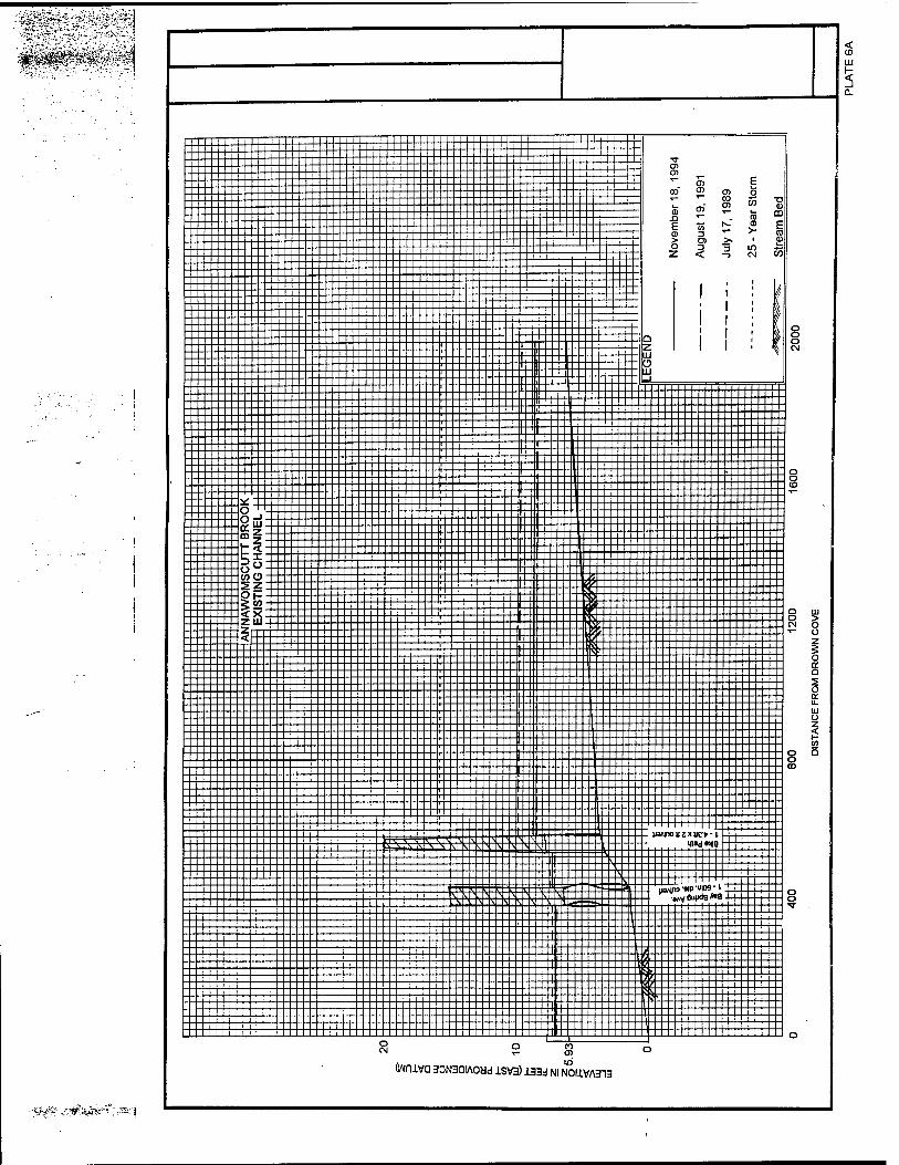
,|tf^p!#g^
\iVl- ÄSÜMS*^ ,,S]
1 I Ü
i...j—\- g
_, L-j t-U—|—)- ^ 5> E 1—j—i I--<-H co o' en o
; ^--1+-- I Z S a s i:::::::-^::::::::::!::: 5 " "". & CD
hfl h" E » - -s § Hi • >□>>.' p h LI Z < -5 CM OT
EEEEEEEEIIEEEEEEEEEEEE ! j ! f EEEEEEEE#EEEE;EEEEEEEE j | ; }
EEEEEEEEEpEpEEEEEEEEEl i ! : fl [. f 0
["£" -1 —
---A
NN
AW
OM
SC
UT
T B
RO
OK
EX
ISTI
NG
CH
AN
NE
L
f.L 1 ._-_— 0 4... J - - 0
"" 1 | 1 ■ -fffH £
^ip!^i!!!l!!!i!::i== "" " L t" --\t - - O — r t _:: s o J.-.1- :'j^::— CM
L.fc jjz ±-
ij > 3 J Z.
D
"? " -^— — — — - - ■ ■ *-
. . . t_.t _ t ............ 2 . . t _ .1 . . .. 1 _ i t _t__ . . s r t 1 ..... ^. s
r L
L .t . - h .£_ t. .. .. .. t .£ . I -X Et ^ h-.|~-L 1 ' M LL — =____=.__,-^_^1.
^^^ = S_i.^-S_\ \^ is v v ]\ «o»d«iia ■
:::::::::it3:::::::5s::::::::::::::::::::::::: T^n \ |'l I . ^ .
:::::::: -:::::::::::::::::::::::::::i-^ j=S=S=S=5Ä:si:::::::!ft::; ^vÄ.ä::::::::: 8 j.^ .^.TX.^.^.^.is il—> ., """^ ^
E _.:_Et;jE __t_; :-- ~ ._ . .::*;±;1. . .j _ . ' i i ,
J I i i V >» II X ^ I Ik f 111 V ^ I Bf'1
1 1 R ^ J f 1 1 1 !li \ 1 I i' [
i i ^
CM
(IWUVCI 3DN3QIA Odd 1SV3) 133d Nl NOUVA313

:^MMkß^^^^
'■ftl'r
HI
0.
> o u z s o K Q s o IT u. HI Ü z
to 5
(wniva 30N3aiAoad isva) laaj NI NOIIVASIS
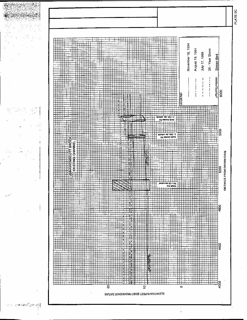
■i-1 ,J/ >.v^-;*-:: O ID
W I-
(WniVQ 30N3aiA0ad 1SV3) 133d Nl NOI1VA313
Q (O
s Q.
-»(5 -2.-Z -op
& S: ;«1 l»A|no «ip uioc -1
OApa eeojueig
IBAliwtip-UKfr-i ABMUOIB»!
O)
01
E (D > O
CO 05
W ^,
E o
55 i_ ra 0) >-
i
in CM
HI > o Ü z g o a: a 5 o o: u. uj ü
o CM
(Wn±Va 30N3QIA0ad 1SV3) ±33d Nl NOI1VA313
-' -'^ ^tg$-

Appendix B - Culvert Descriptions
This section briefly describes some of the physical characteristics of the various
culvert structures in East Providence and Barrington through which Annawomscutt Brook
flows. These structures are culverts of varying sizes and material type. Included are
photographs documenting their location and a brief description of their existing condition.
Plates 2 & 3 show the locations of each of the culverts described in this section. The
information presented here was derived from: (1) field investigations conducted in May 1995,
(2) information obtained from previous reports, and (3) data provided by the City of East
Providence.
B-l
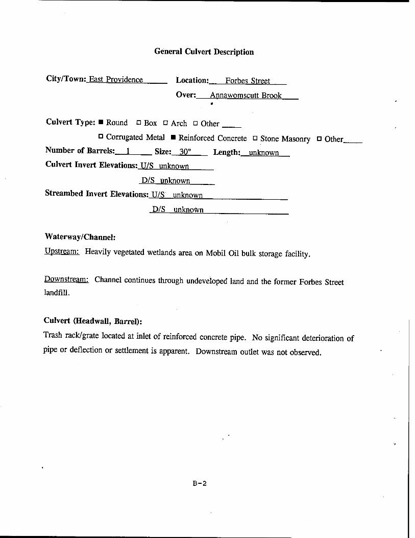
General Culvert Description
City/Town: East Providence Location: Forbes Street
Over: Annawomscutt Brook
Culvert Type: ■ Round □ Box □ Arch □ Other
a Corrugated Metal ■ Reinforced Concrete □ Stone Masonry □ Other.
Number of Barrels: 1 Size: 30" Length: unknown
Culvert Invert Elevations: U/S unknown
D/S unknown
Streambed Invert Elevations: U/S unknown
D/S unknown
Waterway/Channel:
Upstream: Heavily vegetated wetlands area on Mobil Oil bulk storage facility.
Downstream: Channel continues through undeveloped land and the former Forbes Street landfill.
Culvert (Headwall, Barrel):
Trash rack/grate located at inlet of reinforced concrete pipe. No significant deterioration of
pipe or deflection or settlement is apparent. Downstream outlet was not observed.
B-2
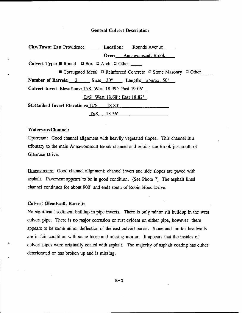
General Culvert Description
City/Town: East Providence Location: Rounds Avenue
Over: Annawomscutt Brook
Culvert Type: ■ Round o Box ö Arch □ Other
■ Corrugated Metal □ Reinforced Concrete o Stone Masonry □ Other,
Number of Barrels: 2 Size: 30" Length: approx. 50'
Culvert Invert Elevations: U/S West 18.99': East 19.06'
D/S West 18.68': East 18.82'
Streambed Invert Elevations: U/S 18.80'
D/S 18.56'
Waterway/Channel:
Upstream: Good channel alignment with heavily vegetated slopes. This channel is a
tributary to the main Annawomscutt Brook channel and rejoins the Brook just south of
Glenrose Drive.
Downstream: Good channel alignment; channel invert and side slopes are paved with
asphalt. Pavement appears to be in good condition. (See Photo 7) The asphalt lined
channel continues for about 900' and ends south of Robin Hood Drive.
Culvert (Headwall, Barrel):
No significant sediment buildup in pipe inverts. There is only minor silt buildup in the west
culvert pipe. There is no major corrosion or rust evident on either pipe, however, there
appears to be some minor deflection of the east culvert barrel. Stone and mortar headwalls
are in fair condition with some loose and missing mortar. It appears that the insides of
culvert pipes were originally coated with asphalt. The majority of asphalt coating has either
deteriorated or has broken up and is missing.
B-3
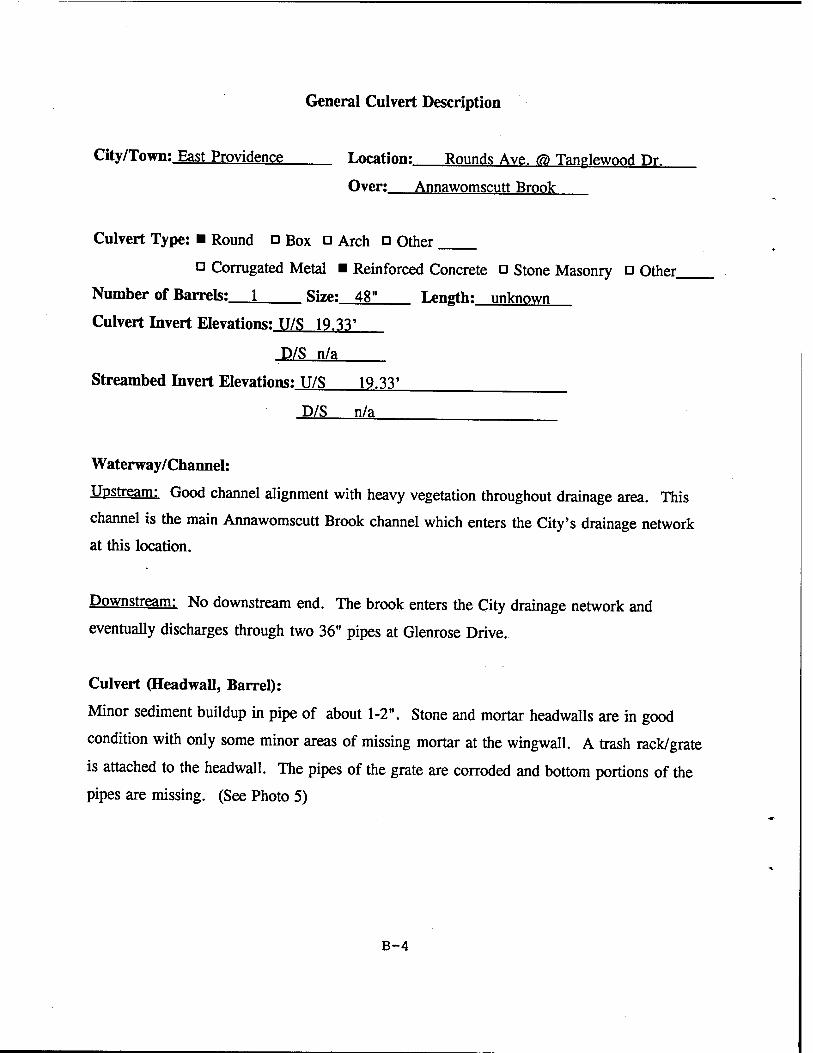
General Culvert Description
City/Town; East Providence Location; Rounds Ave, (a) Tanplewood Dr.
Over: Annawomscutt Brook
Culvert Type: ■ Round □ Box □ Arch n Other
a Corrugated Metal ■ Reinforced Concrete □ Stone Masonry □ Other.
Number of Barrels: 1 Size: 48" Length: unknown
Culvert Invert Elevations: U/S 19.33'
D/S n/a
Streambed Invert Elevations: U/S 19.33'
D/S n/a
Waterway/Channel:
Upstream: Good channel alignment with heavy vegetation throughout drainage area. This
channel is the main Annawomscutt Brook channel which enters the City's drainage network
at this location.
Downstream: No downstream end. The brook enters the City drainage network and
eventually discharges through two 36" pipes at Glenrose Drive.
Culvert (Headwall, Barrel):
Minor sediment buildup in pipe of about 1-2". Stone and mortar headwalls are in good
condition with only some minor areas of missing mortar at the wingwall. A trash rack/grate
is attached to the headwall. The pipes of the grate are corroded and bottom portions of the
pipes are missing. (See Photo 5)
B-4
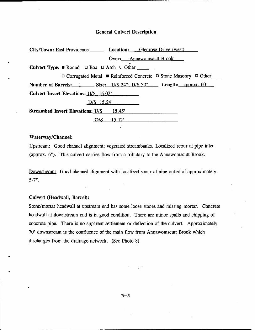
General Culvert Description
City/Town; East Providence Location: Glenrose Drive (west)
Over: Annawomscutt Brook
Culvert Type: ■ Round □ Box o Arch □ Other
□ Corrugated Metal ■ Reinforced Concrete ü Stone Masonry □ Other.
Number of Barrels: 1 Size: U/S 24": D/S 30" Length: approx. 60'
Culvert Invert Elevations: U/S 16.02'
D/S 15.24'
Streambed Invert Elevations: U/S 15.45'
D/S 15.12'
Waterway/Channel:
Upstream: Good channel alignment; vegetated streambanks. Localized scour at pipe inlet
(approx. 6"). This culvert carries flow from a tributary to the Annawomscutt Brook.
Downstream: Good channel alignment with localized scour at pipe outlet of approximately
5-7".
Culvert (Headwall, Barrel):
Stone/mortar headwall at upstream end has some loose stones and missing mortar. Concrete
headwall at downstream end is in good condition. There are minor spalls and chipping of
concrete pipe. There is no apparent settlement or deflection of the culvert. Approximately
70' downstream is the confluence of the main flow from Annawomscutt Brook which
discharges from the drainage network. (See Photo 8)
B-5
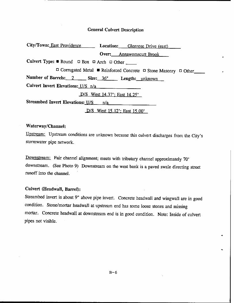
General Culvert Description
City/Town: East Providence Location: Glenrose Drive feasfl
Over; Annawomscutt Brook
Culvert Type: ■ Round ü Box □ Arch o Other
ö Corrugated Metal ■ Reinforced Concrete □ Stone Masonry ü Other,
Number of Barrels: 2 Size: 36" Length: unknown
Culvert Invert Elevations: U/S n/a
D/S West 14.37': East 14.25'
Streambed Invert Elevations: U/S n/a
D/S West 15.12': East 15.00'
Waterway/Channel:
Upstream: Upstream conditions are unknown because this culvert discharges from the City's
stormwater pipe network.
Downstream: Fair channel alignment; meets with tributary channel approximately 70'
downstream. (See Photo 9) Downstream on the west bank is a paved swale directing street
runoff into the channel.
Culvert (Headwall, Barrel):
Streambed invert is about 9" above pipe invert. Concrete headwall and wingwall are in good
condition. Stone/mortar headwall at upstream end has some loose stones and missing
mortar. Concrete headwall at downstream end is in good condition. Note: Inside of culvert
pipes not visible.
B-6
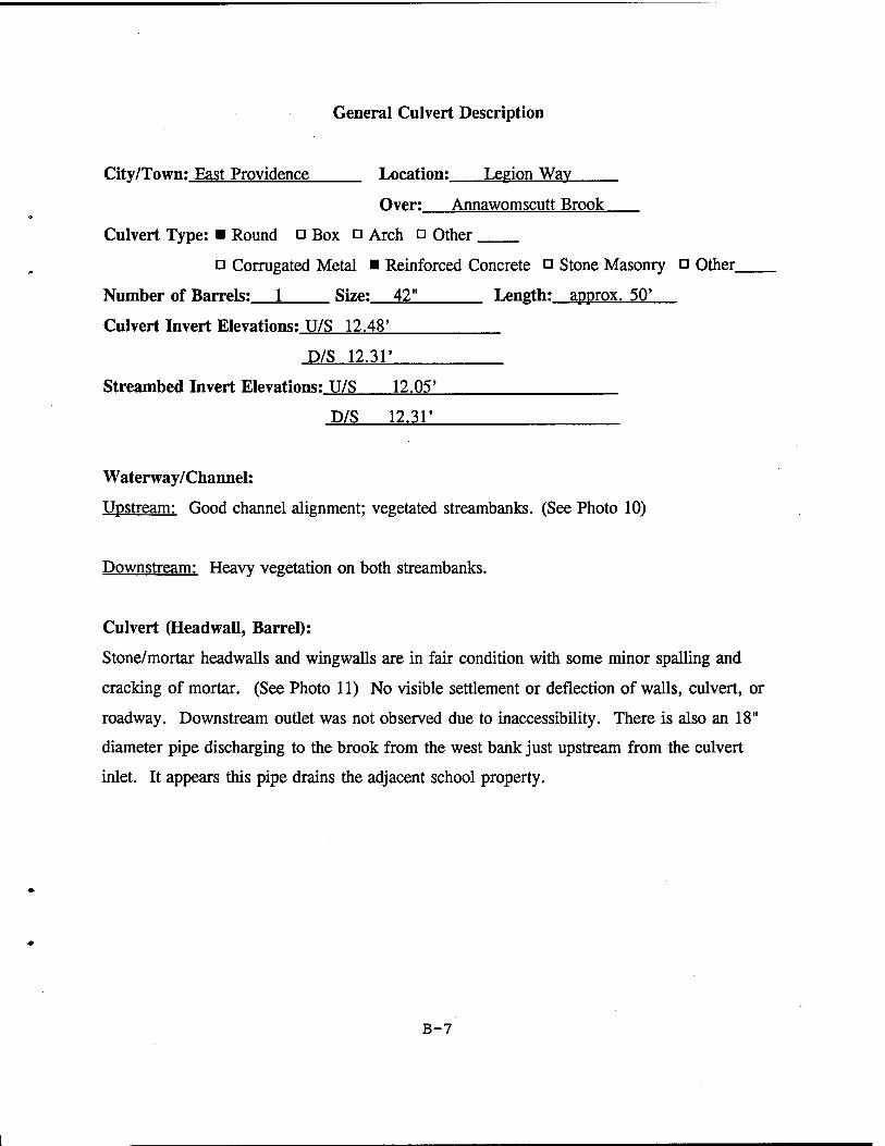
General Culvert Description
City/Town; East Providence Location: Legion Way
Over: Annawomscutt Brook
Culvert Type: ■ Round □ Box □ Arch □ Other
a Corrugated Metal ■ Reinforced Concrete n Stone Masonry □ Other,
Number of Barrels: 1 Size: 42" Length: approx. 50'
Culvert Invert Elevations: U/S 12.48'
D/S 12.31'
Streambed Invert Elevations: U/S 12.05'
D/S 12.31'
Waterway/Channel:
Upstream: Good channel alignment; vegetated streambanks. (See Photo 10)
Downstream: Heavy vegetation on both streambanks.
Culvert (Headwall, Barrel):
Stone/mortar headwalls and wingwalls are in fair condition with some minor spalling and
cracking of mortar. (See Photo 11) No visible settlement or deflection of walls, culvert, or
roadway. Downstream outlet was not observed due to inaccessibility. There is also an 18"
diameter pipe discharging to the brook from the west bank just upstream from the culvert
inlet. It appears this pipe drains the adjacent school property.
B-7
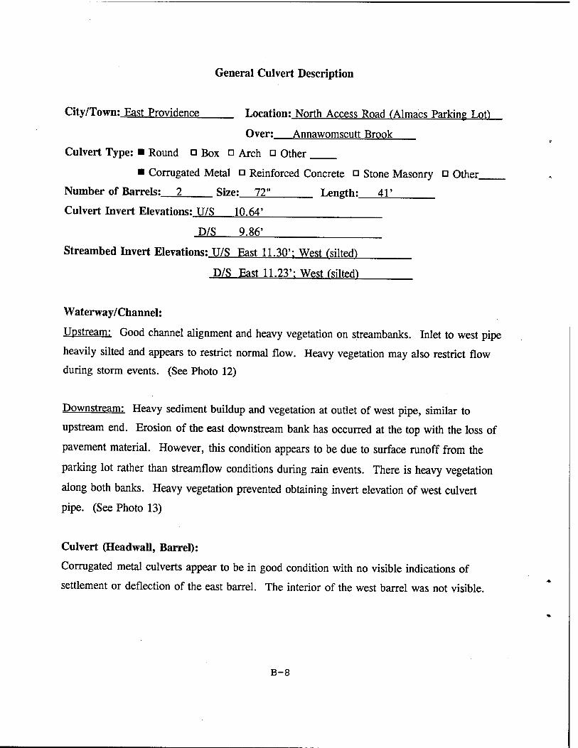
General Culvert Description
City/Town; East Providence Location: North Access Road CAlmacs Parking Lof)
Over: Annawomscutt Brook
Culvert Type: ■ Round □ Box □ Arch □ Other
■ Corrugated Metal □ Reinforced Concrete n Stone Masonry □ Other
Number of Barrels: 2 Size: 72" Length:__4T
Culvert Invert Elevations: U/S 10.64'
D/S 9.86'
Streambed Invert Elevations: U/S East 11.30': West (silted^
D/S East 11.23': West (siltoft
Waterway/Channel:
Upstream: Good channel alignment and heavy vegetation on streambanks. Inlet to west pipe
heavily silted and appears to restrict normal flow. Heavy vegetation may also restrict flow
during storm events. (See Photo 12)
Downstream: Heavy sediment buildup and vegetation at outlet of west pipe, similar to
upstream end. Erosion of the east downstream bank has occurred at the top with the loss of
pavement material. However, this condition appears to be due to surface runoff from the
parking lot rather than streamfiow conditions during rain events. There is heavy vegetation
along both banks. Heavy vegetation prevented obtaining invert elevation of west culvert
pipe. (See Photo 13)
Culvert (Headwall, Barrel):
Corrugated metal culverts appear to be in good condition with no visible indications of
settlement or deflection of the east barrel. The interior of the west barrel was not visible.
B-8
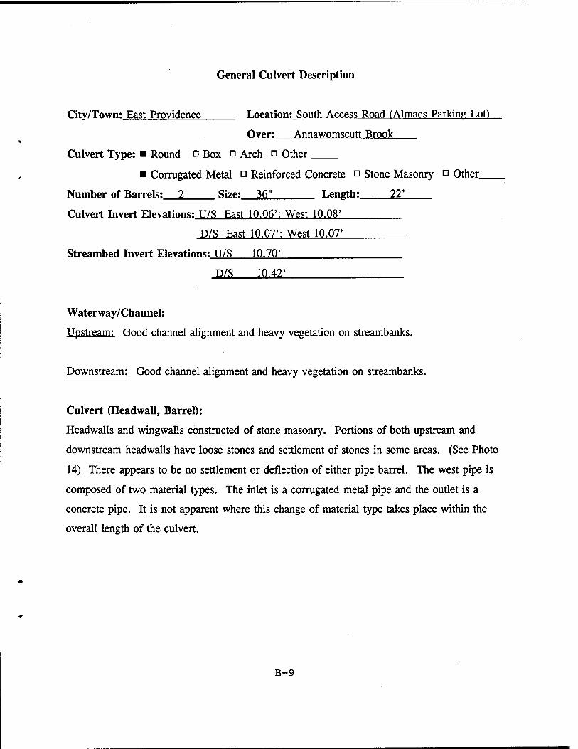
General Culvert Description
City/Town; East Providence Location: South Access Road (Almacs Parking Lot)
Over: Annawomscutt Brook
Culvert Type: ■ Round □ Box a Arch □ Other
■ Corrugated Metal a Reinforced Concrete a Stone Masonry □ Other
Number of Barrels: 2 Size: 36" Length: 22'
Culvert Invert Elevations: U/S East 10.06': West 10.08'
D/S East 10.07': West 10.07'
Streambed Invert Elevations: U/S 10.70'
D/S 10.42'
Waterway/Channel:
Upstream: Good channel alignment and heavy vegetation on streambanks.
Downstream: Good channel alignment and heavy vegetation on streambanks.
Culvert (Headwall, Barrel):
Headwalls and wingwalls constructed of stone masonry. Portions of both upstream and
downstream headwalls have loose stones and settlement of stones in some areas. (See Photo
14) There appears to be no settlement or deflection of either pipe barrel. The west pipe is
composed of two material types. The inlet is a corrugated metal pipe and the outlet is a
concrete pipe. It is not apparent where this change of material type takes place within the
overall length of the culvert.
B-9
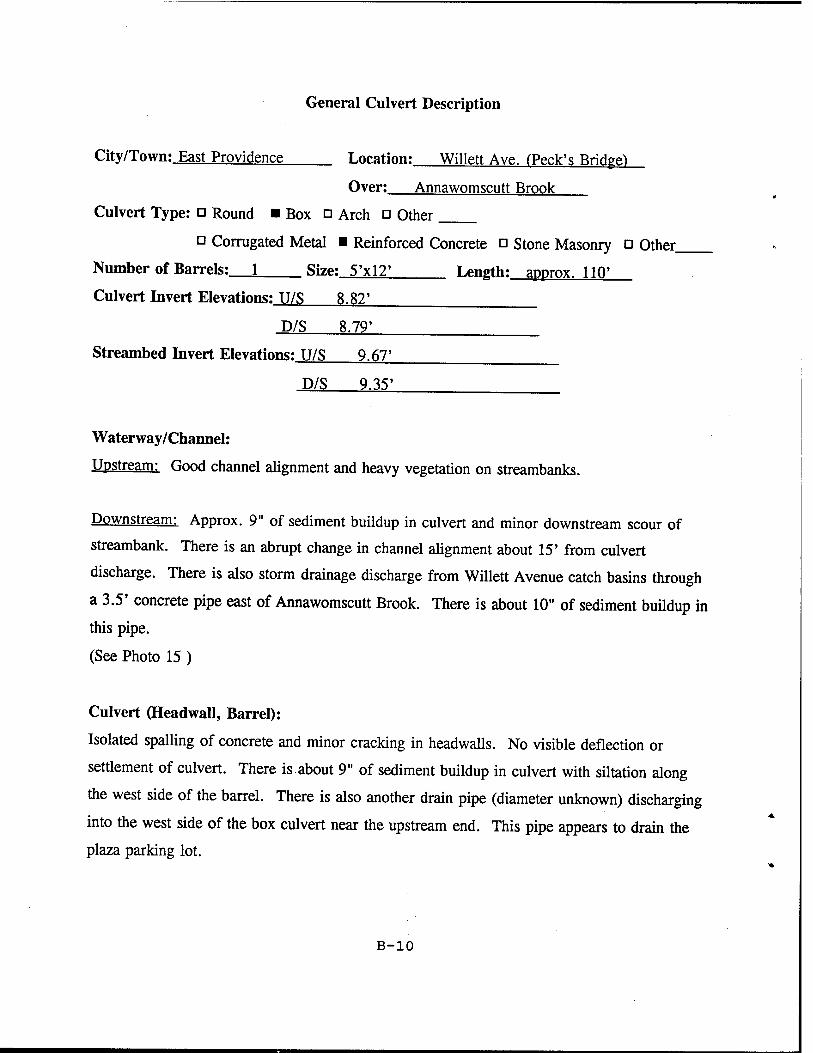
General Culvert Description
City/Town: East Providence Location; Willett Ave. rPeck's Bridge')
Over: Annawomscutt Brook
Culvert Type: □ Round ■ Box □ Arch o Other
n Corrugated Metal ■ Reinforced Concrete n Stone Masonry o Other.
Number of Barrels: 1 Size: 5'xl2' Length: approx. 110'
Culvert Invert Elevations: U/S 8.82'
D/S 8.79'
Streambed Invert Elevations: U/S 9.67'
D/S 9.35'
Waterway/Channel:
Upstream: Good channel alignment and heavy vegetation on streambanks.
Downstream: Approx. 9" of sediment buildup in culvert and minor downstream scour of
streambank. There is an abrupt change in channel alignment about 15' from culvert
discharge. There is also storm drainage discharge from Willett Avenue catch basins through
a 3.5' concrete pipe east of Annawomscutt Brook. There is about 10" of sediment buildup in
this pipe.
(See Photo 15)
Culvert (Headwall, Barrel):
Isolated spalling of concrete and minor cracking in headwalls. No visible deflection or
settlement of culvert. There is about 9" of sediment buildup in culvert with siltation along
the west side of the barrel. There is also another drain pipe (diameter unknown) discharging
into the west side of the box culvert near the upstream end. This pipe appears to drain the
plaza parking lot.
B-io
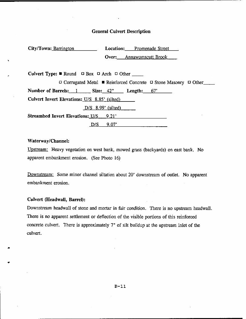
General Culvert Description
City/Town: Barrington Location: Promenade Street
Over: Annawomscutt Brook
Culvert Type: ■ Round □ Box o Arch □ Other
o Corrugated Metal ■ Reinforced Concrete a Stone Masonry □ Other_
Number of Barrels: 1 Size: 42" Length: 67'
Culvert Invert Elevations: U/S 8.85' (silted)
D/S 8.99' (silted)
Streambed Invert Elevations: U/S 9.21'
D/S 9.07'
Waterway/Channel:
Upstream: Heavy vegetation on west bank, mowed grass (backyards) on east bank. No
apparent embankment erosion. (See Photo 16)
Downstream: Some minor channel siltation about 20' downstream of outlet. No apparent
embankment erosion.
Culvert (Headwall, Barrel):
Downstream headwall of stone and mortar in fair condition. There is no upstream headwall.
There is no apparent settlement or deflection of the visible portions of this reinforced
concrete culvert. There is approximately 7" of silt buildup at the upstream inlet of the
culvert.
B-ll
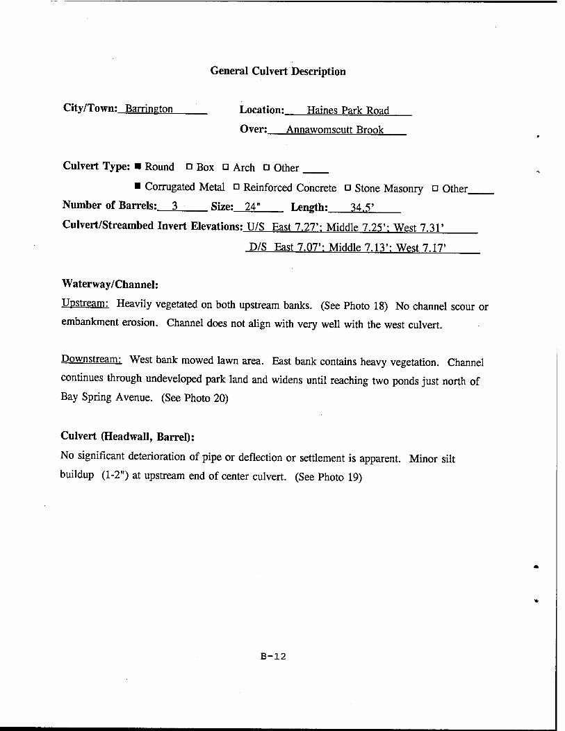
General Culvert Description
City/Town: Barrineton Location: Haines Park Road
Over: Annawomscutt Brook
Culvert Type: ■ Round o Box □ Arch ü Other
■ Corrugated Metal o Reinforced Concrete □ Stone Masonry □ Other
Number of Barrels: 3 Size: 24" Length: 34.5'
Culvert/Streambed Invert Elevations: U/S East 7.27': Middle 7.25': West 7.31*
D/S East 7.07': Middle 7.13': West 7.17'
Waterway/Channel:
Upstream: Heavily vegetated on both upstream banks. (See Photo 18) No channel scour or
embankment erosion. Channel does not align with very well with the west culvert.
Downstream: West bank mowed lawn area. East bank contains heavy vegetation. Channel
continues through undeveloped park land and widens until reaching two ponds just north of
Bay Spring Avenue. (See Photo 20)
Culvert (Headwall, Barrel):
No significant deterioration of pipe or deflection or settlement is apparent. Minor silt
buildup (1-2") at upstream end of center culvert. (See Photo 19)
B-12
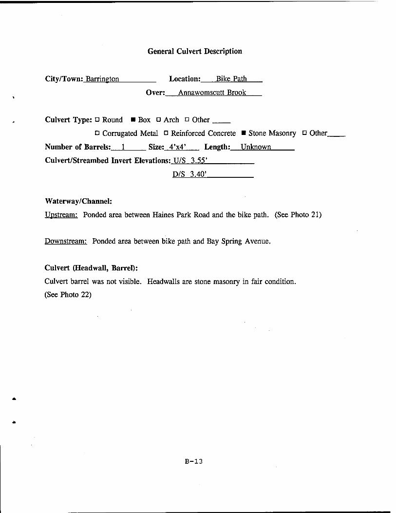
General Culvert Description
City/Town: Barrington Location; Bike Path
Over: Annawomscutt Brook
Culvert Type: □ Round ■ Box □ Arch a Other
o Corrugated Metal a Reinforced Concrete ■ Stone Masonry Q Other.
Number of Barrels: 1 Size: 4'x4' Length: Unknown
Culvert/Streambed Invert Elevations: U/S 3.55'
D/S 3.40'
Waterway/Channel:
Upstream: Ponded area between Haines Park Road and the bike path. (See Photo 21)
Downstream: Ponded area between bike path and Bay Spring Avenue.
Culvert (Headwall, Barrel):
Culvert barrel was not visible. Headwalls are stone masonry in fair condition.
(See Photo 22)
B-13
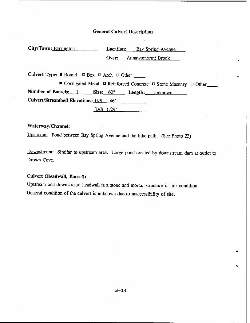
General Culvert Description
City/Town: Barrington Location; Bav Spring Avenue
Over: Annawomscutt Brook
Culvert Type: ■ Round □ Box □ Arch □ Other
■ Corrugated Metal a Reinforced Concrete □ Stone Masonry □ Other.
Number of Barrels: 1 Size: 60" Length: Unknown
Culvert/Streambed Elevations: U/S 1.46'
D/S 1.29'
Waterway/Channel:
Upstream: Pond between Bay Spring Avenue and the bike path. (See Photo 23)
Downstream: Similar to upstream area. Large pond created by downstream dam at outlet to Drown Cove.
Culvert (Headwall, Barrel):
Upstream and downstream headwall is a stone and mortar structure in fair condition.
General condition of the culvert is unknown due to inaccessibility of site.
B-14
Appendix C
Scope of Studies
«
Southeast Area Drainage District East Providence, Rhode Island
Section 206 Flood Plain Management Services (FPMS) Program
I. Introduction:
a. Authority
The Corps of Engineers was requested by the City of East Providence, Rhode Island to conduct an investigation of flooding problems due to surface water and high groundwater levels in the City's Southeast Area Drainage District. However, this study will focus only on flooding problems associated with surface water. This study will be conducted under the Corps of Engineers' Flood Plain Management Services (FPMS) program. The FPMS program is authorized under Section 206 of the Flood Control Act of 1960 (PL-86-645). This program allows the Corps to provide planning and technical assistance relating to flooding and flood plain management.
b. Study Purpose and Scope
The purpose of this study is to evaluate existing and potential flooding along the Annawomscutt Brook and provide recommendations relative to alleviating those problems.
A study conducted for the city in 1981 by Camp Dresser & McKee (CDM), Inc., (Southeast Area Drainage District Report On Drainage Improvements. June 1981) outlined a series of recommendations to address the immediate and most severe street and basement flooding within this area. The information, conclusions, and findings contained in the CDM study will be utilized, to the extent possible, for this investigation.
The CDM study provided specific recommendations for each sub-watershed within the Southeast Area Drainage District. Some of the recommended improvements have been completed by the City, however, they have not implemented the recommended improvements to Annawomscutt Brook.
Therefore, the City has requested that further recommended drainage improvements, as
C-l
detailed in the CDM report, be reevaluated for their effectiveness in mitigating flooding problems within this area. In particular, the City desires a hydraulic analysis of Annawomscutt Brook and the proposed CDM improvements to the brook.
This study will be coordinated with all appropriate Federal, State, Municipal and other interested parties. Areas of additional study will also be identified, if necessary.
II. Project Tasks
a. Problem Identification
Evaluate surface water flooding problems experienced within the Southeast Area Drainage District which are related to Annawomscutt Brook. This will likely include reviewing data collected by CDM in 1980, and collecting information from local officials and residents. This will provide an indication of flooding problems and their locations and will also determine specific areas of recurring street and basement flooding in the watershed.
b. Hydrologic/Hydraulic Analysis
A hydrologic/hydraulic analysis of the Annawomscutt Brook watershed will be accomplished to determine peak flows, hydrographs, and the extent of flooding for two or three rainfall events. The major tasks associated with the hydrologic/hydraulic analysis of Annawomscutt Brook are defined below.
1. Develop hydrologic and hydraulic models which represent the existing condition of the brook and watershed. Modelling will need to address both channel and culvert flow. The model should extend sufficiently downstream to adequately identify adverse impacts in East Providence.
2. Develop appropriate design flows by use of a rainfall-runoff model and identify areas with flooding problems after development of a hydraulic model (HEC-2). This data can then be compared with the flooding information in task "a." above.
3. Modify the existing conditions models to represent improvements proposed in the CDM study and run the modified models for the storms selected in task "b.2." above.
4. Evaluate the hydraulic capacity of the channel to convey both existing flows and flows associated with the proposed CDM improvements.
C-2
5. Identify and evaluate possible corrective measures in the channel configuration to improve its conveyance capacity for both the existing conditions and for the proposed CDM improvements.
c. Findings and Recommendations
Findings of the study tasks will be outlined and recommendations for channel modifications (with preliminary cost estimates) to Annawomscutt Brook will be made.
d. Coordination. Project Management. & Report Preparation
The results of this analysis will be coordinated with appropriate Federal, State, and local agencies to obtain their views. The results of the study will be summarized in a report and additional studies will also be identified, if necessary.
III. Report Documentation
A report will be submitted to the City of East Providence in draft form for comment and review. Upon resolution of provided comments, the New England Division will prepare and issue a final report.
IV. Project Coordination
This study will be conducted by the New England Division of the Corps of Engineers. The New England Division will coordinate with the City of East Providence on all issues concerning the study which deviate from the original Scope of Studies. The New England Division will maintain coordination with all appropriate Federal, State, and local agencies throughout the study.
V. Project Cost and Completion Schedule
It has been determined that the Southeast Area Drainage District study will cost $40,000 and will be completed within 12 months.
C-3