Embed Size (px)
Citation preview
SOUTH SANTA ROSA
AREA PLAN
Adopted by Resolution No. 71691 May 4, 1982
Modified by Resolution No. 93-0337
March 9, 1993
Modified by Resolution No. 07-0481 June 5, 2007
Modified by Resolution No. 08-0808
September 23, 2008
ACKNOWLEDGMENTS
SONOMA COUNTY BOARD OF SUPERVISORS
FIRST DISTRICT: Supervisor Bob Adams SECOND DISTRICT: Supervisor Helen Putnam THIRD DISTRICT: Supervisor Helen Rudee FOURTH DISTRICT: Supervisor Nick Esposti FIFTH DISTRICT: Supervisor Ernie Carpenter
SONOMA COUNTY PLANNING COMMISSION
FIRST DISTRICT FOURTH DISTRICT Janet Nicholas Michael Bojanowski Hal Coleman Glen Haskins
SECOND DISTRICT FIFTH DISTRICT Donald Marquardt Margaret Shank Lesly Meyer Gary Mills
THIRD DISTRICT Laverne Solkov Michael Senneff
CITIZENS COMMITTEE
Robert Gerlach, Chairman Vincent Sisson, Vice Chairman
James Bergeson Henry Matteri Irene Bisagno Ronald Meints Donna Born Cecelia Mello Orr Chistiakoff George "Bud" Merrill Patricia Evans Jerome O'Leary Curtis Hardin Randall Roe Norman Jacobs Peter Verbiscar
South Santa Rosa Area Plan Page 2
STUDY TEAM
SOUTH SANTA ROSA SPECIFIC PLAN
PRANAB CHAKRAWARTI, DIRECTOR OF PLANNING TOBY ROSS, Chief, Comprehensive Planning Section
BOB GASKILL, Project Planner RON TADDEI, Project Planner GARY MANN, Report Graphics BRICE GREGERSON, Mapping
TIMOTHY DOSH, Mapping BETTY HORNER, Mapping MARLAINA PIPAL, Mapping GARY FRESHLEY, Mapping
JANE LUFKIN, Mapping & Graphics RUTH LUND, Word Processor
REVISED SOUTH SANTA ROSA AREA PLAN
KENNETH MILAM, DIRECTOR OF PLANNING GREG CARR, Chief, Comprehensive Planning Division
RICHARD ROGERS, Planner MARIA CIPRIANI, Planner
RICK ROY, Report Graphics ELIZABETH ROBERTS, Word Processor
REVISED SOUTH SANTA ROSA AREA PLAN 2008
PETE PARKINSON, PRMD DIRECTOR JENNIFER BARRETT, PRMD Deputy Director of Planning
GREG CARR, Comprehensive Planning Manager LISA POSTERNAK, Staff Planner YOLANDA SOLANO, Staff Planner
SUE WAXMAN, Production SUSAN DAHL, Production DARCY REINIER, Mapping
South Santa Rosa Area Plan Page 3
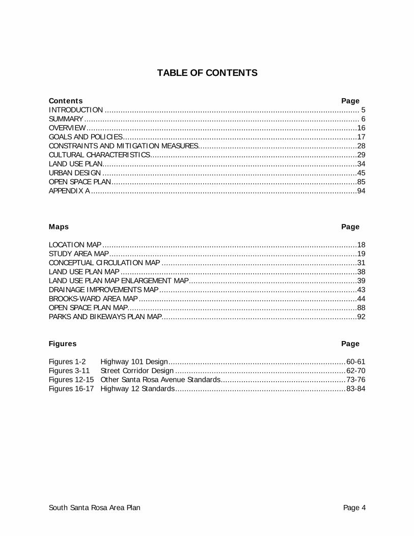
TABLE OF CONTENTS Contents Page INTRODUCTION ................................................................................................................ 5 SUMMARY ......................................................................................................................... 6 OVERVIEW .......................................................................................................................16 GOALS AND POLICIES .......................................................................................................17 CONSTRAINTS AND MITIGATION MEASURES ......................................................................28 CULTURAL CHARACTERISTICS ...........................................................................................29 LAND USE PLAN ................................................................................................................34 URBAN DESIGN ................................................................................................................45 OPEN SPACE PLAN ............................................................................................................85 APPENDIX A .....................................................................................................................94 Maps Page LOCATION MAP ................................................................................................................18 STUDY AREA MAP .............................................................................................................19 CONCEPTUAL CIRCULATION MAP ......................................................................................31 LAND USE PLAN MAP ........................................................................................................38 LAND USE PLAN MAP ENLARGEMENT MAP ..........................................................................39 DRAINAGE IMPROVEMENTS MAP .......................................................................................43 BROOKS-WARD AREA MAP ................................................................................................44 OPEN SPACE PLAN MAP .....................................................................................................88 PARKS AND BIKEWAYS PLAN MAP ......................................................................................92 Figures Page Figures 1-2 Highway 101 Design .............................................................................. 60-61 Figures 3-11 Street Corridor Design ........................................................................... 62-70 Figures 12-15 Other Santa Rosa Avenue Standards ....................................................... 73-76 Figures 16-17 Highway 12 Standards ........................................................................... 83-84
South Santa Rosa Area Plan Page 4
INTRODUCTION In 1982, the County adopted the South Santa Rosa Specific Plan, a planning document prepared under specific requirements of State law and intended to provide an intermediate level of detail between the 1978 General Plan and site development plans submitted to the County for approval. The 1978 General Plan focused on policies of county-wide significance and utilized generalized graphics to illustrate land use, open space and other elements. In 1989, the County adopted an update of the 1978 General Plan. The General Plan update provided parcel-specific information concerning land use and open space. The General Plan update also included "area policies" in an attempt to focus particular attention on a specific area or parcel. Because of this level of specificity in the General Plan update, the Board of Supervisors determined that several of the specific plans, including the South Santa Rosa Specific Plan, were either duplicative of or conflicted with the updated General Plan. The Board of Supervisors further determined that to the extent the specific plans provided policy guidance beyond that provided by the General Plan update, that such plans should be reviewed and revised to focus on such policies, and readopted as "area plans." The General Plan includes a discussion of these specific plans in Land Use Element Section 2.1.1, under Policy LU-1a. This document was prepared pursuant to General Plan Policy LU-1a. In keeping with the above intent, the 1993 revisions of the South Santa Rosa Area Plan did not include exhaustive evaluation or reconsideration of the policies or designations contained in this plan. The scope of the revisions was limited to that necessary to achieve General Plan consistency. In addition, during this process much of the original background language was deleted. This deletion should not be interpreted as diminishing or reducing the significance of the content of the language to the original plan. Should there be any future questions regarding the intent or basis of the policies in the revised plan, the Planning Department shall keep copies of the original plan on file for reference.
South Santa Rosa Area Plan Page 5
SUMMARY The following statements have been extracted, edited and summarized from the text of the Area Plan in order to provide ready reference to development guidelines.
CONCLUSIONS The South Santa Rosa Area Plan reflects several key elements: (1) Revision of the urban boundary.
(2) Accommodation of a variety of rural life styles.
(3) Protection and maintenance of agriculture.
(4) Direction of most new housing to locations closest to the community center.
(5) Provision of urban services before or concurrent with urban development. The South Santa Rosa Land Use Plan and Open Space Plan are consistent with the General Plan.
MAJOR POLICIES (1) Implement the General Plan Circulation and Transit Element. (2) Insure that impacts are mitigated before approving subdivisions or rezonings which
increase residential densities, especially those within proximity to existing agricultural operations.
(3) Limit expansion of sewer service to the General Plan designated urban service area
except when necessary to serve identified health hazards for existing development, as provided by the sewer extension policies of the Public Services and Facilities Element.
(4) Adopt the residential and commercial development standards. (5) Encourage and support protection and enhancement of riparian corridors, particularly
the Laguna de Santa Rosa. (6) Adopt Plan Lines for Farmers Lane Extension, Todd Road extension west to 116, for the
realignment of Hearn Avenue at Stony Point Road and for Dutton Avenue between Sebastopol Road and Bellevue.
South Santa Rosa Area Plan Page 6
(7) Support adoption of fees to provide for necessary fire protection equipment. (8) Support establishment of assessment districts for improvements to Sebastopol Road and
Santa Rosa Avenue. (9) Support extension of public water supply south on Santa Rosa Avenue to Todd Road
through cooperative efforts of local government and private property owners. (10) Support adoption by LAFCO of the City of Santa Rosa’s voter-approved year 2020 Urban
Growth Boundary as the sphere of influence for the City of Santa Rosa.
GOALS AND POLICIES SUMMARY The goals and policies provide the framework of the study. The goals provide direction to guide future development while the policies provide a means of implementation.
Natural Characteristics (1) Insure that densities remain low in areas of public hazard.
(2) Refer projects to a qualified geologist in order to determine when engineering geologic
reports are necessary concerning the following discretionary actions: plan amendments, rezoning use permits, minor subdivisions, design review permits, and gravel extraction permits and reclamation plans. Special attention should be paid to the "possibly active" fault zone which crosses the Roseland area.
(3) Continue to require geologic reports on single family residence building permits in landslide areas in order to enforce the geologic provisions of Chapter 70 of the Uniform Building Code.
MINERALS (1) Adopt reclamation plans for all hard rock quarry operations.
(2) Mining operations which use particular haul routes should contribute to their
maintenance.
GROUNDWATER AVAILABILITY (1) Continue implementation of the groundwater and drainage standards contained in the
Sonoma County Subdivision Ordinance.
(2) Consider specific mitigation measures such as recharge ponds, permeable surfaces, retention of open space by clustering of units for all projects within the study district.
South Santa Rosa Area Plan Page 7
Cultural Characteristics
ROAD IMPROVEMENTS The following roads must be upgraded to the level indicated, to accommodate the increases in Land Use provided for in this plan. Freeway. U.S. Highway 101 (6 lanes) Principal and Minor Arterials. State Highway 12, Sonoma County Fairgrounds to Fulton Road (Rural Principal Arterial, 4 lanes), State Highway 12, Llano Road to boundary of South Santa Rosa Area Plan (Rural Principal Arterial, 3 lanes), Santa Rosa Avenue (Urban Principal Arterial, 4 lanes), Farmers Lane Extension (4 lanes), and Stony Point Road (Urban or Rural Principal Arterial, 4 lanes. Major and Minor Collectors. Todd Road (Rural Major Collector and Minor Arterial), Llano Road (Rural Major Collector and Rural Minor Arterial), and Mountain View Avenue (Rural Major Collector). Local Roads. West Avenue, Burbank Avenue, Wright Road, Colgan Avenue, Yolanda Avenue, East Todd Road (to existing easterly terminus), Bellevue Road, (between Corby, Moorland, and Dutton intersections), Dutton Avenue, Corby Avenue, Hearn Avenue, and Petaluma Hill Road. The Board of Supervisors should establish a vehicle load limit ordinance on Moorland Avenue between Bellevue and Todd to preclude heavy truck traffic associated with nearby industrial developments from using this County Road. Improvements to roads within the City of Santa Rosa Urban Service Area should follow the City of Santa Rosa General Plan and be consistent with city road classifications and design standards, unless these standards are less than County standards.
PUBLIC TRANSIT (1) Increase the frequency of bus service from per hour to two per hour.
(2) Provide service along Dutton Avenue, where a substantial amount of medium and high
density development exists, and more is projected.
(3) Extend bus service to the two large industrial park employment centers (Oak Manor and Industry West) located between Hearn Avenue and Todd Road, west of Highway 101.
(4) Expand bus service to keep pace with urban level development: as lands are converted to urban uses, the bus service area should be increased.
South Santa Rosa Area Plan Page 8
NOISE Development shall comply with the standards and policies of the General Plan and Noise Element.
AIR QUALITY Both point source and cumulative traffic generated emissions should be evaluated for potential adverse air quality impacts for any major developments and these developments should proceed only if the air quality impacts can be mitigated.
SCHOOLS School districts should consider adopting school impact fees, in order to fund additional classrooms. The Board of Supervisors should implement the fee if so requested by the School Board.
ENERGY (1) Cluster rural residential development where feasible. The Land Use Plan allows for small
minimum lot sizes while proposing an overall density.
(2) Design and orient houses to take advantage of solar exposure.
(3) Minimize window areas on north-facing walls and maximize windows on south-facing walls.
(4) Encourage double-glaze windows and glass doors to reduce heat loss during the winter.
(5) Use insulation and weather-stripping to reduce dependence upon air conditioning and heating. Provide additional insulation on north facing walls.
(6) Use solar heating where feasible.
(7) Maximize natural lighting.
(8) Landscape with deciduous trees along south-facing walls to shade south walls during the summer and to permit solar heating in the winter.
(9) Educate the general public about programs such as the "Sun Therm Home Design and Solar Hot Water Heating" programs available through Pacific Gas and Electric Company.
(10) Adopt road widths and standards for rural developments that reduce the amount of petroleum products utilized for construction.
South Santa Rosa Area Plan Page 9
(11) Support and encourage transit and car-pool programs.
ARCHAEOLOGICALLY SENSITIVE AREAS (1) Refer to the Archaeological Sensitivity Map for the study area during the planning phase
of major projects.
(2) Refer all discretionary actions, zone changes, subdivisions, use permits, public projects, etc. to the Regional Office, California Archeological Site Survey, at Sonoma State University to ascertain probability of disturbing archaeological resources.
(3) Require an archaeological field survey for projects found to have a high probability of disturbing archaeological resources.
LAND USE
General Comments
(1) Because urban development is projected in parts of the Study area that do not now have sufficient public services, zoning is used which recognizes this limitation an interim condition. Thus, for instance, areas proposed for urban residential densities are zoned to the Rural Residential district at low densities. Upon provision of public services necessary to achieve the urban densities proposed in the Land Use Plan, rezonings will be appropriate as project proposals are presented for necessary actions.
(2) The B-6 Special Density Combining District is used in many broad areas of the zoning plan. The B-6 district does not set an absolute minimum lot size; it establishes the average size, or residential density, required of all parcels so zoned. Use of the B-6 District is intended to encourage maximum adaptation of land division to the landscape. Clustering is possible where justified. The real minimum lot size will usually be determined by other development standards, usually the septic system minimum of one and one half acres or more per dwelling.
Urban Reserves (1) The development of areas designated "Urban Reserve" is dependent upon the following:
a. The provision of urban facilities and public services including public sewer and
water. b. A planning study (Area Plan Amendment) which establishes precise land use
designations, zoning, circulation patterns, and other planning features necessary for full urban development.
c. An environmental impact report which addresses the effects of development to be accommodated in each Urban Reserve area.
d. An amendment to the Sonoma County General Plan and to the City of Santa Rosa General Plan reflecting the precise land uses recommended by the planning studies prepared for each Urban Reserve area.
South Santa Rosa Area Plan Page 10
e. Parcel sizes remaining sufficiently large to more readily accommodate future urban development.
f. That interim uses of the property do not preclude future urban development.
Public Service Assessments and Fees (1) The Board of Supervisors should initiate additional assessment districts for
improvements to Sebastopol Road and Santa Rosa Avenue, and the Director of Planning, the Director of Public Works, and County Counsel should be directed upon the adoption of this study to commence the necessary proceedings to form the road assessment districts for these major streets.
In the interim period, the County should approve urban developments only when it is assured that the full range of public service infrastructure is adequate to serve the project. In the main this means adequate roads and drainage capacities for the cumulative traffic generation, and the availability of public sewers and an adequate public water supply.
(2) The Board of Supervisors should direct County Counsel to meet with appropriate
representatives of the affected fire districts to determine what specific equipment is needed, its cost, and the method of establishing an appropriate benefit assessment to be applied to commercial and industrial developers.
Sewer Service The public sewer service will be provided by either the South Park Sanitation District (County), or from the City of Santa Rosa.
Water Service Development in the South Santa Rosa Area Plan is served by two sources of water; individual wells using the groundwater supply and the City of Santa Rosa Public Water Service. Refer to Board of Supervisors Resolution No. 71658 for policy guidelines.
Brooks Avenue Area (1) Pursuant to General Plan Policy LU-16h, the following statements shall be the policy of
the Board of Supervisors regarding urban development of the Brooks Avenue area:
a. The County General Plan's urban boundary, for the Brooks Avenue area, will be retained in the South Santa Rosa Area Plan.
b. The Brooks Avenue area will be designated Light Industry/Planned Residential on the Land Use Plan of the South Santa Rosa Area Plan.
c. To identify the precise uses permitted and the circumstances under which
development may proceed, a comprehensive master plan and environmental
South Santa Rosa Area Plan Page 11
impact analysis for the Brooks Avenue area will be prepared at the developer's expense for consideration for approval. The master plan and environmental impact analysis will evaluate the impacts on and mitigations for public sewer, public water, roads, drainage, fire protection, police protection, lighting and parks and recreational facilities and recommend a schedule of improvements to be provided by the developer.
d. The land uses considered in the master plan will be limited to those light
industrial, commercial or residential uses which generate low amounts of sewage effluent. The South Park Sanitation District will establish a specific ceiling on the amount of effluent to be generated.
e. The precise development plan will be the basis for any needed rezoning.
f. No new development other than single family dwellings on existing lots will be
permitted until adoption of the master plan, rezoning of the area, completion of any necessary annexation and/or assessment district formation and recordation of any necessary legal documents.
g. No non-residential development will be approved for occupancy until sewer
mains have been extended to Bucks, Brooks and Ward Avenues, thus enabling existing development to connect to sewer. The Department of Public Works will structure appropriate agreements to insure that sewer extension will be so funded as to insure that resident homeowners will be allowed to connect their residences to sewer after paying only costs for lateral piping and SPCSD charges/fees, and to insure that no public subsidies or grants are required.
h. A 150' setback strip along the eastern edge of the Brooks Avenue area is
established to act as a buffer zone for agricultural lands to the east.
URBAN DESIGN
Background (1) Building permits, zoning permits, design review or use permits for projects shall comply
with the provisions of this chapter.
(2) The design standards, for both public and private projects, shall be administered by the Design Review Committee.
South Santa Rosa Area Plan Page 12
OPEN SPACE PLAN
Bennett Valley Design Review (1) The Bennett Valley/North Sonoma Mountain Design Review Committee was appointed
by the Sonoma County Board of Supervisors in response to local concern about the visual and environmental impacts of development in the Bennett Valley Area Plan which includes the Mount Taylor area. The focus of the Bennett Valley Design Review Committee is to preserve the natural beauty of the area while accommodating development. Toward this end, the Committee stresses development of structures which blend with the natural surroundings as much as possible. The Committee requests that all applicants submit a site plan including topography, proposed grading, location of building site, existing blocks of vegetation and proposed landscaping to maintain the site in as natural a state as possible and to minimize visual intrusion of the structure. Building facade and exterior materials and colors should also be indicated. To achieve the goal of preservation of the natural beauty the following criteria should guide the assessment of all development proposals:
a. Structures should be sited below ridge lines.
b. Structures should be sited out of public view and to blend with the topography
and vegetation of the site. In cases where no building site can be located which is not unobtrusive, a vegetation screen should be planted and maintained.
c. Two story houses are acceptable when not exposed to public view.
d. Cuts and fills are discouraged.
e. The siding and the roof of structures should be of earthtone colors and of a
texture which blends in with the natural surroundings. Bright colors and reflective materials do not harmonize with their surroundings.
f. Driveways should be hidden from public view when possible.
g. Underground utilities are required in visible areas of the site.
Agriculture Any residential development of these lands should occur in a manner which assures the long term productivity of the resource.
Llano Road Corridor The Board of Supervisors should take any steps necessary to preserve this agricultural land.
South Santa Rosa Area Plan Page 13
Petaluma Hill Road Corridor (1) Require all development approvals in sensitive and unique biotic areas to mitigate
potential adverse impacts to the maximum feasible extent.
(2) Encourage any preservation scientific and educational activities which would protect and enhance the natural values in the area.
Riparian Corridors (1) Where riparian setbacks below are less restrictive than required for general plan
designated riparian corridors, compliance with the General Plan standard is required.
(2) Continue to implement the Subdivision Ordinance riparian corridor protection requirements and mitigation measures.
Urban Scenic Highways (1) Development standards including building setbacks and landscaping for Highway 101
and Highway 12 are contained in Chapter 6, Urban Design. Application of these standards is required to mitigate the impacts of development along these scenic corridor routes.
(2) Development standards for the proposed Farmer's Lane Extension should be prepared by the City of Santa Rosa once the city adopts the plan line for the proposed route, determining its location and ultimate number of lanes. These design standards should be approved by the Joint County-City Design Review Board.
Rural Scenic Highways (1) Along rural scenic routes a 100 foot building setback (from the centerline of the road) is
required to preserve the open and scenic quality of the route. If development is proposed within the setback area, an administrative permit procedure is recommended that can authorize exceptions according to design criteria appropriate to the scenic area.
(2) In the vicinity of scenic points a 200 foot setback is recommended to prevent blocking or disrupting these areas' importance. Administrative permits may be approved to allow building within the setback.
(3) Where such setbacks are less restrictive than required for General Plan designated scenic corridors, compliance with the General Plan standards is required.
(4) The portions of the County Subdivision Ordinance addressing site planning on exposed ridges and slopes and sensitive visual areas should continue to be implemented.
South Santa Rosa Area Plan Page 14
Neighborhoods (Parks) Support expansion of public park lands in the area in accord with the Urban Vision Plan.
Bikeways Give highest priority to the bike path between Stony Point Road and Sebastopol.
Archaeologically or Historically Significant Areas (1) As a part of County permit procedure the County Landmarks Commission should
continue to be used as a referral resource to assure proper planning for protection of historical sites and areas.
(2) Historical District Zoning should be applied to "The Gables."
Flood Plain Development which may be susceptible to damage by flood waters or which displaces floodwaters will not be permitted.
South Santa Rosa Area Plan Page 15
OVERVIEW
REGIONAL SETTING The South Santa Rosa Study area is located in central Sonoma County between the County's two most rapidly growing communities: Santa Rosa and Rohnert Park (see Location and Study Area Maps). The study area encompasses approximately 18,000 acres, extending from the Laguna de Santa Rosa on the west to the Sonoma Mountains in the east and from Santa Rosa City limits and Highway 12, on the north nearly to the Rohnert Park City limits on the south. The 1980 census reports a population of 20,700 living in approximately 8,360 dwelling units in the study area. The area includes one of the most dominant commercial and industrial centers of the County including "Corby Auto Mall" on Corby Avenue south of Hearn and two industrial
parks: Industry West and Oak Manor. In addition, major heavy commercial land uses are located along the west side of Santa Rosa Avenue extending southward from Hearn Avenue to
beyond Horn Avenue near the Rohnert Park City limits.
South Santa Rosa Area Plan Page 16
GOALS AND POLICIES
ISSUE: LAND USE
A. Community Form
Goal 1. Accommodate urban and rural life styles in the area, following a community centered
growth concept with provision of greenbelts surrounding and separating urban areas, and retaining agricultural and natural resources.
Policies (1) Preserve the identities of the present communities of Santa Rosa, Rohnert Park and
Sebastopol.
(2) Promote compactness of the Santa Rosa City urban boundary in order to provide urban level public services efficiently.
Goal 2. Promote community-centered growth by providing a setting of outstanding quality in the
designated urban area of Santa Rosa.
Policies (1) Continue cooperation between the City Government and the County Government
including the City-County Joint Design Review Committee in order to achieve consistent high quality urban development and land use policies within the Santa Rosa urban expansion area.
B. Commercial and Industrial
Goal 1. Require compatibility with existing and projected surrounding land uses.
Policies (1) Adopt design standards.
(2) Locate commercial and industrial land uses where public sewer and water are available.
South Santa Rosa Area Plan Page 17
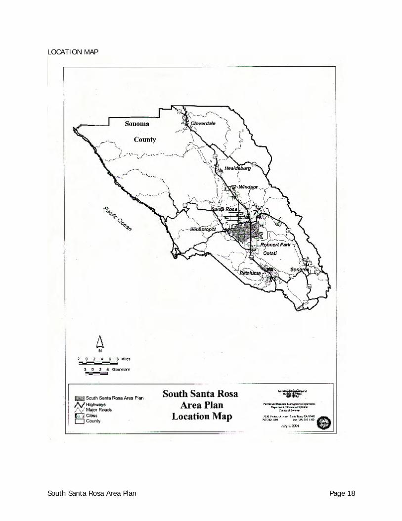
LOCATION MAP
South Santa Rosa Area Plan Page 18
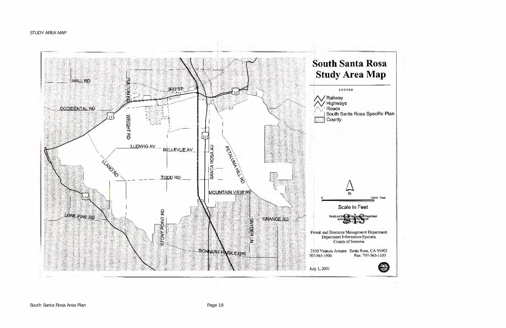
STUDY AREA MAP
South Santa Rosa Area Plan Page 19
Avoid amendments to include additional commercial or industrial use outside urban service areas, per General Plan Policy LU-14g.
(3) Ensure that land use decisions are made with concern for transportation and service
needs.
(4) Require improvements as a condition of approval of commercial or industrial development.
(5) Require new facilities to be designed to conserve energy.
ISSUE: HOUSING
Goal 1. Provide for an adequate mix of residential opportunities as to both cost and type.
Policies (1) Establish land use designations and inclusionary zoning, which promote housing
opportunities in areas where compatible with surrounding land use, and where transportation system and public services exist.
(2) Establish land use designations and zoning which allow mobile home subdivisions in areas where compatible with surrounding land uses, and where transportation system, and public service exist.
ISSUE: AGRICULTURE
Goal 1. Protect, maintain and support agricultural land uses and soils capable of supporting
agriculture.
Policies (1) Support programs insuring long term retention of agriculture, including agriculture,
including agricultural preserve contracts.
(2) Tailor appropriate land use categories and zoning to accommodate existing potential agricultural uses.
South Santa Rosa Area Plan Page 20
ISSUE: SCENIC RESOURCES
Goal 1. Protect, maintain, and enhance the vistas, landscapes and landscape features
throughout the Study Area.
Policies (1) Protect and maintain open scenic areas essential for defining the urban form of Santa
Rosa through use of scenic conservation easements.
(2) Protect the scenic areas within the study district which one is important for visual and psychological relief from Santa Rosa urban environment.
(3) Protect visually vulnerable landscapes, such as ridgelines and foothills.
(4) Use the established Design Review process for development of all lands east of Petaluma Hill Road.
(5) Require building and grading setbacks from riparian corridors to preserve ecological, agricultural and aesthetic values.
ISSUE: MINERALS
Goal 1. Protect the scenic and visual resources of hard rock quarries.
Policies (1) Support Aggregate Resource Management Study requirements for submission and
implementation of reclamation plans as part of the use permit process.
ISSUE: WILDLIFE RESOURCES
Goal 1. Ensure that biological diversity is preserved and restored for scenic and educational
value.
Policies (1) Establish riparian corridor setbacks along all water courses including the Laguna de
Santa Rosa.
South Santa Rosa Area Plan Page 21
(2) Establish development standards that allow water courses to remain in a natural
(unchanneled) state, planted with riparian species.
(3) Preserve and restore the ecological, recreational and aesthetic benefits of the Laguna de Santa Rosa, through land use and open space designations and restoration programs.
ISSUE: ROAD NETWORK
Goal 1. Establish a traffic ways system in which the function and design of each street or road is
consistent with the character and use of adjacent lands.
Policies (1) Establish appropriate design standards for roads and streets to ensure safe and efficient
traffic flow and pedestrian movement consistent with the General Plan Circulation and Transit Element.
(2) Set priorities for the timing of improvements for various roads and streets consistent with projected land uses.
(3) Coordinate the transportation plan with the Land Use Plan to achieve the Level of Service designated in the General Plan Circulation and Transit Element.
ISSUE: CIRCULATION AND TRANSIT
A. Transit Service
Goal 1. Provide transportation system that provides for the specific unmet needs of the socially,
economically, and physically disadvantaged.
Policies (1) Design the transportation system in such a manner that the elderly, the handicapped,
the youth, and the citizens of limited means will not be deprived of the opportunity to participate in a full range of human activity because of insufficient mobility.
South Santa Rosa Area Plan Page 22
ISSUE: BIKEWAYS
Goal 1. Promote increased bicycle use for transportation and recreation, wherever feasible
within the study area.
Policies (1) Integrate the needs of the bicycle users with transportation plans and road
improvements.
(2) Provide a plan acknowledging a safe and efficient bikeway system.
(3) Apply sound planning and engineering principles to the provision of bicycle facilities so as to acknowledge the abilities and limitations of the bicycle user.
Goal 2. Allow for the safe use of the bicycle as a means of transportation and recreation.
Policies (1) Establish bicycle routes between major recreation areas, residential areas and major
work centers.
(2) Encourage bicycle routes which are separate from automobile and pedestrian traffic.
(3) Integrate separate rights-of-way for bicycle routes into the design of new major streets and expressways.
(4) Provide for bicycle security in major parks, commercial areas, and work centers through Design Review and Public Project Review procedures.
ISSUE: OPEN SPACE
Goal 1. Preserve those areas within the study area which are designated unique habitat areas,
critical habitats, scenic landscape units, scenic corridors, riparian corridors, and hazardous areas which could provide for open space.
South Santa Rosa Area Plan Page 23
Policies (1) Establish development standards and development setbacks for those identified areas to
insure their continued preservation.
ISSUE: PARK LANDS
Goal 1. Provide adequate recreation facilities for both present and projected future populations.
Policies (1) Ensure that recreation facilities are compatible with adjacent land uses, the maintenance
of environmental quality, and the protection of property rights.
(2) Consider establishing coordinated urban and rural trail systems that connect parks, schools, playgrounds, shopping areas, and other public scenic areas.
(3) Ensure that those people who use publicly supported recreation facilities contribute toward the cost of providing and operating those facilities.
(4) Encourage the establishment of community and neighborhood recreation facilities.
(5) Coordinate the activities of all park systems, (state, county, city) to avoid duplication.
(6) Promote new trail systems for selected multiple use by pedestrians, bicyclists and equestrians.
(7) Promote the recreational use of natural and man-made streams, where compatible with land use and the private property rights of adjacent land owners, by providing trails for hiking, biking and horseback riding.
ISSUE: HISTORIC PRESERVATION
Goal 1. Preserve significant archaeologic and historic sites represent all the ethnic, cultural, and
economic groups that have lived and worked in Sonoma County.
Policies (1) Ensure adequate open space around historic buildings, areas of archaeological
significance, and other features important to the human history of the County, so that the natural settings of subareas are retained.
South Santa Rosa Area Plan Page 24
(2) Continue the established practices for identification, review, evaluation and protection of archaeologic sites.
(3) Recognize that historic sites, not only prehistoric sites, have archaeological importance; therefore, historic sites, whether or not they include standing structures, may merit preservation; care should be taken when preserving or otherwise modifying historic structures.
ISSUE: PUBLIC SAFETY
A. Geologic Hazards
Goal 1. Protect the public from danger to life and property caused by geologic and seismic
hazards.
Policies (1) Identify and publish maps identifying Geologic Hazards.
(2) Ensure that population densities and development are kept to a minimum in areas of
geologic hazards.
(3) Require geologic reports identifying unstable slopes and seismic hazards relating to building sites be written prior to the approval of a final subdivision map or the issuance of a build permit for areas identified as containing probable geologic hazards to safety.
B. Flood Hazards
Goal 1. Protect the public from danger to life and property caused by floods.
Policies (1) Restrict uses in 100-year floodplains to those that pose the least hazard to public health
and safety.
(2) Identify and publicize the existence of geologic hazards in locations where dams, ponds, and other impoundment areas exist or are proposed.
South Santa Rosa Area Plan Page 25
C. Fire Hazards
Goal 1. Protect the public from danger to life and property caused by fire.
Policies (1) Discourage residential development in regions having high or very high potential for
large wildland fires in the Public Safety Element of the General Plan.
(2) Encourage coordination and cooperation among all fire fighting agencies (City-County district and CDF).
D. Hazardous Materials
Goal 1. Protect the public from exposure to hazardous substances which may be present in soil.
Policies (1) Require preparation of a soils analysis prior to any development proposed within the
boundaries of the Urban Vision Plan unless clearance is received from the North Coast Regional Water Quality Control Board.
ISSUE: SCENIC HIGHWAYS
Goal 1. Protect, maintain, and establish scenic corridors in order to preserve the variety and
beauty of Sonoma County's landscapes for future generations.
Policies (1) Identify the corridors having the highest priority for preservation and enhancement.
(2) Coordinate scenic corridors with recreation bikeways and equestrian and foot trails.
(3) Connect points of cultural and recreational interest. Provide location, design, and
landscaping criteria for new development to be located in designated scenic corridors.
(4) Control the location, size, number, and design of signs in designated scenic corridors.
South Santa Rosa Area Plan Page 26
(5) Encourage the use of native plants for screening and landscaping in proposed development along designated scenic corridors.
(6) Discourage the location of new manufacturing and commercial facilities within designated scenic corridors, except in urban areas or where they are otherwise consistent with the character of scenic areas.
Goal 2. Plan and develop a scenic roadways system which will serve the transportation and
recreation needs of Santa Rosa Planning Area motorists, bicyclists, and pedestrians, while preserving and enhancing aesthetic resources along scenic corridors.
Policies (1) Conduct corridor studies for proposed scenic street extensions at the time plan lines are
developed.
(2) Conduct corridor studies for existing scenic roads before any reconstruction may occur to alleviate serious safety deficiencies.
(3) Defer routine reconstruction of scenic roadways until the appropriate corridor studies are completed.
(4) Reconstruct rural type scenic roads only to alleviate serious capacity or safety shortcomings.
(5) Modify existing environmental and design review procedures to include review of projects along designated scenic corridors and also review of construction or reconstruction of the scenic roadways themselves.
South Santa Rosa Area Plan Page 27

CONSTRAINTS AND MITIGATION MEASURES
NATURAL CHARACTERISTICS
GEOLOGIC HAZARDS
Mitigation Measures: Geology (1) Implement the Land Use Plan to insure that densities remain low in areas of public
hazard.
(2) Refer projects to a qualified geologist in order to determine when engineering geologic reports are necessary concerning the following discretionary actions: plan amendments, rezoning, use permits, minor subdivisions, design review permits, and gravel extraction permits and reclamation plans. Special attention should be paid to the "possibly active" fault zone which crosses the Roseland area.
(3) Continue to require geologic reports on single-family residence building permits in landslide areas in order to enforce the geologic provisions of Chapter 70 of the Uniform Building Code, 1976 edition.
Mitigation Measures: Minerals (1) Adopt reclamation plans for all hard rock quarry operations.
(2) Mining operations which use particular haul routes should contribute to their
maintenance.
Mitigation Measures: Groundwater (1) Continue implementation of the groundwater and drainage standards contained in the
Sonoma County Subdivision Ordinance.
(2) Consider specific mitigation measures such as recharge ponds, permeable surfaces, retention of open space by clustering of units. For all projects within the study district.
South Santa Rosa Area Plan Page 28
CULTURAL CHARACTERISTICS
TRANSPORTATION & CIRCULATION
Mitigation Measures: Roads (1) The following roads must be upgraded to the level indicated, to accommodate the
increases in Land Use provided for in this plan. Freeway. U.S. Highway 101 (6 lanes)
Principal and Minor Arterials. State Highway 12, Sonoma County Fairgrounds to Fulton Road (Rural Principal Arterial, 4 lanes), State Highway 12, Llano Road to boundary of South Santa Rosa Area Plan (Rural Principal Arterial, 3 lanes), Santa Rosa Avenue (Urban Principal Arterial, 4 lanes), Farmers Lane Extension (4 lanes), and Stony Point Road (Urban or Rural Principal Arterial, 4 lanes).
Major and Minor Collectors. Todd Road (Rural Major Collector and Minor Arterial), Llano Road (Rural Major Collector and Rural Minor Arterial), and Mountain View Avenue (Rural Major Collector).
Local Roads. West Avenue, Burbank Avenue, Wright Road, Colgan Avenue, Yolanda Avenue, East Todd Road (to existing easterly terminus), Bellevue Road, (between Corby, Moorland, and Dutton intersections), Dutton Avenue, Corby Avenue, Hearn Avenue, and Petaluma Hill Road.
(2) Improvements to roads within the City of Santa Rosa Urban Service Area should follow
the City of Santa Rosa General Plan and be consistent with city road classifications and design standards, unless these standards are less than County standards.
(3) The Board of Supervisors should establish a vehicle load limit ordinance on Moorland Avenue between Bellevue and Todd to preclude heavy truck traffic associated with nearby industrial developments from using this County road.
(4) Avoid the following unneeded road improvements:
Farmer's Lane extension being realigned from the Hearn Avenue connection south to Bellevue Avenue, including a new complete interchange with U.S. 101 at Bellevue Avenue.
Extension of Moorland Avenue south to South Santa Rosa Avenue in Rohnert Park. Any new major or secondary east/west routes through Roseland.
South Santa Rosa Area Plan Page 29
Mitigation Measures: Public Transit (1) Increase the frequency of bus service from one per hour to two per hour.
(2) Provide service along Dutton Avenue, where a substantial amount of medium and high
density development exists, and more is projected.
(3) Extend bus service to the two large industrial park employment centers (Oak Manor and Industry West) located between Hearn Avenue and Todd Road, west of Highway 101.
(4) Expand bus service to keep pace with urban level development: as lands are converted to urban uses, the bus service area should be increased.
NOISE
Mitigation Measures: Noise (1) Development shall comply with the standards and policies of the General Plan Noise
Element.
AIR QUALITY
Mitigation Measures: Air Quality (1) Both point source and cumulative traffic generated emissions should be evaluated for
potential adverse air quality impacts for any major developments and these developments should proceed only if the air quality impacts can be mitigated.
PUBLIC SERVICES AND FACILITIES
Mitigation Measures: Schools (1) School districts should consider adopting school impact fees, in order to fund additional
classrooms. The Board of Supervisors should implement the fee if so requested by the School Board.
Mitigation Measures: Fire Services (1) The plan recommends formation of an assessment district to fund the purchase of
special equipment.
South Santa Rosa Area Plan Page 30

CONCEPTUAL CIRCULATION MAP
South Santa Rosa Area Plan Page 31
HAZARDOUS MATERIALS
Mitigation Measures: Hazardous Materials (1) Require preparation of a soil analysis prior to any development proposed within the
boundaries of the Urban Vision Plan, unless clearance is received from the North Coast Regional Water Quality Control Board.
ENERGY RESOURCES
Mitigation Measures: Energy (1) Cluster rural residential development where feasible. The Land Use and Zoning Plans
allow for small minimum lot sizes while proposing an overall density.
(2) Design and orient houses to take advantage of solar exposure.
(3) Minimize window areas on north-facing walls and maximize windows on south-facing walls.
(4) Encourage double-glaze windows and glass doors to reduce heat loss during the winter.
(5) Use insulation and weather-stripping to reduce the dependence upon air conditioning and heating. Provide additional insulation on north-facing walls.
(6) Use solar heating where feasible.
(7) Maximize natural lighting.
(8) Landscape with deciduous trees along south-facing walls to shade south walls during the summer and to permit solar heating in the winter.
(9) Educate the general public about programs such as the "Sun Therm Home Design and Solar Hot Water Heating" programs available through Pacific Gas and Electric Company.
(10) Adopt road widths and standards for rural developments that reduce the amount of petroleum products utilized for construction.
(11) Support and encourage transit and car-pool programs.
South Santa Rosa Area Plan Page 32
CULTURAL RESOURCES
Mitigation Measures: Archaeological Sites (1) Refer to the Archaeological Sensitivity Map for the study area during the planning phase
of major projects.
(2) Refer all discretionary actions, zone changes, subdivisions, use permits, public projects, etc. to the Regional Office, California Archaeological Site Survey at Sonoma State University to ascertain probability of disturbing archaeological resources.
(3) Require an archaeological field survey for projects found to have a high probability of disturbing archaeological resources.
South Santa Rosa Area Plan Page 33
LAND USE PLAN
GENERAL COMMENTS The South Santa Rosa Land Use Plan is designed to accommodate the County's General Plan projection of population to the year 2005. Land Use categories found in the Sonoma County General Plan are used to emphasize the continuity between the General Plan and this Area Plan. The South Santa Rosa Land Use Plan is shown on the Land Use Plan and Enlargement Maps. Because urban development is projected in parts of the Study area that do not now have sufficient public services, zoning recognizes this limitation as an interim condition. Thus, for instance, areas proposed for urban residential densities are initially recommended for zoning to the Rural Residential district at low densities. Upon provision of public services necessary to achieve the urban densities proposed in the Land Use Plan, rezonings will be appropriate as project proposals are presented for necessary actions.
LAND USE POLICY
Land Use Plan Categories The Land Use Plan designates different land use categories. These categories are described below:
RESOURCES AND RURAL DEVELOPMENT (RRD) This land is characterized by low intensity of human use and includes the mountainous area not predominantly used for agriculture except for such extensive activities as grazing. Residences are related primarily to the resource use of the land; they are scattered at a very low density throughout the area.
LAND EXTENSIVE AGRICULTURE (LEA) Lands characterized predominantly by dairies and related activity are classified as Land Extensive Agriculture. Included are lands used for silage, dairy grazing, and various animal raising and breeding activities. Lands owned by the City of Santa Rosa and used exclusively for land disposal of treated waste water are also found in this land use category. Residences are related to the agricultural economy and include single family homes, mobile homes, and farm labor housing. Residential densities more intensive are uncommon because dairies generally require parcels of at least 100 acres for economical operation.
South Santa Rosa Area Plan Page 34
DIVERSE AGRICULTURE (DA) Areas characterized by a predominance of agricultural uses on smaller lots are classified as Diverse Agriculture. Preservation of agriculture is the highest priority in these areas, but achieving this preservation is difficult because of nearby residential development and the number of existing small buildable parcels. Overall residential densities range from 10 to 20 acres per dwelling unit. The overall density generally results from a combination of large agriculture parcels with clusters of small parcels.
RURAL RESIDENTIAL (RR) Low Density Residential development that has generally precluded large scale commercial agriculture is classified as Rural Residential. The residential density ranges generally from one to five acres per dwelling unit affording a "country" lifestyle with enough land for home gardens and maintaining a few animals.
URBAN RESIDENTIAL (UR) The Urban Residential category allows densities ranging from five to fifteen dwellings per acre as depicted on the Land Use Plan Map. The General Plan Housing Element designates all lands with an Urban Residential land use category and a density of 4 units per acre or greater as potential Housing Opportunity Areas. Projects in these areas which are consistent with the Housing Element programs and policies are considered consistent with the land use designations in this Area Plan. This category is intended to accommodate either existing or potential mobile home parks at six or seven dwelling units per acre or multi-residential units ranging from duplexes to multiple units generally at a density of 10 units per acre. Where this land use category has been applied to contiguous large parcels (over 10 acres), its intended that they should be developed in such a way that local government can secure dedications for needed park sites and major street improvements.
LIMITED COMMERCIAL (LC) The purpose of the Limited Commercial category is to provide areas for local convenience shopping.
GENERAL COMMERCIAL (GC) This category provides sites for intense commercial uses which serve a mix of business activities and the residential and business community as a whole rather than local residents. These uses provide for comparison shopping and services which are ordinarily obtained on occasional rather than daily basis. This category is also intended to provide opportunities for a mix of residential and commercial uses in urban areas.
South Santa Rosa Area Plan Page 35
LIMITED INDUSTRIAL (LI) This category is intended to accommodate a variety of light industrial in combination with heavy commercial land uses including such uses as automobile sales and service establishments, mobile home sales and service establishments, cabinet shops, truck terminals, contractors yards, landscaping materials yards, light assembly plants, and light distributing plants.
GENERAL INDUSTRIAL (GI) The General Industrial category is intended to accommodate heavy industrial land uses, such as manufacturing and processing plants.
PUBLIC - QUASI PUBLIC (PQP) The Public/Quasi-Public category has been applied to all sites of existing schools and fire stations. It is also applied to certain other publicly owned property.
Urban Reserve The Citizen's Advisory Committee felt that it was appropriate to identify areas suitable for urban expansion beyond that which is anticipated by the present General Plan. Such new areas would require the full range of urban services and facilities (e.g. sewer, water, roads). These areas are designated on the Land Use Plan as Urban Reserve because of existing parcel sizes and proximity to existing or proposed urban development. The Urban Reserve designation is a recommendation that these lands be given priority over other areas when urban expansion is considered. The development of areas designated "Urban Reserve" is dependent upon the following: (1) The provision of urban facilities and public services including public sewer and water.
(2) A planning study (Area Plan Amendment) which establishing precise land use
designations, zoning, circulation patterns, and other planning features necessary for full urban development.
(3) An environmental impact report which addresses the effects of development to be accommodated in each Urban Reserve area.
(4) An amendment to the Sonoma County General Plan and to the City of Santa Rosa General Plan reflecting the precise land uses recommended by the planning studies prepared for each Urban Reserve area.
(5) Parcel sizes remaining sufficiently large to more readily accommodate future urban development.
South Santa Rosa Area Plan Page 36
(6) That interim uses of the property do not preclude future urban development.
Cottage Industries During discussions, a proposal was presented to amend the County's Zoning Ordinance to permit a new use defined as a Cottage Industry. The intent would be to permit something more than a "home occupation," as presently defined in the County's Zoning Ordinance, in the Agricultural and Rural Residential Zoning Districts. The Citizen's Advisory Committee's proposed definition and regulation is contained in Appendix C. Since such an amendment would affect zoning countywide, the proposal is brought forward in this study only as a recommendation for consideration by the Planning Commission and Board of Supervisors. Such consideration would be appropriate during upcoming hearings on the comprehensive amendments to the County's Zoning Ordinance.
PUBLIC SERVICE POLICY
General Comments The South Santa Rosa area inherited a legacy of urban development approved over a long time span. Individual projects were approved, without full consideration of the overall impact that project would have in conjunction with other individual project approvals. Consequently, the County has not been able to meet the demand for public services and facilities. Service problems include -- inadequate road improvements, lack of appropriate traffic signalization and control, scattered street lighting districts, and poorly prepared or incomplete drainage systems. Notable problem areas include Sebastopol Road, Dutton Avenue, and Santa Rosa Avenue. There are also areas where a high intensity of commercial development or high density residential has taken place. Notable exceptions to the generally deficient public services are the high quality service rendered by the fire protection districts and the school districts and a relatively recent significant improvement in police protection through the County Sheriff's Office. In the 1980's and the 1990's the challenge to local government will be to not only improve services where they are deficient, but to see that urban development does not outstrip its fiscal capability to provide the necessary infrastructure. It will therefore be very important to coordinate development approvals compatible with public service capabilities.
Public Service Assessments and Fees In recent efforts to address the problem of inadequate public facilities the Board of Supervisors created a road improvement assessment district related to the commercial industrial developments west of Highway 101 between Hearn Avenue and Todd Road. This assessment district was to improve roads to widen roads where necessary, and to install signalization at key intersections. However, this effort to date has fallen short of its original intent and only minimal road improvements are now anticipated through this assessment district. Nevertheless, assessment districts appear to be the most readily available tool for local government to attack the problem of deficient road conditions.
South Santa Rosa Area Plan Page 37
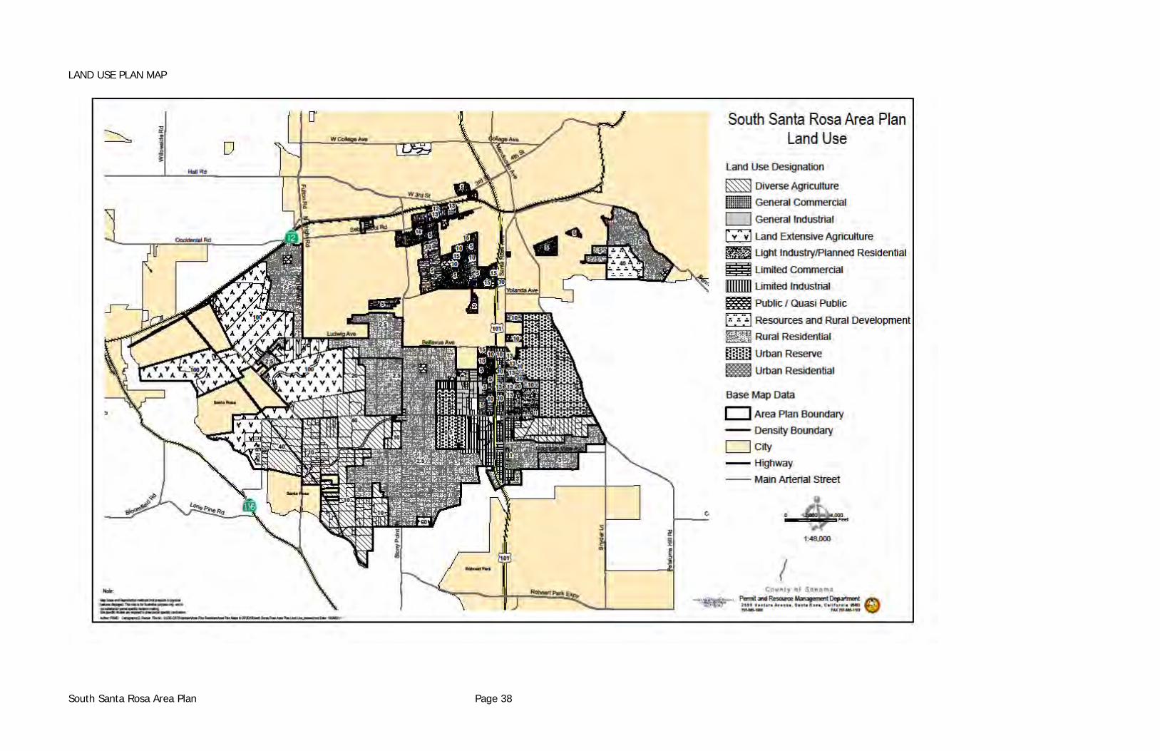
LAND USE PLAN MAP
South Santa Rosa Area Plan Page 38
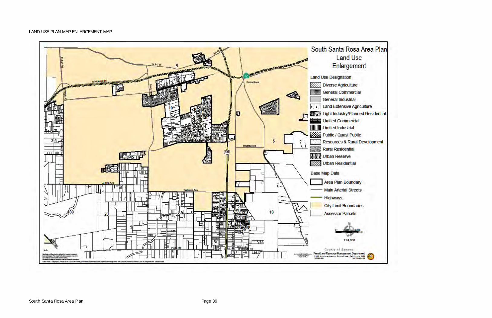
LAND USE PLAN MAP ENLARGEMENT MAP
South Santa Rosa Area Plan Page 39
Policy: The Board of Supervisors should initiate additional assessment districts for improvements on Sebastopol Road and Santa Rosa Avenue, and the Director of Planning, the Director of Public Works. County Counsel should be directed upon the adoption of this plan to commence the necessary proceedings to form the road assessment districts for these major streets. In the interim period, the County should approve urban developments only when it is assured that the full range of public service infrastructure is adequate to serve the project. In the main this means adequate roads and drainage capacities for the cumulative traffic generation, and the availability of public sewers and an adequate public water supply. Proposed drainage improvements are shown on the Drainage Improvements Map on page 43.
Fire Protection In addition to assessment districts it appears necessary to consider and adopt an impact fee for heavy commercial and industrial development to provide special fire fighting apparatus. Policy: The Board of Supervisors should direct County Counsel to meet with appropriate representatives of the affected fire districts to determine what specific equipment is needed, its cost, and the method of establishing an appropriate benefit assessment to be applied to commercial and industrial developers.
Sewer Service Public sewer service will be provided by either the South Park Sanitation District (County), or from the City of Santa Rosa. The outlook at the time of this study for the formation of new sewer assessment districts is not good. Sometime during the planning period it is anticipated that the South Park Sanitation District will reach its contracted treatment capacity. This circumstance is monitored by the City of Santa Rosa as the lead agency in a joint powers agreement for use of the Laguna Treatment Plant facilities. As the time approaches when the South Park District exhausts its contracted capacity, the County will have to enter negotiations with other members of the joint powers agreement, principally the City of Santa Rosa, to determine a course of action to continue providing this service to its district members. Sufficient entitlement to treatment plant capacity remains to accommodate the development proposed within the South Park Sanitation District by the Land Use Plan. Policy: The Board of Supervisors should direct the Director of Public Works to keep it apprised of this situation on an annual basis.
Water Service Development in the South Santa Rosa Study Area is served by two sources of water; individual wells using the groundwater supply and the City of Santa Rosa Public Water Service. The City of Santa Rosa is in a much better position to meet water service needs for the study area than it is for public sewer service. The major shortcoming at this time is that public water service extends only approximately eight-tenths of a mile south of Hearn Avenue, along Santa Rosa
South Santa Rosa Area Plan Page 40
Avenue and there is existing and proposed development for the entire length of Santa Rosa Avenue. The most important improvement appears to be public water service southward on Santa Rosa Avenue to Todd Road, a distance of some three miles. Obviously it would be too costly for a single developer to pay for the entire project. Thus, it will require a concerted effort by public officials and affected private property owners to bring this water service southward to Todd Road. Policy: The Board of Supervisors should direct the County Public Works Director and County Counsel to initiate discussions with the City of Santa Rosa and affected property owners to form an assessment district or determine some other legal device to provide this public service.
CONVENTION FACILITY EXPANSION The El Rancho motel and convention center facility on Santa Rosa Avenue is the County's largest available convention center. To the rear and east of this facility and extending to Petaluma Hill Road, is an area largely undeveloped. In connection with an annexation of this property to the City of Santa Rosa, consideration should be given to the need for expansion of the existing convention facilities and an overall development plan of uses not incompatible with surrounding land uses.
BROOKS AVENUE AREA Consistent with General Plan Policy LU-16h, the following statements shall be the policy of the Board of Supervisors regarding urban development of the Brooks Avenue Area (see the Brooks Ward Area Map on page 44). (1) The County General Plan's urban boundary, for the Brooks Avenue area, will be retained
in the South Santa Rosa Area Plan.
(2) The Brooks Avenue area will be designated Light Industrial/Planned Residential on the Land Use Plan of the South Santa Rosa Area Plan.
(3) To identify the precise uses permitted and the circumstances under which development may proceed, a comprehensive master plan and environmental impact analysis for the Brooks Avenue area will be prepared at the developer's expense for consideration for approval.
(4) The master plan and environmental impact analysis will evaluate the impacts on and mitigations for public sewer, public water, roads, drainage, fire protection, police protection, lighting and parks and recreational facilities and recommend a schedule of improvements to be provided by the developer.
South Santa Rosa Area Plan Page 41
(5) The land uses considered in the master plan will be limited to those light industrial, commercial or residential uses which generate low amounts of sewage effluent. The South Park Sanitation District will establish a specific ceiling on the amount of effluent to be generated.
(6) The precise development plan will be the basis for any needed rezoning. Until this rezoning takes place, the area will be zoned RR-B8 as an interim zone.
(7) No new development, other than single family homes on existing lots, will be permitted until adoption of the master plan, rezoning of the area, completion of any necessary annexation and/or assessment district formation and recordation of any necessary legal documents.
(8) No new non-residential development will be approved for occupancy until sewer mains have been extended to Bucks, Brooks and Ward Avenues, thus enabling existing residential dwellings to connect to sewer. The Department of Public Works will structure appropriate agreements to insure that sewer extension will be so funded as to insure that resident homeowners will be allowed to connect their residences to sewer after paying only costs for lateral piping and SPCSD charges/fees, and to insure that no public subsidies or grants are required.
(9) A 150' setback strip along the Eastern edge of the Brooks Avenue area is established to act as a buffer zone for agricultural lands to the east, unless a greater buffer zone is required to meet the standards of the Zoning Ordinance.
South Santa Rosa Area Plan Page 42
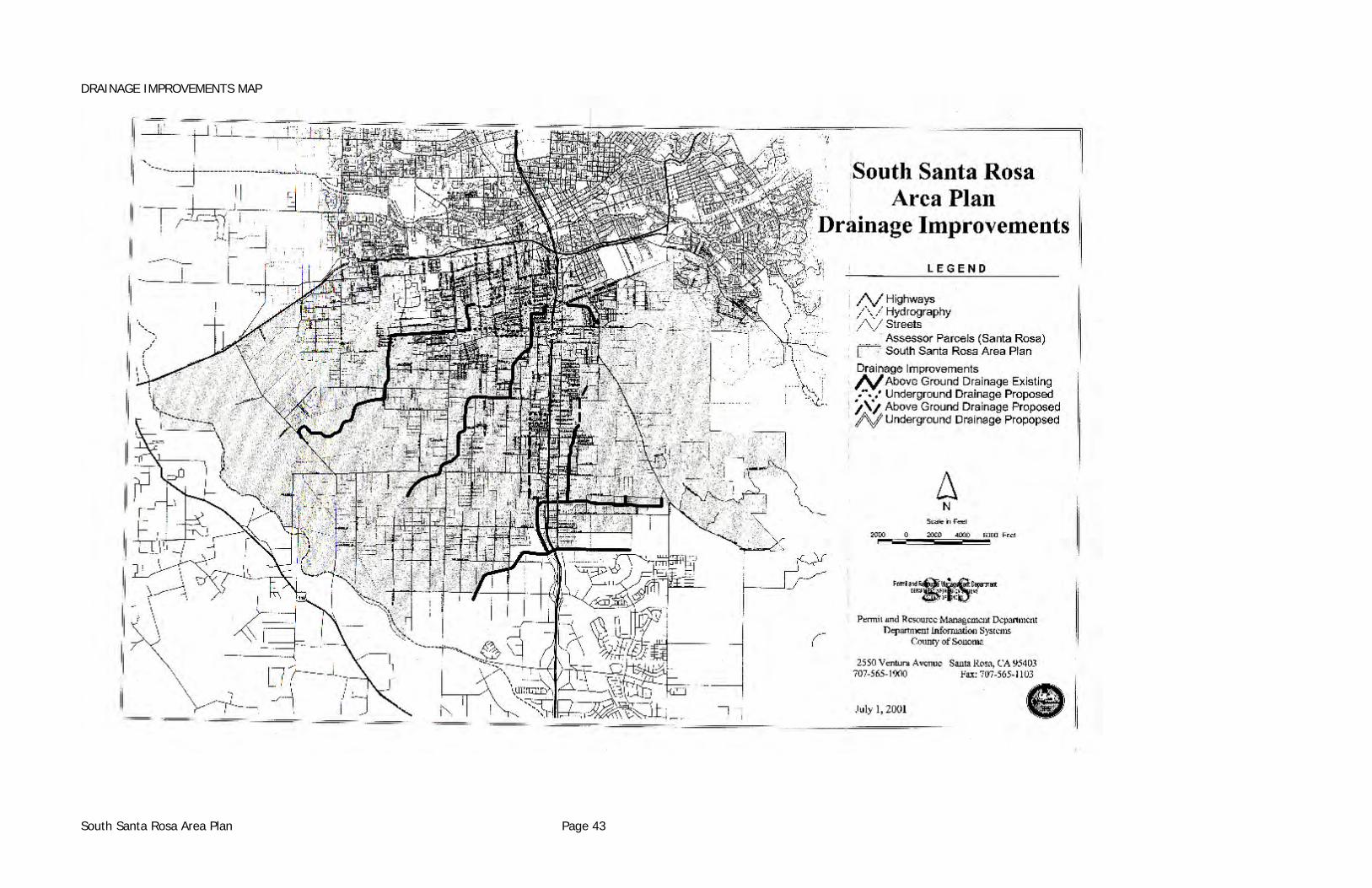
DRAINAGE IMPROVEMENTS MAP
South Santa Rosa Area Plan Page 43
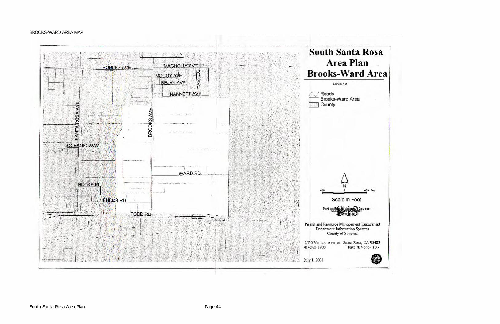
BROOKS-WARD AREA MAP
South Santa Rosa Area Plan Page 44
URBAN DESIGN
BACKGROUND
Statement of Issues Past trends in land use and zoning have resulted in a mixture of commercial, industrial, and residential uses with uncoordinated site development and architectural standards along the major routes such as Santa Rosa Avenue and Sebastopol Road. Over the years, the U.S. 101 corridor has taken on the same look. The majority of new uses along these routes are considered commercial or industrial and are required to obtain architectural and site plan approval from the Design Review Committee. However, because previous development was sporadic and unrelated and because design review occurs on a parcel by parcel basis (at the time of development), it is difficult to establish overall design themes for the various types of development along these routes. The adoption of the County and the City General Plans has established guidelines defining the type and location of various commercial and residential land uses. The land use and zoning elements developed for the South Santa Rosa Specific Plan will further define the types and locations of development at a parcel specific level. As this plan is implemented various residential neighborhoods and business districts will begin to emerge with separate and distinct characteristics. Another key objective is to strengthen the image and visual attractiveness of major movement corridors like U.S. 101, Santa Rosa Avenue, and Sebastopol Road. Along Sebastopol Road the design standards contained in the Urban Vision Plan are intended to enhance the business district in and around the Roseland Village Shopping Center as well as the commercial uses which adjoin the Sebastopol Road corridor. The establishment of design standards is an essential step to development of a sense of neighborhood identity and visual cohesion, in addition to compatibility of land uses. Design standards take the form of special building setback requirements, height limitations, landscaping and street tree programs applied to an entire neighborhood, business district or street corridor. The Public Works Department has developed a concept for a 72 foot right-of-way (face of curb to face of curb) for Santa Rosa Avenue consisting of two traveling lanes in each direction, one continuous center lane for left turns and two parking lanes. This concept provides the engineering framework for development of the street. Landscaping, variation in paving materials, pedestrian circulation, bikeways, lighting and street furniture must be integrated within this framework.
South Santa Rosa Area Plan Page 45
IMPLEMENTATION In the absence of a funding mechanism, implementation will be a slow, incremental process; improvements to public rights-of-way will occur in stages. Individual property owners will improve sections of the street and install the landscape materials as properties are developed. The design standards will be administered, for both public and private projects, by the Design Review Committee.
RECOMMENDATIONS (1) Establish a benefit assessment district to aid in the timely construction of road
improvements including the various design elements within the public right-of-way.
(2) Building permits, zoning permits, design review or use permits for projects shall comply with the provisions of this chapter.
(3) The design standards, for both public and private projects shall be administered by the Design Review Committee.
(4) Building lines shall be shown on the adopted zoning ordinance, reflecting the special yard setbacks from Santa Rosa Avenue, Sebastopol Road, U.S. 101, and State Highway 12.
GENERAL STANDARDS: RETAIL AND NEIGHBORHOOD COMMERCIAL SITES
Setbacks a. Front: Minimum of 20 feet from property line. b. Side: Minimum of 10 feet from property line adjacent to residential development. c. Rear: Minimum of 20 feet from property line adjacent to residential development. d. No structure of any kind and no part thereof shall be placed on any site closer to a
property line than is provided in this Section. The following structures and improvements are specifically excluded from these setback provisions:
i. Roof overhang and support buttress, and wing walls, subject to the specific
approval by the Design Review Committee, but not to exceed six (6) feet into the side and rear yards or three (3) feet into the front setback area;
ii. Steps, walks, and open or enclosed stairways;
South Santa Rosa Area Plan Page 46
iii. Paving and associated curbing, except that vehicle parking areas shall not be
permitted within twenty-five (25) feet of street property line; iv. Landscaping; v. Planters, not to exceed three (3) feet in height;
vii. Displays identifying the owner, lessee, or occupant, subject to the specific approval of the Design Review Committee.
Buildings a. Buildings on streets of high pedestrian use should be directly accessible from the
sidewalk. b. Buildings on streets with heavy traffic including those with no on-street parking shall
provide a major entry from the off-street parking area. c. All new buildings shall be oriented to the street, with parking to the sides or to the rear
of the buildings. d. The design elements in the retail business including street furniture, landscaping and
signs shall relate to pedestrian scale. e. Use of metal buildings shall generally be discouraged in retail and neighborhood
commercial areas unless specifically approved by the Design Review Committee subject to compliance with the standards of Section 6.31.
Parking a. Parking lots and driveways shall be designed so as to provide maximum common access
and use by businesses on adjacent parcels, reducing the amount and the cost of pavement and curb cuts.
b. The maximum distance from an off-street parking space to the building(s) it is
designated to serve shall be 300 feet. c. Parking lot design shall conform to the standards provided in Chapter 26 of the Sonoma
County Code (the County Zoning Ordinance) except that twenty percent (20%) of all parking spaces shall be designed for compact cars (dimension: 8' x 16') in lots of ten (10) or more spaces.
Provisions for Handicapped a. A minimum of two spaces per parking lot shall be designed for use by physically
handicapped people, or at least one space per 20 cars, whichever is greater.
South Santa Rosa Area Plan Page 47
b. These spaces shall be placed as close as possible to a major entrance of a building or
function. c. Design of parking spaces for the handicapped shall comply with the criteria outlined in
Barrier-free Site Design, U.S. Department of Housing and Urban Development, 1975. d. Curb cuts shall be installed at changes in the grade from sidewalks to parking areas. e. To aid in access for the handicapped, six foot (6') wide ramps with 32 inch handrails
with 12 inch overhangs at the ends and a curbing along one side should be considered as an alternative to stairs where the gradient can be limited to 8 percent maximum.
Bicycles a. Bicycle parking shall be provided at a rate based on the number of automobile parking
spaces as follows: NUMBER OF AUTOMOBILE MINIMUM NUMBER OF BICYCLE PARKING SPACES PARKING SPACES 0-30 5 31-60 10 61-Over 15 b. When designing or locating bike parking areas, the following items shall be considered:
i. Secure stanchions shall be provided. That is, the stanchions should allow the bicycle frame rather than a wheel alone be anchored.
ii. Stanchions shall be located in areas where there is constant visual supervision. iii. Parking areas shall be out of pedestrian pathways.
iv. Parking areas shall be conveniently located near cyclist destinations, adjacent to main entries where possible.
Miscellaneous a. On-site electrical, telephone and other utility lines shall not be exposed on the exterior
of buildings. b. Utility meters, transformers, electrical and mechanical equipment and trash containers
must all be screened. c. No materials, supplies, or equipment, including company owned or operated trucks and
motor vehicle shall be stored in any area on a site except inside a closed building or
South Santa Rosa Area Plan Page 48
behind a visual barrier screening such areas from view of adjoining properties or public streets and such barrier shall be at least six (6) feet in height.
Landscaping a. Every site on which a building is placed shall be landscaped according to plans approved
by the Design Review Committee and maintained thereafter in a slightly and well-kept condition.
b. The property owner, lessee or occupant shall landscape and maintain unpaved areas
between the street curb line and the property line adjoining any street. c. The property owner, lessee or occupant shall landscape and maintain unpaved areas
between the property lines and the setback lines. The first twenty feet (20') of the setback from street property lines shall be used exclusively for landscaping except for walks and driveways bisecting the required landscape area or as otherwise specified in this chapter.
d. Automatic sprinkler systems, hose bibs, and maintenance facilities shall be provided in
the landscaped areas. e. An equal area to a minimum of twenty percent (20') of the parking and driveway area
shall be landscaped with trees sized 15 gallons (minimum) and shrubs sized 5 gallons (minimum).
f. Tree wells and planting areas within parking lots are required to be protected from
automobiles by curbing. g. Low groundcover may be used in curbed planting areas along the edges of parking lots
in place of wheelstops to decrease the amount of paving and increase landscaping. h. Pedestrian walkways shall be provided in parking lots along with striped pavement to
minimize conflicts between pedestrians and automobiles. i. Evergreen canopy shade trees shall be provided in parking lots at the rate of one tree
per each six (6) spaces. j. All required yards/setbacks shall be landscaped. k. Street trees shall be planted at a rate of one tree per each 25 linear feet of frontage. l. The project applicant shall, prior to the issuance of a building permit, secure a bond or a
certificate of deposit (in a form acceptable to the Design Review Committee) of an amount sufficient to insure the installation of the approved landscape and irrigation systems.
m. Project landscaping shall comply with the General Plan Water Resources Element policies
relative to water conserving landscaping and stormwater retention.
South Santa Rosa Area Plan Page 49
Signs a. All signs are subject to review and approval of the Design Review Committee. b. A sign program shall be submitted for review and approval as part of the "final" design
review application. c. Size, height, location and materials for signs and graphics shall be compatible with
building design and site planning shall relate to building and site design. d. There shall be no signs on windows or entry areas visible to the outside except that 3/4
inch letters maximum identifying a use and the hours of operation may be located on a glass door or on a window adjacent to a door if specifically approved by the Design Review Committee.
e. The primary form of signing shall be as follows:
i. For internally illuminated signs: individual letters attached to the building (cabinet signs may be permitted, provided that the cabinets are an integral design element of the structure).
ii. For non-illuminated signs: Signs attached to the building, building facia or
suspended from the edge of a pedestrian arcade. f. Detached directional sign boards will be encouraged:
i. For the identification of a building group such as a shopping center or professional office complex.
ii. To direct users to businesses not visible from a main street. Such a sign shall be
located at the intersection of the main street and the driveway leading to the site. Ten foot square maximum sing area per use. Forty square feet overall maximum area. Such signs require use permit approval.
iii. In instances where attached sign would be ineffective due to: A) the location of
the building; B) the location of other buildings or structures on or adjacent to the site; C) tree locations; D) topography or other natural features.
g. A detached sign shall only be considered for approval when it functions as an integral
part of architectural and site design.
i. Detached signs shall not exceed 12 feet in height and 40 square feet in area. Higher signs will be less visible because of street trees.
ii. For internally illuminated cabinet signs, the letters shall be translucent over the
background. Internal illumination of cabinet signs shall use low intensity lamps.
South Santa Rosa Area Plan Page 50
Specifications for illumination shall be submitted to the County for Design Review and approval.
h. Signs shall be non-moving. The County Zoning Ordinance does not permit flashing
lights, rotating parts, banners or streamers to be used as signs.
Lighting a. In addition to the following standards, projects shall comply with General Plan policies
for outdoor lighting.
i. On-site lighting shall be scaled to insure safety as well as convenient pedestrian movement.
ii. Lighting fixtures shall be designed to accept sodium vapor globes, for a "warm
lighting" effect that is energy efficient. iii. Lighting should be designed to enhance the architectural features of the building.
iv. All lighting shall be shielded to prevent glare onto streets and adjacent properties.
v. Specifications of lighting fixtures and shields shall be submitted along with a plan
which details the location and direction of lights for review and approval of the Design Review Committee as part of the application process.
vi. Lighting shall be an integral part of the architecture and landscape design.
vii. Fixtures should be placed so that light patterns overlap at a height of seven feet, which is sufficiently high to illuminate a person's body vertically. This is a particularly important consideration now that lighting fixture manufactures are designing luminaries with highly controlled light patterns.
viii. At hazardous locations such as changes of grade, lower level supplemental
lighting or additional overhead units should be used.
ix. Where low-level lighting (below 5 feet) is used, fixtures should be placed so that they do not produce glare. Most eye levels occur between three feet, eight inches (for wheelchair users) and six feet for standing adults.
x. Posts and standards along thoroughfares should be placed so that they do not
present hazards to pedestrians or vehicles.
xi. Another consideration is the use of shatter-proof coverings on low-level lighting where there is a change of breakage.
b. When walkway lighting is provided primarily by low fixtures, there shall be sufficient
peripheral lighting to illuminate the immediate surroundings. Peripheral lighting
South Santa Rosa Area Plan Page 51
provides for a better feeling of security for individuals because they can see into their surroundings to determine whether passage through an area is safe. Such lighting should be approached from one of two ways:
i. By lighting the area so than an object or a person may be seen directly, or ii. By lighting the area to place an object or a person in silhouette. c. The height range, to maximum height for light standards is as follows: i. Roadways: 15 to 30 feet maximum ii. Walkways, parking lots and driveways: 10 to 15 feet maximum iii. Low level lights, "Mushroom" lights, up lights: 3 feet maximum
GENERAL STANDARDS: INDUSTRIAL/COMMERCIAL SITE
Setbacks a. Front: Minimum of 20 feet from the property line. b. Sides: Minimum of 10 feet from the property line adjacent to residential development. c. Rear: Minimum of 20 feet from the property line adjacent to residential development. d. No structure of any kind and no part thereof shall be placed on any site closer to a
property line than is provided in this Section. The following structures and improvements are specifically excluded from these setback provisions:
i. Roof overhang and support buttress and wing walls, subject to the specific
approval by the Design Review Committee, but not to exceed six (6) feet into the side and rear yards or three (3) feet into the front setback area;
ii. Steps, walks and open or enclosed stairways;
iii. Paving and associated curbing, except that vehicle parking areas shall not be permitted within twenty-five (25) feet of street property lines;
iv. Landscaping; v. Planters, not to exceed three (3) feet in height;
vi. Railroad spur tracks, switches and bumpers, provided that the location of such tracks, switches and bumpers is specifically approved by the Design Review Committee;
vii. Displays identifying the owner, lessee or occupant, subject to the specific
approval of the Design Review Committee.
South Santa Rosa Area Plan Page 52
Buildings a. Metal buildings shall incorporate the following:
i. A continuous facia shall be used to screen a typical pitched roof design as well as to screen mechanical equipment located on the roof.
ii. Contrast colors and accent materials shall be incorporated into the building
design subject to approval of the Design Review Committee.
iii. All new buildings shall be oriented to the street, with parking located to the side or to the rear of the building.
Parking a. Off-street parking shall be provided for each lot or site sufficient for automobiles of
employees and customers and other vehicles used in the conduct of the business so that all parking shall be entirely within the lot or site. Building and structures shall be designed and placed upon the property so that the loading and unloading of materials or supplies for the business conducted thereon shall be entirely within the property lines of the lot or site. Parking area shall be paved and shall be laid out and constructed according to plans approved by the Design Review Committee and shall be maintained thereafter in good condition. The intent of this provision is to eliminate the need for any on-street parking. If parking requirements increase as a result of a change in use or number of employees, additional off-street parking shall be required to satisfy the intent of this section.
b. Minimum Parking Requirements
i. Provisions shall be made for one (1) parking space for each person employed on the site and in no event shall there be less than one (1) parking space for each five hundred (500) square feet of floor space in manufacturing areas, and not less than one (1) parking space for each one thousand (1000) square feet of floor space in storage areas contained in any building site, and one (1) parking space for each two hundred seventy five (275) square feet of gross office floor area contained in any building on the site, and not less than one (1) parking space for each two hundred (200) feet of gross floor space allowed retail sales and customer service uses.
ii. One loading space shall be supplied for each five thousand (5,000) square feet
or portion thereof of any warehouse or storage use whether or not said warehouse use is the primary use or accessory to a different use. Loading docks shall not be closer than seventy-five (75) feet to the street property line unless specifically approved by the Design Review Committee.
iii. No public street shall be used for the parking or standing of any trucks or
passenger vehicles. iv. All parking must be located to the rear or to the sides of buildings.
South Santa Rosa Area Plan Page 53
v. All parking lots must be paved.
vi. No truck loading docks or doors are permitted on the front of buildings. Such docks or doors shall be located at sides or rears of buildings. This requirement also applies to rail siding facilities.
c. Provisions for Handicapped
i. A minimum of two spaces per parking lot shall be designed for use by physically handicapped people or at least one space per 20 cars, whichever is greater. These spaces shall be placed as close as possible to a major entrance of a building or function.
ii. Design of parking spaces for the handicapped shall comply with the criteria outlined
in Barrier-free Site Design, U.S. Department of Housing and Urban Development, 1975.
iii. Curb cuts shall be installed at changes in the grade from sidewalks to parking areas.
iv. To aid in access for the handicapped, 6 foot wide ramps with 32 inch handrails with
12 inch overhangs at the ends and curb along one side should be considered as an alternative to stairs where the gradient can be limited to 8 percent maximum.
d. Bicycles i. Bicycle parking areas for employees is encouraged. ii. If provided the following criteria shall apply to design.
1. Secure stanchions shall be provided. That is, the stanchions should allow the bicycle frame rather than a wheel alone be anchored.
2. Stanchions shall be located in areas where there is constant visual
supervision. 3. Parking areas shall be out of pedestrian pathways.
iii. Parking areas shall be conveniently located near cyclist destinations, adjacent to main entries where possible.
Miscellaneous a. On-site electrical, telephone and other utility lines shall not be exposed on the exterior of
buildings. b. Utility meters, transformers, electrical and mechanical equipment, and trash containers must
all be screened. c. No materials, supplies, or equipment, including company-owned or operated trucks and
motor vehicles shall be stored in any area on a site except inside a closed building or
South Santa Rosa Area Plan Page 54
behind a visual barrier screening such areas from the view of adjoining properties or public streets, and such barrier shall be at least six (6) feet in height.
Landscaping a. Every site on which a building is placed shall be landscaped according to plans approved
by the Design Review Committee and maintained thereafter in a slightly and well-kept condition.
b. The property owner, lessee or occupant shall landscape and maintain unpaved areas
between the property lines and the setback lines. The first twenty (20) feet of the setback from street property lines shall be used exclusively for landscaping except for walks and driveways bisecting the required landscape area or as otherwise specified in this chapter.
c. Automatic sprinkler systems, hose bibs, and maintenance facilities shall be provided in
the landscaped areas. d. The project applicant shall, prior to the issuance of a building permit, secure a bond or a
certificate of deposit (in a form acceptable to the Design Review Committee) of an amount sufficient to insure the installation of the approved landscape and irrigation systems.
e. The area shall be either in sod or other approved landscape materials that minimize
water use. Fifteen (15) gallon trees shall be a part of all landscape plantings. f. In general, approved fencing or screening of outside storage (vehicles, equipment,
materials), when permitted, shall be of a height which exceeds the height of the objects to be screened by at least two (2) feet.
g. No walls greater than three and one half (3.5) feet high shall be located within the
setback area paralleling a street right-of-way. h. No excavation shall be made except in connection with construction of improvements
and, upon completion thereof, exposed openings shall be backfilled and disturbed ground shall be graded and leveled.
I. No fence, wall, hedge, mass planting, or other barrier shall be allowed to extend beyond
the street setback lines established herein except upon arrival of plans and specifications by the Design Review Committee.
j. Project landscaping shall comply with the General Plan Water Resources Element policies
relative to water conserving landscaping and stormwater retention.
Signs a. All signs shall be subject to review and approval of the Design Review Committee. b. A master plan for signs shall be submitted as part of the final Design Review application.
South Santa Rosa Area Plan Page 55
c. No billboard or advertising sign shall be permitted other than real estate signs as
provided for by zoning. d. There shall be no flashing or moving signs. e. There shall be no signs on windows or entry areas visible to the outside except that 3/4
inch letters maximum identifying a use and the hours of operation may be located on a glass door or on a window adjacent to a door if specifically approved by the Design Review Committee.
f. Signs and identifications on buildings or building sites shall only be of such size, design
and color as is specifically approved by the Design Review Committee. In general, low monument/pedestal type signs will be encouraged, and signs on buildings will be discouraged.
Lighting In addition to the following standards, projects shall comply with General Plan policies for outdoor lighting. a. Lighting fixtures shall be designed to accept sodium vapor globes, for a "warm light"
effect that is energy efficient. b. Lighting should be designed to enhance the architectural features of the buildings. c. All lighting shall be shielded to prevent glare onto streets and adjacent properties. d. Specifications of lighting fixtures and shields shall be submitted along with a plan which
details the location and direction of lights for review and approval of the Design Review Committee as part of the application process.
e. Lighting shall be an integral part of the architecture and landscape design. f. Fixtures should be placed so that light patterns overlap at a height of seven feet, which
is sufficiently high to illuminate a person's body vertically. This is a particularly important consideration now that lighting fixture manufacturers are designing luminaries with highly controlled light patterns.
g. At hazardous locations such as changes of grade, lower-level supplemental lighting or
additional overhead units should be used. h. Where low-level lighting (below 5 feet) is used, fixtures should be placed so that they do
not produce glare. Most eye levels occur between three feet, eight inches (for wheelchair users) and six feet for standing adults.
i. Posts and standards along thoroughfares should be placed so that they do not present
hazards to pedestrians or vehicles.
South Santa Rosa Area Plan Page 56
j. Another consideration is the use of shatter-proof coverings on low-level lighting where
there is a chance of breakage. k. When walkway lighting is provided primarily by low fixtures, there shall be sufficient
peripheral lighting to illuminate the immediate surroundings. Peripheral lighting provides for a better feeling of security for individuals because they can see into their surroundings to determine whether passage through an area is safe. Such lighting should be approached from one of two ways:
i. By lighting the area so that an object or a person may be seen directly, or ii. By lighting the area to place an object or a person in silhouette. l. The height range, to maximum height for light standards is as follows: i. Roadways: 15 to 30 feet maximum.
ii. Walkways, parking lots, and driveways: 10 to 15 feet maximum. iii. Low level lights, "Mushroom" lights, up lights: three (3) feet maximum.
URBAN SCENIC HIGHWAY CORRIDOR DESIGN STANDARDS - U.S. 101 SITE
Setbacks a. The minimum setback is 20 feet. b. The setback is based on the height of a building (see Figure 1, Building Setback
Standards) following the same ratio of building setback to building height of twenty-four (24) degrees from the property line to a maximum height of 35 feet at 78 feet from the property line.
Outdoor Storage a. Outdoor storage or parking shall not occur within the 20 foot minimum building setback
landscaped area. b. Outdoor storage areas which face U.S. 101 shall be screened from view in an
appropriate manner as determined by the Design Review Committee (see Figure 2). c. The height of any outdoor storage shall exceed neither: (A) the height of the perimeter
fence, berm or landscape screen, nor (B) the structural height limits specified in this section.
South Santa Rosa Area Plan Page 57
Miscellaneous a. Warm earth tone colors shall be used for all structures along the U.S. 101 corridor. b. Residential properties along the west side of U.S. 101 shall provide mitigations for traffic
noise from U.S. 101 by constructing architectural screen walls, solid fences, landscaped earthen berms or other suitable landscape devices. Architectural screen walls, fences or other structures shall comply with the setbacks provided for in this section. Outside ambient noise levels shall be mitigated in accord with the Sonoma County General Plan.
Landscaping a. The minimum twenty (20) foot setback from U.S. 101 shall be landscaped in an
appropriate manner as determined by the Design Review Committee. b. Properties along U.S. 101 shall provide a continuous vegetative tree screening program. c. Project landscaping shall comply with the General Plan Water Resources Element policies
relative to water conserving landscaping and stormwater retention.
Signs a. Signs shall not be oriented to U.S. 101. The location, scale and height of a sign shall
relate to the street or access point on which it is located. Existing signs that do not conform to this standard shall be made to conform at the time of approval of any new application for Design Review, Use Permit or Land Division. This provision includes billboards.
b. Signs for uses along freeway frontage roads and side streets such as Corby Avenue,
South Moorland Avenue, and Santa Rosa Avenue must relate in scale to the frontage road (or to the street on which they are located) -- not to U.S. 101.
URBAN STREET CORRIDOR DESIGN STANDARDS: SANTA ROSA AVENUE Current proposals for Santa Rosa Avenue call for 72 feet of developed right-of-way consisting of four travel lanes, one continuous left turn lane and two parking lanes. One hundred feet of right-of-way exists along the entire length of Santa Rosa Avenue. Figures 3-11 depict the desired street corridor improvements. Improvements to roads within the City of Santa Rosa Urban Service Area should follow the City of Santa Rosa General Plan and be consistent with city road classifications and design standards, unless these standards are less than County standards.
South Santa Rosa Area Plan Page 58
SANTA ROSA AVENUE - RIGHT-OF-WAY
Street Trees a. Street trees shall be planted in two rows on each side of the street: One row located
within the public right-of-way and one staggered row located on site, with about 15 feet centers between rows.
b. Where parking in front of existing uses conflicts with the above, the sidewalk shall abut
the curb with street trees and landscaping behind the sidewalk. Otherwise, a street tree planter strip should separate the curb from the sidewalk in all areas.
c. Where sidewalks are required, the sidewalk shall be located to make the best use of
canopy of the street trees. d. Street tree sizes within the public right-of-way shall be a minimum of 2 inches caliper,
10 foot height and 2 foot root ball. e. Street tree sizes on the site shall be a minimum of 1 inch caliper, 6 foot height, and 1
foot root ball (15 gallon).
Intersections a. The tree type Pistacia Chinensis (Chinese Pistache) shall be substituted for Plantanus
Acerifolia (London Plane) within 100 feet all directions from the following intersections of side streets with Santa Rosa Avenue: Baker - Colgan Avenue, Bellevue Avenue, Robles Avenue, Todd Road.
b. Trees shall be planted in clusters around the radii of the intersecting streets with special
attention given to traffic safety and pedestrian convenience. c. Medians with left turn pockets shall be installed on Santa Rosa Avenue between Barham
Avenue and East Robles Avenue. d. Medians shall be landscaped with low growing shrubs not to exceed 2 foot height plus
specified street trees as specified (a single row of London Plane trees except within 100 feet of major intersections; then Chinese Pistache is to be used) at a rate of one tree per 25 linear feet.
e. Textured and where possible pervious concrete walkways simulating brick or cut stone
shall be installed at each of the intersections listed. f. Project landscaping shall comply with the General Plan Water Resources Element policies
relative to water conserving landscaping and stormwater retention.
South Santa Rosa Area Plan Page 59
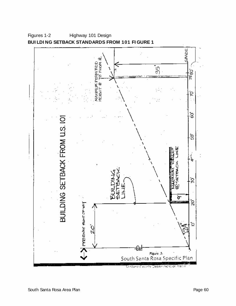
Figures 1-2 Highway 101 Design BUILDING SETBACK STANDARDS FROM 101 FIGURE 1
South Santa Rosa Area Plan Page 60
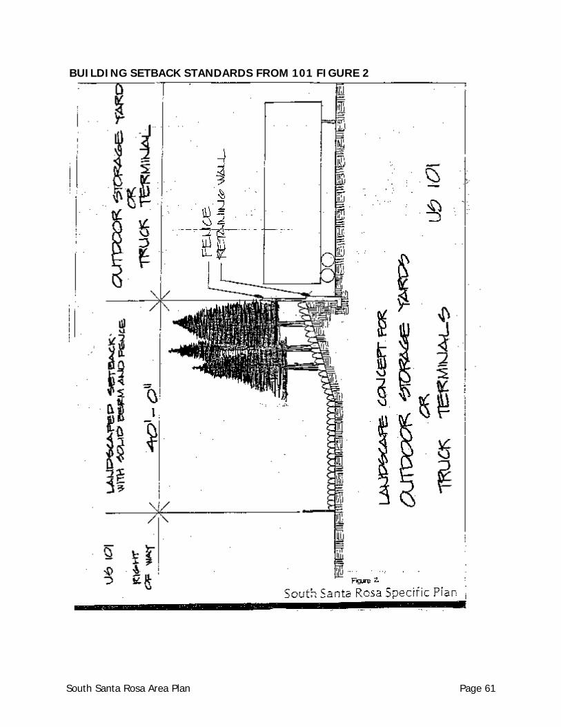
BUILDING SETBACK STANDARDS FROM 101 FIGURE 2
South Santa Rosa Area Plan Page 61
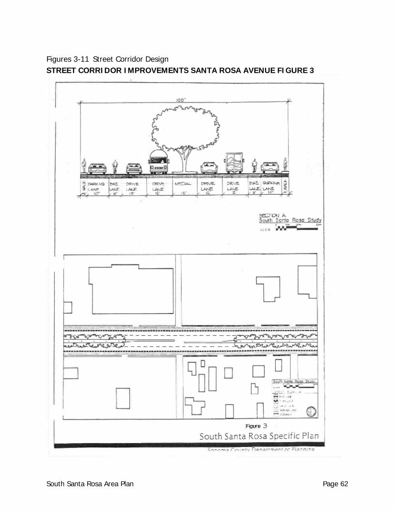
Figures 3-11 Street Corridor Design STREET CORRIDOR IMPROVEMENTS SANTA ROSA AVENUE FIGURE 3
South Santa Rosa Area Plan Page 62
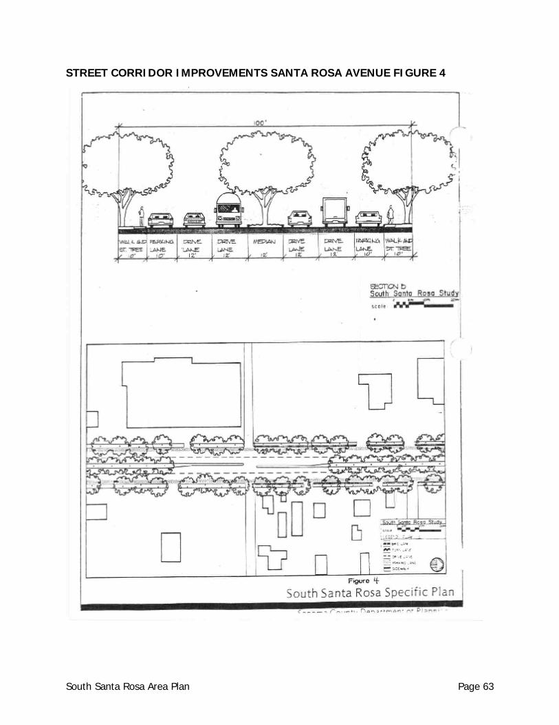
STREET CORRIDOR IMPROVEMENTS SANTA ROSA AVENUE FIGURE 4
South Santa Rosa Area Plan Page 63
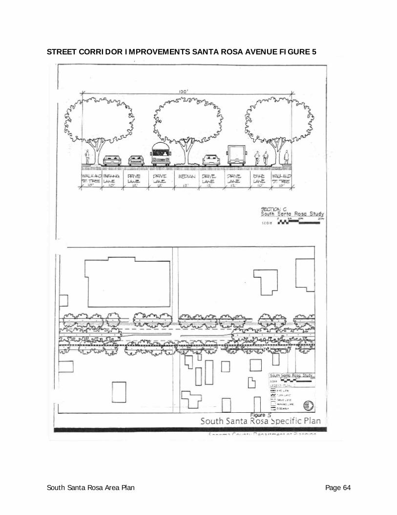
STREET CORRIDOR IMPROVEMENTS SANTA ROSA AVENUE FIGURE 5
South Santa Rosa Area Plan Page 64
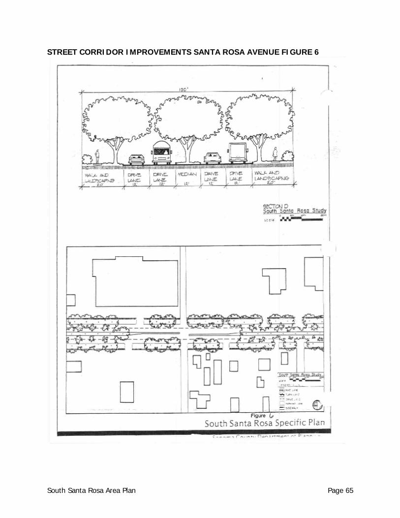
STREET CORRIDOR IMPROVEMENTS SANTA ROSA AVENUE FIGURE 6
South Santa Rosa Area Plan Page 65
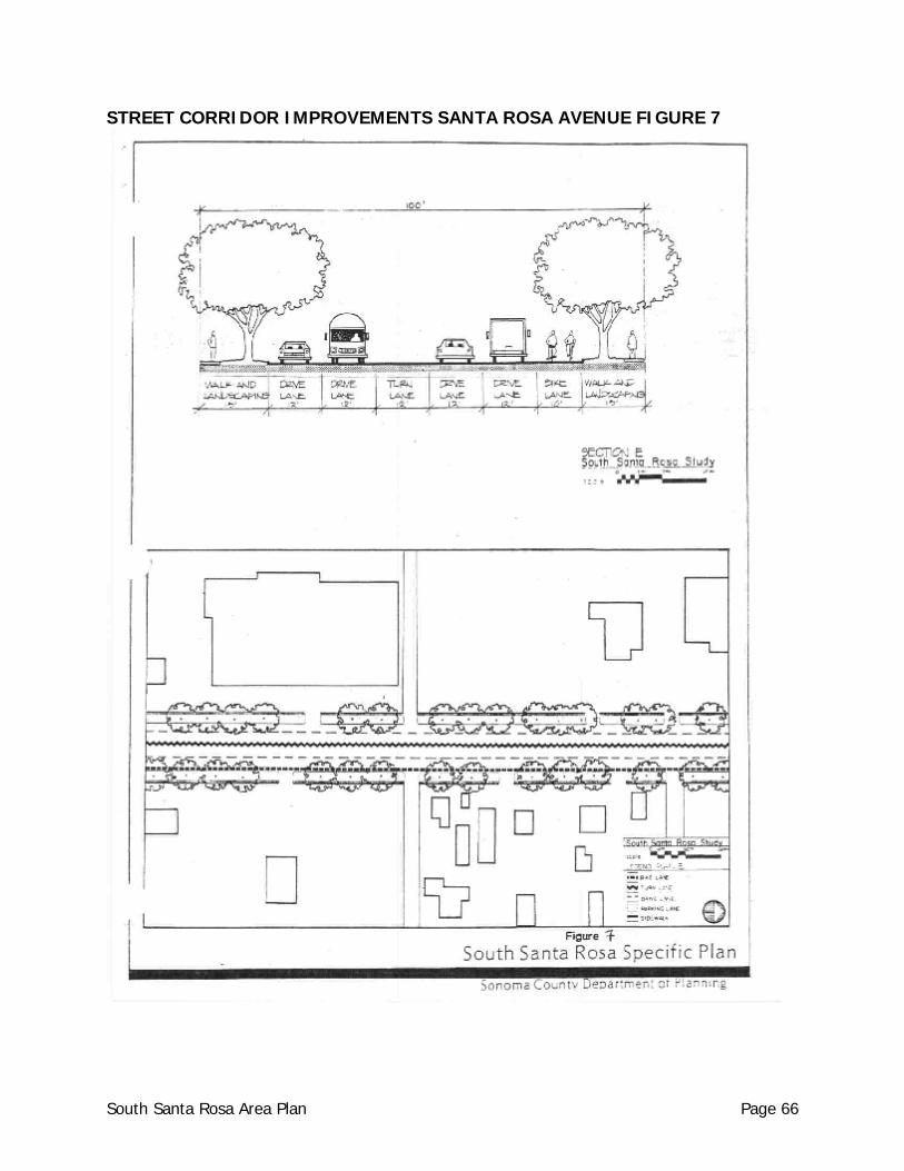
STREET CORRIDOR IMPROVEMENTS SANTA ROSA AVENUE FIGURE 7
South Santa Rosa Area Plan Page 66
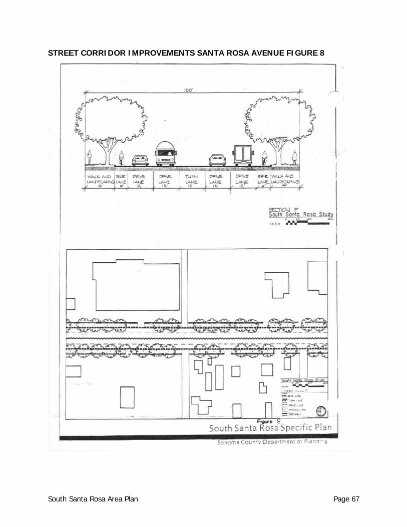
STREET CORRIDOR IMPROVEMENTS SANTA ROSA AVENUE FIGURE 8
South Santa Rosa Area Plan Page 67

STREET CORRIDOR IMPROVEMENTS SANTA ROSA AVENUE FIGURE 9
South Santa Rosa Area Plan Page 68
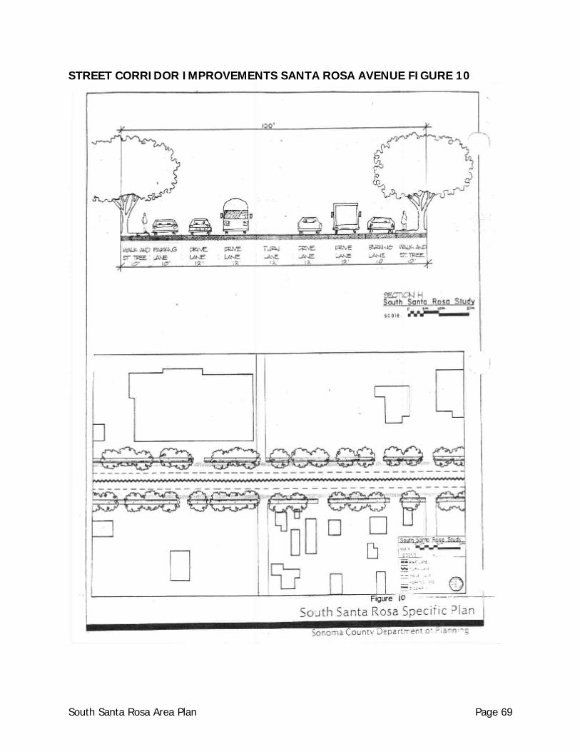
STREET CORRIDOR IMPROVEMENTS SANTA ROSA AVENUE FIGURE 10
South Santa Rosa Area Plan Page 69
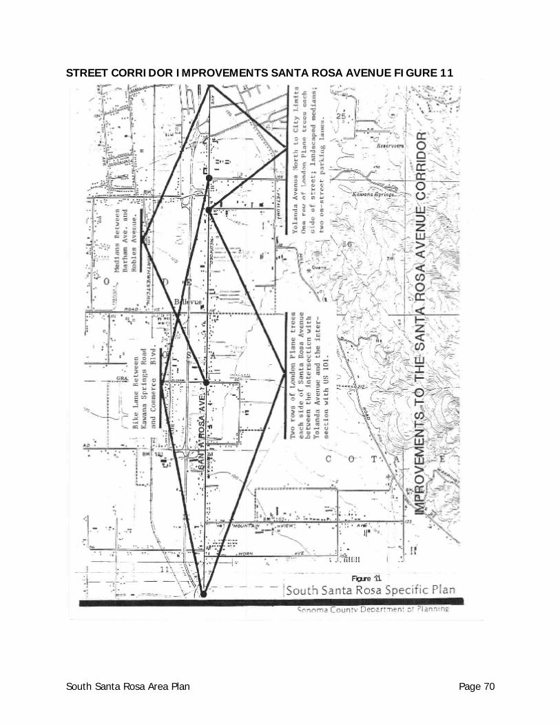
STREET CORRIDOR IMPROVEMENTS SANTA ROSA AVENUE FIGURE 11
South Santa Rosa Area Plan Page 70
Bikeways a. Lanes for bicycle travel a minimum of five (5) feet in width shall be provided on each
side of Santa Rosa Avenue (in lieu of one proposed on-street parking lane) between the proposed Farmers Lane Extension with Santa Rosa Avenue, south to the proposed intersection of Santa Rosa Avenue with Commerce Boulevard near Rohnert Park.
Bus Stops a. Transit shelters shall be installed by the Department of Public Works at all bus stops. b. Bike parking lockers or bike racks shall be installed by the Department of Public Works
at bus stops.
Utility Lines/Street Lighting a. Existing overhead lines shall be placed underground and the existing poles removed.
$172,000 has been appropriated for this project, which is listed on the Board of Supervisors 1981-1984 Priority List.
b. All new project service lines shall be placed underground, with proof of placement
underground to be submitted to the Design Review Committee prior to final inspection or occupancy of the building.
c. Existing street lights mounted on utility poles will be displaced when utility lines are
placed underground. Street lights shall be installed by the Department of Public Works along the entire length of Santa Rosa Avenue, staggered along both sides of the street. Longitudinal spacing and the height of luminaries shall be sufficient to light the entire width of the street.
Sidewalks
Sidewalks shall be provided in all retail and neighborhood commercial and all residential uses.
SANTA ROSA AVENUE - BUILDING SITES
Setbacks a. Building setback from Santa Rosa Avenue: The minimum setback is based on the height
of a building (See Figure 12, Building Setback). The minimum building setback is 20 feet (the maximum building height at the minimum building setback line is 18 feet).
b. Additional height may be permitted by use permit or use permit waiver following the
same ratio of building setback to building height 42 degrees + from the property line to a maximum height of 35-40 feet from the property line.
South Santa Rosa Area Plan Page 71
c. The minimum 20 foot yard setback from Santa Rosa Avenue shall be landscaped,
including the provision for street trees in accord with this section.
Outdoor Storage a. No outdoor storage shall occur within the 20 foot minimum building setback landscaped
area. b. Outdoor storage areas which face Santa Rosa Avenue shall be screened from view by
means of perimeter fencing and landscape screening with berming evergreen shrubs as shown in Figure 13.
c. The area of outdoor storage shall not exceed 100 percent of the floor area of the
primary structure. The height of any outdoor storage shall not exceed either: A) the height of the perimeter fence, berm or landscape screen, nor B) the structural height limits specified in this section.
Parking a. On-site parking shall be located to the rear of structure. b. However, where existing parking lots are adjacent to Santa Rosa Avenue and no
alternative for relocation exists or where physical constraints of a site prohibits development of a functional parking lot to the rear of a building, then a solid berm and retaining wall not less than 3 feet nor more than 3.5 feet in height shall be constructed in accordance with Figures 14 and 15 taking into account sight distance near driveways.
Signs a. Detached: One per parcel, monument type Maximum Height: 8 feet Maximum Area: 48 square feet per parcel b. Attached: One per business, located below roof Maximum Area: 35 square feet per tenant c. Projecting: None unless approved by the Design Review Committee in lieu of an
attached sign, subject to the following criteria:
i. The building must be one located adjacent to a sidewalk, where a projecting sign is oriented to pedestrians;
ii. projecting graphics must clear sidewalks by at least 8 feet, and may project no
more than 4 feet from the building or one-third the width of the sidewalk, whichever is less;
South Santa Rosa Area Plan Page 72
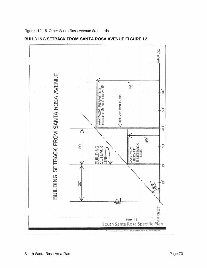
Figures 12-15 Other Santa Rosa Avenue Standards
BUILDING SETBACK FROM SANTA ROSA AVENUE FIGURE 12
South Santa Rosa Area Plan Page 73
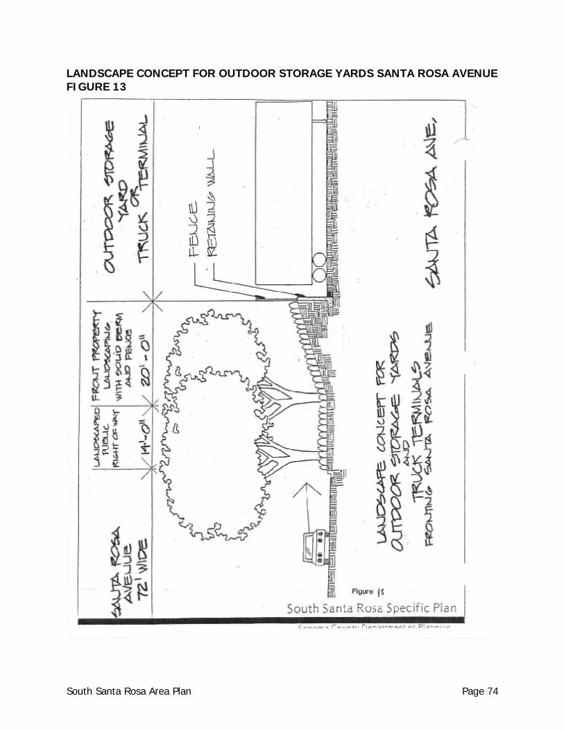
LANDSCAPE CONCEPT FOR OUTDOOR STORAGE YARDS SANTA ROSA AVENUE FIGURE 13
South Santa Rosa Area Plan Page 74
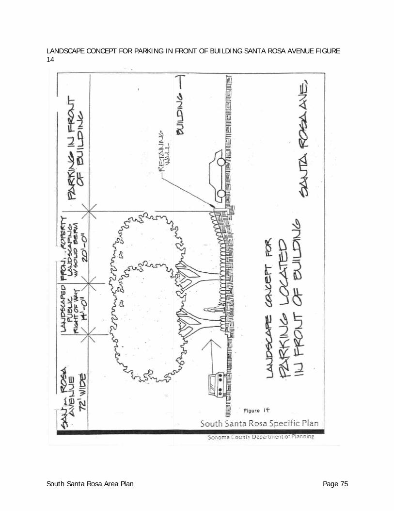
LANDSCAPE CONCEPT FOR PARKING IN FRONT OF BUILDING SANTA ROSA AVENUE FIGURE 14
South Santa Rosa Area Plan Page 75
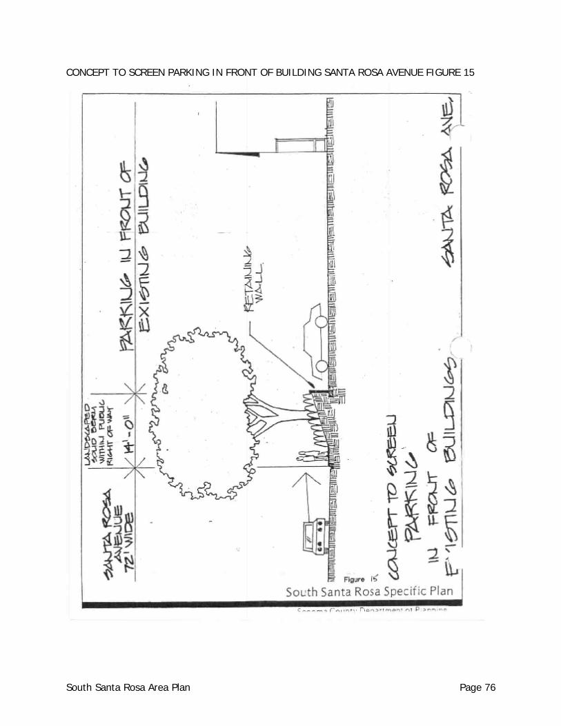
CONCEPT TO SCREEN PARKING IN FRONT OF BUILDING SANTA ROSA AVENUE FIGURE 15
South Santa Rosa Area Plan Page 76
iii. projecting graphics must be mounted away from the wall at least six
inches; projecting graphics are not permitted at the intersection of corners, except at right angles to a building front;
iv. projecting graphics may extend to the bottom of the eaves of a building.
(If the building consists of two or more stories graphics may not extend above the first story).
v. no projecting graphic may be displayed unless the building to which it is
attached is 20 feet or more in width, and no projecting graphic may be closer than 50 feet to any other projecting graphic.
Windows a. None, unless approved by the Design Review Committee in lieu of attached sign.
Subject to the same criteria as attached signs.
SANTA ROSA AVENUE - RESIDENTIAL AREAS
Setbacks a. The front yard setback for residential development must take into account the noise
impact contours established for the area, but in no case shall the setback from Santa Rosa Avenue be less than thirty-five (35) feet from the front property line.
Sidewalks a. Sidewalks shall be provided in all residential areas and should meander through the
front landscape area.
Landscaping a. The front setback area shall be landscaped. b. A minimum of one fifteen (15) gallon tree shall be planted per twenty-five (25) feet of
the perimeter of a mobile home park. c. Street trees shall be planted in accordance with the standards for commercial areas
along Santa Rosa Avenue for all new or expanding (more than 25%) mobile home parks as well as for any other residential development.
d. Project landscaping shall comply with the General Plan Water Resources Element policies
relative to water conserving landscaping and stormwater retention.
South Santa Rosa Area Plan Page 77
URBAN CORRIDOR DESIGN STANDARDS: SEBASTOPOL ROAD The Sebastopol Road Urban Vision Plan (UVP) provides guidelines for development along the Sebastopol Road corridor between Stony Point Road and Dutton Avenue. All development proposed to be located within the boundaries of the Urban Vision Plan is subject to the standards and design guidelines of that Plan.
SEBASTOPOL ROAD - RIGHT-OF-WAY
Street Trees a. Street trees shall be planted at a rate of one per 25 feet of frontage. b. Minimum street tree size shall be as follows: two inch caliper, ten foot height, two foot
root ball.
Intersections a. Textured concrete walkways simulating brick or cut stone shall be installed by the
Department of Public Works along the Sebastopol Road Corridor as follows: four crosswalks at the Dutton Avenue intersection, the West Avenue intersection, and Roseland/McMinn, Burbank and Hampton Way intersections.
Bikeways a. Bike lanes a minimum of five (5) feet in width shall be provided in each direction (in lieu
of the proposed on-street parking lane).
Bus Stops a. Transit shelters shall be installed by the Department of Public Works at all bus stops
along Sebastopol Roads.
Signs a. Detached: One per parcel Monument type Maximum Height: 8 feet Maximum Area: 48 square feet per parcel b. Attached: One per business Located below roof Maximum Area: 35 square feet per tenant c. Projecting: None, unless approved by the Design Review Committee in lieu of an
attached sign subject to the following criteria:
South Santa Rosa Area Plan Page 78
i. the building must be one located adjacent to a sidewalk, where a projecting sign is oriented to pedestrians;
ii. projecting graphics must clear sidewalks by at least 8 feet and may project no
more than 4 feet from the building or one-third the width of the sidewalk, whichever is less;
iii. projecting graphics must be mounted away from the wall at least six inches;
projecting graphics are not permitted at the intersection of corners, except at right angles to a building front;
iv. projecting graphics may extend to the bottom of the eaves of a building. (If the
building consists of two or more stories graphics may not extend above the first story).
v. no projecting graphic may be displayed unless the building to which it is attached
is 20 feet or more in width, and no projecting graphic may be closer than 50 feet (50') to any other projecting graphic.
d. Roof: None permitted. e. Wall Graphics: None, unless approved by Design Review in lieu of and subject to the
same standards as attached signs. f. Window: None, unless specifically approved by Design Review in lieu of and subject to
the same standards as attached signs.
ROSELAND VILLAGE SHOPPING CENTER The Sebastopol Road Urban Vision Plan provides design guidelines, suggested uses and a conceptual site plan intended to be used as a guide to redevelopment of the Roseland Village Shopping Center site. Development proposals for the shopping center site shall incorporate as many elements of the Urban Vision Plan as feasible. The alignment of the West Avenue extension through the shopping center parcel need not remain linear, but may curve outward toward the perimeter of the parcel identified as APN 125-111-037, in order to provide flexibility during site planning. The cost of acquisition for right-of-way and construction of any extension of West Avenue shall be borne by the properties benefitting from the extension. The County will identify the properties benefitted, establish their pro-rata contributions and provide a mechanism to collect the pro-rata contribution through the development process. The Plaza proposed to be located at the Roseland Village Shopping Center would be of benefit to the public and may be the subject of a private/public funding partnership in connection with the development of the Plaza.
South Santa Rosa Area Plan Page 79
URBAN SCENIC HIGHWAY CORRIDOR DESIGN GUIDELINES: STATE HIGHWAY 12 SITE
Setbacks a. The minimum building setback is twenty (20) feet. b. The setback is based on the height of a building (See Figure 16, Building Setback
Standards) following the same ration of building setback to building height of twenty-four (24) degrees from the property line to a maximum height of thirty-five feet (35') at seventy-eight feet (78') from the property line.
Outdoor Storage a. Outdoor storage or parking shall not occur within the twenty (20) foot minimum building
setback landscaped area. b. Outdoor storage areas which face State Highway 12 shall be screened from view in an
appropriate manner as determined by the Design Review Committee. (See Figure 17). c. The height of any outdoor storage shall exceed neither A) the height of the perimeter
fence, berm or landscape screen, nor B) the structural height limits specified in this section.
Miscellaneous a. Warm earth tone colors shall be used for all structures along State Highway 12.
Landscaping a. The minimum twenty foot (20') yard setback from Highway 12 shall be landscaped in an
appropriate manner as determined by the Design Review Committee. b. Properties along Highway 12 shall provide a continuous vegetative tree screening
program incorporating one of the two following major species predominant along the highway corridor: Sequoia sempervirems (coast redwood) or Eucalyptus globulous compacta (blue gum). Redwood trees shall be planted in groups at a maximum of 17 feet on center. Redwoods shall be a 15 gallon size (minimum), 50% of all eucalyptus shall be 5 gallon size (minimum).
Signs a. Signs shall not be oriented to Highway 12. The location, scale and height of a sign shall
relate to the street or access point on which the use is located. Existing signs that do not conform to this standard shall be made to conform at the time of approval of any new application for Design Review, Use Permit or Land Division. This provision includes billboards.
South Santa Rosa Area Plan Page 80
b. Signs for uses along freeway frontage roads and side streets such as Sebastopol Road,
Roseland Avenue, Hampton Way and Stony Point Road must relate in scale to the frontage road (or to the street on which they are located).
Street Tree Program a. Species: Tree species have been selected for the following major streets:
i. Santa Rosa Avenue -- Plantanus Acerifolia (London Plane Tree) with Chinensis Pistacia (Chinese Pistache tree) to accent intersections.
ii. Sebastopol Road -- Liriodendron Tulipifera (Tulip Tree).
iii. Dutton Avenue (between Hearn Avenue and Sebastopol Road) Plantanus Acerifolia (London Plane Tree).
iv. Hearn Avenue (Following proposed upgrading and realignment plans) --
Eucalyptus Nicholii (Willow leafed peppermint). v. West Avenue -- Pyrus Calleryana, Bradford (Bradford Pear). vi. Burbank Avenue -- Gleditsia Triacanthos, Shademaster (Shademaster Locust). vii. Stony Point Road (within the urban area) -- Quercus Plastris (Pin Oak).
viii. Corby Avenue (between Hearn Avenue and Bellevue Road) -- Eucalyptus Rudis (Desert Gum).
b. Planting: Street trees shall be planted as follows:
i. Specifications for planting, protective wrapping, staking and irrigation shall be reviewed and approved by the Design Review Committee.
ii. A single row of street trees shall be planted on each side of the street (for Santa
Rosa Avenue, See Section 6.51). iii. Trees shall be spaced at a rate of one per twenty-five feet (25') of frontage.
iv. The minimum size for a street tree shall be 15 gallons (one inch caliper, six foot height, one foot root ball).
v. An automatic irrigation system shall be installed.
vi. All developments of property fronting a street shall provide street trees in accordance with this section.
South Santa Rosa Area Plan Page 81
c. Maintenance: Street trees shall be maintained in a healthy condition by the property owner or lessee.
d. Continuing Program:
i. All existing streets and future developments should have a street tree program with a designated species.
ii. All future developments involving the dedication of new public streets, street tree
species shall be approved by the Design Review Committee.
iii. For existing streets in the study area, the Design Review Committee should establish street tree species if a significant amount of development potential exists.
South Santa Rosa Area Plan Page 82
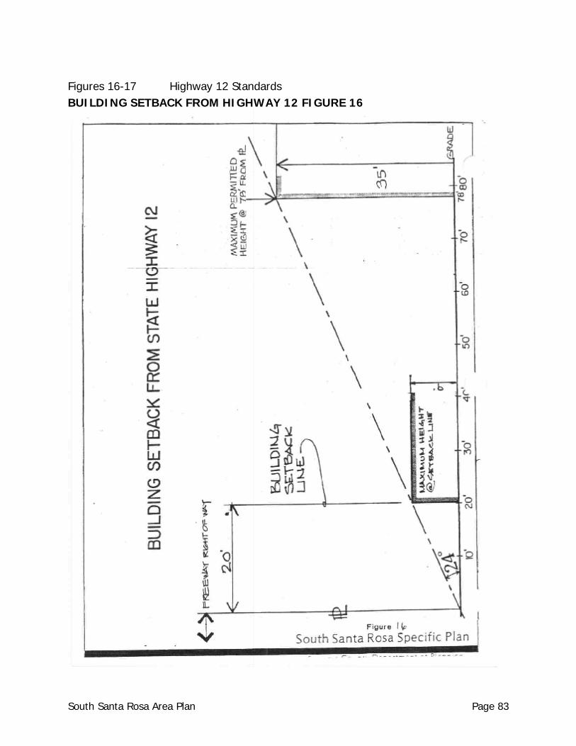
Figures 16-17 Highway 12 Standards BUILDING SETBACK FROM HIGHWAY 12 FIGURE 16
South Santa Rosa Area Plan Page 83
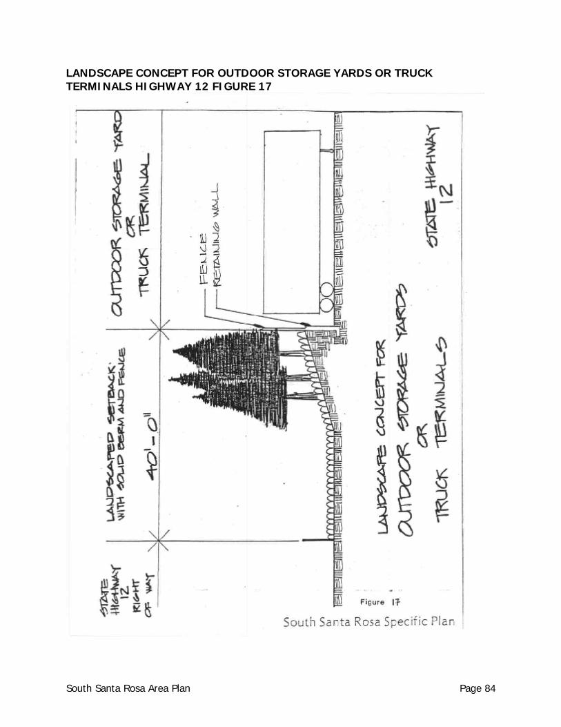
LANDSCAPE CONCEPT FOR OUTDOOR STORAGE YARDS OR TRUCK TERMINALS HIGHWAY 12 FIGURE 17
South Santa Rosa Area Plan Page 84
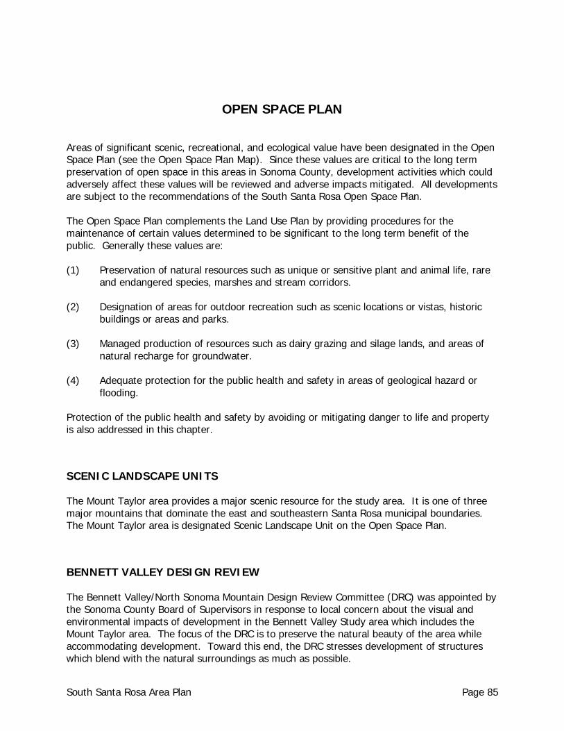
OPEN SPACE PLAN Areas of significant scenic, recreational, and ecological value have been designated in the Open Space Plan (see the Open Space Plan Map). Since these values are critical to the long term preservation of open space in this areas in Sonoma County, development activities which could adversely affect these values will be reviewed and adverse impacts mitigated. All developments are subject to the recommendations of the South Santa Rosa Open Space Plan. The Open Space Plan complements the Land Use Plan by providing procedures for the maintenance of certain values determined to be significant to the long term benefit of the public. Generally these values are: (1) Preservation of natural resources such as unique or sensitive plant and animal life, rare
and endangered species, marshes and stream corridors.
(2) Designation of areas for outdoor recreation such as scenic locations or vistas, historic buildings or areas and parks.
(3) Managed production of resources such as dairy grazing and silage lands, and areas of natural recharge for groundwater.
(4) Adequate protection for the public health and safety in areas of geological hazard or flooding.
Protection of the public health and safety by avoiding or mitigating danger to life and property is also addressed in this chapter.
SCENIC LANDSCAPE UNITS The Mount Taylor area provides a major scenic resource for the study area. It is one of three major mountains that dominate the east and southeastern Santa Rosa municipal boundaries. The Mount Taylor area is designated Scenic Landscape Unit on the Open Space Plan.
BENNETT VALLEY DESIGN REVIEW The Bennett Valley/North Sonoma Mountain Design Review Committee (DRC) was appointed by the Sonoma County Board of Supervisors in response to local concern about the visual and environmental impacts of development in the Bennett Valley Study area which includes the Mount Taylor area. The focus of the DRC is to preserve the natural beauty of the area while accommodating development. Toward this end, the DRC stresses development of structures which blend with the natural surroundings as much as possible.
South Santa Rosa Area Plan Page 85
The DRC requests that all applicants submit a site plan including topography, proposed grading, location of building site, existing blocks of vegetation and proposed landscaping to maintain the site in as natural a state as possible and to minimize visual intrusion of the structure. Building facade and exterior materials and colors should also be indicated. To achieve the goal of preservation of the natural beauty the following criteria should guide the assessment of all development proposals: NOTE: The Open Space Element of the General Plan contains policies and standards which may differ from some of the following criteria. Where such differences occur, the more restrictive policy or standard shall apply. (1) Structures should be sited below ridge lines.
(2) Structures should be sited out of public view and to blend with the topography and
vegetation of the site. In cases where no building site can be located which is not unobtrusive, a vegetative screen should be planted and maintained.
(3) Two story houses are acceptable when not exposed to public view.
(4) Cuts and fills are discouraged.
(5) The siding and the roof of structures should be of earthtone colors and of a texture which blends in with the natural surroundings. Bright colors and reflective materials do not harmonize with their surroundings.
(6) Driveways should be hidden from public view when possible.
(7) Underground utilities are required in visible areas of the site.
PUBLIC SAFETY Natural constraints to development, such as geologic hazards, water scarcity and slope instability, indicate that the western slopes of Mount Taylor should be retained as free of development as possible. Development should not exceed the proposed Land Use Plan densities.
SUBDIVISION REGULATIONS Adherence to the standards regarding construction of homes on ridgelines, or construction of homes, driveways and septic systems on steep or unstable slopes will also aid in the implementation of the Open Space Plan.
South Santa Rosa Area Plan Page 86
BIOTIC HABITAT AREAS Biotic habitat areas include a variety of special natural and cultural features which are particularly vulnerable to disruption by development. The Laguna de Santa Rosa, contains major habitats for known rare and endangered plants.
Laguna de Santa Rosa One of the major riparian corridors in Sonoma County, the Laguna de Santa Rosa, occurs on the western edge of the study area. This significant riparian habitat should be enhanced and preserved at every opportunity. A major issue is the recommendation to extend Todd Road westward to an intersection with Highway 116 south of Sebastopol. The Laguna is known to contain many archaeologically sensitive sites and also has rare and endangered plant species at various locations. These factors may interfere with an eventual crossing of the Laguna by a new roadway. In addition, because of the breadth of the flood plain at the Laguna, any crossing would appear to be extremely expensive. A plan line study for the extension of Todd Road to connect with Highway 116 should be undertaken at the earliest possible time so that various decision makers may have before them the relevant information to decide whether this crossing should be undertaken.
State Biotic Preserve/Vernal Pools The area south of Ludwig Avenue west of Stony Point Road to the Laguna contains a number of vernal pools where there is a variety of rare and endangered plants. The two biotic reserve areas in this portion of the study area are: a 100 acre State preserve west of Llano Road along the north side of Todd Road and a wildlife/wetlands preserve recommended for creation west of the right angle bend of Todd Road at the Laguna. This unique biotic designation in fact extends for the full length of the Laguna and may cause additional mitigation considerations at the time of the development of the Todd Road extension westward to connect with Highway 116 south of Sebastopol.
Policies (1) Pursuant to the policies of the General Plan's Open Space Element, require all
development approvals in critical habitat and unique biotic areas to mitigate potential adverse impacts to the maximum feasible extent.
(2) Encourage preservation of scientific and educational activities which would protect and enhance the natural values in the area.
Riparian Corridors Streams, both seasonal and year-round, provide outstanding wildlife habitat, combining elements, vegetation, food, shelter, and water supply. Development of or encroachment into these areas should be limited and where possible existing conditions enhanced. Setbacks of
South Santa Rosa Area Plan Page 87
OPEN SPACE PLAN MAP
South Santa Rosa Area Plan Page 88
200 feet are required on major or perennial streams and 100 foot setbacks are required on minor and ephemeral streams. Where the standards above are less restrictive than those of the General Plan, compliance with the General Plan standards is required.
Policies (1) Include riparian protection regulations in the County Zoning Ordinance.
(2) Continue to implement the Subdivision Ordinance riparian corridor protection
requirements and mitigation measures.
SCENIC CORRIDORS A number of roads have been designated as scenic corridors because they have high scenic value for the motorist. These roads have been grouped into two categories: Urban Scenic Corridors and Rural Scenic Corridors.
Urban Scenic Corridors Recommended scenic routes through urban areas include Highway 101, Highway 12, and Farmers Lane and Petaluma Hill Road.
Policies (1) Development standards including building setbacks and landscaping for Hwy 101 and
Hwy 12 are contained in the section entitled "Urban Design." Application of these standards is required to mitigate the impacts of development along these scenic corridor routes. Where such standards are less restrictive than those of the General Plan, compliance with the General Plan standards is required.
Rural Scenic Corridors Recommended scenic routes are Petaluma Hill Road, Llano Road, Todd Road and Stony Point Road.
Policies (1) Along rural scenic corridors, a 100 foot building setback (from centerline of the road) is
required to preserve the open and scenic quality of the route. If development is proposed within the setback area, an administrative permit procedure is recommended that can authorize exceptions according to design criteria appropriate to the scenic area.
(2) In the vicinity of scenic points a 200 foot setback is recommended to prevent blocking or disrupting these areas' importance. Administrative permits may be approved to allow building within the setback.
South Santa Rosa Area Plan Page 89
(3) The portions of the County Subdivision Ordinance addressing site planning on exposed ridges and slopes and sensitive visual areas should continue to be implemented.
PARKS Parks are needed in the South Santa Rosa study area. At present, there are no developed park sites within the study district. The study proposes several new parks to accommodate neighborhood, community and regional recreational needs.
Regional Parks The vicinity of Mount Taylor has been identified for a regional park. This land is environmentally unsuitable for development because of shallow soils, some geologic hazards, and low water availability. However, it could provide a spacious area having a high scenic value and natural character which could provide a variety of passive recreation experiences. It would provide for rural recreational opportunities within close proximity of the urban population center of Santa Rosa, while possibly being linked with a trail system to Spring Lake Park and Annadel State Park.
Neighborhood Parks One of the most important park sites that should be developed is a site of one to three acres in size on Dutton Avenue between Hearn and Sebastopol Road. It appears that there are two opportunity areas, one is in the vicinity of the creek crossing which would require the County to purchase the land and reserve it until funds are available for development. The second site on Dutton Avenue would be closer to Hearn Avenue and might be secured through the dedication process associated with development activity. In addition, the Sebastopol Road Urban Vision Plan has provided approximate locations for four neighborhood parks, each of which would adjoin the Joe Rodota bicycle trail. Three of the park sites are proposed to be one acre in size, while the fourth is intended to be a four acre park site. Similarly, through the dedication process a new park site of two to five acres adjacent to the Kawana School on Moraga Avenue (in the Petaluma Hill Road area) should be secured at the time of a major development proposal in that area. A second site that could be obtained through the dedication process would be on Stony Point Road between Giffen and Sebastopol Road. Several contiguous large parcels could be developed in a "planned community" procedure, affording, in addition to a park site, a major road linkage between Stony Point, Burbank and McMinn. The next site recommended for acquisition is on Wright Road at the intersection with Finley. The Federal Government currently owns property at this location and in the future may designate this site as surplus federal land thus making it available to the local government as a park site. In this area it would be well to achieve a minimum five acre site and more if it can be obtained.
South Santa Rosa Area Plan Page 90
The last site to be discussed is designated in the plans to be north of Highway 12 on Occidental Road between Fulton Road and Stony Point Road. In the area near the intersection of West Third and Stony Point, full development has been approved by the City for commercial and residential land uses leaving no space that immediate vicinity for a park site. Therefore, the City should consider with its endorsement of this plan, the provision of a city-wide park on Occidental Road, preferably adjacent to the P.G. & E. facility. The factors which lead to this recommendation include Highway 12 being designated a Scenic Corridor; easy accessibility from major north/south arterials (Fulton Road/Stony Point-Marlow Roads); and the location being in the current approach pattern to the Santa Rosa Air Center for aircraft. Providing a large park area rather than developing housing at five or fifteen units per acre would reduce the conflict of air traffic noise over residential areas. Currently undeveloped land large enough to accommodate a city park is designated in the South Santa Rosa Specific Plan.
Policies (1) Support expansion of public park lands in the area in accord with the Parks and
Bikeways Plan.
BIKEWAYS PLAN Some of the major scenic routes previously described are also recommended bicycle routes: Highway 12, Llano Road, Stony Point Road, Todd Road, Petaluma Hill Road and Farmers Lane Extension (see the Parks and Bikeways Plan Map). They have been selected because the routes lead to major recreational areas and link population and employment centers. In order to make these routes more suitable for bicycle travel future road improvements should provide wide shoulders, separate lanes, or separate paths for bicycle use. The County Public Works Department should be notified of bicycle routes in order to make shoulder improvements or separate lanes (which can accommodate bicycles) in the course of road improvement programs. Other bike routes are proposed along various sections of the County Water Agencies drainage channels, providing loops for touring in addition to the routes provided between the cities of Santa Rosa, Sebastopol and Rohnert Park, as well as to commercial areas within the study.
Policies (1) Adopt the Bikeway Plan; give highest priority to the bike path between Stony Point Road
and Sebastopol.
South Santa Rosa Area Plan Page 91
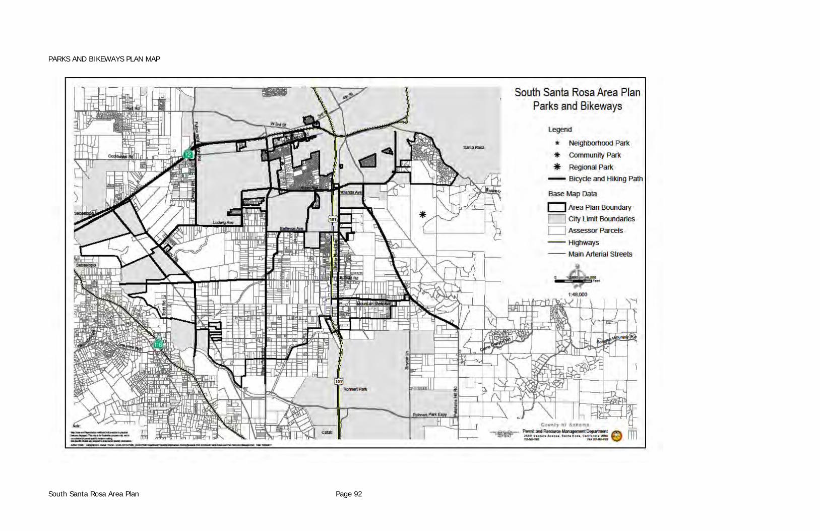
PARKS AND BIKEWAYS PLAN MAP
South Santa Rosa Area Plan Page 92
ARCHAEOLOGICALLY OR HISTORICALLY SIGNIFICANT AREAS Areas of archaeological significance exist along the Laguna de Santa Rosa and along Petaluma Hill Road. Any development in these two areas will require site specific archaeological studies. Two sites of historical significance have been identified and shown on the archaeologically sensitive map. "The Gables" a single family residence on Petaluma Hill Road, has been restored and preserved, and is a major landmark of historic and architectural significance. The second site identified is the former location of the Steven Irwin School on the northwest corner of South Wright Road and Sebastopol Road. The school building was demolished several years ago and the site is now occupied by a contractor's yard.
Policies (1) As a part of County permit procedure the County's Landmark Commission should
continue to be used as a referral resource to assure proper planning for protection of historical sites and areas.
(2) Historical District Zoning should be applied to "The Gables."
FLOOD PLAIN The 100 year flood plain is identified and mapped by the Federal Emergency Management Agency (FEMA). This area has a one-in-a-hundred probability of being inundated in any given year. The 100-year flood plain is the most commonly accepted limit of flood risk; development within the flood plain is subject to the provisions of the General Plan's Public Safety Element and F1 or F2 zoning.
Policies (1) Development which may be susceptible to damage by flood waters, which displaces
floodwaters, or otherwise adversely affects hydrology will not be permitted.
South Santa Rosa Area Plan Page 93
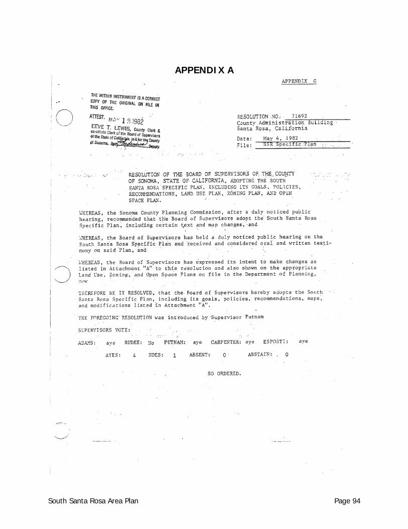
APPENDIX A
South Santa Rosa Area Plan Page 94
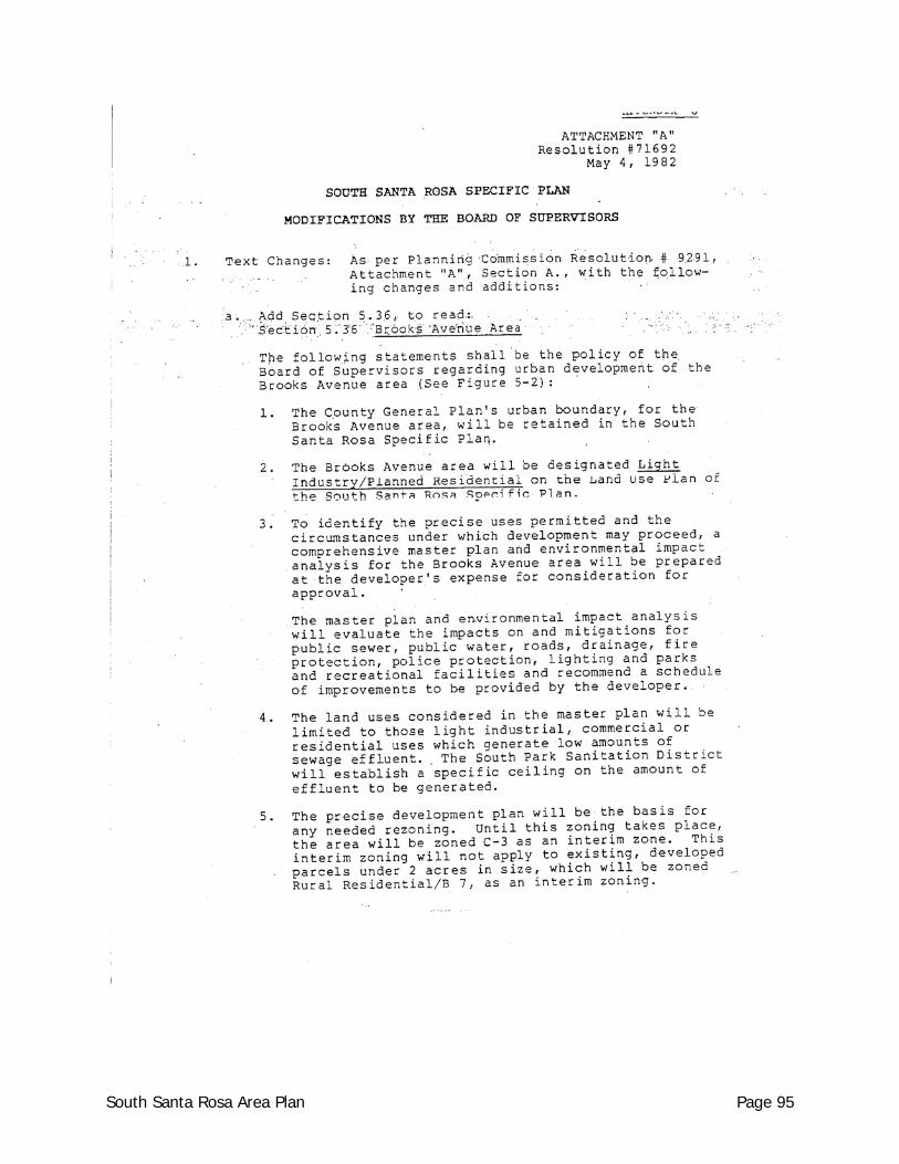
South Santa Rosa Area Plan Page 95
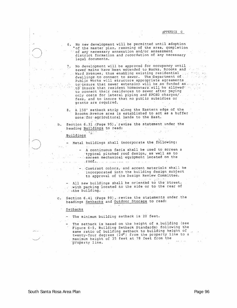
South Santa Rosa Area Plan Page 96
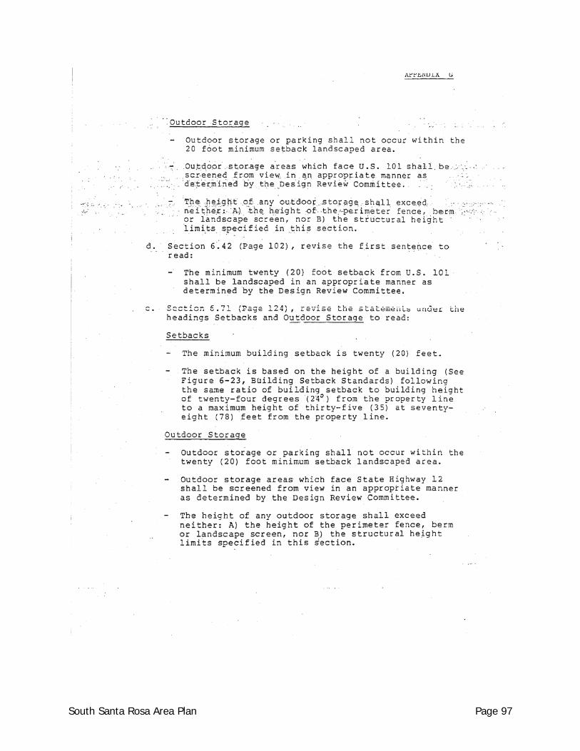
South Santa Rosa Area Plan Page 97
South Santa Rosa Area Plan Page 98
South Santa Rosa Area Plan Page 99
South Santa Rosa Area Plan Page 100
South Santa Rosa Area Plan Page 101
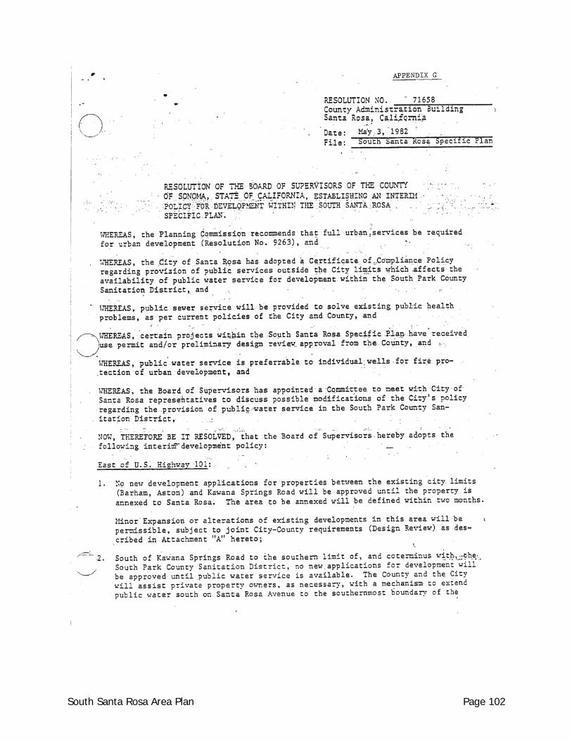
South Santa Rosa Area Plan Page 102
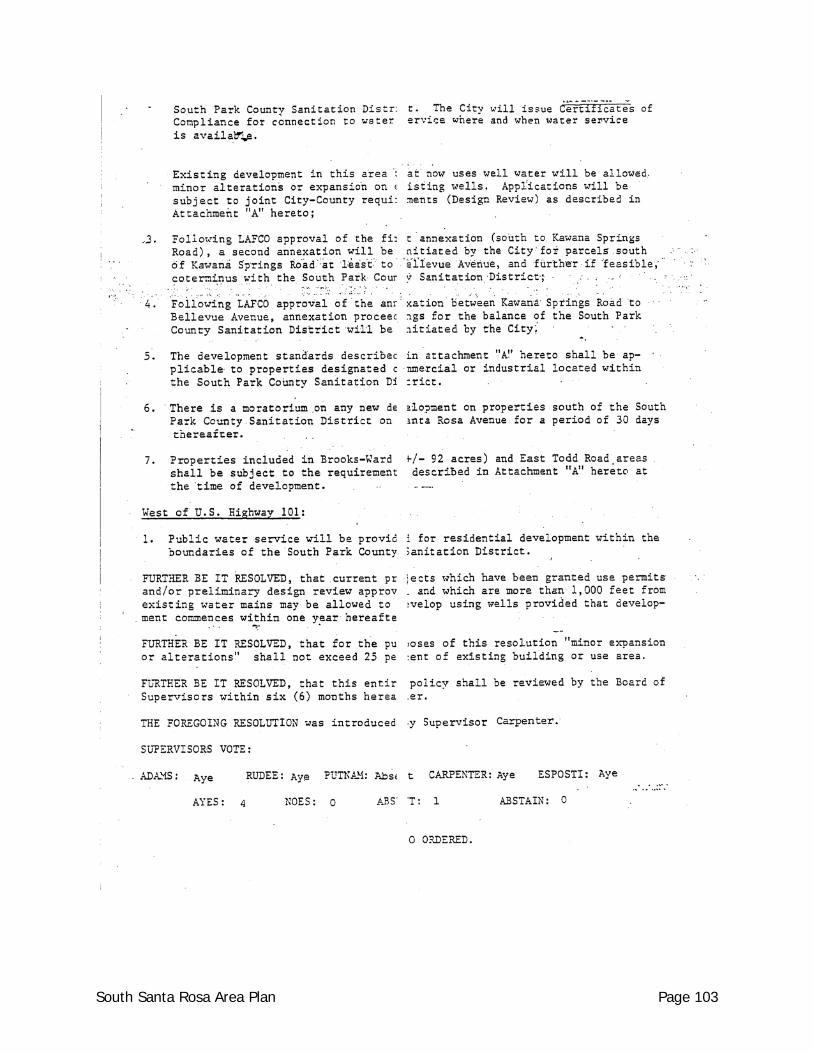
South Santa Rosa Area Plan Page 103
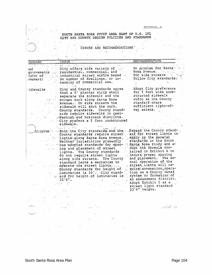
South Santa Rosa Area Plan Page 104
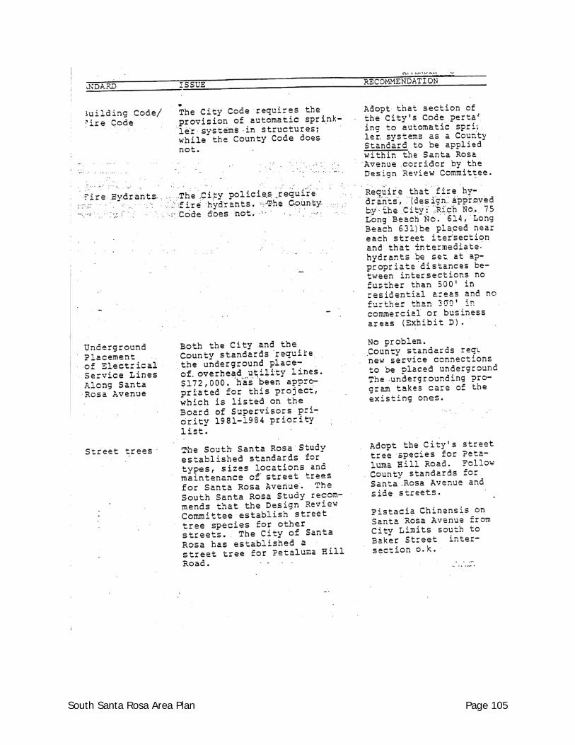
South Santa Rosa Area Plan Page 105
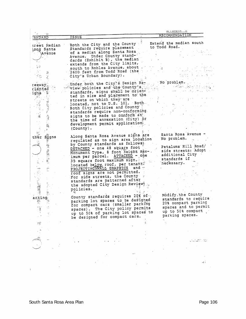
South Santa Rosa Area Plan Page 106
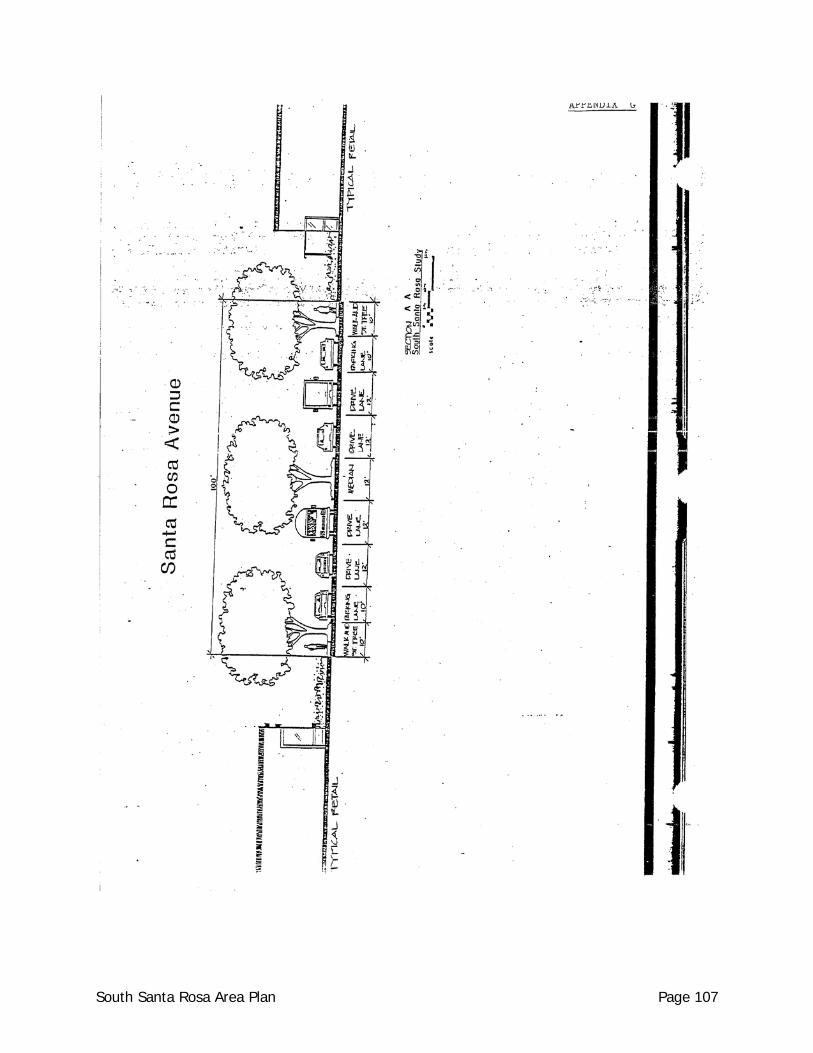
South Santa Rosa Area Plan Page 107
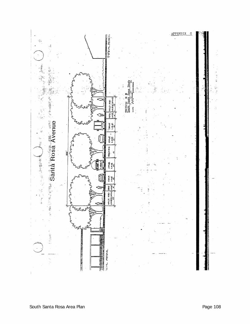
South Santa Rosa Area Plan Page 108
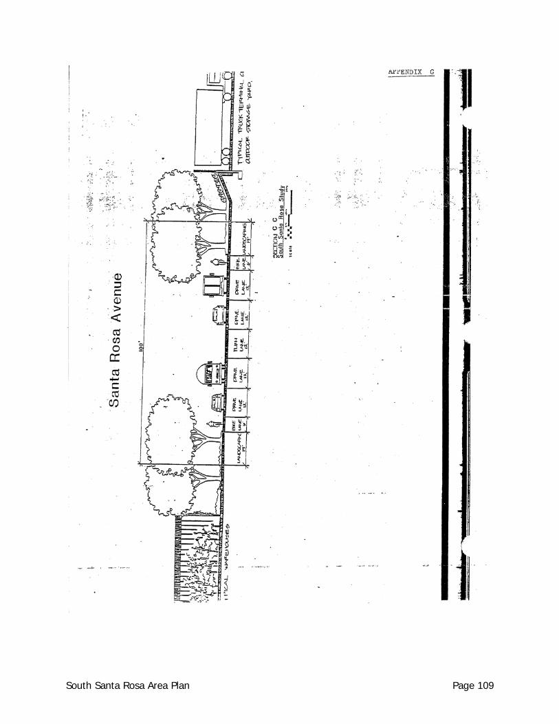
South Santa Rosa Area Plan Page 109
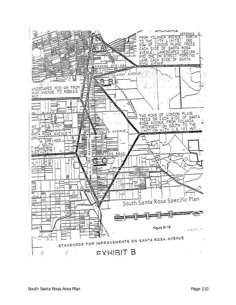
South Santa Rosa Area Plan Page 110
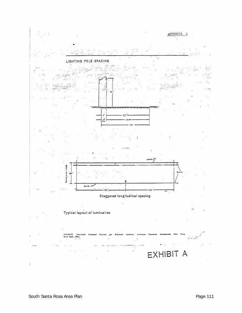
South Santa Rosa Area Plan Page 111
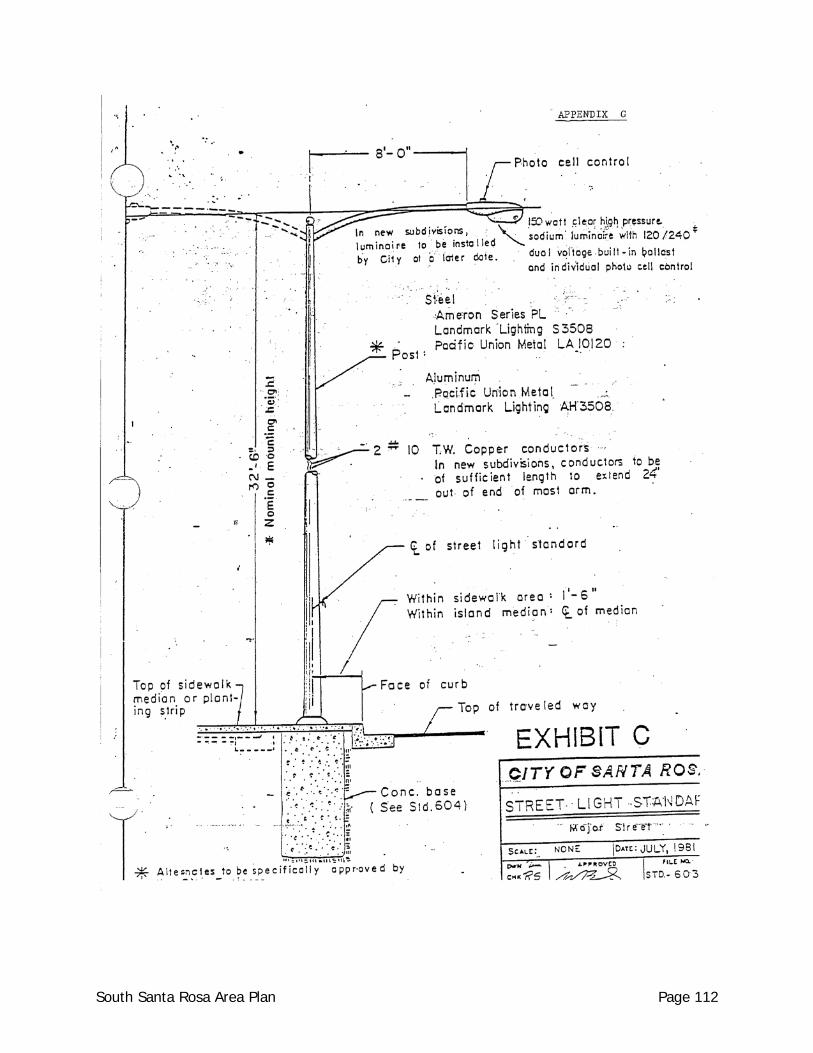
South Santa Rosa Area Plan Page 112
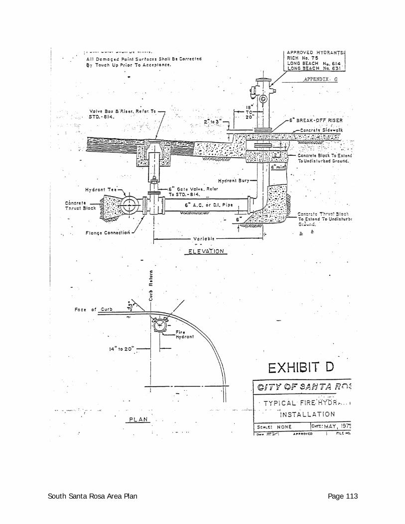
South Santa Rosa Area Plan Page 113
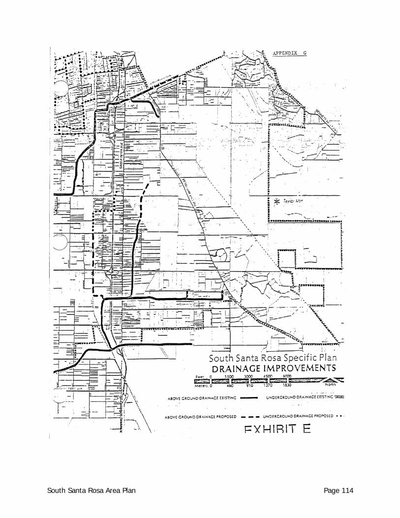
South Santa Rosa Area Plan Page 114
South Santa Rosa Area Plan Page 115
South Santa Rosa Area Plan Page 116
South Santa Rosa Area Plan Page 117
South Santa Rosa Area Plan Page 118
South Santa Rosa Area Plan Page 119

South Santa Rosa Area Plan Page 120
South Santa Rosa Area Plan Page 121