Embed Size (px)
Citation preview

name to work with template script in local application 030613
Report Prepared by
SRK Consulting (UK) Limited UK6355
NI 43-101 MINERAL RESOURCE ESTIMATE FOR THE SONORA LITHIUM
PROJECT, MEXICO, MAY 2015
Prepared For
Bacanora Minerals Ltd
and
Rare Earth Minerals PLC

SRK Consulting Sonora Lithium Project
U6355 Sonora MRE_Report v16 clean.docx June 2015 Page 2 of 82
SRK Legal Entity: SRK Consulting (UK) Limited
SRK Address: 5th Floor Churchill House
17 Churchill Way Cardiff, CF10 2HH
Wales, United Kingdom.
Date: June 2015
Project Number: UK6355
SRK Project Director: Martin Pittuck Director & Corporate Consultant
(Mining Geology)
SRK Project Manager: Colin Rawbone Senior Consultant
(Geology)
Client Legal Entity: Rare Earth Minerals PLC
Client Address: Suite 3B Princes House, 39 Jermyn Street,
London SW1Y 6DN
COPYRIGHT AND DISCLAIMER
Copyright (and any other applicable intellectual property rights) in this document and any accompanying data
or models which are created by SRK Consulting (UK) Limited ("SRK") is reserved by SRK and is protected by
international copyright and other laws. Copyright in any component parts of this document such as images is
owned and reserved by the copyright owner so noted within this document.
The use of this document is strictly subject to terms licensed by SRK to the named recipient or recipients of
this document or persons to whom SRK has agreed that it may be transferred to (the “Recipients”). Unless
otherwise agreed by SRK, this does not grant rights to any third party. This document shall only be
distributed to any third party in full as provided by SRK and may not be reproduced or circulated in the public
domain (in whole or in part) or in any edited, abridged or otherwise amended form unless expressly agreed
by SRK. Any other copyright owner‟s work may not be separated from this document, used or reproduced for
any other purpose other than with this document in full as licensed by SRK. In the event that this document
is disclosed or distributed to any third party, no such third party shall be entitled to place reliance upon any
information, warranties or representations which may be contained within this document and the Recipients
of this document shall indemnify SRK against all and any claims, losses and costs which may be incurred by
SRK relating to such third parties.
This document is issued subject to the confidentiality provisions in SRK‟s Terms and Conditions, which are
included in the Commercial Appendices and contain mutual confidentiality obligations. Accordingly, any
references in the confidentiality provisions in SRK‟s Terms and Conditions to the “Client” should be read as
“Recipients”. SRK respects the general confidentiality of its potential clients‟ confidential information whether
formally agreed with them or not and SRK therefore expects the contents of this document to be treated as
confidential by the Recipients. The Recipients may not release the technical and pricing information
contained in this document or any other documents submitted by SRK to the Recipients, or otherwise make it
or them available to any third party without the express written consent of SRK.
© SRK Consulting (UK) Limited 2015 version: Jan2015

SRK Consulting (UK) Limited 5th Floor Churchill House 17 Churchill Way City and County of Cardiff CF10 2HH, Wales United Kingdom E-mail: [email protected] URL: www.srk.co.uk Tel: + 44 (0) 2920 348 150 Fax: + 44 (0) 2920 348 199
SRK Consulting (UK) Limited 5th Floor Churchill House 17 Churchill Way City and County of Cardiff CF10 2HH, Wales United Kingdom E-mail: [email protected] URL: www.srk.co.uk Tel: + 44 (0) 2920 348 150 Fax: + 44 (0) 2920 348 199
Registered Address: 21 Gold Tops, City and County of Newport, NP20 4PG, Wales, United Kingdom.
SRK Consulting (UK) Limited Reg No 01575403 (England and Wales) Page 3 of 82
Group Offices: Africa Asia
Australia Europe
North America South America
EXECUTIVE SUMMARY NI 43-101 MINERAL RESOURCE ESTIMATE FOR THE SONORA
LITHIUM PROJECT, MEXICO, MAY 2015
1 EXECUTIVE SUMMARY
The Sonora Lithium Project is an exploration project in the northwestern Mexican state of
Sonora, some 11km south of Bacadehuachi which is 180 km northeast of Hermosillo. The
project site is approximately 170 km south of the USA – Mexico border.
Several concessions cover the Project area and these are majority owned by Bacanora
Minerals Limited (Bacanora) many of which are 30% held in joint venture by Rare Earth
Minerals PLC (“REM”). REM owns approximately 16% of Bacanora.
The majority of exploration on the Project has been completed under Bacanora‟s
management since 2010. Following an early sampling and mapping phase, drilling initially
took place on the La Ventana area and more recently on the El Sauz and Fleur areas. Over
11,000m of core drilling has been completed at the effective date of this report; infill drilling
and proximal exploration drilling is on-going. Bacanora has also converted an existing
metallurgical testwork facility in Hermosillo to enable processing testwork on the clay material
and the development of a process flowsheet which is also on-going.
The geology on the property is dominated by the Oligocene and Miocene Sierra Madre
Oriental volcanic complex comprising Miocene sediments and volcanics deposited in half
graben basins. The mineralisation studied in this report is contained in a stratiform package
dominated by pyroclastics including two distinct clay-rich tuffaceous layers. Some of the clay
minerals in these units such as polylithionite are a potentially economic source of lithium. The
clay units are separated by an ignimbrite layer and the upper clay layer is overlain by Miocene
basalt flows.
The area has mountainous relief with deeply incised valleys where the clay units outcrop in
some places; the outcrop geometry is affected by the topography and several faults which
offset the deposit. A three dimensional model of the deposit and faults has been created
based on outcrop mapping, aerial photography and drilling.
SRK has based the resource model on geological maps, satellite imagery, LiDAR topographic
survey, geological and assay data from 81 drillholes and 6 trenches. Density determinations,
sample preparation and assaying of the drillhole samples have been undertaken using
industry accepted methods and quality control. The data is considered by SRK to be
adequate to support Indicated Mineral Resources although some improvements have been
recommended
In the main fault block in the eastern area of drilling, the stratigraphy dips gently, the dip
direction changes along the strike of the deposit from northeasterly in the north, easterly in the
central area to northerly in the south. The clay units have been shown to be continuous over
more than 7km along strike and several hundreds of metres down dip. Each lithium clay unit
SRK Consulting Sonora Lithium Project –Executive Summary
U6355 Sonora MRE_Report v16 clean.docx June 2015 Page 4 of 82
is generally 10m to 50m thick and separated by 6m of ignimbrite. Lithium grades, after
averaging across the total thickness of each layer, are very uniform and change gently along
the strike of the deposit. The Lower Clay Unit is slightly thicker on average and considerably
higher grade than the Upper Clay Unit. Drilling coverage is variable and allows for some
Indicated Mineral Resources in two relatively well drilled areas; the remainder is classified as
an Inferred Mineral Resource and beyond the drilled areas there is further exploration
potential.
In the other fault blocks to the west, the clay units and the faults themselves are defined by
fewer outcrops and drillholes, so the deposit in this area has been interpreted with lower
confidence and classified as an Inferred Mineral Resource with further exploration potential.
The deposit in these areas is similar mineralogically and geologically but has slightly lower
thickness and grade; going westwards the dip direction has been interpreted to change from
northwesterly to westerly but this needs confirmation with more drilling.
3D wireframes of the clay units were used to generate a block model into which geological
codes, dry densities and lithium grades have been assigned and estimated. SRK chose to
composited grades for each sampled intersection of each clay unit and undertook statistical
and geostatistical analysis and block grade estimation on this basis. The mean composited
lithium grade in the Upper Clay Unit is 1,360ppm and the mean composited lithium grade in
the Lower Clay Unit is 3,400ppm. Variography on the lithium grades shows a range in excess
of 1km; a three-pass kriging method was used to identify the better drilled areas in the first
pass and to ensure all blocks in the model were assigned a grade in the third pass.
In order to determine the reasonable prospects for eventual economic extraction required for
Mineral Resources, SRK has used mining and processing cost and recovery assumptions
developed by Bacanora. Bacanora is developing a process flowsheet which is similar to that
being developed for the Kings Valley Lithium Project. The flowsheet involves a series of
stages starting with beneficiation, followed by calcination, leaching, evaporation, filtering and
precipitation.
Current market reports suggest a commodity price of USD 6,500 / t of lithium carbonate
(Li2CO3) is appropriate, assuming sale of a battery grade Li2CO3 product. A 30% increase on
the price has been used to develop a cut-off grade for the Mineral Resource of 450 ppm Li.
Further, SRK has assumed extraction by open pit and has further constrained the resource to
a pit shell which is based on the above parameters and a 45 degree slope.
The resource is based on exploration results from mapping drilling and trenching made
available to SRK on the 16 April 2015 which included geological information but not assays
from 9 drillholes; this is the effective date of the statement; the results of this report were
released in a press release on 12 May 2015 which is the report date.
The reporting standard adopted for the reporting of the MRE uses the terminology, definitions
and guidelines given in the CIM Standards on Mineral Resources and Mineral Reserves (May
2014) as required by NI 43-101 and JORC.
In the Mineral Resource statement, the lithium metal content is also given as a Lithium
Carbonate Equivalent (LCE); using a conversion factor of 1 unit of lithium metal is equivalent
to 5.3 units of (LCE).
The statement has been classified in accordance with the terminology, definitions and
guidelines given in the Canadian Institute of Mining, Metallurgy and Petroleum ("CIM")

SRK Consulting Sonora Lithium Project –Executive Summary
U6355 Sonora MRE_Report v16 clean.docx June 2015 Page 5 of 82
Definition Standards for Mineral Resources and Mineral Reserves (May 2014) and has been
reported in accordance with NI 43-101, by the Qualified Person, Mr Martin Pittuck (MSc.,
C.Eng., MIMMM). Mr Pittuck is an engineering consultant who is independent of Bacanora.
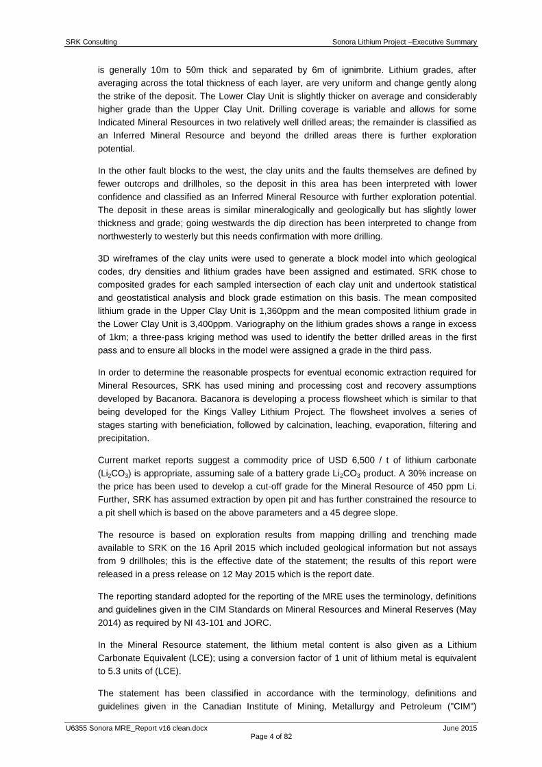
Table ES 1: SRK Mineral Resource Statement as of 12 May 2015
Classi-fication
Con-cession
Owner Geological
Unit
Clay Tonnes
(Mt)
Clay Grade
(Li ppm)
Contained Metal (Kt Li)
Contained Metal
(Kt LCE)
Indicated
La Ventana
Minera Sonora Borax
Lower Clay 35 3,250 110 580
Upper Clay 35 1,400 50 260
El Sauz
Mexilit (JV-1)
Lower Clay 15 2,350 40 220
Upper Clay 8 1,000 8 40
Fleur Lower Clay 1 4,250 4 20
Upper Clay 2 1,800 4 20
Indicated
Combined 95 2,200 220 1,140
Inferred
La Ventana
Minera Sonora Borax
Lower Clay 30 3,700 100 500
Upper Clay 90 1,700 150 800
El Sauz
Mexilit (JV-1)
Lower Clay 100 2,500 250 1,300
Upper Clay 100 1,100 100 500
Fleur Lower Clay 80 4,200 350 2,000
Upper Clay 60 1,800 100 500
El Sauz1 Lower Clay 20 4,300 80 400
Upper Clay 30 1,700 60 300
Inferred
Combined 500 2,300 1,200 6,300
Notes:
1. Mineral Resources are not Mineral Reserves and do not have demonstrated economic viability. All figures are rounded to reflect
the relative accuracy of the estimate and have been used to derive sub-totals, totals and weighted averages. Such calculations
inherently involve a degree of rounding and consequently introduce a margin of error. Where these occur, SRK does not consider
them to be material.
2. The reporting standard adopted for the reporting of the MRE uses the terminology, definitions and guidelines given in the CIM
Standards on Mineral Resources and Mineral Reserves (May 2014) as required by NI 43-101 and JORC.
3. The MRE is reported on 100 percent basis for all project areas.
4. SRK assumes the Sonora Lithium deposit to be amenable to surface mining methods. Using results from initial metallurgical test
work, suitable surface mining and processing costs, and forecast LCE price SRK has reported the Mineral Resource at a cut-off
450 ppm Li (2,400 ppm Li2CO3).
5. SRK completed a site inspection of the deposit by Mr. Martin Pittuck, MSc, C.Eng, MIMMM, an appropriate "independent
qualified person" as such term is defined in NI 43-101.
The Mineral Resource is the total for the Project; in respect of the total metal in the Indicated
and Inferred Mineral Resources:
some 93% and 75% respectively is attributable to Bacanora; and
some 7% and 25% respectively is attributable to REM.
The previous estimates for these concessions prepared by C. Verley in June 2014, when
combined to make a direct comparison with the estimate in this report, had a greater tonnage
and grade of Indicated Mineral Resource compared with the statement in this report and it
had no Inferred Mineral Resource.
The previous estimates used a classic polygonal method whereas SRK created a 3D
geological model giving better confidence in geological continuity which allows extrapolation
over a wider area resulting in a larger overall resource than that produced in the previous
estimate. However, a relatively small part of SRK‟s estimate is considered to be Indicated

SRK Consulting Sonora Lithium Project –Executive Summary
U6355 Sonora MRE_Report v16 clean.docx June 2015 Page 6 of 82
based on a difference in opinion regarding the amount and spacing of geological information
required to confer this classification category.
SRK recommends continued drilling to infill the Inferred Mineral Resource in order to increase
the confidence in these areas to an Indicated level. In the parts of the model which are not
well drilled but which are contained in the pit shell, deeper drilling is recommended to add to
the Mineral Resource.
Some of the quality control procedures should be improved so that the grades of the standard
reference materials are more representative of the deposit grades. Some aspects of the
density determination require further study to confirm the accuracy of the density
determination method which currently assumed no core shrinkage upon drying.
The laboratory method used to date has a maximum detection limit of 10,000 ppm Li; several
samples have returned this grade. SRK recommends resubmitting all high grade samples to
the laboratory, employing a method with a higher upper detection limit; this will result in a
slight increase in the resource grade.
The deposit appears to be robust and amenable to economic extraction, SRK recommends
further study to a prefeasibility level of detail in order to determine Mineral Reserves.

SRK Consulting Sonora Lithium Project – Table of Contents Main Report
U6355 Sonora MRE_Report v16 clean.docx June 2015 Page 7 of 82
Table of Contents
1 INTRODUCTION ............................................................................................... 12
1.1 Background ............................................................................................................................ 12
1.2 Qualifications of Consultants ................................................................................................. 12
2 RELIANCE OF OTHER EXPERTS ................................................................... 13
3 PROJECT DESCRIPTION AND LOCATION .................................................... 13
3.1 Project Location ..................................................................................................................... 13
3.2 Project Concessions and Ownership ..................................................................................... 13
4 ACCESSIBILITY, CLIMATE, LOCAL RESOURCES, INFRASTRUCTURE AND PHYSIOGRAPHY .............................................................................................. 17
4.1.1 International Access ............................................................................................... 17
4.1.2 Regional and Local Access .................................................................................... 17
4.2 Physiography and Climate ..................................................................................................... 17
4.2.1 Physiography .......................................................................................................... 17
4.2.2 Climate ................................................................................................................... 17
4.3 Resources and Infrastructure ................................................................................................ 18
5 HISTORY ........................................................................................................... 19
5.1 Previous Mapping and Surface Sampling ............................................................................. 19
5.2 Drilling by Previous Explorers ................................................................................................ 19
5.3 Previous Mineral Resource Estimation .................................................................................. 19
5.3.1 El Sauz and Fleur Concessions ............................................................................. 19
5.3.2 La Ventana ............................................................................................................. 21
6 GEOLOGICAL SETTING AND MINERALISATION .......................................... 24
6.1 Regional Geology and Tectonics ........................................................................................... 24
6.2 Deposit Stratigraphy .............................................................................................................. 24
6.3 Deposit Structure ................................................................................................................... 25
6.4 Mineralisation ......................................................................................................................... 26
7 DEPOSIT TYPE ................................................................................................. 28
7.1 Deposit type ........................................................................................................................... 28
7.2 Adjacent/Regional Deposits................................................................................................... 28
8 EXPLORATION ................................................................................................. 28
8.1 Introduction ............................................................................................................................ 28
8.2 Surface Sampling Programme .............................................................................................. 28
8.2.1 2010 – La Ventana Concession ............................................................................. 28
8.2.2 2011 – El Sauz Concession ................................................................................... 29
8.2.3 2013 – El Sauz Concession ................................................................................... 31
8.3 Trenching ............................................................................................................................... 31
9 DRILLING .......................................................................................................... 33
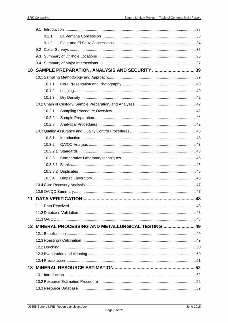
SRK Consulting Sonora Lithium Project – Table of Contents Main Report
U6355 Sonora MRE_Report v16 clean.docx June 2015 Page 8 of 82
9.1 Introduction ............................................................................................................................ 33
9.1.1 La Ventana Concession ......................................................................................... 33
9.1.2 Fleur and El Sauz Concessions ............................................................................. 34
9.2 Collar Surveys ....................................................................................................................... 35
9.3 Summary of Drillhole Locations ............................................................................................. 35
9.4 Summary of Major Intersections ............................................................................................ 37
10 SAMPLE PREPARATION, ANALYSIS AND SECURITY ................................. 39
10.1 Sampling Methodology and Approach ................................................................................... 39
10.1.1 Core Presentation and Photography ...................................................................... 40
10.1.2 Logging ................................................................................................................... 40
10.1.3 Dry Density ............................................................................................................. 42
10.2 Chain of Custody, Sample Preparation, and Analyses ......................................................... 42
10.2.1 Sampling Procedure Overview ............................................................................... 42
10.2.2 Sample Preparation ................................................................................................ 42
10.2.3 Analytical Procedures ............................................................................................. 42
10.3 Quality Assurance and Quality Control Procedures .............................................................. 43
10.3.1 Introduction ............................................................................................................. 43
10.3.2 QA/QC Analysis ..................................................................................................... 43
10.3.2.1 Standards ............................................................................................................... 43
10.3.3 Comparative Laboratory techniques ...................................................................... 45
10.3.3.1 Blanks ..................................................................................................................... 45
10.3.3.2 Duplicates ............................................................................................................... 45
10.3.4 Umpire Laboratory .................................................................................................. 45
10.4 Core Recovery Analysis ........................................................................................................ 47
10.5 QA/QC Summary ................................................................................................................... 47
11 DATA VERIFICATION ....................................................................................... 48
11.1 Data Received ....................................................................................................................... 48
11.2 Database Validation ............................................................................................................... 48
11.3 QA/QC ................................................................................................................................... 48
12 MINERAL PROCESSING AND METALLURGICAL TESTING ......................... 49
12.1 Beneficiation .......................................................................................................................... 49
12.3 Roasting / Calcination ............................................................................................................ 49
12.2 Leaching ................................................................................................................................ 50
12.3 Evaporation and cleaning ...................................................................................................... 50
12.4 Precipitation ........................................................................................................................... 51
13 MINERAL RESOURCE ESTIMATION .............................................................. 52
13.1 Introduction ............................................................................................................................ 52
13.2 Resource Estimation Procedure ............................................................................................ 52
13.3 Resource Database ............................................................................................................... 52

SRK Consulting Sonora Lithium Project – Table of Contents Main Report
U6355 Sonora MRE_Report v16 clean.docx June 2015 Page 9 of 82
13.4 Topographic Survey ............................................................................................................... 53
13.5 Geological Modelling ............................................................................................................. 54
13.6 2D Modelling and Interpretation ............................................................................................ 54
13.7 3D Geological Modelling ........................................................................................................ 56
13.8 Deposit Modelling .................................................................................................................. 56
13.8.1 Geological Zone Modelling ..................................................................................... 56
13.8.2 Block Model Creation ............................................................................................. 59
13.9 Classical Statistical Study ...................................................................................................... 60
13.9.1 Introduction ............................................................................................................. 60
13.9.2 Raw Statistics ......................................................................................................... 60
13.9.3 Data Compositing ................................................................................................... 60
13.9.4 Density Analysis ..................................................................................................... 61
13.10 Geostatistical Analysis and Variography ....................................................................... 62
13.10.1 Introduction ............................................................................................................. 62
13.10.2 Summary ................................................................................................................ 62
13.11 Block Model and Grade Estimation ............................................................................... 63
13.11.1 Block Model Set-Up ................................................................................................ 63
13.11.2 Grade Interpolation ................................................................................................. 64
13.12 Block Model Validation .................................................................................................. 66
13.12.1 Introduction ............................................................................................................. 66
13.12.2 Visual Validation ..................................................................................................... 66
13.12.3 Statistical Validation ............................................................................................... 68
13.13 Mineral Resource Classification .................................................................................... 69
13.13.1 Introduction ............................................................................................................. 69
13.13.2 Geological and Grade Continuity ........................................................................... 70
13.13.3 Data Quality ............................................................................................................ 70
13.13.4 Results of the Geostatistical Analysis .................................................................... 71
13.13.5 Quality of the Estimation ........................................................................................ 71
13.13.6 SRK Classification Approach ................................................................................. 71
13.14 Mineral Resource Cut-Off Grade and Practical Limits .................................................. 73
13.15 Mineral Resource Statement ......................................................................................... 75
13.16 Comparison with Previous Estimate ............................................................................. 76
13.17 Grade Sensitivity Analysis ............................................................................................. 76
13.18 Exploration Potential ..................................................................................................... 78
14 MINERAL RESERVE ESTIMATES ................................................................... 79
15 ADJACENT PROPERTIES ............................................................................... 79
16 OTHER RELEVANT DATA AND INFORMATION ............................................ 79
17 INTERPRETATION AND CONCLUSIONS ....................................................... 79
18 RECOMMENDATIONS ..................................................................................... 79
SRK Consulting Sonora Lithium Project – Table of Contents Main Report
U6355 Sonora MRE_Report v16 clean.docx June 2015 Page 10 of 82
19 REFERENCES .................................................................................................. 80
LIST OF TABLES
Table 3-1: Issued and Approved for Title concessions of Bacanora Minerals ............................. 14 Table 5-1: Historical Indicated Mineral Resources for El Sauz and Fleur (C. Verley, 2014)........ 21 Table 5-2: Historical Indicated Mineral Resources for La Ventana Concessions (C.Verley, 2014)
..................................................................................................................................... 23 Table 6-1: Stratigraphic succession on the El Sauz concession .................................................. 25 Table 8-1: Trench collar locations ................................................................................................ 31 Table 9-1: Sonora drillhole collars ................................................................................................ 35 Table 9-2: Major intersections of lithium mineralisation within the upper and lower clay units .... 37 Table 10-1: Key logging codes summarised based on Bacanora core logging procedures .......... 41 Table 10-2: Summary of reference sample insertion...................................................................... 43 Table 10-3: Summary of reference sample calculated means and standard deviations................ 43 Table 13-1: Kriging Zone Codes (KZONES) .................................................................................. 58 Table 13-2: Raw Statistics for Li by KZONE (weighted by Clay Unit thickness) ............................ 61 Table 13-3: Average density used in block model .......................................................................... 61 Table 13-4: Summary of lithium 2D semi-variogram parameters ................................................... 63 Table 13-5: 2D Block model origins and dimensions ..................................................................... 63 Table 13-6: 3D Block model origins and dimensions ..................................................................... 63 Table 13-7: Summary of fields used during estimation .................................................................. 64 Table 13-8: Search Parameters for interpolation of Li .................................................................... 65 Table 13-9: Comparison statistics for Li composites versus 3D block model grades .................... 69 Table 13-10: Optimisation Parameters ............................................................................................. 73 Table 13-11: SRK Mineral Resource Statement as of 12 May 2015 ................................................ 75
List of Figures Figure 3-1: Current Project ownership structure ............................................................................ 14 Figure 3-2: Project Location Plan .................................................................................................. 16 Figure 3-3: Location of the Sonora Project concessions, Mexico .................................................. 16 Figure 5-1: Plan of Resource Polygons and base geological map for Fleur and El Sauz ............. 20 Figure 5-2: Plan of Resource Polygons and base geological map for La Ventana ....................... 22 Figure 6-1: Northeast view of gently dipping lithium-bearing sediments near the centre of the El
Sauz concession ......................................................................................................... 26 Figure 6-2: Alternating clay and silica bands within an outcrop on the La Ventana concession ... 27 Figure 8-1: Initial mapping undertaken for the Sonora Lithium Project ......................................... 30 Figure 8-2: 2013 surface sampling and mapping undertaken on the El Sauz and Fleur
concessions ................................................................................................................. 31 Figure 8-3: TR-6 excavated through clay horizon in the south of La Ventana .............................. 32 Figure 8-4: Trench locations .......................................................................................................... 32 Figure 9-1: Current drill rig producing NQ drill core ....................................................................... 34 Figure 9-2: Drill collars on the Sonora project concessions .......................................................... 35 Figure 10-1: Bacanora employees preparing core in a dedicated and secure compound,
Bacadehuachi .............................................................................................................. 39 Figure 10-2: Drill core presented after cut and sampling procedures.............................................. 40 Figure 10-3: Low grade lithium reference standard TT ................................................................... 44 Figure 10-4: Low grade lithium reference standard MY-TT ............................................................. 44 Figure 10-5: High grade lithium reference standard ........................................................................ 45 Figure 10-6: Duplicate sample method comparison ........................................................................ 46 Figure 10-7: Duplicate sample laboratory comparison .................................................................... 46 Figure 12-1: Conceptual Flowsheet under Development ................................................................ 50 Figure 13-1: Area covered by available Ikonos imagery ................................................................. 53 Figure 13-2: Digital imagery draped over topographic mesh to validate drillhole locations (red) .... 54 Figure 13-3: Elevation contour maps for the Upper and Lower Clay Units ..................................... 55 Figure 13-4: Thickness contour maps for the Upper and Lower Clay Units .................................... 55 Figure 13-5: Grade contour maps for the Upper and Lower Clay Units .......................................... 56 Figure 13-6: Orthogonal view of client cross sections registered in 3D space ................................ 57

SRK Consulting Sonora Lithium Project – Table of Contents Main Report
U6355 Sonora MRE_Report v16 clean.docx June 2015 Page 11 of 82
Figure 13-7: Northwest-looking cross section showing stratigraphic units and related fault structures ..................................................................................................................... 57
Figure 13-8: 3D view of the geological model in outcrop and section slice ..................................... 58 Figure 13-9: Wireframes clipped by topography, faults and perimeter boundary ............................ 59 Figure 13-10: Combined Histograms for Upper and Lower Clay Units ............................................. 60 Figure 13-11: Grade density relations ships for upper and lower clay units ...................................... 61 Figure 13-12: Lithium variography for Upper and Lower Clay Units based on composite point file .. 62 Figure 13-13: Li block model validated against composited drillhole data – Upper Clay .................. 67 Figure 13-14: Li block model validated against composited drillhole data –Lower Clay ................... 68 Figure 13-15: Plan view showing classification of the Sonora Project .............................................. 72 Figure 13-16: Oblique view showing classified material within the resource pit shell ....................... 74 Figure 13-17: Grade-Tonnage Curve for Li (Upper Clay – Indicated material) ................................. 77 Figure 13-18: Grade-Tonnage Curve for Li (Upper Clay – Inferred material) ................................... 77 Figure 13-19: Grade-Tonnage Curve for Li (Lower Clay – Indicated material) ................................. 78 Figure 13-20: Grade-Tonnage Curve for Li (Lower Clay – Inferred material) ................................... 78
List of Technical Appendices
A QUALIFIED PERSONS CERTIFICATE .........................................................A-81
SRK Consulting (UK) Limited 5th Floor Churchill House 17 Churchill Way City and County of Cardiff CF10 2HH, Wales United Kingdom E-mail: [email protected] URL: www.srk.co.uk Tel: + 44 (0) 2920 348 150 Fax: + 44 (0) 2920 348 199
SRK Consulting (UK) Limited 5th Floor Churchill House 17 Churchill Way City and County of Cardiff CF10 2HH, Wales United Kingdom E-mail: [email protected] URL: www.srk.co.uk Tel: + 44 (0) 2920 348 150 Fax: + 44 (0) 2920 348 199
Registered Address: 21 Gold Tops, City and County of Newport, NP20 4PG, Wales, United Kingdom.
SRK Consulting (UK) Limited Reg No 01575403 (England and Wales) Page 12 of 82
Group Offices: Africa Asia
Australia Europe
North America South America
NI 43-101 MINERAL RESOURCE ESTIMATE FOR THE SONORA LITHIUM PROJECT, MEXICO, MAY 2015
1 INTRODUCTION
1.1 Background
SRK Consulting (UK) Limited (“SRK”) is an associate company of the international group
holding company, SRK Consulting (Global) Limited (the “SRK Group”). SRK has been
commissioned by Rare Earth Minerals PLC (“REM”, or the “Client”) and Bacanora Minerals
Limited (“Bacanora” or the “Company”) to produce a Mineral Resource Estimate (“MRE”) of
the Lithium Resources relating to the Sonora Lithium Project (“Sonora” or “the project”)
located in Mexico.
REM owns approximately 16% of Bacanora and the two companies have joint ventures in
different proportions for several concessions covering the project. The Sonora Project MRE is
for lithium clay units which are distributed across the contiguous El Sauz, Fleur and La
Ventana concessions (“the concessions” or “the asset”).
1.2 Qualifications of Consultants
SRK is an associate company of the SRK Group. The SRK Group comprises over 1,500
professional staff over 50 offices, over 23 countries on 6 continents, offering expertise in a
wide range of engineering disciplines. The SRK Group‟s independence is ensured by the fact
that it holds no equity in any project. This permits the SRK Group to provide its clients with
conflict-free and objective recommendations on crucial judgment issues. The SRK Group has
a demonstrated track record in undertaking independent assessments of resources and
reserves, project evaluations and audits, mineral expert reports, independent valuation
reports and independent feasibility evaluations to bankable standards on behalf of exploration
and mining companies and financial institutions worldwide. The SRK Group has also worked
with a large number of major international mining companies and their projects, providing
mining industry consultancy service inputs. SRK also has specific experience in commissions
of this nature.
SRK‟s contribution to this Technical Report has been prepared based on input from a team of
consultants sourced from SRK‟s office in the UK. These consultants are specialists in the
fields of geology and resource and reserve estimation and classification and mineral
processing.

SRK Consulting Sonora Lithium Project – Main Report
U6355 Sonora MRE_Report v16 clean.docx June 2015 Page 13 of 80
The site visit and inspection of the sample preparation facilities were undertaken between 24th
and 27th March 2015 by:
Mr Martin Pittuck (Project Director), who is a full time employee of SRK. Mr Pittuck is a
Chartered Engineer with the Institute of Materials Minerals and Mining and has sufficient
experience which is relevant to the style of mineralisation under study to qualify as a Qualified
Person (“QP”) as defined in the National Instrument 43-101 Standards of Disclosure for
Mineral Projects. Martin has 20 years broad geological experience, specialising in Mineral
Resource estimation, mine project evaluation and reporting according international reporting
codes. He has produced or reviewed resource estimates for a wide variety of commodities
and mineralisation styles.
Mr Colin Rawbone (Project Manager), who is also a full time employee of SRK. Mr Rawbone
is a Member of the Australian Institute of Mining and Metallurgy, and has a Chartered
Professional status (MAusIMM(CP)) as defined in the Australasian Code for Reporting of
Exploration Results, Mineral Resources and Ore Reserves, 2012 Edition'. Mr Rawbone has
more than 10 years' broad geological experience, specialising in mineral exploration and
Mineral Resource estimation.
The individuals responsible for this report have extensive experience in the mining industry
and are members in good standing of appropriate professional institutions.
2 RELIANCE OF OTHER EXPERTS
SRK has relied upon the company‟s in house legal team with respect to validation of mineral
tenement and land tenure status, specifically location and ownership agreements, including
agreements or material issues with third parties such as joint ventures, partnerships,
overriding royalties, native title interests, historical sites, wilderness or national park and
environmental settings.
3 PROJECT DESCRIPTION AND LOCATION
3.1 Project Location
The project is situated in the northwestern Mexican state of Sonora, some 11km south of
Bacadehuachi which is 180 km northeast of Hermosillo and approximately 170 km south of
the USA – Mexico border. A location plan is given in Figure 3-2.
3.2 Project Concessions and Ownership
The Sonora Lithium Project is an exploration project part of which is owned jointly by REM
and Bacanora. REM owns approximately 16% of Bacanora and has an additional direct share
in some of the operating companies owned by Bacanora.
The Sonora Lithium Project consists of ten concessions which confer rights for exploration,
mining and production. The concessions are owned by a number of REM-Bacanora
subsidiaries :
Mexilit SA de CV (“Mexilit”), owned 70% by Bacanora,
Megalit SA de CV (“Megalit”), owned 70% by Bacanora; and
Minera Sonora Borax SA de CV (“MSB”), owned 99% by Bacanora.
SRK Consulting Sonora Lithium Project – Main Report
U6355 Sonora MRE_Report v16 clean.docx June 2015 Page 14 of 80
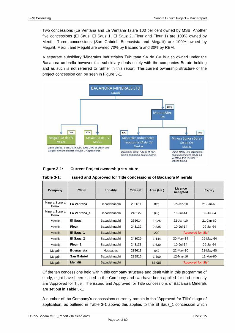
Two concessions (La Ventana and La Ventana 1) are 100 per cent owned by MSB. Another
five concessions (El Sauz, El Sauz 1, El Sauz 2, Fleur and Fleur 1) are 100% owned by
Mexilit. Three concessions (San Gabriel, Buenavista and Megalit) are 100% owned by
Megalit. Mexilit and Megalit are owned 70% by Bacanora and 30% by REM.
A separate subsidiary „Minerales Industriales Tubutana SA de CV is also owned under the
Bacanora umbrella however this subsidiary deals solely with the companies Borate holding
and as such is not referred to further in this report. The current ownership structure of the
project concession can be seen in Figure 3-1.
Figure 3-1: Current Project ownership structure
Table 3-1: Issued and Approved for Title concessions of Bacanora Minerals
Company Claim Locality Title ref. Area (Ha.) Licence
Accepted Expiry
Minera Sonora Borax
La Ventana Bacadehuachi 235611 875 22-Jan-10 21-Jan-60
Minera Sonora Borax
La Ventana_1 Bacadehuachi 243127 945 10-Jul-14 09-Jul-64
Mexilit El Sauz Bacadehuachi 235614 1,025 22-Jan-10 21-Jan-60
Mexilit Fleur Bacadehuachi 243132 2,335 10-Jul-14 09-Jul-64
Mexilit El Sauz_1 Bacadehuachi
200 “Approved for title”
Mexilit El Sauz_2 Bacadehuachi 243029 1,144 30-May-14 29-May-64
Mexilit Fleur_1 Bacadehuachi 243133 1,630 10-Jul-14 09-Jul-64
Megalit Buenavista Huasabas 235613 649 22-May-10 21-May-60
Megalit San Gabriel Bacadehuachi 235816 1,500 12-Mar-10 11-Mar-60
Megalit Megalit Bacadehuachi
87,086 “Approved for title”
Of the ten concessions held within this company structure and dealt with in this programme of
study, eight have been issued to the Company and two have been applied for and currently
are „Approved for Title‟. The issued and Approved for Title concessions of Bacanora Minerals
are set out in Table 3-1.
A number of the Company‟s concessions currently remain in the “Approved for Title” stage of
application, as outlined in Table 3-1 above; this applies to the El Sauz_1 concession which

SRK Consulting Sonora Lithium Project – Main Report
U6355 Sonora MRE_Report v16 clean.docx June 2015 Page 15 of 80
contains some 10% of the Mineral Resource and also to the Megalit concession which does
not contain any of the Mineral Resource reported herein. A summary of the process of
obtaining title to a concession from the Mexican Federal Mining Registry is as follows:
Initially an application for title is submitted to the local registry where the property is
located;
Following the submission of the application, the applicant has 60 days to file a survey
with the local registry;
Upon receipt of the survey, the local registry reviews and either approves it or responds
to the applicant and gives them a further 15 days to correct their survey; and
If the survey is approved (i.e. no objections are conveyed to the applicant), it is stamped
“Approved for Title” and is submitted to the Federal Mining Registry in Mexico City for
them to grant title to the applicant as a final administrative step.
In July 2014 and as part of Bacanora‟s admission to the AIM market on the London Stock
Exchange a legal opinion was prepared in relation the mineral concession status. The opinion
prepared by Melicoff & Asocdiados Abogados confirmed that:
Each mining concession is in full force and effect and has been duly validated by the
Mexican Mining Bureau and is free from any liens and encumbrances
Each mining concession was validly issued for a period of 50 years
Each of the mining concessions are in good standing, and they are not subject of any
unusual or onerous conditions, and their existence or validity will not be effected by any
change of control;
Bacanora and REM do not see any reason why the pending applications which have
been granted full concession status by the Ministry of Mining will not be approved by the
Ministry of Mining and confirm that these transfers are being processed.
The Directors of Bacanora believe that there is minimal risk of title not being eventually
granted for those concessions currently labelled “Approved for Title”. Further the Directors
state that Bacanora is, and has been, appropriately able to conduct its exploration activities
within these concessions consistent with Approved for Title status. Once the concessions that
are presently labelled “Approved for Title” have been issued to MSB, the concessions will be
transferred to Mexilit and Megalit in line with Mexican law and applicable regulations and in
accordance with the contractual obligations under the agreements between Bacanora and
REM.
The licence holding by the Company forms a continuous coverage over the project area. This
is illustrated in Figure 3-3. La Ventana and La Ventana 1, covering approximately 1,820 Ha.
The five concessions El Sauz, El Sauz 1, El Sauz 2, Fleur and Fleur 1 cover approximately
6,334 Ha in total and the additional three concessions Buenavista, Megalit and San Gabriel
cover approximately 89,235 Ha in total.
SRK Consulting Sonora Lithium Project – Main Report
U6355 Sonora MRE_Report v16 clean.docx June 2015 Page 16 of 80
Figure 3-2: Project Location Plan
Figure 3-3: Location of the Sonora Project concessions, Mexico

SRK Consulting Sonora Lithium Project – Main Report
U6355 Sonora MRE_Report v16 clean.docx June 2015 Page 17 of 80
4 ACCESSIBILITY, CLIMATE, LOCAL RESOURCES, INFRASTRUCTURE AND PHYSIOGRAPHY
4.1.1 International Access
Sonora lies on the geographic corridor connecting the central Mexican highlands (Mexico
City) north into the United States of America along the Pacific Coast. It is a major corridor for
travel and shipping, with rail lines and Federal Highway 15 following it. The state contains a
total of 24,396 km of highways. Rail lines mostly consist of those which lead into the U.S. The
major commercial port is in Guaymas, with smaller ones, mostly for tourism located in San
Carlos, Puerto Peñasco and Bahia Kino. The state has four airports in the cities of Hermosillo,
Puerto Peñasco, Ciudad Obregón and Nogales. These airports connect the state with 112
other locations both within Mexico and internationally. Airlines that operate out of them include
Aeromexico, Volaris, Interjet, Vivaaerobus, US Airways and Aero Calafia.
4.1.2 Regional and Local Access
The Sonora State and therefore project area has well developed infrastructure with an
extensive network of roads, including a four-lane highway (Highway 15) that crosses the state
from south to north. This not only joins Sonora with the rest of Mexico but also internationally
with the United States of America.
The project area specifically is accessed by way of Federal Highway 14, a two-lane highway
extending 225 km east of Hermosillo, to the intersection known as “El Coyote”, then south
from the intersection for 20 km on a recently paved, two-lane highway to the town of
Bacadehuachi. Bacanora has set up its local base of operations in this town and undertakes
all core processing facilities from this location.
Access to the concession from Bacadehauchi is on secondary, dry-weather roads, crossing
various privately owned ranches for approximately 11 km. The region is well known for cattle
ranching, and ranches and fenced zones cross the area. The ranchers have created a
network of secondary dirt roads to access other areas, and these roads provide excellent
access to the concessions. Land owners have provided authorisation for the company to
access the concessions on these roads.
4.2 Physiography and Climate
4.2.1 Physiography
The Sonora Lithium Project is situated within the Sonoran Desert in the western portion of the
Sierra Madre Occidental physiographic province, within the Basin and Range sub province. It
lies between “Mesa de Enmedio”, “Rincon del Sauz” and “El Capulin” mountain ranges.
Average elevation at the Project area is 900 m above sea level. The concessions are
surrounded by mountain peaks with elevations ranging up to 1,440 m above sea level.
4.2.2 Climate
The average ambient temperature is 21°C, with minimum and maximum temperatures of -5ºC
and 50ºC, respectively in the project area. Extreme high temperatures, upwards of 49ºC occur
in summer, winters are considered cool compared to most of Mexico.
SRK Consulting Sonora Lithium Project – Main Report
U6355 Sonora MRE_Report v16 clean.docx June 2015 Page 18 of 80
The accumulated annual rainfall for the area is approximately 450 ml. The wet season or
desert “monsoon” season occurs between the months of July and September, and heavy
rainfall can hamper exploration at times. The Sonoran Desert, because of its seasonal rainfall
pattern, hosts plants from the agave, palm, cactus and legume family, as well as many others.
The local climate provides no incumbents to undertaking field programmes and as such the
length of the operating season is 365 days a year.
4.3 Resources and Infrastructure
Bacadehuachi historically is a small farming and ranching community with a population of
approximately 2,010. Basic services capable of supporting early stage exploration projects
are available in the town. Surface rights sufficient for mining operations are obtainable from
local landowners, should such activities develop on the concessions.
The closest electric power line is about 10 km north of the concessions, passing very close to
Bacadehuachi. The power line then heads toward Nacori Chico, the next village southeast
from Bacadehuachi.
SRK Consulting Sonora Lithium Project – Main Report
U6355 Sonora MRE_Report v16 clean.docx June 2015 Page 19 of 80
5 HISTORY
There are no records of mineral exploration or mineral occurrences on the Property prior to
1992, when an American group, US Borax, initiated regional exploration work in the search for
borate deposits.
5.1 Previous Mapping and Surface Sampling
In 1996, US Borax conducted detailed field work in the area which consisted of geological
mapping and rock sampling. The mapping resulted in the discovery of sequences of
calcareous, fine-grained sandstones to mudstones intercalated with tuffaceous bands that are
locally gypsiferous. Rock sampling across representative sections of the sequence at intervals
along the strike extensions of these units returned weakly anomalous boron values,
consequently US Borax abandoned exploration in the area.
5.2 Drilling by Previous Explorers
No drilling has been undertaken on the licence concessions prior to Bacanora commencing
operations in 2010.
5.3 Previous Mineral Resource Estimation
Bacanora has completed mapping, chip sampling, trenching, metallurgical testwork and
drilling on the Project. Mineral Resources have been previously estimated by Bacanora for the
lithium bearing clays on the Company‟s concessions which were reported in ‘Updated and
reclassified Lithium resources, Sonora Lithium project, Sonora Mexico’ produced for
Bacanora Minerals Ltd on 24 June, 2014 (Carl G. Verley of Amerlin Exploration Services Ltd).
Within this document Verley updated earlier estimates based on additional drilling in 2013 and
2014; in the process, reclassifying all resources from inferred to indicated.
5.3.1 El Sauz and Fleur Concessions
A Resource Estimate, using a polygonal method, was undertaken for the area drilled on the El
Sauz and Fleur concessions. Grade and thickness continuity were assumed in an area of
influence around each drill such that: (i) in the north-south direction the influence area is half
of the distance between holes, and (ii) in the east-west direction a distance from outcrop and
extending down dip for 150 m was used. Plan views illustrating the areas of the polygons
used in the estimate are provided in Figure 5-1. Specific gravity of 2.38 and 2.35 tonnes per
cubic metre (t/m3) was assumed for the estimate for the Upper and Lower Clay units
respectively. The resulting grade and tonnage estimates were reported at cut-offs of 1,000,
2,000 and 3,000 ppm Li, with a cut-off of 2,000 ppm Li used as a base case scenario for
future study work.

SRK Consulting Sonora Lithium Project – Main Report
U6355 Sonora MRE_Report v16 clean.docx June 2015 Page 20 of 80
Figure 5-1: Plan of Resource Polygons and base geological map for Fleur and El
Sauz
A total Indicated Mineral Resource, based on CIM Definition Standards for Mineral Resources
and Reserves (2010), was estimated for each of the lithium-bearing units and is given in
Table 5-1. At a cut-off of 2,000 ppm Li, the base case Indicated Mineral Resource for the
Upper Clay unit is estimated to be 47,360,000 tonnes averaging 2,222 ppm Li, and for the
Lower Clay unit the Indicated Mineral Resource is 73,630,000 tonnes averaging 3,698 ppm Li,
giving a total Indicated Mineral Resource of 120,990,000 tonnes averaging 3,120 ppm Li. A
distinct zone of higher grade lithium occurs in the northern part of El Sauz and Fleur and
continues through Fleur onto the southern half of La Ventana.

SRK Consulting Sonora Lithium Project – Main Report
U6355 Sonora MRE_Report v16 clean.docx June 2015 Page 21 of 80
Table 5-1: Historical Indicated Mineral Resources for El Sauz and Fleur (C. Verley, 2014)
1LCE = Lithium carbonate equivalent and assumes that all lithium can be converted to lithium carbonate with no recovery or processing losses.
2 Specific Gravity = 2.38 t/m
3
5.3.2 La Ventana
Based upon drilling undertaken during 2010, 2011 and 2013 Carl G. Verley of Amerlin
Exploration Services used a polygonal estimation method to produce an Indicated Mineral
Resource for the La Ventana concession based upon the same logic and processes as
presented for the El Sauz and Fleur concessions. Plan views illustrating the areas of the
polygons used in the estimate are provided in Figure 5-2.
A total Indicated Mineral Resource, based on CIM Definition Standards for Mineral Resources
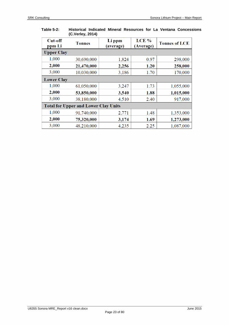
and Reserves (2010), was estimated for each of the lithium-bearing units and is given in
Table 5-2. Using a 2,000 ppm Li cut-off, an Indicated Mineral Resource for the Upper and
Lower Clay Units of 75,320,000 tonnes averaging 3,174 ppm Li (1.69% LCE) or 1,273,000
tonnes LCE was estimated. Both the Upper and Lower Clay Units were considered to be open
down-dip.

SRK Consulting Sonora Lithium Project – Main Report
U6355 Sonora MRE_Report v16 clean.docx June 2015 Page 22 of 80
Figure 5-2: Plan of Resource Polygons and base geological map for La Ventana
SRK Consulting Sonora Lithium Project – Main Report
U6355 Sonora MRE_Report v16 clean.docx June 2015 Page 23 of 80
Table 5-2: Historical Indicated Mineral Resources for La Ventana Concessions (C.Verley, 2014)

SRK Consulting Sonora Lithium Project – Main Report
U6355 Sonora MRE_Report v16 clean.docx June 2015 Page 24 of 80
6 GEOLOGICAL SETTING AND MINERALISATION
The content of this section is largely based on the following report; Updated and Reclassified
Lithium Resource, Sonora Lithium project by Carl G. Verley which was lodged with the
Canadian Securities Administrators 24 June 2014.
6.1 Regional Geology and Tectonics
The Property is underlain by Oligocene to Miocene age rhyolitic tuffs, ignimbrites and breccias
of the upper volcanic complex of the Sierra Madre Occidental. This succession was subjected
to basin and range extensional normal faulting during the Miocene that resulted in the
development of a series of half-grabens. The half-grabens locally filled with fluvial-lacustrine
sediments and intercalated tuffs. Alkaline volcanism around this time is thought to have
contributed lithium and other alkali metals into these basin deposits. Quaternary basalt flows
unconformably cover the basin sediment-volcaniclastic succession, except where later stage
faulting and uplift have exposed the basin succession at surface. Mineralization on the
Property consists of lithium-bearing clays localized within these basins.
6.2 Deposit Stratigraphy
Geological mapping has defined the following stratigraphic sequence, outlined in Table 6-1.
The lithium-bearing sedimentary sequences are well defined and are distinct from the
surrounding volcanics by their pale colour and fine to medium bedding, they have been
recorded and characterised as dominantly north striking, easterly dipping, Li-bearing
sediments.Controls for the lithium sedimentary sequence and resulting mineralisation are
considered to follow the shape of a lake in which the clays became entrained. Faults
underlying the lake may have served as channel ways for lithium-rich solutions to percolate
into the lake basin and possibly alter and enrich the existing clays in lithium. Alternatively, the
lithium may have been sourced from underlying volcanics and remobilised into the basin
sequence at a later date. However, rhyolites with sufficient lithium-rich melt inclusions to act
as source material have not yet been identified in the sequence presented or regionally.
The lithium-bearing clays occur in two discreet units: an upper clay unit and a lower clay unit.
The Lower Clay Unit is underlain by basaltic flows, breccias and tuffaceous rocks and is
overlain by an ignimbrite sheet. The average thickness of the Lower Clay Unit is
approximately 20m reaching 40m in places. The ignimbrite sheet is typically 6m thick and is
overlain by the Upper Clay Unit which averages 22m and reaches over 70m in thickness; the
Upper Clay Unit is overlain by a sequence of basalt flows and intercalated flow top breccias.
These stratigraphic units are reasonably continuous across the La Ventana, Fleur and El
Sauz concessions.

SRK Consulting Sonora Lithium Project – Main Report
U6355 Sonora MRE_Report v16 clean.docx June 2015 Page 25 of 80
Table 6-1: Stratigraphic succession on the El Sauz concession
Both the Upper and Lower clay units are considered to consist of several mineralised
subunits. The Lower Clay Unit consists of a basal red siltstone-sandstone-conglomerate unit,
tuffaceous sediments, thin lapilli tuff layers and reworked tuff layers interbedded with lithium-
rich clay layers.
The Upper clay unit, consists several subunits of thin, rhythmically laminated clay and silica
layers, coarse-grained, poorly sorted brown sandstone beds with a clayey and calcareous
matrix; yellowish green clay beds with silica nodules; dark grey clay bands with distinct slump
features and local calcite masses; light grey claystone layers interbedded with reddish
sandstone beds; reddish medium to coarse-grained sandstone with calcite veinlets.
6.3 Deposit Structure
The lithium-bearing sedimentary sequences are considered distinct and easily distinguished
in the field from the surrounding volcanics by their pale colour and thin to medium bedding, as
illustrated in the northeast view of gently, northeasterly dipping, lithium-bearing sediments
near the centre of the El Sauz concession (Figure 6-1). On the La Ventana concession,
lithium-bearing clay units are exposed from the northwest corner of the concession to the
southeast of the concession, a distance of 3.6 km. The sediments dip approximately 20° to
the northeast. A mapped northwesterly striking oblique slip fault has down thrown the clay
units to the south of La Ventana under basalt cover so they no longer remain exposed at
surface. Drilling however has confirmed the continuity of the clay units under the basalt cover
for a distance of 2.0 km to the southeast where they are again exposed at surface, on the El
Sauz concession for a further distance of 2.0 km to the southeast. In total a 7.6 km strike
length of the clay unit from the north end of La Ventana to the southern part of El Sauz has
been established in both the upper and lower clay units. The deposit is open at depth,
however, the down dip extent to the northeast, southwest and south is not known at present
and remains to be tested by further drilling.
The more southerly exposures of the clay units occurring on the western extent of the oblique

SRK Consulting Sonora Lithium Project – Main Report
U6355 Sonora MRE_Report v16 clean.docx June 2015 Page 26 of 80
slip fault and exposed on the El Sauz concession dip gently westerly probably as a result of
offsets and rotation on faults. In addition, exposures of the basement volcanics consist of
rhyolite tuff on the southern part of El Sauz versus andesitic basalt on La Ventana.
Figure 6-1: Northeast view of gently dipping lithium-bearing sediments near the
centre of the El Sauz concession
6.4 Mineralisation
Mineralisation on the concessions consists of a series of lithium-bearing clays that occur
within two bedded sequences, the Upper and the Lower Clay units, which are separated by
an ignimbrite sheet.
Bacanora understands there to be a number of lithium-bearing clay minerals with
polylithionatie being the only one currently positively identified. The clay units are believed to
have formed from supergene or diagenetic alteration of volcanic ash. The clay layers also
contain relict quartz and feldspar crystal shards, lithic fragments and silica bands (Figure 6-2),
and traces of other minerals. The layers are locally interbedded with reddish terrigenous beds
composed of sand and silt-sized material.
Initial interpretation has indicated a high grade lithium core in the area covered by the La
Ventana, El Sauz and Fleur concessions. This high grade zone extends from the middle of La
Ventana southward across Fleur and approximately a third of the distance south into El Sauz.
There, lithium grades are generally above 3,000 ppm Li. The best grades of lithium are
associated with elevated levels of calcium, cesium, magnesium, potassium, rubidium and
strontium. However, the correlation (especially for magnesium) is not one-to-one.

SRK Consulting Sonora Lithium Project – Main Report
U6355 Sonora MRE_Report v16 clean.docx June 2015 Page 27 of 80
Figure 6-2: Alternating clay and silica bands within an outcrop on the La Ventana
concession
On La Ventana the best grades of lithium are co-incident with elevated levels of potassium
and cesium and are found in the southern part of the deposit. Magnesium appears to be
irregularly distributed and does not follow lithium or the other alkalis. Mineralised intervals
within the clay units vary for the Upper Clay from 25% to 80% of the overall thickness and
from 40% to 100% for the Lower Clay unit, depending on the cut-off used. Vertical grade
variation is noted in places but it has not been identified with sufficient continuity between
drillholes to have been reflected in the 3D modelling process described herein.
Further mineralogical studies are recommended in order to determine what minerals host the
various alkali‟s in the clay units. Results of such studies could have an impact on beneficiation
of these minerals and recovery of the alkalis.

SRK Consulting Sonora Lithium Project – Main Report
U6355 Sonora MRE_Report v16 clean.docx June 2015 Page 28 of 80
7 DEPOSIT TYPE
7.1 Deposit type
The Sonora deposit is believed to have formed by hydrothermal alteration as a result of
alkaline volcanism effecting layers of volcaniclastic sedimentary rocks deposited in a basin
environment. The origin and timing of the mineralised content remains unclear with regard to
source and whether the alteration was essentially syngenetic with deposition of the
sedimentary rocks or whether the alteration is a post depositional event. Additional work is
required to clarify the origin of these deposits.
The Western Lithium Kings Valley development project, Humbolt County Nevada has similar
mineralogy and deposit geology to the Sonora Project but the exact lithium clay mineralogy
and regional geological setting is significantly different.
There are no directly analogous deposits known to be in operation.
7.2 Adjacent/Regional Deposits
The Sonora region plays a large part in Mexican production of ore minerals, dominantly silver,
celestite and bismuth. The state has the largest mining surface in Mexico, and three of the
country‟s largest mines: La Caridad, Cananea and Mineria María. Sonora also remains the
leading Mexican producer of gold, copper, graphite, molybdenum, and wollastonite as well as
one of the largest coal reserves in the country. This has resulted in established and well
maintained resources, specifically infrastructure which services the existing mining industry
through the region.
8 EXPLORATION
8.1 Introduction
There are no records of mineral exploration or mineral occurrences in the project area prior to
1992, when US Borax initiated regional exploration work in the search for industrial minerals.
In 1996, US Borax conducted detailed field work in the area, which consisted of geological
mapping and rock sampling. The mapping resulted in the discovery of sequences of
calcareous, fine-grained sandstones to mudstones intercalated with tuffaceous bands that are
locally gypsiferous. Rock sampling across representative sections of the sequence at intervals
along the strike extensions of these units returned weakly anomalous boron values.
Consequently, US Borax abandoned exploration in the area.
In 2010 Bacanora initiated a program of limited rock sampling on the La Ventana concession
this work led to the discovery of lithium-bearing clays. Follow-up work in 2011 on the El Sauz
concession led to the discovery of the lithium-bearing clays within this concession.
8.2 Surface Sampling Programme
8.2.1 2010 – La Ventana Concession
Bacanora‟s initial exploration efforts were focused on testing the clay exposures located on
the La Ventana concession. In 2010 a series of six continuous chip samples were taken
perpendicular to the strike of upper clay unit at the south end of the concession.
Each sample was placed in a numbered, fibre-weave sack. The samples were then taken to
SRK Consulting Sonora Lithium Project – Main Report
U6355 Sonora MRE_Report v16 clean.docx June 2015 Page 29 of 80
ALS Chemex facility in Hermosillo for lithium analysis and a multi-element scan using ICP-MS
techniques.
The results of this work confirmed the elevated lithium concentrations in the clay unit. Values
for the six samples ranged from 1,710 to 4,680 ppm Li (0.91 to 2.49% LCE).
Bacanora then conducted a diamond drilling campaign at La Ventana in 2010. A total of four
holes were drilled as an initial test of the lithium-bearing clay units.
8.2.2 2011 – El Sauz Concession
A geological reconnaissance and rock-sampling program was conducted on the El Sauz
concession by Bacanora‟s geologists during the period September 28 to November 11, 2011.
A total of 116 rock samples were collected from exposures of a pale coloured, clay-bearing
sequence of sediments and intercalated tuffaceous rocks. The samples were collected across
outcrops as continuous chip samples ranging in width from 0.9 to 2.2 m. and averaging 2.0 m.
perpendicular to the strike direction of the sediments. Sample spacing was dependent on
exposure; consequently, it was difficult to ascertain how representative the samples were of
the overall clay-bearing units on the El Sauz concession.
The sampled exposures occur in the northern half of El Sauz and dip to the east, in the case
of the northeastern most outcrops and to the west in the case of the more southerly
exposures. These opposing dips appear to indicate an anticlinal structure. The initial mapping
of the Fleur and El Sauz concessions is shown in Figure 8-1.
Results of analyses performed on the samples by ALS Chemex ranged from 49 to 7,220 ppm
Li, with 39 samples greater than 1,000 ppm Li. The results indicated that significant lithium-
bearing clay units occur on El Sauz.
A total of 94 rock samples averaging 1.7 kg were taken from outcrops of the clay units
exposed on the El Sauz concession. The samples were collected across outcrops as
continuous chip samples perpendicular to the strike direction of the sediments. Results of
analyses performed on the samples by ALS Chemex ranged from 10 to 2,130 ppm Li, with 15
samples greater than 1,000 ppm Li. The results further confirmed the 2011 work which
indicated that significant lithium-bearing clay units occur on El Sauz warranting further work in
order to more accurately assess the extent of the units and the concentration of lithium within
them.
In conjunction with the rock sampling, the geology of the area around the clay units on El
Sauz and Fleur were mapped (Figure 8-2). Structurally the clay units on El Sauz and Fleur dip
to the northeast at approximately 20° and in the central part of El Sauz the clay units crop out
in an arcuate form with the more easterly arm of the arc dipping to the northeast and the
westerly arm of the arc dipping westerly.
The geological mapping and Stage 1 drill program suggested that the strata on El Sauz were
a continuation of those found on the La Ventana concession. From this comparison it was
concluded that the lithium-bearing clay units on the El Sauz are a southern extension of the
sedimentary basin from La Ventana onto the Fleur and El Sauz concessions.

SRK Consulting Sonora Lithium Project – Main Report
U6355 Sonora MRE_Report v16 clean.docx June 2015 Page 30 of 80
Figure 8-1: Initial mapping undertaken for the Sonora Lithium Project

SRK Consulting Sonora Lithium Project – Main Report
U6355 Sonora MRE_Report v16 clean.docx June 2015 Page 31 of 80
8.2.3 2013 – El Sauz Concession
From February to April, 2013, the mapping and rock sampling campaign continued on the
Fleur and El Sauz concessions.
Figure 8-2: 2013 surface sampling and mapping undertaken on the El Sauz and
Fleur concessions
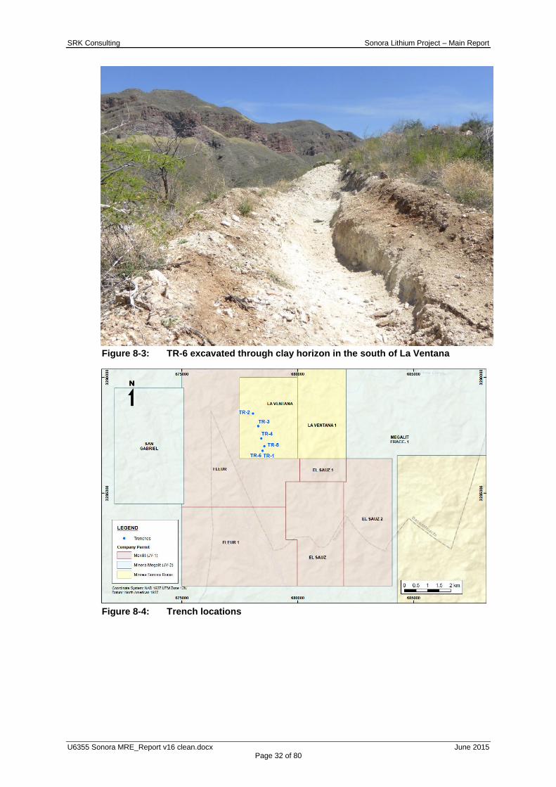
8.3 Trenching
In early 2014, six trenches were excavated across exposures of the Lower Clay Unit on La
Ventana in order to provide additional grade control. Continuous chip samples were taken at
intervals averaging 1.5 m in length. Figure 8-3 shows TR-6 excavated across the Lower Clay
Unit in La Ventana. Collar locations of the trench samples are listed in Table 8-1 and
illustrated in Figure 8-4. The results of the trench exploration and sampling are summarised in
Table 9-2.
Table 8-1: Trench collar locations
TRENCH EASTING NORTHING ELEVATION LENGTH
TR-2 678073.4 3288432 874.7755 30
TR-3 678298.8 3287890 883.1865 27.7
TR-4 678436.1 3287359 925.7235 27
TR-5 678569.9 3287025 882.845 22.5
TR-6 678487.2 3286830 929.467 33.6
SRK Consulting Sonora Lithium Project – Main Report
U6355 Sonora MRE_Report v16 clean.docx June 2015 Page 32 of 80
Figure 8-3: TR-6 excavated through clay horizon in the south of La Ventana
Figure 8-4: Trench locations
SRK Consulting Sonora Lithium Project – Main Report
U6355 Sonora MRE_Report v16 clean.docx June 2015 Page 33 of 80
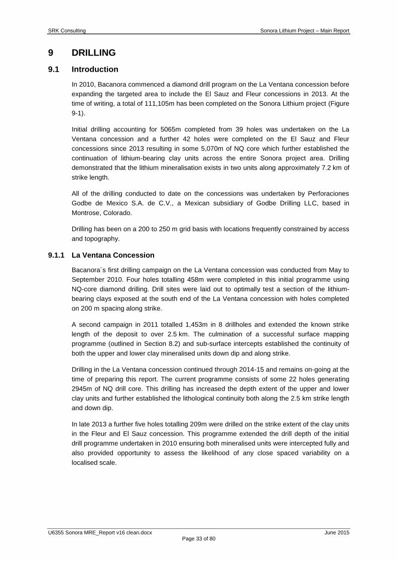
9 DRILLING
9.1 Introduction
In 2010, Bacanora commenced a diamond drill program on the La Ventana concession before
expanding the targeted area to include the El Sauz and Fleur concessions in 2013. At the
time of writing, a total of 111,105m has been completed on the Sonora Lithium project (Figure
9-1).
Initial drilling accounting for 5065m completed from 39 holes was undertaken on the La
Ventana concession and a further 42 holes were completed on the El Sauz and Fleur
concessions since 2013 resulting in some 5,070m of NQ core which further established the
continuation of lithium-bearing clay units across the entire Sonora project area. Drilling
demonstrated that the lithium mineralisation exists in two units along approximately 7.2 km of
strike length.
All of the drilling conducted to date on the concessions was undertaken by Perforaciones
Godbe de Mexico S.A. de C.V., a Mexican subsidiary of Godbe Drilling LLC, based in
Montrose, Colorado.
Drilling has been on a 200 to 250 m grid basis with locations frequently constrained by access
and topography.
9.1.1 La Ventana Concession
Bacanora´s first drilling campaign on the La Ventana concession was conducted from May to
September 2010. Four holes totalling 458m were completed in this initial programme using
NQ-core diamond drilling. Drill sites were laid out to optimally test a section of the lithium-
bearing clays exposed at the south end of the La Ventana concession with holes completed
on 200 m spacing along strike.
A second campaign in 2011 totalled 1,453m in 8 drillholes and extended the known strike
length of the deposit to over 2.5 km. The culmination of a successful surface mapping
programme (outlined in Section 8.2) and sub-surface intercepts established the continuity of
both the upper and lower clay mineralised units down dip and along strike.
Drilling in the La Ventana concession continued through 2014-15 and remains on-going at the
time of preparing this report. The current programme consists of some 22 holes generating
2945m of NQ drill core. This drilling has increased the depth extent of the upper and lower
clay units and further established the lithological continuity both along the 2.5 km strike length
and down dip.
In late 2013 a further five holes totalling 209m were drilled on the strike extent of the clay units
in the Fleur and El Sauz concession. This programme extended the drill depth of the initial
drill programme undertaken in 2010 ensuring both mineralised units were intercepted fully and
also provided opportunity to assess the likelihood of any close spaced variability on a
localised scale.

SRK Consulting Sonora Lithium Project – Main Report
U6355 Sonora MRE_Report v16 clean.docx June 2015 Page 34 of 80
Figure 9-1: Current drill rig producing NQ drill core
9.1.2 Fleur and El Sauz Concessions
In addition to the drilling undertaken on the La Ventana licence, Bacanora have undertaken a
number of drill programmes aimed at extending the known strike of the mineralised clay units
towards the southeast through the Fleur and El Sauz concession areas. Driven by the
continuity established in the La Ventana concession and supported by a positive surface
mapping and sampling programmes are outlined in Section 8.2.
An initial drilling campaign was undertaken from May to September 2013 in which a total of
1,470m of NQ-core was completed in 10 holes. Drill sites were laid out with the objective of
testing the extension of the lithium-bearing clays on the La Ventana concessions which
outcrop in El Sauz.
The second drill program on the Fleur and El Sauz concessions commenced in October 2013
and was completed in February 2014. A total of 2,436m of NQ drilling was completed in 20
holes extending the strike extent of the known lithium mineralisation. This drilling also defined
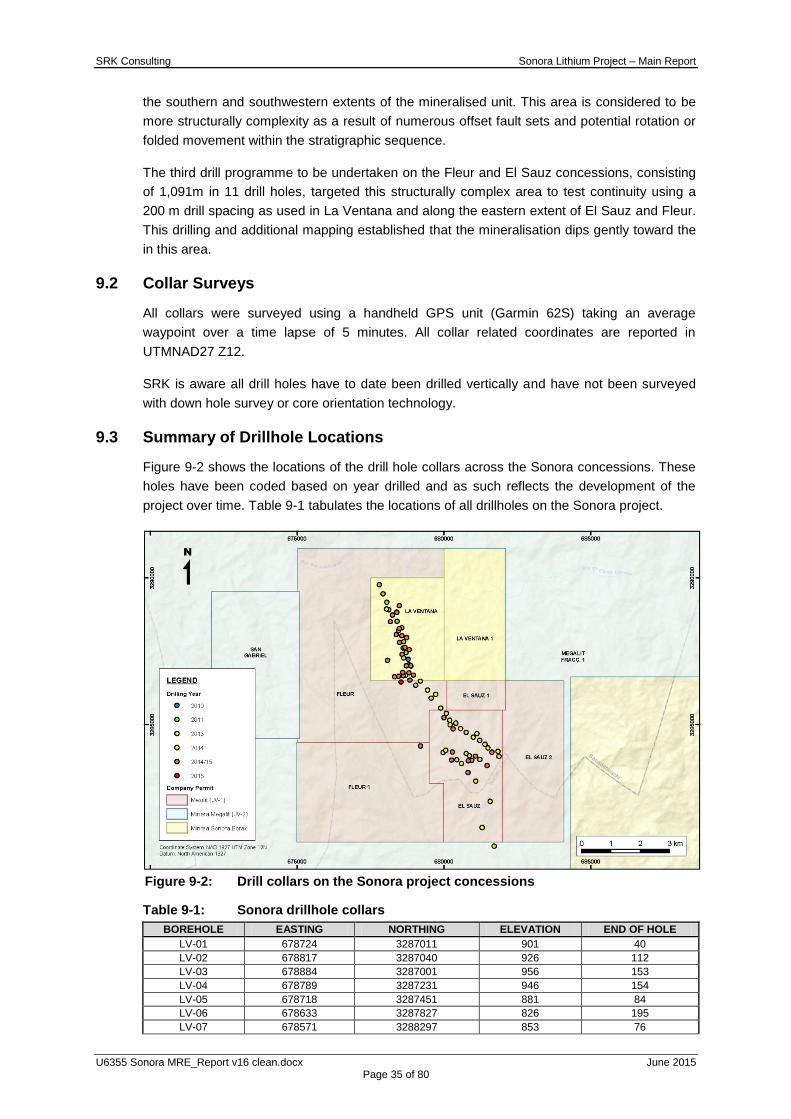
SRK Consulting Sonora Lithium Project – Main Report
U6355 Sonora MRE_Report v16 clean.docx June 2015 Page 35 of 80
the southern and southwestern extents of the mineralised unit. This area is considered to be
more structurally complexity as a result of numerous offset fault sets and potential rotation or
folded movement within the stratigraphic sequence.
The third drill programme to be undertaken on the Fleur and El Sauz concessions, consisting
of 1,091m in 11 drill holes, targeted this structurally complex area to test continuity using a
200 m drill spacing as used in La Ventana and along the eastern extent of El Sauz and Fleur.
This drilling and additional mapping established that the mineralisation dips gently toward the
in this area.
9.2 Collar Surveys
All collars were surveyed using a handheld GPS unit (Garmin 62S) taking an average
waypoint over a time lapse of 5 minutes. All collar related coordinates are reported in
UTMNAD27 Z12.
SRK is aware all drill holes have to date been drilled vertically and have not been surveyed
with down hole survey or core orientation technology.
9.3 Summary of Drillhole Locations
Figure 9-2 shows the locations of the drill hole collars across the Sonora concessions. These
holes have been coded based on year drilled and as such reflects the development of the
project over time. Table 9-1 tabulates the locations of all drillholes on the Sonora project.
Figure 9-2: Drill collars on the Sonora project concessions
Table 9-1: Sonora drillhole collars
BOREHOLE EASTING NORTHING ELEVATION END OF HOLE
LV-01 678724 3287011 901 40
LV-02 678817 3287040 926 112
LV-03 678884 3287001 956 153
LV-04 678789 3287231 946 154
LV-05 678718 3287451 881 84
LV-06 678633 3287827 826 195
LV-07 678571 3288297 853 76

SRK Consulting Sonora Lithium Project – Main Report
U6355 Sonora MRE_Report v16 clean.docx June 2015 Page 36 of 80
LV-08 678406 3288518 808 240
LV-09 678131 3288917 823 203
LV-10 678063 3289167 768 218
LV-11 677931 3289456 664 229
LV-12 677804 3289764 651 208
LV-13 678701 3286677 887 39
LV-14 678636 3287274 889 39
LV-15 678617 3287607 845 45
LV-16 678463 3288208 797 45
LV-17 678049 3288940 807 42
LV-18 678483 3289057 818 292
LV-19 678249 3288736 794 54
LV-20 678399 3288829 907 298
LV-21 678483 3288269 818 97
LV-22 678571 3288030 837 100
LV-23 678670 3287632 873 94
LV-24 678825 3287552 902 167
LV-25 678877 3287010 955 203
LV-26 678849 3286519 900 87
LV-27 678808 3286766 911 103
LV-28 678970 3286688 957 206
LV-29 678726 3287005 901 81
LV-30 678082 3287191 898 261
LV-31 678733 3287966 904 234
LV-32 678461 3286645 916 63
LV-33 678323 3286630 928 274
LV-34 678621 3286660 902 78
LV-35 678599 3286777 918 51
LV-36 678577 3287397 901 63
LV-37 678490 3287801 860 54
LV-38 678382 3288064 850 45
LV-39 678178 3288506 836 42
ES-01 679044 3286339 937 204
ES-02 679568 3285904 976 260
ES-03 680084 3285384 1032 256
ES-04 680410 3285052 1076 195
ES-05 680767 3284733 1092 124
ES-06 681221 3284464 1127 93
ES-07 681228 3283807 1182 96
ES-08 680872 3283939 1216 85
ES-09 680445 3283804 1113 98
ES-10 679972 3284051 1097 60
ES-11 679201 3286480 972 258
ES-12 679447 3286176 993 240
ES-13 679720 3286036 1019 350
ES-14 680202 3285148 1006 95
ES-15 680216 3284999 1035 66
ES-16 680572 3284865 1071 98
ES-17 679894 3285565 1020 223
ES-18 681007 3284566 1102 75
ES-19 681127 3284688 1156 160
ES-20 681403 3284332 1151 57
ES-21 681504 3284206 1182 51
ES-22 681852 3284089 1240 169
ES-23 681882 3283919 1217 48
ES-24 680767 3284014 1187 99
ES-25 680065 3284130 1136 194
ES-26 681092 3283074 1232 66
ES-27 680609 3283670 1130 57
ES-28 681582 3282386 1203 39
ES-29 681309 3281491 1112 39
ES-30 681720 3280859 1052 51
ES-31 680005 3285237 1002 106
ES-32 680319 3284849 1053 109
ES-33 681637 3284061 1212 151
ES-34 681478 3283605 1238 62
ES-35 681078 3283923 1215 133
ES-36 680957 3283776 1231 48
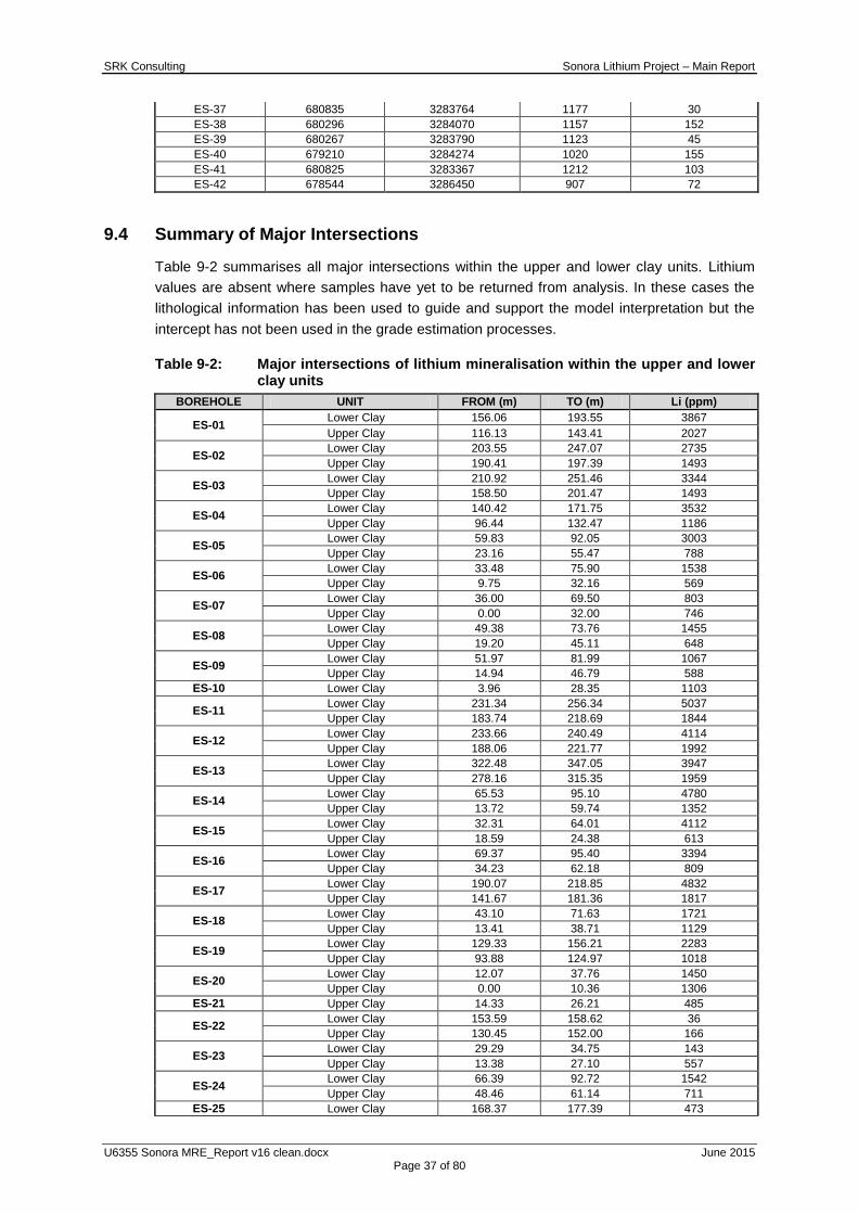
SRK Consulting Sonora Lithium Project – Main Report
U6355 Sonora MRE_Report v16 clean.docx June 2015 Page 37 of 80
ES-37 680835 3283764 1177 30
ES-38 680296 3284070 1157 152
ES-39 680267 3283790 1123 45
ES-40 679210 3284274 1020 155
ES-41 680825 3283367 1212 103
ES-42 678544 3286450 907 72
9.4 Summary of Major Intersections
Table 9-2 summarises all major intersections within the upper and lower clay units. Lithium
values are absent where samples have yet to be returned from analysis. In these cases the
lithological information has been used to guide and support the model interpretation but the
intercept has not been used in the grade estimation processes.
Table 9-2: Major intersections of lithium mineralisation within the upper and lower clay units
BOREHOLE UNIT FROM (m) TO (m) Li (ppm)
ES-01 Lower Clay 156.06 193.55 3867
Upper Clay 116.13 143.41 2027
ES-02 Lower Clay 203.55 247.07 2735
Upper Clay 190.41 197.39 1493
ES-03 Lower Clay 210.92 251.46 3344
Upper Clay 158.50 201.47 1493
ES-04 Lower Clay 140.42 171.75 3532
Upper Clay 96.44 132.47 1186
ES-05 Lower Clay 59.83 92.05 3003
Upper Clay 23.16 55.47 788
ES-06 Lower Clay 33.48 75.90 1538
Upper Clay 9.75 32.16 569
ES-07 Lower Clay 36.00 69.50 803
Upper Clay 0.00 32.00 746
ES-08 Lower Clay 49.38 73.76 1455
Upper Clay 19.20 45.11 648
ES-09 Lower Clay 51.97 81.99 1067
Upper Clay 14.94 46.79 588
ES-10 Lower Clay 3.96 28.35 1103
ES-11 Lower Clay 231.34 256.34 5037
Upper Clay 183.74 218.69 1844
ES-12 Lower Clay 233.66 240.49 4114
Upper Clay 188.06 221.77 1992
ES-13 Lower Clay 322.48 347.05 3947
Upper Clay 278.16 315.35 1959
ES-14 Lower Clay 65.53 95.10 4780
Upper Clay 13.72 59.74 1352
ES-15 Lower Clay 32.31 64.01 4112
Upper Clay 18.59 24.38 613
ES-16 Lower Clay 69.37 95.40 3394
Upper Clay 34.23 62.18 809
ES-17 Lower Clay 190.07 218.85 4832
Upper Clay 141.67 181.36 1817
ES-18 Lower Clay 43.10 71.63 1721
Upper Clay 13.41 38.71 1129
ES-19 Lower Clay 129.33 156.21 2283
Upper Clay 93.88 124.97 1018
ES-20 Lower Clay 12.07 37.76 1450
Upper Clay 0.00 10.36 1306
ES-21 Upper Clay 14.33 26.21 485
ES-22 Lower Clay 153.59 158.62 36
Upper Clay 130.45 152.00 166
ES-23 Lower Clay 29.29 34.75 143
Upper Clay 13.38 27.10 557
ES-24 Lower Clay 66.39 92.72 1542
Upper Clay 48.46 61.14 711
ES-25 Lower Clay 168.37 177.39 473

SRK Consulting Sonora Lithium Project – Main Report
U6355 Sonora MRE_Report v16 clean.docx June 2015 Page 38 of 80
Upper Clay 156.67 168.37 166
ES-26 Lower Clay 48.22 66.14 740
Upper Clay 16.43 44.81 473
ES-27 Lower Clay 24.38 49.50 1143
Upper Clay 7.62 18.17 375
ES-28 Lower Clay 22.86 32.31 77
Upper Clay 0.00 18.59 399
ES-29 Lower Clay 24.90 29.87 62
Upper Clay 11.28 20.12 180
ES-30 Upper Clay 28.35 39.93 139
ES-31 Lower Clay 69.49 99.97 4542
Upper Clay 15.12 59.13 1667
ES-33 Lower Clay 147.83 150.57 847
Upper Clay 121.13 144.78 552
ES-35 Lower Clay 106.68 129.05 1365
Upper Clay 78.33 100.89 779
ES-36 Lower Clay 23.26 44.68 1044
ES-37 Lower Clay 0.00 23.35 1621
ES-38 Upper Clay 109.42 141.12 890
ES-39 Upper Clay 35.60 40.23 101
ES-41 Lower Clay 70.10 95.83 782
Upper Clay 34.14 64.31 449
ES-42 Lower Clay 39.32 59.44
Upper Clay 16.15 23.35
LV-01 Upper Clay 7.32 35.36 2262
LV-02 Upper Clay 78.94 108.51 1734
LV-03 Upper Clay 126.49 135.64 955
LV-04 Lower Clay 126.49 150.88 4720
Upper Clay 91.44 110.57 2613
LV-05 Lower Clay 60.35 80.47 3624
Upper Clay 7.92 50.29 1526
LV-06 Lower Clay 46.18 81.69 2009
Upper Clay 2.44 30.78 1918
LV-08 Lower Clay 98.45 118.26 2106
Upper Clay 67.89 94.18 833
LV-09 Lower Clay 68.88 95.20 896
Upper Clay 38.79 59.64 555
LV-10 Upper Clay 55.17 123.34 651
LV-11 Lower Clay 105.71 109.12
Upper Clay 5.18 74.98 193
LV-12 Lower Clay 118.41 129.24 109
Upper Clay 71.32 98.60 102
LV-13 Lower Clay 13.26 34.60 5076
LV-14 Lower Clay 14.17 32.00 5353
LV-15 Lower Clay 18.28 39.04 3224
LV-16 Lower Clay 17.68 42.52 2603
LV-17 Lower Clay 24.70 34.14 1753
LV-18 Lower Clay 260.30 279.50 1047
Upper Clay 218.24 245.67 618
LV-19 Upper Clay 10.27 51.82 777
LV-20 Lower Clay 268.41 291.39 1629
Upper Clay 219.52 252.07 568
LV-21 Lower Clay 72.24 92.96 1743
Upper Clay 8.93 59.74 1216
LV-22 Lower Clay 75.86 96.35 2960
Upper Clay 18.38 57.30 1389
LV-23 Lower Clay 69.68 84.61 3711
Upper Clay 15.97 53.64 1794
LV-24 Lower Clay 145.27 158.89 4173
Upper Clay 90.53 130.06 1562
LV-25 Upper Clay 127.71 155.75 1560
LV-26 Lower Clay 53.95 72.24 1979
Upper Clay 22.86 50.29 1306
LV-27 Lower Clay 78.03 98.33 5687
Upper Clay 43.16 66.14 2359
LV-28 Lower Clay 179.83 203.30 4845
Upper Clay 131.73 165.93 1996
LV-29 Lower Clay 51.82 73.15

SRK Consulting Sonora Lithium Project – Main Report
U6355 Sonora MRE_Report v16 clean.docx June 2015 Page 39 of 80
Upper Clay 8.23 35.66
LV-31 Lower Clay 203.70 226.04
Upper Clay 147.83 185.56
LV-33 Upper Clay 255.12 261.21
LV-34 Lower Clay 3.05 7.92
LV-35 Lower Clay 12.37 33.41
LV-36 Lower Clay 15.33 35.36
LV-37 Lower Clay 14.84 35.36
LV-38 Lower Clay 13.96 37.49
LV-39 Lower Clay 4.88 27.31
TR-1 Lower Clay 0.00 27.80 1229
TR-2 Lower Clay 0.00 30.00 1448
TR-3 Lower Clay 0.00 27.70 2112
TR-4 Lower Clay 0.00 27.00 4776
TR-5 Lower Clay 0.00 22.50 4771
TR-6 Lower Clay 0.00 33.60 5681
10 SAMPLE PREPARATION, ANALYSIS AND SECURITY
10.1 Sampling Methodology and Approach
All core drilled on site was arranged into referenced core boxes and moved from the drill sites
by Bacanora personnel to a secure compound in Bacadehuachi where under the supervision
of the onsite geologist, it was logged, split and sampled (Figure 10-1). Core was then moved
to Bacanora‟s secured facility in Magdalena de Kino for storage. In addition to logging of
geological parameters in drill core, core recovery was also measured and recorded.
Figure 10-1: Bacanora employees preparing core in a dedicated and secure
compound, Bacadehuachi

SRK Consulting Sonora Lithium Project – Main Report
U6355 Sonora MRE_Report v16 clean.docx June 2015 Page 40 of 80
10.1.1 Core Presentation and Photography
Core and core blocks are placed in core boxes by the driller. Upon receipt in the core shed,
the drill core is cleaned or washed, if required, and core blocks are checked by Bacanora
staff. The core is split using a hydraulic splitter and then photographed wet and dry in a frame
ensuring a constant angle and distance from the camera (Figure 10-2).
Figure 10-2: Drill core presented after cut and sampling procedures
10.1.2 Logging
Geological logging is undertaken once core photography is complete. Logging includes
recording from-to intervals and brief descriptions of the lithological units as well as
observations and measurements regarding core recovery. The key logging codes used by
Bacanora have been summarised in Table 10-1.

SRK Consulting Sonora Lithium Project – Main Report
U6355 Sonora MRE_Report v16 clean.docx June 2015 Page 41 of 80
Table 10-1: Key logging codes summarised based on Bacanora core logging procedures
UNIT CODE Lithology DESCRIPTION
Capping basalt UBAS Capping Basalt Dark grey olivine basalt. Massive
Upper Sandstone UPP_SS Reddish sediments Reddish-grey medium to coarse grained
sandstone. Poorly bedded to massive. Abundant calcite, some iron oxides.
Upper clay
UTC Upper Tuffaceous
sequence
White to light grey claystone. Oxidized. Lithic and reworked. Contains sanidine crystals. Slightly
calcareous
CALCLS Calcareous sequence
Pink to dark breccias, silty-muddy matrix. Abundant calcite in masses and veinlets.
Feldspar altered to clays
WAXCLS Tuffaceous sequence
Light green-white altered tuff. Feldspar is being converted into clays (light green honey). Contains
glass crystals (sanidine) and biotite. Waxy.
BRSS Brown/reddish
sandstone
Brown sandstone. Poorly bedded. From 112 to 113. highly calcareous. Reddish tuffaceous
coarse grained sandstone. Clay matrix. Soft.
HS Hot Spring Type
Section
Light green-pink fine grained sequence composed of clays and silica nodules. Waxy in
zones. Folded. Friable. Abundant calcite in masses and veinlets. Thin bedded.
Ignimbrite IGNIMBRITE Tuffaceous sequence
Orange to pink welded tuff. Well indurated. Brecciated. Highly silicified. Contains pumice
flames.
Lower Clay
LWR-T-SED Lake-beds-altered
Dark green sequence composed of rhythmic beds of clay-silica-marls with abundant calcite in
masses and veinlets. Some dark zones with clay and organic matter. Thin to medium bedded.
LART Lower Seds Grey well indurated sandstone. Reworked
andesitic tuff?
LCGL Lower
conglomerate
Polymitic conglomerate. Reddish matrix to the top and greenish to the bottom. Purple-greenish-
white fragments.
Basement LBAS_AND Lower Basalt
Andesite
Dark green basalt. Biotite rich (black) in a fine grained groundmass. In some holes tuff with
andesite frags.
SRK Consulting Sonora Lithium Project – Main Report
U6355 Sonora MRE_Report v16 clean.docx June 2015 Page 42 of 80
10.1.3 Dry Density
Dry density readings are taken at regular intervals within each lithology and on every
lithological break. The methodology involves weighing dry samples in air and then in water, all
porous samples being wrapped in plastic first. Measurements are carried out on competent
whole core (typically 10-15 cm pieces) using a balance with top and modified under-slung
measuring capabilities with a detection limit of ±1 gm.
10.2 Chain of Custody, Sample Preparation, and Analyses
10.2.1 Sampling Procedure Overview
Sampling was based on lithological intervals and extended 2-3 samples either side the
identified lithium clay contacts. Samples ranged from a reported 0.3 – 8.68 m however the
average sample length remains 1.5 m reflecting the targeted sample length.
Sample intervals are measured by the Project geologists, who mark the sample length on the
core to indicate where it should be cut. The cut line along the core axis is positioned at 90º to
the predominant structure to ensure that both halves of the core represent the same
geological feature.
The core is then transferred to the core shed for sampling. Samples are then collected by
splitting the core in half with a manual core splitter.
10.2.2 Sample Preparation
The samples are bagged and labelled with a sequential, unique sample identification number.
Mr. Martin Vidal (Managing Director of Bacanora) supervised drilling of the first 12 holes on La
Ventana; Daniel Calles, geologist under contract to Bacanora, supervised the core sampling
during the later campaigns.
Split drill-core samples were shipped to an ALS Chemex Laboratories sample preparation
facility in Hermosillo, Mexico, for preparation. Sample preparation was conducted according to
the ALS Chemex rock, drill-core and chip-sampling procedures (PREP-31). This consists of
crushing the sample to minus 5.0 mm sized material, splitting off 250 grams and pulverizing
the split sample so that greater than 85% passed through a 75 micron aperture screen.
10.2.3 Analytical Procedures
Sample pulps were then shipped to ALS Chemex Laboratory in North Vancouver, Canada, for
assay and analysis. ALS Chemex is an ISO 14001-2004 certified laboratory in Canada and its
preparation facility in Mexico has received ISO 17025 certification.
All core samples were analysed by inductively coupled plasma – mass spectrographic (ICP-
MS: ME-MS41) method to provide data for a suite of 51 elements (Ag, Al, As, Au, B, Ba, Be,
Bi, Ca, Cd, Ce, Co, Cr, Cs, Cu, Fe, Ga, Ge, Hf, Hg, In, K, La, Li, Mg, Mn, Mo, Na, Nb, Ni, P,
Pb, Rb, Re, S, Sb, Sc, Se, Sn, Sr, Ta, Te, Th, Ti, Tl, U, V, W, Y, Zn, Zr).
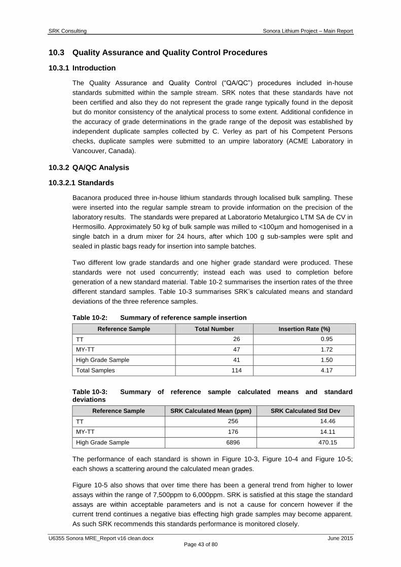
SRK Consulting Sonora Lithium Project – Main Report
U6355 Sonora MRE_Report v16 clean.docx June 2015 Page 43 of 80
10.3 Quality Assurance and Quality Control Procedures
10.3.1 Introduction
The Quality Assurance and Quality Control (“QA/QC”) procedures included in-house
standards submitted within the sample stream. SRK notes that these standards have not
been certified and also they do not represent the grade range typically found in the deposit
but do monitor consistency of the analytical process to some extent. Additional confidence in
the accuracy of grade determinations in the grade range of the deposit was established by
independent duplicate samples collected by C. Verley as part of his Competent Persons
checks, duplicate samples were submitted to an umpire laboratory (ACME Laboratory in
Vancouver, Canada).
10.3.2 QA/QC Analysis
10.3.2.1 Standards
Bacanora produced three in-house lithium standards through localised bulk sampling. These
were inserted into the regular sample stream to provide information on the precision of the
laboratory results. The standards were prepared at Laboratorio Metalurgico LTM SA de CV in
Hermosillo. Approximately 50 kg of bulk sample was milled to <100µm and homogenised in a
single batch in a drum mixer for 24 hours, after which 100 g sub-samples were split and
sealed in plastic bags ready for insertion into sample batches.
Two different low grade standards and one higher grade standard were produced. These
standards were not used concurrently; instead each was used to completion before
generation of a new standard material. Table 10-2 summarises the insertion rates of the three
different standard samples. Table 10-3 summarises SRK‟s calculated means and standard
deviations of the three reference samples.
Table 10-2: Summary of reference sample insertion
Reference Sample Total Number Insertion Rate (%)
TT 26 0.95
MY-TT 47 1.72
High Grade Sample 41 1.50
Total Samples 114 4.17
Table 10-3: Summary of reference sample calculated means and standard deviations
Reference Sample SRK Calculated Mean (ppm) SRK Calculated Std Dev
TT 256 14.46
MY-TT 176 14.11
High Grade Sample 6896 470.15
The performance of each standard is shown in Figure 10-3, Figure 10-4 and Figure 10-5;
each shows a scattering around the calculated mean grades.
Figure 10-5 also shows that over time there has been a general trend from higher to lower
assays within the range of 7,500ppm to 6,000ppm. SRK is satisfied at this stage the standard
assays are within acceptable parameters and is not a cause for concern however if the
current trend continues a negative bias effecting high grade samples may become apparent.
As such SRK recommends this standards performance is monitored closely.
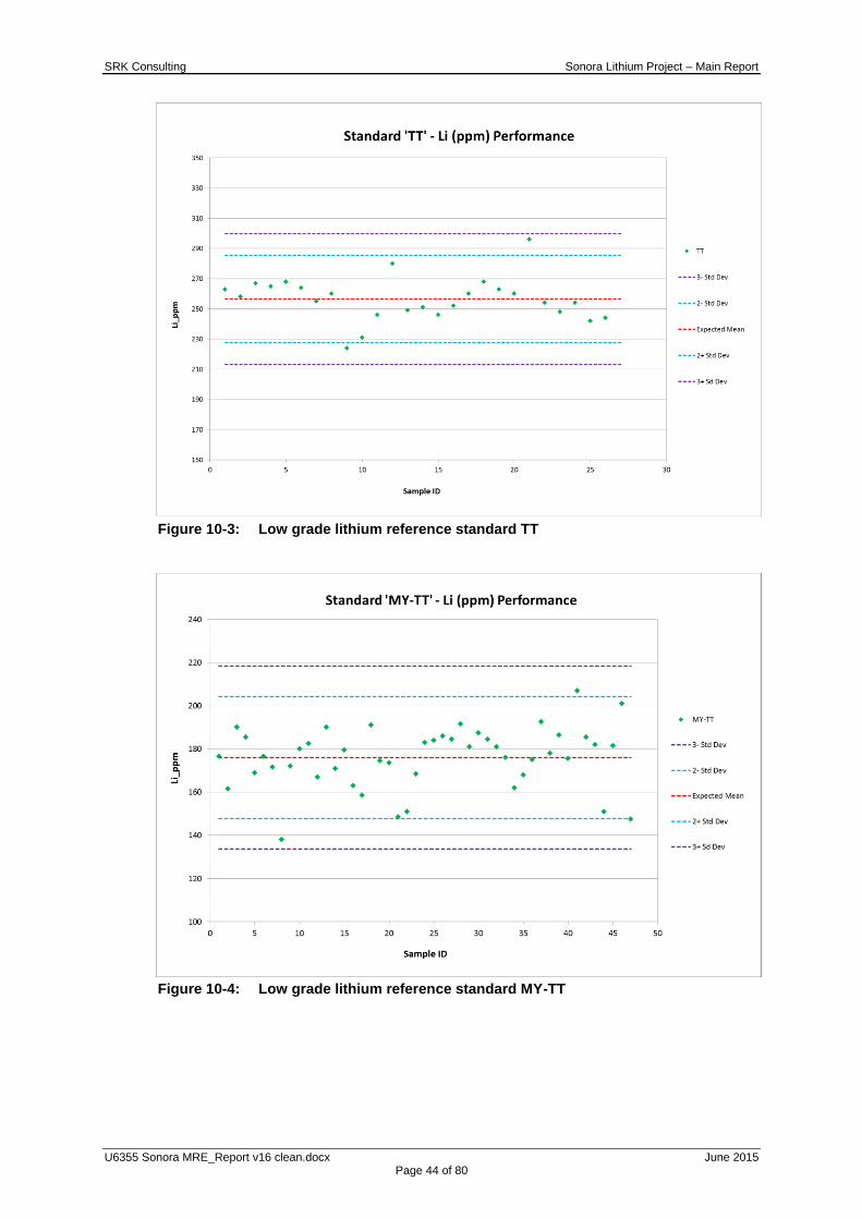
SRK Consulting Sonora Lithium Project – Main Report
U6355 Sonora MRE_Report v16 clean.docx June 2015 Page 44 of 80
Figure 10-3: Low grade lithium reference standard TT
Figure 10-4: Low grade lithium reference standard MY-TT
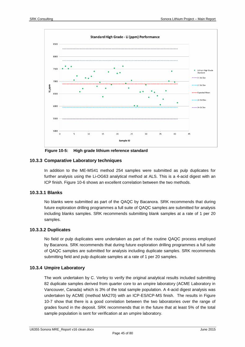
SRK Consulting Sonora Lithium Project – Main Report
U6355 Sonora MRE_Report v16 clean.docx June 2015 Page 45 of 80
Figure 10-5: High grade lithium reference standard
10.3.3 Comparative Laboratory techniques
In addition to the ME-MS41 method 254 samples were submitted as pulp duplicates for
further analysis using the Li-OG63 analytical method at ALS. This is a 4-acid digest with an
ICP finish. Figure 10-6 shows an excellent correlation between the two methods.
10.3.3.1 Blanks
No blanks were submitted as part of the QAQC by Bacanora. SRK recommends that during
future exploration drilling programmes a full suite of QAQC samples are submitted for analysis
including blanks samples. SRK recommends submitting blank samples at a rate of 1 per 20
samples.
10.3.3.2 Duplicates
No field or pulp duplicates were undertaken as part of the routine QAQC process employed
by Bacanora. SRK recommends that during future exploration drilling programmes a full suite
of QAQC samples are submitted for analysis including duplicate samples. SRK recommends
submitting field and pulp duplicate samples at a rate of 1 per 20 samples.
10.3.4 Umpire Laboratory
The work undertaken by C. Verley to verify the original analytical results included submitting
82 duplicate samples derived from quarter core to an umpire laboratory (ACME Laboratory in
Vancouver, Canada) which is 3% of the total sample population. A 4-acid digest analysis was
undertaken by ACME (method MA270) with an ICP-ES/ICP-MS finish. The results in Figure
10-7 show that there is a good correlation between the two laboratories over the range of
grades found in the deposit. SRK recommends that in the future that at least 5% of the total
sample population is sent for verification at an umpire laboratory.

SRK Consulting Sonora Lithium Project – Main Report
U6355 Sonora MRE_Report v16 clean.docx June 2015 Page 46 of 80
Figure 10-6: Duplicate sample method comparison
Figure 10-7: Duplicate sample laboratory comparison

SRK Consulting Sonora Lithium Project – Main Report
U6355 Sonora MRE_Report v16 clean.docx June 2015 Page 47 of 80
10.4 Core Recovery Analysis
Factors that could materially impact the reliability and accuracy of results include core
recovery, sample size, and nature of the mineralization. Core recovery for the sampled
intervals averages greater than 90%, based on core measurements. The core recovery is not
believed to negatively affect the reliability of the results.
10.5 QA/QC Summary
SRK has reviewed the QA/QC and is confident that the quality of the data is sufficient for use
in an Indicated Mineral Resource Estimate. SRK recommends that during future exploration
drilling programmes a full suite of QAQC samples are submitted for analysis including blanks,
and duplicate samples at a rate of 1 per 20 samples and increasing the submission of
samples to umpire laboratories to at least 5% of the total sample population. SRK also
recommends creating more in-house standards which more closely represent the deposit
grade and ensuring a more comprehensive certification process to establish mean and
standard deviation between several laboratories and methods.

SRK Consulting Sonora Lithium Project – Main Report
U6355 Sonora MRE_Report v16 clean.docx June 2015 Page 48 of 80
11 DATA VERIFICATION
Competent Person, Colin Rawbone (MAusIMM(CP)) has verified that the data provided by the
client appears to be correct and viable for use in a MRE. This involved viewing the majority of
the drillholes at the core shed to check the quality of the logging, along with cross-checking
assay certificates against the database. Further statistical validation of the database was
undertaken upon final receipt.
11.1 Data Received
The Company has provided SRK with all requested technical information and data which SRK
have taken in good faith as being accurate to the best of their knowledge.
SRK was provided with a package of electronic and paper based data by the Client. This
included:
Raw drill hole data sheets in Microsoft Excel format covering the drill hole collars,
associated assay results and geology;
Preliminary Economic Model prepared by REM internally (Microsoft Excel);
Draft Preliminary Economic Assessment (“PEA”) report, Preliminary Economic
Assessment for the El Sauz Concession, Sonora Lithium Project, C Verley, October
2014;
Mapinfo data files relating to:
o 2D Resource Polygons for both upper and lower clay;
o Topography;
o Licence tenure;
o Geological and structural interpretation;
o Proposed drill holes and trenches;
Pdf documents relating to Resource Estimates including:
o Initial Lithium Resource estimate for the El Sauz and Fleur Concession, Sonora
lithium project, C Verley, 11 October 2013;
o Updated and Reclassified Lithium Resources, Sonora lithium project, C Verley, 24
June 2013; and
Pdf plan maps relating to drill hole planning.
11.2 Database Validation
All available data has been validated through the production of histograms and scatterplots.
All data was validated by an SRK geologist.
11.3 QA/QC
The quality control measures that have been put in place are discussed in the previous
section. It is SRK‟s opinion that the procedures adopted have led to a reliable database and
SRK is confident that the quality of the data is sufficient for use in an Indicated Mineral
Resource.
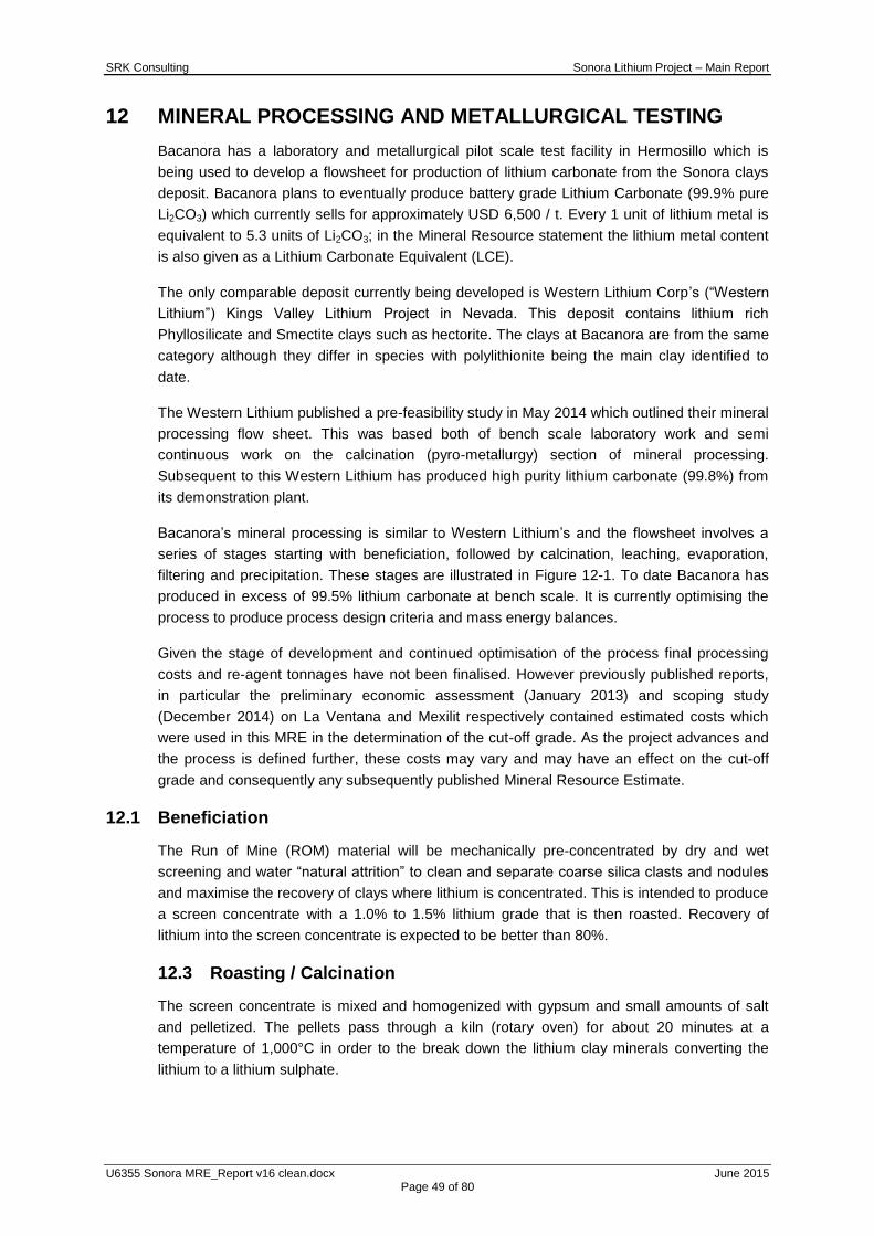
SRK Consulting Sonora Lithium Project – Main Report
U6355 Sonora MRE_Report v16 clean.docx June 2015 Page 49 of 80
12 MINERAL PROCESSING AND METALLURGICAL TESTING
Bacanora has a laboratory and metallurgical pilot scale test facility in Hermosillo which is
being used to develop a flowsheet for production of lithium carbonate from the Sonora clays
deposit. Bacanora plans to eventually produce battery grade Lithium Carbonate (99.9% pure
Li2CO3) which currently sells for approximately USD 6,500 / t. Every 1 unit of lithium metal is
equivalent to 5.3 units of Li2CO3; in the Mineral Resource statement the lithium metal content
is also given as a Lithium Carbonate Equivalent (LCE).
The only comparable deposit currently being developed is Western Lithium Corp‟s (“Western
Lithium”) Kings Valley Lithium Project in Nevada. This deposit contains lithium rich
Phyllosilicate and Smectite clays such as hectorite. The clays at Bacanora are from the same
category although they differ in species with polylithionite being the main clay identified to
date.
The Western Lithium published a pre-feasibility study in May 2014 which outlined their mineral
processing flow sheet. This was based both of bench scale laboratory work and semi
continuous work on the calcination (pyro-metallurgy) section of mineral processing.
Subsequent to this Western Lithium has produced high purity lithium carbonate (99.8%) from
its demonstration plant.
Bacanora‟s mineral processing is similar to Western Lithium‟s and the flowsheet involves a
series of stages starting with beneficiation, followed by calcination, leaching, evaporation,
filtering and precipitation. These stages are illustrated in Figure 12-1. To date Bacanora has
produced in excess of 99.5% lithium carbonate at bench scale. It is currently optimising the
process to produce process design criteria and mass energy balances.
Given the stage of development and continued optimisation of the process final processing
costs and re-agent tonnages have not been finalised. However previously published reports,
in particular the preliminary economic assessment (January 2013) and scoping study
(December 2014) on La Ventana and Mexilit respectively contained estimated costs which
were used in this MRE in the determination of the cut-off grade. As the project advances and
the process is defined further, these costs may vary and may have an effect on the cut-off
grade and consequently any subsequently published Mineral Resource Estimate.
12.1 Beneficiation
The Run of Mine (ROM) material will be mechanically pre-concentrated by dry and wet
screening and water “natural attrition” to clean and separate coarse silica clasts and nodules
and maximise the recovery of clays where lithium is concentrated. This is intended to produce
a screen concentrate with a 1.0% to 1.5% lithium grade that is then roasted. Recovery of
lithium into the screen concentrate is expected to be better than 80%.
12.3 Roasting / Calcination
The screen concentrate is mixed and homogenized with gypsum and small amounts of salt
and pelletized. The pellets pass through a kiln (rotary oven) for about 20 minutes at a
temperature of 1,000°C in order to the break down the lithium clay minerals converting the
lithium to a lithium sulphate.
SRK Consulting Sonora Lithium Project – Main Report
U6355 Sonora MRE_Report v16 clean.docx June 2015 Page 50 of 80
Figure 12-1: Conceptual Flowsheet under Development
12.2 Leaching
The roasted pellets are ground and deposited in a leaching tank and agitated for one hour at
900 RPM with 40% solids dissolving lithium into solution. The product is filtered and the
pregnant solution is recovered. The solids or leach residues are discarded. Recovery of
lithium in this stage is expected to be better than 90%.
12.3 Evaporation and cleaning
The process is carried out in three stages with a reduction of 75% in volume and an increase
in lithium concentration of 1 to 6 times. Initially the leach slurry is gravity filtered through a bag
filter with a minimum particle capture size of 1 μm. The filtrate is concentrated by a factor of
four in two stages of evaporation and the solution is passed through an ionic interchange
resin to reduce contaminants and it is then sent to a precipitator.
SRK Consulting Sonora Lithium Project – Main Report
U6355 Sonora MRE_Report v16 clean.docx June 2015 Page 51 of 80
12.4 Precipitation
The brine is heated up to 95 C and then Na2CO3 is added to convert the lithium sulphate into
lithium carbonate which is then filtrated and recovered for drying. The residual liquor is
circulated back into the leaching process.
SRK Consulting Sonora Lithium Project – Main Report
U6355 Sonora MRE_Report v16 clean.docx June 2015 Page 52 of 80
13 MINERAL RESOURCE ESTIMATION
13.1 Introduction
The MRE was completed by Colin Rawbone (Senior Consultant, Geology) under the
supervision of Martin Pittuck, C.Eng, MIMMM (Director and Corporate Consultant, Resource
Geology) who has some 20 years‟ experience in generating and reviewing Mineral Resource
estimates for a wide variety of deposit styles; meeting the definition of an “independent
Qualified Person” as this term is defined in National Instrument 43-101.
The effective date of the Mineral Resource statement is May 12, 2015.
This section describes the Mineral Resource estimation methodology and parameters. The
Mineral Resources have been reported in accordance with generally accepted CIM
“Estimation of Mineral Resources and Mineral Reserves Best Practices” guidelines and
National Instrument 43-101. Mineral Resources are not Mineral Reserves and do not have
demonstrated economic viability. There is no certainty that all or any part of the Mineral
Resources will be converted to Mineral Reserves.
The database used to estimate the Sonora Mineral Resources was audited by SRK and SRK
is of the opinion that the current drilling information is sufficiently reliable to support a Mineral
Resource.
Leapfrog Geomodeller Software (“Leapfrog”) was used to construct the geological model.
Microsoft Excel was used to audit the drillhole database, and prepare assay data for
geostatistical analysis. Supervisor Software (“Supervisor”) was used for geostatistical analysis
and variography. Datamine Studio Version 3 (“Datamine”) was used to construct the block
model, estimate grades and tabulate the resultant Mineral Resources.
13.2 Resource Estimation Procedure
The estimation methodology comprised:
Database verification and preparation for geological modelling (including compositing);
Discussions with client regarding geology and mineralisation;
Construction of geological model and wireframes;
Definition of fault blocks and resource domains;
Preparation of database for geostatistical analysis and variography;
2D and 3D Block modelling and grade interpolation;
Resource validation and classification;
Assessment of “reasonable prospects for economic extraction” and selection of
appropriate cut-off grade; and
Preparation of a Mineral Resource Statement.
13.3 Resource Database
SRK was provided with a package of electronic and paper based data by the Client. This
included:
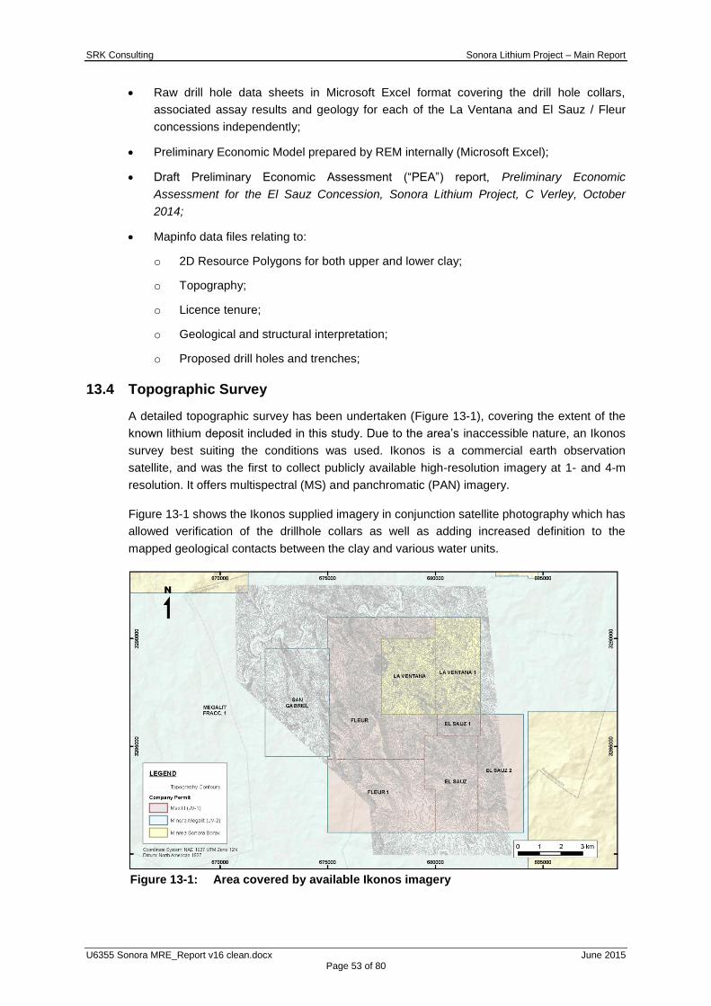
SRK Consulting Sonora Lithium Project – Main Report
U6355 Sonora MRE_Report v16 clean.docx June 2015 Page 53 of 80
Raw drill hole data sheets in Microsoft Excel format covering the drill hole collars,
associated assay results and geology for each of the La Ventana and El Sauz / Fleur
concessions independently;
Preliminary Economic Model prepared by REM internally (Microsoft Excel);
Draft Preliminary Economic Assessment (“PEA”) report, Preliminary Economic
Assessment for the El Sauz Concession, Sonora Lithium Project, C Verley, October
2014;
Mapinfo data files relating to:
o 2D Resource Polygons for both upper and lower clay;
o Topography;
o Licence tenure;
o Geological and structural interpretation;
o Proposed drill holes and trenches;
13.4 Topographic Survey
A detailed topographic survey has been undertaken (Figure 13-1), covering the extent of the
known lithium deposit included in this study. Due to the area‟s inaccessible nature, an Ikonos
survey best suiting the conditions was used. Ikonos is a commercial earth observation
satellite, and was the first to collect publicly available high-resolution imagery at 1- and 4-m
resolution. It offers multispectral (MS) and panchromatic (PAN) imagery.
Figure 13-1 shows the Ikonos supplied imagery in conjunction satellite photography which has
allowed verification of the drillhole collars as well as adding increased definition to the
mapped geological contacts between the clay and various water units.
Figure 13-1: Area covered by available Ikonos imagery
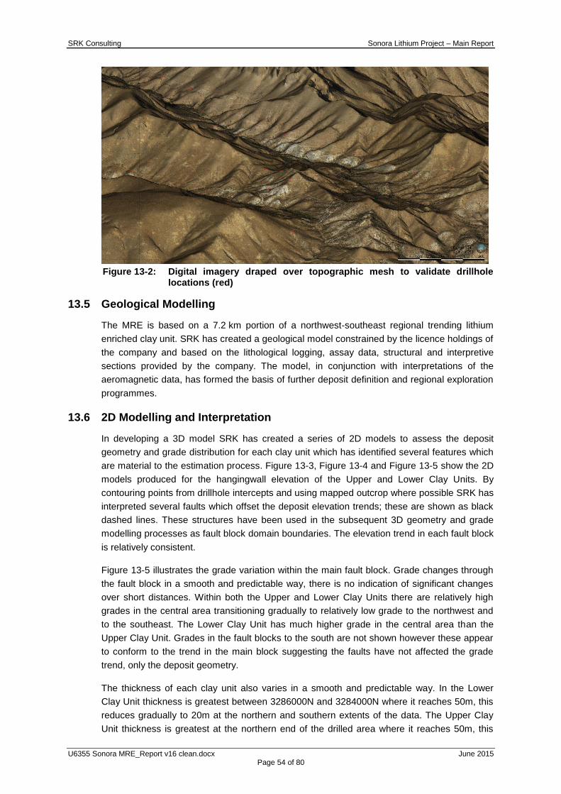
SRK Consulting Sonora Lithium Project – Main Report
U6355 Sonora MRE_Report v16 clean.docx June 2015 Page 54 of 80
Figure 13-2: Digital imagery draped over topographic mesh to validate drillhole
locations (red)
13.5 Geological Modelling
The MRE is based on a 7.2 km portion of a northwest-southeast regional trending lithium
enriched clay unit. SRK has created a geological model constrained by the licence holdings of
the company and based on the lithological logging, assay data, structural and interpretive
sections provided by the company. The model, in conjunction with interpretations of the
aeromagnetic data, has formed the basis of further deposit definition and regional exploration
programmes.
13.6 2D Modelling and Interpretation
In developing a 3D model SRK has created a series of 2D models to assess the deposit
geometry and grade distribution for each clay unit which has identified several features which
are material to the estimation process. Figure 13-3, Figure 13-4 and Figure 13-5 show the 2D
models produced for the hangingwall elevation of the Upper and Lower Clay Units. By
contouring points from drillhole intercepts and using mapped outcrop where possible SRK has
interpreted several faults which offset the deposit elevation trends; these are shown as black
dashed lines. These structures have been used in the subsequent 3D geometry and grade
modelling processes as fault block domain boundaries. The elevation trend in each fault block
is relatively consistent.
Figure 13-5 illustrates the grade variation within the main fault block. Grade changes through
the fault block in a smooth and predictable way, there is no indication of significant changes
over short distances. Within both the Upper and Lower Clay Units there are relatively high
grades in the central area transitioning gradually to relatively low grade to the northwest and
to the southeast. The Lower Clay Unit has much higher grade in the central area than the
Upper Clay Unit. Grades in the fault blocks to the south are not shown however these appear
to conform to the trend in the main block suggesting the faults have not affected the grade
trend, only the deposit geometry.
The thickness of each clay unit also varies in a smooth and predictable way. In the Lower
Clay Unit thickness is greatest between 3286000N and 3284000N where it reaches 50m, this
reduces gradually to 20m at the northern and southern extents of the data. The Upper Clay
Unit thickness is greatest at the northern end of the drilled area where it reaches 50m, this

SRK Consulting Sonora Lithium Project – Main Report
U6355 Sonora MRE_Report v16 clean.docx June 2015 Page 55 of 80
reduces southwards varying gradually between 20m and 30m becoming 10m to 20m thick at
the southern extent of the data.
Figure 13-3: Elevation contour maps for the Upper and Lower Clay Units
Figure 13-4: Thickness contour maps for the Upper and Lower Clay Units

SRK Consulting Sonora Lithium Project – Main Report
U6355 Sonora MRE_Report v16 clean.docx June 2015 Page 56 of 80
Figure 13-5: Grade contour maps for the Upper and Lower Clay Units
13.7 3D Geological Modelling
SRK has undertaken geological modelling of the Sonora Project to provide geological
constraints for the MRE. These constraints are provided as wireframe models into which the
final block models were created and domained. The geological model constructed for the
project has been used to differentiate between fault blocks and the upper and lower clay units.
13.8 Deposit Modelling
The following section describes the methodology undertaken for modelling of the Project. All
modelling was undertaken using Leapfrog Mining software into which cross sections from
previous interpretations were imported for reference. Figure 13-6 shows the cross sections
registered and projected into 3D space.
13.8.1 Geological Zone Modelling
The deposit modelling was conducted in Leapfrog Mining software and comprised the
following:
importing the collar, survey, assay, geology, and magnetic susceptibility data into
Leapfrog to create a desurveyed drillhole file);
importing the topography data file, limited by a 2 km buffer applied the drilled area;
importing site generated interpretations, plan maps and cross sections;
the creation of mineralisation wireframes based on the domain guidelines as set out in
Section 13.8.1; and
A number of fault surface wireframes were first modelled based on mapped traces, dip-strike
field data and interpreted occurrence in drillholes. This process resulted in five fault blocks
which materially impact the strike continuity of the Lithium bearing clay units. To maintain this
distinction, zone codes which are listed in Table 13-1 have been preceded with the numbers 1
to 5 to represent the fault block.
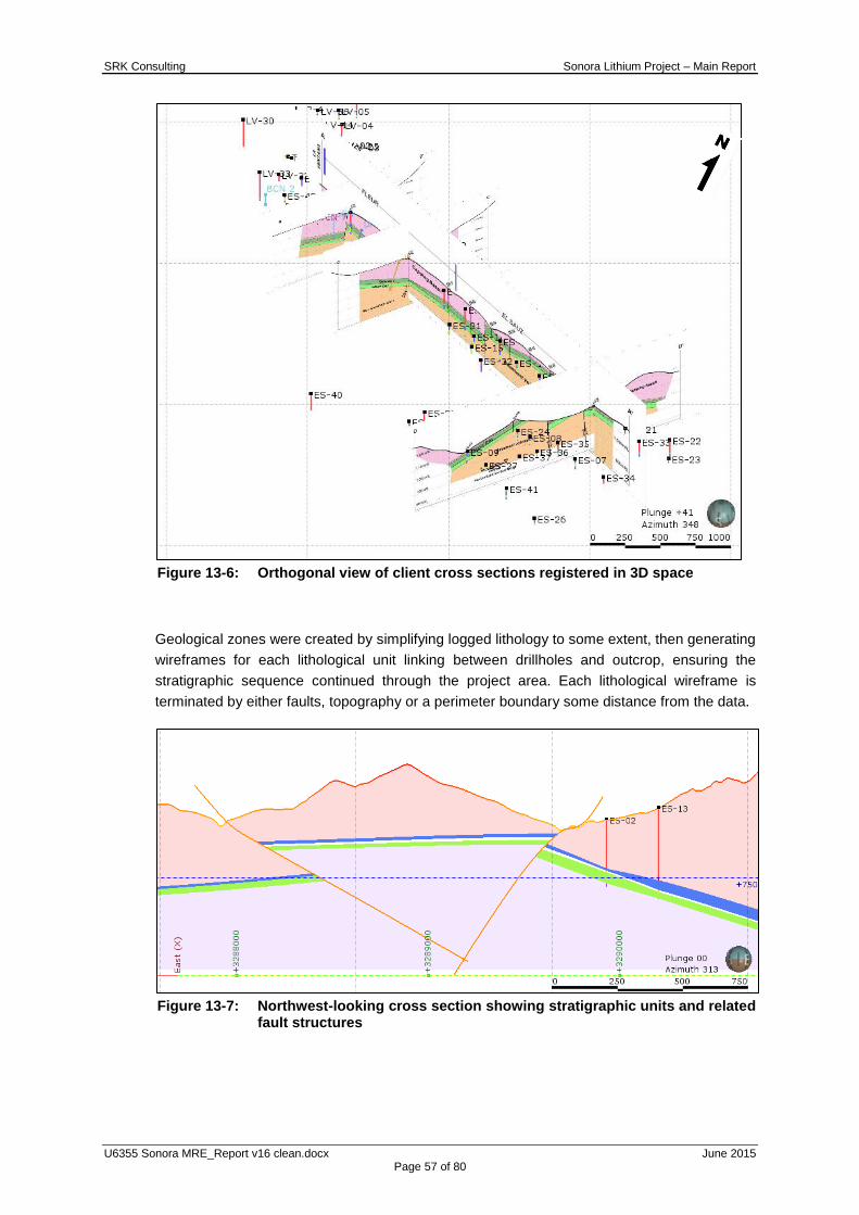
SRK Consulting Sonora Lithium Project – Main Report
U6355 Sonora MRE_Report v16 clean.docx June 2015 Page 57 of 80
Figure 13-6: Orthogonal view of client cross sections registered in 3D space
Geological zones were created by simplifying logged lithology to some extent, then generating
wireframes for each lithological unit linking between drillholes and outcrop, ensuring the
stratigraphic sequence continued through the project area. Each lithological wireframe is
terminated by either faults, topography or a perimeter boundary some distance from the data.
Figure 13-7: Northwest-looking cross section showing stratigraphic units and related
fault structures

SRK Consulting Sonora Lithium Project – Main Report
U6355 Sonora MRE_Report v16 clean.docx June 2015 Page 58 of 80
Figure 13-8: 3D view of the geological model in outcrop and section slice
Figure 13-7 is a 2D cross section showing all stratigraphic units which have been offset and
controlled by generating differing fault blocks independently referenced to structural data
collected on site. Figure 13-8 further demonstrates this control on the stratigraphy over the
entire strike length.
Table 13-1: Kriging Zone Codes (KZONES)
KZONE Description
101 Upper Clay Zone 101
102 Lower Clay Zone 102
201 Upper Clay Zone 201
202 Lower Clay Zone 202
401 Upper Clay Zone 401
402 Lower Clay Zone 402
501 Upper Clay Zone 501
502 Lower Clay Zone 502

SRK Consulting Sonora Lithium Project – Main Report
U6355 Sonora MRE_Report v16 clean.docx June 2015 Page 59 of 80
Figure 13-9: Wireframes clipped by topography, faults and perimeter boundary
Figure 13-9 show the generated wireframes used to constrained the raw data and define the
zone coding implemented during the creation of the block model. Table 13-1 references each
of the Kriging zone codes applied representing both the clay unit and the respective fault
domain.
13.8.2 Block Model Creation
An empty block model was generated in CAE Datamine Studio 3 software (“Datamine”) using
the lithological wireframes, the licence boundaries were used to limit the block model extents.
The block model includes zone codes for each of the mineralised clay units in each of the
fault blocks.
The mineralisation modelled has a strike length of some 7.2 km. Deep drilling has
demonstrated the existence of mineralisation some 500m down dip from outcrop and SRK
has extended the block modelled mineralisation a further 300 to 400 m down dip to ensure
any potentially economic material below that already defined can be included in the Mineral
Resource or identified as a drilling target. A waste model was also generated below the
topography and outside of the mineralisation zones.
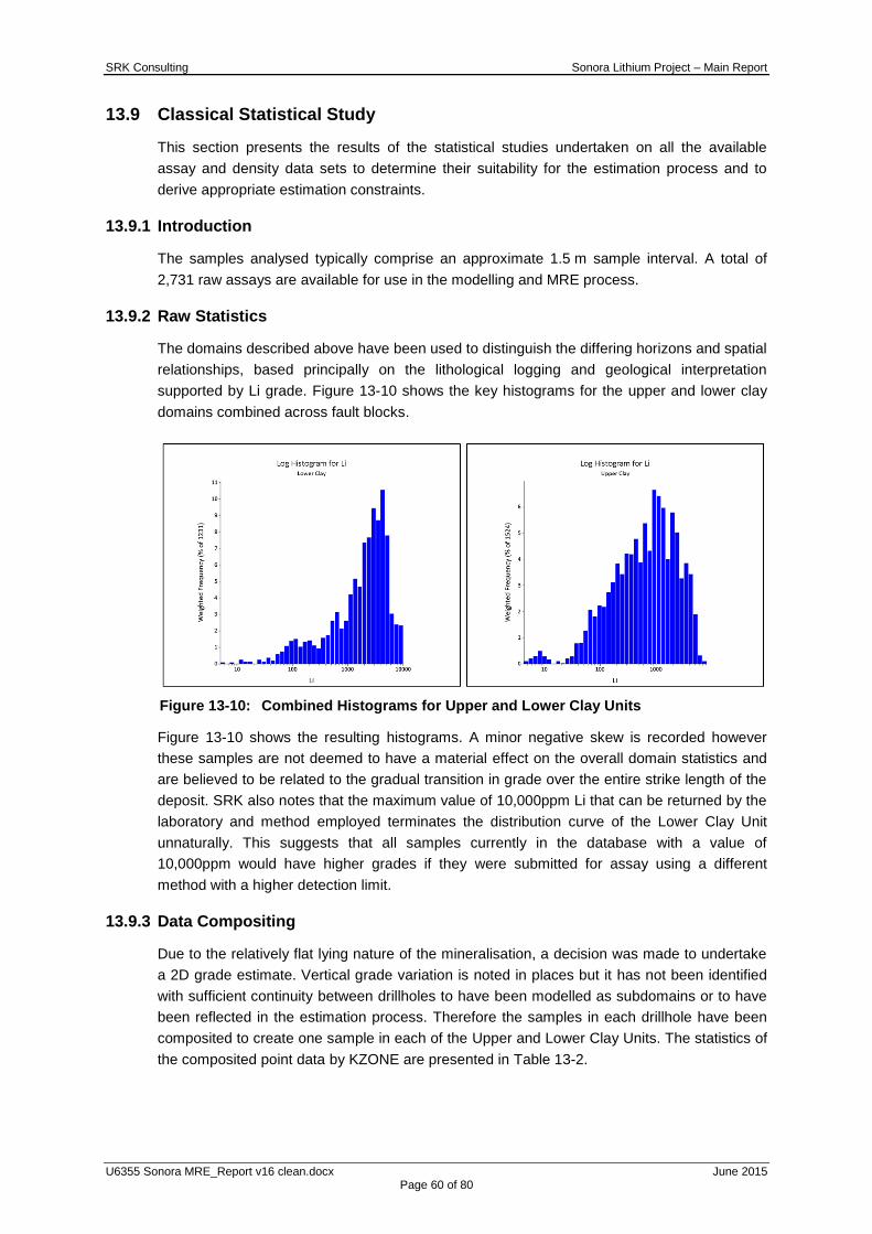
SRK Consulting Sonora Lithium Project – Main Report
U6355 Sonora MRE_Report v16 clean.docx June 2015 Page 60 of 80
13.9 Classical Statistical Study
This section presents the results of the statistical studies undertaken on all the available
assay and density data sets to determine their suitability for the estimation process and to
derive appropriate estimation constraints.
13.9.1 Introduction
The samples analysed typically comprise an approximate 1.5 m sample interval. A total of
2,731 raw assays are available for use in the modelling and MRE process.
13.9.2 Raw Statistics
The domains described above have been used to distinguish the differing horizons and spatial
relationships, based principally on the lithological logging and geological interpretation
supported by Li grade. Figure 13-10 shows the key histograms for the upper and lower clay
domains combined across fault blocks.
Figure 13-10: Combined Histograms for Upper and Lower Clay Units
Figure 13-10 shows the resulting histograms. A minor negative skew is recorded however
these samples are not deemed to have a material effect on the overall domain statistics and
are believed to be related to the gradual transition in grade over the entire strike length of the
deposit. SRK also notes that the maximum value of 10,000ppm Li that can be returned by the
laboratory and method employed terminates the distribution curve of the Lower Clay Unit
unnaturally. This suggests that all samples currently in the database with a value of
10,000ppm would have higher grades if they were submitted for assay using a different
method with a higher detection limit.
13.9.3 Data Compositing
Due to the relatively flat lying nature of the mineralisation, a decision was made to undertake
a 2D grade estimate. Vertical grade variation is noted in places but it has not been identified
with sufficient continuity between drillholes to have been modelled as subdomains or to have
been reflected in the estimation process. Therefore the samples in each drillhole have been
composited to create one sample in each of the Upper and Lower Clay Units. The statistics of
the composited point data by KZONE are presented in Table 13-2.
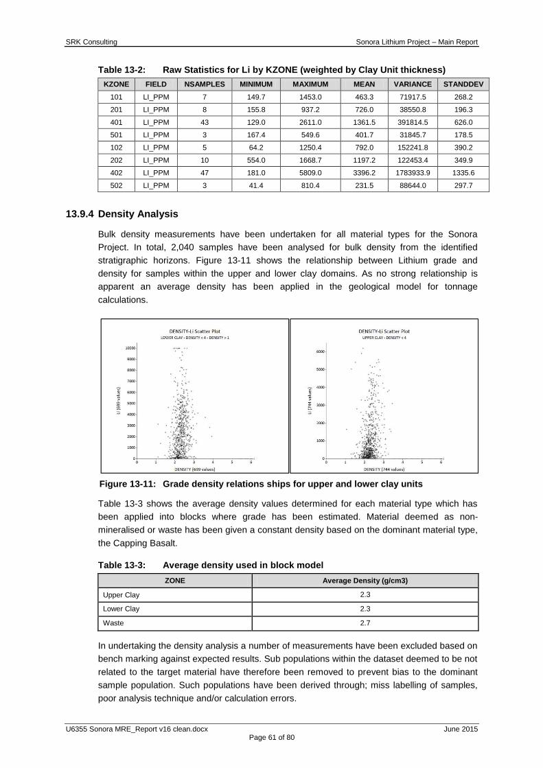
SRK Consulting Sonora Lithium Project – Main Report
U6355 Sonora MRE_Report v16 clean.docx June 2015 Page 61 of 80
Table 13-2: Raw Statistics for Li by KZONE (weighted by Clay Unit thickness)
KZONE FIELD NSAMPLES MINIMUM MAXIMUM MEAN VARIANCE STANDDEV
101 LI_PPM 7 149.7 1453.0 463.3 71917.5 268.2
201 LI_PPM 8 155.8 937.2 726.0 38550.8 196.3
401 LI_PPM 43 129.0 2611.0 1361.5 391814.5 626.0
501 LI_PPM 3 167.4 549.6 401.7 31845.7 178.5
102 LI_PPM 5 64.2 1250.4 792.0 152241.8 390.2
202 LI_PPM 10 554.0 1668.7 1197.2 122453.4 349.9
402 LI_PPM 47 181.0 5809.0 3396.2 1783933.9 1335.6
502 LI_PPM 3 41.4 810.4 231.5 88644.0 297.7
13.9.4 Density Analysis
Bulk density measurements have been undertaken for all material types for the Sonora
Project. In total, 2,040 samples have been analysed for bulk density from the identified
stratigraphic horizons. Figure 13-11 shows the relationship between Lithium grade and
density for samples within the upper and lower clay domains. As no strong relationship is
apparent an average density has been applied in the geological model for tonnage
calculations.
Figure 13-11: Grade density relations ships for upper and lower clay units
Table 13-3 shows the average density values determined for each material type which has
been applied into blocks where grade has been estimated. Material deemed as non-
mineralised or waste has been given a constant density based on the dominant material type,
the Capping Basalt.
Table 13-3: Average density used in block model
ZONE Average Density (g/cm3)
Upper Clay 2.3
Lower Clay 2.3
Waste 2.7
In undertaking the density analysis a number of measurements have been excluded based on
bench marking against expected results. Sub populations within the dataset deemed to be not
related to the target material have therefore been removed to prevent bias to the dominant
sample population. Such populations have been derived through; miss labelling of samples,
poor analysis technique and/or calculation errors.

SRK Consulting Sonora Lithium Project – Main Report
U6355 Sonora MRE_Report v16 clean.docx June 2015 Page 62 of 80
13.10 Geostatistical Analysis and Variography
13.10.1 Introduction
For each clay unit, the different fault block domains have been combined to provide a
sufficient number of data to be able to undertake the geostatistical study. Domains 101, 201,
301 and 401 are considered to have formed as a continuous unit which has been later offset
by additional structural controls. This unit is considered sufficiently different in grade to be
distinguished from zones 102, 202, 302 and 402.
The drillhole database, flagged by modelled zones, was imported into Snowden Supervisor
software for the geostatistical analysis. Variography was successfully undertaken for the
Upper and Lower clay zones.
For the each of the clay zones SRK undertook 2D variography using the composited drillhole
database. Experimental semi-variograms were produced for lithium grades and the semi-
variograms were produced using a sensible lag to define the structures and directional
ranges. The nugget value obtained from the Li variogram (in terms of percentage of the sill)
was applied to fix the nugget for all other variograms. Based on the geometry and
geographical location of these zones, an orientated variogram search was applied parallel
with strike to best capture this orientation.
Figure 13-12 shows the modelled variograms produced for the two orientated clay zones.
Figure 13-12: Lithium variography for Upper and Lower Clay Units based on
composite point file
All variograms show good linear structure and possibly drift but allow reasonable spherical
variogram models to be fitted and used for kriging. The nugget and ranges are easily
generated, providing an appropriate level of confidence in terms of both the short scale and
longer range grade continuity. Table 13-4 presents the defined variograms with all variances
normalised and rescaled to the sill.
13.10.2 Summary
The variogram models produced allowed the generation of suitably reliable interpolation
parameters within the defined zones.
The results of the variography were used in the interpolation to assign the appropriate
weighting to the sample points utilised to calculate the block model grades.
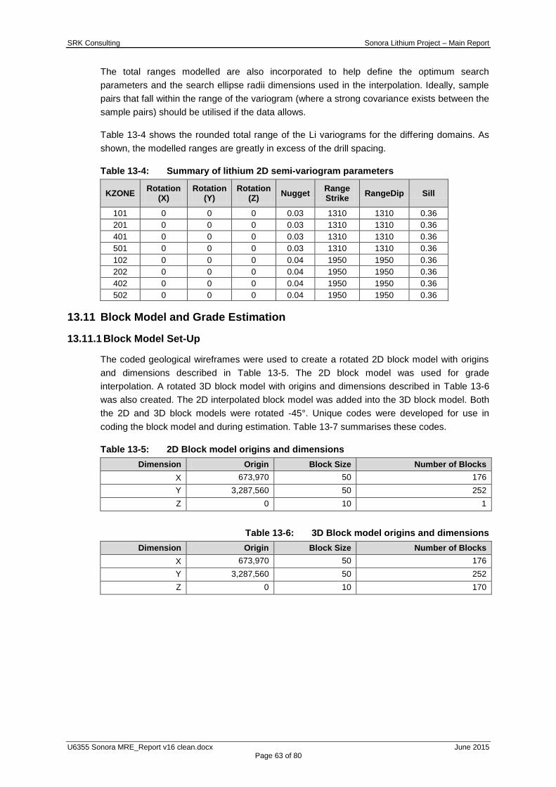
SRK Consulting Sonora Lithium Project – Main Report
U6355 Sonora MRE_Report v16 clean.docx June 2015 Page 63 of 80
The total ranges modelled are also incorporated to help define the optimum search
parameters and the search ellipse radii dimensions used in the interpolation. Ideally, sample
pairs that fall within the range of the variogram (where a strong covariance exists between the
sample pairs) should be utilised if the data allows.
Table 13-4 shows the rounded total range of the Li variograms for the differing domains. As
shown, the modelled ranges are greatly in excess of the drill spacing.
Table 13-4: Summary of lithium 2D semi-variogram parameters
KZONE Rotation
(X) Rotation
(Y) Rotation
(Z) Nugget
Range Strike
RangeDip Sill
101 0 0 0 0.03 1310 1310 0.36
201 0 0 0 0.03 1310 1310 0.36
401 0 0 0 0.03 1310 1310 0.36
501 0 0 0 0.03 1310 1310 0.36
102 0 0 0 0.04 1950 1950 0.36
202 0 0 0 0.04 1950 1950 0.36
402 0 0 0 0.04 1950 1950 0.36
502 0 0 0 0.04 1950 1950 0.36
13.11 Block Model and Grade Estimation
13.11.1 Block Model Set-Up
The coded geological wireframes were used to create a rotated 2D block model with origins
and dimensions described in Table 13-5. The 2D block model was used for grade
interpolation. A rotated 3D block model with origins and dimensions described in Table 13-6
was also created. The 2D interpolated block model was added into the 3D block model. Both
the 2D and 3D block models were rotated -45°. Unique codes were developed for use in
coding the block model and during estimation. Table 13-7 summarises these codes.
Table 13-5: 2D Block model origins and dimensions
Dimension Origin Block Size Number of Blocks
X 673,970 50 176
Y 3,287,560 50 252
Z 0 10 1
Table 13-6: 3D Block model origins and dimensions
Dimension Origin Block Size Number of Blocks
X 673,970 50 176
Y 3,287,560 50 252
Z 0 10 170

SRK Consulting Sonora Lithium Project – Main Report
U6355 Sonora MRE_Report v16 clean.docx June 2015 Page 64 of 80
Table 13-7: Summary of fields used during estimation
Field Name Code Description
KZONE
101 Upper Clay Zone 101
102 Lower Clay Zone 102
201 Upper Clay Zone 201
202 Lower Clay Zone 202
401 Upper Clay Zone 401
402 Lower Clay Zone 402
501 Upper Clay Zone 501
502 Lower Clay Zone 502
Grade LI_EST Ordinary Kriged ("OK") Lithium Grade
Search Parameters
SVOL Search Volume
VAR Variance
NSAM Number of Samples
OREFRAC - Fraction of Parent Block Considered Mineralised
TOPFRAC - Fraction of Parent Block Above/Below Topography
WHIT
UC1 Upper Clay Zone 1 Whittle Code
LC1 Lower Clay Zone 1 Whittle Code
UC2 Upper Clay Zone 2 Whittle Code
LC2 Lower Clay Zone 2 Whittle Code
UC4 Upper Clay Zone 4 Whittle Code
LC4 Lower Clay Zone 4 Whittle Code
UC5 Upper Clay Zone 5 Whittle Code
LC5 Lower Clay Zone 5 Whittle Code
COG 0 Below Li 450 ppm cut-off grade
1 Above Li 450 ppm cut-off grade
OPTI 0 Material outside the optimised pit shell
1 Inside the optimised pit shell
PROJECT
1 La Ventana
2 La Ventana 1
3 El Sauz
4 Fleur
5 El Sauz 1
6 El Sauz 2
7 Fleur 2
Class
2 Indicated
3 Inferred
4 Measured
13.11.2 Grade Interpolation
Ordinary kriging (“OK”) was used for grade interpolation into the 2D block model. Grade for Li
was interpolated into the 2D block model honouring the geological contacts defined by the
geological modelling process, and using the domains (KZONES) previously assigned. The
same search parameters were used for all KZONES, these are summarised in Table 13-8.
The second and third searches were expanded by a multiplier factor of 2 and 15 respectively;
the latter ensured all blocks in the model were estimated. Following the interpolation of the 2D
block model SRK used the SLIMOD and REGMOD functions in Datamine to convert the 2D
grade interpolation into a 3D block model. The SLIMOD function converts the 2D block model
into the 3D prototype space. The REGMOD function removed all sub cells and regularised the
2D block model to 50 x 50 x 10 m (X, Y, Z) blocks. An ore fraction field was calculated and
added into the 3D block model. The ore fraction field calculates the percentage of each block
which is considered mineralised material, this is done as no sub cells are present in the 3D
block model, and therefore the parent block cannot be subdivided.

SRK Consulting Sonora Lithium Project – Main Report
U6355 Sonora MRE_Report v16 clean.docx June 2015 Page 65 of 80
Table 13-8: Search Parameters for interpolation of Li
KZONE Search Dist 1
Search Dist 2
Search Dist 3
SAXIS 1
SAXIS 2
SAXIS 3
Min 1 Max 1
Search Volume Factor
1
Min 2 Max 2
Search Volume Factor
2
Min 3 Max 3
101 500 500 500 3 1 3 4 6 2 4 6 15 2 8
201 500 500 500 3 1 3 4 6 2 4 6 15 2 8
401 500 500 500 3 1 3 4 6 2 4 6 15 2 8
501 500 500 500 3 1 3 4 6 2 4 6 15 2 8
102 500 500 500 3 1 3 4 6 2 4 6 15 2 8
202 500 500 500 3 1 3 4 6 2 4 6 15 2 8
402 500 500 500 3 1 3 4 6 2 4 6 15 2 8
502 500 500 500 3 1 3 4 6 2 4 6 15 2 8

SRK Consulting Sonora Lithium Project – Main Report
U6355 Sonora MRE_Report v16 clean.docx June 2015 Page 66 of 80
13.12 Block Model Validation
13.12.1 Introduction
SRK has undertaken a number of methods of validation to confirm that the modelled
estimates represent the input sample data on both local and global scales and to check that
the estimate is not biased. Methods of validation used include:
Visual inspection of block grades in comparison with drillhole data (in plan and cross
section); and
Comparison of block model statistics.
Validation was undertaken on the 2D block model prior to it being converted into a 3D block
model.
Based on the visual and statistical validation, SRK has accepted the grades in the 2D and 3D
block models. The resultant block grade distribution is considered appropriate for the
mineralisation style. In areas of limited sampling the block grade estimates have been
produced using expanded search ellipses. Localised comparisons of block grades to block
estimates will be less accurate in these areas.
13.12.2 Visual Validation
Visual validation provides a comparison of the interpolated block model on a local scale. A
thorough visual inspection of cross-sections, and bench plans, comparing the sample grades
with the block grades has been undertaken. This demonstrates a good comparison between
local block estimates and nearby samples without excessive smoothing in the block model.
Figure 13-13 and Figure 13-14 show the visual validation checks for the Upper and Lower
Clay zones.

SRK Consulting Sonora Lithium Project – Main Report
U6355 Sonora MRE_Report v16 clean.docx June 2015 Page 67 of 80
Figure 13-13: Li block model validated against composited drillhole data – Upper Clay

SRK Consulting Sonora Lithium Project – Main Report
U6355 Sonora MRE_Report v16 clean.docx June 2015 Page 68 of 80
Figure 13-14: Li block model validated against composited drillhole data –Lower Clay
13.12.3 Statistical Validation
Global mean grade comparison
Classical statistics were calculated for the estimated 2D and 3D block grades and compared
with the declustered drillhole statistics used in the estimation process. The absolute difference
in the declustered and block model means was considered immaterial for all mineralised
domains. The comparison between the declustered composites and 3D block model statistics
is shown in Table 13-9.

SRK Consulting Sonora Lithium Project – Main Report
U6355 Sonora MRE_Report v16 clean.docx June 2015 Page 69 of 80
Table 13-9: Comparison statistics for Li composites versus 3D block model grades
Li Declustered Composite Point Statistics Lithium 3D Block Statistics
KZONE MAXIMUM MEAN STANDDEV MAXIMUM MEAN STANDDEV Mean Absolute Difference (%)
101 2284.0 749.9 688.7 1346.5 756.9 269.4 0.9
102 5703.0 1559.0 1749.8 1981.1 1469.4 448.3 5.9
201 937.2 698.4 215.0 2440.8 692.4 107.1 0.9
202 1668.7 1116.7 382.1 1779.7 1131.0 117.1 1.3
401 2611.0 1257.2 683.0 2739.2 1351.3 549.2 7.2
402 5809.0 3031.3 1536.1 4863.7 2955.2 1261.2 2.5
501 549.6 410.6 172.6 477.6 421.4 22.9 2.6
502 810.4 322.7 346.3 472.5 400.0 26.0 21.4
13.13 Mineral Resource Classification
13.13.1 Introduction
Block model tonnage and grade estimates for the Sonora project have been classified
according to the terminology and definitions given in the CIM Definition Standards for Mineral
Resources and Mineral Reserves (May 2014) by Martin Pittuck, C.Eng, MIMMM who is a
Qualified Person as defined by the Canadian National Instrument 43-101 and the companion
policy 43-101CP.
Mineral Resource classification is a subjective concept, which considers the geological
confidence in the geological continuity of the mineralised structures, the quality and quantity
of exploration data supporting the estimates and the geostatistical confidence in the grade
estimates.
SRK is satisfied that the geological modelling honours the current geological information and
knowledge and extrapolates this reasonably. The location of the samples and the assay data
are sufficiently reliable to support resource evaluation. The sampling information was acquired
by diamond core drilling on sections spaced at approximately 200 m, and associated drill core
samples on 1.5 m intervals. In many places the drilling combined with satellite imagery and
mapped outcrop gives high confidence in the geometry of the geological features controlling
grade and the grade trends themselves.
SRK has also considered sampling quality, representivity and accuracy of historical and
recent assaying and density determinations. The QAQC results suggest an acceptable level
of quality for the assays; in particular, the results from the quarter core submissions to an
umpire laboratory support the accuracy of the assays at the primary laboratory based on
numerous batches representing the major drill phases undertaken. The standards used to
date have demonstrated reasonable consistency at the primary laboratory although the grade
levels were too low or too high to represent the majority of samples in the model.
SRK considers that the number of density determinations and the method used gives an
accurate estimate of dry density.

SRK Consulting Sonora Lithium Project – Main Report
U6355 Sonora MRE_Report v16 clean.docx June 2015 Page 70 of 80
Overall, it is SRK‟s view that the recent data is of a sufficient quality for the quoting of
Indicated and Inferred category of Mineral Resources and that the distinction between these
and areas excluded from resource is dependent on the coverage of sample information which
varies from one area to another and the geological complexity which is considered to be
greater in certain places.
13.13.2 Geological and Grade Continuity
The Sonora Project has been modelled consistently throughout the project area as a single
stratigraphic package containing two units of lithium enriched clays separated by an ignimbrite
unit. These have been offset in places by faults so the deposit has been dived into five fault
blocks, with majority of the modelled deposit falling in a strike extensive fault block tending
northwest-southeast. The remaining fault blocks are less extensive on strike and are based
on limited drilling at present, thus reducing the confidence in the modelling in these areas.
SRK considers there may be greater geological complexity than has been currently been
interpreted particularly in less well drilled or/ mapped areas, specifically;
there may be more faults than currently modelled
there is lower confidence in the geometry of faults in the southern area
thickness is lower and more variable towards the north and south extents
the dip and orientation of the deposit in the western fault blocks is less well defined.
Grades have been composited across the thickness of each clay unit which has resulted in
very good grade continuity in the data used for the block model estimate. However there is
some suggestion that in some places, grade varies from top to bottom within the unit which
may be worthy of investigation in the future; it may be possible to model relatively high and
low grade subdomains at a scale still meaningful for mining.
Overall, it appears that the clay zones identified at the project are of a reasonably low
geological complexity and the hanging wall and footwall contacts are easily defined. However,
localised complexities in the geology arise in the narrow internal banding, as such, and based
on the current level of data supporting the geological model the associated risk relating to the
internal continuity of layers is considered to be low.
SRK is aware that the lithium deportment in the clay units is such that an initial screening
beneficiation process is likely to be used to produce an upgraded product by removing
relatively coarse boulders and cobbles of chert and calcite. These lumps and nodules have
very low lithium grades other than the clay coating they may carry. The proportion of such
coarse barren material in the clay units has not been studied in the drillhole data and it is an
important variable that may be less continuous than the composited grades modelled to date.
13.13.3 Data Quality
SRK considers the QAQC protocols to that have been put in place to monitor sample
preparation quality and laboratory accuracy and precision to be sufficient to support Indicated
and Inferred Mineral Resources.
SRK Consulting Sonora Lithium Project – Main Report
U6355 Sonora MRE_Report v16 clean.docx June 2015 Page 71 of 80
There is a systematic process of sample preparation at the facilities on site. Regular
submission of standards into the sample stream has tracked the performance of the primary
laboratory over time albeit using grades which do not fully represent the clay units. Samples
sent to an umpire laboratory have confirmed the accuracy of primary laboratory assays but
this has not happened consistently through the duration of the programme to date.
SRK recommends these QAQC protocols are brought in line with industry best practice by
regularly submitting standards with representative grades in the range of 200ppm to
2,000ppm and regular submission of blank material to the sample preparation and assay
process.
Validation checks of standards are broadly within acceptable reporting limits and duplicate
field samples show a strong correlation to the original sample. Minor periodic drift has been
recorded within the reference standard and SRK would recommend this is reported to the
certified laboratory and monitored closely.
With respect to the density determinations, SRK considers that the current procedure
provides a reasonably robust measure of the dry density. SRK notes, however, that tends to
be limited to competent material and that samples representing softer material types should
be specifically studied. Further, the potential for clay samples to shrink when they dry should
be specifically studied.
SRK recommends that both these potential sources of error should be addressed to assess
possible overestimation in the method used to date.
13.13.4 Results of the Geostatistical Analysis
The data used in the geostatistical analysis resulted in suitably reliable downhole variograms
for all zones that allowed the nugget variance to be fixed with robust variograms being
developed for both mineralised clay zones. The variography allowed the determination of
reasonable search distances to be used through the estimation process.
13.13.5 Quality of the Estimation
The validation tools utilised for the Project show that the input data used to estimate the
model is replicated in the estimation. The block model grades are smoothed around the input
composites and the mean grades of the block model and composites are comparable for all
modelled zones.
13.13.6 SRK Classification Approach
The Mineral Resources has been classified as Indicated and Inferred in the Upper and Lower
clay units. The Indicated Mineral Resources have been limited to two broad areas which were
estimated in run one of the grade estimation routine and where on cross section, there are at
least three points of geological evidence from mapping and drilling.
Inferred Mineral Resources have been limited to areas where there is a wider spacing of
drilling and outcrop; these areas extend some 200m down dip of the deepest drillhole
intersection.

SRK Consulting Sonora Lithium Project – Main Report
U6355 Sonora MRE_Report v16 clean.docx June 2015 Page 72 of 80
SRK has not yet defined Measured Mineral Resources because there are no large areas
where drilling or outcrop are sufficiently close spaced to demonstrate the 3D geometry of
faults and clay units at a short term mine panning scale. Further, it would be appropriate to
implement SRK‟s recommendations to ensure regular QAQC submissions using standards
with representative grades and to improve confidence in the accuracy of density values
determined to date.
There are large areas of SRK‟s 3D geological model that have been extrapolated beyond the
Mineral Resource that remain unclassified, the intention being to facilitate drillhole planning
should that be desirable in the future.
Figure 13-15 shows the full classified model in terms of Indicated, Inferred and unclassified
material.
Figure 13-15: Plan view showing classification of the Sonora Project
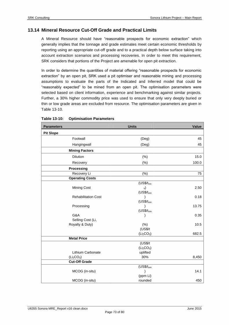
SRK Consulting Sonora Lithium Project – Main Report
U6355 Sonora MRE_Report v16 clean.docx June 2015 Page 73 of 80
13.14 Mineral Resource Cut-Off Grade and Practical Limits
A Mineral Resource should have “reasonable prospects for economic extraction” which
generally implies that the tonnage and grade estimates meet certain economic thresholds by
reporting using an appropriate cut-off grade and to a practical depth below surface taking into
account extraction scenarios and processing recoveries. In order to meet this requirement,
SRK considers that portions of the Project are amenable for open pit extraction.
In order to determine the quantities of material offering “reasonable prospects for economic
extraction” by an open pit, SRK used a pit optimiser and reasonable mining and processing
assumptions to evaluate the parts of the Indicated and Inferred model that could be
“reasonably expected” to be mined from an open pit. The optimisation parameters were
selected based on client information, experience and benchmarking against similar projects.
Further, a 30% higher commodity price was used to ensure that only very deeply buried or
thin or low grade areas are excluded from resource. The optimisation parameters are given in
Table 13-10.
Table 13-10: Optimisation Parameters
Parameters Units Value
Pit Slope
Footwall (Deg) 45
Hangingwall (Deg) 45
Mining Factors
Dilution (%) 15.0
Recovery (%) 100.0
Processing
Recovery Li (%) 75
Operating Costs
Mining Cost
(US$/troc
k) 2.50
Rehabilitation Cost
(US$/tore
) 0.18
Processing
(US$/tore
) 13.75
G&A
(US$/tore
) 0.35
Selling Cost (Li,
Royalty & Duty) (%) 10.5
(US$/t
(Li2CO3) 682.5
Metal Price
Lithium Carbonate
(Li2CO3)
(US$/t
(Li2CO3)
uplifted
30%
8,450
Cut-Off Grade
MCOG (in-situ)
(US$/tore
) 14.1
MCOG (in-situ)
(ppm Li)
rounded 450

SRK Consulting Sonora Lithium Project – Main Report
U6355 Sonora MRE_Report v16 clean.docx June 2015 Page 74 of 80
Figure 13-16: Oblique view showing classified material within the resource pit shell
The reader is cautioned that the results from the pit optimisation are used solely for the
purpose of testing the “reasonable prospects for economic extraction” by an open pit and do
not represent an attempt to estimate Mineral Reserves.
A cut-off grade of 450 ppm for lithium has been applied in reporting the Sonora Mineral
Resource. The resultant pit shell used to limit the resource is shown in grey in Figure 13-16.
The Mineral Resource Statement represents the material which SRK considers has
reasonable prospects for eventual economic extraction based on the pit optimisation analysis.
Table 13-11 shows the resulting Mineral Resource Statement for the Sonora project.
The statement has been classified in accordance with the terminology, definitions and
guidelines given in the Canadian Institute of Mining, Metallurgy and Petroleum ("CIM")
Definition Standards for Mineral Resources and Mineral Reserves (May 2014) and has been
reported in accordance with NI 43-101, by the Qualified Person, Mr Martin Pittuck (MSc.,
C.Eng., MIMMM). Mr Pittuck is an engineering consultant who is independent of Bacanora.
Bacanora and SRK are not aware of any additional factors (environmental, legal, title,
taxation, socio-economic, marketing, political, or other relevant factors) that have materially
affected the Mineral Resource Estimate.

SRK Consulting Sonora Lithium Project – Main Report
U6355 Sonora MRE_Report v16 clean.docx June 2015 Page 75 of 80
The tonnage and grade of Inferred Mineral Resources are uncertain and there has been
insufficient exploration to define these Inferred Mineral Resources as an Indicated or
Measured Mineral Resource and it is therefore uncertain if further exploration will result in
upgrading them to an Indicated or Measured Mineral Resource category.
13.15 Mineral Resource Statement
The resource is based on exploration results from mapping drilling and trenching made
available to SRK on the 16 April 2015 plus geological information but not assays from 9
drillholes that were provided on 24 March 2015 which is the effective date of the statement;
the results of this report were released in a press release on 12 May 2015 which is the report
date.
Every 1 unit of lithium metal is equivalent to 5.3 units of Li2CO3; in the Mineral Resource
statement the lithium metal content is also given as a Lithium Carbonate Equivalent (LCE).
Table 13-11: SRK Mineral Resource Statement as of 12 May 2015
Classi-fication
Con-cession
Owner Geological
Unit
Clay Tonnes
(Mt)
Clay Grade
(Li ppm)
Contained Metal (Kt Li)
Contained Metal
(Kt LCE)
Indicated
La Ventana
Minera Sonora Borax
Lower Clay 35 3,250 110 580
Upper Clay 35 1,400 50 260
El Sauz
Mexilit (JV-1)
Lower Clay 15 2,350 40 220
Upper Clay 8 1,000 8 40
Fleur Lower Clay 1 4,250 4 20
Upper Clay 2 1,800 4 20
Indicated
Combined 95 2,200 220 1,140
Inferred
La Ventana
Minera Sonora Borax
Lower Clay 30 3,700 100 500
Upper Clay 90 1,700 150 800
El Sauz
Mexilit (JV-1)
Lower Clay 100 2,500 250 1,300
Upper Clay 100 1,100 100 500
Fleur Lower Clay 80 4,200 350 2,000
Upper Clay 60 1,800 100 500
El Sauz1 Lower Clay 20 4,300 80 400
Upper Clay 30 1,700 60 300
Inferred
Combined 500 2,300 1,200 6,300
Notes:
6. Mineral Resources are not Mineral Reserves and do not have demonstrated economic viability. All figures are rounded to reflect
the relative accuracy of the estimate and have been used to derive sub-totals, totals and weighted averages. Such calculations
inherently involve a degree of rounding and consequently introduce a margin of error. Where these occur, SRK does not consider
them to be material.
7. The reporting standard adopted for the reporting of the MRE uses the terminology, definitions and guidelines given in the CIM
Standards on Mineral Resources and Mineral Reserves (May 2014) as required by NI 43-101 and JORC.
8. The MRE is reported on 100 percent basis for all project areas.
9. SRK assumes the Sonora Lithium deposit to be amenable to surface mining methods. Using results from initial metallurgical test
work, suitable surface mining and processing costs, and forecast LCE price SRK has reported the Mineral Resource at a cut-off
450 ppm Li (2,400 ppm Li2CO3).
10. SRK completed a site inspection of the deposit by Mr. Martin Pittuck, MSc, C.Eng, MIMMM, an appropriate "independent
qualified person" as such term is defined in NI 43-101.
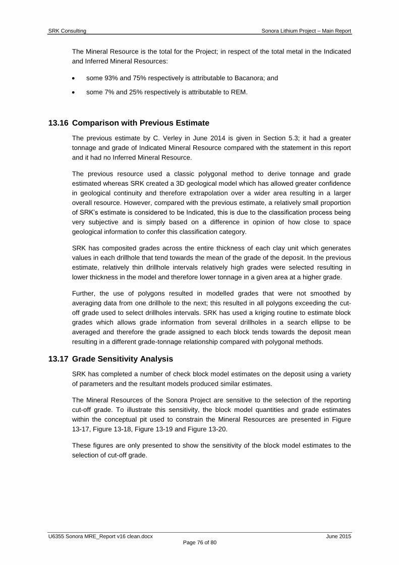
SRK Consulting Sonora Lithium Project – Main Report
U6355 Sonora MRE_Report v16 clean.docx June 2015 Page 76 of 80
The Mineral Resource is the total for the Project; in respect of the total metal in the Indicated
and Inferred Mineral Resources:
some 93% and 75% respectively is attributable to Bacanora; and
some 7% and 25% respectively is attributable to REM.
13.16 Comparison with Previous Estimate
The previous estimate by C. Verley in June 2014 is given in Section 5.3; it had a greater
tonnage and grade of Indicated Mineral Resource compared with the statement in this report
and it had no Inferred Mineral Resource.
The previous resource used a classic polygonal method to derive tonnage and grade
estimated whereas SRK created a 3D geological model which has allowed greater confidence
in geological continuity and therefore extrapolation over a wider area resulting in a larger
overall resource. However, compared with the previous estimate, a relatively small proportion
of SRK‟s estimate is considered to be Indicated, this is due to the classification process being
very subjective and is simply based on a difference in opinion of how close to space
geological information to confer this classification category.
SRK has composited grades across the entire thickness of each clay unit which generates
values in each drillhole that tend towards the mean of the grade of the deposit. In the previous
estimate, relatively thin drillhole intervals relatively high grades were selected resulting in
lower thickness in the model and therefore lower tonnage in a given area at a higher grade.
Further, the use of polygons resulted in modelled grades that were not smoothed by
averaging data from one drillhole to the next; this resulted in all polygons exceeding the cut-
off grade used to select drillholes intervals. SRK has used a kriging routine to estimate block
grades which allows grade information from several drillholes in a search ellipse to be
averaged and therefore the grade assigned to each block tends towards the deposit mean
resulting in a different grade-tonnage relationship compared with polygonal methods.
13.17 Grade Sensitivity Analysis
SRK has completed a number of check block model estimates on the deposit using a variety
of parameters and the resultant models produced similar estimates.
The Mineral Resources of the Sonora Project are sensitive to the selection of the reporting
cut-off grade. To illustrate this sensitivity, the block model quantities and grade estimates
within the conceptual pit used to constrain the Mineral Resources are presented in Figure
13-17, Figure 13-18, Figure 13-19 and Figure 13-20.
These figures are only presented to show the sensitivity of the block model estimates to the
selection of cut-off grade.
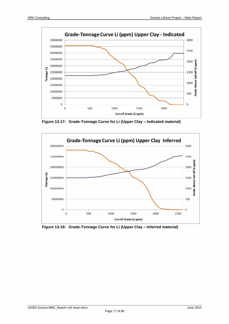
SRK Consulting Sonora Lithium Project – Main Report
U6355 Sonora MRE_Report v16 clean.docx June 2015 Page 77 of 80
Figure 13-17: Grade-Tonnage Curve for Li (Upper Clay – Indicated material)
Figure 13-18: Grade-Tonnage Curve for Li (Upper Clay – Inferred material)

SRK Consulting Sonora Lithium Project – Main Report
U6355 Sonora MRE_Report v16 clean.docx June 2015 Page 78 of 80
Figure 13-19: Grade-Tonnage Curve for Li (Lower Clay – Indicated material)
Figure 13-20: Grade-Tonnage Curve for Li (Lower Clay – Inferred material)
13.18 Exploration Potential
In addition to the MRE, a further conceptual exploration target has been modelled; the
potential of these extensions are in the range of 300 to 350 Mt, at a grade of approximately
1,500 to 2,500 ppm Li. This is limited to the current pit shell and is therefore considered
worthy of further exploration with a deep drilling programme. If these figures were converted
to a Mineral Resource via successful drilling and exploration, it is estimated that this could
represent an additional 2.4 to 4.6 Mt of LCE at the Sonora Lithium Project.

SRK Consulting Sonora Lithium Project – Main Report
U6355 Sonora MRE_Report v16 clean.docx June 2015 Page 79 of 80
14 MINERAL RESERVE ESTIMATES
No Mineral Reserve Estimate has been prepared for the Project at this time.
15 ADJACENT PROPERTIES
No reference has been made to adjacent properties, the Sonora Project is the first such
project to be developed in the area.
16 OTHER RELEVANT DATA AND INFORMATION
To SRK‟s knowledge, no other information is considered relevant at this time.
17 INTERPRETATION AND CONCLUSIONS
The Sonora Lithium Project is substantial in size, with potential to produce several millions of
tonnes of lithium carbonate product; it has a robust average grade compared with the cut-off
grade which suggests there is potential to operate with a good profit margin. The Mineral
Resource comprises an Indicated portion estimated at 95 Mt, averaging 2,200 ppm Li, for
1.12 Mt of LCE, in addition to an Inferred portion estimated at 520 Mt averaging 2,300 ppm Li,
for 6.40 Mt of LCE . The resource is reported above a cut-off grade of 450 ppm lithium based
on reasonably assumed technical and economic parameters and is constrained to an open pit
shell which limits the resource to the near surface areas which have the best potential for
economic extraction. In addition to the resource, a further conceptual target of 300 to 350 Mt,
at a grade of 1,500 to 2,500 ppm Li has been outlined within the current pit shell; this could
add 2.4 to 4.6 Mt of LCE to the resource. The Inferred Mineral Resource and the additional
exploration targets are considered worthy of further exploration drilling.
The mineral processing testwork is on-going; the flow sheet and estimates of reagent
consumptions, operating costs and overall process recovery are evolving, however it is clear
there is potential to process the lithium clays using beneficiation, followed by calcination,
leaching, evaporation, filtering and precipitation. SRK recommends progressing with more
resource definition drilling and mineral processing testwork as well as complimentary mining,
infrastructure, environmental and market studies to produce a prefeasibility study as the next
significant project milestone.
18 RECOMMENDATIONS
SRK recommends continued drilling to infill the Inferred Mineral Resource in order to increase
the confidence in these areas to an Indicated level. In the parts of the model which are
currently too far away from drilling to be included in the resource and which are contained in
the pit shell, deeper drilling is recommended to add to the Mineral Resource.
Some of the quality control procedures should be improved so that the grades of the standard
reference materials are more representative of the deposit grades. The standards should be
more thoroughly tested during the initial determination of mean grade and standard deviation
using several laboratories and methods. Some aspects of the density determination require
further study to confirm the accuracy of the density determination method which currently
assumed no core shrinkage upon drying.
The laboratory method used to date has a maximum detection limit of 10,000 ppm Li; several
SRK Consulting Sonora Lithium Project – Main Report
U6355 Sonora MRE_Report v16 clean.docx June 2015 Page 80 of 80
samples have returned this grade. SRK recommends resubmitting all high grade samples to
the laboratory, employing a method with a higher upper detection limit; this will result in a
slight increase in the resource grade.
The deposit appears to be robust and amenable to economic extraction, SRK recommends
further study to a prefeasibility level of detail in order to determine Mineral Reserves.
19 REFERENCES
Draft Preliminary Economic Assessment (“PEA”) report, Preliminary Economic
Assessment for the El Sauz Concession, Sonara Lithium Project, C Verley, October
2014;
For and on behalf of SRK Consulting (UK) Limited
Martin Pittuck, C.Eng, MIMMM,
Director & Corporate Consultant
(Mining Geology),
SRK Consulting (UK) Limited
Colin Rawbone, MAUSIMM(CP)
Senior Consultant
(Resource Geology)
SRK Consulting (UK) Limited
SRK Consulting Sonora Lithium Project – Technical Appendix Error! Reference source not found.
U6355 Sonora MRE_Report v16 clean.docx June 2015 Page 81 of 82
APPENDIX
A QUALIFIED PERSONS CERTIFICATE
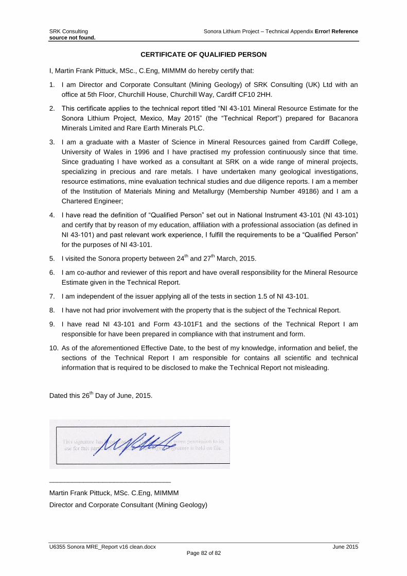
SRK Consulting Sonora Lithium Project – Technical Appendix Error! Reference source not found.
U6355 Sonora MRE_Report v16 clean.docx June 2015 Page 82 of 82
CERTIFICATE OF QUALIFIED PERSON
I, Martin Frank Pittuck, MSc., C.Eng, MIMMM do hereby certify that:
1. I am Director and Corporate Consultant (Mining Geology) of SRK Consulting (UK) Ltd with an
office at 5th Floor, Churchill House, Churchill Way, Cardiff CF10 2HH.
2. This certificate applies to the technical report titled “NI 43-101 Mineral Resource Estimate for the
Sonora Lithium Project, Mexico, May 2015” (the “Technical Report”) prepared for Bacanora
Minerals Limited and Rare Earth Minerals PLC.
3. I am a graduate with a Master of Science in Mineral Resources gained from Cardiff College,
University of Wales in 1996 and I have practised my profession continuously since that time.
Since graduating I have worked as a consultant at SRK on a wide range of mineral projects,
specializing in precious and rare metals. I have undertaken many geological investigations,
resource estimations, mine evaluation technical studies and due diligence reports. I am a member
of the Institution of Materials Mining and Metallurgy (Membership Number 49186) and I am a
Chartered Engineer;
4. I have read the definition of “Qualified Person” set out in National Instrument 43-101 (NI 43-101)
and certify that by reason of my education, affiliation with a professional association (as defined in
NI 43-101) and past relevant work experience, I fulfill the requirements to be a “Qualified Person”
for the purposes of NI 43-101.
5. I visited the Sonora property between 24th and 27
th March, 2015.
6. I am co-author and reviewer of this report and have overall responsibility for the Mineral Resource
Estimate given in the Technical Report.
7. I am independent of the issuer applying all of the tests in section 1.5 of NI 43-101.
8. I have not had prior involvement with the property that is the subject of the Technical Report.
9. I have read NI 43-101 and Form 43-101F1 and the sections of the Technical Report I am
responsible for have been prepared in compliance with that instrument and form.
10. As of the aforementioned Effective Date, to the best of my knowledge, information and belief, the
sections of the Technical Report I am responsible for contains all scientific and technical
information that is required to be disclosed to make the Technical Report not misleading.
Dated this 26th Day of June, 2015.
________________________________
Martin Frank Pittuck, MSc. C.Eng, MIMMM
Director and Corporate Consultant (Mining Geology)