Embed Size (px)
Citation preview
Sonoma Valley Wildlife Corridor Project | ii
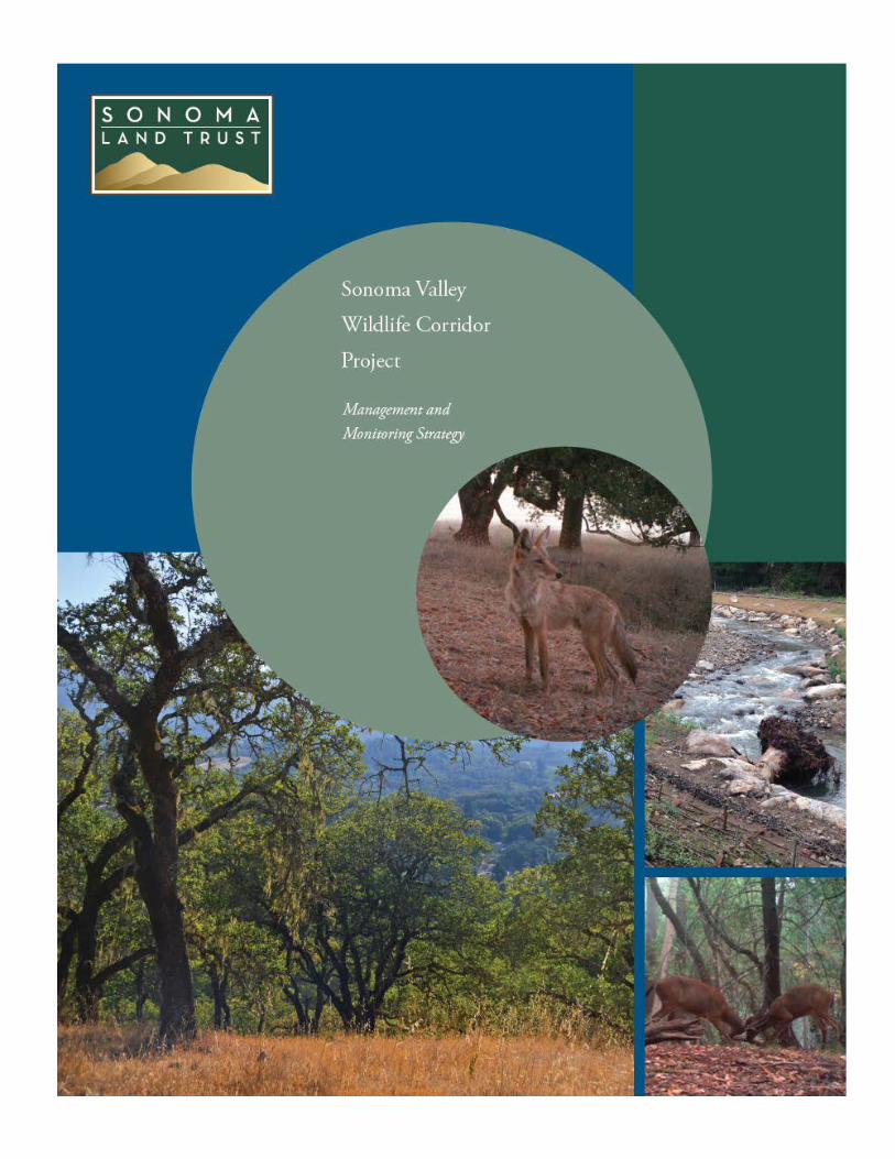
Sonoma Valley Wildlife Corridor Project: Management and Monitoring Strategy
Funding provided by the Gordon and Betty Moore Foundation, and a grant made through the Bay Area Conservation Initiative of Resources Legacy Fund
Citation This document should be cited as follows: Sonoma Land Trust. 2014. Sonoma Valley Wildlife Corridor Project: Management and Monitoring Strategy. Santa Rosa, CA.
Sonoma Land Trust 822 5th St, Santa Rosa, CA 95404
www.sonomalandtrust.org
Sonoma Valley Wildlife Corridor Project | iii
Acknowledgements The Sonoma Valley Wildlife Corridor Project was conceived in response to the visionary work, as described in the Conservation Lands Network, Bay Area Critical Linkages, Mayacamas Connectivity Report, and Sonoma County General Plan, of a consortium of scientists and planners who provided a framework for wildlife conservation in the region. This Management and Monitoring Strategy would not have been possible without the guidance of the Corridor Technical Advisory Group members who generously dedicated their time and expertise. We are also grateful to the landowners in the Corridor for their ongoing support of this project and the Corridor, and their commitment to stewarding their lands for the benefit of all wildlife in the region. We especially thank the Gordon and Betty Moore Foundation and Resources Legacy Fund for their conservation leadership and for providing significant funding for the Sonoma Valley Wildlife Corridor.
Corridor Technical Advisory Group
Caitlin Cornwall, Sonoma Ecology Center Tanya Diamond, Connectivity for Wildlife Wendy Eliot, Sonoma Land Trust Christina Freeman, California Department of Parks and Recreation Sandra Jacobson, US Forest Service Adina Merenlender, UC Cooperative Extension, Berkeley Lisa Micheli, Pepperwood Preserve Bob Neale, Sonoma Land Trust Gail Seymour, California Department of Fish and Wildlife Fraser Shilling, Road Ecology Center, UC Davis Ahiga Snyder, Connectivity for Wildlife Stu Weiss, Creekside Center for Earth Observation Jeff Wilcox, Sonoma Mountain Ranch Preservation Foundation Jeanne Wirka, Audubon Canyon Ranch
Strategy Director Tony Nelson, Sonoma Land Trust Report Authors
Nancy Schaefer, Land Conservation Services Tony Nelson, Sonoma Land Trust Report Reviewers
Wendy Eliot, Sonoma Land Trust Bob Neale, Sonoma Land Trust
Sonoma Valley Wildlife Corridor Project | iv
Contents Executive Summary ........................................................................................................................... vi 1 Introduction ........................................................................................................................................... 12
1.1 Sonoma Valley Wildlife Corridor Project Goal and Objectives ................................................... 14 1.2 Purpose of the Sonoma Valley Wildlife Corridor Management and Monitoring Strategy ......... 15
2 Approach and Methodology ................................................................................................................. 16 3 Sonoma Valley Wildlife Corridor Studies and Planning Efforts ........................................................... 18
3.1 The Conservation Lands Network and Bay Area Critical Linkages .............................................. 18 3.2 Mayacamas Connectivity Report ................................................................................................ 21 3.3 Sonoma County General Plan 2020 ............................................................................................ 23 3.4 Additional Studies and Plans ....................................................................................................... 23
4 Existing Conditions ................................................................................................................................ 25 4.1 Conserved Lands in the Sonoma Valley Wildlife Corridor .......................................................... 25 4.2 Land Uses in the Sonoma Valley Wildlife Corridor ..................................................................... 25 4.3 Roads and Undercrossings in the Sonoma Valley Wildlife Corridor ........................................... 28 4.4 Wildlife Habitat of the Sonoma Valley Wildlife Corridor ............................................................ 31 4.5 Vegetation in the Sonoma Valley Wildlife Corridor .................................................................... 32 4.6 Watersheds and Streams of the Sonoma Valley Wildlife Corridor ............................................. 36
5 Managing for Wildlife Corridor Permeability ..................................................................................... 49 5.1 Characteristics of functional wildlife corridors. .......................................................................... 49 5.2 Residential and Rural Residential Development ......................................................................... 50 5.3 Agricultural Development ........................................................................................................... 51 5.4 Roads and Undercrossings .......................................................................................................... 53 5.5 Fencing ........................................................................................................................................ 58 5.6 Excessive Fire Hazard Reduction and Post-Fire Restoration Practices ....................................... 61 5.7 Pesticide Use ............................................................................................................................... 65 5.8 Outdoor Night Lighting ............................................................................................................. 656 5.9 Trails and Recreational Uses ....................................................................................................... 66 5.10 Streams and Riparian Zones ....................................................................................................... 66
6 Recommendations for Sonoma Valley Wildlife Corridor Properties ................................................... 68 6.1 Oak Hill Farm .................................................................................. Error! Bookmark not defined. 6.2 Glen Oaks Ranch ......................................................................................................................... 68 6.3 Stuart Creek Hill .......................................................................................................................... 71 6.4 Johnson Property ........................................................................... Error! Bookmark not defined. 6.5 Rector Property .............................................................................. Error! Bookmark not defined. 6.6 Curreri Property .......................................................................................................................... 73 6.7 Bouverie Preserve .......................................................................... Error! Bookmark not defined. 6.8 Sonoma Valley Regional Park ...................................................................................................... 76 6.9 Sonoma Developmental Center .................................................................................................. 76
7 Sonoma Valley Wildlife Corridor Monitoring Strategy ........................................................................ 78 7.1 Introduction…………………………………………………………………………………………………………………………..88 7.2 Ecological Monitoring…………………………………………………………………………………………………………….88 7.3 Corridor Monitoring Priorities………………………………………………………………………………………………..89
7.4 Monitoring Protocols……………………………………………………………………………………………………………..90 7.5 Monitoring Outcomes…………………………………………………………………………………………………………….95 8 Recommendations to Maintain and Enhance Sonoma Valley Wildlife Corridor Permeability .......... 90 References .................................................................................................................................................. 95
Sonoma Valley Wildlife Corridor Project | v
Figures Figure A. The Sonoma Valley Wildlife Corridor Map……………………………………………………………………………..vii Figure B. Blue Ridge to Marin Coast Linkage………………………………………………………………………………………..viii Figure C. DRAFT Sonoma Valley Wildlife Corridor Management Guidelines…………………………………….….xi Figure 1. Wildlife corridors……………………………………………………………………………………………………………………12 Figure 2. Sonoma Valley Wildlife Corridor Map…………………………………………………………………………………....13 Figure 3. Key wildlife corridor terms……………………………………………………………………………………………………..14 Figure 4. Corridor Technical Advisory Group…………………………………………………………………………………………16 Figure 5. Sonoma Valley Wildlife Corridor properties assessed for permeability………………………………....17 Figure 6. The Conservation Lands Network for Sonoma Valley………………………………………………………….….19 Figure 7. Blue Ridge to Marin Coast Linkage…………………………………………………………………………………… ...20 Figure 8. Mayacamas Connectivity report results………………………………………………………………………………….22 Figure 9. Sonoma County General Plan 2020 Open Space Map for Sonoma Valley……………………………….24 Figure 10. Sonoma Valley Wildlife Corridor protected lands and lands proposed for protection ..… …..26 Figure 11. Land uses in the Sonoma Valley Wildlife Corridor…………………………………………………………………27 Figure 12. Undercrossings in the Sonoma Valley Wildlife Corridor………………………………………………………..29 Figure 13. Table of Sonoma Valley Wildlife Corridor undercrossings………………………………………..………....30 Figure 14. Vegetation types and habitat condition of the properties in the Prunuske Chatham,
Inc. Wildlife Composition Assessment…………………………………………………………………..……………..32 Figure 15. Rare plants observed on Secret Pasture, Metallinos, and Glen Oaks Ranch………………………….35 Figure 16. Streams within the Sonoma Valley Wildlife Corridor……………………………………………………….……36 Figure 17. Essential Watersheds and Priority Stream Segments for Focused Conservation Actions
(Leidy 2008)………………………………………………………………………………………………………………………….38 Figure 18. Wildlife species in the Sonoma Valley Wildlife Corridor……………………………………………………….40 Figure 19. Wildlife corridors………………………………………………………………………………………………………………….49 Figure 20. Native plant hedgerows in cultivated fields at Oak Hill Farm………………………………………..…..…53 Figure 21. Recommendations to improve permeability for Bridge and culvert undercrossings
in the Sonoma Valley Wildlife Corridor………………………………………………………………………………...56 Figure 22. Wildlife friendly designs for barbed and smooth wire fences…...............................................60 Figure 23. Suggested configurations for exclusionary or drift fencing along highways………………………….62 Figure 24. CAL FIRE defensible space requirements for State Responsibility Areas…………………………......63 Figure 25. CAL FIRE defensible space requirements for Local Responsibility Areas……………………………….63 Figure 26. CAL FIRE State Responsibility Area viewer map of Sonoma Valley Wildlife Corridor……………..64 Figure 27. Sonoma Valley Wildlife Corridor properties assessed for wildlife permeability by the
Corridor Technical Advisory Group……………………………………………………………………………………….68 Figure 28. Oak Hill Farm permeability assessment map………………………………………………………………………..70 Figure 29. Glen Oaks Ranch permeability assessment map……………….………………………………………………….74 Figure 30. Stuart Creek Hill permeability assessment map…………………………………………………..……………….76 Figure 31. Johnson Property permeability assessment map……………………………………………………………......78 Figure 32. Rector Property permeability assessment map…………………………………………………………………….80 Figure 33. Curreri Property permeability assessment map…………….……………………………………………….…….83 Figure 34. Location of Bouverie Preserve, Sonoma Valley Regional Park, and Sonoma
Developmental Center within the Sonoma Valley Wildlife Corridor……………………………………..87 Figure 35. Sonoma Valley Wildlife Corridor Wildlife Picture Index and Roadkill Study Area………….........93 Figure 36. Monitoring priorities as recommended and ranked by the Corridor Technical
Advisory Group……………………………………………………………………………………………………………….……96 Figure 37. DRAFT Sonoma Valley Wildlife Corridor Management Guidelines………………………………………102 Figure 38. Wildlife corridor information for homeowners from Santa Clara River Watershed Plan …….104
Sonoma Valley Wildlife Corridor Project | Executive Summary | vi
The Sonoma Valley Wildlife Corridor Project: Management and Monitoring Strategy
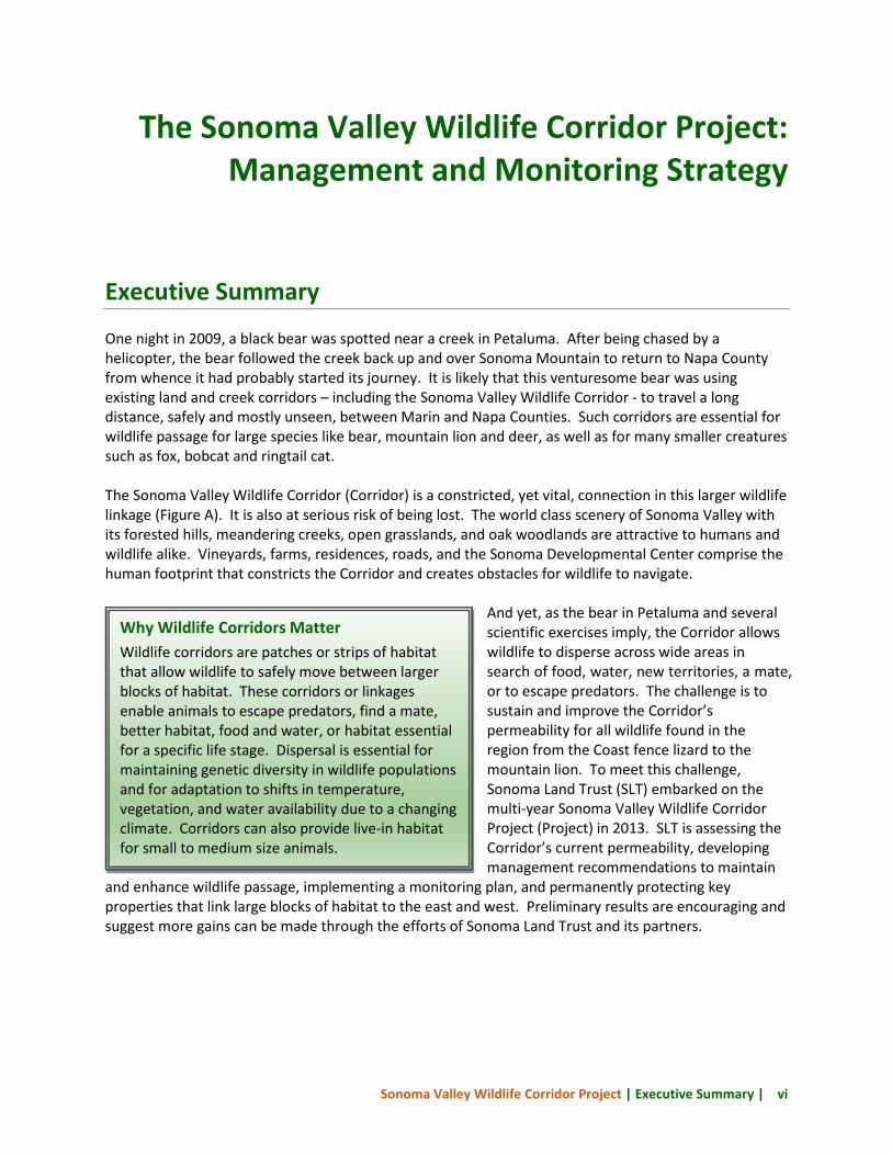
Executive Summary One night in 2009, a black bear was spotted near a creek in Petaluma. After being chased by a helicopter, the bear followed the creek back up and over Sonoma Mountain to return to Napa County from whence it had probably started its journey. It is likely that this venturesome bear was using existing land and creek corridors – including the Sonoma Valley Wildlife Corridor - to travel a long distance, safely and mostly unseen, between Marin and Napa Counties. Such corridors are essential for wildlife passage for large species like bear, mountain lion and deer, as well as for many smaller creatures such as fox, bobcat and ringtail cat. The Sonoma Valley Wildlife Corridor (Corridor) is a constricted, yet vital, connection in this larger wildlife linkage (Figure A). It is also at serious risk of being lost. The world class scenery of Sonoma Valley with its forested hills, meandering creeks, open grasslands, and oak woodlands are attractive to humans and wildlife alike. Vineyards, farms, residences, roads, and the Sonoma Developmental Center comprise the human footprint that constricts the Corridor and creates obstacles for wildlife to navigate.
And yet, as the bear in Petaluma and several scientific exercises imply, the Corridor allows wildlife to disperse across wide areas in search of food, water, new territories, a mate, or to escape predators. The challenge is to sustain and improve the Corridor’s permeability for all wildlife found in the region from the Coast fence lizard to the mountain lion. To meet this challenge, Sonoma Land Trust (SLT) embarked on the multi-year Sonoma Valley Wildlife Corridor Project (Project) in 2013. SLT is assessing the Corridor’s current permeability, developing management recommendations to maintain
and enhance wildlife passage, implementing a monitoring plan, and permanently protecting key properties that link large blocks of habitat to the east and west. Preliminary results are encouraging and suggest more gains can be made through the efforts of Sonoma Land Trust and its partners.
Why Wildlife Corridors Matter Wildlife corridors are patches or strips of habitat that allow wildlife to safely move between larger blocks of habitat. These corridors or linkages enable animals to escape predators, find a mate, better habitat, food and water, or habitat essential for a specific life stage. Dispersal is essential for maintaining genetic diversity in wildlife populations and for adaptation to shifts in temperature, vegetation, and water availability due to a changing climate. Corridors can also provide live-in habitat for small to medium size animals.
Sonoma Valley Wildlife Corridor Project | Executive Summary | vii
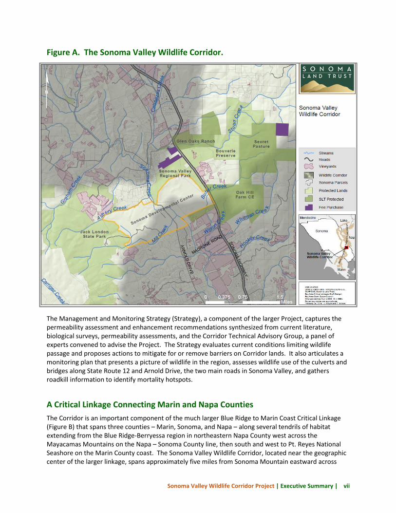
Figure A. The Sonoma Valley Wildlife Corridor.
The Management and Monitoring Strategy (Strategy), a component of the larger Project, captures the permeability assessment and enhancement recommendations synthesized from current literature, biological surveys, permeability assessments, and the Corridor Technical Advisory Group, a panel of experts convened to advise the Project. The Strategy evaluates current conditions limiting wildlife passage and proposes actions to mitigate for or remove barriers on Corridor lands. It also articulates a monitoring plan that presents a picture of wildlife in the region, assesses wildlife use of the culverts and bridges along State Route 12 and Arnold Drive, the two main roads in Sonoma Valley, and gathers roadkill information to identify mortality hotspots.
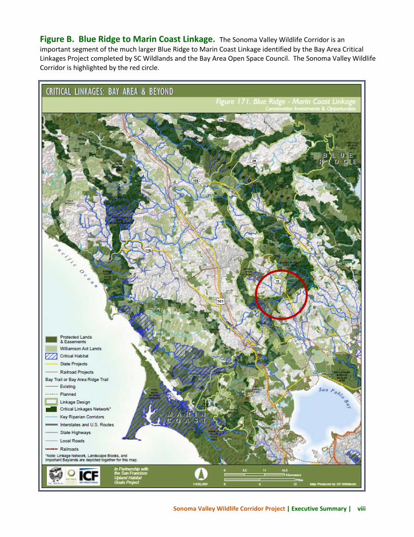
A Critical Linkage Connecting Marin and Napa Counties The Corridor is an important component of the much larger Blue Ridge to Marin Coast Critical Linkage (Figure B) that spans three counties – Marin, Sonoma, and Napa – along several tendrils of habitat extending from the Blue Ridge-Berryessa region in northeastern Napa County west across the Mayacamas Mountains on the Napa – Sonoma County line, then south and west to Pt. Reyes National Seashore on the Marin County coast. The Sonoma Valley Wildlife Corridor, located near the geographic center of the larger linkage, spans approximately five miles from Sonoma Mountain eastward across
Sonoma Valley Wildlife Corridor Project | Executive Summary | viii
Figure B. Blue Ridge to Marin Coast Linkage. The Sonoma Valley Wildlife Corridor is an important segment of the much larger Blue Ridge to Marin Coast Linkage identified by the Bay Area Critical Linkages Project completed by SC Wildlands and the Bay Area Open Space Council. The Sonoma Valley Wildlife Corridor is highlighted by the red circle.
Sonoma Valley Wildlife Corridor Project | Executive Summary | ix
Sonoma Creek and the valley floor near the town of Glen Ellen, and up to the crest of the Mayacamas Range (Figure A). On the valley floor, the Corridor is reduced to only three-quarters of a mile wide by residential and agricultural development thus creating a “pinch point.” The Corridor encompasses approximately 10,000 acres with just over 5,000 of these acres permanently protected and managed for natural resources and recreation by state and county agencies and nonprofit organizations, including Sonoma Land Trust. At the heart of the Corridor lies the state-operated Sonoma Developmental Center and its 700 acres of wildlands which presents both a threat and an opportunity as the state reviews alternative uses for the facility. Keeping the Sonoma Valley Wildlife Corridor Open Sonoma Land Trust and the Corridor Technical Advisory Group, after conducting field visits, biological surveys, permeability assessments, a literature review, and reviewing preliminary monitoring results are confident that the Corridor is permeable to wildlife species occurring in the region and that permeability can be enhanced by incorporating wildlife needs into property management practices on public and private lands in the Corridor. The following recommended actions chart the course for Corridor partners and landowners to achieve this goal. 1. Improve permeability on both public
and private lands. Sonoma Land Trust and the CTAG found numerous opportunities to enhance permeability of public and private properties in the Corridor. Raising awareness of the Corridor’s importance among the Valley’s residents could yield significant benefits. Even small lot homeowners can make just a few changes - keeping lights off and pets inside at night for instance - that can make a big difference. Enhancing the landscape for wildlife will require collaboration with SLT’s partners and cooperation from the diverse Sonoma Valley landowners. Some strategies for making changes both big and small are summarized below.
• Carry out management recommendations for properties with completed
permeability assessments. SLT should meet with the owners of the six properties with completed permeability assessments to share the results and encourage implementation of the recommended actions.
• Complete permeability evaluations for critical properties. Bouverie Preserve, Sonoma Valley Regional Park, and Sonoma Developmental Center are important properties in the heart of the Corridor. More detailed permeability assessments of these properties will determine if there are threats to wildlife passage or opportunities for enhancement.
Corridor Technical Advisory Group: Factors impacting wildlife passage in the Sonoma Valley Wildlife Corridor • roads and driveways • fencing • reduced structural and compositional
diversity of vegetation • agricultural cultivation • free roaming pets and feral cat feeding • exterior nighttime lighting • excessive noise • excessive fire hazard reduction and post-
fire restoration • timing of mechanical weed control • roadside vegetation management
(mowing or spraying) • pesticide use • trails and recreational uses
Sonoma Valley Wildlife Corridor Project | Executive Summary | x
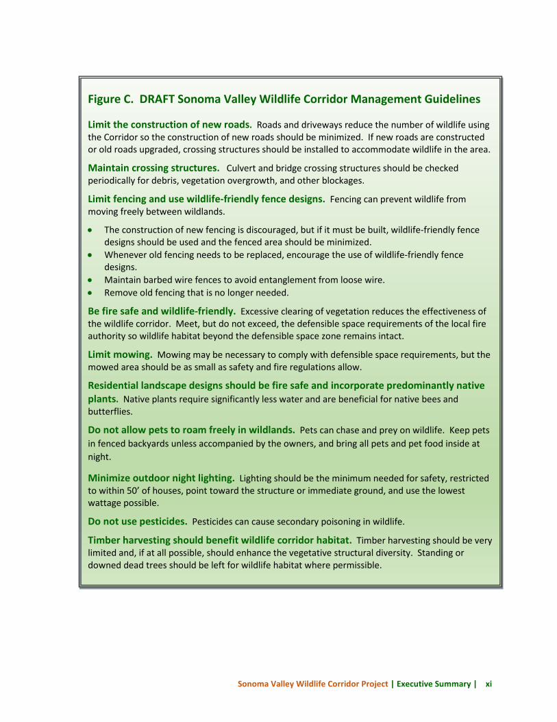
• Work with partners to develop outreach strategies for key audiences. Sonoma Valley has several different types of landowners – residential, agricultural, and conservation – each representing a different audience. Drafting an outreach plan that identifies key audiences, messages for each audience, and a strategy for putting the plan into action can focus limited resources. Figure C presents draft Sonoma Valley Wildlife Corridor guidelines that can be tailored for outreach materials for diverse audiences.
2. Engage regional and state transportation agencies to improve wildlife crossing safety. A number of structural and management changes were recommended for the 21 undercrossing structures (e.g., bridges and culverts) on Arnold Drive and State Route 12. Arnold Drive is under the jurisdiction of the Sonoma County Transportation Authority and State Route 12 is overseen by Caltrans. Motion-activated cameras installed in undercrossing structures and roadkill data will provide valuable information on the use of these structures by wildlife and identify stretches of road with excessive roadkill. Presenting monitoring results and highlighting the importance of the Corridor to these agencies can lay the foundation for the inclusion of permeability enhancements in future road improvement projects.
3. Advocate for stronger policy protections. A milestone was achieved when Corridor advocates, led by the Sonoma Ecology Center, were successful in designating the Corridor as a Habitat Connectivity Corridor in the Sonoma County General Plan 2020. Corridor advocates should work with County officials to develop strong ordinances that support the general plan’s intended protection of wildlife and riparian corridors in the Corridor and throughout the County.
4. Continue to use monitoring results to guide management strategies. As
knowledge of wildlife presence, road undercrossing structures use, and permeability throughout the Corridor increases, monitoring should focus on evaluating and refining the effectiveness of actions taken to improve wildlife passage.
The land conservation and policy successes achieved since the 1990’s when Christy Vreeland, a Sonoma Developmental Center staff member, observed wildlife using the Corridor and began advocating for its protection are formidable. But more work remains to permanently protect these essential strands of habitat and ensure their suitability for all types of wildlife. The Sonoma Valley Wildlife Corridor Management and Monitoring Strategy offers a road map to meet this goal.
Sonoma Valley Wildlife Corridor Project | Executive Summary | xi
Figure C. DRAFT Sonoma Valley Wildlife Corridor Management Guidelines Limit the construction of new roads. Roads and driveways reduce the number of wildlife using the Corridor so the construction of new roads should be minimized. If new roads are constructed or old roads upgraded, crossing structures should be installed to accommodate wildlife in the area.
Maintain crossing structures. Culvert and bridge crossing structures should be checked periodically for debris, vegetation overgrowth, and other blockages.
Limit fencing and use wildlife-friendly fence designs. Fencing can prevent wildlife from moving freely between wildlands.
• The construction of new fencing is discouraged, but if it must be built, wildlife-friendly fence designs should be used and the fenced area should be minimized.
• Whenever old fencing needs to be replaced, encourage the use of wildlife-friendly fence designs.
• Maintain barbed wire fences to avoid entanglement from loose wire. • Remove old fencing that is no longer needed.
Be fire safe and wildlife-friendly. Excessive clearing of vegetation reduces the effectiveness of the wildlife corridor. Meet, but do not exceed, the defensible space requirements of the local fire authority so wildlife habitat beyond the defensible space zone remains intact.
Limit mowing. Mowing may be necessary to comply with defensible space requirements, but the mowed area should be as small as safety and fire regulations allow.
Residential landscape designs should be fire safe and incorporate predominantly native plants. Native plants require significantly less water and are beneficial for native bees and butterflies.
Do not allow pets to roam freely in wildlands. Pets can chase and prey on wildlife. Keep pets in fenced backyards unless accompanied by the owners, and bring all pets and pet food inside at night.
Minimize outdoor night lighting. Lighting should be the minimum needed for safety, restricted to within 50’ of houses, point toward the structure or immediate ground, and use the lowest wattage possible.
Do not use pesticides. Pesticides can cause secondary poisoning in wildlife.
Timber harvesting should benefit wildlife corridor habitat. Timber harvesting should be very limited and, if at all possible, should enhance the vegetative structural diversity. Standing or downed dead trees should be left for wildlife habitat where permissible.
Sonoma Valley Wildlife Corridor Project | Chapter 1 | 12
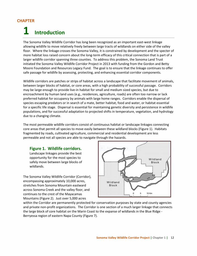
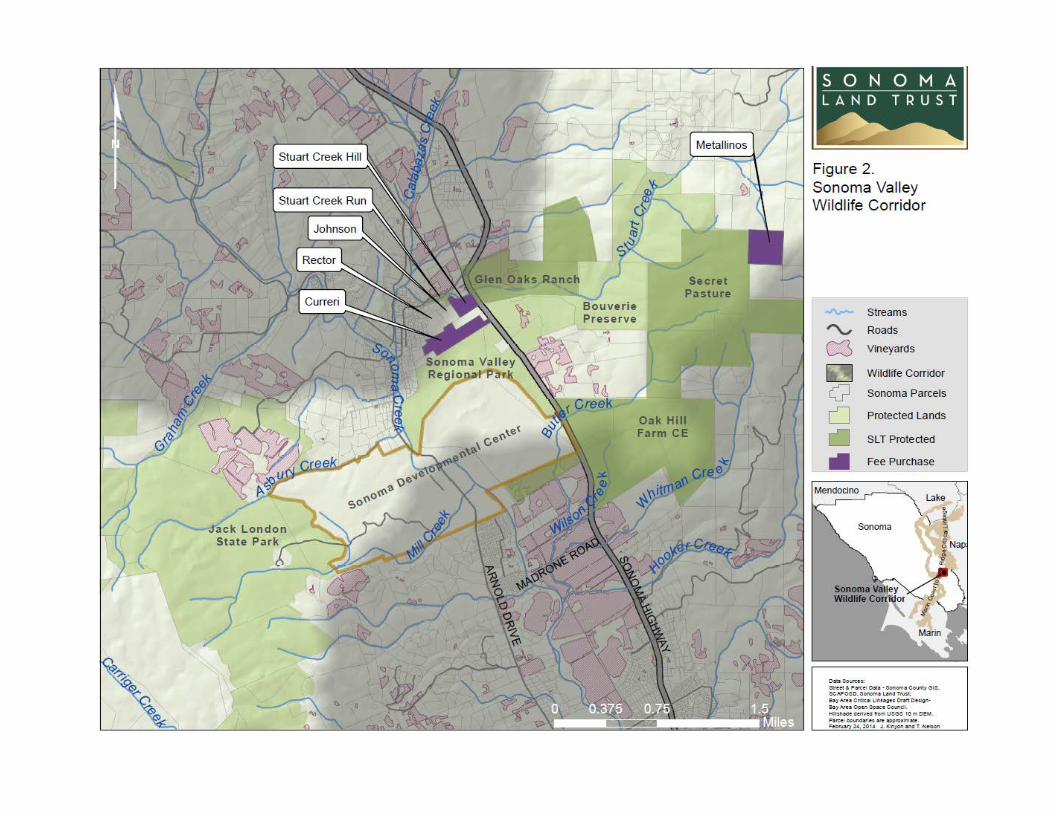
1 Introduction The Sonoma Valley Wildlife Corridor has long been recognized as an important east-west linkage allowing wildlife to move relatively freely between large tracts of wildlands on either side of the valley floor. Where the linkage crosses the Sonoma Valley, it is constrained by development and the specter of more habitat loss raised concern about the long-term efficacy of this critical connection that is part of a larger wildlife corridor spanning three counties. To address this problem, the Sonoma Land Trust initiated the Sonoma Valley Wildlife Corridor Project in 2013 with funding from the Gordon and Betty Moore Foundation and Resources Legacy Fund. The goal is to ensure that the linkage continues to offer safe passage for wildlife by assessing, protecting, and enhancing essential corridor components. Wildlife corridors are patches or strips of habitat across a landscape that facilitate movement of animals, between larger blocks of habitat, or core areas, with a high probability of successful passage. Corridors may be large enough to provide live-in habitat for small and medium sized species, but due to encroachment by human land uses (e.g., residences, agriculture, roads) are often too narrow or lack preferred habitat for occupancy by animals with large home ranges. Corridors enable the dispersal of species escaping predators or in search of a mate, better habitat, food and water, or habitat essential for a specific life stage. Dispersal is essential for maintaining genetic diversity and persistence in wildlife populations, and for successful adaptation to projected shifts in temperature, vegetation, and hydrology due to a changing climate. The most permeable wildlife corridors consist of continuous habitat or landscape linkages connecting core areas that permit all species to move easily between these wildland blocks (Figure 1). Habitats fragmented by roads, cultivated agriculture, commercial and residential development are less permeable and not all species are able to navigate through the hazards. The Sonoma Valley Wildlife Corridor (Corridor), encompassing approximately 10,000 acres, stretches from Sonoma Mountain eastward across Sonoma Creek and the valley floor, and continues to the crest of the Mayacamas Mountains (Figure 2). Just over 5,000 acres within the Corridor are permanently protected for conservation purposes by state and county agencies and private non-profit organizations. The Corridor is one section of a much larger linkage that connects the large block of core habitat on the Marin Coast to the expanse of wildlands in the Blue Ridge - Berryessa region of eastern Napa County (Figure 7).
Figure 1. Wildlife corridors. Landscape linkages provide the best opportunity for the most species to safely move between large blocks of wildlands.
CHAPTER
Sonoma Valley Wildlife Corridor Project | Chapter 1 | 13
Sonoma Valley Wildlife Corridor Project | Chapter 1 | 14
Even though habitats within the Corridor have been altered by roads, residences, businesses, agriculture, and recreational uses, they are dominated by the common vegetation types of the region and have varied structural diversity and composition, excellent cover and food resources, and numerous permanent and intermittent creeks. Oak woodland and savanna, evergreen forests, grasslands, chaparral, lakes, wetlands, and stream corridors provide a continuous network of habitats through the matrix of human land uses in the narrowest part of the Corridor on the valley floor. Based on the diversity and condition of habitats within the Corridor, modeling results from two conservation planning studies, expert observation, and anecdotal evidence, it is presumed that the Corridor supports the diversity of wildlife expected to occur in the region and affords passage between Sonoma Mountain and the Mayacamas Range. Development and intensive land use in the region, concentrated in the valley, have fragmented habitat and created a constriction or “chokepoint” in the Corridor near the small town of Glen Ellen. Further fragmentation or loss of this chokepoint to development would jeopardize the future permeability of the Corridor, the integrity of the larger linkage, and the ability of wildlife populations to persist in the region. The goal and objectives of this project are designed to address these threats. 1.1 Sonoma Valley Wildlife Corridor
Project Goal and Objectives The goal of the Sonoma Valley Wildlife Corridor Project (Project) is to ensure the permeability of this critical linkage for all wildlife in the region to move freely across the network of public and private lands illustrated in Figure 2. Project objectives are to employ a variety of conservation tools to assess current permeability of the Corridor, develop and implement monitoring and management recommendations to maintain and enhance permeability, and permanently protect key properties that provide connectivity between large blocks of habitat to the east and west. These objectives are described below.
1. Corridor permeability assessment. To evaluate the current permeability of the Corridor, Sonoma Land Trust (SLT) gathered available wildlife habitat and use data specific to the Corridor, scientific literature on wildlife corridor management, wildlife and vegetation studies on a few key properties, and the expert opinion of the Corridor Technical Advisory Group (CTAG). SLT is also collecting data from motion-activated cameras and roadkill observations to document current
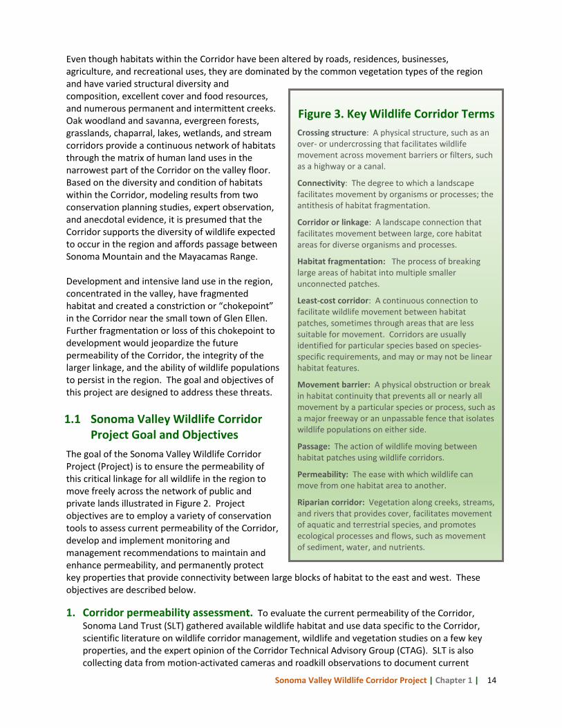
Figure 3. Key Wildlife Corridor Terms Crossing structure: A physical structure, such as an over- or undercrossing that facilitates wildlife movement across movement barriers or filters, such as a highway or a canal.
Connectivity: The degree to which a landscape facilitates movement by organisms or processes; the antithesis of habitat fragmentation.
Corridor or linkage: A landscape connection that facilitates movement between large, core habitat areas for diverse organisms and processes.
Habitat fragmentation: The process of breaking large areas of habitat into multiple smaller unconnected patches.
Least-cost corridor: A continuous connection to facilitate wildlife movement between habitat patches, sometimes through areas that are less suitable for movement. Corridors are usually identified for particular species based on species-specific requirements, and may or may not be linear habitat features.
Movement barrier: A physical obstruction or break in habitat continuity that prevents all or nearly all movement by a particular species or process, such as a major freeway or an unpassable fence that isolates wildlife populations on either side.
Passage: The action of wildlife moving between habitat patches using wildlife corridors.
Permeability: The ease with which wildlife can move from one habitat area to another.
Riparian corridor: Vegetation along creeks, streams, and rivers that provides cover, facilitates movement of aquatic and terrestrial species, and promotes ecological processes and flows, such as movement of sediment, water, and nutrients.
Sonoma Valley Wildlife Corridor Project | Chapter 1 | 15
wildlife use of the Corridor. As more data is gathered the effectiveness of permeability improvements for adaptive management applications can be evaluated.
2. Management and monitoring recommendations. The information gathered from the permeability assessment shaped the management recommendations to reduce or eliminate movement barriers, and the monitoring objectives to assess current and future wildlife use of the Corridor. These recommendations are documented in this Sonoma Valley Wildlife Corridor Management and Monitoring Strategy (Strategy). SLT is committed to implementing the recommended permeability improvements identified in this Strategy on its fee properties, securing permanent wildlife movement protections for the Rector, Johnson, and SDC properties, implementing priority monitoring efforts, and disseminating outreach materials to key audiences as described in Chapter 8.
3. Permanent land protection. SLT identified three key properties for protection in the Corridor chokepoint - Stuart Creek Hill, Metallinos, and Curreri - to expand conserved lands and secure critical wildlife passage features. SLT recently purchased the Stuart Creek Hill and Metallinos properties, and will purchase and transfer Curreri to Sonoma County Regional Parks in July 2014. In addition, SLT will develop model conservation easement and deed restriction language that promotes wildlife passage for other willing landowners within the Corridor and to share with the conservation community. Discussions have been initiated with additional landowners in the chokepoint have been initiated to place such restrictions on their properties. Landowners throughout the Corridor may be approached to explore further opportunities.
At the heart of the Corridor is the approximately 950 acre Sonoma Developmental Center (SDC) owned and operated by the State of California. In operation since 1891, this health care facility provides residential services for individuals with severe developmental and physical disabilities. The SDC is one of the county’s largest employers, and arguably the most ecologically significant property in Sonoma Valley. Through a cooperative planning effort with state agencies, Sonoma County, Sonoma Ecology Center, and other community groups, SLT is working to ensure that the roughly 750 acres of wildlands on the property are preserved, and eventually transferred to an organization that will provide permanent protection for open space, watershed, and wildlife corridor conservation and management purposes.
The successful implementation of this project will demonstrate the feasibility of protecting a functioning wildlife corridor utilizing a range of innovative tools across multiple property ownerships. It is hoped that the project can serve as a model for other watersheds and regions that face multiple threats to the integrity of large, intact natural landscapes. 1.2 Purpose of the Sonoma Valley Wildlife Corridor Management and
Monitoring Strategy This Strategy captures the management and monitoring recommendations for improving the permeability of the Corridor developed by the Sonoma Valley Wildlife Corridor Project. It explains the approach and methodology used to assess the Corridor and develop monitoring objectives and management recommendations (Chapter 2); offers a brief overview of conservation efforts related to the Corridor (Chapter 3); documents existing conditions (Chapter 4); summarizes the factors that impact permeability and mitigating actions (Chapter 5); describes detailed management recommendations for the properties visited by the CTAG (Chapter 6); outlines the objectives and potential protocols for a monitoring plan (Chapter 7); and, finally, presents a summary of the recommendations and management guidelines in Chapter 8.
Sonoma Valley Wildlife Corridor Project | Chapter 2 | 16
2 Approach and Methodology
To develop the monitoring objectives and management recommendations for the Sonoma Valley Wildlife Corridor (Corridor), we employed a review and synthesis of scientific literature on corridor ecology, local wildlife habitat and use data, expert opinion from scientists and land managers, preliminary observations of road undercrossings (bridges and culverts) in the Corridor, and permeability field assessments for six properties located in the Corridor chokepoint. The methodology involved four main steps:
1. Literature review and resource reports. A literature search was conducted for data, research, and reports related to the Sonoma Valley Wildlife Corridor area as well as factors known to impact wildlife permeability of core areas and linkage lands, and management practices to maintain or improve permeability. A wildlife biologist was engaged to complete a wildlife composition assessment for Curreri, Stuart Creek Hill and Metallinos (Prunuske Chatham, Inc. 2013), and a botanist surveyed and prepared vegetation composition descriptions for Glen Oaks Ranch, Curreri, Secret Pasture and Metallinos (Warner 2013). Summaries of the literature review and biotic assessments are provided in Chapter 4 Existing Conditions.
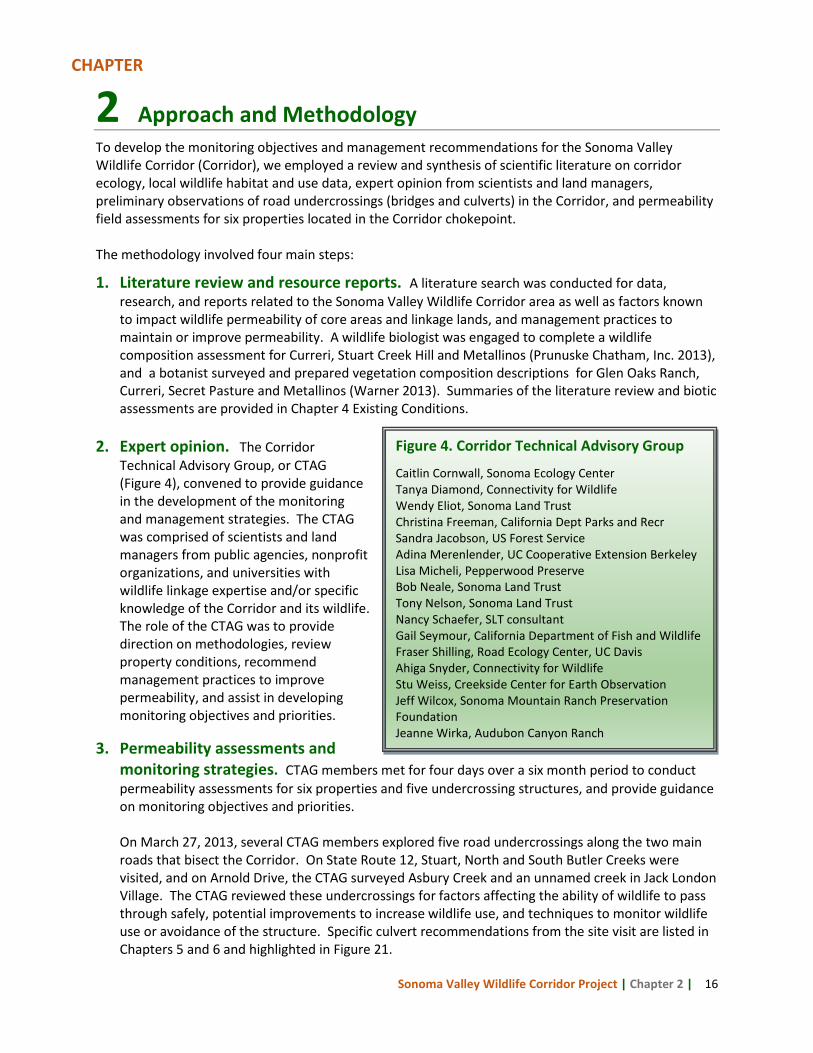
2. Expert opinion. The Corridor Technical Advisory Group, or CTAG (Figure 4), convened to provide guidance in the development of the monitoring and management strategies. The CTAG was comprised of scientists and land managers from public agencies, nonprofit organizations, and universities with wildlife linkage expertise and/or specific knowledge of the Corridor and its wildlife. The role of the CTAG was to provide direction on methodologies, review property conditions, recommend management practices to improve permeability, and assist in developing monitoring objectives and priorities.
3. Permeability assessments and monitoring strategies. CTAG members met for four days over a six month period to conduct permeability assessments for six properties and five undercrossing structures, and provide guidance on monitoring objectives and priorities. On March 27, 2013, several CTAG members explored five road undercrossings along the two main roads that bisect the Corridor. On State Route 12, Stuart, North and South Butler Creeks were visited, and on Arnold Drive, the CTAG surveyed Asbury Creek and an unnamed creek in Jack London Village. The CTAG reviewed these undercrossings for factors affecting the ability of wildlife to pass through safely, potential improvements to increase wildlife use, and techniques to monitor wildlife use or avoidance of the structure. Specific culvert recommendations from the site visit are listed in Chapters 5 and 6 and highlighted in Figure 21.
Figure 4. Corridor Technical Advisory Group
Caitlin Cornwall, Sonoma Ecology Center Tanya Diamond, Connectivity for Wildlife Wendy Eliot, Sonoma Land Trust Christina Freeman, California Dept Parks and Recr Sandra Jacobson, US Forest Service Adina Merenlender, UC Cooperative Extension Berkeley Lisa Micheli, Pepperwood Preserve Bob Neale, Sonoma Land Trust Tony Nelson, Sonoma Land Trust Nancy Schaefer, SLT consultant Gail Seymour, California Department of Fish and Wildlife Fraser Shilling, Road Ecology Center, UC Davis Ahiga Snyder, Connectivity for Wildlife Stu Weiss, Creekside Center for Earth Observation Jeff Wilcox, Sonoma Mountain Ranch Preservation Foundation Jeanne Wirka, Audubon Canyon Ranch
CHAPTER
Sonoma Valley Wildlife Corridor Project | Chapter 2 | 17
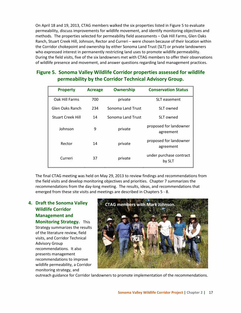
On April 18 and 19, 2013, CTAG members walked the six properties listed in Figure 5 to evaluate permeability, discuss improvements for wildlife movement, and identify monitoring objectives and methods. The properties selected for permeability field assessments – Oak Hill Farms, Glen Oaks Ranch, Stuart Creek Hill, Johnson, Rector and Curreri – were chosen because of their location within the Corridor chokepoint and ownership by either Sonoma Land Trust (SLT) or private landowners who expressed interest in permanently restricting land uses to promote wildlife permeability. During the field visits, five of the six landowners met with CTAG members to offer their observations of wildlife presence and movement, and answer questions regarding land management practices.
Figure 5. Sonoma Valley Wildlife Corridor properties assessed for wildlife permeability by the Corridor Technical Advisory Group.
Property Acreage Ownership Conservation Status
Oak Hill Farms 700 private SLT easement
Glen Oaks Ranch 234 Sonoma Land Trust SLT owned
Stuart Creek Hill 14 Sonoma Land Trust SLT owned
Johnson 9 private proposed for landowner
agreement
Rector 14 private proposed for landowner
agreement
Curreri 37 private under purchase contract
by SLT
The final CTAG meeting was held on May 29, 2013 to review findings and recommendations from the field visits and develop monitoring objectives and priorities. Chapter 7 summarizes the recommendations from the day-long meeting. The results, ideas, and recommendations that emerged from these site visits and meetings are described in Chapters 5 - 8.
4. Draft the Sonoma Valley
Wildlife Corridor Management and Monitoring Strategy. This Strategy summarizes the results of the literature review, field visits, and Corridor Technical Advisory Group recommendations. It also presents management recommendations to improve wildlife permeability, a Corridor monitoring strategy, and outreach guidance for Corridor landowners to promote implementation of the recommendations.
CTAG members with Mark Johnson.
Sonoma Valley Wildlife Corridor Project | Chapter 3 | 18
3 Sonoma Valley Wildlife Corridor Studies and Planning Efforts
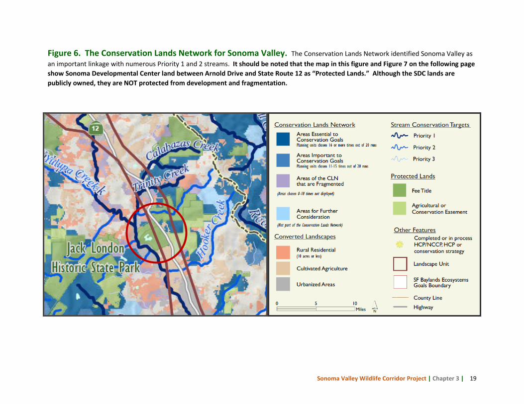
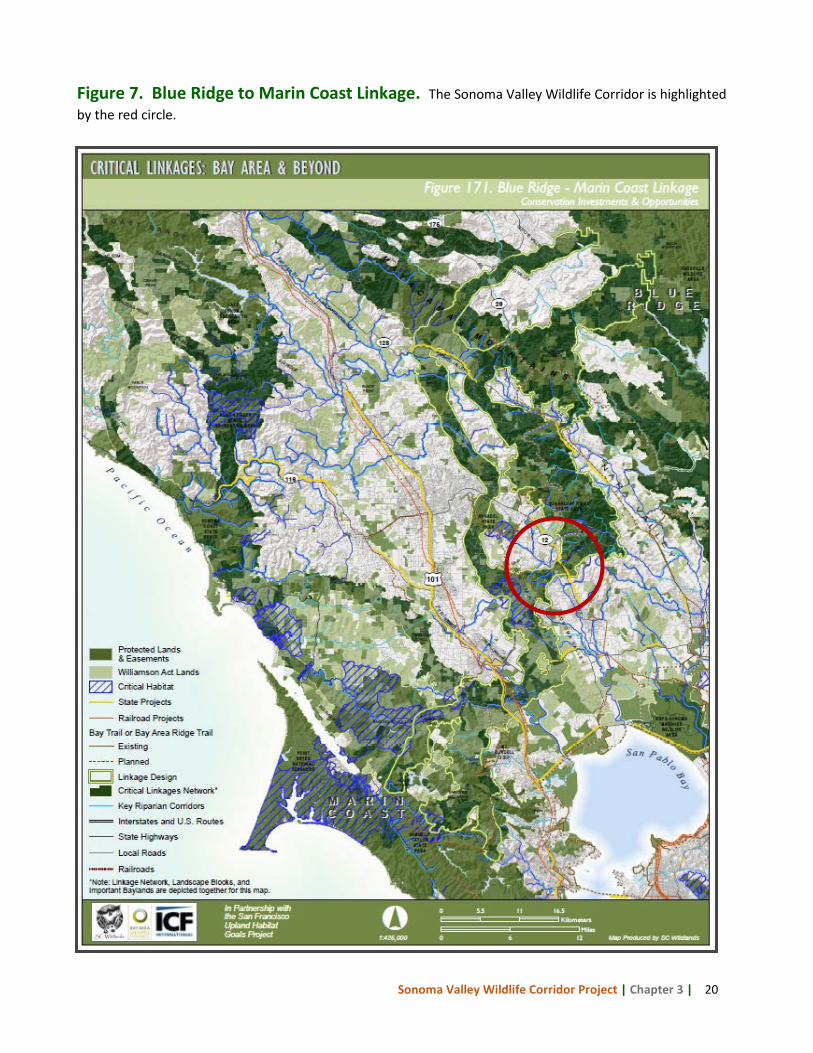
The Sonoma Valley Wildlife Corridor (Corridor) began gaining recognition as a region of significant wildlife presence and movement in the 1990s. Christy Vreeland, an employee of Sonoma Developmental Center, recognized the region as unique and approached the Sonoma Ecology Center (SEC) with a vision to protect the linkage (Hilty et al. 2006). With funding from the Community Foundation of Sonoma County, SEC produced maps and successfully advocated for the Corridor’s recognition in the Sonoma County General Plan 2020 update. In recent years, the Corridor has been identified in, or the subject of, several conservation planning efforts and studies as a key connection and potentially at risk from development. The Bay Area Critical Linkages Project, Conservation Lands Network, and Sonoma County 2020 General Plan highlight the Corridor as land highly suitable for conservation due to the presence of listed species, habitat, priority streams, and connectivity to large protected lands on Sonoma Mountain and in the Mayacamas Mountains. More localized studies have been undertaken in response to development threats and to bolster support for protection of the Corridor. Some of these studies culminated in the transfer of a portion of the Sonoma Developmental Center wildlands to Jack London State Park and conservation easements to Sonoma County Agricultural Preservation and Open Space District. A brief overview of these conservation studies and plans are summarized in the following sections. 3.1 The Conservation Lands Network and Bay Area Critical Linkages The Conservation Lands Network (CLN) is a biodiversity conservation plan for the nine-county Bay Area completed in 2011 by the Bay Area Open Space Council. The purpose of the CLN is to offer guidance for conservation investments and encourage proactive conservation. The CLN identified the Corridor as an important linkage with several Priority 1 and 2 streams (see Chapter 4 Existing Conditions for a description of priority streams). Figure 6 displays the Conservation Lands Network in the Sonoma Valley area. Building on the work of the CLN, the Gordon and Betty Moore Foundation funded Science and Collaboration for Connected Wildlands (SC Wildlands) to complete a detailed linkage analysis as a refinement to the CLN. Called Critical Linkages: The Bay Area and Beyond (Bay Area Critical Linkages), this collaborative project covered the nine Bay Area counties plus several counties to the north and south. The study identified 14 landscape level connections including constrictions within these linkages. The Sonoma Valley Wildlife Corridor is part of the Blue Ridge to Marin Coast Linkage (Figure 7) that spans three counties – Marin, Sonoma and Napa – stretching from the Blue Ridge-Berryessa region in eastern Napa County to Pt. Reyes National Seashore to the south and west. The project employed the focal species method selecting 66 plant and animal species, and conducting least-cost corridor analyses for a subset of the focal species in each of the 14 linkages. A least-cost corridor is the path of least resistance offering connectivity between habitat patches as determined for each focal species. The Blue Ridge to Marin Coast linkage was delineated based on the habitat
CHAPTER
Sonoma Valley Wildlife Corridor Project | Chapter 3 | 19
Figure 6. The Conservation Lands Network for Sonoma Valley. The Conservation Lands Network identified Sonoma Valley as an important linkage with numerous Priority 1 and 2 streams. It should be noted that the map in this figure and Figure 7 on the following page show Sonoma Developmental Center land between Arnold Drive and State Route 12 as “Protected Lands.” Although the SDC lands are publicly owned, they are NOT protected from development and fragmentation.
Sonoma Valley Wildlife Corridor Project | Chapter 3 | 20
Figure 7. Blue Ridge to Marin Coast Linkage. The Sonoma Valley Wildlife Corridor is highlighted by the red circle.
Sonoma Valley Wildlife Corridor Project | Chapter 3 | 21
requirements of mountain lion and badger, but is presumed to be suitable for most species known in the region such as spotted owl, pileated woodpecker, acorn woodpecker, kingsnake, western toad, yellow-legged frog, and long-eared myotis.
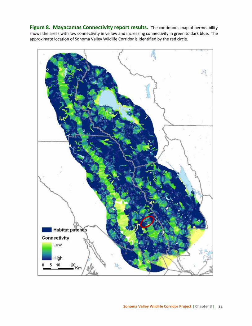
3.2 Mayacamas Connectivity Report In 2010, the Sonoma County Agricultural Preservation and Open Space District commissioned Adina Merenlender, PhD, and her students at the University of California Berkeley to identify and prioritize linkages within the Mayacamas Mountains and among neighboring habitat patches. Unlike the least-cost corridor approach used by Bay Area Critical Linkages that overlays focal species corridors to delineate a linkage, the project team estimated permeability in a continuous manner for the entire mixed oak woodland community found in the study area. This approach, termed a “biologically-informed structural habitat connectivity model,” considers the landscape structure, particularly the built environment consisting of buildings and roads, in evaluating habitat suitability and connectivity for communities of species. The project first identified habitat patches with a minimum size greater than or equal to 4 hectares, then conducted a permeability analysis utilizing distance to nearest road, parcel size, and median patch size. Expected carnivore and bird responses to the three permeability metrics were used to create landscape response models that were then combined to create permeability (or combined cost) layers to estimate a continuous surface of travel cost between habitat patches where cost is determined by distance and habitat permeability. Figure 8 is the continuous map resulting from the combined permeability layers and the SVWC is denoted by the red circle. The permeability layers were used to identify least-cost pathways between existing protected layers using FunConn, an ArcGIS program. This modeling exercise identified the Corridor as an important connection between Sonoma Mountain and the Mayacamas Mountains, and also highlighted the strong threat to the Corridor from vineyard development.
Sonoma Developmental Center
Sonoma Valley Wildlife Corridor Project | Chapter 3 | 22
Figure 8. Mayacamas Connectivity report results. The continuous map of permeability shows the areas with low connectivity in yellow and increasing connectivity in green to dark blue. The approximate location of Sonoma Valley Wildlife Corridor is identified by the red circle.
Sonoma Valley Wildlife Corridor Project | Chapter 3 | 23
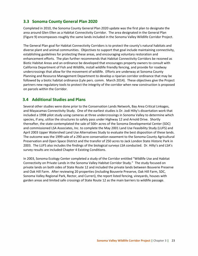
3.3 Sonoma County General Plan 2020 Completed in 2010, the Sonoma County General Plan 2020 update was the first plan to designate the area around Glen Ellen as a Habitat Connectivity Corridor. The area designated in the General Plan (Figure 9) encompasses roughly the same lands included in the Sonoma Valley Wildlife Corridor Project. The General Plan goal for Habitat Connectivity Corridors is to protect the county’s natural habitats and diverse plant and animal communities. Objectives to support that goal include maintaining connectivity, establishing guidelines for protecting these areas, and encouraging voluntary restoration and enhancement efforts. The plan further recommends that Habitat Connectivity Corridors be rezoned as Biotic Habitat Areas and an ordinance be developed that encourages property owners to consult with California Department of Fish and Wildlife, install wildlife friendly fencing, and provide for roadway undercrossings that allow for the movement of wildlife. Efforts are underway at Sonoma County Planning and Resource Management Department to develop a riparian corridor ordinance that may be followed by a biotic habitat ordinance (Lyle pers. comm. March 2014). These objectives give the Project partners new regulatory tools to protect the integrity of the corridor when new construction is proposed on parcels within the Corridor.
3.4 Additional Studies and Plans Several other studies were done prior to the Conservation Lands Network, Bay Area Critical Linkages, and Mayacamas Connectivity Study. One of the earliest studies is Dr. Jodi Hilty’s dissertation work that included a 1998 pilot study using cameras at three undercrossings in Sonoma Valley to determine which species, if any, utilize the structures to safely pass under Highway 12 and Arnold Drive. Shortly thereafter, the state contemplated the sale of 500+ acres of the Sonoma Developmental Center (SDC) and commissioned LSA Associates, Inc. to complete the May 2001 Land Use Feasibility Study (LUFS) and April 2003 Upper Watershed Land Use Alternatives Study to evaluate the best disposition of these lands. The outcome was the 1999 sale of a 290-acre conservation easement to the Sonoma County Agricultural Preservation and Open Space District and the transfer of 250 acres to Jack London State Historic Park in 2003. The LUFS also includes the findings of the biological surveys LSA conducted. Dr. Hilty’s and LSA’s survey results are included Chapter 4 Existing Conditions. In 2003, Sonoma Ecology Center completed a study of the Corridor entitled “Wildlife Use and Habitat Connectivity on Private Lands in the Sonoma Valley Habitat Corridor Study.” The study focused on private lands on both sides of State Route 12 and included the private lands between Bouverie Preserve and Oak Hill Farm. After reviewing 20 properties (including Bouverie Preserve, Oak Hill Farm, SDC, Sonoma Valley Regional Park, Rector, and Curreri), the report listed fencing, vineyards, houses with garden areas and limited safe crossings of State Route 12 as the main barriers to wildlife passage.
Sonoma Valley Wildlife Corridor Project | Chapter 3 | 24
Figure 9. Sonoma County General Plan 2020 Open Space Map for Sonoma Valley. The Habitat Connectivity Corridor is designated by cross-hatching in the northern region of the Sonoma Valley planning unit.
Sonoma Valley Wildlife Corridor Project | Chapter 4 | 25
4 Existing Conditions
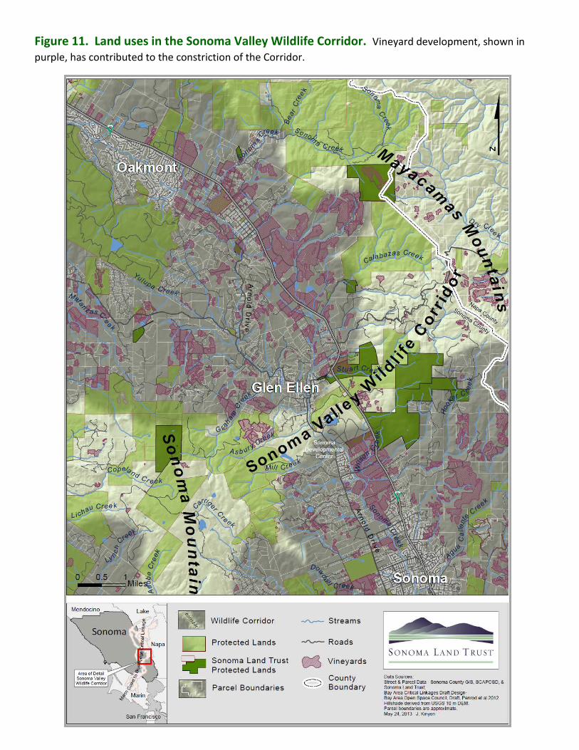
The Sonoma Valley Wildlife Corridor (Corridor) consists of approximately 10,000 acres that span an elevation gradient of approximately 2,080 feet. Just over half of that acreage has been conserved by public agencies and conservation non-profit organizations. This chapter documents the current status of conserved land, land uses, roads and associated undercrossing structures, and vegetation communities and wildlife populations based on existing data and studies commissioned by Sonoma Land Trust for key Corridor properties. 4.1 Conserved Lands in the Sonoma Valley Wildlife Corridor The importance of the Sonoma Valley Wildlife Corridor is evidenced by the 5,058 acres of lands already conserved in the linkage. Sonoma Land Trust (SLT) has been active in the Corridor for many years protecting just under 1,400 acres to date by acquiring fee title and conservation easements. The Sonoma County Agricultural Preservation and Open Space District, Sonoma County Regional Parks, Audubon Canyon Ranch, and California State Parks all own property within the Corridor. The table in Figure 10 lists conserved properties as well as key parcels proposed for conservation. The 935-acre Sonoma Developmental Center (SDC) is a state-owned facility in the heart of the Corridor and is the largest property within the narrowest section of the linkage. Permanently conserving the ~750 acres of wildlands that surround SDC’s cluster of buildings and streets on the valley floor is pivotal to maintaining the permeability of the Corridor. Increasing costs and a dwindling residential client base have the State of California considering alternative uses for the property. A consortium of local government representatives, non-profit groups including SLT and Sonoma Ecology Center, advocates for current SDC residents, and community members have initiated a site assessment and planning process to assure continued services for the developmentally disabled, permanent protection of the wildlands, and increased opportunity for low-intensity recreation that is compatible with corridor function. 4.2 Land Uses in the Sonoma Valley Wildlife Corridor The majority of the development in and around the Sonoma Valley Wildlife Corridor is found on the valley floor. Figure 11 illustrates the diversity of land uses creating a patchwork of variously-sized rural residential parcels with homes, barns, and outbuildings; private agricultural lands; and protected agricultural, park, and wildlands. These developments have constrained the Corridor in the area bounded by Arnold Drive and State Highway 12 just south of the small town of Glen Ellen creating a chokepoint in the Corridor. With the exception of Oak Hill Farm, most of the agricultural lands are in vineyards including approximately 290 acres located within the chokepoint. Figure 11 also illustrates the significance of the SDC property to maintaining the integrity of the Corridor. At 935 acres, SDC is the largest property situated within the Corridor’s chokepoint. The SDC core campus, occupying roughly 200 acres, consists of numerous buildings and is surrounded by open space and relatively undisturbed wildlands rising west toward Sonoma Mountain. Roughly 100 acres on the northeast side, including Suttonfield Reservoir, adjoin Sonoma Valley Regional Park and have recreational trails connecting to the park. Suttonfield and Fern Lake Reservoirs are on the SDC property and provide water for the facility.
CHAPTER
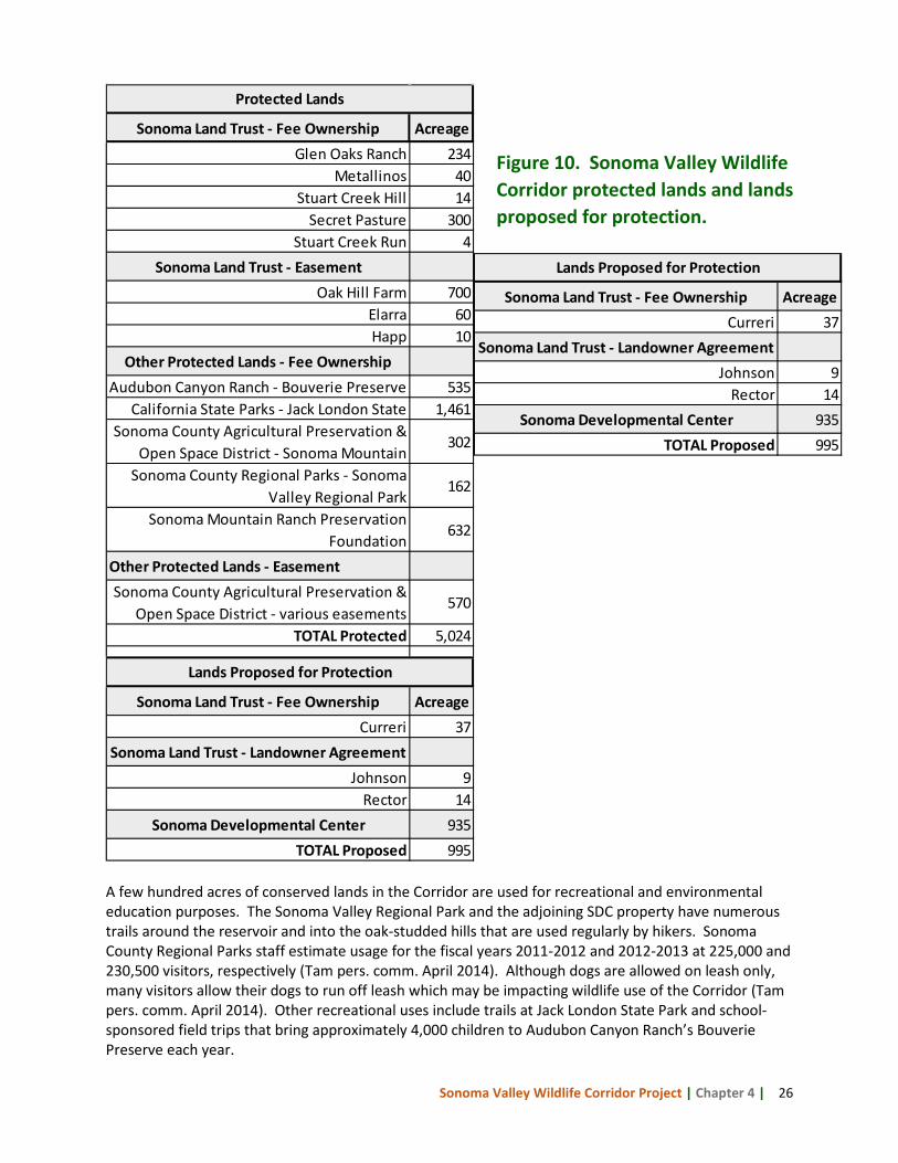
Sonoma Valley Wildlife Corridor Project | Chapter 4 | 26
Sonoma Land Trust - Fee Ownership AcreageGlen Oaks Ranch 234
Metallinos 40Stuart Creek Hill 14
Secret Pasture 300Stuart Creek Run 4
Sonoma Land Trust - EasementOak Hill Farm 700
Elarra 60Happ 10
Other Protected Lands - Fee OwnershipAudubon Canyon Ranch - Bouverie Preserve 535
California State Parks - Jack London State 1,461Sonoma County Agricultural Preservation &
Open Space District - Sonoma Mountain 302
Sonoma County Regional Parks - Sonoma Valley Regional Park
162
Sonoma Mountain Ranch Preservation Foundation
632
Other Protected Lands - EasementSonoma County Agricultural Preservation &
Open Space District - various easements570
TOTAL Protected 5,024
Sonoma Land Trust - Fee Ownership AcreageCurreri 37
Sonoma Land Trust - Landowner AgreementJohnson 9
Rector 14Sonoma Developmental Center 935
TOTAL Proposed 995
Protected Lands
Lands Proposed for Protection
A few hundred acres of conserved lands in the Corridor are used for recreational and environmental education purposes. The Sonoma Valley Regional Park and the adjoining SDC property have numerous trails around the reservoir and into the oak-studded hills that are used regularly by hikers. Sonoma County Regional Parks staff estimate usage for the fiscal years 2011-2012 and 2012-2013 at 225,000 and 230,500 visitors, respectively (Tam pers. comm. April 2014). Although dogs are allowed on leash only, many visitors allow their dogs to run off leash which may be impacting wildlife use of the Corridor (Tam pers. comm. April 2014). Other recreational uses include trails at Jack London State Park and school-sponsored field trips that bring approximately 4,000 children to Audubon Canyon Ranch’s Bouverie Preserve each year.
Figure 10. Sonoma Valley Wildlife Corridor protected lands and lands proposed for protection.
Sonoma Land Trust - Fee Ownership AcreageCurreri 37
Sonoma Land Trust - Landowner AgreementJohnson 9
Rector 14Sonoma Developmental Center 935
TOTAL Proposed 995
Lands Proposed for Protection
Sonoma Valley Wildlife Corridor Project | Chapter 4 | 27
Figure 11. Land uses in the Sonoma Valley Wildlife Corridor. Vineyard development, shown in purple, has contributed to the constriction of the Corridor.

Sonoma Valley Wildlife Corridor Project | Chapter 4 | 28
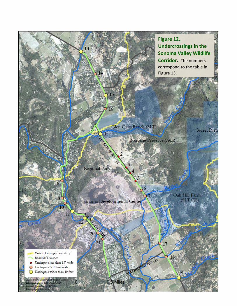
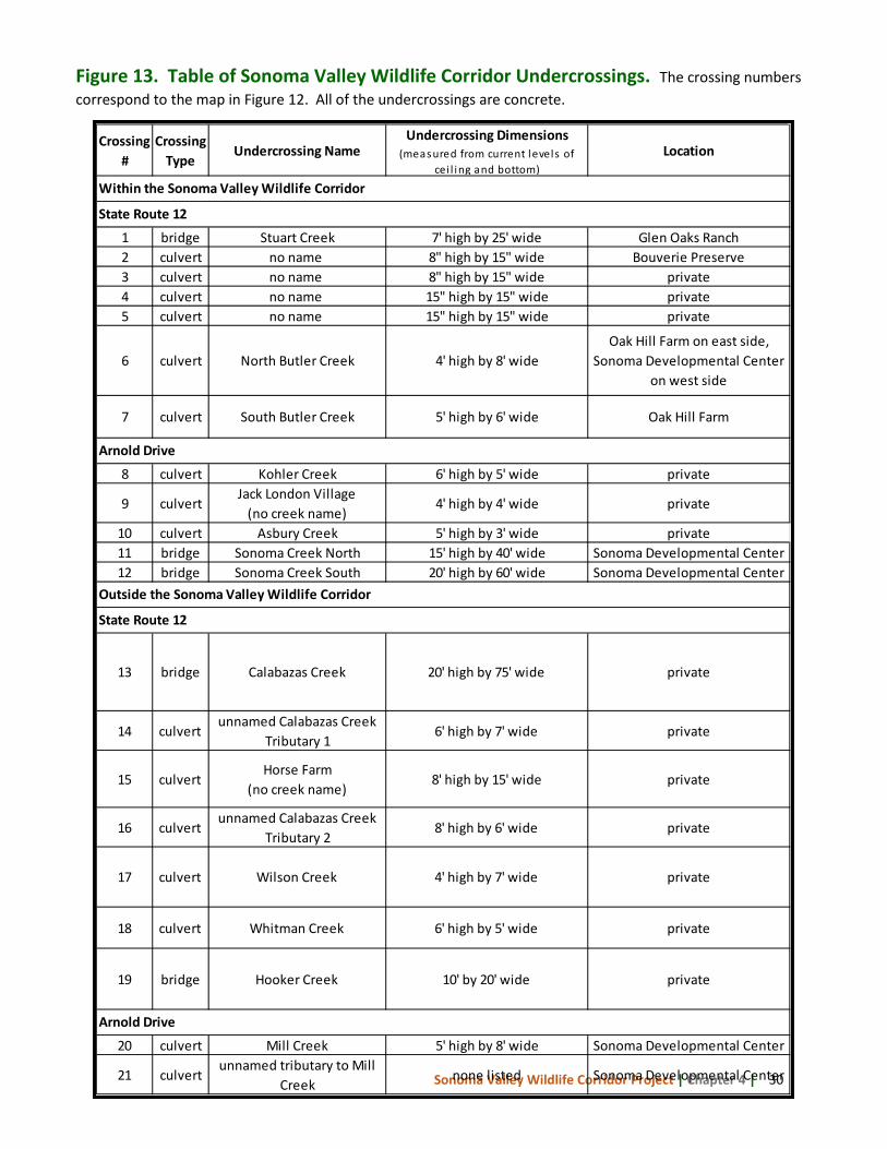
4.3 Roads and Undercrossings in the Sonoma Valley Wildlife Corridor The Corridor has a relatively low density of roadways, but those that exist may pose challenges for wildlife permeability. State Route 12 and Arnold Drive are the two main roads bisecting the Corridor and may pose an impediment to safe wildlife movement. These two busy roads run parallel to one another on the valley floor until they converge just north of Glen Ellen (Figures 11 and 12). State Route 12 is the busier of the two and according to Caltrans’ 2012 Traffic Volumes on California State Highways, for the stretch of State Route 12 between Arnold Drive south to Madrone Road, the Annual Average Daily Traffic Volume1 falls between 13,300 and 15,400 vehicles during peak hours. In addition to these main arteries, the Corridor has many two lane roads and driveways serving residences and businesses that may also be an impediment to wildlife movement. Twenty one culvert or bridge undercrossings that may provide safe passage for wildlife have been identified along State Route 12 and Arnold Drive within and just outside of the Corridor. Five of the twenty one undercrossings are bridges and the remainder are concrete box culverts. Figure 12 shows the undercrossing locations with numbers corresponding to descriptions of each in Figure 13. The majority of the undercrossing structures appear to be aging and in deteriorating condition, but this has not been confirmed by the transportation agencies. Very little data is available on species use of these undercrossings to safely traverse the roads with the exception of the track plate and remote-triggered camera data collected by then-graduate student Dr. Jodi Hilty in 1998 (Hilty and Merenlender 2002). Dr. Hilty’s study evaluated wildlife use of two undercrossings: the large bridge over Whitman Creek (#18 in Figures 12 and 13) and a small box culvert adjacent to SDC lands, but it is not clear which culvert (personal communication, Caitlin Cornwall). Forty three animals were photographed passing under the Whitman Creek bridge including mule deer, western gray squirrel, striped skunk, opossum, raccoon, and domestic cat. Only a raccoon was photographed using the smaller culvert. Roadkill data can indicate whether roads pose a particular challenge to certain species and identify mortality hot-spots, but there is very little data available for Sonoma Valley. The California Roadkill Observation System or CROS, operated by the UC Davis Road Ecology Center, captures roadkill data entered by volunteers, but no records were found within the Corridor. Two observations were recorded further north on State Route 12 near Annadel State Park. A bobcat was hit on May 26, 2013, and in the same vicinity, a northern river otter was reported on February 2, 2014. A search for records from the California Highway Patrol and Caltrans did not yield any roadkill data.
1 Annual average daily traffic is the total volume for the year divided by 365 days. The traffic count year is from October 1st through September 30th.
Sonoma Valley Wildlife Corridor Project | Chapter 4 | 29
Figure 12. Undercrossings in the Sonoma Valley Wildlife Corridor. The numbers correspond to the table in Figure 13.
Sonoma Valley Wildlife Corridor Project | Chapter 4 | 30
Crossing #
Crossing Type
Undercrossing NameUndercrossing Dimensions
(measured from current levels of cei l ing and bottom)
Location
1 bridge Stuart Creek 7' high by 25' wide Glen Oaks Ranch2 culvert no name 8" high by 15" wide Bouverie Preserve 3 culvert no name 8" high by 15" wide private4 culvert no name 15" high by 15" wide private5 culvert no name 15" high by 15" wide private
6 culvert North Butler Creek 4' high by 8' wideOak Hill Farm on east side,
Sonoma Developmental Center on west side
7 culvert South Butler Creek 5' high by 6' wide Oak Hill Farm
8 culvert Kohler Creek 6' high by 5' wide private
9 culvertJack London Village
(no creek name)4' high by 4' wide private
10 culvert Asbury Creek 5' high by 3' wide private11 bridge Sonoma Creek North 15' high by 40' wide Sonoma Developmental Center12 bridge Sonoma Creek South 20' high by 60' wide Sonoma Developmental Center
13 bridge Calabazas Creek 20' high by 75' wide private
14 culvertunnamed Calabazas Creek
Tributary 16' high by 7' wide private
15 culvertHorse Farm
(no creek name)8' high by 15' wide private
16 culvertunnamed Calabazas Creek
Tributary 28' high by 6' wide private
17 culvert Wilson Creek 4' high by 7' wide private
18 culvert Whitman Creek 6' high by 5' wide private
19 bridge Hooker Creek 10' by 20' wide private
20 culvert Mill Creek 5' high by 8' wide Sonoma Developmental Center
21 culvertunnamed tributary to Mill
Creeknone listed Sonoma Developmental Center
Within the Sonoma Valley Wildlife Corridor
State Route 12
Arnold Drive
Outside the Sonoma Valley Wildlife Corridor
State Route 12
Arnold Drive
Figure 13. Table of Sonoma Valley Wildlife Corridor Undercrossings. The crossing numbers correspond to the map in Figure 12. All of the undercrossings are concrete.
Sonoma Valley Wildlife Corridor Project | Chapter 4 | 31
4.4 Wildlife Habitat of the Sonoma Valley Wildlife Corridor Wildlife observed in the Corridor include deer, mountain lion, coyote, bobcat, and black bear (spotted in Glen Ellen in 2009). In order to gain a better understanding of wildlife living in and using the Corridor, Sonoma Land Trust commissioned a wildlife biologist with Prunuske Chatham, Inc. (PCI) in February 2013 to characterize biological communities found on three Corridor properties, develop wildlife species composition lists, and determine if suitable habitat for special-status animal species is present. The properties evaluated were Stuart Creek Hill (14 acres) and Curreri (37 acres) on the valley floor within the chokepoint, and Metallinos (40 acres) higher up in the Mayacamas. SLT owns Stuart Creek Hill and Metallinos, and is under contract to purchase 29 acres of Curreri and transfer it to Sonoma County Regional Parks in late 2014. A brief summary of the PCI report is presented here, an abbreviated list of species observed or with the potential to occur is included at the end of this chapter as Figure 18, and the full report is available from SLT. The report describes six California Wildlife Habitat Relationships (CWHR) plant communities occurring on the three properties – oak woodlands, grassland, evergreen forest, chaparral, riparian woodland and stream channel, and freshwater emergent and seasonal wetland. Special-status species occurrence data was drawn from the California Natural Diversity Database (CNDDB). The report evaluates the condition of each habitat type for the three properties. The results of the CWHR habitat type assessment are summarized in Figure 14. Oak woodland habitat on Curreri and Stuart Creek Hill is in good condition and has the structural diversity necessary to support diverse wildlife communities. The grassland communities found on Curreri and Stuart Creek Hill are dominated by non-native plants which have lower value for wildlife, but pockets of native grasses were found. These habitats are common at lower elevations throughout the region. Metallinos, located at higher elevations in the Mayacamas Mountains, supports evergreen forest and chaparral habitats. The evergreen forest on Metallinos is limited in extent, but is in good condition. The chaparral habitat appears to be relatively undisturbed and in good condition displaying structural diversity. Riparian woodland and stream channel habitats are found on Stuart Creek Hill where Stuart Creek crosses the property, and on a small unnamed Stuart Creek tributary on Metallinos. The riparian habitats on Stuart Creek Hill are only in fair condition due to surrounding development, and those occurring on Metallinos were not observed. Lastly, freshwater emergent and seasonal wetland habitats are only found on the Curreri property at the man-made pond and a swale located at the property’s lower elevations. The habitat provided by the pond is in good condition supporting a diversity of waterfowl, amphibians and invertebrates. The wetland associated with the swale could not be assessed due to a low rainfall winter. The report concludes that the properties surveyed have the potential to support a wide variety and abundance of wildlife species due to the diverse mixture of habitats that offers nesting habitat, food, shelter and movement corridors for native species. The author noted that in just one day of field surveys, five mammals, 36 bird species, one reptile and one amphibian were observed. Extrapolating from this report, it is assumed that most of the species observed or listed as likely to occur will be found in similar habitats throughout the Corridor. Another source of wildlife data is the 2001 Land Use Feasibility Study completed on approximately 477 acres of the SDC property by LSA Associates, Inc., in June and July 2000. The primary focus of the survey was to determine whether northern spotted owls, nesting hawks and owls, and California red- and yellow-legged frogs occupied the area and if there was suitable habitat for these species. The biologists
Sonoma Valley Wildlife Corridor Project | Chapter 4 | 32
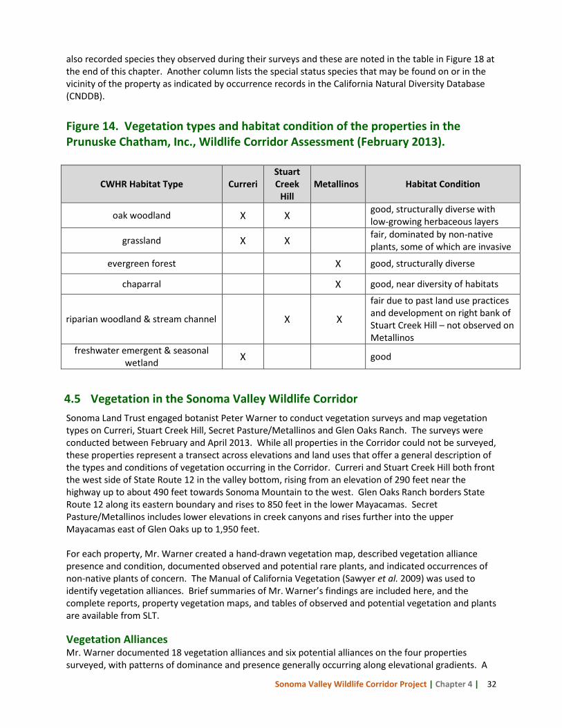
also recorded species they observed during their surveys and these are noted in the table in Figure 18 at the end of this chapter. Another column lists the special status species that may be found on or in the vicinity of the property as indicated by occurrence records in the California Natural Diversity Database (CNDDB). Figure 14. Vegetation types and habitat condition of the properties in the Prunuske Chatham, Inc., Wildlife Corridor Assessment (February 2013).
CWHR Habitat Type Curreri Stuart Creek
Hill Metallinos Habitat Condition
oak woodland X X good, structurally diverse with low-growing herbaceous layers
grassland X X fair, dominated by non-native plants, some of which are invasive
evergreen forest X good, structurally diverse
chaparral X good, near diversity of habitats
riparian woodland & stream channel X X
fair due to past land use practices and development on right bank of Stuart Creek Hill – not observed on Metallinos
freshwater emergent & seasonal wetland X good
4.5 Vegetation in the Sonoma Valley Wildlife Corridor Sonoma Land Trust engaged botanist Peter Warner to conduct vegetation surveys and map vegetation types on Curreri, Stuart Creek Hill, Secret Pasture/Metallinos and Glen Oaks Ranch. The surveys were conducted between February and April 2013. While all properties in the Corridor could not be surveyed, these properties represent a transect across elevations and land uses that offer a general description of the types and conditions of vegetation occurring in the Corridor. Curreri and Stuart Creek Hill both front the west side of State Route 12 in the valley bottom, rising from an elevation of 290 feet near the highway up to about 490 feet towards Sonoma Mountain to the west. Glen Oaks Ranch borders State Route 12 along its eastern boundary and rises to 850 feet in the lower Mayacamas. Secret Pasture/Metallinos includes lower elevations in creek canyons and rises further into the upper Mayacamas east of Glen Oaks up to 1,950 feet. For each property, Mr. Warner created a hand-drawn vegetation map, described vegetation alliance presence and condition, documented observed and potential rare plants, and indicated occurrences of non-native plants of concern. The Manual of California Vegetation (Sawyer et al. 2009) was used to identify vegetation alliances. Brief summaries of Mr. Warner’s findings are included here, and the complete reports, property vegetation maps, and tables of observed and potential vegetation and plants are available from SLT.
Vegetation Alliances Mr. Warner documented 18 vegetation alliances and six potential alliances on the four properties surveyed, with patterns of dominance and presence generally occurring along elevational gradients. A
Sonoma Valley Wildlife Corridor Project | Chapter 4 | 33
few of the observed alliances have restricted ranges, such as the mosquito fern mats found only at the Curreri pond and the narrow band of white alder (Alnus rhombifolia) at Glen Oaks Ranch, but most are well-represented throughout the region. While not all of the alliances are detailed here, all are important elements of wildlife habitat diversity and collectively provide the matrix where wildlife can live and move through safely. Unlike other alliances, grasslands are not limited to certain elevations, occurring from the valley bottom to the higher slopes of Secret Pasture/Metallinos, particularly where land has been cleared for agriculture and livestock grazing has occurred. Large areas of non-native grassland dominated by wild oats (Avena spp.) and bromes (Bromus spp.) as well as fields of perennial ryegrass (Lolium perenne), as found on Curreri, are common on the valley floor, and occur in patches of various size through mid-elevations as at Secret Pasture/Metallinos. Grassland is a dominant cover type on Sonoma Mountain, but becomes less prominent with fewer and smaller patches in the upper Mayacamas. Species constituting these grasslands also dominate the understory of nearby blue oak woodlands. While individual valley oaks (Quercus lobata) are scattered along the valley’s lower elevations, particularly older gallery trees, valley oak woodland is largely restricted to the lower portions of creeks and nearby floodplains, as seen along Stuart Creek. South of Stuart Creek on Glen Oaks Ranch, the oak woodland is well-developed with multiple age-classes while north of the creek, near the farmstead and more intensive human activities, it is comprised of relatively few very large trees with a grass understory and no recruitment. Blue oak (Quercus douglasii) woodlands occur on low, rolling hills as exemplified at Stuart Creek Hill and Glen Oaks Ranch. Canopies range from almost fully closed to open with mostly grass understories. Blue oak recruitment is not extensive, though young trees are found in some limited areas. Contiguous with blue oak woodlands are small stands of Oregon white oak (Quercus garryana) with some hybridization evident. Coast live oak (Quercus agrifolia) woodlands occur mainly on upper alluvial terraces at mid-elevations, though coast live oak has a broader presence and grades into most of the other upland woodland types as a lesser component. This woodland is defined by the relative dominance of coast live oak and includes blue oak, California bay (Umbellularia californica), manzanita (Arctostaphylos spp.), madrone (Arbutus menziesii), knobcone pine (Pinus attenuata), and chaparral species. Manzanita shrubland is a less common vegetation type of mid-elevations. A small remnant stand occurs on Curreri. California bay forest occurs as stands within other alliances. Rising above the oak woodlands, chamise (Adenostoma fasciculatum) chaparral is common and widespread in upper watersheds of the Mayacamas, dominating rocky, shallow soils and slopes and plateaus with south and west facing exposures. It is less common on the east slopes of Sonoma Mountain. Several other shrub species grow along the margins of chamise-dominated stands, creating a complex mosaic of multiple shrub-dominated alliances. Knobcone pine forest prefers high slopes and ridges to the northeast in the Mayacamas at Secret Pasture/Metallinos. Associated trees include madrone, California bay, coast live oak, and Douglas-fir (Pseudotsuga menziesii). Madrone forest also occurs on north and east facing slopes in upper creek tributaries. Riparian vegetation occupies creeksides and proximal zones influenced by greater water availability than surrounding upland areas. Within the Corridor, most of the alliances described above occur along the major creeks and waterways. In upper watersheds, as observed on Glen Oaks Ranch and Secret Pasture/Metallinos, riparian vegetation is well-developed with mature canopies and diverse shrub, forb, and grass understories. Approaching the valley bottom and floodplains, where human uses are more
Sonoma Valley Wildlife Corridor Project | Chapter 4 | 34
prevalent, riparian vegetation narrows and becomes less dense and diverse. Yet even here, bands of mature trees and vegetation remain and provide cover for passing wildlife, albeit of diminished value and safety. Rare Plants Prior to conducting surveys, Mr. Warner compiled a list of rare plant species that could possibly be found in the Corridor region. While none were found on Curreri or Stuart Creek Hill, suitable habitat was observed for 19 rare plant species. Twelve are wetland species that could potentially occupy vernally wet swales on the Curreri property adjacent to and immediately west of State Route 12. A total of six rare plants were observed on Glen Oaks Ranch and Secret Pasture/Metallinos and are listed in Figure 15. Non-native Invasive Plants Invasive plant species in the Corridor are more varied and extensive in lower areas where human activities are concentrated. Eleven non-native invasive plants, as defined by the California Invasive Plant Council, common to the region were documented on or immediately adjacent to the Curreri, Stuart Creek Hill, and Glen Oaks Ranch properties: French broom (Genista monspessulana), Spanish broom (Spartium junceum), oblong spurge (Euphorbia oblongata), English ivy (Hedera helix), periwinkle (Vinca major), Italian thistle (Carduus pycnocephalus), yellow starthistle (Centauria solstitialis), Armenian blackberry (Rubus armeniacus), Klamath weed (Hypericum perforatum), and scattered individuals or small stands of Tasmanian bluegum (Eucalyptus globulus) and cherry plum (Prunus cerasifera). Most of these weeds occur primarily along Stuart Creek and as a component of oak woodland understories. While some are found as scattered individuals, many are locally dense, particularly blackberry, and threaten to displace significant areas of native plant cover. Upper elevations within the Corridor exhibit fewer weed species, though they can be equally invasive. Five invasive species were found on Secret Pasture/Metallinos. Yellow starthistle covers approximately ten acres of open grassland habitat, and Armenian blackberry grows densely along portions of creek channels. Tasmanian bluegum, Klamath weed, and cherry plum also occur here in small amounts but may increase in extent.
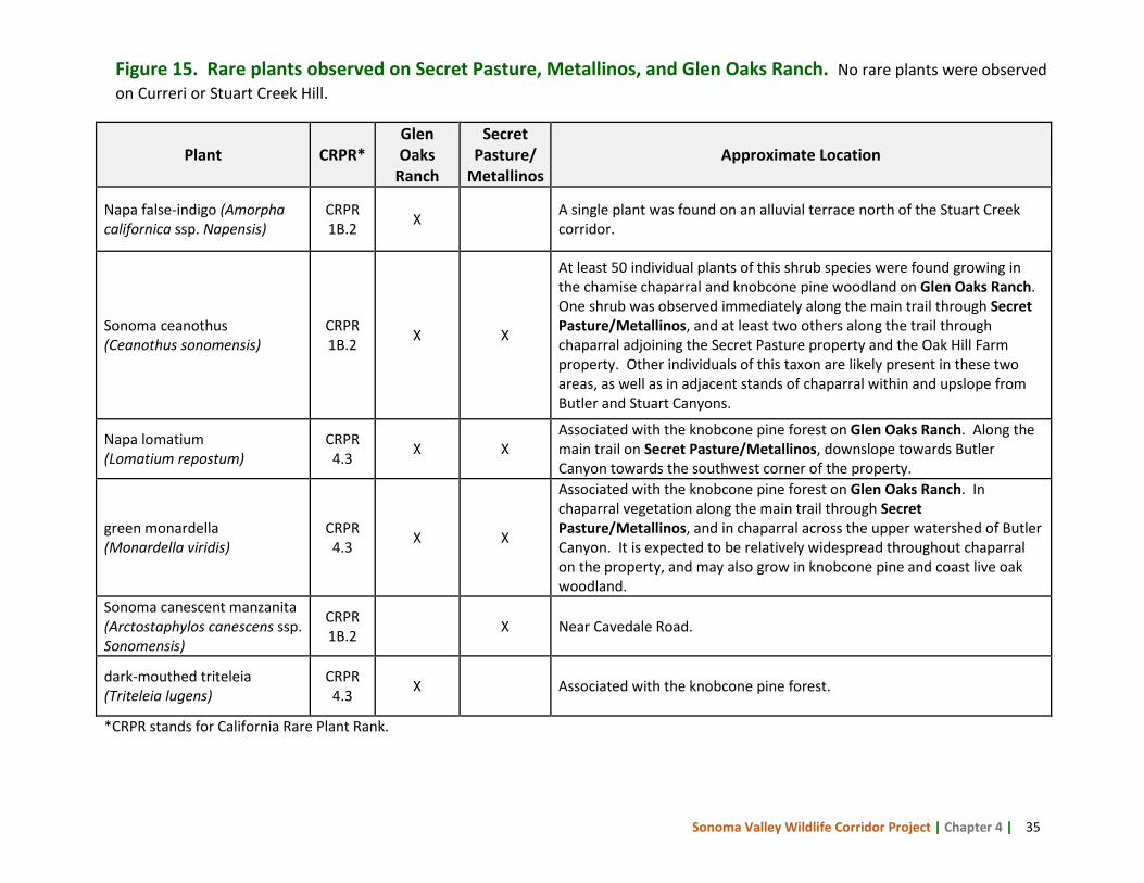
Sonoma Valley Wildlife Corridor Project | Chapter 4 | 35
*CRPR stands for California Rare Plant Rank.
Plant CRPR* Glen Oaks
Ranch
Secret Pasture/
Metallinos Approximate Location
Napa false-indigo (Amorpha californica ssp. Napensis)
CRPR 1B.2 X A single plant was found on an alluvial terrace north of the Stuart Creek
corridor.
Sonoma ceanothus (Ceanothus sonomensis)
CRPR 1B.2 X X
At least 50 individual plants of this shrub species were found growing in the chamise chaparral and knobcone pine woodland on Glen Oaks Ranch. One shrub was observed immediately along the main trail through Secret Pasture/Metallinos, and at least two others along the trail through chaparral adjoining the Secret Pasture property and the Oak Hill Farm property. Other individuals of this taxon are likely present in these two areas, as well as in adjacent stands of chaparral within and upslope from Butler and Stuart Canyons.
Napa lomatium (Lomatium repostum)
CRPR 4.3 X X
Associated with the knobcone pine forest on Glen Oaks Ranch. Along the main trail on Secret Pasture/Metallinos, downslope towards Butler Canyon towards the southwest corner of the property.
green monardella (Monardella viridis)
CRPR 4.3 X X
Associated with the knobcone pine forest on Glen Oaks Ranch. In chaparral vegetation along the main trail through Secret Pasture/Metallinos, and in chaparral across the upper watershed of Butler Canyon. It is expected to be relatively widespread throughout chaparral on the property, and may also grow in knobcone pine and coast live oak woodland.
Sonoma canescent manzanita (Arctostaphylos canescens ssp. Sonomensis)
CRPR 1B.2 X Near Cavedale Road.
dark-mouthed triteleia (Triteleia lugens)
CRPR 4.3 X Associated with the knobcone pine forest.
Figure 15. Rare plants observed on Secret Pasture, Metallinos, and Glen Oaks Ranch. No rare plants were observed on Curreri or Stuart Creek Hill.
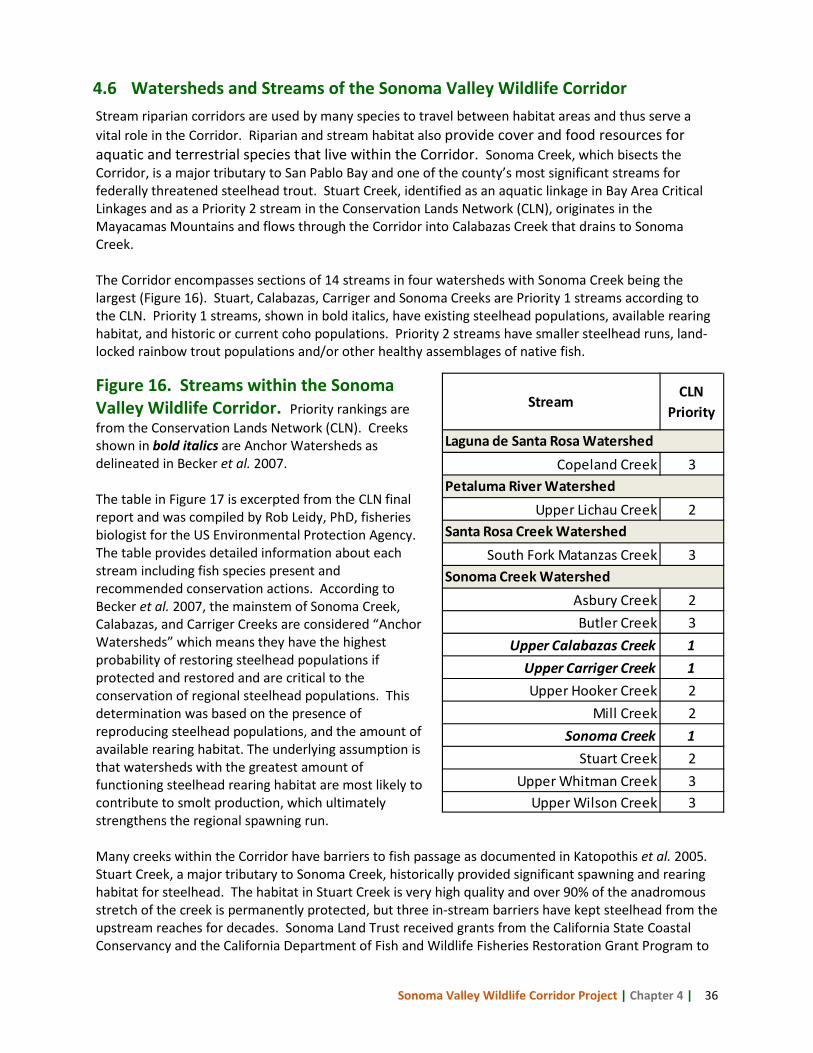
Sonoma Valley Wildlife Corridor Project | Chapter 4 | 36
4.6 Watersheds and Streams of the Sonoma Valley Wildlife Corridor Stream riparian corridors are used by many species to travel between habitat areas and thus serve a vital role in the Corridor. Riparian and stream habitat also provide cover and food resources for aquatic and terrestrial species that live within the Corridor. Sonoma Creek, which bisects the Corridor, is a major tributary to San Pablo Bay and one of the county’s most significant streams for federally threatened steelhead trout. Stuart Creek, identified as an aquatic linkage in Bay Area Critical Linkages and as a Priority 2 stream in the Conservation Lands Network (CLN), originates in the Mayacamas Mountains and flows through the Corridor into Calabazas Creek that drains to Sonoma Creek. The Corridor encompasses sections of 14 streams in four watersheds with Sonoma Creek being the largest (Figure 16). Stuart, Calabazas, Carriger and Sonoma Creeks are Priority 1 streams according to the CLN. Priority 1 streams, shown in bold italics, have existing steelhead populations, available rearing habitat, and historic or current coho populations. Priority 2 streams have smaller steelhead runs, land-locked rainbow trout populations and/or other healthy assemblages of native fish.
Figure 16. Streams within the Sonoma Valley Wildlife Corridor. Priority rankings are from the Conservation Lands Network (CLN). Creeks shown in bold italics are Anchor Watersheds as delineated in Becker et al. 2007. The table in Figure 17 is excerpted from the CLN final report and was compiled by Rob Leidy, PhD, fisheries biologist for the US Environmental Protection Agency. The table provides detailed information about each stream including fish species present and recommended conservation actions. According to Becker et al. 2007, the mainstem of Sonoma Creek, Calabazas, and Carriger Creeks are considered “Anchor Watersheds” which means they have the highest probability of restoring steelhead populations if protected and restored and are critical to the conservation of regional steelhead populations. This determination was based on the presence of reproducing steelhead populations, and the amount of available rearing habitat. The underlying assumption is that watersheds with the greatest amount of functioning steelhead rearing habitat are most likely to contribute to smolt production, which ultimately strengthens the regional spawning run. Many creeks within the Corridor have barriers to fish passage as documented in Katopothis et al. 2005. Stuart Creek, a major tributary to Sonoma Creek, historically provided significant spawning and rearing habitat for steelhead. The habitat in Stuart Creek is very high quality and over 90% of the anadromous stretch of the creek is permanently protected, but three in-stream barriers have kept steelhead from the upstream reaches for decades. Sonoma Land Trust received grants from the California State Coastal Conservancy and the California Department of Fish and Wildlife Fisheries Restoration Grant Program to
StreamCLN
Priority
Copeland Creek 3
Upper Lichau Creek 2
South Fork Matanzas Creek 3
Asbury Creek 2Butler Creek 3
Upper Calabazas Creek 1Upper Carriger Creek 1Upper Hooker Creek 2
Mill Creek 2Sonoma Creek 1
Stuart Creek 2Upper Whitman Creek 3
Upper Wilson Creek 3
Laguna de Santa Rosa Watershed
Petaluma River Watershed
Santa Rosa Creek Watershed
Sonoma Creek Watershed
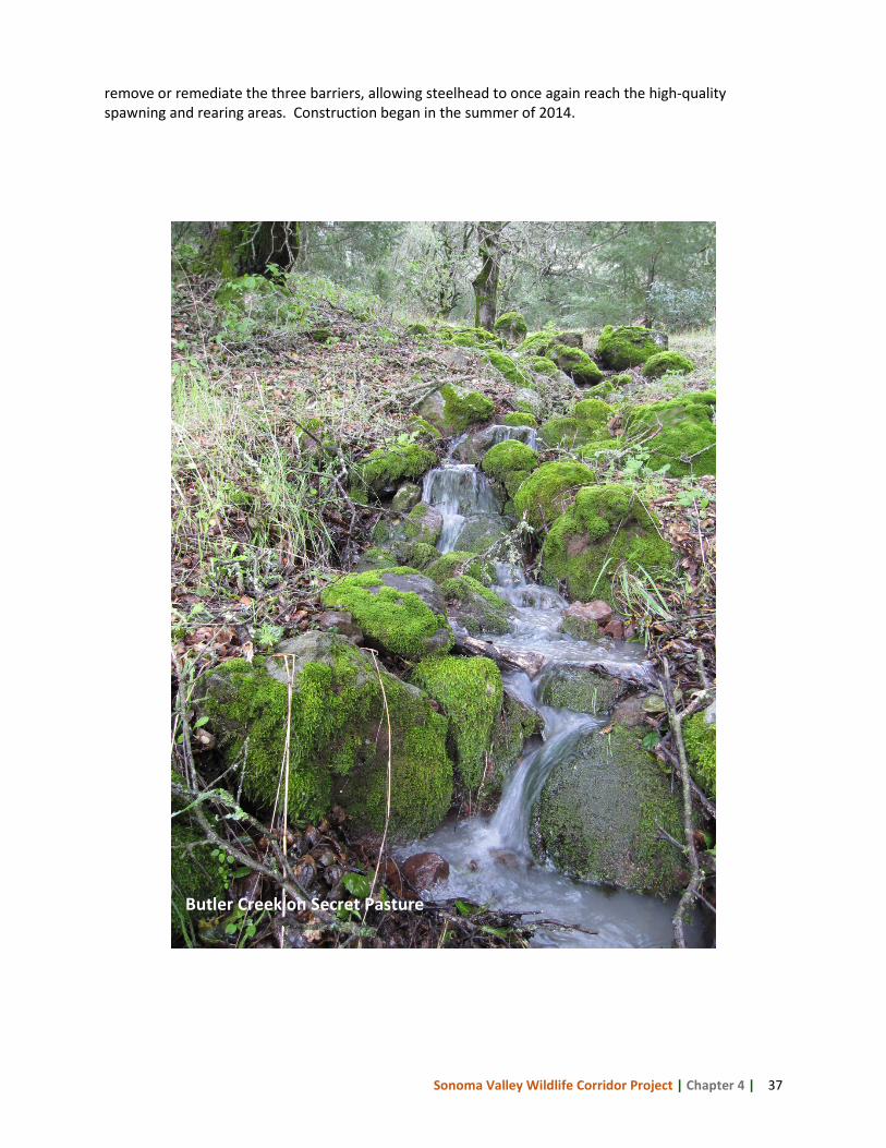
Sonoma Valley Wildlife Corridor Project | Chapter 4 | 37
remove or remediate the three barriers, allowing steelhead to once again reach the high-quality spawning and rearing areas. Construction began in the summer of 2014.
Butler Creek on Secret Pasture
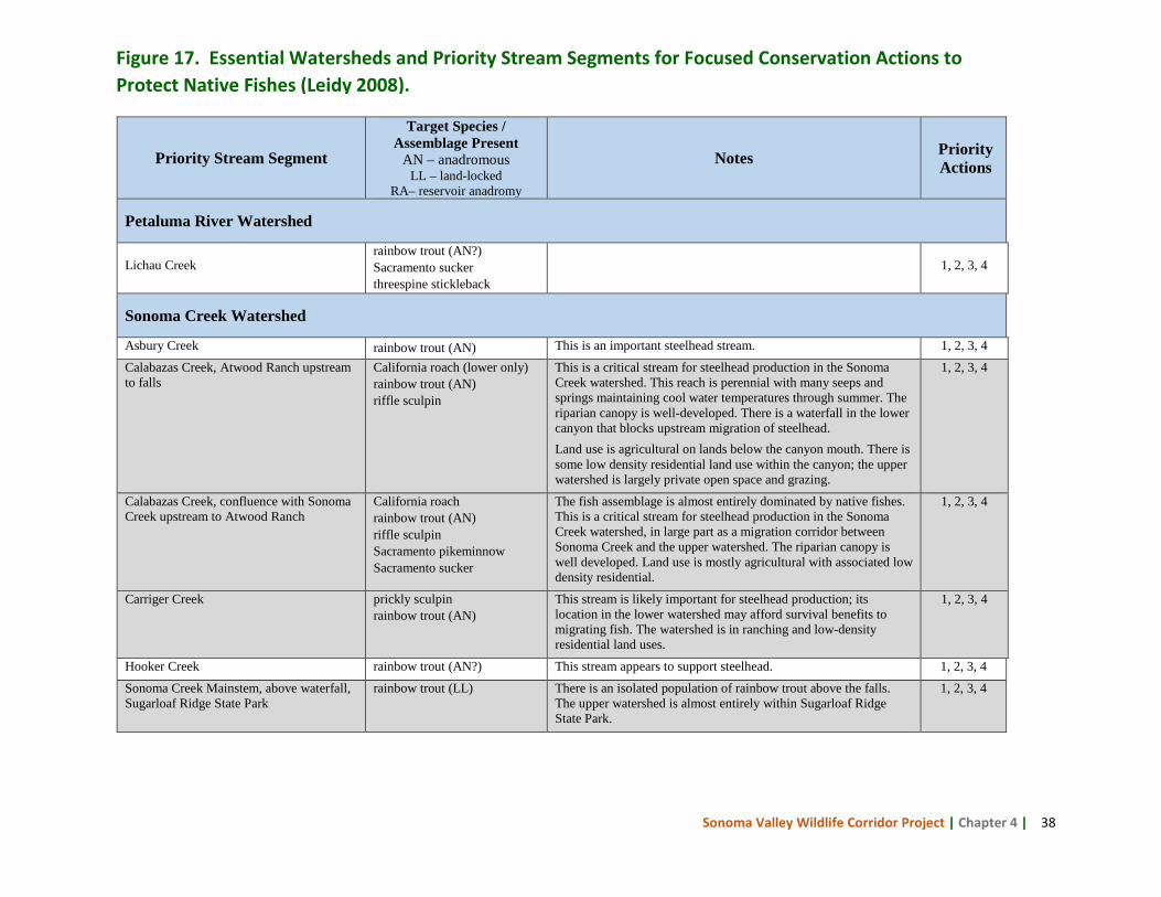
Sonoma Valley Wildlife Corridor Project | Chapter 4 | 38
Priority Stream Segment
Target Species / Assemblage Present
AN – anadromous LL – land-locked
RA– reservoir anadromy
Notes Priority Actions
Petaluma River Watershed
Lichau Creek rainbow trout (AN?) Sacramento sucker threespine stickleback
1, 2, 3, 4
Sonoma Creek Watershed
Asbury Creek rainbow trout (AN) This is an important steelhead stream. 1, 2, 3, 4
Calabazas Creek, Atwood Ranch upstream to falls
California roach (lower only) rainbow trout (AN) riffle sculpin
This is a critical stream for steelhead production in the Sonoma Creek watershed. This reach is perennial with many seeps and springs maintaining cool water temperatures through summer. The riparian canopy is well-developed. There is a waterfall in the lower canyon that blocks upstream migration of steelhead. Land use is agricultural on lands below the canyon mouth. There is some low density residential land use within the canyon; the upper watershed is largely private open space and grazing.
1, 2, 3, 4
Calabazas Creek, confluence with Sonoma Creek upstream to Atwood Ranch
California roach rainbow trout (AN) riffle sculpin Sacramento pikeminnow Sacramento sucker
The fish assemblage is almost entirely dominated by native fishes. This is a critical stream for steelhead production in the Sonoma Creek watershed, in large part as a migration corridor between Sonoma Creek and the upper watershed. The riparian canopy is well developed. Land use is mostly agricultural with associated low density residential.
1, 2, 3, 4
Carriger Creek prickly sculpin rainbow trout (AN)
This stream is likely important for steelhead production; its location in the lower watershed may afford survival benefits to migrating fish. The watershed is in ranching and low-density residential land uses.
1, 2, 3, 4
Hooker Creek rainbow trout (AN?) This stream appears to support steelhead. 1, 2, 3, 4
Sonoma Creek Mainstem, above waterfall, Sugarloaf Ridge State Park
rainbow trout (LL) There is an isolated population of rainbow trout above the falls. The upper watershed is almost entirely within Sugarloaf Ridge State Park.
1, 2, 3, 4
Figure 17. Essential Watersheds and Priority Stream Segments for Focused Conservation Actions to Protect Native Fishes (Leidy 2008).
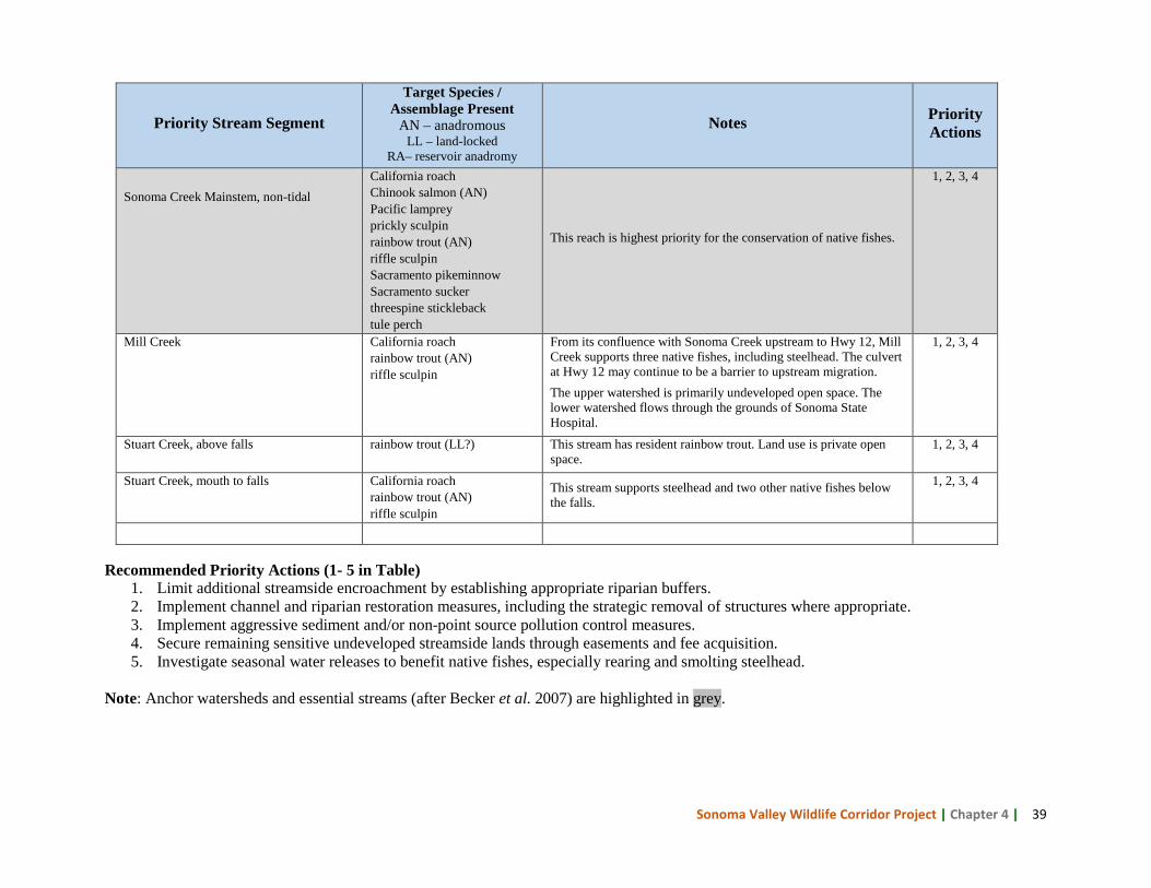
Sonoma Valley Wildlife Corridor Project | Chapter 4 | 39
Recommended Priority Actions (1- 5 in Table) 1. Limit additional streamside encroachment by establishing appropriate riparian buffers. 2. Implement channel and riparian restoration measures, including the strategic removal of structures where appropriate. 3. Implement aggressive sediment and/or non-point source pollution control measures. 4. Secure remaining sensitive undeveloped streamside lands through easements and fee acquisition. 5. Investigate seasonal water releases to benefit native fishes, especially rearing and smolting steelhead.
Note: Anchor watersheds and essential streams (after Becker et al. 2007) are highlighted in grey.
Priority Stream Segment
Target Species / Assemblage Present
AN – anadromous LL – land-locked
RA– reservoir anadromy
Notes Priority Actions
Sonoma Creek Mainstem, non-tidal
California roach Chinook salmon (AN) Pacific lamprey prickly sculpin rainbow trout (AN) riffle sculpin Sacramento pikeminnow Sacramento sucker threespine stickleback tule perch
This reach is highest priority for the conservation of native fishes.
1, 2, 3, 4
Mill Creek California roach rainbow trout (AN) riffle sculpin
From its confluence with Sonoma Creek upstream to Hwy 12, Mill Creek supports three native fishes, including steelhead. The culvert at Hwy 12 may continue to be a barrier to upstream migration. The upper watershed is primarily undeveloped open space. The lower watershed flows through the grounds of Sonoma State Hospital.
1, 2, 3, 4
Stuart Creek, above falls rainbow trout (LL?) This stream has resident rainbow trout. Land use is private open space.
1, 2, 3, 4
Stuart Creek, mouth to falls California roach rainbow trout (AN) riffle sculpin
This stream supports steelhead and two other native fishes below the falls.
1, 2, 3, 4
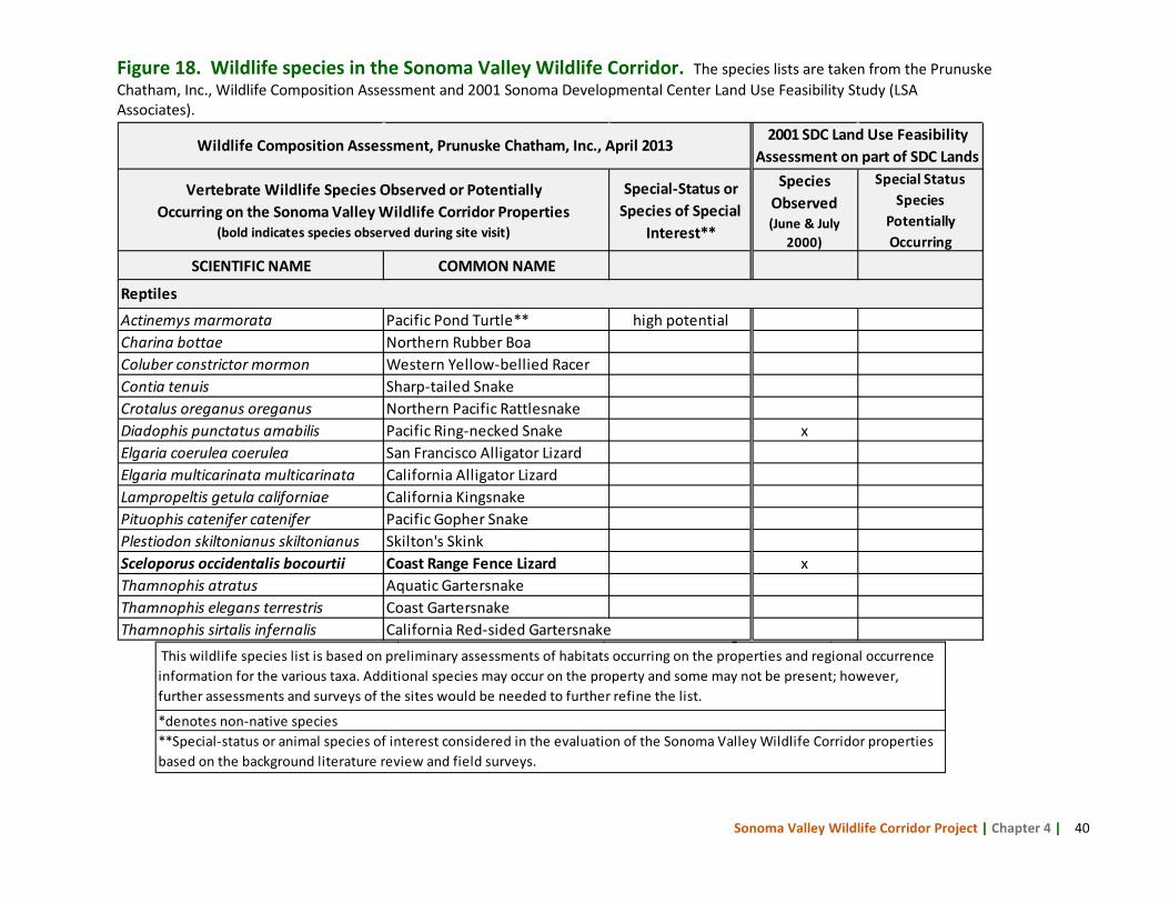
Sonoma Valley Wildlife Corridor Project | Chapter 4 | 40
Figure 18. Wildlife species in the Sonoma Valley Wildlife Corridor. The species lists are taken from the Prunuske Chatham, Inc., Wildlife Composition Assessment and 2001 Sonoma Developmental Center Land Use Feasibility Study (LSA Associates).
Special-Status or Species of Special
Interest**
Species Observed (June & July
2000)
Special Status Species
Potentially Occurring
SCIENTIFIC NAME COMMON NAME
Actinemys marmorata Pacific Pond Turtle** high potentialCharina bottae Northern Rubber BoaColuber constrictor mormon Western Yellow-bellied RacerContia tenuis Sharp-tailed SnakeCrotalus oreganus oreganus Northern Pacific RattlesnakeDiadophis punctatus amabilis Pacific Ring-necked Snake xElgaria coerulea coerulea San Francisco Alligator LizardElgaria multicarinata multicarinata California Alligator LizardLampropeltis getula californiae California KingsnakePituophis catenifer catenifer Pacific Gopher SnakePlestiodon skiltonianus skiltonianus Skilton's SkinkSceloporus occidentalis bocourtii Coast Range Fence Lizard xThamnophis atratus Aquatic GartersnakeThamnophis elegans terrestris Coast GartersnakeThamnophis sirtalis infernalis California Red-sided Gartersnake
Wildlife Composition Assessment, Prunuske Chatham, Inc., April 20132001 SDC Land Use Feasibility
Assessment on part of SDC Lands
Reptiles
Vertebrate Wildlife Species Observed or Potentially Occurring on the Sonoma Valley Wildlife Corridor Properties
(bold indicates species observed during site visit)
This wildlife species list is based on preliminary assessments of habitats occurring on the properties and regional occurrence information for the various taxa. Additional species may occur on the property and some may not be present; however, further assessments and surveys of the sites would be needed to further refine the list.
**Special-status or animal species of interest considered in the evaluation of the Sonoma Valley Wildlife Corridor properties based on the background literature review and field surveys.
*denotes non-native species
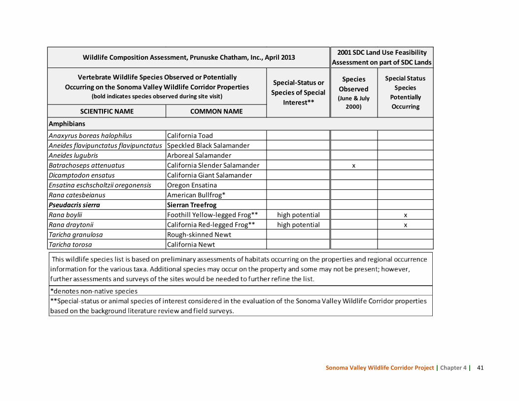
Sonoma Valley Wildlife Corridor Project | Chapter 4 | 41
SCIENTIFIC NAME COMMON NAME
Anaxyrus boreas halophilus California ToadAneides flavipunctatus flavipunctatus Speckled Black SalamanderAneides lugubris Arboreal SalamanderBatrachoseps attenuatus California Slender Salamander xDicamptodon ensatus California Giant SalamanderEnsatina eschscholtzii oregonensis Oregon EnsatinaRana catesbeianus American Bullfrog*Pseudacris sierra Sierran TreefrogRana boylii Foothill Yellow-legged Frog** high potential xRana draytonii California Red-legged Frog** high potential xTaricha granulosa Rough-skinned NewtTaricha torosa California Newt
Amphibians
Wildlife Composition Assessment, Prunuske Chatham, Inc., April 20132001 SDC Land Use Feasibility
Assessment on part of SDC Lands
Vertebrate Wildlife Species Observed or Potentially Occurring on the Sonoma Valley Wildlife Corridor Properties
(bold indicates species observed during site visit)
Special-Status or Species of Special
Interest**
Species Observed (June & July
2000)
Special Status Species
Potentially Occurring
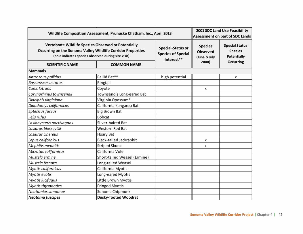
Sonoma Valley Wildlife Corridor Project | Chapter 4 | 42
SCIENTIFIC NAME COMMON NAME
Antrozous pallidus Pallid Bat** high potential xBassariscus astutus RingtailCanis latrans Coyote xCorynorhinus townsendii Townsend’s Long-eared BatDidelphis virginiana Virginia Opossum*Dipodomys californicus California Kangaroo RatEptesicus fuscus Big Brown BatFelis rufus BobcatLasionycteris noctivagans Silver-haired BatLasiurus blossevillii Western Red BatLasiurus cinereus Hoary BatLepus californicus Black-tailed Jackrabbit xMephitis mephitis Striped Skunk xMicrotus californicus California VoleMustela ermine Short-tailed Weasel (Ermine)Mustela frenata Long-tailed WeaselMyotis californicus California MyotisMyotis evotis Long-eared MyotisMyotis lucifugus Little Brown MyotisMyotis thysanodes Fringed MyotisNeotamias sonomae Sonoma ChipmunkNeotoma fuscipes Dusky-footed Woodrat
Mammals
Wildlife Composition Assessment, Prunuske Chatham, Inc., April 20132001 SDC Land Use Feasibility
Assessment on part of SDC Lands
Vertebrate Wildlife Species Observed or Potentially Occurring on the Sonoma Valley Wildlife Corridor Properties
(bold indicates species observed during site visit)
Special-Status or Species of Special
Interest**
Species Observed (June & July
2000)
Special Status Species
Potentially Occurring
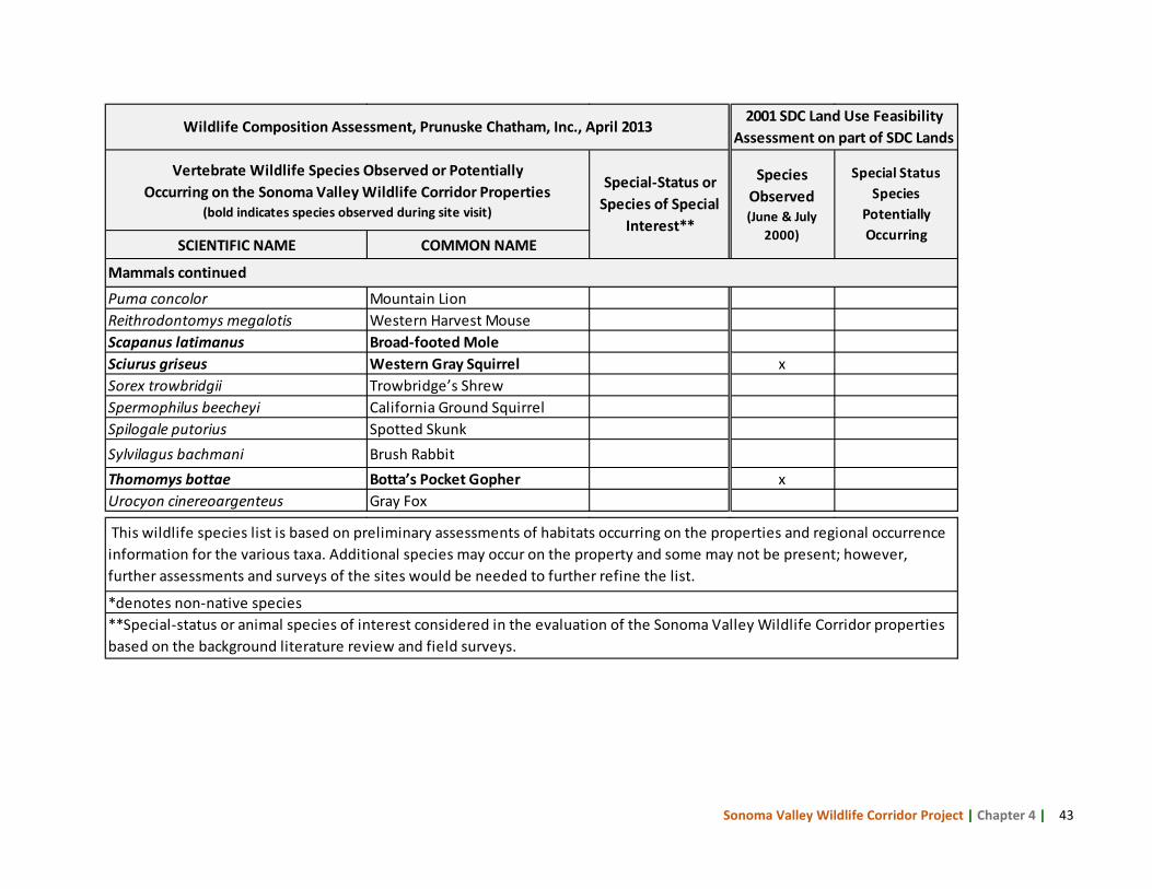
Sonoma Valley Wildlife Corridor Project | Chapter 4 | 43
SCIENTIFIC NAME COMMON NAME
Puma concolor Mountain Lion Reithrodontomys megalotis Western Harvest MouseScapanus latimanus Broad-footed MoleSciurus griseus Western Gray Squirrel xSorex trowbridgii Trowbridge’s ShrewSpermophilus beecheyi California Ground SquirrelSpilogale putorius Spotted SkunkSylvilagus bachmani Brush RabbitThomomys bottae Botta’s Pocket Gopher xUrocyon cinereoargenteus Gray Fox
Wildlife Composition Assessment, Prunuske Chatham, Inc., April 20132001 SDC Land Use Feasibility
Assessment on part of SDC Lands
Vertebrate Wildlife Species Observed or Potentially Occurring on the Sonoma Valley Wildlife Corridor Properties
(bold indicates species observed during site visit)
Special-Status or Species of Special
Interest**
Species Observed (June & July
2000)
Special Status Species
Potentially Occurring
Mammals continued
This wildlife species list is based on preliminary assessments of habitats occurring on the properties and regional occurrence information for the various taxa. Additional species may occur on the property and some may not be present; however, further assessments and surveys of the sites would be needed to further refine the list.
**Special-status or animal species of interest considered in the evaluation of the Sonoma Valley Wildlife Corridor properties based on the background literature review and field surveys.
*denotes non-native species
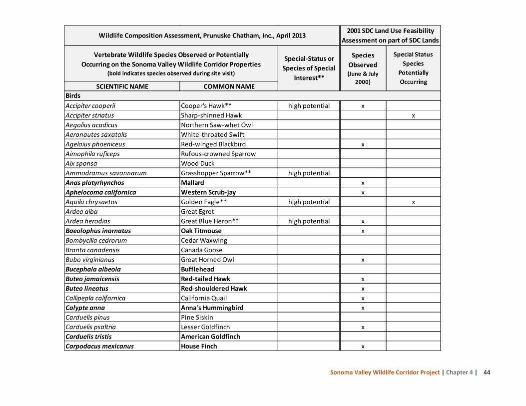
Sonoma Valley Wildlife Corridor Project | Chapter 4 | 44
SCIENTIFIC NAME COMMON NAME
Accipiter cooperii Cooper's Hawk** high potential xAccipiter striatus Sharp-shinned Hawk xAegolius acadicus Northern Saw-whet Owl Aeronautes saxatalis White-throated SwiftAgelaius phoeniceus Red-winged Blackbird xAimophila ruficeps Rufous-crowned SparrowAix sponsa Wood DuckAmmodramus savannarum Grasshopper Sparrow** high potentialAnas platyrhynchos Mallard xAphelocoma californica Western Scrub-jay xAquila chrysaetos Golden Eagle** high potential xArdea alba Great Egret Ardea herodias Great Blue Heron** high potential xBaeolophus inornatus Oak Titmouse xBombycilla cedrorum Cedar Waxwing Branta canadensis Canada Goose Bubo virginianus Great Horned Owl xBucephala albeola BuffleheadButeo jamaicensis Red-tailed Hawk xButeo lineatus Red-shouldered Hawk xCallipepla californica California Quail xCalypte anna Anna's Hummingbird xCarduelis pinus Pine Siskin Carduelis psaltria Lesser Goldfinch xCarduelis tristis American Goldfinch Carpodacus mexicanus House Finch x
Birds
Wildlife Composition Assessment, Prunuske Chatham, Inc., April 20132001 SDC Land Use Feasibility
Assessment on part of SDC Lands
Vertebrate Wildlife Species Observed or Potentially Occurring on the Sonoma Valley Wildlife Corridor Properties
(bold indicates species observed during site visit)
Special-Status or Species of Special
Interest**
Species Observed (June & July
2000)
Special Status Species
Potentially Occurring
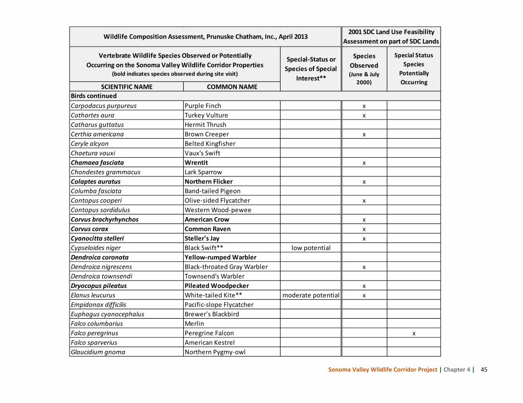
Sonoma Valley Wildlife Corridor Project | Chapter 4 | 45
SCIENTIFIC NAME COMMON NAME
Carpodacus purpureus Purple Finch xCathartes aura Turkey Vulture xCatharus guttatus Hermit Thrush Certhia americana Brown Creeper xCeryle alcyon Belted Kingfisher Chaetura vauxi Vaux's Swift Chamaea fasciata Wrentit xChondestes grammacus Lark SparrowColaptes auratus Northern Flicker xColumba fasciata Band-tailed Pigeon Contopus cooperi Olive-sided Flycatcher xContopus sordidulus Western Wood-pewee Corvus brachyrhynchos American Crow xCorvus corax Common Raven xCyanocitta stelleri Steller's Jay xCypseloides niger Black Swift** low potentialDendroica coronata Yellow-rumped Warbler Dendroica nigrescens Black-throated Gray Warbler xDendroica townsendi Townsend's Warbler Dryocopus pileatus Pileated Woodpecker xElanus leucurus White-tailed Kite** moderate potential xEmpidonax difficilis Pacific-slope Flycatcher Euphagus cyanocephalus Brewer’s BlackbirdFalco columbarius Merlin Falco peregrinus Peregrine Falcon xFalco sparverius American Kestrel Glaucidium gnoma Northern Pygmy-owl
Wildlife Composition Assessment, Prunuske Chatham, Inc., April 20132001 SDC Land Use Feasibility
Assessment on part of SDC Lands
Vertebrate Wildlife Species Observed or Potentially Occurring on the Sonoma Valley Wildlife Corridor Properties
(bold indicates species observed during site visit)
Special-Status or Species of Special
Interest**
Species Observed (June & July
2000)
Special Status Species
Potentially Occurring
Birds continued
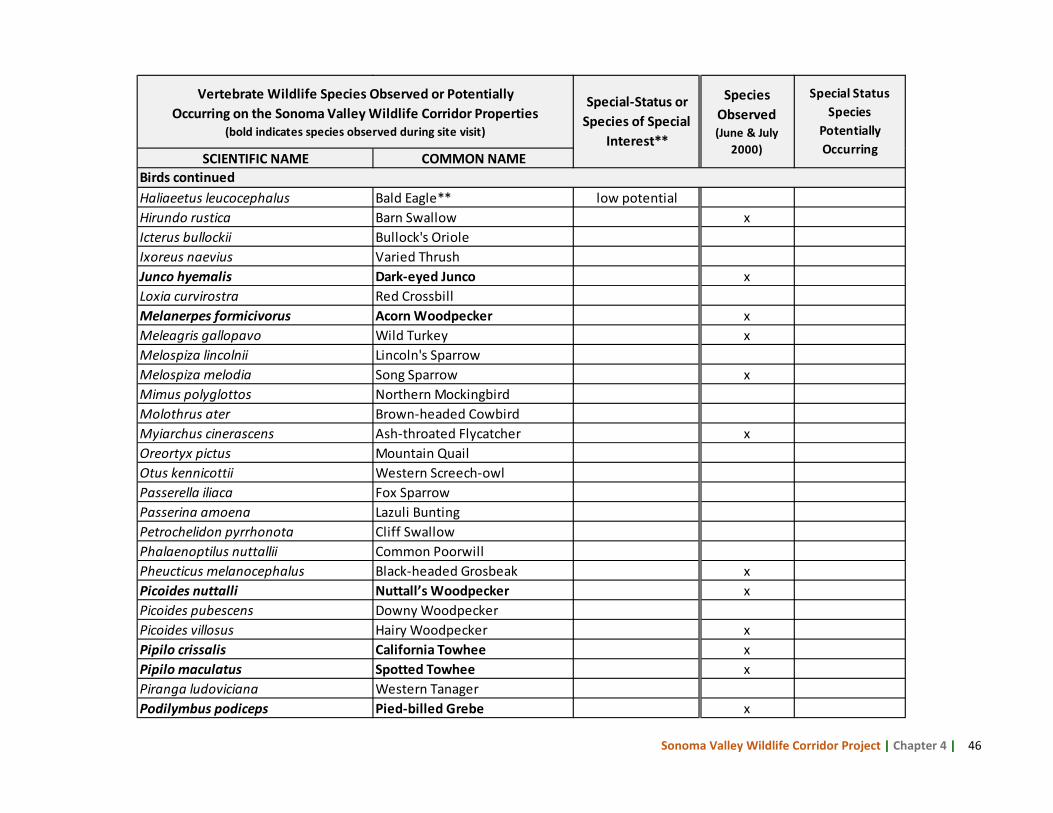
Sonoma Valley Wildlife Corridor Project | Chapter 4 | 46
SCIENTIFIC NAME COMMON NAME
Haliaeetus leucocephalus Bald Eagle** low potentialHirundo rustica Barn Swallow xIcterus bullockii Bullock's Oriole Ixoreus naevius Varied Thrush Junco hyemalis Dark-eyed Junco xLoxia curvirostra Red Crossbill Melanerpes formicivorus Acorn Woodpecker xMeleagris gallopavo Wild Turkey xMelospiza lincolnii Lincoln's Sparrow Melospiza melodia Song Sparrow xMimus polyglottos Northern Mockingbird Molothrus ater Brown-headed Cowbird Myiarchus cinerascens Ash-throated Flycatcher xOreortyx pictus Mountain QuailOtus kennicottii Western Screech-owl Passerella iliaca Fox Sparrow Passerina amoena Lazuli Bunting Petrochelidon pyrrhonota Cliff Swallow Phalaenoptilus nuttallii Common Poorwill Pheucticus melanocephalus Black-headed Grosbeak xPicoides nuttalli Nuttall’s Woodpecker xPicoides pubescens Downy Woodpecker Picoides villosus Hairy Woodpecker xPipilo crissalis California Towhee xPipilo maculatus Spotted Towhee xPiranga ludoviciana Western Tanager Podilymbus podiceps Pied-billed Grebe x
Vertebrate Wildlife Species Observed or Potentially Occurring on the Sonoma Valley Wildlife Corridor Properties
(bold indicates species observed during site visit)
Special-Status or Species of Special
Interest**
Species Observed (June & July
2000)
Special Status Species
Potentially Occurring
Birds continued
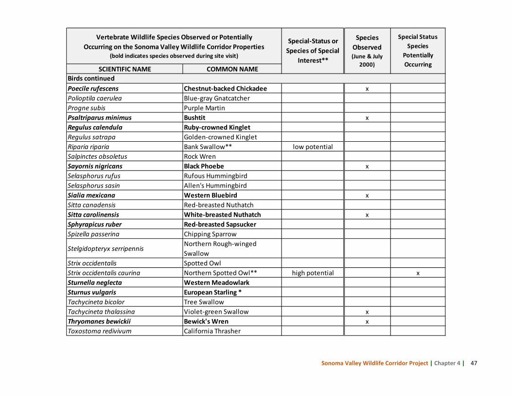
Sonoma Valley Wildlife Corridor Project | Chapter 4 | 47
SCIENTIFIC NAME COMMON NAME
Poecile rufescens Chestnut-backed Chickadee xPolioptila caerulea Blue-gray GnatcatcherProgne subis Purple Martin Psaltriparus minimus Bushtit xRegulus calendula Ruby-crowned Kinglet Regulus satrapa Golden-crowned Kinglet Riparia riparia Bank Swallow** low potentialSalpinctes obsoletus Rock Wren Sayornis nigricans Black Phoebe xSelasphorus rufus Rufous Hummingbird Selasphorus sasin Allen's Hummingbird Sialia mexicana Western Bluebird xSitta canadensis Red-breasted Nuthatch Sitta carolinensis White-breasted Nuthatch xSphyrapicus ruber Red-breasted Sapsucker Spizella passerina Chipping Sparrow
Stelgidopteryx serripennis Northern Rough-winged Swallow
Strix occidentalis Spotted Owl Strix occidentalis caurina Northern Spotted Owl** high potential xSturnella neglecta Western Meadowlark Sturnus vulgaris European Starling *Tachycineta bicolor Tree Swallow Tachycineta thalassina Violet-green Swallow xThryomanes bewickii Bewick's Wren xToxostoma redivivum California Thrasher
Vertebrate Wildlife Species Observed or Potentially Occurring on the Sonoma Valley Wildlife Corridor Properties
(bold indicates species observed during site visit)
Special-Status or Species of Special
Interest**
Species Observed (June & July
2000)
Special Status Species
Potentially Occurring
Birds continued
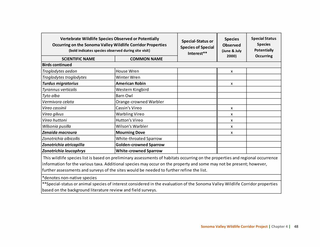
Sonoma Valley Wildlife Corridor Project | Chapter 4 | 48
SCIENTIFIC NAME COMMON NAME
Troglodytes aedon House Wren xTroglodytes troglodytes Winter Wren Turdus migratorius American Robin xTyrannus verticalis Western Kingbird Tyto alba Barn Owl Vermivora celata Orange-crowned Warbler Vireo cassinii Cassin's Vireo xVireo gilvus Warbling Vireo xVireo huttoni Hutton's Vireo xWilsonia pusilla Wilson's Warbler xZenaida macroura Mourning Dove xZonotrichia albicollis White-throated Sparrow Zonotrichia atricapilla Golden-crowned Sparrow Zonotrichia leucophrys White-crowned Sparrow This wildlife species list is based on preliminary assessments of habitats occurring on the properties and regional occurrence information for the various taxa. Additional species may occur on the property and some may not be present; however, further assessments and surveys of the sites would be needed to further refine the list.
**Special-status or animal species of interest considered in the evaluation of the Sonoma Valley Wildlife Corridor properties based on the background literature review and field surveys.
*denotes non-native species
Birds continued
Vertebrate Wildlife Species Observed or Potentially Occurring on the Sonoma Valley Wildlife Corridor Properties
(bold indicates species observed during site visit)
Special-Status or Species of Special
Interest**
Species Observed (June & July
2000)
Special Status Species
Potentially Occurring
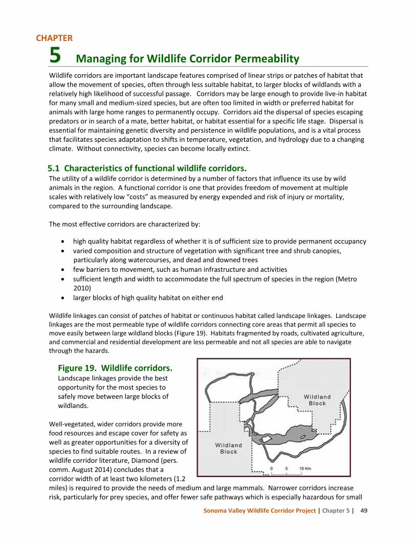
Sonoma Valley Wildlife Corridor Project | Chapter 5 | 49
5 Managing for Wildlife Corridor Permeability Wildlife corridors are important landscape features comprised of linear strips or patches of habitat that allow the movement of species, often through less suitable habitat, to larger blocks of wildlands with a relatively high likelihood of successful passage. Corridors may be large enough to provide live-in habitat for many small and medium-sized species, but are often too limited in width or preferred habitat for animals with large home ranges to permanently occupy. Corridors aid the dispersal of species escaping predators or in search of a mate, better habitat, or habitat essential for a specific life stage. Dispersal is essential for maintaining genetic diversity and persistence in wildlife populations, and is a vital process that facilitates species adaptation to shifts in temperature, vegetation, and hydrology due to a changing climate. Without connectivity, species can become locally extinct. 5.1 Characteristics of functional wildlife corridors. The utility of a wildlife corridor is determined by a number of factors that influence its use by wild animals in the region. A functional corridor is one that provides freedom of movement at multiple scales with relatively low “costs” as measured by energy expended and risk of injury or mortality, compared to the surrounding landscape. The most effective corridors are characterized by:
• high quality habitat regardless of whether it is of sufficient size to provide permanent occupancy • varied composition and structure of vegetation with significant tree and shrub canopies,
particularly along watercourses, and dead and downed trees • few barriers to movement, such as human infrastructure and activities • sufficient length and width to accommodate the full spectrum of species in the region (Metro
2010) • larger blocks of high quality habitat on either end
Wildlife linkages can consist of patches of habitat or continuous habitat called landscape linkages. Landscape linkages are the most permeable type of wildlife corridors connecting core areas that permit all species to move easily between large wildland blocks (Figure 19). Habitats fragmented by roads, cultivated agriculture, and commercial and residential development are less permeable and not all species are able to navigate through the hazards.
Well-vegetated, wider corridors provide more food resources and escape cover for safety as well as greater opportunities for a diversity of species to find suitable routes. In a review of wildlife corridor literature, Diamond (pers. comm. August 2014) concludes that a corridor width of at least two kilometers (1.2 miles) is required to provide the needs of medium and large mammals. Narrower corridors increase risk, particularly for prey species, and offer fewer safe pathways which is especially hazardous for small
Figure 19. Wildlife corridors. Landscape linkages provide the best opportunity for the most species to safely move between large blocks of wildlands.
CHAPTER
Sonoma Valley Wildlife Corridor Project | Chapter 5 | 50
and slow-moving species with limited mobility such as amphibians. Multiple corridors in a region are preferable to maximize the probability that animals can find and successfully navigate a suitable pathway to reach productive habitat, but become even more important where corridors are long and narrow. In the Sonoma Valley, agricultural, rural residential, and near-urban development patterns present significant challenges for large and small wild animals attempting to move between wildlands on Sonoma Mountain and the Mayacamas Mountains. The Corridor, with relatively less human infrastructure and more continuous and varied habitats, is anticipated to provide the most hospitable avenues for dispersal across the valley. Yet many of the factors impacting animal movement in the broader landscape also occur, to a lesser extent, within the Corridor. Reflecting the conditions described above, the Corridor Technical Advisory Group (CTAG) listed the following factors as possibly influencing wildlife passage in the Sonoma Valley Wildlife Corridor.
• roads and driveways • roadside vegetation management
(mowing or spraying) • fencing • timing of mechanical weed control • reduced structural and compositional
diversity of vegetation • agricultural cultivation
• free roaming pets and feral cat feeding • exterior nighttime lighting • excessive noise • excessive fire hazard reduction and
post-fire restoration • pesticide use • trails and recreational uses
Many of the factors overlap (e.g., fencing can be associated with roads, rural residences, and agricultural development). The problems and recommended actions for permeability factors of concern in Corridor, as well as a few general recommendations, are described in the following sections. Specific observations and permeability recommendations for the properties visited by the CTAG are detailed in Chapter 6. 5.2 Residential and Rural Residential Development
The problem: Rural residential development, one of the predominant land uses in Sonoma Valley, results in numerous impacts that fragment habitat, decrease abundance and diversity of native species, and promote displacement of natives by non-native species. These effects stem from, among other things, the development of access roads and driveways, free roaming domestic dogs and cats, feral cat feeding, fencing, night-time lighting, noise, and pesticide use. The introduction of non-native plants in landscaped yards can disrupt the vegetation composition in nearby habitats, diminishing their value to wildlife. Rural residential areas typically see changes in the composition of bird communities (Merenlender et al. 2009), and an increase in predators such as coyotes, raccoons, foxes, rats, and brown-headed cowbirds that outcompete and prey on other native species (Crooks and Soule 1999), and contribute to decreased wildlife diversity. Studies have shown that detrimental impacts are observed at housing densities as low as 1 dwelling unit per 40-50 acres (Beier et al. 2008). As development encroaches on lands that support wildlife occupancy and dispersal routes, human-wildlife conflicts, such as perceived dangers to pets or damage to landscaped yards, often arise and lead to removal of native animals and installation of impervious barriers to movement. Recommended Actions: Population and concomitant development are expected to continue increasing in most areas, placing further pressure on the ability of wildlife to find suitable habitats. While the built environment will inevitable expand, steps can be taken now to educate communities and
Sonoma Valley Wildlife Corridor Project | Chapter 5 | 51
officials on the importance of corridors and ensure that the needs of wildlife are a priority in regional planning and project design review. 1. Collect and share wildlife data. Use the data collected on wildlife occupancy and movement
patterns throughout the Corridor to identify important connections for wildlife passage that should remain undeveloped.
2. Outreach to private landowners. Develop and disseminate outreach materials for private landowners that describe the significance of the Corridor and actions they can take to improve permeability.
3. Engage partners to assist with outreach and permeability enhancement projects. Work with the Sonoma County Resource Conservation District and the local office of the Natural Resources Conservation Service to assist with outreach. These agencies can provide technical and/or financial assistance to improve permeability on private landowner property.
4. Advocate for compliance with corridor objectives in the Sonoma County General Plan
2020 update, adoption of a wildlife corridor ordinance, and the designation of additional corridors. Prevent future development impacts by encouraging compliance with the Sonoma County Habitat Connectivity Corridor land use designation, pressing for the adoption of an implementing ordinance as described in the Sonoma County General Plan, and presenting additional corridors for designation.
5.3 Agricultural Development
The problem: Agriculture is a vital element of the human landscape and has a long history in Sonoma Valley. The relationship of cultivated agriculture to wildlife and their habitats is not always understood and regional planning efforts to incorporate both in a mutually beneficial way may miss the mark. Cultivated agriculture negatively impacts wildlife passage with the effects varying according to size of the fields and management practices. While some animals will traverse some cultivated fields, the conversion from native plants reduces habitat as well as escape cover for most species. Legal and illegal water diversions from creeks for cultivating crops can damage aquatic habitats by reducing water quantity and quality, reduce food and water sources for resident and migrating aquatic and terrestrial wildlife, reduce riparian habitats, and create dry creek reaches that are barriers for fish and other aquatic species. Roads constructed to service the fields disrupt habitat continuity, can result in mortality, cause sedimentation in nearby creeks, and the application of pesticides can harm or kill fish and wildlife far from the source of application. Of primary concern in many corridors is the installation of fences to prevent crop damage. These fences often exclude all terrestrial animals larger than a rat. Depending on size of the fenced field and its juxtaposition to other fences or movement barriers, wildlife can be completely excluded from preferred dispersal pathways, if not prevented entirely from reaching their destination. Recommended Actions: There are tools available that can help safeguard wildlife corridors in agricultural landscapes, and mitigating actions that can be implemented by agricultural landowners to increase permeability for wildlife without sacrificing productivity. Several agencies, including local Resource Conservation Districts, Natural Resources Conservation Service, and University of California
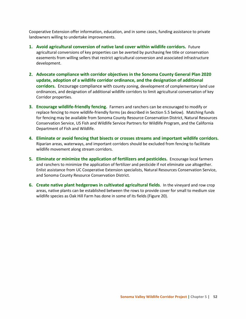
Sonoma Valley Wildlife Corridor Project | Chapter 5 | 52
Cooperative Extension offer information, education, and in some cases, funding assistance to private landowners willing to undertake improvements.
1. Avoid agricultural conversion of native land cover within wildlife corridors. Future agricultural conversions of key properties can be averted by purchasing fee title or conservation easements from willing sellers that restrict agricultural conversion and associated infrastructure development.
2. Advocate compliance with corridor objectives in the Sonoma County General Plan 2020
update, adoption of a wildlife corridor ordinance, and the designation of additional corridors. Encourage compliance with county zoning, development of complementary land use ordinances, and designation of additional wildlife corridors to limit agricultural conversation of key Corridor properties.
3. Encourage wildlife-friendly fencing. Farmers and ranchers can be encouraged to modify or replace fencing to more wildlife-friendly forms (as described in Section 5.5 below). Matching funds for fencing may be available from Sonoma County Resource Conservation District, Natural Resources Conservation Service, US Fish and Wildlife Service Partners for Wildlife Program, and the California Department of Fish and Wildlife.
4. Eliminate or avoid fencing that bisects or crosses streams and important wildlife corridors. Riparian areas, waterways, and important corridors should be excluded from fencing to facilitate wildlife movement along stream corridors.
5. Eliminate or minimize the application of fertilizers and pesticides. Encourage local farmers and ranchers to minimize the application of fertilizer and pesticide if not eliminate use altogether. Enlist assistance from UC Cooperative Extension specialists, Natural Resources Conservation Service, and Sonoma County Resource Conservation District.
6. Create native plant hedgerows in cultivated agricultural fields. In the vineyard and row crop areas, native plants can be established between the rows to provide cover for small to medium size wildlife species as Oak Hill Farm has done in some of its fields (Figure 20).
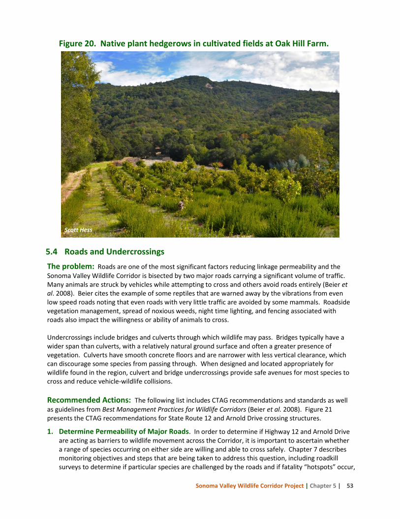
Sonoma Valley Wildlife Corridor Project | Chapter 5 | 53
Figure 20. Native plant hedgerows in cultivated fields at Oak Hill Farm.
5.4 Roads and Undercrossings The problem: Roads are one of the most significant factors reducing linkage permeability and the Sonoma Valley Wildlife Corridor is bisected by two major roads carrying a significant volume of traffic. Many animals are struck by vehicles while attempting to cross and others avoid roads entirely (Beier et al. 2008). Beier cites the example of some reptiles that are warned away by the vibrations from even low speed roads noting that even roads with very little traffic are avoided by some mammals. Roadside vegetation management, spread of noxious weeds, night time lighting, and fencing associated with roads also impact the willingness or ability of animals to cross. Undercrossings include bridges and culverts through which wildlife may pass. Bridges typically have a wider span than culverts, with a relatively natural ground surface and often a greater presence of vegetation. Culverts have smooth concrete floors and are narrower with less vertical clearance, which can discourage some species from passing through. When designed and located appropriately for wildlife found in the region, culvert and bridge undercrossings provide safe avenues for most species to cross and reduce vehicle-wildlife collisions. Recommended Actions: The following list includes CTAG recommendations and standards as well as guidelines from Best Management Practices for Wildlife Corridors (Beier et al. 2008). Figure 21 presents the CTAG recommendations for State Route 12 and Arnold Drive crossing structures.
1. Determine Permeability of Major Roads. In order to determine if Highway 12 and Arnold Drive are acting as barriers to wildlife movement across the Corridor, it is important to ascertain whether a range of species occurring on either side are willing and able to cross safely. Chapter 7 describes monitoring objectives and steps that are being taken to address this question, including roadkill surveys to determine if particular species are challenged by the roads and if fatality “hotspots” occur,
Scott Hess
Sonoma Valley Wildlife Corridor Project | Chapter 5 | 54
and focused camera studies at undercrossings. While major roads are of greatest concern, permeability assessments of less used roads should be conducted where feasible.
2. Engage Caltrans, Sonoma County Transportation Authority, and Public Works. Communicate the road permeability monitoring results to Caltrans and Sonoma County to ensure that wildlife permeability can be maintained or improved when road improvement projects are planned and implemented. Several of the undercrossing structures in the Corridor will likely be in need of repair or replacement in the near future, as will sections of the roads themselves. Incorporating wildlife passage elements into road improvement projects increases costs and will need to be justified. Highlighting the importance of the Corridor and presenting undercrossing and roadkill data to Caltrans and Sonoma County will increase the probability that permeability improvements will be incorporated into road improvement plans. Most road improvement projects require some environmental mitigation and this may be a funding source for non-road needs such as bank layback or drift fencing.
3. Provide multiple crossing structures to promote passage for all species likely to use a given area. Different species prefer different types of structures. Culverts and concrete box structures are used by many species, including mice, shrews, foxes, rabbits, river otters, opossums, raccoons, ground squirrels, skunks, coyotes, bobcats, mountain lions, black bear, great blue heron, long-tailed weasel, amphibians, lizards, and snakes (Yanes et al. 1995; Brudin 2003; Dodd et al. 2004; Ng et al. 2004). For small mammals, pipe culverts from 1 - 3 feet in diameter are preferable. For medium-sized mammals, black bear, and mountain lions, bridges or large box culverts with natural earthen substrate flooring are optimal (Clevenger and Waltho 2005). For deer and other ungulates, an open structure such as a bridge is crucial.
4. Increase use of bridges by small mammals, amphibians, reptiles, and insects. Bridge undercrossings should include uplands above the scour zone of streams, be high enough to provide passage when channels are full, and allow for vegetative growth to accommodate the need for cover and security (Beier et al. 2008). In the Netherlands, rows of stumps or branches in undercrossing structures have increased use by smaller species crossing bridges on floodplains (Forman et al. 2003).
5. Locate at least one crossing structure within an individual’s home range. Because most reptiles, small mammals, and amphibians have small home ranges, culverts should be installed at intervals of 500 – 1,000 feet. Inadequate size and insufficient number of undercrossings are two primary causes of poor use by wildlife.
6. Provide suitable cover and habitat on both sides of undercrossings. This applies to both local and landscape scales. On a local scale, vegetative cover should be present near entrances to give animals security, and reduce negative effects of lighting and noise. A lack of suitable habitat adjacent to undercrossings that were originally installed for hydrologic function may prevent their use as wildlife crossing structures. At the landscape scale, the land management strategies for the surrounding areas must also promote suitable wildlife habitat for the corridor and crossing structures to be effective (Clevenger and Waltho 2005).
7. Whenever possible, provide suitable habitat within undercrossings. This can be achieved by constructing bridges that are high enough to allow light for vegetation to grow underneath, and span upland habitat that is not regularly scoured by floods. Where this is not possible, rows of stumps or branches under large span bridges can provide cover for smaller animals such as reptiles,
Sonoma Valley Wildlife Corridor Project | Chapter 5 | 55
amphibians, rodents, and invertebrates; regular visits are needed to replace artificial cover removed by flood. Within culverts, mammals and reptiles prefer earthen to concrete or metal floors.
8. Regularly clear undercrossings of obstructions that impede passage. Small mammals, carnivores, and reptiles avoid traversing undercrossings with significant detritus or silt blockages and larger mammals may be blocked entirely. Box culverts are much more likely to become blocked than bridges.
9. Utilize fencing to increase, not deter, wildlife use of undercrossings. Fences should never
block entrances to undercrossings. Where a fence must parallel a road near an undercrossing, it should be set back as far as practical and be designed to allow wildlife to pass through easily. Conversely, fences and guard rails at least 6 feet high located in critical areas discourage animals from crossing roads and can be designed to direct them to the safety of undercrossings. Along stretches of road with impermeable fence, one-way ramps on the road side of the fence can allow an animal to escape if it is trapped on a road.
10. Raise sections of road to discourage animals from crossing and direct them to undercrossings. Clevenger et al. (2003) found that vertebrates were 93% less susceptible to road kills on sections of road raised on embankments compared to road segments at the natural grade of the surrounding terrain.
11. Manage human activity near each crossing structure. Clevenger and Waltho (2000) indicate that human use of crossing structures, including undercrossings, diminishes wildlife use and should be restricted. At a minimum, night time lighting and human presence within and near undercrossings should be restricted and foot trails should be relocated elsewhere.
12. Design crossing structures specifically to provide for animal movement. Recent research
shows that traffic noise within an undercrossing can discourage passage by wildlife, suggesting that new designs are needed to minimize vehicle noise in undercrossings. Most road culverts are designed to carry water and minimize erosion hazard to the road, and they often have eroded drop-offs at the downstream end that prevent wildlife usage. A difference of only a few inches between the culvert outlet and the ground hinders many small mammals, snakes, and amphibians from finding or using the culvert. Ungulates prefer undercrossings with sloped earthen sides rather than vertical concrete sides. Minimizing the distance an animal must travel within a structure will increase its usage.
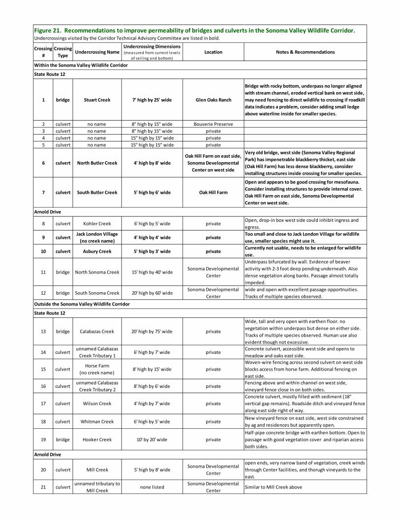
Sonoma Valley Wildlife Corridor Project | Chapter 5 | 56
Crossing #
Crossing Type
Undercrossing NameUndercrossing Dimensions (measured from current levels
of cei l ing and bottom)Location Notes & Recommendations
1 bridge Stuart Creek 7' high by 25' wide Glen Oaks Ranch
Bridge with rocky bottom, underpass no longer aligned with stream channel, eroded vertical bank on west side, may need fencing to direct wildlife to crossing if roadkill data indicates a problem, consider adding small ledge above waterline inside for smaller species.
2 culvert no name 8" high by 15" wide Bouverie Preserve 3 culvert no name 8" high by 15" wide private4 culvert no name 15" high by 15" wide private5 culvert no name 15" high by 15" wide private
6 culvert North Butler Creek 4' high by 8' wideOak Hill Farm on east side,
Sonoma Developmental Center on west side
Very old bridge, west side (Sonoma Valley Regional Park) has impenetrable blackberry thicket, east side (Oak Hill Farm) has less dense blackberry, consider installing structures inside crossing for smaller species.
7 culvert South Butler Creek 5' high by 6' wide Oak Hill Farm
Open and appears to be good crossing for mesofauna. Consider installing structures to provide internal cover. Oak Hill Farm on east side, Sonoma Developmental Center on west side.
8 culvert Kohler Creek 6' high by 5' wide privateOpen, drop-in box west side could inhibit ingress and egress.
9 culvertJack London Village
(no creek name)4' high by 4' wide private
Too small and close to Jack London Village for wildlife use, smaller species might use it.
10 culvert Asbury Creek 5' high by 3' wide privateCurrently not usable, needs to be enlarged for wildlife use.
11 bridge North Sonoma Creek 15' high by 40' wideSonoma Developmental
Center
Underpass bifurcated by wall. Evidence of beaver activity with 2-3 foot deep ponding underneath. Also dense vegetation along banks. Passage almost totally impeded.
12 bridge South Sonoma Creek 20' high by 60' wideSonoma Developmental
Centerwide and open with excellent passage opportnuities. Tracks of multiple species observed.
13 bridge Calabazas Creek 20' high by 75' wide private
Wide, tall and very open with earthen floor. no vegetation within underpass but dense on either side. Tracks of multiple species observed. Human use also evident though not excessive.
14 culvertunnamed Calabazas
Creek Tributary 16' high by 7' wide private
Concrete culvert, accessible west side and opens to meadow and oaks east side.
15 culvertHorse Farm
(no creek name)8' high by 15' wide private
Woven-wire fencing across second culvert on west side blocks access from horse farm. Additional fencing on east side.
16 culvertunnamed Calabazas
Creek Tributary 28' high by 6' wide private
Fencing above and within channel on west side, vineyard fence close in on both sides.
17 culvert Wilson Creek 4' high by 7' wide privateConcrete culvert, mostly filled with sediment (18" vertical gap remains). Roadside ditch and vineyard fence along east side right of way.
18 culvert Whitman Creek 6' high by 5' wide privateNew vineyard fence on east side, west side constrained by ag and residences but apparently open.
19 bridge Hooker Creek 10' by 20' wide privateHalf-pipe concrete bridge with earthen bottom. Open to passage with good vegetation cover and riparian access both sides.
20 culvert Mill Creek 5' high by 8' wideSonoma Developmental
Center
open ends, very narrow band of vegetation, creek winds through Center facilities, and thorugh vineyards to the east.
21 culvertunnamed tributary to
Mill Creeknone listed
Sonoma Developmental Center
Similar to Mill Creek above
Figure 21. Recommendations to improve permeability of bridges and culverts in the Sonoma Valley Wildlife Corridor. Undercrossings visited by the Corridor Technical Advisory Committee are listed in bold.
Arnold Drive
Within the Sonoma Valley Wildlife Corridor
State Route 12
Arnold Drive
Outside the Sonoma Valley Wildlife Corridor
State Route 12
Sonoma Valley Wildlife Corridor Project | Chapter 5 | 57
5.4.1 Roadside vegetation management The effects of roadside vegetation management on wildlife habitat and movement patterns are complex and determining appropriate management strategies depends on the species present as well as the amount and type of traffic. Some species such as deer may be attracted to roads where roadsides offer preferred plants (Feldhamer et al. 1986) while other species may avoid highway corridors with little vegetative cover for protection (Clevenger and Waltho 2005). Some management strategies attempt to direct animals to crossing structures by removing wide strips of vegetation on both sides of the road and leaving vegetated strips that lead to a crossing structure. Management practices may include the application of herbicides and/or mowing to improve visibility for motorists, and both can be detrimental to some species. Recommended actions:
1. Conduct assessment of roadside management practices. The current roadside practices for State Route 12 and Arnold Drive have not been assessed. Evaluating the relationship between roadside management practices and regional wildlife movement and mortality from vehicles would assist Caltrans and the county to implement management practices that promote both wildlife and motorist safety.
2. Promote use of native vegetation. The Caltrans Wildlife Crossings Guidance Manual (Meese et al. 2007) recommends the use of native plants because many invasive species are found in association with roadsides and can impact the habitats in the region. In addition, the long term maintenance costs are lower even though the initial cost may be higher (White and Ernst 2003).
3. Minimize the use of pesticides and herbicides. These management practices should be used very sparingly, if at all, to control invasives or to discourage use of roadsides by certain wildlife species (Meese et al. 2007).
5.4.2 Roadside lighting Street lighting has been shown to be effective in reducing vehicle collisions with large mammals especially when combined with fencing and signage (Reed and Woodard 1981, Maine DOT 2001). The use of lighting is limited to areas with a nearby power source, but has generally been found to be a cost-effective solution to reduce vehicle-animal collisions, especially in urban and suburban regions with high collision rates. Lighting increases a driver’s visibility and reaction time at night when many nocturnal animals become active (Reed and Woodard 1981), and some wildlife avoid lighted areas further reducing the number of wildlife-vehicle collisions. Conversely, because wildlife shy away from lights, wildlife passage interference can be minimized by limiting road lighting in areas where collisions are not a problem and wildlife can cross safely using undercrossings.
Recommended actions:
1. Conduct roadkill surveys and gather wildlife-vehicle collision data. Roadkill data combined with wildlife-vehicle collision data can identify road segments with high wildlife mortality rates. These data can be shared with transportation agencies to encourage changes to alleviate the impacts.
2. Use roadside lighting according to wildlife behavior. Consider adding street lights on roadsides where wildlife mortality is high to redirect animals to safer crossing areas. Restrict lighting where wildlife may cross safely and within 200 feet of all undercrossings.
Sonoma Valley Wildlife Corridor Project | Chapter 5 | 58
5.5 Fencing
The Problem. Many of the connectivity benefits derived from protecting and managing lands for wildlife passage can be diminished if fencing creates an impediment to wildlife passage in otherwise high quality habitats. Fences with loose wires or inappropriately spaced wires can ensnare birds and large mammals, prevent passage entirely, and trap panicked wildlife on highways. In a landscape with smaller and more distant habitat patches, impermeable fencing reduces the effectiveness of a corridor by limiting access to food and water, to other populations to maintain genetic diversity, and makes animals more vulnerable to wildfire, disease and drought. The CTAG noted the following fence characteristics that particularly create barriers for wildlife:
• Fences with overhanging lips along the top that prevent climbing species from getting over. • Fences with solid opaque inserts that prevent pusher species from getting through gaps. • Fences with extensions and lips under the ground that block digging species such as badgers. • Tall fences that impede jumping and climbing species. • Woven-wire fencing, especially tall ones such as vineyard fences, with very small cells at ground
level that prevent passage for anything larger than a mouse. In the Sonoma Valley Wildlife Corridor, fencing is used to control livestock and horses, exclude deer and other wildlife from agricultural lands and residential landscaping and gardens, mark a property boundary, or prevent trespassing. During the field tours, the CTAG observed barbed wire fencing in varying states of disrepair, new barbed wire fencing, 4’ and 8’ woven wire fences, and 6 foot chain link fence. The CTAG noted that impermeable fences parallel to roads are known to trap animals on roadways as they have difficulty finding an escape route when in a panicked state. This problem can be alleviated by encouraging wildlife friendly fencing, installing ramps to provide an escape route over fences along roadsides, and implementing measures that encourage wildlife use of the undercrossings. A wildlife-friendly fence is permeable for all species, is visible to wildlife, easy to get over or under, and also takes into account the purpose for the fence and potential cost to the landowner. For example, fencing built to contain cattle must have sufficient strength to prevent livestock from getting through or knocking it down while providing ample space under, over, and through the wires to allow wildlife in the area to pass through. Recommended actions: There are numerous documents that provide guidance on wildlife-friendly fencing including one prepared in 2003 by the Sonoma County Agricultural Preservation and Open Space District, with assistance from the Sonoma Ecology Center, for owners of District easement-protected lands (http://www.sonoma-county.org/public_reports/documents/district_fencing_ guidelines.pdf). One of the more thorough guides is the Montana Fish Wildlife and Parks publication, A Landowners’ Guide to Wildlife Friendly Fencing: How to Build Fence with Wildlife in Mind (fwp.mt.gov/fwpDoc.html?id=34461). The following general fencing guidelines are a compilation from these guides that are most relevant to the Sonoma Valley and suggestions from the CTAG.
1. Avoid new fencing. Discourage the construction of new fencing whenever possible, and when new fencing is necessary, minimize the size of the area fenced.
Sonoma Valley Wildlife Corridor Project | Chapter 5 | 59
2. Choose wildlife-friendly fence designs. Where fencing is necessary, select a design that addresses the specific need for the fence and allows non-target wildlife to pass through. Avoid using fences with woven wire or barbed wire close to or at ground level, overhanging lips, underground extensions, or solid opaque inserts unless used to protect residential areas or to direct wildlife to undercrossings.
3. Consider wildlife in the region. Consider the type of wildlife found in the area and ensure that the fence can be crossed by young and adult animals. Understand the daily or seasonal movements of wildlife in the area and the location of their calving or nesting areas. Avoid fencing off known wildlife trails.
4. Remove old fencing. Remove fencing that is no longer needed. If fencing materials are too difficult to haul out of remote areas, the fence posts can be left in place and the fence material coiled or rolled, placed so as to eliminate the risk of wildlife entanglement, and left onsite.
5. Replace old fencing with wildlife-friendly fencing. When old fencing needs to be repaired or replaced, use and encourage others to use wildlife-friendly designs.
6. Avoid fencing on steep slopes. A fence of any height is more difficult to cross when placed across a steep slope or next to a deep ditch, and is more likely to cause injury to animals trying to jump the fence.
7. Do not fence natural corridors. Allow movement and access through natural corridors and habitats, keeping swales, gullies, ridges, and stream corridors free of fencing because they often funnel wildlife through an area.
8. Keep fence strands tight. Tension should be maintained on barbed and smooth wire fences to reduce the chance for entanglement.
Wildlife-Friendly Fence Designs
Barbed or smooth wire fences for livestock control. The following specifications are recommended to maximize wildlife passage through barbed and smooth wire fences needed to control cattle. Two designs illustrating these standards are shown in Figure 22.
• The fence should be no more than 42” in height and 40” is the preferred height. • The bottom wire should be 16” to 18” off the ground, and smooth if possible. • The top wire should be smooth, 12” from the next lower wire to preclude entanglements, and made
more visible by marking with flagging or covering with PVC pipe. Installing a top rail in lieu of, or in addition to, the top wire further improves visibility.
Fencing along highway and road rights-of-way need special consideration. Wildlife should be able to pass through fencing on either side of the highway quickly to minimize the amount of time an animal is in the right-of-way. The design preferred by Montana Fish, Wildlife and Parks is four strands with top and bottom smooth wire and two center barbed wires. The top wire should be no more than 42" high with 12" between the top and second wire, and the bottom wire at least 16" off the ground. This design keeps cattle off the roads while allowing wildlife of all sizes to cross. Where impermeable fences parallel roadways, ramps on the road side of the fence should be considered to allow escape.
Boundary marking fences. Several options exist for fences that are solely for marking property boundaries. Hedgerows and low, decorative fences with flat, visible tops (no spikes), and adequate ground clearance delineate property lines without inhibiting wildlife movement. “No Trespassing” sign posts placed at regular intervals along a boundary can also be an effective trespassing deterrent.
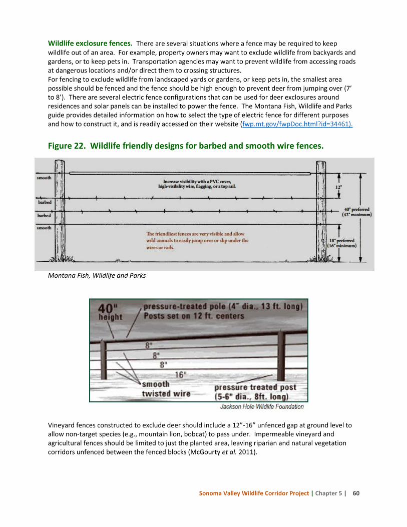
Sonoma Valley Wildlife Corridor Project | Chapter 5 | 60
Wildlife exclosure fences. There are several situations where a fence may be required to keep wildlife out of an area. For example, property owners may want to exclude wildlife from backyards and gardens, or to keep pets in. Transportation agencies may want to prevent wildlife from accessing roads at dangerous locations and/or direct them to crossing structures. For fencing to exclude wildlife from landscaped yards or gardens, or keep pets in, the smallest area possible should be fenced and the fence should be high enough to prevent deer from jumping over (7’ to 8’). There are several electric fence configurations that can be used for deer exclosures around residences and solar panels can be installed to power the fence. The Montana Fish, Wildlife and Parks guide provides detailed information on how to select the type of electric fence for different purposes and how to construct it, and is readily accessed on their website (fwp.mt.gov/fwpDoc.html?id=34461). Figure 22. Wildlife friendly designs for barbed and smooth wire fences.
Montana Fish, Wildlife and Parks
Vineyard fences constructed to exclude deer should include a 12”-16” unfenced gap at ground level to allow non-target species (e.g., mountain lion, bobcat) to pass under. Impermeable vineyard and agricultural fences should be limited to just the planted area, leaving riparian and natural vegetation corridors unfenced between the fenced blocks (McGourty et al. 2011).
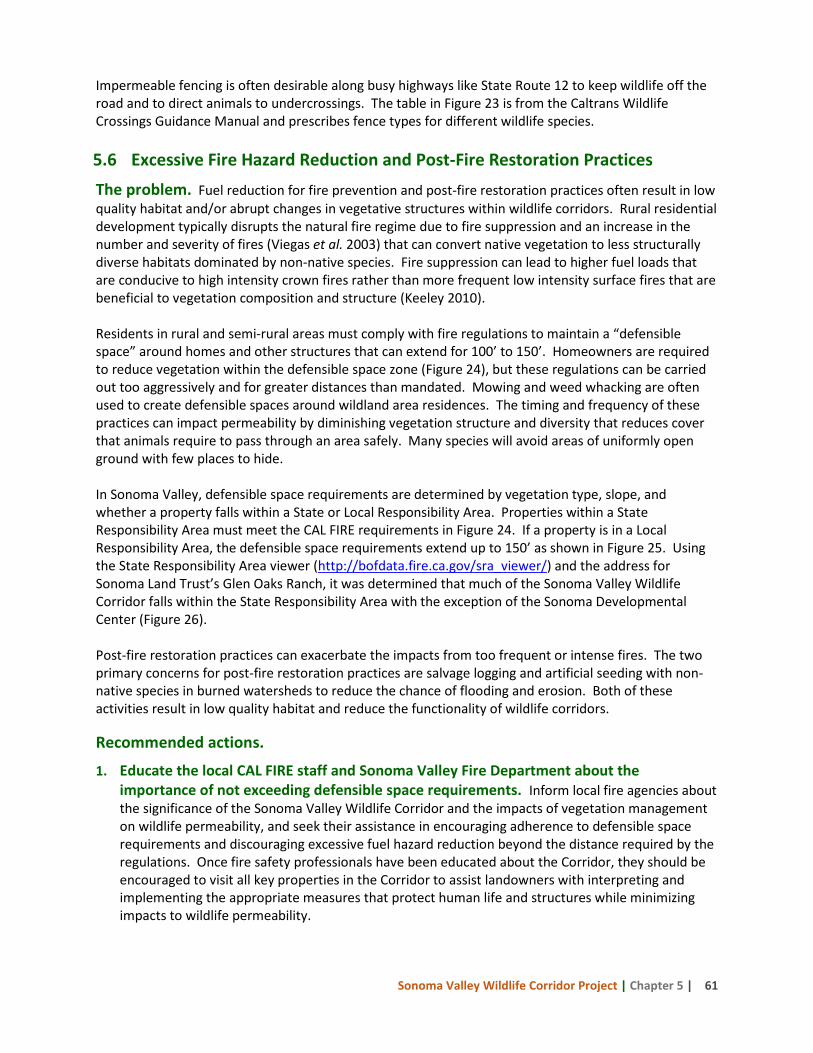
Sonoma Valley Wildlife Corridor Project | Chapter 5 | 61
Impermeable fencing is often desirable along busy highways like State Route 12 to keep wildlife off the road and to direct animals to undercrossings. The table in Figure 23 is from the Caltrans Wildlife Crossings Guidance Manual and prescribes fence types for different wildlife species. 5.6 Excessive Fire Hazard Reduction and Post-Fire Restoration Practices
The problem. Fuel reduction for fire prevention and post-fire restoration practices often result in low quality habitat and/or abrupt changes in vegetative structures within wildlife corridors. Rural residential development typically disrupts the natural fire regime due to fire suppression and an increase in the number and severity of fires (Viegas et al. 2003) that can convert native vegetation to less structurally diverse habitats dominated by non-native species. Fire suppression can lead to higher fuel loads that are conducive to high intensity crown fires rather than more frequent low intensity surface fires that are beneficial to vegetation composition and structure (Keeley 2010). Residents in rural and semi-rural areas must comply with fire regulations to maintain a “defensible space” around homes and other structures that can extend for 100’ to 150’. Homeowners are required to reduce vegetation within the defensible space zone (Figure 24), but these regulations can be carried out too aggressively and for greater distances than mandated. Mowing and weed whacking are often used to create defensible spaces around wildland area residences. The timing and frequency of these practices can impact permeability by diminishing vegetation structure and diversity that reduces cover that animals require to pass through an area safely. Many species will avoid areas of uniformly open ground with few places to hide. In Sonoma Valley, defensible space requirements are determined by vegetation type, slope, and whether a property falls within a State or Local Responsibility Area. Properties within a State Responsibility Area must meet the CAL FIRE requirements in Figure 24. If a property is in a Local Responsibility Area, the defensible space requirements extend up to 150’ as shown in Figure 25. Using the State Responsibility Area viewer (http://bofdata.fire.ca.gov/sra_viewer/) and the address for Sonoma Land Trust’s Glen Oaks Ranch, it was determined that much of the Sonoma Valley Wildlife Corridor falls within the State Responsibility Area with the exception of the Sonoma Developmental Center (Figure 26). Post-fire restoration practices can exacerbate the impacts from too frequent or intense fires. The two primary concerns for post-fire restoration practices are salvage logging and artificial seeding with non-native species in burned watersheds to reduce the chance of flooding and erosion. Both of these activities result in low quality habitat and reduce the functionality of wildlife corridors. Recommended actions.
1. Educate the local CAL FIRE staff and Sonoma Valley Fire Department about the importance of not exceeding defensible space requirements. Inform local fire agencies about the significance of the Sonoma Valley Wildlife Corridor and the impacts of vegetation management on wildlife permeability, and seek their assistance in encouraging adherence to defensible space requirements and discouraging excessive fuel hazard reduction beyond the distance required by the regulations. Once fire safety professionals have been educated about the Corridor, they should be encouraged to visit all key properties in the Corridor to assist landowners with interpreting and implementing the appropriate measures that protect human life and structures while minimizing impacts to wildlife permeability.
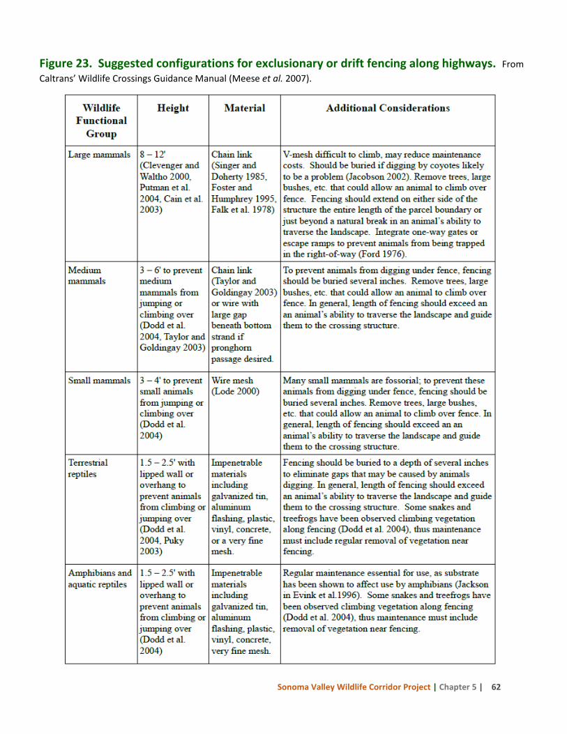
Sonoma Valley Wildlife Corridor Project | Chapter 5 | 62
Figure 23. Suggested configurations for exclusionary or drift fencing along highways. From Caltrans’ Wildlife Crossings Guidance Manual (Meese et al. 2007).
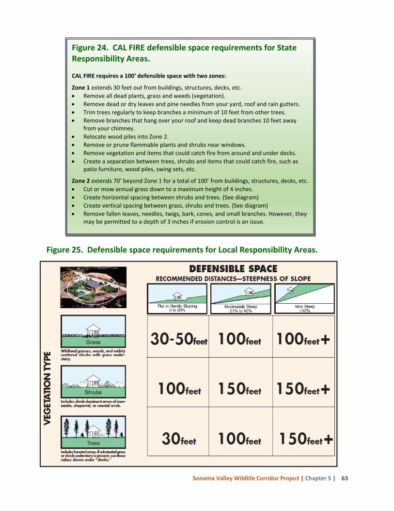
Sonoma Valley Wildlife Corridor Project | Chapter 5 | 63
Figure 25. Defensible space requirements for Local Responsibility Areas.
Figure 24. CAL FIRE defensible space requirements for State Responsibility Areas. CAL FIRE requires a 100’ defensible space with two zones:
Zone 1 extends 30 feet out from buildings, structures, decks, etc. • Remove all dead plants, grass and weeds (vegetation). • Remove dead or dry leaves and pine needles from your yard, roof and rain gutters. • Trim trees regularly to keep branches a minimum of 10 feet from other trees. • Remove branches that hang over your roof and keep dead branches 10 feet away
from your chimney. • Relocate wood piles into Zone 2. • Remove or prune flammable plants and shrubs near windows. • Remove vegetation and items that could catch fire from around and under decks. • Create a separation between trees, shrubs and items that could catch fire, such as
patio furniture, wood piles, swing sets, etc.
Zone 2 extends 70’ beyond Zone 1 for a total of 100’ from buildings, structures, decks, etc. • Cut or mow annual grass down to a maximum height of 4 inches. • Create horizontal spacing between shrubs and trees. (See diagram) • Create vertical spacing between grass, shrubs and trees. (See diagram) • Remove fallen leaves, needles, twigs, bark, cones, and small branches. However, they
may be permitted to a depth of 3 inches if erosion control is an issue.
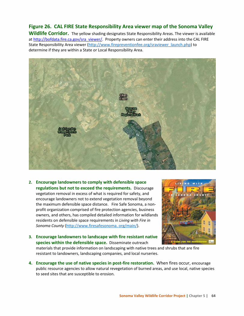
Sonoma Valley Wildlife Corridor Project | Chapter 5 | 64
Figure 26. CAL FIRE State Responsibility Area viewer map of the Sonoma Valley Wildlife Corridor. The yellow shading designates State Responsibility Areas. The viewer is available at http://bofdata.fire.ca.gov/sra_viewer/. Property owners can enter their address into the CAL FIRE State Responsibility Area viewer (http://www.firepreventionfee.org/sraviewer_launch.php) to determine if they are within a State or Local Responsibility Area.
2. Encourage landowners to comply with defensible space regulations but not to exceed the requirements. Discourage vegetation removal in excess of what is required for safety, and encourage landowners not to extend vegetation removal beyond the maximum defensible space distance. Fire Safe Sonoma, a non-profit organization comprised of fire protection agencies, business owners, and others, has compiled detailed information for wildlands residents on defensible space requirements in Living with Fire in Sonoma County (http://www.firesafesonoma. org/main/).
3. Encourage landowners to landscape with fire resistant native
species within the defensible space. Disseminate outreach materials that provide information on landscaping with native trees and shrubs that are fire resistant to landowners, landscaping companies, and local nurseries.
4. Encourage the use of native species in post-fire restoration. When fires occur, encourage public resource agencies to allow natural revegetation of burned areas, and use local, native species to seed sites that are susceptible to erosion.
Sonoma Valley Wildlife Corridor Project | Chapter 5 | 65
5.7 Pesticide Use
The problem. The application of pesticides in and around rural residential development in wildland areas poses a risk to both native plants and animals. These poisons often impact non-target animals and also persist in the environment, killing more than the targeted species when poisoned animals are consumed by other wildlife. The application of herbicides may be necessary to control invasive plants, but their use should be limited.
Recommended actions:
1. Educate landowners about the effects of pesticide use. Outreach materials that detail the effects of pesticides on wildlife and discourage their use can be distributed to Corridor landowners as well as retailers that sell these products.
2. Educate public agency staff and discourage the use of pesticides on public properties. Determine if Sonoma County Public Works Department and Caltrans use pesticides and where they are applied, and encourage the reduction or elimination of their use.
5.8 Outdoor Night Lighting
The problem. Lighting, whether for highway safety or driveways and patios around residences, impacts wildlife in several ways. Some species avoid lighted areas, while others are attracted to artificial light and can become disoriented, increasing the likelihood of mortality resulting from collision with structures or vehicles. Lighting also affects the light-sensitive cycles of many species. For example, some predatory birds and reptiles, usually active only during the day, will forage at night under artificial lights (Longcore and Rich 2004). Prey species may suffer adverse effects over time as a result of this foraging shift.
Recommended actions. There are several good sources of information for minimizing the effects of exterior night lighting. A good example of a comprehensive approach is found in Florida where the state Fish and Wildlife Conservation Commission and the US Fish and Wildlife Service teamed up to develop the Wildlife Lighting Certification Program. The program is designed to educate the public, the building industry, and government officials about ways to minimize artificial light impacts to wildlife by using proper lighting methods and identifying appropriate lighting fixtures, shields, and lamps. The following recommendations are a compilation of the guidelines from the Arizona Game and Fish Department Wildlife Friendly Guidelines: Community and Project Planning (www.azgfd.gov/pdfs/w_c/WildlifeFriendlyDevelopment.pdf ), and the Florida Wildlife Lighting Certification Program (http://myfwc.com/conservation/you-conserve/lighting/certification/).
1. Educate landowners about wildlife friendly lighting. Provide landowners with outreach materials describing wildlife friendly lighting and its benefits to corridor permeability.
2. Eliminate all bare bulbs and any lighting pointing upward. Any outdoor lights should be aimed down toward the ground and light only the areas needing illumination.
3. Keep it low. Fixtures should be mounted as low as possible while still serving the intended purpose.
4. Use the minimum amount of light needed for safety. Install fixtures that use the lowest wattage for the purpose.
Sonoma Valley Wildlife Corridor Project | Chapter 5 | 66
5. Use narrow spectrum bulbs where feasible to lower the range of species affected by lighting. Long wavelength bulbs make the light seem dimmer to nocturnal animals (Longcore and Rich 2004) while still producing sufficient light for safety purposes.
5.9 Trails and Recreational Uses
The problem. Hikers, equestrians, mountain bikers, dog walkers, and many others enjoy the trails found in the Sonoma Valley Wildlife Corridor. Recreational activities are not inherently incompatible with wildlife movement, but heavy use of trails can disrupt wildlife passage due to noise, off-leash dogs, speeding bicycles, and other activities that cause wildlife to shy away (Knight and Cole 1995). Off-leash dogs in wildlife areas can directly harass wildlife by chasing or digging after them, and can indirectly affect wildlife use patterns by leaving their scent, particularly in areas where dogs are a routine presence. In the Corridor, trails are open to the public in Sonoma Valley Regional Park and Jack London State Park. Trail use at Glen Oaks Ranch and Bouverie Preserve is much more restricted. Sonoma Valley Regional Park, and the adjacent SDC lands that are used in conjunction with the park (but not under Park management), are of special concern because they are visited regularly by most of these user groups and comprise the narrowest stretch of the Corridor (Figure 2). An enclosed dog park on approximately one half acre is located next to State Route 12 and may discourage wildlife crossings in that area. Recommended actions:
1. Increase understanding of the interactions between recreation and wildlife in the Corridor. Conduct a thorough review of scientific literature on the effects of recreation on wildlife occupancy, movement patterns, and strategies for mitigating such impacts. Use the results of the review to develop additional recommendations for recreation management during the planning phase for future uses of Jack London State Park, Sonoma Valley Regional Park, and Sonoma Developmental Center.
2. Educate public and private landowners in the Corridor on ways to limit impacts of recreation on wildlife. Ensure that this document and the findings and recommendations from #1 above are provided to Sonoma County Regional Parks and other entities providing recreation in the Corridor, and summarize pertinent sections in outreach materials to private landowners.
5.10 Streams and Riparian Zones
The problem. Streams and associated riparian zones are important habitat and movement corridors for many types of wildlife. Residential and agricultural development can encroach on riparian habitat and impact its ability to support wildlife by reducing vegetation and cover, increasing sedimentation into streams, reducing flows, installing fences and roads, and increasing the presence of non-native plants and animals. In order to maintain stream and riparian functionality as wildlife linkages, Beier et al. (2008) recommends the following general guidelines. Recommended actions:
1. Retain natural fluvial processes. Maintaining or restoring the natural timing, magnitude, frequency, and duration of surface flows is essential for sustaining functional riparian ecosystems (Shafroth et al. 2002, Wissmar 2004). Elimination of unnatural perennial surface pools can eradicate water-dependent invasives such as bullfrogs, crayfish, and mosquitofish.
Sonoma Valley Wildlife Corridor Project | Chapter 5 | 67
2. Promote base flows and maintain groundwater levels within the natural tolerance ranges of native plant species. Subsurface water is important for the health of the riparian habitat, and can be sustained more efficiently by reducing ground water pumping near the river, providing municipal water sources to homes, reducing agricultural water use by planting low water use crops, and routing return flows to the channel (Stromberg 2000, Colby and Wishart 2002).
3. Maintain or improve native riparian vegetation. Whenever possible, removing non-native vegetation and restoring native species is essential for maintaining riparian ecological functions. Hundreds of exotic species have become naturalized in riparian corridors, and a few, such as tamarisk and Russian olive, are significant problems. Removing these stresses to natural ecosystems and reestablishing natural flow regimes can help restore riparian communities, but physical eradication of some persistent exotics is necessary (Stromberg 2000, Savage 2004).
4. Where possible, protect or restore a continuous strip of native vegetation along each side of the channel. Buffer strips can protect and improve water quality, and provide habitat connectivity for many species. Recommended buffer widths to sustain riparian plant and animal communities vary from 90 to 1,500 feet (Wenger 1999, Fisher and Fischenich 2000, Wenger and Fowler 2000, Environmental Law Institute 2003). At a minimum, buffers should capture the stream channel and the terrestrial landscape affected by flooding and elevated water tables (Naiman et al. 1993) and fencing that restricts wildlife movement should be removed from within the streams and buffers.
5. Enforce existing regulations. Existing regulations restricting development, gravel mining, farming, dumping of soil, agricultural waste, and trash, in streams and riparian zones should be enforced.
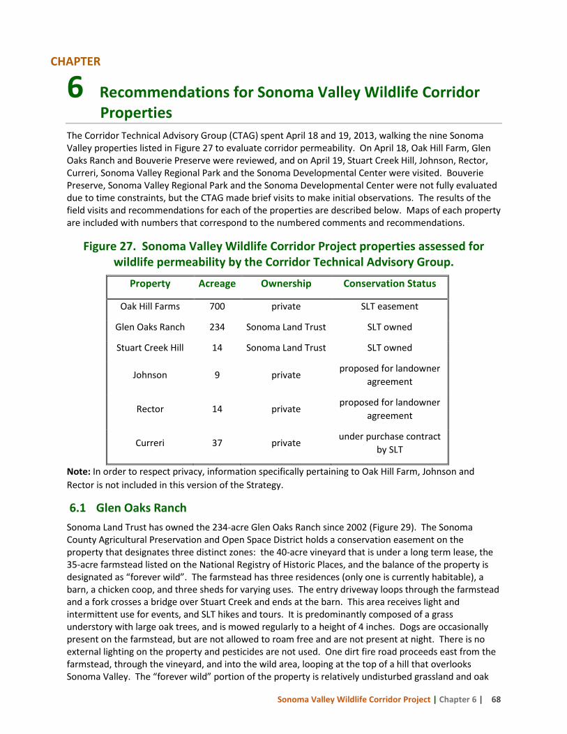
Sonoma Valley Wildlife Corridor Project | Chapter 6 | 68
6 Recommendations for Sonoma Valley Wildlife Corridor Properties
The Corridor Technical Advisory Group (CTAG) spent April 18 and 19, 2013, walking the nine Sonoma Valley properties listed in Figure 27 to evaluate corridor permeability. On April 18, Oak Hill Farm, Glen Oaks Ranch and Bouverie Preserve were reviewed, and on April 19, Stuart Creek Hill, Johnson, Rector, Curreri, Sonoma Valley Regional Park and the Sonoma Developmental Center were visited. Bouverie Preserve, Sonoma Valley Regional Park and the Sonoma Developmental Center were not fully evaluated due to time constraints, but the CTAG made brief visits to make initial observations. The results of the field visits and recommendations for each of the properties are described below. Maps of each property are included with numbers that correspond to the numbered comments and recommendations.
Figure 27. Sonoma Valley Wildlife Corridor Project properties assessed for wildlife permeability by the Corridor Technical Advisory Group.
Property Acreage Ownership Conservation Status
Oak Hill Farms 700 private SLT easement
Glen Oaks Ranch 234 Sonoma Land Trust SLT owned
Stuart Creek Hill 14 Sonoma Land Trust SLT owned
Johnson 9 private proposed for landowner
agreement
Rector 14 private proposed for landowner
agreement
Curreri 37 private under purchase contract
by SLT
Note: In order to respect privacy, information specifically pertaining to Oak Hill Farm, Johnson and Rector is not included in this version of the Strategy.
6.1 Glen Oaks Ranch Sonoma Land Trust has owned the 234-acre Glen Oaks Ranch since 2002 (Figure 29). The Sonoma County Agricultural Preservation and Open Space District holds a conservation easement on the property that designates three distinct zones: the 40-acre vineyard that is under a long term lease, the 35-acre farmstead listed on the National Registry of Historic Places, and the balance of the property is designated as “forever wild”. The farmstead has three residences (only one is currently habitable), a barn, a chicken coop, and three sheds for varying uses. The entry driveway loops through the farmstead and a fork crosses a bridge over Stuart Creek and ends at the barn. This area receives light and intermittent use for events, and SLT hikes and tours. It is predominantly composed of a grass understory with large oak trees, and is mowed regularly to a height of 4 inches. Dogs are occasionally present on the farmstead, but are not allowed to roam free and are not present at night. There is no external lighting on the property and pesticides are not used. One dirt fire road proceeds east from the farmstead, through the vineyard, and into the wild area, looping at the top of a hill that overlooks Sonoma Valley. The “forever wild” portion of the property is relatively undisturbed grassland and oak
CHAPTER
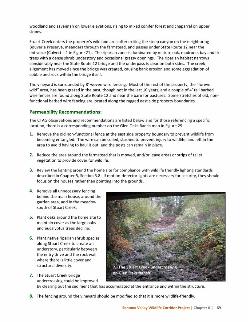
Sonoma Valley Wildlife Corridor Project | Chapter 6 | 69
woodland and savannah on lower elevations, rising to mixed conifer forest and chaparral on upper slopes. Stuart Creek enters the property’s wildland area after exiting the steep canyon on the neighboring Bouverie Preserve, meanders through the farmstead, and passes under State Route 12 near the entrance (Culvert # 1 in Figure 21). The riparian zone is dominated by mature oak, madrone, bay and fir trees with a dense shrub understory and occasional grassy openings. The riparian habitat narrows considerably near the State Route 12 bridge and the underpass is clear on both sides. The creek alignment has moved since the bridge was created, causing bank erosion and some aggradation of cobble and rock within the bridge itself. The vineyard is surrounded by 8’ woven wire fencing. Most of the rest of the property, the “forever wild” area, has been grazed in the past, though not in the last 10 years, and a couple of 4’ tall barbed wire fences are found along State Route 12 and near the barn for pastures. Some stretches of old, non-functional barbed wire fencing are located along the rugged east side property boundaries. Permeability Recommendations: The CTAG observations and recommendations are listed below and for those referencing a specific location, there is a corresponding number on the Glen Oaks Ranch map in Figure 29.
1. Remove the old non-functional fence at the east side property boundary to prevent wildlife from becoming entangled. The wire can be coiled, stashed to prevent injury to wildlife, and left in the area to avoid having to haul it out, and the posts can remain in place.
2. Reduce the area around the farmstead that is mowed, and/or leave areas or strips of taller vegetation to provide cover for wildlife.
3. Review the lighting around the home site for compliance with wildlife friendly lighting standards described in Chapter 5, Section 5.8. If motion-detector lights are necessary for security, they should focus on the houses rather than pointing into the grounds.
4. Remove all unnecessary fencing behind the main house, around the garden area, and in the meadow south of Stuart Creek.
5. Plant oaks around the home site to maintain cover as the large oaks and eucalyptus trees decline.
6. Plant native riparian shrub species along Stuart Creek to create an understory, particularly between the entry drive and the rock wall where there is little cover and structural diversity.
7. The Stuart Creek bridge undercrossing could be improved by clearing out the sediment that has accumulated at the entrance and within the structure.
8. The fencing around the vineyard should be modified so that it is more wildlife-friendly.
7. The Stuart Creek undercrossing on Glen Oaks Ranch.
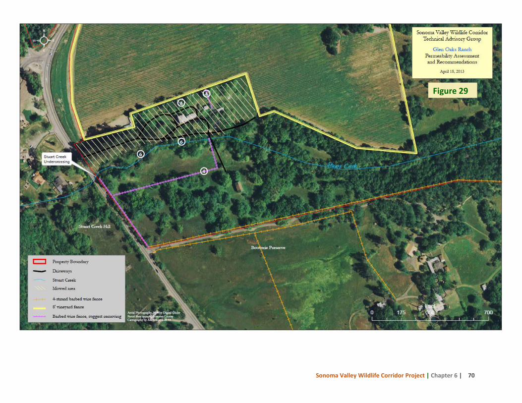
Sonoma Valley Wildlife Corridor Project | Chapter 6 | 70
Figure 29
Sonoma Valley Wildlife Corridor Project | Chapter 6 | 71
6.2 Stuart Creek Hill Sonoma Land Trust purchased the 14-acre Stuart Creek Hill property in 2012 (Figure 30). It is located on the west side of State Route 12, and is easily accessed from Glen Oaks Ranch via the Stuart Creek bridge undercrossing. There are no structures on the property. Old, non-functional, and intermittent four-strand barbed wire fencing occurs in places including along an old rock wall that parallels the highway. Much of the property slopes upward to the west where it abuts the Johnson property. Grasslands, riparian forest, and oak woodlands are the predominant vegetation types. Medusahead and several eucalyptus trees occur in the lower portions of the property, and both can come to dominate the landscape and negatively impact habitat value and use by wildlife if not eliminated or controlled early. To the south, Stuart Creek Hill is bounded by a tall chain link fence on the neighboring property that forms an impermeable barrier. The northern boundary incorporates a small stretch of the Stuart Creek riparian corridor. Riparian vegetation along the creek has tall oak and bay trees with a sparse understory. The creek alignment on the Glen Oaks Ranch side of the bridge has moved since the bridge was created, causing bank erosion and some aggradation of cobble and rock within the bridge itself. The south creek bank on Stuart Creek Hill at the bridge outlet has developed a 10’ vertical drop that may impede entry to and exit from the undercrossing. Access to and from the undercrossing along the north bank is narrowed by a wall along the neighbor’s property line, but wildlife trails and camera captures indicate the north bank is the primary access route to the undercrossing. Permeability Recommendations: The CTAG observations and recommendations are listed below and for those referencing a specific location, there is a corresponding number on the Stuart Creek Hill map in Figure 30.
1. Explore means of laying back and stabilizing the vertical south creek bank so that wildlife can access the underpass more freely to cross under the highway.
2. Remove old and non-functional barbed wire fencing.
3. If roadkill surveys indicate wildlife mortality is problematic on the highway along this property’s frontage, a drift fence should be installed to funnel animals to the Stuart Creek undercrossing for safer passage.
4. Control current noxious non-native plants (medusa head, eucalyptus), watch for new invading weeds, and consider measures such as grazing or mowing to reduce competition from non-native species and promote native plants.
5. Very little oak regeneration was observed in the understory. Explore reasons for this and implement measures to promote oak seedling establishment and survival.
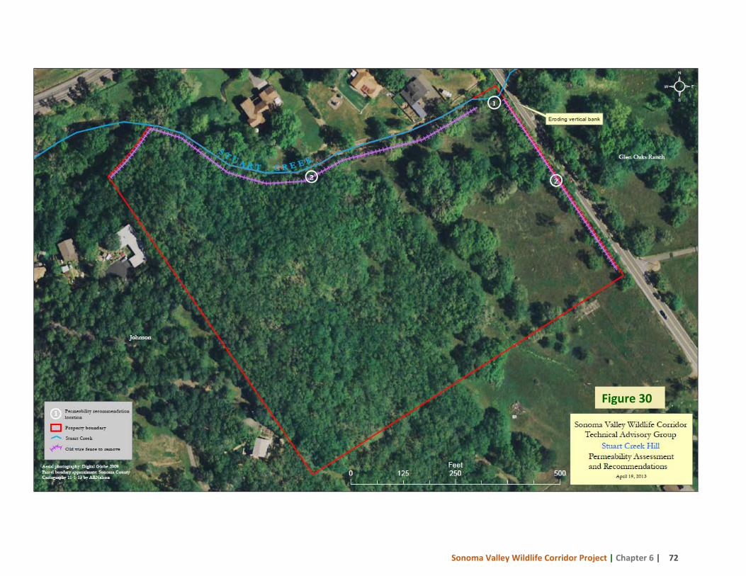
Sonoma Valley Wildlife Corridor Project | Chapter 6 | 72
Figure 30
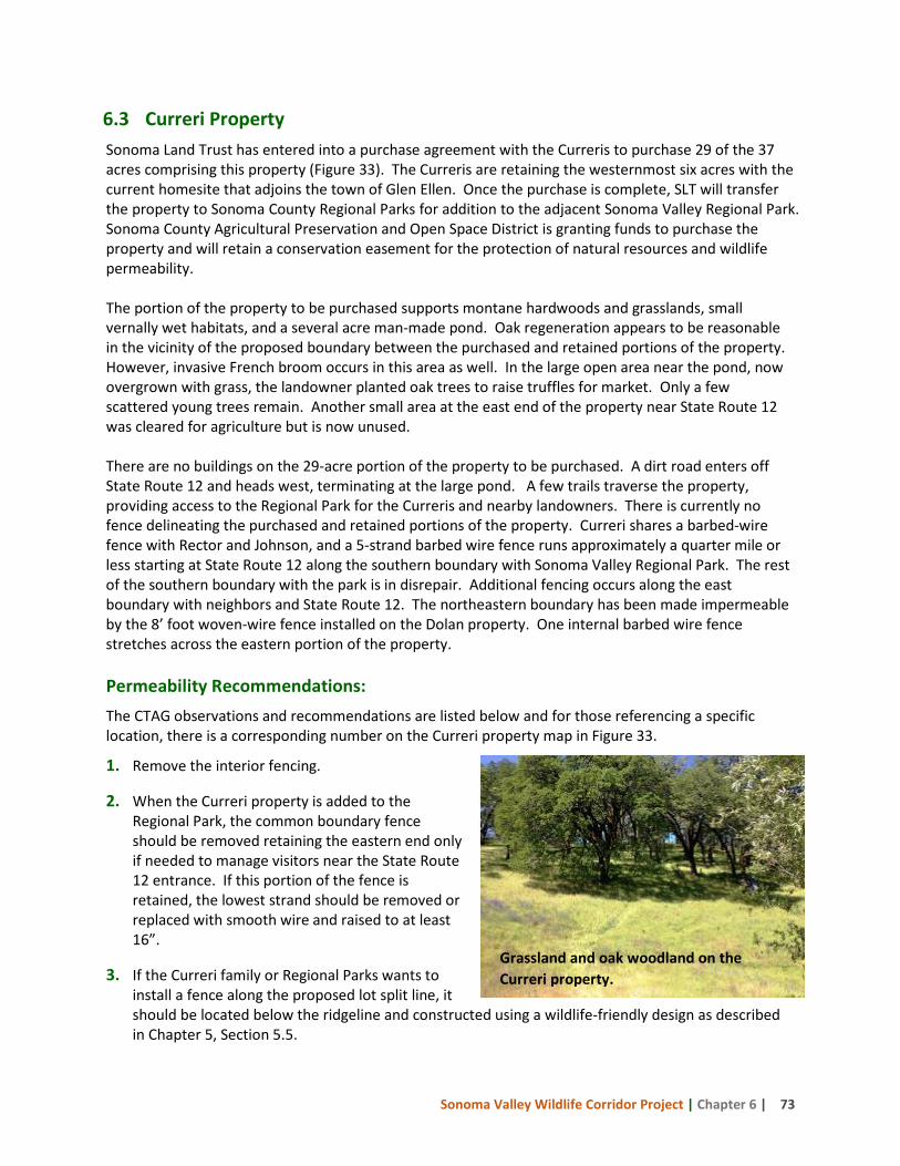
Sonoma Valley Wildlife Corridor Project | Chapter 6 | 73
6.3 Curreri Property Sonoma Land Trust has entered into a purchase agreement with the Curreris to purchase 29 of the 37 acres comprising this property (Figure 33). The Curreris are retaining the westernmost six acres with the current homesite that adjoins the town of Glen Ellen. Once the purchase is complete, SLT will transfer the property to Sonoma County Regional Parks for addition to the adjacent Sonoma Valley Regional Park. Sonoma County Agricultural Preservation and Open Space District is granting funds to purchase the property and will retain a conservation easement for the protection of natural resources and wildlife permeability. The portion of the property to be purchased supports montane hardwoods and grasslands, small vernally wet habitats, and a several acre man-made pond. Oak regeneration appears to be reasonable in the vicinity of the proposed boundary between the purchased and retained portions of the property. However, invasive French broom occurs in this area as well. In the large open area near the pond, now overgrown with grass, the landowner planted oak trees to raise truffles for market. Only a few scattered young trees remain. Another small area at the east end of the property near State Route 12 was cleared for agriculture but is now unused. There are no buildings on the 29-acre portion of the property to be purchased. A dirt road enters off State Route 12 and heads west, terminating at the large pond. A few trails traverse the property, providing access to the Regional Park for the Curreris and nearby landowners. There is currently no fence delineating the purchased and retained portions of the property. Curreri shares a barbed-wire fence with Rector and Johnson, and a 5-strand barbed wire fence runs approximately a quarter mile or less starting at State Route 12 along the southern boundary with Sonoma Valley Regional Park. The rest of the southern boundary with the park is in disrepair. Additional fencing occurs along the east boundary with neighbors and State Route 12. The northeastern boundary has been made impermeable by the 8’ foot woven-wire fence installed on the Dolan property. One internal barbed wire fence stretches across the eastern portion of the property. Permeability Recommendations: The CTAG observations and recommendations are listed below and for those referencing a specific location, there is a corresponding number on the Curreri property map in Figure 33.
1. Remove the interior fencing.
2. When the Curreri property is added to the Regional Park, the common boundary fence should be removed retaining the eastern end only if needed to manage visitors near the State Route 12 entrance. If this portion of the fence is retained, the lowest strand should be removed or replaced with smooth wire and raised to at least 16”.
3. If the Curreri family or Regional Parks wants to install a fence along the proposed lot split line, it should be located below the ridgeline and constructed using a wildlife-friendly design as described in Chapter 5, Section 5.5.
Grassland and oak woodland on the Curreri property.
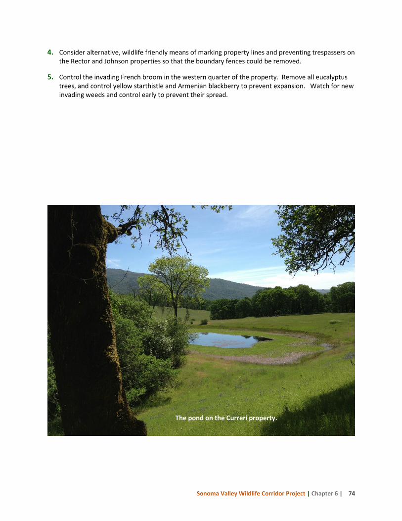
Sonoma Valley Wildlife Corridor Project | Chapter 6 | 74
4. Consider alternative, wildlife friendly means of marking property lines and preventing trespassers on the Rector and Johnson properties so that the boundary fences could be removed.
5. Control the invading French broom in the western quarter of the property. Remove all eucalyptus trees, and control yellow starthistle and Armenian blackberry to prevent expansion. Watch for new invading weeds and control early to prevent their spread.
The pond on the Curreri property.
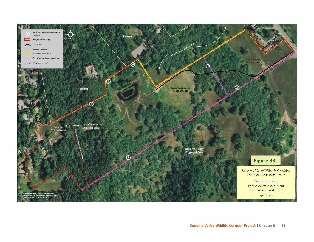
Sonoma Valley Wildlife Corridor Project | Chapter 6 | 75
Figure 33
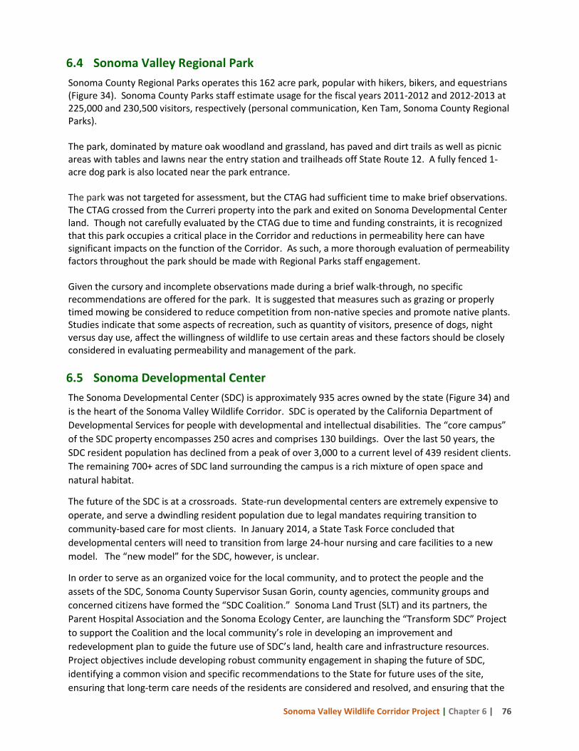
Sonoma Valley Wildlife Corridor Project | Chapter 6 | 76
6.4 Sonoma Valley Regional Park Sonoma County Regional Parks operates this 162 acre park, popular with hikers, bikers, and equestrians (Figure 34). Sonoma County Parks staff estimate usage for the fiscal years 2011-2012 and 2012-2013 at 225,000 and 230,500 visitors, respectively (personal communication, Ken Tam, Sonoma County Regional Parks). The park, dominated by mature oak woodland and grassland, has paved and dirt trails as well as picnic areas with tables and lawns near the entry station and trailheads off State Route 12. A fully fenced 1-acre dog park is also located near the park entrance. The park was not targeted for assessment, but the CTAG had sufficient time to make brief observations. The CTAG crossed from the Curreri property into the park and exited on Sonoma Developmental Center land. Though not carefully evaluated by the CTAG due to time and funding constraints, it is recognized that this park occupies a critical place in the Corridor and reductions in permeability here can have significant impacts on the function of the Corridor. As such, a more thorough evaluation of permeability factors throughout the park should be made with Regional Parks staff engagement. Given the cursory and incomplete observations made during a brief walk-through, no specific recommendations are offered for the park. It is suggested that measures such as grazing or properly timed mowing be considered to reduce competition from non-native species and promote native plants. Studies indicate that some aspects of recreation, such as quantity of visitors, presence of dogs, night versus day use, affect the willingness of wildlife to use certain areas and these factors should be closely considered in evaluating permeability and management of the park. 6.5 Sonoma Developmental Center The Sonoma Developmental Center (SDC) is approximately 935 acres owned by the state (Figure 34) and is the heart of the Sonoma Valley Wildlife Corridor. SDC is operated by the California Department of Developmental Services for people with developmental and intellectual disabilities. The “core campus” of the SDC property encompasses 250 acres and comprises 130 buildings. Over the last 50 years, the SDC resident population has declined from a peak of over 3,000 to a current level of 439 resident clients. The remaining 700+ acres of SDC land surrounding the campus is a rich mixture of open space and natural habitat.
The future of the SDC is at a crossroads. State-run developmental centers are extremely expensive to operate, and serve a dwindling resident population due to legal mandates requiring transition to community-based care for most clients. In January 2014, a State Task Force concluded that developmental centers will need to transition from large 24-hour nursing and care facilities to a new model. The “new model” for the SDC, however, is unclear.
In order to serve as an organized voice for the local community, and to protect the people and the assets of the SDC, Sonoma County Supervisor Susan Gorin, county agencies, community groups and concerned citizens have formed the “SDC Coalition.” Sonoma Land Trust (SLT) and its partners, the Parent Hospital Association and the Sonoma Ecology Center, are launching the “Transform SDC” Project to support the Coalition and the local community’s role in developing an improvement and redevelopment plan to guide the future use of SDC’s land, health care and infrastructure resources. Project objectives include developing robust community engagement in shaping the future of SDC, identifying a common vision and specific recommendations to the State for future uses of the site, ensuring that long-term care needs of the residents are considered and resolved, and ensuring that the
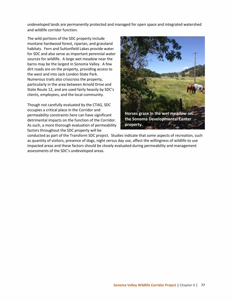
Sonoma Valley Wildlife Corridor Project | Chapter 6 | 77
undeveloped lands are permanently protected and managed for open space and integrated watershed and wildlife corridor function.
The wild portions of the SDC property include montane hardwood forest, riparian, and grassland habitats. Fern and Suttonfield Lakes provide water for SDC and also serve as important perennial water sources for wildlife. A large wet meadow near the barns may be the largest in Sonoma Valley. A few dirt roads are on the property, providing access to the west and into Jack London State Park. Numerous trails also crisscross the property, particularly in the area between Arnold Drive and State Route 12, and are used fairly heavily by SDC’s clients, employees, and the local community. Though not carefully evaluated by the CTAG, SDC occupies a critical place in the Corridor and permeability constraints here can have significant detrimental impacts on the function of the Corridor. As such, a more thorough evaluation of permeability factors throughout the SDC property will be conducted as part of the Transform SDC project. Studies indicate that some aspects of recreation, such as quantity of visitors, presence of dogs, night versus day use, affect the willingness of wildlife to use impacted areas and these factors should be closely evaluated during permeability and management assessments of the SDC’s undeveloped areas.
Horses graze in the wet meadow on the Sonoma Developmental Center property. Preserve.
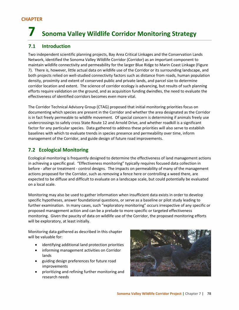
Sonoma Valley Wildlife Corridor Project | Chapter 7 | 78
7 Sonoma Valley Wildlife Corridor Monitoring Strategy
7.1 Introduction Two independent scientific planning projects, Bay Area Critical Linkages and the Conservation Lands Network, identified the Sonoma Valley Wildlife Corridor (Corridor) as an important component to maintain wildlife connectivity and permeability for the larger Blue Ridge to Marin Coast Linkage (Figure 7). There is, however, little actual data on wildlife use of the Corridor or its surrounding landscape, and both projects relied on well-studied connectivity factors such as distance from roads, human population density, proximity and extent of conserved public and private lands, and parcel size to determine corridor location and extent. The science of corridor ecology is advancing, but results of such planning efforts require validation on the ground, and as acquisition funding dwindles, the need to evaluate the effectiveness of identified corridors becomes even more vital. The Corridor Technical Advisory Group (CTAG) proposed that initial monitoring priorities focus on documenting which species are present in the Corridor and whether the area designated as the Corridor is in fact freely permeable to wildlife movement. Of special concern is determining if animals freely use undercrossings to safely cross State Route 12 and Arnold Drive, and whether roadkill is a significant factor for any particular species. Data gathered to address these priorities will also serve to establish baselines with which to evaluate trends in species presence and permeability over time, inform management of the Corridor, and guide design of future road improvements. 7.2 Ecological Monitoring Ecological monitoring is frequently designed to determine the effectiveness of land management actions in achieving a specific goal. “Effectiveness monitoring” typically requires focused data collection in before - after or treatment - control designs. The impacts on permeability of many of the management actions proposed for the Corridor, such as removing a fence here or controlling a weed there, are expected to be diffuse and difficult to evaluate on a landscape scale, but could potentially be evaluated on a local scale. Monitoring may also be used to gather information when insufficient data exists in order to develop specific hypotheses, answer foundational questions, or serve as a baseline or pilot study leading to further examination. In many cases, such “exploratory monitoring” occurs irrespective of any specific or proposed management action and can be a prelude to more specific or targeted effectiveness monitoring. Given the paucity of data on wildlife use of the Corridor, the proposed monitoring efforts will be exploratory, at least initially. Monitoring data gathered as described in this chapter will be valuable for:
• identifying additional land protection priorities • informing management activities on Corridor
lands • guiding design preferences for future road
improvements • prioritizing and refining further monitoring and
research needs
CHAPTER
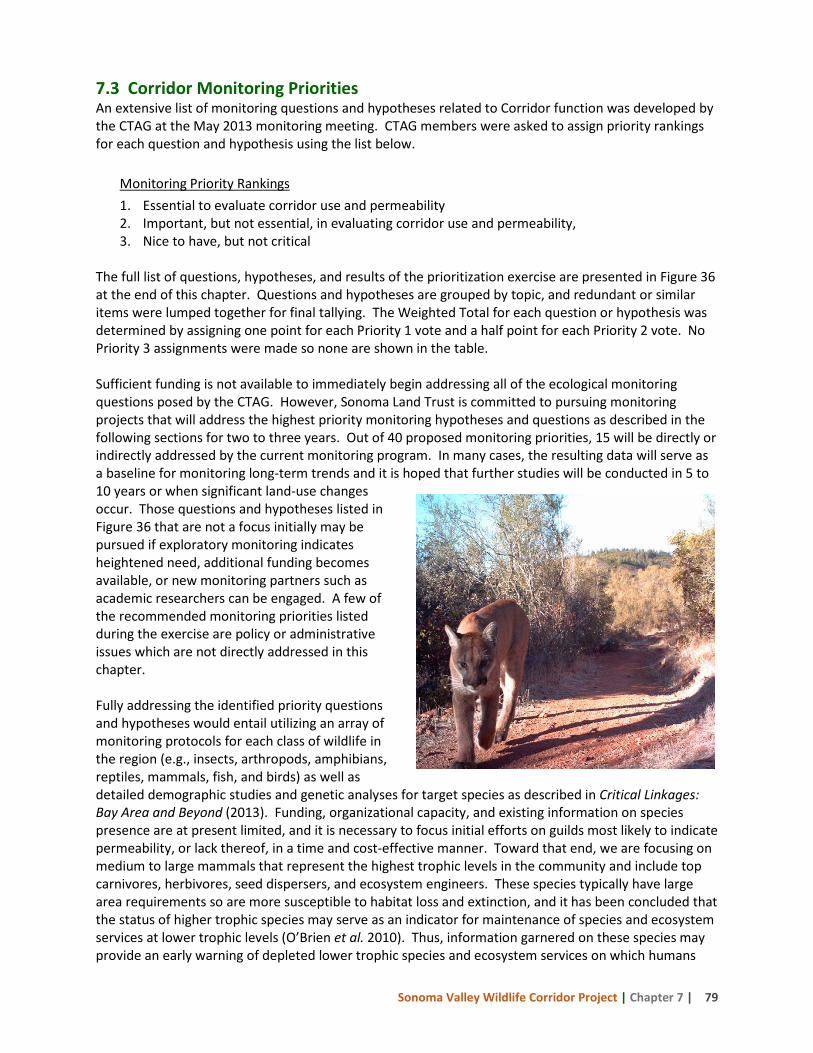
Sonoma Valley Wildlife Corridor Project | Chapter 7 | 79
7.3 Corridor Monitoring Priorities An extensive list of monitoring questions and hypotheses related to Corridor function was developed by the CTAG at the May 2013 monitoring meeting. CTAG members were asked to assign priority rankings for each question and hypothesis using the list below.
Monitoring Priority Rankings 1. Essential to evaluate corridor use and permeability 2. Important, but not essential, in evaluating corridor use and permeability, 3. Nice to have, but not critical
The full list of questions, hypotheses, and results of the prioritization exercise are presented in Figure 36 at the end of this chapter. Questions and hypotheses are grouped by topic, and redundant or similar items were lumped together for final tallying. The Weighted Total for each question or hypothesis was determined by assigning one point for each Priority 1 vote and a half point for each Priority 2 vote. No Priority 3 assignments were made so none are shown in the table. Sufficient funding is not available to immediately begin addressing all of the ecological monitoring questions posed by the CTAG. However, Sonoma Land Trust is committed to pursuing monitoring projects that will address the highest priority monitoring hypotheses and questions as described in the following sections for two to three years. Out of 40 proposed monitoring priorities, 15 will be directly or indirectly addressed by the current monitoring program. In many cases, the resulting data will serve as a baseline for monitoring long-term trends and it is hoped that further studies will be conducted in 5 to 10 years or when significant land-use changes occur. Those questions and hypotheses listed in Figure 36 that are not a focus initially may be pursued if exploratory monitoring indicates heightened need, additional funding becomes available, or new monitoring partners such as academic researchers can be engaged. A few of the recommended monitoring priorities listed during the exercise are policy or administrative issues which are not directly addressed in this chapter. Fully addressing the identified priority questions and hypotheses would entail utilizing an array of monitoring protocols for each class of wildlife in the region (e.g., insects, arthropods, amphibians, reptiles, mammals, fish, and birds) as well as detailed demographic studies and genetic analyses for target species as described in Critical Linkages: Bay Area and Beyond (2013). Funding, organizational capacity, and existing information on species presence are at present limited, and it is necessary to focus initial efforts on guilds most likely to indicate permeability, or lack thereof, in a time and cost-effective manner. Toward that end, we are focusing on medium to large mammals that represent the highest trophic levels in the community and include top carnivores, herbivores, seed dispersers, and ecosystem engineers. These species typically have large area requirements so are more susceptible to habitat loss and extinction, and it has been concluded that the status of higher trophic species may serve as an indicator for maintenance of species and ecosystem services at lower trophic levels (O’Brien et al. 2010). Thus, information garnered on these species may provide an early warning of depleted lower trophic species and ecosystem services on which humans
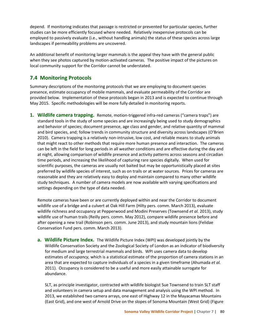
Sonoma Valley Wildlife Corridor Project | Chapter 7 | 80
depend. If monitoring indicates that passage is restricted or prevented for particular species, further studies can be more efficiently focused where needed. Relatively inexpensive protocols can be employed to passively evaluate (i.e., without handling animals) the status of these species across large landscapes if permeability problems are uncovered. An additional benefit of monitoring larger mammals is the appeal they have with the general public when they see photos captured by motion-activated cameras. The positive impact of the pictures on local community support for the Corridor cannot be understated. 7.4 Monitoring Protocols Summary descriptions of the monitoring protocols that we are employing to document species presence, estimate occupancy of mobile mammals, and evaluate permeability of the Corridor are provided below. Implementation of these protocols began in 2013 and is expected to continue through May 2015. Specific methodologies will be more fully detailed in monitoring reports. 1. Wildlife camera trapping. Remote, motion-triggered infra-red cameras (“camera traps”) are
standard tools in the study of some species and are increasingly being used to study demographics and behavior of species; document presence, age class and gender, and relative quantity of mammal and bird species, and; follow trends in community structure and diversity across landscapes (O’Brien 2010). Camera trapping is a relatively non-intrusive, low cost, and reliable means to study animals that might react to other methods that require more human presence and interaction. The cameras can be left in the field for long periods in all weather conditions and are effective during the day and at night, allowing comparison of wildlife presence and activity patterns across seasons and circadian time periods, and increasing the likelihood of capturing rare species digitally. When used for scientific purposes, the cameras are usually not baited but may be opportunistically placed at sites preferred by wildlife species of interest, such as on trails or at water sources. Prices for cameras are reasonable and they are relatively easy to deploy and maintain compared to many other wildlife study techniques. A number of camera models are now available with varying specifications and settings depending on the type of data needed. Remote cameras have been or are currently deployed within and near the Corridor to document wildlife use of a bridge and a culvert at Oak Hill Farm (Hilty pers. comm. March 2013), evaluate wildlife richness and occupancy at Pepperwood and Modini Preserves (Townsend et al. 2013), study wildlife use of human trails (Reilly pers. comm. May 2012), compare wildlife presence before and after opening a new trail (Robinson pers. comm. June 2013), and study mountain lions (Felidae Conservation Fund pers. comm. March 2013).
a. Wildlife Picture Index. The Wildlife Picture Index (WPI) was developed jointly by the
Wildlife Conservation Society and the Zoological Society of London as an indicator of biodiversity for medium and large terrestrial mammals and birds. WPI uses camera data to develop estimates of occupancy, which is a statistical estimate of the proportion of camera stations in an area that are expected to capture individuals of a species in a given timeframe (Ahumada et al. 2011). Occupancy is considered to be a useful and more easily attainable surrogate for abundance.
SLT, as principle investigator, contracted with wildlife biologist Sue Townsend to train SLT staff and volunteers in camera setup and data management and analysis using the WPI method. In 2013, we established two camera arrays, one east of Highway 12 in the Mayacamas Mountains (East Grid), and one west of Arnold Drive on the slopes of Sonoma Mountain (West Grid) (Figure
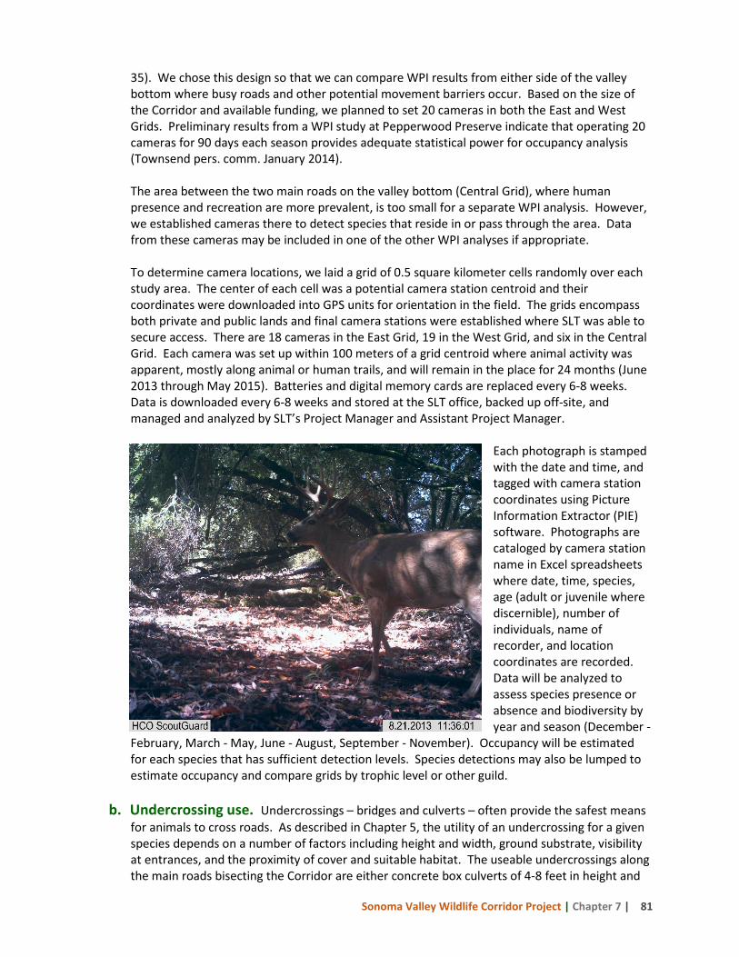
Sonoma Valley Wildlife Corridor Project | Chapter 7 | 81
35). We chose this design so that we can compare WPI results from either side of the valley bottom where busy roads and other potential movement barriers occur. Based on the size of the Corridor and available funding, we planned to set 20 cameras in both the East and West Grids. Preliminary results from a WPI study at Pepperwood Preserve indicate that operating 20 cameras for 90 days each season provides adequate statistical power for occupancy analysis (Townsend pers. comm. January 2014). The area between the two main roads on the valley bottom (Central Grid), where human presence and recreation are more prevalent, is too small for a separate WPI analysis. However, we established cameras there to detect species that reside in or pass through the area. Data from these cameras may be included in one of the other WPI analyses if appropriate.
To determine camera locations, we laid a grid of 0.5 square kilometer cells randomly over each study area. The center of each cell was a potential camera station centroid and their coordinates were downloaded into GPS units for orientation in the field. The grids encompass both private and public lands and final camera stations were established where SLT was able to secure access. There are 18 cameras in the East Grid, 19 in the West Grid, and six in the Central Grid. Each camera was set up within 100 meters of a grid centroid where animal activity was apparent, mostly along animal or human trails, and will remain in the place for 24 months (June 2013 through May 2015). Batteries and digital memory cards are replaced every 6-8 weeks. Data is downloaded every 6-8 weeks and stored at the SLT office, backed up off-site, and managed and analyzed by SLT’s Project Manager and Assistant Project Manager.
Each photograph is stamped with the date and time, and tagged with camera station coordinates using Picture Information Extractor (PIE) software. Photographs are cataloged by camera station name in Excel spreadsheets where date, time, species, age (adult or juvenile where discernible), number of individuals, name of recorder, and location coordinates are recorded. Data will be analyzed to assess species presence or absence and biodiversity by year and season (December -
February, March - May, June - August, September - November). Occupancy will be estimated for each species that has sufficient detection levels. Species detections may also be lumped to estimate occupancy and compare grids by trophic level or other guild.
b. Undercrossing use. Undercrossings – bridges and culverts – often provide the safest means
for animals to cross roads. As described in Chapter 5, the utility of an undercrossing for a given species depends on a number of factors including height and width, ground substrate, visibility at entrances, and the proximity of cover and suitable habitat. The useable undercrossings along the main roads bisecting the Corridor are either concrete box culverts of 4-8 feet in height and
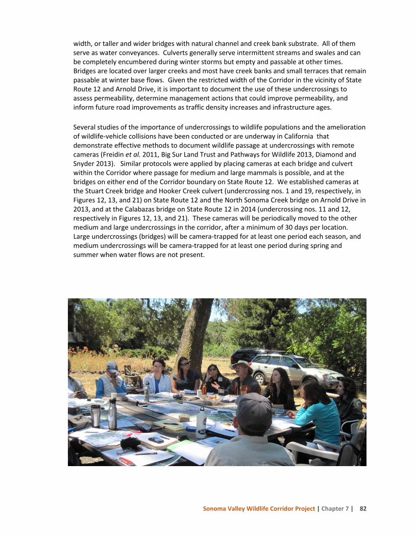
Sonoma Valley Wildlife Corridor Project | Chapter 7 | 82
width, or taller and wider bridges with natural channel and creek bank substrate. All of them serve as water conveyances. Culverts generally serve intermittent streams and swales and can be completely encumbered during winter storms but empty and passable at other times. Bridges are located over larger creeks and most have creek banks and small terraces that remain passable at winter base flows. Given the restricted width of the Corridor in the vicinity of State Route 12 and Arnold Drive, it is important to document the use of these undercrossings to assess permeability, determine management actions that could improve permeability, and inform future road improvements as traffic density increases and infrastructure ages. Several studies of the importance of undercrossings to wildlife populations and the amelioration of wildlife-vehicle collisions have been conducted or are underway in California that demonstrate effective methods to document wildlife passage at undercrossings with remote cameras (Freidin et al. 2011, Big Sur Land Trust and Pathways for Wildlife 2013, Diamond and Snyder 2013). Similar protocols were applied by placing cameras at each bridge and culvert within the Corridor where passage for medium and large mammals is possible, and at the bridges on either end of the Corridor boundary on State Route 12. We established cameras at the Stuart Creek bridge and Hooker Creek culvert (undercrossing nos. 1 and 19, respectively, in Figures 12, 13, and 21) on State Route 12 and the North Sonoma Creek bridge on Arnold Drive in 2013, and at the Calabazas bridge on State Route 12 in 2014 (undercrossing nos. 11 and 12, respectively in Figures 12, 13, and 21). These cameras will be periodically moved to the other medium and large undercrossings in the corridor, after a minimum of 30 days per location. Large undercrossings (bridges) will be camera-trapped for at least one period each season, and medium undercrossings will be camera-trapped for at least one period during spring and summer when water flows are not present.
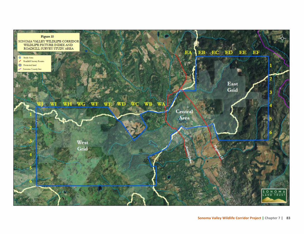
Sonoma Valley Wildlife Corridor Project | Chapter 7 | 83
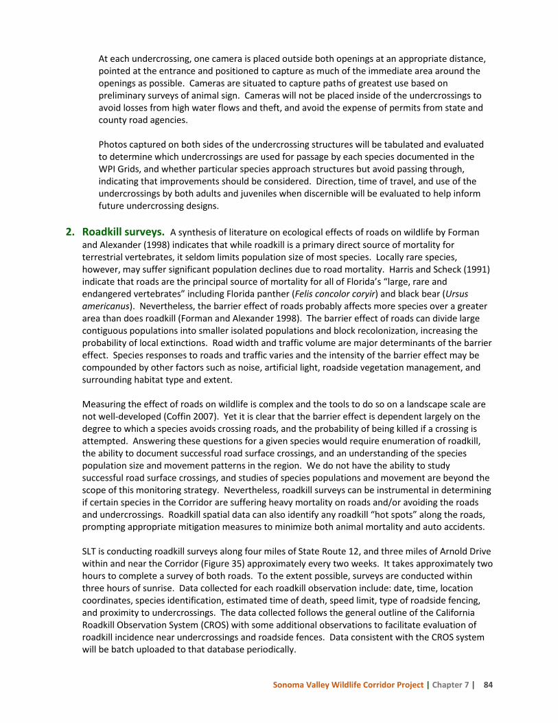
Sonoma Valley Wildlife Corridor Project | Chapter 7 | 84
At each undercrossing, one camera is placed outside both openings at an appropriate distance, pointed at the entrance and positioned to capture as much of the immediate area around the openings as possible. Cameras are situated to capture paths of greatest use based on preliminary surveys of animal sign. Cameras will not be placed inside of the undercrossings to avoid losses from high water flows and theft, and avoid the expense of permits from state and county road agencies.
Photos captured on both sides of the undercrossing structures will be tabulated and evaluated to determine which undercrossings are used for passage by each species documented in the WPI Grids, and whether particular species approach structures but avoid passing through, indicating that improvements should be considered. Direction, time of travel, and use of the undercrossings by both adults and juveniles when discernible will be evaluated to help inform future undercrossing designs.
2. Roadkill surveys. A synthesis of literature on ecological effects of roads on wildlife by Forman
and Alexander (1998) indicates that while roadkill is a primary direct source of mortality for terrestrial vertebrates, it seldom limits population size of most species. Locally rare species, however, may suffer significant population declines due to road mortality. Harris and Scheck (1991) indicate that roads are the principal source of mortality for all of Florida’s “large, rare and endangered vertebrates” including Florida panther (Felis concolor coryir) and black bear (Ursus americanus). Nevertheless, the barrier effect of roads probably affects more species over a greater area than does roadkill (Forman and Alexander 1998). The barrier effect of roads can divide large contiguous populations into smaller isolated populations and block recolonization, increasing the probability of local extinctions. Road width and traffic volume are major determinants of the barrier effect. Species responses to roads and traffic varies and the intensity of the barrier effect may be compounded by other factors such as noise, artificial light, roadside vegetation management, and surrounding habitat type and extent.
Measuring the effect of roads on wildlife is complex and the tools to do so on a landscape scale are not well-developed (Coffin 2007). Yet it is clear that the barrier effect is dependent largely on the degree to which a species avoids crossing roads, and the probability of being killed if a crossing is attempted. Answering these questions for a given species would require enumeration of roadkill, the ability to document successful road surface crossings, and an understanding of the species population size and movement patterns in the region. We do not have the ability to study successful road surface crossings, and studies of species populations and movement are beyond the scope of this monitoring strategy. Nevertheless, roadkill surveys can be instrumental in determining if certain species in the Corridor are suffering heavy mortality on roads and/or avoiding the roads and undercrossings. Roadkill spatial data can also identify any roadkill “hot spots” along the roads, prompting appropriate mitigation measures to minimize both animal mortality and auto accidents.
SLT is conducting roadkill surveys along four miles of State Route 12, and three miles of Arnold Drive within and near the Corridor (Figure 35) approximately every two weeks. It takes approximately two hours to complete a survey of both roads. To the extent possible, surveys are conducted within three hours of sunrise. Data collected for each roadkill observation include: date, time, location coordinates, species identification, estimated time of death, speed limit, type of roadside fencing, and proximity to undercrossings. The data collected follows the general outline of the California Roadkill Observation System (CROS) with some additional observations to facilitate evaluation of roadkill incidence near undercrossings and roadside fences. Data consistent with the CROS system will be batch uploaded to that database periodically.
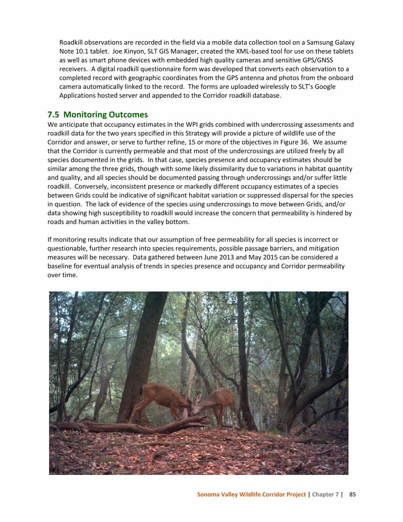
Sonoma Valley Wildlife Corridor Project | Chapter 7 | 85
Roadkill observations are recorded in the field via a mobile data collection tool on a Samsung Galaxy Note 10.1 tablet. Joe Kinyon, SLT GIS Manager, created the XML-based tool for use on these tablets as well as smart phone devices with embedded high quality cameras and sensitive GPS/GNSS receivers. A digital roadkill questionnaire form was developed that converts each observation to a completed record with geographic coordinates from the GPS antenna and photos from the onboard camera automatically linked to the record. The forms are uploaded wirelessly to SLT’s Google Applications hosted server and appended to the Corridor roadkill database.
7.5 Monitoring Outcomes We anticipate that occupancy estimates in the WPI grids combined with undercrossing assessments and roadkill data for the two years specified in this Strategy will provide a picture of wildlife use of the Corridor and answer, or serve to further refine, 15 or more of the objectives in Figure 36. We assume that the Corridor is currently permeable and that most of the undercrossings are utilized freely by all species documented in the grids. In that case, species presence and occupancy estimates should be similar among the three grids, though with some likely dissimilarity due to variations in habitat quantity and quality, and all species should be documented passing through undercrossings and/or suffer little roadkill. Conversely, inconsistent presence or markedly different occupancy estimates of a species between Grids could be indicative of significant habitat variation or suppressed dispersal for the species in question. The lack of evidence of the species using undercrossings to move between Grids, and/or data showing high susceptibility to roadkill would increase the concern that permeability is hindered by roads and human activities in the valley bottom. If monitoring results indicate that our assumption of free permeability for all species is incorrect or questionable, further research into species requirements, possible passage barriers, and mitigation measures will be necessary. Data gathered between June 2013 and May 2015 can be considered a baseline for eventual analysis of trends in species presence and occupancy and Corridor permeability over time.
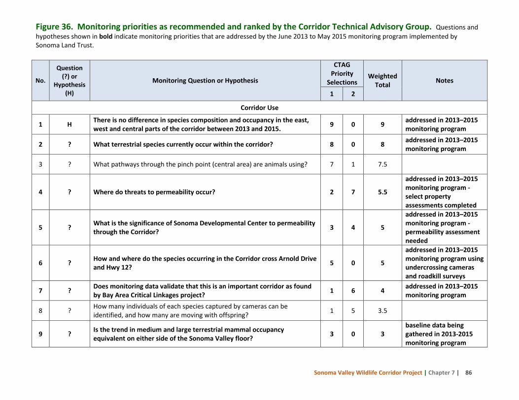
Sonoma Valley Wildlife Corridor Project | Chapter 7 | 86
No.
Question (?) or
Hypothesis (H)
Monitoring Question or Hypothesis
CTAG Priority
Selections Weighted
Total Notes
1 2
Corridor Use
1 H There is no difference in species composition and occupancy in the east, west and central parts of the corridor between 2013 and 2015. 9 0 9 addressed in 2013–2015
monitoring program
2 ? What terrestrial species currently occur within the corridor? 8 0 8 addressed in 2013–2015 monitoring program
3 ? What pathways through the pinch point (central area) are animals using? 7 1 7.5
4 ? Where do threats to permeability occur? 2 7 5.5
addressed in 2013–2015 monitoring program - select property assessments completed
5 ? What is the significance of Sonoma Developmental Center to permeability through the Corridor? 3 4 5
addressed in 2013–2015 monitoring program - permeability assessment needed
6 ? How and where do the species occurring in the Corridor cross Arnold Drive and Hwy 12? 5 0 5
addressed in 2013–2015 monitoring program using undercrossing cameras and roadkill surveys
7 ? Does monitoring data validate that this is an important corridor as found by Bay Area Critical Linkages project? 1 6 4 addressed in 2013–2015
monitoring program
8 ? How many individuals of each species captured by cameras can be identified, and how many are moving with offspring? 1 5 3.5
9 ? Is the trend in medium and large terrestrial mammal occupancy equivalent on either side of the Sonoma Valley floor? 3 0 3
baseline data being gathered in 2013-2015 monitoring program
Figure 36. Monitoring priorities as recommended and ranked by the Corridor Technical Advisory Group. Questions and hypotheses shown in bold indicate monitoring priorities that are addressed by the June 2013 to May 2015 monitoring program implemented by Sonoma Land Trust.
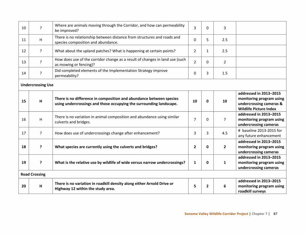
Sonoma Valley Wildlife Corridor Project | Chapter 7 | 87
10 ? Where are animals moving through the Corridor, and how can permeability be improved? 3 0 3
11 H There is no relationship between distance from structures and roads and species composition and abundance. 0 5 2.5
12 ? What about the upland patches? What is happening at certain points? 2 1 2.5
13 ? How does use of the corridor change as a result of changes in land use (such as mowing or fencing)? 2 0 2
14 ? Did completed elements of the Implementation Strategy improve permeability? 0 3 1.5
Undercrossing Use
15 H There is no difference in composition and abundance between species using undercrossings and those occupying the surrounding landscape. 10 0 10
addressed in 2013–2015 monitoring program using undercrossing cameras & Wildlife Picture Index
16 H There is no variation in animal composition and abundance using similar culverts and bridges. 7 0 7
addressed in 2013–2015 monitoring program using undercrossing cameras
17 ? How does use of undercrossings change after enhancement? 3 3 4.5 # baseline 2013-2015 for any future enhancement
18 ? What species are currently using the culverts and bridges? 2 0 2 addressed in 2013–2015 monitoring program using undercrossing cameras
19 ? What is the relative use by wildlife of wide versus narrow undercrossings? 1 0 1 addressed in 2013–2015 monitoring program using undercrossing cameras
Road Crossing
20 H There is no variation in roadkill density along either Arnold Drive or Highway 12 within the study area. 5 2 6
addressed in 2013–2015 monitoring program using roadkill surveys
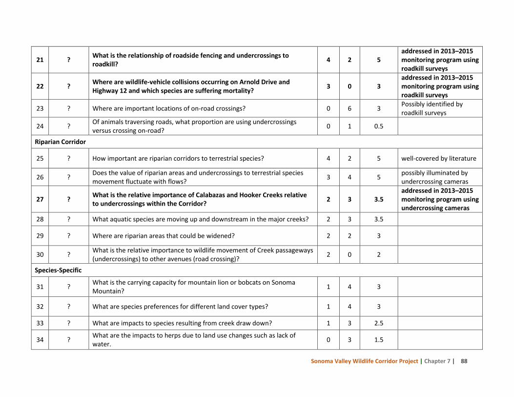
Sonoma Valley Wildlife Corridor Project | Chapter 7 | 88
21 ? What is the relationship of roadside fencing and undercrossings to roadkill? 4 2 5
addressed in 2013–2015 monitoring program using roadkill surveys
22 ? Where are wildlife-vehicle collisions occurring on Arnold Drive and Highway 12 and which species are suffering mortality? 3 0 3
addressed in 2013–2015 monitoring program using roadkill surveys
23 ? Where are important locations of on-road crossings? 0 6 3 Possibly identified by roadkill surveys
24 ? Of animals traversing roads, what proportion are using undercrossings versus crossing on-road? 0 1 0.5
Riparian Corridor
25 ? How important are riparian corridors to terrestrial species? 4 2 5 well-covered by literature
26 ? Does the value of riparian areas and undercrossings to terrestrial species movement fluctuate with flows? 3 4 5 possibly illuminated by
undercrossing cameras
27 ? What is the relative importance of Calabazas and Hooker Creeks relative to undercrossings within the Corridor? 2 3 3.5
addressed in 2013–2015 monitoring program using undercrossing cameras
28 ? What aquatic species are moving up and downstream in the major creeks? 2 3 3.5
29 ? Where are riparian areas that could be widened? 2 2 3
30 ? What is the relative importance to wildlife movement of Creek passageways (undercrossings) to other avenues (road crossing)? 2 0 2
Species-Specific
31 ? What is the carrying capacity for mountain lion or bobcats on Sonoma Mountain? 1 4 3
32 ? What are species preferences for different land cover types? 1 4 3
33 ? What are impacts to species resulting from creek draw down? 1 3 2.5
34 ? What are the impacts to herps due to land use changes such as lack of water. 0 3 1.5
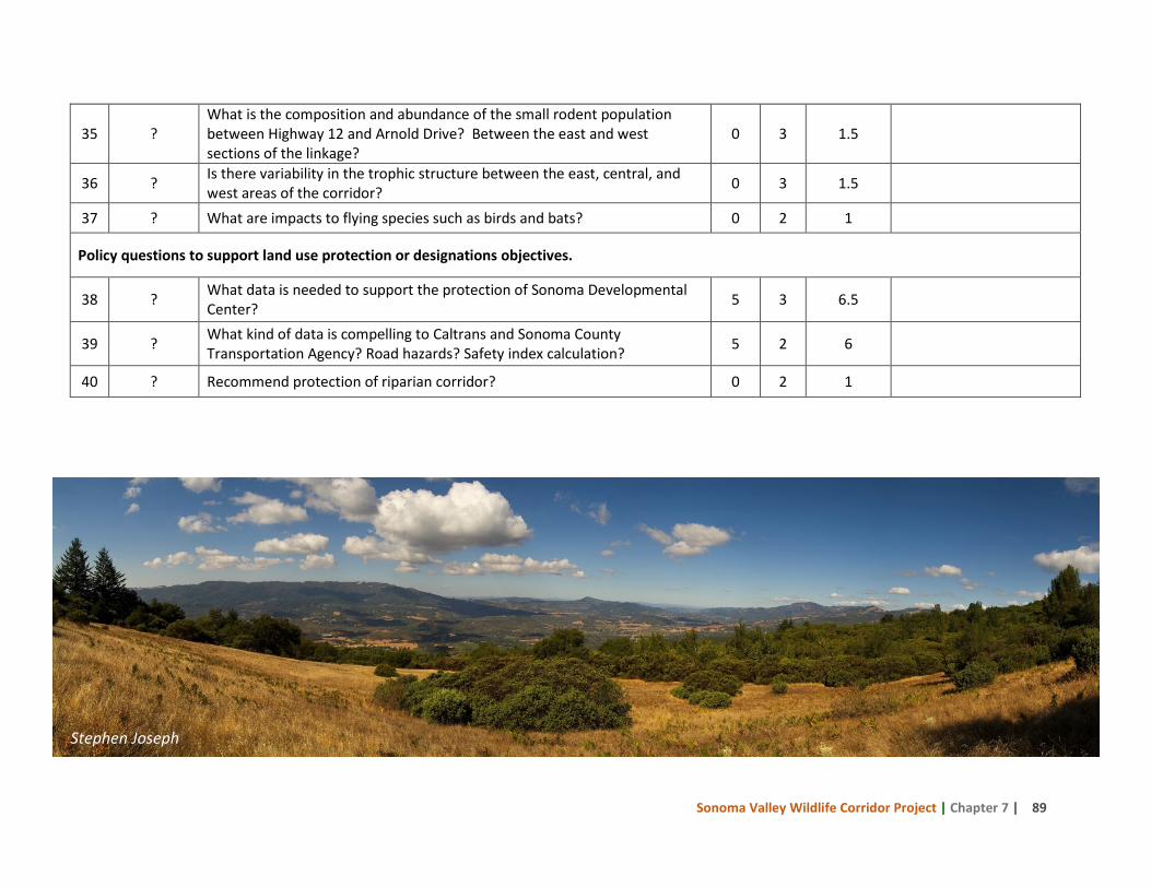
Sonoma Valley Wildlife Corridor Project | Chapter 7 | 89
35 ? What is the composition and abundance of the small rodent population between Highway 12 and Arnold Drive? Between the east and west sections of the linkage?
0 3 1.5
36 ? Is there variability in the trophic structure between the east, central, and west areas of the corridor? 0 3 1.5
37 ? What are impacts to flying species such as birds and bats? 0 2 1
Policy questions to support land use protection or designations objectives.
38 ? What data is needed to support the protection of Sonoma Developmental Center? 5 3 6.5
39 ? What kind of data is compelling to Caltrans and Sonoma County Transportation Agency? Road hazards? Safety index calculation? 5 2 6
40 ? Recommend protection of riparian corridor? 0 2 1
Stephen Joseph
Sonoma Valley Wildlife Corridor Project | Chapter 8 | 90
8 Recommendations to Maintain and Enhance Sonoma Valley Wildlife Corridor Permeability
The Sonoma Valley Wildlife Corridor continues to function for wildlife passage but opportunities remain to enhance permeability. Recommendations to maintain and improve the functionality of the Corridor have been made in the preceding chapters and these are summarized below. Implementing these recommendations should safeguard and enhance permeability while monitoring will develop a baseline and help evaluate success. 8.1 Implement the monitoring strategy and use the results to enhance Corridor
permeability. Finalizing and implementing the Sonoma Valley Wildlife Corridor monitoring strategy is essential to provide insight into what species are in which areas and what species are using the crossing structures, and document permeability throughout the Corridor. In addition to establishing a baseline, the data gathered will inform additional conservation and management actions that may be necessary to sustain or improve wildlife permeability. Adaptive management based on the results from the monitoring strategy will assist with evaluating success and identify any adjustments that may be needed to maintain and enhance permeability. 8.2 Carry out the recommendations for the Corridor properties with completed
permeability assessments. Chapter 6 details management actions to improve permeability on the six properties that were the focus of the Corridor Technical Advisory Group site evaluations. Corridor advocates should begin working with the landowners to implement the recommendations. 8.3 Limit habitat conversion.
8.3.1 Continue to use fee, conservation easement, or deed restriction acquisition to protect key properties. Sonoma Land Trust and Sonoma County Agricultural Preservation and Open Space District, along with other organizations, have conserved 5,058 acres in the Corridor to date. Where there are willing sellers, permanent protection options should be pursued. SLT will be negotiating with two property owners in the Corridor to enter into cooperative agreements or place deed restrictions that require compliance with wildlife corridor management guidelines.
8.3.2 Secure the permanent conservation of Sonoma Developmental Center. Sonoma Land Trust and other Corridor advocates are participating in a coalition that is negotiating for the permanent protection of the Sonoma Developmental Center wildlands as the state evaluates alternatives for the future of the facility.
8.3.3 Advocate for the implementation of the Habitat Connectivity Corridor recommendations in the Sonoma County General Plan 2020. Corridor advocates should use the Sonoma County General Plan Habitat Connectivity Corridor land use designation and riparian restrictions as tools to discourage future developments within the Corridor. Corridor advocates should also assist the County with developing a riparian corridor ordinance, rezoning the Habitat Connectivity Corridors as Biotic Habitat Areas, and establishing a companion
CHAPTER
Sonoma Valley Wildlife Corridor Project | Chapter 8 | 91
ordinance that encourages property owners to consult with California Department of Fish and Wildlife, install wildlife friendly fencing, and provide for roadway undercrossings that allow for the movement of wildlife. Efforts are underway at Sonoma County Planning and Resource Management Department to develop a riparian corridor ordinance that may be followed by a biotic habitat ordinance (Lyle pers. comm. March 2014). These objectives give the Project partners new regulatory tools to protect the integrity of the corridor when new construction is proposed on parcels within the corridor.
8.4 Develop and implement outreach strategies for key audiences in the Sonoma Valley Wildlife Corridor. Several different types of landowners are found in the Corridor – residential, agricultural, and conservation (both public and nonprofit). Drafting an outreach plan that identifies key audiences, messages for each audience, and a strategy for implementing the plan can focus limited resources. Outreach materials should describe the importance of the region for wildlife movement and include wildlife corridor management guidelines to maintain or improve wildlife passage. Draft Sonoma Valley Wildlife Corridor Guidelines are in Figure 37. Key audiences are described below.
8.4.1 Residential landowners. Conducting outreach activities for private residential landowners within the Corridor can increase awareness of the Corridor’s significance and result in some property management changes. An example of outreach materials for residential landowners from the Santa Clara River Watershed is in Figure 38. Ideas for outreach activities include starting a voluntary group of landowners focused on stewardship for wildlife corridor permeability (Hilty et al. 2006), hosting workshops on wildlife corridor management, distributing outreach materials to local organizations, developing a calendar with wildlife corridor management activities for different months, and preparing public service announcements for local television stations.
8.4.2 Agricultural landowners. Several vineyards are located within and adjacent to the Corridor. Some vineyard owners have expressed interest in exploring ways to improve permeability for wildlife. Partnering with groups such as the Sonoma Resource Conservation District and Natural Resources Conservation Service can be especially helpful in providing technical and financial assistance to agricultural landowners who want to modify fencing or management practices.
8.4.3 Public and private conservation landowners. As Figure 10 indicates, several public and private conservation landowners hold land in the Corridor including Sonoma County Agricultural Preservation and Open Space District, Audubon Canyon Ranch, Sonoma Mountain Ranch Preservation Foundation, California State Parks, and Sonoma County Regional Parks. Corridor advocates should meet with representatives of these organizations to present the results of the Sonoma Valley Wildlife Corridor Management and Monitoring Strategy and encourage the use of wildlife passage management practices. Working with Sonoma County Parks on potential changes in management at Sonoma Valley Regional Park, as well as the adjoining Sonoma Developmental Center property, will be essential to minimize recreational use impacts.
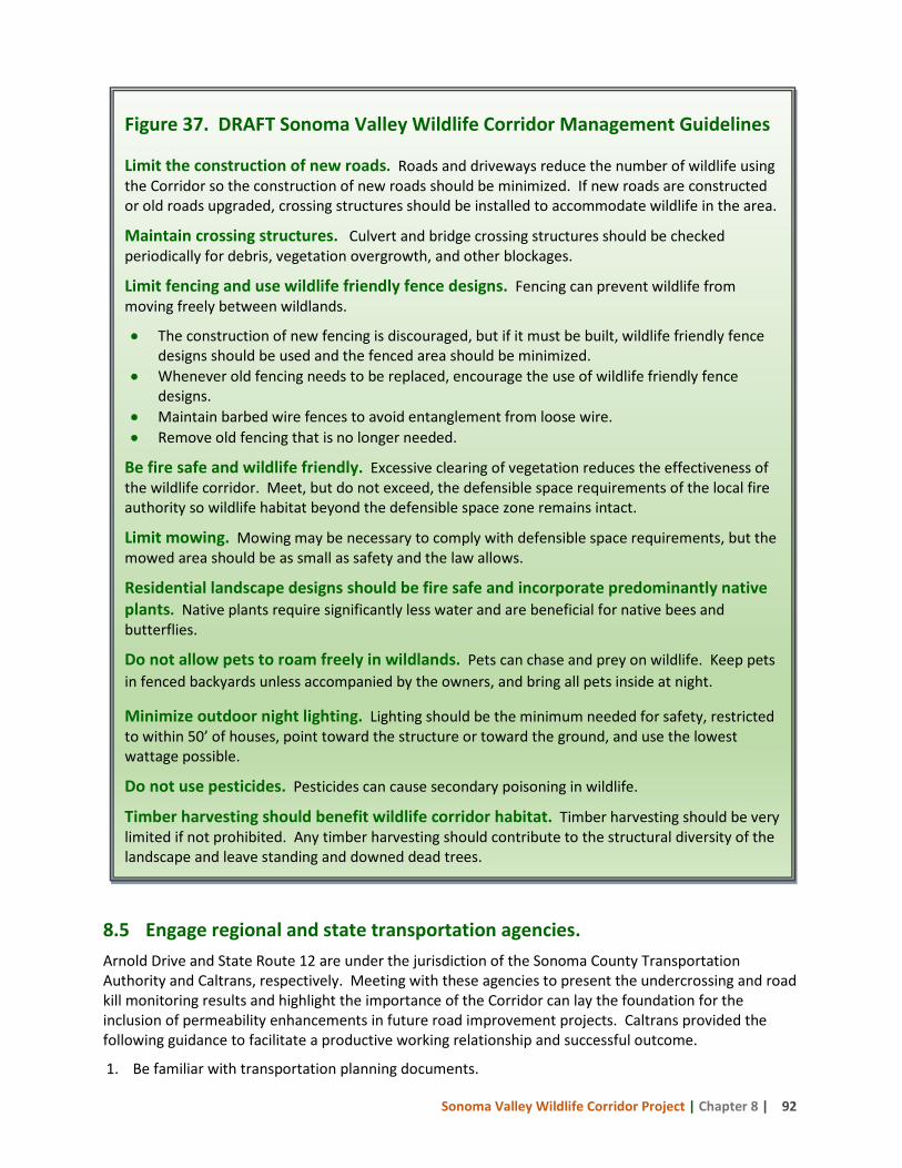
Sonoma Valley Wildlife Corridor Project | Chapter 8 | 92
Figure 37. DRAFT Sonoma Valley Wildlife Corridor Management Guidelines Limit the construction of new roads. Roads and driveways reduce the number of wildlife using the Corridor so the construction of new roads should be minimized. If new roads are constructed or old roads upgraded, crossing structures should be installed to accommodate wildlife in the area.
Maintain crossing structures. Culvert and bridge crossing structures should be checked periodically for debris, vegetation overgrowth, and other blockages.
Limit fencing and use wildlife friendly fence designs. Fencing can prevent wildlife from moving freely between wildlands.
• The construction of new fencing is discouraged, but if it must be built, wildlife friendly fence designs should be used and the fenced area should be minimized.
• Whenever old fencing needs to be replaced, encourage the use of wildlife friendly fence designs.
• Maintain barbed wire fences to avoid entanglement from loose wire. • Remove old fencing that is no longer needed.
Be fire safe and wildlife friendly. Excessive clearing of vegetation reduces the effectiveness of the wildlife corridor. Meet, but do not exceed, the defensible space requirements of the local fire authority so wildlife habitat beyond the defensible space zone remains intact.
Limit mowing. Mowing may be necessary to comply with defensible space requirements, but the mowed area should be as small as safety and the law allows.
Residential landscape designs should be fire safe and incorporate predominantly native plants. Native plants require significantly less water and are beneficial for native bees and butterflies.
Do not allow pets to roam freely in wildlands. Pets can chase and prey on wildlife. Keep pets in fenced backyards unless accompanied by the owners, and bring all pets inside at night.
Minimize outdoor night lighting. Lighting should be the minimum needed for safety, restricted to within 50’ of houses, point toward the structure or toward the ground, and use the lowest wattage possible.
Do not use pesticides. Pesticides can cause secondary poisoning in wildlife.
Timber harvesting should benefit wildlife corridor habitat. Timber harvesting should be very limited if not prohibited. Any timber harvesting should contribute to the structural diversity of the landscape and leave standing and downed dead trees.
8.5 Engage regional and state transportation agencies. Arnold Drive and State Route 12 are under the jurisdiction of the Sonoma County Transportation Authority and Caltrans, respectively. Meeting with these agencies to present the undercrossing and road kill monitoring results and highlight the importance of the Corridor can lay the foundation for the inclusion of permeability enhancements in future road improvement projects. Caltrans provided the following guidance to facilitate a productive working relationship and successful outcome.
1. Be familiar with transportation planning documents.
Sonoma Valley Wildlife Corridor Project | Chapter 8 | 93
a. Transportation Concept Reports are long-term strategies with a 25-year time frame. b. A Project Initiation Document is developed at the start of each new project, approximately
4-6 years prior to implementation, and is the best stage to work with Caltrans to include a wildlife focus.
c. State Transportation Improvement Plan. d. Regional Transportation Improvement Plan.
2. When proposing wildlife elements for a road project:
a. Be sure the proposal addresses the interests of all of the Caltrans departments involved in the planning, e.g., esthetics, maintenance, engineers, etc.
b. Justify the inclusion of wildlife elements into road improvement projects by using all available data including:
o Hot Spot analysis using carcass removal data from Caltrans and Sonoma County Public Works, as well as TASUS data on vehicle collisions maintained by the California Highway Patrol.
o Road kill data gathered by Corridor advocates. o Results of planning efforts demonstrating the need for improvement.
c. Use the crossing and road kill data to illustrate the need for the proposal. d. The proposed structure or management methods should not be experimental and should
have documented results. e. Keep the cost and maintenance of the proposed project as low as possible. f. Engage the California Department of Fish and Wildlife early in process. Caltrans looks to the
Department for guidance on wildlife needs.
8.6 Meet with fire officials to address concerns regarding wildfire and the application of defensible space requirements. CAL FIRE is the responsible agency for much of the Sonoma Valley Wildlife Corridor while the Sonoma Valley Fire Department has responsibility for the developed areas. Meeting with both of these agencies to communicate impacts to wildlife from both wildfire and excessive or inappropriate vegetation removal by landowners creating defensible space could advance the adaptation of fire and fuels goals that are wildlife friendly. Landowners would benefit from the same information. For example, Fire Safe Sonoma makes presentations to neighborhood groups that they call “The Wildlife Wise Acre.” Corridor advocates should work with knowledgeable presenters to provide information about wildlife friendly fire and vegetation management in the Corridor to community and neighborhood groups. 8.7 Complete Permeability Evaluations for Bouverie Preserve, Sonoma Valley Regional Park and Sonoma Developmental Center. Bouverie Preserve, Sonoma Valley Regional Park, and Sonoma Developmental Center are key properties in the heart of the Sonoma Valley Wildlife Corridor. More detailed permeability evaluations of these properties should be conducted to determine if there are opportunities to enhance conditions for successful wildlife passage.
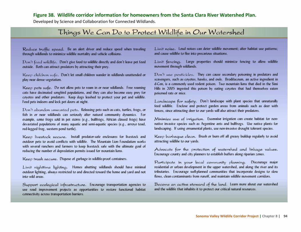
Sonoma Valley Wildlife Corridor Project | Chapter 8 | 94
Figure 38. Wildlife corridor information for homeowners from the Santa Clara River Watershed Plan. Developed by Science and Collaboration for Connected Wildlands.
Sonoma Valley Wildlife Corridor Project | References | 95
References Ahumada, JA, Silva, CEF, Gajapersad, K, Hallam, C, Hurtado, J, Martin, E, McWilliam, A, Mugerwa, B, T. O’Brien, T, Rovero, F, Sheil, D, Spironello, WR, Winarni, N, Andelman, SJ. 2011. Community structure and diversity of tropical forest mammals: data from a global camera trap network. Phil. Trans. R. Soc. Bio. Sci. 366:2703-2711.
Arizona Game and Fish Department. March 2013. Wildlife Friendly Guidelines: Community and Project Planning.
Bay Area Open Space Council. 2011. The Conservation Lands Network: San Francisco Bay Area Upland Habitat Goals Project Report. Berkeley, CA. www.bayarealands.org
Becker, GS, Reining, IJ, Asbury DA, Gunther, A. 2007. San Francisco Estuary Watersheds Evaluation: Identifying Promising Locations for Steelhead Restoration in Tributaries of the San Francisco Estuary. Center for Ecosystem Management and Restoration, Oakland, CA.
Beier, P, Majka D, Newell S, Garding E, January 2008. Best Management Practices for Wildlife Corridors. Northern Arizona University.
Big Sur Land Trust and Pathways for Wildlife. 2013. The CA Central Coast Connectivity Project Story 2008-2012: Identification of Habitat Linkages, Habitat Used By Wildlife, & Lessons Learned. 29pp.
Brudin III, CO. 2003. Wildlife use of existing culverts and bridges in north central Pennsylvania. ICOET 2003.
California Department of Fish and Game. 1997. Letter to Michael S. Cannon, Department of General Services on disposal of Sonoma Developmental Center lands.
Caltrans. 2012. 2012 Traffic Volumes on California State Highways, Sacramento, CA.
Clevenger, A.P., B. Chruszcz, and K. Gunson. 2001. Drainage culverts as habitat linkages and factors affecting passage by mammals. Journal of Applied Ecology 38: 1340-1349.
Clevenger, A.P., B. Chruszcz, and K.E. Gunson. 2003. Spatial patterns and factors influencing small vertebrate fauna road-kill aggregations. Biological Conservation 109: 15-26.
Clevenger, AP, Waltho, N. 2000. Factors influencing the effectiveness of wildlife underpasses in Banff National Park, Alberta, Canada. Conservation Biology 14: 47-56.
Clevenger, AP, Waltho, N. 2005. Performance indices to identify attributes of highway crossing structures facilitating movement of large mammals. Biological Conservation 121: 453-464.
Coffin, AW. 2007. From roadkill to road ecology: A review of the ecological effects of roads. J. Trans. Geog. 15:396-406.
Colby, B, Wishart, S. 2002. Riparian areas generate property value premium for landowners. Agricultural and Resource Economics, Arizona State University, Tucson, AZ. 15p. http://ag.arizona.edu/arec/pubs/riparianreportweb.pdf
Cornwall, C, Davis, M. July 2003. Fencing Guidelines and Specifications for Conservation Easements, Sonoma Ecology Center, prepared for Sonoma County Agricultural Preservation and Open Space District. http://www.sonoma-county.org/public_reports/documents/district_fencing_ guidelines.pdf
Crooks, KR, Soule, M. 1999. Mesopredator release and avifaunal extinctions in a fragmented system. Nature 400:563–566.
Sonoma Valley Wildlife Corridor Project | References | 96
Davis, M. January 2003. Wildlife Use and Habitat Connectivity on Private Lands in the Sonoma Valley Habitat Corridor, Sonoma Ecology Center.
Dawson A. January 2005. Sonoma Creek Watershed Historic Salmonid Habitat and Abundance GIS Mapping Project. Sonoma Valley Historical Ecology Project. Sonoma Ecology Center.
Diamond, T. August 27, 2014. Personal communication.
Diamond, T, Snyder, A. 2013. The Nature Conservancy’s Pajaro Study 2012-2013. Report to The Nature Conservancy. 28pp.
Dodd, CK, Barichivich, WJ, Smith, LL. 2004. Effectiveness of a barrier wall and culverts in reducing wildlife mortality on a heavily traveled highway in Florida. Biological Conservation 118:619-631.
Environmental Law Institute. 2003. Conservation thresholds for land use planners. Environmental Law Institute. Washington D.C. www.elistore.org
Feldhamer, GA, Gates, JE, Harman, DM, Loranger, AJ, Dixon, KR. 1986. Effects of interstate highway fencing on white-tailed deer activity. Journal of Wildlife Management 50:497–503.
Fire Safe Sonoma. Living with Fire in Sonoma County. www.firesafesonoma.org/main/
Fisher, RA, Fischenich, JC. 2000. Design recommendations for riparian corridors and vegetated buffer strips. U.S. Army Engineer Research and Development Center. ERDC-TN-EMRRPSR-24.
Forman, RT, Alexander, LE. 1998. Roads and their major ecological effects. Annu. Rev. Ecol. Syst. 29:207-231.
Forman, RT, Sperling, D, Bissonette, JA, Clevenger, AP, Cutshall, CD, Dale, VH, Fahrig, L, France, R, Goldman, CR, Heanue, K, Jones, JA, Swanson, FJ, Turrentine, T, Winter, TC. 2003. Road Ecology: Science and Solutions. Island Press, Washington, D. C. 481 pp.
Freidin, R, Schreck, D, Scruggs, B, Shulman, E, Swauger, A, Tashnek, A. 2011. Wildlife Use of the Los Pinetos Underpass Santa Clarita, California. UCLA Institute of the Environment and Sustainability, Senior Practicum in Environmental Science. 39pp.
Harris, LD, Scheck, J. 1991. From Implications to applications: the dispersal corridor principle applied to the conservation of biological diversity. In: Saunders, D.A. and R.J. Hobbs, (Eds), Nature Conservation 2: The role of corridors. Surrey Beatty, Chipping Norton, Australia. pp 189-220.
Hilty, J, March 2013. Personal communication.
Hilty, JA, Lidicker, WZ, Merenlender, AM. 2006. Corridor Ecology: The Science and Practice of Linking Landscapes for Biodiversity Conservation. Island Press.
Hilty, JA, Merenlender, AM. November/December 2002. Wildlife Activity along Creek Corridors. Practical Winery and Vineyard Journal. Dept. of Environmental Science, Policy, & Management, University of California, Berkeley.
Katopothis, C, Micheli, L, Orme, M, Rossi, C, Branciforte, R. 2005. Fish Passage Barrier Assessment in Sonoma Creek Watershed Final Report. Sonoma Ecology Center.
Keeley, J. 2010. Fire on California Landscapes. Fremontia: Volume 38:2/38:3.
Knight, RL, Cole, DN. 1995. Wildlife Responses to Recreationists. In: Knight, RL, Gutzwiller, eds. Wildlife and recreationists, coexistence through management and research. Island Press. Washington, DC.
Leidy, RA. June 2008. Essential Watersheds and Priority Stream Segments for Focused Conservation Actions to Protect Native Fishes, San Francisco Estuary, California. San Francisco, CA.
Sonoma Valley Wildlife Corridor Project | References | 97
LSA Associates, Inc. April 2003. Final Report, Sonoma Developmental Center Upper Watershed Land-Use Alternatives Study. California Department of General Services, and Department of Developmental Services.
LSA Associates, Inc. May 30, 2001. Sonoma Developmental Center Land Use Feasibility Study. Prepared for the California Department of General Services.
Longcore, T, Rich, C, 2004. Ecological Light Pollution. Frontiers in Ecology and the Environment 2(4): 191-198.
Lyle, AW. March 2014. Personal communication. Sonoma County Planning and Resource Management Department.
Maine Department of Transportation. 2001. Collisions between large wildlife species and motor vehicles in Maine, Interim Report. www.maine.gov/mdot/safety-programs/pdf/
McGourty, GT, Ohmart, D, Chaney, D. 2011. Organic Winegrowing Manual. University of California Agricultural and Natural Resources. Davis, CA.
Meese, RJ, Shilling, FM, Quinn, JF. October 2007. Wildlife Crossings Guidance Manual. California Department of Transportation. Information Center for the Environment, Department of Environmental Science and Policy, University of California, One Shields Avenue, Davis, CA 95616.
McDonald, Z. March 2013. Personal communication. Felidae Conservation Fund.
Merenlender, AM, Reed, SE, Heise, KL. 2009. Exurban Development Influences Woodland Bird Composition. Landscape and Urban Planning, Landscape and Urban Planning 92:255-263.
Metro. April 2010. Wildlife corridors and permeability: A literature review. Metro. Portland, Oregon.
Montana Fish Wildlife and Parks. 2012. Landowners’ Guide to Wildlife Friendly Fencing: How to Build Fence with Wildlife in Mind, Second Edition. fwp.mt.gov/fwpDoc.html?id=34461
Naiman, R J, Decamps, H, Pollock, M. 1993. The role of riparian corridors in maintaining regional biodiversity. Ecological Applications 3: 209-212.
Ng, SJ, Dole, JW, Sauvajot, RM, Riley, SPD, Valone, TJ. 2004. Use of highway undercrossings by wildlife in southern California. Biological Conservation 115:499-507.
Prunuske Chatham, Inc. 2013. Wildlife Composition Assessment, Sonoma Valley Wildlife Corridor (Draft). Prepared for Sonoma Land Trust.
O’Brien, T. 2010. Wildlife Picture Index: Implementation Manual Version 1.0. Wildlife Conservation Society Working Paper No. 39. 36pp.
O’Brien, TG, Baillie JEM, Krueger, L, Cuke, M. 2010. The Wildlife Picture Index: monitoring top trophic levels. Anim. Cons. 13:335-343.
RHJV (Riparian Habitat Joint Venture). 2004. Version 2.0. The riparian bird conservation plan: a strategy for reversing the decline of riparian associated birds in California. California Partners in Flight. www.prbo.org/calpif/pdfs/riparian.v-2.pdf
Reed, DF, Woodard, TN. 1981. Effectiveness of Highway Lighting in Reducing Deer-Vehicle Accidents. Journal of Wildlife Management. 45(2): 721-726. Year: 1981.
Reilly, M. May 2013. Personal communication. Doctoral candidate, Northern Arizona University, Flagstaff.
Rich, C, Longcore, T, editors. 2004. Ecological Consequences of Artificial Night Lighting, Island Press.
Sonoma Valley Wildlife Corridor Project | References | 98
Robinson, T. June 2013. Personal communication. Sonoma County Agricultural Preservation and Open Space District. Santa Rosa, California.
Sawyer, J, Keeler-Wolf, T, Evens, J. 2009. A Manual of California Vegetation. Second Edition. California Native Plant Society and California Department of Fish and Wildlife. Sacramento, CA.
Science and Collaboration for Connected Wildlands. 2013. Critical Linkages: The Bay Area and Beyond.
Shafroth, PB, Stromberg, JC, Patten, DT. 2002. Riparian vegetation response to altered disturbance and stress regimes. Ecological Applications 12: 107-123.
Sonoma County General Plan 2020, Open Space and Resource Conservation Element.
Stromberg, J. 2000. Parts 1-3: Restoration of riparian vegetation in the arid Southwest: challenges and opportunities. Arizona Riparian Council Newsletter vol. 13 no. 1-3. Arizona Riparian Council. Tempe, Arizona. www.azriparian.asu.edu/newsletters.htm
Tam, K. April 2014. Personal communication. Sonoma County Regional Parks.
Townsend, S. January 2014. Personal communication. Connectivity for Wildlife.
Townsend, S, Halbur, M, Micheli, L. 2013. Wildlife Camera Studies at Pepperwood 2011-2013. Dwight Center for Conservation Science Technical Report. 21pp. California.
Viegas, DX, Allgöwer, B, Koutsias, N, Eftichidis, G. 2003. Fire spread and the wildland urban interface problem. Ch. 12 in Proceedings of the International Scientific Workshop on Forest Fires in the Wildland-Urban Interface and Rural Areas in Europe: an integral planning and management challenge.
Warner, P. 2013. Vegetation Survey Reports for Glen Oaks Ranch, Curreri, and Secret Pasture. Commissioned by Sonoma Land Trust.
Wenger, SJ. 1999. A review of the scientific literature on riparian buffer width, extent and vegetation. Athens, GA: University of Georgia, Public Service & Outreach, Institute of Ecology. 59 p.
Wenger, SJ, Fowler, L. 2000. Protecting stream and river corridors. Policy Notes, Public Policy Research Series vol 1, no. 1. Carl Vinson Institute of Government, University of Georgia, Athens, GA. Available online: http://www.cviog.uga.edu/publications/pprs/96.pdf.
White, PA, Ernst, M. 2003. Second Nature: Improving Transportation without putting Nature Second. Defenders of Wildlife publication, Washington, DC.
Wissmar, RC. 2004. Riparian corridors of Eastern Oregon and Washington: Functions and sustainability along lowland-arid to mountain gradients. Aquatic Sciences 66: 373-387.
Yanes, M, Velasco, JM, Suárez, F. 1995. Permeability of roads and railways to vertebrates: the importance of culverts. Biological Conservation 71: 217-222.