Embed Size (px)
Citation preview
a Corresponding author: [email protected]
Some experience in numerical modelling of unsaturated slope instabilities
Josif Josifovski1 and Stanislav Lenart
2
1 Faculty of Civil Engineering, Ss. Cyril and Methodius University, Skopje, Republic of Macedonia
2 Slovenian National Building and Civil Engineering Institute, Ljubljana, Slovenia
Abstract. In the past couple years, the region of South-East Europe is subjected to gust rainfall events activating
many landslides which cause significant material and human losses. To revaluate the existing risk maps and set new
standards some old case histories are revaluated. This paper presents two case histories of landslide instabilities
subjected to excess climatic perturbations, gust rainfall, namely the «Stanjevci» cut-slope near the railway line in
North-East of Slovenia; and the «Ramina» a natural landslide in urban area near the city of Veles in Central
Macedonia. They are briefly described later to be analysed using coupled thermo-mechanical calculations. They are
subjected to specific short and gusting rainfall considered as possible trigger. Hence, van Genuchten’s hydraulic
model is used in combination with elastoplastic material models. The results are summarized with critical comments
regarding the mathematical formulation used to describe atmospheric-soil interaction and the influence of different
aspects on the accuracy is discussed briefly.
1 Introduction
Many new landsliding occurrences have been recorded in
the past couple of years, in South-East Europe as a
consequence of climate change and storm rainfall. If this
trend continues, the landslides could cause significant
devastation to infrastructure and human life. This requires
that the existing risk maps to be revaluated thoroughly,
based on advanced calculations that include the effects of
saturation or partial saturation of the soil on slope
stability [3].
The behaviour of the slopes is controlled by their hydro-
mechanical conditions and by soil-atmosphere
interaction. The pore water pressure changes within a
slope in some cases significantly reducing the soil
strength. Climatic factors such as precipitation,
evapotranspiration and runoff may also have a substantial
impact on slope stability.
In terms of numerical modelling, the stability analysis of
partially saturated slopes is a complex problem with
many variables. The more advanced approaches require
input data obtained from the Soil Water Retention Curve
(SWRC) and the unsaturated hydraulic conductivity
function. Moreover, the time dependent hydro-
mechanical behaviour of the soil should be described in a
coupled format, taking both deformation and
groundwater flow into account, in which mixed equations
of displacement and pore pressure, called, have to be
solved simultaneously in a coupled hydro-mechanical
approach [9].
Advanced numerical model with definitions of climate-
soil system is used to determine the rainfall influence on
the slope failure. Conclusive discussion of the simulated
hydro–mechanical numerical effects with suggestions for
possible model improvements is presented at the end.
2 Site descriptions
The analysis considers two different slope instabilities,
namely, the «Stanjevci» cut-slope near the railway line in
North-East of Slovenia; and the «Ramina» a natural
landslide in urban area near the city of Veles in Central
Macedonia. In the following text they are briefly
described through their geo-hydro-mechanical
characteristics.
2.1 The «Ramina» case history
Macedonia is situated on the southern part of Balkan
Peninsula as mountainous country 79 % are hills and
mountains with mean altitude of 832 m with large areas
of erodible soils and rocks, steep slopes. Most hillslopes
are composed of crystalline rocks (gneiss, mica-schists,
other schists), sandstones, lacustrine and river deposits –
all of them highly erodible. Mean topographic slope of
the country is 13.5° with 39.5 % of the area steeper than
15° [5].
The influence of Continental and Mediterranean climate
in Macedonia unequally spreads the precipitations
through throughout the year with intensity between 400-
900 mm/year, thus long-time arid periods from (summer-
autumn) and short wet seasons exist. According to the
precipitation data for the period 2007-2010 there is
evident increase in the precipitation (Table 1).
DOI: 10.1051/08005 (2016), 9
E 2016-
E3S Web of Conferences e3sconf/20160908005UNSAT
© The Authors, published by EDP Sciences. This is an open access article distributed under the terms of the Creative Commons Attribution License 4.0 (http://creativecommons.org/licenses/by/4.0/).
The «Ramina» is natural landslide located in highly
urbanized hilly area of city Veles, Macedonia, on the left
bank of the river Vardar. In the past it had been
reactivated several times, last time in 2002 with major
deformations leading to severe damage of the
infrastructure and buildings.
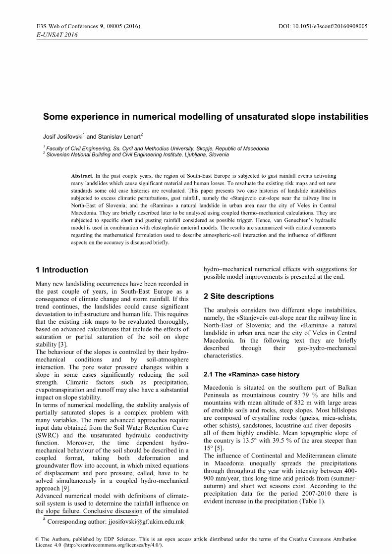
Figure 1. Simplified Engineering Geological map of «Ramina»
landslide.
A season of gust rainfall in period from December to
March averages with monthly precipitation of around 140
mm/month or as maximal daily precipitation of 70 mm.
The elevation of the slope is around 1000 m above sea
level sited on the transition of relatively steep mountain
slopes to a river valley. Actually, it is attacked by a
surface and ground water from wider catchment area,
moreover there is no vegetation to reduce the effects of
heavy rainfall events. The average slope angle is around
15º and maximal 22º. The landslide is about 500 m long
with average width of about 100 m and height of 95 m
(Fig. 1). The estimated maximum depth of the shear zone
is 24 m. The sliding system is comprised of two parts
(Fig.2), the «upper» with a length of 350 m, width 110 m,
height 60 m and «lower» with length of 200 m, width 90
m, height 35 m and depth up to 18 m. The total area of
the landslide is estimated to be 37,600 m2 with around
475,200 m3 of sliding mass, ranking it as the biggest in
the Balkans, and possibly in South East Europe [4].
Table 1. Precipitations in the analysed case histories.
Site Stanjevci, SLO Ramina, MK
Year Precip.
(mm/y)
Max precip.
(mm/month)
Precip.
(mm/y)
Max precip.
(mm/month)
2000 719.1 44.4 - -
2001 595.2 30 - -
2002 847.5 79.2 - -
2003 554.1 33 - -
2004 1032.4 38 - -
2005 851.2 79.2 - -
2006 828.5 75 - -
2007 895.4 79.2 498.7 140.0
2008 929.7 52 438.5 78.5
2009 - - 642.6 104.3
2010 - - 900.0 108.2
Avg 805.9 56.7 626.9 107.7
r. Vardar
160.00
220.00
180.00 D-11N
200.00
240.00
D-10ND-2ND-12N
GWL
Sam,py
PG,col
D-1
Sam,py
RZ
PG,colD-3
D-4N RZ
R
D-1N
0 50 100 m
Scale Profile 1-1
Green schists (Palaeozoic bedrock)Sam,py
Artificial material, embankment in a zone of landslide
River deposits, sandy gravel
Sandy clay, locally with bouldersin a landslide body
PG,Bcol
PCal
N
Fault zone BoreholesD-1 N
River deposits,claylike siltGPRal
Main zone of sliding
Figure 2. Typical geological profile of «Ramina» landslide.
The geotechnical investigations indicate a sliding zone on
the contact between weathered bedrock (Palaeozoic
amphibolitic schists, highly foliated and faulted) and low
plasticity claylike mass. The hydrogeological conditions
indicate that the zones with increased water contents are
related to the sliding zone. Also, a slight sub-artesian
effect is found in almost all boreholes [5]. The GWL has
been detected at 8 m of depth while in the lower part it
was around 2 m below the terrain.
2.2 The «Stajcevci» case history
Slovenia is a southern Central European country located
at the junction of three important geotectonic units: the
Alps at the north, the Dinaric Alps at the south and the
Pannonian Basin at the east. The territory of Slovenia is
mostly mountainous with a mainly continental climate.
Additionally, coastal part of the country has sub-
DOI: 10.1051/08005 (2016), 9
E 2016-
E3S Web of Conferences e3sconf/20160908005UNSAT
2
Mediterranean climate and the north-western part has an
Alpine climate. Diversity in every aspects of nature is a
trade mark of country. Slovenia is located in temperate
latitudes. The climate is also influenced by the variety of
relief, and the influence of the Alps and the Adriatic Sea.
In the Northeast, the continental climate type with
greatest difference between winter and summer
temperatures prevails. In the coastal region, there is sub-
Mediterranean climate. The effect of the sea on the
temperature rates is visible also up the Soča valley, while
a severe Alpine climate is present in the high mountain
regions. There is a strong interaction between these three
climatic systems across most of the country [13].
Precipitation varies across the country as well. Average
rainfall depth exceeds 3,500 mm/year in some Western
regions and dropping down to 800 mm/year in
northeastern part of the country. In the winter, also snow
is quite frequent.
A seemingly almost routine railway cut slope, beside
railway tunnel «Stajcevci» on the railway line between
Murska Sobota and Hodoš in northeastern part of
Slovenia, was constructed in the first half of early year
2000. Tunnel and cut slope passed through Pliocenne soil
layers: sand with gravel, silt and clay in subhorizontal
orientations [6]. Although the cut slope was made in
gentle slope not steep, stability problems arose already
during the construction works, particularly due to
saturated silty-sand layers covered by clay and low
cohesion of saturated contact between clay and silty-sand.
Stanjevci tunnel and the cut slope in its vicinity are
located in the northern, central part of the Goričko hills in
north-eastern Slovenia, that are dominated by sediments
of the middle Pliocene, both marine and brackish, as well
as fluvial and lacustrine origin. Generally, sediments of
Goričko hills belong to tectonic zone of the Pannonian
basin. Unstable cut slope above railway line near
Stanjevci tunnel is located in the middle Pliocene
sediments PL2, which passes in the middle Miocene
(tortonium) layers that lie discordantly on the Paleozoic
metamorphic rocks. The estimated thickness of Tertiary
sediments in the area of the landslide is approximately
2000 m. General dip of the layers of the Tertiary
sediments and contact with Paleozoic rocks is
approximately 10° towards the SSE.
a)
b)
Figure 3. (a) The «Stajcevci» cut-slope: (a) Plan view on cut-slope near the tunnel and (b) Simplified geological profile of the
excavated slope.
DOI: 10.1051/08005 (2016), 9
E 2016-
E3S Web of Conferences e3sconf/20160908005UNSAT
3
The landslide is located on the hillside, where a cut slope
was made with slope direction towards north. The
excavation pit is in the deepest part more than 30 m deep.
At the time of the pit excavation an extensive
geotechnical investigation was performed to support
stabilization measures. In the vicinity of the landslide
there are no recorded tectonic structures. The
precipitation data [12] in the period 2000-2008 was taken
with maximal values in the analysis (Table 1).
3 Numerical modelling
To analyse mechanical behaviour of saturated or partially
saturated soils by means of numerical method e.g. finite
element method, in proper manner, it is necessary to take
into account both deformation and groundwater flow. For
time dependent behaviour, this leads to mixed equations
of displacement and pore pressure, called coupled hydro-
mechanical approach, which have to be solved
simultaneously [2].
The task was to perform a coupled hydro-mechanical
analysis of slope stability on the presented case histories.
The calculation was performed using the finite element
software Plaxis [1] which enables fully coupled hydro-
mechanical analysis. This type of analysis is able
properly to evaluate the effects of rainfall and water
infiltration on the slope stability. The shear strength of
the unsaturated soil has been examined based on effective
stress concept considering suction. The finite element
method with shear strength reduction technique was
employed to evaluate the stability using the factor of
safety (FoS). For the soil material an elastic-perfectly
plastic small strain Mohr-Coulomb (MC) model was
employed with special attention put on definition of
mechanical and hydraulic parameters critical for realistic
simulation. According to the available data, a
conservative choice has been taken. For simplicity a
homogeneous profile is assumed with soil parameters
given in Table 2.
Table 2. Soil material parameters for MC model.
Case (material) Ramina
(Sandy-Clay) Stajcevci
(Clay) Unit weight
(kN/m3)
20.14 20.2
Eff. friction angle
’ (0) 23 22
Eff. Cohesion
c’ (kPa) 12 15
Eff. Poisson’s
ratio’ (/) 0.32 0.30
Elastic modulus
E’ (kPa) 10000 7000
For definition of the hydraulic models at the Slovenian
National Building and Civil Engineering Institute
tensiometer laboratory test were performed to determined
the suction in the material samples for different water
content. Through the measured data a nonlinear SWRC
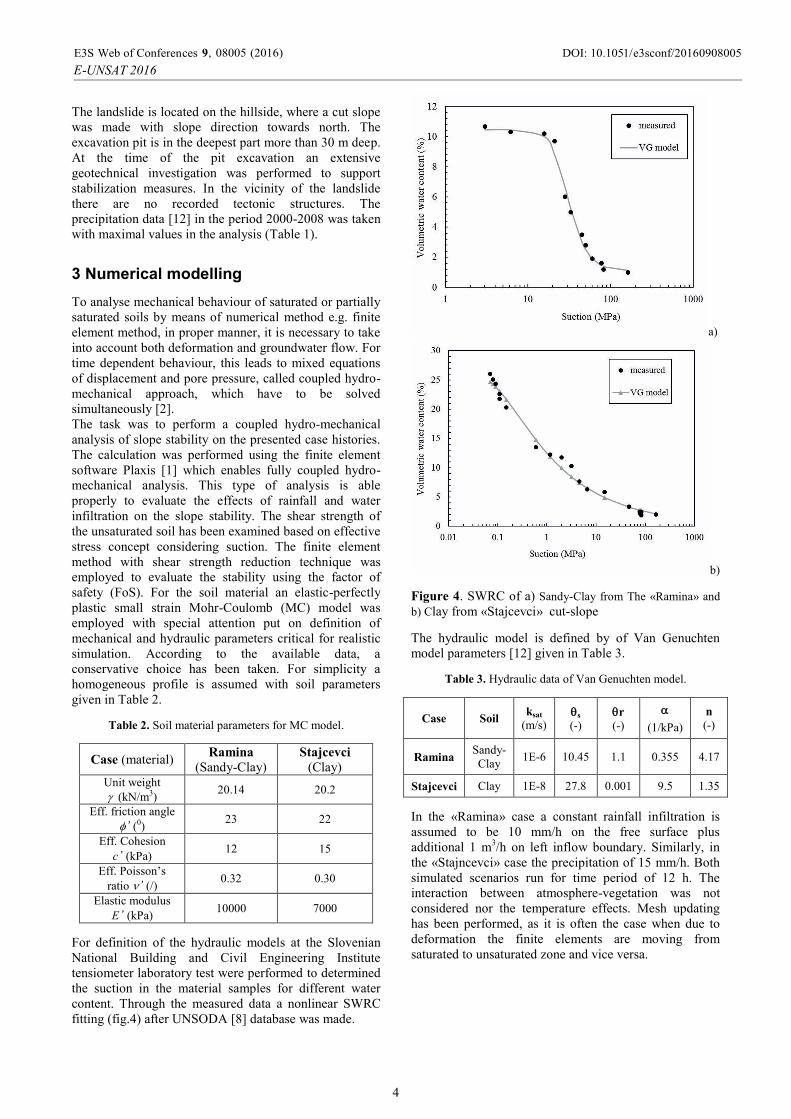
fitting (fig.4) after UNSODA [8] database was made.
a)
b)
Figure 4. SWRC of a) Sandy-Clay from The «Ramina» and
b) Clay from «Stajcevci» cut-slope
The hydraulic model is defined by of Van Genuchten
model parameters [12] given in Table 3.
Table 3. Hydraulic data of Van Genuchten model.
Case Soil ksat
(m/s) s
(-)
r
(-)
(1/kPa)
n
(-)
Ramina Sandy-
Clay 1E-6 10.45 1.1 0.355 4.17
Stajcevci Clay 1E-8 27.8 0.001 9.5 1.35
In the «Ramina» case a constant rainfall infiltration is
assumed to be 10 mm/h on the free surface plus
additional 1 m3/h on left inflow boundary. Similarly, in
the «Stajncevci» case the precipitation of 15 mm/h. Both
simulated scenarios run for time period of 12 h. The
interaction between atmosphere-vegetation was not
considered nor the temperature effects. Mesh updating
has been performed, as it is often the case when due to
deformation the finite elements are moving from
saturated to unsaturated zone and vice versa.
DOI: 10.1051/08005 (2016), 9
E 2016-
E3S Web of Conferences e3sconf/20160908005UNSAT
4
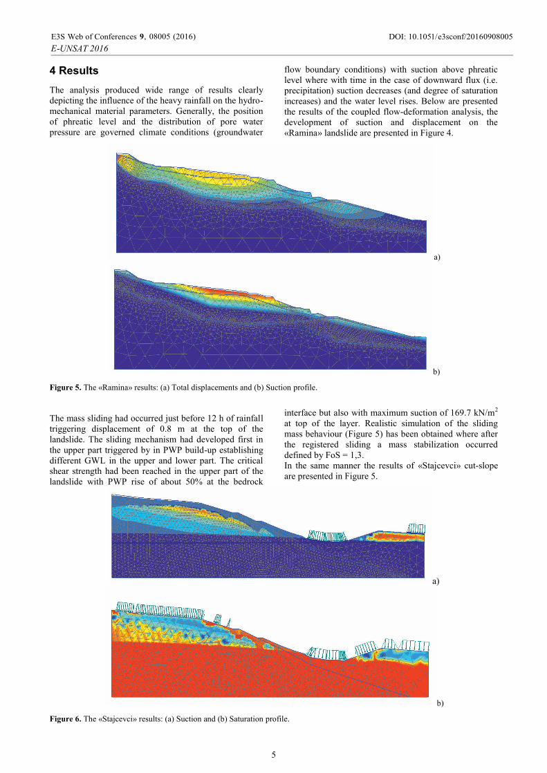
4 Results
The analysis produced wide range of results clearly
depicting the influence of the heavy rainfall on the hydro-
mechanical material parameters. Generally, the position
of phreatic level and the distribution of pore water
pressure are governed climate conditions (groundwater
flow boundary conditions) with suction above phreatic
level where with time in the case of downward flux (i.e.
precipitation) suction decreases (and degree of saturation
increases) and the water level rises. Below are presented
the results of the coupled flow-deformation analysis, the
development of suction and displacement on the
«Ramina» landslide are presented in Figure 4.
a)
b)
Figure 5. The «Ramina» results: (a) Total displacements and (b) Suction profile.
The mass sliding had occurred just before 12 h of rainfall
triggering displacement of 0.8 m at the top of the
landslide. The sliding mechanism had developed first in
the upper part triggered by in PWP build-up establishing
different GWL in the upper and lower part. The critical
shear strength had been reached in the upper part of the
landslide with PWP rise of about 50% at the bedrock
interface but also with maximum suction of 169.7 kN/m2
at top of the layer. Realistic simulation of the sliding
mass behaviour (Figure 5) has been obtained where after
the registered sliding a mass stabilization occurred
defined by FoS = 1,3.
In the same manner the results of «Stajcevci» cut-slope
are presented in Figure 5.
a)
b)
Figure 6. The «Stajcevci» results: (a) Suction and (b) Saturation profile.
DOI: 10.1051/08005 (2016), 9
E 2016-
E3S Web of Conferences e3sconf/20160908005UNSAT
5
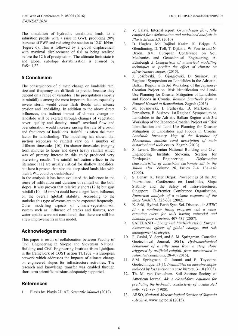
The simulation of hydraulic conditions leads to a
saturation profile with a raise in GWL producing 20%
increase of PWP and reducing the suction to 12.81 kN/m2
(Figure 6). This is followed by a global displacement
with maximal displacement of 0.6 m being realized
before the 12 h of precipitation. The ultimate limit state is
and global cut-slope destabilization is ensured by
FoS= 1,22.
5 Conclusion
The consequences of climate change on landslide rate,
size and frequency are difficult to predict because they
depend on a range of variables. The precipitation (mostly
in rainfall) is among the most important factors especially
severe storm would cause flash floods with intense
erosion and landsliding. In addition to the above direct
influences, the indirect impact of climate change on
landslide will be exerted through changes of vegetation
cover, quality and density, runoff, overland flow and
oversaturation would increase raising the rate of erosion
and frequency of landslides. Rainfall is often the main
factor for landslinding. The modelling has shown that
suction responses to rainfall vary on a number of
different timescales [10]. On shorter timescales (ranging
from minutes to hours and days) heavy rainfall which
was of primary interest in this study produced very
interesting results. The rainfall infiltration effects in the
literature [11] are usually critical for shallow landslides,
but here it proven that also the deep sited landslides with
high GWL could be destabilized.
In the analysis it has been evaluated the influence in the
sense of infiltration and duration of rainfall on the both
slopes. It was proven that relatively short (12 h) but gust
rainfall (10 - 15 mm/h) could have a significant influence
on the overall (global) stability. According to the
statistics this type of events are to be expected frequently.
Other modelling aspects of climate-vegetation-soil
system such as: influence of cracks and fissures, root
water uptake were not considered, thus there are still but
a few improvements in this model.
Acknowledgements
This paper is result of collaboration between Faculty of
Civil Engineering in Skopje and Slovenian National
Building and Civil Engineering Institute from Ljubljana
in the framework of COST action TU1202 – a European
network which addresses the impacts of climate change
on engineered slopes for infrastructure activities. The
research and knowledge transfer was enabled through
short term scientific missions adequately supported.
References
1. Plaxis bv. Plaxis 2D AE. Scientific Manuel (2012).
2. V. Galavi, Internal report: Groundwater flow, fully
coupled flow deformation and undrained analysis in
Plaxis 2d and 3D. (2010)
3. D. Hughes, Md Rajibul Karim, K. Briggs, S.
Glendinning, D. Toll, T. Dijkstra, W. Powrie and N.
Dixon. XVI European Conference on Soil
Mechanics and Geotechnical Engineering, At
Edinburgh A Comparison of numerical modelling
techniques to predict the effect of climate on
infrastructure slopes, (2015).
4. J. Josifovski, S. Gjorgjevski, B. Susinov. 1st
Regional Symposium on Landslides in the Adriatic-
Balkan Region with 3rd Workshop of the Japanese-
Croatian Project on ‘Risk Identification and Land-
Use Planning for Disaster Mitigation of Landslides
and Floods in Croatia. Ramina Landslide from a
Natural Hazard to Remediation. Zagreb (2013)
5. M. Jovanovski, I. Peshevski, B. Markoski, S.
Petrusheva, B. Susinov. 1st Regional Symposium on
Landslides in the Adriatic-Balkan Region with 3rd
Workshop of the Japanese-Croatian Project on ‘Risk
Identification and Land-Use Planning for Disaster
Mitigation of Landslides and Floods in Croatia.
Landslide Inventory Map of the Republic of
Macedonia, statistic sand description of main
historical and slide events. Zagreb (2013).
6. S. Lenart. Slovenian National Building and Civil
Engineering Institute Slovenia, Section for
Earthquake Engineering. Deformation
characteristics of lacustrine carbonate silt in the
Julian Alps. Volume 26, Issues 2–4. 131–142
(2006).
7. S. Lenart, K. Fifer Bizjak. Proceedings of the 3rd
International Conference on Landslides, Slope
Stability and the Safety of Infra-Structures,
Singapore: Ci-Premier Conference Organisation,
Numerical analysis of a seismic response of the
Stože landslide, 325-331 (2002).
8. K. Seki, Hydrol. Earth Syst. Sci. Discuss., 4: SWRC
fit - a nonlinear fitting program with a water
retention curve for soils having unimodal and
bimodal pore structure. 407-437 (2007).
9. SAFELAND – Living with landslide risk in Europe:
Assessment, effects of global change, and risk
management strategies.
10. F. Casini, V. Serri, and S. M. Springman. Canadian
Geotechnical Journal, 50(1): Hydromechanical
behaviour of a silty sand from a steep slope
triggered by artificial rainfall: from unsaturated to
saturated conditions, 28-40 (2015).
11. S.M. Springman, C. Jommi and P. Teysseire.
Géotechnique, 53(1). Instabilities on moraine slopes
induced by loss suction: a case history, 3–10 (2003).
12. Th. M. van Genuchten. Soil Science Society of
American Journal, 44: A closed-form equation for
predicting the hydraulic conductivity of unsaturated
soils. 892–898 (1980).
13. ARSO, National Meteorological Service of Slovenia
- Archive. www.meteo.si (2015).
DOI: 10.1051/08005 (2016), 9
E 2016-
E3S Web of Conferences e3sconf/20160908005UNSAT
6