Embed Size (px)
Citation preview
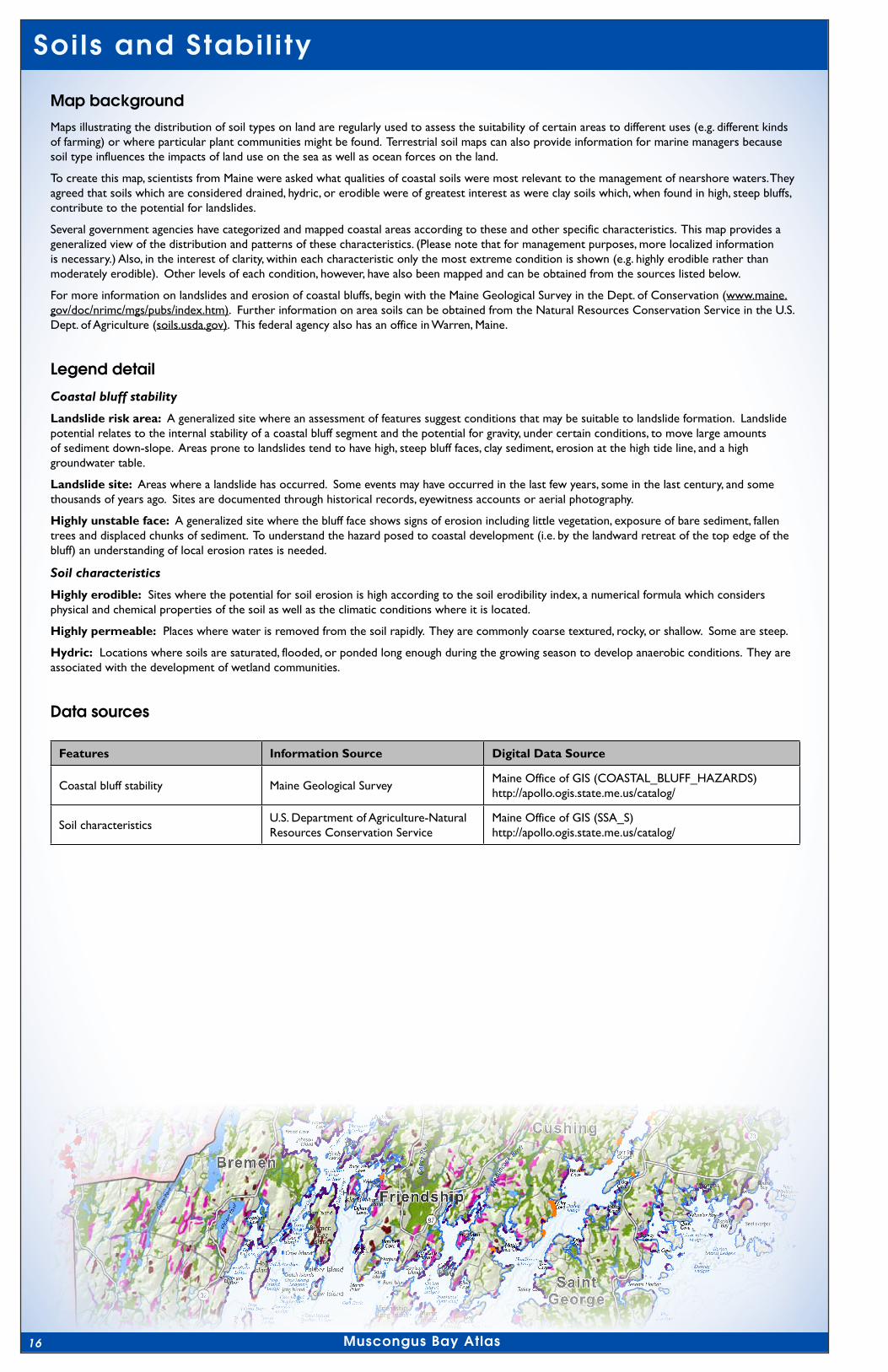
Soi ls and Stabi l i ty
Haddock IslandKelp Ledge
Little EggRock Shoals
NortheastPoint
Ledges
Cow IslandDry Ledges
Egg RockNorth Ledge
Egg RockSouth Ledge
HaddockIsland Ledge
Gunning Rock Shoal
Pola
ndLe
dge
s
PumpkinCove Ledge
WebberNorthLedge
SoutheastBreaker
GooseRock Ledge
Old CilleyLedge
Salt PondLedge
Bay CoveLedge
Mosquito Ledge
Pemaquid Ledge
Midway Rocks
RoaringBull
JenksLedge
KelpLedges
AllenShoal
InnerLedge
Gig Rock
Garden IslandSouth Ledge
New HarborSunken Ledges
Cow IslandSunken Ledges
Little FranklinLedge
New HarborDry Ledges
CrotchIslandLedges
MetinicIsland Ledge
NortheastPoint Reef
NortonIsland Ledges
WebberSunkenLedge
WreckIsland Ledges
BlackIsland Ledge
Clark IslandLedge
Hart IslandLedges
OtterIslandLedge
LongIslandLedges
HarborIslandRock
Cow IslandLedges
BrownsHeadLedge
PolinsEast
Ledge
BeyerShip Ledge
Inner Shag LedgeOuter Shag Ledge
HogIslandLedge
Webber DryLedge
Bar IslandLedge
Sunken DuckRock
Old HorseLedge
Old WomanLedge
HendersonLedge
Gull Rock Ledge
Old HumpLedge
MarshallLedge
HalftideLedge
HogIsland Bar
ThrumcapLedge
GangwayLedge
HarpoonLedge
Old ManLedge
SeaveyLedges
GriffinLedge
HaddockLedge
ThompsonRock
HavenerLedge
Middle Ledges
Polins Ledges
BaileyLedge
Barter Shoal
HupperShoal
ChannelRock
MurrayLedge
CoombsLedge
DevilsElbow
AllenLedge
Hough Ledge
MorseLedge
Seal Ledges
ShagLedges
DavisShoal
SouthLedge
Moser Ledge
SealLedges
DevilsBack
DevilsLimb
BlackRockCarey Rock
DryLedges
HartLedge
Long Ledge
WashLedge
RamLedges
Round Rock
Gull Rock
Hay Ledge
The Kegs
Otter
Islan
dPa
ssag
e
Hocko
mock Cha
nnel
OldH
ump Cha
nnel
Flyi
ngPa
ssag
e
Keen
e Nar
rows
Lower Narro
ws
Davis
Strait
TheNarr
ows
P E N O B S C OT B AY
M U S C O N G U S B AY
KN
OX
CO
UN
TY
CO
UN
TY
LI N
CO
LN
Fort St.George
Little Griffen Isand
OarIsland
BensIsland
Little CaldwellIslands
Killick StoneIsland
Smutty Nose IslandMonhegan
Island
WhartonIsland
Seavey Island
SandIsland
TeelIsland
FriendshipLong Island
Little Burnt Island
Jones GardenIsland
BremenLongIsland
WolsgroverIsland
Eastern Duck Rock
CranberryIsland
EasternEgg Rock
WesternEgg Rock
CaldwellIsland
Franklin Island
GarrisonIsland
Little EggRock
MosquitoIsland
ThompsonIsland
Inner Duck Rock
ThrumcapIsland
BlubberIsland
TwobushIsland
Crotch Islands
HaddockIsland
JohnsonIsland
Barter Island
Benner Island
CrotchIsland
GunningRocksHarbor
Island
HupperIsland
HungryIsland
Indian Island
Little Island
LocustIsland
MananaIsland
Palmer Island
AllenIsland
Black Island
BurntIsland
CedarIsland
Crane Island
Davis Island
EagleIsland
McGeeIsland
MorseIsland
OtterIsland
Shark Island
Stone Island
The Brothers
HardyIsland
LoudsIsland
Marsh Island
Thief Island
Wreck IslandHall Island
Hart Island
TomsIsland
Clam Island
Crow Island
Jims Island
RossIsland
Bar Island
Black Rock
GayIsland
GooseRock
RamIsland
Ram Island
Bar Island
Cow Island
Duck Rocks
HogIsland
RamIsland
Nubbins
Monhegan
SouthThomaston
Thomaston
Friendship
SaintGeorge
Bremen
Cushing
Bristol
Warren
Waldoboro
FriendshipHarbor
MonheganHarbor
GayCove
FalseWhitehead
Harbor
Port ClydeHarbor
MeetinghouseCove
MapleJuice Cove
Browns HeadCove
MuscongusHarbor
HarringtonCove
MosquitoHarbor
Back RiverCove
Mus
cong
usSo
und
PemaquidHarbor
GeorgesHarbor
Tenants Harbor
ChristmasCove
MartinPoint
GreenlandCove
BallyhacCove
Drinking Cove
HornbarnCove
FossettsCove
PitchersCove
HatchetCove
RackliffBay
DeadmanCove
HavenerCove
LobsterCove
Marsh Harbor
PumpkinCove
SampsonCove
CutlerCove
DelanoCove
Seal Harbor
SeaveyCove
Turkey Cove
Wheeler Bay
BrownsCove
CoombsCove
BroadCove
ClarkCove
DavisCove
HylerCove
NabbyCove
WattsCove
WileyCove
Broad Cove
MoxieCove
New Harbor
RoundPond
AmesCove
DeepCove
Long Cove
MillCove
OtisCove
TeelCove
BackCove
Johns Bay
LongCove
LongCove
BaumBay
Med
omak
Rive
r
St. G
eorg
eRi
ver
Goo
seRi
ver
Weskeag River
Oys
ter R
iver
Med
unco
okRiv
er
KalersPond
SidesparkerPond
SevenTreePond
North
Pond
South Pond
MedomakPond
Pem
aqui
dPo
nd
Web
ber P
ondBisc
ayPo
nd
Boyd
Pond
LittleMedomakPond
CrawfordPond
HavenerPond
Duck PuddlePond 1
1
32
32
32
97
97
73
90
32
130
220
131
131
131
235
220
1:150,000
¢Miles
Kilometers
0 2 4 6
0 1 2 3 4
MAP 7
Hydric
Highly permeableHighly erodible
Coastal bluff stabilityLandslide risk areaLandslide site
Highly unstable face
Soil characteristics
Digital Data Sources: Maine Office of GIS QLF- Center for Community GIS, 2008Map created by:
16
Soils and Stabil i ty
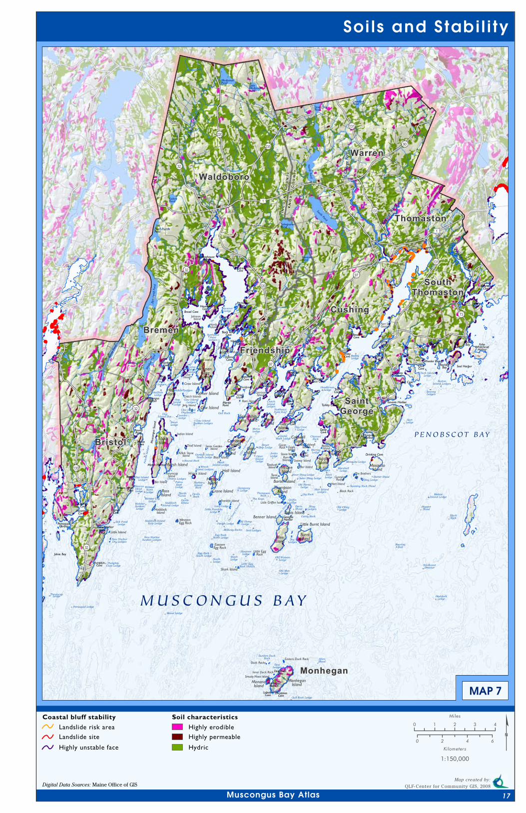
Map backgroundMaps illustrating the distribution of soil types on land are regularly used to assess the suitability of certain areas to different uses (e.g. different kinds of farming) or where particular plant communities might be found. Terrestrial soil maps can also provide information for marine managers because soil type influences the impacts of land use on the sea as well as ocean forces on the land.
To create this map, scientists from Maine were asked what qualities of coastal soils were most relevant to the management of nearshore waters. They agreed that soils which are considered drained, hydric, or erodible were of greatest interest as were clay soils which, when found in high, steep bluffs, contribute to the potential for landslides.
Several government agencies have categorized and mapped coastal areas according to these and other specific characteristics. This map provides a generalized view of the distribution and patterns of these characteristics. (Please note that for management purposes, more localized information is necessary.) Also, in the interest of clarity, within each characteristic only the most extreme condition is shown (e.g. highly erodible rather than moderately erodible). Other levels of each condition, however, have also been mapped and can be obtained from the sources listed below.
For more information on landslides and erosion of coastal bluffs, begin with the Maine Geological Survey in the Dept. of Conservation (www.maine.gov/doc/nrimc/mgs/pubs/index.htm). Further information on area soils can be obtained from the Natural Resources Conservation Service in the U.S. Dept. of Agriculture (soils.usda.gov). This federal agency also has an office in Warren, Maine.
Legend detail
Coastal bluff stability
Landslide risk area: A generalized site where an assessment of features suggest conditions that may be suitable to landslide formation. Landslide potential relates to the internal stability of a coastal bluff segment and the potential for gravity, under certain conditions, to move large amounts of sediment down-slope. Areas prone to landslides tend to have high, steep bluff faces, clay sediment, erosion at the high tide line, and a high groundwater table.
Landslide site: Areas where a landslide has occurred. Some events may have occurred in the last few years, some in the last century, and some thousands of years ago. Sites are documented through historical records, eyewitness accounts or aerial photography.
Highly unstable face: A generalized site where the bluff face shows signs of erosion including little vegetation, exposure of bare sediment, fallen trees and displaced chunks of sediment. To understand the hazard posed to coastal development (i.e. by the landward retreat of the top edge of the bluff) an understanding of local erosion rates is needed.
Soil characteristics
Highly erodible: Sites where the potential for soil erosion is high according to the soil erodibility index, a numerical formula which considers physical and chemical properties of the soil as well as the climatic conditions where it is located.
Highly permeable: Places where water is removed from the soil rapidly. They are commonly coarse textured, rocky, or shallow. Some are steep.
Hydric: Locations where soils are saturated, flooded, or ponded long enough during the growing season to develop anaerobic conditions. They are associated with the development of wetland communities.
Data sources
Features Information Source Digital Data Source
Coastal bluff stability Maine Geological SurveyMaine Office of GIS (COASTAL_BLUFF_HAZARDS)http://apollo.ogis.state.me.us/catalog/
Soil characteristicsU.S. Department of Agriculture-Natural Resources Conservation Service
Maine Office of GIS (SSA_S)http://apollo.ogis.state.me.us/catalog/
Muscongus Bay Atlas
Soi ls and Stabi l i ty
Haddock IslandKelp Ledge
Little EggRock Shoals
NortheastPoint
Ledges
Cow IslandDry Ledges
Egg RockNorth Ledge
Egg RockSouth Ledge
HaddockIsland Ledge
Gunning Rock Shoal
Pola
ndLe
dge
s
PumpkinCove Ledge
WebberNorthLedge
SoutheastBreaker
GooseRock Ledge
Old CilleyLedge
Salt PondLedge
Bay CoveLedge
Mosquito Ledge
Pemaquid Ledge
Midway Rocks
RoaringBull
JenksLedge
KelpLedges
AllenShoal
InnerLedge
Gig Rock
Garden IslandSouth Ledge
New HarborSunken Ledges
Cow IslandSunken Ledges
Little FranklinLedge
New HarborDry Ledges
CrotchIslandLedges
MetinicIsland Ledge
NortheastPoint Reef
NortonIsland Ledges
WebberSunkenLedge
WreckIsland Ledges
BlackIsland Ledge
Clark IslandLedge
Hart IslandLedges
OtterIslandLedge
LongIslandLedges
HarborIslandRock
Cow IslandLedges
BrownsHeadLedge
PolinsEast
Ledge
BeyerShip Ledge
Inner Shag LedgeOuter Shag Ledge
HogIslandLedge
Webber DryLedge
Bar IslandLedge
Sunken DuckRock
Old HorseLedge
Old WomanLedge
HendersonLedge
Gull Rock Ledge
Old HumpLedge
MarshallLedge
HalftideLedge
HogIsland Bar
ThrumcapLedge
GangwayLedge
HarpoonLedge
Old ManLedge
SeaveyLedges
GriffinLedge
HaddockLedge
ThompsonRock
HavenerLedge
Middle Ledges
Polins Ledges
BaileyLedge
Barter Shoal
HupperShoal
ChannelRock
MurrayLedge
CoombsLedge
DevilsElbow
AllenLedge
Hough Ledge
MorseLedge
Seal Ledges
ShagLedges
DavisShoal
SouthLedge
Moser Ledge
SealLedges
DevilsBack
DevilsLimb
BlackRockCarey Rock
DryLedges
HartLedge
Long Ledge
WashLedge
RamLedges
Round Rock
Gull Rock
Hay Ledge
The Kegs
Otter
Islan
dPa
ssag
e
Hocko
mock Cha
nnel
OldH
ump Cha
nnel
Flyi
ngPa
ssag
e
Keen
e Nar
rows
Lower Narro
ws
Davis
Strait
TheNarr
ows
P E N O B S C OT B AY
M U S C O N G U S B AY
KN
OX
CO
UN
TY
CO
UN
TY
LI N
CO
LN
Fort St.George
Little Griffen Isand
OarIsland
BensIsland
Little CaldwellIslands
Killick StoneIsland
Smutty Nose IslandMonhegan
Island
WhartonIsland
Seavey Island
SandIsland
TeelIsland
FriendshipLong Island
Little Burnt Island
Jones GardenIsland
BremenLongIsland
WolsgroverIsland
Eastern Duck Rock
CranberryIsland
EasternEgg Rock
WesternEgg Rock
CaldwellIsland
Franklin Island
GarrisonIsland
Little EggRock
MosquitoIsland
ThompsonIsland
Inner Duck Rock
ThrumcapIsland
BlubberIsland
TwobushIsland
Crotch Islands
HaddockIsland
JohnsonIsland
Barter Island
Benner Island
CrotchIsland
GunningRocksHarbor
Island
HupperIsland
HungryIsland
Indian Island
Little Island
LocustIsland
MananaIsland
Palmer Island
AllenIsland
Black Island
BurntIsland
CedarIsland
Crane Island
Davis Island
EagleIsland
McGeeIsland
MorseIsland
OtterIsland
Shark Island
Stone Island
The Brothers
HardyIsland
LoudsIsland
Marsh Island
Thief Island
Wreck IslandHall Island
Hart Island
TomsIsland
Clam Island
Crow Island
Jims Island
RossIsland
Bar Island
Black Rock
GayIsland
GooseRock
RamIsland
Ram Island
Bar Island
Cow Island
Duck Rocks
HogIsland
RamIsland
Nubbins
Monhegan
SouthThomaston
Thomaston
Friendship
SaintGeorge
Bremen
Cushing
Bristol
Warren
Waldoboro
FriendshipHarbor
MonheganHarbor
GayCove
FalseWhitehead
Harbor
Port ClydeHarbor
MeetinghouseCove
MapleJuice Cove
Browns HeadCove
MuscongusHarbor
HarringtonCove
MosquitoHarbor
Back RiverCove
Mus
cong
usSo
und
PemaquidHarbor
GeorgesHarbor
Tenants Harbor
ChristmasCove
MartinPoint
GreenlandCove
BallyhacCove
Drinking Cove
HornbarnCove
FossettsCove
PitchersCove
HatchetCove
RackliffBay
DeadmanCove
HavenerCove
LobsterCove
Marsh Harbor
PumpkinCove
SampsonCove
CutlerCove
DelanoCove
Seal Harbor
SeaveyCove
Turkey Cove
Wheeler Bay
BrownsCove
CoombsCove
BroadCove
ClarkCove
DavisCove
HylerCove
NabbyCove
WattsCove
WileyCove
Broad Cove
MoxieCove
New Harbor
RoundPond
AmesCove
DeepCove
Long Cove
MillCove
OtisCove
TeelCove
BackCove
Johns Bay
LongCove
LongCove
BaumBay
Med
omak
Rive
r
St. G
eorg
eRi
ver
Goo
seRi
ver
Weskeag River
Oys
ter R
iver
Med
unco
okRiv
er
KalersPond
SidesparkerPond
SevenTreePond
North
Pond
South Pond
MedomakPond
Pem
aqui
dPo
nd
Web
ber P
ondBisc
ayPo
nd
Boyd
Pond
LittleMedomakPond
CrawfordPond
HavenerPond
Duck PuddlePond 1
1
32
32
32
97
97
73
90
32
130
220
131
131
131
235
220
1:150,000
¢Miles
Kilometers
0 2 4 6
0 1 2 3 4
MAP 7
Hydric
Highly permeableHighly erodible
Coastal bluff stabilityLandslide risk areaLandslide site
Highly unstable face
Soil characteristics
Digital Data Sources: Maine Office of GIS QLF- Center for Community GIS, 2008Map created by:
Muscongus Bay Atlas 17