Embed Size (px)
Citation preview

United StatesDepartment ofAgriculture
NaturalResourcesConservationService
In cooperationwith UnitedStatesDepartment ofthe Interior,
Bureau of LandManagement,
Bureau of IndianAffairs,
National ParkService
and the ArizonaAgriculturalExperimentStation
Soil Survey ofMohave County,Arizona,Southern Part


Detailed Soil Maps
The detailed soil maps can be useful in planning the use and management of small areas.
To find information about your area of interest, locate that area on the Index to Map Sheets. Note the number ofthe map sheet and turn to that sheet.
Locate your area of interest on the map sheet. Note the map unit symbols that are in that area. Turn to theContents, which lists the map units by symbol and name and shows the page where each map unit is described.
The Contents shows which table has data on a specific land use for each detailed soil map unit. Also see theContents for sections of this publication that may address your specific needs.
3
How To Use This Soil Survey

4
This soil survey is a publication of the National Cooperative Soil Survey, a joint effortof the United States Department of Agriculture and other Federal agencies, Stateagencies including the Agricultural Experiment Stations, and local agencies. The NaturalResources Conservation Service (formerly the Soil Conservation Service) hasleadership for the Federal part of the National Cooperative Soil Survey.
Major fieldwork for this soil survey was completed in 1996. Soil names anddescriptions were approved in 2005. Unless otherwise indicated, statements in thispublication refer to conditions in the survey area in 1996. This survey was madecooperatively by the Natural Resources Conservation Service, the Bureau of LandManagement, the National Park Service, the Bureau of Indian Affairs, and the ArizonaAgricultural Experiment Station. The survey is part of the technical assistance furnishedto the Big Sandy Natural Resources Conservation District.
Soil maps in this survey may be copied without permission. Enlargement of thesemaps, however, could cause misunderstanding of the detail of mapping. If enlarged,maps do not show the small areas of contrasting soils that could have been shown at alarger scale.
The U.S. Department of Agriculture (USDA) prohibits discrimination in all its programsand activities on the basis of race, color, national origin, age, disability, and whereapplicable, sex, marital status, familial status, parental status, religion, sexualorientation, genetic information, political beliefs, reprisal, or because all or a part of anindividual’s income is derived from any public assistance program. (Not all prohibitedbases apply to all programs.) Persons with disabilities who require alternative means forcommunication of program information (Braille, large print, audiotape, etc.) shouldcontact USDA’s TARGET Center at (202) 720-2600 (voice and TDD).
To file a complaint of discrimination write to USDA, Director, Office of Civil Rights,1400 Independence Avenue, S.W., Washington, D.C. 20250-9410 or call (800) 795-3272(voice) or (202) 720-6382 (TDD). USDA is an equal opportunity provider and employer.
Cover: Romero, Chiricahua, and Lampshire soils in the Arroweed Canyon area, MohaveCounty, Arizona. (Photo courtesy of the Bureau of Land Management, Kingman Field Office.)
5
Contents
How To Use This Soil Survey ................................. 3Contents .................................................................. 5Foreword ............................................................... 11
General Nature of the Area ................................. 13How This Survey Was Made .......................... 13
Detailed Soil Map Units ........................................ 151—Akela-Rock outcrop-Rubble land complex,
40 to 70 percent slopes ................................ 162—Akela-Rock outcrop-Rubble land complex,
dry, 40 to 70 percent slopes ......................... 163—Alko family cobbly loam, 2 to 15 percent
slopes .......................................................... 174—Alko family cobbly loam, dry, 2 to 15
percent slopes .............................................. 185—Amole sandy loam, 1 to 3 percent slopes ...... 186—Amole sandy loam, dry, 1 to 3 percent
slopes .......................................................... 197—Anthony-Dudleyville complex, 1 to 3
percent slopes .............................................. 198—Aquarius-Akela-Rock outcrop complex,
1 to 25 percent slopes .................................. 209—Arizo-Franconia-Riverwash complex,
1 to 3 percent slopes .................................... 2110—Arizo-Franconia-Riverwash complex,
dry, 1 to 3 percent slopes ............................. 2211—Bartmus very gravelly sandy loam, 2 to
15 percent slopes ......................................... 2212—Bonita family very cobbly silty clay
loam, 2 to 10 percent slopes ........................ 2313—Bonita family-Gonzales complex, 10
to 35 percent slopes ..................................... 2414—Brazito family sand, 0 to 3 percent
slopes .......................................................... 2415—Bucklebar sandy loam, 1 to 3 percent
slopes .......................................................... 2516—Cacique family extremely gravelly
loam, 1 to 7 percent slopes .......................... 2517—Castaneda extremely gravelly loam,
1 to 7 percent slopes .................................... 2618—Castaneda extremely gravelly loam, dry,
1 to 7 percent slopes .................................... 2619—Carrizo family very gravelly loamy sand,
1 to 3 percent slopes .................................... 2720—Carrizo family-Riverwash complex, 1
to 3 percent slopes ....................................... 28
21—Carrizo-Riverwash complex, 3 to 8percent slopes .............................................. 28
22—Carrizo-Riverwash complex, 1 to 3percent slopes .............................................. 29
23—Cave gravelly sandy loam, 10 to 35percent slopes .............................................. 29
24—Cave gravelly sandy loam, dry, 10 to35 percent slopes ......................................... 30
25—Cellar-Rock outcrop complex, 20 to 60percent slopes .............................................. 30
26—Cellar-Rock outcrop complex, dry, 20to 60 percent slopes ..................................... 31
27—Cellar-Topock-Rock outcrop complex,5 to 35 percent slopes .................................. 31
28—Cherioni very cobbly loam, 2 to 15percent slopes .............................................. 32
29—Chuckawalla-Riverbend complex,2 to 15 percent slopes .................................. 33
30—Chuckawalla-Riverbend familiescomplex, 2 to 15 percent slopes ................... 34
31—Cipriano very stony loam, 2 to 10percent slopes .............................................. 34
32—Cline very stony loam, 2 to 15 percentslopes .......................................................... 35
33—Cline very stony loam, dry, 2 to 15percent slopes .............................................. 35
34—Continental-Tres Hermanos complex,2 to 15 percent slopes .................................. 36
35—Continental-Tres Hermanos complex,dry, 2 to 15 percent slopes ........................... 37
36—Continental-Rillino complex, 2 to 15percent slopes .............................................. 37
37—Continental-Rillino complex, dry, 2 to15 percent slopes ......................................... 38
38—Coolidge-Denure complex, 1 to 7percent slopes .............................................. 39
39—Coolidge-Denure families complex,1 to 7 percent slopes .................................... 40
40—Courthouse family-Rock outcrop-Rubbleland complex, 40 to 70 percent slopes ......... 41
41—Courthouse family-Rock outcrop-Wagonbow complex, 15 to 70 percentslopes .......................................................... 41
42—Far-Rock outcrop complex, 10 to 45percent slopes .............................................. 42

6
43—Dutchflat sandy loam, 0 to 2 percentslopes .......................................................... 43
44—Dutchflat fine sandy loam, dry, 1 to 3percent slopes .............................................. 43
45—Gadsden silty clay, 0 to 1 percent slopes .... 4446—Gila-Glendale complex, 1 to 3 percent
slopes .......................................................... 4447—Gila-Glendale complex, dry, 1 to 3
percent slopes .............................................. 4548—Goldroad-Rock outcrop complex, 20
to 60 percent slopes ..................................... 4649—Gonzales-Rock outcrop complex, 15
to 35 percent slopes ..................................... 4750—Goodsprings family gravelly sandy
loam, 1 to 15 percent slopes ........................ 4751—Goodsprings family gravelly sandy
loam, dry, 1 to 15 percent slopes ................. 4852—Goodsprings family gravelly sandy
loam, 10 to 35 percent slopes ...................... 4853—Goodsprings family gravelly sandy
loam, dry, 10 to 35 percent slopes ............... 4954—Graham-Arivaca complex, 2 to 15
percent slopes .............................................. 4955—Graham-Rock outcrop complex, 10
to 40 percent slopes ..................................... 5056—Gunsight very gravelly loam, 2 to 15
percent slopes .............................................. 5157—Gunsight very gravelly sandy loam,
10 to 40 percent slopes ................................ 5158—Hassell family-Lampshire-Rock outcrop
complex, 10 to 30 percent slopes ................. 5259—Holtville silty clay, 0 to 1 percent slopes ..... 5360—Huevi very gravelly loam, 2 to 15
percent slopes .............................................. 5361—Huevi very gravelly loam, 10 to 40
percent slopes .............................................. 5462—Akela-Rock outcrop complex, 20 to 60
percent slopes .............................................. 5463—Hyder-Rock outcrop-Rubble land
complex, 40 to 70 percent slopes ................. 5564—Indio silt loam, 0 to 1 percent slopes ........... 5665—Ireteba family-Arizo complex, 1 to 3
percent slopes .............................................. 56
66—Kinley gravelly loamy sand, 15 to 35percent slopes .............................................. 57
67—Kinley-Poachie complex, 2 to 15percent slopes .............................................. 57
68—Kofa silty clay, 0 to 1 percent slopes ........... 5869—Dudleyville-Vinton-Riverwash complex,
1 to 3 percent slopes .................................... 5970—Dudleyville-Vinton-Riverwash complex,
dry, 1 to 3 percent slopes ............................. 6071—Lagunita sand, 0 to 1 percent slopes ........... 6072—Lagunita-Ripley complex, 0 to 3
percent slopes .............................................. 6173—Lampshire-Rock outcrop complex,
20 to 60 percent slopes ................................ 6174—Lampshire-Rock outcrop complex, 30
to 70 percent slopes ..................................... 6275—Lampshire-Rock outcrop complex, 15
to 60 percent slopes, stony .......................... 6376—Lostman gravelly sandy loam, moist,
1 to 5 percent slopes .................................... 6377—Lostman sandy loam, dry, 1 to 3 percent
slopes .......................................................... 6478—Lostman-Kinley complex, 1 to 7 percent
slopes .......................................................... 6479—Marshes ...................................................... 6580—Meloland very fine sandy loam, 0 to 1
percent slopes .............................................. 6581—Mohon-Kinley complex, 2 to 15 percent
slopes .......................................................... 6682—Mohon-Poachie complex, 2 to 15 percent
slopes .......................................................... 6683—Mohon-Poachie complex, dry, 2 to 15
percent slopes .............................................. 6784—Nickel-Topawa-Eba families complex,
10 to 50 percent slopes ................................ 6885—Orwash family sandy loam, 1 to 3
percent slopes .............................................. 6986—Orwash family sandy loam, dry, 1 to
3 percent slopes ........................................... 7087—Penthouse-Gonzales complex, 5 to 35
percent slopes .............................................. 7088—Poachie very gravelly loam, 1 to 4
percent slopes .............................................. 71

7
89—Poachie very gravelly loam, dry, 1to 4 percent slopes ....................................... 71
90—Quilotosa-Rock outcrop complex,20 to 60 percent slopes ................................ 72
91—Razorback extremely gravelly sandyloam, 15 to 35 percent slopes ...................... 73
92—Razorback-Rock outcrop complex, 1to 25 percent slopes ..................................... 73
93—Razorback-Rock outcrop complex, 15to 70 percent slopes ..................................... 74
94—Razorback-Rock outcrop complex, dry,15 to 70 percent slopes ................................ 74
95—Razorback-Rock outcrop-Rubble landcomplex, 40 to 70 percent slopes ................. 75
96—Razorback-Rock outcrop-Rubble landcomplex, dry, 40 to 70 percent slopes .......... 75
97—Rillino gravelly loamy sand, 15 to 35percent slopes .............................................. 76
98—Rillino-Tres Hermanos complex, 2 to15 percent slopes ......................................... 77
99—Ripley silt loam, 0 to 1 percent slopes ......... 77100—Riverbend family very cobbly sandy
loam, 2 to 15 percent slopes ........................ 78101—Riverbend very cobbly sandy loam,
2 to 15 percent slopes .................................. 78102—Riverwash-Fluvaquents association,
0 to 3 percent slopes .................................... 79103—Rock outcrop-Hyder complex, 35 to
65 percent slopes ......................................... 79104—Rock outcrop-Razorback complex,
20 to 70 percent slopes ................................ 80105—Rock outcrop-Sunrock complex, 35
to 65 percent slopes ..................................... 80106—Romero-Chiricahua-Rock outcrop
complex, 5 to 35 percent slopes ................... 81107—Romero-Lampshire-Rock outcrop
complex, 35 to 70 percent slopes ................. 82108—Rositas family, Superstition and
Torriorthents soils, 1 to 60 percentslopes .......................................................... 83
109—Rositas, Superstition family andTorriorthents soils, 1 to 60 percent slopes .... 84
110—Stagecoach very gravelly loam, 2 to 15percent slopes .............................................. 85
111—Stagecoach very gravelly loam, 10to 40 percent slopes ..................................... 86
112—Stagecoach very gravelly sandy loam,5 to 35 percent slopes .................................. 86
113—Stagecoach very gravelly sandy loam,dry, 5 to 35 percent slopes ........................... 87
114—Stagecoach-Topawa family-Ebacomplex, 10 to 50 percent slopes ................. 87
115—Stagecoach-Topawa family-Ebacomplex, dry, 10 to 50 percent slopes .......... 88
116—Sunrock extremely gravelly sandyloam, 15 to 35 percent slopes ...................... 90
117—Sunrock-Rock outcrop complex, 30to 65 percent slopes ..................................... 90
118—Tombstone-Caralampi-Elomacomplex, 10 to 50 percent slopes ................. 91
119—Torriorthents, 35 to 65 percent slopes ........ 92120—Torriorthents, dry, 35 to 65 percent
slopes .......................................................... 92121—Tumarion very cobbly loam, 2 to 15
percent slopes .............................................. 93122—Tumarion very cobbly loam, dry, 2
to 15 percent slopes ..................................... 93123—Tyro extremely stony sandy loam,
3 to 35 percent slopes .................................. 94124—Tyro very stony loam, 2 to 10 percent
slopes .......................................................... 94125—Vekol family gravelly loamy sand, 2
to 7 percent slopes ....................................... 95126—Vekol family gravelly loamy sand,
dry, 2 to 7 percent slopes ............................. 95127—Water ......................................................... 96128—Whitehills very gravelly loam, 1 to 5
percent slopes .............................................. 96129—Whitehills very gravelly loam, dry,
2 to 15 percent slopes .................................. 96130—White House family very gravelly
loamy sand, 2 to 15 percent slopes .............. 97131—White House gravelly loamy sand,
2 to 15 percent slopes .................................. 97132—Wikieup-Mutang-Rock outcrop
complex, 5 to 35 percent slopes ................... 98133—Mutang-Wikieup-Rock outcrop
complex, 3 to 30 percent slopes ................... 99

8
134—Wikieup-Rock outcrop complex, dry,20 to 60 percent slopes .............................. 100
135—Yahana family silty clay loam, 1 to 3percent slopes ............................................ 100
136—Tumarion-Nickel family complex, 8to 35 percent slopes ................................... 101
137—Valena-Rock outcrop-Carri familycomplex, 1 to 25 percent slopes ................. 102
138—Nodman-Rock outcrop complex,15 to 65 percent slopes .............................. 103
139—Nodman-Romero family complex,15 to 65 percent slopes .............................. 103
Use and Management of the Soils ..................... 105Interpretive Ratings ........................................... 105Rating Class Terms .......................................... 105Numerical Ratings ............................................ 105Prime Farmland ................................................ 105Rangeland......................................................... 106Forest Productivity ........................................... 107Recreation ........................................................ 107Engineering ....................................................... 108Building Site Development ................................ 109Sanitary Facilities ............................................. 110Construction Materials ...................................... 112Water Management ........................................... 113
Soil Properties .................................................... 115Engineering Index Properties ............................ 115Physical Properties ........................................... 116Chemical Properties.......................................... 117Soil Features .................................................... 118Water Features ................................................. 118
Classification of the Soils ................................... 121Soil Series and Their Morphology ..................... 121
Akela Series ................................................. 121Alko family ................................................... 122Amole Series ................................................ 123Anthony Series ............................................. 123Aquarius Series ............................................ 124Arivaca taxadjunct ........................................ 125Arizo Series.................................................. 125Bartmus Series ............................................ 126Bonita family ................................................ 126Brazito family ............................................... 127
Bucklebar Series .......................................... 128Cacique family .............................................. 129Caralampi Series .......................................... 129Carri family ................................................... 130Carrizo Series ............................................... 131Carrizo family ............................................... 131Castaneda Series ......................................... 132Cave Series.................................................. 133Cellar Series ................................................. 133Cherioni Series ............................................. 134Chiricahua Series ......................................... 134Chuckawalla Series ...................................... 135Chuckawalla family ....................................... 136Cipriano Series ............................................. 137Cline Series .................................................. 137Continental Series ........................................ 138Coolidge Series ............................................ 138Coolidge family ............................................. 139Courthouse family ........................................ 140Denure Series ............................................... 140Denure family ............................................... 141Dudleyville Series ......................................... 142Dutchflat Series ............................................ 143Eba taxadjunct ............................................. 143Eba family .................................................... 144Eloma Series ................................................ 145Far Series .................................................... 146Fluvaquents.................................................. 146Franconia Series .......................................... 147Gadsden Series ............................................ 147Gila Series ................................................... 148Glendale Series ............................................ 149Goldroad Series ............................................ 149Gonzales Series ........................................... 150Goodsprings family ....................................... 150Graham Series ............................................. 151Gunsight Series ............................................ 152Hassell family ............................................... 152Holtville Series ............................................. 153Huevi Series ................................................. 154Hyder Series ................................................ 155Indio Series .................................................. 155Ireteba family ............................................... 156

9
Kinley Series ................................................ 157Kofa Series .................................................. 158Lagunita Series ............................................ 158Lampshire Series.......................................... 159Lostman Series ............................................ 159Meloland Series ............................................ 160Mohon Series ............................................... 161Mutang Series .............................................. 161Nickel family ................................................ 162Nodman Series ............................................. 163Orwash family .............................................. 163Penthouse Series ......................................... 164Poachie Series ............................................. 165Quilotosa Series ........................................... 166Razorback Series ......................................... 166Rillino Series ................................................ 167Ripley Series ................................................ 168Riverbend Series .......................................... 168Riverbend family ........................................... 169Romero Series .............................................. 170Romero family .............................................. 171Rositas Series .............................................. 171Rositas family .............................................. 172Stagecoach Series ....................................... 172Sunrock Series ............................................. 173Superstition Series ....................................... 173Superstition family ........................................ 174Tombstone Series ........................................ 175Topawa family .............................................. 175Topock Series .............................................. 176Torriorthents ................................................. 177Tres Hermanos Series .................................. 177Tumarion Series ........................................... 178Tyro Series ................................................... 179Valena Series ............................................... 180Vekol family ................................................. 180Vinton Series ................................................ 181Wagonbow Series ......................................... 182White House Series ...................................... 182
White House family ...................................... 183Whitehills Series ........................................... 184Wikieup Series ............................................. 185Yahana family .............................................. 185
References ........................................................... 187Glossary .............................................................. 189Tables .................................................................. 199
Table 1.—Acreage and Proportionate Extentof the Soils ................................................. 200
Table 2.—Prime and Other ImportantFarmland .................................................... 204
Table 3.—Rangeland and Forest UnderstoryProductivity and Characteristic PlantCommunities .............................................. 205
Table 4.—Forestland Productivity ..................... 255Table 5.—Camp Areas, Picnic Areas, and
Playgrounds ............................................... 267Table 6.—Paths, Trails, and Golf
Fairways .................................................... 301Table 7.—Dwellings and Small Commercial
Buildings .................................................... 332Table 8.—Roads and Streets, Shallow
Excavations, and Lawns andLandscaping ............................................... 359
Table 9.—Sewage Disposal .............................. 393Table 10.—Landfills .......................................... 417Table 11.—Source of Gravel and Sand ............. 447Table 12.—Source of Reclamation Material,
Roadfill, and Topsoil ................................... 467Table 13.—Ponds and Embankments ............... 503Table 14.—Engineering Properties .................... 528Table 15.—Physical Soil Properties .................. 576Table 16.—Chemical Soil Properties ................. 606Table 17a.—Soil Features ................................ 634Table 17b.—Soil Features ................................ 647Table 18.—Water Features ............................... 658Table 19.—Taxonomic Classification of
the Soils ..................................................... 682NRCS Accessibility Statement ............................ 685
Issued 2006

11
This soil survey contains information that affects land use planning in this surveyarea. It contains predictions of soil behavior for selected land uses. The survey alsohighlights soil limitations and the impact of selected land uses on the environment.
This soil survey is designed for many different users. Farmers, ranchers, foresters,and agronomists can use it to evaluate the potential of the soil and the managementneeded for maximum food and fiber production. Planners, community officials,engineers, developers, builders, and home buyers can use the survey to plan land use,select sites for construction, and identify special practices needed to ensure properperformance. Conservationists, teachers, students, and specialists in recreation, wildlifemanagement, waste disposal, and pollution control can use the survey to help themunderstand, protect, and enhance the environment.
Various land use regulations of Federal, State, and local governments may imposespecial restrictions on land use or land treatment. The information in this report isintended to identify soil properties that are used in making various land use or landtreatment decisions. Statements made in this report are intended to help the land usersidentify and reduce the effects of soil limitations on various land uses. The landowner oruser is responsible for identifying and complying with existing laws and regulations.
Great differences in soil properties can occur within short distances. Some soils areseasonally wet or subject to flooding. Some are shallow to bedrock. Some are toounstable to be used as a foundation for buildings or roads. Clayey or wet soils are poorlysuited to use as septic tank absorption fields. A high water table makes a soil poorlysuited to basements or underground installations.
These and many other soil properties that affect land use are described in this soilsurvey. The location of each soil is shown on the detailed soil maps. Each soil in thesurvey area is described. Information on specific uses is given for each soil. Help inusing this publication and additional information are available at the local office of theNatural Resources Conservation Service or the Cooperative Extension Service.
David L. McKayState ConservationistNatural Resources Conservation Service
Foreword


13
General Nature of the AreaMOHAVE COUNTY, SOUTHERN PART, is located in the
southern portion of Mohave County, Arizona. LakeHavasu City, the largest city in the survey area, had apopulation of 41,938 in 2000. The survey areaencompasses about 3,894 square miles or 2,492,300acres. Dominant land types include rangeland,recreation, urban land, farmland, and woodland.
Physiographically, the survey area consists of sixmain mountain ranges and two broad valleys. TheHualapai mountain range, the largest in the area, lies inthe center of the survey area. The Black Mountainsand the Mohave Mountains separate the ColoradoRiver drainage and the Mohave Valley from theSacramento Valley. The Arrastra Mountains and theRawhide Mountains are located in the southern portionof the area along the Bill Williams and the Santa Mariarivers. The Aquarius Mountains lie in the easternportion of the area.
Soils in the mountains formed primarily fromalluvium, colluvium, and residuum from igneous andmetamorphic rocks. Valley soils formed from mixedalluvium washed down from the mountains. Wind andwater erosion is a major concern in the area. Erosioncan damage areas such as paths and trails,construction areas, and areas where vegetative coverhas been lost. Soils that have accumulations of saltsand sodium are also a concern in farmland areas.
Major Land Resource Areas within the survey areainclude the Mohave Desert Basin and Range, the
Sonoran Basin and Range, and the MogollonTransition. The northern portion of the survey area fallsinto the Mohave Desert Basin and Range, and thesouthern part is in the Sonoran Basin and Range. TheMogollon Transition is restricted to the Hualapai andAquarius Mountains (USDA, 1981).
Elevations of the survey area range from about 400to about 8,000 feet above mean sea level. Meanannual precipitation ranges from about 3 inches in thelower elevations of the Mohave Desert and SonoranDesert to about 20 inches in the higher elevations ofthe Hualapai Mountains. Mean annual air temperatureranges from about 48 degrees Fahrenheit in the highermountains to 78 degrees Fahrenheit in the low deserts.
How This Survey Was MadeThis survey was made to provide information about
the soils and miscellaneous areas in the survey area.The information includes a description of the soils andmiscellaneous areas and their location. Soil scientistsobserved the steepness, length, and shape of theslopes; the general pattern of drainage; the kinds ofcrops and native plants; and the kinds of bedrock.They dug many holes to study the soil profile, which isthe sequence of natural layers, or horizons, in a soil.The profile extends from the surface down into theunconsolidated material in which the soil formed. Theunconsolidated material is devoid of roots and otherliving organisms and has not been changed by otherbiological activity.
Soil Survey of
Mohave County, Arizona,Southern Part
By Richard K. Strait, Natural Resources Conservation Service
Fieldwork by Wendell Jorgensen and Russell L. Barmore, Natural ResourcesConservation Service, and Paul Hobbs, Bureau of Land Management.
This survey was made cooperatively by the Natural Resources Conservation Service,the Bureau of Land Management, the Bureau of Indian Affairs, the National ParkService, and the Arizona Agricultural Experiment Station. The survey is part of thetechnical assistance furnished to the Big Sandy Natural Resources ConservationDistrict.

14
The soils and miscellaneous areas in the surveyarea are in an orderly pattern that is related to thegeology, landforms, relief, climate, and naturalvegetation of the area. Each kind of soil andmiscellaneous area is associated with a particular kindof landform or with a segment of the landform. Byobserving the soils and miscellaneous areas in thesurvey area and relating their position to specificsegments of the landform, a soil scientist develops aconcept or model of how they were formed. Thus,during mapping, this model enables the soil scientist topredict with a considerable degree of accuracy the kindof soil or miscellaneous area at a specific location onthe landscape.
Commonly, individual soils on the landscape mergeinto one another as their characteristics graduallychange. To construct an accurate soil map, however,soil scientists must determine the boundaries betweenthe soils. They can observe only a limited number ofsoil profiles. Nevertheless, these observations,supplemented by an understanding of the soil-vegetation-landscape relationship, are sufficient toverify predictions of the kinds of soil in an area and todetermine the boundaries.
Soil scientists recorded the characteristics of thesoil profiles that they studied. They noted soil color,texture, size and shape of soil aggregates, kind andamount of rock fragments, distribution of plant roots,reaction, and other features that enable them toidentify soils. After describing the soils in the surveyarea and determining their properties, the soilscientists assigned the soils to taxonomic classes(units). Taxonomic classes are concepts. Eachtaxonomic class has a set of soil characteristics withprecisely defined limits. The classes are used as abasis for comparison to classify soils systematically.Soil taxonomy, the system of taxonomic classificationused in the United States, is based mainly on the kind
and character of soil properties and the arrangement ofhorizons within the profile. After the soil scientistsclassified and named the soils in the survey area, theycompared the individual soils with similar soils in thesame taxonomic class in other areas so that theycould confirm data and assemble additional data basedon experience and research.
While a soil survey is in progress, samples of someof the soils in the area generally are collected forlaboratory analyses and for engineering tests. Soilscientists interpret the data from these analyses andtests as well as the field-observed characteristics andthe soil properties to determine the expected behaviorof the soils under different uses. Interpretations for allof the soils are field tested through observation of thesoils in different uses and under different levels ofmanagement. Some interpretations are modified to fitlocal conditions, and some new interpretations aredeveloped to meet local needs. Data are assembledfrom other sources, such as research information,production records, and field experience of specialists.
Predictions about soil behavior are based not onlyon soil properties but also on such variables as climateand biological activity. Soil conditions are predictableover long periods of time, but they are not predictablefrom year to year. For example, soil scientists canpredict with a fairly high degree of accuracy that agiven soil will have a high water table within certaindepths in most years, but they cannot predict that ahigh water table will always be at a specific level in thesoil on a specific date.
After soil scientists located and identified thesignificant natural bodies of soil in the survey area,they drew the boundaries of these bodies on aerialphotographs and identified each as a specific map unit.Aerial photographs show trees, buildings, roads, andrivers, all of which help in locating boundariesaccurately.

15
The map units delineated on the detailed soil mapsin this survey represent the soils or miscellaneousareas in the survey area. The map unit descriptions inthis section, along with the maps, can be used todetermine the suitability and potential of a unit forspecific uses. They also can be used to plan themanagement needed for those uses.
A map unit delineation on a soil map represents anarea dominated by one or more major kinds of soil ormiscellaneous areas. A map unit is identified andnamed according to the taxonomic classification of thedominant soils. Within a taxonomic class there areprecisely defined limits for the properties of the soils.On the landscape, however, the soils are naturalphenomena, and they have the characteristic variabilityof all natural phenomena. Thus, the range of someobserved properties may extend beyond the limitsdefined for a taxonomic class. Areas of soils of asingle taxonomic class rarely, if ever, can be mappedwithout including areas of other taxonomic classes.Consequently, every map unit is made up of the soilsor miscellaneous areas for which it is named and someminor components that belong to taxonomic classesother than those of the major soils.
Most minor soils have properties similar to those ofthe dominant soil or soils in the map unit, and thusthey do not affect use and management. These arecalled noncontrasting, or similar, components. Theymay or may not be mentioned in a particular map unitdescription. Other minor components, however, haveproperties and behavioral characteristics divergentenough to affect use or to require differentmanagement. These are called contrasting, ordissimilar, components. They generally are in smallareas and could not be mapped separately because ofthe scale used. The contrasting components arementioned in the map unit descriptions. A few areas ofminor components may not have been observed, andconsequently they are not mentioned in thedescriptions, especially where the pattern was socomplex that it was impractical to make enoughobservations to identify all the soils and miscellaneousareas on the landscape.
The presence of minor components in a map unit in
no way diminishes the usefulness or accuracy of thedata. The objective of mapping is not to delineate puretaxonomic classes but rather to separate thelandscape into landforms or landform segments thathave similar use and management requirements. Thedelineation of such segments on the map providessufficient information for the development of resourceplans. If intensive use of small areas is planned,however, onsite investigation is needed to define andlocate the soils and miscellaneous areas.
An identifying symbol precedes the map unit namein the map unit descriptions. Each description includesgeneral facts about the unit and gives the principalhazards and limitations to be considered in planning forspecific uses.
Soils that have profiles that are almost alike makeup a soil series. Except for differences in texture of thesurface layer, all the soils of a series have majorhorizons that are similar in composition, thickness, andarrangement.
Soils of one series can differ in texture of thesurface layer, slope, stoniness, salinity, degree oferosion, and other characteristics that affect their use.On the basis of such differences, a soil series isdivided into soil phases. Most of the areas shown onthe detailed soil maps are phases of soil series. Thename of a soil phase commonly indicates a featurethat affects use or management. For example, Tyrovery stony loam, 2 to 10 percent slopes, is a phase ofthe Tyro series.
Some map units are made up of two or more majorsoils or miscellaneous areas. These map units arecomplexes or associations.
A complex consists of two or more soils ormiscellaneous areas in such an intricate pattern or insuch small areas that they cannot be shown separatelyon the maps. The pattern and proportion of the soils ormiscellaneous areas are somewhat similar in all areas.Goldroad-Rock outcrop complex, 20 to 60 percentslopes, is an example.
An association is made up of two or moregeographically associated soils or miscellaneous areasthat are shown as one unit on the maps. Because ofpresent or anticipated uses of the map units in the
Detailed Soil Map Units
16 Soil Survey
survey area, it was not considered practical ornecessary to map the soils or miscellaneous areasseparately. The pattern and relative proportion of thesoils or miscellaneous areas are somewhat similar.Riverwash-Fluvaquents association, 0 to 3 percentslopes, is an example.
An undifferentiated group is made up of two or moresoils or miscellaneous areas that could be mappedindividually but are mapped as one unit becausesimilar interpretations can be made for use andmanagement. The pattern and proportion of the soils ormiscellaneous areas in a mapped area are not uniform.An area can be made up of only one of the major soilsor miscellaneous areas, or it can be made up of all ofthem. Rositas family, Superstition and Torriorthentssoils, 1 to 60 percent slopes, is an undifferentiatedgroup in this survey area.
This survey includes miscellaneous areas. Suchareas have little or no soil material and support little orno vegetation. Riverwash is an example.
Table 1 gives the acreage and proportionate extentof each map unit. Other tables give properties of thesoils and the limitations, capabilities, and potentials formany uses. The Glossary defines many of the termsused in describing the soils or miscellaneous areas.
1—Akela-Rock outcrop-Rubble landcomplex, 40 to 70 percent slopes
Map Unit Setting
Landform: hills and mountainsElevation: 2,100 to 4,600 feet (640 to 1,402 meters)Mean annual precipitation: 10 to 12 inches (254 to 305
millimeters)Mean annual air temperature: 59 to 70 degrees F. (15
to 21 degrees C.)Mean annual soil temperature: 61 to 72 degrees F. (17
to 23 degrees C.)Frost-free period: 200 to 250 days
Map Unit Composition
Akela and similar soils: 45 percentRock outcrop: 20 percentRubble land: 20 percentMinor components: 15 percent
Properties and Qualities
Akela soils
Taxonomic Classification: Loamy-skeletal, mixed,superactive, calcareous, thermic LithicTorriorthents
Parent Material: Alluvium and/or colluvium derivedfrom volcanic rock
Slope: 40 to 70 percentDepth to restrictive feature: 4 to 20 inches to bedrock
(lithic)Drainage class: Well drainedPermeability: From 0.6 to 2.0 in/hr (moderate)Available water capacity total inches: 0.3Shrink-swell potential: About 1.5 LEP (low)Flooding hazard: NoneRunoff class: Very highHydrologic group: DMajor Land Resource Area: 40; Sonoran Basin and
RangeLand Resource Unit: 40-1AZ; Upper Sonoran DesertEcological site name: Basalt Hills 10-13" p.z.Other ecological sites may occur in this map unit and
vary in extent between delineations.Ecosystem site number: R040XA101AZPresent native vegetation: littleleaf palo verde, bush
muhly, big galleta, creosotebush, white brittlebush,desert globemallow, desert needlegrass, rangeratany, sideoats grama, slim tridens
Land capability (nonirrigated): 7c
Typical Profile
A—0 to 1 inches; extremely cobbly loamBw—1 to 5 inches; extremely cobbly loam2R—5 inches; unweathered bedrock
Rock outcrop
Exposures of bedrock, typically barren but may havesparse vegetation growing in cracks and crevices or inthin layers of alluvium or colluvium.
Rubble land
Consists of areas of cobbles, stones, and boulders.Rubble land is commonly at the base of mountains,mesas, and escarpments.
2—Akela-Rock outcrop-Rubble landcomplex, dry, 40 to 70 percent slopes
Map Unit Setting
Landform: hills and mountainsElevation: 2,100 to 4,600 feet (640 to 1,402 meters)Mean annual precipitation: 7 to 10 inches (178 to 254
millimeters)Mean annual air temperature: 59 to 70 degrees F. (15
to 21 degrees C.)Mean annual soil temperature: 61 to 72 degrees F. (17
to 23 degrees C.)

Mohave County, Arizona, Southern Part 17
Frost-free period: 200 to 250 days
Map Unit Composition
Akela and similar soils: 45 percentRock outcrop: 20 percentRubble land: 20 percentMinor components: 15 percent
Properties and Qualities
Akela soils
Taxonomic Classification: Loamy-skeletal, mixed,superactive, calcareous, thermic LithicTorriorthents
Parent Material: Alluvium and/or colluvium derivedfrom volcanic rock
Slope: 40 to 70 percentDepth to restrictive feature: 4 to 20 inches to bedrock
(lithic)Drainage class: Well drainedPermeability: From 0.6 to 2.0 in/hr (moderate)Available water capacity total inches: 0.3Shrink-swell potential: About 1.5 LEP (low)Flooding hazard: NoneRunoff class: Very highHydrologic group: DMajor Land Resource Area: 40; Sonoran Basin and
RangeLand Resource Unit: 40-2AZ; Middle Sonoran DesertEcological site name: Basalt Hills 7-10" p.z.Other ecological sites may occur in this map unit and
vary in extent between delineations.Ecosystem site number: R040XB201AZPresent native vegetation: white brittlebush, littleleaf
palo verde, bush muhly, creosotebush, slimtridens, desert globemallow, white bursage
Land capability (nonirrigated): 7c
Typical Profile
A—0 to 1 inches; extremely cobbly loamBw—1 to 5 inches; extremely cobbly loam2R—5 inches; unweathered bedrock
Rock outcrop
Exposures of bedrock, typically barren but may havesparse vegetation growing in cracks and crevices or inthin layers of alluvium or colluvium.
Rubble land
Consists of areas of cobbles, stones, and boulders.Rubble land is commonly at the base of mountains,mesas, and escarpments.
3—Alko family cobbly loam, 2 to 15percent slopes
Map Unit Setting
Landform: fan terracesElevation: 1,800 to 3,500 feet (549 to 1,067 meters)Mean annual precipitation: 9 to 12 inches (229 to 305
millimeters)Mean annual air temperature: 59 to 70 degrees F. (15
to 21 degrees C.)Mean annual soil temperature: 61 to 72 degrees F. (17
to 23 degrees C.)Frost-free period: 200 to 250 days
Map Unit Composition
Alko family and similar soils: 85 percentMinor components: 15 percent
Properties and Qualities
Alko family soils
Taxonomic Classification: Loamy, mixed, superactive,thermic, shallow Typic Haplodurids
Parent Material: Alluvium derived from volcanic rockSlope: 2 to 15 percentDepth to restrictive feature: 5 to 20 inches to
duripanDrainage class: Well drainedPermeability: From 2.0 to 6.0 in/hr (moderately
rapid)Available water capacity total inches: 1.6Shrink-swell potential: About 1.5 LEP (low)Flooding hazard: NoneRunoff class: Very highHydrologic group: DMajor Land Resource Area: 30; Mojave DesertLand Resource Unit: 30-3AZ; Upper Mohave DesertEcological site name: Limy Upland 10-13" p.z.Other ecological sites may occur in this map unit and
vary in extent between delineations.Ecosystem site number: R030XC311AZPresent native vegetation: blackbrush, big galleta,
bush muhly, Mojave yucca, creosotebush,goldenhead, red brome
Land capability (nonirrigated): 7c
Typical Profile
A—0 to 1 inches; cobbly loamB—1 to 15 inches; gravelly loam2Bqkm—15 to 31 inches; indurated2C—31 to 60 inches; extremely gravelly sand

18 Soil Survey
4—Alko family cobbly loam, dry, 2 to 15percent slopes
Map Unit Setting
Landform: fan terracesElevation: 1,800 to 3,500 feet (549 to 1,067 meters)Mean annual precipitation: 6 to 9 inches (152 to 229
millimeters)Mean annual air temperature: 59 to 70 degrees F. (15
to 21 degrees C.)Mean annual soil temperature: 61 to 72 degrees F. (17
to 23 degrees C.)Frost-free period: 200 to 250 days
Map Unit Composition
Alko family and similar soils: 85 percentMinor components: 15 percent
Properties and Qualities
Alko family soils
Taxonomic Classification: Loamy, mixed, superactive,thermic, shallow Typic Haplodurids
Parent Material: Alluvium derived from volcanic rockSlope: 2 to 15 percentDepth to restrictive feature: 5 to 20 inches to duripanDrainage class: Well drainedPermeability: From 2.0 to 6.0 in/hr (moderately
rapid)Available water capacity total inches: 1.6Shrink-swell potential: About 1.5 LEP (low)Flooding hazard: NoneRunoff class: Very highHydrologic group: DMajor Land Resource Area: 30; Mojave DesertLand Resource Unit: 30-2AZ; Middle Mohave
DesertEcological site name: Limy Upland 6-10" p.z.Other ecological sites may occur in this map unit and
vary in extent between delineations.Ecosystem site number: R030XB214AZPresent native vegetation: creosotebush, white
bursage, red brome, Mojave yucca, goldenheadLand capability (nonirrigated): 7c
Typical Profile
A—0 to 1 inches; cobbly loamB—1 to 15 inches; gravelly loam2Bqkm—15 to 31 inches; indurated2C—31 to 60 inches; extremely gravelly sand
5—Amole sandy loam, 1 to 3 percentslopes
Map Unit Setting
Landform: fan terracesElevation: 1,500 to 2,700 feet (457 to 823 meters)Mean annual precipitation: 10 to 12 inches (254 to 305
millimeters)Mean annual air temperature: 59 to 70 degrees F. (15
to 21 degrees C.)Mean annual soil temperature: 61 to 72 degrees F. (17
to 23 degrees C.)Frost-free period: 200 to 250 days
Map Unit Composition
Amole and similar soils: 75 percentMinor components: 25 percent
Properties and Qualities
Amole soils
Taxonomic Classification: Sandy, mixed, thermicTypic Torriorthents
Parent Material: Alluvium derived from mixed rocksources
Slope: 1 to 3 percentDrainage class: well drainedPermeability: From 2.0 to 6.0 in/hr (moderately rapid)Available water capacity total inches: 4.0Shrink-swell potential: About 1.5 LEP (low)Flooding hazard: NoneRunoff class: very lowHydrologic group: CMajor Land Resource Area: 40; Sonoran Basin and
RangeLand Resource Unit: 40-1AZ; Upper Sonoran DesertEcological site name: Sandy Loam Upland 10-13" p.z.Other ecological sites may occur in this map unit and
vary in extent between delineations.Ecosystem site number: R040XA118AZPresent native vegetation: black grama, bush muhly,
big galleta, burrobush, Eastern Mojave wildbuckwheat, Indian ricegrass, buckhorn cholla,goldenhead, range ratany, whitestem paperflower
Land capability (nonirrigated): 7c
Typical Profile
A—0 to 1 inches; sandy loamC1—1 to 19 inches; sandy loamC2—19 to 60 inches; loamy coarse sand

Mohave County, Arizona, Southern Part 19
6—Amole sandy loam, dry, 1 to 3 percentslopes
Map Unit Setting
Landform: fan terracesElevation: 1,500 to 2,700 feet (457 to 823 meters)Mean annual precipitation: 7 to 10 inches (178 to 254
millimeters)Mean annual air temperature: 59 to 70 degrees F. (15
to 21 degrees C.)Mean annual soil temperature: 61 to 72 degrees F. (17
to 23 degrees C.)Frost-free period: 200 to 250 days
Map Unit Composition
Amole and similar soils: 75 percentMinor components: 25 percent
Properties and Qualities
Amole soils
Taxonomic Classification: Sandy, mixed, thermicTypic Torriorthents
Parent Material: Alluvium derived from mixed rocksources
Slope: 1 to 3 percentDrainage class: well drainedPermeability: From 2.0 to 6.0 in/hr (moderately
rapid)Available water capacity total inches: 4.0Shrink-swell potential: About 1.5 LEP (low)Flooding hazard: NoneRunoff class: Very lowHydrologic group: CMajor Land Resource Area: 40; Sonoran Basin and
RangeLand Resource Unit: 40-2AZ; Middle Sonoran DesertEcological site name: Sandy Loam Upland 7-10" p.z.Other ecological sites may occur in this map unit and
vary in extent between delineations.Ecosystem site number: R040XB218AZPresent native vegetation: big galleta, creosotebush,
bush muhly, black grama, Indian ricegrass, whitebursage
Land capability (nonirrigated): 7c
Typical Profile
A—0 to 1 inches; sandy loamC1—1 to 19 inches; sandy loamC2—19 to 60 inches; loamy coarse sand
7—Anthony-Dudleyville complex, 1 to 3percent slopes
Map Unit Setting
Landform: flood plains and stream terracesElevation: 2,200 to 3,200 feet (671 to 975 meters)Mean annual precipitation: 10 to 12 inches (254 to 305
millimeters)Mean annual air temperature: 59 to 70 degrees F. (15
to 21 degrees C.)Mean annual soil temperature: 61 to 72 degrees F. (17
to 23 degrees C.)Frost-free period: 200 to 230 days
Map Unit Composition
Anthony and similar soils: 45 percentDudleyville and similar soils: 30 percentMinor components: 25 percent
Properties and Qualities
Anthony soils
Taxonomic Classification: Coarse-loamy, mixed,superactive, calcareous, thermic TypicTorrifluvents
Parent Material: Alluvium derived from mixed rocksources
Slope: 1 to 3 percentDrainage class: Well drainedPermeability: From 2.0 to 6.0 in/hr (moderately rapid)Available water capacity total inches: 4.4Shrink-swell potential: About 1.5 LEP (low)Flooding hazard: OccasionalRunoff class: Very lowHydrologic group: BMajor Land Resource Area: 40; Sonoran Basin and
RangeLand Resource Unit: 40-1AZ; Upper Sonoran DesertEcological site name: Sandy Bottom 10-13" p.z.Other ecological sites may occur in this map unit and
vary in extent between delineations.Ecosystem site number: R040XA115AZPresent native vegetation: Arizona cottontop, Mexican
bladder sage, big galleta, bush muhly, catclawacacia, western honey mesquite, fourwingsaltbush, sand dropseed
Land capability (nonirrigated): 7c
Typical Profile
A—0 to 1 inches; gravelly sandy loam

20 Soil Survey
C1—1 to 35 inches; gravelly coarse sandy loamC2—35 to 60 inches; gravelly sandy loam
Dudleyville soils
Taxonomic Classification: Sandy-skeletal, mixed,thermic Typic Torriorthents
Parent Material: Alluvium derived from mixed rocksources
Slope: 1 to 3 percentDrainage class: Excessively drainedPermeability: Greater than 20 in/hr (very rapid)Available water capacity total inches: 3.1Shrink-swell potential: About 1.5 LEP (low)Flooding hazard: NoneRunoff class: NegligibleHydrologic group: AMajor Land Resource Area: 40; Sonoran Basin and
RangeLand Resource Unit: 40-3AZ; Sonoran-Mohave Desert
TransitionEcological site name: Sandy Bottom 10-12" p.z.Other ecological sites may occur in this map unit and
vary in extent between delineations.Ecosystem site number: R040XC343AZPresent native vegetation: Arizona cottontop, Mexican
bladder sage, big galleta, bush muhly, catclawacacia, western honey mesquite, fourwingsaltbush, sand dropseed
Land capability (nonirrigated): 7c
Typical Profile
A—0 to 2 inches; gravelly loamy sandC1—2 to 12 inches; gravelly loamy coarse sandC—12 to 60 inches; very gravelly coarse sand
8—Aquarius-Akela-Rock outcropcomplex, 1 to 25 percent slopes
Map Unit Setting
Landform: plateaus and hillsElevation: 2,100 to 4,600 feet (640 to 1,402 meters)Mean annual precipitation: 10 to 12 inches (254 to 305
millimeters)Mean annual air temperature: 59 to 70 degrees F. (15
to 21 degrees C.)Mean annual soil temperature: 61 to 72 degrees F. (17
to 23 degrees C.)Frost-free period: 200 to 230 days
Map Unit Composition
Aquarius and similar soils: 45 percentAkela and similar soils: 30 percent
Rock outcrop: 20 percentMinor components: 5 percent
Properties and Qualities
Aquarius soils
Taxonomic Classification: Fine, smectitic, calcareous,thermic Vertic Torriorthents
Parent Material: Alluvium and/or colluvium derivedfrom volcanic rock
Slope: 10 to 25 percentDrainage class: Well drainedPermeability: From 0.06 to 0.2 in/hr (slow)Available water capacity total inches: 8.6Shrink-swell potential: About 10.0 LEP (very high)Flooding hazard: NoneRunoff class: MediumHydrologic group: CMajor Land Resource Area: 40; Sonoran Basin and
RangeLand Resource Unit: 40-1AZ; Upper Sonoran DesertEcological site name: Clay Loam Upland 10-13" p.z.Other ecological sites may occur in this map unit and
vary in extent between delineations.Ecosystem site number: R040XA120AZPresent native vegetation: black grama, sideoats
grama, tobosa, big galleta, broom snakeweed,bush muhly, desert globemallow, false mesquite,littleleaf palo verde, range ratany, shrubbybuckwheat
Land capability (nonirrigated): 7c
Typical Profile
A1—0 to 2 inches; very cobbly silt loamA2—2 to 8 inches; silty clay loamC1—8 to 24 inches; cobbly silty clayC2—24 to 42 inches; silty clay2Btkb1—42 to 50 inches; silty clay2Btkb2—50 to 60 inches; gravelly silty clay loam
Akela soils
Taxonomic Classification: Loamy-skeletal, mixed,superactive, calcareous, thermic LithicTorriorthents
Parent Material: Alluvium and/or colluvium derivedfrom volcanic rock
Slope: 1 to 25 percentSurface fragments: About 9 percent stonesDepth to restrictive feature: 4 to 20 inches to bedrock
(lithic)Drainage class: Well drainedPermeability: From 0.6 to 2.0 in/hr (moderate)Available water capacity total inches: 0.3Shrink-swell potential: About 1.5 LEP (low)
Mohave County, Arizona, Southern Part 21
Flooding hazard: NoneRunoff class: Very highHydrologic group: DMajor Land Resource Area: 40; Sonoran Basin and
RangeLand Resource Unit: 40-1AZ; Upper Sonoran DesertEcological site name: Basalt Hills 10-13" p.z.Other ecological sites may occur in this map unit and
vary in extent between delineations.Ecosystem site number: R040XA101AZPresent native vegetation: littleleaf palo verde, bush
muhly, big galleta, creosotebush, white brittlebush,Eastern Mojave wild buckwheat, desertglobemallow, desert needlegrass, range ratany,sideoats grama, slim tridens
Land capability (nonirrigated): 7c
Typical Profile
A—0 to 1 inches; extremely cobbly loamBw—1 to 5 inches; extremely cobbly loam2R—5 inches; unweathered bedrock
Rock outcrop
Exposures of bedrock, typically barren but may havesparse vegetation growing in cracks and crevices or inthin layers of alluvium or colluvium.
9—Arizo-Franconia-Riverwash complex, 1to 3 percent slopes
Map Unit Setting
Landform: flood plains and alluvial fansElevation: 2,300 to 3,900 feet (701 to 1189 meters)Mean annual precipitation: 9 to 12 inches (229 to 305
millimeters)Mean annual air temperature: 59 to 64 degrees F. (15
to 18 degrees C.)Mean annual soil temperature: 61 to 66 degrees F. (17
to 19 degrees C.)Frost-free period: 200 to 230 days
Map Unit Composition
Arizo and similar soils: 40 percentFranconia and similar soils: 30 percentRiverwash: 20 percentMinor components: 10 percent
Properties and Qualities
Arizo soils
Taxonomic Classification: Sandy-skeletal, mixed,thermic Typic Torriorthents
Parent Material: Alluvium derived from mixed rocksources
Slope: 1 to 3 percentDrainage class: Excessively drainedPermeability: From 2.0 to 6.0 in/hr (moderately rapid)Available water capacity total inches: 2.4Shrink-swell potential: About 1.5 LEP (low)Flooding hazard: FrequentRunoff class: Very lowHydrologic group: BMajor Land Resource Area: 30; Mojave DesertLand Resource Unit: 30-3AZ; Upper Mohave DesertEcological site name: Sandy Bottom 10-13" p.z.Other ecological sites may occur in this map unit and
vary in extent between delineations.Ecosystem site number: R030XC317AZPresent native vegetation: white burrobush, bush
muhly, desert rabbitbrush, Anderson wolfberry, biggalleta, catclaw acacia, creosotebush, desertwillow, red brome, sand dropseed, white bursage
Land capability (nonirrigated): 7c
Typical Profile
A—0 to 2 inches; gravelly sandy loamC1—2 to 11 inches; gravelly sandy loamC2—11 to 15 inches; sandy loamC3—15 to 35 inches; extremely gravelly loamy
sandC4—35 to 60 inches; very gravelly loamy coarse
sand
Franconia soils
Taxonomic Classification: Sandy, mixed, thermicTypic Torrifluvents
Parent Material: Alluvium derived from mixed rocksources
Slope: 1 to 3 percentDrainage class: Somewhat excessively drainedPermeability: From 2.0 to 6.0 in/hr (moderately rapid)Available water capacity total inches: 4.0Shrink-swell potential: About 1.5 LEP (low)Flooding hazard: OccasionalRunoff class: Very lowHydrologic group: BMajor Land Resource Area: 30; Mojave DesertLand Resource Unit: 30-3AZ; Upper Mohave DesertEcological site name: Sandy Bottom 10-13" p.z.Other ecological sites may occur in this map unit and
vary in extent between delineations.Ecosystem site number: R030XC317AZPresent native vegetation: white burrobush, bush
muhly, desert rabbitbrush, Anderson wolfberry, biggalleta, catclaw acacia, creosotebush, red brome,sand dropseed, white bursage

22 Soil Survey
Land capability (nonirrigated): 7c
Typical Profile
A—0 to 2 inches; sandy loamC—2 to 33 inches; loamy sandC3—33 to 60 inches; gravelly loamy sand
Riverwash
Barren fluvial channels, usually coarse-textured,exposed along narrow drainageways, subject to shiftingduring flood events.
10—Arizo-Franconia-Riverwash complex,dry, 1 to 3 percent slopes
Map Unit Setting
Landform: flood plainsElevation: 1,500 to 3,000 feet (457 to 914 meters)Mean annual precipitation: 6 to 9 inches (152 to 229
millimeters)Mean annual air temperature: 59 to 70 degrees F. (15
to 21 degrees C.)Mean annual soil temperature: 61 to 72 degrees F. (17
to 22 degrees C.)Frost-free period: 200 to 250 days
Map Unit Composition
Arizo and similar soils: 40 percentFranconia and similar soils: 30 percentRiverwash: 20 percentMinor components: 10 percent
Properties and Qualities
Arizo soils
Taxonomic Classification: Sandy-skeletal, mixed,thermic Typic Torriorthents
Parent Material: Alluvium derived from mixed rocksources
Slope: 1 to 3 percentDrainage class: Excessively drainedPermeability: From 2.0 to 6.0 in/hr (moderately rapid)Available water capacity total inches: 2.4Shrink-swell potential: About 1.5 LEP (low)Flooding hazard: FrequentRunoff class: Very lowHydrologic group: AMajor Land Resource Area: 30; Mojave DesertLand Resource Unit: 30-2AZ; Middle Mohave DesertEcological site name: Sandy Wash 6-10" p.z.Other ecological sites may occur in this map unit and
vary in extent between delineations.Ecosystem site number: R030XB218AZ
Present native vegetation: white burrobrush, catclawacacia, creosotebush
Land capability (nonirrigated): 7c
Typical Profile
A—0 to 2 inches; gravelly sandy loamC1—2 to 11 inches; gravelly sandy loamC2—11 to 15 inches; sandy loamC3—15 to 35 inches; extremely gravelly loamy
sandC4—35 to 60 inches; very gravelly loamy coarse
sand
Franconia soils
Taxonomic Classification: Sandy, mixed, thermicTypic Torrifluvents
Parent Material: Alluvium derived from mixed rocksources
Slope: 1 to 3 percentDrainage class: Somewhat excessively drainedPermeability: From 2.0 to 6.0 in/hr (moderately rapid)Available water capacity total inches: 4.0Shrink-swell potential: About 1.5 LEP (low)Flooding hazard: OccasionalRunoff class: Very lowHydrologic group: BMajor Land Resource Area: 30; Mojave DesertLand Resource Unit: 30-2AZ; Middle Mohave DesertEcological site name: Sandy Wash 6-10" p.z.Other ecological sites may occur in this map unit and
vary in extent between delineations.Ecosystem site number: R030XB218AZPresent native vegetation: white burrobrush, catclaw
acacia, creosotebushLand capability (nonirrigated): 7c
Typical Profile
A—0 to 2 inches; sandy loamC1—2 to 18 inches; loamy sandC2—18 to 33 inches; stratified loamy sandC3—33 to 60 inches; gravelly loamy sand
Riverwash
Barren fluvial channels, usually coarse-textured,exposed along narrow drainageways, subject to shiftingduring flood events.
11—Bartmus very gravelly sandy loam, 2to 15 percent slopes
Map Unit Setting
Landform: mesasElevation: 4,000 to 4,200 feet (1,219 to 1,280 meters)

Mohave County, Arizona, Southern Part 23
Mean annual precipitation: 12 to 16 inches (305 to 406millimeters)
Mean annual air temperature: 57 to 61 degrees F. (14to 16 degrees C.)
Mean annual soil temperature: 59 to 63 degrees F. (15to 18 degrees C.)
Frost-free period: 180 to 210 days
Map Unit Composition
Bartmus and similar soils: 85 percentMinor components: 15 percent
Properties and Qualities
Bartmus soils
Taxonomic Classification: Loamy-skeletal, mixed,superactive, thermic, shallow Ustic Haplodurids
Parent Material: Alluvium derived from volcanic rockSlope: 2 to 15 percentDepth to restrictive feature: 5 to 18 inches to duripan; 7
to 30 inches to bedrock (lithic)Drainage class: Well drainedPermeability: From 0.6 to 2.0 in/hr (moderate)Available water capacity total inches: 0.4Shrink-swell potential: About 4.5 LEP (moderate)Flooding hazard: NoneRunoff class: Very highHydrologic group: DMajor Land Resource Area: 38; Mogollon TransitionLand Resource Unit: 38-1AZ; Mogollon Transition
Interior Chaparral, Grassland, and Pinyon-JuniperSavannah
Ecological site name: Limy Upland 12-16" p.z.Other ecological sites may occur in this map unit and
vary in extent between delineations.Ecosystem site number: R038XA106AZPresent native vegetation: black grama, sideoats
grama, needle and thread, birchleafmountainmahogany, desert ceanothus,muttongrass, range ratany, slim tridens, turbinellaoak, western bottlebrush grass
Land capability (nonirrigated): 6c
Typical Profile
A—0 to 2 inches; very gravelly sandy loamBt—2 to 6 inches; very gravelly sandy clay loam2Bkqm—6 to 19 inches; indurated3R—19 inches; unweathered bedrock
12—Bonita family very cobbly silty clayloam, 2 to 10 percent slopes
Map Unit Setting
Landform: mesasElevation: 4,400 to 5,600 feet (1,341 to 1,707
meters)Mean annual precipitation: 12 to 16 inches (305 to 406
millimeters)Mean annual air temperature: 59 to 61 degrees F. (15
to 16 degrees C.)Mean annual soil temperature: 61 to 63 degrees F. (17
to 18 degrees C.)Frost-free period: 180 to 210 days
Map Unit Composition
Bonita family and similar soils: 85 percentMinor components: 15 percent
Properties and Qualities
Bonita family soils
Taxonomic Classification: Fine, smectitic, thermicTypic Haplotorrerts
Parent Material: Alluvium derived from volcanic rockSlope: 2 to 10 percentDrainage class: Well drainedPermeability: From 0.06 to 0.2 in/hr (slow)Available water capacity total inches: 6.1Shrink-swell potential: About 7.5 LEP (high)Flooding hazard: NoneRunoff class: MediumHydrologic group: BMajor Land Resource Area: 38; Mogollon
TransitionLand Resource Unit: 38-1AZ; Mogollon Transition
Interior Chaparral, Grassland, and Pinyon-JuniperSavannah
Ecological site name: Clayey Upland 12-16" p.z.Other ecological sites may occur in this map unit and
vary in extent between delineations.Ecosystem site number: R038XA102AZPresent native vegetation: tobosa, sideoats grama,
muttongrass, western bottlebrush grass, broomsnakeweed, globemallow, shrubby buckwheat,turbinella oak
Land capability (nonirrigated): 6c

24 Soil Survey
Typical Profile
A—0 to 2 inches; very cobbly silty clay loamC—2 to 35 inches; clay2Btkb—35 to 60 inches; very gravelly loam
13—Bonita family-Gonzales complex, 10to 35 percent slopes
Map Unit Setting
Landform: mesasElevation: 3,800 to 5,800 feet (1,158 to 1,768 meters)Mean annual precipitation: 12 to 16 inches (305 to 406
millimeters)Mean annual air temperature: 59 to 61 degrees F. (15
to 16 degrees C.)Mean annual soil temperature: 61 to 63 degrees F. (17
to 18 degrees C.)Frost-free period: 180 to 210 days
Map Unit Composition
Bonita family and similar soils: 60 percentGonzales and similar soils: 30 percentMinor components: 10 percent
Properties and Qualities
Bonita family soils
Taxonomic Classification: Fine, smectitic, thermicTypic Haplotorrerts
Parent Material: Alluvium derived from volcanicrock
Slope: 10 to 15 percentDrainage class: Well drainedPermeability: From 0.06 to 0.2 in/hr (slow)Available water capacity total inches: 6.1Shrink-swell potential: About 7.5 LEP (high)Flooding hazard: NoneRunoff class: HighHydrologic group: BMajor Land Resource Area: 38; Mogollon TransitionLand Resource Unit: 38-1AZ; Mogollon Transition
Interior Chaparral, Grassland, and Pinyon-JuniperSavannah
Ecological site name: Clayey Upland 12-16" p.z.Other ecological sites may occur in this map unit and
vary in extent between delineations.Ecosystem site number: R038XA102AZPresent native vegetation: tobosa, sideoats grama,
muttongrass, western bottlebrush grass, broomsnakeweed, globemallow, shrubby buckwheat,turbinella oak
Land capability (nonirrigated): 6c
Typical Profile
A—0 to 2 inches; very cobbly silty clay loamC—2 to 35 inches; clay2Btkb—35 to 60 inches; very gravelly loam
Gonzales soils
Taxonomic Classification: Clayey, smectitic, thermic,shallow Ustic Haplocambids
Parent Material: Alluvium derived from volcanic rockSlope: 15 to 35 percentDepth to restrictive feature: 10 to 20 inches to bedrock
(paralithic); 13 to 23 inches to bedrock (lithic)Drainage class: Well drainedPermeability: From 0.06 to 0.2 in/hr (slow)Available water capacity total inches: 2.2Shrink-swell potential: About 7.5 LEP (high)Flooding hazard: NoneRunoff class: Very highHydrologic group: DMajor Land Resource Area: 38; Mogollon TransitionLand Resource Unit: 38-1AZ; Mogollon Transition
Interior Chaparral, Grassland, and Pinyon-JuniperSavannah
Ecological site name: Clayey Upland 12-16" p.z.Other ecological sites may occur in this map unit and
vary in extent between delineations.Ecosystem site number: R038XA117AZPresent native vegetation: sideoats grama, desert
ceanothus, birchleaf mountainmahogany, blackgrama, blue grama, desert needlegrass, rangeratany, shrubby buckwheat, skunkbush sumac,sugar sumac
Land capability (nonirrigated): 6c
Typical Profile
A—0 to 1 inches; very cobbly loamBw—1 to 14 inches; clay2Cr—14 to 17 inches; weathered bedrock2R—17 inches; unweathered bedrock
14—Brazito family sand, 0 to 3 percentslopes
Map Unit Setting
Landform: flood plainsElevation: 1,500 to 1,600 feet (457 to 488 meters)Mean annual precipitation: 7 to 10 inches (178 to 254
millimeters)Mean annual air temperature: 64 to 70 degrees F. (18
to 21 degrees C.)

Mohave County, Arizona, Southern Part 25
Mean annual soil temperature: 66 to 72 degrees F. (20to 23 degrees C.)
Frost-free period: 230 to 250 days
Map Unit Composition
Brazito family and similar soils: 75 percentMinor components: 25 percent
Properties and Qualities
Brazito family soils
Taxonomic Classification: Mixed, thermic TypicTorripsamments
Parent Material: Alluvium derived from mixed rocksources
Slope: 0 to 3 percentDrainage class: Somewhat excessively drainedPermeability: From 6.0 to 20 in/hr (rapid)Available water capacity total inches: 4.2Shrink-swell potential: About 1.5 LEP (low)Flooding hazard: NoneRunoff class: NegligibleHydrologic group: AMajor Land Resource Area: 40; Sonoran Basin and
RangeLand Resource Unit: 40-2AZ; Middle Sonoran DesertEcological site name: Sandy Bottom 7-10" p.z.Other ecological sites may occur in this map unit and
vary in extent between delineations.Ecosystem site number: R040XB216AZPresent native vegetation: big galleta, bush muhly,
Mexican bladder sage, shortleaf baccharis, bluepalo verde, catclaw acacia, desert needlegrass,littleleaf palo verde, western honey mesquite,whitestem paperflower
Land capability (nonirrigated): 7c
Typical Profile
A—0 to 7 inches; sandC1—7 to 14 inches; very fine sandC2—14 to 28 inches; fine sandC3—28 to 60 inches; very fine sand
15—Bucklebar sandy loam, 1 to 3 percentslopes
Map Unit Setting
Landform: fan terracesElevation: 3,000 to 3,300 feet (914 to 1,006 meters)Mean annual precipitation: 10 to 12 inches (254 to 305
millimeters)Mean annual air temperature: 59 to 64 degrees F. (15
to 18 degrees C.)
Mean annual soil temperature: 61 to 66 degrees F. (17to 20 degrees C.)
Frost-free period: 200 to 230 days
Map Unit Composition
Bucklebar and similar soils: 80 percentMinor components: 20 percent
Properties and Qualities
Bucklebar soils
Taxonomic Classification: Fine-loamy, mixed,superactive, thermic Typic Haplargids
Parent Material: Alluvium and/or colluvium derivedfrom metamorphic rock
Slope: 1 to 3 percentDrainage class: Well drainedPermeability: From 0.6 to 2.0 in/hr (moderate)Available water capacity total inches: 7.7Shrink-swell potential: About 4.5 LEP (moderate)Flooding hazard: NoneRunoff class: LowHydrologic group: BMajor Land Resource Area: 40; Sonoran Basin and
RangeLand Resource Unit: 40-1AZ; Upper Sonoran
DesertEcological site name: Loamy Hills 10-13" p.z.Other ecological sites may occur in this map unit and
vary in extent between delineations.Ecosystem site number: R040XA113AZPresent native vegetation: black grama, big galleta,
bush muhly, Arizona cottontop, Eastern Mojavewild buckwheat, Joshua tree, banana yucca,broom snakeweed, creosotebush, goldenhead,plains bristlegrass, range ratany
Land capability (nonirrigated): 7c
Typical Profile
A—0 to 4 inches; sandy loamBt—4 to 37 inches; sandy clay loamC—37 to 60 inches; coarse sandy loam
16—Cacique family extremely gravellyloam, 1 to 7 percent slopes
Map Unit Setting
Landform: fan terracesElevation: 1,800 to 2,400 feet (549 to 732 meters)Mean annual precipitation: 7 to 10 inches (178 to 254
millimeters)Mean annual air temperature: 64 to 70 degrees F. (18
to 21 degrees C.)

26 Soil Survey
Mean annual soil temperature: 66 to 72 degrees F. (20to 23 degrees C.)
Frost-free period: 230 to 250 days
Map Unit Composition
Cacique family and similar soils: 75 percentMinor components: 25 percent
Properties and Qualities
Cacique family soils
Taxonomic Classification: Fine-loamy, mixed,superactive, thermic Argic Petrocalcids
Parent Material: Alluvium and/or colluvium derivedfrom metamorphic rock
Slope: 1 to 7 percentDepth to restrictive feature: 20 to 40 inches to
petrocalcicDrainage class: Well drainedPermeability: From 0.6 to 2.0 in/hr (moderate)Available water capacity total inches: 4.7Shrink-swell potential: About 1.5 LEP (low)Flooding hazard: NoneRunoff class: HighHydrologic group: DMajor Land Resource Area: 40; Sonoran Basin and
RangeLand Resource Unit: 40-2AZ; Middle Sonoran DesertEcological site name: Limy Upland 7-10" p.z.Other ecological sites may occur in this map unit and
vary in extent between delineations.Ecosystem site number: R040XB210AZPresent native vegetation: creosotebush, bush muhly,
littleleaf palo verde, big galleta, Andersonwolfberry, Eastern Mojave wild buckwheat, blackgrama, sideoats grama, slim tridens
Land capability (nonirrigated): 7c
Typical Profile
A—0 to 1 inches; extremely gravelly loamBt—1 to 8 inches; gravelly sandy clay loamBtk—8 to 35 inches; gravelly clay loam2Bkm—35 to 60 inches; indurated
17—Castaneda extremely gravelly loam, 1to 7 percent slopes
Map Unit Setting
Landform: fan terracesElevation: 1,600 to 4,000 feet (488 to 1,219 meters)Mean annual precipitation: 9 to 12 inches (229 to 305
millimeters)
Mean annual air temperature: 59 to 70 degrees F. (15to 21 degrees C.)
Mean annual soil temperature: 61 to 72 degrees F. (17to 23 degrees C.)
Frost-free period: 200 to 250 days
Map Unit Composition
Castaneda and similar soils: 75 percentMinor components: 25 percent
Properties and Qualities
Castaneda soils
Taxonomic Classification: Fine-loamy, mixed,superactive, thermic Argic Petrocalcids
Parent Material: Alluvium and/or colluvium derivedfrom metamorphic rock
Slope: 1 to 7 percentDepth to restrictive feature: 20 to 40 inches to
petrocalcicDrainage class: Well drainedPermeability: From 0.6 to 2.0 in/hr (moderate)Available water capacity total inches: 3.9Shrink-swell potential: About 4.5 LEP (moderate)Flooding hazard: NoneRunoff class: HighHydrologic group: CMajor Land Resource Area: 30; Mojave DesertLand Resource Unit: 30-3AZ; Upper Mohave DesertEcological site name: Limy Upland 10-13" p.z.Other ecological sites may occur in this map unit and
vary in extent between delineations.Ecosystem site number: R030XC311AZPresent native vegetation: Eastern Mojave wild
buckwheat, big galleta, bush muhly, goldenhead,range ratany, creosotebush, red brome
Land capability (nonirrigated): 7c
Typical Profile
A—0 to 1 inches; extremely gravelly loamBt—1 to 9 inches; gravelly clay loamBtk—9 to 17 inches; gravelly clay loamBk—17 to 32 inches; very gravelly loam2Bkm—32 to 41 inches; indurated3C—41 to 60 inches; extremely gravelly loamy
sand
18—Castaneda extremely gravelly loam,dry, 1 to 7 percent slopes
Map Unit Setting
Landform: fan terraces

Mohave County, Arizona, Southern Part 27
Elevation: 1,600 to 4,000 feet (488 to 1,219 meters)Mean annual precipitation: 6 to 9 inches (152 to 229
millimeters)Mean annual air temperature: 59 to 70 degrees F. (15
to 21 degrees C.)Mean annual soil temperature: 61 to 72 degrees F. (17
to 23 degrees C.)Frost-free period: 200 to 250 days
Map Unit Composition
Castaneda and similar soils: 75 percentMinor components: 25 percent
Properties and Qualities
Castaneda soils
Taxonomic Classification: Fine-loamy, mixed,superactive, thermic Argic Petrocalcids
Parent Material: Alluvium and/or colluvium derivedfrom metamorphic rock
Slope: 1 to 7 percentDepth to restrictive feature: 20 to 40 inches to
petrocalcicDrainage class: Well drainedPermeability: From 0.6 to 2.0 in/hr (moderate)Available water capacity total inches: 3.9Shrink-swell potential: About 4.5 LEP (moderate)Flooding hazard: NoneRunoff class: HighHydrologic group: CMajor Land Resource Area: 30; Mojave DesertLand Resource Unit: 30-2AZ; Middle Mohave DesertEcological site name: Limy Upland 6-10" p.z.Other ecological sites may occur in this map unit and
vary in extent between delineations.Ecosystem site number: R030XB214AZPresent native vegetation: creosotebush, white
bursage, red brome, goldenhead, range ratanyLand capability (nonirrigated): 7c
Typical Profile
A—0 to 1 inches; extremely gravelly loamBt—1 to 9 inches; gravelly clay loamBtk—9 to 17 inches; gravelly clay loamBk—17 to 32 inches; very gravelly loam2Bkm—32 to 41 inches; indurated3C—41 to 60 inches; extremely gravelly loamy
sand
19—Carrizo family very gravelly loamysand, 1 to 3 percent slopes
Map Unit Setting
Landform: flood plains and alluvial fansElevation: 500 to 1,800 feet (152 to 549 meters)Mean annual precipitation: 3 to 7 inches (76 to 178
millimeters)Mean annual air temperature: 70 to 74 degrees F. (21
to 23 degrees C.)Mean annual soil temperature: 72 to 76 degrees F. (23
to 25 degrees C.)Frost-free period: 250 to 325 days
Map Unit Composition
Carrizo family and similar soils: 75 percentMinor components: 25 percent
Properties and Qualities
Carrizo family soils
Taxonomic Classification: Sandy-skeletal, mixed,hyperthermic Typic Torriorthents
Parent Material: Alluvium derived from mixed rocksources
Slope: 1 to 3 percentDrainage class: Excessively drainedPermeability: Greater than 20 in/hr (very rapid)Available water capacity total inches: 2.1Shrink-swell potential: About 1.5 LEP (low)Flooding hazard: FrequentRunoff class: NegligibleHydrologic group: BMajor Land Resource Area: 40; Sonoran Basin and
RangeLand Resource Unit: 40-4AZ; Lower Sonoran DesertEcological site name: Sandy Bottom 2-7" p.z.Other ecological sites may occur in this map unit and
vary in extent between delineations.Ecosystem site number: R040XD416AZPresent native vegetation: ironwood, burrobush, big
galleta, catclaw acacia, creosotebush, littleleafpalo verde, smoketree, white bursage, white ratany
Land capability (nonirrigated): 7c
Typical Profile
A—0 to 1 inches; very gravelly loamy sand

28 Soil Survey
C1—1 to 9 inches; loamy sandC2—9 to 60 inches; very gravelly coarse sand
20—Carrizo family-Riverwash complex, 1to 3 percent slopes
Map Unit Setting
Landform: flood plains and alluvial fansElevation: 500 to 1,800 feet (152 to 549 meters)Mean annual precipitation: 3 to 7 inches (76 to 178
millimeters)Mean annual air temperature: 70 to 74 degrees F. (21
to 23 degrees C.)Mean annual soil temperature: 72 to 76 degrees F. (23
to 25 degrees C.)Frost-free period: 250 to 325 days
Map Unit Composition
Carrizo family and similar soils: 65 percentRiverwash: 20 percentMinor components: 15 percent
Properties and Qualities
Carrizo family soils
Taxonomic Classification: Sandy-skeletal, mixed,hyperthermic Typic Torriorthents
Parent Material: Alluvium derived from mixed rocksources
Slope: 1 to 3 percentDrainage class: Excessively drainedPermeability: Greater than 20 in/hr (very rapid)Available water capacity total inches: 2.1Shrink-swell potential: About 1.5 LEP (low)Flooding hazard: FrequentRunoff class: NegligibleHydrologic group: BMajor Land Resource Area: 40; Sonoran Basin and
RangeLand Resource Unit: 40-4AZ; Lower Sonoran DesertEcological site name: Sandy Bottom 2-7" p.z.Other ecological sites may occur in this map unit and
vary in extent between delineations.Ecosystem site number: R040XD416AZPresent native vegetation: ironwood, burrobush, big
galleta, catclaw acacia, creosotebush, littleleafpalo verde, smoketree, white bursage, white ratany
Land capability (nonirrigated): 7c
Typical Profile
A—0 to 1 inches; very gravelly loamy sandC1—1 to 9 inches; loamy sand
C2—9 to 60 inches; very gravelly coarse sand
Riverwash
Barren fluvial channels, usually coarse-textured,exposed along narrow drainageways, subject to shiftingduring flood events.
21—Carrizo-Riverwash complex, 3 to 8percent slopes
Map Unit Setting
Landform: flood plainsElevation: 750 to 2,000 feet (229 to 610 meters)Mean annual precipitation: 3 to 6 inches (76 to 152
millimeters)Mean annual air temperature: 70 to 74 degrees F. (21
to 23 degrees C.)Mean annual soil temperature: 72 to 76 degrees F. (23
to 24 degrees C.)Frost-free period: 280 to 320 days
Map Unit Composition
Carrizo and similar soils: 75 percentRiverwash: 15 percentMinor components: 10 percent
Properties and Qualities
Carrizo soils
Taxonomic Classification: Sandy-skeletal, mixed,hyperthermic Typic Torriorthents
Parent Material: Alluvium derived from mixed rocksources
Slope: 3 to 8 percentSurface fragments: About 70 percent gravel, about 5
percent cobbles, about 2 percent stonesDrainage class: Excessively drainedPermeability: From 6.0 to 20 in/hr (rapid)Available water capacity total inches: 1.2Shrink-swell potential: About 1.5 LEP (low)Flooding hazard: OccasionalRunoff class: Very lowHydrologic group: AMajor Land Resource Area: 30; Mojave DesertLand Resource Unit: 30-1AZ; Lower Mohave DesertEcological site name: Sandy Wash 3-6" p.z.Other ecological sites may occur in this map unit and
vary in extent between delineations.Ecosystem site number: R030XA115AZPresent native vegetation: creosotebush, white
bursage, white burrobrushLand capability (nonirrigated): 7c

Mohave County, Arizona, Southern Part 29
Typical Profile
A—0 to 1 inches; extremely gravelly loamy sandC1—1 to 23 inches; extremely gravelly loamy sandC2—23 to 60 inches; extremely gravelly sand
Riverwash
Barren fluvial channels, usually coarse-textured,exposed along narrow drainageways, subject to shiftingduring flood events.
22—Carrizo-Riverwash complex, 1 to 3percent slopes
Map Unit Setting
Landform: flood plains and alluvial fansElevation: 500 to 2,000 feet (152 to 610 meters)Mean annual precipitation: 3 to 6 inches (76 to 152
millimeters)Mean annual air temperature: 70 to 74 degrees F. (21
to 23 degrees C.)Mean annual soil temperature: 72 to 76 degrees F. (23
to 25 degrees C.)Frost-free period: 250 to 325 days
Map Unit Composition
Carrizo and similar soils: 65 percentRiverwash: 20 percentMinor components: 15 percent
Properties and Qualities
Carrizo soils
Taxonomic Classification: Sandy-skeletal, mixed,hyperthermic Typic Torriorthents
Parent Material: Alluvium derived from mixed rocksources
Slope: 1 to 3 percentDrainage class: Excessively drainedPermeability: From 6.0 to 20 in/hr (rapid)Available water capacity total inches: 1.2Shrink-swell potential: About 1.5 LEP (low)Flooding hazard: FrequentRunoff class: NegligibleHydrologic group: BMajor Land Resource Area: 30; Mojave DesertLand Resource Unit: 30-1AZ; Lower Mohave DesertEcological site name: Sandy Terrace 3-6" p.z.Other ecological sites may occur in this map unit and
vary in extent between delineations.Ecosystem site number: R030XA112AZPresent native vegetation: white burrobush,
creosotebush, smoketree, white bursage, big
galleta, bush muhly, catclaw acacia, red brome,sweetbush, white brittlebush
Land capability (nonirrigated): 7c
Typical Profile
A—0 to 1 inches; very gravelly coarse sandC—1 to 60 inches; extremely gravelly loamy
coarse sand
Riverwash
Barren fluvial channels, usually coarse-textured,exposed along narrow drainageways, subject to shiftingduring flood events.
23—Cave gravelly sandy loam, 10 to 35percent slopes
Map Unit Setting
Landform: fan terracesElevation: 1,900 to 4,000 feet (579 to 1,219 meters)Mean annual precipitation: 10 to 12 inches (254 to 305
millimeters)Mean annual air temperature: 59 to 70 degrees F. (15
to 21 degrees C.)Mean annual soil temperature: 61 to 72 degrees F. (17
to 23 degrees C.)Frost-free period: 200 to 250 days
Map Unit Composition
Cave and similar soils: 75 percentMinor components: 25 percent
Properties and Qualities
Cave soils
Taxonomic Classification: Loamy, mixed, superactive,thermic, shallow Typic Petrocalcids
Parent Material: Alluvium derived from mixed rocksources
Slope: 10 to 35 percentDepth to restrictive feature: 4 to 20 inches to
petrocalcicDrainage class: Well drainedPermeability: From 2.0 to 6.0 in/hr (moderately rapid)Available water capacity total inches: 0.5Shrink-swell potential: About 1.5 LEP (low)Flooding hazard: NoneRunoff class: Very highHydrologic group: DMajor Land Resource Area: 40; Sonoran Basin and
RangeLand Resource Unit: 40-1AZ; Upper Sonoran DesertEcological site name: Limy Upland 10-13" p.z.

30 Soil Survey
Other ecological sites may occur in this map unit andvary in extent between delineations.
Ecosystem site number: R040XA111AZPresent native vegetation: black grama, bush muhly,
creosotebush, sideoats grama, big galleta, littleleafpalo verde, range ratany, shrubby buckwheat, slimtridens, whitestem paperflower
Land capability (nonirrigated): 7c
Typical Profile
A—0 to 1 inches; gravelly sandy loamBw—1 to 7 inches; gravelly coarse sandy loam2Bkm—7 to 28 inches; indurated2C—28 to 60 inches; extremely gravelly loamy
coarse sand
24—Cave gravelly sandy loam, dry, 10 to35 percent slopes
Map Unit Setting
Landform: fan terracesElevation: 1,900 to 4,000 feet (579 to 1,219 meters)Mean annual precipitation: 7 to 10 inches (178 to 254
millimeters)Mean annual air temperature: 59 to 70 degrees F. (15
to 21 degrees C.)Mean annual soil temperature: 61 to 72 degrees F. (17
to 23 degrees C.)Frost-free period: 200 to 250 days
Map Unit Composition
Cave and similar soils: 75 percentMinor components: 25 percent
Properties and Qualities
Cave soils
Taxonomic Classification: Loamy, mixed, superactive,thermic, shallow Typic Petrocalcids
Parent Material: Alluvium derived from mixed rocksources
Slope: 10 to 35 percentDepth to restrictive feature: 4 to 20 inches to
petrocalcicDrainage class: Well drainedPermeability: From 2.0 to 6.0 in/hr (moderately rapid)Available water capacity total inches: 0.5Shrink-swell potential: About 1.5 LEP (low)Flooding hazard: NoneRunoff class: Very highHydrologic group: DMajor Land Resource Area: 40; Sonoran Basin and
Range
Land Resource Unit: 40-2AZ; Middle Sonoran DesertEcological site name: Limy Upland 7-10" p.z.Other ecological sites may occur in this map unit and
vary in extent between delineations.Ecosystem site number: R040XB210AZPresent native vegetation: creosotebush, bush muhly,
littleleaf palo verde, big galleta, black grama,sideoats grama, slim tridens, white bursage, whiteratany
Land capability (nonirrigated): 7c
Typical Profile
A—0 to 1 inches; gravelly sandy loamBw—1 to 7 inches; gravelly coarse sandy loam2Bkm—7 to 28 inches; indurated2C—28 to 60 inches; extremely gravelly loamy
coarse sand
25—Cellar-Rock outcrop complex, 20 to60 percent slopes
Map Unit Setting
Landform: hills and mountainsElevation: 1,800 to 3,700 feet (549 to 1,128 meters)Mean annual precipitation: 10 to 12 inches (254 to 305
millimeters)Mean annual air temperature: 64 to 70 degrees F. (18
to 21 degrees C.)Mean annual soil temperature: 66 to 72 degrees F. (20
to 23 degrees C.)Frost-free period: 230 to 250 days
Map Unit Composition
Cellar and similar soils: 50 percentRock outcrop: 25 percentMinor components: 25 percent
Properties and Qualities
Cellar soils
Taxonomic Classification: Loamy-skeletal, mixed,superactive, nonacid, thermic Lithic Torriorthents
Parent Material: Alluvium and/or colluvium derivedfrom igneous and metamorphic rock
Slope: 20 to 60 percentDepth to restrictive feature: 4 to 20 inches to bedrock
(paralithic); 4 to 20 inches to bedrock (lithic)Drainage class: Somewhat excessively drainedPermeability: From 2.0 to 6.0 in/hr (moderately rapid)Available water capacity total inches: 0.5Shrink-swell potential: About 1.5 LEP (low)Flooding hazard: NoneRunoff class: Very high

Mohave County, Arizona, Southern Part 31
Hydrologic group: DMajor Land Resource Area: 40; Sonoran Basin and
RangeLand Resource Unit: 40-3AZ; Sonoran-Mohave Desert
TransitionEcological site name: Granitic Hills 10-12" p.z.Other ecological sites may occur in this map unit and
vary in extent between delineations.Ecosystem site number: R040XC335AZPresent native vegetation: black grama, sideoats
grama, desert needlegrass, Eastern Mojave wildbuckwheat, agave, big galleta, bush muhly, falsemesquite, ocotillo, shrubby buckwheat, tobosa
Land capability (nonirrigated): 7c
Typical Profile
A—0 to 2 inches; very gravelly sandy loamBw—2 to 10 inches; very gravelly sandy loam2Cr—10 to 13 inches; weathered bedrock2R—13 inches; unweathered bedrock
Rock outcrop
Exposures of bedrock, typically barren but may havesparse vegetation growing in cracks and crevices or inthin layers of alluvium or colluvium.
26—Cellar-Rock outcrop complex, dry, 20to 60 percent slopes
Map Unit Setting
Landform: hills and mountainsElevation: 1,800 to 3,700 feet (549 to 1,128 meters)Mean annual precipitation: 7 to 10 inches (178 to 254
millimeters)Mean annual air temperature: 64 to 70 degrees F. (18
to 21 degrees C.)Mean annual soil temperature: 66 to 72 degrees F. (20
to 23 degrees C.)Frost-free period: 230 to 250 days
Map Unit Composition
Cellar and similar soils: 50 percentRock outcrop: 25 percentMinor components: 25 percent
Properties and Qualities
Cellar soils
Taxonomic Classification: Loamy-skeletal, mixed,superactive, nonacid, thermic Lithic Torriorthents
Parent Material: Alluvium and/or colluvium derivedfrom igneous and metamorphic rock
Slope: 20 to 60 percent
Depth to restrictive feature: 4 to 20 inches to bedrock(paralithic); 4 to 20 inches to bedrock (lithic)
Drainage class: Somewhat excessively drainedPermeability: From 2.0 to 6.0 in/hr (moderately rapid)Available water capacity total inches: 0.5Shrink-swell potential: About 1.5 LEP (low)Flooding hazard: NoneRunoff class: Very highHydrologic group: DMajor Land Resource Area: 40; Sonoran Basin and
RangeLand Resource Unit: 40-3AZ; Sonoran-Mohave Desert
TransitionEcological site name: Granitic Hills 7-10" p.z.Other ecological sites may occur in this map unit and
vary in extent between delineations.Ecosystem site number: R040XC306AZPresent native vegetation: bush muhly, tobosa, desert
needlegrass, Eastern Mojave wild buckwheat,agave, big galleta, black grama, false mesquite,ocotillo, shrubby buckwheat, sideoats grama, whitebrittlebush
Land capability (nonirrigated): 7c
Typical Profile
A—0 to 2 inches; very gravelly sandy loamBw—2 to 10 inches; very gravelly sandy loam2Cr—10 to 13 inches; weathered bedrock2R—13 inches; unweathered bedrock
Rock outcrop
Exposures of bedrock, typically barren but may havesparse vegetation growing in cracks and crevices or inthin layers of alluvium or colluvium.
27—Cellar-Topock-Rock outcropcomplex, 5 to 35 percent slopes
Map Unit Setting
Landform: hills and mountainsElevation: 2,400 to 4,800 feet (732 to 1,463 meters)Mean annual precipitation: 10 to 12 inches (254 to 305
millimeters)Mean annual air temperature: 59 to 64 degrees F. (15
to 18 degrees C.)Mean annual soil temperature: 61 to 66 degrees F. (17
to 19 degrees C.)Frost-free period: 200 to 230 days
Map Unit Composition
Cellar and similar soils: 45 percentTopock and similar soils: 30 percentRock outcrop: 20 percent

32 Soil Survey
Minor components: 5 percent
Properties and Qualities
Cellar soils
Taxonomic Classification: Loamy-skeletal, mixed,superactive, nonacid, thermic Lithic Torriorthents
Parent Material: Alluvium and/or colluvium derivedfrom igneous and metamorphic rock
Slope: 5 to 35 percentDepth to restrictive feature: 4 to 20 inches to bedrock
(paralithic); 4 to 20 inches to bedrock (lithic)Drainage class: Somewhat excessively drainedPermeability: From 2.0 to 6.0 in/hr (moderately rapid)Available water capacity total inches: 0.5Shrink-swell potential: About 1.5 LEP (low)Flooding hazard: NoneRunoff class: Very highHydrologic group: DMajor Land Resource Area: 40; Sonoran Basin and
RangeLand Resource Unit: 40-3AZ; Sonoran-Mohave Desert
TransitionEcological site name: Granitic Hills 10-12" p.z.Other ecological sites may occur in this map unit and
vary in extent between delineations.Ecosystem site number: R040XC335AZPresent native vegetation: black grama, sideoats
grama, desert needlegrass, Eastern Mojave wildbuckwheat, agave, big galleta, bush muhly, falsemesquite, ocotillo, shrubby buckwheat, tobosa
Land capability (nonirrigated): 7c
Typical Profile
A—0 to 2 inches; very gravelly sandy loamBw—2 to 10 inches; very gravelly sandy loam2Cr—10 to 13 inches; weathered bedrock2R—13 to 13 inches; unweathered bedrock
Topock soils
Taxonomic Classification: Clayey, mixed, superactive,thermic, shallow Typic Haplargids
Parent Material: Alluvium derived from metamorphicrock
Slope: 5 to 35 percentDepth to restrictive feature: 10 to 20 inches to bedrock
(paralithic); 20 to 40 inches to bedrock (lithic)Drainage class: Well drainedPermeability: From 0.06 to 0.2 in/hr (slow)Available water capacity total inches: 1.3Shrink-swell potential: About 4.5 LEP (moderate)Flooding hazard: NoneRunoff class: Very highHydrologic group: D
Major Land Resource Area: 40; Sonoran Basin andRange
Land Resource Unit: 40-1AZ; Upper Sonoran DesertEcological site name: Shallow Hills 10-13" p.z.Other ecological sites may occur in this map unit and
vary in extent between delineations.Ecosystem site number: R040XA105AZPresent native vegetation: black grama, sideoats
grama, desert needlegrass, California juniper,Eastern Mojave wild buckwheat, big galleta, broomsnakeweed, range ratany, tobosa, turbinella oak,turpentine bush
Land capability (nonirrigated): 7c
Typical Profile
A—0 to 2 inches; extremely gravelly sandy loamBt1—2 to 5 inches; gravelly sandy clayBt2—5 to 12 inches; sandy clay2Cr—12 to 23 inches; weathered bedrock2R—23 inches; unweathered bedrock
Rock outcrop
Exposures of bedrock, typically barren but may havesparse vegetation growing in cracks and crevices or inthin layers of alluvium or colluvium.
28—Cherioni very cobbly loam, 2 to 15percent slopes
Map Unit Setting
Landform: fan terracesElevation: 1,600 to 2,900 feet (488 to 884 meters)Mean annual precipitation: 3 to 7 inches (76 to 178
millimeters)Mean annual air temperature: 70 to 74 degrees F. (21
to 23 degrees C.)Mean annual soil temperature: 72 to 76 degrees F. (23
to 25 degrees C.)Frost-free period: 250 to 325 days
Map Unit Composition
Cherioni and similar soils: 85 percentMinor components: 15 percent
Properties and Qualities
Cherioni soils
Taxonomic Classification: Loamy-skeletal, mixed,superactive, hyperthermic, shallow TypicHaplodurids
Parent Material: Alluvium derived from volcanic rockSlope: 2 to 15 percent

Mohave County, Arizona, Southern Part 33
Depth to restrictive feature: 5 to 20 inches to duripan; 7to 20 inches to bedrock (lithic)
Drainage class: Somewhat excessively drainedPermeability: From 0.6 to 2.0 in/hr (moderate)Available water capacity total inches: 0.8Shrink-swell potential: About 1.5 LEP (low)Flooding hazard: NoneRunoff class: MediumHydrologic group: DMajor Land Resource Area: 40; Sonoran Basin and
RangeLand Resource Unit: 40-4AZ; Lower Sonoran DesertEcological site name: Limy Upland 2-7" p.z.Other ecological sites may occur in this map unit and
vary in extent between delineations.Ecosystem site number: R040XD409AZPresent native vegetation: white bursage,
creosotebush, white brittlebush, white ratany, biggalleta, bush muhly, teddybear cholla
Land capability (nonirrigated): 7c
Typical Profile
A—0 to 1 inches; very cobbly loamBw—1 to 8 inches; very gravelly clay loamBkqm—8 to 10 inches; indurated2R—10 inches; unweathered bedrock
29—Chuckawalla-Riverbend complex, 2 to15 percent slopes
Map Unit Setting
Landform: fan terracesElevation: 550 to 2,300 feet (168 to 701 meters)Mean annual precipitation: 3 to 6 inches (76 to 152
millimeters)Mean annual air temperature: 70 to 74 degrees F. (21
to 23 degrees C.)Mean annual soil temperature: 72 to 76 degrees F. (23
to 25 degrees C.)Frost-free period: 270 to 320 days
Map Unit Composition
Chuckawalla and similar soils: 65 percentRiverbend and similar soils: 25 percentMinor components: 10 percent
Properties and Qualities
Chuckawalla soils
Taxonomic Classification: Loamy-skeletal, mixed,superactive, hyperthermic Typic Calciargids
Parent Material: Alluvium derived from mixed rocksources
Slope: 2 to 15 percentSurface fragments: About 15 percent cobbles, about
75 percent gravelDrainage class: Well drainedPermeability: From 0.6 to 2.0 in/hr (moderate)Available water capacity total inches: 3.4Shrink-swell potential: About 1.5 LEP (low)Flooding hazard: NoneRunoff class: MediumHydrologic group: BMajor Land Resource Area: 30; Mojave DesertLand Resource Unit: 30-1AZ; Lower Mohave DesertLand capability (nonirrigated): 7c
Typical Profile
E—0 to 1 inches; extremely gravelly silt loamBtz—1 to 5 inches; gravelly loamBtkz—5 to 20 inches; very gravelly loamCk1—20 to 29 inches; extremely gravelly loamy
sandCk2—29 to 34 inches; very gravelly sandy loamCk3—34 to 60 inches; very gravelly loamy sand
Riverbend soils
Taxonomic Classification: Sandy-skeletal, mixed,hyperthermic Typic Haplocalcids
Parent Material: Alluvium derived from mixed rocksources
Slope: 2 to 15 percentSurface fragments: About 25 percent cobbles, about
30 percent gravelDrainage class: Excessively drainedPermeability: From 6.0 to 20 in/hr (rapid)Available water capacity total inches: 2.6Shrink-swell potential: About 1.5 LEP (low)Flooding hazard: NoneRunoff class: LowHydrologic group: AMajor Land Resource Area: 30; Mojave DesertLand Resource Unit: 30-1AZ; Lower Mohave DesertEcological site name: Limy Upland 3-6" p.z. DeepOther ecological sites may occur in this map unit and
vary in extent between delineations.Ecosystem site number: R030XA109AZPresent native vegetation: creosotebush, white
bursageLand capability (nonirrigated): 7c
Typical Profile
A—0 to 2 inches; very cobbly sandy loamBw—2 to 7 inches; very gravelly sandy loamBk1—7 to 18 inches; very cobbly loamy sandBk2—18 to 34 inches; very gravelly loamy sandBk3—34 to 60 inches; very gravelly sand

34 Soil Survey
30—Chuckawalla-Riverbend familiescomplex, 2 to 15 percent slopes
Map Unit Setting
Landform: fan terracesElevation: 550 to 2,200 feet (168 to 671 meters)Mean annual precipitation: 3 to 7 inches (76 to 178
millimeters)Mean annual air temperature: 70 to 74 degrees F. (21
to 23 degrees C.)Mean annual soil temperature: 72 to 76 degrees F. (23
to 25 degrees C.)Frost-free period: 250 to 325 days
Map Unit Composition
Chuckawalla family and similar soils: 65 percentRiverbend family and similar soils: 25 percentMinor components: 10 percent
Properties and Qualities
Chuckawalla family soils
Taxonomic Classification: Loamy-skeletal, mixed,superactive, hyperthermic Typic Calciargids
Parent Material: Alluvium derived from mixed rocksources
Slope: 2 to 15 percentDrainage class: Well drainedPermeability: From 0.6 to 2.0 in/hr (moderate)Available water capacity total inches: 4.2Shrink-swell potential: About 1.5 LEP (low)Flooding hazard: NoneRunoff class: MediumHydrologic group: BMajor Land Resource Area: 40; Sonoran Basin and
RangeLand Resource Unit: 40-4AZ; Lower Sonoran DesertEcological site name: Saline Upland 2-7" p.z.Other ecological sites may occur in this map unit and
vary in extent between delineations.Ecosystem site number: R040XD414AZLand capability (nonirrigated): 7c
Typical Profile
A—0 to 1 inches; extremely gravelly silt loamBtz—1 to 10 inches; very gravelly loamBtk—10 to 23 inches; very gravelly sandy clay
loam2Bk—23 to 60 inches; very gravelly sandy loam
Riverbend family soils
Taxonomic Classification: Sandy-skeletal, mixed,hyperthermic Typic Haplocalcids
Parent Material: Alluvium derived from mixed rocksources
Slope: 2 to 15 percentDrainage class: Excessively drainedPermeability: From 6.0 to 20 in/hr (rapid)Available water capacity total inches: 2.6Shrink-swell potential: About 1.5 LEP (low)Flooding hazard: NoneRunoff class: LowHydrologic group: BMajor Land Resource Area: 40; Sonoran Basin and
RangeLand Resource Unit: 40-4AZ; Lower Sonoran DesertEcological site name: Limy Upland 2-7" p.z. DeepOther ecological sites may occur in this map unit and
vary in extent between delineations.Ecosystem site number: R040XD410AZPresent native vegetation: creosotebush, white
bursage, white ratany, big galleta, littleleaf paloverde, white brittlebush
Land capability (nonirrigated): 7c
Typical Profile
A—0 to 2 inches; very gravelly sandy loamBA—2 to 11 inches; very gravelly sandy loamBk—11 to 60 inches; very gravelly loamy sand
31—Cipriano very stony loam, 2 to 10percent slopes
Map Unit Setting
Landform: fan terracesElevation: 500 to 1,500 feet (152 to 457 meters)Mean annual precipitation: 3 to 7 inches (76 to 178
millimeters)Mean annual air temperature: 70 to 74 degrees F. (21
to 23 degrees C.)Mean annual soil temperature: 72 to 76 degrees F. (23
to 25 degrees C.)Frost-free period: 250 to 325 days
Map Unit Composition
Cipriano and similar soils: 85 percentMinor components: 15 percent
Properties and Qualities
Cipriano soils
Taxonomic Classification: Loamy-skeletal, mixed,superactive, hyperthermic, shallow TypicHaplodurids
Parent Material: Alluvium derived from volcanic rock

Mohave County, Arizona, Southern Part 35
Slope: 2 to 10 percentSurface fragments: About 2 percent stonesDepth to restrictive feature: 4 to 20 inches to duripanDrainage class: Somewhat excessively drainedPermeability: From 0.6 to 2.0 in/hr (moderate)Available water capacity total inches: 0.9Shrink-swell potential: About 1.5 LEP (low)Flooding hazard: NoneRunoff class: Very highHydrologic group: DMajor Land Resource Area: 40; Sonoran Basin and
RangeLand Resource Unit: 40-4AZ; Lower Sonoran DesertEcological site name: Limy Upland 2-7" p.z.Other ecological sites may occur in this map unit and
vary in extent between delineations.Ecosystem site number: R040XD409AZPresent native vegetation: creosotebush, white
bursage, red brome, white ratany, big galleta, bushmuhly, littleleaf palo verde, ocotillo
Land capability (nonirrigated): 7c
Typical Profile
A—0 to 1 inches; very stony loamBk—1 to 10 inches; very gravelly loam2Bkqm—10 inches; indurated
32—Cline very stony loam, 2 to 15 percentslopes
Map Unit Setting
Landform: mesasElevation: 2,400 to 4,900 feet (732 to 1,494 meters)Mean annual precipitation: 10 to 12 inches (254 to 305
millimeters)Mean annual air temperature: 59 to 70 degrees F. (15
to 21 degrees C.)Mean annual soil temperature: 61 to 72 degrees F. (17
to 23 degrees C.)Frost-free period: 200 to 250 days
Map Unit Composition
Cline and similar soils: 85 percentMinor components: 15 percent
Properties and Qualities
Cline soils
Taxonomic Classification: Loamy-skeletal, mixed,superactive, thermic, shallow Typic Haplodurids
Parent Material: Alluvium derived from volcanic rockSlope: 2 to 15 percentSurface fragments: About 2 percent stones
Depth to restrictive feature: 4 to 18 inches to duripan; 7to 20 inches to bedrock (lithic)
Drainage class: Well drainedPermeability: From 0.6 to 2.0 in/hr (moderate)Available water capacity total inches: 1.0Shrink-swell potential: About 4.5 LEP (moderate)Flooding hazard: NoneRunoff class: Very highHydrologic group: DMajor Land Resource Area: 40; Sonoran Basin and
RangeLand Resource Unit: 40-1AZ; Upper Sonoran DesertEcological site name: Limy Upland 10-13" p.z.Other ecological sites may occur in this map unit and
vary in extent between delineations.Ecosystem site number: R040XA111AZPresent native vegetation: bush muhly, black grama,
creosotebush, sideoats grama, big galleta, littleleafpalo verde, range ratany, shrubby buckwheat, slimtridens, whitestem paperflower
Land capability (nonirrigated): 7c
Typical Profile
A—0 to 1 inches; very stony loamBw—1 to 11 inches; very gravelly loam2Bkqm—11 to 18 inches; indurated3R—18 inches; unweathered bedrock
33—Cline very stony loam, dry, 2 to 15percent slopes
Map Unit Setting
Landform: mesasElevation: 2,400 to 4,900 feet (732 to 1,494 meters)Mean annual precipitation: 7 to 10 inches (178 to 254
millimeters)Mean annual air temperature: 59 to 70 degrees F. (15
to 21 degrees C.)Mean annual soil temperature: 61 to 72 degrees F. (17
to 23 degrees C.)Frost-free period: 200 to 250 days
Map Unit Composition
Cline and similar soils: 85 percentMinor components: 15 percent
Properties and Qualities
Cline soils
Taxonomic Classification: Loamy-skeletal, mixed,superactive, thermic, shallow Typic Haplodurids
Parent Material: Alluvium derived from volcanic rockSlope: 2 to 15 percent

36 Soil Survey
Surface fragments: About 2 percent stonesDepth to restrictive feature: 4 to 18 inches to duripan; 7
to 20 inches to bedrock (lithic)Drainage class: Well drainedPermeability: From 0.6 to 2.0 in/hr (moderate)Available water capacity total inches: 1.0Shrink-swell potential: About 4.5 LEP (moderate)Flooding hazard: NoneRunoff class: Very highHydrologic group: DMajor Land Resource Area: 40; Sonoran Basin and
RangeLand Resource Unit: 40-2AZ; Middle Sonoran DesertEcological site name: Limy Upland 7-10" p.z.Other ecological sites may occur in this map unit and
vary in extent between delineations.Ecosystem site number: R040XB210AZPresent native vegetation: creosotebush, bush muhly,
littleleaf palo verde, Eastern Mojave wildbuckwheat, big galleta, Anderson wolfberry, blackgrama, sideoats grama, slim tridens
Land capability (nonirrigated): 7c
Typical Profile
A—0 to 1 inches; very stony loamBw—1 to 11 inches; very gravelly loam2Bkqm—11 to 18 inches; indurated3R—18 inches; unweathered bedrock
34—Continental-Tres Hermanos complex,2 to 15 percent slopes
Map Unit Setting
Landform: fan terracesElevation: 2,200 to 3,700 feet (671 to 1,128 meters)Mean annual precipitation: 10 to 12 inches (254 to 305
millimeters)Mean annual air temperature: 59 to 70 degrees F. (15
to 21 degrees C.)Mean annual soil temperature: 61 to 72 degrees F. (17
to 23 degrees C.)Frost-free period: 200 to 250 days
Map Unit Composition
Continental and similar soils: 50 percentTres Hermanos and similar soils: 25 percentMinor components: 25 percent
Properties and Qualities
Continental soils
Taxonomic Classification: Fine, mixed, superactive,thermic Vertic Calciargids
Parent Material: Alluvium derived from mixed rocksources
Slope: 2 to 10 percentDrainage class: Well drainedPermeability: From 0.06 to 0.2 in/hr (slow)Available water capacity total inches: 8.5Shrink-swell potential: About 7.5 LEP (high)Flooding hazard: NoneRunoff class: HighHydrologic group: CMajor Land Resource Area: 40; Sonoran Basin and
RangeLand Resource Unit: 40-3AZ; Sonoran-Mohave Desert
TransitionEcological site name: Clay Loam Upland 10-12" p.z.Other ecological sites may occur in this map unit and
vary in extent between delineations.Ecosystem site number: R040XC334AZPresent native vegetation: Eastern Mojave wild
buckwheat, big galleta, black grama, littleleaf paloverde, tobosa, bush muhly, canotia, goldenhead,ocotillo, range ratany, shrubby buckwheat,sideoats grama, whitestem paperflower
Land capability (nonirrigated): 7c
Typical Profile
A—0 to 1 inches; very gravelly sandy loamBt1—1 to 19 inches; very gravelly sandy clay loamBt2—19 to 39 inches; clayBk—39 to 60 inches; clay loam
Tres Hermanos soils
Taxonomic Classification: Fine-loamy, mixed,superactive, thermic Typic Calciargids
Parent Material: Alluvium derived from mixed rocksources
Slope: 2 to 15 percentDrainage class: Well drainedPermeability: From 0.2 to 0.6 in/hr (moderately slow)Available water capacity total inches: 6.1Shrink-swell potential: About 4.5 LEP (moderate)Flooding hazard: NoneRunoff class: MediumHydrologic group: CMajor Land Resource Area: 40; Sonoran Basin and
RangeLand Resource Unit: 40-3AZ; Sonoran-Mohave Desert
TransitionEcological site name: Loamy Upland 10-12" p.z. LimyOther ecological sites may occur in this map unit and
vary in extent between delineations.Ecosystem site number: R040XC337AZPresent native vegetation: Indian ricegrass, big galleta,
black grama, bush muhly, range ratany, sideoats

Mohave County, Arizona, Southern Part 37
grama, whitestem paperflower, Joshua tree,goldenhead, plains blackfoot
Land capability (nonirrigated): 7c
Typical Profile
A—0 to 2 inches; gravelly sandy loamBtk—2 to 26 inches; gravelly sandy clay loamBk—26 to 60 inches; gravelly sandy loam
35—Continental-Tres Hermanos complex,dry, 2 to 15 percent slopes
Map Unit Setting
Landform: fan terracesElevation: 1,600 to 3,000 feet (488 to 914 meters)Mean annual precipitation: 7 to 10 inches (178 to 254
millimeters)Mean annual air temperature: 59 to 70 degrees F. (15
to 21 degrees C.)Mean annual soil temperature: 61 to 72 degrees F. (17
to 23 degrees C.)Frost-free period: 200 to 250 days
Map Unit Composition
Continental and similar soils: 50 percentTres Hermanos and similar soils: 25 percentMinor components: 25 percent
Properties and Qualities
Continental soils
Taxonomic Classification: Fine, mixed, superactive,thermic Vertic Calciargids
Parent Material: Alluvium derived from mixed rocksources
Slope: 2 to 15 percentDrainage class: Well drainedPermeability: From 0.06 to 0.2 in/hr (slow)Available water capacity total inches: 8.5Shrink-swell potential: About 7.5 LEP (high)Flooding hazard: NoneRunoff class: HighHydrologic group: CMajor Land Resource Area: 40; Sonoran Basin and
RangeLand Resource Unit: 40-3AZ; Sonoran-Mohave Desert
TransitionEcological site name: Clay Loam Upland 7-10" p.z.Other ecological sites may occur in this map unit and
vary in extent between delineations.Ecosystem site number: R040XC305AZPresent native vegetation: big galleta, tobosa, Eastern
Mojave wild buckwheat, Nevada Mormon tea,
black grama, bush muhly, creosotebush,goldenhead, littleleaf palo verde, range ratany,sideoats grama
Land capability (nonirrigated): 7c
Typical Profile
A—0 to 1 inches; very gravelly sandy loamBt1—1 to 19 inches; very gravelly sandy clay loamBt2—19 to 39 inches; clayBk—39 to 60 inches; clay loam
Tres Hermanos soils
Taxonomic Classification: Fine-loamy, mixed,superactive, thermic Typic Calciargids
Parent Material: Alluvium derived from mixed rocksources
Slope: 2 to 15 percentDrainage class: Well drainedPermeability: From 0.2 to 0.6 in/hr (moderately slow)Available water capacity total inches: 6.1Shrink-swell potential: About 4.5 LEP (moderate)Flooding hazard: NoneRunoff class: MediumHydrologic group: CMajor Land Resource Area: 40; Sonoran Basin and
RangeLand Resource Unit: 40-3AZ; Sonoran-Mohave Desert
TransitionEcological site name: Limy Fan 7-10" p.z.Other ecological sites may occur in this map unit and
vary in extent between delineations.Ecosystem site number: R040XC308AZPresent native vegetation: creosotebush, big galleta,
range ratany, white bursage, whitestempaperflower, Joshua tree, black grama, bushmuhly, goldenhead
Land capability (nonirrigated): 7c
Typical Profile
A—0 to 2 inches; gravelly sandy loamBtk—2 to 26 inches; gravelly sandy clay loamBk—26 to 60 inches; gravelly sandy loam
36—Continental-Rillino complex, 2 to 15percent slopes
Map Unit Setting
Landform: fan terracesElevation: 2,100 to 3,400 feet (640 to 1,036 meters)Mean annual precipitation: 10 to 12 inches (254 to 305
millimeters)Mean annual air temperature: 59 to 70 degrees F. (15
to 21 degrees C.)

38 Soil Survey
Mean annual soil temperature: 61 to 72 degrees F. (17to 23 degrees C.)
Frost-free period: 200 to 250 days
Map Unit Composition
Continental and similar soils: 50 percentRillino and similar soils: 35 percentMinor components: 15 percent
Properties and Qualities
Continental soils
Taxonomic Classification: Fine, mixed, superactive,thermic Vertic Calciargids
Parent Material: Alluvium derived from mixed rocksources
Slope: 2 to 10 percentDrainage class: Well drainedPermeability: From 0.06 to 0.2 in/hr (slow)Available water capacity total inches: 8.5Shrink-swell potential: About 7.5 LEP (high)Flooding hazard: NoneRunoff class: HighHydrologic group: CMajor Land Resource Area: 40; Sonoran Basin and
RangeLand Resource Unit: 40-3AZ; Sonoran-Mohave Desert
TransitionEcological site name: Clay Loam Upland 10-12" p.z.Other ecological sites may occur in this map unit and
vary in extent between delineations.Ecosystem site number: R040XC334AZPresent native vegetation: Eastern Mojave wild
buckwheat, big galleta, black grama, littleleaf paloverde, tobosa, bush muhly, canotia, goldenhead,ocotillo, range ratany, shrubby buckwheat,sideoats grama, whitestem paperflower
Land capability (nonirrigated): 7c
Typical Profile
A—0 to 1 inches; very gravelly sandy loamBt1—1 to 19 inches; very gravelly sandy clay loamBt2—19 to 39 inches; clayBk—39 to 60 inches; clay loam
Rillino soils
Taxonomic Classification: Coarse-loamy, mixed,superactive, thermic Typic Haplocalcids
Parent Material: Alluvium derived from mixed rocksources
Slope: 5 to 15 percentDrainage class: Well drainedPermeability: From 0.6 to 2.0 in/hr (moderate)Available water capacity total inches: 5.5
Shrink-swell potential: About 1.5 LEP (low)Flooding hazard: NoneRunoff class: MediumHydrologic group: BMajor Land Resource Area: 40; Sonoran Basin and
RangeLand Resource Unit: 40-3AZ; Sonoran-Mohave Desert
TransitionEcological site name: Loamy Upland 10-12" p.z. LimyOther ecological sites may occur in this map unit and
vary in extent between delineations.Ecosystem site number: R040XC337AZPresent native vegetation: Indian ricegrass, big galleta,
black grama, bush muhly, range ratany, sideoatsgrama, whitestem paperflower, Joshua tree,canotia, goldenhead, littleleaf palo verde, plainsblackfoot
Land capability (nonirrigated): 7c
Typical Profile
A—0 to 2 inches; gravelly sandy loamBw—2 to 8 inches; gravelly sandy clay loamBk1—8 to 16 inches; gravelly sandy clay loamBk2—16 to 27 inches; gravelly sandy loamBk3—27 to 39 inches; gravelly loamy sandBk4—39 to 54 inches; gravelly loamy sandBk5—54 to 60 inches; gravelly loamy sand
37—Continental-Rillino complex, dry, 2 to15 percent slopes
Map Unit Setting
Landform: fan terracesElevation: 2,200 to 2,700 feet (671 to 823 meters)Mean annual precipitation: 7 to 10 inches (178 to 254
millimeters)Mean annual air temperature: 59 to 70 degrees F. (15
to 21 degrees C.)Mean annual soil temperature: 61 to 72 degrees F. (17
to 23 degrees C.)Frost-free period: 200 to 250 days
Map Unit Composition
Continental and similar soils: 50 percentRillino and similar soils: 35 percentMinor components: 15 percent
Properties and Qualities
Continental soils
Taxonomic Classification: Fine, mixed, superactive,thermic Vertic Calciargids

Mohave County, Arizona, Southern Part 39
Parent Material: Alluvium derived from mixed rocksources
Slope: 2 to 10 percentDrainage class: Well drainedPermeability: From 0.06 to 0.2 in/hr (slow)Available water capacity total inches: 8.5Shrink-swell potential: About 7.5 LEP (high)Flooding hazard: NoneRunoff class: HighHydrologic group: CMajor Land Resource Area: 40; Sonoran Basin and
RangeLand Resource Unit: 40-3AZ; Sonoran-Mohave Desert
TransitionEcological site name: Clay Loam Upland 7-10" p.z.Other ecological sites may occur in this map unit and
vary in extent between delineations.Ecosystem site number: R040XC305AZPresent native vegetation: big galleta, tobosa, Eastern
Mojave wild buckwheat, Nevada Mormon tea,black grama, bush muhly, creosotebush,goldenhead, littleleaf palo verde, range ratany,sideoats grama
Land capability (nonirrigated): 7c
Typical Profile
A—0 to 1 inches; very gravelly sandy loamBt1—1 to 19 inches; very gravelly sandy clay loamBt2—19 to 39 inches; clayBk—39 to 60 inches; clay loam
Rillino soils
Taxonomic Classification: Coarse-loamy, mixed,superactive, thermic Typic Haplocalcids
Parent Material: Alluvium derived from mixed rocksources
Slope: 2 to 15 percentDrainage class: Well drainedPermeability: From 0.6 to 2.0 in/hr (moderate)Available water capacity total inches: 5.5Shrink-swell potential: About 1.5 LEP (low)Flooding hazard: NoneRunoff class: MediumHydrologic group: BMajor Land Resource Area: 40; Sonoran Basin and
RangeLand Resource Unit: 40-3AZ; Sonoran-Mohave Desert
TransitionEcological site name: Limy Fan 7-10" p.z.Other ecological sites may occur in this map unit and
vary in extent between delineations.Ecosystem site number: R040XC308AZPresent native vegetation: creosotebush, big galleta,
range ratany, white bursage, whitestem
paperflower, Joshua tree, black grama, bushmuhly, goldenhead, littleleaf palo verde
Land capability (nonirrigated): 7c
Typical Profile
A—0 to 2 inches; gravelly sandy loamBw—2 to 16 inches; gravelly sandy clay loamBk2—16 to 27 inches; gravelly sandy loamBk—27 to 60 inches; gravelly loamy sand
38—Coolidge-Denure complex, 1 to 7percent slopes
Map Unit Setting
Landform: stream terraces and fan terracesElevation: 600 to 1,200 feet (183 to 366 meters)Mean annual precipitation: 3 to 7 inches (76 to 178
millimeters)Mean annual air temperature: 70 to 74 degrees F. (21
to 23 degrees C.)Mean annual soil temperature: 72 to 76 degrees F. (23
to 25 degrees C.)Frost-free period: 250 to 325 days
Map Unit Composition
Coolidge and similar soils: 40 percentDenure and similar soils: 35 percentMinor components: 25 percent
Properties and Qualities
Coolidge soils
Taxonomic Classification: Coarse-loamy, mixed,superactive, hyperthermic Typic Haplocalcids
Parent Material: Alluvium derived from mixed rocksources
Slope: 1 to 5 percentDrainage class: Well drainedPermeability: From 2.0 to 6.0 in/hr (moderately rapid)Available water capacity total inches: 6.3Shrink-swell potential: About 1.5 LEP (low)Flooding hazard: NoneRunoff class: Very lowHydrologic group: BMajor Land Resource Area: 40; Sonoran Basin and
RangeLand Resource Unit: 40-4AZ; Lower Sonoran DesertEcological site name: Sandy Loam Upland 2-7" p.z.Other ecological sites may occur in this map unit and
vary in extent between delineations.Ecosystem site number: R040XD418AZPresent native vegetation: creosotebush, white

40 Soil Survey
bursage, blond plantain, big galleta, littleleaf paloverde, white ratany
Land capability (nonirrigated): 7c
Typical Profile
A—0 to 2 inches; gravelly sandy loamBk1—2 to 27 inches; sandy loamBk2—27 to 46 inches; sandy loamC—46 to 60 inches; gravelly sandy loam
Denure soils
Taxonomic Classification: Coarse-loamy, mixed,superactive, hyperthermic Typic Haplocambids
Parent Material: Alluvium derived from mixed rocksources
Slope: 1 to 7 percentDrainage class: Somewhat excessively drainedPermeability: From 2.0 to 6.0 in/hr (moderately rapid)Available water capacity total inches: 5.6Shrink-swell potential: About 1.5 LEP (low)Flooding hazard: NoneRunoff class: Very lowHydrologic group: AMajor Land Resource Area: 40; Sonoran Basin and
RangeLand Resource Unit: 40-4AZ; Lower Sonoran DesertEcological site name: Sandy Loam Upland 2-7" p.z.Other ecological sites may occur in this map unit and
vary in extent between delineations.Ecosystem site number: R040XD418AZPresent native vegetation: creosotebush, white
bursage, blond plantain, big galleta, littleleaf paloverde, white ratany
Land capability (nonirrigated): 7c
Typical Profile
A—0 to 2 inches; loamy sandBw1—2 to 7 inches; loamy sandBw2—7 to 18 inches; gravelly coarse sandy loamBC—18 to 60 inches; coarse sandy loam
39—Coolidge-Denure families complex, 1to 7 percent slopes
Map Unit Setting
Landform: stream terraces and fan terracesElevation: 500 to 1,200 feet (152 to 366 meters)Mean annual precipitation: 3 to 6 inches (76 to 152
millimeters)Mean annual air temperature: 70 to 74 degrees F. (21
to 23 degrees C.)Mean annual soil temperature: 72 to 76 degrees F. (23
to 25 degrees C.)
Frost-free period: 250 to 325 days
Map Unit Composition
Coolidge family and similar soils: 40 percentDenure family and similar soils: 35 percentMinor components: 25 percent
Properties and Qualities
Coolidge family soils
Taxonomic Classification: Coarse-loamy, mixed,superactive, hyperthermic Typic Haplocalcids
Parent Material: Alluvium derived from mixed rocksources
Slope: 1 to 7 percentDrainage class: Well drainedPermeability: From 2.0 to 6.0 in/hr (moderately rapid)Available water capacity total inches: 4.7Shrink-swell potential: About 1.5 LEP (low)Flooding hazard: NoneRunoff class: Very lowHydrologic group: BMajor Land Resource Area: 30; Mojave DesertLand Resource Unit: 30-1AZ; Lower Mohave DesertEcological site name: Limy Fan 3-6" p.z.Other ecological sites may occur in this map unit and
vary in extent between delineations.Ecosystem site number: R030XA105AZPresent native vegetation: creosotebush, white
bursage, white ratany, blond plantain, big galletaLand capability (nonirrigated): 7c
Typical Profile
A—0 to 2 inches; gravelly loamBk1—2 to 8 inches; gravelly sandy loamBk2—8 to 29 inches; sandy loamBk3—29 to 41 inches; sandy loam2Bk4—41 to 60 inches; gravelly sand
Denure family soils
Taxonomic Classification: Coarse-loamy, mixed,superactive, hyperthermic Typic Haplocambids
Parent Material: Alluvium derived from mixed rocksources
Slope: 1 to 7 percentDrainage class: Somewhat excessively drainedPermeability: From 2.0 to 6.0 in/hr (moderately rapid)Available water capacity total inches: 4.8Shrink-swell potential: About 1.5 LEP (low)Flooding hazard: NoneRunoff class: Very lowHydrologic group: BMajor Land Resource Area: 30; Mojave DesertLand Resource Unit: 30-1AZ; Lower Mohave Desert

Mohave County, Arizona, Southern Part 41
Ecological site name: Limy Fan 3-6" p.z.Other ecological sites may occur in this map unit and
vary in extent between delineations.Ecosystem site number: R030XA105AZPresent native vegetation: creosotebush, white
bursage, white ratany, blond plantain, big galletaLand capability (nonirrigated): 7c
Typical Profile
A—0 to 1 inches; very gravelly loamy sandAB—1 to 11 inches; loamy sandBk—11 to 60 inches; sandy loam
40—Courthouse family-Rock outcrop-Rubble land complex, 40 to 70 percentslopes
Map Unit Setting
Landform: hills and mountainsElevation: 3,800 to 5,200 feet (1,158 to 1,585 meters)Mean annual precipitation: 12 to 16 inches (305 to 406
millimeters)Mean annual air temperature: 59 to 61 degrees F. (15
to 16 degrees C.)Mean annual soil temperature: 61 to 63 degrees F. (17
to 18 degrees C.)Frost-free period: 180 to 210 days
Map Unit Composition
Courthouse family and similar soils: 45 percentRock outcrop: 20 percentRubble land: 20 percentMinor components: 15 percent
Properties and Qualities
Courthouse family soils
Taxonomic Classification: Loamy-skeletal, mixed,superactive, calcareous, thermic Lithic UsticTorriorthents
Parent Material: Alluvium and/or colluvium derivedfrom volcanic rock
Slope: 40 to 70 percentDepth to restrictive feature: 4 to 20 inches to bedrock
(lithic)Drainage class: Well drainedPermeability: From 0.6 to 2.0 in/hr (moderate)Available water capacity total inches: 1.1Shrink-swell potential: About 1.5 LEP (low)Flooding hazard: NoneRunoff class: Very high
Hydrologic group: DMajor Land Resource Area: 38; Mogollon TransitionLand Resource Unit: 38-1AZ; Mogollon Transition
Interior Chaparral, Grassland, and Pinyon-JuniperSavannah
Ecological site name: Clayey Upland 12-16" p.z.Other ecological sites may occur in this map unit and
vary in extent between delineations.Ecosystem site number: R038XA117AZPresent native vegetation: desert ceanothus, turbinella
oak, birchleaf mountainmahogany, black grama,sideoats grama, desert needlegrass, range ratany,skunkbush sumac, sugar sumac, westernbottlebrush grass, yellow-leaf silktassel
Land capability (nonirrigated): 6c
Typical Profile
A—0 to 2 inches; very cobbly loamC—2 to 12 inches; extremely gravelly loam2R—12 inches; unweathered bedrock
Rock outcrop
Exposures of bedrock, typically barren but may havesparse vegetation growing in cracks and crevices or inthin layers of alluvium or colluvium.
Rubble land
Consists of areas of cobbles, stones, and boulders.Rubble land is commonly at the base of mountains,mesas, and escarpments.
41—Courthouse family-Rock outcrop-Wagonbow complex, 15 to 70 percentslopes
Map Unit Setting
Landform: hills and mountainsElevation: 3,800 to 5,200 feet (1,158 to 1,585 meters)Mean annual precipitation: 12 to 16 inches (305 to 406
millimeters)Mean annual air temperature: 57 to 61 degrees F. (14
to 16 degrees C.)Mean annual soil temperature: 59 to 63 degrees F. (15
to 18 degrees C.)Frost-free period: 180 to 210 days
Map Unit Composition
Courthouse family and similar soils: 40 percentRock outcrop: 30 percentWagonbow and similar soils: 20 percentMinor components: 10 percent

42 Soil Survey
Properties and Qualities
Courthouse family soils
Taxonomic Classification: Loamy-skeletal, mixed,superactive, calcareous, thermic Lithic UsticTorriorthents
Parent Material: Alluvium and/or colluvium derivedfrom volcanic rock
Slope: 15 to 70 percentDepth to restrictive feature: 4 to 20 inches to bedrock
(lithic)Drainage class: Well drainedPermeability: From 0.6 to 2.0 in/hr (moderate)Available water capacity total inches: 1.1Shrink-swell potential: About 1.5 LEP (low)Flooding hazard: NoneRunoff class: Very highHydrologic group: DMajor Land Resource Area: 38; Mogollon TransitionLand Resource Unit: 38-1AZ; Mogollon Transition
Interior Chaparral, Grassland, and Pinyon-JuniperSavannah
Ecological site name: Clayey Upland 12-16" p.z.Other ecological sites may occur in this map unit and
vary in extent between delineations.Ecosystem site number: R038XA117AZPresent native vegetation: desert ceanothus, turbinella
oak, birchleaf mountainmahogany, black grama,sideoats grama, desert needlegrass, range ratany,skunkbush sumac, sugar sumac, westernbottlebrush grass, yellow-leaf silktassel
Land capability (nonirrigated): 6c
Typical Profile
A—0 to 2 inches; extremely cobbly loamC—2 to 12 inches; extremely gravelly loam2R—12 inches; unweathered bedrock
Rock outcrop
Exposures of bedrock, typically barren but may havesparse vegetation growing in cracks and crevices or inthin layers of alluvium or colluvium.
Wagonbow soils
Taxonomic Classification: Fine, smectitic, thermicUstertic Haplocambids
Parent Material: Alluvium and/or colluvium derivedfrom volcanic rock
Slope: 15 to 25 percentSurface fragments: About 2 percent stonesDrainage class: Well drainedPermeability: From 0.06 to 0.2 in/hr (slow)Available water capacity total inches: 7.1
Shrink-swell potential: About 7.5 LEP (high)Flooding hazard: NoneRunoff class: HighHydrologic group: DMajor Land Resource Area: 38; Mogollon TransitionLand Resource Unit: 38-1AZ; Mogollon Transition
Interior Chaparral, Grassland, and Pinyon-JuniperSavannah
Ecological site name: Clay Loam Slopes 12-16" p.z.Other ecological sites may occur in this map unit and
vary in extent between delineations.Ecosystem site number: R038XA108AZPresent native vegetation: black grama, sideoats
grama, desert ceanothus, desert needlegrass,turbinella oak, birchleaf mountainmahogany, falsemesquite, muttongrass, shrubby buckwheat,western bottlebrush grass
Land capability (nonirrigated): 6c
Typical Profile
A1—0 to 3 inches; very stony clay loamA2—3 to 6 inches; cobbly clay loamBw—6 to 50 inches; silty clayC—50 to 60 inches; very gravelly clay loam
42—Far-Rock outcrop complex, 10 to 45percent slopes
Map Unit Setting
Landform: hills and mountainsElevation: 5,800 to 8,000 feet (1,768 to 2,438 meters)Mean annual precipitation: 16 to 20 inches (406 to 508
millimeters)Mean annual air temperature: 48 to 57 degrees F. (9 to
14 degrees C.)Mean annual soil temperature: 50 to 59 degrees F. (11
to 16 degrees C.)Frost-free period: 100 to 190 days
Map Unit Composition
Far and similar soils: 70 percentRock outcrop: 20 percentMinor components: 10 percent
Properties and Qualities
Far soils
Taxonomic Classification: Loamy-skeletal, mixed,superactive, mesic Lithic Haplustolls
Parent Material: Mixed alluvium and colluviumdominated by granite
Slope: 10 to 45 percent

Mohave County, Arizona, Southern Part 43
Surface fragments: About 2 percent bouldersDepth to restrictive feature: 5 to 20 inches to bedrock
(lithic)Drainage class: Well drainedPermeability: From 0. 6 to 0.2 in/hr (moderate)Available water capacity total inches: 0.8Shrink-swell potential: About 1.5 LEP (low)Flooding hazard: NoneRunoff class: Very highHydrologic group: DMajor Land Resource Area: 38; Mogollon TransitionLand Resource Unit: 38-2AZ; Mogollon Transition
Interior Chaparral, Pinyon-Juniper Woodland, andPonderosa Pine Savannah
Ecological site name: Granitic Hills 16-20" p.z.Other ecological sites may occur in this map unit and
vary in extent between delineations.Ecosystem site number: R038XB204AZPresent native vegetation: black grama, sideoats
grama, birchleaf mountainmahogany, muttongrass,Arizona fescue, Gambel oak, desert ceanothus,false mesquite, pointleaf manzanita, ponderosapine, shrubby buckwheat, single-leaf pinyon,turbinella oak
Land capability (nonirrigated): 6c
Typical Profile
A1—0 to 5 inches; very bouldery loamA2—5 to 9 inches; very gravelly loam2R—9 inches; unweathered bedrock
Rock outcrop
Exposures of bedrock, typically barren but may havesparse vegetation growing in cracks and crevices or inthin layers of alluvium or colluvium.
43—Dutchflat sandy loam, 0 to 2 percentslopes
Map Unit Setting
Landform: fan terracesElevation: 2,800 to 4,800 feet (854 to 1,463 meters)Mean annual precipitation: 6 to 9 inches (152 to 229
millimeters)Mean annual air temperature: 62 to 68 degrees F. (17
to 20 degrees C.)Mean annual soil temperature: 64 to 70 degrees F. (19
to 22 degrees C.)Frost-free period: 200 to 250 days
Map Unit Composition
Dutchflat and similar soils: 80 percentMinor components: 20 percent
Properties and Qualities
Dutchflat soils
Taxonomic Classification: Fine-loamy, mixed,superactive, thermic Typic Haplargids
Parent Material: Alluvium derived from igneous andmetamorphic rock
Slope: 0 to 2 percentDrainage class: Well drainedPermeability: From 0.6 to 2.0 in/hr (moderate)Available water capacity total inches: 7.7Shrink-swell potential: About 4.5 LEP (moderate)Flooding hazard: NoneRunoff class: LowHydrologic group: BMajor Land Resource Area: 30; Mojave DesertLand Resource Unit: 30-2AZ; Middle Mohave DesertEcological site name: Sandy Loam Upland 6-10" p.z.
FineOther ecological sites may occur in this map unit and
vary in extent between delineations.Ecosystem site number: R030XB226AZPresent native vegetation: big galleta, white
burrobrushLand capability (nonirrigated): 7c
Typical Profile
A—0 to 4 inches; sandy loamBt—4 to 37 inches; sandy clay loam2C—37 to 60 inches; coarse sandy loam
44—Dutchflat fine sandy loam, dry, 1 to 3percent slopes
Map Unit Setting
Landform: fan terracesElevation: 2,400 to 3,100 feet (732 to 945 meters)Mean annual precipitation: 6 to 9 inches (152 to 229
millimeters)Mean annual air temperature: 59 to 70 degrees F. (15
to 21 degrees C.)Mean annual soil temperature: 61 to 72 degrees F. (17
to 23 degrees C.)Frost-free period: 200 to 250 days

44 Soil Survey
Map Unit Composition
Dutchflat and similar soils: 80 percentMinor components: 20 percent
Properties and Qualities
Dutchflat soils
Taxonomic Classification: Fine-loamy, mixed,superactive, thermic Typic Haplargids
Parent Material: Alluvium derived from igneous rockand metamorphic rock
Slope: 1 to 3 percentDrainage class: Well drainedPermeability: From 0.6 to 2.0 in/hr (moderate)Available water capacity total inches: 6.1Shrink-swell potential: About 4.5 LEP (moderate)Flooding hazard: NoneRunoff class: LowHydrologic group: CMajor Land Resource Area: 30; Mojave DesertLand Resource Unit: 30-2AZ; Middle Mohave DesertEcological site name: Sandy Loam Upland 6-10" p.z.
FineOther ecological sites may occur in this map unit and
vary in extent between delineations.Ecosystem site number: R030XB226AZPresent native vegetation: creosotebush, white
bursage, big galleta, Anderson wolfberry, buckhorncholla, bush muhly, goldenhead, range ratany, redbrome
Land capability (nonirrigated): 7c
Typical Profile
A—0 to 2 inches; fine sandy loamBt—2 to 28 inches; gravelly sandy clay loam2Btk—28 to 41 inches; gravelly sandy clay loam2Bk—41 to 60 inches; very gravelly coarse sandy
loam
45—Gadsden silty clay, 0 to 1 percentslopes
Map Unit Setting
Landform: flood plains (protected)Elevation: 400 to 500 feet (122 to 152 meters)Mean annual precipitation: 3 to 6 inches (76 to 152
millimeters)Mean annual air temperature: 70 to 74 degrees F. (21
to 23 degrees C.)
Mean annual soil temperature: 72 to 76 degrees F. (23to 25 degrees C.)
Frost-free period: 250 to 325 days
Map Unit Composition
Gadsden and similar soils: 80 percentMinor components: 20 percent
Properties and Qualities
Gadsden soils
Taxonomic Classification: Fine, smectitic, calcareous,hyperthermic Vertic Torrifluvents
Parent Material: Alluvium derived from mixed rocksources
Slope: 0 to 1 percentDrainage class: Well drainedPermeability: From 0.06 to 0.2 in/hr (slow)Available water capacity total inches: 9.0Shrink-swell potential: About 7.5 LEP (high)Flooding hazard: NoneRunoff class: LowHydrologic group: DMajor Land Resource Area: 31; Lower Colorado DesertLand capability (irrigated): 3s
Typical Profile
Az—0 to 2 inches; silty clayCz—2 to 56 inches; stratified silty clay to clay2C—56 to 60 inches; stratified very fine sandy
loam to silt loam
46—Gila-Glendale complex, 1 to 3 percentslopes
Map Unit Setting
Landform: flood plains and alluvial fansElevation: 2,400 to 2,600 feet (732 to 792 meters)Mean annual precipitation: 10 to 12 inches (254 to 305
millimeters)Mean annual air temperature: 59 to 70 degrees F. (15
to 21 degrees C.)Mean annual soil temperature: 61 to 72 degrees F. (17
to 23 degrees C.)Frost-free period: 200 to 250 days
Map Unit Composition
Gila and similar soils: 50 percentGlendale and similar soils: 30 percentMinor components: 20 percent

Mohave County, Arizona, Southern Part 45
Properties and Qualities
Gila soils
Taxonomic Classification: Coarse-loamy, mixed,superactive, calcareous, thermic TypicTorrifluvents
Parent Material: Alluvium derived from mixed rocksources
Slope: 1 to 3 percentDrainage class: Well drainedPermeability: From 0.6 to 2.0 in/hr (moderate)Available water capacity total inches: 10.0Shrink-swell potential: About 4.5 LEP (moderate)Flooding hazard: OccasionalRunoff class: LowHydrologic group: BMajor Land Resource Area: 40; Sonoran Basin and
RangeLand Resource Unit: 40-3AZ; Sonoran-Mohave Desert
TransitionEcological site name: Loamy Bottom 10-12" p.z.Other ecological sites may occur in this map unit and
vary in extent between delineations.Ecosystem site number: R040XC340AZPresent native vegetation: Arizona cottontop, bush
muhly, big galleta, tobosa, Nevada Mormon tea,arrowweed, catclaw acacia, western honeymesquite
Land capability (nonirrigated): 7c
Typical Profile
Az—0 to 4 inches; very fine sandy loamC1—4 to 12 inches; stratified silt loamC2—12 to 21 inches; stratified very fine sandy
loamC3—21 to 29 inches; stratified fine sand to loamy
fine sandC4—29 to 60 inches; stratified fine sandy loam to
silty clay loam
Glendale soils
Taxonomic Classification: Fine-silty, mixed,superactive, calcareous, thermic TypicTorrifluvents
Parent Material: Alluvium derived from mixed rocksources
Slope: 1 to 3 percentDrainage class: Well drainedPermeability: From 0.2 to 0.6 in/hr (moderately slow)Available water capacity total inches: 10.4Shrink-swell potential: About 4.5 LEP (moderate)Flooding hazard: OccasionalRunoff class: MediumHydrologic group: C
Major Land Resource Area: 40; Sonoran Basin andRange
Land Resource Unit: 40-3AZ; Sonoran-Mohave DesertTransition
Ecological site name: Loamy Bottom 10-12" p.z.Other ecological sites may occur in this map unit and
vary in extent between delineations.Ecosystem site number: R040XC340AZPresent native vegetation: Arizona cottontop, bush
muhly, big galleta, tobosa, Nevada Mormon tea,arrowweed, catclaw acacia, western honeymesquite
Land capability (nonirrigated): 7c
Typical Profile
Ap—0 to 10 inches; silty clay loamC—10 to 37 inches; silty clay loamC3—37 to 54 inches; silt loamC4—54 to 60 inches; coarse sand
47—Gila-Glendale complex, dry, 1 to 3percent slopes
Map Unit Setting
Landform: flood plains and alluvial fansElevation: 1,800 to 2,400 feet (549 to 732 meters)Mean annual precipitation: 7 to 10 inches (178 to 254
millimeters)Mean annual air temperature: 59 to 70 degrees F. (15
to 21 degrees C.)Mean annual soil temperature: 61 to 72 degrees F. (17
to 23 degrees C.)Frost-free period: 200 to 250 days
Map Unit Composition
Gila and similar soils: 50 percentGlendale and similar soils: 30 percentMinor components: 20 percent
Properties and Qualities
Gila soils
Taxonomic Classification: Coarse-loamy, mixed,superactive, calcareous, thermic TypicTorrifluvents
Parent Material: Alluvium derived from mixed rocksources
Slope: 1 to 3 percentDrainage class: Well drainedPermeability: From 0.06 to 0.2 in/hr (slow)Available water capacity total inches: 10.0Shrink-swell potential: About 4.5 LEP (moderate)Flooding hazard: Occasional

46 Soil Survey
Runoff class: LowHydrologic group: BMajor Land Resource Area: 40; Sonoran Basin and
RangeLand Resource Unit: 40-3AZ; Sonoran-Mohave Desert
TransitionEcological site name: Loamy Bottom 7-10" p.z.Other ecological sites may occur in this map unit and
vary in extent between delineations.Ecosystem site number: R040XC313AZPresent native vegetation: big galleta, bush muhly,
Arizona cottontop, Nevada Mormon tea,arrowweed, black grama, catclaw acacia, tobosa,western bottlebrush grass, western honeymesquite
Land capability (nonirrigated): 7c
Typical Profile
Az—0 to 4 inches; very fine sandy loamC1—4 to 12 inches; stratified silt loamC2—12 to 21 inches; stratified very fine sandy
loamC3—21 to 29 inches; stratified fine sand to loamy
fine sandC4—29 to 60 inches; stratified fine sandy loam to
silty clay loam
Glendale soils
Taxonomic Classification: Fine-silty, mixed,superactive, calcareous, thermic TypicTorrifluvents
Parent Material: Alluvium derived from mixed rocksources
Slope: 1 to 3 percentDrainage class: Well drainedPermeability: From 0.2 to 0.6 in/hr (moderately slow)Available water capacity total inches: 10.4Shrink-swell potential: About 4.5 LEP (moderate)Flooding hazard: OccasionalRunoff class: MediumHydrologic group: CMajor Land Resource Area: 40; Sonoran Basin and
RangeLand Resource Unit: 40-3AZ; Sonoran-Mohave Desert
TransitionEcological site name: Loamy Bottom 7-10" p.z.Other ecological sites may occur in this map unit and
vary in extent between delineations.Ecosystem site number: R040XC313AZPresent native vegetation: big galleta, bush muhly,
Arizona cottontop, Nevada Mormon tea,arrowweed, black grama, catclaw acacia, tobosa,western bottlebrush grass, western honeymesquite
Land capability (nonirrigated): 7c
Typical Profile
Ap—0 to 10 inches; silty clay loamC1—10 to 21 inches; silty clay loamC2—21 to 37 inches; silty clay loamC3—37 to 54 inches; silt loamC4—54 to 60 inches; coarse sand
48—Goldroad-Rock outcrop complex, 20to 60 percent slopes
Map Unit Setting
Landform: hills and mountainsElevation: 1,400 to 3,000 feet (427 to 914 meters)Mean annual precipitation: 3 to 6 inches (76 to 152
millimeters)Mean annual air temperature: 70 to 74 degrees F. (21
to 23 degrees C.)Mean annual soil temperature: 72 to 76 degrees F. (23
to 25 degrees C.)Frost-free period: 250 to 325 days
Map Unit Composition
Goldroad and similar soils: 60 percentRock outcrop: 20 percentMinor components: 20 percent
Properties and Qualities
Goldroad soils
Taxonomic Classification: Loamy-skeletal, mixed,superactive, calcareous, hyperthermic LithicTorriorthents
Parent Material: Alluvium and colluvium derived fromigneous and metamorphic rock
Slope: 20 to 60 percentDepth to restrictive feature: 4 to 20 inches to bedrock
(lithic)Drainage class: Somewhat excessively drainedPermeability: From 2.0 to 6.0 in/hr (moderately rapid)Available water capacity total inches: 0.7Shrink-swell potential: About 1.5 LEP (low)Flooding hazard: NoneRunoff class: Very highHydrologic group: DMajor Land Resource Area: 30; Mojave DesertLand Resource Unit: 30-1AZ; Lower Mohave DesertEcological site name: Granitic Hills 3-6" p.z.Other ecological sites may occur in this map unit and
vary in extent between delineations.Ecosystem site number: R030XA104AZ

Mohave County, Arizona, Southern Part 47
Present native vegetation: white brittlebush,creosotebush, white bursage, Nevada Mormon tea,big galleta, white ratany
Land capability (nonirrigated): 7c
Typical Profile
A—0 to 2 inches; extremely gravelly sandy loamBw—2 to 13 inches; very gravelly sandy loam2R—13 inches; unweathered bedrock
Rock outcrop
Exposures of bedrock, typically barren but may havesparse vegetation growing in cracks and crevices or inthin layers of alluvium or colluvium.
49—Gonzales-Rock outcrop complex, 15to 35 percent slopes
Map Unit Setting
Landform: hills and mountainsElevation: 3,800 to 5,200 feet (1,158 to 1,585 meters)Mean annual precipitation: 12 to 16 inches (305 to 406
millimeters)Mean annual air temperature: 57 to 61 degrees F. (14
to 16 degrees C.)Mean annual soil temperature: 59 to 63 degrees F. (16
to 18 degrees C.)Frost-free period: 180 to 210 days
Map Unit Composition
Gonzales and similar soils: 60 percentRock outcrop: 25 percentMinor components: 15 percent
Properties and Qualities
Gonzales soils
Taxonomic Classification: Clayey, smectitic, thermic,shallow Ustic Haplocambids
Parent Material: Alluvium derived from volcanic rockSlope: 15 to 35 percentSurface fragments: About 25 percent cobbles, about
20 percent gravelDepth to restrictive feature: 10 to 20 inches to bedrock
(paralithic); 13 to 23 inches to bedrock (lithic)Drainage class: Well drainedPermeability: From 0.06 to 0.2 in/hr (slow)Available water capacity total inches: 2.2Shrink-swell potential: About 7.5 LEP (high)Flooding hazard: NoneRunoff class: Very highHydrologic group: DMajor Land Resource Area: 38; Mogollon Transition
Land Resource Unit: 38-1AZ; Mogollon TransitionInterior Chaparral, Grassland, and Pinyon-JuniperSavannah
Ecological site name: Clayey Upland 12-16" p.z.Other ecological sites may occur in this map unit and
vary in extent between delineations.Ecosystem site number: R038XA117AZPresent native vegetation: sideoats grama, black
grama, blue grama, bottlebrush squirreltail, desertneedlegrass
Land capability (nonirrigated): 6c
Typical Profile
A—0 to 1 inches; very cobbly sandy clay loamBw1—1 to 7 inches; clayBw2—7 to 14 inches; clay2Cr—14 to 17 inches; weathered bedrock2R—17 inches; unweathered bedrock
Rock outcrop
Exposures of bedrock, typically barren but may havesparse vegetation growing in cracks and crevices or inthin layers of alluvium or colluvium.
50—Goodsprings family gravelly sandyloam, 1 to 15 percent slopes
Map Unit Setting
Landform: fan terracesElevation: 2,200 to 3,600 feet (793 to 1,097 meters)Mean annual precipitation: 9 to 12 inches (229 to 305
millimeters)Mean annual air temperature: 59 to 70 degrees F. (15
to 21 degrees C.)Mean annual soil temperature: 61 to 72 degrees F. (17
to 23 degrees C.)Frost-free period: 200 to 250 days
Map Unit Composition
Goodsprings family and similar soils: 75 percentMinor components: 25 percent
Properties and Qualities
Goodsprings family soils
Taxonomic Classification: Loamy, mixed, superactive,thermic, shallow Typic Petrocalcids
Parent Material: Alluvium derived from mixed rocksources
Slope: 1 to 15 percentDepth to restrictive feature: 4 to 20 inches to
petrocalcicDrainage class: Well drained

48 Soil Survey
Permeability: From 0.6 to 2.0 in/hr (moderate)Available water capacity total inches: 2.1Shrink-swell potential: About 1.5 LEP (low)Flooding hazard: NoneRunoff class: Very highHydrologic group: DMajor Land Resource Area: 30; Mojave DesertLand Resource Unit: 30-3AZ; Upper Mohave DesertEcological site name: Limy Upland 10-13" p.z.Other ecological sites may occur in this map unit and
vary in extent between delineations.Ecosystem site number: R030XC311AZPresent native vegetation: white bursage, Schott
yucca, bush muhly, creosotebush, Mexicanbladder sage, Nevada Mormon tea, big galleta,broom snakeweed, goldenhead, ocotillo, red brome
Land capability (nonirrigated): 7c
Typical Profile
A—0 to 2 inches; gravelly sandy loamBk—2 to 18 inches; gravelly loam2Bkm—18 to 39 inches; cemented3C—39 to 60 inches; extremely gravelly loamy
coarse sand
51—Goodsprings family gravelly sandyloam, dry, 1 to 15 percent slopes
Map Unit Setting
Landform: fan terracesElevation: 1,450 to 3,000 feet (442 to 914 meters)Mean annual precipitation: 6 to 9 inches (152 to 229
millimeters)Mean annual air temperature: 59 to 70 degrees F. (15
to 21 degrees C.)Mean annual soil temperature: 61 to 72 degrees F. (17
to 23 degrees C.)Frost-free period: 200 to 250 days
Map Unit Composition
Goodsprings family and similar soils: 75 percentMinor components: 25 percent
Properties and Qualities
Goodsprings family soils
Taxonomic Classification: Loamy, mixed, superactive,thermic, shallow Typic Petrocalcids
Parent Material: Alluvium derived from mixed rocksources
Slope: 1 to 15 percent
Depth to restrictive feature: 4 to 20 inches topetrocalcic
Drainage class: Well drainedPermeability: From 0.6 to 2.0 in/hr (moderate)Available water capacity total inches: 2.1Shrink-swell potential: About 1.5 LEP (low)Flooding hazard: NoneRunoff class: Very highHydrologic group: DMajor Land Resource Area: 30; Mojave DesertLand Resource Unit: 30-2AZ; Middle Mohave DesertEcological site name: Limy Upland 6-10" p.z.Other ecological sites may occur in this map unit and
vary in extent between delineations.Ecosystem site number: R030XB214AZPresent native vegetation: creosotebush, white
bursage, red brome, Mexican bladder sage,Nevada Mormon tea, big galleta, goldenhead,ocotillo
Land capability (nonirrigated): 7c
Typical Profile
A—0 to 2 inches; gravelly sandy loamBk—2 to 18 inches; gravelly loam2Bkm—18 to 39 inches; cemented3C—39 to 60 inches; extremely gravelly loamy
coarse sand
52—Goodsprings family gravelly sandyloam, 10 to 35 percent slopes
Map Unit Setting
Landform: fan terracesElevation: 3,200 to 3,800 feet (975 to 1,158 meters)Mean annual precipitation: 9 to 12 inches (229 to 305
millimeters)Mean annual air temperature: 61 to 70 degrees F. (16
to 21 degrees C.)Mean annual soil temperature: 63 to 72 degrees F. (18
to 23 degrees C.)Frost-free period: 200 to 250 days
Map Unit Composition
Goodsprings family and similar soils: 75 percentMinor components: 25 percent
Properties and Qualities
Goodsprings family soils
Taxonomic Classification: Loamy, mixed, superactive,thermic, shallow Typic Petrocalcids

Mohave County, Arizona, Southern Part 49
Parent Material: Alluvium derived from mixed rocksources
Slope: 10 to 35 percentDepth to restrictive feature: 4 to 20 inches to
petrocalcicDrainage class: Well drainedPermeability: From 0.6 to 2.0 in/hr (moderate)Available water capacity total inches: 2.1Shrink-swell potential: About 1.5 LEP (low)Flooding hazard: NoneRunoff class: Very highHydrologic group: DMajor Land Resource Area: 30; Mojave DesertLand Resource Unit: 30-3AZ; Upper Mohave DesertEcological site name: Sandy Loam Hills 10-13" p.z.
Limy, ShallowOther ecological sites may occur in this map unit and
vary in extent between delineations.Ecosystem site number: R030XC327AZPresent native vegetation: Mexican bladder sage, big
galleta, rayless goldenheadLand capability (nonirrigated): 7c
Typical Profile
A—0 to 2 inches; gravelly sandy loamBk—2 to 18 inches; gravelly loam2Bkm—18 to 39 inches; cemented3C—39 to 60 inches; extremely gravelly loamy
coarse sand
53—Goodsprings family gravelly sandyloam, dry, 10 to 35 percent slopes
Map Unit Setting
Landform: fan terracesElevation: 1,990 to 2,020 feet (607 to 616 meters)Mean annual precipitation: 6 to 9 inches (152 to 229
millimeters)Mean annual air temperature: 59 to 70 degrees F. (15
to 21 degrees C.)Mean annual soil temperature: 61 to 72 degrees F. (17
to 23 degrees C.)Frost-free period: 200 to 250 days
Map Unit Composition
Goodsprings family and similar soils: 75 percentMinor components: 25 percent
Properties and Qualities
Goodsprings family soils
Taxonomic Classification: Loamy, mixed, superactive,thermic, shallow Typic Petrocalcids
Parent Material: Alluvium derived from mixed rocksources
Slope: 10 to 35 percentDepth to restrictive feature: 4 to 20 inches to
petrocalcicDrainage class: Well drainedPermeability: From 0.6 to 2.0 in/hr (moderate)Available water capacity total inches: 2.1Shrink-swell potential: About 1.5 LEP (low)Flooding hazard: NoneRunoff class: Very highHydrologic group: DMajor Land Resource Area: 30; Mojave DesertLand Resource Unit: 30-2AZ; Middle Mohave DesertEcological site name: Limy Upland 6-10" p.z.Other ecological sites may occur in this map unit and
vary in extent between delineations.Ecosystem site number: R030XB214AZPresent native vegetation: creosotebush, white
bursage, red brome, Mexican bladder sage,Nevada Mormon tea, big galleta, goldenhead,ocotillo
Land capability (nonirrigated): 7c
Typical Profile
A—0 to 2 inches; gravelly sandy loamBk—2 to 18 inches; gravelly loam2Bkm—18 to 39 inches; cemented3C—39 to 60 inches; extremely gravelly loamy
coarse sand
54—Graham-Arivaca complex, 2 to 15percent slopes
Map Unit Setting
Landform: hills and mountainsElevation: 4,000 to 5,500 feet (1,219 to 1,676 meters)Mean annual precipitation: 12 to 16 inches (305 to 406
millimeters)Mean annual air temperature: 57 to 61 degrees F. (14
to 16 degrees C.)

50 Soil Survey
Mean annual soil temperature: 59 to 63 degrees F. (16to 18 degrees C.)
Frost-free period: 180 to 210 days
Map Unit Composition
Graham and similar soils: 60 percentArivaca and similar soils: 25 percentMinor components: 15 percent
Properties and Qualities
Graham soils
Taxonomic Classification: Clayey, smectitic, thermicLithic Ustic Haplargids
Parent Material: Alluvium derived from igneous rockSlope: 2 to 15 percentSurface fragments: About 10 percent stones, about 25
percent gravel, about 25 percent cobblesDepth to restrictive feature: 8 to 20 inches to bedrock
(lithic)Drainage class: Well drainedPermeability: From 0.06 to 0.2 in/hr (slow)Available water capacity total inches: 2.2Shrink-swell potential: About 7.5 LEP (high)Flooding hazard: NoneRunoff class: Very highHydrologic group: DMajor Land Resource Area: 38; Mogollon TransitionLand Resource Unit: 38-1AZ; Mogollon Transition
Interior Chaparral, Grassland, and Pinyon-JuniperSavannah
Ecological site name: Shallow Loamy 12-16" p.z.Other ecological sites may occur in this map unit and
vary in extent between delineations.Ecosystem site number: R038XA115AZPresent native vegetation: Stansbury cliffrose, broom
snakeweed, Aristida, Utah juniper, Opuntia, blackgrama, blue grama
Land capability (nonirrigated): 6c
Typical Profile
A—0 to 2 inches; very cobbly loamBt1—2 to 7 inches; clay loamBt2—7 to 14 inches; clay2R—14 inches; unweathered bedrock
Arivaca soils
Taxonomic Classification: Fine, smectitic, thermicUstic Haplargids
Parent Material: Alluvium derived from volcanic rockSlope: 2 to 15 percent
Surface fragments: About 25 percent cobbles, about20 percent gravel, about 5 percent stones
Depth to restrictive feature: 20 to 40 inches to bedrock(lithic)
Drainage class: Well drainedPermeability: From 0.06 to 0.2 in/hr (slow)Available water capacity total inches: 3.8Shrink-swell potential: About 7.5 LEP (high)Flooding hazard: NoneRunoff class: HighHydrologic group: DMajor Land Resource Area: 38; Mogollon TransitionLand Resource Unit: 38-1AZ; Mogollon Transition
Interior Chaparral, Grassland, and Pinyon-JuniperSavannah
Ecological site name: Clay Loam Upland 12-16" p.z.Other ecological sites may occur in this map unit and
vary in extent between delineations.Ecosystem site number: R038XA103AZPresent native vegetation: sideoats grama, black
grama, blue grama, bottlebrush squirreltail,muttongrass
Land capability (nonirrigated): 6c
Typical Profile
A—0 to 2 inches; very cobbly silty clay loamBA—2 to 6 inches; cobbly silty clay2Bt1—6 to 17 inches; clay2Bt2—17 to 30 inches; clay3Bk—30 to 36 inches; clay loam4R—36 inches; unweathered bedrock
55—Graham-Rock outcrop complex, 10 to40 percent slopes
Map Unit Setting
Landform: hills and mountainsElevation: 4,000 to 5,500 feet (1,219 to 1,676 meters)Mean annual precipitation: 12 to 16 inches (305 to 406
millimeters)Mean annual air temperature: 57 to 61 degrees F. (14
to 16 degrees C.)Mean annual soil temperature: 59 to 63 degrees F. (16
to 18 degrees C.)Frost-free period: 180 to 210 days
Map Unit Composition
Graham and similar soils: 60 percentRock outcrop: 20 percentMinor components: 20 percent

Mohave County, Arizona, Southern Part 51
Properties and Qualities
Graham soils
Taxonomic Classification: Clayey, smectitic, thermicLithic Ustic Haplargids
Parent Material: Alluvium derived from igneous rockSlope: 10 to 40 percentSurface fragments: About 25 percent gravel, about 25
percent cobbles, about 10 percent stonesDepth to restrictive feature: 8 to 20 inches to bedrock
(lithic)Drainage class: Well drainedPermeability: From 0.06 to 0.2 in/hr (slow)Available water capacity total inches: 2.2Shrink-swell potential: About 7.5 LEP (high)Flooding hazard: NoneRunoff class: Very highHydrologic group: DMajor Land Resource Area: 38; Mogollon TransitionLand Resource Unit: 38-1AZ; Mogollon Transition
Interior Chaparral, Grassland, and Pinyon-JuniperSavannah
Ecological site name: Clayey Upland 12-16" p.z.Other ecological sites may occur in this map unit and
vary in extent between delineations.Ecosystem site number: R038XA117AZPresent native vegetation: sideoats grama, black
grama, blue grama, bottlebrush squirreltail, desertneedlegrass
Land capability (nonirrigated): 6c
Typical Profile
A—0 to 2 inches; very cobbly loamBt1—2 to 7 inches; clay loamBt2—7 to 14 inches; clay2R—14 inches; unweathered bedrock
Rock outcrop
Exposures of bedrock, typically barren but may havesparse vegetation growing in cracks and crevices or inthin layers of alluvium or colluvium.
56—Gunsight very gravelly loam, 2 to 15percent slopes
Map Unit Setting
Landform: fan terracesElevation: 460 to 2,600 feet (140 to 792 meters)Mean annual precipitation: 3 to 7 inches (76 to 178
millimeters)
Mean annual air temperature: 70 to 74 degrees F. (21to 23 degrees C.)
Mean annual soil temperature: 72 to 76 degrees F. (23to 25 degrees C.)
Frost-free period: 250 to 325 days
Map Unit Composition
Gunsight and similar soils: 75 percentMinor components: 25 percent
Properties and Qualities
Gunsight soils
Taxonomic Classification: Loamy-skeletal, mixed,superactive, hyperthermic Typic Haplocalcids
Parent Material: Alluvium derived from mixed rocksources
Slope: 2 to 15 percentDrainage class: Somewhat excessively drainedPermeability: From 2.0 to 6.0 in/hr (moderately rapid)Available water capacity total inches: 6.1Shrink-swell potential: About 1.5 LEP (low)Flooding hazard: NoneRunoff class: LowHydrologic group: BMajor Land Resource Area: 40; Sonoran Basin and
RangeLand Resource Unit: 40-4AZ; Lower Sonoran DesertEcological site name: Limy Upland 2-7" p.z. DeepOther ecological sites may occur in this map unit and
vary in extent between delineations.Ecosystem site number: R040XD410AZPresent native vegetation: creosotebush, white
bursage, red brome, white ratany, big galleta, bushmuhly, white brittlebush
Land capability (nonirrigated): 7c
Typical Profile
A—0 to 3 inches; very gravelly loamBw—3 to 6 inches; very gravelly sandy loamBk1—6 to 28 inches; extremely gravelly sandy
loamBk2—28 to 50 inches; extremely gravelly coarse
sandy loamC—50 to 60 inches; extremely gravelly loamy sand
57—Gunsight very gravelly sandy loam,10 to 40 percent slopes
Map Unit Setting
Landform: fan terraces

52 Soil Survey
Elevation: 460 to 2,400 feet (140 to 732 meters)Mean annual precipitation: 3 to 7 inches (76 to 178
millimeters)Mean annual air temperature: 70 to 74 degrees F. (21
to 23 degrees C.)Mean annual soil temperature: 72 to 76 degrees F. (23
to 25 degrees C.)Frost-free period: 250 to 325 days
Map Unit Composition
Gunsight and similar soils: 85 percentMinor components: 15 percent
Properties and Qualities
Gunsight soils
Taxonomic Classification: Loamy-skeletal, mixed,superactive, hyperthermic Typic Haplocalcids
Parent Material: Alluvium derived from mixed rocksources
Slope: 10 to 40 percentDrainage class: Somewhat excessively drainedPermeability: From 2.0 to 6.0 in/hr (moderately rapid)Available water capacity total inches: 6.0Shrink-swell potential: About 1.5 LEP (low)Flooding hazard: NoneRunoff class: MediumHydrologic group: BMajor Land Resource Area: 40; Sonoran Basin and
RangeLand Resource Unit: 40-4AZ; Lower Sonoran DesertEcological site name: Limy Slopes 2-7" p.z.Other ecological sites may occur in this map unit and
vary in extent between delineations.Ecosystem site number: R040XD408AZPresent native vegetation: creosotebush, red brome,
big galleta, bush muhly, white brittlebush, whitebursage, white ratany
Land capability (nonirrigated): 7c
Typical Profile
A—0 to 3 inches; very gravelly sandy loamBw—3 to 6 inches; very gravelly sandy loamBk1—6 to 28 inches; extremely gravelly sandy
loamBk2—28 to 50 inches; extremely gravelly coarse
sandy loamC—50 to 60 inches; extremely gravelly loamy sand
58—Hassell family-Lampshire-Rockoutcrop complex, 10 to 30 percentslopes
Map Unit Setting
Landform: hills and mountainsElevation: 3,800 to 7,200 feet (1,158 to 2,195 meters)Mean annual precipitation: 12 to 16 inches (305 to 406
millimeters)Mean annual air temperature: 58 to 60 degrees F. (14
to 16 degrees C.)Mean annual soil temperature: 60 to 62 degrees F. (16
to 18 degrees C.)Frost-free period: 170 to 190 days
Map Unit Composition
Hassell family and similar soils: 50 percentLampshire and similar soils: 25 percentRock outcrop: 20 percentMinor components: 5 percent
Properties and Qualities
Hassell family soils
Taxonomic Classification: Fine, smectitic, thermicUstertic Haplargids
Parent Material: Alluvium derived from graniteSlope: 10 to 30 percentSurface fragments: About 10 percent gravel, about 2
percent cobblesDepth to restrictive feature: 20 to 40 inches to bedrock
(paralithic)Drainage class: Well drainedPermeability: From 0.06 to 0.2 in/hr (slow)Available water capacity total inches: 4.4Shrink-swell potential: About 4.5 LEP (moderate)Flooding hazard: NoneRunoff class: Very highHydrologic group: CMajor Land Resource Area: 38; Mogollon Transition Land Resource Unit: 38-1AZ; Mogollon Transition
Interior Chaparral, Grassland, and Pinyon-JuniperSavannah
Ecological site name: Granitic/Schist Hills 10-13" p.z.Other ecological sites may occur in this map unit and
vary in extent between delineations.Ecosystem site number: R030XC355AZ

Mohave County, Arizona, Southern Part 53
Present native vegetation: desert ceanothus, turbinellaoak, Colorado pinyon, Opuntia, banana yucca,singleleaf pinyon, desert needlegrass
Land capability (nonirrigated): 6c
Typical Profile
A—0 to 4 inches; loamBt1—4 to 13 inches; clayBt2—13 to 24 inches; clayBt3—24 to 33 inches; gravelly clay loam2Cr—33 to 47 inches; weathered bedrock2R—47 inches; unweathered bedrock
Lampshire soils
Taxonomic Classification: Loamy-skeletal, mixed,superactive, nonacid, thermic Lithic UsticTorriorthents
Parent Material: Alluvium derived from graniteSlope: 20 to 30 percentSurface fragments: About 50 percent gravel, about 2
percent cobblesDepth to restrictive feature: 4 to 20 inches to
bedrock (lithic); 4 to 20 inches to bedrock(paralithic)
Drainage class: Well drainedPermeability: From 0.6 to 2.0 in/hr (moderate)Available water capacity total inches: 0.4Shrink-swell potential: About 1.5 LEP (low)Flooding hazard: NoneRunoff class: Very highHydrologic group: DMajor Land Resource Area: 38; Mogollon Transition Land Resource Unit: 38-1AZ; Mogollon Transition
Interior Chaparral, Grassland, and Pinyon-JuniperSavannah
Ecological site name: Granitic/Schist Hills 10-13" p.z.Other ecological sites may occur in this map unit and
vary in extent between delineations.Ecosystem site number: R030XC355AZPresent native vegetation: desert ceanothus, turbinella
oak, Colorado pinyon, Opuntia, banana yucca,singleleaf pinyon, desert needlegrass
Land capability (nonirrigated): 6c
Typical Profile
A—0 to 1 inches; very gravelly loamBw—1 to 6 inches; very gravelly sandy loam2Cr—6 to 9 inches; weathered bedrock2R—9 inches; unweathered bedrock
Rock outcrop
Exposures of bedrock, typically barren but may havesparse vegetation growing in cracks and crevices or inthin layers of alluvium or colluvium.
59—Holtville silty clay, 0 to 1 percentslopes
Map Unit Setting
Landform: flood plains (protected)Elevation: 500 to 700 feet (152 to 213 meters)Mean annual precipitation: 3 to 6 inches (76 to 152
millimeters)Mean annual air temperature: 70 to 74 degrees F. (21
to 23 degrees C.)Mean annual soil temperature: 72 to 76 degrees F. (23
to 25 degrees C.)Frost-free period: 250 to 325 days
Map Unit Composition
Holtville and similar soils: 75 percentMinor components: 25 percent
Properties and Qualities
Holtville soils
Taxonomic Classification: Clayey over loamy,smectitic over mixed, calcareous, hyperthermicTypic Torrifluvents
Parent Material: Alluvium derived from mixed rocksources
Slope: 0 to 1 percentDrainage class: Well drainedPermeability: From 0.06 to 0.2 in/hr (slow)Available water capacity total inches: 7.6Shrink-swell potential: About 7.5 LEP (high)Flooding hazard: NoneRunoff class: LowHydrologic group: DMajor Land Resource Area: 31; Lower Colorado DesertLand capability (irrigated): 3s
Typical Profile
Az—0 to 2 inches; silty clayCz1—2 to 23 inches; clayCz2—23 to 31 inches; silty clay2Cz3—31 to 42 inches; very fine sandy loam2Cz4—42 to 60 inches; fine sand
60—Huevi very gravelly loam, 2 to 15percent slopes
Map Unit Setting
Landform: fan terracesElevation: 600 to 3,000 feet (183 to 914 meters)Mean annual precipitation: 3 to 6 inches (76 to 152
millimeters)

54 Soil Survey
Mean annual air temperature: 70 to 74 degrees F. (21to 23 degrees C.)
Mean annual soil temperature: 72 to 76 degrees F. (23to 25 degrees C.)
Frost-free period: 250 to 325 days
Map Unit Composition
Huevi and similar soils: 75 percentMinor components: 25 percent
Properties and Qualities
Huevi soils
Taxonomic Classification: Loamy-skeletal, mixed,superactive, hyperthermic Durinodic Haplocalcids
Parent Material: Alluvium derived from mixed rocksources
Slope: 2 to 15 percentDrainage class: Well drainedPermeability: From 2.0 to 6.0 in/hr (moderately rapid)Available water capacity total inches: 3.0Shrink-swell potential: About 1.5 LEP (low)Flooding hazard: NoneRunoff class: LowHydrologic group: BMajor Land Resource Area: 30; Mojave DesertLand Resource Unit: 30-1AZ; Lower Mohave DesertEcological site name: Limy Slopes 3-6" p.z.Other ecological sites may occur in this map unit and
vary in extent between delineations.Ecosystem site number: R030XA107AZPresent native vegetation: creosotebush, white
bursage, red brome, white brittlebush, whiteratany
Land capability (nonirrigated): 7c
Typical Profile
A—0 to 2 inches; very gravelly loamBw—2 to 9 inches; very gravelly sandy loamBkq—9 to 27 inches; very gravelly sandy loamBk—27 to 40 inches; extremely gravelly sandy
loam2C—40 to 60 inches; very gravelly loamy sand
61—Huevi very gravelly loam, 10 to 40percent slopes
Map Unit Setting
Landform: fan terracesElevation: 600 to 2,400 feet (183 to 732 meters)Mean annual precipitation: 3 to 6 inches (76 to 152
millimeters)
Mean annual air temperature: 70 to 74 degrees F. (21to 23 degrees C.)
Mean annual soil temperature: 72 to 76 degrees F. (23to 25 degrees C.)
Frost-free period: 250 to 325 days
Map Unit Composition
Huevi and similar soils: 85 percentMinor components: 15 percent
Properties and Qualities
Huevi soils
Taxonomic Classification: Loamy-skeletal, mixed,superactive, hyperthermic Durinodic Haplocalcids
Parent Material: Alluvium derived from mixed rocksources
Slope: 10 to 40 percentSurface fragments: About 65 percent gravelDrainage class: Well drainedPermeability: From 2.0 to 6.0 in/hr (moderately rapid)Available water capacity total inches: 3.0Shrink-swell potential: About 1.5 LEP (low)Flooding hazard: NoneRunoff class: MediumHydrologic group: BMajor Land Resource Area: 30; Mojave DesertLand Resource Unit: 30-1AZ; Lower Mohave DesertEcological site name: Limy Slopes 3-6" p.z.Other ecological sites may occur in this map unit and
vary in extent between delineations.Ecosystem site number: R030XA107AZPresent native vegetation: creosotebush, white
bursageLand capability (nonirrigated): 7c
Typical Profile
A—0 to 2 inches; very gravelly loamBw—2 to 9 inches; very gravelly sandy loamBkq—9 to 27 inches; very gravelly sandy loamBk—27 to 40 inches; extremely gravelly sandy
loam2C—40 to 60 inches; very gravelly loamy sand
62—Akela-Rock outcrop complex, 20 to60 percent slopes
Map Unit Setting
Landform: hills and mountainsElevation: 1,400 to 2,200 feet (427 to 671 meters)Mean annual precipitation: 7 to 10 inches (178 to 254
millimeters)

Mohave County, Arizona, Southern Part 55
Mean annual air temperature: 64 to 70 degrees F. (18to 21 degrees C.)
Mean annual soil temperature: 66 to 72 degrees F. (20to 23 degrees C.)
Frost-free period: 230 to 250 days
Map Unit Composition
Akela and similar soils: 60 percentRock outcrop: 20 percentMinor components: 20 percent
Properties and Qualities
Akela soils
Taxonomic Classification: Loamy-skeletal, mixed,superactive, calcareous, thermic LithicTorriorthents
Parent Material: Alluvium and/or colluvium derivedfrom volcanic rock
Slope: 20 to 60 percentDepth to restrictive feature: 4 to 20 inches to bedrock
(lithic)Drainage class: Well drainedPermeability: From 0.6 to 2.0 in/hr (moderate)Available water capacity total inches: 0.7Shrink-swell potential: About 1.5 LEP (low)Flooding hazard: NoneRunoff class: Very highHydrologic group: DMajor Land Resource Area: 40; Sonoran Basin and
RangeLand Resource Unit: 40-3AZ; Sonoran-Mohave Desert
TransitionEcological site name: Granitic Hills 7-10" p.z.Other ecological sites may occur in this map unit and
vary in extent between delineations.Ecosystem site number: R040XC306AZPresent native vegetation: tobosa, bush muhly,
Eastern Mojave wild buckwheat, desertneedlegrass, littleleaf palo verde, shrubbybuckwheat, slim tridens
Land capability (nonirrigated): 7c
Typical Profile
A—0 to 1 inches; very gravelly sandy loamC—1 to 12 inches; very gravelly sandy loam2R—12 inches; unweathered bedrock
Rock outcrop
Exposures of bedrock, typically barren but may havesparse vegetation growing in cracks and crevices or inthin layers of alluvium or colluvium.
63—Hyder-Rock outcrop-Rubble landcomplex, 40 to 70 percent slopes
Map Unit Setting
Landform: hills and mountainsElevation: 1,750 to 3,200 feet (533 to 975 meters)Mean annual precipitation: 3 to 7 inches (76 to 178
millimeters)Mean annual air temperature: 70 to 74 degrees F. (21
to 23 degrees C.)Mean annual soil temperature: 72 to 76 degrees F. (23
to 25 degrees C.)Frost-free period: 250 to 325 days
Map Unit Composition
Hyder and similar soils: 50 percentRock outcrop: 20 percentRubble land: 20 percentMinor components: 10 percent
Properties and Qualities
Hyder soils
Taxonomic Classification: Loamy-skeletal, mixed,superactive, calcareous, hyperthermic LithicTorriorthents
Parent Material: Alluvium and/or colluvium derivedfrom volcanic rock
Slope: 40 to 70 percentSurface fragments: About 9 percent stonesDepth to restrictive feature: 4 to 20 inches to bedrock
(lithic)Drainage class: Somewhat excessively drainedPermeability: From 0.6 to 2.0 in/hr (moderate)Available water capacity total inches: 0.4Shrink-swell potential: About 1.5 LEP (low)Flooding hazard: NoneRunoff class: Very highHydrologic group: DMajor Land Resource Area: 40; Sonoran Basin and
RangeLand Resource Unit: 40-4AZ; Lower Sonoran DesertEcological site name: Basalt Hills 2-7" p.z.Other ecological sites may occur in this map unit and
vary in extent between delineations.Ecosystem site number: R040XD401AZPresent native vegetation: Nevada Mormon tea, big
galleta, littleleaf palo verde, shrubby buckwheat,bush muhly, creosotebush, desert globemallow,white brittlebush, white bursage, white ratany
Land capability (nonirrigated): 7c

56 Soil Survey
Typical Profile
A—0 to 2 inches; extremely stony loamBw—2 to 7 inches; extremely cobbly loam2R—7 inches; unweathered bedrock
Rock outcrop
Exposures of bedrock, typically barren but may havesparse vegetation growing in cracks and crevices or inthin layers of alluvium or colluvium.
Rubble land
Consists of areas of cobbles, stones, and boulders.Rubble land is commonly at the base of mountains,mesas, and escarpments.
64—Indio silt loam, 0 to 1 percent slopes
Map Unit Setting
Landform: flood plains (protected)Elevation: 500 to 1,000 feet (152 to 305 meters)Mean annual precipitation: 3 to 6 inches (76 to 152
millimeters)Mean annual air temperature: 70 to 74 degrees F. (21
to 23 degrees C.)Mean annual soil temperature: 72 to 76 degrees F. (23
to 25 degrees C.)Frost-free period: 250 to 325 days
Map Unit Composition
Indio and similar soils: 85 percentMinor components: 15 percent
Properties and Qualities
Indio soils
Taxonomic Classification: Coarse-silty, mixed,superactive, calcareous, hyperthermic TypicTorrifluvents
Parent Material: Alluvium derived from mixed rocksources
Slope: 0 to 1 percentDrainage class: Well drainedPermeability: From 0.6 to 2.0 in/hr (moderate)Available water capacity total inches: 10.2Shrink-swell potential: About 7.5 LEP (high)Flooding hazard: NoneRunoff class: LowHydrologic group: BMajor Land Resource Area: 31; Lower Colorado DesertLand capability (irrigated): 3s
Typical Profile
A—0 to 8 inches; silt loamCz1—8 to 46 inches; silt loamCz2—46 to 58 inches; clay2C—58 to 60 inches; sand
65—Ireteba family-Arizo complex, 1 to 3percent slopes
Map Unit Setting
Landform: stream terraces and flood plainsElevation: 2,800 to 4,600 feet (854 to 1,402 meters)Mean annual precipitation: 9 to 12 inches (229 to 305
millimeters)Mean annual air temperature: 57 to 64 degrees F. (14
to 18 degrees C.)Mean annual soil temperature: 59 to 66 degrees F. (16
to 20 degrees C.)Frost-free period: 200 to 230 days
Map Unit Composition
Ireteba family and similar soils: 45 percentArizo and similar soils: 30 percentMinor components: 25 percent
Properties and Qualities
Ireteba family soils
Taxonomic Classification: Coarse-loamy, mixed,superactive, calcareous, thermic TypicTorrifluvents
Parent Material: Alluvium derived from mixed rocksources
Slope: 1 to 3 percentSurface fragments: About 15 percent gravelDrainage class: Well drainedPermeability: From 2.0 to 6.0 in/hr (moderately rapid)Available water capacity total inches: 4.6Shrink-swell potential: About 1.5 LEP (low)Flooding hazard: RareRunoff class: Very lowHydrologic group: BMajor Land Resource Area: 30; Mojave DesertLand Resource Unit: 30-3AZ; Upper Mohave DesertEcological site name: Sandy Wash 10-13" p.z.Other ecological sites may occur in this map unit and
vary in extent between delineations.Ecosystem site number: R030XC322AZPresent native vegetation: white burrobrush, catclaw
acacia, creosotebush

Mohave County, Arizona, Southern Part 57
Land capability (nonirrigated): 7c
Typical Profile
A—0 to 2 inches; gravelly sandy loamC1—2 to 10 inches; sandy loamC2—10 to 19 inches; gravelly sandy loamC3—19 to 31 inches; gravelly sandy loamC4—31 to 41 inches; gravelly coarse sandy loamC5—41 to 60 inches; very gravelly loamy sand
Arizo soils
Taxonomic Classification: Sandy-skeletal, mixed,thermic Typic Torriorthents
Parent Material: Alluvium derived from mixed rocksources
Slope: 1 to 3 percentSurface fragments: About 30 percent gravelDrainage class: Excessively drainedPermeability: From 2.0 to 6.0 in/hr (moderately rapid)Available water capacity total inches: 2.4Shrink-swell potential: About 1.5 LEP (low)Flooding hazard: FrequentRunoff class: Very lowHydrologic group: BMajor Land Resource Area: 30; Mojave DesertLand Resource Unit: 30-3AZ; Upper Mohave DesertEcological site name: Sandy Wash 10-13" p.z.Other ecological sites may occur in this map unit and
vary in extent between delineations.Ecosystem site number: R030XC322AZPresent native vegetation: white burrobrush, catclaw
acacia, creosotebushLand capability (nonirrigated): 7c
Typical Profile
A—0 to 2 inches; gravelly sandy loamC1—2 to 11 inches; gravelly sandy loamC2—11 to 15 inches; sandy loamC3—15 to 35 inches; extremely gravelly loamy
sandC4—35 to 60 inches; very gravelly loamy coarse
sand
66—Kinley gravelly loamy sand, 15 to 35percent slopes
Map Unit Setting
Landform: fan terracesElevation: 3,200 to 3,400 feet (975 to 1,036 meters)Mean annual precipitation: 9 to 12 inches (229 to 305
millimeters)Mean annual air temperature: 64 to 70 degrees F. (18
to 21 degrees C.)
Mean annual soil temperature: 66 to 72 degrees F. (20to 23 degrees C.)
Frost-free period: 230 to 250 days
Map Unit Composition
Kinley and similar soils: 75 percentMinor components: 25 percent
Properties and Qualities
Kinley soils
Taxonomic Classification: Coarse-loamy, mixed,superactive, thermic Typic Haplocalcids
Parent Material: Alluvium derived from mixed rocksources
Slope: 15 to 35 percentSurface fragments: About 20 percent gravelDrainage class: Well drainedPermeability: From 2.0 to 6.0 in/hr (moderately rapid)Available water capacity total inches: 6.5Shrink-swell potential: About 1.5 LEP (low)Flooding hazard: NoneRunoff class: MediumHydrologic group: BMajor Land Resource Area: 30; Mojave DesertLand Resource Unit: 30-3AZ; Upper Mohave DesertEcological site name: Sandy Loam Slopes 10-13" p.z.
Limy, SkeletalOther ecological sites may occur in this map unit and
vary in extent between delineations.Ecosystem site number: R030XC331AZPresent native vegetation: Aristida, black grama,
Mexican bladdersage, banana yucca, big galleta,turbinella oak
Land capability (nonirrigated): 7c
Typical Profile
A—0 to 2 inches; gravelly loamy sandBA—2 to 9 inches; sandy loamBk1—9 to 13 inches; sandy loamBk2—13 to 24 inches; sandy loamBk3—24 to 34 inches; gravelly sandy loamBk4—34 to 50 inches; very gravelly sandy loamC—50 to 60 inches; very gravelly sandy loam
67—Kinley-Poachie complex, 2 to 15percent slopes
Map Unit Setting
Landform: fan terracesElevation: 1,800 to 3,000 feet (549 to 914 meters)Mean annual precipitation: 6 to 9 inches (152 to 229
millimeters)

58 Soil Survey
Mean annual air temperature: 59 to 70 degrees F. (15to 21 degrees C.)
Mean annual soil temperature: 61 to 72 degrees F. (17to 23 degrees C.)
Frost-free period: 200 to 250 days
Map Unit Composition
Kinley and similar soils: 50 percentPoachie and similar soils: 35 percentMinor components: 15 percent
Properties and Qualities
Kinley soils
Taxonomic Classification: Coarse-loamy, mixed,superactive, thermic Typic Haplocalcids
Parent Material: Alluvium derived from mixed rocksources
Slope: 2 to 15 percentDrainage class: Well drainedPermeability: From 2.0 to 6.0 in/hr (moderately rapid)Available water capacity total inches: 6.6Shrink-swell potential: About 1.5 LEP (low)Flooding hazard: NoneRunoff class: LowHydrologic group: BMajor Land Resource Area: 30; Mojave DesertLand Resource Unit: 30-2AZ; Middle Mohave DesertEcological site name: Limy Fan 6-10" p.z.Other ecological sites may occur in this map unit and
vary in extent between delineations.Ecosystem site number: R030XB211AZPresent native vegetation: creosotebush, white
bursage, Anderson wolfberry, Joshua tree, NevadaMormon tea, big galleta, catclaw acacia,goldenhead, range ratany
Land capability (nonirrigated): 7c
Typical Profile
A—0 to 2 inches; gravelly sandy loamBA—2 to 9 inches; sandy loamBk1—9 to 13 inches; sandy loamBk2—13 to 24 inches; sandy loamBk3—24 to 34 inches; gravelly sandy loamBk4—34 to 50 inches; very gravelly sandy loamC—50 to 60 inches; very gravelly sandy loam
Poachie soils
Taxonomic Classification: Fine-loamy, mixed,superactive, thermic Typic Calciargids
Parent Material: Alluvium derived from mixed rocksources
Slope: 2 to 7 percentDrainage class: Well drained
Permeability: From 0.6 to 2.0 in/hr (moderate)Available water capacity total inches: 6.7Shrink-swell potential: About 4.5 LEP (moderate)Flooding hazard: NoneRunoff class: MediumHydrologic group: BMajor Land Resource Area: 30; Mojave DesertLand Resource Unit: 30-2AZ; Middle Mohave DesertEcological site name: Limy Fan 6-10" p.z.Other ecological sites may occur in this map unit and
vary in extent between delineations.Ecosystem site number: R030XB211AZPresent native vegetation: creosotebush, white
bursage, Joshua tree, big galleta, goldenhead,range ratany, red brome
Land capability (nonirrigated): 7c
Typical Profile
A—0 to 2 inches; gravelly clay loamBw—2 to 24 inches; sandy loamBtk—24 to 38 inches; sandy clay loamBk—38 to 60 inches; gravelly coarse sandy loam
68—Kofa silty clay, 0 to 1 percent slopes
Map Unit Setting
Landform: flood plains (protected)Elevation: 500 to 700 feet (152 to 213 meters)Mean annual precipitation: 3 to 6 inches (76 to 152
millimeters)Mean annual air temperature: 70 to 74 degrees F. (21
to 23 degrees C.)Mean annual soil temperature: 72 to 76 degrees F. (23
to 25 degrees C.)Frost-free period: 250 to 325 days
Map Unit Composition
Kofa and similar soils: 85 percentMinor components: 15 percent
Properties and Qualities
Kofa soils
Taxonomic Classification: Clayey over sandy or sandy-skeletal, smectitic over mixed, calcareous,hyperthermic Vertic Torrifluvents
Parent Material: Alluvium derived from mixed rocksources
Slope: 0 to 1 percentDrainage class: Well drainedPermeability: From 0.06 to 0.2 in/hr (slow)Available water capacity total inches: 5.9Shrink-swell potential: About 7.5 LEP (high)

Mohave County, Arizona, Southern Part 59
Flooding hazard: NoneRunoff class: HighHydrologic group: CMajor Land Resource Area: 31; Lower Colorado DesertLand capability (irrigated): 3s
Typical Profile
Ap—0 to 12 inches; silty clayCz—12 to 29 inches; stratified silty clay2C—29 to 60 inches; stratified fine sand
69—Dudleyville-Vinton-Riverwashcomplex, 1 to 3 percent slopes
Map Unit Setting
Landform: stream terraces and flood plainsElevation: 2,000 to 3,800 feet (610 to 1,158 meters)Mean annual precipitation: 10 to 12 inches (254 to 305
millimeters)Mean annual air temperature: 59 to 70 degrees F. (15
to 21 degrees C.)Mean annual soil temperature: 61 to 72 degrees F. (17
to 23 degrees C.)Frost-free period: 200 to 250 days
Map Unit Composition
Dudleyville and similar soils: 40 percentVinton and similar soils: 30 percentRiverwash: 20 percentMinor components: 10 percent
Properties and Qualities
Dudleyville soils
Taxonomic Classification: Sandy-skeletal, mixed,thermic Typic Torriorthents
Parent Material: Alluvium derived from mixed rocksources
Slope: 1 to 3 percentDrainage class: Excessively drainedPermeability: Greater than 20 in/hr (very rapid)Available water capacity total inches: 3.1Shrink-swell potential: About 1.5 LEP (low)Flooding hazard: NoneRunoff class: NegligibleHydrologic group: AMajor Land Resource Area: 40; Sonoran Basin and
RangeLand Resource Unit: 40-3AZ; Sonoran-Mohave Desert
TransitionEcological site name: Sandy Bottom 10-12" p.z.
Other ecological sites may occur in this map unit andvary in extent between delineations.
Ecosystem site number: R040XC343AZPresent native vegetation: Arizona cottontop, Mexican
bladder sage, big galleta, bush muhly, catclawacacia, western honey mesquite, fourwingsaltbush, sand dropseed
Land capability (nonirrigated): 7c
Typical Profile
A—0 to 2 inches; gravelly loamy sandC1—2 to 12 inches; gravelly loamy coarse sandC—12 to 60 inches; very gravelly coarse sand
Vinton soils
Taxonomic Classification: Sandy, mixed, thermicTypic Torrifluvents
Parent Material: Alluvium derived from mixed rocksources
Slope: 1 to 3 percentDrainage class: Somewhat excessively drainedPermeability: From 2.0 to 6.0 in/hr (moderately rapid)Available water capacity total inches: 3.3Shrink-swell potential: About 1.5 LEP (low)Flooding hazard: OccasionalRunoff class: Very lowHydrologic group: BMajor Land Resource Area: 40; Sonoran Basin and
RangeLand Resource Unit: 40-3AZ; Sonoran-Mohave Desert
TransitionEcological site name: Sandy Bottom 10-12" p.z.Other ecological sites may occur in this map unit and
vary in extent between delineations.Ecosystem site number: R040XC343AZPresent native vegetation: Arizona cottontop, Mexican
bladder sage, big galleta, bush muhly, catclawacacia, western honey mesquite, fourwingsaltbush, sand dropseed
Land capability (nonirrigated): 7c
Typical Profile
A—0 to 3 inches; coarse sandy loamBw—3 to 24 inches; loamy coarse sandC1—24 to 30 inches; gravelly loamy coarse sand2C2—30 to 38 inches; loamy coarse sand3C3—38 to 60 inches; very gravelly loamy coarse
sand
Riverwash
Barren fluvial channels, usually coarse-textured,exposed along narrow drainageways, subject to shiftingduring flood events.

60 Soil Survey
70—Dudleyville-Vinton-Riverwashcomplex, dry, 1 to 3 percent slopes
Map Unit Setting
Landform: flood plains and stream terracesElevation: 2,000 to 2,800 feet (610 to 853 meters)Mean annual precipitation: 7 to 10 inches (178 to 254
millimeters)Mean annual air temperature: 59 to 70 degrees F. (15
to 21 degrees C.)Mean annual soil temperature: 61 to 72 degrees F. (17
to 23 degrees C.)Frost-free period: 200 to 250 days
Map Unit Composition
Dudleyville and similar soils: 40 percentVinton and similar soils: 30 percentRiverwash: 20 percentMinor components: 10 percent
Properties and Qualities
Dudleyville soils
Taxonomic Classification: Sandy-skeletal, mixed,thermic Typic Torriorthents
Parent Material: Alluvium derived from mixed rocksources
Slope: 1 to 3 percentDrainage class: Excessively drainedPermeability: Greater than 20 in/hr (very rapid)Available water capacity total inches: 3.1Shrink-swell potential: About 1.5 LEP (low)Flooding hazard: NoneRunoff class: NegligibleHydrologic group: AMajor Land Resource Area: 40; Sonoran Basin and
RangeLand Resource Unit: 40-3AZ; Sonoran-Mohave Desert
TransitionEcological site name: Sandy Bottom 7-10" p.z.Other ecological sites may occur in this map unit and
vary in extent between delineations.Ecosystem site number: R040XC318AZPresent native vegetation: big galleta, bush muhly,
Mexican bladder sage, shortleaf baccharis, bluepalo verde, catclaw acacia, desert needlegrass,littleleaf palo verde, western bottlebrush grass,western honey mesquite, whitestem paperflower
Land capability (nonirrigated): 7c
Typical Profile
A—0 to 2 inches; gravelly loamy sand
C1—2 to 12 inches; gravelly loamy coarse sandC—12 to 60 inches; very gravelly coarse sand
Vinton soils
Taxonomic Classification: Sandy, mixed, thermicTypic Torrifluvents
Parent Material: Alluvium derived from mixed rocksources
Slope: 1 to 3 percentDrainage class: Somewhat excessively drainedPermeability: From 2.0 to 6.0 in/hr (moderately rapid)Available water capacity total inches: 3.3Shrink-swell potential: About 1.5 LEP (low)Flooding hazard: OccasionalRunoff class: Very lowHydrologic group: BMajor Land Resource Area: 40; Sonoran Basin and
RangeLand Resource Unit: 40-3AZ; Sonoran-Mohave Desert
TransitionEcological site name: Sandy Bottom 7-10" p.z.Other ecological sites may occur in this map unit and
vary in extent between delineations.Ecosystem site number: R040XC318AZPresent native vegetation: big galleta, bush muhly,
Mexican bladder sage, shortleaf baccharis, bluepalo verde, catclaw acacia, desert needlegrass,littleleaf palo verde, western bottlebrush grass,western honey mesquite, whitestem paperflower
Land capability (nonirrigated): 7c
Typical Profile
A—0 to 3 inches; coarse sandy loamBw—3 to 24 inches; loamy coarse sandC1—24 to 30 inches; gravelly loamy coarse sand2C2—30 to 38 inches; loamy coarse sand3C3—38 to 60 inches; very gravelly loamy coarse
sand
Riverwash
Barren fluvial channels, usually coarse-textured,exposed along narrow drainageways, subject to shiftingduring flood events.
71—Lagunita sand, 0 to 1 percent slopes
Map Unit Setting
Landform: flood plains (protected)Elevation: 500 to 700 feet (152 to 213 meters)Mean annual precipitation: 3 to 6 inches (76 to 152
millimeters)

Mohave County, Arizona, Southern Part 61
Mean annual air temperature: 70 to 74 degrees F. (21to 23 degrees C.)
Mean annual soil temperature: 72 to 76 degrees F. (23to 25 degrees C.)
Frost-free period: 250 to 325 days
Map Unit Composition
Lagunita and similar soils: 85 percentMinor components: 15 percent
Properties and Qualities
Lagunita soils
Taxonomic Classification: Mixed, hyperthermic TypicTorripsamments
Parent Material: Alluvium derived from mixed rocksources
Slope: 0 to 1 percentDrainage class: Excessively drainedPermeability: From 6.0 to 20 in/hr (rapid)Available water capacity total inches: 3.0Shrink-swell potential: About 1.5 LEP (low)Flooding hazard: NoneRunoff class: NegligibleHydrologic group: AMajor Land Resource Area: 31; Lower Colorado DesertLand capability (irrigated): 3s
Typical Profile
A—0 to 2 inches; sandC—2 to 60 inches; loamy sand
72—Lagunita-Ripley complex, 0 to 3percent slopes
Map Unit Setting
Landform: flood plains (protected)Elevation: 450 to 1,400 feet (137 to 427 meters)Mean annual precipitation: 3 to 6 inches (76 to 152
millimeters)Mean annual air temperature: 70 to 74 degrees F. (21
to 23 degrees C.)Mean annual soil temperature: 72 to 76 degrees F. (23
to 25 degrees C.)Frost-free period: 250 to 325 days
Map Unit Composition
Lagunita and similar soils: 60 percentRipley and similar soils: 25 percentMinor components: 15 percent
Properties and Qualities
Lagunita soils
Taxonomic Classification: Mixed, hyperthermic TypicTorripsamments
Parent Material: Alluvium derived from mixed rocksources
Slope: 0 to 3 percentDrainage class: Excessively drainedPermeability: From 6.0 to 20 in/hr (rapid)Available water capacity total inches: 3.0Shrink-swell potential: About 1.5 LEP (low)Flooding hazard: NoneRunoff class: NegligibleHydrologic group: AMajor Land Resource Area: 31; Lower Colorado DesertLand capability (irrigated): 4s
Typical Profile
A—0 to 2 inches; coarse sandC—2 to 60 inches; loamy sand
Ripley soils
Taxonomic Classification: Coarse-silty over sandy orsandy-skeletal, mixed, superactive, calcareous,hyperthermic Typic Torrifluvents
Parent Material: Alluvium derived from mixed rocksources
Slope: 0 to 3 percentDrainage class: Well drainedPermeability: From 0.6 to 2.0 in/hr (moderate)Available water capacity total inches: 5.9Shrink-swell potential: About 1.5 LEP (low)Flooding hazard: NoneRunoff class: LowHydrologic group: BMajor Land Resource Area: 31; Lower Colorado DesertLand capability (irrigated): 3s
Typical Profile
A—0 to 1 inches; fine sandy loamC1—1 to 30 inches; gravelly silt loamC2—30 to 60 inches; gravelly loamy fine sand
73—Lampshire-Rock outcrop complex, 20to 60 percent slopes
Map Unit Setting
Landform: hills and mountains

62 Soil Survey
Elevation: 3,300 to 4,000 feet (1,006 to 1,219 meters)Mean annual precipitation: 12 to 16 inches (305 to 406
millimeters)Mean annual air temperature: 57 to 64 degrees F. (14
to 18 degrees C.)Mean annual soil temperature: 59 to 66 degrees F. (16
to 20 degrees C.)Frost-free period: 180 to 210 days
Map Unit Composition
Lampshire and similar soils: 65 percentRock outcrop: 20 percentMinor components: 15 percent
Properties and Qualities
Lampshire soils
Taxonomic Classification: Loamy-skeletal, mixed,superactive, nonacid, thermic Lithic UsticTorriorthents
Parent Material: Alluvium and colluvium derived fromigneous rock
Slope: 20 to 60 percentSurface fragments: About 15 percent gravelDepth to restrictive feature: 6 to 20 inches to bedrock
(paralithic); 17 to 20 inches to bedrock (lithic)Drainage class: Well drainedPermeability: From 2.0 to 6.0 in/hr (moderately rapid)Available water capacity total inches: 0.4Shrink-swell potential: About 1.5 LEP (low)Flooding hazard: NoneRunoff class: Very highHydrologic group: DMajor Land Resource Area: 38; Mogollon Transition Land Resource Unit: 38-1AZ; Mogollon Transition
Interior Chaparral, Grassland, and Pinyon-JuniperSavannah
Ecological site name: Granitic/Schist Hills 10-13" p.z.Other ecological sites may occur in this map unit and
vary in extent between delineations.Ecosystem site number: R030XC355AZPresent native vegetation: desert ceanothus, turbinella
oak, Colorado pinyon, Opuntia, banana yucca,singleleaf pinyon, desert needlegrass
Land capability (nonirrigated): 6c
Typical Profile
A—0 to 1 inches; gravelly coarse sandy loamC—1 to 6 inches; very gravelly sandy loamCr—6 to 17 inches; weathered bedrockR—17 inches; unweathered bedrock
Rock outcrop
Exposures of bedrock, typically barren but may havesparse vegetation growing in cracks and crevices or inthin layers of alluvium or colluvium.
74—Lampshire-Rock outcrop complex, 30to 70 percent slopes
Map Unit Setting
Landform: hills and mountainsElevation: 3,800 to 7,200 feet (1,158 to 2,195 meters)Mean annual precipitation: 12 to 16 inches (305 to 406
millimeters)Mean annual air temperature: 59 to 61 degrees F. (15
to 16 degrees C.)Mean annual soil temperature: 61 to 63 degrees F. (17
to 18 degrees C.)Frost-free period: 180 to 210 days
Map Unit Composition
Lampshire and similar soils: 65 percentRock outcrop: 20 percentMinor components: 15 percent
Properties and Qualities
Lampshire soils
Taxonomic Classification: Loamy-skeletal, mixed,superactive, nonacid, thermic Lithic UsticTorriorthents
Parent Material: Alluvium and colluvium derived fromigneous and metamorphic rock
Slope: 30 to 70 percentDepth to restrictive feature: 4 to 16 inches to bedrock
(paralithic); 4 to 20 inches to bedrock (lithic)Drainage class: Well drainedPermeability: From 0.6 to 2.0 in/hr (moderate)Available water capacity total inches: 0.4Shrink-swell potential: About 1.5 LEP (low)Flooding hazard: NoneRunoff class: Very highHydrologic group: DMajor Land Resource Area: 38; Mogollon TransitionLand Resource Unit: 38-1AZ; Mogollon Transition
Interior Chaparral, Grassland, and Pinyon-JuniperSavannah
Ecological site name: Granitic Hills 12-16" p.z.Other ecological sites may occur in this map unit and
vary in extent between delineations.

Mohave County, Arizona, Southern Part 63
Ecosystem site number: R038XA104AZPresent native vegetation: turbinella oak, birchleaf
mountainmahogany, black grama, desertceanothus, sideoats grama, Wright silktassel,bush muhly, desert needlegrass, pointleafmanzanita, shrubby buckwheat, single-leaf pinyon
Land capability (nonirrigated): 6c
Typical Profile
A—0 to 1 inches; very gravelly loamC—1 to 6 inches; very gravelly sandy loamCr—6 to 17 inches; weathered bedrockR—17 inches; unweathered bedrock
Rock outcrop
Exposures of bedrock, typically barren but may havesparse vegetation growing in cracks and crevices or inthin layers of alluvium or colluvium.
75—Lampshire-Rock outcrop complex, 15to 60 percent slopes, stony
Map Unit Setting
Landform: hills and mountainsElevation: 4,200 to 6,000 feet (1,280 to 1,829 meters)Mean annual precipitation: 12 to 16 inches (305 to 406
millimeters)Mean annual air temperature: 59 to 61 degrees F. (15
to 16 degrees C.)Mean annual soil temperature: 61 to 63 degrees F. (17
to 18 degrees C.)Frost-free period: 180 to 210 days
Map Unit Composition
Lampshire and similar soils: 45 percentRock outcrop: 40 percentMinor components: 15 percent
Properties and Qualities
Lampshire soils
Taxonomic Classification: Loamy-skeletal, mixed,superactive, nonacid, thermic Lithic UsticTorriorthents
Parent Material: Alluvium and/or colluvium derivedfrom volcanic rock
Slope: 15 to 60 percentSurface fragments: About 2 percent stonesDepth to restrictive feature: 4 to 20 inches to bedrock
(lithic)Drainage class: Well drainedPermeability: From 0.6 to 2.0 in/hr (moderate)Available water capacity total inches: 0.6
Shrink-swell potential: About 1.5 LEP (low)Flooding hazard: NoneRunoff class: Very highHydrologic group: DMajor Land Resource Area: 38; Mogollon TransitionLand Resource Unit: 38-1AZ; Mogollon Transition
Interior Chaparral, Grassland, and Pinyon-JuniperSavannah
Ecological site name: Clayey Upland 12-16" p.z.Other ecological sites may occur in this map unit and
vary in extent between delineations.Ecosystem site number: R038XA117AZPresent native vegetation: sideoats grama, desert
ceanothus, turbinella oak, birchleafmountainmahogany, black grama, blue grama,desert needlegrass, range ratany, shrubbybuckwheat, skunkbush sumac, sugar sumac,yellow-leaf silktassel
Land capability (nonirrigated): 6c
Typical Profile
A—0 to 2 inches; very stony loamBw—2 to 7 inches; very cobbly loam2R—7 inches; unweathered bedrock
Rock outcrop
Exposures of bedrock, typically barren but may havesparse vegetation growing in cracks and crevices or inthin layers of alluvium or colluvium.
76—Lostman gravelly sandy loam, moist,1 to 5 percent slopes
Map Unit Setting
Landform: stream terracesElevation: 2,400 to 3,200 feet (732 to 975 meters)Mean annual precipitation: 9 to 12 inches (229 to 305
millimeters)Mean annual air temperature: 59 to 64 degrees F. (15
to 18 degrees C.)Mean annual soil temperature: 61 to 66 degrees F. (17
to 20 degrees C.)Frost-free period: 200 to 230 days
Map Unit Composition
Lostman and similar soils: 80 percentMinor components: 20 percent
Properties and Qualities
Lostman soils
Taxonomic Classification: Coarse-loamy, mixed,superactive, thermic Typic Haplocambids

64 Soil Survey
Parent Material: Alluvium derived from mixed rocksources
Slope: 1 to 5 percentSurface fragments: About 15 percent gravelDrainage class: Well drainedPermeability: From 2.0 to 6.0 in/hr (moderately rapid)Available water capacity total inches: 4.1Shrink-swell potential: About 1.5 LEP (low)Flooding hazard: NoneRunoff class: Very lowHydrologic group: BMajor Land Resource Area: 30; Mojave DesertLand Resource Unit: 30-3AZ; Upper Mohave DesertEcological site name: Coarse Sandy Loam 10-13" p.z.Other ecological sites may occur in this map unit and
vary in extent between delineations.Ecosystem site number: R030XC305AZPresent native vegetation: creosotebush, big galleta,
white bursageLand capability (nonirrigated): 7c
Typical Profile
A—0 to 2 inches; gravelly sandy loamBw—2 to 36 inches; gravelly sandy loam2C—36 to 56 inches; very gravelly loamy coarse
sand3Bk—56 to 60 inches; gravelly sandy clay loam
77—Lostman sandy loam, dry, 1 to 3percent slopes
Map Unit Setting
Landform: stream terracesElevation: 2,100 to 2,600 feet (640 to 792 meters)Mean annual precipitation: 6 to 9 inches (152 to 229
millimeters)Mean annual air temperature: 59 to 70 degrees F. (15
to 21 degrees C.)Mean annual soil temperature: 61 to 72 degrees F. (17
to 23 degrees C.)Frost-free period: 200 to 250 days
Map Unit Composition
Lostman and similar soils: 80 percentMinor components: 20 percent
Properties and Qualities
Lostman soils
Taxonomic Classification: Coarse-loamy, mixed,superactive, thermic Typic Haplocambids
Parent Material: Alluvium derived from mixed rocksources
Slope: 1 to 3 percentDrainage class: Well drainedPermeability: From 2.0 to 6.0 in/hr (moderately rapid)Available water capacity total inches: 6.2Shrink-swell potential: About 1.5 LEP (low)Flooding hazard: NoneRunoff class: Very lowHydrologic group: BMajor Land Resource Area: 30; Mojave DesertLand Resource Unit: 30-2AZ; Middle Mohave DesertEcological site name: Sandy Loam Upland 6-10" p.z.
Limy Subsurface, GravellyOther ecological sites may occur in this map unit and
vary in extent between delineations.Ecosystem site number: R030XB205AZPresent native vegetation: creosotebush, white
bursage, big galleta, goldenheadLand capability (nonirrigated): 7c
Typical Profile
A—0 to 2 inches; sandy loamBw1—2 to 12 inches; fine sandy loamBw2—12 to 27 inches; sandy loamC1—27 to 38 inches; loamC2—38 to 60 inches; very gravelly sandy loam
78—Lostman-Kinley complex, 1 to 7percent slopes
Map Unit Setting
Landform: stream terraces and fan terracesElevation: 1,600 to 3,000 feet (488 to 914 meters)Mean annual precipitation: 9 to 12 inches (229 to 305
millimeters)Mean annual air temperature: 59 to 70 degrees F. (15
to 21 degrees C.)Mean annual soil temperature: 61 to 72 degrees F. (17
to 23 degrees C.)Frost-free period: 200 to 250 days
Map Unit Composition
Lostman and similar soils: 40 percentKinley and similar soils: 35 percentMinor components: 25 percent
Properties and Qualities
Lostman soils
Taxonomic Classification: Coarse-loamy, mixed,superactive, thermic Typic Haplocambids
Parent Material: Alluvium derived from mixed rocksources
Slope: 1 to 7 percent

Mohave County, Arizona, Southern Part 65
Drainage class: Well drainedPermeability: From 2.0 to 6.0 in/hr (moderately rapid)Available water capacity total inches: 6.2Shrink-swell potential: About 1.5 LEP (low)Flooding hazard: NoneRunoff class: Very lowHydrologic group: BMajor Land Resource Area: 30; Mojave DesertLand Resource Unit: 30-3AZ; Upper Mohave DesertEcological site name: Coarse Sandy Loam 10-13" p.z.Other ecological sites may occur in this map unit and
vary in extent between delineations.Ecosystem site number: R030XC305AZPresent native vegetation: big galleta, creosotebush,
black grama, bush muhlyLand capability (nonirrigated): 7c
Typical Profile
A—0 to 2 inches; sandy loamBw1—2 to 12 inches; fine sandy loamBw2—12 to 27 inches; sandy loamC1—27 to 38 inches; loamC2—38 to 60 inches; very gravelly sandy loam
Kinley soils
Taxonomic Classification: Coarse-loamy, mixed,superactive, thermic Typic Haplocalcids
Parent Material: Alluvium derived from mixed rocksources
Slope: 1 to 7 percentDrainage class: Well drainedPermeability: From 2.0 to 6.0 in/hr (moderately rapid)Available water capacity total inches: 6.6Shrink-swell potential: About 1.5 LEP (low)Flooding hazard: NoneRunoff class: Very lowHydrologic group: BMajor Land Resource Area: 30; Mojave DesertLand Resource Unit: 30-3AZ; Upper Mohave DesertEcological site name: Sandy Loam Slopes 10-13" p.z.
Limy, SkeletalOther ecological sites may occur in this map unit and
vary in extent between delineations.Ecosystem site number: R030XC331AZPresent native vegetation: Mexican bladder sage, big
galleta, creosotebush, goldenhead, NevadaMormon tea, black grama, broom snakeweed,bush muhly, range ratany, winterfat
Land capability (nonirrigated): 7c
Typical Profile
A—0 to 2 inches; gravelly sandy loamBA—2 to 9 inches; sandy loamBk1—9 to 13 inches; sandy loam
Bk2—13 to 24 inches; sandy loamBk3—24 to 34 inches; gravelly sandy loamBk4—34 to 50 inches; very gravelly sandy loamC—50 to 60 inches; very gravelly sandy loam
79—Marshes
Areas that are periodically wet or continually flooded.The surface is not deeply submerged.
80—Meloland very fine sandy loam, 0 to 1percent slopes
Map Unit Setting
Landform: flood plains (protected)Elevation: 500 to 700 feet (152 to 213 meters)Mean annual precipitation: 3 to 6 inches (76 to 152
millimeters)Mean annual air temperature: 70 to 74 degrees F. (21
to 23 degrees C.)Mean annual soil temperature: 72 to 76 degrees F. (23
to 25 degrees C.)Frost-free period: 250 to 325 days
Map Unit Composition
Meloland and similar soils: 85 percentMinor components: 15 percent
Properties and Qualities
Meloland soils
Taxonomic Classification: Coarse-loamy over clayey,mixed, superactive, calcareous, hyperthermicTypic Torrifluvents
Parent Material: Alluvium derived from mixed rocksources
Slope: 0 to 1 percentDrainage class: Well drainedPermeability: From 0.06 to 0.2 in/hr (slow)Available water capacity total inches: 7.4Shrink-swell potential: About 7.5 LEP (high)Flooding hazard: NoneRunoff class: LowHydrologic group: CMajor Land Resource Area: 31; Lower Colorado
DesertLand capability (irrigated): 3s
Typical Profile
Ap—0 to 8 inches; very fine sandy loamC—8 to 19 inches; very fine sandy loam2Cz—19 to 60 inches; clay

66 Soil Survey
81—Mohon-Kinley complex, 2 to 15percent slopes
Map Unit Setting
Landform: fan terracesElevation: 2,400 to 3,600 feet (732 to 1,097 meters)Mean annual precipitation: 9 to 12 inches (229 to 305
millimeters)Mean annual air temperature: 59 to 70 degrees F. (15
to 21 degrees C.)Mean annual soil temperature: 61 to 72 degrees F. (17
to 23 degrees C.)Frost-free period: 200 to 250 days
Map Unit Composition
Mohon and similar soils: 50 percentKinley and similar soils: 35 percentMinor components: 15 percent
Properties and Qualities
Mohon soils
Taxonomic Classification: Fine, smectitic, thermicTypic Calciargids
Parent Material: Alluvium derived from volcanic rockSlope: 2 to 10 percentDrainage class: Well drainedPermeability: From 0.06 to 0.2 in/hr (slow)Available water capacity total inches: 9.0Shrink-swell potential: About 4.5 LEP (moderate)Flooding hazard: NoneRunoff class: MediumHydrologic group: CMajor Land Resource Area: 30; Mojave DesertLand Resource Unit: 30-3AZ; Upper Mohave DesertEcological site name: Sandy Clay Loam Upland 10-13"
p.z. GravellyOther ecological sites may occur in this map unit and
vary in extent between delineations.Ecosystem site number: R030XC302AZPresent native vegetation: creosotebush, white
bursage, Anderson wolfberry, Nevada Mormon tea,Schott yucca, big galleta, catclaw acacia, rangeratany
Land capability (nonirrigated): 7c
Typical Profile
A—0 to 2 inches; gravelly loamy sandBA—2 to 6 inches; clay loamBtk—6 to 40 inches; clay2Btk—40 to 60 inches; cobbly clay loam
Kinley soils
Taxonomic Classification: Coarse-loamy, mixed,superactive, thermic Typic Haplocalcids
Parent Material: Alluvium derived from mixed rocksources
Slope: 5 to 15 percentDrainage class: Well drainedPermeability: From 2.0 to 6.0 in/hr (moderately rapid)Available water capacity total inches: 6.6Shrink-swell potential: About 1.5 LEP (low)Flooding hazard: NoneRunoff class: LowHydrologic group: BMajor Land Resource Area: 30; Mojave DesertLand Resource Unit: 30-3AZ; Upper Mohave DesertEcological site name: Limy Fan 10-13" p.z.Other ecological sites may occur in this map unit and
vary in extent between delineations.Ecosystem site number: R030XC308AZPresent native vegetation: big galleta, bush muhly,
creosotebush, Anderson wolfberry, Mexicanbladder sage, black grama, broom snakeweed,goldenhead, range ratany, winterfat
Land capability (nonirrigated): 7c
Typical Profile
A—0 to 2 inches; gravelly sandy loamBA—2 to 9 inches; sandy loamBk1—9 to 13 inches; sandy loamBk2—13 to 24 inches; sandy loamBk3—24 to 34 inches; gravelly sandy loamBk4—34 to 50 inches; very gravelly sandy loamC—50 to 60 inches; very gravelly sandy loam
82—Mohon-Poachie complex, 2 to 15percent slopes
Map Unit Setting
Landform: fan terracesElevation: 2,550 to 4,000 feet (777 to 1,219 meters)Mean annual precipitation: 9 to 12 inches (229 to 305
millimeters)Mean annual air temperature: 59 to 70 degrees F. (15
to 21 degrees C.)Mean annual soil temperature: 61 to 72 degrees F. (17
to 23 degrees C.)Frost-free period: 200 to 250 days
Map Unit Composition
Mohon and similar soils: 50 percent

Mohave County, Arizona, Southern Part 67
Poachie and similar soils: 25 percentMinor components: 25 percent
Properties and Qualities
Mohon soils
Taxonomic Classification: Fine, smectitic, thermicTypic Calciargids
Parent Material: Alluvium derived from volcanic rockSlope: 2 to 15 percentDrainage class: Well drainedPermeability: From 0.06 to 0.2 in/hr (slow)Available water capacity total inches: 9.0Shrink-swell potential: About 4.5 LEP (moderate)Flooding hazard: NoneRunoff class: MediumHydrologic group: CMajor Land Resource Area: 30; Mojave DesertLand Resource Unit: 30-3AZ; Upper Mohave DesertEcological site name: Sandy Clay Loam Upland 10-13"
p.z. GravellyOther ecological sites may occur in this map unit and
vary in extent between delineations.Ecosystem site number: R030XC302AZPresent native vegetation: creosotebush, white
bursage, Anderson wolfberry, Nevada Mormon tea,Schott yucca, big galleta, catclaw acacia, rangeratany
Land capability (nonirrigated): 7c
Typical Profile
A—0 to 2 inches; very cobbly loamBk—2 to 6 inches; clay loamBtk—6 to 40 inches; clay2Btk—40 to 60 inches; cobbly clay loam
Poachie soils
Taxonomic Classification: Fine-loamy, mixed,superactive, thermic Typic Calciargids
Parent Material: Alluvium derived from mixed rocksources
Slope: 2 to 15 percentDrainage class: Well drainedPermeability: From 0.6 to 2.0 in/hr (moderate)Available water capacity total inches: 6.5Shrink-swell potential: About 1.5 LEP (low)Flooding hazard: NoneRunoff class: LowHydrologic group: BMajor Land Resource Area: 30; Mojave DesertLand Resource Unit: 30-3AZ; Upper Mohave DesertEcological site name: Limy Fan 10-13" p.z.Other ecological sites may occur in this map unit and
vary in extent between delineations.
Ecosystem site number: R030XC308AZPresent native vegetation: creosotebush, goldenhead,
winterfat, Anderson wolfberry, Joshua tree, biggalleta, black grama, broom snakeweed, bushmuhly, desert globemallow, range ratany, redbrome
Land capability (nonirrigated): 7c
Typical Profile
A—0 to 2 inches; gravelly sandy loamBw—2 to 24 inches; sandy loamBtk—24 to 38 inches; sandy clay loamBk—38 to 60 inches; gravelly coarse sandy loam
83—Mohon-Poachie complex, dry, 2 to 15percent slopes
Map Unit Setting
Landform: fan terracesElevation: 1,800 to 2,800 feet (549 to 853 meters)Mean annual precipitation: 6 to 9 inches (152 to 229
millimeters)Mean annual air temperature: 59 to 70 degrees F. (15
to 21 degrees C.)Mean annual soil temperature: 61 to 72 degrees F. (17
to 23 degrees C.)Frost-free period: 200 to 250 days
Map Unit Composition
Mohon and similar soils: 50 percentPoachie and similar soils: 25 percentMinor components: 25 percent
Properties and Qualities
Mohon soils
Taxonomic Classification: Fine, smectitic, thermicTypic Calciargids
Parent Material: Alluvium derived from volcanic rockSlope: 2 to 10 percentDrainage class: Well drainedPermeability: From 0.06 to 0.2 in/hr (slow)Available water capacity total inches: 9.0Shrink-swell potential: About 4.5 LEP (moderate)Flooding hazard: NoneRunoff class: MediumHydrologic group: CMajor Land Resource Area: 30; Mojave DesertLand Resource Unit: 30-2AZ; Middle Mohave DesertEcological site name: Clay Loam Upland 6-10" p.z.Other ecological sites may occur in this map unit and
vary in extent between delineations.Ecosystem site number: R030XB227AZ

68 Soil Survey
Present native vegetation: creosotebush, whitebursage, Anderson wolfberry, Nevada Mormon tea,Schott yucca, big galleta, catclaw acacia, rangeratany
Land capability (nonirrigated): 7c
Typical Profile
A—0 to 2 inches; very gravelly sandy loamBA—2 to 6 inches; clay loamBtk—6 to 40 inches; clay2Btk—40 to 60 inches; cobbly clay loam
Poachie soils
Taxonomic Classification: Fine-loamy, mixed,superactive, thermic Typic Calciargids
Parent Material: Alluvium derived from mixed rocksources
Slope: 2 to 15 percentDrainage class: Well drainedPermeability: From 0.6 to 2.0 in/hr (moderate)Available water capacity total inches: 6.5Shrink-swell potential: About 1.5 LEP (low)Flooding hazard: NoneRunoff class: LowHydrologic group: BMajor Land Resource Area: 30; Mojave DesertLand Resource Unit: 30-2AZ; Middle Mohave DesertEcological site name: Limy Fan 6-10" p.z.Other ecological sites may occur in this map unit and
vary in extent between delineations.Ecosystem site number: R030XB211AZPresent native vegetation: creosotebush, white
bursage, Joshua tree, big galleta, goldenhead,range ratany, red brome
Land capability (nonirrigated): 7c
Typical Profile
A—0 to 2 inches; gravelly sandy loamBw—2 to 24 inches; sandy loamBtk—24 to 38 inches; sandy clay loamBk—38 to 60 inches; gravelly coarse sandy loam
84—Nickel-Topawa-Eba families complex,10 to 50 percent slopes
Map Unit Setting
Landform: fan terracesElevation: 3,000 to 4,200 feet (914 to 1,280 meters)Mean annual precipitation: 9 to 12 inches (229 to 305
millimeters)Mean annual air temperature: 57 to 64 degrees F. (14
to 18 degrees C.)
Mean annual soil temperature: 59 to 66 degrees F. (16to 20 degrees C.)
Frost-free period: 200 to 230 days
Map Unit Composition
Nickel family and similar soils: 35 percentTopawa family and similar soils: 30 percentEba family and similar soils: 25 percentMinor components: 10 percent
Properties and Qualities
Nickel family soils
Taxonomic Classification: Loamy-skeletal, mixed,superactive, thermic Typic Haplocalcids
Parent Material: Alluvium and/or colluvium derivedfrom metamorphic rock
Slope: 15 to 50 percentDrainage class: Well drainedPermeability: From 0.6 to 2.0 in/hr (moderate)Available water capacity total inches: 4.3Shrink-swell potential: About 1.5 LEP (low)Flooding hazard: NoneRunoff class: HighHydrologic group: CMajor Land Resource Area: 30; Mojave DesertLand Resource Unit: 30-3AZ; Upper Mohave DesertEcological site name: Sandy Loam Slopes 10-13" p.z.
Limy, SkeletalOther ecological sites may occur in this map unit and
vary in extent between delineations.Ecosystem site number: R030XC331AZPresent native vegetation: Aristida, black grama,
Mexican bladdersage, banana yucca, big galleta,turbinella oak
Land capability (nonirrigated): 7c
Typical Profile
A—0 to 3 inches; very gravelly loamy sandBk1—3 to 7 inches; very gravelly sandy clay loamBk2—7 to 26 inches; very gravelly loamBk3—26 to 60 inches; very gravelly sandy loam
Topawa family soils
Taxonomic Classification: Loamy-skeletal, mixed,superactive, thermic Typic Haplargids
Parent Material: Alluvium derived from metamorphicrock and/or igneous rock
Slope: 15 to 50 percentDrainage class: Well drainedPermeability: From 0.2 to 0.6 in/hr (moderately slow)Available water capacity total inches: 4.0Shrink-swell potential: About 4.5 LEP (moderate)Flooding hazard: None

Mohave County, Arizona, Southern Part 69
Runoff class: HighHydrologic group: CMajor Land Resource Area: 30; Mojave DesertLand Resource Unit: 30-3AZ; Upper Mohave DesertEcological site name: Sandy Loam Slopes 10-13" p.z.
Fine, SkeletalOther ecological sites may occur in this map unit and
vary in extent between delineations.Ecosystem site number: R030XC353AZPresent native vegetation: black grama, flattop
buckwheat, turbinella oak, Mexican bladdersage,banana yucca
Land capability (nonirrigated): 7c
Typical Profile
A—0 to 3 inches; very gravelly loamy sandBt1—3 to 18 inches; very gravelly sandy clay loamBt2—18 to 50 inches; very gravelly sandy loamC—50 to 58 inches; gravelly loamy sand2Bkb—58 to 60 inches; gravelly loam
Eba family soils
Taxonomic Classification: Clayey-skeletal, mixed,superactive, thermic Typic Calciargids
Parent Material: Alluvium derived from igneous rockand metamorphic rock
Slope: 10 to 25 percentDrainage class: Well drainedPermeability: From 0.06 to 0.2 in/hr (slow)Available water capacity total inches: 4.0Shrink-swell potential: About 4.5 LEP (moderate)Flooding hazard: NoneRunoff class: MediumHydrologic group: CMajor Land Resource Area: 30; Mojave DesertLand Resource Unit: 30-3AZ; Upper Mohave DesertEcological site name: Clay Loam Upland 10-13" p.z.Other ecological sites may occur in this map unit and
vary in extent between delineations.Ecosystem site number: R030XC334AZPresent native vegetation: big galleta, flattop
buckwheat, Mexican bladdersageLand capability (nonirrigated): 7c
Typical Profile
A—0 to 1 inches; very gravelly sandy loamBt1—1 to 8 inches; very gravelly clayBt2—8 to 32 inches; very gravelly clayBt3—32 to 52 inches; very gravelly sandy clay2Bkb—52 to 60 inches; very gravelly loam
85—Orwash family sandy loam, 1 to 3percent slopes
Map Unit Setting
Landform: fan terracesElevation: 2,600 to 4,000 feet (792 to 1,219 meters)Mean annual precipitation: 9 to 12 inches (229 to 305
millimeters)Mean annual air temperature: 59 to 70 degrees F. (15
to 21 degrees C.)Mean annual soil temperature: 61 to 72 degrees F. (17
to 23 degrees C.)Frost-free period: 200 to 230 days
Map Unit Composition
Orwash family and similar soils: 75 percentMinor components: 25 percent
Properties and Qualities
Orwash family soils
Taxonomic Classification: Sandy, mixed, thermicTypic Torriorthents
Parent Material: Alluvium derived from graniteSlope: 1 to 3 percentDrainage class: Somewhat excessively drainedPermeability: From 6.0 to 20 in/hr (rapid)Available water capacity total inches: 4.9Shrink-swell potential: About 1.5 LEP (low)Flooding hazard: NoneRunoff class: Very lowHydrologic group: AMajor Land Resource Area: 30; Mojave DesertLand Resource Unit: 30-3AZ; Upper Mohave DesertEcological site name: Coarse Sandy Loam 10-13" p.z.Other ecological sites may occur in this map unit and
vary in extent between delineations.Ecosystem site number: R030XC305AZPresent native vegetation: big galleta, white burrobush,
Joshua tree, black grama, bush muhly,creosotebush, goldenhead, red brome
Land capability (nonirrigated): 7c
Typical Profile
A1—0 to 2 inches; sandy loamA2—2 to 14 inches; coarse sandy loamC1—14 to 26 inches; gravelly loamy sandC2—26 to 47 inches; gravelly sand2Btkb—47 to 60 inches; gravelly sandy clay loam

70 Soil Survey
86—Orwash family sandy loam, dry, 1 to 3percent slopes
Map Unit Setting
Landform: fan terracesElevation: 1,450 to 3,000 feet (442 to 914 meters)Mean annual precipitation: 6 to 9 inches (152 to 229
millimeters)Mean annual air temperature: 59 to 70 degrees F. (15
to 21 degrees C.)Mean annual soil temperature: 61 to 72 degrees F. (17
to 23 degrees C.)Frost-free period: 200 to 230 days
Map Unit Composition
Orwash family and similar soils: 75 percentMinor components: 25 percent
Properties and Qualities
Orwash family soils
Taxonomic Classification: Sandy, mixed, thermicTypic Torriorthents
Parent Material: Alluvium derived from graniteSlope: 1 to 3 percentDrainage class: Somewhat excessively drainedPermeability: From 6.0 to 20 in/hr (rapid)Available water capacity total inches: 4.9Shrink-swell potential: About 1.5 LEP (low)Flooding hazard: NoneRunoff class: Very lowHydrologic group: AMajor Land Resource Area: 30; Mojave DesertLand Resource Unit: 30-2AZ; Middle Mohave DesertEcological site name: Sandy Loam Upland 6-10" p.z.
Limy Subsurface, GravellyOther ecological sites may occur in this map unit and
vary in extent between delineations.Ecosystem site number: R030XB205AZPresent native vegetation: creosotebush, white
bursage, goldenhead, big galleta, red bromeLand capability (nonirrigated): 7c
Typical Profile
A1—0 to 2 inches; sandy loamA2—2 to 14 inches; coarse sandy loamC1—14 to 26 inches; gravelly loamy sandC2—26 to 47 inches; gravelly sand2Btkb—47 to 60 inches; gravelly sandy clay loam
87—Penthouse-Gonzales complex, 5 to 35percent slopes
Map Unit Setting
Landform: fan terraces and hillsElevation: 3,650 to 5,600 feet (1,113 to 1,706
meters)Mean annual precipitation: 12 to 16 inches (305 to 406
millimeters)Mean annual air temperature: 59 to 61 degrees F. (15
to 16 degrees C.)Mean annual soil temperature: 61 to 63 degrees F. (17
to 18 degrees C.)Frost-free period: 180 to 210 days
Map Unit Composition
Penthouse and similar soils: 50 percentGonzales and similar soils: 25 percentMinor components: 25 percent
Properties and Qualities
Penthouse soils
Taxonomic Classification: Fine, mixed, superactive,thermic Ustic Calciargids
Parent Material: Alluvium derived from mixed rocksources
Slope: 5 to 15 percentDrainage class: Well drainedPermeability: From 0.06 to 0.2 in/hr (slow)Available water capacity total inches: 6.4Shrink-swell potential: About 4.5 LEP (moderate)Flooding hazard: NoneRunoff class: HighHydrologic group: CMajor Land Resource Area: 38; Mogollon TransitionLand Resource Unit: 38-1AZ; Mogollon Transition
Interior Chaparral, Grassland, and Pinyon-JuniperSavannah
Ecological site name: Clay Loam Upland 12-16" p.z.Other ecological sites may occur in this map unit and
vary in extent between delineations.Ecosystem site number: R038XA103AZPresent native vegetation: sideoats grama, western
bottlebrush grass, Utah juniper, black grama, bluegrama, desert ceanothus, false mesquite, hairygrama, muttongrass, range ratany, roughmenodora, turbinella oak, western wheatgrass
Land capability (nonirrigated): 6c

Mohave County, Arizona, Southern Part 71
Typical Profile
A—0 to 2 inches; very cobbly loamBA—2 to 8 inches; gravelly clay loamBt—8 to 27 inches; gravelly clayBtk—27 to 40 inches; gravelly clay loam2Btkb—40 to 47 inches; gravelly sandy loam2Bkb—47 to 60 inches; very gravelly loamy sand
Gonzales soils
Taxonomic Classification: Clayey, smectitic, thermic,shallow Ustic Haplocambids
Parent Material: Alluvium derived from volcanic rockSlope: 5 to 35 percentDepth to restrictive feature: 10 to 20 inches to bedrock
(paralithic); 13 to 23 inches to bedrock (lithic)Drainage class: Well drainedPermeability: From 0.06 to 0.2 in/hr (slow)Available water capacity total inches: 2.2Shrink-swell potential: About 7.5 LEP (high)Flooding hazard: NoneRunoff class: Very highHydrologic group: DMajor Land Resource Area: 38; Mogollon TransitionLand Resource Unit: 38-1AZ; Mogollon Transition
Interior Chaparral, Grassland, and Pinyon-JuniperSavannah
Ecological site name: Clayey Upland 12-16" p.z.Other ecological sites may occur in this map unit and
vary in extent between delineations.Ecosystem site number: R038XA117AZPresent native vegetation: sideoats grama, desert
ceanothus, birchleaf mountainmahogany, blackgrama, blue grama, desert needlegrass, rangeratany, shrubby buckwheat, skunkbush sumac,sugar sumac
Land capability (nonirrigated): 6c
Typical Profile
A—0 to 1 inches; very cobbly loamBw—1 to 14 inches; clay2Cr—14 to 17 inches; weathered bedrock2R—17 inches; unweathered bedrock
88—Poachie very gravelly loam, 1 to 4percent slopes
Map Unit Setting
Landform: fan terracesElevation: 2,500 to 2,800 feet (762 to 853 meters)Mean annual precipitation: 6 to 12 inches (152 to 305
millimeters)
Mean annual air temperature: 59 to 70 degrees F. (15to 21 degrees C.)
Mean annual soil temperature: 61 to 72 degrees F. (17to 23 degrees C.)
Frost-free period: 200 to 250 days
Map Unit Composition
Poachie and similar soils: 80 percentMinor components: 20 percent
Properties and Qualities
Poachie soils
Taxonomic Classification: Fine-loamy, mixed,superactive, thermic Typic Calciargids
Parent Material: Alluvium derived from mixed rocksources
Slope: 1 to 4 percentDrainage class: Well drainedPermeability: From 0.6 to 2.0 in/hr (moderate)Available water capacity total inches: 6.5Shrink-swell potential: About 1.5 LEP (low)Flooding hazard: NoneRunoff class: LowHydrologic group: BMajor Land Resource Area: 30; Mojave DesertLand Resource Unit: 30-3AZ; Upper Mohave DesertEcological site name: Limy Fan 10-13" p.z.Other ecological sites may occur in this map unit and
vary in extent between delineations.Ecosystem site number: R030XC308AZPresent native vegetation: creosotebush, goldenhead,
winterfat, Anderson wolfberry, Joshua tree, biggalleta, black grama, broom snakeweed, bushmuhly, desert globemallow, range ratany, redbrome
Land capability (nonirrigated): 7c
Typical Profile
A—0 to 2 inches; very gravelly loamBw—2 to 24 inches; sandy loamBtk—24 to 38 inches; sandy clay loamBk—38 to 60 inches; gravelly coarse sandy loam
89—Poachie very gravelly loam, dry, 1 to 4percent slopes
Map Unit Setting
Landform: fan terracesElevation: 2,300 to 2,900 feet (701 to 884 meters)Mean annual precipitation: 6 to 9 inches (152 to 229
millimeters)

72 Soil Survey
Mean annual air temperature: 59 to 70 degrees F. (15to 21 degrees C.)
Mean annual soil temperature: 61 to 72 degrees F. (17to 23 degrees C.)
Frost-free period: 200 to 250 days
Map Unit Composition
Poachie and similar soils: 80 percentMinor components: 20 percent
Properties and Qualities
Poachie soils
Taxonomic Classification: Fine-loamy, mixed,superactive, thermic Typic Calciargids
Parent Material: Alluvium derived from mixed rocksources
Slope: 1 to 4 percentDrainage class: Well drainedPermeability: From 0.6 to 2.0 in/hr (moderate)Available water capacity total inches: 6.5Shrink-swell potential: About 1.5 LEP (low)Flooding hazard: NoneRunoff class: LowHydrologic group: BMajor Land Resource Area: 30; Mojave DesertLand Resource Unit: 30-2AZ; Middle Mohave DesertEcological site name: Limy Fan 6-10" p.z.Other ecological sites may occur in this map unit and
vary in extent between delineations.Ecosystem site number: R030XB211AZPresent native vegetation: creosotebush, white
bursage, Joshua tree, big galleta, goldenhead,range ratany, red brome
Land capability (nonirrigated): 7c
Typical Profile
A—0 to 2 inches; very gravelly loamBw—2 to 24 inches; sandy loamBtk—24 to 38 inches; sandy clay loamBk—38 to 60 inches; gravelly coarse sandy loam
90—Quilotosa-Rock outcrop complex, 20to 60 percent slopes
Map Unit Setting
Landform: hills and mountainsElevation: 500 to 3,000 feet (152 to 914 meters)Mean annual precipitation: 7 to 10 inches (178 to 254
millimeters)
Mean annual air temperature: 70 to 74 degrees F. (21to 23 degrees C.)
Mean annual soil temperature: 72 to 76 degrees F. (23to 25 degrees C.)
Frost-free period: 250 to 325 days
Map Unit Composition
Quilotosa and similar soils: 60 percentRock outcrop: 20 percentMinor components: 20 percent
Properties and Qualities
Quilotosa soils
Taxonomic Classification: Loamy-skeletal, mixed,superactive, calcareous, hyperthermic LithicTorriorthents
Parent Material: Alluvium and colluvium derived fromigneous and metamorphic rock
Slope: 20 to 60 percentDepth to restrictive feature: 9 to 12 inches to bedrock
(paralithic); 10 to 20 inches to bedrock (lithic)Drainage class: Somewhat excessively drainedPermeability: From 2.0 to 6.0 in/hr (moderately rapid)Available water capacity total inches: 0.5Shrink-swell potential: About 1.5 LEP (low)Flooding hazard: NoneRunoff class: Very highHydrologic group: DMajor Land Resource Area: 40; Sonoran Basin and
RangeLand Resource Unit: 40-3AZ; Sonoran-Mohave Desert
TransitionEcological site name: Granitic Hills 7-10" p.z.Other ecological sites may occur in this map unit and
vary in extent between delineations.Ecosystem site number: R040XC306AZPresent native vegetation: white brittlebush, littleleaf
palo verde, white bursage, blond plantain, bushmuhly, desert globemallow, ocotillo, white ratany
Land capability (nonirrigated): 7c
Typical Profile
A—0 to 3 inches; extremely gravelly sandy loamBw—3 to 9 inches; very gravelly sandy loam2Cr—9 to 15 inches; weathered bedrock2R—15 inches; unweathered bedrock
Rock outcrop
Exposures of bedrock, typically barren but may havesparse vegetation growing in cracks and crevices or inthin layers of alluvium or colluvium.

Mohave County, Arizona, Southern Part 73
91—Razorback extremely gravelly sandyloam, 15 to 35 percent slopes
Map Unit Setting
Landform: hillsElevation: 2,400 to 3,900 feet (732 to 1,189 meters)Mean annual precipitation: 6 to 9 inches (152 to 229
millimeters)Mean annual air temperature: 64 to 70 degrees F. (18
to 21 degrees C.)Mean annual soil temperature: 66 to 72 degrees F. (20
to 23 degrees C.)Frost-free period: 230 to 280 days
Map Unit Composition
Razorback and similar soils: 90 percentMinor components: 10 percent
Properties and Qualities
Razorback soils
Taxonomic Classification: Loamy-skeletal, mixed,superactive, calcareous, thermic LithicTorriorthents
Parent Material: Alluvium and colluvium derived fromvolcanic rock
Slope: 15 to 35 percentDepth to restrictive feature: 4 to 20 inches to bedrock
(lithic)Drainage class: Somewhat excessively drainedPermeability: From 0.6 to 2.0 in/hr (moderate)Available water capacity total inches: 0.3Shrink-swell potential: About 1.5 LEP (low)Flooding hazard: NoneRunoff class: Very highHydrologic group: DMajor Land Resource Area: 30; Mojave DesertLand Resource Unit: 30-2AZ; Middle Mohave DesertEcological site name: Andesite Hills 6-10" p.z. CoarseOther ecological sites may occur in this map unit and
vary in extent between delineations.Ecosystem site number: R030XB201AZPresent native vegetation: creosotebush, white
bursageLand capability (nonirrigated): 7c
Typical Profile
A—0 to 2 inches; extremely gravelly sandy loamC—2 to 5 inches; very gravelly sandy loam2R—5 inches; unweathered bedrock
92—Razorback-Rock outcrop complex, 1to 25 percent slopes
Map Unit Setting
Landform: hills and mountainsElevation: 1,900 to 3,000 feet (579 to 914
meters)Mean annual precipitation: 6 to 9 inches (152 to 229
millimeters)Mean annual air temperature: 59 to 70 degrees F. (15
to 21 degrees C.)Mean annual soil temperature: 61 to 72 degrees F. (17
to 23 degrees C.)Frost-free period: 200 to 250 days
Map Unit Composition
Razorback and similar soils: 65 percentRock outcrop: 20 percentMinor components: 15 percent
Properties and Qualities
Razorback soils
Taxonomic Classification: Loamy-skeletal, mixed,superactive, calcareous, thermic LithicTorriorthents
Parent Material: Alluvium and/or colluvium derivedfrom igneous rock
Slope: 1 to 25 percentSurface fragments: About 9 percent stonesDepth to restrictive feature: 4 to 20 inches to bedrock
(lithic)Drainage class: Somewhat excessively drainedPermeability: From 0.6 to 2.0 in/hr (moderate)Available water capacity total inches: 0.9Shrink-swell potential: About 1.5 LEP (low)Flooding hazard: NoneRunoff class: Very highHydrologic group: DMajor Land Resource Area: 30; Mojave DesertLand Resource Unit: 30-2AZ; Middle Mohave DesertEcological site name: Basalt Hills 6-10" p.z.Other ecological sites may occur in this map unit and
vary in extent between delineations.Ecosystem site number: R030XB202AZPresent native vegetation: creosotebush, Nevada
Mormon tea, range ratany, red brome, EasternMojave wild buckwheat, big galleta, blackbrush,bush encelia, white bursage
Land capability (nonirrigated): 7c

74 Soil Survey
Typical Profile
A—0 to 2 inches; extremely cobbly loamBk—2 to 15 inches; extremely gravelly loam2R—15 inches; unweathered bedrock
Rock outcrop
Exposures of bedrock, typically barren but may havesparse vegetation growing in cracks and crevices or inthin layers of alluvium or colluvium.
93—Razorback-Rock outcrop complex, 15to 70 percent slopes
Map Unit Setting
Landform: hills and mountainsElevation: 2,500 to 5,000 feet (762 to 1,524 meters)Mean annual precipitation: 9 to 12 inches (229 to 305
millimeters)Mean annual air temperature: 59 to 70 degrees F. (15
to 21 degrees C.)Mean annual soil temperature: 61 to 72 degrees F. (17
to 23 degrees C.)Frost-free period: 200 to 250 days
Map Unit Composition
Razorback and similar soils: 60 percentRock outcrop: 20 percentMinor components: 20 percent
Properties and Qualities
Razorback soils
Taxonomic Classification: Loamy-skeletal, mixed,superactive, calcareous, thermic LithicTorriorthents
Parent Material: Alluvium and/or colluvium derivedfrom igneous rock
Slope: 15 to 70 percentDepth to restrictive feature: 4 to 20 inches to bedrock
(lithic)Drainage class: Somewhat excessively drainedPermeability: From 0.6 to 2.0 in/hr (moderate)Available water capacity total inches: 0.9Shrink-swell potential: About 1.5 LEP (low)Flooding hazard: NoneRunoff class: Very highHydrologic group: DMajor Land Resource Area: 30; Mojave DesertLand Resource Unit: 30-3AZ; Upper Mohave DesertEcological site name: Basalt Hills 10-13" p.z. LimyOther ecological sites may occur in this map unit and
vary in extent between delineations.
Ecosystem site number: R030XC333AZPresent native vegetation: creosotebush, rayless
brittlebush, slim tridens, black gramaLand capability (nonirrigated): 7c
Typical Profile
A—0 to 2 inches; very stony loamBk—2 to 15 inches; very gravelly loam2R—15 inches; unweathered bedrock
Rock outcrop
Exposures of bedrock, typically barren but may havesparse vegetation growing in cracks and crevices or inthin layers of alluvium or colluvium.
94—Razorback-Rock outcrop complex,dry, 15 to 70 percent slopes
Map Unit Setting
Landform: hills and mountainsElevation: 1,700 to 4,800 feet (518 to 1,463 meters)Mean annual precipitation: 6 to 9 inches (152 to 229
millimeters)Mean annual air temperature: 59 to 70 degrees F. (15
to 21 degrees C.)Mean annual soil temperature: 61 to 72 degrees F. (17
to 23 degrees C.)Frost-free period: 200 to 250 days
Map Unit Composition
Razorback and similar soils: 60 percentRock outcrop: 20 percentMinor components: 20 percent
Properties and Qualities
Razorback soils
Taxonomic Classification: Loamy-skeletal, mixed,superactive, calcareous, thermic LithicTorriorthents
Parent Material: Alluvium and/or colluvium derivedfrom igneous rock
Slope: 15 to 70 percentSurface fragments: About 9 percent stonesDepth to restrictive feature: 4 to 20 inches to bedrock
(lithic)Drainage class: Somewhat excessively drainedPermeability: From 0.6 to 2.0 in/hr (moderate)Available water capacity total inches: 0.9Shrink-swell potential: About 1.5 LEP (low)Flooding hazard: NoneRunoff class: Very high

Mohave County, Arizona, Southern Part 75
Hydrologic group: DMajor Land Resource Area: 30; Mojave DesertLand Resource Unit: 30-2AZ; Middle Mohave DesertEcological site name: Basalt Hills 6-10" p.z.Other ecological sites may occur in this map unit and
vary in extent between delineations.Ecosystem site number: R030XB202AZPresent native vegetation: creosotebush, Nevada
Mormon tea, range ratany, red brome, EasternMojave wild buckwheat, big galleta, blackbrush,bush encelia, white bursage
Land capability (nonirrigated): 7c
Typical Profile
A—0 to 2 inches; extremely cobbly loamBk—2 to 15 inches; extremely gravelly loam2R—15 inches; unweathered bedrock
Rock outcrop
Exposures of bedrock, typically barren but may havesparse vegetation growing in cracks and crevices or inthin layers of alluvium or colluvium.
95—Razorback-Rock outcrop-Rubbleland complex, 40 to 70 percent slopes
Map Unit Setting
Landform: hills and mountainsElevation: 2,400 to 4,700 feet (732 to 1,433 meters)Mean annual precipitation: 9 to 12 inches (229 to 305
millimeters)Mean annual air temperature: 59 to 70 degrees F. (15
to 21 degrees C.)Mean annual soil temperature: 61 to 72 degrees F. (17
to 23 degrees C.)Frost-free period: 200 to 250 days
Map Unit Composition
Razorback and similar soils: 45 percentRock outcrop: 20 percentRubble land: 20 percentMinor components: 15 percent
Properties and Qualities
Razorback soils
Taxonomic Classification: Loamy-skeletal, mixed,superactive, calcareous, thermic LithicTorriorthents
Parent Material: Alluvium and/or colluvium derivedfrom igneous rock
Slope: 40 to 70 percentDepth to restrictive feature: 4 to 20 inches to bedrock
(lithic)Drainage class: Somewhat excessively drainedPermeability: From 0.6 to 2.0 in/hr (moderate)Available water capacity total inches: 0.9Shrink-swell potential: About 1.5 LEP (low)Flooding hazard: NoneRunoff class: Very highHydrologic group: DMajor Land Resource Area: 30; Mojave DesertLand Resource Unit: 30-3AZ; Upper Mohave DesertEcological site name: Basalt Hills 10-13" p.z. LimyOther ecological sites may occur in this map unit and
vary in extent between delineations.Ecosystem site number: R030XC333AZPresent native vegetation: Eastern Mojave wild
buckwheat, creosotebush, red brome, whitebursage, Nevada Mormon tea, big galleta,blackbrush, bush encelia, desert needlegrass,range ratany, turpentine bush
Land capability (nonirrigated): 7c
Typical Profile
A—0 to 2 inches; extremely cobbly loamBk—2 to 15 inches; extremely gravelly loam2R—15 inches; unweathered bedrock
Rock outcrop
Exposures of bedrock, typically barren but may havesparse vegetation growing in cracks and crevices or inthin layers of alluvium or colluvium.
Rubble land
Consists of areas of cobbles, stones, and boulders.Rubble land is commonly at the base of mountains,mesas, and escarpments.
96—Razorback-Rock outcrop-Rubbleland complex, dry, 40 to 70 percentslopes
Map Unit Setting
Landform: hills and mountainsElevation: 1,700 to 4,100 feet (518 to 1,250 meters)Mean annual precipitation: 6 to 9 inches (152 to 229
millimeters)Mean annual air temperature: 59 to 70 degrees F. (15
to 21 degrees C.)Mean annual soil temperature: 61 to 72 degrees F. (17
to 23 degrees C.)

76 Soil Survey
Frost-free period: 200 to 250 days
Map Unit Composition
Razorback and similar soils: 45 percentRock outcrop: 20 percentRubble land: 20 percentMinor components: 15 percent
Properties and Qualities
Razorback soils
Taxonomic Classification: Loamy-skeletal, mixed,superactive, calcareous, thermic LithicTorriorthents
Parent Material: Alluvium and/or colluvium derivedfrom igneous rock
Slope: 40 to 70 percentDepth to restrictive feature: 4 to 20 inches to bedrock
(lithic)Drainage class: Somewhat excessively drainedPermeability: From 0.6 to 2.0 in/hr (moderate)Available water capacity total inches: 0.9Shrink-swell potential: About 1.5 LEP (low)Flooding hazard: NoneRunoff class: Very highHydrologic group: DMajor Land Resource Area: 30; Mojave DesertLand Resource Unit: 30-2AZ; Middle Mohave DesertEcological site name: Basalt Hills 6-10" p.z.Other ecological sites may occur in this map unit and
vary in extent between delineations.Ecosystem site number: R030XB202AZPresent native vegetation: creosotebush, Nevada
Mormon tea, range ratany, red brome, EasternMojave wild buckwheat, big galleta, blackbrush,bush encelia, white bursage
Land capability (nonirrigated): 7c
Typical Profile
A—0 to 2 inches; extremely cobbly loamBk—2 to 15 inches; extremely gravelly loam2R—15 inches; unweathered bedrock
Rock outcrop
Exposures of bedrock, typically barren but may havesparse vegetation growing in cracks and crevices or inthin layers of alluvium or colluvium.
Rubble land
Consists of areas of cobbles, stones, and boulders.Rubble land is commonly at the base of mountains,mesas, and escarpments.
97—Rillino gravelly loamy sand, 15 to 35percent slopes
Map Unit Setting
Landform: fan terracesElevation: 2,200 to 2,800 feet (671 to 853 meters)Mean annual precipitation: 7 to 10 inches (178 to 254
millimeters)Mean annual air temperature: 59 to 70 degrees F. (15
to 21 degrees C.)Mean annual soil temperature: 61 to 72 degrees F. (17
to 23 degrees C.)Frost-free period: 200 to 250 days
Map Unit Composition
Rillino and similar soils: 75 percentMinor components: 25 percent
Properties and Qualities
Rillino soils
Taxonomic Classification: Coarse-loamy, mixed,superactive, thermic Typic Haplocalcids
Parent Material: Alluvium derived from mixed rocksources
Slope: 15 to 35 percentDrainage class: Well drainedPermeability: From 0.6 to 2.0 in/hr (moderate)Available water capacity total inches: 5.5Shrink-swell potential: About 1.5 LEP (low)Flooding hazard: NoneRunoff class: HighHydrologic group: BMajor Land Resource Area: 40; Sonoran Basin and
RangeLand Resource Unit: 40-3AZ; Sonoran-Mohave Desert
TransitionEcological site name: Limy Fan 7-10" p.z.Other ecological sites may occur in this map unit and
vary in extent between delineations.Ecosystem site number: R040XC308AZPresent native vegetation: creosotebush, big galleta,
range ratany, white bursage, whitestempaperflower, Joshua tree, black grama, bushmuhly, goldenhead, littleleaf palo verde
Land capability (nonirrigated): 7c
Typical Profile
A—0 to 2 inches; gravelly loamy sandBw—2 to 16 inches; gravelly sandy clay loamBk2—16 to 27 inches; gravelly sandy loam

Mohave County, Arizona, Southern Part 77
Bk—27 to 60 inches; gravelly loamy sand
98—Rillino-Tres Hermanos complex, 2 to15 percent slopes
Map Unit Setting
Landform: fan terracesElevation: 1,700 to 2,600 feet (518 to 792 meters)Mean annual precipitation: 7 to 10 inches (178 to 254
millimeters)Mean annual air temperature: 59 to 70 degrees F. (15
to 21 degrees C.)Mean annual soil temperature: 61 to 72 degrees F. (17
to 23 degrees C.)Frost-free period: 200 to 250 days
Map Unit Composition
Rillino and similar soils: 50 percentTres Hermanos and similar soils: 35 percentMinor components: 15 percent
Properties and Qualities
Rillino soils
Taxonomic Classification: Coarse-loamy, mixed,superactive, thermic Typic Haplocalcids
Parent Material: Alluvium derived from mixed rocksources
Slope: 2 to 15 percentDrainage class: Well drainedPermeability: From 0.6 to 2.0 in/hr (moderate)Available water capacity total inches: 5.5Shrink-swell potential: About 1.5 LEP (low)Flooding hazard: NoneRunoff class: MediumHydrologic group: BMajor Land Resource Area: 40; Sonoran Basin and
RangeLand Resource Unit: 40-3AZ; Sonoran-Mohave Desert
TransitionEcological site name: Limy Fan 7-10" p.z.Other ecological sites may occur in this map unit and
vary in extent between delineations.Ecosystem site number: R040XC308AZPresent native vegetation: creosotebush, big galleta,
range ratany, white bursage, whitestempaperflower, Joshua tree, black grama, bushmuhly, goldenhead, littleleaf palo verde
Land capability (nonirrigated): 7c
Typical Profile
A—0 to 2 inches; gravelly sandy loam
Bw—2 to 16 inches; gravelly sandy clay loamBk2—16 to 27 inches; gravelly sandy loamBk—27 to 60 inches; gravelly loamy sand
Tres Hermanos soils
Taxonomic Classification: Fine-loamy, mixed,superactive, thermic Typic Calciargids
Parent Material: Alluvium derived from mixed rocksources
Slope: 2 to 7 percentDrainage class: Well drainedPermeability: From 0.2 to 0.6 in/hr (moderately slow)Available water capacity total inches: 6.2Shrink-swell potential: About 4.5 LEP (moderate)Flooding hazard: NoneRunoff class: LowHydrologic group: CMajor Land Resource Area: 40; Sonoran Basin and
RangeLand Resource Unit: 40-3AZ; Sonoran-Mohave Desert
TransitionEcological site name: Limy Fan 7-10" p.z.Other ecological sites may occur in this map unit and
vary in extent between delineations.Ecosystem site number: R040XC308AZPresent native vegetation: creosotebush, big galleta,
range ratany, white bursage, whitestempaperflower, Joshua tree, black grama, bushmuhly, goldenhead
Land capability (nonirrigated): 7c
Typical Profile
A—0 to 2 inches; gravelly clay loamBtk—2 to 26 inches; gravelly sandy clay loamBk—26 to 60 inches; gravelly sandy loam
99—Ripley silt loam, 0 to 1 percent slopes
Map Unit Setting
Landform: flood plains (protected)Elevation: 460 to 870 feet (140 to 265 meters)Mean annual precipitation: 3 to 6 inches (76 to 152
millimeters)Mean annual air temperature: 70 to 74 degrees F. (21
to 23 degrees C.)Mean annual soil temperature: 72 to 76 degrees F. (23
to 25 degrees C.)Frost-free period: 250 to 325 days
Map Unit Composition
Ripley and similar soils: 85 percentMinor components: 15 percent

78 Soil Survey
Properties and Qualities
Ripley soils
Taxonomic Classification: Coarse-silty over sandy orsandy-skeletal, mixed, superactive, calcareous,hyperthermic Typic Torrifluvents
Parent Material: Alluvium derived from mixed rocksources
Slope: 0 to 1 percentDrainage class: Well drainedPermeability: From 0.6 to 2.0 in/hr (moderate)Available water capacity total inches: 6.0Shrink-swell potential: About 1.5 LEP (low)Flooding hazard: NoneRunoff class: LowHydrologic group: BMajor Land Resource Area: 31; Lower Colorado DesertLand capability (irrigated): 3w
Typical Profile
Az—0 to 2 inches; silt loamCz—2 to 26 inches; silt loamC—26 to 60 inches; fine sand
100—Riverbend family very cobbly sandyloam, 2 to 15 percent slopes
Map Unit Setting
Landform: fan terracesElevation: 1,250 to 1,600 feet (381 to 488 meters)Mean annual precipitation: 3 to 7 inches (76 to 178
millimeters)Mean annual air temperature: 70 to 74 degrees F. (21
to 23 degrees C.)Mean annual soil temperature: 72 to 76 degrees F. (23
to 25 degrees C.)Frost-free period: 250 to 325 days
Map Unit Composition
Riverbend family and similar soils: 75 percentMinor components: 25 percent
Properties and Qualities
Riverbend family soils
Taxonomic Classification: Sandy-skeletal, mixed,hyperthermic Typic Haplocalcids
Parent Material: Alluvium derived from mixed rocksources
Slope: 2 to 15 percentDrainage class: Excessively drainedPermeability: From 6.0 to 20 in/hr (rapid)
Available water capacity total inches: 2.6Shrink-swell potential: About 1.5 LEP (low)Flooding hazard: NoneRunoff class: LowHydrologic group: BMajor Land Resource Area: 40; Sonoran Basin and
RangeLand Resource Unit: 40-4AZ; Lower Sonoran DesertEcological site name: Limy Upland 2-7" p.z. DeepOther ecological sites may occur in this map unit and
vary in extent between delineations.Ecosystem site number: R040XD410AZPresent native vegetation: creosotebush, white
bursage, white ratany, big galleta, littleleaf paloverde, white brittlebush
Land capability (nonirrigated): 7c
Typical Profile
A—0 to 2 inches; very cobbly sandy loamBA—2 to 11 inches; very gravelly sandy loamBk—11 to 60 inches; very gravelly loamy sand
101—Riverbend very cobbly sandy loam,2 to 15 percent slopes
Map Unit Setting
Landform: fan terracesElevation: 550 to 2,000 feet (168 to 610 meters)Mean annual precipitation: 3 to 6 inches (76 to 152
millimeters)Mean annual air temperature: 70 to 74 degrees F. (21
to 23 degrees C.)Mean annual soil temperature: 72 to 76 degrees F. (23
to 25 degrees C.)Frost-free period: 250 to 325 days
Map Unit Composition
Riverbend and similar soils: 75 percentMinor components: 25 percent
Properties and Qualities
Riverbend soils
Taxonomic Classification: Sandy-skeletal, mixed,hyperthermic Typic Haplocalcids
Parent Material: Alluvium derived from mixed rocksources
Slope: 2 to 15 percentDrainage class: Excessively drainedPermeability: From 6.0 to 20 in/hr (rapid)Available water capacity total inches: 2.6Shrink-swell potential: About 1.5 LEP (low)Flooding hazard: None

Mohave County, Arizona, Southern Part 79
Runoff class: LowHydrologic group: AMajor Land Resource Area: 30; Mojave DesertLand Resource Unit: 30-1AZ; Lower Mohave DesertEcological site name: Limy Upland 3-6" p.z. DeepOther ecological sites may occur in this map unit and
vary in extent between delineations.Ecosystem site number: R030XA109AZPresent native vegetation: creosotebush, white
bursage, Mediterranean grass, Nevada Mormontea, white ratany
Land capability (nonirrigated): 7c
Typical Profile
A—0 to 2 inches; very cobbly sandy loamBw—2 to 7 inches; very gravelly sandy loamBk—7 to 60 inches; very gravelly loamy sand
102—Riverwash-Fluvaquents association,0 to 3 percent slopes
Map Unit Setting
Landform: flood plainsElevation: 3,700 to 3,800 feet (1,128 to 1,158 meters)Mean annual precipitation: 12 to 16 inches (305 to 406
millimeters)Mean annual air temperature: 59 to 61 degrees F. (15
to 16 degrees C.)Mean annual soil temperature: 61 to 63 degrees F. (17
to 18 degrees C.)Frost-free period: 180 to 210 days
Map Unit Composition
Riverwash: 70 percentFluvaquents and similar soils: 20 percentMinor components: 10 percent
Properties and Qualities
Riverwash
Barren fluvial channels, usually coarse-textured,exposed along narrow drainageways, subject to shiftingduring flood events.
Fluvaquents soils
Taxonomic Classification: FluvaquentsParent Material: Alluvium derived from mixed rock
sourcesSlope: 0 to 3 percentDrainage class: Moderately well drainedFlooding hazard: FrequentHydrologic group: AMajor Land Resource Area: 38; Mogollon Transition
Land Resource Unit: 38-1AZ; Mogollon TransitionInterior Chaparral, Grassland, and Pinyon-JuniperSavannah
Ecological site name: Sandy Bottom 12-16" p.z.Other ecological sites may occur in this map unit and
vary in extent between delineations.Ecosystem site number: R038XA111AZPresent native vegetation: western wheatgrass,
Fremont cottonwood, burrobush, netleaf hackberry,sand dropseed, seep willow, sideoats grama,skunkbush sumac, spike dropseed, vine mesquite,western bottlebrush grass, willow
Land capability (nonirrigated): 6c
Typical Profile
Soils in this landscape position are highly variable withrespect to depth, texture, color, and/or chemicalproperties. Therefore, physical and chemical propertiesof specific horizons are not given, and interpretationssuch as erodibility are not determined. The taxonomicunit description is representative of what may be foundin this landscape position.
103—Rock outcrop-Hyder complex, 35 to65 percent slopes
Map Unit Setting
Landform: hillsElevation: 500 to 2,600 feet (152 to 792 meters)Mean annual precipitation: 3 to 7 inches (76 to 178
millimeters)Mean annual air temperature: 70 to 74 degrees F. (21
to 23 degrees C.)Mean annual soil temperature: 72 to 76 degrees F. (23
to 25 degrees C.)Frost-free period: 250 to 325 days
Map Unit Composition
Rock outcrop: 45 percentHyder and similar soils: 40 percentMinor components: 15 percent
Properties and Qualities
Rock outcrop
Exposures of bedrock, typically barren but may havesparse vegetation growing in cracks and crevices or inthin layers of alluvium or colluvium.
Hyder soils
Taxonomic Classification: Loamy-skeletal, mixed,superactive, calcareous, hyperthermic LithicTorriorthents

80 Soil Survey
Parent Material: Alluvium and/or colluvium derivedfrom volcanic rock
Slope: 35 to 65 percentSurface fragments: About 9 percent stonesDepth to restrictive feature: 4 to 20 inches to bedrock
(lithic)Drainage class: Somewhat excessively drainedPermeability: From 0.6 to 2.0 in/hr (moderate)Available water capacity total inches: 0.4Shrink-swell potential: About 1.5 LEP (low)Flooding hazard: NoneRunoff class: Very highHydrologic group: DMajor Land Resource Area: 40; Sonoran Basin and
RangeLand Resource Unit: 40-4AZ; Lower Sonoran DesertEcological site name: Volcanic Hills 2-7" p.z.Other ecological sites may occur in this map unit and
vary in extent between delineations.Ecosystem site number: R040XD422AZPresent native vegetation: white brittlebush, Nevada
Mormon tea, big galleta, bush muhly,creosotebush, desert globemallow, littleleaf paloverde, white bursage, white ratany
Land capability (nonirrigated): 7c
Typical Profile
A—0 to 2 inches; extremely stony loamBw—2 to 7 inches; extremely cobbly loam2R—7 inches; unweathered bedrock
104—Rock outcrop-Razorback complex,20 to 70 percent slopes
Map Unit Setting
Landform: hills and mountainsElevation: 1,800 to 4,150 feet (549 to 1,265 meters)Mean annual precipitation: 6 to 9 inches (152 to 229
millimeters)Mean annual air temperature: 59 to 70 degrees F. (15
to 21 degrees C.)Mean annual soil temperature: 61 to 72 degrees F. (17
to 23 degrees C.)Frost-free period: 200 to 250 days
Map Unit Composition
Rock outcrop: 65 percentRazorback and similar soils: 30 percentMinor components: 5 percent
Properties and Qualities
Rock outcrop
Exposures of bedrock, typically barren but may havesparse vegetation growing in cracks and crevices or inthin layers of alluvium or colluvium.
Razorback soils
Taxonomic Classification: Loamy-skeletal, mixed,superactive, calcareous, thermic LithicTorriorthents
Parent Material: Alluvium and/or colluvium derivedfrom igneous rock
Slope: 20 to 70 percentDepth to restrictive feature: 4 to 20 inches to bedrock
(lithic)Drainage class: Somewhat excessively drainedPermeability: From 0.6 to 2.0 in/hr (moderate)Available water capacity total inches: 0.9Shrink-swell potential: About 1.5 LEP (low)Flooding hazard: NoneRunoff class: Very highHydrologic group: DMajor Land Resource Area: 30; Mojave DesertLand Resource Unit: 30-2AZ; Middle Mohave DesertEcological site name: Andesite Hills 6-10" p.z.Other ecological sites may occur in this map unit and
vary in extent between delineations.Ecosystem site number: R030XB220AZPresent native vegetation: flattop buckwheat, white
bursage, creosotebush, blackbrushLand capability (nonirrigated): 7c
Typical Profile
A—0 to 2 inches; very gravelly sandy loamC—2 to 15 inches; very gravelly loam2R—15 inches; unweathered bedrock
105—Rock outcrop-Sunrock complex, 35to 65 percent slopes
Map Unit Setting
Landform: hillsElevation: 1,150 to 3,000 feet (351 to 914 meters)Mean annual precipitation: 3 to 6 inches (76 to 152
millimeters)Mean annual air temperature: 70 to 74 degrees F. (21
to 23 degrees C.)

Mohave County, Arizona, Southern Part 81
Mean annual soil temperature: 72 to 76 degrees F. (23to 25 degrees C.)
Frost-free period: 250 to 325 days
Map Unit Composition
Rock outcrop: 45 percentSunrock and similar soils: 40 percentMinor components: 15 percent
Properties and Qualities
Rock outcrop
Exposures of bedrock, typically barren but may havesparse vegetation growing in cracks and crevices or inthin layers of alluvium or colluvium.
Sunrock soils
Taxonomic Classification: Loamy-skeletal, mixed,superactive, calcareous, hyperthermic LithicTorriorthents
Parent Material: Colluvium over residuum weatheredfrom igneous and metamorphic rock
Slope: 35 to 65 percentSurface fragments: About 9 percent stonesDepth to restrictive feature: 4 to 20 inches to bedrock
(paralithic); 4 to 20 inches to bedrock (lithic)Drainage class: Somewhat excessively drainedPermeability: From 2.0 to 6.0 in/hr (moderately rapid)Available water capacity total inches: 0.3Shrink-swell potential: About 1.5 LEP (low)Flooding hazard: NoneRunoff class: Very highHydrologic group: DMajor Land Resource Area: 30; Mojave DesertLand Resource Unit: 30-1AZ; Lower Mohave DesertEcological site name: Volcanic Hills 3-6" p.z.Other ecological sites may occur in this map unit and
vary in extent between delineations.Ecosystem site number: R030XA118AZPresent native vegetation: creosotebush, white
bursage, white brittlebush, bush encelia, desertneedlegrass, red brome, white ratany
Land capability (nonirrigated): 7c
Typical Profile
A—0 to 2 inches; extremely gravelly fine sandyloam
Bw—2 to 5 inches; very gravelly sandy loam
2Cr—5 to 6 inches; weathered bedrock2R—6 inches; unweathered bedrock
106—Romero-Chiricahua-Rock outcropcomplex, 5 to 35 percent slopes
Map Unit Setting
Landform: hills and mountainsElevation: 3,400 to 5,600 feet (1,036 to 1,707 meters)Mean annual precipitation: 12 to 16 inches (305 to 406
millimeters)Mean annual air temperature: 57 to 61 degrees F. (14
to 16 degrees C.)Mean annual soil temperature: 59 to 63 degrees F. (16
to 18 degrees C.)Frost-free period: 180 to 210 days
Map Unit Composition
Romero and similar soils: 45 percentChiricahua and similar soils: 30 percentRock outcrop: 20 percentMinor components: 5 percent
Properties and Qualities
Romero soils
Taxonomic Classification: Loamy-skeletal, mixed,superactive, nonacid, thermic, shallow UsticTorriorthents
Parent Material: Alluvium derived from graniteSlope: 5 to 35 percentSurface fragments: About 5 percent stones, about 20
percent cobbles, about 40 percent gravelDepth to restrictive feature: 6 to 20 inches to bedrock
(lithic)Drainage class: Well drainedPermeability: From 2.0 to 6.0 in/hr (moderately rapid)Available water capacity total inches: 0.4Shrink-swell potential: About 4.5 LEP (moderate)Flooding hazard: NoneRunoff class: Very highHydrologic group: DMajor Land Resource Area: 38; Mogollon TransitionLand Resource Unit: 38-1AZ; Mogollon Transition
Interior Chaparral, Grassland, and Pinyon-JuniperSavannah

82 Soil Survey
Ecological site name: Granitic Hills 12-16" p.z.Other ecological sites may occur in this map unit and
vary in extent between delineations.Ecosystem site number: R038XA104AZPresent native vegetation: turbinella oak, Utah juniper,
Eriogonum, singleleaf pinyon, Colorado pinyonLand capability (nonirrigated): 6c
Typical Profile
A—0 to 1 inches; extremely cobbly sandy loamBw—1 to 6 inches; very gravelly sandy clay loamCr—6 to 60 inches; weathered bedrock
Chiricahua soils
Taxonomic Classification: Clayey, mixed, superactive,thermic, shallow Ustic Haplargids
Parent Material: Alluvium derived from graniteSlope: 5 to 35 percentSurface fragments: About 10 percent cobbles, about
40 percent gravelDepth to restrictive feature: 10 to 20 inches to bedrock
(paralithic); 20 to 40 inches to bedrock (lithic)Drainage class: Well drainedPermeability: From 0.06 to 0.2 in/hr (slow)Available water capacity total inches: 2.0Shrink-swell potential: About 7.5 LEP (high)Flooding hazard: NoneRunoff class: Very highHydrologic group: DMajor Land Resource Area: 38; Mogollon TransitionLand Resource Unit: 38-1AZ; Mogollon Transition
Interior Chaparral, Grassland, and Pinyon-JuniperSavannah
Ecological site name: Granitic Hills 12-16" p.z.Other ecological sites may occur in this map unit and
vary in extent between delineations.Ecosystem site number: R038XA104AZPresent native vegetation: turbinella oak, Utah juniper,
Eriogonum, singleleaf pinyon, Colorado pinyonLand capability (nonirrigated): 6c
Typical Profile
A—0 to 1 inches; very gravelly sandy loamBt1—1 to 6 inches; sandy clayBt2—6 to 14 inches; sandy clayBt3—14 to 16 inches; gravelly sandy clay2Cr—16 to 22 inches; weathered bedrock2R—22 inches; unweathered bedrock
Rock outcrop
Exposures of bedrock, typically barren but may have
sparse vegetation growing in cracks and crevices or inthin layers of alluvium or colluvium.
107—Romero-Lampshire-Rock outcropcomplex, 35 to 70 percent slopes
Map Unit Setting
Landform: hills and mountainsElevation: 3,400 to 6,000 feet (1,036 to 1,829 meters)Mean annual precipitation: 12 to 16 inches (305 to 406
millimeters)Mean annual air temperature: 57 to 61 degrees F. (14
to 16 degrees C.)Mean annual soil temperature: 59 to 63 degrees F. (16
to 18 degrees C.)Frost-free period: 180 to 210 days
Map Unit Composition
Romero and similar soils: 60 percentLampshire and similar soils: 20 percentRock outcrop: 15 percentMinor components: 5 percent
Properties and Qualities
Romero soils
Taxonomic Classification: Loamy-skeletal, mixed,superactive, nonacid, thermic, shallow UsticTorriorthents
Parent Material: Alluvium derived from graniteSlope: 35 to 70 percentSurface fragments: About 30 percent cobbles, about
20 percent gravel, about 10 percent stonesDepth to restrictive feature: 4 to 20 inches to bedrock
(paralithic)Drainage class: Well drainedPermeability: From 2.0 to 6.0 in/hr (moderately rapid)Available water capacity total inches: 0.4Shrink-swell potential: About 4.5 LEP (moderate)Flooding hazard: NoneRunoff class: Very highHydrologic group: DMajor Land Resource Area: 38; Mogollon TransitionLand Resource Unit: 38-1AZ; Mogollon Transition
Interior Chaparral, Grassland, and Pinyon-JuniperSavannah
Ecological site name: Granitic Hills 12-16" p.z.Other ecological sites may occur in this map unit and
vary in extent between delineations.

Mohave County, Arizona, Southern Part 83
Ecosystem site number: R038XA104AZPresent native vegetation: birchleaf
mountainmahogany, black grama, bush muhly,desert ceanothus, shrubby buckwheat, sideoatsgrama, turbinella oak
Land capability (nonirrigated): 6c
Typical Profile
A—0 to 1 inches; extremely cobbly sandy loamBw—1 to 6 inches; very gravelly sandy clay loam2Cr—6 to 60 inches; weathered bedrock
Lampshire soils
Taxonomic Classification: Loamy-skeletal, mixed,superactive, nonacid, thermic Lithic UsticTorriorthents
Parent Material: Alluvium derived from graniteSlope: 35 to 70 percentSurface fragments: About 70 percent gravelDepth to restrictive feature: 4 to 20 inches to bedrock
(paralithic); 4 to 20 inches to bedrock (lithic)Drainage class: Well drainedPermeability: From 2.0 to 6.0 in/hr (moderately rapid)Available water capacity total inches: 0.4Shrink-swell potential: About 1.5 LEP (low)Flooding hazard: NoneRunoff class: Very highHydrologic group: DMajor Land Resource Area: 38; Mogollon TransitionLand Resource Unit: 38-1AZ; Mogollon Transition
Interior Chaparral, Grassland, and Pinyon-JuniperSavannah
Ecological site name: Granitic Hills 12-16" p.z.Other ecological sites may occur in this map unit and
vary in extent between delineations.Ecosystem site number: R038XA104AZPresent native vegetation: Wright silktassel, birchleaf
mountainmahogany, black grama, bush muhly,desert ceanothus, desert needlegrass, pointleafmanzanita, shrubby buckwheat, sideoats grama,single-leaf pinyon, turbinella oak
Land capability (nonirrigated): 6c
Typical Profile
A—0 to 1 inches; gravelly coarse sandy loamC—1 to 6 inches; very gravelly sandy loamCr—6 to 17 inches; weathered bedrockR—17 inches; unweathered bedrock
Rock outcrop
Exposures of bedrock, typically barren but may have
sparse vegetation growing in cracks and crevices or inthin layers of alluvium or colluvium.
108—Rositas family, Superstition andTorriorthents soils, 1 to 60 percentslopes
Map Unit Setting
Landform: sand sheets and dunes and relic streamterraces
Elevation: 450 to 950 feet (137 to 290 meters)Mean annual precipitation: 3 to 7 inches (76 to 178
millimeters)Mean annual air temperature: 70 to 74 degrees F. (21
to 23 degrees C.)Mean annual soil temperature: 72 to 76 degrees F. (23
to 25 degrees C.)Frost-free period: 250 to 325 days
Map Unit Composition
Rositas family and similar soils: 40 percentSuperstition and similar soils: 25 percentTorriorthents and similar soils: 25 percentMinor components: 10 percent
Properties and Qualities
Rositas family soils
Taxonomic Classification: Mixed, hyperthermic TypicTorripsamments
Parent Material: Eolian sandsSlope: 5 to 30 percentDrainage class: Somewhat excessively drainedPermeability: From 6.0 to 20 in/hr (rapid)Available water capacity total inches: 4.0Shrink-swell potential: About 1.5 LEP (low)Flooding hazard: NoneRunoff class: LowHydrologic group: AMajor Land Resource Area: 40; Sonoran Basin and
RangeLand Resource Unit: 40-4AZ; Lower Sonoran DesertEcological site name: Deep Sand 2-7" p.z.Other ecological sites may occur in this map unit and
vary in extent between delineations.Ecosystem site number: R040XD423AZPresent native vegetation: big galleta, creosotebush,
white bursage, birdcage eveningprimroseLand capability (nonirrigated): 7c

84 Soil Survey
Typical Profile
C1—0 to 17 inches; fine sandC2—17 to 60 inches; sand
Superstition soils
Taxonomic Classification: Sandy, mixed, hyperthermicTypic Haplocalcids
Parent Material: Eolian sandsSlope: 1 to 10 percentDrainage class: Somewhat excessively drainedPermeability: From 6.0 to 20 in/hr (rapid)Available water capacity total inches: 3.6Shrink-swell potential: About 1.5 LEP (low)Flooding hazard: NoneRunoff class: LowHydrologic group: AMajor Land Resource Area: 40; Sonoran Basin and
RangeLand Resource Unit: 40-4AZ; Lower Sonoran DesertEcological site name: Limy Fan 2-7" p.z. SandyOther ecological sites may occur in this map unit and
vary in extent between delineations.Ecosystem site number: R040XD406AZPresent native vegetation: big galleta, white bursage,
creosotebush, white ratanyLand capability (nonirrigated): 7c
Typical Profile
A—0 to 1 inches; gravelly fine sandBw—1 to 7 inches; fine sandBk—7 to 60 inches; fine sand
Torriorthents soils
Taxonomic Classification: TorriorthentsParent Material: Lacustrine depositsSlope: 25 to 60 percentDepth to restrictive feature: 4 to 60 inches to bedrock
(lithic)Drainage class: Well drainedFlooding hazard: NoneHydrologic group: DMajor Land Resource Area: 40; Sonoran Basin and
RangeLand capability (nonirrigated): 7c
Typical Profile
Soils in this landscape position are highly variable withrespect to depth, texture, color, and/or chemicalproperties. Therefore, physical and chemical propertiesof specific horizons are not given, and interpretations
such as erodibility are not determined. The taxonomicunit description is representative of what may be foundin this landscape position.
109—Rositas, Superstition family andTorriorthents soils, 1 to 60 percentslopes
Map Unit Setting
Landform: sand sheets and dunes, stream terrace, andfan terrace
Elevation: 500 to 1,600 feet (152 to 488 meters)Mean annual precipitation: 3 to 6 inches (76 to 152
millimeters)Mean annual air temperature: 70 to 74 degrees F. (21
to 23 degrees C.)Mean annual soil temperature: 72 to 76 degrees F. (23
to 25 degrees C.)Frost-free period: 250 to 325 days
Map Unit Composition
Rositas and similar soils: 40 percentSuperstition family and similar soils: 25 percentTorriorthents and similar soils: 20 percentMinor components: 15 percent
Properties and Qualities
Rositas soils
Taxonomic Classification: Mixed, hyperthermic TypicTorripsamments
Parent Material: Eolian sandsSlope: 5 to 30 percentDrainage class: Somewhat excessively drainedPermeability: From 6.0 to 20 in/hr (rapid)Available water capacity total inches: 4.2Shrink-swell potential: About 1.5 LEP (low)Flooding hazard: NoneRunoff class: Very lowHydrologic group: AMajor Land Resource Area: 30; Mojave DesertLand Resource Unit: 30-1AZ; Lower Mohave
DesertEcological site name: Sandy Upland 3-6" p.z.Other ecological sites may occur in this map unit and
vary in extent between delineations.Ecosystem site number: R030XA113AZPresent native vegetation: big galleta, creosotebush,
white bursage, white ratany

Mohave County, Arizona, Southern Part 85
Land capability (nonirrigated): 7c
Typical Profile
A—0 to 1 inches; sandC—1 to 60 inches; sand
Superstition family soils
Taxonomic Classification: Sandy, mixed, hyperthermicTypic Haplocalcids
Parent Material: Eolian sandsSlope: 1 to 10 percentDrainage class: Somewhat excessively drainedPermeability: From 6.0 to 20 in/hr (rapid)Available water capacity total inches: 3.6Shrink-swell potential: About 1.5 LEP (low)Flooding hazard: NoneRunoff class: Very lowHydrologic group: AMajor Land Resource Area: 30; Mojave DesertLand Resource Unit: 30-1AZ; Lower Mohave DesertEcological site name: Limy Fan 3-6" p.z. SandyOther ecological sites may occur in this map unit and
vary in extent between delineations.Ecosystem site number: R030XA121AZPresent native vegetation: white bursage,
creosotebush, big galleta, white ratanyLand capability (nonirrigated): 7c
Typical Profile
A—0 to 2 inches; fine sandBk1—2 to 35 inches; fine sandBk2—35 to 60 inches; fine sand
Torriorthents soils
Taxonomic Classification: TorriorthentsParent Material: Lacustrine depositsSlope: 25 to 60 percentDepth to restrictive feature: 4 to 60 inches to bedrock
(lithic)Drainage class: Well drainedFlooding hazard: NoneHydrologic group: DMajor Land Resource Area: 30; Mojave DesertLand Resource Unit: 30-1AZ; Lower Mohave DesertEcological site name: Breaks 3-6" p.z.Other ecological sites may occur in this map unit and
vary in extent between delineations.Ecosystem site number: R030XA102AZLand capability (nonirrigated): 7c
Typical Profile
Soils in this landscape position are highly variable withrespect to depth, texture, color, and/or chemicalproperties. Therefore, physical and chemical properties
of specific horizons are not given, and interpretationssuch as erodibility are not determined. The taxonomicunit description is representative of what may be foundin this landscape position.
110—Stagecoach very gravelly loam, 2 to15 percent slopes
Map Unit Setting
Landform: fan terracesElevation: 1,800 to 2,200 feet (549 to 671 meters)Mean annual precipitation: 7 to 10 inches (178 to 254
millimeters)Mean annual air temperature: 59 to 70 degrees F. (15
to 21 degrees C.)Mean annual soil temperature: 61 to 72 degrees F. (17
to 23 degrees C.)Frost-free period: 200 to 250 days
Map Unit Composition
Stagecoach and similar soils: 75 percentMinor components: 25 percent
Properties and Qualities
Stagecoach soils
Taxonomic Classification: Loamy-skeletal, mixed,superactive, thermic Typic Haplocalcids
Parent Material: Alluvium derived from mixed rocksources
Slope: 2 to 15 percentDrainage class: Well drainedPermeability: From 2.0 to 6.0 in/hr (moderately rapid)Available water capacity total inches: 4.8Shrink-swell potential: About 1.5 LEP (low)Flooding hazard: NoneRunoff class: LowHydrologic group: BMajor Land Resource Area: 40; Sonoran Basin and
RangeLand Resource Unit: 40-3AZ; Sonoran-Mohave Desert
TransitionEcological site name: Sandy Loam Slopes 7-10" p.z.
LimyOther ecological sites may occur in this map unit and
vary in extent between delineations.Ecosystem site number: R040XC310AZPresent native vegetation: big galleta, creosotebush,
black grama, bush muhly, buckhorn cholla,littleleaf palo verde, ocotillo, range ratany, whitebrittlebush, white bursage
Land capability (nonirrigated): 7c

86 Soil Survey
Typical Profile
A—0 to 2 inches; very gravelly loamBw—2 to 19 inches; gravelly loamBk—19 to 60 inches; very gravelly sandy loam
111—Stagecoach very gravelly loam, 10to 40 percent slopes
Map Unit Setting
Landform: fan terracesElevation: 1,800 to 2,500 feet (549 to 762 meters)Mean annual precipitation: 7 to 10 inches (178 to 254
millimeters)Mean annual air temperature: 59 to 70 degrees F. (15
to 21 degrees C.)Mean annual soil temperature: 61 to 72 degrees F. (17
to 23 degrees C.)Frost-free period: 200 to 250 days
Map Unit Composition
Stagecoach and similar soils: 85 percentMinor components: 15 percent
Properties and Qualities
Stagecoach soils
Taxonomic Classification: Loamy-skeletal, mixed,superactive, thermic Typic Haplocalcids
Parent Material: Alluvium derived from mixed rocksources
Slope: 10 to 40 percentDrainage class: Well drainedPermeability: From 2.0 to 6.0 in/hr (moderately rapid)Available water capacity total inches: 4.8Shrink-swell potential: About 1.5 LEP (low)Flooding hazard: NoneRunoff class: HighHydrologic group: BMajor Land Resource Area: 40; Sonoran Basin and
RangeLand Resource Unit: 40-3AZ; Sonoran-Mohave Desert
TransitionEcological site name: Sandy Loam Slopes 7-10" p.z.
LimyOther ecological sites may occur in this map unit and
vary in extent between delineations.Ecosystem site number: R040XC310AZPresent native vegetation: big galleta, creosotebush,
black grama, bush muhly, buckhorn cholla,
littleleaf palo verde, ocotillo, range ratany, whitebrittlebush, white bursage
Land capability (nonirrigated): 7c
Typical Profile
A—0 to 2 inches; very gravelly loamBw—2 to 19 inches; gravelly loamBk—19 to 60 inches; very gravelly sandy loam
112—Stagecoach very gravelly sandyloam, 5 to 35 percent slopes
Map Unit Setting
Landform: fan terracesElevation: 1,900 to 3,700 feet (579 to 1,128 meters)Mean annual precipitation: 10 to 12 inches (254 to 305
millimeters)Mean annual air temperature: 59 to 70 degrees F. (15
to 21 degrees C.)Mean annual soil temperature: 61 to 72 degrees F. (17
to 23 degrees C.)Frost-free period: 200 to 250 days
Map Unit Composition
Stagecoach and similar soils: 80 percentMinor components: 20 percent
Properties and Qualities
Stagecoach soils
Taxonomic Classification: Loamy-skeletal, mixed,superactive, thermic Typic Haplocalcids
Parent Material: Alluvium derived from mixed rocksources
Slope: 5 to 35 percentDrainage class: Well drainedPermeability: From 2.0 to 6.0 in/hr (moderately rapid)Available water capacity total inches: 4.8Shrink-swell potential: About 1.5 LEP (low)Flooding hazard: NoneRunoff class: HighHydrologic group: BMajor Land Resource Area: 40; Sonoran Basin and
RangeLand Resource Unit: 40-3AZ; Sonoran-Mohave Desert
TransitionEcological site name: Loamy Upland 10-12" p.z. LimyOther ecological sites may occur in this map unit and
vary in extent between delineations.

Mohave County, Arizona, Southern Part 87
Ecosystem site number: R040XC337AZPresent native vegetation: big galleta, black grama,
bush muhly, Nevada Mormon tea, broomsnakeweed, creosotebush, goldenhead, littleleafpalo verde, range ratany, white bursage
Land capability (nonirrigated): 7c
Typical Profile
A—0 to 2 inches; very gravelly sandy loamBw—2 to 19 inches; gravelly loamBk—19 to 60 inches; very gravelly sandy loam
113—Stagecoach very gravelly sandyloam, dry, 5 to 35 percent slopes
Map Unit Setting
Landform: fan terracesElevation: 1,800 to 2,800 feet (549 to 853 meters)Mean annual precipitation: 7 to 10 inches (178 to 254
millimeters)Mean annual air temperature: 59 to 70 degrees F. (15
to 21 degrees C.)Mean annual soil temperature: 61 to 72 degrees F. (17
to 23 degrees C.)Frost-free period: 200 to 250 days
Map Unit Composition
Stagecoach and similar soils: 80 percentMinor components: 20 percent
Properties and Qualities
Stagecoach soils
Taxonomic Classification: Loamy-skeletal, mixed,superactive, thermic Typic Haplocalcids
Parent Material: Alluvium derived from mixed rocksources
Slope: 5 to 35 percentDrainage class: Well drainedPermeability: From 2.0 to 6.0 in/hr (moderately rapid)Available water capacity total inches: 4.8Shrink-swell potential: About 1.5 LEP (low)Flooding hazard: NoneRunoff class: HighHydrologic group: BMajor Land Resource Area: 40; Sonoran Basin and
RangeLand Resource Unit: 40-3AZ; Sonoran-Mohave Desert
TransitionEcological site name: Sandy Loam Slopes 7-10" p.z.
Limy
Other ecological sites may occur in this map unit andvary in extent between delineations.
Ecosystem site number: R040XC310AZPresent native vegetation: creosotebush, white
bursage, littleleaf palo verde, Nevada Mormon tea,big galleta, buckhorn cholla, bush muhly, whiteratany
Land capability (nonirrigated): 7c
Typical Profile
A—0 to 2 inches; very gravelly sandy loamBw—2 to 19 inches; gravelly loamBk—19 to 60 inches; very gravelly sandy loam
114—Stagecoach-Topawa family-Ebacomplex, 10 to 50 percent slopes
Map Unit Setting
Landform: fan terracesElevation: 2,000 to 4,400 feet (610 to 1,341 meters)Mean annual precipitation: 10 to 12 inches (254 to 305
millimeters)Mean annual air temperature: 59 to 70 degrees F. (15
to 21 degrees C.)Mean annual soil temperature: 61 to 72 degrees F. (17
to 23 degrees C.)Frost-free period: 200 to 250 days
Map Unit Composition
Stagecoach and similar soils: 35 percentTopawa family and similar soils: 30 percentEba and similar soils: 25 percentMinor components: 10 percent
Properties and Qualities
Stagecoach soils
Taxonomic Classification: Loamy-skeletal, mixed,superactive, thermic Typic Haplocalcids
Parent Material: Alluvium derived from mixed rocksources
Slope: 15 to 50 percentDrainage class: Well drainedPermeability: From 2.0 to 6.0 in/hr (moderately rapid)Available water capacity total inches: 4.7Shrink-swell potential: About 1.5 LEP (low)Flooding hazard: NoneRunoff class: MediumHydrologic group: BMajor Land Resource Area: 40; Sonoran Basin and
Range

88 Soil Survey
Land Resource Unit: 40-3AZ; Sonoran-Mohave DesertTransition
Ecological site name: Loamy Upland 10-12" p.z. LimyOther ecological sites may occur in this map unit and
vary in extent between delineations.Ecosystem site number: R040XC337AZPresent native vegetation: big galleta, black grama,
bush muhly, Nevada Mormon tea, broomsnakeweed, creosotebush, goldenhead, littleleafpalo verde, range ratany, white bursage
Land capability (nonirrigated): 7c
Typical Profile
A—0 to 2 inches; very gravelly loamy sandBw—2 to 19 inches; gravelly loamBk—19 to 60 inches; very gravelly sandy loam
Topawa family soils
Taxonomic Classification: Loamy-skeletal, mixed,superactive, thermic Typic Haplargids
Parent Material: Alluvium derived from igneous andmetamorphic rock
Slope: 10 to 50 percentDrainage class: Well drainedPermeability: From 0.2 to 0.6 in/hr (moderately slow)Available water capacity total inches: 3.4Shrink-swell potential: About 4.5 LEP (moderate)Flooding hazard: NoneRunoff class: HighHydrologic group: CMajor Land Resource Area: 40; Sonoran Basin and
RangeLand Resource Unit: 40-3AZ; Sonoran-Mohave Desert
TransitionEcological site name: Loamy Upland 10-12" p.z. LimyOther ecological sites may occur in this map unit and
vary in extent between delineations.Ecosystem site number: R040XC337AZPresent native vegetation: big galleta, black grama,
bush muhly, Nevada Mormon tea, broomsnakeweed, creosotebush, goldenhead, littleleafpalo verde, range ratany, white bursage
Land capability (nonirrigated): 7c
Typical Profile
A—0 to 2 inches; very gravelly sandy loamBt—2 to 23 inches; extremely cobbly sandy clay
loamBC—23 to 58 inches; very gravelly sandy loam
2Btb—58 to 60 inches; very gravelly sandy clayloam
Eba soils
Taxonomic Classification: Clayey-skeletal, mixed,superactive, thermic Typic Haplargids
Parent Material: Alluvium and/or colluvium derivedfrom metamorphic rock
Slope: 10 to 25 percentDrainage class: Well drainedPermeability: From 0.06 to 0.2 in/hr (slow)Available water capacity total inches: 3.3Shrink-swell potential: About 4.5 LEP (moderate)Flooding hazard: NoneRunoff class: HighHydrologic group: CMajor Land Resource Area: 40; Sonoran Basin and
RangeLand Resource Unit: 40-3AZ; Sonoran-Mohave Desert
TransitionEcological site name: Clay Loam Upland 10-12" p.z.Other ecological sites may occur in this map unit and
vary in extent between delineations.Ecosystem site number: R040XC334AZPresent native vegetation: black grama, Eastern
Mojave wild buckwheat, big galleta, bush muhly,tobosa, canotia, false mesquite, littleleaf paloverde, range ratany, turpentine bush
Land capability (nonirrigated): 7c
Typical Profile
A—0 to 1 inches; very gravelly sandy loamBt—1 to 28 inches; very gravelly sandy clayBC—28 to 38 inches; very gravelly sandy clay
loamC—38 to 60 inches; very gravelly sandy loam
115—Stagecoach-Topawa family-Ebacomplex, dry, 10 to 50 percent slopes
Map Unit Setting
Landform: fan terracesElevation: 1,800 to 2,750 feet (549 to 838 meters)Mean annual precipitation: 7 to 10 inches (178 to 254
millimeters)Mean annual air temperature: 59 to 70 degrees F. (15
to 21 degrees C.)

Mohave County, Arizona, Southern Part 89
Mean annual soil temperature: 61 to 72 degrees F. (17to 23 degrees C.)
Frost-free period: 200 to 250 days
Map Unit Composition
Stagecoach and similar soils: 35 percentTopawa family and similar soils: 30 percentEba and similar soils: 25 percentMinor components: 10 percent
Properties and Qualities
Stagecoach soils
Taxonomic Classification: Loamy-skeletal, mixed,superactive, thermic Typic Haplocalcids
Parent Material: Alluvium derived from mixed rocksources
Slope: 15 to 50 percentDrainage class: Well drainedPermeability: From 2.0 to 6.0 in/hr (moderately rapid)Available water capacity total inches: 4.7Shrink-swell potential: About 1.5 LEP (low)Flooding hazard: NoneRunoff class: MediumHydrologic group: BMajor Land Resource Area: 40; Sonoran Basin and
RangeLand Resource Unit: 40-3AZ; Sonoran-Mohave Desert
TransitionEcological site name: Sandy Loam Slopes 7-10" p.z.
LimyOther ecological sites may occur in this map unit and
vary in extent between delineations.Ecosystem site number: R040XC310AZPresent native vegetation: big galleta, creosotebush,
black grama, bush muhly, buckhorn cholla,littleleaf palo verde, ocotillo, range ratany, whitebrittlebush, white bursage
Land capability (nonirrigated): 7c
Typical Profile
A—0 to 2 inches; very gravelly loamy sandBw—2 to 19 inches; gravelly loamBk—19 to 60 inches; very gravelly sandy loam
Topawa family soils
Taxonomic Classification: Loamy-skeletal, mixed,superactive, thermic Typic Haplargids
Parent Material: Alluvium derived from igneous andmetamorphic rock
Slope: 10 to 50 percentDrainage class: Well drainedPermeability: From 0.2 to 0.6 in/hr (moderately slow)
Available water capacity total inches: 3.4Shrink-swell potential: About 4.5 LEP (moderate)Flooding hazard: NoneRunoff class: HighHydrologic group: CMajor Land Resource Area: 40; Sonoran Basin and
RangeLand Resource Unit: 40-3AZ; Sonoran-Mohave Desert
TransitionEcological site name: Sandy Loam Slopes 7-10" p.z.
LimyOther ecological sites may occur in this map unit and
vary in extent between delineations.Ecosystem site number: R040XC310AZPresent native vegetation: big galleta, creosotebush,
black grama, bush muhly, buckhorn cholla,littleleaf palo verde, ocotillo, range ratany, whitebrittlebush, white bursage
Land capability (nonirrigated): 7c
Typical Profile
A—0 to 2 inches; very gravelly sandy loamBt—2 to 23 inches; extremely cobbly sandy clay
loamBC—23 to 58 inches; very gravelly sandy loam2Btb—58 to 60 inches; very gravelly sandy clay
loam
Eba soils
Taxonomic Classification: Clayey-skeletal, mixed,superactive, thermic Typic Haplargids
Parent Material: Alluvium and/or colluvium derivedfrom metamorphic rock
Slope: 10 to 25 percentDrainage class: Well drainedPermeability: From 0.06 to 0.2 in/hr (slow)Available water capacity total inches: 3.3Shrink-swell potential: About 4.5 LEP (moderate)Flooding hazard: NoneRunoff class: HighHydrologic group: CMajor Land Resource Area: 40; Sonoran Basin and
RangeLand Resource Unit: 40-3AZ; Sonoran-Mohave Desert
TransitionEcological site name: Clay Loam Upland 7-10" p.z.Other ecological sites may occur in this map unit and
vary in extent between delineations.Ecosystem site number: R040XC305AZPresent native vegetation: big galleta, tobosa,
Nevada Mormon tea, black grama, bushmuhly, littleleaf palo verde, range ratany,white bursage

90 Soil Survey
Land capability (nonirrigated): 7c
Typical Profile
A—0 to 1 inches; very gravelly sandy loamBt—1 to 28 inches; very gravelly sandy clayBC—28 to 38 inches; very gravelly sandy clay
loamC—38 to 60 inches; very gravelly sandy loam
116—Sunrock extremely gravelly sandyloam, 15 to 35 percent slopes
Map Unit Setting
Landform: hillsElevation: 1,350 to 3,000 feet (411 to 914 meters)Mean annual precipitation: 3 to 6 inches (76 to 152
millimeters)Mean annual air temperature: 70 to 78 degrees F. (21
to 26 degrees C.)Mean annual soil temperature: 72 to 80 degrees F. (23
to 28 degrees C.)Frost-free period: 250 to 340 days
Map Unit Composition
Sunrock and similar soils: 90 percentMinor components: 10 percent
Properties and Qualities
Sunrock soils
Taxonomic Classification: Loamy-skeletal, mixed,superactive, calcareous, hyperthermic LithicTorriorthents
Parent Material: Colluvium derived from volcanic rockSlope: 15 to 35 percentDepth to restrictive feature: 4 to 20 inches to bedrock
(lithic)Drainage class: Somewhat excessively drainedPermeability: From 2.0 to 6.0 in/hr (moderately rapid)Available water capacity total inches: 0.3Shrink-swell potential: About 1.5 LEP (low)Flooding hazard: NoneRunoff class: Very highHydrologic group: DMajor Land Resource Area: 30; Mojave DesertLand Resource Unit: 30-1AZ; Lower Mohave DesertEcological site name: Volcanic Hills 3-6" p.z.Other ecological sites may occur in this map unit and
vary in extent between delineations.Ecosystem site number: R030XA118AZPresent native vegetation: creosotebush, white
brittlebush, white bursageLand capability (nonirrigated): 7c
Typical Profile
A—0 to 2 inches; extremely gravelly sandy loamBw—2 to 5 inches; very gravelly sandy loam2R—5 inches; unweathered bedrock
117—Sunrock-Rock outcrop complex, 30to 65 percent slopes
Map Unit Setting
Landform: hills and mountainsElevation: 1,850 to 2,800 feet (564 to 853 meters)Mean annual precipitation: 3 to 6 inches (76 to 152
millimeters)Mean annual air temperature: 70 to 74 degrees F. (21
to 23 degrees C.)Mean annual soil temperature: 72 to 76 degrees F. (23
to 25 degrees C.)Frost-free period: 250 to 325 days
Map Unit Composition
Sunrock and similar soils: 70 percentRock outcrop: 20 percentMinor components: 10 percent
Properties and Qualities
Sunrock soils
Taxonomic Classification: Loamy-skeletal, mixed,superactive, calcareous, hyperthermic LithicTorriorthents
Parent Material: Colluvium over residuum weatheredfrom igneous and metamorphic rock
Slope: 30 to 65 percentDepth to restrictive feature: 4 to 20 inches to bedrock
(paralithic); 4 to 20 inches to bedrock (lithic)Drainage class: Somewhat excessively drainedPermeability: From 2.0 to 6.0 in/hr (moderately rapid)Available water capacity total inches: 0.3Shrink-swell potential: About 1.5 LEP (low)Flooding hazard: NoneRunoff class: Very highHydrologic group: DMajor Land Resource Area: 30; Mojave DesertLand Resource Unit: 30-1AZ; Lower Mohave DesertEcological site name: Volcanic Hills 3-6" p.z.Other ecological sites may occur in this map unit and
vary in extent between delineations.Ecosystem site number: R030XA118AZPresent native vegetation: creosotebush, white
bursage, bush encelia, white brittlebush, whiteratany
Land capability (nonirrigated): 7c

Mohave County, Arizona, Southern Part 91
Typical Profile
A—0 to 2 inches; extremely gravelly sandy loamBw—2 to 5 inches; very gravelly sandy loam2Cr—5 to 6 inches; weathered bedrock2R—6 inches; unweathered bedrock
Rock outcrop
Exposures of bedrock, typically barren but may havesparse vegetation growing in cracks and crevices or inthin layers of alluvium or colluvium.
118—Tombstone-Caralampi-Elomacomplex, 10 to 50 percent slopes
Map Unit Setting
Landform: fan terracesElevation: 3,200 to 4,800 feet (975 to 1,463 meters)Mean annual precipitation: 12 to 16 inches (305 to 406
millimeters)Mean annual air temperature: 57 to 61 degrees F. (14
to 16 degrees C.)Mean annual soil temperature: 59 to 63 degrees F. (16
to 18 degrees C.)Frost-free period: 180 to 210 days
Map Unit Composition
Tombstone and similar soils: 35 percentCaralampi and similar soils: 30 percentEloma and similar soils: 25 percentMinor components: 10 percent
Properties and Qualities
Tombstone soils
Taxonomic Classification: Loamy-skeletal, mixed,superactive, thermic Ustic Haplocalcids
Parent Material: Alluvium derived from graniteSlope: 15 to 50 percentDrainage class: Somewhat excessively drainedPermeability: From 2.0 to 6.0 in/hr (moderately rapid)Available water capacity total inches: 3.6Shrink-swell potential: About 1.5 LEP (low)Flooding hazard: NoneRunoff class: MediumHydrologic group: BMajor Land Resource Area: 38; Mogollon TransitionLand Resource Unit: 38-1AZ; Mogollon Transition
Interior Chaparral, Grassland, and Pinyon-JuniperSavannah
Ecological site name: Limy Upland 12-16" p.z.Other ecological sites may occur in this map unit and
vary in extent between delineations.
Ecosystem site number: R038XA106AZPresent native vegetation: black grama, sideoats
grama, needle and thread, desert ceanothus,muttongrass, range ratany, slim tridens, turbinellaoak, western bottlebrush grass
Land capability (nonirrigated): 6c
Typical Profile
A—0 to 1 inches; extremely cobbly loamBw—1 to 4 inches; very gravelly loamBk—4 to 60 inches; very gravelly loam
Caralampi soils
Taxonomic Classification: Loamy-skeletal, mixed,superactive, thermic Ustic Haplargids
Parent Material: Alluvium derived from graniteSlope: 15 to 50 percentDrainage class: Well drainedPermeability: From 0.2 to 0.6 in/hr (moderately slow)Available water capacity total inches: 3.9Shrink-swell potential: About 4.5 LEP (moderate)Flooding hazard: NoneRunoff class: HighHydrologic group: CMajor Land Resource Area: 38; Mogollon TransitionLand Resource Unit: 38-1AZ; Mogollon Transition
Interior Chaparral, Grassland, and Pinyon-JuniperSavannah
Ecological site name: Limy Upland 12-16" p.z.Other ecological sites may occur in this map unit and
vary in extent between delineations.Ecosystem site number: R038XA106AZPresent native vegetation: black grama, sideoats
grama, needle and thread, desert ceanothus,muttongrass, range ratany, slim tridens, turbinellaoak
Land capability (nonirrigated): 6c
Typical Profile
A—0 to 3 inches; very gravelly loamy sandBt1—3 to 18 inches; very gravelly sandy clay loamBt2—18 to 50 inches; very gravelly sandy loam2C—50 to 58 inches; gravelly loamy sand3Bkb—58 to 60 inches; gravelly loam
Eloma soils
Taxonomic Classification: Clayey-skeletal, mixed,superactive, thermic Ustic Haplargids
Parent Material: Alluvium derived from graniteSlope: 10 to 25 percentDrainage class: Well drainedPermeability: From 0.06 to 0.2 in/hr (slow)Available water capacity total inches: 3.8Shrink-swell potential: About 7.5 LEP (high)

92 Soil Survey
Flooding hazard: NoneRunoff class: MediumHydrologic group: DMajor Land Resource Area: 38; Mogollon TransitionLand Resource Unit: 38-1AZ; Mogollon Transition
Interior Chaparral, Grassland, and Pinyon-JuniperSavannah
Ecological site name: Clay Loam Upland 12-16" p.z.Other ecological sites may occur in this map unit and
vary in extent between delineations.Ecosystem site number: R038XA103AZPresent native vegetation: sideoats grama, western
bottlebrush grass, black grama, blue grama, desertceanothus, false mesquite, muttongrass, rangeratany, rough menodora, turbinella oak, westernwheatgrass
Land capability (nonirrigated): 6c
Typical Profile
A—0 to 1 inches; very cobbly sandy loamBw—1 to 3 inches; very cobbly sandy clay loamBt1—3 to 40 inches; very cobbly clayBt2—40 to 60 inches; extremely cobbly sandy clay
119—Torriorthents, 35 to 65 percentslopes
Map Unit Setting
Landform: hills and fan terracesElevation: 2,400 to 3,800 feet (732 to 1,158 meters)Mean annual precipitation: 10 to 12 inches (254 to 305
millimeters)Mean annual air temperature: 57 to 64 degrees F. (14
to 18 degrees C.)Mean annual soil temperature: 59 to 66 degrees F. (16
to 20 degrees C.)Frost-free period: 200 to 230 days
Map Unit Composition
Torriorthents and similar soils: 75 percentMinor components: 25 percent
Properties and Qualities
Torriorthents soils
Taxonomic Classification: TorriorthentsSlope: 35 to 65 percentDepth to restrictive feature: 4 to 60 inches to bedrock
(lithic)Drainage class: Well drainedFlooding hazard: NoneHydrologic group: D
Major Land Resource Area: 40; Sonoran Basin andRange
Land Resource Unit: 40-3AZ; Sonoran-Mohave DesertTransition
Ecological site name: Loamy Breaks 10-12" p.z.Other ecological sites may occur in this map unit and
vary in extent between delineations.Ecosystem site number: R040XC336AZLand capability (nonirrigated): 7c
Typical Profile
Soils in this landscape position are highly variable withrespect to depth, texture, color, and/or chemicalproperties. Therefore, physical and chemical propertiesof specific horizons are not given, and interpretationssuch as erodibility are not determined. The taxonomicunit description is representative of what may be foundin this landscape position.
120—Torriorthents, dry, 35 to 65 percentslopes
Map Unit Setting
Landform: hills and fan terracesElevation: 1,800 to 2,800 feet (549 to 2,800 meters)Mean annual precipitation: 7 to 10 inches (178 to 254
millimeters)Mean annual air temperature: 57 to 64 degrees F. (14
to 18 degrees C.)Mean annual soil temperature: 59 to 66 degrees F. (16
to 20 degrees C.)Frost-free period: 200 to 230 days
Map Unit Composition
Torriorthents and similar soils: 75 percentMinor components: 25 percent
Properties and Qualities
Torriorthents soils
Taxonomic Classification: TorriorthentsSlope: 35 to 65 percentDepth to restrictive feature: 4 to 60 inches to bedrock
(lithic)Drainage class: Well drainedFlooding hazard: NoneHydrologic group: DMajor Land Resource Area: 40; Sonoran Basin and
RangeLand Resource Unit: 40-3AZ; Sonoran-Mohave Desert
TransitionEcological site name: Loamy Breaks 7-10" p.z.

Mohave County, Arizona, Southern Part 93
Other ecological sites may occur in this map unit andvary in extent between delineations.
Ecosystem site number: R040XC302AZLand capability (nonirrigated): 7c
Typical Profile
Soils in this landscape position are highly variable withrespect to depth, texture, color, and/or chemicalproperties. Therefore, physical and chemical propertiesof specific horizons are not given, and interpretationssuch as erodibility are not determined. The taxonomicunit description is representative of what may be foundin this landscape position.
121—Tumarion very cobbly loam, 2 to 15percent slopes
Map Unit Setting
Landform: mesasElevation: 2,400 to 4,600 feet (732 to 1,402 meters)Mean annual precipitation: 9 to 12 inches (229 to 305
millimeters)Mean annual air temperature: 59 to 70 degrees F. (15
to 21 degrees C.)Mean annual soil temperature: 61 to 72 degrees F. (16
to 23 degrees C.)Frost-free period: 190 to 250 days
Map Unit Composition
Tumarion and similar soils: 85 percentMinor components: 15 percent
Properties and Qualities
Tumarion soils
Taxonomic Classification: Loamy-skeletal, mixed,superactive, thermic, shallow Typic Haplodurids
Parent Material: Alluvium derived from volcanic rockSlope: 2 to 15 percentSurface fragments: About 30 percent cobbles, about
25 percent gravelDepth to restrictive feature: 5 to 18 inches to duripan; 7
to 20 inches to bedrock (lithic)Drainage class: Somewhat excessively drainedPermeability: From 2.0 to 6.0 in/hr (moderately rapid)Available water capacity total inches: 0.5Shrink-swell potential: About 1.5 LEP (low)Flooding hazard: NoneRunoff class: Very highHydrologic group: D
Major Land Resource Area: 30; Mojave DesertLand Resource Unit: 30-3AZ; Upper Mohave DesertEcological site name: Limy Upland 10-13" p.z.Other ecological sites may occur in this map unit and
vary in extent between delineations.Ecosystem site number: R030XC311AZPresent native vegetation: Juniperus, broom
snakeweed, YuccaLand capability (nonirrigated): 7c
Typical Profile
A—0 to 3 inches; very cobbly loamBk—3 to 10 inches; extremely gravelly loam2Bkqm—10 to 12 inches; indurated3R—12 inches; unweathered bedrock
122—Tumarion very cobbly loam, dry, 2 to15 percent slopes
Map Unit Setting
Landform: plateaus and mesasElevation: 2,200 to 3,800 feet (671 to 1,158 meters)Mean annual precipitation: 6 to 9 inches (152 to 229
millimeters)Mean annual air temperature: 59 to 70 degrees F. (15
to 21 degrees C.)Mean annual soil temperature: 61 to 72 degrees F. (16
to 23 degrees C.)Frost-free period: 190 to 250 days
Map Unit Composition
Tumarion and similar soils: 85 percentMinor components: 15 percent
Properties and Qualities
Tumarion soils
Taxonomic Classification: Loamy-skeletal, mixed,superactive, thermic, shallow Typic Haplodurids
Parent Material: Alluvium derived from volcanic rockSlope: 2 to 15 percentDepth to restrictive feature: 5 to 18 inches to duripan; 7
to 20 inches to bedrock (lithic)Drainage class: Well drainedPermeability: From 2.0 to 6.0 in/hr (moderately rapid)Available water capacity total inches: 0.5Shrink-swell potential: About 1.5 LEP (low)Flooding hazard: NoneRunoff class: Very highHydrologic group: D

94 Soil Survey
Major Land Resource Area: 30; Mojave DesertLand Resource Unit: 30-2AZ; Middle Mohave DesertEcological site name: Limy Upland 6-10" p.z.Other ecological sites may occur in this map unit and
vary in extent between delineations.Ecosystem site number: R030XB214AZPresent native vegetation: creosotebush, white
bursage, red brome, Mojave yucca, goldenheadLand capability (nonirrigated): 7c
Typical Profile
A—0 to 3 inches; very cobbly loamBk—3 to 10 inches; extremely gravelly loam2Bkqm—10 to 12 inches; indurated3R—12 inches; unweathered bedrock
123—Tyro extremely stony sandy loam, 3to 35 percent slopes
Map Unit Setting
Landform: pedimentsElevation: 1,000 to 2,000 feet (305 to 610 meters)Mean annual precipitation: 3 to 6 inches (76 to 152
millimeters)Mean annual air temperature: 70 to 74 degrees F. (21
to 23 degrees C.)Mean annual soil temperature: 72 to 76 degrees F. (23
to 25 degrees C.)Frost-free period: 250 to 325 days
Map Unit Composition
Tyro and similar soils: 90 percentMinor components: 10 percent
Properties and Qualities
Tyro soils
Taxonomic Classification: Loamy-skeletal, mixed,superactive, hyperthermic, shallow TypicHaplodurids
Parent Material: Alluvium and/or colluvium derivedfrom metamorphic rock
Slope: 3 to 35 percentSurface fragments: About 9 percent stonesDepth to restrictive feature: 5 to 19 inches to duripanDrainage class: Somewhat excessively drainedPermeability: From 2.0 to 6.0 in/hr (moderately rapid)Available water capacity total inches: 0.5Shrink-swell potential: About 1.5 LEP (low)Flooding hazard: NoneRunoff class: Very highHydrologic group: D
Major Land Resource Area: 30; Mojave DesertLand Resource Unit: 30-1AZ; Lower Mohave DesertEcological site name: Sandy Loam Hills 3-6" p.z. Limy,
Gravelly, ShallowOther ecological sites may occur in this map unit and
vary in extent between delineations.Ecosystem site number: R030XA120AZPresent native vegetation: creosotebush, blond
plantain, white brittlebush, red brome, white ratanyLand capability (nonirrigated): 7c
Typical Profile
A—0 to 1 inches; extremely stony sandy loamBw—1 to 6 inches; very gravelly sandy loamBk—6 to 9 inches; very gravelly coarse sandy
loamBkqm—9 inches; indurated
124—Tyro very stony loam, 2 to 10percent slopes
Map Unit Setting
Landform: pedimentsElevation: 900 to 3,000 feet (274 to 914 meters)Mean annual precipitation: 3 to 6 inches (76 to 152
millimeters)Mean annual air temperature: 70 to 74 degrees F. (21
to 23 degrees C.)Mean annual soil temperature: 72 to 76 degrees F. (23
to 25 degrees C.)Frost-free period: 250 to 325 days
Map Unit Composition
Tyro and similar soils: 85 percentMinor components: 15 percent
Properties and Qualities
Tyro soils
Taxonomic Classification: Loamy-skeletal, mixed,superactive, hyperthermic, shallow TypicHaplodurids
Parent Material: Alluvium and/or colluvium derivedfrom metamorphic rock
Slope: 2 to 10 percentSurface fragments: About 2 percent stonesDepth to restrictive feature: 5 to 19 inches to duripanDrainage class: Somewhat excessively drainedPermeability: From 2.0 to 6.0 in/hr (moderately rapid)Available water capacity total inches: 0.5Shrink-swell potential: About 1.5 LEP (low)Flooding hazard: None

Mohave County, Arizona, Southern Part 95
Runoff class: Very highHydrologic group: DMajor Land Resource Area: 30; Mojave DesertLand Resource Unit: 30-1AZ; Lower Mohave DesertEcological site name: Sandy Loam Hills 3-6" p.z. Limy,
Gravelly, ShallowOther ecological sites may occur in this map unit and
vary in extent between delineations.Ecosystem site number: R030XA120AZPresent native vegetation: creosotebush, blond
plantain, white brittlebush, red brome, white ratanyLand capability (nonirrigated): 7c
Typical Profile
A—0 to 1 inches; very stony loamBw—1 to 6 inches; very gravelly sandy loamBk—6 to 9 inches; very gravelly coarse sandy
loamBkqm—9 inches; indurated
125—Vekol family gravelly loamy sand, 2to 7 percent slopes
Map Unit Setting
Landform: fan terracesElevation: 2,000 to 3,200 feet (610 to 975 meters)Mean annual precipitation: 9 to 12 inches (229 to 305
millimeters)Mean annual air temperature: 59 to 70 degrees F. (15
to 21 degrees C.)Mean annual soil temperature: 61 to 72 degrees F. (17
to 23 degrees C.)Frost-free period: 200 to 250 days
Map Unit Composition
Vekol family and similar soils: 85 percentMinor components: 15 percent
Properties and Qualities
Vekol family soils
Taxonomic Classification: Fine, mixed, superactive,thermic Typic Haplargids
Parent Material: Alluvium derived from mixed rocksources
Slope: 2 to 7 percentDrainage class: Well drainedPermeability: From 0.06 to 0.2 in/hr (slow)Available water capacity total inches: 5.2Shrink-swell potential: About 4.5 LEP (moderate)Flooding hazard: NoneRunoff class: MediumHydrologic group: D
Major Land Resource Area: 30; Mohave DesertLand Resource Unit: 30-3AZ; Upper Mohave DesertEcological site name: Sandy Loam Upland 10-13" p.z.
FineOther ecological sites may occur in this map unit and
vary in extent between delineations.Ecosystem site number: R030XC321AZPresent native vegetation: big galleta, Opuntia,
burrograss, black grama, rayless goldenheadLand capability (nonirrigated): 7c
Typical Profile
A—0 to 4 inches; gravelly loamy sandBA—4 to 10 inches; gravelly sandy loam2Bt1—10 to 26 inches; gravelly sandy clay2Bt2—26 to 40 inches; gravelly sandy clay loam3Bkn—40 to 60 inches; very gravelly sand
126—Vekol family gravelly loamy sand,dry, 2 to 7 percent slopes
Map Unit Setting
Landform: fan terracesElevation: 2,000 to 3,200 feet (610 to 975 meters)Mean annual precipitation: 7 to 10 inches (178 to 254
millimeters)Mean annual air temperature: 59 to 70 degrees F. (15
to 21 degrees C.)Mean annual soil temperature: 61 to 72 degrees F. (17
to 23 degrees C.)Frost-free period: 200 to 250 days
Map Unit Composition
Vekol family and similar soils: 85 percentMinor components: 15 percent
Properties and Qualities
Vekol family soils
Taxonomic Classification: Fine, mixed, superactive,thermic Typic Haplargids
Parent Material: Alluvium derived from mixed rocksources
Slope: 2 to 7 percentDrainage class: Well drainedPermeability: From 0.06 to 0.2 in/hr (slow)Available water capacity total inches: 5.2Shrink-swell potential: About 4.5 LEP (moderate)Flooding hazard: NoneRunoff class: MediumHydrologic group: DMajor Land Resource Area: 40; Sonoran Basin and
Range
96 Soil Survey
Land Resource Unit: 40-3AZ; Sonoran-Mohave DesertTransition
Ecological site name: Clay Loam Upland 7-10" p.z.Other ecological sites may occur in this map unit and
vary in extent between delineations.Ecosystem site number: R040XC305AZPresent native vegetation: big galleta, tobosa, Nevada
Mormon tea, black grama, bush muhly,goldenhead, littleleaf palo verde, range ratany,white bursage
Land capability (nonirrigated): 7c
Typical Profile
A—0 to 4 inches; gravelly loamy sandBA—4 to 10 inches; gravelly sandy loam2Bt1—10 to 26 inches; gravelly sandy clay2Bt2—26 to 40 inches; gravelly sandy clay loam3Bkn—40 to 60 inches; very gravelly sand
127—Water
Includes streams, rivers, lakes, and ponds. Theseareas are covered with water in most years, at leastduring the period that is warm enough for plants togrow. Many areas are covered throughout the year.
128—Whitehills very gravelly loam, 1 to 5percent slopes
Map Unit Setting
Landform: fan terracesElevation: 2,500 to 3,500 feet (762 to 1,067 meters)Mean annual precipitation: 9 to 12 inches (229 to 305
millimeters)Mean annual air temperature: 62 to 68 degrees F. (17
to 20 degrees C.)Mean annual soil temperature: 64 to 70 degrees F. (19
to 22 degrees C.)Frost-free period: 190 to 250 days
Map Unit Composition
Whitehills and similar soils: 80 percentMinor components: 20 percent
Properties and Qualities
Whitehills soils
Taxonomic Classification: Loamy-skeletal, mixed,superactive, thermic Typic Argidurids
Parent Material: Alluvium derived from volcanic rockSlope: 1 to 5 percent
Depth to restrictive feature: 20 to 40 inches to duripanDrainage class: Well drainedPermeability: From 0.2 to 0.6 in/hr (moderately slow)Available water capacity total inches: 2.7Shrink-swell potential: About 4.5 LEP (moderate)Flooding hazard: NoneRunoff class: LowHydrologic group: CMajor Land Resource Area: 30; Mojave DesertLand Resource Unit: 30-3AZ; Upper Mohave DesertEcological site name: Limy Upland 10-13" p.z.Other ecological sites may occur in this map unit and
vary in extent between delineations.Ecosystem site number: R030XC311AZPresent native vegetation: creosotebush, white
bursage, big galletaLand capability (nonirrigated): 7c
Typical Profile
A—0 to 2 inches; very gravelly loamBtk1—2 to 7 inches; very gravelly loamBtk2—7 to 19 inches; very gravelly clay loamBk—19 to 27 inches; very gravelly loam2Bkqm—27 inches; indurated
129—Whitehills very gravelly loam, dry, 2to 15 percent slopes
Map Unit Setting
Landform: fan terracesElevation: 1,800 to 3,000 feet (549 to 914 meters)Mean annual precipitation: 6 to 9 inches (152 to 229
millimeters)Mean annual air temperature: 62 to 68 degrees F. (17
to 20 degrees C.)Mean annual soil temperature: 64 to 70 degrees F. (19
to 22 degrees C.)Frost-free period: 200 to 250 days
Map Unit Composition
Whitehills and similar soils: 80 percentMinor components: 20 percent
Properties and Qualities
Whitehills soils
Taxonomic Classification: Loamy-skeletal, mixed,superactive, thermic Typic Argidurids
Parent Material: Alluvium derived from volcanic rockSlope: 2 to 15 percentDepth to restrictive feature: 20 to 40 inches to duripan

Mohave County, Arizona, Southern Part 97
Drainage class: Well drainedPermeability: From 0.2 to 0.6 in/hr (moderately slow)Available water capacity total inches: 2.7Shrink-swell potential: About 4.5 LEP (moderate)Flooding hazard: NoneRunoff class: MediumHydrologic group: CMajor Land Resource Area: 30; Mojave DesertLand Resource Unit: 30-2AZ; Middle Mohave DesertEcological site name: Limy Upland 6-10" p.z.Other ecological sites may occur in this map unit and
vary in extent between delineations.Ecosystem site number: R030XB214AZPresent native vegetation: creosotebush, white
bursage, red brome, Anderson wolfberry, Mojaveyucca, goldenhead, range ratany
Land capability (nonirrigated): 7c
Typical Profile
A—0 to 2 inches; very gravelly loamBtk1—2 to 7 inches; very gravelly loamBtk2—7 to 19 inches; very gravelly clay loamBk—19 to 27 inches; very gravelly loam2Bkqm—27 inches; indurated
130—White House family very gravellyloamy sand, 2 to 15 percent slopes
Map Unit Setting
Landform: fan terracesElevation: 3,400 to 4,000 feet (1,036 to 1,219 meters)Mean annual precipitation: 9 to 12 inches (229 to 305
millimeters)Mean annual air temperature: 57 to 64 degrees F. (14
to 16 degrees C.)Mean annual soil temperature: 59 to 63 degrees F. (16
to 18 degrees C.)Frost-free period: 200 to 230 days
Map Unit Composition
White House family and similar soils: 85 percentMinor components: 15 percent
Properties and Qualities
White House family soils
Taxonomic Classification: Fine, mixed, superactive,thermic Ustic Haplargids
Parent Material: Alluvium derived from mixed rocksources
Slope: 2 to 15 percentSurface fragments: About 40 percent gravel
Drainage class: Well drainedPermeability: From 0.001 to .06 in/hr (very slow)Available water capacity total inches: 5.1Shrink-swell potential: About 10.0 LEP (very high)Flooding hazard: NoneRunoff class: HighHydrologic group: CMajor Land Resource Area: 30; Mojave DesertLand Resource Unit: 30-3AZ; Upper Mohave DesertEcological site name: Sandy Loam Upland 10-13" p.z.
Fine, GravellyOther ecological sites may occur in this map unit and
vary in extent between delineations.Ecosystem site number: R030XC315AZPresent native vegetation: big galleta, Aristida, Utah
juniper, banana yucca, black gramaLand capability (nonirrigated): 6c
Typical Profile
A—0 to 1 inches; very gravelly loamy sandBt1—1 to 15 inches; very gravelly sandy clay loamBt2—15 to 21 inches; gravelly clayBt3—21 to 32 inches; clayBC—32 to 43 inches; gravelly sandy clay loamC—43 to 60 inches; gravelly loamy sand
131—White House gravelly loamy sand, 2to 15 percent slopes
Map Unit Setting
Landform: fan terracesElevation: 3,800 to 4,800 feet (1,158 to 1,463 meters)Mean annual precipitation: 12 to 16 inches (305 to 406
millimeters)Mean annual air temperature: 57 to 61 degrees F. (14
to 16 degrees C.)Mean annual soil temperature: 59 to 63 degrees F. (16
to 18 degrees C.)Frost-free period: 180 to 210 days
Map Unit Composition
White House and similar soils: 85 percentMinor components: 15 percent
Properties and Qualities
White House soils
Taxonomic Classification: Fine, mixed, superactive,thermic Ustic Haplargids
Parent Material: Alluvium derived from mixed rocksources
Slope: 2 to 15 percent

98 Soil Survey
Surface fragments: About 2 percent cobbles, about 30percent gravel
Drainage class: Well drainedPermeability: From 0.06 to 0.2 in/hr (slow)Available water capacity total inches: 6.7Shrink-swell potential: About 7.5 LEP (high)Flooding hazard: NoneRunoff class: MediumHydrologic group: CMajor Land Resource Area: 38; Mogollon TransitionLand Resource Unit: 38-1AZ; Mogollon Transition
Interior Chaparral, Grassland, and Pinyon-JuniperSavannah
Ecological site name: Loamy Upland 12-16" p.z.Other ecological sites may occur in this map unit and
vary in extent between delineations.Ecosystem site number: R038XA109AZPresent native vegetation: big galleta, Opuntia,
burrograss, Utah juniper, banana yucca, blackgrama, rayless goldenhead
Land capability (nonirrigated): 6c
Typical Profile
A—0 to 1 inches; gravelly loamy sandBA—1 to 5 inches; sandy clay loam2Bt—5 to 23 inches; sandy clay2Btk—23 to 42 inches; gravelly sandy clay loam2Bk—42 to 60 inches; gravelly loamy sand
132—Wikieup-Mutang-Rock outcropcomplex, 5 to 35 percent slopes
Map Unit Setting
Landform: hills and mountainsElevation: 3,100 to 5,400 feet (945 to 1,646 meters)Mean annual precipitation: 9 to 12 inches (229 to 305
millimeters)Mean annual air temperature: 59 to 70 degrees F. (15
to 21 degrees C.)Mean annual soil temperature: 61 to 72 degrees F. (17
to 22 degrees C.)Frost-free period: 200 to 250 days
Map Unit Composition
Wikieup and similar soils: 45 percentMutang and similar soils: 30 percentRock outcrop: 20 percentMinor components: 5 percent
Properties and Qualities
Wikieup soils
Taxonomic Classification: Loamy-skeletal, mixed,superactive, nonacid, thermic, shallow TypicTorriorthents
Parent Material: Alluvium and colluvium derived fromigneous and metamorphic rock
Slope: 5 to 35 percentDepth to restrictive feature: 4 to 20 inches to bedrock
(paralithic); 7 to 20 inches to bedrock (lithic)Drainage class: Somewhat excessively drainedPermeability: From 2.0 to 6.0 in/hr (moderately rapid)Available water capacity total inches: 0.4Shrink-swell potential: About 1.5 LEP (low)Flooding hazard: NoneRunoff class: Very highHydrologic group: DMajor Land Resource Area: 30; Mojave DesertLand Resource Unit: 30-3AZ; Upper Mohave DesertEcological site name: Granitic/Schist Hills 10-13" p.z.
AlkalineOther ecological sites may occur in this map unit and
vary in extent between delineations.Ecosystem site number: R030XC306AZPresent native vegetation: Eastern Mojave wild
buckwheat, desert needlegrass, big galleta,Nevada Mormon tea, range ratany, red brome,turbinella oak, white brittlebush
Land capability (nonirrigated): 7c
Typical Profile
A—0 to 1 inches; extremely cobbly coarse sandyloam
C—1 to 5 inches; gravelly coarse sandy loam2Cr—5 to 8 inches; weathered bedrock2R—8 inches; unweathered bedrock
Mutang soils
Taxonomic Classification: Clayey, mixed, superactive,thermic, shallow Typic Haplargids
Parent Material: Alluvium and/or colluvium derivedfrom metamorphic rock
Slope: 5 to 35 percentDepth to restrictive feature: 10 to 20 inches to
bedrock (paralithic); 15 to 30 inches to bedrock(lithic)
Drainage class: Well drainedPermeability: From 0.06 to 0.2 in/hr (slow)

Mohave County, Arizona, Southern Part 99
Available water capacity total inches: 1.5Shrink-swell potential: About 4.5 LEP (moderate)Flooding hazard: NoneRunoff class: Very highHydrologic group: DMajor Land Resource Area: 30; Mojave DesertLand Resource Unit: 30-3AZ; Upper Mohave DesertEcological site name: Granitic/Schist Hills 10-13" p.z.
AlkalineOther ecological sites may occur in this map unit and
vary in extent between delineations.Ecosystem site number: R030XC306AZPresent native vegetation: desert needlegrass, black
grama, big galleta, broom snakeweed, rangeratany, sideoats grama, turpentine bush
Land capability (nonirrigated): 7c
Typical Profile
A—0 to 3 inches; extremely gravelly sandy loamBt1—3 to 5 inches; very gravelly clay loamBt2—5 to 15 inches; gravelly clayCr—15 to 22 inches; weathered bedrockR—22 inches; unweathered bedrock
Rock outcrop
Exposures of bedrock, typically barren but may havesparse vegetation growing in cracks and crevices or inthin layers of alluvium or colluvium.
133—Mutang-Wikieup-Rock outcropcomplex, 3 to 30 percent slopes
Map Unit Setting
Landform: pedimentsElevation: 2,400 to 5,400 feet (732 to 1,646 meters)Mean annual precipitation: 9 to 12 inches (229 to 305
millimeters)Mean annual air temperature: 59 to 70 degrees F. (15
to 21 degrees C.)Mean annual soil temperature: 61 to 72 degrees F. (16
to 22 degrees C.)Frost-free period: 180 to 250 days
Map Unit Composition
Mutang and similar soils: 55 percentWikieup and similar soils: 25 percentRock outcrop: 15 percentMinor components: 5 percent
Properties and Qualities
Mutang soils
Taxonomic Classification: Clayey, mixed, superactive,thermic, shallow Typic Haplargids
Parent Material: Alluvium derived from igneous rockSlope: 3 to 30 percentSurface fragments: About 15 percent gravelDepth to restrictive feature: 10 to 20 inches to bedrock
(paralithic); 20 to 41 inches to bedrock (lithic)Drainage class: Well drainedPermeability: From 0.001 to .06 in/hr (very slow)Available water capacity total inches: 2.2Shrink-swell potential: About 7.0 LEP (high)Flooding hazard: NoneRunoff class: Very highHydrologic group: CMajor Land Resource Area: 30; Mojave DesertLand Resource Unit: 30-3AZ; Upper Mohave DesertEcological site name: Granitic/Schist Upland 10-13"
p.z.Other ecological sites may occur in this map unit and
vary in extent between delineations.Ecosystem site number: R030XC346AZPresent native vegetation: turbinella oak, Utah juniper,
banana yucca, Eriogonum, desert ceanothusLand capability (nonirrigated): 7c
Typical Profile
A—0 to 1 inches; gravelly sandy loamBt1—1 to 5 inches; loamBt2—5 to 15 inches; gravelly clay2Cr—15 to 22 inches; weathered bedrock2R—22 inches; unweathered bedrock
Wikieup soils
Taxonomic Classification: Loamy-skeletal, mixed,superactive, nonacid, thermic, shallow TypicTorriorthents
Parent Material: Alluvium derived from mixed rocksources
Slope: 3 to 30 percentDepth to restrictive feature: 5 to 20 inches to bedrock
(lithic)Drainage class: Somewhat excessively drainedPermeability: From 2.0 to 6.0 in/hr (moderately rapid)Available water capacity total inches: 0.5Shrink-swell potential: About 1.5 LEP (low)Flooding hazard: None

100 Soil Survey
Runoff class: Very highHydrologic group: DMajor Land Resource Area: 30; Mojave DesertLand Resource Unit: 30-3AZ; Upper Mohave DesertEcological site name: Granitic/Schist Upland 10-13"
p.z.Other ecological sites may occur in this map unit and
vary in extent between delineations.Ecosystem site number: R030XC346AZPresent native vegetation: turbinella oak, Utah
juniper, banana yucca, Eriogonum, desertceanothus
Land capability (nonirrigated): 7c
Typical Profile
A—0 to 1 inches; extremely cobbly coarse sandyloam
C—1 to 5 inches; gravelly coarse sandy loam2Cr—5 to 8 inches; weathered bedrock2R—8 inches; unweathered bedrock
Rock outcrop
Exposures of bedrock, typically barren but may havesparse vegetation growing in cracks and crevices or inthin layers of alluvium or colluvium.
134—Wikieup-Rock outcrop complex, dry,20 to 60 percent slopes
Map Unit Setting
Landform: hills and mountainsElevation: 2,150 to 2,900 feet (655 to 884 meters)Mean annual precipitation: 6 to 9 inches (152 to 229
millimeters)Mean annual air temperature: 59 to 70 degrees F. (15
to 21 degrees C.)Mean annual soil temperature: 61 to 72 degrees F. (17
to 22 degrees C.)Frost-free period: 200 to 250 days
Map Unit Composition
Wikieup and similar soils: 50 percentRock outcrop: 25 percentMinor components: 25 percent
Properties and Qualities
Wikieup soils
Taxonomic Classification: Loamy-skeletal, mixed,superactive, nonacid, thermic, shallow TypicTorriorthents
Parent Material: Alluvium and colluvium derived fromigneous and metamorphic rock
Slope: 20 to 60 percentDepth to restrictive feature: 4 to 20 inches to bedrock
(paralithic); 7 to 20 inches to bedrock (lithic)Drainage class: Somewhat excessively drainedPermeability: From 2.0 to 6.0 in/hr (moderately rapid)Available water capacity total inches: 0.4Shrink-swell potential: About 1.5 LEP (low)Flooding hazard: NoneRunoff class: Very highHydrologic group: DMajor Land Resource Area: 30; Mojave DesertLand Resource Unit: 30-2AZ; Middle Mohave DesertEcological site name: Granitic Hills 6-10" p.z.Other ecological sites may occur in this map unit and
vary in extent between delineations.Ecosystem site number: R030XB207AZPresent native vegetation: big galleta, desert
needlegrass, Nevada Mormon tea, Parishthreeawn, bush encelia, creosotebush, red brome,white brittlebush
Land capability (nonirrigated): 7c
Typical Profile
A—0 to 1 inches; very gravelly sandy loamC—1 to 5 inches; gravelly coarse sandy loam2Cr—5 to 8 inches; weathered bedrock2R—8 inches; unweathered bedrock
Rock outcrop
Exposures of bedrock, typically barren but may havesparse vegetation growing in cracks and crevices or inthin layers of alluvium or colluvium.
135—Yahana family silty clay loam, 1 to 3percent slopes
Map Unit Setting
Landform: flood plains (protected)Elevation: 500 to 700 feet (152 to 213 meters)Mean annual precipitation: 3 to 6 inches (76 to 152
millimeters)Mean annual air temperature: 70 to 74 degrees F. (21
to 23 degrees C.)Mean annual soil temperature: 72 to 76 degrees F. (23
to 25 degrees C.)Frost-free period: 250 to 325 days
Map Unit Composition
Yahana family and similar soils: 85 percent

Mohave County, Arizona, Southern Part 101
Minor components: 15 percent
Properties and Qualities
Yahana family soils
Taxonomic Classification: Fine-silty, mixed,superactive, hyperthermic Typic Haplosalids
Parent Material: Alluvium derived from mixed rocksources
Slope: 1 to 3 percentDrainage class: Well drainedPermeability: From 0.06 to 0.2 in/hr (slow)Available water capacity total inches: 6.3Shrink-swell potential: About 7.5 LEP (high)Flooding hazard: NoneRunoff class: LowHydrologic group: DMajor Land Resource Area: 30; Mojave DesertLand Resource Unit: 30-1AZ; Lower Mohave DesertOther ecological sites may occur in this map unit and
vary in extent between delineations.Land capability (irrigated): 3s
Typical Profile
Anz—0 to 4 inches; silty clay loamBnz1—4 to 8 inches; stratified silty clayBnz2—8 to 29 inches; silt loamBnz3—29 to 41 inches; stratified silty clayBnz4—41 to 56 inches; silty clay loamC—56 to 60 inches; fine sand
136—Tumarion-Nickel family complex, 8to 35 percent slopes
Map Unit Setting
Landform: mesasElevation: 2,900 to 3,000 feet (884 to 914 meters)Mean annual precipitation: 9 to 12 inches (229 to 305
millimeters)Mean annual air temperature: 59 to 70 degrees F. (15
to 21 degrees C.)Mean annual soil temperature: 61 to 72 degrees F. (17
to 22 degrees C.)Frost-free period: 190 to 250 days
Map Unit Composition
Tumarion and similar soils: 70 percentNickel family and similar soils: 15 percentMinor components: 15 percent
Properties and Qualities
Tumarion soils
Taxonomic Classification: Loamy-skeletal, mixed,superactive, thermic, shallow Typic Haplodurids
Parent Material: Alluvium derived from basaltSlope: 8 to 35 percentSurface fragments: About 10 percent gravel, about 60
percent cobbles, about 5 percent stonesDepth to restrictive feature: 5 to 18 inches to duripan; 7
to 20 inches to bedrock (lithic)Drainage class: Somewhat excessively drainedPermeability: From 2.0 to 6.0 in/hr (moderately rapid)Available water capacity total inches: 1.3Shrink-swell potential: About 1.5 LEP (low)Flooding hazard: NoneRunoff class: Very highHydrologic group: DMajor Land Resource Area: 30; Mojave DesertLand Resource Unit: 30-3AZ; Upper Mohave DesertEcological site name: Loamy Slopes 10-13" p.z.
CobblyOther ecological sites may occur in this map unit and
vary in extent between delineations.Ecosystem site number: R030XC309AZPresent native vegetation: creosotebush, rayless
brittlebush, slim tridens, black gramaLand capability (nonirrigated): 7c
Typical Profile
A—0 to 2 inches; extremely cobbly sandy loamBk—2 to 15 inches; very cobbly sandy loamBkqm—15 to 19 inches; indurated2R—19 inches; unweathered bedrock
Nickel family soils
Taxonomic Classification: Loamy-skeletal, mixed,superactive, thermic Typic Haplocalcids
Parent Material: Alluvium derived from basaltSlope: 8 to 35 percentSurface fragments: About 25 percent gravel, about 20
percent cobbles, about 20 percent stonesDrainage class: Well drainedPermeability: From 0.6 to 2.0 in/hr (moderate)Available water capacity total inches: 5.1Shrink-swell potential: About 1.5 LEP (low)Flooding hazard: NoneRunoff class: HighHydrologic group: BMajor Land Resource Area: 30; Mojave Desert

102 Soil Survey
Land Resource Unit: 30-3AZ; Upper Mohave DesertEcological site name: Basalt Hills 10-13" p.z. LimyOther ecological sites may occur in this map unit and
vary in extent between delineations.Ecosystem site number: R030XC333AZPresent native vegetation: creosotebush, big galleta,
bush muhlyLand capability (nonirrigated): 7c
Typical Profile
A—0 to 4 inches; extremely stony loamBw—4 to 23 inches; very cobbly silt loamBk1—23 to 51 inches; very cobbly loamBk2—51 to 60 inches; very cobbly sandy loam
137—Valena-Rock outcrop-Carri familycomplex, 1 to 25 percent slopes
Map Unit Setting
Landform: plateausElevation: 5,000 to 5,200 feet (1,524 to 1,585 meters)Mean annual precipitation: 14 to 18 inches (356 to 457
millimeters)Mean annual air temperature: 48 to 52 degrees F. (9 to
11 degrees C.)Mean annual soil temperature: 50 to 54 degrees F. (11
to 13 degrees C.)Frost-free period: 135 to 150 days
Map Unit Composition
Valena and similar soils: 40 percentRock outcrop: 20 percentCarri family and similar soils: 15 percentMinor components: 25 percent
Properties and Qualities
Valena soils
Taxonomic Classification: Loamy, mixed, superactive,mesic Lithic Haplustalfs
Parent Material: Alluvium derived from igneous andmetamorphic rock
Slope: 1 to 25 percentSurface fragments: About 10 percent gravelDepth to restrictive feature: 10 to 20 inches to bedrock
(lithic)Drainage class: Well drainedPermeability: From 0.6 to 2.0 in/hr (moderate)Available water capacity total inches: 1.7Shrink-swell potential: About 1.5 LEP (low)Flooding hazard: NoneRunoff class: Very highHydrologic group: D
Major Land Resource Area: 38; Mogollon TransitionLand Resource Unit: 38-1AZ; Mogollon Transition
Interior Chaparral, Grassland, and Pinyon-JuniperSavannah
Ecological site name: Granitic Upland 12-16" p.z.Other ecological sites may occur in this map unit and
vary in extent between delineations.Ecosystem site number: R038XA119AZPresent native vegetation: turbinella oak, Utah juniper,
desert ceanothus, pointleaf manzanita, blackgrama, broom snakeweed
Land capability (nonirrigated): 6c
Typical Profile
A—0 to 2 inches; sandy loamBw—2 to 7 inches; sandy loam2Bt—7 to 12 inches; sandy clay loam2R—12 inches; unweathered bedrock
Rock outcrop
Exposures of bedrock, typically barren but may havesparse vegetation growing in cracks and crevices or inthin layers of alluvium or colluvium.
Carri family soils
Taxonomic Classification: Fine-loamy, mixed,superactive, mesic Aridic Haplustalfs
Parent Material: Alluvium derived from granite overresiduum weathered from granite
Slope: 1 to 25 percentSurface fragments: About 5 percent gravelDrainage class: Well drainedPermeability: From 0.2 to 0.6 in/hr (moderately slow)Available water capacity total inches: 8.4Shrink-swell potential: About 4.5 LEP (moderate)Flooding hazard: NoneRunoff class: MediumHydrologic group: BMajor Land Resource Area: 38; Mogollon TransitionLand Resource Unit: 38-1AZ; Mogollon Transition
Interior Chaparral, Grassland, and Pinyon-JuniperSavannah
Ecological site name: Sandy Loam Upland 12-16" p.z.Other ecological sites may occur in this map unit and
vary in extent between delineations.Ecosystem site number: R038XA113AZPresent native vegetation: pointleaf manzanitaLand capability (nonirrigated): 6c
Typical Profile
A—0 to 2 inches; sandy loamBt—2 to 34 inches; sandy clay loamBC—34 to 44 inches; gravelly coarse sandy loam2Btb—44 to 60 inches; loam

Mohave County, Arizona, Southern Part 103
138—Nodman-Rock outcrop complex, 15to 65 percent slopes
Map Unit Setting
Landform: hills and mountainsElevation: 4,900 to 6,300 feet (1,494 to 1,921 meters)Mean annual precipitation: 12 to 16 inches (305 to 406
millimeters)Mean annual air temperature: 57 to 62 degrees F. (14
to 17 degrees C.)Mean annual soil temperature: 59 to 64 degrees F. (16
to 18 degrees C.)Frost-free period: 200 to 230 days
Map Unit Composition
Nodman and similar soils: 65 percentRock outcrop: 20 percentMinor components: 15 percent
Properties and Qualities
Nodman soils
Taxonomic Classification: Loamy-skeletal, mixed,superactive, thermic, shallow Ustic Haplargids
Parent Material: Alluvium, colluvium, or residuumweathered from granite
Slope: 15 to 65 percentSurface fragments: About 5 percent cobbles, about 25
percent gravelDepth to restrictive feature: 5 to 20 inches to bedrock
(paralithic); 5 to 20 inches to bedrock (paralithic)Drainage class: Well drainedPermeability: From 0.2 to 0.6 in/hr (moderately slow)Available water capacity total inches: 0.7Shrink-swell potential: About 5.0 LEP (moderate)Flooding hazard: NoneRunoff class: Very highHydrologic group: DMajor Land Resource Area: 38; Mogollon TransitionLand Resource Unit: 38-1AZ; Mogollon Transition
Interior Chaparral, Grassland, and Pinyon-JuniperSavannah
Ecological site name: Granitic/Schist Hills 10-13" p.z.Other ecological sites may occur in this map unit and
vary in extent between delineations.Ecosystem site number: R030XC355AZPresent native vegetation: desert ceanothus, turbinella
oak, Colorado pinyon, Opuntia, banana yucca,singleleaf pinyon, desert needlegrass
Land capability (nonirrigated): 6c
Typical Profile
A—0 to 2 inches; gravelly sandy loamBt—2 to 10 inches; very gravelly sandy clay loam2Cr1—10 to 17 inches; weathered bedrock2Cr2—17 to 60 inches; weathered bedrock
Rock outcrop
Exposures of bedrock, typically barren but may havesparse vegetation growing in cracks and crevices or inthin layers of alluvium or colluvium.
139—Nodman-Romero family complex, 15to 65 percent slopes
Map Unit Setting
Landform: hills and mountainsElevation: 4,900 to 6,200 feet (1,494 to 1,890 meters)Mean annual precipitation: 12 to 16 inches (305 to 406
millimeters)Mean annual air temperature: 57 to 62 degrees F. (14
to 17 degrees C.)Mean annual soil temperature: 59 to 64 degrees F. (16
to 18 degrees C.)Frost-free period: 200 to 230 days
Map Unit Composition
Nodman and similar soils: 60 percentRomero family and similar soils: 20 percentMinor components: 20 percent
Properties and Qualities
Nodman soils
Taxonomic Classification: Loamy-skeletal, mixed,superactive, thermic, shallow Ustic Haplargids
Parent Material: Alluvium, colluvium, or residuumweathered from granite
Slope: 15 to 65 percentSurface fragments: About 2 percent stones, about 15
percent cobbles, about 75 percent gravelDepth to restrictive feature: 5 to 20 inches to bedrock
(paralithic)Drainage class: Well drainedPermeability: From 0.2 to 0.6 in/hr (moderately slow)Available water capacity total inches: 0.7Shrink-swell potential: About 5.0 LEP (moderate)Flooding hazard: NoneRunoff class: Very highHydrologic group: C
104
Major Land Resource Area: 38; Mogollon TransitionLand Resource Unit: 38-1AZ; Mogollon Transition
Interior Chaparral, Grassland, and Pinyon-JuniperSavannah
Ecological site name: Granitic/Schist Hills 10-13" p.z.Other ecological sites may occur in this map unit and
vary in extent between delineations.Ecosystem site number: R030XC355AZPresent native vegetation: desert ceanothus, turbinella
oak, Colorado pinyon, Opuntia, banana yucca,singleleaf pinyon, desert needlegrass
Land capability (nonirrigated): 6c
Typical Profile
A—0 to 1 inches; gravelly sandy loamBA—1 to 6 inches; extremely gravelly sandy loamBt—6 to 12 inches; very cobbly sandy clay loam2Cr—12 to 60 inches; weathered bedrock
Romero family soils
Taxonomic Classification: Loamy-skeletal, mixed,superactive, nonacid, thermic, shallow UsticTorriorthents
Parent Material: Alluvium and/or colluvium derivedfrom metamorphic rock over residuum weatheredfrom metamorphic rock
Slope: 15 to 65 percentSurface fragments: About 65 percent gravel
Depth to restrictive feature: 5 to 20 inches to bedrock(paralithic); 5 to 20 inches to bedrock (paralithic);20 to 40 inches to bedrock (lithic)
Drainage class: Well drainedPermeability: From 2.0 to 6.0 in/hr (moderately rapid)Available water capacity total inches: 0.4Shrink-swell potential: About 2.0 LEP (low)Flooding hazard: NoneRunoff class: Very highHydrologic group: CMajor Land Resource Area: 38; Mogollon TransitionLand Resource Unit: 38-1AZ; Mogollon Transition
Interior Chaparral, Grassland, and Pinyon-JuniperSavannah
Ecological site name: Basalt/Schist Hills 10-13" p.z.Other ecological sites may occur in this map unit and
vary in extent between delineations.Ecosystem site number: R030XC326AZPresent native vegetation: Opuntia, Pleuraphis,
banana yucca, Eriogonum, black grama, sideoatsgrama
Land capability (nonirrigated): 6c
Typical Profile
A—0 to 2 inches; very gravelly sandy loamBw—2 to 7 inches; extremely cobbly sandy loam2Cr—7 to 21 inches; weathered bedrock2R—21 inches; unweathered bedrock

105
This soil survey is an inventory and evaluation ofthe soils in the survey area. It can be used to adjustland uses to the limitations and potentials of naturalresources and the environment. Also, it can help toprevent soil-related failures in land uses.
In preparing a soil survey, soil scientists,conservationists, engineers, and others collectextensive field data about the nature and behavioralcharacteristics of the soils. They collect data onerosion, droughtiness, flooding, and other factors thataffect various soil uses and management. Fieldexperience and collected data on soil properties andperformance are used as a basis in predicting soilbehavior.
Information in this section can be used to plan theuse and management of soils as rangeland andforestland; as sites for buildings, sanitary facilities,highways and other transportation systems, and parksand other recreational facilities. It can be used toidentify the potentials and limitations of each soil forspecific land uses and to help prevent constructionfailures caused by unfavorable soil properties.
Planners and others using soil survey informationcan evaluate the effect of specific land uses onproductivity and on the environment in all or part of thesurvey area. The survey can help planners to maintainor create a land use pattern in harmony with the naturalsoil.
Contractors can use this survey to locate sources ofsand and gravel, roadfill, and topsoil. They can use itto identify areas where bedrock, wetness, or very firmsoil layers can cause difficulty in excavation.
Health officials, highway officials, engineers, andothers may also find this survey useful. The surveycan help them plan the safe disposal of wastes andlocate sites for pavements, sidewalks, campgrounds,playgrounds, lawns, and trees and shrubs.
Interpretive RatingsThe interpretive tables in this survey rate the soils in
the survey area for various uses. Many of the tablesidentify the limitations that affect specified uses andindicate the severity of those limitations. The ratings inthese tables are both verbal and numerical.
Rating Class Terms
Rating classes are expressed in the tables in termsthat indicate the extent to which the soils are limited byall of the soil features that affect a specified use or interms that indicate the suitability of the soils for theuse. Thus, the tables may show limitation classes orsuitability classes. Terms for the limitation classes arenot limited, somewhat limited, and very limited. Thesuitability ratings are expressed as well suited,moderately suited, poorly suited, and unsuited or asgood, fair, and poor.
Numerical Ratings
Numerical ratings in the tables indicate the relativeseverity of individual limitations. The ratings are shownas decimal fractions ranging from 0.00 to 1.00. Theyindicate gradations between the point at which a soilfeature has the greatest negative impact on the useand the point at which the soil feature is not alimitation. The limitations appear in order from the mostlimiting to the least limiting. Thus, if more than onelimitation is identified, the most severe limitation islisted first and the least severe one is listed last.
Prime Farmland
Prime farmland is one of several kinds of importantfarmland defined by the U.S. Department ofAgriculture. It is of major importance in meeting theNation’s short- and long-range needs for food and fiber.Because the supply of high-quality farmland is limited,the U.S. Department of Agriculture recognizes thatresponsible levels of government, as well asindividuals, should encourage and facilitate the wiseuse of our Nation’s prime farmland.
Prime farmland, as defined by the U.S. Departmentof Agriculture, is land that has the best combination ofphysical and chemical characteristics for producingfood, feed, forage, fiber, and oilseed crops and isavailable for these uses. It could be cultivated land,pastureland, forestland, or other land, but it is noturban or built-up land or water areas. The soil qualities,growing season, and moisture supply are those neededfor the soil to economically produce sustained highyields of crops when proper management, including
Use and Management of the Soils

106 Soil Survey
water management, and acceptable farming methodsare applied. In general, prime farmland has anadequate and dependable supply of moisture fromprecipitation or irrigation, a favorable temperature andgrowing season, acceptable acidity or alkalinity, anacceptable salt and sodium content, and few or norocks. It is permeable to water and air. It is notexcessively erodible or saturated with water for longperiods, and it either is not frequently flooded duringthe growing season or is protected from flooding. Sloperanges mainly from 0 to 6 percent. More detailedinformation about the criteria for prime farmland isavailable at the local office of the Natural ResourcesConservation Service.
A recent trend in land use in some parts of thesurvey area has been the loss of some prime farmlandto industrial and urban uses. The loss of primefarmland to other uses puts pressure on marginallands, which generally are more erodible, droughty, andless productive and cannot be easily cultivated.
The map units in the survey area that areconsidered prime farmland are listed in table 2. Thislist does not constitute a recommendation for aparticular land use. On some soils included in the list,measures that overcome a hazard or limitation, suchas flooding, wetness, and droughtiness, are needed.Onsite evaluation is needed to determine whether ornot the hazard or limitation has been overcome bycorrective measures. The extent of each listed mapunit is shown in table 1. The location is shown on thedetailed soil maps. The soil qualities that affect useand management are described under the heading“Detailed Soil Map Units.”
Rangeland
In areas that have similar climate and topography,differences in the kind and amount of rangeland orforest understory vegetation are closely related to thekind of soil. Effective management is based on therelationship between the soils and vegetation andwater.
Table 3 shows, for each soil that supportsvegetation suitable for grazing, the ecological site; thetotal annual production of vegetation in favorable,normal, and unfavorable years; the characteristicvegetation; and the average percentage of eachspecies. An explanation of the column headings intable 3 follows.
An ecological site is the product of all theenvironmental factors responsible for its development.It has characteristic soils that have developed overtime throughout the soil development process; a
characteristic hydrology, particularly infiltration andrunoff, that has developed over time; and acharacteristic plant community (kind and amount ofvegetation). The hydrology of the site is influenced bydevelopment of the soil and plant community. Thevegetation, soils, and hydrology are all interrelated.Each is influenced by the others and influences thedevelopment of the others. The plant community on anecological site is typified by an association of speciesthat differs from that of other ecological sites in thekind and/or proportion of species or in total production.Descriptions of ecological sites are provided in theField Office Technical Guide, which is available in localoffices of the Natural Resources Conservation Service.
Total dry-weight production is the amount ofvegetation that can be expected to grow annually in awell managed area that is supporting the potentialnatural plant community. It includes all vegetation,whether or not it is palatable to grazing animals. Itincludes the current year’s growth of leaves, twigs, andfruits of woody plants. It does not include the increasein stem diameter of trees and shrubs. It is expressedin pounds per acre of air-dry vegetation for favorable,normal, and unfavorable years. In a favorable year, theamount and distribution of precipitation and thetemperatures make growing conditions substantiallybetter than average. In a normal year, growingconditions are about average. In an unfavorable year,growing conditions are well below average, generallybecause of low available soil moisture. Yields areadjusted to a common percent of air-dry moisturecontent.
Characteristic vegetation—the grasses, forbs, andshrubs that make up most of the potential natural plantcommunity on each soil is listed by common name.Under rangeland composition, the expected percentageof the total annual production is given for each speciesmaking up the characteristic vegetation. The amountthat can be used as forage depends on the kinds ofgrazing animals and on the grazing season.
Range management requires a knowledge of thekinds of soil and of the potential natural plantcommunity. It also requires an evaluation of thepresent range similarity index and rangeland trend.Range similarity index is determined by comparing thepresent plant community with the potential natural plantcommunity on a particular rangeland ecological site.The more closely the existing community resemblesthe potential community, the higher the range similarityindex. Rangeland trend is defined as the direction ofchange in an existing plant community relative to thepotential natural plant community. Further informationabout the range similarity index and rangeland trend is

Mohave County, Arizona, Southern Part 107
available in chapter 4 of the “National Range andPasture Handbook” (http://www.ftw.nrcs.usda.gov/glti/NRPH.html).
The objective in range management is to controlgrazing so that the plants growing on a site are aboutthe same in kind and amount as the potential naturalplant community for that site. Such managementgenerally results in the optimum production ofvegetation, control of undesirable brush species,conservation of water, and control of erosion.Sometimes, however, an area with a range similarityindex somewhat below the potential meets grazingneeds, provides wildlife habitat, and protects soil andwater resources.
Forest Productivity
Table 4 can help forest owners or managers plan theuse of soils for wood crops. It shows the potentialproductivity of the soils for wood crops.
In table 4, the potential productivity of merchantableor common trees on a soil is expressed as a site indexand as a volume number. The site index is the averageheight, in feet, that dominant and codominant trees ofa given species attain in a specified number of years.The site index applies to fully stocked, even-aged,unmanaged stands. Commonly grown trees are thosethat forest managers generally favor in intermediate orimprovement cuttings. They are selected on the basisof growth rate, quality, value, and marketability. Moredetailed information regarding site index is available inthe “National Forestry Manual,” which is available inlocal offices of the Natural Resources ConservationService or on the Internet (http://nsscnt.nssc.nrcs.usda.gov/nfm/).
The volume of wood fiber, a number, is the yieldlikely to be produced by the most important treespecies. This number, expressed as cubic feet peracre per year and calculated at the age of culminationof the mean annual increment (CMAI), indicates theamount of fiber produced in a fully stocked, even-aged,unmanaged stand.
Trees to manage are those that are preferred forplanting, seeding, or natural regeneration and thosethat remain in the stand after thinning or partialharvest.
Recreation
The soils of the survey area are rated in table 5 andtable 6 according to limitations that affect theirsuitability for recreation. The ratings are both verbaland numerical. Rating class terms indicate the extentto which the soils are limited by all of the soil features
that affect the recreational uses. Not limited indicatesthat the soil has features that are very favorable for thespecified use. Good performance and very lowmaintenance can be expected. Somewhat limitedindicates that the soil has features that are moderatelyfavorable for the specified use. The limitations can beovercome or minimized by special planning, design, orinstallation. Fair performance and moderatemaintenance can be expected. Very limited indicatesthat the soil has one or more features that areunfavorable for the specified use. The limitationsgenerally cannot be overcome without major soilreclamation, special design, or expensive installationprocedures. Poor performance and high maintenancecan be expected.
Numerical ratings in the tables indicate the severityof individual limitations. The ratings are shown asdecimal fractions ranging from 0.01 to 1.00. Theyindicate gradations between the point at which a soilfeature has the greatest negative impact on the use(1.00) and the point at which the soil feature is not alimitation (0.00).
The ratings in the tables are based on restrictive soilfeatures, such as wetness, slope, and texture of thesurface layer. Susceptibility to flooding is considered.Not considered in the ratings, but important inevaluating a site, are the location and accessibility ofthe area, the size and shape of the area and its scenicquality, vegetation, access to water, potential waterimpoundment sites, and access to public sewer lines.The capacity of the soil to absorb septic tank effluentand the ability of the soil to support vegetation also areimportant. Soils that are subject to flooding are limitedfor recreational uses by the duration and intensity offlooding and the season when flooding occurs. Inplanning recreational facilities, onsite assessment ofthe height, duration, intensity, and frequency offlooding is essential.
The information in tables 5 and 6 can besupplemented by other information in this survey, forexample, interpretations for building site development,construction materials, sanitary facilities, and watermanagement.
Camp areas require site preparation, such asshaping and leveling the tent and parking areas,stabilizing roads and intensively used areas, andinstalling sanitary facilities and utility lines. Campareas are subject to heavy foot traffic and somevehicular traffic. The ratings are based on the soilproperties that affect the ease of developing campareas and the performance of the areas afterdevelopment. Slope, stoniness, and depth to bedrockor a cemented pan are the main concerns affecting thedevelopment of camp areas. The soil properties that

108 Soil Survey
affect the performance of the areas after developmentare those that influence trafficability and promote thegrowth of vegetation, especially in heavily used areas.For good trafficability, the surface of camp areasshould absorb rainfall readily, remain firm under heavyfoot traffic, and not be dusty when dry. The soilproperties that influence trafficability are texture of thesurface layer, depth to a water table, ponding, flooding,permeability, and large stones. The soil properties thataffect the growth of plants are depth to bedrock or acemented pan, permeability, and toxic substances inthe soil.
Picnic areas are subject to heavy foot traffic. Mostvehicular traffic is confined to access roads andparking areas. The ratings are based on the soilproperties that affect the ease of developing picnicareas and that influence trafficability and the growth ofvegetation after development. Slope and stoniness arethe main concerns affecting the development of picnicareas. For good trafficability, the surface of picnicareas should absorb rainfall readily, remain firm underheavy foot traffic, and not be dusty when dry. The soilproperties that influence trafficability are texture of thesurface layer, depth to a water table, ponding, flooding,permeability, and large stones. The soil properties thataffect the growth of plants are depth to bedrock or acemented pan, permeability, and toxic substances inthe soil.
Playgrounds require soils that are nearly level, arefree of stones, and can withstand intensive foot traffic.The ratings are based on the soil properties that affectthe ease of developing playgrounds and that influencetrafficability and the growth of vegetation afterdevelopment. Slope and stoniness are the mainconcerns affecting the development of playgrounds.For good trafficability, the surface of the playgroundsshould absorb rainfall readily, remain firm under heavyfoot traffic, and not be dusty when dry. The soilproperties that influence trafficability are texture of thesurface layer, depth to a water table, ponding, flooding,permeability, and large stones. The soil properties thataffect the growth of plants are depth to bedrock or acemented pan, permeability, and toxic substances inthe soil.
Paths and trails for hiking and horseback ridingshould require little or no slope modification throughcutting and filling. The ratings are based on the soilproperties that affect trafficability and erodibility. Theseproperties are stoniness, depth to a water table,ponding, flooding, slope, and texture of the surfacelayer.
Off-road motorcycle trails require little or no sitepreparation. They are not covered with surfacingmaterial or vegetation. Considerable compaction of the
soil material is likely. The ratings are based on the soilproperties that influence erodibility, trafficability,dustiness, and the ease of revegetation. Theseproperties are stoniness, slope, depth to a water table,ponding, flooding, and texture of the surface layer.
Golf fairways are subject to heavy foot traffic andsome light vehicular traffic. Cutting or filling may berequired. Irrigation is not considered in the ratings. Theratings are based on the soil properties that affect plantgrowth and trafficability after vegetation is established.The properties that affect plant growth are reaction;depth to a water table; ponding; depth to bedrock or acemented pan; the available water capacity in theupper 40 inches; the content of salts, sodium, orcalcium carbonate; and sulfidic materials. Theproperties that affect trafficability are flooding, depth toa water table, ponding, slope, stoniness, and theamount of sand, clay, or organic matter in the surfacelayer. The suitability of the soil for traps, tees, roughs,and greens is not considered in the ratings.
Engineering
This section provides information for planning landuses related to urban development and to watermanagement. Soils are rated for various uses, and themost limiting features are identified. Ratings are givenfor building site development, sanitary facilities,construction materials, and water management. Theratings are based on observed performance of the soilsand on the data in the tables described under theheading “Soil Properties.”
Information in this section is intended for land useplanning, for evaluating land use alternatives, and forplanning site investigations prior to design andconstruction. The information, however, haslimitations. For example, estimates and other datagenerally apply only to that part of the soil between thesurface and a depth of 5 to 7 feet. Because of the mapscale, small areas of different soils may be includedwithin the mapped areas of a specific soil.
The information is not site specific and does noteliminate the need for onsite investigation of the soilsor for testing and analysis by personnel experienced inthe design and construction of engineering works.
Government ordinances and regulations that restrictcertain land uses or impose specific design criteriawere not considered in preparing the information in thissection. Local ordinances and regulations should beconsidered in planning, in site selection, and in design.
Soil properties, site features, and observedperformance were considered in determining the ratingsin this section. During the fieldwork for this soil survey,determinations were made about particle-size

Mohave County, Arizona, Southern Part 109
distribution, liquid limit, plasticity index, soil reaction,depth to bedrock, hardness of bedrock within 5 to 7feet of the surface, soil wetness, depth to a watertable, ponding, slope, likelihood of flooding, natural soilstructure aggregation, and soil density. Data werecollected about kinds of clay minerals, mineralogy ofthe sand and silt fractions, and the kinds of adsorbedcations. Estimates were made for erodibility,permeability, corrosivity, shrink-swell potential,available water capacity, and other behavioralcharacteristics affecting engineering uses.
This information can be used to evaluate thepotential of areas for residential, commercial,industrial, and recreational uses; make preliminaryestimates of construction conditions; evaluatealternative routes for roads, streets, highways,pipelines, and underground cables; evaluate alternativesites for sanitary landfills, septic tank absorption fields,and sewage lagoons; plan detailed onsiteinvestigations of soils and geology; locate potentialsources of gravel, sand, earthfill, and topsoil; plandrainage systems, ponds, terraces, and otherstructures for soil and water conservation; and predictperformance of proposed small structures andpavements by comparing the performance of existingsimilar structures on the same or similar soils.
The information in the tables, along with the soilmaps, the soil descriptions, and other data provided inthis survey, can be used to make additionalinterpretations.
Some of the terms used in this soil survey have aspecial meaning in soil science and are defined in theGlossary.
Building Site Development
Soil properties influence the development of buildingsites, including the selection of the site, the design ofthe structure, construction, performance afterconstruction, and maintenance. Table 7 shows thedegree and kind of soil limitations that affect dwellingswith and without basements, and small commercialbuildings. Table 8 shows the degree and kind of soillimitations that affect local roads and streets, shallowexcavations, and lawns and landscaping.
The ratings in the tables are both verbal andnumerical. Rating class terms indicate the extent towhich the soils are limited by all of the soil featuresthat affect building site development. Not limitedindicates that the soil has features that are veryfavorable for the specified use. Good performance andvery low maintenance can be expected. Somewhatlimited indicates that the soil has features that are
moderately favorable for the specified use. Thelimitations can be overcome or minimized by specialplanning, design, or installation. Fair performance andmoderate maintenance can be expected. Very limitedindicates that the soil has one or more features thatare unfavorable for the specified use. The limitationsgenerally cannot be overcome without major soilreclamation, special design, or expensive installationprocedures. Poor performance and high maintenancecan be expected.
Numerical ratings in the tables indicate the severityof individual limitations. The ratings are shown asdecimal fractions ranging from 0.01 to 1.00. Theyindicate gradations between the point at which a soilfeature has the greatest negative impact on the use(1.00) and the point at which the soil feature is not alimitation (0.00).
Dwellings are single-family houses of three storiesor less. For dwellings without basements, thefoundation is assumed to consist of spread footings ofreinforced concrete built on undisturbed soil at a depthof 2 feet or at the depth of maximum frost penetration,whichever is deeper. For dwellings with basements, thefoundation is assumed to consist of spread footings ofreinforced concrete built on undisturbed soil at a depthof about 7 feet. The ratings for dwellings are based onthe soil properties that affect the capacity of the soil tosupport a load without movement and on the propertiesthat affect excavation and construction costs. Theproperties that affect the load-supporting capacityinclude depth to a water table, ponding, flooding,subsidence, linear extensibility (shrink-swell potential),and compressibility. Compressibility is inferred fromthe Unified classification. The properties that affect theease and amount of excavation include depth to awater table, ponding, flooding, slope, depth to bedrockor a cemented pan, hardness of bedrock or acemented pan, and the amount and size of rockfragments.
Small commercial buildings are structures that areless than three stories high and do not havebasements. The foundation is assumed to consist ofspread footings of reinforced concrete built onundisturbed soil at a depth of 2 feet or at the depth ofmaximum frost penetration, whichever is deeper. Theratings are based on the soil properties that affect thecapacity of the soil to support a load withoutmovement and on the properties that affect excavationand construction costs. The properties that affect theload-supporting capacity include depth to a water table,ponding, flooding, subsidence, linear extensibility(shrink-swell potential), and compressibility (which is

110 Soil Survey
inferred from the Unified classification). The propertiesthat affect the ease and amount of excavation includeflooding, depth to a water table, ponding, slope, depthto bedrock or a cemented pan, hardness of bedrock ora cemented pan, and the amount and size of rockfragments.
Local roads and streets have an all-weather surfaceand carry automobile and light truck traffic all year.They have a subgrade of cut or fill soil material; a baseof gravel, crushed rock, or soil material stabilized bylime or cement; and a surface of flexible material(asphalt), rigid material (concrete), or gravel with abinder. The ratings are based on the soil properties thataffect the ease of excavation and grading and thetraffic-supporting capacity. The properties that affectthe ease of excavation and grading are depth tobedrock or a cemented pan, hardness of bedrock or acemented pan, depth to a water table, ponding,flooding, the amount of large stones, and slope. Theproperties that affect the traffic-supporting capacity aresoil strength (as inferred from the AASHTO groupindex number), subsidence, linear extensibility (shrink-swell potential), the potential for frost action, depth to awater table, and ponding.
Shallow excavations are trenches or holes dug to amaximum depth of 5 or 6 feet for graves, utility lines,open ditches, or other purposes. The ratings are basedon the soil properties that influence the ease of diggingand the resistance to sloughing. Depth to bedrock or acemented pan, hardness of bedrock or a cementedpan, the amount of large stones, and dense layersinfluence the ease of digging, filling, and compacting.Depth to the seasonal high water table, flooding, andponding may restrict the period when excavations canbe made. Slope influences the ease of usingmachinery. Soil texture, depth to the water table, andlinear extensibility (shrink-swell potential) influence theresistance to sloughing.
Lawns and landscaping require soils on which turfand ornamental trees and shrubs can be establishedand maintained. Irrigation is not considered in theratings. The ratings are based on the soil propertiesthat affect plant growth and trafficability aftervegetation is established. The properties that affectplant growth are reaction; depth to a water table;ponding; depth to bedrock or a cemented pan; theavailable water capacity in the upper 40 inches; thecontent of salts, sodium, or calcium carbonate; andsulfidic materials. The properties that affecttrafficability are flooding, depth to a water table,ponding, slope, stoniness, and the amount of sand,clay, or organic matter in the surface layer.
Sanitary Facilities
Table 9 shows the degree and kind of soil limitationsthat affect septic tank absorption fields and sewagelagoons. Table 10 shows the degree and kind of soillimitations that affect sanitary landfills and daily coverfor landfill. The ratings are both verbal and numerical.Rating class terms indicate the extent to which thesoils are limited by all of the soil features that affectthese uses. Not limited indicates that the soil hasfeatures that are very favorable for the specified use.Good performance and very low maintenance can beexpected. Somewhat limited indicates that the soil hasfeatures that are moderately favorable for the specifieduse. The limitations can be overcome or minimized byspecial planning, design, or installation. Fairperformance and moderate maintenance can beexpected. Very limited indicates that the soil has oneor more features that are unfavorable for the specifieduse. The limitations generally cannot be overcomewithout major soil reclamation, special design, orexpensive installation procedures. Poor performanceand high maintenance can be expected.
Numerical ratings in the tables indicate the severityof individual limitations. The ratings are shown asdecimal fractions ranging from 0.01 to 1.00. Theyindicate gradations between the point at which a soilfeature has the greatest negative impact on the use(1.00) and the point at which the soil feature is not alimitation (0.00).
Septic tank absorption fields are areas in whicheffluent from a septic tank is distributed into the soilthrough subsurface tiles or perforated pipe. Only thatpart of the soil between depths of 24 and 60 inches isevaluated. The ratings are based on the soil propertiesthat affect absorption of the effluent, construction andmaintenance of the system, and public health.Permeability, depth to a water table, ponding, depth tobedrock or a cemented pan, and flooding affectabsorption of the effluent. Stones and boulders, ice,and bedrock or a cemented pan interfere withinstallation. Subsidence interferes with installation andmaintenance. Excessive slope may cause lateralseepage and surfacing of the effluent in downslopeareas.
Some soils are underlain by loose sand and gravelor fractured bedrock at a depth of less than 4 feetbelow the distribution lines. In these soils theabsorption field may not adequately filter the effluent,particularly when the system is new. As a result, theground water may become contaminated.
Sewage lagoons are shallow ponds constructed to

Mohave County, Arizona, Southern Part 111
hold sewage while aerobic bacteria decompose thesolid and liquid wastes. Lagoons should have a nearlylevel floor surrounded by cut slopes or embankmentsof compacted soil. Nearly impervious soil material forthe lagoon floor and sides is required to minimizeseepage and contamination of ground water.Considered in the ratings are slope, permeability, depthto a water table, ponding, depth to bedrock or acemented pan, flooding, large stones, and content oforganic matter.
Soil permeability is a critical property affecting thesuitability for sewage lagoons. Most porous soilseventually become sealed when they are used as sitesfor sewage lagoons. Until sealing occurs, however, thehazard of pollution is severe. Soils that have apermeability rate of more than 2 inches per hour aretoo porous for the proper functioning of sewagelagoons. In these soils, seepage of the effluent canresult in contamination of the ground water. Groundwater contamination is also a hazard if fracturedbedrock is within a depth of 40 inches, if the watertable is high enough to raise the level of sewage in thelagoon, or if floodwater overtops the lagoon.
A high content of organic matter is detrimental toproper functioning of the lagoon because it inhibitsaerobic activity. Slope, bedrock, and cemented panscan cause construction problems, and large stonescan hinder compaction of the lagoon floor. If the lagoonis to be uniformly deep throughout, the slope must begentle enough and the soil material must be thickenough over bedrock or a cemented pan to make landsmoothing practical.
A trench sanitary landfill is an area where solidwaste is placed in successive layers in an excavatedtrench. The waste is spread, compacted, and covereddaily with a thin layer of soil excavated at the site.When the trench is full, a final cover of soil material atleast 2 feet thick is placed over the landfill. The ratingsin the table are based on the soil properties that affectthe risk of pollution, the ease of excavation,trafficability, and revegetation. These propertiesinclude permeability, depth to bedrock or a cementedpan, depth to a water table, ponding, slope, flooding,texture, stones and boulders, highly organic layers, soilreaction, and content of salts and sodium. Unlessotherwise stated, the ratings apply only to that part ofthe soil within a depth of about 6 feet. For deepertrenches, onsite investigation may be needed.
Hard, nonrippable bedrock, creviced bedrock, orhighly permeable strata in or directly below theproposed trench bottom can affect the ease ofexcavation and the hazard of ground water pollution.Slope affects construction of the trenches and themovement of surface water around the landfill. It also
affects the construction and performance of roads inareas of the landfill.
Soil texture and consistence affect the ease withwhich the trench is dug and the ease with which thesoil can be used as daily or final cover. Theydetermine the workability of the soil when dry and whenwet. Soils that are plastic and sticky when wet aredifficult to excavate, grade, or compact and are difficultto place as a uniformly thick cover over a layer ofrefuse.
The soil material used as the final cover for a trenchlandfill should be suitable for plants. It should not haveexcess sodium or salts and should not be too acid.The surface layer generally has the best workability,the highest content of organic matter, and the bestpotential for plants. Material from the surface layershould be stockpiled for use as the final cover.
In an area sanitary landfill, solid waste is placed insuccessive layers on the surface of the soil. Thewaste is spread, compacted, and covered daily with athin layer of soil from a source away from the site. Afinal cover of soil material at least 2 feet thick isplaced over the completed landfill. The ratings in thetable are based on the soil properties that affecttrafficability and the risk of pollution. These propertiesinclude flooding, permeability, depth to a water table,ponding, slope, and depth to bedrock or a cementedpan.
Flooding is a serious problem because it can resultin pollution in areas downstream from the landfill. Ifpermeability is too rapid or if fractured bedrock, afractured cemented pan, or the water table is close tothe surface, the leachate can contaminate the watersupply. Slope is a consideration because of the extragrading required to maintain roads in the steeper areasof the landfill. Also, leachate may flow along thesurface of the soils in the steeper areas and causedifficult seepage problems.
Daily cover for landfill is the soil material that isused to cover compacted solid waste in an areasanitary landfill. The soil material is obtained offsite,transported to the landfill, and spread over the waste.The ratings in the table also apply to the final cover fora landfill. They are based on the soil properties thataffect workability, the ease of digging, and the ease ofmoving and spreading the material over the refusedaily during wet and dry periods. These propertiesinclude soil texture, depth to a water table, ponding,rock fragments, slope, depth to bedrock or a cementedpan, reaction, and content of salts, sodium, or lime.
Loamy or silty soils that are free of large stones andexcess gravel are the best cover for a landfill. Clayeysoils may be sticky and difficult to spread; sandy soilsare subject to wind erosion.

112 Soil Survey
Slope affects the ease of excavation and of movingthe cover material. Also, it can influence runoff,erosion, and reclamation of the borrow area.
After soil material has been removed, the soilmaterial remaining in the borrow area must be thickenough over bedrock, a cemented pan, or the watertable to permit revegetation. The soil material used asthe final cover for a landfill should be suitable forplants. It should not have excess sodium, salts, orlime and should not be too acid.
Construction Materials
Table 11 gives information about the soils aspotential sources of gravel and sand. Table 12 givesinformation about the soils as potential sources oftopsoil, reclamation material, and roadfill. Normalcompaction, minor processing, and other standardconstruction practices are assumed.
Sand and gravel are natural aggregates suitable forcommercial use with a minimum of processing. Theyare used in many kinds of construction. Specificationsfor each use vary widely. In table 11, only thelikelihood of finding material in suitable quantity isevaluated. The suitability of the material for specificpurposes is not evaluated, nor are factors that affectexcavation of the material. The properties used toevaluate the soil as a source of sand or gravel aregradation of grain sizes (as indicated by the Unifiedclassification of the soil), the thickness of suitablematerial, and the content of rock fragments. If thebottom layer of the soil contains sand or gravel, thesoil is considered a likely source regardless ofthickness. The assumption is that the sand or gravellayer below the depth of observation exceeds theminimum thickness.
In table 12, the soils are rated good, fair, or poor aspotential sources of sand and gravel. A rating of goodor fair means that the source material is likely to be inor below the soil. The bottom layer and the thickestlayer of the soils are assigned numerical ratings.These ratings indicate the likelihood that the layer is asource of sand or gravel. The number 0.00 indicatesthat the layer is a poor source. The number 1.00indicates that the layer is a good source. A numberbetween 0.00 and 1.00 indicates the degree to whichthe layer is a likely source.
The soils are rated good, fair, or poor as potentialsources of topsoil, reclamation material, and roadfill.The features that limit the soils as sources of thesematerials are specified in the tables. The numericalratings given after the specified features indicate thedegree to which the features limit the soils as sources
of topsoil, reclamation material, or roadfill. The lowerthe number, the greater the limitation.
Topsoil is used to cover an area so that vegetationcan be established and maintained. The upper 40inches of a soil is evaluated for use as topsoil. Alsoevaluated is the reclamation potential of the borrowarea. The ratings are based on the soil properties thataffect plant growth; the ease of excavating, loading,and spreading the material; and reclamation of theborrow area. Toxic substances, soil reaction, and theproperties that are inferred from soil texture, such asavailable water capacity and fertility, affect plantgrowth. The ease of excavating, loading, and spreadingis affected by rock fragments, slope, depth to a watertable, soil texture, and thickness of suitable material.Reclamation of the borrow area is affected by slope,depth to a water table, rock fragments, depth tobedrock or a cemented pan, and toxic material.
The surface layer of most soils is generallypreferred for topsoil because of its organic mattercontent. Organic matter greatly increases theabsorption and retention of moisture and nutrients forplant growth.
Reclamation material is used in areas that havebeen drastically disturbed by surface mining or similaractivities. When these areas are reclaimed, layers ofsoil material or unconsolidated geological material, orboth, are replaced in a vertical sequence. Thereconstructed soil favors plant growth. The ratings inthe table do not apply to quarries and other minedareas that require an offsite source of reconstructionmaterial. The ratings are based on the soil propertiesthat affect erosion and stability of the surface and theproductive potential of the reconstructed soil. Theseproperties include the content of sodium, salts, andcalcium carbonate; reaction; available water capacity;erodibility; texture; content of rock fragments; andcontent of organic matter and other features that affectfertility.
Roadfill is soil material that is excavated in oneplace and used in road embankments in another place.In this table, the soils are rated as a source of roadfillfor low embankments, generally less than 6 feet highand less exacting in design than higher embankments.
The ratings are for the whole soil, from the surfaceto a depth of about 5 feet. It is assumed that soillayers will be mixed when the soil material isexcavated and spread.
The ratings are based on the amount of suitablematerial and on soil properties that affect the ease ofexcavation and the performance of the material after itis in place. The thickness of the suitable material is a

Mohave County, Arizona, Southern Part 113
major consideration. The ease of excavation isaffected by large stones, depth to a water table, andslope. How well the soil performs in place after it hasbeen compacted and drained is determined by itsstrength (as inferred from the AASHTO classificationof the soil) and linear extensibility (shrink-swellpotential).
Water Management
Table 13 gives information on the soil properties andsite features that affect water management. Thedegree and kind of soil limitations are given for pondreservoir areas; embankments, dikes, and levees; andaquifer-fed excavated ponds. The ratings are bothverbal and numerical. Rating class terms indicate theextent to which the soils are limited by all of the soilfeatures that affect these uses. Not limited indicatesthat the soil has features that are very favorable for thespecified use. Good performance and very lowmaintenance can be expected. Somewhat limitedindicates that the soil has features that are moderatelyfavorable for the specified use. The limitations can beovercome or minimized by special planning, design, orinstallation. Fair performance and moderatemaintenance can be expected. Very limited indicatesthat the soil has one or more features that areunfavorable for the specified use. The limitationsgenerally cannot be overcome without major soilreclamation, special design, or expensive installationprocedures. Poor performance and high maintenancecan be expected.
Numerical ratings in the tables indicate the severityof individual limitations. The ratings are shown asdecimal fractions ranging from 0.01 to 1.00. Theyindicate gradations between the point at which a soilfeature has the greatest negative impact on the use(1.00) and the point at which the soil feature is not alimitation (0.00).
Pond reservoir areas hold water behind a dam or
embankment. Soils best suited to this use have lowseepage potential in the upper 60 inches. The seepagepotential is determined by the permeability of the soiland the depth to fractured bedrock or other permeablematerial. Excessive slope can affect the storagecapacity of the reservoir area.
Embankments, dikes, and levees are raisedstructures of soil material, generally less than 20 feethigh, constructed to impound water or to protect landagainst overflow. Embankments that have zonedconstruction (core and shell) are not considered. In thistable, the soils are rated as a source of material forembankment fill. The ratings apply to the soil materialbelow the surface layer to a depth of about 5 feet. It isassumed that soil layers will be uniformly mixed andcompacted during construction.
The ratings do not indicate the ability of the naturalsoil to support an embankment. Soil properties to adepth even greater than the height of the embankmentcan affect performance and safety of the embankment.Generally, deeper onsite investigation is needed todetermine these properties.
Soil material in embankments must be resistant toseepage, piping, and erosion and have favorablecompaction characteristics. Unfavorable featuresinclude less than 5 feet of suitable material anda high content of stones or boulders, organicmatter, or salts or sodium. A high water table affectsthe amount of usable material. It also affectstrafficability.
Aquifer-fed excavated ponds are pits or dugouts thatextend to a ground water aquifer or to a depth below apermanent water table. Excluded are ponds that arefed only by surface runoff and embankment ponds thatimpound water 3 feet or more above the originalsurface. Excavated ponds are affected by depth to apermanent water table, permeability of the aquifer, andquality of the water as inferred from the salinity of thesoil. Depth to bedrock and the content of large stonesaffect the ease of excavation.


115
Data relating to soil properties are collected duringthe course of the soil survey.
Soil properties are ascertained by field examinationof the soils and by laboratory index testing of somebenchmark soils. Established standard procedures arefollowed. During the survey, many shallow borings aremade and examined to identify and classify the soilsand to delineate them on the soil maps. Samples aretaken from some typical profiles and tested in thelaboratory to determine particle-size distribution,plasticity, and compaction characteristics.
Estimates of soil properties are based on fieldexaminations, on laboratory tests of samples from thesurvey area, and on laboratory tests of samples ofsimilar soils in nearby areas. Tests verify fieldobservations, verify properties that cannot beestimated accurately by field observation, and help tocharacterize key soils.
The estimates of soil properties are shown in tables.They include engineering index properties, physicaland chemical properties, and pertinent soil and waterfeatures.
Engineering Index Properties
Table 14 gives the engineering classifications andthe range of index properties for the layers of each soilin the survey area.
Depth to the upper and lower boundaries of eachlayer is indicated.
Texture is given in the standard terms used by theU.S. Department of Agriculture. These terms aredefined according to percentages of sand, silt, andclay in the fraction of the soil that is less than 2millimeters in diameter. “Loam,” for example, is soilthat is 7 to 27 percent clay, 28 to 50 percent silt, andless than 52 percent sand. If the content of particlescoarser than sand is 15 percent or more, anappropriate modifier is added, for example, “gravelly.”Textural terms are defined in the Glossary.
Classification of the soils is determined according tothe Unified soil classification system (ASTM, 2001)and the system adopted by the American Associationof State Highway and Transportation Officials(AASHTO, 2000).
The Unified system classifies soils according toproperties that affect their use as constructionmaterial. Soils are classified according to particle-sizedistribution of the fraction less than 3 inches indiameter and according to plasticity index, liquid limit,and organic matter content. Sandy and gravelly soilsare identified as GW, GP, GM, GC, SW, SP, SM, andSC; silty and clayey soils as ML, CL, OL, MH, CH, andOH; and highly organic soils as PT. Soils exhibitingengineering properties of two groups can have a dualclassification, for example, CL-ML.
The AASHTO system classifies soils according tothose properties that affect roadway construction andmaintenance. In this system, the fraction of a mineralsoil that is less than 3 inches in diameter is classifiedin one of seven groups from A-1 through A-7 on thebasis of particle-size distribution, liquid limit, andplasticity index. Soils in group A-1 are coarse grainedand low in content of fines (silt and clay). At the otherextreme, soils in group A-7 are fine grained. Highlyorganic soils are classified in group A-8 on the basis ofvisual inspection.
Rock fragments larger than 10 inches in diameterand 3 to 10 inches in diameter are indicated as apercentage of the total soil on a dry-weight basis. Thepercentages are estimates determined mainly byconverting volume percentage in the field to weightpercentage.
Percentage (of soil particles) passing designatedsieves is the percentage of the soil fraction less than 3inches in diameter based on an oven dry weight. Thesieves, numbers 4, 10, 40, and 200 (USA StandardSeries), have openings of 4.76, 2.00, 0.420, and 0.074millimeters, respectively. Estimates are based onlaboratory tests of soils sampled in the survey areaand in nearby areas and on estimates made in thefield.
Liquid limit and plasticity index (Atterberg limits)indicate the plasticity characteristics of a soil. Theestimates are based on test data from the survey areaor from nearby areas and on field examination.
The estimates of particle-size distribution, liquidlimit, and plasticity index are generally rounded to thenearest 5 percent. Thus, if the ranges of gradation andAtterberg limits extend a marginal amount (1 or 2
Soil Properties

116 Soil Survey
percentage points) across classification boundaries,the classification in the marginal zone is generallyomitted in the table.
Physical Properties
Table 15 shows estimates of some physicalcharacteristics and features that affect soil behavior.These estimates are given for the layers of each soil inthe survey area. The estimates are based on fieldobservations and on test data for these and similarsoils.
Depth to the upper and lower boundaries of eachlayer is indicated.
Particle size is the effective diameter of a soilparticle as measured by sedimentation, sieving, ormicrometric methods. Particle sizes are expressed asclasses with specific effective diameter class limits.The broad classes are sand, silt, and clay, rangingfrom the larger to the smaller.
Clay as a soil separate consists of mineral soilparticles that are less than 0.002 millimeter indiameter. In table 15, the estimated clay content ofeach soil layer is given as a percentage, by weight, ofthe soil material that is less than 2 millimeters indiameter.
The content of sand, silt, and clay affects thephysical behavior of a soil. Particle size is importantfor engineering interpretations, for determination of soilhydrologic qualities, and for soil classification.
The amount and kind of clay affect the fertility andphysical condition of the soil and the ability of the soilto adsorb cations and to retain moisture. Theyinfluence shrink-swell potential, permeability, plasticity,the ease of soil dispersion, and other soil properties.The amount and kind of clay in a soil also affectearthmoving operations.
Moist bulk density is the weight of soil (oven dry)per unit volume. Volume is measured when the soil isat field moisture capacity, that is, the moisture contentat 1/3- or 1/10-bar (33kPa or 10kPa) moisture tension.Weight is determined after the soil is dried at 105degrees C. In the table, the estimated moist bulkdensity of each soil horizon is expressed in grams percubic centimeter of soil material that is less than 2millimeters in diameter. Bulk density data are used tocompute shrink-swell potential, available watercapacity, total pore space, and other soil properties.The moist bulk density of a soil indicates the porespace available for water and roots. Depending on soiltexture, a bulk density of more than 1.4 can restrictwater storage and root penetration. Moist bulk densityis influenced by texture, kind of clay, content oforganic matter, and soil structure.
Permeability (Ksat
) refers to the ability of a soil totransmit water or air. The term “permeability,” as usedin soil surveys, indicates saturated hydraulicconductivity (K
sat ). The estimates in the table indicate
the rate of water movement, in inches per hour, whenthe soil is saturated. They are based on soilcharacteristics observed in the field, particularlystructure, porosity, and texture. Permeability isconsidered in the design of soil drainage systems andseptic tank absorption fields.
Available water capacity refers to the quantity ofwater that the soil is capable of storing for use byplants. The capacity for water storage is given ininches of water per inch of soil for each soil layer. Thecapacity varies, depending on soil properties thataffect retention of water. The most important propertiesare the content of organic matter, soil texture, bulkdensity, and soil structure. Available water capacity isnot an estimate of the quantity of water actuallyavailable to plants at any given time.
Linear extensibility refers to the change in length ofan unconfined clod as moisture content is decreasedfrom a moist to a dry state. It is an expression of thevolume change between the water content of the clodat 1/3- or 1/10-bar tension (33kPa or 10kPa tension) andoven dryness. The volume change is reported in thetable as percent change for the whole soil. Volumechange is influenced by the amount and type of clayminerals in the soil.
Linear extensibility is used to determine the shrink-swell potential of soils. The shrink-swell potential is lowif the soil has a linear extensibility of less than 3percent; moderate if 3 to 6 percent; high if 6 to 9percent; and very high if more than 9 percent. If thelinear extensibility is more than 3, shrinking andswelling can cause damage to buildings, roads, andother structures and to plant roots. Special designcommonly is needed.
Organic matter is the plant and animal residue in thesoil at various stages of decomposition. In table 15,the estimated content of organic matter is expressedas a percentage, by weight, of the soil material that isless than 2 millimeters in diameter.
Organic matter has a positive effect on availablewater capacity, water infiltration, soil organism activity,and tilth. It is a source of nitrogen and other nutrientsfor plants and soil organisms.
Erosion factors are shown in table 15 as the Kfactor (Kw and Kf) and the T factor. Erosion factor Kindicates the susceptibility of a soil to sheet and rillerosion by water. Factor K is one of several factorsused in the Universal Soil Loss Equation (USLE) andthe Revised Universal Soil Loss Equation (RUSLE) topredict the average annual rate of soil loss by sheet

Mohave County, Arizona, Southern Part 117
and rill erosion in tons per acre per year. The estimatesare based primarily on percentage of silt, sand, andorganic matter and on soil structure and permeability.Values of K range from 0.02 to 0.69. Other factorsbeing equal, the higher the value, the more susceptiblethe soil is to sheet and rill erosion by water.
Erosion factor Kw indicates the erodibility of thewhole soil. The estimates are modified by the presenceof rock fragments.
Erosion factor Kf indicates the erodibility of the fine-earth fraction, or the material less than 2 millimeters insize.
Erosion factor T is an estimate of the maximumaverage annual rate of soil erosion by wind or waterthat can occur without affecting productivity over asustained period. The rate is in tons per acre per year.
Wind erodibility groups are made up of soils thathave similar properties affecting their susceptibility towind erosion in cultivated areas. The soils assigned togroup 1 are the most susceptible to wind erosion, andthose assigned to group 8 are the least susceptible.The groups are as follows:
1. Coarse sands, sands, fine sands, and very finesands.
2. Loamy coarse sands, loamy sands, loamy finesands, loamy very fine sands, ash material, and sapricsoil material.
3. Coarse sandy loams, sandy loams, fine sandyloams, and very fine sandy loams.
4L. Calcareous loams, silt loams, clay loams, andsilty clay loams.
4. Clays, silty clays, noncalcareous clay loams,and silty clay loams that are more than 35 percentclay.
5. Noncalcareous loams and silt loams that areless than 20 percent clay and sandy clay loams, sandyclays, and hemic soil material.
6. Noncalcareous loams and silt loams that aremore than 20 percent clay and noncalcareous clayloams that are less than 35 percent clay.
7. Silts, noncalcareous silty clay loams that areless than 35 percent clay, and fibric soil material.
8. Soils that are not subject to wind erosionbecause of rock fragments on the surface or becauseof surface wetness.
Wind erodibility index is a numerical value indicatingthe susceptibility of soil to wind erosion, or the tons peracre per year that can be expected to be lost to winderosion. There is a close correlation between winderosion and the texture of the surface layer, the sizeand durability of surface clods, rock fragments, organicmatter, and a calcareous reaction. Soil moisture andfrozen soil layers also influence wind erosion.
Chemical Properties
Table 16 shows estimates of some chemicalcharacteristics and features that affect soil behavior.These estimates are given for the layers of each soil inthe survey area. The estimates are based on fieldobservations and on test data for these and similarsoils.
Depth to the upper and lower boundaries of eachlayer is indicated.
Cation-exchange capacity is the total amount ofextractable bases that can be held by the soil,expressed in terms of milliequivalents per 100 gramsof soil at neutrality (pH 7.0) or at some other stated pHvalue. Soils having a low cation-exchange capacityhold fewer cations and may require more frequentapplications of fertilizer than soils having a high cation-exchange capacity. The ability to retain cationsreduces the hazard of ground-water pollution.
Effective cation-exchange capacity refers to thesum of extractable bases plus aluminum expressed interms of milliequivalents per 100 grams of soil. It isdetermined for soils that have pH of less than 5.5.
Soil reaction is a measure of acidity or alkalinity.The pH of each soil horizon is based on many fieldtests. For many soils, values have been verified bylaboratory analyses. Soil reaction is important inevaluating soil amendments for fertility andstabilization and in determining the risk of corrosion.
Calcium carbonate equivalent is the percent ofcarbonates, by weight, in the fraction of the soil lessthan 2 millimeters in size. The availability of plantnutrients is influenced by the amount of carbonates inthe soil. Incorporating nitrogen fertilizer into calcareoussoils helps to prevent nitrite accumulation andammonium-N volatilization.
Gypsum is expressed as a percent, by weight, ofhydrated calcium sulfates in the fraction of the soilless than 20 millimeters in size. Gypsum is partiallysoluble in water. Soils that have a high content ofgypsum may collapse if the gypsum is removed bypercolating water.
Salinity is a measure of soluble salts in the soil atsaturation. It is expressed as the electricalconductivity of the saturation extract, in millimhos percentimeter at 25 degrees C. Estimates are based onfield and laboratory measurements at representativesites. Salinity affects the stability of soil if used asconstruction material and the potential of the soil tocorrode metal and concrete.
Sodium adsorption ratio (SAR) is a measure of theamount of sodium (Na) relative to calcium (Ca) andmagnesium (Mg) in the water extract from saturated

118 Soil Survey
soil paste. It is the ratio of the Na concentrationdivided by the square root of one-half of the Ca + Mgconcentration. Soils that have SAR values of 13 ormore may be characterized by an increased dispersionof organic matter and clay particles, reducedpermeability and aeration, and a general degradation ofsoil structure.
Soil Features
Tables 17a and 17b give estimates of various soilfeatures. The estimates are used in land use planningthat involves engineering considerations.
In table 17a, a restrictive layer is a nearlycontinuous layer that has one or more physical,chemical, or thermal properties that significantlyimpede the movement of water and air through the soilor that restrict roots or otherwise provide anunfavorable root environment. Examples are bedrock,cemented layers, dense layers, and frozen layers. Thetable indicates the hardness and thickness of therestrictive layer, both of which significantly affect theease of excavation. Depth to top is the verticaldistance from the soil surface to the upper boundary ofthe restrictive layer.
In table 17b, subsidence is the settlement of organicsoils or of saturated mineral soils of very low density.Subsidence generally results from either desiccationand shrinkage or oxidation of organic material, or both,following drainage. Subsidence takes place gradually,usually over a period of several years. The table showsthe expected initial subsidence, which usually is aresult of drainage, and total subsidence, which resultsfrom a combination of factors.
Potential for frost action is the likelihood of upwardor lateral expansion of the soil caused by the formationof segregated ice lenses (frost heave) and thesubsequent collapse of the soil and loss of strength onthawing. Frost action occurs when moisture moves intothe freezing zone of the soil. Temperature, texture,density, permeability, content of organic matter, anddepth to the water table are the most important factorsconsidered in evaluating the potential for frost action. Itis assumed that the soil is not insulated by vegetationor snow and is not artificially drained. Silty and highlystructured, clayey soils that have a high water table inwinter are the most susceptible to frost action. Welldrained, very gravelly, or very sandy soils are the leastsusceptible. Frost heave and low soil strength duringthawing cause damage to pavements and other rigidstructures.
Risk of corrosion pertains to potential soil-inducedelectrochemical or chemical action that corrodes orweakens uncoated steel or concrete. The rate of
corrosion of uncoated steel is related to such factorsas soil moisture, particle-size distribution, acidity, andelectrical conductivity of the soil. The rate of corrosionof concrete is based mainly on the sulfate and sodiumcontent, texture, moisture content, and acidity of thesoil. Special site examination and design may beneeded if the combination of factors results in a severehazard of corrosion. The steel or concrete ininstallations that intersect soil boundaries or soil layersis more susceptible to corrosion than the steel orconcrete in installations that are entirely within onekind of soil or within one soil layer.
For uncoated steel, the risk of corrosion, expressedas low, moderate, or high, is based on soil drainageclass, total acidity, electrical resistivity near fieldcapacity, and electrical conductivity of the saturationextract.
For concrete, the risk of corrosion also is expressedas low, moderate, or high. It is based on soil texture,acidity, and amount of sulfates in the saturationextract.
Water Features
Table 18 gives estimates of various water features.The estimates are used in land use planning thatinvolves engineering considerations.
Hydrologic soil groups are based on estimates ofrunoff potential. Soils are assigned to one of fourgroups according to the rate of water infiltration whenthe soils are not protected by vegetation, arethoroughly wet, and receive precipitation from long-duration storms.
The four hydrologic soil groups are:Group A. Soils having a high infiltration rate (low
runoff potential) when thoroughly wet. These consistmainly of deep, well drained to excessively drainedsands or gravelly sands. These soils have a high rateof water transmission.
Group B. Soils having a moderate infiltration ratewhen thoroughly wet. These consist chiefly ofmoderately deep or deep, moderately well drained orwell drained soils that have moderately fine texture tomoderately coarse texture. These soils have amoderate rate of water transmission.
Group C. Soils having a slow infiltration rate whenthoroughly wet. These consist chiefly of soils having alayer that impedes the downward movement of water orsoils of moderately fine texture or fine texture. Thesesoils have a slow rate of water transmission.
Group D. Soils having a very slow infiltration rate(high runoff potential) when thoroughly wet. Theseconsist chiefly of clays that have a high shrink-swellpotential, soils that have a high water table, soils that

Mohave County, Arizona, Southern Part 119
have a clay pan or clay layer at or near the surface,and soils that are shallow over nearly imperviousmaterial. These soils have a very slow rate of watertransmission.
If a soil is assigned to a dual hydrologic group (A/D,B/D, or C/D), the first letter is for drained areas and thesecond is for undrained areas.
The months in the table indicate the portion of theyear in which the feature is most likely to be aconcern.
Water table refers to a saturated zone in the soil.Estimates of the upper and lower limits are basedmainly on observations of the water table at selectedsites and on evidence of a saturated zone, namelygrayish colors or mottles (redoximorphic features) inthe soil. A saturated zone that lasts for less than amonth is not considered a water table. Water tabledepths and other properties were not estimated in thissurvey.
Ponding is standing water in a closed depression.Unless a drainage system is installed, the water isremoved only by percolation, transpiration, orevaporation. Table 18 indicates surface water depthand the duration and frequency of ponding. Duration isexpressed as very brief if less than 2 days, brief if 2 to7 days, long if 7 to 30 days, and very long if more than30 days. Frequency is expressed as none, rare,occasional, and frequent. None means that ponding isnot probable; rare that it is unlikely but possible underunusual weather conditions (the chance of ponding isnearly 0 percent to 5 percent in any year); occasionalthat it occurs, on the average, once or less in 2 years(the chance of ponding is 5 to 50 percent in any year);and frequent that it occurs, on the average, more thanonce in 2 years (the chance of ponding is more than 50percent in any year).
Flooding is the temporary inundation of an area
caused by overflowing streams, by runoff fromadjacent slopes, or by tides. Water standing for shortperiods after rainfall or snowmelt is not consideredflooding, and water standing in swamps and marshesis considered ponding rather than flooding.
Duration and frequency are estimated. Duration isexpressed as extremely brief if 0.1 hour to 4 hours,very brief if 4 hours to 2 days, brief if 2 to 7 days, longif 7 to 30 days, and very long if more than 30 days.Frequency is expressed as none, very rare, rare,occasional, frequent, and very frequent. None meansthat flooding is not probable; very rare that it is veryunlikely but possible under extremely unusual weatherconditions (the chance of flooding is less than 1percent in any year); rare that it is unlikely but possibleunder unusual weather conditions (the chance offlooding is 1 to 5 percent in any year); occasional thatit occurs infrequently under normal weather conditions(the chance of flooding is 5 to 50 percent in any year);frequent that it is likely to occur often under normalweather conditions (the chance of flooding is more than50 percent in any year but is less than 50 percent in allmonths in any year); and very frequent that it is likelyto occur very often under normal weather conditions(the chance of flooding is more than 50 percent in allmonths of any year).
The information is based on evidence in the soilprofile, namely thin strata of gravel, sand, silt, or claydeposited by floodwater; irregular decrease in organicmatter content with increasing depth; and little or nohorizon development.
Also considered are local information about theextent and levels of flooding and the relation of eachsoil on the landscape to historic floods. Information onthe extent of flooding based on soil data is lessspecific than that provided by detailed engineeringsurveys that delineate flood-prone areas at specificflood frequency levels.

121
The system of soil classification used by theNational Cooperative Soil Survey has six categories(Soil Survey Staff, 1999 and 2003). Beginning with thebroadest, these categories are the order, suborder,great group, subgroup, family, and series.Classification is based on soil properties observed inthe field or inferred from those observations or fromlaboratory measurements. Table 19 shows theclassification of the soils in the survey area. Thecategories are defined in the following paragraphs.
ORDER. Twelve soil orders are recognized. Thedifferences among orders reflect the dominant soil-forming processes and the degree of soil formation.Each order is identified by a word ending in sol. Anexample is Alfisol.
SUBORDER. Each order is divided into subordersprimarily on the basis of properties that influence soilgenesis and are important to plant growth or propertiesthat reflect the most important variables within theorders. The last syllable in the name of a suborderindicates the order. An example is Ustalf (Ust,meaning humid, plus alf, from Alfisol).
GREAT GROUP. Each suborder is divided intogreat groups on the basis of close similarities in kind,arrangement, and degree of development of pedogenichorizons; soil moisture and temperature regimes; typeof saturation; and base status. Each great group isidentified by the name of a suborder and by a prefixthat indicates a property of the soil. An example isHaplustalfs (Hapl, meaning minimal horizonation, plusustalf, the suborder of the Alfisols that has a usticmoisture regime).
SUBGROUP. Each great group has a typicsubgroup. Other subgroups are intergrades orextragrades. The typic subgroup is the central conceptof the great group; it is not necessarily the mostextensive. Intergrades are transitions to other orders,suborders, or great groups. Extragrades have someproperties that are not representative of the great groupbut do not indicate transitions to any other taxonomicclass. Each subgroup is identified by one or moreadjectives preceding the name of the great group. Theadjective Aridic identifies the subgroup that issomewhat drier than the typical great group. Anexample is Aridic Haplustalfs.
FAMILY. Families are established within asubgroup on the basis of physical and chemicalproperties and other characteristics that affectmanagement. Generally, the properties are those ofhorizons below plow depth where there is muchbiological activity. Among the properties andcharacteristics considered are particle-size class,mineralogy class, cation-exchange activity class, soiltemperature regime, soil depth, and reaction class. Afamily name consists of the name of a subgrouppreceded by terms that indicate soil properties. Anexample is fine-loamy, mixed, superactive, mesicAridic Haplustalfs.
SERIES. The series consists of soils within afamily that have horizons similar in color, texture,structure, reaction, consistence, mineral and chemicalcomposition, and arrangement in the profile. Anexample is the Dutchflat series.
Soil Series and Their MorphologyIn this section, each soil series recognized in the
survey area is described. Characteristics of the soiland the material in which it formed are identified foreach series. A pedon, a small three-dimensional areaof soil, that is typical of the series in the survey area isdescribed. The detailed description of each soil horizonfollows standards in the “Soil Survey Manual” (SoilSurvey Division Staff, 1993). Many of the technicalterms used in the descriptions are defined in “SoilTaxonomy” (Soil Survey Staff, 1999) and in “Keys toSoil Taxonomy” (Soil Survey Staff, 2003). Unlessotherwise indicated, colors in the descriptions are fordry soil. Following the pedon description is the range ofimportant characteristics of the soils in the series.
Akela Series
Depth class: Very shallow and shallowDrainage class: Well drainedPermeability: ModerateLandform: Hills and mountainsParent material: Alluvium and colluvium from volcanic
rocks
Classification of the Soils

122 Soil Survey
Slope range: 1 to 70 percentElevation: 1,400 to 4,600 feetMean annual precipitation: 7 to 12 inchesMean annual air temperature: 59 to 70 degrees FFrost-free period: 200 to 250 daysClassification: Loamy�skeletal, mixed, superactive,
calcareous, thermic Lithic Torriorthents
Typical Pedon
Typical pedon of Akela extremely cobbly loam in anarea of Akela-Rock outcrop-Rubble land complex, dry,40 to 70 percent slopes; latitude of 34 degrees, 41minutes, 35 seconds north and a longitude of 113degrees, 30 minutes, 49 seconds west; 600 feet northand 600 feet west of the southeast corner of sec. 28,T. 16 N., R. 12 W.
A—0 to 1 inch; brown (10YR 5/3) extremely cobblyloam, dark brown (10YR 3/3) moist; weak fine granularstructure; soft, very friable, nonsticky and nonplastic;many very fine roots; common very fine tubular pores;25 percent gravel, 40 percent cobble, 5 percent stone;slightly effervescent; moderately alkaline (pH 8.0);abrupt smooth boundary.
Bw—1 to 5 inches; brown (10YR 5/3) extremelycobbly loam, brown (10YR 4/3) moist; weak very finesubangular blocky structure; slightly hard, very friable,slightly sticky and slightly plastic; many very fineroots; common very fine tubular pores; 30 percentgravel, 30 percent cobble, 5 percent stone; slightlyeffervescent; moderately alkaline (pH 8.0); abruptsmooth boundary.
2R—5 inches; rhyolite.
Range in Characteristics
Depth to bedrock: 4 to 20 inchesCalcium carbonate equivalent: 1 to 15 percentRock fragments: 35 to 75 percent gravel and cobble
and/or stone
A horizon:Hue: 7.5YR, 10YRValue: 3 or 4 moistChroma: 3 or 4, dry or moist
Bw horizon:Hue: 7.5YR, 10YRValue: 3 or 4 moistChroma: 3 or 4, dry or moistTexture: loam or sandy loam
Alko family
Depth class: Shallow and very shallowDrainage class: Well drained
Permeability: Moderately rapidLandform: Fan terracesParent material: Mixed fan alluvium from volcanic
rocksSlope range: 2 to 15 percentElevation: 1,800 to 3,500 feetMean annual precipitation: 6 to 12 inchesMean annual air temperature: 59 to 70 degrees FFrost-free period: 200 to 250 daysClassification: Loamy, mixed, superactive, thermic,
shallow Typic Haplodurids
Typical Pedon
Typical pedon of Alko family cobbly loam in an area ofAlko family cobbly loam, 2 to 15 percent slopes;latitude of 35 degrees, 01 minutes, 17 seconds northand a longitude of 114 degrees, 17 minutes, 11seconds west; 1,450 feet south and 1,750 feet west ofthe northeast corner of sec. 22, T. 19 N., R. 19 W.
A—0 to 1 inch; light brown (7.5YR 6/4) cobbly loam,brown (7.5YR 4/4) moist; weak medium platy structure;slightly hard, friable, slightly sticky and nonplastic;common fine roots; many very fine vesicular pores; 23percent calcium carbonate equivalent; violentlyeffervescent; 10 percent gravel, 20 percent cobble;moderately alkaline (pH, 8.0); abrupt smooth boundary.
Bw—1 to 10 inches; light brown (7.5YR 6/4) gravellyloam, brown (7.5YR 5/4) moist; moderate mediumsubangular blocky structure; slightly hard, friable,slightly sticky and slightly plastic; common fine roots;many very fine tubular pores; 28 percent calciumcarbonate equivalent; violently effervescent; 25percent gravel; moderately alkaline (pH 8.0); clearsmooth boundary.
Bk—10 to 15 inches; light brown (7.5YR 6/4)gravelly loam, brown (7.5YR 5/4) moist; moderatemedium subangular blocky structure; slightly hard,friable, slightly sticky and slightly plastic; common fineroots; many very fine tubular pores; 33 percent calciumcarbonate equivalent; rock fragments have thincalcium carbonate coats on the undersides; violentlyeffervescent; 30 percent gravel; moderately alkaline(pH 8.0); abrupt wavy boundary.
2Bqkm—15 to 31 inches; indurated duripan.2C—31 to 60 inches; light brownish gray (10YR 6/2)
extremely gravelly sand, brown (10YR 5/3) moist;massive; soft, very friable, nonsticky and nonplastic;many very fine irregular pores; 70 percent gravel;strongly effervescent; moderately alkaline (pH 8.0).
Range in Characteristics
Use of the "Alko family" reference term is a conventionto reduce name length and implies no specific use of asoil series, reduced mapping intensity, or range of

Mohave County, Arizona, Southern Part 123
properties beyond that which is described in the mapunit description and database. Use, management, andinterpretations are not affected.Depth to a duripan: 5 to 20 inchesCalcium carbonate equivalent: 25 to 35 percentRock fragments: 15 to 30 percent pan fragments and
gravel
A horizon:Hue: 7.5YR, 10YRValue: 5 or 6 dry, 4 or 5 moistChroma: 3 or 4, dry or moist
Bw and Bk horizons:Hue: 7.5YR, 10YRValue: 5 or 6, dry or moistChroma: 3 or 4, dry or moistTexture: sandy loam, loamRock fragments: 15 to 30 percent pan fragments and
gravelEffervescence: strong or violent
Amole Series
Depth class: Very deepDrainage class: Well drainedPermeability: Moderately rapidLandform: Fan terracesParent material: Alluvium derived from mixed rock
sourcesSlope range: 1 to 3 percentElevation: 1,500 to 2,700 feetMean annual precipitation: 7 to 12 inchesMean annual air temperature: 59 to 70 degrees FFrost-free period: 200 to 250 daysClassification: Sandy, mixed, thermic Typic
Torriorthents
Typical Pedon
Typical pedon of Amole sandy loam in an area ofAmole sandy loam, dry, 1 to 3 percent slopes; latitudeof 34 degrees, 29 minutes, 20 seconds north and alongitude of 113 degrees, 44 minutes, 01 secondswest; 1,350 feet east and 150 feet north of thesouthwest corner of sec. 04, T. 13 N., R. 14 W.
A—0 to 1 inch; brown (10YR 5/3) sandy loam, brown(10YR 4/3) moist; weak thin platy structure; soft, veryfriable, nonsticky and nonplastic; few very fine roots;few fine irregular pores; 10 percent gravel,noneffervescent slightly alkaline (pH 7.8); abruptsmooth boundary.
C1—1 to 19 inches; pale brown (10YR 6/3) sandyloam, brown (7.5YR 5/3) moist; massive; soft, veryfriable, nonsticky and nonplastic; few very fine roots;common very fine tubular pores; 10 percent gravel;
slightly effervescent; moderately alkaline (pH 8.0);clear smooth boundary.
C2—19 to 60 inches; pale brown (10YR 6/3) loamycoarse sand, brown (7.5YR 5/3) moist; massive; soft,very friable, nonsticky and nonplastic; few fine roots;common very fine tubular pores; 10 percent gravel;slightly effervescent; moderately alkaline (pH 8.2);clear smooth boundary.
Range in Characteristics
A horizon:Hue: 7.5YR, 10YRValue: 4 or 5 moistChroma: 3 or 4, dry or moist
C horizons:Hue: 7.5YR, 10YRValue: 6 or 7 dry, 4 or 5 moistChroma: 3 or 4, dry or moistTexture: sandy loam, coarse sandy loam, loamy
coarse sand, loamy sand or sandRock fragments: 10 to 25 percent gravel
Anthony Series
Depth class: Very deepDrainage class: Well drainedPermeability: Moderately rapidLandform: Alluvial fansParent material: Alluvium derived from mixed rock
sourcesSlope range: 1 to 3 percentElevation: 2,000 to 3,800 feetMean annual precipitation: 10 to 12 inchesMean annual air temperature: 59 to 70 degrees FFrost-free period: 200 to 230 daysClassification: Coarse�loamy, mixed, superactive,
calcareous, thermic Typic Torrifluvents
Typical Pedon
Typical pedon of Anthony gravelly sandy loam in anarea of Anthony-Dudleyville complex, 1 to 3 percentslopes; latitude of 34 degrees, 45 minutes, 09 secondsnorth and a longitude of 113 degrees, 40 minutes, 36seconds west; 950 feet north and 2,400 feet west ofthe southeast corner of sec. 01, T. 16 N., R. 14 W.
A—0 to 1 inch; brown (10YR 5/3) gravelly sandyloam, brown (10YR 4/3) moist; weak thin platystructure; soft, very friable, nonsticky and nonplastic;few very fine roots; common very fine irregular pores,15 percent gravel; noneffervescent; neutral (pH 7.0);abrupt smooth boundary.
C1—1 to 35 inches; brown (10YR 5/3) gravellycoarse sandy loam, brown (10YR 4/3) moist; massive;

124 Soil Survey
soft, very friable, nonsticky and nonplastic; few veryfine roots; common very fine irregular pores; 15percent gravel; slightly effervescent; neutral (pH 7.2);gradual smooth boundary.
C2—35 to 60 inches; brown (10YR 5/3) gravellysandy loam, brown (10YR 4/3) moist; massive; soft,very friable, nonsticky and nonplastic; few very fineroots; common very fine irregular pores; 20 percentgravel; slightly effervescent; slightly alkaline (pH 7.4).
Range in Characteristics
Rock fragments: 10 to 35 percent gravel
A horizon:Value: 5 or 6 dry, 4 or 5 moistChroma: 3 or 4, dry or moist
C horizons:Value: 5 or 6 dry, 3 or 4 moistChroma: 3 or 4, dry or moistEffervescence: slight to strong
Aquarius Series
Depth class: Very deepDrainage class: Well drainedPermeability: SlowLandform: PlateausParent material: Alluvium and colluvium from volcanic
rockSlope range: 10 to 25 percentElevation: 2,400 to 3,000 feetMean annual precipitation: 10 to 12 inchesMean annual air temperature: 59 to 64 degrees FFrost-free period: 200 to 230 daysClassification: Fine, smectitic, calcareous, thermic
Vertic Torriorthents
Typical Pedon
Typical pedon of Aquarius very cobbly silt loam in anarea of Aquarius-Akela-Rock outcrop complex, 1 to 25percent slopes; latitude of 34 degrees, 29 minutes, 56seconds north and a longitude of 113 degrees, 21minutes, 55 seconds west; 1,700 feet south and 2,200feet east of the northwest corner of sec. 01, T. 13 N.,R. 11 W.
A1—0 to 2 inches; brown (7.5YR 5/3) very cobblysilt loam, dark brown (7.5YR 3/3) moist; moderatemedium platy structure; slightly hard, friable,moderately sticky and moderately plastic; manyvery fine roots; many fine tubular pores; 50 percentcobble; moderately alkaline (pH 8.0); clear wavyboundary.
A2—2 to 8 inches; brown (7.5YR 4/4) silty clayloam, dark brown (7.5YR 3/4) moist; moderate medium
subangular blocky structure; slightly hard, firm,moderately sticky and moderately plastic; many veryfine roots; many very fine tubular pores; 10 percentcobble; slightly effervescent; slightly alkaline (pH 7.4);abrupt wavy boundary.
C1—8 to 24 inches; brown (7.5YR 4/4) cobbly siltyclay, dark brown (7.5YR 3/4) moist; strong mediumprismatic structure; very hard, very firm, very stickyand very plastic; many very fine roots; many very finetubular pores; many pressure faces; 15 percent cobbleand 5 percent gravel; strongly effervescent; moderatelyalkaline (pH 8.0); clear wavy boundary.
C2—24 to 42 inches; strong brown (7.5YR 5/6) siltyclay, strong brown (7.5YR 4/6) moist; strong mediumsubangular blocky structure; very hard, very firm, verysticky and very plastic; common fine roots; commonfine tubular pores; many pressure faces; stronglyeffervescent; slightly alkaline (pH 7.8); clear wavyboundary.
2Btkb1—42 to 50 inches; strong brown (7.5YR 5/6)silty clay, strong brown (7.5YR 4/6) moist; strongmedium subangular blocky structure; very hard, veryfirm, very sticky and very plastic; few fine roots; fewfine tubular pores; many pressure faces; commonblack stains and common distinct clay films on facesof peds; 10 percent gravel; few medium soft calciumcarbonate accumulations; strongly effervescent;slightly alkaline (pH 7.8); clear wavy boundary.
2Btkb2—50 to 60 inches; pink (7.5YR 7/4) gravellysilty clay loam, light brown (7.5YR 6/4) moist; weakmedium subangular blocky structure; hard, firm,moderately sticky and moderately plastic; few fineroots; few fine tubular pores; few distinct clay films onfaces of peds; 20 percent gravel; common coarse softcalcium carbonate accumulations; violentlyeffervescent; moderately alkaline (pH 8.4).
Range in Characteristics
Rock fragments: 35 to 60 percent cobble on thesurface; 0 to 20 percent cobble and pebbles in thecontrol section.
Cracks: More than 1 centimeter wide to a depth of 20inches or more that are open for more than 240days in most years
Organic matter: less than 1 percent in the surface
A horizon:Value: 4, 5 or 6 dry, 3 or 4 moistChroma: 3 or 4, dry or moist
C horizons:Value: 4 through 7 dry, 3 through 6 moistChroma: 4, 5 or 6, dry or moistTexture: Clay, silty clay loam
The buried soil is not present in all pedons.

Mohave County, Arizona, Southern Part 125
Arivaca taxadjunct
Depth class: Moderately deepDrainage class: Well drainedPermeability: SlowLandform: Hills and mountainsParent material: Alluvium from volcanic rocksSlope range: 2 to 15 percentElevation: 4,000 to 5,500 feetMean annual precipitation: 12 to 16 inchesMean annual air temperature: 57 to 61 degrees FFrost-free period: 180 to 210 daysClassification: Fine, smectitic, thermic Ustic
Haplargids
Typical Pedon
Typical pedon of Arivaca very cobbly silty clay loam inan area of Graham-Arivaca complex, 2 to 15 percentslopes; latitude of 35 degrees, 08 minutes, 52 secondsnorth and a longitude of 113 degrees, 25 minutes, 47seconds west; 1,650 feet south and 640 feet west ofthe northeast corner of sec. 04, T. 20 N., R. 11 W.
A—0 to 2 inches; brown (7.5YR 5/2) very cobblysilty clay loam, brown (7.5YR 4/2) moist; moderatemedium granular structure; slightly hard, friable,slightly sticky and slightly plastic; many fine roots;many fine vesicular pores; 20 percent gravel, 35percent cobble, and 2 percent stone; noneffervescent;neutral (pH 7.2); abrupt wavy boundary.
BA—2 to 6 inches; brown (7.5YR 4/2) cobbly siltyclay, dark brown (7.5YR 3/2) moist; moderate mediumsubangular blocky structure; hard, firm, moderatelysticky and moderately plastic; common fine roots;common fine tubular pores; 5 percent gravel, 25percent cobble; slightly effervescent; slightly alkaline(pH 7.4); clear wavy boundary.
2Bt1—6 to 17 inches; reddish brown (5YR 5/3) clay,reddish brown (5YR 4/3) moist; strong mediumprismatic structure; very hard, very firm, very stickyand very plastic; common fine roots; common finetubular pores; few faint clay films on faces of peds; 2percent gravel; many pressure faces; slightlyeffervescent; slightly alkaline (pH 7.4); gradual wavyboundary.
2Bt2—17 to 30 inches; reddish brown (5YR 5/3)clay, reddish brown (5YR 4/3) moist; weak mediumsubangular blocky structure; very hard, very firm, verysticky and very plastic; common very fine roots;common fine tubular pores; few faint clay film on facesof peds; 5 percent gravel; many pressure faces;strongly effervescent; slightly alkaline (pH 7.4); abruptwavy boundary.
3Bk—30 to 36 inches; pink (7.5YR 7/4) clay loam,
brown (7.5YR 5/4) moist; moderate fine subangularblocky structure; hard, firm, moderately sticky andplastic few very fine roots; few fine tubular pores; 10percent gravel; common medium soft calciumcarbonate masses; violently effervescent; slightlyalkaline (pH 7.8); abrupt irregular boundary.
4R—36 inches; andesite bedrock.
Range in Characteristics
These soils are a taxadjunct to the Arivaca series.This component does not have a petrocalcic horizonoverlying bedrock.Depth to bedrock: 20 to 40 inchesEffervescence: none to violent
A and BA horizons:Hue: 5YR, 7.5YRValue: 4 or 5 dry, 3 or 4 moistChroma: 2 or 3, dry or moist
Bt horizon:Hue: 5YR, 7.5YRValue: 4 or 5 dry, 3 or 4 moistChroma: 3 or 4 dry or moistTexture: clay loam, clayRock fragments: less than 25 percent
Bk horizon:Hue: 5YR, 7.5YRValue: 4 to 7 dry, 3 to 5 moistCalcium carbonate equivalent: less than 15 percent
Arizo Series
Depth class: Very deepDrainage class: Excessively drainedPermeability: Moderately rapid over rapidFlooding: None to rare in the winter; occasional to
frequent in the summerLandform: Flood plains and alluvial fansParent material: Alluvium derived from mixed rock
sourcesSlope range: 1 to 3 percentElevation: 1,400 to 4,600 feetMean annual precipitation: 6 to 12 inchesMean annual air temperature: 57 to 70 degrees FFrost-free period: 200 to 230 daysClassification: Sandy�skeletal, mixed, thermic Typic
Torriorthents
Typical Pedon
Typical pedon of Arizo gravelly sandy loam in an areaof Arizo-Franconia-Riverwash complex, 1 to 3 percentslopes; latitude of 35 degrees, 09 minutes, 21 seconds

126 Soil Survey
north and a longitude of 114 degrees, 09 minutes, 31seconds west; 200 feet south and 300 feet west of thenortheast corner of sec. 02, T. 20 N., R. 18 W.
A—0 to 2 inches; pale brown (10YR 6/3) gravellysandy loam, brown (10YR 4/3) moist; weak thin platystructure; slightly hard, friable, nonsticky andnonplastic; many very fine roots; few fine irregularpores; 30 percent gravel; slightly effervescent;moderately alkaline (pH 8.0); clear wavy boundary.
C1—2 to 11 inches; light yellowish brown (10YR 6/4)gravelly sandy loam, dark yellowish brown (10YR 3/4)moist; massive; slightly hard, friable, nonsticky andnonplastic; many very fine roots; many very finetubular pores; 25 percent gravel; slightly effervescent;moderately alkaline (pH 8.0); clear wavy boundary.
C2—11 to 15 inches; light yellowish brown (10YR6/4) sandy loam, dark yellowish brown (10YR 3/4)moist; massive; slightly hard, friable, nonsticky andnonplastic; many very fine roots; many very finetubular pores; 10 percent gravel; strongly effervescent;moderately alkaline (pH 8.2); abrupt wavy boundary.
C3—15 to 35 inches; pale brown (1OYR 6/3)extremely gravelly loamy sand, brown (10YR 4/3)moist; single grain; loose, nonsticky and nonplastic;many very fine roots; many very fine tubular pores; 70percent gravel; strongly effervescent; moderatelyalkaline (pH 8.2); clear wavy boundary.
C4—35 to 60 inches; pale brown (1OYR 6/3) verygravelly loamy coarse sand, brown (10YR 4/3) moist;single grain; loose, nonsticky and nonplastic; few veryfine roots; many very fine irregular pores; 50 percentgravel; strongly effervescent; moderately alkaline (pH8.0).
Range in Characteristics
Effervescence: slight to violent
A horizon:Chroma: 3 or 4, dry or moist
C horizons:Value: 3 or 4 moistChroma: 3 or 4 moistRock fragments: 35 to 70 percent gravel
Bartmus Series
Depth class: Very shallow and shallowDrainage class: Well drainedPermeability: ModerateLandform: MesasParent material: Alluvium from volcanic rockSlope range: 2 to 15 percentElevation: 4,000 to 4,200 feetMean annual precipitation: 12 to 16 inches
Mean annual air temperature: 57 to 61 degrees FFrost-free period: 180 to 210 daysClassification: Loamy�skeletal, mixed, superactive,
thermic, shallow Ustic Haplodurids
Typical Pedon
Typical pedon of Bartmus very gravelly sandy loam inan area of Bartmus very gravelly sandy loam, 2 to 15percent slopes; latitude of 35 degrees, 06 minutes, 11seconds north and a longitude of 113 degrees, 32minutes, 01 seconds west; 550 feet south and 1,100feet east of the northwest corner of sec. 15, T. 20 N.,R. 12 W.
A—0 to 2 inches; pale brown (10YR 6/3) verygravelly sandy loam, brown (10YR 5/3) moist;moderate thin platy structure; soft, very friable, slightlysticky and slightly plastic; common fine roots;common very fine irregular pores; 40 percent gravel: 10percent cobble; slightly effervescent; slightly alkaline(pH 7.6); abrupt smooth boundary.
Bw—2 to 6 inches; brown (10YR 5/3) very gravellysandy clay loam, brown (10YR 4/3) moist; weak finesubangular blocky structure; soft, very friable, slightlysticky and moderately plastic; common fine roots;common very fine tubular pores; 40 percent gravel;strongly effervescent; slightly alkaline (pH 7.6); abruptsmooth boundary.
2Bkqm—6 to 19 inches; indurated hardpan withfractured thick laminar cap.
3R—19 inches; rhyolite.
Range in Characteristics
Depth to duripan: 5 to 18 inchesDepth to bedrock: 7 to 30 inchesEffervescence: slight to violentRock fragments: 35 to 75 percent gravel
A horizon:Hue: 7.5YR, 10YRValue: 4 through 6 dry, 4 or 5 moistChroma: 3 or 4, dry or moistReaction: neutral or slightly alkaline
Bw horizon:Hue: 7.5YR, 10YRValue: 4 or 5, dry or moistChroma: 3 or 4, dry or moistTexture: sandy loam, loam, sandy clay loam (15 to 25
percent clay)Reaction: neutral or slightly alkaline
Bonita family
Depth class: Very deepDrainage class: Well drained

Mohave County, Arizona, Southern Part 127
Permeability: SlowLandform: MesasParent material: Alluvium from volcanic rocksSlope range: 2 to 15 percentElevation: 3,800 to 5,800 feetMean annual precipitation: 12 to 16 inchesMean annual air temperature: 59 to 61 degrees FFrost-free period: 180 to 210 daysClassification: Fine, smectitic, thermic Typic
Haplotorrerts
Typical Pedon
Typical pedon of Bonita family very cobbly silty clayloam in an area of Bonita family very cobbly silty clayloam, 2 to 10 percent slopes; latitude of 34 degrees, 44minutes, 58 seconds north and a longitude of 113degrees, 22 minutes, 32 seconds west; 30 feet northand 1,245 feet west of the southeast corner of sec. 02,T. 16 N., R. 11 W.
A—0 to 2 inches; dark reddish gray (5YR 4/2) verycobbly silty clay loam, dark reddish brown (5YR 3/2)moist; moderate fine granular structure; slightly hard,friable, slightly sticky and moderately plastic; manyfine roots; few fine tubular pores; 10 percent gravel, 35percent cobble, and 10 percent stone; noneffervescent;slightly alkaline (pH 7.8); abrupt wavy boundary.
C1—2 to 21 inches; dark reddish gray (5YR 4/2)clay, dark reddish brown (5YR 3/2) moist; massive;very hard, very firm, very sticky and very plastic;common fine roots; few fine tubular pores; 5 percentgravel, 5 percent cobble; many pressure faces andshrinkage cracks; slightly effervescent; slightlyalkaline (pH 7.6); abrupt wavy boundary.
C2—21 to 35 inches; dark reddish gray (5YR 4/2)clay, dark reddish brown (5YR 3/2) moist; massive;very hard, very firm, very sticky and very plastic;common intersecting slickensides; common very fineroots; few fine tubular pores; 5 percent gravel, 5percent cobble; slightly effervescent; slightly alkaline(pH 7.6); abrupt wavy boundary.
2Btkb—35 to 60 inches; pink (7.5YR 8/4) verygravelly loam, pinkish gray (7.5YR 7/2) moist; weakmedium subangular blocky structure; hard, firm,slightly sticky and moderately plastic; few very fineroots; few fine irregular pores; 35 percent gravel, 10percent cobble; few faint clay films on faces of peds;many large soft masses; violently effervescent;moderately alkaline (pH 8.0).
Range in Characteristics
Use of the "Bonita family" reference term is aconvention to reduce name length and implies nospecific use of a soil series, reduced mappingintensity, or range of properties beyond that which is
described in the map unit description and database.Use, management, and interpretations are not affected.
A and C horizons:Texture: clay or silty clay loamHue: 5YR, 7.5YRValue: 4 or 5 dry, 3 or 4 moistChroma: 2 or 3, dry or moist
2Btb horizon:Not present in all pedons.
Texture: loam or clay loamCalcium carbonate: 15 to 30 percentRock fragments: 10 to 45 percent cobble and gravel
Brazito family
Depth class: Very deepDrainage class: Somewhat excessively drainedPermeability: RapidLandform: Flood plainsFlooding: NoneParent material: Alluvium derived from mixed rock
sourcesSlope range: 0 to 3 percentElevation: 1,500 to 1,600 feetMean annual precipitation: 7 to 10 inchesMean annual air temperature: 64 to 70 degrees FFrost-free period: 230 to 250 daysClassification: Mixed, thermic Typic Torripsamments
Typical Pedon
Typical pedon of Brazito family sand in an area ofBrazito family sand, 0 to 3 percent slopes; latitude of34 degrees, 32 minutes, 03 seconds north and alongitude of 113 degrees, 35 minutes, 57 secondswest; 4,450 feet south and 100 feet west of thenortheast corner of sec. 23, T. 14 N., R. 13 W.
A—0 to 7 inches; yellowish brown (10YR 5/4) sand,dark yellowish brown (10YR 4/4) moist; single grain;loose, nonsticky and nonplastic; many very fine roots;few very fine irregular pores; slightly effervescent;moderately alkaline (pH 8.0); abrupt smooth boundary.
C1—7 to 14 inches; yellowish brown (10YR 5/4)very fine sand, dark yellowish brown (10YR 4/4) moist;massive; soft, very friable, nonsticky and nonplastic;common very fine roots; few very fine tubular pores;slightly effervescent; moderately alkaline (pH 8.0);abrupt smooth boundary.
C2—14 to 28 inches; pale brown (10YR 6/3) finesand, single grain; loose, nonsticky and nonplastic;few very fine roots; few very fine tubular pores; slightlyeffervescent; moderately alkaline (pH 8.0); abruptsmooth boundary.

128 Soil Survey
C3—28 to 60 inches; yellowish brown (10YR 5/4)very fine sand, dark yellowish brown (10YR 4/4) moist;massive; soft, very friable, nonsticky and nonplastic;few very fine roots; few very fine tubular pores; slightlyeffervescent; moderately alkaline (pH 8.4).
Range in Characteristics
Use of the "Brazito family" reference term is aconvention to reduce name length and implies nospecific use of a soil series, reduced mappingintensity, or range of properties beyond that which isdescribed in the map unit description and database.Use, management, and interpretations are not affected.Salinity (ECe): 2 to 12 dS/mSodicity (SAR): 4 to 20Effervescence: Slight to violent
A horizon:Value: 5 or 6 dry, 4 or 5 moistChroma: 3 or 4, dry or moistTexture: silt loam, fine sandy loam
C horizon:Value: 5 or 6 dry, 4 or 5 moistChroma: 3 or 4, dry or moistTexture: fine sand, very fine sand
Bucklebar Series
Depth class: Very deepDrainage class: Well drainedPermeability: ModerateLandform: Fan terracesParent material: Mixed igneous and metamorphic
alluviumSlope range: 1 to 3 percentElevation: 3,000 to 3,300 feetMean annual precipitation: 10 to 12 inchesMean annual air temperature: 59 to 64 degrees FFrost-free period: 200 to 230 daysClassification: Fine�loamy, mixed, superactive, thermic
Typic Haplargids
Typical Pedon
Typical pedon of Bucklebar sandy loam in an area ofBucklebar sandy loam, 1 to 3 percent slopes; latitudeof 35 degrees, 14 minutes, 35 seconds north and alongitude of 114 degrees, 16 minutes, 49 secondswest; 200 feet south and 2,600 feet east of thenorthwest corner of sec. 02, T. 21 N., R. 19 W.
A—0 to 4 inches; yellowish brown (10YR 5/4) sandyloam, brown (10YR 4/3) moist; moderate thin platystructure; soft, very friable, slightly sticky, nonplastic;many very fine roots; many very fine irregular pores;
10 percent gravel; noneffervescent; slightly alkaline(pH 7.6); clear wavy boundary.
BA—4 to 13 inches; yellowish red (5YR 4/6) sandyclay loam, dark reddish brown (5YR 3/4) moist; weakfine subangular blocky structure; slightly hard, friable,moderately sticky and moderately plastic; many veryfine roots; many fine tubular pores; common faint clayfilms lining pores; noneffervescent; slightly alkaline (pH7.8); clear wavy boundary.
Bt1—13 to 22 inches; reddish brown (5YR 4/4)sandy clay loam; dark reddish brown (5YR 3/3) moist;weak fine subangular blocky structure; slightly hard,friable, moderately sticky and moderately plastic;many very fine roots; many fine tubular pores; manyfaint clay films on face of peds and lining pores;noneffervescent; slightly alkaline (pH 7.6); clear wavyboundary.
Bt2—22 to 30 inches; reddish brown (5YR 4/4)sandy clay loam, dark reddish brown (5YR 3/4) moist;weak fine prismatic structure parting to moderate fineand medium subangular blocky; hard, firm, moderatelysticky and moderately plastic; many very fine roots;many very fine tubular pores; many faint clay films onface of peds and lining pores; noneffervescent; slightlyalkaline (pH 7.6); clear wavy boundary.
Btk—30 to 37 inches; reddish brown (5YR 4/4)sandy clay loam, dark reddish brown (5YR 3/3) moist;weak medium subangular blocky structure; hard, firm,moderately sticky and moderately plastic, many veryfine roots; many very fine tubular pores; common faintclay films on faces of peds; many very fine softcalcium carbonate masses; 10 percent gravel; slightlyeffervescent; moderately alkaline (pH 8.0); abrupt wavyboundary.
C—37 to 60 inches; strong brown (7.5 YR 5/6)coarse sandy loam, brown (7.5YR 4/4) moist; singlegrain; loose, nonsticky and nonplastic; many very fineroots; many very fine tubular pores; 10 percent gravel;slightly effervescent; moderately alkaline (pH 8.0).
Range in Characteristics
Calcium carbonate equivalent: less than 10 percentOrganic matter content: less than 1 percent
A horizon:Hue: 7.5YR, 10YRValue: 5 or 6 dry, 4 or 5 moistChroma: 3 or 4, dry or moist
BA horizon:Not present in all pedons.
Bt horizons:Hue: 5YR, 7.5YRValue: 4 or 5 dry, 3 or 4 moist

Mohave County, Arizona, Southern Part 129
Texture: sandy clay loam, clay loamRock fragments: less than 15 percent gravel
C horizon:Not present in all pedons.
Cacique family
Depth class: Moderately deepDrainage class: Well drainedPermeability: ModerateLandform: Fan terracesParent material: Mixed igneous and metamorphic
alluviumSlope range: 1 to 7 percentElevation: 1,800 to 2,400 feetMean annual precipitation: 7 to 10 inchesMean annual air temperature: 64 to 70 degrees FFrost-free period: 230 to 250 daysClassification: Fine�loamy, mixed, superactive, thermic
Argic Petrocalcids
Typical Pedon
Typical pedon of Cacique family extremely gravellyloam in an area of Cacique family extremely gravellyloam, 1 to 7 percent slopes; latitude of 34 degrees, 36minutes, 56 seconds north and a longitude of 114degrees, 06 minutes, 32 seconds west; 1,400 feetsouth and 4,500 feet east of the northwest corner ofsec. 26, T. 15 N., R. 18 W.
A—0 to 1 inch; brown (7.5YR 5/4) extremelygravelly loam, dark brown (7.5YR 3/4) moist; weak thinplaty structure; soft, very friable, slightly sticky andslightly plastic; few very fine roots; few very finetubular pores; noneffervescent; 15 percent gravel;slightly alkaline (pH 7.8); abrupt smooth boundary.
Bt1—1 to 8 inches; brown (7.5YR 5/4) gravellysandy clay loam, brown (7.5YR 4/4) moist; moderatemedium subangular blocky structure; soft, friable,moderately sticky and moderately plastic; commonvery fine roots; few very fine tubular pores; faint clayfilms on faces of peds and lining pores;noneffervescent; 15 percent gravel; moderatelyalkaline (pH 8.0); clear smooth boundary.
Btk—8 to 35 inches; yellowish red (5YR 5/6)gravelly clay loam, yellowish red (5YR 4/6) moist;moderate medium subangular blocky structure; slightlyhard, friable, very sticky and very plastic; commonvery fine roots; common very fine tubular pores;common faint clay films on faces of peds and liningpores; few very fine calcium carbonate seams andfilaments; strongly effervescent; 15 percent gravel;moderately alkaline (pH 8.0); abrupt smooth boundary
2Bkm—35 to 60 inches; calcium carbonate-cemented hardpan with troweled laminar cap.
Range in Characteristics
Use of the "Cacique family" reference term is aconvention to reduce name length and implies nospecific use of a soil series, reduced mappingintensity, or range of properties beyond that which isdescribed in the map unit description and database.Use, management, and interpretations are not affected.Depth to calcium carbonate cemented hardpan: 20 to
40 inchesDepth to unconsolidated alluvium: 40 to 60 inches
A horizon:Value: 4 or 5 dry, 3 or 4 moistChroma: 3 or 4, dry or moist
Bt horizon:Hue: 5YR, 7.5YRValue: 5 or 6 dry, 4 or 5 moistChroma: 4 to 6, dry or moistTexture: clay loam, sandy clay loamRock fragments: 10 to 25 percent gravel
Caralampi Series
Depth class: Very deepDrainage class: WellPermeability: Moderately slowLandform: Fan terracesParent material: Mixed fan alluvium from granitic rocksSlope range: 15 to 50 percentElevation: 3,500 to 4,800 feetMean annual precipitation: 12 to 16 inchesMean annual air temperature: 57 to 61 degrees FFrost-free period: 180 to 210 daysClassification: Loamy-skeletal, mixed, superactive,
thermic Ustic Haplargids
Typical Pedon
Typical pedon of Caralampi very gravelly loamy sandin an area of Tombstone-Caralampi-Eloma complex, 10to 50 percent slopes; l,000 feet east and 1,400 feetsouth of the northwest corner of sec. 1, T.18 N., R.14W.
A—0 to 3 inches; brown (7.5YR 5/3) very gravellyloamy sand, dark brown (7.5YR 3/3) moist; weak finegranular structure; slightly hard, very friable, nonstickyand nonplastic; many very fine roots; many very fineirregular pores; 15 percent cobble and 35 percentgravel; noneffervescent; neutral (pH 7.0); abrupt wavyboundary.
Bt1—3 to 18 inches; reddish brown (5YR 5/4) verygravelly sandy clay loam, dark reddish brown (5YR 3/4)moist; moderate medium subangular blocky structure;hard, friable, moderately sticky and moderately plastic;

130 Soil Survey
many very fine roots; many very fine tubular pores;common distinct clay films on faces of peds; 50percent gravel; noneffervescent; neutral (pH 7.2); clearwavy boundary.
Bt2—18 to 50 inches; strong brown (7.5YR 5/6) verygravelly sandy loam, strong brown (7.5YR 4/6) moist;weak medium subangular blocky structure; slightlyhard, friable, nonsticky and nonplastic; few fine roots;few fine tubular pores; few faint clay films bridgingsand grains; 45 percent gravel; noneffervescent;neutral (pH 7.2); abrupt wavy boundary.
2C—50 to 58 inches; reddish yellow (7.5YR 6/6)gravelly loamy sand, strong brown (7.5YR 5/6) moist;single grain, loose, nonsticky and nonplastic; few fineroots; few fine irregular pores; 25 percent gravel;noneffervescent; neutral (pH 7.2); abrupt wavyboundary.
3Bkb—58 to 60 inches; pink (7.5YR 8/3) gravellyloam, pink (7.5YR 7/3) moist; massive; slightly hard,friable, slightly sticky and slightly plastic; few finetubular pores; 30 percent gravel; violently effervescent;many coarse soft calcium carbonate masses;moderately alkaline (pH 8.4).
Range in Characteristics
Effervescence: none to violentOrganic matter content: greater than 1 percent
A horizon:Coarse fragments: 35 to 60 percent cobble and gravel
Bt horizons:Texture: sandy loam, sandy clay loam, clay loamCoarse fragments: 35 to 65 percent gravel
2C horizon:Texture: loamy sand, sandCoarse fragments: 15 to 35 percent gravel
3Bkb horizon:Texture: loam, sandy loam, loamy sand, sandCalcium carbonate equivalent: 15 to 30 percent
Carri family
Depth class: Very deepDrainage class: Well drainedPermeability: Moderately slowLandform: PlateausParent material: Alluvium derived from granite over
residuum weathered from graniteSlope: 1 to 25 percentElevation: 5,000 to 5,200 feetMean annual precipitation: 14 to 18 inchesMean annual air temperature: 48 to 52 degrees F
Frost-free period: 135 to 150 daysClassification: Fine-loamy, mixed, superactive, mesic
Aridic Haplustalfs
Typical Pedon
Typical pedon of Carri family sandy loam in an area ofValena-Rock outcrop-Carri family complex, 1 to 25percent slopes; latitude of 35 degrees, 12 minutes, 31seconds north and a longitude of 113 degrees, 23minutes, 11 seconds west; 600 feet south and 400 feetwest of the northeast corner of sec. 13, T. 21 N., R. 11W.
A—0 to 2 inches; brown (10YR 5/3) sandy loam,dark brown (10YR 3/3) moist; weak fine granularstructure; slightly hard, very friable, nonsticky andnonplastic; many very fine roots; many very fine, fine,and medium interstitial pores; 10 percent gravel;noneffervescent; slightly alkaline (pH 7.8); abruptsmooth boundary.
Bt—2 to 34 inches; dark brown (10YR 3/3) sandyclay loam, dark brown (10YR 3/3) moist; moderate finesubangular blocky structure; hard, friable, slightlysticky and slightly plastic; many very fine roots;common very fine tubular pores; few faint clay films onfaces of peds and lining pores; 10 percent gravel;noneffervescent; slightly alkaline (pH 7.8); clear wavyboundary.
BC—34 to 44 inches; brown (10YR 4/3) gravellycoarse sandy loam, dark brown (10YR 3/3) moist;massive; hard, friable, nonsticky and nonplastic; fewfine, medium, and coarse roots; common very finetubular pores; 20 percent gravel; noneffervescent;slightly alkaline (pH 7.8); abrupt smooth boundary.
2Btb—44 to 60 inches; brown (10YR 4/3) loam, darkbrown (10YR 3/3) moist; moderate fine subangularblocky structure; hard, friable, slightly sticky andslightly plastic; few very fine roots; common very finetubular pores; 10 percent gravel; noneffervescent;slightly alkaline (pH 7.8).
Range in Characteristics
Use of the "Carri family" reference term is a conventionto reduce name length and implies no specific use of asoil series, reduced mapping intensity, or range ofproperties beyond that which is described in the mapunit description and database. Use, management, andinterpretations are not affected.Rock fragments: less than 10 percent in the particle-
size control section
A horizon:Hue: 7.5YR, 10YRValue: 5 or 6 dry, 3 to 5 moistChroma: 3 or 4, dry or moist

Mohave County, Arizona, Southern Part 131
Bt horizon:Hue: 7.5YR, 10YRValue: 3 to 6 dry, 2 to 5 moistChroma: 3 or 4, dry or moistTexture: sandy clay loam, clay loam, loam
Carrizo Series
Depth class: Very deepDrainage class: Excessively drainedPermeability: Very rapidFlooding: Occasional or frequentLandform: Flood plains and alluvial fansParent material: Alluvium derived from mixed rock
sourcesSlope range: 1 to 8 percentElevation: 500 to 2,000 feetMean annual precipitation: 3 to 6 inchesMean annual air temperature: 70 to 74 degrees FFrost-free period: 250 to 325 daysClassification: Sandy�skeletal, mixed, hyperthermic
Typic Torriorthents
Typical Pedon
Typical pedon of Carrizo extremely gravelly loamysand in an area of Carrizo-Riverwash complex, 3 to 8percent slopes; latitude of 35 degrees, 51 minutes, 23seconds north and a longitude of 114 degrees, 39minutes, 04 seconds west; 2,000 feet north and 3,700feet west of the southeast corner of sec. 33, T. 29 N.,R. 22 W.
A—0 to 1 inch; brown (10YR 5/3) extremely gravellyloamy sand, dark grayish brown (10YR 4/2) moist;weak fine granular; slightly hard, very friable, nonstickyand nonplastic; many very fine roots; common finetubular pores; 70 percent gravel, 5 percent cobble, and1 percent stone; slightly effervescent; moderatelyalkaline (pH 8.0); abrupt smooth boundary.
C1—1 to 23 inches; brown (10YR 5/3) extremelygravelly loamy sand, brown (10YR 4/3) moist; singlegrain; loose, nonsticky and nonplastic; common veryfine roots; common fine irregular pores; 70 percentgravel; strongly effervescent; moderately alkaline (pH8.0); clear smooth boundary.
C2—23 to 60 inches; brown (10YR 5/3) extremelygravelly sand, brown (10YR 4/3) moist; single grain;loose, nonsticky and nonplastic; few very fine roots;many very fine irregular pores; 80 percent gravel;slightly effervescent; moderately alkaline (pH 8.2).
Range in Characteristics
Effervescence: slight to violentRock fragments: 35 to 85 percent gravel and cobble
A and C horizons:Hue: 7.5YR, 10YRValue: 4 to 7 dry, 2 to 6 moistChroma: 2 to 6 dry, 2 to 4 moistTexture: coarse sand, sand, loamy coarse sand, loamy
sand
Carrizo family
Depth class: Very deepDrainage class: Excessively drainedPermeability: Very rapidFlooding: FrequentLandform: Flood plains and alluvial fansParent material: Alluvium derived from mixed rock
sourcesSlope range: 1 to 3 percentElevation: 500 to 1,800 feetMean annual precipitation: 3 to 7 inchesMean annual air temperature: 70 to 74 degrees FFrost-free period: 250 to 325 daysClassification: Sandy�skeletal, mixed, hyperthermic
Typic Torriorthents
Typical Pedon
Typical pedon of Carrizo family very gravelly loamysand in an area of Carrizo family-Riverwash complex, 1to 3 percent slopes; latitude of 34 degrees, 47 minutes,54 seconds north and a longitude of 114 degrees, 10minutes, 46 seconds west; 2,000 feet north and 750feet west of the southeast corner of sec. 19, T. 16 1/2N., R. 18 W.
A—0 to 1 inch; pale brown (10YR 6/3) very gravellyloamy sand, brown (10YR 5/3) moist; moderate thinplaty structure; soft, very friable, nonsticky andnonplastic; common very fine roots; few very fineirregular pores; 40 percent gravel, few cobble andstone; strongly effervescent; moderately alkaline (pH8.0); abrupt smooth boundary.
C1—1 to 9 inches; pale brown (10YR 6/3) loamysand, brown (10YR 5/3) moist; massive; soft, veryfriable, nonsticky and nonplastic; common very fineroots; common very fine irregular pores; 10 percentgravel; strongly effervescent; moderately alkaline (pH8.0); abrupt smooth boundary.
C2—9 to 33 inches; light yellowish brown (10YR 6/4)very gravelly coarse sand, dark yellowish brown (10YR4/4) moist; single grain; loose, nonsticky andnonplastic; few fine and medium roots; common veryfine irregular pores; 45 percent gravel; slightlyeffervescent; moderately alkaline (pH 8.0); abruptsmooth boundary.
C3—33 to 60 inches; light yellowish brown (10YR

132 Soil Survey
6/4) very gravelly coarse sand; dark yellowish brown(10YR 4/4) moist; single grain; loose, nonsticky andnonplastic; few fine roots; common very fine irregularpores; 40 percent gravel; slightly effervescent;moderately alkaline (pH 8.2).
Range in Characteristics
Use of the "Carrizo family" reference term is aconvention to reduce name length and implies nospecific use of a soil series, reduced mappingintensity, or range of properties beyond that which isdescribed in the map unit description and database.Use, management, and interpretations are not affected.Effervescence: slight to violentRock fragments: 35 to 85 percent gravel in the particle-
size control section
A horizon:Not present in some pedons
Value: 6 or 7 dry
C horizons:Value: 4 or 5 moistChroma: 3 or 4, dry and moistTexture: loamy sand, coarse sand, sand
Castaneda Series
Depth class: Moderately deepDrainage class: Well drainedPermeability: ModerateLandform: Fan terracesParent material: Mixed igneous and metamorphic
alluviumSlope range: 1 to 7 percentElevation: 1,600 to 4,000 feetMean annual precipitation: 6 to 12 inchesMean annual air temperature: 59 to 70 degrees FFrost-free period: 200 to 250 daysClassification: Fine-loamy, mixed, superactive, thermic
Argic Petrocalcids
Typical Pedon
Typical pedon of Castaneda extremely gravelly loam inan area of Castaneda extremely gravelly loam, dry, 1to 7 percent slopes; latitude of 34 degrees, 35 minutes,41 seconds north and a longitude of 114 degrees, 05minutes, 58 seconds west; 1,730 feet north and 2,120feet east of the southwest corner of sec. 36, T. 15 N.,R. 18 W.
A—0 to 1 inch; light brown (7.5YR 6/4) extremelygravelly loam, brown (7.5YR 5/4) moist; moderatemedium platy structure; slightly hard, slightly stickyand slightly plastic; few fine roots; many fine tubularpores; 75 percent gravel with varnish on surface
gravel; slightly effervescent; slightly alkaline (pH 7.6);abrupt wavy boundary.)
BA—1 to 3 inches; brown (7.5YR 5/4) gravelly clayloam, brown (7.5YR 4/4) moist; moderate thin platystructure; hard, friable, moderately sticky andmoderately plastic; few fine roots; many fine tubularpores; 20 percent gravel; slightly effervescent; slightlyalkaline (pH 7.8); abrupt wavy boundary.
Bt—3 to 9 inches; yellowish red (5YR 5/6) clayloam, yellowish red (5YR 4/6) moist; moderate mediumsubangular blocky structure; hard, firm, moderatelysticky and moderately plastic; common very fine roots;common very fine tubular pores; few faint clay films onfaces of peds and lining pores; 5 percent gravel;slightly effervescent; slightly alkaline (pH 7.8); clearwavy boundary.
Btk—9 to 17 inches; yellowish red (5YR 4/6)gravelly clay loam, dark reddish brown (5YR 3/4)moist; moderate medium subangular blocky structure;hard, firm, moderately sticky and moderately plastic;few very fine roots; common very fine tubular pores; 20percent gravel; few distinct clay films on faces ofpeds; many medium soft rounded calcium carbonatemasses; strongly effervescent, 15 percent calciumcarbonate equivalent; moderately alkaline (pH 8.0);abrupt wavy boundary.
Bk—17 to 32 inches; pink (7.5YR 8/4) very gravellyloam, pink (7.5YR 7/4) moist; massive; hard, friable,slightly sticky and slightly plastic; few very fine roots;few very fine tubular pores; 40 percent gravel; weaklycemented with calcium carbonate; many medium softcalcium carbonate masses; violently effervescent, 20percent calcium carbonate equivalent; moderatelyalkaline (pH 8.0); clear wavy boundary.
2Bkm—32 to 41 inches; calcium carbonatecemented hardpan; abrupt smooth boundary.
3C—41 to 60 inches; pale brown (10YR 6/3)extremely gravelly loamy sand, brown (10YR 5/3)moist; massive; slightly hard, very friable, nonstickyand nonplastic; many very fine irregular pores; 65percent gravel; violently effervescent; moderatelyalkaline (pH 8.0).
Range in Characteristics
Depth to the calcic horizon: 9 to 20 inchesDepth to petrocalcic horizon: 20 to 40 inches
A and BA horizons:Hue: 10YR, 7.5YRValue: 5 or 6 dry, 4 or 5 moistChroma: 3 or 4, dry or moist
The BA horizon is absent in some pedons.
Bt and Btk horizons:Hue: 7.5YR, 5YR
Mohave County, Arizona, Southern Part 133
Value: 4 through 6 dry, 3 through 5 moistChroma: 4 or 6, dry or moistTexture: clay loam, sandy clay loam (averages 20 to
35 percent clay)Rock fragments: 5 to 35 percent gravel
Bk horizon:Hue: 7.5YR, 5YRValue: 6 through 8 dry, 5 through 7 moistChroma: 3 through 6, dry or moistRock fragments: 35 to 65 percent gravel
C horizon:Value: 6 or 7 dry, 4 through 6 moistChroma: 3 or 4, dry or moistTexture: sand or loamy sandRock fragments: average greater than 60 percent
gravel
Cave Series
Depth class: Very shallow and shallowDrainage class: Well drainedPermeability: Moderately rapidLandform: Fan terracesParent material: Alluvium derived from mixed rock
sourcesSlope range: 10 to 35 percentElevation: 1,900 to 4,000 feetMean annual precipitation: 7 to 12 inchesMean annual air temperature: 59 to 70 degrees FFrost free period: 200 to 250 daysClassification: Loamy, mixed, superactive, thermic,
shallow Typic Petrocalcids
Typical Pedon
Typical pedon of Cave gravelly sandy loam in an areaof Cave gravelly sandy loam, dry, 10 to 35 percentslopes; latitude of 34 degrees, 26 minutes, 29 secondsnorth and a longitude of 113 degrees, 50 minutes, 09seconds west; 1,400 feet south and 2,400 feet east ofthe northwest corner of sec. 28, T. 13 N., R. 15 W.
A—0 to 1 inch; yellowish brown (10YR 5/4) gravellysandy loam, dark yellowish brown (10YR 4/4) moist;moderate thin platy structure; slightly hard, friable,nonsticky and nonplastic; few very fine roots; manyfine vesicular pores; 25 percent gravel; stronglyeffervescent; moderately alkaline (pH 8.2); abruptsmooth boundary.
Bw—1 to 7 inches; pale brown (10YR 6/3) gravellycoarse sandy loam, yellowish brown (10YR 5/4) moist;weak fine subangular blocky structure; soft, veryfriable, nonsticky and nonplastic; few fine roots;common very fine tubular pores; 25 percent gravel;
violently effervescent; moderately alkaline (pH 8.2);abrupt smooth boundary.
2Bkm—7 to 28 inches; calcium carbonate cementedhardpan with a continuous troweled surface.
2C—28 to 60 inches; light yellowish brown (10YR6/4) extremely gravelly loamy coarse sand, yellowishbrown (10YR 5/4) moist; massive; hard, very friable,nonsticky and nonplastic; many very fine irregularpores; 70 percent gravel; violently effervescent;discontinuous areas of thin pan material; moderatelyalkaline (pH 8.4).
Range in Characteristics
Depth to cemented hardpan: 4 to 20 inchesDepth to unconsolidated alluvium: 20 to 60 inches
A horizon:Hue: 7.5YR, 10YRValue: 5 or 6 dry, 4 or 5 moistChroma: 3 or 4, dry or moist
Bw horizon:Hue: 7.5YR, 10YRValue: 5 or 6 dry, 4 or 5 moistChroma: 3 or 4, dry or moistRock fragments: less than 35 percent gravel
Cellar Series
Depth class: Shallow and very shallowDrainage class: Somewhat excessively drainedPermeability: Moderately rapidLandform: Hills and mountainsParent material: Mixed igneous and metamorphic
alluvium and colluvium dominated by granite.Slope range: 5 to 60 percentElevation: 1,800 to 4,800 feetMean annual precipitation: 7 to 12 inchesMean annual air temperature: 59 to 70 degrees FFrost-free period: 200 to 250Classification: Loamy�skeletal, mixed, superactive,
nonacid, thermic Lithic Torriorthents
Typical Pedon
Typical pedon of Cellar very gravelly sandy loam in anarea of Cellar-Rock outcrop complex, dry, 20 to 60percent slopes; latitude of 34 degrees, 33 minutes, 36seconds north and a longitude of 114 degrees, 06minutes, 22 seconds west; 300 feet south and 30 feeteast of the northwest corner of sec. 13, T. 14 N., R. 18W.
A—0 to 2 inches; light yellowish brown (10YR 6/4)very gravelly sandy loam, dark yellowish brown (10YR4/4) moist; weak thin platy structure; slightly hard,

134 Soil Survey
friable, nonsticky and nonplastic; common fine roots;many fine vesicular pores; 40 percent gravel, 10percent cobble, 5 percent stone; noneffervescent;moderately alkaline (pH 8.0); abrupt smooth boundary.
Bw—2 to 10 inches; yellowish brown (10YR 5/4)very gravelly sandy loam, dark yellowish brown (10YR4/4) moist; weak fine subangular blocky structure;slightly hard, friable, nonsticky and nonplastic; manyfine roots; common fine vesicular pores; 50 percentgravel; noneffervescent; moderately alkaline (pH 8.0);abrupt wavy boundary.
2Cr—10 to 13 inches; slightly weathered granite;abrupt wavy boundary.
2R—13 inches; granite.
Range in Characteristics
Depth to bedrock: 4 to 20 inches
A horizon:Rock fragments: 35 to 55 percent gravel, cobble, and
stone
Bw horizon:Texture: sandy loam, loamRock fragments: 35 to 60 percent gravel
Cherioni Series
Depth class: Very shallow and shallowDrainage class: Somewhat excessively drainedPermeability: ModerateLandform: Fan terracesParent material: Alluvium from volcanic rockSlope range: 2 to 15 percentElevation: 1,600 to 2,900 feetMean annual precipitation: 3 to 7 inchesMean annual air temperature: 70 to 74 degrees FFrost-free period: 250 to 325 daysClassification: Loamy�skeletal, mixed, superactive,
hyperthermic, shallow Typic Haplodurids
Typical Pedon
Typical pedon of Cherioni very cobbly loam in an areaof Cherioni very cobbly loam, 2 to 15 percent slopes;latitude of 34 degrees, 20 minutes, 34 seconds northand a longitude of 113 degrees, 39 minutes, 47seconds west; 1,500 feet south and 800 feet west ofthe northeast corner of sec. 36, T. 12 N., R. 14 W.
A—0 to 1 inch; light yellowish brown (10YR 6/4)very cobbly loam, dark yellowish brown (10YR 4/4)moist; moderate thin platy structure; slightly hard, veryfriable, very sticky and moderately plastic; few veryfine roots; few fine vesicular pores; 25 percent gravel,25 percent cobble, 1 percent boulder; slightly
effervescent; moderately alkaline (pH 8.0); abruptsmooth boundary.
Bw—1 to 8 inches; brown (7.5YR 5/4) very gravellyclay loam, dark yellowish brown (10YR 4/4) moist;weak fine subangular blocky structure; slightly hard,friable, very sticky and very plastic; common very fineroots; common very fine tubular pores; 40 percentgravel; strongly effervescent; moderately alkaline (pH8.0); abrupt smooth boundary.
Bkqm—8 to 10 inches; silica and calcium carbonatecemented hardpan with a discontinuous troweledsurface.
2R—10 inches; fractured basalt.
Range in Characteristics
Depth to duripan: 5 to 20 inches; has a thin (1/4 inch to2 inches) laminar cap in some pedons
Depth to bedrock: 7 to 20 inchesEffervescence: strong to violent
A horizon:Hue: 7.5YR, 10YRValue: 6 or 7 dry, 4 or 5 moistChroma: 3 or 4, dry or moistRock fragments: 25 to 80 percent stone, cobble, and
gravelTexture: clay loam, loam
Bw horizon:Hue: 7.5YR, 10YRValue: 6 or 7 dry, 4 or 5 moistChroma: 3 or 4, dry or moistRock fragments: 35 to 60 percent, predominantly
gravelTexture: clay loam, loam
Chiricahua Series
Depth class: Shallow to bedrock (paralithic)Drainage class: Well drainedPermeability: SlowLandform: Hills and mountainsParent material: Alluvium derived from graniteSlope: 5 to 35 percentElevation: 3,400 to 5,600 feetMean annual precipitation: 12 to 16 inchesMean annual air temperature: 57 to 61 degrees FFrost-free period: 180 to 210 daysClassification: Clayey, mixed, superactive, thermic,
shallow Ustic Haplargids
Typical Pedon
Typical pedon of Chiricahua very gravelly sandy loamin an area of Romero-Chiricauhua-Rock outcrop

Mohave County, Arizona, Southern Part 135
complex, 5 to 35 percent slopes; about 600 feet eastand 2,400 feet south of the northwest corner of sec.36, T. 16 N., R 15 W.
A—0 to 1 inch; brown (10YR 5/3) very gravellysandy loam, dark brown (10YR 3/3) moist; weak finegranular structure; slightly hard, very friable, nonstickyand nonplastic; common very fine roots; common veryfine tubular pores; 40 percent gravel, 10 percentcobble; noneffervescent; neutral (pH 7.2); abruptsmooth boundary.
Bt1—1 to 6 inches; yellowish brown (10YR 5/4)sandy clay, brown (7.5YR 4/4) moist; moderate veryfine subangular blocky structure; hard, firm, slightlysticky and moderately plastic; common very fine roots;common very fine tubular pores; common faint clayfilms on faces of peds and lining pores; 10 percentgravel; noneffervescent; neutral (pH 7.2); clear wavyboundary.
Bt2—6 to 14 inches; yellowish brown (10YR 5/4)sandy clay, dark yellowish brown (10YR 4/6) moist;moderate very fine subangular blocky structure; hard,firm, slightly sticky and moderately plastic; few veryfine roots; common very fine tubular pores; commonfaint clay films on faces of peds and lining pores; 10percent gravel; noneffervescent; slightly alkaline (pH7.4); abrupt smooth boundary.
Bt3—14 to 16 inches; yellowish brown (10YR 5/4)gravelly sandy clay, dark yellowish brown (10YR 4/6)moist; moderate very fine subangular blocky structure;hard, firm, slightly sticky and moderately plastic; fewvery fine roots; common very fine tubular pores;common faint clay films on faces of peds and liningpores; 30 percent gravel; noneffervescent; slightlyalkaline (pH 7.4); abrupt smooth boundary.
2Cr—16 to 22 inches; slightly weathered granite.2R—22 inches; unweathered granite.
Range in Characteristics
Depth to paralithic contact: 10 to 20 inchesDepth to lithic contact: 20 to 40 inches
A horizon:Rock fragments: 35 to 70 percent gravel
Bt horizons:Texture: sandy clay, clayRock fragments: less than 35 percent gravel
Chuckawalla Series
Depth class: Very deepDrainage class: Well drainedPermeability: ModerateLandform: Fan terraces
Parent material: Alluvium derived from mixed rocksources
Slope: 2 to 15 percentElevation: 600 to 1,800 feetMean annual precipitation: 3 to 6 inchesMean annual air temperature: 70 to 74 degrees FFrost-free period: 270 to 320 daysClassification: Loamy-skeletal, mixed, superactive,
hyperthermic Typic Calciargids
Typical Pedon
Typical pedon of Chuckawalla extremely gravelly siltloam in an area of Chuckawalla-Riverbend complex, 2to 15 percent slopes; latitude of 34 degrees, 58minutes, 42 seconds north and a longitude of 114degrees, 25 minutes, 10 seconds west; 1,500 feetsouth and 500 feet east of the northwest corner of sec.04, T. 18 N., R. 20 W.
E—0 to 1 inch; light brown (7.5YR 6/4) extremelygravelly silt loam, brown (7.5YR 4/4) moist; moderatemedium platy structure; slightly hard, friable, slightlysticky and slightly plastic; few fine roots; many finevesicular pores; 75 percent gravel, stronglyeffervescent; 15 percent cobble; slightly alkaline (pH7.6); abrupt smooth boundary.
Btz—1 to 5 inches; reddish brown (5YR 5/3) gravellyloam, reddish brown (5YR 4/4) moist; weak finesubangular blocky structure; slightly sticky and slightlyplastic; few fine roots; few fine irregular pores;common faint clay films on faces of peds; few fine saltcrystals; strongly effervescent; 25 percent gravel;slightly alkaline (pH 7.8); abrupt smooth boundary.
Btkz—5 to 20 inches; brown (7.5YR 5/4) verygravelly loam, brown (7.5YR 4/4) moist; weak finesubangular blocky structure; slightly hard, friable,slightly sticky and slightly plastic; few fine roots; fewfine irregular pores; few thin clay films on faces ofpeds; few fine salt crystals; common fine soft calciumcarbonate masses; violently effervescent; 55 percentgravel; moderately alkaline (pH 7.8); clear wavyboundary.
Ck1—20 to 29 inches; light brown (7 5YR 6/4)extremely gravelly loamy sand, brown (7.5YR 5/4)moist; massive; slightly hard; friable, nonsticky andnonplastic; few fine irregular pores; violentlyeffervescent; 70 percent gravel; moderately alkaline(pH 8.0); abrupt wavy boundary.
Ck2—29 to 34 inches; pink (7.5YR 8/3) verygravelly sandy loam, gray (7.5YR 7/3) moist; massive;hard, firm, nonsticky and nonplastic; few fine irregularpores; common fine soft calcium carbonate masses;violently effervescent; 55 percent gravel; moderatelyalkaline (pH 8.0); abrupt wavy boundary.

136 Soil Survey
Ck3—34 to 60 inches; pinkish gray (7.5YR 6/3) verygravelly loamy sand, light brown (7.5YR 6/3) moist;massive; hard, firm, nonsticky and nonplastic; few fineirregular pores; many large soft calcium carbonatemasses, strongly effervescent; 55 percent gravel;moderately alkaline (pH 8.0).
Range in Characteristics
Salinity: slight to strongRock fragments: average 35 to 60 percent in the
control section.Calcium carbonate equivalent: 15 to 25 percent
E horizon:Hue: 7.5YR, 10YRValue: 6 or 7 dry, 4 or 5 moistChroma: 3 or 4, dry or moist
Btz horizon:Hue: 5YR, 7.5YRValue: 5 or 6 dry, 4 or 5 moist
Ck horizons:Hue: 5YR, 7.5YRValue: 5 or 6 dry, 4 or 5 moistChroma: 3 or 4, dry or moistTexture: loamy sand, sandy loam
Chuckawalla family
Depth class: Very deepDrainage class: Well drainedPermeability: ModerateLandform: Fan terracesParent material: Alluvium derived from mixed rock
sourcesSlope range: 2 to 15 percentElevation: 600 to 1,800 feetMean annual precipitation: 3 to 7 inchesMean annual air temperature: 70 to 74 degrees FFrost-free period: 250 to 325 daysClassification: Loamy�skeletal, mixed, superactive,
hyperthermic Typic Calciargids
Typical Pedon
Typical pedon of Chuckawalla family extremelygravelly silt loam in an area of Chuckawalla-Riverbendfamilies complex, 2 to 15 percent slopes; latitude of 34degrees, 17 minutes, 03 seconds north and a longitudeof 113 degrees, 36 minutes, 59 seconds west; 1,500feet south and 2,500 feet west of the northeast cornerof sec. 21, T. 11 N., R. 13 W.
Surface fragment coverage: 80 to 100 percentgravel as desert pavement.
A—0 to 1 inches; reddish yellow (7.5YR 6/6)
extremely gravelly silt loam, strong brown (7.5YR 5/6)moist; moderate medium platy structure; hard, friable,moderately sticky and moderately plastic; commonvery fine roots; many very fine irregular pores; 5percent gravel; strongly effervescent; moderatelyalkaline (pH 8.0); abrupt smooth boundary.
Btz—1 to 10 inches; red (2.5YR 4/6) very gravellyloam, dark red (2.5YR 3/6) moist; weak fine subangularblocky structure; soft, very friable, slightly sticky andslightly plastic; common very fine tubular pores; fewfaint clay films on faces of peds and lining pores; fewfine masses of salt; few thin soft calcium carbonatefilaments and threads; strongly effervescent; 45percent gravel; moderately alkaline (pH 8.4); clearsmooth boundary.
Btk—10 to 23 inches; strong brown (7.5YR 4/6) verygravelly sandy clay loam, brown (7.5YR 4/4) moist;weak fine subangular blocky structure; slightly hard,friable, slightly sticky and slightly plastic; few very fineroots; common very fine tubular pores; few faint clayfilms on faces of peds and lining pores; few thin softcalcium carbonate masses and filaments; stronglyeffervescent; 35 percent gravel; moderately alkaline(pH 8.2); abrupt smooth boundary.
2Bk—23 to 60 inches; light reddish brown (5YR 6/4)very gravelly sandy loam, brown (7.5YR 4/4) moist;weak fine subangular blocky structure; hard, veryfriable, nonsticky and nonplastic; common very finetubular pores; common moderately thick calciumcarbonate coatings on faces of peds and gravel;violently effervescent; 65 percent gravel; moderatelyalkaline (pH 8.2).
Range in Characteristics
Use of the "Chuckawalla family" reference term is aconvention to reduce name length and implies nospecific use of a soil series, reduced mappingintensity, or range of properties beyond that which isdescribed in the map unit description and database.Use, management, and interpretations are not affected.Salinity: slight to strong
A horizon:Hue: 7.5YR, 10YRValue: 6 or 7 dry, 4 or 5 moistChroma: 4 through 6, dry or moist
Btz horizon:Hue: 2.5YR, 5YR, 7.5YRValue: 5 or 6 dry, 4 or 5 moistFew to many fine masses of salt
Bk horizons:Hue: 5YR, 7.5YRValue: 5 or 6 dry, 4 or 5 moistChroma: 3 or 4

Mohave County, Arizona, Southern Part 137
Texture: loamy sand, fine sandy loam, sandy loam
Cipriano Series
Depth class: Very shallow and shallowDrainage class: Somewhat excessively drainedPermeability: ModerateLandform: Fan terracesParent material: Alluvium derived from volcanic rockSlope range: 2 to 10 percentElevation: 500 to 1,500 feetMean annual precipitation: 3 to 7 inchesMean annual air temperature: 70 to 74 degrees FFrost-free period: 250 to 325Classification: Loamy�skeletal, mixed, superactive,
hyperthermic, shallow Typic Haplodurids
Typical Pedon
Typical pedon of Cipriano very stony loam in an area ofCipriano very stony loam, 2 to 10 percent slopes;latitude of 34 degrees, 21 minutes, 48 seconds northand a longitude of 113 degrees, 42 minutes, 22seconds west; 600 feet north and 2,200 feet east ofthe southwest corner of sec. 22, T. 12 N., R. 14 W.
A—0 to 1 inch; light brown (7.5YR 6/4) very stonyloam, brown (7.5YR 4/4) moist; weak medium platystructure parting to weak fine granular; slightly hard,friable, slightly sticky and slightly plastic; many veryfine roots; many very fine vesicular pores; 20 percentgravel and gravel-size pan fragments, 10 percentcobble, 25 percent stone; strongly effervescent;moderately alkaline (pH 8.0); abrupt wavy boundary.
Bw—1 to 5 inches; light brown (7.5YR 6/4) verygravelly loam, brown (7.5YR 4/4) moist; weak finesubangular blocky structure; slightly hard, friable,slightly sticky and slightly plastic; many very fineroots; many very fine tubular pores; 35 percent graveland gravel-size pan fragments; violently effervescent;moderately alkaline (pH 8.0); clear smooth boundary.
Bk—5 to 10 inches; pink (7.5YR 7/4) very gravellyloam, light brown (7.5YR 6/4) moist; massive; soft,friable, slightly sticky and slightly plastic; commonvery fine roots; few very fine vesicular pores; 40percent gravel and gravel-size pan fragments; calciumcarbonate coatings on underside of gravel; violentlyeffervescent; moderately alkaline (pH 8.0); abruptsmooth boundary.
2Bkqm—10 inches; indurated silica-calciumcarbonate-cemented duripan with laminar layer onupper surface.
Range in Characteristics
Depth to duripan: 4 to 20 inchesRock fragments: 35 to 60 percent gravel and cobbleEffervescence: slight to violent
A horizon:Hue: 7.5YR, 10YRValue: 5 or 6 dry, 4 or 5 moistChroma: 3 or 4, dry or moistRock fragments: 35 to 60 percent stone, cobble and/or
gravel
Bw and Bk horizons:Value: 6 or 7 dry, 4 to 6 moistChroma: 3 or 4, dry or moistCalcium carbonate: 15 to 40 percent
Cline Series
Depth class: Very shallow and shallowDrainage class: Well drainedPermeability: ModerateLandform: MesasParent material: Alluvium from volcanic rockSlope range: 2 to 15 percentElevation: 2,400 to 4,900 feetMean annual precipitation: 7 to 12 inchesMean annual air temperature: 59 to 70 degrees FFrost-free period: 200 to 250 daysClassification: Loamy�skeletal, mixed, superactive,
thermic, shallow Typic Haplodurids
Typical Pedon
Typical pedon of Cline very stony loam in an area ofCline very stony loam, 2 to 15 percent slopes; latitudeof 34 degrees, 31 minutes, 41 seconds north and alongitude of 113 degrees, 24 minutes, 27 secondswest; 1,600 feet south and 50 feet east of thenorthwest corner of sec. 27, T. 14 N., R. 11 W.
A—0 to 1 inch; yellowish brown (10YR 5/4) verystony loam, dark yellowish brown (10YR 4/4) moist;weak thin platy structure; soft, very friable, slightlysticky and moderately plastic; few very fine roots; fewvery fine tubular pores; 25 percent gravel, 15 percentstone, 5 percent cobble; violently effervescent; slightlyalkaline (pH 7.6); abrupt smooth boundary.
Bw—1 to 11 inches; yellowish brown (10YR 5/4)very gravelly loam, dark yellowish brown (10YR 4/4)moist; weak fine subangular blocky structure; slightlyhard, friable, slightly sticky and moderately plastic;

138 Soil Survey
common very fine root; common very fine tubularpores; 25 percent gravel and 10 percent cobble;violently effervescent; slightly alkaline (pH 7.8); abruptsmooth boundary.
2Bkqm—11 to 18 inches: indurated duripan with atroweled laminar cap.
3R—18 inches: basalt bedrock.
Range in Characteristics
Depth to duripan: 4 to 18 inchesDepth to bedrock: 7 to 20 inches
A horizon:Hue: 10YR, 7.5YRValue: 5 or 6 dry, 4 or 5 moistChroma: 3 or 4 dry or moistEffervescence: strong or violent
Bw horizon:Texture: Fine sandy loam, sandy loam, loam (15 to 25
percent clay)Rock fragments: 35 to 70 percent gravel, cobble and/or
stone.
Continental Series
Depth class: Very deepDrainage class: Well drainedPermeability: SlowLandform: Fan terracesParent material: Alluvium derived from mixed rock
sourcesSlope range: 2 to 15 percentElevation: 1,600 to 3,700 feetMean annual precipitation: 7 to 12 inchesMean annual air temperature: 59 to 70 degrees FFrost-free period: 200 to 250 daysClassification: Fine, mixed, superactive, thermic Vertic
Calciargids
Typical Pedon
Typical pedon of Continental very gravelly sandy loamin an area of Continental-Tres Hermanos complex, 2 to15 percent slopes; latitude of 34 degrees, 34 minutes,25 seconds north and a longitude of 113 degrees, 46minutes, 43 seconds west; 3,950 feet south and 150feet west of the northeast corner of sec. 12, T. 14 N.,R. 15 W.
A—0 to 1 inch; brown (7.5YR 5/4) very gravellysandy loam, brown (7.5YR 4/4) moist; moderate thinplaty structure; soft, very friable, nonsticky andnonplastic; few very fine roots; few very fine irregularpores; 35 percent gravel; noneffervescent; slightlyalkaline (pH 7.6); abrupt smooth boundary.
Btl—1 to 19 inches; reddish brown (5YR 4/4) verygravelly sandy clay loam, yellowish red (5YR 4/6)moist; weak fine subangular blocky structure; soft,very friable, slightly sticky and slightly plastic;common fine roots; common very fine tubular pores;few faint clay films on faces of peds and lining pores;55 percent gravel; noneffervescent; slightly alkaline(pH 7.6); clear smooth boundary.
Bt2—19 to 39 inches; brown (7.5YR 4/4) clay,strong brown (7.5YR 4/6) moist; moderate mediumprismatic structure parting to moderate mediumsubangular blocky; slightly hard, friable, very stickyand very plastic; few medium roots; common very finetubular pores; common distinct clay films on faces ofpeds and lining pores; noneffervescent; slightlyalkaline (pH 7.8); abrupt smooth boundary.
Bk—39 to 60 inches; light yellowish brown (10YR6/4) clay loam, yellowish brown (10YR 5/4) moist;moderate medium subangular blocky; hard, friable,slightly sticky and slightly plastic; few very fine roots;few very fine tubular pores; violently effervescent;common very fine soft calcium carbonate masses;moderately alkaline (pH 8.0).
Range in Characteristics
Depth to calcic horizon: 20 to 40 inchesRock fragments: 0 to 35 percent gravel or cobble
A horizon:Value: 5 or 6 dry, 4 or 5 moistChroma: 3 or 4, dry or moistTexture: loam, sandy loam
Bt horizons:Hue: 5YR, 7.5YRValue: 5 or 6 dry, 4 or 5 moistChroma: 4 or 6 moistTexture: clay loam, sandy clay, clay
Bk horizon:Value: 5 or 6 dry, 4 or 5 moistCalcium carbonate equivalent: 15 to 25 percent within
the calcic horizon
Coolidge Series
Depth class: Very deepDrainage class: Well drainedPermeability: Moderately rapidLandform: Stream terraces and fan terracesParent material: Alluvium derived from mixed rock
sourcesSlope range: 1 to 5 percentElevation: 600 to 1,200 feet

Mohave County, Arizona, Southern Part 139
Mean annual precipitation: 3 to 7 inchesMean annual air temperature: 70 to 74 degrees FFrost-free period: 250 to 325 daysClassification: Coarse�loamy, mixed, superactive,
hyperthermic Typic Haplocalcids
Typical Pedon
Typical pedon of Coolidge gravelly sandy loam in anarea of Coolidge-Denure complex, 1 to 7 percentslopes; latitude of 34 degrees, 43 minutes, 58 secondsnorth and a longitude of 114 degrees, 11 minutes, 53seconds west; 700 feet south and 1,300 feet west ofthe northeast corner of sec. 13, T. 16 N., R. 19 W.
A—0 to 2 inches; light yellowish brown (10YR 6/4)gravelly sandy loam, yellowish brown (10YR 5/4)moist; weak thin platy structure; soft, very friable,nonsticky and nonplastic; few very fine roots; few veryfine irregular pores; 15 percent gravel; stronglyeffervescent; slightly alkaline (pH 7.8); abrupt smoothboundary.
Bk1—2 to 27 inches; light yellowish brown (10YR6/4) sandy loam, yellowish brown (10YR 5/4) moist;weak fine subangular blocky structure; soft, veryfriable, nonsticky and nonplastic; common very fineroots; common very fine irregular pores; many veryfine soft calcium carbonate seams and filaments;violently effervescent; 10 percent gravel; moderatelyalkaline (pH 8.0); abrupt smooth boundary.
Bk2—27 to 46 inches; light brown (7.5YR 6/3) sandyloam, brown (7.5YR 5/3) moist; moderate mediumsubangular blocky structure; slightly hard, very friable,nonsticky and nonplastic; few very fine roots; few veryfine irregular pores; common soft calcium carbonatemasses in stratified lenses, few fine calcium carbonatecoatings on the undersides of gravel; violentlyeffervescent; 5 percent gravel; moderately alkaline (pH8.0); clear smooth boundary.
C—46 to 60 inches; light brown (7.5YR 6/4) gravellysandy loam, brown (7.5YR 5/4) moist; massive; soft,very friable, nonsticky and nonplastic; few fine roots;few very fine irregular pores; 30 percent gravel; slightlyeffervescent; moderately alkaline (pH 8.0).
Range in Characteristics
A horizon:Value: 5 or 6 dry, 4 or 5 moistChroma: 2 through 4, dry or moist
Bk horizons:Hue: 7.5YR, 10YRValue: 5 or 6 dry, 4 or 5 moistChroma: 2 through 4, dry or moistCalcium carbonate: 15 to 25 percent
C horizon:Hue: 7.5YR, 10YRValue: 5 or 6 dry, 4 or 5 moistChroma: 2 through 4, dry or moist
Coolidge family
Depth class: Very deepDrainage class: Well drainedLandform: Stream terraces and fan terracesParent material: Mixed alluviumSlope range: 1 to 7 percentPermeability: Moderately rapidElevation: 500 to 1,200 feetMean annual precipitation: 3 to 6 inchesMean annual air temperature: 70 to 74 degrees FFrost free period: 250 to 325 daysClassification: Coarse-loamy, mixed, superactive,
hyperthermic Typic Haplocalcids
Typical Pedon
Typical pedon of Coolidge family gravelly loam in anarea of Coolidge-Denure families complex, 1 to 7percent slopes; latitude of 34 degrees, 46 minutes, 06seconds north and a longitude of 114 degrees, 28minutes, 02 seconds west; 1,400 feet north, 800 feetwest of the southeast corner of sec. 14, T. 16 N., R.21 W.
A—0 to 2 inches; brown (7.5YR 5/4) gravelly loam,brown (7.5YR 4/4) moist; moderate medium platystructure; soft, friable, slightly sticky and slightlyplastic; common fine roots; many very fine vesicularpores; few fine soft calcium carbonate masses andcalcium carbonate coatings on undersides of gravel;strongly effervescent; 30 percent gravel; slightlyalkaline (pH 7.8); clear wavy boundary.
Bk1—2 to 8 inches; light brown (7.5YR 6/4) gravellysandy loam, brown (7.5YR 5/4) moist; weak mediumsubangular blocky structure; slightly hard, friable,nonsticky and nonplastic; common very fine roots;common very fine tubular pores; few fine soft calciumcarbonate masses and calcium carbonate coatings onundersides of gravel; strongly effervescent; 15 percentgravel; slightly alkaline (pH 7.8); clear wavy boundary.
Bk2—8 to 29 inches; light brown (7.5YR 6/4) sandyloam, brown (7.5YR 5/4) moist; weak mediumsubangular blocky structure; slightly hard, friable,nonsticky and nonplastic; common very fine roots;common very fine tubular pores; few fine soft calciumcarbonate masses and calcium carbonate coatings onundersides of gravel; strongly effervescent; 5 percentgravel; slightly alkaline (pH 7.8); clear wavy boundary.
Bk3—29 to 41 inches; light brown (7.5YR 6/3) sandy
140 Soil Survey
loam, brown (7.5YR 5/3) moist; massive; slightly hard,friable, nonsticky and nonplastic; few fine roots;common fine tubular pores; common fine soft calciumcarbonate masses; strongly effervescent; 10 percentgravel; moderately alkaline (pH 8.0); abrupt wavyboundary.
2Bk4—41 to 60 inches; light brown (7.5YR 6/4)gravelly sand, brown (7.5YR 5/4) moist; single grain;loose, nonsticky and nonplastic; few very fine roots,many fine irregular pores; few fine soft calciumcarbonate masses; strongly effervescent; 25 percentgravel; moderately alkaline (pH 8.0).
Range in Characteristics
Depth to a calcic horizon: 8 to 30 inchesCalcium carbonate equivalent: 15 to 30 percent within
the calcic horizon
A horizon:Hue: 7.5YR, 10YRValue: 5 or 6 dry, 4 or 5 moistChroma: 2 through 4, dry or moist
Bk horizons:Hue: 7.5YR, 10YRValue: 5 or 6 dry, 4 or 5 moistChroma: 2 through 4, dry or moistTexture: sandy loam, loam
2Bk4 horizon:Hue: 7.5YR, 10YRValue: 5 or 6 dry, 4 or 5 moistChroma: 2 through 4, dry or moist
Courthouse family
Depth class: Very shallow and shallowDrainage class: Well drainedPermeability: ModerateLandform: Hills and mountainsParent material: Alluvium and colluvium from volcanicsSlope range: 15 to 70 percentElevation: 3,800 to 5,200 feetMean annual precipitation: 12 to 16 inchesMean annual air temperature: 57 to 61 degrees FFrost-free period: 180 to 210 days.Classification: Loamy�skeletal, mixed, superactive,
calcareous, thermic Lithic Ustic Torriorthents
Typical Pedon
Typical pedon of Courthouse family very cobbly loamin an area of Courthouse family-Rock outcrop-Rubbleland complex, 40 to 70 percent slopes; latitude of 34degrees, 43 minutes, 45 seconds north and a longitude
of 113 degrees, 24 minutes, 01 seconds west; 2,200feet south and 1,900 feet east of the northwest cornerof sec. 15, T. 16 N., R. 11 W.
A—0 to 2 inches; brown (10YR 5/3) very cobblyloam, brown (10YR 4/3) moist; weak fine granularstructure; slightly hard, very friable, slightly sticky andslightly plastic; common very fine roots; common veryfine tubular pores; 5 percent stone, 20 percent cobble,20 percent gravel; strongly effervescent; slightlyalkaline (pH 7.6); abrupt smooth boundary.
C—2 to 12 inches; brown (10YR 5/3) extremelygravelly loam, brown (10YR 4/3) moist; massive;slightly hard, very friable, slightly sticky and slightlyplastic; many very fine roots; common fine tubularpores; 70 percent gravel; strongly effervescent; slightlyalkaline (pH 7.8); abrupt smooth boundary.
2R—12 inches; basalt bedrock.
Range in Characteristics
Use of the "Courthouse family" reference term is aconvention to reduce name length and implies nospecific use of a soil series, reduced mappingintensity, or range of properties beyond that which isdescribed in the map unit description and database.Use, management, and interpretations are not affected.Depth to bedrock: 4 to 20 inchesCalcium carbonate equivalent: 1 to 15 percentTexture: loam, sandy loam
A horizon:Hue: 7.5YR, 10YRValue: 4 or 5 dry, 3 or 4 moistChroma: 3 or 4, dry or moist
C horizon:Hue: 7.5YR, 10YRValue: 4 or 5 dry, 3 or 4 moistChroma: 3 or 4, dry or moistRock fragments: 35 to 75 percent gravel, cobble and/or
stone
Denure Series
Depth class: Very deepDrainage class: Somewhat excessively drainedPermeability: Moderately rapidLandform: Stream terraces and fan terracesParent material: Alluvium derived from mixed rock
sourcesSlope range: 1 to 7 percentElevation: 600 to 1,200 feetMean annual precipitation: 3 to 7 inchesMean annual air temperature: 70 to 74 degrees FFrost-free period: 250 to 325 days

Mohave County, Arizona, Southern Part 141
Classification: Coarse�loamy, mixed, superactive,hyperthermic, Typic Haplocambids
Typical Pedon
Typical pedon of Denure loamy sand in an area ofCoolidge-Denure complex, 1 to 7 percent slopes;latitude of 34 degrees, 44 minutes, 22 seconds northand a longitude of 114 degrees, 13 minutes, 10seconds west; 3,700 feet south and 2,800 feet east ofthe northwest corner of sec. 11, T. 16 N., R. 19 W.
A—0 to 2 inches; light yellowish brown (10YR 6/4)loamy sand, yellowish brown (10YR 5/4) moist; weakthin platy structure; soft, very friable, nonsticky andnonplastic; common very fine foots; few fine irregularpores slightly effervescent; 10 percent gravel;moderately alkaline (pH 8.0); abrupt smooth boundary.
Bw1—2 to 7 inches; light yellowish brown (10YR6/4) loamy sand, yellowish brown (10YR 5/4) moist;weak fine subangular blocky structure; soft, veryfriable, nonsticky and nonplastic; few very fine roots;few fine irregular pores; strongly effervescent; 10percent gravel; moderately alkaline (pH 8.0); clearsmooth boundary.
Bw2—7 to 18 inches; strong brown (7.5YR 5/6)gravelly coarse sandy loam, strong brown (7.5YR 4/6)moist; weak fine subangular blocky structure; soft,very friable, nonsticky and nonplastic; few very fineroots; common fine interstitial pores; slightlyeffervescent; 25 percent gravel; moderately alkaline(pH 8.2); clear smooth boundary.
Bk—18 to 27 inches; strong brown (7.5YR 4/6)coarse sandy loam, brown (7.5YR 4/4) moist; weakfine subangular blocky structure; soft, very friable,nonsticky and nonplastic; few very fine roots; commonfine interstitial pores; slightly effervescent with areasthat are noneffervescent; 10 percent gravel;moderately alkaline (pH 8.2); clear smooth boundary.
C—27 to 60 inches; strong brown (7.5YR 4/6)coarse sandy loam, brown (7.5YR 4/4) moist; massive;soft, very friable, nonsticky and nonplastic; few veryfine roots; common fine interstitial pores;noneffervescent with areas that are slightlyeffervescent; 10 percent gravel; moderately alkaline(pH 8.2).
Range in Characteristics
Rock fragments: 10 to 35 percentEffervescence: slight to violentCalcium carbonate equivalent: less than 15 percent
A horizon:Hue: 7.5YR, 10YRValue: 5 or 6 dry, 4 or 5 moistChroma: 3 or 4, dry or moist
Bw horizons:Hue: 7.5YR, 10YRValue: 5 or 6 dry, 4 or 5 moistChroma: 4 through 6, dry or moistTexture: coarse sandy loam, sandy loam
Bk horizon:Hue: 7.5YR, 10YRValue: 4 through 6 dry, 4 or 5 moistChroma: 3 or 4, dry or moistTexture: sandy loam, coarse sandy loam
C horizon:Hue: 7.5YR, 10YRValue: 4 through 6 dry, 4 or 5 moistChroma: 3 or 4, dry or moistTexture: sandy loam, coarse sandy loam
Denure family
Depth class: Very deepDrainage class: Somewhat excessively drainedPermeability: Moderately rapidLandform: Stream terraces and fan terracesParent material: Alluvium derived from mixed rock
sourcesSlope range: 1 to 7 percentElevation: 500 to 1,200 feetMean annual precipitation: 3 to 6 inchesMean annual air temperature: 70 to 74 degrees FFrost-free period: 250 to 325 daysClassification: Coarse�loamy, mixed, superactive,
hyperthermic Typic Haplocambids
Typical Pedon
Typical pedon of Denure family very gravelly loamysand in an area of Coolidge-Denure families complex, 1to 7 percent slopes; latitude of 34 degrees, 46 minutes,30 seconds north and a longitude of 114 degrees, 28minutes, 39 seconds west; 1,500 feet south and 1,500feet east of the northwest corner of sec. 14, T. 16 N.,R. 21 W.
A—0 to 1 inch; light brown (7.5YR 6/4) very gravellyloamy sand, brown (7.5YR 4/4) moist; weak thin platystructure; soft, very friable, nonsticky and nonplastic;common fine roots; few fine irregular pores; stronglyeffervescent; 45 percent gravel; slightly alkaline (pH7.4); abrupt wavy boundary.
AB—1 to 11 inches; reddish yellow (7.5YR 6/6)loamy sand, strong brown (7.5YR 5/6) moist; singlegrain; loose, nonsticky and nonplastic; common fineroots; few fine irregular pores; strongly effervescent; 20percent gravel; slightly alkaline (pH 7.4); abrupt wavyboundary.

142 Soil Survey
Bw—11 to 32 inches; reddish yellow (7.5YR 6/6)sandy loam, strong brown (7.5YR 5/6) moist; weakmedium subangular blocky structure; slightly hard,friable, nonsticky and nonplastic; few fine roots; fewfine tubular pores; calcium carbonate coatings onundersides of gravel, few fine calcium carbonatefilaments; 5 percent gravel; strongly effervescent;slightly alkaline (pH7.8); clear wavy boundary.
Bk—32 to 60 inches; reddish yellow (7.5YR 6/6)sandy loam; strong brown (7.5YR 4/6) moist; massive;soft, friable, nonsticky and nonplastic; few fine roots;few fine tubular pores; common fine soft calciumcarbonate masses; violently effervescent; 5 percentgravel; moderately alkaline (pH 8.2).
Range in Characteristics
Use of the "Denure family" reference term is aconvention to reduce name length and implies nospecific use of a soil series, reduced mappingintensity, or range of properties beyond that which isdescribed in the map unit description and database.Use, management, and interpretations are not affected.Effervescence: slight to violent
A horizon:Value: 5 or 6 dry, 4 or 5 moistChroma: 3 or 4, dry or moistRock fragments: 15 to 50 percent gravel
AB horizon:Hue: 7.5YR, 10YRValue: 5 or 6 dry, 4 or 5 moistChroma: 4 through 6, dry or moistTexture: loamy sand, coarse sandy loam, sandy
loam
Bw horizon:Hue: 7.5YR, 10YRValue: 5 or 6 dry, 4 or 5 moistChroma: 4 through 6, dry or moistTexture: sandy loam, loam
Bk horizon:Hue: 7.5YR, 10YRValue: 4 through 6 dry, 3 through 5 moistChroma: 3 through 6, dry or moistTexture: sandy loam, coarse sandy loamCalcium carbonate equivalent: less than 15 percentRock fragments: 5 to 35 percent
Dudleyville Series
Depth class: Very deepDrainage class: Excessively drainedPermeability: Very rapid
Flooding: NoneLandform: stream terracesParent material: Alluvium derived from mixed rock
sourcesSlope range: 1 to 3 percentElevation: 2,000 to 3,800 feetMean annual precipitation: 7 to 12 inchesMean annual air temperature: 59 to 70 degrees FFrost-free period: 200 to 250 daysClassification: Sandy-skeletal, mixed, thermic Typic
Torriorthents
Typical Pedon
Typical pedon of Dudleyville gravelly loamy sand in anarea of Dudleyville-Vinton-Riverwash complex, dry, 1to 3 percent slopes; latitude of 34 degrees, 28 minutes,07 seconds north and a longitude of 113 degrees, 38minutes, 20 seconds west; 1,900 feet south and 1,500feet west of the northeast corner of sec. 17, T. 13 N.,R. 13 W.
A—0 to 2 inches; light yellowish brown (10YR 6/4)gravelly loamy sand, yellowish brown (10YR 5/4)moist; moderate thin platy structure; soft, very friable,nonsticky and nonplastic; few very fine roots; commonvery fine irregular pores; strongly effervescent; 20percent gravel; slightly alkaline (pH 7.8); abrupt smoothboundary.
C1—2 to 12 inches; light yellowish brown (10YR 6/4)gravelly loamy coarse sand, yellowish brown (10YR5/4) moist; single grain; loose, nonsticky andnonplastic; few fine roots; common very fine irregularpores; slightly effervescent; 25 percent gravel; slightlyalkaline (pH 7.8); abrupt smooth boundary.
C2—12 to 21 inches; light yellowish brown (10YR6/4) very gravelly coarse sand, yellowish brown (10YR5/4) moist; single grain; loose, nonsticky andnonplastic; few fine roots; common very fine irregularpores; slightly effervescent; 40 percent gravel;moderately alkaline (pH 8.0); abrupt smoothboundary.
C3—21 to 31 inches; light yellowish brown(10YR 6/4) very gravelly coarse sand, darkyellowish brown (10YR 4/4) moist; single grain; loose,nonsticky and nonplastic; few fine roots; common veryfine irregular pores; slightly effervescent; 55 percentgravel; moderately alkaline (pH 8.0); abrupt smoothboundary.
C4—31 to 60 inches; light yellowish brown (10YR6/4) very gravelly coarse sand, dark yellowish brown(10YR 4/4) moist; single grain; loose, nonsticky andnonplastic; few fine roots; common very fine irregularpores; slightly effervescent; 50 percent gravel;moderately alkaline (pH 8.0).

Mohave County, Arizona, Southern Part 143
Range in Characteristics
Rock fragments: 30 to 70 percent gravel, average ismore than 35 percent in the particle-size controlsection.
Effervescence: Slight to violent
A horizon:Rock fragments: 15 to 35 percent gravel
C horizons:Texture: loamy sand, loamy coarse sand, coarse sand
Dutchflat Series
Depth class: Very deepDrainage class: Well drainedPermeability: ModerateLandform: Fan terracesParent material: Mixed igneous and metamorphic
alluviumSlope range: 0 to 3 percentElevation: 2,400 to 4,800 feetMean annual precipitation: 6 to 9 inchesMean annual air temperature: 59 to 70 degrees FFrost-free period: 200 to 250 daysClassification: Fine�loamy, mixed, superactive, thermic
Typic Haplargids
Typical Pedon
Typical pedon of Dutchflat fine sandy loam in an areaof Dutchflat fine sandy loam, dry, 1 to 3 percentslopes; latitude of 35 degrees, 05 minutes, 02 secondsnorth and a longitude of 114 degrees, 12 minutes, 34seconds west; 200 feet north and 350 feet east of thesouthwest corner of sec. 29, T. 20 N., R. 18 W.
A—0 to 2 inches; light yellowish brown (10YR 6/4)fine sandy loam, yellowish brown (10YR 5/4) moist;common medium platy structure; soft, very friable,slightly sticky and slightly plastic; common very fineroots; common very fine irregular pores; 10 percentgravel; noneffervescent; slightly alkaline (pH 7.8);abrupt smooth boundary.
Bt—2 to 28 inches; brown (7.5YR 5/4) gravellysandy clay loam, brown (7.5YR 4/4) moist; weak finesubangular blocky structure; soft, very friable, slightlysticky and slightly plastic; common very fine roots;common very fine tubular pores; few faint clay films onped faces and in pores; 30 percent gravel;noneffervescent; moderately alkaline (pH 8.0); clearsmooth boundary.
2Btk—28 to 41 inches; brown (7.5YR 5/4) gravellysandy clay loam, brown (7.5YR 4/4) moist; weak finesubangular blocky structure; soft, very friable, slightlysticky and slightly plastic; few very fine roots; few very
fine tubular pores; few faint clay films on ped facesand in pores; 30 percent gravel; strongly effervescent;few very fine soft seams and filaments of calciumcarbonate; moderately alkaline (pH 8.0); clear smoothboundary.
2Bk—41 to 60 inches; brown (7.5YR 5/4) verygravelly coarse sandy loam, brown (7.5YR 4/4) moist;weak fine subangular blocky structure; soft, veryfriable, nonsticky and nonplastic; few very fine roots;few very fine tubular pores; 40 percent gravel; stronglyeffervescent; moderately alkaline (pH 8.0).
Range in Characteristics
Calcium carbonate equivalent: less than 10 percentDepth to calcium carbonate: more than 9 inches;
commonly 20 to 31 inchesRock fragments: average less than 35 percent in the
control section
A horizon:Hue: 10YR, 7.5YRValue: 5 or 6 dry, 4 or 5 moistChroma: 3 or 4, dry or moist
Bt horizon:Hue: 10YR, 7.5YRValue: 5 or 6 dry, 4 or 5 moistChroma: 3 or 4, dry or moistTexture: sandy clay loam, clay loam (20 to 35 percent
clay)Rock fragments: 15 to 35 percent
Btk and Bk horizons:Hue: 10YR, 7.5YRValue: 5 or 6 dry, 4 or 5 moistChroma: 3 or 4, dry or moistRock fragments: 15 to 60 percent gravelSome pedons have nongravelly coarse sandy loam C
horizons beneath the argillic.
Eba taxadjunct
Depth class: Very deepDrainage class: Well drainedPermeability: SlowLandform: Fan terracesParent material: Mixed igneous and metamorphic
alluviumSlope range: 10 to 25 percentElevation: 2,000 to 4,000 feetMean annual precipitation: 7 to 12 inchesMean annual air temperature: 59 to 70 degrees FFrost-free period: 200 to 250 daysClassification: Clayey�skeletal, mixed, superactive,
thermic Typic Haplargids

144 Soil Survey
Typical Pedon
Typical pedon of Eba very gravelly sandy loam in anarea of Stagecoach-Topawa family-Eba complex, dry,10 to 50 percent slopes; latitude of 34 degrees, 52minutes, 03 seconds north and a longitude of 113degrees, 43 minutes, 25 seconds west; 3,600 feetsouth and 350 feet west of the northeast corner of sec.11, T. 17 N., R. 14 W.
A—0 to 1 inch; brown (7.5YR 5/4) very gravellysandy loam, dark brown (7.5YR 3/4) moist; weak thinplaty structure; soft, very friable, nonsticky andnonplastic; few very fine roots; common very finetubular pores; noneffervescent; 40 percent gravel;slightly alkaline (pH 7.4); abrupt smooth boundary.
Bt1—1 to 16 inches; reddish brown (5YR 4/4) verygravelly sandy clay, dark reddish brown (5YR 3/4)moist; moderate medium subangular blocky structure;slightly hard, firm, very sticky and very plastic;common very fine roots; common very fine tubularpores; common distinct clay films on faces of pedsand lining pores; noneffervescent; 35 percent gravel, 5percent cobble; slightly alkaline (pH 7.4); clear smoothboundary.
Bt2—16 to 28 inches; brown (7.5YR 5/4) verygravelly sandy clay, brown (7.5YR 4/4) moist;moderate medium subangular blocky structure; slightlyhard, firm, very sticky and very plastic; few very fineroots; common very fine tubular pores; commondistinct clay films on faces of peds and lining pores;noneffervescent; 35 percent gravel, 5 percent cobble;slightly alkaline (pH 7.4); clear wavy boundary.
BC—28 to 38 inches; brown (7.5YR 5/4) verygravelly sandy clay loam, dark brown (7.5YR 4/4)moist; weak medium subangular blocky structure;slightly hard, firm, slightly sticky and moderatelyplastic; few very fine roots; common very fine tubularpores; few faint clay films on faces of peds and liningpores; noneffervescent; 35 percent gravel; slightlyalkaline (pH 7.6); clear wavy boundary.
C—38 to 60 inches; brownish yellow (10YR 6/6)very gravelly sandy loam, yellowish brown (10YR 5/6)moist; massive; slightly hard, very friable, nonstickyand nonplastic; few very fine roots; few very finepores; noneffervescent; 35 percent gravel, 10 percentcobble; moderately alkaline (pH 8.0).
Range in Characteristics
This component is a taxadjunct to the Eba Series. TheEba series classifies as a clayey-skeletal, mixed,superactive, thermic Typic Calciargids. Thiscomponent does not have a calcic horizon. Use andmanagement are not affected.Reaction: neutral to slightly alkaline
A horizon:Value: 3 or 4 moist
Bt horizons:Hue: 5YR, 7.5YRValue: 4 or 5 dry, 3 or 4 moistTexture: clay loam, sandy clay loam, sandy clay, clayRock fragments: 35 to 60 percent gravel and cobble
C horizon:Hue: 7.5YR, 10YRValue: 5 or 6 dry, 4 or 5 moistChroma: 4 through 6, dry or moist
Eba family
Depth class: Very deepDrainage class: Well drainedPermeability: SlowLandform: Fan terracesParent material: Alluvium derived from metamorphic
rock and/or igneous rockSlope: 10 to 25 percentElevation: 3,000 to 4,200 feetMean annual precipitation: 9 to 12 inchesMean annual air temperature: 57 to 64 degrees FFrost-free period: 200 to 230 daysClassification: Clayey-skeletal, mixed, superactive,
thermic Typic Calciargids
Typical Pedon
Typical pedon of Eba family very gravelly sandy loamin an area of Nickel-Topawa-Eba families complex, 10to 50 percent slopes; latitude of 35 degrees, 09minutes, 14 seconds north and a longitude of 113degrees, 47 minutes, 46 seconds west; 550 feet northand 1,050 feet east of the southwest corner of sec. 32,T. 21 N., R. 14 W.
A—0 to 1 inch; brown (7.5YR 5/3) very gravellysandy loam, dark brown (7.5YR 3/3) moist; weak finegranular structure; slightly hard, very friable, nonstickyand nonplastic; many very fine roots; many fineirregular pores; noneffervescent; 45 percent gravel, 10percent cobble; neutral (pH 7.2); abrupt wavyboundary.
Bt1—1 to 8 inches; reddish brown (5YR 4/3) verygravelly clay, dark reddish brown (5YR 3/3) moist;strong medium subangular blocky structure; very hard,very firm, very sticky and very plastic; many very fineroots; common very fine tubular pores; many distinctclay films on faces of peds; noneffervescent; 40percent gravel, 10 percent cobble; neutral (pH 7.2);clear wavy boundary.
Bt2—8 to 32 inches; reddish brown (2.5YR 4/4) very

Mohave County, Arizona, Southern Part 145
gravelly clay, dark reddish brown (2.5YR 3/4) moist;strong medium subangular blocky structure; very hard,very firm, very sticky and very plastic; common veryfine roots; common very fine tubular pores; manydistinct clay films on faces of peds; noneffervescent;55 percent gravel; neutral (pH 7.2); clear wavyboundary.
Bt3—32 to 52 inches; reddish brown (5YR 5/4) verygravelly sandy clay, reddish brown (5YR 4/4) moist;moderate medium subangular blocky structure; veryhard, very firm, very sticky and very plastic; commonvery fine roots; few very fine tubular pores; manydistinct clay films on faces of peds; noneffervescent;35 percent gravel, 15 percent cobble; neutral (pH 7.2);abrupt wavy boundary.
2Bkb—52 to 60 inches; pinkish white (7.5YR 8/2)very gravelly loam, pinkish gray (7.5YR 7/2) moist;massive; slightly hard, friable, slightly sticky andslightly plastic; few very fine roots; few fine irregularpores; many large soft calcium carbonate masses;violently effervescent; 40 percent gravel; moderatelyalkaline (pH 8.0).
Range in Characteristics
Use of the "Eba family" reference term is a conventionto reduce name length and implies no specific use of asoil series, reduced mapping intensity, or range ofproperties beyond that which is described in the mapunit description and database. Use, management, andinterpretations are not affected.
A horizon:Value: 3 or 4 moistChroma: 3 or 4 moistRock fragments: 40 to 60 percent cobble and gravel
Bt horizons:Hue: 2.5YR, 5YRValue: 4 or 5 dry, 3 or 4 moistTexture: sandy clay loam, sandy clay, clayRock fragments: 35 to 60 percent gravel and cobble
2Bkb horizon:Hue: 7.5YR, 10YRValue: 5 through 8 dry, 4 through 7 moistChroma: 2 through 6, dry or moist
Eloma Series
Depth class: Very deepDrainage class: Well drainedPermeability: SlowLandform: Fan terraces
Parent material: Alluvium derived from graniteSlope range: 10 to 25 percentElevation: 3,500 to 4,800 feetMean annual precipitation: 12 to 16 inchesMean annual air temperature: 57 to 61 degrees FFrost-free period: 180 to 210 daysClassification: Clayey-skeletal, mixed, superactive,
thermic Ustic Haplargids
Typical Pedon
Typical pedon of Eloma very cobbly sandy loam in anarea of Tombstone-Caralampi-Eloma complex, 10 to 50percent slopes; latitude of 35 degrees, 04 minutes, 14seconds north and a longitude of 113 degrees, 48minutes, 19 seconds west; 3,500 feet south and 1,400feet east of the northwest corner of sec. 31, T. 20 N.,R. 14 W.
A—0 to 1 inch; brown (10YR 4/3) very cobbly sandyloam, dark brown (10YR 3/3) moist; weak fine granularstructure; soft, very friable, nonsticky and nonplastic;many very fine roots; many very fine irregular pores;10 percent gravel, 30 percent cobble; noneffervescent;neutral (pH 7.2); abrupt smooth boundary.
Bw—1 to 3 inches; brown (7.5YR 4/3) very cobblysandy clay loam, dark brown (7.5YR 3/3) moist; weakvery fine subangular blocky structure; slightly hard,very friable, moderately sticky and slightly plastic;common fine roots; common very fine tubular pores;25 percent gravel, 30 percent cobble; noneffervescent;slightly alkaline (pH 7.4); clear wavy boundary.
Bt1—3 to 40 inches; brown (7.5YR 5/4) very cobblyclay, brown (7.5YR 4/4) moist; strong fine subangularblocky structure; hard, firm, very sticky and veryplastic; common fine roots; few very fine tubular pores;common thin clay films on faces of peds and liningpores; 20 percent gravel, 20 percent cobble;noneffervescent; discontinuous areas are slightlyeffervescent; slightly alkaline (pH 7.4); clear wavyboundary.
Bt2—40 to 60 inches; brown (7.5YR 5/4) extremelycobbly sandy clay, brown (7.5YR 4/4) moist; strongfine subangular blocky structure; hard, firm, very stickyand very plastic; common fine roots; few very finetubular pores; common clay films on faces of peds andlining pores; 30 percent gravel, 30 percent cobble;slightly effervescent; few discontinuous areas ofcalcium carbonate threads and filaments; slightlyalkaline (pH 7.8).
Range in Characteristics
A and Bw horizons:Hue: 7.5YR, 10YR

146 Soil Survey
Value: 4 or 5 dryRock fragments: 40 to 60 percent cobble and gravel
Bt horizons:Hue: 2.5YR, 5YR, 7.5YRValue: 4 or 5 dryTexture: clay loam, sandy clay, clayRock fragments: 40 to 70 percent cobble and gravelEffervescence: none to slight
Far Series
Depth class: Very shallow and shallowDrainage class: Well drainedPermeability: ModerateLandform: Hills and mountainsParent material: Mixed alluvium and colluvium
dominated by graniteSlope range: 10 to 45 percentElevation: 5,800 to 8,000 feetMean annual precipitation: 16 to 20 inchesMean annual air temperature: 48 to 57 degrees FFrost-free period: 100 to 190 daysClassification: Loamy-skeletal, mixed, superactive,
mesic, Lithic Haplustolls
Typical Pedon
Typical pedon of Far very bouldery loam in an area ofFar-Rock outcrop complex, 10 to 45 percent slopes;latitude of 35 degrees, 5 minutes, 48 seconds northand a longitude of 113 degrees, 54 minutes, 14seconds west; 800 feet north and 1,600 feet west ofthe southeast corner of sec. 19, T .20 N., R.15W.
Al—0 to 5 inches; very dark grayish brown (10YR3/2) very bouldery loam, black (10YR 2/1) moist;moderate thin platy structure parting to weak finegranular; soft, very friable, slightly sticky andnonplastic; many very fine and few fine roots; manyvery fine interstitial pores; 30 percent boulders and 5percent gravel; strongly acid (pH 5.2); clear wavyboundary.
A2—5 to 9 inches; brown (10YR 4/3) very gravellyloam, black (10YR 2/1) moist; weak fine granularstructure; soft, very friable, slightly sticky andnonplastic; many very fine and few fine roots; manyvery fine tubular pores; 40 percent gravel; strongly acid(pH 5.6); abrupt wavy boundary.
2R—9 inches; fractured granite, fractures aregreater than 4 inches apart.
Range in Characteristics
Depth to bedrock: 5 to 20 inchesOrganic matter content: greater than 2 percentReaction: Slightly acid to strongly acidRock fragments: 35 to 60 percent boulders, cobble,
flagstone, and/or gravel
A horizons:Hue: 7.5YR, 10YRValue: 3 or 4 dry, 2 or 3 moistChroma: 1 or 2 moist
Fluvaquents
Depth class: Very deepDrainage class: moderately well to very poorly drainedPermeability: ExcessiveFlooding: FrequentLandform: flood plainsParent material: Alluvium derived from mixed rock
sourcesSlope range: 0 to 3 percentElevation: 3,700 to 3,800 feetMean annual precipitation: 12 to 16 inchesMean annual air temperature: 59 to 61 degrees FFrost free period: 180 to 210 daysClassification: Fluvaquents
Typical Pedon
Typical pedon of Fluvaquents extremely cobbly loamysand in an area of Riverwash-Fluvaquents association,0 to 3 percent slopes; latitude of 34 degrees, 49minutes, 43 seconds north and a longitude of 113degrees, 26 minutes, 06 seconds west; 1,900 feetsouth and 1,800 feet east of the northwest corner ofsec. 27, T. 17 N., R. 11 W.
C1—0 to 5 inches; yellowish brown (10YR 5/4)extremely cobbly loamy sand, dark yellowish brown(10YR 4/4) moist; massive; soft, very friable,nonsticky and nonplastic; many very fine roots; manyvery fine irregular pores; 30 percent gravel, 45 percentcobble; noneffervescent; neutral (pH 7.2); abruptsmooth boundary.
C2—5 to 60 inches; yellowish brown (10YR 5/4)sand with discontinuous layers of sandy clay loam,dark yellowish brown (10YR 4/4) moist; massive;slightly hard, very friable, nonsticky and nonplastic;few very fine roots; many very fine irregular pores; 5
Mohave County, Arizona, Southern Part 147
percent gravel, 5 percent cobble; noneffervescent;neutral (pH 7.2).
Range in Characteristics
Effervescence: none to moderate
C2 horizon:Texture: sand or loamy sand with discontinuous strata
of sandy loam through clay loamRock fragments: 5 to 30 percent cobble, 5 to 45
percent gravel.
Franconia Series
Depth class: Very deepDrainage class: Somewhat excessively drainedPermeability: Moderately rapidFlooding: Very rare to rare in the winter, occasional in
the summerLandform: Alluvial fans and flood plainsParent material: Alluvium derived from mixed rock
sourcesSlope: 1 to 3 percentElevation: 1,500 to 3,900 feetMean annual precipitation: 6 to 12 inchesMean annual air temperature: 59 to 70 degrees FFrost-free period: 200 to 250 daysClassification: Sandy, mixed, thermic Typic
Torrifluvents
Typical Pedon
Typical pedon of Franconia sandy loam in an area ofArizo-Franconia-Riverwash complex, 1 to 3 percentslopes; latitude of 34 degrees, 39 minutes, 43 secondsnorth and a longitude of 114 degrees, 05 minutes, 18seconds west; 50 feet north and 100 feet west of thesoutheast corner of sec. 01, T. 15 N., R. 18 W.
A—0 to 2 inches; light brown (7.5YR 6/4) sandyloam, brown (7.5YR 5/4) moist; moderate thin platystructure; slightly hard, friable, nonsticky andnonplastic; common fine roots; many fine tubularpores; 5 percent gravel; strongly effervescent; slightlyalkaline (pH 7.6); abrupt wavy boundary.
C1—2 to 18 inches; light brown (7.5YR 6/4) loamysand, brown (7.5YR 5/4) moist; massive; soft, veryfriable, nonsticky and nonplastic; common fine roots;common fine irregular pores; 10 percent gravel;strongly effervescent; slightly alkaline (pH 7.8); clearwavy boundary.
C2—18 to 33 inches; pink (7.5YR 7/4) stratifiedloamy sand, light brown (7.5YR 6/4) moist; massive;soft, very friable, nonsticky and nonplastic; commonfine roots; common fine irregular pores; 5 percent
gravel; strongly effervescent; moderately alkaline (pH8.0); abrupt wavy boundary.
C3—33 to 60 inches; pink (7.5YR 7/4) gravellyloamy sand, light brown (7.5YR 6/4) moist; massive;soft, very friable, few fine roots; few fine irregularpores; 20 percent gravel; slightly effervescent;moderately alkaline (pH 8.0).
Range in Characteristics
Stratification: few thin strata of finer or coarser materialin part or all of the control section
A horizon:Hue: 10YR, 7.5YRValue: 5 or 6 dry, 4 or 5 moistChroma: 3 or 4, dry or moistTexture: sandy loam, fine sandy loam
C horizons:Hue: 10YR, 7.5YRValue: 5 through 7 dry, 4 through 6 moistChroma: 3 or 4, dry or moistTexture: loamy sand, sandRock fragments: 0 to 25 percent gravelCalcium carbonate equivalent: 5 to 10 percent
Gadsden Series
Depth class: Very deepDrainage class: Well drainedPermeability: SlowFlooding: NoneLandform: Flood plains (protected)Parent material: Alluvium derived from mixed rock
sourcesSlope range: 0 to 1 percentElevation: 400 to 500 feetMean annual precipitation: 3 to 6 inchesMean annual air temperature: 70 to 74 degrees FFrost-free period: 250 to 325 daysClassification: Fine, smectitic, calcareous,
hyperthermic Vertic Torrifluvents
Typical Pedon
Typical pedon of Gadsden silty clay in an area ofGadsden silty clay, 0 to 1 percent slopes; latitude of34 degrees, 52 minutes, 47 seconds north and alongitude of 114 degrees, 33 minutes, 42 secondswest; 300 feet south and 300 feet east of the northwestcorner of sec. 07, T. 17 N., R. 21 W.
Az—0 to 2 inches; grayish brown (10YR 5/2) siltyclay, very dark grayish brown (10YR 3/2) moist;moderate medium platy structure; hard, firm,

148 Soil Survey
moderately sticky and moderately plastic; few very fineroots; many very fine tubular pores; many medium saltcrystals; strongly effervescent; moderately alkaline (pH8.0); clear wavy boundary.
Cz1—2 to 28 inches; pale brown (10YR 6/3) weaklystratified clay, very dark grayish brown (10YR 3/2)moist; massive; hard, firm, very sticky and veryplastic; few very fine roots; many very fine tubularpores; common pressure faces; common iron stains onfaces of peds and in root channels; many fine saltcrystals; slightly effervescent; slightly alkaline (pH7.8); clear wavy boundary.
Cz2—28 to 56 inches; pinkish gray (7.5YR 6/2)weakly stratified clay, brown (7.5YR 4/2) moist;massive; hard, firm, very sticky and very plastic; fewfine roots; many very fine tubular pores; commonpressure faces; many iron stains on faces of peds andin root channels; many fine salt crystals; slightlyeffervescent; slightly alkaline (pH 7.8); abrupt wavyboundary.
2C—56 to 60 inches; yellowish brown (10YR 5/4)stratified very fine sandy loam and silt loam, brown(10YR 4/3) moist; massive; slightly hard, friable,nonsticky and nonplastic; few fine tubular pores; manyiron stains; strongly effervescent; moderately alkaline(pH 8.0).
Range in Characteristics
Effervescence: slight to violentSalinity (ECe): 2 to 12 dS/mSodicity (SAR): 4 to 20
A horizon:Hue: 7.5YR, 10YRValue: 3 or 4 moistChroma: 2 through 4, dry or moistTexture: silty clay, clay
Cz horizon:Hue: 7.5YR, 10YRValue: 4 through 6 dry, 3 or 4 moistChroma: 2 through 4, dry or moistTexture: clay, silty clay
Gila Series
Depth class: Very deepDrainage class: Well drainedPermeability: ModerateFlooding: OccasionalLandform: Alluvial fans and flood plainsParent material: Alluvium derived from mixed rock
sourcesSlope range: 1 to 3 percentElevation: 1,800 to 2,600 feet
Mean annual precipitation: 7 to 12 inchesMean annual air temperature: 59 to 70 degrees FFrost-free period: 200 to 250 daysClassification: Coarse-loamy, mixed, superactive,
calcareous, thermic Typic Torrifluvents
Typical Pedon
Typical pedon of Gila very fine sandy loam in an areaof Gila-Glendale complex, dry, 1 to 3 percent slopes;latitude of 34 degrees, 44 minutes, 20 seconds northand a longitude of 113 degrees, 36 minutes, 39seconds west; 1,700 feet north and 1,800 feet east ofthe southwest corner of sec. 10, T. 16 N., R. 13 W.
Az—0 to 4 inches; light yellowish brown (10YR 6/4)very fine sandy loam, brown (10YR 4/3) moist;moderate medium granular structure; slightly hard,friable, nonsticky and slightly plastic; common fineroots; common fine tubular pores; common fine saltcrystals; strongly effervescent; moderately alkaline (pH8.0); abrupt smooth boundary.
C1—4 to 12 inches; light yellowish brown (10YR 6/4)stratified silt loam, brown (10YR 5/3) moist; massive;slightly hard, friable, slightly sticky and slightly plastic;common fine roots; common fine tubular pores; fewfine salt crystal; strongly effervescent; moderatelyalkaline (pH 8.0); clear wavy boundary.
C2—12 to 21 inches; light yellowish brown (10YR6/4) stratified very fine sandy loam, brown (10YR 5/3)moist; massive; slightly hard, friable, nonsticky andslightly plastic; common fine roots; common finetubular pores; few iron stains; strongly effervescent;moderately alkaline (pH 7.8); abrupt wavy boundary.
C3—21 to 29 inches; pale brown (10YR 6/3)stratified loamy fine sand and fine sand, brown (10YR4/3) moist; massive; soft, very friable, nonsticky andnonplastic; few fine roots; common fine irregular pores;many iron stains; strongly effervescent; moderatelyalkaline (pH 7.8); abrupt wavy boundary.
C4—29 to 60 inches; pale brown (10YR 6/3)stratified silty clay loam and fine sandy loam; brown(10YR 4/3) moist; massive; hard, firm, moderatelysticky and moderately plastic; few very fine roots; fewvery fine tubular pores; many iron stains; stronglyeffervescent; moderately alkaline (pH 7.8).
Range in Characteristics
A horizon:Hue: 7.5YR, 10YRValue: 5 or 6 dry, 4 or 5 moistChroma: 3 or 4, dry or moist
C horizons:Hue: 7.5YR, 10YRValue: 5 or 6 dry, 4 or 5 moist
Mohave County, Arizona, Southern Part 149
Chroma: 3 or 4, dry or moist.
Glendale Series
Depth class: Very deepDrainage class: Well drainedPermeability: Moderately slowFlooding: OccasionalLandform: Alluvial fans and flood plainsParent material: Alluvium derived from mixed rock
sourcesSlope range: 1 to 3 percentElevation: 1,800 to 2,600 feetMean annual precipitation: 7 to 12 inchesMean annual air temperature: 59 to 70 degrees FFrost-free period: 200 to 250 daysClassification: Fine-silty, mixed, superactive,
calcareous, thermic Typic Torrifluvents
Typical Pedon
Typical pedon of Glendale silty clay loam in an area ofGila-Glendale complex, dry, 1 to 3 percent slopes;latitude of 34 degrees, 46 minutes, 16 seconds northand a longitude of 113 degrees, 36 minutes, 49seconds west; 2,400 feet south and 900 feet east ofthe northwest corner of sec. 34, T. 16 1/2 N., R. 13 W.
Ap—0 to 10 inches; brown (7.5YR 5/4) silty clayloam, dark brown (7.5YR 3/4) moist; strong mediumgranular structure; hard, firm, moderately sticky andmoderately plastic; common fine roots; many finetubular pores; strongly effervescent; slightly alkaline(pH 7.8); clear wavy boundary.
C1—10 to 21 inches; light yellowish brown (10YR6/4) silty clay loam, yellowish brown (10YR 5/4) moist;weak medium subangular blocky structure; hard, firm,moderately sticky and moderately plastic; commonfine roots; common fine tubular pores; stronglyeffervescent; slightly alkaline (pH 7.8); gradual wavyboundary.
C2—21 to 37 inches; light yellowish brown (10YR6/4) silty clay loam, dark yellowish brown (10YR 4/4)moist; massive; hard, firm, moderately sticky andmoderately plastic; few fine roots; common fine tubularpores; strongly effervescent; slightly alkaline (pH 7.8);abrupt wavy boundary.
C3—37 to 54 inches; light yellowish brown (10YR6/4) silt loam, yellowish brown (10YR 5/4) moist;massive; slightly hard, friable, slightly sticky andmoderately plastic; few very fine roots; few fine tubularpores; strongly effervescent; moderately alkaline(pH8.0); abrupt wavy boundary.
C4—54 to 60 inches; pale brown (10YR 6/3) coarse
sand, dark brown (10YR 3/3) moist; single grain; loose,few medium irregular pores; 5 percent gravel; stronglyeffervescent; slightly alkaline (pH7.6).
Range in Characteristics
C1, C2, C3 horizons:Hue: 7.5YR, 10YRTexture: silt loam, silty clay loam
C4 horizon:Hue: 7.5YR, 10YRValue: 5 or 6 dry, 3 or 4 moist
Not present in all pedons.
Goldroad Series
Depth class: Shallow and very shallowDrainage class: Somewhat excessively drainedPermeability: Moderately rapid over bedrockLandform: Hills and mountainsParent material: Mixed igneous and metamorphic
alluvium and colluviumSlope range: 20 to 60 percentElevation: 1,400 to 3,000 feetMean annual precipitation: 3 to 6 inchesMean annual air temperature: 70 to 74 degrees FFrost-free period: 250 to 325 daysClassification: Loamy-skeletal, mixed, superactive,
calcareous, hyperthermic Lithic Torriorthents
Typical Pedon
Typical pedon of Goldroad extremely gravelly sandyloam in an area of Goldroad-Rock outcrop complex, 20to 60 percent slopes; latitude of 35 degrees, 51minutes, 04 seconds north and a longitude of 114degrees, 38 minutes, 56 seconds west; 70 feet southand 610 feet west of the northeast corner of sec. 05, T.28 N., R. 22 W.
A—0 to 2 inches; yellowish brown (10YR 5/4)extremely gravelly sandy loam, brown (10YR 4/3)moist; weak fine granular structure; soft, very friable,nonsticky and nonplastic; common very fine roots;common very fine tubular pores; 50 percent gravel, 10percent cobble; strongly effervescent, 9 percentcalcium carbonate equivalent; moderately alkaline (pH8.0); abrupt smooth boundary.
Bw—2 to 13 inches; yellowish brown (10YR 5/4)very gravelly sandy loam, brown (10YR 4/3) moist;weak fine subangular blocky structure; soft, veryfriable, nonsticky and nonplastic; common very fineroots; common very fine tubular pores; 40 percentgravel, strongly effervescent; 10 percent calcium

150 Soil Survey
carbonate equivalent; the undersides of flat gravelhave thin calcium carbonate coatings; moderatelyalkaline (pH 8.0); abrupt smooth boundary.
2R—13 inches; granite bedrock.
Range in Characteristics
Rock fragments: 35 to 75 percent granitic gravel andcobble
Depth to bedrock: 4 to 20 inchesReaction: slightly or moderately alkalineClay content: 5 to 18 percentCalcium carbonate equivalent: 1 to 10 percent
A horizon:Hue: 10YR, 7.5YRValue: 5 or 6 dry, 4 or 5 moistChroma: 3 or 4, dry or moist
Bw horizon:Hue: 10YR, 7.5YRValue: 5 or 6 dry, 4 through 6 moistChroma: 3 or 4, dry or moistTexture: sandy loam, coarse sandy loam; dominantly
coarse and very coarse in the sand fraction
Gonzales Series
Depth class: Shallow to bedrock (paralithic)Drainage class: Well drainedPermeability: SlowLandform: Hills and mountainsParent material: Alluvium derived from volcanic rockSlope: 5 to 35 percentElevation: 3,800 to 5,800 feetMean annual precipitation: 12 to 16 inchesMean annual air temperature: 57 to 61 degrees FFrost-free period: 180 to 210 daysClassification: Clayey, smectitic, thermic, shallow
Ustic Haplocambids
Typical Pedon
Typical pedon of Gonzales very cobbly sandy clayloam in an area of Gonzales-Rock outcrop complex, 15to 35 percent slopes; latitude of 34 degrees, 51minutes, 44 seconds north and a longitude of 113degrees, 24 minutes, 55 seconds west; 200 feet southand 2,500 feet east of the northwest corner of sec. 14,T. 17 N., R. 11 W.
A—0 to 1 inch; reddish gray (5YR 5/2) very cobblysandy clay loam, dark reddish brown (5YR 3/2) moist;moderate fine granular structure; slightly hard, friable,moderately sticky and moderately plastic; many veryfine roots; many very fine irregular pores; 20 percentcobble and 25 percent gravel; neutral (pH 7.0); abruptwavy boundary.
Bw1—1 to 7 inches; dark reddish brown (5YR 3/2)clay, dark reddish brown (5YR 3/2) moist; moderatemedium subangular blocky structure; hard, very firm,very sticky and very plastic; many very fine roots;common fine tubular pores; neutral (pH 7.0) clear wavyboundary.
Bw2—7 to 14 inches; reddish brown (5YR 4/4) clay,dark reddish brown (5YR 3/4) moist; strong mediumsubangular blocky structure; very hard, very firm, verysticky and very plastic; many very fine roots; few finetubular pores; neutral (pH 7.0) abrupt wavy boundary.
2Cr—14 to 17 inches; weathered tuff.2R—17 inches; tuff.
Range in Characteristics
Depth to bedrock: 10 to 20 inchesRock fragments: average less than 15 percent in the
control sectionOrganic matter: less than 3 percent in the surface
A horizon:Hue: 5YR, 7.5YRValue: 4 or 5 dryChroma: 2 or 3, dry or moist
B horizon:Hue: 5YR, 7.5YRValue"2 through 4, dry or moistChroma: 2 through 4, dry or moistTexture: clay, sandy clay (40 to 55 percent clay)
Goodsprings family
Depth class: Shallow and very shallow to petrocalcicDrainage class: Well drainedPermeability: ModerateLandform: Fan terracesParent material: Alluvium derived from mixed rock
sourcesSlope: 1 to 35 percentElevation: 1,450 to 3,800 feetMean annual precipitation: 6 to 12 inchesMean annual air temperature: 59 to 70 degrees FFrost-free period: 200 to 250 daysClassification: Loamy, mixed, superactive, thermic,
shallow Typic Petrocalcids
Typical Pedon
Typical pedon of Goodsprings family gravelly sandyloam in an area of Goodsprings family gravelly sandyloam, dry, 1 to 15 percent slopes; latitude of 34degrees, 32 minutes, 09 seconds north and a longitudeof 114 degrees, 02 minutes, 36 seconds west; 2,300feet north and 2,200 feet west of the southeast cornerof sec. 21, T. 14 N., R. 17 W.

Mohave County, Arizona, Southern Part 151
A—0 to 2 inches; light yellowish brown (10YR 6/4)gravelly sandy loam, dark yellowish brown (10YR 4/4)moist; moderate thin platy structure; slightly hard,friable, nonsticky and nonplastic; many very fine roots;many very fine vesicular pores; 30 percent gravel andgravel-size pan fragments; strongly effervescent;moderately alkaline (pH 8.2); clear wavy boundary.
Bk1—2 to 9 inches; light yellowish brown (10YR 6/4)gravelly loam, yellowish brown (10YR 5/4) moist;massive; slightly hard, friable, nonsticky andnonplastic; many very fine roots; many very finetubular pores; 20 percent gravel and gravel-size panfragments; common fine soft calcium carbonatemasses; violently effervescent; moderately alkaline(pH 8.0); abrupt wavy boundary.
Bk2—9 to 18 inches; very pale brown (10YR 7/3)gravelly loam, pale brown (10YR 6/3) moist; massive;hard, firm, slightly sticky and slightly plastic; commonvery fine roots; few very fine tubular pores; 20 percentgravel and gravel-size pan fragments; many large softcalcium carbonate masses; violently effervescent;moderately alkaline (pH 8.2); abrupt wavy boundary.
2Bkm—18 to 39 inches; calcium carbonatecemented hardpan.
3C—39 to 60 inches; pale brown (10YR 6/3)extremely gravelly loamy coarse sand, yellowish brown(10YR 5/4) moist; massive; slightly hard, friable,nonsticky and nonplastic, many very fine irregularpores; 75 percent gravel; strongly effervescent;moderately alkaline (pH 8.2).
Range in Characteristics
Use of the "Goodsprings family" reference term is aconvention to reduce name length and implies nospecific use of a soil series, reduced mappingintensity, or range of properties beyond that which isdescribed in the map unit description and database.Use, management, and interpretations are not affected.Depth to calcium carbonate cemented hardpan: 4 to 20
inchesRock fragments: 15 to 35 percent gravel and gravel-
sized pan fragments
A horizon:Hue: 7.5YR, 10YR
Bk horizon:Chroma: 3 or 4, dry or moistCalcium carbonate equivalent: 5 to 15 percent
Graham Series
Depth class: Very shallow and shallow to bedrock(lithic)
Drainage class: Well drained
Permeability: SlowLandform: Hills and mountainsParent material: Alluvium derived from igneous rockSlope: 2 to 40 percentElevation: 4,000 to 5,500 feetMean annual precipitation: 12 to 16 inchesMean annual air temperature: 57 to 61 degrees FFrost-free period: 180 to 210 daysClassification: Clayey, smectitic, thermic Lithic Ustic
Haplargids
Typical Pedon
Typical pedon of Graham very cobbly loam in an areaof Graham-Rock outcrop complex, 10 to 40 percentslopes; latitude of 35 degrees, 06 minutes, 12 secondsnorth and a longitude of 113 degrees, 26 minutes, 33seconds west; 2,150 feet south and 820 feet east ofthe northwest corner of sec. 21, T. 20 N., R. 11 W.
A—0 to 2 inches; brown (7.5YR 5/2) very cobblyloam, dark brown (7.5YR 3/2) moist; moderate mediumgranular structure; slightly hard, friable, nonsticky andnonplastic; many fine roots; many fine vesicular pores;noneffervescent; 30 percent gravel, 20 percent cobble,5 percent stone; neutral (pH 6.8); abrupt wavyboundary.
Bt1—2 to 7 inches; brown (7.5YR 5/3) clay loam,dark brown (7.5YR 3/3) moist; weak mediumsubangular blocky structure; hard, firm, moderatelysticky and moderately plastic; common fine roots;common fine tubular pores; few faint clay films onfaces of peds; noneffervescent; 5 percent gravel, 5percent cobble; slightly alkaline (pH 7.4) clear wavyboundary.
Bt2—7 to 14 inches; brown (7.5YR 5/3) clay, darkbrown (7.5YR 3/3) moist; moderate medium subangularblocky structure; very hard, very firm, very sticky andvery plastic; common fine roots; common fine tubularpores; few faint clay films on faces of peds; commonpressure faces; noneffervescent; 5 percent gravel, 2percent cobble; slightly alkaline (pH 7.4); abruptirregular boundary.
2R—14 inches; andesite.
Range in Characteristics
Rock fragments: average 1 to 35 percent in theparticle-size control section.
A horizon:Hue: 7.5YR, 10YRValue: 4 or 5 dry, 3 or 4 moistChroma: 2 or 3, dry or moistReaction: neutral to moderately alkaline
Bt horizons:Value: 4 or 5 dry, 3 or 4 moist

152 Soil Survey
Chroma: 3 or 4, dry or moistTexture: clay, clay loamReaction: slightly or moderately alkaline
Gunsight Series
Depth class: Very deepDrainage class: Somewhat excessively drainedPermeability: Moderately rapidLandform: Fan terracesParent material: Alluvium derived from mixed rock
sourcesSlope range: 2 to 40 percentElevation: 400 to 2,600 feetMean annual precipitation: 3 to 7 inchesMean annual air temperature: 70 to 74 degrees FFrost-free period: 250 to 325 daysClassification: Loamy-skeletal, mixed, superactive,
hyperthermic Typic Haplocalcids
Typical Pedon
Typical pedon of Gunsight very gravelly sandy loam inan area of Gunsight very gravelly sandy loam, 10 to 40percent slopes; latitude of 34 degrees, 26 minutes, 57seconds north and a longitude of 114 degrees, 13minutes, 23 seconds west; 100 feet north and 3,250feet east of the southwest corner of sec. 23, T. 13 N.,R. 19 W.
A—0 to 3 inches; very pale brown (10YR 7/4) verygravelly sandy loam, yellowish brown (10YR 5/4)moist; weak thin platy structure; slightly hard, veryfriable, slightly sticky and nonplastic; many very fineroots; many very fine irregular pores; stronglyeffervescent; 30 percent gravel, 10 percent cobble;moderately alkaline (pH 8.0); clear wavy boundary.
Bw—3 to 6 inches; light yellowish brown (10YR 6/4)very gravelly sandy loam, dark yellowish brown (10YR4/4) moist; weak fine subangular blocky structure;slightly hard, very friable, slightly sticky andnonplastic; many very fine roots; many very fineirregular pores; violently effervescent; 40 percentgravel; moderately alkaline (pH 8.0); clear wavyboundary.
Bkl—6 to 28 inches; yellowish brown (10YR 5/4)extremely gravelly sandy loam, dark yellowish brown(10YR 4/4) moist; massive; slightly hard, very friable,nonsticky and nonplastic; many very fine roots; fewfine irregular pores; common fine soft calciumcarbonate masses and coatings on undersides ofgravel; violently effervescent; 70 percent gravel;moderately alkaline (pH 8.0); clear wavy boundary.
Bk2—28 to 50 inches; light yellowish brown (10YR
6/4) extremely gravelly coarse sandy loam, darkyellowish brown (10YR 4/4) moist; massive; slightlyhard, very friable, nonsticky and nonplastic; few veryfine roots; few fine irregular pores; few fine softcalcium carbonate masses; weakly cemented withcalcium carbonate; violently effervescent; 70 percentgravel; moderately alkaline (pH 8.0); abrupt wavyboundary.
C—50 to 60 inches; light yellowish brown (10YR 6/4)extremely gravelly loamy sand, yellowish brown (10YR5/4) moist; single grain; loose, nonsticky andnonplastic; common very fine irregular pores; slightlyeffervescent; 75 percent gravel; moderately alkaline(pH 8.0).
Range in Characteristics
Depth to a calcic horizon: 6 to 20 inchesRock fragments: 35 to 75 percentClay content: 5 to 18 percent in the particle-size
control section
A horizon:Hue: 7.5YR, 10YRValue: 6 or 7 dry, 5 or 6 moistChroma: 3 or 4, dry or moistTexture: sandy loam, loam
Bw horizon:Hue: 7.5YR, 10YRValue: 6 or 7 dry, 5 or 6 moistChroma: 3 or 4, dry or moistTexture: sandy loam, loam
Bk horizons:Hue: 7.5YR, 10YRValue: 5 through 7 dry, 4 through 6 moistChroma: 3 or 4, dry or moistCalcium carbonate equivalent: 15 to 30 percent
C horizon:Value: 6 or 7 dry, 5 or 6 moistTexture: loamy sand, sandy loam, coarse sandy loam
Hassell family
Depth class: Moderately deep to bedrock (paralithic)Drainage class: Well drainedPermeability: SlowLandform: Hills and mountainsParent material: Alluvium derived from graniteSlope: 10 to 30 percentElevation: 5,000 to 6,800 feetMean annual precipitation: 12 to 16 inchesMean annual air temperature: 58 to 60 degrees F

Mohave County, Arizona, Southern Part 153
Frost-free period: 170 to 190 daysClassification: Fine, smectitic, thermic Ustertic
Haplargids
Typical Pedon
Typical pedon of Hassell family loam in an area ofHassell family-Lampshire-Rock outcrop complex, 10 to30 percent slope; latitude of 35 degrees, 05 minutes,25 seconds north and a longitude of 113 degrees, 52minutes, 27 seconds west; 1,600 feet south and 2,000feet east of the northwest corner of sec. 28, T. 20 N.,R. 15 W.
A—0 to 4 inches; brown (10YR 4/3) loam, very darkgrayish brown (10YR 3/2) moist; moderate thin andmedium platy structure; hard, friable, slightly stickyand slightly plastic; many very fine roots; many veryfine irregular pores; noneffervescent; 10 percent gravel;slightly acid (pH 6.5); abrupt wavy boundary.
Bt1—4 to 13 inches; yellowish red (5YR 5/6) clay,reddish brown (5YR 4/4) moist; strong fine and mediumsubangular blocky structure; very hard, firm,moderately sticky and moderately plastic; many veryfine, common fine and medium roots; many very finetubular pores; many prominent clay films on faces ofpeds and lining pores; noneffervescent; 5 percentgravel; neutral (pH 6.8); clear wavy boundary.
Bt2—13 to 24 inches; strong brown (7.5YR 5/6)clay, brown (7.5YR 4/4) moist; strong fine and mediumsubangular blocky structure; very hard, firm,moderately sticky and moderately plastic; many veryfine, common fine and medium roots; many very finetubular pores; many distinct clay films on faces ofpeds; noneffervescent; 10 percent gravel; neutral (pH6.8); clear wavy boundary.
Bt3—24 to 33 inches; reddish yellow (7.5YR 6/6)gravelly clay loam, strong brown (7.5YR 5/6) moist;weak fine and medium subangular blocky structure;hard, friable, moderately sticky and moderately plastic;many very fine and medium roots; many very finetubular pores; few faint clay films on faces of peds;noneffervescent; 15 percent gravel; neutral (pH 6.8);abrupt wavy boundary.
2Cr—33 to 47 inches; weathered granite (grus);common yellowish red (5YR 4/6) clay coatings; fewblack stains; many very fine roots matted in fractures.
2R—47 inches; granite bedrock.
Range in Characteristics
Use of the "Hassell family" reference term is aconvention to reduce name length and implies nospecific use of a soil series, reduced mappingintensity, or range of properties beyond that which isdescribed in the map unit description and database.Use, management, and interpretations are not affected.
Depth to weathered bedrock: 20 to 40 inchesReaction: slightly acid or neutral
A horizon:Hue: 7.5YR, 10YRValue: 3 or 4, dry or moistChroma: 2 or 3, dry or moist
Bt horizons:Hue: 5YR, 7.5YR, 10YRValue: 4 or 5, dry or moistChroma: 4 to 6, dry or moistTexture: clay, clay loam
Holtville Series
Depth class: Very deepDrainage class: Well drainedPermeability: SlowFlooding: NoneLandform: Flood plains (protected)Parent material: Alluvium derived from mixed rock
sourcesSlope range: 0 to 1 percentElevation: 500 to 700 feetMean annual precipitation: 3 to 6 inchesMean annual air temperature: 70 to 74 degrees FFrost-free period: 250 to 325 daysClassification: Clayey over loamy, smectitic over
mixed, superactive, calcareous, hyperthermicTypic Torrifluvents
Typical Pedon
Typical pedon of Holtville silty clay in an area ofHoltville silty clay, 0 to 1 percent slopes; latitude of 35degrees, 04 minutes, 41 seconds north and a longitudeof 114 degrees, 36 minutes, 07 seconds west; 3,200feet north and 2,100 feet west of the southeast cornerof sec. 32, T. 20 N., R. 22 W.
Az—0 to 2 inches; gray (10YR 6/1) silty clay, verydark gray (10YR 3/1) moist; strong thin platy structure;hard, firm, very sticky and very plastic; few very fineroots; few fine tubular pores; many fine salt crystals;slightly effervescent; moderately alkaline (pH 8.0);clear wavy boundary.
Cz1—2 to 23 inches; pale brown (10YR 6/3) clay,brown (10YR 4/3) moist; massive; very hard, very firm,very sticky and very plastic; few very fine roots; manyvery fine tubular pores; many fine salt crystals; manymedium iron stains; many pressure faces; stronglyeffervescent; moderately alkaline (pH 8.0); clear wavyboundary.
Cz2—23 to 31 inches; very pale brown (10YR 7/3)silty clay, brown (10YR 4/3) moist; massive; hard, firm,

154 Soil Survey
very sticky and very plastic; few very fine roots; manyfine tubular pores; many fine salt crystals; manymedium iron stains; many pressure faces; stronglyeffervescent; slightly alkaline (pH 7.7); abrupt wavyboundary.
2Cz3—31 to 42 inches; light yellowish brown (10YR6/4) very fine sandy loam, brown (10YR 4/3) moist;massive; slightly hard, very friable, nonsticky andnonplastic; few very fine roots; many very fine tubularpores; many fine iron stains; strongly effervescent;slightly alkaline (pH 7.8); clear wavy boundary.
2Cz4—42 to 60 inches; pale brown (10YR 6/3) finesand, brown (10YR 4/3) moist; single grain; loose,nonsticky and nonplastic; few very fine roots; manyfine irregular pores; slightly effervescent; slightlyalkaline (pH 7.8).
Range in Characteristics
Depth to contrasting particle-size (2Cz horizon): 20 to35 inches
Effervescence: slight to strongSalinity (ECe): 2 to 12 dS/mSodicity (SAR): 4 to 20
Az horizon:Value: 5 or 6 dry, 3 through 5 moistChroma: 1 through 3
Cz horizons:Value: 5 through 7 dry, 3 or 4 moistChroma: 3 or 4, dry or moistTexture: silty clay, clay
Huevi Series
Depth class: Very deepDrainage class: Well drainedPermeability: Moderately rapidLandform: Fan terracesParent material: Alluvium derived from mixed rock
sourcesSlope range: 2 to 40 percentElevation: 600 to 3,00 feetMean annual precipitation: 3 to 6 inchesMean annual air temperature: 70 to 74 degrees FFrost-free period: 250 to 325 daysClassification: Loamy-skeletal, mixed, superactive,
hyperthermic Durinodic Haplocalcids
Typical Pedon
Typical pedon of Huevi very gravelly loam in an area ofHuevi very gravelly loam, 2 to 15 percent slopes;
latitude of 35 degrees, 53 minutes, 43 seconds northand a longitude of 114 degrees, 31 minutes, 56seconds west; 300 feet north and 200 feet west of thesoutheast corner of sec. 16, T. 29 N., R. 21 W.
A—0 to 2 inches; yellowish brown (10YR 5/4) verygravelly loam, dark yellowish brown (10YR 4/4) moist;common thick platy structure; slightly hard, veryfriable, slightly sticky and slightly plastic; few very fineroots; many fine vesicular pores; 65 percent gravel;strongly effervescent; 7 percent calcium carbonateequivalent; moderately alkaline (pH 8.0); abrupt smoothboundary.
Bw—2 to 9 inches; brown (7.5YR 5/4) very gravellysandy loam, brown (7.5YR 4/4) moist; weak finesubangular blocky structure; soft, very friable,nonsticky and nonplastic; common very fine roots; fewvery fine tubular pores; 40 percent gravel; stronglyeffervescent, 10 percent calcium carbonate equivalent;moderately alkaline; (pH 8.0); clear wavy boundary.
Bkq—9 to 27 inches; light yellowish brown (10YR6/4) very gravelly sandy loam, dark yellowish brown(10YR 4/4) moist; weak fine subangular blockystructure; slightly hard, friable, nonsticky andnonplastic; common very fine roots; common very finetubular pores; 50 percent gravel; violently effervescent;15 percent calcium carbonate equivalent; many largesoft calcium carbonate masses; gravel has 0.3-millimeter-thick calcium carbonate coatings onundersides; common nodules that are weaklycemented with silica; moderately alkaline (pH 8.2);clear wavy boundary.
Bk—27 to 40 inches; light yellowish brown (10YR6/4) extremely gravelly sandy loam; dark yellowishbrown (10YR 4/4) moist; weak fine subangular blockystructure; hard, friable, nonsticky and nonplastic; fewfine roots; common very fine interstitial pore; 65percent gravel; violently effervescent; 15 percentcalcium carbonate equivalent; large irregularly shapedsoft to hard calcium carbonate masses; moderatelyalkaline (pH 8.2); clear wavy boundary.
2C—40 to 60 inches; light yellowish brown (10YR6/4) very gravelly loamy sand; dark yellowish brown(10YR 4/4) moist; massive; slightly hard, very friable,nonsticky and nonplastic; few very fine roots; few veryfine interstitial pores; 55 percent gravel; violentlyeffervescent; 6 percent calcium carbonate; moderatelyalkaline (pH 8.4).
Range in Characteristics
Rock fragments: 35 to 75 percent gravelReaction: Slightly or moderately alkalineOrganic matter content: less than 1 percent

Mohave County, Arizona, Southern Part 155
Calcic horizon: Begins above 20 inches. Calciumcarbonate and coatings on gravel make up greaterthan 15 percent calcium carbonate equivalent.
A horizon:Value: 5 through 7 dry, 4 or 5 moistChroma: 3 or 4, dry or moist
Bw horizon:Value: 5 through 7 dry, 4 or 5 moistChroma: 3 or 4, dry or moist
Bk and Bkq horizons:Hue: 7.5YR, 10YRValue: 6 or 7 dry, 4 or 5 moistChroma: 3 or 4, dry or moist
Hyder Series
Depth class: Very shallow and shallowDrainage class: Somewhat excessively drainedPermeability: ModerateLandform: Hills and mountainsParent material: Alluvium and colluvium from
volcanicsSlope range: 35 to 70 percentElevation: 500 to 3,200 feetMean annual precipitation: 3 to 7 inchesMean annual air temperature: 70 to 74 degrees FFrost-free period: 250 to 325 daysClassification: Loamy-skeletal, mixed, superactive,
calcareous, hyperthermic Lithic Torriorthents
Typical Pedon
Typical pedon of Hyder extremely stony loam in anarea of Hyder-Rock outcrop-Rubble land complex, 40to 70 percent slopes; latitude of 34 degrees, 25minutes, 48 seconds north and a longitude of 113degrees, 44 minutes, 11 seconds west; 150 feet southand 800 feet east of the northwest corner of sec. 33, T.13 N., R. 14 W.
A—0 to 2 inches; brown (7.5YR 5/4) extremelystony loam, brown (7.5YR 4/4) moist; weak finegranular structure; soft, very friable, nonsticky andnonplastic; many very fine roots; many very fineirregular pores; 20 percent gravel, 30 percent cobble,20 percent stone; slightly effervescent; moderatelyalkaline (pH 8.0); abrupt smooth boundary.
Bw—2 to 7 inches; brown (7.5YR 5/4) extremelycobbly loam, brown (7.5YR 4/4) moist; weak finesubangular blocky structure; slightly hard, very friable,slightly sticky and nonplastic; many very fine roots;many very fine tubular pores; 40 percent gravel, 30
percent cobble; slightly effervescent; moderatelyalkaline (pH 8.0); abrupt smooth boundary.
2R—7 inches; basalt bedrock.
Range in Characteristics
Depth to bedrock: 5 to 20 inchesCalcium carbonate equivalent: 2 to 10 percentContent of rock fragments: 35 to 75 percent gravel and
cobble and/or stoneTexture of the fine earth fraction: loam, sandy loam
Bw horizon:Value: 5 or 6 dry, 4 or 5 moist
Indio Series
Depth class: Very deepDrainage class: Well drainedPermeability: ModerateFlooding: NoneLandform: Flood plains (protected)Parent material: Alluvium derived from mixed rock
sourcesSlope range: 0 to 1 percentElevation: 500 to 1,000 feetMean annual precipitation: 3 to 6 inchesMean annual air temperature: 70 to 74 degrees FFrost-free period: 250 to 325 daysClassification: Coarse-silty, mixed, superactive,
calcareous, hyperthermic Typic Torrifluvents
Typical Pedon
Typical pedon of Indio silt loam in an area of Indio siltloam, 0 to 1 percent slopes; latitude of 34 degrees, 53minutes, 53 seconds north and a longitude of 114degrees, 34 minutes, 43 seconds west; 1,050 feetnorth and 550 feet east of the southwest corner of sec.36, T. 18 N., R. 22 W.
A—0 to 4 inches; light yellowish brown (10YR 6/4)silt loam, brown (10YR 4/3) moist; weak thin platystructure; slightly hard, friable, slightly sticky andslightly plastic; many fine roots; many fine vesicularpores; strongly effervescent; moderately alkaline (pH8.0); clear wavy boundary.
AC—4 to 8 inches; light yellowish brown (10YR 6/4)silt loam, dark yellowish brown (10YR 3/4) moist;massive; slightly hard, friable, slightly sticky andslightly plastic; many fine roots; many very fineirregular pores; strongly effervescent; moderatelyalkaline (pH 8.0); clear wavy boundary.
Cz1—8 to 46 inches; light yellowish brown (10YR6/4) silt loam, brown (10YR 4/3) moist; massive;

156 Soil Survey
slightly hard, friable, slightly sticky and slightly plastic;many very fine roots; few fine tubular pores; commonfine salt crystals; many medium iron stains; stronglyeffervescent; moderately alkaline (pH 8.0); abrupt wavyboundary.
Cz2—46 to 58 inches; light yellowish brown (10YR6/4) clay, dark yellowish brown (10YR 4/4) moist;massive; hard, firm, moderately sticky and moderatelyplastic; few very fine roots; common very fine irregularpores; many very fine salt crystals; violentlyeffervescent; moderately alkaline (pH 8.0); abrupt wavyboundary.
2C—58 to 60 inches; very pale brown (10YR 7/4)sand, brown (10YR 4/3) moist; single grain; loose,nonsticky and nonplastic; few very fine roots; manyvery fine vesicular pores; slightly effervescent;moderately alkaline (pH 8.0).
Range in Characteristics
Effervescence: slight to violentSalinity (ECe): 2 to 12 dS/mSodicity (SAR): 4 to 20Texture: silt loam, very fine sandy loam (less than 18
percent clay and less than 15 percent fine sand orcoarser sand); finer or coarser textures occurbelow 40 inches.
A and AC horizons:Value: 5 or 6 dry, 3 or 4 moist
Cz horizons:Value: 5 or 6 dry, 3 or 4 moistChroma: 3 or 4, dry or moist
2C horizon:Value: 5 through dry, 3 or 4 moistChroma: 3 or 4 dry or moist
Ireteba family
Depth class: Very deepDrainage class: Well drainedPermeability: Moderately rapidFlooding: RareLandform: Stream terracesParent material: Alluvium derived from mixed rock
sourcesSlope: 1 to 3 percentElevation: 2,800 to 4,600 feetMean annual precipitation: 9 to 12 inchesMean annual air temperature: 57 to 64 degrees FFrost-free period: 200 to 230 daysClassification: Coarse-loamy, mixed, superactive,
calcareous, thermic Typic Torrifluvents
Typical Pedon
Typical pedon of Ireteba family gravelly sandy loam inan area of Ireteba family-Arizo complex, 1 to 3 percentslopes; latitude of 35 degrees, 07 minutes, 24 secondsnorth and a longitude of 113 degrees, 41 minutes, 15seconds west; 50 feet south and 120 feet east of thenorthwest corner of sec. 17, T. 20 N., R. 13 W.
A—0 to 2 inches; brown (7.5YR 5/4) gravelly sandyloam, dark brown (7.5YR 3/4); moist; weak finegranular structure; soft, very friable, nonsticky andnonplastic; many very fine roots; many very finetubular pores; noneffervescent; 15 percent gravel;neutral (pH 6.8); clear wavy boundary.
C1—2 to 10 inches; brown (7.5YR 5/4) sandy loam,dark brown (7.5YR 3/4) moist; moderate mediumsubangular blocky structure; slightly hard, friable,nonsticky and nonplastic; many very fine roots;common very fine tubular pores; noneffervescent; 10percent gravel; neutral (pH 7.0); clear wavy boundary.
C2—10 to 19 inches; brown (7.5YR 4/4) gravellysandy loam, dark brown (7.5YR 3/4) moist, moderatemedium subangular blocky structure; slightly hard,friable, nonsticky and nonplastic; many very fine roots;common very fine tubular pores; noneffervescent; 15percent gravel; neutral (pH 7.0) clear wavy boundary.
C3—19 to 31 inches; brown (7.5YR 5/4) gravellysandy loam, brown (7.5YR 4/4) moist; massive;slightly hard, friable, nonsticky and nonplastic;common fine roots; common very fine tubular pores;few very fine calcium carbonate filaments; stronglyeffervescent; 30 percent gravel; slightly alkaline (pH7.4); clear wavy boundary.
C4—31 to 41 inches; brown (7.5YR 5/4) gravellycoarse sandy loam, brown (7.5YR 4/4) moist; massive;soft, very friable, nonsticky and nonplastic; commonvery fine roots; common very fine irregular pores; fewvery fine calcium carbonate filaments; stronglyeffervescent; 25 percent gravel; slightly alkaline (pH7.4); abrupt wavy boundary.
C5—41 to 60 inches; light brown (7.5YR 6/4) verygravelly loamy sand, brown (7.5YR 5/4) moist; singlegrain; loose, nonsticky and nonplastic; common veryfine roots; common very fine irregular pores; few veryfine calcium carbonate filaments; stronglyeffervescent; 40 percent gravel; slightly alkaline (pH7.4).
Range in Characteristics
Use of the "Ireteba family" reference term is aconvention to reduce name length and implies nospecific use of a soil series, reduced mappingintensity, or range of properties beyond that which is

Mohave County, Arizona, Southern Part 157
described in the map unit description and database.Use, management, and interpretations are not affected.
A horizon:Value: 4 or 5 dry, 3 or 4 moistCoarse fragments: 15 to 25 percent gravel
C horizons:Value: 4 to 6 dry, 3 to 5 moistTexture: sandy loam, coarse sandy loam, loamy sandCoarse fragments: 10 to 40 percent gravel, average is
less than 35 percent in the particle-size controlsection.
Kinley Series
Depth class: Very deepDrainage class: Well drainedPermeability: Moderately rapidLandform: Fan terracesParent material: Alluvium derived from mixed rock
sourcesSlope: 1 to 35 percentElevation: 1,600 to 3,500 feetMean annual precipitation: 6 to 12 inchesMean annual air temperature: 59 to 70 degrees FFrost-free period: 200 to 250 daysClassification: Coarse-loamy, mixed, superactive,
thermic Typic Haplocalcids
Typical Pedon
Typical pedon of Kinley gravelly sandy loam in an areaof Lostman-Kinley complex, 1 to 7 percent slopes;latitude of 34 degrees, 35 minutes, 15 seconds northand a longitude of 114 degrees, 02 minutes, 27seconds west; 900 feet south and 1,500 feet west ofthe northeast corner of sec. 04, T. 14 N., R. 17 W.
A—0 to 2 inches; light brown (7.5YR 6/4) gravellysandy loam, brown (7.5YR 5/4) moist; moderate thinplaty structure; slightly hard, very friable, nonstickyand nonplastic; many very fine roots; many fineirregular pores; 20 percent gravel; slightly effervescent;moderately alkaline (pH 8.0); clear wavy boundary.
BA—2 to 9 inches; light brown (7.5YR 6/4) sandyloam, brown (7.5YR 4/4) moist; weak fine subangularblocky structure; slightly hard, very friable, nonstickyand nonplastic; many very fine roots; many very finetubular pores; slightly effervescent; moderately alkaline(pH 8.0); clear wavy boundary.
Bk1—9 to 13 inches; light brown (7.5YR 6/4) sandyloam, brown (7.5YR 4/4) moist; weak fine subangularblocky structure; slightly hard, very friable, nonstickyand nonplastic; many very fine roots; many very fine
tubular pores; 5 percent gravel; strongly effervescent;15 percent calcium carbonate equivalent; few softcalcium carbonate masses; moderately alkaline (pH8.2); abrupt wavy boundary.
Bk2—13 to 24 inches; pinkish gray (7.5YR 7/2)sandy loam, pinkish gray (7.5YR 6/2) moist; weak finesubangular blocky structure; slightly hard, friable,nonsticky and nonplastic; few fine roots; many veryfine tubular pores; 10 percent gravel; violentlyeffervescent; 35 percent calcium carbonate equivalent;10 percent hard calcium carbonate nodules; few softcalcium carbonate masses; moderately alkaline (PH8.2); clear wavy boundary.
Bk3—24 to 34 inches; pinkish gray (7.5YR 7/2)gravelly sandy loam, light brown (7.5YR 6/4) moist;weak fine subangular blocky structure; hard, firm,nonsticky and nonplastic; many very fine roots; 25percent gravel; violently effervescent; 40 percentcalcium carbonate equivalent; continuous calciumcarbonate coating on peds; common soft calciumcarbonate masses; moderately alkaline (pH 8.2); clearwavy boundary.
Bk4—34 to 50 inches; light gray (10YR 7/2) verygravelly sandy loam, light brownish gray (10YR 6/2)moist; weak fine subangular blocky structure; hard,firm, nonsticky and nonplastic; many very fine tubularpores; 40 percent gravel; violently effervescent; 35Calcium carbonate equivalent; continuous calciumcarbonate coatings on peds; few soft calciumcarbonate masses; moderately alkaline (pH 8.2); clearwavy boundary.
C—50 to 60 inches; very pale brown (10YR 8/2)very gravelly sandy loam, light gray (10YR 7/2) moist;massive; hard, firm, nonsticky and nonplastic;common very fine tubular pores; 45 percent gravel;violently effervescent; 35 percent calcium carbonateequivalent; moderately alkaline (pH 8.0).
Range in Characteristics
Reaction: slightly or moderately alkalineDepth to the calcic horizon: 5 to 20 inchesCalcium carbonate equivalent: 15 to 40 percentRock fragments: average 15 to 35 percent in the
particle-size control section
A horizon:Hue: 10YR, 7.5YRValue: 5 or 6 dry, 3 through 5 moistChroma: 3 or 4, dry or moistTexture: loamy sand, sandy loamRock fragments: 0 to 35 percent gravel
BA horizon:Hue: 10YR, 7.5YR

158 Soil Survey
Value: 5 or 6 dry, 4 or 5 moistChroma: 3 or 4, dry or moist
Bk horizons:Hue: 10YR, 7.5YRValue: 6 through 8 dry, 4 through 7 moistChroma: 2 through 4, dry or moistClay content: 5 to 18 percent
Kofa Series
Depth class: Very deepDrainage class: Well drainedPermeability: SlowFlooding: NoneLandform: Flood plains (protected)Parent material: Alluvium derived from mixed rock
sourcesSlope range: 0 to 1 percentElevation: 500 to 700 feetMean annual precipitation: 3 to 6 inchesMean annual air temperature: 70 to 74 degrees FFrost-free period: 250 to 325 daysClassification: Clayey over sandy or sandy-skeletal,
smectitic over mixed, superactive, calcareous,hyperthermic Vertic Torrifluvents
Typical Pedon
Typical pedon of Kofa silty clay in an area of Kofa siltyclay, 0 to 1 percent slopes; latitude of 34 degrees, 55minutes, 18 seconds north and a longitude of 114degrees, 35 minutes, 28 seconds west; 1,000 feetsouth and 2,000 feet east of the northwest corner ofsec. 26, T. 18 N., R. 22 W.
Ap—0 to 6 inches; pale brown (10YR 6/3) silty clay,dark brown (10YR 3/3) moist; moderate medium platystructure; hard, firm, moderately sticky and moderatelyplastic; many very fine roots; many very fine tubularpores; few cracks 1-1/2 to 2 inches wide extending tolower boundary; strongly effervescent; moderatelyalkaline (pH 8.0); clear wavy boundary.
Apz—6 to 12 inches; light yellowish brown (10YR6/4) silty clay, brown (10YR 4/3) moist; massive; hard,firm, moderately sticky and moderately plastic; fewvery fine roots; many very fine tubular pores; fewcracks 1/2 to 1 inch wide extending to lower boundary;many fine salt crystals; strongly effervescent;moderately alkaline (pH 8.2); abrupt wavy boundary.
Cz1—12 to 22 inches; pale brown (10YR 6/3)stratified silty clay, dark brown (10YR 3/3) moist;massive; hard, firm, moderately sticky and moderatelyplastic; few very fine roots; many very fine tubular
pores; few cracks 1/2 inch wide extending to lowerboundary; common pressure faces; few fine saltcrystals; strongly effervescent; moderately alkaline (pH8.2); clear wavy boundary.
Cz2—22 to 29 inches; brown (10YR 5/3) stratifiedsilty clay, dark grayish brown (10YR 4/2) moist;massive; hard, firm, moderately sticky and moderatelyplastic; few very fine roots; many very fine tubularpores; few cracks 1/2 inch wide extending to lowerboundary; common pressure faces; few fine saltcrystals; strongly effervescent; moderately alkaline (pH8.2); abrupt wavy boundary.
2C—29 to 60 inches; very pale brown (10YR 7/4)fine sand, dark yellowish brown (10YR 4/4) moist;single grain; loose, nonsticky and nonplastic; few veryfine roots; many very fine irregular pores;noneffervescent; moderately alkaline (pH 8.2).
Range in Characteristics
Effervescence: none to strongSalinity (ECe): 2 to 12 dS/mSodicity (SAR): 4 to 20Depth to contrasting layer: 20 to 40 inchesCracking: 1/3 inch to 2 inches wide to a depth of 20
inches or more
A horizons:Value: 5 or 6 dry, 3 through 5 moistChroma: 3 or 4 dry or moist
Cz horizons:Value: 5 or 6 dry, 3 through 5 moistChroma: 3 or 4 dry or moistTexture: silty clay, clay
C horizon:Value: 6 or 7 dry, 4 or 5 moistTexture: fine sand or sand
Lagunita Series
Depth class: Very deepDrainage class: Excessively drainedPermeability: RapidFlooding: NoneLandform: Flood plains (protected)Parent material: Alluvium derived from mixed rock
sourcesSlope range: 0 to 3 percentElevation: 500 to 1,400 feetMean annual precipitation: 3 to 6 inchesMean annual air temperature: 70 to 74 degrees FFrost-free period: 250 to 325 days

Mohave County, Arizona, Southern Part 159
Classification: Mixed, hyperthermic TypicTorripsamments
Typical Pedon
Typical pedon of Lagunita sand in an unsectionizedarea of Lagunita sand, 0 to 1 percent slopes; latitude of34 degrees, 56 minutes, 14 seconds north and alongitude of 114 degrees, 37 minutes, 27 secondswest.
A—0 to 2 inches; yellowish brown (10YR 5/4) sand,dark yellowish brown (10YR 4/4) moist; weak thin platystructure; loose, nonsticky and nonplastic; commonvery fine roots; many very fine irregular pores;noneffervescent; moderately alkaline (pH 8.0); abruptsmooth boundary.
C—2 to 60 inches; light yellowish brown (10YR 6/4)loamy sand, yellowish brown (10YR 5/4) moist; singlegrain; loose, nonsticky and nonplastic; 10 percentgravel; noneffervescent; moderately alkaline (pH 8.0);clear smooth boundary.
Range in Characteristics
Rock fragments: less than 15 percent gravel
A horizon:Value: 5 through 7 dry, 3 or 4 moistChroma: 3 or 4, dry or moist
C horizon:Value: 5 through 7 dry, 3 or 4 moistChroma: 3 or 4, dry or moistTexture: sand, loamy sand
Lampshire Series
Depth class: Very shallow and shallowDrainage class: Well drainedPermeability: Moderate or moderately rapidLandform: Hills and mountainsParent material: Alluvium and colluvium from igneous
and metamorphic rocksSlope range: 15 to 70 percentElevation: 3,300 to 7,200 feetMean annual precipitation: 12 to 16 inchesMean annual air temperature: 57 to 61 degrees FFrost-free period: 170 to 210 daysClassification: Loamy-skeletal, mixed, superactive,
nonacid, thermic Lithic Ustic Torriorthents
Typical Pedon
Typical pedon of Lampshire very stony loam in an areaof Lampshire-Rock outcrop complex, 15 to 60 percentslopes, stony; latitude of 34 degrees, 54 minutes, 43seconds north and a longitude of 114 degrees, 01minutes, 14 seconds west; 2,100 feet north and 200
feet east of the southwest corner of sec. 30, T. 18 N.,R. 16 W.
A—0 to 2 inches; brown (7.5YR 5/3) very stonyloam, dark brown (7.5YR 3/2) moist; moderate finegranular structure; slightly hard, friable, nonsticky andnonplastic; common fine roots; many fine vesicularpores; 15 percent stone, 15 percent cobble, and 20percent gravel; noneffervescent; neutral (pH 6.8); clearwavy boundary.
Bw—2 to 7 inches; brown (7.5YR 5/2) very cobblyloam, dark brown (7.5YR 3/2) moist; weak mediumsubangular blocky structure; slightly hard, friable,nonsticky and nonplastic; common fine roots; commonfine tubular pores; 5 percent stone, 25 percent cobble,and 20 percent gravel; noneffervescent; neutral (pH7.0); abrupt irregular boundary.
2R—7 inches; rhyolite bedrock.
Range in Characteristics
Depth to bedrock: 5 to 20 inches
A horizon:Value: 3 or 4 moistChroma: 2 or 3, dry or moistRock fragments: 50 to 60 percent stone, cobble, and
gravel
Bw horizon:Value: 3 or 4 moistTexture: sandy loam, loamRock fragments: 45 to 55 percent stone, cobble, and
gravel
Lostman Series
Depth class: Very deepDrainage class: Well drainedPermeability: Moderately rapidLandform: Stream terracesParent material: Alluvium derived from mixed rock
sourcesSlope: 1 to 7 percentElevation: 1,600 to 3,200 feetMean annual precipitation: 6 to 12 inchesMean annual air temperature: 59 to 70 degrees FFrost-free period: 200 to 250 daysClassification: Coarse-loamy, mixed, superactive,
thermic Typic Haplocambids
Typical Pedon
Typical pedon of Lostman sandy loam in an area ofLostman-Kinley complex, 1 to 7 percent slopes;latitude of 34 degrees, 39 seconds, 56 minutes northand longitude of 113 degrees, 59 minutes, 17 seconds

160 Soil Survey
west; 1,140 feet north and 1,290 feet west of thesoutheast corner of sec. 1, T. 15 N., R. 17 W.
A—0 to 2 inches; brown (7.5YR 5/3) sandy loam,brown (7.5YR 4/3) moist; moderate thin platy structure;soft, friable, nonsticky and nonplastic; common fineroots; many fine vesicular pores; noneffervescent; 10percent gravel, 2 percent cobble; slightly alkaline (pH7.4); abrupt wavy boundary.
Bw1—2 to 12 inches; brown (7.5YR 5/4) fine sandyloam, brown (7.5YR 4/4) moist; weak mediumsubangular blocky structure; soft, friable, nonstickyand nonplastic; common fine roots; many very finetubular pores; slightly effervescent; 2 percent gravel;slightly alkaline (pH 7.6); clear wavy boundary.
Bw2—12 to 27 inches; brown (7.5YR 5/4) sandyloam, brown (7.5YR 4/4) moist; weak mediumsubangular blocky structure; soft, friable, nonstickyand nonplastic; few very fine roots; common finetubular pores; common fine soft calcium carbonatemasses and calcium carbonate coatings on undersidesof gravel; slightly effervescent; 5 percent gravel;slightly alkaline (pH 7.6); abrupt wavy boundary.
C1—27 to 38 inches; brown (7.5YR 5/4) loam, brown(7.5YR 4/4) moist; massive; slightly hard, friable,nonsticky and slightly plastic; few fine roots; commonfine tubular pores; strongly effervescent; 5 percentgravel; slightly alkaline (7.8); abrupt wavy boundary.
C2—38 to 60 inches; light brown (7.5YR 6/4) verygravelly sandy loam, brown (7.5YR 5/4) moist;massive; soft, friable, nonsticky and nonplastic; fewfine roots; few fine tubular pores; strongly effervescent;50 percent gravel; slightly alkaline (pH 7.8).
Range in Characteristics
Rock fragments: average 15 to 35 percent, dominantlygravel in the control section. The upper 10 inchesmay contain less than 15 percent gravel. Below 40inches, the substratum may contain more than 35percent.
Calcium carbonate equivalent: 5 to 10 percent,increasing with depth
A horizon:Hue: 7.5YR, 10YRValue: 4 or 5 dry, 3 or 4 moistChroma: 3 or 4, dry or moist
Bw horizons:Hue: 7.5YR, 10YRValue: 4 through 6 dry, 3 through 5 moistChroma: 3 through 5, dry or moistTexture: sandy loam, fine sandy loam, loamReaction: slightly to moderately alkaline
C horizons:Texture: loamy coarse sand, sandy loam, loam
Meloland Series
Depth class: Very deepDrainage class: Well drainedPermeability: SlowFlooding: NoneLandform: Flood plains (protected)Parent material: Alluvium derived from mixed rock
sourcesSlope range: 0 to 1 percentElevation: 500 to 700 feetMean annual precipitation: 3 to 6 inchesMean annual air temperature: 70 to 74 degreesFrost-free period: 250 to 325 daysClassification: Coarse-loamy over clayey, mixed,
superactive, calcareous, hyperthermic TypicTorrifluvents
Typical Pedon
Typical pedon of Meloland very fine sandy loam in anarea of Meloland very fine sandy loam, 0 to 1 percentslopes; latitude of 34 degrees, 52 minutes, 5 secondsnorth and a longitude of 114 degrees, 31 minutes, 40seconds west; 2,550 feet south and 50 feet east of thenorthwest corner of sec. 7, T. 17 N., R. 21W.
Ap—0 to 8 inches; pale brown (10YR 6/3) very finesandy loam, brown (10YR 4/3) moist; weak finegranular structure; slightly hard, friable, nonsticky andnonplastic; many very fine roots; many very finetubular pores; strongly effervescent; moderatelyalkaline (pH 8.0); clear wavy boundary.
C—8 to 19 inches; yellowish brown (10YR 5/4) veryfine sandy loam, dark yellowish brown (10YR 4/4)moist; massive; slightly hard, very friable, slightlysticky and slightly plastic; many very fine roots; manyvery fine tubular pores; strongly effervescent;moderately alkaline (pH 8.0); abrupt wavy boundary.
2Cz1—19 to 32 inches; brown (7.5YR 5/4) clay,brown (7.5YR 4/4) moist; massive; very hard, veryfirm, moderately sticky and moderately plastic; manyvery fine roots; few very fine tubular pores; commonpressure faces; few fine salt crystals; violentlyeffervescent; moderately alkaline (pH 8.2); clear wavyboundary.
2Cz2—32 to 60 inches; brown (7.5YR 5/2) clay,dark brown (7.5YR 3/4) moist; massive; very hard,very firm, moderately sticky and moderately plastic;few very fine roots; few very fine tubular pores; fewpressure faces; few fine salt crystals; many ironstains; violently effervescent; moderately alkaline(8.0).
Range in Characteristics
Effervescence: slight to strongSalinity (ECe): 2 to 16 dS/m

Mohave County, Arizona, Southern Part 161
Sodicity (SAR): 4 to 20
Ap horizon:Value: 5 or 6 dry
C and Cz horizons:Texture: very fine sandy loam, clay
Mohon Series
Depth class: Very deepDrainage class: Well drainedPermeability: SlowLandform: Fan terracesParent material: Alluvium from volcanicsSlope range: 2 to 15 percentElevation: 1,900 to 3,800 feetMean annual precipitation: 6 to 12 inchesMean annual air temperature: 59 to 70 degrees FFrost-free period: 200 to 250Classification: Fine, smectitic, thermic Typic
Calciargids
Typical Pedon
Typical pedon of Mohon very cobbly loam in an area ofMohon-Poachie complex, 2 to 15 percent slopes;latitude of 34 degrees, 58 minutes, 01 seconds northand a longitude of 114 degrees, 14 minutes, 35seconds west; 260 feet south and 700 feet east of thenorthwest corner of sec. 07, T. 18 N., R. 18 W.
A—0 to 2 inches; brown (7.5YR 5/4) very cobblyloam, dark brown (7.5YR 3/2) moist; moderate mediumplaty structure; slightly hard, friable, slightly sticky andslightly plastic; many very fine roots; many very finetubular pores; 30 percent cobble and 15 percent gravel;slightly effervescent; slightly alkaline (pH 7.6); abruptwavy boundary.
Bk—2 to 6 inches; strong brown (7.5YR 5/6) clayloam, strong brown (7.5YR 4/6) moist; weak mediumsubangular blocky structure; hard, firm, sticky andplastic; many very fine roots; many very fine tubularpores; strongly effervescent; 5 percent calciumcarbonate equivalent; common fine soft calciumcarbonate filaments; slightly alkaline (pH 7.8); clearwavy boundary.
Btk1—6 to 25 inches; strong brown (7.5YR 5/6)clay, brown (7.5YR 4/4) moist; strong mediumprismatic structure; very hard, very firm, very stickyand very plastic; many very fine roots; many very finetubular pores; few faint clay films on ped faces and inpores; 2 percent gravel; strongly effervescent, 10percent calcium carbonate equivalent; few fine softcalcium carbonate masses; slightly alkaline (pH 7.8);clear wavy boundary.
Btk2—25 to 40 inches; strong brown (7.5YR 5/6)
clay, brown (7.5YR 4/4) moist; moderate mediumsubangular blocky structure; very hard, very firm, verysticky and very plastic; common fine roots; commonfine tubular pores; common distinct clay films on pedfaces and in pores; strongly effervescent, 15 percentcalcium carbonate equivalent; 2 percent gravel;common medium soft calcium carbonate masses;moderately alkaline (pH 8.0); abrupt wavy boundary.
2Btk3—40 to 47 inches; pink (7.5YR 7/4) cobblyclay loam, light brown (7.5YR 6/4) moist; moderatemedium subangular blocky structure; hard, firm,slightly sticky and plastic; few very fine roots; few veryfine tubular pores; common faint clay films on pedfaces and in pores; 10 percent cobble and 15 percentgravel; strongly effervescent, 20 percent calciumcarbonate equivalent; common soft calcium carbonatemasses; moderately alkaline (pH 8.4); gradual wavyboundary.
2Btk4—47 to 60 inches; pink (7.5YR 8/4) cobblyclay loam, pink (7.5YR 7/4) moist; moderate mediumsubangular blocky structure; hard, firm, slightly stickyand plastic; few very fine roots; few very fine tubularpores; few faint clay films on ped faces and in pores;10 percent cobble and 20 percent gravel; violentlyeffervescent, 25 percent calcium carbonate equivalent;many coarse soft calcium carbonate masses;moderately alkaline (8.4).
Range in Characteristics
Depth to the calcic horizon: 20 to 40 inches
A horizon:Hue: 7.5YR, 5YRValue: 5 or 6 dry, 3 through 5 moistChroma: 4 through 6, dry or moist
Btk horizons:Hue: 7.5YR, 5YRValue: 5 or 6 dry, 4 or 5 moistChroma: 4 or 6, dry or moistTexture: sandy clay loam, clay loam, sandy clay, clay
(averages 35 to 50 percent clay)Rock fragments: 0 to 15 percent gravel
2Btk horizons:Hue: 10YR, 7.5YRValue: 6 through 8 dry, 5 through 7 moistChroma: 4 through 6, dry or moistRock fragments: 15 to 35 percent cobble and gravel
Mutang Series
Depth class: Shallow to bedrock (paralithic)Drainage class: Well drainedPermeability: Slow

162 Soil Survey
Landform: Pediments, hills, and mountainsParent material: Alluvium derived from igneous rockSlope: 3 to 35 percentElevation: 2,400 to 5,800 feetMean annual precipitation: 9 to 12 inchesMean annual air temperature: 59 to 68 degrees FFrost-free period: 180 to 250 daysClassification: Clayey, mixed, superactive, thermic,
shallow Typic Haplargids
Typical Pedon
Typical pedon of Mutang extremely gravelly sandyloam in an area of Wikieup-Mutang-Rock outcropcomplex, 5 to 35 percent slopes; latitude of 34degrees, 41 minutes, 05 seconds north and a longitudeof 113 degrees, 47 minutes, 18 seconds west; 600 feeteast and 2,400 feet south of the northwest corner ofsec. 36, T. 16 N., R. 15 W.
A—0 to 3 inches; brown (7.5YR 5/3) extremelygravelly sandy loam, brown (7.5YR 4/3) moist; weakfine granular structure; soft, very friable, nonsticky andnonplastic; few very fine roots; few very fine tubularpores; 65 percent gravel; noneffervescent; slightlyalkaline (pH 7.8); abrupt smooth boundary.
Bt1—3 to 5 inches; brown (7.5YR 5/4) very gravellyclay loam, brown (7.5YR 4/4) moist; moderate finesubangular blocky structure; hard, firm, sticky andplastic; common very fine roots; common very finetubular pores; few faint clay films on ped faces and inpores; 40 percent gravel; noneffervescent; slightlyalkaline (PH 7.8); clear wavy boundary.
Bt2—5 to 15 inches; reddish brown (5YR 4/4)gravelly clay, dark reddish brown (5YR 3/4) moist;strong medium subangular blocky structure; hard, firm,very sticky and very plastic; common very fine roots;common very fine tubular pores; common faint clayfilms on ped faces and in pores; 15 percent gravel;noneffervescent; moderately alkaline (pH 8.0); abruptsmooth boundary.
2Cr—15 to 22 inches; weathered granite.2R—22 inches; granite.
Range in Characteristics
Depth to bedrock: 10 to 20 inchesReaction: slightly or moderately alkaline
A horizon:Hue: 10YR, 7.5YRValue: 4 or 6 dry, 3 or 4 moistChroma: 3 or 4, dry or moist
Bt horizons:Hue: 5YR, 7.5YRValue: 3 or 5 dry, 3 or 4 moistChroma: 4 to 6 dry, 3 or 4 moist
Texture: sandy clay, clay, clay loam (averages morethan 35 percent clay)
Rock fragments: 5 to 35 percent gravel
Nickel family
Depth class: Very deepDrainage class: Well drainedPermeability: ModerateLandform: Fan terraces and mesasParent material: Alluvium derived from mixed rock
sourcesSlope: 8 to 50 percentElevation: 2,900 to 4,500 feetMean annual precipitation: 9 to 12 inchesMean annual air temperature: 57 to 70 degrees FFrost-free period: 190 to 250 daysClassification: Loamy-skeletal, mixed, superactive,
thermic Typic Haplocalcids
Typical Pedon
Typical pedon of Nickel family extremely stony loam inan area of Tumarion-Nickel family complex, 8 to 35percent slopes; latitude of 35 degrees, 21 minutes, 25seconds north and a longitude of 114 degrees, 03minutes, 11 seconds west; 1,250 feet south and 1,300feet east of the northwest corner of sec. 25, T. 23 N.,R. 17 W.
A—0 to 4 inches; yellowish brown (10YR 5/4)extremely stony loam, brown (10YR 4/3) moist; weakfine granular structure; soft, very friable, slightly stickyand nonplastic; many very fine roots; common finetubular pores; 25 percent gravel, 20 percent cobble,and 20 percent stone; noneffervescent; slightly alkaline(pH 7.8); abrupt smooth boundary.
Bw—4 to 23 inches; yellowish brown (10YR 5/4)very cobbly silt loam, brown (10YR 4/3) moist; weakfine subangular blocky structure; slightly hard, veryfriable, slightly sticky and slightly plastic; many veryfine roots; many fine and medium tubular pores;slightly effervescent; 20 percent gravel, 20 percentcobble; moderately alkaline (pH 8.0); clear wavyboundary.
Bk1—23 to 51 inches; very pale brown (10YR 8/3)very cobbly loam, pale brown (10YR 6/3) moist; strongfine subangular blocky structure; slightly hard, veryfriable, slightly sticky and slightly plastic; few very fineand fine roots; many fine tubular pores; common finesoft calcium carbonate masses; violently effervescent;20 percent gravel, 20 percent cobble; moderatelyalkaline (pH 8.2); clear wavy boundary.
Bk2—51 to 60 inches; pale brown (10YR 6/3) verycobbly sandy loam, brown (10YR 4/3) moist; strong

Mohave County, Arizona, Southern Part 163
fine subangular blocky structure; slightly hard, veryfriable, nonsticky and nonplastic; few very fine and fineroots; many fine tubular pores; violently effervescent;20 percent gravel, 20 percent cobble; moderatelyalkaline (pH 8.2).
Range in Characteristics
Use of the "Nickel family" reference term is aconvention to reduce name length and implies nospecific use of a soil series, reduced mappingintensity, or range of properties beyond that which isdescribed in the map unit description and database.Use, management, and interpretations are not affected.Depth to calcic horizon: 10 to 25 inches
Control section:Clay content: averages 6 to 23 percentRock fragments: 40 to 85 percent
A horizon:Hue: 10YR, 7.5YRValue: 5 or 6 dry, 4 or 5 moistChroma: 3 or 4, dry or moist
Bw horizon (when present):Hue: 10YR, 7.5YRValue: 5 or 6 dry, 4 or 5 moistChroma: 3 or 4, dry or moistTexture: silt loam or loam
Bk horizon:Hue: 10YR, 7.5YRValue: 6 to 8 dry, 4 to 6 moistChroma: 1 to 4, dry or moistCalcium carbonate equivalent: 15 to 35 percent
Nodman Series
Depth class: Very shallow and shallow to bedrock(paralithic)
Drainage class: Well drainedPermeability: Moderately slowLandform: Hills and mountainsParent material: Alluvium, colluvium, or residuum
weathered from graniteSlope: 15 to 65 percentElevation: 4,900 to 6,300 feetMean annual precipitation: 12 to 16 inchesMean annual air temperature: 57 to 62 degrees FFrost-free period: 200 to 230 daysClassification: Loamy-skeletal, mixed, superactive,
thermic, shallow Ustic Haplargids
Typical Pedon
Typical pedon of Nodman gravelly sandy loam in anarea of Nodman-Rock outcrop complex, 15 to 65
percent slopes; latitude of 35 degrees, 21 minutes, 3.6seconds north and a longitude of 113 degrees, 46minutes, 9.6 seconds west; 1,600 feet south and 1,600feet west of the northeast corner of sec. 28, T. 23 N.,R. 14 W.
A—0 to 2 inches; light brown (7.5YR 6/4) gravellysandy loam, brown (7.5YR 4/3) moist; weak mediumplaty structure parting to moderate very fine subangularblocky; soft, very friable, nonsticky and nonplastic;common very fine and fine and few medium roots;common very fine irregular pores; 30 percent gravel;noneffervescent; moderately acid (pH 5.8); abruptsmooth boundary.
Bt—2 to 10 inches; reddish yellow (7.5YR 6/6) verygravelly sandy clay loam, strong brown (7.5YR 5/6)moist; moderate fine subangular blocky structure;slightly hard, friable, moderately sticky and moderatelyplastic; common very fine through medium roots;common very fine and fine irregular pores; few faintclay films bridging sand grains, common faint clayfilms lining pores and on faces of peds; 45 percentgravel; noneffervescent; moderately acid (pH 6.0);clear wavy boundary.
2Cr1—10 to 17 inches; highly weathered granitebedrock penetrated by roots; abrupt irregular boundary.
2Cr2—17 inches; fractured slightly weatheredgranite bedrock.
Range in Characteristics
Rock fragments: average 35 to 60 percent; less than50 percent 2 to 5 millimeter gravel; some veryshallow pedons may have as much as 75 percent
Depth to weathered bedrock: 5 to 20 inchesReaction: moderately acid to neutralClay content: averages 20 to 35 percent in the control
section
A horizon:Hue: 10YR, 7.5YRValue: 4 through 6 dry, 3 through 5 moistChroma: 3 or 4, dry or moist
Bt horizons:Hue: 10YR, 7.5YRValue: 4 through 6 dry, 3 through 5 moistChroma: 3 through 6, dry or moistTexture: sandy clay loam, clay loam, loam
Orwash family
Depth class: Very deepDrainage class: Somewhat excessively drainedPermeability: RapidLandform: Fan terracesParent material: Alluvium derived from granite

164 Soil Survey
Slope range: 1 to 3 percentElevation: 1,450 to 4,000 feetMean annual precipitation: 6 to 12 inchesMean annual air temperature: 59 to 70 degrees FFrost-free period: 200 to 230 daysClassification: Sandy, mixed, thermic Typic
Torriorthents
Typical Pedon
Typical pedon of Orwash family sandy loam in an areaof Orwash family sandy loam, 1 to 3 percent slopes;latitude of 34 degrees, 38 minutes, 30 seconds northand a longitude of 113 degrees, 51 minutes, 40seconds west; 2,350 feet south and 50 feet east of thenorthwest corner of sec. 17, T. 15 N., R. 15 W.
A1—0 to 2 inches; brown (7.5YR 5/4) sandy loam,brown (7.5YR 4/4) moist; weak medium platy structure;soft, very friable, nonsticky and nonplastic many fineroots; many fine irregular pores; 10 percent gravel;noneffervescent; neutral (pH 7. 2); abrupt wavyboundary.
A2—2 to 14 inches; light brown (7.5YR 6/4) coarsesandy loam, brown (7.5YR 5/4) moist; weak mediumsubangular blocky structure; slightly hard, very friable,nonsticky and nonplastic; many very fine roots; fewfine tubular pores; 2 percent cobble and 10 percentgravel; noneffervescent; neutral (pH 7.2); clear wavyboundary.
C1—14 to 26 inches; light brown (7.5YR 6/4)gravelly loamy sand, brown (7.5YR 5/4) moist; singlegrain; loose, nonsticky and nonplastic; many very fineroots; many very fine irregular pores; 20 percentgravel; slightly effervescent; slightly alkaline (pH 7.4);abrupt wavy boundary.
C2—26 to 47 inches; pink (7.5YR 7/4) gravellysand, light brown (7.5YR 6/4) moist; single grain;loose, nonsticky and nonplastic; few very fine roots;many fine irregular pores; 25 percent gravel; stronglyeffervescent; slightly alkaline (pH 7.6); abrupt wavyboundary.
2Btkb—47 to 60 inches; strong brown (7.5YR 5/6)gravelly sandy clay loam, strong brown (7.5YR 4/6)moist; moderate medium subangular blocky structure;hard, friable, moderately sticky and moderately plastic;few very fine roots; many fine tubular pores; commonmoderately thick clay films on faces of peds; few finesoft calcium carbonate masses; strongly effervescent;20 percent gravel; slightly alkaline (pH 7.8).
Range in Characteristics
Use of the "Orwash family" reference term is aconvention to reduce name length and implies nospecific use of a soil series, reduced mapping
intensity, or range of properties beyond that which isdescribed in the map unit description and database.Use, management, and interpretations are not affected.
A horizon:Hue: 7.5YR, 10YRValue: 5 or 6 dry, 4 or 5 moistChroma: 3 or 4 dry or moistRock fragments: 5 to 15 percent gravel
C horizons:Hue: 7.5YR, 10YRValue: 5 through 7 dry, 4 through 6 moistChroma: 4 or 6 dry or moistTexture: coarse sandy loam, loamy sand, sandRock fragments: 10 to 25 percent gravel
2Btkb horizon:Not present in some pedons.
Penthouse Series
Depth class: Very deepDrainage class: Well drainedPermeability: SlowLandform: Fan terracesParent material: Alluvium derived from mixed rock
sourcesSlope range: 5 to 15 percentElevation: 3,650 to 5,600 feetMean annual precipitation: 12 to 16 inchesMean annual air temperature: 59 to 61 degrees FFrost-free period: 180 to 210 daysClassification: Fine, mixed, superactive, thermic Ustic
Calciargids
Typical Pedon
Typical pedon of Penthouse very cobbly loam in anarea of Penthouse-Gonzales complex, 5 to 35 percentslopes; latitude of 34 degrees, 54 minutes, 34 secondsnorth and a longitude of 113 degrees, 24 minutes, 18seconds west; 1,200 feet north and 400 feet east ofthe southwest corner of sec. 25, T. 18 N., R. 11 W.
A—0 to 2 inches; reddish gray (5YR 5/2) verycobbly loam, dark reddish brown (5YR 3/2) moist; weakfine granular structure; slightly hard, friable, slightlysticky and slightly plastic; many very fine roots; manyvery fine vesicular pores; 25 percent gravel, 20 percentcobble; noneffervescent; neutral (pH 7.0); abrupt wavyboundary.
BA—2 to 8 inches; reddish gray (5YR 5/2) gravellyclay loam, dark reddish gray (5YR 4/2) moist; weakmedium subangular blocky structure; slightly hard,friable, moderately sticky and moderately plastic;

Mohave County, Arizona, Southern Part 165
many very fine roots; many very fine tubular pores; 15percent gravel, 5 percent cobble; noneffervescent;neutral (pH 7.0); clear wavy boundary.
Bt—8 to 27 inches; reddish brown (5YR 4/3) gravellyclay, dark reddish brown (5YR 3/3) moist; moderatemedium prismatic structure parting to strong mediumsubangular blocky; very hard, very firm, very stickyand very plastic; many very fine roots; many very finetubular pores; common distinct clay films on faces ofpeds; few pressure faces; 10 percent calciumcarbonate equivalent; slightly effervescent; 15 percentgravel, 10 percent cobble; neutral (pH 7.2); clear wavyboundary.
Btk—27 to 40 inches; reddish brown (5YR 5/4)gravelly clay loam, reddish brown (5YR 4/4) moist;moderate medium subangular blocky structure; hard,firm, moderately sticky and moderately plastic;common very fine roots; common very fine tubularpores; common distinct clay films on faces of peds; 19percent calcium carbonate equivalent; stronglyeffervescent; 15 percent gravel, 5 percent cobble;slightly alkaline (pH 7.8); abrupt irregular boundary.
2Btkb—40 to 47 inches; yellowish red (5YR 5/6)gravelly sandy loam, yellowish red (5YR 4/6) moist;weak medium subangular blocky structure; slightlyhard, friable, nonsticky and nonplastic; few fine roots;few fine tubular pores; few distinct clay films on facesof peds; few medium calcium carbonate masses; 13percent calcium carbonate equivalent; stronglyeffervescent; 25 percent gravel, 5 percent cobble;slightly alkaline (pH 7.8); abrupt wavy boundary.
2Bkb—47 to 60 inches; brown (7.5YR 5/4) verygravelly loamy sand, brown (7.5YR 4/4) moist; weakmedium subangular blocky structure; slightly hard,friable, nonsticky and nonplastic; few fine irregularpores; few large soft calcium carbonate masses; 9percent calcium carbonate equivalent; stronglyeffervescent; 30 percent gravel, 10 percent cobble;slightly alkaline (pH 7.8).
Range in Characteristics
Depth to a calcic horizon: 25 to 35 inchesEffervescence: none to strong
A horizon:Hue: 5YR, 7.5YRValue: 5 or 6 dry, 3 through 5 moist
Bt horizon:Hue: 5YR, 7.5YRValue: 4 through 6 dry, 3 through 5 moistTexture: gravelly clay, gravelly clay loam
Btk horizon:Hue: 5YR, 7.5YRValue: 4 through 6 dry, 3 through 5 moist
Chroma: 4 through 6 dry and moistTexture: gravelly clay, gravelly clay loamCalcium carbonate equivalent: 10 to 20 percent
2Btkb and 2Bkb horizons:Coarse fragments: 30 to 40 percent cobble and gravel
Poachie Series
Depth class: Very deepDrainage class: Well drainedPermeability: ModerateLandform: Fan terracesParent material: Alluvium from volcanicsSlope range: 1 to 15 percentElevation: 1,800 to 4,000 feetMean annual precipitation: 6 to 12 inchesMean annual air temperature: 59 to 70 degrees FFrost-free period: 200 to 250 daysClassification: Fine-loamy, mixed, superactive, thermic
Typic Haplargids
Typical Pedon
Typical pedon of Poachie gravelly sandy loam in anarea of Mohon-Poachie complex, 2 to 15 percentslopes; latitude of 34 degrees, 40 minutes, 13 secondsnorth and a longitude of 113 degrees, 55 minutes, 54seconds west; 1,550 feet east and 2,500 feet south ofthe northwest corner of sec. 01, T. 15 N., R. 16 W.
A—0 to 2 inches; yellowish brown (10YR 5/4)gravelly sandy loam, dark yellowish brown (10YR 4/4)moist; weak thin platy structure; soft, very friable,nonsticky and nonplastic; common very fine roots; fewfine irregular pores; 15 percent gravel; slightlyeffervescent; slightly alkaline (pH 7.6); abrupt smoothboundary.
Bw—2 to 24 inches; brown (7.5YR 5/4) sandy loam,brown (7.5YR 4/4) moist; weak fine subangular blockystructure; soft, very friable, nonsticky and nonplastic;common very fine roots; common fine tubular pores;10 percent gravel; slightly effervescent; slightlyalkaline (pH 7.8); abrupt smooth boundary.
Btk—24 to 38 inches; brown (7.5YR 5/4) sandy clayloam, brown (7.5YR 4/4) moist; moderate finesubangular blocky structure; slightly hard, soft, slightlysticky and slightly plastic; common very fine roots;common fine tubular pores; common faint clay films onfaces of peds and lining pores; 10 percent gravel;strongly effervescent, 12 percent calcium carbonateequivalent; many very fine soft calcium carbonatemasses; moderately alkaline (pH 8.0); clear smoothboundary.
Bk—38 to 60 inches; pink (7.5YR 8/4) gravellycoarse sandy loam, pink (7.5YR 7/4) moist; weak fine

166 Soil Survey
subangular blocky structure; slightly hard, very friable,nonsticky and nonplastic; few very fine roots; commonfine tubular pores; 15 percent gravel; violentlyeffervescent, 30 percent calcium carbonate equivalent;moderately alkaline (pH 8.2).
Range in Characteristics
Rock fragments: average less than 15 percent in thecontrol section.
Depth to calcic horizon: 14 to 38 inches; 15 to 30percent calcium carbonate equivalent
A horizon:Hue: 10YR, 7.5YRValue: 5 or 6 dry, 3 to 5 moistChroma: 3 or 4, dry or moist
Bw horizon:Hue: 7.5YR, 5YRValue: 5 or 6 dry, 4 or 5 moistChroma: 3 to 6, dry or moist
Btk horizon:Hue: 7.5YR, 5YRValue: 5 or 6 dry, 4 or 5 moistChroma: 4 to 6, dry or moistTexture: sandy clay loam, loam (20 to 27 percent clay)
Bk horizon:Hue: 7.5YR, 5YRValue: 6 to 8 dry, 5 to 7 moistChroma: 4 to 6, dry or moistRock fragments: 15 to 35 percent gravel
Quilotosa Series
Depth class: Shallow and very shallowDrainage class: Somewhat excessively drainedPermeability: Moderately rapidLandform: Hills and mountainsParent material: Mixed igneous and metamorphic
alluvium and colluviumSlope range: 20 to 60 percentElevation: 500 to 3,000 feetMean annual precipitation: 7 to 10 inchesMean annual air temperature: 70 to 74 degrees FFrost-free period: 250 to 325 daysClassification: Loamy-skeletal, mixed, superactive,
calcareous, hyperthermic Lithic Torriorthents
Typical Pedon
Typical pedon of Quilotosa extremely gravelly sandyloam in an area of Quilotosa-Rock outcrop complex, 20to 60 percent slopes; latitude of 34 degrees, 39minutes, 03 seconds north and a longitude of 114degrees, 20 minutes, 46 seconds west; 1,000 feet
north and 1,700 feet east of the southwest corner ofsec. 10, T. 15 N., R. 20 W.
A—0 to 3 inches; light brown (7.5YR 6/4) extremelygravelly sandy loam, brown (7.5YR 5/4) moist;moderate medium platy structure; soft, very friable,nonsticky and nonplastic; many very fine roots; manyvery fine irregular pores; 5 percent cobble and 65percent gravel; slightly effervescent; moderatelyalkaline (pH 8.0); clear wavy boundary.
Bw—3 to 9 inches; light brown (7.5YR 6/4) verygravelly sandy loam, brown (7.5YR 5/4) moist; weakmedium subangular blocky structure; slightly hard,very friable nonsticky and nonplastic; many very fineroots; many very fine tubular pores; 50 percent gravel;few calcium carbonate filaments on the underside ofgravel; slightly effervescent; moderately alkaline (pH8.2); abrupt wavy boundary.
2Cr—9 to 15 inches; slightly weathered and highlyfractured granite; clear irregular boundary.
2R—15 inches; granite bedrock.
Range in Characteristics
Depth to bedrock: 9 to 12 inches
Bw horizon:Value: 4 or 5 moistCoarse fragments: 40 to 50 percent gravel
Razorback Series
Depth class: Very shallow and shallow to bedrock(lithic)
Drainage class: Somewhat excessively drainedPermeability: ModerateLandform: Hills and mountainsParent material: Alluvium and/or colluvium derived
from igneous rockSlope: 1 to 70 percentElevation: 1,700 to 5,000 feetMean annual precipitation: 6 to 12 inchesMean annual air temperature: 59 to 70 degrees FFrost-free period: 200 to 280 daysClassification: Loamy-skeletal, mixed, superactive,
calcareous, thermic Lithic Torriorthents
Typical Pedon
Typical pedon of Razorback extremely cobbly loam inan area of Razorback-Rock outcrop-Rubble landcomplex, dry, 40 to 70 percent slopes; latitude of 34degrees, 31 minutes, 17 seconds north and a longitudeof 114 degrees, 01 minutes, 29 seconds west; 1,500feet north and 2,000 feet west of the southeast cornerof sec. 27, T. 14 N., R. 17 W.
A—0 to 2 inches; light yellowish brown (10YR 6/4)

Mohave County, Arizona, Southern Part 167
extremely cobbly loam, dark yellowish brown (10YR4/4) moist; weak thin platy structure; soft, very friable,nonsticky and nonplastic; few fine roots; few fineirregular pores; 10 percent stone, 35 percent cobble, 25percent gravel; strongly effervescent; moderatelyalkaline (pH 8.0); clear smooth boundary.
Bk—2 to 15 inches; light yellowish brown (10YR 6/4)extremely gravelly loam, dark yellowish brown (10YR4/4) moist; massive; soft, very friable, nonsticky andnonplastic; few fine roots; few fine tubular pores; 70percent gravel; calcium carbonate coatings on theunderside of gravel; strongly effervescent; moderatelyalkaline (pH 8.0); abrupt wavy boundary.
2R—15 inches; basalt, calcium carbonate coatingsin fractures.
Range in Characteristics
Depth to bedrock: 4 to 20 inches
A horizon:Hue: 10YR, 7.5YRValue: 5 or 6 dry, 4 or 5 moistChroma: 3 or 4, dry or moistRock fragments: 35 to 75 percent gravel, cobble and
stone
Bk horizon:Hue: 10YR, 7.5YRValue: 5 or 6 dry, 4 or 5 moistChroma: 3 or 4, dry or moistTexture: loam, sandy loam (7 to 18 percent clay)Rock fragments: 35 to 70 percent gravel
Rillino Series
Depth class: Very deepDrainage class: Well drainedPermeability: ModerateLandform: Fan terracesParent material: Alluvium derived from mixed rock
sourcesSlope range: 2 to 35 percentElevation: 1,700 to 3,400 feetMean annual precipitation: 7 to 12 inchesMean annual air temperature: 59 to 70 degrees FFrost-free period: 200 to 250 daysClassification: Coarse-loamy, mixed, superactive,
thermic Typic Haplocalcids
Typical Pedon
Typical pedon of Rillino gravelly sandy loam in an areaof Continental-Rillino complex, 2 to 15 percent slopes;latitude of 34 degrees, 48 minutes, 44 seconds northand a longitude of 113 degrees, 39 minutes, 03
seconds west; 2,600 feet south and 400 feet east ofthe northwest corner of sec. 34, T. 17 N., R. 13 W.
A—0 to 2 inches; brown (7.5YR 5/2) gravelly sandyloam, brown (7.5YR 4/2) moist; weak fine granularstructure; slightly hard, very friable, nonsticky andnonplastic; many fine roots; many very fine irregularpores; strongly effervescent; 5 percent calciumcarbonate equivalent; 20 percent gravel; neutral (pH7.2); abrupt wavy boundary.
Bw—2 to 8 inches; light brown (7.5YR 6/4) gravellysandy clay loam, brown (7.5YR 5/4) moist; weakmedium subangular blocky structure; slightly hard,friable, slightly sticky and slightly plastic; many fineroots; common very fine tubular pores; 8 percentcalcium carbonate equivalent; violently effervescent;20 percent gravel; moderately alkaline (pH 8.0); clearwavy boundary.
Bk1—8 to 16 inches; light brown (7.5YR 6/4)gravelly sandy clay loam, brown (7.5YR 5/4) moist;weak medium subangular blocky structure; slightlyhard, friable, slightly sticky and slightly plastic; manyvery fine roots; common very fine tubular pores; fewfine soft calcium carbonate masses; 12 percentcalcium carbonate equivalent; violently effervescent;15 percent gravel, 5 percent cobble; moderatelyalkaline (pH 8.2); clear wavy boundary.
Bk2—16 to 27 inches; light brown (7.5YR 6/4)gravelly sandy loam, brown (7.5YR 5/4) moist,massive; slightly hard, friable, nonsticky andnonplastic; common very fine roots; common finetubular pores; many coarse soft calcium carbonatemasses; weakly cemented; 27 percent calciumcarbonate equivalent; violently effervescent; 25percent gravel; moderately alkaline (pH 8.2); abruptwavy boundary.
Bk3—27 to 39 inches; light brown (7.5YR 6/4)gravelly loamy sand, brown (7.5YR 5/4) moist;massive; slightly hard, friable, nonsticky andnonplastic; common very fine roots; common fineirregular pores; many coarse soft calcium carbonatemasses; weakly cemented; 24 percent calciumcarbonate equivalent; violently effervescent; 20percent gravel; moderately alkaline (pH 8.2); clearwavy boundary.
Bk4—39 to 54 inches; pink (7.5YR 7/4) gravellyloamy sand, light brown (7.5YR 6/4) moist; singlegrain; loose, nonsticky and nonplastic; few very fineroots; common fine irregular pores; many coarse softcalcium carbonate masses; 18 percent calciumcarbonate equivalent; violently effervescent; 25percent gravel; moderately alkaline (pH 8.4); clearwavy boundary.
Bk5—54 to 60 inches; light brown (7.5YR 6/4)gravelly loamy sand, brown (7.5YR 5/4) moist;

168 Soil Survey
massive; slightly hard, very friable, nonsticky andnonplastic; few very fine roots; common fine irregularpores; many coarse soft calcium carbonate masses;25 percent calcium carbonate equivalent; violentlyeffervescent; 25 percent gravel; moderately alkaline(pH 8.4).
Range in Characteristics
Depth to calcic horizon: 5 to 20 inchesRock fragments: average 15 to 30 percent in the
control section.
A horizon:Hue: 7.5YR, 10YRValue: 5 or 6 dry, 4 or 5 moistChroma: 2 through 4, dry or moistTexture: gravelly sandy loam, gravelly loamy sandRock fragments: 15 to 25 percent gravel
B horizons:Value: 6 or 7 dry, 4 through 6 moistCalcium carbonate equivalent: 10 to 30 percent
Ripley Series
Depth class: Very deepDrainage class: Well drainedPermeability: ModerateFlooding: NoneLandform: Flood plains (protected)Parent material: Alluvium derived from mixed rock
sourcesSlope range: 0 to 3 percentElevation: 450 to 1,400 feetMean annual precipitation: 3 to 6 inchesMean annual air temperature: 70 to 74 degrees FFrost-free period: 250 to 325 daysClassification: Coarse-silty over sandy or sandy-
skeletal, mixed, superactive, calcareous,hyperthermic Typic Torrifluvents
Typical Pedon
Typical pedon of Ripley silt loam in an area of Ripleysilt loam, 0 to 1 percent slopes; latitude of 34 degrees,56 minutes, 20 seconds north and a longitude of 114degrees, 34 minutes, 51 seconds west; 400 feet westand 800 feet north of the southeast corner of sec. 14,T. 18 N., R. 22 W.
Az—0 to 2 inch; yellowish brown (10YR 5/4) siltloam, dark yellowish brown (10YR 3/4) moist; weakthin platy structure; slightly hard, friable, slightly stickyand slightly plastic; few very fine roots; few very finetubular pores; few fine salt crystals; slightlyeffervescent; moderately alkaline (pH 8.0); abruptsmooth boundary.
Cz—2 to 26 inches; dark yellowish brown (10YR4/4) silt loam, brown (10YR 4/3) moist; massive;slightly hard, friable, slightly sticky and slightly plastic;few very fine roots; few very fine tubular pores; fewfine salt crystals; strongly effervescent; moderatelyalkaline (pH 8.0); abrupt smooth boundary.
C—26 to 60 inches; dark yellowish brown (10YR4/4) fine sand, dark yellowish brown (10YR 4/4)moist; single grain; loose, nonsticky andnonplastic; few very fine roots; few very fine tubularpores; strongly effervescent; moderately alkaline (pH8.4).
Range in Characteristics
Salinity (ECe): 2 to 14 dS/mSodicity (SAR): 4 to 15Depth to strongly contrasting particle size: 20 to 40
inchesRock fragments: 0 to 30 percentTexture: silt loam or very fine sandy loam with less
than 18 percent clay and less than 15 percent finesand or coarser sand in the upper part; fine sand orloamy fine sand in the lower part
A horizon:Value: 4 through 6 dryChroma: 3 or 4, dry or moist
C horizon:Value: 4 through 6 dryChroma: 3 or 4, dry or moistEffervescence: strong to violent
Riverbend Series
Depth class: Very deepDrainage class: Excessively drainedPermeability: RapidLandform: Fan terracesParent material: Alluvium derived from mixed rock
sourcesSlope range: 2 to 15 percentElevation: 550 to 2,300 feetMean annual precipitation: 3 to 6 inchesMean annual air temperature: 70 to 74 degrees FFrost-free period: 250 to 325 daysClassification: Sandy-skeletal, mixed, hyperthermic
Typic Haplocalcids
Typical Pedon
Typical pedon of Riverbend very cobbly sandy loam inan area of Riverbend very cobbly sandy loam, 2 to 15percent slopes; latitude of 34 degrees, 46 minutes, 45seconds north and a longitude of 114 degrees, 24minutes, 42 seconds west; 680 feet west and 2,350
Mohave County, Arizona, Southern Part 169
feet north of the southeast corner of sec. 25, T. 16-1/2N., R. 20-1/2 W.
A—0 to 2 inches; brown (7.5YR 5/4) very cobblysandy loam, brown (7.5YR 4/4) moist; moderatemedium platy structure; soft, friable, nonsticky andnonplastic; common fine roots; many fine irregularpores; 25 percent cobble and 30 percent gravel;strongly effervescent; moderately alkaline (pH 7.9);abrupt wavy boundary.
Bw—2 to 7 inches; brown (7.5YR 5/4) very gravellysandy loam, brown (7.5YR 4/4) moist; weak mediumsubangular blocky structure; soft, friable, nonstickyand nonplastic; common fine roots; common finetubular pores; 5 percent cobble and 30 percent gravel;strongly effervescent; moderately alkaline (pH 8.0);abrupt wavy boundary.
Bk1—7 to 18 inches; light brown (7.5YR 6/4) verycobbly loamy sand, brown (7.5YR 5/4) moist; massive;loose, nonsticky and nonplastic; common very fineroots; many fine irregular pores; 20 percent cobble and30 percent calcium carbonate coated gravel; manylarge soft calcium carbonate accumulations; violentlyeffervescent, 12 percent calcium carbonate equivalent;moderately alkaline (pH 8.0); clear wavy boundary.
Bk2—18 to 34 inches; light brown (7.5YR 6/4) verygravelly loamy sand, brown (7.5YR 5/4) moist; singlegrain; loose, nonsticky and nonplastic; few very fineroots; common fine irregular pores; 40 percent calciumcarbonate coated gravel; common medium softcalcium carbonate accumulations; violentlyeffervescent, 16 percent calcium carbonate equivalent;moderately alkaline (pH 8.2); clear wavy boundary.
Bk3—34 to 60 inches; brown (7.5YR 5/4) verygravelly sand, brown (7.5YR 4/4) moist; single grain;loose, nonsticky and nonplastic; few very fine roots;common fine irregular pores; 10 percent cobble and 45percent calcium carbonate coated gravel; stronglyeffervescent, 10 percent calcium carbonate equivalent;moderately alkaline (pH 8.0).
Range in Characteristics
Rock fragments: 35 to 75 percent in the controlsection; mostly gravel with up to 30 percent cobble
Depth to calcic horizon: 4 to 20 inchesCalcium carbonate equivalent: 7 to 20 percent in the
control sectionReaction: slightly to strongly alkalineEffervescence: strong to violent
A horizon:Hue: 7.5YR, 10YRValue: 5 or 6 dry, 4 or 5 moistChroma: 3 or 4, dry or moist
B horizon:Hue: 7.5YR, 10YRValue: 5 through 7 dry, 4 through 6 moistChroma: 3 or 4, dry or moistCalcium carbonate equivalent: 10 to 20 percentTexture: loamy sand, sand
Bw horizons are absent in some pedons.
Riverbend family
Depth class: Very deepDrainage class: Excessively drainedPermeability: RapidLandform: Fan terracesParent material: Alluvium derived from mixed rock
sourcesSlope range: 2 to 15 percentElevation: 550 to 2,200 feetMean annual precipitation: 3 to 7 inchesMean annual air temperature: 70 to 74 degrees FFrost-free period: 250 to 325 daysClassification: Sandy-skeletal, mixed, hyperthermic
Typic Haplocalcids
Typical Pedon
Typical pedon of Riverbend family very gravelly sandyloam in an area of Chuckawalla-Riverbend familiescomplex, 2 to 15 percent slopes; latitude of 34degrees, 26 minutes, 04 seconds north and a longitudeof 114 degrees, 14 minutes, 27 seconds west; 1,450feet north and 1,700 feet east of the southwest cornerof sec. 27, T. 13 N., R. 19 W.
A—0 to 2 inches; pale brown (10YR 6/3) verygravelly sandy loam, brown (10YR 4/3) moist; weakthin platy structure; soft, very friable, nonsticky andnonplastic; many very fine roots; many very finetubular pores; 8 percent calcium carbonate equivalent;strongly effervescent; 55 percent gravel; moderatelyalkaline (pH 8.0); clear wavy boundary.
BA—2 to 6 inches; pale brown (10YR 6/3) verygravelly sandy loam, brown (10YR 5/3) moist; weakfine granular structure; slightly hard, very friable,nonsticky and nonplastic; many very fine roots; manyvery fine tubular pores; 11 percent calcium carbonateequivalent; strongly effervescent; 40 percent gravel;moderately alkaline (pH 8.2); clear wavy boundary.
Bk1—6 to 11 inches; very pale brown (10YR 7/3),very gravelly sandy loam, brown (10YR 5/3) moist;weak fine subangular blocky structure; slightly hard,very friable, nonsticky and nonplastic; many very fineroots; common very fine tubular pores; few fine softcalcium carbonate masses; 15 percent calcium

170 Soil Survey
carbonate equivalent; violently effervescent; 40percent gravel; moderately alkaline (pH 8.4); clearwavy boundary.
Bk2—11 to 26 inches; light gray (10YR 7/2) verygravelly loamy sand, brown (10YR 5/3) moist;massive; slightly hard, very friable, nonsticky andnonplastic; many fine roots; common very fine irregularpores; common fine soft calcium carbonate masses;16 percent calcium carbonate equivalent; violentlyeffervescent; 35 percent gravel; moderately alkaline(pH 8.4); clear wavy boundary.
Bk3—26 to 40 inches; very pale brown (10YR 7/3)very gravelly loamy sand, brown (10YR 5/3) moist;massive; slightly hard, friable, nonsticky andnonplastic; many fine roots; few very fine irregularpores; common fine soft calcium carbonate masses;common very pale brown (10YR 8/3) calciumcarbonate cemented masses; 27 percent calciumcarbonate equivalent; violently effervescent; 50percent gravel; moderately alkaline (pH 8.4); clearwavy boundary.
Bk4—40 to 60 inches; pale brown (10YR 6/3) verygravelly loamy sand, brown (10YR 4/3) moist;massive; hard, firm, nonsticky and nonplastic;common very fine roots; few very fine irregular pores;few strata of weakly calcium carbonate cemented sandand gravel; 10 percent calcium carbonate equivalent;strongly effervescent; 55 percent gravel; moderatelyalkaline (pH 8.4).
Range in Characteristics
Use of the "Riverbend family" reference term is aconvention to reduce name length and implies nospecific use of a soil series, reduced mappingintensity, or range of properties beyond that which isdescribed in the map unit description and database.Use, management, and interpretations are not affected.Coarse fragments: 35 to 60 percent gravelEffervescence: strong to violent
A horizon:Value: 5 or 6 dryRock fragments: 50 to 55 percent cobble and gravel
BA and Bk1 horizons:Value: 5 or 6 dry
The BA horizon is not present in all pedons.
Bk2, Bk3, and Bk4 horizons:Value: 5 through 7 dryCalcium carbonate equivalent: 10 to 20 percentTexture: loamy sand, sand
Romero Series
Depth class: Very shallow or shallow to bedrock(paralithic)
Drainage class: Well drainedPermeability: Moderately rapidLandform: Hills and mountainsParent material: Alluvium derived from graniteSlope: 5 to 70 percentElevation: 3,400 to 5,600 feetMean annual precipitation: 12 to 16 inchesMean annual air temperature: 57 to 61 degrees FFrost-free period: 180 to 210 daysClassification: Loamy-skeletal, mixed, superactive,
nonacid, thermic, shallow Ustic Torriorthents
Typical Pedon
Typical pedon of Romero extremely cobbly sandy loamin an area of Romero-Lampshire-Rock outcropcomplex, 35 to 70 percent slopes; latitude of 34degrees, 39 minutes, 22 seconds north and a longitudeof 113 degrees, 23 minutes, 27 seconds west; 2,450feet south and 250 feet west of the northeast corner ofsec. 10, T. 15 N., R. 11 W.
A—0 to 1 inch; dark yellowish brown (10YR 4/4)extremely cobbly sandy loam, dark yellowish brown(10YR 3/4) moist; weak fine granular structure; soft,very friable, nonsticky and nonplastic; common veryfine roots; common very fine irregular pores; 40percent gravel, 20 percent cobble, and 5 percent stone;noneffervescent; neutral (pH 7.2); abrupt smoothboundary.
Bw—1 to 6 inches; dark yellowish brown (10YR 4/4)very gravelly sandy clay loam, dark yellowish brown(10YR 3/4) moist; weak fine subangular blockystructure; slightly hard, very friable, slightly sticky andnonplastic; common very fine roots; common very finetubular pores; 35 percent gravel and 5 percent cobble;noneffervescent; neutral (pH 7.2); abrupt smoothboundary.
2Cr—6 to 60 inches; slightly weathered granitebedrock.
Range in Characteristics
Rock fragments: average 35 to 90 percentReaction: neutral or slightly alkaline
A horizon:Hue: 10YR, 7.5YRValue: 3 or 4, dry or moistChroma: 3 or 4, dry or moist

Mohave County, Arizona, Southern Part 171
Texture: sandy loam, fine sandy loam
Romero family
Depth class: Very shallow and shallow to bedrock(paralithic)
Drainage class: Well drainedPermeability: Moderately rapidLandform: Hills and mountainsParent material: Alluvium and/or colluvium derived
from metamorphic rock over residuum weatheredfrom metamorphic rock
Slope: 15 to 65 percentElevation: 4,900 to 6,200 feetMean annual precipitation: 12 to 16 inchesMean annual air temperature: 57 to 62 degrees FFrost-free period: 200 to 230 daysClassification: Loamy-skeletal, mixed, superactive,
nonacid, thermic, shallow Ustic Torriorthents
Typical Pedon
Typical pedon of Romero family very gravelly sandyloam in an area of Nodman-Romero family complex, 15to 65 percent slopes; latitude of 35 degrees, 14minutes, 21.1 seconds north and a longitude of 113degrees, 46 minutes, 2.7 seconds west; 65 feet southand 970 feet west of the northeast corner of sec. 04, T.21 N., R. 14 W.
A—0 to 2 inches; brown (10YR 5/3) very gravellysandy loam, brown (10YR 4/3) moist; weak mediumplaty structure parting to weak very fine subangularblocky; soft, very friable, nonsticky and nonplastic;common very fine and fine roots; common very finetubular pores; 45 percent gravel, 5 percent channer and5 percent cobble; noneffervescent; moderately acid(pH 6.0); clear wavy boundary.
Bw—2 to 7 inches; yellowish brown (10YR 5/4)extremely cobbly sandy loam, brown (10YR 4/3) moist;moderate very fine and fine subangular blockystructure; soft, very friable, slightly sticky and slightlyplastic; 25 percent gravel, 10 percent channer and 30percent cobble; noneffervescent to very slightlyeffervescent; neutral (pH 7.3); abrupt wavy boundary.
2Cr—7 to 21 inches; moderately weathered to highlyweathered schist with soil in fractures; fracture facesare coated with calcium carbonate, abrupt irregularboundary.
2R—21 inches; fractured very slightly weathered tounweathered, hard schist.
Range in Characteristics
Use of the "Romero family" reference term is aconvention to reduce name length and implies nospecific use of a soil series, reduced mapping
intensity, or range of properties beyond that which isdescribed in the map unit description and database.Use, management, and interpretations are not affected.Rock fragments: 35 to 65 percent in the particle-size
control sectionReaction: moderately acid to slightly alkalineClay content: 8 to 18 percent in the particle-size
control sectionEffervescence: none to slight
A horizons:Hue: 7.5YR, 10YRValue: 4 to 5 dry, 3 to 4 moistChroma: 3 to 4, dry or moist
Bw horizons:Hue: 10YR, 7.5YRValue: 4 or 5 dry, 3 or 4 moistChroma: 3 or 4, dry or moistTexture: sandy loam, loam
Rositas Series
Depth class: Very deepDrainage class: Somewhat excessively drainedPermeability: RapidLandform: Sand sheets and dunesParent material: Eolian sandSlope range: 5 to 30 percentElevation: 500 to 1,600 feetMean annual precipitation: 3 to 6 inchesMean annual air temperature: 70 to 74 degrees FFrost-free period: 250 to 325 daysClassification: Mixed, hyperthermic Typic
Torripsamments
Typical Pedon
Typical pedon of Rositas sand in an area of Rositas,Superstition family and Torriorthents soils, 1 to 60;latitude of 34 degrees, 45 minutes, 53 seconds northand a longitude of 114 degrees, 23 minutes, 41seconds west; 375 feet north and 2,400 feet west ofthe southeast corner of sec. 31, T. 16 1/2 N., R. 20 W.
A—0 to 1 inch; pinkish gray (7.5YR 7/2) sand,pinkish gray (7.5YR 6/2) moist; weak thin platystructure; soft, very friable, nonsticky and nonplastic;many very fine roots; many very fine irregular pores;noneffervescent; neutral (pH 7.2); clear wavyboundary.
C1—1 to 13 inches; pinkish gray (7.5YR 7/2) sand,pinkish gray (7.5YR 6/2) moist; single grain; loose,nonsticky and nonplastic; many very fine roots; manyfine irregular pores; noneffervescent; slightly alkaline(pH 7.6); clear wavy boundary.
C2—13 to 60 inches; pink (7.5YR 7/4) sand, light

172 Soil Survey
brown (7.5YR 6/4) moist; single grain; loose, nonstickyand nonplastic; few fine roots; many fine irregularpores; slightly effervescent; slightly alkaline (pH 7.8).
Range in Characteristics
Rock fragments: less than 15 percent gravelCoppice dunes: 2 to 12 inches high under all shrubsEffervescence: none in the upper part to slight
throughoutReaction: neutral or slightly alkaline
C horizons:Value: 5 through 6 moistChroma: 2 through 6 dry, 2 through 4 moistTexture: loamy sand, sand, fine sand
Rositas family
Depth class: Very deepDrainage class: Somewhat excessively drainedPermeability: RapidLandform: Sand sheets and dunesParent material: Eolian sandSlope range: 5 to 30 percentElevation: 500 to 600 feetMean annual precipitation: 3 to 7 inchesMean annual air temperature: 70 to 74 degrees FFrost-free period: 250 to 325 daysClassification: Mixed, hyperthermic Typic
Torripsamments
Typical Pedon
Typical pedon of Rositas family fine sand in an area ofRositas family, Superstition and Torriorthents soils, 1to 60 percent slopes; latitude of 34 degrees, 33minutes, 46 seconds north and a longitude of 114degrees, 23 minutes, 04 seconds west; 700 feet northand 700 feet east of the southwest corner of sec. 08,T. 14 N., R. 20 W.
C1—0 to 17 inches; light yellowish brown (10YR 6/4)fine sand, yellowish brown (10YR 5/4) moist; singlegrain; loose, nonsticky and nonplastic; common fineroots; many very fine irregular pores; 5 percent gravel;slightly effervescent; moderately alkaline (pH 8.0);gradual wavy boundary.
C2—17 to 60 inches; light yellowish brown (10YR6/4) sand, yellowish brown (10YR 5/4) moist; singlegrain; loose, nonsticky and nonplastic; few fine roots;many very fine irregular pores; 5 percent gravel;slightly effervescent; moderately alkaline (pH 8.0).
Range in Characteristics
Use of the "Rositas family" reference term is aconvention to reduce name length and implies no
specific use of a soil series, reduced mappingintensity, or range of properties beyond that which isdescribed in the map unit description and database.Use, management, and interpretations are not affected.Effervescence: none to slightReaction: neutral to moderately alkaline
C horizons:Value: 4 through 6 moistChroma: 2 through 6 dry, 2 through 4 moistTexture: sand, fine sand
Stagecoach Series
Depth class: Very deepDrainage class: Well drainedPermeability: Moderately rapidLandform: Fan terracesParent material: Alluvium derived from mixed rock
sourcesSlope range: 2 to 50 percentElevation: 1,800 to 4,400 feetMean annual precipitation: 7 to 12 inchesMean annual air temperature: 59 to 70 degrees FFrost-free period: 200 to 250 daysClassification: Loamy-skeletal, mixed, superactive,
thermic Typic Haplocalcids
Typical Pedon
Typical pedon of Stagecoach very gravelly sandy loamin an area of Stagecoach very gravelly sandy loam,dry, 5 to 35 percent slopes; latitude of 34 degrees, 32minutes, 42 seconds north and a longitude of 113degrees, 38 minutes, 12 seconds west; 500 feet southand 800 feet west of the northeast corner of sec. 20, T.14 N., R. 13 W.
A—0 to 2 inches; light brown (7.5YR 6/4) verygravelly sandy loam, brown (7.5YR 5/4) moist;moderate fine granular structure; soft, very friable,nonsticky and nonplastic; many fine roots; many fineirregular pores; 5 percent cobble and 40 percent gravel;strongly effervescent; slightly alkaline (pH 7.8); abruptsmooth boundary.
Bw1—2 to 10 inches; light brown (7.5YR 6/4)gravelly loam, brown (7.5YR 5/4) moist; weak mediumsubangular blocky structure; slightly hard, friable,slightly sticky and slightly plastic; many fine roots; fewfine irregular pores; 25 percent gravel; stronglyeffervescent; slightly alkaline (pH 7.8); clear wavyboundary.
Bw2—10 to 19 inches; pink (7.5YR 7/4) gravellyloam, light brown (7.5YR 6/4) moist; weak mediumsubangular blocky structure; slightly hard, friable,slightly sticky and slightly plastic; many fine roots; few

Mohave County, Arizona, Southern Part 173
fine irregular pores; 20 percent gravel; stronglyeffervescent; slightly alkaline (pH 7.8); clear wavyboundary.
Bk1—19 to 36 inches; pinkish white (7.5YR 8/2)very gravelly sandy loam, pinkish gray (7.5YR 7/2)moist; massive; slightly hard, friable, nonsticky andnonplastic; common very fine roots; common fineirregular pores; calcium carbonate coatings onundersides of gravel; many medium soft calciumcarbonate masses; violently effervescent; 55 percentgravel; moderately alkaline (pH 8.2); gradual wavyboundary.
Bk2—36 to 60 inches; pinkish white (7.5YR 8/2)very gravelly sandy loam, pinkish gray (7.5YR 7/2)moist; massive; slightly hard, friable, nonsticky andnonplastic; few very fine roots; few fine irregular pores;weakly cemented by calcium carbonate; calciumcarbonate coatings on underside of cobble and gravel;many large soft calcium carbonate masses; violentlyeffervescent; 10 percent cobble and 45 percent gravel;moderately alkaline (pH 8.2).
Range in Characteristics
Depth to a calcic horizon: 12 to 25 inchesRock fragments: 35 to 55 percent
A horizon:Hue: 7.5YR, 10YR
B horizons:Value: 6 through 8 dry, 5 through 7 moistChroma: 2 through 4, dry or moistCalcium carbonate equivalent: 15 to 25 percent in the
Bk horizon
Sunrock Series
Depth class: Very shallow and shallow to bedrock(lithic)
Drainage class: Somewhat excessively drainedPermeability: Moderately rapidLandform: Hills and mountainsParent material: Colluvium derived from volcanic rockSlope: 15 to 65 percentElevation: 1,150 to 3,000 feetMean annual precipitation: 3 to 6 inchesMean annual air temperature: 70 to 78 degrees FFrost-free period: 250 to 340 daysClassification: Loamy-skeletal, mixed, superactive,
calcareous, hyperthermic Lithic Torriorthents
Typical Pedon
Typical pedon of Sunrock extremely gravelly sandyloam in an area of Sunrock extremely gravelly sandy
loam, 15 to 35 percent slopes; latitude of 35 degrees,45 minutes, 58 seconds north and a longitude of 114degrees, 39 minutes, 10 seconds west; 850 feet northand 1,800 feet west of the southeast corner of sec. 32,T. 28 N., R. 22 W.
A—0 to 2 inches; brown (10YR 5/3) extremelygravelly sandy loam, brown (10YR 4/3) moist; weakfine granular structure; loose, nonsticky andnonplastic; many very fine roots; many very fineirregular pores; 65 percent gravel and 5 percent cobble;slightly alkaline (pH 7.8); abrupt smooth boundary.
Bw—2 to 5 inches; brown (10YR 5/3) very gravellysandy loam, brown (10YR 4/3) moist; weak finesubangular blocky structure; slightly hard, very friable,nonsticky and nonplastic; many very fine roots; manyvery fine irregular pores; 50 percent gravel with few thincalcium carbonate coatings; strongly effervescent;moderately alkaline (pH 8.0); abrupt smooth boundary.
2R—5 inches; thin layer of weathered andesite overhard andesite; common calcium carbonate coatings onrock surfaces and in fractures.
Range in Characteristics
Reaction: slightly or moderately alkalineRock fragments: 35 to 65 percentClay content: 5 to 20 percent; averages less than 18
percentDepth to bedrock: 4 to 20 inches
A horizon:Hue: 7.5YR, 10YRValue: 5 or 6 dry, 4 or 5 moistChroma: 3 or 4, dry or moistTexture: loamy sand, sandy loam, fine sandy loamCalcium carbonate equivalent: 1 to 15 percent
Bw horizon:Hue: 7.5YR, 10YRValue: 5 or 6 dry, 4 or 5 moistChroma: 3 or 4, dry or moistTexture: fine sandy loam, sandy loam, loamCalcium carbonate equivalent: 1 to 15 percent
Superstition Series
Depth class: Very deepDrainage class: Somewhat excessively drainedPermeability: RapidLandform: Sand sheetsParent material: Eolian sandSlope range: 1 to 10 percentElevation: 450 to 950 feetMean annual precipitation: 3 to 7 inchesMean annual air temperature: 70 to 74 degrees F

174 Soil Survey
Frost-free period: 250 to 325 daysClassification: Sandy, mixed, hyperthermic Typic
Haplocalcids
Typical Pedon
Typical pedon of Superstition gravelly fine sand in anarea of Rositas family, Superstition and Torriorthentssoils, 1 to 60 percent slopes; latitude of 34 degrees, 33minutes, 28 seconds north and a longitude of 115degrees, 23 minutes, 50 seconds west; 1,700 feet eastand 300 feet south of the northwest corner of sec. 7, T.14 N., R. 20 W.
A—0 to 1 inch; light yellowish brown (10YR 6/4)gravelly fine sand, yellowish brown (10YR 5/4) moist;weak fine granular structure; slightly hard, very friable,slightly sticky and slightly plastic; common very fineroots; common very fine irregular pores; 20 percentgravel; strongly effervescent; moderately alkaline (pH8.0); abrupt smooth boundary.
Bw—1 to 7 inches; light yellowish brown (10YR 6/4)fine sand, yellowish brown (10YR 5/4) moist; weak finesubangular blocky structure; slightly hard, very friable,slightly sticky and slightly plastic; common very fineroots; common very fine irregular pores; discontinuousareas of few medium soft calcium carbonate masses;strongly effervescent; 10 percent gravel; moderatelyalkaline (pH 8.2); clear wavy boundary.
Bk1—7 to 16 inches; light yellowish brown (10YR6/4) fine sand, yellowish brown (10YR 5/4) moist; weakfine subangular blocky structure; slightly hard, veryfriable, slightly sticky and slightly plastic; few very fineroots; common very fine irregular pores; few mediumsoft calcium carbonate masses; violently effervescent;10 percent gravel; moderately alkaline (pH 8.2); clearwavy boundary.
Bk2—16 to 22 inches; light yellowish brown (10YR6/4) fine sand, yellowish brown (10YR 5/4) moist; weakfine subangular blocky structure; slightly hard, veryfriable, nonsticky and nonplastic; common very fineroots; common very fine irregular pores; many largesoft calcium carbonate masses; violently effervescent;5 percent gravel; moderately alkaline (pH 8.2); clearwavy boundary.
Bk3—22 to 60 inches; light yellowish brown (10YR6/4) fine sand, yellowish brown (10YR 5/4) moist;massive; soft, very friable, nonsticky and nonplastic;few very fine irregular pores; common very fine andfine soft calcium carbonate masses and roundedconcretions; violently effervescent; 5 percent gravel;moderately alkaline (pH 8.2).
Range in Characteristics
Rock fragments: less than 15 percent gravel
Effervescence: strong to violent
A horizon:Hue: 7.5YR, 10YRValue: 6 or 7 dry, 4 or 5 moist
B horizons:Hue: 7.5YR, 10YRValue: 6 or 7 dry, 3 through 5 moistChroma: 3 or 4, dry or moistCalcium carbonate equivalent: 5 to 15 percent
Superstition family
Depth class: Very deepDrainage class: Somewhat excessively drainedPermeability: RapidLandform: Sand sheetsParent material: Eolian sandSlope range: 1 to 10 percentElevation: 500 to 1,600 feetMean annual precipitation: 3 to 6 inchesMean annual air temperature: 70 to 74 degrees FFrost-free period: 250 to 325 daysClassification: Sandy, mixed, hyperthermic Typic
Haplocalcids
Typical Pedon
Typical pedon of Superstition family fine sand in anarea of Rositas, Superstition family and Torriorthentssoils, 1 to 60 percent slopes; latitude of 34 degrees, 45minutes, 15 seconds north and a longitude of 114degrees, 24 minutes, 14 seconds west; 400 feet westand 2,600 feet south of the northeast corner sec. 36,T. 161/2 N., R. 201/2 W.
A—0 to 2 inches; very pale brown (10YR 7/4) finesand, yellowish brown (10YR 5/4) moist; weak thinplaty structure; soft, very friable, nonsticky andnonplastic; many very fine roots; many fine irregularpores; 10 percent gravel; strongly effervescent;moderately alkaline (pH 8.2); clear wavy boundary.
Bk1—2 to 35 inches; very pale brown (10YR 7/3)fine sand, pale brown (10YR 6/3) moist; single grain;loose, nonsticky and nonplastic; many very fine roots;many fine irregular pores; many fine rounded calciumcarbonate masses and concretions; violentlyeffervescent; 5 percent gravel; moderately alkaline (pH8.2); clear wavy boundary.
Bk2—35 to 60 inches; very pale brown (10YR 7/3)fine sand, brown (10YR 5/3) moist; single grain; loose,nonsticky and nonplastic; few very fine roots; manyfine irregular pores; few fine soft calcium carbonatemasses; strongly effervescent; 5 percent gravel;moderately alkaline (pH 8.0).

Mohave County, Arizona, Southern Part 175
Range in Characteristics
Use of the "Superstition family" reference term is aconvention to reduce name length and implies nospecific use of a soil series, reduced mappingintensity, or range of properties beyond that which isdescribed in the map unit description and database.Use, management, and interpretations are not affected.Rock fragments: less than 15 percent gravelEffervescence: strong to violent
A horizon:Hue: 7.5YR, 10YRValue: 6 or 7 dry, 4 or 5 moist
Bk horizons:Hue: 7.5YR, 10YRValue: 6 or 7 dry, 3 through 5 moistChroma: 3 or 4, dry or moistCalcium carbonate equivalent: 10 to 25 percent
Tombstone Series
Depth class: Very deepDrainage class: Somewhat excessively drainedPermeability: Moderately rapidLandform: Fan terracesParent material: Alluvium derived from graniteSlope range: 15 to 50 percentElevation: 3,200 to 4,800 feetMean annual precipitation: 12 to 16 inchesMean annual air temperature: 57 to 61 degrees FFrost-free period: 180 to 210 daysClassification: Loamy-skeletal, mixed, superactive,
thermic Ustic Haplocalcids
Typical Pedon
Typical pedon of Tombstone extremely cobbly loam inan area of Tombstone-Caralampi-Eloma complex, 10 to50 percent slopes; latitude of 35 degrees, 04 minutes,13 seconds north and a longitude of 113 degrees, 47minutes, 17 seconds west; 1,730 feet north and 1,600feet east of the southwest corner of sec. 32, T. 20 N.,R. 14 W.
A—0 to 1 inch; brown (10YR 4/3) extremely cobblyloam, dark brown (10YR 3/3) moist; weak fine granularstructure; soft, very friable, slightly sticky andnonplastic; many very fine roots; many very fineirregular pores; 30 percent gravel, 30 percent cobble,10 percent stone; slightly effervescent; slightly alkaline(pH 7.8); abrupt smooth boundary.
Bw—1 to 4 inches; brown (10YR 4/3) very gravellyloam, dark brown (10YR 3/3) moist; weak finesubangular blocky structure; slightly hard, very friable,slightly sticky and slightly plastic; many very fine
roots; many very fine tubular pores; 30 percent gravel,10 percent cobble; slightly effervescent; slightlyalkaline (pH 7.8); clear wavy boundary.
Bk—4 to 22 inches; pale brown (10YR 6/3) verygravelly loam, brown (10YR 5/3) moist; weak finesubangular blocky structure; slightly hard, friable,slightly sticky and slightly plastic; common very fineroots; common very fine tubular pores; 30 percentgravel, 10 percent cobble; violently effervescent; fewfine soft calcium carbonate masses; moderatelyalkaline (pH 8.0); clear wavy boundary.
Ck—22 to 60 inches; pale brown (10YR 6/3) verygravelly loam, brown (10YR 5/3) moist; massive;slightly hard, very friable, slightly sticky and slightlyplastic; few very fine roots; common very fine tubularpores; 30 percent gravel, 10 percent cobble; violentlyeffervescent; few fine soft calcium carbonate masses;areas of decomposing rocks; moderately alkaline (pH8.0).
Range in Characteristics
A horizon:Hue: 7.5YR, 10YRValue: 4 or 5 dry, 3 or 4 moistChroma: 2 through 4, dry or moist
B horizon:Hue: 7.5YR, 10YRValue: 4 through 6, dry or moistChroma: 2 through 4, dry or moistRock fragments: 35 to 60 percent gravel and cobble
Topawa family
Depth class: Very deepDrainage class: Well drainedPermeability: Moderately slowLandform: Fan terracesParent material: Alluvium and/or colluvium derived
from mixed rock sourcesSlope: 10 to 50 percentElevation: 1,800 to 4,400 feetMean annual precipitation: 7 to 12 inchesMean annual air temperature: 57 to 70 degrees FFrost-free period: 200 to 250 daysClassification: Loamy-skeletal, mixed, superactive,
thermic Typic Haplargids
Typical Pedon
Typical pedon of Topawa family very gravelly loamysand in an area of Nickel-Topawa-Eba familiescomplex, 10 to 50 percent slopes; latitude of 34degrees, 58 minutes, 29 seconds north and a longitudeof 113 degrees, 43 minutes, 10 seconds west; 1,400

176 Soil Survey
feet south and 1,000 feet east of the northwest cornerof sec. 01, T. 18 N., R. 14 W.
A—0 to 3 inches; brown (7.5YR 5/3) very gravellyloamy sand, dark brown (7.5YR 3/3) moist; weak finegranular structure; slightly hard, very friable, nonstickyand nonplastic; many very fine roots; many very fineirregular pores; 15 percent cobble and 35 percentgravel; noneffervescent; neutral (pH 7.0); abrupt wavyboundary.
Bt1—3 to 18 inches; reddish brown (5YR 5/4) verygravelly sandy clay loam, dark reddish brown (5YR 3/4)moist; moderate medium subangular blocky structure;hard, friable, moderately sticky and moderately plastic;many very fine roots; many very fine tubular pores;common distinct clay films on faces of peds; 50percent gravel; noneffervescent; neutral (pH 7.2); clearwavy boundary.
Bt2—18 to 50 inches; strong brown (7.5YR 5/6) verygravelly sandy loam, strong brown (7.5YR 4/6) moist;weak medium subangular blocky structure; slightlyhard, friable, nonsticky and nonplastic; few fine roots;few fine tubular pores; few faint clay films bridgingsand grains; 45 percent gravel; noneffervescent;neutral (pH 7.2); abrupt wavy boundary.
C—50 to 58 inches; reddish yellow (7.5YR 6/6)gravelly loamy sand, strong brown (7.5YR 5/6) moist;single grain; slightly hard, friable, nonsticky andnonplastic; few fine roots; few fine irregular pores; 25percent gravel; noneffervescent; neutral (pH 7.2);abrupt wavy boundary.
2Bkb-58 to 60 inches; pink (7.5YR 8/3) gravellyloam, pink (7.5YR 7/3) moist; massive; slightly hard,friable, slightly sticky and slightly plastic; few finetubular pores; many large soft calcium carbonatemasses; violently effervescent; 30 percent gravel;moderately alkaline (pH 8.4).
Range in Characteristics
Use of the "Topawa family" reference term is aconvention to reduce name length and implies nospecific use of a soil series, reduced mappingintensity, or range of properties beyond that which isdescribed in the map unit description and database.Use, management, and interpretations are not affected.
A horizon:Hue: 7.5YR, 10YRValue: 4 or 5 dry, 3 or 4 moistRock fragments: 35 to 60 percent gravel and cobble
Bt horizon:Chroma: 3 to 6, dry or moistTexture: loam, clay loam, sandy clay loam, sandy
loam
Rock fragments: 35 to 60 percent gravel and/or cobble
BC horizon (when present):Hue: 5YR, 7.5YRValue: 5 or 6 dry, 3 or 4 moistChroma: 4 or 6, dry or moistTexture: sandy loam, sandy clay loam
C horizon (when present):Chroma: 4 to 6, dry or moistTexture: sand, loamy sand, sandy loam
2Bkb or 2Btb horizon (when present):Texture: sandy loam, loam, sandy clay loamCalcium carbonate equivalent: 0 to 30 percentRock fragments: 15 to 50 percent gravel or cobble
Topock Series
Depth class: ShallowDrainage class: Well drainedPermeability: SlowLandform: Hills and mountainsParent material: Mixed igneous and metamorphic
alluviumSlope range: 5 to 35 percentElevation: 2,400 to 4,800 feetMean annual precipitation: 10 to 12 inchesMean annual air temperature: 59 to 64 degrees FFrost-free period: 200 to 230 daysClassification: Clayey, mixed, superactive, thermic,
shallow Typic Haplargids
Typical Pedon
Typical pedon of Topock extremely gravelly sandyloam in an area of Cellar-Topock-Rock outcropcomplex, 5 to 35 percent slopes; latitude of 34degrees, 41 minutes, 05 seconds north and a longitudeof 113 degrees, 43 minutes, 38 seconds west; 2,500feet south and 2,000 feet east of the northwest cornerof sec. 33, T. 16 N., R. 14 W.
A—0 to 2 inches; reddish brown (5YR 5/3)extremely gravelly sandy loam, dark reddish brown(5YR 3/3) moist; weak fine granular structure; slightlyhard, friable, slightly sticky and slightly plastic; manyvery fine roots; many fine irregular pores; 70 percentgravel; noneffervescent; neutral (pH 7.2); abrupt wavyboundary.
Bt1—2 to 5 inches; reddish brown (5YR 4/4) gravellysandy clay, reddish brown (5YR 4/3) moist; moderatemedium subangular blocky structure; very hard, veryfirm, very sticky and very plastic; common very fineroots; few fine tubular pores; common distinct clayfilms on faces of peds; 25 percent gravel;

Mohave County, Arizona, Southern Part 177
noneffervescent; neutral (pH 7.2); clear wavyboundary.
Bt2—5 to 12 inches; yellowish red (5YR 4/6) sandyclay, yellowish red (5YR 4/6) moist; strong mediumsubangular blocky structure; very hard, very firm, verysticky and very plastic; few very fine roots; few veryfine tubular pores; common distinct clay films on facesof peds; 10 percent gravel; noneffervescent; slightlyalkaline (pH 7.6); abrupt irregular boundary.
2Cr—12 to 23 inches; weathered granite; clearirregular boundary.
2R—23 inches; granite.
Range in Characteristics
Depth to weathered bedrock: 10 to 20 inchesDepth to unweathered bedrock: 20 to 40 inches
A horizon:Hue: 5YR, 7.5YRValue: 5 or 6 dry, 3 or 4 moistChroma: 3 or 4, dry or moist
Bt horizons:Hue: 5YR, 7.5YRValue: 4 through 6 dry, 3 or 4 moistChroma: 3 through 6, dry or moistTexture: clay, sandy clayClay content: 35 to 60 percentRock fragments: 5 to 35 percent gravel
Torriorthents
Depth class: VariableDrainage class: Well drainedPermeability: VariableLandform: Hills, fan terraces, and stream terracesSlope range: 25 to 65 percentElevation: 450 to 3,800 feetMean annual precipitation: 3 to 12 inchesMean annual air temperature: 57 to 74 degrees FFrost free period: 200 to 325 daysClassification: Torriorthents
Typical Pedon
Typical pedon of Torriorthents in an area of Rositasfamily, Superstition and Torriorthents soils, 1 to 60percent slopes; latitude of 34 degrees, 32 minutes, 29seconds north and a longitude of 114 degrees, 22minutes, 12 seconds west; 1,850 feet south and 350feet west of the northeast corner of sec. 20, T. 14 N.,R. 20 W.
A—0 to 1 inch; light yellowish brown (10YR 6/4)sand, brown (10YR 4/3) moist; single grain; loose,nonsticky and nonplastic; common very fine roots;
many very fine irregular pores; slightly effervescent;moderately alkaline (pH 8.2); abrupt smooth boundary.
C1—1 to 5 inches; light yellowish brown (10YR 6/4)silty clay, dark yellowish brown (10YR 4/4) moist;moderate thin platy structure; very hard, very firm, verysticky and very plastic; common very fine roots;common very fine tubular pores; slightly effervescent;stratified; moderately alkaline (pH 8.2); abrupt smoothboundary.
C2—5 to 10 inches; light yellowish brown (10YR 6/4)silty clay, dark yellowish brown (10YR 4/4) moist;moderate medium angular blocky structure; very hard,very firm, very sticky and very plastic; common veryfine roots; common very fine tubular pores; slightlyeffervescent; stratified; moderately alkaline (pH 8.2);abrupt smooth boundary.
C3—10 to 18 inches; yellowish brown (10YR 5/4)silty clay, yellowish brown (10YR 5/4) moist; strongcoarse angular blocky structure; very hard, very firm,very sticky and very plastic; few very fine roots;common very fine tubular pores; slightly effervescent;stratified; moderately alkaline (pH 8.2); abrupt smoothboundary.
C4—18 to 24 inches; light yellowish brown (10YR6/4) silt loam, brown (10YR 5/3) moist; moderatecoarse angular blocky structure; hard, slightly stickyand moderately plastic; common very fine tubularpores; slightly effervescent; stratified; moderatelyalkaline (pH 8.4); abrupt smooth boundary.
C5—24 to 37 inches; light yellowish brown (10YR6/4) silt loam, brown (10YR 5/3) moist; massive;slightly hard, very friable, slightly sticky and slightlyplastic; common very fine tubular pores; slightlyeffervescent; stratified; moderately alkaline (pH 8.2);abrupt smooth boundary.
C6—37 to 60 inches; light yellowish brown (10YR6/4) silt loam, brown (10YR 4/3) moist; slightly hard,friable, slightly sticky and slightly plastic; few very finetubular pores; strongly effervescent; stratified;moderately alkaline (pH 8.2).
Range in Characteristics:
Soils in these landscape positions are highly variablewith respect to depth, texture, color and/or chemicalproperties. Therefore physical and chemical propertiesof specific horizons are not given and interpretationssuch as erodibility are not determined.
Tres Hermanos Series
Depth class: Very deepDrainage class: Well drainedPermeability: Moderately slow

178 Soil Survey
Landform: Fan terracesParent material: Alluvium derived from mixed rock
sourcesSlope range: 2 to 15 percentElevation: 1,600 to 3,700 feetMean annual precipitation: 7 to 12 inchesMean annual air temperature: 59 to 70 degrees FFrost-free period: 200 to 250 daysClassification: Fine�loamy, mixed, superactive, thermic
Typic Calciargids
Typical Pedon
Typical pedon of Tres Hermanos gravelly sandy loamin an area of Continental-Tres Hermanos complex, 2 to15 percent slopes; latitude of 34 degrees, 34 minutes,25 seconds north and a longitude of 113 degrees, 45minutes, 41 seconds west; 630 feet south and 1,520feet west of the northeast corner of sec. 07, T. 14 N.,R. 14 W.
A—0 to 2 inches; yellowish brown (10YR 5/4)gravelly sandy loam, brown (10YR 4/3) moist;moderate fine granular structure; soft, very friable,nonsticky and nonplastic; common medium roots;common fine tubular pores; 20 percent gravel; slightlyeffervescent; slightly alkaline (pH 7.6); abrupt smoothboundary.
Btk1—2 to 16 inches; light brown (7.5YR 6/4)gravelly sandy clay loam, brown (7.5YR 5/4) moist;moderate medium subangular blocky structure; slightlyhard, friable, slightly sticky and slightly plastic;common medium roots; common fine tubular pores;few faint clay films on faces of peds; few fine softcalcium carbonate masses; 14 percent calciumcarbonate equivalent; strongly effervescent; 25 percentgravel; slightly alkaline (pH 7.8); abrupt wavyboundary.
Btk2—16 to 26 inches; light brown (7.5YR 6/4.)gravelly sandy clay loam, brown (7.5YR 5/4) moist;weak medium subangular blocky structure; slightlyhard, friable, slightly sticky and slightly plastic;common fine roots; common fine tubular pores; fewfaint clay films on faces of peds; common fine softcalcium carbonate masses and coatings on undersidesof gravel; 22 percent calcium carbonate equivalent;strongly effervescent; 20 percent gravel; moderatelyalkaline (pH 8.0); abrupt wavy boundary.
Bk—26 to 60 inches; pink (7.5YR 8/4) gravellysandy loam, pink (7.5YR 7/4) moist; massive; hard,firm, nonsticky and nonplastic; common very fineroots; few fine tubular pores; common fine soft calciumcarbonate masses and coatings on underside ofgravel; weakly cemented with calcium carbonate; 28percent calcium carbonate equivalent; violently
effervescent; 20 percent gravel; strongly alkaline (pH8.6).
Range in Characteristics
Effervescence: slight to violentReaction: slightly to strongly alkaline
A horizon:Hue: 7.5YR, 10YRValue: 5 or 6 dry, 4 or 5 moist
Bt horizon:Hue: 5YR, 7.5YRValue: 5 or 6 dry, 4 or 5 moist
Bk horizon:Value: 6 through 8 dry, 5 through 7 moistCalcium carbonate equivalent: 15 to 30 percentRock fragments: 15 to 35 percent
Tumarion Series
Depth class: Very shallow and shallow to duripanDrainage class: Somewhat excessively drainedPermeability: Moderately rapidLandform: Mesas and plateausParent material: Alluvium derived from volcanic rockSlope: 2 to 35 percentElevation: 2,200 to 4,600 feetMean annual precipitation: 6 to 12 inchesMean annual air temperature: 59 to 70 degrees FFrost-free period: 190 to 250 daysClassification: Loamy-skeletal, mixed, superactive,
thermic, shallow Typic Haplodurids
Typical Pedon
Typical pedon of Tumarion very cobbly loam in an areaof Tumarion very cobbly loam, 2 to 15 percent slopes;latitude of 34 degrees, 30 minutes, 12 seconds northand a longitude of 114 degrees, 02 minutes, 39seconds west; 300 feet north and 2,350 feet west ofthe southeast corner of sec. 33, T. 14 N., R. 17 W.
A—0 to 3 inches; light yellowish brown (10YR 6/4)very cobbly loam, dark yellowish brown (10YR 4/4)moist; moderate thin platy structure; slightly hard, veryfriable, slightly sticky and slightly plastic; few fineroots; many fine irregular pores; 30 percent cobble and25 percent gravel; strongly effervescent; moderatelyalkaline (pH 8.0); clear wavy boundary.
Bk—3 to 10 inches; light brown (7.5YR 6/4)extremely gravelly loam, brown (7.5YR 4/4) moist;massive; slightly hard, very friable, slightly sticky andslightly plastic; few fine roots; many fine irregularpores; 75 percent gravel; many moderately thick

Mohave County, Arizona, Southern Part 179
calcium carbonate coatings on undersides of gravel;violently effervescent; moderately alkaline (pH 8.0);abrupt wavy boundary.
2Bkqm—10 to 12 inches; indurated silica-calciumcarbonate cemented duripan with laminar cap; abruptwavy boundary.
3R—12 inches; basalt bedrock.
Range in Characteristics
Depth to hardpan: 5 to 18 inchesDepth to bedrock: 7 to 20 inchesRock fragments: 35 to 80 percent gravel in the particle-
size control section
A horizon:Hue: 7.5YR, 10YRValue: 5 or 6 dry, 4 or 5 moistChroma: 2, 3 or 4, dry or moist
B horizon:Hue: 7.5YR, 10YRValue: 5 or 6 dry, 4 or 5 moistChroma: 2, 3 or 4, dry or moistTexture: fine sandy loam, sandy loam, loam (15 to 25
percent clay)
Tyro Series
Depth class: Very shallow and shallowDrainage class: Somewhat excessively drainedPermeability: Moderately rapidLandform: PedimentsParent material: Mixed igneous and metamorphic
alluviumSlope range: 2 to 35 percentElevation: 900 to 3,000 feetMean annual precipitation: 3 to 6 inchesMean annual air temperature: 70 to 74 degrees FFrost-free period: 250 to 325 daysClassification: Loamy-skeletal, mixed, superactive,
hyperthermic, shallow Typic Haplodurids
Typical Pedon
Typical pedon of Tyro very stony loam in an area ofTyro very stony loam, 2 to 10 percent slopes; latitudeof 34 degrees, 49 minutes, 36 seconds north and alongitude of 114 degrees, 25 minutes, 25 secondswest; 1,500 feet north and 600 feet west of thesoutheast corner of sec. 29, T. 17 N., R. 20 W.
A—0 to 1 inch; pale brown (10YR 6/3) very stonyloam, brown (10YR 4/3) moist; moderate fine granularstructure; soft, very friable, nonsticky and nonplastic;
common very fine roots; common very fine irregularpores; 10 percent gravel, 20 percent cobble, and 25percent stone; strongly effervescent; moderatelyalkaline (pH 8.0); abrupt smooth boundary.
Bw—1 to 6 inches; light brown (7.5YR 6/3) verygravelly sandy loam, brown (7.5YR 4/4) moist; weakfine subangular blocky structure; soft, very friable,nonsticky and nonplastic; common very fine roots;common very fine tubular pores; 35 percent gravel and5 percent cobble and stone; violently effervescent;calcium carbonate pendants on undersides of gravel;moderately alkaline (pH 8.0); abrupt smooth boundary.
Bk—6 to 9 inches; pinkish white (7.5YR 8/2) verygravelly coarse sandy loam, light brown (7.5YR 6/4)moist; moderate fine subangular blocky structure; hard,firm, nonsticky and nonplastic; few very fine roots; fewvery fine tubular pores; 35 percent gravel and 5 percentcobble and stone; violently effervescent; many slightlyhard and hard medium and large calcium carbonateconcretions; moderately alkaline (pH 8.0); abruptsmooth boundary.
2Bkqm—9 inches; indurated duripan with laminarcap and troweled surface.
Range in Characteristics:
Depth to duripan: 5 to 19 inchesDepth to bedrock: 7 to 19 inchesCalcium carbonate equivalent: 15 to 35 percent in the
calcic horizonClay content: less than 18 percent in the control
sectionRock fragments: 35 to 80 percent gravel, cobble, or
pan fragments
A horizon:Hue: 7.5YR, 10YRValue: 5 or 6 dry, 4 or 5 moistChroma: 3 or 4, dry or moistTexture: loam, sandy loamCalcium carbonate equivalent: 5 to 15 percent
Bw horizon:Hue: 7.5YR, 10YRValue: 5 through 7 dry, 4 or 5 moistChroma: 3 or 4, dry or moist
Bk horizon:Hue: 7.5YR, 10YRValue: 6 through 8 dry, 4 or 5 moistChroma: 2 through 4, dry or moistRock fragments: 35 to 60 percent, predominantly
gravel and gravel-size pan fragmentsTexture: loam, sandy loam or coarse sandy loam

180 Soil Survey
Calcium carbonate equivalent: 15 to 40 percent
Valena Series
Depth class: Shallow to bedrock (lithic)Drainage class: Well drainedPermeability: ModerateLandform: PlateausParent material: Alluvium derived from igneous and
metamorphic rockSlope: 1 to 25 percentElevation: 5,000 to 5,200 feetMean annual precipitation: 14 to 18 inchesMean annual air temperature: 48 to 52 degrees FFrost-free period: 135 to 150 daysClassification: Loamy, mixed, superactive, mesic
Lithic Haplustalfs
Typical Pedon
Typical pedon of Valena sandy loam in an area ofValena-Rock outcrop-Carri family complex, 1 to 25percent slopes; latitude of 35 degrees, 23 minutes, 28seconds north and a longitude of 113 degrees, 37minutes, 10 seconds west; 1,700 feet north and 2,000feet west of the southeast corner of sec. 12, T. 23 N.,R. 13 W.
A—0 to 2 inches; brown (10YR 5/3) sandy loam,dark brown (10YR 3/3) moist; weak fine granularstructure; soft, very friable, nonsticky and nonplastic;common very fine roots; many very fine tubular pores;5 percent gravel; noneffervescent; slightly alkaline (pH7.6); abrupt smooth boundary.
Bw—2 to 7 inches; dark yellowish brown (10YR 4/4)sandy loam, dark yellowish brown (10YR 3/4) moist;moderate fine subangular blocky structure; slightlyhard, very friable, slightly sticky and slightly plastic;few very fine roots; many very fine tubular pores; 5percent gravel; noneffervescent; slightly alkaline (pH7.8); clear wavy boundary.
2Bt—7 to 12 inches; yellowish red (5YR 4/6) sandyclay loam, reddish brown (5YR 4/4) moist; strong finesubangular blocky structure; hard, firm, moderatelysticky and moderately plastic; few very fine roots;many very fine tubular pores; common faint clay filmson faces of peds and lining pores; 5 percent gravel;noneffervescent; moderately alkaline (pH 8.0); abruptsmooth boundary.
2R—12 inches; granite bedrock.
Range in Characteristics
Rock fragments: less than 25 percentReaction: slightly or moderately alkalineEffervescence: noneffervescent or slightly
effervescent
A horizon:Hue: 7.5YR, 10YRValue: 4 or 5 dry, 3 or 4 moistChroma: 3 or 4, dry or moist
2Bt horizon:Hue: 7.5YR, 5YRValue: 4 or 5 dry, 3 or 4 moistChroma: 4 or 6, dry or moistTexture: loam, sandy loam, sandy clay loamClay content: 18 to 35 percent clay
Vekol family
Depth class: Very deepDrainage class: Well drainedPermeability: SlowLandform: Fan terracesParent material: Alluvium derived from mixed rock
sourcesSlope: 2 to 7 percentElevation: 2,000 to 3,200 feetMean annual precipitation: 7 to 12 inchesMean annual air temperature: 59 to 70 degrees FFrost-free period: 200 to 250 daysClassification: Fine, mixed, superactive, thermic Typic
Haplargids
Typical Pedon
Typical pedon of Vekol family gravelly loamy sand inan area of Vekol family gravelly loamy sand, 2 to 7percent slopes; latitude of 34 degrees, 55 minutes, 02seconds north and a longitude of 113 degrees, 38minutes, 19 seconds west; 1,100 feet south and 1,200feet west of the northeast corner of sec. 27, T. 18 N.,R. 13 W.
A—0 to 4 inches; strong brown (7.5YR 5/6) gravellyloamy sand, brown (7.5YR 4/4) moist; weak finegranular structure; slightly hard, very friable, nonstickyand nonplastic; many fine roots; many fine irregularpores; 25 percent gravel; noneffervescent; neutral (pH7.2); abrupt smooth boundary.
BA—4 to 10 inches; brown (7.5YR 5/4) gravellysandy loam, brown (7.5YR 4/4) moist; moderate finegranular structure; slightly hard, very friable, nonstickyand nonplastic; many fine roots; many very fineirregular and few fine tubular pores; 15 percent gravel,5 percent cobble; noneffervescent; slightly alkaline (pH7.4); clear wavy boundary.
2Bt1—10 to 26 inches; brown (7.5YR 5/4) gravellysandy clay, reddish brown (5YR 4/4) moist; moderatemedium subangular blocky structure; hard, firm,moderately sticky and moderately plastic; many veryfine roots; common fine tubular pores; common distinct

Mohave County, Arizona, Southern Part 181
clay films on faces of peds; 25 percent gravel;noneffervescent; slightly alkaline (pH 7.6); clear wavyboundary.
2Bt2—26 to 40 inches; reddish brown (5YR 5/4)gravelly sandy clay loam, reddish brown (5YR 4/4)moist; weak medium subangular blocky structure;slightly hard, friable, moderately sticky and moderatelyplastic; few very fine roots; few fine tubular pores; fewfaint clay films lining pores; 20 percent gravel;noneffervescent; slightly alkaline (pH 7.6); abrupt wavyboundary.
3Bk—40 to 60 inches; strong brown (7.5YR 5/6)very gravelly sand, strong brown (7.5YR 4/6) moist;single grain; loose, nonsticky and nonplastic; few fineroots; few fine tubular pores; few large soft calciumcarbonate masses; violently effervescent; 40 percentgravel; moderately alkaline (pH 8.4).
Range in Characteristics
Use of the "Vekol family" reference term is aconvention to reduce name length and implies nospecific use of a soil series, reduced mappingintensity, or range of properties beyond that which isdescribed in the map unit description and database.Use, management, and interpretations are not affected.Depth to calcium carbonate: 35 to 40 inches
A horizon:Hue: 7.5YR, 10YRValue: 5 or 6 dry, 3 or 4 moistChroma: 4 or 6 dry, 3 or 4 moist
BA horizon:Not present in all pedons.
2Bt horizons:Hue: 5YR, 7.5YRValue: 4 or 5 dry, 3 or 4 moistChroma: 4 or 6, dry or moistTexture: sandy clay, sandy clay loamRock fragments: less than 30 percent gravel
3Bk horizon:Not present in all pedons.
Calcium carbonate equivalent: 2 to 10 percent
Vinton Series
Depth class: Very deepDrainage class: Somewhat excessively drainedPermeability: Moderately rapidFlooding: OccasionalLandform: Flood plainsParent material: Alluvium derived from mixed rock
sources
Slope range: 1 to 3 percentElevation: 2,000 to 3,800 feetMean annual precipitation: 7 to 12 inchesMean annual air temperature: 59 to 70 degrees FFrost-free period: 200 to 250Classification: Sandy, mixed, thermic Typic
Torrifluvents
Typical Pedon
Typical pedon of Vinton coarse sandy loam in an areaof Dudleyville-Vinton-Riverwash complex, 1 to 3percent slopes; latitude of 34 degrees, 31 minutes, 55seconds north and a longitude of 113 degrees, 27minutes, 08 seconds west; 0 feet south and 2,100 feeteast of the northwest corner of sec. 30, T. 14 N., R. 11W.
A—0 to 3 inches; brown (10YR 5/3) coarse sandyloam, dark brown (10YR 3/3) moist; weak fine granularstructure; slightly hard, very friable, nonsticky andnonplastic; many very fine roots; common very finetubular pores; slightly effervescent; slightly alkaline(pH 7.8); abrupt smooth boundary.
Bw—3 to 24 inches; brown (10YR 5/3) loamy coarsesand, dark brown (10YR 4/3) moist; weak fine granularstructure; slightly hard, very friable, nonsticky andnonplastic; common very fine roots; common very finetubular pores; slightly effervescent; slightly alkaline(pH 7.8); abrupt smooth boundary.
C1—24 to 30 inches; brown (10YR 5/3) gravellyloamy coarse sand, brown (10YR 4/3) moist; massive;slightly hard, very friable, nonsticky and nonplastic;few very fine roots; common very fine tubular pores; 30percent gravel; slightly effervescent; moderatelyalkaline (pH 8.0); abrupt smooth boundary.
2C2—30 to 38 inches; brown (10YR 5/3) loamycoarse sand, brown (10YR 4/3) moist; massive;slightly hard, very friable, nonsticky and nonplastic;few very fine roots; common very fine irregular pores;10 percent gravel; slightly effervescent; moderatelyalkaline (pH 8.0); abrupt smooth boundary.
3C3—38 to 60 inches; brown (10YR 5/3) verygravelly loamy coarse sand, brown (10YR 4/3) moist;massive; slightly hard, very friable, nonsticky andnonplastic; few very fine roots; common very fineirregular pores; 40 percent gravel, 5 percent cobble;slightly effervescent; moderately alkaline (pH 8.0).
Range in Characteristics
Effervescence: slight to violent
A horizon:Hue: 7.5YR, 10YRValue: 5 or 6 dry, 3 or 4 moistChroma: 3 or 4 moist

182 Soil Survey
C horizons:Hue: 7 YR, 10YRValue: 6 or 7 dry, 3 through 6 moistChroma: 3 or 4 moistRock fragments: averages 5 to 35 percent gravel; one
or more horizons within the control section mayhave more than 35 percent gravel
Texture: loamy coarse sand, loamy sand, sand, coarsesand
Wagonbow Series
Depth class: Very deepDrainage class: Well drainedPermeability: SlowLandform: Hills and mountainsParent material: Alluvium and colluvium from volcanicsSlope range: 15 to 25 percentElevation: 3,800 to 5,200 feetMean annual precipitation: 12 to 16 inchesMean annual air temperature: 57 to 61 degrees FFrost-free period: 180 to 210 daysClassification: Fine, smectitic, thermic Ustertic
Haplocambids
Typical Pedon
Typical pedon of Wagonbow very stony clay loam in anarea of Courthouse family-Rock outcrop-Wagonbowcomplex, 15 to 70 percent slopes; latitude of 34degrees, 43 minutes, 22 seconds north and a longitudeof 113 degrees, 23 minutes, 16 seconds west; 4,400feet south and 200 feet east of the northwest corner ofsec. 14, T. 16 N., R. 11 W.
A1—0 to 3 inches; brown (10YR 4/3) very stonyclay loam, dark grayish brown (10YR 4/2) moist;moderate fine granular structure; hard, firm, moderatelysticky and moderately plastic; many very fine roots;many very fine irregular pores; 20 percent stone, 20percent cobble, and 20 percent gravel; few shrinkagecracks; noneffervescent; slightly alkaline (pH 7.8);abrupt smooth boundary.
A2—3 to 6 inches; brown (10YR 4/3) cobbly clayloam, brown (10YR 4/3) moist; moderate very finesubangular blocky structure; hard, firm, moderatelysticky and moderately plastic; many very fine roots;common very fine tubular pores; 20 percent cobble;few shrinkage cracks; noneffervescent; slightlyalkaline (pH 7.8); clear wavy boundary.
Bw1—6 to 26 inches; brown (10YR 4/3) silty clay,brown (10YR 4/3) moist; moderate medium prismaticstructure parting to strong medium subangular blocky;very hard, very firm, very sticky and very plastic; fewvery fine roots; few very fine tubular pores; 10 percentcobble; common pressure faces; few slickensides; few
shrinkage cracks; slightly effervescent; slightlyalkaline (pH 7.8); gradual wavy boundary.
Bw2—26 to 50 inches; brown (7.5YR 5/4) silty clay,brown (7.5YR 4/4) moist; moderate medium prismaticstructure parting to strong medium subangular blocky;very hard, very firm, very sticky and very plastic; fewvery fine roots; few very fine tubular pores; 5 percentgravel; common pressure faces; few slickensides;slightly effervescent; slightly alkaline (pH 7.8); abruptwavy boundary.
C—50 to 60 inches; yellowish brown (10YR 5/4)very gravelly clay loam, dark yellowish brown (10YR4/4) moist; massive; hard, firm, moderately sticky andmoderately plastic; few very fine roots; common veryfine tubular pores; 40 percent gravel; slightlyeffervescent; moderately alkaline (pH 8.0).
Range in Characteristics
Linear extensibility: 6.0 centimeters or more from thesurface to 40 inches
A horizon:Hue: 7.5YR, 10YRValue: 4 or 5 dry, 3 or 4 moistChroma: 2 or 3, dry or moistTexture: clay loam, silty clay loamRock fragments: 35 to 65 percent stone, cobble, and
gravel
Bw horizons:Hue: 7.5YR, 10YRValue: 4 or 5 dry, 3 or 4 moistChroma: 3 or 4, dry or moistTexture: silty clay, clayRock fragments: 5 to 25 percent gravel, cobble and/or
stoneCalcium carbonate equivalent: 5 to 10 percent
C horizon:Hue: 7.5, 10YRValue: 4 or 5, dry or moistChroma: 3 or 4, dry or moistTexture: clay loam, silty clay loam, clayCoarse fragments: 5 to 45 percent gravel, cobble and/
or stoneCalcium carbonate equivalent: 5 to 10 percent
White House Series
Depth class: Very deepDrainage class: Well drainedPermeability: SlowLandform: Fan terracesParent material: Alluvium derived from mixed rock
sources

Mohave County, Arizona, Southern Part 183
Slope: 2 to 15 percentElevation: 3,800 to 4,800 feetMean annual precipitation: 12 to 16 inchesMean annual air temperature: 57 to 61 degrees FFrost-free period: 180 to 210 daysClassification: Fine, mixed, superactive, thermic Ustic
Haplargids
Typical Pedon
Typical pedon of White House gravelly loamy sand inan area of White House gravelly loamy sand, 2 to 15percent slopes; latitude of 35 degrees, 08 minutes, 16seconds north and a longitude of 113 degrees, 44minutes, 35 seconds west; 100 feet south and 750 feetwest of the northeast corner of sec. 10, T. 20 N., R. 14W.
A—0 to 1 inch; brown (7.5YR 5/4) gravelly loamysand, dark brown (7.5YR 3/4) moist; weak fine granularstructure; loose, nonsticky and nonplastic; many fineroots; many fine irregular pores; noneffervescent; 30percent gravel, 2 percent cobble; neutral (pH 7.0);abrupt wavy boundary.
BA—1 to 5 inches; reddish brown (5YR 5/4) sandyclay loam, reddish brown (5YR 4/4) moist; weakmedium subangular blocky structure; hard, firm,moderately sticky and moderately plastic; many fineroots; many fine tubular pores; noneffervescent; 5percent gravel, 5 percent cobble; neutral (pH 7.0); clearwavy boundary.
2Bt1—5 to 23 inches; yellowish red (5YR 5/6) sandyclay, yellowish red (5YR 4/6) moist; strong mediumprismatic structure; very hard, very firm, very stickyand very plastic; common fine roots; common very finetubular pores; many distinct clay films on faces ofpeds; noneffervescent; 10 percent gravel, 2 percentcobble; neutral (pH 7.2); abrupt wavy boundary.
2Bt2—23 to 42 inches; strong brown (7.5YR 5/6)gravelly sandy clay loam, strong brown (7.5YR 4/6)moist; moderate medium subangular blocky structure;hard, firm, moderately sticky and moderately plastic;common very fine roots; common very fine tubularpores; common distinct clay films on faces of peds;slightly effervescent; 25 percent gravel; slightlyalkaline (pH 7.4); gradual wavy boundary.
2BC—42 to 60 inches; strong brown (7.5YR 5/6)gravelly loamy sand, brown (7.5YR 4/4) moist; singlegrain; loose, nonsticky and nonplastic; few very fineroots; few fine irregular pores; slightly effervescent; 30percent gravel; slightly alkaline (pH 7.6).
Range in Characteristics
Calcium carbonate equivalent: less than 10 percentReaction: neutral or slightly alkaline
A horizon:
Rock fragments: 15 to 35 percent cobble and gravel
Bt horizons:Texture: sandy clay loam, sandy clay (averaging
greater than 35 percent clay)Rock fragments: 15 to 35 percent
BC horizon:Rock fragments: 15 to 35 percent
White House family
Depth class: Very deepDrainage class: Well drainedPermeability: Very slowLandform: Fan terracesParent material: Alluvium derived from mixed rock
sourcesSlope: 2 to 15 percentElevation: 3,400 to 4,000 feetMean annual precipitation: 9 to 12 inchesMean annual air temperature: 57 to 64 degrees FFrost-free period: 200 to 230 daysClassification: Fine, mixed, superactive, thermic Ustic
Haplargids
Typical Pedon
Typical pedon of White House family very gravellyloamy sand in an area of White House family verygravelly loamy sand, 2 to 15 percent slopes; latitude of35 degrees, 09 minutes, 15 seconds north and alongitude of 113 degrees, 44 minutes, 37 secondswest; 67 feet north and 850 feet east of the southwestcorner of sec. 35, T. 21 N., R. 14 W.
A1—0 to 1 inch; brown (10YR 4/3) very gravellyloamy sand, dark brown (10YR 3/3) moist; weak finegranular structure; soft, very friable, nonsticky andnonplastic; common very fine roots; common very fineirregular pores; 40 percent gravel; noneffervescent;neutral (pH 7.2); abrupt smooth boundary.
A2—1 to 2 inches; brown (10YR 4/3) very gravellysandy clay loam, dark brown (10YR 3/3) moist;moderate fine granular structure; soft, very friable,slightly sticky and nonplastic; few very fine roots;common very fine irregular pores; 40 percent gravel;noneffervescent; neutral (pH 7.2); abrupt smoothboundary.
Bt1—2 to 15 inches; yellowish brown (10YR 5/4)very gravelly sandy clay loam, brown (7.5YR 4/4)moist; strong very fine subangular blocky structure;hard, firm, moderately sticky and moderately plastic;few very fine roots; common very fine tubular pores;common thin clay films on faces of peds and liningpores; 40 percent gravel; noneffervescent; slightlyalkaline (pH 7.4); clear wavy boundary.

184 Soil Survey
Bt2—15 to 21 inches; yellowish brown (10YR 5/4)gravelly clay, brown (7.5YR 4/4) moist; strong very finesubangular blocky structure; very hard, very firm, verysticky and very plastic; few very fine roots; commonvery fine tubular pores; common thin clay films onfaces of peds and lining pores; 30 percent gravel;noneffervescent; slightly alkaline (pH 7.4); clear wavyboundary.
Bt3—21 to 32 inches; yellowish brown (10YR 5/4)clay, brown (7.5YR 4/4) moist; strong fine subangularblocky structure; very hard, very firm, very sticky andvery plastic; few very fine roots; common very finetubular pores; many thin clay films on faces of pedsand lining pores; 10 percent gravel; noneffervescent;slightly alkaline (pH 7.4); clear wavy boundary.
BC—32 to 43 inches; yellowish brown (10YR 5/4)gravelly sandy clay loam, dark yellowish brown (10YR4/4) moist; weak fine subangular blocky structure;hard, very firm, slightly sticky and nonplastic; few veryfine roots; common very fine tubular pores; few 1/2-inch-wide cylindrical areas with thin clay films on facesof peds and lining pores; 15 percent gravel;noneffervescent; slightly alkaline (pH 7.6); clear wavyboundary.
C—43 to 60 inches; yellowish brown (10YR 5/4)gravelly loamy sand, brown (10YR 4/3) moist;massive; slightly hard, very firm, nonsticky andnonplastic; few very fine roots; few fine tubular pores;15 percent gravel; noneffervescent with few areas thatare slightly effervescent; slightly alkaline (pH 7.6).
Range in Characteristics
Use of the "White House family" reference term is aconvention to reduce name length and implies nospecific use of a soil series, reduced mappingintensity, or range of properties beyond that which isdescribed in the map unit description and database.Use, management, and interpretations are not affected.Clay content: averages more than 35 percent clay in
the particle-size control sectionReaction: neutral to slightly alkaline
A horizons:Rock fragments: 15 to 60 percent, predominantly
gravel
Bt horizons:Rock fragments: 15 to 35 percent, predominantly
gravelTexture: sandy clay loam, clay
Whitehills Series
Depth class: Moderately deep to duripan
Drainage class: Well drainedPermeability: Moderately slowLandform: Fan terracesParent material: Alluvium derived from mixed volcanic
rockSlope: 1 to 15 percentElevation: 1,800 to 3,800 feetMean annual precipitation: 6 to 9 inchesMean annual air temperature: 62 to 68 degrees FFrost-free period: 190 to 250 daysClassification: Loamy-skeletal, mixed, superactive,
thermic Typic Argidurids
Typical Pedon
Typical pedon of Whitehills very gravelly loam in anarea of Whitehills very gravelly loam, 1 to 5 percentslopes; latitude of 35 degrees, 07 minutes, 25 secondsnorth and a longitude of 114 degrees, 17 minutes, 39seconds west; 1,200 feet east and 1,400 feet south ofthe northwest corner of sec. 15, T. 20 N., R. 19 W.
A—0 to 2 inches; yellowish brown (10YR 5/4) verygravelly loam, dark yellowish brown (10YR 3/4) moist;weak medium platy structure; slightly hard, friable,nonsticky and nonplastic; many very fine roots; manyvery fine vesicular pores; 40 percent gravel and 5percent cobble; slightly effervescent; slightly alkaline(pH 7.8); clear wavy boundary.
Btk1—2 to 7 inches; strong brown (7.5YR 5/6) verygravelly loam, brown (7.5YR 4/4) moist; moderatemedium subangular blocky structure; hard, friable,slightly sticky and slightly plastic; many very fineroots; common very fine tubular pores; common faintclay films on faces of peds; 35 percent gravel and 5percent cobble; few fine soft calcium carbonateaccumulations; slightly effervescent; 10 percentcalcium carbonate equivalent; moderately alkaline (pH8.0); clear wavy boundary.
Btk2—7 to 19 inches; strong brown (7.5YR 5/6) verygravelly clay loam, strong brown (7.5YR 4/6) moist;strong medium subangular blocky structure; very hard,firm, moderately sticky and moderately plastic;common very fine roots; common very fine tubularpores; strong distinct clay films on faces of peds;40 percent gravel and 5 percent cobble; common finesoft calcium carbonate accumulations; stronglyeffervescent; 14 percent calcium carbonate equivalent;moderately alkaline (pH 8.0); abrupt wavy boundary.
Bk—19 to 27 inches; pink (7.5YR 8/4) very gravellyloam, pink (7.5YR 7/4) moist; massive; hard, firm,nonsticky and nonplastic; few very fine roots; few veryfine tubular pores; 45 percent gravel and 10 percentcobble with calcium carbonate coating undersides;many coarse soft calcium carbonate accumulations;violently effervescent; 24 percent calcium carbonate

Mohave County, Arizona, Southern Part 185
equivalent; moderately alkaline (pH 8.4); abrupt wavyboundary.
2Bkqm—27 inches; indurated silica-calciumcarbonate cemented duripan.
Range in Characteristics
Rock fragments: 35 to 70 percentOrganic matter: less than 1 percent in the surfaceDepth to duripan: 20 to 40 inches
A horizon:Hue: 7.5YR, 10YRValue: 5 or 6 dry, 3 or 4 moistChroma: 3 or 4, dry or moist
B horizon:Hue: 5YR, 7.5YRValue: 5 or 6 dry, 4 or 5 moistChroma: 3, 4 or 6, dry or moistTexture: loam, sandy clay loam, clay loam
Bk horizon:Hue: 7.5YR, 10YRValue: 6, 7 or 8 dry, 4 through 7 moistChroma: 3 or 4, dry or moistTexture: sandy loam, loam
Wikieup Series
Depth class: Very shallow and shallow to bedrockDrainage class: Somewhat excessively drainedPermeability: Moderately rapidLandform: Pediments, hills and mountainsParent material: Alluvium derived from mixed rock
sourcesSlope: 3 to 60 percentElevation: 2,150 to 5,400 feetMean annual precipitation: 6 to 12 inchesMean annual air temperature: 59 to 70 degrees FFrost-free period: 180 to 250 daysClassification: Loamy-skeletal, mixed, superactive,
nonacid, thermic, shallow Typic Torriorthents
Typical Pedon
Typical pedon of Wikieup extremely cobbly coarsesandy loam in an area of Mutang-Wikieup-Rockoutcrop complex, 3 to 30 percent slopes; latitude of 35degrees, 02 minutes, 03 seconds north and a longitudeof 114 degrees, 04 minutes, 17 seconds west; 900 feetsouth and 600 feet east of the northwest corner of sec.15, T. 19 N., R. 17 W.
A—0 to 1 inch; yellowish brown (10YR 5/4)extremely cobbly coarse sandy loam, dark yellowishbrown (10YR 4/4) moist; weak fine granular structure;loose, very friable, nonsticky and nonplastic; common
very fine roots; common very fine tubular pores; 45percent gravel and 25 percent cobble; noneffervescent;moderately alkaline (pH 8.0); abrupt smooth boundary.
C—1 to 5 inches; yellowish brown (10YR 5/4) verygravelly coarse sandy loam, dark yellowish brown(10YR 4/4) moist; massive; loose, very friable,nonsticky and nonplastic; common very fine roots;common very fine tubular pores; 35 percent gravel;noneffervescent; moderately alkaline (pH 8.0); abruptsmooth boundary.
2Cr—5 to 8 inches; weathered granite.2R—8 inches; granite.
Range in Characteristics
Depth to paralithic contact: 4 to 20 inchesDepth to unweathered bedrock: 6 to 20 inchesReaction: neutral to moderately alkaline
A horizon:Hue: 10YR, 7.5YRValue: 5 or 6 dry, 3 to 5 moistChroma: 3 or 4, dry or moistRock fragments: 35 to 70 percent gravel and cobble
C horizon:Hue: 10YR, 7.5YRValue: 5 or 6 dry, 3 to 5 moistChroma: 2 to 4, dry or moistTexture: loam, sandy loam, coarse sandy loamRock fragments: 35 to 60 percent, dominantly gravel
Yahana family
Depth class: Very deepDrainage class: Well drainedPermeability: SlowLandform: Flood plains (protected)Parent material: Alluvium derived from mixed rock
sourcesSlope: 1 to 3 percentElevation: 500 to 700 feetMean annual precipitation: 3 to 6 inchesMean annual air temperature: 70 to 74 degrees FFrost-free period: 250 to 325 daysClassification: Fine-silty, mixed, superactive,
hyperthermic Typic Haplosalids
Typical Pedon
Typical pedon of Yahana family silty clay loam in anarea of Yahana family silty clay loam, 1 to 3 percentslopes; latitude of 34 degrees, 58 minutes, 07 secondsnorth and a longitude of 114 degrees, 35 minutes, 21seconds west; 200 feet north and 2,650 feet east ofthe southwest corner of sec. 02, T. 18 N., R. 22 W.

186
Anz—0 to 4 inches; brown (7.5YR 5/2) silty clayloam, brown (7.5YR 4/2) moist; moderate thick platystructure; hard, firm, moderately sticky and moderatelyplastic; few fine roots; common fine tubular pores; thinsalt crust and few fine salt crystals; stronglyeffervescent; very strongly alkaline (pH 9.2); abruptwavy boundary.
Bnz1—4 to 8 inches; brown (7.5YR 5/2) stratifiedsilty clay, brown (7.5YR 4/2) moist; weak finesubangular blocky structure; very hard, very firm, verysticky and very plastic; few fine roots; few fineinterstitial pores; many fine salt crystals; many fineiron stains; violently effervescent; very stronglyalkaline (pH 9.4); abrupt wavy boundary.
Bnz2—8 to 29 inches; light brown (7.5YR 6/3) siltloam, brown (7.5YR 5/3) moist; weak fine subangularblocky structure; slightly hard, friable, nonsticky andmoderately plastic; few fine roots; few fine interstitialpores; few fine salt crystals; many fine iron stains;violently effervescent; very strongly alkaline (pH 9.2);abrupt wavy boundary.
Bnz3—29 to 41 inches; light brown (7.5YR 6/4)stratified silty clay, brown (7.5YR 5/4) moist; massive;very hard, very firm, very sticky and very plastic; fewvery fine roots; few fine interstitial pores; common finesalt crystals; many fine iron stains; violentlyeffervescent; very strongly alkaline (pH 9.4); abruptsmooth boundary.
Bnz4—41 to 56 inches; light brown (7.5YR 6/4) silty
clay loam, brown (7.5YR 5/4) moist; massive; hard,firm, moderately sticky and moderately plastic; fewvery fine roots few fine interstitial pores; common finesalt crystals; many fine iron stains; stronglyeffervescent; very strongly alkaline (pH 9.2); abruptwavy boundary.
C—56 to 60 inches; pink (7.5YR 7/4) fine sand, lightbrown (7.5YR 6/4) moist; massive; loose, nonstickyand nonplastic; common medium interstitial pores;slightly effervescent; moderately alkaline (pH 8.2).
Range in Characteristics
Use of the "Yahana family" reference term is aconvention to reduce name length and implies nospecific use of a soil series, reduced mappingintensity, or range of properties beyond that which isdescribed in the map unit description and database.Use, management, and interpretations are not affected.Depth to a salic horizon: 0 to 10 inchesSalinity (ECe): up to 80 dS/mSodicity (SAR): up to 400Clay content: averages 18 to 35 percent clay with less
than 15 percent fine sand or coarser sand
Bnz horizons:Texture: stratified silt loam, silty clay, silty clay loam,
very fine sandy loam
C horizon:Texture: fine sand, sand

187
American Association of State Highway and Transportation Officials (AASHTO). 2000.Standard specifications for transportation materials and methods of sampling andtesting. 20th edition, 2 volumes.
American Society for Testing and Materials (ASTM). 2001. Standard classification ofsoils for engineering purposes. ASTM Standard D 2487-00.
Soil Survey Division Staff. 1993. Soil survey manual. Soil Conservation Service. U.S.Department of Agriculture Handbook 18.
Soil Survey Staff. 1999. Soil taxonomy: A basic system of soil classification for makingand interpreting soil surveys. 2nd edition. Natural Resources Conservation Service. U.S.Department of Agriculture Handbook 436.
Soil Survey Staff. 2003. Keys to soil taxonomy. 9th edition. U.S. Department ofAgriculture, Natural Resources Conservation Service.
United States Department of Agriculture, Natural Resources Conservation Service.National forestry manual. http://soils.usda.gov/technical/nfmanual/ (verified 11/05).
United States Department of Agriculture, Natural Resources Conservation Service.National range and pasture handbook. http://www.glti.nrcs.usda.gov/technical/publications/nrph.html (verified 11/05).
United States Department of Agriculture, Soil Conservation Service. 1981. Landresource regions and major land resource areas of the United States. U.S. Departmentof Agriculture Handbook 296.
References


189
Aeration, soil. The exchange of air in soil with air fromthe atmosphere. The air in a well aerated soil issimilar to that in the atmosphere; the air in a poorlyaerated soil is considerably higher in carbondioxide and lower in oxygen.
Aggregate, soil. Many fine particles held in a singlemass or cluster. Natural soil aggregates, such asgranules, blocks, or prisms, are called peds. Clodsare aggregates produced by tillage or logging.
Sodic soil. A soil having so high a degree of alkalinity(pH 8.5 or higher) or so high a percentage ofexchangeable sodium (15 percent or more of thetotal exchangeable bases), or both, that plantgrowth is restricted.
Alluvial fan. The fanlike deposit of a stream where itissues from a gorge upon a plain or of a tributarystream near or at its junction with its main stream.
Alluvium. Material, such as sand, silt, or clay,deposited on land by streams.
Aquic conditions. Current soil wetness characterizedby saturation, reduction, and redoximorphicfeatures.
Argillic horizon. A subsoil horizon characterized byan accumulation of illuvial clay.
Aspect. The direction in which a slope faces.Association, soil. A group of soils or miscellaneous
areas geographically associated in a characteristicrepeating pattern and defined and delineated as asingle map unit.
Available water capacity (available moisturecapacity). The capacity of soils to hold wateravailable for use by most plants. It is commonlydefined as the difference between the amount ofsoil water at field moisture capacity and theamount at wilting point. It is commonly expressedas inches of water per inch of soil.
Backslope. The position that forms the steepest andgenerally linear, middle portion of a hillslope. Inprofile, backslopes are commonly bounded by aconvex shoulder above and a concave footslopebelow.
Base saturation. The degree to which material havingcation-exchange properties is saturated with
exchangeable bases (sum of Ca, Mg, Na, and K),expressed as a percentage of the total cation-exchange capacity.
Bedding planes. Fine strata, less than 5 millimetersthick, in unconsolidated alluvial, eolian, lacustrine,or marine sediment.
Bedrock. The solid rock that underlies the soil andother unconsolidated material or that is exposed atthe surface.
Boulders. Rock fragments larger than 2 feet (60centimeters) in diameter.
Calcareous soil. A soil containing enough calciumcarbonate (commonly combined with magnesiumcarbonate) to effervesce visibly when treated withcold, dilute hydrochloric acid.
Capillary water. Water held as a film around soilparticles and in tiny spaces between particles.Surface tension is the adhesive force that holdscapillary water in the soil.
Cation. An ion carrying a positive charge of electricity.The common soil cations are calcium, potassium,magnesium, sodium, and hydrogen.
Cation-exchange capacity. The total amount ofexchangeable cations that can be held by the soil,expressed in terms of milliequivalents per 100grams of soil at neutrality (pH 7.0) or at some otherstated pH value. The term, as applied to soils, issynonymous with base-exchange capacity but ismore precise in meaning.
Channery soil material. Soil material that has, byvolume, 15 to 35 percent thin, flat fragments ofsandstone, shale, slate, limestone, or schist asmuch as 6 inches (15 centimeters) along thelongest axis. A single piece is called a channer.
Chemical treatment. Control of unwanted vegetationthrough the use of chemicals.
Clay. As a soil separate, the mineral soil particles lessthan 0.002 millimeter in diameter. As a soil texturalclass, soil material that is 40 percent or more clay,less than 45 percent sand, and less than 40percent silt.
Clay depletions. Low-chroma zones having a lowcontent of iron, manganese, and clay because of
Glossary

190 Soil Survey
the chemical reduction of iron and manganese andthe removal of iron, manganese, and clay. A typeof redoximorphic depletion.
Clay film. A thin coating of oriented clay on thesurface of a soil aggregate or lining pores or rootchannels. Synonyms: clay coating, clay skin.
Coarse textured soil. Sand or loamy sand.Cobble (or cobblestone). A rounded or partly rounded
fragment of rock 3 to 10 inches (7.6 to 25centimeters) in diameter.
Cobbly soil material. Material that has 15 to 35percent, by volume, rounded or partially roundedrock fragments 3 to 10 inches (7.6 to 25centimeters) in diameter. Very cobbly soil materialhas 35 to 60 percent of these rock fragments, andextremely cobbly soil material has more than 60percent.
COLE (coefficient of linear extensibility). See Linearextensibility.
Colluvium. Soil material or rock fragments, or both,moved by creep, slide, or local wash anddeposited at the base of steep slopes.
Complex, soil. A map unit of two or more kinds of soilor miscellaneous areas in such an intricate patternor so small in area that it is not practical to mapthem separately at the selected scale of mapping.The pattern and proportion of the soils ormiscellaneous areas are somewhat similar in allareas.
Concretions. Cemented bodies with crude internalsymmetry organized around a point, a line, or aplane. They typically take the form of concentriclayers visible to the naked eye. Calciumcarbonate, iron oxide, and manganese oxide arecommon compounds making up concretions. Ifformed in place, concretions of iron oxide ormanganese oxide are generally considered a typeof redoximorphic concentration.
Conglomerate. A coarse grained, clastic rockcomposed of rounded or subangular rockfragments more than 2 millimeters in diameter. Itcommonly has a matrix of sand and finer texturedmaterial. Conglomerate is the consolidatedequivalent of gravel.
Consistence, soil. Refers to the degree of cohesionand adhesion of soil material and its resistance todeformation when ruptured. Consistence includesresistance of soil material to rupture and topenetration; plasticity, toughness, and stickinessof puddled soil material; and the manner in whichthe soil material behaves when subject tocompression. Terms describing consistence aredefined in the “Soil Survey Manual.”
Control section. The part of the soil on whichclassification is based. The thickness variesamong different kinds of soil, but for many it is thatpart of the soil profile between depths of 10 inchesand 40 or 80 inches.
Corrosion. Soil-induced electrochemical or chemicalaction that dissolves or weakens concrete oruncoated steel.
Cutbanks cave (in tables). The walls of excavationstend to cave in or slough.
Dense layer (in tables). A very firm, massive layer thathas a bulk density of more than 1.8 grams percubic centimeter. Such a layer affects the ease ofdigging and can affect filling and compacting.
Depth, soil. Generally, the thickness of the soil overbedrock. Very deep soils are more than 60 inchesdeep over bedrock; deep soils, 40 to 60 inches;moderately deep, 20 to 40 inches; shallow, 10 to20 inches; and very shallow, less than 10 inches.
Desert pavement. On a desert surface, a layer ofgravel or larger fragments that was emplaced byupward movement of the underlying sediments orthat remains after finer particles have beenremoved by running water or the wind.
Drainage class (natural). Refers to the frequency andduration of wet periods under conditions similar tothose under which the soil formed. Alterations ofthe water regime by human activities, eitherthrough drainage or irrigation, are not aconsideration unless they have significantlychanged the morphology of the soil. Sevenclasses of natural soil drainage are recognized—excessively drained, somewhat excessivelydrained, well drained, moderately well drained,somewhat poorly drained, poorly drained, and verypoorly drained. These classes are defined in the“Soil Survey Manual.”
Drainage, surface. Runoff, or surface flow of water,from an area.
Ecological site. An area where climate, soil, and reliefare sufficiently uniform to produce a distinctnatural plant community. An ecological site is theproduct of all the environmental factors responsiblefor its development. It is typified by an associationof species that differ from those on otherecological sites in kind and/or proportion ofspecies or in total production.
Eluviation. The movement of material in true solutionor colloidal suspension from one place to anotherwithin the soil. Soil horizons that have lost materialthrough eluviation are eluvial; those that havereceived material are illuvial.
Eolian soil material. Earthy parent material

Mohave County, Arizona, Southern Part 191
accumulated through wind action; commonly refersto sandy material in dunes or to loess in blanketson the surface.
Erosion. The wearing away of the land surface bywater, wind, ice, or other geologic agents and bysuch processes as gravitational creep.Erosion (geologic). Erosion caused by geologicprocesses acting over long geologic periods andresulting in the wearing away of mountains and thebuilding up of such landscape features as floodplains and coastal plains. Synonym: naturalerosion.Erosion (accelerated). Erosion much more rapidthan geologic erosion, mainly as a result of humanor animal activities or of a catastrophe in nature,such as a fire, that exposes the surface.
Escarpment. A relatively continuous and steep slopeor cliff breaking the general continuity of moregently sloping land surfaces and resulting fromerosion or faulting. Synonym: scarp.
Extrusive rock. Igneous rock derived from deep-seated molten matter (magma) emplaced on theearth’s surface.
Fan terrace. A relict alluvial fan, no longer a site ofactive deposition, incised by younger and loweralluvial surfaces.
Fertility, soil. The quality that enables a soil toprovide plant nutrients, in adequate amounts and inproper balance, for the growth of specified plantswhen light, moisture, temperature, tilth, and othergrowth factors are favorable.
Field moisture capacity. The moisture content of asoil, expressed as a percentage of the oven dryweight, after the gravitational, or free, water hasdrained away; the field moisture content 2 or 3days after a soaking rain; also called normal fieldcapacity, normal moisture capacity, or capillarycapacity.
Fine textured soil. Sandy clay, silty clay, or clay.Flaggy soil material. Material that has, by volume, 15
to 35 percent flagstones. Very flaggy soil materialhas 35 to 60 percent flagstones, and extremelyflaggy soil material has more than 60 percentflagstones.
Flagstone. A thin fragment of sandstone, limestone,slate, shale, or (rarely) schist 6 to 15 inches (15 to38 centimeters) long.
Flood plain. A nearly level alluvial plain that borders astream and is subject to flooding unless protectedartificially.
Foothill. A steeply sloping upland that has relief of as
much as 1,000 feet (300 meters) and fringes amountain range or high-plateau escarpment.
Footslope. The position that forms the inner, gentlyinclined surface at the base of a hillslope. Inprofile, footslopes are commonly concave. Afootslope is a transition zone between upslopesites of erosion and transport (shoulders andbackslopes) and downslope sites of deposition(toeslopes).
Forb. Any herbaceous plant not a grass or a sedge.Genesis, soil. The mode of origin of the soil. Refers
especially to the processes or soil-forming factorsresponsible for the formation of the solum, or truesoil, from the unconsolidated parent material.
Gravel. Rounded or angular fragments of rock as muchas 3 inches (2 millimeters to 7.6 centimeters) indiameter. An individual piece is a pebble.
Gravelly soil material. Material that has 15 to 35percent, by volume, rounded or angular rockfragments, not prominently flattened, as much as 3inches (7.6 centimeters) in diameter.
Ground water. Water filling all the unblocked pores ofthe material below the water table.
Gully. A miniature valley with steep sides cut byrunning water and through which water ordinarilyruns only after rainfall. The distinction between agully and a rill is one of depth. A gully generally isan obstacle to farm machinery and is too deep tobe obliterated by ordinary tillage; a rill is of lesserdepth and can be smoothed over by ordinarytillage.
Hard bedrock. Bedrock that cannot be excavatedexcept by blasting or by the use of specialequipment that is not commonly used inconstruction.
Hardpan. A hardened or cemented soil horizon, orlayer. The soil material is sandy, loamy, or clayeyand is cemented by iron oxide, silica, calciumcarbonate, or other substance.
Hard to reclaim (in tables). Reclamation is difficultafter the removal of soil for construction and otheruses. Revegetation and erosion control areextremely difficult.
Head slope. A geomorphic component of hillsconsisting of a laterally concave area of a hillside,especially at the head of a drainageway. Theoverland waterflow is converging.
Horizon, soil. A layer of soil, approximately parallel tothe surface, having distinct characteristicsproduced by soil-forming processes. In theidentification of soil horizons, an uppercase letter

192 Soil Survey
represents the major horizons. Numbers orlowercase letters that follow represent subdivisionsof the major horizons. An explanation of thesubdivisions is given in the “Soil Survey Manual.”The major horizons of mineral soil are as follows:O horizon.—An organic layer of fresh and decayingplant residue.A horizon.—The mineral horizon at or near thesurface in which an accumulation of humifiedorganic matter is mixed with the mineral material.Also, a plowed surface horizon, most of which wasoriginally part of a B horizon.E horizon.—The mineral horizon in which the mainfeature is loss of silicate clay, iron, aluminum, orsome combination of these.B horizon.—The mineral horizon below an Ahorizon. The B horizon is in part a layer oftransition from the overlying A to the underlying Chorizon. The B horizon also has distinctivecharacteristics, such as (1) accumulation of clay,sesquioxides, humus, or a combination of these;(2) prismatic or blocky structure; (3) redder orbrowner colors than those in the A horizon; or (4) acombination of these.C horizon.—The mineral horizon or layer, excludingindurated bedrock, that is little affected by soil-forming processes and does not have theproperties typical of the overlying soil material. Thematerial of a C horizon may be either like or unlikethat in which the solum formed. If the material isknown to differ from that in the solum, an Arabicnumeral, commonly a 2, precedes the letter C.Cr horizon.—Soft, consolidated bedrock beneaththe soil.R layer.—Consolidated bedrock beneath the soil.The bedrock commonly underlies a C horizon, butit can be directly below an A or a B horizon.
Humus. The well decomposed, more or less stablepart of the organic matter in mineral soils.
Hydrologic soil groups. Refers to soils groupedaccording to their runoff potential. The soilproperties that influence this potential are thosethat affect the minimum rate of water infiltration ona bare soil during periods after prolonged wettingwhen the soil is not frozen. These properties aredepth to a seasonal high water table, the infiltrationrate and permeability after prolonged wetting, anddepth to a very slowly permeable layer. The slopeand the kind of plant cover are not considered butare separate factors in predicting runoff.
Igneous rock. Rock formed by solidification from amolten or partially molten state. Major varietiesinclude plutonic and volcanic rock. Examples areandesite, basalt, and granite.
Illuviation. The movement of soil material from onehorizon to another in the soil profile. Generally,material is removed from an upper horizon anddeposited in a lower horizon.
Impervious soil. A soil through which water, air, orroots penetrate slowly or not at all. No soil isabsolutely impervious to air and water all the time.
Infiltration. The downward entry of water into theimmediate surface of soil or other material, ascontrasted with percolation, which is movement ofwater through soil layers or material.
Infiltration capacity. The maximum rate at whichwater can infiltrate into a soil under a given set ofconditions.
Infiltration rate. The rate at which water penetratesthe surface of the soil at any given instant, usuallyexpressed in inches per hour. The rate can belimited by the infiltration capacity of the soil or therate at which water is applied at the surface.
Iron depletions. Low-chroma zones having a lowcontent of iron and manganese oxide because ofchemical reduction and removal, but having a claycontent similar to that of the adjacent matrix. Atype of redoximorphic depletion.
Irrigation. Application of water to soils to assist inproduction of crops. Methods of irrigation are:Basin.—Water is applied rapidly to nearly levelplains surrounded by levees or dikes.
Ksat. Saturated hydraulic conductivity. (SeePermeability.)
Lacustrine deposit. Material deposited in lake waterand exposed when the water level is lowered or theelevation of the land is raised.
Land capability classification. A system of groupingsoils primarily on the basis of their capability toproduce common cultivated crops and pastureplants without deteriorating over a long period oftime. Separate classifications are given forirrigated and nonirrigated soils. In Arizona, irrigatedland capability classifications are applied only tocultivated soils. (Natural Resources ConservationService, Arizona, 2001).
Large stones (in tables). Rock fragments 3 inches (7.6centimeters) or more across. Large stonesadversely affect the specified use of the soil.
Leaching. The removal of soluble material from soil orother material by percolating water.
Linear extensibility. Refers to the change in length ofan unconfined clod as moisture content isdecreased from a moist to a dry state. Linearextensibility is used to determine the shrink-swellpotential of soils. It is an expression of the volumechange between the water content of the clod at1/3- or 1/10-bar tension (33kPa or 10kPa tension) and

Mohave County, Arizona, Southern Part 193
oven dryness. Volume change is influenced by theamount and type of clay minerals in the soil. Thevolume change is the percent change for the wholesoil. If it is expressed as a fraction, the resultingvalue is COLE, coefficient of linear extensibility.
Liquid limit. The moisture content at which the soilpasses from a plastic to a liquid state.
Loam. Soil material that is 7 to 27 percent clayparticles, 28 to 50 percent silt particles, and lessthan 52 percent sand particles.
Low strength. The soil is not strong enough to supportloads.
Masses. Concentrations of substances in the soilmatrix that do not have a clearly defined boundarywith the surrounding soil material and cannot beremoved as a discrete unit. Common compoundsmaking up masses are calcium carbonate, gypsumor other soluble salts, iron oxide, and manganeseoxide. Masses consisting of iron oxide ormanganese oxide generally are considered a typeof redoximorphic concentration.
Mechanical treatment. Use of mechanical equipmentfor seeding, brush management, and othermanagement practices.
Medium textured soil. Very fine sandy loam, loam,silt loam, or silt.
Mesa. A broad, nearly flat topped and commonlyisolated upland mass characterized by summitwidths that are more than the heights of boundingerosional scarps.
Metamorphic rock. Rock of any origin altered inmineralogical composition, chemical composition,or structure by heat, pressure, and movement.Nearly all such rocks are crystalline.
Mineral soil. Soil that is mainly mineral material andlow in organic material. Its bulk density is morethan that of organic soil.
Miscellaneous area. An area that has little or nonatural soil and supports little or no vegetation.
Moderately coarse textured soil. Coarse sandy loam,sandy loam, or fine sandy loam.
Moderately fine textured soil. Clay loam, sandy clayloam, or silty clay loam.
Mollic epipedon. A thick, dark, humus-rich surfacehorizon (or horizons) that has high base saturationand pedogenic soil structure. It may include theupper part of the subsoil.
Morphology, soil. The physical makeup of the soil,including the texture, structure, porosity,consistence, color, and other physical, mineral,and biological properties of the various horizons,
and the thickness and arrangement of thosehorizons in the soil profile.
Mottling, soil. Irregular spots of different colors thatvary in number and size. Descriptive terms are asfollows: abundance—few, common, and many;size—fine, medium, and coarse; and contrast—faint, distinct, and prominent. The sizemeasurements are of the diameter along thegreatest dimension. Fine indicates less than 5millimeters (about 0.2 inch); medium, from 5 to 15millimeters (about 0.2 to 0.6 inch); and coarse,more than 15 millimeters (about 0.6 inch).
Mountain. A natural elevation of the land surface,rising more than 1,000 feet above surroundinglowlands, commonly of restricted summit area(relative to a plateau) and generally having steepsides. A mountain can occur as a single, isolatedmass or in a group forming a chain or range.
Mudstone. Sedimentary rock formed by induration ofsilt and clay in approximately equal amounts.
Munsell notation. A designation of color by degreesof three simple variables—hue, value, and chroma.For example, a notation of 10YR 6/4 is a color withhue of 10YR, value of 6, and chroma of 4.
Natric horizon. A special kind of argillic horizon thatcontains enough exchangeable sodium to have anadverse effect on the physical condition of thesubsoil.
Neutral soil. A soil having a pH value of 6.6 to 7.3.(See Reaction, soil.)
Nodules. Cemented bodies lacking visible internalstructure. Calcium carbonate, iron oxide, andmanganese oxide are common compounds makingup nodules. If formed in place, nodules of ironoxide or manganese oxide are considered types ofredoximorphic concentrations.
Nose slope. A geomorphic component of hillsconsisting of the projecting end (laterally convexarea) of a hillside. The overland waterflow ispredominantly divergent.
Nutrient, plant. Any element taken in by a plantessential to its growth. Plant nutrients are mainlynitrogen, phosphorus, potassium, calcium,magnesium, sulfur, iron, manganese, copper,boron, and zinc obtained from the soil and carbon,hydrogen, and oxygen obtained from the air andwater.
Organic matter. Plant and animal residue in the soil invarious stages of decomposition. The content oforganic matter in the surface layer is described asfollows:

194 Soil Survey
Very low ................................. less than 0.5 percent
Low ............................................... 0.5 to 1.0 percent
Moderately low ............................. 1.0 to 2.0 percent
Moderate ...................................... 2.0 to 4.0 percent
High .............................................. 4.0 to 8.0 percent
Very high ............................... more than 8.0 percent
Pan. A compact, dense layer in a soil that impedes themovement of water and the growth of roots. Forexample, hardpan, fragipan, clay pan, plowpan,and traffic pan.
Parent material. The unconsolidated organic andmineral material in which soil forms.
Ped. An individual natural soil aggregate, such as agranule, a prism, or a block.
Pedon. The smallest volume that can be called “asoil.” A pedon is three dimensional and largeenough to permit study of all horizons. Its arearanges from about 10 to 100 square feet (1 squaremeter to 10 square meters), depending on thevariability of the soil.
Percolation. The movement of water through the soil.Permeability. The quality of the soil that enables
water or air to move downward through the profile.The rate at which a saturated soil transmits wateris accepted as a measure of this quality. In soilphysics, the rate is referred to as “saturatedhydraulic conductivity,” which is defined in the“Soil Survey Manual.” In line with conventionalusage in the engineering profession and withtraditional usage in published soil surveys, thisrate of flow continues to be expressed as“permeability.” Terms describing permeability,measured in inches per hour, are as follows:
Impermeable .......................... less than 0.0015 inch
Very slow ................................... 0.0015 to 0.06 inch
Slow .................................................. 0.06 to 0.2 inch
Moderately slow ................................ 0.2 to 0.6 inch
Moderate ................................ 0.6 inch to 2.0 inches
Moderately rapid ............................ 2.0 to 6.0 inches
Rapid ............................................... 6.0 to 20 inches
Very rapid ............................... more than 20 inches
Phase, soil. A subdivision of a soil series based onfeatures that affect its use and management, suchas slope, stoniness, and flooding.
pH value. A numerical designation of acidity andalkalinity in soil. (See Reaction, soil.)
Piping (in tables). Formation of subsurface tunnels orpipelike cavities by water moving through the soil.
Plasticity index. The numerical difference between theliquid limit and the plastic limit; the range ofmoisture content within which the soil remainsplastic.
Plastic limit. The moisture content at which a soilchanges from semisolid to plastic.
Plateau. An extensive upland mass with relatively flatsummit area that is considerably elevated (morethan 100 meters) above adjacent lowlands andseparated from them on one or more sides byescarpments.
Playa. The generally dry and nearly level lake plainthat occupies the lowest parts of closeddepressional areas, such as those on intermontanebasin floors. Temporary flooding occurs primarily inresponse to precipitation and runoff.
Ponding. Standing water on soils in closeddepressions. Unless the soils are artificiallydrained, the water can be removed only bypercolation or evapotranspiration.
Poorly graded. Refers to a coarse grained soil or soilmaterial consisting mainly of particles of nearly thesame size. Because there is little difference insize of the particles, density can be increased onlyslightly by compaction.
Potential rooting depth (effective rooting depth).Depth to which roots could penetrate if the contentof moisture in the soil were adequate. The soil hasno properties restricting the penetration of roots tothis depth.
Prescribed burning. Deliberately burning an area forspecific management purposes, under theappropriate conditions of weather and soil moistureand at the proper time of day.
Productivity, soil. The capability of a soil forproducing a specified plant or sequence of plantsunder specific management.
Profile, soil. A vertical section of the soil extendingthrough all its horizons and into the parentmaterial.
Proper grazing use. Grazing at an intensity thatmaintains enough cover to protect the soil andmaintain or improve the quantity and quality of thedesirable vegetation. This practice increases thevigor and reproduction capacity of the key plantsand promotes the accumulation of litter and mulchnecessary to conserve soil and water.
Rangeland. Land on which the potential naturalvegetation is predominantly grasses, grasslikeplants, forbs, or shrubs suitable for grazing orbrowsing. It includes natural grasslands,savannas, many wetlands, some deserts, tundras,and areas that support certain forb and shrubcommunities.
Reaction, soil. A measure of acidity or alkalinity of asoil, expressed in pH values. A soil that tests topH 7.0 is described as precisely neutral in reaction

Mohave County, Arizona, Southern Part 195
because it is neither acid nor alkaline. The degreesof acidity or alkalinity, expressed as pH values,are:
Ultra acid .............................................. less than 3.5
Extremely acid ........................................... 3.5 to 4.4
Very strongly acid ..................................... 4.5 to 5.0
Strongly acid .............................................. 5.1 to 5.5
Moderately acid ......................................... 5.6 to 6.0
Slightly acid ................................................ 6.1 to 6.5
Neutral ....................................................... 6.6 to 7.3
Slightly alkaline ........................................... 7.4 to 7.8
Moderately alkaline .................................... 7.9 to 8.4
Strongly alkaline ........................................ 8.5 to 9.0
Very strongly alkaline ........................ 9.1 and higher
Redoximorphic concentrations. Nodules,concretions, soft masses, pore linings, and otherfeatures resulting from the accumulation of iron ormanganese oxide. An indication of chemicalreduction and oxidation resulting from saturation.
Redoximorphic depletions. Low-chroma zones fromwhich iron and manganese oxide or a combinationof iron and manganese oxide and clay has beenremoved. These zones are indications of thechemical reduction of iron resulting fromsaturation.
Redoximorphic features. Redoximorphicconcentrations, redoximorphic depletions, reducedmatrices, a positive reaction to alpha,alpha-dipyridyl, and other features indicating thechemical reduction and oxidation of iron andmanganese compounds resulting from saturation.
Reduced matrix. A soil matrix that has low chroma insitu because of chemically reduced iron (Fe II).The chemical reduction results from nearlycontinuous wetness. The matrix undergoes achange in hue or chroma within 30 minutes afterexposure to air as the iron is oxidized (Fe III). Atype of redoximorphic feature.
Relief. The elevations or inequalities of a land surface,considered collectively.
Residuum (residual soil material). Unconsolidated,weathered or partly weathered mineral material thataccumulated as consolidated rock disintegrated inplace.
Rill. A steep-sided channel resulting from acceleratederosion. A rill generally is a few inches deep andnot wide enough to be an obstacle to farmmachinery.
Road cut. A sloping surface produced by mechanicalmeans during road construction. It is commonly onthe uphill side of the road.
Rock fragments. Rock or mineral fragments having a
diameter of 2 millimeters or more; for example,pebbles, cobbles, stones, and boulders.
Root zone. The part of the soil that can be penetratedby plant roots.
Runoff. The precipitation discharged into streamchannels from an area. The water that flows off thesurface of the land without sinking into the soil iscalled surface runoff. Water that enters the soilbefore reaching surface streams is called ground-water runoff or seepage flow from ground water.
Saline soil. A soil containing soluble salts in anamount that impairs growth of plants. A saline soildoes not contain excess exchangeable sodium.
Sand. As a soil separate, individual rock or mineralfragments from 0.05 millimeter to 2.0 millimeters indiameter. Most sand grains consist of quartz. As asoil textural class, a soil that is 85 percent or moresand and not more than 10 percent clay.
Sandstone. Sedimentary rock containing dominantlysand-sized particles.
Saturation. Wetness characterized by zero or positivepressure of the soil water. Under conditions ofsaturation, the water will flow from the soil matrixinto an unlined auger hole.
Sedimentary rock. Rock made up of particlesdeposited from suspension in water. The chiefkinds of sedimentary rock are conglomerate,formed from gravel; sandstone, formed from sand;shale, formed from clay; and limestone, formedfrom soft masses of calcium carbonate. There aremany intermediate types. Some wind-depositedsand is consolidated into sandstone.
Series, soil. A group of soils that have profiles thatare almost alike, except for differences in textureof the surface layer. All the soils of a series havehorizons that are similar in composition, thickness,and arrangement.
Sheet erosion. The removal of a fairly uniform layer ofsoil material from the land surface by the action ofrainfall and surface runoff.
Shoulder. The position that forms the uppermostinclined surface near the top of a hillslope. It is atransition from backslope to summit. The surfaceis dominantly convex in profile and erosional inorigin.
Shrink-swell (in tables). The shrinking of soil when dryand the swelling when wet. Shrinking and swellingcan damage roads, dams, building foundations,and other structures. It can also damage plantroots.
Side slope. A geomorphic component of hillsconsisting of a laterally planar area of a hillside.The overland waterflow is predominantly parallel.

196 Soil Survey
Silica. A combination of silicon and oxygen. Themineral form is called quartz.
Silt. As a soil separate, individual mineral particlesthat range in diameter from the upper limit of clay(0.002 millimeter) to the lower limit of very finesand (0.05 millimeter). As a soil textural class, soilthat is 80 percent or more silt and less than 12percent clay.
Siltstone. Sedimentary rock made up of dominantlysilt-sized particles.
Similar soils. Soils that share limits of diagnosticcriteria, behave and perform in a similar manner,and have similar conservation needs ormanagement requirements for the major land usesin the survey area.
Slickensides. Polished and grooved surfacesproduced by one mass sliding past another. Insoils, slickensides may occur at the bases of slipsurfaces on the steeper slopes; on faces ofblocks, prisms, and columns; and in swellingclayey soils, where there is marked change inmoisture content.
Slope. The inclination of the land surface from thehorizontal. Percentage of slope is the verticaldistance divided by horizontal distance, thenmultiplied by 100. Thus, a slope of 20 percent is adrop of 20 feet in 100 feet of horizontal distance.
Sodic (alkali) soil. A soil having so high a degree ofalkalinity (pH 8.5 or higher) or so high a percentageof exchangeable sodium (15 percent or more of thetotal exchangeable bases), or both, that plantgrowth is restricted.
Sodicity. The degree to which a soil is affected byexchangeable sodium. Sodicity is expressed as asodium adsorption ratio (SAR) of a saturationextract, or the ratio of Na+ to Ca++ + Mg++. Thedegrees of sodicity and their respective ratios are:
Slight ................................................... less than 13:1
Moderate ....................................................... 13-30:1
Strong .............................................. more than 30:1
Sodium adsorption ratio (SAR). A measure of theamount of sodium (Na) relative to calcium (Ca) andmagnesium (Mg) in the water extract fromsaturated soil paste. It is the ratio of the Naconcentration divided by the square root of one-half of the Ca + Mg concentration.
Soft bedrock. Bedrock that can be excavated withtrenching machines, backhoes, small rippers, andother equipment commonly used in construction.
Soil. A natural, three-dimensional body at the earth’ssurface. It is capable of supporting plants and hasproperties resulting from the integrated effect of
climate and living matter acting on earthy parentmaterial, as conditioned by relief over periods oftime.
Soil separates. Mineral particles less than 2millimeters in equivalent diameter and rangingbetween specified size limits. The names andsizes, in millimeters, of separates recognized inthe United States are as follows:
Very coarse sand ...................................... 2.0 to 1.0
Coarse sand .............................................. 1.0 to 0.5
Medium sand ........................................... 0.5 to 0.25
Fine sand ............................................... 0.25 to 0.10
Very fine sand ........................................ 0.10 to 0.05
Silt ......................................................... 0.05 to 0.002
Clay .................................................. less than 0.002
Solum. The upper part of a soil profile, above the Chorizon, in which the processes of soil formationare active. The solum in soil consists of the A, E,and B horizons. Generally, the characteristics ofthe material in these horizons are unlike those ofthe material below the solum. The living roots andplant and animal activities are largely confined tothe solum.
Stones. Rock fragments 10 to 24 inches (25 to 60centimeters) in diameter if rounded or 15 to 24inches (38 to 60 centimeters) in length if flat.
Stony. Refers to a soil containing stones in numbersthat interfere with or prevent tillage.
Structure, soil. The arrangement of primary soilparticles into compound particles or aggregates.The principal forms of soil structure are—platy(laminated), prismatic (vertical axis of aggregateslonger than horizontal), columnar (prisms withrounded tops), blocky (angular or subangular), andgranular. Structureless soils are either singlegrained (each grain by itself, as in dune sand) ormassive (the particles adhering without any regularcleavage, as in many hardpans).
Subsoil. Technically, the B horizon; roughly, the partof the solum below plow depth.
Substratum. The part of the soil below the solum.Subsurface layer. Any surface soil horizon (A, E, AB,
or EB) below the surface layer.Summit. The topographically highest position of a
hillslope. It has a nearly level (planar or onlyslightly convex) surface.
Surface layer. The soil ordinarily moved in tillage, orits equivalent in uncultivated soil, ranging in depthfrom 4 to 10 inches (10 to 25 centimeters).Frequently designated as the “plow layer,” or the“Ap horizon.”
Surface soil. The A, E, AB, and EB horizons,

Mohave County, Arizona, Southern Part 197
considered collectively. It includes all subdivisionsof these horizons.
Talus. Fragments of rock and other soil materialaccumulated by gravity at the foot of cliffs or steepslopes.
Taxadjuncts. Soils that cannot be classified in aseries recognized in the classification system.Such soils are named for a series they stronglyresemble and are designated as taxadjuncts tothat series because they differ in ways too small tobe of consequence in interpreting their use andbehavior. Soils are recognized as taxadjuncts onlywhen one or more of their characteristics areslightly outside the range defined for the family ofthe series for which the soils are named.
Terrace. An embankment, or ridge, constructed acrosssloping soils on the contour or at a slight angle tothe contour. The terrace intercepts surface runoffso that water soaks into the soil or flows slowly toa prepared outlet. A terrace in a field generally isbuilt so that the field can be farmed. A terraceintended mainly for drainage has a deep channelthat is maintained in permanent sod.
Terrace (geologic). An old alluvial plain, ordinarily flator undulating, bordering a river, a lake, or the sea.
Texture, soil. The relative proportions of sand, silt,and clay particles in a mass of soil. The basictextural classes, in order of increasing proportionof fine particles, are sand, loamy sand, sandyloam, loam, silt loam, silt, sandy clay loam, clayloam, silty clay loam, sandy clay, silty clay, andclay. The sand, loamy sand, and sandy loamclasses may be further divided by specifying“coarse,” “fine,” or “very fine.”
Thin layer (in tables). Otherwise suitable soil materialthat is too thin for the specified use.
Tilth, soil. The physical condition of the soil as related
to tillage, seedbed preparation, seedlingemergence, and root penetration.
Toeslope. The position that forms the gently inclinedsurface at the base of a hillslope. Toeslopes inprofile are commonly gentle and linear and areconstructional surfaces forming the lower part of ahillslope continuum that grades to valley or closed-depression floors.
Topsoil. The upper part of the soil, which is the mostfavorable material for plant growth. It is ordinarilyrich in organic matter and is used to topdressroadbanks, lawns, and land affected by mining.
Trace elements. Chemical elements, for example,zinc, cobalt, manganese, copper, and iron, in soilsin extremely small amounts. They are essential toplant growth.
Tuff. A compacted deposit that is 50 percent or morevolcanic ash and dust.
Upland. Land at a higher elevation, in general, than thealluvial plain or stream terrace; land above thelowlands along streams.
Weathering. All physical and chemical changesproduced in rocks or other deposits at or near theearth’s surface by atmospheric agents. Thesechanges result in disintegration and decompositionof the material.
Well graded. Refers to soil material consisting ofcoarse grained particles that are well distributedover a wide range in size or diameter. Such soilnormally can be easily increased in density andbearing properties by compaction. Contrasts withpoorly graded soil.
Wilting point (or permanent wilting point). Themoisture content of soil, on an oven dry basis, atwhich a plant (specifically a sunflower) wilts somuch that it does not recover when placed in ahumid, dark chamber.


199
Tables

200S
oil Survey
Table 1.--Acreage and Proportionate Extent of the Soils_______________________________________________________________________________________________________ | | | Map | Soil name | Acres |Percentsymbol | | |_______|_________________________________________________________________________|____________|________ | | |1 |Akela-Rock outcrop-Rubble land complex, 40 to 70 percent slopes----------| 31,817 | 1.32 |Akela-Rock outcrop-Rubble land complex, dry, 40 to 70 percent slopes-----| 22,053 | 0.93 |Alko family cobbly loam, 2 to 15 percent slopes--------------------------| 1,204 | *4 |Alko family cobbly loam, dry, 2 to 15 percent slopes---------------------| 10,501 | 0.45 |Amole sandy loam, 1 to 3 percent slopes----------------------------------| 2,719 | 0.16 |Amole sandy loam, dry, 1 to 3 percent slopes-----------------------------| 11,545 | 0.57 |Anthony-Dudleyville complex, 1 to 3 percent slopes-----------------------| 4,675 | 0.28 |Aquarius-Akela-Rock outcrop complex, 1 to 25 percent slopes--------------| 3,836 | 0.29 |Arizo-Franconia-Riverwash complex, 1 to 3 percent slopes-----------------| 9,682 | 0.410 |Arizo-Franconia-Riverwash complex, dry, 1 to 3 percent slopes------------| 17,648 | 0.711 |Bartmus very cobbly loam, 2 to 15 percent slopes-------------------------| 955 | *12 |Bonita family very cobbly silty clay loam, 2 to 10 percent slopes--------| 16,343 | 0.713 |Bonita family-Gonzales complex, 10 to 35 percent slopes------------------| 5,048 | 0.214 |Brazito family sand, 0 to 3 percent slopes-------------------------------| 2,555 | 0.115 |Bucklebar sandy loam, 1 to 3 percent slopes------------------------------| 2,256 | *16 |Cacique family extremely gravelly loam, 1 to 7 percent slopes------------| 21,384 | 0.917 |Castaneda extremely gravelly loam, 1 to 7 percent slopes-----------------| 13,030 | 0.518 |Castaneda extremely gravelly loam, dry, 1 to 7 percent slopes------------| 58,152 | 2.319 |Carrizo family very gravelly loamy sand, 1 to 3 percent slopes-----------| 35,606 | 1.420 |Carrizo family-Riverwash complex, 1 to 3 percent slopes------------------| 5,063 | 0.221 |Carrizo-Riverwash complex, 3 to 8 percent slopes-------------------------| 14,756 | 0.622 |Carrizo-Riverwash complex, 1 to 3 percent slopes-------------------------| 5,919 | 0.223 |Cave gravelly sandy loam, 10 to 35 percent slopes------------------------| 3,597 | 0.124 |Cave gravelly sandy loam, dry, 10 to 35 percent slopes-------------------| 17,541 | 0.725 |Cellar-Rock outcrop complex, 20 to 60 percent slopes---------------------| 158,231 | 6.326 |Cellar-Rock outcrop complex, dry, 20 to 60 percent slopes----------------| 42,424 | 1.727 |Cellar-Topock-Rock outcrop complex, 5 to 35 percent slopes---------------| 34,202 | 1.428 |Cherioni very cobbly loam, 2 to 15 percent slopes------------------------| 9,089 | 0.429 |Chuckawalla-Riverbend complex, 2 to 15 percent slopes--------------------| 33,507 | 1.330 |Chuckawalla-Riverbend families complex, 2 to 15 percent slopes-----------| 27,706 | 1.131 |Cipriano very stony loam, 2 to 10 percent slopes-------------------------| 2,094 | *32 |Cline very stony loam, 2 to 15 percent slopes----------------------------| 10,446 | 0.433 |Cline very stony loam, dry, 2 to 15 percent slopes-----------------------| 6,572 | 0.334 |Continental-Tres Hermanos complex, 2 to 15 percent slopes----------------| 12,778 | 0.535 |Continental-Tres Hermanos complex, dry, 2 to 15 percent slopes-----------| 6,807 | 0.336 |Continental-Rillino complex, 2 to 15 percent slopes----------------------| 11,094 | 0.437 |Continental-Rillino complex, dry, 2 to 15 percent slopes-----------------| 4,520 | 0.238 |Coolidge-Denure complex, 1 to 7 percent slopes---------------------------| 17,023 | 0.739 |Coolidge-Denure families complex, 1 to 7 percent slopes------------------| 12,780 | 0.540 |Courthouse family-Rock outcrop-Rubble land complex, 40 to 70 | | |percent slopes-----------------------------------------------------------| 1,455 | *41 |Courthouse family-Rock outcrop-Wagonbow complex, 15 to 70 percent slopes-| 11,034 | 0.4 | | |

Mohave C
ounty, Arizona, S
outhern Part
201
Table 1.--Acreage and Proportionate Extent of the Soils--Continued_______________________________________________________________________________________________________ | | | Map | Soil name | Acres |Percentsymbol | | |_______|_________________________________________________________________________|____________|________ | | |42 |Far-Rock outcrop complex, 10 to 45 percent slopes------------------------| 9,847 | 0.443 |Dutchflat sandy loam, 0 to 2 percent slopes------------------------------| 21,640 | 0.944 |Dutchflat fine sandy loam, dry, 1 to 3 percent slopes--------------------| 8,209 | 0.345 |Gadsden silty clay, 0 to 1 percent slopes--------------------------------| 1,818 | *46 |Gila-Glendale complex, 1 to 3 percent slopes-----------------------------| 1,567 | *47 |Gila-Glendale complex, dry, 1 to 3 percent slopes------------------------| 4,311 | 0.248 |Goldroad-Rock outcrop complex, 20 to 60 percent slopes-------------------| 6,558 | 0.349 |Gonzales-Rock outcrop complex, 15 to 35 percent slopes-------------------| 41,414 | 1.750 |Goodsprings family gravelly sandy loam, 1 to 15 percent slopes-----------| 14,065 | 0.651 |Goodsprings family gravelly sandy loam, dry, 1 to 15 percent slopes------| 23,885 | 1.052 |Goodsprings family gravelly sandy loam, 10 to 35 percent slopes----------| 7,152 | 0.353 |Goodsprings family gravelly sandy loam, dry, 10 to 35 percent slopes-----| 158 | *54 |Graham-Arivaca complex, 2 to 15 percent slopes---------------------------| 9,934 | 0.455 |Graham-Rock outcrop complex, 10 to 40 percent slopes---------------------| 17,423 | 0.756 |Gunsight very gravelly loam, 2 to 15 percent slopes----------------------| 89,321 | 3.657 |Gunsight very gravelly sandy loam, 10 to 40 percent slopes---------------| 49,679 | 2.058 |Hassell family-Lampshire-Rock outcrop complex, 10 to 30 percent slopes---| 15,176 | 0.659 |Holtville silty clay, 0 to 1 percent slopes------------------------------| 6,206 | 0.260 |Huevi very gravelly loam, 2 to 15 percent slopes-------------------------| 33,850 | 1.461 |Huevi very gravelly loam, 10 to 40 percent slopes------------------------| 15,580 | 0.662 |Akela-Rock outcrop complex, 20 to 60 percent slopes----------------------| 5,133 | 0.263 |Hyder-Rock outcrop-Rubble land complex, 40 to 70 percent slopes----------| 12,880 | 0.564 |Indio silt loam, 0 to 1 percent slopes-----------------------------------| 6,969 | 0.365 |Ireteba family-Arizo complex, 1 to 3 percent slopes----------------------| 3,953 | 0.266 |Kinley gravelly loamy sand, 15 to 35 percent slopes----------------------| 2,969 | 0.167 |Kinley-Poachie complex, 2 to 15 percent slopes---------------------------| 20,531 | 0.868 |Kofa silty clay, 0 to 1 percent slopes-----------------------------------| 2,162 | *69 |Dudleyville-Vinton-Riverwash complex, 1 to 3 percent slopes--------------| 5,686 | 0.270 |Dudleyville-Vinton-Riverwash complex, dry, 1 to 3 percent slopes---------| 10,640 | 0.471 |Lagunita sand, 0 to 1 percent slopes-------------------------------------| 18,168 | 0.772 |Lagunita-Ripley complex, 0 to 3 percent slopes---------------------------| 1,678 | *73 |Lampshire-Rock outcrop complex, 20 to 60 percent slopes------------------| 3,830 | 0.274 |Lampshire-Rock outcrop complex, 30 to 70 percent slopes------------------| 94,367 | 3.875 |Lampshire-Rock outcrop complex, 15 to 60 percent slopes, stony-----------| 7,214 | 0.376 |Lostman sandy loam, moist, 1 to 5 percent slopes-------------------------| 6,031 | 0.277 |Lostman sandy loam, dry, 1 to 3 percent slopes---------------------------| 4,172 | 0.278 |Lostman-Kinley complex, 1 to 7 percent slopes----------------------------| 61,392 | 2.579 |Marshes------------------------------------------------------------------| 2,911 | 0.180 |Meloland very fine sandy loam, 0 to 1 percent slopes---------------------| 1,863 | *81 |Mohon-Kinley complex, 2 to 15 percent slopes-----------------------------| 11,511 | 0.582 |Mohon-Poachie complex, 2 to 15 percent slopes----------------------------| 25,557 | 1.083 |Mohon-Poachie complex, dry, 2 to 15 percent slopes-----------------------| 20,904 | 0.8 | | |

202S
oil Survey
Table 1.--Acreage and Proportionate Extent of the Soils--Continued_______________________________________________________________________________________________________ | | | Map | Soil name | Acres |Percentsymbol | | |_______|_________________________________________________________________________|____________|________ | | |84 |Nickel-Topawa-Eba families complex, 10 to 50 percent slopes--------------| 32,678 | 1.385 |Orwash family sandy loam, 1 to 3 percent slopes--------------------------| 7,942 | 0.386 |Orwash family sandy loam, dry, 1 to 3 percent slopes---------------------| 46,943 | 1.987 |Penthouse-Gonzales complex, 5 to 35 percent slopes-----------------------| 30,867 | 1.288 |Poachie very gravelly loam, 1 to 4 percent slopes------------------------| 2,513 | 0.189 |Poachie very gravelly loam, dry, 1 to 4 percent slopes-------------------| 13,657 | 0.590 |Quilotosa-Rock outcrop complex, 20 to 60 percent slopes------------------| 190,105 | 7.691 |Razorback extremely gravelly sandy loam, 15 to 35 percent slopes---------| 1,264 | *92 |Razorback-Rock outcrop complex, 1 to 25 percent slopes-------------------| 1,881 | *93 |Razorback-Rock outcrop complex, 15 to 70 percent slopes------------------| 36,986 | 1.594 |Razorback-Rock outcrop complex, dry, 15 to 70 percent slopes-------------| 4,599 | 0.295 |Razorback-Rock outcrop-Rubble land complex, 40 to 70 percent slopes------| 11,979 | 0.596 |Razorback-Rock outcrop-Rubble land complex, dry, 40 to 70 percent slopes-| 22,143 | 0.997 |Rillino gravelly loamy sand, 15 to 35 percent slopes---------------------| 1,887 | *98 |Rillino-Tres Hermanos complex, 2 to 15 percent slopes--------------------| 11,645 | 0.599 |Ripley silt loam, 0 to 1 percent slopes----------------------------------| 6,342 | 0.3100 |Riverbend family very cobbly sandy loam, 2 to 15 percent slopes----------| 2,828 | 0.1101 |Riverbend very cobbly sandy loam, 2 to 15 percent slopes-----------------| 14,741 | 0.6102 |Riverwash-Fluvaquents association, 0 to 3 percent slopes-----------------| 224 | *103 |Rock outcrop-Hyder complex, 35 to 65 percent slopes----------------------| 57,466 | 2.3104 |Rock outcrop-Razorback complex, 20 to 70 percent slopes------------------| 13,985 | 0.6105 |Rock outcrop-Sunrock complex, 35 to 65 percent slopes--------------------| 26,635 | 1.1106 |Romero-Chiricahua-Rock outcrop complex, 5 to 35 percent slopes-----------| 55,524 | 2.2107 |Romero-Lampshire-Rock outcrop complex, 35 to 70 percent slopes-----------| 83,379 | 3.3108 |Rositas family, Superstition and Torriorthents soils, 1 to 60 | | |percent slopes-----------------------------------------------------------| 4,534 | 0.2109 |Rositas, Superstition family and Torriorthents soils, 1 to 60 | | |percent slopes-----------------------------------------------------------| 23,432 | 0.9110 |Stagecoach very gravelly loam, 2 to 15 percent slopes--------------------| 2,582 | 0.1111 |Stagecoach very gravelly loam, 10 to 40 percent slopes-------------------| 4,324 | 0.2112 |Stagecoach very gravelly sandy loam, 5 to 35 percent slopes--------------| 19,467 | 0.8113 |Stagecoach very gravelly sandy loam, dry, 5 to 35 percent slopes---------| 8,731 | 0.4114 |Stagecoach-Topawa family-Eba complex, 10 to 50 percent slopes------------| 45,919 | 1.8115 |Stagecoach-Topawa family-Eba complex, dry, 10 to 50 percent slopes-------| 2,657 | 0.1116 |Sunrock extremely gravelly sandy loam, 15 to 35 percent slopes-----------| 19,277 | 0.8117 |Sunrock-Rock outcrop complex, 30 to 65 percent slopes--------------------| 991 | *118 |Tombstone-Caralampi-Eloma complex, 10 to 50 percent slopes---------------| 15,610 | 0.6119 |Torriorthents, 35 to 65 percent slopes-----------------------------------| 4,493 | 0.2120 |Torriorthents, dry, 35 to 65 percent slopes------------------------------| 4,574 | 0.2121 |Tumarion very cobbly loam, 2 to 15 percent slopes------------------------| 12,884 | 0.5

Mohave C
ounty, Arizona, S
outhern Part
203
Table 1.--Acreage and Proportionate Extent of the Soils--Continued_______________________________________________________________________________________________________ | | | Map | Soil name | Acres |Percentsymbol | | |_______|_________________________________________________________________________|____________|________ | | |122 |Tumarion very cobbly loam, dry, 2 to 15 percent slopes-------------------| 10,249 | 0.4123 |Tyro extremely stony sandy loam, 3 to 35 percent slopes------------------| 15,504 | 0.6124 |Tyro very stony loam, 2 to 10 percent slopes-----------------------------| 24,046 | 1.0125 |Vekol family gravelly loamy sand, 2 to 7 percent slopes------------------| 21,446 | 0.9126 |Vekol family gravelly loamy sand, dry, 2 to 7 percent slopes-------------| 5,146 | 0.2127 |Water--------------------------------------------------------------------| 22,053 | 0.9128 |Whitehills very gravelly loam, 1 to 5 percent slopes---------------------| 3,641 | 0.1129 |Whitehills very gravelly loam, dry, 2 to 15 percent slopes---------------| 7,508 | 0.3130 |White House family very gravelly loamy sand, 2 to 15 percent slopes------| 5,657 | 0.2131 |White House gravelly loamy sand, 2 to 15 percent slopes------------------| 5,987 | 0.2132 |Wikieup-Mutang-Rock outcrop complex, 5 to 35 percent slopes--------------| 7,957 | 0.3133 |Mutang-Wikieup-Rock outcrop complex, 3 to 30 percent slopes--------------| 83,583 | 3.4134 |Wikieup-Rock outcrop complex, dry, 20 to 60 percent slopes---------------| 2,597 | 0.1135 |Yahana family silty clay loam, 1 to 3 percent slopes---------------------| 498 | *136 |Tumarion-Nickel family complex, 8 to 35 percent slopes-------------------| 61 | *137 |Valena-Rock outcrop-Carri family complex, 1 to 25 percent slopes---------| 8 | *138 |Nodman-Rock outcrop complex, 15 to 65 percent slopes---------------------| 507 | *139 |Nodman-Romero family complex, 15 to 65 percent slopes--------------------| 203 | * | |____________|________ | Total---------------------------------------------------------------| 2,492,300 | 100.0_______|_________________________________________________________________________|____________|________
* Less than 0.1 percent.

204S
oil Survey
Table 2.--Prime and Other Important Farmland
(Only the soils considered prime or important farmland are listed. Urban or built-up areas of the soils listed are not considered prime or important farmland. If a soil is prime or important farmland only under certain conditions, the conditions are specified in parentheses after the soil name.)_________________________________________________________________________________________________________ Map Map unit name Farmland Classification symbol_________________________________________________________________________________________________________45 Gadsden silty clay, 0 to 1 percent slopes Prime farmland if irrigated59 Holtville silty clay, 0 to 1 percent slopes Prime farmland if irrigated64 Indio silt loam, 0 to 1 percent slopes Prime farmland if irrigated68 Kofa silty clay, 0 to 1 percent slopes Prime farmland if irrigated80 Meloland very fine sandy loam, 0 to 1 percent slopes Prime farmland if irrigated99 Ripley silt loam, 0 to 1 percent slopes Prime farmland if irrigated__________________________________________________________________________________________________________

Mohave C
ounty, Arizona, S
outhern Part
205
Table 3.--Rangeland and Forest Understory Productivity and Characteristic Plant Communities
(This soil survey does not contain sufficient information for planning and management of rangeland or forestland grazing. A detailed ecological site inventory is necessary for all management decisions.)_______________________________________________________________________________________________________________________ | | Total production | | Composition Map symbol | Ecological site |_____________________| Characteristic vegetation |_________________ and soil name | |Kind of year | Dry | |Forest |Range | | |weight | |Understory|_______________|______________________________|_____________|_______|________________________________|__________|______ | | |Lb/acre| | Pct | Pct | | | | | |1: | | | | | | Akela---------|Basalt Hills 10-13" p.z. |Favorable | 500|big galleta | | 10 | |Normal | 300|bush muhly | | 15 | |Unfavorable | 100|creosotebush | | 10 | | | |desert globemallow | | 5 | | | |desert needlegrass | | 5 | | | |littleleaf palo verde | | 20 | | | |range ratany | | 5 | | | |sideoats grama | | 5 | | | |slim tridens | | 5 | | | |white brittlebush | | 10 | | | | | | Rock outcrop--| --- |Favorable | --- | | | | |Normal | --- | | | | |Unfavorable | --- | | | | | | | | | Rubble land---| --- |Favorable | --- | | | | |Normal | --- | | | | |Unfavorable | --- | | | | | | | | |2: | | | | | | Akela---------|Basalt Hills 7-10" p.z. |Favorable | 550|bush muhly | | 10 | |Normal | 400|creosotebush | | 10 | |Unfavorable | 300|desert globemallow | | 5 | | | |littleleaf palo verde | | 20 | | | |slim tridens | | 10 | | | |white brittlebush | | 25 | | | |white bursage | | 5 | | | | | | Rock outcrop--| --- |Favorable | --- | | | | |Normal | --- | | | | |Unfavorable | --- | | | | | | | | | Rubble land---| --- |Favorable | --- | | | | |Normal | --- | | | | |Unfavorable | --- | | | | | | | | |

206S
oil Survey
Table 3.--Rangeland and Forest Understory Productivity and Characteristic Plant Communities--Continued_______________________________________________________________________________________________________________________ | | Total production | | Composition Map symbol | Ecological site |_____________________| Characteristic vegetation |_________________ and soil name | |Kind of year | Dry | |Forest |Range | | |weight | |Understory|_______________|______________________________|_____________|_______|________________________________|__________|______ | | |Lb/acre| | Pct | Pct | | | | | |3: | | | | | | Alko family---|Limy Upland 10-13" p.z. |Favorable | 550|Mojave yucca | | 5 | |Normal | 350|big galleta | | 10 | |Unfavorable | 150|blackbrush | | 55 | | | |bush muhly | | 10 | | | |creosotebush | | 5 | | | |goldenhead | | 5 | | | |red brome | | 5 | | | | | |4: | | | | | | Alko family---|Limy Upland 6-10" p.z. |Favorable | 350|Mojave yucca | | 5 | |Normal | 250|creosotebush | | 25 | |Unfavorable | 100|goldenhead | | 5 | | | |red brome | | 15 | | | |white bursage | | 25 | | | | | |5: | | | | | | Amole---------|Sandy Loam Upland 10-13" p.z. |Favorable | 1000|Eastern Mojave wild buckwheat | | 5 | |Normal | 700|Indian ricegrass | | 5 | |Unfavorable | 500|big galleta | | 10 | | | |black grama | | 20 | | | |buckhorn cholla | | 5 | | | |burrobush | | 10 | | | |bush muhly | | 15 | | | |goldenhead | | 5 | | | |range ratany | | 5 | | | |whitestem paperflower | | 5 | | | | | |6: | | | | | | Amole---------|Sandy Loam Upland 7-10" p.z. |Favorable | 900|Indian ricegrass | | 5 | |Normal | 700|big galleta | | 25 | |Unfavorable | 400|black grama | | 10 | | | |bush muhly | | 15 | | | |creosotebush | | 20 | | | |white bursage | | 5 | | | | | | | | | | | |
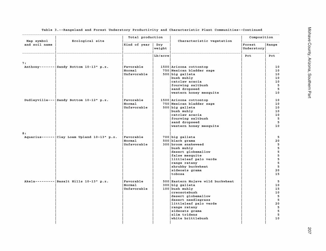
Mohave C
ounty, Arizona, S
outhern Part
207
Table 3.--Rangeland and Forest Understory Productivity and Characteristic Plant Communities--Continued_______________________________________________________________________________________________________________________ | | Total production | | Composition Map symbol | Ecological site |_____________________| Characteristic vegetation |_________________ and soil name | |Kind of year | Dry | |Forest |Range | | |weight | |Understory|_______________|______________________________|_____________|_______|________________________________|__________|______ | | |Lb/acre| | Pct | Pct | | | | | |7: | | | | | | Anthony-------|Sandy Bottom 10-13" p.z. |Favorable | 1500|Arizona cottontop | | 10 | |Normal | 750|Mexican bladder sage | | 10 | |Unfavorable | 500|big galleta | | 10 | | | |bush muhly | | 10 | | | |catclaw acacia | | 10 | | | |fourwing saltbush | | 5 | | | |sand dropseed | | 5 | | | |western honey mesquite | | 10 | | | | | | Dudleyville---|Sandy Bottom 10-12" p.z. |Favorable | 1500|Arizona cottontop | | 10 | |Normal | 750|Mexican bladder sage | | 10 | |Unfavorable | 500|big galleta | | 10 | | | |bush muhly | | 10 | | | |catclaw acacia | | 10 | | | |fourwing saltbush | | 5 | | | |sand dropseed | | 5 | | | |western honey mesquite | | 10 | | | | | |8: | | | | | | Aquarius------|Clay Loam Upland 10-13" p.z. |Favorable | 700|big galleta | | 5 | |Normal | 500|black grama | | 20 | |Unfavorable | 300|broom snakeweed | | 5 | | | |bush muhly | | 5 | | | |desert globemallow | | 5 | | | |false mesquite | | 5 | | | |littleleaf palo verde | | 5 | | | |range ratany | | 5 | | | |shrubby buckwheat | | 5 | | | |sideoats grama | | 20 | | | |tobosa | | 15 | | | | | | Akela---------|Basalt Hills 10-13" p.z. |Favorable | 500|Eastern Mojave wild buckwheat | | 5 | |Normal | 300|big galleta | | 10 | |Unfavorable | 100|bush muhly | | 15 | | | |creosotebush | | 10 | | | |desert globemallow | | 5 | | | |desert needlegrass | | 5 | | | |littleleaf palo verde | | 20 | | | |range ratany | | 5 | | | |sideoats grama | | 5 | | | |slim tridens | | 5 | | | |white brittlebush | | 10 | | | | | |

208S
oil Survey
Table 3.--Rangeland and Forest Understory Productivity and Characteristic Plant Communities--Continued_______________________________________________________________________________________________________________________ | | Total production | | Composition Map symbol | Ecological site |_____________________| Characteristic vegetation |_________________ and soil name | |Kind of year | Dry | |Forest |Range | | |weight | |Understory|_______________|______________________________|_____________|_______|________________________________|__________|______ | | |Lb/acre| | Pct | Pct | | | | | |8: | | | | | | Rock outcrop--| --- |Favorable | --- | | | | |Normal | --- | | | | |Unfavorable | --- | | | | | | | | |9: | | | | | | Arizo---------|Sandy Bottom 10-13" p.z. |Favorable | 1000|Anderson wolfberry | | 5 | |Normal | 600|big galleta | | 5 | |Unfavorable | 300|bush muhly | | 10 | | | |catclaw acacia | | 5 | | | |creosotebush | | 5 | | | |desert rabbitbrush | | 10 | | | |desert willow | | 5 | | | |red brome | | 5 | | | |sand dropseed | | 5 | | | |white burrobush | | 30 | | | |white bursage | | 5 | | | | | | Franconia-----|Sandy Bottom 10-13" p.z. |Favorable | 1000|Anderson wolfberry | | 5 | |Normal | 600|big galleta | | 5 | |Unfavorable | 300|bush muhly | | 10 | | | |catclaw acacia | | 5 | | | |creosotebush | | 5 | | | |desert rabbitbrush | | 10 | | | |red brome | | 5 | | | |sand dropseed | | 5 | | | |white burrobush | | 35 | | | |white bursage | | 5 | | | | | | Riverwash-----| --- |Favorable | --- | | | | |Normal | --- | | | | |Unfavorable | --- | | | | | | | | |10: | | | | | | Arizo---------|Sandy Wash 6-10" p.z. |Favorable | 600|catclaw acacia | | 15 | |Normal | 350|creosotebush | | 10 | |Unfavorable | 100|white burrobrush | | 50 | | | | | | Franconia-----|Sandy Wash 6-10" p.z. |Favorable | 600|catclaw acacia | | 15 | |Normal | 350|creosotebush | | 10 | |Unfavorable | 100|white burrobrush | | 50 | | | | | |

Mohave C
ounty, Arizona, S
outhern Part
209
Table 3.--Rangeland and Forest Understory Productivity and Characteristic Plant Communities--Continued_______________________________________________________________________________________________________________________ | | Total production | | Composition Map symbol | Ecological site |_____________________| Characteristic vegetation |_________________ and soil name | |Kind of year | Dry | |Forest |Range | | |weight | |Understory|_______________|______________________________|_____________|_______|________________________________|__________|______ | | |Lb/acre| | Pct | Pct | | | | | |10: | | | | | | Riverwash-----|Sandy Wash 6-10" p.z. |Favorable | 600|catclaw acacia | | 15 | |Normal | 350|creosotebush | | 10 | |Unfavorable | 100|white burrobrush | | 50 | | | | | |11: | | | | | | Bartmus-------|Limy Upland 12-16" p.z. |Favorable | 900|birchleaf mountain mahogany | | 5 | |Normal | 700|black grama | | 30 | |Unfavorable | 450|desert ceanothus | | 5 | | | |muttongrass | | 5 | | | |needle and thread | | 10 | | | |range ratany | | 5 | | | |sideoats grama | | 25 | | | |slim tridens | | 5 | | | |turbinella oak | | 5 | | | |western bottle-brush grass | | 5 | | | | | |12: | | | | | | Bonita family-|Clayey Upland 12-16" p.z. |Favorable | 1300|broom snakeweed | | 5 | |Normal | 1000|globemallow | | 5 | |Unfavorable | 500|muttongrass | | 10 | | | |shrubby buckwheat | | 5 | | | |sideoats grama | | 20 | | | |tobosa | | 25 | | | |turbinella oak | | 5 | | | |western bottle-brush grass | | 10 | | | | | |13: | | | | | | Bonita family-|Clayey Upland 12-16" p.z. |Favorable | 1300|broom snakeweed | | 5 | |Normal | 1000|globemallow | | 5 | |Unfavorable | 500|muttongrass | | 10 | | | |shrubby buckwheat | | 5 | | | |sideoats grama | | 20 | | | |tobosa | | 25 | | | |turbinella oak | | 5 | | | |western bottle-brush grass | | 10 | | | | | |

210S
oil Survey
Table 3.--Rangeland and Forest Understory Productivity and Characteristic Plant Communities--Continued_______________________________________________________________________________________________________________________ | | Total production | | Composition Map symbol | Ecological site |_____________________| Characteristic vegetation |_________________ and soil name | |Kind of year | Dry | |Forest |Range | | |weight | |Understory|_______________|______________________________|_____________|_______|________________________________|__________|______ | | |Lb/acre| | Pct | Pct | | | | | |13: | | | | | | Gonzales------|Volcanic Hills 12-16" p.z. |Favorable | 1200|birchleaf mountain mahogany | | 5 | Fine |Normal | 900|black grama | | 5 | |Unfavorable | 700|blue grama | | 5 | | | |desert ceanothus | | 10 | | | |desert needlegrass | | 5 | | | |range ratany | | 5 | | | |shrubby buckwheat | | 5 | | | |sideoats grama | | 15 | | | |skunkbush sumac | | 5 | | | |sugar sumac | | 5 | | | | | |14: | | | | | | Brazito family|Sandy Bottom 7-10" p.z. |Favorable | 2500|Mexican bladder sage | | 10 | |Normal | 1500|big galleta | | 15 | |Unfavorable | 500|blue palo verde | | 5 | | | |bush muhly | | 15 | | | |catclaw acacia | | 5 | | | |desert needlegrass | | 5 | | | |littleleaf palo verde | | 5 | | | |shortleaf baccharis | | 10 | | | |western honey mesquite | | 5 | | | |whitestem paperflower | | 5 | | | | | |15: | | | | | | Bucklebar-----|Loamy Hills 10-13" p.z. |Favorable | 1000|Arizona cottontop | | 5 | |Normal | 700|Eastern Mojave wild buckwheat | | 5 | |Unfavorable | 500|Joshua tree | | 5 | | | |banana yucca | | 5 | | | |big galleta | | 10 | | | |black grama | | 20 | | | |broom snakeweed | | 5 | | | |bush muhly | | 10 | | | |creosotebush | | 5 | | | |goldenhead | | 5 | | | |plains bristlegrass | | 5 | | | |range ratany | | 5 | | | | | |

Mohave C
ounty, Arizona, S
outhern Part
211
Table 3.--Rangeland and Forest Understory Productivity and Characteristic Plant Communities--Continued_______________________________________________________________________________________________________________________ | | Total production | | Composition Map symbol | Ecological site |_____________________| Characteristic vegetation |_________________ and soil name | |Kind of year | Dry | |Forest |Range | | |weight | |Understory|_______________|______________________________|_____________|_______|________________________________|__________|______ | | |Lb/acre| | Pct | Pct | | | | | |16: | | | | | | Cacique family|Limy Upland 7-10" p.z. |Favorable | 500|Anderson wolfberry | | 5 | |Normal | 250|Eastern Mojave wild buckwheat | | 5 | |Unfavorable | 100|big galleta | | 10 | | | |black grama | | 5 | | | |bush muhly | | 15 | | | |creosotebush | | 20 | | | |littleleaf palo verde | | 15 | | | |sideoats grama | | 5 | | | |slim tridens | | 5 | | | | | |17: | | | | | | Castaneda-----|Limy Upland 10-13" p.z. |Favorable | 550|Eastern Mojave wild buckwheat | | 25 | |Normal | 350|big galleta | | 10 | |Unfavorable | 150|bush muhly | | 10 | | | |creosotebush | | 5 | | | |goldenhead | | 10 | | | |range ratany | | 10 | | | |red brome | | 5 | | | | | |18: | | | | | | Castaneda-----|Limy Upland 6-10" p.z. |Favorable | 350|creosotebush | | 25 | |Normal | 250|goldenhead | | 5 | |Unfavorable | 100|range ratany | | 5 | | | |red brome | | 15 | | | |white bursage | | 25 | | | | | |19: | | | | | | Carrizo family|Sandy Bottom 2-7" p.z. |Favorable | 2200|big galleta | | 5 | |Normal | 1400|burrobush | | 10 | |Unfavorable | 300|catclaw acacia | | 5 | | | |creosotebush | | 5 | | | |ironwood | | 25 | | | |littleleaf palo verde | | 5 | | | |smoketree | | 5 | | | |white bursage | | 5 | | | |white ratany | | 5 | | | | | |

212S
oil Survey
Table 3.--Rangeland and Forest Understory Productivity and Characteristic Plant Communities--Continued_______________________________________________________________________________________________________________________ | | Total production | | Composition Map symbol | Ecological site |_____________________| Characteristic vegetation |_________________ and soil name | |Kind of year | Dry | |Forest |Range | | |weight | |Understory|_______________|______________________________|_____________|_______|________________________________|__________|______ | | |Lb/acre| | Pct | Pct | | | | | |20: | | | | | | Carrizo family|Sandy Bottom 2-7" p.z. |Favorable | 800|big galleta | | 5 | |Normal | 600|burrobush | | 10 | |Unfavorable | 250|catclaw acacia | | 5 | | | |creosotebush | | 5 | | | |ironwood | | 25 | | | |littleleaf palo verde | | 5 | | | |smoketree | | 5 | | | |white bursage | | 5 | | | |white ratany | | 5 | | | | | | Riverwash-----| --- |Favorable | --- | | | | |Normal | --- | | | | |Unfavorable | --- | | | | | | | | |21: | | | | | | Carrizo-------|Sandy Wash 3-6" p.z. |Favorable | 500|creosotebush | | 25 | |Normal | 300|white burrobrush | | 10 | |Unfavorable | 75|white bursage | | 25 | | | | | | Riverwash-----|Sandy Wash 3-6" p.z. |Favorable | 500|creosotebush | | 25 | |Normal | 300|white burrobrush | | 10 | |Unfavorable | 75|white bursage | | 25 | | | | | |22: | | | | | | Carrizo-------|Sandy Terrace 3-6" p.z. |Favorable | 1000|big galleta | | 5 | |Normal | 600|bush muhly | | 5 | |Unfavorable | 400|catclaw acacia | | 5 | | | |creosotebush | | 10 | | | |red brome | | 5 | | | |smoketree | | 10 | | | |sweetbush | | 5 | | | |white brittlebush | | 5 | | | |white burrobush | | 20 | | | |white bursage | | 10 | | | | | | Riverwash-----| --- |Favorable | --- | | | | |Normal | --- | | | | |Unfavorable | --- | | | | | | | | |

Mohave C
ounty, Arizona, S
outhern Part
213
Table 3.--Rangeland and Forest Understory Productivity and Characteristic Plant Communities--Continued_______________________________________________________________________________________________________________________ | | Total production | | Composition Map symbol | Ecological site |_____________________| Characteristic vegetation |_________________ and soil name | |Kind of year | Dry | |Forest |Range | | |weight | |Understory|_______________|______________________________|_____________|_______|________________________________|__________|______ | | |Lb/acre| | Pct | Pct | | | | | |23: | | | | | | Cave----------|Limy Upland 10-13" p.z. |Favorable | 500|big galleta | | 5 | |Normal | 300|black grama | | 15 | |Unfavorable | 250|bush muhly | | 15 | | | |creosotebush | | 10 | | | |littleleaf palo verde | | 5 | | | |range ratany | | 5 | | | |shrubby buckwheat | | 5 | | | |sideoats grama | | 10 | | | |slim tridens | | 5 | | | |whitestem paperflower | | 5 | | | | | |24: | | | | | | Cave----------|Limy Upland 7-10" p.z. |Favorable | 500|big galleta | | 10 | |Normal | 250|black grama | | 5 | |Unfavorable | 150|bush muhly | | 15 | | | |creosotebush | | 20 | | | |littleleaf palo verde | | 15 | | | |sideoats grama | | 5 | | | |slim tridens | | 5 | | | |white bursage | | 5 | | | |white ratany | | 5 | | | | | |25: | | | | | | Cellar--------|Granitic Hills 10-12" p.z. |Favorable | 1000|Eastern Mojave wild buckwheat | | 5 | |Normal | 800|agave | | 5 | |Unfavorable | 600|big galleta | | 5 | | | |black grama | | 15 | | | |bush muhly | | 5 | | | |desert needlegrass | | 10 | | | |false mesquite | | 5 | | | |ocotillo | | 5 | | | |shrubby buckwheat | | 5 | | | |sideoats grama | | 15 | | | |tobosa | | 5 | | | | | | Rock outcrop--| --- |Favorable | --- | | | | |Normal | --- | | | | |Unfavorable | --- | | | | | | | | |

214S
oil Survey
Table 3.--Rangeland and Forest Understory Productivity and Characteristic Plant Communities--Continued_______________________________________________________________________________________________________________________ | | Total production | | Composition Map symbol | Ecological site |_____________________| Characteristic vegetation |_________________ and soil name | |Kind of year | Dry | |Forest |Range | | |weight | |Understory|_______________|______________________________|_____________|_______|________________________________|__________|______ | | |Lb/acre| | Pct | Pct | | | | | |26: | | | | | | Cellar--------|Granitic Hills 7-10" p.z. |Favorable | 700|Eastern Mojave wild buckwheat | | 5 | |Normal | 550|agave | | 5 | |Unfavorable | 350|big galleta | | 5 | | | |black grama | | 5 | | | |bush muhly | | 20 | | | |desert needlegrass | | 10 | | | |false mesquite | | 5 | | | |ocotillo | | 5 | | | |shrubby buckwheat | | 5 | | | |sideoats grama | | 5 | | | |tobosa | | 15 | | | |white brittlebush | | 5 | | | | | | Rock outcrop--| --- |Favorable | --- | | | | |Normal | --- | | | | |Unfavorable | --- | | | | | | | | |27: | | | | | | Cellar--------|Granitic Hills 10-12" p.z. |Favorable | 1000|Eastern Mojave wild buckwheat | | 5 | |Normal | 800|agave | | 5 | |Unfavorable | 600|big galleta | | 5 | | | |black grama | | 15 | | | |bush muhly | | 5 | | | |desert needlegrass | | 10 | | | |false mesquite | | 5 | | | |ocotillo | | 5 | | | |shrubby buckwheat | | 5 | | | |sideoats grama | | 15 | | | |tobosa | | 5 | | | | | | Topock--------|Shallow Hills 10-13" p.z. |Favorable | 1000|California juniper | | 5 | |Normal | 800|Eastern Mojave wild buckwheat | | 5 | |Unfavorable | 600|big galleta | | 5 | | | |black grama | | 15 | | | |broom snakeweed | | 5 | | | |desert needlegrass | | 10 | | | |range ratany | | 5 | | | |sideoats grama | | 15 | | | |tobosa | | 5 | | | |turbinella oak | | 5 | | | |turpentine bush | | 5 | | | | | |

Mohave C
ounty, Arizona, S
outhern Part
215
Table 3.--Rangeland and Forest Understory Productivity and Characteristic Plant Communities--Continued_______________________________________________________________________________________________________________________ | | Total production | | Composition Map symbol | Ecological site |_____________________| Characteristic vegetation |_________________ and soil name | |Kind of year | Dry | |Forest |Range | | |weight | |Understory|_______________|______________________________|_____________|_______|________________________________|__________|______ | | |Lb/acre| | Pct | Pct | | | | | |27: | | | | | | Rock outcrop--| --- |Favorable | --- | | | | |Normal | --- | | | | |Unfavorable | --- | | | | | | | | |28: | | | | | | Cherioni------|Limy Upland 2-7" p.z. |Favorable | 150|big galleta | | 5 | |Normal | 100|bush muhly | | 5 | |Unfavorable | 25|creosotebush | | 20 | | | |teddybear cholla | | 5 | | | |white brittlebush | | 15 | | | |white bursage | | 25 | | | |white ratany | | 15 | | | | | |29: | | | | | | Chuckawalla---| --- |Favorable | --- | | | | |Normal | --- | | | | |Unfavorable | --- | | | | | | | | | Riverbend-----|Limy Upland 3-6" p.z. Deep |Favorable | 200|creosotebush | | 50 | |Normal | 100|white bursage | | 35 | |Unfavorable | 25| | | | | | | | |30: | | | | | | Chuckawalla |Saline Upland 2-7" p.z. |Favorable | --- | | | family-------| |Normal | --- | | | | |Unfavorable | --- | | | | | | | | | Riverbend |Limy Upland 2-7" p.z. Deep |Favorable | 150|big galleta | | 5 family-------| |Normal | 100|creosotebush | | 40 | |Unfavorable | 25|littleleaf palo verde | | 5 | | | |white brittlebush | | 5 | | | |white bursage | | 20 | | | |white ratany | | 10 | | | | | |

216S
oil Survey
Table 3.--Rangeland and Forest Understory Productivity and Characteristic Plant Communities--Continued_______________________________________________________________________________________________________________________ | | Total production | | Composition Map symbol | Ecological site |_____________________| Characteristic vegetation |_________________ and soil name | |Kind of year | Dry | |Forest |Range | | |weight | |Understory|_______________|______________________________|_____________|_______|________________________________|__________|______ | | |Lb/acre| | Pct | Pct | | | | | |31: | | | | | | Cipriano------|Limy Upland 2-7" p.z. |Favorable | 150|big galleta | | 5 | |Normal | 100|bush muhly | | 5 | |Unfavorable | 25|creosotebush | | 40 | | | |littleleaf palo verde | | 5 | | | |ocotillo | | 5 | | | |red brome | | 10 | | | |white bursage | | 15 | | | |white ratany | | 10 | | | | | |32: | | | | | | Cline---------|Limy Upland 10-13" p.z. |Favorable | 500|big galleta | | 5 | |Normal | 300|black grama | | 10 | |Unfavorable | 250|bush muhly | | 15 | | | |creosotebush | | 10 | | | |littleleaf palo verde | | 5 | | | |range ratany | | 5 | | | |shrubby buckwheat | | 5 | | | |sideoats grama | | 10 | | | |slim tridens | | 5 | | | |whitestem paperflower | | 5 | | | | | |33: | | | | | | Cline---------|Limy Upland 7-10" p.z. |Favorable | 500|Anderson wolfberry | | 5 | |Normal | 250|Eastern Mojave wild buckwheat | | 10 | |Unfavorable | 150|big galleta | | 10 | | | |black grama | | 5 | | | |bush muhly | | 15 | | | |creosotebush | | 20 | | | |littleleaf palo verde | | 15 | | | |sideoats grama | | 5 | | | |slim tridens | | 5 | | | | | |
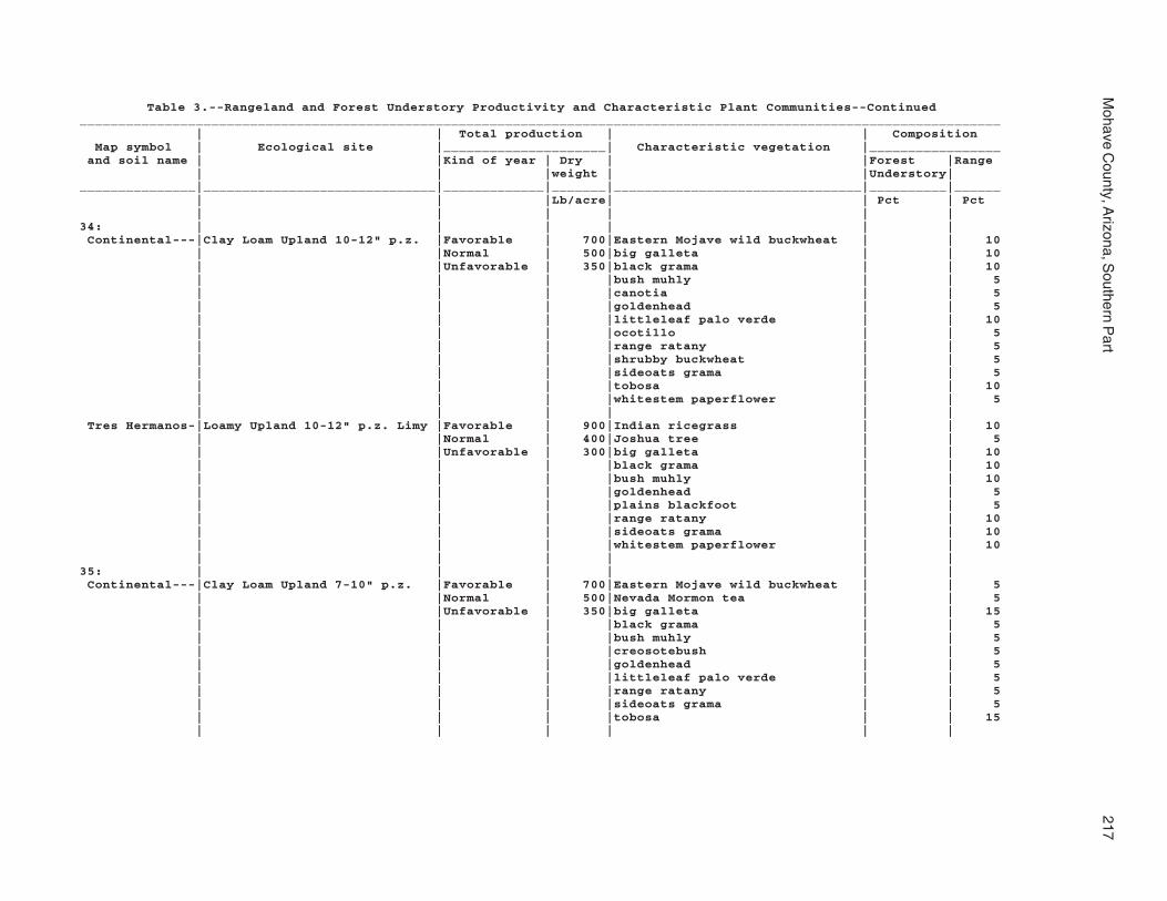
Mohave C
ounty, Arizona, S
outhern Part
217
Table 3.--Rangeland and Forest Understory Productivity and Characteristic Plant Communities--Continued_______________________________________________________________________________________________________________________ | | Total production | | Composition Map symbol | Ecological site |_____________________| Characteristic vegetation |_________________ and soil name | |Kind of year | Dry | |Forest |Range | | |weight | |Understory|_______________|______________________________|_____________|_______|________________________________|__________|______ | | |Lb/acre| | Pct | Pct | | | | | |34: | | | | | | Continental---|Clay Loam Upland 10-12" p.z. |Favorable | 700|Eastern Mojave wild buckwheat | | 10 | |Normal | 500|big galleta | | 10 | |Unfavorable | 350|black grama | | 10 | | | |bush muhly | | 5 | | | |canotia | | 5 | | | |goldenhead | | 5 | | | |littleleaf palo verde | | 10 | | | |ocotillo | | 5 | | | |range ratany | | 5 | | | |shrubby buckwheat | | 5 | | | |sideoats grama | | 5 | | | |tobosa | | 10 | | | |whitestem paperflower | | 5 | | | | | | Tres Hermanos-|Loamy Upland 10-12" p.z. Limy |Favorable | 900|Indian ricegrass | | 10 | |Normal | 400|Joshua tree | | 5 | |Unfavorable | 300|big galleta | | 10 | | | |black grama | | 10 | | | |bush muhly | | 10 | | | |goldenhead | | 5 | | | |plains blackfoot | | 5 | | | |range ratany | | 10 | | | |sideoats grama | | 10 | | | |whitestem paperflower | | 10 | | | | | |35: | | | | | | Continental---|Clay Loam Upland 7-10" p.z. |Favorable | 700|Eastern Mojave wild buckwheat | | 5 | |Normal | 500|Nevada Mormon tea | | 5 | |Unfavorable | 350|big galleta | | 15 | | | |black grama | | 5 | | | |bush muhly | | 5 | | | |creosotebush | | 5 | | | |goldenhead | | 5 | | | |littleleaf palo verde | | 5 | | | |range ratany | | 5 | | | |sideoats grama | | 5 | | | |tobosa | | 15 | | | | | |

218S
oil Survey
Table 3.--Rangeland and Forest Understory Productivity and Characteristic Plant Communities--Continued_______________________________________________________________________________________________________________________ | | Total production | | Composition Map symbol | Ecological site |_____________________| Characteristic vegetation |_________________ and soil name | |Kind of year | Dry | |Forest |Range | | |weight | |Understory|_______________|______________________________|_____________|_______|________________________________|__________|______ | | |Lb/acre| | Pct | Pct | | | | | |35: | | | | | | Tres Hermanos-|Limy Fan 7-10" p.z. |Favorable | 600|Joshua tree | | 5 | |Normal | 400|big galleta | | 10 | |Unfavorable | 200|black grama | | 5 | | | |bush muhly | | 5 | | | |creosotebush | | 25 | | | |goldenhead | | 5 | | | |range ratany | | 10 | | | |white bursage | | 10 | | | |whitestem paperflower | | 10 | | | | | |36: | | | | | | Continental---|Clay Loam Upland 10-12" p.z. |Favorable | 700|Eastern Mojave wild buckwheat | | 10 | |Normal | 500|big galleta | | 10 | |Unfavorable | 350|black grama | | 10 | | | |bush muhly | | 5 | | | |canotia | | 5 | | | |goldenhead | | 5 | | | |littleleaf palo verde | | 10 | | | |ocotillo | | 5 | | | |range ratany | | 5 | | | |shrubby buckwheat | | 5 | | | |sideoats grama | | 5 | | | |tobosa | | 10 | | | |whitestem paperflower | | 5 | | | | | | Rillino-------|Loamy Upland 10-12" p.z. Limy |Favorable | 900|Indian ricegrass | | 10 | |Normal | 400|Joshua tree | | 5 | |Unfavorable | 300|big galleta | | 10 | | | |black grama | | 10 | | | |bush muhly | | 10 | | | |canotia | | 5 | | | |goldenhead | | 5 | | | |littleleaf palo verde | | 5 | | | |plains blackfoot | | 5 | | | |range ratany | | 10 | | | |sideoats grama | | 10 | | | |whitestem paperflower | | 10 | | | | | |

Mohave C
ounty, Arizona, S
outhern Part
219
Table 3.--Rangeland and Forest Understory Productivity and Characteristic Plant Communities--Continued_______________________________________________________________________________________________________________________ | | Total production | | Composition Map symbol | Ecological site |_____________________| Characteristic vegetation |_________________ and soil name | |Kind of year | Dry | |Forest |Range | | |weight | |Understory|_______________|______________________________|_____________|_______|________________________________|__________|______ | | |Lb/acre| | Pct | Pct | | | | | |37: | | | | | | Continental---|Clay Loam Upland 7-10" p.z. |Favorable | 700|Eastern Mojave wild buckwheat | | 5 | |Normal | 500|Nevada Mormon tea | | 5 | |Unfavorable | 350|big galleta | | 15 | | | |black grama | | 5 | | | |bush muhly | | 5 | | | |creosotebush | | 5 | | | |goldenhead | | 5 | | | |littleleaf palo verde | | 5 | | | |range ratany | | 5 | | | |sideoats grama | | 5 | | | |tobosa | | 15 | | | | | | Rillino-------|Limy Fan 7-10" p.z. |Favorable | 600|Joshua tree | | 5 | |Normal | 400|big galleta | | 10 | |Unfavorable | 200|black grama | | 5 | | | |bush muhly | | 5 | | | |creosotebush | | 25 | | | |goldenhead | | 5 | | | |littleleaf palo verde | | 5 | | | |range ratany | | 10 | | | |white bursage | | 10 | | | |whitestem paperflower | | 10 | | | | | |38: | | | | | | Coolidge------|Sandy Loam Upland 2-7" p.z. |Favorable | 800|big galleta | | 5 | |Normal | 300|blond plantain | | 10 | |Unfavorable | 100|creosotebush | | 40 | | | |littleleaf palo verde | | 5 | | | |white bursage | | 20 | | | |white ratany | | 5 | | | | | | Denure--------|Sandy Loam Upland 2-7" p.z. |Favorable | 800|big galleta | | 5 | |Normal | 300|blond plantain | | 10 | |Unfavorable | 100|creosotebush | | 40 | | | |littleleaf palo verde | | 5 | | | |white bursage | | 20 | | | |white ratany | | 5 | | | | | |

220S
oil Survey
Table 3.--Rangeland and Forest Understory Productivity and Characteristic Plant Communities--Continued_______________________________________________________________________________________________________________________ | | Total production | | Composition Map symbol | Ecological site |_____________________| Characteristic vegetation |_________________ and soil name | |Kind of year | Dry | |Forest |Range | | |weight | |Understory|_______________|______________________________|_____________|_______|________________________________|__________|______ | | |Lb/acre| | Pct | Pct | | | | | |39: | | | | | | Coolidge |Limy Fan 3-6" p.z. |Favorable | 500|big galleta | | 5 family-------| |Normal | 300|blond plantain | | 10 | |Unfavorable | 100|creosotebush | | 40 | | | |white bursage | | 25 | | | |white ratany | | 15 | | | | | | Denure family-|Limy Fan 3-6" p.z. |Favorable | 500|big galleta | | 5 | |Normal | 300|blond plantain | | 10 | |Unfavorable | 100|creosotebush | | 40 | | | |white bursage | | 25 | | | |white ratany | | 15 | | | | | |40: | | | | | | Courthouse |Volcanic Hills 12-16" p.z. |Favorable | 1200|birchleaf mountain mahogany | | 10 family-------| Fine |Normal | 900|black grama | | 10 | |Unfavorable | 700|desert ceanothus | | 15 | | | |desert needlegrass | | 5 | | | |range ratany | | 5 | | | |sideoats grama | | 10 | | | |skunkbush sumac | | 5 | | | |sugar sumac | | 5 | | | |turbinella oak | | 15 | | | |western bottle-brush grass | | 5 | | | |yellow-leaf silktassel | | 5 | | | | | | Rock outcrop--| --- |Favorable | --- | | | | |Normal | --- | | | | |Unfavorable | --- | | | | | | | | | Rubble land---| --- |Favorable | --- | | | | |Normal | --- | | | | |Unfavorable | --- | | | | | | | | |

Mohave C
ounty, Arizona, S
outhern Part
221
Table 3.--Rangeland and Forest Understory Productivity and Characteristic Plant Communities--Continued_______________________________________________________________________________________________________________________ | | Total production | | Composition Map symbol | Ecological site |_____________________| Characteristic vegetation |_________________ and soil name | |Kind of year | Dry | |Forest |Range | | |weight | |Understory|_______________|______________________________|_____________|_______|________________________________|__________|______ | | |Lb/acre| | Pct | Pct | | | | | |41: | | | | | | Courthouse |Volcanic Hills 12-16" p.z. |Favorable | 1200|birchleaf mountain mahogany | | 10 family-------| Fine |Normal | 900|black grama | | 10 | |Unfavorable | 700|desert ceanothus | | 15 | | | |desert needlegrass | | 5 | | | |range ratany | | 5 | | | |sideoats grama | | 10 | | | |skunkbush sumac | | 5 | | | |sugar sumac | | 5 | | | |turbinella oak | | 15 | | | |western bottle-brush grass | | 5 | | | |yellow-leaf silktassel | | 5 | | | | | | Rock outcrop--| --- |Favorable | --- | | | | |Normal | --- | | | | |Unfavorable | --- | | | | | | | | | Wagonbow------|Clay Loam Slopes 12-16" p.z. |Favorable | 800|birchleaf mountain mahogany | | 5 | |Normal | 650|black grama | | 20 | |Unfavorable | 500|desert ceanothus | | 10 | | | |desert needlegrass | | 10 | | | |false mesquite | | 5 | | | |muttongrass | | 5 | | | |shrubby buckwheat | | 5 | | | |sideoats grama | | 15 | | | |turbinella oak | | 10 | | | |western bottle-brush grass | | 5 | | | | | |42: | | | | | | Far-----------|Granitic Hills 16-20" p.z. |Favorable | 1500|Arizona fescue | 5| 5 | |Normal | 1000|Gambel oak | 5| 5 | |Unfavorable | 850|birchleaf mountain mahogany | 10| 10 | | | |black grama | 15| 15 | | | |desert ceanothus | 5| 5 | | | |false mesquite | 5| 5 | | | |muttongrass | 10| 10 | | | |pointleaf manzanita | 5| 5 | | | |ponderosa pine | 5| 5 | | | |shrubby buckwheat | 5| 5 | | | |sideoats grama | 15| 15 | | | |single-leaf pinyon | 5| 5 | | | |turbinella oak | 5| 5 | | | | | |

222S
oil Survey
Table 3.--Rangeland and Forest Understory Productivity and Characteristic Plant Communities--Continued_______________________________________________________________________________________________________________________ | | Total production | | Composition Map symbol | Ecological site |_____________________| Characteristic vegetation |_________________ and soil name | |Kind of year | Dry | |Forest |Range | | |weight | |Understory|_______________|______________________________|_____________|_______|________________________________|__________|______ | | |Lb/acre| | Pct | Pct | | | | | |42: | | | | | | Rock outcrop--| --- |Favorable | --- | | | | |Normal | --- | | | | |Unfavorable | --- | | | | | | | | |43: | | | | | | Dutchflat-----|Sandy Loam Upland 6-10" p.z. |Favorable | 300|big galleta | | 35 | Fine |Normal | 200|white burrobrush | | 10 | |Unfavorable | 75| | | | | | | | |44: | | | | | | Dutchflat-----|Sandy Loam Upland 6-10" p.z. |Favorable | 500|Anderson wolfberry | | 5 | Fine |Normal | 350|big galleta | | 15 | |Unfavorable | 200|buckhorn cholla | | 5 | | | |bush muhly | | 5 | | | |creosotebush | | 20 | | | |goldenhead | | 5 | | | |range ratany | | 5 | | | |red brome | | 5 | | | |white bursage | | 20 | | | | | |45: | | | | | | Gadsden-------| --- |Favorable | --- | | | | |Normal | --- | | | | |Unfavorable | --- | | | | | | | | |46: | | | | | | Gila----------|Loamy Bottom 10-12" p.z. |Favorable | 1800|Arizona cottontop | | 25 | |Normal | 1400|Nevada Mormon tea | | 5 | |Unfavorable | 1000|arrowweed | | 5 | | | |big galleta | | 10 | | | |bush muhly | | 25 | | | |catclaw acacia | | 5 | | | |tobosa | | 10 | | | |western honey mesquite | | 5 | | | | | |

Mohave C
ounty, Arizona, S
outhern Part
223
Table 3.--Rangeland and Forest Understory Productivity and Characteristic Plant Communities--Continued_______________________________________________________________________________________________________________________ | | Total production | | Composition Map symbol | Ecological site |_____________________| Characteristic vegetation |_________________ and soil name | |Kind of year | Dry | |Forest |Range | | |weight | |Understory|_______________|______________________________|_____________|_______|________________________________|__________|______ | | |Lb/acre| | Pct | Pct | | | | | |46: | | | | | | Glendale------|Loamy Bottom 10-12" p.z. |Favorable | 1800|Arizona cottontop | | 25 | |Normal | 1400|Nevada Mormon tea | | 5 | |Unfavorable | 1000|arrowweed | | 5 | | | |big galleta | | 10 | | | |bush muhly | | 25 | | | |catclaw acacia | | 5 | | | |tobosa | | 10 | | | |western honey mesquite | | 5 | | | | | |47: | | | | | | Gila----------|Loamy Bottom 7-10" p.z. |Favorable | 1800|Arizona cottontop | | 5 | |Normal | 900|Nevada Mormon tea | | 5 | |Unfavorable | 600|arrowweed | | 5 | | | |big galleta | | 25 | | | |black grama | | 5 | | | |bush muhly | | 20 | | | |catclaw acacia | | 5 | | | |tobosa | | 5 | | | |western bottle-brush grass | | 5 | | | |western honey mesquite | | 5 | | | | | | Glendale------|Loamy Bottom 7-10" p.z. |Favorable | 1800|Arizona cottontop | | 5 | |Normal | 900|Nevada Mormon tea | | 5 | |Unfavorable | 600|arrowweed | | 5 | | | |big galleta | | 25 | | | |black grama | | 5 | | | |bush muhly | | 20 | | | |catclaw acacia | | 5 | | | |tobosa | | 5 | | | |western bottle-brush grass | | 5 | | | |western honey mesquite | | 5 | | | | | |48: | | | | | | Goldroad------|Granitic Hills 3-6" p.z. |Favorable | 700|Nevada Mormon tea | | 5 | |Normal | 300|big galleta | | 5 | |Unfavorable | 200|creosotebush | | 20 | | | |white brittlebush | | 30 | | | |white bursage | | 15 | | | |white ratany | | 5 | | | | | |

224S
oil Survey
Table 3.--Rangeland and Forest Understory Productivity and Characteristic Plant Communities--Continued_______________________________________________________________________________________________________________________ | | Total production | | Composition Map symbol | Ecological site |_____________________| Characteristic vegetation |_________________ and soil name | |Kind of year | Dry | |Forest |Range | | |weight | |Understory|_______________|______________________________|_____________|_______|________________________________|__________|______ | | |Lb/acre| | Pct | Pct | | | | | |48: | | | | | | Rock outcrop--| --- |Favorable | --- | | | | |Normal | --- | | | | |Unfavorable | --- | | | | | | | | |49: | | | | | | Gonzales------|Volcanic Hills 12-16" p.z. |Favorable | 1200|black grama | | 10 | Fine |Normal | 900|blue grama | | 10 | |Unfavorable | 700|bottlebrush squirreltail | | 7 | | | |desert needlegrass | | 7 | | | |sideoats grama | | 25 | | | | | | Rock outcrop--| --- |Favorable | --- | | | | |Normal | --- | | | | |Unfavorable | --- | | | | | | | | |50: | | | | | | Goodsprings |Limy Upland 10-13" p.z. |Favorable | 550|Mexican bladder sage | | 5 family-------| |Normal | 350|Nevada Mormon tea | | 5 | |Unfavorable | 150|Schott yucca | | 10 | | | |big galleta | | 5 | | | |broom snakeweed | | 5 | | | |bush muhly | | 10 | | | |creosotebush | | 10 | | | |goldenhead | | 5 | | | |ocotillo | | 5 | | | |red brome | | 5 | | | |white bursage | | 25 | | | | | |51: | | | | | | Goodsprings |Limy Upland 6-10" p.z. |Favorable | 350|Mexican bladder sage | | 5 family-------| |Normal | 250|Nevada Mormon tea | | 5 | |Unfavorable | 100|big galleta | | 5 | | | |creosotebush | | 25 | | | |goldenhead | | 5 | | | |ocotillo | | 5 | | | |red brome | | 10 | | | |white bursage | | 25 | | | | | |

Mohave C
ounty, Arizona, S
outhern Part
225
Table 3.--Rangeland and Forest Understory Productivity and Characteristic Plant Communities--Continued_______________________________________________________________________________________________________________________ | | Total production | | Composition Map symbol | Ecological site |_____________________| Characteristic vegetation |_________________ and soil name | |Kind of year | Dry | |Forest |Range | | |weight | |Understory|_______________|______________________________|_____________|_______|________________________________|__________|______ | | |Lb/acre| | Pct | Pct | | | | | |52: | | | | | | Goodsprings |Sandy Loam Hills 10-13" p.z. |Favorable | --- |Mexican bladder sage | | 25 family-------| Limy, Shallow |Normal | 475|big galleta | | 30 | |Unfavorable | --- |rayless goldenhead | | 10 | | | | | |53: | | | | | | Goodsprings |Limy Upland 6-10" p.z. |Favorable | 350|Mexican bladder sage | | 5 family-------| |Normal | 250|Nevada Mormon tea | | 5 | |Unfavorable | 100|big galleta | | 5 | | | |creosotebush | | 25 | | | |goldenhead | | 5 | | | |ocotillo | | 5 | | | |red brome | | 10 | | | |white bursage | | 25 | | | | | |54: | | | | | | Graham--------|Volcanic Upland 12-16" p.z. |Favorable | 500|Aristida | | 10 | |Normal | 300|Opuntia | | 7 | |Unfavorable | 100|Stansbury cliffrose | | 15 | | | |Utah juniper | | 10 | | | |black grama | | 7 | | | |blue grama | | 7 | | | |broom snakeweed | | 15 | | | | | | Arivaca-------|Clay Loam Upland 12-16" p.z. |Favorable | 1150|black grama | | 15 | |Normal | 950|blue grama | | 15 | |Unfavorable | 750|bottlebrush squirreltail | | 10 | | | |muttongrass | | 10 | | | |sideoats grama | | 20 | | | | | |55: | | | | | | Graham--------|Volcanic Hills 12-16" p.z. |Favorable | 1200|black grama | | 10 | Fine |Normal | 900|blue grama | | 10 | |Unfavorable | 700|bottlebrush squirreltail | | 7 | | | |desert needlegrass | | 7 | | | |sideoats grama | | 25 | | | | | | Rock outcrop--| --- |Favorable | --- | | | | |Normal | --- | | | | |Unfavorable | --- | | | | | | | | |

226S
oil Survey
Table 3.--Rangeland and Forest Understory Productivity and Characteristic Plant Communities--Continued_______________________________________________________________________________________________________________________ | | Total production | | Composition Map symbol | Ecological site |_____________________| Characteristic vegetation |_________________ and soil name | |Kind of year | Dry | |Forest |Range | | |weight | |Understory|_______________|______________________________|_____________|_______|________________________________|__________|______ | | |Lb/acre| | Pct | Pct | | | | | |56: | | | | | | Gunsight------|Limy Upland 2-7" p.z. Deep |Favorable | 150|big galleta | | 5 | |Normal | 100|bush muhly | | 5 | |Unfavorable | 25|creosotebush | | 25 | | | |red brome | | 10 | | | |white brittlebush | | 5 | | | |white bursage | | 25 | | | |white ratany | | 10 | | | | | |57: | | | | | | Gunsight------|Limy Slopes 2-7" p.z. |Favorable | 250|big galleta | | 5 | |Normal | 175|bush muhly | | 5 | |Unfavorable | 75|creosotebush | | 50 | | | |red brome | | 10 | | | |white brittlebush | | 5 | | | |white bursage | | 5 | | | |white ratany | | 5 | | | | | |58: | | | | | | Hassell family|Granitic/Schist Hills 10-13" |Favorable | 1500|Colorado pinyon | | 10 | p.z. |Normal | 1000|Opuntia | | 10 | |Unfavorable | 500|banana yucca | | 10 | | | |desert ceanothus | | 20 | | | |desert needlegrass | | 7 | | | |singleleaf pinyon | | 10 | | | |turbinella oak | | 20 | | | | | | Lampshire-----|Granitic/Schist Hills 10-13" |Favorable | 1500|Colorado pinyon | | 10 | p.z. |Normal | 1000|Opuntia | | 10 | |Unfavorable | 500|banana yucca | | 10 | | | |desert ceanothus | | 20 | | | |desert needlegrass | | 7 | | | |singleleaf pinyon | | 10 | | | |turbinella oak | | 20 | | | | | | Rock outcrop--|Granitic/Schist Hills 10-13" |Favorable | 1500|Colorado pinyon | | 10 | p.z. |Normal | 1000|Opuntia | | 10 | |Unfavorable | 500|banana yucca | | 10 | | | |desert ceanothus | | 20 | | | |desert needlegrass | | 7 | | | |singleleaf pinyon | | 10 | | | |turbinella oak | | 20 | | | | | |

Mohave C
ounty, Arizona, S
outhern Part
227
Table 3.--Rangeland and Forest Understory Productivity and Characteristic Plant Communities--Continued_______________________________________________________________________________________________________________________ | | Total production | | Composition Map symbol | Ecological site |_____________________| Characteristic vegetation |_________________ and soil name | |Kind of year | Dry | |Forest |Range | | |weight | |Understory|_______________|______________________________|_____________|_______|________________________________|__________|______ | | |Lb/acre| | Pct | Pct | | | | | |59: | | | | | | Holtville-----| --- |Favorable | --- | | | | |Normal | --- | | | | |Unfavorable | --- | | | | | | | | |60: | | | | | | Huevi---------|Limy Slopes 3-6" p.z. |Favorable | 250|creosotebush | | 60 | |Normal | 125|red brome | | 5 | |Unfavorable | 50|white brittlebush | | 5 | | | |white bursage | | 10 | | | |white ratany | | 5 | | | | | |61: | | | | | | Huevi---------|Limy Slopes 3-6" p.z. |Favorable | 200|creosotebush | | 60 | |Normal | 100|white bursage | | 15 | |Unfavorable | 25| | | | | | | | |62: | | | | | | Akela---------|Granitic Hills 7-10" p.z. |Favorable | 700|Eastern Mojave wild buckwheat | | 10 | |Normal | 550|bush muhly | | 15 | |Unfavorable | 350|desert needlegrass | | 10 | | | |littleleaf palo verde | | 5 | | | |shrubby buckwheat | | 5 | | | |slim tridens | | 5 | | | |tobosa | | 20 | | | | | | Rock outcrop--| --- |Favorable | --- | | | | |Normal | --- | | | | |Unfavorable | --- | | | | | | | | |63: | | | | | | Hyder---------|Basalt Hills 2-7" p.z. |Favorable | 450|Nevada Mormon tea | | 10 | |Normal | 350|big galleta | | 10 | |Unfavorable | 200|bush muhly | | 5 | | | |creosotebush | | 5 | | | |desert globemallow | | 5 | | | |littleleaf palo verde | | 10 | | | |shrubby buckwheat | | 10 | | | |white brittlebush | | 5 | | | |white bursage | | 5 | | | |white ratany | | 5 | | | | | |

228S
oil Survey
Table 3.--Rangeland and Forest Understory Productivity and Characteristic Plant Communities--Continued_______________________________________________________________________________________________________________________ | | Total production | | Composition Map symbol | Ecological site |_____________________| Characteristic vegetation |_________________ and soil name | |Kind of year | Dry | |Forest |Range | | |weight | |Understory|_______________|______________________________|_____________|_______|________________________________|__________|______ | | |Lb/acre| | Pct | Pct | | | | | |63: | | | | | | Rock outcrop--| --- |Favorable | --- | | | | |Normal | --- | | | | |Unfavorable | --- | | | | | | | | | Rubble land---| --- |Favorable | --- | | | | |Normal | --- | | | | |Unfavorable | --- | | | | | | | | |64: | | | | | | Indio---------| --- |Favorable | --- | | | | |Normal | --- | | | | |Unfavorable | --- | | | | | | | | |65: | | | | | | Ireteba family|Sandy Wash 10-13" p.z. |Favorable | 900|catclaw acacia | | 15 | |Normal | 550|creosotebush | | 10 | |Unfavorable | 200|white burrobrush | | 35 | | | | | | Arizo---------|Sandy Wash 10-13" p.z. |Favorable | 900|catclaw acacia | | 15 | |Normal | 550|creosotebush | | 10 | |Unfavorable | 200|white burrobrush | | 35 | | | | | |66: | | | | | | Kinley--------|Sandy Loam Slopes 10-13" p.z. |Favorable | 700|Aristida | | 20 | Limy, Skeletal |Normal | 450|Mexican bladdersage | | 15 | |Unfavorable | 200|banana yucca | | 7 | | | |big galleta | | 7 | | | |black grama | | 20 | | | |turbinella oak | | 7 | | | | | |67: | | | | | | Kinley--------|Limy Fan 6-10" p.z. |Favorable | 400|Anderson wolfberry | | 5 | |Normal | 300|Joshua tree | | 5 | |Unfavorable | 200|Nevada Mormon tea | | 5 | | | |big galleta | | 5 | | | |catclaw acacia | | 5 | | | |creosotebush | | 30 | | | |goldenhead | | 5 | | | |range ratany | | 5 | | | |white bursage | | 30 | | | | | |

Mohave C
ounty, Arizona, S
outhern Part
229
Table 3.--Rangeland and Forest Understory Productivity and Characteristic Plant Communities--Continued_______________________________________________________________________________________________________________________ | | Total production | | Composition Map symbol | Ecological site |_____________________| Characteristic vegetation |_________________ and soil name | |Kind of year | Dry | |Forest |Range | | |weight | |Understory|_______________|______________________________|_____________|_______|________________________________|__________|______ | | |Lb/acre| | Pct | Pct | | | | | |67: | | | | | | Poachie-------|Limy Fan 6-10" p.z. |Favorable | 400|Joshua tree | | 5 | |Normal | 300|big galleta | | 5 | |Unfavorable | 200|creosotebush | | 35 | | | |goldenhead | | 5 | | | |range ratany | | 5 | | | |red brome | | 5 | | | |white bursage | | 30 | | | | | |68: | | | | | | Kofa----------| --- |Favorable | --- | | | | |Normal | --- | | | | |Unfavorable | --- | | | | | | | | |69: | | | | | | Dudleyville---|Sandy Bottom 10-12" p.z. |Favorable | 1500|Arizona cottontop | | 10 | |Normal | 750|Mexican bladder sage | | 10 | |Unfavorable | 500|big galleta | | 10 | | | |bush muhly | | 10 | | | |catclaw acacia | | 10 | | | |fourwing saltbush | | 5 | | | |sand dropseed | | 5 | | | |western honey mesquite | | 10 | | | | | | Vinton--------|Sandy Bottom 10-12" p.z. |Favorable | 1500|Arizona cottontop | | 10 | |Normal | 750|Mexican bladder sage | | 10 | |Unfavorable | 500|big galleta | | 10 | | | |bush muhly | | 10 | | | |catclaw acacia | | 10 | | | |fourwing saltbush | | 5 | | | |sand dropseed | | 5 | | | |western honey mesquite | | 10 | | | | | | Riverwash-----| --- |Favorable | --- | | | | |Normal | --- | | | | |Unfavorable | --- | | | | | | | | |

230S
oil Survey
Table 3.--Rangeland and Forest Understory Productivity and Characteristic Plant Communities--Continued_______________________________________________________________________________________________________________________ | | Total production | | Composition Map symbol | Ecological site |_____________________| Characteristic vegetation |_________________ and soil name | |Kind of year | Dry | |Forest |Range | | |weight | |Understory|_______________|______________________________|_____________|_______|________________________________|__________|______ | | |Lb/acre| | Pct | Pct | | | | | |70: | | | | | | Dudleyville---|Sandy Bottom 7-10" p.z. |Favorable | 2500|Mexican bladder sage | | 10 | |Normal | 1500|big galleta | | 15 | |Unfavorable | 500|blue palo verde | | 5 | | | |bush muhly | | 15 | | | |catclaw acacia | | 5 | | | |desert needlegrass | | 5 | | | |littleleaf palo verde | | 5 | | | |shortleaf baccharis | | 10 | | | |western bottle-brush grass | | 5 | | | |western honey mesquite | | 5 | | | |whitestem paperflower | | 5 | | | | | | Vinton--------|Sandy Bottom 7-10" p.z. |Favorable | 2500|Mexican bladder sage | | 10 | |Normal | 1500|big galleta | | 15 | |Unfavorable | 500|blue palo verde | | 5 | | | |bush muhly | | 15 | | | |catclaw acacia | | 5 | | | |desert needlegrass | | 5 | | | |littleleaf palo verde | | 5 | | | |shortleaf baccharis | | 10 | | | |western bottle-brush grass | | 5 | | | |western honey mesquite | | 5 | | | |whitestem paperflower | | 5 | | | | | | Riverwash-----| --- |Favorable | --- | | | | |Normal | --- | | | | |Unfavorable | --- | | | | | | | | |71: | | | | | | Lagunita------| --- |Favorable | 800| | | | |Normal | 600| | | | |Unfavorable | 250| | | | | | | | |72: | | | | | | Lagunita------| --- |Favorable | --- | | | | |Normal | --- | | | | |Unfavorable | --- | | | | | | | | | Ripley--------| --- |Favorable | --- | | | | |Normal | --- | | | | |Unfavorable | --- | | | | | | | | |

Mohave C
ounty, Arizona, S
outhern Part
231
Table 3.--Rangeland and Forest Understory Productivity and Characteristic Plant Communities--Continued_______________________________________________________________________________________________________________________ | | Total production | | Composition Map symbol | Ecological site |_____________________| Characteristic vegetation |_________________ and soil name | |Kind of year | Dry | |Forest |Range | | |weight | |Understory|_______________|______________________________|_____________|_______|________________________________|__________|______ | | |Lb/acre| | Pct | Pct | | | | | |73: | | | | | | Lampshire-----|Granitic/Schist Hills 10-13" |Favorable | 1500|Colorado pinyon | | 10 | p.z. |Normal | 1000|Opuntia | | 10 | |Unfavorable | 500|banana yucca | | 10 | | | |desert ceanothus | | 20 | | | |desert needlegrass | | 7 | | | |singleleaf pinyon | | 10 | | | |turbinella oak | | 20 | | | | | | Rock outcrop--|Granitic/Schist Hills 10-13" |Favorable | 1500|Colorado pinyon | | 10 | p.z. |Normal | 1000|Opuntia | | 10 | |Unfavorable | 500|banana yucca | | 10 | | | |desert ceanothus | | 20 | | | |desert needlegrass | | 7 | | | |singleleaf pinyon | | 10 | | | |turbinella oak | | 20 | | | | | |74: | | | | | | Lampshire-----|Granitic Hills 12-16" p.z. |Favorable | 1500|Wright silktassel | | 5 | |Normal | 1000|birchleaf mountain mahogany | | 10 | |Unfavorable | 850|black grama | | 10 | | | |bush muhly | | 5 | | | |desert ceanothus | | 10 | | | |desert needlegrass | | 5 | | | |pointleaf manzanita | | 5 | | | |shrubby buckwheat | | 5 | | | |sideoats grama | | 10 | | | |single-leaf pinyon | | 5 | | | |turbinella oak | | 20 | | | | | | Rock outcrop--| --- |Favorable | --- | | | | |Normal | --- | | | | |Unfavorable | --- | | | | | | | | |

232S
oil Survey
Table 3.--Rangeland and Forest Understory Productivity and Characteristic Plant Communities--Continued_______________________________________________________________________________________________________________________ | | Total production | | Composition Map symbol | Ecological site |_____________________| Characteristic vegetation |_________________ and soil name | |Kind of year | Dry | |Forest |Range | | |weight | |Understory|_______________|______________________________|_____________|_______|________________________________|__________|______ | | |Lb/acre| | Pct | Pct | | | | | |75: | | | | | | Lampshire-----|Volcanic Hills 12-16" p.z. |Favorable | 1200|birchleaf mountain mahogany | | 5 | Fine |Normal | 900|black grama | | 5 | |Unfavorable | 700|blue grama | | 5 | | | |desert ceanothus | | 10 | | | |desert needlegrass | | 5 | | | |range ratany | | 5 | | | |shrubby buckwheat | | 5 | | | |sideoats grama | | 15 | | | |skunkbush sumac | | 5 | | | |sugar sumac | | 5 | | | |turbinella oak | | 10 | | | |yellow-leaf silktassel | | 5 | | | | | | Rock outcrop--| --- |Favorable | --- | | | | |Normal | --- | | | | |Unfavorable | --- | | | | | | | | |76: | | | | | | Lostman-------|Coarse Sandy Loam 10-13" p.z. |Favorable | 650|big galleta | | 20 | |Normal | 350|creosotebush | | 40 | |Unfavorable | 50|white bursage | | 20 | | | | | |77: | | | | | | Lostman-------|Sandy Loam Upland 6-10" p.z. |Favorable | 300|big galleta | | 5 | Limy Subsurface, Gravelly |Normal | 200|creosotebush | | 40 | |Unfavorable | 100|goldenhead | | 5 | | | |white bursage | | 35 | | | | | |78: | | | | | | Lostman-------|Coarse Sandy Loam 10-13" p.z. |Favorable | 600|big galleta | | 50 | |Normal | 400|black grama | | 5 | |Unfavorable | 200|bush muhly | | 5 | | | |creosotebush | | 20 | | | | | |

Mohave C
ounty, Arizona, S
outhern Part
233
Table 3.--Rangeland and Forest Understory Productivity and Characteristic Plant Communities--Continued_______________________________________________________________________________________________________________________ | | Total production | | Composition Map symbol | Ecological site |_____________________| Characteristic vegetation |_________________ and soil name | |Kind of year | Dry | |Forest |Range | | |weight | |Understory|_______________|______________________________|_____________|_______|________________________________|__________|______ | | |Lb/acre| | Pct | Pct | | | | | |78: | | | | | | Kinley--------|Sandy Loam Slopes 10-13" p.z. |Favorable | 800|Mexican bladder sage | | 10 | Limy, Skeletal |Normal | 600|Nevada Mormon tea | | 5 | |Unfavorable | 400|big galleta | | 10 | | | |black grama | | 5 | | | |broom snakeweed | | 5 | | | |bush muhly | | 5 | | | |creosotebush | | 10 | | | |goldenhead | | 10 | | | |range ratany | | 5 | | | |winterfat | | 5 | | | | | |79: | | | | | | Marshes-------| --- |Favorable | --- | | | | |Normal | --- | | | | |Unfavorable | --- | | | | | | | | |80: | | | | | | Meloland------| --- |Favorable | --- | | | | |Normal | --- | | | | |Unfavorable | --- | | | | | | | | |81: | | | | | | Mohon---------|Sandy Clay Loam Upland 10-13" |Favorable | 450|Anderson wolfberry | | 5 | p.z. Gravelly |Normal | 350|Nevada Mormon tea | | 5 | |Unfavorable | 250|Schott yucca | | 5 | | | |big galleta | | 5 | | | |catclaw acacia | | 5 | | | |creosotebush | | 30 | | | |range ratany | | 5 | | | |white bursage | | 25 | | | | | | Kinley--------|Limy Fan 10-13" p.z. |Favorable | 700|Anderson wolfberry | | 5 | |Normal | 500|Mexican bladder sage | | 5 | |Unfavorable | 300|big galleta | | 20 | | | |black grama | | 5 | | | |broom snakeweed | | 5 | | | |bush muhly | | 10 | | | |creosotebush | | 10 | | | |goldenhead | | 5 | | | |range ratany | | 5 | | | |winterfat | | 5 | | | | | |

234S
oil Survey
Table 3.--Rangeland and Forest Understory Productivity and Characteristic Plant Communities--Continued_______________________________________________________________________________________________________________________ | | Total production | | Composition Map symbol | Ecological site |_____________________| Characteristic vegetation |_________________ and soil name | |Kind of year | Dry | |Forest |Range | | |weight | |Understory|_______________|______________________________|_____________|_______|________________________________|__________|______ | | |Lb/acre| | Pct | Pct | | | | | |82: | | | | | | Mohon---------|Sandy Clay Loam Upland 10-13" |Favorable | 450|Anderson wolfberry | | 5 | p.z. Gravelly |Normal | 350|Nevada Mormon tea | | 5 | |Unfavorable | 250|Schott yucca | | 5 | | | |big galleta | | 5 | | | |catclaw acacia | | 5 | | | |creosotebush | | 30 | | | |range ratany | | 5 | | | |white bursage | | 25 | | | | | | Poachie-------|Limy Fan 10-13" p.z. |Favorable | 700|Anderson wolfberry | | 5 | |Normal | 500|Joshua tree | | 5 | |Unfavorable | 300|big galleta | | 5 | | | |black grama | | 5 | | | |broom snakeweed | | 5 | | | |bush muhly | | 5 | | | |creosotebush | | 20 | | | |desert globemallow | | 5 | | | |goldenhead | | 10 | | | |range ratany | | 5 | | | |red brome | | 5 | | | |winterfat | | 10 | | | | | |83: | | | | | | Mohon---------|Clay Loam Upland 6-10" p.z. |Favorable | 450|Anderson wolfberry | | 5 | |Normal | 350|Nevada Mormon tea | | 5 | |Unfavorable | 250|Schott yucca | | 5 | | | |big galleta | | 5 | | | |catclaw acacia | | 5 | | | |creosotebush | | 30 | | | |range ratany | | 5 | | | |white bursage | | 25 | | | | | | Poachie-------|Limy Fan 6-10" p.z. |Favorable | 400|Joshua tree | | 5 | |Normal | 300|big galleta | | 5 | |Unfavorable | 200|creosotebush | | 35 | | | |goldenhead | | 5 | | | |range ratany | | 5 | | | |red brome | | 5 | | | |white bursage | | 30 | | | | | |

Mohave C
ounty, Arizona, S
outhern Part
235
Table 3.--Rangeland and Forest Understory Productivity and Characteristic Plant Communities--Continued_______________________________________________________________________________________________________________________ | | Total production | | Composition Map symbol | Ecological site |_____________________| Characteristic vegetation |_________________ and soil name | |Kind of year | Dry | |Forest |Range | | |weight | |Understory|_______________|______________________________|_____________|_______|________________________________|__________|______ | | |Lb/acre| | Pct | Pct | | | | | |84: | | | | | | Nickel family-|Sandy Loam Slopes 10-13" p.z. |Favorable | 700|Aristida | | 20 | Limy, Skeletal |Normal | 450|Mexican bladdersage | | 15 | |Unfavorable | 200|banana yucca | | 7 | | | |big galleta | | 7 | | | |black grama | | 20 | | | |turbinella oak | | 7 | | | | | | Topawa family-|Sandy Loam Slopes 10-13" p.z. |Favorable | 700|Mexican bladdersage | | 10 | Fine, Skeletal |Normal | 500|banana yucca | | 10 | |Unfavorable | 300|black grama | | 20 | | | |flattop buckwheat | | 20 | | | |turbinella oak | | 20 | | | | | | Eba family----|Clay Loam Upland 10-13" p.z. |Favorable | 750|Mexican bladdersage | | 7 | |Normal | 325|big galleta | | 25 | |Unfavorable | 100|flattop buckwheat | | 15 | | | | | |85: | | | | | | Orwash family-|Coarse Sandy Loam 10-13" p.z. |Favorable | 600|Joshua tree | | 5 | |Normal | 400|big galleta | | 40 | |Unfavorable | 200|black grama | | 5 | | | |bush muhly | | 5 | | | |creosotebush | | 5 | | | |goldenhead | | 5 | | | |red brome | | 5 | | | |white burrobush | | 10 | | | | | | | | | | | |86: | | | | | | Orwash family-|Sandy Loam Upland 6-10" p.z. |Favorable | 300|big galleta | | 5 | Limy Subsurface, Gravelly |Normal | 200|creosotebush | | 40 | |Unfavorable | 100|goldenhead | | 10 | | | |red brome | | 5 | | | |white bursage | | 35 | | | | | |

236S
oil Survey
Table 3.--Rangeland and Forest Understory Productivity and Characteristic Plant Communities--Continued_______________________________________________________________________________________________________________________ | | Total production | | Composition Map symbol | Ecological site |_____________________| Characteristic vegetation |_________________ and soil name | |Kind of year | Dry | |Forest |Range | | |weight | |Understory|_______________|______________________________|_____________|_______|________________________________|__________|______ | | |Lb/acre| | Pct | Pct87: | | | | | | Penthouse-----|Clay Loam Upland 12-16" p.z. |Favorable | 1100|Utah juniper | | 5 | |Normal | 950|black grama | | 5 | |Unfavorable | 750|blue grama | | 5 | | | |desert ceanothus | | 5 | | | |false mesquite | | 5 | | | |hairy grama | | 5 | | | |muttongrass | | 5 | | | |range ratany | | 5 | | | |rough menodora | | 5 | | | |sideoats grama | | 20 | | | |turbinella oak | | 5 | | | |western bottle-brush grass | | 10 | | | |western-wheat grass | | 5 | | | | | | Gonzales------|Volcanic Hills 12-16" p.z. |Favorable | 1200|birchleaf mountain mahogany | | 5 | Fine |Normal | 900|black grama | | 5 | |Unfavorable | 700|blue grama | | 5 | | | |desert ceanothus | | 10 | | | |desert needlegrass | | 5 | | | |range ratany | | 5 | | | |shrubby buckwheat | | 5 | | | |sideoats grama | | 15 | | | |skunkbush sumac | | 5 | | | |sugar sumac | | 5 | | | | | |88: | | | | | | Poachie-------|Limy Fan 10-13" p.z. |Favorable | 700|Anderson wolfberry | | 5 | |Normal | 500|Joshua tree | | 5 | |Unfavorable | 300|big galleta | | 5 | | | |black grama | | 5 | | | |broom snakeweed | | 5 | | | |bush muhly | | 5 | | | |creosotebush | | 20 | | | |desert globemallow | | 5 | | | |goldenhead | | 10 | | | |range ratany | | 5 | | | |red brome | | 5 | | | |winterfat | | 10 | | | | | |

Mohave C
ounty, Arizona, S
outhern Part
237
Table 3.--Rangeland and Forest Understory Productivity and Characteristic Plant Communities--Continued_______________________________________________________________________________________________________________________ | | Total production | | Composition Map symbol | Ecological site |_____________________| Characteristic vegetation |_________________ and soil name | |Kind of year | Dry | |Forest |Range | | |weight | |Understory|_______________|______________________________|_____________|_______|________________________________|__________|______ | | |Lb/acre| | Pct | Pct | | | | | |89: | | | | | | Poachie-------|Limy Fan 6-10" p.z. |Favorable | 400|Joshua tree | | 5 | |Normal | 300|big galleta | | 5 | |Unfavorable | 200|creosotebush | | 35 | | | |goldenhead | | 5 | | | |range ratany | | 5 | | | |red brome | | 5 | | | |white bursage | | 30 | | | | | |90: | | | | | | Quilotosa-----|Granitic Hills 7-10" p.z. |Favorable | 300|blond plantain | | 5 | |Normal | 225|bush muhly | | 5 | |Unfavorable | 150|desert globemallow | | 5 | | | |littleleaf palo verde | | 15 | | | |ocotillo | | 5 | | | |white brittlebush | | 20 | | | |white bursage | | 15 | | | |white ratany | | 5 | | | | | | Rock outcrop--| --- |Favorable | --- | | | | |Normal | --- | | | | |Unfavorable | --- | | | | | | | | |91: | | | | | | Razorback-----|Andesite Hills 6-10" p.z. |Favorable | 600|creosotebush | | 35 | Coarse |Normal | 300|white bursage | | 30 | |Unfavorable | 75| | | | | | | | |92: | | | | | | Razorback-----|Basalt Hills 6-10" p.z. |Favorable | 500|Eastern Mojave wild buckwheat | | 5 | |Normal | 300|Nevada Mormon tea | | 10 | |Unfavorable | 100|big galleta | | 5 | | | |blackbrush | | 5 | | | |bush encelia | | 5 | | | |creosotebush | | 30 | | | |range ratany | | 10 | | | |red brome | | 10 | | | |white bursage | | 5 | | | | | | Rock outcrop--| --- |Favorable | --- | | | | |Normal | --- | | | | |Unfavorable | --- | | | | | | | | |

238S
oil Survey
Table 3.--Rangeland and Forest Understory Productivity and Characteristic Plant Communities--Continued_______________________________________________________________________________________________________________________ | | Total production | | Composition Map symbol | Ecological site |_____________________| Characteristic vegetation |_________________ and soil name | |Kind of year | Dry | |Forest |Range | | |weight | |Understory|_______________|______________________________|_____________|_______|________________________________|__________|______ | | |Lb/acre| | Pct | Pct | | | | | |93: | | | | | | Razorback-----|Basalt Hills 10-13" p.z. Limy |Favorable | 800|black grama | | 7 | |Normal | 300|creosotebush | | 30 | |Unfavorable | 100|rayless brittlebush | | 15 | | | |slim tridens | | 10 | | | | | | Rock outcrop--| --- |Favorable | --- | | | | |Normal | --- | | | | |Unfavorable | --- | | | | | | | | |94: | | | | | | Razorback-----|Basalt Hills 6-10" p.z. |Favorable | 500|Eastern Mojave wild buckwheat | | 5 | |Normal | 300|Nevada Mormon tea | | 10 | |Unfavorable | 100|big galleta | | 5 | | | |blackbrush | | 5 | | | |bush encelia | | 5 | | | |creosotebush | | 30 | | | |range ratany | | 10 | | | |red brome | | 10 | | | |white bursage | | 5 | | | | | | Rock outcrop--| --- |Favorable | --- | | | | |Normal | --- | | | | |Unfavorable | --- | | | | | | | | |95: | | | | | | Razorback-----|Basalt Hills 10-13" p.z. Limy |Favorable | 800|Eastern Mojave wild buckwheat | | 15 | |Normal | 400|Nevada Mormon tea | | 5 | |Unfavorable | 200|big galleta | | 5 | | | |blackbrush | | 5 | | | |bush encelia | | 5 | | | |creosotebush | | 10 | | | |desert needlegrass | | 5 | | | |range ratany | | 5 | | | |red brome | | 10 | | | |turpentine bush | | 5 | | | |white bursage | | 10 | | | | | |

Mohave C
ounty, Arizona, S
outhern Part
239
Table 3.--Rangeland and Forest Understory Productivity and Characteristic Plant Communities--Continued_______________________________________________________________________________________________________________________ | | Total production | | Composition Map symbol | Ecological site |_____________________| Characteristic vegetation |_________________ and soil name | |Kind of year | Dry | |Forest |Range | | |weight | |Understory|_______________|______________________________|_____________|_______|________________________________|__________|______ | | |Lb/acre| | Pct | Pct | | | | | |95: | | | | | | Rock outcrop--| --- |Favorable | --- | | | | |Normal | --- | | | | |Unfavorable | --- | | | | | | | | | Rubble land---| --- |Favorable | --- | | | | |Normal | --- | | | | |Unfavorable | --- | | | | | | | | |96: | | | | | | Razorback-----|Basalt Hills 6-10" p.z. |Favorable | 500|Eastern Mojave wild buckwheat | | 5 | |Normal | 300|Nevada Mormon tea | | 10 | |Unfavorable | 100|big galleta | | 5 | | | |blackbrush | | 5 | | | |bush encelia | | 5 | | | |creosotebush | | 30 | | | |range ratany | | 10 | | | |red brome | | 10 | | | |white bursage | | 5 | | | | | | Rock outcrop--| --- |Favorable | --- | | | | |Normal | --- | | | | |Unfavorable | --- | | | | | | | | | Rubble land---| --- |Favorable | --- | | | | |Normal | --- | | | | |Unfavorable | --- | | | | | | | | |97: | | | | | | Rillino-------|Limy Fan 7-10" p.z. |Favorable | 600|Joshua tree | | 5 | |Normal | 400|big galleta | | 10 | |Unfavorable | 200|black grama | | 5 | | | |bush muhly | | 5 | | | |creosotebush | | 25 | | | |goldenhead | | 5 | | | |littleleaf palo verde | | 5 | | | |range ratany | | 10 | | | |white bursage | | 10 | | | |whitestem paperflower | | 10 | | | | | |

240S
oil Survey
Table 3.--Rangeland and Forest Understory Productivity and Characteristic Plant Communities--Continued_______________________________________________________________________________________________________________________ | | Total production | | Composition Map symbol | Ecological site |_____________________| Characteristic vegetation |_________________ and soil name | |Kind of year | Dry | |Forest |Range | | |weight | |Understory|_______________|______________________________|_____________|_______|________________________________|__________|______ | | |Lb/acre| | Pct | Pct | | | | | |98: | | | | | | Rillino-------|Limy Fan 7-10" p.z. |Favorable | 600|Joshua tree | | 5 | |Normal | 400|big galleta | | 10 | |Unfavorable | 200|black grama | | 5 | | | |bush muhly | | 5 | | | |creosotebush | | 25 | | | |goldenhead | | 5 | | | |littleleaf palo verde | | 5 | | | |range ratany | | 10 | | | |white bursage | | 10 | | | |whitestem paperflower | | 10 | | | | | | Tres Hermanos-|Limy Fan 7-10" p.z. |Favorable | 600|Joshua tree | | 5 | |Normal | 400|big galleta | | 10 | |Unfavorable | 200|black grama | | 5 | | | |bush muhly | | 5 | | | |creosotebush | | 25 | | | |goldenhead | | 5 | | | |range ratany | | 10 | | | |white bursage | | 10 | | | |whitestem paperflower | | 10 | | | | | |99: | | | | | | Ripley--------| --- |Favorable | --- | | | | |Normal | --- | | | | |Unfavorable | --- | | | | | | | | |100: | | | | | | Riverbend |Limy Upland 2-7" p.z. Deep |Favorable | 150|big galleta | | 5 family-------| |Normal | 100|creosotebush | | 40 | |Unfavorable | 25|littleleaf palo verde | | 5 | | | |white brittlebush | | 5 | | | |white bursage | | 20 | | | |white ratany | | 10 | | | | | |101: | | | | | | Riverbend-----|Limy Upland 3-6" p.z. Deep |Favorable | 250|Mediterranean grass | | 5 | |Normal | 125|Nevada Mormon tea | | 5 | |Unfavorable | 50|creosotebush | | 55 | | | |white bursage | | 20 | | | |white ratany | | 5 | | | | | |

Mohave C
ounty, Arizona, S
outhern Part
241
Table 3.--Rangeland and Forest Understory Productivity and Characteristic Plant Communities--Continued_______________________________________________________________________________________________________________________ | | Total production | | Composition Map symbol | Ecological site |_____________________| Characteristic vegetation |_________________ and soil name | |Kind of year | Dry | |Forest |Range | | |weight | |Understory|_______________|______________________________|_____________|_______|________________________________|__________|______ | | |Lb/acre| | Pct | Pct | | | | | |102: | | | | | | Riverwash-----| --- |Favorable | --- | | | | |Normal | --- | | | | |Unfavorable | --- | | | | | | | | | Fluvaquents---|Sandy Bottom 12-16" p.z. |Favorable | 2000|Fremont cottonwood | | 15 | |Normal | 1400|burrobush | | 5 | |Unfavorable | 800|netleaf hackberry | | 5 | | | |sand dropseed | | 5 | | | |seep willow | | 5 | | | |sideoats grama | | 5 | | | |skunkbush sumac | | 5 | | | |spike dropseed | | 5 | | | |vine mesquite | | 5 | | | |western bottle-brush grass | | 5 | | | |western-wheat grass | | 20 | | | |willow | | 5 | | | | | |103: | | | | | | Rock outcrop--| --- |Favorable | --- | | | | |Normal | --- | | | | |Unfavorable | --- | | | | | | | | | Hyder---------|Volcanic Hills 2-7" p.z. |Favorable | 300|Nevada Mormon tea | | 5 | |Normal | 225|big galleta | | 5 | |Unfavorable | 150|bush muhly | | 5 | | | |creosotebush | | 5 | | | |desert globemallow | | 5 | | | |littleleaf palo verde | | 5 | | | |white brittlebush | | 50 | | | |white bursage | | 5 | | | |white ratany | | 5 | | | | | |104: | | | | | | Rock outcrop--| --- |Favorable | --- | | | | |Normal | --- | | | | |Unfavorable | --- | | | | | | | | |

242S
oil Survey
Table 3.--Rangeland and Forest Understory Productivity and Characteristic Plant Communities--Continued_______________________________________________________________________________________________________________________ | | Total production | | Composition Map symbol | Ecological site |_____________________| Characteristic vegetation |_________________ and soil name | |Kind of year | Dry | |Forest |Range | | |weight | |Understory|_______________|______________________________|_____________|_______|________________________________|__________|______ | | |Lb/acre| | Pct | Pct | | | | | |104: | | | | | | Razorback-----|Andesite Hills 6-10" p.z. |Favorable | 500|blackbrush | | 10 | |Normal | 350|creosotebush | | 15 | |Unfavorable | 200|flattop buckwheat | | 20 | | | |white bursage | | 20 | | | | | |105: | | | | | | Rock outcrop--| --- |Favorable | --- | | | | |Normal | --- | | | | |Unfavorable | --- | | | | | | | | | Sunrock-------|Volcanic Hills 3-6" p.z. |Favorable | 350|bush encelia | | 5 | |Normal | 250|creosotebush | | 25 | |Unfavorable | 150|desert needlegrass | | 5 | | | |red brome | | 5 | | | |white brittlebush | | 20 | | | |white bursage | | 25 | | | |white ratany | | 5 | | | | | |106: | | | | | | Romero--------|Granitic Hills 12-16" p.z. |Favorable | 1500|Colorado pinyon | | 3 | |Normal | 1000|Eriogonum | | 10 | |Unfavorable | 500|Utah juniper | | 15 | | | |singleleaf pinyon | | 4 | | | |turbinella oak | | 30 | | | | | | Chiricahua----|Granitic Hills 12-16" p.z. |Favorable | 1500|Colorado pinyon | | 3 | |Normal | 1000|Eriogonum | | 10 | |Unfavorable | 500|Utah juniper | | 15 | | | |singleleaf pinyon | | 4 | | | |turbinella oak | | 30 | | | | | | Rock outcrop--|Granitic/Schist Upland 10-13" |Favorable | 1500|Colorado pinyon | | 3 | p.z. |Normal | 1000|Eriogonum | | 10 | |Unfavorable | 500|Utah juniper | | 15 | | | |singleleaf pinyon | | 4 | | | |turbinella oak | | 30 | | | | | |

Mohave C
ounty, Arizona, S
outhern Part
243
Table 3.--Rangeland and Forest Understory Productivity and Characteristic Plant Communities--Continued_______________________________________________________________________________________________________________________ | | Total production | | Composition Map symbol | Ecological site |_____________________| Characteristic vegetation |_________________ and soil name | |Kind of year | Dry | |Forest |Range | | |weight | |Understory|_______________|______________________________|_____________|_______|________________________________|__________|______ | | |Lb/acre| | Pct | Pct | | | | | |107: | | | | | | Romero--------|Granitic Hills 12-16" p.z. |Favorable | 1000|birchleaf mountain mahogany | | 10 | |Normal | 750|black grama | | 10 | |Unfavorable | 600|bush muhly | | 5 | | | |desert ceanothus | | 20 | | | |shrubby buckwheat | | 5 | | | |sideoats grama | | 15 | | | |turbinella oak | | 20 | | | | | | Lampshire-----|Granitic Hills 12-16" p.z. |Favorable | 1500|Wright silktassel | | 5 | |Normal | 1000|birchleaf mountain mahogany | | 10 | |Unfavorable | 850|black grama | | 10 | | | |bush muhly | | 5 | | | |desert ceanothus | | 10 | | | |desert needlegrass | | 5 | | | |pointleaf manzanita | | 5 | | | |shrubby buckwheat | | 5 | | | |sideoats grama | | 10 | | | |single-leaf pinyon | | 5 | | | |turbinella oak | | 20 | | | | | | Rock outcrop--|Granitic/Schist Hills 12-16" |Favorable | --- | | | | p.z. Paralithic |Normal | --- | | | | |Unfavorable | --- | | | | | | | | |108: | | | | | | Rositas family|Deep Sand 2-7" p.z. |Favorable | 800|big galleta | | 40 | |Normal | 500|birdcage eveningprimrose | | 5 | |Unfavorable | 200|creosotebush | | 10 | | | |white bursage | | 10 | | | | | | Superstition--|Limy Fan 2-7" p.z. Sandy |Favorable | 750|big galleta | | 30 | |Normal | 500|creosotebush | | 20 | |Unfavorable | 300|white bursage | | 25 | | | |white ratany | | 10 | | | | | | Torriorthents-| --- |Favorable | --- | | | | |Normal | --- | | | | |Unfavorable | --- | | | | | | | | |

244S
oil Survey
Table 3.--Rangeland and Forest Understory Productivity and Characteristic Plant Communities--Continued_______________________________________________________________________________________________________________________ | | Total production | | Composition Map symbol | Ecological site |_____________________| Characteristic vegetation |_________________ and soil name | |Kind of year | Dry | |Forest |Range | | |weight | |Understory|_______________|______________________________|_____________|_______|________________________________|__________|______ | | |Lb/acre| | Pct | Pct | | | | | |109: | | | | | | Rositas-------|Sandy Upland 3-6" p.z. |Favorable | 900|big galleta | | 70 | |Normal | 500|creosotebush | | 5 | |Unfavorable | 200|white bursage | | 5 | | | |white ratany | | 5 | | | | | | Superstition |Limy Fan 3-6" p.z. Sandy |Favorable | 350|big galleta | | 10 family-------| |Normal | 250|creosotebush | | 25 | |Unfavorable | 150|white bursage | | 40 | | | |white ratany | | 10 | | | | | | Torriorthents-|Breaks 3-6" p.z. |Favorable | 400|creosotebush | | 15 | |Normal | 250|smoketree | | 7 | |Unfavorable | 15|triangle bursage | | 10 | | | |white bursage | | 7 | | | |white ratany | | 7 | | | | | |110: | | | | | | Stagecoach----|Sandy Loam Slopes 7-10" p.z. |Favorable | 800|big galleta | | 20 | Limy |Normal | 400|black grama | | 10 | |Unfavorable | 250|buckhorn cholla | | 5 | | | |bush muhly | | 10 | | | |creosotebush | | 15 | | | |littleleaf palo verde | | 5 | | | |ocotillo | | 5 | | | |range ratany | | 5 | | | |white brittlebush | | 5 | | | |white bursage | | 5 | | | | | |111: | | | | | | Stagecoach----|Sandy Loam Slopes 7-10" p.z. |Favorable | 800|big galleta | | 20 | Limy |Normal | 400|black grama | | 10 | |Unfavorable | 250|buckhorn cholla | | 5 | | | |bush muhly | | 10 | | | |creosotebush | | 15 | | | |littleleaf palo verde | | 5 | | | |ocotillo | | 5 | | | |range ratany | | 5 | | | |white brittlebush | | 5 | | | |white bursage | | 5 | | | | | |
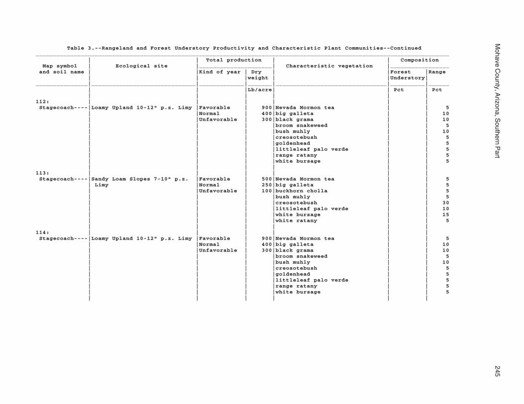
Mohave C
ounty, Arizona, S
outhern Part
245
Table 3.--Rangeland and Forest Understory Productivity and Characteristic Plant Communities--Continued_______________________________________________________________________________________________________________________ | | Total production | | Composition Map symbol | Ecological site |_____________________| Characteristic vegetation |_________________ and soil name | |Kind of year | Dry | |Forest |Range | | |weight | |Understory|_______________|______________________________|_____________|_______|________________________________|__________|______ | | |Lb/acre| | Pct | Pct | | | | | |112: | | | | | | Stagecoach----|Loamy Upland 10-12" p.z. Limy |Favorable | 900|Nevada Mormon tea | | 5 | |Normal | 400|big galleta | | 10 | |Unfavorable | 300|black grama | | 10 | | | |broom snakeweed | | 5 | | | |bush muhly | | 10 | | | |creosotebush | | 5 | | | |goldenhead | | 5 | | | |littleleaf palo verde | | 5 | | | |range ratany | | 5 | | | |white bursage | | 5 | | | | | |113: | | | | | | Stagecoach----|Sandy Loam Slopes 7-10" p.z. |Favorable | 500|Nevada Mormon tea | | 5 | Limy |Normal | 250|big galleta | | 5 | |Unfavorable | 100|buckhorn cholla | | 5 | | | |bush muhly | | 5 | | | |creosotebush | | 30 | | | |littleleaf palo verde | | 10 | | | |white bursage | | 15 | | | |white ratany | | 5 | | | | | |114: | | | | | | Stagecoach----|Loamy Upland 10-12" p.z. Limy |Favorable | 900|Nevada Mormon tea | | 5 | |Normal | 400|big galleta | | 10 | |Unfavorable | 300|black grama | | 10 | | | |broom snakeweed | | 5 | | | |bush muhly | | 10 | | | |creosotebush | | 5 | | | |goldenhead | | 5 | | | |littleleaf palo verde | | 5 | | | |range ratany | | 5 | | | |white bursage | | 5 | | | | | |

246S
oil Survey
Table 3.--Rangeland and Forest Understory Productivity and Characteristic Plant Communities--Continued_______________________________________________________________________________________________________________________ | | Total production | | Composition Map symbol | Ecological site |_____________________| Characteristic vegetation |_________________ and soil name | |Kind of year | Dry | |Forest |Range | | |weight | |Understory|_______________|______________________________|_____________|_______|________________________________|__________|______ | | |Lb/acre| | Pct | Pct | | | | | |114: | | | | | | Topawa family-|Loamy Upland 10-12" p.z. Limy |Favorable | 900|Nevada Mormon tea | | 5 | |Normal | 400|big galleta | | 10 | |Unfavorable | 300|black grama | | 10 | | | |broom snakeweed | | 5 | | | |bush muhly | | 10 | | | |creosotebush | | 5 | | | |goldenhead | | 5 | | | |littleleaf palo verde | | 5 | | | |range ratany | | 5 | | | |white bursage | | 5 | | | | | | Eba-----------|Clay Loam Upland 10-12" p.z. |Favorable | 700|Eastern Mojave wild buckwheat | | 10 | |Normal | 500|big galleta | | 10 | |Unfavorable | 300|black grama | | 20 | | | |bush muhly | | 10 | | | |canotia | | 5 | | | |false mesquite | | 5 | | | |littleleaf palo verde | | 5 | | | |range ratany | | 5 | | | |tobosa | | 10 | | | |turpentine bush | | 5 | | | | | |115: | | | | | | Stagecoach----|Sandy Loam Slopes 7-10" p.z. |Favorable | 800|big galleta | | 20 | Limy |Normal | 400|black grama | | 10 | |Unfavorable | 250|buckhorn cholla | | 5 | | | |bush muhly | | 10 | | | |creosotebush | | 15 | | | |littleleaf palo verde | | 5 | | | |ocotillo | | 5 | | | |range ratany | | 5 | | | |white brittlebush | | 5 | | | |white bursage | | 5 | | | | | |

Mohave C
ounty, Arizona, S
outhern Part
247
Table 3.--Rangeland and Forest Understory Productivity and Characteristic Plant Communities--Continued_______________________________________________________________________________________________________________________ | | Total production | | Composition Map symbol | Ecological site |_____________________| Characteristic vegetation |_________________ and soil name | |Kind of year | Dry | |Forest |Range | | |weight | |Understory|_______________|______________________________|_____________|_______|________________________________|__________|______ | | |Lb/acre| | Pct | Pct | | | | | |115: | | | | | | Topawa family-|Sandy Loam Slopes 7-10" p.z. |Favorable | 800|big galleta | | 20 | Limy |Normal | 400|black grama | | 10 | |Unfavorable | 250|buckhorn cholla | | 5 | | | |bush muhly | | 10 | | | |creosotebush | | 15 | | | |littleleaf palo verde | | 5 | | | |ocotillo | | 5 | | | |range ratany | | 5 | | | |white brittlebush | | 5 | | | |white bursage | | 5 | | | | | | Eba-----------|Clay Loam Upland 7-10" p.z. |Favorable | 700|Nevada Mormon tea | | 5 | |Normal | 500|big galleta | | 20 | |Unfavorable | 350|black grama | | 5 | | | |bush muhly | | 5 | | | |littleleaf palo verde | | 5 | | | |range ratany | | 5 | | | |tobosa | | 20 | | | |white bursage | | 5 | | | | | |116: | | | | | | Sunrock-------|Volcanic Hills 3-6" p.z. |Favorable | 700|creosotebush | | 40 | |Normal | 300|white brittlebush | | 25 | |Unfavorable | 25|white bursage | | 15 | | | | | |117: | | | | | | Sunrock-------|Volcanic Hills 3-6" p.z. |Favorable | 300|bush encelia | | 5 | |Normal | 200|creosotebush | | 40 | |Unfavorable | 100|white brittlebush | | 5 | | | |white bursage | | 25 | | | |white ratany | | 5 | | | | | | Rock outcrop--| --- |Favorable | --- | | | | |Normal | --- | | | | |Unfavorable | --- | | | | | | | | |

248S
oil Survey
Table 3.--Rangeland and Forest Understory Productivity and Characteristic Plant Communities--Continued_______________________________________________________________________________________________________________________ | | Total production | | Composition Map symbol | Ecological site |_____________________| Characteristic vegetation |_________________ and soil name | |Kind of year | Dry | |Forest |Range | | |weight | |Understory|_______________|______________________________|_____________|_______|________________________________|__________|______ | | |Lb/acre| | Pct | Pct | | | | | |118: | | | | | | Tombstone-----|Limy Upland 12-16" p.z. |Favorable | 900|black grama | | 30 | |Normal | 700|desert ceanothus | | 5 | |Unfavorable | 450|muttongrass | | 5 | | | |needle and thread | | 10 | | | |range ratany | | 5 | | | |sideoats grama | | 25 | | | |slim tridens | | 5 | | | |turbinella oak | | 5 | | | |western bottle-brush grass | | 5 | | | | | | Caralampi-----|Limy Upland 12-16" p.z. |Favorable | 900|black grama | | 30 | |Normal | 700|desert ceanothus | | 5 | |Unfavorable | 450|muttongrass | | 5 | | | |needle and thread | | 10 | | | |range ratany | | 5 | | | |sideoats grama | | 25 | | | |slim tridens | | 5 | | | |turbinella oak | | 5 | | | | | | Eloma---------|Clay Loam Upland 12-16" p.z. |Favorable | 1100|black grama | | 5 | |Normal | 950|blue grama | | 5 | |Unfavorable | 750|desert ceanothus | | 5 | | | |false mesquite | | 5 | | | |muttongrass | | 5 | | | |range ratany | | 5 | | | |rough menodora | | 5 | | | |sideoats grama | | 20 | | | |turbinella oak | | 5 | | | |western bottle-brush grass | | 10 | | | |western-wheat grass | | 5 | | | | | |119: | | | | | | Torriorthents-|Loamy Breaks 10-12" p.z. |Favorable | --- | | | | |Normal | --- | | | | |Unfavorable | --- | | | | | | | | |120: | | | | | | Torriorthents-|Loamy Breaks 7-10" p.z. |Favorable | --- | | | | |Normal | --- | | | | |Unfavorable | --- | | | | | | | | |

Mohave C
ounty, Arizona, S
outhern Part
249
Table 3.--Rangeland and Forest Understory Productivity and Characteristic Plant Communities--Continued_______________________________________________________________________________________________________________________ | | Total production | | Composition Map symbol | Ecological site |_____________________| Characteristic vegetation |_________________ and soil name | |Kind of year | Dry | |Forest |Range | | |weight | |Understory|_______________|______________________________|_____________|_______|________________________________|__________|______ | | |Lb/acre| | Pct | Pct | | | | | |121: | | | | | | Tumarion------|Limy Upland 10-13" p.z. |Favorable | 500|Juniperus | | 20 | |Normal | 300|Yucca | | 10 | |Unfavorable | 100|broom snakeweed | | 20 | | | | | |122: | | | | | | Tumarion------|Limy Upland 6-10" p.z. |Favorable | 350|Mojave yucca | | 5 | |Normal | 250|creosotebush | | 25 | |Unfavorable | 100|goldenhead | | 5 | | | |red brome | | 15 | | | |white bursage | | 25 | | | | | |123: | | | | | | Tyro----------|Sandy Loam Hills 3-6" p.z. |Favorable | 300|blond plantain | | 10 | Limy, Gravelly, Shallow |Normal | 150|creosotebush | | 50 | |Unfavorable | 50|red brome | | 5 | | | |white brittlebush | | 10 | | | |white ratany | | 5 | | | | | |124: | | | | | | Tyro----------|Sandy Loam Hills 3-6" p.z. |Favorable | 300|blond plantain | | 10 | Limy, Gravelly, Shallow |Normal | 150|creosotebush | | 50 | |Unfavorable | 50|red brome | | 5 | | | |white brittlebush | | 10 | | | |white ratany | | 5 | | | | | |125: | | | | | | Vekol family--|Sandy Loam Upland 10-13" p.z. |Favorable | 600|Opuntia | | 10 | Fine |Normal | 350|big galleta | | 15 | |Unfavorable | 100|black grama | | 7 | | | |burrograss | | 10 | | | |rayless goldenhead | | 7 | | | | | |

250S
oil Survey
Table 3.--Rangeland and Forest Understory Productivity and Characteristic Plant Communities--Continued_______________________________________________________________________________________________________________________ | | Total production | | Composition Map symbol | Ecological site |_____________________| Characteristic vegetation |_________________ and soil name | |Kind of year | Dry | |Forest |Range | | |weight | |Understory|_______________|______________________________|_____________|_______|________________________________|__________|______ | | |Lb/acre| | Pct | Pct | | | | | |126: | | | | | | Vekol family--|Clay Loam Upland 7-10" p.z. |Favorable | 700|Nevada Mormon tea | | 5 | |Normal | 500|big galleta | | 20 | |Unfavorable | 350|black grama | | 5 | | | |bush muhly | | 5 | | | |goldenhead | | 5 | | | |littleleaf palo verde | | 5 | | | |range ratany | | 5 | | | |tobosa | | 20 | | | |white bursage | | 5 | | | | | |127: | | | | | | Water---------| --- |Favorable | --- | | | | |Normal | --- | | | | |Unfavorable | --- | | | | | | | | |128: | | | | | | Whitehills----|Limy Upland 10-13" p.z. |Favorable | 600|big galleta | | 10 | |Normal | 350|creosotebush | | 20 | |Unfavorable | 150|white bursage | | 20 | | | | | |129: | | | | | | Whitehills----|Limy Upland 6-10" p.z. |Favorable | 350|Anderson wolfberry | | 5 | |Normal | 250|Mojave yucca | | 5 | |Unfavorable | 100|creosotebush | | 25 | | | |goldenhead | | 5 | | | |range ratany | | 5 | | | |red brome | | 15 | | | |white bursage | | 25 | | | | | |130: | | | | | | White House |Sandy Loam Upland 10-13" p.z. |Favorable | 700|Aristida | | 10 family-------| Fine, Gravelly |Normal | 450|banana yucca | | 10 | |Unfavorable | 200|big galleta | | 15 | | | |black grama | | 10 | | | | | |

Mohave C
ounty, Arizona, S
outhern Part
251
Table 3.--Rangeland and Forest Understory Productivity and Characteristic Plant Communities--Continued_______________________________________________________________________________________________________________________ | | Total production | | Composition Map symbol | Ecological site |_____________________| Characteristic vegetation |_________________ and soil name | |Kind of year | Dry | |Forest |Range | | |weight | |Understory|_______________|______________________________|_____________|_______|________________________________|__________|______ | | |Lb/acre| | Pct | Pct | | | | | |131: | | | | | | White House---|Loamy Upland 12-16" p.z. |Favorable | 600|Opuntia | | 10 | |Normal | 350|Utah juniper | | 10 | |Unfavorable | 100|banana yucca | | 10 | | | |big galleta | | 15 | | | |black grama | | 7 | | | |burrograss | | 10 | | | |rayless goldenhead | | 7 | | | | | |132: | | | | | | Wikieup-------|Granitic/Schist Hills 10-13" |Favorable | 800|Eastern Mojave wild buckwheat | | 20 | p.z. Alkaline |Normal | 600|Nevada Mormon tea | | 5 | |Unfavorable | 400|big galleta | | 15 | | | |desert needlegrass | | 20 | | | |range ratany | | 5 | | | |red brome | | 5 | | | |turbinella oak | | 5 | | | |white brittlebush | | 5 | | | | | | Mutang--------|Granitic/Schist Hills 10-13" |Favorable | 800|big galleta | | 5 | p.z. Alkaline |Normal | 600|black grama | | 15 | |Unfavorable | 400|broom snakeweed | | 5 | | | |desert needlegrass | | 20 | | | |range ratany | | 5 | | | |sideoats grama | | 5 | | | |turpentine bush | | 5 | | | | | | Rock outcrop--| --- |Favorable | --- | | | | |Normal | --- | | | | |Unfavorable | --- | | | | | | | | |133: | | | | | | Mutang--------|Granitic/Schist Upland 10-13" |Favorable | 1500|Eriogonum | | 10 | p.z. |Normal | 1000|Utah juniper | | 15 | |Unfavorable | 500|banana yucca | | 15 | | | |desert ceanothus | | 10 | | | |turbinella oak | | 30 | | | | | |
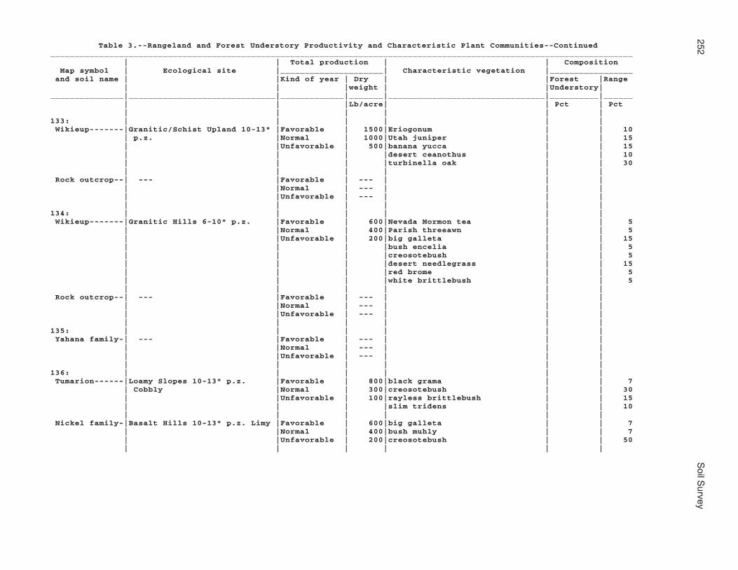
252S
oil Survey
Table 3.--Rangeland and Forest Understory Productivity and Characteristic Plant Communities--Continued_______________________________________________________________________________________________________________________ | | Total production | | Composition Map symbol | Ecological site |_____________________| Characteristic vegetation |_________________ and soil name | |Kind of year | Dry | |Forest |Range | | |weight | |Understory|_______________|______________________________|_____________|_______|________________________________|__________|______ | | |Lb/acre| | Pct | Pct | | | | | |133: | | | | | | Wikieup-------|Granitic/Schist Upland 10-13" |Favorable | 1500|Eriogonum | | 10 | p.z. |Normal | 1000|Utah juniper | | 15 | |Unfavorable | 500|banana yucca | | 15 | | | |desert ceanothus | | 10 | | | |turbinella oak | | 30 | | | | | | Rock outcrop--| --- |Favorable | --- | | | | |Normal | --- | | | | |Unfavorable | --- | | | | | | | | |134: | | | | | | Wikieup-------|Granitic Hills 6-10" p.z. |Favorable | 600|Nevada Mormon tea | | 5 | |Normal | 400|Parish threeawn | | 5 | |Unfavorable | 200|big galleta | | 15 | | | |bush encelia | | 5 | | | |creosotebush | | 5 | | | |desert needlegrass | | 15 | | | |red brome | | 5 | | | |white brittlebush | | 5 | | | | | | Rock outcrop--| --- |Favorable | --- | | | | |Normal | --- | | | | |Unfavorable | --- | | | | | | | | |135: | | | | | | Yahana family-| --- |Favorable | --- | | | | |Normal | --- | | | | |Unfavorable | --- | | | | | | | | |136: | | | | | | Tumarion------|Loamy Slopes 10-13" p.z. |Favorable | 800|black grama | | 7 | Cobbly |Normal | 300|creosotebush | | 30 | |Unfavorable | 100|rayless brittlebush | | 15 | | | |slim tridens | | 10 | | | | | | Nickel family-|Basalt Hills 10-13" p.z. Limy |Favorable | 600|big galleta | | 7 | |Normal | 400|bush muhly | | 7 | |Unfavorable | 200|creosotebush | | 50 | | | | | |

Mohave C
ounty, Arizona, S
outhern Part
253
Table 3.--Rangeland and Forest Understory Productivity and Characteristic Plant Communities--Continued_______________________________________________________________________________________________________________________ | | Total production | | Composition Map symbol | Ecological site |_____________________| Characteristic vegetation |_________________ and soil name | |Kind of year | Dry | |Forest |Range | | |weight | |Understory|_______________|______________________________|_____________|_______|________________________________|__________|______ | | |Lb/acre| | Pct | Pct | | | | | |137: | | | | | | Valena--------|Granitic Upland 12-16" p.z. |Favorable | 1000|Utah juniper | | 10 | |Normal | 700|black grama | | 7 | |Unfavorable | 300|broom snakeweed | | 7 | | | |desert ceanothus | | 10 | | | |pointleaf manzanita | | 10 | | | |turbinella oak | | 25 | | | | | | Rock outcrop--|Granitic Upland 12-16" p.z. |Favorable | 1000|Utah juniper | | 10 | |Normal | 700|black grama | | 7 | |Unfavorable | 300|broom snakeweed | | 7 | | | |desert ceanothus | | 10 | | | |pointleaf manzanita | | 10 | | | |turbinella oak | | 25 | | | | | | Carri family--|Sandy Loam Upland 12-16" p.z. |Favorable | --- |pointleaf manzanita | | 10 | |Normal | --- | | | | |Unfavorable | --- | | | | | | | | |138: | | | | | | Nodman--------|Granitic/Schist Hills 10-13" |Favorable | 1500|Colorado pinyon | | 10 | p.z. |Normal | 1000|Opuntia | | 10 | |Unfavorable | 500|banana yucca | | 10 | | | |desert ceanothus | | 20 | | | |desert needlegrass | | 7 | | | |singleleaf pinyon | | 10 | | | |turbinella oak | | 20 | | | | | | Rock outcrop--|Granitic/Schist Hills 10-13" |Favorable | 1500|Colorado pinyon | | 10 | p.z. |Normal | 1000|Opuntia | | 10 | |Unfavorable | 500|banana yucca | | 10 | | | |desert ceanothus | | 20 | | | |desert needlegrass | | 7 | | | |singleleaf pinyon | | 10 | | | |turbinella oak | | 20 | | | | | |

254S
oil Survey
Table 3.--Rangeland and Forest Understory Productivity and Characteristic Plant Communities--Continued_______________________________________________________________________________________________________________________ | | Total production | | Composition Map symbol | Ecological site |_____________________| Characteristic vegetation |_________________ and soil name | |Kind of year | Dry | |Forest |Range | | |weight | |Understory|_______________|______________________________|_____________|_______|________________________________|__________|______ | | |Lb/acre| | Pct | Pct | | | | | |139: | | | | | | Nodman--------|Granitic/Schist Hills 10-13" |Favorable | 1500|Colorado pinyon | | 10 | p.z. |Normal | 1000|Opuntia | | 10 | |Unfavorable | 500|banana yucca | | 10 | | | |desert ceanothus | | 20 | | | |desert needlegrass | | 7 | | | |singleleaf pinyon | | 10 | | | |turbinella oak | | 20 | | | | | | Romero family-|Basalt/Schist Hills 10-13" |Favorable | 800|Eriogonum | | 7 | p.z. |Normal | 550|Opuntia | | 20 | |Unfavorable | 300|Pleuraphis | | 20 | | | |banana yucca | | 10 | | | |black grama | | 7 | | | |sideoats grama | | 7 | | | | | |_______________|______________________________|_____________|_______|________________________________|__________|______

Mohave County, Arizona, Southern Part 255
Table 4.--Forestland Productivity_________________________________________________________________________________ | Potential productivity | |___________________________________| Map symbol and | | | | soil name | Common trees |Site | Volume | Trees to manage | |index|of wood | | | | fiber |_________________________|____________________|_____|________|___________________ | | |cu ft/ac| | | | |1: | | | | Akela-------------------| --- | --- | --- | --- | | | | Rock outcrop------------| --- | --- | --- | --- | | | | Rubble land-------------| --- | --- | --- | --- | | | |2: | | | | Akela-------------------| --- | --- | --- | --- | | | | Rock outcrop------------| --- | --- | --- | --- | | | | Rubble land-------------| --- | --- | --- | --- | | | |3: | | | | Alko family-------------| --- | --- | --- | --- | | | |4: | | | | Alko family-------------| --- | --- | --- | --- | | | |5: | | | | Amole-------------------| --- | --- | --- | --- | | | |6: | | | | Amole-------------------| --- | --- | --- | --- | | | |7: | | | | Anthony-----------------| --- | --- | --- | --- | | | | Dudleyville-------------| --- | --- | --- | --- | | | |8: | | | | Aquarius----------------| --- | --- | --- | --- | | | | Akela-------------------| --- | --- | --- | --- | | | | Rock outcrop------------| --- | --- | --- | --- | | | |9: | | | | Arizo-------------------| --- | --- | --- | --- | | | | Franconia---------------| --- | --- | --- | --- | | | | Riverwash---------------| --- | --- | --- | --- | | | |10: | | | | Arizo-------------------| --- | --- | --- | --- | | | | Franconia---------------| --- | --- | --- | --- | | | | Riverwash---------------| --- | --- | --- | --- | | | |11: | | | | Bartmus-----------------| --- | --- | --- | --- | | | |
256 Soil Survey
Table 4.--Forestland Productivity--Continued_________________________________________________________________________________ | Potential productivity | |___________________________________| Map symbol and | | | | soil name | Common trees |Site | Volume | Trees to manage | |index|of wood | | | | fiber |_________________________|____________________|_____|________|___________________ | | |cu ft/ac|12: | | | | Bonita family-----------| --- | --- | --- | --- | | | | | | | |13: | | | | Bonita family-----------| --- | --- | --- | --- | | | | Gonzales----------------| --- | --- | --- | --- | | | |14: | | | | Brazito family----------| --- | --- | --- | --- | | | |15: | | | | Bucklebar---------------| --- | --- | --- | --- | | | |16: | | | | Cacique family----------| --- | --- | --- | --- | | | |17: | | | | Castaneda---------------| --- | --- | --- | --- | | | |18: | | | | Castaneda---------------| --- | --- | --- | --- | | | |19: | | | | Carrizo family----------| --- | --- | --- | --- | | | |20: | | | | Carrizo family----------| --- | --- | --- | --- | | | | Riverwash---------------| --- | --- | --- | --- | | | |21: | | | | Carrizo-----------------| --- | --- | --- | --- | | | | Riverwash---------------| --- | --- | --- | --- | | | |22: | | | | Carrizo-----------------| --- | --- | --- | --- | | | | Riverwash---------------| --- | --- | --- | --- | | | |23: | | | | Cave--------------------| --- | --- | --- | --- | | | |24: | | | | Cave--------------------| --- | --- | --- | --- | | | |25: | | | | Cellar------------------| --- | --- | --- | --- | | | | Rock outcrop------------| --- | --- | --- | --- | | | |

Mohave County, Arizona, Southern Part 257
Table 4.--Forestland Productivity--Continued_________________________________________________________________________________ | Potential productivity | |___________________________________| Map symbol and | | | | soil name | Common trees |Site | Volume | Trees to manage | |index|of wood | | | | fiber |_________________________|____________________|_____|________|___________________ | | |cu ft/ac|26: | | | | Cellar------------------| --- | --- | --- | --- | | | | Rock outcrop------------| --- | --- | --- | --- | | | |27: | | | | Cellar------------------| --- | --- | --- | --- | | | | Topock------------------| --- | --- | --- | --- | | | | Rock outcrop------------| --- | --- | --- | --- | | | | | | | |28: | | | | Cherioni----------------| --- | --- | --- | --- | | | |29: | | | | Chuckawalla-------------| --- | --- | --- | --- | | | | Riverbend---------------| --- | --- | --- | --- | | | |30: | | | | Chuckawalla family------| --- | --- | --- | --- | | | | Riverbend family--------| --- | --- | --- | --- | | | |31: | | | | Cipriano----------------| --- | --- | --- | --- | | | |32: | | | | Cline-------------------| --- | --- | --- | --- | | | |33: | | | | Cline-------------------| --- | --- | --- | --- | | | |34: | | | | Continental-------------| --- | --- | --- | --- | | | | Tres Hermanos-----------| --- | --- | --- | --- | | | |35: | | | | Continental-------------| --- | --- | --- | --- | | | | Tres Hermanos-----------| --- | --- | --- | --- | | | |36: | | | | Continental-------------| --- | --- | --- | --- | | | | Rillino-----------------| --- | --- | --- | --- | | | |37: | | | | Continental-------------| --- | --- | --- | --- | | | | Rillino-----------------| --- | --- | --- | --- | | | |

258 Soil Survey
Table 4.--Forestland Productivity--Continued_________________________________________________________________________________ | Potential productivity | |___________________________________| Map symbol and | | | | soil name | Common trees |Site | Volume | Trees to manage | |index|of wood | | | | fiber |_________________________|____________________|_____|________|___________________ | | |cu ft/ac|38: | | | | Coolidge----------------| --- | --- | --- | --- | | | | Denure------------------| --- | --- | --- | --- | | | |39: | | | | Coolidge family---------| --- | --- | --- | --- | | | | Denure family-----------| --- | --- | --- | --- | | | |40: | | | | Courthouse family-------| --- | --- | --- | --- | | | | Rock outcrop------------| --- | --- | --- | --- | | | | Rubble land-------------| --- | --- | --- | --- | | | | | | | |41: | | | | Courthouse family-------| --- | --- | --- | --- | | | | Rock outcrop------------| --- | --- | --- | --- | | | | Wagonbow----------------| --- | --- | --- | --- | | | |42: | | | | Far---------------------|ponderosa pine------| 60 | 43 |ponderosa pine | | | | Rock outcrop------------| --- | --- | --- | --- | | | |43: | | | | Dutchflat---------------| --- | --- | --- | --- | | | |44: | | | | Dutchflat---------------| --- | --- | --- | --- | | | |45: | | | | Gadsden-----------------| --- | --- | --- | --- | | | |46: | | | | Gila--------------------| --- | --- | --- | --- | | | | Glendale----------------| --- | --- | --- | --- | | | |47: | | | | Gila--------------------| --- | --- | --- | --- | | | | Glendale----------------| --- | --- | --- | --- | | | |48: | | | | Goldroad----------------| --- | --- | --- | --- | | | | Rock outcrop------------| --- | --- | --- | --- | | | |

Mohave County, Arizona, Southern Part 259
Table 4.--Forestland Productivity--Continued_________________________________________________________________________________ | Potential productivity | |___________________________________| Map symbol and | | | | soil name | Common trees |Site | Volume | Trees to manage | |index|of wood | | | | fiber |_________________________|____________________|_____|________|___________________ | | |cu ft/ac|49: | | | | Gonzales----------------| --- | --- | --- | --- | | | | Rock outcrop------------| --- | --- | --- | --- | | | |50: | | | | Goodsprings family------| --- | --- | --- | --- | | | |51: | | | | Goodsprings family------| --- | --- | --- | --- | | | |52: | | | | Goodsprings family------| --- | --- | --- | --- | | | |53: | | | | Goodsprings family------| --- | --- | --- | --- | | | |54: | | | | Graham------------------| --- | --- | --- | --- | | | | Arivaca-----------------| --- | --- | --- | --- | | | |55: | | | | Graham------------------| --- | --- | --- | --- | | | | | | | | Rock outcrop------------| --- | --- | --- | --- | | | |56: | | | | Gunsight----------------| --- | --- | --- | --- | | | |57: | | | | Gunsight----------------| --- | --- | --- | --- | | | |58: | | | | Hassell family----------| --- | --- | --- | --- | | | | Lampshire---------------| --- | --- | --- | --- | | | | Rock outcrop------------| --- | --- | --- | --- | | | |59: | | | | Holtville---------------| --- | --- | --- | --- | | | |60: | | | | Huevi-------------------| --- | --- | --- | --- | | | |61: | | | | Huevi-------------------| --- | --- | --- | --- | | | |62: | | | | Akela-------------------| --- | --- | --- | --- | | | | Rock outcrop------------| --- | --- | --- | --- | | | |
260 Soil Survey
Table 4.--Forestland Productivity--Continued_________________________________________________________________________________ | Potential productivity | |___________________________________| Map symbol and | | | | soil name | Common trees |Site | Volume | Trees to manage | |index|of wood | | | | fiber |_________________________|____________________|_____|________|___________________ | | |cu ft/ac|63: | | | | Hyder-------------------| --- | --- | --- | --- | | | | Rock outcrop------------| --- | --- | --- | --- | | | | Rubble land-------------| --- | --- | --- | --- | | | |64: | | | | Indio-------------------| --- | --- | --- | --- | | | |65: | | | | Ireteba family----------| --- | --- | --- | --- | | | | Arizo-------------------| --- | --- | --- | --- | | | |66: | | | | Kinley------------------| --- | --- | --- | --- | | | |67: | | | | Kinley------------------| --- | --- | --- | --- | | | | Poachie-----------------| --- | --- | --- | --- | | | |68: | | | | Kofa--------------------| --- | --- | --- | --- | | | |69: | | | | Dudleyville-------------| --- | --- | --- | --- | | | | Vinton------------------| --- | --- | --- | --- | | | | | | | | Riverwash---------------| --- | --- | --- | --- | | | |70: | | | | Dudleyville-------------| --- | --- | --- | --- | | | | Vinton------------------| --- | --- | --- | --- | | | | Riverwash---------------| --- | --- | --- | --- | | | |71: | | | | Lagunita----------------| --- | --- | --- | --- | | | |72: | | | | Lagunita----------------| --- | --- | --- | --- | | | | Ripley------------------| --- | --- | --- | --- | | | |73: | | | | Lampshire---------------| --- | --- | --- | --- | | | | Rock outcrop------------| --- | --- | --- | --- | | | |

Mohave County, Arizona, Southern Part 261
Table 4.--Forestland Productivity--Continued_________________________________________________________________________________ | Potential productivity | |___________________________________| Map symbol and | | | | soil name | Common trees |Site | Volume | Trees to manage | |index|of wood | | | | fiber |_________________________|____________________|_____|________|___________________ | | |cu ft/ac|74: | | | | Lampshire---------------| --- | --- | --- | --- | | | | Rock outcrop------------| --- | --- | --- | --- | | | |75: | | | | Lampshire---------------| --- | --- | --- | --- | | | | Rock outcrop------------| --- | --- | --- | --- | | | |76: | | | | Lostman-----------------| --- | --- | --- | --- | | | |77: | | | | Lostman-----------------| --- | --- | --- | --- | | | |78: | | | | Lostman-----------------| --- | --- | --- | --- | | | | Kinley------------------| --- | --- | --- | --- | | | |79: | | | | Marshes-----------------| --- | --- | --- | --- | | | |80: | | | | Meloland----------------| --- | --- | --- | --- | | | |81: | | | | Mohon-------------------| --- | --- | --- | --- | | | | Kinley------------------| --- | --- | --- | --- | | | |82: | | | | Mohon-------------------| --- | --- | --- | --- | | | | Poachie-----------------| --- | --- | --- | --- | | | | | | | |83: | | | | Mohon-------------------| --- | --- | --- | --- | | | | Poachie-----------------| --- | --- | --- | --- | | | |84: | | | | Nickel family-----------| --- | --- | --- | --- | | | | Topawa family-----------| --- | --- | --- | --- | | | | Eba family--------------| --- | --- | --- | --- | | | |85: | | | | Orwash family-----------| --- | --- | --- | --- | | | |86: | | | | Orwash family-----------| --- | --- | --- | --- | | | |

262 Soil Survey
Table 4.--Forestland Productivity--Continued_________________________________________________________________________________ | Potential productivity | |___________________________________| Map symbol and | | | | soil name | Common trees |Site | Volume | Trees to manage | |index|of wood | | | | fiber |_________________________|____________________|_____|________|___________________ | | |cu ft/ac|87: | | | | Penthouse---------------| --- | --- | --- | --- | | | | Gonzales----------------| --- | --- | --- | --- | | | |88: | | | | Poachie-----------------| --- | --- | --- | --- | | | |89: | | | | Poachie-----------------| --- | --- | --- | --- | | | |90: | | | | Quilotosa---------------| --- | --- | --- | --- | | | | Rock outcrop------------| --- | --- | --- | --- | | | |91: | | | | Razorback---------------| --- | --- | --- | --- | | | |92: | | | | Razorback---------------| --- | --- | --- | --- | | | | Rock outcrop------------| --- | --- | --- | --- | | | |93: | | | | Razorback---------------| --- | --- | --- | --- | | | | Rock outcrop------------| --- | --- | --- | --- | | | |94: | | | | Razorback---------------| --- | --- | --- | --- | | | | Rock outcrop------------| --- | --- | --- | --- | | | |95: | | | | Razorback---------------| --- | --- | --- | --- | | | | Rock outcrop------------| --- | --- | --- | --- | | | | Rubble land-------------| --- | --- | --- | --- | | | |96: | | | | Razorback---------------| --- | --- | --- | --- | | | | Rock outcrop------------| --- | --- | --- | --- | | | | Rubble land-------------| --- | --- | --- | --- | | | |97: | | | | Rillino-----------------| --- | --- | --- | --- | | | |98: | | | | Rillino-----------------| --- | --- | --- | --- | | | | Tres Hermanos-----------| --- | --- | --- | --- | | | |

Mohave County, Arizona, Southern Part 263
Table 4.--Forestland Productivity--Continued_________________________________________________________________________________ | Potential productivity | |___________________________________| Map symbol and | | | | soil name | Common trees |Site | Volume | Trees to manage | |index|of wood | | | | fiber |_________________________|____________________|_____|________|___________________ | | |cu ft/ac|99: | | | | Ripley------------------| --- | --- | --- | --- | | | |100: | | | | Riverbend family--------| --- | --- | --- | --- | | | |101: | | | | Riverbend---------------| --- | --- | --- | --- | | | |102: | | | | Riverwash---------------| --- | --- | --- | --- | | | | Fluvaquents-------------| --- | --- | --- | --- | | | |103: | | | | Rock outcrop------------| --- | --- | --- | --- | | | | Hyder-------------------| --- | --- | --- | --- | | | |104: | | | | Rock outcrop------------| --- | --- | --- | --- | | | | Razorback---------------| --- | --- | --- | --- | | | |105: | | | | Rock outcrop------------| --- | --- | --- | --- | | | | Sunrock-----------------| --- | --- | --- | --- | | | |106: | | | | Romero------------------| --- | --- | --- | --- | | | | Chiricahua--------------| --- | --- | --- | --- | | | | Rock outcrop------------| --- | --- | --- | --- | | | |107: | | | | Romero------------------| --- | --- | --- | --- | | | | Lampshire---------------| --- | --- | --- | --- | | | | Rock outcrop------------| --- | --- | --- | --- | | | |108: | | | | Rositas family----------| --- | --- | --- | --- | | | | Superstition------------| --- | --- | --- | --- | | | | Torriorthents-----------| --- | --- | --- | --- | | | |

264 Soil Survey
Table 4.--Forestland Productivity--Continued_________________________________________________________________________________ | Potential productivity | |___________________________________| Map symbol and | | | | soil name | Common trees |Site | Volume | Trees to manage | |index|of wood | | | | fiber |_________________________|____________________|_____|________|___________________ | | |cu ft/ac|109: | | | | Rositas-----------------| --- | --- | --- | --- | | | | Superstition family-----| --- | --- | --- | --- | | | | Torriorthents-----------| --- | --- | --- | --- | | | |110: | | | | Stagecoach--------------| --- | --- | --- | --- | | | |111: | | | | Stagecoach--------------| --- | --- | --- | --- | | | |112: | | | | Stagecoach--------------| --- | --- | --- | --- | | | |113: | | | | Stagecoach--------------| --- | --- | --- | --- | | | |114: | | | | Stagecoach--------------| --- | --- | --- | --- | | | | Topawa family-----------| --- | --- | --- | --- | | | | Eba---------------------| --- | --- | --- | --- | | | |115: | | | | Stagecoach--------------| --- | --- | --- | --- | | | | Topawa family-----------| --- | --- | --- | --- | | | | Eba---------------------| --- | --- | --- | --- | | | |116: | | | | Sunrock-----------------| --- | --- | --- | --- | | | |117: | | | | Sunrock-----------------| --- | --- | --- | --- | | | | Rock outcrop------------| --- | --- | --- | --- | | | |118: | | | | Tombstone---------------| --- | --- | --- | --- | | | | Caralampi---------------| --- | --- | --- | --- | | | | Eloma-------------------| --- | --- | --- | --- | | | |119: | | | | Torriorthents-----------| --- | --- | --- | --- | | | |120: | | | | Torriorthents-----------| --- | --- | --- | --- | | | |

Mohave County, Arizona, Southern Part 265
Table 4.--Forestland Productivity--Continued_________________________________________________________________________________ | Potential productivity | |___________________________________| Map symbol and | | | | soil name | Common trees |Site | Volume | Trees to manage | |index|of wood | | | | fiber |_________________________|____________________|_____|________|___________________ | | |cu ft/ac|121: | | | | Tumarion----------------| --- | --- | --- | --- | | | |122: | | | | Tumarion----------------| --- | --- | --- | --- | | | |123: | | | | Tyro--------------------| --- | --- | --- | --- | | | |124: | | | | Tyro--------------------| --- | --- | --- | --- | | | |125: | | | | Vekol family------------| --- | --- | --- | --- | | | |126: | | | | Vekol family------------| --- | --- | --- | --- | | | |127: | | | | Water-------------------| --- | --- | --- | --- | | | |128: | | | | Whitehills--------------| --- | --- | --- | --- | | | |129: | | | | Whitehills--------------| --- | --- | --- | --- | | | |130: | | | | White House family------| --- | --- | --- | --- | | | |131: | | | | White House-------------| --- | --- | --- | --- | | | |132: | | | | Wikieup-----------------| --- | --- | --- | --- | | | | Mutang------------------| --- | --- | --- | --- | | | | Rock outcrop------------| --- | --- | --- | --- | | | |133: | | | | Mutang------------------| --- | --- | --- | --- | | | | Wikieup-----------------| --- | --- | --- | --- | | | | Rock outcrop------------| --- | --- | --- | --- | | | |134: | | | | Wikieup-----------------| --- | --- | --- | --- | | | | Rock outcrop------------| --- | --- | --- | --- | | | |135: | | | | Yahana family-----------| --- | --- | --- | --- | | | |

266 Soil Survey
Table 4.--Forestland Productivity--Continued_________________________________________________________________________________ | Potential productivity | |___________________________________| Map symbol and | | | | soil name | Common trees |Site | Volume | Trees to manage | |index|of wood | | | | fiber |_________________________|____________________|_____|________|___________________ | | |cu ft/ac|136: | | | | Tumarion----------------| --- | --- | --- | --- | | | | Nickel family-----------| --- | --- | --- | --- | | | |137: | | | | Valena------------------| --- | --- | --- | --- | | | | Rock outcrop------------| --- | --- | --- | --- | | | | Carri family------------| --- | --- | --- | --- | | | |138: | | | | Nodman------------------| --- | --- | --- | --- | | | | Rock outcrop------------| --- | --- | --- | --- | | | |139: | | | | Nodman------------------| --- | --- | --- | --- | | | | Romero family-----------| --- | --- | --- | --- | | | |_________________________|____________________|_____|________|___________________

Mohave C
ounty, Arizona, S
outhern Part
267
Table 5.--Camp Areas, Picnic Areas, and Playgrounds
(The information in this table indicates the dominant soil condition but does not eliminate the need for onsite investigation. The numbers in the value columns range from 0.01 to 1.00. The larger the value, the greater the limitation. See text for further explanation of ratings in this table.)________________________________________________________________________________________________________ | | | | Map symbol |Pct.| Camp areas | Picnic areas | Playgrounds and soil name | of | | | |map | | | |unit| | | | |_________________________|_________________________|_________________________ | | Rating class and |Value| Rating class and |Value| Rating class and |Value | | limiting features | | limiting features | | limiting features |_____________________|____|___________________|_____|___________________|_____|___________________|_____ | | | | | | |1: | | | | | | | Akela---------------| 45 |Very limited | |Very limited | |Very limited | | | Slope |1.00 | Slope |1.00 | Content of large |1.00 | | | | | | stones | | | Depth to bedrock |1.00 | Depth to bedrock |1.00 | Slope |1.00 | | Content of large |0.88 | Content of large |0.88 | Depth to bedrock |1.00 | | stones | | stones | | | | | | | | | | Rock outcrop--------| 20 |Not rated | |Not rated | |Not rated | | | | | | | | Rubble land---------| 20 |Not rated | |Not rated | |Not rated | | | | | | | |2: | | | | | | | Akela---------------| 45 |Very limited | |Very limited | |Very limited | | | Slope |1.00 | Slope |1.00 | Content of large |1.00 | | | | | | stones | | | Depth to bedrock |1.00 | Depth to bedrock |1.00 | Slope |1.00 | | Content of large |0.88 | Content of large |0.88 | Depth to bedrock |1.00 | | stones | | stones | | | | | | | | | | Rock outcrop--------| 20 |Not rated | |Not rated | |Not rated | | | | | | | | Rubble land---------| 20 |Not rated | |Not rated | |Not rated | | | | | | | |3: | | | | | | | Alko family---------| 85 |Very limited | |Very limited | |Very limited | | | Depth to cemented|1.00 | Depth to cemented|1.00 | Depth to cemented|1.00 | | pan | | pan | | pan | | | Dusty |0.50 | Dusty |0.50 | Content of large |1.00 | | | | | | stones | | | Content of large |0.18 | Content of large |0.18 | Slope |1.00 | | stones | | stones | | | | | | | | | |

268S
oil Survey
Table 5.--Camp Areas, Picnic Areas, and Playgrounds--Continued________________________________________________________________________________________________________ | | | | Map symbol |Pct.| Camp areas | Picnic areas | Playgrounds and soil name | of | | | |map | | | |unit| | | | |_________________________|_________________________|_________________________ | | Rating class and |Value| Rating class and |Value| Rating class and |Value | | limiting features | | limiting features | | limiting features |_____________________|____|___________________|_____|___________________|_____|___________________|_____ | | | | | | |4: | | | | | | | Alko family---------| 85 |Very limited | |Very limited | |Very limited | | | Depth to cemented|1.00 | Depth to cemented|1.00 | Depth to cemented|1.00 | | pan | | pan | | pan | | | Dusty |0.50 | Dusty |0.50 | Content of large |1.00 | | | | | | stones | | | Content of large |0.18 | Content of large |0.18 | Slope |1.00 | | stones | | stones | | | | | | | | | |5: | | | | | | | Amole---------------| 75 |Not limited | |Not limited | |Not limited | | | | | | | |6: | | | | | | | Amole---------------| 75 |Not limited | |Not limited | |Not limited | | | | | | | |7: | | | | | | | Anthony-------------| 45 |Somewhat limited | |Somewhat limited | |Very limited | | | Gravel content |0.50 | Gravel content |0.50 | Gravel content |1.00 | | | | | | | | | | | | | | Dudleyville---------| 30 |Very limited | |Very limited | |Very limited | | | Flooding |1.00 | Gravel content |1.00 | Gravel content |1.00 | | Gravel content |1.00 | Too sandy |0.79 | Flooding |1.00 | | Too sandy |0.79 | Flooding |0.40 | Too sandy |0.79 | | | | | | |8: | | | | | | | Aquarius------------| 45 |Very limited | |Very limited | |Very limited | | | Slope |1.00 | Slope |1.00 | Slope |1.00 | | Dusty |0.50 | Dusty |0.50 | Content of large |1.00 | | | | | | stones | | | Restricted |0.45 | Restricted |0.45 | Gravel content |1.00 | | permeability | | permeability | | | | | | | | | | Akela---------------| 30 |Very limited | |Very limited | |Very limited | | | Depth to bedrock |1.00 | Depth to bedrock |1.00 | Content of large |1.00 | | | | | | stones | | | Too Stony |1.00 | Too Stony |1.00 | Depth to bedrock |1.00 | | Content of large |0.98 | Content of large |0.98 | Too Stony |1.00 | | stones | | stones | | | | | | | | | |

Mohave C
ounty, Arizona, S
outhern Part
269
Table 5.--Camp Areas, Picnic Areas, and Playgrounds--Continued________________________________________________________________________________________________________ | | | | Map symbol |Pct.| Camp areas | Picnic areas | Playgrounds and soil name | of | | | |map | | | |unit| | | | |_________________________|_________________________|_________________________ | | Rating class and |Value| Rating class and |Value| Rating class and |Value | | limiting features | | limiting features | | limiting features |_____________________|____|___________________|_____|___________________|_____|___________________|_____ | | | | | | |8: | | | | | | | Rock outcrop--------| 20 |Not rated | |Not rated | |Not rated | | | | | | | |9: | | | | | | | Arizo---------------| 40 |Very limited | |Somewhat limited | |Very limited | | | Flooding |1.00 | Gravel content |0.50 | Gravel content |1.00 | | Gravel content |0.50 | Flooding |0.40 | Flooding |1.00 | | | | | | | Franconia-----------| 30 |Very limited | |Not limited | |Somewhat limited | | | Flooding |1.00 | | | Flooding |0.60 | | | | | | | Riverwash-----------| 20 |Not rated | |Not rated | |Not rated | | | | | | | |10: | | | | | | | Arizo---------------| 40 |Very limited | |Somewhat limited | |Very limited | | | Flooding |1.00 | Gravel content |0.50 | Gravel content |1.00 | | Gravel content |0.50 | Flooding |0.40 | Flooding |1.00 | | | | | | | Franconia-----------| 30 |Very limited | |Not limited | |Somewhat limited | | | Flooding |1.00 | | | Flooding |0.60 | | | | | | | Riverwash-----------| 20 |Not rated | |Not rated | |Not rated | | | | | | | |11: | | | | | | | Bartmus-------------| 85 |Very limited | |Very limited | |Very limited | | | Depth to bedrock |1.00 | Depth to bedrock |1.00 | Gravel content |1.00 | | Depth to cemented|1.00 | Depth to cemented|1.00 | Depth to bedrock |1.00 | | pan | | pan | | | | | Gravel content |1.00 | Gravel content |1.00 | Depth to cemented|1.00 | | | | | | pan | | | | | | | |12: | | | | | | | Bonita family-------| 85 |Somewhat limited | |Somewhat limited | |Very limited | | | Content of large |0.84 | Content of large |0.84 | Content of large |1.00 | | stones | | stones | | stones | | | Restricted |0.39 | Restricted |0.39 | Slope |1.00 | | permeability | | permeability | | | | | | | | | Restricted |0.39 | | | | | | permeability | | | | | | | |

270S
oil Survey
Table 5.--Camp Areas, Picnic Areas, and Playgrounds--Continued________________________________________________________________________________________________________ | | | | Map symbol |Pct.| Camp areas | Picnic areas | Playgrounds and soil name | of | | | |map | | | |unit| | | | |_________________________|_________________________|_________________________ | | Rating class and |Value| Rating class and |Value| Rating class and |Value | | limiting features | | limiting features | | limiting features |_____________________|____|___________________|_____|___________________|_____|___________________|_____ | | | | | | |13: | | | | | | | Bonita family-------| 60 |Somewhat limited | |Somewhat limited | |Very limited | | | Content of large |0.84 | Content of large |0.84 | Content of large |1.00 | | stones | | stones | | stones | | | Slope |0.84 | Slope |0.84 | Slope |1.00 | | Restricted |0.39 | Restricted |0.39 | Restricted |0.39 | | permeability | | permeability | | permeability | | | | | | | | Gonzales------------| 30 |Very limited | |Very limited | |Very limited | | | Slope |1.00 | Slope |1.00 | Content of large |1.00 | | | | | | stones | | | Depth to bedrock |1.00 | Depth to bedrock |1.00 | Slope |1.00 | | Dusty |0.50 | Dusty |0.50 | Depth to bedrock |1.00 | | | | | | |14: | | | | | | | Brazito family------| 75 |Very limited | |Very limited | |Very limited | | | Too sandy |1.00 | Too sandy |1.00 | Too sandy |1.00 | | | | | | |15: | | | | | | | Bucklebar-----------| 80 |Not limited | |Not limited | |Not limited | | | | | | | |16: | | | | | | | Cacique family------| 75 |Very limited | |Very limited | |Very limited | | | Gravel content |1.00 | Gravel content |1.00 | Gravel content |1.00 | | Dusty |0.50 | Dusty |0.50 | Slope |0.50 | | Depth to cemented|0.10 | Depth to cemented|0.10 | Dusty |0.50 | | pan | | pan | | | | | | | | | |17: | | | | | | | Castaneda-----------| 75 |Very limited | |Very limited | |Very limited | | | Gravel content |1.00 | Gravel content |1.00 | Gravel content |1.00 | | Dusty |0.50 | Dusty |0.50 | Slope |0.50 | | Depth to cemented|0.29 | Depth to cemented|0.29 | Dusty |0.50 | | pan | | pan | | | | | | | | | |

Mohave C
ounty, Arizona, S
outhern Part
271
Table 5.--Camp Areas, Picnic Areas, and Playgrounds--Continued________________________________________________________________________________________________________ | | | | Map symbol |Pct.| Camp areas | Picnic areas | Playgrounds and soil name | of | | | |map | | | |unit| | | | |_________________________|_________________________|_________________________ | | Rating class and |Value| Rating class and |Value| Rating class and |Value | | limiting features | | limiting features | | limiting features |_____________________|____|___________________|_____|___________________|_____|___________________|_____ | | | | | | |18: | | | | | | | Castaneda-----------| 75 |Very limited | |Very limited | |Very limited | | | Gravel content |1.00 | Gravel content |1.00 | Gravel content |1.00 | | Dusty |0.50 | Dusty |0.50 | Slope |0.50 | | Depth to cemented|0.29 | Depth to cemented|0.29 | Dusty |0.50 | | pan | | pan | | | | | | | | | |19: | | | | | | | Carrizo family------| 75 |Very limited | |Very limited | |Very limited | | | Flooding |1.00 | Gravel content |1.00 | Gravel content |1.00 | | Gravel content |1.00 | Flooding |0.40 | Flooding |1.00 | | Too sandy |0.30 | Too sandy |0.30 | Too sandy |0.30 | | | | | | |20: | | | | | | | Carrizo family------| 65 |Very limited | |Very limited | |Very limited | | | Flooding |1.00 | Gravel content |1.00 | Gravel content |1.00 | | Gravel content |1.00 | Flooding |0.40 | Flooding |1.00 | | Too sandy |0.30 | Too sandy |0.30 | Too sandy |0.30 | | | | | | | Riverwash-----------| 20 |Not rated | |Not rated | |Not rated | | | | | | | |21: | | | | | | | Carrizo-------------| 75 |Very limited | |Very limited | |Very limited | | | Flooding |1.00 | Gravel content |1.00 | Gravel content |1.00 | | Gravel content |1.00 | Too Stony |0.76 | Slope |1.00 | | Too Stony |0.76 | Too sandy |0.30 | Too Stony |0.76 | | | | | | | Riverwash-----------| 15 |Not rated | |Not rated | |Not rated | | | | | | | |22: | | | | | | | Carrizo-------------| 65 |Very limited | |Very limited | |Very limited | | | Flooding |1.00 | Too sandy |1.00 | Too sandy |1.00 | | Too sandy |1.00 | Flooding |0.40 | Flooding |1.00 | | Content of large |0.18 | Content of large |0.18 | Content of large |1.00 | | stones | | stones | | stones | | | | | | | | Riverwash-----------| 20 |Not rated | |Not rated | |Not rated | | | | | | | |

272S
oil Survey
Table 5.--Camp Areas, Picnic Areas, and Playgrounds--Continued________________________________________________________________________________________________________ | | | | Map symbol |Pct.| Camp areas | Picnic areas | Playgrounds and soil name | of | | | |map | | | |unit| | | | |_________________________|_________________________|_________________________ | | Rating class and |Value| Rating class and |Value| Rating class and |Value | | limiting features | | limiting features | | limiting features |_____________________|____|___________________|_____|___________________|_____|___________________|_____ | | | | | | |23: | | | | | | | Cave----------------| 75 |Very limited | |Very limited | |Very limited | | | Depth to cemented|1.00 | Depth to cemented|1.00 | Slope |1.00 | | pan | | pan | | | | | Slope |1.00 | Slope |1.00 | Depth to cemented|1.00 | | | | | | pan | | | Gravel content |0.41 | Gravel content |0.41 | Gravel content |1.00 | | | | | | |24: | | | | | | | Cave----------------| 75 |Very limited | |Very limited | |Very limited | | | Depth to cemented|1.00 | Depth to cemented|1.00 | Slope |1.00 | | pan | | pan | | | | | Slope |1.00 | Slope |1.00 | Depth to cemented|1.00 | | | | | | pan | | | Gravel content |0.41 | Gravel content |0.41 | Gravel content |1.00 | | | | | | |25: | | | | | | | Cellar--------------| 50 |Very limited | |Very limited | |Very limited | | | Slope |1.00 | Slope |1.00 | Gravel content |1.00 | | Depth to bedrock |1.00 | Depth to bedrock |1.00 | Slope |1.00 | | Gravel content |1.00 | Gravel content |1.00 | Depth to bedrock |1.00 | | | | | | | Rock outcrop--------| 25 |Not rated | |Not rated | |Not rated | | | | | | | |26: | | | | | | | Cellar--------------| 50 |Very limited | |Very limited | |Very limited | | | Slope |1.00 | Slope |1.00 | Gravel content |1.00 | | Depth to bedrock |1.00 | Depth to bedrock |1.00 | Slope |1.00 | | Gravel content |1.00 | Gravel content |1.00 | Depth to bedrock |1.00 | | | | | | | Rock outcrop--------| 25 |Not rated | |Not rated | |Not rated | | | | | | | |27: | | | | | | | Cellar--------------| 45 |Very limited | |Very limited | |Very limited | | | Depth to bedrock |1.00 | Depth to bedrock |1.00 | Gravel content |1.00 | | Gravel content |1.00 | Gravel content |1.00 | Depth to bedrock |1.00 | | Slope |1.00 | Slope |1.00 | Slope |1.00 | | | | | | |

Mohave C
ounty, Arizona, S
outhern Part
273
Table 5.--Camp Areas, Picnic Areas, and Playgrounds--Continued________________________________________________________________________________________________________ | | | | Map symbol |Pct.| Camp areas | Picnic areas | Playgrounds and soil name | of | | | |map | | | |unit| | | | |_________________________|_________________________|_________________________ | | Rating class and |Value| Rating class and |Value| Rating class and |Value | | limiting features | | limiting features | | limiting features |_____________________|____|___________________|_____|___________________|_____|___________________|_____ | | | | | | |27: | | | | | | | Topock--------------| 30 |Very limited | |Very limited | |Very limited | | | Gravel content |1.00 | Gravel content |1.00 | Gravel content |1.00 | | Depth to bedrock |1.00 | Depth to bedrock |1.00 | Depth to bedrock |1.00 | | Slope |1.00 | Slope |1.00 | Slope |1.00 | | | | | | | Rock outcrop--------| 20 |Not rated | |Not rated | |Not rated | | | | | | | |28: | | | | | | | Cherioni------------| 85 |Very limited | |Very limited | |Very limited | | | Depth to bedrock |1.00 | Depth to bedrock |1.00 | Content of large |1.00 | | | | | | stones | | | Depth to cemented|1.00 | Depth to cemented|1.00 | Depth to bedrock |1.00 | | pan | | pan | | | | | Content of large |0.54 | Content of large |0.54 | Depth to cemented|1.00 | | stones | | stones | | pan | | | | | | | |29: | | | | | | | Chuckawalla---------| 65 |Very limited | |Very limited | |Very limited | | | Gravel content |1.00 | Gravel content |1.00 | Gravel content |1.00 | | Dusty |0.50 | Dusty |0.50 | Slope |1.00 | | Slope |0.04 | Slope |0.04 | Dusty |0.50 | | | | | | | Riverbend-----------| 25 |Somewhat limited | |Somewhat limited | |Very limited | | | Gravel content |0.65 | Gravel content |0.65 | Gravel content |1.00 | | Slope |0.04 | Slope |0.04 | Slope |1.00 | | Content of large |0.01 | Content of large |0.01 | Content of large |0.99 | | stones | | stones | | stones | | | | | | | |30: | | | | | | | Chuckawalla family--| 65 |Very limited | |Very limited | |Very limited | | | Gravel content |1.00 | Gravel content |1.00 | Gravel content |1.00 | | Dusty |0.50 | Dusty |0.50 | Slope |1.00 | | Slope |0.04 | Slope |0.04 | Dusty |0.50 | | | | | | | Riverbend family----| 25 |Very limited | |Very limited | |Very limited | | | Gravel content |1.00 | Gravel content |1.00 | Gravel content |1.00 | | Slope |0.04 | Slope |0.04 | Slope |1.00 | | | | | | |

274S
oil Survey
Table 5.--Camp Areas, Picnic Areas, and Playgrounds--Continued________________________________________________________________________________________________________ | | | | Map symbol |Pct.| Camp areas | Picnic areas | Playgrounds and soil name | of | | | |map | | | |unit| | | | |_________________________|_________________________|_________________________ | | Rating class and |Value| Rating class and |Value| Rating class and |Value | | limiting features | | limiting features | | limiting features |_____________________|____|___________________|_____|___________________|_____|___________________|_____ | | | | | | |31: | | | | | | | Cipriano------------| 85 |Very limited | |Very limited | |Very limited | | | Depth to cemented|1.00 | Depth to cemented|1.00 | Content of large |1.00 | | pan | | pan | | stones | | | Content of large |0.77 | Content of large |0.77 | Depth to cemented|1.00 | | stones | | stones | | pan | | | Too Stony |0.53 | Too Stony |0.53 | Slope |1.00 | | | | | | |32: | | | | | | | Cline---------------| 85 |Very limited | |Very limited | |Very limited | | | Depth to bedrock |1.00 | Depth to bedrock |1.00 | Gravel content |1.00 | | Depth to cemented|1.00 | Depth to cemented|1.00 | Depth to bedrock |1.00 | | pan | | pan | | | | | Gravel content |0.99 | Gravel content |0.99 | Depth to cemented|1.00 | | | | | | pan | | | | | | | |33: | | | | | | | Cline---------------| 85 |Very limited | |Very limited | |Very limited | | | Depth to bedrock |1.00 | Depth to bedrock |1.00 | Gravel content |1.00 | | Depth to cemented|1.00 | Depth to cemented|1.00 | Depth to bedrock |1.00 | | pan | | pan | | | | | Gravel content |0.99 | Gravel content |0.99 | Depth to cemented|1.00 | | | | | | pan | | | | | | | |34: | | | | | | | Continental---------| 50 |Very limited | |Very limited | |Very limited | | | Gravel content |1.00 | Gravel content |1.00 | Gravel content |1.00 | | Restricted |0.94 | Restricted |0.94 | Slope |1.00 | | permeability | | permeability | | | | | | | | | Restricted |0.94 | | | | | | permeability | | | | | | | | Tres Hermanos-------| 25 |Somewhat limited | |Somewhat limited | |Very limited | | | Gravel content |0.50 | Gravel content |0.50 | Gravel content |1.00 | | Restricted |0.15 | Restricted |0.15 | Slope |1.00 | | permeability | | permeability | | | | | Slope |0.04 | Slope |0.04 | Restricted |0.15 | | | | | | permeability | | | | | | | |

Mohave C
ounty, Arizona, S
outhern Part
275
Table 5.--Camp Areas, Picnic Areas, and Playgrounds--Continued________________________________________________________________________________________________________ | | | | Map symbol |Pct.| Camp areas | Picnic areas | Playgrounds and soil name | of | | | |map | | | |unit| | | | |_________________________|_________________________|_________________________ | | Rating class and |Value| Rating class and |Value| Rating class and |Value | | limiting features | | limiting features | | limiting features |_____________________|____|___________________|_____|___________________|_____|___________________|_____ | | | | | | |35: | | | | | | | Continental---------| 50 |Very limited | |Very limited | |Very limited | | | Gravel content |1.00 | Gravel content |1.00 | Gravel content |1.00 | | Restricted |0.94 | Restricted |0.94 | Slope |1.00 | | permeability | | permeability | | | | | Slope |0.04 | Slope |0.04 | Restricted |0.94 | | | | | | permeability | | | | | | | | Tres Hermanos-------| 25 |Somewhat limited | |Somewhat limited | |Very limited | | | Gravel content |0.50 | Gravel content |0.50 | Gravel content |1.00 | | Restricted |0.15 | Restricted |0.15 | Slope |1.00 | | permeability | | permeability | | | | | Slope |0.04 | Slope |0.04 | Restricted |0.15 | | | | | | permeability | | | | | | | |36: | | | | | | | Continental---------| 50 |Very limited | |Very limited | |Very limited | | | Gravel content |1.00 | Gravel content |1.00 | Gravel content |1.00 | | Restricted |0.94 | Restricted |0.94 | Slope |1.00 | | permeability | | permeability | | | | | | | | | Restricted |0.94 | | | | | | permeability | | | | | | | | Rillino-------------| 35 |Very limited | |Very limited | |Very limited | | | Gravel content |1.00 | Gravel content |1.00 | Gravel content |1.00 | | Slope |0.16 | Slope |0.16 | Slope |1.00 | | | | | | |37: | | | | | | | Continental---------| 50 |Very limited | |Very limited | |Very limited | | | Gravel content |1.00 | Gravel content |1.00 | Gravel content |1.00 | | Restricted |0.94 | Restricted |0.94 | Slope |1.00 | | permeability | | permeability | | | | | | | | | Restricted |0.94 | | | | | | permeability | | | | | | | | Rillino-------------| 35 |Very limited | |Very limited | |Very limited | | | Gravel content |1.00 | Gravel content |1.00 | Gravel content |1.00 | | Slope |0.04 | Slope |0.04 | Slope |1.00 | | | | | | |

276S
oil Survey
Table 5.--Camp Areas, Picnic Areas, and Playgrounds--Continued________________________________________________________________________________________________________ | | | | Map symbol |Pct.| Camp areas | Picnic areas | Playgrounds and soil name | of | | | |map | | | |unit| | | | |_________________________|_________________________|_________________________ | | Rating class and |Value| Rating class and |Value| Rating class and |Value | | limiting features | | limiting features | | limiting features |_____________________|____|___________________|_____|___________________|_____|___________________|_____ | | | | | | |38: | | | | | | | Coolidge------------| 40 |Somewhat limited | |Somewhat limited | |Very limited | | | Gravel content |0.50 | Gravel content |0.50 | Gravel content |1.00 | | | | | | Slope |0.12 | | | | | | | Denure--------------| 35 |Somewhat limited | |Somewhat limited | |Somewhat limited | | | Too sandy |0.79 | Too sandy |0.79 | Too sandy |0.79 | | | | | | Slope |0.50 | | | | | | Gravel content |0.06 | | | | | | |39: | | | | | | | Coolidge family-----| 40 |Somewhat limited | |Somewhat limited | |Very limited | | | Dusty |0.50 | Dusty |0.50 | Gravel content |1.00 | | Gravel content |0.50 | Gravel content |0.50 | Slope |0.50 | | | | | | Dusty |0.50 | | | | | | | Denure family-------| 35 |Very limited | |Very limited | |Very limited | | | Gravel content |1.00 | Gravel content |1.00 | Gravel content |1.00 | | Too sandy |0.36 | Too sandy |0.36 | Slope |0.50 | | | | | | Too sandy |0.36 | | | | | | |40: | | | | | | | Courthouse family---| 45 |Very limited | |Very limited | |Very limited | | | Slope |1.00 | Slope |1.00 | Slope |1.00 | | Depth to bedrock |1.00 | Depth to bedrock |1.00 | Depth to bedrock |1.00 | | Dusty |0.50 | Dusty |0.50 | Content of large |1.00 | | | | | | stones | | | | | | | | Rock outcrop--------| 20 |Not rated | |Not rated | |Not rated | | | | | | | | Rubble land---------| 20 |Not rated | |Not rated | |Not rated | | | | | | | |41: | | | | | | | Courthouse family---| 40 |Very limited | |Very limited | |Very limited | | | Slope |1.00 | Slope |1.00 | Content of large |1.00 | | | | | | stones | | | Depth to bedrock |1.00 | Depth to bedrock |1.00 | Slope |1.00 | | Content of large |0.61 | Content of large |0.61 | Depth to bedrock |1.00 | | stones | | stones | | | | | | | | | |

Mohave C
ounty, Arizona, S
outhern Part
277
Table 5.--Camp Areas, Picnic Areas, and Playgrounds--Continued________________________________________________________________________________________________________ | | | | Map symbol |Pct.| Camp areas | Picnic areas | Playgrounds and soil name | of | | | |map | | | |unit| | | | |_________________________|_________________________|_________________________ | | Rating class and |Value| Rating class and |Value| Rating class and |Value | | limiting features | | limiting features | | limiting features |_____________________|____|___________________|_____|___________________|_____|___________________|_____ | | | | | | |41: | | | | | | | Rock outcrop--------| 30 |Not rated | |Not rated | |Not rated | | | | | | | | Wagonbow------------| 20 |Very limited | |Very limited | |Very limited | | | Slope |1.00 | Slope |1.00 | Content of large |1.00 | | | | | | stones | | | Content of large |0.71 | Content of large |0.71 | Slope |1.00 | | stones | | stones | | | | | Too Stony |0.53 | Too Stony |0.53 | Too Stony |0.53 | | | | | | |42: | | | | | | | Far-----------------| 70 |Very limited | |Very limited | |Very limited | | | Depth to bedrock |1.00 | Depth to bedrock |1.00 | Content of large |1.00 | | | | | | stones | | | Slope |1.00 | Slope |1.00 | Slope |1.00 | | Too Stony |0.53 | Too Stony |0.53 | Depth to bedrock |1.00 | | | | | | | Rock outcrop--------| 20 |Not rated | |Not rated | |Not rated | | | | | | | |43: | | | | | | | Dutchflat-----------| 80 |Not limited | |Not limited | |Not limited | | | | | | | |44: | | | | | | | Dutchflat-----------| 80 |Somewhat limited | |Somewhat limited | |Somewhat limited | | | Restricted |0.15 | Restricted |0.15 | Restricted |0.15 | | permeability | | permeability | | permeability | | | Too sandy |0.01 | Too sandy |0.01 | Gravel content |0.06 | | | | | | Too sandy |0.01 | | | | | | |45: | | | | | | | Gadsden-------------| 80 |Somewhat limited | |Somewhat limited | |Somewhat limited | | | Salinity |0.88 | Salinity |0.88 | Salinity |0.88 | | Too clayey |0.50 | Too clayey |0.50 | Too clayey |0.50 | | Restricted |0.39 | Restricted |0.39 | Restricted |0.39 | | permeability | | permeability | | permeability | | | | | | | |

278S
oil Survey
Table 5.--Camp Areas, Picnic Areas, and Playgrounds--Continued________________________________________________________________________________________________________ | | | | Map symbol |Pct.| Camp areas | Picnic areas | Playgrounds and soil name | of | | | |map | | | |unit| | | | |_________________________|_________________________|_________________________ | | Rating class and |Value| Rating class and |Value| Rating class and |Value | | limiting features | | limiting features | | limiting features |_____________________|____|___________________|_____|___________________|_____|___________________|_____ | | | | | | |46: | | | | | | | Gila----------------| 50 |Very limited | |Somewhat limited | |Somewhat limited | | | Flooding |1.00 | Dusty |0.50 | Flooding |0.60 | | Dusty |0.50 | | | Dusty |0.50 | | | | | | | Glendale------------| 30 |Very limited | |Not limited | |Somewhat limited | | | Flooding |1.00 | | | Flooding |0.60 | | | | | | |47: | | | | | | | Gila----------------| 50 |Very limited | |Somewhat limited | |Somewhat limited | | | Flooding |1.00 | Dusty |0.50 | Flooding |0.60 | | Dusty |0.50 | Restricted |0.39 | Dusty |0.50 | | | | permeability | | | | | Restricted |0.39 | | | Restricted |0.39 | | permeability | | | | permeability | | | | | | | | Glendale------------| 30 |Very limited | |Not limited | |Somewhat limited | | | Flooding |1.00 | | | Flooding |0.60 | | | | | | |48: | | | | | | | Goldroad------------| 60 |Very limited | |Very limited | |Very limited | | | Slope |1.00 | Slope |1.00 | Gravel content |1.00 | | Gravel content |1.00 | Gravel content |1.00 | Slope |1.00 | | Depth to bedrock |1.00 | Depth to bedrock |1.00 | Depth to bedrock |1.00 | | | | | | | Rock outcrop--------| 20 |Not rated | |Not rated | |Not rated | | | | | | | |49: | | | | | | | Gonzales------------| 60 |Very limited | |Very limited | |Very limited | | | Slope |1.00 | Slope |1.00 | Content of large |1.00 | | | | | | stones | | | Depth to bedrock |1.00 | Depth to bedrock |1.00 | Slope |1.00 | | Restricted |0.39 | Restricted |0.39 | Depth to bedrock |1.00 | | permeability | | permeability | | | | | | | | | | Rock outcrop--------| 25 |Not rated | |Not rated | |Not rated | | | | | | | |

Mohave C
ounty, Arizona, S
outhern Part
279
Table 5.--Camp Areas, Picnic Areas, and Playgrounds--Continued________________________________________________________________________________________________________ | | | | Map symbol |Pct.| Camp areas | Picnic areas | Playgrounds and soil name | of | | | |map | | | |unit| | | | |_________________________|_________________________|_________________________ | | Rating class and |Value| Rating class and |Value| Rating class and |Value | | limiting features | | limiting features | | limiting features |_____________________|____|___________________|_____|___________________|_____|___________________|_____ | | | | | | |50: | | | | | | | Goodsprings family--| 75 |Very limited | |Very limited | |Very limited | | | Depth to cemented|1.00 | Depth to cemented|1.00 | Gravel content |1.00 | | pan | | pan | | | | | Gravel content |0.68 | Gravel content |0.68 | Depth to cemented|1.00 | | | | | | pan | | | | | | | Slope |1.00 | | | | | | |51: | | | | | | | Goodsprings family--| 75 |Very limited | |Very limited | |Very limited | | | Depth to cemented|1.00 | Depth to cemented|1.00 | Gravel content |1.00 | | pan | | pan | | | | | Gravel content |0.68 | Gravel content |0.68 | Depth to cemented|1.00 | | | | | | pan | | | | | | | Slope |1.00 | | | | | | |52: | | | | | | | Goodsprings family--| 75 |Very limited | |Very limited | |Very limited | | | Depth to cemented|1.00 | Depth to cemented|1.00 | Gravel content |1.00 | | pan | | pan | | | | | Slope |1.00 | Slope |1.00 | Slope |1.00 | | Gravel content |0.68 | Gravel content |0.68 | Depth to cemented|1.00 | | | | | | pan | | | | | | | |53: | | | | | | | Goodsprings family--| 75 |Very limited | |Very limited | |Very limited | | | Depth to cemented|1.00 | Depth to cemented|1.00 | Gravel content |1.00 | | pan | | pan | | | | | Slope |1.00 | Slope |1.00 | Slope |1.00 | | Gravel content |0.68 | Gravel content |0.68 | Depth to cemented|1.00 | | | | | | pan | | | | | | | |54: | | | | | | | Graham--------------| 60 |Very limited | |Very limited | |Very limited | | | Depth to bedrock |1.00 | Depth to bedrock |1.00 | Content of large |1.00 | | | | | | stones | | | Too Stony |1.00 | Too Stony |1.00 | Depth to bedrock |1.00 | | Restricted |0.94 | Restricted |0.94 | Too Stony |1.00 | | permeability | | permeability | | | | | | | | | |

280S
oil Survey
Table 5.--Camp Areas, Picnic Areas, and Playgrounds--Continued________________________________________________________________________________________________________ | | | | Map symbol |Pct.| Camp areas | Picnic areas | Playgrounds and soil name | of | | | |map | | | |unit| | | | |_________________________|_________________________|_________________________ | | Rating class and |Value| Rating class and |Value| Rating class and |Value | | limiting features | | limiting features | | limiting features |_____________________|____|___________________|_____|___________________|_____|___________________|_____ | | | | | | |54: | | | | | | | Arivaca-------------| 25 |Very limited | |Very limited | |Very limited | | | Too Stony |1.00 | Too Stony |1.00 | Content of large |1.00 | | | | | | stones | | | Restricted |0.39 | Restricted |0.39 | Gravel content |1.00 | | permeability | | permeability | | | | | Content of large |0.32 | Content of large |0.32 | Slope |1.00 | | stones | | stones | | | | | | | | | |55: | | | | | | | Graham--------------| 60 |Very limited | |Very limited | |Very limited | | | Depth to bedrock |1.00 | Depth to bedrock |1.00 | Content of large |1.00 | | | | | | stones | | | Too Stony |1.00 | Too Stony |1.00 | Slope |1.00 | | Slope |1.00 | Slope |1.00 | Depth to bedrock |1.00 | | | | | | | Rock outcrop--------| 20 |Not rated | |Not rated | |Not rated | | | | | | | |56: | | | | | | | Gunsight------------| 75 |Very limited | |Very limited | |Very limited | | | Gravel content |1.00 | Gravel content |1.00 | Gravel content |1.00 | | Dusty |0.50 | Dusty |0.50 | Slope |1.00 | | Slope |0.04 | Slope |0.04 | Dusty |0.50 | | | | | | |57: | | | | | | | Gunsight------------| 85 |Very limited | |Very limited | |Very limited | | | Gravel content |1.00 | Gravel content |1.00 | Gravel content |1.00 | | Slope |1.00 | Slope |1.00 | Slope |1.00 | | | | | | Content of large |0.32 | | | | | | stones | | | | | | | |58: | | | | | | | Hassell family------| 50 |Very limited | |Very limited | |Very limited | | | Slope |1.00 | Slope |1.00 | Slope |1.00 | | Dusty |0.50 | Dusty |0.50 | Dusty |0.50 | | Restricted |0.39 | Restricted |0.39 | Depth to bedrock |0.42 | | permeability | | permeability | | | | | | | | | |

Mohave C
ounty, Arizona, S
outhern Part
281
Table 5.--Camp Areas, Picnic Areas, and Playgrounds--Continued________________________________________________________________________________________________________ | | | | Map symbol |Pct.| Camp areas | Picnic areas | Playgrounds and soil name | of | | | |map | | | |unit| | | | |_________________________|_________________________|_________________________ | | Rating class and |Value| Rating class and |Value| Rating class and |Value | | limiting features | | limiting features | | limiting features |_____________________|____|___________________|_____|___________________|_____|___________________|_____ | | | | | | |58: | | | | | | | Lampshire-----------| 25 |Very limited | |Very limited | |Very limited | | | Slope |1.00 | Slope |1.00 | Gravel content |1.00 | | Depth to bedrock |1.00 | Depth to bedrock |1.00 | Slope |1.00 | | Gravel content |1.00 | Gravel content |1.00 | Depth to bedrock |1.00 | | | | | | | Rock outcrop--------| 20 |Not rated | |Not rated | |Not rated | | | | | | | |59: | | | | | | | Holtville-----------| 75 |Somewhat limited | |Somewhat limited | |Somewhat limited | | | Salinity |0.88 | Salinity |0.88 | Salinity |0.88 | | Too clayey |0.50 | Too clayey |0.50 | Too clayey |0.50 | | Restricted |0.41 | Restricted |0.41 | Restricted |0.41 | | permeability | | permeability | | permeability | | | | | | | |60: | | | | | | | Huevi---------------| 75 |Somewhat limited | |Somewhat limited | |Very limited | | | Dusty |0.50 | Dusty |0.50 | Gravel content |1.00 | | Gravel content |0.41 | Gravel content |0.41 | Slope |1.00 | | Slope |0.04 | Slope |0.04 | Dusty |0.50 | | | | | | |61: | | | | | | | Huevi---------------| 85 |Very limited | |Very limited | |Very limited | | | Gravel content |1.00 | Gravel content |1.00 | Gravel content |1.00 | | Slope |1.00 | Slope |1.00 | Slope |1.00 | | Dusty |0.50 | Dusty |0.50 | Dusty |0.50 | | | | | | |62: | | | | | | | Akela---------------| 60 |Very limited | |Very limited | |Very limited | | | Slope |1.00 | Slope |1.00 | Gravel content |1.00 | | Depth to bedrock |1.00 | Depth to bedrock |1.00 | Slope |1.00 | | Gravel content |1.00 | Gravel content |1.00 | Depth to bedrock |1.00 | | | | | | | Rock outcrop--------| 20 |Not rated | |Not rated | |Not rated | | | | | | | |

282S
oil Survey
Table 5.--Camp Areas, Picnic Areas, and Playgrounds--Continued________________________________________________________________________________________________________ | | | | Map symbol |Pct.| Camp areas | Picnic areas | Playgrounds and soil name | of | | | |map | | | |unit| | | | |_________________________|_________________________|_________________________ | | Rating class and |Value| Rating class and |Value| Rating class and |Value | | limiting features | | limiting features | | limiting features |_____________________|____|___________________|_____|___________________|_____|___________________|_____ | | | | | | |63: | | | | | | | Hyder---------------| 50 |Very limited | |Very limited | |Very limited | | | Slope |1.00 | Content of large |1.00 | Content of large |1.00 | | | | stones | | stones | | | Content of large |1.00 | Slope |1.00 | Slope |1.00 | | stones | | | | | | | Depth to bedrock |1.00 | Depth to bedrock |1.00 | Depth to bedrock |1.00 | | | | | | | Rock outcrop--------| 20 |Not rated | |Not rated | |Not rated | | | | | | | | Rubble land---------| 20 |Not rated | |Not rated | |Not rated | | | | | | | |64: | | | | | | | Indio---------------| 85 |Somewhat limited | |Somewhat limited | |Somewhat limited | | | Salinity |0.88 | Salinity |0.88 | Salinity |0.88 | | Dusty |0.50 | Dusty |0.50 | Dusty |0.50 | | | | | | |65: | | | | | | | Ireteba family------| 45 |Very limited | |Somewhat limited | |Very limited | | | Flooding |1.00 | Gravel content |0.50 | Gravel content |1.00 | | Gravel content |0.50 | | | | | | | | | | | Arizo---------------| 30 |Very limited | |Somewhat limited | |Very limited | | | Flooding |1.00 | Gravel content |0.50 | Gravel content |1.00 | | Gravel content |0.50 | Flooding |0.40 | Flooding |1.00 | | | | | | |66: | | | | | | | Kinley--------------| 75 |Very limited | |Very limited | |Very limited | | | Slope |1.00 | Slope |1.00 | Gravel content |1.00 | | Too sandy |0.79 | Too sandy |0.79 | Slope |1.00 | | Gravel content |0.50 | Gravel content |0.50 | Too sandy |0.79 | | | | | | |67: | | | | | | | Kinley--------------| 50 |Somewhat limited | |Somewhat limited | |Very limited | | | Gravel content |0.50 | Gravel content |0.50 | Gravel content |1.00 | | Slope |0.04 | Slope |0.04 | Slope |1.00 | | | | | | |

Mohave C
ounty, Arizona, S
outhern Part
283
Table 5.--Camp Areas, Picnic Areas, and Playgrounds--Continued________________________________________________________________________________________________________ | | | | Map symbol |Pct.| Camp areas | Picnic areas | Playgrounds and soil name | of | | | |map | | | |unit| | | | |_________________________|_________________________|_________________________ | | Rating class and |Value| Rating class and |Value| Rating class and |Value | | limiting features | | limiting features | | limiting features |_____________________|____|___________________|_____|___________________|_____|___________________|_____ | | | | | | |67: | | | | | | | Poachie-------------| 35 |Somewhat limited | |Somewhat limited | |Very limited | | | Gravel content |0.50 | Gravel content |0.50 | Gravel content |1.00 | | Restricted |0.15 | Restricted |0.15 | Slope |0.88 | | permeability | | permeability | | | | | | | | | Restricted |0.15 | | | | | | permeability | | | | | | | |68: | | | | | | | Kofa----------------| 85 |Somewhat limited | |Somewhat limited | |Somewhat limited | | | Salinity |0.88 | Salinity |0.88 | Salinity |0.88 | | Too clayey |0.50 | Too clayey |0.50 | Too clayey |0.50 | | Restricted |0.39 | Restricted |0.39 | Restricted |0.39 | | permeability | | permeability | | permeability | | | | | | | |69: | | | | | | | Dudleyville---------| 40 |Very limited | |Very limited | |Very limited | | | Flooding |1.00 | Gravel content |1.00 | Gravel content |1.00 | | Gravel content |1.00 | Too sandy |0.79 | Flooding |1.00 | | Too sandy |0.79 | Flooding |0.40 | Too sandy |0.79 | | | | | | | Vinton--------------| 30 |Very limited | |Not limited | |Somewhat limited | | | Flooding |1.00 | | | Flooding |0.60 | | | | | | | Riverwash-----------| 20 |Not rated | |Not rated | |Not rated | | | | | | | |70: | | | | | | | Dudleyville---------| 40 |Very limited | |Very limited | |Very limited | | | Flooding |1.00 | Gravel content |1.00 | Gravel content |1.00 | | Gravel content |1.00 | Too sandy |0.79 | Flooding |1.00 | | Too sandy |0.79 | Flooding |0.40 | Too sandy |0.79 | | | | | | | Vinton--------------| 30 |Very limited | |Not limited | |Somewhat limited | | | Flooding |1.00 | | | Flooding |0.60 | | | | | | | Riverwash-----------| 20 |Not rated | |Not rated | |Not rated | | | | | | | |

284S
oil Survey
Table 5.--Camp Areas, Picnic Areas, and Playgrounds--Continued________________________________________________________________________________________________________ | | | | Map symbol |Pct.| Camp areas | Picnic areas | Playgrounds and soil name | of | | | |map | | | |unit| | | | |_________________________|_________________________|_________________________ | | Rating class and |Value| Rating class and |Value| Rating class and |Value | | limiting features | | limiting features | | limiting features |_____________________|____|___________________|_____|___________________|_____|___________________|_____ | | | | | | |71: | | | | | | | Lagunita------------| 85 |Very limited | |Very limited | |Very limited | | | Too sandy |1.00 | Too sandy |1.00 | Too sandy |1.00 | | | | | | Gravel content |0.06 | | | | | | |72: | | | | | | | Lagunita------------| 60 |Very limited | |Very limited | |Very limited | | | Too sandy |1.00 | Too sandy |1.00 | Too sandy |1.00 | | | | | | | Ripley--------------| 25 |Very limited | |Very limited | |Very limited | | | Salinity |1.00 | Salinity |1.00 | Salinity |1.00 | | Too sandy |0.01 | Too sandy |0.01 | Gravel content |0.06 | | | | | | Too sandy |0.01 | | | | | | |73: | | | | | | | Lampshire-----------| 65 |Very limited | |Very limited | |Very limited | | | Slope |1.00 | Slope |1.00 | Gravel content |1.00 | | Depth to bedrock |1.00 | Depth to bedrock |1.00 | Slope |1.00 | | Gravel content |0.46 | Gravel content |0.46 | Depth to bedrock |1.00 | | | | | | | Rock outcrop--------| 20 |Not rated | |Not rated | |Not rated | | | | | | | |74: | | | | | | | Lampshire-----------| 65 |Very limited | |Very limited | |Very limited | | | Slope |1.00 | Slope |1.00 | Gravel content |1.00 | | Depth to bedrock |1.00 | Depth to bedrock |1.00 | Slope |1.00 | | Gravel content |1.00 | Gravel content |1.00 | Depth to bedrock |1.00 | | | | | | | Rock outcrop--------| 20 |Not rated | |Not rated | |Not rated | | | | | | | |75: | | | | | | | Lampshire-----------| 45 |Very limited | |Very limited | |Very limited | | | Slope |1.00 | Slope |1.00 | Content of large |1.00 | | | | | | stones | | | Depth to bedrock |1.00 | Depth to bedrock |1.00 | Slope |1.00 | | Content of large |0.82 | Content of large |0.82 | Depth to bedrock |1.00 | | stones | | stones | | | | | | | | | | Rock outcrop--------| 40 |Not rated | |Not rated | |Not rated | | | | | | | |

Mohave C
ounty, Arizona, S
outhern Part
285
Table 5.--Camp Areas, Picnic Areas, and Playgrounds--Continued________________________________________________________________________________________________________ | | | | Map symbol |Pct.| Camp areas | Picnic areas | Playgrounds and soil name | of | | | |map | | | |unit| | | | |_________________________|_________________________|_________________________ | | Rating class and |Value| Rating class and |Value| Rating class and |Value | | limiting features | | limiting features | | limiting features |_____________________|____|___________________|_____|___________________|_____|___________________|_____ | | | | | | |76: | | | | | | | Lostman-------------| 80 |Somewhat limited | |Somewhat limited | |Very limited | | | Gravel content |0.32 | Gravel content |0.32 | Gravel content |1.00 | | | | | | Slope |0.12 | | | | | | |77: | | | | | | | Lostman-------------| 80 |Not limited | |Not limited | |Somewhat limited | | | | | | | Gravel content |0.06 | | | | | | |78: | | | | | | | Lostman-------------| 40 |Not limited | |Not limited | |Somewhat limited | | | | | | | Slope |0.50 | | | | | | Gravel content |0.06 | | | | | | | Kinley--------------| 35 |Somewhat limited | |Somewhat limited | |Very limited | | | Gravel content |0.50 | Gravel content |0.50 | Gravel content |1.00 | | | | | | Slope |0.50 | | | | | | |79: | | | | | | | Marshes-------------|100 |Not rated | |Not rated | |Not rated | | | | | | | |80: | | | | | | | Meloland------------| 85 |Very limited | |Very limited | |Very limited | | | Flooding |1.00 | Salinity |1.00 | Salinity |1.00 | | Salinity |1.00 | Dusty |0.50 | Flooding |0.60 | | Dusty |0.50 | Restricted |0.41 | Dusty |0.50 | | | | permeability | | | | | | | | | |81: | | | | | | | Mohon---------------| 50 |Somewhat limited | |Somewhat limited | |Very limited | | | Restricted |0.94 | Restricted |0.94 | Gravel content |1.00 | | permeability | | permeability | | | | | Too sandy |0.79 | Too sandy |0.79 | Slope |1.00 | | Gravel content |0.41 | Gravel content |0.41 | Restricted |0.94 | | | | | | permeability | | | | | | | | Kinley--------------| 35 |Somewhat limited | |Somewhat limited | |Very limited | | | Gravel content |0.50 | Gravel content |0.50 | Gravel content |1.00 | | Slope |0.16 | Slope |0.16 | Slope |1.00 | | | | | | |

286S
oil Survey
Table 5.--Camp Areas, Picnic Areas, and Playgrounds--Continued________________________________________________________________________________________________________ | | | | Map symbol |Pct.| Camp areas | Picnic areas | Playgrounds and soil name | of | | | |map | | | |unit| | | | |_________________________|_________________________|_________________________ | | Rating class and |Value| Rating class and |Value| Rating class and |Value | | limiting features | | limiting features | | limiting features |_____________________|____|___________________|_____|___________________|_____|___________________|_____ | | | | | | |82: | | | | | | | Mohon---------------| 50 |Somewhat limited | |Somewhat limited | |Very limited | | | Restricted |0.94 | Restricted |0.94 | Content of large |1.00 | | permeability | | permeability | | stones | | | Dusty |0.50 | Dusty |0.50 | Gravel content |1.00 | | Content of large |0.32 | Content of large |0.32 | Slope |1.00 | | stones | | stones | | | | | | | | | | Poachie-------------| 25 |Somewhat limited | |Somewhat limited | |Very limited | | | Gravel content |0.50 | Gravel content |0.50 | Gravel content |1.00 | | Restricted |0.15 | Restricted |0.15 | Slope |1.00 | | permeability | | permeability | | | | | Slope |0.04 | Slope |0.04 | Restricted |0.15 | | | | | | permeability | | | | | | | |83: | | | | | | | Mohon---------------| 50 |Very limited | |Very limited | |Very limited | | | Gravel content |1.00 | Gravel content |1.00 | Gravel content |1.00 | | Restricted |0.94 | Restricted |0.94 | Slope |1.00 | | permeability | | permeability | | | | | | | | | Restricted |0.94 | | | | | | permeability | | | | | | | | Poachie-------------| 25 |Somewhat limited | |Somewhat limited | |Very limited | | | Gravel content |0.50 | Gravel content |0.50 | Gravel content |1.00 | | Restricted |0.15 | Restricted |0.15 | Slope |1.00 | | permeability | | permeability | | | | | Slope |0.04 | Slope |0.04 | Restricted |0.15 | | | | | | permeability | | | | | | | |84: | | | | | | | Nickel family-------| 35 |Very limited | |Very limited | |Very limited | | | Slope |1.00 | Slope |1.00 | Gravel content |1.00 | | Gravel content |1.00 | Gravel content |1.00 | Slope |1.00 | | Too sandy |0.30 | Too sandy |0.30 | Too sandy |0.30 | | | | | | |

Mohave C
ounty, Arizona, S
outhern Part
287
Table 5.--Camp Areas, Picnic Areas, and Playgrounds--Continued________________________________________________________________________________________________________ | | | | Map symbol |Pct.| Camp areas | Picnic areas | Playgrounds and soil name | of | | | |map | | | |unit| | | | |_________________________|_________________________|_________________________ | | Rating class and |Value| Rating class and |Value| Rating class and |Value | | limiting features | | limiting features | | limiting features |_____________________|____|___________________|_____|___________________|_____|___________________|_____ | | | | | | |84: | | | | | | | Topawa family-------| 30 |Very limited | |Very limited | |Very limited | | | Slope |1.00 | Slope |1.00 | Gravel content |1.00 | | Gravel content |1.00 | Gravel content |1.00 | Slope |1.00 | | Too sandy |0.72 | Too sandy |0.72 | Too sandy |0.72 | | | | | | | Eba family----------| 25 |Very limited | |Very limited | |Very limited | | | Gravel content |1.00 | Gravel content |1.00 | Gravel content |1.00 | | Slope |1.00 | Slope |1.00 | Slope |1.00 | | Restricted |0.94 | Restricted |0.94 | Restricted |0.94 | | permeability | | permeability | | permeability | | | | | | | |85: | | | | | | | Orwash family-------| 75 |Not limited | |Not limited | |Somewhat limited | | | | | | | Gravel content |0.06 | | | | | | |86: | | | | | | | Orwash family-------| 75 |Not limited | |Not limited | |Somewhat limited | | | | | | | Gravel content |0.06 | | | | | | |87: | | | | | | | Penthouse-----------| 50 |Somewhat limited | |Somewhat limited | |Very limited | | | Dusty |0.50 | Dusty |0.50 | Content of large |1.00 | | | | | | stones | | | Restricted |0.39 | Restricted |0.39 | Slope |1.00 | | permeability | | permeability | | | | | Slope |0.16 | Slope |0.16 | Gravel content |1.00 | | | | | | | Gonzales------------| 25 |Very limited | |Very limited | |Very limited | | | Depth to bedrock |1.00 | Depth to bedrock |1.00 | Content of large |1.00 | | | | | | stones | | | Slope |1.00 | Slope |1.00 | Depth to bedrock |1.00 | | Dusty |0.50 | Dusty |0.50 | Slope |1.00 | | | | | | |

288S
oil Survey
Table 5.--Camp Areas, Picnic Areas, and Playgrounds--Continued________________________________________________________________________________________________________ | | | | Map symbol |Pct.| Camp areas | Picnic areas | Playgrounds and soil name | of | | | |map | | | |unit| | | | |_________________________|_________________________|_________________________ | | Rating class and |Value| Rating class and |Value| Rating class and |Value | | limiting features | | limiting features | | limiting features |_____________________|____|___________________|_____|___________________|_____|___________________|_____ | | | | | | |88: | | | | | | | Poachie-------------| 80 |Very limited | |Very limited | |Very limited | | | Gravel content |1.00 | Gravel content |1.00 | Gravel content |1.00 | | Dusty |0.50 | Dusty |0.50 | Dusty |0.50 | | Restricted |0.15 | Restricted |0.15 | Restricted |0.15 | | permeability | | permeability | | permeability | | | | | | | |89: | | | | | | | Poachie-------------| 80 |Very limited | |Very limited | |Very limited | | | Gravel content |1.00 | Gravel content |1.00 | Gravel content |1.00 | | Dusty |0.50 | Dusty |0.50 | Dusty |0.50 | | Restricted |0.15 | Restricted |0.15 | Restricted |0.15 | | permeability | | permeability | | permeability | | | | | | | |90: | | | | | | | Quilotosa-----------| 60 |Very limited | |Very limited | |Very limited | | | Slope |1.00 | Slope |1.00 | Gravel content |1.00 | | Gravel content |1.00 | Gravel content |1.00 | Slope |1.00 | | Depth to bedrock |1.00 | Depth to bedrock |1.00 | Depth to bedrock |1.00 | | | | | | | Rock outcrop--------| 20 |Not rated | |Not rated | |Not rated | | | | | | | |91: | | | | | | | Razorback-----------| 90 |Very limited | |Very limited | |Very limited | | | Slope |1.00 | Slope |1.00 | Gravel content |1.00 | | Gravel content |1.00 | Gravel content |1.00 | Slope |1.00 | | Depth to bedrock |1.00 | Depth to bedrock |1.00 | Depth to bedrock |1.00 | | | | | | |92: | | | | | | | Razorback-----------| 65 |Very limited | |Very limited | |Very limited | | | Depth to bedrock |1.00 | Depth to bedrock |1.00 | Content of large |1.00 | | | | | | stones | | | Too Stony |1.00 | Too Stony |1.00 | Depth to bedrock |1.00 | | Content of large |0.98 | Content of large |0.98 | Too Stony |1.00 | | stones | | stones | | | | | | | | | |

Mohave C
ounty, Arizona, S
outhern Part
289
Table 5.--Camp Areas, Picnic Areas, and Playgrounds--Continued________________________________________________________________________________________________________ | | | | Map symbol |Pct.| Camp areas | Picnic areas | Playgrounds and soil name | of | | | |map | | | |unit| | | | |_________________________|_________________________|_________________________ | | Rating class and |Value| Rating class and |Value| Rating class and |Value | | limiting features | | limiting features | | limiting features |_____________________|____|___________________|_____|___________________|_____|___________________|_____ | | | | | | |92: | | | | | | | Rock outcrop--------| 20 |Not rated | |Not rated | |Not rated | | | | | | | |93: | | | | | | | Razorback-----------| 60 |Very limited | |Very limited | |Very limited | | | Slope |1.00 | Slope |1.00 | Content of large |1.00 | | | | | | stones | | | Depth to bedrock |1.00 | Depth to bedrock |1.00 | Slope |1.00 | | Content of large |0.61 | Content of large |0.61 | Depth to bedrock |1.00 | | stones | | stones | | | | | | | | | | Rock outcrop--------| 20 |Not rated | |Not rated | |Not rated | | | | | | | |94: | | | | | | | Razorback-----------| 60 |Very limited | |Very limited | |Very limited | | | Slope |1.00 | Slope |1.00 | Content of large |1.00 | | | | | | stones | | | Depth to bedrock |1.00 | Depth to bedrock |1.00 | Slope |1.00 | | Too Stony |1.00 | Too Stony |1.00 | Depth to bedrock |1.00 | | | | | | | Rock outcrop--------| 20 |Not rated | |Not rated | |Not rated | | | | | | | |95: | | | | | | | Razorback-----------| 45 |Very limited | |Very limited | |Very limited | | | Slope |1.00 | Slope |1.00 | Content of large |1.00 | | | | | | stones | | | Depth to bedrock |1.00 | Depth to bedrock |1.00 | Slope |1.00 | | Content of large |0.61 | Content of large |0.61 | Depth to bedrock |1.00 | | stones | | stones | | | | | | | | | | Rock outcrop--------| 20 |Not rated | |Not rated | |Not rated | | | | | | | | Rubble land---------| 20 |Not rated | |Not rated | |Not rated | | | | | | | |

290S
oil Survey
Table 5.--Camp Areas, Picnic Areas, and Playgrounds--Continued________________________________________________________________________________________________________ | | | | Map symbol |Pct.| Camp areas | Picnic areas | Playgrounds and soil name | of | | | |map | | | |unit| | | | |_________________________|_________________________|_________________________ | | Rating class and |Value| Rating class and |Value| Rating class and |Value | | limiting features | | limiting features | | limiting features |_____________________|____|___________________|_____|___________________|_____|___________________|_____ | | | | | | |96: | | | | | | | Razorback-----------| 45 |Very limited | |Very limited | |Very limited | | | Slope |1.00 | Slope |1.00 | Content of large |1.00 | | | | | | stones | | | Depth to bedrock |1.00 | Depth to bedrock |1.00 | Slope |1.00 | | Content of large |0.61 | Content of large |0.61 | Depth to bedrock |1.00 | | stones | | stones | | | | | | | | | | Rock outcrop--------| 20 |Not rated | |Not rated | |Not rated | | | | | | | | Rubble land---------| 20 |Not rated | |Not rated | |Not rated | | | | | | | |97: | | | | | | | Rillino-------------| 75 |Very limited | |Very limited | |Very limited | | | Slope |1.00 | Slope |1.00 | Gravel content |1.00 | | Gravel content |0.50 | Gravel content |0.50 | Slope |1.00 | | Too sandy |0.30 | Too sandy |0.30 | Too sandy |0.30 | | | | | | |98: | | | | | | | Rillino-------------| 50 |Very limited | |Very limited | |Very limited | | | Gravel content |1.00 | Gravel content |1.00 | Gravel content |1.00 | | Slope |0.04 | Slope |0.04 | Slope |1.00 | | | | | | | Tres Hermanos-------| 35 |Somewhat limited | |Somewhat limited | |Very limited | | | Gravel content |0.50 | Gravel content |0.50 | Gravel content |1.00 | | Restricted |0.15 | Restricted |0.15 | Slope |0.88 | | permeability | | permeability | | | | | | | | | Restricted |0.15 | | | | | | permeability | | | | | | | |99: | | | | | | | Ripley--------------| 85 |Very limited | |Very limited | |Very limited | | | Flooding |1.00 | Salinity |1.00 | Salinity |1.00 | | Salinity |1.00 | Dusty |0.50 | Flooding |0.60 | | Dusty |0.50 | | | Dusty |0.50 | | | | | | |
Mohave C
ounty, Arizona, S
outhern Part
291
Table 5.--Camp Areas, Picnic Areas, and Playgrounds--Continued________________________________________________________________________________________________________ | | | | Map symbol |Pct.| Camp areas | Picnic areas | Playgrounds and soil name | of | | | |map | | | |unit| | | | |_________________________|_________________________|_________________________ | | Rating class and |Value| Rating class and |Value| Rating class and |Value | | limiting features | | limiting features | | limiting features |_____________________|____|___________________|_____|___________________|_____|___________________|_____ | | | | | | |100: | | | | | | | Riverbend family----| 75 |Somewhat limited | |Somewhat limited | |Very limited | | | Gravel content |0.87 | Gravel content |0.87 | Gravel content |1.00 | | Slope |0.04 | Slope |0.04 | Slope |1.00 | | Content of large |0.02 | Content of large |0.02 | Content of large |0.99 | | stones | | stones | | stones | | | | | | | |101: | | | | | | | Riverbend-----------| 75 |Somewhat limited | |Somewhat limited | |Very limited | | | Gravel content |0.65 | Gravel content |0.65 | Gravel content |1.00 | | Slope |0.04 | Slope |0.04 | Slope |1.00 | | Content of large |0.01 | Content of large |0.01 | Content of large |0.99 | | stones | | stones | | stones | | | | | | | |102: | | | | | | | Riverwash-----------| 70 |Not rated | |Not rated | |Not rated | | | | | | | | Fluvaquents---------| 20 |Not rated | |Not rated | |Not rated | | | | | | | |103: | | | | | | | Rock outcrop--------| 45 |Not rated | |Not rated | |Not rated | | | | | | | | Hyder---------------| 40 |Very limited | |Very limited | |Very limited | | | Slope |1.00 | Content of large |1.00 | Content of large |1.00 | | | | stones | | stones | | | Content of large |1.00 | Slope |1.00 | Slope |1.00 | | stones | | | | | | | Depth to bedrock |1.00 | Depth to bedrock |1.00 | Depth to bedrock |1.00 | | | | | | |104: | | | | | | | Rock outcrop--------| 65 |Not rated | |Not rated | |Not rated | | | | | | | | Razorback-----------| 30 |Very limited | |Very limited | |Very limited | | | Slope |1.00 | Slope |1.00 | Gravel content |1.00 | | Gravel content |1.00 | Gravel content |1.00 | Slope |1.00 | | Depth to bedrock |1.00 | Depth to bedrock |1.00 | Depth to bedrock |1.00 | | | | | | |

292S
oil Survey
Table 5.--Camp Areas, Picnic Areas, and Playgrounds--Continued________________________________________________________________________________________________________ | | | | Map symbol |Pct.| Camp areas | Picnic areas | Playgrounds and soil name | of | | | |map | | | |unit| | | | |_________________________|_________________________|_________________________ | | Rating class and |Value| Rating class and |Value| Rating class and |Value | | limiting features | | limiting features | | limiting features |_____________________|____|___________________|_____|___________________|_____|___________________|_____ | | | | | | |105: | | | | | | | Rock outcrop--------| 45 |Not rated | |Not rated | |Not rated | | | | | | | | Sunrock-------------| 40 |Very limited | |Very limited | |Very limited | | | Slope |1.00 | Slope |1.00 | Gravel content |1.00 | | Gravel content |1.00 | Gravel content |1.00 | Slope |1.00 | | Depth to bedrock |1.00 | Depth to bedrock |1.00 | Depth to bedrock |1.00 | | | | | | |106: | | | | | | | Romero--------------| 45 |Very limited | |Very limited | |Very limited | | | Depth to bedrock |1.00 | Depth to bedrock |1.00 | Depth to bedrock |1.00 | | Too Stony |1.00 | Too Stony |1.00 | Too Stony |1.00 | | Slope |1.00 | Slope |1.00 | Content of large |1.00 | | | | | | stones | | | | | | | | Chiricahua----------| 30 |Very limited | |Very limited | |Very limited | | | Depth to bedrock |1.00 | Depth to bedrock |1.00 | Gravel content |1.00 | | Gravel content |1.00 | Gravel content |1.00 | Depth to bedrock |1.00 | | Slope |1.00 | Slope |1.00 | Slope |1.00 | | | | | | | Rock outcrop--------| 20 |Not rated | |Not rated | |Not rated | | | | | | | |107: | | | | | | | Romero--------------| 60 |Very limited | |Very limited | |Very limited | | | Slope |1.00 | Slope |1.00 | Content of large |1.00 | | | | | | stones | | | Depth to bedrock |1.00 | Depth to bedrock |1.00 | Slope |1.00 | | Too Stony |1.00 | Too Stony |1.00 | Depth to bedrock |1.00 | | | | | | | Lampshire-----------| 20 |Very limited | |Very limited | |Very limited | | | Slope |1.00 | Slope |1.00 | Gravel content |1.00 | | Depth to bedrock |1.00 | Depth to bedrock |1.00 | Slope |1.00 | | Gravel content |0.46 | Gravel content |0.46 | Depth to bedrock |1.00 | | | | | | | Rock outcrop--------| 15 |Not rated | |Not rated | |Not rated | | | | | | | |

Mohave C
ounty, Arizona, S
outhern Part
293
Table 5.--Camp Areas, Picnic Areas, and Playgrounds--Continued________________________________________________________________________________________________________ | | | | Map symbol |Pct.| Camp areas | Picnic areas | Playgrounds and soil name | of | | | |map | | | |unit| | | | |_________________________|_________________________|_________________________ | | Rating class and |Value| Rating class and |Value| Rating class and |Value | | limiting features | | limiting features | | limiting features |_____________________|____|___________________|_____|___________________|_____|___________________|_____ | | | | | | |108: | | | | | | | Rositas family------| 40 |Very limited | |Very limited | |Very limited | | | Too sandy |1.00 | Too sandy |1.00 | Too sandy |1.00 | | Slope |1.00 | Slope |1.00 | Slope |1.00 | | | | | | | Superstition--------| 25 |Very limited | |Very limited | |Very limited | | | Too sandy |1.00 | Too sandy |1.00 | Gravel content |1.00 | | Gravel content |0.50 | Gravel content |0.50 | Too sandy |1.00 | | | | | | Slope |1.00 | | | | | | | Torriorthents-------| 25 |Not rated | |Not rated | |Not rated | | | | | | | |109: | | | | | | | Rositas-------------| 40 |Very limited | |Very limited | |Very limited | | | Too sandy |1.00 | Too sandy |1.00 | Too sandy |1.00 | | Slope |1.00 | Slope |1.00 | Slope |1.00 | | | | | | | Superstition family-| 25 |Very limited | |Very limited | |Very limited | | | Too sandy |1.00 | Too sandy |1.00 | Too sandy |1.00 | | | | | | Slope |1.00 | | | | | | Gravel content |0.06 | | | | | | | Torriorthents-------| 20 |Not rated | |Not rated | |Not rated | | | | | | | |110: | | | | | | | Stagecoach----------| 75 |Very limited | |Very limited | |Very limited | | | Gravel content |1.00 | Gravel content |1.00 | Gravel content |1.00 | | Dusty |0.50 | Dusty |0.50 | Slope |1.00 | | Slope |0.04 | Slope |0.04 | Dusty |0.50 | | | | | | |111: | | | | | | | Stagecoach----------| 85 |Very limited | |Very limited | |Very limited | | | Gravel content |1.00 | Gravel content |1.00 | Gravel content |1.00 | | Slope |1.00 | Slope |1.00 | Slope |1.00 | | Dusty |0.50 | Dusty |0.50 | Dusty |0.50 | | | | | | |

294S
oil Survey
Table 5.--Camp Areas, Picnic Areas, and Playgrounds--Continued________________________________________________________________________________________________________ | | | | Map symbol |Pct.| Camp areas | Picnic areas | Playgrounds and soil name | of | | | |map | | | |unit| | | | |_________________________|_________________________|_________________________ | | Rating class and |Value| Rating class and |Value| Rating class and |Value | | limiting features | | limiting features | | limiting features |_____________________|____|___________________|_____|___________________|_____|___________________|_____ | | | | | | |112: | | | | | | | Stagecoach----------| 80 |Very limited | |Very limited | |Very limited | | | Gravel content |1.00 | Gravel content |1.00 | Gravel content |1.00 | | Slope |1.00 | Slope |1.00 | Slope |1.00 | | | | | | Content of large |0.03 | | | | | | stones | | | | | | | |113: | | | | | | | Stagecoach----------| 80 |Very limited | |Very limited | |Very limited | | | Gravel content |1.00 | Gravel content |1.00 | Gravel content |1.00 | | Slope |1.00 | Slope |1.00 | Slope |1.00 | | | | | | Content of large |0.03 | | | | | | stones | | | | | | | |114: | | | | | | | Stagecoach----------| 35 |Very limited | |Very limited | |Very limited | | | Slope |1.00 | Slope |1.00 | Gravel content |1.00 | | Gravel content |1.00 | Gravel content |1.00 | Slope |1.00 | | Too sandy |0.30 | Too sandy |0.30 | Too sandy |0.30 | | | | | | | Topawa family-------| 30 |Very limited | |Very limited | |Very limited | | | Gravel content |1.00 | Gravel content |1.00 | Gravel content |1.00 | | Slope |1.00 | Slope |1.00 | Slope |1.00 | | Restricted |0.15 | Restricted |0.15 | Content of large |0.32 | | permeability | | permeability | | stones | | | | | | | | Eba-----------------| 25 |Very limited | |Very limited | |Very limited | | | Gravel content |1.00 | Gravel content |1.00 | Gravel content |1.00 | | Slope |1.00 | Slope |1.00 | Slope |1.00 | | Restricted |0.94 | Restricted |0.94 | Restricted |0.94 | | permeability | | permeability | | permeability | | | | | | | |115: | | | | | | | Stagecoach----------| 35 |Very limited | |Very limited | |Very limited | | | Slope |1.00 | Slope |1.00 | Gravel content |1.00 | | Gravel content |1.00 | Gravel content |1.00 | Slope |1.00 | | Too sandy |0.30 | Too sandy |0.30 | Too sandy |0.30 | | | | | | |

Mohave C
ounty, Arizona, S
outhern Part
295
Table 5.--Camp Areas, Picnic Areas, and Playgrounds--Continued________________________________________________________________________________________________________ | | | | Map symbol |Pct.| Camp areas | Picnic areas | Playgrounds and soil name | of | | | |map | | | |unit| | | | |_________________________|_________________________|_________________________ | | Rating class and |Value| Rating class and |Value| Rating class and |Value | | limiting features | | limiting features | | limiting features |_____________________|____|___________________|_____|___________________|_____|___________________|_____ | | | | | | |115: | | | | | | | Topawa family-------| 30 |Very limited | |Very limited | |Very limited | | | Gravel content |1.00 | Gravel content |1.00 | Gravel content |1.00 | | Slope |1.00 | Slope |1.00 | Slope |1.00 | | Restricted |0.15 | Restricted |0.15 | Content of large |0.32 | | permeability | | permeability | | stones | | | | | | | | Eba-----------------| 25 |Very limited | |Very limited | |Very limited | | | Gravel content |1.00 | Gravel content |1.00 | Gravel content |1.00 | | Slope |1.00 | Slope |1.00 | Slope |1.00 | | Restricted |0.94 | Restricted |0.94 | Restricted |0.94 | | permeability | | permeability | | permeability | | | | | | | |116: | | | | | | | Sunrock-------------| 90 |Very limited | |Very limited | |Very limited | | | Slope |1.00 | Slope |1.00 | Gravel content |1.00 | | Gravel content |1.00 | Gravel content |1.00 | Slope |1.00 | | Depth to bedrock |1.00 | Depth to bedrock |1.00 | Depth to bedrock |1.00 | | | | | | |117: | | | | | | | Sunrock-------------| 70 |Very limited | |Very limited | |Very limited | | | Slope |1.00 | Slope |1.00 | Gravel content |1.00 | | Gravel content |1.00 | Gravel content |1.00 | Slope |1.00 | | Depth to bedrock |1.00 | Depth to bedrock |1.00 | Depth to bedrock |1.00 | | | | | | | Rock outcrop--------| 20 |Not rated | |Not rated | |Not rated | | | | | | | |118: | | | | | | | Tombstone-----------| 35 |Very limited | |Very limited | |Very limited | | | Slope |1.00 | Slope |1.00 | Content of large |1.00 | | | | | | stones | | | Content of large |0.88 | Content of large |0.88 | Slope |1.00 | | stones | | stones | | | | | Dusty |0.50 | Dusty |0.50 | Gravel content |0.97 | | | | | | | Caralampi-----------| 30 |Very limited | |Very limited | |Very limited | | | Slope |1.00 | Slope |1.00 | Gravel content |1.00 | | Gravel content |1.00 | Gravel content |1.00 | Slope |1.00 | | Too sandy |0.47 | Too sandy |0.47 | Content of large |0.54 | | | | | | stones | | | | | | | |

296S
oil Survey
Table 5.--Camp Areas, Picnic Areas, and Playgrounds--Continued________________________________________________________________________________________________________ | | | | Map symbol |Pct.| Camp areas | Picnic areas | Playgrounds and soil name | of | | | |map | | | |unit| | | | |_________________________|_________________________|_________________________ | | Rating class and |Value| Rating class and |Value| Rating class and |Value | | limiting features | | limiting features | | limiting features |_____________________|____|___________________|_____|___________________|_____|___________________|_____ | | | | | | |118: | | | | | | | Eloma---------------| 25 |Very limited | |Very limited | |Very limited | | | Slope |1.00 | Slope |1.00 | Slope |1.00 | | Restricted |0.39 | Restricted |0.39 | Content of large |1.00 | | permeability | | permeability | | stones | | | Content of large |0.18 | Content of large |0.18 | Gravel content |0.99 | | stones | | stones | | | | | | | | | |119: | | | | | | | Torriorthents-------| 75 |Not rated | |Not rated | |Not rated | | | | | | | |120: | | | | | | | Torriorthents-------| 75 |Not rated | |Not rated | |Not rated | | | | | | | |121: | | | | | | | Tumarion------------| 85 |Very limited | |Very limited | |Very limited | | | Depth to bedrock |1.00 | Depth to bedrock |1.00 | Content of large |1.00 | | | | | | stones | | | Depth to cemented|1.00 | Depth to cemented|1.00 | Depth to bedrock |1.00 | | pan | | pan | | | | | Restricted |1.00 | Restricted |1.00 | Depth to cemented|1.00 | | permeability | | permeability | | pan | | | | | | | |122: | | | | | | | Tumarion------------| 85 |Very limited | |Very limited | |Very limited | | | Depth to bedrock |1.00 | Depth to bedrock |1.00 | Content of large |1.00 | | | | | | stones | | | Depth to cemented|1.00 | Depth to cemented|1.00 | Depth to bedrock |1.00 | | pan | | pan | | | | | Dusty |0.50 | Dusty |0.50 | Depth to cemented|1.00 | | | | | | pan | | | | | | | |123: | | | | | | | Tyro----------------| 90 |Very limited | |Very limited | |Very limited | | | Content of large |1.00 | Content of large |1.00 | Content of large |1.00 | | stones | | stones | | stones | | | Depth to cemented|1.00 | Depth to cemented|1.00 | Depth to cemented|1.00 | | pan | | pan | | pan | | | Too Stony |1.00 | Too Stony |1.00 | Too Stony |1.00 | | | | | | |

Mohave C
ounty, Arizona, S
outhern Part
297
Table 5.--Camp Areas, Picnic Areas, and Playgrounds--Continued________________________________________________________________________________________________________ | | | | Map symbol |Pct.| Camp areas | Picnic areas | Playgrounds and soil name | of | | | |map | | | |unit| | | | |_________________________|_________________________|_________________________ | | Rating class and |Value| Rating class and |Value| Rating class and |Value | | limiting features | | limiting features | | limiting features |_____________________|____|___________________|_____|___________________|_____|___________________|_____ | | | | | | |124: | | | | | | | Tyro----------------| 85 |Very limited | |Very limited | |Very limited | | | Depth to cemented|1.00 | Depth to cemented|1.00 | Content of large |1.00 | | pan | | pan | | stones | | | Too Stony |0.53 | Too Stony |0.53 | Gravel content |1.00 | | Dusty |0.50 | Dusty |0.50 | Depth to cemented|1.00 | | | | | | pan | | | | | | | |125: | | | | | | | Vekol family--------| 85 |Somewhat limited | |Somewhat limited | |Very limited | | | Restricted |0.94 | Restricted |0.94 | Gravel content |1.00 | | permeability | | permeability | | | | | Too sandy |0.79 | Too sandy |0.79 | Restricted |0.94 | | | | | | permeability | | | Gravel content |0.50 | Gravel content |0.50 | Slope |0.88 | | | | | | |126: | | | | | | | Vekol family--------| 85 |Somewhat limited | |Somewhat limited | |Very limited | | | Restricted |0.94 | Restricted |0.94 | Gravel content |1.00 | | permeability | | permeability | | | | | Too sandy |0.79 | Too sandy |0.79 | Restricted |0.94 | | | | | | permeability | | | Gravel content |0.50 | Gravel content |0.50 | Slope |0.88 | | | | | | |127: | | | | | | | Water---------------|100 |Not rated | |Not rated | |Not rated | | | | | | | |128: | | | | | | | Whitehills----------| 80 |Very limited | |Very limited | |Very limited | | | Gravel content |1.00 | Gravel content |1.00 | Gravel content |1.00 | | Depth to cemented|0.71 | Depth to cemented|0.71 | Depth to cemented|0.71 | | pan | | pan | | pan | | | Dusty |0.50 | Dusty |0.50 | Dusty |0.50 | | | | | | |

298S
oil Survey
Table 5.--Camp Areas, Picnic Areas, and Playgrounds--Continued________________________________________________________________________________________________________ | | | | Map symbol |Pct.| Camp areas | Picnic areas | Playgrounds and soil name | of | | | |map | | | |unit| | | | |_________________________|_________________________|_________________________ | | Rating class and |Value| Rating class and |Value| Rating class and |Value | | limiting features | | limiting features | | limiting features |_____________________|____|___________________|_____|___________________|_____|___________________|_____ | | | | | | |129: | | | | | | | Whitehills----------| 80 |Very limited | |Very limited | |Very limited | | | Gravel content |1.00 | Gravel content |1.00 | Gravel content |1.00 | | Depth to cemented|0.71 | Depth to cemented|0.71 | Slope |1.00 | | pan | | pan | | | | | Dusty |0.50 | Dusty |0.50 | Depth to cemented|0.71 | | | | | | pan | | | | | | | |130: | | | | | | | White House family--| 85 |Very limited | |Very limited | |Very limited | | | Gravel content |1.00 | Gravel content |1.00 | Gravel content |1.00 | | Too sandy |0.79 | Too sandy |0.79 | Slope |1.00 | | Restricted |0.45 | Restricted |0.45 | Too sandy |0.79 | | permeability | | permeability | | | | | | | | | |131: | | | | | | | White House---------| 85 |Somewhat limited | |Somewhat limited | |Very limited | | | Too sandy |0.79 | Too sandy |0.79 | Gravel content |1.00 | | Gravel content |0.41 | Gravel content |0.41 | Slope |1.00 | | Restricted |0.39 | Restricted |0.39 | Too sandy |0.79 | | permeability | | permeability | | | | | | | | | |132: | | | | | | | Wikieup-------------| 45 |Very limited | |Very limited | |Very limited | | | Depth to bedrock |1.00 | Depth to bedrock |1.00 | Gravel content |1.00 | | Slope |1.00 | Slope |1.00 | Depth to bedrock |1.00 | | Gravel content |0.59 | Gravel content |0.59 | Content of large |1.00 | | | | | | stones | | | | | | | | Mutang--------------| 30 |Very limited | |Very limited | |Very limited | | | Gravel content |1.00 | Gravel content |1.00 | Gravel content |1.00 | | Depth to bedrock |1.00 | Depth to bedrock |1.00 | Depth to bedrock |1.00 | | Slope |1.00 | Slope |1.00 | Slope |1.00 | | | | | | | Rock outcrop--------| 20 |Not rated | |Not rated | |Not rated | | | | | | | |
Mohave C
ounty, Arizona, S
outhern Part
299
Table 5.--Camp Areas, Picnic Areas, and Playgrounds--Continued________________________________________________________________________________________________________ | | | | Map symbol |Pct.| Camp areas | Picnic areas | Playgrounds and soil name | of | | | |map | | | |unit| | | | |_________________________|_________________________|_________________________ | | Rating class and |Value| Rating class and |Value| Rating class and |Value | | limiting features | | limiting features | | limiting features |_____________________|____|___________________|_____|___________________|_____|___________________|_____ | | | | | | |133: | | | | | | | Mutang--------------| 55 |Very limited | |Very limited | |Very limited | | | Depth to bedrock |1.00 | Depth to bedrock |1.00 | Gravel content |1.00 | | Restricted |1.00 | Restricted |1.00 | Depth to bedrock |1.00 | | permeability | | permeability | | | | | Slope |1.00 | Slope |1.00 | Restricted |1.00 | | | | | | permeability | | | | | | | | Wikieup-------------| 25 |Very limited | |Very limited | |Very limited | | | Gravel content |1.00 | Gravel content |1.00 | Gravel content |1.00 | | Depth to bedrock |1.00 | Depth to bedrock |1.00 | Depth to bedrock |1.00 | | Slope |1.00 | Slope |1.00 | Slope |1.00 | | | | | | | Rock outcrop--------| 15 |Not rated | |Not rated | |Not rated | | | | | | | |134: | | | | | | | Wikieup-------------| 50 |Very limited | |Very limited | |Very limited | | | Slope |1.00 | Slope |1.00 | Gravel content |1.00 | | Depth to bedrock |1.00 | Depth to bedrock |1.00 | Slope |1.00 | | Gravel content |1.00 | Gravel content |1.00 | Depth to bedrock |1.00 | | | | | | | Rock outcrop--------| 25 |Not rated | |Not rated | |Not rated | | | | | | | |135: | | | | | | | Yahana family-------| 85 |Very limited | |Very limited | |Very limited | | | Sodium content |1.00 | Sodium content |1.00 | Sodium content |1.00 | | Salinity |1.00 | Salinity |1.00 | Salinity |1.00 | | Restricted |0.94 | Restricted |0.94 | Restricted |0.94 | | permeability | | permeability | | permeability | | | | | | | |136: | | | | | | | Tumarion------------| 70 |Very limited | |Very limited | |Very limited | | | Content of large |1.00 | Content of large |1.00 | Content of large |1.00 | | stones | | stones | | stones | | | Depth to cemented|1.00 | Depth to cemented|1.00 | Slope |1.00 | | pan | | pan | | | | | Slope |1.00 | Slope |1.00 | Depth to cemented|1.00 | | | | | | pan | | | | | | | |

300S
oil Survey
Table 5.--Camp Areas, Picnic Areas, and Playgrounds--Continued________________________________________________________________________________________________________ | | | | Map symbol |Pct.| Camp areas | Picnic areas | Playgrounds and soil name | of | | | |map | | | |unit| | | | |_________________________|_________________________|_________________________ | | Rating class and |Value| Rating class and |Value| Rating class and |Value | | limiting features | | limiting features | | limiting features |_____________________|____|___________________|_____|___________________|_____|___________________|_____ | | | | | | |136: | | | | | | | Nickel family-------| 15 |Very limited | |Very limited | |Very limited | | | Too Stony |1.00 | Too Stony |1.00 | Content of large |1.00 | | | | | | stones | | | Content of large |1.00 | Content of large |1.00 | Slope |1.00 | | stones | | stones | | | | | Slope |1.00 | Slope |1.00 | Too Stony |1.00 | | | | | | |137: | | | | | | | Valena--------------| 40 |Very limited | |Very limited | |Very limited | | | Depth to bedrock |1.00 | Depth to bedrock |1.00 | Depth to bedrock |1.00 | | Slope |0.84 | Slope |0.84 | Slope |1.00 | | | | | | | Rock outcrop--------| 20 |Not rated | |Not rated | |Not rated | | | | | | | | Carri family--------| 15 |Somewhat limited | |Somewhat limited | |Very limited | | | Slope |0.84 | Slope |0.84 | Slope |1.00 | | | | | | |138: | | | | | | | Nodman--------------| 65 |Very limited | |Very limited | |Very limited | | | Slope |1.00 | Slope |1.00 | Gravel content |1.00 | | Depth to bedrock |1.00 | Depth to bedrock |1.00 | Slope |1.00 | | Gravel content |0.92 | Gravel content |0.92 | Depth to bedrock |1.00 | | | | | | | Rock outcrop--------| 20 |Not rated | |Not rated | |Not rated | | | | | | | |139: | | | | | | | Nodman--------------| 60 |Very limited | |Very limited | |Very limited | | | Slope |1.00 | Slope |1.00 | Slope |1.00 | | Depth to bedrock |1.00 | Depth to bedrock |1.00 | Depth to bedrock |1.00 | | Too Stony |0.76 | Too Stony |0.76 | Gravel content |1.00 | | | | | | | Romero family-------| 20 |Very limited | |Very limited | |Very limited | | | Slope |1.00 | Slope |1.00 | Gravel content |1.00 | | Depth to bedrock |1.00 | Depth to bedrock |1.00 | Slope |1.00 | | Gravel content |1.00 | Gravel content |1.00 | Depth to bedrock |1.00 | | | | | | |_____________________|____|___________________|_____|___________________|_____|___________________|_____

Mohave C
ounty, Arizona, S
outhern Part
301
Table 6.--Paths, Trails, and Golf Fairways
(The information in this table indicates the dominant soil condition but does not eliminate the need for onsite investigation. The numbers in the value columns range from 0.01 to 1.00. The larger the value, the greater the limitation. See text for further explanation of ratings in this table.)________________________________________________________________________________________________________ | | | | Map symbol |Pct.| Paths and trails | Off-road | Golf fairways and soil name | of | | motorcycle trails | |map | | | |unit| | | | |_________________________|_________________________|_________________________ | | Rating class and |Value| Rating class and |Value| Rating class and |Value | | limiting features | | limiting features | | limiting features |_____________________|____|___________________|_____|___________________|_____|___________________|_____ | | | | | | |1: | | | | | | | Akela---------------| 45 |Very limited | |Very limited | |Very limited | | | Slope |1.00 | Slope |1.00 | Depth to bedrock |1.00 | | Content of large |0.88 | Content of large |0.88 | Slope |1.00 | | stones | | stones | | | | | Dusty |0.50 | Dusty |0.50 | Content of large |1.00 | | | | | | stones | | | | | | | | Rock outcrop--------| 20 |Not rated | |Not rated | |Not rated | | | | | | | | Rubble land---------| 20 |Not rated | |Not rated | |Not rated | | | | | | | |2: | | | | | | | Akela---------------| 45 |Very limited | |Very limited | |Very limited | | | Slope |1.00 | Slope |1.00 | Depth to bedrock |1.00 | | Content of large |0.88 | Content of large |0.88 | Slope |1.00 | | stones | | stones | | | | | Dusty |0.50 | Dusty |0.50 | Content of large |1.00 | | | | | | stones | | | | | | | | Rock outcrop--------| 20 |Not rated | |Not rated | |Not rated | | | | | | | | Rubble land---------| 20 |Not rated | |Not rated | |Not rated | | | | | | | |3: | | | | | | | Alko family---------| 85 |Somewhat limited | |Somewhat limited | |Very limited | | | Dusty |0.50 | Dusty |0.50 | Depth to cemented|1.00 | | | | | | pan | | | Content of large |0.18 | Content of large |0.18 | Droughty |1.00 | | stones | | stones | | | | | | | | | Content of large |1.00 | | | | | | stones | | | | | | | |

302S
oil Survey
Table 6.--Paths, Trails, and Golf Fairways--Continued________________________________________________________________________________________________________ | | | | Map symbol |Pct.| Paths and trails | Off-road | Golf fairways and soil name | of | | motorcycle trails | |map | | | |unit| | | | |_________________________|_________________________|_________________________ | | Rating class and |Value| Rating class and |Value| Rating class and |Value | | limiting features | | limiting features | | limiting features |_____________________|____|___________________|_____|___________________|_____|___________________|_____ | | | | | | |4: | | | | | | | Alko family---------| 85 |Somewhat limited | |Somewhat limited | |Very limited | | | Dusty |0.50 | Dusty |0.50 | Depth to cemented|1.00 | | | | | | pan | | | Content of large |0.18 | Content of large |0.18 | Droughty |1.00 | | stones | | stones | | | | | | | | | Content of large |1.00 | | | | | | stones | | | | | | | |5: | | | | | | | Amole---------------| 75 |Not limited | |Not limited | |Somewhat limited | | | | | | | Droughty |0.68 | | | | | | |6: | | | | | | | Amole---------------| 75 |Not limited | |Not limited | |Somewhat limited | | | | | | | Droughty |0.68 | | | | | | |7: | | | | | | | Anthony-------------| 45 |Not limited | |Not limited | |Somewhat limited | | | | | | | Droughty |0.65 | | | | | | Gravel content |0.50 | | | | | | | Dudleyville---------| 30 |Somewhat limited | |Somewhat limited | |Very limited | | | Too sandy |0.79 | Too sandy |0.79 | Flooding |1.00 | | Flooding |0.40 | Flooding |0.40 | Gravel content |1.00 | | | | | | Droughty |0.99 | | | | | | |8: | | | | | | | Aquarius------------| 45 |Somewhat limited | |Somewhat limited | |Very limited | | | Dusty |0.50 | Dusty |0.50 | Content of large |1.00 | | | | | | stones | | | Content of large |0.32 | Content of large |0.32 | Slope |1.00 | | stones | | stones | | | | | Slope |0.18 | | | Gravel content |0.01 | | | | | | |

Mohave C
ounty, Arizona, S
outhern Part
303
Table 6.--Paths, Trails, and Golf Fairways--Continued________________________________________________________________________________________________________ | | | | Map symbol |Pct.| Paths and trails | Off-road | Golf fairways and soil name | of | | motorcycle trails | |map | | | |unit| | | | |_________________________|_________________________|_________________________ | | Rating class and |Value| Rating class and |Value| Rating class and |Value | | limiting features | | limiting features | | limiting features |_____________________|____|___________________|_____|___________________|_____|___________________|_____ | | | | | | |8: | | | | | | | Akela---------------| 30 |Very limited | |Very limited | |Very limited | | | Too Stony |1.00 | Too Stony |1.00 | Depth to bedrock |1.00 | | Content of large |0.98 | Content of large |0.98 | Content of large |1.00 | | stones | | stones | | stones | | | Dusty |0.50 | Dusty |0.50 | Droughty |1.00 | | | | | | | Rock outcrop--------| 20 |Not rated | |Not rated | |Not rated | | | | | | | |9: | | | | | | | Arizo---------------| 40 |Somewhat limited | |Somewhat limited | |Very limited | | | Flooding |0.40 | Flooding |0.40 | Flooding |1.00 | | | | | | Droughty |1.00 | | | | | | Gravel content |0.50 | | | | | | | Franconia-----------| 30 |Not limited | |Not limited | |Somewhat limited | | | | | | | Droughty |0.68 | | | | | | Flooding |0.60 | | | | | | | Riverwash-----------| 20 |Not rated | |Not rated | |Not rated | | | | | | | |10: | | | | | | | Arizo---------------| 40 |Somewhat limited | |Somewhat limited | |Very limited | | | Flooding |0.40 | Flooding |0.40 | Flooding |1.00 | | | | | | Droughty |1.00 | | | | | | Gravel content |0.50 | | | | | | | Franconia-----------| 30 |Not limited | |Not limited | |Somewhat limited | | | | | | | Droughty |0.68 | | | | | | Flooding |0.60 | | | | | | | Riverwash-----------| 20 |Not rated | |Not rated | |Not rated | | | | | | | |

304S
oil Survey
Table 6.--Paths, Trails, and Golf Fairways--Continued________________________________________________________________________________________________________ | | | | Map symbol |Pct.| Paths and trails | Off-road | Golf fairways and soil name | of | | motorcycle trails | |map | | | |unit| | | | |_________________________|_________________________|_________________________ | | Rating class and |Value| Rating class and |Value| Rating class and |Value | | limiting features | | limiting features | | limiting features |_____________________|____|___________________|_____|___________________|_____|___________________|_____ | | | | | | |11: | | | | | | | Bartmus-------------| 85 |Not limited | |Not limited | |Very limited | | | | | | | Depth to bedrock |1.00 | | | | | | Depth to cemented|1.00 | | | | | | pan | | | | | | | Droughty |1.00 | | | | | | |12: | | | | | | | Bonita family-------| 85 |Somewhat limited | |Somewhat limited | |Very limited | | | Content of large |0.84 | Content of large |0.84 | Content of large |1.00 | | stones | | stones | | stones | | | | | | | |13: | | | | | | | Bonita family-------| 60 |Somewhat limited | |Somewhat limited | |Very limited | | | Content of large |0.84 | Content of large |0.84 | Content of large |1.00 | | stones | | stones | | stones | | | | | | | Slope |0.84 | | | | | | | Gonzales------------| 30 |Very limited | |Somewhat limited | |Very limited | | | Slope |1.00 | Dusty |0.50 | Depth to bedrock |1.00 | | Dusty |0.50 | Content of large |0.18 | Slope |1.00 | | | | stones | | | | | Content of large |0.18 | | | Content of large |1.00 | | stones | | | | stones | | | | | | | |14: | | | | | | | Brazito family------| 75 |Very limited | |Very limited | |Somewhat limited | | | Too sandy |1.00 | Too sandy |1.00 | Droughty |0.69 | | | | | | Too sandy |0.50 | | | | | | |15: | | | | | | | Bucklebar-----------| 80 |Not limited | |Not limited | |Not limited | | | | | | | |16: | | | | | | | Cacique family------| 75 |Very limited | |Very limited | |Very limited | | | Gravel content |1.00 | Gravel content |1.00 | Gravel content |1.00 | | Dusty |0.50 | Dusty |0.50 | Depth to cemented|0.10 | | | | | | pan | | | | | | | |

Mohave C
ounty, Arizona, S
outhern Part
305
Table 6.--Paths, Trails, and Golf Fairways--Continued________________________________________________________________________________________________________ | | | | Map symbol |Pct.| Paths and trails | Off-road | Golf fairways and soil name | of | | motorcycle trails | |map | | | |unit| | | | |_________________________|_________________________|_________________________ | | Rating class and |Value| Rating class and |Value| Rating class and |Value | | limiting features | | limiting features | | limiting features |_____________________|____|___________________|_____|___________________|_____|___________________|_____ | | | | | | |17: | | | | | | | Castaneda-----------| 75 |Very limited | |Very limited | |Very limited | | | Gravel content |1.00 | Gravel content |1.00 | Gravel content |1.00 | | Dusty |0.50 | Dusty |0.50 | Depth to cemented|0.29 | | | | | | pan | | | | | | | Droughty |0.01 | | | | | | |18: | | | | | | | Castaneda-----------| 75 |Very limited | |Very limited | |Very limited | | | Gravel content |1.00 | Gravel content |1.00 | Gravel content |1.00 | | Dusty |0.50 | Dusty |0.50 | Depth to cemented|0.29 | | | | | | pan | | | | | | | Droughty |0.01 | | | | | | |19: | | | | | | | Carrizo family------| 75 |Somewhat limited | |Somewhat limited | |Very limited | | | Flooding |0.40 | Flooding |0.40 | Flooding |1.00 | | Too sandy |0.30 | Too sandy |0.30 | Droughty |1.00 | | | | | | Gravel content |1.00 | | | | | | |20: | | | | | | | Carrizo family------| 65 |Somewhat limited | |Somewhat limited | |Very limited | | | Flooding |0.40 | Flooding |0.40 | Flooding |1.00 | | Too sandy |0.30 | Too sandy |0.30 | Droughty |1.00 | | | | | | Gravel content |1.00 | | | | | | | Riverwash-----------| 20 |Not rated | |Not rated | |Not rated | | | | | | | |21: | | | | | | | Carrizo-------------| 75 |Very limited | |Very limited | |Very limited | | | Gravel content |1.00 | Gravel content |1.00 | Gravel content |1.00 | | Too Stony |0.76 | Too Stony |0.76 | Droughty |1.00 | | Too sandy |0.30 | Too sandy |0.30 | Flooding |0.60 | | | | | | | Riverwash-----------| 15 |Not rated | |Not rated | |Not rated | | | | | | | |

306S
oil Survey
Table 6.--Paths, Trails, and Golf Fairways--Continued________________________________________________________________________________________________________ | | | | Map symbol |Pct.| Paths and trails | Off-road | Golf fairways and soil name | of | | motorcycle trails | |map | | | |unit| | | | |_________________________|_________________________|_________________________ | | Rating class and |Value| Rating class and |Value| Rating class and |Value | | limiting features | | limiting features | | limiting features |_____________________|____|___________________|_____|___________________|_____|___________________|_____ | | | | | | |22: | | | | | | | Carrizo-------------| 65 |Very limited | |Very limited | |Very limited | | | Too sandy |1.00 | Too sandy |1.00 | Flooding |1.00 | | Flooding |0.40 | Flooding |0.40 | Too sandy |1.00 | | Content of large |0.18 | Content of large |0.18 | Droughty |1.00 | | stones | | stones | | | | | | | | | | Riverwash-----------| 20 |Not rated | |Not rated | |Not rated | | | | | | | |23: | | | | | | | Cave----------------| 75 |Somewhat limited | |Not limited | |Very limited | | | Slope |0.92 | | | Depth to cemented|1.00 | | | | | | pan | | | | | | | Droughty |1.00 | | | | | | Slope |1.00 | | | | | | |24: | | | | | | | Cave----------------| 75 |Somewhat limited | |Not limited | |Very limited | | | Slope |0.92 | | | Depth to cemented|1.00 | | | | | | pan | | | | | | | Droughty |1.00 | | | | | | Slope |1.00 | | | | | | |25: | | | | | | | Cellar--------------| 50 |Very limited | |Very limited | |Very limited | | | Slope |1.00 | Slope |1.00 | Depth to bedrock |1.00 | | | | | | Slope |1.00 | | | | | | Droughty |1.00 | | | | | | | Rock outcrop--------| 25 |Not rated | |Not rated | |Not rated | | | | | | | |26: | | | | | | | Cellar--------------| 50 |Very limited | |Very limited | |Very limited | | | Slope |1.00 | Slope |1.00 | Depth to bedrock |1.00 | | | | | | Slope |1.00 | | | | | | Droughty |1.00 | | | | | | |

Mohave C
ounty, Arizona, S
outhern Part
307
Table 6.--Paths, Trails, and Golf Fairways--Continued________________________________________________________________________________________________________ | | | | Map symbol |Pct.| Paths and trails | Off-road | Golf fairways and soil name | of | | motorcycle trails | |map | | | |unit| | | | |_________________________|_________________________|_________________________ | | Rating class and |Value| Rating class and |Value| Rating class and |Value | | limiting features | | limiting features | | limiting features |_____________________|____|___________________|_____|___________________|_____|___________________|_____ | | | | | | |30: | | | | | | | Chuckawalla family--| 65 |Very limited | |Very limited | |Very limited | | | Gravel content |1.00 | Gravel content |1.00 | Gravel content |1.00 | | Dusty |0.50 | Dusty |0.50 | Droughty |0.46 | | | | | | Slope |0.04 | | | | | | | Riverbend family----| 25 |Not limited | |Not limited | |Very limited | | | | | | | Gravel content |1.00 | | | | | | Droughty |1.00 | | | | | | Slope |0.04 | | | | | | |31: | | | | | | | Cipriano------------| 85 |Somewhat limited | |Somewhat limited | |Very limited | | | Content of large |0.77 | Content of large |0.77 | Depth to cemented|1.00 | | stones | | stones | | pan | | | Too Stony |0.53 | Too Stony |0.53 | Content of large |1.00 | | | | | | stones | | | Dusty |0.50 | Dusty |0.50 | Droughty |1.00 | | | | | | |32: | | | | | | | Cline---------------| 85 |Somewhat limited | |Somewhat limited | |Very limited | | | Too Stony |0.53 | Too Stony |0.53 | Depth to bedrock |1.00 | | Dusty |0.50 | Dusty |0.50 | Depth to cemented|1.00 | | | | | | pan | | | | | | | Droughty |1.00 | | | | | | |33: | | | | | | | Cline---------------| 85 |Somewhat limited | |Somewhat limited | |Very limited | | | Too Stony |0.53 | Too Stony |0.53 | Depth to bedrock |1.00 | | Dusty |0.50 | Dusty |0.50 | Depth to cemented|1.00 | | | | | | pan | | | | | | | Droughty |1.00 | | | | | | |34: | | | | | | | Continental---------| 50 |Not limited | |Not limited | |Very limited | | | | | | | Gravel content |1.00 | | | | | | |

308S
oil Survey
Table 6.--Paths, Trails, and Golf Fairways--Continued________________________________________________________________________________________________________ | | | | Map symbol |Pct.| Paths and trails | Off-road | Golf fairways and soil name | of | | motorcycle trails | |map | | | |unit| | | | |_________________________|_________________________|_________________________ | | Rating class and |Value| Rating class and |Value| Rating class and |Value | | limiting features | | limiting features | | limiting features |_____________________|____|___________________|_____|___________________|_____|___________________|_____ | | | | | | |34: | | | | | | | Tres Hermanos-------| 25 |Not limited | |Not limited | |Somewhat limited | | | | | | | Gravel content |0.50 | | | | | | Slope |0.04 | | | | | | |35: | | | | | | | Continental---------| 50 |Not limited | |Not limited | |Very limited | | | | | | | Gravel content |1.00 | | | | | | Slope |0.04 | | | | | | | Tres Hermanos-------| 25 |Not limited | |Not limited | |Somewhat limited | | | | | | | Gravel content |0.50 | | | | | | Slope |0.04 | | | | | | |36: | | | | | | | Continental---------| 50 |Not limited | |Not limited | |Very limited | | | | | | | Gravel content |1.00 | | | | | | | Rillino-------------| 35 |Not limited | |Not limited | |Very limited | | | | | | | Gravel content |1.00 | | | | | | Slope |0.16 | | | | | | Droughty |0.01 | | | | | | |37: | | | | | | | Continental---------| 50 |Not limited | |Not limited | |Very limited | | | | | | | Gravel content |1.00 | | | | | | | Rillino-------------| 35 |Not limited | |Not limited | |Very limited | | | | | | | Gravel content |1.00 | | | | | | Slope |0.04 | | | | | | Droughty |0.01 | | | | | | |38: | | | | | | | Coolidge------------| 40 |Not limited | |Not limited | |Somewhat limited | | | | | | | Gravel content |0.50 | | | | | | | Denure--------------| 35 |Somewhat limited | |Somewhat limited | |Somewhat limited | | | Too sandy |0.79 | Too sandy |0.79 | Droughty |0.07 | | | | | | |

Mohave C
ounty, Arizona, S
outhern Part
309
Table 6.--Paths, Trails, and Golf Fairways--Continued________________________________________________________________________________________________________ | | | | Map symbol |Pct.| Paths and trails | Off-road | Golf fairways and soil name | of | | motorcycle trails | |map | | | |unit| | | | |_________________________|_________________________|_________________________ | | Rating class and |Value| Rating class and |Value| Rating class and |Value | | limiting features | | limiting features | | limiting features |_____________________|____|___________________|_____|___________________|_____|___________________|_____ | | | | | | |39: | | | | | | | Coolidge family-----| 40 |Somewhat limited | |Somewhat limited | |Somewhat limited | | | Dusty |0.50 | Dusty |0.50 | Gravel content |0.50 | | | | | | Droughty |0.06 | | | | | | | Denure family-------| 35 |Somewhat limited | |Somewhat limited | |Very limited | | | Too sandy |0.36 | Too sandy |0.36 | Gravel content |1.00 | | | | | | Droughty |0.48 | | | | | | |40: | | | | | | | Courthouse family---| 45 |Very limited | |Very limited | |Very limited | | | Slope |1.00 | Slope |1.00 | Depth to bedrock |1.00 | | Dusty |0.50 | Dusty |0.50 | Slope |1.00 | | Content of large |0.26 | Content of large |0.26 | Droughty |1.00 | | stones | | stones | | | | | | | | | | Rock outcrop--------| 20 |Not rated | |Not rated | |Not rated | | | | | | | | Rubble land---------| 20 |Not rated | |Not rated | |Not rated | | | | | | | |41: | | | | | | | Courthouse family---| 40 |Very limited | |Very limited | |Very limited | | | Slope |1.00 | Slope |1.00 | Depth to bedrock |1.00 | | Content of large |0.61 | Content of large |0.61 | Slope |1.00 | | stones | | stones | | | | | Dusty |0.50 | Dusty |0.50 | Content of large |1.00 | | | | | | stones | | | | | | | | Rock outcrop--------| 30 |Not rated | |Not rated | |Not rated | | | | | | | | Wagonbow------------| 20 |Somewhat limited | |Somewhat limited | |Very limited | | | Content of large |0.71 | Content of large |0.71 | Slope |1.00 | | stones | | stones | | | | | Too Stony |0.53 | Too Stony |0.53 | Content of large |1.00 | | | | | | stones | | | Slope |0.50 | | | | | | | | | | |
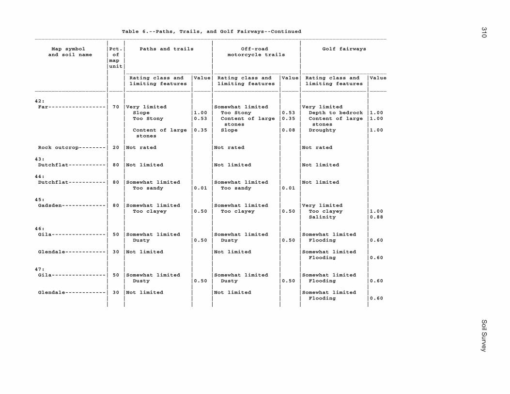
310S
oil Survey
Table 6.--Paths, Trails, and Golf Fairways--Continued________________________________________________________________________________________________________ | | | | Map symbol |Pct.| Paths and trails | Off-road | Golf fairways and soil name | of | | motorcycle trails | |map | | | |unit| | | | |_________________________|_________________________|_________________________ | | Rating class and |Value| Rating class and |Value| Rating class and |Value | | limiting features | | limiting features | | limiting features |_____________________|____|___________________|_____|___________________|_____|___________________|_____ | | | | | | |42: | | | | | | | Far-----------------| 70 |Very limited | |Somewhat limited | |Very limited | | | Slope |1.00 | Too Stony |0.53 | Depth to bedrock |1.00 | | Too Stony |0.53 | Content of large |0.35 | Content of large |1.00 | | | | stones | | stones | | | Content of large |0.35 | Slope |0.08 | Droughty |1.00 | | stones | | | | | | | | | | | | Rock outcrop--------| 20 |Not rated | |Not rated | |Not rated | | | | | | | |43: | | | | | | | Dutchflat-----------| 80 |Not limited | |Not limited | |Not limited | | | | | | | |44: | | | | | | | Dutchflat-----------| 80 |Somewhat limited | |Somewhat limited | |Not limited | | | Too sandy |0.01 | Too sandy |0.01 | | | | | | | | |45: | | | | | | | Gadsden-------------| 80 |Somewhat limited | |Somewhat limited | |Very limited | | | Too clayey |0.50 | Too clayey |0.50 | Too clayey |1.00 | | | | | | Salinity |0.88 | | | | | | |46: | | | | | | | Gila----------------| 50 |Somewhat limited | |Somewhat limited | |Somewhat limited | | | Dusty |0.50 | Dusty |0.50 | Flooding |0.60 | | | | | | | Glendale------------| 30 |Not limited | |Not limited | |Somewhat limited | | | | | | | Flooding |0.60 | | | | | | |47: | | | | | | | Gila----------------| 50 |Somewhat limited | |Somewhat limited | |Somewhat limited | | | Dusty |0.50 | Dusty |0.50 | Flooding |0.60 | | | | | | | Glendale------------| 30 |Not limited | |Not limited | |Somewhat limited | | | | | | | Flooding |0.60 | | | | | | |

Mohave C
ounty, Arizona, S
outhern Part
311
Table 6.--Paths, Trails, and Golf Fairways--Continued________________________________________________________________________________________________________ | | | | Map symbol |Pct.| Paths and trails | Off-road | Golf fairways and soil name | of | | motorcycle trails | |map | | | |unit| | | | |_________________________|_________________________|_________________________ | | Rating class and |Value| Rating class and |Value| Rating class and |Value | | limiting features | | limiting features | | limiting features |_____________________|____|___________________|_____|___________________|_____|___________________|_____ | | | | | | |48: | | | | | | | Goldroad------------| 60 |Very limited | |Very limited | |Very limited | | | Gravel content |1.00 | Gravel content |1.00 | Depth to bedrock |1.00 | | Slope |1.00 | Slope |1.00 | Slope |1.00 | | | | | | Gravel content |1.00 | | | | | | | Rock outcrop--------| 20 |Not rated | |Not rated | |Not rated | | | | | | | |49: | | | | | | | Gonzales------------| 60 |Very limited | |Somewhat limited | |Very limited | | | Slope |1.00 | Content of large |0.18 | Depth to bedrock |1.00 | | | | stones | | | | | Content of large |0.18 | | | Slope |1.00 | | stones | | | | | | | | | | | Content of large |1.00 | | | | | | stones | | | | | | | | Rock outcrop--------| 25 |Not rated | |Not rated | |Not rated | | | | | | | |50: | | | | | | | Goodsprings family--| 75 |Not limited | |Not limited | |Very limited | | | | | | | Depth to cemented|1.00 | | | | | | pan | | | | | | | Droughty |0.99 | | | | | | Gravel content |0.68 | | | | | | |51: | | | | | | | Goodsprings family--| 75 |Not limited | |Not limited | |Very limited | | | | | | | Depth to cemented|1.00 | | | | | | pan | | | | | | | Droughty |0.99 | | | | | | Gravel content |0.68 | | | | | | |52: | | | | | | | Goodsprings family--| 75 |Somewhat limited | |Not limited | |Very limited | | | Slope |0.92 | | | Depth to cemented|1.00 | | | | | | pan | | | | | | | Slope |1.00 | | | | | | Droughty |0.99 | | | | | | |

312S
oil Survey
Table 6.--Paths, Trails, and Golf Fairways--Continued________________________________________________________________________________________________________ | | | | Map symbol |Pct.| Paths and trails | Off-road | Golf fairways and soil name | of | | motorcycle trails | |map | | | |unit| | | | |_________________________|_________________________|_________________________ | | Rating class and |Value| Rating class and |Value| Rating class and |Value | | limiting features | | limiting features | | limiting features |_____________________|____|___________________|_____|___________________|_____|___________________|_____ | | | | | | |53: | | | | | | | Goodsprings family--| 75 |Somewhat limited | |Not limited | |Very limited | | | Slope |0.92 | | | Depth to cemented|1.00 | | | | | | pan | | | | | | | Slope |1.00 | | | | | | Droughty |0.99 | | | | | | |54: | | | | | | | Graham--------------| 60 |Very limited | |Very limited | |Very limited | | | Too Stony |1.00 | Too Stony |1.00 | Depth to bedrock |1.00 | | Content of large |0.54 | Content of large |0.54 | Content of large |1.00 | | stones | | stones | | stones | | | Dusty |0.50 | Dusty |0.50 | Droughty |0.98 | | | | | | | Arivaca-------------| 25 |Very limited | |Very limited | |Very limited | | | Too Stony |1.00 | Too Stony |1.00 | Content of large |1.00 | | | | | | stones | | | Content of large |0.32 | Content of large |0.32 | Depth to bedrock |0.42 | | stones | | stones | | | | | | | | | Slope |0.04 | | | | | | |55: | | | | | | | Graham--------------| 60 |Very limited | |Very limited | |Very limited | | | Too Stony |1.00 | Too Stony |1.00 | Depth to bedrock |1.00 | | Slope |1.00 | Content of large |0.54 | Content of large |1.00 | | | | stones | | stones | | | Content of large |0.54 | Dusty |0.50 | Slope |1.00 | | stones | | | | | | | | | | | | Rock outcrop--------| 20 |Not rated | |Not rated | |Not rated | | | | | | | |56: | | | | | | | Gunsight------------| 75 |Somewhat limited | |Somewhat limited | |Very limited | | | Dusty |0.50 | Dusty |0.50 | Gravel content |1.00 | | | | | | Slope |0.04 | | | | | | |
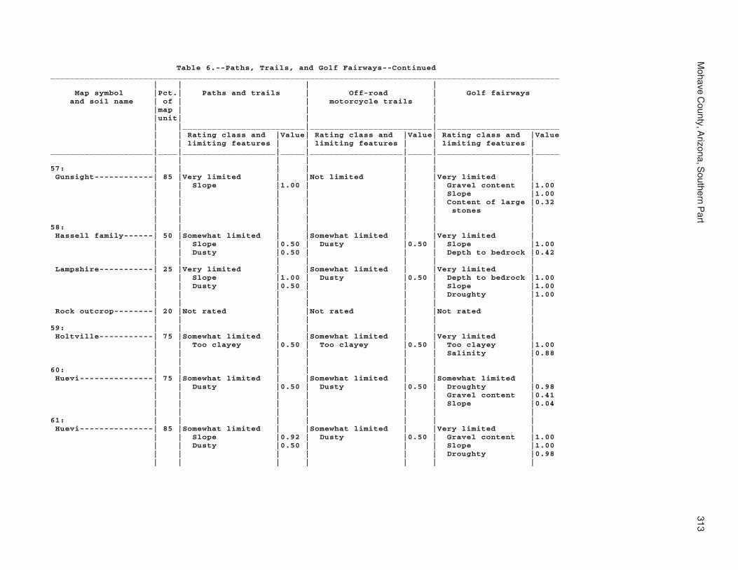
Mohave C
ounty, Arizona, S
outhern Part
313
Table 6.--Paths, Trails, and Golf Fairways--Continued________________________________________________________________________________________________________ | | | | Map symbol |Pct.| Paths and trails | Off-road | Golf fairways and soil name | of | | motorcycle trails | |map | | | |unit| | | | |_________________________|_________________________|_________________________ | | Rating class and |Value| Rating class and |Value| Rating class and |Value | | limiting features | | limiting features | | limiting features |_____________________|____|___________________|_____|___________________|_____|___________________|_____ | | | | | | |57: | | | | | | | Gunsight------------| 85 |Very limited | |Not limited | |Very limited | | | Slope |1.00 | | | Gravel content |1.00 | | | | | | Slope |1.00 | | | | | | Content of large |0.32 | | | | | | stones | | | | | | | |58: | | | | | | | Hassell family------| 50 |Somewhat limited | |Somewhat limited | |Very limited | | | Slope |0.50 | Dusty |0.50 | Slope |1.00 | | Dusty |0.50 | | | Depth to bedrock |0.42 | | | | | | | Lampshire-----------| 25 |Very limited | |Somewhat limited | |Very limited | | | Slope |1.00 | Dusty |0.50 | Depth to bedrock |1.00 | | Dusty |0.50 | | | Slope |1.00 | | | | | | Droughty |1.00 | | | | | | | Rock outcrop--------| 20 |Not rated | |Not rated | |Not rated | | | | | | | |59: | | | | | | | Holtville-----------| 75 |Somewhat limited | |Somewhat limited | |Very limited | | | Too clayey |0.50 | Too clayey |0.50 | Too clayey |1.00 | | | | | | Salinity |0.88 | | | | | | |60: | | | | | | | Huevi---------------| 75 |Somewhat limited | |Somewhat limited | |Somewhat limited | | | Dusty |0.50 | Dusty |0.50 | Droughty |0.98 | | | | | | Gravel content |0.41 | | | | | | Slope |0.04 | | | | | | |61: | | | | | | | Huevi---------------| 85 |Somewhat limited | |Somewhat limited | |Very limited | | | Slope |0.92 | Dusty |0.50 | Gravel content |1.00 | | Dusty |0.50 | | | Slope |1.00 | | | | | | Droughty |0.98 | | | | | | |

314S
oil Survey
Table 6.--Paths, Trails, and Golf Fairways--Continued________________________________________________________________________________________________________ | | | | Map symbol |Pct.| Paths and trails | Off-road | Golf fairways and soil name | of | | motorcycle trails | |map | | | |unit| | | | |_________________________|_________________________|_________________________ | | Rating class and |Value| Rating class and |Value| Rating class and |Value | | limiting features | | limiting features | | limiting features |_____________________|____|___________________|_____|___________________|_____|___________________|_____ | | | | | | |62: | | | | | | | Akela---------------| 60 |Very limited | |Very limited | |Very limited | | | Slope |1.00 | Slope |1.00 | Depth to bedrock |1.00 | | | | | | Slope |1.00 | | | | | | Droughty |1.00 | | | | | | | Rock outcrop--------| 20 |Not rated | |Not rated | |Not rated | | | | | | | |63: | | | | | | | Hyder---------------| 50 |Very limited | |Very limited | |Very limited | | | Content of large |1.00 | Content of large |1.00 | Depth to bedrock |1.00 | | stones | | stones | | | | | Slope |1.00 | Slope |1.00 | Slope |1.00 | | Too Stony |1.00 | Too Stony |1.00 | Content of large |1.00 | | | | | | stones | | | | | | | | Rock outcrop--------| 20 |Not rated | |Not rated | |Not rated | | | | | | | | Rubble land---------| 20 |Not rated | |Not rated | |Not rated | | | | | | | |64: | | | | | | | Indio---------------| 85 |Somewhat limited | |Somewhat limited | |Somewhat limited | | | Dusty |0.50 | Dusty |0.50 | Salinity |0.88 | | | | | | |65: | | | | | | | Ireteba family------| 45 |Not limited | |Not limited | |Somewhat limited | | | | | | | Gravel content |0.50 | | | | | | Droughty |0.04 | | | | | | | Arizo---------------| 30 |Somewhat limited | |Somewhat limited | |Very limited | | | Flooding |0.40 | Flooding |0.40 | Flooding |1.00 | | | | | | Droughty |1.00 | | | | | | Gravel content |0.50 | | | | | | |66: | | | | | | | Kinley--------------| 75 |Very limited | |Somewhat limited | |Very limited | | | Slope |1.00 | Too sandy |0.79 | Slope |1.00 | | Too sandy |0.79 | | | Gravel content |0.50 | | | | | | |

Mohave C
ounty, Arizona, S
outhern Part
315
Table 6.--Paths, Trails, and Golf Fairways--Continued________________________________________________________________________________________________________ | | | | Map symbol |Pct.| Paths and trails | Off-road | Golf fairways and soil name | of | | motorcycle trails | |map | | | |unit| | | | |_________________________|_________________________|_________________________ | | Rating class and |Value| Rating class and |Value| Rating class and |Value | | limiting features | | limiting features | | limiting features |_____________________|____|___________________|_____|___________________|_____|___________________|_____ | | | | | | |67: | | | | | | | Kinley--------------| 50 |Not limited | |Not limited | |Somewhat limited | | | | | | | Gravel content |0.50 | | | | | | Slope |0.04 | | | | | | | Poachie-------------| 35 |Not limited | |Not limited | |Somewhat limited | | | | | | | Gravel content |0.50 | | | | | | |68: | | | | | | | Kofa----------------| 85 |Somewhat limited | |Somewhat limited | |Very limited | | | Too clayey |0.50 | Too clayey |0.50 | Too clayey |1.00 | | | | | | Salinity |0.88 | | | | | | |69: | | | | | | | Dudleyville---------| 40 |Somewhat limited | |Somewhat limited | |Very limited | | | Too sandy |0.79 | Too sandy |0.79 | Flooding |1.00 | | Flooding |0.40 | Flooding |0.40 | Gravel content |1.00 | | | | | | Droughty |0.99 | | | | | | | Vinton--------------| 30 |Not limited | |Not limited | |Somewhat limited | | | | | | | Droughty |0.86 | | | | | | Flooding |0.60 | | | | | | | Riverwash-----------| 20 |Not rated | |Not rated | |Not rated | | | | | | | |70: | | | | | | | Dudleyville---------| 40 |Somewhat limited | |Somewhat limited | |Very limited | | | Too sandy |0.79 | Too sandy |0.79 | Flooding |1.00 | | Flooding |0.40 | Flooding |0.40 | Gravel content |1.00 | | | | | | Droughty |0.99 | | | | | | | Vinton--------------| 30 |Not limited | |Not limited | |Somewhat limited | | | | | | | Droughty |0.86 | | | | | | Flooding |0.60 | | | | | | | Riverwash-----------| 20 |Not rated | |Not rated | |Not rated | | | | | | | |

316S
oil Survey
Table 6.--Paths, Trails, and Golf Fairways--Continued________________________________________________________________________________________________________ | | | | Map symbol |Pct.| Paths and trails | Off-road | Golf fairways and soil name | of | | motorcycle trails | |map | | | |unit| | | | |_________________________|_________________________|_________________________ | | Rating class and |Value| Rating class and |Value| Rating class and |Value | | limiting features | | limiting features | | limiting features |_____________________|____|___________________|_____|___________________|_____|___________________|_____ | | | | | | |71: | | | | | | | Lagunita------------| 85 |Very limited | |Very limited | |Very limited | | | Too sandy |1.00 | Too sandy |1.00 | Droughty |0.99 | | | | | | Too sandy |0.50 | | | | | | |72: | | | | | | | Lagunita------------| 60 |Very limited | |Very limited | |Very limited | | | Too sandy |1.00 | Too sandy |1.00 | Too sandy |1.00 | | | | | | Droughty |0.99 | | | | | | | Ripley--------------| 25 |Somewhat limited | |Somewhat limited | |Very limited | | | Too sandy |0.01 | Too sandy |0.01 | Salinity |1.00 | | | | | | |73: | | | | | | | Lampshire-----------| 65 |Very limited | |Very limited | |Very limited | | | Slope |1.00 | Slope |1.00 | Depth to bedrock |1.00 | | | | | | Slope |1.00 | | | | | | Droughty |1.00 | | | | | | | Rock outcrop--------| 20 |Not rated | |Not rated | |Not rated | | | | | | | |74: | | | | | | | Lampshire-----------| 65 |Very limited | |Very limited | |Very limited | | | Slope |1.00 | Slope |1.00 | Depth to bedrock |1.00 | | Dusty |0.50 | Dusty |0.50 | Slope |1.00 | | | | | | Droughty |1.00 | | | | | | | Rock outcrop--------| 20 |Not rated | |Not rated | |Not rated | | | | | | | |75: | | | | | | | Lampshire-----------| 45 |Very limited | |Somewhat limited | |Very limited | | | Slope |1.00 | Slope |0.96 | Depth to bedrock |1.00 | | Content of large |0.82 | Content of large |0.82 | Slope |1.00 | | stones | | stones | | | | | Too Stony |0.53 | Too Stony |0.53 | Content of large |1.00 | | | | | | stones | | | | | | | | Rock outcrop--------| 40 |Not rated | |Not rated | |Not rated | | | | | | | |

Mohave C
ounty, Arizona, S
outhern Part
317
Table 6.--Paths, Trails, and Golf Fairways--Continued________________________________________________________________________________________________________ | | | | Map symbol |Pct.| Paths and trails | Off-road | Golf fairways and soil name | of | | motorcycle trails | |map | | | |unit| | | | |_________________________|_________________________|_________________________ | | Rating class and |Value| Rating class and |Value| Rating class and |Value | | limiting features | | limiting features | | limiting features |_____________________|____|___________________|_____|___________________|_____|___________________|_____ | | | | | | |76: | | | | | | | Lostman-------------| 80 |Not limited | |Not limited | |Somewhat limited | | | | | | | Droughty |0.46 | | | | | | Gravel content |0.32 | | | | | | |77: | | | | | | | Lostman-------------| 80 |Not limited | |Not limited | |Not limited | | | | | | | |78: | | | | | | | Lostman-------------| 40 |Not limited | |Not limited | |Not limited | | | | | | | | Kinley--------------| 35 |Not limited | |Not limited | |Somewhat limited | | | | | | | Gravel content |0.50 | | | | | | |79: | | | | | | | Marshes-------------|100 |Not rated | |Not rated | |Not rated | | | | | | | |80: | | | | | | | Meloland------------| 85 |Somewhat limited | |Somewhat limited | |Very limited | | | Dusty |0.50 | Dusty |0.50 | Salinity |1.00 | | | | | | Flooding |0.60 | | | | | | |81: | | | | | | | Mohon---------------| 50 |Somewhat limited | |Somewhat limited | |Somewhat limited | | | Too sandy |0.79 | Too sandy |0.79 | Gravel content |0.41 | | | | | | | Kinley--------------| 35 |Not limited | |Not limited | |Somewhat limited | | | | | | | Gravel content |0.50 | | | | | | Slope |0.16 | | | | | | |82: | | | | | | | Mohon---------------| 50 |Somewhat limited | |Somewhat limited | |Very limited | | | Dusty |0.50 | Dusty |0.50 | Content of large |1.00 | | | | | | stones | | | Content of large |0.32 | Content of large |0.32 | Slope |0.04 | | stones | | stones | | | | | | | | | Gravel content |0.02 | | | | | | |

318S
oil Survey
Table 6.--Paths, Trails, and Golf Fairways--Continued________________________________________________________________________________________________________ | | | | Map symbol |Pct.| Paths and trails | Off-road | Golf fairways and soil name | of | | motorcycle trails | |map | | | |unit| | | | |_________________________|_________________________|_________________________ | | Rating class and |Value| Rating class and |Value| Rating class and |Value | | limiting features | | limiting features | | limiting features |_____________________|____|___________________|_____|___________________|_____|___________________|_____ | | | | | | |82: | | | | | | | Poachie-------------| 25 |Not limited | |Not limited | |Somewhat limited | | | | | | | Gravel content |0.50 | | | | | | Slope |0.04 | | | | | | |83: | | | | | | | Mohon---------------| 50 |Not limited | |Not limited | |Very limited | | | | | | | Gravel content |1.00 | | | | | | | Poachie-------------| 25 |Not limited | |Not limited | |Somewhat limited | | | | | | | Gravel content |0.50 | | | | | | Slope |0.04 | | | | | | |84: | | | | | | | Nickel family-------| 35 |Very limited | |Somewhat limited | |Very limited | | | Slope |1.00 | Slope |0.56 | Slope |1.00 | | Too sandy |0.30 | Too sandy |0.30 | Gravel content |1.00 | | | | | | Droughty |0.41 | | | | | | | Topawa family-------| 30 |Very limited | |Somewhat limited | |Very limited | | | Slope |1.00 | Too sandy |0.72 | Slope |1.00 | | Too sandy |0.72 | Slope |0.56 | Gravel content |1.00 | | | | | | Droughty |0.80 | | | | | | | Eba family----------| 25 |Somewhat limited | |Not limited | |Very limited | | | Slope |0.18 | | | Gravel content |1.00 | | | | | | Slope |1.00 | | | | | | Droughty |0.63 | | | | | | |85: | | | | | | | Orwash family-------| 75 |Not limited | |Not limited | |Somewhat limited | | | | | | | Droughty |0.55 | | | | | | |86: | | | | | | | Orwash family-------| 75 |Not limited | |Not limited | |Somewhat limited | | | | | | | Droughty |0.55 | | | | | | |

Mohave C
ounty, Arizona, S
outhern Part
319
Table 6.--Paths, Trails, and Golf Fairways--Continued________________________________________________________________________________________________________ | | | | Map symbol |Pct.| Paths and trails | Off-road | Golf fairways and soil name | of | | motorcycle trails | |map | | | |unit| | | | |_________________________|_________________________|_________________________ | | Rating class and |Value| Rating class and |Value| Rating class and |Value | | limiting features | | limiting features | | limiting features |_____________________|____|___________________|_____|___________________|_____|___________________|_____ | | | | | | |87: | | | | | | | Penthouse-----------| 50 |Somewhat limited | |Somewhat limited | |Very limited | | | Dusty |0.50 | Dusty |0.50 | Content of large |1.00 | | | | | | stones | | | Content of large |0.05 | Content of large |0.05 | Slope |0.16 | | stones | | stones | | | | | | | | | Gravel content |0.01 | | | | | | | Gonzales------------| 25 |Somewhat limited | |Somewhat limited | |Very limited | | | Dusty |0.50 | Dusty |0.50 | Depth to bedrock |1.00 | | Content of large |0.18 | Content of large |0.18 | Content of large |1.00 | | stones | | stones | | stones | | | | | | | Slope |1.00 | | | | | | |88: | | | | | | | Poachie-------------| 80 |Somewhat limited | |Somewhat limited | |Very limited | | | Dusty |0.50 | Dusty |0.50 | Gravel content |1.00 | | | | | | |89: | | | | | | | Poachie-------------| 80 |Somewhat limited | |Somewhat limited | |Very limited | | | Dusty |0.50 | Dusty |0.50 | Gravel content |1.00 | | | | | | |90: | | | | | | | Quilotosa-----------| 60 |Very limited | |Very limited | |Very limited | | | Slope |1.00 | Gravel content |1.00 | Depth to bedrock |1.00 | | Gravel content |1.00 | Slope |1.00 | Slope |1.00 | | | | | | Gravel content |1.00 | | | | | | | Rock outcrop--------| 20 |Not rated | |Not rated | |Not rated | | | | | | | |91: | | | | | | | Razorback-----------| 90 |Very limited | |Very limited | |Very limited | | | Gravel content |1.00 | Gravel content |1.00 | Depth to bedrock |1.00 | | Slope |1.00 | | | Slope |1.00 | | | | | | Gravel content |1.00 | | | | | | |

320S
oil Survey
Table 6.--Paths, Trails, and Golf Fairways--Continued________________________________________________________________________________________________________ | | | | Map symbol |Pct.| Paths and trails | Off-road | Golf fairways and soil name | of | | motorcycle trails | |map | | | |unit| | | | |_________________________|_________________________|_________________________ | | Rating class and |Value| Rating class and |Value| Rating class and |Value | | limiting features | | limiting features | | limiting features |_____________________|____|___________________|_____|___________________|_____|___________________|_____ | | | | | | |92: | | | | | | | Razorback-----------| 65 |Very limited | |Very limited | |Very limited | | | Too Stony |1.00 | Too Stony |1.00 | Depth to bedrock |1.00 | | Content of large |0.98 | Content of large |0.98 | Content of large |1.00 | | stones | | stones | | stones | | | Dusty |0.50 | Dusty |0.50 | Droughty |1.00 | | | | | | | Rock outcrop--------| 20 |Not rated | |Not rated | |Not rated | | | | | | | |93: | | | | | | | Razorback-----------| 60 |Very limited | |Very limited | |Very limited | | | Slope |1.00 | Slope |1.00 | Depth to bedrock |1.00 | | Content of large |0.61 | Content of large |0.61 | Slope |1.00 | | stones | | stones | | | | | Dusty |0.50 | Dusty |0.50 | Content of large |1.00 | | | | | | stones | | | | | | | | Rock outcrop--------| 20 |Not rated | |Not rated | |Not rated | | | | | | | | | | | | | | |94: | | | | | | | Razorback-----------| 60 |Very limited | |Very limited | |Very limited | | | Too Stony |1.00 | Too Stony |1.00 | Depth to bedrock |1.00 | | Slope |1.00 | Slope |1.00 | Slope |1.00 | | Content of large |0.98 | Content of large |0.98 | Content of large |1.00 | | stones | | stones | | stones | | | | | | | | Rock outcrop--------| 20 |Not rated | |Not rated | |Not rated | | | | | | | |95: | | | | | | | Razorback-----------| 45 |Very limited | |Very limited | |Very limited | | | Slope |1.00 | Slope |1.00 | Depth to bedrock |1.00 | | Content of large |0.61 | Content of large |0.61 | Slope |1.00 | | stones | | stones | | | | | Dusty |0.50 | Dusty |0.50 | Content of large |1.00 | | | | | | stones | | | | | | | | Rock outcrop--------| 20 |Not rated | |Not rated | |Not rated | | | | | | | | Rubble land---------| 20 |Not rated | |Not rated | |Not rated | | | | | | | |

Mohave C
ounty, Arizona, S
outhern Part
321
Table 6.--Paths, Trails, and Golf Fairways--Continued________________________________________________________________________________________________________ | | | | Map symbol |Pct.| Paths and trails | Off-road | Golf fairways and soil name | of | | motorcycle trails | |map | | | |unit| | | | |_________________________|_________________________|_________________________ | | Rating class and |Value| Rating class and |Value| Rating class and |Value | | limiting features | | limiting features | | limiting features |_____________________|____|___________________|_____|___________________|_____|___________________|_____ | | | | | | |96: | | | | | | | Razorback-----------| 45 |Very limited | |Very limited | |Very limited | | | Slope |1.00 | Slope |1.00 | Depth to bedrock |1.00 | | Content of large |0.61 | Content of large |0.61 | Slope |1.00 | | stones | | stones | | | | | Dusty |0.50 | Dusty |0.50 | Content of large |1.00 | | | | | | stones | | | | | | | | Rock outcrop--------| 20 |Not rated | |Not rated | |Not rated | | | | | | | | Rubble land---------| 20 |Not rated | |Not rated | |Not rated | | | | | | | |97: | | | | | | | Rillino-------------| 75 |Very limited | |Somewhat limited | |Very limited | | | Slope |1.00 | Too sandy |0.30 | Slope |1.00 | | Too sandy |0.30 | | | Gravel content |0.50 | | | | | | Droughty |0.01 | | | | | | |98: | | | | | | | Rillino-------------| 50 |Not limited | |Not limited | |Very limited | | | | | | | Gravel content |1.00 | | | | | | Slope |0.04 | | | | | | Droughty |0.01 | | | | | | | Tres Hermanos-------| 35 |Not limited | |Not limited | |Somewhat limited | | | | | | | Gravel content |0.50 | | | | | | |99: | | | | | | | Ripley--------------| 85 |Somewhat limited | |Somewhat limited | |Very limited | | | Dusty |0.50 | Dusty |0.50 | Salinity |1.00 | | | | | | Flooding |0.60 | | | | | | |100: | | | | | | | Riverbend family----| 75 |Somewhat limited | |Somewhat limited | |Very limited | | | Content of large |0.02 | Content of large |0.02 | Droughty |1.00 | | stones | | stones | | | | | | | | | Content of large |0.99 | | | | | | stones | | | | | | | Gravel content |0.87 | | | | | | |

322S
oil Survey
Table 6.--Paths, Trails, and Golf Fairways--Continued________________________________________________________________________________________________________ | | | | Map symbol |Pct.| Paths and trails | Off-road | Golf fairways and soil name | of | | motorcycle trails | |map | | | |unit| | | | |_________________________|_________________________|_________________________ | | Rating class and |Value| Rating class and |Value| Rating class and |Value | | limiting features | | limiting features | | limiting features |_____________________|____|___________________|_____|___________________|_____|___________________|_____ | | | | | | |101: | | | | | | | Riverbend-----------| 75 |Somewhat limited | |Somewhat limited | |Very limited | | | Content of large |0.01 | Content of large |0.01 | Droughty |1.00 | | stones | | stones | | | | | | | | | Content of large |0.99 | | | | | | stones | | | | | | | Gravel content |0.65 | | | | | | |102: | | | | | | | Riverwash-----------| 70 |Not rated | |Not rated | |Not rated | | | | | | | | Fluvaquents---------| 20 |Not rated | |Not rated | |Not rated | | | | | | | |103: | | | | | | | Rock outcrop--------| 45 |Not rated | |Not rated | |Not rated | | | | | | | | Hyder---------------| 40 |Very limited | |Very limited | |Very limited | | | Content of large |1.00 | Content of large |1.00 | Depth to bedrock |1.00 | | stones | | stones | | | | | Slope |1.00 | Too Stony |1.00 | Slope |1.00 | | Too Stony |1.00 | Slope |1.00 | Content of large |1.00 | | | | | | stones | | | | | | | |104: | | | | | | | Rock outcrop--------| 65 |Not rated | |Not rated | |Not rated | | | | | | | | Razorback-----------| 30 |Very limited | |Very limited | |Very limited | | | Gravel content |1.00 | Gravel content |1.00 | Depth to bedrock |1.00 | | Slope |1.00 | Slope |1.00 | Slope |1.00 | | | | | | Gravel content |1.00 | | | | | | |105: | | | | | | | Rock outcrop--------| 45 |Not rated | |Not rated | |Not rated | | | | | | | | Sunrock-------------| 40 |Very limited | |Very limited | |Very limited | | | Slope |1.00 | Too Stony |1.00 | Depth to bedrock |1.00 | | Too Stony |1.00 | Slope |1.00 | Slope |1.00 | | Gravel content |1.00 | Gravel content |1.00 | Gravel content |1.00 | | | | | | |

Mohave C
ounty, Arizona, S
outhern Part
323
Table 6.--Paths, Trails, and Golf Fairways--Continued________________________________________________________________________________________________________ | | | | Map symbol |Pct.| Paths and trails | Off-road | Golf fairways and soil name | of | | motorcycle trails | |map | | | |unit| | | | |_________________________|_________________________|_________________________ | | Rating class and |Value| Rating class and |Value| Rating class and |Value | | limiting features | | limiting features | | limiting features |_____________________|____|___________________|_____|___________________|_____|___________________|_____ | | | | | | |106: | | | | | | | Romero--------------| 45 |Very limited | |Very limited | |Very limited | | | Too Stony |1.00 | Too Stony |1.00 | Depth to bedrock |1.00 | | Slope |0.50 | Content of large |0.26 | Droughty |1.00 | | | | stones | | | | | Content of large |0.26 | | | Content of large |1.00 | | stones | | | | stones | | | | | | | | Chiricahua----------| 30 |Somewhat limited | |Not limited | |Very limited | | | Slope |0.50 | | | Depth to bedrock |1.00 | | | | | | Droughty |1.00 | | | | | | Gravel content |1.00 | | | | | | | Rock outcrop--------| 20 |Not rated | |Not rated | |Not rated | | | | | | | |107: | | | | | | | Romero--------------| 60 |Very limited | |Very limited | |Very limited | | | Slope |1.00 | Too Stony |1.00 | Depth to bedrock |1.00 | | Too Stony |1.00 | Slope |1.00 | Slope |1.00 | | Content of large |0.61 | Content of large |0.61 | Content of large |1.00 | | stones | | stones | | stones | | | | | | | | Lampshire-----------| 20 |Very limited | |Very limited | |Very limited | | | Slope |1.00 | Slope |1.00 | Depth to bedrock |1.00 | | | | | | Slope |1.00 | | | | | | Droughty |1.00 | | | | | | | Rock outcrop--------| 15 |Not rated | |Not rated | |Not rated | | | | | | | |108: | | | | | | | Rositas family------| 40 |Very limited | |Very limited | |Very limited | | | Too sandy |1.00 | Too sandy |1.00 | Slope |1.00 | | Slope |0.18 | | | Droughty |0.81 | | | | | | | Superstition--------| 25 |Very limited | |Very limited | |Somewhat limited | | | Too sandy |1.00 | Too sandy |1.00 | Droughty |0.93 | | | | | | Gravel content |0.50 | | | | | | |

324S
oil Survey
Table 6.--Paths, Trails, and Golf Fairways--Continued________________________________________________________________________________________________________ | | | | Map symbol |Pct.| Paths and trails | Off-road | Golf fairways and soil name | of | | motorcycle trails | |map | | | |unit| | | | |_________________________|_________________________|_________________________ | | Rating class and |Value| Rating class and |Value| Rating class and |Value | | limiting features | | limiting features | | limiting features |_____________________|____|___________________|_____|___________________|_____|___________________|_____ | | | | | | |108: | | | | | | | Torriorthents-------| 25 |Not rated | |Not rated | |Not rated | | | | | | | |109: | | | | | | | Rositas-------------| 40 |Very limited | |Very limited | |Very limited | | | Too sandy |1.00 | Too sandy |1.00 | Slope |1.00 | | Slope |0.18 | | | Droughty |0.69 | | | | | | Too sandy |0.50 | | | | | | | Superstition family-| 25 |Very limited | |Very limited | |Somewhat limited | | | Too sandy |1.00 | Too sandy |1.00 | Droughty |0.92 | | | | | | | Torriorthents-------| 20 |Not rated | |Not rated | |Not rated | | | | | | | |110: | | | | | | | Stagecoach----------| 75 |Somewhat limited | |Somewhat limited | |Very limited | | | Dusty |0.50 | Dusty |0.50 | Gravel content |1.00 | | | | | | Droughty |0.07 | | | | | | Slope |0.04 | | | | | | |111: | | | | | | | Stagecoach----------| 85 |Very limited | |Somewhat limited | |Very limited | | | Slope |1.00 | Dusty |0.50 | Gravel content |1.00 | | Dusty |0.50 | | | Slope |1.00 | | | | | | Droughty |0.07 | | | | | | |112: | | | | | | | Stagecoach----------| 80 |Somewhat limited | |Not limited | |Very limited | | | Slope |0.50 | | | Gravel content |1.00 | | | | | | Slope |1.00 | | | | | | Droughty |0.09 | | | | | | |113: | | | | | | | Stagecoach----------| 80 |Somewhat limited | |Not limited | |Very limited | | | Slope |0.50 | | | Gravel content |1.00 | | | | | | Slope |1.00 | | | | | | Droughty |0.09 | | | | | | |

Mohave C
ounty, Arizona, S
outhern Part
325
Table 6.--Paths, Trails, and Golf Fairways--Continued________________________________________________________________________________________________________ | | | | Map symbol |Pct.| Paths and trails | Off-road | Golf fairways and soil name | of | | motorcycle trails | |map | | | |unit| | | | |_________________________|_________________________|_________________________ | | Rating class and |Value| Rating class and |Value| Rating class and |Value | | limiting features | | limiting features | | limiting features |_____________________|____|___________________|_____|___________________|_____|___________________|_____ | | | | | | |114: | | | | | | | Stagecoach----------| 35 |Very limited | |Somewhat limited | |Very limited | | | Slope |1.00 | Slope |0.56 | Slope |1.00 | | Too sandy |0.30 | Too sandy |0.30 | Gravel content |1.00 | | | | | | Droughty |0.11 | | | | | | | Topawa family-------| 30 |Very limited | |Somewhat limited | |Very limited | | | Slope |1.00 | Slope |0.22 | Gravel content |1.00 | | | | | | Slope |1.00 | | | | | | Droughty |0.98 | | | | | | | Eba-----------------| 25 |Somewhat limited | |Not limited | |Very limited | | | Slope |0.18 | | | Gravel content |1.00 | | | | | | Slope |1.00 | | | | | | Droughty |0.99 | | | | | | |115: | | | | | | | Stagecoach----------| 35 |Very limited | |Somewhat limited | |Very limited | | | Slope |1.00 | Slope |0.56 | Slope |1.00 | | Too sandy |0.30 | Too sandy |0.30 | Gravel content |1.00 | | | | | | Droughty |0.11 | | | | | | | Topawa family-------| 30 |Very limited | |Somewhat limited | |Very limited | | | Slope |1.00 | Slope |0.22 | Gravel content |1.00 | | | | | | Slope |1.00 | | | | | | Droughty |0.98 | | | | | | | Eba-----------------| 25 |Somewhat limited | |Not limited | |Very limited | | | Slope |0.18 | | | Gravel content |1.00 | | | | | | Slope |1.00 | | | | | | Droughty |0.99 | | | | | | |116: | | | | | | | Sunrock-------------| 90 |Very limited | |Very limited | |Very limited | | | Gravel content |1.00 | Gravel content |1.00 | Depth to bedrock |1.00 | | Slope |1.00 | | | Slope |1.00 | | | | | | Gravel content |1.00 | | | | | | |

326S
oil Survey
Table 6.--Paths, Trails, and Golf Fairways--Continued________________________________________________________________________________________________________ | | | | Map symbol |Pct.| Paths and trails | Off-road | Golf fairways and soil name | of | | motorcycle trails | |map | | | |unit| | | | |_________________________|_________________________|_________________________ | | Rating class and |Value| Rating class and |Value| Rating class and |Value | | limiting features | | limiting features | | limiting features |_____________________|____|___________________|_____|___________________|_____|___________________|_____ | | | | | | |117: | | | | | | | Sunrock-------------| 70 |Very limited | |Very limited | |Very limited | | | Gravel content |1.00 | Gravel content |1.00 | Depth to bedrock |1.00 | | Slope |1.00 | Slope |1.00 | Slope |1.00 | | | | | | Gravel content |1.00 | | | | | | | Rock outcrop--------| 20 |Not rated | |Not rated | |Not rated | | | | | | | |118: | | | | | | | Tombstone-----------| 35 |Very limited | |Somewhat limited | |Very limited | | | Slope |1.00 | Content of large |0.88 | Slope |1.00 | | | | stones | | | | | Content of large |0.88 | Slope |0.56 | Content of large |1.00 | | stones | | | | stones | | | Dusty |0.50 | Dusty |0.50 | Droughty |0.92 | | | | | | | Caralampi-----------| 30 |Very limited | |Somewhat limited | |Very limited | | | Slope |1.00 | Slope |0.56 | Slope |1.00 | | Too sandy |0.47 | Too sandy |0.47 | Gravel content |1.00 | | | | | | Droughty |0.82 | | | | | | | Eloma---------------| 25 |Somewhat limited | |Somewhat limited | |Very limited | | | Slope |0.18 | Content of large |0.18 | Content of large |1.00 | | | | stones | | stones | | | Content of large |0.18 | | | Slope |1.00 | | stones | | | | | | | | | | | Droughty |0.36 | | | | | | |119: | | | | | | | Torriorthents-------| 75 |Not rated | |Not rated | |Not rated | | | | | | | |120: | | | | | | | Torriorthents-------| 75 |Not rated | |Not rated | |Not rated | | | | | | | |

Mohave C
ounty, Arizona, S
outhern Part
327
Table 6.--Paths, Trails, and Golf Fairways--Continued________________________________________________________________________________________________________ | | | | Map symbol |Pct.| Paths and trails | Off-road | Golf fairways and soil name | of | | motorcycle trails | |map | | | |unit| | | | |_________________________|_________________________|_________________________ | | Rating class and |Value| Rating class and |Value| Rating class and |Value | | limiting features | | limiting features | | limiting features |_____________________|____|___________________|_____|___________________|_____|___________________|_____ | | | | | | |121: | | | | | | | Tumarion------------| 85 |Somewhat limited | |Somewhat limited | |Very limited | | | Dusty |0.50 | Dusty |0.50 | Depth to bedrock |1.00 | | Content of large |0.32 | Content of large |0.32 | Depth to cemented|1.00 | | stones | | stones | | pan | | | | | | | Content of large |1.00 | | | | | | stones | | | | | | | |122: | | | | | | | Tumarion------------| 85 |Somewhat limited | |Somewhat limited | |Very limited | | | Dusty |0.50 | Dusty |0.50 | Depth to bedrock |1.00 | | Content of large |0.32 | Content of large |0.32 | Depth to cemented|1.00 | | stones | | stones | | pan | | | | | | | Content of large |1.00 | | | | | | stones | | | | | | | |123: | | | | | | | Tyro----------------| 90 |Very limited | |Very limited | |Very limited | | | Content of large |1.00 | Content of large |1.00 | Depth to cemented|1.00 | | stones | | stones | | pan | | | Too Stony |1.00 | Too Stony |1.00 | Content of large |1.00 | | | | | | stones | | | Slope |0.32 | | | Droughty |1.00 | | | | | | |124: | | | | | | | Tyro----------------| 85 |Somewhat limited | |Somewhat limited | |Very limited | | | Too Stony |0.53 | Too Stony |0.53 | Depth to cemented|1.00 | | | | | | pan | | | Dusty |0.50 | Dusty |0.50 | Content of large |1.00 | | | | | | stones | | | Content of large |0.32 | Content of large |0.32 | Droughty |1.00 | | stones | | stones | | | | | | | | | |125: | | | | | | | Vekol family--------| 85 |Somewhat limited | |Somewhat limited | |Somewhat limited | | | Too sandy |0.79 | Too sandy |0.79 | Gravel content |0.50 | | | | | | |

328S
oil Survey
Table 6.--Paths, Trails, and Golf Fairways--Continued________________________________________________________________________________________________________ | | | | Map symbol |Pct.| Paths and trails | Off-road | Golf fairways and soil name | of | | motorcycle trails | |map | | | |unit| | | | |_________________________|_________________________|_________________________ | | Rating class and |Value| Rating class and |Value| Rating class and |Value | | limiting features | | limiting features | | limiting features |_____________________|____|___________________|_____|___________________|_____|___________________|_____ | | | | | | |126: | | | | | | | Vekol family--------| 85 |Somewhat limited | |Somewhat limited | |Somewhat limited | | | Too sandy |0.79 | Too sandy |0.79 | Gravel content |0.50 | | | | | | |127: | | | | | | | Water---------------|100 |Not rated | |Not rated | |Not rated | | | | | | | |128: | | | | | | | Whitehills----------| 80 |Somewhat limited | |Somewhat limited | |Very limited | | | Dusty |0.50 | Dusty |0.50 | Gravel content |1.00 | | | | | | Droughty |0.75 | | | | | | Depth to cemented|0.71 | | | | | | pan | | | | | | | |129: | | | | | | | Whitehills----------| 80 |Somewhat limited | |Somewhat limited | |Very limited | | | Dusty |0.50 | Dusty |0.50 | Gravel content |1.00 | | | | | | Droughty |0.75 | | | | | | Depth to cemented|0.71 | | | | | | pan | | | | | | | |130: | | | | | | | White House family--| 85 |Somewhat limited | |Somewhat limited | |Very limited | | | Too sandy |0.79 | Too sandy |0.79 | Gravel content |1.00 | | | | | | Slope |0.04 | | | | | | Droughty |0.01 | | | | | | |131: | | | | | | | White House---------| 85 |Somewhat limited | |Somewhat limited | |Somewhat limited | | | Too sandy |0.79 | Too sandy |0.79 | Gravel content |0.41 | | | | | | Slope |0.04 | | | | | | |132: | | | | | | | Wikieup-------------| 45 |Somewhat limited | |Somewhat limited | |Very limited | | | Slope |0.50 | Content of large |0.14 | Depth to bedrock |1.00 | | | | stones | | | | | Content of large |0.14 | | | Droughty |1.00 | | stones | | | | | | | | | | | Content of large |1.00 | | | | | | stones | | | | | | | |

Mohave C
ounty, Arizona, S
outhern Part
329
Table 6.--Paths, Trails, and Golf Fairways--Continued________________________________________________________________________________________________________ | | | | Map symbol |Pct.| Paths and trails | Off-road | Golf fairways and soil name | of | | motorcycle trails | |map | | | |unit| | | | |_________________________|_________________________|_________________________ | | Rating class and |Value| Rating class and |Value| Rating class and |Value | | limiting features | | limiting features | | limiting features |_____________________|____|___________________|_____|___________________|_____|___________________|_____ | | | | | | |132: | | | | | | | Mutang--------------| 30 |Very limited | |Very limited | |Very limited | | | Gravel content |1.00 | Gravel content |1.00 | Depth to bedrock |1.00 | | Slope |0.50 | | | Gravel content |1.00 | | | | | | Droughty |1.00 | | | | | | | Rock outcrop--------| 20 |Not rated | |Not rated | |Not rated | | | | | | | |133: | | | | | | | Mutang--------------| 55 |Somewhat limited | |Not limited | |Very limited | | | Slope |0.08 | | | Depth to bedrock |1.00 | | | | | | Slope |1.00 | | | | | | Droughty |0.98 | | | | | | | Wikieup-------------| 25 |Very limited | |Very limited | |Very limited | | | Gravel content |1.00 | Gravel content |1.00 | Depth to bedrock |1.00 | | Dusty |0.50 | Dusty |0.50 | Gravel content |1.00 | | Slope |0.08 | | | Droughty |1.00 | | | | | | | Rock outcrop--------| 15 |Not rated | |Not rated | |Not rated | | | | | | | |134: | | | | | | | Wikieup-------------| 50 |Very limited | |Very limited | |Very limited | | | Slope |1.00 | Slope |1.00 | Depth to bedrock |1.00 | | | | | | Slope |1.00 | | | | | | Droughty |1.00 | | | | | | | Rock outcrop--------| 25 |Not rated | |Not rated | |Not rated | | | | | | | | | | | | | | |135: | | | | | | | Yahana family-------| 85 |Not limited | |Not limited | |Very limited | | | | | | | Salinity |1.00 | | | | | | Sodium content |1.00 | | | | | | |

330S
oil Survey
Table 6.--Paths, Trails, and Golf Fairways--Continued________________________________________________________________________________________________________ | | | | Map symbol |Pct.| Paths and trails | Off-road | Golf fairways and soil name | of | | motorcycle trails | |map | | | |unit| | | | |_________________________|_________________________|_________________________ | | Rating class and |Value| Rating class and |Value| Rating class and |Value | | limiting features | | limiting features | | limiting features |_____________________|____|___________________|_____|___________________|_____|___________________|_____ | | | | | | |136: | | | | | | | Tumarion------------| 70 |Very limited | |Very limited | |Very limited | | | Content of large |1.00 | Content of large |1.00 | Depth to cemented|1.00 | | stones | | stones | | pan | | | Too Stony |1.00 | Too Stony |1.00 | Content of large |1.00 | | | | | | stones | | | Slope |0.82 | | | Droughty |1.00 | | | | | | | Nickel family-------| 15 |Very limited | |Very limited | |Very limited | | | Too Stony |1.00 | Too Stony |1.00 | Content of large |1.00 | | | | | | stones | | | Content of large |1.00 | Content of large |1.00 | Slope |1.00 | | stones | | stones | | | | | Slope |0.82 | Dusty |0.50 | Droughty |0.16 | | | | | | |137: | | | | | | | Valena--------------| 40 |Not limited | |Not limited | |Very limited | | | | | | | Depth to bedrock |1.00 | | | | | | Droughty |1.00 | | | | | | Slope |0.84 | | | | | | | Rock outcrop--------| 20 |Not rated | |Not rated | |Not rated | | | | | | | | Carri family--------| 15 |Not limited | |Not limited | |Somewhat limited | | | | | | | Slope |0.84 | | | | | | |138: | | | | | | | Nodman--------------| 65 |Very limited | |Somewhat limited | |Very limited | | | Slope |1.00 | Slope |0.22 | Depth to bedrock |1.00 | | | | | | Slope |1.00 | | | | | | Droughty |1.00 | | | | | | | Rock outcrop--------| 20 |Not rated | |Not rated | |Not rated | | | | | | | | | | | | | | |

Mohave C
ounty, Arizona, S
outhern Part
331
Table 6.--Paths, Trails, and Golf Fairways--Continued________________________________________________________________________________________________________ | | | | Map symbol |Pct.| Paths and trails | Off-road | Golf fairways and soil name | of | | motorcycle trails | |map | | | |unit| | | | |_________________________|_________________________|_________________________ | | Rating class and |Value| Rating class and |Value| Rating class and |Value | | limiting features | | limiting features | | limiting features |_____________________|____|___________________|_____|___________________|_____|___________________|_____ | | | | | | |139: | | | | | | | Nodman--------------| 60 |Very limited | |Somewhat limited | |Very limited | | | Slope |1.00 | Too Stony |0.76 | Depth to bedrock |1.00 | | Too Stony |0.76 | Slope |0.22 | Slope |1.00 | | | | | | Droughty |1.00 | | | | | | | Romero family-------| 20 |Very limited | |Somewhat limited | |Very limited | | | Slope |1.00 | Slope |0.78 | Depth to bedrock |1.00 | | | | | | Slope |1.00 | | | | | | Droughty |1.00 | | | | | | |_____________________|____|___________________|_____|___________________|_____|___________________|_____

332S
oil Survey
Table 7.--Dwellings and Small Commercial Buildings(The information in this table indicates the dominant soil condition but does not eliminate the need for onsite investigation. The numbers in the value columns range from 0.01 to 1.00. The larger the value, the greater the limitation. See text for further explanation of ratings in this table.)________________________________________________________________________________________________________ | | | | Map symbol |Pct.| Dwellings without | Dwellings with | Small commercial and soil name | of | basements | basements | buildings |map | | | |unit| | | | |_________________________|_________________________|_________________________ | | Rating class and |Value| Rating class and |Value| Rating class and |Value | | limiting features | | limiting features | | limiting features |_____________________|____|___________________|_____|___________________|_____|___________________|_____ | | | | | | |1: | | | | | | | Akela---------------| 45 |Very limited | |Very limited | |Very limited | | | Slope |1.00 | Slope |1.00 | Slope |1.00 | | Depth to hard |1.00 | Depth to hard |1.00 | Depth to hard |1.00 | | bedrock | | bedrock | | bedrock | | | Content of large |1.00 | Content of large |1.00 | Content of large |1.00 | | stones | | stones | | stones | | | | | | | | Rock outcrop--------| 20 |Not rated | |Not rated | |Not rated | | | | | | | | Rubble land---------| 20 |Not rated | |Not rated | |Not rated | | | | | | | |2: | | | | | | | Akela---------------| 45 |Very limited | |Very limited | |Very limited | | | Slope |1.00 | Slope |1.00 | Slope |1.00 | | Depth to hard |1.00 | Depth to hard |1.00 | Depth to hard |1.00 | | bedrock | | bedrock | | bedrock | | | Content of large |1.00 | Content of large |1.00 | Content of large |1.00 | | stones | | stones | | stones | | | | | | | | Rock outcrop--------| 20 |Not rated | |Not rated | |Not rated | | | | | | | | Rubble land---------| 20 |Not rated | |Not rated | |Not rated | | | | | | | |3: | | | | | | | Alko family---------| 85 |Somewhat limited | |Somewhat limited | |Very limited | | | Slope |0.04 | Slope |0.04 | Slope |1.00 | | | | | | |4: | | | | | | | Alko family---------| 85 |Somewhat limited | |Somewhat limited | |Very limited | | | Slope |0.04 | Slope |0.04 | Slope |1.00 | | | | | | |

Mohave C
ounty, Arizona, S
outhern Part
333
Table 7.--Dwellings and Small Commercial Buildings--Continued________________________________________________________________________________________________________ | | | | Map symbol |Pct.| Dwellings without | Dwellings with | Small commercial and soil name | of | basements | basements | buildings |map | | | |unit| | | | |_________________________|_________________________|_________________________ | | Rating class and |Value| Rating class and |Value| Rating class and |Value | | limiting features | | limiting features | | limiting features |_____________________|____|___________________|_____|___________________|_____|___________________|_____ | | | | | | |5: | | | | | | | Amole---------------| 75 |Not limited | |Not limited | |Not limited | | | | | | | |6: | | | | | | | Amole---------------| 75 |Not limited | |Not limited | |Not limited | | | | | | | |7: | | | | | | | Anthony-------------| 45 |Not limited | |Not limited | |Not limited | | | | | | | | Dudleyville---------| 30 |Very limited | |Very limited | |Very limited | | | Flooding |1.00 | Flooding |1.00 | Flooding |1.00 | | | | | | |8: | | | | | | | Aquarius------------| 45 |Very limited | |Very limited | |Very limited | | | Shrink-swell |1.00 | Shrink-swell |1.00 | Slope |1.00 | | Slope |1.00 | Slope |1.00 | Shrink-swell |1.00 | | | | | | | Akela---------------| 30 |Very limited | |Very limited | |Very limited | | | Depth to hard |1.00 | Depth to hard |1.00 | Depth to hard |1.00 | | bedrock | | bedrock | | bedrock | | | Content of large |1.00 | Content of large |1.00 | Content of large |1.00 | | stones | | stones | | stones | | | Slope |0.84 | Slope |0.84 | Slope |1.00 | | | | | | | Rock outcrop--------| 20 |Not rated | |Not rated | |Not rated | | | | | | | |9: | | | | | | | Arizo---------------| 40 |Very limited | |Very limited | |Very limited | | | Flooding |1.00 | Flooding |1.00 | Flooding |1.00 | | | | | | | Franconia-----------| 30 |Very limited | |Very limited | |Very limited | | | Flooding |1.00 | Flooding |1.00 | Flooding |1.00 | | | | | | | Riverwash-----------| 20 |Not rated | |Not rated | |Not rated | | | | | | | |10: | | | | | | | Arizo---------------| 40 |Very limited | |Very limited | |Very limited | | | Flooding |1.00 | Flooding |1.00 | Flooding |1.00 | | | | | | |

334S
oil Survey
Table 7.--Dwellings and Small Commercial Buildings--Continued________________________________________________________________________________________________________ | | | | Map symbol |Pct.| Dwellings without | Dwellings with | Small commercial and soil name | of | basements | basements | buildings |map | | | |unit| | | | |_________________________|_________________________|_________________________ | | Rating class and |Value| Rating class and |Value| Rating class and |Value | | limiting features | | limiting features | | limiting features |_____________________|____|___________________|_____|___________________|_____|___________________|_____ | | | | | | |10: | | | | | | | Franconia-----------| 30 |Very limited | |Very limited | |Very limited | | | Flooding |1.00 | Flooding |1.00 | Flooding |1.00 | | | | | | | Riverwash-----------| 20 |Not rated | |Not rated | |Not rated | | | | | | | |11: | | | | | | | Bartmus-------------| 85 |Very limited | |Very limited | |Very limited | | | Depth to hard |1.00 | Depth to hard |1.00 | Depth to hard |1.00 | | bedrock | | bedrock | | bedrock | | | Shrink-swell |0.50 | Shrink-swell |0.50 | Slope |1.00 | | Slope |0.04 | Slope |0.04 | Shrink-swell |0.50 | | | | | | |12: | | | | | | | Bonita family-------| 85 |Very limited | |Very limited | |Very limited | | | Shrink-swell |1.00 | Shrink-swell |1.00 | Shrink-swell |1.00 | | | | | | Slope |0.50 | | | | | | |13: | | | | | | | Bonita family-------| 60 |Very limited | |Very limited | |Very limited | | | Shrink-swell |1.00 | Shrink-swell |1.00 | Slope |1.00 | | Slope |0.84 | Slope |0.84 | Shrink-swell |1.00 | | | | | | | Gonzales------------| 30 |Very limited | |Very limited | |Very limited | | | Slope |1.00 | Slope |1.00 | Slope |1.00 | | Depth to hard |1.00 | Shrink-swell |1.00 | Depth to hard |1.00 | | bedrock | | | | bedrock | | | Depth to soft |1.00 | Depth to hard |1.00 | Depth to soft |1.00 | | bedrock | | bedrock | | bedrock | | | | | | | |14: | | | | | | | Brazito family------| 75 |Not limited | |Not limited | |Not limited | | | | | | | |15: | | | | | | | Bucklebar-----------| 80 |Somewhat limited | |Somewhat limited | |Somewhat limited | | | Shrink-swell |0.50 | Shrink-swell |0.50 | Shrink-swell |0.50 | | | | | | |

Mohave C
ounty, Arizona, S
outhern Part
335
Table 7.--Dwellings and Small Commercial Buildings--Continued________________________________________________________________________________________________________ | | | | Map symbol |Pct.| Dwellings without | Dwellings with | Small commercial and soil name | of | basements | basements | buildings |map | | | |unit| | | | |_________________________|_________________________|_________________________ | | Rating class and |Value| Rating class and |Value| Rating class and |Value | | limiting features | | limiting features | | limiting features |_____________________|____|___________________|_____|___________________|_____|___________________|_____ | | | | | | |16: | | | | | | | Cacique family------| 75 |Not limited | |Not limited | |Not limited | | | | | | | |17: | | | | | | | Castaneda-----------| 75 |Not limited | |Not limited | |Not limited | | | | | | | |18: | | | | | | | Castaneda-----------| 75 |Not limited | |Not limited | |Not limited | | | | | | | |19: | | | | | | | Carrizo family------| 75 |Very limited | |Very limited | |Very limited | | | Flooding |1.00 | Flooding |1.00 | Flooding |1.00 | | | | | | |20: | | | | | | | Carrizo family------| 65 |Very limited | |Very limited | |Very limited | | | Flooding |1.00 | Flooding |1.00 | Flooding |1.00 | | | | | | | Riverwash-----------| 20 |Not rated | |Not rated | |Not rated | | | | | | | |21: | | | | | | | Carrizo-------------| 75 |Very limited | |Very limited | |Very limited | | | Flooding |1.00 | Flooding |1.00 | Flooding |1.00 | | | | | | Slope |0.50 | | | | | | | Riverwash-----------| 15 |Not rated | |Not rated | |Not rated | | | | | | | |22: | | | | | | | Carrizo-------------| 65 |Very limited | |Very limited | |Very limited | | | Flooding |1.00 | Flooding |1.00 | Flooding |1.00 | | | | | | | Riverwash-----------| 20 |Not rated | |Not rated | |Not rated | | | | | | | |23: | | | | | | | Cave----------------| 75 |Very limited | |Very limited | |Very limited | | | Slope |1.00 | Slope |1.00 | Slope |1.00 | | | | | | |

336S
oil Survey
Table 7.--Dwellings and Small Commercial Buildings--Continued________________________________________________________________________________________________________ | | | | Map symbol |Pct.| Dwellings without | Dwellings with | Small commercial and soil name | of | basements | basements | buildings |map | | | |unit| | | | |_________________________|_________________________|_________________________ | | Rating class and |Value| Rating class and |Value| Rating class and |Value | | limiting features | | limiting features | | limiting features |_____________________|____|___________________|_____|___________________|_____|___________________|_____ | | | | | | |24: | | | | | | | Cave----------------| 75 |Very limited | |Very limited | |Very limited | | | Slope |1.00 | Slope |1.00 | Slope |1.00 | | | | | | |25: | | | | | | | Cellar--------------| 50 |Very limited | |Very limited | |Very limited | | | Slope |1.00 | Slope |1.00 | Slope |1.00 | | Depth to hard |1.00 | Depth to hard |1.00 | Depth to hard |1.00 | | bedrock | | bedrock | | bedrock | | | Depth to soft |1.00 | Depth to soft |1.00 | Depth to soft |1.00 | | bedrock | | bedrock | | bedrock | | | | | | | | Rock outcrop--------| 25 |Not rated | |Not rated | |Not rated | | | | | | | |26: | | | | | | | Cellar--------------| 50 |Very limited | |Very limited | |Very limited | | | Slope |1.00 | Slope |1.00 | Slope |1.00 | | Depth to hard |1.00 | Depth to hard |1.00 | Depth to hard |1.00 | | bedrock | | bedrock | | bedrock | | | Depth to soft |1.00 | Depth to soft |1.00 | Depth to soft |1.00 | | bedrock | | bedrock | | bedrock | | | | | | | | Rock outcrop--------| 25 |Not rated | |Not rated | |Not rated | | | | | | | |27: | | | | | | | Cellar--------------| 45 |Very limited | |Very limited | |Very limited | | | Depth to hard |1.00 | Depth to hard |1.00 | Depth to hard |1.00 | | bedrock | | bedrock | | bedrock | | | Depth to soft |1.00 | Depth to soft |1.00 | Depth to soft |1.00 | | bedrock | | bedrock | | bedrock | | | Slope |1.00 | Slope |1.00 | Slope |1.00 | | | | | | | Topock--------------| 30 |Very limited | |Very limited | |Very limited | | | Depth to soft |1.00 | Depth to hard |1.00 | Depth to soft |1.00 | | bedrock | | bedrock | | bedrock | | | Slope |1.00 | Depth to soft |1.00 | Slope |1.00 | | | | bedrock | | | | | Depth to hard |0.95 | Slope |1.00 | Depth to hard |0.95 | | bedrock | | | | bedrock | | | | | | | |

Mohave C
ounty, Arizona, S
outhern Part
337
Table 7.--Dwellings and Small Commercial Buildings--Continued________________________________________________________________________________________________________ | | | | Map symbol |Pct.| Dwellings without | Dwellings with | Small commercial and soil name | of | basements | basements | buildings |map | | | |unit| | | | |_________________________|_________________________|_________________________ | | Rating class and |Value| Rating class and |Value| Rating class and |Value | | limiting features | | limiting features | | limiting features |_____________________|____|___________________|_____|___________________|_____|___________________|_____ | | | | | | |27: | | | | | | | Rock outcrop--------| 20 |Not rated | |Not rated | |Not rated | | | | | | | |28: | | | | | | | Cherioni------------| 85 |Very limited | |Very limited | |Very limited | | | Depth to hard |1.00 | Depth to hard |1.00 | Depth to hard |1.00 | | bedrock | | bedrock | | bedrock | | | Depth to thin |1.00 | Depth to thin |1.00 | Depth to thin |1.00 | | cemented pan | | cemented pan | | cemented pan | | | Slope |0.04 | Slope |0.04 | Slope |1.00 | | | | | | |29: | | | | | | | Chuckawalla---------| 65 |Somewhat limited | |Somewhat limited | |Very limited | | | Slope |0.04 | Slope |0.04 | Slope |1.00 | | | | | | | Riverbend-----------| 25 |Somewhat limited | |Somewhat limited | |Very limited | | | Slope |0.04 | Slope |0.04 | Slope |1.00 | | | | | | |30: | | | | | | | Chuckawalla family--| 65 |Somewhat limited | |Somewhat limited | |Very limited | | | Slope |0.04 | Slope |0.04 | Slope |1.00 | | | | | | | Riverbend family----| 25 |Somewhat limited | |Somewhat limited | |Very limited | | | Slope |0.04 | Slope |0.04 | Slope |1.00 | | | | | | |31: | | | | | | | Cipriano------------| 85 |Not limited | |Not limited | |Somewhat limited | | | | | | | Slope |0.50 | | | | | | |32: | | | | | | | Cline---------------| 85 |Very limited | |Very limited | |Very limited | | | Depth to hard |1.00 | Depth to hard |1.00 | Depth to hard |1.00 | | bedrock | | bedrock | | bedrock | | | Shrink-swell |0.50 | Shrink-swell |0.50 | Slope |1.00 | | Slope |0.04 | Slope |0.04 | Shrink-swell |0.50 | | | | | | |

338S
oil Survey
Table 7.--Dwellings and Small Commercial Buildings--Continued________________________________________________________________________________________________________ | | | | Map symbol |Pct.| Dwellings without | Dwellings with | Small commercial and soil name | of | basements | basements | buildings |map | | | |unit| | | | |_________________________|_________________________|_________________________ | | Rating class and |Value| Rating class and |Value| Rating class and |Value | | limiting features | | limiting features | | limiting features |_____________________|____|___________________|_____|___________________|_____|___________________|_____ | | | | | | |33: | | | | | | | Cline---------------| 85 |Very limited | |Very limited | |Very limited | | | Depth to hard |1.00 | Depth to hard |1.00 | Depth to hard |1.00 | | bedrock | | bedrock | | bedrock | | | Shrink-swell |0.50 | Shrink-swell |0.50 | Slope |1.00 | | Slope |0.04 | Slope |0.04 | Shrink-swell |0.50 | | | | | | |34: | | | | | | | Continental---------| 50 |Very limited | |Somewhat limited | |Very limited | | | Shrink-swell |1.00 | Shrink-swell |0.50 | Shrink-swell |1.00 | | | | | | Slope |0.50 | | | | | | | Tres Hermanos-------| 25 |Somewhat limited | |Somewhat limited | |Very limited | | | Shrink-swell |0.50 | Slope |0.04 | Slope |1.00 | | Slope |0.04 | | | Shrink-swell |0.50 | | | | | | |35: | | | | | | | Continental---------| 50 |Very limited | |Somewhat limited | |Very limited | | | Shrink-swell |1.00 | Shrink-swell |0.50 | Shrink-swell |1.00 | | Slope |0.04 | Slope |0.04 | Slope |1.00 | | | | | | | Tres Hermanos-------| 25 |Somewhat limited | |Somewhat limited | |Very limited | | | Shrink-swell |0.50 | Slope |0.04 | Slope |1.00 | | Slope |0.04 | | | Shrink-swell |0.50 | | | | | | |36: | | | | | | | Continental---------| 50 |Very limited | |Somewhat limited | |Very limited | | | Shrink-swell |1.00 | Shrink-swell |0.50 | Shrink-swell |1.00 | | | | | | Slope |0.50 | | | | | | | Rillino-------------| 35 |Somewhat limited | |Somewhat limited | |Very limited | | | Slope |0.16 | Slope |0.16 | Slope |1.00 | | | | | | |37: | | | | | | | Continental---------| 50 |Very limited | |Somewhat limited | |Very limited | | | Shrink-swell |1.00 | Shrink-swell |0.50 | Shrink-swell |1.00 | | | | | | Slope |0.50 | | | | | | |

Mohave C
ounty, Arizona, S
outhern Part
339
Table 7.--Dwellings and Small Commercial Buildings--Continued________________________________________________________________________________________________________ | | | | Map symbol |Pct.| Dwellings without | Dwellings with | Small commercial and soil name | of | basements | basements | buildings |map | | | |unit| | | | |_________________________|_________________________|_________________________ | | Rating class and |Value| Rating class and |Value| Rating class and |Value | | limiting features | | limiting features | | limiting features |_____________________|____|___________________|_____|___________________|_____|___________________|_____ | | | | | | |37: | | | | | | | Rillino-------------| 35 |Somewhat limited | |Somewhat limited | |Very limited | | | Slope |0.04 | Slope |0.04 | Slope |1.00 | | | | | | |38: | | | | | | | Coolidge------------| 40 |Not limited | |Not limited | |Not limited | | | | | | | | Denure--------------| 35 |Not limited | |Not limited | |Not limited | | | | | | | |39: | | | | | | | Coolidge family-----| 40 |Not limited | |Not limited | |Not limited | | | | | | | | Denure family-------| 35 |Not limited | |Not limited | |Not limited | | | | | | | |40: | | | | | | | Courthouse family---| 45 |Very limited | |Very limited | |Very limited | | | Slope |1.00 | Slope |1.00 | Slope |1.00 | | Depth to hard |1.00 | Depth to hard |1.00 | Depth to hard |1.00 | | bedrock | | bedrock | | bedrock | | | | | | | | Rock outcrop--------| 20 |Not rated | |Not rated | |Not rated | | | | | | | | Rubble land---------| 20 |Not rated | |Not rated | |Not rated | | | | | | | |41: | | | | | | | Courthouse family---| 40 |Very limited | |Very limited | |Very limited | | | Slope |1.00 | Slope |1.00 | Slope |1.00 | | Depth to hard |1.00 | Depth to hard |1.00 | Depth to hard |1.00 | | bedrock | | bedrock | | bedrock | | | | | | | | Rock outcrop--------| 30 |Not rated | |Not rated | |Not rated | | | | | | | | Wagonbow------------| 20 |Very limited | |Very limited | |Very limited | | | Slope |1.00 | Slope |1.00 | Slope |1.00 | | Shrink-swell |1.00 | Shrink-swell |1.00 | Shrink-swell |1.00 | | | | | | |

340S
oil Survey
Table 7.--Dwellings and Small Commercial Buildings--Continued________________________________________________________________________________________________________ | | | | Map symbol |Pct.| Dwellings without | Dwellings with | Small commercial and soil name | of | basements | basements | buildings |map | | | |unit| | | | |_________________________|_________________________|_________________________ | | Rating class and |Value| Rating class and |Value| Rating class and |Value | | limiting features | | limiting features | | limiting features |_____________________|____|___________________|_____|___________________|_____|___________________|_____ | | | | | | |42: | | | | | | | Far-----------------| 70 |Very limited | |Very limited | |Very limited | | | Depth to hard |1.00 | Depth to hard |1.00 | Slope |1.00 | | bedrock | | bedrock | | | | | Depth to soft |1.00 | Depth to soft |1.00 | Depth to hard |1.00 | | bedrock | | bedrock | | bedrock | | | Slope |1.00 | Slope |1.00 | Depth to soft |1.00 | | | | | | bedrock | | | | | | | | Rock outcrop--------| 20 |Not rated | |Not rated | |Not rated | | | | | | | |43: | | | | | | | Dutchflat-----------| 80 |Somewhat limited | |Somewhat limited | |Somewhat limited | | | Shrink-swell |0.50 | Shrink-swell |0.50 | Shrink-swell |0.50 | | | | | | |44: | | | | | | | Dutchflat-----------| 80 |Somewhat limited | |Not limited | |Somewhat limited | | | Shrink-swell |0.50 | | | Shrink-swell |0.50 | | | | | | |45: | | | | | | | Gadsden-------------| 80 |Very limited | |Very limited | |Very limited | | | Shrink-swell |1.00 | Shrink-swell |1.00 | Shrink-swell |1.00 | | | | | | |46: | | | | | | | Gila----------------| 50 |Very limited | |Very limited | |Very limited | | | Flooding |1.00 | Flooding |1.00 | Flooding |1.00 | | Shrink-swell |0.50 | Shrink-swell |0.50 | Shrink-swell |0.50 | | | | | | | Glendale------------| 30 |Very limited | |Very limited | |Very limited | | | Flooding |1.00 | Flooding |1.00 | Flooding |1.00 | | Shrink-swell |0.50 | Shrink-swell |0.50 | Shrink-swell |0.50 | | | | | | |47: | | | | | | | Gila----------------| 50 |Very limited | |Very limited | |Very limited | | | Flooding |1.00 | Flooding |1.00 | Flooding |1.00 | | Shrink-swell |0.50 | Shrink-swell |0.50 | Shrink-swell |0.50 | | | | | | |

Mohave C
ounty, Arizona, S
outhern Part
341
Table 7.--Dwellings and Small Commercial Buildings--Continued________________________________________________________________________________________________________ | | | | Map symbol |Pct.| Dwellings without | Dwellings with | Small commercial and soil name | of | basements | basements | buildings |map | | | |unit| | | | |_________________________|_________________________|_________________________ | | Rating class and |Value| Rating class and |Value| Rating class and |Value | | limiting features | | limiting features | | limiting features |_____________________|____|___________________|_____|___________________|_____|___________________|_____ | | | | | | |47: | | | | | | | Glendale------------| 30 |Very limited | |Very limited | |Very limited | | | Flooding |1.00 | Flooding |1.00 | Flooding |1.00 | | Shrink-swell |0.50 | | | Shrink-swell |0.50 | | | | | | |48: | | | | | | | Goldroad------------| 60 |Very limited | |Very limited | |Very limited | | | Slope |1.00 | Slope |1.00 | Slope |1.00 | | Depth to hard |1.00 | Depth to hard |1.00 | Depth to hard |1.00 | | bedrock | | bedrock | | bedrock | | | | | | | | Rock outcrop--------| 20 |Not rated | |Not rated | |Not rated | | | | | | | |49: | | | | | | | Gonzales------------| 60 |Very limited | |Very limited | |Very limited | | | Slope |1.00 | Slope |1.00 | Slope |1.00 | | Depth to hard |1.00 | Shrink-swell |1.00 | Depth to hard |1.00 | | bedrock | | | | bedrock | | | Depth to soft |1.00 | Depth to hard |1.00 | Depth to soft |1.00 | | bedrock | | bedrock | | bedrock | | | | | | | | Rock outcrop--------| 25 |Not rated | |Not rated | |Not rated | | | | | | | |50: | | | | | | | Goodsprings family--| 75 |Not limited | |Not limited | |Very limited | | | | | | | Slope |1.00 | | | | | | |51: | | | | | | | Goodsprings family--| 75 |Not limited | |Not limited | |Very limited | | | | | | | Slope |1.00 | | | | | | |52: | | | | | | | Goodsprings family--| 75 |Very limited | |Very limited | |Very limited | | | Slope |1.00 | Slope |1.00 | Slope |1.00 | | | | | | |53: | | | | | | | Goodsprings family--| 75 |Very limited | |Very limited | |Very limited | | | Slope |1.00 | Slope |1.00 | Slope |1.00 | | | | | | |

342S
oil Survey
Table 7.--Dwellings and Small Commercial Buildings--Continued________________________________________________________________________________________________________ | | | | Map symbol |Pct.| Dwellings without | Dwellings with | Small commercial and soil name | of | basements | basements | buildings |map | | | |unit| | | | |_________________________|_________________________|_________________________ | | Rating class and |Value| Rating class and |Value| Rating class and |Value | | limiting features | | limiting features | | limiting features |_____________________|____|___________________|_____|___________________|_____|___________________|_____ | | | | | | |54: | | | | | | | Graham--------------| 60 |Very limited | |Very limited | |Very limited | | | Depth to hard |1.00 | Shrink-swell |1.00 | Depth to hard |1.00 | | bedrock | | | | bedrock | | | Shrink-swell |1.00 | Depth to hard |1.00 | Shrink-swell |1.00 | | | | bedrock | | | | | Slope |0.04 | Slope |0.04 | Slope |1.00 | | | | | | | Arivaca-------------| 25 |Very limited | |Very limited | |Very limited | | | Shrink-swell |1.00 | Shrink-swell |1.00 | Shrink-swell |1.00 | | Depth to hard |0.42 | Depth to hard |1.00 | Slope |1.00 | | bedrock | | bedrock | | | | | Slope |0.04 | Slope |0.04 | Depth to hard |0.42 | | | | | | bedrock | | | | | | | |55: | | | | | | | Graham--------------| 60 |Very limited | |Very limited | |Very limited | | | Depth to hard |1.00 | Shrink-swell |1.00 | Slope |1.00 | | bedrock | | | | | | | Shrink-swell |1.00 | Depth to hard |1.00 | Depth to hard |1.00 | | | | bedrock | | bedrock | | | Slope |1.00 | Slope |1.00 | Shrink-swell |1.00 | | | | | | | Rock outcrop--------| 20 |Not rated | |Not rated | |Not rated | | | | | | | |56: | | | | | | | Gunsight------------| 75 |Somewhat limited | |Somewhat limited | |Very limited | | | Slope |0.04 | Slope |0.04 | Slope |1.00 | | | | | | |57: | | | | | | | Gunsight------------| 85 |Very limited | |Very limited | |Very limited | | | Slope |1.00 | Slope |1.00 | Slope |1.00 | | | | | | |58: | | | | | | | Hassell family------| 50 |Very limited | |Very limited | |Very limited | | | Slope |1.00 | Slope |1.00 | Slope |1.00 | | Shrink-swell |0.50 | Shrink-swell |0.50 | Shrink-swell |0.50 | | | | Depth to soft |0.42 | | | | | | bedrock | | | | | | | | | |

Mohave C
ounty, Arizona, S
outhern Part
343
Table 7.--Dwellings and Small Commercial Buildings--Continued________________________________________________________________________________________________________ | | | | Map symbol |Pct.| Dwellings without | Dwellings with | Small commercial and soil name | of | basements | basements | buildings |map | | | |unit| | | | |_________________________|_________________________|_________________________ | | Rating class and |Value| Rating class and |Value| Rating class and |Value | | limiting features | | limiting features | | limiting features |_____________________|____|___________________|_____|___________________|_____|___________________|_____ | | | | | | |58: | | | | | | | Lampshire-----------| 25 |Very limited | |Very limited | |Very limited | | | Slope |1.00 | Slope |1.00 | Slope |1.00 | | Depth to hard |1.00 | Depth to hard |1.00 | Depth to hard |1.00 | | bedrock | | bedrock | | bedrock | | | Depth to soft |1.00 | Depth to soft |1.00 | Depth to soft |1.00 | | bedrock | | bedrock | | bedrock | | | | | | | | Rock outcrop--------| 20 |Not rated | |Not rated | |Not rated | | | | | | | |59: | | | | | | | Holtville-----------| 75 |Very limited | |Not limited | |Very limited | | | Shrink-swell |1.00 | | | Shrink-swell |1.00 | | | | | | |60: | | | | | | | Huevi---------------| 75 |Somewhat limited | |Somewhat limited | |Very limited | | | Slope |0.04 | Slope |0.04 | Slope |1.00 | | | | | | |61: | | | | | | | Huevi---------------| 85 |Very limited | |Very limited | |Very limited | | | Slope |1.00 | Slope |1.00 | Slope |1.00 | | | | | | |62: | | | | | | | Akela---------------| 60 |Very limited | |Very limited | |Very limited | | | Slope |1.00 | Slope |1.00 | Slope |1.00 | | Depth to hard |1.00 | Depth to hard |1.00 | Depth to hard |1.00 | | bedrock | | bedrock | | bedrock | | | | | | | | Rock outcrop--------| 20 |Not rated | |Not rated | |Not rated | | | | | | | |63: | | | | | | | Hyder---------------| 50 |Very limited | |Very limited | |Very limited | | | Slope |1.00 | Slope |1.00 | Slope |1.00 | | Depth to hard |1.00 | Depth to hard |1.00 | Depth to hard |1.00 | | bedrock | | bedrock | | bedrock | | | Content of large |1.00 | Content of large |1.00 | Content of large |1.00 | | stones | | stones | | stones | | | | | | | |

344S
oil Survey
Table 7.--Dwellings and Small Commercial Buildings--Continued________________________________________________________________________________________________________ | | | | Map symbol |Pct.| Dwellings without | Dwellings with | Small commercial and soil name | of | basements | basements | buildings |map | | | |unit| | | | |_________________________|_________________________|_________________________ | | Rating class and |Value| Rating class and |Value| Rating class and |Value | | limiting features | | limiting features | | limiting features |_____________________|____|___________________|_____|___________________|_____|___________________|_____ | | | | | | |63: | | | | | | | Rock outcrop--------| 20 |Not rated | |Not rated | |Not rated | | | | | | | | Rubble land---------| 20 |Not rated | |Not rated | |Not rated | | | | | | | |64: | | | | | | | Indio---------------| 85 |Not limited | |Not limited | |Not limited | | | | | | | |65: | | | | | | | Ireteba family------| 45 |Very limited | |Very limited | |Very limited | | | Flooding |1.00 | Flooding |1.00 | Flooding |1.00 | | | | | | | Arizo---------------| 30 |Very limited | |Very limited | |Very limited | | | Flooding |1.00 | Flooding |1.00 | Flooding |1.00 | | | | | | |66: | | | | | | | Kinley--------------| 75 |Very limited | |Very limited | |Very limited | | | Slope |1.00 | Slope |1.00 | Slope |1.00 | | | | | | |67: | | | | | | | Kinley--------------| 50 |Somewhat limited | |Somewhat limited | |Very limited | | | Slope |0.04 | Slope |0.04 | Slope |1.00 | | | | | | | Poachie-------------| 35 |Not limited | |Not limited | |Somewhat limited | | | | | | | Slope |0.12 | | | | | | |68: | | | | | | | Kofa----------------| 85 |Very limited | |Not limited | |Very limited | | | Shrink-swell |1.00 | | | Shrink-swell |1.00 | | | | | | |69: | | | | | | | Dudleyville---------| 40 |Very limited | |Very limited | |Very limited | | | Flooding |1.00 | Flooding |1.00 | Flooding |1.00 | | | | | | | Vinton--------------| 30 |Very limited | |Very limited | |Very limited | | | Flooding |1.00 | Flooding |1.00 | Flooding |1.00 | | | | | | | Riverwash-----------| 20 |Not rated | |Not rated | |Not rated | | | | | | | |

Mohave C
ounty, Arizona, S
outhern Part
345
Table 7.--Dwellings and Small Commercial Buildings--Continued________________________________________________________________________________________________________ | | | | Map symbol |Pct.| Dwellings without | Dwellings with | Small commercial and soil name | of | basements | basements | buildings |map | | | |unit| | | | |_________________________|_________________________|_________________________ | | Rating class and |Value| Rating class and |Value| Rating class and |Value | | limiting features | | limiting features | | limiting features |_____________________|____|___________________|_____|___________________|_____|___________________|_____ | | | | | | |70: | | | | | | | Dudleyville---------| 40 |Very limited | |Very limited | |Very limited | | | Flooding |1.00 | Flooding |1.00 | Flooding |1.00 | | | | | | | Vinton--------------| 30 |Very limited | |Very limited | |Very limited | | | Flooding |1.00 | Flooding |1.00 | Flooding |1.00 | | | | | | | Riverwash-----------| 20 |Not rated | |Not rated | |Not rated | | | | | | | |71: | | | | | | | Lagunita------------| 85 |Not limited | |Not limited | |Not limited | | | | | | | |72: | | | | | | | Lagunita------------| 60 |Not limited | |Not limited | |Not limited | | | | | | | | Ripley--------------| 25 |Not limited | |Not limited | |Not limited | | | | | | | |73: | | | | | | | Lampshire-----------| 65 |Very limited | |Very limited | |Very limited | | | Slope |1.00 | Slope |1.00 | Slope |1.00 | | Depth to hard |1.00 | Depth to hard |1.00 | Depth to hard |1.00 | | bedrock | | bedrock | | bedrock | | | Depth to soft |1.00 | Depth to soft |1.00 | Depth to soft |1.00 | | bedrock | | bedrock | | bedrock | | | | | | | | Rock outcrop--------| 20 |Not rated | |Not rated | |Not rated | | | | | | | |74: | | | | | | | Lampshire-----------| 65 |Very limited | |Very limited | |Very limited | | | Slope |1.00 | Slope |1.00 | Slope |1.00 | | Depth to hard |1.00 | Depth to hard |1.00 | Depth to hard |1.00 | | bedrock | | bedrock | | bedrock | | | Depth to soft |1.00 | Depth to soft |1.00 | Depth to soft |1.00 | | bedrock | | bedrock | | bedrock | | | | | | | | Rock outcrop--------| 20 |Not rated | |Not rated | |Not rated | | | | | | | |

346S
oil Survey
Table 7.--Dwellings and Small Commercial Buildings--Continued________________________________________________________________________________________________________ | | | | Map symbol |Pct.| Dwellings without | Dwellings with | Small commercial and soil name | of | basements | basements | buildings |map | | | |unit| | | | |_________________________|_________________________|_________________________ | | Rating class and |Value| Rating class and |Value| Rating class and |Value | | limiting features | | limiting features | | limiting features |_____________________|____|___________________|_____|___________________|_____|___________________|_____ | | | | | | |75: | | | | | | | Lampshire-----------| 45 |Very limited | |Very limited | |Very limited | | | Slope |1.00 | Slope |1.00 | Slope |1.00 | | Depth to hard |1.00 | Depth to hard |1.00 | Depth to hard |1.00 | | bedrock | | bedrock | | bedrock | | | Content of large |0.98 | Content of large |0.98 | Content of large |0.98 | | stones | | stones | | stones | | | | | | | | Rock outcrop--------| 40 |Not rated | |Not rated | |Not rated | | | | | | | |76: | | | | | | | Lostman-------------| 80 |Not limited | |Not limited | |Not limited | | | | | | | |77: | | | | | | | Lostman-------------| 80 |Not limited | |Not limited | |Not limited | | | | | | | |78: | | | | | | | Lostman-------------| 40 |Not limited | |Not limited | |Not limited | | | | | | | | Kinley--------------| 35 |Not limited | |Not limited | |Not limited | | | | | | | |79: | | | | | | | Marshes-------------|100 |Not rated | |Not rated | |Not rated | | | | | | | |80: | | | | | | | Meloland------------| 85 |Very limited | |Very limited | |Very limited | | | Flooding |1.00 | Flooding |1.00 | Flooding |1.00 | | Shrink-swell |1.00 | Shrink-swell |1.00 | Shrink-swell |1.00 | | | | | | |81: | | | | | | | Mohon---------------| 50 |Somewhat limited | |Somewhat limited | |Somewhat limited | | | Shrink-swell |0.50 | Shrink-swell |0.50 | Slope |0.50 | | | | | | Shrink-swell |0.50 | | | | | | | Kinley--------------| 35 |Somewhat limited | |Somewhat limited | |Very limited | | | Slope |0.16 | Slope |0.16 | Slope |1.00 | | | | | | |

Mohave C
ounty, Arizona, S
outhern Part
347
Table 7.--Dwellings and Small Commercial Buildings--Continued________________________________________________________________________________________________________ | | | | Map symbol |Pct.| Dwellings without | Dwellings with | Small commercial and soil name | of | basements | basements | buildings |map | | | |unit| | | | |_________________________|_________________________|_________________________ | | Rating class and |Value| Rating class and |Value| Rating class and |Value | | limiting features | | limiting features | | limiting features |_____________________|____|___________________|_____|___________________|_____|___________________|_____ | | | | | | |82: | | | | | | | Mohon---------------| 50 |Somewhat limited | |Somewhat limited | |Very limited | | | Shrink-swell |0.50 | Shrink-swell |0.50 | Slope |1.00 | | Slope |0.04 | Slope |0.04 | Shrink-swell |0.50 | | | | | | | Poachie-------------| 25 |Somewhat limited | |Somewhat limited | |Very limited | | | Slope |0.04 | Slope |0.04 | Slope |1.00 | | | | | | |83: | | | | | | | Mohon---------------| 50 |Somewhat limited | |Somewhat limited | |Somewhat limited | | | Shrink-swell |0.50 | Shrink-swell |0.50 | Slope |0.50 | | | | | | Shrink-swell |0.50 | | | | | | | Poachie-------------| 25 |Somewhat limited | |Somewhat limited | |Very limited | | | Slope |0.04 | Slope |0.04 | Slope |1.00 | | | | | | |84: | | | | | | | Nickel family-------| 35 |Very limited | |Very limited | |Very limited | | | Slope |1.00 | Slope |1.00 | Slope |1.00 | | | | | | | Topawa family-------| 30 |Very limited | |Very limited | |Very limited | | | Slope |1.00 | Slope |1.00 | Slope |1.00 | | | | | | | Eba family----------| 25 |Very limited | |Very limited | |Very limited | | | Slope |1.00 | Slope |1.00 | Slope |1.00 | | Shrink-swell |0.50 | Shrink-swell |0.50 | Shrink-swell |0.50 | | | | | | |85: | | | | | | | Orwash family-------| 75 |Not limited | |Not limited | |Not limited | | | | | | | |86: | | | | | | | Orwash family-------| 75 |Not limited | |Not limited | |Not limited | | | | | | | |87: | | | | | | | Penthouse-----------| 50 |Somewhat limited | |Somewhat limited | |Very limited | | | Shrink-swell |0.50 | Shrink-swell |0.50 | Slope |1.00 | | Slope |0.16 | Slope |0.16 | Shrink-swell |0.50 | | | | | | |

348S
oil Survey
Table 7.--Dwellings and Small Commercial Buildings--Continued________________________________________________________________________________________________________ | | | | Map symbol |Pct.| Dwellings without | Dwellings with | Small commercial and soil name | of | basements | basements | buildings |map | | | |unit| | | | |_________________________|_________________________|_________________________ | | Rating class and |Value| Rating class and |Value| Rating class and |Value | | limiting features | | limiting features | | limiting features |_____________________|____|___________________|_____|___________________|_____|___________________|_____ | | | | | | |87: | | | | | | | Gonzales------------| 25 |Very limited | |Very limited | |Very limited | | | Depth to hard |1.00 | Shrink-swell |1.00 | Depth to hard |1.00 | | bedrock | | | | bedrock | | | Depth to soft |1.00 | Depth to hard |1.00 | Depth to soft |1.00 | | bedrock | | bedrock | | bedrock | | | Shrink-swell |1.00 | Depth to soft |1.00 | Shrink-swell |1.00 | | | | bedrock | | | | | | | | | |88: | | | | | | | Poachie-------------| 80 |Not limited | |Not limited | |Not limited | | | | | | | |89: | | | | | | | Poachie-------------| 80 |Not limited | |Not limited | |Not limited | | | | | | | |90: | | | | | | | Quilotosa-----------| 60 |Very limited | |Very limited | |Very limited | | | Slope |1.00 | Slope |1.00 | Slope |1.00 | | Depth to hard |1.00 | Depth to hard |1.00 | Depth to hard |1.00 | | bedrock | | bedrock | | bedrock | | | Depth to soft |1.00 | Depth to soft |1.00 | Depth to soft |1.00 | | bedrock | | bedrock | | bedrock | | | | | | | | Rock outcrop--------| 20 |Not rated | |Not rated | |Not rated | | | | | | | |91: | | | | | | | Razorback-----------| 90 |Very limited | |Very limited | |Very limited | | | Slope |1.00 | Slope |1.00 | Slope |1.00 | | Depth to hard |1.00 | Depth to hard |1.00 | Depth to hard |1.00 | | bedrock | | bedrock | | bedrock | | | | | | | |92: | | | | | | | Razorback-----------| 65 |Very limited | |Very limited | |Very limited | | | Depth to hard |1.00 | Depth to hard |1.00 | Depth to hard |1.00 | | bedrock | | bedrock | | bedrock | | | Slope |0.84 | Slope |0.84 | Slope |1.00 | | | | | | | Rock outcrop--------| 20 |Not rated | |Not rated | |Not rated | | | | | | | |

Mohave C
ounty, Arizona, S
outhern Part
349
Table 7.--Dwellings and Small Commercial Buildings--Continued________________________________________________________________________________________________________ | | | | Map symbol |Pct.| Dwellings without | Dwellings with | Small commercial and soil name | of | basements | basements | buildings |map | | | |unit| | | | |_________________________|_________________________|_________________________ | | Rating class and |Value| Rating class and |Value| Rating class and |Value | | limiting features | | limiting features | | limiting features |_____________________|____|___________________|_____|___________________|_____|___________________|_____ | | | | | | |93: | | | | | | | Razorback-----------| 60 |Very limited | |Very limited | |Very limited | | | Slope |1.00 | Slope |1.00 | Slope |1.00 | | Depth to hard |1.00 | Depth to hard |1.00 | Depth to hard |1.00 | | bedrock | | bedrock | | bedrock | | | | | | | | Rock outcrop--------| 20 |Not rated | |Not rated | |Not rated | | | | | | | |94: | | | | | | | Razorback-----------| 60 |Very limited | |Very limited | |Very limited | | | Slope |1.00 | Slope |1.00 | Slope |1.00 | | Depth to hard |1.00 | Depth to hard |1.00 | Depth to hard |1.00 | | bedrock | | bedrock | | bedrock | | | | | | | | Rock outcrop--------| 20 |Not rated | |Not rated | |Not rated | | | | | | | |95: | | | | | | | Razorback-----------| 45 |Very limited | |Very limited | |Very limited | | | Slope |1.00 | Slope |1.00 | Slope |1.00 | | Depth to hard |1.00 | Depth to hard |1.00 | Depth to hard |1.00 | | bedrock | | bedrock | | bedrock | | | | | | | | | | | | | | | Rock outcrop--------| 20 |Not rated | |Not rated | |Not rated | | | | | | | | Rubble land---------| 20 |Not rated | |Not rated | |Not rated | | | | | | | |96: | | | | | | | Razorback-----------| 45 |Very limited | |Very limited | |Very limited | | | Slope |1.00 | Slope |1.00 | Slope |1.00 | | Depth to hard |1.00 | Depth to hard |1.00 | Depth to hard |1.00 | | bedrock | | bedrock | | bedrock | | | | | | | | Rock outcrop--------| 20 |Not rated | |Not rated | |Not rated | | | | | | | | Rubble land---------| 20 |Not rated | |Not rated | |Not rated | | | | | | | |

350S
oil Survey
Table 7.--Dwellings and Small Commercial Buildings--Continued________________________________________________________________________________________________________ | | | | Map symbol |Pct.| Dwellings without | Dwellings with | Small commercial and soil name | of | basements | basements | buildings |map | | | |unit| | | | |_________________________|_________________________|_________________________ | | Rating class and |Value| Rating class and |Value| Rating class and |Value | | limiting features | | limiting features | | limiting features |_____________________|____|___________________|_____|___________________|_____|___________________|_____ | | | | | | |97: | | | | | | | Rillino-------------| 75 |Very limited | |Very limited | |Very limited | | | Slope |1.00 | Slope |1.00 | Slope |1.00 | | | | | | |98: | | | | | | | Rillino-------------| 50 |Somewhat limited | |Somewhat limited | |Very limited | | | Slope |0.04 | Slope |0.04 | Slope |1.00 | | | | | | | Tres Hermanos-------| 35 |Somewhat limited | |Not limited | |Somewhat limited | | | Shrink-swell |0.50 | | | Shrink-swell |0.50 | | | | | | Slope |0.12 | | | | | | |99: | | | | | | | Ripley--------------| 85 |Very limited | |Very limited | |Very limited | | | Flooding |1.00 | Flooding |1.00 | Flooding |1.00 | | | | | | |100: | | | | | | | Riverbend family----| 75 |Somewhat limited | |Somewhat limited | |Very limited | | | Slope |0.04 | Slope |0.04 | Slope |1.00 | | | | | | |101: | | | | | | | Riverbend-----------| 75 |Somewhat limited | |Somewhat limited | |Very limited | | | Slope |0.04 | Slope |0.04 | Slope |1.00 | | | | | | |102: | | | | | | | Riverwash-----------| 70 |Not rated | |Not rated | |Not rated | | | | | | | | Fluvaquents---------| 20 |Not rated | |Not rated | |Not rated | | | | | | | |103: | | | | | | | Rock outcrop--------| 45 |Not rated | |Not rated | |Not rated | | | | | | | | Hyder---------------| 40 |Very limited | |Very limited | |Very limited | | | Slope |1.00 | Slope |1.00 | Slope |1.00 | | Depth to hard |1.00 | Depth to hard |1.00 | Depth to hard |1.00 | | bedrock | | bedrock | | bedrock | | | Content of large |1.00 | Content of large |1.00 | Content of large |1.00 | | stones | | stones | | stones | | | | | | | |

Mohave C
ounty, Arizona, S
outhern Part
351
Table 7.--Dwellings and Small Commercial Buildings--Continued________________________________________________________________________________________________________ | | | | Map symbol |Pct.| Dwellings without | Dwellings with | Small commercial and soil name | of | basements | basements | buildings |map | | | |unit| | | | |_________________________|_________________________|_________________________ | | Rating class and |Value| Rating class and |Value| Rating class and |Value | | limiting features | | limiting features | | limiting features |_____________________|____|___________________|_____|___________________|_____|___________________|_____ | | | | | | |104: | | | | | | | Rock outcrop--------| 65 |Not rated | |Not rated | |Not rated | | | | | | | | Razorback-----------| 30 |Very limited | |Very limited | |Very limited | | | Slope |1.00 | Slope |1.00 | Slope |1.00 | | Depth to hard |1.00 | Depth to hard |1.00 | Depth to hard |1.00 | | bedrock | | bedrock | | bedrock | | | | | | | |105: | | | | | | | Rock outcrop--------| 45 |Not rated | |Not rated | |Not rated | | | | | | | | Sunrock-------------| 40 |Very limited | |Very limited | |Very limited | | | Slope |1.00 | Slope |1.00 | Slope |1.00 | | Depth to hard |1.00 | Depth to hard |1.00 | Depth to hard |1.00 | | bedrock | | bedrock | | bedrock | | | Depth to soft |1.00 | Depth to soft |1.00 | Depth to soft |1.00 | | bedrock | | bedrock | | bedrock | | | | | | | |106: | | | | | | | Romero--------------| 45 |Very limited | |Very limited | |Very limited | | | Depth to hard |1.00 | Depth to hard |1.00 | Depth to hard |1.00 | | bedrock | | bedrock | | bedrock | | | Slope |1.00 | Slope |1.00 | Slope |1.00 | | Shrink-swell |0.50 | Shrink-swell |0.50 | Shrink-swell |0.50 | | | | | | | Chiricahua----------| 30 |Very limited | |Very limited | |Very limited | | | Depth to soft |1.00 | Shrink-swell |1.00 | Depth to soft |1.00 | | bedrock | | | | bedrock | | | Shrink-swell |1.00 | Depth to hard |1.00 | Shrink-swell |1.00 | | | | bedrock | | | | | Slope |1.00 | Depth to soft |1.00 | Slope |1.00 | | | | bedrock | | | | | | | | | | Rock outcrop--------| 20 |Not rated | |Not rated | |Not rated | | | | | | | |

352S
oil Survey
Table 7.--Dwellings and Small Commercial Buildings--Continued________________________________________________________________________________________________________ | | | | Map symbol |Pct.| Dwellings without | Dwellings with | Small commercial and soil name | of | basements | basements | buildings |map | | | |unit| | | | |_________________________|_________________________|_________________________ | | Rating class and |Value| Rating class and |Value| Rating class and |Value | | limiting features | | limiting features | | limiting features |_____________________|____|___________________|_____|___________________|_____|___________________|_____ | | | | | | |107: | | | | | | | Romero--------------| 60 |Very limited | |Very limited | |Very limited | | | Slope |1.00 | Slope |1.00 | Slope |1.00 | | Depth to soft |1.00 | Depth to soft |1.00 | Depth to soft |1.00 | | bedrock | | bedrock | | bedrock | | | Shrink-swell |0.50 | Shrink-swell |0.50 | Shrink-swell |0.50 | | | | | | | Lampshire-----------| 20 |Very limited | |Very limited | |Very limited | | | Slope |1.00 | Slope |1.00 | Slope |1.00 | | Depth to hard |1.00 | Depth to hard |1.00 | Depth to hard |1.00 | | bedrock | | bedrock | | bedrock | | | Depth to soft |1.00 | Depth to soft |1.00 | Depth to soft |1.00 | | bedrock | | bedrock | | bedrock | | | | | | | | Rock outcrop--------| 15 |Not rated | |Not rated | |Not rated | | | | | | | |108: | | | | | | | Rositas family------| 40 |Very limited | |Very limited | |Very limited | | | Slope |1.00 | Slope |1.00 | Slope |1.00 | | | | | | | Superstition--------| 25 |Not limited | |Not limited | |Somewhat limited | | | | | | | Slope |0.50 | | | | | | | Torriorthents-------| 25 |Not rated | |Not rated | |Not rated | | | | | | | |109: | | | | | | | Rositas-------------| 40 |Very limited | |Very limited | |Very limited | | | Slope |1.00 | Slope |1.00 | Slope |1.00 | | | | | | | Superstition family-| 25 |Not limited | |Not limited | |Somewhat limited | | | | | | | Slope |0.50 | | | | | | | Torriorthents-------| 20 |Not rated | |Not rated | |Not rated | | | | | | | |110: | | | | | | | Stagecoach----------| 75 |Somewhat limited | |Somewhat limited | |Very limited | | | Slope |0.04 | Slope |0.04 | Slope |1.00 | | | | | | |

Mohave C
ounty, Arizona, S
outhern Part
353
Table 7.--Dwellings and Small Commercial Buildings--Continued________________________________________________________________________________________________________ | | | | Map symbol |Pct.| Dwellings without | Dwellings with | Small commercial and soil name | of | basements | basements | buildings |map | | | |unit| | | | |_________________________|_________________________|_________________________ | | Rating class and |Value| Rating class and |Value| Rating class and |Value | | limiting features | | limiting features | | limiting features |_____________________|____|___________________|_____|___________________|_____|___________________|_____ | | | | | | |111: | | | | | | | Stagecoach----------| 85 |Very limited | |Very limited | |Very limited | | | Slope |1.00 | Slope |1.00 | Slope |1.00 | | | | | | |112: | | | | | | | Stagecoach----------| 80 |Very limited | |Very limited | |Very limited | | | Slope |1.00 | Slope |1.00 | Slope |1.00 | | | | | | |113: | | | | | | | Stagecoach----------| 80 |Very limited | |Very limited | |Very limited | | | Slope |1.00 | Slope |1.00 | Slope |1.00 | | | | | | |114: | | | | | | | Stagecoach----------| 35 |Very limited | |Very limited | |Very limited | | | Slope |1.00 | Slope |1.00 | Slope |1.00 | | | | | | | Topawa family-------| 30 |Very limited | |Very limited | |Very limited | | | Slope |1.00 | Slope |1.00 | Slope |1.00 | | Content of large |0.02 | Content of large |0.02 | Content of large |0.02 | | stones | | stones | | stones | | | | | | | | Eba-----------------| 25 |Very limited | |Very limited | |Very limited | | | Slope |1.00 | Slope |1.00 | Slope |1.00 | | Shrink-swell |0.50 | | | Shrink-swell |0.50 | | | | | | |115: | | | | | | | Stagecoach----------| 35 |Very limited | |Very limited | |Very limited | | | Slope |1.00 | Slope |1.00 | Slope |1.00 | | | | | | | Topawa family-------| 30 |Very limited | |Very limited | |Very limited | | | Slope |1.00 | Slope |1.00 | Slope |1.00 | | Content of large |0.02 | Content of large |0.02 | Content of large |0.02 | | stones | | stones | | stones | | | | | | | | Eba-----------------| 25 |Very limited | |Very limited | |Very limited | | | Slope |1.00 | Slope |1.00 | Slope |1.00 | | Shrink-swell |0.50 | | | Shrink-swell |0.50 | | | | | | |

354S
oil Survey
Table 7.--Dwellings and Small Commercial Buildings--Continued________________________________________________________________________________________________________ | | | | Map symbol |Pct.| Dwellings without | Dwellings with | Small commercial and soil name | of | basements | basements | buildings |map | | | |unit| | | | |_________________________|_________________________|_________________________ | | Rating class and |Value| Rating class and |Value| Rating class and |Value | | limiting features | | limiting features | | limiting features |_____________________|____|___________________|_____|___________________|_____|___________________|_____ | | | | | | |116: | | | | | | | Sunrock-------------| 90 |Very limited | |Very limited | |Very limited | | | Slope |1.00 | Slope |1.00 | Slope |1.00 | | Depth to hard |1.00 | Depth to hard |1.00 | Depth to hard |1.00 | | bedrock | | bedrock | | bedrock | | | | | | | |117: | | | | | | | Sunrock-------------| 70 |Very limited | |Very limited | |Very limited | | | Slope |1.00 | Slope |1.00 | Slope |1.00 | | Depth to hard |1.00 | Depth to hard |1.00 | Depth to hard |1.00 | | bedrock | | bedrock | | bedrock | | | Depth to soft |1.00 | Depth to soft |1.00 | Depth to soft |1.00 | | bedrock | | bedrock | | bedrock | | | | | | | | Rock outcrop--------| 20 |Not rated | |Not rated | |Not rated | | | | | | | |118: | | | | | | | Tombstone-----------| 35 |Very limited | |Very limited | |Very limited | | | Slope |1.00 | Slope |1.00 | Slope |1.00 | | | | | | | Caralampi-----------| 30 |Very limited | |Very limited | |Very limited | | | Slope |1.00 | Slope |1.00 | Slope |1.00 | | | | | | | Eloma---------------| 25 |Very limited | |Very limited | |Very limited | | | Shrink-swell |1.00 | Shrink-swell |1.00 | Slope |1.00 | | Slope |1.00 | Slope |1.00 | Shrink-swell |1.00 | | Content of large |0.68 | Content of large |0.68 | Content of large |0.68 | | stones | | stones | | stones | | | | | | | |119: | | | | | | | Torriorthents-------| 75 |Not rated | |Not rated | |Not rated | | | | | | | |120: | | | | | | | Torriorthents-------| 75 |Not rated | |Not rated | |Not rated | | | | | | | |

Mohave C
ounty, Arizona, S
outhern Part
355
Table 7.--Dwellings and Small Commercial Buildings--Continued________________________________________________________________________________________________________ | | | | Map symbol |Pct.| Dwellings without | Dwellings with | Small commercial and soil name | of | basements | basements | buildings |map | | | |unit| | | | |_________________________|_________________________|_________________________ | | Rating class and |Value| Rating class and |Value| Rating class and |Value | | limiting features | | limiting features | | limiting features |_____________________|____|___________________|_____|___________________|_____|___________________|_____ | | | | | | |121: | | | | | | | Tumarion------------| 85 |Very limited | |Very limited | |Very limited | | | Depth to hard |1.00 | Depth to hard |1.00 | Depth to hard |1.00 | | bedrock | | bedrock | | bedrock | | | Slope |0.04 | Slope |0.04 | Slope |1.00 | | | | | | |122: | | | | | | | Tumarion------------| 85 |Very limited | |Very limited | |Very limited | | | Depth to hard |1.00 | Depth to hard |1.00 | Depth to hard |1.00 | | bedrock | | bedrock | | bedrock | | | Slope |0.04 | Slope |0.04 | Slope |1.00 | | | | | | |123: | | | | | | | Tyro----------------| 90 |Very limited | |Very limited | |Very limited | | | Slope |1.00 | Slope |1.00 | Slope |1.00 | | | | | | |124: | | | | | | | Tyro----------------| 85 |Not limited | |Not limited | |Somewhat limited | | | | | | | Slope |0.50 | | | | | | |125: | | | | | | | Vekol family--------| 85 |Somewhat limited | |Not limited | |Somewhat limited | | | Shrink-swell |0.50 | | | Shrink-swell |0.50 | | | | | | Slope |0.12 | | | | | | |126: | | | | | | | Vekol family--------| 85 |Somewhat limited | |Not limited | |Somewhat limited | | | Shrink-swell |0.50 | | | Shrink-swell |0.50 | | | | | | Slope |0.12 | | | | | | |127: | | | | | | | Water---------------|100 |Not rated | |Not rated | |Not rated | | | | | | | |128: | | | | | | | Whitehills----------| 80 |Somewhat limited | |Somewhat limited | |Somewhat limited | | | Shrink-swell |0.50 | Shrink-swell |0.50 | Shrink-swell |0.50 | | | | | | |

356S
oil Survey
Table 7.--Dwellings and Small Commercial Buildings--Continued________________________________________________________________________________________________________ | | | | Map symbol |Pct.| Dwellings without | Dwellings with | Small commercial and soil name | of | basements | basements | buildings |map | | | |unit| | | | |_________________________|_________________________|_________________________ | | Rating class and |Value| Rating class and |Value| Rating class and |Value | | limiting features | | limiting features | | limiting features |_____________________|____|___________________|_____|___________________|_____|___________________|_____ | | | | | | |129: | | | | | | | Whitehills----------| 80 |Somewhat limited | |Somewhat limited | |Very limited | | | Shrink-swell |0.50 | Shrink-swell |0.50 | Slope |1.00 | | Slope |0.04 | Slope |0.04 | Shrink-swell |0.50 | | | | | | |130: | | | | | | | White House family--| 85 |Very limited | |Somewhat limited | |Very limited | | | Shrink-swell |1.00 | Slope |0.04 | Shrink-swell |1.00 | | Slope |0.04 | | | Slope |1.00 | | | | | | |131: | | | | | | | White House---------| 85 |Somewhat limited | |Somewhat limited | |Very limited | | | Shrink-swell |0.50 | Shrink-swell |0.50 | Slope |1.00 | | Slope |0.04 | Slope |0.04 | Shrink-swell |0.50 | | | | | | |132: | | | | | | | Wikieup-------------| 45 |Very limited | |Very limited | |Very limited | | | Depth to hard |1.00 | Depth to hard |1.00 | Depth to hard |1.00 | | bedrock | | bedrock | | bedrock | | | Depth to soft |1.00 | Depth to soft |1.00 | Depth to soft |1.00 | | bedrock | | bedrock | | bedrock | | | Slope |1.00 | Slope |1.00 | Slope |1.00 | | | | | | | Mutang--------------| 30 |Very limited | |Very limited | |Very limited | | | Depth to soft |1.00 | Depth to hard |1.00 | Depth to soft |1.00 | | bedrock | | bedrock | | bedrock | | | Slope |1.00 | Depth to soft |1.00 | Slope |1.00 | | | | bedrock | | | | | Depth to hard |0.97 | Slope |1.00 | Depth to hard |0.97 | | bedrock | | | | bedrock | | | | | | | | Rock outcrop--------| 20 |Not rated | |Not rated | |Not rated | | | | | | | |

Mohave C
ounty, Arizona, S
outhern Part
357
Table 7.--Dwellings and Small Commercial Buildings--Continued________________________________________________________________________________________________________ | | | | Map symbol |Pct.| Dwellings without | Dwellings with | Small commercial and soil name | of | basements | basements | buildings |map | | | |unit| | | | |_________________________|_________________________|_________________________ | | Rating class and |Value| Rating class and |Value| Rating class and |Value | | limiting features | | limiting features | | limiting features |_____________________|____|___________________|_____|___________________|_____|___________________|_____ | | | | | | |133: | | | | | | | Mutang--------------| 55 |Very limited | |Very limited | |Very limited | | | Depth to soft |1.00 | Shrink-swell |1.00 | Depth to soft |1.00 | | bedrock | | | | bedrock | | | Shrink-swell |1.00 | Depth to hard |1.00 | Shrink-swell |1.00 | | | | bedrock | | | | | Slope |1.00 | Depth to soft |1.00 | Slope |1.00 | | | | bedrock | | | | | | | | | | Wikieup-------------| 25 |Very limited | |Very limited | |Very limited | | | Depth to hard |1.00 | Depth to hard |1.00 | Depth to hard |1.00 | | bedrock | | bedrock | | bedrock | | | Slope |1.00 | Slope |1.00 | Slope |1.00 | | | | | | | Rock outcrop--------| 15 |Not rated | |Not rated | |Not rated | | | | | | | |134: | | | | | | | Wikieup-------------| 50 |Very limited | |Very limited | |Very limited | | | Slope |1.00 | Slope |1.00 | Slope |1.00 | | Depth to hard |1.00 | Depth to hard |1.00 | Depth to hard |1.00 | | bedrock | | bedrock | | bedrock | | | Depth to soft |1.00 | Depth to soft |1.00 | Depth to soft |1.00 | | bedrock | | bedrock | | bedrock | | | | | | | | Rock outcrop--------| 25 |Not rated | |Not rated | |Not rated | | | | | | | |135: | | | | | | | Yahana family-------| 85 |Somewhat limited | |Somewhat limited | |Somewhat limited | | | Shrink-swell |0.50 | Shrink-swell |0.50 | Shrink-swell |0.50 | | | | | | |136: | | | | | | | Tumarion------------| 70 |Very limited | |Very limited | |Very limited | | | Slope |1.00 | Depth to hard |1.00 | Slope |1.00 | | | | bedrock | | | | | Content of large |0.84 | Slope |1.00 | Content of large |0.84 | | stones | | | | stones | | | Depth to hard |0.79 | Content of large |0.84 | Depth to hard |0.79 | | bedrock | | stones | | bedrock | | | | | | | |

358S
oil Survey
Table 7.--Dwellings and Small Commercial Buildings--Continued________________________________________________________________________________________________________ | | | | Map symbol |Pct.| Dwellings without | Dwellings with | Small commercial and soil name | of | basements | basements | buildings |map | | | |unit| | | | |_________________________|_________________________|_________________________ | | Rating class and |Value| Rating class and |Value| Rating class and |Value | | limiting features | | limiting features | | limiting features |_____________________|____|___________________|_____|___________________|_____|___________________|_____ | | | | | | |136: | | | | | | | Nickel family-------| 15 |Very limited | |Very limited | |Very limited | | | Slope |1.00 | Slope |1.00 | Slope |1.00 | | Content of large |0.90 | Content of large |0.90 | Content of large |0.90 | | stones | | stones | | stones | | | | | | | |137: | | | | | | | Valena--------------| 40 |Very limited | |Very limited | |Very limited | | | Depth to hard |1.00 | Depth to hard |1.00 | Depth to hard |1.00 | | bedrock | | bedrock | | bedrock | | | Slope |0.84 | Slope |0.84 | Slope |1.00 | | | | | | | Rock outcrop--------| 20 |Not rated | |Not rated | |Not rated | | | | | | | | Carri family--------| 15 |Somewhat limited | |Somewhat limited | |Very limited | | | Slope |0.84 | Slope |0.84 | Slope |1.00 | | Shrink-swell |0.50 | Shrink-swell |0.50 | Shrink-swell |0.50 | | | | | | |138: | | | | | | | Nodman--------------| 65 |Very limited | |Very limited | |Very limited | | | Slope |1.00 | Slope |1.00 | Slope |1.00 | | Depth to soft |1.00 | Depth to soft |1.00 | Depth to soft |1.00 | | bedrock | | bedrock | | bedrock | | | Shrink-swell |0.78 | Shrink-swell |0.78 | Shrink-swell |0.78 | | | | | | | Rock outcrop--------| 20 |Not rated | |Not rated | |Not rated | | | | | | | |139: | | | | | | | Nodman--------------| 60 |Very limited | |Very limited | |Very limited | | | Slope |1.00 | Slope |1.00 | Slope |1.00 | | Depth to soft |1.00 | Depth to soft |1.00 | Depth to soft |1.00 | | bedrock | | bedrock | | bedrock | | | Shrink-swell |0.78 | Shrink-swell |0.78 | Shrink-swell |0.78 | | | | | | | Romero family-------| 20 |Very limited | |Very limited | |Very limited | | | Slope |1.00 | Slope |1.00 | Slope |1.00 | | Depth to soft |1.00 | Depth to hard |1.00 | Depth to soft |1.00 | | bedrock | | bedrock | | bedrock | | | Depth to hard |0.99 | Depth to soft |1.00 | Depth to hard |0.99 | | bedrock | | bedrock | | bedrock | | | | | | | |_____________________|____|___________________|_____|___________________|_____|___________________|_____

Mohave C
ounty, Arizona, S
outhern Part
359
Table 8.--Roads and Streets, Shallow Excavations, and Lawns and Landscaping
(The information in this table indicates the dominant soil condition but does not eliminate the need for onsite investigation. The numbers in the value columns range from 0.01 to 1.00. The larger the value, the greater the limitation. See text for further explanation of ratings in this table.)________________________________________________________________________________________________________ | | | | Map symbol |Pct.| Local roads and | Shallow excavations | Lawns and landscaping and soil name | of | streets | | |map | | | |unit| | | | |_________________________|_________________________|_________________________ | | Rating class and |Value| Rating class and |Value| Rating class and |Value | | limiting features | | limiting features | | limiting features |_____________________|____|___________________|_____|___________________|_____|___________________|_____ | | | | | | |1: | | | | | | | Akela---------------| 45 |Very limited | |Very limited | |Very limited | | | Depth to hard |1.00 | Depth to hard |1.00 | Depth to bedrock |1.00 | | bedrock | | bedrock | | | | | Slope |1.00 | Slope |1.00 | Slope |1.00 | | Content of large |1.00 | Content of large |1.00 | Content of large |1.00 | | stones | | stones | | stones | | | | | | | | Rock outcrop--------| 20 |Not rated | |Not rated | |Not rated | | | | | | | | Rubble land---------| 20 |Not rated | |Not rated | |Not rated | | | | | | | |2: | | | | | | | Akela---------------| 45 |Very limited | |Very limited | |Very limited | | | Depth to hard |1.00 | Depth to hard |1.00 | Depth to bedrock |1.00 | | bedrock | | bedrock | | | | | Slope |1.00 | Slope |1.00 | Slope |1.00 | | Content of large |1.00 | Content of large |1.00 | Content of large |1.00 | | stones | | stones | | stones | | | | | | | | Rock outcrop--------| 20 |Not rated | |Not rated | |Not rated | | | | | | | | Rubble land---------| 20 |Not rated | |Not rated | |Not rated | | | | | | | |3: | | | | | | | Alko family---------| 85 |Somewhat limited | |Very limited | |Very limited | | | Slope |0.04 | Cutbanks cave |1.00 | Depth to cemented|1.00 | | | | | | pan | | | | | Slope |0.04 | Droughty |1.00 | | | | | | Content of large |1.00 | | | | | | stones | | | | | | | |

360S
oil Survey
Table 8.--Roads and Streets, Shallow Excavations, and Lawns and Landscaping--Continued________________________________________________________________________________________________________ | | | | Map symbol |Pct.| Local roads and | Shallow excavations | Lawns and landscaping and soil name | of | streets | | |map | | | |unit| | | | |_________________________|_________________________|_________________________ | | Rating class and |Value| Rating class and |Value| Rating class and |Value | | limiting features | | limiting features | | limiting features |_____________________|____|___________________|_____|___________________|_____|___________________|_____ | | | | | | |4: | | | | | | | Alko family---------| 85 |Somewhat limited | |Very limited | |Very limited | | | Slope |0.04 | Cutbanks cave |1.00 | Depth to cemented|1.00 | | | | | | pan | | | | | Slope |0.04 | Droughty |1.00 | | | | | | Content of large |1.00 | | | | | | stones | | | | | | | |5: | | | | | | | Amole---------------| 75 |Not limited | |Very limited | |Somewhat limited | | | | | Cutbanks cave |1.00 | Droughty |0.68 | | | | | | |6: | | | | | | | Amole---------------| 75 |Not limited | |Very limited | |Somewhat limited | | | | | Cutbanks cave |1.00 | Droughty |0.68 | | | | | | |7: | | | | | | | Anthony-------------| 45 |Not limited | |Very limited | |Somewhat limited | | | | | Cutbanks cave |1.00 | Droughty |0.65 | | | | | | Gravel content |0.50 | | | | | | | Dudleyville---------| 30 |Very limited | |Very limited | |Very limited | | | Flooding |1.00 | Cutbanks cave |1.00 | Flooding |1.00 | | | | Flooding |0.80 | Gravel content |1.00 | | | | | | Droughty |0.99 | | | | | | |8: | | | | | | | Aquarius------------| 45 |Very limited | |Very limited | |Very limited | | | Shrink-swell |1.00 | Cutbanks cave |1.00 | Content of large |1.00 | | | | | | stones | | | Low strength |1.00 | Slope |1.00 | Slope |1.00 | | Slope |1.00 | Too clayey |0.50 | Gravel content |0.01 | | | | | | | Akela---------------| 30 |Very limited | |Very limited | |Very limited | | | Depth to hard |1.00 | Depth to hard |1.00 | Depth to bedrock |1.00 | | bedrock | | bedrock | | | | | Content of large |1.00 | Content of large |1.00 | Content of large |1.00 | | stones | | stones | | stones | | | Slope |0.84 | Slope |0.84 | Droughty |1.00 | | | | | | |

Mohave C
ounty, Arizona, S
outhern Part
361
Table 8.--Roads and Streets, Shallow Excavations, and Lawns and Landscaping--Continued________________________________________________________________________________________________________ | | | | Map symbol |Pct.| Local roads and | Shallow excavations | Lawns and landscaping and soil name | of | streets | | |map | | | |unit| | | | |_________________________|_________________________|_________________________ | | Rating class and |Value| Rating class and |Value| Rating class and |Value | | limiting features | | limiting features | | limiting features |_____________________|____|___________________|_____|___________________|_____|___________________|_____ | | | | | | |8: | | | | | | | Rock outcrop--------| 20 |Not rated | |Not rated | |Not rated | | | | | | | |9: | | | | | | | Arizo---------------| 40 |Very limited | |Very limited | |Very limited | | | Flooding |1.00 | Cutbanks cave |1.00 | Flooding |1.00 | | | | Flooding |0.80 | Droughty |1.00 | | | | | | Gravel content |0.50 | | | | | | | Franconia-----------| 30 |Very limited | |Very limited | |Somewhat limited | | | Flooding |1.00 | Cutbanks cave |1.00 | Droughty |0.68 | | | | Flooding |0.60 | Flooding |0.60 | | | | | | | Riverwash-----------| 20 |Not rated | |Not rated | |Not rated | | | | | | | |10: | | | | | | | Arizo---------------| 40 |Very limited | |Very limited | |Very limited | | | Flooding |1.00 | Cutbanks cave |1.00 | Flooding |1.00 | | | | Flooding |0.80 | Droughty |1.00 | | | | | | Gravel content |0.50 | | | | | | | Franconia-----------| 30 |Very limited | |Very limited | |Somewhat limited | | | Flooding |1.00 | Cutbanks cave |1.00 | Droughty |0.68 | | | | Flooding |0.60 | Flooding |0.60 | | | | | | | Riverwash-----------| 20 |Not rated | |Not rated | |Not rated | | | | | | | |11: | | | | | | | Bartmus-------------| 85 |Very limited | |Very limited | |Very limited | | | Depth to hard |1.00 | Depth to hard |1.00 | Depth to bedrock |1.00 | | bedrock | | bedrock | | | | | Shrink-swell |0.50 | Cutbanks cave |0.10 | Depth to cemented|1.00 | | | | | | pan | | | Slope |0.04 | Slope |0.04 | Droughty |1.00 | | | | | | |

362S
oil Survey
Table 8.--Roads and Streets, Shallow Excavations, and Lawns and Landscaping--Continued________________________________________________________________________________________________________ | | | | Map symbol |Pct.| Local roads and | Shallow excavations | Lawns and landscaping and soil name | of | streets | | |map | | | |unit| | | | |_________________________|_________________________|_________________________ | | Rating class and |Value| Rating class and |Value| Rating class and |Value | | limiting features | | limiting features | | limiting features |_____________________|____|___________________|_____|___________________|_____|___________________|_____ | | | | | | |12: | | | | | | | Bonita family-------| 85 |Very limited | |Very limited | |Very limited | | | Shrink-swell |1.00 | Cutbanks cave |1.00 | Content of large |1.00 | | | | | | stones | | | | | Too clayey |0.50 | | | | | | | | |13: | | | | | | | Bonita family-------| 60 |Very limited | |Very limited | |Very limited | | | Shrink-swell |1.00 | Cutbanks cave |1.00 | Content of large |1.00 | | | | | | stones | | | Slope |0.84 | Slope |0.84 | Slope |0.84 | | | | Too clayey |0.50 | | | | | | | | | Gonzales------------| 30 |Very limited | |Very limited | |Very limited | | | Depth to hard |1.00 | Depth to hard |1.00 | Depth to bedrock |1.00 | | bedrock | | bedrock | | | | | Slope |1.00 | Depth to soft |1.00 | Slope |1.00 | | | | bedrock | | | | | Depth to soft |1.00 | Slope |1.00 | Content of large |1.00 | | bedrock | | | | stones | | | | | | | |14: | | | | | | | Brazito family------| 75 |Not limited | |Very limited | |Somewhat limited | | | | | Cutbanks cave |1.00 | Droughty |0.69 | | | | | | Too sandy |0.50 | | | | | | |15: | | | | | | | Bucklebar-----------| 80 |Somewhat limited | |Somewhat limited | |Not limited | | | Shrink-swell |0.50 | Cutbanks cave |0.10 | | | | | | | | |16: | | | | | | | Cacique family------| 75 |Not limited | |Very limited | |Very limited | | | | | Cutbanks cave |1.00 | Gravel content |1.00 | | | | | | Depth to cemented|0.10 | | | | | | pan | | | | | | | |

Mohave C
ounty, Arizona, S
outhern Part
363
Table 8.--Roads and Streets, Shallow Excavations, and Lawns and Landscaping--Continued________________________________________________________________________________________________________ | | | | Map symbol |Pct.| Local roads and | Shallow excavations | Lawns and landscaping and soil name | of | streets | | |map | | | |unit| | | | |_________________________|_________________________|_________________________ | | Rating class and |Value| Rating class and |Value| Rating class and |Value | | limiting features | | limiting features | | limiting features |_____________________|____|___________________|_____|___________________|_____|___________________|_____ | | | | | | |17: | | | | | | | Castaneda-----------| 75 |Not limited | |Very limited | |Very limited | | | | | Cutbanks cave |1.00 | Gravel content |1.00 | | | | | | Depth to cemented|0.29 | | | | | | pan | | | | | | | Droughty |0.01 | | | | | | |18: | | | | | | | Castaneda-----------| 75 |Not limited | |Very limited | |Very limited | | | | | Cutbanks cave |1.00 | Gravel content |1.00 | | | | | | Depth to cemented|0.29 | | | | | | pan | | | | | | | Droughty |0.01 | | | | | | |19: | | | | | | | Carrizo family------| 75 |Very limited | |Very limited | |Very limited | | | Flooding |1.00 | Cutbanks cave |1.00 | Flooding |1.00 | | | | Flooding |0.80 | Droughty |1.00 | | | | | | Gravel content |1.00 | | | | | | |20: | | | | | | | Carrizo family------| 65 |Very limited | |Very limited | |Very limited | | | Flooding |1.00 | Cutbanks cave |1.00 | Flooding |1.00 | | | | Flooding |0.80 | Droughty |1.00 | | | | | | Gravel content |1.00 | | | | | | | Riverwash-----------| 20 |Not rated | |Not rated | |Not rated | | | | | | | |21: | | | | | | | Carrizo-------------| 75 |Very limited | |Very limited | |Very limited | | | Flooding |1.00 | Cutbanks cave |1.00 | Gravel content |1.00 | | | | Flooding |0.60 | Droughty |1.00 | | | | | | Flooding |0.60 | | | | | | | Riverwash-----------| 15 |Not rated | |Not rated | |Not rated | | | | | | | |

364S
oil Survey
Table 8.--Roads and Streets, Shallow Excavations, and Lawns and Landscaping--Continued________________________________________________________________________________________________________ | | | | Map symbol |Pct.| Local roads and | Shallow excavations | Lawns and landscaping and soil name | of | streets | | |map | | | |unit| | | | |_________________________|_________________________|_________________________ | | Rating class and |Value| Rating class and |Value| Rating class and |Value | | limiting features | | limiting features | | limiting features |_____________________|____|___________________|_____|___________________|_____|___________________|_____ | | | | | | |22: | | | | | | | Carrizo-------------| 65 |Very limited | |Very limited | |Very limited | | | Flooding |1.00 | Cutbanks cave |1.00 | Flooding |1.00 | | | | Flooding |0.80 | Too sandy |1.00 | | | | | | Droughty |1.00 | | | | | | | Riverwash-----------| 20 |Not rated | |Not rated | |Not rated | | | | | | | |23: | | | | | | | Cave----------------| 75 |Very limited | |Very limited | |Very limited | | | Slope |1.00 | Cutbanks cave |1.00 | Depth to cemented|1.00 | | | | | | pan | | | | | Slope |1.00 | Droughty |1.00 | | | | | | Slope |1.00 | | | | | | |24: | | | | | | | Cave----------------| 75 |Very limited | |Very limited | |Very limited | | | Slope |1.00 | Cutbanks cave |1.00 | Depth to cemented|1.00 | | | | | | pan | | | | | Slope |1.00 | Droughty |1.00 | | | | | | Slope |1.00 | | | | | | |25: | | | | | | | Cellar--------------| 50 |Very limited | |Very limited | |Very limited | | | Depth to hard |1.00 | Depth to hard |1.00 | Depth to bedrock |1.00 | | bedrock | | bedrock | | | | | Slope |1.00 | Depth to soft |1.00 | Slope |1.00 | | | | bedrock | | | | | Depth to soft |1.00 | Slope |1.00 | Droughty |1.00 | | bedrock | | | | | | | | | | | | Rock outcrop--------| 25 |Not rated | |Not rated | |Not rated | | | | | | | |

Mohave C
ounty, Arizona, S
outhern Part
365
Table 8.--Roads and Streets, Shallow Excavations, and Lawns and Landscaping--Continued________________________________________________________________________________________________________ | | | | Map symbol |Pct.| Local roads and | Shallow excavations | Lawns and landscaping and soil name | of | streets | | |map | | | |unit| | | | |_________________________|_________________________|_________________________ | | Rating class and |Value| Rating class and |Value| Rating class and |Value | | limiting features | | limiting features | | limiting features |_____________________|____|___________________|_____|___________________|_____|___________________|_____ | | | | | | |26: | | | | | | | Cellar--------------| 50 |Very limited | |Very limited | |Very limited | | | Depth to hard |1.00 | Depth to hard |1.00 | Depth to bedrock |1.00 | | bedrock | | bedrock | | | | | Slope |1.00 | Depth to soft |1.00 | Slope |1.00 | | | | bedrock | | | | | Depth to soft |1.00 | Slope |1.00 | Droughty |1.00 | | bedrock | | | | | | | | | | | | Rock outcrop--------| 25 |Not rated | |Not rated | |Not rated | | | | | | | |27: | | | | | | | Cellar--------------| 45 |Very limited | |Very limited | |Very limited | | | Depth to hard |1.00 | Depth to hard |1.00 | Depth to bedrock |1.00 | | bedrock | | bedrock | | | | | Depth to soft |1.00 | Depth to soft |1.00 | Droughty |1.00 | | bedrock | | bedrock | | | | | Slope |1.00 | Slope |1.00 | Gravel content |1.00 | | | | | | | Topock--------------| 30 |Very limited | |Very limited | |Very limited | | | Depth to soft |1.00 | Depth to hard |1.00 | Depth to bedrock |1.00 | | bedrock | | bedrock | | | | | Slope |1.00 | Depth to soft |1.00 | Gravel content |1.00 | | | | bedrock | | | | | Depth to hard |0.95 | Slope |1.00 | Droughty |1.00 | | bedrock | | | | | | | | | | | | Rock outcrop--------| 20 |Not rated | |Not rated | |Not rated | | | | | | | |28: | | | | | | | Cherioni------------| 85 |Very limited | |Very limited | |Very limited | | | Depth to hard |1.00 | Depth to hard |1.00 | Depth to bedrock |1.00 | | bedrock | | bedrock | | | | | Depth to thin |1.00 | Depth to thin |1.00 | Depth to cemented|1.00 | | cemented pan | | cemented pan | | pan | | | Slope |0.04 | Cutbanks cave |0.10 | Content of large |1.00 | | | | | | stones | | | | | | | |

366S
oil Survey
Table 8.--Roads and Streets, Shallow Excavations, and Lawns and Landscaping--Continued________________________________________________________________________________________________________ | | | | Map symbol |Pct.| Local roads and | Shallow excavations | Lawns and landscaping and soil name | of | streets | | |map | | | |unit| | | | |_________________________|_________________________|_________________________ | | Rating class and |Value| Rating class and |Value| Rating class and |Value | | limiting features | | limiting features | | limiting features |_____________________|____|___________________|_____|___________________|_____|___________________|_____ | | | | | | |29: | | | | | | | Chuckawalla---------| 65 |Somewhat limited | |Very limited | |Very limited | | | Slope |0.04 | Cutbanks cave |1.00 | Gravel content |1.00 | | | | Slope |0.04 | Droughty |0.82 | | | | | | Content of large |0.08 | | | | | | stones | | | | | | | | Riverbend-----------| 25 |Somewhat limited | |Very limited | |Very limited | | | Slope |0.04 | Cutbanks cave |1.00 | Droughty |1.00 | | | | Slope |0.04 | Content of large |0.99 | | | | | | stones | | | | | | | Gravel content |0.65 | | | | | | |30: | | | | | | | Chuckawalla family--| 65 |Somewhat limited | |Very limited | |Very limited | | | Slope |0.04 | Cutbanks cave |1.00 | Gravel content |1.00 | | | | Slope |0.04 | Droughty |0.46 | | | | | | Slope |0.04 | | | | | | | Riverbend family----| 25 |Somewhat limited | |Very limited | |Very limited | | | Slope |0.04 | Cutbanks cave |1.00 | Gravel content |1.00 | | | | Slope |0.04 | Droughty |1.00 | | | | | | Slope |0.04 | | | | | | |31: | | | | | | | Cipriano------------| 85 |Not limited | |Somewhat limited | |Very limited | | | | | Cutbanks cave |0.10 | Depth to cemented|1.00 | | | | | | pan | | | | | | | Content of large |1.00 | | | | | | stones | | | | | | | Droughty |1.00 | | | | | | |32: | | | | | | | Cline---------------| 85 |Very limited | |Very limited | |Very limited | | | Depth to hard |1.00 | Depth to hard |1.00 | Depth to bedrock |1.00 | | bedrock | | bedrock | | | | | Shrink-swell |0.50 | Cutbanks cave |0.10 | Depth to cemented|1.00 | | | | | | pan | | | Slope |0.04 | Slope |0.04 | Droughty |1.00 | | | | | | |

Mohave C
ounty, Arizona, S
outhern Part
367
Table 8.--Roads and Streets, Shallow Excavations, and Lawns and Landscaping--Continued________________________________________________________________________________________________________ | | | | Map symbol |Pct.| Local roads and | Shallow excavations | Lawns and landscaping and soil name | of | streets | | |map | | | |unit| | | | |_________________________|_________________________|_________________________ | | Rating class and |Value| Rating class and |Value| Rating class and |Value | | limiting features | | limiting features | | limiting features |_____________________|____|___________________|_____|___________________|_____|___________________|_____ | | | | | | |33: | | | | | | | Cline---------------| 85 |Very limited | |Very limited | |Very limited | | | Depth to hard |1.00 | Depth to hard |1.00 | Depth to bedrock |1.00 | | bedrock | | bedrock | | | | | Shrink-swell |0.50 | Cutbanks cave |0.10 | Depth to cemented|1.00 | | | | | | pan | | | Slope |0.04 | Slope |0.04 | Droughty |1.00 | | | | | | |34: | | | | | | | Continental---------| 50 |Very limited | |Somewhat limited | |Very limited | | | Shrink-swell |1.00 | Too clayey |0.12 | Gravel content |1.00 | | | | Cutbanks cave |0.10 | | | | | | | | | Tres Hermanos-------| 25 |Somewhat limited | |Very limited | |Somewhat limited | | | Shrink-swell |0.50 | Cutbanks cave |1.00 | Gravel content |0.50 | | Slope |0.04 | Slope |0.04 | Slope |0.04 | | | | | | |35: | | | | | | | Continental---------| 50 |Very limited | |Somewhat limited | |Very limited | | | Shrink-swell |1.00 | Too clayey |0.12 | Gravel content |1.00 | | Slope |0.04 | Cutbanks cave |0.10 | Slope |0.04 | | | | Slope |0.04 | | | | | | | | | Tres Hermanos-------| 25 |Somewhat limited | |Very limited | |Somewhat limited | | | Shrink-swell |0.50 | Cutbanks cave |1.00 | Gravel content |0.50 | | Slope |0.04 | Slope |0.04 | Slope |0.04 | | | | | | |36: | | | | | | | Continental---------| 50 |Very limited | |Somewhat limited | |Very limited | | | Shrink-swell |1.00 | Too clayey |0.12 | Gravel content |1.00 | | | | Cutbanks cave |0.10 | | | | | | | | | Rillino-------------| 35 |Somewhat limited | |Very limited | |Very limited | | | Slope |0.16 | Cutbanks cave |1.00 | Gravel content |1.00 | | | | Slope |0.16 | Slope |0.16 | | | | | | Droughty |0.01 | | | | | | |

368S
oil Survey
Table 8.--Roads and Streets, Shallow Excavations, and Lawns and Landscaping--Continued________________________________________________________________________________________________________ | | | | Map symbol |Pct.| Local roads and | Shallow excavations | Lawns and landscaping and soil name | of | streets | | |map | | | |unit| | | | |_________________________|_________________________|_________________________ | | Rating class and |Value| Rating class and |Value| Rating class and |Value | | limiting features | | limiting features | | limiting features |_____________________|____|___________________|_____|___________________|_____|___________________|_____ | | | | | | |37: | | | | | | | Continental---------| 50 |Very limited | |Somewhat limited | |Very limited | | | Shrink-swell |1.00 | Too clayey |0.12 | Gravel content |1.00 | | | | Cutbanks cave |0.10 | | | | | | | | | Rillino-------------| 35 |Somewhat limited | |Very limited | |Very limited | | | Slope |0.04 | Cutbanks cave |1.00 | Gravel content |1.00 | | | | Slope |0.04 | Slope |0.04 | | | | | | Droughty |0.01 | | | | | | |38: | | | | | | | Coolidge------------| 40 |Not limited | |Very limited | |Somewhat limited | | | | | Cutbanks cave |1.00 | Gravel content |0.50 | | | | | | | Denure--------------| 35 |Not limited | |Somewhat limited | |Somewhat limited | | | | | Cutbanks cave |0.10 | Droughty |0.07 | | | | | | |39: | | | | | | | Coolidge family-----| 40 |Not limited | |Very limited | |Somewhat limited | | | | | Cutbanks cave |1.00 | Gravel content |0.50 | | | | | | Droughty |0.06 | | | | | | | Denure family-------| 35 |Not limited | |Somewhat limited | |Very limited | | | | | Cutbanks cave |0.10 | Gravel content |1.00 | | | | | | Droughty |0.48 | | | | | | |40: | | | | | | | Courthouse family---| 45 |Very limited | |Very limited | |Very limited | | | Depth to hard |1.00 | Depth to hard |1.00 | Depth to bedrock |1.00 | | bedrock | | bedrock | | | | | Slope |1.00 | Slope |1.00 | Slope |1.00 | | | | Cutbanks cave |0.10 | Droughty |1.00 | | | | | | | Rock outcrop--------| 20 |Not rated | |Not rated | |Not rated | | | | | | | | Rubble land---------| 20 |Not rated | |Not rated | |Not rated | | | | | | | |

Mohave C
ounty, Arizona, S
outhern Part
369
Table 8.--Roads and Streets, Shallow Excavations, and Lawns and Landscaping--Continued________________________________________________________________________________________________________ | | | | Map symbol |Pct.| Local roads and | Shallow excavations | Lawns and landscaping and soil name | of | streets | | |map | | | |unit| | | | |_________________________|_________________________|_________________________ | | Rating class and |Value| Rating class and |Value| Rating class and |Value | | limiting features | | limiting features | | limiting features |_____________________|____|___________________|_____|___________________|_____|___________________|_____ | | | | | | |41: | | | | | | | Courthouse family---| 40 |Very limited | |Very limited | |Very limited | | | Depth to hard |1.00 | Depth to hard |1.00 | Depth to bedrock |1.00 | | bedrock | | bedrock | | | | | Slope |1.00 | Slope |1.00 | Slope |1.00 | | | | Cutbanks cave |0.10 | Content of large |1.00 | | | | | | stones | | | | | | | | Rock outcrop--------| 30 |Not rated | |Not rated | |Not rated | | | | | | | | Wagonbow------------| 20 |Very limited | |Very limited | |Very limited | | | Slope |1.00 | Slope |1.00 | Slope |1.00 | | Shrink-swell |1.00 | Cutbanks cave |1.00 | Content of large |1.00 | | | | | | stones | | | | | Too clayey |0.50 | | | | | | | | |42: | | | | | | | Far-----------------| 70 |Very limited | |Very limited | |Very limited | | | Depth to hard |1.00 | Depth to hard |1.00 | Depth to bedrock |1.00 | | bedrock | | bedrock | | | | | Depth to soft |1.00 | Depth to soft |1.00 | Content of large |1.00 | | bedrock | | bedrock | | stones | | | Slope |1.00 | Slope |1.00 | Droughty |1.00 | | | | | | | Rock outcrop--------| 20 |Not rated | |Not rated | |Not rated | | | | | | | |43: | | | | | | | Dutchflat-----------| 80 |Somewhat limited | |Somewhat limited | |Not limited | | | Shrink-swell |0.50 | Cutbanks cave |0.10 | | | | | | | | |44: | | | | | | | Dutchflat-----------| 80 |Somewhat limited | |Very limited | |Not limited | | | Shrink-swell |0.50 | Cutbanks cave |1.00 | | | | | | | | |45: | | | | | | | Gadsden-------------| 80 |Very limited | |Somewhat limited | |Very limited | | | Shrink-swell |1.00 | Too clayey |0.12 | Too clayey |1.00 | | | | Cutbanks cave |0.10 | Salinity |0.88 | | | | | | |
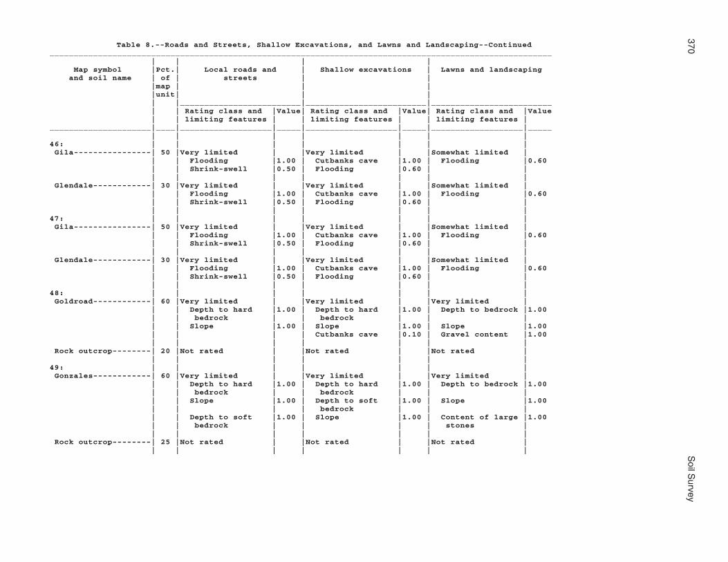
370S
oil Survey
Table 8.--Roads and Streets, Shallow Excavations, and Lawns and Landscaping--Continued________________________________________________________________________________________________________ | | | | Map symbol |Pct.| Local roads and | Shallow excavations | Lawns and landscaping and soil name | of | streets | | |map | | | |unit| | | | |_________________________|_________________________|_________________________ | | Rating class and |Value| Rating class and |Value| Rating class and |Value | | limiting features | | limiting features | | limiting features |_____________________|____|___________________|_____|___________________|_____|___________________|_____ | | | | | | |46: | | | | | | | Gila----------------| 50 |Very limited | |Very limited | |Somewhat limited | | | Flooding |1.00 | Cutbanks cave |1.00 | Flooding |0.60 | | Shrink-swell |0.50 | Flooding |0.60 | | | | | | | | | Glendale------------| 30 |Very limited | |Very limited | |Somewhat limited | | | Flooding |1.00 | Cutbanks cave |1.00 | Flooding |0.60 | | Shrink-swell |0.50 | Flooding |0.60 | | | | | | | | |47: | | | | | | | Gila----------------| 50 |Very limited | |Very limited | |Somewhat limited | | | Flooding |1.00 | Cutbanks cave |1.00 | Flooding |0.60 | | Shrink-swell |0.50 | Flooding |0.60 | | | | | | | | | Glendale------------| 30 |Very limited | |Very limited | |Somewhat limited | | | Flooding |1.00 | Cutbanks cave |1.00 | Flooding |0.60 | | Shrink-swell |0.50 | Flooding |0.60 | | | | | | | | |48: | | | | | | | Goldroad------------| 60 |Very limited | |Very limited | |Very limited | | | Depth to hard |1.00 | Depth to hard |1.00 | Depth to bedrock |1.00 | | bedrock | | bedrock | | | | | Slope |1.00 | Slope |1.00 | Slope |1.00 | | | | Cutbanks cave |0.10 | Gravel content |1.00 | | | | | | | Rock outcrop--------| 20 |Not rated | |Not rated | |Not rated | | | | | | | |49: | | | | | | | Gonzales------------| 60 |Very limited | |Very limited | |Very limited | | | Depth to hard |1.00 | Depth to hard |1.00 | Depth to bedrock |1.00 | | bedrock | | bedrock | | | | | Slope |1.00 | Depth to soft |1.00 | Slope |1.00 | | | | bedrock | | | | | Depth to soft |1.00 | Slope |1.00 | Content of large |1.00 | | bedrock | | | | stones | | | | | | | | Rock outcrop--------| 25 |Not rated | |Not rated | |Not rated | | | | | | | |

Mohave C
ounty, Arizona, S
outhern Part
371
Table 8.--Roads and Streets, Shallow Excavations, and Lawns and Landscaping--Continued________________________________________________________________________________________________________ | | | | Map symbol |Pct.| Local roads and | Shallow excavations | Lawns and landscaping and soil name | of | streets | | |map | | | |unit| | | | |_________________________|_________________________|_________________________ | | Rating class and |Value| Rating class and |Value| Rating class and |Value | | limiting features | | limiting features | | limiting features |_____________________|____|___________________|_____|___________________|_____|___________________|_____ | | | | | | |50: | | | | | | | Goodsprings family--| 75 |Not limited | |Very limited | |Very limited | | | | | Cutbanks cave |1.00 | Depth to cemented|1.00 | | | | | | pan | | | | | | | Droughty |0.99 | | | | | | Gravel content |0.68 | | | | | | |51: | | | | | | | Goodsprings family--| 75 |Not limited | |Very limited | |Very limited | | | | | Cutbanks cave |1.00 | Depth to cemented|1.00 | | | | | | pan | | | | | | | Droughty |0.99 | | | | | | Gravel content |0.68 | | | | | | |52: | | | | | | | Goodsprings family--| 75 |Very limited | |Very limited | |Very limited | | | Slope |1.00 | Cutbanks cave |1.00 | Depth to cemented|1.00 | | | | | | pan | | | | | Slope |1.00 | Slope |1.00 | | | | | | Droughty |0.99 | | | | | | |53: | | | | | | | Goodsprings family--| 75 |Very limited | |Very limited | |Very limited | | | Slope |1.00 | Cutbanks cave |1.00 | Depth to cemented|1.00 | | | | | | pan | | | | | Slope |1.00 | Slope |1.00 | | | | | | Droughty |0.99 | | | | | | |54: | | | | | | | Graham--------------| 60 |Very limited | |Very limited | |Very limited | | | Depth to hard |1.00 | Depth to hard |1.00 | Depth to bedrock |1.00 | | bedrock | | bedrock | | | | | Shrink-swell |1.00 | Cutbanks cave |0.10 | Content of large |1.00 | | | | | | stones | | | Low strength |1.00 | Slope |0.04 | Droughty |0.98 | | | | | | |

372S
oil Survey
Table 8.--Roads and Streets, Shallow Excavations, and Lawns and Landscaping--Continued________________________________________________________________________________________________________ | | | | Map symbol |Pct.| Local roads and | Shallow excavations | Lawns and landscaping and soil name | of | streets | | |map | | | |unit| | | | |_________________________|_________________________|_________________________ | | Rating class and |Value| Rating class and |Value| Rating class and |Value | | limiting features | | limiting features | | limiting features |_____________________|____|___________________|_____|___________________|_____|___________________|_____ | | | | | | |54: | | | | | | | Arivaca-------------| 25 |Very limited | |Very limited | |Very limited | | | Shrink-swell |1.00 | Depth to hard |1.00 | Content of large |1.00 | | | | bedrock | | stones | | | Low strength |1.00 | Too clayey |0.50 | Depth to bedrock |0.42 | | Depth to hard |0.42 | Cutbanks cave |0.10 | Slope |0.04 | | bedrock | | | | | | | | | | | |55: | | | | | | | Graham--------------| 60 |Very limited | |Very limited | |Very limited | | | Depth to hard |1.00 | Depth to hard |1.00 | Depth to bedrock |1.00 | | bedrock | | bedrock | | | | | Shrink-swell |1.00 | Slope |1.00 | Content of large |1.00 | | | | | | stones | | | Slope |1.00 | Cutbanks cave |0.10 | Slope |1.00 | | | | | | | Rock outcrop--------| 20 |Not rated | |Not rated | |Not rated | | | | | | | |56: | | | | | | | Gunsight------------| 75 |Somewhat limited | |Very limited | |Very limited | | | Slope |0.04 | Cutbanks cave |1.00 | Gravel content |1.00 | | | | Slope |0.04 | Slope |0.04 | | | | | | |57: | | | | | | | Gunsight------------| 85 |Very limited | |Very limited | |Very limited | | | Slope |1.00 | Cutbanks cave |1.00 | Gravel content |1.00 | | | | Slope |1.00 | Slope |1.00 | | | | | | Content of large |0.32 | | | | | | stones | | | | | | | |58: | | | | | | | Hassell family------| 50 |Very limited | |Very limited | |Very limited | | | Slope |1.00 | Cutbanks cave |1.00 | Slope |1.00 | | Low strength |1.00 | Slope |1.00 | Depth to bedrock |0.42 | | Shrink-swell |0.50 | Too clayey |0.50 | | | | | | | | |

Mohave C
ounty, Arizona, S
outhern Part
373
Table 8.--Roads and Streets, Shallow Excavations, and Lawns and Landscaping--Continued________________________________________________________________________________________________________ | | | | Map symbol |Pct.| Local roads and | Shallow excavations | Lawns and landscaping and soil name | of | streets | | |map | | | |unit| | | | |_________________________|_________________________|_________________________ | | Rating class and |Value| Rating class and |Value| Rating class and |Value | | limiting features | | limiting features | | limiting features |_____________________|____|___________________|_____|___________________|_____|___________________|_____ | | | | | | |58: | | | | | | | Lampshire-----------| 25 |Very limited | |Very limited | |Very limited | | | Depth to hard |1.00 | Depth to hard |1.00 | Depth to bedrock |1.00 | | bedrock | | bedrock | | | | | Slope |1.00 | Depth to soft |1.00 | Slope |1.00 | | | | bedrock | | | | | Depth to soft |1.00 | Slope |1.00 | Droughty |1.00 | | bedrock | | | | | | | | | | | | Rock outcrop--------| 20 |Not rated | |Not rated | |Not rated | | | | | | | |59: | | | | | | | Holtville-----------| 75 |Very limited | |Very limited | |Very limited | | | Shrink-swell |1.00 | Cutbanks cave |1.00 | Too clayey |1.00 | | | | Too clayey |0.12 | Salinity |0.88 | | | | | | |60: | | | | | | | Huevi---------------| 75 |Somewhat limited | |Very limited | |Somewhat limited | | | Slope |0.04 | Cutbanks cave |1.00 | Droughty |0.98 | | | | Slope |0.04 | Gravel content |0.41 | | | | | | Slope |0.04 | | | | | | |61: | | | | | | | Huevi---------------| 85 |Very limited | |Very limited | |Very limited | | | Slope |1.00 | Cutbanks cave |1.00 | Gravel content |1.00 | | | | Slope |1.00 | Slope |1.00 | | | | | | Droughty |0.98 | | | | | | |62: | | | | | | | Akela---------------| 60 |Very limited | |Very limited | |Very limited | | | Depth to hard |1.00 | Depth to hard |1.00 | Depth to bedrock |1.00 | | bedrock | | bedrock | | | | | Slope |1.00 | Slope |1.00 | Slope |1.00 | | | | Cutbanks cave |0.10 | Droughty |1.00 | | | | | | | Rock outcrop--------| 20 |Not rated | |Not rated | |Not rated | | | | | | | |

374S
oil Survey
Table 8.--Roads and Streets, Shallow Excavations, and Lawns and Landscaping--Continued________________________________________________________________________________________________________ | | | | Map symbol |Pct.| Local roads and | Shallow excavations | Lawns and landscaping and soil name | of | streets | | |map | | | |unit| | | | |_________________________|_________________________|_________________________ | | Rating class and |Value| Rating class and |Value| Rating class and |Value | | limiting features | | limiting features | | limiting features |_____________________|____|___________________|_____|___________________|_____|___________________|_____ | | | | | | |63: | | | | | | | Hyder---------------| 50 |Very limited | |Very limited | |Very limited | | | Depth to hard |1.00 | Depth to hard |1.00 | Depth to bedrock |1.00 | | bedrock | | bedrock | | | | | Slope |1.00 | Slope |1.00 | Slope |1.00 | | Content of large |1.00 | Content of large |1.00 | Content of large |1.00 | | stones | | stones | | stones | | | | | | | | Rock outcrop--------| 20 |Not rated | |Not rated | |Not rated | | | | | | | | Rubble land---------| 20 |Not rated | |Not rated | |Not rated | | | | | | | |64: | | | | | | | Indio---------------| 85 |Not limited | |Very limited | |Somewhat limited | | | | | Cutbanks cave |1.00 | Salinity |0.88 | | | | Too clayey |0.12 | | | | | | | | |65: | | | | | | | Ireteba family------| 45 |Somewhat limited | |Very limited | |Somewhat limited | | | Flooding |0.40 | Cutbanks cave |1.00 | Gravel content |0.50 | | | | | | Droughty |0.04 | | | | | | | Arizo---------------| 30 |Very limited | |Very limited | |Very limited | | | Flooding |1.00 | Cutbanks cave |1.00 | Flooding |1.00 | | | | Flooding |0.80 | Droughty |1.00 | | | | | | Gravel content |0.50 | | | | | | |66: | | | | | | | Kinley--------------| 75 |Very limited | |Very limited | |Very limited | | | Slope |1.00 | Slope |1.00 | Slope |1.00 | | | | Cutbanks cave |1.00 | Gravel content |0.50 | | | | | | |67: | | | | | | | Kinley--------------| 50 |Somewhat limited | |Very limited | |Somewhat limited | | | Slope |0.04 | Cutbanks cave |1.00 | Gravel content |0.50 | | | | Slope |0.04 | Slope |0.04 | | | | | | | Poachie-------------| 35 |Not limited | |Very limited | |Somewhat limited | | | | | Cutbanks cave |1.00 | Gravel content |0.50 | | | | | | |

Mohave C
ounty, Arizona, S
outhern Part
375
Table 8.--Roads and Streets, Shallow Excavations, and Lawns and Landscaping--Continued________________________________________________________________________________________________________ | | | | Map symbol |Pct.| Local roads and | Shallow excavations | Lawns and landscaping and soil name | of | streets | | |map | | | |unit| | | | |_________________________|_________________________|_________________________ | | Rating class and |Value| Rating class and |Value| Rating class and |Value | | limiting features | | limiting features | | limiting features |_____________________|____|___________________|_____|___________________|_____|___________________|_____ | | | | | | |68: | | | | | | | Kofa----------------| 85 |Very limited | |Very limited | |Very limited | | | Shrink-swell |1.00 | Cutbanks cave |1.00 | Too clayey |1.00 | | | | Too clayey |0.72 | Salinity |0.88 | | | | | | |69: | | | | | | | Dudleyville---------| 40 |Very limited | |Very limited | |Very limited | | | Flooding |1.00 | Cutbanks cave |1.00 | Flooding |1.00 | | | | Flooding |0.80 | Gravel content |1.00 | | | | | | Droughty |0.99 | | | | | | | Vinton--------------| 30 |Very limited | |Very limited | |Somewhat limited | | | Flooding |1.00 | Cutbanks cave |1.00 | Droughty |0.86 | | | | Flooding |0.60 | Flooding |0.60 | | | | | | | Riverwash-----------| 20 |Not rated | |Not rated | |Not rated | | | | | | | |70: | | | | | | | Dudleyville---------| 40 |Very limited | |Very limited | |Very limited | | | Flooding |1.00 | Cutbanks cave |1.00 | Flooding |1.00 | | | | Flooding |0.80 | Gravel content |1.00 | | | | | | Droughty |0.99 | | | | | | | Vinton--------------| 30 |Very limited | |Very limited | |Somewhat limited | | | Flooding |1.00 | Cutbanks cave |1.00 | Droughty |0.86 | | | | Flooding |0.60 | Flooding |0.60 | | | | | | | Riverwash-----------| 20 |Not rated | |Not rated | |Not rated | | | | | | | |71: | | | | | | | Lagunita------------| 85 |Not limited | |Very limited | |Very limited | | | | | Cutbanks cave |1.00 | Droughty |0.99 | | | | | | Too sandy |0.5072: | | | | | | | Lagunita------------| 60 |Not limited | |Very limited | |Very limited | | | | | Cutbanks cave |1.00 | Too sandy |1.00 | | | | | | Droughty |0.99 | | | | | | |

376S
oil Survey
Table 8.--Roads and Streets, Shallow Excavations, and Lawns and Landscaping--Continued________________________________________________________________________________________________________ | | | | Map symbol |Pct.| Local roads and | Shallow excavations | Lawns and landscaping and soil name | of | streets | | |map | | | |unit| | | | |_________________________|_________________________|_________________________ | | Rating class and |Value| Rating class and |Value| Rating class and |Value | | limiting features | | limiting features | | limiting features |_____________________|____|___________________|_____|___________________|_____|___________________|_____ | | | | | | |72: | | | | | | | Ripley--------------| 25 |Not limited | |Very limited | |Very limited | | | | | Cutbanks cave |1.00 | Salinity |1.00 | | | | | | |73: | | | | | | | Lampshire-----------| 65 |Very limited | |Very limited | |Very limited | | | Depth to hard |1.00 | Depth to hard |1.00 | Depth to bedrock |1.00 | | bedrock | | bedrock | | | | | Slope |1.00 | Depth to soft |1.00 | Slope |1.00 | | | | bedrock | | | | | Depth to soft |1.00 | Slope |1.00 | Droughty |1.00 | | bedrock | | | | | | | | | | | | Rock outcrop--------| 20 |Not rated | |Not rated | |Not rated | | | | | | | |74: | | | | | | | Lampshire-----------| 65 |Very limited | |Very limited | |Very limited | | | Depth to hard |1.00 | Depth to hard |1.00 | Depth to bedrock |1.00 | | bedrock | | bedrock | | | | | Slope |1.00 | Depth to soft |1.00 | Slope |1.00 | | | | bedrock | | | | | Depth to soft |1.00 | Slope |1.00 | Droughty |1.00 | | bedrock | | | | | | | | | | | | Rock outcrop--------| 20 |Not rated | |Not rated | |Not rated | | | | | | | |75: | | | | | | | Lampshire-----------| 45 |Very limited | |Very limited | |Very limited | | | Depth to hard |1.00 | Depth to hard |1.00 | Depth to bedrock |1.00 | | bedrock | | bedrock | | | | | Slope |1.00 | Slope |1.00 | Slope |1.00 | | Content of large |0.98 | Content of large |0.98 | Content of large |1.00 | | stones | | stones | | stones | | | | | | | | Rock outcrop--------| 40 |Not rated | |Not rated | |Not rated | | | | | | | |

Mohave C
ounty, Arizona, S
outhern Part
377
Table 8.--Roads and Streets, Shallow Excavations, and Lawns and Landscaping--Continued________________________________________________________________________________________________________ | | | | Map symbol |Pct.| Local roads and | Shallow excavations | Lawns and landscaping and soil name | of | streets | | |map | | | |unit| | | | |_________________________|_________________________|_________________________ | | Rating class and |Value| Rating class and |Value| Rating class and |Value | | limiting features | | limiting features | | limiting features |_____________________|____|___________________|_____|___________________|_____|___________________|_____ | | | | | | |76: | | | | | | | Lostman-------------| 80 |Somewhat limited | |Very limited | |Somewhat limited | | | Frost action |0.50 | Cutbanks cave |1.00 | Droughty |0.46 | | | | | | Gravel content |0.32 | | | | | | |77: | | | | | | | Lostman-------------| 80 |Not limited | |Very limited | |Not limited | | | | | Cutbanks cave |1.00 | | | | | | | | |78: | | | | | | | Lostman-------------| 40 |Not limited | |Very limited | |Not limited | | | | | Cutbanks cave |1.00 | | | | | | | | | Kinley--------------| 35 |Not limited | |Very limited | |Somewhat limited | | | | | Cutbanks cave |1.00 | Gravel content |0.50 | | | | | | |79: | | | | | | | Marshes-------------|100 |Not rated | |Not rated | |Not rated | | | | | | | |80: | | | | | | | Meloland------------| 85 |Very limited | |Somewhat limited | |Very limited | | | Flooding |1.00 | Flooding |0.60 | Salinity |1.00 | | Shrink-swell |1.00 | Too clayey |0.28 | Flooding |0.60 | | | | Cutbanks cave |0.10 | | | | | | | | |81: | | | | | | | Mohon---------------| 50 |Somewhat limited | |Somewhat limited | |Somewhat limited | | | Shrink-swell |0.50 | Too clayey |0.50 | Gravel content |0.41 | | | | Cutbanks cave |0.10 | | | | | | | | | Kinley--------------| 35 |Somewhat limited | |Very limited | |Somewhat limited | | | Slope |0.16 | Cutbanks cave |1.00 | Gravel content |0.50 | | | | Slope |0.16 | Slope |0.16 | | | | | | |

378S
oil Survey
Table 8.--Roads and Streets, Shallow Excavations, and Lawns and Landscaping--Continued________________________________________________________________________________________________________ | | | | Map symbol |Pct.| Local roads and | Shallow excavations | Lawns and landscaping and soil name | of | streets | | |map | | | |unit| | | | |_________________________|_________________________|_________________________ | | Rating class and |Value| Rating class and |Value| Rating class and |Value | | limiting features | | limiting features | | limiting features |_____________________|____|___________________|_____|___________________|_____|___________________|_____ | | | | | | |82: | | | | | | | Mohon---------------| 50 |Somewhat limited | |Somewhat limited | |Very limited | | | Shrink-swell |0.50 | Too clayey |0.50 | Content of large |1.00 | | | | | | stones | | | Slope |0.04 | Cutbanks cave |0.10 | Slope |0.04 | | | | Slope |0.04 | Gravel content |0.02 | | | | | | | Poachie-------------| 25 |Somewhat limited | |Very limited | |Somewhat limited | | | Slope |0.04 | Cutbanks cave |1.00 | Gravel content |0.50 | | | | Slope |0.04 | Slope |0.04 | | | | | | |83: | | | | | | | Mohon---------------| 50 |Somewhat limited | |Somewhat limited | |Very limited | | | Shrink-swell |0.50 | Too clayey |0.50 | Gravel content |1.00 | | | | Cutbanks cave |0.10 | | | | | | | | | Poachie-------------| 25 |Somewhat limited | |Very limited | |Somewhat limited | | | Slope |0.04 | Cutbanks cave |1.00 | Gravel content |0.50 | | | | Slope |0.04 | Slope |0.04 | | | | | | |84: | | | | | | | Nickel family-------| 35 |Very limited | |Very limited | |Very limited | | | Slope |1.00 | Slope |1.00 | Slope |1.00 | | | | Cutbanks cave |1.00 | Gravel content |1.00 | | | | | | Droughty |0.41 | | | | | | | Topawa family-------| 30 |Very limited | |Very limited | |Very limited | | | Slope |1.00 | Slope |1.00 | Slope |1.00 | | | | Cutbanks cave |1.00 | Gravel content |1.00 | | | | | | Droughty |0.80 | | | | | | | Eba family----------| 25 |Very limited | |Very limited | |Very limited | | | Slope |1.00 | Cutbanks cave |1.00 | Gravel content |1.00 | | Shrink-swell |0.50 | Slope |1.00 | Slope |1.00 | | | | Too clayey |0.50 | Droughty |0.63 | | | | | | |

Mohave C
ounty, Arizona, S
outhern Part
379
Table 8.--Roads and Streets, Shallow Excavations, and Lawns and Landscaping--Continued________________________________________________________________________________________________________ | | | | Map symbol |Pct.| Local roads and | Shallow excavations | Lawns and landscaping and soil name | of | streets | | |map | | | |unit| | | | |_________________________|_________________________|_________________________ | | Rating class and |Value| Rating class and |Value| Rating class and |Value | | limiting features | | limiting features | | limiting features |_____________________|____|___________________|_____|___________________|_____|___________________|_____ | | | | | | |85: | | | | | | | Orwash family-------| 75 |Not limited | |Very limited | |Somewhat limited | | | | | Cutbanks cave |1.00 | Droughty |0.55 | | | | | | |86: | | | | | | | Orwash family-------| 75 |Not limited | |Very limited | |Somewhat limited | | | | | Cutbanks cave |1.00 | Droughty |0.55 | | | | | | |87: | | | | | | | Penthouse-----------| 50 |Somewhat limited | |Very limited | |Very limited | | | Shrink-swell |0.50 | Cutbanks cave |1.00 | Content of large |1.00 | | | | | | stones | | | Slope |0.16 | Slope |0.16 | Slope |0.16 | | | | Too clayey |0.12 | Gravel content |0.01 | | | | | | | Gonzales------------| 25 |Very limited | |Very limited | |Very limited | | | Depth to hard |1.00 | Depth to hard |1.00 | Depth to bedrock |1.00 | | bedrock | | bedrock | | | | | Depth to soft |1.00 | Depth to soft |1.00 | Content of large |1.00 | | bedrock | | bedrock | | stones | | | Shrink-swell |1.00 | Slope |1.00 | Slope |1.00 | | | | | | |88: | | | | | | | Poachie-------------| 80 |Not limited | |Very limited | |Very limited | | | | | Cutbanks cave |1.00 | Gravel content |1.00 | | | | | | |89: | | | | | | | Poachie-------------| 80 |Not limited | |Very limited | |Very limited | | | | | Cutbanks cave |1.00 | Gravel content |1.00 | | | | | | |90: | | | | | | | Quilotosa-----------| 60 |Very limited | |Very limited | |Very limited | | | Depth to hard |1.00 | Depth to hard |1.00 | Depth to bedrock |1.00 | | bedrock | | bedrock | | | | | Slope |1.00 | Depth to soft |1.00 | Slope |1.00 | | | | bedrock | | | | | Depth to soft |1.00 | Slope |1.00 | Gravel content |1.00 | | bedrock | | | | | | | | | | | |
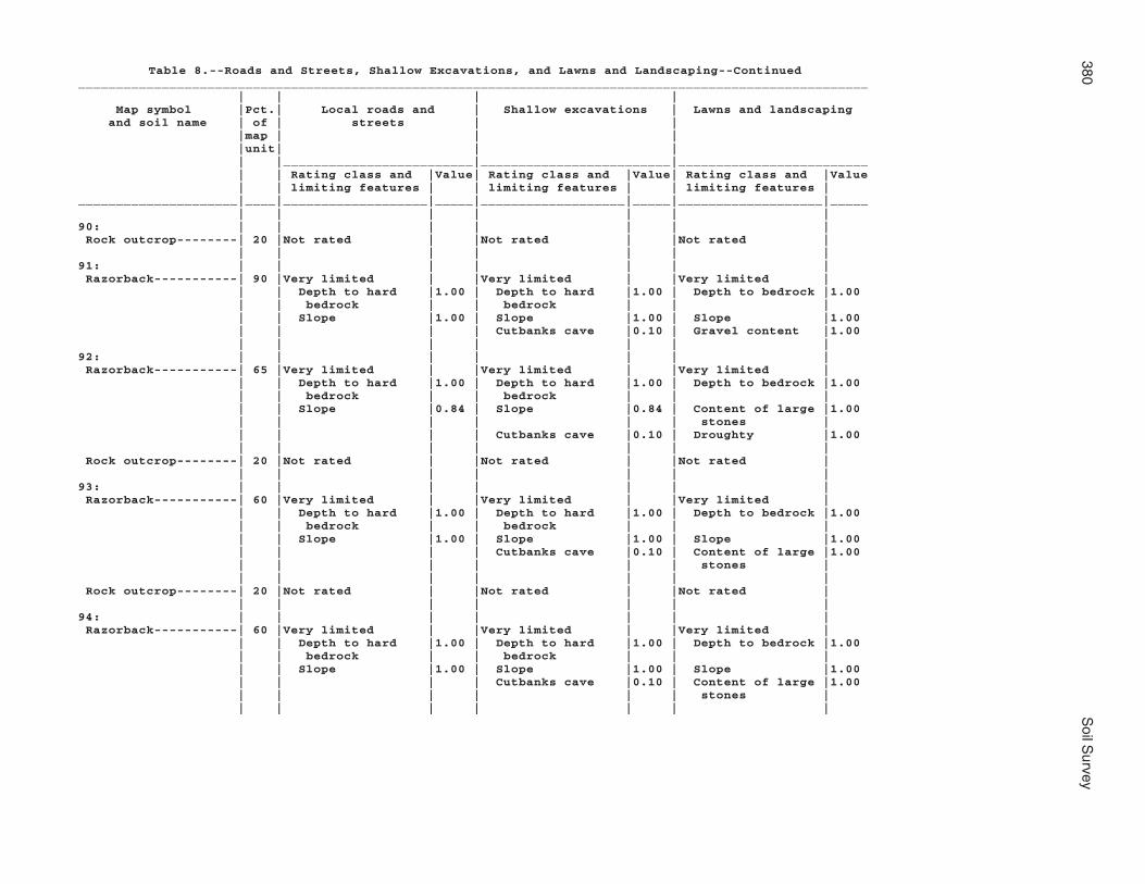
380S
oil Survey
Table 8.--Roads and Streets, Shallow Excavations, and Lawns and Landscaping--Continued________________________________________________________________________________________________________ | | | | Map symbol |Pct.| Local roads and | Shallow excavations | Lawns and landscaping and soil name | of | streets | | |map | | | |unit| | | | |_________________________|_________________________|_________________________ | | Rating class and |Value| Rating class and |Value| Rating class and |Value | | limiting features | | limiting features | | limiting features |_____________________|____|___________________|_____|___________________|_____|___________________|_____ | | | | | | |90: | | | | | | | Rock outcrop--------| 20 |Not rated | |Not rated | |Not rated | | | | | | | |91: | | | | | | | Razorback-----------| 90 |Very limited | |Very limited | |Very limited | | | Depth to hard |1.00 | Depth to hard |1.00 | Depth to bedrock |1.00 | | bedrock | | bedrock | | | | | Slope |1.00 | Slope |1.00 | Slope |1.00 | | | | Cutbanks cave |0.10 | Gravel content |1.00 | | | | | | |92: | | | | | | | Razorback-----------| 65 |Very limited | |Very limited | |Very limited | | | Depth to hard |1.00 | Depth to hard |1.00 | Depth to bedrock |1.00 | | bedrock | | bedrock | | | | | Slope |0.84 | Slope |0.84 | Content of large |1.00 | | | | | | stones | | | | | Cutbanks cave |0.10 | Droughty |1.00 | | | | | | | Rock outcrop--------| 20 |Not rated | |Not rated | |Not rated | | | | | | | |93: | | | | | | | Razorback-----------| 60 |Very limited | |Very limited | |Very limited | | | Depth to hard |1.00 | Depth to hard |1.00 | Depth to bedrock |1.00 | | bedrock | | bedrock | | | | | Slope |1.00 | Slope |1.00 | Slope |1.00 | | | | Cutbanks cave |0.10 | Content of large |1.00 | | | | | | stones | | | | | | | | Rock outcrop--------| 20 |Not rated | |Not rated | |Not rated | | | | | | | |94: | | | | | | | Razorback-----------| 60 |Very limited | |Very limited | |Very limited | | | Depth to hard |1.00 | Depth to hard |1.00 | Depth to bedrock |1.00 | | bedrock | | bedrock | | | | | Slope |1.00 | Slope |1.00 | Slope |1.00 | | | | Cutbanks cave |0.10 | Content of large |1.00 | | | | | | stones | | | | | | | |

Mohave C
ounty, Arizona, S
outhern Part
381
Table 8.--Roads and Streets, Shallow Excavations, and Lawns and Landscaping--Continued________________________________________________________________________________________________________ | | | | Map symbol |Pct.| Local roads and | Shallow excavations | Lawns and landscaping and soil name | of | streets | | |map | | | |unit| | | | |_________________________|_________________________|_________________________ | | Rating class and |Value| Rating class and |Value| Rating class and |Value | | limiting features | | limiting features | | limiting features |_____________________|____|___________________|_____|___________________|_____|___________________|_____ | | | | | | |94: | | | | | | | Rock outcrop--------| 20 |Not rated | |Not rated | |Not rated | | | | | | | |95: | | | | | | | Razorback-----------| 45 |Very limited | |Very limited | |Very limited | | | Depth to hard |1.00 | Depth to hard |1.00 | Depth to bedrock |1.00 | | bedrock | | bedrock | | | | | Slope |1.00 | Slope |1.00 | Slope |1.00 | | | | Cutbanks cave |0.10 | Content of large |1.00 | | | | | | stones | | | | | | | | Rock outcrop--------| 20 |Not rated | |Not rated | |Not rated | | | | | | | | Rubble land---------| 20 |Not rated | |Not rated | |Not rated | | | | | | | |96: | | | | | | | Razorback-----------| 45 |Very limited | |Very limited | |Very limited | | | Depth to hard |1.00 | Depth to hard |1.00 | Depth to bedrock |1.00 | | bedrock | | bedrock | | | | | Slope |1.00 | Slope |1.00 | Slope |1.00 | | | | Cutbanks cave |0.10 | Content of large |1.00 | | | | | | stones | | | | | | | | Rock outcrop--------| 20 |Not rated | |Not rated | |Not rated | | | | | | | | Rubble land---------| 20 |Not rated | |Not rated | |Not rated | | | | | | | |97: | | | | | | | Rillino-------------| 75 |Very limited | |Very limited | |Very limited | | | Slope |1.00 | Slope |1.00 | Slope |1.00 | | | | Cutbanks cave |1.00 | Gravel content |0.50 | | | | | | Droughty |0.01 | | | | | | |98: | | | | | | | Rillino-------------| 50 |Somewhat limited | |Very limited | |Very limited | | | Slope |0.04 | Cutbanks cave |1.00 | Gravel content |1.00 | | | | Slope |0.04 | Slope |0.04 | | | | | | Droughty |0.01 | | | | | | |

382S
oil Survey
Table 8.--Roads and Streets, Shallow Excavations, and Lawns and Landscaping--Continued________________________________________________________________________________________________________ | | | | Map symbol |Pct.| Local roads and | Shallow excavations | Lawns and landscaping and soil name | of | streets | | |map | | | |unit| | | | |_________________________|_________________________|_________________________ | | Rating class and |Value| Rating class and |Value| Rating class and |Value | | limiting features | | limiting features | | limiting features |_____________________|____|___________________|_____|___________________|_____|___________________|_____ | | | | | | |98: | | | | | | | Tres Hermanos-------| 35 |Somewhat limited | |Very limited | |Somewhat limited | | | Shrink-swell |0.50 | Cutbanks cave |1.00 | Gravel content |0.50 | | | | | | |99: | | | | | | | Ripley--------------| 85 |Very limited | |Very limited | |Very limited | | | Flooding |1.00 | Cutbanks cave |1.00 | Salinity |1.00 | | | | Flooding |0.60 | Flooding |0.60 | | | | | | |100: | | | | | | | Riverbend family----| 75 |Somewhat limited | |Very limited | |Very limited | | | Slope |0.04 | Cutbanks cave |1.00 | Droughty |1.00 | | | | Slope |0.04 | Content of large |0.99 | | | | | | stones | | | | | | | Gravel content |0.87 | | | | | | |101: | | | | | | | Riverbend-----------| 75 |Somewhat limited | |Very limited | |Very limited | | | Slope |0.04 | Cutbanks cave |1.00 | Droughty |1.00 | | | | Slope |0.04 | Content of large |0.99 | | | | | | stones | | | | | | | Gravel content |0.65 | | | | | | |102: | | | | | | | Riverwash-----------| 70 |Not rated | |Not rated | |Not rated | | | | | | | | Fluvaquents---------| 20 |Not rated | |Not rated | |Not rated | | | | | | | |103: | | | | | | | Rock outcrop--------| 45 |Not rated | |Not rated | |Not rated | | | | | | | | Hyder---------------| 40 |Very limited | |Very limited | |Very limited | | | Depth to hard |1.00 | Depth to hard |1.00 | Depth to bedrock |1.00 | | bedrock | | bedrock | | | | | Slope |1.00 | Slope |1.00 | Slope |1.00 | | Content of large |1.00 | Content of large |1.00 | Content of large |1.00 | | stones | | stones | | stones | | | | | | | |

Mohave C
ounty, Arizona, S
outhern Part
383
Table 8.--Roads and Streets, Shallow Excavations, and Lawns and Landscaping--Continued________________________________________________________________________________________________________ | | | | Map symbol |Pct.| Local roads and | Shallow excavations | Lawns and landscaping and soil name | of | streets | | |map | | | |unit| | | | |_________________________|_________________________|_________________________ | | Rating class and |Value| Rating class and |Value| Rating class and |Value | | limiting features | | limiting features | | limiting features |_____________________|____|___________________|_____|___________________|_____|___________________|_____ | | | | | | |104: | | | | | | | Rock outcrop--------| 65 |Not rated | |Not rated | |Not rated | | | | | | | | Razorback-----------| 30 |Very limited | |Very limited | |Very limited | | | Depth to hard |1.00 | Depth to hard |1.00 | Depth to bedrock |1.00 | | bedrock | | bedrock | | | | | Slope |1.00 | Slope |1.00 | Slope |1.00 | | | | Cutbanks cave |0.10 | Gravel content |1.00 | | | | | | |105: | | | | | | | Rock outcrop--------| 45 |Not rated | |Not rated | |Not rated | | | | | | | | Sunrock-------------| 40 |Very limited | |Very limited | |Very limited | | | Depth to hard |1.00 | Depth to hard |1.00 | Depth to bedrock |1.00 | | bedrock | | bedrock | | | | | Slope |1.00 | Depth to soft |1.00 | Slope |1.00 | | | | bedrock | | | | | Depth to soft |1.00 | Slope |1.00 | Gravel content |1.00 | | bedrock | | | | | | | | | | | |106: | | | | | | | Romero--------------| 45 |Very limited | |Very limited | |Very limited | | | Depth to hard |1.00 | Depth to hard |1.00 | Depth to bedrock |1.00 | | bedrock | | bedrock | | | | | Slope |1.00 | Slope |1.00 | Droughty |1.00 | | Shrink-swell |0.50 | Cutbanks cave |0.10 | Content of large |1.00 | | | | | | stones | | | | | | | | Chiricahua----------| 30 |Very limited | |Very limited | |Very limited | | | Depth to soft |1.00 | Depth to hard |1.00 | Depth to bedrock |1.00 | | bedrock | | bedrock | | | | | Shrink-swell |1.00 | Depth to soft |1.00 | Droughty |1.00 | | | | bedrock | | | | | Slope |1.00 | Slope |1.00 | Gravel content |1.00 | | | | | | | Rock outcrop--------| 20 |Not rated | |Not rated | |Not rated | | | | | | | |

384S
oil Survey
Table 8.--Roads and Streets, Shallow Excavations, and Lawns and Landscaping--Continued________________________________________________________________________________________________________ | | | | Map symbol |Pct.| Local roads and | Shallow excavations | Lawns and landscaping and soil name | of | streets | | |map | | | |unit| | | | |_________________________|_________________________|_________________________ | | Rating class and |Value| Rating class and |Value| Rating class and |Value | | limiting features | | limiting features | | limiting features |_____________________|____|___________________|_____|___________________|_____|___________________|_____ | | | | | | |107: | | | | | | | Romero--------------| 60 |Very limited | |Very limited | |Very limited | | | Slope |1.00 | Depth to soft |1.00 | Depth to bedrock |1.00 | | | | bedrock | | | | | Depth to soft |1.00 | Slope |1.00 | Slope |1.00 | | bedrock | | | | | | | Shrink-swell |0.50 | Cutbanks cave |0.10 | Content of large |1.00 | | | | | | stones | | | | | | | | Lampshire-----------| 20 |Very limited | |Very limited | |Very limited | | | Depth to hard |1.00 | Depth to hard |1.00 | Depth to bedrock |1.00 | | bedrock | | bedrock | | | | | Slope |1.00 | Depth to soft |1.00 | Slope |1.00 | | | | bedrock | | | | | Depth to soft |1.00 | Slope |1.00 | Droughty |1.00 | | bedrock | | | | | | | | | | | | Rock outcrop--------| 15 |Not rated | |Not rated | |Not rated | | | | | | | |108: | | | | | | | Rositas family------| 40 |Very limited | |Very limited | |Very limited | | | Slope |1.00 | Cutbanks cave |1.00 | Slope |1.00 | | | | Slope |1.00 | Droughty |0.81 | | | | | | | Superstition--------| 25 |Not limited | |Very limited | |Somewhat limited | | | | | Cutbanks cave |1.00 | Droughty |0.93 | | | | | | Gravel content |0.50 | | | | | | | Torriorthents-------| 25 |Not rated | |Not rated | |Not rated | | | | | | | |109: | | | | | | | Rositas-------------| 40 |Very limited | |Very limited | |Very limited | | | Slope |1.00 | Cutbanks cave |1.00 | Slope |1.00 | | | | Slope |1.00 | Droughty |0.69 | | | | | | Too sandy |0.50 | | | | | | | Superstition family-| 25 |Not limited | |Very limited | |Somewhat limited | | | | | Cutbanks cave |1.00 | Droughty |0.92 | | | | | | |

Mohave C
ounty, Arizona, S
outhern Part
385
Table 8.--Roads and Streets, Shallow Excavations, and Lawns and Landscaping--Continued________________________________________________________________________________________________________ | | | | Map symbol |Pct.| Local roads and | Shallow excavations | Lawns and landscaping and soil name | of | streets | | |map | | | |unit| | | | |_________________________|_________________________|_________________________ | | Rating class and |Value| Rating class and |Value| Rating class and |Value | | limiting features | | limiting features | | limiting features |_____________________|____|___________________|_____|___________________|_____|___________________|_____ | | | | | | |109: | | | | | | | Torriorthents-------| 20 |Not rated | |Not rated | |Not rated | | | | | | | |110: | | | | | | | Stagecoach----------| 75 |Somewhat limited | |Very limited | |Very limited | | | Slope |0.04 | Cutbanks cave |1.00 | Gravel content |1.00 | | | | Slope |0.04 | Droughty |0.07 | | | | | | Slope |0.04 | | | | | | |111: | | | | | | | Stagecoach----------| 85 |Very limited | |Very limited | |Very limited | | | Slope |1.00 | Cutbanks cave |1.00 | Gravel content |1.00 | | | | Slope |1.00 | Slope |1.00 | | | | | | Droughty |0.07 | | | | | | |112: | | | | | | | Stagecoach----------| 80 |Very limited | |Very limited | |Very limited | | | Slope |1.00 | Cutbanks cave |1.00 | Gravel content |1.00 | | | | Slope |1.00 | Slope |1.00 | | | | | | Droughty |0.09 | | | | | | |113: | | | | | | | Stagecoach----------| 80 |Very limited | |Very limited | |Very limited | | | Slope |1.00 | Cutbanks cave |1.00 | Gravel content |1.00 | | | | Slope |1.00 | Slope |1.00 | | | | | | Droughty |0.09 | | | | | | |114: | | | | | | | Stagecoach----------| 35 |Very limited | |Very limited | |Very limited | | | Slope |1.00 | Slope |1.00 | Slope |1.00 | | | | Cutbanks cave |1.00 | Gravel content |1.00 | | | | | | Droughty |0.11 | | | | | | | Topawa family-------| 30 |Very limited | |Very limited | |Very limited | | | Slope |1.00 | Cutbanks cave |1.00 | Gravel content |1.00 | | Content of large |0.02 | Slope |1.00 | Slope |1.00 | | stones | | | | | | | | | Content of large |0.02 | Droughty |0.98 | | | | stones | | | | | | | | | |

386S
oil Survey
Table 8.--Roads and Streets, Shallow Excavations, and Lawns and Landscaping--Continued________________________________________________________________________________________________________ | | | | Map symbol |Pct.| Local roads and | Shallow excavations | Lawns and landscaping and soil name | of | streets | | |map | | | |unit| | | | |_________________________|_________________________|_________________________ | | Rating class and |Value| Rating class and |Value| Rating class and |Value | | limiting features | | limiting features | | limiting features |_____________________|____|___________________|_____|___________________|_____|___________________|_____ | | | | | | |114: | | | | | | | Eba-----------------| 25 |Very limited | |Very limited | |Very limited | | | Slope |1.00 | Cutbanks cave |1.00 | Gravel content |1.00 | | Shrink-swell |0.50 | Slope |1.00 | Slope |1.00 | | | | Too clayey |0.12 | Droughty |0.99 | | | | | | |115: | | | | | | | Stagecoach----------| 35 |Very limited | |Very limited | |Very limited | | | Slope |1.00 | Slope |1.00 | Slope |1.00 | | | | Cutbanks cave |1.00 | Gravel content |1.00 | | | | | | Droughty |0.11 | | | | | | | Topawa family-------| 30 |Very limited | |Very limited | |Very limited | | | Slope |1.00 | Cutbanks cave |1.00 | Gravel content |1.00 | | Content of large |0.02 | Slope |1.00 | Slope |1.00 | | stones | | | | | | | | | Content of large |0.02 | Droughty |0.98 | | | | stones | | | | | | | | | | Eba-----------------| 25 |Very limited | |Very limited | |Very limited | | | Slope |1.00 | Cutbanks cave |1.00 | Gravel content |1.00 | | Shrink-swell |0.50 | Slope |1.00 | Slope |1.00 | | | | Too clayey |0.12 | Droughty |0.99 | | | | | | |116: | | | | | | | Sunrock-------------| 90 |Very limited | |Very limited | |Very limited | | | Depth to hard |1.00 | Depth to hard |1.00 | Depth to bedrock |1.00 | | bedrock | | bedrock | | | | | Slope |1.00 | Slope |1.00 | Slope |1.00 | | | | Cutbanks cave |0.10 | Gravel content |1.00 | | | | | | |117: | | | | | | | Sunrock-------------| 70 |Very limited | |Very limited | |Very limited | | | Depth to hard |1.00 | Depth to hard |1.00 | Depth to bedrock |1.00 | | bedrock | | bedrock | | | | | Slope |1.00 | Depth to soft |1.00 | Slope |1.00 | | | | bedrock | | | | | Depth to soft |1.00 | Slope |1.00 | Gravel content |1.00 | | bedrock | | | | | | | | | | | |

Mohave C
ounty, Arizona, S
outhern Part
387
Table 8.--Roads and Streets, Shallow Excavations, and Lawns and Landscaping--Continued________________________________________________________________________________________________________ | | | | Map symbol |Pct.| Local roads and | Shallow excavations | Lawns and landscaping and soil name | of | streets | | |map | | | |unit| | | | |_________________________|_________________________|_________________________ | | Rating class and |Value| Rating class and |Value| Rating class and |Value | | limiting features | | limiting features | | limiting features |_____________________|____|___________________|_____|___________________|_____|___________________|_____ | | | | | | |117: | | | | | | | Rock outcrop--------| 20 |Not rated | |Not rated | |Not rated | | | | | | | |118: | | | | | | | Tombstone-----------| 35 |Very limited | |Very limited | |Very limited | | | Slope |1.00 | Slope |1.00 | Slope |1.00 | | | | Cutbanks cave |1.00 | Content of large |1.00 | | | | | | stones | | | | | | | Droughty |0.92 | | | | | | | Caralampi-----------| 30 |Very limited | |Very limited | |Very limited | | | Slope |1.00 | Slope |1.00 | Slope |1.00 | | | | Cutbanks cave |1.00 | Gravel content |1.00 | | | | | | Droughty |0.82 | | | | | | | Eloma---------------| 25 |Very limited | |Very limited | |Very limited | | | Shrink-swell |1.00 | Slope |1.00 | Content of large |1.00 | | | | | | stones | | | Slope |1.00 | Content of large |0.68 | Slope |1.00 | | | | stones | | | | | Content of large |0.68 | Too clayey |0.12 | Droughty |0.36 | | stones | | | | | | | | | | | |119: | | | | | | | Torriorthents-------| 75 |Not rated | |Not rated | |Not rated | | | | | | | |120: | | | | | | | Torriorthents-------| 75 |Not rated | |Not rated | |Not rated | | | | | | | |121: | | | | | | | Tumarion------------| 85 |Very limited | |Very limited | |Very limited | | | Depth to hard |1.00 | Depth to hard |1.00 | Depth to bedrock |1.00 | | bedrock | | bedrock | | | | | Slope |0.04 | Cutbanks cave |0.10 | Depth to cemented|1.00 | | | | | | pan | | | | | Slope |0.04 | Content of large |1.00 | | | | | | stones | | | | | | | |

388S
oil Survey
Table 8.--Roads and Streets, Shallow Excavations, and Lawns and Landscaping--Continued________________________________________________________________________________________________________ | | | | Map symbol |Pct.| Local roads and | Shallow excavations | Lawns and landscaping and soil name | of | streets | | |map | | | |unit| | | | |_________________________|_________________________|_________________________ | | Rating class and |Value| Rating class and |Value| Rating class and |Value | | limiting features | | limiting features | | limiting features |_____________________|____|___________________|_____|___________________|_____|___________________|_____ | | | | | | |122: | | | | | | | Tumarion------------| 85 |Very limited | |Very limited | |Very limited | | | Depth to hard |1.00 | Depth to hard |1.00 | Depth to bedrock |1.00 | | bedrock | | bedrock | | | | | Slope |0.04 | Cutbanks cave |0.10 | Depth to cemented|1.00 | | | | | | pan | | | | | Slope |0.04 | Content of large |1.00 | | | | | | stones | | | | | | | |123: | | | | | | | Tyro----------------| 90 |Very limited | |Very limited | |Very limited | | | Slope |1.00 | Slope |1.00 | Depth to cemented|1.00 | | | | | | pan | | | | | Cutbanks cave |0.10 | Content of large |1.00 | | | | | | stones | | | | | | | Droughty |1.00 | | | | | | |124: | | | | | | | Tyro----------------| 85 |Not limited | |Somewhat limited | |Very limited | | | | | Cutbanks cave |0.10 | Depth to cemented|1.00 | | | | | | pan | | | | | | | Content of large |1.00 | | | | | | stones | | | | | | | Droughty |1.00 | | | | | | |125: | | | | | | | Vekol family--------| 85 |Somewhat limited | |Very limited | |Somewhat limited | | | Shrink-swell |0.50 | Cutbanks cave |1.00 | Gravel content |0.50 | | | | Too clayey |0.12 | | | | | | | | |126: | | | | | | | Vekol family--------| 85 |Somewhat limited | |Very limited | |Somewhat limited | | | Shrink-swell |0.50 | Cutbanks cave |1.00 | Gravel content |0.50 | | | | Too clayey |0.12 | | | | | | | | |127: | | | | | | | Water---------------|100 |Not rated | |Not rated | |Not rated | | | | | | | |

Mohave C
ounty, Arizona, S
outhern Part
389
Table 8.--Roads and Streets, Shallow Excavations, and Lawns and Landscaping--Continued________________________________________________________________________________________________________ | | | | Map symbol |Pct.| Local roads and | Shallow excavations | Lawns and landscaping and soil name | of | streets | | |map | | | |unit| | | | |_________________________|_________________________|_________________________ | | Rating class and |Value| Rating class and |Value| Rating class and |Value | | limiting features | | limiting features | | limiting features |_____________________|____|___________________|_____|___________________|_____|___________________|_____ | | | | | | |128: | | | | | | | Whitehills----------| 80 |Somewhat limited | |Very limited | |Very limited | | | Shrink-swell |0.50 | Cutbanks cave |1.00 | Gravel content |1.00 | | | | | | Droughty |0.75 | | | | | | Depth to cemented|0.71 | | | | | | pan | | | | | | | |129: | | | | | | | Whitehills----------| 80 |Somewhat limited | |Very limited | |Very limited | | | Shrink-swell |0.50 | Cutbanks cave |1.00 | Gravel content |1.00 | | Slope |0.04 | Slope |0.04 | Droughty |0.75 | | | | | | Depth to cemented|0.71 | | | | | | pan | | | | | | | |130: | | | | | | | White House family--| 85 |Very limited | |Very limited | |Very limited | | | Low strength |1.00 | Cutbanks cave |1.00 | Gravel content |1.00 | | Shrink-swell |1.00 | Too clayey |0.12 | Slope |0.04 | | Slope |0.04 | Slope |0.04 | Droughty |0.01 | | | | | | |131: | | | | | | | White House---------| 85 |Somewhat limited | |Very limited | |Somewhat limited | | | Shrink-swell |0.50 | Cutbanks cave |1.00 | Gravel content |0.41 | | Slope |0.04 | Too clayey |0.12 | Slope |0.04 | | | | Slope |0.04 | | | | | | | | |132: | | | | | | | Wikieup-------------| 45 |Very limited | |Very limited | |Very limited | | | Depth to hard |1.00 | Depth to hard |1.00 | Depth to bedrock |1.00 | | bedrock | | bedrock | | | | | Depth to soft |1.00 | Depth to soft |1.00 | Droughty |1.00 | | bedrock | | bedrock | | | | | Slope |1.00 | Slope |1.00 | Content of large |1.00 | | | | | | stones | | | | | | | |

390S
oil Survey
Table 8.--Roads and Streets, Shallow Excavations, and Lawns and Landscaping--Continued________________________________________________________________________________________________________ | | | | Map symbol |Pct.| Local roads and | Shallow excavations | Lawns and landscaping and soil name | of | streets | | |map | | | |unit| | | | |_________________________|_________________________|_________________________ | | Rating class and |Value| Rating class and |Value| Rating class and |Value | | limiting features | | limiting features | | limiting features |_____________________|____|___________________|_____|___________________|_____|___________________|_____ | | | | | | |132: | | | | | | | Mutang--------------| 30 |Very limited | |Very limited | |Very limited | | | Depth to soft |1.00 | Depth to hard |1.00 | Depth to bedrock |1.00 | | bedrock | | bedrock | | | | | Slope |1.00 | Depth to soft |1.00 | Gravel content |1.00 | | | | bedrock | | | | | Low strength |1.00 | Slope |1.00 | Droughty |1.00 | | | | | | | Rock outcrop--------| 20 |Not rated | |Not rated | |Not rated | | | | | | | |133: | | | | | | | Mutang--------------| 55 |Very limited | |Very limited | |Very limited | | | Depth to soft |1.00 | Depth to hard |1.00 | Depth to bedrock |1.00 | | bedrock | | bedrock | | | | | Low strength |1.00 | Depth to soft |1.00 | Slope |1.00 | | | | bedrock | | | | | Shrink-swell |1.00 | Slope |1.00 | Droughty |0.98 | | | | | | | Wikieup-------------| 25 |Very limited | |Very limited | |Very limited | | | Depth to hard |1.00 | Depth to hard |1.00 | Depth to bedrock |1.00 | | bedrock | | bedrock | | | | | Slope |1.00 | Slope |1.00 | Gravel content |1.00 | | Frost action |0.50 | Cutbanks cave |0.10 | Droughty |1.00 | | | | | | | Rock outcrop--------| 15 |Not rated | |Not rated | |Not rated | | | | | | | |134: | | | | | | | Wikieup-------------| 50 |Very limited | |Very limited | |Very limited | | | Depth to hard |1.00 | Depth to hard |1.00 | Depth to bedrock |1.00 | | bedrock | | bedrock | | | | | Slope |1.00 | Depth to soft |1.00 | Slope |1.00 | | | | bedrock | | | | | Depth to soft |1.00 | Slope |1.00 | Droughty |1.00 | | bedrock | | | | | | | | | | | | Rock outcrop--------| 25 |Not rated | |Not rated | |Not rated | | | | | | | |

Mohave C
ounty, Arizona, S
outhern Part
391
Table 8.--Roads and Streets, Shallow Excavations, and Lawns and Landscaping--Continued________________________________________________________________________________________________________ | | | | Map symbol |Pct.| Local roads and | Shallow excavations | Lawns and landscaping and soil name | of | streets | | |map | | | |unit| | | | |_________________________|_________________________|_________________________ | | Rating class and |Value| Rating class and |Value| Rating class and |Value | | limiting features | | limiting features | | limiting features |_____________________|____|___________________|_____|___________________|_____|___________________|_____ | | | | | | |135: | | | | | | | Yahana family-------| 85 |Somewhat limited | |Very limited | |Very limited | | | Shrink-swell |0.50 | Cutbanks cave |1.00 | Salinity |1.00 | | | | Too clayey |0.02 | Sodium content |1.00 | | | | | | |136: | | | | | | | Tumarion------------| 70 |Very limited | |Very limited | |Very limited | | | Slope |1.00 | Depth to hard |1.00 | Depth to cemented|1.00 | | | | bedrock | | pan | | | Content of large |0.84 | Slope |1.00 | Content of large |1.00 | | stones | | | | stones | | | Depth to hard |0.79 | Content of large |0.84 | Droughty |1.00 | | bedrock | | stones | | | | | | | | | | Nickel family-------| 15 |Very limited | |Very limited | |Very limited | | | Slope |1.00 | Slope |1.00 | Content of large |1.00 | | | | | | stones | | | Content of large |0.90 | Content of large |0.90 | Slope |1.00 | | stones | | stones | | | | | Frost action |0.50 | Cutbanks cave |0.10 | Droughty |0.16 | | | | | | |137: | | | | | | | Valena--------------| 40 |Very limited | |Very limited | |Very limited | | | Depth to hard |1.00 | Depth to hard |1.00 | Depth to bedrock |1.00 | | bedrock | | bedrock | | | | | Slope |0.84 | Slope |0.84 | Droughty |1.00 | | | | Cutbanks cave |0.10 | Slope |0.84 | | | | | | | Rock outcrop--------| 20 |Not rated | |Not rated | |Not rated | | | | | | | | Carri family--------| 15 |Somewhat limited | |Very limited | |Somewhat limited | | | Slope |0.84 | Cutbanks cave |1.00 | Slope |0.84 | | Shrink-swell |0.50 | Slope |0.84 | | | | | | | | |

392S
oil Survey
Table 8.--Roads and Streets, Shallow Excavations, and Lawns and Landscaping--Continued________________________________________________________________________________________________________ | | | | Map symbol |Pct.| Local roads and | Shallow excavations | Lawns and landscaping and soil name | of | streets | | |map | | | |unit| | | | |_________________________|_________________________|_________________________ | | Rating class and |Value| Rating class and |Value| Rating class and |Value | | limiting features | | limiting features | | limiting features |_____________________|____|___________________|_____|___________________|_____|___________________|_____ | | | | | | |138: | | | | | | | Nodman--------------| 65 |Very limited | |Very limited | |Very limited | | | Slope |1.00 | Depth to soft |1.00 | Depth to bedrock |1.00 | | | | bedrock | | | | | Depth to soft |1.00 | Slope |1.00 | Slope |1.00 | | bedrock | | | | | | | Shrink-swell |0.78 | Cutbanks cave |0.10 | Droughty |1.00 | | | | | | | Rock outcrop--------| 20 |Not rated | |Not rated | |Not rated | | | | | | | |139: | | | | | | | Nodman--------------| 60 |Very limited | |Very limited | |Very limited | | | Slope |1.00 | Depth to soft |1.00 | Depth to bedrock |1.00 | | | | bedrock | | | | | Depth to soft |1.00 | Slope |1.00 | Slope |1.00 | | bedrock | | | | | | | Shrink-swell |0.78 | Content of large |0.55 | Droughty |1.00 | | | | stones | | | | | | | | | | Romero family-------| 20 |Very limited | |Very limited | |Very limited | | | Slope |1.00 | Depth to hard |1.00 | Depth to bedrock |1.00 | | | | bedrock | | | | | Depth to soft |1.00 | Depth to soft |1.00 | Slope |1.00 | | bedrock | | bedrock | | | | | Depth to hard |0.99 | Slope |1.00 | Droughty |1.00 | | bedrock | | | | | | | | | | | |_____________________|____|___________________|_____|___________________|_____|___________________|_____

Mohave County, Arizona, Southern Part 393
Table 9.--Sewage Disposal
(The information in this table indicates the dominant soil condition but does not eliminate the need for onsite investigation. The numbers in the value columns range from 0.01 to 1.00. The larger the value, the greater the limitation. See text for further explanation of ratings in this table.)______________________________________________________________________________ | | | Map symbol |Pct.| Septic tank | Sewage lagoons and soil name | of | absorption fields | |map | | |unit| | | |_________________________|_________________________ | | Rating class and |Value| Rating class and |Value | | limiting features | | limiting features |_____________________|____|___________________|_____|___________________|_____ | | | | |1: | | | | | Akela---------------| 45 |Very limited | |Very limited | | | Depth to bedrock |1.00 | Depth to hard |1.00 | | | | bedrock | | | Slope |1.00 | Slope |1.00 | | Content of large |1.00 | Content of large |1.00 | | stones | | stones | | | | | | Rock outcrop--------| 20 |Not rated | |Not rated | | | | | | Rubble land---------| 20 |Not rated | |Not rated | | | | | |2: | | | | | Akela---------------| 45 |Very limited | |Very limited | | | Depth to bedrock |1.00 | Depth to hard |1.00 | | | | bedrock | | | Slope |1.00 | Slope |1.00 | | Content of large |1.00 | Content of large |1.00 | | stones | | stones | | | | | | Rock outcrop--------| 20 |Not rated | |Not rated | | | | | | Rubble land---------| 20 |Not rated | |Not rated | | | | | |3: | | | | | Alko family---------| 85 |Very limited | |Very limited | | | Depth to cemented|1.00 | Depth to cemented|1.00 | | pan | | pan | | | Slope |0.04 | Seepage |1.00 | | | | Slope |1.00 | | | | |4: | | | | | Alko family---------| 85 |Very limited | |Very limited | | | Depth to cemented|1.00 | Depth to cemented|1.00 | | pan | | pan | | | Slope |0.04 | Seepage |1.00 | | | | Slope |1.00 | | | | |5: | | | | | Amole---------------| 75 |Not limited | |Very limited | | | | | Seepage |1.00 | | | | |6: | | | | | Amole---------------| 75 |Not limited | |Very limited | | | | | Seepage |1.00 | | | | |

394 Soil Survey
Table 9.--Sewage Disposal--Continued______________________________________________________________________________ | | | Map symbol |Pct.| Septic tank | Sewage lagoons and soil name | of | absorption fields | |map | | |unit| | | |_________________________|_________________________ | | Rating class and |Value| Rating class and |Value | | limiting features | | limiting features |_____________________|____|___________________|_____|___________________|_____ | | | | |7: | | | | | Anthony-------------| 45 |Not limited | |Very limited | | | | | Seepage |1.00 | | | | | Dudleyville---------| 30 |Very limited | |Very limited | | | Flooding |1.00 | Flooding |1.00 | | Filtering |1.00 | Seepage |1.00 | | capacity | | | | | | | |8: | | | | | Aquarius------------| 45 |Very limited | |Very limited | | | Restricted |1.00 | Slope |1.00 | | permeability | | | | | Slope |1.00 | Content of large |0.78 | | | | stones | | | | | | Akela---------------| 30 |Very limited | |Very limited | | | Depth to bedrock |1.00 | Depth to hard |1.00 | | | | bedrock | | | Content of large |1.00 | Content of large |1.00 | | stones | | stones | | | Slope |0.84 | Slope |1.00 | | | | | Rock outcrop--------| 20 |Not rated | |Not rated | | | | | |9: | | | | | Arizo---------------| 40 |Very limited | |Very limited | | | Flooding |1.00 | Flooding |1.00 | | | | Seepage |1.00 | | | | | Franconia-----------| 30 |Very limited | |Very limited | | | Flooding |1.00 | Flooding |1.00 | | | | Seepage |1.00 | | | | | Riverwash-----------| 20 |Not rated | |Not rated | | | | | |10: | | | | | Arizo---------------| 40 |Very limited | |Very limited | | | Flooding |1.00 | Flooding |1.00 | | | | Seepage |1.00 | | | | | Franconia-----------| 30 |Very limited | |Very limited | | | Flooding |1.00 | Flooding |1.00 | | | | Seepage |1.00 | | | | | Riverwash-----------| 20 |Not rated | |Not rated | | | | | |11: | | | | | Bartmus-------------| 85 |Very limited | |Very limited | | | Depth to bedrock |1.00 | Depth to hard |1.00 | | | | bedrock | | | Depth to cemented|1.00 | Depth to cemented|1.00 | | pan | | pan | | | Slope |0.04 | Slope |1.00 | | | | |

Mohave County, Arizona, Southern Part 395
Table 9.--Sewage Disposal--Continued______________________________________________________________________________ | | | Map symbol |Pct.| Septic tank | Sewage lagoons and soil name | of | absorption fields | |map | | |unit| | | |_________________________|_________________________ | | Rating class and |Value| Rating class and |Value | | limiting features | | limiting features |_____________________|____|___________________|_____|___________________|_____ | | | | |12: | | | | | Bonita family-------| 85 |Very limited | |Somewhat limited | | | Restricted |1.00 | Slope |0.92 | | permeability | | | | | | | Seepage |0.50 | | | | |13: | | | | | Bonita family-------| 60 |Very limited | |Very limited | | | Restricted |1.00 | Slope |1.00 | | permeability | | | | | Slope |0.84 | Seepage |0.50 | | | | | Gonzales------------| 30 |Very limited | |Very limited | | | Depth to bedrock |1.00 | Depth to hard |1.00 | | | | bedrock | | | Slope |1.00 | Depth to soft |1.00 | | | | bedrock | | | | | Slope |1.00 | | | | |14: | | | | | Brazito family------| 75 |Not limited | |Very limited | | | | | Seepage |1.00 | | | | |15: | | | | | Bucklebar-----------| 80 |Somewhat limited | |Very limited | | | Restricted |0.50 | Seepage |1.00 | | permeability | | | | | | | |16: | | | | | Cacique family------| 75 |Very limited | |Very limited | | | Depth to cemented|1.00 | Depth to cemented|1.00 | | pan | | pan | | | Restricted |0.50 | Seepage |0.50 | | permeability | | | | | | | Slope |0.32 | | | | |17: | | | | | Castaneda-----------| 75 |Very limited | |Very limited | | | Depth to cemented|1.00 | Depth to cemented|1.00 | | pan | | pan | | | | | Seepage |1.00 | | | | Slope |0.32 | | | | |18: | | | | | Castaneda-----------| 75 |Very limited | |Very limited | | | Depth to cemented|1.00 | Depth to cemented|1.00 | | pan | | pan | | | | | Seepage |1.00 | | | | Slope |0.32 | | | | |

396 Soil Survey
Table 9.--Sewage Disposal--Continued______________________________________________________________________________ | | | Map symbol |Pct.| Septic tank | Sewage lagoons and soil name | of | absorption fields | |map | | |unit| | | |_________________________|_________________________ | | Rating class and |Value| Rating class and |Value | | limiting features | | limiting features |_____________________|____|___________________|_____|___________________|_____ | | | | |19: | | | | | Carrizo family------| 75 |Very limited | |Very limited | | | Flooding |1.00 | Flooding |1.00 | | Filtering |1.00 | Seepage |1.00 | | capacity | | | | | | | |20: | | | | | Carrizo family------| 65 |Very limited | |Very limited | | | Flooding |1.00 | Flooding |1.00 | | Filtering |1.00 | Seepage |1.00 | | capacity | | | | | | | | Riverwash-----------| 20 |Not rated | |Not rated | | | | | |21: | | | | | Carrizo-------------| 75 |Very limited | |Very limited | | | Flooding |1.00 | Flooding |1.00 | | Filtering |1.00 | Seepage |1.00 | | capacity | | | | | | | Slope |0.92 | | | | | Riverwash-----------| 15 |Not rated | |Not rated | | | | | |22: | | | | | Carrizo-------------| 65 |Very limited | |Very limited | | | Flooding |1.00 | Flooding |1.00 | | Filtering |1.00 | Seepage |1.00 | | capacity | | | | | | | | Riverwash-----------| 20 |Not rated | |Not rated | | | | | |23: | | | | | Cave----------------| 75 |Very limited | |Very limited | | | Depth to cemented|1.00 | Depth to cemented|1.00 | | pan | | pan | | | Slope |1.00 | Slope |1.00 | | | | Seepage |1.00 | | | | |24: | | | | | Cave----------------| 75 |Very limited | |Very limited | | | Depth to cemented|1.00 | Depth to cemented|1.00 | | pan | | pan | | | Slope |1.00 | Slope |1.00 | | | | Seepage |1.00 | | | | |25: | | | | | Cellar--------------| 50 |Very limited | |Very limited | | | Depth to bedrock |1.00 | Depth to hard |1.00 | | | | bedrock | | | Slope |1.00 | Depth to soft |1.00 | | | | bedrock | | | | | Slope |1.00 | | | | |

Mohave County, Arizona, Southern Part 397
Table 9.--Sewage Disposal--Continued______________________________________________________________________________ | | | Map symbol |Pct.| Septic tank | Sewage lagoons and soil name | of | absorption fields | |map | | |unit| | | |_________________________|_________________________ | | Rating class and |Value| Rating class and |Value | | limiting features | | limiting features |_____________________|____|___________________|_____|___________________|_____ | | | | |25: | | | | | Rock outcrop--------| 25 |Not rated | |Not rated | | | | | |26: | | | | | Cellar--------------| 50 |Very limited | |Very limited | | | Depth to bedrock |1.00 | Depth to hard |1.00 | | | | bedrock | | | Slope |1.00 | Depth to soft |1.00 | | | | bedrock | | | | | Slope |1.00 | | | | | Rock outcrop--------| 25 |Not rated | |Not rated | | | | | |27: | | | | | Cellar--------------| 45 |Very limited | |Very limited | | | Depth to bedrock |1.00 | Depth to hard |1.00 | | | | bedrock | | | Slope |1.00 | Depth to soft |1.00 | | | | bedrock | | | | | Slope |1.00 | | | | | Topock--------------| 30 |Very limited | |Very limited | | | Depth to bedrock |1.00 | Depth to hard |1.00 | | | | bedrock | | | Slope |1.00 | Depth to soft |1.00 | | | | bedrock | | | | | Slope |1.00 | | | | | Rock outcrop--------| 20 |Not rated | |Not rated | | | | | |28: | | | | | Cherioni------------| 85 |Very limited | |Very limited | | | Depth to bedrock |1.00 | Depth to hard |1.00 | | | | bedrock | | | Depth to cemented|1.00 | Depth to cemented|1.00 | | pan | | pan | | | Slope |0.04 | Slope |1.00 | | | | |29: | | | | | Chuckawalla---------| 65 |Somewhat limited | |Very limited | | | Slope |0.04 | Seepage |1.00 | | | | Slope |1.00 | | | | | Riverbend-----------| 25 |Very limited | |Very limited | | | Filtering |1.00 | Seepage |1.00 | | capacity | | | | | Slope |0.04 | Slope |1.00 | | | | |30: | | | | | Chuckawalla family--| 65 |Somewhat limited | |Very limited | | | Slope |0.04 | Seepage |1.00 | | | | Slope |1.00 | | | | |

398 Soil Survey
Table 9.--Sewage Disposal--Continued______________________________________________________________________________ | | | Map symbol |Pct.| Septic tank | Sewage lagoons and soil name | of | absorption fields | |map | | |unit| | | |_________________________|_________________________ | | Rating class and |Value| Rating class and |Value | | limiting features | | limiting features |_____________________|____|___________________|_____|___________________|_____ | | | | |30: | | | | | Riverbend family----| 25 |Somewhat limited | |Very limited | | | Slope |0.04 | Seepage |1.00 | | | | Slope |1.00 | | | | |31: | | | | | Cipriano------------| 85 |Very limited | |Very limited | | | Depth to cemented|1.00 | Depth to cemented|1.00 | | pan | | pan | | | | | Slope |0.92 | | | | |32: | | | | | Cline---------------| 85 |Very limited | |Very limited | | | Depth to bedrock |1.00 | Depth to hard |1.00 | | | | bedrock | | | Depth to cemented|1.00 | Depth to cemented|1.00 | | pan | | pan | | | Slope |0.04 | Slope |1.00 | | | | |33: | | | | | Cline---------------| 85 |Very limited | |Very limited | | | Depth to bedrock |1.00 | Depth to hard |1.00 | | | | bedrock | | | Depth to cemented|1.00 | Depth to cemented|1.00 | | pan | | pan | | | Slope |0.04 | Slope |1.00 | | | | |34: | | | | | Continental---------| 50 |Very limited | |Somewhat limited | | | Restricted |1.00 | Slope |0.92 | | permeability | | | | | | | | Tres Hermanos-------| 25 |Very limited | |Very limited | | | Restricted |1.00 | Seepage |1.00 | | permeability | | | | | Slope |0.04 | Slope |1.00 | | | | |35: | | | | | Continental---------| 50 |Very limited | |Very limited | | | Restricted |1.00 | Slope |1.00 | | permeability | | | | | Slope |0.04 | | | | | | | Tres Hermanos-------| 25 |Very limited | |Very limited | | | Restricted |1.00 | Seepage |1.00 | | permeability | | | | | Slope |0.04 | Slope |1.00 | | | | |36: | | | | | Continental---------| 50 |Very limited | |Somewhat limited | | | Restricted |1.00 | Slope |0.92 | | permeability | | | | | | | |

Mohave County, Arizona, Southern Part 399
Table 9.--Sewage Disposal--Continued______________________________________________________________________________ | | | Map symbol |Pct.| Septic tank | Sewage lagoons and soil name | of | absorption fields | |map | | |unit| | | |_________________________|_________________________ | | Rating class and |Value| Rating class and |Value | | limiting features | | limiting features |_____________________|____|___________________|_____|___________________|_____ | | | | |36: | | | | | Rillino-------------| 35 |Somewhat limited | |Very limited | | | Slope |0.16 | Seepage |1.00 | | | | Slope |1.00 | | | | |37: | | | | | Continental---------| 50 |Very limited | |Somewhat limited | | | Restricted |1.00 | Slope |0.92 | | permeability | | | | | | | | Rillino-------------| 35 |Somewhat limited | |Very limited | | | Slope |0.04 | Seepage |1.00 | | | | Slope |1.00 | | | | |38: | | | | | Coolidge------------| 40 |Not limited | |Very limited | | | | | Seepage |1.00 | | | | Slope |0.08 | | | | | Denure--------------| 35 |Not limited | |Very limited | | | | | Seepage |1.00 | | | | Slope |0.32 | | | | |39: | | | | | Coolidge family-----| 40 |Very limited | |Very limited | | | Filtering |1.00 | Seepage |1.00 | | capacity | | | | | | | Slope |0.32 | | | | | Denure family-------| 35 |Not limited | |Very limited | | | | | Seepage |1.00 | | | | Slope |0.32 | | | | |40: | | | | | Courthouse family---| 45 |Very limited | |Very limited | | | Depth to bedrock |1.00 | Depth to hard |1.00 | | | | bedrock | | | Slope |1.00 | Slope |1.00 | | | | | Rock outcrop--------| 20 |Not rated | |Not rated | | | | | | Rubble land---------| 20 |Not rated | |Not rated | | | | | |41: | | | | | Courthouse family---| 40 |Very limited | |Very limited | | | Depth to bedrock |1.00 | Depth to hard |1.00 | | | | bedrock | | | Slope |1.00 | Slope |1.00 | | | | | Rock outcrop--------| 30 |Not rated | |Not rated | | | | | |

400 Soil Survey
Table 9.--Sewage Disposal--Continued______________________________________________________________________________ | | | Map symbol |Pct.| Septic tank | Sewage lagoons and soil name | of | absorption fields | |map | | |unit| | | |_________________________|_________________________ | | Rating class and |Value| Rating class and |Value | | limiting features | | limiting features |_____________________|____|___________________|_____|___________________|_____ | | | | |41: | | | | | Wagonbow------------| 20 |Very limited | |Very limited | | | Restricted |1.00 | Slope |1.00 | | permeability | | | | | Slope |1.00 | | | | | | |42: | | | | | Far-----------------| 70 |Very limited | |Very limited | | | Depth to bedrock |1.00 | Depth to hard |1.00 | | | | bedrock | | | Slope |1.00 | Depth to soft |1.00 | | | | bedrock | | | Content of large |0.58 | Slope |1.00 | | stones | | | | | | | | Rock outcrop--------| 20 |Not rated | |Not rated | | | | | |43: | | | | | Dutchflat-----------| 80 |Somewhat limited | |Very limited | | | Restricted |0.50 | Seepage |1.00 | | permeability | | | | | | | |44: | | | | | Dutchflat-----------| 80 |Very limited | |Very limited | | | Restricted |1.00 | Seepage |1.00 | | permeability | | | | | | | |45: | | | | | Gadsden-------------| 80 |Very limited | |Very limited | | | Restricted |1.00 | Seepage |1.00 | | permeability | | | | | | | |46: | | | | | Gila----------------| 50 |Very limited | |Very limited | | | Flooding |1.00 | Flooding |1.00 | | Restricted |0.50 | Seepage |1.00 | | permeability | | | | | | | | Glendale------------| 30 |Very limited | |Very limited | | | Flooding |1.00 | Flooding |1.00 | | Filtering |1.00 | Seepage |1.00 | | capacity | | | | | Restricted |1.00 | | | | permeability | | | | | | | |47: | | | | | Gila----------------| 50 |Very limited | |Very limited | | | Flooding |1.00 | Flooding |1.00 | | Restricted |1.00 | Seepage |1.00 | | permeability | | | | | | | |

Mohave County, Arizona, Southern Part 401
Table 9.--Sewage Disposal--Continued______________________________________________________________________________ | | | Map symbol |Pct.| Septic tank | Sewage lagoons and soil name | of | absorption fields | |map | | |unit| | | |_________________________|_________________________ | | Rating class and |Value| Rating class and |Value | | limiting features | | limiting features |_____________________|____|___________________|_____|___________________|_____ | | | | |47: | | | | | Glendale------------| 30 |Very limited | |Very limited | | | Flooding |1.00 | Flooding |1.00 | | Filtering |1.00 | Seepage |1.00 | | capacity | | | | | Restricted |1.00 | | | | permeability | | | | | | | |48: | | | | | Goldroad------------| 60 |Very limited | |Very limited | | | Depth to bedrock |1.00 | Depth to hard |1.00 | | | | bedrock | | | Slope |1.00 | Slope |1.00 | | | | Seepage |1.00 | | | | | Rock outcrop--------| 20 |Not rated | |Not rated | | | | | |49: | | | | | Gonzales------------| 60 |Very limited | |Very limited | | | Depth to bedrock |1.00 | Depth to hard |1.00 | | | | bedrock | | | Slope |1.00 | Depth to soft |1.00 | | | | bedrock | | | | | Slope |1.00 | | | | | Rock outcrop--------| 25 |Not rated | |Not rated | | | | | |50: | | | | | Goodsprings family--| 75 |Very limited | |Very limited | | | Depth to cemented|1.00 | Depth to cemented|1.00 | | pan | | pan | | | | | Seepage |1.00 | | | | Slope |1.00 | | | | |51: | | | | | Goodsprings family--| 75 |Very limited | |Very limited | | | Depth to cemented|1.00 | Depth to cemented|1.00 | | pan | | pan | | | | | Seepage |1.00 | | | | Slope |1.00 | | | | |52: | | | | | Goodsprings family--| 75 |Very limited | |Very limited | | | Depth to cemented|1.00 | Depth to cemented|1.00 | | pan | | pan | | | Slope |1.00 | Slope |1.00 | | | | Seepage |1.00 | | | | |53: | | | | | Goodsprings family--| 75 |Very limited | |Very limited | | | Depth to cemented|1.00 | Depth to cemented|1.00 | | pan | | pan | | | Slope |1.00 | Slope |1.00 | | | | Seepage |1.00 | | | | |

402 Soil Survey
Table 9.--Sewage Disposal--Continued______________________________________________________________________________ | | | Map symbol |Pct.| Septic tank | Sewage lagoons and soil name | of | absorption fields | |map | | |unit| | | |_________________________|_________________________ | | Rating class and |Value| Rating class and |Value | | limiting features | | limiting features |_____________________|____|___________________|_____|___________________|_____ | | | | |54: | | | | | Graham--------------| 60 |Very limited | |Very limited | | | Depth to bedrock |1.00 | Depth to hard |1.00 | | | | bedrock | | | Slope |0.04 | Slope |1.00 | | | | | Arivaca-------------| 25 |Very limited | |Very limited | | | Restricted |1.00 | Depth to hard |1.00 | | permeability | | bedrock | | | Depth to bedrock |1.00 | Slope |1.00 | | Slope |0.04 | | | | | | |55: | | | | | Graham--------------| 60 |Very limited | |Very limited | | | Depth to bedrock |1.00 | Depth to hard |1.00 | | | | bedrock | | | Slope |1.00 | Slope |1.00 | | | | | Rock outcrop--------| 20 |Not rated | |Not rated | | | | | |56: | | | | | Gunsight------------| 75 |Somewhat limited | |Very limited | | | Slope |0.04 | Seepage |1.00 | | | | Slope |1.00 | | | | |57: | | | | | Gunsight------------| 85 |Very limited | |Very limited | | | Slope |1.00 | Slope |1.00 | | | | Seepage |1.00 | | | | |58: | | | | | Hassell family------| 50 |Very limited | |Very limited | | | Restricted |1.00 | Depth to soft |1.00 | | permeability | | bedrock | | | Depth to bedrock |1.00 | Slope |1.00 | | Slope |1.00 | | | | | | | Lampshire-----------| 25 |Very limited | |Very limited | | | Depth to bedrock |1.00 | Depth to hard |1.00 | | | | bedrock | | | Slope |1.00 | Depth to soft |1.00 | | | | bedrock | | | | | Slope |1.00 | | | | | Rock outcrop--------| 20 |Not rated | |Not rated | | | | | |59: | | | | | Holtville-----------| 75 |Very limited | |Very limited | | | Restricted |1.00 | Seepage |1.00 | | permeability | | | | | | | |
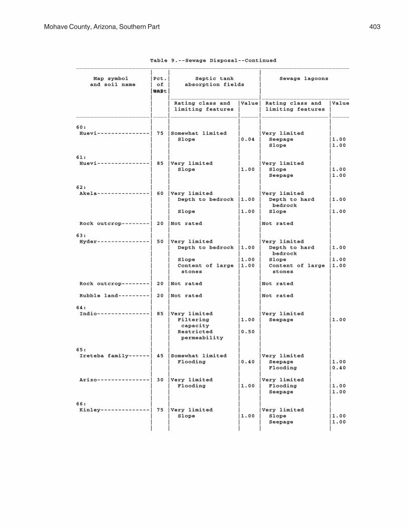
Mohave County, Arizona, Southern Part 403
Table 9.--Sewage Disposal--Continued______________________________________________________________________________ | | | Map symbol |Pct.| Septic tank | Sewage lagoons and soil name | of | absorption fields | |map | | |unit| | | |_________________________|_________________________ | | Rating class and |Value| Rating class and |Value | | limiting features | | limiting features |_____________________|____|___________________|_____|___________________|_____ | | | | |60: | | | | | Huevi---------------| 75 |Somewhat limited | |Very limited | | | Slope |0.04 | Seepage |1.00 | | | | Slope |1.00 | | | | |61: | | | | | Huevi---------------| 85 |Very limited | |Very limited | | | Slope |1.00 | Slope |1.00 | | | | Seepage |1.00 | | | | |62: | | | | | Akela---------------| 60 |Very limited | |Very limited | | | Depth to bedrock |1.00 | Depth to hard |1.00 | | | | bedrock | | | Slope |1.00 | Slope |1.00 | | | | | Rock outcrop--------| 20 |Not rated | |Not rated | | | | | |63: | | | | | Hyder---------------| 50 |Very limited | |Very limited | | | Depth to bedrock |1.00 | Depth to hard |1.00 | | | | bedrock | | | Slope |1.00 | Slope |1.00 | | Content of large |1.00 | Content of large |1.00 | | stones | | stones | | | | | | Rock outcrop--------| 20 |Not rated | |Not rated | | | | | | Rubble land---------| 20 |Not rated | |Not rated | | | | | |64: | | | | | Indio---------------| 85 |Very limited | |Very limited | | | Filtering |1.00 | Seepage |1.00 | | capacity | | | | | Restricted |0.50 | | | | permeability | | | | | | | |65: | | | | | Ireteba family------| 45 |Somewhat limited | |Very limited | | | Flooding |0.40 | Seepage |1.00 | | | | Flooding |0.40 | | | | | Arizo---------------| 30 |Very limited | |Very limited | | | Flooding |1.00 | Flooding |1.00 | | | | Seepage |1.00 | | | | |66: | | | | | Kinley--------------| 75 |Very limited | |Very limited | | | Slope |1.00 | Slope |1.00 | | | | Seepage |1.00 | | | | |

404 Soil Survey
Table 9.--Sewage Disposal--Continued______________________________________________________________________________ | | | Map symbol |Pct.| Septic tank | Sewage lagoons and soil name | of | absorption fields | |map | | |unit| | | |_________________________|_________________________ | | Rating class and |Value| Rating class and |Value | | limiting features | | limiting features |_____________________|____|___________________|_____|___________________|_____ | | | | |67: | | | | | Kinley--------------| 50 |Somewhat limited | |Very limited | | | Slope |0.04 | Seepage |1.00 | | | | Slope |1.00 | | | | | Poachie-------------| 35 |Very limited | |Very limited | | | Restricted |1.00 | Seepage |1.00 | | permeability | | | | | | | Slope |0.68 | | | | |68: | | | | | Kofa----------------| 85 |Very limited | |Very limited | | | Restricted |1.00 | Seepage |1.00 | | permeability | | | | | | | |69: | | | | | Dudleyville---------| 40 |Very limited | |Very limited | | | Flooding |1.00 | Flooding |1.00 | | Filtering |1.00 | Seepage |1.00 | | capacity | | | | | | | | Vinton--------------| 30 |Very limited | |Very limited | | | Flooding |1.00 | Flooding |1.00 | | | | Seepage |1.00 | | | | | Riverwash-----------| 20 |Not rated | |Not rated | | | | | |70: | | | | | Dudleyville---------| 40 |Very limited | |Very limited | | | Flooding |1.00 | Flooding |1.00 | | Filtering |1.00 | Seepage |1.00 | | capacity | | | | | | | | Vinton--------------| 30 |Very limited | |Very limited | | | Flooding |1.00 | Flooding |1.00 | | | | Seepage |1.00 | | | | | Riverwash-----------| 20 |Not rated | |Not rated | | | | | |71: | | | | | Lagunita------------| 85 |Not limited | |Very limited | | | | | Seepage |1.00 | | | | |72: | | | | | Lagunita------------| 60 |Not limited | |Very limited | | | | | Seepage |1.00 | | | | | Ripley--------------| 25 |Somewhat limited | |Very limited | | | Restricted |0.50 | Seepage |1.00 | | permeability | | | | | | | |

Mohave County, Arizona, Southern Part 405
Table 9.--Sewage Disposal--Continued______________________________________________________________________________ | | | Map symbol |Pct.| Septic tank | Sewage lagoons and soil name | of | absorption fields | |map | | |unit| | | |_________________________|_________________________ | | Rating class and |Value| Rating class and |Value | | limiting features | | limiting features |_____________________|____|___________________|_____|___________________|_____ | | | | |73: | | | | | Lampshire-----------| 65 |Very limited | |Very limited | | | Depth to bedrock |1.00 | Depth to hard |1.00 | | | | bedrock | | | Slope |1.00 | Depth to soft |1.00 | | | | bedrock | | | | | Slope |1.00 | | | | | Rock outcrop--------| 20 |Not rated | |Not rated | | | | | |74: | | | | | Lampshire-----------| 65 |Very limited | |Very limited | | | Depth to bedrock |1.00 | Depth to hard |1.00 | | | | bedrock | | | Slope |1.00 | Depth to soft |1.00 | | | | bedrock | | | | | Slope |1.00 | | | | | Rock outcrop--------| 20 |Not rated | |Not rated | | | | | |75: | | | | | Lampshire-----------| 45 |Very limited | |Very limited | | | Depth to bedrock |1.00 | Depth to hard |1.00 | | | | bedrock | | | Slope |1.00 | Slope |1.00 | | Content of large |0.98 | | | | stones | | | | | | | | Rock outcrop--------| 40 |Not rated | |Not rated | | | | | |76: | | | | | Lostman-------------| 80 |Not limited | |Very limited | | | | | Seepage |1.00 | | | | Slope |0.08 | | | | |77: | | | | | Lostman-------------| 80 |Not limited | |Very limited | | | | | Seepage |1.00 | | | | |78: | | | | | Lostman-------------| 40 |Not limited | |Very limited | | | | | Seepage |1.00 | | | | Slope |0.32 | | | | | Kinley--------------| 35 |Not limited | |Very limited | | | | | Seepage |1.00 | | | | Slope |0.32 | | | | |79: | | | | | Marshes-------------|100 |Not rated | |Not rated | | | | | |

406 Soil Survey
Table 9.--Sewage Disposal--Continued______________________________________________________________________________ | | | Map symbol |Pct.| Septic tank | Sewage lagoons and soil name | of | absorption fields | |map | | |unit| | | |_________________________|_________________________ | | Rating class and |Value| Rating class and |Value | | limiting features | | limiting features |_____________________|____|___________________|_____|___________________|_____ | | | | |80: | | | | | Meloland------------| 85 |Very limited | |Very limited | | | Flooding |1.00 | Flooding |1.00 | | Restricted |1.00 | Seepage |0.50 | | permeability | | | | | | | |81: | | | | | Mohon---------------| 50 |Very limited | |Somewhat limited | | | Restricted |1.00 | Slope |0.92 | | permeability | | | | | | | | Kinley--------------| 35 |Somewhat limited | |Very limited | | | Slope |0.16 | Seepage |1.00 | | | | Slope |1.0082: | | | | | Mohon---------------| 50 |Very limited | |Very limited | | | Restricted |1.00 | Slope |1.00 | | permeability | | | | | Slope |0.04 | | | | | | | Poachie-------------| 25 |Very limited | |Very limited | | | Restricted |1.00 | Seepage |1.00 | | permeability | | | | | Slope |0.04 | Slope |1.00 | | | | |83: | | | | | Mohon---------------| 50 |Very limited | |Somewhat limited | | | Restricted |1.00 | Slope |0.92 | | permeability | | | | | | | | Poachie-------------| 25 |Very limited | |Very limited | | | Restricted |1.00 | Seepage |1.00 | | permeability | | | | | Slope |0.04 | Slope |1.00 | | | | |84: | | | | | Nickel family-------| 35 |Very limited | |Very limited | | | Slope |1.00 | Slope |1.00 | | Restricted |1.00 | Seepage |1.00 | | permeability | | | | | | | | Topawa family-------| 30 |Very limited | |Very limited | | | Slope |1.00 | Slope |1.00 | | Restricted |1.00 | Seepage |1.00 | | permeability | | | | | | | | Eba family----------| 25 |Very limited | |Very limited | | | Restricted |1.00 | Slope |1.00 | | permeability | | | | | Slope |1.00 | Seepage |0.50 | | | | |

Mohave County, Arizona, Southern Part 407
Table 9.--Sewage Disposal--Continued______________________________________________________________________________ | | | Map symbol |Pct.| Septic tank | Sewage lagoons and soil name | of | absorption fields | |map | | |unit| | | |_________________________|_________________________ | | Rating class and |Value| Rating class and |Value | | limiting features | | limiting features |_____________________|____|___________________|_____|___________________|_____ | | | | |85: | | | | | Orwash family-------| 75 |Very limited | |Very limited | | | Filtering |1.00 | Seepage |1.00 | | capacity | | | | | | | |86: | | | | | Orwash family-------| 75 |Very limited | |Very limited | | | Filtering |1.00 | Seepage |1.00 | | capacity | | | | | | | |87: | | | | | Penthouse-----------| 50 |Very limited | |Very limited | | | Restricted |1.00 | Seepage |1.00 | | permeability | | | | | Slope |0.16 | Slope |1.00 | | | | | Gonzales------------| 25 |Very limited | |Very limited | | | Depth to bedrock |1.00 | Depth to hard |1.00 | | | | bedrock | | | Slope |1.00 | Depth to soft |1.00 | | | | bedrock | | | | | Slope |1.00 | | | | |88: | | | | | Poachie-------------| 80 |Very limited | |Very limited | | | Restricted |1.00 | Seepage |1.00 | | permeability | | | | | | | Slope |0.08 | | | | |89: | | | | | Poachie-------------| 80 |Very limited | |Very limited | | | Restricted |1.00 | Seepage |1.00 | | permeability | | | | | | | Slope |0.08 | | | | |90: | | | | | Quilotosa-----------| 60 |Very limited | |Very limited | | | Depth to bedrock |1.00 | Depth to hard |1.00 | | | | bedrock | | | Slope |1.00 | Depth to soft |1.00 | | | | bedrock | | | | | Slope |1.00 | | | | | Rock outcrop--------| 20 |Not rated | |Not rated | | | | | |91: | | | | | Razorback-----------| 90 |Very limited | |Very limited | | | Depth to bedrock |1.00 | Depth to hard |1.00 | | | | bedrock | | | Slope |1.00 | Slope |1.00 | | | | |

408 Soil Survey
Table 9.--Sewage Disposal--Continued______________________________________________________________________________ | | | Map symbol |Pct.| Septic tank | Sewage lagoons and soil name | of | absorption fields | |map | | |unit| | | |_________________________|_________________________ | | Rating class and |Value| Rating class and |Value | | limiting features | | limiting features |_____________________|____|___________________|_____|___________________|_____ | | | | |92: | | | | | Razorback-----------| 65 |Very limited | |Very limited | | | Depth to bedrock |1.00 | Depth to hard |1.00 | | | | bedrock | | | Slope |0.84 | Slope |1.00 | | | | Seepage |0.50 | | | | | Rock outcrop--------| 20 |Not rated | |Not rated | | | | | |93: | | | | | Razorback-----------| 60 |Very limited | |Very limited | | | Depth to bedrock |1.00 | Depth to hard |1.00 | | | | bedrock | | | Slope |1.00 | Slope |1.00 | | | | Seepage |0.50 | | | | | Rock outcrop--------| 20 |Not rated | |Not rated | | | | | |94: | | | | | Razorback-----------| 60 |Very limited | |Very limited | | | Depth to bedrock |1.00 | Depth to hard |1.00 | | | | bedrock | | | Slope |1.00 | Slope |1.00 | | | | Seepage |0.50 | | | | | Rock outcrop--------| 20 |Not rated | |Not rated | | | | | |95: | | | | | Razorback-----------| 45 |Very limited | |Very limited | | | Depth to bedrock |1.00 | Depth to hard |1.00 | | | | bedrock | | | Slope |1.00 | Slope |1.00 | | | | Seepage |0.50 | | | | | Rock outcrop--------| 20 |Not rated | |Not rated | | | | | | Rubble land---------| 20 |Not rated | |Not rated | | | | | |96: | | | | | Razorback-----------| 45 |Very limited | |Very limited | | | Depth to bedrock |1.00 | Depth to hard |1.00 | | | | bedrock | | | Slope |1.00 | Slope |1.00 | | | | Seepage |0.50 | | | | | Rock outcrop--------| 20 |Not rated | |Not rated | | | | | | Rubble land---------| 20 |Not rated | |Not rated | | | | | |97: | | | | | Rillino-------------| 75 |Very limited | |Very limited | | | Slope |1.00 | Slope |1.00 | | | | Seepage |1.00 | | | | |

Mohave County, Arizona, Southern Part 409
Table 9.--Sewage Disposal--Continued______________________________________________________________________________ | | | Map symbol |Pct.| Septic tank | Sewage lagoons and soil name | of | absorption fields | |map | | |unit| | | |_________________________|_________________________ | | Rating class and |Value| Rating class and |Value | | limiting features | | limiting features |_____________________|____|___________________|_____|___________________|_____ | | | | |98: | | | | | Rillino-------------| 50 |Somewhat limited | |Very limited | | | Slope |0.04 | Seepage |1.00 | | | | Slope |1.00 | | | | | Tres Hermanos-------| 35 |Very limited | |Very limited | | | Restricted |1.00 | Seepage |1.00 | | permeability | | | | | | | Slope |0.68 | | | | |99: | | | | | Ripley--------------| 85 |Very limited | |Very limited | | | Flooding |1.00 | Flooding |1.00 | | Restricted |0.50 | Seepage |1.00 | | permeability | | | | | | | |100: | | | | | Riverbend family----| 75 |Somewhat limited | |Very limited | | | Slope |0.04 | Seepage |1.00 | | | | Slope |1.00 | | | | |101: | | | | | Riverbend-----------| 75 |Somewhat limited | |Very limited | | | Slope |0.04 | Seepage |1.00 | | | | Slope |1.00 | | | | |102: | | | | | Riverwash-----------| 70 |Not rated | |Not rated | | | | | | Fluvaquents---------| 20 |Not rated | |Not rated | | | | | |103: | | | | | Rock outcrop--------| 45 |Not rated | |Not rated | | | | | | Hyder---------------| 40 |Very limited | |Very limited | | | Depth to bedrock |1.00 | Depth to hard |1.00 | | | | bedrock | | | Slope |1.00 | Slope |1.00 | | Content of large |1.00 | Content of large |1.00 | | stones | | stones | | | | | |104: | | | | | Rock outcrop--------| 65 |Not rated | |Not rated | | | | | | Razorback-----------| 30 |Very limited | |Very limited | | | Depth to bedrock |1.00 | Depth to hard |1.00 | | | | bedrock | | | Slope |1.00 | Slope |1.00 | | | | Seepage |0.50 | | | | |

410 Soil Survey
Table 9.--Sewage Disposal--Continued______________________________________________________________________________ | | | Map symbol |Pct.| Septic tank | Sewage lagoons and soil name | of | absorption fields | |map | | |unit| | | |_________________________|_________________________ | | Rating class and |Value| Rating class and |Value | | limiting features | | limiting features |_____________________|____|___________________|_____|___________________|_____ | | | | |105: | | | | | Rock outcrop--------| 45 |Not rated | |Not rated | | | | | | Sunrock-------------| 40 |Very limited | |Very limited | | | Depth to bedrock |1.00 | Depth to hard |1.00 | | | | bedrock | | | Slope |1.00 | Depth to soft |1.00 | | | | bedrock | | | | | Slope |1.00 | | | | |106: | | | | | Romero--------------| 45 |Very limited | |Very limited | | | Depth to bedrock |1.00 | Depth to hard |1.00 | | | | bedrock | | | Slope |1.00 | Slope |1.00 | | | | | Chiricahua----------| 30 |Very limited | |Very limited | | | Depth to bedrock |1.00 | Depth to hard |1.00 | | | | bedrock | | | Slope |1.00 | Depth to soft |1.00 | | | | bedrock | | | | | Slope |1.00 | | | | | Rock outcrop--------| 20 |Not rated | |Not rated | | | | | |107: | | | | | Romero--------------| 60 |Very limited | |Very limited | | | Depth to bedrock |1.00 | Depth to soft |1.00 | | | | bedrock | | | Slope |1.00 | Slope |1.00 | | | | | Lampshire-----------| 20 |Very limited | |Very limited | | | Depth to bedrock |1.00 | Depth to hard |1.00 | | | | bedrock | | | Slope |1.00 | Depth to soft |1.00 | | | | bedrock | | | | | Slope |1.00 | | | | | Rock outcrop--------| 15 |Not rated | |Not rated | | | | | |108: | | | | | Rositas family------| 40 |Very limited | |Very limited | | | Slope |1.00 | Seepage |1.00 | | | | Slope |1.00 | | | | | Superstition--------| 25 |Very limited | |Very limited | | | Filtering |1.00 | Seepage |1.00 | | capacity | | | | | | | Slope |0.92 | | | | | Torriorthents-------| 25 |Not rated | |Not rated | | | | | |

Mohave County, Arizona, Southern Part 411
Table 9.--Sewage Disposal--Continued______________________________________________________________________________ | | | Map symbol |Pct.| Septic tank | Sewage lagoons and soil name | of | absorption fields | |map | | |unit| | | |_________________________|_________________________ | | Rating class and |Value| Rating class and |Value | | limiting features | | limiting features |_____________________|____|___________________|_____|___________________|_____ | | | | |109: | | | | | Rositas-------------| 40 |Very limited | |Very limited | | | Filtering |1.00 | Seepage |1.00 | | capacity | | | | | Slope |1.00 | Slope |1.00 | | | | | Superstition family-| 25 |Very limited | |Very limited | | | Filtering |1.00 | Seepage |1.00 | | capacity | | | | | | | Slope |0.92 | | | | | Torriorthents-------| 20 |Not rated | |Not rated | | | | | |110: | | | | | Stagecoach----------| 75 |Somewhat limited | |Very limited | | | Slope |0.04 | Seepage |1.00 | | | | Slope |1.00 | | | | |111: | | | | | Stagecoach----------| 85 |Very limited | |Very limited | | | Slope |1.00 | Slope |1.00 | | | | Seepage |1.00 | | | | |112: | | | | | Stagecoach----------| 80 |Very limited | |Very limited | | | Slope |1.00 | Seepage |1.00 | | | | Slope |1.00 | | | | |113: | | | | | Stagecoach----------| 80 |Very limited | |Very limited | | | Slope |1.00 | Seepage |1.00 | | | | Slope |1.00 | | | | |114: | | | | | Stagecoach----------| 35 |Very limited | |Very limited | | | Slope |1.00 | Slope |1.00 | | | | Seepage |1.00 | | | | | Topawa family-------| 30 |Very limited | |Very limited | | | Restricted |1.00 | Slope |1.00 | | permeability | | | | | Slope |1.00 | Seepage |1.00 | | Content of large |0.02 | Content of large |1.00 | | stones | | stones | | | | | | Eba-----------------| 25 |Very limited | |Very limited | | | Restricted |1.00 | Slope |1.00 | | permeability | | | | | Slope |1.00 | Seepage |1.00 | | | | |

412 Soil Survey
Table 9.--Sewage Disposal--Continued______________________________________________________________________________ | | | Map symbol |Pct.| Septic tank | Sewage lagoons and soil name | of | absorption fields | |map | | |unit| | | |_________________________|_________________________ | | Rating class and |Value| Rating class and |Value | | limiting features | | limiting features |_____________________|____|___________________|_____|___________________|_____ | | | | |115: | | | | | Stagecoach----------| 35 |Very limited | |Very limited | | | Slope |1.00 | Slope |1.00 | | | | Seepage |1.00 | | | | | Topawa family-------| 30 |Very limited | |Very limited | | | Restricted |1.00 | Slope |1.00 | | permeability | | | | | Slope |1.00 | Seepage |1.00 | | Content of large |0.02 | Content of large |1.00 | | stones | | stones | | | | | | Eba-----------------| 25 |Very limited | |Very limited | | | Restricted |1.00 | Slope |1.00 | | permeability | | | | | Slope |1.00 | Seepage |1.00 | | | | |116: | | | | | Sunrock-------------| 90 |Very limited | |Very limited | | | Depth to bedrock |1.00 | Depth to hard |1.00 | | | | bedrock | | | Slope |1.00 | Slope |1.00 | | | | |117: | | | | | Sunrock-------------| 70 |Very limited | |Very limited | | | Depth to bedrock |1.00 | Depth to hard |1.00 | | | | bedrock | | | Slope |1.00 | Depth to soft |1.00 | | | | bedrock | | | | | Slope |1.00 | | | | | Rock outcrop--------| 20 |Not rated | |Not rated | | | | | |118: | | | | | Tombstone-----------| 35 |Very limited | |Very limited | | | Slope |1.00 | Slope |1.00 | | | | Seepage |1.00 | | | | | Caralampi-----------| 30 |Very limited | |Very limited | | | Slope |1.00 | Slope |1.00 | | Restricted |0.50 | Seepage |1.00 | | permeability | | | | | | | | Eloma---------------| 25 |Very limited | |Very limited | | | Restricted |1.00 | Slope |1.00 | | permeability | | | | | Slope |1.00 | Content of large |1.00 | | | | stones | | | Content of large |0.68 | | | | stones | | | | | | | |

Mohave County, Arizona, Southern Part 413
Table 9.--Sewage Disposal--Continued______________________________________________________________________________ | | | Map symbol |Pct.| Septic tank | Sewage lagoons and soil name | of | absorption fields | |map | | |unit| | | |_________________________|_________________________ | | Rating class and |Value| Rating class and |Value | | limiting features | | limiting features |_____________________|____|___________________|_____|___________________|_____ | | | | |119: | | | | | Torriorthents-------| 75 |Not rated | |Not rated | | | | | |120: | | | | | Torriorthents-------| 75 |Not rated | |Not rated | | | | | |121: | | | | | Tumarion------------| 85 |Very limited | |Very limited | | | Depth to bedrock |1.00 | Depth to hard |1.00 | | | | bedrock | | | Depth to cemented|1.00 | Depth to cemented|1.00 | | pan | | pan | | | Slope |0.04 | Slope |1.00 | | | | |122: | | | | | Tumarion------------| 85 |Very limited | |Very limited | | | Depth to bedrock |1.00 | Depth to hard |1.00 | | | | bedrock | | | Depth to cemented|1.00 | Depth to cemented|1.00 | | pan | | pan | | | Slope |0.04 | Slope |1.00 | | | | |123: | | | | | Tyro----------------| 90 |Very limited | |Very limited | | | Depth to cemented|1.00 | Depth to cemented|1.00 | | pan | | pan | | | Slope |1.00 | Slope |1.00 | | | | |124: | | | | | Tyro----------------| 85 |Very limited | |Very limited | | | Depth to cemented|1.00 | Depth to cemented|1.00 | | pan | | pan | | | | | Slope |0.92 | | | | |125: | | | | | Vekol family--------| 85 |Very limited | |Very limited | | | Restricted |1.00 | Seepage |1.00 | | permeability | | | | | Filtering |1.00 | Slope |0.68 | | capacity | | | | | | | |126: | | | | | Vekol family--------| 85 |Very limited | |Very limited | | | Restricted |1.00 | Seepage |1.00 | | permeability | | | | | Filtering |1.00 | Slope |0.68 | | capacity | | | | | | | |127: | | | | | Water---------------|100 |Not rated | |Not rated | | | | | |

414 Soil Survey
Table 9.--Sewage Disposal--Continued______________________________________________________________________________ | | | Map symbol |Pct.| Septic tank | Sewage lagoons and soil name | of | absorption fields | |map | | |unit| | | |_________________________|_________________________ | | Rating class and |Value| Rating class and |Value | | limiting features | | limiting features |_____________________|____|___________________|_____|___________________|_____ | | | | |128: | | | | | Whitehills----------| 80 |Very limited | |Very limited | | | Restricted |1.00 | Depth to cemented|1.00 | | permeability | | pan | | | Depth to cemented|1.00 | Seepage |0.50 | | pan | | | | | | | Slope |0.08 | | | | |129: | | | | | Whitehills----------| 80 |Very limited | |Very limited | | | Depth to cemented|1.00 | Depth to cemented|1.00 | | pan | | pan | | | Restricted |0.50 | Slope |1.00 | | permeability | | | | | Slope |0.04 | Seepage |0.50 | | | | |130: | | | | | White House family--| 85 |Very limited | |Very limited | | | Restricted |1.00 | Seepage |1.00 | | permeability | | | | | Slope |0.04 | Slope |1.00 | | | | |131: | | | | | White House---------| 85 |Very limited | |Very limited | | | Restricted |1.00 | Seepage |1.00 | | permeability | | | | | Slope |0.04 | Slope |1.00 | | | | |132: | | | | | Wikieup-------------| 45 |Very limited | |Very limited | | | Depth to bedrock |1.00 | Depth to hard |1.00 | | | | bedrock | | | Slope |1.00 | Depth to soft |1.00 | | | | bedrock | | | | | Slope |1.00 | | | | | Mutang--------------| 30 |Very limited | |Very limited | | | Depth to bedrock |1.00 | Depth to hard |1.00 | | | | bedrock | | | Slope |1.00 | Depth to soft |1.00 | | | | bedrock | | | | | Slope |1.00 | | | | | Rock outcrop--------| 20 |Not rated | |Not rated | | | | | |133: | | | | | Mutang--------------| 55 |Very limited | |Very limited | | | Depth to bedrock |1.00 | Depth to hard |1.00 | | | | bedrock | | | Slope |1.00 | Depth to soft |1.00 | | | | bedrock | | | | | Slope |1.00 | | | | |

Mohave County, Arizona, Southern Part 415
Table 9.--Sewage Disposal--Continued______________________________________________________________________________ | | | Map symbol |Pct.| Septic tank | Sewage lagoons and soil name | of | absorption fields | |map | | |unit| | | |_________________________|_________________________ | | Rating class and |Value| Rating class and |Value | | limiting features | | limiting features |_____________________|____|___________________|_____|___________________|_____ | | | | |133: | | | | | Wikieup-------------| 25 |Very limited | |Very limited | | | Depth to bedrock |1.00 | Depth to hard |1.00 | | | | bedrock | | | Slope |1.00 | Slope |1.00 | | | | | Rock outcrop--------| 15 |Not rated | |Not rated | | | | | |134: | | | | | Wikieup-------------| 50 |Very limited | |Very limited | | | Depth to bedrock |1.00 | Depth to hard |1.00 | | | | bedrock | | | Slope |1.00 | Depth to soft |1.00 | | | | bedrock | | | | | Slope |1.00 | | | | | Rock outcrop--------| 25 |Not rated | |Not rated | | | | | |135: | | | | | Yahana family-------| 85 |Very limited | |Very limited | | | Restricted |1.00 | Seepage |1.00 | | permeability | | | | | | | |136: | | | | | Tumarion------------| 70 |Very limited | |Very limited | | | Depth to bedrock |1.00 | Depth to hard |1.00 | | | | bedrock | | | Depth to cemented|1.00 | Depth to cemented|1.00 | | pan | | pan | | | Slope |1.00 | Slope |1.00 | | | | | Nickel family-------| 15 |Very limited | |Very limited | | | Slope |1.00 | Slope |1.00 | | Content of large |0.90 | Content of large |1.00 | | stones | | stones | | | | | Seepage |1.00 | | | | |137: | | | | | Valena--------------| 40 |Very limited | |Very limited | | | Depth to bedrock |1.00 | Depth to hard |1.00 | | | | bedrock | | | Slope |0.84 | Slope |1.00 | | | | | Rock outcrop--------| 20 |Not rated | |Not rated | | | | | | Carri family--------| 15 |Very limited | |Very limited | | | Restricted |1.00 | Seepage |1.00 | | permeability | | | | | Slope |0.84 | Slope |1.00 | | | | |

416 Soil Survey
Table 9.--Sewage Disposal--Continued______________________________________________________________________________ | | | Map symbol |Pct.| Septic tank | Sewage lagoons and soil name | of | absorption fields | |map | | |unit| | | |_________________________|_________________________ | | Rating class and |Value| Rating class and |Value | | limiting features | | limiting features |_____________________|____|___________________|_____|___________________|_____ | | | | |138: | | | | | Nodman--------------| 65 |Very limited | |Very limited | | | Depth to bedrock |1.00 | Depth to soft |1.00 | | | | bedrock | | | Slope |1.00 | Slope |1.00 | | | | | Rock outcrop--------| 20 |Not rated | |Not rated | | | | | |139: | | | | | Nodman--------------| 60 |Very limited | |Very limited | | | Depth to bedrock |1.00 | Depth to soft |1.00 | | | | bedrock | | | Slope |1.00 | Slope |1.00 | | Content of large |0.55 | Content of large |0.08 | | stones | | stones | | | | | | Romero family-------| 20 |Very limited | |Very limited | | | Depth to bedrock |1.00 | Depth to hard |1.00 | | | | bedrock | | | Slope |1.00 | Depth to soft |1.00 | | | | bedrock | | | Content of large |0.75 | Slope |1.00 | | stones | | | | | | | |_____________________|____|___________________|_____|___________________|_____

Mohave C
ounty, Arizona, S
outhern Part
417
Table 10.--Landfills
(The information in this table indicates the dominant soil condition but does not eliminate the need for onsite investigation. The numbers in the value columns range from 0.01 to 1.00. The larger the value, the greater the limitation. See text for further explanation of ratings in this table.)________________________________________________________________________________________________________ | | | | Map symbol |Pct.| Trench sanitary | Area sanitary | Daily cover for and soil name | of | landfill | landfill | landfill |map | | | |unit| | | | |_________________________|_________________________|_________________________ | | Rating class and |Value| Rating class and |Value| Rating class and |Value | | limiting features | | limiting features | | limiting features |_____________________|____|___________________|_____|___________________|_____|___________________|_____ | | | | | | |1: | | | | | | | Akela---------------| 45 |Very limited | |Very limited | |Very limited | | | Slope |1.00 | Slope |1.00 | Depth to bedrock |1.00 | | Depth to bedrock |1.00 | | | Slope |1.00 | | Content of large |1.00 | | | Content of large |1.00 | | stones | | | | stones | | | | | | | | Rock outcrop--------| 20 |Not rated | |Not rated | |Not rated | | | | | | | | Rubble land---------| 20 |Not rated | |Not rated | |Not rated | | | | | | | |2: | | | | | | | Akela---------------| 45 |Very limited | |Very limited | |Very limited | | | Slope |1.00 | Slope |1.00 | Depth to bedrock |1.00 | | Depth to bedrock |1.00 | | | Slope |1.00 | | Content of large |1.00 | | | Content of large |1.00 | | stones | | | | stones | | | | | | | | Rock outcrop--------| 20 |Not rated | |Not rated | |Not rated | | | | | | | | Rubble land---------| 20 |Not rated | |Not rated | |Not rated | | | | | | | |3: | | | | | | | Alko family---------| 85 |Somewhat limited | |Somewhat limited | |Very limited | | | Slope |0.04 | Slope |0.04 | Depth to cemented|1.00 | | | | | | pan | | | | | | | Seepage |0.50 | | | | | | Gravel content |0.25 | | | | | | |

418S
oil Survey
Table 10.--Landfills--Continued________________________________________________________________________________________________________ | | | | Map symbol |Pct.| Trench sanitary | Area sanitary | Daily cover for and soil name | of | landfill | landfill | landfill |map | | | |unit| | | | |_________________________|_________________________|_________________________ | | Rating class and |Value| Rating class and |Value| Rating class and |Value | | limiting features | | limiting features | | limiting features |_____________________|____|___________________|_____|___________________|_____|___________________|_____ | | | | | | |4: | | | | | | | Alko family---------| 85 |Somewhat limited | |Somewhat limited | |Very limited | | | Slope |0.04 | Slope |0.04 | Depth to cemented|1.00 | | | | | | pan | | | | | | | Seepage |0.50 | | | | | | Gravel content |0.25 | | | | | | |5: | | | | | | | Amole---------------| 75 |Somewhat limited | |Not limited | |Very limited | | | Too Sandy |0.50 | | | Seepage |1.00 | | | | | | Too Sandy |0.50 | | | | | | |6: | | | | | | | Amole---------------| 75 |Somewhat limited | |Not limited | |Very limited | | | Too Sandy |0.50 | | | Seepage |1.00 | | | | | | Too Sandy |0.50 | | | | | | |7: | | | | | | | Anthony-------------| 45 |Not limited | |Not limited | |Somewhat limited | | | | | | | Seepage |0.50 | | | | | | Gravel content |0.45 | | | | | | | Dudleyville---------| 30 |Very limited | |Very limited | |Very limited | | | Flooding |1.00 | Flooding |1.00 | Too Sandy |1.00 | | Too Sandy |1.00 | | | Seepage |1.00 | | | | | | Gravel content |1.00 | | | | | | |8: | | | | | | | Aquarius------------| 45 |Very limited | |Very limited | |Very limited | | | Slope |1.00 | Slope |1.00 | Hard to compact |1.00 | | | | | | Slope |1.00 | | | | | | | Akela---------------| 30 |Very limited | |Somewhat limited | |Very limited | | | Depth to bedrock |1.00 | Slope |0.84 | Depth to bedrock |1.00 | | Content of large |1.00 | | | Content of large |1.00 | | stones | | | | stones | | | Slope |0.84 | | | Slope |0.84 | | | | | | | Rock outcrop--------| 20 |Not rated | |Not rated | |Not rated | | | | | | | |

Mohave C
ounty, Arizona, S
outhern Part
419
Table 10.--Landfills--Continued________________________________________________________________________________________________________ | | | | Map symbol |Pct.| Trench sanitary | Area sanitary | Daily cover for and soil name | of | landfill | landfill | landfill |map | | | |unit| | | | |_________________________|_________________________|_________________________ | | Rating class and |Value| Rating class and |Value| Rating class and |Value | | limiting features | | limiting features | | limiting features |_____________________|____|___________________|_____|___________________|_____|___________________|_____ | | | | | | |9: | | | | | | | Arizo---------------| 40 |Very limited | |Very limited | |Very limited | | | Flooding |1.00 | Flooding |1.00 | Seepage |1.00 | | Too Sandy |0.50 | | | Gravel content |1.00 | | | | | | Too Sandy |0.50 | | | | | | | Franconia-----------| 30 |Very limited | |Very limited | |Very limited | | | Flooding |1.00 | Flooding |1.00 | Seepage |1.00 | | Too Sandy |0.50 | | | Too Sandy |0.50 | | | | | | | Riverwash-----------| 20 |Not rated | |Not rated | |Not rated | | | | | | | |10: | | | | | | | Arizo---------------| 40 |Very limited | |Very limited | |Very limited | | | Flooding |1.00 | Flooding |1.00 | Seepage |1.00 | | Too Sandy |0.50 | | | Gravel content |1.00 | | | | | | Too Sandy |0.50 | | | | | | | Franconia-----------| 30 |Very limited | |Very limited | |Very limited | | | Flooding |1.00 | Flooding |1.00 | Seepage |1.00 | | Too Sandy |0.50 | | | Too Sandy |0.50 | | | | | | | Riverwash-----------| 20 |Not rated | |Not rated | |Not rated | | | | | | | |11: | | | | | | | Bartmus-------------| 85 |Very limited | |Somewhat limited | |Very limited | | | Depth to bedrock |1.00 | Slope |0.04 | Depth to cemented|1.00 | | | | | | pan | | | Slope |0.04 | | | Depth to bedrock |1.00 | | | | | | Gravel content |1.00 | | | | | | |12: | | | | | | | Bonita family-------| 85 |Not limited | |Not limited | |Very limited | | | | | | | Hard to compact |1.00 | | | | | | Gravel content |0.12 | | | | | | |

420S
oil Survey
Table 10.--Landfills--Continued________________________________________________________________________________________________________ | | | | Map symbol |Pct.| Trench sanitary | Area sanitary | Daily cover for and soil name | of | landfill | landfill | landfill |map | | | |unit| | | | |_________________________|_________________________|_________________________ | | Rating class and |Value| Rating class and |Value| Rating class and |Value | | limiting features | | limiting features | | limiting features |_____________________|____|___________________|_____|___________________|_____|___________________|_____ | | | | | | |13: | | | | | | | Bonita family-------| 60 |Somewhat limited | |Somewhat limited | |Very limited | | | Slope |0.84 | Slope |0.84 | Hard to compact |1.00 | | | | | | Slope |0.84 | | | | | | Gravel content |0.12 | | | | | | | Gonzales------------| 30 |Very limited | |Very limited | |Very limited | | | Slope |1.00 | Slope |1.00 | Depth to bedrock |1.00 | | Depth to bedrock |1.00 | | | Slope |1.00 | | | | | | Hard to compact |1.00 | | | | | | |14: | | | | | | | Brazito family------| 75 |Very limited | |Not limited | |Very limited | | | Too Sandy |1.00 | | | Seepage |1.00 | | | | | | Too Sandy |0.50 | | | | | | |15: | | | | | | | Bucklebar-----------| 80 |Not limited | |Not limited | |Not limited | | | | | | | |16: | | | | | | | Cacique family------| 75 |Not limited | |Not limited | |Very limited | | | | | | | Depth to cemented|1.00 | | | | | | pan | | | | | | | Gravel content |0.61 | | | | | | |17: | | | | | | | Castaneda-----------| 75 |Not limited | |Not limited | |Very limited | | | | | | | Depth to cemented|1.00 | | | | | | pan | | | | | | | Gravel content |0.98 | | | | | | Seepage |0.50 | | | | | | |18: | | | | | | | Castaneda-----------| 75 |Not limited | |Not limited | |Very limited | | | | | | | Depth to cemented|1.00 | | | | | | pan | | | | | | | Gravel content |0.98 | | | | | | Seepage |0.50 | | | | | | |

Mohave C
ounty, Arizona, S
outhern Part
421
Table 10.--Landfills--Continued________________________________________________________________________________________________________ | | | | Map symbol |Pct.| Trench sanitary | Area sanitary | Daily cover for and soil name | of | landfill | landfill | landfill |map | | | |unit| | | | |_________________________|_________________________|_________________________ | | Rating class and |Value| Rating class and |Value| Rating class and |Value | | limiting features | | limiting features | | limiting features |_____________________|____|___________________|_____|___________________|_____|___________________|_____ | | | | | | |19: | | | | | | | Carrizo family------| 75 |Very limited | |Very limited | |Very limited | | | Flooding |1.00 | Flooding |1.00 | Too Sandy |1.00 | | Too Sandy |1.00 | | | Seepage |1.00 | | | | | | Gravel content |1.00 | | | | | | |20: | | | | | | | Carrizo family------| 65 |Very limited | |Very limited | |Very limited | | | Flooding |1.00 | Flooding |1.00 | Too Sandy |1.00 | | Too Sandy |1.00 | | | Seepage |1.00 | | | | | | Gravel content |1.00 | | | | | | | Riverwash-----------| 20 |Not rated | |Not rated | |Not rated | | | | | | | |21: | | | | | | | Carrizo-------------| 75 |Very limited | |Very limited | |Very limited | | | Flooding |1.00 | Flooding |1.00 | Too Sandy |1.00 | | Too Sandy |1.00 | | | Seepage |1.00 | | | | | | Gravel content |1.00 | | | | | | | Riverwash-----------| 15 |Not rated | |Not rated | |Not rated | | | | | | | |22: | | | | | | | Carrizo-------------| 65 |Very limited | |Very limited | |Very limited | | | Flooding |1.00 | Flooding |1.00 | Seepage |1.00 | | Too Sandy |0.50 | | | Gravel content |1.00 | | | | | | Too Sandy |0.50 | | | | | | | Riverwash-----------| 20 |Not rated | |Not rated | |Not rated | | | | | | | |23: | | | | | | | Cave----------------| 75 |Very limited | |Very limited | |Very limited | | | Slope |1.00 | Slope |1.00 | Depth to cemented|1.00 | | | | | | pan | | | Too Sandy |0.50 | | | Slope |1.00 | | | | | | Seepage |1.00 | | | | | | |

422S
oil Survey
Table 10.--Landfills--Continued________________________________________________________________________________________________________ | | | | Map symbol |Pct.| Trench sanitary | Area sanitary | Daily cover for and soil name | of | landfill | landfill | landfill |map | | | |unit| | | | |_________________________|_________________________|_________________________ | | Rating class and |Value| Rating class and |Value| Rating class and |Value | | limiting features | | limiting features | | limiting features |_____________________|____|___________________|_____|___________________|_____|___________________|_____ | | | | | | |24: | | | | | | | Cave----------------| 75 |Very limited | |Very limited | |Very limited | | | Slope |1.00 | Slope |1.00 | Depth to cemented|1.00 | | | | | | pan | | | Too Sandy |0.50 | | | Slope |1.00 | | | | | | Seepage |1.00 | | | | | | |25: | | | | | | | Cellar--------------| 50 |Very limited | |Very limited | |Very limited | | | Slope |1.00 | Slope |1.00 | Depth to bedrock |1.00 | | Depth to bedrock |1.00 | | | Slope |1.00 | | | | | | Gravel content |1.00 | | | | | | | Rock outcrop--------| 25 |Not rated | |Not rated | |Not rated | | | | | | | |26: | | | | | | | Cellar--------------| 50 |Very limited | |Very limited | |Very limited | | | Slope |1.00 | Slope |1.00 | Depth to bedrock |1.00 | | Depth to bedrock |1.00 | | | Slope |1.00 | | | | | | Gravel content |1.00 | | | | | | | Rock outcrop--------| 25 |Not rated | |Not rated | |Not rated | | | | | | | |27: | | | | | | | Cellar--------------| 45 |Very limited | |Very limited | |Very limited | | | Depth to bedrock |1.00 | Slope |1.00 | Depth to bedrock |1.00 | | Slope |1.00 | | | Gravel content |1.00 | | | | | | Slope |1.00 | | | | | | | Topock--------------| 30 |Very limited | |Very limited | |Very limited | | | Depth to bedrock |1.00 | Slope |1.00 | Depth to bedrock |1.00 | | Slope |1.00 | | | Hard to compact |1.00 | | | | | | Slope |1.00 | | | | | | | Rock outcrop--------| 20 |Not rated | |Not rated | |Not rated | | | | | | | |

Mohave C
ounty, Arizona, S
outhern Part
423
Table 10.--Landfills--Continued________________________________________________________________________________________________________ | | | | Map symbol |Pct.| Trench sanitary | Area sanitary | Daily cover for and soil name | of | landfill | landfill | landfill |map | | | |unit| | | | |_________________________|_________________________|_________________________ | | Rating class and |Value| Rating class and |Value| Rating class and |Value | | limiting features | | limiting features | | limiting features |_____________________|____|___________________|_____|___________________|_____|___________________|_____ | | | | | | |28: | | | | | | | Cherioni------------| 85 |Very limited | |Somewhat limited | |Very limited | | | Depth to bedrock |1.00 | Slope |0.04 | Depth to cemented|1.00 | | | | | | pan | | | Depth to thin |0.50 | | | Depth to bedrock |1.00 | | cemented pan | | | | | | | Slope |0.04 | | | Gravel content |1.00 | | | | | | |29: | | | | | | | Chuckawalla---------| 65 |Somewhat limited | |Somewhat limited | |Very limited | | | Too Sandy |0.50 | Slope |0.04 | Seepage |1.00 | | Slope |0.04 | | | Gravel content |1.00 | | | | | | Too Sandy |0.50 | | | | | | | Riverbend-----------| 25 |Very limited | |Somewhat limited | |Very limited | | | Too Sandy |1.00 | Slope |0.04 | Too Sandy |1.00 | | Slope |0.04 | | | Seepage |1.00 | | | | | | Gravel content |1.00 | | | | | | |30: | | | | | | | Chuckawalla family--| 65 |Somewhat limited | |Somewhat limited | |Very limited | | | Slope |0.04 | Slope |0.04 | Gravel content |1.00 | | | | | | Seepage |0.50 | | | | | | Slope |0.04 | | | | | | | Riverbend family----| 25 |Somewhat limited | |Somewhat limited | |Very limited | | | Too Sandy |0.50 | Slope |0.04 | Seepage |1.00 | | Slope |0.04 | | | Gravel content |1.00 | | | | | | Too Sandy |0.50 | | | | | | |31: | | | | | | | Cipriano------------| 85 |Not limited | |Not limited | |Very limited | | | | | | | Depth to cemented|1.00 | | | | | | pan | | | | | | | Gravel content |1.00 | | | | | | |

424S
oil Survey
Table 10.--Landfills--Continued________________________________________________________________________________________________________ | | | | Map symbol |Pct.| Trench sanitary | Area sanitary | Daily cover for and soil name | of | landfill | landfill | landfill |map | | | |unit| | | | |_________________________|_________________________|_________________________ | | Rating class and |Value| Rating class and |Value| Rating class and |Value | | limiting features | | limiting features | | limiting features |_____________________|____|___________________|_____|___________________|_____|___________________|_____ | | | | | | |32: | | | | | | | Cline---------------| 85 |Very limited | |Somewhat limited | |Very limited | | | Depth to bedrock |1.00 | Slope |0.04 | Depth to cemented|1.00 | | | | | | pan | | | Slope |0.04 | | | Depth to bedrock |1.00 | | | | | | Gravel content |1.00 | | | | | | |33: | | | | | | | Cline---------------| 85 |Very limited | |Somewhat limited | |Very limited | | | Depth to bedrock |1.00 | Slope |0.04 | Depth to cemented|1.00 | | | | | | pan | | | Slope |0.04 | | | Depth to bedrock |1.00 | | | | | | Gravel content |1.00 | | | | | | |34: | | | | | | | Continental---------| 50 |Not limited | |Not limited | |Not limited | | | | | | | | Tres Hermanos-------| 25 |Somewhat limited | |Somewhat limited | |Somewhat limited | | | Slope |0.04 | Slope |0.04 | Seepage |0.50 | | | | | | Gravel content |0.50 | | | | | | Slope |0.04 | | | | | | |35: | | | | | | | Continental---------| 50 |Somewhat limited | |Somewhat limited | |Somewhat limited | | | Slope |0.04 | Slope |0.04 | Slope |0.04 | | | | | | | Tres Hermanos-------| 25 |Somewhat limited | |Somewhat limited | |Somewhat limited | | | Slope |0.04 | Slope |0.04 | Seepage |0.50 | | | | | | Gravel content |0.50 | | | | | | Slope |0.04 | | | | | | |36: | | | | | | | Continental---------| 50 |Not limited | |Not limited | |Not limited | | | | | | | | Rillino-------------| 35 |Somewhat limited | |Somewhat limited | |Very limited | | | Too Sandy |0.50 | Slope |0.16 | Seepage |1.00 | | Slope |0.16 | | | Gravel content |1.00 | | | | | | Too Sandy |0.50 | | | | | | |

Mohave C
ounty, Arizona, S
outhern Part
425
Table 10.--Landfills--Continued________________________________________________________________________________________________________ | | | | Map symbol |Pct.| Trench sanitary | Area sanitary | Daily cover for and soil name | of | landfill | landfill | landfill |map | | | |unit| | | | |_________________________|_________________________|_________________________ | | Rating class and |Value| Rating class and |Value| Rating class and |Value | | limiting features | | limiting features | | limiting features |_____________________|____|___________________|_____|___________________|_____|___________________|_____ | | | | | | |37: | | | | | | | Continental---------| 50 |Not limited | |Not limited | |Not limited | | | | | | | | Rillino-------------| 35 |Somewhat limited | |Somewhat limited | |Very limited | | | Too Sandy |0.50 | Slope |0.04 | Seepage |1.00 | | Slope |0.04 | | | Gravel content |1.00 | | | | | | Too Sandy |0.50 | | | | | | |38: | | | | | | | Coolidge------------| 40 |Not limited | |Not limited | |Somewhat limited | | | | | | | Seepage |0.50 | | | | | | | Denure--------------| 35 |Not limited | |Not limited | |Somewhat limited | | | | | | | Seepage |0.50 | | | | | | |39: | | | | | | | Coolidge family-----| 40 |Not limited | |Not limited | |Somewhat limited | | | | | | | Seepage |0.50 | | | | | | | Denure family-------| 35 |Not limited | |Not limited | |Somewhat limited | | | | | | | Seepage |0.50 | | | | | | |40: | | | | | | | Courthouse family---| 45 |Very limited | |Very limited | |Very limited | | | Slope |1.00 | Slope |1.00 | Depth to bedrock |1.00 | | Depth to bedrock |1.00 | | | Slope |1.00 | | | | | | Gravel content |1.00 | | | | | | | Rock outcrop--------| 20 |Not rated | |Not rated | |Not rated | | | | | | | | Rubble land---------| 20 |Not rated | |Not rated | |Not rated | | | | | | | |41: | | | | | | | Courthouse family---| 40 |Very limited | |Very limited | |Very limited | | | Slope |1.00 | Slope |1.00 | Depth to bedrock |1.00 | | Depth to bedrock |1.00 | | | Slope |1.00 | | | | | | Gravel content |1.00 | | | | | | |

426S
oil Survey
Table 10.--Landfills--Continued________________________________________________________________________________________________________ | | | | Map symbol |Pct.| Trench sanitary | Area sanitary | Daily cover for and soil name | of | landfill | landfill | landfill |map | | | |unit| | | | |_________________________|_________________________|_________________________ | | Rating class and |Value| Rating class and |Value| Rating class and |Value | | limiting features | | limiting features | | limiting features |_____________________|____|___________________|_____|___________________|_____|___________________|_____ | | | | | | |41: | | | | | | | Rock outcrop--------| 30 |Not rated | |Not rated | |Not rated | | | | | | | | Wagonbow------------| 20 |Very limited | |Very limited | |Very limited | | | Slope |1.00 | Slope |1.00 | Slope |1.00 | | | | | | Hard to compact |1.00 | | | | | | |42: | | | | | | | Far-----------------| 70 |Very limited | |Very limited | |Very limited | | | Depth to bedrock |1.00 | Depth to bedrock |1.00 | Depth to bedrock |1.00 | | Slope |1.00 | Slope |1.00 | Slope |1.00 | | Content of large |0.58 | | | Content of large |0.58 | | stones | | | | stones | | | | | | | | Rock outcrop--------| 20 |Not rated | |Not rated | |Not rated | | | | | | | |43: | | | | | | | Dutchflat-----------| 80 |Not limited | |Not limited | |Not limited | | | | | | | |44: | | | | | | | Dutchflat-----------| 80 |Not limited | |Not limited | |Somewhat limited | | | | | | | Gravel content |0.91 | | | | | | Seepage |0.50 | | | | | | |45: | | | | | | | Gadsden-------------| 80 |Not limited | |Not limited | |Very limited | | | | | | | Hard to compact |1.00 | | | | | | |46: | | | | | | | Gila----------------| 50 |Very limited | |Very limited | |Not limited | | | Flooding |1.00 | Flooding |1.00 | | | | | | | | | Glendale------------| 30 |Very limited | |Very limited | |Not limited | | | Flooding |1.00 | Flooding |1.00 | | | | | | | | |

Mohave C
ounty, Arizona, S
outhern Part
427
Table 10.--Landfills--Continued________________________________________________________________________________________________________ | | | | Map symbol |Pct.| Trench sanitary | Area sanitary | Daily cover for and soil name | of | landfill | landfill | landfill |map | | | |unit| | | | |_________________________|_________________________|_________________________ | | Rating class and |Value| Rating class and |Value| Rating class and |Value | | limiting features | | limiting features | | limiting features |_____________________|____|___________________|_____|___________________|_____|___________________|_____ | | | | | | |47: | | | | | | | Gila----------------| 50 |Very limited | |Very limited | |Not limited | | | Flooding |1.00 | Flooding |1.00 | | | | | | | | | Glendale------------| 30 |Very limited | |Very limited | |Not limited | | | Flooding |1.00 | Flooding |1.00 | | | | | | | | |48: | | | | | | | Goldroad------------| 60 |Very limited | |Very limited | |Very limited | | | Slope |1.00 | Slope |1.00 | Depth to bedrock |1.00 | | Depth to bedrock |1.00 | | | Slope |1.00 | | | | | | Gravel content |1.00 | | | | | | | Rock outcrop--------| 20 |Not rated | |Not rated | |Not rated | | | | | | | |49: | | | | | | | Gonzales------------| 60 |Very limited | |Very limited | |Very limited | | | Slope |1.00 | Slope |1.00 | Depth to bedrock |1.00 | | Depth to bedrock |1.00 | | | Slope |1.00 | | | | | | Hard to compact |1.00 | | | | | | | Rock outcrop--------| 25 |Not rated | |Not rated | |Not rated | | | | | | | |50: | | | | | | | Goodsprings family--| 75 |Not limited | |Not limited | |Very limited | | | | | | | Depth to cemented|1.00 | | | | | | pan | | | | | | | Gravel content |0.52 | | | | | | |51: | | | | | | | Goodsprings family--| 75 |Not limited | |Not limited | |Very limited | | | | | | | Depth to cemented|1.00 | | | | | | pan | | | | | | | Gravel content |0.52 | | | | | | |

428S
oil Survey
Table 10.--Landfills--Continued________________________________________________________________________________________________________ | | | | Map symbol |Pct.| Trench sanitary | Area sanitary | Daily cover for and soil name | of | landfill | landfill | landfill |map | | | |unit| | | | |_________________________|_________________________|_________________________ | | Rating class and |Value| Rating class and |Value| Rating class and |Value | | limiting features | | limiting features | | limiting features |_____________________|____|___________________|_____|___________________|_____|___________________|_____ | | | | | | |52: | | | | | | | Goodsprings family--| 75 |Very limited | |Very limited | |Very limited | | | Slope |1.00 | Slope |1.00 | Depth to cemented|1.00 | | | | | | pan | | | | | | | Slope |1.00 | | | | | | Gravel content |0.52 | | | | | | |53: | | | | | | | Goodsprings family--| 75 |Very limited | |Very limited | |Very limited | | | Slope |1.00 | Slope |1.00 | Depth to cemented|1.00 | | | | | | pan | | | | | | | Slope |1.00 | | | | | | Gravel content |0.52 | | | | | | |54: | | | | | | | Graham--------------| 60 |Very limited | |Somewhat limited | |Very limited | | | Depth to bedrock |1.00 | Slope |0.04 | Depth to bedrock |1.00 | | Slope |0.04 | | | Hard to compact |1.00 | | | | | | Slope |0.04 | | | | | | | Arivaca-------------| 25 |Very limited | |Somewhat limited | |Very limited | | | Depth to bedrock |1.00 | Slope |0.04 | Depth to bedrock |1.00 | | Slope |0.04 | | | Hard to compact |1.00 | | | | | | Slope |0.04 | | | | | | |55: | | | | | | | Graham--------------| 60 |Very limited | |Very limited | |Very limited | | | Depth to bedrock |1.00 | Slope |1.00 | Depth to bedrock |1.00 | | Slope |1.00 | | | Hard to compact |1.00 | | | | | | Slope |1.00 | | | | | | | Rock outcrop--------| 20 |Not rated | |Not rated | |Not rated | | | | | | | |56: | | | | | | | Gunsight------------| 75 |Somewhat limited | |Somewhat limited | |Very limited | | | Slope |0.04 | Slope |0.04 | Gravel content |1.00 | | | | | | Seepage |0.50 | | | | | | Slope |0.04 | | | | | | |

Mohave C
ounty, Arizona, S
outhern Part
429
Table 10.--Landfills--Continued________________________________________________________________________________________________________ | | | | Map symbol |Pct.| Trench sanitary | Area sanitary | Daily cover for and soil name | of | landfill | landfill | landfill |map | | | |unit| | | | |_________________________|_________________________|_________________________ | | Rating class and |Value| Rating class and |Value| Rating class and |Value | | limiting features | | limiting features | | limiting features |_____________________|____|___________________|_____|___________________|_____|___________________|_____ | | | | | | |57: | | | | | | | Gunsight------------| 85 |Very limited | |Very limited | |Very limited | | | Slope |1.00 | Slope |1.00 | Gravel content |1.00 | | | | | | Slope |1.00 | | | | | | Seepage |0.50 | | | | | | |58: | | | | | | | Hassell family------| 50 |Very limited | |Very limited | |Very limited | | | Depth to bedrock |1.00 | Slope |1.00 | Depth to bedrock |1.00 | | Slope |1.00 | | | Hard to compact |1.00 | | | | | | Slope |1.00 | | | | | | | Lampshire-----------| 25 |Very limited | |Very limited | |Very limited | | | Slope |1.00 | Slope |1.00 | Depth to bedrock |1.00 | | Depth to bedrock |1.00 | | | Slope |1.00 | | | | | | Gravel content |1.00 | | | | | | | Rock outcrop--------| 20 |Not rated | |Not rated | |Not rated | | | | | | | |59: | | | | | | | Holtville-----------| 75 |Very limited | |Not limited | |Very limited | | | Too Sandy |1.00 | | | Too Sandy |1.00 | | | | | | Seepage |1.00 | | | | | | |60: | | | | | | | Huevi---------------| 75 |Somewhat limited | |Somewhat limited | |Very limited | | | Too Sandy |0.50 | Slope |0.04 | Seepage |1.00 | | Slope |0.04 | | | Gravel content |1.00 | | | | | | Too Sandy |0.50 | | | | | | |61: | | | | | | | Huevi---------------| 85 |Very limited | |Very limited | |Very limited | | | Slope |1.00 | Slope |1.00 | Seepage |1.00 | | Too Sandy |0.50 | | | Gravel content |1.00 | | | | | | Slope |1.00 | | | | | | |

430S
oil Survey
Table 10.--Landfills--Continued________________________________________________________________________________________________________ | | | | Map symbol |Pct.| Trench sanitary | Area sanitary | Daily cover for and soil name | of | landfill | landfill | landfill |map | | | |unit| | | | |_________________________|_________________________|_________________________ | | Rating class and |Value| Rating class and |Value| Rating class and |Value | | limiting features | | limiting features | | limiting features |_____________________|____|___________________|_____|___________________|_____|___________________|_____ | | | | | | |62: | | | | | | | Akela---------------| 60 |Very limited | |Very limited | |Very limited | | | Slope |1.00 | Slope |1.00 | Depth to bedrock |1.00 | | Depth to bedrock |1.00 | | | Slope |1.00 | | | | | | Gravel content |1.00 | | | | | | | Rock outcrop--------| 20 |Not rated | |Not rated | |Not rated | | | | | | | |63: | | | | | | | Hyder---------------| 50 |Very limited | |Very limited | |Very limited | | | Slope |1.00 | Slope |1.00 | Depth to bedrock |1.00 | | Depth to bedrock |1.00 | | | Slope |1.00 | | Content of large |1.00 | | | Content of large |1.00 | | stones | | | | stones | | | | | | | | Rock outcrop--------| 20 |Not rated | |Not rated | |Not rated | | | | | | | | Rubble land---------| 20 |Not rated | |Not rated | |Not rated | | | | | | | |64: | | | | | | | Indio---------------| 85 |Not limited | |Not limited | |Not limited | | | | | | | |65: | | | | | | | Ireteba family------| 45 |Somewhat limited | |Somewhat limited | |Very limited | | | Too Sandy |0.50 | Flooding |0.40 | Seepage |1.00 | | Flooding |0.40 | | | Gravel content |0.80 | | | | | | Too Sandy |0.50 | | | | | | | Arizo---------------| 30 |Very limited | |Very limited | |Very limited | | | Flooding |1.00 | Flooding |1.00 | Seepage |1.00 | | Too Sandy |0.50 | | | Gravel content |1.00 | | | | | | Too Sandy |0.50 | | | | | | |66: | | | | | | | Kinley--------------| 75 |Very limited | |Very limited | |Very limited | | | Slope |1.00 | Slope |1.00 | Slope |1.00 | | | | | | Gravel content |0.62 | | | | | | Seepage |0.50 | | | | | | |

Mohave C
ounty, Arizona, S
outhern Part
431
Table 10.--Landfills--Continued________________________________________________________________________________________________________ | | | | Map symbol |Pct.| Trench sanitary | Area sanitary | Daily cover for and soil name | of | landfill | landfill | landfill |map | | | |unit| | | | |_________________________|_________________________|_________________________ | | Rating class and |Value| Rating class and |Value| Rating class and |Value | | limiting features | | limiting features | | limiting features |_____________________|____|___________________|_____|___________________|_____|___________________|_____ | | | | | | |67: | | | | | | | Kinley--------------| 50 |Somewhat limited | |Somewhat limited | |Somewhat limited | | | Slope |0.04 | Slope |0.04 | Gravel content |0.62 | | | | | | Seepage |0.50 | | | | | | Slope |0.04 | | | | | | | Poachie-------------| 35 |Not limited | |Not limited | |Somewhat limited | | | | | | | Seepage |0.50 | | | | | | |68: | | | | | | | Kofa----------------| 85 |Very limited | |Not limited | |Very limited | | | Too Sandy |1.00 | | | Too Sandy |1.00 | | | | | | Seepage |1.00 | | | | | | |69: | | | | | | | Dudleyville---------| 40 |Very limited | |Very limited | |Very limited | | | Flooding |1.00 | Flooding |1.00 | Too Sandy |1.00 | | Too Sandy |1.00 | | | Seepage |1.00 | | | | | | Gravel content |1.00 | | | | | | | Vinton--------------| 30 |Very limited | |Very limited | |Very limited | | | Flooding |1.00 | Flooding |1.00 | Seepage |1.00 | | Too Sandy |0.50 | | | Too Sandy |0.50 | | | | | | Gravel content |0.08 | | | | | | | Riverwash-----------| 20 |Not rated | |Not rated | |Not rated | | | | | | | |70: | | | | | | | Dudleyville---------| 40 |Very limited | |Very limited | |Very limited | | | Flooding |1.00 | Flooding |1.00 | Too Sandy |1.00 | | Too Sandy |1.00 | | | Seepage |1.00 | | | | | | Gravel content |1.00 | | | | | | | Vinton--------------| 30 |Very limited | |Very limited | |Very limited | | | Flooding |1.00 | Flooding |1.00 | Seepage |1.00 | | Too Sandy |0.50 | | | Too Sandy |0.50 | | | | | | Gravel content |0.08 | | | | | | |

432S
oil Survey
Table 10.--Landfills--Continued________________________________________________________________________________________________________ | | | | Map symbol |Pct.| Trench sanitary | Area sanitary | Daily cover for and soil name | of | landfill | landfill | landfill |map | | | |unit| | | | |_________________________|_________________________|_________________________ | | Rating class and |Value| Rating class and |Value| Rating class and |Value | | limiting features | | limiting features | | limiting features |_____________________|____|___________________|_____|___________________|_____|___________________|_____ | | | | | | |70: | | | | | | | Riverwash-----------| 20 |Not rated | |Not rated | |Not rated | | | | | | | |71: | | | | | | | Lagunita------------| 85 |Somewhat limited | |Not limited | |Very limited | | | Too Sandy |0.50 | | | Seepage |1.00 | | | | | | Too Sandy |0.50 | | | | | | |72: | | | | | | | Lagunita------------| 60 |Somewhat limited | |Not limited | |Very limited | | | Too Sandy |0.50 | | | Seepage |1.00 | | | | | | Too Sandy |0.50 | | | | | | | Ripley--------------| 25 |Somewhat limited | |Not limited | |Very limited | | | Too Sandy |0.50 | | | Seepage |1.00 | | | | | | Too Sandy |0.50 | | | | | | Gravel content |0.46 | | | | | | |73: | | | | | | | Lampshire-----------| 65 |Very limited | |Very limited | |Very limited | | | Slope |1.00 | Slope |1.00 | Depth to bedrock |1.00 | | Depth to bedrock |1.00 | | | Slope |1.00 | | | | | | Gravel content |1.00 | | | | | | | Rock outcrop--------| 20 |Not rated | |Not rated | |Not rated | | | | | | | |74: | | | | | | | Lampshire-----------| 65 |Very limited | |Very limited | |Very limited | | | Slope |1.00 | Slope |1.00 | Depth to bedrock |1.00 | | Depth to bedrock |1.00 | | | Slope |1.00 | | | | | | Gravel content |1.00 | | | | | | | Rock outcrop--------| 20 |Not rated | |Not rated | |Not rated | | | | | | | |

Mohave C
ounty, Arizona, S
outhern Part
433
Table 10.--Landfills--Continued________________________________________________________________________________________________________ | | | | Map symbol |Pct.| Trench sanitary | Area sanitary | Daily cover for and soil name | of | landfill | landfill | landfill |map | | | |unit| | | | |_________________________|_________________________|_________________________ | | Rating class and |Value| Rating class and |Value| Rating class and |Value | | limiting features | | limiting features | | limiting features |_____________________|____|___________________|_____|___________________|_____|___________________|_____ | | | | | | |75: | | | | | | | Lampshire-----------| 45 |Very limited | |Very limited | |Very limited | | | Slope |1.00 | Slope |1.00 | Depth to bedrock |1.00 | | Depth to bedrock |1.00 | | | Slope |1.00 | | Content of large |0.98 | | | Content of large |0.98 | | stones | | | | stones | | | | | | | | Rock outcrop--------| 40 |Not rated | |Not rated | |Not rated | | | | | | | |76: | | | | | | | Lostman-------------| 80 |Not limited | |Not limited | |Somewhat limited | | | | | | | Gravel content |0.86 | | | | | | Seepage |0.50 | | | | | | |77: | | | | | | | Lostman-------------| 80 |Not limited | |Not limited | |Somewhat limited | | | | | | | Seepage |0.50 | | | | | | Gravel content |0.10 | | | | | | |78: | | | | | | | Lostman-------------| 40 |Not limited | |Not limited | |Somewhat limited | | | | | | | Seepage |0.50 | | | | | | Gravel content |0.10 | | | | | | | Kinley--------------| 35 |Not limited | |Not limited | |Somewhat limited | | | | | | | Gravel content |0.62 | | | | | | Seepage |0.50 | | | | | | |79: | | | | | | | Marshes-------------|100 |Not rated | |Not rated | |Not rated | | | | | | | |80: | | | | | | | Meloland------------| 85 |Very limited | |Very limited | |Very limited | | | Flooding |1.00 | Flooding |1.00 | Hard to compact |1.00 | | | | | | |81: | | | | | | | Mohon---------------| 50 |Not limited | |Not limited | |Not limited | | | | | | | |

434S
oil Survey
Table 10.--Landfills--Continued________________________________________________________________________________________________________ | | | | Map symbol |Pct.| Trench sanitary | Area sanitary | Daily cover for and soil name | of | landfill | landfill | landfill |map | | | |unit| | | | |_________________________|_________________________|_________________________ | | Rating class and |Value| Rating class and |Value| Rating class and |Value | | limiting features | | limiting features | | limiting features |_____________________|____|___________________|_____|___________________|_____|___________________|_____ | | | | | | |81: | | | | | | | Kinley--------------| 35 |Somewhat limited | |Somewhat limited | |Somewhat limited | | | Slope |0.16 | Slope |0.16 | Gravel content |0.62 | | | | | | Seepage |0.50 | | | | | | Slope |0.16 | | | | | | |82: | | | | | | | Mohon---------------| 50 |Somewhat limited | |Somewhat limited | |Somewhat limited | | | Slope |0.04 | Slope |0.04 | Slope |0.04 | | | | | | | Poachie-------------| 25 |Somewhat limited | |Somewhat limited | |Somewhat limited | | | Slope |0.04 | Slope |0.04 | Seepage |0.50 | | | | | | Slope |0.04 | | | | | | |83: | | | | | | | Mohon---------------| 50 |Not limited | |Not limited | |Not limited | | | | | | | | Poachie-------------| 25 |Somewhat limited | |Somewhat limited | |Somewhat limited | | | Slope |0.04 | Slope |0.04 | Seepage |0.50 | | | | | | Slope |0.04 | | | | | | |84: | | | | | | | Nickel family-------| 35 |Very limited | |Very limited | |Very limited | | | Slope |1.00 | Slope |1.00 | Slope |1.00 | | | | | | Gravel content |1.00 | | | | | | Seepage |0.50 | | | | | | | Topawa family-------| 30 |Very limited | |Very limited | |Very limited | | | Slope |1.00 | Slope |1.00 | Slope |1.00 | | | | | | Gravel content |1.00 | | | | | | Seepage |0.50 | | | | | | | Eba family----------| 25 |Very limited | |Very limited | |Very limited | | | Slope |1.00 | Slope |1.00 | Gravel content |1.00 | | | | | | Slope |1.00 | | | | | | |

Mohave C
ounty, Arizona, S
outhern Part
435
Table 10.--Landfills--Continued________________________________________________________________________________________________________ | | | | Map symbol |Pct.| Trench sanitary | Area sanitary | Daily cover for and soil name | of | landfill | landfill | landfill |map | | | |unit| | | | |_________________________|_________________________|_________________________ | | Rating class and |Value| Rating class and |Value| Rating class and |Value | | limiting features | | limiting features | | limiting features |_____________________|____|___________________|_____|___________________|_____|___________________|_____ | | | | | | |85: | | | | | | | Orwash family-------| 75 |Very limited | |Not limited | |Very limited | | | Too Sandy |1.00 | | | Too Sandy |1.00 | | | | | | Seepage |1.00 | | | | | | Gravel content |0.14 | | | | | | |86: | | | | | | | Orwash family-------| 75 |Very limited | |Not limited | |Very limited | | | Too Sandy |1.00 | | | Too Sandy |1.00 | | | | | | Seepage |1.00 | | | | | | Gravel content |0.14 | | | | | | |87: | | | | | | | Penthouse-----------| 50 |Somewhat limited | |Somewhat limited | |Somewhat limited | | | Slope |0.16 | Slope |0.16 | Gravel content |0.64 | | | | | | Slope |0.16 | | | | | | | Gonzales------------| 25 |Very limited | |Very limited | |Very limited | | | Depth to bedrock |1.00 | Slope |1.00 | Depth to bedrock |1.00 | | Slope |1.00 | | | Hard to compact |1.00 | | | | | | Slope |1.00 | | | | | | |88: | | | | | | | Poachie-------------| 80 |Not limited | |Not limited | |Somewhat limited | | | | | | | Seepage |0.50 | | | | | | |89: | | | | | | | Poachie-------------| 80 |Not limited | |Not limited | |Somewhat limited | | | | | | | Seepage |0.50 | | | | | | |90: | | | | | | | Quilotosa-----------| 60 |Very limited | |Very limited | |Very limited | | | Slope |1.00 | Slope |1.00 | Depth to bedrock |1.00 | | Depth to bedrock |1.00 | | | Slope |1.00 | | | | | | Gravel content |1.00 | | | | | | | Rock outcrop--------| 20 |Not rated | |Not rated | |Not rated | | | | | | | |

436S
oil Survey
Table 10.--Landfills--Continued________________________________________________________________________________________________________ | | | | Map symbol |Pct.| Trench sanitary | Area sanitary | Daily cover for and soil name | of | landfill | landfill | landfill |map | | | |unit| | | | |_________________________|_________________________|_________________________ | | Rating class and |Value| Rating class and |Value| Rating class and |Value | | limiting features | | limiting features | | limiting features |_____________________|____|___________________|_____|___________________|_____|___________________|_____ | | | | | | |91: | | | | | | | Razorback-----------| 90 |Very limited | |Very limited | |Very limited | | | Slope |1.00 | Slope |1.00 | Depth to bedrock |1.00 | | Depth to bedrock |1.00 | | | Slope |1.00 | | | | | | Gravel content |1.00 | | | | | | |92: | | | | | | | Razorback-----------| 65 |Very limited | |Somewhat limited | |Very limited | | | Depth to bedrock |1.00 | Slope |0.84 | Depth to bedrock |1.00 | | Slope |0.84 | | | Gravel content |1.00 | | | | | | Slope |0.84 | | | | | | | Rock outcrop--------| 20 |Not rated | |Not rated | |Not rated | | | | | | | |93: | | | | | | | Razorback-----------| 60 |Very limited | |Very limited | |Very limited | | | Slope |1.00 | Slope |1.00 | Depth to bedrock |1.00 | | Depth to bedrock |1.00 | | | Slope |1.00 | | | | | | Gravel content |1.00 | | | | | | | Rock outcrop--------| 20 |Not rated | |Not rated | |Not rated | | | | | | | |94: | | | | | | | Razorback-----------| 60 |Very limited | |Very limited | |Very limited | | | Slope |1.00 | Slope |1.00 | Depth to bedrock |1.00 | | Depth to bedrock |1.00 | | | Slope |1.00 | | | | | | Gravel content |1.00 | | | | | | | Rock outcrop--------| 20 |Not rated | |Not rated | |Not rated | | | | | | | |95: | | | | | | | Razorback-----------| 45 |Very limited | |Very limited | |Very limited | | | Slope |1.00 | Slope |1.00 | Depth to bedrock |1.00 | | Depth to bedrock |1.00 | | | Slope |1.00 | | | | | | Gravel content |1.00 | | | | | | | Rock outcrop--------| 20 |Not rated | |Not rated | |Not rated | | | | | | | | Rubble land---------| 20 |Not rated | |Not rated | |Not rated | | | | | | | |

Mohave C
ounty, Arizona, S
outhern Part
437
Table 10.--Landfills--Continued________________________________________________________________________________________________________ | | | | Map symbol |Pct.| Trench sanitary | Area sanitary | Daily cover for and soil name | of | landfill | landfill | landfill |map | | | |unit| | | | |_________________________|_________________________|_________________________ | | Rating class and |Value| Rating class and |Value| Rating class and |Value | | limiting features | | limiting features | | limiting features |_____________________|____|___________________|_____|___________________|_____|___________________|_____ | | | | | | |96: | | | | | | | Razorback-----------| 45 |Very limited | |Very limited | |Very limited | | | Slope |1.00 | Slope |1.00 | Depth to bedrock |1.00 | | Depth to bedrock |1.00 | | | Slope |1.00 | | | | | | Gravel content |1.00 | | | | | | | Rock outcrop--------| 20 |Not rated | |Not rated | |Not rated | | | | | | | | Rubble land---------| 20 |Not rated | |Not rated | |Not rated | | | | | | | |97: | | | | | | | Rillino-------------| 75 |Very limited | |Very limited | |Very limited | | | Slope |1.00 | Slope |1.00 | Slope |1.00 | | Too Sandy |0.50 | | | Seepage |1.00 | | | | | | Gravel content |1.00 | | | | | | |98: | | | | | | | Rillino-------------| 50 |Somewhat limited | |Somewhat limited | |Very limited | | | Too Sandy |0.50 | Slope |0.04 | Seepage |1.00 | | Slope |0.04 | | | Gravel content |1.00 | | | | | | Too Sandy |0.50 | | | | | | | Tres Hermanos-------| 35 |Not limited | |Not limited | |Somewhat limited | | | | | | | Seepage |0.50 | | | | | | Gravel content |0.50 | | | | | | |99: | | | | | | | Ripley--------------| 85 |Very limited | |Very limited | |Very limited | | | Flooding |1.00 | Flooding |1.00 | Seepage |1.00 | | Too Sandy |0.50 | | | Too Sandy |0.50 | | | | | | Gravel content |0.46 | | | | | | |100: | | | | | | | Riverbend family----| 75 |Somewhat limited | |Somewhat limited | |Very limited | | | Too Sandy |0.50 | Slope |0.04 | Seepage |1.00 | | Slope |0.04 | | | Gravel content |1.00 | | | | | | Too Sandy |0.50 | | | | | | |

438S
oil Survey
Table 10.--Landfills--Continued________________________________________________________________________________________________________ | | | | Map symbol |Pct.| Trench sanitary | Area sanitary | Daily cover for and soil name | of | landfill | landfill | landfill |map | | | |unit| | | | |_________________________|_________________________|_________________________ | | Rating class and |Value| Rating class and |Value| Rating class and |Value | | limiting features | | limiting features | | limiting features |_____________________|____|___________________|_____|___________________|_____|___________________|_____ | | | | | | |101: | | | | | | | Riverbend-----------| 75 |Somewhat limited | |Somewhat limited | |Very limited | | | Too Sandy |0.50 | Slope |0.04 | Seepage |1.00 | | Slope |0.04 | | | Gravel content |1.00 | | | | | | Too Sandy |0.50 | | | | | | |102: | | | | | | | Riverwash-----------| 70 |Not rated | |Not rated | |Not rated | | | | | | | | Fluvaquents---------| 20 |Not rated | |Very limited | |Not rated | | | | | Flooding |1.00 | | | | | | | | |103: | | | | | | | Rock outcrop--------| 45 |Not rated | |Not rated | |Not rated | | | | | | | | Hyder---------------| 40 |Very limited | |Very limited | |Very limited | | | Slope |1.00 | Slope |1.00 | Depth to bedrock |1.00 | | Depth to bedrock |1.00 | | | Slope |1.00 | | Content of large |1.00 | | | Content of large |1.00 | | stones | | | | stones | | | | | | | |104: | | | | | | | Rock outcrop--------| 65 |Not rated | |Not rated | |Not rated | | | | | | | | Razorback-----------| 30 |Very limited | |Very limited | |Very limited | | | Slope |1.00 | Slope |1.00 | Depth to bedrock |1.00 | | Depth to bedrock |1.00 | | | Slope |1.00 | | | | | | Gravel content |1.00 | | | | | | |105: | | | | | | | Rock outcrop--------| 45 |Not rated | |Not rated | |Not rated | | | | | | | | Sunrock-------------| 40 |Very limited | |Very limited | |Very limited | | | Slope |1.00 | Slope |1.00 | Depth to bedrock |1.00 | | Depth to bedrock |1.00 | | | Slope |1.00 | | | | | | Gravel content |1.00 | | | | | | |

Mohave C
ounty, Arizona, S
outhern Part
439
Table 10.--Landfills--Continued________________________________________________________________________________________________________ | | | | Map symbol |Pct.| Trench sanitary | Area sanitary | Daily cover for and soil name | of | landfill | landfill | landfill |map | | | |unit| | | | |_________________________|_________________________|_________________________ | | Rating class and |Value| Rating class and |Value| Rating class and |Value | | limiting features | | limiting features | | limiting features |_____________________|____|___________________|_____|___________________|_____|___________________|_____ | | | | | | |106: | | | | | | | Romero--------------| 45 |Very limited | |Very limited | |Very limited | | | Depth to bedrock |1.00 | Slope |1.00 | Depth to bedrock |1.00 | | Slope |1.00 | | | Gravel content |1.00 | | | | | | Slope |1.00 | | | | | | | Chiricahua----------| 30 |Very limited | |Very limited | |Very limited | | | Depth to bedrock |1.00 | Slope |1.00 | Depth to bedrock |1.00 | | Slope |1.00 | | | Hard to compact |1.00 | | | | | | Slope |1.00 | | | | | | | Rock outcrop--------| 20 |Not rated | |Not rated | |Not rated | | | | | | | |107: | | | | | | | Romero--------------| 60 |Very limited | |Very limited | |Very limited | | | Slope |1.00 | Slope |1.00 | Depth to bedrock |1.00 | | Depth to bedrock |1.00 | | | Slope |1.00 | | | | | | Gravel content |1.00 | | | | | | | Lampshire-----------| 20 |Very limited | |Very limited | |Very limited | | | Slope |1.00 | Slope |1.00 | Depth to bedrock |1.00 | | Depth to bedrock |1.00 | | | Slope |1.00 | | | | | | Gravel content |1.00 | | | | | | | Rock outcrop--------| 15 |Not rated | |Not rated | |Not rated | | | | | | | |108: | | | | | | | Rositas family------| 40 |Very limited | |Very limited | |Very limited | | | Too Sandy |1.00 | Slope |1.00 | Too Sandy |1.00 | | Slope |1.00 | | | Seepage |1.00 | | | | | | Slope |1.00 | | | | | | | Superstition--------| 25 |Very limited | |Not limited | |Very limited | | | Too Sandy |1.00 | | | Too Sandy |1.00 | | | | | | Seepage |1.00 | | | | | | | Torriorthents-------| 25 |Not rated | |Very limited | |Not rated | | | | | Slope |1.00 | | | | | | | | |

440S
oil Survey
Table 10.--Landfills--Continued________________________________________________________________________________________________________ | | | | Map symbol |Pct.| Trench sanitary | Area sanitary | Daily cover for and soil name | of | landfill | landfill | landfill |map | | | |unit| | | | |_________________________|_________________________|_________________________ | | Rating class and |Value| Rating class and |Value| Rating class and |Value | | limiting features | | limiting features | | limiting features |_____________________|____|___________________|_____|___________________|_____|___________________|_____ | | | | | | |109: | | | | | | | Rositas-------------| 40 |Very limited | |Very limited | |Very limited | | | Too Sandy |1.00 | Slope |1.00 | Too Sandy |1.00 | | Slope |1.00 | | | Seepage |1.00 | | | | | | Slope |1.00 | | | | | | | Superstition family-| 25 |Very limited | |Not limited | |Very limited | | | Too Sandy |1.00 | | | Too Sandy |1.00 | | | | | | Seepage |1.00 | | | | | | | Torriorthents-------| 20 |Not rated | |Very limited | |Not rated | | | | | Slope |1.00 | | | | | | | | |110: | | | | | | | Stagecoach----------| 75 |Somewhat limited | |Somewhat limited | |Very limited | | | Slope |0.04 | Slope |0.04 | Gravel content |1.00 | | | | | | Seepage |0.50 | | | | | | Slope |0.04 | | | | | | |111: | | | | | | | Stagecoach----------| 85 |Very limited | |Very limited | |Very limited | | | Slope |1.00 | Slope |1.00 | Gravel content |1.00 | | | | | | Slope |1.00 | | | | | | Seepage |0.50 | | | | | | |112: | | | | | | | Stagecoach----------| 80 |Very limited | |Very limited | |Very limited | | | Slope |1.00 | Slope |1.00 | Gravel content |1.00 | | | | | | Slope |1.00 | | | | | | Seepage |0.50 | | | | | | |113: | | | | | | | Stagecoach----------| 80 |Very limited | |Very limited | |Very limited | | | Slope |1.00 | Slope |1.00 | Gravel content |1.00 | | | | | | Slope |1.00 | | | | | | Seepage |0.50 | | | | | | |

Mohave C
ounty, Arizona, S
outhern Part
441
Table 10.--Landfills--Continued________________________________________________________________________________________________________ | | | | Map symbol |Pct.| Trench sanitary | Area sanitary | Daily cover for and soil name | of | landfill | landfill | landfill |map | | | |unit| | | | |_________________________|_________________________|_________________________ | | Rating class and |Value| Rating class and |Value| Rating class and |Value | | limiting features | | limiting features | | limiting features |_____________________|____|___________________|_____|___________________|_____|___________________|_____ | | | | | | |114: | | | | | | | Stagecoach----------| 35 |Very limited | |Very limited | |Very limited | | | Slope |1.00 | Slope |1.00 | Slope |1.00 | | | | | | Gravel content |1.00 | | | | | | Seepage |0.50 | | | | | | | Topawa family-------| 30 |Very limited | |Very limited | |Very limited | | | Slope |1.00 | Slope |1.00 | Slope |1.00 | | | | | | Gravel content |0.99 | | | | | | Seepage |0.50 | | | | | | | Eba-----------------| 25 |Very limited | |Very limited | |Very limited | | | Slope |1.00 | Slope |1.00 | Gravel content |1.00 | | | | | | Slope |1.00 | | | | | | Seepage |0.50 | | | | | | |115: | | | | | | | Stagecoach----------| 35 |Very limited | |Very limited | |Very limited | | | Slope |1.00 | Slope |1.00 | Slope |1.00 | | | | | | Gravel content |1.00 | | | | | | Seepage |0.50 | | | | | | | Topawa family-------| 30 |Very limited | |Very limited | |Very limited | | | Slope |1.00 | Slope |1.00 | Slope |1.00 | | | | | | Gravel content |0.99 | | | | | | Seepage |0.50 | | | | | | | Eba-----------------| 25 |Very limited | |Very limited | |Very limited | | | Slope |1.00 | Slope |1.00 | Gravel content |1.00 | | | | | | Slope |1.00 | | | | | | Seepage |0.50 | | | | | | |116: | | | | | | | Sunrock-------------| 90 |Very limited | |Very limited | |Very limited | | | Slope |1.00 | Slope |1.00 | Depth to bedrock |1.00 | | Depth to bedrock |1.00 | | | Slope |1.00 | | | | | | Gravel content |1.00 | | | | | | |
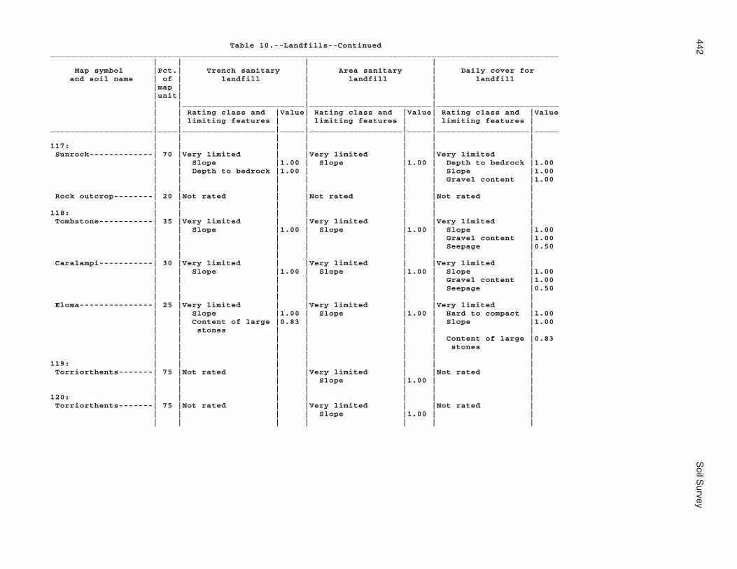
442S
oil Survey
Table 10.--Landfills--Continued________________________________________________________________________________________________________ | | | | Map symbol |Pct.| Trench sanitary | Area sanitary | Daily cover for and soil name | of | landfill | landfill | landfill |map | | | |unit| | | | |_________________________|_________________________|_________________________ | | Rating class and |Value| Rating class and |Value| Rating class and |Value | | limiting features | | limiting features | | limiting features |_____________________|____|___________________|_____|___________________|_____|___________________|_____ | | | | | | |117: | | | | | | | Sunrock-------------| 70 |Very limited | |Very limited | |Very limited | | | Slope |1.00 | Slope |1.00 | Depth to bedrock |1.00 | | Depth to bedrock |1.00 | | | Slope |1.00 | | | | | | Gravel content |1.00 | | | | | | | Rock outcrop--------| 20 |Not rated | |Not rated | |Not rated | | | | | | | |118: | | | | | | | Tombstone-----------| 35 |Very limited | |Very limited | |Very limited | | | Slope |1.00 | Slope |1.00 | Slope |1.00 | | | | | | Gravel content |1.00 | | | | | | Seepage |0.50 | | | | | | | Caralampi-----------| 30 |Very limited | |Very limited | |Very limited | | | Slope |1.00 | Slope |1.00 | Slope |1.00 | | | | | | Gravel content |1.00 | | | | | | Seepage |0.50 | | | | | | | Eloma---------------| 25 |Very limited | |Very limited | |Very limited | | | Slope |1.00 | Slope |1.00 | Hard to compact |1.00 | | Content of large |0.83 | | | Slope |1.00 | | stones | | | | | | | | | | | Content of large |0.83 | | | | | | stones | | | | | | | |119: | | | | | | | Torriorthents-------| 75 |Not rated | |Very limited | |Not rated | | | | | Slope |1.00 | | | | | | | | |120: | | | | | | | Torriorthents-------| 75 |Not rated | |Very limited | |Not rated | | | | | Slope |1.00 | | | | | | | | |

Mohave C
ounty, Arizona, S
outhern Part
443
Table 10.--Landfills--Continued________________________________________________________________________________________________________ | | | | Map symbol |Pct.| Trench sanitary | Area sanitary | Daily cover for and soil name | of | landfill | landfill | landfill |map | | | |unit| | | | |_________________________|_________________________|_________________________ | | Rating class and |Value| Rating class and |Value| Rating class and |Value | | limiting features | | limiting features | | limiting features |_____________________|____|___________________|_____|___________________|_____|___________________|_____ | | | | | | |121: | | | | | | | Tumarion------------| 85 |Very limited | |Somewhat limited | |Very limited | | | Depth to bedrock |1.00 | Slope |0.04 | Depth to cemented|1.00 | | | | | | pan | | | Slope |0.04 | | | Depth to bedrock |1.00 | | | | | | Gravel content |1.00 | | | | | | |122: | | | | | | | Tumarion------------| 85 |Very limited | |Somewhat limited | |Very limited | | | Depth to bedrock |1.00 | Slope |0.04 | Depth to cemented|1.00 | | | | | | pan | | | Slope |0.04 | | | Depth to bedrock |1.00 | | | | | | Gravel content |1.00 | | | | | | |123: | | | | | | | Tyro----------------| 90 |Very limited | |Very limited | |Very limited | | | Slope |1.00 | Slope |1.00 | Depth to cemented|1.00 | | | | | | pan | | | | | | | Gravel content |1.00 | | | | | | Slope |1.00 | | | | | | |124: | | | | | | | Tyro----------------| 85 |Not limited | |Not limited | |Very limited | | | | | | | Depth to cemented|1.00 | | | | | | pan | | | | | | | Gravel content |1.00 | | | | | | Seepage |0.50 | | | | | | |125: | | | | | | | Vekol family--------| 85 |Very limited | |Not limited | |Very limited | | | Too Sandy |1.00 | | | Too Sandy |1.00 | | | | | | Seepage |1.00 | | | | | | Gravel content |0.94 | | | | | | |126: | | | | | | | Vekol family--------| 85 |Very limited | |Not limited | |Very limited | | | Too Sandy |1.00 | | | Too Sandy |1.00 | | | | | | Seepage |1.00 | | | | | | Gravel content |0.94 | | | | | | |

444S
oil Survey
Table 10.--Landfills--Continued________________________________________________________________________________________________________ | | | | Map symbol |Pct.| Trench sanitary | Area sanitary | Daily cover for and soil name | of | landfill | landfill | landfill |map | | | |unit| | | | |_________________________|_________________________|_________________________ | | Rating class and |Value| Rating class and |Value| Rating class and |Value | | limiting features | | limiting features | | limiting features |_____________________|____|___________________|_____|___________________|_____|___________________|_____ | | | | | | |127: | | | | | | | Water---------------|100 |Not rated | |Not rated | |Not rated | | | | | | | |128: | | | | | | | Whitehills----------| 80 |Not limited | |Not limited | |Very limited | | | | | | | Depth to cemented|1.00 | | | | | | pan | | | | | | | Gravel content |1.00 | | | | | | |129: | | | | | | | Whitehills----------| 80 |Somewhat limited | |Somewhat limited | |Very limited | | | Slope |0.04 | Slope |0.04 | Depth to cemented|1.00 | | | | | | pan | | | | | | | Gravel content |1.00 | | | | | | Slope |0.04 | | | | | | |130: | | | | | | | White House family--| 85 |Somewhat limited | |Somewhat limited | |Very limited | | | Too Sandy |0.50 | Slope |0.04 | Seepage |1.00 | | Slope |0.04 | | | Too Sandy |0.50 | | | | | | Gravel content |0.43 | | | | | | |131: | | | | | | | White House---------| 85 |Somewhat limited | |Somewhat limited | |Somewhat limited | | | Slope |0.04 | Slope |0.04 | Slope |0.04 | | | | | | Gravel content |0.03 | | | | | | |132: | | | | | | | Wikieup-------------| 45 |Very limited | |Very limited | |Very limited | | | Depth to bedrock |1.00 | Slope |1.00 | Depth to bedrock |1.00 | | Slope |1.00 | | | Slope |1.00 | | | | | | Seepage |0.50 | | | | | | | Mutang--------------| 30 |Very limited | |Very limited | |Very limited | | | Depth to bedrock |1.00 | Slope |1.00 | Depth to bedrock |1.00 | | Slope |1.00 | | | Hard to compact |1.00 | | | | | | Slope |1.00 | | | | | | |

Mohave C
ounty, Arizona, S
outhern Part
445
Table 10.--Landfills--Continued________________________________________________________________________________________________________ | | | | Map symbol |Pct.| Trench sanitary | Area sanitary | Daily cover for and soil name | of | landfill | landfill | landfill |map | | | |unit| | | | |_________________________|_________________________|_________________________ | | Rating class and |Value| Rating class and |Value| Rating class and |Value | | limiting features | | limiting features | | limiting features |_____________________|____|___________________|_____|___________________|_____|___________________|_____ | | | | | | |132: | | | | | | | Rock outcrop--------| 20 |Not rated | |Not rated | |Not rated | | | | | | | |133: | | | | | | | Mutang--------------| 55 |Very limited | |Very limited | |Very limited | | | Depth to bedrock |1.00 | Slope |1.00 | Depth to bedrock |1.00 | | Slope |1.00 | | | Hard to compact |1.00 | | | | | | Slope |1.00 | | | | | | | Wikieup-------------| 25 |Very limited | |Very limited | |Very limited | | | Depth to bedrock |1.00 | Slope |1.00 | Depth to bedrock |1.00 | | Slope |1.00 | | | Gravel content |1.00 | | | | | | Slope |1.00 | | | | | | | Rock outcrop--------| 15 |Not rated | |Not rated | |Not rated | | | | | | | |134: | | | | | | | Wikieup-------------| 50 |Very limited | |Very limited | |Very limited | | | Slope |1.00 | Slope |1.00 | Depth to bedrock |1.00 | | Depth to bedrock |1.00 | | | Slope |1.00 | | | | | | Gravel content |0.75 | | | | | | | Rock outcrop--------| 25 |Not rated | |Not rated | |Not rated | | | | | | | |135: | | | | | | | Yahana family-------| 85 |Very limited | |Not limited | |Not limited | | | Salinity |1.00 | | | | | | | | | | |136: | | | | | | | Tumarion------------| 70 |Very limited | |Very limited | |Very limited | | | Depth to bedrock |1.00 | Slope |1.00 | Depth to cemented|1.00 | | | | | | pan | | | Slope |1.00 | | | Depth to bedrock |1.00 | | Content of large |0.84 | | | Slope |1.00 | | stones | | | | | | | | | | | |

446S
oil Survey
Table 10.--Landfills--Continued________________________________________________________________________________________________________ | | | | Map symbol |Pct.| Trench sanitary | Area sanitary | Daily cover for and soil name | of | landfill | landfill | landfill |map | | | |unit| | | | |_________________________|_________________________|_________________________ | | Rating class and |Value| Rating class and |Value| Rating class and |Value | | limiting features | | limiting features | | limiting features |_____________________|____|___________________|_____|___________________|_____|___________________|_____ | | | | | | |136: | | | | | | | Nickel family-------| 15 |Very limited | |Very limited | |Very limited | | | Slope |1.00 | Slope |1.00 | Slope |1.00 | | Content of large |0.71 | | | Content of large |0.71 | | stones | | | | stones | | | | | | | Seepage |0.50 | | | | | | |137: | | | | | | | Valena--------------| 40 |Very limited | |Very limited | |Very limited | | | Depth to bedrock |1.00 | Depth to bedrock |1.00 | Depth to bedrock |1.00 | | Slope |0.84 | Slope |0.84 | Slope |0.84 | | | | | | | Rock outcrop--------| 20 |Not rated | |Not rated | |Not rated | | | | | | | | Carri family--------| 15 |Somewhat limited | |Somewhat limited | |Somewhat limited | | | Slope |0.84 | Slope |0.84 | Slope |0.84 | | | | | | |138: | | | | | | | Nodman--------------| 65 |Very limited | |Very limited | |Very limited | | | Slope |1.00 | Slope |1.00 | Depth to bedrock |1.00 | | Depth to bedrock |1.00 | | | Slope |1.00 | | | | | | Gravel content |1.00 | | | | | | | Rock outcrop--------| 20 |Not rated | |Not rated | |Not rated | | | | | | | |139: | | | | | | | Nodman--------------| 60 |Very limited | |Very limited | |Very limited | | | Slope |1.00 | Slope |1.00 | Depth to bedrock |1.00 | | Depth to bedrock |1.00 | | | Slope |1.00 | | Content of large |0.55 | | | Content of large |0.55 | | stones | | | | stones | | | | | | | | Romero family-------| 20 |Very limited | |Very limited | |Very limited | | | Slope |1.00 | Slope |1.00 | Depth to bedrock |1.00 | | Depth to bedrock |1.00 | | | Slope |1.00 | | Content of large |0.75 | | | Content of large |0.75 | | stones | | | | stones | | | | | | | |_____________________|____|___________________|_____|___________________|_____|___________________|_____

Mohave County, Arizona, Southern Part 447
Table 11.--Source of Gravel and Sand
(The information in this table indicates the dominant soil condition but does not eliminate the need for onsite investigation. The ratings given for the thickest layer are for the thickest layer above and excluding the bottom layer. The numbers in the value columns range from 0.00 to 0.99. The greater the value, the greater the likelihood that the bottom layer or thickest layer of the soil is a source of sand or gravel. See text for further explanation of ratings in this table.)______________________________________________________________________________ | | | Map symbol |Pct.| Potential source of | Potential source of and soil name | of | gravel | sand |map | | |unit| | | |_________________________|_________________________ | | Rating class |Value| Rating class |Value_____________________|____|___________________|_____|___________________|_____ | | | | |1: | | | | | Akela---------------| 45 |Poor | |Poor | | | Bottom layer |0.00 | Bottom layer |0.00 | | Thickest layer |0.00 | Thickest layer |0.00 | | | | | Rock outcrop--------| 20 |Not rated | |Not rated | | | | | | | | | | | Rubble land---------| 20 |Not rated | |Not rated | | | | | | | | | | |2: | | | | | Akela---------------| 45 |Poor | |Poor | | | Bottom layer |0.00 | Bottom layer |0.00 | | Thickest layer |0.00 | Thickest layer |0.00 | | | | | Rock outcrop--------| 20 |Not rated | |Not rated | | | | | | | | | | | Rubble land---------| 20 |Not rated | |Not rated | | | | | | | | | | |3: | | | | | Alko family---------| 85 |Fair | |Fair | | | Thickest layer |0.00 | Thickest layer |0.00 | | Bottom layer |0.62 | Bottom layer |0.34 | | | | |4: | | | | | Alko family---------| 85 |Fair | |Fair | | | Thickest layer |0.00 | Thickest layer |0.00 | | Bottom layer |0.62 | Bottom layer |0.34 | | | | |5: | | | | | Amole---------------| 75 |Poor | |Fair | | | Bottom layer |0.00 | Thickest layer |0.04 | | Thickest layer |0.00 | Bottom layer |0.12 | | | | |6: | | | | | Amole---------------| 75 |Poor | |Fair | | | Bottom layer |0.00 | Thickest layer |0.04 | | Thickest layer |0.00 | Bottom layer |0.12 | | | | |7: | | | | | Anthony-------------| 45 |Poor | |Fair | | | Bottom layer |0.00 | Bottom layer |0.02 | | Thickest layer |0.00 | Thickest layer |0.05 | | | | |

448 Soil Survey
Table 11.--Source of Gravel and Sand--Continued______________________________________________________________________________ | | | Map symbol |Pct.| Potential source of | Potential source of and soil name | of | gravel | sand |map | | |unit| | | |_________________________|_________________________ | | Rating class |Value| Rating class |Value_____________________|____|___________________|_____|___________________|_____ | | | | |7: | | | | | Dudleyville---------| 30 |Fair | |Fair | | | Thickest layer |0.00 | Thickest layer |0.12 | | Bottom layer |0.06 | Bottom layer |0.61 | | | | |8: | | | | | Aquarius------------| 45 |Poor | |Poor | | | Bottom layer |0.00 | Bottom layer |0.00 | | Thickest layer |0.00 | Thickest layer |0.00 | | | | | Akela---------------| 30 |Poor | |Poor | | | Bottom layer |0.00 | Bottom layer |0.00 | | Thickest layer |0.00 | Thickest layer |0.00 | | | | | Rock outcrop--------| 20 |Not rated | |Not rated | | | | | | | | | | |9: | | | | | Arizo---------------| 40 |Fair | |Fair | | | Bottom layer |0.19 | Thickest layer |0.10 | | Thickest layer |0.47 | Bottom layer |0.12 | | | | | Franconia-----------| 30 |Poor | |Fair | | | Bottom layer |0.00 | Bottom layer |0.10 | | Thickest layer |0.00 | Thickest layer |0.10 | | | | | Riverwash-----------| 20 |Not rated | |Not rated | | | | | | | | | | |10: | | | | | Arizo---------------| 40 |Fair | |Fair | | | Bottom layer |0.19 | Thickest layer |0.10 | | Thickest layer |0.47 | Bottom layer |0.12 | | | | | Franconia-----------| 30 |Poor | |Fair | | | Bottom layer |0.00 | Bottom layer |0.10 | | Thickest layer |0.00 | Thickest layer |0.10 | | | | | Riverwash-----------| 20 |Not rated | |Not rated | | | | | | | | | | |11: | | | | | Bartmus-------------| 85 |Poor | |Poor | | | Bottom layer |0.00 | Bottom layer |0.00 | | Thickest layer |0.00 | Thickest layer |0.00 | | | | |12: | | | | | Bonita family-------| 85 |Fair | |Poor | | | Thickest layer |0.00 | Bottom layer |0.00 | | Bottom layer |0.12 | Thickest layer |0.00 | | | | |

Mohave County, Arizona, Southern Part 449
Table 11.--Source of Gravel and Sand--Continued______________________________________________________________________________ | | | Map symbol |Pct.| Potential source of | Potential source of and soil name | of | gravel | sand |map | | |unit| | | |_________________________|_________________________ | | Rating class |Value| Rating class |Value_____________________|____|___________________|_____|___________________|_____ | | | | |13: | | | | | Bonita family-------| 60 |Fair | |Poor | | | Thickest layer |0.00 | Bottom layer |0.00 | | Bottom layer |0.12 | Thickest layer |0.00 | | | | | Gonzales------------| 30 |Poor | |Poor | | | Bottom layer |0.00 | Bottom layer |0.00 | | Thickest layer |0.00 | Thickest layer |0.00 | | | | |14: | | | | | Brazito family------| 75 |Poor | |Fair | | | Bottom layer |0.00 | Bottom layer |0.00 | | Thickest layer |0.00 | Thickest layer |0.64 | | | | |15: | | | | | Bucklebar-----------| 80 |Poor | |Fair | | | Bottom layer |0.00 | Thickest layer |0.00 | | Thickest layer |0.00 | Bottom layer |0.05 | | | | |16: | | | | | Cacique family------| 75 |Poor | |Poor | | | Bottom layer |0.00 | Bottom layer |0.00 | | Thickest layer |0.00 | Thickest layer |0.00 | | | | |17: | | | | | Castaneda-----------| 75 |Fair | |Fair | | | Thickest layer |0.11 | Thickest layer |0.00 | | Bottom layer |0.56 | Bottom layer |0.10 | | | | |18: | | | | | Castaneda-----------| 75 |Fair | |Fair | | | Thickest layer |0.11 | Thickest layer |0.00 | | Bottom layer |0.56 | Bottom layer |0.10 | | | | |19: | | | | | Carrizo family------| 75 |Fair | |Fair | | | Thickest layer |0.00 | Thickest layer |0.07 | | Bottom layer |0.19 | Bottom layer |0.61 | | | | |20: | | | | | Carrizo family------| 65 |Fair | |Fair | | | Thickest layer |0.00 | Thickest layer |0.07 | | Bottom layer |0.19 | Bottom layer |0.61 | | | | | Riverwash-----------| 20 |Not rated | |Not rated | | | | | | | | | | |21: | | | | | Carrizo-------------| 75 |Fair | |Fair | | | Bottom layer |0.62 | Thickest layer |0.07 | | Thickest layer |0.62 | Bottom layer |0.79 | | | | | | | | | |

450 Soil Survey
Table 11.--Source of Gravel and Sand--Continued______________________________________________________________________________ | | | Map symbol |Pct.| Potential source of | Potential source of and soil name | of | gravel | sand |map | | |unit| | | |_________________________|_________________________ | | Rating class |Value| Rating class |Value_____________________|____|___________________|_____|___________________|_____ | | | | |21: | | | | | Riverwash-----------| 15 |Not rated | |Not rated | | | | | |22: | | | | | Carrizo-------------| 65 |Fair | |Fair | | | Thickest layer |0.00 | Bottom layer |0.13 | | Bottom layer |0.62 | Thickest layer |0.61 | | | | | Riverwash-----------| 20 |Not rated | |Not rated | | | | | | | | | | |23: | | | | | Cave----------------| 75 |Fair | |Fair | | | Thickest layer |0.00 | Thickest layer |0.00 | | Bottom layer |0.62 | Bottom layer |0.13 | | | | |24: | | | | | Cave----------------| 75 |Fair | |Fair | | | Thickest layer |0.00 | Thickest layer |0.00 | | Bottom layer |0.62 | Bottom layer |0.13 | | | | |25: | | | | | Cellar--------------| 50 |Fair | |Fair | | | Thickest layer |0.00 | Thickest layer |0.00 | | Bottom layer |0.19 | Bottom layer |0.02 | | | | | Rock outcrop--------| 25 |Not rated | |Not rated | | | | | | | | | | |26: | | | | | Cellar--------------| 50 |Fair | |Fair | | | Thickest layer |0.00 | Thickest layer |0.00 | | Bottom layer |0.19 | Bottom layer |0.02 | | | | | Rock outcrop--------| 25 |Not rated | |Not rated | | | | | | | | | | |27: | | | | | Cellar--------------| 45 |Fair | |Fair | | | Thickest layer |0.00 | Thickest layer |0.00 | | Bottom layer |0.19 | Bottom layer |0.02 | | | | | Topock--------------| 30 |Poor | |Poor | | | Bottom layer |0.00 | Bottom layer |0.00 | | Thickest layer |0.00 | Thickest layer |0.00 | | | | | Rock outcrop--------| 20 |Not rated | |Not rated | | | | | | | | | | |28: | | | | | Cherioni------------| 85 |Poor | |Poor | | | Bottom layer |0.00 | Bottom layer |0.00 | | Thickest layer |0.00 | Thickest layer |0.00 | | | | |

Mohave County, Arizona, Southern Part 451
Table 11.--Source of Gravel and Sand--Continued______________________________________________________________________________ | | | Map symbol |Pct.| Potential source of | Potential source of and soil name | of | gravel | sand |map | | |unit| | | |_________________________|_________________________ | | Rating class |Value| Rating class |Value_____________________|____|___________________|_____|___________________|_____ | | | | |29: | | | | | Chuckawalla---------| 65 |Fair | |Fair | | | Bottom layer |0.19 | Thickest layer |0.00 | | Thickest layer |0.19 | Bottom layer |0.10 | | | | | Riverbend-----------| 25 |Fair | |Fair | | | Bottom layer |0.06 | Thickest layer |0.10 | | Thickest layer |0.19 | Bottom layer |0.82 | | | | |30: | | | | | Chuckawalla family--| 65 |Fair | |Fair | | | Bottom layer |0.19 | Thickest layer |0.00 | | Thickest layer |0.19 | Bottom layer |0.04 | | | | | Riverbend family----| 25 |Fair | |Fair | | | Bottom layer |0.19 | Thickest layer |0.04 | | Thickest layer |0.19 | Bottom layer |0.10 | | | | |31: | | | | | Cipriano------------| 85 |Fair | |Poor | | | Thickest layer |0.00 | Bottom layer |0.00 | | Bottom layer |0.19 | Thickest layer |0.00 | | | | |32: | | | | | Cline---------------| 85 |Poor | |Poor | | | Bottom layer |0.00 | Bottom layer |0.00 | | Thickest layer |0.00 | Thickest layer |0.00 | | | | |33: | | | | | Cline---------------| 85 |Poor | |Poor | | | Bottom layer |0.00 | Bottom layer |0.00 | | Thickest layer |0.00 | Thickest layer |0.00 | | | | |34: | | | | | Continental---------| 50 |Poor | |Poor | | | Bottom layer |0.00 | Bottom layer |0.00 | | Thickest layer |0.00 | Thickest layer |0.00 | | | | | Tres Hermanos-------| 25 |Poor | |Fair | | | Bottom layer |0.00 | Thickest layer |0.00 | | Thickest layer |0.00 | Bottom layer |0.04 | | | | |35: | | | | | Continental---------| 50 |Poor | |Poor | | | Bottom layer |0.00 | Bottom layer |0.00 | | Thickest layer |0.00 | Thickest layer |0.00 | | | | | Tres Hermanos-------| 25 |Poor | |Fair | | | Bottom layer |0.00 | Thickest layer |0.00 | | Thickest layer |0.00 | Bottom layer |0.04 | | | | |

452 Soil Survey
Table 11.--Source of Gravel and Sand--Continued______________________________________________________________________________ | | | Map symbol |Pct.| Potential source of | Potential source of and soil name | of | gravel | sand |map | | |unit| | | |_________________________|_________________________ | | Rating class |Value| Rating class |Value_____________________|____|___________________|_____|___________________|_____ | | | | |36: | | | | | Continental---------| 50 |Poor | |Poor | | | Bottom layer |0.00 | Bottom layer |0.00 | | Thickest layer |0.00 | Thickest layer |0.00 | | | | | Rillino-------------| 35 |Fair | |Fair | | | Thickest layer |0.11 | Bottom layer |0.07 | | Bottom layer |0.19 | Thickest layer |0.07 | | | | |37: | | | | | Continental---------| 50 |Poor | |Poor | | | Bottom layer |0.00 | Bottom layer |0.00 | | Thickest layer |0.00 | Thickest layer |0.00 | | | | | Rillino-------------| 35 |Fair | |Fair | | | Thickest layer |0.00 | Thickest layer |0.00 | | Bottom layer |0.19 | Bottom layer |0.07 | | | | |38: | | | | | Coolidge------------| 40 |Poor | |Fair | | | Bottom layer |0.00 | Bottom layer |0.04 | | Thickest layer |0.00 | Thickest layer |0.04 | | | | | Denure--------------| 35 |Poor | |Fair | | | Bottom layer |0.00 | Bottom layer |0.06 | | Thickest layer |0.00 | Thickest layer |0.06 | | | | |39: | | | | | Coolidge family-----| 40 |Poor | |Fair | | | Bottom layer |0.00 | Thickest layer |0.02 | | Thickest layer |0.00 | Bottom layer |0.64 | | | | | Denure family-------| 35 |Poor | |Fair | | | Bottom layer |0.00 | Bottom layer |0.02 | | Thickest layer |0.00 | Thickest layer |0.07 | | | | |40: | | | | | Courthouse family---| 45 |Fair | |Poor | | | Thickest layer |0.00 | Bottom layer |0.00 | | Bottom layer |0.19 | Thickest layer |0.00 | | | | | Rock outcrop--------| 20 |Not rated | |Not rated | | | | | | | | | | | Rubble land---------| 20 |Not rated | |Not rated | | | | | | | | | | |41: | | | | | Courthouse family---| 40 |Fair | |Poor | | | Thickest layer |0.00 | Bottom layer |0.00 | | Bottom layer |0.19 | Thickest layer |0.00 | | | | |

Mohave County, Arizona, Southern Part 453
Table 11.--Source of Gravel and Sand--Continued______________________________________________________________________________ | | | Map symbol |Pct.| Potential source of | Potential source of and soil name | of | gravel | sand |map | | |unit| | | |_________________________|_________________________ | | Rating class |Value| Rating class |Value_____________________|____|___________________|_____|___________________|_____ | | | | |41: | | | | | Rock outcrop--------| 30 |Not rated | |Not rated | | | | | | | | | | | Wagonbow------------| 20 |Fair | |Poor | | | Thickest layer |0.00 | Bottom layer |0.00 | | Bottom layer |0.19 | Thickest layer |0.00 | | | | |42: | | | | | Far-----------------| 70 |Fair | |Poor | | | Thickest layer |0.00 | Bottom layer |0.00 | | Bottom layer |0.19 | Thickest layer |0.00 | | | | | Rock outcrop--------| 20 |Not rated | |Not rated | | | | | | | | | | |43: | | | | | Dutchflat-----------| 80 |Poor | |Fair | | | Bottom layer |0.00 | Thickest layer |0.00 | | Thickest layer |0.00 | Bottom layer |0.05 | | | | |44: | | | | | Dutchflat-----------| 80 |Fair | |Fair | | | Thickest layer |0.00 | Thickest layer |0.00 | | Bottom layer |0.19 | Bottom layer |0.06 | | | | |45: | | | | | Gadsden-------------| 80 |Poor | |Poor | | | Bottom layer |0.00 | Bottom layer |0.00 | | Thickest layer |0.00 | Thickest layer |0.00 | | | | |46: | | | | | Gila----------------| 50 |Poor | |Poor | | | Bottom layer |0.00 | Bottom layer |0.00 | | Thickest layer |0.00 | Thickest layer |0.00 | | | | | Glendale------------| 30 |Poor | |Fair | | | Bottom layer |0.00 | Thickest layer |0.00 | | Thickest layer |0.00 | Bottom layer |0.61 | | | | |47: | | | | | Gila----------------| 50 |Poor | |Poor | | | Bottom layer |0.00 | Bottom layer |0.00 | | Thickest layer |0.00 | Thickest layer |0.00 | | | | | Glendale------------| 30 |Poor | |Fair | | | Bottom layer |0.00 | Thickest layer |0.00 | | Thickest layer |0.00 | Bottom layer |0.61 | | | | |48: | | | | | Goldroad------------| 60 |Fair | |Fair | | | Thickest layer |0.00 | Thickest layer |0.00 | | Bottom layer |0.19 | Bottom layer |0.02 | | | | |

454 Soil Survey
Table 11.--Source of Gravel and Sand--Continued______________________________________________________________________________ | | | Map symbol |Pct.| Potential source of | Potential source of and soil name | of | gravel | sand |map | | |unit| | | |_________________________|_________________________ | | Rating class |Value| Rating class |Value_____________________|____|___________________|_____|___________________|_____ | | | | |48: | | | | | Rock outcrop--------| 20 |Not rated | |Not rated | | | | | | | | | | |49: | | | | | Gonzales------------| 60 |Poor | |Poor | | | Bottom layer |0.00 | Bottom layer |0.00 | | Thickest layer |0.00 | Thickest layer |0.00 | | | | | Rock outcrop--------| 25 |Not rated | |Not rated | | | | | | | | | | |50: | | | | | Goodsprings family--| 75 |Fair | |Fair | | | Thickest layer |0.00 | Thickest layer |0.00 | | Bottom layer |0.62 | Bottom layer |0.10 | | | | |51: | | | | | Goodsprings family--| 75 |Fair | |Fair | | | Thickest layer |0.00 | Thickest layer |0.00 | | Bottom layer |0.62 | Bottom layer |0.10 | | | | |52: | | | | | Goodsprings family--| 75 |Fair | |Fair | | | Thickest layer |0.00 | Thickest layer |0.00 | | Bottom layer |0.62 | Bottom layer |0.10 | | | | |53: | | | | | Goodsprings family--| 75 |Fair | |Fair | | | Thickest layer |0.00 | Thickest layer |0.00 | | Bottom layer |0.62 | Bottom layer |0.10 | | | | |54: | | | | | Graham--------------| 60 |Poor | |Poor | | | Bottom layer |0.00 | Bottom layer |0.00 | | Thickest layer |0.00 | Thickest layer |0.00 | | | | | Arivaca-------------| 25 |Poor | |Poor | | | Bottom layer |0.00 | Bottom layer |0.00 | | Thickest layer |0.00 | Thickest layer |0.00 | | | | |55: | | | | | Graham--------------| 60 |Poor | |Poor | | | Bottom layer |0.00 | Bottom layer |0.00 | | Thickest layer |0.00 | Thickest layer |0.00 | | | | | Rock outcrop--------| 20 |Not rated | |Not rated | | | | | | | | | | |56: | | | | | Gunsight------------| 75 |Fair | |Fair | | | Thickest layer |0.37 | Thickest layer |0.05 | | Bottom layer |0.56 | Bottom layer |0.07 | | | | |

Mohave County, Arizona, Southern Part 455
Table 11.--Source of Gravel and Sand--Continued______________________________________________________________________________ | | | Map symbol |Pct.| Potential source of | Potential source of and soil name | of | gravel | sand |map | | |unit| | | |_________________________|_________________________ | | Rating class |Value| Rating class |Value_____________________|____|___________________|_____|___________________|_____ | | | | |57: | | | | | Gunsight------------| 85 |Fair | |Fair | | | Thickest layer |0.37 | Thickest layer |0.05 | | Bottom layer |0.56 | Bottom layer |0.07 | | | | |58: | | | | | Hassell family------| 50 |Poor | |Poor | | | Bottom layer |0.00 | Bottom layer |0.00 | | Thickest layer |0.00 | Thickest layer |0.00 | | | | | Lampshire-----------| 25 |Fair | |Fair | | | Thickest layer |0.00 | Thickest layer |0.00 | | Bottom layer |0.12 | Bottom layer |0.02 | | | | | Rock outcrop--------| 20 |Not rated | |Not rated | | | | | | | | | | |59: | | | | | Holtville-----------| 75 |Poor | |Fair | | | Bottom layer |0.00 | Thickest layer |0.00 | | Thickest layer |0.00 | Bottom layer |0.25 | | | | |60: | | | | | Huevi---------------| 75 |Fair | |Fair | | | Thickest layer |0.19 | Thickest layer |0.02 | | Bottom layer |0.19 | Bottom layer |0.10 | | | | |61: | | | | | Huevi---------------| 85 |Fair | |Fair | | | Thickest layer |0.19 | Thickest layer |0.02 | | Bottom layer |0.19 | Bottom layer |0.10 | | | | |62: | | | | | Akela---------------| 60 |Fair | |Fair | | | Thickest layer |0.00 | Thickest layer |0.00 | | Bottom layer |0.31 | Bottom layer |0.02 | | | | | Rock outcrop--------| 20 |Not rated | |Not rated | | | | | | | | | | |63: | | | | | Hyder---------------| 50 |Poor | |Poor | | | Bottom layer |0.00 | Bottom layer |0.00 | | Thickest layer |0.00 | Thickest layer |0.00 | | | | | Rock outcrop--------| 20 |Not rated | |Not rated | | | | | | | | | | | Rubble land---------| 20 |Not rated | |Not rated | | | | | | | | | | |64: | | | | | Indio---------------| 85 |Poor | |Fair | | | Bottom layer |0.00 | Thickest layer |0.00 | | Thickest layer |0.00 | Bottom layer |0.64 | | | | |

456 Soil Survey
Table 11.--Source of Gravel and Sand--Continued______________________________________________________________________________ | | | Map symbol |Pct.| Potential source of | Potential source of and soil name | of | gravel | sand |map | | |unit| | | |_________________________|_________________________ | | Rating class |Value| Rating class |Value_____________________|____|___________________|_____|___________________|_____ | | | | |65: | | | | | Ireteba family------| 45 |Fair | |Fair | | | Thickest layer |0.00 | Thickest layer |0.02 | | Bottom layer |0.19 | Bottom layer |0.07 | | | | | Arizo---------------| 30 |Fair | |Fair | | | Bottom layer |0.19 | Thickest layer |0.10 | | Thickest layer |0.47 | Bottom layer |0.12 | | | | |66: | | | | | Kinley--------------| 75 |Fair | |Fair | | | Thickest layer |0.12 | Bottom layer |0.02 | | Bottom layer |0.12 | Thickest layer |0.02 | | | | |67: | | | | | Kinley--------------| 50 |Fair | |Fair | | | Thickest layer |0.00 | Bottom layer |0.02 | | Bottom layer |0.12 | Thickest layer |0.02 | | | | | Poachie-------------| 35 |Poor | |Fair | | | Bottom layer |0.00 | Thickest layer |0.04 | | Thickest layer |0.00 | Bottom layer |0.05 | | | | |68: | | | | | Kofa----------------| 85 |Poor | |Fair | | | Bottom layer |0.00 | Thickest layer |0.00 | | Thickest layer |0.00 | Bottom layer |0.12 | | | | |69: | | | | | Dudleyville---------| 40 |Fair | |Fair | | | Thickest layer |0.00 | Thickest layer |0.12 | | Bottom layer |0.06 | Bottom layer |0.61 | | | | | Vinton--------------| 30 |Fair | |Fair | | | Thickest layer |0.00 | Bottom layer |0.13 | | Bottom layer |0.19 | Thickest layer |0.13 | | | | | Riverwash-----------| 20 |Not rated | |Not rated | | | | | | | | | | |70: | | | | | Dudleyville---------| 40 |Fair | |Fair | | | Thickest layer |0.00 | Thickest layer |0.12 | | Bottom layer |0.06 | Bottom layer |0.61 | | | | | Vinton--------------| 30 |Fair | |Fair | | | Thickest layer |0.00 | Bottom layer |0.13 | | Bottom layer |0.19 | Thickest layer |0.13 | | | | | Riverwash-----------| 20 |Not rated | |Not rated | | | | | | | | | | |

Mohave County, Arizona, Southern Part 457
Table 11.--Source of Gravel and Sand--Continued______________________________________________________________________________ | | | Map symbol |Pct.| Potential source of | Potential source of and soil name | of | gravel | sand |map | | |unit| | | |_________________________|_________________________ | | Rating class |Value| Rating class |Value_____________________|____|___________________|_____|___________________|_____ | | | | |71: | | | | | Lagunita------------| 85 |Poor | |Fair | | | Bottom layer |0.00 | Bottom layer |0.08 | | Thickest layer |0.00 | Thickest layer |0.82 | | | | |72: | | | | | Lagunita------------| 60 |Poor | |Fair | | | Thickest layer |0.00 | Bottom layer |0.08 | | Bottom layer |0.00 | Thickest layer |0.54 | | | | | Ripley--------------| 25 |Poor | |Fair | | | Bottom layer |0.00 | Thickest layer |0.00 | | Thickest layer |0.00 | Bottom layer |0.06 | | | | |73: | | | | | Lampshire-----------| 65 |Poor | |Fair | | | Bottom layer |0.00 | Thickest layer |0.00 | | Thickest layer |0.00 | Bottom layer |0.02 | | | | | Rock outcrop--------| 20 |Not rated | |Not rated | | | | | | | | | | |74: | | | | | Lampshire-----------| 65 |Fair | |Fair | | | Thickest layer |0.00 | Thickest layer |0.00 | | Bottom layer |0.12 | Bottom layer |0.02 | | | | | Rock outcrop--------| 20 |Not rated | |Not rated | | | | | | | | | | |75: | | | | | Lampshire-----------| 45 |Poor | |Poor | | | Bottom layer |0.00 | Bottom layer |0.00 | | Thickest layer |0.00 | Thickest layer |0.00 | | | | | Rock outcrop--------| 40 |Not rated | |Not rated | | | | | | | | | | |76: | | | | | Lostman-------------| 80 |Poor | |Fair | | | Bottom layer |0.00 | Bottom layer |0.00 | | Thickest layer |0.00 | Thickest layer |0.02 | | | | |77: | | | | | Lostman-------------| 80 |Fair | |Fair | | | Thickest layer |0.00 | Bottom layer |0.02 | | Bottom layer |0.19 | Thickest layer |0.02 | | | | |78: | | | | | Lostman-------------| 40 |Fair | |Fair | | | Thickest layer |0.00 | Bottom layer |0.02 | | Bottom layer |0.19 | Thickest layer |0.02 | | | | |

458 Soil Survey
Table 11.--Source of Gravel and Sand--Continued______________________________________________________________________________ | | | Map symbol |Pct.| Potential source of | Potential source of and soil name | of | gravel | sand |map | | |unit| | | |_________________________|_________________________ | | Rating class |Value| Rating class |Value_____________________|____|___________________|_____|___________________|_____ | | | | |78: | | | | | Kinley--------------| 35 |Fair | |Fair | | | Thickest layer |0.00 | Bottom layer |0.02 | | Bottom layer |0.12 | Thickest layer |0.02 | | | | |79: | | | | | Marshes-------------|100 |Not rated | |Not rated | | | | | | | | | | |80: | | | | | Meloland------------| 85 |Poor | |Poor | | | Bottom layer |0.00 | Bottom layer |0.00 | | Thickest layer |0.00 | Thickest layer |0.00 | | | | |81: | | | | | Mohon---------------| 50 |Poor | |Poor | | | Bottom layer |0.00 | Bottom layer |0.00 | | Thickest layer |0.00 | Thickest layer |0.00 | | | | | Kinley--------------| 35 |Fair | |Fair | | | Thickest layer |0.00 | Bottom layer |0.02 | | Bottom layer |0.12 | Thickest layer |0.02 | | | | |82: | | | | | Mohon---------------| 50 |Poor | |Poor | | | Bottom layer |0.00 | Bottom layer |0.00 | | Thickest layer |0.00 | Thickest layer |0.00 | | | | | Poachie-------------| 25 |Poor | |Fair | | | Bottom layer |0.00 | Thickest layer |0.04 | | Thickest layer |0.00 | Bottom layer |0.05 | | | | |83: | | | | | Mohon---------------| 50 |Poor | |Poor | | | Bottom layer |0.00 | Bottom layer |0.00 | | Thickest layer |0.00 | Thickest layer |0.00 | | | | | Poachie-------------| 25 |Poor | |Fair | | | Bottom layer |0.00 | Thickest layer |0.04 | | Thickest layer |0.00 | Bottom layer |0.05 | | | | |84: | | | | | Nickel family-------| 35 |Fair | |Fair | | | Bottom layer |0.19 | Thickest layer |0.00 | | Thickest layer |0.19 | Bottom layer |0.04 | | | | | Topawa family-------| 30 |Fair | |Fair | | | Bottom layer |0.00 | Bottom layer |0.00 | | Thickest layer |0.19 | Thickest layer |0.04 | | | | | Eba family----------| 25 |Fair | |Poor | | | Thickest layer |0.19 | Bottom layer |0.00 | | Bottom layer |0.19 | Thickest layer |0.00 | | | | |

Mohave County, Arizona, Southern Part 459
Table 11.--Source of Gravel and Sand--Continued______________________________________________________________________________ | | | Map symbol |Pct.| Potential source of | Potential source of and soil name | of | gravel | sand |map | | |unit| | | |_________________________|_________________________ | | Rating class |Value| Rating class |Value_____________________|____|___________________|_____|___________________|_____ | | | | |85: | | | | | Orwash family-------| 75 |Poor | |Fair | | | Bottom layer |0.00 | Bottom layer |0.00 | | Thickest layer |0.00 | Thickest layer |0.33 | | | | |86: | | | | | Orwash family-------| 75 |Poor | |Fair | | | Bottom layer |0.00 | Bottom layer |0.00 | | Thickest layer |0.00 | Thickest layer |0.33 | | | | |87: | | | | | Penthouse-----------| 50 |Fair | |Fair | | | Thickest layer |0.00 | Thickest layer |0.00 | | Bottom layer |0.19 | Bottom layer |0.10 | | | | | Gonzales------------| 25 |Poor | |Poor | | | Bottom layer |0.00 | Bottom layer |0.00 | | Thickest layer |0.00 | Thickest layer |0.00 | | | | |88: | | | | | Poachie-------------| 80 |Poor | |Fair | | | Bottom layer |0.00 | Thickest layer |0.04 | | Thickest layer |0.00 | Bottom layer |0.05 | | | | |89: | | | | | Poachie-------------| 80 |Poor | |Fair | | | Bottom layer |0.00 | Thickest layer |0.04 | | Thickest layer |0.00 | Bottom layer |0.05 | | | | |90: | | | | | Quilotosa-----------| 60 |Fair | |Fair | | | Thickest layer |0.00 | Thickest layer |0.00 | | Bottom layer |0.62 | Bottom layer |0.02 | | | | | Rock outcrop--------| 20 |Not rated | |Not rated | | | | | | | | | | |91: | | | | | Razorback-----------| 90 |Fair | |Fair | | | Thickest layer |0.00 | Thickest layer |0.00 | | Bottom layer |0.12 | Bottom layer |0.02 | | | | |92: | | | | | Razorback-----------| 65 |Fair | |Poor | | | Thickest layer |0.04 | Bottom layer |0.00 | | Bottom layer |0.62 | Thickest layer |0.00 | | | | | Rock outcrop--------| 20 |Not rated | |Not rated | | | | | | | | | | |93: | | | | | Razorback-----------| 60 |Fair | |Poor | | | Thickest layer |0.04 | Bottom layer |0.00 | | Bottom layer |0.62 | Thickest layer |0.00

460 Soil Survey
Table 11.--Source of Gravel and Sand--Continued______________________________________________________________________________ | | | Map symbol |Pct.| Potential source of | Potential source of and soil name | of | gravel | sand |map | | |unit| | | |_________________________|_________________________ | | Rating class |Value| Rating class |Value_____________________|____|___________________|_____|___________________|_____ | | | | | | | | | |93: | | | | | Rock outcrop--------| 20 |Not rated | |Not rated | | | | | | | | | | |94: | | | | | Razorback-----------| 60 |Fair | |Poor | | | Thickest layer |0.04 | Bottom layer |0.00 | | Bottom layer |0.62 | Thickest layer |0.00 | | | | | Rock outcrop--------| 20 |Not rated | |Not rated | | | | | | | | | | |95: | | | | | Razorback-----------| 45 |Fair | |Poor | | | Thickest layer |0.04 | Bottom layer |0.00 | | Bottom layer |0.62 | Thickest layer |0.00 | | | | | Rock outcrop--------| 20 |Not rated | |Not rated | | | | | | | | | | | Rubble land---------| 20 |Not rated | |Not rated | | | | | | | | | | |96: | | | | | Razorback-----------| 45 |Fair | |Poor | | | Thickest layer |0.04 | Bottom layer |0.00 | | Bottom layer |0.62 | Thickest layer |0.00 | | | | | Rock outcrop--------| 20 |Not rated | |Not rated | | | | | | | | | | | Rubble land---------| 20 |Not rated | |Not rated | | | | | | | | | | |97: | | | | | Rillino-------------| 75 |Fair | |Fair | | | Thickest layer |0.00 | Thickest layer |0.00 | | Bottom layer |0.19 | Bottom layer |0.07 | | | | |98: | | | | | Rillino-------------| 50 |Fair | |Fair | | | Thickest layer |0.00 | Thickest layer |0.00 | | Bottom layer |0.19 | Bottom layer |0.07 | | | | | Tres Hermanos-------| 35 |Poor | |Fair | | | Bottom layer |0.00 | Thickest layer |0.00 | | Thickest layer |0.00 | Bottom layer |0.04 | | | | |99: | | | | | Ripley--------------| 85 |Poor | |Fair | | | Bottom layer |0.00 | Thickest layer |0.00 | | Thickest layer |0.00 | Bottom layer |0.06 | | | | |

Mohave County, Arizona, Southern Part 461
Table 11.--Source of Gravel and Sand--Continued______________________________________________________________________________ | | | Map symbol |Pct.| Potential source of | Potential source of and soil name | of | gravel | sand |map | | |unit| | | |_________________________|_________________________ | | Rating class |Value| Rating class |Value_____________________|____|___________________|_____|___________________|_____ | | | | |100: | | | | | Riverbend family----| 75 |Fair | |Fair | | | Bottom layer |0.19 | Thickest layer |0.04 | | Thickest layer |0.19 | Bottom layer |0.10 | | | | |101: | | | | | Riverbend-----------| 75 |Poor | |Fair | | | Thickest layer |0.00 | Thickest layer |0.03 | | Bottom layer |0.00 | Bottom layer |0.10 | | | | |102: | | | | | Riverwash-----------| 70 |Not rated | |Not rated | | | | | | | | | | | Fluvaquents---------| 20 |Not rated | |Not rated | | | | | | | | | | |103: | | | | | Rock outcrop--------| 45 |Not rated | |Not rated | | | | | | | | | | | Hyder---------------| 40 |Poor | |Poor | | | Bottom layer |0.00 | Bottom layer |0.00 | | Thickest layer |0.00 | Thickest layer |0.00 | | | | |104: | | | | | Rock outcrop--------| 65 |Not rated | |Not rated | | | | | | | | | | | Razorback-----------| 30 |Fair | |Poor | | | Thickest layer |0.04 | Bottom layer |0.00 | | Bottom layer |0.62 | Thickest layer |0.00 | | | | |105: | | | | | Rock outcrop--------| 45 |Not rated | |Not rated | | | | | | | | | | | Sunrock-------------| 40 |Fair | |Fair | | | Thickest layer |0.00 | Thickest layer |0.00 | | Bottom layer |0.19 | Bottom layer |0.04 | | | | |106: | | | | | Romero--------------| 45 |Fair | |Poor | | | Thickest layer |0.00 | Bottom layer |0.00 | | Bottom layer |0.19 | Thickest layer |0.00 | | | | |106: | | | | | Chiricahua----------| 30 |Poor | |Poor | | | Thickest layer |0.00 | Thickest layer |0.00 | | Bottom layer |0.00 | Bottom layer |0.00 | | | | | Rock outcrop--------| 20 |Not rated | |Not rated | | | | | | | | | | |

462 Soil Survey
Table 11.--Source of Gravel and Sand--Continued______________________________________________________________________________ | | | Map symbol |Pct.| Potential source of | Potential source of and soil name | of | gravel | sand |map | | |unit| | | |_________________________|_________________________ | | Rating class |Value| Rating class |Value_____________________|____|___________________|_____|___________________|_____ | | | | |107: | | | | | Romero--------------| 60 |Fair | |Poor | | | Thickest layer |0.00 | Bottom layer |0.00 | | Bottom layer |0.19 | Thickest layer |0.00 | | | | | Lampshire-----------| 20 |Poor | |Fair | | | Bottom layer |0.00 | Thickest layer |0.00 | | Thickest layer |0.00 | Bottom layer |0.02 | | | | | Rock outcrop--------| 15 |Not rated | |Not rated | | | | | | | | | | |108: | | | | | Rositas family------| 40 |Poor | |Fair | | | Thickest layer |0.00 | Bottom layer |0.31 | | Bottom layer |0.00 | Thickest layer |0.34 | | | | | Superstition--------| 25 |Poor | |Fair | | | Bottom layer |0.00 | Bottom layer |0.25 | | Thickest layer |0.00 | Thickest layer |0.25 | | | | | Torriorthents-------| 25 |Not rated | |Not rated | | | | | | | | | | |109: | | | | | Rositas-------------| 40 |Poor | |Fair | | | Bottom layer |0.00 | Bottom layer |0.64 | | Thickest layer |0.00 | Thickest layer |0.64 | | | | | Superstition family-| 25 |Poor | |Fair | | | Bottom layer |0.00 | Bottom layer |0.25 | | Thickest layer |0.00 | Thickest layer |0.25 | | | | | Torriorthents-------| 20 |Not rated | |Not rated | | | | | | | | | | |110: | | | | | Stagecoach----------| 75 |Fair | |Fair | | | Thickest layer |0.00 | Thickest layer |0.00 | | Bottom layer |0.19 | Bottom layer |0.02 | | | | |111: | | | | | Stagecoach----------| 85 |Fair | |Fair | | | Thickest layer |0.00 | Thickest layer |0.00 | | Bottom layer |0.19 | Bottom layer |0.02 | | | | |112: | | | | | Stagecoach----------| 80 |Fair | |Fair | | | Thickest layer |0.00 | Thickest layer |0.00 | | Bottom layer |0.19 | Bottom layer |0.02 | | | | |

Mohave County, Arizona, Southern Part 463
Table 11.--Source of Gravel and Sand--Continued______________________________________________________________________________ | | | Map symbol |Pct.| Potential source of | Potential source of and soil name | of | gravel | sand |map | | |unit| | | |_________________________|_________________________ | | Rating class |Value| Rating class |Value_____________________|____|___________________|_____|___________________|_____ | | | | |113: | | | | | Stagecoach----------| 80 |Fair | |Fair | | | Thickest layer |0.00 | Thickest layer |0.00 | | Bottom layer |0.19 | Bottom layer |0.02 | | | | |114: | | | | | Stagecoach----------| 35 |Fair | |Fair | | | Thickest layer |0.00 | Thickest layer |0.00 | | Bottom layer |0.19 | Bottom layer |0.02 | | | | | Topawa family-------| 30 |Fair | |Fair | | | Bottom layer |0.12 | Bottom layer |0.00 | | Thickest layer |0.19 | Thickest layer |0.04 | | | | | Eba-----------------| 25 |Fair | |Fair | | | Bottom layer |0.12 | Thickest layer |0.00 | | Thickest layer |0.12 | Bottom layer |0.04 | | | | |115: | | | | | Stagecoach----------| 35 |Fair | |Fair | | | Thickest layer |0.00 | Thickest layer |0.00 | | Bottom layer |0.19 | Bottom layer |0.02 | | | | | Topawa family-------| 30 |Fair | |Fair | | | Bottom layer |0.12 | Bottom layer |0.00 | | Thickest layer |0.19 | Thickest layer |0.04 | | | | | Eba-----------------| 25 |Fair | |Fair | | | Bottom layer |0.12 | Thickest layer |0.00 | | Thickest layer |0.12 | Bottom layer |0.04 | | | | |116: | | | | | Sunrock-------------| 90 |Fair | |Fair | | | Thickest layer |0.00 | Thickest layer |0.00 | | Bottom layer |0.19 | Bottom layer |0.04 | | | | |117: | | | | | Sunrock-------------| 70 |Fair | |Fair | | | Thickest layer |0.00 | Thickest layer |0.00 | | Bottom layer |0.19 | Bottom layer |0.04 | | | | | Rock outcrop--------| 20 |Not rated | |Not rated | | | | | | | | | | |118: | | | | | Tombstone-----------| 35 |Fair | |Poor | | | Bottom layer |0.19 | Bottom layer |0.00 | | Thickest layer |0.19 | Thickest layer |0.00 | | | | |118: | | | | | Caralampi-----------| 30 |Fair | |Fair | | | Bottom layer |0.00 | Bottom layer |0.00 | | Thickest layer |0.18 | Thickest layer |0.03 | | | | |

464 Soil Survey
Table 11.--Source of Gravel and Sand--Continued______________________________________________________________________________ | | | Map symbol |Pct.| Potential source of | Potential source of and soil name | of | gravel | sand |map | | |unit| | | |_________________________|_________________________ | | Rating class |Value| Rating class |Value_____________________|____|___________________|_____|___________________|_____ | | | | |118: | | | | | Eloma---------------| 25 |Poor | |Poor | | | Bottom layer |0.00 | Bottom layer |0.00 | | Thickest layer |0.00 | Thickest layer |0.00 | | | | |119: | | | | | Torriorthents-------| 75 |Not rated | |Not rated | | | | | | | | | | |120: | | | | | Torriorthents-------| 75 |Not rated | |Not rated | | | | | | | | | | |121: | | | | | Tumarion------------| 85 |Poor | |Poor | | | Bottom layer |0.00 | Bottom layer |0.00 | | Thickest layer |0.00 | Thickest layer |0.00 | | | | |122: | | | | | Tumarion------------| 85 |Poor | |Poor | | | Bottom layer |0.00 | Bottom layer |0.00 | | Thickest layer |0.00 | Thickest layer |0.00 | | | | |123: | | | | | Tyro----------------| 90 |Fair | |Fair | | | Thickest layer |0.00 | Thickest layer |0.00 | | Bottom layer |0.19 | Bottom layer |0.06 | | | | |124: | | | | | Tyro----------------| 85 |Fair | |Fair | | | Thickest layer |0.00 | Thickest layer |0.00 | | Bottom layer |0.19 | Bottom layer |0.06 | | | | |125: | | | | | Vekol family--------| 85 |Fair | |Fair | | | Thickest layer |0.00 | Thickest layer |0.00 | | Bottom layer |0.19 | Bottom layer |0.64 | | | | |126: | | | | | Vekol family--------| 85 |Fair | |Fair | | | Thickest layer |0.00 | Thickest layer |0.00 | | Bottom layer |0.19 | Bottom layer |0.64 | | | | |127: | | | | | Water---------------|100 |Not rated | |Not rated | | | | | | | | | | |128: | | | | | Whitehills----------| 80 |Fair | |Poor | | | Thickest layer |0.00 | Bottom layer |0.00 | | Bottom layer |0.19 | Thickest layer |0.00 | | | | |

Mohave County, Arizona, Southern Part 465
Table 11.--Source of Gravel and Sand--Continued______________________________________________________________________________ | | | Map symbol |Pct.| Potential source of | Potential source of and soil name | of | gravel | sand |map | | |unit| | | |_________________________|_________________________ | | Rating class |Value| Rating class |Value_____________________|____|___________________|_____|___________________|_____ | | | | |129: | | | | | Whitehills----------| 80 |Poor | |Poor | | | Bottom layer |0.00 | Bottom layer |0.00 | | Thickest layer |0.00 | Thickest layer |0.00 | | | | |130: | | | | | White House family--| 85 |Fair | |Fair | | | Bottom layer |0.00 | Thickest layer |0.00 | | Thickest layer |0.12 | Bottom layer |0.10 | | | | |131: | | | | | White House---------| 85 |Poor | |Fair | | | Bottom layer |0.00 | Thickest layer |0.00 | | Thickest layer |0.00 | Bottom layer |0.10 | | | | |132: | | | | | Wikieup-------------| 45 |Poor | |Fair | | | Bottom layer |0.00 | Thickest layer |0.00 | | Thickest layer |0.00 | Bottom layer |0.05 | | | | | Mutang--------------| 30 |Poor | |Poor | | | Bottom layer |0.00 | Bottom layer |0.00 | | Thickest layer |0.00 | Thickest layer |0.00 | | | | | Rock outcrop--------| 20 |Not rated | |Not rated | | | | | | | | | | |133: | | | | | Mutang--------------| 55 |Poor | |Poor | | | Bottom layer |0.00 | Bottom layer |0.00 | | Thickest layer |0.00 | Thickest layer |0.00 | | | | | Wikieup-------------| 25 |Poor | |Poor | | | Bottom layer |0.00 | Bottom layer |0.00 | | Thickest layer |0.00 | Thickest layer |0.00 | | | | | Rock outcrop--------| 15 |Not rated | |Not rated | | | | | | | | | | |134: | | | | | Wikieup-------------| 50 |Poor | |Fair | | | Bottom layer |0.00 | Thickest layer |0.00 | | Thickest layer |0.00 | Bottom layer |0.05 | | | | | Rock outcrop--------| 25 |Not rated | |Not rated | | | | | | | | | | |135: | | | | | Yahana family-------| 85 |Poor | |Fair | | | Bottom layer |0.00 | Thickest layer |0.00 | | Thickest layer |0.00 | Bottom layer |0.28 | | | | |
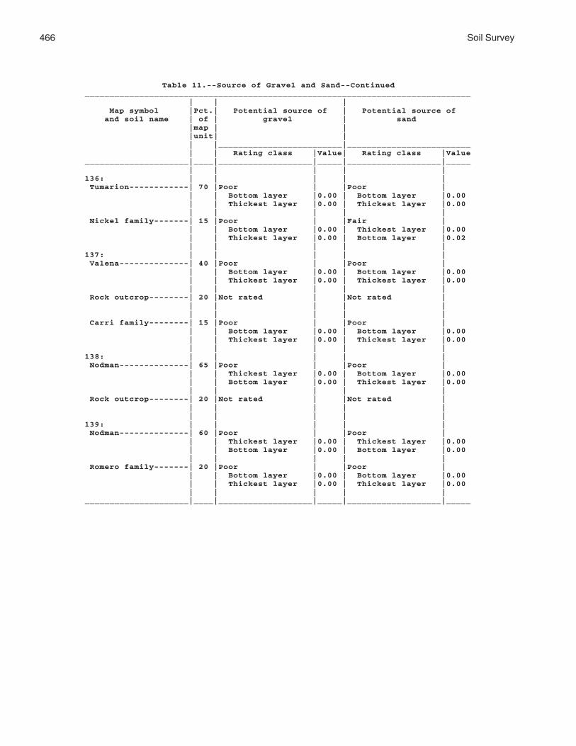
466 Soil Survey
Table 11.--Source of Gravel and Sand--Continued______________________________________________________________________________ | | | Map symbol |Pct.| Potential source of | Potential source of and soil name | of | gravel | sand |map | | |unit| | | |_________________________|_________________________ | | Rating class |Value| Rating class |Value_____________________|____|___________________|_____|___________________|_____ | | | | |136: | | | | | Tumarion------------| 70 |Poor | |Poor | | | Bottom layer |0.00 | Bottom layer |0.00 | | Thickest layer |0.00 | Thickest layer |0.00 | | | | | Nickel family-------| 15 |Poor | |Fair | | | Bottom layer |0.00 | Thickest layer |0.00 | | Thickest layer |0.00 | Bottom layer |0.02 | | | | |137: | | | | | Valena--------------| 40 |Poor | |Poor | | | Bottom layer |0.00 | Bottom layer |0.00 | | Thickest layer |0.00 | Thickest layer |0.00 | | | | | Rock outcrop--------| 20 |Not rated | |Not rated | | | | | | | | | | | Carri family--------| 15 |Poor | |Poor | | | Bottom layer |0.00 | Bottom layer |0.00 | | Thickest layer |0.00 | Thickest layer |0.00 | | | | |138: | | | | | Nodman--------------| 65 |Poor | |Poor | | | Thickest layer |0.00 | Bottom layer |0.00 | | Bottom layer |0.00 | Thickest layer |0.00 | | | | | Rock outcrop--------| 20 |Not rated | |Not rated | | | | | | | | | | |139: | | | | | Nodman--------------| 60 |Poor | |Poor | | | Thickest layer |0.00 | Thickest layer |0.00 | | Bottom layer |0.00 | Bottom layer |0.00 | | | | | Romero family-------| 20 |Poor | |Poor | | | Bottom layer |0.00 | Bottom layer |0.00 | | Thickest layer |0.00 | Thickest layer |0.00 | | | | |_____________________|____|___________________|_____|___________________|_____

Mohave C
ounty, Arizona, S
outhern Part
467
Table 12.--Source of Reclamation Material, Roadfill, and Topsoil
(The information in this table indicates the dominant soil condition but does not eliminate the need for onsite investigation. The numbers in the value columns range from 0.00 to 0.99. The smaller the value, the greater the limitation. See text for further explanation of ratings in this table.)________________________________________________________________________________________________________ | | | | Map symbol |Pct.| Potential source of | Potential source of | Potential source of and soil name | of | reclamation material | roadfill | topsoil |map | | | |unit| | | | |_________________________|_________________________|_________________________ | | Rating class and |Value| Rating class and |Value| Rating class and |Value | | limiting features | | limiting features | | limiting features |_____________________|____|___________________|_____|___________________|_____|___________________|_____ | | | | | | |1: | | | | | | | Akela---------------| 45 |Poor | |Poor | |Poor | | | Droughty |0.00 | Depth to bedrock |0.00 | Slope |0.00 | | Depth to bedrock |0.00 | Slope |0.00 | Rock fragments |0.00 | | Cobble content |0.00 | Cobble content |0.00 | Depth to bedrock |0.00 | | | | | | | Rock outcrop--------| 20 |Not rated | |Not rated | |Not rated | | | | | | | | | | | | | | | Rubble land---------| 20 |Not rated | |Not rated | |Not rated | | | | | | | | | | | | | | |2: | | | | | | | Akela---------------| 45 |Poor | |Poor | |Poor | | | Droughty |0.00 | Depth to bedrock |0.00 | Slope |0.00 | | Depth to bedrock |0.00 | Slope |0.00 | Rock fragments |0.00 | | Cobble content |0.00 | Cobble content |0.00 | Depth to bedrock |0.00 | | | | | | | Rock outcrop--------| 20 |Not rated | |Not rated | |Not rated | | | | | | | | | | | | | | | Rubble land---------| 20 |Not rated | |Not rated | |Not rated | | | | | | | | | | | | | | |3: | | | | | | | Alko family---------| 85 |Poor | |Good | |Poor | | | Droughty |0.00 | | | Rock fragments |0.00 | | Carbonate content|0.68 | | | Carbonate content|0.92 | | Low content of |0.88 | | | Slope |0.96 | | organic matter | | | | | | | | | | | |

468S
oil Survey
Table 12.--Source of Reclamation Material, Roadfill, and Topsoil--Continued________________________________________________________________________________________________________ | | | | Map symbol |Pct.| Potential source of | Potential source of | Potential source of and soil name | of | reclamation material | roadfill | topsoil |map | | | |unit| | | | |_________________________|_________________________|_________________________ | | Rating class and |Value| Rating class and |Value| Rating class and |Value | | limiting features | | limiting features | | limiting features |_____________________|____|___________________|_____|___________________|_____|___________________|_____ | | | | | | |4: | | | | | | | Alko family---------| 85 |Poor | |Good | |Poor | | | Droughty |0.00 | | | Rock fragments |0.00 | | Carbonate content|0.68 | | | Carbonate content|0.92 | | Low content of |0.88 | | | Slope |0.96 | | organic matter | | | | | | | | | | | |5: | | | | | | | Amole---------------| 75 |Fair | |Good | |Fair | | | Too sandy |0.09 | | | Too sandy |0.09 | | Droughty |0.25 | | | Rock fragments |0.88 | | Low content of |0.88 | | | | | | organic matter | | | | | | | | | | | |6: | | | | | | | Amole---------------| 75 |Fair | |Good | |Fair | | | Too sandy |0.09 | | | Too sandy |0.09 | | Droughty |0.25 | | | Rock fragments |0.88 | | Low content of |0.88 | | | | | | organic matter | | | | | | | | | | | |7: | | | | | | | Anthony-------------| 45 |Fair | |Good | |Poor | | | Droughty |0.51 | | | Rock fragments |0.00 | | Low content of |0.88 | | | Hard to reclaim, |0.50 | | organic matter | | | | rock fragments | | | | | | | | Dudleyville---------| 30 |Poor | |Good | |Poor | | | Too sandy |0.00 | | | Too sandy |0.00 | | Droughty |0.01 | | | Rock fragments |0.00 | | Low content of |0.88 | | | Hard to reclaim, |0.00 | | organic matter | | | | rock fragments | | | | | | | |8: | | | | | | | Aquarius------------| 45 |Poor | |Poor | |Poor | | | Too clayey |0.00 | Low strength |0.00 | Too clayey |0.00 | | Low content of |0.88 | Shrink-swell |0.14 | Rock fragments |0.00 | | organic matter | | | | | | | Water erosion |0.99 | Slope |0.82 | Slope |0.00 | | | | | | |

Mohave C
ounty, Arizona, S
outhern Part
469
Table 12.--Source of Reclamation Material, Roadfill, and Topsoil--Continued________________________________________________________________________________________________________ | | | | Map symbol |Pct.| Potential source of | Potential source of | Potential source of and soil name | of | reclamation material | roadfill | topsoil |map | | | |unit| | | | |_________________________|_________________________|_________________________ | | Rating class and |Value| Rating class and |Value| Rating class and |Value | | limiting features | | limiting features | | limiting features |_____________________|____|___________________|_____|___________________|_____|___________________|_____ | | | | | | |8: | | | | | | | Akela---------------| 30 |Poor | |Poor | |Poor | | | Cobble content |0.00 | Depth to bedrock |0.00 | Rock fragments |0.00 | | Droughty |0.00 | Cobble content |0.00 | Depth to bedrock |0.00 | | Depth to bedrock |0.00 | Stone content |0.95 | Slope |0.16 | | | | | | | Rock outcrop--------| 20 |Not rated | |Not rated | |Not rated | | | | | | | | | | | | | | |9: | | | | | | | Arizo---------------| 40 |Poor | |Good | |Poor | | | Droughty |0.00 | | | Hard to reclaim, |0.00 | | | | | | rock fragments | | | Too sandy |0.02 | | | Rock fragments |0.00 | | Low content of |0.88 | | | Too sandy |0.02 | | organic matter | | | | | | | | | | | | Franconia-----------| 30 |Fair | |Good | |Fair | | | Too sandy |0.02 | | | Too sandy |0.02 | | Droughty |0.25 | | | Hard to reclaim, |0.50 | | | | | | rock fragments | | | Low content of |0.88 | | | Rock fragments |0.97 | | organic matter | | | | | | | | | | | | Riverwash-----------| 20 |Not rated | |Not rated | |Not rated | | | | | | | | | | | | | | |10: | | | | | | | Arizo---------------| 40 |Poor | |Good | |Poor | | | Droughty |0.00 | | | Hard to reclaim, |0.00 | | | | | | rock fragments | | | Too sandy |0.02 | | | Rock fragments |0.00 | | Low content of |0.88 | | | Too sandy |0.02 | | organic matter | | | | | | | | | | | |

470S
oil Survey
Table 12.--Source of Reclamation Material, Roadfill, and Topsoil--Continued________________________________________________________________________________________________________ | | | | Map symbol |Pct.| Potential source of | Potential source of | Potential source of and soil name | of | reclamation material | roadfill | topsoil |map | | | |unit| | | | |_________________________|_________________________|_________________________ | | Rating class and |Value| Rating class and |Value| Rating class and |Value | | limiting features | | limiting features | | limiting features |_____________________|____|___________________|_____|___________________|_____|___________________|_____ | | | | | | |10: | | | | | | | Franconia-----------| 30 |Fair | |Good | |Fair | | | Too sandy |0.02 | | | Too sandy |0.02 | | Droughty |0.25 | | | Hard to reclaim, |0.50 | | | | | | rock fragments | | | Low content of |0.88 | | | Rock fragments |0.97 | | organic matter | | | | | | | | | | | | Riverwash-----------| 20 |Not rated | |Not rated | |Not rated | | | | | | | | | | | | | | |11: | | | | | | | Bartmus-------------| 85 |Poor | |Poor | |Poor | | | Droughty |0.00 | Depth to bedrock |0.00 | Rock fragments |0.00 | | Depth to bedrock |0.00 | | | Depth to bedrock |0.00 | | | | | | Slope |0.96 | | | | | | |12: | | | | | | | Bonita family-------| 85 |Poor | |Fair | |Poor | | | Too clayey |0.00 | Shrink-swell |0.86 | Too clayey |0.00 | | Carbonate content|0.80 | | | Hard to reclaim, |0.00 | | | | | | rock fragments | | | | | | | Rock fragments |0.72 | | | | | | |13: | | | | | | | Bonita family-------| 60 |Poor | |Fair | |Poor | | | Too clayey |0.00 | Shrink-swell |0.86 | Too clayey |0.00 | | Carbonate content|0.80 | | | Hard to reclaim, |0.00 | | | | | | rock fragments | | | | | | | Slope |0.16 | | | | | | | Gonzales------------| 30 |Poor | |Poor | |Poor | | | Too clayey |0.00 | Depth to bedrock |0.00 | Slope |0.00 | | Droughty |0.00 | Slope |0.00 | Too clayey |0.00 | | Depth to bedrock |0.00 | Shrink-swell |0.12 | Depth to bedrock |0.00 | | | | | | |

Mohave C
ounty, Arizona, S
outhern Part
471
Table 12.--Source of Reclamation Material, Roadfill, and Topsoil--Continued________________________________________________________________________________________________________ | | | | Map symbol |Pct.| Potential source of | Potential source of | Potential source of and soil name | of | reclamation material | roadfill | topsoil |map | | | |unit| | | | |_________________________|_________________________|_________________________ | | Rating class and |Value| Rating class and |Value| Rating class and |Value | | limiting features | | limiting features | | limiting features |_____________________|____|___________________|_____|___________________|_____|___________________|_____ | | | | | | |14: | | | | | | | Brazito family------| 75 |Poor | |Good | |Poor | | | Too sandy |0.00 | | | Too sandy |0.00 | | Wind erosion |0.00 | | | | | | Droughty |0.35 | | | | | | | | | | |15: | | | | | | | Bucklebar-----------| 80 |Fair | |Fair | |Good | | | Low content of |0.88 | Shrink-swell |0.99 | | | | organic matter | | | | | | | | | | | |16: | | | | | | | Cacique family------| 75 |Fair | |Good | |Poor | | | Droughty |0.68 | | | Rock fragments |0.00 | | Too clayey |0.76 | | | Too clayey |0.54 | | Low content of |0.88 | | | | | | organic matter | | | | | | | | | | | |17: | | | | | | | Castaneda-----------| 75 |Fair | |Good | |Poor | | | Droughty |0.22 | | | Rock fragments |0.00 | | Carbonate content|0.68 | | | Carbonate content|0.68 | | Low content of |0.88 | | | | | | organic matter | | | | | | | | | | | |18: | | | | | | | Castaneda-----------| 75 |Fair | |Good | |Poor | | | Droughty |0.22 | | | Rock fragments |0.00 | | Carbonate content|0.68 | | | Carbonate content|0.68 | | Low content of |0.88 | | | | | | organic matter | | | | | | | | | | | |19: | | | | | | | Carrizo family------| 75 |Poor | |Good | |Poor | | | Too sandy |0.00 | | | Too sandy |0.00 | | Droughty |0.00 | | | Hard to reclaim, |0.00 | | | | | | rock fragments | | | Low content of |0.88 | | | Rock fragments |0.00 | | organic matter | | | | | | | | | | | |

472S
oil Survey
Table 12.--Source of Reclamation Material, Roadfill, and Topsoil--Continued________________________________________________________________________________________________________ | | | | Map symbol |Pct.| Potential source of | Potential source of | Potential source of and soil name | of | reclamation material | roadfill | topsoil |map | | | |unit| | | | |_________________________|_________________________|_________________________ | | Rating class and |Value| Rating class and |Value| Rating class and |Value | | limiting features | | limiting features | | limiting features |_____________________|____|___________________|_____|___________________|_____|___________________|_____ | | | | | | |20: | | | | | | | Carrizo family------| 65 |Poor | |Good | |Poor | | | Too sandy |0.00 | | | Too sandy |0.00 | | Droughty |0.00 | | | Hard to reclaim, |0.00 | | | | | | rock fragments | | | Low content of |0.88 | | | Rock fragments |0.00 | | organic matter | | | | | | | | | | | | Riverwash-----------| 20 |Not rated | |Not rated | |Not rated | | | | | | | | | | | | | | |21: | | | | | | | Carrizo-------------| 75 |Poor | |Good | |Poor | | | Droughty |0.00 | | | Hard to reclaim, |0.00 | | | | | | rock fragments | | | Low content of |0.12 | | | Rock fragments |0.00 | | organic matter | | | | | | | Too sandy |0.47 | | | Too sandy |0.47 | | | | | | | Riverwash-----------| 15 |Not rated | |Not rated | |Not rated | | | | | | | | | | | | | | |22: | | | | | | | Carrizo-------------| 65 |Poor | |Good | |Poor | | | Droughty |0.00 | | | Hard to reclaim, |0.00 | | | | | | rock fragments | | | Too sandy |0.03 | | | Rock fragments |0.00 | | Low content of |0.88 | | | Too sandy |0.03 | | organic matter | | | | | | | | | | | | Riverwash-----------| 20 |Not rated | |Not rated | |Not rated | | | | | | | | | | | | | | |23: | | | | | | | Cave----------------| 75 |Poor | |Fair | |Poor | | | Droughty |0.00 | Slope |0.08 | Rock fragments |0.00 | | Low content of |0.88 | | | Slope |0.00 | | organic matter | | | | | | | | | | | |

Mohave C
ounty, Arizona, S
outhern Part
473
Table 12.--Source of Reclamation Material, Roadfill, and Topsoil--Continued________________________________________________________________________________________________________ | | | | Map symbol |Pct.| Potential source of | Potential source of | Potential source of and soil name | of | reclamation material | roadfill | topsoil |map | | | |unit| | | | |_________________________|_________________________|_________________________ | | Rating class and |Value| Rating class and |Value| Rating class and |Value | | limiting features | | limiting features | | limiting features |_____________________|____|___________________|_____|___________________|_____|___________________|_____ | | | | | | |24: | | | | | | | Cave----------------| 75 |Poor | |Fair | |Poor | | | Droughty |0.00 | Slope |0.08 | Rock fragments |0.00 | | Low content of |0.88 | | | Slope |0.00 | | organic matter | | | | | | | | | | | |25: | | | | | | | Cellar--------------| 50 |Poor | |Poor | |Poor | | | Droughty |0.00 | Depth to bedrock |0.00 | Slope |0.00 | | Depth to bedrock |0.00 | Slope |0.00 | Rock fragments |0.00 | | Low content of |0.88 | | | Depth to bedrock |0.00 | | organic matter | | | | | | | | | | | | Rock outcrop--------| 25 |Not rated | |Not rated | |Not rated | | | | | | | | | | | | | | |26: | | | | | | | Cellar--------------| 50 |Poor | |Poor | |Poor | | | Droughty |0.00 | Depth to bedrock |0.00 | Slope |0.00 | | Depth to bedrock |0.00 | Slope |0.00 | Rock fragments |0.00 | | Low content of |0.88 | | | Depth to bedrock |0.00 | | organic matter | | | | | | | | | | | | Rock outcrop--------| 25 |Not rated | |Not rated | |Not rated | | | | | | | | | | | | | | |27: | | | | | | | Cellar--------------| 45 |Poor | |Poor | |Poor | | | Droughty |0.00 | Depth to bedrock |0.00 | Rock fragments |0.00 | | Depth to bedrock |0.00 | Slope |0.50 | Depth to bedrock |0.00 | | Low content of |0.88 | | | Slope |0.00 | | organic matter | | | | | | | | | | | |27: | | | | | | | Topock--------------| 30 |Poor | |Poor | |Poor | | | Droughty |0.00 | Depth to bedrock |0.00 | Depth to bedrock |0.00 | | Depth to bedrock |0.00 | Slope |0.50 | Too clayey |0.00 | | Too clayey |0.00 | Shrink-swell |0.87 | Slope |0.00 | | | | | | |

474S
oil Survey
Table 12.--Source of Reclamation Material, Roadfill, and Topsoil--Continued________________________________________________________________________________________________________ | | | | Map symbol |Pct.| Potential source of | Potential source of | Potential source of and soil name | of | reclamation material | roadfill | topsoil |map | | | |unit| | | | |_________________________|_________________________|_________________________ | | Rating class and |Value| Rating class and |Value| Rating class and |Value | | limiting features | | limiting features | | limiting features |_____________________|____|___________________|_____|___________________|_____|___________________|_____ | | | | | | |27: | | | | | | | Rock outcrop--------| 20 |Not rated | |Not rated | |Not rated | | | | | | | | | | | | | | |28: | | | | | | | Cherioni------------| 85 |Poor | |Poor | |Poor | | | Droughty |0.00 | Depth to bedrock |0.00 | Rock fragments |0.00 | | Depth to bedrock |0.00 | | | Depth to bedrock |0.00 | | Low content of |0.88 | | | Too clayey |0.70 | | organic matter | | | | | | | | | | | |29: | | | | | | | Chuckawalla---------| 65 |Fair | |Good | |Poor | | | Droughty |0.04 | | | Salinity |0.00 | | Salinity |0.72 | | | Hard to reclaim, |0.00 | | | | | | rock fragments | | | Low content of |0.88 | | | Rock fragments |0.00 | | organic matter | | | | | | | | | | | | Riverbend-----------| 25 |Poor | |Good | |Poor | | | Droughty |0.00 | | | Rock fragments |0.00 | | Too sandy |0.02 | | | Hard to reclaim, |0.00 | | | | | | rock fragments | | | Low content of |0.50 | | | Too sandy |0.02 | | organic matter | | | | | | | | | | | |30: | | | | | | | Chuckawalla family--| 65 |Fair | |Good | |Poor | | | Droughty |0.38 | | | Hard to reclaim, |0.00 | | | | | | rock fragments | | | Low content of |0.88 | | | Rock fragments |0.00 | | organic matter | | | | | | | Carbonate content|0.92 | | | Carbonate content|0.92 | | | | | | | Riverbend family----| 25 |Poor | |Good | |Poor | | | Droughty |0.00 | | | Hard to reclaim, |0.00 | | | | | | rock fragments | | | Too sandy |0.02 | | | Rock fragments |0.00 | | Low content of |0.88 | | | Too sandy |0.02 | | organic matter | | | | | | | | | | | |

Mohave C
ounty, Arizona, S
outhern Part
475
Table 12.--Source of Reclamation Material, Roadfill, and Topsoil--Continued________________________________________________________________________________________________________ | | | | Map symbol |Pct.| Potential source of | Potential source of | Potential source of and soil name | of | reclamation material | roadfill | topsoil |map | | | |unit| | | | |_________________________|_________________________|_________________________ | | Rating class and |Value| Rating class and |Value| Rating class and |Value | | limiting features | | limiting features | | limiting features |_____________________|____|___________________|_____|___________________|_____|___________________|_____ | | | | | | |31: | | | | | | | Cipriano------------| 85 |Poor | |Good | |Poor | | | Droughty |0.00 | | | Rock fragments |0.00 | | Carbonate content|0.46 | | | Carbonate content|0.46 | | Low content of |0.88 | | | | | | organic matter | | | | | | | | | | | |32: | | | | | | | Cline---------------| 85 |Poor | |Poor | |Poor | | | Droughty |0.00 | Depth to bedrock |0.00 | Rock fragments |0.00 | | Depth to bedrock |0.00 | Shrink-swell |0.87 | Depth to bedrock |0.00 | | Low content of |0.50 | | | Carbonate content|0.92 | | organic matter | | | | | | | | | | | |33: | | | | | | | Cline---------------| 85 |Poor | |Poor | |Poor | | | Droughty |0.00 | Depth to bedrock |0.00 | Rock fragments |0.00 | | Depth to bedrock |0.00 | Shrink-swell |0.87 | Depth to bedrock |0.00 | | Low content of |0.50 | | | Carbonate content|0.92 | | organic matter | | | | | | | | | | | |34: | | | | | | | Continental---------| 50 |Poor | |Fair | |Poor | | | Too clayey |0.00 | Shrink-swell |0.59 | Too clayey |0.00 | | Carbonate content|0.68 | | | | | | Low content of |0.88 | | | | | | organic matter | | | | | | | | | | | | Tres Hermanos-------| 25 |Fair | |Good | |Poor | | | Carbonate content|0.80 | | | Rock fragments |0.00 | | Low content of |0.88 | | | Hard to reclaim, |0.50 | | organic matter | | | | rock fragments | | | | | | | Slope |0.96 | | | | | | |35: | | | | | | | Continental---------| 50 |Poor | |Fair | |Poor | | | Too clayey |0.00 | Shrink-swell |0.59 | Too clayey |0.00 | | Carbonate content|0.68 | | | Slope |0.96 | | Low content of |0.88 | | | | | | organic matter | | | | | | | | | | | |

476S
oil Survey
Table 12.--Source of Reclamation Material, Roadfill, and Topsoil--Continued________________________________________________________________________________________________________ | | | | Map symbol |Pct.| Potential source of | Potential source of | Potential source of and soil name | of | reclamation material | roadfill | topsoil |map | | | |unit| | | | |_________________________|_________________________|_________________________ | | Rating class and |Value| Rating class and |Value| Rating class and |Value | | limiting features | | limiting features | | limiting features |_____________________|____|___________________|_____|___________________|_____|___________________|_____ | | | | | | |35: | | | | | | | Tres Hermanos-------| 25 |Fair | |Good | |Poor | | | Carbonate content|0.80 | | | Rock fragments |0.00 | | Low content of |0.88 | | | Hard to reclaim, |0.50 | | organic matter | | | | rock fragments | | | | | | | Slope |0.96 | | | | | | |36: | | | | | | | Continental---------| 50 |Poor | |Fair | |Poor | | | Too clayey |0.00 | Shrink-swell |0.59 | Too clayey |0.00 | | Carbonate content|0.68 | | | | | | Low content of |0.88 | | | | | | organic matter | | | | | | | | | | | | Rillino-------------| 35 |Fair | |Good | |Poor | | | Too sandy |0.47 | | | Hard to reclaim, |0.00 | | | | | | rock fragments | | | Carbonate content|0.80 | | | Rock fragments |0.00 | | Low content of |0.88 | | | Too sandy |0.47 | | organic matter | | | | | | | | | | | |37: | | | | | | | Continental---------| 50 |Poor | |Fair | |Poor | | | Too clayey |0.00 | Shrink-swell |0.59 | Too clayey |0.00 | | Carbonate content|0.68 | | | | | | Low content of |0.88 | | | | | | organic matter | | | | | | | | | | | |37: | | | | | | | Rillino-------------| 35 |Fair | |Good | |Poor | | | Carbonate content|0.80 | | | Hard to reclaim, |0.00 | | | | | | rock fragments | | | Low content of |0.88 | | | Rock fragments |0.00 | | organic matter | | | | | | | Droughty |0.96 | | | Slope |0.96 | | | | | | |

Mohave C
ounty, Arizona, S
outhern Part
477
Table 12.--Source of Reclamation Material, Roadfill, and Topsoil--Continued________________________________________________________________________________________________________ | | | | Map symbol |Pct.| Potential source of | Potential source of | Potential source of and soil name | of | reclamation material | roadfill | topsoil |map | | | |unit| | | | |_________________________|_________________________|_________________________ | | Rating class and |Value| Rating class and |Value| Rating class and |Value | | limiting features | | limiting features | | limiting features |_____________________|____|___________________|_____|___________________|_____|___________________|_____ | | | | | | |38: | | | | | | | Coolidge------------| 40 |Fair | |Good | |Fair | | | Low content of |0.88 | | | Hard to reclaim, |0.50 | | organic matter | | | | rock fragments | | | Carbonate content|0.92 | | | Carbonate content|0.92 | | | | | | Rock fragments |0.97 | | | | | | | Denure--------------| 35 |Fair | |Good | |Fair | | | Low content of |0.88 | | | Rock fragments |0.97 | | organic matter | | | | | | | Droughty |0.98 | | | | | | | | | | |39: | | | | | | | Coolidge family-----| 40 |Fair | |Good | |Fair | | | Droughty |0.67 | | | Hard to reclaim, |0.50 | | | | | | rock fragments | | | Carbonate content|0.80 | | | Carbonate content|0.80 | | Low content of |0.88 | | | Rock fragments |0.97 | | organic matter | | | | | | | | | | | | Denure family-------| 35 |Fair | |Good | |Fair | | | Droughty |0.74 | | | Rock fragments |0.97 | | Low content of |0.88 | | | | | | organic matter | | | | | | | | | | | |40: | | | | | | | Courthouse family---| 45 |Poor | |Poor | |Poor | | | Droughty |0.00 | Depth to bedrock |0.00 | Slope |0.00 | | Depth to bedrock |0.00 | Slope |0.00 | Rock fragments |0.00 | | | | | | Depth to bedrock |0.00 | | | | | | |40: | | | | | | | Rock outcrop--------| 20 |Not rated | |Not rated | |Not rated | | | | | | | | | | | | | | | Rubble land---------| 20 |Not rated | |Not rated | |Not rated | | | | | | | | | | | | | | |
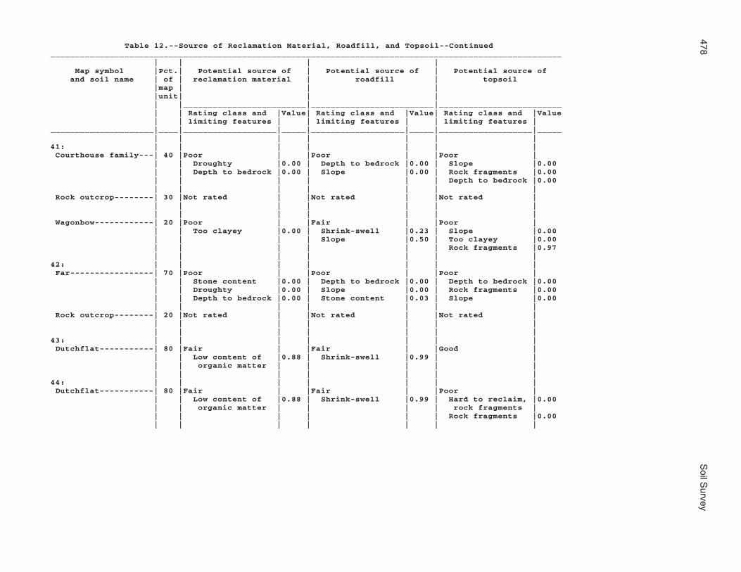
478S
oil Survey
Table 12.--Source of Reclamation Material, Roadfill, and Topsoil--Continued________________________________________________________________________________________________________ | | | | Map symbol |Pct.| Potential source of | Potential source of | Potential source of and soil name | of | reclamation material | roadfill | topsoil |map | | | |unit| | | | |_________________________|_________________________|_________________________ | | Rating class and |Value| Rating class and |Value| Rating class and |Value | | limiting features | | limiting features | | limiting features |_____________________|____|___________________|_____|___________________|_____|___________________|_____ | | | | | | |41: | | | | | | | Courthouse family---| 40 |Poor | |Poor | |Poor | | | Droughty |0.00 | Depth to bedrock |0.00 | Slope |0.00 | | Depth to bedrock |0.00 | Slope |0.00 | Rock fragments |0.00 | | | | | | Depth to bedrock |0.00 | | | | | | | Rock outcrop--------| 30 |Not rated | |Not rated | |Not rated | | | | | | | | | | | | | | | Wagonbow------------| 20 |Poor | |Fair | |Poor | | | Too clayey |0.00 | Shrink-swell |0.23 | Slope |0.00 | | | | Slope |0.50 | Too clayey |0.00 | | | | | | Rock fragments |0.97 | | | | | | |42: | | | | | | | Far-----------------| 70 |Poor | |Poor | |Poor | | | Stone content |0.00 | Depth to bedrock |0.00 | Depth to bedrock |0.00 | | Droughty |0.00 | Slope |0.00 | Rock fragments |0.00 | | Depth to bedrock |0.00 | Stone content |0.03 | Slope |0.00 | | | | | | | Rock outcrop--------| 20 |Not rated | |Not rated | |Not rated | | | | | | | | | | | | | | |43: | | | | | | | Dutchflat-----------| 80 |Fair | |Fair | |Good | | | Low content of |0.88 | Shrink-swell |0.99 | | | | organic matter | | | | | | | | | | | |44: | | | | | | | Dutchflat-----------| 80 |Fair | |Fair | |Poor | | | Low content of |0.88 | Shrink-swell |0.99 | Hard to reclaim, |0.00 | | organic matter | | | | rock fragments | | | | | | | Rock fragments |0.00 | | | | | | |

Mohave C
ounty, Arizona, S
outhern Part
479
Table 12.--Source of Reclamation Material, Roadfill, and Topsoil--Continued________________________________________________________________________________________________________ | | | | Map symbol |Pct.| Potential source of | Potential source of | Potential source of and soil name | of | reclamation material | roadfill | topsoil |map | | | |unit| | | | |_________________________|_________________________|_________________________ | | Rating class and |Value| Rating class and |Value| Rating class and |Value | | limiting features | | limiting features | | limiting features |_____________________|____|___________________|_____|___________________|_____|___________________|_____ | | | | | | |45: | | | | | | | Gadsden-------------| 80 |Poor | |Fair | |Poor | | | Too clayey |0.00 | Shrink-swell |0.20 | Too clayey |0.00 | | Sodium content |0.03 | | | Sodium content |0.02 | | Low content of |0.88 | | | Salinity |0.12 | | organic matter | | | | | | | | | | | |46: | | | | | | | Gila----------------| 50 |Fair | |Fair | |Fair | | | Water erosion |0.37 | Shrink-swell |0.99 | Too clayey |0.54 | | Too clayey |0.76 | | | | | | Low content of |0.88 | | | | | | organic matter | | | | | | | | | | | | Glendale------------| 30 |Fair | |Fair | |Fair | | | Too clayey |0.88 | Shrink-swell |0.99 | Too clayey |0.63 | | Low content of |0.88 | | | | | | organic matter | | | | | | | Water erosion |0.90 | | | | | | | | | | |47: | | | | | | | Gila----------------| 50 |Fair | |Fair | |Fair | | | Water erosion |0.37 | Shrink-swell |0.99 | Too clayey |0.54 | | Too clayey |0.76 | | | | | | Low content of |0.88 | | | | | | organic matter | | | | | | | | | | | | Glendale------------| 30 |Fair | |Fair | |Fair | | | Too clayey |0.88 | Shrink-swell |0.99 | Too clayey |0.63 | | Low content of |0.88 | | | | | | organic matter | | | | | | | Water erosion |0.90 | | | | | | | | | | |48: | | | | | | | Goldroad------------| 60 |Poor | |Poor | |Poor | | | Droughty |0.00 | Depth to bedrock |0.00 | Slope |0.00 | | Depth to bedrock |0.00 | Slope |0.00 | Rock fragments |0.00 | | Low content of |0.88 | | | Depth to bedrock |0.00 | | organic matter | | | | | | | | | | | |

480S
oil Survey
Table 12.--Source of Reclamation Material, Roadfill, and Topsoil--Continued________________________________________________________________________________________________________ | | | | Map symbol |Pct.| Potential source of | Potential source of | Potential source of and soil name | of | reclamation material | roadfill | topsoil |map | | | |unit| | | | |_________________________|_________________________|_________________________ | | Rating class and |Value| Rating class and |Value| Rating class and |Value | | limiting features | | limiting features | | limiting features |_____________________|____|___________________|_____|___________________|_____|___________________|_____ | | | | | | |48: | | | | | | | Rock outcrop--------| 20 |Not rated | |Not rated | |Not rated | | | | | | | | | | | | | | |49: | | | | | | | Gonzales------------| 60 |Poor | |Poor | |Poor | | | Too clayey |0.00 | Depth to bedrock |0.00 | Slope |0.00 | | Droughty |0.00 | Low strength |0.00 | Too clayey |0.00 | | Depth to bedrock |0.00 | Slope |0.00 | Depth to bedrock |0.00 | | | | | | | Rock outcrop--------| 25 |Not rated | |Not rated | |Not rated | | | | | | | | | | | | | | |50: | | | | | | | Goodsprings family--| 75 |Poor | |Good | |Poor | | | Droughty |0.00 | | | Rock fragments |0.00 | | Low content of |0.12 | | | | | | organic matter | | | | | | | | | | | |51: | | | | | | | Goodsprings family--| 75 |Poor | |Good | |Poor | | | Droughty |0.00 | | | Rock fragments |0.00 | | Low content of |0.12 | | | | | | organic matter | | | | | | | | | | | |52: | | | | | | | Goodsprings family--| 75 |Poor | |Fair | |Poor | | | Droughty |0.00 | Slope |0.08 | Rock fragments |0.00 | | Low content of |0.12 | | | Slope |0.00 | | organic matter | | | | | | | | | | | |53: | | | | | | | Goodsprings family--| 75 |Poor | |Fair | |Poor | | | Droughty |0.00 | Slope |0.08 | Rock fragments |0.00 | | Low content of |0.12 | | | Slope |0.00 | | organic matter | | | | | | | | | | | |

Mohave C
ounty, Arizona, S
outhern Part
481
Table 12.--Source of Reclamation Material, Roadfill, and Topsoil--Continued________________________________________________________________________________________________________ | | | | Map symbol |Pct.| Potential source of | Potential source of | Potential source of and soil name | of | reclamation material | roadfill | topsoil |map | | | |unit| | | | |_________________________|_________________________|_________________________ | | Rating class and |Value| Rating class and |Value| Rating class and |Value | | limiting features | | limiting features | | limiting features |_____________________|____|___________________|_____|___________________|_____|___________________|_____ | | | | | | |54: | | | | | | | Graham--------------| 60 |Poor | |Poor | |Poor | | | Too clayey |0.00 | Depth to bedrock |0.00 | Too clayey |0.00 | | Droughty |0.00 | Low strength |0.00 | Depth to bedrock |0.00 | | Depth to bedrock |0.00 | Shrink-swell |0.12 | Slope |0.96 | | | | | | | Arivaca-------------| 25 |Poor | |Poor | |Poor | | | Too clayey |0.00 | Depth to bedrock |0.00 | Too clayey |0.00 | | Droughty |0.17 | Low strength |0.00 | Depth to bedrock |0.58 | | Low content of |0.50 | Shrink-swell |0.13 | Slope |0.96 | | organic matter | | | | | | | | | | | |55: | | | | | | | Graham--------------| 60 |Poor | |Poor | |Poor | | | Too clayey |0.00 | Depth to bedrock |0.00 | Too clayey |0.00 | | Droughty |0.00 | Slope |0.00 | Depth to bedrock |0.00 | | Depth to bedrock |0.00 | Low strength |0.00 | Slope |0.00 | | | | | | | Rock outcrop--------| 20 |Not rated | |Not rated | |Not rated | | | | | | | | | | | | | | |56: | | | | | | | Gunsight------------| 75 |Fair | |Good | |Poor | | | Carbonate content|0.80 | | | Hard to reclaim, |0.00 | | | | | | rock fragments | | | Low content of |0.88 | | | Rock fragments |0.00 | | organic matter | | | | | | | | | | | Carbonate content|0.80 | | | | | | |57: | | | | | | | Gunsight------------| 85 |Fair | |Poor | |Poor | | | Carbonate content|0.80 | Slope |0.00 | Hard to reclaim, |0.00 | | | | | | rock fragments | | | Low content of |0.88 | | | Rock fragments |0.00 | | organic matter | | | | | | | | | | | Slope |0.00 | | | | | | |

482S
oil Survey
Table 12.--Source of Reclamation Material, Roadfill, and Topsoil--Continued________________________________________________________________________________________________________ | | | | Map symbol |Pct.| Potential source of | Potential source of | Potential source of and soil name | of | reclamation material | roadfill | topsoil |map | | | |unit| | | | |_________________________|_________________________|_________________________ | | Rating class and |Value| Rating class and |Value| Rating class and |Value | | limiting features | | limiting features | | limiting features |_____________________|____|___________________|_____|___________________|_____|___________________|_____ | | | | | | |58: | | | | | | | Hassell family------| 50 |Poor | |Poor | |Poor | | | Too clayey |0.00 | Depth to bedrock |0.00 | Too clayey |0.00 | | Droughty |0.47 | Low strength |0.00 | Slope |0.00 | | Depth to bedrock |0.58 | Slope |0.50 | Depth to bedrock |0.58 | | | | | | | Lampshire-----------| 25 |Poor | |Poor | |Poor | | | Droughty |0.00 | Depth to bedrock |0.00 | Slope |0.00 | | Depth to bedrock |0.00 | Slope |0.00 | Rock fragments |0.00 | | | | | | Depth to bedrock |0.00 | | | | | | | Rock outcrop--------| 20 |Not rated | |Not rated | |Not rated | | | | | | | | | | | | | | |59: | | | | | | | Holtville-----------| 75 |Poor | |Fair | |Poor | | | Too clayey |0.00 | Shrink-swell |0.93 | Too clayey |0.00 | | Sodium content |0.03 | | | Sodium content |0.02 | | Water erosion |0.37 | | | Salinity |0.12 | | | | | | |60: | | | | | | | Huevi---------------| 75 |Poor | |Good | |Poor | | | Droughty |0.00 | | | Hard to reclaim, |0.00 | | | | | | rock fragments | | | Carbonate content|0.80 | | | Rock fragments |0.00 | | Low content of |0.88 | | | Slope |0.96 | | organic matter | | | | | | | | | | | |61: | | | | | | | Huevi---------------| 85 |Poor | |Fair | |Poor | | | Droughty |0.00 | Slope |0.08 | Hard to reclaim, |0.00 | | | | | | rock fragments | | | Low content of |0.88 | | | Rock fragments |0.00 | | organic matter | | | | | | | | | | | Slope |0.00 | | | | | | |

Mohave C
ounty, Arizona, S
outhern Part
483
Table 12.--Source of Reclamation Material, Roadfill, and Topsoil--Continued________________________________________________________________________________________________________ | | | | Map symbol |Pct.| Potential source of | Potential source of | Potential source of and soil name | of | reclamation material | roadfill | topsoil |map | | | |unit| | | | |_________________________|_________________________|_________________________ | | Rating class and |Value| Rating class and |Value| Rating class and |Value | | limiting features | | limiting features | | limiting features |_____________________|____|___________________|_____|___________________|_____|___________________|_____ | | | | | | |62: | | | | | | | Akela---------------| 60 |Poor | |Poor | |Poor | | | Droughty |0.00 | Depth to bedrock |0.00 | Slope |0.00 | | Depth to bedrock |0.00 | Slope |0.00 | Rock fragments |0.00 | | Low content of |0.88 | | | Depth to bedrock |0.00 | | organic matter | | | | | | | | | | | | Rock outcrop--------| 20 |Not rated | |Not rated | |Not rated | | | | | | | | | | | | | | |63: | | | | | | | Hyder---------------| 50 |Poor | |Poor | |Poor | | | Droughty |0.00 | Depth to bedrock |0.00 | Slope |0.00 | | Depth to bedrock |0.00 | Slope |0.00 | Rock fragments |0.00 | | Cobble content |0.04 | Cobble content |0.00 | Depth to bedrock |0.00 | | | | | | | Rock outcrop--------| 20 |Not rated | |Not rated | |Not rated | | | | | | | | | | | | | | | Rubble land---------| 20 |Not rated | |Not rated | |Not rated | | | | | | | | | | | | | | |64: | | | | | | | Indio---------------| 85 |Fair | |Good | |Fair | | | Sodium content |0.03 | | | Sodium content |0.02 | | Low content of |0.88 | | | Salinity |0.12 | | organic matter | | | | | | | Water erosion |0.90 | | | | | | | | | | |65: | | | | | | | Ireteba family------| 45 |Fair | |Good | |Poor | | | Droughty |0.61 | | | Hard to reclaim, |0.00 | | | | | | rock fragments | | | Low content of |0.88 | | | Rock fragments |0.00 | | organic matter | | | | | | | | | | | |

484S
oil Survey
Table 12.--Source of Reclamation Material, Roadfill, and Topsoil--Continued________________________________________________________________________________________________________ | | | | Map symbol |Pct.| Potential source of | Potential source of | Potential source of and soil name | of | reclamation material | roadfill | topsoil |map | | | |unit| | | | |_________________________|_________________________|_________________________ | | Rating class and |Value| Rating class and |Value| Rating class and |Value | | limiting features | | limiting features | | limiting features |_____________________|____|___________________|_____|___________________|_____|___________________|_____ | | | | | | |65: | | | | | | | Arizo---------------| 30 |Poor | |Good | |Poor | | | Droughty |0.00 | | | Hard to reclaim, |0.00 | | | | | | rock fragments | | | Too sandy |0.02 | | | Rock fragments |0.00 | | Low content of |0.88 | | | Too sandy |0.02 | | organic matter | | | | | | | | | | | |66: | | | | | | | Kinley--------------| 75 |Poor | |Poor | |Poor | | | Carbonate content|0.00 | Slope |0.00 | Slope |0.00 | | Low content of |0.88 | | | Hard to reclaim, |0.00 | | organic matter | | | | rock fragments | | | | | | | Rock fragments |0.97 | | | | | | |67: | | | | | | | Kinley--------------| 50 |Fair | |Good | |Poor | | | Carbonate content|0.08 | | | Hard to reclaim, |0.00 | | | | | | rock fragments | | | Low content of |0.88 | | | Carbonate content|0.92 | | organic matter | | | | | | | | | | | Slope |0.96 | | | | | | | Poachie-------------| 35 |Fair | |Good | |Fair | | | Carbonate content|0.68 | | | Hard to reclaim, |0.50 | | | | | | rock fragments | | | Low content of |0.88 | | | Rock fragments |0.97 | | organic matter | | | | | | | | | | | |68: | | | | | | | Kofa----------------| 85 |Poor | |Fair | |Poor | | | Too clayey |0.00 | Shrink-swell |0.96 | Too clayey |0.00 | | Sodium content |0.03 | | | Sodium content |0.02 | | Low content of |0.88 | | | Salinity |0.12 | | organic matter | | | | | | | | | | | |

Mohave C
ounty, Arizona, S
outhern Part
485
Table 12.--Source of Reclamation Material, Roadfill, and Topsoil--Continued________________________________________________________________________________________________________ | | | | Map symbol |Pct.| Potential source of | Potential source of | Potential source of and soil name | of | reclamation material | roadfill | topsoil |map | | | |unit| | | | |_________________________|_________________________|_________________________ | | Rating class and |Value| Rating class and |Value| Rating class and |Value | | limiting features | | limiting features | | limiting features |_____________________|____|___________________|_____|___________________|_____|___________________|_____ | | | | | | |69: | | | | | | | Dudleyville---------| 40 |Poor | |Good | |Poor | | | Too sandy |0.00 | | | Too sandy |0.00 | | Droughty |0.01 | | | Rock fragments |0.00 | | Low content of |0.88 | | | Hard to reclaim, |0.00 | | organic matter | | | | rock fragments | | | | | | | | Vinton--------------| 30 |Fair | |Good | |Poor | | | Droughty |0.03 | | | Hard to reclaim, |0.00 | | | | | | rock fragments | | | Too sandy |0.03 | | | Too sandy |0.03 | | Low content of |0.88 | | | | | | organic matter | | | | | | | | | | | | Riverwash-----------| 20 |Not rated | |Not rated | |Not rated | | | | | | | | | | | | | | |70: | | | | | | | Dudleyville---------| 40 |Poor | |Good | |Poor | | | Too sandy |0.00 | | | Too sandy |0.00 | | Droughty |0.01 | | | Rock fragments |0.00 | | Low content of |0.88 | | | Hard to reclaim, |0.00 | | organic matter | | | | rock fragments | | | | | | | | Vinton--------------| 30 |Fair | |Good | |Poor | | | Droughty |0.03 | | | Hard to reclaim, |0.00 | | | | | | rock fragments | | | Too sandy |0.03 | | | Too sandy |0.03 | | Low content of |0.88 | | | | | | organic matter | | | | | | | | | | | | Riverwash-----------| 20 |Not rated | |Not rated | |Not rated | | | | | | | | | | | | | | |71: | | | | | | | Lagunita------------| 85 |Poor | |Good | |Fair | | | Wind erosion |0.00 | | | Too sandy |0.18 | | Droughty |0.00 | | | Rock fragments |0.97 | | Too sandy |0.18 | | | | | | | | | | |

486S
oil Survey
Table 12.--Source of Reclamation Material, Roadfill, and Topsoil--Continued________________________________________________________________________________________________________ | | | | Map symbol |Pct.| Potential source of | Potential source of | Potential source of and soil name | of | reclamation material | roadfill | topsoil |map | | | |unit| | | | |_________________________|_________________________|_________________________ | | Rating class and |Value| Rating class and |Value| Rating class and |Value | | limiting features | | limiting features | | limiting features |_____________________|____|___________________|_____|___________________|_____|___________________|_____ | | | | | | |72: | | | | | | | Lagunita------------| 60 |Poor | |Good | |Fair | | | Wind erosion |0.00 | | | Too sandy |0.18 | | Droughty |0.00 | | | Rock fragments |0.97 | | Too sandy |0.18 | | | | | | | | | | | Ripley--------------| 25 |Fair | |Good | |Poor | | | Low content of |0.88 | | | Rock fragments |0.00 | | organic matter | | | | | | | Salinity |0.97 | | | Salinity |0.00 | | | | | | Hard to reclaim, |0.50 | | | | | | rock fragments | | | | | | | |73: | | | | | | | Lampshire-----------| 65 |Poor | |Poor | |Poor | | | Droughty |0.00 | Depth to bedrock |0.00 | Slope |0.00 | | Depth to bedrock |0.00 | Slope |0.00 | Rock fragments |0.00 | | | | | | Depth to bedrock |0.00 | | | | | | | Rock outcrop--------| 20 |Not rated | |Not rated | |Not rated | | | | | | | | | | | | | | |74: | | | | | | | Lampshire-----------| 65 |Poor | |Poor | |Poor | | | Droughty |0.00 | Depth to bedrock |0.00 | Slope |0.00 | | Depth to bedrock |0.00 | Slope |0.00 | Rock fragments |0.00 | | | | | | Depth to bedrock |0.00 | | | | | | | Rock outcrop--------| 20 |Not rated | |Not rated | |Not rated | | | | | | | | | | | | | | |75: | | | | | | | Lampshire-----------| 45 |Poor | |Poor | |Poor | | | Droughty |0.00 | Depth to bedrock |0.00 | Slope |0.00 | | Depth to bedrock |0.00 | Slope |0.00 | Depth to bedrock |0.00 | | Stone content |0.02 | Stone content |0.98 | Rock fragments |0.00 | | | | | | | Rock outcrop--------| 40 |Not rated | |Not rated | |Not rated | | | | | | | | | | | | | | |

Mohave C
ounty, Arizona, S
outhern Part
487
Table 12.--Source of Reclamation Material, Roadfill, and Topsoil--Continued________________________________________________________________________________________________________ | | | | Map symbol |Pct.| Potential source of | Potential source of | Potential source of and soil name | of | reclamation material | roadfill | topsoil |map | | | |unit| | | | |_________________________|_________________________|_________________________ | | Rating class and |Value| Rating class and |Value| Rating class and |Value | | limiting features | | limiting features | | limiting features |_____________________|____|___________________|_____|___________________|_____|___________________|_____ | | | | | | |76: | | | | | | | Lostman-------------| 80 |Fair | |Good | |Poor | | | Droughty |0.30 | | | Hard to reclaim, |0.00 | | | | | | rock fragments | | | | | | | Rock fragments |0.00 | | | | | | |77: | | | | | | | Lostman-------------| 80 |Fair | |Good | |Poor | | | Low content of |0.88 | | | Hard to reclaim, |0.00 | | organic matter | | | | rock fragments | | | | | | | Rock fragments |0.97 | | | | | | |78: | | | | | | | Lostman-------------| 40 |Fair | |Good | |Poor | | | Low content of |0.88 | | | Hard to reclaim, |0.00 | | organic matter | | | | rock fragments | | | | | | | Rock fragments |0.97 | | | | | | | Kinley--------------| 35 |Fair | |Good | |Poor | | | Carbonate content|0.08 | | | Hard to reclaim, |0.00 | | | | | | rock fragments | | | Low content of |0.88 | | | Carbonate content|0.92 | | organic matter | | | | | | | | | | | Rock fragments |0.97 | | | | | | |79: | | | | | | | Marshes-------------|100 |Not rated | |Not rated | |Not rated | | | | | | | | | | | | | | |80: | | | | | | | Meloland------------| 85 |Poor | |Fair | |Poor | | | Too clayey |0.00 | Shrink-swell |0.38 | Too clayey |0.00 | | Sodium content |0.03 | | | Salinity |0.00 | | Carbonate content|0.46 | | | Sodium content |0.02 | | | | | | |

488S
oil Survey
Table 12.--Source of Reclamation Material, Roadfill, and Topsoil--Continued________________________________________________________________________________________________________ | | | | Map symbol |Pct.| Potential source of | Potential source of | Potential source of and soil name | of | reclamation material | roadfill | topsoil |map | | | |unit| | | | |_________________________|_________________________|_________________________ | | Rating class and |Value| Rating class and |Value| Rating class and |Value | | limiting features | | limiting features | | limiting features |_____________________|____|___________________|_____|___________________|_____|___________________|_____ | | | | | | |81: | | | | | | | Mohon---------------| 50 |Poor | |Fair | |Poor | | | Too clayey |0.00 | Shrink-swell |0.99 | Too clayey |0.00 | | Low content of |0.88 | | | Hard to reclaim, |0.50 | | organic matter | | | | rock fragments | | | Carbonate content|0.92 | | | Carbonate content|0.92 | | | | | | | Kinley--------------| 35 |Fair | |Good | |Poor | | | Carbonate content|0.08 | | | Hard to reclaim, |0.00 | | | | | | rock fragments | | | Low content of |0.88 | | | Slope |0.84 | | organic matter | | | | | | | | | | | Carbonate content|0.92 | | | | | | |82: | | | | | | | Mohon---------------| 50 |Poor | |Fair | |Poor | | | Too clayey |0.00 | Shrink-swell |0.99 | Too clayey |0.00 | | Low content of |0.88 | | | Hard to reclaim, |0.50 | | organic matter | | | | rock fragments | | | Carbonate content|0.92 | | | Carbonate content|0.92 | | | | | | | Poachie-------------| 25 |Fair | |Good | |Fair | | | Carbonate content|0.68 | | | Hard to reclaim, |0.50 | | | | | | rock fragments | | | Low content of |0.88 | | | Slope |0.96 | | organic matter | | | | | | | | | | | Rock fragments |0.97 | | | | | | |83: | | | | | | | Mohon---------------| 50 |Poor | |Fair | |Poor | | | Too clayey |0.00 | Shrink-swell |0.99 | Too clayey |0.00 | | Low content of |0.88 | | | Hard to reclaim, |0.50 | | organic matter | | | | rock fragments | | | Carbonate content|0.92 | | | Carbonate content|0.92 | | | | | | |

Mohave C
ounty, Arizona, S
outhern Part
489
Table 12.--Source of Reclamation Material, Roadfill, and Topsoil--Continued________________________________________________________________________________________________________ | | | | Map symbol |Pct.| Potential source of | Potential source of | Potential source of and soil name | of | reclamation material | roadfill | topsoil |map | | | |unit| | | | |_________________________|_________________________|_________________________ | | Rating class and |Value| Rating class and |Value| Rating class and |Value | | limiting features | | limiting features | | limiting features |_____________________|____|___________________|_____|___________________|_____|___________________|_____ | | | | | | |83: | | | | | | | Poachie-------------| 25 |Fair | |Good | |Fair | | | Carbonate content|0.68 | | | Hard to reclaim, |0.50 | | | | | | rock fragments | | | Low content of |0.88 | | | Slope |0.96 | | organic matter | | | | | | | | | | | Rock fragments |0.97 | | | | | | |84: | | | | | | | Nickel family-------| 35 |Fair | |Poor | |Poor | | | Droughty |0.41 | Slope |0.00 | Slope |0.00 | | Carbonate content|0.80 | | | Hard to reclaim, |0.00 | | | | | | rock fragments | | | Low content of |0.88 | | | Rock fragments |0.00 | | organic matter | | | | | | | | | | | | Topawa family-------| 30 |Fair | |Poor | |Poor | | | Droughty |0.23 | Slope |0.00 | Slope |0.00 | | Low content of |0.88 | | | Hard to reclaim, |0.00 | | organic matter | | | | rock fragments | | | | | | | Rock fragments |0.00 | | | | | | | Eba family----------| 25 |Poor | |Fair | |Poor | | | Too clayey |0.00 | Slope |0.82 | Too clayey |0.00 | | Droughty |0.27 | Shrink-swell |0.94 | Hard to reclaim, |0.00 | | | | | | rock fragments | | | Low content of |0.88 | | | Rock fragments |0.00 | | organic matter | | | | | | | | | | | |85: | | | | | | | Orwash family-------| 75 |Poor | |Good | |Poor | | | Too sandy |0.00 | | | Too sandy |0.00 | | Droughty |0.75 | | | Rock fragments |0.00 | | Low content of |0.88 | | | Hard to reclaim, |0.50 | | organic matter | | | | rock fragments | | | | | | | |

490S
oil Survey
Table 12.--Source of Reclamation Material, Roadfill, and Topsoil--Continued________________________________________________________________________________________________________ | | | | Map symbol |Pct.| Potential source of | Potential source of | Potential source of and soil name | of | reclamation material | roadfill | topsoil |map | | | |unit| | | | |_________________________|_________________________|_________________________ | | Rating class and |Value| Rating class and |Value| Rating class and |Value | | limiting features | | limiting features | | limiting features |_____________________|____|___________________|_____|___________________|_____|___________________|_____ | | | | | | |86: | | | | | | | Orwash family-------| 75 |Poor | |Good | |Poor | | | Too sandy |0.00 | | | Too sandy |0.00 | | Droughty |0.75 | | | Rock fragments |0.00 | | Low content of |0.88 | | | Hard to reclaim, |0.50 | | organic matter | | | | rock fragments | | | | | | | |87: | | | | | | | Penthouse-----------| 50 |Poor | |Fair | |Poor | | | Too clayey |0.00 | Shrink-swell |0.99 | Too clayey |0.00 | | Carbonate content|0.92 | | | Hard to reclaim, |0.00 | | | | | | rock fragments | | | | | | | Rock fragments |0.00 | | | | | | | Gonzales------------| 25 |Poor | |Poor | |Poor | | | Too clayey |0.00 | Depth to bedrock |0.00 | Too clayey |0.00 | | Droughty |0.00 | Shrink-swell |0.12 | Depth to bedrock |0.00 | | Depth to bedrock |0.00 | | | Slope |0.00 | | | | | | |88: | | | | | | | Poachie-------------| 80 |Fair | |Good | |Fair | | | Carbonate content|0.68 | | | Hard to reclaim, |0.50 | | | | | | rock fragments | | | Low content of |0.88 | | | Rock fragments |0.97 | | organic matter | | | | | | | | | | | |89: | | | | | | | Poachie-------------| 80 |Fair | |Good | |Fair | | | Carbonate content|0.68 | | | Hard to reclaim, |0.50 | | | | | | rock fragments | | | Low content of |0.88 | | | Rock fragments |0.97 | | organic matter | | | | | | | | | | | |90: | | | | | | | Quilotosa-----------| 60 |Poor | |Poor | |Poor | | | Droughty |0.00 | Depth to bedrock |0.00 | Slope |0.00 | | Depth to bedrock |0.00 | Slope |0.00 | Rock fragments |0.00 | | Low content of |0.88 | | | Depth to bedrock |0.00 | | organic matter | | | | | | | | | | | |

Mohave C
ounty, Arizona, S
outhern Part
491
Table 12.--Source of Reclamation Material, Roadfill, and Topsoil--Continued________________________________________________________________________________________________________ | | | | Map symbol |Pct.| Potential source of | Potential source of | Potential source of and soil name | of | reclamation material | roadfill | topsoil |map | | | |unit| | | | |_________________________|_________________________|_________________________ | | Rating class and |Value| Rating class and |Value| Rating class and |Value | | limiting features | | limiting features | | limiting features |_____________________|____|___________________|_____|___________________|_____|___________________|_____ | | | | | | |90: | | | | | | | Rock outcrop--------| 20 |Not rated | |Not rated | |Not rated | | | | | | | | | | | | | | |91: | | | | | | | Razorback-----------| 90 |Poor | |Poor | |Poor | | | Depth to bedrock |0.00 | Slope |0.00 | Slope |0.00 | | Droughty |0.00 | Depth to bedrock |0.00 | Rock fragments |0.00 | | | | | | Depth to bedrock |0.00 | | | | | | |92: | | | | | | | Razorback-----------| 65 |Poor | |Poor | |Poor | | | Droughty |0.00 | Depth to bedrock |0.00 | Rock fragments |0.00 | | Depth to bedrock |0.00 | | | Depth to bedrock |0.00 | | Low content of |0.88 | | | Slope |0.16 | | organic matter | | | | | | | | | | | | Rock outcrop--------| 20 |Not rated | |Not rated | |Not rated | | | | | | | | | | | | | | |93: | | | | | | | Razorback-----------| 60 |Poor | |Poor | |Poor | | | Droughty |0.00 | Depth to bedrock |0.00 | Slope |0.00 | | Depth to bedrock |0.00 | Slope |0.00 | Rock fragments |0.00 | | Stone content |0.75 | | | Depth to bedrock |0.00 | | | | | | | Rock outcrop--------| 20 |Not rated | |Not rated | |Not rated | | | | | | | | | | | | | | |94: | | | | | | | Razorback-----------| 60 |Poor | |Poor | |Poor | | | Droughty |0.00 | Depth to bedrock |0.00 | Slope |0.00 | | Depth to bedrock |0.00 | Slope |0.00 | Rock fragments |0.00 | | Low content of |0.88 | | | Depth to bedrock |0.00 | | organic matter | | | | | | | | | | | | Rock outcrop--------| 20 |Not rated | |Not rated | |Not rated | | | | | | | | | | | | | | |

492S
oil Survey
Table 12.--Source of Reclamation Material, Roadfill, and Topsoil--Continued________________________________________________________________________________________________________ | | | | Map symbol |Pct.| Potential source of | Potential source of | Potential source of and soil name | of | reclamation material | roadfill | topsoil |map | | | |unit| | | | |_________________________|_________________________|_________________________ | | Rating class and |Value| Rating class and |Value| Rating class and |Value | | limiting features | | limiting features | | limiting features |_____________________|____|___________________|_____|___________________|_____|___________________|_____ | | | | | | |95: | | | | | | | Razorback-----------| 45 |Poor | |Poor | |Poor | | | Droughty |0.00 | Depth to bedrock |0.00 | Slope |0.00 | | Depth to bedrock |0.00 | Slope |0.00 | Rock fragments |0.00 | | Low content of |0.88 | | | Depth to bedrock |0.00 | | organic matter | | | | | | | | | | | | Rock outcrop--------| 20 |Not rated | |Not rated | |Not rated | | | | | | | | | | | | | | | Rubble land---------| 20 |Not rated | |Not rated | |Not rated | | | | | | | | | | | | | | |96: | | | | | | | Razorback-----------| 45 |Poor | |Poor | |Poor | | | Droughty |0.00 | Depth to bedrock |0.00 | Slope |0.00 | | Depth to bedrock |0.00 | Slope |0.00 | Rock fragments |0.00 | | Low content of |0.88 | | | Depth to bedrock |0.00 | | organic matter | | | | | | | | | | | | Rock outcrop--------| 20 |Not rated | |Not rated | |Not rated | | | | | | | | | | | | | | | Rubble land---------| 20 |Not rated | |Not rated | |Not rated | | | | | | | | | | | | | | |97: | | | | | | | Rillino-------------| 75 |Fair | |Poor | |Poor | | | Carbonate content|0.80 | Slope |0.00 | Slope |0.00 | | Low content of |0.88 | | | Hard to reclaim, |0.00 | | organic matter | | | | rock fragments | | | Droughty |0.96 | | | Rock fragments |0.00 | | | | | | |98: | | | | | | | Rillino-------------| 50 |Fair | |Good | |Poor | | | Carbonate content|0.80 | | | Hard to reclaim, |0.00 | | | | | | rock fragments | | | Low content of |0.88 | | | Rock fragments |0.00 | | organic matter | | | | | | | Droughty |0.96 | | | Slope |0.96 | | | | | | |

Mohave C
ounty, Arizona, S
outhern Part
493
Table 12.--Source of Reclamation Material, Roadfill, and Topsoil--Continued________________________________________________________________________________________________________ | | | | Map symbol |Pct.| Potential source of | Potential source of | Potential source of and soil name | of | reclamation material | roadfill | topsoil |map | | | |unit| | | | |_________________________|_________________________|_________________________ | | Rating class and |Value| Rating class and |Value| Rating class and |Value | | limiting features | | limiting features | | limiting features |_____________________|____|___________________|_____|___________________|_____|___________________|_____ | | | | | | |98: | | | | | | | Tres Hermanos-------| 35 |Fair | |Good | |Poor | | | Carbonate content|0.80 | | | Rock fragments |0.00 | | Low content of |0.88 | | | Hard to reclaim, |0.50 | | organic matter | | | | rock fragments | | | | | | | Carbonate content|0.97 | | | | | | |99: | | | | | | | Ripley--------------| 85 |Fair | |Good | |Poor | | | Low content of |0.88 | | | Rock fragments |0.00 | | organic matter | | | | | | | Salinity |0.97 | | | Salinity |0.00 | | Water erosion |0.99 | | | Hard to reclaim, |0.50 | | | | | | rock fragments | | | | | | | |100: | | | | | | | Riverbend family----| 75 |Poor | |Good | |Poor | | | Droughty |0.00 | | | Hard to reclaim, |0.00 | | | | | | rock fragments | | | Too sandy |0.02 | | | Rock fragments |0.00 | | Low content of |0.88 | | | Too sandy |0.02 | | organic matter | | | | | | | | | | | |101: | | | | | | | Riverbend-----------| 75 |Poor | |Good | |Poor | | | Droughty |0.00 | | | Hard to reclaim, |0.00 | | | | | | rock fragments | | | Too sandy |0.06 | | | Rock fragments |0.00 | | Low content of |0.88 | | | Too sandy |0.06 | | organic matter | | | | | | | | | | | |102: | | | | | | | Riverwash-----------| 70 |Not rated | |Not rated | |Not rated | | | | | | | | | | | | | | | Fluvaquents---------| 20 |Not rated | |Not rated | |Not rated | | | | | | | | | | | | | | |

494S
oil Survey
Table 12.--Source of Reclamation Material, Roadfill, and Topsoil--Continued________________________________________________________________________________________________________ | | | | Map symbol |Pct.| Potential source of | Potential source of | Potential source of and soil name | of | reclamation material | roadfill | topsoil |map | | | |unit| | | | |_________________________|_________________________|_________________________ | | Rating class and |Value| Rating class and |Value| Rating class and |Value | | limiting features | | limiting features | | limiting features |_____________________|____|___________________|_____|___________________|_____|___________________|_____ | | | | | | |103: | | | | | | | Rock outcrop--------| 45 |Not rated | |Not rated | |Not rated | | | | | | | | | | | | | | | Hyder---------------| 40 |Poor | |Poor | |Poor | | | Depth to bedrock |0.00 | Cobble content |0.00 | Depth to bedrock |0.00 | | Droughty |0.00 | Slope |0.00 | Slope |0.00 | | Cobble content |0.04 | Depth to bedrock |0.00 | Rock fragments |0.00 | | | | | | |104: | | | | | | | Rock outcrop--------| 65 |Not rated | |Not rated | |Not rated | | | | | | | | | | | | | | | Razorback-----------| 30 |Poor | |Poor | |Poor | | | Depth to bedrock |0.00 | Depth to bedrock |0.00 | Depth to bedrock |0.00 | | Droughty |0.00 | Slope |0.00 | Slope |0.00 | | Low content of |0.88 | | | Rock fragments |0.00 | | organic matter | | | | | | | | | | | |105: | | | | | | | Rock outcrop--------| 45 |Not rated | |Not rated | |Not rated | | | | | | | | | | | | | | | Sunrock-------------| 40 |Poor | |Poor | |Poor | | | Droughty |0.00 | Depth to bedrock |0.00 | Rock fragments |0.00 | | Depth to bedrock |0.00 | Slope |0.00 | Depth to bedrock |0.00 | | Low content of |0.50 | | | Slope |0.00 | | organic matter | | | | | | | | | | | |106: | | | | | | | Romero--------------| 45 |Poor | |Poor | |Poor | | | Depth to bedrock |0.00 | Depth to bedrock |0.00 | Rock fragments |0.00 | | Droughty |0.00 | Slope |0.50 | Depth to bedrock |0.00 | | | | | | Slope |0.00 | | | | | | | Chiricahua----------| 30 |Poor | |Poor | |Poor | | | Too clayey |0.00 | Depth to bedrock |0.00 | Slope |0.00 | | Droughty |0.00 | Shrink-swell |0.12 | Too clayey |0.00 | | Depth to bedrock |0.00 | Low strength |0.22 | Depth to bedrock |0.00 | | | | | | |

Mohave C
ounty, Arizona, S
outhern Part
495
Table 12.--Source of Reclamation Material, Roadfill, and Topsoil--Continued________________________________________________________________________________________________________ | | | | Map symbol |Pct.| Potential source of | Potential source of | Potential source of and soil name | of | reclamation material | roadfill | topsoil |map | | | |unit| | | | |_________________________|_________________________|_________________________ | | Rating class and |Value| Rating class and |Value| Rating class and |Value | | limiting features | | limiting features | | limiting features |_____________________|____|___________________|_____|___________________|_____|___________________|_____ | | | | | | |106: | | | | | | | Rock outcrop--------| 20 |Not rated | |Not rated | |Not rated | | | | | | | | | | | | | | |107: | | | | | | | Romero--------------| 60 |Poor | |Poor | |Poor | | | Droughty |0.00 | Slope |0.00 | Slope |0.00 | | Depth to bedrock |0.00 | Depth to bedrock |0.00 | Depth to bedrock |0.00 | | | | | | Rock fragments |0.00 | | | | | | | Lampshire-----------| 20 |Poor | |Poor | |Poor | | | Droughty |0.00 | Depth to bedrock |0.00 | Slope |0.00 | | Depth to bedrock |0.00 | Slope |0.00 | Rock fragments |0.00 | | | | | | Depth to bedrock |0.00 | | | | | | | Rock outcrop--------| 15 |Not rated | |Not rated | |Not rated | | | | | | | | | | | | | | |108: | | | | | | | Rositas family------| 40 |Poor | |Fair | |Poor | | | Wind erosion |0.00 | Slope |0.82 | Too sandy |0.00 | | Too sandy |0.00 | | | Slope |0.00 | | Low content of |0.12 | | | | | | organic matter | | | | | | | | | | | | Superstition--------| 25 |Poor | |Good | |Poor | | | Too sandy |0.00 | | | Too sandy |0.00 | | Wind erosion |0.00 | | | Carbonate content|0.92 | | Droughty |0.09 | | | Rock fragments |0.97 | | | | | | | Torriorthents-------| 25 |Not rated | |Not rated | |Not rated | | | | | | | | | | | | | | |109: | | | | | | | Rositas-------------| 40 |Poor | |Fair | |Poor | | | Too sandy |0.00 | Slope |0.82 | Too sandy |0.00 | | Wind erosion |0.00 | | | Slope |0.00 | | Droughty |0.35 | | | | | | | | | | |

496S
oil Survey
Table 12.--Source of Reclamation Material, Roadfill, and Topsoil--Continued________________________________________________________________________________________________________ | | | | Map symbol |Pct.| Potential source of | Potential source of | Potential source of and soil name | of | reclamation material | roadfill | topsoil |map | | | |unit| | | | |_________________________|_________________________|_________________________ | | Rating class and |Value| Rating class and |Value| Rating class and |Value | | limiting features | | limiting features | | limiting features |_____________________|____|___________________|_____|___________________|_____|___________________|_____ | | | | | | |109: | | | | | | | Superstition family-| 25 |Poor | |Good | |Poor | | | Too sandy |0.00 | | | Too sandy |0.00 | | Wind erosion |0.00 | | | Carbonate content|0.92 | | Droughty |0.09 | | | Rock fragments |0.97 | | | | | | | Torriorthents-------| 20 |Not rated | |Not rated | |Not rated | | | | | | | | | | | | | | |110: | | | | | | | Stagecoach----------| 75 |Fair | |Good | |Poor | | | Droughty |0.74 | | | Hard to reclaim, |0.00 | | | | | | rock fragments | | | Low content of |0.88 | | | Rock fragments |0.00 | | organic matter | | | | | | | Carbonate content|0.92 | | | Carbonate content|0.92 | | | | | | |111: | | | | | | | Stagecoach----------| 85 |Fair | |Poor | |Poor | | | Droughty |0.74 | Slope |0.00 | Hard to reclaim, |0.00 | | | | | | rock fragments | | | Low content of |0.88 | | | Rock fragments |0.00 | | organic matter | | | | | | | Carbonate content|0.92 | | | Slope |0.00 | | | | | | |112: | | | | | | | Stagecoach----------| 80 |Fair | |Fair | |Poor | | | Droughty |0.71 | Slope |0.50 | Hard to reclaim, |0.00 | | | | | | rock fragments | | | Low content of |0.88 | | | Rock fragments |0.00 | | organic matter | | | | | | | Carbonate content|0.92 | | | Slope |0.00 | | | | | | |

Mohave C
ounty, Arizona, S
outhern Part
497
Table 12.--Source of Reclamation Material, Roadfill, and Topsoil--Continued________________________________________________________________________________________________________ | | | | Map symbol |Pct.| Potential source of | Potential source of | Potential source of and soil name | of | reclamation material | roadfill | topsoil |map | | | |unit| | | | |_________________________|_________________________|_________________________ | | Rating class and |Value| Rating class and |Value| Rating class and |Value | | limiting features | | limiting features | | limiting features |_____________________|____|___________________|_____|___________________|_____|___________________|_____ | | | | | | |113: | | | | | | | Stagecoach----------| 80 |Fair | |Fair | |Poor | | | Droughty |0.71 | Slope |0.50 | Hard to reclaim, |0.00 | | | | | | rock fragments | | | Low content of |0.88 | | | Rock fragments |0.00 | | organic matter | | | | | | | Carbonate content|0.92 | | | Slope |0.00 | | | | | | |114: | | | | | | | Stagecoach----------| 35 |Fair | |Poor | |Poor | | | Droughty |0.69 | Slope |0.00 | Slope |0.00 | | Low content of |0.88 | | | Hard to reclaim, |0.00 | | organic matter | | | | rock fragments | | | Carbonate content|0.92 | | | Rock fragments |0.00 | | | | | | | Topawa family-------| 30 |Fair | |Poor | |Poor | | | Droughty |0.04 | Slope |0.00 | Hard to reclaim, |0.00 | | | | | | rock fragments | | | Low content of |0.88 | Cobble content |0.31 | Rock fragments |0.00 | | organic matter | | | | | | | | | | | Slope |0.00 | | | | | | | Eba-----------------| 25 |Poor | |Fair | |Poor | | | Too clayey |0.00 | Slope |0.82 | Hard to reclaim, |0.00 | | | | | | rock fragments | | | Droughty |0.02 | Shrink-swell |0.99 | Rock fragments |0.00 | | Low content of |0.88 | | | Too clayey |0.00 | | organic matter | | | | | | | | | | | |115: | | | | | | | Stagecoach----------| 35 |Fair | |Poor | |Poor | | | Droughty |0.69 | Slope |0.00 | Slope |0.00 | | Low content of |0.88 | | | Hard to reclaim, |0.00 | | organic matter | | | | rock fragments | | | Carbonate content|0.92 | | | Rock fragments |0.00 | | | | | | |

498S
oil Survey
Table 12.--Source of Reclamation Material, Roadfill, and Topsoil--Continued________________________________________________________________________________________________________ | | | | Map symbol |Pct.| Potential source of | Potential source of | Potential source of and soil name | of | reclamation material | roadfill | topsoil |map | | | |unit| | | | |_________________________|_________________________|_________________________ | | Rating class and |Value| Rating class and |Value| Rating class and |Value | | limiting features | | limiting features | | limiting features |_____________________|____|___________________|_____|___________________|_____|___________________|_____ | | | | | | |115: | | | | | | | Topawa family-------| 30 |Fair | |Poor | |Poor | | | Droughty |0.04 | Slope |0.00 | Hard to reclaim, |0.00 | | | | | | rock fragments | | | Low content of |0.88 | Cobble content |0.31 | Rock fragments |0.00 | | organic matter | | | | | | | | | | | Slope |0.00 | | | | | | | Eba-----------------| 25 |Poor | |Fair | |Poor | | | Too clayey |0.00 | Slope |0.82 | Hard to reclaim, |0.00 | | | | | | rock fragments | | | Droughty |0.02 | Shrink-swell |0.99 | Rock fragments |0.00 | | Low content of |0.88 | | | Too clayey |0.00 | | organic matter | | | | | | | | | | | |116: | | | | | | | Sunrock-------------| 90 |Poor | |Poor | |Poor | | | Droughty |0.00 | Depth to bedrock |0.00 | Slope |0.00 | | Depth to bedrock |0.00 | Slope |0.00 | Rock fragments |0.00 | | Low content of |0.50 | | | Depth to bedrock |0.00 | | organic matter | | | | | | | | | | | |117: | | | | | | | Sunrock-------------| 70 |Poor | |Poor | |Poor | | | Droughty |0.00 | Depth to bedrock |0.00 | Slope |0.00 | | Depth to bedrock |0.00 | Slope |0.00 | Rock fragments |0.00 | | Low content of |0.50 | | | Depth to bedrock |0.00 | | organic matter | | | | | | | | | | | | Rock outcrop--------| 20 |Not rated | |Not rated | |Not rated | | | | | | | | | | | | | | |118: | | | | | | | Tombstone-----------| 35 |Fair | |Poor | |Poor | | | Droughty |0.09 | Slope |0.00 | Slope |0.00 | | Carbonate content|0.92 | | | Hard to reclaim, |0.00 | | | | | | rock fragments | | | | | | | Rock fragments |0.00 | | | | | | |

Mohave C
ounty, Arizona, S
outhern Part
499
Table 12.--Source of Reclamation Material, Roadfill, and Topsoil--Continued________________________________________________________________________________________________________ | | | | Map symbol |Pct.| Potential source of | Potential source of | Potential source of and soil name | of | reclamation material | roadfill | topsoil |map | | | |unit| | | | |_________________________|_________________________|_________________________ | | Rating class and |Value| Rating class and |Value| Rating class and |Value | | limiting features | | limiting features | | limiting features |_____________________|____|___________________|_____|___________________|_____|___________________|_____ | | | | | | |118: | | | | | | | Caralampi-----------| 30 |Fair | |Poor | |Poor | | | Droughty |0.22 | Slope |0.00 | Slope |0.00 | | Low content of |0.50 | | | Hard to reclaim, |0.00 | | organic matter | | | | rock fragments | | | Carbonate content|0.80 | | | Rock fragments |0.00 | | | | | | | Eloma---------------| 25 |Poor | |Poor | |Poor | | | Too clayey |0.00 | Cobble content |0.00 | Hard to reclaim, |0.00 | | | | | | rock fragments | | | Droughty |0.16 | Shrink-swell |0.39 | Rock fragments |0.00 | | Cobble content |0.17 | Slope |0.82 | Too clayey |0.00 | | | | | | |119: | | | | | | | Torriorthents-------| 75 |Not rated | |Not rated | |Not rated | | | | | | | | | | | | | | |120: | | | | | | | Torriorthents-------| 75 |Not rated | |Not rated | |Not rated | | | | | | | | | | | | | | |121: | | | | | | | Tumarion------------| 85 |Poor | |Poor | |Poor | | | Droughty |0.00 | Depth to bedrock |0.00 | Rock fragments |0.00 | | Depth to cemented|0.00 | Depth to cemented|0.00 | Depth to bedrock |0.00 | | pan | | pan | | | | | Depth to bedrock |0.00 | | | Depth to cemented|0.00 | | | | | | pan | | | | | | | |122: | | | | | | | Tumarion------------| 85 |Poor | |Poor | |Poor | | | Droughty |0.00 | Depth to bedrock |0.00 | Rock fragments |0.00 | | Depth to bedrock |0.00 | | | Depth to bedrock |0.00 | | Carbonate content|0.46 | | | Carbonate content|0.46 | | | | | | |123: | | | | | | | Tyro----------------| 90 |Poor | |Fair | |Poor | | | Droughty |0.00 | Slope |0.68 | Rock fragments |0.00 | | Carbonate content|0.68 | | | Slope |0.00 | | Low content of |0.88 | | | | | | organic matter | | | | | | | | | | | |

500S
oil Survey
Table 12.--Source of Reclamation Material, Roadfill, and Topsoil--Continued________________________________________________________________________________________________________ | | | | Map symbol |Pct.| Potential source of | Potential source of | Potential source of and soil name | of | reclamation material | roadfill | topsoil |map | | | |unit| | | | |_________________________|_________________________|_________________________ | | Rating class and |Value| Rating class and |Value| Rating class and |Value | | limiting features | | limiting features | | limiting features |_____________________|____|___________________|_____|___________________|_____|___________________|_____ | | | | | | |124: | | | | | | | Tyro----------------| 85 |Poor | |Fair | |Poor | | | Droughty |0.00 | Stone content |0.99 | Rock fragments |0.00 | | Carbonate content|0.68 | | | | | | Low content of |0.88 | | | | | | organic matter | | | | | | | | | | | |125: | | | | | | | Vekol family--------| 85 |Poor | |Fair | |Poor | | | Too clayey |0.00 | Shrink-swell |0.99 | Hard to reclaim, |0.00 | | | | | | rock fragments | | | Low content of |0.88 | | | Rock fragments |0.00 | | organic matter | | | | | | | Droughty |0.88 | | | Too clayey |0.00 | | | | | | |126: | | | | | | | Vekol family--------| 85 |Poor | |Fair | |Poor | | | Too clayey |0.00 | Shrink-swell |0.99 | Hard to reclaim, |0.00 | | | | | | rock fragments | | | Low content of |0.88 | | | Rock fragments |0.00 | | organic matter | | | | | | | Droughty |0.88 | | | Too clayey |0.00 | | | | | | |127: | | | | | | | Water---------------|100 |Not rated | |Not rated | |Not rated | | | | | | | | | | | | | | |128: | | | | | | | Whitehills----------| 80 |Poor | |Poor | |Poor | | | Droughty |0.00 | Depth to cemented|0.00 | Rock fragments |0.00 | | | | pan | | | | | Depth to cemented|0.29 | | | Depth to cemented|0.29 | | pan | | | | pan | | | Carbonate content|0.80 | | | Too clayey |0.70 | | | | | | |129: | | | | | | | Whitehills----------| 80 |Poor | |Fair | |Poor | | | Droughty |0.00 | | | Rock fragments |0.00 | | Carbonate content|0.80 | | | Too clayey |0.70 | | Low content of |0.88 | | | Slope |0.96 | | organic matter | | | | | | | | | | | |

Mohave C
ounty, Arizona, S
outhern Part
501
Table 12.--Source of Reclamation Material, Roadfill, and Topsoil--Continued________________________________________________________________________________________________________ | | | | Map symbol |Pct.| Potential source of | Potential source of | Potential source of and soil name | of | reclamation material | roadfill | topsoil |map | | | |unit| | | | |_________________________|_________________________|_________________________ | | Rating class and |Value| Rating class and |Value| Rating class and |Value | | limiting features | | limiting features | | limiting features |_____________________|____|___________________|_____|___________________|_____|___________________|_____ | | | | | | |130: | | | | | | | White House family--| 85 |Fair | |Fair | |Poor | | | Droughty |0.86 | Shrink-swell |0.81 | Rock fragments |0.00 | | | | | | Hard to reclaim, |0.50 | | | | | | rock fragments | | | | | | | Slope |0.96 | | | | | | |131: | | | | | | | White House---------| 85 |Poor | |Fair | |Poor | | | Too clayey |0.00 | Shrink-swell |0.91 | Too clayey |0.00 | | | | | | Hard to reclaim, |0.50 | | | | | | rock fragments | | | | | | | Slope |0.96 | | | | | | |132: | | | | | | | Wikieup-------------| 45 |Poor | |Poor | |Poor | | | Droughty |0.00 | Depth to bedrock |0.00 | Depth to bedrock |0.00 | | Depth to bedrock |0.00 | Slope |0.50 | Rock fragments |0.00 | | Low content of |0.50 | | | Slope |0.00 | | organic matter | | | | | | | | | | | | Mutang--------------| 30 |Poor | |Poor | |Poor | | | Too clayey |0.00 | Depth to bedrock |0.00 | Too clayey |0.00 | | Droughty |0.00 | Low strength |0.00 | Depth to bedrock |0.00 | | Depth to bedrock |0.00 | Slope |0.50 | Rock fragments |0.00 | | | | | | | Rock outcrop--------| 20 |Not rated | |Not rated | |Not rated | | | | | | | | | | | | | | |133: | | | | | | | Mutang--------------| 55 |Poor | |Poor | |Poor | | | Too clayey |0.00 | Depth to bedrock |0.00 | Too clayey |0.00 | | Droughty |0.00 | Low strength |0.00 | Depth to bedrock |0.00 | | Depth to bedrock |0.00 | Shrink-swell |0.22 | Rock fragments |0.00 | | | | | | | Wikieup-------------| 25 |Poor | |Poor | |Poor | | | Droughty |0.00 | Depth to bedrock |0.00 | Rock fragments |0.00 | | Depth to bedrock |0.00 | Slope |0.92 | Depth to bedrock |0.00 | | Low content of |0.32 | | | Slope |0.00 | | organic matter | | | | | | | | | | | |

502S
oil Survey
Table 12.--Source of Reclamation Material, Roadfill, and Topsoil--Continued________________________________________________________________________________________________________ | | | | Map symbol |Pct.| Potential source of | Potential source of | Potential source of and soil name | of | reclamation material | roadfill | topsoil |map | | | |unit| | | | |_________________________|_________________________|_________________________ | | Rating class and |Value| Rating class and |Value| Rating class and |Value | | limiting features | | limiting features | | limiting features |_____________________|____|___________________|_____|___________________|_____|___________________|_____ | | | | | | |133: | | | | | | | Rock outcrop--------| 15 |Not rated | |Not rated | |Not rated | | | | | | | | | | | | | | |134: | | | | | | | Wikieup-------------| 50 |Poor | |Poor | |Poor | | | Droughty |0.00 | Depth to bedrock |0.00 | Slope |0.00 | | Depth to bedrock |0.00 | Slope |0.00 | Depth to bedrock |0.00 | | Low content of |0.50 | | | Rock fragments |0.00 | | organic matter | | | | | | | | | | | | Rock outcrop--------| 25 |Not rated | |Not rated | |Not rated | | | | | | | | | | | | | | |135: | | | | | | | Yahana family-------| 85 |Poor | |Fair | |Poor | | | Salinity |0.00 | Shrink-swell |0.77 | Sodium content |0.00 | | Sodium content |0.00 | | | Salinity |0.00 | | Too alkaline |0.00 | | | | | | | | | | | Rock outcrop--------| 20 |Not rated | |Not rated | |Not rated | | | | | | | | | | | | | | |139: | | | | | | | Nodman--------------| 60 |Poor | |Poor | |Poor | | | Droughty |0.00 | Depth to bedrock |0.00 | Slope |0.00 | | Depth to bedrock |0.00 | Slope |0.00 | Rock fragments |0.00 | | Low content of |0.12 | Shrink-swell |0.78 | Depth to bedrock |0.00 | | organic matter | | | | | | | | | | | | Romero family-------| 20 |Poor | |Poor | |Poor | | | Droughty |0.00 | Depth to bedrock |0.00 | Depth to bedrock |0.00 | | Depth to bedrock |0.00 | Slope |0.00 | Slope |0.00 | | Low content of |0.12 | | | Rock fragments |0.00 | | organic matter | | | | | | | | | | | |_____________________|____|___________________|_____|___________________|_____|___________________|_____

Mohave C
ounty, Arizona, S
outhern Part
503
Table 13.--Ponds and Embankments
(The information in this table indicates the dominant soil condition but does not eliminate the need for onsite investigation. The numbers in the value columns range from 0.01 to 1.00. The larger the value, the greater the limitation. See text for further explanation of ratings in this table.)________________________________________________________________________________________________________ | | | | Map symbol |Pct.| Pond reservoir areas | Embankments, dikes, and | Aquifer-fed and soil name | of | | levees | excavated ponds |map | | | |unit| | | | |_________________________|_________________________|_________________________ | | Rating class and |Value| Rating class and |Value| Rating class and |Value | | limiting features | | limiting features | | limiting features |_____________________|____|___________________|_____|___________________|_____|___________________|_____ | | | | | | |1: | | | | | | | Akela---------------| 45 |Very limited | |Very limited | |Very limited | | | Depth to bedrock |1.00 | Thin layer |1.00 | No ground water |1.00 | | Slope |1.00 | Content of large |1.00 | | | | | | stones | | | | | | | | | | Rock outcrop--------| 20 |Not rated | |Not rated | |Not rated | | | | | | | | Rubble land---------| 20 |Not rated | |Not rated | |Not rated | | | | | | | |2: | | | | | | | Akela---------------| 45 |Very limited | |Very limited | |Very limited | | | Depth to bedrock |1.00 | Thin layer |1.00 | No ground water |1.00 | | Slope |1.00 | Content of large |1.00 | | | | | | stones | | | | | | | | | | Rock outcrop--------| 20 |Not rated | |Not rated | |Not rated | | | | | | | | Rubble land---------| 20 |Not rated | |Not rated | |Not rated | | | | | | | |3: | | | | | | | Alko family---------| 85 |Very limited | |Very limited | |Very limited | | | Seepage |1.00 | Thin layer |1.00 | No ground water |1.00 | | Depth to cemented|1.00 | Seepage |0.62 | | | | pan | | | | | | | | | | | |4: | | | | | | | Alko family---------| 85 |Very limited | |Very limited | |Very limited | | | Seepage |1.00 | Thin layer |1.00 | No ground water |1.00 | | Depth to cemented|1.00 | Seepage |0.62 | | | | pan | | | | | | | | | | | |5: | | | | | | | Amole---------------| 75 |Very limited | |Somewhat limited | |Very limited | | | Seepage |1.00 | Seepage |0.12 | No ground water |1.00 | | | | | | |

504S
oil Survey
Table 13.--Ponds and Embankments--Continued________________________________________________________________________________________________________ | | | | Map symbol |Pct.| Pond reservoir areas | Embankments, dikes, and | Aquifer-fed and soil name | of | | levees | excavated ponds |map | | | |unit| | | | |_________________________|_________________________|_________________________ | | Rating class and |Value| Rating class and |Value| Rating class and |Value | | limiting features | | limiting features | | limiting features |_____________________|____|___________________|_____|___________________|_____|___________________|_____ | | | | | | |6: | | | | | | | Amole---------------| 75 |Very limited | |Somewhat limited | |Very limited | | | Seepage |1.00 | Seepage |0.12 | No ground water |1.00 | | | | | | |7: | | | | | | | Anthony-------------| 45 |Very limited | |Somewhat limited | |Very limited | | | Seepage |1.00 | Seepage |0.05 | No ground water |1.00 | | | | | | | Dudleyville---------| 30 |Very limited | |Somewhat limited | |Very limited | | | Seepage |1.00 | Seepage |0.61 | No ground water |1.00 | | | | | | |8: | | | | | | | Aquarius------------| 45 |Somewhat limited | |Somewhat limited | |Very limited | | | Slope |0.08 | Hard to pack |0.31 | No ground water |1.00 | | Seepage |0.05 | | | | | | | | | | | Akela---------------| 30 |Very limited | |Very limited | |Very limited | | | Depth to bedrock |1.00 | Content of large |1.00 | No ground water |1.00 | | | | stones | | | | | Slope |0.01 | Thin layer |1.00 | | | | | | | | | Rock outcrop--------| 20 |Not rated | |Not rated | |Not rated | | | | | | | |9: | | | | | | | Arizo---------------| 40 |Very limited | |Somewhat limited | |Very limited | | | Seepage |1.00 | Seepage |0.62 | No ground water |1.00 | | | | | | | Franconia-----------| 30 |Very limited | |Somewhat limited | |Very limited | | | Seepage |1.00 | Seepage |0.10 | No ground water |1.00 | | | | | | | Riverwash-----------| 20 |Not rated | |Not rated | |Not rated | | | | | | | |10: | | | | | | | Arizo---------------| 40 |Very limited | |Somewhat limited | |Very limited | | | Seepage |1.00 | Seepage |0.62 | No ground water |1.00 | | | | | | | Franconia-----------| 30 |Very limited | |Somewhat limited | |Very limited | | | Seepage |1.00 | Seepage |0.10 | No ground water |1.00 | | | | | | | Riverwash-----------| 20 |Not limited | |Not rated | |Not rated | | | | | | | |

Mohave C
ounty, Arizona, S
outhern Part
505
Table 13.--Ponds and Embankments--Continued________________________________________________________________________________________________________ | | | | Map symbol |Pct.| Pond reservoir areas | Embankments, dikes, and | Aquifer-fed and soil name | of | | levees | excavated ponds |map | | | |unit| | | | |_________________________|_________________________|_________________________ | | Rating class and |Value| Rating class and |Value| Rating class and |Value | | limiting features | | limiting features | | limiting features |_____________________|____|___________________|_____|___________________|_____|___________________|_____ | | | | | | |11: | | | | | | | Bartmus-------------| 85 |Very limited | |Very limited | |Very limited | | | Depth to cemented|1.00 | Thin layer |1.00 | No ground water |1.00 | | pan | | | | | | | Depth to bedrock |1.00 | Seepage |0.19 | | | | | | | | |12: | | | | | | | Bonita family-------| 85 |Somewhat limited | |Somewhat limited | |Very limited | | | Seepage |0.70 | Piping |0.40 | No ground water |1.00 | | | | Seepage |0.12 | | | | | | | | |13: | | | | | | | Bonita family-------| 60 |Somewhat limited | |Somewhat limited | |Very limited | | | Seepage |0.70 | Piping |0.40 | No ground water |1.00 | | Slope |0.01 | Seepage |0.12 | | | | | | | | | Gonzales------------| 30 |Very limited | |Very limited | |Very limited | | | Depth to bedrock |1.00 | Thin layer |1.00 | No ground water |1.00 | | Slope |0.28 | | | | | | | | | | |14: | | | | | | | Brazito family------| 75 |Very limited | |Somewhat limited | |Very limited | | | Seepage |1.00 | Seepage |0.64 | No ground water |1.00 | | | | | | |15: | | | | | | | Bucklebar-----------| 80 |Very limited | |Somewhat limited | |Very limited | | | Seepage |1.00 | Seepage |0.05 | No ground water |1.00 | | | | | | |16: | | | | | | | Cacique family------| 75 |Somewhat limited | |Somewhat limited | |Very limited | | | Seepage |0.70 | Thin layer |0.70 | No ground water |1.00 | | Depth to cemented|0.70 | | | | | | pan | | | | | | | | | | | |17: | | | | | | | Castaneda-----------| 75 |Very limited | |Somewhat limited | |Very limited | | | Seepage |1.00 | Thin layer |0.81 | No ground water |1.00 | | Depth to cemented|0.81 | Seepage |0.56 | | | | pan | | | | | | | | | | | |

506S
oil Survey
Table 13.--Ponds and Embankments--Continued________________________________________________________________________________________________________ | | | | Map symbol |Pct.| Pond reservoir areas | Embankments, dikes, and | Aquifer-fed and soil name | of | | levees | excavated ponds |map | | | |unit| | | | |_________________________|_________________________|_________________________ | | Rating class and |Value| Rating class and |Value| Rating class and |Value | | limiting features | | limiting features | | limiting features |_____________________|____|___________________|_____|___________________|_____|___________________|_____ | | | | | | |18: | | | | | | | Castaneda-----------| 75 |Very limited | |Somewhat limited | |Very limited | | | Seepage |1.00 | Thin layer |0.81 | No ground water |1.00 | | Depth to cemented|0.81 | Seepage |0.56 | | | | pan | | | | | | | | | | | |19: | | | | | | | Carrizo family------| 75 |Very limited | |Somewhat limited | |Very limited | | | Seepage |1.00 | Seepage |0.61 | No ground water |1.00 | | | | | | |20: | | | | | | | Carrizo family------| 65 |Very limited | |Somewhat limited | |Very limited | | | Seepage |1.00 | Seepage |0.61 | No ground water |1.00 | | | | | | | Riverwash-----------| 20 |Not rated | |Not rated | |Not rated | | | | | | | |21: | | | | | | | Carrizo-------------| 75 |Very limited | |Somewhat limited | |Very limited | | | Seepage |1.00 | Seepage |0.79 | No ground water |1.00 | | | | | | | Riverwash-----------| 15 |Not limited | |Not rated | |Not rated | | | | | | | |22: | | | | | | | Carrizo-------------| 65 |Very limited | |Somewhat limited | |Very limited | | | Seepage |1.00 | Seepage |0.62 | No ground water |1.00 | | | | | | | Riverwash-----------| 20 |Not rated | |Not rated | |Not rated | | | | | | | |23: | | | | | | | Cave----------------| 75 |Very limited | |Very limited | |Very limited | | | Seepage |1.00 | Thin layer |1.00 | No ground water |1.00 | | Depth to cemented|1.00 | Seepage |0.62 | | | | pan | | | | | | | Slope |0.21 | | | | | | | | | | |24: | | | | | | | Cave----------------| 75 |Very limited | |Very limited | |Very limited | | | Seepage |1.00 | Thin layer |1.00 | No ground water |1.00 | | Depth to cemented|1.00 | Seepage |0.62 | | | | pan | | | | | | | Slope |0.21 | | | | | | | | | | |

Mohave C
ounty, Arizona, S
outhern Part
507
Table 13.--Ponds and Embankments--Continued________________________________________________________________________________________________________ | | | | Map symbol |Pct.| Pond reservoir areas | Embankments, dikes, and | Aquifer-fed and soil name | of | | levees | excavated ponds |map | | | |unit| | | | |_________________________|_________________________|_________________________ | | Rating class and |Value| Rating class and |Value| Rating class and |Value | | limiting features | | limiting features | | limiting features |_____________________|____|___________________|_____|___________________|_____|___________________|_____ | | | | | | |25: | | | | | | | Cellar--------------| 50 |Very limited | |Very limited | |Very limited | | | Depth to bedrock |1.00 | Thin layer |1.00 | No ground water |1.00 | | Slope |0.88 | Seepage |0.19 | | | | | | | | | Rock outcrop--------| 25 |Not rated | |Not rated | |Not rated | | | | | | | |26: | | | | | | | Cellar--------------| 50 |Very limited | |Very limited | |Very limited | | | Depth to bedrock |1.00 | Thin layer |1.00 | No ground water |1.00 | | Slope |0.88 | Seepage |0.19 | | | | | | | | | Rock outcrop--------| 25 |Not rated | |Not rated | |Not rated | | | | | | | |27: | | | | | | | Cellar--------------| 45 |Very limited | |Very limited | |Very limited | | | Depth to bedrock |1.00 | Thin layer |1.00 | No ground water |1.00 | | Slope |0.12 | Seepage |0.19 | | | | | | | | | Topock--------------| 30 |Somewhat limited | |Very limited | |Very limited | | | Depth to bedrock |0.99 | Thin layer |1.00 | No ground water |1.00 | | Slope |0.12 | | | | | | | | | | | Rock outcrop--------| 20 |Not rated | |Not rated | |Not rated | | | | | | | |28: | | | | | | | Cherioni------------| 85 |Very limited | |Very limited | |Very limited | | | Depth to cemented|1.00 | Thin layer |1.00 | No ground water |1.00 | | pan | | | | | | | Depth to bedrock |1.00 | Seepage |0.19 | | | | | | | | |29: | | | | | | | Chuckawalla---------| 65 |Very limited | |Somewhat limited | |Very limited | | | Seepage |1.00 | Salinity |0.28 | No ground water |1.00 | | | | Seepage |0.19 | | | | | | | | | Riverbend-----------| 25 |Very limited | |Somewhat limited | |Very limited | | | Seepage |1.00 | Seepage |0.82 | No ground water |1.00 | | | | | | |

508S
oil Survey
Table 13.--Ponds and Embankments--Continued________________________________________________________________________________________________________ | | | | Map symbol |Pct.| Pond reservoir areas | Embankments, dikes, and | Aquifer-fed and soil name | of | | levees | excavated ponds |map | | | |unit| | | | |_________________________|_________________________|_________________________ | | Rating class and |Value| Rating class and |Value| Rating class and |Value | | limiting features | | limiting features | | limiting features |_____________________|____|___________________|_____|___________________|_____|___________________|_____ | | | | | | |30: | | | | | | | Chuckawalla family--| 65 |Very limited | |Somewhat limited | |Very limited | | | Seepage |1.00 | Seepage |0.19 | No ground water |1.00 | | | | | | | Riverbend family----| 25 |Very limited | |Somewhat limited | |Very limited | | | Seepage |1.00 | Seepage |0.19 | No ground water |1.00 | | | | | | |31: | | | | | | | Cipriano------------| 85 |Very limited | |Very limited | |Very limited | | | Depth to cemented|1.00 | Thin layer |1.00 | No ground water |1.00 | | pan | | | | | | | | | Seepage |0.19 | | | | | | | | |32: | | | | | | | Cline---------------| 85 |Very limited | |Very limited | |Very limited | | | Depth to cemented|1.00 | Thin layer |1.00 | No ground water |1.00 | | pan | | | | | | | Depth to bedrock |1.00 | Seepage |0.19 | | | | | | | | |33: | | | | | | | Cline---------------| 85 |Very limited | |Very limited | |Very limited | | | Depth to cemented|1.00 | Thin layer |1.00 | No ground water |1.00 | | pan | | | | | | | Depth to bedrock |1.00 | Seepage |0.19 | | | | | | | | |34: | | | | | | | Continental---------| 50 |Somewhat limited | |Somewhat limited | |Very limited | | | Seepage |0.05 | Piping |0.50 | No ground water |1.00 | | | | | | | Tres Hermanos-------| 25 |Very limited | |Somewhat limited | |Very limited | | | Seepage |1.00 | Seepage |0.04 | No ground water |1.00 | | | | | | |35: | | | | | | | Continental---------| 50 |Somewhat limited | |Somewhat limited | |Very limited | | | Seepage |0.05 | Piping |0.50 | No ground water |1.00 | | | | | | | Tres Hermanos-------| 25 |Very limited | |Somewhat limited | |Very limited | | | Seepage |1.00 | Seepage |0.04 | No ground water |1.00 | | | | | | |

Mohave C
ounty, Arizona, S
outhern Part
509
Table 13.--Ponds and Embankments--Continued________________________________________________________________________________________________________ | | | | Map symbol |Pct.| Pond reservoir areas | Embankments, dikes, and | Aquifer-fed and soil name | of | | levees | excavated ponds |map | | | |unit| | | | |_________________________|_________________________|_________________________ | | Rating class and |Value| Rating class and |Value| Rating class and |Value | | limiting features | | limiting features | | limiting features |_____________________|____|___________________|_____|___________________|_____|___________________|_____ | | | | | | |36: | | | | | | | Continental---------| 50 |Somewhat limited | |Somewhat limited | |Very limited | | | Seepage |0.05 | Piping |0.50 | No ground water |1.00 | | | | | | | Rillino-------------| 35 |Very limited | |Somewhat limited | |Very limited | | | Seepage |1.00 | Seepage |0.19 | No ground water |1.00 | | | | | | |37: | | | | | | | Continental---------| 50 |Somewhat limited | |Somewhat limited | |Very limited | | | Seepage |0.05 | Piping |0.50 | No ground water |1.00 | | | | | | | Rillino-------------| 35 |Very limited | |Somewhat limited | |Very limited | | | Seepage |1.00 | Seepage |0.19 | No ground water |1.00 | | | | | | |38: | | | | | | | Coolidge------------| 40 |Very limited | |Somewhat limited | |Very limited | | | Seepage |1.00 | Seepage |0.04 | No ground water |1.00 | | | | | | | Denure--------------| 35 |Very limited | |Somewhat limited | |Very limited | | | Seepage |1.00 | Seepage |0.06 | No ground water |1.00 | | | | | | |39: | | | | | | | Coolidge family-----| 40 |Very limited | |Somewhat limited | |Very limited | | | Seepage |1.00 | Seepage |0.64 | No ground water |1.00 | | | | | | | Denure family-------| 35 |Very limited | |Somewhat limited | |Very limited | | | Seepage |1.00 | Seepage |0.07 | No ground water |1.00 | | | | | | |40: | | | | | | | Courthouse family---| 45 |Very limited | |Very limited | |Very limited | | | Depth to bedrock |1.00 | Thin layer |1.00 | No ground water |1.00 | | Slope |1.00 | Seepage |0.19 | | | | | | | | | Rock outcrop--------| 20 |Not rated | |Not rated | |Not rated | | | | | | | | Rubble land---------| 20 |Not rated | |Not rated | |Not rated | | | | | | | |

510S
oil Survey
Table 13.--Ponds and Embankments--Continued________________________________________________________________________________________________________ | | | | Map symbol |Pct.| Pond reservoir areas | Embankments, dikes, and | Aquifer-fed and soil name | of | | levees | excavated ponds |map | | | |unit| | | | |_________________________|_________________________|_________________________ | | Rating class and |Value| Rating class and |Value| Rating class and |Value | | limiting features | | limiting features | | limiting features |_____________________|____|___________________|_____|___________________|_____|___________________|_____ | | | | | | |41: | | | | | | | Courthouse family---| 40 |Very limited | |Very limited | |Very limited | | | Depth to bedrock |1.00 | Thin layer |1.00 | No ground water |1.00 | | Slope |0.94 | Seepage |0.19 | | | | | | | | | Rock outcrop--------| 30 |Not rated | |Not rated | |Not rated | | | | | | | | Wagonbow------------| 20 |Somewhat limited | |Somewhat limited | |Very limited | | | Slope |0.12 | Seepage |0.19 | No ground water |1.00 | | Seepage |0.05 | | | | | | | | | | |42: | | | | | | | Far-----------------| 70 |Very limited | |Very limited | |Very limited | | | Depth to bedrock |1.00 | Thin layer |1.00 | No ground water |1.00 | | Slope |0.41 | Content of large |0.58 | | | | | | stones | | | | | | | Seepage |0.19 | | | | | | | | | Rock outcrop--------| 20 |Not rated | |Not rated | |Not rated | | | | | | | |43: | | | | | | | Dutchflat-----------| 80 |Very limited | |Somewhat limited | |Very limited | | | Seepage |1.00 | Seepage |0.05 | No ground water |1.00 | | | | | | |44: | | | | | | | Dutchflat-----------| 80 |Very limited | |Somewhat limited | |Very limited | | | Seepage |1.00 | Seepage |0.19 | No ground water |1.00 | | | | | | |45: | | | | | | | Gadsden-------------| 80 |Very limited | |Somewhat limited | |Very limited | | | Seepage |1.00 | Piping |0.98 | No ground water |1.00 | | | | | | |46: | | | | | | | Gila----------------| 50 |Very limited | |Very limited | |Very limited | | | Seepage |1.00 | Piping |1.00 | No ground water |1.00 | | | | | | | Glendale------------| 30 |Very limited | |Somewhat limited | |Very limited | | | Seepage |1.00 | Piping |0.98 | No ground water |1.00 | | | | Seepage |0.61 | | | | | | | | |

Mohave C
ounty, Arizona, S
outhern Part
511
Table 13.--Ponds and Embankments--Continued________________________________________________________________________________________________________ | | | | Map symbol |Pct.| Pond reservoir areas | Embankments, dikes, and | Aquifer-fed and soil name | of | | levees | excavated ponds |map | | | |unit| | | | |_________________________|_________________________|_________________________ | | Rating class and |Value| Rating class and |Value| Rating class and |Value | | limiting features | | limiting features | | limiting features |_____________________|____|___________________|_____|___________________|_____|___________________|_____ | | | | | | |47: | | | | | | | Gila----------------| 50 |Very limited | |Very limited | |Very limited | | | Seepage |1.00 | Piping |1.00 | No ground water |1.00 | | | | | | | Glendale------------| 30 |Very limited | |Somewhat limited | |Very limited | | | Seepage |1.00 | Piping |0.98 | No ground water |1.00 | | | | Seepage |0.61 | | | | | | | | |48: | | | | | | | Goldroad------------| 60 |Very limited | |Very limited | |Very limited | | | Depth to bedrock |1.00 | Thin layer |1.00 | No ground water |1.00 | | Slope |0.88 | Seepage |0.62 | | | | | | | | | Rock outcrop--------| 20 |Not rated | |Not rated | |Not rated | | | | | | | |49: | | | | | | | Gonzales------------| 60 |Very limited | |Very limited | |Very limited | | | Depth to bedrock |1.00 | Thin layer |1.00 | No ground water |1.00 | | Slope |0.28 | | | | | | | | | | | Rock outcrop--------| 25 |Not rated | |Not rated | |Not rated | | | | | | | |50: | | | | | | | Goodsprings family--| 75 |Very limited | |Very limited | |Very limited | | | Seepage |1.00 | Thin layer |1.00 | No ground water |1.00 | | Depth to cemented|1.00 | Seepage |0.62 | | | | pan | | | | | | | | | | | |51: | | | | | | | Goodsprings family--| 75 |Very limited | |Very limited | |Very limited | | | Seepage |1.00 | Thin layer |1.00 | No ground water |1.00 | | Depth to cemented|1.00 | Seepage |0.62 | | | | pan | | | | | | | | | | | |52: | | | | | | | Goodsprings family--| 75 |Very limited | |Very limited | |Very limited | | | Seepage |1.00 | Thin layer |1.00 | No ground water |1.00 | | Depth to cemented|1.00 | Seepage |0.62 | | | | pan | | | | | | | Slope |0.21 | | | | | | | | | | |

512S
oil Survey
Table 13.--Ponds and Embankments--Continued________________________________________________________________________________________________________ | | | | Map symbol |Pct.| Pond reservoir areas | Embankments, dikes, and | Aquifer-fed and soil name | of | | levees | excavated ponds |map | | | |unit| | | | |_________________________|_________________________|_________________________ | | Rating class and |Value| Rating class and |Value| Rating class and |Value | | limiting features | | limiting features | | limiting features |_____________________|____|___________________|_____|___________________|_____|___________________|_____ | | | | | | |53: | | | | | | | Goodsprings family--| 75 |Very limited | |Very limited | |Very limited | | | Seepage |1.00 | Thin layer |1.00 | No ground water |1.00 | | Depth to cemented|1.00 | Seepage |0.62 | | | | pan | | | | | | | Slope |0.21 | | | | | | | | | | |54: | | | | | | | Graham--------------| 60 |Very limited | |Very limited | |Very limited | | | Depth to bedrock |1.00 | Thin layer |1.00 | No ground water |1.00 | | | | Piping |0.11 | | | | | | | | | Arivaca-------------| 25 |Somewhat limited | |Somewhat limited | |Very limited | | | Depth to bedrock |0.85 | Thin layer |0.85 | No ground water |1.00 | | Seepage |0.05 | | | | | | | | | | |55: | | | | | | | Graham--------------| 60 |Very limited | |Very limited | |Very limited | | | Depth to bedrock |1.00 | Thin layer |1.00 | No ground water |1.00 | | Slope |0.28 | Piping |0.11 | | | | | | | | | Rock outcrop--------| 20 |Not rated | |Not rated | |Not rated | | | | | | | |56: | | | | | | | Gunsight------------| 75 |Very limited | |Somewhat limited | |Very limited | | | Seepage |1.00 | Seepage |0.62 | No ground water |1.00 | | | | | | |57: | | | | | | | Gunsight------------| 85 |Very limited | |Somewhat limited | |Very limited | | | Seepage |1.00 | Seepage |0.62 | No ground water |1.00 | | Slope |0.28 | | | | | | | | | | |58: | | | | | | | Hassell family------| 50 |Somewhat limited | |Somewhat limited | |Very limited | | | Slope |0.12 | Thin layer |0.85 | No ground water |1.00 | | Depth to bedrock |0.11 | Piping |0.01 | | | | Seepage |0.03 | | | | | | | | | | | Lampshire-----------| 25 |Very limited | |Very limited | |Very limited | | | Depth to bedrock |1.00 | Thin layer |1.00 | No ground water |1.00 | | Slope |0.28 | Seepage |0.12 | | | | | | | | |

Mohave C
ounty, Arizona, S
outhern Part
513
Table 13.--Ponds and Embankments--Continued________________________________________________________________________________________________________ | | | | Map symbol |Pct.| Pond reservoir areas | Embankments, dikes, and | Aquifer-fed and soil name | of | | levees | excavated ponds |map | | | |unit| | | | |_________________________|_________________________|_________________________ | | Rating class and |Value| Rating class and |Value| Rating class and |Value | | limiting features | | limiting features | | limiting features |_____________________|____|___________________|_____|___________________|_____|___________________|_____ | | | | | | |58: | | | | | | | Rock outcrop--------| 20 |Not rated | |Not rated | |Not rated | | | | | | | |59: | | | | | | | Holtville-----------| 75 |Very limited | |Very limited | |Very limited | | | Seepage |1.00 | Piping |1.00 | No ground water |1.00 | | | | Seepage |0.25 | | | | | | | | |60: | | | | | | | Huevi---------------| 75 |Very limited | |Somewhat limited | |Very limited | | | Seepage |1.00 | Seepage |0.19 | No ground water |1.00 | | | | | | |61: | | | | | | | Huevi---------------| 85 |Very limited | |Somewhat limited | |Very limited | | | Seepage |1.00 | Seepage |0.19 | No ground water |1.00 | | Slope |0.21 | | | | | | | | | | |62: | | | | | | | Akela---------------| 60 |Very limited | |Very limited | |Very limited | | | Depth to bedrock |1.00 | Thin layer |1.00 | No ground water |1.00 | | Slope |0.88 | Seepage |0.31 | | | | | | | | | Rock outcrop--------| 20 |Not rated | |Not rated | |Not rated | | | | | | | |63: | | | | | | | Hyder---------------| 50 |Very limited | |Very limited | |Very limited | | | Depth to bedrock |1.00 | Thin layer |1.00 | No ground water |1.00 | | Slope |1.00 | Content of large |1.00 | | | | | | stones | | | | | | | Seepage |0.19 | | | | | | | | | Rock outcrop--------| 20 |Not rated | |Not rated | |Not rated | | | | | | | | Rubble land---------| 20 |Not rated | |Not rated | |Not rated | | | | | | | |64: | | | | | | | Indio---------------| 85 |Very limited | |Very limited | |Very limited | | | Seepage |1.00 | Piping |1.00 | No ground water |1.00 | | | | Seepage |0.64 | | | | | | | | |

514S
oil Survey
Table 13.--Ponds and Embankments--Continued________________________________________________________________________________________________________ | | | | Map symbol |Pct.| Pond reservoir areas | Embankments, dikes, and | Aquifer-fed and soil name | of | | levees | excavated ponds |map | | | |unit| | | | |_________________________|_________________________|_________________________ | | Rating class and |Value| Rating class and |Value| Rating class and |Value | | limiting features | | limiting features | | limiting features |_____________________|____|___________________|_____|___________________|_____|___________________|_____ | | | | | | |65: | | | | | | | Ireteba family------| 45 |Very limited | |Somewhat limited | |Very limited | | | Seepage |1.00 | Seepage |0.19 | No ground water |1.00 | | | | | | | Arizo---------------| 30 |Very limited | |Somewhat limited | |Very limited | | | Seepage |1.00 | Seepage |0.62 | No ground water |1.00 | | | | | | |66: | | | | | | | Kinley--------------| 75 |Very limited | |Somewhat limited | |Very limited | | | Seepage |1.00 | Seepage |0.12 | No ground water |1.00 | | Slope |0.28 | | | | | | | | | | |67: | | | | | | | Kinley--------------| 50 |Very limited | |Somewhat limited | |Very limited | | | Seepage |1.00 | Seepage |0.12 | No ground water |1.00 | | | | | | | Poachie-------------| 35 |Very limited | |Somewhat limited | |Very limited | | | Seepage |1.00 | Seepage |0.05 | No ground water |1.00 | | | | | | |68: | | | | | | | Kofa----------------| 85 |Very limited | |Very limited | |Very limited | | | Seepage |1.00 | Piping |1.00 | No ground water |1.00 | | | | Seepage |0.12 | | | | | | | | |69: | | | | | | | Dudleyville---------| 40 |Very limited | |Somewhat limited | |Very limited | | | Seepage |1.00 | Seepage |0.61 | No ground water |1.00 | | | | | | | Vinton--------------| 30 |Very limited | |Somewhat limited | |Very limited | | | Seepage |1.00 | Seepage |0.19 | No ground water |1.00 | | | | | | | Riverwash-----------| 20 |Not rated | |Not rated | |Not rated | | | | | | | |70: | | | | | | | Dudleyville---------| 40 |Very limited | |Somewhat limited | |Very limited | | | Seepage |1.00 | Seepage |0.61 | No ground water |1.00 | | | | | | | Vinton--------------| 30 |Very limited | |Somewhat limited | |Very limited | | | Seepage |1.00 | Seepage |0.19 | No ground water |1.00 | | | | | | | Riverwash-----------| 20 |Not rated | |Not rated | |Not rated | | | | | | | |

Mohave C
ounty, Arizona, S
outhern Part
515
Table 13.--Ponds and Embankments--Continued________________________________________________________________________________________________________ | | | | Map symbol |Pct.| Pond reservoir areas | Embankments, dikes, and | Aquifer-fed and soil name | of | | levees | excavated ponds |map | | | |unit| | | | |_________________________|_________________________|_________________________ | | Rating class and |Value| Rating class and |Value| Rating class and |Value | | limiting features | | limiting features | | limiting features |_____________________|____|___________________|_____|___________________|_____|___________________|_____ | | | | | | |71: | | | | | | | Lagunita------------| 85 |Very limited | |Somewhat limited | |Very limited | | | Seepage |1.00 | Seepage |0.82 | No ground water |1.00 | | | | | | |72: | | | | | | | Lagunita------------| 60 |Very limited | |Somewhat limited | |Very limited | | | Seepage |1.00 | Seepage |0.54 | No ground water |1.00 | | | | | | | Ripley--------------| 25 |Very limited | |Somewhat limited | |Very limited | | | Seepage |1.00 | Seepage |0.06 | No ground water |1.00 | | | | Salinity |0.03 | | | | | | | | |73: | | | | | | | Lampshire-----------| 65 |Very limited | |Very limited | |Very limited | | | Depth to bedrock |1.00 | Thin layer |1.00 | No ground water |1.00 | | Slope |0.88 | Seepage |0.02 | | | | | | | | | Rock outcrop--------| 20 |Not rated | |Not rated | |Not rated | | | | | | | |74: | | | | | | | Lampshire-----------| 65 |Very limited | |Very limited | |Very limited | | | Depth to bedrock |1.00 | Thin layer |1.00 | No ground water |1.00 | | Slope |1.00 | Seepage |0.12 | | | | | | | | | Rock outcrop--------| 20 |Not rated | |Not rated | |Not rated | | | | | | | |75: | | | | | | | Lampshire-----------| 45 |Very limited | |Very limited | |Very limited | | | Depth to bedrock |1.00 | Thin layer |1.00 | No ground water |1.00 | | Slope |0.82 | Piping |1.00 | | | | | | Content of large |0.98 | | | | | | stones | | | | | | | | | | Rock outcrop--------| 40 |Not rated | |Not rated | |Not rated | | | | | | | |

516S
oil Survey
Table 13.--Ponds and Embankments--Continued________________________________________________________________________________________________________ | | | | Map symbol |Pct.| Pond reservoir areas | Embankments, dikes, and | Aquifer-fed and soil name | of | | levees | excavated ponds |map | | | |unit| | | | |_________________________|_________________________|_________________________ | | Rating class and |Value| Rating class and |Value| Rating class and |Value | | limiting features | | limiting features | | limiting features |_____________________|____|___________________|_____|___________________|_____|___________________|_____ | | | | | | |76: | | | | | | | Lostman-------------| 80 |Very limited | |Somewhat limited | |Very limited | | | Seepage |1.00 | Seepage |0.02 | No ground water |1.00 | | | | | | |77: | | | | | | | Lostman-------------| 80 |Very limited | |Somewhat limited | |Very limited | | | Seepage |1.00 | Seepage |0.19 | No ground water |1.00 | | | | | | |78: | | | | | | | Lostman-------------| 40 |Very limited | |Somewhat limited | |Very limited | | | Seepage |1.00 | Seepage |0.19 | No ground water |1.00 | | | | | | | Kinley--------------| 35 |Very limited | |Somewhat limited | |Very limited | | | Seepage |1.00 | Seepage |0.12 | No ground water |1.00 | | | | | | |79: | | | | | | | Marshes-------------|100 |Not rated | |Not rated | |Not rated | | | | | | | |80: | | | | | | | Meloland------------| 85 |Not limited | |Somewhat limited | |Very limited | | | | | Piping |0.98 | No ground water |1.00 | | | | Salinity |0.03 | | | | | | | | |81: | | | | | | | Mohon---------------| 50 |Somewhat limited | |Somewhat limited | |Very limited | | | Seepage |0.05 | Piping |0.01 | No ground water |1.00 | | | | | | | Kinley--------------| 35 |Very limited | |Somewhat limited | |Very limited | | | Seepage |1.00 | Seepage |0.12 | No ground water |1.00 | | | | | | |82: | | | | | | | Mohon---------------| 50 |Somewhat limited | |Somewhat limited | |Very limited | | | Seepage |0.05 | Piping |0.01 | No ground water |1.00 | | | | | | | Poachie-------------| 25 |Very limited | |Somewhat limited | |Very limited | | | Seepage |1.00 | Seepage |0.05 | No ground water |1.00 | | | | | | |

Mohave C
ounty, Arizona, S
outhern Part
517
Table 13.--Ponds and Embankments--Continued________________________________________________________________________________________________________ | | | | Map symbol |Pct.| Pond reservoir areas | Embankments, dikes, and | Aquifer-fed and soil name | of | | levees | excavated ponds |map | | | |unit| | | | |_________________________|_________________________|_________________________ | | Rating class and |Value| Rating class and |Value| Rating class and |Value | | limiting features | | limiting features | | limiting features |_____________________|____|___________________|_____|___________________|_____|___________________|_____ | | | | | | |83: | | | | | | | Mohon---------------| 50 |Somewhat limited | |Somewhat limited | |Very limited | | | Seepage |0.05 | Piping |0.01 | No ground water |1.00 | | | | | | | Poachie-------------| 25 |Very limited | |Somewhat limited | |Very limited | | | Seepage |1.00 | Seepage |0.05 | No ground water |1.00 | | | | | | |84: | | | | | | | Nickel family-------| 35 |Very limited | |Somewhat limited | |Very limited | | | Seepage |1.00 | Seepage |0.19 | No ground water |1.00 | | Slope |0.64 | | | | | | | | | | | Topawa family-------| 30 |Very limited | |Somewhat limited | |Very limited | | | Seepage |1.00 | Seepage |0.19 | No ground water |1.00 | | Slope |0.64 | | | | | | | | | | | Eba family----------| 25 |Somewhat limited | |Somewhat limited | |Very limited | | | Seepage |0.70 | Seepage |0.19 | No ground water |1.00 | | Slope |0.08 | | | | | | | | | | |85: | | | | | | | Orwash family-------| 75 |Very limited | |Somewhat limited | |Very limited | | | Seepage |1.00 | Seepage |0.64 | No ground water |1.00 | | | | | | |86: | | | | | | | Orwash family-------| 75 |Very limited | |Somewhat limited | |Very limited | | | Seepage |1.00 | Seepage |0.64 | No ground water |1.00 | | | | | | |87: | | | | | | | Penthouse-----------| 50 |Very limited | |Somewhat limited | |Very limited | | | Seepage |1.00 | Seepage |0.19 | No ground water |1.00 | | | | | | | Gonzales------------| 25 |Very limited | |Very limited | |Very limited | | | Depth to bedrock |1.00 | Thin layer |1.00 | No ground water |1.00 | | Slope |0.03 | | | | | | | | | | |

518S
oil Survey
Table 13.--Ponds and Embankments--Continued________________________________________________________________________________________________________ | | | | Map symbol |Pct.| Pond reservoir areas | Embankments, dikes, and | Aquifer-fed and soil name | of | | levees | excavated ponds |map | | | |unit| | | | |_________________________|_________________________|_________________________ | | Rating class and |Value| Rating class and |Value| Rating class and |Value | | limiting features | | limiting features | | limiting features |_____________________|____|___________________|_____|___________________|_____|___________________|_____ | | | | | | |88: | | | | | | | Poachie-------------| 80 |Very limited | |Somewhat limited | |Very limited | | | Seepage |1.00 | Seepage |0.05 | No ground water |1.00 | | | | | | |89: | | | | | | | Poachie-------------| 80 |Very limited | |Somewhat limited | |Very limited | | | Seepage |1.00 | Seepage |0.05 | No ground water |1.00 | | | | | | |90: | | | | | | | Quilotosa-----------| 60 |Very limited | |Very limited | |Very limited | | | Depth to bedrock |1.00 | Thin layer |1.00 | No ground water |1.00 | | Slope |0.88 | Seepage |0.62 | | | | | | | | | Rock outcrop--------| 20 |Not rated | |Not rated | |Not rated | | | | | | | |91: | | | | | | | Razorback-----------| 90 |Very limited | |Very limited | |Very limited | | | Depth to bedrock |1.00 | Thin layer |1.00 | No ground water |1.00 | | Slope |0.28 | Seepage |0.62 | | | | | | | | |92: | | | | | | | Razorback-----------| 65 |Very limited | |Very limited | |Very limited | | | Depth to bedrock |1.00 | Thin layer |1.00 | No ground water |1.00 | | Slope |0.01 | Seepage |0.62 | | | | | | | | | Rock outcrop--------| 20 |Not rated | |Not rated | |Not rated | | | | | | | |93: | | | | | | | Razorback-----------| 60 |Very limited | |Very limited | |Very limited | | | Depth to bedrock |1.00 | Thin layer |1.00 | No ground water |1.00 | | Slope |0.94 | Seepage |0.62 | | | | | | | | | Rock outcrop--------| 20 |Not rated | |Not rated | |Not rated | | | | | | | |94: | | | | | | | Razorback-----------| 60 |Very limited | |Very limited | |Very limited | | | Depth to bedrock |1.00 | Thin layer |1.00 | No ground water |1.00 | | Slope |0.94 | Seepage |0.62 | | | | | | | | | Rock outcrop--------| 20 |Not rated | |Not rated | |Not rated | | | | | | | |

Mohave C
ounty, Arizona, S
outhern Part
519
Table 13.--Ponds and Embankments--Continued________________________________________________________________________________________________________ | | | | Map symbol |Pct.| Pond reservoir areas | Embankments, dikes, and | Aquifer-fed and soil name | of | | levees | excavated ponds |map | | | |unit| | | | |_________________________|_________________________|_________________________ | | Rating class and |Value| Rating class and |Value| Rating class and |Value | | limiting features | | limiting features | | limiting features |_____________________|____|___________________|_____|___________________|_____|___________________|_____ | | | | | | |95: | | | | | | | Razorback-----------| 45 |Very limited | |Very limited | |Very limited | | | Depth to bedrock |1.00 | Thin layer |1.00 | No ground water |1.00 | | Slope |1.00 | Seepage |0.62 | | | | | | | | | Rock outcrop--------| 20 |Not rated | |Not rated | |Not rated | | | | | | | | Rubble land---------| 20 |Not rated | |Not rated | |Not rated | | | | | | | |96: | | | | | | | Razorback-----------| 45 |Very limited | |Very limited | |Very limited | | | Depth to bedrock |1.00 | Thin layer |1.00 | No ground water |1.00 | | Slope |1.00 | Seepage |0.62 | | | | | | | | | Rock outcrop--------| 20 |Not rated | |Not rated | |Not rated | | | | | | | | Rubble land---------| 20 |Not rated | |Not rated | |Not rated | | | | | | | |97: | | | | | | | Rillino-------------| 75 |Very limited | |Somewhat limited | |Very limited | | | Seepage |1.00 | Seepage |0.19 | No ground water |1.00 | | Slope |0.28 | | | | | | | | | | |98: | | | | | | | Rillino-------------| 50 |Very limited | |Somewhat limited | |Very limited | | | Seepage |1.00 | Seepage |0.19 | No ground water |1.00 | | | | | | | Tres Hermanos-------| 35 |Very limited | |Somewhat limited | |Very limited | | | Seepage |1.00 | Seepage |0.04 | No ground water |1.00 | | | | | | |99: | | | | | | | Ripley--------------| 85 |Very limited | |Somewhat limited | |Very limited | | | Seepage |1.00 | Seepage |0.06 | No ground water |1.00 | | | | Salinity |0.03 | | | | | | | | |100: | | | | | | | Riverbend family----| 75 |Very limited | |Somewhat limited | |Very limited | | | Seepage |1.00 | Seepage |0.19 | No ground water |1.00 | | | | | | |

520S
oil Survey
Table 13.--Ponds and Embankments--Continued________________________________________________________________________________________________________ | | | | Map symbol |Pct.| Pond reservoir areas | Embankments, dikes, and | Aquifer-fed and soil name | of | | levees | excavated ponds |map | | | |unit| | | | |_________________________|_________________________|_________________________ | | Rating class and |Value| Rating class and |Value| Rating class and |Value | | limiting features | | limiting features | | limiting features |_____________________|____|___________________|_____|___________________|_____|___________________|_____ | | | | | | |101: | | | | | | | Riverbend-----------| 75 |Very limited | |Somewhat limited | |Very limited | | | Seepage |1.00 | Seepage |0.10 | No ground water |1.00 | | | | | | |102: | | | | | | | Riverwash-----------| 70 |Not rated | |Not rated | |Not rated | | | | | | | | Fluvaquents---------| 20 |Not limited | |Not rated | |Not rated | | | | | | | |103: | | | | | | | Rock outcrop--------| 45 |Not rated | |Not rated | |Not rated | | | | | | | | Hyder---------------| 40 |Very limited | |Very limited | |Very limited | | | Depth to bedrock |1.00 | Thin layer |1.00 | No ground water |1.00 | | Slope |1.00 | Content of large |1.00 | | | | | | stones | | | | | | | Seepage |0.19 | | | | | | | | |104: | | | | | | | Rock outcrop--------| 65 |Not rated | |Not rated | |Not rated | | | | | | | | Razorback-----------| 30 |Very limited | |Very limited | |Very limited | | | Depth to bedrock |1.00 | Thin layer |1.00 | No ground water |1.00 | | Slope |0.97 | Seepage |0.62 | | | | | | | | |105: | | | | | | | Rock outcrop--------| 45 |Not rated | |Not rated | |Not rated | | | | | | | | Sunrock-------------| 40 |Very limited | |Very limited | |Very limited | | | Depth to bedrock |1.00 | Thin layer |1.00 | No ground water |1.00 | | Slope |1.00 | Seepage |0.19 | | | | | | | | |106: | | | | | | | Romero--------------| 45 |Very limited | |Very limited | |Very limited | | | Depth to bedrock |1.00 | Thin layer |1.00 | No ground water |1.00 | | Slope |0.12 | Seepage |0.19 | | | | | | | | | Chiricahua----------| 30 |Somewhat limited | |Very limited | |Very limited | | | Depth to bedrock |0.99 | Thin layer |1.00 | No ground water |1.00 | | Slope |0.12 | | | | | | | | | | |

Mohave C
ounty, Arizona, S
outhern Part
521
Table 13.--Ponds and Embankments--Continued________________________________________________________________________________________________________ | | | | Map symbol |Pct.| Pond reservoir areas | Embankments, dikes, and | Aquifer-fed and soil name | of | | levees | excavated ponds |map | | | |unit| | | | |_________________________|_________________________|_________________________ | | Rating class and |Value| Rating class and |Value| Rating class and |Value | | limiting features | | limiting features | | limiting features |_____________________|____|___________________|_____|___________________|_____|___________________|_____ | | | | | | |106: | | | | | | | Rock outcrop--------| 20 |Not rated | |Not rated | |Not rated | | | | | | | |107: | | | | | | | Romero--------------| 60 |Very limited | |Very limited | |Very limited | | | Slope |1.00 | Thin layer |1.00 | No ground water |1.00 | | Depth to bedrock |0.94 | Seepage |0.19 | | | | | | | | | Lampshire-----------| 20 |Very limited | |Very limited | |Very limited | | | Depth to bedrock |1.00 | Thin layer |1.00 | No ground water |1.00 | | Slope |1.00 | Seepage |0.02 | | | | | | | | | Rock outcrop--------| 15 |Not rated | |Not rated | |Not rated | | | | | | | |108: | | | | | | | Rositas family------| 40 |Very limited | |Somewhat limited | |Very limited | | | Seepage |1.00 | Seepage |0.34 | No ground water |1.00 | | Slope |0.08 | | | | | | | | | | | Superstition--------| 25 |Very limited | |Somewhat limited | |Very limited | | | Seepage |1.00 | Seepage |0.25 | No ground water |1.00 | | | | | | | Torriorthents-------| 25 |Somewhat limited | |Not rated | |Not rated | | | Slope |0.94 | | | | | | Depth to bedrock |0.81 | | | | | | | | | | |109: | | | | | | | Rositas-------------| 40 |Very limited | |Somewhat limited | |Very limited | | | Seepage |1.00 | Seepage |0.64 | No ground water |1.00 | | Slope |0.08 | | | | | | | | | | | Superstition family-| 25 |Very limited | |Somewhat limited | |Very limited | | | Seepage |1.00 | Seepage |0.25 | No ground water |1.00 | | | | | | | Torriorthents-------| 20 |Somewhat limited | |Not rated | |Not rated | | | Slope |0.94 | | | | | | Depth to bedrock |0.81 | | | | | | | | | | |

522S
oil Survey
Table 13.--Ponds and Embankments--Continued________________________________________________________________________________________________________ | | | | Map symbol |Pct.| Pond reservoir areas | Embankments, dikes, and | Aquifer-fed and soil name | of | | levees | excavated ponds |map | | | |unit| | | | |_________________________|_________________________|_________________________ | | Rating class and |Value| Rating class and |Value| Rating class and |Value | | limiting features | | limiting features | | limiting features |_____________________|____|___________________|_____|___________________|_____|___________________|_____ | | | | | | |110: | | | | | | | Stagecoach----------| 75 |Very limited | |Somewhat limited | |Very limited | | | Seepage |1.00 | Seepage |0.19 | No ground water |1.00 | | | | | | |111: | | | | | | | Stagecoach----------| 85 |Very limited | |Somewhat limited | |Very limited | | | Seepage |1.00 | Seepage |0.19 | No ground water |1.00 | | Slope |0.28 | | | | | | | | | | |112: | | | | | | | Stagecoach----------| 80 |Very limited | |Somewhat limited | |Very limited | | | Seepage |1.00 | Seepage |0.19 | No ground water |1.00 | | Slope |0.12 | | | | | | | | | | |113: | | | | | | | Stagecoach----------| 80 |Very limited | |Somewhat limited | |Very limited | | | Seepage |1.00 | Seepage |0.19 | No ground water |1.00 | | Slope |0.12 | | | | | | | | | | |114: | | | | | | | Stagecoach----------| 35 |Very limited | |Somewhat limited | |Very limited | | | Seepage |1.00 | Seepage |0.19 | No ground water |1.00 | | Slope |0.64 | | | | | | | | | | | Topawa family-------| 30 |Very limited | |Somewhat limited | |Very limited | | | Seepage |1.00 | Seepage |0.19 | No ground water |1.00 | | Slope |0.50 | Content of large |0.02 | | | | | | stones | | | | | | | | | | Eba-----------------| 25 |Very limited | |Somewhat limited | |Very limited | | | Seepage |1.00 | Seepage |0.12 | No ground water |1.00 | | Slope |0.08 | | | | | | | | | | |115: | | | | | | | Stagecoach----------| 35 |Very limited | |Somewhat limited | |Very limited | | | Seepage |1.00 | Seepage |0.19 | No ground water |1.00 | | Slope |0.64 | | | | | | | | | | |

Mohave C
ounty, Arizona, S
outhern Part
523
Table 13.--Ponds and Embankments--Continued________________________________________________________________________________________________________ | | | | Map symbol |Pct.| Pond reservoir areas | Embankments, dikes, and | Aquifer-fed and soil name | of | | levees | excavated ponds |map | | | |unit| | | | |_________________________|_________________________|_________________________ | | Rating class and |Value| Rating class and |Value| Rating class and |Value | | limiting features | | limiting features | | limiting features |_____________________|____|___________________|_____|___________________|_____|___________________|_____ | | | | | | |115: | | | | | | | Topawa family-------| 30 |Very limited | |Somewhat limited | |Very limited | | | Seepage |1.00 | Seepage |0.19 | No ground water |1.00 | | Slope |0.50 | Content of large |0.02 | | | | | | stones | | | | | | | | | | Eba-----------------| 25 |Very limited | |Somewhat limited | |Very limited | | | Seepage |1.00 | Seepage |0.12 | No ground water |1.00 | | Slope |0.08 | | | | | | | | | | |116: | | | | | | | Sunrock-------------| 90 |Very limited | |Very limited | |Very limited | | | Depth to bedrock |1.00 | Thin layer |1.00 | No ground water |1.00 | | Slope |0.28 | Seepage |0.62 | | | | | | | | |117: | | | | | | | Sunrock-------------| 70 |Very limited | |Very limited | |Very limited | | | Depth to bedrock |1.00 | Thin layer |1.00 | No ground water |1.00 | | Slope |0.99 | Seepage |0.19 | | | | | | | | | Rock outcrop--------| 20 |Not rated | |Not rated | |Not rated | | | | | | | |118: | | | | | | | Tombstone-----------| 35 |Very limited | |Somewhat limited | |Very limited | | | Seepage |1.00 | Seepage |0.19 | No ground water |1.00 | | Slope |0.64 | | | | | | | | | | | Caralampi-----------| 30 |Very limited | |Somewhat limited | |Very limited | | | Seepage |1.00 | Seepage |0.18 | No ground water |1.00 | | Slope |0.64 | | | | | | | | | | | Eloma---------------| 25 |Somewhat limited | |Somewhat limited | |Very limited | | | Slope |0.08 | Content of large |0.68 | No ground water |1.00 | | | | stones | | | | | | | Seepage |0.19 | | | | | | | | |119: | | | | | | | Torriorthents-------| 75 |Very limited | |Not rated | |Not rated | | | Slope |1.00 | | | | | | Depth to bedrock |0.81 | | | | | | | | | | |

524S
oil Survey
Table 13.--Ponds and Embankments--Continued________________________________________________________________________________________________________ | | | | Map symbol |Pct.| Pond reservoir areas | Embankments, dikes, and | Aquifer-fed and soil name | of | | levees | excavated ponds |map | | | |unit| | | | |_________________________|_________________________|_________________________ | | Rating class and |Value| Rating class and |Value| Rating class and |Value | | limiting features | | limiting features | | limiting features |_____________________|____|___________________|_____|___________________|_____|___________________|_____ | | | | | | |120: | | | | | | | Torriorthents-------| 75 |Very limited | |Not rated | |Not rated | | | Slope |1.00 | | | | | | Depth to bedrock |0.81 | | | | | | | | | | |121: | | | | | | | Tumarion------------| 85 |Very limited | |Very limited | |Very limited | | | Depth to cemented|1.00 | Thin layer |1.00 | No ground water |1.00 | | pan | | | | | | | Depth to bedrock |1.00 | Seepage |0.56 | | | | | | | | |122: | | | | | | | Tumarion------------| 85 |Very limited | |Very limited | |Very limited | | | Depth to cemented|1.00 | Thin layer |1.00 | No ground water |1.00 | | pan | | | | | | | Depth to bedrock |1.00 | Seepage |0.56 | | | | | | | | |123: | | | | | | | Tyro----------------| 90 |Very limited | |Very limited | |Very limited | | | Depth to cemented|1.00 | Thin layer |1.00 | No ground water |1.00 | | pan | | | | | | | Slope |0.10 | Seepage |0.19 | | | | | | | | |124: | | | | | | | Tyro----------------| 85 |Very limited | |Very limited | |Very limited | | | Depth to cemented|1.00 | Thin layer |1.00 | No ground water |1.00 | | pan | | | | | | | | | Seepage |0.19 | | | | | | | | |125: | | | | | | | Vekol family--------| 85 |Very limited | |Somewhat limited | |Very limited | | | Seepage |1.00 | Seepage |0.64 | No ground water |1.00 | | | | | | |126: | | | | | | | Vekol family--------| 85 |Very limited | |Somewhat limited | |Very limited | | | Seepage |1.00 | Seepage |0.64 | No ground water |1.00 | | | | | | |

Mohave C
ounty, Arizona, S
outhern Part
525
Table 13.--Ponds and Embankments--Continued________________________________________________________________________________________________________ | | | | Map symbol |Pct.| Pond reservoir areas | Embankments, dikes, and | Aquifer-fed and soil name | of | | levees | excavated ponds |map | | | |unit| | | | |_________________________|_________________________|_________________________ | | Rating class and |Value| Rating class and |Value| Rating class and |Value | | limiting features | | limiting features | | limiting features |_____________________|____|___________________|_____|___________________|_____|___________________|_____ | | | | | | |127: | | | | | | | Water---------------|100 |Not rated | |Not rated | |Not rated | | | | | | | |128: | | | | | | | Whitehills----------| 80 |Somewhat limited | |Somewhat limited | |Very limited | | | Depth to cemented|0.93 | Thin layer |0.93 | No ground water |1.00 | | pan | | | | | | | Seepage |0.70 | Seepage |0.19 | | | | | | | | |129: | | | | | | | Whitehills----------| 80 |Somewhat limited | |Somewhat limited | |Very limited | | | Depth to cemented|0.93 | Thin layer |0.93 | No ground water |1.00 | | pan | | | | | | | Seepage |0.70 | Seepage |0.19 | | | | | | | | |130: | | | | | | | White House family--| 85 |Very limited | |Somewhat limited | |Very limited | | | Seepage |1.00 | Seepage |0.12 | No ground water |1.00 | | | | | | |131: | | | | | | | White House---------| 85 |Very limited | |Somewhat limited | |Very limited | | | Seepage |1.00 | Seepage |0.10 | No ground water |1.00 | | | | | | |132: | | | | | | | Wikieup-------------| 45 |Very limited | |Very limited | |Very limited | | | Depth to bedrock |1.00 | Thin layer |1.00 | No ground water |1.00 | | Slope |0.12 | Seepage |0.05 | | | | | | | | | Mutang--------------| 30 |Somewhat limited | |Very limited | |Very limited | | | Depth to bedrock |0.99 | Thin layer |1.00 | No ground water |1.00 | | Slope |0.12 | | | | | | | | | | | Rock outcrop--------| 20 |Not rated | |Not rated | |Not rated | | | | | | | |133: | | | | | | | Mutang--------------| 55 |Somewhat limited | |Very limited | |Very limited | | | Depth to bedrock |0.99 | Thin layer |1.00 | No ground water |1.00 | | Slope |0.06 | Hard to pack |0.08 | | | | | | | | |

526S
oil Survey
Table 13.--Ponds and Embankments--Continued________________________________________________________________________________________________________ | | | | Map symbol |Pct.| Pond reservoir areas | Embankments, dikes, and | Aquifer-fed and soil name | of | | levees | excavated ponds |map | | | |unit| | | | |_________________________|_________________________|_________________________ | | Rating class and |Value| Rating class and |Value| Rating class and |Value | | limiting features | | limiting features | | limiting features |_____________________|____|___________________|_____|___________________|_____|___________________|_____ | | | | | | |133: | | | | | | | Wikieup-------------| 25 |Very limited | |Very limited | |Very limited | | | Depth to bedrock |1.00 | Thin layer |1.00 | No ground water |1.00 | | Slope |0.06 | | | | | | | | | | | Rock outcrop--------| 15 |Not rated | |Not rated | |Not rated | | | | | | | |134: | | | | | | | Wikieup-------------| 50 |Very limited | |Very limited | |Very limited | | | Depth to bedrock |1.00 | Thin layer |1.00 | No ground water |1.00 | | Slope |0.88 | Seepage |0.05 | | | | | | | | | Rock outcrop--------| 25 |Not rated | |Not rated | |Not rated | | | | | | | |135: | | | | | | | Yahana family-------| 85 |Very limited | |Very limited | |Very limited | | | Seepage |1.00 | Salinity |1.00 | No ground water |1.00 | | | | Piping |1.00 | | | | | | Seepage |0.28 | | | | | | | | |136: | | | | | | | Tumarion------------| 70 |Very limited | |Very limited | |Very limited | | | Depth to cemented|1.00 | Thin layer |1.00 | No ground water |1.00 | | pan | | | | | | | Depth to bedrock |0.95 | Content of large |0.84 | | | | | | stones | | | | | Slope |0.18 | Seepage |0.03 | | | | | | | | | Nickel family-------| 15 |Very limited | |Somewhat limited | |Very limited | | | Seepage |1.00 | Content of large |0.90 | No ground water |1.00 | | | | stones | | | | | Slope |0.18 | Seepage |0.02 | | | | | | | | |137: | | | | | | | Valena--------------| 40 |Very limited | |Very limited | |Very limited | | | Depth to bedrock |1.00 | Thin layer |1.00 | No ground water |1.00 | | Slope |0.01 | Seepage |0.02 | | | | | | | | |

Mohave C
ounty, Arizona, S
outhern Part
527
Table 13.--Ponds and Embankments--Continued________________________________________________________________________________________________________ | | | | Map symbol |Pct.| Pond reservoir areas | Embankments, dikes, and | Aquifer-fed and soil name | of | | levees | excavated ponds |map | | | |unit| | | | |_________________________|_________________________|_________________________ | | Rating class and |Value| Rating class and |Value| Rating class and |Value | | limiting features | | limiting features | | limiting features |_____________________|____|___________________|_____|___________________|_____|___________________|_____ | | | | | | |137: | | | | | | | Rock outcrop--------| 20 |Not rated | |Not rated | |Not rated | | | | | | | | Carri family--------| 15 |Very limited | |Not limited | |Very limited | | | Seepage |1.00 | | | No ground water |1.00 | | Slope |0.01 | | | | | | | | | | |138: | | | | | | | Nodman--------------| 65 |Somewhat limited | |Very limited | |Very limited | | | Depth to bedrock |0.84 | Thin layer |1.00 | No ground water |1.00 | | Slope |0.50 | Piping |0.60 | | | | | | | | | Rock outcrop--------| 20 |Not rated | |Not rated | |Not rated | | | | | | | |139: | | | | | | | Nodman--------------| 60 |Somewhat limited | |Very limited | |Very limited | | | Depth to bedrock |0.78 | Thin layer |1.00 | No ground water |1.00 | | Slope |0.50 | Content of large |0.55 | | | | | | stones | | | | | | | Piping |0.22 | | | | | | | | | Romero family-------| 20 |Somewhat limited | |Very limited | |Very limited | | | Depth to bedrock |0.99 | Thin layer |1.00 | No ground water |1.00 | | Slope |0.72 | Content of large |0.75 | | | | | | stones | | | | | | | Seepage |0.25 | | | | | | | | |_____________________|____|___________________|_____|___________________|_____|___________________|_____

528S
oil Survey
Table 14.--Engineering Properties
(Absence of an entry indicates that the data were not estimated.)_____________________________________________________________________________________________________________________________ | | | Classification | Fragments | Percentage passing | | Map symbol | Depth | USDA texture |___________________________|_____________| sieve number-- |Liquid| Plas- and soil name | | | | | >10 | 3-10 |___________________________|limit |ticity | | | Unified | AASHTO |inches|inches| 4 | 10 | 40 | 200 | |index_________________|_______|_______________|_____________|_____________|______|______|______|______|______|______|______|______ | In | | | | Pct | Pct | | | | | Pct | | | | | | | | | | | | |1: | | | | | | | | | | | | Akela-----------| 0-1 |Extremely |GC-GM, GM, |A-1, A-2, A-4| 0-10 |50-65 |35-70 |30-65 |25-60 |20-45 |15-25 |NP-5 | | cobbly loam | SC-SM, SM | | | | | | | | | | 1-5 |Extremely |GC-GM, GM, |A-1, A-2, A-4| 0-10 |50-65 |35-70 |30-65 |25-60 |20-45 |15-25 |NP-5 | | cobbly loam | SC-SM, SM | | | | | | | | | | >5 |Unweathered | | | --- | --- | --- | --- | --- | --- | --- | --- | | bedrock | | | | | | | | | | | | | | | | | | | | | | Rock outcrop----| --- | --- | --- | --- | --- | --- | --- | --- | --- | --- | --- | --- | | | | | | | | | | | | Rubble land-----| --- | --- | --- | --- | --- | --- | --- | --- | --- | --- | --- | --- | | | | | | | | | | | |2: | | | | | | | | | | | | Akela-----------| 0-1 |Extremely |GC-GM, GM, |A-1, A-2, A-4| 0-10 |50-65 |35-70 |30-65 |25-60 |20-45 |15-25 |NP-5 | | cobbly loam | SC-SM, SM | | | | | | | | | | 1-5 |Extremely |GC-GM, GM, |A-1, A-2, A-4| 0-10 |50-65 |35-70 |30-65 |25-60 |20-45 |15-25 |NP-5 | | cobbly loam | SC-SM, SM | | | | | | | | | | >5 |Unweathered | | | --- | --- | --- | --- | --- | --- | --- | --- | | bedrock | | | | | | | | | | | | | | | | | | | | | | Rock outcrop----| --- | --- | --- | --- | --- | --- | --- | --- | --- | --- | --- | --- | | | | | | | | | | | | Rubble land-----| --- | --- | --- | --- | --- | --- | --- | --- | --- | --- | --- | --- | | | | | | | | | | | |3: | | | | | | | | | | | | Alko family-----| 0-1 |Cobbly loam |CL-ML, GM, |A-4 | 0-10 |25-45 |70-95 |65-90 |55-85 |40-70 |15-25 |NP-5 | | | ML, SC-SM | | | | | | | | | | 1-15 |Gravelly loam |CL-ML, GC-GM,|A-2, A-4 | 0 | 0-10 |55-80 |50-75 |40-70 |30-55 |15-25 |NP-5 | | | GM | | | | | | | | | | 15-31 |Indurated | | | --- | --- | --- | --- | --- | --- | --- | --- | 31-60 |Extremely |GP, GP-GM |A-1 | 0 | 0 |20-30 |15-25 | 5-20 | 0-5 |15-25 |NP-5 | | gravelly sand | | | | | | | | | | | | | | | | | | | | | |

Mohave C
ounty, Arizona, S
outhern Part
529
Table 14.--Engineering Properties--Continued_____________________________________________________________________________________________________________________________ | | | Classification | Fragments | Percentage passing | | Map symbol | Depth | USDA texture |___________________________|_____________| sieve number-- |Liquid| Plas- and soil name | | | | | >10 | 3-10 |___________________________|limit |ticity | | | Unified | AASHTO |inches|inches| 4 | 10 | 40 | 200 | |index_________________|_______|_______________|_____________|_____________|______|______|______|______|______|______|______|______ | In | | | | Pct | Pct | | | | | Pct | | | | | | | | | | | | |4: | | | | | | | | | | | | Alko family-----| 0-1 |Cobbly loam |CL-ML, GM, |A-4 | 0-10 |25-45 |70-95 |65-90 |55-85 |40-70 |15-25 |NP-5 | | | ML, SC-SM | | | | | | | | | | 1-15 |Gravelly loam |CL-ML, GC-GM,|A-2, A-4 | 0 | 0-10 |55-80 |50-75 |40-70 |30-55 |15-25 |NP-5 | | | GM | | | | | | | | | | 15-31 |Indurated | | | --- | --- | --- | --- | --- | --- | --- | --- | 31-60 |Extremely |GP, GP-GM |A-1 | 0 | 0 |20-30 |15-25 | 5-20 | 0-5 |15-25 |NP-5 | | gravelly sand | | | | | | | | | | | | | | | | | | | | | |5: | | | | | | | | | | | | Amole-----------| 0-1 |Sandy loam |SC-SM, SM |A-2, A-4 | 0 | 0 |90-100|85-100|50-70 |25-40 |15-25 |NP-5 | 1-19 |Sandy loam |SC-SM, SM |A-1, A-2 | 0 | 0-5 |80-95 |75-90 |35-60 |15-30 |15-25 |NP-5 | 19-60 |Loamy coarse |SM |A-1, A-2 | 0 | 0 |85-95 |80-90 |35-55 |10-20 |15-25 |NP-5 | | sand | | | | | | | | | | | | | | | | | | | | | |6: | | | | | | | | | | | | Amole-----------| 0-1 |Sandy loam |SM, SC-SM |A-2, A-4 | 0 | 0 |90-100|85-100|50-70 |25-40 |15-25 |NP-5 | 1-19 |Sandy loam |SC-SM, SM |A-1, A-2 | 0 | 0-5 |80-95 |75-90 |35-60 |15-30 |15-25 |NP-5 | 19-60 |Loamy coarse |SM |A-1, A-2 | 0 | 0 |90-100|80-90 |35-55 |10-20 |15-25 |NP-5 | | sand | | | | | | | | | | | | | | | | | | | | | |7: | | | | | | | | | | | | Anthony---------| 0-1 |Gravelly sandy |GC-GM, GM, |A-1, A-2 | 0 | 0 |55-80 |50-75 |30-50 |15-30 |15-25 |NP-5 | | loam | SC-SM, SM | | | | | | | | | | 1-35 |Gravelly coarse|GC-GM, GM, |A-1 | 0 | 0-5 |55-80 |50-75 |25-45 |10-25 |15-25 |NP-5 | | sandy loam | GP-GM | | | | | | | | | | 35-60 |Gravelly sandy |GC-GM, GM, |A-1, A-2 | 0 | 0 |55-80 |50-75 |30-50 |15-30 |15-25 |NP-5 | | loam | SC-SM, SM | | | | | | | | | | | | | | | | | | | | | Dudleyville-----| 0-2 |Gravelly loamy |GM, GP-GM, |A-1, A-2 | 0 | 0 |55-80 |25-55 |25-55 |10-20 |10-20 |NP-5 | | sand | SC-SM, SM | | | | | | | | | | 2-12 |Gravelly loamy |GM, SC-SM, |A-1 | 0 | 0 |55-80 |20-40 |20-40 | 5-15 |10-20 |NP-5 | | coarse sand | SM, SP-SM | | | | | | | | | | 12-60 |Very gravelly |GP, GP-GM, |A-1 | 0 | 0 |35-60 |35-60 |15-25 | 0-5 |10-20 |NP-5 | | coarse sand | SP, SP-SM | | | | | | | | | | | | | | | | | | | | |
530S
oil Survey
Table 14.--Engineering Properties--Continued_____________________________________________________________________________________________________________________________ | | | Classification | Fragments | Percentage passing | | Map symbol | Depth | USDA texture |___________________________|_____________| sieve number-- |Liquid| Plas- and soil name | | | | | >10 | 3-10 |___________________________|limit |ticity | | | Unified | AASHTO |inches|inches| 4 | 10 | 40 | 200 | |index_________________|_______|_______________|_____________|_____________|______|______|______|______|______|______|______|______ | In | | | | Pct | Pct | | | | | Pct | | | | | | | | | | | | |8: | | | | | | | | | | | | Aquarius--------| 0-2 |Very cobbly |GC, SC |A-2, A-4 | 0 |30-60 |45-70 |40-65 |30-60 |25-50 |26-32 | 7-10 | | silt loam | | | | | | | | | | | 2-8 |Silty clay loam|CL, ML |A-6, A-7 | 0 | 0-10 |90-100|85-100|80-100|70-95 |35-45 |10-20 | 8-24 |Cobbly silty |CH, CL |A-6, A-7 | 0 |30-50 |80-100|75-100|70-100|65-95 |35-65 |15-45 | | clay | | | | | | | | | | | 24-42 |Silty clay |CH |A-7 | 0 | 0 | 100 | 100 |95-100|90-95 |55-60 |30-40 | 42-50 |Silty clay |CH |A-7 | 0 | 0 | 100 | 100 |95-100|90-95 |55-60 |30-40 | 50-60 |Gravelly silty |CL |A-7 | 0 | 0 |75-85 |65-75 |60-75 |55-70 |40-45 |15-20 | | clay loam | | | | | | | | | | | | | | | | | | | | | | Akela-----------| 0-1 |Extremely |GC-GM, GM |A-1, A-2, A-4|10-15 |55-60 |45-55 |40-50 |35-50 |25-40 |15-25 |NP-5 | | cobbly loam | | | | | | | | | | | 1-5 |Extremely |GC-GM, GM, |A-1, A-2, A-4| 0-10 |50-65 |35-70 |30-65 |25-60 |20-45 |15-25 |NP-5 | | cobbly loam | SC-SM, SM | | | | | | | | | | >5 |Unweathered | | | --- | --- | --- | --- | --- | --- | --- | --- | | bedrock | | | | | | | | | | | | | | | | | | | | | | Rock outcrop----| --- | --- | --- | --- | --- | --- | --- | --- | --- | --- | --- | --- | | | | | | | | | | | |9: | | | | | | | | | | | | Arizo-----------| 0-2 |Gravelly sandy |GC-GM, GM, |A-1, A-2 | 0 | 0 |55-80 |50-75 |30-50 |15-30 |15-25 |NP-5 | | loam | SC-SM, SM | | | | | | | | | | 2-11 |Gravelly sandy |GC-GM, GM, |A-1, A-2 | 0 | 0 |55-80 |50-75 |30-50 |15-30 |15-25 |NP-5 | | loam | SC-SM, SM | | | | | | | | | | 11-15 |Sandy loam |SC-SM, SM |A-2, A-4, A-1| 0 | 0 |80-100|75-100|45-70 |20-40 |15-25 |NP-5 | 15-35 |Extremely |GP, GP-GC |A-1, A-2 | 0 | 0 |20-30 |15-25 | 5-20 | 0-10 |15-30 |NP-10 | | gravelly loamy| | | | | | | | | | | | sand | | | | | | | | | | | 35-60 |Very gravelly |GP, GP-GC, |A-1, A-2 | 0 | 0 |30-55 |25-50 |10-25 | 0-10 |15-30 |NP-10 | | loamy coarse | GP-GM, SP | | | | | | | | | | | sand | | | | | | | | | | | | | | | | | | | | | | Franconia-------| 0-2 |Sandy loam |SC-SM, SM |A-2, A-4 | 0 | 0 |95-100|90-100|65-85 |35-55 |15-25 |NP-5 | 2-33 |Loamy sand |SC, SC-SM, SM|A-1, A-2 | 0 | 0 |80-100|75-100|40-75 |10-30 |10-25 |NP-10 | 33-60 |Gravelly loamy |GM, GP-GM, |A-1, A-2 | 0 | 0 |55-80 |50-75 |25-55 |10-20 |10-25 |NP-10 | | sand | SC-SM, SM | | | | | | | | | | | | | | | | | | | | | Riverwash-------| --- | --- | --- | --- | --- | --- | --- | --- | --- | --- | --- | --- | | | | | | | | | | | |

Mohave C
ounty, Arizona, S
outhern Part
531
Table 14.--Engineering Properties--Continued_____________________________________________________________________________________________________________________________ | | | Classification | Fragments | Percentage passing | | Map symbol | Depth | USDA texture |___________________________|_____________| sieve number-- |Liquid| Plas- and soil name | | | | | >10 | 3-10 |___________________________|limit |ticity | | | Unified | AASHTO |inches|inches| 4 | 10 | 40 | 200 | |index_________________|_______|_______________|_____________|_____________|______|______|______|______|______|______|______|______ | In | | | | Pct | Pct | | | | | Pct | | | | | | | | | | | | |10: | | | | | | | | | | | | Arizo-----------| 0-2 |Gravelly sandy |GC-GM, GM, |A-1, A-2 | 0 | 0 |55-80 |50-75 |30-50 |15-30 |15-25 |NP-5 | | loam | SC-SM, SM | | | | | | | | | | 2-11 |Gravelly sandy |GC-GM, GM, |A-1, A-2 | 0 | 0 |55-80 |50-75 |30-50 |15-30 |15-25 |NP-5 | | loam | SC-SM, SM | | | | | | | | | | 11-15 |Sandy loam |SC-SM, SM |A-2, A-4, A-1| 0 | 0 |80-100|75-100|45-70 |20-40 |15-25 |NP-5 | 15-35 |Extremely |GW, GC-GM |A-1, A-2 | 0 | 0 |20-30 |15-25 | 5-20 | 0-10 |15-30 |NP-10 | | gravelly loamy| | | | | | | | | | | | sand | | | | | | | | | | | 35-60 |Very gravelly |GW |A-1, A-2 | 0 | 0 |30-55 |25-50 |10-25 | 0-10 |15-30 |NP-10 | | loamy coarse | | | | | | | | | | | | sand | | | | | | | | | | | | | | | | | | | | | | Franconia-------| 0-2 |Sandy loam |SC-SM, SM |A-4 | 0 | 0 |95-100|90-100|65-85 |35-55 |15-25 |NP-5 | 2-18 |Loamy sand |SM, SC, SC-SM|A-1, A-2 | 0 | 0 |80-100|75-100|40-75 |10-30 |10-25 |NP-10 | 18-33 |Stratified |SM, SC, SC-SM|A-1, A-2 | 0 | 0 |80-100|75-100|40-75 |10-30 |10-25 |NP-10 | | loamy sand | | | | | | | | | | | 33-60 |Gravelly loamy |SC-SM, SM |A-1, A-2 | 0 | 0 |55-80 |50-75 |25-55 |10-20 |10-25 |NP-10 | | sand | | | | | | | | | | | | | | | | | | | | | | Riverwash-------| --- | --- | --- | --- | --- | --- | --- | --- | --- | --- | --- | --- | | | | | | | | | | | |11: | | | | | | | | | | | | Bartmus---------| 0-2 |Very gravelly |GC-GM, GM |A-1 | 0 | 0-20 |30-55 |25-50 |15-35 |15-20 |15-25 |NP-5 | | sandy loam | | | | | | | | | | | 2-6 |Very gravelly |GC, GC-GM, |A-1, A-2 | 0 | 0-20 |30-55 |25-50 |25-45 |10-30 |25-30 | 5-15 | | sandy clay | GP-GC | | | | | | | | | | | loam | | | | | | | | | | | 6-19 |Indurated | | | --- | --- | --- | --- | --- | --- | --- | --- | >19 |Unweathered | | | --- | --- | --- | --- | --- | --- | --- | --- | | bedrock | | | | | | | | | | | | | | | | | | | | | |12: | | | | | | | | | | | | Bonita family---| 0-2 |Very cobbly |CL, GC, ML, |A-4, A-6, A-7| 0-15 |45-60 |60-95 |55-90 |50-90 |45-85 | 0-45 |NP-20 | | silty clay | SC | | | | | | | | | | | loam | | | | | | | | | | | 2-35 |Clay |CH, CL |A-7 | 0 | 0-10 |80-95 |75-90 |70-90 |55-85 |40-55 |20-35 | 35-60 |Very gravelly |GM |A-1, A-2, A-4| 0 | 0-25 |35-55 |30-50 |25-50 |20-40 | 0-0 | NP | | loam | | | | | | | | | | | | | | | | | | | | | |
532S
oil Survey
Table 14.--Engineering Properties--Continued_____________________________________________________________________________________________________________________________ | | | Classification | Fragments | Percentage passing | | Map symbol | Depth | USDA texture |___________________________|_____________| sieve number-- |Liquid| Plas- and soil name | | | | | >10 | 3-10 |___________________________|limit |ticity | | | Unified | AASHTO |inches|inches| 4 | 10 | 40 | 200 | |index_________________|_______|_______________|_____________|_____________|______|______|______|______|______|______|______|______ | In | | | | Pct | Pct | | | | | Pct | | | | | | | | | | | | |13: | | | | | | | | | | | | Bonita family---| 0-2 |Very cobbly |CL, GC, ML, |A-4, A-6, A-7| 0-15 |45-60 |60-95 |55-90 |50-90 |45-85 | 0-45 |NP-20 | | silty clay | SC | | | | | | | | | | | loam | | | | | | | | | | | 2-35 |Clay |CH, CL |A-7 | 0 | 0-10 |80-95 |75-90 |70-90 |55-85 |40-55 |20-35 | 35-60 |Very gravelly |GM |A-1, A-2, A-4| 0 | 0-25 |35-55 |30-50 |25-50 |20-40 | 0-0 | NP | | loam | | | | | | | | | | | | | | | | | | | | | | Gonzales--------| 0-1 |Very cobbly |GC, GC-GM, |A-2, A-4, A-6| 0 |35-45 |65-75 |55-65 |45-60 |25-45 |25-35 | 5-15 | | loam | SC, SC-SM | | | | | | | | | | 1-14 |Clay, sandy |CH, CL |A-7 | 0 | 0-10 |95-100|90-95 |75-90 |50-75 |40-55 |20-30 | | clay | | | | | | | | | | | 14-17 |Weathered | | | --- | --- | --- | --- | --- | --- | --- | --- | | bedrock | | | | | | | | | | | >17 |Unweathered | | | --- | --- | --- | --- | --- | --- | --- | --- | | bedrock | | | | | | | | | | | | | | | | | | | | | |14: | | | | | | | | | | | | Brazito family--| 0-7 |Sand |SC-SM, SM, |A-2, A-3 | 0 | 0 | 100 | 100 |50-70 | 5-15 |10-20 |NP-5 | | | SP-SM | | | | | | | | | | 7-14 |Very fine sand |CL-ML, ML, |A-4 | 0 | 0 | 100 | 100 |75-90 |35-55 |10-20 |NP-5 | | | SC-SM, SM | | | | | | | | | | 14-28 |Fine sand |SC-SM, SM, |A-2, A-3 | 0 | 0 | 100 | 100 |50-70 | 5-15 |10-20 |NP-5 | | | SP-SM | | | | | | | | | | 28-60 |Very fine sand |CL-ML, ML, |A-4 | 0 | 0 | 100 | 100 |75-90 |35-55 |10-20 |NP-5 | | | SC-SM, SM | | | | | | | | | | | | | | | | | | | | |15: | | | | | | | | | | | | Bucklebar-------| 0-4 |Sandy loam |SC-SM, SM |A-2, A-4 | 0 | 0 |90-100|85-100|50-70 |25-40 |15-25 |NP-5 | 4-37 |Sandy clay loam|CL, CL-ML, |A-2, A-4, A-6| 0 | 0 |90-100|85-100|70-90 |30-55 |15-35 | 5-15 | | | SC, SC-SM | | | | | | | | | | 37-60 |Coarse sandy |SC-SM, SM |A-1, A-2 | 0 | 0 |90-100|85-100|45-65 |20-35 |15-25 |NP-5 | | loam | | | | | | | | | | | | | | | | | | | | | |
Mohave C
ounty, Arizona, S
outhern Part
533
Table 14.--Engineering Properties--Continued_____________________________________________________________________________________________________________________________ | | | Classification | Fragments | Percentage passing | | Map symbol | Depth | USDA texture |___________________________|_____________| sieve number-- |Liquid| Plas- and soil name | | | | | >10 | 3-10 |___________________________|limit |ticity | | | Unified | AASHTO |inches|inches| 4 | 10 | 40 | 200 | |index_________________|_______|_______________|_____________|_____________|______|______|______|______|______|______|______|______ | In | | | | Pct | Pct | | | | | Pct | | | | | | | | | | | | |16: | | | | | | | | | | | | Cacique family--| 0-1 |Extremely |GC, GM, GP- |A-1, A-2 | 0 | 0 |20-30 |15-25 |10-25 | 5-20 |15-30 |NP-10 | | gravelly loam | GC, GP-GM | | | | | | | | | | 1-8 |Gravelly sandy |GC, GC-GM, |A-1, A-2, A- | 0 | 0 |55-80 |50-75 |40-70 |20-40 |25-35 | 5-15 | | clay loam | SC, SC-SM | 4, A-6 | | | | | | | | | 8-35 |Gravelly clay |CL, GC, SC |A-6 | 0 | 0 |55-80 |50-75 |45-75 |35-60 |30-40 |10-20 | | loam | | | | | | | | | | | 35-60 |Indurated | | | --- | --- | --- | --- | --- | --- | --- | --- | | | | | | | | | | | |17: | | | | | | | | | | | | Castaneda-------| 0-1 |Extremely |GC, GC-GM, |A-1, A-2 | 0 | 0 |20-30 |15-25 |15-25 |10-25 |15-30 |NP-10 | | gravelly loam | GM, GP-GM | | | | | | | | | | 1-9 |Gravelly clay |CL |A-2, A-4, A-6| 0 | 0 |55-100|50-100|45-100|35-80 |30-35 |10-15 | | loam, sandy | | | | | | | | | | | | clay loam | | | | | | | | | | | 9-17 |Sandy clay |CL |A-2, A-4, A-6| 0 | 0 |55-80 |50-75 |45-75 |35-60 |30-35 |10-15 | | loam, gravelly| | | | | | | | | | | | clay loam | | | | | | | | | | | 17-32 |Very gravelly |GC, GC-GM, GM|A-1, A-2, A-4| 0 | 0 |35-55 |25-50 |20-50 |15-40 |15-30 |NP-10 | | loam | | | | | | | | | | | 32-41 |Indurated | | | --- | --- | --- | --- | --- | --- | --- | --- | 41-60 |Extremely |GP, GP-GC, |A-1 | 0 | 0 |20-35 |15-30 | 5-20 | 0-10 | 0-30 |NP-10 | | gravelly loamy| GP-GM | | | | | | | | | | | sand | | | | | | | | | | | | | | | | | | | | | |18: | | | | | | | | | | | | Castaneda-------| 0-1 |Extremely |GC, GC-GM, |A-1, A-2 | 0 | 0 |20-30 |15-25 |15-25 |10-25 |15-30 |NP-10 | | gravelly loam | GM, GP-GM | | | | | | | | | | 1-9 |Gravelly clay |CL |A-2, A-4, A-6| 0 | 0 |55-100|50-100|45-100|35-80 |30-35 |10-15 | | loam, sandy | | | | | | | | | | | | clay loam | | | | | | | | | | | 9-17 |Sandy clay |CL |A-2, A-4, A-6| 0 | 0 |55-80 |50-75 |45-75 |35-60 |30-35 |10-15 | | loam, gravelly| | | | | | | | | | | | clay loam | | | | | | | | | | | 17-32 |Very gravelly |GC, GC-GM, GM|A-1, A-2, A-4| 0 | 0 |35-55 |25-50 |20-50 |15-40 |15-30 |NP-10 | | loam | | | | | | | | | | | 32-41 |Indurated | | | --- | --- | --- | --- | --- | --- | --- | --- | 41-60 |Extremely |GP, GP-GC, |A-1 | 0 | 0 |20-35 |15-30 | 5-20 | 0-10 | 0-30 |NP-10 | | gravelly loamy| GP-GM | | | | | | | | | | | sand | | | | | | | | | | | | | | | | | | | | | |
534S
oil Survey
Table 14.--Engineering Properties--Continued_____________________________________________________________________________________________________________________________ | | | Classification | Fragments | Percentage passing | | Map symbol | Depth | USDA texture |___________________________|_____________| sieve number-- |Liquid| Plas- and soil name | | | | | >10 | 3-10 |___________________________|limit |ticity | | | Unified | AASHTO |inches|inches| 4 | 10 | 40 | 200 | |index_________________|_______|_______________|_____________|_____________|______|______|______|______|______|______|______|______ | In | | | | Pct | Pct | | | | | Pct | | | | | | | | | | | | |19: | | | | | | | | | | | | Carrizo family--| 0-1 |Very gravelly |GC-GM, GM, |A-1 | 0-5 | 0-5 |30-55 |25-50 |10-30 | 5-15 |10-20 |NP-5 | | loamy sand | GP-GM | | | | | | | | | | 1-9 |Loamy sand |SC-SM, SM, |A-1, A-2 | 0 | 0-5 |80-95 |75-90 |35-70 |10-25 |10-20 |NP-5 | | | SP-SM | | | | | | | | | | 9-60 |Very gravelly |GP, GP-GM, |A-1 | 0 | 0-5 |30-55 |25-50 |10-25 | 0-5 |10-20 |NP-5 | | coarse sand | SP, SP-SM | | | | | | | | | | | | | | | | | | | | |20: | | | | | | | | | | | | Carrizo family--| 0-1 |Very gravelly |GC-GM, GM, |A-1 | 0-5 | 0-5 |30-55 |25-50 |10-30 | 5-15 |10-20 |NP-5 | | loamy sand | GP-GM | | | | | | | | | | 1-9 |Loamy sand |SC-SM, SM, |A-1, A-2 | 0 | 0-5 |80-95 |75-90 |35-70 |10-25 |10-20 |NP-5 | | | SP-SM | | | | | | | | | | 9-60 |Very gravelly |GP, GP-GM, |A-1 | 0 | 0-5 |30-55 |25-50 |10-25 | 0-5 |10-20 |NP-5 | | coarse sand | SP, SP-SM | | | | | | | | | | | | | | | | | | | | | Riverwash-------| --- | --- | --- | --- | --- | --- | --- | --- | --- | --- | --- | --- | | | | | | | | | | | |21: | | | | | | | | | | | | Carrizo---------| 0-1 |Extremely |GW-GM |A-1 | 0 | 0-5 |20-30 |15-25 |10-20 | 5-10 |10-25 | NP | | gravelly loamy| | | | | | | | | | | | sand | | | | | | | | | | | 1-23 |Extremely |GW-GM |A-1 | 0 | 0-5 |20-30 |15-25 |10-20 | 5-10 |10-25 | NP | | gravelly loamy| | | | | | | | | | | | sand | | | | | | | | | | | 23-60 |Extremely |GW |A-1 | 0 | 0-5 |20-30 |15-25 |10-20 | 1-5 | 0-10 | NP | | gravelly sand | | | | | | | | | | | | | | | | | | | | | | Riverwash-------| --- | --- | --- | --- | --- | --- | --- | --- | --- | --- | --- | --- | | | | | | | | | | | |22: | | | | | | | | | | | | Carrizo---------| 0-1 |Very gravelly |SP, SP-SM |A-1 | 0 |30-50 |60-95 |55-90 |20-50 | 0-10 |10-20 |NP-5 | | coarse sand | | | | | | | | | | | 1-60 |Extremely |GP, GP-GM |A-1 | 0 | 0 |20-30 |15-25 | 5-20 | 0-5 |10-20 |NP-5 | | gravelly loamy| | | | | | | | | | | | coarse sand | | | | | | | | | | | | | | | | | | | | | | Riverwash-------| --- | --- | --- | --- | --- | --- | --- | --- | --- | --- | --- | --- | | | | | | | | | | | |

Mohave C
ounty, Arizona, S
outhern Part
535
Table 14.--Engineering Properties--Continued_____________________________________________________________________________________________________________________________ | | | Classification | Fragments | Percentage passing | | Map symbol | Depth | USDA texture |___________________________|_____________| sieve number-- |Liquid| Plas- and soil name | | | | | >10 | 3-10 |___________________________|limit |ticity | | | Unified | AASHTO |inches|inches| 4 | 10 | 40 | 200 | |index_________________|_______|_______________|_____________|_____________|______|______|______|______|______|______|______|______ | In | | | | Pct | Pct | | | | | Pct | | | | | | | | | | | | |23: | | | | | | | | | | | | Cave------------| 0-1 |Gravelly sandy |GC-GM, GM, |A-1, A-2 | 0 | 0-5 |55-80 |50-75 |30-50 |15-30 |15-25 |NP-5 | | loam | SC-SM, SM | | | | | | | | | | 1-7 |Gravelly coarse|GC-GM, GM, |A-1 | 0 | 0-5 |55-80 |50-75 |25-45 |10-25 |15-25 |NP-5 | | sandy loam | GP-GM | | | | | | | | | | 7-28 |Indurated | | | --- | --- | --- | --- | --- | --- | --- | --- | 28-60 |Extremely |GP, GP-GM |A-1 | 0 | 0-5 |20-30 |15-25 | 5-20 | 0-5 |10-20 |NP-5 | | gravelly loamy| | | | | | | | | | | | coarse sand | | | | | | | | | | | | | | | | | | | | | |24: | | | | | | | | | | | | Cave------------| 0-1 |Gravelly sandy |GC-GM, GM, |A-1, A-2 | 0 | 0-5 |55-80 |50-75 |30-50 |15-30 |15-25 |NP-5 | | loam | SC-SM, SM | | | | | | | | | | 1-7 |Gravelly coarse|GC-GM, GM, |A-1 | 0 | 0-5 |55-80 |50-75 |25-45 |10-25 |15-25 |NP-5 | | sandy loam | GP-GM | | | | | | | | | | 7-28 |Indurated | | | --- | --- | --- | --- | --- | --- | --- | --- | 28-60 |Extremely |GP, GP-GM |A-1 | 0 | 0-5 |20-30 |15-25 | 5-20 | 0-5 |10-20 |NP-5 | | gravelly loamy| | | | | | | | | | | | coarse sand | | | | | | | | | | | | | | | | | | | | | |25: | | | | | | | | | | | | Cellar----------| 0-2 |Very gravelly |GC-GM, GM, |A-1 | 0-10 | 0-25 |30-55 |25-50 |15-35 | 5-20 |15-25 |NP-5 | | sandy loam | GP-GM | | | | | | | | | | 2-10 |Very gravelly |GC-GM, GM, |A-1 | 0-5 | 0-5 |30-55 |25-50 |15-35 | 5-20 |15-25 |NP-5 | | sandy loam | GP-GM | | | | | | | | | | 10-13 |Weathered | | | --- | --- | --- | --- | --- | --- | --- | --- | | bedrock | | | | | | | | | | | >13 |Unweathered | | | --- | --- | --- | --- | --- | --- | --- | --- | | bedrock | | | | | | | | | | | | | | | | | | | | | | Rock outcrop----| --- | --- | --- | --- | --- | --- | --- | --- | --- | --- | --- | --- | | | | | | | | | | | |26: | | | | | | | | | | | | Cellar----------| 0-2 |Very gravelly |GC-GM, GM, |A-1 | 0-10 | 0-25 |30-55 |25-50 |15-35 | 5-20 |15-25 |NP-5 | | sandy loam | GP-GM | | | | | | | | | | 2-10 |Very gravelly |GC-GM, GM, |A-1 | 0-5 | 0-5 |30-55 |25-50 |15-35 | 5-20 |15-25 |NP-5 | | sandy loam | GP-GM | | | | | | | | | | 10-13 |Weathered | | | --- | --- | --- | --- | --- | --- | --- | --- | | bedrock | | | | | | | | | | | >13 |Unweathered | | | --- | --- | --- | --- | --- | --- | --- | --- | | bedrock | | | | | | | | | | | | | | | | | | | | | | Rock outcrop----| --- | --- | --- | --- | --- | --- | --- | --- | --- | --- | --- | --- | | | | | | | | | | | |

536S
oil Survey
Table 14.--Engineering Properties--Continued_____________________________________________________________________________________________________________________________ | | | Classification | Fragments | Percentage passing | | Map symbol | Depth | USDA texture |___________________________|_____________| sieve number-- |Liquid| Plas- and soil name | | | | | >10 | 3-10 |___________________________|limit |ticity | | | Unified | AASHTO |inches|inches| 4 | 10 | 40 | 200 | |index_________________|_______|_______________|_____________|_____________|______|______|______|______|______|______|______|______ | In | | | | Pct | Pct | | | | | Pct | | | | | | | | | | | | |27: | | | | | | | | | | | | Cellar----------| 0-2 |Very gravelly |GC-GM, GM, |A-1 | 0-10 | 0-25 |30-55 |25-50 |15-35 | 5-20 |15-25 |NP-5 | | sandy loam | GP-GM | | | | | | | | | | 2-10 |Very gravelly |GC-GM, GM, |A-1 | 0-5 | 0-5 |30-55 |25-50 |15-35 | 5-20 |15-25 |NP-5 | | sandy loam | GP-GM | | | | | | | | | | 10-13 |Weathered | | | --- | --- | --- | --- | --- | --- | --- | --- | | bedrock | | | | | | | | | | | >13 |Unweathered | | | --- | --- | --- | --- | --- | --- | --- | --- | | bedrock | | | | | | | | | | | | | | | | | | | | | | Topock----------| 0-2 |Extremely |GC-GM, GM, |A-1 | 0 | 0-5 |20-30 |15-25 | 5-20 | 0-15 |15-25 |NP-5 | | gravelly sandy| GP, GP-GM | | | | | | | | | | | loam | | | | | | | | | | | 2-5 |Gravelly sandy |GC, SC |A-2, A-6, A-7| 0 | 0-5 |55-80 |50-75 |40-70 |20-45 |40-60 |15-40 | | clay | | | | | | | | | | | 5-12 |Sandy clay |CH, CL, SC |A-2, A-6, A-7| 0 | 0-5 |80-100|75-100|65-95 |35-60 |40-60 |15-40 | 12-23 |Weathered | | | --- | --- | --- | --- | --- | --- | --- | --- | | bedrock | | | | | | | | | | | >23 |Unweathered | | | --- | --- | --- | --- | --- | --- | --- | --- | | bedrock | | | | | | | | | | | | | | | | | | | | | | Rock outcrop----| --- | --- | --- | --- | --- | --- | --- | --- | --- | --- | --- | --- | | | | | | | | | | | |28: | | | | | | | | | | | | Cherioni--------| 0-1 |Very cobbly |GC, GC-GM, |A-1, A-2, A-4| 0-5 |40-55 |40-75 |35-70 |30-65 |20-50 |25-30 | 5-10 | | loam | SC, SC-SM | | | | | | | | | | 1-8 |Very gravelly |GC |A-2, A-6 | 0 | 0-10 |30-55 |25-50 |20-50 |15-40 |30-35 |10-15 | | clay loam | | | | | | | | | | | 8-10 |Indurated | | | --- | --- | --- | --- | --- | --- | --- | --- | >10 |Unweathered | | | --- | --- | --- | --- | --- | --- | --- | --- | | bedrock | | | | | | | | | | | | | | | | | | | | | |

Mohave C
ounty, Arizona, S
outhern Part
537
Table 14.--Engineering Properties--Continued_____________________________________________________________________________________________________________________________ | | | Classification | Fragments | Percentage passing | | Map symbol | Depth | USDA texture |___________________________|_____________| sieve number-- |Liquid| Plas- and soil name | | | | | >10 | 3-10 |___________________________|limit |ticity | | | Unified | AASHTO |inches|inches| 4 | 10 | 40 | 200 | |index_________________|_______|_______________|_____________|_____________|______|______|______|______|______|______|______|______ | In | | | | Pct | Pct | | | | | Pct | | | | | | | | | | | | |29: | | | | | | | | | | | | Chuckawalla-----| 0-1 |Extremely |GC-GM, GM |A-1 | 0 | 5-15 |15-30 |10-25 | 5-25 | 5-20 |15-25 |NP-5 | | gravelly silt | | | | | | | | | | | | loam | | | | | | | | | | | 1-5 |Gravelly loam |CL, CL-ML, |A-2, A-4 | 0 | 0-5 |55-80 |50-75 |40-70 |30-55 |25-30 | 5-10 | | | SC, SC-SM | | | | | | | | | | 5-20 |Very gravelly |GC, GC-GM |A-1, A-2, A-4| 0 | 0 |30-55 |25-50 |20-50 |15-40 |25-30 | 5-10 | | loam | | | | | | | | | | | 20-29 |Extremely |GW, GW-GM |A-1 | 0 | 0 |20-30 |15-25 | 5-20 | 0-10 |10-20 |NP-5 | | gravelly loamy| | | | | | | | | | | | sand | | | | | | | | | | | 29-34 |Very gravelly |GC-GM, GM |A-1 | 0 | 0 |30-55 |25-50 |15-35 | 5-20 |15-25 |NP-5 | | sandy loam | | | | | | | | | | | 34-60 |Very gravelly |GC-GM, GM |A-1 | 0 | 0 |30-55 |25-50 |10-30 | 5-15 |10-20 |NP-5 | | loamy sand | | | | | | | | | | | | | | | | | | | | | | Riverbend-------| 0-2 |Very cobbly |GC-GM, GM |A-1 | 0-5 |20-30 |45-55 |40-50 |20-25 |10-20 |15-25 |NP-5 | | sandy loam | | | | | | | | | | | 2-7 |Very gravelly |GC-GM, GM, |A-1 | 0 | 0-5 |55-65 |45-55 |25-30 |15-25 |20-25 |NP-5 | | sandy loam | SC-SM, SM | | | | | | | | | | 7-18 |Very cobbly |GM |A-1 | 0 | 0-15 |45-55 |40-50 |15-25 | 5-15 |15-20 |NP-5 | | loamy sand | | | | | | | | | | | 18-34 |Very gravelly |GC-GM, GM |A-1 | 0 | 0 |30-55 |25-50 |10-30 | 5-15 |10-20 |NP-5 | | loamy sand | | | | | | | | | | | 34-60 |Very gravelly |GM, GP, GP- |A-1 | 0 | 0 |30-65 |15-60 | 5-35 | 0-15 | 0-14 | NP | | sand | GM, SP-SM | | | | | | | | | | | | | | | | | | | | |30: | | | | | | | | | | | | Chuckawalla | | | | | | | | | | | | family---------| 0-1 |Extremely |GC, GM, GP- |A-1, A-2 | 0 | 0 |20-30 |15-25 |10-25 |10-20 |15-30 |NP-10 | | gravelly silt | GC, GP-GM | | | | | | | | | | | loam | | | | | | | | | | | 1-10 |Very gravelly |GC, GC-GM, GM|A-1, A-2, A-4| 0 | 0 |30-55 |25-50 |20-50 |15-40 |15-30 |NP-10 | | loam | | | | | | | | | | | 10-23 |Very gravelly |GC, GC-GM, |A-1, A-2 | 0 | 0 |30-55 |25-50 |20-45 |10-30 |25-35 | 5-15 | | sandy clay | GP-GC | | | | | | | | | | | loam | | | | | | | | | | | 23-60 |Very gravelly |GC-GM, GM, |A-1 | 0 | 0 |30-55 |25-50 |15-35 | 5-20 |15-25 |NP-5 | | sandy loam | GP-GM | | | | | | | | | | | | | | | | | | | | |
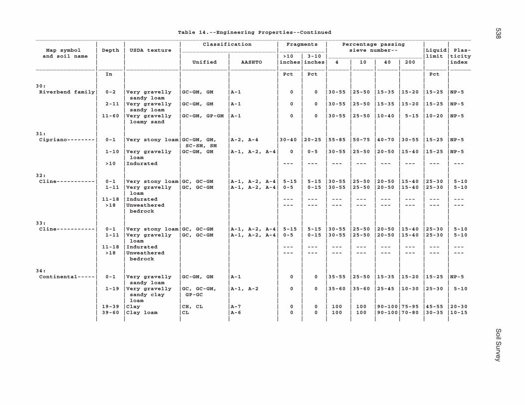
538S
oil Survey
Table 14.--Engineering Properties--Continued_____________________________________________________________________________________________________________________________ | | | Classification | Fragments | Percentage passing | | Map symbol | Depth | USDA texture |___________________________|_____________| sieve number-- |Liquid| Plas- and soil name | | | | | >10 | 3-10 |___________________________|limit |ticity | | | Unified | AASHTO |inches|inches| 4 | 10 | 40 | 200 | |index_________________|_______|_______________|_____________|_____________|______|______|______|______|______|______|______|______ | In | | | | Pct | Pct | | | | | Pct | | | | | | | | | | | | |30: | | | | | | | | | | | | Riverbend family| 0-2 |Very gravelly |GC-GM, GM |A-1 | 0 | 0 |30-55 |25-50 |15-35 |15-20 |15-25 |NP-5 | | sandy loam | | | | | | | | | | | 2-11 |Very gravelly |GC-GM, GM |A-1 | 0 | 0 |30-55 |25-50 |15-35 |15-20 |15-25 |NP-5 | | sandy loam | | | | | | | | | | | 11-60 |Very gravelly |GC-GM, GP-GM |A-1 | 0 | 0 |30-55 |25-50 |10-40 | 5-15 |10-20 |NP-5 | | loamy sand | | | | | | | | | | | | | | | | | | | | | |31: | | | | | | | | | | | | Cipriano--------| 0-1 |Very stony loam|GC-GM, GM, |A-2, A-4 |30-40 |20-25 |55-85 |50-75 |40-70 |30-55 |15-25 |NP-5 | | | SC-SM, SM | | | | | | | | | | 1-10 |Very gravelly |GC-GM, GM |A-1, A-2, A-4| 0 | 0-5 |30-55 |25-50 |20-50 |15-40 |15-25 |NP-5 | | loam | | | | | | | | | | | >10 |Indurated | | | --- | --- | --- | --- | --- | --- | --- | --- | | | | | | | | | | | |32: | | | | | | | | | | | | Cline-----------| 0-1 |Very stony loam|GC, GC-GM |A-1, A-2, A-4| 5-15 | 5-15 |30-55 |25-50 |20-50 |15-40 |25-30 | 5-10 | 1-11 |Very gravelly |GC, GC-GM |A-1, A-2, A-4| 0-5 | 0-15 |30-55 |25-50 |20-50 |15-40 |25-30 | 5-10 | | loam | | | | | | | | | | | 11-18 |Indurated | | | --- | --- | --- | --- | --- | --- | --- | --- | >18 |Unweathered | | | --- | --- | --- | --- | --- | --- | --- | --- | | bedrock | | | | | | | | | | | | | | | | | | | | | |33: | | | | | | | | | | | | Cline-----------| 0-1 |Very stony loam|GC, GC-GM |A-1, A-2, A-4| 5-15 | 5-15 |30-55 |25-50 |20-50 |15-40 |25-30 | 5-10 | 1-11 |Very gravelly |GC, GC-GM |A-1, A-2, A-4| 0-5 | 0-15 |30-55 |25-50 |20-50 |15-40 |25-30 | 5-10 | | loam | | | | | | | | | | | 11-18 |Indurated | | | --- | --- | --- | --- | --- | --- | --- | --- | >18 |Unweathered | | | --- | --- | --- | --- | --- | --- | --- | --- | | bedrock | | | | | | | | | | | | | | | | | | | | | |34: | | | | | | | | | | | | Continental-----| 0-1 |Very gravelly |GC-GM, GM |A-1 | 0 | 0 |35-55 |25-50 |15-35 |15-20 |15-25 |NP-5 | | sandy loam | | | | | | | | | | | 1-19 |Very gravelly |GC, GC-GM, |A-1, A-2 | 0 | 0 |35-60 |35-60 |25-45 |10-30 |25-30 | 5-10 | | sandy clay | GP-GC | | | | | | | | | | | loam | | | | | | | | | | | 19-39 |Clay |CH, CL |A-7 | 0 | 0 | 100 | 100 |90-100|75-95 |45-55 |20-30 | 39-60 |Clay loam |CL |A-6 | 0 | 0 | 100 | 100 |90-100|70-80 |30-35 |10-15 | | | | | | | | | | | |

Mohave C
ounty, Arizona, S
outhern Part
539
Table 14.--Engineering Properties--Continued_____________________________________________________________________________________________________________________________ | | | Classification | Fragments | Percentage passing | | Map symbol | Depth | USDA texture |___________________________|_____________| sieve number-- |Liquid| Plas- and soil name | | | | | >10 | 3-10 |___________________________|limit |ticity | | | Unified | AASHTO |inches|inches| 4 | 10 | 40 | 200 | |index_________________|_______|_______________|_____________|_____________|______|______|______|______|______|______|______|______ | In | | | | Pct | Pct | | | | | Pct | | | | | | | | | | | | |34: | | | | | | | | | | | | Tres Hermanos---| 0-2 |Gravelly sandy |GC-GM, GM, |A-1 | 0 | 0 |55-80 |50-75 |35-50 |15-30 |15-25 |NP-10 | | loam | SC-SM, SM | | | | | | | | | | 2-26 |Gravelly sandy |GC, GC-GM, |A-2, A-4, A- | 0 | 0 |55-80 |50-75 |40-70 |20-40 |30-40 | 5-15 | | clay loam | SC, SC-SM | 6, A-1 | | | | | | | | | 26-60 |Gravelly sandy |GC-GM, GM, |A-1, A-2 | 0 | 0 |55-80 |50-75 |30-50 |15-30 |15-25 |NP-10 | | loam | SC-SM, SM | | | | | | | | | | | | | | | | | | | | |35: | | | | | | | | | | | | Continental-----| 0-1 |Very gravelly |GC-GM, GM |A-1 | 0 | 0 |35-55 |25-50 |15-35 |15-20 |15-25 |NP-5 | | sandy loam | | | | | | | | | | | 1-19 |Very gravelly |GC, GC-GM, |A-1, A-2 | 0 | 0 |35-60 |35-60 |25-45 |10-30 |25-30 | 5-10 | | sandy clay | GP-GC | | | | | | | | | | | loam | | | | | | | | | | | 19-39 |Clay |CH, CL |A-7 | 0 | 0 | 100 | 100 |90-100|75-95 |45-55 |20-30 | 39-60 |Clay loam |CL |A-6 | 0 | 0 | 100 | 100 |90-100|70-80 |30-35 |10-15 | | | | | | | | | | | | Tres Hermanos---| 0-2 |Gravelly sandy |GC-GM, GM, |A-1 | 0 | 0 |55-80 |50-75 |35-50 |15-30 |15-25 |NP-10 | | loam | SC-SM, SM | | | | | | | | | | 2-26 |Gravelly sandy |SC-SM, GC, |A-1, A-2, A- | 0 | 0 |55-80 |50-75 |40-70 |20-40 |30-40 | 5-15 | | clay loam | GC-GM, SC | 4, A-6 | | | | | | | | | 26-60 |Gravelly sandy |GC-GM, GM, |A-1, A-2 | 0 | 0 |55-80 |50-75 |30-50 |15-30 |15-25 |NP-10 | | loam | SC-SM, SM | | | | | | | | | | | | | | | | | | | | |36: | | | | | | | | | | | | Continental-----| 0-1 |Very gravelly |GC-GM, GM |A-1 | 0 | 0 |35-55 |25-50 |15-35 |15-20 |15-25 |NP-5 | | sandy loam | | | | | | | | | | | 1-19 |Very gravelly |GC, GC-GM, |A-1, A-2 | 0 | 0 |35-60 |35-60 |25-45 |10-30 |25-30 | 5-10 | | sandy clay | GP-GC | | | | | | | | | | | loam | | | | | | | | | | | 19-39 |Clay |CH, CL |A-7 | 0 | 0 | 100 | 100 |90-100|75-95 |45-55 |20-30 | 39-60 |Clay loam |CL |A-6 | 0 | 0 | 100 | 100 |90-100|70-80 |30-35 |10-15 | | | | | | | | | | | |

540S
oil Survey
Table 14.--Engineering Properties--Continued_____________________________________________________________________________________________________________________________ | | | Classification | Fragments | Percentage passing | | Map symbol | Depth | USDA texture |___________________________|_____________| sieve number-- |Liquid| Plas- and soil name | | | | | >10 | 3-10 |___________________________|limit |ticity | | | Unified | AASHTO |inches|inches| 4 | 10 | 40 | 200 | |index_________________|_______|_______________|_____________|_____________|______|______|______|______|______|______|______|______ | In | | | | Pct | Pct | | | | | Pct | | | | | | | | | | | | |36: | | | | | | | | | | | | Rillino---------| 0-2 |Gravelly sandy |GC-GM, GM |A-1 | 0 | 0 |30-55 |25-50 |15-35 |15-20 |15-25 |NP-5 | | loam | | | | | | | | | | | 2-8 |Gravelly sandy |GC-GM, SC-SM |A-1, A-2, A-4| 0 | 0 |55-80 |50-75 |40-70 |20-40 |30-35 | 5-10 | | clay loam | | | | | | | | | | | 8-16 |Gravelly sandy |GC-GM, SC-SM |A-1, A-2, A-4| 0 | 0 |55-80 |50-75 |40-70 |20-40 |30-35 | 5-10 | | clay loam | | | | | | | | | | | 16-27 |Gravelly sandy |GC-GM, GM |A-1 | 0 | 0 |30-55 |25-50 |15-35 |15-20 |15-25 |NP-5 | | loam | | | | | | | | | | | 27-39 |Gravelly loamy |GC, GC-GM, GM|A-1, A-2 | 0 | 0 |30-55 |25-50 |15-35 |15-20 | 0-25 |NP-10 | | sand | | | | | | | | | | | 39-54 |Gravelly loamy |GC, GC-GM, GM|A-1, A-2 | 0 | 0 |30-55 |25-50 |15-35 |15-20 | 0-25 |NP-10 | | sand | | | | | | | | | | | 54-60 |Gravelly loamy |GC, GC-GM, GM|A-1, A-2 | 0 | 0 |30-55 |25-50 |15-35 |15-20 | 0-25 |NP-10 | | sand | | | | | | | | | | | | | | | | | | | | | |37: | | | | | | | | | | | | Continental-----| 0-1 |Very gravelly |GC-GM, GM |A-1 | 0 | 0 |35-55 |25-50 |15-35 |15-20 |15-25 |NP-5 | | sandy loam | | | | | | | | | | | 1-19 |Very gravelly |GC, GC-GM, |A-1, A-2 | 0 | 0 |35-60 |35-60 |25-45 |10-30 |25-30 | 5-10 | | sandy clay | GP-GC | | | | | | | | | | | loam | | | | | | | | | | | 19-39 |Clay |CH, CL |A-7 | 0 | 0 | 100 | 100 |90-100|75-95 |45-55 |20-30 | 39-60 |Clay loam |CL |A-6 | 0 | 0 | 100 | 100 |90-100|70-80 |30-35 |10-15 | | | | | | | | | | | | Rillino---------| 0-2 |Gravelly sandy |GC-GM, GM |A-1 | 0 | 0 |30-55 |25-50 |15-35 |15-20 |15-25 |NP-5 | | loam | | | | | | | | | | | 2-16 |Gravelly sandy |GC-GM, SC-SM |A-1, A-2, A-4| 0 | 0 |55-80 |50-75 |40-70 |20-40 |30-35 | 5-10 | | clay loam | | | | | | | | | | | 16-27 |Gravelly sandy |GC-GM, GM |A-1 | 0 | 0 |30-55 |25-50 |15-35 |15-20 |15-25 |NP-5 | | loam | | | | | | | | | | | 27-60 |Gravelly loamy |GC, GC-GM, GM|A-1, A-2 | 0 | 0 |30-55 |25-50 |15-35 |15-20 | 0-25 |NP-10 | | sand | | | | | | | | | | | | | | | | | | | | | |38: | | | | | | | | | | | | Coolidge--------| 0-2 |Gravelly sandy |GC-GM, GM, |A-1, A-2 | 0 | 0 |55-80 |50-75 |30-50 |15-30 |15-25 |NP-5 | | loam | SC-SM, SM | | | | | | | | | | 2-27 |Sandy loam |SC-SM, SM |A-1, A-2, A-4| 0 | 0 |80-100|75-100|45-70 |20-40 |15-25 |NP-5 | 27-46 |Sandy loam |SC-SM, SM |A-1, A-2, A-4| 0 | 0 |80-100|75-100|45-70 |20-40 |15-25 |NP-5 | 46-60 |Gravelly sandy |GC-GM, GM, |A-1, A-2 | 0 | 0 |55-80 |50-75 |30-50 |15-30 |15-25 |NP-5 | | loam | SC-SM, SM | | | | | | | | | | | | | | | | | | | | |

Mohave C
ounty, Arizona, S
outhern Part
541
Table 14.--Engineering Properties--Continued_____________________________________________________________________________________________________________________________ | | | Classification | Fragments | Percentage passing | | Map symbol | Depth | USDA texture |___________________________|_____________| sieve number-- |Liquid| Plas- and soil name | | | | | >10 | 3-10 |___________________________|limit |ticity | | | Unified | AASHTO |inches|inches| 4 | 10 | 40 | 200 | |index_________________|_______|_______________|_____________|_____________|______|______|______|______|______|______|______|______ | In | | | | Pct | Pct | | | | | Pct | | | | | | | | | | | | |38: | | | | | | | | | | | | Denure----------| 0-2 |Loamy sand |SC-SM, SM |A-1, A-2 | 0 | 0 |80-100|75-100|40-75 |10-30 |10-15 |NP-5 | 2-7 |Loamy sand |SC-SM, SM |A-1, A-2 | 0 | 0 |80-100|75-100|40-75 |10-30 |10-15 |NP-5 | 7-18 |Gravelly coarse|GC-GM, SC-SM,|A-1 | 0 | 0 |55-80 |50-75 |25-45 |10-20 |15-25 |NP-5 | | sandy loam | SP-SM | | | | | | | | | | 18-60 |Coarse sandy |SC-SM, SM |A-1, A-2 | 0 | 0 |80-100|75-100|35-65 |15-35 |15-25 |NP-5 | | loam | | | | | | | | | | | | | | | | | | | | | |39: | | | | | | | | | | | | Coolidge family-| 0-2 |Gravelly loam |GC-GM, GM, |A-2, A-4 | 0 | 0 |55-80 |50-75 |40-70 |30-55 |15-25 |NP-5 | | | SC-SM, SM | | | | | | | | | | 2-8 |Gravelly sandy |GC-GM, GM, |A-1 | 0 | 0 |55-80 |50-75 |30-50 |15-30 |15-25 |NP-5 | | loam | SC-SM, SM | | | | | | | | | | 8-29 |Sandy loam |SC-SM, SM |A-1, A-2 | 0 | 0 |80-100|75-100|45-70 |20-40 |15-25 |NP-5 | 29-41 |Sandy loam |SC-SM, SM |A-1, A-2 | 0 | 0 |80-100|75-100|45-70 |20-40 |15-25 |NP-5 | 41-60 |Gravelly sand |SP, SP-SM |A-1 | 0 | 0 |55-80 |50-75 |25-50 | 0-10 |10-20 |NP-5 | | | | | | | | | | | | Denure family---| 0-1 |Very gravelly |GC-GM, GP-GM |A-1 | 0 | 0 |30-55 |25-50 |10-40 | 5-15 |10-20 |NP-5 | | loamy sand | | | | | | | | | | | 1-11 |Loamy sand |SC-SM, SM, |A-1, A-2 | 0 | 0 |80-100|75-100|40-75 |10-30 |10-20 |NP-5 | | | SP-SM | | | | | | | | | | 11-60 |Sandy loam |SC-SM, SM |A-1, A-2, A-4| 0 | 0 |80-100|75-100|45-70 |20-40 |15-25 |NP-5 | | | | | | | | | | | |40: | | | | | | | | | | | | Courthouse | | | | | | | | | | | | family---------| 0-2 |Very cobbly |GC-GM, GM, |A-2, A-4 | 0-10 |30-45 |55-80 |50-75 |40-70 |30-55 |15-25 |NP-5 | | loam | ML, SM | | | | | | | | | | 2-12 |Extremely |GC-GM, GM |A-1, A-2, A-4| 0 | 0-10 |30-55 |25-50 |20-50 |15-40 |15-25 |NP-5 | | gravelly loam | | | | | | | | | | | >12 |Unweathered | | | --- | --- | --- | --- | --- | --- | --- | --- | | bedrock | | | | | | | | | | | | | | | | | | | | | | Rock outcrop----| --- | --- | --- | --- | --- | --- | --- | --- | --- | --- | --- | --- | | | | | | | | | | | | Rubble land-----| --- | --- | --- | --- | --- | --- | --- | --- | --- | --- | --- | --- | | | | | | | | | | | |

542S
oil Survey
Table 14.--Engineering Properties--Continued_____________________________________________________________________________________________________________________________ | | | Classification | Fragments | Percentage passing | | Map symbol | Depth | USDA texture |___________________________|_____________| sieve number-- |Liquid| Plas- and soil name | | | | | >10 | 3-10 |___________________________|limit |ticity | | | Unified | AASHTO |inches|inches| 4 | 10 | 40 | 200 | |index_________________|_______|_______________|_____________|_____________|______|______|______|______|______|______|______|______ | In | | | | Pct | Pct | | | | | Pct | | | | | | | | | | | | |41: | | | | | | | | | | | | Courthouse | | | | | | | | | | | | family---------| 0-2 |Extremely |GC-GM, GM, |A-2, A-4 | 0-10 |40-55 |55-80 |50-75 |40-70 |30-55 |15-25 |NP-5 | | cobbly loam | ML, SM | | | | | | | | | | 2-12 |Extremely |GC-GM, GM |A-1, A-2, A-4| 0 | 0-10 |30-55 |25-50 |20-50 |15-40 |15-25 |NP-5 | | gravelly loam | | | | | | | | | | | >12 |Unweathered | | | --- | --- | --- | --- | --- | --- | --- | --- | | bedrock | | | | | | | | | | | | | | | | | | | | | | Rock outcrop----| --- | --- | --- | --- | --- | --- | --- | --- | --- | --- | --- | --- | | | | | | | | | | | | Wagonbow--------| 0-3 |Very stony clay|CL, GC, SC |A-6 |20-35 |20-35 |55-80 |50-75 |45-75 |35-60 |30-35 |10-15 | | loam | | | | | | | | | | | 3-6 |Cobbly clay |CL |A-6 | 0-5 |20-35 |80-100|75-100|70-100|50-100|30-35 |10-15 | | loam | | | | | | | | | | | 6-50 |Silty clay |CH, CL |A-7 | 0-5 | 0-10 |80-100|75-100|70-100|65-95 |35-55 |15-35 | 50-60 |Very gravelly |GC |A-2, A-6 | 0 | 0-5 |30-55 |25-50 |20-50 |20-40 |30-35 |10-15 | | clay loam | | | | | | | | | | | | | | | | | | | | | |42: | | | | | | | | | | | | Far-------------| 0-5 |Very bouldery |GC-GM, GM, |A-2, A-4 |40-45 | 0-5 |55-80 |50-75 |40-70 |30-55 |15-25 |NP-5 | | loam | SC-SM | | | | | | | | | | 5-9 |Very gravelly |GC-GM, GM |A-1, A-2, A-4| 0-5 | 0-51 |30-55 |25-50 |20-50 |15-40 |15-25 |NP-5 | | loam | | | | | | | | | | | >9 |Weathered | | | --- | --- | --- | --- | --- | --- | --- | --- | | bedrock | | | | | | | | | | | | | | | | | | | | | | Rock outcrop----| --- | --- | --- | --- | --- | --- | --- | --- | --- | --- | --- | --- | | | | | | | | | | | |43: | | | | | | | | | | | | Dutchflat-------| 0-4 |Sandy loam |SC-SM, SM |A-2, A-4 | 0 | 0 |90-100|85-100|50-70 |25-40 |15-25 |NP-5 | 4-37 |Sandy clay loam|CL, CL-ML, |A-2, A-4, A-6| 0 | 0 |90-100|85-100|70-90 |30-55 |15-35 | 5-15 | | | SC, SC-SM | | | | | | | | | | 37-60 |Coarse sandy |SC-SM, SM |A-1, A-2 | 0 | 0 |90-100|85-100|45-65 |20-35 |15-25 |NP-5 | | loam | | | | | | | | | | | | | | | | | | | | | |

Mohave C
ounty, Arizona, S
outhern Part
543
Table 14.--Engineering Properties--Continued_____________________________________________________________________________________________________________________________ | | | Classification | Fragments | Percentage passing | | Map symbol | Depth | USDA texture |___________________________|_____________| sieve number-- |Liquid| Plas- and soil name | | | | | >10 | 3-10 |___________________________|limit |ticity | | | Unified | AASHTO |inches|inches| 4 | 10 | 40 | 200 | |index_________________|_______|_______________|_____________|_____________|______|______|______|______|______|______|______|______ | In | | | | Pct | Pct | | | | | Pct | | | | | | | | | | | | |44: | | | | | | | | | | | | Dutchflat-------| 0-2 |Fine sandy loam|CL-ML, ML, |A-2, A-4 | 0 | 0 |80-100|75-100|50-85 |30-55 |15-25 |NP-5 | | | SC-SM, SM | | | | | | | | | | 2-28 |Gravelly sandy |GC, GC-GM, |A-1, A-2, A- | 0 | 0 |55-80 |50-75 |40-70 |20-40 |30-40 | 5-15 | | clay loam | SC, SC-SM | 4, A-6 | | | | | | | | | 28-41 |Gravelly sandy |GC, GC-GM, |A-1, A-2, A- | 0 | 0 |55-80 |50-75 |40-70 |20-40 |30-40 | 5-15 | | clay loam | SC, SC-SM | 4, A-6 | | | | | | | | | 41-60 |Very gravelly |GC-GM, GM, |A-1 | 0 | 0 |30-55 |25-50 |15-30 | 5-15 |15-25 |NP-5 | | coarse sandy | GP-GM | | | | | | | | | | | loam | | | | | | | | | | | | | | | | | | | | | |45: | | | | | | | | | | | | Gadsden---------| 0-2 |Silty clay |CL |A-7 | 0 | 0 | 100 | 100 |95-100|90-95 |40-50 |20-30 | 2-56 |Stratified |CH, CL |A-7 | 0 | 0 | 100 | 100 |90-100|75-95 |45-55 |20-30 | | silty clay to | | | | | | | | | | | | clay | | | | | | | | | | | 56-60 |Stratified very|CL-ML, ML |A-4 | 0 | 0 | 100 | 100 |80-90 |50-60 |15-25 |NP-5 | | fine sandy | | | | | | | | | | | | loam to silt | | | | | | | | | | | | loam | | | | | | | | | | | | | | | | | | | | | |46: | | | | | | | | | | | | Gila------------| 0-4 |Very fine sandy|CL-ML, ML |A-4 | 0 | 0 | 100 | 100 |85-95 |50-60 |15-25 |NP-5 | | loam | | | | | | | | | | | 4-12 |Stratified silt|CL, CL-ML, ML|A-4 | 0 | 0 | 100 | 100 |90-100|70-90 |15-30 |NP-10 | | loam | | | | | | | | | | | 12-21 |Stratified very|CL, CL-ML, ML|A-4 | 0 | 0 | 100 | 100 |85-95 |50-60 |15-30 |NP-10 | | fine sandy | | | | | | | | | | | | loam | | | | | | | | | | | 21-29 |Stratified fine|SC-SM, SM |A-2 | 0 | 0 | 100 | 100 |50-75 |15-30 |10-20 |NP-5 | | sand to loamy | | | | | | | | | | | | fine sand | | | | | | | | | | | 29-60 |Stratified fine|CL |A-6 | 0 | 0 | 100 | 100 |95-100|85-90 |30-40 |10-20 | | sandy loam to | | | | | | | | | | | | silty clay | | | | | | | | | | | | loam | | | | | | | | | | | | | | | | | | | | | | Glendale--------| 0-10 |Silty clay loam|CL |A-6 | 0 | 0 | 100 | 100 |95-100|85-95 |30-40 |10-20 | 10-37 |Silty clay loam|CL |A-6 | 0 | 0 | 100 | 100 |95-100|85-95 |30-40 |10-20 | 37-54 |Silt loam |CL, CL-ML, ML|A-4 | 0 | 0 | 100 | 100 |90-100|70-90 |15-30 |NP-10 | 54-60 |Coarse sand |SP-SM |A-1, A-2, A-3| 0 | 0 | 100 | 100 |45-60 | 5-10 |10-20 |NP-5 | | | | | | | | | | | |

544S
oil Survey
Table 14.--Engineering Properties--Continued_____________________________________________________________________________________________________________________________ | | | Classification | Fragments | Percentage passing | | Map symbol | Depth | USDA texture |___________________________|_____________| sieve number-- |Liquid| Plas- and soil name | | | | | >10 | 3-10 |___________________________|limit |ticity | | | Unified | AASHTO |inches|inches| 4 | 10 | 40 | 200 | |index_________________|_______|_______________|_____________|_____________|______|______|______|______|______|______|______|______ | In | | | | Pct | Pct | | | | | Pct | | | | | | | | | | | | |47: | | | | | | | | | | | | Gila------------| 0-4 |Very fine sandy|CL-ML, ML |A-4 | 0 | 0 | 100 | 100 |85-95 |50-60 |15-25 |NP-5 | | loam | | | | | | | | | | | 4-12 |Stratified silt|CL, CL-ML, ML|A-4 | 0 | 0 | 100 | 100 |90-100|70-90 |15-30 |NP-10 | | loam | | | | | | | | | | | 12-21 |Stratified very|CL, CL-ML, ML|A-4 | 0 | 0 | 100 | 100 |85-95 |50-60 |15-30 |NP-10 | | fine sandy | | | | | | | | | | | | loam | | | | | | | | | | | 21-29 |Stratified fine|SC-SM, SM |A-2 | 0 | 0 | 100 | 100 |50-75 |15-30 |10-20 |NP-5 | | sand to loamy | | | | | | | | | | | | fine sand | | | | | | | | | | | 29-60 |Stratified fine|CL |A-6 | 0 | 0 | 100 | 100 |95-100|85-90 |30-40 |10-20 | | sandy loam to | | | | | | | | | | | | silty clay | | | | | | | | | | | | loam | | | | | | | | | | | | | | | | | | | | | | Glendale--------| 0-10 |Silty clay loam|CL |A-6 | 0 | 0 | 100 | 100 |95-100|85-95 |30-40 |10-20 | 10-21 |Silty clay loam|CL |A-6 | 0 | 0 | 100 | 100 |95-100|85-95 |30-40 |10-20 | 21-37 |Silty clay loam|CL |A-6 | 0 | 0 | 100 | 100 |95-100|85-95 |30-40 |10-20 | 37-54 |Silt loam |CL, CL-ML, ML|A-4 | 0 | 0 | 100 | 100 |90-100|70-90 |15-30 |NP-10 | 54-60 |Coarse sand |SW-SM |A-1, A-2, A-3| 0 | 0 | 100 | 100 |45-60 | 5-10 |10-20 |NP-5 | | | | | | | | | | | |48: | | | | | | | | | | | | Goldroad--------| 0-2 |Extremely |GC-GM, GM, GP|A-1 | 0 | 0-10 |20-30 |15-25 | 5-20 | 0-15 |15-25 |NP-5 | | gravelly sandy| | | | | | | | | | | | loam | | | | | | | | | | | 2-13 |Very gravelly |GC-GM, GM, |A-1 | 0 | 0-10 |30-55 |25-50 |15-30 | 5-15 |15-25 |NP-5 | | sandy loam | GP-GM | | | | | | | | | | --- |Unweathered | | | --- | --- | --- | --- | --- | --- | --- | --- | | bedrock | | | | | | | | | | | | | | | | | | | | | | Rock outcrop----| --- | --- | --- | --- | --- | --- | --- | --- | --- | --- | --- | --- | | | | | | | | | | | |49: | | | | | | | | | | | | Gonzales--------| 0-1 |Very cobbly |GC, GC-GM, |A-2, A-4, A-6| 0 |35-45 |65-75 |55-65 |45-60 |25-45 |25-35 | 5-15 | | sandy clay | SC, SC-SM | | | | | | | | | | | loam | | | | | | | | | | | 1-7 |Clay |CH, CL |A-7 | 0 | 0-10 |95-100|90-95 |75-90 |50-75 |40-55 |20-30 | 7-14 |Clay |CH, CL |A-7 | 0 | 0-10 |95-100|90-95 |75-90 |50-75 |40-55 |20-30 | 14-17 |Weathered | | | --- | --- | --- | --- | --- | --- | --- | --- | | bedrock | | | | | | | | | | | >17 |Unweathered | | | --- | --- | --- | --- | --- | --- | --- | --- | | bedrock | | | | | | | | | | | | | | | | | | | | | |

Mohave C
ounty, Arizona, S
outhern Part
545
Table 14.--Engineering Properties--Continued_____________________________________________________________________________________________________________________________ | | | Classification | Fragments | Percentage passing | | Map symbol | Depth | USDA texture |___________________________|_____________| sieve number-- |Liquid| Plas- and soil name | | | | | >10 | 3-10 |___________________________|limit |ticity | | | Unified | AASHTO |inches|inches| 4 | 10 | 40 | 200 | |index_________________|_______|_______________|_____________|_____________|______|______|______|______|______|______|______|______ | In | | | | Pct | Pct | | | | | Pct | | | | | | | | | | | | |49: | | | | | | | | | | | | Rock outcrop----| --- | --- | --- | --- | --- | --- | --- | --- | --- | --- | --- | --- | | | | | | | | | | | |50: | | | | | | | | | | | | Goodsprings | | | | | | | | | | | | family---------| 0-2 |Gravelly sandy |SM, GC-GM, |A-1 | 0 | 0 |60-70 |55-65 |30-45 |15-25 |15-30 |NP-10 | | loam | GM, SC-SM | | | | | | | | | | 2-18 |Gravelly loam |GM, SM |A-4 | 0 | 0 |60-75 |55-70 |45-65 |35-50 |15-30 |NP-10 | 18-39 |Cemented | | | --- | --- | --- | --- | --- | --- | --- | --- | 39-60 |Extremely |GP, GP-GM |A-1 | 0 | 0 |20-30 |15-25 | 5-20 | 0-5 |10-15 |NP-5 | | gravelly loamy| | | | | | | | | | | | coarse sand | | | | | | | | | | | | | | | | | | | | | |51: | | | | | | | | | | | | Goodsprings | | | | | | | | | | | | family---------| 0-2 |Gravelly sandy |SM, GC-GM, |A-1 | 0 | 0 |60-70 |55-65 |30-45 |15-25 |15-30 |NP-10 | | loam | GM, SC-SM | | | | | | | | | | 2-18 |Gravelly loam |GM, SM |A-4 | 0 | 0 |60-75 |55-70 |45-65 |35-50 |15-30 |NP-10 | 18-39 |Cemented | | | --- | --- | --- | --- | --- | --- | --- | --- | 39-60 |Extremely |GP, GP-GM |A-1 | 0 | 0 |20-30 |15-25 | 5-20 | 0-5 |10-15 |NP-5 | | gravelly loamy| | | | | | | | | | | | coarse sand | | | | | | | | | | | | | | | | | | | | | |52: | | | | | | | | | | | | Goodsprings | | | | | | | | | | | | family---------| 0-2 |Gravelly sandy |SM, GC-GM, |A-1 | 0 | 0 |60-70 |55-65 |30-45 |15-25 |15-30 |NP-10 | | loam | GM, SC-SM | | | | | | | | | | 2-18 |Gravelly loam |GM, SM |A-4 | 0 | 0 |60-75 |55-70 |45-65 |35-50 |15-30 |NP-10 | 18-39 |Cemented | | | --- | --- | --- | --- | --- | --- | --- | --- | 39-60 |Extremely |GP, GP-GM |A-1 | 0 | 0 |20-30 |15-25 | 5-20 | 0-5 |10-15 |NP-5 | | gravelly loamy| | | | | | | | | | | | coarse sand | | | | | | | | | | | | | | | | | | | | | |

546S
oil Survey
Table 14.--Engineering Properties--Continued_____________________________________________________________________________________________________________________________ | | | Classification | Fragments | Percentage passing | | Map symbol | Depth | USDA texture |___________________________|_____________| sieve number-- |Liquid| Plas- and soil name | | | | | >10 | 3-10 |___________________________|limit |ticity | | | Unified | AASHTO |inches|inches| 4 | 10 | 40 | 200 | |index_________________|_______|_______________|_____________|_____________|______|______|______|______|______|______|______|______ | In | | | | Pct | Pct | | | | | Pct | | | | | | | | | | | | |53: | | | | | | | | | | | | Goodsprings | | | | | | | | | | | | family---------| 0-2 |Gravelly sandy |SM, GC-GM, |A-1 | 0 | 0 |60-70 |55-65 |30-45 |15-25 |15-30 |NP-10 | | loam | GM, SC-SM | | | | | | | | | | 2-18 |Gravelly loam |GM, SM |A-4 | 0 | 0 |60-75 |55-70 |45-65 |35-50 |15-30 |NP-10 | 18-39 |Cemented | | | --- | --- | --- | --- | --- | --- | --- | --- | 39-60 |Extremely |GP, GP-GM |A-1 | 0 | 0 |20-30 |15-25 | 5-20 | 0-5 |10-15 |NP-5 | | gravelly loamy| | | | | | | | | | | | coarse sand | | | | | | | | | | | | | | | | | | | | | |54: | | | | | | | | | | | | Graham----------| 0-2 |Very cobbly |GC, GC-GM, GM|A-1, A-2, A-4|10-15 |30-45 |30-55 |25-50 |20-50 |15-40 |15-30 |NP-10 | | loam | | | | | | | | | | | 2-7 |Clay loam |CL |A-6 | 0-5 | 0-10 |80-100|75-100|70-100|50-80 |30-35 |10-15 | 7-14 |Clay |CH, CL |A-6, A-7 | 0 | 0-5 |80-100|75-100|70-100|50-95 |35-55 |15-35 | >14 |Unweathered | | | --- | --- | --- | --- | --- | --- | --- | --- | | bedrock | | | | | | | | | | | | | | | | | | | | | | Arivaca---------| 0-2 |Very cobbly |CL, GC, GM, |A-1, A-2, A- | 0-10 |25-55 |30-80 |25-75 |20-75 |20-70 | 0-40 |NP-15 | | silty clay | ML | 4, A-6 | | | | | | | | | | loam | | | | | | | | | | | 2-6 |Cobbly silty |CH, CL |A-6, A-7 | 0 |30-50 |80-100|75-100|70-100|65-95 |35-65 |15-45 | | clay | | | | | | | | | | | 6-17 |Clay |CH, CL |A-6, A-7 | 0 | 0 |90-100|85-100|75-100|65-95 |35-65 |15-45 | 17-30 |Clay |CH, CL |A-6, A-7 | 0 | 0 |90-100|85-100|75-100|65-95 |35-65 |15-45 | 30-36 |Clay loam |CL |A-6 | 0 | 0 |90-100|85-100|75-100|60-80 |25-40 |10-20 | >36 |Unweathered | | | --- | --- | --- | --- | --- | --- | --- | --- | | bedrock | | | | | | | | | | | | | | | | | | | | | |55: | | | | | | | | | | | | Graham----------| 0-2 |Very cobbly |GC, GC-GM, GM|A-1, A-2, A-4|10-15 |30-45 |30-55 |25-50 |20-50 |15-40 |15-30 |NP-10 | | loam | | | | | | | | | | | 2-7 |Clay loam |CL |A-6 | 0-5 | 0-10 |80-100|75-100|70-100|50-80 |30-35 |10-15 | 7-14 |Clay |CH, CL |A-6, A-7 | 0 | 0-5 |80-100|75-100|70-100|50-95 |35-55 |15-35 | >14 |Unweathered | | | --- | --- | --- | --- | --- | --- | --- | --- | | bedrock | | | | | | | | | | | | | | | | | | | | | |

Mohave C
ounty, Arizona, S
outhern Part
547
Table 14.--Engineering Properties--Continued_____________________________________________________________________________________________________________________________ | | | Classification | Fragments | Percentage passing | | Map symbol | Depth | USDA texture |___________________________|_____________| sieve number-- |Liquid| Plas- and soil name | | | | | >10 | 3-10 |___________________________|limit |ticity | | | Unified | AASHTO |inches|inches| 4 | 10 | 40 | 200 | |index_________________|_______|_______________|_____________|_____________|______|______|______|______|______|______|______|______ | In | | | | Pct | Pct | | | | | Pct | | | | | | | | | | | | |55: | | | | | | | | | | | | Rock outcrop----| --- | --- | --- | --- | --- | --- | --- | --- | --- | --- | --- | --- | | | | | | | | | | | |56: | | | | | | | | | | | | Gunsight--------| 0-3 |Very gravelly |GM |A-1 | 0 | 0 |50-60 |40-50 |25-35 |15-20 |15-20 |NP-5 | | loam | | | | | | | | | | | 3-6 |Very gravelly |GC-GM, GM |A-1 | 0 | 0 |35-55 |25-50 |15-35 |15-20 |15-25 |NP-5 | | sandy loam | | | | | | | | | | | 6-28 |Extremely |GC-GM, GM, GP|A-1 | 0 | 0 |20-30 |15-25 | 5-20 | 0-15 |15-25 |NP-5 | | gravelly sandy| | | | | | | | | | | | loam | | | | | | | | | | | 28-50 |Extremely |GP, GP-GM |A-1 | 0 | 0 |20-30 |15-25 | 5-20 | 0-10 |15-25 |NP-5 | | gravelly | | | | | | | | | | | | coarse sandy | | | | | | | | | | | | loam | | | | | | | | | | | 50-60 |Extremely |GP, GP-GM |A-1 | 0 | 0 |20-35 |15-30 | 5-20 | 0-10 |10-20 |NP-5 | | gravelly loamy| | | | | | | | | | | | sand | | | | | | | | | | | | | | | | | | | | | |57: | | | | | | | | | | | | Gunsight--------| 0-3 |Very gravelly |GC-GM, GM |A-1 | 0 | 0-20 |35-55 |25-50 |15-35 |15-20 |15-25 |NP-5 | | sandy loam | | | | | | | | | | | 3-6 |Very gravelly |GC-GM, GM |A-1 | 0 | 0 |35-55 |25-50 |15-35 |15-20 |15-25 |NP-5 | | sandy loam | | | | | | | | | | | 6-28 |Extremely |GC-GM, GM, GP|A-1 | 0 | 0 |20-30 |15-25 | 5-20 | 0-15 |15-25 |NP-5 | | gravelly sandy| | | | | | | | | | | | loam | | | | | | | | | | | 28-50 |Extremely |GP, GP-GM |A-1 | 0 | 0 |20-30 |15-25 | 5-20 | 0-10 |15-25 |NP-5 | | gravelly | | | | | | | | | | | | coarse sandy | | | | | | | | | | | | loam | | | | | | | | | | | 50-60 |Extremely |GP, GP-GM |A-1 | 0 | 0 |20-35 |15-30 | 5-20 | 0-10 |10-20 |NP-5 | | gravelly loamy| | | | | | | | | | | | sand | | | | | | | | | | | | | | | | | | | | | |

548S
oil Survey
Table 14.--Engineering Properties--Continued_____________________________________________________________________________________________________________________________ | | | Classification | Fragments | Percentage passing | | Map symbol | Depth | USDA texture |___________________________|_____________| sieve number-- |Liquid| Plas- and soil name | | | | | >10 | 3-10 |___________________________|limit |ticity | | | Unified | AASHTO |inches|inches| 4 | 10 | 40 | 200 | |index_________________|_______|_______________|_____________|_____________|______|______|______|______|______|______|______|______ | In | | | | Pct | Pct | | | | | Pct | | | | | | | | | | | | |58: | | | | | | | | | | | | Hassell family--| 0-4 |Loam |CL, CL-ML, |A-4 | 0 | 0-5 |80-100|75-100|65-95 |45-75 |15-30 |NP-10 | | | SC-SM, SM | | | | | | | | | | 4-13 |Clay |CH, CL |A-7 | 0 | 0 |80-100|75-100|70-100|50-95 |35-55 |15-35 | 13-24 |Clay |CH, CL |A-7 | 0 | 0 |80-100|75-100|70-100|50-95 |35-55 |15-35 | 24-33 |Gravelly clay |CL, GC, SC |A-6 | 0 | 0 |55-80 |50-75 |45-75 |35-60 |32-40 |10-15 | | loam | | | | | | | | | | | 33-47 |Weathered | | | --- | --- | --- | --- | --- | --- | --- | --- | | bedrock | | | | | | | | | | | >47 |Unweathered | | | --- | --- | --- | --- | --- | --- | --- | --- | | bedrock | | | | | | | | | | | | | | | | | | | | | | Lampshire-------| 0-1 |Very gravelly |GC-GM, GM |A-1, A-2, A-4| 0 | 0-5 |30-55 |20-50 |20-50 |15-40 |15-25 |NP-5 | | loam | | | | | | | | | | | 1-6 |Very gravelly |GW-GM |A-1 | 0 | 0 |40-50 |35-45 |15-20 | 5-15 |15-25 |NP-5 | | sandy loam | | | | | | | | | | | 6-9 |Weathered | | | --- | --- | --- | --- | --- | --- | --- | --- | | bedrock | | | | | | | | | | | >9 |Unweathered | | | --- | --- | --- | --- | --- | --- | --- | --- | | bedrock | | | | | | | | | | | | | | | | | | | | | | Rock outcrop----| --- | --- | --- | --- | --- | --- | --- | --- | --- | --- | --- | --- | | | | | | | | | | | |59: | | | | | | | | | | | | Holtville-------| 0-2 |Silty clay |CH, CL |A-6, A-7 | 0 | 0 | 100 | 100 |95-100|90-95 |35-55 |15-35 | 2-23 |Clay |CH, CL |A-6, A-7 | 0 | 0 | 100 | 100 |90-100|75-95 |35-55 |15-35 | 23-31 |Silty clay |CL, CH |A-6, A-7 | 0 | 0 | 100 | 100 |95-100|90-95 |35-55 |15-35 | 31-42 |Very fine sandy|CL-ML, ML |A-4 | 0 | 0 | 100 | 100 |75-85 |50-60 |15-25 |NP-5 | | loam | | | | | | | | | | | 42-60 |Fine sand |CL-ML, ML, |A-2, A-4 | 0 | 0 | 100 | 100 |75-95 |35-55 |15-20 |NP-5 | | | SC-SM, SM | | | | | | | | | | | | | | | | | | | | |

Mohave C
ounty, Arizona, S
outhern Part
549
Table 14.--Engineering Properties--Continued_____________________________________________________________________________________________________________________________ | | | Classification | Fragments | Percentage passing | | Map symbol | Depth | USDA texture |___________________________|_____________| sieve number-- |Liquid| Plas- and soil name | | | | | >10 | 3-10 |___________________________|limit |ticity | | | Unified | AASHTO |inches|inches| 4 | 10 | 40 | 200 | |index_________________|_______|_______________|_____________|_____________|______|______|______|______|______|______|______|______ | In | | | | Pct | Pct | | | | | Pct | | | | | | | | | | | | |60: | | | | | | | | | | | | Huevi-----------| 0-2 |Very gravelly |GC-GM, GM, |A-2, A-4 | 0 | 0-5 |55-80 |50-75 |40-70 |30-55 |15-25 |NP-5 | | loam | ML, SM | | | | | | | | | | 2-9 |Very gravelly |GC-GM, GM |A-1 | 0 | 0-5 |30-55 |25-50 |15-35 |15-20 |15-25 |NP-5 | | sandy loam | | | | | | | | | | | 9-27 |Very gravelly |GC-GM, GM |A-1 | 0 | 0-5 |30-55 |25-50 |15-35 |15-20 |15-25 |NP-5 | | sandy loam | | | | | | | | | | | 27-40 |Extremely |GC-GM, GM, GP|A-1 | 0 | 0-5 |20-30 |15-25 | 5-20 | 0-15 |15-25 |NP-5 | | gravelly sandy| | | | | | | | | | | | loam | | | | | | | | | | | 40-60 |Very gravelly |GP-GM |A-1 | 0 | 0-5 |30-55 |25-50 |10-40 | 5-15 |10-20 |NP-5 | | loamy sand | | | | | | | | | | | | | | | | | | | | | |61: | | | | | | | | | | | | Huevi-----------| 0-2 |Very gravelly |GM |A-1 | 0 | 0-5 |40-60 |35-50 |30-45 |20-25 |15-25 |NP-5 | | loam | | | | | | | | | | | 2-9 |Very gravelly |GC-GM, GM |A-1 | 0 | 0-5 |30-55 |25-50 |15-35 |15-20 |15-25 |NP-5 | | sandy loam | | | | | | | | | | | 9-27 |Very gravelly |GC-GM, GM |A-1 | 0 | 0-5 |30-55 |25-50 |15-35 |15-20 |15-25 |NP-5 | | sandy loam | | | | | | | | | | | 27-40 |Extremely |GC-GM, GM, GW|A-1 | 0 | 0-5 |20-30 |15-25 | 5-20 | 0-15 |15-25 |NP-5 | | gravelly sandy| | | | | | | | | | | | loam | | | | | | | | | | | 40-60 |Very gravelly |GW-GM |A-1 | 0 | 0-5 |30-55 |25-50 |10-40 | 5-15 |10-20 |NP-5 | | loamy sand | | | | | | | | | | | | | | | | | | | | | |62: | | | | | | | | | | | | Akela-----------| 0-1 |Very gravelly |GC-GM, GM |A-1 | 0 | 0-10 |30-55 |25-50 |15-35 |15-25 |15-20 |NP-5 | | sandy loam | | | | | | | | | | | 1-12 |Very gravelly |GC-GM, GM, |A-1 | 0 | 0-5 |20-55 |15-50 |10-35 | 5-20 |15-20 |NP-5 | | sandy loam, | GP-GM, GW-GM| | | | | | | | | | | extremely | | | | | | | | | | | | gravelly sandy| | | | | | | | | | | | loam | | | | | | | | | | | >12 |Unweathered | | | --- | --- | --- | --- | --- | --- | --- | --- | | bedrock | | | | | | | | | | | | | | | | | | | | | |
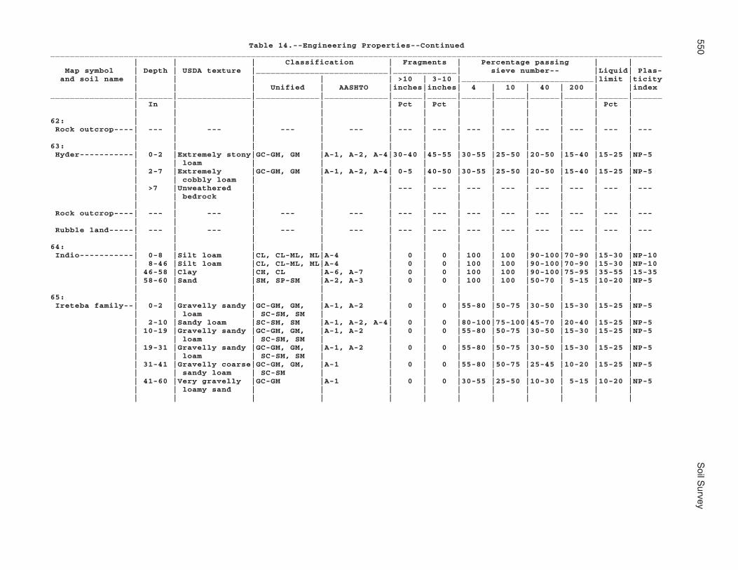
550S
oil Survey
Table 14.--Engineering Properties--Continued_____________________________________________________________________________________________________________________________ | | | Classification | Fragments | Percentage passing | | Map symbol | Depth | USDA texture |___________________________|_____________| sieve number-- |Liquid| Plas- and soil name | | | | | >10 | 3-10 |___________________________|limit |ticity | | | Unified | AASHTO |inches|inches| 4 | 10 | 40 | 200 | |index_________________|_______|_______________|_____________|_____________|______|______|______|______|______|______|______|______ | In | | | | Pct | Pct | | | | | Pct | | | | | | | | | | | | |62: | | | | | | | | | | | | Rock outcrop----| --- | --- | --- | --- | --- | --- | --- | --- | --- | --- | --- | --- | | | | | | | | | | | |63: | | | | | | | | | | | | Hyder-----------| 0-2 |Extremely stony|GC-GM, GM |A-1, A-2, A-4|30-40 |45-55 |30-55 |25-50 |20-50 |15-40 |15-25 |NP-5 | | loam | | | | | | | | | | | 2-7 |Extremely |GC-GM, GM |A-1, A-2, A-4| 0-5 |40-50 |30-55 |25-50 |20-50 |15-40 |15-25 |NP-5 | | cobbly loam | | | | | | | | | | | >7 |Unweathered | | | --- | --- | --- | --- | --- | --- | --- | --- | | bedrock | | | | | | | | | | | | | | | | | | | | | | Rock outcrop----| --- | --- | --- | --- | --- | --- | --- | --- | --- | --- | --- | --- | | | | | | | | | | | | Rubble land-----| --- | --- | --- | --- | --- | --- | --- | --- | --- | --- | --- | --- | | | | | | | | | | | |64: | | | | | | | | | | | | Indio-----------| 0-8 |Silt loam |CL, CL-ML, ML|A-4 | 0 | 0 | 100 | 100 |90-100|70-90 |15-30 |NP-10 | 8-46 |Silt loam |CL, CL-ML, ML|A-4 | 0 | 0 | 100 | 100 |90-100|70-90 |15-30 |NP-10 | 46-58 |Clay |CH, CL |A-6, A-7 | 0 | 0 | 100 | 100 |90-100|75-95 |35-55 |15-35 | 58-60 |Sand |SM, SP-SM |A-2, A-3 | 0 | 0 | 100 | 100 |50-70 | 5-15 |10-20 |NP-5 | | | | | | | | | | | |65: | | | | | | | | | | | | Ireteba family--| 0-2 |Gravelly sandy |GC-GM, GM, |A-1, A-2 | 0 | 0 |55-80 |50-75 |30-50 |15-30 |15-25 |NP-5 | | loam | SC-SM, SM | | | | | | | | | | 2-10 |Sandy loam |SC-SM, SM |A-1, A-2, A-4| 0 | 0 |80-100|75-100|45-70 |20-40 |15-25 |NP-5 | 10-19 |Gravelly sandy |GC-GM, GM, |A-1, A-2 | 0 | 0 |55-80 |50-75 |30-50 |15-30 |15-25 |NP-5 | | loam | SC-SM, SM | | | | | | | | | | 19-31 |Gravelly sandy |GC-GM, GM, |A-1, A-2 | 0 | 0 |55-80 |50-75 |30-50 |15-30 |15-25 |NP-5 | | loam | SC-SM, SM | | | | | | | | | | 31-41 |Gravelly coarse|GC-GM, GM, |A-1 | 0 | 0 |55-80 |50-75 |25-45 |10-20 |15-25 |NP-5 | | sandy loam | SC-SM | | | | | | | | | | 41-60 |Very gravelly |GC-GM |A-1 | 0 | 0 |30-55 |25-50 |10-30 | 5-15 |10-20 |NP-5 | | loamy sand | | | | | | | | | | | | | | | | | | | | | |

Mohave C
ounty, Arizona, S
outhern Part
551
Table 14.--Engineering Properties--Continued_____________________________________________________________________________________________________________________________ | | | Classification | Fragments | Percentage passing | | Map symbol | Depth | USDA texture |___________________________|_____________| sieve number-- |Liquid| Plas- and soil name | | | | | >10 | 3-10 |___________________________|limit |ticity | | | Unified | AASHTO |inches|inches| 4 | 10 | 40 | 200 | |index_________________|_______|_______________|_____________|_____________|______|______|______|______|______|______|______|______ | In | | | | Pct | Pct | | | | | Pct | | | | | | | | | | | | |65: | | | | | | | | | | | | Arizo-----------| 0-2 |Gravelly sandy |GC-GM, GM, |A-1, A-2 | 0 | 0 |55-80 |50-75 |30-50 |15-30 |15-25 |NP-5 | | loam | SC-SM, SM | | | | | | | | | | 2-11 |Gravelly sandy |GC-GM, GM, |A-1, A-2 | 0 | 0 |55-80 |50-75 |30-50 |15-30 |15-25 |NP-5 | | loam | SC-SM, SM | | | | | | | | | | 11-15 |Sandy loam |SC-SM, SM |A-1, A-2, A-4| 0 | 0 |80-100|75-100|45-70 |20-40 |15-25 |NP-5 | 15-35 |Extremely |GW, GW-GC |A-1, A-2 | 0 | 0 |20-30 |15-25 | 5-20 | 0-10 |15-30 |NP-10 | | gravelly loamy| | | | | | | | | | | | sand | | | | | | | | | | | 35-60 |Very gravelly |GW, GW-GC |A-1, A-2 | 0 | 0 |30-55 |25-50 |10-25 | 0-10 |15-30 |NP-10 | | loamy coarse | | | | | | | | | | | | sand | | | | | | | | | | | | | | | | | | | | | |66: | | | | | | | | | | | | Kinley----------| 0-2 |Gravelly loamy |GC, GM, SC-SM|A-1, A-2 | 0 | 0 |55-80 |50-75 |25-55 |10-20 | 0-30 |NP-10 | | sand | | | | | | | | | | | 2-9 |Sandy loam |SC-SM, SM |A-1, A-2, A-4| 0 | 0 |80-100|75-100|45-70 |20-40 |15-25 |NP-5 | 9-13 |Sandy loam |SC-SM, SM |A-1, A-2, A-4| 0 | 0 |80-100|75-100|45-70 |20-40 |15-25 |NP-5 | 13-24 |Sandy loam |SC-SM, SM |A-1, A-2, A-4| 0 | 0 |80-100|75-100|45-70 |20-40 |15-25 |NP-5 | 24-34 |Gravelly sandy |SC-SM, SM, |A-1, A-2 | 0 | 0 |55-80 |50-75 |30-50 |15-30 |15-25 |NP-5 | | loam | GC-GM, GM | | | | | | | | | | 34-50 |Very gravelly |GC-GM, GM |A-1 | 0 | 0 |35-55 |25-50 |15-35 |15-20 |15-25 |NP-5 | | sandy loam | | | | | | | | | | | 50-60 |Very gravelly |GC-GM, GM |A-1 | 0 | 0 |35-55 |25-50 |15-35 |15-20 |15-25 |NP-5 | | sandy loam | | | | | | | | | | | | | | | | | | | | | |67: | | | | | | | | | | | | Kinley----------| 0-2 |Gravelly sandy |GC-GM, GM, |A-1, A-2 | 0 | 0 |55-80 |50-75 |30-50 |15-30 |15-25 |NP-5 | | loam | SC-SM, SM | | | | | | | | | | 2-9 |Sandy loam |SC-SM, SM |A-1, A-2, A-4| 0 | 0 |80-100|75-100|45-70 |20-40 |15-25 |NP-5 | 9-13 |Sandy loam |SC-SM, SM |A-1, A-2, A-4| 0 | 0 |80-100|75-100|45-70 |20-40 |15-25 |NP-5 | 13-24 |Sandy loam |SC-SM, SM |A-1, A-2, A-4| 0 | 0 |80-100|75-100|45-70 |20-40 |15-25 |NP-5 | 24-34 |Gravelly sandy |SC-SM, SM, |A-1, A-2 | 0 | 0 |55-80 |50-75 |30-50 |15-30 |15-25 |NP-5 | | loam | GC-GM, GM | | | | | | | | | | 34-50 |Very gravelly |GC-GM, GM |A-1 | 0 | 0 |35-55 |25-50 |15-35 |15-20 |15-25 |NP-5 | | sandy loam | | | | | | | | | | | 50-60 |Very gravelly |GC-GM, GM |A-1 | 0 | 0 |35-55 |25-50 |15-35 |15-20 |15-25 |NP-5 | | sandy loam | | | | | | | | | | | | | | | | | | | | | |

552S
oil Survey
Table 14.--Engineering Properties--Continued_____________________________________________________________________________________________________________________________ | | | Classification | Fragments | Percentage passing | | Map symbol | Depth | USDA texture |___________________________|_____________| sieve number-- |Liquid| Plas- and soil name | | | | | >10 | 3-10 |___________________________|limit |ticity | | | Unified | AASHTO |inches|inches| 4 | 10 | 40 | 200 | |index_________________|_______|_______________|_____________|_____________|______|______|______|______|______|______|______|______ | In | | | | Pct | Pct | | | | | Pct | | | | | | | | | | | | |67: | | | | | | | | | | | | Poachie---------| 0-2 |Gravelly clay |CL, GC, SC |A-6 | 0 | 0 |55-80 |50-75 |45-75 |35-60 |30-35 |10-15 | | loam | | | | | | | | | | | 2-24 |Sandy loam |SC-SM, SM |A-1, A-2, A-4| 0 | 0 |80-100|75-100|45-70 |20-40 |15-25 |NP-5 | 24-38 |Sandy clay loam|CL, CL-ML, |A-2, A-4 | 0 | 0 |80-100|75-100|60-90 |25-55 |25-30 | 5-10 | | | SC, SC-SM | | | | | | | | | | 38-60 |Gravelly coarse|GC-GM, GM, |A-1 | 0 | 0 |55-80 |50-75 |25-45 |10-20 |15-25 |NP-5 | | sandy loam | SC-SM, SP-SM| | | | | | | | | | | | | | | | | | | | |68: | | | | | | | | | | | | Kofa------------| 0-12 |Silty clay |CH, CL |A-7 | 0 | 0 | 100 | 100 |95-100|90-95 |45-55 |20-30 | 12-29 |Stratified |CH |A-7 | 0 | 0 | 100 | 100 |95-100|85-95 |55-75 |35-50 | | clay, | | | | | | | | | | | | stratified | | | | | | | | | | | | silty clay | | | | | | | | | | | 29-60 |Stratified |SM, SP-SM |A-2, A-3 | 0 | 0 | 100 | 100 |60-80 | 5-25 | 0-14 | NP | | sand, | | | | | | | | | | | | stratified | | | | | | | | | | | | loamy sand, | | | | | | | | | | | | stratified | | | | | | | | | | | | fine sand | | | | | | | | | | | | | | | | | | | | | |69: | | | | | | | | | | | | Dudleyville-----| 0-2 |Gravelly loamy |GM, GP-GM, |A-1, A-2 | 0 | 0 |55-80 |25-55 |25-55 |10-20 |10-20 |NP-5 | | sand | SC-SM, SM | | | | | | | | | | 2-12 |Gravelly loamy |GM, SC-SM, |A-1 | 0 | 0 |55-80 |20-40 |20-40 | 5-15 |10-20 |NP-5 | | coarse sand | SM, SP-SM | | | | | | | | | | 12-60 |Very gravelly |GP, GP-GM, |A-1 | 0 | 0 |35-60 |35-60 |15-25 | 0-5 |10-20 |NP-5 | | coarse sand | SP, SP-SM | | | | | | | | | | | | | | | | | | | | | Vinton----------| 0-3 |Coarse sandy |SC-SM, SM |A-2 | 0 | 0 |95-100|90-100|50-60 |20-35 |15-25 |NP-5 | | loam | | | | | | | | | | | 3-24 |Loamy coarse |SC-SM, SM, |A-1, A-2 | 0 | 0 |95-100|90-100|45-60 |10-25 |10-20 |NP-5 | | sand | SP-SM | | | | | | | | | | 24-30 |Gravelly loamy |GM, SC-SM, |A-1 | 0 | 0 |55-80 |50-75 |20-40 | 5-15 |10-20 |NP-5 | | coarse sand | SM, SP-SM | | | | | | | | | | 30-38 |Loamy coarse |SC-SM, SM, |A-1, A-2, A-3| 0 | 0 |80-100|75-100|30-60 | 5-25 |10-20 |NP-5 | | sand | SP-SM | | | | | | | | | | 38-60 |Very gravelly |GP, GP-GM, |A-1 | 0 | 0 |30-55 |25-50 |15-25 | 0-10 |10-20 |NP-5 | | loamy coarse | SP, SP-SM | | | | | | | | | | | sand | | | | | | | | | | | | | | | | | | | | | |

Mohave C
ounty, Arizona, S
outhern Part
553
Table 14.--Engineering Properties--Continued_____________________________________________________________________________________________________________________________ | | | Classification | Fragments | Percentage passing | | Map symbol | Depth | USDA texture |___________________________|_____________| sieve number-- |Liquid| Plas- and soil name | | | | | >10 | 3-10 |___________________________|limit |ticity | | | Unified | AASHTO |inches|inches| 4 | 10 | 40 | 200 | |index_________________|_______|_______________|_____________|_____________|______|______|______|______|______|______|______|______ | In | | | | Pct | Pct | | | | | Pct | | | | | | | | | | | | |69: | | | | | | | | | | | | Riverwash-------| --- | --- | --- | --- | --- | --- | --- | --- | --- | --- | --- | --- | | | | | | | | | | | |70: | | | | | | | | | | | | Dudleyville-----| 0-2 |Gravelly loamy |GM, GP-GM, |A-1, A-2 | 0 | 0 |55-80 |25-55 |25-55 |10-20 |10-20 |NP-5 | | sand | SC-SM, SM | | | | | | | | | | 2-12 |Gravelly loamy |GM, SC-SM, |A-1 | 0 | 0 |55-80 |20-40 |20-40 | 5-15 |10-20 |NP-5 | | coarse sand | SM, SP-SM | | | | | | | | | | 12-60 |Very gravelly |GP, GP-GM, |A-1 | 0 | 0 |35-60 |35-60 |15-25 | 0-5 |10-20 |NP-5 | | coarse sand | SP, SP-SM | | | | | | | | | | | | | | | | | | | | | Vinton----------| 0-3 |Coarse sandy |SC-SM, SM |A-2 | 0 | 0 |95-100|90-100|50-60 |20-35 |15-25 |NP-5 | | loam | | | | | | | | | | | 3-24 |Loamy coarse |SC-SM, SM, |A-1, A-2 | 0 | 0 |95-100|90-100|45-60 |10-25 |10-20 |NP-5 | | sand | SP-SM | | | | | | | | | | 24-30 |Gravelly loamy |GM, SC-SM, |A-1 | 0 | 0 |55-80 |50-75 |20-40 | 5-15 |10-20 |NP-5 | | coarse sand | SM, SP-SM | | | | | | | | | | 30-38 |Loamy coarse |SC-SM, SM, |A-1, A-2, A-3| 0 | 0 |80-100|75-100|30-60 | 5-25 |10-20 |NP-5 | | sand | SP-SM | | | | | | | | | | 38-60 |Very gravelly |GP, GP-GM, |A-1 | 0 | 0 |30-55 |25-50 |15-25 | 0-10 |10-20 |NP-5 | | loamy coarse | SP, SP-SM | | | | | | | | | | | sand | | | | | | | | | | | | | | | | | | | | | | Riverwash-------| --- | --- | --- | --- | --- | --- | --- | --- | --- | --- | --- | --- | | | | | | | | | | | |71: | | | | | | | | | | | | Lagunita--------| 0-2 |Sand |SM, SP-SM, |A-2, A-3, A-1| 0 | 0 |80-100|75-100|40-70 | 5-15 |10-20 |NP-5 | | | SC-SM | | | | | | | | | | 2-60 |Loamy sand |SC-SM, SM, |A-1, A-2, A-3| 0 | 0 |80-100|75-100|40-70 | 5-15 |10-20 |NP-5 | | | SP-SM | | | | | | | | | | | | | | | | | | | | |72: | | | | | | | | | | | | Lagunita--------| 0-2 |Coarse sand |SP-SM |A-1, A-2, A-3| 0 | 0 |95-100|90-100|40-60 | 5-10 |10-20 |NP-5 | 2-60 |Loamy sand |SC-SM, SM, |A-1, A-2, A-3| 0 | 0 |80-100|75-100|40-70 | 5-15 |10-20 |NP-5 | | | SP-SM | | | | | | | | | | | | | | | | | | | | |

554S
oil Survey
Table 14.--Engineering Properties--Continued_____________________________________________________________________________________________________________________________ | | | Classification | Fragments | Percentage passing | | Map symbol | Depth | USDA texture |___________________________|_____________| sieve number-- |Liquid| Plas- and soil name | | | | | >10 | 3-10 |___________________________|limit |ticity | | | Unified | AASHTO |inches|inches| 4 | 10 | 40 | 200 | |index_________________|_______|_______________|_____________|_____________|______|______|______|______|______|______|______|______ | In | | | | Pct | Pct | | | | | Pct | | | | | | | | | | | | |72: | | | | | | | | | | | | Ripley----------| 0-1 |Fine sandy loam|CL-ML, ML, |A-2, A-4 | 0 | 0 |80-100|75-100|50-85 |30-55 |15-25 |NP-5 | | | SC-SM, SM | | | | | | | | | | 1-30 |Gravelly silt |CL, GC, GM, |A-4 | 0 | 0 |55-80 |50-75 |45-75 |35-70 |10-30 |NP-10 | | loam | ML | | | | | | | | | | 30-60 |Gravelly loamy |GM, SC-SM, SM|A-1, A-2 | 0 | 0 |55-80 |50-75 |25-55 |10-20 |10-20 |NP-5 | | fine sand | | | | | | | | | | | | | | | | | | | | | |73: | | | | | | | | | | | | Lampshire-------| 0-1 |Gravelly coarse|SC-SM, SM |A-2, A-1 | 0 | 0 |55-80 |50-75 |25-45 |15-30 |20-25 |NP-5 | | sandy loam | | | | | | | | | | | 1-6 |Very gravelly |SM |A-1 | 0 | 0-5 |50-60 |40-50 |23-35 |10-20 |15-25 |NP-5 | | sandy loam | | | | | | | | | | | 6-17 |Weathered | | | --- | --- | --- | --- | --- | --- | --- | --- | | bedrock | | | | | | | | | | | >17 |Unweathered | | | --- | --- | --- | --- | --- | --- | --- | --- | | bedrock | | | | | | | | | | | | | | | | | | | | | | Rock outcrop----| --- | --- | --- | --- | --- | --- | --- | --- | --- | --- | --- | --- | | | | | | | | | | | |74: | | | | | | | | | | | | Lampshire-------| 0-1 |Very gravelly |GC-GM, GM |A-1, A-2, A-4| 0 | 0-5 |30-55 |20-50 |20-50 |15-40 |15-25 |NP-5 | | loam | | | | | | | | | | | 1-6 |Very gravelly |GC-GM, GM, |A-1 | 0 | 0-5 |35-55 |15-35 |15-30 | 5-15 |15-25 |NP-5 | | sandy loam | GP-GM | | | | | | | | | | 6-17 |Weathered | | | --- | --- | --- | --- | --- | --- | --- | --- | | bedrock | | | | | | | | | | | >17 |Unweathered | | | --- | --- | --- | --- | --- | --- | --- | --- | | bedrock | | | | | | | | | | | | | | | | | | | | | | Rock outcrop----| --- | --- | --- | --- | --- | --- | --- | --- | --- | --- | --- | --- | | | | | | | | | | | |75: | | | | | | | | | | | | Lampshire-------| 0-2 |Very stony loam|GC-GM, SC-SM,|A-2, A-4 |20-40 |20-40 |55-80 |50-75 |40-75 |30-75 |15-25 |NP-5 | | | SM | | | | | | | | | | 2-7 |Very cobbly |GC-GM, GM, |A-2, A-4 | 0-15 |20-50 |55-80 |50-75 |40-75 |30-75 |15-25 |NP-5 | | loam | SC-SM, SM | | | | | | | | | | >7 |Unweathered | | | --- | --- | --- | --- | --- | --- | --- | --- | | bedrock | | | | | | | | | | | | | | | | | | | | | | Rock outcrop----| --- | --- | --- | --- | --- | --- | --- | --- | --- | --- | --- | --- | | | | | | | | | | | |

Mohave C
ounty, Arizona, S
outhern Part
555
Table 14.--Engineering Properties--Continued_____________________________________________________________________________________________________________________________ | | | Classification | Fragments | Percentage passing | | Map symbol | Depth | USDA texture |___________________________|_____________| sieve number-- |Liquid| Plas- and soil name | | | | | >10 | 3-10 |___________________________|limit |ticity | | | Unified | AASHTO |inches|inches| 4 | 10 | 40 | 200 | |index_________________|_______|_______________|_____________|_____________|______|______|______|______|______|______|______|______ | In | | | | Pct | Pct | | | | | Pct | | | | | | | | | | | | |76: | | | | | | | | | | | | Lostman---------| 0-2 |Gravelly sandy |SM |A-2 | 0 | 0 |60-80 |55-75 |35-60 |15-25 |20-25 |NP-5 | | loam | | | | | | | | | | | 2-36 |Gravelly sandy |SM |A-2 | 0 | 0 |60-80 |55-75 |35-60 |15-25 |20-25 |NP-5 | | loam | | | | | | | | | | | 36-56 |Very gravelly |GM, GW-GM |A-1 | 0 | 0 |40-49 |30-45 |20-30 | 5-15 |10-15 | NP | | loamy coarse | | | | | | | | | | | | sand | | | | | | | | | | | 56-60 |Gravelly sandy |GC |A-6 | 0 | 0 |60-80 |55-75 |40-50 |35-45 |30-35 |10-15 | | clay loam | | | | | | | | | | | | | | | | | | | | | |77: | | | | | | | | | | | | Lostman---------| 0-2 |Sandy loam |SC-SM, SM |A-1, A-2, A-4| 0 | 0 |80-100|75-100|45-70 |20-40 |15-25 |NP-5 | 2-12 |Fine sandy loam|CL-ML, ML, |A-2, A-4 | 0 | 0 |80-100|75-100|50-85 |30-55 |15-25 |NP-5 | | | SC-SM, SM | | | | | | | | | | 12-27 |Sandy loam |SC-SM, SM |A-1, A-2, A-4| 0 | 0 |80-100|75-100|45-70 |20-40 |15-25 |NP-5 | 27-38 |Loam |CL-ML, ML, |A-4 | 0 | 0 |80-100|75-100|65-95 |45-75 |15-25 |NP-5 | | | SC-SM, SM | | | | | | | | | | 38-60 |Very gravelly |GC-GM, GM |A-1 | 0 | 0 |30-55 |25-50 |15-35 |15-20 |15-25 |NP-5 | | sandy loam | | | | | | | | | | | | | | | | | | | | | |78: | | | | | | | | | | | | Lostman---------| 0-2 |Sandy loam |SC-SM, SM |A-1, A-2, A-4| 0 | 0 |80-100|75-100|45-70 |20-40 |15-25 |NP-5 | 2-12 |Fine sandy loam|CL-ML, ML, |A-2, A-4 | 0 | 0 |80-100|75-100|50-85 |30-55 |15-25 |NP-5 | | | SC-SM, SM | | | | | | | | | | 12-27 |Sandy loam |SC-SM, SM |A-1, A-2, A-4| 0 | 0 |80-100|75-100|45-70 |20-40 |15-25 |NP-5 | 27-38 |Loam |CL-ML, ML, |A-4 | 0 | 0 |80-100|75-100|65-95 |45-75 |15-25 |NP-5 | | | SC-SM, SM | | | | | | | | | | 38-60 |Very gravelly |GC-GM, GM |A-1 | 0 | 0 |30-55 |25-50 |15-35 |15-20 |15-25 |NP-5 | | sandy loam | | | | | | | | | | | | | | | | | | | | | |

556S
oil Survey
Table 14.--Engineering Properties--Continued_____________________________________________________________________________________________________________________________ | | | Classification | Fragments | Percentage passing | | Map symbol | Depth | USDA texture |___________________________|_____________| sieve number-- |Liquid| Plas- and soil name | | | | | >10 | 3-10 |___________________________|limit |ticity | | | Unified | AASHTO |inches|inches| 4 | 10 | 40 | 200 | |index_________________|_______|_______________|_____________|_____________|______|______|______|______|______|______|______|______ | In | | | | Pct | Pct | | | | | Pct | | | | | | | | | | | | |78: | | | | | | | | | | | | Kinley----------| 0-2 |Gravelly sandy |GC-GM, GM, |A-1, A-2 | 0 | 0 |55-80 |50-75 |30-50 |15-30 |15-25 |NP-5 | | loam | SC-SM, SM | | | | | | | | | | 2-9 |Sandy loam |SC-SM, SM |A-1, A-2, A-4| 0 | 0 |80-100|75-100|45-70 |20-40 |15-25 |NP-5 | 9-13 |Sandy loam |SC-SM, SM |A-1, A-2, A-4| 0 | 0 |80-100|75-100|45-70 |20-40 |15-25 |NP-5 | 13-24 |Sandy loam |SC-SM, SM |A-1, A-2, A-4| 0 | 0 |80-100|75-100|45-70 |20-40 |15-25 |NP-5 | 24-34 |Gravelly sandy |SC-SM, SM, |A-1, A-2 | 0 | 0 |55-80 |50-75 |30-50 |15-30 |15-25 |NP-5 | | loam | GC-GM, GM | | | | | | | | | | 34-50 |Very gravelly |GC-GM, GM |A-1 | 0 | 0 |35-55 |25-50 |15-35 |15-20 |15-25 |NP-5 | | sandy loam | | | | | | | | | | | 50-60 |Very gravelly |GC-GM, GM |A-1 | 0 | 0 |35-55 |25-50 |15-35 |15-20 |15-25 |NP-5 | | sandy loam | | | | | | | | | | | | | | | | | | | | | |79: | | | | | | | | | | | | Marshes---------| --- | --- | --- | --- | --- | --- | --- | --- | --- | --- | --- | --- | | | | | | | | | | | |80: | | | | | | | | | | | | Meloland--------| 0-8 |Very fine sandy|CL-ML |A-4 | 0 | 0 | 100 | 100 |85-95 |50-65 |20-25 |NP-5 | | loam | | | | | | | | | | | 8-19 |Very fine sandy|CL-ML |A-4 | 0 | 0 | 100 | 100 |85-95 |50-65 |20-25 |NP-5 | | loam | | | | | | | | | | | 19-60 |Clay |CH, CL |A-7 | 0 | 0 | 100 | 100 |90-100|75-95 |40-55 |20-35 | | | | | | | | | | | |81: | | | | | | | | | | | | Mohon-----------| 0-2 |Gravelly loamy |GM, GP-GM, |A-1, A-2 | 0 | 0-5 |55-80 |50-75 |25-55 |10-20 |10-20 |NP-5 | | sand | SC-SM, SM | | | | | | | | | | 2-6 |Clay loam |CL |A-6 | 0 | 0-5 |95-100|90-100|80-100|65-80 |30-35 |10-15 | 6-40 |Clay |CL |A-7 | 0 | 0-5 |95-100|90-100|80-100|70-95 |40-50 |20-30 | 40-60 |Cobbly clay |CL, GC, SC |A-6 | 0 | 0-25 |55-80 |50-75 |45-75 |35-60 |30-35 |10-15 | | loam | | | | | | | | | | | | | | | | | | | | | | Kinley----------| 0-2 |Gravelly sandy |GC-GM, GM, |A-1, A-2 | 0 | 0 |55-80 |50-75 |30-50 |15-30 |15-25 |NP-5 | | loam | SC-SM, SM | | | | | | | | | | 2-9 |Sandy loam |SC-SM, SM |A-1, A-2, A-4| 0 | 0 |80-100|75-100|45-70 |20-40 |15-25 |NP-5 | 9-13 |Sandy loam |SC-SM, SM |A-1, A-2, A-4| 0 | 0 |80-100|75-100|45-70 |20-40 |15-25 |NP-5 | 13-24 |Sandy loam |SC-SM, SM |A-1, A-2, A-4| 0 | 0 |80-100|75-100|45-70 |20-40 |15-25 |NP-5 | 24-34 |Gravelly sandy |SC-SM, SM, |A-1, A-2 | 0 | 0 |55-80 |50-75 |30-50 |15-30 |15-25 |NP-5 | | loam | GC-GM, GM | | | | | | | | | | 34-50 |Very gravelly |GC-GM, GM |A-1 | 0 | 0 |35-55 |25-50 |15-35 |15-20 |15-25 |NP-5 | | sandy loam | | | | | | | | | | | 50-60 |Very gravelly |GC-GM, GM |A-1 | 0 | 0 |35-55 |25-50 |15-35 |15-20 |15-25 |NP-5 | | sandy loam | | | | | | | | | | | | | | | | | | | | | |

Mohave C
ounty, Arizona, S
outhern Part
557
Table 14.--Engineering Properties--Continued_____________________________________________________________________________________________________________________________ | | | Classification | Fragments | Percentage passing | | Map symbol | Depth | USDA texture |___________________________|_____________| sieve number-- |Liquid| Plas- and soil name | | | | | >10 | 3-10 |___________________________|limit |ticity | | | Unified | AASHTO |inches|inches| 4 | 10 | 40 | 200 | |index_________________|_______|_______________|_____________|_____________|______|______|______|______|______|______|______|______ | In | | | | Pct | Pct | | | | | Pct | | | | | | | | | | | | |82: | | | | | | | | | | | | Mohon-----------| 0-2 |Very cobbly |GC, GC-GM |A-2, A-4 | 0 |35-55 |55-65 |45-55 |40-50 |25-40 |25-30 | 5-10 | | loam | | | | | | | | | | | 2-6 |Clay loam |CL |A-6 | 0 | 0-5 |95-100|90-100|80-100|65-80 |30-35 |10-15 | 6-40 |Clay |CL |A-7 | 0 | 0-5 |95-100|90-100|80-100|70-95 |40-50 |20-30 | 40-60 |Cobbly clay |CL, GC, SC |A-6 | 0 | 0-25 |55-80 |50-75 |45-75 |35-60 |30-35 |10-15 | | loam | | | | | | | | | | | | | | | | | | | | | | Poachie---------| 0-2 |Gravelly sandy |GC-GM, GM, |A-1, A-2 | 0 | 0 |55-80 |50-75 |30-50 |15-30 |15-25 |NP-5 | | loam | SC-SM, SM | | | | | | | | | | 2-24 |Sandy loam |SC-SM, SM |A-1, A-2, A-4| 0 | 0 |80-100|75-100|45-70 |20-40 |15-25 |NP-5 | 24-38 |Sandy clay loam|CL, CL-ML, |A-2, A-4 | 0 | 0 |80-100|75-100|60-90 |25-55 |25-30 | 5-10 | | | SC, SC-SM | | | | | | | | | | 38-60 |Gravelly coarse|GC-GM, GM, |A-1 | 0 | 0 |55-80 |50-75 |25-45 |10-20 |15-25 |NP-5 | | sandy loam | SC-SM, SP-SM| | | | | | | | | | | | | | | | | | | | |83: | | | | | | | | | | | | Mohon-----------| 0-2 |Very gravelly |GC-GM, GM |A-1 | 0 | 0-5 |30-55 |25-50 |15-35 |15-20 |15-25 |NP-5 | | sandy loam | | | | | | | | | | | 2-6 |Clay loam |CL |A-6 | 0 | 0-5 |95-100|90-100|80-100|65-80 |30-35 |10-15 | 6-40 |Clay |CL |A-7 | 0 | 0-5 |95-100|90-100|80-100|70-95 |40-50 |20-30 | 40-60 |Cobbly clay |CL, GC, SC |A-6 | 0 | 0-25 |55-80 |50-75 |45-75 |35-60 |30-35 |10-15 | | loam | | | | | | | | | | | | | | | | | | | | | | Poachie---------| 0-2 |Gravelly sandy |GC-GM, GM, |A-1, A-2 | 0 | 0 |55-80 |50-75 |30-50 |15-30 |15-25 |NP-5 | | loam | SC-SM, SM | | | | | | | | | | 2-24 |Sandy loam |SC-SM, SM |A-1, A-2, A-4| 0 | 0 |80-100|75-100|45-70 |20-40 |15-25 |NP-5 | 24-38 |Sandy clay loam|CL, CL-ML, |A-2, A-4 | 0 | 0 |80-100|75-100|60-90 |25-55 |25-30 | 5-10 | | | SC, SC-SM | | | | | | | | | | 38-60 |Gravelly coarse|GC-GM, GM, |A-1 | 0 | 0 |55-80 |50-75 |25-45 |10-20 |15-25 |NP-5 | | sandy loam | SC-SM, SP-SM| | | | | | | | | | | | | | | | | | | | |84: | | | | | | | | | | | | Nickel family---| 0-3 |Very gravelly |GC-GM |A-1 | 0 | 0-20 |30-55 |25-50 |10-40 | 5-15 |10-20 |NP-5 | | loamy sand | | | | | | | | | | | 3-7 |Very gravelly |GC, GC-GM |A-1, A-2 | 0 | 0-15 |30-55 |25-50 |25-45 |10-30 |25-30 | 5-10 | | sandy clay | | | | | | | | | | | | loam | | | | | | | | | | | 7-26 |Very gravelly |GC-GM, GM |A-1, A-2, A-4| 0 | 0-5 |30-55 |25-50 |20-50 |15-40 |15-25 |NP-5 | | loam | | | | | | | | | | | 26-60 |Very gravelly |GC-GM, GM |A-1 | 0 | 0-5 |30-55 |25-50 |15-35 |15-20 |15-25 |NP-5 | | sandy loam | | | | | | | | | | | | | | | | | | | | | |

558S
oil Survey
Table 14.--Engineering Properties--Continued_____________________________________________________________________________________________________________________________ | | | Classification | Fragments | Percentage passing | | Map symbol | Depth | USDA texture |___________________________|_____________| sieve number-- |Liquid| Plas- and soil name | | | | | >10 | 3-10 |___________________________|limit |ticity | | | Unified | AASHTO |inches|inches| 4 | 10 | 40 | 200 | |index_________________|_______|_______________|_____________|_____________|______|______|______|______|______|______|______|______ | In | | | | Pct | Pct | | | | | Pct | | | | | | | | | | | | |84: | | | | | | | | | | | | Topawa family---| 0-3 |Very gravelly |GC, GC-GM |A-1, A-2 | 0 | 0 |30-55 |25-50 |10-40 | 5-15 | 0-30 |NP-10 | | loamy sand | | | | | | | | | | | 3-18 |Very gravelly |GC |A-2 | 0 | 0 |30-55 |25-50 |25-45 |10-30 |30-35 |10-15 | | sandy clay | | | | | | | | | | | | loam | | | | | | | | | | | 18-50 |Very gravelly |GC-GM, GM |A-1 | 0 | 0 |30-55 |25-50 |15-35 |15-20 |20-25 |NP-5 | | sandy loam | | | | | | | | | | | 50-58 |Gravelly loamy |GM, SC-SM, SM|A-1, A-2 | 0 | 0 |55-80 |50-75 |25-55 |10-20 |10-20 |NP-5 | | sand | | | | | | | | | | | 58-60 |Gravelly loam |SC, SC-SM, |A-2, A-4 | 0 | 0 |55-80 |50-75 |40-70 |30-55 |25-30 | 5-10 | | | CL, GC | | | | | | | | | | | | | | | | | | | | | Eba family------| 0-1 |Very gravelly |GC-GM, GM |A-1 | 0 | 0-15 |30-55 |25-50 |15-30 | 5-15 |15-25 |NP-5 | | sandy loam | | | | | | | | | | | 1-8 |Very gravelly |GC |A-2, A-7 | 0 | 0-15 |30-55 |25-50 |25-50 |20-50 |35-55 |15-35 | | clay | | | | | | | | | | | 8-32 |Very gravelly |GC |A-2, A-7 | 0 | 0-15 |30-55 |25-50 |25-50 |20-50 |35-55 |15-35 | | clay | | | | | | | | | | | 32-52 |Very gravelly |GC |A-2 | 0 | 0-25 |30-55 |25-50 |20-50 |15-30 |35-55 |15-35 | | sandy clay | | | | | | | | | | | 52-60 |Very gravelly |GC, GC-GM |A-1, A-2, A-4| 0 | 0-15 |30-55 |25-50 |20-50 |15-40 |25-30 | 5-10 | | loam | | | | | | | | | | | | | | | | | | | | | |85: | | | | | | | | | | | | Orwash family---| 0-2 |Sandy loam |SC-SM, SM |A-1, A-2, A-4| 0 | 0 |80-100|75-100|45-70 |20-40 |15-25 |NP-5 | 2-14 |Coarse sandy |SC-SM, SM |A-1, A-2 | 0 | 0 |80-100|75-100|35-65 |15-35 |15-25 |NP-5 | | loam | | | | | | | | | | | 14-26 |Gravelly loamy |GM, SC-SM, SM|A-1, A-2 | 0 | 0 |55-80 |50-75 |25-55 |10-20 |10-20 |NP-5 | | sand | | | | | | | | | | | 26-47 |Gravelly sand |SP, SP-SM |A-1 | 0 | 0 |55-80 |50-75 |25-50 | 0-10 |10-20 |NP-5 | 47-60 |Gravelly sandy |GC, GC-GM, |A-1, A-4, A-6| 0 | 0 |55-80 |50-75 |40-70 |20-40 |20-30 | 5-15 | | clay loam | SC, SC-SM | | | | | | | | | | | | | | | | | | | | |86: | | | | | | | | | | | | Orwash family---| 0-2 |Sandy loam |SC-SM, SM |A-1, A-2, A-4| 0 | 0 |80-100|75-100|45-70 |20-40 |15-25 |NP-5 | 2-14 |Coarse sandy |SC-SM, SM |A-1, A-2 | 0 | 0 |80-100|75-100|35-65 |15-35 |15-25 |NP-5 | | loam | | | | | | | | | | | 14-26 |Gravelly loamy |GM, SC-SM, SM|A-1, A-2 | 0 | 0 |55-80 |50-75 |25-55 |10-20 |10-20 |NP-5 | | sand | | | | | | | | | | | 26-47 |Gravelly sand |SP, SP-SM |A-1 | 0 | 0 |55-80 |50-75 |25-50 | 0-10 |10-20 |NP-5 | 47-60 |Gravelly sandy |GC, GC-GM, |A-1, A-4, A-6| 0 | 0 |55-80 |50-75 |40-70 |20-40 |20-30 | 5-15 | | clay loam | SC, SC-SM | | | | | | | | | | | | | | | | | | | | |

Mohave C
ounty, Arizona, S
outhern Part
559
Table 14.--Engineering Properties--Continued_____________________________________________________________________________________________________________________________ | | | Classification | Fragments | Percentage passing | | Map symbol | Depth | USDA texture |___________________________|_____________| sieve number-- |Liquid| Plas- and soil name | | | | | >10 | 3-10 |___________________________|limit |ticity | | | Unified | AASHTO |inches|inches| 4 | 10 | 40 | 200 | |index_________________|_______|_______________|_____________|_____________|______|______|______|______|______|______|______|______ | In | | | | Pct | Pct | | | | | Pct | | | | | | | | | | | | |87: | | | | | | | | | | | | Penthouse-------| 0-2 |Very cobbly |GC-GM, GM, |A-2, A-4 | 0 |25-40 |55-80 |50-75 |40-70 |30-55 |15-25 |NP-5 | | loam | SC-SM | | | | | | | | | | 2-8 |Gravelly clay |CL, GC, SC |A-6 | 0 | 0-10 |55-80 |50-75 |45-75 |35-60 |30-35 |10-15 | | loam | | | | | | | | | | | 8-27 |Gravelly clay |CL, GC, SC |A-7 | 0 | 0-20 |55-80 |50-75 |45-75 |40-70 |40-50 |20-30 | 27-40 |Gravelly clay |CL, GC, SC |A-6 | 0 | 0-10 |55-80 |50-75 |45-75 |35-60 |25-35 |10-15 | | loam | | | | | | | | | | | 40-47 |Gravelly sandy |GC-GM, GM, |A-1, A-2 | 0 | 0-10 |55-80 |50-75 |30-50 |15-30 |20-25 |NP-5 | | loam | SC-SM, SM | | | | | | | | | | 47-60 |Very gravelly |GM, GP-GM |A-1 | 0 | 0-15 |30-55 |25-50 |10-40 | 5-15 |10-20 |NP-5 | | loamy sand | | | | | | | | | | | | | | | | | | | | | | Gonzales--------| 0-1 |Very cobbly |GC, GC-GM, |A-2, A-4, A-6| 0 |35-45 |65-75 |55-65 |45-60 |25-45 |25-35 | 5-15 | | loam | SC, SC-SM | | | | | | | | | | 1-14 |Clay, sandy |CH, CL |A-7 | 0 | 0-10 |95-100|90-95 |75-90 |50-75 |40-55 |20-30 | | clay | | | | | | | | | | | 14-17 |Weathered | | | --- | --- | --- | --- | --- | --- | --- | --- | | bedrock | | | | | | | | | | | >17 |Unweathered | | | --- | --- | --- | --- | --- | --- | --- | --- | | bedrock | | | | | | | | | | | | | | | | | | | | | |88: | | | | | | | | | | | | Poachie---------| 0-2 |Very gravelly |GC, GC-GM, GM|A-1, A-2, A-4| 0 | 0 |30-55 |25-50 |20-50 |15-40 |15-30 |NP-10 | | loam | | | | | | | | | | | 2-24 |Sandy loam |SC-SM, SM |A-1, A-2, A-4| 0 | 0 |80-100|75-100|45-70 |20-40 |15-25 |NP-5 | 24-38 |Sandy clay loam|CL, CL-ML, |A-2, A-4 | 0 | 0 |80-100|75-100|60-90 |25-55 |25-30 | 5-10 | | | SC, SC-SM | | | | | | | | | | 38-60 |Gravelly coarse|GC-GM, GM, |A-1 | 0 | 0 |55-80 |50-75 |25-45 |10-20 |15-25 |NP-5 | | sandy loam | SC-SM, SP-SM| | | | | | | | | | | | | | | | | | | | |89: | | | | | | | | | | | | Poachie---------| 0-2 |Very gravelly |GC, GC-GM, GM|A-1, A-2, A-4| 0 | 0 |30-55 |25-50 |20-50 |15-40 |15-30 |NP-10 | | loam | | | | | | | | | | | 2-24 |Sandy loam |SC-SM, SM |A-1, A-2, A-4| 0 | 0 |80-100|75-100|45-70 |20-40 |15-25 |NP-5 | 24-38 |Sandy clay loam|CL, CL-ML, |A-2, A-4 | 0 | 0 |80-100|75-100|60-90 |25-55 |25-30 | 5-10 | | | SC, SC-SM | | | | | | | | | | 38-60 |Gravelly coarse|GC-GM, GM, |A-1 | 0 | 0 |55-80 |50-75 |25-45 |10-20 |15-25 |NP-5 | | sandy loam | SC-SM, SP-SM| | | | | | | | | | | | | | | | | | | | |

560S
oil Survey
Table 14.--Engineering Properties--Continued_____________________________________________________________________________________________________________________________ | | | Classification | Fragments | Percentage passing | | Map symbol | Depth | USDA texture |___________________________|_____________| sieve number-- |Liquid| Plas- and soil name | | | | | >10 | 3-10 |___________________________|limit |ticity | | | Unified | AASHTO |inches|inches| 4 | 10 | 40 | 200 | |index_________________|_______|_______________|_____________|_____________|______|______|______|______|______|______|______|______ | In | | | | Pct | Pct | | | | | Pct | | | | | | | | | | | | |90: | | | | | | | | | | | | Quilotosa-------| 0-3 |Extremely |GC-GM, GM, |A-1 | 0 | 0-15 |20-30 |15-25 |10-20 | 5-15 |15-25 |NP-5 | | gravelly sandy| GP-GM | | | | | | | | | | | loam | | | | | | | | | | | 3-9 |Very gravelly |GP-GM, GC-GM,|A-1 | 0 | 0 |20-30 |15-25 | 5-20 | 0-15 |15-25 |NP-5 | | sandy loam | GM, GP | | | | | | | | | | 9-15 |Weathered | | | 0 | 0 | --- | --- | --- | --- | --- | --- | | bedrock | | | | | | | | | | | >15 |Unweathered | | | 0 | 0 | --- | --- | --- | --- | --- | --- | | bedrock | | | | | | | | | | | | | | | | | | | | | | Rock outcrop----| --- | --- | --- | --- | --- | --- | --- | --- | --- | --- | --- | --- | | | | | | | | | | | |91: | | | | | | | | | | | | Razorback-------| 0-2 |Extremely |GW |A-1 | 0 | 0-10 |20-30 |15-25 | 5-20 | 0-15 |15-25 |NP-5 | | gravelly sandy| | | | | | | | | | | | loam | | | | | | | | | | | 2-5 |Very gravelly |GW-GM |A-1 | 0 | 0-5 |35-50 |30-45 |15-30 | 5-15 |15-25 |NP-5 | | sandy loam | | | | | | | | | | | >5 |Unweathered | | | --- | --- | --- | --- | --- | --- | --- | --- | | bedrock | | | | | | | | | | | | | | | | | | | | | |92: | | | | | | | | | | | | Razorback-------| 0-2 |Extremely |GC-GM, GM |A-1, A-2, A-4|15-20 |50-55 |45-55 |40-50 |35-50 |25-50 |15-25 |NP-5 | | cobbly loam | | | | | | | | | | | 2-15 |Extremely |GC-GM, GM, |A-1 | 0-5 | 0-5 |20-30 |15-25 |15-25 |10-25 |15-25 |NP-5 | | gravelly loam | GP-GM | | | | | | | | | | >15 |Unweathered | | | --- | --- | --- | --- | --- | --- | --- | --- | | bedrock | | | | | | | | | | | | | | | | | | | | | | Rock outcrop----| --- | --- | --- | --- | --- | --- | --- | --- | --- | --- | --- | --- | | | | | | | | | | | |93: | | | | | | | | | | | | Razorback-------| 0-2 |Very stony loam|GC-GM, GM |A-1, A-2, A-4|40-50 | 0-15 |35-55 |25-50 |20-50 |15-40 |15-25 |NP-5 | 2-15 |Very gravelly |GC-GM, GM |A-1 | 0-5 | 0-5 |20-30 |15-25 |15-25 |10-25 |15-25 |NP-5 | | loam | | | | | | | | | | | >15 |Unweathered | | | --- | --- | --- | --- | --- | --- | --- | --- | | bedrock | | | | | | | | | | | | | | | | | | | | | | Rock outcrop----| --- | --- | --- | --- | --- | --- | --- | --- | --- | --- | --- | --- | | | | | | | | | | | |

Mohave C
ounty, Arizona, S
outhern Part
561
Table 14.--Engineering Properties--Continued_____________________________________________________________________________________________________________________________ | | | Classification | Fragments | Percentage passing | | Map symbol | Depth | USDA texture |___________________________|_____________| sieve number-- |Liquid| Plas- and soil name | | | | | >10 | 3-10 |___________________________|limit |ticity | | | Unified | AASHTO |inches|inches| 4 | 10 | 40 | 200 | |index_________________|_______|_______________|_____________|_____________|______|______|______|______|______|______|______|______ | In | | | | Pct | Pct | | | | | Pct | | | | | | | | | | | | |94: | | | | | | | | | | | | Razorback-------| 0-2 |Extremely |GC-GM, GM |A-1, A-2, A-4|15-20 |50-55 |45-55 |40-50 |35-50 |25-50 |15-25 |NP-5 | | cobbly loam | | | | | | | | | | | 2-15 |Extremely |GC-GM, GM, |A-1 | 0-5 | 0-5 |20-30 |15-25 |15-25 |10-25 |15-25 |NP-5 | | gravelly loam | GP-GM | | | | | | | | | | >15 |Unweathered | | | --- | --- | --- | --- | --- | --- | --- | --- | | bedrock | | | | | | | | | | | | | | | | | | | | | | Rock outcrop----| --- | --- | --- | --- | --- | --- | --- | --- | --- | --- | --- | --- | | | | | | | | | | | |95: | | | | | | | | | | | | Razorback-------| 0-2 |Extremely |GC-GM, GM |A-1, A-2, A-4| 5-20 |30-50 |35-55 |25-50 |20-50 |15-40 |15-25 |NP-5 | | cobbly loam | | | | | | | | | | | 2-15 |Extremely |GC-GM, GM, |A-1 | 0-5 | 0-5 |20-30 |15-25 |15-25 |10-25 |15-25 |NP-5 | | gravelly loam | GP-GM | | | | | | | | | | >15 |Unweathered | | | --- | --- | --- | --- | --- | --- | --- | --- | | bedrock | | | | | | | | | | | | | | | | | | | | | | Rock outcrop----| --- | --- | --- | --- | --- | --- | --- | --- | --- | --- | --- | --- | | | | | | | | | | | | Rubble land-----| --- | --- | --- | --- | --- | --- | --- | --- | --- | --- | --- | --- | | | | | | | | | | | |96: | | | | | | | | | | | | Razorback-------| 0-2 |Extremely |GC-GM, GM |A-1, A-2, A-4| 5-20 |30-50 |35-55 |25-50 |20-50 |15-40 |15-25 |NP-5 | | cobbly loam | | | | | | | | | | | 2-15 |Extremely |GC-GM, GM, |A-1 | 0-5 | 0-5 |20-30 |15-25 |15-25 |10-25 |15-25 |NP-5 | | gravelly loam | GP-GM | | | | | | | | | | >15 |Unweathered | | | --- | --- | --- | --- | --- | --- | --- | --- | | bedrock | | | | | | | | | | | | | | | | | | | | | | Rock outcrop----| --- | --- | --- | --- | --- | --- | --- | --- | --- | --- | --- | --- | | | | | | | | | | | | Rubble land-----| --- | --- | --- | --- | --- | --- | --- | --- | --- | --- | --- | --- | | | | | | | | | | | |97: | | | | | | | | | | | | Rillino---------| 0-2 |Gravelly loamy |GC, GM, SC, |A-1, A-2 | 0 | 0 |55-80 |50-75 |25-55 |10-20 | 0-25 |NP-10 | | sand | SM | | | | | | | | | | 2-16 |Gravelly sandy |GC-GM, SC-SM |A-1, A-2, A-4| 0 | 0 |55-80 |50-75 |40-70 |20-40 |30-35 | 5-10 | | clay loam | | | | | | | | | | | 16-27 |Gravelly sandy |GC-GM, GM |A-1 | 0 | 0 |30-55 |25-50 |15-35 |15-20 |15-25 |NP-5 | | loam | | | | | | | | | | | 27-60 |Gravelly loamy |GC, GC-GM, GM|A-1, A-2 | 0 | 0 |30-55 |25-50 |15-35 |15-20 | 0-25 |NP-10 | | sand | | | | | | | | | | | | | | | | | | | | | |

562S
oil Survey
Table 14.--Engineering Properties--Continued_____________________________________________________________________________________________________________________________ | | | Classification | Fragments | Percentage passing | | Map symbol | Depth | USDA texture |___________________________|_____________| sieve number-- |Liquid| Plas- and soil name | | | | | >10 | 3-10 |___________________________|limit |ticity | | | Unified | AASHTO |inches|inches| 4 | 10 | 40 | 200 | |index_________________|_______|_______________|_____________|_____________|______|______|______|______|______|______|______|______ | In | | | | Pct | Pct | | | | | Pct | | | | | | | | | | | | |98: | | | | | | | | | | | | Rillino---------| 0-2 |Gravelly sandy |GC-GM, GM |A-1 | 0 | 0 |30-55 |25-50 |15-35 |15-20 |15-25 |NP-5 | | loam | | | | | | | | | | | 2-16 |Gravelly sandy |GC-GM, SC-SM |A-1, A-2, A-4| 0 | 0 |55-80 |50-75 |40-70 |20-40 |30-35 | 5-10 | | clay loam | | | | | | | | | | | 16-27 |Gravelly sandy |GC-GM, GM |A-1 | 0 | 0 |30-55 |25-50 |15-35 |15-20 |15-25 |NP-5 | | loam | | | | | | | | | | | 27-60 |Gravelly loamy |GC, GC-GM, GM|A-1, A-2 | 0 | 0 |30-55 |25-50 |15-35 |15-20 | 0-25 |NP-10 | | sand | | | | | | | | | | | | | | | | | | | | | | Tres Hermanos---| 0-2 |Gravelly clay |CL, GC, SC |A-2, A-6 | 0 | 0 |55-80 |50-75 |45-75 |35-60 |30-35 |10-15 | | loam | | | | | | | | | | | 2-26 |Gravelly sandy |GC, GC-GM, |A-1, A-2, A- | 0 | 0 |55-80 |50-75 |40-70 |20-40 |30-40 | 5-15 | | clay loam | SC, SC-SM | 4, A-6 | | | | | | | | | 26-60 |Gravelly sandy |GC-GM, GM, |A-1, A-2 | 0 | 0 |55-80 |50-75 |30-50 |15-30 |15-25 |NP-10 | | loam | SC-SM, SM | | | | | | | | | | | | | | | | | | | | |99: | | | | | | | | | | | | Ripley----------| 0-2 |Silt loam |ML |A-4 | 0 | 0 |90-100|90-100|80-90 |70-90 |15-30 |NP-10 | 2-26 |Silt loam |ML |A-4 | 0 | 0 |90-100|90-100|80-90 |70-90 |15-30 |NP-10 | 26-60 |Fine sand |SM |A-2 | 0 | 0 |90-100|90-100|70-80 |20-30 | 0-0 |NP-5 | | | | | | | | | | | |100: | | | | | | | | | | | | Riverbend family| 0-2 |Very cobbly |GC-GM, GM |A-1 | 0 |25-35 |30-55 |25-50 |15-35 |15-20 |15-25 |NP-5 | | sandy loam | | | | | | | | | | | 2-11 |Very gravelly |GC-GM, GM |A-1 | 0 | 0 |30-55 |25-50 |15-35 |15-20 |15-25 |NP-5 | | sandy loam | | | | | | | | | | | 11-60 |Very gravelly |GC-GM, GP-GM |A-1 | 0 | 0 |30-55 |25-50 |10-40 | 5-15 |10-20 |NP-5 | | loamy sand | | | | | | | | | | | | | | | | | | | | | |101: | | | | | | | | | | | | Riverbend-------| 0-2 |Very cobbly |GC-GM, GM, |A-1 | 0-5 |20-30 |45-55 |40-50 |20-25 |10-20 |15-25 |NP-5 | | sandy loam | GP-GM | | | | | | | | | | 2-7 |Very gravelly |GC-GM, GM, |A-1 | 0 | 0-5 |55-65 |45-55 |25-30 |15-25 |20-25 |NP-5 | | sandy loam | SC-SM, SM | | | | | | | | | | 7-60 |Very cobbly |GM, GP-GM |A-1 | 0 | 0-15 |45-55 |40-50 |15-25 | 5-15 |15-20 |NP-5 | | loamy sand, | | | | | | | | | | | | very gravelly | | | | | | | | | | | | loamy sand, | | | | | | | | | | | | very gravelly | | | | | | | | | | | | sand | | | | | | | | | | | | | | | | | | | | | |

Mohave C
ounty, Arizona, S
outhern Part
563
Table 14.--Engineering Properties--Continued_____________________________________________________________________________________________________________________________ | | | Classification | Fragments | Percentage passing | | Map symbol | Depth | USDA texture |___________________________|_____________| sieve number-- |Liquid| Plas- and soil name | | | | | >10 | 3-10 |___________________________|limit |ticity | | | Unified | AASHTO |inches|inches| 4 | 10 | 40 | 200 | |index_________________|_______|_______________|_____________|_____________|______|______|______|______|______|______|______|______ | In | | | | Pct | Pct | | | | | Pct | | | | | | | | | | | | |102: | | | | | | | | | | | | Riverwash-------| --- | --- | --- | --- | --- | --- | --- | --- | --- | --- | --- | --- | | | | | | | | | | | | Fluvaquents-----| --- | --- | --- | --- | --- | --- | --- | --- | --- | --- | --- | --- | | | | | | | | | | | |103: | | | | | | | | | | | | Rock outcrop----| --- | --- | --- | --- | --- | --- | --- | --- | --- | --- | --- | --- | | | | | | | | | | | | Hyder-----------| 0-2 |Extremely stony|GC-GM, GM |A-1, A-2, A-4|30-40 |45-55 |30-55 |25-50 |20-50 |15-40 |15-25 |NP-5 | | loam | | | | | | | | | | | 2-7 |Extremely |GC-GM, GM |A-1, A-2, A-4| 0-5 |40-50 |30-55 |25-50 |20-50 |15-40 |15-25 |NP-5 | | cobbly loam | | | | | | | | | | | >7 |Unweathered | | | --- | --- | --- | --- | --- | --- | --- | --- | | bedrock | | | | | | | | | | | | | | | | | | | | | |104: | | | | | | | | | | | | Rock outcrop----| --- | --- | --- | --- | --- | --- | --- | --- | --- | --- | --- | --- | | | | | | | | | | | | Razorback-------| 0-2 |Very gravelly |GC-GM, GM |A-1 | 0 | 0-10 |20-30 |15-25 | 5-20 | 0-15 |15-25 |NP-5 | | sandy loam | | | | | | | | | | | 2-15 |Very gravelly |GC-GM, GM |A-1 | 0-5 | 0-5 |20-30 |15-25 |15-25 |10-25 |15-25 |NP-5 | | loam | | | | | | | | | | | >15 |Unweathered | | | --- | --- | --- | --- | --- | --- | --- | --- | | bedrock | | | | | | | | | | | | | | | | | | | | | |105: | | | | | | | | | | | | Rock outcrop----| --- | --- | --- | --- | --- | --- | --- | --- | --- | --- | --- | --- | | | | | | | | | | | | Sunrock---------| 0-2 |Extremely |GC-GM, GM, |A-1 | 0 | 0-15 |20-30 |15-25 |10-25 | 5-15 |15-25 |NP-5 | | gravelly fine | GP-GM | | | | | | | | | | | sandy loam | | | | | | | | | | | 2-5 |Very gravelly |GC-GM, GM, |A-1 | 0 | 0 |30-55 |25-50 |15-35 |10-20 |20-25 |NP-5 | | sandy loam | GP-GM | | | | | | | | | | 5-6 |Weathered | | | --- | --- | --- | --- | --- | --- | --- | --- | | bedrock | | | | | | | | | | | >6 |Unweathered | | | --- | --- | --- | --- | --- | --- | --- | --- | | bedrock | | | | | | | | | | | | | | | | | | | | | |

564S
oil Survey
Table 14.--Engineering Properties--Continued_____________________________________________________________________________________________________________________________ | | | Classification | Fragments | Percentage passing | | Map symbol | Depth | USDA texture |___________________________|_____________| sieve number-- |Liquid| Plas- and soil name | | | | | >10 | 3-10 |___________________________|limit |ticity | | | Unified | AASHTO |inches|inches| 4 | 10 | 40 | 200 | |index_________________|_______|_______________|_____________|_____________|______|______|______|______|______|______|______|______ | In | | | | Pct | Pct | | | | | Pct | | | | | | | | | | | | |106: | | | | | | | | | | | | Romero----------| 0-1 |Extremely |GC-GM, GM |A-1 | 0-10 |30-45 |30-55 |25-50 |15-30 | 5-15 |15-25 |NP-5 | | cobbly sandy | | | | | | | | | | | | loam | | | | | | | | | | | 1-6 |Very gravelly |GC |A-1, A-2 | 0-5 | 0-10 |30-55 |25-50 |25-45 |10-30 |30-40 | 5-15 | | sandy clay | | | | | | | | | | | | loam | | | | | | | | | | | 6-60 |Weathered | | | --- | --- | --- | --- | --- | --- | --- | --- | | bedrock | | | | | | | | | | | | | | | | | | | | | | Chiricahua------| 0-1 |Very gravelly |GC-GM, GM |A-1 | 0 |10-15 |25-55 |20-50 |10-35 | 5-20 |15-25 |NP-5 | | sandy loam | | | | | | | | | | | 1-6 |Sandy clay |CH, CL, SC |A-7 | 0 | 0-5 |80-95 |75-90 |65-85 |35-55 |40-60 |20-35 | 6-14 |Sandy clay |CH, CL, SC |A-7 | 0 | 0-5 |80-95 |75-90 |65-85 |35-55 |40-60 |20-35 | 14-16 |Gravelly sandy |GC, SC |A-2, A-7 | 0 | 0-5 |55-80 |50-75 |40-70 |20-45 |40-60 |20-35 | | clay | | | | | | | | | | | 16-22 |Weathered | | | --- | --- | --- | --- | --- | --- | --- | --- | | bedrock | | | | | | | | | | | >22 |Unweathered | | | --- | --- | --- | --- | --- | --- | --- | --- | | bedrock | | | | | | | | | | | | | | | | | | | | | | Rock outcrop----| --- | --- | --- | --- | --- | --- | --- | --- | --- | --- | --- | --- | | | | | | | | | | | |107: | | | | | | | | | | | | Romero----------| 0-1 |Extremely |GW-GM |A-1 | 5-15 |35-45 |30-55 |25-50 |15-30 | 5-15 |15-25 |NP-5 | | cobbly sandy | | | | | | | | | | | | loam | | | | | | | | | | | 1-6 |Very gravelly |GC |A-1, A-2 | 0-5 | 0-10 |30-55 |25-50 |25-45 |10-30 |30-40 | 5-15 | | sandy clay | | | | | | | | | | | | loam | | | | | | | | | | | 6-60 |Weathered | | | --- | --- | --- | --- | --- | --- | --- | --- | | bedrock | | | | | | | | | | | | | | | | | | | | | | Lampshire-------| 0-1 |Gravelly coarse|SC-SM, SM |A-2, A-1 | 0 | 0 |55-80 |50-75 |25-45 |15-30 |20-25 |NP-5 | | sandy loam | | | | | | | | | | | 1-6 |Very gravelly |SM |A-1 | 0 | 0-5 |50-60 |40-50 |23-35 |10-20 |15-25 |NP-5 | | sandy loam | | | | | | | | | | | 6-17 |Weathered | | | --- | --- | --- | --- | --- | --- | --- | --- | | bedrock | | | | | | | | | | | >17 |Unweathered | | | --- | --- | --- | --- | --- | --- | --- | --- | | bedrock | | | | | | | | | | | | | | | | | | | | | |

Mohave C
ounty, Arizona, S
outhern Part
565
Table 14.--Engineering Properties--Continued_____________________________________________________________________________________________________________________________ | | | Classification | Fragments | Percentage passing | | Map symbol | Depth | USDA texture |___________________________|_____________| sieve number-- |Liquid| Plas- and soil name | | | | | >10 | 3-10 |___________________________|limit |ticity | | | Unified | AASHTO |inches|inches| 4 | 10 | 40 | 200 | |index_________________|_______|_______________|_____________|_____________|______|______|______|______|______|______|______|______ | In | | | | Pct | Pct | | | | | Pct | | | | | | | | | | | | |107: | | | | | | | | | | | | Rock outcrop----| --- | --- | --- | --- | --- | --- | --- | --- | --- | --- | --- | --- | | | | | | | | | | | |108: | | | | | | | | | | | | Rositas family--| 0-17 |Fine sand |SM, SP-SM |A-1, A-2, A-3| 0 | 0 | 100 |80-100|40-80 | 5-25 |10-20 |NP-5 | 17-60 |Sand, fine |SM, SP-SM |A-1, A-2, A-3| 0 | 0 | 100 |80-100|40-85 | 5-30 |10-20 |NP-5 | | sand, loamy | | | | | | | | | | | | sand | | | | | | | | | | | | | | | | | | | | | | Superstition----| 0-1 |Gravelly fine |GC-GM, GM, |A-1, A-2 | 0 | 0 |55-80 |50-75 |30-60 |10-25 |10-20 |NP-5 | | sand | SM, SP-SM | | | | | | | | | | 1-7 |Fine sand |SC-SM, SM |A-2 | 0 | 0 |80-100|75-100|50-80 |15-30 |10-20 |NP-5 | 7-60 |Fine sand |SC-SM, SM |A-2 | 0 | 0 |80-100|75-100|50-80 |15-30 |10-20 |NP-5 | | | | | | | | | | | | Torriorthents---| --- | --- | --- | --- | --- | --- | --- | --- | --- | --- | --- | --- | | | | | | | | | | | |109: | | | | | | | | | | | | Rositas---------| 0-1 |Sand |SM, SP-SM |A-2, A-3 | 0 | 0 | 100 | 100 |50-70 | 5-15 |10-20 |NP-5 | 1-60 |Sand |SM, SP-SM |A-2, A-3 | 0 | 0 | 100 | 100 |50-70 | 5-15 |10-20 |NP-5 | | | | | | | | | | | | Superstition | | | | | | | | | | | | family---------| 0-2 |Fine sand |SC-SM, SM |A-2 | 0 | 0 |80-100|75-100|50-80 |15-35 |10-20 |NP-5 | 2-35 |Fine sand |SC-SM, SM |A-2 | 0 | 0 |80-100|75-100|50-80 |15-35 |10-20 |NP-5 | 35-60 |Fine sand |SC-SM, SM |A-2 | 0 | 0 |80-100|75-100|50-80 |15-35 |10-20 |NP-5 | | | | | | | | | | | | Torriorthents---| --- | --- | --- | --- | --- | --- | --- | --- | --- | --- | --- | --- | | | | | | | | | | | |110: | | | | | | | | | | | | Stagecoach------| 0-2 |Very gravelly |GC-GM, GM |A-1, A-2, A-4| 0 | 0-10 |30-55 |25-50 |20-50 |15-40 |15-25 |NP-5 | | loam | | | | | | | | | | | 2-19 |Gravelly loam |GC-GM, GM, |A-2, A-4 | 0 | 0 |55-80 |50-75 |40-70 |30-55 |15-25 |NP-5 | | | SC-SM, SM | | | | | | | | | | 19-60 |Very gravelly |GC-GM, GM, |A-1 | 0 | 0 |30-55 |25-50 |15-35 | 5-15 |15-25 |NP-5 | | sandy loam | GP-GM | | | | | | | | | | | | | | | | | | | | |111: | | | | | | | | | | | | Stagecoach------| 0-2 |Very gravelly |GC-GM, GM |A-1, A-2, A-4| 0 | 0-10 |30-55 |25-50 |20-50 |15-40 |15-25 |NP-5 | | loam | | | | | | | | | | | 2-19 |Gravelly loam |GC-GM, GM, |A-2, A-4 | 0 | 0 |55-80 |50-75 |40-70 |30-55 |15-25 |NP-5 | | | SC-SM, SM | | | | | | | | | | 19-60 |Very gravelly |GC-GM, GM, |A-1 | 0 | 0 |30-55 |25-50 |15-35 | 5-15 |15-25 |NP-5 | | sandy loam | GP-GM | | | | | | | | | | | | | | | | | | | | |

566S
oil Survey
Table 14.--Engineering Properties--Continued_____________________________________________________________________________________________________________________________ | | | Classification | Fragments | Percentage passing | | Map symbol | Depth | USDA texture |___________________________|_____________| sieve number-- |Liquid| Plas- and soil name | | | | | >10 | 3-10 |___________________________|limit |ticity | | | Unified | AASHTO |inches|inches| 4 | 10 | 40 | 200 | |index_________________|_______|_______________|_____________|_____________|______|______|______|______|______|______|______|______ | In | | | | Pct | Pct | | | | | Pct | | | | | | | | | | | | |112: | | | | | | | | | | | | Stagecoach------| 0-2 |Very gravelly |GC-GM, GM, |A-1 | 0 | 0-15 |30-55 |25-50 |15-35 | 5-15 |15-25 |NP-5 | | sandy loam | GP-GM | | | | | | | | | | 2-19 |Gravelly loam |GC-GM, GM, |A-2, A-4 | 0 | 0 |55-80 |50-75 |40-70 |30-55 |15-25 |NP-5 | | | SC-SM, SM | | | | | | | | | | 19-60 |Very gravelly |GC-GM, GM, |A-1 | 0 | 0 |30-55 |25-50 |15-35 | 5-15 |15-25 |NP-5 | | sandy loam | GP-GM | | | | | | | | | | | | | | | | | | | | |113: | | | | | | | | | | | | Stagecoach------| 0-2 |Very gravelly |GC-GM, GM, |A-1 | 0 | 0-15 |30-55 |25-50 |15-35 | 5-15 |15-25 |NP-5 | | sandy loam | GP-GM | | | | | | | | | | 2-19 |Gravelly loam |GC-GM, GM, |A-2, A-4 | 0 | 0 |55-80 |50-75 |40-70 |30-55 |15-25 |NP-5 | | | SC-SM, SM | | | | | | | | | | 19-60 |Very gravelly |GC-GM, GM, |A-1 | 0 | 0 |30-55 |25-50 |15-35 | 5-15 |15-25 |NP-5 | | sandy loam | GP-GM | | | | | | | | | | | | | | | | | | | | |114: | | | | | | | | | | | | Stagecoach------| 0-2 |Very gravelly |GC-GM, GP-GM |A-1 | 0 | 0-10 |30-55 |25-50 |10-40 | 5-15 |10-20 |NP-5 | | loamy sand | | | | | | | | | | | 2-19 |Gravelly loam |GC-GM, GM, |A-2, A-4 | 0 | 0 |55-80 |50-75 |40-70 |30-55 |15-25 |NP-5 | | | SC-SM, SM | | | | | | | | | | 19-60 |Very gravelly |GC-GM, GM, |A-1 | 0 | 0 |30-55 |25-50 |15-35 | 5-15 |15-25 |NP-5 | | sandy loam | GP-GM | | | | | | | | | | | | | | | | | | | | | Topawa family---| 0-2 |Very gravelly |GC-GM, GM, |A-1 | 0 | 5-25 |30-55 |25-50 |15-30 | 5-15 |15-25 |NP-5 | | sandy loam | GP-GM | | | | | | | | | | 2-23 |Extremely |GC, GP-GC |A-1, A-2 | 0 |30-45 |30-55 |25-50 |25-45 |10-30 |30-40 | 5-15 | | cobbly sandy | | | | | | | | | | | | clay loam | | | | | | | | | | | 23-58 |Very gravelly |GC-GM, GM |A-1 | 0 | 5-25 |30-55 |25-50 |15-35 |15-20 |15-25 |NP-5 | | sandy loam | | | | | | | | | | | 58-60 |Very gravelly |GC, GP-GC |A-1, A-2 | 0 | 0 |35-55 |25-55 |25-45 |10-30 |30-40 | 5-15 | | sandy clay | | | | | | | | | | | | loam | | | | | | | | | | | | | | | | | | | | | |

Mohave C
ounty, Arizona, S
outhern Part
567
Table 14.--Engineering Properties--Continued_____________________________________________________________________________________________________________________________ | | | Classification | Fragments | Percentage passing | | Map symbol | Depth | USDA texture |___________________________|_____________| sieve number-- |Liquid| Plas- and soil name | | | | | >10 | 3-10 |___________________________|limit |ticity | | | Unified | AASHTO |inches|inches| 4 | 10 | 40 | 200 | |index_________________|_______|_______________|_____________|_____________|______|______|______|______|______|______|______|______ | In | | | | Pct | Pct | | | | | Pct | | | | | | | | | | | | |114: | | | | | | | | | | | | Eba-------------| 0-1 |Very gravelly |GC-GM, GM |A-1 | 0 | 0 |35-55 |25-50 |15-35 |15-20 |15-25 |NP-5 | | sandy loam | | | | | | | | | | | 1-28 |Very gravelly |GC |A-2 | 0 | 0-5 |35-55 |25-50 |25-50 |15-30 |35-55 |15-35 | | sandy clay | | | | | | | | | | | 28-38 |Very gravelly |GC, GM, GP- |A-1, A-2 | 0 | 0-5 |35-55 |25-50 |25-45 |10-30 |30-40 | 5-15 | | sandy clay | GC, GP-GM | | | | | | | | | | | loam | | | | | | | | | | | 38-60 |Very gravelly |GC-GM, GM |A-1 | 0 | 0-10 |35-55 |25-50 |15-35 |15-20 |15-25 |NP-5 | | sandy loam | | | | | | | | | | | | | | | | | | | | | |115: | | | | | | | | | | | | Stagecoach------| 0-2 |Very gravelly |GC-GM, GP-GM |A-1 | 0 | 0-10 |30-55 |25-50 |10-40 | 5-15 |10-20 |NP-5 | | loamy sand | | | | | | | | | | | 2-19 |Gravelly loam |GC-GM, GM, |A-2, A-4 | 0 | 0 |55-80 |50-75 |40-70 |30-55 |15-25 |NP-5 | | | SC-SM, SM | | | | | | | | | | 19-60 |Very gravelly |GC-GM, GM, |A-1 | 0 | 0 |30-55 |25-50 |15-35 | 5-15 |15-25 |NP-5 | | sandy loam | GP-GM | | | | | | | | | | | | | | | | | | | | | Topawa family---| 0-2 |Very gravelly |GC-GM, GM, |A-1 | 0 | 5-25 |30-55 |25-50 |15-30 | 5-15 |15-25 |NP-5 | | sandy loam | GP-GM | | | | | | | | | | 2-23 |Extremely |GC, GP-GC |A-1, A-2 | 0 |30-45 |30-55 |25-50 |25-45 |10-30 |30-40 | 5-15 | | cobbly sandy | | | | | | | | | | | | clay loam | | | | | | | | | | | 23-58 |Very gravelly |GC-GM, GM |A-1 | 0 | 5-25 |30-55 |25-50 |15-35 |15-20 |15-25 |NP-5 | | sandy loam | | | | | | | | | | | 58-60 |Very gravelly |GC, GP-GC |A-1, A-2 | 0 | 0 |35-55 |25-55 |25-45 |10-30 |30-40 | 5-15 | | sandy clay | | | | | | | | | | | | loam | | | | | | | | | | | | | | | | | | | | | | Eba-------------| 0-1 |Very gravelly |GC-GM, GM |A-1 | 0 | 0 |35-55 |25-50 |15-35 |15-20 |15-25 |NP-5 | | sandy loam | | | | | | | | | | | 1-28 |Very gravelly |GC |A-2 | 0 | 0-5 |35-55 |25-50 |25-50 |15-30 |35-55 |15-35 | | sandy clay | | | | | | | | | | | 28-38 |Very gravelly |GC, GM, GP- |A-1, A-2 | 0 | 0-5 |35-55 |25-50 |25-45 |10-30 |30-40 | 5-15 | | sandy clay | GC, GP-GM | | | | | | | | | | | loam | | | | | | | | | | | 38-60 |Very gravelly |GC-GM, GM |A-1 | 0 | 0-10 |35-55 |25-50 |15-35 |15-20 |15-25 |NP-5 | | sandy loam | | | | | | | | | | | | | | | | | | | | | |

568S
oil Survey
Table 14.--Engineering Properties--Continued_____________________________________________________________________________________________________________________________ | | | Classification | Fragments | Percentage passing | | Map symbol | Depth | USDA texture |___________________________|_____________| sieve number-- |Liquid| Plas- and soil name | | | | | >10 | 3-10 |___________________________|limit |ticity | | | Unified | AASHTO |inches|inches| 4 | 10 | 40 | 200 | |index_________________|_______|_______________|_____________|_____________|______|______|______|______|______|______|______|______ | In | | | | Pct | Pct | | | | | Pct | | | | | | | | | | | | |116: | | | | | | | | | | | | Sunrock---------| 0-2 |Extremely |GW-GM |A-1 | 0 | 5-10 |20-30 |15-25 |10-20 | 5-10 |20-25 |NP-5 | | gravelly sandy| | | | | | | | | | | | loam | | | | | | | | | | | 2-5 |Very gravelly |GM |A-1 | 0 | 0 |30-55 |25-50 |15-35 |10-20 |20-25 |NP-5 | | sandy loam | | | | | | | | | | | >5 |Unweathered | | | --- | --- | --- | --- | --- | --- | --- | --- | | bedrock | | | | | | | | | | | | | | | | | | | | | |117: | | | | | | | | | | | | Sunrock---------| 0-2 |Extremely |GP-GM, GW-GM |A-1 | 0 | 5-10 |20-30 |15-25 |10-20 | 5-10 |20-25 |NP-5 | | gravelly sandy| | | | | | | | | | | | loam | | | | | | | | | | | 2-5 |Very gravelly |GC-GM, GM, |A-1 | 0 | 0 |30-55 |25-50 |15-35 |10-20 |20-25 |NP-5 | | sandy loam | GP-GM | | | | | | | | | | 5-6 |Weathered | | | --- | --- | --- | --- | --- | --- | --- | --- | | bedrock | | | | | | | | | | | >6 |Unweathered | | | --- | --- | --- | --- | --- | --- | --- | --- | | bedrock | | | | | | | | | | | | | | | | | | | | | | Rock outcrop----| --- | --- | --- | --- | --- | --- | --- | --- | --- | --- | --- | --- | | | | | | | | | | | |118: | | | | | | | | | | | | Tombstone-------| 0-1 |Extremely |GC-GM, GM |A-1, A-2, A-4| 5-20 |45-55 |30-55 |25-50 |20-50 |15-40 |15-25 |NP-5 | | cobbly loam | | | | | | | | | | | 1-4 |Very gravelly |GC-GM, GM |A-1, A-2, A-4| 0 | 5-20 |30-55 |25-50 |20-50 |15-40 |15-25 |NP-5 | | loam | | | | | | | | | | | 4-60 |Very gravelly |GC-GM, GM |A-1, A-2, A-4| 0 | 5-20 |30-55 |25-50 |20-50 |15-40 |15-25 |NP-5 | | loam | | | | | | | | | | | | | | | | | | | | | | Caralampi-------| 0-3 |Very gravelly |GW-GM |A-1 | 0 | 0-20 |35-45 |30-40 |15-30 | 5-10 |10-15 | NP | | loamy sand | | | | | | | | | | | 3-18 |Very gravelly |GC-GM, GC |A-2, A-1 | 0 | 0-5 |30-55 |25-55 |25-45 |10-30 |25-35 | 5-15 | | sandy clay | | | | | | | | | | | | loam | | | | | | | | | | | 18-50 |Very gravelly |GM |A-1 | 0 | 0 |30-50 |25-50 |15-35 |10-20 |10-25 |NP-5 | | sandy loam | | | | | | | | | | | 50-58 |Gravelly loamy |SM |A-1, A-2 | 0 | 0 |65-85 |55-75 |45-65 |20-30 | 0-15 | NP | | sand | | | | | | | | | | | 58-60 |Gravelly loam |CL, CL-ML, |A-2, A-4 | 0 | 0 |55-80 |50-75 |40-70 |30-55 |20-30 | 5-10 | | | SC, SC-SM | | | | | | | | | | | | | | | | | | | | |

Mohave C
ounty, Arizona, S
outhern Part
569
Table 14.--Engineering Properties--Continued_____________________________________________________________________________________________________________________________ | | | Classification | Fragments | Percentage passing | | Map symbol | Depth | USDA texture |___________________________|_____________| sieve number-- |Liquid| Plas- and soil name | | | | | >10 | 3-10 |___________________________|limit |ticity | | | Unified | AASHTO |inches|inches| 4 | 10 | 40 | 200 | |index_________________|_______|_______________|_____________|_____________|______|______|______|______|______|______|______|______ | In | | | | Pct | Pct | | | | | Pct | | | | | | | | | | | | |118: | | | | | | | | | | | | Eloma-----------| 0-1 |Very cobbly |GM, SC-SM, |A-1 | 0 |30-50 |55-80 |50-70 |30-50 |15-20 |15-25 |NP-5 | | sandy loam | SM, GC-GM | | | | | | | | | | 1-3 |Very cobbly |GC, GC-GM, |A-1, A-2, A- | 0 |30-50 |55-80 |50-75 |40-70 |20-40 |30-40 | 5-15 | | sandy clay | SC, SC-SM | 4, A-6 | | | | | | | | | | loam | | | | | | | | | | | 3-40 |Very cobbly |CH, CL, GC, |A-6, A-7 | 0 |30-50 |55-80 |50-75 |45-75 |40-70 |35-55 |15-35 | | clay | SC | | | | | | | | | | 40-60 |Extremely |GC |A-2 | 0 |40-55 |30-55 |25-50 |25-50 |15-30 |40-50 |20-30 | | cobbly sandy | | | | | | | | | | | | clay | | | | | | | | | | | | | | | | | | | | | |119: | | | | | | | | | | | | Torriorthents---| --- | --- | --- | --- | --- | --- | --- | --- | --- | --- | --- | --- | | | | | | | | | | | |120: | | | | | | | | | | | | Torriorthents---| --- | --- | --- | --- | --- | --- | --- | --- | --- | --- | --- | --- | | | | | | | | | | | |121: | | | | | | | | | | | | Tumarion--------| 0-3 |Very cobbly |GC, GC-GM |A-2, A-4 | 0 |35-55 |55-65 |45-55 |40-50 |25-40 |25-30 | 5-10 | | loam | | | | | | | | | | | 3-10 |Extremely |GC, GC-GM |A-1, A-2 | 0 | 0-5 |25-30 |15-20 |10-20 | 5-15 |20-30 | 5-10 | | gravelly loam | | | | | | | | | | | 10-12 |Indurated | | | --- | --- | --- | --- | --- | --- | --- | --- | >12 |Unweathered | | | --- | --- | --- | --- | --- | --- | --- | --- | | bedrock | | | | | | | | | | | | | | | | | | | | | |122: | | | | | | | | | | | | Tumarion--------| 0-3 |Very cobbly |GC, GC-GM |A-2, A-4 | 0 |35-55 |55-65 |45-55 |40-50 |25-40 |25-30 | 5-10 | | loam | | | | | | | | | | | 3-10 |Extremely |GC, GC-GM, |A-1, A-2 | 0 | 0-5 |25-30 |15-20 |10-20 | 5-15 |20-30 | 5-10 | | gravelly loam,| GP-GC | | | | | | | | | | | extremely | | | | | | | | | | | | gravelly fine | | | | | | | | | | | | sandy loam | | | | | | | | | | | 10-12 |Indurated | | | --- | --- | --- | --- | --- | --- | --- | --- | >12 |Unweathered | | | --- | --- | --- | --- | --- | --- | --- | --- | | bedrock | | | | | | | | | | | | | | | | | | | | | |

570S
oil Survey
Table 14.--Engineering Properties--Continued_____________________________________________________________________________________________________________________________ | | | Classification | Fragments | Percentage passing | | Map symbol | Depth | USDA texture |___________________________|_____________| sieve number-- |Liquid| Plas- and soil name | | | | | >10 | 3-10 |___________________________|limit |ticity | | | Unified | AASHTO |inches|inches| 4 | 10 | 40 | 200 | |index_________________|_______|_______________|_____________|_____________|______|______|______|______|______|______|______|______ | In | | | | Pct | Pct | | | | | Pct | | | | | | | | | | | | |123: | | | | | | | | | | | | Tyro------------| 0-1 |Extremely stony|GC-GM, GM |A-1, A-2, A-4|30-40 |45-55 |30-55 |25-50 |20-50 |15-40 |15-25 |NP-5 | | sandy loam | | | | | | | | | | | 1-6 |Very gravelly |GC-GM, GM, |A-1 | 0 | 0 |30-55 |25-50 |15-35 |10-20 |20-25 |NP-5 | | sandy loam | GP-GM | | | | | | | | | | 6-9 |Very gravelly |GC-GM, GM, |A-1 | 0 | 0 |30-55 |25-50 |10-30 |10-20 |20-25 |NP-5 | | coarse sandy | GP-GM | | | | | | | | | | | loam | | | | | | | | | | | >9 |Indurated | | | --- | --- | --- | --- | --- | --- | --- | --- | | | | | | | | | | | |124: | | | | | | | | | | | | Tyro------------| 0-1 |Very stony loam|GC-GM, GM |A-1, A-2, A-4|40-50 | 0 |45-55 |40-50 |35-50 |25-40 |15-25 |NP-5 | 1-6 |Very gravelly |GC-GM, GM, |A-1 | 0 | 0 |30-55 |25-50 |15-35 |10-20 |20-25 |NP-5 | | sandy loam | GP-GM | | | | | | | | | | 6-9 |Very gravelly |GC-GM, GM, |A-1 | 0 | 0 |30-55 |25-50 |10-30 |10-20 |20-25 |NP-5 | | coarse sandy | GP-GM | | | | | | | | | | | loam | | | | | | | | | | | >9 |Indurated | | | --- | --- | --- | --- | --- | --- | --- | --- | | | | | | | | | | | |125: | | | | | | | | | | | | Vekol family----| 0-4 |Gravelly loamy |GM, SC-SM, SM|A-1, A-2 | 0 | 0 |55-80 |50-75 |25-55 |10-20 |10-20 |NP-5 | | sand | | | | | | | | | | | 4-10 |Gravelly sandy |GC-GM, GM, |A-1, A-2 | 0 | 0-5 |55-80 |50-75 |30-50 |15-30 |15-25 |NP-5 | | loam | SC-SM, SM | | | | | | | | | | 10-26 |Gravelly sandy |GC, SC |A-2, A-6, A-7| 0 | 0 |55-80 |50-75 |40-70 |20-45 |35-55 |15-35 | | clay | | | | | | | | | | | 26-40 |Gravelly sandy |GC, SC |A-1, A-2, A- | 0 | 0 |55-80 |50-75 |40-70 |20-40 |30-40 | 5-15 | | clay loam | | 4, A-6 | | | | | | | | | 40-60 |Very gravelly |SW |A-1 | 0 | 0 |30-55 |25-50 |10-35 | 0-10 |10-20 |NP-5 | | sand | | | | | | | | | | | | | | | | | | | | | |126: | | | | | | | | | | | | Vekol family----| 0-4 |Gravelly loamy |GM, GP-GM, |A-1, A-2 | 0 | 0 |55-80 |50-75 |25-55 |10-20 |10-20 |NP-5 | | sand | SC-SM, SM | | | | | | | | | | 4-10 |Gravelly sandy |GC-GM, GM, |A-1, A-2 | 0 | 0-5 |55-80 |50-75 |30-50 |15-30 |15-25 |NP-5 | | loam | SC-SM, SM | | | | | | | | | | 10-26 |Gravelly sandy |GC, SC |A-2, A-6, A-7| 0 | 0 |55-80 |50-75 |40-70 |20-45 |35-55 |15-35 | | clay | | | | | | | | | | | 26-40 |Gravelly sandy |GC, SC |A-1, A-2, A- | 0 | 0 |55-80 |50-75 |40-70 |20-40 |30-40 | 5-15 | | clay loam | | 4, A-6 | | | | | | | | | 40-60 |Very gravelly |GP, GP-GM, |A-1 | 0 | 0 |30-55 |25-50 |10-35 | 0-10 |10-20 |NP-5 | | sand | SP, SP-SM | | | | | | | | | | | | | | | | | | | | |

Mohave C
ounty, Arizona, S
outhern Part
571
Table 14.--Engineering Properties--Continued_____________________________________________________________________________________________________________________________ | | | Classification | Fragments | Percentage passing | | Map symbol | Depth | USDA texture |___________________________|_____________| sieve number-- |Liquid| Plas- and soil name | | | | | >10 | 3-10 |___________________________|limit |ticity | | | Unified | AASHTO |inches|inches| 4 | 10 | 40 | 200 | |index_________________|_______|_______________|_____________|_____________|______|______|______|______|______|______|______|______ | In | | | | Pct | Pct | | | | | Pct | | | | | | | | | | | | |127: | | | | | | | | | | | | Water-----------| --- | --- | --- | --- | --- | --- | --- | --- | --- | --- | --- | --- | | | | | | | | | | | |128: | | | | | | | | | | | | Whitehills------| 0-2 |Very gravelly |GC, GC-GM, GM|A-1, A-2, A-4| 0 | 0-15 |30-55 |25-50 |20-50 |15-40 |15-30 |NP-10 | | loam | | | | | | | | | | | 2-7 |Very gravelly |GC, GC-GM, GM|A-1, A-2, A-4| 0 | 0-15 |30-55 |25-50 |20-50 |15-40 |15-30 |NP-10 | | loam | | | | | | | | | | | 7-19 |Very gravelly |GC |A-2, A-6 | 0 | 0-15 |30-55 |25-50 |20-50 |20-40 |30-35 |10-15 | | clay loam | | | | | | | | | | | 19-27 |Very gravelly |GC, GC-GM, GM|A-1, A-2, A-4| 0 | 0-15 |30-55 |25-50 |20-50 |15-40 |15-30 |NP-10 | | loam | | | | | | | | | | | >27 |Indurated | | | --- | --- | --- | --- | --- | --- | --- | --- | | | | | | | | | | | |129: | | | | | | | | | | | | Whitehills------| 0-2 |Very gravelly |GC, GC-GM, GM|A-1, A-2, A-4| 0 | 0-15 |30-55 |25-50 |20-50 |15-40 |15-30 |NP-10 | | loam | | | | | | | | | | | 2-7 |Very gravelly |GC, GC-GM, GM|A-1, A-2, A-4| 0 | 0-15 |30-55 |25-50 |20-50 |15-40 |15-30 |NP-10 | | loam | | | | | | | | | | | 7-19 |Very gravelly |GC |A-2, A-6 | 0 | 0-15 |30-55 |25-50 |20-50 |20-40 |30-35 |10-15 | | clay loam | | | | | | | | | | | 19-27 |Very gravelly |GC, GC-GM, GM|A-1, A-2, A-4| 0 | 0-15 |30-55 |25-50 |20-50 |15-40 |15-30 |NP-10 | | loam | | | | | | | | | | | >27 |Indurated | | | --- | --- | --- | --- | --- | --- | --- | --- | | | | | | | | | | | |130: | | | | | | | | | | | | White House | | | | | | | | | | | | family---------| 0-1 |Very gravelly |GM |A-1 | 0 | 0 |40-50 |35-45 |15-30 | 5-15 | 0-10 | NP | | loamy sand | | | | | | | | | | | 1-15 |Very gravelly |GC |A-1, A-2 | 0 | 0 |35-55 |25-50 |25-45 |10-30 |30-40 | 5-15 | | sandy clay | | | | | | | | | | | | loam | | | | | | | | | | | 15-21 |Gravelly clay |CH |A-7 | 0 | 0 |60-80 |55-75 |50-75 |50-70 |50-60 |20-35 | 21-32 |Clay |CH, CL |A-6, A-7 | 0 | 0 | 100 | 100 |90-100|75-95 |35-55 |15-35 | 32-43 |Gravelly sandy |GC, SC |A-1, A-2, A- | 0 | 0 |55-80 |50-75 |40-70 |20-40 |30-40 | 5-15 | | clay loam | | 4, A-6 | | | | | | | | | 43-60 |Gravelly loamy |GM, SC-SM, SM|A-1, A-2 | 0 | 0 |55-80 |50-75 |25-55 |10-20 |10-20 |NP-5 | | sand | | | | | | | | | | | | | | | | | | | | | |

572S
oil Survey
Table 14.--Engineering Properties--Continued_____________________________________________________________________________________________________________________________ | | | Classification | Fragments | Percentage passing | | Map symbol | Depth | USDA texture |___________________________|_____________| sieve number-- |Liquid| Plas- and soil name | | | | | >10 | 3-10 |___________________________|limit |ticity | | | Unified | AASHTO |inches|inches| 4 | 10 | 40 | 200 | |index_________________|_______|_______________|_____________|_____________|______|______|______|______|______|______|______|______ | In | | | | Pct | Pct | | | | | Pct | | | | | | | | | | | | |131: | | | | | | | | | | | | White House-----| 0-1 |Gravelly loamy |GC, GM, SC- |A-2, A-1 | 0 | 0-5 |55-80 |50-75 |25-55 |10-20 | 0-30 |NP-10 | | sand | SM, SM | | | | | | | | | | 1-5 |Sandy clay loam|CL, SC |A-2, A-4, A-6| 0 | 0-5 |95-100|90-100|70-90 |30-55 |30-40 | 5-15 | 5-23 |Sandy clay |CH, CL, SC |A-6, A-7 | 0 | 0-5 |80-100|75-100|65-95 |35-60 |35-55 |15-35 | 23-42 |Gravelly sandy |GC, SC |A-1, A-2, A- | 0 | 0 |55-80 |50-75 |40-70 |20-40 |30-40 | 5-15 | | clay loam | | 4, A-6 | | | | | | | | | 42-60 |Gravelly loamy |GC, GM, SC- |A-1, A-2 | 0 | 0 |55-80 |50-75 |25-55 |10-20 |10-25 |NP-15 | | sand | SM, SM | | | | | | | | | | | | | | | | | | | | |132: | | | | | | | | | | | | Wikieup---------| 0-1 |Extremely |GC-GM, GM, |A-1 | 0 |30-45 |30-55 |25-50 |15-30 | 5-15 |15-25 |NP-5 | | cobbly coarse | GP-GM | | | | | | | | | | | sandy loam | | | | | | | | | | | 1-5 |Gravelly coarse|GC-GM, GM, |A-1 | 0 | 0-10 |55-80 |50-75 |25-45 |10-20 |15-24 |NP-5 | | sandy loam | SC-SM, SM | | | | | | | | | | 5-8 |Weathered | | | --- | --- | --- | --- | --- | --- | --- | --- | | bedrock | | | | | | | | | | | >8 |Unweathered | | | --- | --- | --- | --- | --- | --- | --- | --- | | bedrock | | | | | | | | | | | | | | | | | | | | | | Mutang----------| 0-3 |Extremely |GC-GM, GM, GP|A-1 | 0 | 0-5 |20-30 |15-25 | 5-20 | 0-15 |15-25 |NP-5 | | gravelly sandy| | | | | | | | | | | | loam | | | | | | | | | | | 3-5 |Very gravelly |GC |A-2, A-6 | 0 | 0-5 |30-55 |25-50 |20-50 |20-40 |25-35 |10-15 | | clay loam | | | | | | | | | | | 5-15 |Gravelly clay |CH, CL, GC, |A-7 | 0 | 0-5 |55-80 |50-75 |45-75 |40-70 |35-55 |20-35 | | | SC | | | | | | | | | | 15-22 |Weathered | | | --- | --- | --- | --- | --- | --- | --- | --- | | bedrock | | | | | | | | | | | >22 |Unweathered | | | --- | --- | --- | --- | --- | --- | --- | --- | | bedrock | | | | | | | | | | | | | | | | | | | | | | Rock outcrop----| --- | --- | --- | --- | --- | --- | --- | --- | --- | --- | --- | --- | | | | | | | | | | | |

Mohave C
ounty, Arizona, S
outhern Part
573
Table 14.--Engineering Properties--Continued_____________________________________________________________________________________________________________________________ | | | Classification | Fragments | Percentage passing | | Map symbol | Depth | USDA texture |___________________________|_____________| sieve number-- |Liquid| Plas- and soil name | | | | | >10 | 3-10 |___________________________|limit |ticity | | | Unified | AASHTO |inches|inches| 4 | 10 | 40 | 200 | |index_________________|_______|_______________|_____________|_____________|______|______|______|______|______|______|______|______ | In | | | | Pct | Pct | | | | | Pct | | | | | | | | | | | | |133: | | | | | | | | | | | | Mutang----------| 0-1 |Gravelly sandy |SM |A-2 | 0 | 0 |60-80 |55-75 |35-60 |15-25 |20-25 |NP-5 | | loam | | | | | | | | | | | 1-5 |Loam |ML |A-4 | 0 | 0-5 |85-100|80-100|70-95 |50-75 |25-30 |NP-5 | 5-15 |Gravelly clay |CH |A-7 | 0 | 0-15 |70-80 |65-75 |50-70 |50-60 |50-60 |30-40 | 15-22 |Weathered | | | --- | --- | --- | --- | --- | --- | --- | --- | | bedrock | | | | | | | | | | | >22 |Unweathered | | | --- | --- | --- | --- | --- | --- | --- | --- | | bedrock | | | | | | | | | | | | | | | | | | | | | | Wikieup---------| 0-1 |Extremely |GC-GM, GM, |A-1 | 0 |30-45 |30-55 |25-50 |15-30 | 5-15 |15-25 |NP-5 | | cobbly coarse | GP-GM | | | | | | | | | | | sandy loam | | | | | | | | | | | 1-5 |Gravelly coarse|GC-GM, GM, |A-1 | 0 | 0-10 |55-80 |50-75 |25-45 |10-20 |15-24 |NP-5 | | sandy loam | SC-SM, SM | | | | | | | | | | 5-8 |Weathered | | | --- | --- | --- | --- | --- | --- | --- | --- | | bedrock | | | | | | | | | | | >8 |Unweathered | | | --- | --- | --- | --- | --- | --- | --- | --- | | bedrock | | | | | | | | | | | | | | | | | | | | | | Rock outcrop----| --- | --- | --- | --- | --- | --- | --- | --- | --- | --- | --- | --- | | | | | | | | | | | |134: | | | | | | | | | | | | Wikieup---------| 0-1 |Very gravelly |GC-GM, GM |A-1 | 0 | 0-10 |30-55 |25-50 |15-35 |15-20 |15-25 |NP-5 | | sandy loam | | | | | | | | | | | 1-5 |Gravelly coarse|GC-GM, GM, |A-1 | 0 | 0-10 |55-80 |50-75 |25-45 |10-20 |15-24 |NP-5 | | sandy loam | SC-SM, SM | | | | | | | | | | 5-8 |Weathered | | | --- | --- | --- | --- | --- | --- | --- | --- | | bedrock | | | | | | | | | | | >8 |Unweathered | | | --- | --- | --- | --- | --- | --- | --- | --- | | bedrock | | | | | | | | | | | | | | | | | | | | | | Rock outcrop----| --- | --- | --- | --- | --- | --- | --- | --- | --- | --- | --- | --- | | | | | | | | | | | |

574S
oil Survey
Table 14.--Engineering Properties--Continued_____________________________________________________________________________________________________________________________ | | | Classification | Fragments | Percentage passing | | Map symbol | Depth | USDA texture |___________________________|_____________| sieve number-- |Liquid| Plas- and soil name | | | | | >10 | 3-10 |___________________________|limit |ticity | | | Unified | AASHTO |inches|inches| 4 | 10 | 40 | 200 | |index_________________|_______|_______________|_____________|_____________|______|______|______|______|______|______|______|______ | In | | | | Pct | Pct | | | | | Pct | | | | | | | | | | | | |135: | | | | | | | | | | | | Yahana family---| 0-4 |Silty clay loam|CL |A-6, A-7 | 0 | 0 | 100 | 100 |95-100|85-95 |30-45 |10-20 | 4-8 |Stratified |CH, CL, CL-ML|A-4, A-6, A-7| 0 | 0 | 100 | 100 |85-100|50-95 |20-60 | 5-35 | | silty clay | | | | | | | | | | | 8-29 |Silt loam |CL, CL-ML |A-4 | 0 | 0 |95-100|90-100|80-100|65-90 |25-30 | 5-10 | 29-41 |Stratified |CH, CL, CL-ML|A-4, A-6, A-7| 0 | 0 | 100 | 100 |85-100|50-95 |20-60 | 5-35 | | silty clay | | | | | | | | | | | 41-56 |Silty clay loam|CL |A-6, A-7 | 0 | 0 | 100 | 100 |95-100|85-95 |30-45 |10-20 | 56-60 |Fine sand |SM |A-2 | 0 | 0 | 100 | 100 |60-80 |20-25 | 0-14 | NP | | | | | | | | | | | |136: | | | | | | | | | | | | Tumarion--------| 0-2 |Extremely |SW-SM |A-1 | 5-10 |80-90 |60-80 |55-75 |20-40 | 5-10 |15-25 |NP-5 | | cobbly sandy | | | | | | | | | | | | loam | | | | | | | | | | | 2-15 |Very cobbly |SW-SM |A-1 | 0 |30-40 |60-80 |55-75 |20-40 | 5-10 |15-25 |NP-5 | | sandy loam | | | | | | | | | | | 15-19 |Indurated | | | --- | --- | --- | --- | --- | --- | --- | --- | >19 |Unweathered | | | --- | --- | --- | --- | --- | --- | --- | --- | | bedrock | | | | | | | | | | | | | | | | | | | | | | Nickel family---| 0-4 |Extremely stony|CL-ML |A-4 |40-60 |30-50 |80-90 |75-85 |70-80 |50-60 |20-25 | 5-10 | | loam | | | | | | | | | | | 4-23 |Very cobbly |GC, SC |A-2, A-4 | 0 |30-60 |45-70 |40-65 |30-60 |25-50 |26-32 | 7-10 | | silt loam | | | | | | | | | | | 23-51 |Very cobbly |GM |A-1 | 0 |30-45 |50-60 |45-55 |25-50 |15-20 |20-25 |NP-10 | | loam | | | | | | | | | | | 51-60 |Very cobbly |SW-SM |A-1 | 0 |30-45 |60-80 |55-75 |20-40 | 5-10 |15-25 |NP-5 | | sandy loam | | | | | | | | | | | | | | | | | | | | | |137: | | | | | | | | | | | | Valena----------| 0-2 |Sandy loam |SC-SM, SM |A-4, A-2 | 0 | 0 |80-100|75-100|45-70 |20-40 |20-25 |NP-5 | 2-7 |Sandy loam |SM |A-4, A-2 | 0 | 0 |80-100|75-100|45-70 |20-40 |20-25 |NP-5 | 7-12 |Sandy clay loam|SC-SM, SC |A-6, A-4 | 0 | 0 |80-100|75-100|60-90 |25-55 |25-35 | 5-15 | >12 |Unweathered | | | --- | --- | --- | --- | --- | --- | --- | --- | | bedrock | | | | | | | | | | | | | | | | | | | | | | Rock outcrop----| --- | --- | --- | --- | --- | --- | --- | --- | --- | --- | --- | --- | | | | | | | | | | | |

Mohave C
ounty, Arizona, S
outhern Part
575
Table 14.--Engineering Properties--Continued_____________________________________________________________________________________________________________________________ | | | Classification | Fragments | Percentage passing | | Map symbol | Depth | USDA texture |___________________________|_____________| sieve number-- |Liquid| Plas- and soil name | | | | | >10 | 3-10 |___________________________|limit |ticity | | | Unified | AASHTO |inches|inches| 4 | 10 | 40 | 200 | |index_________________|_______|_______________|_____________|_____________|______|______|______|______|______|______|______|______ | In | | | | Pct | Pct | | | | | Pct | | | | | | | | | | | | |137: | | | | | | | | | | | | Carri family----| 0-2 |Sandy loam |SC, SC-SM |A-2, A-4 | 0 | 0 |95-100|90-100|55-70 |30-40 |25-30 | 5-10 | 2-34 |Sandy clay loam|CL, SC |A-6 | 0 | 0 |95-100|90-100|75-90 |35-55 |30-40 |10-15 | 34-44 |Gravelly coarse|SC-SM, SM |A-2 | 0 | 0 |70-85 |60-75 |35-50 |20-30 |15-20 |NP-5 | | sandy loam | | | | | | | | | | | 44-60 |Loam |CL-ML |A-4 | 0 | 0 |85-100|80-100|50-75 |50-75 |20-25 |NP-5 | | | | | | | | | | | |138: | | | | | | | | | | | | Nodman----------| 0-2 |Gravelly sandy |GC |A-2 | 0 | 0 |65-90 |50-75 |30-50 |20-35 |20-30 | 5-10 | | loam | | | | | | | | | | | 2-10 |Very gravelly |GC-GM |A-2 | 0 | 0 |45-60 |30-45 |25-40 |15-25 |30-40 |10-20 | | sandy clay | | | | | | | | | | | | loam | | | | | | | | | | | 10-17 |Weathered | | | --- | --- | --- | --- | --- | --- | --- | --- | | bedrock | | | | | | | | | | | 17-60 |Weathered | | | --- | --- | --- | --- | --- | --- | --- | --- | | bedrock | | | | | | | | | | | | | | | | | | | | | | Rock outcrop----| --- | --- | --- | --- | --- | --- | --- | --- | --- | --- | --- | --- | | | | | | | | | | | |139: | | | | | | | | | | | | Nodman----------| 0-1 |Gravelly sandy |SM |A-2 | 0 | 0-15 |75-90 |60-75 |35-50 |15-30 |15-30 |NP-5 | | loam | | | | | | | | | | | 1-6 |Extremely |GW-GM |A-1 | 0 | 0-20 |25-40 |10-25 | 5-20 | 5-10 |15-30 |NP-5 | | gravelly sandy| | | | | | | | | | | | loam | | | | | | | | | | | 6-12 |Very cobbly |SC |A-2 | 0 |55-75 |70-85 |55-70 |45-65 |25-35 |30-45 |25-35 | | sandy clay | | | | | | | | | | | | loam | | | | | | | | | | | 12-60 |Weathered | | | --- | --- | --- | --- | --- | --- | --- | --- | | bedrock | | | | | | | | | | | | | | | | | | | | | | Romero family---| 0-2 |Very gravelly |GC-GM |A-2 | 0 | 0-10 |35-50 |30-45 |15-30 |10-15 |20-30 | 5-10 | | sandy loam | | | | | | | | | | | 2-7 |Extremely |GC-GM |A-2 | 0 |50-60 |35-50 |30-45 |15-30 |10-15 |20-30 | 5-10 | | cobbly sandy | | | | | | | | | | | | loam | | | | | | | | | | | 7-21 |Weathered | | | --- | --- | --- | --- | --- | --- | --- | --- | | bedrock | | | | | | | | | | | >21 |Unweathered | | | --- | --- | --- | --- | --- | --- | --- | --- | | bedrock | | | | | | | | | | | | | | | | | | | | | |_________________|_______|_______________|_____________|_____________|______|______|______|______|______|______|______|______

576S
oil Survey
Table 15.--Physical Soil Properties
(Entries under "Erosion factors--T" apply to the entire profile. Entries under "Wind erodibility group" and "Wind erodibility index" apply only to the surface layer. Absence of an entry indicates that data were not estimated.)________________________________________________________________________________________________________________________ | | | | | | | |Erosion factors|Wind |Wind Map symbol | Depth | Clay | Moist | Permea- |Available| Linear | Organic |_______________|erodi-|erodi- and soil name | | | bulk | bility | water |extensi- | matter | | | |bility|bility | | | density | (Ksat) |capacity | bility | | Kw | Kf | T |group |index_____________________|_______|______|_________|_____________|_________|_________|_________|_____|_____|___|______|______ | In | Pct | g/cc | In/hr | In/in | Pct | Pct | | | | | | | | | | | | | | | | |1: | | | | | | | | | | | | Akela---------------| 0-1 | 7-18|1.25-1.55| 0.6-2 |0.02-0.09| 0.0-2.9 | 0.5-1.0 | .05 | .32 | 1 | 8 | 0 | 1-5 | 7-18|1.25-1.55| 0.6-2 |0.02-0.09| 0.0-2.9 | 0.5-1.0 | .10 | .43 | | | | >5 | --- | --- | 0.00- 0.00 | --- | --- | --- | --- | --- | | | | | | | | | | | | | | | Rock outcrop--------| --- | --- | --- | --- | --- | --- | --- | --- | --- | - | 8 | 0 | | | | | | | | | | | | Rubble land---------| --- | --- | --- | --- | --- | --- | --- | --- | --- | - | --- | --- | | | | | | | | | | | |2: | | | | | | | | | | | | Akela---------------| 0-1 | 7-18|1.25-1.55| 0.6-2 |0.02-0.09| 0.0-2.9 | 0.5-1.0 | .05 | .32 | 1 | 8 | 0 | 1-5 | 7-18|1.25-1.55| 0.6-2 |0.02-0.09| 0.0-2.9 | 0.5-1.0 | .10 | .43 | | | | >5 | --- | --- | 0.00- 0.00 | --- | --- | --- | --- | --- | | | | | | | | | | | | | | | Rock outcrop--------| --- | --- | --- | --- | --- | --- | --- | --- | --- | - | 8 | 0 | | | | | | | | | | | | Rubble land---------| --- | --- | --- | --- | --- | --- | --- | --- | --- | - | --- | --- | | | | | | | | | | | |3: | | | | | | | | | | | | Alko family---------| 0-1 | 7-18|1.25-1.55| 2-6 |0.06-0.14| 0.0-2.9 | 0.5-1.0 | .17 | .43 | 1 | 5 | 56 | 1-15 | 7-18|1.25-1.55| 2-6 |0.07-0.15| 0.0-2.9 | 0.5-1.0 | .20 | .43 | | | | 15-31 | --- | --- | 0.00- 0.00 | --- | --- | --- | --- | --- | | | | 31-60 | 0-15|1.55-1.65| 6-20 |0.01-0.03| 0.0-2.9 | 0.5-1.0 | .02 | .02 | | | | | | | | | | | | | | |4: | | | | | | | | | | | | Alko family---------| 0-1 | 7-18|1.25-1.55| 2-6 |0.06-0.14| 0.0-2.9 | 0.5-1.0 | .17 | .43 | 1 | 5 | 56 | 1-15 | 7-18|1.25-1.55| 2-6 |0.07-0.15| 0.0-2.9 | 0.5-1.0 | .20 | .43 | | | | 15-31 | --- | --- | 0.00- 0.00 | --- | --- | --- | --- | --- | | | | 31-60 | 0-15|1.55-1.65| 6-20 |0.01-0.03| 0.0-2.9 | 0.5-1.0 | .02 | .02 | | | | | | | | | | | | | | |5: | | | | | | | | | | | | Amole---------------| 0-1 | 5-20|1.35-1.55| 6-20 |0.07-0.13| 0.0-2.9 | 0.5-1.0 | .15 | .17 | 2 | 3 | 86 | 1-19 | 5-20|1.35-1.75| 6-20 |0.05-0.11| 0.0-2.9 | 0.5-1.0 | .10 | .15 | | | | 19-60 | 0-15|1.45-1.65| 6-20 |0.04-0.07| 0.0-2.9 | 0.5-1.0 | .05 | .10 | | | | | | | | | | | | | | |6: | | | | | | | | | | | | Amole---------------| 0-1 | 5-20|1.35-1.55| 6-20 |0.07-0.13| 0.0-2.9 | 0.5-1.0 | .15 | .17 | 2 | 3 | 86 | 1-19 | 5-20|1.35-1.75| 6-20 |0.05-0.11| 0.0-2.9 | 0.5-1.0 | .10 | .15 | | | | 19-60 | 0-15|1.45-1.65| 6-20 |0.04-0.07| 0.0-2.9 | 0.5-1.0 | .05 | .10 | | | | | | | | | | | | | | |

Mohave C
ounty, Arizona, S
outhern Part
577
Table 15.--Physical Soil Properties--Continued________________________________________________________________________________________________________________________ | | | | | | | |Erosion factors|Wind |Wind Map symbol | Depth | Clay | Moist | Permea- |Available| Linear | Organic |_______________|erodi-|erodi- and soil name | | | bulk | bility | water |extensi- | matter | | | |bility|bility | | | density | (Ksat) |capacity | bility | | Kw | Kf | T |group |index_____________________|_______|______|_________|_____________|_________|_________|_________|_____|_____|___|______|______ | In | Pct | g/cc | In/hr | In/in | Pct | Pct | | | | | | | | | | | | | | | | |7: | | | | | | | | | | | | Anthony-------------| 0-1 | 5-18|1.35-1.55| 2-6 |0.05-0.11| 0.0-2.9 | 0.5-1.0 | .10 | .17 | 5 | 5 | 56 | 1-35 | 5-18|1.35-1.75| 2-6 |0.04-0.10| 0.0-2.9 | 0.5-1.0 | .10 | .15 | | | | 35-60 | 5-18|1.35-1.55| 2-6 |0.05-0.11| 0.0-2.9 | 0.5-1.0 | .10 | .17 | | | | | | | | | | | | | | | Dudleyville---------| 0-2 | 0-15|1.55-1.65| 20-40 |0.04-0.07| 0.0-2.9 | 0.5-1.0 | .10 | .17 | 5 | 3 | 86 | 2-12 | 0-15|1.60-1.65| 20-40 |0.04-0.07| 0.0-2.9 | 0.5-1.0 | .10 | .17 | | | | 12-60 | 0-10|1.55-1.65| 20-40 |0.03-0.06| 0.0-2.9 | 0.5-1.0 | .05 | .15 | | | | | | | | | | | | | | |8: | | | | | | | | | | | | Aquarius------------| 0-2 | 18-25|1.15-1.40| 0.6-2 |0.08-0.12| 0.0-2.9 | 1.0-3.0 | .05 | .55 | 5 | 7 | 38 | 2-8 | 27-40|1.25-1.55| 0.2-0.6 |0.14-0.21| 3.0-6.0 | 1.0-3.0 | .24 | .32 | | | | 8-24 | 40-60|1.35-1.45| 0.06-0.2 |0.07-0.14| 9.0-10.9| 0.5-1.0 | .10 | .28 | | | | 24-42 | 40-50|1.15-1.30| 0.06-0.2 |0.13-0.17| 9.0-10.9| 0.2-0.6 | .37 | .37 | | | | 42-50 | 40-50|1.15-1.30| 0.06-0.2 |0.13-0.17| 9.0-10.9| 0.2-0.6 | .37 | .37 | | | | 50-60 | 35-40|1.10-1.20| 0.2-0.6 |0.15-0.18| 3.0-6.0 | 0.2-0.6 | .37 | .55 | | | | | | | | | | | | | | | Akela---------------| 0-1 | 7-18|1.25-1.55| 0.6-2 |0.02-0.09| 0.0-2.9 | 0.5-1.0 | .05 | .32 | 1 | 8 | 0 | 1-5 | 7-18|1.25-1.55| 0.6-2 |0.02-0.09| 0.0-2.9 | 0.5-1.0 | .10 | .43 | | | | >5 | --- | --- | 0.00- 0.00 | --- | --- | --- | --- | --- | | | | | | | | | | | | | | | Rock outcrop--------| --- | --- | --- | --- | --- | --- | --- | --- | --- | - | 8 | 0 | | | | | | | | | | | |9: | | | | | | | | | | | | Arizo---------------| 0-2 | 5-18|1.35-1.55| 2-6 |0.05-0.11| 0.0-2.9 | 0.5-1.0 | .10 | .17 | 5 | 5 | 56 | 2-11 | 5-18|1.35-1.55| 2-6 |0.05-0.11| 0.0-2.9 | 0.5-1.0 | .10 | .17 | | | | 11-15 | 5-18|1.35-1.55| 2-6 |0.06-0.13| 0.0-2.9 | 0.5-1.0 | .15 | .17 | | | | 15-35 | 0-15|1.45-1.65| 6-20 |0.01-0.03| 0.0-2.9 | 0.5-1.0 | .02 | .10 | | | | 35-60 | 0-15|1.55-1.65| 6-20 |0.02-0.04| 0.0-2.9 | 0.5-1.0 | .02 | .10 | | | | | | | | | | | | | | | Franconia-----------| 0-2 | 5-18|1.45-1.65| 2-6 |0.08-0.13| 0.0-2.9 | 0.5-1.0 | .20 | .24 | 5 | 3 | 86 | 2-33 | 0-15|1.55-1.65| 6-20 |0.06-0.08| 0.0-2.9 | 0.5-1.0 | .15 | .17 | | | | 33-60 | 0-15|1.55-1.65| 6-20 |0.04-0.07| 0.0-2.9 | 0.5-1.0 | .15 | .17 | | | | | | | | | | | | | | | Riverwash-----------| --- | --- | --- | --- | --- | --- | --- | --- | --- | - | 8 | 0 | | | | | | | | | | | |10: | | | | | | | | | | | | Arizo---------------| 0-2 | 5-18|1.35-1.55| 2-6 |0.05-0.11| 0.0-2.9 | 0.5-1.0 | .10 | .17 | 5 | 5 | 56 | 2-11 | 5-18|1.35-1.55| 2-6 |0.05-0.11| 0.0-2.9 | 0.5-1.0 | .10 | .17 | | | | 11-15 | 5-18|1.35-1.55| 2-6 |0.06-0.13| 0.0-2.9 | 0.5-1.0 | .15 | .17 | | | | 15-35 | 0-15|1.45-1.65| 6-20 |0.01-0.03| 0.0-2.9 | 0.5-1.0 | .02 | .10 | | | | 35-60 | 0-15|1.55-1.65| 6-20 |0.02-0.04| 0.0-2.9 | 0.5-1.0 | .02 | .10 | | | | | | | | | | | | | | |

578S
oil Survey
Table 15.--Physical Soil Properties--Continued________________________________________________________________________________________________________________________ | | | | | | | |Erosion factors|Wind |Wind Map symbol | Depth | Clay | Moist | Permea- |Available| Linear | Organic |_______________|erodi-|erodi- and soil name | | | bulk | bility | water |extensi- | matter | | | |bility|bility | | | density | (Ksat) |capacity | bility | | Kw | Kf | T |group |index_____________________|_______|______|_________|_____________|_________|_________|_________|_____|_____|___|______|______ | In | Pct | g/cc | In/hr | In/in | Pct | Pct | | | | | | | | | | | | | | | | |10: | | | | | | | | | | | | Franconia-----------| 0-2 | 5-18|1.45-1.65| 2-6 |0.08-0.13| 0.0-2.9 | 0.5-1.0 | .20 | .24 | 5 | 3 | 86 | 2-18 | 0-15|1.55-1.65| 6-20 |0.06-0.08| 0.0-2.9 | 0.5-1.0 | .15 | .17 | | | | 18-33 | 0-15|1.55-1.65| 6-20 |0.06-0.08| 0.0-2.9 | 0.5-1.0 | .15 | .17 | | | | 33-60 | 0-15|1.55-1.65| 6-20 |0.04-0.07| 0.0-2.9 | 0.5-1.0 | .10 | .17 | | | | | | | | | | | | | | | Riverwash-----------| --- | --- | --- | --- | --- | --- | --- | --- | --- | - | 8 | 0 | | | | | | | | | | | |11: | | | | | | | | | | | | Bartmus-------------| 0-2 | 5-18|1.45-1.65| 2-6 |0.04-0.08| 0.0-2.9 | 1.0-3.0 | .10 | .24 | 1 | 6 | 48 | 2-6 | 20-27|1.55-1.65| 0.6-2 |0.05-0.10| 3.0-6.0 | 1.0-2.0 | .15 | .32 | | | | 6-19 | --- | --- | 0.00- 0.00 | --- | --- | --- | --- | --- | | | | >19 | --- | --- | 0.00- 0.00 | --- | --- | --- | --- | --- | | | | | | | | | | | | | | |12: | | | | | | | | | | | | Bonita family-------| 0-2 | 27-40|1.25-1.55| 0.2-0.6 |0.05-0.14| 0.0-2.9 | 1.0-3.0 | .05 | .24 | 4 | 8 | 0 | 2-35 | 40-60|1.15-1.55| 0.06-0.2 |0.09-0.15| 6.0-9.0 | 1.0-3.0 | .15 | .24 | | | | 35-60 | 18-27|1.25-1.55| 0.6-2 |0.04-0.12| 0.0-2.9 | 1.0-3.0 | .10 | .28 | | | | | | | | | | | | | | |13: | | | | | | | | | | | | Bonita family-------| 0-2 | 27-40|1.25-1.55| 0.2-0.6 |0.05-0.14| 0.0-2.9 | 1.0-3.0 | .05 | .24 | 4 | 8 | 0 | 2-35 | 40-60|1.15-1.55| 0.06-0.2 |0.09-0.15| 6.0-9.0 | 1.0-3.0 | .15 | .24 | | | | 35-60 | 18-27|1.25-1.55| 0.6-2 |0.04-0.12| 0.0-2.9 | 1.0-3.0 | .10 | .28 | | | | | | | | | | | | | | | Gonzales------------| 0-1 | 20-27|1.20-1.30| 0.2-0.6 |0.08-0.11| 3.0-6.0 | 1.0-3.0 | .17 | .64 | 1 | 8 | 0 | 1-14 | 40-55|1.30-1.40| 0.06-0.2 |0.14-0.17| 6.0-9.0 | 1.0-3.0 | .28 | .32 | | | | 14-17 | --- | --- | 0.00-0.06 | --- | --- | --- | --- | --- | | | | >17 | --- | --- | 0.00- 0.00 | --- | --- | --- | --- | --- | | | | | | | | | | | | | | |14: | | | | | | | | | | | | Brazito family------| 0-7 | 0-10|1.55-1.65| 6-20 |0.05-0.08| 0.0-2.9 | 0.5-1.0 | .05 | .05 | 5 | 1 | 220 | 7-14 | 0-10|1.55-1.65| 6-20 |0.06-0.08| 0.0-2.9 | 0.5-1.0 | .28 | .28 | | | | 14-28 | 0-10|1.55-1.65| 6-20 |0.05-0.08| 0.0-2.9 | 0.5-1.0 | .05 | .05 | | | | 28-60 | 0-10|1.55-1.65| 6-20 |0.06-0.08| 0.0-2.9 | 0.5-1.0 | .28 | .28 | | | | | | | | | | | | | | |15: | | | | | | | | | | | | Bucklebar-----------| 0-4 | 5-18|1.35-1.55| 2-6 |0.07-0.13| 0.0-2.9 | 0.5-1.0 | .15 | .17 | 5 | 3 | 86 | 4-37 | 20-27|1.55-1.75| 0.6-2 |0.12-0.19| 3.0-6.0 | 0.5-1.0 | .17 | .20 | | | | 37-60 | 5-18|1.35-1.75| 2-6 |0.06-0.12| 0.0-2.9 | 0.5-1.0 | .15 | .15 | | | | | | | | | | | | | | |

Mohave C
ounty, Arizona, S
outhern Part
579
Table 15.--Physical Soil Properties--Continued________________________________________________________________________________________________________________________ | | | | | | | |Erosion factors|Wind |Wind Map symbol | Depth | Clay | Moist | Permea- |Available| Linear | Organic |_______________|erodi-|erodi- and soil name | | | bulk | bility | water |extensi- | matter | | | |bility|bility | | | density | (Ksat) |capacity | bility | | Kw | Kf | T |group |index_____________________|_______|______|_________|_____________|_________|_________|_________|_____|_____|___|______|______ | In | Pct | g/cc | In/hr | In/in | Pct | Pct | | | | | | | | | | | | | | | | |16: | | | | | | | | | | | | Cacique family------| 0-1 | 7-27|1.25-1.55| 0.6-2 |0.03-0.07| 0.0-2.9 | 0.5-1.0 | .05 | .28 | 2 | 8 | 0 | 1-8 | 20-35|1.55-1.75| 0.6-2 |0.09-0.16| 0.0-2.9 | 0.5-1.0 | .10 | .17 | | | | 8-35 | 27-40|1.25-1.55| 0.6-2 |0.10-0.18| 0.0-2.9 | 0.5-1.0 | .15 | .28 | | | | 35-60 | --- | --- | 0.00- 0.00 | --- | --- | --- | --- | --- | | | | | | | | | | | | | | |17: | | | | | | | | | | | | Castaneda-----------| 0-1 | 7-27|1.35-1.55| 2-6 |0.04-0.07| 0.0-2.9 | 0.5-1.0 | .05 | .37 | 2 | 8 | 0 | 1-9 | 20-35|1.25-1.55| 0.6-2 |0.12-0.21| 3.0-6.0 | 0.5-1.0 | .15 | .32 | | | | 9-17 | 20-35|1.35-1.65| 0.6-2 |0.12-0.18| 3.0-6.0 | 0.5-1.0 | .15 | .32 | | | | 17-32 | 7-27|1.25-1.75| 2-6 |0.05-0.12| 0.0-2.9 | 0.5-1.0 | .15 | .37 | | | | 32-41 | --- | --- | 0.00- 0.00 | --- | --- | --- | --- | --- | | | | 41-60 | 0-15|1.45-1.65| 6-20 |0.01-0.03| 0.0-2.9 | 0.5-1.0 | .05 | .17 | | | | | | | | | | | | | | |18: | | | | | | | | | | | | Castaneda-----------| 0-1 | 7-27|1.35-1.55| 2-6 |0.04-0.07| 0.0-2.9 | 0.5-1.0 | .05 | .37 | 2 | 8 | 0 | 1-9 | 20-35|1.25-1.55| 0.6-2 |0.12-0.21| 3.0-6.0 | 0.5-1.0 | .15 | .32 | | | | 9-17 | 20-35|1.35-1.65| 0.6-2 |0.12-0.18| 3.0-6.0 | 0.5-1.0 | .15 | .32 | | | | 17-32 | 7-27|1.25-1.75| 2-6 |0.05-0.12| 0.0-2.9 | 0.5-1.0 | .15 | .37 | | | | 32-41 | --- | --- | 0.00- 0.00 | --- | --- | --- | --- | --- | | | | 41-60 | 0-15|1.45-1.65| 6-20 |0.01-0.03| 0.0-2.9 | 0.5-1.0 | .05 | .17 | | | | | | | | | | | | | | |19: | | | | | | | | | | | | Carrizo family------| 0-1 | 2-10|1.45-1.65| 6-20 |0.02-0.05| 0.0-2.9 | 0.5-1.0 | .02 | .10 | 5 | 5 | 56 | 1-9 | 2-10|1.45-1.65| 6-20 |0.05-0.08| 0.0-2.9 | 0.5-1.0 | .10 | .10 | | | | 9-60 | 0-10|1.55-1.65| 20-40 |0.01-0.04| 0.0-2.9 | 0.5-1.0 | .02 | .02 | | | | | | | | | | | | | | |20: | | | | | | | | | | | | Carrizo family------| 0-1 | 2-10|1.45-1.65| 6-20 |0.02-0.05| 0.0-2.9 | 0.5-1.0 | .02 | .10 | 5 | 5 | 56 | 1-9 | 2-10|1.45-1.65| 6-20 |0.05-0.08| 0.0-2.9 | 0.5-1.0 | .10 | .10 | | | | 9-60 | 0-10|1.55-1.65| 20-40 |0.01-0.04| 0.0-2.9 | 0.5-1.0 | .02 | .02 | | | | | | | | | | | | | | | Riverwash-----------| --- | --- | --- | --- | --- | --- | --- | --- | --- | - | 8 | 0 | | | | | | | | | | | |21: | | | | | | | | | | | | Carrizo-------------| 0-1 | 2-10|1.45-1.55| 6-20 |0.01-0.03| 0.0-2.9 | 0.0-0.5 | .02 | .17 | 5 | 8 | 0 | 1-23 | 2-10|1.45-1.55| 6-20 |0.01-0.03| 0.0-2.9 | 0.0-0.5 | .02 | .17 | | | | 23-60 | 0-5 |1.45-1.55| 20-40 |0.01-0.03| 0.0-2.9 | 0.0-0.5 | .02 | .10 | | | | | | | | | | | | | | | Riverwash-----------| --- | --- | --- | --- | --- | --- | --- | --- | --- | - | 8 | 0 | | | | | | | | | | | |

580S
oil Survey
Table 15.--Physical Soil Properties--Continued________________________________________________________________________________________________________________________ | | | | | | | |Erosion factors|Wind |Wind Map symbol | Depth | Clay | Moist | Permea- |Available| Linear | Organic |_______________|erodi-|erodi- and soil name | | | bulk | bility | water |extensi- | matter | | | |bility|bility | | | density | (Ksat) |capacity | bility | | Kw | Kf | T |group |index_____________________|_______|______|_________|_____________|_________|_________|_________|_____|_____|___|______|______ | In | Pct | g/cc | In/hr | In/in | Pct | Pct | | | | | | | | | | | | | | | | |22: | | | | | | | | | | | | Carrizo-------------| 0-1 | 0-10|1.55-1.65| 20-40 |0.01-0.05| 0.0-2.9 | 0.5-1.0 | .02 | .02 | 5 | 3 | 86 | 1-60 | 2-10|1.55-1.65| 6-20 |0.01-0.03| 0.0-2.9 | 0.5-1.0 | .02 | .10 | | | | | | | | | | | | | | | Riverwash-----------| --- | --- | --- | --- | --- | --- | --- | --- | --- | - | 8 | 0 | | | | | | | | | | | |23: | | | | | | | | | | | | Cave----------------| 0-1 | 5-18|1.35-1.55| 2-6 |0.05-0.11| 0.0-2.9 | 0.5-1.0 | .10 | .17 | 1 | 5 | 56 | 1-7 | 5-18|1.35-1.75| 2-6 |0.04-0.10| 0.0-2.9 | 0.5-1.0 | .10 | .15 | | | | 7-28 | --- | --- | 0.00- 0.00 | --- | --- | --- | --- | --- | | | | 28-60 | 2-10|1.55-1.65| 6-20 |0.01-0.03| 0.0-2.9 | 0.5-1.0 | .02 | .10 | | | | | | | | | | | | | | |24: | | | | | | | | | | | | Cave----------------| 0-1 | 5-18|1.35-1.55| 2-6 |0.05-0.11| 0.0-2.9 | 0.5-1.0 | .10 | .17 | 1 | 5 | 56 | 1-7 | 5-18|1.35-1.75| 2-6 |0.04-0.10| 0.0-2.9 | 0.5-1.0 | .10 | .15 | | | | 7-28 | --- | --- | 0.00- 0.00 | --- | --- | --- | --- | --- | | | | 28-60 | 2-10|1.55-1.65| 6-20 |0.01-0.03| 0.0-2.9 | 0.5-1.0 | .02 | .10 | | | | | | | | | | | | | | |25: | | | | | | | | | | | | Cellar--------------| 0-2 | 5-18|1.35-1.55| 2-6 |0.02-0.08| 0.0-2.9 | 0.5-1.0 | .05 | .17 | 1 | 6 | 48 | 2-10 | 5-18|1.35-1.55| 2-6 |0.02-0.08| 0.0-2.9 | 0.5-1.0 | .05 | .17 | | | | 10-13 | --- | --- | 0.00-0.06 | --- | --- | --- | --- | --- | | | | >13 | --- | --- | 0.00- 0.00 | --- | --- | --- | --- | --- | | | | | | | | | | | | | | | Rock outcrop--------| --- | --- | --- | --- | --- | --- | --- | --- | --- | - | 8 | 0 | | | | | | | | | | | |26: | | | | | | | | | | | | Cellar--------------| 0-2 | 5-18|1.35-1.55| 2-6 |0.02-0.08| 0.0-2.9 | 0.5-1.0 | .05 | .17 | 1 | 6 | 48 | 2-10 | 5-18|1.35-1.55| 2-6 |0.02-0.08| 0.0-2.9 | 0.5-1.0 | .05 | .17 | | | | 10-13 | --- | --- | 0.00-0.06 | --- | --- | --- | --- | --- | | | | >13 | --- | --- | 0.00- 0.00 | --- | --- | --- | --- | --- | | | | | | | | | | | | | | | Rock outcrop--------| --- | --- | --- | --- | --- | --- | --- | --- | --- | - | 8 | 0 | | | | | | | | | | | |27: | | | | | | | | | | | | Cellar--------------| 0-2 | 5-18|1.35-1.55| 2-6 |0.02-0.08| 0.0-2.9 | 0.5-1.0 | .05 | .17 | 1 | 6 | 48 | 2-10 | 5-18|1.35-1.55| 2-6 |0.02-0.08| 0.0-2.9 | 0.5-1.0 | .05 | .17 | | | | 10-13 | --- | --- | 0.00-0.06 | --- | --- | --- | --- | --- | | | | >13 | --- | --- | 0.00- 0.00 | --- | --- | --- | --- | --- | | | | | | | | | | | | | | |

Mohave C
ounty, Arizona, S
outhern Part
581
Table 15.--Physical Soil Properties--Continued________________________________________________________________________________________________________________________ | | | | | | | |Erosion factors|Wind |Wind Map symbol | Depth | Clay | Moist | Permea- |Available| Linear | Organic |_______________|erodi-|erodi- and soil name | | | bulk | bility | water |extensi- | matter | | | |bility|bility | | | density | (Ksat) |capacity | bility | | Kw | Kf | T |group |index_____________________|_______|______|_________|_____________|_________|_________|_________|_____|_____|___|______|______ | In | Pct | g/cc | In/hr | In/in | Pct | Pct | | | | | | | | | | | | | | | | |27: | | | | | | | | | | | | Topock--------------| 0-2 | 5-18|1.45-1.65| 2-6 |0.03-0.05| 0.0-2.9 | 1.0-2.0 | .05 | .24 | 2 | 8 | 0 | 2-5 | 35-60|1.55-1.65| 0.06-0.2 |0.10-0.14| 3.0-6.0 | 1.0-2.0 | .10 | .32 | | | | 5-12 | 35-60|1.55-1.65| 0.06-0.2 |0.10-0.14| 3.0-6.0 | 1.0-2.0 | .32 | .32 | | | | 12-23 | --- | --- | 0.00-0.06 | --- | --- | --- | --- | --- | | | | >23 | --- | --- | 0.00- 0.00 | --- | --- | --- | --- | --- | | | | | | | | | | | | | | | Rock outcrop--------| --- | --- | --- | --- | --- | --- | --- | --- | --- | - | 8 | 0 | | | | | | | | | | | |28: | | | | | | | | | | | | Cherioni------------| 0-1 | 18-27|1.25-1.55| 0.6-2 |0.03-0.11| 0.0-2.9 | 0.5-1.0 | .10 | .32 | 1 | 6 | 48 | 1-8 | 27-35|1.25-1.55| 0.6-2 |0.06-0.14| 0.0-2.9 | 0.5-1.0 | .10 | .32 | | | | 8-10 | --- | --- | 0.00- 0.00 | --- | --- | --- | --- | --- | | | | >10 | --- | --- | 0.00- 0.00 | --- | --- | --- | --- | --- | | | | | | | | | | | | | | |29: | | | | | | | | | | | | Chuckawalla---------| 0-1 | 5-18|1.00-1.55| 0.6-2 |0.02-0.08| 0.0-2.9 | 0.5-1.0 | .05 | .55 | 5 | 8 | 0 | 1-5 | 18-27|1.25-1.55| 0.6-2 |0.08-0.15| 0.0-2.9 | 0.5-1.0 | .17 | .32 | | | | 5-20 | 18-27|1.25-1.55| 0.6-2 |0.05-0.12| 0.0-2.9 | 0.5-1.0 | .10 | .32 | | | | 20-29 | 0-15|1.45-1.65| 6-20 |0.01-0.03| 0.0-2.9 | 0.5-1.0 | .02 | .10 | | | | 29-34 | 5-18|1.35-1.55| 2-6 |0.03-0.08| 0.0-2.9 | 0.5-1.0 | .05 | .17 | | | | 34-60 | 0-15|1.45-1.65| 6-20 |0.02-0.05| 0.0-2.9 | 0.5-1.0 | .02 | .10 | | | | | | | | | | | | | | | Riverbend-----------| 0-2 | 7-15|1.45-1.65| 6-20 |0.06-0.08| 0.0-2.9 | 0.5-1.0 | .17 | .64 | 5 | 6 | 48 | 2-7 | 10-18|1.45-1.65| 6-20 |0.06-0.08| 0.0-2.9 | 0.5-1.0 | .10 | .28 | | | | 7-18 | 5-12|1.55-1.65| 6-20 |0.03-0.05| 0.0-2.9 | 0.5-1.0 | .05 | .17 | | | | 18-34 | 0-15|1.45-1.65| 6-20 |0.02-0.05| 0.0-2.9 | 0.5-1.0 | .02 | .10 | | | | 34-60 | 0-5 |1.60-1.75| 20-40 |0.03-0.05| 0.0-2.9 | 0.2-0.8 | .02 | .10 | | | | | | | | | | | | | | |30: | | | | | | | | | | | | Chuckawalla family--| 0-1 | 5-27|1.00-1.55| 0.6-2 |0.04-0.08| 0.0-2.9 | 0.5-1.0 | .10 | .49 | 5 | 8 | 0 | 1-10 | 7-27|1.25-1.55| 0.6-2 |0.05-0.12| 0.0-2.9 | 0.5-1.0 | .10 | .37 | | | | 10-23 | 20-35|1.55-1.75| 0.6-2 |0.05-0.12| 0.0-2.9 | 0.5-1.0 | .05 | .17 | | | | 23-60 | 5-20|1.35-1.55| 2-6 |0.03-0.08| 0.0-2.9 | 0.5-1.0 | .05 | .17 | | | | | | | | | | | | | | | Riverbend family----| 0-2 | 7-18|1.45-1.65| 6-20 |0.04-0.08| 0.0-2.9 | 0.5-1.0 | .10 | .24 | 2 | 6 | 48 | 2-11 | 7-18|1.45-1.65| 6-20 |0.04-0.08| 0.0-2.9 | 0.5-1.0 | .10 | .24 | | | | 11-60 | 0-15|1.55-1.65| 6-20 |0.02-0.05| 0.0-2.9 | 0.5-1.0 | .05 | .17 | | | | | | | | | | | | | | |

582S
oil Survey
Table 15.--Physical Soil Properties--Continued________________________________________________________________________________________________________________________ | | | | | | | |Erosion factors|Wind |Wind Map symbol | Depth | Clay | Moist | Permea- |Available| Linear | Organic |_______________|erodi-|erodi- and soil name | | | bulk | bility | water |extensi- | matter | | | |bility|bility | | | density | (Ksat) |capacity | bility | | Kw | Kf | T |group |index_____________________|_______|______|_________|_____________|_________|_________|_________|_____|_____|___|______|______ | In | Pct | g/cc | In/hr | In/in | Pct | Pct | | | | | | | | | | | | | | | | |31: | | | | | | | | | | | | Cipriano------------| 0-1 | 7-18|1.35-1.55| 0.6-2 |0.04-0.07| 0.0-2.9 | 0.5-1.0 | .15 | .37 | 1 | 6 | 48 | 1-10 | 7-18|1.35-1.55| 0.6-2 |0.05-0.12| 0.0-2.9 | 0.5-1.0 | .15 | .37 | | | | >10 | --- | --- | 0.00- 0.00 | --- | --- | --- | --- | --- | | | | | | | | | | | | | | |32: | | | | | | | | | | | | Cline---------------| 0-1 | 18-27|1.35-1.55| 0.6-2 |0.05-0.12| 3.0-6.0 | 0.0-1.0 | .15 | .37 | 1 | 6 | 48 | 1-11 | 15-25|1.35-1.55| 0.6-2 |0.05-0.12| 3.0-6.0 | 0.0-1.0 | .15 | .37 | | | | 11-18 | --- | --- | 0.00- 0.00 | --- | --- | --- | --- | --- | | | | >18 | --- | --- | 0.00- 0.00 | --- | --- | --- | --- | --- | | | | | | | | | | | | | | |33: | | | | | | | | | | | | Cline---------------| 0-1 | 18-27|1.35-1.55| 0.6-2 |0.05-0.12| 3.0-6.0 | 0.0-1.0 | .15 | .37 | 1 | 6 | 48 | 1-11 | 15-25|1.35-1.55| 0.6-2 |0.05-0.12| 3.0-6.0 | 0.0-1.0 | .15 | .37 | | | | 11-18 | --- | --- | 0.00- 0.00 | --- | --- | --- | --- | --- | | | | >18 | --- | --- | 0.00- 0.00 | --- | --- | --- | --- | --- | | | | | | | | | | | | | | |34: | | | | | | | | | | | | Continental---------| 0-1 | 5-20|1.25-1.75| 2-6 |0.04-0.08| 0.0-2.9 | 0.5-1.0 | .10 | .24 | 5 | 6 | 48 | 1-19 | 20-35|1.55-1.75| 0.2-0.6 |0.05-0.10| 3.0-6.0 | 0.5-1.0 | .10 | .32 | | | | 19-39 | 35-55|1.15-1.55| 0.06-0.2 |0.14-0.16| 6.0-9.0 | 0.5-1.0 | .17 | .20 | | | | 39-60 | 27-40|1.35-1.65| 0.2-0.6 |0.17-0.21| 3.0-6.0 | 0.5-1.0 | .28 | .32 | | | | | | | | | | | | | | | | | | | | | | | | | | | Tres Hermanos-------| 0-2 | 5-20|1.45-1.65| 2-6 |0.07-0.11| 0.0-2.9 | 0.5-1.0 | .10 | .24 | 5 | 5 | 56 | 2-26 | 20-35|1.55-1.65| 0.2-0.6 |0.09-0.14| 3.0-6.0 | 0.5-1.0 | .15 | .32 | | | | 26-60 | 5-20|1.45-1.63| 2-6 |0.07-0.11| 0.0-2.9 | 0.5-1.0 | .15 | .24 | | | | | | | | | | | | | | |35: | | | | | | | | | | | | Continental---------| 0-1 | 5-20|1.25-1.75| 2-6 |0.04-0.08| 0.0-2.9 | 0.5-1.0 | .10 | .24 | 5 | 6 | 48 | 1-19 | 20-35|1.55-1.75| 0.2-0.6 |0.05-0.10| 3.0-6.0 | 0.5-1.0 | .10 | .32 | | | | 19-39 | 35-55|1.15-1.55| 0.06-0.2 |0.14-0.16| 6.0-9.0 | 0.5-1.0 | .17 | .20 | | | | 39-60 | 27-40|1.35-1.65| 0.2-0.6 |0.17-0.21| 3.0-6.0 | 0.5-1.0 | .28 | .32 | | | | | | | | | | | | | | | Tres Hermanos-------| 0-2 | 5-20|1.45-1.65| 2-6 |0.07-0.11| 0.0-2.9 | 0.5-1.0 | .10 | .24 | 5 | 5 | 56 | 2-26 | 20-35|1.55-1.65| 0.2-0.6 |0.09-0.14| 3.0-6.0 | 0.5-1.0 | .15 | .32 | | | | 26-60 | 5-20|1.45-1.63| 2-6 |0.07-0.11| 0.0-2.9 | 0.5-1.0 | .15 | .24 | | | | | | | | | | | | | | |

Mohave C
ounty, Arizona, S
outhern Part
583
Table 15.--Physical Soil Properties--Continued________________________________________________________________________________________________________________________ | | | | | | | |Erosion factors|Wind |Wind Map symbol | Depth | Clay | Moist | Permea- |Available| Linear | Organic |_______________|erodi-|erodi- and soil name | | | bulk | bility | water |extensi- | matter | | | |bility|bility | | | density | (Ksat) |capacity | bility | | Kw | Kf | T |group |index_____________________|_______|______|_________|_____________|_________|_________|_________|_____|_____|___|______|______ | In | Pct | g/cc | In/hr | In/in | Pct | Pct | | | | | | | | | | | | | | | | |36: | | | | | | | | | | | | Continental---------| 0-1 | 5-20|1.25-1.75| 2-6 |0.04-0.08| 0.0-2.9 | 0.5-1.0 | .10 | .24 | 5 | 6 | 48 | 1-19 | 20-35|1.55-1.75| 0.2-0.6 |0.05-0.10| 3.0-6.0 | 0.5-1.0 | .10 | .32 | | | | 19-39 | 35-55|1.15-1.55| 0.06-0.2 |0.14-0.16| 6.0-9.0 | 0.5-1.0 | .17 | .20 | | | | 39-60 | 27-40|1.35-1.65| 0.2-0.6 |0.17-0.21| 3.0-6.0 | 0.5-1.0 | .28 | .32 | | | | | | | | | | | | | | | Rillino-------------| 0-2 | 5-18|1.45-1.65| 2-6 |0.07-0.11| 0.0-2.9 | 1.0-2.0 | .15 | .24 | 3 | 5 | 56 | 2-8 | 20-27|1.55-1.65| 0.6-2 |0.09-0.14| 0.0-2.9 | 0.5-1.0 | .15 | .32 | | | | 8-16 | 20-27|1.55-1.65| 0.6-2 |0.09-0.14| 0.0-2.9 | 0.5-1.0 | .15 | .32 | | | | 16-27 | 5-18|1.45-1.65| 2-6 |0.07-0.11| 0.0-2.9 | 0.5-1.0 | .15 | .24 | | | | 27-39 | 2-10|1.55-1.65| 6-20 |0.06-0.09| 0.0-2.9 | 0.5-1.0 | .17 | .17 | | | | 39-54 | 2-10|1.55-1.65| 6-20 |0.06-0.09| 0.0-2.9 | 0.5-1.0 | .17 | .17 | | | | 54-60 | 2-10|1.55-1.65| 6-20 |0.06-0.09| 0.0-2.9 | 0.5-1.0 | .17 | .17 | | | | | | | | | | | | | | |37: | | | | | | | | | | | | Continental---------| 0-1 | 5-20|1.25-1.75| 2-6 |0.04-0.08| 0.0-2.9 | 0.5-1.0 | .10 | .24 | 5 | 6 | 48 | 1-19 | 20-35|1.55-1.75| 0.2-0.6 |0.05-0.10| 3.0-6.0 | 0.5-1.0 | .10 | .32 | | | | 19-39 | 35-55|1.15-1.55| 0.06-0.2 |0.14-0.16| 6.0-9.0 | 0.5-1.0 | .17 | .20 | | | | 39-60 | 27-40|1.35-1.65| 0.2-0.6 |0.17-0.21| 3.0-6.0 | 0.5-1.0 | .28 | .32 | | | | | | | | | | | | | | | Rillino-------------| 0-2 | 5-18|1.45-1.65| 2-6 |0.07-0.11| 0.0-2.9 | 1.0-2.0 | .15 | .24 | 3 | 5 | 56 | 2-16 | 20-27|1.55-1.65| 0.6-2 |0.09-0.14| 0.0-2.9 | 0.5-1.0 | .15 | .32 | | | | 16-27 | 5-18|1.45-1.65| 2-6 |0.07-0.11| 0.0-2.9 | 0.5-1.0 | .15 | .24 | | | | 27-60 | 2-10|1.55-1.65| 6-20 |0.06-0.09| 0.0-2.9 | 0.5-1.0 | .17 | .17 | | | | | | | | | | | | | | |38: | | | | | | | | | | | | Coolidge------------| 0-2 | 5-20|1.25-1.75| 2-6 |0.07-0.11| 0.0-2.9 | 0.5-1.0 | .15 | .24 | 5 | 5 | 56 | 2-27 | 5-20|1.25-1.75| 2-6 |0.09-0.13| 0.0-2.9 | 0.5-1.0 | .17 | .24 | | | | 27-46 | 5-20|1.25-1.75| 2-6 |0.09-0.13| 0.0-2.9 | 0.5-1.0 | .17 | .24 | | | | 46-60 | 5-20|1.25-1.75| 2-6 |0.07-0.11| 0.0-2.9 | 0.5-1.0 | .15 | .24 | | | | | | | | | | | | | | | | | | | | | | | | | | | Denure--------------| 0-2 | 0-15|1.55-1.65| 6-20 |0.04-0.07| 0.0-2.9 | 0.5-1.0 | .10 | .17 | 5 | 3 | 86 | 2-7 | 0-15|1.55-1.65| 6-20 |0.06-0.08| 0.0-2.9 | 0.5-1.0 | .10 | .17 | | | | 7-18 | 5-20|1.65-1.75| 2-6 |0.07-0.11| 0.0-2.9 | 0.5-1.0 | .10 | .20 | | | | 18-60 | 5-20|1.65-1.75| 2-6 |0.07-0.12| 0.0-2.9 | 0.5-1.0 | .10 | .20 | | | | | | | | | | | | | | |

584S
oil Survey
Table 15.--Physical Soil Properties--Continued________________________________________________________________________________________________________________________ | | | | | | | |Erosion factors|Wind |Wind Map symbol | Depth | Clay | Moist | Permea- |Available| Linear | Organic |_______________|erodi-|erodi- and soil name | | | bulk | bility | water |extensi- | matter | | | |bility|bility | | | density | (Ksat) |capacity | bility | | Kw | Kf | T |group |index_____________________|_______|______|_________|_____________|_________|_________|_________|_____|_____|___|______|______ | In | Pct | g/cc | In/hr | In/in | Pct | Pct | | | | | | | | | | | | | | | | |39: | | | | | | | | | | | | Coolidge family-----| 0-2 | 7-20|1.35-1.55| 2-6 |0.10-0.15| 0.0-2.9 | 0.5-1.0 | .20 | .37 | 4 | 5 | 56 | 2-8 | 5-18|1.45-1.65| 2-6 |0.07-0.11| 0.0-2.9 | 0.5-1.0 | .15 | .24 | | | | 8-29 | 5-18|1.45-1.65| 2-6 |0.07-0.11| 0.0-2.9 | 0.5-1.0 | .24 | .24 | | | | 29-41 | 5-18|1.45-1.65| 2-6 |0.07-0.11| 0.0-2.9 | 0.5-1.0 | .24 | .24 | | | | 41-60 | 0-10|1.55-1.65| 20-40 |0.03-0.07| 0.0-2.9 | 0.5-1.0 | .05 | .10 | | | | | | | | | | | | | | | Denure family-------| 0-1 | 0-10|1.55-1.65| 6-20 |0.02-0.05| 0.0-2.9 | 0.5-1.0 | .02 | .17 | 5 | 5 | 56 | 1-11 | 0-10|1.55-1.65| 6-20 |0.02-0.05| 0.0-2.9 | 0.5-1.0 | .17 | .17 | | | | 11-60 | 5-18|1.45-1.65| 2-6 |0.07-0.11| 0.0-2.9 | 0.5-1.0 | .24 | .24 | | | | | | | | | | | | | | |40: | | | | | | | | | | | | Courthouse family---| 0-2 | 7-18|1.25-1.50| 0.6-2 |0.05-0.12| 0.0-2.9 | 1.0-2.0 | .15 | .37 | 1 | 6 | 48 | 2-12 | 7-18|1.25-1.50| 0.6-2 |0.05-0.12| 0.0-2.9 | 1.0-2.0 | .15 | .37 | | | | >12 | --- | --- | 0.00- 0.00 | --- | --- | --- | --- | --- | | | | | | | | | | | | | | | Rock outcrop--------| --- | --- | --- | --- | --- | --- | --- | --- | --- | - | 8 | 0 | | | | | | | | | | | | Rubble land---------| --- | --- | --- | --- | --- | --- | --- | --- | --- | - | --- | --- | | | | | | | | | | | |41: | | | | | | | | | | | | Courthouse family---| 0-2 | 7-18|1.25-1.50| 0.6-2 |0.05-0.12| 0.0-2.9 | 1.0-2.0 | .15 | .37 | 1 | 8 | 0 | 2-12 | 7-18|1.25-1.50| 0.6-2 |0.05-0.12| 0.0-2.9 | 1.0-2.0 | .15 | .37 | | | | >12 | --- | --- | 0.00- 0.00 | --- | --- | --- | --- | --- | | | | | | | | | | | | | | | Rock outcrop--------| --- | --- | --- | --- | --- | --- | --- | --- | --- | - | 8 | 0 | | | | | | | | | | | | Wagonbow------------| 0-3 | 27-35|1.25-1.55| 0.2-0.6 |0.07-0.14| 6.0-9.0 | 1.0-2.0 | .10 | .32 | 4 | 6 | 48 | 3-6 | 27-35|1.25-1.55| 0.2-0.6 |0.12-0.18| 6.0-9.0 | 1.0-2.0 | .15 | .32 | | | | 6-50 | 40-60|1.35-1.45| 0.06-0.2 |0.10-0.14| 6.0-9.0 | 1.0-2.0 | .15 | .20 | | | | 50-60 | 27-35|1.25-1.55| 0.2-0.6 |0.07-0.14| 3.0-6.0 | 1.0-2.0 | .10 | .32 | | | | | | | | | | | | | | |42: | | | | | | | | | | | | Far-----------------| 0-5 | 7-18|1.35-1.55| 0.6-2 |0.05-0.12| 0.0-2.9 | 2.0-4.0 | .15 | .37 | 1 | 7 | 38 | 5-9 | 7-18|1.35-1.55| 0.6-2 |0.05-0.12| 0.0-2.9 | 2.0-4.0 | .15 | .37 | | | | >9 | --- | --- | 0.00-0.06 | --- | --- | --- | --- | --- | | | | | | | | | | | | | | | Rock outcrop--------| --- | --- | --- | --- | --- | --- | --- | --- | --- | - | 8 | 0 | | | | | | | | | | | |
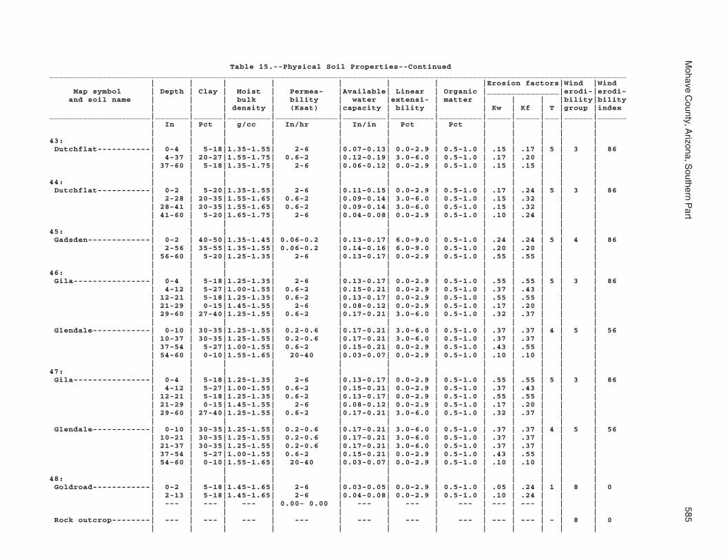
Mohave C
ounty, Arizona, S
outhern Part
585
Table 15.--Physical Soil Properties--Continued________________________________________________________________________________________________________________________ | | | | | | | |Erosion factors|Wind |Wind Map symbol | Depth | Clay | Moist | Permea- |Available| Linear | Organic |_______________|erodi-|erodi- and soil name | | | bulk | bility | water |extensi- | matter | | | |bility|bility | | | density | (Ksat) |capacity | bility | | Kw | Kf | T |group |index_____________________|_______|______|_________|_____________|_________|_________|_________|_____|_____|___|______|______ | In | Pct | g/cc | In/hr | In/in | Pct | Pct | | | | | | | | | | | | | | | | |43: | | | | | | | | | | | | Dutchflat-----------| 0-4 | 5-18|1.35-1.55| 2-6 |0.07-0.13| 0.0-2.9 | 0.5-1.0 | .15 | .17 | 5 | 3 | 86 | 4-37 | 20-27|1.55-1.75| 0.6-2 |0.12-0.19| 3.0-6.0 | 0.5-1.0 | .17 | .20 | | | | 37-60 | 5-18|1.35-1.75| 2-6 |0.06-0.12| 0.0-2.9 | 0.5-1.0 | .15 | .15 | | | | | | | | | | | | | | |44: | | | | | | | | | | | | Dutchflat-----------| 0-2 | 5-20|1.35-1.55| 2-6 |0.11-0.15| 0.0-2.9 | 0.5-1.0 | .17 | .24 | 5 | 3 | 86 | 2-28 | 20-35|1.55-1.65| 0.6-2 |0.09-0.14| 3.0-6.0 | 0.5-1.0 | .15 | .32 | | | | 28-41 | 20-35|1.55-1.65| 0.6-2 |0.09-0.14| 3.0-6.0 | 0.5-1.0 | .15 | .32 | | | | 41-60 | 5-20|1.65-1.75| 2-6 |0.04-0.08| 0.0-2.9 | 0.5-1.0 | .10 | .24 | | | | | | | | | | | | | | |45: | | | | | | | | | | | | Gadsden-------------| 0-2 | 40-50|1.35-1.45| 0.06-0.2 |0.13-0.17| 6.0-9.0 | 0.5-1.0 | .24 | .24 | 5 | 4 | 86 | 2-56 | 35-55|1.35-1.55| 0.06-0.2 |0.14-0.16| 6.0-9.0 | 0.5-1.0 | .20 | .20 | | | | 56-60 | 5-20|1.25-1.35| 2-6 |0.13-0.17| 0.0-2.9 | 0.5-1.0 | .55 | .55 | | | | | | | | | | | | | | |46: | | | | | | | | | | | | Gila----------------| 0-4 | 5-18|1.25-1.35| 2-6 |0.13-0.17| 0.0-2.9 | 0.5-1.0 | .55 | .55 | 5 | 3 | 86 | 4-12 | 5-27|1.00-1.55| 0.6-2 |0.15-0.21| 0.0-2.9 | 0.5-1.0 | .37 | .43 | | | | 12-21 | 5-18|1.25-1.35| 0.6-2 |0.13-0.17| 0.0-2.9 | 0.5-1.0 | .55 | .55 | | | | 21-29 | 0-15|1.45-1.55| 2-6 |0.08-0.12| 0.0-2.9 | 0.5-1.0 | .17 | .20 | | | | 29-60 | 27-40|1.25-1.55| 0.6-2 |0.17-0.21| 3.0-6.0 | 0.5-1.0 | .32 | .37 | | | | | | | | | | | | | | | Glendale------------| 0-10 | 30-35|1.25-1.55| 0.2-0.6 |0.17-0.21| 3.0-6.0 | 0.5-1.0 | .37 | .37 | 4 | 5 | 56 | 10-37 | 30-35|1.25-1.55| 0.2-0.6 |0.17-0.21| 3.0-6.0 | 0.5-1.0 | .37 | .37 | | | | 37-54 | 5-27|1.00-1.55| 0.6-2 |0.15-0.21| 0.0-2.9 | 0.5-1.0 | .43 | .55 | | | | 54-60 | 0-10|1.55-1.65| 20-40 |0.03-0.07| 0.0-2.9 | 0.5-1.0 | .10 | .10 | | | | | | | | | | | | | | |47: | | | | | | | | | | | | Gila----------------| 0-4 | 5-18|1.25-1.35| 2-6 |0.13-0.17| 0.0-2.9 | 0.5-1.0 | .55 | .55 | 5 | 3 | 86 | 4-12 | 5-27|1.00-1.55| 0.6-2 |0.15-0.21| 0.0-2.9 | 0.5-1.0 | .37 | .43 | | | | 12-21 | 5-18|1.25-1.35| 0.6-2 |0.13-0.17| 0.0-2.9 | 0.5-1.0 | .55 | .55 | | | | 21-29 | 0-15|1.45-1.55| 2-6 |0.08-0.12| 0.0-2.9 | 0.5-1.0 | .17 | .20 | | | | 29-60 | 27-40|1.25-1.55| 0.6-2 |0.17-0.21| 3.0-6.0 | 0.5-1.0 | .32 | .37 | | | | | | | | | | | | | | | Glendale------------| 0-10 | 30-35|1.25-1.55| 0.2-0.6 |0.17-0.21| 3.0-6.0 | 0.5-1.0 | .37 | .37 | 4 | 5 | 56 | 10-21 | 30-35|1.25-1.55| 0.2-0.6 |0.17-0.21| 3.0-6.0 | 0.5-1.0 | .37 | .37 | | | | 21-37 | 30-35|1.25-1.55| 0.2-0.6 |0.17-0.21| 3.0-6.0 | 0.5-1.0 | .37 | .37 | | | | 37-54 | 5-27|1.00-1.55| 0.6-2 |0.15-0.21| 0.0-2.9 | 0.5-1.0 | .43 | .55 | | | | 54-60 | 0-10|1.55-1.65| 20-40 |0.03-0.07| 0.0-2.9 | 0.5-1.0 | .10 | .10 | | | | | | | | | | | | | | |48: | | | | | | | | | | | | Goldroad------------| 0-2 | 5-18|1.45-1.65| 2-6 |0.03-0.05| 0.0-2.9 | 0.5-1.0 | .05 | .24 | 1 | 8 | 0 | 2-13 | 5-18|1.45-1.65| 2-6 |0.04-0.08| 0.0-2.9 | 0.5-1.0 | .10 | .24 | | | | --- | --- | --- | 0.00- 0.00 | --- | --- | --- | --- | --- | | | | | | | | | | | | | | | Rock outcrop--------| --- | --- | --- | --- | --- | --- | --- | --- | --- | - | 8 | 0 | | | | | | | | | | | |

586S
oil Survey
Table 15.--Physical Soil Properties--Continued________________________________________________________________________________________________________________________ | | | | | | | |Erosion factors|Wind |Wind Map symbol | Depth | Clay | Moist | Permea- |Available| Linear | Organic |_______________|erodi-|erodi- and soil name | | | bulk | bility | water |extensi- | matter | | | |bility|bility | | | density | (Ksat) |capacity | bility | | Kw | Kf | T |group |index_____________________|_______|______|_________|_____________|_________|_________|_________|_____|_____|___|______|______ | In | Pct | g/cc | In/hr | In/in | Pct | Pct | | | | | | | | | | | | | | | | |49: | | | | | | | | | | | | Gonzales------------| 0-1 | 20-30|1.20-1.30| 0.2-0.6 |0.08-0.11| 3.0-6.0 | 1.0-3.0 | .17 | .64 | 1 | 7 | 38 | 1-7 | 40-55|1.30-1.40| 0.06-0.2 |0.14-0.17| 6.0-9.0 | 1.0-3.0 | .28 | .32 | | | | 7-14 | 40-55|1.30-1.40| 0.06-0.2 |0.14-0.17| 6.0-9.0 | 1.0-3.0 | .28 | .32 | | | | 14-17 | --- | --- | 0.00-0.06 | --- | --- | --- | --- | --- | | | | >17 | --- | --- | 0.00- 0.00 | --- | --- | --- | --- | --- | | | | | | | | | | | | | | | Rock outcrop--------| --- | --- | --- | --- | --- | --- | --- | --- | --- | - | 8 | 0 | | | | | | | | | | | |50: | | | | | | | | | | | | Goodsprings family--| 0-2 | 5-10|1.35-1.55| 2-6 |0.06-0.10| 0.0-2.9 | 0.0-0.5 | .10 | .24 | 1 | 5 | 56 | 2-18 | 7-12|1.25-1.55| 0.6-2 |0.09-0.14| 0.0-2.9 | 0.0-0.5 | .24 | .49 | | | | 18-39 | --- | --- | 0.00-0.06 | --- | --- | --- | --- | --- | | | | 39-60 | 0-5 |1.55-1.65| 6-20 |0.01-0.03| 0.0-2.9 | 0.0-0.5 | .02 | .15 | | | | | | | | | | | | | | |51: | | | | | | | | | | | | Goodsprings family--| 0-2 | 5-10|1.35-1.55| 2-6 |0.06-0.10| 0.0-2.9 | 0.0-0.5 | .10 | .24 | 1 | 5 | 56 | 2-18 | 7-12|1.25-1.55| 0.6-2 |0.09-0.14| 0.0-2.9 | 0.0-0.5 | .24 | .49 | | | | 18-39 | --- | --- | 0.00-0.06 | --- | --- | --- | --- | --- | | | | 39-60 | 0-5 |1.55-1.65| 6-20 |0.01-0.03| 0.0-2.9 | 0.0-0.5 | .02 | .15 | | | | | | | | | | | | | | |52: | | | | | | | | | | | | Goodsprings family--| 0-2 | 5-10|1.35-1.55| 2-6 |0.06-0.10| 0.0-2.9 | 0.0-0.5 | .10 | .24 | 1 | 5 | 56 | 2-18 | 7-12|1.25-1.55| 0.6-2 |0.09-0.14| 0.0-2.9 | 0.0-0.5 | .24 | .49 | | | | 18-39 | --- | --- | 0.00-0.06 | --- | --- | --- | --- | --- | | | | 39-60 | 0-5 |1.55-1.65| 6-20 |0.01-0.03| 0.0-2.9 | 0.0-0.5 | .02 | .15 | | | | | | | | | | | | | | |53: | | | | | | | | | | | | Goodsprings family--| 0-2 | 5-10|1.35-1.55| 2-6 |0.06-0.10| 0.0-2.9 | 0.0-0.5 | .10 | .24 | 1 | 5 | 56 | 2-18 | 7-12|1.25-1.55| 0.6-2 |0.09-0.14| 0.0-2.9 | 0.0-0.5 | .24 | .49 | | | | 18-39 | --- | --- | 0.00-0.06 | --- | --- | --- | --- | --- | | | | 39-60 | 0-5 |1.55-1.65| 6-20 |0.01-0.03| 0.0-2.9 | 0.0-0.5 | .02 | .15 | | | | | | | | | | | | | | |54: | | | | | | | | | | | | Graham--------------| 0-2 | 7-27|1.35-1.55| 0.06-2 |0.07-0.12| 0.0-2.9 | 1.0-3.0 | .15 | .37 | 1 | 7 | 38 | 2-7 | 27-35|1.25-1.55| 0.2-0.6 |0.16-0.21| 3.0-6.0 | 1.0-3.0 | .24 | .32 | | | | 7-14 | 40-60|1.35-1.55| 0.06-0.2 |0.12-0.16| 6.0-9.0 | 1.0-2.0 | .15 | .20 | | | | >14 | --- | --- | 0.00- 0.00 | --- | --- | --- | --- | --- | | | | | | | | | | | | | | |

Mohave C
ounty, Arizona, S
outhern Part
587
Table 15.--Physical Soil Properties--Continued________________________________________________________________________________________________________________________ | | | | | | | |Erosion factors|Wind |Wind Map symbol | Depth | Clay | Moist | Permea- |Available| Linear | Organic |_______________|erodi-|erodi- and soil name | | | bulk | bility | water |extensi- | matter | | | |bility|bility | | | density | (Ksat) |capacity | bility | | Kw | Kf | T |group |index_____________________|_______|______|_________|_____________|_________|_________|_________|_____|_____|___|______|______ | In | Pct | g/cc | In/hr | In/in | Pct | Pct | | | | | | | | | | | | | | | | |54: | | | | | | | | | | | | Arivaca-------------| 0-2 | 27-35|1.25-1.55| 0.2-0.6 |0.03-0.15| 0.0-2.9 | 0.3-1.0 | .10 | .37 | 2 | 8 | 0 | 2-6 | 40-60|1.35-1.45| 0.06-0.2 |0.07-0.14| 3.0-6.0 | 0.3-1.0 | .10 | .28 | | | | 6-17 | 40-60|1.15-1.55| 0.06-0.2 |0.10-0.16| 6.0-9.0 | 0.2-0.8 | .20 | .24 | | | | 17-30 | 40-60|1.15-1.55| 0.06-0.2 |0.10-0.16| 6.0-9.0 | 0.2-0.8 | .20 | .24 | | | | 30-36 | 30-35|1.25-1.55| 0.2-0.6 |0.14-0.21| 3.0-6.0 | 0.2-0.8 | .24 | .28 | | | | >36 | --- | --- | 0.00- 0.00 | --- | --- | --- | --- | --- | | | | | | | | | | | | | | |55: | | | | | | | | | | | | Graham--------------| 0-2 | 7-27|1.35-1.55| 0.06-2 |0.07-0.12| 0.0-2.9 | 1.0-3.0 | .15 | .37 | 1 | 7 | 38 | 2-7 | 27-35|1.25-1.55| 0.2-0.6 |0.16-0.21| 3.0-6.0 | 1.0-3.0 | .24 | .32 | | | | 7-14 | 40-60|1.35-1.55| 0.06-0.2 |0.12-0.16| 6.0-9.0 | 1.0-2.0 | .15 | .20 | | | | >14 | --- | --- | 0.00- 0.00 | --- | --- | --- | --- | --- | | | | | | | | | | | | | | | Rock outcrop--------| --- | --- | --- | --- | --- | --- | --- | --- | --- | - | 8 | 0 | | | | | | | | | | | |56: | | | | | | | | | | | | Gunsight------------| 0-3 | 7-20|1.35-1.55| 2-6 |0.13-0.18| 0.0-2.9 | 0.5-1.0 | .10 | .28 | 4 | 6 | 48 | 3-6 | 5-18|1.45-1.65| 2-6 |0.08-0.13| 0.0-2.9 | 0.5-1.0 | .10 | .24 | | | | 6-28 | 5-18|1.45-1.65| 2-6 |0.08-0.13| 0.0-2.9 | 0.5-1.0 | .20 | .24 | | | | 28-50 | 5-18|1.55-1.75| 2-6 |0.07-0.12| 0.0-2.9 | 0.5-1.0 | .20 | .24 | | | | 50-60 | 2-10|1.55-1.65| 6-20 |0.06-0.08| 0.0-2.9 | 0.5-1.0 | .17 | .17 | | | | | | | | | | | | | | |57: | | | | | | | | | | | | Gunsight------------| 0-3 | 5-18|1.45-1.65| 2-6 |0.08-0.13| 0.0-2.9 | 0.5-1.0 | .10 | .24 | 4 | 6 | 48 | 3-6 | 5-18|1.45-1.65| 2-6 |0.08-0.13| 0.0-2.9 | 0.5-1.0 | .10 | .24 | | | | 6-28 | 5-18|1.45-1.65| 2-6 |0.08-0.13| 0.0-2.9 | 0.5-1.0 | .20 | .24 | | | | 28-50 | 5-18|1.55-1.75| 2-6 |0.07-0.12| 0.0-2.9 | 0.5-1.0 | .20 | .24 | | | | 50-60 | 2-10|1.55-1.65| 6-20 |0.06-0.08| 0.0-2.9 | 0.5-1.0 | .17 | .17 | | | | | | | | | | | | | | |58: | | | | | | | | | | | | Hassell family------| 0-4 | 7-27|1.35-1.55| 0.6-2 |0.14-0.18| 0.0-2.9 | 1.0-3.0 | .20 | .37 | 3 | 5 | 56 | 4-13 | 40-50|1.35-1.55| 0.06-0.2 |0.12-0.16| 3.0-6.0 | 1.0-3.0 | .20 | .20 | | | | 13-24 | 40-50|1.35-1.55| 0.06-0.2 |0.12-0.16| 3.0-6.0 | 1.0-3.0 | .20 | .20 | | | | 24-33 | 28-37|1.25-1.45| 0.2-0.6 |0.13-0.17| 3.0-6.0 | 1.0-2.0 | .15 | .32 | | | | 33-47 | --- | --- | 0.00-0.06 | --- | --- | --- | --- | --- | | | | >47 | --- | --- | 0.00- 0.00 | --- | --- | --- | --- | --- | | | | | | | | | | | | | | |

588S
oil Survey
Table 15.--Physical Soil Properties--Continued________________________________________________________________________________________________________________________ | | | | | | | |Erosion factors|Wind |Wind Map symbol | Depth | Clay | Moist | Permea- |Available| Linear | Organic |_______________|erodi-|erodi- and soil name | | | bulk | bility | water |extensi- | matter | | | |bility|bility | | | density | (Ksat) |capacity | bility | | Kw | Kf | T |group |index_____________________|_______|______|_________|_____________|_________|_________|_________|_____|_____|___|______|______ | In | Pct | g/cc | In/hr | In/in | Pct | Pct | | | | | | | | | | | | | | | | |58: | | | | | | | | | | | | Lampshire-----------| 0-1 | 10-20|1.35-1.55| 0.6-2 |0.05-0.12| 0.0-2.9 | 1.0-3.0 | .15 | .37 | 1 | 7 | 38 | 1-6 | 10-20|1.45-1.65| 2-6 |0.04-0.08| 0.0-2.9 | 1.0-3.0 | .10 | .24 | | | | 6-9 | --- | --- | 0.00-0.06 | --- | --- | --- | --- | --- | | | | >9 | --- | --- | 0.00- 0.00 | --- | --- | --- | --- | --- | | | | | | | | | | | | | | | Rock outcrop--------| --- | --- | --- | --- | --- | --- | --- | --- | --- | - | 8 | 0 | | | | | | | | | | | |59: | | | | | | | | | | | | Holtville-----------| 0-2 | 35-55|1.35-1.45| 0.06-0.2 |0.13-0.17| 3.0-6.0 | 0.5-1.0 | .20 | .24 | 4 | 4 | 86 | 2-23 | 35-55|1.35-1.55| 0.06-0.2 |0.14-0.16| 6.0-9.0 | 0.5-1.0 | .17 | .20 | | | | 23-31 | 35-55|1.35-1.45| 0.06-0.2 |0.13-0.17| 6.0-9.0 | 0.5-1.0 | .20 | .24 | | | | 31-42 | 5-18|1.25-1.35| 2-6 |0.13-0.17| 0.0-2.9 | 0.5-1.0 | .55 | .55 | | | | 42-60 | 0-10|1.50-1.60| 6-20 |0.05-0.08| 0.0-2.9 | 0.5-1.0 | .17 | .17 | | | | | | | | | | | | | | |60: | | | | | | | | | | | | Huevi---------------| 0-2 | 7-18|1.35-1.55| 2-6 |0.05-0.12| 0.0-2.9 | 0.5-1.0 | .20 | .37 | 4 | 6 | 48 | 2-9 | 5-18|1.45-1.65| 2-6 |0.04-0.08| 0.0-2.9 | 0.5-1.0 | .10 | .24 | | | | 9-27 | 5-18|1.45-1.65| 2-6 |0.04-0.08| 0.0-2.9 | 0.5-1.0 | .10 | .24 | | | | 27-40 | 5-18|1.45-1.65| 2-6 |0.03-0.05| 0.0-2.9 | 0.5-1.0 | .05 | .24 | | | | 40-60 | 0-15|1.55-1.65| 6-20 |0.02-0.05| 0.0-2.9 | 0.5-1.0 | .05 | .17 | | | | | | | | | | | | | | |61: | | | | | | | | | | | | Huevi---------------| 0-2 | 7-18|1.35-1.55| 2-6 |0.05-0.12| 0.0-2.9 | 0.5-1.0 | .20 | .37 | 4 | 7 | 38 | 2-9 | 5-18|1.45-1.65| 2-6 |0.04-0.08| 0.0-2.9 | 0.5-1.0 | .10 | .24 | | | | 9-27 | 5-18|1.45-1.65| 2-6 |0.04-0.08| 0.0-2.9 | 0.5-1.0 | .10 | .24 | | | | 27-40 | 5-18|1.45-1.65| 2-6 |0.03-0.05| 0.0-2.9 | 0.5-1.0 | .05 | .24 | | | | 40-60 | 0-15|1.55-1.65| 6-20 |0.02-0.05| 0.0-2.9 | 0.5-1.0 | .05 | .17 | | | | | | | | | | | | | | |62: | | | | | | | | | | | | Akela---------------| 0-1 | 5-18|1.45-1.65| 0.6-2 |0.04-0.08| 0.0-2.9 | 0.5-1.0 | .10 | .24 | 1 | 6 | 48 | 1-12 | 5-18|1.35-1.50| 0.6-2 |0.03-0.08| 0.0-2.9 | 0.5-1.0 | .10 | .24 | | | | >12 | --- | --- | 0.00- 0.00 | --- | --- | --- | --- | --- | | | | | | | | | | | | | | | Rock outcrop--------| --- | --- | --- | --- | --- | --- | --- | --- | --- | - | 8 | 0 | | | | | | | | | | | |63: | | | | | | | | | | | | Hyder---------------| 0-2 | 7-18|1.35-1.55| 0.6-2 |0.04-0.07| 0.0-2.9 | 0.5-1.0 | .05 | .37 | 1 | 8 | 0 | 2-7 | 7-18|1.35-1.55| 0.6-2 |0.04-0.07| 0.0-2.9 | 0.5-1.0 | .05 | .37 | | | | >7 | --- | --- | 0.00- 0.00 | --- | --- | --- | --- | --- | | | | | | | | | | | | | | |
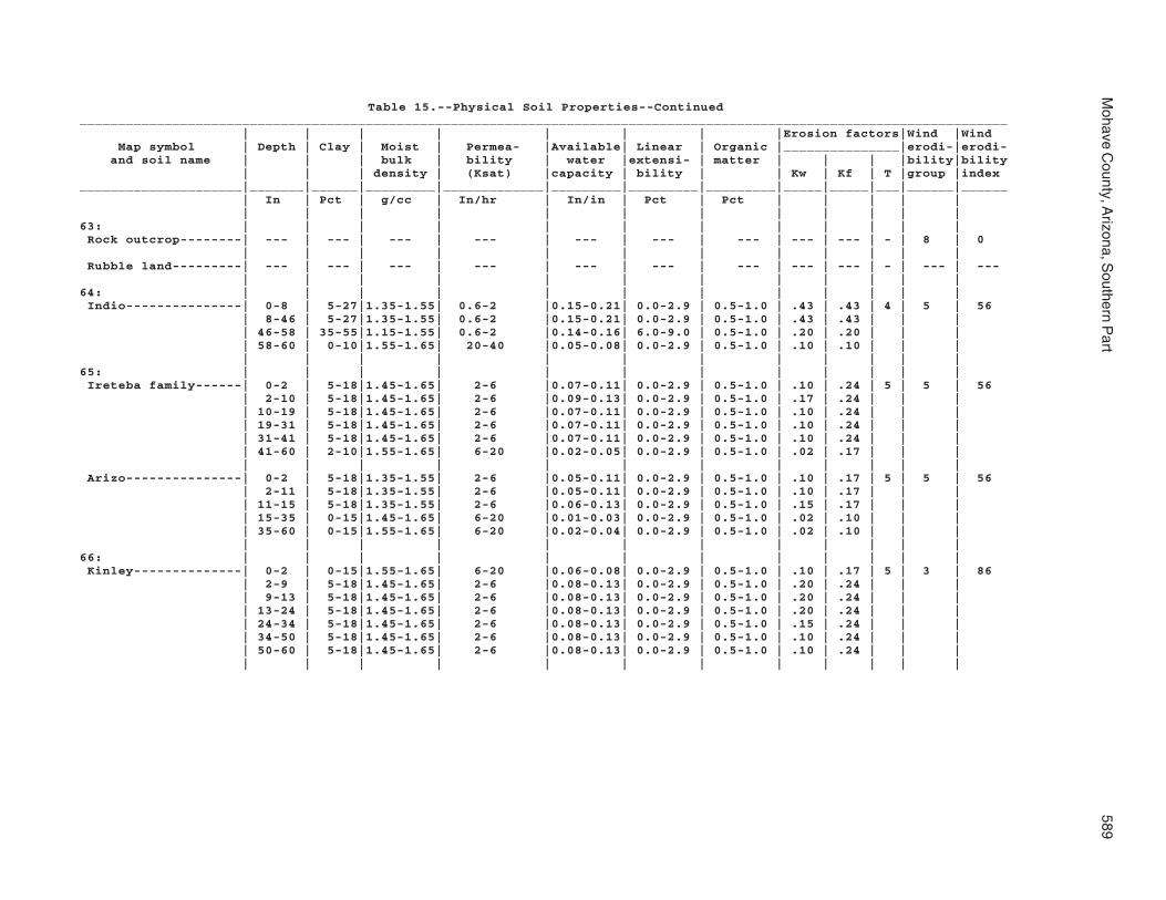
Mohave C
ounty, Arizona, S
outhern Part
589
Table 15.--Physical Soil Properties--Continued________________________________________________________________________________________________________________________ | | | | | | | |Erosion factors|Wind |Wind Map symbol | Depth | Clay | Moist | Permea- |Available| Linear | Organic |_______________|erodi-|erodi- and soil name | | | bulk | bility | water |extensi- | matter | | | |bility|bility | | | density | (Ksat) |capacity | bility | | Kw | Kf | T |group |index_____________________|_______|______|_________|_____________|_________|_________|_________|_____|_____|___|______|______ | In | Pct | g/cc | In/hr | In/in | Pct | Pct | | | | | | | | | | | | | | | | |63: | | | | | | | | | | | | Rock outcrop--------| --- | --- | --- | --- | --- | --- | --- | --- | --- | - | 8 | 0 | | | | | | | | | | | | Rubble land---------| --- | --- | --- | --- | --- | --- | --- | --- | --- | - | --- | --- | | | | | | | | | | | |64: | | | | | | | | | | | | Indio---------------| 0-8 | 5-27|1.35-1.55| 0.6-2 |0.15-0.21| 0.0-2.9 | 0.5-1.0 | .43 | .43 | 4 | 5 | 56 | 8-46 | 5-27|1.35-1.55| 0.6-2 |0.15-0.21| 0.0-2.9 | 0.5-1.0 | .43 | .43 | | | | 46-58 | 35-55|1.15-1.55| 0.6-2 |0.14-0.16| 6.0-9.0 | 0.5-1.0 | .20 | .20 | | | | 58-60 | 0-10|1.55-1.65| 20-40 |0.05-0.08| 0.0-2.9 | 0.5-1.0 | .10 | .10 | | | | | | | | | | | | | | |65: | | | | | | | | | | | | Ireteba family------| 0-2 | 5-18|1.45-1.65| 2-6 |0.07-0.11| 0.0-2.9 | 0.5-1.0 | .10 | .24 | 5 | 5 | 56 | 2-10 | 5-18|1.45-1.65| 2-6 |0.09-0.13| 0.0-2.9 | 0.5-1.0 | .17 | .24 | | | | 10-19 | 5-18|1.45-1.65| 2-6 |0.07-0.11| 0.0-2.9 | 0.5-1.0 | .10 | .24 | | | | 19-31 | 5-18|1.45-1.65| 2-6 |0.07-0.11| 0.0-2.9 | 0.5-1.0 | .10 | .24 | | | | 31-41 | 5-18|1.45-1.65| 2-6 |0.07-0.11| 0.0-2.9 | 0.5-1.0 | .10 | .24 | | | | 41-60 | 2-10|1.55-1.65| 6-20 |0.02-0.05| 0.0-2.9 | 0.5-1.0 | .02 | .17 | | | | | | | | | | | | | | | Arizo---------------| 0-2 | 5-18|1.35-1.55| 2-6 |0.05-0.11| 0.0-2.9 | 0.5-1.0 | .10 | .17 | 5 | 5 | 56 | 2-11 | 5-18|1.35-1.55| 2-6 |0.05-0.11| 0.0-2.9 | 0.5-1.0 | .10 | .17 | | | | 11-15 | 5-18|1.35-1.55| 2-6 |0.06-0.13| 0.0-2.9 | 0.5-1.0 | .15 | .17 | | | | 15-35 | 0-15|1.45-1.65| 6-20 |0.01-0.03| 0.0-2.9 | 0.5-1.0 | .02 | .10 | | | | 35-60 | 0-15|1.55-1.65| 6-20 |0.02-0.04| 0.0-2.9 | 0.5-1.0 | .02 | .10 | | | | | | | | | | | | | | |66: | | | | | | | | | | | | Kinley--------------| 0-2 | 0-15|1.55-1.65| 6-20 |0.06-0.08| 0.0-2.9 | 0.5-1.0 | .10 | .17 | 5 | 3 | 86 | 2-9 | 5-18|1.45-1.65| 2-6 |0.08-0.13| 0.0-2.9 | 0.5-1.0 | .20 | .24 | | | | 9-13 | 5-18|1.45-1.65| 2-6 |0.08-0.13| 0.0-2.9 | 0.5-1.0 | .20 | .24 | | | | 13-24 | 5-18|1.45-1.65| 2-6 |0.08-0.13| 0.0-2.9 | 0.5-1.0 | .20 | .24 | | | | 24-34 | 5-18|1.45-1.65| 2-6 |0.08-0.13| 0.0-2.9 | 0.5-1.0 | .15 | .24 | | | | 34-50 | 5-18|1.45-1.65| 2-6 |0.08-0.13| 0.0-2.9 | 0.5-1.0 | .10 | .24 | | | | 50-60 | 5-18|1.45-1.65| 2-6 |0.08-0.13| 0.0-2.9 | 0.5-1.0 | .10 | .24 | | | | | | | | | | | | | | |

590S
oil Survey
Table 15.--Physical Soil Properties--Continued________________________________________________________________________________________________________________________ | | | | | | | |Erosion factors|Wind |Wind Map symbol | Depth | Clay | Moist | Permea- |Available| Linear | Organic |_______________|erodi-|erodi- and soil name | | | bulk | bility | water |extensi- | matter | | | |bility|bility | | | density | (Ksat) |capacity | bility | | Kw | Kf | T |group |index_____________________|_______|______|_________|_____________|_________|_________|_________|_____|_____|___|______|______ | In | Pct | g/cc | In/hr | In/in | Pct | Pct | | | | | | | | | | | | | | | | |67: | | | | | | | | | | | | Kinley--------------| 0-2 | 5-18|1.45-1.65| 2-6 |0.08-0.13| 0.0-2.9 | 0.5-1.0 | .15 | .24 | 5 | 5 | 56 | 2-9 | 5-18|1.45-1.65| 2-6 |0.08-0.13| 0.0-2.9 | 0.5-1.0 | .20 | .24 | | | | 9-13 | 5-18|1.45-1.65| 2-6 |0.08-0.13| 0.0-2.9 | 0.5-1.0 | .20 | .24 | | | | 13-24 | 5-18|1.45-1.65| 2-6 |0.08-0.13| 0.0-2.9 | 0.5-1.0 | .20 | .24 | | | | 24-34 | 5-18|1.45-1.65| 2-6 |0.08-0.13| 0.0-2.9 | 0.5-1.0 | .15 | .24 | | | | 34-50 | 5-18|1.45-1.65| 2-6 |0.08-0.13| 0.0-2.9 | 0.5-1.0 | .10 | .24 | | | | 50-60 | 5-18|1.45-1.65| 2-6 |0.08-0.13| 0.0-2.9 | 0.5-1.0 | .10 | .24 | | | | | | | | | | | | | | | Poachie-------------| 0-2 | 27-35|1.25-1.65| 0.6-2 |0.12-0.18| 3.0-6.0 | 0.5-1.0 | .15 | .32 | 5 | 5 | 56 | 2-24 | 5-20|1.45-1.65| 2-6 |0.09-0.13| 0.0-2.9 | 0.5-1.0 | .24 | .24 | | | | 24-38 | 20-27|1.55-1.65| 0.6-2 |0.12-0.16| 0.0-2.9 | 0.5-1.0 | .32 | .32 | | | | 38-60 | 5-18|1.65-1.75| 2-6 |0.07-0.11| 0.0-2.9 | 0.5-1.0 | .15 | .20 | | | | | | | | | | | | | | |68: | | | | | | | | | | | | Kofa----------------| 0-12 | 40-50|1.35-1.45| 0.06-0.2 |0.13-0.15| 6.0-9.0 | 0.5-1.0 | .32 | .32 | 3 | 8 | 0 | 12-29 | 50-55|1.35-1.45| 0.06-0.2 |0.13-0.15| 6.0-9.0 | 0.5-1.0 | .32 | .32 | | | | 29-60 | 5-10|1.55-1.65| 6-20 |0.04-0.07| 0.0-2.9 | 0.5-1.0 | .10 | .10 | | | | | | | | | | | | | | |69: | | | | | | | | | | | | Dudleyville---------| 0-2 | 0-15|1.55-1.65| 20-40 |0.04-0.07| 0.0-2.9 | 0.5-1.0 | .10 | .17 | 5 | 3 | 86 | 2-12 | 0-15|1.60-1.65| 20-40 |0.04-0.07| 0.0-2.9 | 0.5-1.0 | .10 | .17 | | | | 12-60 | 0-10|1.55-1.65| 20-40 |0.03-0.06| 0.0-2.9 | 0.5-1.0 | .05 | .15 | | | | | | | | | | | | | | | Vinton--------------| 0-3 | 5-20|1.55-1.75| 2-6 |0.07-0.12| 0.0-2.9 | 0.5-1.0 | .20 | .20 | 5 | 3 | 86 | 3-24 | 2-10|1.60-1.65| 6-20 |0.05-0.07| 0.0-2.9 | 0.5-1.0 | .15 | .15 | | | | 24-30 | 2-10|1.60-1.65| 6-20 |0.03-0.06| 0.0-2.9 | 0.5-1.0 | .10 | .15 | | | | 30-38 | 2-10|1.60-1.65| 6-20 |0.05-0.08| 0.0-2.9 | 0.5-1.0 | .15 | .15 | | | | 38-60 | 2-10|1.50-1.65| 6-20 |0.02-0.05| 0.0-2.9 | 0.5-1.0 | .05 | .15 | | | | | | | | | | | | | | | Riverwash-----------| --- | --- | --- | --- | --- | --- | --- | --- | --- | - | 8 | 0 | | | | | | | | | | | |70: | | | | | | | | | | | | Dudleyville---------| 0-2 | 0-15|1.55-1.65| 20-40 |0.04-0.07| 0.0-2.9 | 0.5-1.0 | .10 | .17 | 5 | 3 | 86 | 2-12 | 0-15|1.60-1.65| 20-40 |0.04-0.07| 0.0-2.9 | 0.5-1.0 | .10 | .17 | | | | 12-60 | 0-10|1.55-1.65| 20-40 |0.03-0.06| 0.0-2.9 | 0.5-1.0 | .05 | .15 | | | | | | | | | | | | | | |

Mohave C
ounty, Arizona, S
outhern Part
591
Table 15.--Physical Soil Properties--Continued________________________________________________________________________________________________________________________ | | | | | | | |Erosion factors|Wind |Wind Map symbol | Depth | Clay | Moist | Permea- |Available| Linear | Organic |_______________|erodi-|erodi- and soil name | | | bulk | bility | water |extensi- | matter | | | |bility|bility | | | density | (Ksat) |capacity | bility | | Kw | Kf | T |group |index_____________________|_______|______|_________|_____________|_________|_________|_________|_____|_____|___|______|______ | In | Pct | g/cc | In/hr | In/in | Pct | Pct | | | | | | | | | | | | | | | | |70: | | | | | | | | | | | | Vinton--------------| 0-3 | 5-20|1.55-1.75| 2-6 |0.07-0.12| 0.0-2.9 | 0.5-1.0 | .20 | .20 | 5 | 3 | 86 | 3-24 | 2-10|1.60-1.65| 6-20 |0.05-0.07| 0.0-2.9 | 0.5-1.0 | .15 | .15 | | | | 24-30 | 2-10|1.60-1.65| 6-20 |0.03-0.06| 0.0-2.9 | 0.5-1.0 | .10 | .15 | | | | 30-38 | 2-10|1.60-1.65| 6-20 |0.05-0.08| 0.0-2.9 | 0.5-1.0 | .15 | .15 | | | | 38-60 | 2-10|1.50-1.65| 6-20 |0.02-0.05| 0.0-2.9 | 0.5-1.0 | .05 | .15 | | | | | | | | | | | | | | | Riverwash-----------| --- | --- | --- | --- | --- | --- | --- | --- | --- | - | 8 | 0 | | | | | | | | | | | |71: | | | | | | | | | | | | Lagunita------------| 0-2 | 0-5 |1.55-1.65| 6-20 |0.03-0.06| 0.0-2.9 | 0.5-1.0 | .10 | .10 | 5 | 1 | 160 | 2-60 | 0-5 |1.55-1.65| 6-20 |0.03-0.06| 0.0-2.9 | 0.5-1.0 | .10 | .10 | | | | | | | | | | | | | | |72: | | | | | | | | | | | | Lagunita------------| 0-2 | 0-5 |1.55-1.65| 6-20 |0.03-0.06| 0.0-2.9 | 0.5-1.0 | .10 | .10 | 5 | 1 | 160 | 2-60 | 0-5 |1.55-1.65| 6-20 |0.03-0.06| 0.0-2.9 | 0.5-1.0 | .10 | .10 | | | | | | | | | | | | | | | Ripley--------------| 0-1 | 5-20|1.35-1.55| 2-6 |0.11-0.13| 0.0-2.9 | 0.5-1.0 | .20 | .28 | 5 | 3 | 86 | 1-30 | 0-27|1.00-1.55| 0.6-2 |0.12-0.18| 0.0-2.9 | 0.5-1.0 | .24 | .43 | | | | 30-60 | 0-15|1.45-1.65| 6-20 |0.03-0.07| 0.0-2.9 | 0.5-1.0 | .10 | .20 | | | | | | | | | | | | | | |73: | | | | | | | | | | | | Lampshire-----------| 0-1 | 7-17|1.35-1.50| 2-6 |0.07-0.09| 0.0-2.9 | 1.0-3.0 | .15 | .20 | 1 | 5 | 56 | 1-6 | 5-18|1.45-1.65| 2-6 |0.04-0.08| 0.0-2.9 | 1.0-3.0 | .10 | .24 | | | | 6-17 | --- | --- | 0.00-0.06 | --- | --- | --- | --- | --- | | | | >17 | --- | --- | 0.00- 0.00 | --- | --- | --- | --- | --- | | | | | | | | | | | | | | | Rock outcrop--------| --- | --- | --- | --- | --- | --- | --- | --- | --- | - | 8 | 0 | | | | | | | | | | | |74: | | | | | | | | | | | | Lampshire-----------| 0-1 | 7-18|1.35-1.55| 0.6-2 |0.05-0.12| 0.0-2.9 | 1.0-3.0 | .15 | .37 | 1 | 7 | 38 | 1-6 | 5-18|1.45-1.65| 2-6 |0.04-0.08| 0.0-2.9 | 1.0-3.0 | .10 | .24 | | | | 6-17 | --- | --- | 0.00-0.06 | --- | --- | --- | --- | --- | | | | >17 | --- | --- | 0.00- 0.00 | --- | --- | --- | --- | --- | | | | | | | | | | | | | | | Rock outcrop--------| --- | --- | --- | --- | --- | --- | --- | --- | --- | - | 8 | 0 | | | | | | | | | | | |75: | | | | | | | | | | | | Lampshire-----------| 0-2 | 7-18|1.35-1.55| 0.6-2 |0.05-0.12| 0.0-2.9 | 1.0-3.0 | .15 | .37 | 1 | 7 | 38 | 2-7 | 7-18|1.35-1.55| 0.6-2 |0.05-0.12| 0.0-2.9 | 1.0-3.0 | .15 | .37 | | | | >7 | --- | --- | 0.00- 0.00 | --- | --- | --- | --- | --- | | | | | | | | | | | | | | |

592S
oil Survey
Table 15.--Physical Soil Properties--Continued________________________________________________________________________________________________________________________ | | | | | | | |Erosion factors|Wind |Wind Map symbol | Depth | Clay | Moist | Permea- |Available| Linear | Organic |_______________|erodi-|erodi- and soil name | | | bulk | bility | water |extensi- | matter | | | |bility|bility | | | density | (Ksat) |capacity | bility | | Kw | Kf | T |group |index_____________________|_______|______|_________|_____________|_________|_________|_________|_____|_____|___|______|______ | In | Pct | g/cc | In/hr | In/in | Pct | Pct | | | | | | | | | | | | | | | | |75: | | | | | | | | | | | | Rock outcrop--------| --- | --- | --- | --- | --- | --- | --- | --- | --- | - | 8 | 0 | | | | | | | | | | | |76: | | | | | | | | | | | | Lostman-------------| 0-2 | 10-18|1.35-1.50| 2-6 |0.07-0.13| 0.0-2.9 | 1.0-2.0 | .20 | .24 | 5 | 5 | 56 | 2-36 | 10-18|1.35-1.50| 2-6 |0.07-0.13| 0.0-2.9 | 1.0-2.0 | .20 | .24 | | | | 36-56 | 2-10|1.55-1.75| 6-20 |0.03-0.05| 0.0-2.9 | 0.0-0.5 | .02 | .05 | | | | 56-60 | 21-35|1.25-1.40| 2-6 |0.10-0.13| 0.0-2.9 | 0.0-0.5 | .17 | .32 | | | | | | | | | | | | | | |77: | | | | | | | | | | | | Lostman-------------| 0-2 | 5-18|1.45-1.65| 2-6 |0.09-0.13| 0.0-2.9 | 0.5-1.0 | .17 | .24 | 5 | 3 | 86 | 2-12 | 5-18|1.35-1.55| 2-6 |0.11-0.15| 0.0-2.9 | 0.5-1.0 | .20 | .28 | | | | 12-27 | 5-18|1.45-1.65| 2-6 |0.09-0.13| 0.0-2.9 | 0.5-1.0 | .17 | .24 | | | | 27-38 | 7-18|1.35-1.55| 2-6 |0.14-0.18| 0.0-2.9 | 0.5-1.0 | .28 | .37 | | | | 38-60 | 5-18|1.45-1.65| 2-6 |0.04-0.08| 0.0-2.9 | 0.5-1.0 | .10 | .24 | | | | | | | | | | | | | | |78: | | | | | | | | | | | | Lostman-------------| 0-2 | 5-18|1.45-1.65| 2-6 |0.09-0.13| 0.0-2.9 | 0.5-1.0 | .17 | .24 | 5 | 3 | 86 | 2-12 | 5-18|1.35-1.55| 2-6 |0.11-0.15| 0.0-2.9 | 0.5-1.0 | .20 | .28 | | | | 12-27 | 5-18|1.45-1.65| 2-6 |0.09-0.13| 0.0-2.9 | 0.5-1.0 | .17 | .24 | | | | 27-38 | 7-18|1.35-1.55| 2-6 |0.14-0.18| 0.0-2.9 | 0.5-1.0 | .28 | .37 | | | | 38-60 | 5-18|1.45-1.65| 2-6 |0.04-0.08| 0.0-2.9 | 0.5-1.0 | .10 | .24 | | | | | | | | | | | | | | | Kinley--------------| 0-2 | 5-18|1.45-1.65| 2-6 |0.08-0.13| 0.0-2.9 | 0.5-1.0 | .15 | .24 | 5 | 5 | 56 | 2-9 | 5-18|1.45-1.65| 2-6 |0.08-0.13| 0.0-2.9 | 0.5-1.0 | .20 | .24 | | | | 9-13 | 5-18|1.45-1.65| 2-6 |0.08-0.13| 0.0-2.9 | 0.5-1.0 | .20 | .24 | | | | 13-24 | 5-18|1.45-1.65| 2-6 |0.08-0.13| 0.0-2.9 | 0.5-1.0 | .20 | .24 | | | | 24-34 | 5-18|1.45-1.65| 2-6 |0.08-0.13| 0.0-2.9 | 0.5-1.0 | .15 | .24 | | | | 34-50 | 5-18|1.45-1.65| 2-6 |0.08-0.13| 0.0-2.9 | 0.5-1.0 | .10 | .24 | | | | 50-60 | 5-18|1.45-1.65| 2-6 |0.08-0.13| 0.0-2.9 | 0.5-1.0 | .10 | .24 | | | | | | | | | | | | | | |79: | | | | | | | | | | | | Marshes-------------| --- | --- | --- | --- | --- | --- | --- | --- | --- | - | --- | --- | | | | | | | | | | | |80: | | | | | | | | | | | | Meloland------------| 0-8 | 10-18|1.25-1.35| 0.6-2 |0.09-0.16| 0.0-2.9 | 0.5-1.0 | .24 | .24 | 2 | 3 | 86 | 8-19 | 10-18|1.25-1.35| 0.6-2 |0.09-0.16| 0.0-2.9 | 0.5-1.0 | .32 | .32 | | | | 19-60 | 40-55|1.15-1.55| 0.06-0.2 |0.08-0.15| 6.0-9.0 | 0.5-1.0 | .24 | .24 | | | | | | | | | | | | | | |

Mohave C
ounty, Arizona, S
outhern Part
593
Table 15.--Physical Soil Properties--Continued________________________________________________________________________________________________________________________ | | | | | | | |Erosion factors|Wind |Wind Map symbol | Depth | Clay | Moist | Permea- |Available| Linear | Organic |_______________|erodi-|erodi- and soil name | | | bulk | bility | water |extensi- | matter | | | |bility|bility | | | density | (Ksat) |capacity | bility | | Kw | Kf | T |group |index_____________________|_______|______|_________|_____________|_________|_________|_________|_____|_____|___|______|______ | In | Pct | g/cc | In/hr | In/in | Pct | Pct | | | | | | | | | | | | | | | | |81: | | | | | | | | | | | | Mohon---------------| 0-2 | 0-15|1.55-1.65| 6-20 |0.04-0.07| 0.0-2.9 | 0.5-1.0 | .10 | .17 | 5 | 3 | 86 | 2-6 | 27-35|1.25-1.55| 0.2-0.6 |0.19-0.21| 0.0-2.9 | 0.5-1.0 | .32 | .32 | | | | 6-40 | 40-60|1.35-1.55| 0.06-0.2 |0.14-0.16| 3.0-6.0 | 0.5-1.0 | .20 | .20 | | | | 40-60 | 27-35|1.25-1.55| 0.2-0.6 |0.12-0.18| 0.0-2.9 | 0.5-1.0 | .15 | .32 | | | | | | | | | | | | | | | Kinley--------------| 0-2 | 5-18|1.45-1.65| 2-6 |0.08-0.13| 0.0-2.9 | 0.5-1.0 | .15 | .24 | 5 | 5 | 56 | 2-9 | 5-18|1.45-1.65| 2-6 |0.08-0.13| 0.0-2.9 | 0.5-1.0 | .20 | .24 | | | | 9-13 | 5-18|1.45-1.65| 2-6 |0.08-0.13| 0.0-2.9 | 0.5-1.0 | .20 | .24 | | | | 13-24 | 5-18|1.45-1.65| 2-6 |0.08-0.13| 0.0-2.9 | 0.5-1.0 | .20 | .24 | | | | 24-34 | 5-18|1.45-1.65| 2-6 |0.08-0.13| 0.0-2.9 | 0.5-1.0 | .15 | .24 | | | | 34-50 | 5-18|1.45-1.65| 2-6 |0.08-0.13| 0.0-2.9 | 0.5-1.0 | .10 | .24 | | | | 50-60 | 5-18|1.45-1.65| 2-6 |0.08-0.13| 0.0-2.9 | 0.5-1.0 | .10 | .24 | | | | | | | | | | | | | | |82: | | | | | | | | | | | | Mohon---------------| 0-2 | 20-25|1.15-1.25| 2-6 |0.05-0.08| 0.0-2.9 | 0.5-1.0 | .17 | .64 | 5 | 8 | 0 | 2-6 | 27-35|1.25-1.55| 0.2-0.6 |0.19-0.21| 0.0-2.9 | 0.5-1.0 | .32 | .32 | | | | 6-40 | 40-60|1.35-1.55| 0.06-0.2 |0.14-0.16| 3.0-6.0 | 0.5-1.0 | .20 | .20 | | | | 40-60 | 27-35|1.25-1.55| 0.2-0.6 |0.12-0.18| 0.0-2.9 | 0.5-1.0 | .15 | .32 | | | | | | | | | | | | | | | Poachie-------------| 0-2 | 7-18|1.45-1.65| 2-6 |0.07-0.11| 0.0-2.9 | 0.5-1.0 | .15 | .24 | 5 | 5 | 56 | 2-24 | 5-20|1.45-1.65| 2-6 |0.09-0.13| 0.0-2.9 | 0.5-1.0 | .24 | .24 | | | | 24-38 | 20-27|1.55-1.65| 0.6-2 |0.12-0.16| 0.0-2.9 | 0.5-1.0 | .32 | .32 | | | | 38-60 | 5-18|1.65-1.75| 2-6 |0.07-0.11| 0.0-2.9 | 0.5-1.0 | .15 | .20 | | | | | | | | | | | | | | |83: | | | | | | | | | | | | Mohon---------------| 0-2 | 5-20|1.45-1.65| 2-6 |0.04-0.08| 0.0-2.9 | 0.5-1.0 | .10 | .28 | 5 | 6 | 48 | 2-6 | 27-35|1.25-1.55| 0.2-0.6 |0.19-0.21| 0.0-2.9 | 0.5-1.0 | .32 | .32 | | | | 6-40 | 40-60|1.35-1.55| 0.06-0.2 |0.14-0.16| 3.0-6.0 | 0.5-1.0 | .20 | .20 | | | | 40-60 | 27-35|1.25-1.55| 0.2-0.6 |0.12-0.18| 0.0-2.9 | 0.5-1.0 | .15 | .32 | | | | | | | | | | | | | | | Poachie-------------| 0-2 | 7-18|1.45-1.65| 2-6 |0.07-0.11| 0.0-2.9 | 0.5-1.0 | .15 | .24 | 5 | 5 | 56 | 2-24 | 5-20|1.45-1.65| 2-6 |0.09-0.13| 0.0-2.9 | 0.5-1.0 | .24 | .24 | | | | 24-38 | 20-27|1.55-1.65| 0.6-2 |0.12-0.16| 0.0-2.9 | 0.5-1.0 | .32 | .32 | | | | 38-60 | 5-18|1.65-1.75| 2-6 |0.07-0.11| 0.0-2.9 | 0.5-1.0 | .15 | .20 | | | | | | | | | | | | | | |84: | | | | | | | | | | | | Nickel family-------| 0-3 | 2-10|1.55-1.65| 6-20 |0.02-0.05| 0.0-2.9 | 0.5-1.0 | .02 | .17 | 5 | 5 | 56 | 3-7 | 20-27|1.55-1.65| 0.2-0.6 |0.07-0.14| 0.0-2.9 | 0.5-1.0 | .05 | .32 | | | | 7-26 | 7-18|1.35-1.55| 0.2-0.6 |0.05-0.12| 0.0-2.9 | 0.5-1.0 | .05 | .37 | | | | 26-60 | 5-20|1.45-1.65| 2-6 |0.04-0.08| 0.0-2.9 | 0.5-1.0 | .05 | .24 | | | | | | | | | | | | | | |

594S
oil Survey
Table 15.--Physical Soil Properties--Continued________________________________________________________________________________________________________________________ | | | | | | | |Erosion factors|Wind |Wind Map symbol | Depth | Clay | Moist | Permea- |Available| Linear | Organic |_______________|erodi-|erodi- and soil name | | | bulk | bility | water |extensi- | matter | | | |bility|bility | | | density | (Ksat) |capacity | bility | | Kw | Kf | T |group |index_____________________|_______|______|_________|_____________|_________|_________|_________|_____|_____|___|______|______ | In | Pct | g/cc | In/hr | In/in | Pct | Pct | | | | | | | | | | | | | | | | |84: | | | | | | | | | | | | Topawa family-------| 0-3 | 2-15|1.55-1.65| 6-20 |0.02-0.05| 0.0-2.9 | 0.5-1.0 | .05 | .17 | 5 | 5 | 56 | 3-18 | 27-35|1.55-1.65| 0.2-0.6 |0.05-0.10| 3.0-6.0 | 0.5-1.0 | .10 | .32 | | | | 18-50 | 15-20|1.45-1.65| 2-6 |0.04-0.08| 0.0-2.9 | 0.5-1.0 | .10 | .24 | | | | 50-58 | 2-15|1.55-1.65| 0.2-0.6 |0.04-0.07| 0.0-2.9 | 0.5-1.0 | .10 | .17 | | | | 58-60 | 18-27|1.35-1.55| 0.6-2 |0.10-0.15| 0.0-2.9 | 0.5-1.0 | .20 | .37 | | | | | | | | | | | | | | | Eba family----------| 0-1 | 5-20|1.45-1.65| 2-6 |0.04-0.08| 0.0-2.9 | 0.5-1.0 | .10 | .24 | 5 | 6 | 48 | 1-8 | 40-60|1.35-1.55| 0.06-0.2 |0.05-0.10| 3.0-6.0 | 0.5-1.0 | .05 | .20 | | | | 8-32 | 40-60|1.35-1.55| 0.06-0.2 |0.05-0.10| 3.0-6.0 | 0.5-1.0 | .05 | .20 | | | | 32-52 | 35-55|1.45-1.60| 0.06-0.2 |0.02-0.05| 3.0-6.0 | 0.5-1.0 | .10 | .32 | | | | 52-60 | 18-27|1.35-1.55| 0.6-2 |0.05-0.12| 0.0-2.9 | 0.5-1.0 | .15 | .37 | | |85: | | | | | | | | | | | | Orwash family-------| 0-2 | 5-20|1.45-1.65| 6-20 |0.09-0.11| 0.0-2.9 | 0.5-1.0 | .17 | .24 | 2 | 3 | 86 | 2-14 | 5-20|1.55-1.75| 6-20 |0.09-0.13| 0.0-2.9 | 0.5-1.0 | .15 | .20 | | | | 14-26 | 0-15|1.55-1.65| 6-20 |0.04-0.07| 0.0-2.9 | 0.5-1.0 | .10 | .17 | | | | 26-47 | 0-10|1.55-1.65| 20-40 |0.03-0.06| 0.0-2.9 | 0.5-1.0 | .05 | .10 | | | | 47-60 | 20-35|1.55-1.65| 6-20 |0.09-0.14| 0.0-2.9 | 0.5-1.0 | .15 | .32 | | | | | | | | | | | | | | |86: | | | | | | | | | | | | Orwash family-------| 0-2 | 5-20|1.45-1.65| 6-20 |0.09-0.11| 0.0-2.9 | 0.5-1.0 | .17 | .24 | 2 | 3 | 86 | 2-14 | 5-20|1.55-1.75| 6-20 |0.09-0.13| 0.0-2.9 | 0.5-1.0 | .15 | .20 | | | | 14-26 | 0-15|1.55-1.65| 6-20 |0.04-0.07| 0.0-2.9 | 0.5-1.0 | .10 | .17 | | | | 26-47 | 0-10|1.55-1.65| 20-40 |0.03-0.06| 0.0-2.9 | 0.5-1.0 | .05 | .10 | | | | 47-60 | 20-35|1.55-1.65| 6-20 |0.09-0.14| 0.0-2.9 | 0.5-1.0 | .15 | .32 | | | | | | | | | | | | | | |87: | | | | | | | | | | | | Penthouse-----------| 0-2 | 7-18|1.35-1.55| 0.06-2 |0.05-0.12| 0.0-2.9 | 1.0-3.0 | .15 | .37 | 4 | 6 | 48 | 2-8 | 27-35|1.25-1.55| 0.2-0.6 |0.12-0.18| 3.0-6.0 | 1.0-3.0 | .15 | .32 | | | | 8-27 | 40-50|1.35-1.55| 0.06-0.2 |0.09-0.14| 3.0-6.0 | 1.0-2.0 | .15 | .20 | | | | 27-40 | 30-35|1.25-1.55| 0.2-0.6 |0.12-0.18| 3.0-6.0 | 1.0-2.0 | .15 | .32 | | | | 40-47 | 15-20|1.45-1.65| 2-6 |0.07-0.11| 0.0-2.9 | 0.5-1.0 | .15 | .24 | | | | 47-60 | 0-15|1.55-1.65| 6-20 |0.02-0.05| 0.0-2.9 | 0.5-1.0 | .05 | .17 | | | | | | | | | | | | | | | Gonzales------------| 0-1 | 20-27|1.20-1.30| 0.2-0.6 |0.08-0.11| 3.0-6.0 | 1.0-3.0 | .17 | .64 | 1 | 8 | 0 | 1-14 | 40-55|1.30-1.40| 0.06-0.2 |0.14-0.17| 6.0-9.0 | 1.0-3.0 | .28 | .32 | | | | 14-17 | --- | --- | 0.00-0.06 | --- | --- | --- | --- | --- | | | | >17 | --- | --- | 0.00- 0.00 | --- | --- | --- | --- | --- | | | | | | | | | | | | | | |

Mohave C
ounty, Arizona, S
outhern Part
595
Table 15.--Physical Soil Properties--Continued________________________________________________________________________________________________________________________ | | | | | | | |Erosion factors|Wind |Wind Map symbol | Depth | Clay | Moist | Permea- |Available| Linear | Organic |_______________|erodi-|erodi- and soil name | | | bulk | bility | water |extensi- | matter | | | |bility|bility | | | density | (Ksat) |capacity | bility | | Kw | Kf | T |group |index_____________________|_______|______|_________|_____________|_________|_________|_________|_____|_____|___|______|______ | In | Pct | g/cc | In/hr | In/in | Pct | Pct | | | | | | | | | | | | | | | | |88: | | | | | | | | | | | | Poachie-------------| 0-2 | 7-27|1.35-1.55| 0.6-2 |0.04-0.08| 0.0-2.9 | 0.5-1.0 | .15 | .37 | 5 | 6 | 48 | 2-24 | 5-20|1.45-1.65| 2-6 |0.09-0.13| 0.0-2.9 | 0.5-1.0 | .24 | .24 | | | | 24-38 | 20-27|1.55-1.65| 0.6-2 |0.12-0.16| 0.0-2.9 | 0.5-1.0 | .32 | .32 | | | | 38-60 | 5-18|1.65-1.75| 2-6 |0.07-0.11| 0.0-2.9 | 0.5-1.0 | .15 | .20 | | | | | | | | | | | | | | |89: | | | | | | | | | | | | Poachie-------------| 0-2 | 7-27|1.35-1.55| 0.6-2 |0.04-0.08| 0.0-2.9 | 0.5-1.0 | .15 | .37 | 5 | 6 | 48 | 2-24 | 5-20|1.45-1.65| 2-6 |0.09-0.13| 0.0-2.9 | 0.5-1.0 | .24 | .24 | | | | 24-38 | 20-27|1.55-1.65| 0.6-2 |0.12-0.16| 0.0-2.9 | 0.5-1.0 | .32 | .32 | | | | 38-60 | 5-18|1.65-1.75| 2-6 |0.07-0.11| 0.0-2.9 | 0.5-1.0 | .15 | .20 | | | | | | | | | | | | | | |90: | | | | | | | | | | | | Quilotosa-----------| 0-3 | 5-18|1.45-1.65| 2-6 |0.05-0.07| 0.0-2.9 | 0.5-1.0 | .05 | .24 | 1 | 8 | 0 | 3-9 | 5-18|1.45-1.65| 2-6 |0.04-0.08| 0.0-2.9 | 0.5-1.0 | .10 | .24 | | | | 9-15 | --- | --- | 0.00-0.06 | --- | --- | --- | --- | --- | | | | >15 | --- | --- | 0.00- 0.00 | --- | --- | --- | --- | --- | | | | | | | | | | | | | | | Rock outcrop--------| --- | --- | --- | --- | --- | --- | --- | --- | --- | - | 8 | 0 | | | | | | | | | | | |91: | | | | | | | | | | | | Razorback-----------| 0-2 | 5-18|1.45-1.65| 2-6 |0.03-0.05| 0.0-2.9 | 0.5-1.0 | .05 | .24 | 1 | 8 | 0 | 2-5 | 5-18|1.45-1.65| 0.6-2 |0.04-0.08| 0.0-2.9 | 1.0-3.0 | .10 | .24 | | | | >5 | --- | --- | 0.00- 0.00 | --- | --- | --- | --- | --- | | | | | | | | | | | | | | |92: | | | | | | | | | | | | Razorback-----------| 0-2 | 7-18|1.35-1.55| 0.6-2 |0.04-0.07| 0.0-2.9 | 0.5-1.0 | .15 | .37 | 1 | 8 | 0 | 2-15 | 7-18|1.35-1.55| 0.6-2 |0.04-0.07| 0.0-2.9 | 0.5-1.0 | .05 | .37 | | | | >15 | --- | --- | 0.00- 0.00 | --- | --- | --- | --- | --- | | | | | | | | | | | | | | | Rock outcrop--------| --- | --- | --- | --- | --- | --- | --- | --- | --- | - | 8 | 0 | | | | | | | | | | | |93: | | | | | | | | | | | | Razorback-----------| 0-2 | 7-18|1.35-1.55| 0.6-2 |0.04-0.07| 0.0-2.9 | 0.5-1.0 | .15 | .37 | 1 | 7 | 38 | 2-15 | 7-18|1.35-1.55| 0.6-2 |0.04-0.07| 0.0-2.9 | 0.5-1.0 | .05 | .37 | | | | >15 | --- | --- | 0.00- 0.00 | --- | --- | --- | --- | --- | | | | | | | | | | | | | | | Rock outcrop--------| --- | --- | --- | --- | --- | --- | --- | --- | --- | - | 8 | 0 | | | | | | | | | | | |

596S
oil Survey
Table 15.--Physical Soil Properties--Continued________________________________________________________________________________________________________________________ | | | | | | | |Erosion factors|Wind |Wind Map symbol | Depth | Clay | Moist | Permea- |Available| Linear | Organic |_______________|erodi-|erodi- and soil name | | | bulk | bility | water |extensi- | matter | | | |bility|bility | | | density | (Ksat) |capacity | bility | | Kw | Kf | T |group |index_____________________|_______|______|_________|_____________|_________|_________|_________|_____|_____|___|______|______ | In | Pct | g/cc | In/hr | In/in | Pct | Pct | | | | | | | | | | | | | | | | |94: | | | | | | | | | | | | Razorback-----------| 0-2 | 7-18|1.35-1.55| 0.6-2 |0.04-0.07| 0.0-2.9 | 0.5-1.0 | .15 | .37 | 1 | 8 | 0 | 2-15 | 7-18|1.35-1.55| 0.6-2 |0.04-0.07| 0.0-2.9 | 0.5-1.0 | .05 | .37 | | | | >15 | --- | --- | 0.00- 0.00 | --- | --- | --- | --- | --- | | | | | | | | | | | | | | | Rock outcrop--------| --- | --- | --- | --- | --- | --- | --- | --- | --- | - | 8 | 0 | | | | | | | | | | | |95: | | | | | | | | | | | | Razorback-----------| 0-2 | 7-18|1.35-1.55| 0.6-2 |0.04-0.07| 0.0-2.9 | 0.5-1.0 | .15 | .37 | 1 | 8 | 0 | 2-15 | 7-18|1.35-1.55| 0.6-2 |0.04-0.07| 0.0-2.9 | 0.5-1.0 | .05 | .37 | | | | >15 | --- | --- | 0.00- 0.00 | --- | --- | --- | --- | --- | | | | | | | | | | | | | | | Rock outcrop--------| --- | --- | --- | --- | --- | --- | --- | --- | --- | - | 8 | 0 | | | | | | | | | | | | Rubble land---------| --- | --- | --- | --- | --- | --- | --- | --- | --- | - | --- | --- | | | | | | | | | | | |96: | | | | | | | | | | | | Razorback-----------| 0-2 | 7-18|1.35-1.55| 0.6-2 |0.04-0.07| 0.0-2.9 | 0.5-1.0 | .15 | .37 | 1 | 8 | 0 | 2-15 | 7-18|1.35-1.55| 0.6-2 |0.04-0.07| 0.0-2.9 | 0.5-1.0 | .05 | .37 | | | | >15 | --- | --- | 0.00- 0.00 | --- | --- | --- | --- | --- | | | | | | | | | | | | | | | Rock outcrop--------| --- | --- | --- | --- | --- | --- | --- | --- | --- | - | 8 | 0 | | | | | | | | | | | | Rubble land---------| --- | --- | --- | --- | --- | --- | --- | --- | --- | - | --- | --- | | | | | | | | | | | |97: | | | | | | | | | | | | Rillino-------------| 0-2 | 2-10|1.55-1.65| 6-20 |0.06-0.09| 0.0-2.9 | 1.0-2.0 | .10 | .17 | 3 | 3 | 86 | 2-16 | 20-27|1.55-1.65| 0.6-2 |0.09-0.14| 0.0-2.9 | 0.5-1.0 | .15 | .32 | | | | 16-27 | 5-18|1.45-1.65| 2-6 |0.07-0.11| 0.0-2.9 | 0.5-1.0 | .15 | .24 | | | | 27-60 | 2-10|1.55-1.65| 6-20 |0.06-0.09| 0.0-2.9 | 0.5-1.0 | .17 | .17 | | | | | | | | | | | | | | |98: | | | | | | | | | | | | Rillino-------------| 0-2 | 5-18|1.45-1.65| 2-6 |0.07-0.11| 0.0-2.9 | 1.0-2.0 | .15 | .24 | 3 | 5 | 56 | 2-16 | 20-27|1.55-1.65| 0.6-2 |0.09-0.14| 0.0-2.9 | 0.5-1.0 | .15 | .32 | | | | 16-27 | 5-18|1.45-1.65| 2-6 |0.07-0.11| 0.0-2.9 | 0.5-1.0 | .15 | .24 | | | | 27-60 | 2-10|1.55-1.65| 6-20 |0.06-0.09| 0.0-2.9 | 0.5-1.0 | .17 | .17 | | | | | | | | | | | | | | | Tres Hermanos-------| 0-2 | 27-35|1.25-1.55| 0.2-0.6 |0.12-0.18| 3.0-6.0 | 0.5-1.0 | .15 | .32 | 5 | 5 | 56 | 2-26 | 20-35|1.55-1.65| 0.2-0.6 |0.09-0.14| 3.0-6.0 | 0.5-1.0 | .15 | .32 | | | | 26-60 | 5-20|1.45-1.63| 2-6 |0.07-0.11| 0.0-2.9 | 0.5-1.0 | .15 | .24 | | | | | | | | | | | | | | |

Mohave C
ounty, Arizona, S
outhern Part
597
Table 15.--Physical Soil Properties--Continued________________________________________________________________________________________________________________________ | | | | | | | |Erosion factors|Wind |Wind Map symbol | Depth | Clay | Moist | Permea- |Available| Linear | Organic |_______________|erodi-|erodi- and soil name | | | bulk | bility | water |extensi- | matter | | | |bility|bility | | | density | (Ksat) |capacity | bility | | Kw | Kf | T |group |index_____________________|_______|______|_________|_____________|_________|_________|_________|_____|_____|___|______|______ | In | Pct | g/cc | In/hr | In/in | Pct | Pct | | | | | | | | | | | | | | | | |99: | | | | | | | | | | | | Ripley--------------| 0-2 | 0-27|1.15-1.25| 0.6-2 |0.19-0.21| 0.0-2.9 | 0.5-1.0 | .37 | .43 | 5 | 5 | 56 | 2-26 | 0-27|1.15-1.25| 0.6-2 |0.19-0.21| 0.0-2.9 | 0.5-1.0 | .24 | .43 | | | | 26-60 | 0-10|1.50-1.60| 6-20 |0.05-0.07| 0.0-2.9 | 0.5-1.0 | .10 | .20 | | | | | | | | | | | | | | |100: | | | | | | | | | | | | Riverbend family----| 0-2 | 7-18|1.45-1.65| 6-20 |0.04-0.08| 0.0-2.9 | 0.5-1.0 | .10 | .24 | 2 | 6 | 48 | 2-11 | 7-18|1.45-1.65| 6-20 |0.04-0.08| 0.0-2.9 | 0.5-1.0 | .10 | .24 | | | | 11-60 | 0-15|1.55-1.65| 6-20 |0.02-0.05| 0.0-2.9 | 0.5-1.0 | .05 | .17 | | | | | | | | | | | | | | |101: | | | | | | | | | | | | Riverbend-----------| 0-2 | 7-15|1.45-1.65| 6-20 |0.06-0.08| 0.0-2.9 | 0.5-1.0 | .17 | .64 | 5 | 6 | 48 | 2-7 | 10-18|1.45-1.65| 6-20 |0.06-0.08| 0.0-2.9 | 0.5-1.0 | .10 | .28 | | | | 7-60 | 5-12|1.55-1.65| 6-20 |0.03-0.05| 0.0-2.9 | 0.5-1.0 | .05 | .17 | | | | | | | | | | | | | | |102: | | | | | | | | | | | | Riverwash-----------| --- | --- | --- | --- | --- | --- | --- | --- | --- | - | 8 | 0 | | | | | | | | | | | | Fluvaquents---------| --- | --- | --- | --- | --- | --- | --- | --- | --- | 5 | 8 | 0 | | | | | | | | | | | |103: | | | | | | | | | | | | Rock outcrop--------| --- | --- | --- | --- | --- | --- | --- | --- | --- | - | 8 | 0 | | | | | | | | | | | | Hyder---------------| 0-2 | 7-18|1.35-1.55| 0.6-2 |0.04-0.07| 0.0-2.9 | 0.5-1.0 | .05 | .37 | 1 | 8 | 0 | 2-7 | 7-18|1.35-1.55| 0.6-2 |0.04-0.07| 0.0-2.9 | 0.5-1.0 | .05 | .37 | | | | >7 | --- | --- | 0.00- 0.00 | --- | --- | --- | --- | --- | | | | | | | | | | | | | | |104: | | | | | | | | | | | | Rock outcrop--------| --- | --- | --- | --- | --- | --- | --- | --- | --- | - | 8 | 0 | | | | | | | | | | | | Razorback-----------| 0-2 | 5-18|1.45-1.65| 2-6 |0.03-0.05| 0.0-2.9 | 0.5-1.0 | .05 | .24 | 1 | 6 | 48 | 2-15 | 7-18|1.35-1.55| 0.6-2 |0.04-0.07| 0.0-2.9 | 0.5-1.0 | .05 | .37 | | | | >15 | --- | --- | 0.00- 0.00 | --- | --- | --- | --- | --- | | | | | | | | | | | | | | |105: | | | | | | | | | | | | Rock outcrop--------| --- | --- | --- | --- | --- | --- | --- | --- | --- | - | 8 | 0 | | | | | | | | | | | | Sunrock-------------| 0-2 | 5-20|1.25-1.35| 2-6 |0.04-0.05| 0.0-2.9 | 0.0-1.0 | .05 | .24 | 1 | 8 | 0 | 2-5 | 5-20|1.35-1.50| 2-6 |0.04-0.08| 0.0-2.9 | 0.0-1.0 | .10 | .24 | | | | 5-6 | --- | --- | 0.00-0.06 | --- | --- | --- | --- | --- | | | | >6 | --- | --- | 0.00- 0.00 | --- | --- | --- | --- | --- | | | | | | | | | | | | | | |

598S
oil Survey
Table 15.--Physical Soil Properties--Continued________________________________________________________________________________________________________________________ | | | | | | | |Erosion factors|Wind |Wind Map symbol | Depth | Clay | Moist | Permea- |Available| Linear | Organic |_______________|erodi-|erodi- and soil name | | | bulk | bility | water |extensi- | matter | | | |bility|bility | | | density | (Ksat) |capacity | bility | | Kw | Kf | T |group |index_____________________|_______|______|_________|_____________|_________|_________|_________|_____|_____|___|______|______ | In | Pct | g/cc | In/hr | In/in | Pct | Pct | | | | | | | | | | | | | | | | |106: | | | | | | | | | | | | Romero--------------| 0-1 | 5-20|1.45-1.65| 2-6 |0.03-0.05| 0.0-2.9 | 1.0-2.0 | .05 | .24 | 1 | 8 | 0 | 1-6 | 20-35|1.55-1.65| 2-6 |0.05-0.10| 3.0-6.0 | 1.0-2.0 | .10 | .32 | | | | 6-60 | --- | --- | 0.00-0.06 | --- | --- | --- | --- | --- | | | | | | | | | | | | | | | Chiricahua----------| 0-1 | 5-20|1.35-1.55| 2-6 |0.02-0.08| 0.0-2.9 | 1.0-3.0 | .02 | .10 | 1 | 6 | 48 | 1-6 | 40-60|1.55-1.65| 0.06-0.2 |0.09-0.16| 6.0-9.0 | 0.5-1.0 | .10 | .10 | | | | 6-14 | 40-60|1.55-1.65| 0.06-0.2 |0.09-0.16| 6.0-9.0 | 0.5-1.0 | .10 | .10 | | | | 14-16 | 40-60|1.55-1.65| 0.06-0.2 |0.07-0.14| 6.0-9.0 | 0.5-1.0 | .05 | .10 | | | | 16-22 | --- | --- | 0.00-0.06 | --- | --- | --- | --- | --- | | | | >22 | --- | --- | 0.00- 0.00 | --- | --- | --- | --- | --- | | | | | | | | | | | | | | | Rock outcrop--------| --- | --- | --- | --- | --- | --- | --- | --- | --- | - | 8 | 0 | | | | | | | | | | | |107: | | | | | | | | | | | | Romero--------------| 0-1 | 5-20|1.45-1.65| 2-6 |0.03-0.05| 0.0-2.9 | 1.0-2.0 | .05 | .24 | 1 | 8 | 0 | 1-6 | 20-35|1.55-1.65| 2-6 |0.05-0.10| 3.0-6.0 | 1.0-2.0 | .10 | .32 | | | | 6-60 | --- | --- | 0.00-0.06 | --- | --- | --- | --- | --- | | | | | | | | | | | | | | | Lampshire-----------| 0-1 | 7-17|1.35-1.50| 2-6 |0.07-0.09| 0.0-2.9 | 1.0-3.0 | .15 | .20 | 1 | 5 | 56 | 1-6 | 5-18|1.45-1.65| 2-6 |0.04-0.08| 0.0-2.9 | 1.0-3.0 | .10 | .24 | | | | 6-17 | --- | --- | 0.00-0.06 | --- | --- | --- | --- | --- | | | | >17 | --- | --- | 0.00- 0.00 | --- | --- | --- | --- | --- | | | | | | | | | | | | | | | Rock outcrop--------| --- | --- | --- | --- | --- | --- | --- | --- | --- | - | 8 | 0 | | | | | | | | | | | |108: | | | | | | | | | | | | Rositas family------| 0-17 | 0-5 |1.55-1.65| 6-20 |0.05-0.07| 0.0-2.9 | 0.0-0.5 | .17 | .20 | 5 | 1 | 220 | 17-60 | 0-6 |1.55-1.65| 6-20 |0.05-0.08| 0.0-2.9 | 0.0-0.5 | .17 | .20 | | | | | | | | | | | | | | | Superstition--------| 0-1 | 0-10|1.50-1.60| 6-20 |0.03-0.06| 0.0-2.9 | 0.5-1.0 | .10 | .17 | 5 | 1 | 220 | 1-7 | 0-10|1.50-1.60| 6-20 |0.04-0.07| 0.0-2.9 | 0.5-1.0 | .17 | .17 | | | | 7-60 | 0-10|1.50-1.60| 6-20 |0.04-0.07| 0.0-2.9 | 0.5-1.0 | .17 | .17 | | | | | | | | | | | | | | | Torriorthents-------| --- | --- | --- | --- | --- | --- | --- | --- | --- | 2 | --- | --- | | | | | | | | | | | |109: | | | | | | | | | | | | Rositas-------------| 0-1 | 0-10|1.55-1.65| 6-20 |0.05-0.08| 0.0-2.9 | 0.5-1.0 | .10 | .10 | 5 | 1 | 220 | 1-60 | 0-10|1.55-1.65| 6-20 |0.05-0.08| 0.0-2.9 | 0.5-1.0 | .10 | .10 | | | | | | | | | | | | | | |

Mohave C
ounty, Arizona, S
outhern Part
599
Table 15.--Physical Soil Properties--Continued________________________________________________________________________________________________________________________ | | | | | | | |Erosion factors|Wind |Wind Map symbol | Depth | Clay | Moist | Permea- |Available| Linear | Organic |_______________|erodi-|erodi- and soil name | | | bulk | bility | water |extensi- | matter | | | |bility|bility | | | density | (Ksat) |capacity | bility | | Kw | Kf | T |group |index_____________________|_______|______|_________|_____________|_________|_________|_________|_____|_____|___|______|______ | In | Pct | g/cc | In/hr | In/in | Pct | Pct | | | | | | | | | | | | | | | | |109: | | | | | | | | | | | | Superstition family-| 0-2 | 0-10|1.50-1.60| 6-20 |0.04-0.07| 0.0-2.9 | 0.5-1.0 | .15 | .17 | 5 | 1 | 220 | 2-35 | 0-10|1.50-1.60| 6-20 |0.04-0.07| 0.0-2.9 | 0.5-1.0 | .15 | .17 | | | | 35-60 | 0-10|1.50-1.60| 6-20 |0.04-0.07| 0.0-2.9 | 0.5-1.0 | .15 | .17 | | | | | | | | | | | | | | | Torriorthents-------| --- | --- | --- | --- | --- | --- | --- | --- | --- | 2 | --- | --- | | | | | | | | | | | |110: | | | | | | | | | | | | Stagecoach----------| 0-2 | 7-18|1.35-1.55| 2-6 |0.05-0.12| 0.0-2.9 | 0.5-1.0 | .20 | .37 | 5 | 6 | 48 | 2-19 | 7-18|1.35-1.55| 2-6 |0.10-0.15| 0.0-2.9 | 0.5-1.0 | .20 | .37 | | | | 19-60 | 5-18|1.45-1.65| 2-6 |0.04-0.08| 0.0-2.9 | 0.5-1.0 | .10 | .24 | | | | | | | | | | | | | | |111: | | | | | | | | | | | | Stagecoach----------| 0-2 | 7-18|1.35-1.55| 2-6 |0.05-0.12| 0.0-2.9 | 0.5-1.0 | .20 | .37 | 5 | 6 | 48 | 2-19 | 7-18|1.35-1.55| 2-6 |0.10-0.15| 0.0-2.9 | 0.5-1.0 | .20 | .37 | | | | 19-60 | 5-18|1.45-1.65| 2-6 |0.04-0.08| 0.0-2.9 | 0.5-1.0 | .10 | .24 | | | | | | | | | | | | | | |112: | | | | | | | | | | | | Stagecoach----------| 0-2 | 5-18|1.45-1.65| 2-6 |0.04-0.08| 0.0-2.9 | 0.5-1.0 | .10 | .24 | 5 | 6 | 48 | 2-19 | 7-18|1.35-1.55| 2-6 |0.10-0.15| 0.0-2.9 | 0.5-1.0 | .20 | .37 | | | | 19-60 | 5-18|1.45-1.65| 2-6 |0.04-0.08| 0.0-2.9 | 0.5-1.0 | .10 | .24 | | | | | | | | | | | | | | |113: | | | | | | | | | | | | Stagecoach----------| 0-2 | 5-18|1.45-1.65| 2-6 |0.04-0.08| 0.0-2.9 | 0.5-1.0 | .10 | .24 | 5 | 6 | 48 | 2-19 | 7-18|1.35-1.55| 2-6 |0.10-0.15| 0.0-2.9 | 0.5-1.0 | .20 | .37 | | | | 19-60 | 5-18|1.45-1.65| 2-6 |0.04-0.08| 0.0-2.9 | 0.5-1.0 | .10 | .24 | | | | | | | | | | | | | | |114: | | | | | | | | | | | | Stagecoach----------| 0-2 | 2-10|1.55-1.65| 6-20 |0.02-0.05| 0.0-2.9 | 0.5-1.0 | .05 | .17 | 5 | 5 | 56 | 2-19 | 7-18|1.35-1.55| 2-6 |0.10-0.15| 0.0-2.9 | 0.5-1.0 | .20 | .37 | | | | 19-60 | 5-18|1.45-1.65| 2-6 |0.04-0.08| 0.0-2.9 | 0.5-1.0 | .10 | .24 | | | | | | | | | | | | | | | Topawa family-------| 0-2 | 7-18|1.45-1.65| 2-6 |0.04-0.08| 0.0-2.9 | 1.0-2.0 | .10 | .24 | 5 | 6 | 48 | 2-23 | 20-35|1.55-1.65| 0.2-0.6 |0.03-0.06| 3.0-6.0 | 0.5-1.0 | .10 | .24 | | | | 23-58 | 7-18|1.45-1.65| 2-6 |0.04-0.08| 0.0-2.9 | 0.5-1.0 | .10 | .32 | | | | 58-60 | 20-35|1.55-1.65| 0.2-0.6 |0.03-0.06| 3.0-6.0 | 0.5-1.0 | .10 | .24 | | | | | | | | | | | | | | | Eba-----------------| 0-1 | 5-20|1.45-1.65| 2-6 |0.04-0.08| 0.0-2.9 | 0.5-1.0 | .10 | .24 | 5 | 6 | 48 | 1-28 | 35-55|1.45-1.60| 0.06-0.2 |0.02-0.05| 3.0-6.0 | 0.5-1.0 | .10 | .32 | | | | 28-38 | 20-35|1.55-1.65| 0.2-0.6 |0.05-0.10| 3.0-6.0 | 0.5-1.0 | .10 | .32 | | | | 38-60 | 5-20|1.45-1.65| 2-6 |0.04-0.08| 0.0-2.9 | 0.5-1.0 | .10 | .24 | | | | | | | | | | | | | | |

600S
oil Survey
Table 15.--Physical Soil Properties--Continued________________________________________________________________________________________________________________________ | | | | | | | |Erosion factors|Wind |Wind Map symbol | Depth | Clay | Moist | Permea- |Available| Linear | Organic |_______________|erodi-|erodi- and soil name | | | bulk | bility | water |extensi- | matter | | | |bility|bility | | | density | (Ksat) |capacity | bility | | Kw | Kf | T |group |index_____________________|_______|______|_________|_____________|_________|_________|_________|_____|_____|___|______|______ | In | Pct | g/cc | In/hr | In/in | Pct | Pct | | | | | | | | | | | | | | | | |115: | | | | | | | | | | | | Stagecoach----------| 0-2 | 2-10|1.55-1.65| 6-20 |0.02-0.05| 0.0-2.9 | 0.5-1.0 | .05 | .17 | 5 | 5 | 56 | 2-19 | 7-18|1.35-1.55| 2-6 |0.10-0.15| 0.0-2.9 | 0.5-1.0 | .20 | .37 | | | | 19-60 | 5-18|1.45-1.65| 2-6 |0.04-0.08| 0.0-2.9 | 0.5-1.0 | .10 | .24 | | | | | | | | | | | | | | | Topawa family-------| 0-2 | 7-18|1.45-1.65| 2-6 |0.04-0.08| 0.0-2.9 | 1.0-2.0 | .10 | .24 | 5 | 6 | 48 | 2-23 | 20-35|1.55-1.65| 0.2-0.6 |0.03-0.06| 3.0-6.0 | 0.5-1.0 | .10 | .24 | | | | 23-58 | 7-18|1.45-1.65| 2-6 |0.04-0.08| 0.0-2.9 | 0.5-1.0 | .10 | .32 | | | | 58-60 | 20-35|1.55-1.65| 0.2-0.6 |0.03-0.06| 3.0-6.0 | 0.5-1.0 | .10 | .24 | | | | | | | | | | | | | | | Eba-----------------| 0-1 | 5-20|1.45-1.65| 2-6 |0.04-0.08| 0.0-2.9 | 0.5-1.0 | .10 | .24 | 5 | 6 | 48 | 1-28 | 35-55|1.45-1.60| 0.06-0.2 |0.02-0.05| 3.0-6.0 | 0.5-1.0 | .10 | .32 | | | | 28-38 | 20-35|1.55-1.65| 0.2-0.6 |0.05-0.10| 3.0-6.0 | 0.5-1.0 | .10 | .32 | | | | 38-60 | 5-20|1.45-1.65| 2-6 |0.04-0.08| 0.0-2.9 | 0.5-1.0 | .10 | .24 | | | | | | | | | | | | | | |116: | | | | | | | | | | | | Sunrock-------------| 0-2 | 5-20|1.25-1.35| 2-6 |0.03-0.05| 0.0-2.9 | 0.0-1.0 | .05 | .24 | 1 | 8 | 0 | 2-5 | 5-20|1.35-1.50| 2-6 |0.04-0.08| 0.0-2.9 | 0.0-1.0 | .10 | .24 | | | | >5 | --- | --- | 0.00- 0.00 | --- | --- | --- | --- | --- | | | | | | | | | | | | | | |117: | | | | | | | | | | | | Sunrock-------------| 0-2 | 5-20|1.25-1.35| 2-6 |0.03-0.05| 0.0-2.9 | 0.0-1.0 | .05 | .24 | 1 | 8 | 0 | 2-5 | 5-20|1.35-1.50| 2-6 |0.04-0.08| 0.0-2.9 | 0.0-1.0 | .10 | .24 | | | | 5-6 | --- | --- | 0.00-0.06 | --- | --- | --- | --- | --- | | | | >6 | --- | --- | 0.00- 0.00 | --- | --- | --- | --- | --- | | | | | | | | | | | | | | | Rock outcrop--------| --- | --- | --- | --- | --- | --- | --- | --- | --- | - | 8 | 0 | | | | | | | | | | | |118: | | | | | | | | | | | | Tombstone-----------| 0-1 | 7-18|1.35-1.55| 2-6 |0.04-0.07| 0.0-2.9 | 1.0-3.0 | .05 | .37 | 5 | 8 | 0 | 1-4 | 7-18|1.35-1.55| 2-6 |0.04-0.07| 0.0-2.9 | 1.0-2.0 | .15 | .37 | | | | 4-60 | 7-18|1.35-1.55| 2-6 |0.04-0.07| 0.0-2.9 | 1.0-2.0 | .15 | .37 | | | | | | | | | | | | | | | Caralampi-----------| 0-3 | 2-5 |1.45-1.65| 6-20 |0.02-0.04| 0.0-2.9 | 0.5-1.0 | .05 | .17 | 5 | 5 | 56 | 3-18 | 20-35|1.55-1.65| 0.2-0.6 |0.05-0.10| 3.0-6.0 | 0.5-1.0 | .10 | .32 | | | | 18-50 | 12-27|1.35-1.50| 2-6 |0.04-0.08| 0.0-2.9 | 0.0-1.0 | .10 | .24 | | | | 50-58 | 0-8 |1.55-1.70| 6-20 |0.04-0.07| 0.0-2.9 | 0.0-0.5 | .15 | .24 | | | | 58-60 | 5-18|1.25-1.50| 0.6-2 |0.10-0.15| 0.0-2.9 | 0.5-1.0 | .17 | .32 | | | | | | | | | | | | | | |
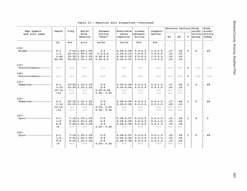
Mohave C
ounty, Arizona, S
outhern Part
601
Table 15.--Physical Soil Properties--Continued________________________________________________________________________________________________________________________ | | | | | | | |Erosion factors|Wind |Wind Map symbol | Depth | Clay | Moist | Permea- |Available| Linear | Organic |_______________|erodi-|erodi- and soil name | | | bulk | bility | water |extensi- | matter | | | |bility|bility | | | density | (Ksat) |capacity | bility | | Kw | Kf | T |group |index_____________________|_______|______|_________|_____________|_________|_________|_________|_____|_____|___|______|______ | In | Pct | g/cc | In/hr | In/in | Pct | Pct | | | | | | | | | | | | | | | | |118: | | | | | | | | | | | | Eloma---------------| 0-1 | 5-20|1.45-1.65| 2-6 |0.04-0.08| 0.0-2.9 | 1.0-3.0 | .17 | .24 | 5 | 6 | 48 | 1-3 | 20-35|1.55-1.65| 0.2-0.6 |0.05-0.10| 3.0-6.0 | 1.0-3.0 | .15 | .32 | | | | 3-40 | 35-55|1.35-1.55| 0.06-0.2 |0.05-0.10| 6.0-9.0 | 1.0-3.0 | .10 | .20 | | | | 40-60 | 35-55|1.35-1.55| 0.06-0.2 |0.02-0.03| 3.0-6.0 | 1.0-3.0 | .10 | .32 | | | | | | | | | | | | | | |119: | | | | | | | | | | | | Torriorthents-------| --- | --- | --- | --- | --- | --- | --- | --- | --- | 2 | --- | --- | | | | | | | | | | | |120: | | | | | | | | | | | | Torriorthents-------| --- | --- | --- | --- | --- | --- | --- | --- | --- | 2 | --- | --- | | | | | | | | | | | |121: | | | | | | | | | | | | Tumarion------------| 0-3 | 15-25|1.15-1.25| 2-6 |0.05-0.08| 0.0-2.9 | 0.5-1.0 | .17 | .64 | 1 | 6 | 48 | 3-10 | 15-25|1.15-1.25| 2-6 |0.03-0.05| 0.0-2.9 | 0.5-1.0 | .05 | .32 | | | | 10-12 | --- | --- | 0.00-0.06 | --- | --- | --- | --- | --- | | | | >12 | --- | --- | 0.00- 0.01 | --- | --- | --- | --- | --- | | | | | | | | | | | | | | |122: | | | | | | | | | | | | Tumarion------------| 0-3 | 20-25|1.15-1.25| 2-6 |0.05-0.08| 0.0-2.9 | 0.5-1.0 | .17 | .64 | 1 | 6 | 48 | 3-10 | 15-25|1.15-1.25| 2-6 |0.03-0.05| 0.0-2.9 | 0.5-1.0 | .05 | .32 | | | | 10-12 | --- | --- | 0.00- 0.00 | --- | --- | --- | --- | --- | | | | >12 | --- | --- | 0.00- 0.00 | --- | --- | --- | --- | --- | | | | | | | | | | | | | | |123: | | | | | | | | | | | | Tyro----------------| 0-1 | 7-18|1.35-1.55| 2-6 |0.04-0.07| 0.0-2.9 | 0.5-1.0 | .10 | .24 | 1 | 8 | 0 | 1-6 | 5-20|1.35-1.50| 2-6 |0.04-0.08| 0.0-2.9 | 0.5-1.0 | .10 | .24 | | | | 6-9 | 5-20|1.35-1.50| 2-6 |0.04-0.08| 0.0-2.9 | 0.5-1.0 | .10 | .24 | | | | >9 | --- | --- | 0.00- 0.00 | --- | --- | --- | --- | --- | | | | | | | | | | | | | | |124: | | | | | | | | | | | | Tyro----------------| 0-1 | 7-18|1.35-1.55| 2-6 |0.04-0.07| 0.0-2.9 | 0.5-1.0 | .10 | .24 | 1 | 6 | 48 | 1-6 | 5-20|1.35-1.50| 2-6 |0.04-0.08| 0.0-2.9 | 0.5-1.0 | .10 | .24 | | | | 6-9 | 5-20|1.35-1.50| 2-6 |0.04-0.08| 0.0-2.9 | 0.5-1.0 | .10 | .24 | | | | >9 | --- | --- | 0.00- 0.00 | --- | --- | --- | --- | --- | | | | | | | | | | | | | | |

602S
oil Survey
Table 15.--Physical Soil Properties--Continued________________________________________________________________________________________________________________________ | | | | | | | |Erosion factors|Wind |Wind Map symbol | Depth | Clay | Moist | Permea- |Available| Linear | Organic |_______________|erodi-|erodi- and soil name | | | bulk | bility | water |extensi- | matter | | | |bility|bility | | | density | (Ksat) |capacity | bility | | Kw | Kf | T |group |index_____________________|_______|______|_________|_____________|_________|_________|_________|_____|_____|___|______|______ | In | Pct | g/cc | In/hr | In/in | Pct | Pct | | | | | | | | | | | | | | | | |125: | | | | | | | | | | | | Vekol family--------| 0-4 | 0-15|1.55-1.65| 6-20 |0.04-0.07| 0.0-2.9 | 0.5-1.0 | .05 | .10 | 5 | 3 | 86 | 4-10 | 5-20|1.45-1.65| 6-20 |0.07-0.11| 0.0-2.9 | 0.5-1.0 | .10 | .15 | | | | 10-26 | 35-55|1.55-1.65| 0.06-0.2 |0.10-0.14| 3.0-6.0 | 0.5-1.0 | .10 | .15 | | | | 26-40 | 20-35|1.55-1.65| 0.2-0.6 |0.09-0.14| 3.0-6.0 | 0.5-1.0 | .10 | .15 | | | | 40-60 | 0-10|1.55-1.65| 20-40 |0.03-0.05| 0.0-2.9 | 0.5-1.0 | .02 | .05 | | | | | | | | | | | | | | |126: | | | | | | | | | | | | Vekol family--------| 0-4 | 0-15|1.55-1.65| 6-20 |0.04-0.07| 0.0-2.9 | 0.5-1.0 | .05 | .10 | 3 | 3 | 86 | 4-10 | 5-20|1.45-1.65| 6-20 |0.07-0.11| 0.0-2.9 | 0.5-1.0 | .10 | .15 | | | | 10-26 | 35-55|1.55-1.65| 0.06-0.2 |0.10-0.14| 3.0-6.0 | 0.5-1.0 | .10 | .15 | | | | 26-40 | 20-35|1.55-1.65| 0.2-0.6 |0.09-0.14| 3.0-6.0 | 0.5-1.0 | .10 | .15 | | | | 40-60 | 0-10|1.55-1.65| 20-40 |0.03-0.05| 0.0-2.9 | 0.5-1.0 | .02 | .05 | | | | | | | | | | | | | | |127: | | | | | | | | | | | | Water---------------| --- | --- | --- | --- | --- | --- | --- | --- | --- | - | --- | --- | | | | | | | | | | | |128: | | | | | | | | | | | | Whitehills----------| 0-2 | 7-27|1.35-1.55| 0.6-2 |0.05-0.12| 0.0-2.9 | 0.5-1.0 | .20 | .37 | 2 | 7 | 38 | 2-7 | 7-27|1.35-1.55| 0.6-2 |0.05-0.12| 0.0-2.9 | 0.5-1.0 | .20 | .37 | | | | 7-19 | 27-35|1.25-1.55| 0.2-0.6 |0.07-0.14| 3.0-6.0 | 0.5-1.0 | .15 | .32 | | | | 19-27 | 7-27|1.35-1.55| 0.6-2 |0.05-0.12| 0.0-2.9 | 0.5-1.0 | .15 | .37 | | | | >27 | --- | --- | 0.00-0.06 | --- | --- | --- | --- | --- | | | | | | | | | | | | | | |129: | | | | | | | | | | | | Whitehills----------| 0-2 | 7-27|1.35-1.55| 0.6-2 |0.05-0.12| 0.0-2.9 | 0.5-1.0 | .20 | .37 | 2 | 6 | 48 | 2-7 | 7-27|1.35-1.55| 0.6-2 |0.05-0.12| 0.0-2.9 | 0.5-1.0 | .20 | .37 | | | | 7-19 | 27-35|1.25-1.55| 0.2-0.6 |0.07-0.14| 3.0-6.0 | 0.5-1.0 | .15 | .32 | | | | 19-27 | 7-27|1.35-1.55| 0.6-2 |0.05-0.12| 0.0-2.9 | 0.5-1.0 | .15 | .37 | | | | >27 | --- | --- | 0.00- 0.00 | --- | --- | --- | --- | --- | | | | | | | | | | | | | | |130: | | | | | | | | | | | | White House family--| 0-1 | 0-15|1.55-1.65| 6-20 |0.02-0.05| 0.0-2.9 | 1.0-2.0 | .05 | .17 | 4 | 5 | 56 | 1-15 | 20-35|1.55-1.65| 0.2-0.6 |0.05-0.10| 3.0-6.0 | 1.0-2.0 | .10 | .32 | | | | 15-21 | 35-60|1.15-1.30| 0.00-0.06 |0.10-0.12| 9.0-10.9| 1.0-2.0 | .28 | .32 | | | | 21-32 | 35-60|1.35-1.55| 0.06-0.2 |0.12-0.14| 9.0-10.9| 1.0-2.0 | .15 | .20 | | | | 32-43 | 20-35|1.55-1.65| 0.2-0.6 |0.05-0.10| 3.0-6.0 | 1.0-2.0 | .15 | .32 | | | | 43-60 | 0-15|1.55-1.65| 6-20 |0.04-0.07| 0.0-2.9 | 1.0-2.0 | .05 | .17 | | | | | | | | | | | | | | |

Mohave C
ounty, Arizona, S
outhern Part
603
Table 15.--Physical Soil Properties--Continued________________________________________________________________________________________________________________________ | | | | | | | |Erosion factors|Wind |Wind Map symbol | Depth | Clay | Moist | Permea- |Available| Linear | Organic |_______________|erodi-|erodi- and soil name | | | bulk | bility | water |extensi- | matter | | | |bility|bility | | | density | (Ksat) |capacity | bility | | Kw | Kf | T |group |index_____________________|_______|______|_________|_____________|_________|_________|_________|_____|_____|___|______|______ | In | Pct | g/cc | In/hr | In/in | Pct | Pct | | | | | | | | | | | | | | | | |131: | | | | | | | | | | | | White House---------| 0-1 | 0-15|1.55-1.65| 6-20 |0.04-0.07| 0.0-2.9 | 1.0-3.0 | .10 | .17 | 4 | 3 | 86 | 1-5 | 20-35|1.55-1.65| 0.2-0.6 |0.15-0.17| 3.0-6.0 | 1.0-3.0 | .28 | .32 | | | | 5-23 | 35-60|1.55-1.65| 0.06-0.2 |0.13-0.17| 6.0-9.0 | 1.0-3.0 | .24 | .32 | | | | 23-42 | 20-35|1.55-1.65| 0.2-0.6 |0.09-0.14| 3.0-6.0 | 1.0-3.0 | .15 | .32 | | | | 42-60 | 0-15|1.55-1.65| 6-20 |0.04-0.07| 0.0-2.9 | 1.0-3.0 | .10 | .17 | | | | | | | | | | | | | | |132: | | | | | | | | | | | | Wikieup-------------| 0-1 | 5-18|1.65-1.75| 2-6 |0.03-0.05| 0.0-2.9 | 0.0-1.0 | .05 | .24 | 1 | 8 | 0 | 1-5 | 5-18|1.65-1.75| 2-6 |0.07-0.11| 0.0-2.9 | 0.0-1.0 | .15 | .24 | | | | 5-8 | --- | --- | 0.00-0.06 | --- | --- | --- | --- | --- | | | | >8 | --- | --- | 0.00- 0.00 | --- | --- | --- | --- | --- | | | | | | | | | | | | | | | Mutang--------------| 0-3 | 5-18|1.45-1.65| 2-6 |0.03-0.05| 0.0-2.9 | 1.0-2.0 | .05 | .24 | 2 | 8 | 0 | 3-5 | 30-35|1.25-1.55| 0.2-0.6 |0.07-0.14| 3.0-6.0 | 1.0-2.0 | .10 | .32 | | | | 5-15 | 40-60|1.35-1.55| 0.06-0.2 |0.10-0.14| 3.0-6.0 | 1.0-2.0 | .10 | .20 | | | | 15-22 | --- | --- | 0.00-0.06 | --- | --- | --- | --- | --- | | | | >22 | --- | --- | 0.00- 0.00 | --- | --- | --- | --- | --- | | | | | | | | | | | | | | | Rock outcrop--------| --- | --- | --- | --- | --- | --- | --- | --- | --- | - | 8 | 0 | | | | | | | | | | | |133: | | | | | | | | | | | | Mutang--------------| 0-1 | 10-18|1.35-1.50| 2-6 |0.07-0.13| 0.0-2.9 | 0.5-1.0 | .20 | .24 | 2 | 5 | 56 | 1-5 | 10-25|1.25-1.40| 0.6-2 |0.13-0.18| 0.0-2.9 | 0.5-1.0 | .32 | .32 | | | | 5-15 | 40-55|1.15-1.30| 0.00-0.06 |0.14-0.16| 6.0-9.0 | 0.5-1.0 | .32 | .32 | | | | 15-22 | --- | --- | 0.00-0.06 | --- | --- | --- | --- | --- | | | | >22 | --- | --- | 0.00-0.03 | --- | --- | --- | --- | --- | | | | | | | | | | | | | | | Wikieup-------------| 0-1 | 5-18|1.65-1.75| 2-6 |0.03-0.05| 0.0-2.9 | 0.0-1.0 | .05 | .24 | 1 | 8 | 0 | 1-5 | 5-18|1.65-1.75| 2-6 |0.07-0.11| 0.0-2.9 | 0.0-1.0 | .15 | .24 | | | | 5-8 | --- | --- | 0.00-0.06 | --- | --- | --- | --- | --- | | | | >8 | --- | --- | 0.00- 0.00 | --- | --- | --- | --- | --- | | | | | | | | | | | | | | | Rock outcrop--------| --- | --- | --- | --- | --- | --- | --- | --- | --- | - | 8 | 0 | | | | | | | | | | | |134: | | | | | | | | | | | | Wikieup-------------| 0-1 | 5-18|1.35-1.50| 2-6 |0.04-0.08| 0.0-2.9 | 0.0-1.0 | .10 | .24 | 1 | 6 | 48 | 1-5 | 5-18|1.65-1.75| 2-6 |0.07-0.11| 0.0-2.9 | 0.0-1.0 | .15 | .24 | | | | 5-8 | --- | --- | 0.00-0.06 | --- | --- | --- | --- | --- | | | | >8 | --- | --- | 0.00- 0.00 | --- | --- | --- | --- | --- | | | | | | | | | | | | | | | Rock outcrop--------| --- | --- | --- | --- | --- | --- | --- | --- | --- | - | 8 | 0 | | | | | | | | | | | |

604S
oil Survey
Table 15.--Physical Soil Properties--Continued________________________________________________________________________________________________________________________ | | | | | | | |Erosion factors|Wind |Wind Map symbol | Depth | Clay | Moist | Permea- |Available| Linear | Organic |_______________|erodi-|erodi- and soil name | | | bulk | bility | water |extensi- | matter | | | |bility|bility | | | density | (Ksat) |capacity | bility | | Kw | Kf | T |group |index_____________________|_______|______|_________|_____________|_________|_________|_________|_____|_____|___|______|______ | In | Pct | g/cc | In/hr | In/in | Pct | Pct | | | | | | | | | | | | | | | | |135: | | | | | | | | | | | | Yahana family-------| 0-4 | 27-40|1.15-1.30| 0.06-0.2 |0.05-0.06| 3.0-6.0 | 1.0-2.0 | .37 | .37 | 5 | 4 | 86 | 4-8 | 10-50|1.15-1.40| 0.06-0.2 |0.04-0.05| 6.0-9.0 | 0.5-1.0 | .32 | .32 | | | | 8-29 | 18-27|1.00-1.55| 0.6-2 |0.19-0.21| 3.0-6.0 | 0.5-1.0 | .43 | .43 | | | | 29-41 | 10-50|1.15-1.40| 0.06-0.2 |0.04-0.05| 6.0-9.0 | 0.5-1.0 | .32 | .32 | | | | 41-56 | 27-40|1.15-1.30| 0.06-0.2 |0.05-0.06| 3.0-6.0 | 0.5-1.0 | .37 | .37 | | | | 56-60 | 3-5 |1.45-1.60| 6-20 |0.02-0.03| 0.0-2.9 | 0.0-0.5 | .15 | .15 | | | | | | | | | | | | | | |136: | | | | | | | | | | | | Tumarion------------| 0-2 | 10-18|1.35-1.50| 2-6 |0.04-0.06| 0.0-2.9 | 0.5-1.0 | .05 | .24 | 1 | 8 | 0 | 2-15 | 15-25|1.35-1.50| 2-6 |0.07-0.12| 0.0-2.9 | 0.5-1.0 | .10 | .24 | | | | 15-19 | --- | --- | 0.00-0.06 | --- | --- | --- | --- | --- | | | | >19 | --- | --- | 0.00- 0.00 | --- | --- | --- | --- | --- | | | | | | | | | | | | | | | Nickel family-------| 0-4 | 10-27|1.25-1.40| 0.6-2 |0.01-0.06| 0.0-2.9 | 0.0-0.5 | .02 | .32 | 4 | 8 | 0 | 4-23 | 18-25|1.15-1.40| 0.6-2 |0.08-0.12| 0.0-2.9 | 0.0-1.0 | .05 | .55 | | | | 23-51 | 12-27|1.25-1.40| 2-6 |0.07-0.09| 0.0-2.9 | 0.0-1.0 | .15 | .32 | | | | 51-60 | 8-15|1.35-1.50| 2-6 |0.07-0.12| 0.0-2.9 | 0.0-1.0 | .10 | .24 | | | | | | | | | | | | | | |137: | | | | | | | | | | | | Valena--------------| 0-2 | 5-18|1.25-1.35| 2-6 |0.09-0.13| 0.0-2.9 | 1.0-2.0 | .24 | .24 | 1 | 3 | 86 | 2-7 | 15-18|1.35-1.50| 2-6 |0.09-0.13| 0.0-2.9 | 1.0-2.0 | .24 | .24 | | | | 7-12 | 20-35|1.25-1.50| 0.6-2 |0.16-0.21| 0.0-2.9 | 0.0-1.0 | .32 | .32 | | | | >12 | --- | --- | 0.00- 0.00 | --- | --- | --- | --- | --- | | | | | | | | | | | | | | | Rock outcrop--------| --- | --- | --- | --- | --- | --- | --- | --- | --- | - | 8 | 0 | | | | | | | | | | | | Carri family--------| 0-2 | 7-18|1.10-1.20| 2-6 |0.11-0.13| 0.0-2.9 | 1.0-2.0 | .24 | .24 | 5 | 3 | 86 | 2-34 | 20-35|1.05-1.15| 0.2-0.6 |0.14-0.16| 3.0-6.0 | 1.0-2.0 | .32 | .32 | | | | 34-44 | 10-18|1.35-1.50| 2-6 |0.08-0.11| 0.0-2.9 | 0.5-1.0 | .20 | .32 | | | | 44-60 | 18-27|1.25-1.40| 2-6 |0.13-0.18| 0.0-2.9 | 0.5-1.0 | .32 | .32 | | | | | | | | | | | | | | |138: | | | | | | | | | | | | Nodman--------------| 0-2 | 5-18|1.35-1.50| 2-6 |0.05-0.07| 0.0-2.9 | 0.5-1.0 | .10 | .24 | 1 | 5 | 56 | 2-10 | 20-35|1.25-1.40| 0.2-0.6 |0.05-0.08| 3.0-6.0 | 0.0-0.5 | .10 | .32 | | | | 10-17 | --- | --- | 0.00-0.06 | --- | --- | --- | --- | --- | | | | 17-60 | --- | --- | 0.00-0.06 | --- | --- | --- | --- | --- | | | | | | | | | | | | | | | Rock outcrop--------| --- | --- | --- | --- | --- | --- | --- | --- | --- | - | 8 | 0 | | | | | | | | | | | |

Mohave C
ounty, Arizona, S
outhern Part
605
Table 15.--Physical Soil Properties--Continued________________________________________________________________________________________________________________________ | | | | | | | |Erosion factors|Wind |Wind Map symbol | Depth | Clay | Moist | Permea- |Available| Linear | Organic |_______________|erodi-|erodi- and soil name | | | bulk | bility | water |extensi- | matter | | | |bility|bility | | | density | (Ksat) |capacity | bility | | Kw | Kf | T |group |index_____________________|_______|______|_________|_____________|_________|_________|_________|_____|_____|___|______|______ | In | Pct | g/cc | In/hr | In/in | Pct | Pct | | | | | | | | | | | | | | | | |139: | | | | | | | | | | | | Nodman--------------| 0-1 | 5-18|1.35-1.50| 2-6 |0.08-0.11| 0.0-2.9 | 0.5-1.0 | .15 | .24 | 1 | 5 | 56 | 1-6 | 5-18|1.35-1.50| 2-6 |0.03-0.05| 0.0-2.9 | 0.0-0.5 | .05 | .24 | | | | 6-12 | 20-35|1.25-1.40| 0.2-0.6 |0.06-0.08| 3.0-6.0 | 0.0-0.5 | .10 | .32 | | | | 12-60 | --- | --- | 0.00-0.06 | --- | --- | --- | --- | --- | | | | | | | | | | | | | | | Romero family-------| 0-2 | 8-18|1.35-1.50| 2-6 |0.05-0.07| 0.0-2.9 | 0.5-1.0 | .05 | .24 | 1 | 6 | 48 | 2-7 | 8-18|1.35-1.50| 2-6 |0.05-0.07| 0.0-2.9 | 0.0-0.5 | .05 | .24 | | | | 7-21 | --- | --- | 0.00-0.06 | --- | --- | --- | --- | --- | | | | >21 | --- | --- | 0.00- 0.00 | --- | --- | --- | --- | --- | | | | | | | | | | | | | | |_____________________|_______|______|_________|_____________|_________|_________|_________|_____|_____|___|______|______

606S
oil Survey
Table 16.--Chemical Soil Properties
(Absence of an entry indicates that data were not estimated.)_______________________________________________________________________________________________________ | | | | | | | | Map symbol | Depth | Cation |Effective| Soil |Calcium| Gypsum | Salinity | Sodium and soil name | |exchange | cation |reaction |carbon-| | | adsorp- | |capacity |exchange | | ate | | | tion | | |capacity | | | | | ratio______________________|________|_________|_________|_________|_______|________|_______________|__________ | Inches |meq/100 g|meq/100 g| pH | Pct | Pct | mmhos/cm | | | | | | | | |1: | | | | | | | | Akela----------------| 0-1 | 5.0-15 | --- | 7.4-8.4 | 1-15 | 0 | 0.0-2.0 | 0 | 1-5 | 5.0-15 | --- | 7.4-8.4 | 1-15 | 0 | 0.0-2.0 | 0 | >5 | --- | --- | --- | --- | --- | --- | --- | | | | | | | | Rock outcrop---------| --- | --- | --- | --- | --- | --- | --- | --- | | | | | | | | Rubble land----------| --- | --- | --- | --- | --- | --- | --- | --- | | | | | | | |2: | | | | | | | | Akela----------------| 0-1 | 5.0-15 | --- | 7.4-8.4 | 1-15 | 0 | 0.0-2.0 | 0 | 1-5 | 5.0-15 | --- | 7.4-8.4 | 1-15 | 0 | 0.0-2.0 | 0 | >5 | --- | --- | --- | --- | --- | --- | --- | | | | | | | | Rock outcrop---------| --- | --- | --- | --- | --- | --- | --- | --- | | | | | | | | Rubble land----------| --- | --- | --- | --- | --- | --- | --- | --- | | | | | | | |3: | | | | | | | | Alko family----------| 0-1 | 5.0-15 | --- | 7.4-8.4 | 5-30 | 0 | 0.0-2.0 | 0 | 1-15 | 5.0-15 | --- | 7.4-8.4 | 25-35 | 0 | 0.0-2.0 | 0 | 15-31 | --- | --- | --- | --- | --- | --- | --- | 31-60 | 0.0-10 | --- | 7.4-8.4 | 25-35 | 0 | 0.0-2.0 | 0 | | | | | | | |4: | | | | | | | | Alko family----------| 0-1 | 5.0-15 | --- | 7.4-8.4 | 10-30 | 0 | 0.0-2.0 | 0 | 1-15 | 5.0-15 | --- | 7.4-8.4 | 10-30 | 0 | 0.0-2.0 | 0 | 15-31 | --- | --- | --- | --- | --- | --- | --- | 31-60 | 0.0-10 | --- | 7.4-8.4 | 15-35 | 0 | 0.0-2.0 | 0 | | | | | | | |5: | | | | | | | | Amole----------------| 0-1 | 5.0-15 | --- | 6.6-8.4 | 0 | 0 | 0.0-2.0 | 0 | 1-19 | 5.0-15 | --- | 7.4-8.4 | 0 | 0 | 0.0-2.0 | 0 | 19-60 | 0.0-10 | --- | 7.4-8.4 | 2-10 | 0 | 0.0-2.0 | 0 | | | | | | | |6: | | | | | | | | Amole----------------| 0-1 | 5.0-15 | --- | 6.6-8.4 | 0 | 0 | 0.0-2.0 | 0 | 1-19 | 5.0-15 | --- | 7.4-8.4 | 0 | 0 | 0.0-2.0 | 0 | 19-60 | 0.0-10 | --- | 7.4-8.4 | 2-10 | 0 | 0.0-2.0 | 0 | | | | | | | |
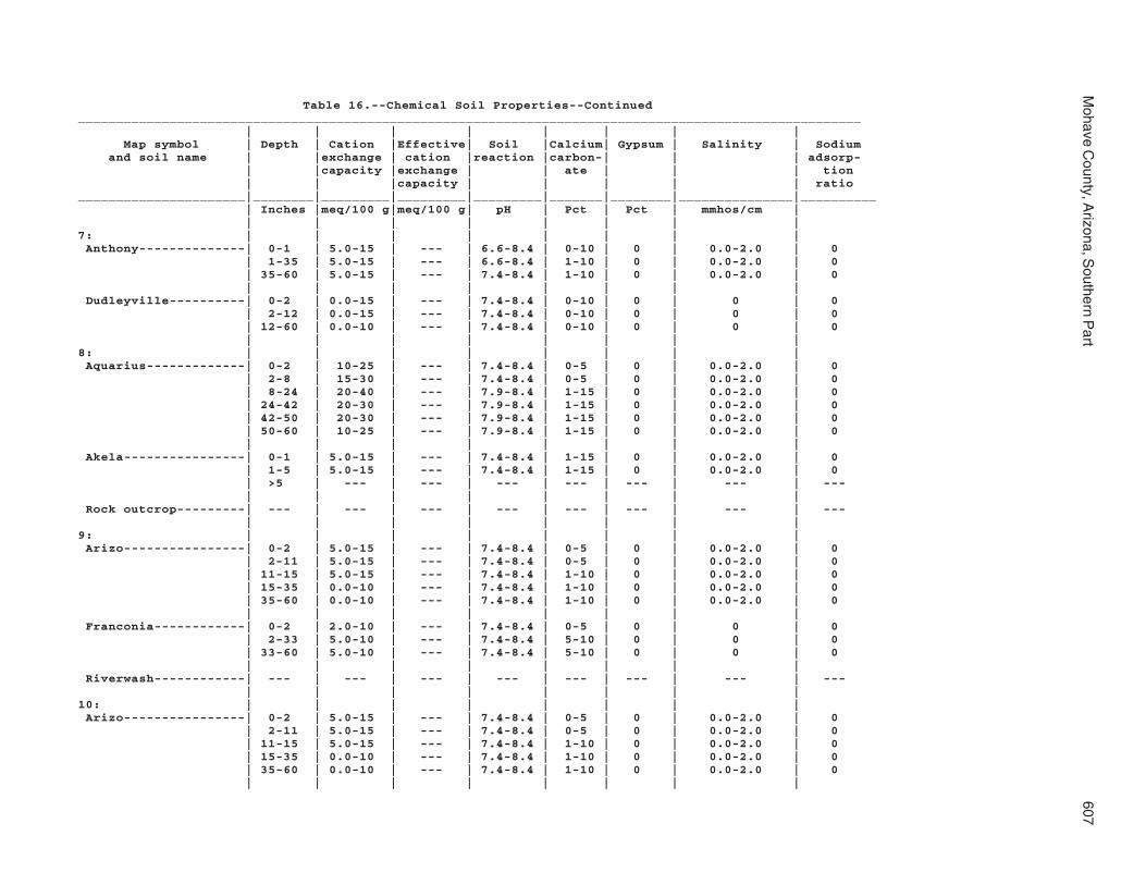
Mohave C
ounty, Arizona, S
outhern Part
607
Table 16.--Chemical Soil Properties--Continued_______________________________________________________________________________________________________ | | | | | | | | Map symbol | Depth | Cation |Effective| Soil |Calcium| Gypsum | Salinity | Sodium and soil name | |exchange | cation |reaction |carbon-| | | adsorp- | |capacity |exchange | | ate | | | tion | | |capacity | | | | | ratio______________________|________|_________|_________|_________|_______|________|_______________|__________ | Inches |meq/100 g|meq/100 g| pH | Pct | Pct | mmhos/cm | | | | | | | | |7: | | | | | | | | Anthony--------------| 0-1 | 5.0-15 | --- | 6.6-8.4 | 0-10 | 0 | 0.0-2.0 | 0 | 1-35 | 5.0-15 | --- | 6.6-8.4 | 1-10 | 0 | 0.0-2.0 | 0 | 35-60 | 5.0-15 | --- | 7.4-8.4 | 1-10 | 0 | 0.0-2.0 | 0 | | | | | | | | Dudleyville----------| 0-2 | 0.0-15 | --- | 7.4-8.4 | 0-10 | 0 | 0 | 0 | 2-12 | 0.0-15 | --- | 7.4-8.4 | 0-10 | 0 | 0 | 0 | 12-60 | 0.0-10 | --- | 7.4-8.4 | 0-10 | 0 | 0 | 0 | | | | | | | |8: | | | | | | | | Aquarius-------------| 0-2 | 10-25 | --- | 7.4-8.4 | 0-5 | 0 | 0.0-2.0 | 0 | 2-8 | 15-30 | --- | 7.4-8.4 | 0-5 | 0 | 0.0-2.0 | 0 | 8-24 | 20-40 | --- | 7.9-8.4 | 1-15 | 0 | 0.0-2.0 | 0 | 24-42 | 20-30 | --- | 7.9-8.4 | 1-15 | 0 | 0.0-2.0 | 0 | 42-50 | 20-30 | --- | 7.9-8.4 | 1-15 | 0 | 0.0-2.0 | 0 | 50-60 | 10-25 | --- | 7.9-8.4 | 1-15 | 0 | 0.0-2.0 | 0 | | | | | | | | Akela----------------| 0-1 | 5.0-15 | --- | 7.4-8.4 | 1-15 | 0 | 0.0-2.0 | 0 | 1-5 | 5.0-15 | --- | 7.4-8.4 | 1-15 | 0 | 0.0-2.0 | 0 | >5 | --- | --- | --- | --- | --- | --- | --- | | | | | | | | Rock outcrop---------| --- | --- | --- | --- | --- | --- | --- | --- | | | | | | | |9: | | | | | | | | Arizo----------------| 0-2 | 5.0-15 | --- | 7.4-8.4 | 0-5 | 0 | 0.0-2.0 | 0 | 2-11 | 5.0-15 | --- | 7.4-8.4 | 0-5 | 0 | 0.0-2.0 | 0 | 11-15 | 5.0-15 | --- | 7.4-8.4 | 1-10 | 0 | 0.0-2.0 | 0 | 15-35 | 0.0-10 | --- | 7.4-8.4 | 1-10 | 0 | 0.0-2.0 | 0 | 35-60 | 0.0-10 | --- | 7.4-8.4 | 1-10 | 0 | 0.0-2.0 | 0 | | | | | | | | Franconia------------| 0-2 | 2.0-10 | --- | 7.4-8.4 | 0-5 | 0 | 0 | 0 | 2-33 | 5.0-10 | --- | 7.4-8.4 | 5-10 | 0 | 0 | 0 | 33-60 | 5.0-10 | --- | 7.4-8.4 | 5-10 | 0 | 0 | 0 | | | | | | | | Riverwash------------| --- | --- | --- | --- | --- | --- | --- | --- | | | | | | | |10: | | | | | | | | Arizo----------------| 0-2 | 5.0-15 | --- | 7.4-8.4 | 0-5 | 0 | 0.0-2.0 | 0 | 2-11 | 5.0-15 | --- | 7.4-8.4 | 0-5 | 0 | 0.0-2.0 | 0 | 11-15 | 5.0-15 | --- | 7.4-8.4 | 1-10 | 0 | 0.0-2.0 | 0 | 15-35 | 0.0-10 | --- | 7.4-8.4 | 1-10 | 0 | 0.0-2.0 | 0 | 35-60 | 0.0-10 | --- | 7.4-8.4 | 1-10 | 0 | 0.0-2.0 | 0 | | | | | | | |

608S
oil Survey
Table 16.--Chemical Soil Properties--Continued_______________________________________________________________________________________________________ | | | | | | | | Map symbol | Depth | Cation |Effective| Soil |Calcium| Gypsum | Salinity | Sodium and soil name | |exchange | cation |reaction |carbon-| | | adsorp- | |capacity |exchange | | ate | | | tion | | |capacity | | | | | ratio______________________|________|_________|_________|_________|_______|________|_______________|__________ | Inches |meq/100 g|meq/100 g| pH | Pct | Pct | mmhos/cm | | | | | | | | |10: | | | | | | | | Franconia------------| 0-2 | 2.0-10 | --- | 7.4-8.4 | 0-5 | 0 | 0 | 0 | 2-18 | 5.0-10 | --- | 7.4-8.4 | 5-10 | 0 | 0 | 0 | 18-33 | 5.0-10 | --- | 7.4-8.4 | 5-10 | 0 | 0 | 0 | 33-60 | 5.0-10 | --- | 7.4-8.4 | 5-10 | 0 | 0 | 0 | | | | | | | | Riverwash------------| --- | --- | --- | --- | --- | --- | --- | --- | | | | | | | |11: | | | | | | | | Bartmus--------------| 0-2 | 5.0-20 | --- | 7.4-8.4 | 1-5 | 0 | 0 | 0 | 2-6 | 10-25 | --- | 7.4-8.4 | 1-5 | 0 | 0 | 0 | 6-19 | --- | --- | --- | --- | --- | --- | --- | >19 | --- | --- | --- | --- | --- | --- | --- | | | | | | | |12: | | | | | | | | Bonita family--------| 0-2 | 15-30 | --- | 7.4-8.4 | 0-5 | 0 | 0.0-2.0 | 0 | 2-35 | 20-40 | --- | 7.4-8.4 | 0-5 | 0 | 0.0-2.0 | 0 | 35-60 | 10-20 | --- | 7.4-8.4 | 15-30 | 0 | 0.0-2.0 | 0 | | | | | | | |13: | | | | | | | | Bonita family--------| 0-2 | 15-30 | --- | 7.4-8.4 | 0-5 | 0 | 0.0-2.0 | 0 | 2-35 | 20-40 | --- | 7.4-8.4 | 0-5 | 0 | 0.0-2.0 | 0 | 35-60 | 10-20 | --- | 7.4-8.4 | 15-30 | 0 | 0.0-2.0 | 0 | | | | | | | | Gonzales-------------| 0-1 | 5.0-25 | --- | 6.6-7.3 | 0 | 0 | 0.0-2.0 | 0 | 1-14 | 20-40 | --- | 6.1-7.3 | 0 | 0 | 0.0-2.0 | 0 | 14-17 | --- | --- | --- | --- | --- | --- | --- | >17 | --- | --- | --- | --- | --- | --- | --- | | | | | | | |14: | | | | | | | | Brazito family-------| 0-7 | 0.0-10 | --- | 7.4-8.4 | 1-10 | 0 | 0.0-2.0 | 0 | 7-14 | 0.0-10 | --- | 7.4-8.4 | 1-10 | 0 | 0.0-2.0 | 0 | 14-28 | 0.0-10 | --- | 7.4-8.4 | 1-10 | 0 | 0.0-2.0 | 0 | 28-60 | 0.0-10 | --- | 7.4-8.4 | 1-10 | 0 | 0.0-2.0 | 0 | | | | | | | |15: | | | | | | | | Bucklebar------------| 0-4 | 5.0-15 | --- | 7.4-7.8 | 0 | 0 | 0.0-2.0 | 0 | 4-37 | 10-20 | --- | 7.4-7.8 | 0-5 | 0 | 0.0-2.0 | 0 | 37-60 | 5.0-15 | --- | 7.4-8.4 | 1-10 | 0 | 0.0-2.0 | 0 | | | | | | | |

Mohave C
ounty, Arizona, S
outhern Part
609
Table 16.--Chemical Soil Properties--Continued_______________________________________________________________________________________________________ | | | | | | | | Map symbol | Depth | Cation |Effective| Soil |Calcium| Gypsum | Salinity | Sodium and soil name | |exchange | cation |reaction |carbon-| | | adsorp- | |capacity |exchange | | ate | | | tion | | |capacity | | | | | ratio______________________|________|_________|_________|_________|_______|________|_______________|__________ | Inches |meq/100 g|meq/100 g| pH | Pct | Pct | mmhos/cm | | | | | | | | |16: | | | | | | | | Cacique family-------| 0-1 | 5.0-20 | --- | 7.4-8.4 | 0 | 0 | 0.0-2.0 | 0 | 1-8 | 10-25 | --- | 7.4-8.4 | 0-5 | 0 | 0.0-2.0 | 0 | 8-35 | 10-25 | --- | 7.4-8.4 | 5-15 | 0 | 0.0-2.0 | 0 | 35-60 | --- | --- | --- | --- | --- | --- | --- | | | | | | | |17: | | | | | | | | Castaneda------------| 0-1 | 2.0-10 | --- | 7.4-8.4 | 0-10 | 0 | 0 | 0 | 1-9 | 10-20 | --- | 7.4-8.4 | 0-10 | 0 | 0 | 0 | 9-17 | 10-20 | --- | 7.4-8.4 | 5-15 | 0 | 0 | 0 | 17-32 | 2.0-10 | --- | 7.4-8.4 | 15-35 | 0 | 0 | 0 | 32-41 | --- | --- | --- | --- | --- | --- | --- | 41-60 | 0.0-10 | --- | 7.4-8.4 | 5-15 | 0 | 0 | 0 | | | | | | | |18: | | | | | | | | Castaneda------------| 0-1 | 2.0-10 | --- | 7.4-8.4 | 0-10 | 0 | 0 | 0 | 1-9 | 10-20 | --- | 7.4-8.4 | 0-10 | 0 | 0 | 0 | 9-17 | 10-20 | --- | 7.4-8.4 | 5-15 | 0 | 0 | 0 | 17-32 | 2.0-10 | --- | 7.4-8.4 | 15-35 | 0 | 0 | 0 | 32-41 | --- | --- | --- | --- | --- | --- | --- | 41-60 | 0.0-10 | --- | 7.4-8.4 | 5-15 | 0 | 0 | 0 | | | | | | | |19: | | | | | | | | Carrizo family-------| 0-1 | 0.0-10 | --- | 7.4-8.4 | 0-10 | 0 | 0.0-2.0 | 0 | 1-9 | 0.0-10 | --- | 7.4-8.4 | 0-10 | 0 | 0.0-2.0 | 0 | 9-60 | 0.0-10 | --- | 7.4-8.4 | 0-10 | 0 | 0.0-2.0 | 0 | | | | | | | |20: | | | | | | | | Carrizo family-------| 0-1 | 0.0-10 | --- | 7.4-8.4 | 0-10 | 0 | 0.0-2.0 | 0 | 1-9 | 0.0-10 | --- | 7.4-8.4 | 0-10 | 0 | 0.0-2.0 | 0 | 9-60 | 0.0-10 | --- | 7.4-8.4 | 0-10 | 0 | 0.0-2.0 | 0 | | | | | | | | Riverwash------------| --- | --- | --- | --- | --- | --- | --- | --- | | | | | | | |21: | | | | | | | | Carrizo--------------| 0-1 | 0.0-10 | --- | 7.4-8.4 | 2-10 | 0 | 0.0-2.0 | 0 | 1-23 | 0.0-10 | --- | 7.4-8.4 | 2-10 | 0 | 0.0-2.0 | 0 | 23-60 | 0.0-5.0 | --- | 7.4-8.4 | 2-10 | 0 | 0.0-2.0 | 0 | | | | | | | | Riverwash------------| --- | --- | --- | --- | --- | --- | --- | --- | | | | | | | |

610S
oil Survey
Table 16.--Chemical Soil Properties--Continued_______________________________________________________________________________________________________ | | | | | | | | Map symbol | Depth | Cation |Effective| Soil |Calcium| Gypsum | Salinity | Sodium and soil name | |exchange | cation |reaction |carbon-| | | adsorp- | |capacity |exchange | | ate | | | tion | | |capacity | | | | | ratio______________________|________|_________|_________|_________|_______|________|_______________|__________ | Inches |meq/100 g|meq/100 g| pH | Pct | Pct | mmhos/cm | | | | | | | | |22: | | | | | | | | Carrizo--------------| 0-1 | 0.0-10 | --- | 7.4-8.4 | 0-10 | 0 | 0.0-2.0 | 0 | 1-60 | 0.0-10 | --- | 7.4-8.4 | 0-10 | 0 | 0.0-2.0 | 0 | | | | | | | | Riverwash------------| --- | --- | --- | --- | --- | --- | --- | --- | | | | | | | |23: | | | | | | | | Cave-----------------| 0-1 | 5.0-15 | --- | 7.9-8.4 | 5-15 | 0 | 0.0-2.0 | 0 | 1-7 | 5.0-15 | --- | 7.9-8.4 | 5-15 | 0 | 0.0-2.0 | 0 | 7-28 | --- | --- | --- | --- | --- | --- | --- | 28-60 | 0.0-10 | --- | 7.9-8.4 | 5-20 | 0 | 0.0-2.0 | 0 | | | | | | | |24: | | | | | | | | Cave-----------------| 0-1 | 5.0-15 | --- | 7.9-8.4 | 5-15 | 0 | 0.0-2.0 | 0 | 1-7 | 5.0-15 | --- | 7.9-8.4 | 5-15 | 0 | 0.0-2.0 | 0 | 7-28 | --- | --- | --- | --- | --- | --- | --- | 28-60 | 0.0-10 | --- | 7.9-8.4 | 5-20 | 0 | 0.0-2.0 | 0 | | | | | | | |25: | | | | | | | | Cellar---------------| 0-2 | 5.0-15 | --- | 7.4-8.4 | 0 | 0 | 0.0-2.0 | 0 | 2-10 | 5.0-15 | --- | 7.4-8.4 | 0 | 0 | 0.0-2.0 | 0 | 10-13 | --- | --- | --- | --- | --- | --- | --- | >13 | --- | --- | --- | --- | --- | --- | --- | | | | | | | | Rock outcrop---------| --- | --- | --- | --- | --- | --- | --- | --- | | | | | | | |26: | | | | | | | | Cellar---------------| 0-2 | 5.0-15 | --- | 7.4-8.4 | 0 | 0 | 0.0-2.0 | 0 | 2-10 | 5.0-15 | --- | 7.4-8.4 | 0 | 0 | 0.0-2.0 | 0 | 10-13 | --- | --- | --- | --- | --- | --- | --- | >13 | --- | --- | --- | --- | --- | --- | --- | | | | | | | | Rock outcrop---------| --- | --- | --- | --- | --- | --- | --- | --- | | | | | | | |27: | | | | | | | | Cellar---------------| 0-2 | 5.0-15 | --- | 7.4-8.4 | 0 | 0 | 0.0-2.0 | 0 | 2-10 | 5.0-15 | --- | 7.4-8.4 | 0 | 0 | 0.0-2.0 | 0 | 10-13 | --- | --- | --- | --- | --- | --- | --- | >13 | --- | --- | --- | --- | --- | --- | --- | | | | | | | |

Mohave C
ounty, Arizona, S
outhern Part
611
Table 16.--Chemical Soil Properties--Continued_______________________________________________________________________________________________________ | | | | | | | | Map symbol | Depth | Cation |Effective| Soil |Calcium| Gypsum | Salinity | Sodium and soil name | |exchange | cation |reaction |carbon-| | | adsorp- | |capacity |exchange | | ate | | | tion | | |capacity | | | | | ratio______________________|________|_________|_________|_________|_______|________|_______________|__________ | Inches |meq/100 g|meq/100 g| pH | Pct | Pct | mmhos/cm | | | | | | | | |27: | | | | | | | | Topock---------------| 0-2 | 5.0-15 | --- | 7.4-8.4 | 0-5 | 0 | 0 | 0 | 2-5 | 15-40 | --- | 7.4-8.4 | 0-5 | 0 | 0 | 0 | 5-12 | 15-40 | --- | 7.4-8.4 | 0-5 | 0 | 0 | 0 | 12-23 | --- | --- | --- | --- | --- | --- | --- | >23 | --- | --- | --- | --- | --- | --- | --- | | | | | | | | Rock outcrop---------| --- | --- | --- | --- | --- | --- | --- | --- | | | | | | | |28: | | | | | | | | Cherioni-------------| 0-1 | 10-20 | --- | 7.4-8.4 | 2-10 | 0 | 0.0-2.0 | 0 | 1-8 | 10-25 | --- | 7.4-8.4 | 10-15 | 0 | 0.0-2.0 | 0 | 8-10 | --- | --- | --- | --- | --- | --- | --- | >10 | --- | --- | --- | --- | --- | --- | --- | | | | | | | |29: | | | | | | | | Chuckawalla----------| 0-1 | 5.0-15 | --- | 7.4-7.8 | 1-15 | 0 | 0.0-2.0 | 0 | 1-5 | 10-20 | --- | 7.4-8.4 | 1-15 | 0 | 2.0-20.0 | 0 | 5-20 | 10-20 | --- | 7.4-8.4 | 15-25 | 0 | 2.0-20.0 | 0 | 20-29 | 0.0-10 | --- | 7.4-8.4 | 15-25 | 0 | 2.0-8.0 | 0 | 29-34 | 5.0-15 | --- | 7.4-8.4 | 15-25 | 0 | 0.0-2.0 | 0 | 34-60 | 0.0-10 | --- | 7.4-8.4 | 10-25 | 0 | 0.0-2.0 | 0 | | | | | | | | Riverbend------------| 0-2 | 2.0-10 | --- | 7.9-8.4 | 1-5 | 0 | 0.0-2.0 | 0 | 2-7 | 2.0-10 | --- | 7.9-8.4 | 1-5 | 0 | 0.0-2.0 | 0 | 7-18 | 0.0-10 | --- | 7.9-8.4 | 10-20 | 0 | 0.0-2.0 | 0 | 18-34 | 0.0-10 | --- | 7.4-8.4 | 10-20 | 0 | 0.0-2.0 | 0 | 34-60 | 1.0-5.0 | --- | 7.9-8.4 | 10-20 | 0 | 0.0-2.0 | 0 | | | | | | | |30: | | | | | | | | Chuckawalla family---| 0-1 | 5.0-20 | --- | 7.4-8.4 | 2-10 | 0 | 0.0-2.0 | 0 | 1-10 | 5.0-20 | --- | 7.4-8.4 | 2-10 | 0 | 0.0-2.0 | 0 | 10-23 | 10-25 | --- | 7.4-8.4 | 15-25 | 0 | 0.0-2.0 | 0 | 23-60 | 5.0-15 | --- | 7.4-8.4 | 15-25 | 0 | 0.0-2.0 | 0 | | | | | | | | Riverbend family-----| 0-2 | 2.0-10 | --- | 7.4-8.4 | 1-10 | 0 | 0 | 0 | 2-11 | 2.0-10 | --- | 7.4-8.4 | 5-10 | 0 | 0 | 0 | 11-60 | 0.0-10 | --- | 7.4-8.4 | 15-30 | 0 | 0 | 0 | | | | | | | |31: | | | | | | | | Cipriano-------------| 0-1 | 2.0-10 | --- | 7.9-8.4 | 1-10 | 0 | 0 | 0 | 1-10 | 2.0-10 | --- | 7.9-8.4 | 15-40 | 0 | 0 | 0 | >10 | --- | --- | --- | --- | --- | --- | --- | | | | | | | |

612S
oil Survey
Table 16.--Chemical Soil Properties--Continued_______________________________________________________________________________________________________ | | | | | | | | Map symbol | Depth | Cation |Effective| Soil |Calcium| Gypsum | Salinity | Sodium and soil name | |exchange | cation |reaction |carbon-| | | adsorp- | |capacity |exchange | | ate | | | tion | | |capacity | | | | | ratio______________________|________|_________|_________|_________|_______|________|_______________|__________ | Inches |meq/100 g|meq/100 g| pH | Pct | Pct | mmhos/cm | | | | | | | | |32: | | | | | | | | Cline----------------| 0-1 | 2.0-10 | --- | 7.4-8.4 | 5-15 | 0 | 0 | 0 | 1-11 | 2.0-10 | --- | 7.4-8.4 | 15-25 | 0 | 0 | 0 | 11-18 | --- | --- | --- | --- | --- | --- | --- | >18 | --- | --- | --- | --- | --- | --- | --- | | | | | | | |33: | | | | | | | | Cline----------------| 0-1 | 2.0-10 | --- | 7.4-8.4 | 5-15 | 0 | 0 | 0 | 1-11 | 2.0-10 | --- | 7.4-8.4 | 15-25 | 0 | 0 | 0 | 11-18 | --- | --- | --- | --- | --- | --- | --- | >18 | --- | --- | --- | --- | --- | --- | --- | | | | | | | |34: | | | | | | | | Continental----------| 0-1 | 2.0-10 | --- | 7.4-8.4 | 0 | 0 | 0 | 0 | 1-19 | 10-20 | --- | 7.4-8.4 | 0 | 0 | 0 | 0 | 19-39 | 15-35 | --- | 7.4-8.4 | 0 | 0 | 0 | 0 | 39-60 | 10-20 | --- | 7.4-8.4 | 15-25 | 0 | 0 | 0 | | | | | | | | Tres Hermanos--------| 0-2 | 2.0-10 | --- | 7.4-8.4 | 1-10 | 0 | 0 | 0 | 2-26 | 10-20 | --- | 7.4-8.4 | 10-25 | 0 | 0 | 0 | 26-60 | 2.0-10 | --- | 7.9-9.0 | 15-30 | 0 | 0 | 0 | | | | | | | |35: | | | | | | | | Continental----------| 0-1 | 2.0-10 | --- | 7.4-8.4 | 0 | 0 | 0 | 0 | 1-19 | 10-20 | --- | 7.4-8.4 | 0 | 0 | 0 | 0 | 19-39 | 15-35 | --- | 7.4-8.4 | 0 | 0 | 0 | 0 | 39-60 | 10-20 | --- | 7.4-8.4 | 15-25 | 0 | 0 | 0 | | | | | | | | Tres Hermanos--------| 0-2 | 2.0-10 | --- | 7.4-8.4 | 1-10 | 0 | 0 | 0 | 2-26 | 10-20 | --- | 7.4-8.4 | 10-25 | 0 | 0 | 0 | 26-60 | 2.0-10 | --- | 7.9-9.0 | 15-30 | 0 | 0 | 0 | | | | | | | |36: | | | | | | | | Continental----------| 0-1 | 2.0-10 | --- | 7.4-8.4 | 0 | 0 | 0 | 0 | 1-19 | 10-20 | --- | 7.4-8.4 | 0 | 0 | 0 | 0 | 19-39 | 15-35 | --- | 7.4-8.4 | 0 | 0 | 0 | 0 | 39-60 | 10-20 | --- | 7.4-8.4 | 15-25 | 0 | 0 | 0 | | | | | | | |

Mohave C
ounty, Arizona, S
outhern Part
613
Table 16.--Chemical Soil Properties--Continued_______________________________________________________________________________________________________ | | | | | | | | Map symbol | Depth | Cation |Effective| Soil |Calcium| Gypsum | Salinity | Sodium and soil name | |exchange | cation |reaction |carbon-| | | adsorp- | |capacity |exchange | | ate | | | tion | | |capacity | | | | | ratio______________________|________|_________|_________|_________|_______|________|_______________|__________ | Inches |meq/100 g|meq/100 g| pH | Pct | Pct | mmhos/cm | | | | | | | | |36: | | | | | | | | Rillino--------------| 0-2 | 5.0-15 | --- | 7.4-8.4 | 15-30 | 0 | 0 | 0 | 2-8 | 10-25 | --- | 7.4-8.4 | 5-10 | 0 | 0 | 0 | 8-16 | 10-25 | --- | 7.4-8.4 | 5-10 | 0 | 0 | 0 | 16-27 | 5.0-15 | --- | 7.4-8.4 | 15-30 | 0 | 0 | 0 | 27-39 | 0.0-15 | --- | 7.4-8.4 | 15-30 | 0 | 0 | 0 | 39-54 | 0.0-15 | --- | 7.4-8.4 | 15-30 | 0 | 0 | 0 | 54-60 | 0.0-15 | --- | 7.4-8.4 | 15-30 | 0 | 0 | 0 | | | | | | | |37: | | | | | | | | Continental----------| 0-1 | 2.0-10 | --- | 7.4-8.4 | 0 | 0 | 0 | 0 | 1-19 | 10-20 | --- | 7.4-8.4 | 0 | 0 | 0 | 0 | 19-39 | 15-35 | --- | 7.4-8.4 | 0 | 0 | 0 | 0 | 39-60 | 10-20 | --- | 7.4-8.4 | 15-25 | 0 | 0 | 0 | | | | | | | | Rillino--------------| 0-2 | 5.0-15 | --- | 7.4-8.4 | 15-30 | 0 | 0 | 0 | 2-16 | 10-25 | --- | 7.4-8.4 | 5-10 | 0 | 0 | 0 | 16-27 | 5.0-15 | --- | 7.4-8.4 | 15-30 | 0 | 0 | 0 | 27-60 | 0.0-15 | --- | 7.4-8.4 | 15-30 | 0 | 0 | 0 | | | | | | | |38: | | | | | | | | Coolidge-------------| 0-2 | 2.0-10 | --- | 7.4-8.4 | 2-10 | 0 | 0 | 0 | 2-27 | 2.0-10 | --- | 7.4-8.4 | 2-10 | 0 | 0 | 0 | 27-46 | 2.0-10 | --- | 7.4-8.4 | 15-25 | 0 | 0 | 0 | 46-60 | 2.0-10 | --- | 7.4-8.4 | 2-10 | 0 | 0 | 0 | | | | | | | | Denure---------------| 0-2 | 0.0-10 | --- | 7.4-8.4 | 2-10 | 0 | 0 | 0 | 2-7 | 0.0-10 | --- | 7.4-8.4 | 2-10 | 0 | 0 | 0 | 7-18 | 2.0-10 | --- | 7.4-8.4 | 2-10 | 0 | 0 | 0 | 18-60 | 2.0-10 | --- | 7.4-8.4 | 2-15 | 0 | 0 | 0 | | | | | | | |39: | | | | | | | | Coolidge family------| 0-2 | 2.0-10 | --- | 7.4-8.4 | 2-10 | 0 | 0 | 0 | 2-8 | 2.0-10 | --- | 7.4-8.4 | 5-10 | 0 | 0 | 0 | 8-29 | 2.0-10 | --- | 7.4-8.4 | 5-10 | 0 | 0 | 0 | 29-41 | 2.0-10 | --- | 7.4-8.4 | 15-30 | 0 | 0 | 0 | 41-60 | 0.0-5.0 | --- | 7.4-8.4 | 10-20 | 0 | 0 | 0 | | | | | | | | Denure family--------| 0-1 | 0.0-10 | --- | 7.4-8.4 | 2-10 | 0 | 0 | 0 | 1-11 | 0.0-10 | --- | 7.4-8.4 | 2-10 | 0 | 0 | 0 | 11-60 | 2.0-10 | --- | 7.4-8.4 | 2-15 | 0 | 0 | 0 | | | | | | | |

614S
oil Survey
Table 16.--Chemical Soil Properties--Continued_______________________________________________________________________________________________________ | | | | | | | | Map symbol | Depth | Cation |Effective| Soil |Calcium| Gypsum | Salinity | Sodium and soil name | |exchange | cation |reaction |carbon-| | | adsorp- | |capacity |exchange | | ate | | | tion | | |capacity | | | | | ratio______________________|________|_________|_________|_________|_______|________|_______________|__________ | Inches |meq/100 g|meq/100 g| pH | Pct | Pct | mmhos/cm | | | | | | | | |40: | | | | | | | | Courthouse family----| 0-2 | 5.0-20 | --- | 7.4-7.8 | 1-15 | 0 | 0 | 0 | 2-12 | 5.0-20 | --- | 7.4-8.4 | 1-15 | 0 | 0 | 0 | >12 | --- | --- | --- | --- | --- | --- | --- | | | | | | | | Rock outcrop---------| --- | --- | --- | --- | --- | --- | --- | --- | | | | | | | | Rubble land----------| --- | --- | --- | --- | --- | --- | --- | --- | | | | | | | |41: | | | | | | | | Courthouse family----| 0-2 | 5.0-20 | --- | 7.4-7.8 | 1-15 | 0 | 0 | 0 | 2-12 | 5.0-20 | --- | 7.4-8.4 | 1-15 | 0 | 0 | 0 | >12 | --- | --- | --- | --- | --- | --- | --- | | | | | | | | Rock outcrop---------| --- | --- | --- | --- | --- | --- | --- | --- | | | | | | | | Wagonbow-------------| 0-3 | 10-25 | --- | 7.4-8.4 | 0 | 0 | 0 | 0 | 3-6 | 10-25 | --- | 7.4-8.4 | 0 | 0 | 0 | 0 | 6-50 | 20-40 | --- | 7.4-8.4 | 5-10 | 0 | 0 | 0 | 50-60 | 10-25 | --- | 7.4-8.4 | 5-10 | 0 | 0 | 0 | | | | | | | |42: | | | | | | | | Far------------------| 0-5 | 5.0-20 | --- | 5.1-6.6 | 0 | 0 | 0 | 0 | 5-9 | 5.0-20 | --- | 5.1-6.6 | 0 | 0 | 0 | 0 | >9 | --- | --- | --- | --- | --- | --- | --- | | | | | | | | Rock outcrop---------| --- | --- | --- | --- | --- | --- | --- | --- | | | | | | | |43: | | | | | | | | Dutchflat------------| 0-4 | 5.0-15 | --- | 7.4-7.8 | 0 | 0 | 0.0-2.0 | 0 | 4-37 | 10-20 | --- | 7.4-7.8 | 0 | 0 | 0.0-2.0 | 0 | 37-60 | 5.0-15 | --- | 7.4-8.4 | 1-10 | 0 | 0.0-2.0 | 0 | | | | | | | |44: | | | | | | | | Dutchflat------------| 0-2 | 2.0-10 | --- | 7.4-8.4 | 0 | 0 | 0 | 0 | 2-28 | 5.0-10 | --- | 7.4-8.4 | 0 | 0 | 0 | 0 | 28-41 | 5.0-10 | --- | 7.4-8.4 | 5-10 | 0 | 0 | 0 | 41-60 | 2.0-10 | --- | 7.4-8.4 | 5-10 | 0 | 0 | 0 | | | | | | | |45: | | | | | | | | Gadsden--------------| 0-2 | 15-35 | --- | 7.4-8.4 | 2-10 | 0 | 2.0-12.0 | 4-20 | 2-56 | 15-35 | --- | 7.4-8.4 | 2-10 | 0 | 2.0-12.0 | 4-20 | 56-60 | 0.0-10 | --- | 7.4-8.4 | 2-10 | 0 | 0 | 0 | | | | | | | |
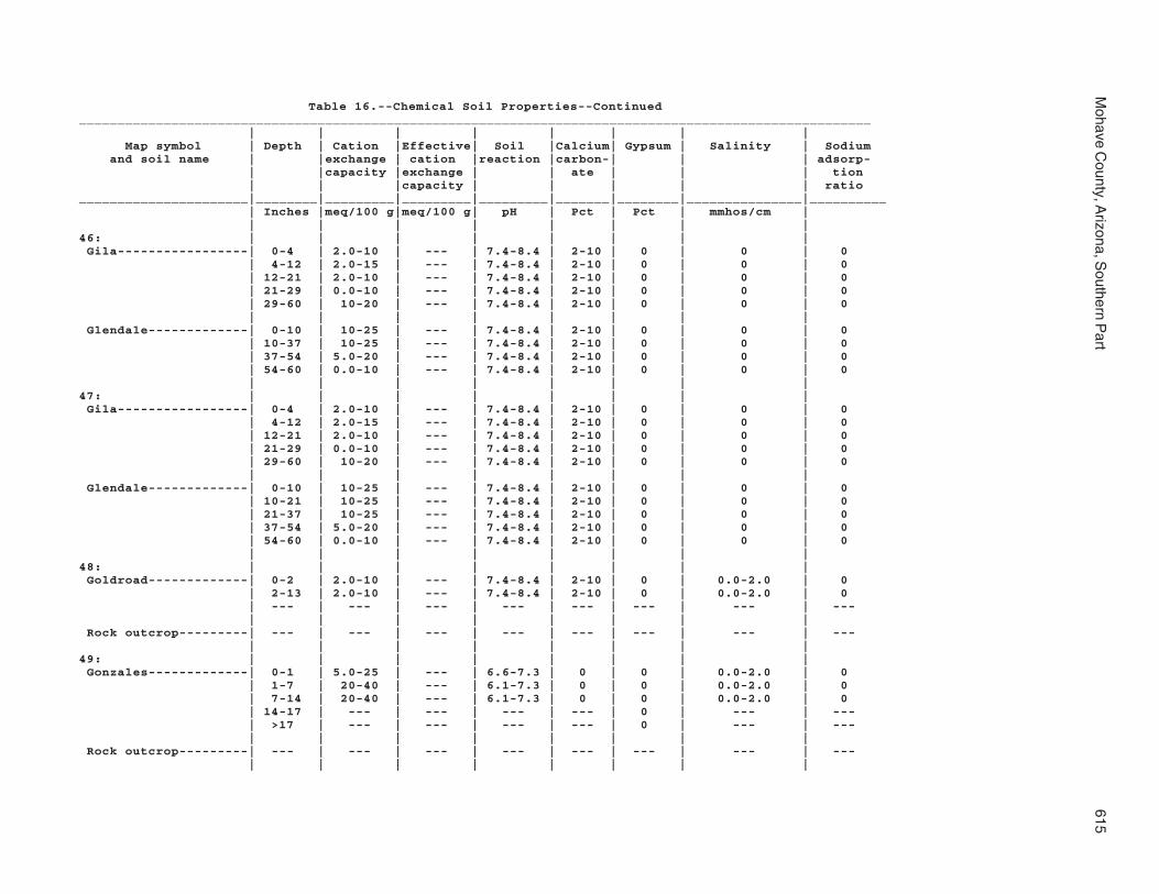
Mohave C
ounty, Arizona, S
outhern Part
615
Table 16.--Chemical Soil Properties--Continued_______________________________________________________________________________________________________ | | | | | | | | Map symbol | Depth | Cation |Effective| Soil |Calcium| Gypsum | Salinity | Sodium and soil name | |exchange | cation |reaction |carbon-| | | adsorp- | |capacity |exchange | | ate | | | tion | | |capacity | | | | | ratio______________________|________|_________|_________|_________|_______|________|_______________|__________ | Inches |meq/100 g|meq/100 g| pH | Pct | Pct | mmhos/cm | | | | | | | | |46: | | | | | | | | Gila-----------------| 0-4 | 2.0-10 | --- | 7.4-8.4 | 2-10 | 0 | 0 | 0 | 4-12 | 2.0-15 | --- | 7.4-8.4 | 2-10 | 0 | 0 | 0 | 12-21 | 2.0-10 | --- | 7.4-8.4 | 2-10 | 0 | 0 | 0 | 21-29 | 0.0-10 | --- | 7.4-8.4 | 2-10 | 0 | 0 | 0 | 29-60 | 10-20 | --- | 7.4-8.4 | 2-10 | 0 | 0 | 0 | | | | | | | | Glendale-------------| 0-10 | 10-25 | --- | 7.4-8.4 | 2-10 | 0 | 0 | 0 | 10-37 | 10-25 | --- | 7.4-8.4 | 2-10 | 0 | 0 | 0 | 37-54 | 5.0-20 | --- | 7.4-8.4 | 2-10 | 0 | 0 | 0 | 54-60 | 0.0-10 | --- | 7.4-8.4 | 2-10 | 0 | 0 | 0 | | | | | | | |47: | | | | | | | | Gila-----------------| 0-4 | 2.0-10 | --- | 7.4-8.4 | 2-10 | 0 | 0 | 0 | 4-12 | 2.0-15 | --- | 7.4-8.4 | 2-10 | 0 | 0 | 0 | 12-21 | 2.0-10 | --- | 7.4-8.4 | 2-10 | 0 | 0 | 0 | 21-29 | 0.0-10 | --- | 7.4-8.4 | 2-10 | 0 | 0 | 0 | 29-60 | 10-20 | --- | 7.4-8.4 | 2-10 | 0 | 0 | 0 | | | | | | | | Glendale-------------| 0-10 | 10-25 | --- | 7.4-8.4 | 2-10 | 0 | 0 | 0 | 10-21 | 10-25 | --- | 7.4-8.4 | 2-10 | 0 | 0 | 0 | 21-37 | 10-25 | --- | 7.4-8.4 | 2-10 | 0 | 0 | 0 | 37-54 | 5.0-20 | --- | 7.4-8.4 | 2-10 | 0 | 0 | 0 | 54-60 | 0.0-10 | --- | 7.4-8.4 | 2-10 | 0 | 0 | 0 | | | | | | | |48: | | | | | | | | Goldroad-------------| 0-2 | 2.0-10 | --- | 7.4-8.4 | 2-10 | 0 | 0.0-2.0 | 0 | 2-13 | 2.0-10 | --- | 7.4-8.4 | 2-10 | 0 | 0.0-2.0 | 0 | --- | --- | --- | --- | --- | --- | --- | --- | | | | | | | | Rock outcrop---------| --- | --- | --- | --- | --- | --- | --- | --- | | | | | | | |49: | | | | | | | | Gonzales-------------| 0-1 | 5.0-25 | --- | 6.6-7.3 | 0 | 0 | 0.0-2.0 | 0 | 1-7 | 20-40 | --- | 6.1-7.3 | 0 | 0 | 0.0-2.0 | 0 | 7-14 | 20-40 | --- | 6.1-7.3 | 0 | 0 | 0.0-2.0 | 0 | 14-17 | --- | --- | --- | --- | 0 | --- | --- | >17 | --- | --- | --- | --- | 0 | --- | --- | | | | | | | | Rock outcrop---------| --- | --- | --- | --- | --- | --- | --- | --- | | | | | | | |

616S
oil Survey
Table 16.--Chemical Soil Properties--Continued_______________________________________________________________________________________________________ | | | | | | | | Map symbol | Depth | Cation |Effective| Soil |Calcium| Gypsum | Salinity | Sodium and soil name | |exchange | cation |reaction |carbon-| | | adsorp- | |capacity |exchange | | ate | | | tion | | |capacity | | | | | ratio______________________|________|_________|_________|_________|_______|________|_______________|__________ | Inches |meq/100 g|meq/100 g| pH | Pct | Pct | mmhos/cm | | | | | | | | |50: | | | | | | | | Goodsprings family---| 0-2 | 0.0-5.0 | --- | 7.4-8.4 | 1-15 | 0 | 0 | 0 | 2-18 | 5.0-10 | --- | 7.4-8.4 | 5-15 | 0 | 0 | 0 | 18-39 | --- | --- | --- | --- | --- | --- | --- | 39-60 | 0.0-4.0 | --- | 7.9-8.4 | 5-25 | 0 | 0 | 0 | | | | | | | |51: | | | | | | | | Goodsprings family---| 0-2 | 0.0-5.0 | --- | 7.4-8.4 | 1-15 | 0 | 0 | 0 | 2-18 | 5.0-10 | --- | 7.4-8.4 | 5-15 | 0 | 0 | 0 | 18-39 | --- | --- | --- | --- | --- | --- | --- | 39-60 | 0.0-4.0 | --- | 7.9-8.4 | 5-25 | 0 | 0 | 0 | | | | | | | |52: | | | | | | | | Goodsprings family---| 0-2 | 0.0-5.0 | --- | 7.4-8.4 | 1-15 | 0 | 0 | 0 | 2-18 | 5.0-10 | --- | 7.4-8.4 | 5-15 | 0 | 0 | 0 | 18-39 | --- | --- | --- | --- | --- | --- | --- | 39-60 | 0.0-4.0 | --- | 7.9-8.4 | 5-25 | 0 | 0 | 0 | | | | | | | |53: | | | | | | | | Goodsprings family---| 0-2 | 0.0-5.0 | --- | 7.4-8.4 | 1-15 | 0 | 0 | 0 | 2-18 | 5.0-10 | --- | 7.4-8.4 | 5-15 | 0 | 0 | 0 | 18-39 | --- | --- | --- | --- | --- | --- | --- | 39-60 | 0.0-4.0 | --- | 7.9-8.4 | 5-25 | 0 | 0 | 0 | | | | | | | |54: | | | | | | | | Graham---------------| 0-2 | 5.0-20 | --- | 7.4-8.4 | 0 | 0 | 0 | 0-2 | 2-7 | 10-30 | --- | 7.4-8.4 | 0 | 0 | 0 | 0-2 | 7-14 | 20-40 | --- | 7.4-8.4 | 0 | 0 | 0 | 0-2 | >14 | --- | --- | --- | --- | 0 | --- | --- | | | | | | | | Arivaca--------------| 0-2 | 15-25 | --- | 6.6-7.8 | 0 | 0 | 0.0-2.0 | 0 | 2-6 | 20-40 | --- | 6.6-7.8 | 0 | 0 | 0.0-2.0 | 0 | 6-17 | 20-40 | --- | 7.4-8.4 | 0-5 | 0 | 0.0-2.0 | 0 | 17-30 | 20-40 | --- | 7.4-8.4 | 0-5 | 0 | 0.0-2.0 | 0 | 30-36 | 15-25 | --- | 7.4-7.8 | 5-15 | 0 | 0.0-2.0 | 0 | >36 | --- | --- | --- | --- | 0 | --- | --- | | | | | | | |55: | | | | | | | | Graham---------------| 0-2 | 5.0-20 | --- | 6.6-8.4 | 0 | 0 | 0 | 0-2 | 2-7 | 10-30 | --- | 7.4-8.4 | 0 | 0 | 0 | 0-2 | 7-14 | 20-40 | --- | 7.4-8.4 | 0 | 0 | 0 | 0-2 | >14 | --- | --- | --- | --- | 0 | --- | --- | | | | | | | |

Mohave C
ounty, Arizona, S
outhern Part
617
Table 16.--Chemical Soil Properties--Continued_______________________________________________________________________________________________________ | | | | | | | | Map symbol | Depth | Cation |Effective| Soil |Calcium| Gypsum | Salinity | Sodium and soil name | |exchange | cation |reaction |carbon-| | | adsorp- | |capacity |exchange | | ate | | | tion | | |capacity | | | | | ratio______________________|________|_________|_________|_________|_______|________|_______________|__________ | Inches |meq/100 g|meq/100 g| pH | Pct | Pct | mmhos/cm | | | | | | | | |55: | | | | | | | | Rock outcrop---------| --- | --- | --- | --- | --- | --- | --- | --- | | | | | | | |56: | | | | | | | | Gunsight-------------| 0-3 | 2.0-10 | --- | 7.9-8.4 | 5-10 | 0 | 0.0-2.0 | 0 | 3-6 | 2.0-10 | --- | 7.9-8.4 | 5-10 | 0 | 0.0-2.0 | 0 | 6-28 | 2.0-10 | --- | 7.9-8.4 | 15-30 | 0 | 0.0-2.0 | 0 | 28-50 | 2.0-10 | --- | 7.9-8.4 | 15-30 | 0 | 0.0-2.0 | 0 | 50-60 | 0.0-10 | --- | 7.9-8.4 | 15-30 | 0 | 0.0-2.0 | 0 | | | | | | | |57: | | | | | | | | Gunsight-------------| 0-3 | 2.0-10 | --- | 7.9-8.4 | 5-10 | 0 | 0.0-2.0 | 0 | 3-6 | 2.0-10 | --- | 7.9-8.4 | 5-10 | 0 | 0.0-2.0 | 0 | 6-28 | 2.0-10 | --- | 7.9-8.4 | 15-30 | 0 | 0.0-2.0 | 0 | 28-50 | 2.0-10 | --- | 7.9-8.4 | 15-30 | 0 | 0.0-2.0 | 0 | 50-60 | 0.0-10 | --- | 7.9-8.4 | 15-30 | 0 | 0.0-2.0 | 0 | | | | | | | |58: | | | | | | | | Hassell family-------| 0-4 | 10-20 | --- | 7.4-8.4 | 0-3 | 0 | 0 | 0-2 | 4-13 | 20-40 | --- | 7.4-8.4 | 0-3 | 0 | 0 | 0-2 | 13-24 | 20-40 | --- | 7.4-8.4 | 0-3 | 0 | 0 | 0-2 | 24-33 | 10-25 | --- | 7.4-8.4 | 0-3 | 0 | 0 | 0-2 | 33-47 | --- | --- | --- | --- | 0 | --- | --- | >47 | --- | --- | --- | --- | 0 | --- | --- | | | | | | | | Lampshire------------| 0-1 | 5.0-20 | --- | 6.6-8.4 | 0 | 0 | 0 | 0 | 1-6 | 5.0-20 | --- | 6.6-8.4 | 0 | 0 | 0 | 0 | 6-9 | --- | --- | --- | --- | 0 | --- | --- | >9 | --- | --- | --- | --- | 0 | --- | --- | | | | | | | | Rock outcrop---------| --- | --- | --- | --- | --- | --- | --- | --- | | | | | | | |59: | | | | | | | | Holtville------------| 0-2 | 15-35 | --- | 7.4-8.4 | 2-10 | 0 | 2.0-12.0 | 4-20 | 2-23 | 15-35 | --- | 7.4-8.4 | 2-10 | 0 | 2.0-12.0 | 4-20 | 23-31 | 15-35 | --- | 7.4-8.4 | 2-10 | 0 | 2.0-12.0 | 4-20 | 31-42 | 2.0-10 | --- | 7.4-8.4 | 2-10 | 0 | 2.0-12.0 | 4-20 | 42-60 | 0.0-5.0 | --- | 7.4-8.4 | 2-10 | 0 | 2.0-12.0 | 4-20 | | | | | | | |

618S
oil Survey
Table 16.--Chemical Soil Properties--Continued_______________________________________________________________________________________________________ | | | | | | | | Map symbol | Depth | Cation |Effective| Soil |Calcium| Gypsum | Salinity | Sodium and soil name | |exchange | cation |reaction |carbon-| | | adsorp- | |capacity |exchange | | ate | | | tion | | |capacity | | | | | ratio______________________|________|_________|_________|_________|_______|________|_______________|__________ | Inches |meq/100 g|meq/100 g| pH | Pct | Pct | mmhos/cm | | | | | | | | |60: | | | | | | | | Huevi----------------| 0-2 | 2.0-10 | --- | 7.4-8.4 | 5-10 | 0 | 0 | 0 | 2-9 | 2.0-10 | --- | 7.4-8.4 | 10-15 | 0 | 0 | 0 | 9-27 | 2.0-10 | --- | 7.4-8.4 | 10-15 | 0 | 0 | 0 | 27-40 | 2.0-10 | --- | 7.9-8.4 | 15-30 | 0 | 0 | 0 | 40-60 | 0.0-10 | --- | 7.9-8.4 | 2-10 | 0 | 0 | 0 | | | | | | | |61: | | | | | | | | Huevi----------------| 0-2 | 2.0-10 | --- | 7.4-8.4 | 5-10 | 0 | 0 | 0 | 2-9 | 2.0-10 | --- | 7.4-8.4 | 10-15 | 0 | 0 | 0 | 9-27 | 2.0-10 | --- | 7.4-8.4 | 15-30 | 0 | 0 | 0 | 27-40 | 2.0-10 | --- | 7.9-8.4 | 15-30 | 0 | 0 | 0 | 40-60 | 0.0-10 | --- | 7.9-8.4 | 2-10 | 0 | 0 | 0 | | | | | | | |62: | | | | | | | | Akela----------------| 0-1 | 2.0-10 | --- | 7.4-8.4 | 5-13 | 0 | 0 | 0-2 | 1-12 | 2.0-10 | --- | 7.4-8.4 | 5-13 | 0 | 0.0-2.0 | 0 | >12 | --- | --- | --- | --- | --- | --- | --- | | | | | | | | Rock outcrop---------| --- | --- | --- | --- | --- | --- | --- | --- | | | | | | | |63: | | | | | | | | Hyder----------------| 0-2 | 2.0-10 | --- | 7.4-8.4 | 2-10 | 0 | 0.0-2.0 | 0 | 2-7 | 2.0-10 | --- | 7.4-8.4 | 2-10 | 0 | 0.0-2.0 | 0 | >7 | --- | --- | --- | --- | --- | --- | --- | | | | | | | | Rock outcrop---------| --- | --- | --- | --- | --- | --- | --- | --- | | | | | | | | Rubble land----------| --- | --- | --- | --- | --- | --- | --- | --- | | | | | | | |64: | | | | | | | | Indio----------------| 0-8 | 2.0-15 | --- | 7.4-8.4 | 5-15 | 0 | 2.0-12.0 | 4-20 | 8-46 | 2.0-15 | --- | 7.4-8.4 | 5-15 | 0 | 2.0-12.0 | 4-20 | 46-58 | 15-35 | --- | 7.4-8.4 | 5-15 | 0 | 2.0-12.0 | 4-20 | 58-60 | 0.0-5.0 | --- | 7.4-8.4 | 5-15 | 0 | 2.0-12.0 | 4-20 | | | | | | | |65: | | | | | | | | Ireteba family-------| 0-2 | 2.0-10 | --- | 7.9-8.4 | 1-5 | 0 | 0 | 0 | 2-10 | 2.0-10 | --- | 7.9-8.4 | 1-5 | 0 | 0 | 0 | 10-19 | 2.0-10 | --- | 7.9-8.4 | 5-10 | 0 | 0 | 0 | 19-31 | 2.0-10 | --- | 7.9-8.4 | 5-10 | 0 | 0 | 0 | 31-41 | 2.0-10 | --- | 7.9-8.4 | 5-10 | 0 | 0 | 0 | 41-60 | 0.0-10 | --- | 7.9-8.4 | 5-10 | 0 | 0 | 0 | | | | | | | |
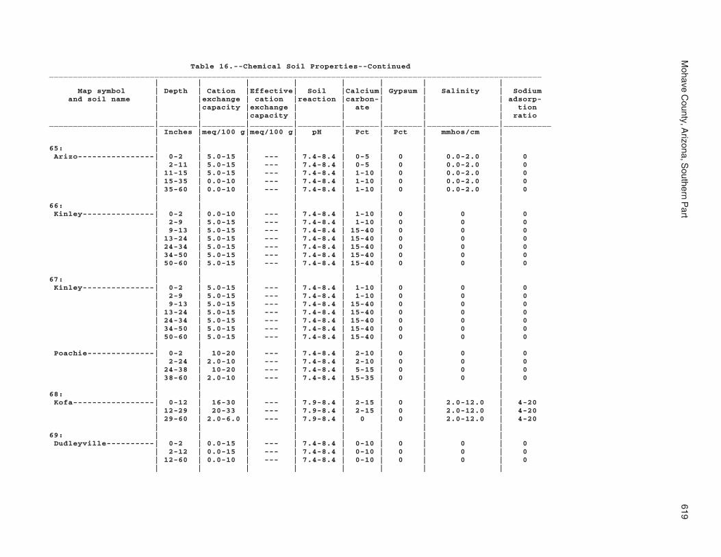
Mohave C
ounty, Arizona, S
outhern Part
619
Table 16.--Chemical Soil Properties--Continued_______________________________________________________________________________________________________ | | | | | | | | Map symbol | Depth | Cation |Effective| Soil |Calcium| Gypsum | Salinity | Sodium and soil name | |exchange | cation |reaction |carbon-| | | adsorp- | |capacity |exchange | | ate | | | tion | | |capacity | | | | | ratio______________________|________|_________|_________|_________|_______|________|_______________|__________ | Inches |meq/100 g|meq/100 g| pH | Pct | Pct | mmhos/cm | | | | | | | | |65: | | | | | | | | Arizo----------------| 0-2 | 5.0-15 | --- | 7.4-8.4 | 0-5 | 0 | 0.0-2.0 | 0 | 2-11 | 5.0-15 | --- | 7.4-8.4 | 0-5 | 0 | 0.0-2.0 | 0 | 11-15 | 5.0-15 | --- | 7.4-8.4 | 1-10 | 0 | 0.0-2.0 | 0 | 15-35 | 0.0-10 | --- | 7.4-8.4 | 1-10 | 0 | 0.0-2.0 | 0 | 35-60 | 0.0-10 | --- | 7.4-8.4 | 1-10 | 0 | 0.0-2.0 | 0 | | | | | | | |66: | | | | | | | | Kinley---------------| 0-2 | 0.0-10 | --- | 7.4-8.4 | 1-10 | 0 | 0 | 0 | 2-9 | 5.0-15 | --- | 7.4-8.4 | 1-10 | 0 | 0 | 0 | 9-13 | 5.0-15 | --- | 7.4-8.4 | 15-40 | 0 | 0 | 0 | 13-24 | 5.0-15 | --- | 7.4-8.4 | 15-40 | 0 | 0 | 0 | 24-34 | 5.0-15 | --- | 7.4-8.4 | 15-40 | 0 | 0 | 0 | 34-50 | 5.0-15 | --- | 7.4-8.4 | 15-40 | 0 | 0 | 0 | 50-60 | 5.0-15 | --- | 7.4-8.4 | 15-40 | 0 | 0 | 0 | | | | | | | |67: | | | | | | | | Kinley---------------| 0-2 | 5.0-15 | --- | 7.4-8.4 | 1-10 | 0 | 0 | 0 | 2-9 | 5.0-15 | --- | 7.4-8.4 | 1-10 | 0 | 0 | 0 | 9-13 | 5.0-15 | --- | 7.4-8.4 | 15-40 | 0 | 0 | 0 | 13-24 | 5.0-15 | --- | 7.4-8.4 | 15-40 | 0 | 0 | 0 | 24-34 | 5.0-15 | --- | 7.4-8.4 | 15-40 | 0 | 0 | 0 | 34-50 | 5.0-15 | --- | 7.4-8.4 | 15-40 | 0 | 0 | 0 | 50-60 | 5.0-15 | --- | 7.4-8.4 | 15-40 | 0 | 0 | 0 | | | | | | | | Poachie--------------| 0-2 | 10-20 | --- | 7.4-8.4 | 2-10 | 0 | 0 | 0 | 2-24 | 2.0-10 | --- | 7.4-8.4 | 2-10 | 0 | 0 | 0 | 24-38 | 10-20 | --- | 7.4-8.4 | 5-15 | 0 | 0 | 0 | 38-60 | 2.0-10 | --- | 7.4-8.4 | 15-35 | 0 | 0 | 0 | | | | | | | |68: | | | | | | | | Kofa-----------------| 0-12 | 16-30 | --- | 7.9-8.4 | 2-15 | 0 | 2.0-12.0 | 4-20 | 12-29 | 20-33 | --- | 7.9-8.4 | 2-15 | 0 | 2.0-12.0 | 4-20 | 29-60 | 2.0-6.0 | --- | 7.9-8.4 | 0 | 0 | 2.0-12.0 | 4-20 | | | | | | | |69: | | | | | | | | Dudleyville----------| 0-2 | 0.0-15 | --- | 7.4-8.4 | 0-10 | 0 | 0 | 0 | 2-12 | 0.0-15 | --- | 7.4-8.4 | 0-10 | 0 | 0 | 0 | 12-60 | 0.0-10 | --- | 7.4-8.4 | 0-10 | 0 | 0 | 0 | | | | | | | |

620S
oil Survey
Table 16.--Chemical Soil Properties--Continued_______________________________________________________________________________________________________ | | | | | | | | Map symbol | Depth | Cation |Effective| Soil |Calcium| Gypsum | Salinity | Sodium and soil name | |exchange | cation |reaction |carbon-| | | adsorp- | |capacity |exchange | | ate | | | tion | | |capacity | | | | | ratio______________________|________|_________|_________|_________|_______|________|_______________|__________ | Inches |meq/100 g|meq/100 g| pH | Pct | Pct | mmhos/cm | | | | | | | | |69: | | | | | | | | Vinton---------------| 0-3 | 2.0-10 | --- | 7.4-8.4 | 1-10 | 0 | 0 | 0 | 3-24 | 0.0-10 | --- | 7.4-8.4 | 2-10 | 0 | 0 | 0 | 24-30 | 0.0-10 | --- | 7.4-8.4 | 2-10 | 0 | 0 | 0 | 30-38 | 0.0-10 | --- | 7.4-8.4 | 2-10 | 0 | 0 | 0 | 38-60 | 0.0-10 | --- | 7.4-8.4 | 2-10 | 0 | 0 | 0 | | | | | | | | Riverwash------------| --- | --- | --- | --- | --- | --- | --- | --- | | | | | | | |70: | | | | | | | | Dudleyville----------| 0-2 | 0.0-15 | --- | 7.4-8.4 | 0-10 | 0 | 0 | 0 | 2-12 | 0.0-15 | --- | 7.4-8.4 | 0-10 | 0 | 0 | 0 | 12-60 | 0.0-10 | --- | 7.4-8.4 | 0-10 | 0 | 0 | 0 | | | | | | | | Vinton---------------| 0-3 | 2.0-10 | --- | 7.4-8.4 | 1-10 | 0 | 0 | 0 | 3-24 | 0.0-10 | --- | 7.4-8.4 | 2-10 | 0 | 0 | 0 | 24-30 | 0.0-10 | --- | 7.4-8.4 | 2-10 | 0 | 0 | 0 | 30-38 | 0.0-10 | --- | 7.4-8.4 | 2-10 | 0 | 0 | 0 | 38-60 | 0.0-10 | --- | 7.4-8.4 | 2-10 | 0 | 0 | 0 | | | | | | | | Riverwash------------| --- | --- | --- | --- | --- | --- | --- | --- | | | | | | | |71: | | | | | | | | Lagunita-------------| 0-2 | 0.0-5.0 | --- | 7.4-8.4 | 0-5 | 0 | 0.0-4.0 | 0 | 2-60 | 0.0-5.0 | --- | 7.4-8.4 | 0-5 | 0 | 0.0-4.0 | 0 | | | | | | | |72: | | | | | | | | Lagunita-------------| 0-2 | 0.0-5.0 | --- | 7.4-8.4 | 0-5 | 0 | 0.0-4.0 | 0 | 2-60 | 0.0-5.0 | --- | 7.4-8.4 | 0-5 | 0 | 0.0-4.0 | 0 | | | | | | | | Ripley---------------| 0-1 | 2.0-10 | --- | 7.4-8.4 | 5-15 | 0 | 2.0-16.0 | 0 | 1-30 | 2.0-15 | --- | 7.4-8.4 | 5-15 | 0 | 2.0-16.0 | 0 | 30-60 | 0.0-10 | --- | 7.4-8.4 | 5-15 | 0 | 2.0-16.0 | 0 | | | | | | | |73: | | | | | | | | Lampshire------------| 0-1 | 5.0-15 | --- | 6.6-7.8 | 0 | 0 | 0 | 0 | 1-6 | 5.0-20 | --- | 6.6-7.8 | 0 | 0 | 0 | 0 | 6-17 | --- | --- | --- | --- | 0 | --- | --- | >17 | --- | --- | --- | --- | 0 | --- | --- | | | | | | | | Rock outcrop---------| --- | --- | --- | --- | --- | --- | --- | --- | | | | | | | |

Mohave C
ounty, Arizona, S
outhern Part
621
Table 16.--Chemical Soil Properties--Continued_______________________________________________________________________________________________________ | | | | | | | | Map symbol | Depth | Cation |Effective| Soil |Calcium| Gypsum | Salinity | Sodium and soil name | |exchange | cation |reaction |carbon-| | | adsorp- | |capacity |exchange | | ate | | | tion | | |capacity | | | | | ratio______________________|________|_________|_________|_________|_______|________|_______________|__________ | Inches |meq/100 g|meq/100 g| pH | Pct | Pct | mmhos/cm | | | | | | | | |74: | | | | | | | | Lampshire------------| 0-1 | 5.0-20 | --- | 6.6-7.8 | 0 | 0 | 0 | 0 | 1-6 | 5.0-20 | --- | 6.6-7.8 | 0 | 0 | 0 | 0 | 6-17 | --- | --- | --- | --- | --- | --- | --- | >17 | --- | --- | --- | --- | --- | --- | --- | | | | | | | | Rock outcrop---------| --- | --- | --- | --- | --- | --- | --- | --- | | | | | | | |75: | | | | | | | | Lampshire------------| 0-2 | 5.0-20 | --- | 6.6-7.8 | 0 | 0 | 0 | 0 | 2-7 | 5.0-20 | --- | 6.6-7.8 | 0 | 0 | 0 | 0 | >7 | --- | --- | --- | --- | --- | --- | --- | | | | | | | | Rock outcrop---------| --- | --- | --- | --- | --- | --- | --- | --- | | | | | | | |76: | | | | | | | | Lostman--------------| 0-2 | 10-20 | --- | 7.4-8.4 | 0-2 | 0 | 0.0-2.0 | 0 | 2-36 | 10-20 | --- | 7.4-8.4 | 10-15 | 0 | 0.0-2.0 | 0 | 36-56 | 1.0-5.0 | --- | 7.4-8.4 | 0-2 | 0 | 0.0-2.0 | 0 | 56-60 | 15-25 | --- | 7.4-8.4 | 10-15 | 0 | 0.0-2.0 | 0 | | | | | | | |77: | | | | | | | | Lostman--------------| 0-2 | 2.0-10 | --- | 7.4-8.4 | 0-10 | 0 | 0 | 0 | 2-12 | 2.0-10 | --- | 7.4-8.4 | 1-10 | 0 | 0 | 0 | 12-27 | 2.0-10 | --- | 7.4-8.4 | 1-10 | 0 | 0 | 0 | 27-38 | 2.0-10 | --- | 7.4-8.4 | 1-15 | 0 | 0 | 0 | 38-60 | 2.0-10 | --- | 7.4-8.4 | 1-15 | 0 | 0 | 0 | | | | | | | |78: | | | | | | | | Lostman--------------| 0-2 | 2.0-10 | --- | 7.4-8.4 | 0-10 | 0 | 0 | 0 | 2-12 | 2.0-10 | --- | 7.4-8.4 | 1-10 | 0 | 0 | 0 | 12-27 | 2.0-10 | --- | 7.4-8.4 | 1-10 | 0 | 0 | 0 | 27-38 | 2.0-10 | --- | 7.4-8.4 | 1-15 | 0 | 0 | 0 | 38-60 | 2.0-10 | --- | 7.4-8.4 | 1-15 | 0 | 0 | 0 | | | | | | | | Kinley---------------| 0-2 | 5.0-15 | --- | 7.4-8.4 | 1-10 | 0 | 0 | 0 | 2-9 | 5.0-15 | --- | 7.4-8.4 | 1-10 | 0 | 0 | 0 | 9-13 | 5.0-15 | --- | 7.4-8.4 | 15-40 | 0 | 0 | 0 | 13-24 | 5.0-15 | --- | 7.4-8.4 | 15-40 | 0 | 0 | 0 | 24-34 | 5.0-15 | --- | 7.4-8.4 | 15-40 | 0 | 0 | 0 | 34-50 | 5.0-15 | --- | 7.4-8.4 | 15-40 | 0 | 0 | 0 | 50-60 | 5.0-15 | --- | 7.4-8.4 | 15-40 | 0 | 0 | 0 | | | | | | | |

622S
oil Survey
Table 16.--Chemical Soil Properties--Continued_______________________________________________________________________________________________________ | | | | | | | | Map symbol | Depth | Cation |Effective| Soil |Calcium| Gypsum | Salinity | Sodium and soil name | |exchange | cation |reaction |carbon-| | | adsorp- | |capacity |exchange | | ate | | | tion | | |capacity | | | | | ratio______________________|________|_________|_________|_________|_______|________|_______________|__________ | Inches |meq/100 g|meq/100 g| pH | Pct | Pct | mmhos/cm | | | | | | | | |79: | | | | | | | | Marshes--------------| --- | --- | --- | --- | --- | --- | --- | --- | | | | | | | |80: | | | | | | | | Meloland-------------| 0-8 | 5.0-15 | --- | 7.9-8.4 | 10-15 | 0 | 2.0-16.0 | 4-20 | 8-19 | 5.0-15 | --- | 7.9-8.4 | 10-15 | 0 | 2.0-16.0 | 4-20 | 19-60 | 15-35 | --- | 7.9-8.4 | 25-30 | 0 | 2.0-16.0 | 4-20 | | | | | | | |81: | | | | | | | | Mohon----------------| 0-2 | 0.0-10 | --- | 7.4-8.4 | 1-5 | 0 | 0 | 0 | 2-6 | 10-20 | --- | 7.4-8.4 | 2-10 | 0 | 0 | 0 | 6-40 | 15-35 | --- | 7.4-8.4 | 15-25 | 0 | 0 | 0 | 40-60 | 10-20 | --- | 7.4-8.4 | 15-25 | 0 | 0 | 0 | | | | | | | | Kinley---------------| 0-2 | 5.0-15 | --- | 7.4-8.4 | 1-10 | 0 | 0 | 0 | 2-9 | 5.0-15 | --- | 7.4-8.4 | 1-10 | 0 | 0 | 0 | 9-13 | 5.0-15 | --- | 7.4-8.4 | 15-40 | 0 | 0 | 0 | 13-24 | 5.0-15 | --- | 7.4-8.4 | 15-40 | 0 | 0 | 0 | 24-34 | 5.0-15 | --- | 7.4-8.4 | 15-40 | 0 | 0 | 0 | 34-50 | 5.0-15 | --- | 7.4-8.4 | 15-40 | 0 | 0 | 0 | 50-60 | 5.0-15 | --- | 7.4-8.4 | 15-40 | 0 | 0 | 0 | | | | | | | |82: | | | | | | | | Mohon----------------| 0-2 | 8.0-15 | --- | 7.4-8.4 | 1-5 | 0 | 0 | 0 | 2-6 | 10-20 | --- | 7.4-8.4 | 2-10 | 0 | 0 | 0 | 6-40 | 15-35 | --- | 7.4-8.4 | 15-25 | 0 | 0 | 0 | 40-60 | 10-20 | --- | 7.4-8.4 | 15-25 | 0 | 0 | 0 | | | | | | | | Poachie--------------| 0-2 | 2.0-10 | --- | 7.4-8.4 | 2-10 | 0 | 0 | 0 | 2-24 | 2.0-10 | --- | 7.4-8.4 | 2-10 | 0 | 0 | 0 | 24-38 | 10-20 | --- | 7.4-8.4 | 5-15 | 0 | 0 | 0 | 38-60 | 2.0-10 | --- | 7.4-8.4 | 15-35 | 0 | 0 | 0 | | | | | | | |83: | | | | | | | | Mohon----------------| 0-2 | 2.0-10 | --- | 7.4-8.4 | 1-5 | 0 | 0 | 0 | 2-6 | 10-20 | --- | 7.4-8.4 | 2-10 | 0 | 0 | 0 | 6-40 | 15-35 | --- | 7.4-8.4 | 15-25 | 0 | 0 | 0 | 40-60 | 10-20 | --- | 7.4-8.4 | 15-25 | 0 | 0 | 0 | | | | | | | | Poachie--------------| 0-2 | 2.0-10 | --- | 7.4-8.4 | 2-10 | 0 | 0 | 0 | 2-24 | 2.0-10 | --- | 7.4-8.4 | 2-10 | 0 | 0 | 0 | 24-38 | 10-20 | --- | 7.4-8.4 | 5-15 | 0 | 0 | 0 | 38-60 | 2.0-10 | --- | 7.4-8.4 | 15-35 | 0 | 0 | 0 | | | | | | | |

Mohave C
ounty, Arizona, S
outhern Part
623
Table 16.--Chemical Soil Properties--Continued_______________________________________________________________________________________________________ | | | | | | | | Map symbol | Depth | Cation |Effective| Soil |Calcium| Gypsum | Salinity | Sodium and soil name | |exchange | cation |reaction |carbon-| | | adsorp- | |capacity |exchange | | ate | | | tion | | |capacity | | | | | ratio______________________|________|_________|_________|_________|_______|________|_______________|__________ | Inches |meq/100 g|meq/100 g| pH | Pct | Pct | mmhos/cm | | | | | | | | |84: | | | | | | | | Nickel family--------| 0-3 | 0.0-10 | --- | 7.4-8.4 | 1-10 | 0 | 0 | 0 | 3-7 | 10-20 | --- | 7.4-8.4 | 10-25 | 0 | 0 | 0 | 7-26 | 2.0-10 | --- | 7.4-8.4 | 15-30 | 0 | 0 | 0 | 26-60 | 2.0-10 | --- | 7.4-8.4 | 15-30 | 0 | 0 | 0 | | | | | | | | Topawa family--------| 0-3 | 0.0-10 | --- | 6.6-7.8 | 0 | 0 | 0 | 0 | 3-18 | 10-20 | --- | 6.6-7.8 | 0 | 0 | 0 | 0 | 18-50 | 2.0-10 | --- | 6.6-7.8 | 0 | 0 | 0 | 0 | 50-58 | 0.0-10 | --- | 6.6-7.8 | 0 | 0 | 0 | 0 | 58-60 | 2.0-10 | --- | 7.4-8.4 | 0-20 | 0 | 0 | 0 | | | | | | | | Eba family-----------| 0-1 | 2.0-10 | --- | 6.6-7.8 | 0 | 0 | 0 | 0 | 1-8 | 15-35 | --- | 6.6-7.8 | 0 | 0 | 0 | 0 | 8-32 | 15-35 | --- | 6.6-7.8 | 0 | 0 | 0 | 0 | 32-52 | 15-35 | --- | 6.6-7.8 | 0 | 0 | 0 | 0 | 52-60 | 2.0-10 | --- | 7.4-8.4 | 15-25 | 0 | 0 | 085: | | | | | | | | Orwash family--------| 0-2 | 2.0-10 | --- | 7.4-8.4 | 2-10 | 0 | 0 | 0 | 2-14 | 2.0-10 | --- | 7.4-8.4 | 2-10 | 0 | 0 | 0 | 14-26 | 0.0-10 | --- | 7.4-8.4 | 2-10 | 0 | 0 | 0 | 26-47 | 0.0-5.0 | --- | 7.4-8.4 | 2-10 | 0 | 0 | 0 | 47-60 | 10-20 | --- | 7.4-8.4 | 2-10 | 0 | 0 | 0 | | | | | | | |86: | | | | | | | | Orwash family--------| 0-2 | 2.0-10 | --- | 7.4-8.4 | 2-10 | 0 | 0 | 0 | 2-14 | 2.0-10 | --- | 7.4-8.4 | 2-10 | 0 | 0 | 0 | 14-26 | 0.0-10 | --- | 7.4-8.4 | 2-10 | 0 | 0 | 0 | 26-47 | 0.0-5.0 | --- | 7.4-8.4 | 2-10 | 0 | 0 | 0 | 47-60 | 10-20 | --- | 7.4-8.4 | 2-10 | 0 | 0 | 0 | | | | | | | |87: | | | | | | | | Penthouse------------| 0-2 | 5.0-20 | --- | 6.6-7.8 | 0 | 0 | 0 | 0 | 2-8 | 10-30 | --- | 6.6-7.8 | 0 | 0 | 0 | 0 | 8-27 | 20-40 | --- | 6.6-7.8 | 1-10 | 0 | 0 | 0 | 27-40 | 10-30 | --- | 6.6-7.8 | 15-25 | 0 | 0 | 0 | 40-47 | 5.0-20 | --- | 6.6-7.8 | 10-25 | 0 | 0 | 0 | 47-60 | 0.0-15 | --- | 6.6-7.8 | 5-15 | 0 | 0 | 0 | | | | | | | | Gonzales-------------| 0-1 | 5.0-25 | --- | 6.6-7.3 | 0 | 0 | 0.0-2.0 | 0 | 1-14 | 20-40 | --- | 6.1-7.3 | 0 | 0 | 0.0-2.0 | 0 | 14-17 | --- | --- | --- | --- | --- | --- | --- | >17 | --- | --- | --- | --- | --- | --- | --- | | | | | | | |

624S
oil Survey
Table 16.--Chemical Soil Properties--Continued_______________________________________________________________________________________________________ | | | | | | | | Map symbol | Depth | Cation |Effective| Soil |Calcium| Gypsum | Salinity | Sodium and soil name | |exchange | cation |reaction |carbon-| | | adsorp- | |capacity |exchange | | ate | | | tion | | |capacity | | | | | ratio______________________|________|_________|_________|_________|_______|________|_______________|__________ | Inches |meq/100 g|meq/100 g| pH | Pct | Pct | mmhos/cm | | | | | | | | |88: | | | | | | | | Poachie--------------| 0-2 | 2.0-10 | --- | 7.4-8.4 | 2-10 | 0 | 0 | 0 | 2-24 | 2.0-10 | --- | 7.4-8.4 | 2-10 | 0 | 0 | 0 | 24-38 | 10-20 | --- | 7.4-8.4 | 5-15 | 0 | 0 | 0 | 38-60 | 2.0-10 | --- | 7.4-8.4 | 15-35 | 0 | 0 | 0 | | | | | | | |89: | | | | | | | | Poachie--------------| 0-2 | 2.0-10 | --- | 7.4-8.4 | 2-10 | 0 | 0 | 0 | 2-24 | 2.0-10 | --- | 7.4-8.4 | 2-10 | 0 | 0 | 0 | 24-38 | 10-20 | --- | 7.4-8.4 | 5-15 | 0 | 0 | 0 | 38-60 | 2.0-10 | --- | 7.4-8.4 | 15-35 | 0 | 0 | 0 | | | | | | | |90: | | | | | | | | Quilotosa------------| 0-3 | 2.0-10 | --- | 7.4-8.4 | 2-10 | 0 | 0 | 0 | 3-9 | 2.0-10 | --- | 7.4-8.4 | 2-10 | 0 | 0 | 0 | 9-15 | --- | --- | --- | --- | --- | --- | --- | >15 | --- | --- | --- | --- | --- | --- | --- | | | | | | | | Rock outcrop---------| --- | --- | --- | --- | --- | --- | --- | --- | | | | | | | |91: | | | | | | | | Razorback------------| 0-2 | 2.0-10 | --- | 7.4-8.4 | 1-15 | 0 | 0 | 0 | 2-5 | 5.0-20 | --- | 6.6-7.8 | 0 | 0 | 0 | 0 | >5 | --- | --- | --- | --- | 0 | --- | --- | | | | | | | |92: | | | | | | | | Razorback------------| 0-2 | 2.0-10 | --- | 7.4-8.4 | 2-10 | 0 | 0 | 0 | 2-15 | 2.0-10 | --- | 7.4-8.4 | 5-10 | 0 | 0 | 0 | >15 | --- | --- | --- | --- | --- | --- | --- | | | | | | | | Rock outcrop---------| --- | --- | --- | --- | --- | --- | --- | --- | | | | | | | |93: | | | | | | | | Razorback------------| 0-2 | 2.0-10 | --- | 7.4-8.4 | 2-10 | 0 | 0 | 0 | 2-15 | 2.0-10 | --- | 7.4-8.4 | 5-10 | 0 | 0 | 0 | >15 | --- | --- | --- | --- | --- | --- | --- | | | | | | | | Rock outcrop---------| --- | --- | --- | --- | --- | --- | --- | --- | | | | | | | |94: | | | | | | | | Razorback------------| 0-2 | 2.0-10 | --- | 7.4-8.4 | 2-10 | 0 | 0 | 0 | 2-15 | 2.0-10 | --- | 7.4-8.4 | 5-10 | 0 | 0 | 0 | >15 | --- | --- | --- | --- | --- | --- | --- | | | | | | | |

Mohave C
ounty, Arizona, S
outhern Part
625
Table 16.--Chemical Soil Properties--Continued_______________________________________________________________________________________________________ | | | | | | | | Map symbol | Depth | Cation |Effective| Soil |Calcium| Gypsum | Salinity | Sodium and soil name | |exchange | cation |reaction |carbon-| | | adsorp- | |capacity |exchange | | ate | | | tion | | |capacity | | | | | ratio______________________|________|_________|_________|_________|_______|________|_______________|__________ | Inches |meq/100 g|meq/100 g| pH | Pct | Pct | mmhos/cm | | | | | | | | |94: | | | | | | | | Rock outcrop---------| --- | --- | --- | --- | --- | --- | --- | --- | | | | | | | |95: | | | | | | | | Razorback------------| 0-2 | 2.0-10 | --- | 7.4-8.4 | 2-10 | 0 | 0 | 0 | 2-15 | 2.0-10 | --- | 7.4-8.4 | 5-10 | 0 | 0 | 0 | >15 | --- | --- | --- | --- | --- | --- | --- | | | | | | | | Rock outcrop---------| --- | --- | --- | --- | --- | --- | --- | --- | | | | | | | | Rubble land----------| --- | --- | --- | --- | --- | --- | --- | --- | | | | | | | |96: | | | | | | | | Razorback------------| 0-2 | 2.0-10 | --- | 7.4-8.4 | 2-10 | 0 | 0 | 0 | 2-15 | 2.0-10 | --- | 7.4-8.4 | 5-10 | 0 | 0 | 0 | >15 | --- | --- | --- | --- | --- | --- | --- | | | | | | | | Rock outcrop---------| --- | --- | --- | --- | --- | --- | --- | --- | | | | | | | | Rubble land----------| --- | --- | --- | --- | --- | --- | --- | --- | | | | | | | |97: | | | | | | | | Rillino--------------| 0-2 | 0.0-15 | --- | 6.6-7.8 | 2-10 | 0 | 0 | 0 | 2-16 | 10-25 | --- | 7.4-8.4 | 5-10 | 0 | 0 | 0 | 16-27 | 5.0-15 | --- | 7.4-8.4 | 15-30 | 0 | 0 | 0 | 27-60 | 0.0-15 | --- | 7.4-8.4 | 15-30 | 0 | 0 | 0 | | | | | | | |98: | | | | | | | | Rillino--------------| 0-2 | 5.0-15 | --- | 7.4-8.4 | 15-30 | 0 | 0 | 0 | 2-16 | 10-25 | --- | 7.4-8.4 | 5-10 | 0 | 0 | 0 | 16-27 | 5.0-15 | --- | 7.4-8.4 | 15-30 | 0 | 0 | 0 | 27-60 | 0.0-15 | --- | 7.4-8.4 | 15-30 | 0 | 0 | 0 | | | | | | | | Tres Hermanos--------| 0-2 | 2.0-10 | --- | 7.4-8.4 | 1-10 | 0 | 0 | 0 | 2-26 | 10-20 | --- | 7.4-8.4 | 10-25 | 0 | 0 | 0 | 26-60 | 2.0-10 | --- | 7.9-9.0 | 15-30 | 0 | 0 | 0 | | | | | | | |99: | | | | | | | | Ripley---------------| 0-2 | 2.0-15 | --- | 7.4-8.4 | 5-15 | 0 | 2.0-14.0 | 4-15 | 2-26 | 2.0-15 | --- | 7.4-8.4 | 5-15 | 0 | 2.0-14.0 | 4-15 | 26-60 | 0.0-10 | --- | 7.4-8.4 | 5-15 | 0 | 2.0-14.0 | 4-15 | | | | | | | |

626S
oil Survey
Table 16.--Chemical Soil Properties--Continued_______________________________________________________________________________________________________ | | | | | | | | Map symbol | Depth | Cation |Effective| Soil |Calcium| Gypsum | Salinity | Sodium and soil name | |exchange | cation |reaction |carbon-| | | adsorp- | |capacity |exchange | | ate | | | tion | | |capacity | | | | | ratio______________________|________|_________|_________|_________|_______|________|_______________|__________ | Inches |meq/100 g|meq/100 g| pH | Pct | Pct | mmhos/cm | | | | | | | | |100: | | | | | | | | Riverbend family-----| 0-2 | 2.0-10 | --- | 7.4-8.4 | 1-10 | 0 | 0 | 0 | 2-11 | 2.0-10 | --- | 7.4-8.4 | 5-10 | 0 | 0 | 0 | 11-60 | 0.0-10 | --- | 7.4-8.4 | 15-30 | 0 | 0 | 0 | | | | | | | |101: | | | | | | | | Riverbend------------| 0-2 | 2.0-10 | --- | 7.9-8.4 | 1-5 | 0 | 0.0-2.0 | 0 | 2-7 | 2.0-10 | --- | 7.9-8.4 | 1-5 | 0 | 0.0-2.0 | 0 | 7-60 | 0.0-10 | --- | 7.9-8.4 | 10-20 | 0 | 0.0-2.0 | 0 | | | | | | | |102: | | | | | | | | Riverwash------------| --- | --- | --- | --- | --- | --- | --- | --- | | | | | | | | Fluvaquents----------| --- | --- | --- | --- | --- | --- | --- | --- | | | | | | | |103: | | | | | | | | Rock outcrop---------| --- | --- | --- | --- | --- | --- | --- | --- | | | | | | | | Hyder----------------| 0-2 | 2.0-10 | --- | 7.4-8.4 | 2-10 | 0 | 0.0-2.0 | 0 | 2-7 | 2.0-10 | --- | 7.4-8.4 | 2-10 | 0 | 0.0-2.0 | 0 | >7 | --- | --- | --- | --- | --- | --- | --- | | | | | | | |104: | | | | | | | | Rock outcrop---------| --- | --- | --- | --- | --- | --- | --- | --- | | | | | | | | Razorback------------| 0-2 | 2.0-10 | --- | 7.4-8.4 | 1-15 | 0 | 0 | 0 | 2-15 | 2.0-10 | --- | 7.4-8.4 | 5-10 | 0 | 0 | 0 | >15 | --- | --- | --- | --- | --- | --- | --- | | | | | | | |105: | | | | | | | | Rock outcrop---------| --- | --- | --- | --- | --- | --- | --- | --- | | | | | | | | Sunrock--------------| 0-2 | 2.0-10 | --- | 7.4-8.4 | 5-15 | 0 | 0 | 0 | 2-5 | 2.0-10 | --- | 7.4-8.4 | 5-15 | 0 | 0 | 0 | 5-6 | --- | --- | --- | --- | --- | 0 | --- | >6 | --- | --- | --- | --- | --- | 0 | --- | | | | | | | |106: | | | | | | | | Romero---------------| 0-1 | 5.0-20 | --- | 6.6-7.8 | 0 | 0 | 0 | 0 | 1-6 | 10-25 | --- | 6.6-7.8 | 0 | 0 | 0 | 0 | 6-60 | --- | --- | --- | --- | 0 | --- | --- | | | | | | | |

Mohave C
ounty, Arizona, S
outhern Part
627
Table 16.--Chemical Soil Properties--Continued_______________________________________________________________________________________________________ | | | | | | | | Map symbol | Depth | Cation |Effective| Soil |Calcium| Gypsum | Salinity | Sodium and soil name | |exchange | cation |reaction |carbon-| | | adsorp- | |capacity |exchange | | ate | | | tion | | |capacity | | | | | ratio______________________|________|_________|_________|_________|_______|________|_______________|__________ | Inches |meq/100 g|meq/100 g| pH | Pct | Pct | mmhos/cm | | | | | | | | |106: | | | | | | | | Chiricahua-----------| 0-1 | 5.0-20 | --- | 6.6-7.8 | 0 | 0 | 0.0-2.0 | 0 | 1-6 | 15-40 | --- | 6.6-7.8 | 0 | 0 | 0.0-2.0 | 0 | 6-14 | 15-40 | --- | 6.6-7.8 | 0 | 0 | 0.0-2.0 | 0 | 14-16 | 15-40 | --- | 6.6-7.8 | 0 | 0 | 0.0-2.0 | 0 | 16-22 | --- | --- | --- | --- | 0 | --- | --- | >22 | --- | --- | --- | --- | 0 | --- | --- | | | | | | | | Rock outcrop---------| --- | --- | --- | --- | --- | --- | --- | --- | | | | | | | |107: | | | | | | | | Romero---------------| 0-1 | 5.0-20 | --- | 6.6-7.8 | 0 | 0 | 0 | 0 | 1-6 | 10-25 | --- | 6.6-7.8 | 0 | 0 | 0 | 0 | 6-60 | --- | --- | --- | --- | 0 | --- | --- | | | | | | | | Lampshire------------| 0-1 | 5.0-15 | --- | 6.6-7.8 | 0 | 0 | 0 | 0 | 1-6 | 5.0-20 | --- | 6.6-7.8 | 0 | 0 | 0 | 0 | 6-17 | --- | --- | --- | --- | 0 | --- | --- | >17 | --- | --- | --- | --- | 0 | --- | --- | | | | | | | | Rock outcrop---------| --- | --- | --- | --- | --- | --- | --- | --- | | | | | | | |108: | | | | | | | | Rositas family-------| 0-17 | 0.0-5.0 | --- | 7.9-8.4 | 1-10 | 0 | 2.0-4.0 | 0 | 17-60 | 0.0-10 | --- | 7.9-8.4 | 1-10 | 0 | 2.0-4.0 | 0 | | | | | | | | Superstition---------| 0-1 | 0.0-5.0 | --- | 7.4-8.4 | 0-10 | 0 | 0 | 0 | 1-7 | 0.0-5.0 | --- | 7.4-8.4 | 0-10 | 0 | 0 | 0 | 7-60 | 0.0-5.0 | --- | 7.4-8.4 | 5-15 | 0 | 0 | 0 | | | | | | | | Torriorthents--------| --- | --- | --- | --- | --- | --- | --- | --- | | | | | | | |109: | | | | | | | | Rositas--------------| 0-1 | 0.0-5.0 | --- | 6.6-8.4 | 0-5 | 0 | 0 | 0 | 1-60 | 0.0-5.0 | --- | 6.6-8.4 | 1-10 | 0 | 0 | 0 | | | | | | | | Superstition family--| 0-2 | 0.0-5.0 | --- | 7.4-8.4 | 5-10 | 0 | 0 | 0 | 2-35 | 0.0-5.0 | --- | 7.4-8.4 | 15-25 | 0 | 0 | 0 | 35-60 | 0.0-5.0 | --- | 7.4-8.4 | 10-20 | 0 | 0 | 0 | | | | | | | | Torriorthents--------| --- | --- | --- | --- | --- | --- | --- | --- | | | | | | | |

628S
oil Survey
Table 16.--Chemical Soil Properties--Continued_______________________________________________________________________________________________________ | | | | | | | | Map symbol | Depth | Cation |Effective| Soil |Calcium| Gypsum | Salinity | Sodium and soil name | |exchange | cation |reaction |carbon-| | | adsorp- | |capacity |exchange | | ate | | | tion | | |capacity | | | | | ratio______________________|________|_________|_________|_________|_______|________|_______________|__________ | Inches |meq/100 g|meq/100 g| pH | Pct | Pct | mmhos/cm | | | | | | | | |110: | | | | | | | | Stagecoach-----------| 0-2 | 5.0-15 | --- | 7.4-8.4 | 2-10 | 0 | 0 | 0 | 2-19 | 5.0-15 | --- | 7.4-8.4 | 5-10 | 0 | 0 | 0 | 19-60 | 5.0-15 | --- | 7.4-8.4 | 15-25 | 0 | 0 | 0 | | | | | | | |111: | | | | | | | | Stagecoach-----------| 0-2 | 5.0-15 | --- | 7.4-8.4 | 2-10 | 0 | 0 | 0 | 2-19 | 5.0-15 | --- | 7.4-8.4 | 5-10 | 0 | 0 | 0 | 19-60 | 5.0-15 | --- | 7.4-8.4 | 15-25 | 0 | 0 | 0 | | | | | | | |112: | | | | | | | | Stagecoach-----------| 0-2 | 5.0-15 | --- | 7.4-8.4 | 2-10 | 0 | 0 | 0 | 2-19 | 5.0-15 | --- | 7.4-8.4 | 5-10 | 0 | 0 | 0 | 19-60 | 5.0-15 | --- | 7.4-8.4 | 15-25 | 0 | 0 | 0 | | | | | | | |113: | | | | | | | | Stagecoach-----------| 0-2 | 5.0-15 | --- | 7.4-8.4 | 2-10 | 0 | 0 | 0 | 2-19 | 5.0-15 | --- | 7.4-8.4 | 5-10 | 0 | 0 | 0 | 19-60 | 5.0-15 | --- | 7.4-8.4 | 15-25 | 0 | 0 | 0 | | | | | | | |114: | | | | | | | | Stagecoach-----------| 0-2 | 5.0-15 | --- | 7.4-8.4 | 2-10 | 0 | 0 | 0 | 2-19 | 5.0-15 | --- | 7.4-8.4 | 5-10 | 0 | 0 | 0 | 19-60 | 5.0-15 | --- | 7.4-8.4 | 15-25 | 0 | 0 | 0 | | | | | | | | Topawa family--------| 0-2 | 5.0-15 | --- | 6.6-7.8 | 0 | 0 | 0 | 0 | 2-23 | 10-25 | --- | 6.6-7.8 | 0 | 0 | 0 | 0 | 23-58 | 2.0-10 | --- | 6.6-7.8 | 0-5 | 0 | 0 | 0 | 58-60 | 10-20 | --- | 7.4-8.4 | 0-5 | 0 | 0 | 0 | | | | | | | | Eba------------------| 0-1 | 2.0-10 | --- | 7.4-8.4 | 0-5 | 0 | 0 | 0 | 1-28 | 15-35 | --- | 7.4-8.4 | 0-10 | 0 | 0 | 0 | 28-38 | 10-20 | --- | 7.4-8.4 | 0-10 | 0 | 0 | 0 | 38-60 | 2.0-10 | --- | 7.4-8.4 | 2-10 | 0 | 0 | 0 | | | | | | | |115: | | | | | | | | Stagecoach-----------| 0-2 | 5.0-15 | --- | 7.4-8.4 | 2-10 | 0 | 0 | 0 | 2-19 | 5.0-15 | --- | 7.4-8.4 | 5-10 | 0 | 0 | 0 | 19-60 | 5.0-15 | --- | 7.4-8.4 | 15-25 | 0 | 0 | 0 | | | | | | | |

Mohave C
ounty, Arizona, S
outhern Part
629
Table 16.--Chemical Soil Properties--Continued_______________________________________________________________________________________________________ | | | | | | | | Map symbol | Depth | Cation |Effective| Soil |Calcium| Gypsum | Salinity | Sodium and soil name | |exchange | cation |reaction |carbon-| | | adsorp- | |capacity |exchange | | ate | | | tion | | |capacity | | | | | ratio______________________|________|_________|_________|_________|_______|________|_______________|__________ | Inches |meq/100 g|meq/100 g| pH | Pct | Pct | mmhos/cm | | | | | | | | |115: | | | | | | | | Topawa family--------| 0-2 | 5.0-15 | --- | 6.6-7.8 | 0 | 0 | 0 | 0 | 2-23 | 10-25 | --- | 6.6-7.8 | 0 | 0 | 0 | 0 | 23-58 | 2.0-10 | --- | 6.6-7.8 | 0-5 | 0 | 0 | 0 | 58-60 | 10-20 | --- | 7.4-8.4 | 0-5 | 0 | 0 | 0 | | | | | | | | Eba------------------| 0-1 | 2.0-10 | --- | 7.4-8.4 | 0-5 | 0 | 0 | 0 | 1-28 | 15-35 | --- | 7.4-8.4 | 0-10 | 0 | 0 | 0 | 28-38 | 10-20 | --- | 7.4-8.4 | 0-10 | 0 | 0 | 0 | 38-60 | 2.0-10 | --- | 7.4-8.4 | 2-10 | 0 | 0 | 0 | | | | | | | |116: | | | | | | | | Sunrock--------------| 0-2 | 2.0-10 | --- | 7.4-8.4 | 1-15 | 0 | 0 | 0 | 2-5 | 2.0-10 | --- | 7.4-8.4 | 1-15 | 0 | 0 | 0 | >5 | --- | --- | --- | --- | 0 | --- | --- | | | | | | | |117: | | | | | | | | Sunrock--------------| 0-2 | 2.0-10 | --- | 7.4-8.4 | 5-15 | 0 | 0 | 0 | 2-5 | 2.0-10 | --- | 7.4-8.4 | 5-15 | 0 | 0 | 0 | 5-6 | --- | --- | --- | --- | --- | 0 | --- | >6 | --- | --- | --- | --- | --- | 0 | --- | | | | | | | | Rock outcrop---------| --- | --- | --- | --- | --- | --- | --- | --- | | | | | | | |118: | | | | | | | | Tombstone------------| 0-1 | 5.0-20 | --- | 7.4-8.4 | 1-10 | 0 | 0 | 0 | 1-4 | 5.0-20 | --- | 7.4-8.4 | 1-10 | 0 | 0 | 0 | 4-60 | 5.0-20 | --- | 7.4-8.4 | 15-25 | 0 | 0 | 0 | | | | | | | | Caralampi------------| 0-3 | 0.0-5.0 | --- | 6.6-7.3 | 0 | 0 | 0.0-2.0 | 0 | 3-18 | 10-20 | --- | 6.6-7.3 | 0 | 0 | 0.0-2.0 | 0 | 18-50 | 2.0-10 | --- | 6.6-7.3 | 0 | 0 | 0.0-2.0 | 0 | 50-58 | 1.0-5.0 | --- | 6.6-7.3 | 0 | 0 | 0.0-2.0 | 0 | 58-60 | 5.0-15 | --- | 7.9-8.4 | 15-30 | 0 | 0.0-2.0 | 0 | | | | | | | | Eloma----------------| 0-1 | 5.0-20 | --- | 6.6-7.8 | 0-10 | 0 | 0 | 0 | 1-3 | 10-25 | --- | 6.6-7.8 | 0-10 | 0 | 0 | 0 | 3-40 | 20-40 | --- | 6.6-7.8 | 0-10 | 0 | 0 | 0 | 40-60 | 15-40 | --- | 7.4-8.4 | 2-10 | 0 | 0 | 0 | | | | | | | |

630S
oil Survey
Table 16.--Chemical Soil Properties--Continued_______________________________________________________________________________________________________ | | | | | | | | Map symbol | Depth | Cation |Effective| Soil |Calcium| Gypsum | Salinity | Sodium and soil name | |exchange | cation |reaction |carbon-| | | adsorp- | |capacity |exchange | | ate | | | tion | | |capacity | | | | | ratio______________________|________|_________|_________|_________|_______|________|_______________|__________ | Inches |meq/100 g|meq/100 g| pH | Pct | Pct | mmhos/cm | | | | | | | | |119: | | | | | | | | Torriorthents--------| --- | --- | --- | --- | --- | --- | --- | --- | | | | | | | |120: | | | | | | | | Torriorthents--------| --- | --- | --- | --- | --- | --- | --- | --- | | | | | | | |121: | | | | | | | | Tumarion-------------| 0-3 | 8.0-15 | --- | 7.9-8.4 | 10-15 | 0 | 0.0-4.0 | 0 | 3-10 | 6.0-15 | --- | 7.9-8.4 | 25-30 | 0 | 0.0-4.0 | 0 | 10-12 | --- | --- | --- | --- | 0 | --- | --- | >12 | --- | --- | --- | --- | 0 | --- | --- | | | | | | | |122: | | | | | | | | Tumarion-------------| 0-3 | 8.0-15 | --- | 7.9-8.4 | 10-15 | 0 | 0.0-4.0 | 0 | 3-10 | 6.0-15 | --- | 7.9-8.4 | 25-30 | 0 | 0.0-4.0 | 0 | 10-12 | --- | --- | --- | --- | --- | --- | --- | >12 | --- | --- | --- | --- | --- | --- | --- | | | | | | | |123: | | | | | | | | Tyro-----------------| 0-1 | 2.0-10 | --- | 7.4-8.4 | 5-15 | 0 | 0 | 0 | 1-6 | 2.0-10 | --- | 7.4-8.4 | 5-15 | 0 | 0 | 0 | 6-9 | 2.0-10 | --- | 7.4-8.4 | 15-40 | 0 | 0 | 0 | >9 | --- | --- | --- | --- | --- | --- | --- | | | | | | | |124: | | | | | | | | Tyro-----------------| 0-1 | 2.0-10 | --- | 7.4-8.4 | 5-15 | 0 | 0 | 0 | 1-6 | 2.0-10 | --- | 7.4-8.4 | 5-15 | 0 | 0 | 0 | 6-9 | 2.0-10 | --- | 7.4-8.4 | 15-40 | 0 | 0 | 0 | >9 | --- | --- | --- | --- | --- | --- | --- | | | | | | | |125: | | | | | | | | Vekol family---------| 0-4 | 0.0-10 | --- | 7.4-8.4 | 0 | 0 | 0 | 0 | 4-10 | 2.0-10 | --- | 7.4-8.4 | 0 | 0 | 0 | 0 | 10-26 | 15-35 | --- | 7.4-8.4 | 0 | 0 | 0 | 0 | 26-40 | 10-20 | --- | 7.4-7.8 | 0 | 0 | 0 | 0 | 40-60 | 0.0-5.0 | --- | 7.4-7.8 | 2-10 | 0 | 0 | 0 | | | | | | | |126: | | | | | | | | Vekol family---------| 0-4 | 0.0-10 | --- | 7.4-8.4 | 0 | 0 | 0 | 0 | 4-10 | 2.0-10 | --- | 7.4-8.4 | 0 | 0 | 0 | 0 | 10-26 | 15-35 | --- | 7.4-8.4 | 0 | 0 | 0 | 0 | 26-40 | 10-20 | --- | 7.4-7.8 | 0 | 0 | 0 | 0 | 40-60 | 0.0-5.0 | --- | 7.4-7.8 | 2-10 | 0 | 0 | 0 | | | | | | | |

Mohave C
ounty, Arizona, S
outhern Part
631
Table 16.--Chemical Soil Properties--Continued_______________________________________________________________________________________________________ | | | | | | | | Map symbol | Depth | Cation |Effective| Soil |Calcium| Gypsum | Salinity | Sodium and soil name | |exchange | cation |reaction |carbon-| | | adsorp- | |capacity |exchange | | ate | | | tion | | |capacity | | | | | ratio______________________|________|_________|_________|_________|_______|________|_______________|__________ | Inches |meq/100 g|meq/100 g| pH | Pct | Pct | mmhos/cm | | | | | | | | |127: | | | | | | | | Water----------------| --- | --- | --- | --- | --- | --- | --- | --- | | | | | | | |128: | | | | | | | | Whitehills-----------| 0-2 | 2.0-10 | --- | 7.4-8.4 | 2-10 | 0 | 0 | 0 | 2-7 | 2.0-10 | --- | 7.4-8.4 | 5-10 | 0 | 0 | 0 | 7-19 | 10-20 | --- | 7.4-8.4 | 10-15 | 0 | 0 | 0 | 19-27 | 2.0-10 | --- | 7.4-8.4 | 15-30 | 0 | 0 | 0 | >27 | --- | --- | --- | --- | 0 | --- | --- | | | | | | | |129: | | | | | | | | Whitehills-----------| 0-2 | 2.0-10 | --- | 7.4-8.4 | 2-10 | 0 | 0 | 0 | 2-7 | 2.0-10 | --- | 7.4-8.4 | 5-10 | 0 | 0 | 0 | 7-19 | 10-20 | --- | 7.4-8.4 | 10-15 | 0 | 0 | 0 | 19-27 | 2.0-10 | --- | 7.4-8.4 | 15-30 | 0 | 0 | 0 | >27 | --- | --- | --- | --- | --- | --- | --- | | | | | | | |130: | | | | | | | | White House family---| 0-1 | 0.0-15 | --- | 7.4-8.4 | 2-10 | 0 | 0 | 0 | 1-15 | 10-25 | --- | 7.4-8.4 | 2-10 | 0 | 0 | 0 | 15-21 | 20-40 | --- | 7.4-8.4 | 0 | 0 | 0 | 0-2 | 21-32 | 20-40 | --- | 7.4-8.4 | 2-10 | 0 | 0 | 0 | 32-43 | 10-25 | --- | 7.4-8.4 | 2-10 | 0 | 0 | 0 | 43-60 | 0.0-15 | --- | 7.4-8.4 | 2-10 | 0 | 0 | 0 | | | | | | | |131: | | | | | | | | White House----------| 0-1 | 0.0-15 | --- | 6.6-7.8 | 0 | 0 | 0 | 0 | 1-5 | 10-25 | --- | 6.6-7.8 | 0-10 | 0 | 0 | 0 | 5-23 | 20-40 | --- | 6.6-7.8 | 0-10 | 0 | 0 | 0 | 23-42 | 10-25 | --- | 6.6-7.8 | 2-10 | 0 | 0 | 0 | 42-60 | 0.0-15 | --- | 6.6-7.8 | 2-10 | 0 | 0 | 0 | | | | | | | |132: | | | | | | | | Wikieup--------------| 0-1 | 2.0-10 | --- | 7.4-8.4 | 0 | 0 | 0 | 0 | 1-5 | 2.0-10 | --- | 7.4-8.4 | 0 | 0 | 0 | 0 | 5-8 | --- | --- | --- | --- | --- | --- | --- | >8 | --- | --- | --- | --- | --- | --- | --- | | | | | | | | Mutang---------------| 0-3 | 5.0-15 | --- | 7.4-8.4 | 0-5 | 0 | 0 | 0 | 3-5 | 10-25 | --- | 7.4-8.4 | 0-5 | 0 | 0 | 0 | 5-15 | 20-40 | --- | 7.4-8.4 | 0-5 | 0 | 0 | 0 | 15-22 | --- | --- | --- | --- | --- | --- | --- | >22 | --- | --- | --- | --- | --- | --- | --- | | | | | | | |

632S
oil Survey
Table 16.--Chemical Soil Properties--Continued_______________________________________________________________________________________________________ | | | | | | | | Map symbol | Depth | Cation |Effective| Soil |Calcium| Gypsum | Salinity | Sodium and soil name | |exchange | cation |reaction |carbon-| | | adsorp- | |capacity |exchange | | ate | | | tion | | |capacity | | | | | ratio______________________|________|_________|_________|_________|_______|________|_______________|__________ | Inches |meq/100 g|meq/100 g| pH | Pct | Pct | mmhos/cm | | | | | | | | |132: | | | | | | | | Rock outcrop---------| --- | --- | --- | --- | --- | --- | --- | --- | | | | | | | |133: | | | | | | | | Mutang---------------| 0-1 | 10-20 | --- | 6.6-8.4 | 0 | 0 | 0.0-2.0 | 0 | 1-5 | 15-25 | --- | 7.4-8.4 | 0 | 0 | 0.0-2.0 | 0 | 5-15 | 20-30 | --- | 6.6-7.3 | 0 | 0 | 0.0-2.0 | 0-2 | 15-22 | --- | --- | --- | --- | --- | --- | --- | >22 | --- | --- | --- | --- | --- | --- | --- | | | | | | | | Wikieup--------------| 0-1 | 2.0-10 | --- | 7.4-8.4 | 0 | 0 | 0 | 0 | 1-5 | 2.0-10 | --- | 7.4-8.4 | 0 | 0 | 0 | 0 | 5-8 | --- | --- | --- | --- | --- | --- | --- | >8 | --- | --- | --- | --- | --- | --- | --- | | | | | | | | Rock outcrop---------| --- | --- | --- | --- | --- | --- | --- | --- | | | | | | | |134: | | | | | | | | Wikieup--------------| 0-1 | 2.0-10 | --- | 7.4-8.4 | 0 | 0 | 0 | 0 | 1-5 | 2.0-10 | --- | 7.4-8.4 | 0 | 0 | 0 | 0 | 5-8 | --- | --- | --- | --- | --- | --- | --- | >8 | --- | --- | --- | --- | --- | --- | --- | | | | | | | | Rock outcrop---------| --- | --- | --- | --- | --- | --- | --- | --- | | | | | | | |135: | | | | | | | | Yahana family--------| 0-4 | 10-25 | --- | 8.5-9.6 | 0-5 | 0 | 16.0-32.0 | 30-203 | 4-8 | 8.0-38 | --- | 8.5-9.6 | 0-5 | 0 | 16.0-32.0 | 30-393 | 8-29 | 10-20 | --- | 8.5-9.6 | 0-5 | 0 | 16.0-32.0 | 30-393 | 29-41 | 8.0-38 | --- | 8.5-9.6 | 0-5 | 0 | 16.0-32.0 | 30-393 | 41-56 | 10-25 | --- | 8.5-9.6 | 0-5 | 0 | 16.0-32.0 | 30-203 | 56-60 | 1.0-3.0 | --- | 7.9-9.6 | 0-5 | 0 | 16.0-32.0 | 13-30 | | | | | | | |136: | | | | | | | | Tumarion-------------| 0-2 | 10-15 | --- | 7.9-8.4 | 1-5 | 0 | 0 | 0 | 2-15 | 20-30 | --- | 7.9-8.4 | 10-30 | 0 | 0 | 0 | 15-19 | --- | --- | --- | --- | 0 | --- | --- | >19 | --- | --- | --- | --- | 0 | --- | --- | | | | | | | | Nickel family--------| 0-4 | 5.0-10 | --- | 7.4-8.4 | 0 | 0 | 0.0-2.0 | 0-13 | 4-23 | 10-25 | --- | 7.4-8.4 | 0-2 | 0 | 0.0-2.0 | 0 | 23-51 | 5.0-20 | --- | 7.4-8.4 | 15-35 | 0 | 0.0-2.0 | 0-2 | 51-60 | 20-30 | --- | 7.4-8.4 | 15-35 | 0 | 0.0-2.0 | 0-2 | | | | | | | |

Mohave C
ounty, Arizona, S
outhern Part
633
Table 16.--Chemical Soil Properties--Continued_______________________________________________________________________________________________________ | | | | | | | | Map symbol | Depth | Cation |Effective| Soil |Calcium| Gypsum | Salinity | Sodium and soil name | |exchange | cation |reaction |carbon-| | | adsorp- | |capacity |exchange | | ate | | | tion | | |capacity | | | | | ratio______________________|________|_________|_________|_________|_______|________|_______________|__________ | Inches |meq/100 g|meq/100 g| pH | Pct | Pct | mmhos/cm | | | | | | | | |137: | | | | | | | | Valena---------------| 0-2 | 5.0-15 | --- | 7.4-8.4 | 0 | 0 | 0.0-3.0 | 0 | 2-7 | 5.0-15 | --- | 7.4-8.4 | 0 | 0 | 0.0-3.0 | 0 | 7-12 | 10-25 | --- | 7.4-8.4 | 0 | 0 | 0.0-3.0 | 0 | >12 | --- | --- | --- | --- | 0 | --- | --- | | | | | | | | Rock outcrop---------| --- | --- | --- | --- | --- | --- | --- | --- | | | | | | | | Carri family---------| 0-2 | 10-20 | --- | 6.6-7.3 | 0 | 0 | 0 | 0 | 2-34 | 10-25 | --- | 6.6-7.3 | 0 | 0 | 0 | 0 | 34-44 | 2.0-10 | --- | 6.6-7.3 | 0 | 0 | 0 | 0 | 44-60 | 5.0-15 | --- | 6.6-7.3 | 0 | 0 | 0 | 0-2 | | | | | | | |138: | | | | | | | | Nodman---------------| 0-2 | 5.0-12 | --- | 5.6-6.0 | 0-2 | 0-2 | 0.0-2.0 | 0-13 | 2-10 | 10-22 | --- | 5.6-7.3 | 0-2 | 0-2 | 0.0-2.0 | 0-13 | 10-17 | --- | --- | --- | --- | 0 | --- | --- | 17-60 | --- | --- | --- | --- | 0 | --- | --- | | | | | | | | Rock outcrop---------| --- | --- | --- | --- | --- | --- | --- | --- | | | | | | | |139: | | | | | | | | Nodman---------------| 0-1 | 4.0-10 | --- | 5.6-6.0 | 0-2 | 0-2 | 0.0-2.0 | 0-13 | 1-6 | 3.0-9.0 | --- | 6.1-6.5 | 0-2 | 0-2 | 0.0-2.0 | 0-13 | 6-12 | 9.0-22 | --- | 6.6-7.3 | 0-2 | 0-2 | 0.0-2.0 | 0-13 | 12-60 | --- | --- | --- | --- | 0 | --- | --- | | | | | | | | Romero family--------| 0-2 | 5.0-11 | --- | 5.6-6.0 | 0-2 | 0-2 | 0.0-2.0 | 0-13 | 2-7 | 4.0-10 | --- | 6.6-7.8 | 0-5 | 0-2 | 0.0-2.0 | 0-13 | 7-21 | --- | --- | --- | --- | 0 | --- | --- | >21 | --- | --- | --- | --- | 0 | --- | --- | | | | | | | |______________________|________|_________|_________|_________|_______|________|_______________|__________

634 Soil Survey
Table 17a.--Soil Features
(See text for definitions of terms used in this table. Absence of an entry indicates that the feature is not a concern or that data were not estimated.)______________________________________________________________________________ | Restrictive layer Map symbol |_____________________________________________________ and soil name | | Depth | | | Kind |to top |Thickness| Hardness________________________|_________________|_______|_________|_________________ | | In | In | | | | |1: | | | | Akela------------------|Bedrock (lithic) | 4-20 | --- |Indurated | | | | Rock outcrop-----------| --- | --- | --- | --- | | | | Rubble land------------| --- | --- | --- | --- | | | |2: | | | | Akela------------------|Bedrock (lithic) | 4-20 | --- |Indurated | | | | Rock outcrop-----------| --- | --- | --- | --- | | | | Rubble land------------| --- | --- | --- | --- | | | |3: | | | | Alko family------------|Duripan | 5-20 | --- |Indurated | | | |4: | | | | Alko family------------|Duripan | 5-20 | --- |Indurated | | | |5: | | | | Amole------------------| --- | --- | --- | --- | | | |6: | | | | Amole------------------| --- | --- | --- | --- | | | |7: | | | | Anthony----------------| --- | --- | --- | --- | | | | Dudleyville------------| --- | --- | --- | --- | | | |8: | | | | Aquarius---------------| --- | --- | --- | --- | | | | Akela------------------|Bedrock (lithic) | 4-20 | --- |Indurated | | | | Rock outcrop-----------| --- | --- | --- | --- | | | |9: | | | | Arizo------------------| --- | --- | --- | --- | | | | Franconia--------------| --- | --- | --- | --- | | | | Riverwash--------------| --- | --- | --- | --- | | | |10: | | | | Arizo------------------| --- | --- | --- | --- | | | | Franconia--------------| --- | --- | --- | --- | | | | Riverwash--------------| --- | --- | --- | --- | | | |

Mohave County, Arizona, Southern Part 635
Table 17a.--Soil Features--Continued______________________________________________________________________________ | Restrictive layer Map symbol |_____________________________________________________ and soil name | | Depth | | | Kind |to top |Thickness| Hardness________________________|_________________|_______|_________|_________________ | | In | In | | | | |11: | | | | Bartmus----------------|Duripan | 5-18 | --- |Indurated | | | | |Bedrock (lithic) | 7-30 | --- |Indurated | | | |12: | | | | Bonita family----------| --- | --- | --- | --- | | | |13: | | | | Bonita family----------| --- | --- | --- | --- | | | | Gonzales---------------|Bedrock | 10-20 | --- |Strongly cemented | (paralithic) | | | | | | | |Bedrock (lithic) | 13-23 | --- |Indurated | | | |14: | | | | Brazito family---------| --- | --- | --- | --- | | | |15: | | | | Bucklebar--------------| --- | --- | --- | --- | | | |16: | | | | Cacique family---------|Petrocalcic | 20-40 | --- |Very strongly | | | | cemented | | | |17: | | | | Castaneda--------------|Petrocalcic | 20-40 | --- |Very strongly | | | | cemented | | | |18: | | | | Castaneda--------------|Petrocalcic | 20-40 | --- |Very strongly | | | | cemented | | | |19: | | | | Carrizo family---------| --- | --- | --- | --- | | | |20: | | | | Carrizo family---------| --- | --- | --- | --- | | | | Riverwash--------------| --- | --- | --- | --- | | | |21: | | | | Carrizo----------------| --- | --- | --- | --- | | | | Riverwash--------------| --- | --- | --- | --- | | | |22: | | | | Carrizo----------------| --- | --- | --- | --- | | | | Riverwash--------------| --- | --- | --- | --- | | | |23: | | | | Cave-------------------|Petrocalcic | 4-20 | --- |Very strongly | | | | cemented | | | |

636 Soil Survey
Table 17a.--Soil Features--Continued______________________________________________________________________________ | Restrictive layer Map symbol |_____________________________________________________ and soil name | | Depth | | | Kind |to top |Thickness| Hardness________________________|_________________|_______|_________|_________________ | | In | In | | | | |24: | | | | Cave-------------------|Petrocalcic | 4-20 | --- |Very strongly | | | | cemented | | | |25: | | | | Cellar-----------------|Bedrock | 4-20 | --- |Very strongly | (paralithic) | | | cemented | | | | |Bedrock (lithic) | 4-20 | --- |Indurated | | | | Rock outcrop-----------| --- | --- | --- | --- | | | |26: | | | | Cellar-----------------|Bedrock | 4-20 | --- |Very strongly | (paralithic) | | | cemented | | | | |Bedrock (lithic) | 4-20 | --- |Indurated | | | | Rock outcrop-----------| --- | --- | --- | --- | | | |27: | | | | Cellar-----------------|Bedrock | 4-20 | --- |Very strongly | (paralithic) | | | cemented | | | | |Bedrock (lithic) | 4-20 | --- |Indurated | | | | Topock-----------------|Bedrock | 10-20 | --- |Very strongly | (paralithic) | | | cemented | | | | |Bedrock (lithic) | 20-40 | --- |Indurated | | | | Rock outcrop-----------| --- | --- | --- | --- | | | |28: | | | | Cherioni---------------|Duripan | 5-20 | 4-17 |Indurated | | | | |Bedrock (lithic) | 7-20 | --- |Indurated | | | |29: | | | | Chuckawalla------------| --- | --- | --- | --- | | | | Riverbend--------------| --- | --- | --- | --- | | | |30: | | | | Chuckawalla family-----| --- | --- | --- | --- | | | | Riverbend family-------| --- | --- | --- | --- | | | |31: | | | | Cipriano---------------|Duripan | 4-20 | --- |Indurated | | | |32: | | | | Cline------------------|Duripan | 4-18 | --- |Indurated | | | | |Bedrock (lithic) | 7-20 | --- |Indurated | | | |

Mohave County, Arizona, Southern Part 637
Table 17a.--Soil Features--Continued______________________________________________________________________________ | Restrictive layer Map symbol |_____________________________________________________ and soil name | | Depth | | | Kind |to top |Thickness| Hardness________________________|_________________|_______|_________|_________________ | | In | In | | | | |33: | | | | Cline------------------|Duripan | 4-18 | --- |Indurated | | | | |Bedrock (lithic) | 7-20 | --- |Indurated | | | |34: | | | | Continental------------| --- | --- | --- | --- | | | | Tres Hermanos----------| --- | --- | --- | --- | | | |35: | | | | Continental------------| --- | --- | --- | --- | | | | Tres Hermanos----------| --- | --- | --- | --- | | | |36: | | | | Continental------------| --- | --- | --- | --- | | | | Rillino----------------| --- | --- | --- | --- | | | |37: | | | | Continental------------| --- | --- | --- | --- | | | | Rillino----------------| --- | --- | --- | --- | | | |38: | | | | Coolidge---------------| --- | --- | --- | --- | | | | Denure-----------------| --- | --- | --- | --- | | | |39: | | | | Coolidge family--------| --- | --- | --- | --- | | | | Denure family----------| --- | --- | --- | --- | | | |40: | | | | Courthouse family------|Bedrock (lithic) | 4-20 | --- |Indurated | | | | Rock outcrop-----------| --- | --- | --- | --- | | | | Rubble land------------| --- | --- | --- | --- | | | |41: | | | | Courthouse family------|Bedrock (lithic) | 4-20 | --- |Indurated | | | | Rock outcrop-----------| --- | --- | --- | --- | | | | Wagonbow---------------| --- | --- | --- | --- | | | |42: | | | | Far--------------------|Bedrock (lithic) | 5-20 | --- |Indurated | | | | Rock outcrop-----------| --- | --- | --- | --- | | | |43: | | | | Dutchflat--------------| --- | --- | --- | --- | | | |

638 Soil Survey
Table 17a.--Soil Features--Continued______________________________________________________________________________ | Restrictive layer Map symbol |_____________________________________________________ and soil name | | Depth | | | Kind |to top |Thickness| Hardness________________________|_________________|_______|_________|_________________ | | In | In | | | | |44: | | | | Dutchflat--------------| --- | --- | --- | --- | | | |45: | | | | Gadsden----------------| --- | --- | --- | --- | | | |46: | | | | Gila-------------------| --- | --- | --- | --- | | | | Glendale---------------| --- | --- | --- | --- | | | |47: | | | | Gila-------------------| --- | --- | --- | --- | | | | Glendale---------------| --- | --- | --- | --- | | | |48: | | | | Goldroad---------------|Bedrock (lithic) | 4-20 | --- |Indurated | | | | Rock outcrop-----------| --- | --- | --- | --- | | | |49: | | | | Gonzales---------------|Bedrock | 10-20 | --- |Strongly cemented | (paralithic) | | | | | | | |Bedrock (lithic) | 13-23 | --- |Indurated | | | | Rock outcrop-----------| --- | --- | --- | --- | | | |50: | | | | Goodsprings family-----|Petrocalcic | 4-20 | --- |Very strongly | | | | cemented | | | |51: | | | | Goodsprings family-----|Petrocalcic | 4-20 | --- |Very strongly | | | | cemented | | | |52: | | | | Goodsprings family-----|Petrocalcic | 4-20 | --- |Very strongly | | | | cemented | | | |53: | | | | Goodsprings family-----|Petrocalcic | 4-20 | --- |Very strongly | | | | cemented | | | |54: | | | | Graham-----------------|Bedrock (lithic) | 8-20 | --- |Indurated | | | | Arivaca----------------|Bedrock (lithic) | 20-40 | --- |Indurated | | | |55: | | | | Graham-----------------|Bedrock (lithic) | 8-20 | --- |Indurated | | | | Rock outcrop-----------| --- | --- | --- | --- | | | |

Mohave County, Arizona, Southern Part 639
Table 17a.--Soil Features--Continued______________________________________________________________________________ | Restrictive layer Map symbol |_____________________________________________________ and soil name | | Depth | | | Kind |to top |Thickness| Hardness________________________|_________________|_______|_________|_________________ | | In | In | | | | |56: | | | | Gunsight---------------| --- | --- | --- | --- | | | |57: | | | | Gunsight---------------| --- | --- | --- | --- | | | |58: | | | | Hassell family---------|Bedrock | 20-40 | --- |Very strongly | (paralithic) | | | cemented | | | | |Bedrock (lithic) | 30-60 | --- |Indurated | | | | Lampshire--------------|Bedrock (lithic) | 4-20 | --- |Indurated | | | | |Bedrock | 4-20 | --- |Very strongly | (paralithic) | | | cemented | | | | Rock outcrop-----------| --- | --- | --- | --- | | | |59: | | | | Holtville--------------| --- | --- | --- | --- | | | |60: | | | | Huevi------------------| --- | --- | --- | --- | | | |61: | | | | Huevi------------------| --- | --- | --- | --- | | | |62: | | | | Akela------------------|Bedrock (lithic) | 4-20 | --- |Indurated | | | | Rock outcrop-----------| --- | --- | --- | --- | | | |63: | | | | Hyder------------------|Bedrock (lithic) | 4-20 | --- |Indurated | | | | Rock outcrop-----------| --- | --- | --- | --- | | | | Rubble land------------| --- | --- | --- | --- | | | |64: | | | | Indio------------------| --- | --- | --- | --- | | | |65: | | | | Ireteba family---------| --- | --- | --- | --- | | | | Arizo------------------| --- | --- | --- | --- | | | |66: | | | | Kinley-----------------| --- | --- | --- | --- | | | |67: | | | | Kinley-----------------| --- | --- | --- | --- | | | | Poachie----------------| --- | --- | --- | --- | | | |
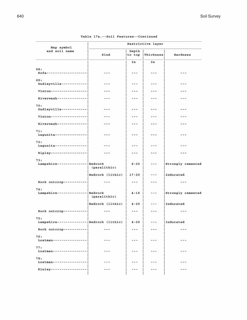
640 Soil Survey
Table 17a.--Soil Features--Continued______________________________________________________________________________ | Restrictive layer Map symbol |_____________________________________________________ and soil name | | Depth | | | Kind |to top |Thickness| Hardness________________________|_________________|_______|_________|_________________ | | In | In | | | | |68: | | | | Kofa-------------------| --- | --- | --- | --- | | | |69: | | | | Dudleyville------------| --- | --- | --- | --- | | | | Vinton-----------------| --- | --- | --- | --- | | | | Riverwash--------------| --- | --- | --- | --- | | | |70: | | | | Dudleyville------------| --- | --- | --- | --- | | | | Vinton-----------------| --- | --- | --- | --- | | | | Riverwash--------------| --- | --- | --- | --- | | | |71: | | | | Lagunita---------------| --- | --- | --- | --- | | | |72: | | | | Lagunita---------------| --- | --- | --- | --- | | | | Ripley-----------------| --- | --- | --- | --- | | | |73: | | | | Lampshire--------------|Bedrock | 6-20 | --- |Strongly cemented | (paralithic) | | | | | | | |Bedrock (lithic) | 17-20 | --- |Indurated | | | | Rock outcrop-----------| --- | --- | --- | --- | | | |74: | | | | Lampshire--------------|Bedrock | 4-16 | --- |Strongly cemented | (paralithic) | | | | | | | |Bedrock (lithic) | 4-20 | --- |Indurated | | | | Rock outcrop-----------| --- | --- | --- | --- | | | |75: | | | | Lampshire--------------|Bedrock (lithic) | 4-20 | --- |Indurated | | | | Rock outcrop-----------| --- | --- | --- | --- | | | |76: | | | | Lostman----------------| --- | --- | --- | --- | | | |77: | | | | Lostman----------------| --- | --- | --- | --- | | | |78: | | | | Lostman----------------| --- | --- | --- | --- | | | | Kinley-----------------| --- | --- | --- | --- | | | |

Mohave County, Arizona, Southern Part 641
Table 17a.--Soil Features--Continued______________________________________________________________________________ | Restrictive layer Map symbol |_____________________________________________________ and soil name | | Depth | | | Kind |to top |Thickness| Hardness________________________|_________________|_______|_________|_________________ | | In | In | | | | |79: | | | | Marshes----------------| --- | --- | --- | --- | | | |80: | | | | Meloland---------------| --- | --- | --- | --- | | | |81: | | | | Mohon------------------| --- | --- | --- | --- | | | | Kinley-----------------| --- | --- | --- | --- | | | |82: | | | | Mohon------------------| --- | --- | --- | --- | | | | Poachie----------------| --- | --- | --- | --- | | | |83: | | | | Mohon------------------| --- | --- | --- | --- | | | | Poachie----------------| --- | --- | --- | --- | | | |84: | | | | Nickel family----------| --- | --- | --- | --- | | | | Topawa family----------| --- | --- | --- | --- | | | | Eba family-------------| --- | --- | --- | --- | | | |85: | | | | Orwash family----------| --- | --- | --- | --- | | | |86: | | | | Orwash family----------| --- | --- | --- | --- | | | |87: | | | | Penthouse--------------| --- | --- | --- | --- | | | | Gonzales---------------|Bedrock | 10-20 | --- |Very strongly | (paralithic) | | | cemented | | | | |Bedrock (lithic) | 13-23 | --- |Indurated | | | |88: | | | | Poachie----------------| --- | --- | --- | --- | | | |89: | | | | Poachie----------------| --- | --- | --- | --- | | | |90: | | | | Quilotosa--------------|Bedrock | 9-12 | --- |Very strongly | (paralithic) | | | cemented | | | | |Bedrock (lithic) | 10-20 | --- |Indurated | | | | Rock outcrop-----------| --- | --- | --- | --- | | | |

642 Soil Survey
Table 17a.--Soil Features--Continued______________________________________________________________________________ | Restrictive layer Map symbol |_____________________________________________________ and soil name | | Depth | | | Kind |to top |Thickness| Hardness________________________|_________________|_______|_________|_________________ | | In | In | | | | |91: | | | | Razorback--------------|Bedrock (lithic) | 4-20 | --- |Indurated | | | |92: | | | | Razorback--------------|Bedrock (lithic) | 4-20 | --- |Indurated | | | | Rock outcrop-----------| --- | --- | --- | --- | | | |93: | | | | Razorback--------------|Bedrock (lithic) | 4-20 | --- |Indurated | | | | Rock outcrop-----------| --- | --- | --- | --- | | | |94: | | | | Razorback--------------|Bedrock (lithic) | 4-20 | --- |Indurated | | | | Rock outcrop-----------| --- | --- | --- | --- | | | |95: | | | | Razorback--------------|Bedrock (lithic) | 4-20 | --- |Indurated | | | | Rock outcrop-----------| --- | --- | --- | --- | | | | Rubble land------------| --- | --- | --- | --- | | | |96: | | | | Razorback--------------|Bedrock (lithic) | 4-20 | --- |Indurated | | | | Rock outcrop-----------| --- | --- | --- | --- | | | | Rubble land------------| --- | --- | --- | --- | | | |97: | | | | Rillino----------------| --- | --- | --- | --- | | | |98: | | | | Rillino----------------| --- | --- | --- | --- | | | | Tres Hermanos----------| --- | --- | --- | --- | | | |99: | | | | Ripley-----------------| --- | --- | --- | --- | | | |100: | | | | Riverbend family-------| --- | --- | --- | --- | | | |101: | | | | Riverbend--------------| --- | --- | --- | --- | | | |102: | | | | Riverwash--------------| --- | --- | --- | --- | | | | Fluvaquents------------| --- | --- | --- | --- | | | |103: | | | | Rock outcrop-----------| --- | --- | --- | --- | | | |

Mohave County, Arizona, Southern Part 643
Table 17a.--Soil Features--Continued______________________________________________________________________________ | Restrictive layer Map symbol |_____________________________________________________ and soil name | | Depth | | | Kind |to top |Thickness| Hardness________________________|_________________|_______|_________|_________________ | | In | In | | | | |103: | | | | Hyder------------------|Bedrock (lithic) | 4-20 | --- |Indurated | | | |104: | | | | Rock outcrop-----------| --- | --- | --- | --- | | | | Razorback--------------|Bedrock (lithic) | 4-20 | --- |Indurated | | | |105: | | | | Rock outcrop-----------| --- | --- | --- | --- | | | | Sunrock----------------|Bedrock | 4-20 | --- |Very strongly | (paralithic) | | | cemented | | | | |Bedrock (lithic) | 4-20 | --- |Indurated | | | |106: | | | | Romero-----------------|Bedrock (lithic) | 6-20 | --- |Indurated | | | | Chiricahua-------------|Bedrock | 10-20 | --- |Very strongly | (paralithic) | | | cemented | | | | |Bedrock (lithic) | 20-40 | --- |Indurated | | | | Rock outcrop-----------| --- | --- | --- | --- | | | |107: | | | | Romero-----------------|Bedrock | 4-20 | --- |Indurated | (paralithic) | | | | | | | Lampshire--------------|Bedrock | 4-20 | --- |Very strongly | (paralithic) | | | cemented | | | | |Bedrock (lithic) | 4-20 | --- |Indurated | | | | Rock outcrop-----------| --- | --- | --- | --- | | | |108: | | | | Rositas family---------| --- | --- | --- | --- | | | | Superstition-----------| --- | --- | --- | --- | | | | Torriorthents----------|Bedrock (lithic) | 4-60 | --- |Indurated | | | |109: | | | | Rositas----------------| --- | --- | --- | --- | | | | Superstition family----| --- | --- | --- | --- | | | | Torriorthents----------|Bedrock (lithic) | 4-60 | --- |Indurated | | | |110: | | | | Stagecoach-------------| --- | --- | --- | --- | | | |111: | | | | Stagecoach-------------| --- | --- | --- | --- | | | |

644 Soil Survey
Table 17a.--Soil Features--Continued______________________________________________________________________________ | Restrictive layer Map symbol |_____________________________________________________ and soil name | | Depth | | | Kind |to top |Thickness| Hardness________________________|_________________|_______|_________|_________________ | | In | In | | | | |112: | | | | Stagecoach-------------| --- | --- | --- | --- | | | |113: | | | | Stagecoach-------------| --- | --- | --- | --- | | | |114: | | | | Stagecoach-------------| --- | --- | --- | --- | | | | Topawa family----------| --- | --- | --- | --- | | | | Eba--------------------| --- | --- | --- | --- | | | |115: | | | | Stagecoach-------------| --- | --- | --- | --- | | | | Topawa family----------| --- | --- | --- | --- | | | | Eba--------------------| --- | --- | --- | --- | | | |116: | | | | Sunrock----------------|Bedrock (lithic) | 4-20 | --- |Indurated | | | |117: | | | | Sunrock----------------|Bedrock | 4-20 | --- |Very strongly | (paralithic) | | | cemented | | | | |Bedrock (lithic) | 4-20 | --- |Indurated | | | | Rock outcrop-----------| --- | --- | --- | --- | | | |118: | | | | Tombstone--------------| --- | --- | --- | --- | | | | Caralampi--------------| --- | --- | --- | --- | | | | Eloma------------------| --- | --- | --- | --- | | | |119: | | | | Torriorthents----------|Bedrock (lithic) | 4-60 | --- |Indurated | | | |120: | | | | Torriorthents----------|Bedrock (lithic) | 4-60 | --- |Indurated | | | |121: | | | | Tumarion---------------|Duripan | 5-18 | --- |Indurated | | | | |Bedrock (lithic) | 7-20 | --- |Indurated | | | |122: | | | | Tumarion---------------|Duripan | 5-18 | --- |Indurated | | | | |Bedrock (lithic) | 7-20 | --- |Indurated | | | |123: | | | | Tyro-------------------|Duripan | 5-19 | --- |Indurated | | | |

Mohave County, Arizona, Southern Part 645
Table 17a.--Soil Features--Continued______________________________________________________________________________ | Restrictive layer Map symbol |_____________________________________________________ and soil name | | Depth | | | Kind |to top |Thickness| Hardness________________________|_________________|_______|_________|_________________ | | In | In | | | | |124: | | | | Tyro-------------------|Duripan | 5-19 | --- |Indurated | | | |125: | | | | Vekol family-----------| --- | --- | --- | --- | | | |126: | | | | Vekol family-----------| --- | --- | --- | --- | | | |127: | | | | Water------------------| --- | --- | --- | --- | | | |128: | | | | Whitehills-------------|Duripan | 20-40 | --- |Indurated | | | |129: | | | | Whitehills-------------|Duripan | 20-40 | --- |Indurated | | | |130: | | | | White House family-----| --- | --- | --- | --- | | | |131: | | | | White House------------| --- | --- | --- | --- | | | |132: | | | | Wikieup----------------|Bedrock | 4-20 | --- |Very strongly | (paralithic) | | | cemented | | | | |Bedrock (lithic) | 7-20 | --- |Indurated | | | | Mutang-----------------|Bedrock | 10-20 | --- |Very strongly | (paralithic) | | | cemented | | | | |Bedrock (lithic) | 15-30 | --- |Indurated | | | | Rock outcrop-----------| --- | --- | --- | --- | | | |133: | | | | Mutang-----------------|Bedrock | 10-20 | --- |Very strongly | (paralithic) | | | cemented | | | | |Bedrock (lithic) | 20-41 | --- |Indurated | | | | Wikieup----------------|Bedrock (lithic) | 5-20 | --- |Indurated | | | | Rock outcrop-----------| --- | --- | --- | --- | | | |134: | | | | Wikieup----------------|Bedrock | 4-20 | --- |Very strongly | (paralithic) | | | cemented | | | | |Bedrock (lithic) | 7-20 | --- |Indurated | | | | Rock outcrop-----------| --- | --- | --- | --- | | | |135: | | | | Yahana family----------| --- | --- | --- | --- | | | |

646 Soil Survey
Table 17a.--Soil Features--Continued______________________________________________________________________________ | Restrictive layer Map symbol |_____________________________________________________ and soil name | | Depth | | | Kind |to top |Thickness| Hardness________________________|_________________|_______|_________|_________________ | | In | In |136: | | | | Tumarion---------------|Duripan | 5-18 | --- |Indurated | | | | |Bedrock (lithic) | 7-20 | --- |Indurated | | | | Nickel family----------| --- | --- | --- | --- | | | |137: | | | | Valena-----------------|Bedrock (lithic) | 10-20 | --- |Indurated | | | | Rock outcrop-----------| --- | --- | --- | --- | | | | Carri family-----------| --- | --- | --- | --- | | | |138: | | | | Nodman-----------------|Bedrock | 5-20 | --- |Strongly cemented | (paralithic) | | | | | | | |Bedrock | 5-20 | --- |Very strongly | (paralithic) | | | cemented | | | | Rock outcrop-----------| --- | --- | --- | --- | | | |139: | | | | Nodman-----------------|Bedrock | 5-20 | --- |Very strongly | (paralithic) | | | cemented | | | | Romero family----------|Bedrock | 5-20 | --- |Very strongly | (paralithic) | | | cemented | | | | |Bedrock (lithic) | 20-40 | --- |Indurated | | | |________________________|_________________|_______|_________|_________________

Mohave County, Arizona, Southern Part 647
Table 17b.--Soil Features
(See text for definitions of terms used in this table. Absence of an entry indicates that the feature is not a concern or that data were not estimated.)_______________________________________________________________________________ | Subsidence | | Risk of corrosion Map symbol |_______________| Potential |_________________________ and soil name | | | for | Uncoated | |Initial| Total |frost action| steel | Concrete________________________|_______|_______|____________|____________|____________ | In | In | | | | | | | |1: | | | | | Akela------------------| 0 | --- |None |High |Low | | | | | Rock outcrop-----------| --- | --- | --- | --- | --- | | | | | Rubble land------------| --- | --- | --- | --- | --- | | | | |2: | | | | | Akela------------------| 0 | --- |None |High |Low | | | | | Rock outcrop-----------| --- | --- | --- | --- | --- | | | | | Rubble land------------| --- | --- | --- | --- | --- | | | | |3: | | | | | Alko family------------| 0 | --- |None |High |Low | | | | |4: | | | | | Alko family------------| 0 | --- |None |High |Low | | | | |5: | | | | | Amole------------------| 0 | --- |None |High |Low | | | | |6: | | | | | Amole------------------| 0 | --- |None |High |Low | | | | |7: | | | | | Anthony----------------| 0 | --- |None |High |Low | | | | | Dudleyville------------| 0 | --- |None |High |Low | | | | |8: | | | | | Aquarius---------------| 0 | --- |None |High |Low | | | | | Akela------------------| 0 | --- |None |High |Low | | | | | Rock outcrop-----------| --- | --- | --- | --- | --- | | | | |9: | | | | | Arizo------------------| 0 | --- |None |High |Low | | | | | Franconia--------------| 0 | --- |None |High |Low | | | | | Riverwash--------------| --- | --- | --- | --- | --- | | | | |10: | | | | | Arizo------------------| 0 | --- |Low |High |Low | | | | | Franconia--------------| 0 | --- |None |High |Low | | | | | Riverwash--------------| --- | --- | --- | --- | --- | | | | |

648 Soil Survey
Table 17b.--Soil Features_______________________________________________________________________________ | Subsidence | | Risk of corrosion Map symbol |_______________| Potential |_________________________ and soil name | | | for | Uncoated | |Initial| Total |frost action| steel | Concrete________________________|_______|_______|____________|____________|____________ | In | In | | | | | | | |11: | | | | | Bartmus----------------| 0 | --- |None |High |Low | | | | |12: | | | | | Bonita family----------| 0 | --- |None |High |Low | | | | |13: | | | | | Bonita family----------| 0 | --- |None |High |Low | | | | | Gonzales---------------| 0 | --- |None |High |Low | | | | |14: | | | | | Brazito family---------| 0 | --- |None |High |Low | | | | |15: | | | | | Bucklebar--------------| 0 | --- |None |High |Low | | | | |16: | | | | | Cacique family---------| 0 | --- |None |High |Low | | | | |17: | | | | | Castaneda--------------| 0 | --- |None |High |Low | | | | |18: | | | | | Castaneda--------------| 0 | --- |None |High |Low | | | | |19: | | | | | Carrizo family---------| 0 | --- |None |High |Low | | | | |20: | | | | | Carrizo family---------| 0 | --- |None |High |Low | | | | | Riverwash--------------| --- | --- | --- | --- | --- | | | | |21: | | | | | Carrizo----------------| 0 | --- |Low |High |Low | | | | | Riverwash--------------| --- | --- | --- | --- | --- | | | | |22: | | | | | Carrizo----------------| 0 | --- |None |High |Low | | | | | Riverwash--------------| --- | --- | --- | --- | --- | | | | |23: | | | | | Cave-------------------| 0 | --- |None |High |Low | | | | |24: | | | | | Cave-------------------| 0 | --- |None |High |Low | | | | |25: | | | | | Cellar-----------------| 0 | --- |None |High |Low | | | | | Rock outcrop-----------| --- | --- | --- | --- | --- | | | | |

Mohave County, Arizona, Southern Part 649
Table 17b.--Soil Features_______________________________________________________________________________ | Subsidence | | Risk of corrosion Map symbol |_______________| Potential |_________________________ and soil name | | | for | Uncoated | |Initial| Total |frost action| steel | Concrete________________________|_______|_______|____________|____________|____________ | In | In | | | | | | | |26: | | | | | Cellar-----------------| 0 | --- |None |High |Low | | | | | Rock outcrop-----------| --- | --- | --- | --- | --- | | | | |27: | | | | | Cellar-----------------| 0 | --- |None |High |Low | | | | | Topock-----------------| 0 | --- |None |High |Low | | | | | Rock outcrop-----------| --- | --- | --- | --- | --- | | | | |28: | | | | | Cherioni---------------| 0 | --- |None |High |Low | | | | |29: | | | | | Chuckawalla------------| 0 | --- |None |High |Low | | | | | Riverbend--------------| 0 | --- |None |High |Low | | | | |30: | | | | | Chuckawalla family-----| 0 | --- |None |High |Low | | | | | Riverbend family-------| 0 | --- |None |High |Low | | | | |31: | | | | | Cipriano---------------| 0 | --- |None |High |Low | | | | |32: | | | | | Cline------------------| 0 | --- |None |High |Low | | | | |33: | | | | | Cline------------------| 0 | --- |None |High |Low | | | | |34: | | | | | Continental------------| 0 | --- |None |High |Low | | | | | Tres Hermanos----------| 0 | --- |None |High |Low | | | | |35: | | | | | Continental------------| 0 | --- |None |High |Low | | | | | Tres Hermanos----------| 0 | --- |None |High |Low | | | | |36: | | | | | Continental------------| 0 | --- |None |High |Low | | | | | Rillino----------------| 0 | --- |None |High |Low | | | | |37: | | | | | Continental------------| 0 | --- |None |High |Low | | | | | Rillino----------------| 0 | --- |None |High |Low | | | | |
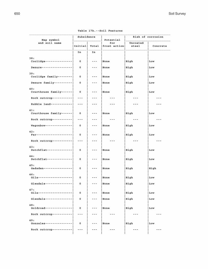
650 Soil Survey
Table 17b.--Soil Features_______________________________________________________________________________ | Subsidence | | Risk of corrosion Map symbol |_______________| Potential |_________________________ and soil name | | | for | Uncoated | |Initial| Total |frost action| steel | Concrete________________________|_______|_______|____________|____________|____________ | In | In | | | | | | | |38: | | | | | Coolidge---------------| 0 | --- |None |High |Low | | | | | Denure-----------------| 0 | --- |None |High |Low | | | | |39: | | | | | Coolidge family--------| 0 | --- |None |High |Low | | | | | Denure family----------| 0 | --- |None |High |Low | | | | |40: | | | | | Courthouse family------| 0 | --- |None |High |Low | | | | | Rock outcrop-----------| --- | --- | --- | --- | --- | | | | | Rubble land------------| --- | --- | --- | --- | --- | | | | |41: | | | | | Courthouse family------| 0 | --- |None |High |Low | | | | | Rock outcrop-----------| --- | --- | --- | --- | --- | | | | | Wagonbow---------------| 0 | --- |None |High |Low | | | | |42: | | | | | Far--------------------| 0 | --- |None |High |Low | | | | | Rock outcrop-----------| --- | --- | --- | --- | --- | | | | |43: | | | | | Dutchflat--------------| 0 | --- |None |High |Low | | | | |44: | | | | | Dutchflat--------------| 0 | --- |None |High |Low | | | | |45: | | | | | Gadsden----------------| 0 | --- |None |High |High | | | | |46: | | | | | Gila-------------------| 0 | --- |None |High |Low | | | | | Glendale---------------| 0 | --- |None |High |Low | | | | |47: | | | | | Gila-------------------| 0 | --- |None |High |Low | | | | | Glendale---------------| 0 | --- |None |High |Low | | | | |48: | | | | | Goldroad---------------| 0 | --- |None |High |Low | | | | | Rock outcrop-----------| --- | --- | --- | --- | --- | | | | |49: | | | | | Gonzales---------------| 0 | --- |None |High |Low | | | | | Rock outcrop-----------| --- | --- | --- | --- | --- | | | | |

Mohave County, Arizona, Southern Part 651
Table 17b.--Soil Features_______________________________________________________________________________ | Subsidence | | Risk of corrosion Map symbol |_______________| Potential |_________________________ and soil name | | | for | Uncoated | |Initial| Total |frost action| steel | Concrete________________________|_______|_______|____________|____________|____________ | In | In | | | | | | | |50: | | | | | Goodsprings family-----| 0 | --- |Low |Low |Low | | | | |51: | | | | | Goodsprings family-----| 0 | --- |Low |Low |Low | | | | |52: | | | | | Goodsprings family-----| 0 | --- |Low |Low |Low | | | | |53: | | | | | Goodsprings family-----| 0 | --- |Low |Low |Low | | | | |54: | | | | | Graham-----------------| 0 | --- |None |High |Low | | | | | Arivaca----------------| 0 | --- |None |High |Low | | | | |55: | | | | | Graham-----------------| 0 | --- |None |High |Low | | | | | Rock outcrop-----------| --- | --- | --- | --- | --- | | | | |56: | | | | | Gunsight---------------| 0 | --- |None |High |Low | | | | |57: | | | | | Gunsight---------------| 0 | --- |None |High |Low | | | | |58: | | | | | Hassell family---------| 0 | --- |None |High |Low | | | | | | | | | | Lampshire--------------| 0 | --- |None |High |Low | | | | | | | | | | Rock outcrop-----------| --- | --- | --- | --- | --- | | | | |59: | | | | | Holtville--------------| 0 | --- |None |High |Low | | | | |60: | | | | | Huevi------------------| 0 | --- |None |High |Low | | | | |61: | | | | | Huevi------------------| 0 | --- |None |High |Low | | | | |62: | | | | | Akela------------------| 0 | --- |Low |High |Low | | | | | Rock outcrop-----------| --- | --- | --- | --- | --- | | | | |63: | | | | | Hyder------------------| 0 | --- |None |High |Low | | | | | Rock outcrop-----------| --- | --- | --- | --- | --- | | | | | Rubble land------------| --- | --- | --- | --- | --- | | | | |

652 Soil Survey
Table 17b.--Soil Features_______________________________________________________________________________ | Subsidence | | Risk of corrosion Map symbol |_______________| Potential |_________________________ and soil name | | | for | Uncoated | |Initial| Total |frost action| steel | Concrete________________________|_______|_______|____________|____________|____________ | In | In | | | | | | | |64: | | | | | Indio------------------| 0 | --- |None |High |Low | | | | |65: | | | | | Ireteba family---------| 0 | --- |None |High |Low | | | | | Arizo------------------| 0 | --- |None |High |Low | | | | |66: | | | | | Kinley-----------------| 0 | --- |None |High |Low | | | | |67: | | | | | Kinley-----------------| 0 | --- |None |High |Low | | | | | Poachie----------------| 0 | --- |None |High |Low | | | | |68: | | | | | Kofa-------------------| 0 | --- |None |High |Low | | | | |69: | | | | | Dudleyville------------| 0 | --- |None |High |Low | | | | | Vinton-----------------| 0 | --- |None |High |Low | | | | | Riverwash--------------| --- | --- | --- | --- | --- | | | | |70: | | | | | Dudleyville------------| 0 | --- |None |High |Low | | | | | Vinton-----------------| 0 | --- |None |High |Low | | | | | Riverwash--------------| --- | --- | --- | --- | --- | | | | |71: | | | | | Lagunita---------------| 0 | --- |None |High |Low | | | | |72: | | | | | Lagunita---------------| 0 | --- |None |High |Low | | | | | Ripley-----------------| 0 | --- |None |High |Low | | | | |73: | | | | | Lampshire--------------| 0 | --- |None |High |Low | | | | | | | | | | Rock outcrop-----------| --- | --- | --- | --- | --- | | | | |74: | | | | | Lampshire--------------| 0 | --- |None |High |Low | | | | | | | | | | Rock outcrop-----------| --- | --- | --- | --- | --- | | | | |75: | | | | | Lampshire--------------| 0 | --- |None |High |Low | | | | | Rock outcrop-----------| --- | --- | --- | --- | --- | | | | |

Mohave County, Arizona, Southern Part 653
Table 17b.--Soil Features_______________________________________________________________________________ | Subsidence | | Risk of corrosion Map symbol |_______________| Potential |_________________________ and soil name | | | for | Uncoated | |Initial| Total |frost action| steel | Concrete________________________|_______|_______|____________|____________|____________ | In | In | | | | | | | |76: | | | | | Lostman----------------| 0 | --- |Moderate |High |Low | | | | |77: | | | | | Lostman----------------| 0 | --- |None |High |Low | | | | |78: | | | | | Lostman----------------| 0 | --- |None |High |Low | | | | | Kinley-----------------| 0 | --- |None |High |Low | | | | |79: | | | | | Marshes----------------| --- | --- | --- | --- | --- | | | | |80: | | | | | Meloland---------------| 0 | --- |None |High |Low | | | | |81: | | | | | Mohon------------------| 0 | --- |None |High |Low | | | | | Kinley-----------------| 0 | --- |None |High |Low | | | | |82: | | | | | Mohon------------------| 0 | --- |None |High |Low | | | | | Poachie----------------| 0 | --- |None |High |Low | | | | |83: | | | | | Mohon------------------| 0 | --- |None |High |Low | | | | | Poachie----------------| 0 | --- |None |High |Low | | | | |84: | | | | | Nickel family----------| 0 | --- |None |High |Low | | | | | Topawa family----------| 0 | --- |None |High |Low | | | | | Eba family-------------| 0 | --- |None |High |Low | | | | |85: | | | | | Orwash family----------| 0 | --- |None |High |Low | | | | |86: | | | | | Orwash family----------| 0 | --- |None |High |Low | | | | |87: | | | | | Penthouse--------------| 0 | --- |None |High |Low | | | | | Gonzales---------------| 0 | --- |None |High |Low | | | | |88: | | | | | Poachie----------------| 0 | --- |None |High |Low | | | | |89: | | | | | Poachie----------------| 0 | --- |None |High |Low | | | | |

654 Soil Survey
Table 17b.--Soil Features_______________________________________________________________________________ | Subsidence | | Risk of corrosion Map symbol |_______________| Potential |_________________________ and soil name | | | for | Uncoated | |Initial| Total |frost action| steel | Concrete________________________|_______|_______|____________|____________|____________ | In | In | | | | | | | |90: | | | | | Quilotosa--------------| 0 | --- |None |High |Low | | | | | Rock outcrop-----------| --- | --- | --- | --- | --- | | | | |91: | | | | | Razorback--------------| 0 | --- |None |High |Low | | | | |92: | | | | | Razorback--------------| 0 | --- |None |High |Low | | | | | Rock outcrop-----------| --- | --- | --- | --- | --- | | | | |93: | | | | | Razorback--------------| 0 | --- |None |High |Low | | | | | Rock outcrop-----------| --- | --- | --- | --- | --- | | | | |94: | | | | | Razorback--------------| 0 | --- |None |High |Low | | | | | Rock outcrop-----------| --- | --- | --- | --- | --- | | | | |95: | | | | | Razorback--------------| 0 | --- |None |High |Low | | | | | Rock outcrop-----------| --- | --- | --- | --- | --- | | | | | Rubble land------------| --- | --- | --- | --- | --- | | | | |96: | | | | | Razorback--------------| 0 | --- |None |High |Low | | | | | Rock outcrop-----------| --- | --- | --- | --- | --- | | | | | Rubble land------------| --- | --- | --- | --- | --- | | | | |97: | | | | | Rillino----------------| 0 | --- |None |High |Low | | | | |98: | | | | | Rillino----------------| 0 | --- |None |High |Low | | | | | Tres Hermanos----------| 0 | --- |None |High |Low | | | | |99: | | | | | Ripley-----------------| 0 | --- |None |High |Low | | | | |100: | | | | | Riverbend family-------| 0 | --- |None |High |Low | | | | |101: | | | | | Riverbend--------------| 0 | --- |None |High |Low | | | | |102: | | | | | Riverwash--------------| --- | --- | --- | --- | --- | | | | | Fluvaquents------------| 0 | --- |None |High |Low | | | | |

Mohave County, Arizona, Southern Part 655
Table 17b.--Soil Features_______________________________________________________________________________ | Subsidence | | Risk of corrosion Map symbol |_______________| Potential |_________________________ and soil name | | | for | Uncoated | |Initial| Total |frost action| steel | Concrete________________________|_______|_______|____________|____________|____________ | In | In | | | | | | | |103: | | | | | Rock outcrop-----------| --- | --- | --- | --- | --- | | | | | Hyder------------------| 0 | --- |None |High |Low | | | | |104: | | | | | Rock outcrop-----------| --- | --- | --- | --- | --- | | | | | Razorback--------------| 0 | --- |None |High |Low | | | | |105: | | | | | Rock outcrop-----------| --- | --- | --- | --- | --- | | | | | Sunrock----------------| 0 | --- |Low |High |Low | | | | |106: | | | | | Romero-----------------| 0 | --- |None |High |Low | | | | | Chiricahua-------------| 0 | --- |None |High |Low | | | | | Rock outcrop-----------| --- | --- | --- | --- | --- | | | | |107: | | | | | Romero-----------------| 0 | --- |None |High |Low | | | | | Lampshire--------------| 0 | --- |None |High |Low | | | | | Rock outcrop-----------| --- | --- | --- | --- | --- | | | | |108: | | | | | Rositas family---------| 0 | --- |None |High |Low | | | | | Superstition-----------| 0 | --- |None |High |Low | | | | | Torriorthents----------| 0 | --- |Low | --- | --- | | | | |109: | | | | | Rositas----------------| 0 | --- |None |High |Low | | | | | Superstition family----| 0 | --- |None |High |Low | | | | | Torriorthents----------| 0 | --- |Low | --- | --- | | | | |110: | | | | | Stagecoach-------------| 0 | --- |None |High |Low | | | | |111: | | | | | Stagecoach-------------| 0 | --- |None |High |Low | | | | |112: | | | | | Stagecoach-------------| 0 | --- |None |High |Low | | | | |113: | | | | | Stagecoach-------------| 0 | --- |None |High |Low | | | | |

656 Soil Survey
Table 17b.--Soil Features_______________________________________________________________________________ | Subsidence | | Risk of corrosion Map symbol |_______________| Potential |_________________________ and soil name | | | for | Uncoated | |Initial| Total |frost action| steel | Concrete________________________|_______|_______|____________|____________|____________ | In | In | | | | | | | |114: | | | | | Stagecoach-------------| 0 | --- |None |High |Low | | | | | Topawa family----------| 0 | --- |None |High |Low | | | | | Eba--------------------| 0 | --- |None |High |Low | | | | |115: | | | | | Stagecoach-------------| 0 | --- |None |High |Low | | | | | Topawa family----------| 0 | --- |None |High |Low | | | | | Eba--------------------| 0 | --- |None |High |Low | | | | |116: | | | | | Sunrock----------------| 0 | --- |Low |High |Low | | | | |117: | | | | | Sunrock----------------| 0 | --- |Low |High |Low | | | | | Rock outcrop-----------| --- | --- | --- | --- | --- | | | | |118: | | | | | Tombstone--------------| 0 | --- |None |High |Low | | | | | Caralampi--------------| 0 | --- |None |High |Low | | | | | Eloma------------------| 0 | --- |None |High |Low | | | | |119: | | | | | Torriorthents----------| 0 | --- |Low | --- | --- | | | | |120: | | | | | Torriorthents----------| 0 | --- |Low | --- | --- | | | | |121: | | | | | Tumarion---------------| 0 | --- |None |High |Low | | | | |122: | | | | | Tumarion---------------| 0 | --- |None |High |Low | | | | |123: | | | | | Tyro-------------------| 0 | --- |Low |High |Low | | | | |124: | | | | | Tyro-------------------| 0 | --- |Low |High |Low | | | | |125: | | | | | Vekol family-----------| 0 | --- |None |High |Low | | | | |126: | | | | | Vekol family-----------| 0 | --- |None |High |Low | | | | |127: | | | | | Water------------------| --- | --- | --- | --- | --- | | | | |

Mohave County, Arizona, Southern Part 657
Table 17b.--Soil Features_______________________________________________________________________________ | Subsidence | | Risk of corrosion Map symbol |_______________| Potential |_________________________ and soil name | | | for | Uncoated | |Initial| Total |frost action| steel | Concrete________________________|_______|_______|____________|____________|____________ | In | In | | | | | | | |128: | | | | | Whitehills-------------| 0 | --- |None |High |Low | | | | |129: | | | | | Whitehills-------------| 0 | --- |None |High |Low | | | | |130: | | | | | White House family-----| 0 | --- |None |High |Low | | | | |131: | | | | | White House------------| 0 | --- |None |High |Low | | | | |132: | | | | | Wikieup----------------| 0 | --- |None |High |Low | | | | | | | | | | Mutang-----------------| 0 | --- |None |High |Low | | | | | Rock outcrop-----------| --- | --- | --- | --- | --- | | | | |133: | | | | | Mutang-----------------| 0 | --- |Low |High |Low | | | | | Wikieup----------------| 0 | --- |Moderate |High |Low | | | | | Rock outcrop-----------| --- | --- | --- | --- | --- | | | | |134: | | | | | Wikieup----------------| 0 | --- |None |High |Low | | | | | Rock outcrop-----------| --- | --- | --- | --- | --- | | | | |135: | | | | | Yahana family----------| 0 | --- |None |High |High | | | | |136: | | | | | Tumarion---------------| 0 | --- |Moderate |High |Low | | | | | Nickel family----------| 0 | --- |Moderate |High |Low | | | | |137: | | | | | Valena-----------------| 0 | --- |Low |High |Low | | | | | Rock outcrop-----------| --- | --- | --- | --- | --- | | | | | Carri family-----------| 0 | --- |Low |High |Low | | | | |138: | | | | | Nodman-----------------| 0 | --- |Moderate |Moderate |Low | | | | | Rock outcrop-----------| --- | --- | --- | --- | --- | | | | |139: | | | | | Nodman-----------------| 0 | --- |Moderate |Moderate |Low | | | | | | | | | | Romero family----------| 0 | --- |Moderate |Low |Low | | | | |________________________|_______|_______|____________|____________|____________

658S
oil Survey
Table 18.--Water Features
(Depths of layers are in feet. See text for definitions of terms used in this table. Estimates of the frequency of ponding and flooding apply to the whole year rather than to individual months. Absence of an entry indicates that the feature is not a concern or that data were not estimated.)_______________________________________________________________________________________________________________ | | | Water table | Ponding | Flooding | | |_______________|_____________________________|_________________________ Map symbol |Hydro-| Month | Upper | Lower |Surface| Duration |Frequency | Duration | Frequency and soil name |logic | | limit | limit | water | | | | |group | | | | depth | | | |_____________________|______|__________|_______|_______|_______|__________|__________|____________|____________ | | | Ft | Ft | Ft | | | | | | | | | | | | |1: | | | | | | | | | Akela---------------| D | | | | | | | | | |Jan-Dec | --- | --- | --- | --- | None | --- | None | | | | | | | | | Rock outcrop--------| --- | | | | | | | | | |Jan-Dec | --- | --- | --- | --- | None | --- | None | | | | | | | | | Rubble land---------| --- | | | | | | | | | |Jan-Dec | --- | --- | --- | --- | None | --- | None | | | | | | | | |2: | | | | | | | | | Akela---------------| D | | | | | | | | | |Jan-Dec | --- | --- | --- | --- | None | --- | None | | | | | | | | | Rock outcrop--------| --- | | | | | | | | | |Jan-Dec | --- | --- | --- | --- | None | --- | None | | | | | | | | | Rubble land---------| --- | | | | | | | | | |Jan-Dec | --- | --- | --- | --- | None | --- | None | | | | | | | | |3: | | | | | | | | | Alko Family---------| D | | | | | | | | | |Jan-Dec | --- | --- | --- | --- | None | --- | None | | | | | | | | |4: | | | | | | | | | Alko Family---------| D | | | | | | | | | |Jan-Dec | --- | --- | --- | --- | None | --- | None | | | | | | | | |5: | | | | | | | | | Amole---------------| C | | | | | | | | | |Jan-Dec | --- | --- | --- | --- | None | --- | None | | | | | | | | |

Mohave C
ounty, Arizona, S
outhern Part
659
Table 18.--Water Features--Continued_______________________________________________________________________________________________________________ | | | Water table | Ponding | Flooding | | |_______________|_____________________________|_________________________ Map s|Hydro-| Month | Upper | Lower |Surface| Duration |Frequency | Duration | Frequency and soi|logic | | limit | limit | water | | | | |group | | | | depth | | | |_____________________|______|__________|_______|_______|_______|__________|__________|____________|____________ | | | Ft | Ft | Ft | | | | | | | | | | | | |6: | | | | | | | | | Amole---------------| C | | | | | | | | | |Jan-Dec | --- | --- | --- | --- | None | --- | None | | | | | | | | |7: | | | | | | | | | Anthony-------------| B | | | | | | | | | |July | --- | --- | --- | --- | None | Brief | Occasional | |August | --- | --- | --- | --- | None | Brief | Occasional | |September | --- | --- | --- | --- | None | Brief | Occasional | | | | | | | | | Dudleyville---------| A | | | | | | | | | |Jan-Dec | --- | --- | --- | --- | None | --- | None | | | | | | | | |8: | | | | | | | | | Aquarius------------| C | | | | | | | | | |Jan-Dec | --- | --- | --- | --- | None | --- | None | | | | | | | | | Akela---------------| D | | | | | | | | | |Jan-Dec | --- | --- | --- | --- | None | --- | None | | | | | | | | | Rock outcrop--------| --- | | | | | | | | | |Jan-Dec | --- | --- | --- | --- | None | --- | None | | | | | | | | |9: | | | | | | | | | Arizo---------------| B | | | | | | | | | |July | --- | --- | --- | --- | None | Brief | Frequent | |August | --- | --- | --- | --- | None | Brief | Frequent | |September | --- | --- | --- | --- | None | Brief | Frequent | | | | | | | | | Franconia-----------| B | | | | | | | | | |July | --- | --- | --- | --- | None | Brief | Occasional | |August | --- | --- | --- | --- | None | Brief | Occasional | |September | --- | --- | --- | --- | None | Brief | Occasional | | | | | | | | | Riverwash-----------| --- | | | | | | | | | |July | --- | --- | --- | --- | None | Brief | Frequent | |August | --- | --- | --- | --- | None | Brief | Frequent | |September | --- | --- | --- | --- | None | Brief | Frequent | | | | | | | | |

660S
oil Survey
Table 18.--Water Features--Continued_______________________________________________________________________________________________________________ | | | Water table | Ponding | Flooding | | |_______________|_____________________________|_________________________ Map s|Hydro-| Month | Upper | Lower |Surface| Duration |Frequency | Duration | Frequency and soi|logic | | limit | limit | water | | | | |group | | | | depth | | | |_____________________|______|__________|_______|_______|_______|__________|__________|____________|____________ | | | Ft | Ft | Ft | | | | | | | | | | | | |10: | | | | | | | | | Arizo---------------| A | | | | | | | | | |July | --- | --- | --- | --- | None | Brief | Frequent | |August | --- | --- | --- | --- | None | Brief | Frequent | |September | --- | --- | --- | --- | None | Brief | Frequent | | | | | | | | | Franconia-----------| B | | | | | | | | | |July | --- | --- | --- | --- | None | Brief | Occasional | |August | --- | --- | --- | --- | None | Brief | Occasional | |September | --- | --- | --- | --- | None | Brief | Occasional | | | | | | | | | Riverwash-----------| A | | | | | | | | | |July | --- | --- | --- | --- | None | Brief | Frequent | |August | --- | --- | --- | --- | None | Brief | Frequent | |September | --- | --- | --- | --- | None | Brief | Frequent | | | | | | | | |11: | | | | | | | | | Bartmus-------------| D | | | | | | | | | |Jan-Dec | --- | --- | --- | --- | None | --- | None | | | | | | | | |12: | | | | | | | | | Bonita Family-------| B | | | | | | | | | |Jan-Dec | --- | --- | --- | --- | None | --- | None | | | | | | | | |13: | | | | | | | | | Bonita Family-------| B | | | | | | | | | |Jan-Dec | --- | --- | --- | --- | None | --- | None | | | | | | | | | Gonzales------------| D | | | | | | | | | |Jan-Dec | --- | --- | --- | --- | None | --- | None | | | | | | | | |14: | | | | | | | | | Brazito Family------| A | | | | | | | | | |Jan-Dec | --- | --- | --- | --- | None | --- | None | | | | | | | | |15: | | | | | | | | | Bucklebar-----------| B | | | | | | | | | |Jan-Dec | --- | --- | --- | --- | None | --- | None | | | | | | | | |

Mohave C
ounty, Arizona, S
outhern Part
661
Table 18.--Water Features--Continued_______________________________________________________________________________________________________________ | | | Water table | Ponding | Flooding | | |_______________|_____________________________|_________________________ Map s|Hydro-| Month | Upper | Lower |Surface| Duration |Frequency | Duration | Frequency and soi|logic | | limit | limit | water | | | | |group | | | | depth | | | |_____________________|______|__________|_______|_______|_______|__________|__________|____________|____________ | | | Ft | Ft | Ft | | | | | | | | | | | | |16: | | | | | | | | | Cacique Family------| D | | | | | | | | | |Jan-Dec | --- | --- | --- | --- | None | --- | None | | | | | | | | |17: | | | | | | | | | Castaneda-----------| C | | | | | | | | | |Jan-Dec | --- | --- | --- | --- | None | --- | None | | | | | | | | |18: | | | | | | | | | Castaneda-----------| C | | | | | | | | | |Jan-Dec | --- | --- | --- | --- | None | --- | None | | | | | | | | |19: | | | | | | | | | Carrizo Family------| B | | | | | | | | | |July | --- | --- | --- | --- | None | Brief | Frequent | |August | --- | --- | --- | --- | None | Brief | Frequent | |September | --- | --- | --- | --- | None | Brief | Frequent | | | | | | | | |20: | | | | | | | | | Carrizo Family------| B | | | | | | | | | |July | --- | --- | --- | --- | None | Brief | Frequent | |August | --- | --- | --- | --- | None | Brief | Frequent | |September | --- | --- | --- | --- | None | Brief | Frequent | | | | | | | | | Riverwash-----------| --- | | | | | | | | | |July | --- | --- | --- | --- | None | Brief | Frequent | |August | --- | --- | --- | --- | None | Brief | Frequent | |September | --- | --- | --- | --- | None | Brief | Frequent | | | | | | | | |21: | | | | | | | | | Carrizo-------------| A | | | | | | | | | |July | --- | --- | --- | --- | None | Brief | Occasional | |August | --- | --- | --- | --- | None | Brief | Occasional | |September | --- | --- | --- | --- | None | Brief | Occasional | | | | | | | | | Riverwash-----------| A | | | | | | | | | |July | --- | --- | --- | --- | None | Brief | Frequent | |August | --- | --- | --- | --- | None | Brief | Frequent | |September | --- | --- | --- | --- | None | Brief | Frequent | | | | | | | | |

662S
oil Survey
Table 18.--Water Features--Continued_______________________________________________________________________________________________________________ | | | Water table | Ponding | Flooding | | |_______________|_____________________________|_________________________ Map s|Hydro-| Month | Upper | Lower |Surface| Duration |Frequency | Duration | Frequency and soi|logic | | limit | limit | water | | | | |group | | | | depth | | | |_____________________|______|__________|_______|_______|_______|__________|__________|____________|____________ | | | Ft | Ft | Ft | | | | | | | | | | | | |22: | | | | | | | | | Carrizo-------------| B | | | | | | | | | |July | --- | --- | --- | --- | None | Brief | Frequent | |August | --- | --- | --- | --- | None | Brief | Frequent | |September | --- | --- | --- | --- | None | Brief | Frequent | | | | | | | | | Riverwash-----------| --- | | | | | | | | | |July | --- | --- | --- | --- | None | Brief | Frequent | |August | --- | --- | --- | --- | None | Brief | Frequent | |September | --- | --- | --- | --- | None | Brief | Frequent | | | | | | | | |23: | | | | | | | | | Cave----------------| D | | | | | | | | | |Jan-Dec | --- | --- | --- | --- | None | --- | None | | | | | | | | |24: | | | | | | | | | Cave----------------| D | | | | | | | | | |Jan-Dec | --- | --- | --- | --- | None | --- | None | | | | | | | | |25: | | | | | | | | | Cellar--------------| D | | | | | | | | | |Jan-Dec | --- | --- | --- | --- | None | --- | None | | | | | | | | | Rock outcrop--------| --- | | | | | | | | | |Jan-Dec | --- | --- | --- | --- | None | --- | None | | | | | | | | |26: | | | | | | | | | Cellar--------------| D | | | | | | | | | |Jan-Dec | --- | --- | --- | --- | None | --- | None | | | | | | | | | Rock outcrop--------| --- | | | | | | | | | |Jan-Dec | --- | --- | --- | --- | None | --- | None | | | | | | | | |27: | | | | | | | | | Cellar--------------| D | | | | | | | | | |Jan-Dec | --- | --- | --- | --- | None | --- | None | | | | | | | | | Topock--------------| D | | | | | | | | | |Jan-Dec | --- | --- | --- | --- | None | --- | None | | | | | | | | |

Mohave C
ounty, Arizona, S
outhern Part
663
Table 18.--Water Features--Continued_______________________________________________________________________________________________________________ | | | Water table | Ponding | Flooding | | |_______________|_____________________________|_________________________ Map s|Hydro-| Month | Upper | Lower |Surface| Duration |Frequency | Duration | Frequency and soi|logic | | limit | limit | water | | | | |group | | | | depth | | | |_____________________|______|__________|_______|_______|_______|__________|__________|____________|____________ | | | Ft | Ft | Ft | | | | | | | | | | | | |27: | | | | | | | | | Rock outcrop--------| --- | | | | | | | | | |Jan-Dec | --- | --- | --- | --- | None | --- | None | | | | | | | | |28: | | | | | | | | | Cherioni------------| D | | | | | | | | | |Jan-Dec | --- | --- | --- | --- | None | --- | None | | | | | | | | |29: | | | | | | | | | Chuckawalla---------| B | | | | | | | | | |Jan-Dec | --- | --- | --- | --- | None | --- | None | | | | | | | | | Riverbend-----------| A | | | | | | | | | |Jan-Dec | --- | --- | --- | --- | None | --- | None | | | | | | | | |30: | | | | | | | | | Chuckawalla Family--| B | | | | | | | | | |Jan-Dec | --- | --- | --- | --- | None | --- | None | | | | | | | | | Riverbend Family----| B | | | | | | | | | |Jan-Dec | --- | --- | --- | --- | None | --- | None | | | | | | | | |31: | | | | | | | | | Cipriano------------| D | | | | | | | | | |Jan-Dec | --- | --- | --- | --- | None | --- | None | | | | | | | | |32: | | | | | | | | | Cline---------------| D | | | | | | | | | |Jan-Dec | --- | --- | --- | --- | None | --- | None | | | | | | | | |33: | | | | | | | | | Cline---------------| D | | | | | | | | | |Jan-Dec | --- | --- | --- | --- | None | --- | None | | | | | | | | |34: | | | | | | | | | Continental---------| C | | | | | | | | | |Jan-Dec | --- | --- | --- | --- | None | --- | None | | | | | | | | | Tres Hermanos-------| C | | | | | | | | | |Jan-Dec | --- | --- | --- | --- | None | --- | None | | | | | | | | |

664S
oil Survey
Table 18.--Water Features--Continued_______________________________________________________________________________________________________________ | | | Water table | Ponding | Flooding | | |_______________|_____________________________|_________________________ Map s|Hydro-| Month | Upper | Lower |Surface| Duration |Frequency | Duration | Frequency and soi|logic | | limit | limit | water | | | | |group | | | | depth | | | |_____________________|______|__________|_______|_______|_______|__________|__________|____________|____________ | | | Ft | Ft | Ft | | | | | | | | | | | | |35: | | | | | | | | | Continental---------| C | | | | | | | | | |Jan-Dec | --- | --- | --- | --- | None | --- | None | | | | | | | | | Tres Hermanos-------| C | | | | | | | | | |Jan-Dec | --- | --- | --- | --- | None | --- | None | | | | | | | | |36: | | | | | | | | | Continental---------| C | | | | | | | | | |Jan-Dec | --- | --- | --- | --- | None | --- | None | | | | | | | | | Rillino-------------| B | | | | | | | | | |Jan-Dec | --- | --- | --- | --- | None | --- | None | | | | | | | | |37: | | | | | | | | | Continental---------| C | | | | | | | | | |Jan-Dec | --- | --- | --- | --- | None | --- | None | | | | | | | | | Rillino-------------| B | | | | | | | | | |Jan-Dec | --- | --- | --- | --- | None | --- | None | | | | | | | | |38: | | | | | | | | | Coolidge------------| B | | | | | | | | | |Jan-Dec | --- | --- | --- | --- | None | --- | None | | | | | | | | | Denure--------------| A | | | | | | | | | |Jan-Dec | --- | --- | --- | --- | None | --- | None | | | | | | | | |39: | | | | | | | | | Coolidge Family-----| B | | | | | | | | | |Jan-Dec | --- | --- | --- | --- | None | --- | None | | | | | | | | | Denure Family-------| B | | | | | | | | | |Jan-Dec | --- | --- | --- | --- | None | --- | None | | | | | | | | |

Mohave C
ounty, Arizona, S
outhern Part
665
Table 18.--Water Features--Continued_______________________________________________________________________________________________________________ | | | Water table | Ponding | Flooding | | |_______________|_____________________________|_________________________ Map s|Hydro-| Month | Upper | Lower |Surface| Duration |Frequency | Duration | Frequency and soi|logic | | limit | limit | water | | | | |group | | | | depth | | | |_____________________|______|__________|_______|_______|_______|__________|__________|____________|____________ | | | Ft | Ft | Ft | | | | | | | | | | | | |40: | | | | | | | | | Courthouse Family---| D | | | | | | | | | |Jan-Dec | --- | --- | --- | --- | None | --- | None | | | | | | | | | Rock outcrop--------| --- | | | | | | | | | |Jan-Dec | --- | --- | --- | --- | None | --- | None | | | | | | | | | Rubble land---------| --- | | | | | | | | | |Jan-Dec | --- | --- | --- | --- | None | --- | None | | | | | | | | |41: | | | | | | | | | Courthouse Family---| D | | | | | | | | | |Jan-Dec | --- | --- | --- | --- | None | --- | None | | | | | | | | | Rock outcrop--------| --- | | | | | | | | | |Jan-Dec | --- | --- | --- | --- | None | --- | None | | | | | | | | | Wagonbow------------| D | | | | | | | | | |Jan-Dec | --- | --- | --- | --- | None | --- | None | | | | | | | | |42: | | | | | | | | | Far-----------------| D | | | | | | | | | |Jan-Dec | --- | --- | --- | --- | None | --- | None | | | | | | | | | Rock outcrop--------| --- | | | | | | | | | |Jan-Dec | --- | --- | --- | --- | None | --- | None | | | | | | | | |43: | | | | | | | | | Dutchflat-----------| B | | | | | | | | | |Jan-Dec | --- | --- | --- | --- | None | --- | None | | | | | | | | |44: | | | | | | | | | Dutchflat-----------| C | | | | | | | | | |Jan-Dec | --- | --- | --- | --- | None | --- | None | | | | | | | | |45: | | | | | | | | | Gadsden-------------| D | | | | | | | | | |Jan-Dec | --- | --- | --- | --- | None | --- | None | | | | | | | | |

666S
oil Survey
Table 18.--Water Features--Continued_______________________________________________________________________________________________________________ | | | Water table | Ponding | Flooding | | |_______________|_____________________________|_________________________ Map s|Hydro-| Month | Upper | Lower |Surface| Duration |Frequency | Duration | Frequency and soi|logic | | limit | limit | water | | | | |group | | | | depth | | | |_____________________|______|__________|_______|_______|_______|__________|__________|____________|____________ | | | Ft | Ft | Ft | | | | | | | | | | | | |46: | | | | | | | | | Gila----------------| B | | | | | | | | | |July | --- | --- | --- | --- | None | Brief | Occasional | |August | --- | --- | --- | --- | None | Brief | Occasional | |September | --- | --- | --- | --- | None | Brief | Occasional | | | | | | | | | Glendale------------| C | | | | | | | | | |July | --- | --- | --- | --- | None | Brief | Occasional | |August | --- | --- | --- | --- | None | Brief | Occasional | |September | --- | --- | --- | --- | None | Brief | Occasional | | | | | | | | |47: | | | | | | | | | Gila----------------| B | | | | | | | | | |July | --- | --- | --- | --- | None | Brief | Occasional | |August | --- | --- | --- | --- | None | Brief | Occasional | |September | --- | --- | --- | --- | None | Brief | Occasional | | | | | | | | | Glendale------------| C | | | | | | | | | |July | --- | --- | --- | --- | None | Brief | Occasional | |August | --- | --- | --- | --- | None | Brief | Occasional | |September | --- | --- | --- | --- | None | Brief | Occasional | | | | | | | | |48: | | | | | | | | | Goldroad------------| D | | | | | | | | | |Jan-Dec | --- | --- | --- | --- | None | --- | None | | | | | | | | | Rock outcrop--------| --- | | | | | | | | | |Jan-Dec | --- | --- | --- | --- | None | --- | None | | | | | | | | |49: | | | | | | | | | Gonzales------------| D | | | | | | | | | |Jan-Dec | --- | --- | --- | --- | None | --- | None | | | | | | | | | Rock outcrop--------| --- | | | | | | | | | |Jan-Dec | --- | --- | --- | --- | None | --- | None | | | | | | | | |50: | | | | | | | | | Goodsprings Family--| D | | | | | | | | | |Jan-Dec | --- | --- | --- | --- | None | --- | None | | | | | | | | |

Mohave C
ounty, Arizona, S
outhern Part
667
Table 18.--Water Features--Continued_______________________________________________________________________________________________________________ | | | Water table | Ponding | Flooding | | |_______________|_____________________________|_________________________ Map s|Hydro-| Month | Upper | Lower |Surface| Duration |Frequency | Duration | Frequency and soi|logic | | limit | limit | water | | | | |group | | | | depth | | | |_____________________|______|__________|_______|_______|_______|__________|__________|____________|____________ | | | Ft | Ft | Ft | | | | | | | | | | | | |51: | | | | | | | | | Goodsprings Family--| D | | | | | | | | | |Jan-Dec | --- | --- | --- | --- | None | --- | None | | | | | | | | |52: | | | | | | | | | Goodsprings Family--| D | | | | | | | | | |Jan-Dec | --- | --- | --- | --- | None | --- | None | | | | | | | | |53: | | | | | | | | | Goodsprings Family--| D | | | | | | | | | |Jan-Dec | --- | --- | --- | --- | None | --- | None | | | | | | | | |54: | | | | | | | | | Graham--------------| D | | | | | | | | | |Jan-Dec | --- | --- | --- | --- | None | --- | None | | | | | | | | | Arivaca-------------| D | | | | | | | | | |Jan-Dec | --- | --- | --- | --- | None | --- | None | | | | | | | | |55: | | | | | | | | | Graham--------------| D | | | | | | | | | |Jan-Dec | --- | --- | --- | --- | None | --- | None | | | | | | | | | Rock outcrop--------| --- | | | | | | | | | |Jan-Dec | --- | --- | --- | --- | None | --- | None | | | | | | | | |56: | | | | | | | | | Gunsight------------| B | | | | | | | | | |Jan-Dec | --- | --- | --- | --- | None | --- | None | | | | | | | | |57: | | | | | | | | | Gunsight------------| B | | | | | | | | | |Jan-Dec | --- | --- | --- | --- | None | --- | None | | | | | | | | |58: | | | | | | | | | Hassell Family------| C | | | | | | | | | |Jan-Dec | --- | --- | --- | --- | None | --- | None | | | | | | | | | Lampshire-----------| D | | | | | | | | | |Jan-Dec | --- | --- | --- | --- | None | --- | None | | | | | | | | |

668S
oil Survey
Table 18.--Water Features--Continued_______________________________________________________________________________________________________________ | | | Water table | Ponding | Flooding | | |_______________|_____________________________|_________________________ Map s|Hydro-| Month | Upper | Lower |Surface| Duration |Frequency | Duration | Frequency and soi|logic | | limit | limit | water | | | | |group | | | | depth | | | |_____________________|______|__________|_______|_______|_______|__________|__________|____________|____________ | | | Ft | Ft | Ft | | | | | | | | | | | | |58: | | | | | | | | | Rock outcrop--------| --- | | | | | | | | | |Jan-Dec | --- | --- | --- | --- | None | --- | None | | | | | | | | |59: | | | | | | | | | Holtville-----------| D | | | | | | | | | |Jan-Dec | --- | --- | --- | --- | None | --- | None | | | | | | | | |60: | | | | | | | | | Huevi---------------| B | | | | | | | | | |Jan-Dec | --- | --- | --- | --- | None | --- | None | | | | | | | | |61: | | | | | | | | | Huevi---------------| B | | | | | | | | | |Jan-Dec | --- | --- | --- | --- | None | --- | None | | | | | | | | |62: | | | | | | | | | Akela---------------| D | | | | | | | | | |Jan-Dec | --- | --- | --- | --- | None | --- | None | | | | | | | | | Rock outcrop--------| --- | | | | | | | | | |Jan-Dec | --- | --- | --- | --- | None | --- | None | | | | | | | | |63: | | | | | | | | | Hyder---------------| D | | | | | | | | | |Jan-Dec | --- | --- | --- | --- | None | --- | None | | | | | | | | | Rock outcrop--------| --- | | | | | | | | | |Jan-Dec | --- | --- | --- | --- | None | --- | None | | | | | | | | | Rubble land---------| --- | | | | | | | | | |Jan-Dec | --- | --- | --- | --- | None | --- | None | | | | | | | | |64: | | | | | | | | | Indio---------------| B | | | | | | | | | |Jan-Dec | --- | --- | --- | --- | None | --- | None | | | | | | | | |

Mohave C
ounty, Arizona, S
outhern Part
669
Table 18.--Water Features--Continued_______________________________________________________________________________________________________________ | | | Water table | Ponding | Flooding | | |_______________|_____________________________|_________________________ Map s|Hydro-| Month | Upper | Lower |Surface| Duration |Frequency | Duration | Frequency and soi|logic | | limit | limit | water | | | | |group | | | | depth | | | |_____________________|______|__________|_______|_______|_______|__________|__________|____________|____________ | | | Ft | Ft | Ft | | | | | | | | | | | | |65: | | | | | | | | | Ireteba Family------| B | | | | | | | | | |July | --- | --- | --- | --- | None | Brief | Rare | |August | --- | --- | --- | --- | None | Brief | Rare | |September | --- | --- | --- | --- | None | Brief | Rare | | | | | | | | | Arizo---------------| B | | | | | | | | | |July | --- | --- | --- | --- | None | Brief | Frequent | |August | --- | --- | --- | --- | None | Brief | Frequent | |September | --- | --- | --- | --- | None | Brief | Frequent | | | | | | | | |66: | | | | | | | | | Kinley--------------| B | | | | | | | | | |Jan-Dec | --- | --- | --- | --- | None | --- | None | | | | | | | | |67: | | | | | | | | | Kinley--------------| B | | | | | | | | | |Jan-Dec | --- | --- | --- | --- | None | --- | None | | | | | | | | | Poachie-------------| B | | | | | | | | | |Jan-Dec | --- | --- | --- | --- | None | --- | None | | | | | | | | |68: | | | | | | | | | Kofa----------------| C | | | | | | | | | |Jan-Dec | --- | --- | --- | --- | None | --- | None | | | | | | | | |69: | | | | | | | | | Dudleyville---------| A | | | | | | | | | |Jan-Dec | --- | --- | --- | --- | None | --- | None | | | | | | | | | Vinton--------------| B | | | | | | | | | |July | --- | --- | --- | --- | None | Brief | Occasional | |August | --- | --- | --- | --- | None | Brief | Occasional | |September | --- | --- | --- | --- | None | Brief | Occasional | | | | | | | | | Riverwash-----------| --- | | | | | | | | | |July | --- | --- | --- | --- | None | Brief | Frequent | |August | --- | --- | --- | --- | None | Brief | Frequent | |September | --- | --- | --- | --- | None | Brief | Frequent | | | | | | | | |

670S
oil Survey
Table 18.--Water Features--Continued_______________________________________________________________________________________________________________ | | | Water table | Ponding | Flooding | | |_______________|_____________________________|_________________________ Map s|Hydro-| Month | Upper | Lower |Surface| Duration |Frequency | Duration | Frequency and soi|logic | | limit | limit | water | | | | |group | | | | depth | | | |_____________________|______|__________|_______|_______|_______|__________|__________|____________|____________ | | | Ft | Ft | Ft | | | | | | | | | | | | |70: | | | | | | | | | Dudleyville---------| A | | | | | | | | | |Jan-Dec | --- | --- | --- | --- | None | --- | None | | | | | | | | | Vinton--------------| B | | | | | | | | | |July | --- | --- | --- | --- | None | Brief | Occasional | |August | --- | --- | --- | --- | None | Brief | Occasional | |September | --- | --- | --- | --- | None | Brief | Occasional | | | | | | | | | Riverwash-----------| --- | | | | | | | | | |July | --- | --- | --- | --- | None | Brief | Frequent | |August | --- | --- | --- | --- | None | Brief | Frequent | |September | --- | --- | --- | --- | None | Brief | Frequent | | | | | | | | |71: | | | | | | | | | Lagunita------------| A | | | | | | | | | |Jan-Dec | --- | --- | --- | --- | None | --- | None | | | | | | | | |72: | | | | | | | | | Lagunita------------| A | | | | | | | | | |Jan-Dec | --- | --- | --- | --- | None | --- | None | | | | | | | | | Ripley--------------| B | | | | | | | | | |Jan-Dec | --- | --- | --- | --- | None | --- | None | | | | | | | | |73: | | | | | | | | | Lampshire-----------| D | | | | | | | | | |Jan-Dec | --- | --- | --- | --- | None | --- | None | | | | | | | | | Rock outcrop--------| --- | | | | | | | | | |Jan-Dec | --- | --- | --- | --- | None | --- | None | | | | | | | | |74: | | | | | | | | | Lampshire-----------| D | | | | | | | | | |Jan-Dec | --- | --- | --- | --- | None | --- | None | | | | | | | | | Rock outcrop--------| --- | | | | | | | | | |Jan-Dec | --- | --- | --- | --- | None | --- | None | | | | | | | | |

Mohave C
ounty, Arizona, S
outhern Part
671
Table 18.--Water Features--Continued_______________________________________________________________________________________________________________ | | | Water table | Ponding | Flooding | | |_______________|_____________________________|_________________________ Map s|Hydro-| Month | Upper | Lower |Surface| Duration |Frequency | Duration | Frequency and soi|logic | | limit | limit | water | | | | |group | | | | depth | | | |_____________________|______|__________|_______|_______|_______|__________|__________|____________|____________ | | | Ft | Ft | Ft | | | | | | | | | | | | |75: | | | | | | | | | Lampshire-----------| D | | | | | | | | | |Jan-Dec | --- | --- | --- | --- | None | --- | None | | | | | | | | | Rock outcrop--------| --- | | | | | | | | | |Jan-Dec | --- | --- | --- | --- | None | --- | None | | | | | | | | |76: | | | | | | | | | Lostman-------------| B | | | | | | | | | |Jan-Dec | --- | --- | --- | --- | None | --- | None | | | | | | | | |77: | | | | | | | | | Lostman-------------| B | | | | | | | | | |Jan-Dec | --- | --- | --- | --- | None | --- | None | | | | | | | | |78: | | | | | | | | | Lostman-------------| B | | | | | | | | | |Jan-Dec | --- | --- | --- | --- | None | --- | None | | | | | | | | | Kinley--------------| B | | | | | | | | | |Jan-Dec | --- | --- | --- | --- | None | --- | None | | | | | | | | |80: | | | | | | | | | Meloland------------| C | | | | | | | | | |Jan-Dec | --- | --- | --- | --- | None | --- | None | | | | | | | | |81: | | | | | | | | | Mohon---------------| C | | | | | | | | | |Jan-Dec | --- | --- | --- | --- | None | --- | None | | | | | | | | | Kinley--------------| B | | | | | | | | | |Jan-Dec | --- | --- | --- | --- | None | --- | None | | | | | | | | |82: | | | | | | | | | Mohon---------------| C | | | | | | | | | |Jan-Dec | --- | --- | --- | --- | None | --- | None | | | | | | | | | Poachie-------------| B | | | | | | | | | |Jan-Dec | --- | --- | --- | --- | None | --- | None | | | | | | | | |

672S
oil Survey
Table 18.--Water Features--Continued_______________________________________________________________________________________________________________ | | | Water table | Ponding | Flooding | | |_______________|_____________________________|_________________________ Map s|Hydro-| Month | Upper | Lower |Surface| Duration |Frequency | Duration | Frequency and soi|logic | | limit | limit | water | | | | |group | | | | depth | | | |_____________________|______|__________|_______|_______|_______|__________|__________|____________|____________ | | | Ft | Ft | Ft | | | | | | | | | | | | |83: | | | | | | | | | Mohon---------------| C | | | | | | | | | |Jan-Dec | --- | --- | --- | --- | None | --- | None | | | | | | | | | Poachie-------------| B | | | | | | | | | |Jan-Dec | --- | --- | --- | --- | None | --- | None | | | | | | | | |84: | | | | | | | | | Nickel Family-------| C | | | | | | | | | |Jan-Dec | --- | --- | --- | --- | None | --- | None | | | | | | | | | Topawa Family-------| C | | | | | | | | | |Jan-Dec | --- | --- | --- | --- | None | --- | None | | | | | | | | | Eba Family----------| C | | | | | | | | | |Jan-Dec | --- | --- | --- | --- | None | --- | None | | | | | | | | |85: | | | | | | | | | Orwash Family-------| A | | | | | | | | | |Jan-Dec | --- | --- | --- | --- | None | --- | None | | | | | | | | |86: | | | | | | | | | Orwash Family-------| A | | | | | | | | | |Jan-Dec | --- | --- | --- | --- | None | --- | None | | | | | | | | |87: | | | | | | | | | Penthouse-----------| C | | | | | | | | | |Jan-Dec | --- | --- | --- | --- | None | --- | None | | | | | | | | | Gonzales------------| D | | | | | | | | | |Jan-Dec | --- | --- | --- | --- | None | --- | None | | | | | | | | |88: | | | | | | | | | Poachie-------------| B | | | | | | | | | |Jan-Dec | --- | --- | --- | --- | None | --- | None | | | | | | | | |89: | | | | | | | | | Poachie-------------| B | | | | | | | | | |Jan-Dec | --- | --- | --- | --- | None | --- | None | | | | | | | | |

Mohave C
ounty, Arizona, S
outhern Part
673
Table 18.--Water Features--Continued_______________________________________________________________________________________________________________ | | | Water table | Ponding | Flooding | | |_______________|_____________________________|_________________________ Map s|Hydro-| Month | Upper | Lower |Surface| Duration |Frequency | Duration | Frequency and soi|logic | | limit | limit | water | | | | |group | | | | depth | | | |_____________________|______|__________|_______|_______|_______|__________|__________|____________|____________ | | | Ft | Ft | Ft | | | | | | | | | | | | |90: | | | | | | | | | Quilotosa-----------| D | | | | | | | | | |Jan-Dec | --- | --- | --- | --- | None | --- | None | | | | | | | | | Rock outcrop--------| --- | | | | | | | | | |Jan-Dec | --- | --- | --- | --- | None | --- | None | | | | | | | | |91: | | | | | | | | | Razorback-----------| D | | | | | | | | | |Jan-Dec | --- | --- | --- | --- | None | --- | None | | | | | | | | |92: | | | | | | | | | Razorback-----------| D | | | | | | | | | |Jan-Dec | --- | --- | --- | --- | None | --- | None | | | | | | | | | Rock outcrop--------| --- | | | | | | | | | |Jan-Dec | --- | --- | --- | --- | None | --- | None | | | | | | | | |93: | | | | | | | | | Razorback-----------| D | | | | | | | | | |Jan-Dec | --- | --- | --- | --- | None | --- | None | | | | | | | | | Rock outcrop--------| --- | | | | | | | | | |Jan-Dec | --- | --- | --- | --- | None | --- | None | | | | | | | | |94: | | | | | | | | | Razorback-----------| D | | | | | | | | | |Jan-Dec | --- | --- | --- | --- | None | --- | None | | | | | | | | | Rock outcrop--------| --- | | | | | | | | | |Jan-Dec | --- | --- | --- | --- | None | --- | None | | | | | | | | |95: | | | | | | | | | Razorback-----------| D | | | | | | | | | |Jan-Dec | --- | --- | --- | --- | None | --- | None | | | | | | | | | Rock outcrop--------| --- | | | | | | | | | |Jan-Dec | --- | --- | --- | --- | None | --- | None | | | | | | | | | Rubble land---------| --- | | | | | | | | | |Jan-Dec | --- | --- | --- | --- | None | --- | None | | | | | | | | |

674S
oil Survey
Table 18.--Water Features--Continued_______________________________________________________________________________________________________________ | | | Water table | Ponding | Flooding | | |_______________|_____________________________|_________________________ Map s|Hydro-| Month | Upper | Lower |Surface| Duration |Frequency | Duration | Frequency and soi|logic | | limit | limit | water | | | | |group | | | | depth | | | |_____________________|______|__________|_______|_______|_______|__________|__________|____________|____________ | | | Ft | Ft | Ft | | | | | | | | | | | | |96: | | | | | | | | | Razorback-----------| D | | | | | | | | | |Jan-Dec | --- | --- | --- | --- | None | --- | None | | | | | | | | | Rock outcrop--------| --- | | | | | | | | | |Jan-Dec | --- | --- | --- | --- | None | --- | None | | | | | | | | | Rubble land---------| --- | | | | | | | | | |Jan-Dec | --- | --- | --- | --- | None | --- | None | | | | | | | | |97: | | | | | | | | | Rillino-------------| B | | | | | | | | | |Jan-Dec | --- | --- | --- | --- | None | --- | None | | | | | | | | |98: | | | | | | | | | Rillino-------------| B | | | | | | | | | |Jan-Dec | --- | --- | --- | --- | None | --- | None | | | | | | | | | Tres Hermanos-------| C | | | | | | | | | |Jan-Dec | --- | --- | --- | --- | None | --- | None | | | | | | | | |99: | | | | | | | | | Ripley--------------| B | | | | | | | | | |Jan-Dec | --- | --- | --- | --- | None | --- | None | | | | | | | | |100: | | | | | | | | | Riverbend Family----| B | | | | | | | | | |Jan-Dec | --- | --- | --- | --- | None | --- | None | | | | | | | | |101: | | | | | | | | | Riverbend-----------| A | | | | | | | | | |Jan-Dec | --- | --- | --- | --- | None | --- | None | | | | | | | | |102: | | | | | | | | | Riverwash-----------| --- | | | | | | | | | |July | --- | --- | --- | --- | None | Brief | Frequent | |August | --- | --- | --- | --- | None | Brief | Frequent | |September | --- | --- | --- | --- | None | Brief | Frequent | | | | | | | | |

Mohave C
ounty, Arizona, S
outhern Part
675
Table 18.--Water Features--Continued_______________________________________________________________________________________________________________ | | | Water table | Ponding | Flooding | | |_______________|_____________________________|_________________________ Map s|Hydro-| Month | Upper | Lower |Surface| Duration |Frequency | Duration | Frequency and soi|logic | | limit | limit | water | | | | |group | | | | depth | | | |_____________________|______|__________|_______|_______|_______|__________|__________|____________|____________ | | | Ft | Ft | Ft | | | | | | | | | | | | |102: | | | | | | | | | Fluvaquents---------| A | | | | | | | | | |January | --- | --- | --- | --- | None | Long | Frequent | |February | --- | --- | --- | --- | None | Long | Frequent | |March | --- | --- | --- | --- | None | Long | Frequent | |April | --- | --- | --- | --- | None | Long | Frequent | |May | --- | --- | --- | --- | None | Long | Frequent | |June | --- | --- | --- | --- | None | Long | Frequent | |July | --- | --- | --- | --- | None | Long | Frequent | |August | --- | --- | --- | --- | None | Long | Frequent | |September | --- | --- | --- | --- | None | Long | Frequent | |October | --- | --- | --- | --- | None | Long | Frequent | |November | --- | --- | --- | --- | None | Long | Frequent | |December | --- | --- | --- | --- | None | Long | Frequent | | | | | | | | |103: | | | | | | | | | Rock outcrop--------| --- | | | | | | | | | |Jan-Dec | --- | --- | --- | --- | None | --- | None | | | | | | | | | Hyder---------------| D | | | | | | | | | |Jan-Dec | --- | --- | --- | --- | None | --- | None | | | | | | | | |104: | | | | | | | | | Rock outcrop--------| --- | | | | | | | | | |Jan-Dec | --- | --- | --- | --- | None | --- | None | | | | | | | | | Razorback-----------| D | | | | | | | | | |Jan-Dec | --- | --- | --- | --- | None | --- | None | | | | | | | | |105: | | | | | | | | | Rock outcrop--------| --- | | | | | | | | | |Jan-Dec | --- | --- | --- | --- | None | --- | None | | | | | | | | | Sunrock-------------| D | | | | | | | | | |Jan-Dec | --- | --- | --- | --- | None | --- | None | | | | | | | | |106: | | | | | | | | | Romero--------------| D | | | | | | | | | |Jan-Dec | --- | --- | --- | --- | None | --- | None | | | | | | | | |

676S
oil Survey
Table 18.--Water Features--Continued_______________________________________________________________________________________________________________ | | | Water table | Ponding | Flooding | | |_______________|_____________________________|_________________________ Map s|Hydro-| Month | Upper | Lower |Surface| Duration |Frequency | Duration | Frequency and soi|logic | | limit | limit | water | | | | |group | | | | depth | | | |_____________________|______|__________|_______|_______|_______|__________|__________|____________|____________ | | | Ft | Ft | Ft | | | | | | | | | | | | |106: | | | | | | | | | Chiricahua----------| D | | | | | | | | | |Jan-Dec | --- | --- | --- | --- | None | --- | None | | | | | | | | | Rock outcrop--------| --- | | | | | | | | | |Jan-Dec | --- | --- | --- | --- | None | --- | None | | | | | | | | |107: | | | | | | | | | Romero--------------| D | | | | | | | | | |Jan-Dec | --- | --- | --- | --- | None | --- | None | | | | | | | | | Lampshire-----------| D | | | | | | | | | |Jan-Dec | --- | --- | --- | --- | None | --- | None | | | | | | | | | Rock outcrop--------| --- | | | | | | | | | |Jan-Dec | --- | --- | --- | --- | None | --- | None | | | | | | | | |108: | | | | | | | | | Rositas Family------| A | | | | | | | | | |Jan-Dec | --- | --- | --- | --- | None | --- | None | | | | | | | | | Superstition--------| A | | | | | | | | | |Jan-Dec | --- | --- | --- | --- | None | --- | None | | | | | | | | | Torriorthents-------| D | | | | | | | | | |Jan-Dec | --- | --- | --- | --- | None | --- | None | | | | | | | | |109: | | | | | | | | | Rositas-------------| A | | | | | | | | | |Jan-Dec | --- | --- | --- | --- | None | --- | None | | | | | | | | | Superstition Family-| A | | | | | | | | | |Jan-Dec | --- | --- | --- | --- | None | --- | None | | | | | | | | | Torriorthents-------| D | | | | | | | | | |Jan-Dec | --- | --- | --- | --- | None | --- | None | | | | | | | | |110: | | | | | | | | | Stagecoach----------| B | | | | | | | | | |Jan-Dec | --- | --- | --- | --- | None | --- | None | | | | | | | | |
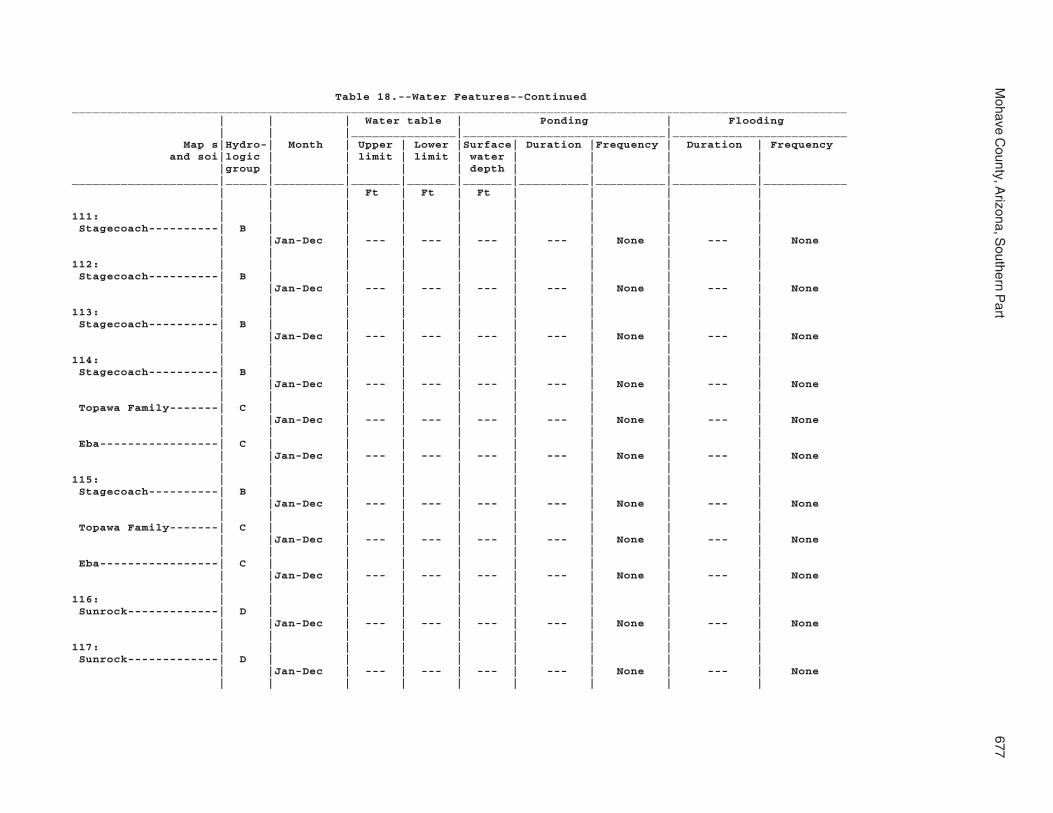
Mohave C
ounty, Arizona, S
outhern Part
677
Table 18.--Water Features--Continued_______________________________________________________________________________________________________________ | | | Water table | Ponding | Flooding | | |_______________|_____________________________|_________________________ Map s|Hydro-| Month | Upper | Lower |Surface| Duration |Frequency | Duration | Frequency and soi|logic | | limit | limit | water | | | | |group | | | | depth | | | |_____________________|______|__________|_______|_______|_______|__________|__________|____________|____________ | | | Ft | Ft | Ft | | | | | | | | | | | | |111: | | | | | | | | | Stagecoach----------| B | | | | | | | | | |Jan-Dec | --- | --- | --- | --- | None | --- | None | | | | | | | | |112: | | | | | | | | | Stagecoach----------| B | | | | | | | | | |Jan-Dec | --- | --- | --- | --- | None | --- | None | | | | | | | | |113: | | | | | | | | | Stagecoach----------| B | | | | | | | | | |Jan-Dec | --- | --- | --- | --- | None | --- | None | | | | | | | | |114: | | | | | | | | | Stagecoach----------| B | | | | | | | | | |Jan-Dec | --- | --- | --- | --- | None | --- | None | | | | | | | | | Topawa Family-------| C | | | | | | | | | |Jan-Dec | --- | --- | --- | --- | None | --- | None | | | | | | | | | Eba-----------------| C | | | | | | | | | |Jan-Dec | --- | --- | --- | --- | None | --- | None | | | | | | | | |115: | | | | | | | | | Stagecoach----------| B | | | | | | | | | |Jan-Dec | --- | --- | --- | --- | None | --- | None | | | | | | | | | Topawa Family-------| C | | | | | | | | | |Jan-Dec | --- | --- | --- | --- | None | --- | None | | | | | | | | | Eba-----------------| C | | | | | | | | | |Jan-Dec | --- | --- | --- | --- | None | --- | None | | | | | | | | |116: | | | | | | | | | Sunrock-------------| D | | | | | | | | | |Jan-Dec | --- | --- | --- | --- | None | --- | None | | | | | | | | |117: | | | | | | | | | Sunrock-------------| D | | | | | | | | | |Jan-Dec | --- | --- | --- | --- | None | --- | None | | | | | | | | |

678S
oil Survey
Table 18.--Water Features--Continued_______________________________________________________________________________________________________________ | | | Water table | Ponding | Flooding | | |_______________|_____________________________|_________________________ Map s|Hydro-| Month | Upper | Lower |Surface| Duration |Frequency | Duration | Frequency and soi|logic | | limit | limit | water | | | | |group | | | | depth | | | |_____________________|______|__________|_______|_______|_______|__________|__________|____________|____________ | | | Ft | Ft | Ft | | | | | | | | | | | | |117: | | | | | | | | | Rock outcrop--------| --- | | | | | | | | | |Jan-Dec | --- | --- | --- | --- | None | --- | None | | | | | | | | |118: | | | | | | | | | Tombstone-----------| B | | | | | | | | | |Jan-Dec | --- | --- | --- | --- | None | --- | None | | | | | | | | | Caralampi-----------| C | | | | | | | | | |Jan-Dec | --- | --- | --- | --- | None | --- | None | | | | | | | | | Eloma---------------| D | | | | | | | | | |Jan-Dec | --- | --- | --- | --- | None | --- | None | | | | | | | | |119: | | | | | | | | | Torriorthents-------| D | | | | | | | | | |Jan-Dec | --- | --- | --- | --- | None | --- | None | | | | | | | | |120: | | | | | | | | | Torriorthents-------| D | | | | | | | | | |Jan-Dec | --- | --- | --- | --- | None | --- | None | | | | | | | | |121: | | | | | | | | | Tumarion------------| D | | | | | | | | | |Jan-Dec | --- | --- | --- | --- | None | --- | None | | | | | | | | |122: | | | | | | | | | Tumarion------------| D | | | | | | | | | |Jan-Dec | --- | --- | --- | --- | None | --- | None | | | | | | | | |123: | | | | | | | | | Tyro----------------| D | | | | | | | | | |Jan-Dec | --- | --- | --- | --- | None | --- | None | | | | | | | | |124: | | | | | | | | | Tyro----------------| D | | | | | | | | | |Jan-Dec | --- | --- | --- | --- | None | --- | None | | | | | | | | |

Mohave C
ounty, Arizona, S
outhern Part
679
Table 18.--Water Features--Continued_______________________________________________________________________________________________________________ | | | Water table | Ponding | Flooding | | |_______________|_____________________________|_________________________ Map s|Hydro-| Month | Upper | Lower |Surface| Duration |Frequency | Duration | Frequency and soi|logic | | limit | limit | water | | | | |group | | | | depth | | | |_____________________|______|__________|_______|_______|_______|__________|__________|____________|____________ | | | Ft | Ft | Ft | | | | | | | | | | | | |125: | | | | | | | | | Vekol Family--------| D | | | | | | | | | |Jan-Dec | --- | --- | --- | --- | None | --- | None | | | | | | | | |126: | | | | | | | | | Vekol Family--------| D | | | | | | | | | |Jan-Dec | --- | --- | --- | --- | None | --- | None | | | | | | | | |127: | | | | | | | | | Water---------------| --- | | | | | | | | | |Jan-Dec | --- | --- | --- | --- | None | --- | None | | | | | | | | |128: | | | | | | | | | Whitehills----------| C | | | | | | | | | |Jan-Dec | --- | --- | --- | --- | None | --- | None | | | | | | | | |129: | | | | | | | | | Whitehills----------| C | | | | | | | | | |Jan-Dec | --- | --- | --- | --- | None | --- | None | | | | | | | | |130: | | | | | | | | | White House Family--| C | | | | | | | | | |Jan-Dec | --- | --- | --- | --- | None | --- | None | | | | | | | | |131: | | | | | | | | | White House---------| C | | | | | | | | | |Jan-Dec | --- | --- | --- | --- | None | --- | None | | | | | | | | |132: | | | | | | | | | Wikieup-------------| D | | | | | | | | | |Jan-Dec | --- | --- | --- | --- | None | --- | None | | | | | | | | | Mutang--------------| D | | | | | | | | | |Jan-Dec | --- | --- | --- | --- | None | --- | None | | | | | | | | | Rock outcrop--------| --- | | | | | | | | | |Jan-Dec | --- | --- | --- | --- | None | --- | None | | | | | | | | |

680S
oil Survey
Table 18.--Water Features--Continued_______________________________________________________________________________________________________________ | | | Water table | Ponding | Flooding | | |_______________|_____________________________|_________________________ Map s|Hydro-| Month | Upper | Lower |Surface| Duration |Frequency | Duration | Frequency and soi|logic | | limit | limit | water | | | | |group | | | | depth | | | |_____________________|______|__________|_______|_______|_______|__________|__________|____________|____________ | | | Ft | Ft | Ft | | | | | | | | | | | | |133: | | | | | | | | | Mutang--------------| C | | | | | | | | | |Jan-Dec | --- | --- | --- | --- | None | --- | None | | | | | | | | | Wikieup-------------| D | | | | | | | | | |Jan-Dec | --- | --- | --- | --- | None | --- | None | | | | | | | | | Rock outcrop--------| --- | | | | | | | | | |Jan-Dec | --- | --- | --- | --- | None | --- | None | | | | | | | | |134: | | | | | | | | | Wikieup-------------| D | | | | | | | | | |Jan-Dec | --- | --- | --- | --- | None | --- | None | | | | | | | | | Rock outcrop--------| --- | | | | | | | | | |Jan-Dec | --- | --- | --- | --- | None | --- | None | | | | | | | | |135: | | | | | | | | | Yahana Family-------| D | | | | | | | | | |Jan-Dec | --- | --- | --- | --- | None | --- | None | | | | | | | | |136: | | | | | | | | | Tumarion------------| D | | | | | | | | | |Jan-Dec | --- | --- | --- | --- | None | --- | None | | | | | | | | | Nickel Family-------| B | | | | | | | | | |Jan-Dec | --- | --- | --- | --- | None | --- | None | | | | | | | | |137: | | | | | | | | | Valena--------------| D | | | | | | | | | |Jan-Dec | --- | --- | --- | --- | None | --- | None | | | | | | | | | Rock outcrop--------| --- | | | | | | | | | |Jan-Dec | --- | --- | --- | --- | None | --- | None | | | | | | | | | Carri Family--------| B | | | | | | | | | |Jan-Dec | --- | --- | --- | --- | None | --- | None | | | | | | | | |

Mohave C
ounty, Arizona, S
outhern Part
681
Table 18.--Water Features--Continued_______________________________________________________________________________________________________________ | | | Water table | Ponding | Flooding | | |_______________|_____________________________|_________________________ Map s|Hydro-| Month | Upper | Lower |Surface| Duration |Frequency | Duration | Frequency and soi|logic | | limit | limit | water | | | | |group | | | | depth | | | |_____________________|______|__________|_______|_______|_______|__________|__________|____________|____________ | | | Ft | Ft | Ft | | | | | | | | | | | | |138: | | | | | | | | | Nodman--------------| D | | | | | | | | | |Jan-Dec | --- | --- | --- | --- | None | --- | None | | | | | | | | | Rock outcrop--------| --- | | | | | | | | | |Jan-Dec | --- | --- | --- | --- | None | --- | None | | | | | | | | |139: | | | | | | | | | Nodman--------------| C | | | | | | | | | |Jan-Dec | --- | --- | --- | --- | None | --- | None | | | | | | | | | Romero Family-------| C | | | | | | | | | |Jan-Dec | --- | --- | --- | --- | None | --- | None_____________________|______|__________|_______|_______|_______|__________|__________|____________|____________

682S
oil Survey
Table 19.--Taxonomic Classification of the Soils
(An asterisk in the first column indicates a taxadjunct to the series. See text for a description of those characteristics that are outside the range of the series.)______________________________________________________________________________________________________ | Soil name | Family or higher taxonomic class__________________________|___________________________________________________________________________ | Akela--------------------|Loamy-skeletal, mixed, superactive, calcareous, thermic Lithic | Torriorthents Alko family--------------|Loamy, mixed, superactive, thermic, shallow Typic Haplodurids Amole--------------------|Sandy, mixed, thermic Typic Torriorthents Anthony------------------|Coarse-loamy, mixed, superactive, calcareous, thermic Typic Torrifluvents Aquarius-----------------|Fine, smectitic, calcareous, thermic Vertic Torriorthents*Arivaca------------------|Fine, smectitic, thermic Ustic Haplargids Arizo--------------------|Sandy-skeletal, mixed, thermic Typic Torriorthents Bartmus------------------|Loamy-skeletal, mixed, superactive, thermic, shallow Ustic Haplodurids Bonita family------------|Fine, smectitic, thermic Typic Haplotorrerts Brazito family-----------|Mixed, thermic Typic Torripsamments Bucklebar----------------|Fine-loamy, mixed, superactive, thermic Typic Haplargids Cacique family-----------|Fine-loamy, mixed, superactive, thermic Argic Petrocalcids Caralampi----------------|Loamy-skeletal, mixed, superactive, thermic Ustic Haplargids Carri family-------------|Fine-loamy, mixed, superactive, mesic Aridic Haplustalfs Carrizo------------------|Sandy-skeletal, mixed, hyperthermic Typic Torriorthents Carrizo family-----------|Sandy-skeletal, mixed, hyperthermic Typic Torriorthents Castaneda----------------|Fine-loamy, mixed, superactive, thermic Argic Petrocalcids Cave---------------------|Loamy, mixed, superactive, thermic, shallow Typic Petrocalcids Cellar-------------------|Loamy-skeletal, mixed, superactive, nonacid, thermic Lithic Torriorthents Cherioni-----------------|Loamy-skeletal, mixed, superactive, hyperthermic, shallow Typic Haplodurids Chiricahua---------------|Clayey, mixed, superactive, thermic, shallow Ustic Haplargids Chuckawalla--------------|Loamy-skeletal, mixed, superactive, hyperthermic Typic Calciargids Chuckawalla family-------|Loamy-skeletal, mixed, superactive, hyperthermic Typic Calciargids Cipriano-----------------|Loamy-skeletal, mixed, superactive, hyperthermic, shallow Typic Haplodurids Cline--------------------|Loamy-skeletal, mixed, superactive, thermic, shallow Typic Haplodurids Continental--------------|Fine, mixed, superactive, thermic Vertic Calciargids Coolidge-----------------|Coarse-loamy, mixed, superactive, hyperthermic Typic Haplocalcids Coolidge family----------|Coarse-loamy, mixed, superactive, hyperthermic Typic Haplocalcids Courthouse family--------|Loamy-skeletal, mixed, superactive, calcareous, thermic Lithic Ustic | Torriorthents Denure-------------------|Coarse-loamy, mixed, superactive, hyperthermic Typic Haplocambids Denure family------------|Coarse-loamy, mixed, superactive, hyperthermic Typic Haplocambids Far----------------------|Loamy-skeletal, mixed, superactive, mesic Lithic Haplustolls Tres Hermanos------------|Fine-loamy, mixed, superactive, thermic Typic Calciargids Dutchflat----------------|Fine-loamy, mixed, superactive, thermic Typic Haplargids *Eba---------------------|Clayey-skeletal, mixed, superactive, thermic Typic Haplargids Eba family---------------|Clayey-skeletal, mixed, superactive, thermic Typic Calciargids Eloma--------------------|Clayey-skeletal, mixed, superactive, thermic Ustic Haplargids Faraway------------------|Loamy-skeletal, mixed, superactive, mesic Lithic Haplustolls Fluvaquents--------------|Fluvaquents Franconia----------------|Sandy, mixed, thermic Typic Torrifluvents Gadsden------------------|Fine, smectitic, calcareous, hyperthermic Vertic Torrifluvents Gila---------------------|Coarse-loamy, mixed, superactive, calcareous, thermic Typic Torrifluvents Glendale-----------------|Fine-silty, mixed, superactive, calcareous, thermic Typic Torrifluvents

Mohave C
ounty, Arizona, S
outhern Part
683
Table 19.--Taxonomic Classification of the Soils--Continued______________________________________________________________________________________________________ | Soil name | Family or higher taxonomic class__________________________|___________________________________________________________________________ | Goldroad-----------------|Loamy-skeletal, mixed, superactive, calcareous, hyperthermic Lithic | Torriorthents Gonzales-----------------|Clayey, smectitic, thermic, shallow Ustic Haplocambids Goodsprings family-------|Loamy, mixed, superactive, thermic, shallow Typic Petrocalcids Graham-------------------|Clayey, smectitic, thermic Lithic Ustic Haplargids Gunsight-----------------|Loamy-skeletal, mixed, superactive, hyperthermic Typic Haplocalcids Hassell family-----------|Fine, smectitic, thermic Ustertic Haplargids Holtville----------------|Clayey over loamy, smectitic over mixed, calcareous, hyperthermic Typic | Torrifluvents Huevi--------------------|Loamy-skeletal, mixed, superactive, hyperthermic Durinodic Haplocalcids Akela--------------------|Loamy-skeletal, mixed, superactive, calcareous, thermic Lithic | Torriorthents Hyder--------------------|Loamy-skeletal, mixed, superactive, calcareous, hyperthermic Lithic | Torriorthents Indio--------------------|Coarse-silty, mixed, superactive, calcareous, hyperthermic Typic | Torrifluvents Ireteba family-----------|Coarse-loamy, mixed, superactive, calcareous, thermic Typic Torrifluvents Kinley-------------------|Coarse-loamy, mixed, superactive, thermic Typic Haplocalcids Kofa---------------------|Clayey over sandy or sandy-skeletal, smectitic over mixed, calcareous, | hyperthermic Vertic Torrifluvents Dudleyville--------------|Sandy-skeletal, mixed, thermic Typic Torriorthents Lagunita-----------------|Mixed, hyperthermic Typic Torripsamments Lampshire----------------|Loamy-skeletal, mixed, superactive, nonacid, thermic Lithic Ustic | Torriorthents Lampshire----------------|Loamy-skeletal, mixed, superactive, nonacid, thermic Lithic Ustic | Torriorthents Lostman------------------|Coarse-loamy, mixed, superactive, thermic Typic Haplocambids Meloland-----------------|Coarse-loamy over clayey, mixed, superactive, calcareous, hyperthermic | Typic Torrifluvents Mohon--------------------|Fine, smectitic, thermic Typic Calciargids Mutang-------------------|Clayey, mixed, superactive, thermic, shallow Typic Haplargids Nickel family------------|Loamy-skeletal, mixed, superactive, thermic Typic Haplocalcids Nodman-------------------|Loamy-skeletal, mixed, superactive, thermic, shallow Ustic Haplargids Orwash family------------|Sandy, mixed, thermic Typic Torriorthents Penthouse----------------|Fine, mixed, superactive, thermic Ustic Calciargids Poachie------------------|Fine-loamy, mixed, superactive, thermic Typic Calciargids Quilotosa----------------|Loamy-skeletal, mixed, superactive, calcareous, hyperthermic Lithic | Torriorthents Razorback----------------|Loamy-skeletal, mixed, superactive, calcareous, thermic Lithic | Torriorthents Rillino------------------|Coarse-loamy, mixed, superactive, thermic Typic Haplocalcids Ripley-------------------|Coarse-silty over sandy or sandy-skeletal, mixed, superactive, calcareous, | hyperthermic Typic Torrifluvents Riverbend----------------|Sandy-skeletal, mixed, hyperthermic Typic Haplocalcids Riverbend family---------|Sandy-skeletal, mixed, hyperthermic Typic Haplocalcids Romero-------------------|Loamy-skeletal, mixed, superactive, nonacid, thermic, shallow Ustic | Torriorthents Romero family------------|Loamy-skeletal, mixed, superactive, nonacid, thermic, shallow Ustic | Torriorthents

684S
oil Survey
Table 19.--Taxonomic Classification of the Soils--Continued______________________________________________________________________________________________________ | Soil name | Family or higher taxonomic class__________________________|___________________________________________________________________________ | Rositas------------------|Mixed, hyperthermic Typic Torripsamments Rositas family-----------|Mixed, hyperthermic Typic Torripsamments Stagecoach---------------|Loamy-skeletal, mixed, superactive, thermic Typic Haplocalcids Sunrock------------------|Loamy-skeletal, mixed, superactive, calcareous, hyperthermic Lithic | Torriorthents Superstition-------------|Sandy, mixed, hyperthermic Typic Haplocalcids Superstition family------|Sandy, mixed, hyperthermic Typic Haplocalcids Tombstone----------------|Loamy-skeletal, mixed, superactive, thermic Ustic Haplocalcids Topawa family------------|Loamy-skeletal, mixed, superactive, thermic Typic Haplargids Topock-------------------|Clayey, mixed, superactive, thermic, shallow Typic Haplargids Torriorthents------------|Torriorthents Tumarion-----------------|Loamy-skeletal, mixed, superactive, thermic, shallow Typic Haplodurids Tyro---------------------|Loamy-skeletal, mixed, superactive, hyperthermic, shallow Typic Haplodurids Valena-------------------|Loamy, mixed, superactive, mesic Lithic Haplustalfs Vekol family-------------|Fine, mixed, superactive, thermic Typic Haplargids Vinton-------------------|Sandy, mixed, thermic Typic Torrifluvents Wagonbow-----------------|Fine, smectitic, thermic Ustertic Haplocambids White House--------------|Fine, mixed, superactive, thermic Ustic Haplargids White House family-------|Fine, mixed, superactive, thermic Ustic Haplargids Whitehills---------------|Loamy-skeletal, mixed, superactive, thermic Typic Argidurids Wikieup------------------|Loamy-skeletal, mixed, superactive, nonacid, thermic, shallow Typic | Torriorthents Yahana family------------|Fine-silty, mixed, superactive, hyperthermic Typic Haplosalids__________________________|___________________________________________________________________________

685
The Natural Resources Conservation Service (NRCS) is committed to making itsinformation accessible to all of its customers and employees. If you are experiencingaccessibility issues and need assistance, please contact our Helpdesk by phone at1-800-457-3642 or by e-mail at [email protected]. For assistancewith publications that include maps, graphs, or similar forms of information, you mayalso wish to contact our State or local office. You can locate the correct office andphone number at http://offices.sc.egov.usda.gov/locator/app.
NRCS Accessibility Statement