Embed Size (px)
Citation preview
United StatesDepartment ofAgriculture
NaturalResourcesConservationService
In cooperation withVirginia PolytechnicInstitute and StateUniversity
Soil Survey ofCaroline County,Virginia


The detailed soil maps can be useful in planning the use and management of smallareas.
To find information about your area of interest, locate that area on the Index to MapSheets. Note the number of the map sheet and go to that sheet.
Locate your area of interest on the map sheet. Note the map unit symbols that are inthat area. Go to the Contents, which lists the map units by symbol and name andshows the page where each map unit is described.
The Contents shows which table has data on a specific land use for each detailedsoil map unit. Also see the Contents for sections of this publication that may addressyour specific needs.
iii
How To Use This Soil Survey
Additional information about the Nation’s natural resources is available onlinefrom the Natural Resources Conservation Service at http://www.nrcs.usda.gov.
iv
National Cooperative Soil Survey
This soil survey is a publication of the National Cooperative Soil Survey, a joint effortof the United States Department of Agriculture and other Federal agencies, Stateagencies including the Agricultural Experiment Stations, and local agencies. TheNatural Resources Conservation Service (formerly the Soil Conservation Service) hasleadership for the Federal part of the National Cooperative Soil Survey. This survey wasmade cooperatively by the Natural Resources Conservation Service and the VirginiaPolytechnic Institute and State University. It is part of the technical assistance furnishedto the Hanover-Caroline Soil and Water Conservation District. The Caroline CountyBoard of Supervisors provided financial assistance for the survey.
Major fieldwork for this soil survey was completed in 1996. Soil names anddescriptions were approved in 1996. Unless otherwise indicated, statements in thispublication refer to conditions in the survey area in 1996. The most current official dataare available at http://websoilsurvey.nrcs.usda.gov/app/.
Soil maps in this survey may be copied without permission. Enlargement of thesemaps, however, could cause misunderstanding of the detail of mapping. If enlarged,maps do not show the small areas of contrasting soils that could have been shown at alarger scale.
Nondiscrimination Statement
The United States Department of Agriculture (USDA) prohibits discrimination in all itsprograms and activities on the basis of race, color, national origin, sex, religion, age,disability, political beliefs, sexual orientation, or marital or family status. (Not allprohibited bases apply to all programs.) Persons with disabilities who requirealternative means for communication of program information (Braille, large print,audiotape, etc.) should contact the USDA’s TARGET Center at (202) 720-2600 (voiceand TDD).
To file a complaint of discrimination, write USDA, Director, Office of Civil Rights,Room 326-W, Whitten Building, 1400 Independence Avenue, SW, Washington, D.C.20250-9410, or call (202) 720-5964 (voice and TDD). USDA is an equal opportunityprovider and employer.
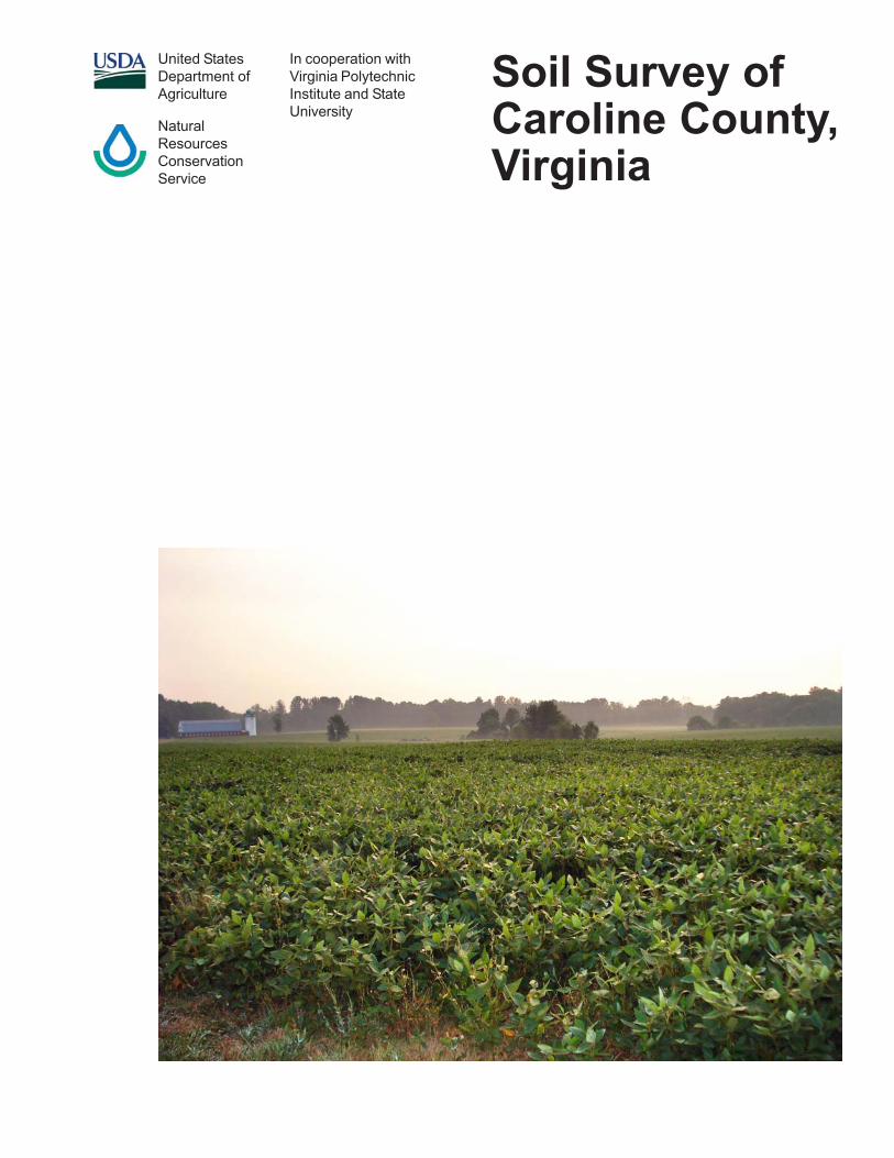
Cover Caption
A soybean field in an area of Kempsville-Emporia complex, 2 to 6 percent slopes.

v
ContentsCover ............................................................................................................................. iHow To Use This Soil Survey .................................................................................... iiiContents .......................................................................................................................vForeword ..................................................................................................................... ixIntroduction ................................................................................................................ 1
General Nature of the Survey Area .......................................................................... 1How This Survey Was Made .................................................................................... 3
Detailed Soil Map Units .............................................................................................. 51A—Altavista fine sandy loam, 0 to 2 percent slopes, very rarely flooded ............... 61B—Altavista fine sandy loam, 2 to 6 percent slopes, very rarely flooded ............... 82B—Appling sandy loam, 2 to 7 percent slopes....................................................... 92C—Appling sandy loam, 7 to 15 percent slopes ................................................... 113A—Bama sandy loam, 0 to 2 percent slopes ....................................................... 133B—Bama sandy loam, 2 to 6 percent slopes ....................................................... 144A—Bibb-Chastain complex, 0 to 2 percent slopes, frequently flooded ................ 165B—Bojac sandy loam, 0 to 6 percent slopes, very rarely flooded ........................ 186B—Cecil sandy loam, 2 to 7 percent slopes ........................................................ 197A—Chastain loam, 0 to 2 percent slopes, ponded ............................................... 218A—Chewacla silt loam, 0 to 2 percent slopes, occasionally flooded .................... 239C—Helena-Appling complex, 2 to 15 percent slopes ........................................... 2510E—Kempsville-Emporia-Remlik complex, 15 to 50 percent slopes ................... 2711A—Kempsville-Emporia complex, 0 to 2 percent slopes .................................... 2911B—Kempsville-Emporia complex, 2 to 6 percent slopes .................................... 3111C—Kempsville-Emporia complex, 6 to 10 percent slopes ................................. 3312A—Myatt-Slagle complex, 0 to 2 percent slopes ............................................... 3513E—Nevarc sandy loam, 15 to 50 percent slopes ............................................... 3714—Pits, gravel, 0 to 3 percent slopes .................................................................. 3915A—Rappahannock muck, 0 to 1 percent slopes, frequently flooded ................. 4016B—Remlik loamy sand, 2 to 6 percent slopes ................................................... 4116C—Remlik loamy sand, 6 to 15 percent slopes ................................................. 4316E—Remlik loamy sand, 15 to 50 percent slopes ............................................... 4517D—Rion sandy loam, 15 to 25 percent slopes ................................................... 4718A—Riverview silt loam, 0 to 2 percent slopes, occasionally flooded .................. 4919A—Roanoke loam, 0 to 2 percent slopes, ponded ............................................. 5020B—Rumford loamy sand, 0 to 6 percent slopes ................................................. 5220C—Rumford loamy sand, 6 to 10 percent slopes .............................................. 5420D—Rumford loamy sand, 10 to 15 percent slopes ............................................ 5621C—Slagle-Kempsville complex, 2 to 15 percent slopes ..................................... 5822A—Slagle fine sandy loam, 0 to 2 percent slopes .............................................. 6022B—Slagle fine sandy loam, 2 to 6 percent slopes .............................................. 6123A—State fine sandy loam, 0 to 2 percent slopes, very rarely flooded ................ 6323B—State fine sandy loam, 2 to 6 percent slopes, very rarely flooded ................ 6523C—State fine sandy loam, 6 to 10 percent slopes, very rarely flooded .............. 6624A—Suffolk fine sandy loam, 0 to 2 percent slopes ............................................. 6824B—Suffolk fine sandy loam, 2 to 6 percent slopes ............................................. 70
vi
25B—Tarboro-Bojac complex, 0 to 6 percent slopes, very rarely flooded.............. 7126A—Tomotley-Roanoke complex, 0 to 2 percent slopes, rarely flooded .............. 7327C—Udorthents, loamy, 0 to 15 percent slopes ................................................... 7528A—Wedhadkee silt loam, 0 to 2 percent slopes, frequently flooded .................. 7629A—Wickham fine sandy loam, 0 to 2 percent slopes, very rarely flooded ......... 7829B—Wickham fine sandy loam, 2 to 6 percent slopes, very rarely flooded ......... 7930E—Wateree-Rock outcrop complex, 25 to 70 percent slopes ........................... 81W—Water .............................................................................................................. 83
Use and Management of the Soils .......................................................................... 85Interpretive Ratings ................................................................................................ 85
Rating Class Terms ........................................................................................... 85Numerical Ratings ............................................................................................. 85
Crops and Pasture ................................................................................................. 86Yields per Acre ................................................................................................... 86Land Capability Classification ............................................................................ 87Virginia Soil Management Groups ..................................................................... 88
Prime Farmland and Other Important Farmlands .................................................. 90Hydric Soils ............................................................................................................ 91Agricultural Waste Management ............................................................................ 92Forestland Productivity and Management .............................................................. 94
Forestland Productivity ...................................................................................... 95Forestland Management .................................................................................... 95
Recreational Development ..................................................................................... 97Engineering ............................................................................................................ 99
Building Site Development ................................................................................. 99Sanitary Facilities ............................................................................................. 101Construction Materials ..................................................................................... 103Water Management ......................................................................................... 104
Soil Properties ........................................................................................................ 107Engineering Properties ........................................................................................ 107Physical Soil Properties ....................................................................................... 108Chemical Soil Properties ....................................................................................... 110Water Features ..................................................................................................... 110Soil Features ......................................................................................................... 112
Classification of the Soils ...................................................................................... 113Soil Series and Their Morphology ............................................................................. 113
Altavista Series ..................................................................................................... 114Appling Series ....................................................................................................... 116Bama Series ......................................................................................................... 118Bibb Series ............................................................................................................ 119Bojac Series ......................................................................................................... 120Cecil Series .......................................................................................................... 122Chastain Series .................................................................................................... 124Chewacla Series .................................................................................................. 125Emporia Series .................................................................................................... 127

vii
Helena Series ...................................................................................................... 129Kempsville Series ................................................................................................ 131Myatt Series ......................................................................................................... 132Nevarc Series ...................................................................................................... 134Rappahannock Series .......................................................................................... 136Remlik Series ....................................................................................................... 137Rion Series .......................................................................................................... 138Riverview Series .................................................................................................. 140Roanoke Series ................................................................................................... 141Rumford Series .................................................................................................... 143Slagle Series ........................................................................................................ 144State Series .......................................................................................................... 146Suffolk Series ....................................................................................................... 148Tarboro Series ..................................................................................................... 150Tomotley Series ................................................................................................... 151Wateree Series .................................................................................................... 153Wehadkee Series ................................................................................................ 154Wickham Series ................................................................................................... 156
Formation of the Soils ........................................................................................... 159Factors of Soil Formation ..................................................................................... 159Processes of Soil Horizon Differentiation ............................................................. 162
References .............................................................................................................. 163Glossary .................................................................................................................. 165Tables ...................................................................................................................... 183
Table 1.—Temperature and Precipitation ............................................................. 184Table 2.—Freeze Dates in Spring and Fall ........................................................... 185Table 3.—Growing Season .................................................................................. 185Table 4.—Acreage and Proportionate Extent of the Soils .................................... 186Table 5.—Land Capability Class, Virginia Soil Management Group, and
Yields per Acre of Crops and Pasture ............................................................ 187Table 6.—Prime and Other Important Farmland .................................................. 190Table 7.—Hydric Soils .......................................................................................... 190Table 8.—Agricultural Waste Management, Part I ............................................... 191Table 8.—Agricultural Waste Management, Part II .............................................. 197Table 8.—Agricultural Waste Management, Part III ............................................. 205Table 9.—Forestland Productivity ........................................................................ 213Table 10.—Forestland Management, Part I ......................................................... 219Table 10.—Forestland Management, Part II ........................................................ 224Table 10.—Forestland Management, Part III ....................................................... 228Table 10.—Forestland Management, Part IV ....................................................... 232Table 10.—Forestland Management, Part V ........................................................ 235Table 11.—Recreational Development, Part I ...................................................... 240Table 11.—Recreational Development, Part II ..................................................... 245Table 12.—Building Site Development, Part I ...................................................... 249Table 12.—Building Site Development, Part II ..................................................... 254
viii
Table 13.—Sanitary Facilities, Part I .................................................................... 260Table 13.—Sanitary Facilities, Part II ................................................................... 267Table 14.—Construction Materials, Part I ............................................................ 273Table 14.—Construction Materials, Part II ........................................................... 278Table 15.—Water Management ........................................................................... 284Table 16.—Engineering Properties ...................................................................... 289Table 17.—Physical Soil Properties ..................................................................... 303Table 18.—Chemical Soil Properties ................................................................... 310Table 19.—Water Features .................................................................................. 315Table 20.—Soil Features ...................................................................................... 320Table 21.—Taxonomic Classification of the Soils ................................................. 323
Issued 2009
ix
Soil surveys contain information that affects land use planning in survey areas.They include predictions of soil behavior for selected land uses. The surveys highlightsoil limitations, improvements needed to overcome the limitations, and the impact ofselected land uses on the environment.
Soil surveys are designed for many different users. Farmers, ranchers, foresters,and agronomists can use the surveys to evaluate the potential of the soil and themanagement needed for maximum food and fiber production. Planners, communityofficials, engineers, developers, builders, and home buyers can use the surveys toplan land use, select sites for construction, and identify special practices needed toensure proper performance. Conservationists, teachers, students, and specialists inrecreation, wildlife management, waste disposal, and pollution control can use thesurveys to help them understand, protect, and enhance the environment.
Various land use regulations of Federal, State, and local governments may imposespecial restrictions on land use or land treatment. The information in this report isintended to identify soil properties that are used in making various land use or landtreatment decisions. Statements made in this report are intended to help the landusers identify and reduce the effects of soil limitations on various land uses. Thelandowner or user is responsible for identifying and complying with existing laws andregulations.
Although soil survey information can be used for general farm, local, and wider areaplanning, onsite investigation is needed to supplement this information in some cases.Examples include soil quality assessments (http://soils.usda.gov/sqi/) and certainconservation and engineering applications. For more detailed information, contact yourlocal USDA Service Center (http://offices.sc.egov.usda.gov/locator/app?agency—nrcs)or your NRCS State Soil Scientist (http://soils.usda.gov/contact/state_offices/).
Great differences in soil properties can occur within short distances. Some soils areseasonally wet or subject to flooding. Some are too unstable to be used as afoundation for buildings or roads. Clayey or wet soils are poorly suited to use as septictank absorption fields. A high water table makes a soil poorly suited to basements orunderground installations.
These and many other soil properties that affect land use are described in this soilsurvey. The location of each map unit is shown on the detailed soil maps. Each soil inthe survey area is described, and information on specific uses is given. Help in usingthis publication and additional information are available at the local office of theNatural Resources Conservation Service or the Cooperative Extension Service.
John A. BrickerState ConservationistNatural Resources Conservation Service
Foreword


1
CAROLINE COUNTY is in the mid-eastern part of Virginia (fig. 1). It consists of 315,600acres. The county is approximately 30 miles northeast of the capital city of Richmond.Bowling Green, Virginia, is the county seat. Dawn, Ladysmith, Ruther Glen, andChilesburg are also located in Caroline County. In 2000, according to the Bureau ofCensus, the population of the county was 22,121 (United States Department ofCommerce, Census Bureau, 2000).
General Nature of the Survey AreaThis section provides general information about the survey area. It describes
physiography, relief, and drainage; history; and climate.
Physiography, Relief, and Drainage
Caroline County is mostly in the Southern Coastal Plain Major Land Resource Area.A small section in the western part of the county is in the Southern Piedmont MajorLand Resource Area. Elevations range from about 20 feet above sea level to about270 feet above sea level. The elevation of 20 feet is in an area where theRappahannock River crosses the Caroline-Essex County line, which is in the SouthernCoastal Plain portion of the county. The elevation of 350 feet is in an area in thewestern part of the county, which is in the Southern Piedmont portion. The countydrains mostly through the Rappahannock, Mattaponi, and North Anna Rivers and theirtributaries. The land surface is mostly nearly level to gently sloping in the Coastal Plainportion of the county and generally gently sloping to strongly sloping in the Piedmontportion.
History
In 1728, Caroline County was established from the upper portions of Essex, Kingand Queen, and King William Counties. The county was named for Caroline ofAnspach, consort of King George II. Some additional territory from King and QueenCounty was added in 1742 and 1762. The boundaries have not changed since then.Caroline County is bordered by Spotsylvania County to the northwest, by King George
Soil Survey ofCaroline County, VirginiaBy the Virginia Soil Survey Staff, Natural Resources Conservation Service
Fieldwork by Dabney Eastham, Bruce Dubee, and Greg Hammer, Natural ResourcesConservation Service
United States Department of Agriculture, Natural Resources Conservation Service,in cooperation withVirginia Polytechnic Institute and State University

Soil Survey of Caroline County, Virginia
2
County to the northeast, by Hanover County to the southwest, and by King William,King and Queen, and Essex Counties to the southeast. Settlers first came to theregion in the 1650’s because land was inexpensive and the area had access to thedeep water of the Rappahannock River. Caroline County was one of the mostpopulated counties in all of Virginia through the 18th century (Caroline County, VirginiaWebsite).
Climate
Table 1 gives data on temperature and precipitation for the survey area as recordedat Corbin, Virginia, in the period 1961 to 1990. Table 2 shows probable dates of thefirst freeze in fall and the last freeze in spring. Table 3 provides data on the length ofthe growing season.
In winter, the average temperature is 35.4 degrees F and the average dailyminimum temperature is 25.3 degrees. The lowest temperature on record, whichoccurred at Corbin on February 5, 1996, was -11 degrees. In summer, the averagetemperature is 74.1 degrees and the average daily maximum temperature is 84.9degrees. The highest temperature, which occurred at Corbin on August 21, 1983, was104 degrees.
Growing degree days are shown in table 1. They are equivalent to “heat units.”During the month, growing degree days accumulate by the amount that the averagetemperature each day exceeds a base temperature (50 degrees F). The normalmonthly accumulation is used to schedule single or successive plantings of a cropbetween the last freeze in spring and the first freeze in fall.
The average annual total precipitation is 42.67 inches. Of this, 26 inches, or about61 percent, usually falls in April through October. The growing season for most cropsfalls within this period. The heaviest 1-day rainfall during the period of record was 7.45inches at Corbin on June 22, 1972. Thunderstorms occur on about 37 days each year,and most occur between May and August.
The average seasonal snowfall is 17.0 inches. The greatest snow depth at any onetime during the period of record was 16 inches, recorded on January 26, 1987. On anaverage, 15 days per year have at least 1 inch of snow on the ground. The heaviest1-day snowfall on record was 15.0 inches, recorded on March 6, 1962.
The average relative humidity in mid-afternoon is about 53 percent. Humidity ishigher at night, and the average at dawn is about 83 percent. The sun shines 68percent of the time in summer and 55 percent in winter. The prevailing wind is from
Figure 1.—Location of Caroline County in Virginia.
Soil Survey of Caroline County, Virginia
3
the southwest. Average windspeed is highest, around 9 miles per hour, betweenFebruary to April.
How This Survey Was MadeThis survey was made to provide information about the soils and miscellaneous
areas in the survey area. The information includes a description of the soils andmiscellaneous areas and their location and a discussion of their suitability, limitations,and management for specified uses. Soil scientists observed the steepness, length,and shape of the slopes; the general pattern of drainage; the kinds of crops and nativeplants; and the kinds of bedrock. They dug many holes to study the soil profile, whichis the sequence of natural layers, or horizons, in a soil. The profile extends from thesurface down into the unconsolidated material in which the soil formed. Theunconsolidated material is devoid of roots and other living organisms and has notbeen changed by other biological activity.
Currently, soils are mapped according to the boundaries of major land resourceareas (MLRAs). MLRAs are geographically associated land resource units that sharecommon characteristics related to physiography, geology, climate, water resources,soils, biological resources, and land uses. Soil survey areas typically consist of partsof one or more MLRA.
The soils and miscellaneous areas in the survey area occur in an orderly patternthat is related to the geology, landforms, relief, climate, and natural vegetation of thearea. Each kind of soil and miscellaneous area is associated with a particular kind oflandform or with a segment of the landform. By observing the soils and miscellaneousareas in the survey area and relating their position to specific segments of thelandform, a soil scientist develops a concept, or model, of how they were formed.Thus, during mapping, this model enables the soil scientist to predict with aconsiderable degree of accuracy the kind of soil or miscellaneous area at a specificlocation on the landscape.
Commonly, individual soils on the landscape merge into one another as theircharacteristics gradually change. To construct an accurate soil map, however, soilscientists must determine the boundaries between the soils. They can observe only alimited number of soil profiles. Nevertheless, these observations, supplemented by anunderstanding of the soil-vegetation-landscape relationship, are sufficient to verifypredictions of the kinds of soil in an area and to determine the boundaries.
Soil scientists recorded the characteristics of the soil profiles that they studied. Theynoted soil color, texture, size and shape of soil aggregates, kind and amount of rockfragments, distribution of plant roots, reaction, and other features that enable them toidentify soils. After describing the soils in the survey area and determining theirproperties, the soil scientists assigned the soils to taxonomic classes (units).Taxonomic classes are concepts. Each taxonomic class has a set of soilcharacteristics with precisely defined limits. The classes are used as a basis forcomparison to classify soils systematically. Soil taxonomy, the system of taxonomicclassification used in the United States, is based mainly on the kind and character ofsoil properties and the arrangement of horizons within the profile. After the soilscientists classified and named the soils in the survey area, they compared theindividual soils with similar soils in the same taxonomic class in other areas so thatthey could confirm data and assemble additional data based on experience andresearch.
While a soil survey is in progress, samples of some of the soils in the areagenerally are collected for laboratory analyses and for engineering tests. Soil scientistsinterpret the data from these analyses and tests as well as the field-observedcharacteristics and the soil properties to determine the expected behavior of the soilsunder different uses. Interpretations for all of the soils are field tested through
Soil Survey of Caroline County, Virginia
4
observation of the soils in different uses and under different levels of management.Some interpretations are modified to fit local conditions, and some new interpretationsare developed to meet local needs. Data are assembled from other sources, such asresearch information, production records, and field experience of specialists. Forexample, data on crop yields under defined levels of management are assembledfrom farm records and from field or plot experiments on the same kinds of soil.
Predictions about soil behavior are based not only on soil properties but also onsuch variables as climate and biological activity. Soil conditions are predictable overlong periods of time, but they are not predictable from year to year. For example, soilscientists can predict with a fairly high degree of accuracy that a given soil will have ahigh water table within certain depths in most years, but they cannot predict that a highwater table will always be at a specific level in the soil on a specific date.
After soil scientists located and identified the significant natural bodies of soil in thesurvey area, they drew the boundaries of these bodies on aerial photographs andidentified each as a specific map unit. Aerial photographs show trees, buildings, fields,roads, and rivers, all of which help in locating boundaries accurately.
The descriptions, names, and delineations of the soils in this survey area do notfully agree with those of the soils in adjacent survey areas. Differences are the resultof a better knowledge of soils, modifications in series concepts, or variations in theintensity of mapping or in the extent of the soils in the survey areas.
5
The map units delineated on the detailed soil maps in this survey represent the soilsor miscellaneous areas in the survey area. The map unit descriptions in this section,along with the maps, can be used to determine the suitability and potential of a unit forspecific uses. They also can be used to plan the management needed for those uses.
A map unit delineation on a soil map represents an area dominated by one or moremajor kinds of soil or miscellaneous areas. A map unit is identified and namedaccording to the taxonomic classification of the dominant soils. Within a taxonomicclass there are precisely defined limits for the properties of the soils. On thelandscape, however, the soils are natural phenomena, and they have thecharacteristic variability of all natural phenomena. Thus, the range of some observedproperties may extend beyond the limits defined for a taxonomic class. Areas of soilsof a single taxonomic class rarely, if ever, can be mapped without including areas ofother taxonomic classes. Consequently, every map unit is made up of the soils ormiscellaneous areas for which it is named and some minor components that belong totaxonomic classes other than those of the major soils.
Most minor soils have properties similar to those of the dominant soil or soils in themap unit, and thus they do not affect use and management. These are callednoncontrasting, or similar, components. They may or may not be mentioned in aparticular map unit description. Other minor components, however, have propertiesand behavioral characteristics divergent enough to affect use or to require differentmanagement. These are called contrasting, or dissimilar, components. They generallyare in small areas and could not be mapped separately because of the scale used.Some small areas of strongly contrasting soils or miscellaneous areas are identifiedby a special symbol on the maps. The contrasting components are mentioned in themap unit descriptions. A few areas of minor components may not have been observed,and consequently they are not mentioned in the descriptions, especially where thepattern was so complex that it was impractical to make enough observations toidentify all the soils and miscellaneous areas on the landscape.
The presence of minor components in a map unit in no way diminishes theusefulness or accuracy of the data. The objective of mapping is not to delineate puretaxonomic classes but rather to separate the landscape into landforms or landformsegments that have similar use and management requirements. The delineation ofsuch segments on the map provides sufficient information for the development ofresource plans. If intensive use of small areas is planned, however, onsiteinvestigation is needed to define and locate the soils and miscellaneous areas.
An identifying symbol precedes the map unit name in the map unit descriptions.Each description includes general facts about the unit and gives the principal hazardsand limitations to be considered in planning for specific uses.
Soils that have profiles that are almost alike make up a soil series. All the soils of aseries have major horizons that are similar in composition, thickness, andarrangement. The soils of a given series can differ in texture of the surface layer,slope, stoniness, salinity, degree of erosion, and other characteristics that affect theiruse. On the basis of such differences, a soil series is divided into soil phases. Most of
Detailed Soil Map Units

Soil Survey of Caroline County, Virginia
6
the areas shown on the detailed soil maps are phases of soil series. The name of asoil phase commonly indicates a feature that affects use or management. Forexample, Wehadkee silt loam, 0 to 2 percent slopes, frequently flooded, is a phase ofthe Wehadkee series.
Some map units are made up of two or more major soils or miscellaneous areas.These map units are complexes. A complex consists of two or more soils ormiscellaneous areas in such an intricate pattern or in such small areas that theycannot be shown separately on the maps. The pattern and proportion of the soils ormiscellaneous areas are somewhat similar in all areas. Kempsville-Emporia complex,0 to 2 percent slopes, is an example.
This survey includes miscellaneous areas. Such areas have little or no soil materialand support little or no vegetation. Pits, gravel, is an example.
Table 4 gives the acreage and proportionate extent of the soils in the survey area.Other tables give properties of the soils and the limitations, capabilities, and potentialsfor many uses. The Glossary defines many of the terms used in describing the soils.
1A—Altavista fine sandy loam, 0 to 2 percent slopes, veryrarely flooded
Setting
Major land resource area: Southern Coastal Plain (MLRA 133A)Landform: Stream terrace on coastal plainPosition on the landform: Convex treadsSize of areas: 2 to 110 acresShape of areas: Elongated or irregularly oval
Map Unit Composition
Altavista and similar soils: Typically 90 percent, ranging from about 85 to 95 percent
Typical Profile
Surface layer:0 to 12 inches—brown fine sandy loam
Subsurface layer:12 to 16 inches—light yellowish brown fine sandy loam
Subsoil:16 to 20 inches—yellowish brown fine sandy loam20 to 34 inches—yellowish brown sandy clay loam34 to 40 inches—brownish yellow sandy loam; strong brown masses of oxidized iron
and light gray iron depletions
Substratum:40 to 65 inches—brownish yellow sand; light gray iron depletions
Minor Components
Dissimilar components:• Bojac and State soils, which are well drained• Tomotley soils, which are poorly drained; in more linear or concave landscape
positions that are not subject to flooding
Similar components:• Soils that have more silt; in similar landscape positions
Soil Survey of Caroline County, Virginia
7
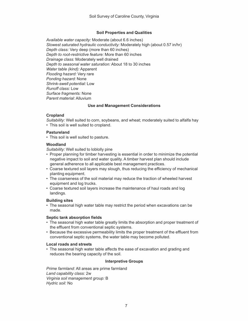
Soil Properties and Qualities
Available water capacity: Moderate (about 6.6 inches)Slowest saturated hydraulic conductivity: Moderately high (about 0.57 in/hr)Depth class: Very deep (more than 60 inches)Depth to root-restrictive feature: More than 60 inchesDrainage class: Moderately well drainedDepth to seasonal water saturation: About 18 to 30 inchesWater table (kind): ApparentFlooding hazard: Very rarePonding hazard: NoneShrink-swell potential: LowRunoff class: LowSurface fragments: NoneParent material: Alluvium
Use and Management Considerations
CroplandSuitability: Well suited to corn, soybeans, and wheat; moderately suited to alfalfa hay• This soil is well suited to cropland.
Pastureland• This soil is well suited to pasture.
WoodlandSuitability: Well suited to loblolly pine• Proper planning for timber harvesting is essential in order to minimize the potential
negative impact to soil and water quality. A timber harvest plan should includegeneral adherence to all applicable best management practices.
• Coarse textured soil layers may slough, thus reducing the efficiency of mechanicalplanting equipment.
• The coarseness of the soil material may reduce the traction of wheeled harvestequipment and log trucks.
• Coarse textured soil layers increase the maintenance of haul roads and loglandings.
Building sites• The seasonal high water table may restrict the period when excavations can be
made.
Septic tank absorption fields• The seasonal high water table greatly limits the absorption and proper treatment of
the effluent from conventional septic systems.• Because the excessive permeability limits the proper treatment of the effluent from
conventional septic systems, the water table may become polluted.
Local roads and streets• The seasonal high water table affects the ease of excavation and grading and
reduces the bearing capacity of the soil.
Interpretive Groups
Prime farmland: All areas are prime farmlandLand capability class: 2wVirginia soil management group: BHydric soil: No
Soil Survey of Caroline County, Virginia
8
1B—Altavista fine sandy loam, 2 to 6 percent slopes, veryrarely flooded
Setting
Major land resource area: Southern Coastal Plain (MLRA 133A)Landform: Stream terrace on coastal plainPosition on the landform: Convex treadsSize of areas: 2 to 110 acresShape of areas: Elongated or irregularly oval
Map Unit Composition
Altavista and similar soils: Typically 90 percent, ranging from about 85 to 95 percent
Typical Profile
Surface layer:0 to 12 inches—brown fine sandy loam
Subsurface layer:12 to 16 inches—light yellowish brown fine sandy loam
Subsoil:16 to 20 inches—yellowish brown fine sandy loam20 to 34 inches—yellowish brown sandy clay loam34 to 40 inches—brownish yellow sandy loam; strong brown masses of oxidized iron
and light gray iron depletions
Substratum:40 to 65 inches—brownish yellow sand; light gray iron depletions
Minor Components
Dissimilar components:• Bojac and State soils, which are well drained• Tomotley soils, which are poorly drained; in more linear or concave landscape
positions that are not subject to flooding
Similar components:• Soils that have more silt; in similar landscape positions
Soil Properties and Qualities
Available water capacity: Moderate (about 6.6 inches)Slowest saturated hydraulic conductivity: Moderately high (about 0.57 in/hr)Depth class: Very deep (more than 60 inches)Depth to root-restrictive feature: More than 60 inchesDrainage class: Moderately well drainedDepth to seasonal water saturation: About 18 to 30 inchesWater table (kind): ApparentFlooding hazard: Very rarePonding hazard: NoneShrink-swell potential: LowRunoff class: LowSurface fragments: NoneParent material: Alluvium

Soil Survey of Caroline County, Virginia
9
Use and Management Considerations
CroplandSuitability: Well suited to corn, soybeans and wheat; moderately suited to alfalfa hay• The rate of surface runoff, the erosion hazard, and the amount of nutrient loss are
increased because of the slope.
PasturelandSuitability: Well suited to pasture• The hazard of erosion, the rate of surface runoff, and the amount of nutrient loss are
increased because of the slope.
WoodlandSuitability: Well suited to loblolly pine• Proper planning for timber harvesting is essential in order to minimize the potential
negative impact to soil and water quality. A timber harvest plan should includegeneral adherence to all applicable best management practices.
• Coarse textured soil layers may slough, thus reducing the efficiency of mechanicalplanting equipment.
• The coarseness of the soil material may reduce the traction of wheeled harvestequipment and log trucks.
• Coarse textured soil layers increase the maintenance of haul roads and loglandings.
Building sites• The seasonal high water table may restrict the period when excavations can be
made.
Septic tank absorption fields• The seasonal high water table greatly limits the absorption and proper treatment of
the effluent from conventional septic systems.• Because the excessive permeability limits the proper treatment of the effluent from
conventional septic systems, the water table may become polluted.
Local roads and streets• The seasonal high water table affects the ease of excavation and grading and
reduces the bearing capacity of the soil.
Interpretive Groups
Prime farmland: All areas are prime farmlandLand capability class: 2eVirginia soil management group: BHydric soil: No
2B—Appling sandy loam, 2 to 7 percent slopes
Setting
Major land resource area: Southern Piedmont (MLRA 136)Landform: Piedmont uplandsPosition on the landform: Gently sloping broad, convex ridgesSize of areas: 2 to 110 acresShape of areas: Broad and irregular
Map Unit Composition
Appling and similar soils: Typically 80 percent, ranging from about 75 to 90 percent
Soil Survey of Caroline County, Virginia
10
Typical Profile
Surface layer:0 to 4 inches—light olive brown sandy loam
Subsurface layer:4 to 10 inches—light yellowish brown sandy loam
Subsoil:10 to 13 inches—yellowish brown clay loam13 to 24 inches—strong brown clay loam24 to 30 inches—strong brown clay30 to 42 inches—strong brown, yellowish red, and red clay42 to 60 inches—red clay loam
Substratum:60 to 72 inches—yellowish red and strong brown sandy loam
Minor Components
Dissimilar components:• Helena soils, which are moderately well drained
Similar components:• Cecil soils, which are redder
Soil Properties and Qualities
Available water capacity: Moderate (about 8.9 inches)Slowest saturated hydraulic conductivity: Moderately high (about 0.57 in/hr)Depth class: Very deep (more than 60 inches)Depth to root-restrictive feature: More than 60 inchesDrainage class: Well drainedDepth to seasonal water saturation: More than 6 feetFlooding hazard: NonePonding hazard: NoneShrink-swell potential: LowRunoff class: MediumSurface fragments: NoneParent material: Residuum weathered from granite and gneiss
Use and Management Considerations
CroplandSuitability: Moderately suited to corn, soybeans, and alfalfa hay; well suited to wheat• The rate of surface runoff, the erosion hazard, and the amount of nutrient loss are
increased because of the slope.• The high clay content restricts the rooting depth of crops.
PasturelandSuitability: Well suited to pasture• The hazard of erosion, the rate of surface runoff, and the amount of nutrient loss are
increased because of the slope.
WoodlandSuitability: Moderately suited to loblolly pine and yellow-poplar• Proper planning for timber harvesting is essential in order to minimize the potential
negative impact to soil and water quality. A timber harvest plan should includegeneral adherence to all applicable best management practices.
• The slope may restrict the use of some mechanical planting equipment.
Soil Survey of Caroline County, Virginia
11
• Coarse textured soil layers may slough, thus reducing the efficiency of mechanicalplanting equipment.
• The coarseness of the soil material may reduce the traction of wheeled harvestequipment and log trucks.
• Coarse textured soil layers increase the maintenance of haul roads and loglandings.
Building sites• The high content of clay in the subsurface layer increases the difficulty of digging,
filling, and compacting the soil material in shallow excavations.
Septic tank absorption fields• Because the excessive permeability limits the proper treatment of the effluent from
conventional septic systems, the water table may become polluted.• This soil is well suited to septic tank absorption fields.
Local roads and streets• The low strength may cause structural damage to local roads and streets.
Interpretive Groups
Prime farmland: All areas are prime farmlandLand capability class: 2eVirginia soil management group: VHydric soil: No
2C—Appling sandy loam, 7 to 15 percent slopes
Setting
Major land resource area: Southern Piedmont (MLRA 136)Landform: Piedmont uplandsPosition on the landform: Strongly sloping narrow, winding ridges and short to
moderately long, complex side slopesSize of areas: 2 to 110 acresShape of areas: Broad and irregular
Map Unit Composition
Appling and similar soils: Typically 90 percent, ranging from about 85 to 95 percent
Typical Profile
Surface layer:0 to 4 inches—light olive brown sandy loam
Subsurface layer:4 to 10 inches—light yellowish brown sandy loam
Subsoil:10 to 13 inches—yellowish brown clay loam13 to 24 inches—strong brown clay loam24 to 30 inches—strong brown clay30 to 42 inches—strong brown, yellowish red, and red clay42 to 60 inches—red clay loam
Substratum:60 to 72 inches—yellowish red and strong brown sandy loam

Soil Survey of Caroline County, Virginia
12
Minor Components
Dissimilar components:• Helena soils, which are moderately well drained
Similar components:• Cecil soils, which are redder
Soil Properties and Qualities
Available water capacity: Moderate (about 8.9 inches)Slowest saturated hydraulic conductivity: Moderately high (about 0.57 in/hr)Depth class: Very deep (more than 60 inches)Depth to root-restrictive feature: More than 60 inchesDrainage class: Well drainedDepth to seasonal water saturation: More than 6 feetFlooding hazard: NonePonding hazard: NoneShrink-swell potential: LowRunoff class: MediumSurface fragments: NoneParent material: Residuum weathered from granite and gneiss
Use and Management Considerations
CroplandSuitability: Moderately suited to corn, soybeans, wheat, and alfalfa hay• The rate of surface runoff, the erosion hazard, and the amount of nutrient loss are
increased because of the slope.• The high clay content restricts the rooting depth of crops.
PasturelandSuitability: Well suited to pasture• The hazard of erosion, the rate of surface runoff, and the amount of nutrient loss are
increased because of the slope.
WoodlandSuitability: Moderately suited to loblolly pine and yellow-poplar• Proper planning for timber harvesting is essential in order to minimize the potential
negative impact to soil and water quality. A timber harvest plan should includegeneral adherence to all applicable best management practices.
• The slope creates unsafe operating conditions and reduces the operating efficiencyof log trucks.
• The slope may restrict the use of some mechanical planting equipment.• Coarse textured soil layers may slough, thus reducing the efficiency of mechanical
planting equipment.• The coarseness of the soil material may reduce the traction of wheeled harvest
equipment and log trucks.• Coarse textured soil layers increase the maintenance of haul roads and log
landings.
Building sites• The slope influences the use of machinery and the amount of excavation required.• The high content of clay in the subsurface layer increases the difficulty of digging,
filling, and compacting the soil material in shallow excavations.
Septic tank absorption fields• The slope limits the proper treatment of effluent from conventional septic systems.

Soil Survey of Caroline County, Virginia
13
Local roads and streets• The low strength may cause structural damage to local roads and streets.• Because of the slope, designing local roads and streets is difficult.
Interpretive Groups
Prime farmland: Not prime farmlandLand capability class: 3eVirginia soil management group: VHydric soil: No
3A—Bama sandy loam, 0 to 2 percent slopes
Setting
Major land resource area: Southern Coastal Plain (MLRA 133A)Landform: Marine terrace on coastal plainPosition on the landform: UplandsSize of areas: 3 to 20 acresShape of areas: Elongated or irregularly oval
Map Unit Composition
Bama and similar soils: Typically 90 percent, ranging from about 85 to 95 percent
Typical Profile
Surface layer:0 to 4 inches—dark grayish brown sandy loam
Subsurface layer:4 to 13 inches—light yellowish brown loam
Subsoil:13 to 19 inches—strong brown loam19 to 26 inches—yellowish red loam26 to 50 inches—yellowish red sandy clay loam; red masses of oxidized iron50 to 70 inches—yellowish red sandy clay loam; pink masses of oxidized iron
Minor Components
Dissimilar components:• Slagle soils, which are moderately well drained and have gray iron depletions in the
upper part of the subsoil; in more linear or concave landscape positions
Similar components:• Emporia soils, which have gray iron depletions in the lower part of the subsoil; in
similar landscape positions• Kempsville soils, which have a decrease in clay content within a depth of 60 inches;
in similar landscape positions• Suffolk soils, which have thinner sola; in similar landscape positions
Soil Properties and Qualities
Available water capacity: Moderate (about 8.6 inches)Slowest saturated hydraulic conductivity: Moderately high (about 0.57 in/hr)Depth class: Very deep (more than 60 inches)Depth to root-restrictive feature: More than 60 inchesDrainage class: Well drainedDepth to seasonal water saturation: More than 6 feet

Soil Survey of Caroline County, Virginia
14
Flooding hazard: NonePonding hazard: NoneShrink-swell potential: LowRunoff class: LowSurface fragments: NoneParent material: Loamy marine deposits
Use and Management Considerations
CroplandSuitability: Moderately suited to corn; well suited to soybeans, wheat, and alfalfa hay• Soil crusting results in a decrease in water infiltration and hinders the emergence of
seedlings.
Pastureland• This soil is well suited to pasture.
WoodlandSuitability: Moderately suited to loblolly pine, southern red oak, yellow-poplar, and
sweetgum• Proper planning for timber harvesting is essential in order to minimize the potential
negative impact to soil and water quality. A timber harvest plan should includegeneral adherence to all applicable best management practices.
• The low strength interferes with the construction of haul roads and log landings.• The low strength may create unsafe conditions for log trucks.
Building sites• This soil is well suited to building sites.
Septic tank absorption fields• This soil is well suited to septic tank absorption fields.
Local roads and streets• This soil is well suited to local roads and streets.
Interpretive Groups
Prime farmland: All areas are prime farmlandLand capability class: 1Virginia soil management group: RHydric soil: No
3B—Bama sandy loam, 2 to 6 percent slopes
Setting
Major land resource area: Southern Coastal Plain (MLRA 133A)Landform: Marine terrace on coastal plainPosition on the landform: UplandsSize of areas: 3 to 20 acresShape of areas: Elongated or irregularly oval
Map Unit Composition
Bama and similar soils: Typically 90 percent, ranging from about 85 to 95 percent
Typical Profile
Surface layer:0 to 4 inches—dark grayish brown sandy loam
Soil Survey of Caroline County, Virginia
15
Subsurface layer:4 to 13 inches—light yellowish brown loam
Subsoil:13 to 19 inches—strong brown loam19 to 26 inches—yellowish red loam26 to 50 inches—yellowish red sandy clay loam; red masses of oxidized iron50 to 70 inches—yellowish red sandy clay loam; pink masses of oxidized iron
Minor Components
Dissimilar components:• Slagle soils, which are moderately well drained and have gray iron depletions in the
upper part of the subsoil; in more linear or concave landscape positions
Similar components:• Emporia soils, which have gray iron depletions in the lower part of the subsoil; in
similar landscape positions• Kempsville soils, which have a decrease in clay content within a depth of 60 inches;
in similar landscape positions• Suffolk soils, which have thinner sola; in similar landscape positions
Soil Properties and Qualities
Available water capacity: Moderate (about 8.6 inches)Slowest saturated hydraulic conductivity: Moderately high (about 0.57 in/hr)Depth class: Very deep (more than 60 inches)Depth to root-restrictive feature: More than 60 inchesDrainage class: Well drainedDepth to seasonal water saturation: More than 6 feetFlooding hazard: NonePonding hazard: NoneShrink-swell potential: LowRunoff class: LowSurface fragments: NoneParent material: Loamy marine deposits
Use and Management Considerations
CroplandSuitability: Moderately suited to corn and alfalfa hay; well suited to soybeans and
wheat• The rate of surface runoff, the erosion hazard, and the amount of nutrient loss are
increased because of the slope.• Soil crusting results in a decrease in water infiltration and hinders the emergence of
seedlings.
PasturelandSuitability: Well suited to pasture• The hazard of erosion, the rate of surface runoff, and the amount of nutrient loss are
increased because of the slope.
WoodlandSuitability: Moderately suited to loblolly pine, southern red oak, yellow-poplar, and
sweetgum• Proper planning for timber harvesting is essential in order to minimize the potential
negative impact to soil and water quality. A timber harvest plan should includegeneral adherence to all applicable best management practices.
Soil Survey of Caroline County, Virginia
16
• The low strength interferes with the construction of haul roads and log landings.• The low strength may create unsafe conditions for log trucks.
Building sites• This soil is well suited to building sites.
Septic tank absorption fields• This soil is well suited to septic tank absorption fields.
Local roads and streets• This soil is well suited to local roads and streets.
Interpretive Groups
Prime farmland: All areas are prime farmlandLand capability class: 2eVirginia soil management group: RHydric soil: No
4A—Bibb-Chastain complex, 0 to 2 percent slopes,frequently flooded
Setting
Major land resource area: Southern Coastal Plain (MLRA 133A)Landform: Flood plain on coastal plainPosition on the landform: Low linear or concave surfacesSize of areas: 2 to 15 acresShape of areas: Oval or irregular
Map Unit Composition
Bibb and similar soils: Typically 75 percent, ranging from about 70 to 85 percentChastain and similar soils: Typically 20 percent, ranging from about 15 to 35 percent
Typical Profile
BibbSurface layer:0 to 4 inches—grayish brown loamy sand4 to 15 inches—grayish brown loamy sand; gray iron depletions and yellowish red
masses of oxidized iron
Substratum:15 to 42 inches—gray sandy loam; yellowish brown masses of oxidized iron42 to 65 inches—gray loamy sand; yellowish brown masses of oxidized iron
ChastainSurface layer:0 to 2 inches—dark grayish brown silt loam2 to 13 inches—dark gray silt loam; reddish brown and brown masses of oxidized iron
Subsoil:13 to 24 inches—dark gray clay loam; reddish brown masses of oxidized iron24 to 36 inches—dark gray clay loam; reddish brown and strong brown masses of
oxidized iron
Substratum:36 to 80 inches—dark gray sand; strong brown masses of oxidized iron
Soil Survey of Caroline County, Virginia
17
Minor Components
Dissimilar components:• Myatt soils, which have a regular increase and decrease in clay content; on low
stream terrace treads
Soil Properties and Qualities
Available water capacity: Moderate (about 6.7 inches)Slowest saturated hydraulic conductivity: Bibb—moderately high (about 0.57 in/hr);
Chastain—moderately low (about 0.06 in/hr)Depth class: Very deep (more than 60 inches)Depth to root-restrictive feature: More than 60 inchesDrainage class: Poorly drainedDepth to seasonal water saturation: About 0 to 12 inchesWater table (kind): ApparentFlooding hazard: FrequentPonding hazard: NoneShrink-swell potential: LowRunoff class: Very highSurface fragments: NoneParent material: Alluvium
Use and Management Considerations
Cropland• These soils are unsuited to cropland.
PasturelandSuitability: Poorly suited to pasture• Flooding may damage pastures.• The seasonal high water table can affect equipment use, grazing patterns, and the
viability of grass and legume species.
WoodlandSuitability: Moderately suited to loblolly pine and sweetgum• Proper planning for timber harvesting is essential in order to minimize the potential
negative impact to soil and water quality. A timber harvest plan should focus onstreamside management zones and stream crossings and should include generaladherence to all applicable best management practices.
• Flooding may damage haul roads.• Flooding restricts the safe use of roads by log trucks.• Soil wetness may limit the use of log trucks.• Coarse textured soil layers may slough, thus reducing the efficiency of mechanical
planting equipment.• The coarseness of the soil material may reduce the traction of wheeled harvest
equipment and log trucks.• Coarse textured soil layers increase the maintenance of haul roads and log
landings.• The low strength interferes with the construction of haul roads and log landings.• The low strength may create unsafe conditions for log trucks.
Building sites• Flooding is a limitation affecting building site development.• The seasonal high water table may restrict the period when excavations can be
made.
Soil Survey of Caroline County, Virginia
18
Septic tank absorption fields• Flooding is a limitation affecting septic tank absorption fields.• The seasonal high water table greatly limits the absorption and proper treatment of
the effluent from conventional septic systems.
Local roads and streets• Flooding may damage local roads and streets.• The seasonal high water table affects the ease of excavation and grading and
reduces the bearing capacity of the soil.
Interpretive Groups
Prime farmland: Not prime farmlandLand capability class: 6wVirginia soil management group: Bibb—EE; Chastain—LLHydric soils: Yes
5B—Bojac sandy loam, 0 to 6 percent slopes, very rarelyflooded
Setting
Major land resource area: Southern Coastal Plain (MLRA 133A)Landform: Stream terrace on coastal plainPosition on the landform: Convex treadsSize of areas: 3 to 40 acresShape of areas: Broad and irregular
Map Unit Composition
Bojac and similar soils: Typically 85 percent, ranging from about 80 to 90 percent
Typical Profile
Surface layer:0 to 6 inches—light yellowish brown sandy loam
Subsurface layer:6 to 12 inches—yellowish brown fine sandy loam
Subsoil:12 to 40 inches—strong brown fine sandy loam40 to 46 inches—reddish yellow fine sandy loam
Substratum:46 to 65 inches—very pale brown fine sand
Minor Components
Dissimilar components:• Tarboro soils, which are somewhat excessively drained and sandy throughout; in
slightly higher landscape positions• Tomotley soils, which are poorly drained; in linear or concave landscape positions
Similar components:• State soils, which have more clay in the subsoil; in similar landscape positions
Soil Properties and Qualities
Available water capacity: Moderate (about 6.2 inches)Slowest saturated hydraulic conductivity: High (about 1.98 in/hr)
Soil Survey of Caroline County, Virginia
19
Depth class: Very deep (more than 60 inches)Depth to root-restrictive feature: More than 60 inchesDrainage class: Well drainedDepth to seasonal water saturation: About 48 to 72 inchesWater table (kind): ApparentFlooding hazard: Very rarePonding hazard: NoneShrink-swell potential: LowRunoff class: Very lowSurface fragments: NoneParent material: Loamy marine deposits
Use and Management Considerations
CroplandSuitability: Moderately suited to corn; poorly suited to soybeans; well suited to wheat;
not suited to alfalfa hay• The rate of surface runoff, the erosion hazard, and the amount of nutrient loss are
increased because of the slope.
PasturelandSuitability: Well suited to pasture• The hazard of erosion, the rate of surface runoff, and the amount of nutrient loss are
increased because of the slope.
WoodlandSuitability: Moderately suited to loblolly pine, southern red oak, and sweetgum• Proper planning for timber harvesting is essential in order to minimize the potential
negative impact to soil and water quality. A timber harvest plan should includegeneral adherence to all applicable best management practices.
• This soil is well suited to haul roads and log landings.
Building sites• The seasonal high water table may restrict the period when excavations can be
made.
Septic tank absorption fields• The seasonal high water table greatly limits the absorption and proper treatment of
the effluent from conventional septic systems.• Because the excessive permeability limits the proper treatment of the effluent from
conventional septic systems, the water table may become polluted.
Local roads and streets• This soil is well suited to local roads and streets.
Interpretive Groups
Prime farmland: All areas are prime farmlandLand capability class: 2eVirginia soil management group: DDHydric soil: No
6B—Cecil sandy loam, 2 to 7 percent slopes
Setting
Major land resource area: Southern Piedmont (MLRA 136)Landform: Piedmont uplands
Soil Survey of Caroline County, Virginia
20
Position on the landform: Moderately sloping narrow, convex ridges and moderatelylong, complex side slopes
Size of areas: 2 to 100 acresShape of areas: Irregular
Map Unit Composition
Cecil and similar soils: Typically 90 percent, ranging from about 85 to 95 percent
Typical Profile
Surface layer:0 to 1 inch—dark grayish brown sandy loam
Subsurface layer:1 to 9 inches—yellowish brown sandy loam
Subsoil:9 to 14 inches—yellowish red sandy clay loam14 to 26 inches—red clay; few yellowish brown mottles26 to 39 inches—red clay; few dark yellowish brown mottles39 to 63 inches—red clay; few yellowish brown and few yellowish red mottles
Substratum:63 to 83 inches—red, strong brown, and white loam
Minor Components
Dissimilar components:• Helena soils, which are moderately well drained
Similar components:• Appling soils, which are yellower• Rion soils, which have less clay
Soil Properties and Qualities
Available water capacity: Moderate (about 8.3 inches)Slowest saturated hydraulic conductivity: Moderately high (about 0.57 in/hr)Depth class: Very deep (more than 60 inches)Depth to root-restrictive feature: More than 60 inchesDrainage class: Well drainedDepth to seasonal water saturation: More than 6 feetFlooding hazard: NonePonding hazard: NoneShrink-swell potential: LowRunoff class: MediumSurface fragments: NoneParent material: Residuum weathered from granite and gneiss
Use and Management Considerations
CroplandSuitability: Moderately suited to corn, alfalfa hay, and soybeans; well suited to wheat• The rate of surface runoff, the erosion hazard, and the amount of nutrient loss are
increased because of the slope.• The high clay content restricts the rooting depth of crops.• Soil crusting results in a decrease in water infiltration and hinders the emergence of
seedlings.

Soil Survey of Caroline County, Virginia
21
PasturelandSuitability: Well suited to pasture• The hazard of erosion, the rate of surface runoff, and the amount of nutrient loss are
increased because of the slope.
WoodlandSuitability: Moderately suited to loblolly pine, southern red oak, yellow-poplar, and
sweetgum; well suited to northern red oak• Proper planning for timber harvesting is essential in order to minimize the potential
negative impact to soil and water quality. A timber harvest plan should includegeneral adherence to all applicable best management practices.
• The slope may restrict the use of some mechanical planting equipment.• This soil is well suited to haul roads and log landings.• This soil is well suited to equipment operations.
Building sites• The high content of clay in the subsurface layer increases the difficulty of digging,
filling, and compacting the soil material in shallow excavations.
Septic tank absorption fields• This soil is well suited to septic tank absorption fields.
Local roads and streets• The low strength may cause structural damage to local roads and streets.
Interpretive Groups
Prime farmland: All areas are prime farmlandLand capability class: 2eVirginia soil management group: XHydric soil: No
7A—Chastain loam, 0 to 2 percent slopes, ponded
Setting
Major land resource area: Southern Coastal Plain (MLRA 133A)Landform: Swamp on coastal plainPosition on the landform: Low linear or concave surfacesSize of areas: 2 to 15 acresShape of areas: Oval or irregular
Map Unit Composition
Chastain and similar soils: Typically 95 percent, ranging from about 90 to 95 percent
Typical Profile
Surface layer:0 to 2 inches—dark grayish brown silt loam2 to 13 inches—dark gray silt loam; reddish brown and brown masses of oxidized iron
Subsoil:13 to 24 inches—dark gray clay loam; reddish brown masses of oxidized iron24 to 36 inches—dark gray clay loam; reddish brown and strong brown masses of
oxidized iron
Substratum:36 to 80 inches—dark gray sand; strong brown masses of oxidized iron
Soil Survey of Caroline County, Virginia
22
Minor Components
Dissimilar components:• Myatt soils, which have a regular increase and decrease in clay content; on low
stream terrace treads
Soil Properties and Qualities
Available water capacity: Moderate (about 6.3 inches)Slowest saturated hydraulic conductivity: Moderately low (about 0.06 in/hr)Depth class: Very deep (more than 60 inches)Depth to root-restrictive feature: More than 60 inchesDrainage class: Poorly drainedDepth to seasonal water saturation: About 0 inchesWater table (kind): ApparentFlooding hazard: FrequentPonding hazard: FrequentDepth of ponding: 0.0 to 3.0 feetShrink-swell potential: LowRunoff class: NegligibleSurface fragments: NoneParent material: Alluvium
Use and Management Considerations
Cropland• This soil is unsuited to cropland.
Pastureland• This soil is unsuited to pastureland.
WoodlandSuitability: Moderately suited to sweetgum• Proper planning for timber harvesting is essential in order to minimize the potential
negative impact to soil and water quality. A timber harvest plan should focus onstreamside management zones and stream crossings and should include generaladherence to all applicable best management practices.
• Flooding may damage haul roads.• Flooding and ponding restrict the safe use of roads by log trucks.• Soil wetness may limit the use of log trucks.• The low strength interferes with the construction of haul roads and log landings.• The low strength may create unsafe conditions for log trucks.
Building sites• This soil is unsuited to building sites.• Flooding and ponding are limitations affecting building site development.• The seasonal high water table may restrict the period when excavations can be
made.
Septic tank absorption fields• This soil is unsuited to septic tank absorption fields.• Flooding and ponding are limitations affecting septic tank absorption fields.• The seasonal high water table greatly limits the absorption and proper treatment of
the effluent from conventional septic systems.
Local roads and streets• Flooding may damage local roads and streets.
Soil Survey of Caroline County, Virginia
23
• Ponding affects the ease of excavation and grading and limits the bearing capacityof the soil.
• The low strength is unfavorable for supporting heavy loads.
Interpretive Groups
Prime farmland: Not prime farmlandLand capability class: 6wVirginia soil management group: LLHydric soil: Yes
8A—Chewacla silt loam, 0 to 2 percent slopes,occasionally flooded
Setting
Major land resource area: Southern Coastal Plain (MLRA 133A)Landform: Coastal Plain and Piedmont flood plainsPosition on the landform: Nearly level low-lying flood plainsSize of areas: 2 to 150 acresShape of areas: Elongated
Map Unit Composition
Chewacla and similar soils: Typically 75 percent, ranging from about 70 to 85 percent
Typical Profile
Surface layer:0 to 5 inches—dark brown silt loam
Subsoil:5 to 13 inches—brown clay loam13 to 26 inches—brown, pale brown, and light brownish gray sandy clay loam26 to 40 inches—brown, light brownish gray, and weak red clay loam
Substratum:40 to 60 inches—yellowish brown, light brownish gray, and black silty clay loam
Minor Components
Dissmilar components:• Riverview soils, which are well drained; in higher convex landscape positions
Similar components:• Soils that have less clay; in similar landscape positions• Soils that have less than 50 percent gray iron depletions in the upper part of the
subsoil; in higher linear or concave areas
Soil Properties and Qualities
Available water capacity: High (about 9.3 inches)Slowest saturated hydraulic conductivity: Moderately high (about 0.20 in/hr)Depth class: Very deep (more than 60 inches)Depth to root-restrictive feature: More than 60 inchesDrainage class: Somewhat poorly drainedDepth to seasonal water saturation: About 6 to 18 inchesWater table (kind): ApparentFlooding hazard: Occasional
Soil Survey of Caroline County, Virginia
24
Ponding hazard: NoneShrink-swell potential: LowRunoff class: Very highSurface fragments: NoneParent material: Alluvium
Use and Management Considerations
CroplandSuitability: Well suited to corn, soybeans, and wheat; not suited to alfalfa hay• The risk of compaction increases when the soil is wet.• Soil crusting results in a decrease in water infiltration and hinders the emergence of
seedlings.• Flooding may damage crops.• The seasonal high water table restricts equipment operation, decreases the viability
of crops, and interferes with the planting and harvesting of crops.
PasturelandSuitability: Well suited to pasture• Flooding may damage pastures.• The seasonal high water table can affect equipment use, grazing patterns, and the
viability of grass and legume species.• Compaction may occur when the soil is wet.
WoodlandSuitability: Well suited to loblolly pine; moderately suited to yellow-poplar and
sweetgum• Proper planning for timber harvesting is essential in order to minimize the potential
negative impact to soil and water quality. A timber harvest plan should focus onstreamside management zones and stream crossings and should include generaladherence to all applicable best management practices.
• Flooding may damage haul roads.• Flooding restricts the safe use of roads by log trucks.• Soil wetness may limit the use of log trucks.• The low strength interferes with the construction of haul roads and log landings.• The low strength may create unsafe conditions for log trucks.
Building sites• Flooding is a limitation affecting building site development.• The seasonal high water table may restrict the period when excavations can be
made.
Septic tank absorption fields• Flooding is a limitation affecting septic tank absorption fields.• The seasonal high water table greatly limits the absorption and proper treatment of
the effluent from conventional septic systems.
Local roads and streets• Flooding may damage local roads and streets.• The seasonal high water table affects the ease of excavation and grading and
reduces the bearing capacity of the soil.
Interpretive Groups
Prime farmland: Prime farmland if drainedLand capability class: 4wVirginia soil management group: IHydric soil: No
Soil Survey of Caroline County, Virginia
25
9C—Helena-Appling complex, 2 to 15 percent slopes
Setting
Major land resource area: Southern Piedmont (MLRA 136)Landform: Piedmont uplandsPosition on the landform: Strongly sloping narrow, winding ridges and short to
moderately long, complex side slopesSize of areas: 2 to 110 acresShape of areas: Broad and irregular
Map Unit Composition
Helena and similar soils: Typically 65 percent, ranging from about 60 to 75 percentAppling and similar soils: Typically 20 percent, ranging from about 15 to 35 percent
Typical Profile
HelenaSurface layer:0 to 8 inches—yellowish brown sandy loam
Subsoil:8 to 15 inches—yellowish brown sandy clay loam15 to 30 inches—yellowish brown sandy clay; red masses of oxidized iron30 to 40 inches—yellowish brown sandy clay; light gray iron depletions40 to 50 inches—strong brown and brownish yellow clay loam; light gray iron
depletions
Substratum:50 to 60 inches—yellowish brown sandy clay loam; light gray iron depletions
ApplingSurface layer:0 to 4 inches—light olive brown sandy loam
Subsurface layer:4 to 10 inches—light yellowish brown sandy loam
Subsoil:10 to 13 inches—yellowish brown clay loam13 to 24 inches—strong brown clay loam24 to 30 inches—strong brown clay30 to 42 inches—strong brown, yellowish red, and red clay42 to 60 inches—red clay loam
Substratum:60 to 72 inches—yellowish red and strong brown sandy loam
Minor Components
Dissimilar components:• Rion soils, which have less clay
Similar components:• Cecil soils, which are redder
Soil Properties and Qualities
Available water capacity: Helena—moderate (about 7.8 inches); Appling—moderate(about 8.9 inches)
Soil Survey of Caroline County, Virginia
26
Slowest saturated hydraulic conductivity: Helena—moderately low (about 0.06 in/hr);Appling—moderately high (about 0.57 in/hr)
Depth class: Very deep (more than 60 inches)Depth to root-restrictive feature: More than 60 inchesDrainage class: Helena—moderately well drained; Appling—well drainedDepth to seasonal water saturation: Helena—about 12 to 30 inches; Appling—more
than 6 feetWater table (kind): Helena—perchedFlooding hazard: NonePonding hazard: NoneShrink-swell potential: Helena—high; Appling—lowRunoff class: MediumSurface fragments: NoneParent material: Residuum weathered from granite and gneiss
Use and Management Considerations
CroplandSuitability: Moderately suited to corn, soybeans, and wheat; not suited to alfalfa hay• The rate of surface runoff, the erosion hazard, and the amount of nutrient loss are
increased because of the slope.• The high clay content restricts the rooting depth of crops.• The seasonal high water table restricts equipment operation, decreases the viability
of crops, and interferes with the planting and harvesting of crops.
PasturelandSuitability: Moderately suited to pasture• The hazard of erosion, the rate of surface runoff, and the amount of nutrient loss are
increased because of the slope.
WoodlandSuitability: Moderately suited to loblolly pine• Proper planning for timber harvesting is essential in order to minimize the potential
negative impact to soil and water quality. A timber harvest plan should includegeneral adherence to all applicable best management practices.
• The slope creates unsafe operating conditions and reduces the operating efficiencyof log trucks.
• The slope may restrict the use of some mechanical planting equipment.• Coarse textured soil layers may slough, thus reducing the efficiency of mechanical
planting equipment.• The coarseness of the soil material may reduce the traction of wheeled harvest
equipment and log trucks.• Coarse textured soil layers increase the maintenance of haul roads and log
landings.
Building sites• The seasonal high water table may restrict the period when excavations can be
made.• The slope influences the use of machinery and the amount of excavation required.• Shrinking and swelling of the soil may crack foundations and basement walls.• The high content of clay in the subsurface layer increases the difficulty of digging,
filling, and compacting the soil material in shallow excavations.
Septic tank absorption fields• The seasonal high water table greatly limits the absorption and proper treatment of
the effluent from conventional septic systems.

Soil Survey of Caroline County, Virginia
27
• The restricted permeability limits the absorption and proper treatment of the effluentfrom conventional septic systems.
• The slope limits the proper treatment of effluent from conventional septic systems.
Local roads and streets• The seasonal high water table affects the ease of excavation and grading and
reduces the bearing capacity of the soil.• Because of shrinking and swelling, the use of these soils as base material for local
roads and streets is restricted.• The low strength is unfavorable for supporting heavy loads.• Because of the slope, designing local roads and streets is difficult.
Interpretive Groups
Prime farmland: Not prime farmlandLand capability class: 3eVirginia soil management group: Helena—KK; Appling—VHydric soils: No
10E—Kempsville-Emporia-Remlik complex, 15 to 50percent slopes
Setting
Major land resource area: Southern Coastal Plain (MLRA 133A)Landform: Marine terrace on coastal plainPosition on the landform: Moderately steep to very steep side slopesSize of areas: 5 to 600 acresShape of areas: Irregular
Map Unit Composition
Kempsville and similar soils: Typically 45 percent, ranging from about 40 to 55 percentEmporia and similar soils: Typically 25 percent, ranging from about 20 to 35 percentRemlik and similar soils: Typically 20 percent, ranging from about 15 to 25 percent
Typical Profile
KempsvilleSurface layer:0 to 3 inches—dark grayish brown sandy loam
Subsurface layer:3 to 19 inches—light reddish brown sandy loam
Subsoil:19 to 29 inches—yellowish brown sandy clay loam29 to 37 inches—yellowish brown sandy clay loam; pale brown and common strong
brown mottles37 to 65 inches—yellowish brown sandy clay; pale brown and common strong brown
mottles
Substratum:65 to 150 inches—yellowish brown, gray, and red sandy clay loam; plinthite nodules150 to 234 inches—red sand
EmporiaSurface layer:0 to 6 inches—grayish brown sandy loam
Soil Survey of Caroline County, Virginia
28
Subsurface layer:6 to 12 inches—light yellowish brown sandy loam
Subsoil:12 to 22 inches—yellowish brown loam; light yellowish brown masses of oxidized iron22 to 36 inches—yellowish brown loam; strong brown and very pale brown masses of
oxidized iron36 to 42 inches—yellowish brown loam; very pale brown masses of oxidized iron42 to 62 inches—brownish yellow, strong brown, pinkish gray, and red sandy clay loam
RemlikSurface layer:0 to 4 inches—brown loamy sand
Subsurface layer:4 to 22 inches—light yellowish brown loamy sand
Subsoil:22 to 38 inches—strong brown sandy clay loam38 to 70 inches—strong brown sandy loam
Minor Components
Dissimilar components:• Bibb soils, which are poorly drained and subject to flooding; on narrow bottoms
along drainageways and small streams
Similar components:• Suffolk soils, which are well drained and similar to Rumford soils but have more clay
in the subsoil than Rumford soils; in similar landscape positions• Slagle soils, which have more clay in the subsoil than Emporia soils; in similar
landscape positions• Soils that have a cobbly or gravelly surface layer; in similar landscape positions
Soil Properties and Qualities
Available water capacity: Kempsville—moderate (about 8.2 inches); Emporia—moderate (about 8.8 inches); Remlik—moderate (about 6.2 inches)
Slowest saturated hydraulic conductivity: Kempsville—moderately high (about 0.20in/hr); Emporia—moderately low (about 0.01 in/hr); Remlik—moderately high(about 0.57 in/hr)
Depth class: Very deep (more than 60 inches)Depth to root-restrictive feature: More than 60 inchesDrainage class: Well drainedDepth to seasonal water saturation: Kempsville—more than 6 feet; Emporia—about
36 to 54 inches; Remlik—about 48 to 72 inchesFlooding hazard: NonePonding hazard: NoneShrink-swell potential: LowRunoff class: MediumSurface fragments: NoneParent material: Loamy marine deposits
Use and Management Considerations
Cropland• These soils are unsuited to cropland.
Pastureland• These soils are unsuited to pastureland.
Soil Survey of Caroline County, Virginia
29
WoodlandSuitability: Moderately suited to loblolly pine, southern red oak, yellow-poplar, and
sweetgum• Proper planning for timber harvesting is essential in order to minimize the potential
negative impact to soil and water quality. A timber harvest plan should includegeneral adherence to all applicable best management practices.
• The slope poses safety hazards and creates a potential for erosion during theconstruction of haul roads and log landings.
• The slope creates unsafe operating conditions and reduces the operating efficiencyof log trucks and harvesting equipment.
• Because of the slope, the use of equipment for preparing sites for planting andseeding is restricted.
• The slope makes the use of mechanical planting equipment impractical.• Coarse textured soil layers may slough, thus reducing the efficiency of mechanical
planting equipment.• The coarseness of the soil material may reduce the traction of wheeled harvest
equipment and log trucks.• Coarse textured soil layers increase the maintenance of haul roads and log
landings.• The low strength interferes with the construction of haul roads and log landings.
Building sites• The seasonal high water table may restrict the period when excavations can be
made.• The slope influences the use of machinery and the amount of excavation required.• The high content of sand or gravel in the soil increases sloughing and causes
cutbanks to be more susceptible to caving.
Septic tank absorption fields• The seasonal high water table greatly limits the absorption and proper treatment of
the effluent from conventional septic systems.• The slope limits the proper treatment of effluent from conventional septic systems.
Local roads and streets• Because of shrinking and swelling, the use of these soils as base material for local
roads and streets is restricted.• The low strength is unfavorable for supporting heavy loads.• Because of the slope, designing local roads and streets is difficult.
Interpretive Groups
Prime farmland: Not prime farmlandLand capability class: 6eVirginia soil management group: Kempsville—S; Emporia—R; Remlik—DDHydric soils: No
11A—Kempsville-Emporia complex, 0 to 2 percent slopes
Setting
Major land resource area: Southern Coastal Plain (MLRA 133A)Landform: Marine terrace on coastal plainPosition on the landform: Nearly level convex areas on summits and shouldersSize of areas: 5 to 150 acresShape of areas: Irregular

Soil Survey of Caroline County, Virginia
30
Map Unit Composition
Kempsville and similar soils: Typically 70 percent, ranging from about 65 to 75 percentEmporia and similar soils: Typically 30 percent, ranging from about 25 to 40 percent
Typical Profile
KempsvilleSurface layer:0 to 3 inches—dark grayish brown sandy loam
Subsurface layer:3 to 19 inches—light reddish brown sandy loam
Subsoil:19 to 29 inches—yellowish brown sandy clay loam29 to 37 inches—yellowish brown sandy clay loam; pale brown and common strong
brown mottles37 to 65 inches—yellowish brown sandy clay; pale brown and common strong brown
mottles
Substratum:65 to 150 inches—yellowish brown, gray, and red sandy clay loam; plinthite nodules150 to 234 inches—red sand
EmporiaSurface layer:0 to 6 inches—grayish brown sandy loam
Subsurface layer:6 to 12 inches—light yellowish brown sandy loam
Subsoil:12 to 22 inches—yellowish brown loam; light yellowish brown masses of oxidized iron22 to 36 inches—yellowish brown loam; strong brown and very pale brown masses of
oxidized iron36 to 42 inches—yellowish brown loam; very pale brown masses of oxidized iron42 to 62 inches—brownish yellow, strong brown, pinkish gray, and red sandy clay loam
Minor Components
Dissimilar components:• Suffolk soils, which are well drained and have coarse underlying material within a
depth of 50 inches; in similar landscape positions
Similar components:• Slagle soils, which are moderately well drained; in concave landscape positions
Soil Properties and Qualities
Available water capacity: Kempsville—moderate (about 8.2 inches); Emporia—moderate (about 8.8 inches)
Slowest saturated hydraulic conductivity: Kempsville—moderately high (about 0.20in/hr); Emporia—moderately low (about 0.01 in/hr)
Depth class: Very deep (more than 60 inches)Depth to root-restrictive feature: More than 60 inchesDrainage class: Well drainedDepth to seasonal water saturation: Kempsville—more than 6 feet; Emporia—about
36 to 54 inchesFlooding hazard: NonePonding hazard: None
Soil Survey of Caroline County, Virginia
31
Shrink-swell potential: LowRunoff class: MediumSurface fragments: NoneParent material: Loamy marine deposits
Use and Management Considerations
Cropland• These soils are moderately suited to corn, well suited to soybeans and wheat, and
not suited to alfalfa hay.
Pastureland• These soils are well suited to pastureland.
WoodlandSuitability: Moderately suited to loblolly pine, southern red oak, yellow-poplar, and
sweetgum• Proper planning for timber harvesting is essential in order to minimize the potential
negative impact to soil and water quality. A timber harvest plan should includegeneral adherence to all applicable best management practices.
• These soils are well suited to haul roads and log landings.• These soils are well suited to equipment operations.
Building sites• The seasonal high water table may restrict the period when excavations can be
made.
Septic tank absorption fields• The seasonal high water table greatly limits the absorption and proper treatment of
the effluent from conventional septic systems.
Local roads and streets• Because of shrinking and swelling, the use of these soils as base material for local
roads and streets is restricted.• The low strength is unfavorable for supporting heavy loads.
Interpretive Groups
Prime farmland: All areas are prime farmlandLand capability class: 1Virginia soil management group: Kempsville—S; Emporia—RHydric soils: No
11B—Kempsville-Emporia complex, 2 to 6 percent slopes
Setting
Major land resource area: Southern Coastal Plain (MLRA 133A)Landform: Marine terrace on coastal plainPosition on the landform: Gently sloping convex areas on summits and shouldersSize of areas: 5 to 150 acresShape of areas: Irregular
Map Unit Composition
Kempsville and similar soils: Typically 60 percent, ranging from about 55 to 75 percentEmporia and similar soils: Typically 35 percent, ranging from about 30 to 45 percent
Soil Survey of Caroline County, Virginia
32
Typical Profile
KempsvilleSurface layer:0 to 3 inches—dark grayish brown sandy loam
Subsurface layer:3 to 19 inches—light reddish brown sandy loam
Subsoil:19 to 29 inches—yellowish brown sandy clay loam29 to 37 inches—yellowish brown sandy clay loam; pale brown and common strong
brown mottles37 to 65 inches—yellowish brown sandy clay; pale brown and common strong brown
mottles
Substratum:65 to 150 inches—yellowish brown, gray, and red sandy clay loam; plinthite nodules150 to 234 inches—red sand
EmporiaSurface layer:0 to 6 inches—grayish brown sandy loam
Subsurface layer:6 to 12 inches—light yellowish brown sandy loam
Subsoil:12 to 22 inches—yellowish brown loam; light yellowish brown masses of oxidized iron22 to 36 inches—yellowish brown loam; strong brown and very pale brown masses of
oxidized iron36 to 42 inches—yellowish brown loam; very pale brown masses of oxidized iron42 to 62 inches—brownish yellow, strong brown, pinkish gray, and red sandy clay loam
Minor Components
Dissimilar components:• Suffolk soils, which are well drained and have coarse underlying material within a
depth of 50 inches; in similar landscape positions
Similar components:• Slagle soils, which are moderately well drained; in concave landscape positions
Soil Properties and Qualities
Available water capacity: Kempsville—moderate (about 8.2 inches); Emporia—moderate (about 8.8 inches)
Slowest saturated hydraulic conductivity: Kempsville—moderately high (about 0.20in/hr); Emporia—moderately low (about 0.01 in/hr)
Depth class: Very deep (more than 60 inches)Depth to root-restrictive feature: More than 60 inchesDrainage class: Well drainedDepth to seasonal water saturation: Kempsville—more than 6 feet; Emporia—about
36 to 54 inchesFlooding hazard: NonePonding hazard: NoneShrink-swell potential: LowRunoff class: MediumSurface fragments: NoneParent material: Loamy marine deposits
Soil Survey of Caroline County, Virginia
33
Use and Management Considerations
CroplandSuitability: Moderately suited to corn; well suited to soybeans and wheat; not suited to
alfalfa hay• The rate of surface runoff, the erosion hazard, and the amount of nutrient loss are
increased because of the slope.
PasturelandSuitability: Well suited to pasture• The hazard of erosion, the rate of surface runoff, and the amount of nutrient loss are
increased because of the slope.
WoodlandSuitability: Moderately suited to loblolly pine, southern red oak, yellow-poplar, and
sweetgum• Proper planning for timber harvesting is essential in order to minimize the potential
negative impact to soil and water quality. A timber harvest plan should includegeneral adherence to all applicable best management practices.
• These soils are well suited to haul roads and log landings.• These soils are well suited to equipment operations.
Building sites• The seasonal high water table may restrict the period when excavations can be
made.
Septic tank absorption fields• The seasonal high water table greatly limits the absorption and proper treatment of
the effluent from conventional septic systems.
Local roads and streets• Because of shrinking and swelling, the use of these soils as base material for local
roads and streets is restricted.• The low strength is unfavorable for supporting heavy loads.
Interpretive Groups
Prime farmland: All areas are prime farmlandLand capability class: 2eVirginia soil management group: Kempsville—S; Emporia—RHydric soils: No
11C—Kempsville-Emporia complex, 6 to 10 percentslopes
Setting
Major land resource area: Southern Coastal Plain (MLRA 133A)Landform: Marine terrace on coastal plainPosition on the landform: Strongly sloping side slopesSize of areas: 5 to 150 acresShape of areas: Irregular
Map Unit Composition
Kempsville and similar soils: Typically 65 percent, ranging from about 60 to 75 percentEmporia and similar soils: Typically 30 percent, ranging from about 25 to 45 percent

Soil Survey of Caroline County, Virginia
34
Typical Profile
KempsvilleSurface layer:0 to 3 inches—dark grayish brown sandy loam
Subsurface layer:3 to 19 inches—light reddish brown sandy loam
Subsoil:19 to 29 inches—yellowish brown sandy clay loam29 to 37 inches—yellowish brown sandy clay loam; pale brown and common strong
brown mottles37 to 65 inches—yellowish brown sandy clay; pale brown and common strong brown
mottles
Substratum:65 to 150 inches—yellowish brown, gray, and red sandy clay loam; plinthite nodules150 to 234 inches—red sand
EmporiaSurface layer:0 to 6 inches—grayish brown sandy loam
Subsurface layer:6 to 12 inches—light yellowish brown sandy loam
Subsoil:12 to 22 inches—yellowish brown loam; light yellowish brown masses of oxidized iron22 to 36 inches—yellowish brown loam; strong brown and very pale brown masses of
oxidized iron36 to 42 inches—yellowish brown loam; very pale brown masses of oxidized iron42 to 62 inches—brownish yellow, strong brown, pinkish gray, and red sandy clay loam
Minor Components
Dissimilar components:• Suffolk soils, which are well drained and have coarse underlying material within a
depth of 50 inches; in similar landscape positions
Similar components:• Slagle soils, which are moderately well drained; in concave landscape positions
Soil Properties and Qualities
Available water capacity: Kempsville—moderate (about 8.2 inches); Emporia—moderate (about 8.8 inches)
Slowest saturated hydraulic conductivity: Kempsville—moderately high (about 0.20in/hr); Emporia—moderately low (about 0.01 in/hr)
Depth class: Very deep (more than 60 inches)Depth to root-restrictive feature: More than 60 inchesDrainage class: Well drainedDepth to seasonal water saturation: Kempsville—more than 6 feet; Emporia—about
36 to 54 inchesFlooding hazard: NonePonding hazard: NoneShrink-swell potential: LowRunoff class: MediumSurface fragments: NoneParent material: Loamy marine deposits

Soil Survey of Caroline County, Virginia
35
Use and Management Considerations
CroplandSuitability: Moderately suited to corn, soybeans, and wheat; not suited to alfalfa hay• The rate of surface runoff, the erosion hazard, and the amount of nutrient loss are
increased because of the slope.
PasturelandSuitability: Well suited to pasture• The hazard of erosion, the rate of surface runoff, and the amount of nutrient loss are
increased because of the slope.
WoodlandSuitability: Moderately suited to loblolly pine, southern red oak, yellow-poplar, and
sweetgum• Proper planning for timber harvesting is essential in order to minimize the potential
negative impact to soil and water quality. A timber harvest plan should includegeneral adherence to all applicable best management practices.
• The slope creates unsafe operating conditions and reduces the operating efficiencyof log trucks.
• The slope may restrict the use of some mechanical planting equipment.• These soils are well suited to haul roads and log landings.
Building sites• The seasonal high water table may restrict the period when excavations can be
made.• The slope influences the use of machinery and the amount of excavation required.
Septic tank absorption fields• The seasonal high water table greatly limits the absorption and proper treatment of
the effluent from conventional septic systems.• The slope limits the proper treatment of effluent from conventional septic systems.
Local roads and streets• Because of shrinking and swelling, the use of these soils as base material for local
roads and streets is restricted.• The low strength is unfavorable for supporting heavy loads.• Because of the slope, designing local roads and streets is difficult.
Interpretive Groups
Prime farmland: All areas are prime farmlandLand capability class: 3eVirginia soil management group: Kempsville—S; Emporia—RHydric soils: No
12A—Myatt-Slagle complex, 0 to 2 percent slopes
Setting
Major land resource area: Southern Coastal Plain (MLRA 133A)Landform: Marine terraces and stream terracesPosition on the landform: Upland flatsSize of areas: 3 to 10 acresShape of areas: Irregularly oval
Soil Survey of Caroline County, Virginia
36
Map Unit Composition
Myatt and similar soils: Typically 70 percent, ranging from about 65 to 85 percentSlagle and similar soils: Typically 20 percent, ranging from about 15 to 40 percent
Typical Profile
MyattSurface layer:0 to 7 inches—very dark grayish brown loam
Subsurface layer:7 to 15 inches—dark grayish brown fine sandy loam
Subsoil:15 to 31 inches—dark gray sandy clay loam; yellowish brown and dark yellowish
brown masses of oxidized iron31 to 40 inches—dark gray sandy clay loam; gray iron depletions
Substratum:40 to 65 inches—gray coarse sand
SlagleSurface layer:0 to 10 inches—brown fine sandy loam
Subsurface layer:10 to 16 inches—light yellowish brown fine sandy loam
Subsoil:16 to 21 inches—yellowish brown sandy clay loam; light yellowish brown masses of
oxidized iron21 to 28 inches—yellowish brown sandy clay loam; pale brown masses of oxidized
iron and light brownish gray iron depletions28 to 40 inches—yellowish brown sandy clay loam; yellowish red masses of oxidized
iron and light brownish gray iron depletions40 to 51 inches—light brownish gray, yellowish brown, pale brown, and strong brown
sandy loam51 to 65 inches—light brownish gray, yellowish brown, and strong brown fine sandy
loam
Minor Components
Dissimilar components:• Kempsville soils, which are well drained
Similar components:• Soils that are subject to ponding; in concave landscape positions
Soil Properties and Qualities
Available water capacity: Myatt—moderate (about 7.7 inches); Slagle—moderate(about 8.1 inches)
Slowest saturated hydraulic conductivity: Myatt—moderately high (about 0.20 in/hr);Slagle—moderately low (about 0.06 in/hr)
Depth class: Very deep (more than 60 inches)Depth to root-restrictive feature: More than 60 inchesDrainage class: Myatt—poorly drained; Slagle—moderately well drainedDepth to seasonal water saturation: Myatt—about 0 to 12 inches; Slagle—about 48 to
72 inchesWater table (kind): Myatt—apparent; Slagle—perched
Soil Survey of Caroline County, Virginia
37
Flooding hazard: NonePonding hazard: NoneShrink-swell potential: LowRunoff class: Very highSurface fragments: NoneParent material: Loamy marine deposits
Use and Management Considerations
CroplandSuitability: Poorly suited to corn, soybeans, and wheat; not suited to alfalfa hay• The seasonal high water table restricts equipment operation, decreases the viability
of crops, and interferes with the planting and harvesting of crops.
PasturelandSuitability: Moderately suited to pasture• The seasonal high water table can affect equipment use, grazing patterns, and the
viability of grass and legume species.
WoodlandSuitability: Moderately suited to loblolly pine and sweetgum• Proper planning for timber harvesting is essential in order to minimize the potential
negative impact to soil and water quality. A timber harvest plan should includegeneral adherence to all applicable best management practices.
• Soil wetness may limit the use of log trucks.• The low strength interferes with the construction of haul roads and log landings.• The low strength may create unsafe conditions for log trucks.
Building sites• Flooding is a limitation affecting building site development.• The seasonal high water table may restrict the period when excavations can be
made.
Septic tank absorption fields• The seasonal high water table greatly limits the absorption and proper treatment of
the effluent from conventional septic systems.
Local roads and streets• The seasonal high water table affects the ease of excavation and grading and
reduces the bearing capacity of the soil.
Interpretive Groups
Prime farmland: Not prime farmlandLand capability class: Myatt—4w; Slagle—2wVirginia soil management group: Myatt—OO; Slagle—KHydric soils: Myatt—yes; Slagle—no
13E—Nevarc sandy loam, 15 to 50 percent slopes
Setting
Major land resource area: Southern Coastal Plain (MLRA 133A)Landform: Marine terrace on coastal plainPosition on the landform: UplandsSize of areas: 2 to 20 acresShape of areas: Irregular, long and winding
Soil Survey of Caroline County, Virginia
38
Map Unit Composition
Nevarc and similar soils: Typically 85 percent, ranging from about 70 to 90 percent
Typical Profile
Surface layer:0 to 6 inches—grayish brown sandy loam
Subsoil:6 to 22 inches—pale brown clay loam; yellowish brown masses of oxidized iron22 to 40 inches—yellowish brown clay; strong brown masses of oxidized iron and light
gray iron depletions
Substratum:40 to 60 inches—pinkish gray clay; strong brown and red masses of oxidized iron
Minor Components
Dissimilar components:• Bibb soils, which are poorly drained and subject to flooding; on narrow bottoms
along drainageways and small streams
Similar components:• Emporia soils, which are well drained and have gray iron depletions in the subsoil
that are deeper than those of the Nevarc soil; in similar landscape positions• Suffolk soils, which are well drained and do not have gray iron depletions in the
subsoil; in similar landscape positions• Rumford soils, which are well drained, have less clay in the subsoil than the Nevarc
soil, and do not have the thick sandy surface layer of Remlik soils; in similarlandscape positions
• Slagle soils, which are moderately well drained and have less clay in the subsoilthan the Nevarc soil; in similar landscape positions
• Soils that have sandy surface material more than 40 inches thick; in similarlandscape positions
• Soils that have more gravel; in similar landscape positions• Soils that are severely eroded; in similar landscape positions• Soils that contain ironstone fragments; in similar landscape positions• Soils that are in areas of springs or seeps; at the base of slopes
Soil Properties and Qualities
Available water capacity: Moderate (about 7.4 inches)Slowest saturated hydraulic conductivity: Moderately low (about 0.06 in/hr)Depth class: Very deep (more than 60 inches)Depth to root-restrictive feature: More than 60 inchesDrainage class: Moderately well drainedDepth to seasonal water saturation: About 18 to 36 inchesWater table (kind): PerchedFlooding hazard: NonePonding hazard: NoneShrink-swell potential: ModerateRunoff class: HighSurface fragments: NoneParent material: Loamy marine deposits
Use and Management Considerations
Cropland• This soil is unsuited to cropland.

Soil Survey of Caroline County, Virginia
39
Pastureland• This soil is unsuited to pastureland.
WoodlandSuitability: Moderately suited to loblolly pine, southern red oak, yellow-poplar, and
sweetgum• Proper planning for timber harvesting is essential in order to minimize the potential
negative impact to soil and water quality. A timber harvest plan should includegeneral adherence to all applicable best management practices.
• The slope poses safety hazards and creates a potential for erosion during theconstruction of haul roads and log landings.
• The slope creates unsafe operating conditions and reduces the operating efficiencyof log trucks and harvesting equipment.
• Because of the slope, the use of equipment for preparing sites for planting andseeding is restricted.
• The slope makes the use of mechanical planting equipment impractical.• The low strength interferes with the construction of haul roads and log landings.• The stickiness of the soil reduces the efficiency of mechanical planting equipment.• The stickiness of the soil restricts the use of equipment for site preparation to the
drier periods.
Building sites• The seasonal high water table may restrict the period when excavations can be
made.• The slope influences the use of machinery and the amount of excavation required.• The high content of clay in the subsurface layer increases the difficulty of digging,
filling, and compacting the soil material in shallow excavations.
Septic tank absorption fields• The seasonal high water table greatly limits the absorption and proper treatment of
the effluent from conventional septic systems.• The restricted permeability limits the absorption and proper treatment of the effluent
from conventional septic systems.• The slope limits the proper treatment of effluent from conventional septic systems.
Local roads and streets• The seasonal high water table affects the ease of excavation and grading and
reduces the bearing capacity of the soil.• Because of shrinking and swelling, the use of this soil as base material for local
roads and streets is restricted.• The low strength is unfavorable for supporting heavy loads.• Because of the slope, designing local roads and streets is difficult.
Interpretive Groups
Prime farmland: Not prime farmlandLand capability class: 6eVirginia soil management group: HHHydric soil: No
14—Pits, gravel, 0 to 3 percent slopes
Setting
Major land resource area: Southern Coastal Plain (MLRA 133A)Landform: Quarry on upland

Soil Survey of Caroline County, Virginia
40
Map Unit Composition
Pits, gravel and similar soils: Typically 85 percent, ranging from about 85 to 100percent
Definition
This map unit is composed of open excavations. These types of pits are associatedwith gravel mining or quarry activities. The sides of the pits are generally steep, andthe floor is nearly level. Piles of stones and boulders are commonly on the pit floor.These areas may contain water in some low-lying places.
Use and Management Considerations
Onsite investigation is needed to determine the suitability for specific uses.
15A—Rappahannock muck, 0 to 1 percent slopes,frequently flooded
Setting
Major land resource area: Southern Coastal Plain (MLRA 133A)Landform: Marsh on coastal plainPosition on the landform: Nearly level low, linear flood plainsSize of areas: 5 to 25 acresShape of areas: Irregular
Map Unit Composition
Rappahannock and similar soils: Typically 85 percent, ranging from about 80 to 95percent
Typical Profile
Organic layer:0 to 12 inches—very dark grayish brown muck12 to 29 inches—very dark grayish brown highly decomposed plant material29 to 39 inches—very dark gray highly decomposed plant material
Substratum:39 to 62 inches—very dark gray sandy loam
Minor Components
Dissimilar components:• Roanoke and Tomotley soils, which are poorly drained; on low terraces
Similar components:• Levy soils, which are very poorly drained and mineral; in marshes and swamps• Bibb soils, which are poorly drained and mineral; on flood plains
Soil Properties and Qualities
Available water capacity: Very high (about 12.3 inches)Slowest saturated hydraulic conductivity: Moderately high (about 0.57 in/hr)Depth class: Very deep (more than 60 inches)Depth to root-restrictive feature: More than 60 inchesDrainage class: Very poorly drainedDepth to seasonal water saturation: About 0 inchesWater table (kind): ApparentFlooding hazard: Frequent
Soil Survey of Caroline County, Virginia
41
Ponding hazard: FrequentDepth of ponding: 0.0 to 2.0 feetShrink-swell potential: LowRunoff class: NegligibleSurface fragments: NoneParent material: Organic material over alluvial sediments
Use and Management Considerations
Cropland• This soil is unsuited to cropland.
Pastureland• This soil is unsuited to pastureland.
Building sites• This soil is unsuited to building sites.• Flooding and ponding are limitations affecting building site development.• The seasonal high water table may restrict the period when excavations can be
made.
Septic tank absorption fields• This soil is unsuited to septic tank absorption fields.• Flooding and ponding are limitations affecting septic tank absorption fields.• The seasonal high water table greatly limits the absorption and proper treatment of
the effluent from conventional septic systems.
Local roads and streets• Flooding may damage local roads and streets.• Ponding affects the ease of excavation and grading and limits the bearing capacity
of the soil.
Interpretive Groups
Prime farmland: Not prime farmlandLand capability class: 7wVirginia soil management group: PPHydric soil: Yes
16B—Remlik loamy sand, 2 to 6 percent slopes
Setting
Major land resource area: Southern Coastal Plain (MLRA 133A)Landform: Marine terrace on coastal plainPosition on the landform: UplandsSize of areas: 2 to 20 acresShape of areas: Irregular, long and winding
Map Unit Composition
Remlik and similar soils: Typically 95 percent, ranging from about 85 to 95 percent
Typical Profile
Surface layer:0 to 4 inches—brown loamy sand
Subsurface layer:4 to 22 inches—light yellowish brown loamy sand
Soil Survey of Caroline County, Virginia
42
Subsoil:22 to 38 inches—strong brown sandy clay loam38 to 70 inches—strong brown sandy loam
Minor Components
Dissimilar components:• Bibb soils, which are poorly drained and subject to flooding; on narrow bottoms
along drainageways and small streams
Similar components:• Emporia soils, which are well drained and have gray iron depletions in the subsoil
that are deeper than those of Nevarc soils; in similar landscape positions• Kemspville and Suffolk soils, which are well drained and do not have gray iron
depletions in the subsoil; in similar landscape positions• Rumford soils, which are well drained, have less clay in the subsoil than Nevarc
soils, and do not have the thick sandy surface layer of the Remlik soil; in similarlandscape positions
• Slagle soils, which are moderately well drained and have less clay in the subsoilthan Nevarc soils; in similar landscape positions
• Soils that have sandy surface material more than 40 inches thick; in similarlandscape positions
• Soils that have more gravel; in similar landscape positions• Soils that are severely eroded; in similar landscape positions• Soils that contain ironstone fragments; in similar landscape positions• Soils that are in areas of springs or seeps; at the base of slopes
Soil Properties and Qualities
Available water capacity: Moderate (about 6.2 inches)Slowest saturated hydraulic conductivity: Moderately high (about 0.57 in/hr)Depth class: Very deep (more than 60 inches)Depth to root-restrictive feature: More than 60 inchesDrainage class: Well drainedDepth to seasonal water saturation: About 48 to 72 inchesWater table (kind): PerchedFlooding hazard: NonePonding hazard: NoneShrink-swell potential: LowRunoff class: Very lowSurface fragments: NoneParent material: Loamy marine deposits
Use and Management Considerations
CroplandSuitability: Moderately suited to corn; poorly suited to soybeans; well suited to wheat;
not suited to alfalfa hay• The rate of surface runoff, the erosion hazard, and the amount of nutrient loss are
increased because of the slope.• Sandy or coarse textured layers accelerate the rate at which plant nutrients are
leached.• Soil crusting results in a decrease in water infiltration and hinders the emergence of
seedlings.
PasturelandSuitability: Well suited to pasture
Soil Survey of Caroline County, Virginia
43
• The hazard of erosion, the rate of surface runoff, and the amount of nutrient loss areincreased because of the slope.
WoodlandSuitability: Moderately suited to loblolly pine, southern red oak, and yellow-poplar• Proper planning for timber harvesting is essential in order to minimize the potential
negative impact to soil and water quality. A timber harvest plan should includegeneral adherence to all applicable best management practices.
• Coarse textured soil layers may slough, thus reducing the efficiency of mechanicalplanting equipment.
• The coarseness of the soil material may reduce the traction of wheeled harvestequipment and log trucks.
• Coarse textured soil layers increase the maintenance of haul roads and loglandings.
Building sites• The seasonal high water table may restrict the period when excavations can be
made.• The high content of sand or gravel in the soil increases sloughing and causes
cutbanks to be more susceptible to caving.
Septic tank absorption fields• The seasonal high water table greatly limits the absorption and proper treatment of
the effluent from conventional septic systems.• Because the excessive permeability limits the proper treatment of the effluent from
conventional septic systems, the water table may become polluted.
Local roads and streets• This soil is well suited to local roads and streets.
Interpretive Groups
Prime farmland: All areas are prime farmlandLand capability class: 4sVirginia soil management group: DDHydric soil: No
16C—Remlik loamy sand, 6 to 15 percent slopes
Setting
Major land resource area: Southern Coastal Plain (MLRA 133A)Landform: Marine terrace on coastal plainPosition on the landform: UplandsSize of areas: 2 to 20 acresShape of areas: Irregular, long and winding
Map Unit Composition
Remlik and similar soils: Typically 95 percent, ranging from about 85 to 95 percent
Typical Profile
Surface layer:0 to 4 inches—brown loamy sand
Subsurface layer:4 to 22 inches—light yellowish brown loamy sand
Soil Survey of Caroline County, Virginia
44
Subsoil:22 to 38 inches—strong brown sandy clay loam38 to 70 inches—strong brown sandy loam
Minor Components
Dissimilar components:• Bibb soils, which are poorly drained and subject to flooding; on narrow bottoms
along drainageways and small streams
Similar components:• Emporia soils, which are well drained and have gray iron depletions in the subsoil
that are deeper than those of Nevarc soils; in similar landscape positions• Kemspville and Suffolk soils, which are well drained and do not have gray iron
depletions in the subsoil; in similar landscape positions• Rumford soils, which are well drained, have less clay in the subsoil than Nevarc
soils, and do not have the thick sandy surface layer of the Remlik soil; in similarlandscape positions
• Slagle soils, which are moderately well drained and have less clay in the subsoilthan Nevarc soils; in similar landscape positions
• Soils that have sandy surface material more than 40 inches thick; in similarlandscape positions
• Soils that have more gravel; in similar landscape positions• Soils that are severely eroded; in similar landscape positions• Soils that contain ironstone fragments; in similar landscape positions• Soils that are in areas of springs or seeps; at the base of slopes
Soil Properties and Qualities
Available water capacity: Moderate (about 6.2 inches)Slowest saturated hydraulic conductivity: Moderately high (about 0.57 in/hr)Depth class: Very deep (more than 60 inches)Depth to root-restrictive feature: More than 60 inchesDrainage class: Well drainedDepth to seasonal water saturation: About 48 to 72 inchesWater table (kind): PerchedFlooding hazard: NonePonding hazard: NoneShrink-swell potential: LowRunoff class: LowSurface fragments: NoneParent material: Loamy marine deposits
Use and Management Considerations
CroplandSuitability: Poorly suited to corn and soybeans; moderately suited to wheat; not suited
to alfalfa hay• The rate of surface runoff, the erosion hazard, and the amount of nutrient loss are
increased because of the slope.• Sandy or coarse textured layers accelerate the rate at which plant nutrients are
leached.• Soil crusting results in a decrease in water infiltration and hinders the emergence of
seedlings.
PasturelandSuitability: Well suited to pasture
Soil Survey of Caroline County, Virginia
45
• The hazard of erosion, the rate of surface runoff, and the amount of nutrient loss areincreased because of the slope.
WoodlandSuitability: Moderately suited to loblolly pine, southern red oak, and yellow-poplar• Proper planning for timber harvesting is essential in order to minimize the potential
negative impact to soil and water quality. A timber harvest plan should includegeneral adherence to all applicable best management practices.
• The slope creates unsafe operating conditions and reduces the operating efficiencyof log trucks.
• The slope may restrict the use of some mechanical planting equipment.• Coarse textured soil layers may slough, thus reducing the efficiency of mechanical
planting equipment.• The coarseness of the soil material may reduce the traction of wheeled harvest
equipment and log trucks.• Coarse textured soil layers increase the maintenance of haul roads and log
landings.
Building sites• The seasonal high water table may restrict the period when excavations can be
made.• The slope influences the use of machinery and the amount of excavation required.• The high content of sand or gravel in the soil increases sloughing and causes
cutbanks to be more susceptible to caving.
Septic tank absorption fields• The seasonal high water table greatly limits the absorption and proper treatment of
the effluent from conventional septic systems.• The slope limits the proper treatment of effluent from conventional septic systems.
Local roads and streets• Because of the slope, designing local roads and streets is difficult.
Interpretive Groups
Prime farmland: Not prime farmlandLand capability class: 4sVirginia soil management group: DDHydric soil: No
16E—Remlik loamy sand, 15 to 50 percent slopes
Setting
Major land resource area: Southern Coastal Plain (MLRA 133A)Landform: Marine terrace on coastal plainPosition on the landform: UplandsSize of areas: 2 to 20 acresShape of areas: Irregular, long and winding
Map Unit Composition
Remlik and similar soils: Typically 90 percent, ranging from about 85 to 95 percent
Typical Profile
Surface layer:0 to 4 inches—brown loamy sand
Soil Survey of Caroline County, Virginia
46
Subsurface layer:4 to 22 inches—light yellowish brown loamy sand
Subsoil:22 to 38 inches—strong brown sandy clay loam38 to 70 inches—strong brown sandy loam
Minor Components
Dissimilar components:• Bibb soils, which are poorly drained and subject to flooding; on narrow bottoms
along drainageways and small streams
Similar components:• Emporia soils, which are well drained and have gray iron depletions in the subsoil
that are deeper than those of Nevarc soils; in similar landscape positions• Kemspville and Suffolk soils, which are well drained and do not have gray iron
depletions in the subsoil; in similar landscape positions• Rumford soils, which are well drained, have less clay in the subsoil than Nevarc
soils, and do not have the thick sandy surface layer of the Remlik soil; in similarlandscape positions
• Slagle soils, which are moderately well drained and have less clay in the subsoilthan Nevarc soils; in similar landscape positions
• Soils that have sandy surface material more than 40 inches thick; in similarlandscape positions
• Soils that have more gravel; in similar landscape positions• Soils that are severely eroded; in similar landscape positions• Soils that contain ironstone fragments; in similar landscape positions• Soils that are in areas of springs or seeps; at the base of slopes
Soil Properties and Qualities
Available water capacity: Moderate (about 6.2 inches)Slowest saturated hydraulic conductivity: Moderately high (about 0.57 in/hr)Depth class: Very deep (more than 60 inches)Depth to root-restrictive feature: More than 60 inchesDrainage class: Well drainedDepth to seasonal water saturation: About 48 to 72 inchesWater table (kind): PerchedFlooding hazard: NonePonding hazard: NoneShrink-swell potential: LowRunoff class: MediumSurface fragments: NoneParent material: Loamy marine deposits
Use and Management Considerations
Cropland• This soil is unsuited to cropland.
Pastureland• This soil is unsuited to pastureland.
WoodlandSuitability: Moderately suited to loblolly pine, southern red oak, and yellow-poplar• Proper planning for timber harvesting is essential in order to minimize the potential
negative impact to soil and water quality. A timber harvest plan should includegeneral adherence to all applicable best management practices.

Soil Survey of Caroline County, Virginia
47
• The slope poses safety hazards and creates a potential for erosion during theconstruction of haul roads and log landings.
• The slope creates unsafe operating conditions and reduces the operating efficiencyof log trucks and harvesting equipment.
• Because of the slope, the use of equipment for preparing sites for planting andseeding is restricted.
• The slope makes the use of mechanical planting equipment impractical.• Coarse textured soil layers may slough, thus reducing the efficiency of mechanical
planting equipment.• The coarseness of the soil material may reduce the traction of wheeled harvest
equipment and log trucks.• Coarse textured soil layers increase the maintenance of haul roads and log
landings.
Building sites• The seasonal high water table may restrict the period when excavations can be
made.• The slope influences the use of machinery and the amount of excavation required.• The high content of sand or gravel in the soil increases sloughing and causes
cutbanks to be more susceptible to caving.
Septic tank absorption fields• The seasonal high water table greatly limits the absorption and proper treatment of
the effluent from conventional septic systems.• The slope limits the proper treatment of effluent from conventional septic systems.
Local roads and streets• Because of the slope, designing local roads and streets is difficult.
Interpretive Groups
Prime farmland: Not prime farmlandLand capability class: 6eVirginia soil management group: DDHydric soil: No
17D—Rion sandy loam, 15 to 25 percent slopes
Setting
Major land resource area: Southern Piedmont (MLRA 136)Landform: UplandsPosition on the landform: Side slope, nose slope, and backslopeSize of areas: 2 to 20 acresShape of areas: Irregular, long and winding
Map Unit Composition
Rion and similar soils: Typically 95 percent, ranging from about 85 to 95 percent
Typical Profile
Surface layer:0 to 4 inches—brown sandy loam
Subsurface layer:4 to 18 inches—yellowish brown sandy loam
Soil Survey of Caroline County, Virginia
48
Subsoil:18 to 38 inches—strong brown sandy clay loam
Substratum:38 to 60 inches—light yellowish brown sandy loam
Minor Components
Dissimilar components:• Helena soils, which are moderately well drained
Similar components:• Cecil and Appling soils, which have more clay
Soil Properties and Qualities
Available water capacity: Moderate (about 6.4 inches)Slowest saturated hydraulic conductivity: Moderately high (about 0.57 in/hr)Depth class: Very deep (more than 60 inches)Depth to root-restrictive feature: More than 60 inchesDrainage class: Well drainedDepth to seasonal water saturation: More than 6 feetFlooding hazard: NonePonding hazard: NoneShrink-swell potential: LowRunoff class: HighSurface fragments: NoneParent material: Residuum weathered from granite and gneiss
Use and Management Considerations
Cropland• This soil is unsuited to cropland.
PasturelandSuitability: Moderately suited to pasture• The hazard of erosion, the rate of surface runoff, and the amount of nutrient loss are
increased because of the slope.
WoodlandSuitability: Moderately suited to loblolly pine, yellow-poplar, and sweetgum; well suited
to southern red oak• Proper planning for timber harvesting is essential in order to minimize the potential
negative impact to soil and water quality. A timber harvest plan should includegeneral adherence to all applicable best management practices.
• The slope poses safety hazards and creates a potential for erosion during theconstruction of haul roads and log landings.
• The slope creates unsafe operating conditions and reduces the operating efficiencyof log trucks and harvesting equipment.
• Because of the slope, the use of equipment for preparing sites for planting andseeding is restricted.
• The slope may restrict the use of some mechanical planting equipment.
Building sites• The slope influences the use of machinery and the amount of excavation required.
Septic tank absorption fields• The slope limits the proper treatment of effluent from conventional septic systems.
Soil Survey of Caroline County, Virginia
49
Local roads and streets• Because of the slope, designing local roads and streets is difficult.
Interpretive Groups
Prime farmland: Not prime farmlandLand capability class: 4eVirginia soil management group: XHydric soil: No
18A—Riverview silt loam, 0 to 2 percent slopes,occasionally flooded
Setting
Major land resource area: Southern Coastal Plain (MLRA 133A)Landform: Piedmont flood plainsPosition on the landform: Nearly level broad terraces along the James RiverSize of areas: 2 to 20 acresShape of areas: Irregular, long and winding
Map Unit Composition
Riverview and similar soils: Typically 80 percent, ranging from about 80 to 95 percent
Typical Profile
Surface layer:0 to 2 inches—dark brown silt loam2 to 5 inches—brown silt loam
Subsoil:5 to 27 inches—brown silt loam
Substratum:27 to 56 inches—brown silt loam; light gray iron depletions and very pale brown and
yellowish brown masses of oxidized iron56 to 104 inches—very dark grayish brown silt loam; strong brown and brownish
yellow masses of oxidized iron
Minor Components
Dissmilar components:• Chewacla soils, which are somewhat poorly drained
Similar components:• Soils that have less clay; in similar landscape positions• Soils that have less than 50 percent gray iron depletions in the upper part of the
subsoil; in higher linear or concave areas
Soil Properties and Qualities
Available water capacity: Moderate (about 8.2 inches)Slowest saturated hydraulic conductivity: Moderately high (about 0.57 in/hr)Depth class: Very deep (more than 60 inches)Depth to root-restrictive feature: More than 60 inchesDrainage class: Well drainedDepth to seasonal water saturation: About 36 to 60 inchesWater table (kind): ApparentFlooding hazard: Occasional
Soil Survey of Caroline County, Virginia
50
Ponding hazard: NoneShrink-swell potential: LowRunoff class: LowSurface fragments: NoneParent material: Alluvium
Use and Management Considerations
CroplandSuitability: Well suited to corn, soybeans, and wheat; moderately suited to alfalfa hay• The risk of compaction increases when the soil is wet.• Soil crusting results in a decrease in water infiltration and hinders the emergence of
seedlings.• Flooding may damage crops.
PasturelandSuitability: Well suited to pasture• Flooding may damage pastures.
WoodlandSuitability: Well suited to loblolly pine, yellow-poplar, and sweetgum• Proper planning for timber harvesting is essential in order to minimize the potential
negative impact to soil and water quality. A timber harvest plan should focus onstreamside management zones and stream crossings and should include generaladherence to all applicable best management practices.
• Flooding may damage haul roads.• Flooding restricts the safe use of roads by log trucks.• The low strength interferes with the construction of haul roads and log landings.
Building sites• Flooding is a limitation affecting building site development.• The seasonal high water table may restrict the period when excavations can be
made.
Septic tank absorption fields• Flooding is a limitation affecting septic tank absorption fields.• The seasonal high water table greatly limits the absorption and proper treatment of
the effluent from conventional septic systems.
Local roads and streets• Flooding may damage local roads and streets.• The low strength is unfavorable for supporting heavy loads.
Interpretive Groups
Prime farmland: All areas are prime farmlandLand capability class: 1Virginia soil management group: GHydric soil: No
19A—Roanoke loam, 0 to 2 percent slopes, ponded
Setting
Major land resource area: Southern Coastal Plain (MLRA 133A)Landform: Stream terrace on coastal plainPosition on the landform: Nearly level linear or concave treads
Soil Survey of Caroline County, Virginia
51
Elevation: 10 to 351 feetSize and shape of areas: 5 to 75 acres
Map Unit Composition
Roanoke and similar soils: Typically 85 percent, ranging from about 80 to 95 percent
Typical Profile
Surface layer:0 to 5 inches—very dark grayish brown loam
Subsoil:5 to 10 inches—dark grayish brown clay loam; grayish brown iron depletions and
brownish yellow masses of oxidized iron10 to 30 inches—grayish brown clay; brownish yellow masses of oxidized iron30 to 36 inches—light brownish gray clay36 to 42 inches—light brownish gray sandy clay loam; brownish yellow masses of
oxidized iron
Substratum:42 to 62 inches—light brownish gray stratified loamy sand to sandy loam to clay loam;
brownish yellow masses of oxidized iron
Minor Components
Dissimilar components:• Bibb soils, which are poorly drained and have less clay throughout than the Roanoke
soil; on flood plainsSimilar components:• Tomotley soils, which are poorly drained and have less clay in the subsoil than the
Roanoke soil
Soil Properties and Qualities
Available water capacity: Moderate (about 8.9 inches)Slowest saturated hydraulic conductivity: Low (about 0.00 in/hr)Drainage class: Poorly drainedDepth to seasonal water saturation: About 0 to 6 inchesWater table kind: ApparentFlooding hazard: NonePonding hazard: OccasionalDepth of ponding: 0.0 to 1.0 footShrink-swell potential: ModerateRunoff class: NegligibleParent material: Alluvium
Use and Management Considerations
Cropland• This soil is unsuited to cropland.
Pasture• The seasonal high water table and ponding affect equipment use, grazing patterns,
and the viability of grass and legume species.
WoodlandSuitability: Moderately suited to sweetgum• Ponding restricts the safe use of roads by log trucks.• Soil wetness may limit the use of log trucks.

Soil Survey of Caroline County, Virginia
52
• The low strength of the soil interferes with the construction of haul roads and loglandings.
• The low strength of the soil may create unsafe conditions for log trucks.• The stickiness increases the difficulty of constructing haul roads and log landings
when the soil is wet.• The stickiness of the soil reduces the efficiency of mechanical planting equipment.• The stickiness of the soil restricts the use of equipment for site preparation to the
drier periods.
Building sites• Ponding is a limitation affecting building site development.
Septic tank absorption fields• Ponding is a limitation affecting septic tank absorption fields.• The seasonal high water table greatly limits the absorption and proper treatment of
the effluent from conventional septic systems.
Local roads and streets• Ponding affects the ease of excavation and grading and limits the bearing capacity
of this soil.• Shrinking and swelling restrict the use of this soil as base material for local roads
and streets.• The low strength of this soil is unfavorable for supporting heavy loads.
Interpretive Groups
Prime farmland: Not prime farmlandLand capability class: 6wVirginia soil management group: NNHydric soil: Yes
20B—Rumford loamy sand, 0 to 6 percent slopes
Setting
Major land resource area: Southern Coastal Plain (MLRA 133A)Landform: Marine terrace on coastal plainPosition on the landform: Nearly level to gently sloping convex areas on summits and
shouldersSize of areas: 5 to 50 acresShape of areas: Irregular, long and winding
Map Unit Composition
Rumford and similar soils: Typically 95 percent, ranging from about 80 to 95 percent
Typical Profile
Surface layer:0 to 7 inches—brown loamy sand
Subsurface layer:7 to 14 inches—light yellowish brown loamy sand
Subsoil:14 to 24 inches—dark yellowish brown sandy loam24 to 38 inches—yellowish brown sandy loam38 to 55 inches—yellowish brown loamy sand
Soil Survey of Caroline County, Virginia
53
Substratum:55 to 84 inches—brownish yellow sand84 to 95 inches—yellowish brown sandy loam95 to 99 inches—brownish yellow loamy sand
Minor Components
Dissimilar components:• Slagle soils, which are moderately well drained and have more clay in the subsoil
than the Rumford soil; in concave landscape positions• Emporia soils, which are well drained and have more clay in the subsoil than the
Rumford soil; in similar landscape positions
Similar components:• Suffolk soils, which are well drained and have more clay in the subsoil than the
Rumford soil; in similar landscape positions
Soil Properties and Qualities
Available water capacity: Moderate (about 6.3 inches)Slowest saturated hydraulic conductivity: High (about 1.98 in/hr)Depth class: Very deep (more than 60 inches)Depth to root-restrictive feature: More than 60 inchesDrainage class: Well drainedDepth to seasonal water saturation: More than 6 feetFlooding hazard: NonePonding hazard: NoneShrink-swell potential: LowRunoff class: Very lowSurface fragments: NoneParent material: Loamy marine deposits
Use and Management Considerations
CroplandSuitability: Moderately suited to corn; poorly suited to soybeans; well suited to wheat;
not suited to alfalfa hay• The rate of surface runoff, the erosion hazard, and the amount of nutrient loss are
increased because of the slope.• Soil crusting results in a decrease in water infiltration and hinders the emergence of
seedlings.
PasturelandSuitability: Well suited to pasture• The hazard of erosion, the rate of surface runoff, and the amount of nutrient loss are
increased because of the slope.
WoodlandSuitability: Moderately suited to loblolly pine and southern red oak• Proper planning for timber harvesting is essential in order to minimize the potential
negative impact to soil and water quality. A timber harvest plan should includegeneral adherence to all applicable best management practices.
• Coarse textured soil layers may slough, thus reducing the efficiency of mechanicalplanting equipment.
• The coarseness of the soil material may reduce the traction of wheeled harvestequipment and log trucks.
• Coarse textured soil layers increase the maintenance of haul roads and loglandings.
Soil Survey of Caroline County, Virginia
54
Building sites• The high content of sand or gravel in the soil increases sloughing and causes
cutbanks to be more susceptible to caving.
Septic tank absorption fields• Because the excessive permeability limits the proper treatment of the effluent from
conventional septic systems, the water table may become polluted.• This soil is well suited to septic tank absorption fields.
Local roads and streets• This soil is well suited to local roads and streets.
Interpretive Groups
Prime farmland: Not prime farmlandLand capability class: 2eVirginia soil management group: DDHydric soil: No
20C—Rumford loamy sand, 6 to 10 percent slopes
Setting
Major land resource area: Southern Coastal Plain (MLRA 133A)Landform: Marine terrace on coastal plainPosition on the landform: Strongly sloping side slopesSize of areas: 2 to 20 acresShape of areas: Irregular, long and winding
Map Unit Composition
Rumford and similar soils: Typically 95 percent, ranging from about 80 to 95 percent
Typical Profile
Surface layer:0 to 7 inches—brown loamy sand
Subsurface layer:7 to 14 inches—light yellowish brown loamy sand
Subsoil:14 to 24 inches—dark yellowish brown sandy loam24 to 38 inches—yellowish brown sandy loam38 to 55 inches—yellowish brown loamy sand
Substratum:55 to 84 inches—brownish yellow sand84 to 95 inches—yellowish brown sandy loam95 to 99 inches—brownish yellow loamy sand
Minor Components
Dissimilar components:• Slagle soils, which are moderately well drained and have more clay in the subsoil
than the Rumford soil; in concave landscape positions• Emporia soils, which are well drained and have more clay in the subsoil than the
Rumford soil; in similar landscape positions

Soil Survey of Caroline County, Virginia
55
Similar components:• Suffolk soils, which are well drained and have more clay in the subsoil than the
Rumford soil; in similar landscape positions
Soil Properties and Qualities
Available water capacity: Moderate (about 6.3 inches)Slowest saturated hydraulic conductivity: High (about 1.98 in/hr)Depth class: Very deep (more than 60 inches)Depth to root-restrictive feature: More than 60 inchesDrainage class: Well drainedDepth to seasonal water saturation: More than 6 feetFlooding hazard: NonePonding hazard: NoneShrink-swell potential: LowRunoff class: LowSurface fragments: NoneParent material: Loamy marine deposits
Use and Management Considerations
CroplandSuitability: Poorly suited to corn and soybeans; moderately suited to wheat; not suited
to alfalfa hay• The rate of surface runoff, the erosion hazard, and the amount of nutrient loss are
increased because of the slope.• Soil crusting results in a decrease in water infiltration and hinders the emergence of
seedlings.
PasturelandSuitability: Well suited to pasture• The hazard of erosion, the rate of surface runoff, and the amount of nutrient loss are
increased because of the slope.
WoodlandSuitability: Moderately suited to loblolly pine and southern red oak• Proper planning for timber harvesting is essential in order to minimize the potential
negative impact to soil and water quality. A timber harvest plan should includegeneral adherence to all applicable best management practices.
• The slope creates unsafe operating conditions and reduces the operating efficiencyof log trucks.
• The slope may restrict the use of some mechanical planting equipment.• Coarse textured soil layers may slough, thus reducing the efficiency of mechanical
planting equipment.• The coarseness of the soil material may reduce the traction of wheeled harvest
equipment and log trucks.• Coarse textured soil layers increase the maintenance of haul roads and log
landings.
Building sites• The slope influences the use of machinery and the amount of excavation required.• The high content of sand or gravel in the soil increases sloughing and causes
cutbanks to be more susceptible to caving.
Septic tank absorption fields• Because the excessive permeability limits the proper treatment of the effluent from
conventional septic systems, the water table may become polluted.• The slope limits the proper treatment of effluent from conventional septic systems.
Soil Survey of Caroline County, Virginia
56
Local roads and streets• Because of the slope, designing local roads and streets is difficult.
Interpretive Groups
Prime farmland: Not prime farmlandLand capability class: 3eVirginia soil management group: DDHydric soil: No
20D—Rumford loamy sand, 10 to 15 percent slopes
Setting
Major land resource area: Southern Coastal Plain (MLRA 133A)Landform: Marine terrace on coastal plainPosition on the landform: Strongly sloping side slopesSize of areas: 5 to 600 acresShape of areas: Irregular, long and winding
Map Unit Composition
Rumford and similar soils: Typically 90 percent, ranging from about 80 to 95 percent
Typical Profile
Surface layer:0 to 7 inches—brown loamy sand
Subsurface layer:7 to 14 inches—light yellowish brown loamy sand
Subsoil:14 to 24 inches—dark yellowish brown sandy loam24 to 38 inches—yellowish brown sandy loam38 to 55 inches—yellowish brown loamy sand
Substratum:55 to 84 inches—brownish yellow sand84 to 95 inches—yellowish brown sandy loam95 to 99 inches—brownish yellow loamy sand
Minor Components
Dissimilar components:• Slagle soils, which are moderately well drained and have more clay in the subsoil
than the Rumford soil; in concave landscape positions• Emporia soils, which are well drained and have more clay in the subsoil than the
Rumford soil; in similar landscape positions
Similar components:• Suffolk soils, which are well drained and have more clay in the subsoil than the
Rumford soil; in similar landscape positions
Soil Properties and Qualities
Available water capacity: Moderate (about 6.3 inches)Slowest saturated hydraulic conductivity: High (about 1.98 in/hr)
Soil Survey of Caroline County, Virginia
57
Depth class: Very deep (more than 60 inches)Depth to root-restrictive feature: More than 60 inchesDrainage class: Well drainedDepth to seasonal water saturation: More than 6 feetFlooding hazard: NonePonding hazard: NoneShrink-swell potential: LowRunoff class: LowSurface fragments: NoneParent material: Loamy marine deposits
Use and Management Considerations
CroplandSuitability: Poorly suited to corn, soybeans, and wheat; not suited to alfalfa hay• The rate of surface runoff, the erosion hazard, and the amount of nutrient loss are
increased because of the slope.• Soil crusting results in a decrease in water infiltration and hinders the emergence of
seedlings.
PasturelandSuitability: Moderately suited to pasture• The hazard of erosion, the rate of surface runoff, and the amount of nutrient loss are
increased because of the slope.
WoodlandSuitability: Moderately suited to loblolly pine and southern red oak• Proper planning for timber harvesting is essential in order to minimize the potential
negative impact to soil and water quality. A timber harvest plan should includegeneral adherence to all applicable best management practices.
• The slope creates unsafe operating conditions and reduces the operating efficiencyof log trucks.
• The slope may restrict the use of some mechanical planting equipment.• Coarse textured soil layers may slough, thus reducing the efficiency of mechanical
planting equipment.• The coarseness of the soil material may reduce the traction of wheeled harvest
equipment and log trucks.• Coarse textured soil layers increase the maintenance of haul roads and log
landings.
Building sites• The slope influences the use of machinery and the amount of excavation required.• The high content of sand or gravel in the soil increases sloughing and causes
cutbanks to be more susceptible to caving.
Septic tank absorption fields• The slope limits the proper treatment of effluent from conventional septic systems.
Local roads and streets• Because of the slope, designing local roads and streets is difficult.
Interpretive Groups
Prime farmland: Not prime farmlandLand capability class: 3eVirginia soil management group: DDHydric soil: No

Soil Survey of Caroline County, Virginia
58
21C—Slagle-Kempsville complex, 2 to 15 percent slopes
Setting
Major land resource area: Southern Coastal Plain (MLRA 133A)Landform: Marine terrace on coastal plainPosition on the landform: Strongly sloping side slopesSize and shape of areas: 5 to 50 acresShape of areas: Irregular
Map Unit Composition
Slagle and similar soils: Typically 55 percent, ranging from about 50 to 70 percentKempsville and similar soils: Typically 30 percent, ranging from about 25 to 40 percent
Typical Profile
SlagleSurface layer:0 to 10 inches—brown fine sandy loam
Subsurface layer:10 to 16 inches—light yellowish brown fine sandy loam
Subsoil:16 to 21 inches—yellowish brown sandy clay loam; light yellowish brown masses of
oxidized iron21 to 28 inches—yellowish brown sandy clay loam; pale brown masses of oxidized
iron and light brownish gray iron depletions28 to 40 inches—yellowish brown sandy clay loam; yellowish red masses of oxidized
iron and light brownish gray iron depletions40 to 51 inches—light brownish gray, yellowish brown, pale brown, and strong brown
sandy loam51 to 65 inches—light brownish gray, yellowish brown, and strong brown fine sandy
loam
KempsvilleSurface layer:0 to 3 inches—dark grayish brown sandy loam
Subsurface layer:3 to 19 inches—light reddish brown sandy loam
Subsoil:19 to 29 inches—yellowish brown sandy clay loam29 to 37 inches—yellowish brown sandy clay loam; pale brown and common strong
brown mottles37 to 65 inches—yellowish brown sandy clay; pale brown and common strong brown
mottles
Substratum:65 to 150 inches—yellowish brown, gray, and red sandy clay loam; plinthite nodules150 to 234 inches—red sand
Minor Components
Dissimilar components:• Suffolk soils, which are well drained and have coarse underlying material within a
depth of 50 inches; in similar landscape positions
Soil Survey of Caroline County, Virginia
59
Similar components:• Emporia soils, which are well drained
Soil Properties and Qualities
Available water capacity: Moderate (about 8.1 inches)Slowest saturated hydraulic conductivity: Slagle—moderately low (about 0.06 in/hr);
Kempsville—moderately high (about 0.20 in/hr)Depth class: Very deep (more than 60 inches)Depth to root-restrictive feature: More than 60 inchesDrainage class: Slagle—moderately well drained; Kempsville—well drainedDepth to seasonal water saturation: Slagle—about 48 to 72 inches; Kempsville—more
than 6 feetWater table (kind): Slagle—perchedFlooding hazard: NonePonding hazard: NoneShrink-swell potential: Slagle—moderate; Kempsville—lowRunoff class: MediumSurface fragments: NoneParent material: Loamy marine deposits
Use and Management Considerations
CroplandSuitability: Moderately suited to corn, soybeans, and alfalfa hay; well suited to wheat• The rate of surface runoff, the erosion hazard, and the amount of nutrient loss are
increased because of the slope.
PasturelandSuitability: Well suited to pasture• The hazard of erosion, the rate of surface runoff, and the amount of nutrient loss are
increased because of the slope.
WoodlandSuitability: Well suited to loblolly pine; moderately suited to southern red oak, yellow-
poplar, and sweetgum• Proper planning for timber harvesting is essential in order to minimize the potential
negative impact to soil and water quality. A timber harvest plan should includegeneral adherence to all applicable best management practices.
• The slope creates unsafe operating conditions and reduces the operating efficiencyof log trucks.
• The slope may restrict the use of some mechanical planting equipment.• The low strength interferes with the construction of haul roads and log landings.• The low strength may create unsafe conditions for log trucks.
Building sites• The seasonal high water table may restrict the period when excavations can be
made.• The slope influences the use of machinery and the amount of excavation required.
Septic tank absorption fields• The seasonal high water table greatly limits the absorption and proper treatment of
the effluent from conventional septic systems.• The restricted permeability limits the absorption and proper treatment of the effluent
from conventional septic systems.• The slope limits the proper treatment of effluent from conventional septic systems.
Soil Survey of Caroline County, Virginia
60
Local roads and streets• Because of the slope, designing local roads and streets is difficult.
Interpretive Groups
Prime farmland: Not prime farmlandLand capability class: 3eVirginia soil management group: Slagle—K; Kempsville—SHydric soils: No
22A—Slagle fine sandy loam, 0 to 2 percent slopes
Setting
Major land resource area: Southern Coastal Plain (MLRA 133A)Landform: Coastal Plain uplandsPosition on the landform: Gently sloping broad, slightly convex risesSize of areas: 5 to 60 acresShape of areas: Irregular
Map Unit Composition
Slagle and similar soils: Typically 90 percent, ranging from about 70 to 95 percent
Typical Profile
Surface layer:0 to 10 inches—brown fine sandy loam
Subsurface layer:10 to 16 inches—light yellowish brown fine sandy loam
Subsoil:16 to 21 inches—yellowish brown sandy clay loam; light yellowish brown masses of
oxidized iron21 to 28 inches—yellowish brown sandy clay loam; pale brown masses of oxidized
iron and light brownish gray iron depletions28 to 40 inches—yellowish brown sandy clay loam; yellowish red masses of oxidized
iron and light brownish gray iron depletions40 to 51 inches—light brownish gray, yellowish brown, pale brown, and strong brown
sandy loam51 to 65 inches—light brownish gray, yellowish brown, and strong brown fine sandy
loam
Minor Components
Dissimilar components:• Suffolk soils, which are well drained and have coarse underlying material within a
depth of 50 inches; in similar landscape positions
Similar components:• Emporia soils, which are well drained
Soil Properties and Qualities
Available water capacity: Moderate (about 8.1 inches)Slowest saturated hydraulic conductivity: Moderately low (about 0.06 in/hr)Depth class: Very deep (more than 60 inches)Depth to root-restrictive feature: More than 60 inchesDrainage class: Moderately well drained
Soil Survey of Caroline County, Virginia
61
Depth to seasonal water saturation: About 48 to 72 inchesWater table (kind): PerchedFlooding hazard: NonePonding hazard: NoneShrink-swell potential: ModerateRunoff class: LowSurface fragments: NoneParent material: Loamy marine deposits
Use and Management Considerations
Cropland• This soil is well suited to corn, soybeans, and wheat and moderately suited to alfalfa
hay.
Pastureland• This soil is well suited to pastureland.
WoodlandSuitability: Well suited to loblolly pine; moderately suited to southern red oak, yellow-
poplar, and sweetgum• Proper planning for timber harvesting is essential in order to minimize the potential
negative impact to soil and water quality. A timber harvest plan should includegeneral adherence to all applicable best management practices.
• The low strength interferes with the construction of haul roads and log landings.• The low strength may create unsafe conditions for log trucks.
Building sites• The seasonal high water table may restrict the period when excavations can be
made.
Septic tank absorption fields• The seasonal high water table greatly limits the absorption and proper treatment of
the effluent from conventional septic systems.• Because the excessive permeability limits the proper treatment of the effluent from
conventional septic systems, the water table may become polluted.• The restricted permeability limits the absorption and proper treatment of the effluent
from conventional septic systems.
Local roads and streets• This soil is well suited to local roads and streets.
Interpretive Groups
Prime farmland: All areas are prime farmlandLand capability class: 2wVirginia soil management group: KHydric soil: No
22B—Slagle fine sandy loam, 2 to 6 percent slopes
Setting
Major land resource area: Southern Coastal Plain (MLRA 133A)Landform: Coastal Plain uplandsPosition on the landform: Gently sloping broad, slightly convex risesSize of areas: 5 to 60 acresShape of areas: Irregular

Soil Survey of Caroline County, Virginia
62
Map Unit Composition
Slagle and similar soils: Typically 95 percent, ranging from about 80 to 95 percent
Typical Profile
Surface layer:0 to 10 inches—brown fine sandy loam
Subsurface layer:10 to 16 inches—light yellowish brown fine sandy loam
Subsoil:16 to 21 inches—yellowish brown sandy clay loam; light yellowish brown masses of
oxidized iron21 to 28 inches—yellowish brown sandy clay loam; pale brown masses of oxidized
iron and light brownish gray iron depletions28 to 40 inches—yellowish brown sandy clay loam; yellowish red masses of oxidized
iron and light brownish gray iron depletions40 to 51 inches—light brownish gray, yellowish brown, pale brown, and strong brown
sandy loam51 to 65 inches—light brownish gray, yellowish brown, and strong brown fine sandy
loam
Minor Components
Dissimilar components:• Suffolk soils, which are well drained and have coarse underlying material within a
depth of 50 inches; in similar landscape positions
Similar components:• Emporia soils, which are well drained
Soil Properties and Qualities
Available water capacity: Moderate (about 8.1 inches)Slowest saturated hydraulic conductivity: Moderately low (about 0.06 in/hr)Depth class: Very deep (more than 60 inches)Depth to root-restrictive feature: More than 60 inchesDrainage class: Moderately well drainedDepth to seasonal water saturation: About 48 to 72 inchesWater table (kind): PerchedFlooding hazard: NonePonding hazard: NoneShrink-swell potential: ModerateRunoff class: LowSurface fragments: NoneParent material: Loamy marine deposits
Use and Management Considerations
CroplandSuitability: Well suited to corn, soybeans, and wheat; not suited to alfalfa hay• The rate of surface runoff, the erosion hazard, and the amount of nutrient loss are
increased because of the slope.
PasturelandSuitability: Well suited to pasture• The hazard of erosion, the rate of surface runoff, and the amount of nutrient loss are
increased because of the slope.
Soil Survey of Caroline County, Virginia
63
WoodlandSuitability: Well suited to loblolly pine; moderately suited to southern red oak, yellow-
poplar, and sweetgum• Proper planning for timber harvesting is essential in order to minimize the potential
negative impact to soil and water quality. A timber harvest plan should includegeneral adherence to all applicable best management practices.
• The low strength interferes with the construction of haul roads and log landings.• The low strength may create unsafe conditions for log trucks.
Building sites• The seasonal high water table may restrict the period when excavations can be
made.
Septic tank absorption fields• The seasonal high water table greatly limits the absorption and proper treatment of
the effluent from conventional septic systems.• Because the excessive permeability limits the proper treatment of the effluent from
conventional septic systems, the water table may become polluted.• The restricted permeability limits the absorption and proper treatment of the effluent
from conventional septic systems.
Local roads and streets• This soil is well suited to local roads and streets.
Interpretive Groups
Prime farmland: All areas are prime farmlandLand capability class: 2eVirginia soil management group: KHydric soil: No
23A—State fine sandy loam, 0 to 2 percent slopes, veryrarely flooded
Setting
Major land resource area: Southern Coastal Plain (MLRA 133A)Landform: Stream terrace on coastal plainPosition on the landform: Gently sloping convex treadsSize of areas: 5 to 60 acresShape of areas: Irregular, long and winding
Map Unit Composition
State and similar soils: Typically 90 percent, ranging from about 85 to 95 percent
Typical Profile
Surface layer:0 to 8 inches—brown fine sandy loam
Subsurface layer:8 to 17 inches—light yellowish brown fine sandy loam
Subsoil:17 to 28 inches—yellowish brown sandy clay loam28 to 36 inches—yellowish brown sandy loam
Soil Survey of Caroline County, Virginia
64
Substratum:36 to 46 inches—yellowish brown loamy fine sand46 to 56 inches—brownish yellow and very pale brown loamy sand56 to 62 inches—very pale brown and olive yellow loamy fine sand
Minor Components
Dissimilar components:• Craven soils, which are moderately well drained and have more clay in the subsoil
than the State soil; in higher concave landscape positions• Tarboro soils, which are somewhat excessively drained and sandy throughout; in
slightly lower landscape positions
Similar components:• Bojac soils, which are well drained and have less clay in the subsoil than the State
soil; in similar landscape positions
Soil Properties and Qualities
Available water capacity: Moderate (about 6.7 inches)Slowest saturated hydraulic conductivity: Moderately high (about 0.57 in/hr)Depth class: Very deep (more than 60 inches)Depth to root-restrictive feature: More than 60 inchesDrainage class: Well drainedDepth to seasonal water saturation: About 48 to 72 inchesWater table (kind): ApparentFlooding hazard: Very rarePonding hazard: NoneShrink-swell potential: LowRunoff class: LowSurface fragments: NoneParent material: Alluvium
Use and Management Considerations
Cropland• This soil is well suited to corn, soybeans, and wheat and moderately suited to alfalfa
hay.
Pastureland• This soil is well suited to pasture.
WoodlandSuitability: Well suited to loblolly pine, southern red oak, and yellow-poplar• Proper planning for timber harvesting is essential in order to minimize the potential
negative impact to soil and water quality. A timber harvest plan should includegeneral adherence to all applicable best management practices.
• This soil is well suited to haul roads and log landings.
Building sites• The seasonal high water table may restrict the period when excavations can be
made.
Septic tank absorption fields• The seasonal high water table greatly limits the absorption and proper treatment of
the effluent from conventional septic systems.• Because the excessive permeability limits the proper treatment of the effluent from
conventional septic systems, the water table may become polluted.

Soil Survey of Caroline County, Virginia
65
Local roads and streets• This soil is well suited to local roads and streets.
Interpretive Groups
Prime farmland: All areas are prime farmlandLand capability class: 1Virginia soil management group: BHydric soil: No
23B—State fine sandy loam, 2 to 6 percent slopes, veryrarely flooded
Setting
Major land resource area: Southern Coastal Plain (MLRA 133A)Landform: Stream terrace on coastal plainPosition on the landform: Gently sloping convex treadsSize of areas: 5 to 60 acresShape of areas: Irregular, long and winding
Map Unit Composition
State and similar soils: Typically 90 percent, ranging from about 85 to 95 percent
Typical Profile
Surface layer:0 to 8 inches—brown fine sandy loam
Subsurface layer:8 to 17 inches—light yellowish brown fine sandy loam
Subsoil:17 to 28 inches—yellowish brown sandy clay loam28 to 36 inches—yellowish brown sandy loam
Substratum:36 to 46 inches—yellowish brown loamy fine sand46 to 56 inches—brownish yellow and very pale brown loamy sand56 to 62 inches—very pale brown and olive yellow loamy fine sand
Minor Components
Dissimilar components:• Nevarc soils, which are moderately well drained and have more clay in the subsoil
than the State soil; in higher concave landscape positions• Tarboro soils, which are somewhat excessively drained and sandy throughout; in
slightly lower landscape positions
Similar components:• Bojac soils, which are well drained and have less clay in the subsoil than the State
soil; in similar landscape positions
Soil Properties and Qualities
Available water capacity: Moderate (about 6.7 inches)Slowest saturated hydraulic conductivity: Moderately high (about 0.57 in/hr)Depth class: Very deep (more than 60 inches)Depth to root-restrictive feature: More than 60 inches
Soil Survey of Caroline County, Virginia
66
Drainage class: Well drainedDepth to seasonal water saturation: About 48 to 72 inchesWater table (kind): ApparentFlooding hazard: Very rarePonding hazard: NoneShrink-swell potential: LowRunoff class: LowSurface fragments: NoneParent material: Alluvium
Use and Management Considerations
CroplandSuitability: Well suited to corn, soybeans, wheat; moderately suited to alfalfa hay• The rate of surface runoff, the erosion hazard, and the amount of nutrient loss are
increased because of the slope.
PasturelandSuitability: Well suited to pasture• The hazard of erosion, the rate of surface runoff, and the amount of nutrient loss are
increased because of the slope.
WoodlandSuitability: Well suited to loblolly pine, southern red oak, and yellow-poplar• Proper planning for timber harvesting is essential in order to minimize the potential
negative impact to soil and water quality. A timber harvest plan should includegeneral adherence to all applicable best management practices.
• This soil is well suited to haul roads and log landings.
Building sites• The seasonal high water table may restrict the period when excavations can be
made.
Septic tank absorption fields• The seasonal high water table greatly limits the absorption and proper treatment of
the effluent from conventional septic systems.• Because the excessive permeability limits the proper treatment of the effluent from
conventional septic systems, the water table may become polluted.
Local roads and streets• This soil is well suited to local roads and streets.
Interpretive Groups
Prime farmland: All areas are prime farmlandLand capability class: 2eVirginia soil management group: BHydric soil: No
23C—State fine sandy loam, 6 to 10 percent slopes, veryrarely flooded
Setting
Major land resource area: Southern Coastal Plain (MLRA 133A)Landform: Stream terrace on coastal plainPosition on the landform: Gently sloping convex treads
Soil Survey of Caroline County, Virginia
67
Size of areas: 5 to 60 acresShape of areas: Irregular, long and winding
Map Unit Composition
State and similar soils: Typically 90 percent, ranging from about 80 to 95 percent
Typical Profile
Surface layer:0 to 8 inches—brown fine sandy loam
Subsurface layer:8 to 17 inches—light yellowish brown fine sandy loam
Subsoil:17 to 28 inches—yellowish brown sandy clay loam28 to 36 inches—yellowish brown sandy loam
Substratum:36 to 46 inches—yellowish brown loamy fine sand46 to 56 inches—brownish yellow and very pale brown loamy sand56 to 62 inches—very pale brown and olive yellow loamy fine sand
Minor Components
Dissimilar components:• Nevarc soils, which are moderately well drained and have more clay in the subsoil
than the State soil; in higher concave landscape positions• Tarboro soils, which are somewhat excessively drained and sandy throughout; in
slightly lower landscape positions
Similar components:• Bojac soils, which are well drained and have less clay in the subsoil than the State
soil; in similar landscape positions
Soil Properties and Qualities
Available water capacity: Moderate (about 6.7 inches)Slowest saturated hydraulic conductivity: Moderately high (about 0.57 in/hr)Depth class: Very deep (more than 60 inches)Depth to root-restrictive feature: More than 60 inchesDrainage class: Well drainedDepth to seasonal water saturation: About 48 to 72 inchesWater table (kind): ApparentFlooding hazard: Very rarePonding hazard: NoneShrink-swell potential: LowRunoff class: MediumSurface fragments: NoneParent material: Alluvium
Use and Management Considerations
CroplandSuitability: Well suited to corn, soybeans, and wheat; moderately suited to alfalfa hay• The rate of surface runoff, the erosion hazard, and the amount of nutrient loss are
increased because of the slope.
PasturelandSuitability: Well suited to pasture
Soil Survey of Caroline County, Virginia
68
• The hazard of erosion, the rate of surface runoff, and the amount of nutrient loss areincreased because of the slope.
WoodlandSuitability: Well suited to loblolly pine and southern red oak; moderately suited to
yellow-poplar• Proper planning for timber harvesting is essential in order to minimize the potential
negative impact to soil and water quality. A timber harvest plan should includegeneral adherence to all applicable best management practices.
• The slope creates unsafe operating conditions and reduces the operating efficiencyof log trucks.
• The slope may restrict the use of some mechanical planting equipment.• This soil is well suited to haul roads and log landings.
Building sites• The seasonal high water table may restrict the period when excavations can be
made.
Septic tank absorption fields• The seasonal high water table greatly limits the absorption and proper treatment of
the effluent from conventional septic systems.• Because the excessive permeability limits the proper treatment of the effluent from
conventional septic systems, the water table may become polluted.• The slope limits the proper treatment of effluent from conventional septic systems.
Local roads and streets• Because of the slope, designing local roads and streets is difficult.
Interpretive Groups
Prime farmland: Not prime farmlandLand capability class: 3eVirginia soil management group: BHydric soil: No
24A—Suffolk fine sandy loam, 0 to 2 percent slopes
Setting
Major land resource area: Southern Coastal Plain (MLRA 133A)Landform: Marine terrace on coastal plainPosition on the landform: Nearly level convex areas on summits and shouldersSize of areas: 5 to 30 acresShape of areas: Irregular, long and winding
Map Unit Composition
Suffolk and similar soils: Typically 95 percent, ranging from about 85 to 95 percent
Typical Profile
Surface layer:0 to 8 inches—brown fine sandy loam
Subsurface layer:8 to 16 inches—yellowish brown sandy loam
Subsoil:16 to 21 inches—yellowish brown sandy loam21 to 28 inches—dark yellowish brown sandy loam
Soil Survey of Caroline County, Virginia
69
28 to 37 inches—strong brown sandy clay loam37 to 43 inches—strong brown sandy loam
Substratum:43 to 59 inches—yellowish brown loamy sand59 to 65 inches—very pale brown, brownish yellow, and yellowish brown sand
Minor Components
Dissimilar components:• Nevarc soils, which are moderately well drained and have more clay in the subsoil
than the Suffolk soil; in concave landscape positions• Slagle soils, which are moderately well drained; in concave landscape positions• Emporia soils, which are well drained and have more clay in the underlying material
than the Suffolk soil; in similar landscape positions
Similar components:• Rumford soils, which are well drained and have less clay in the subsoil than the
Suffolk soil; in similar landscape positions
Soil Properties and Qualities
Available water capacity: Moderate (about 6.8 inches)Slowest saturated hydraulic conductivity: Moderately high (about 0.57 in/hr)Depth class: Very deep (more than 60 inches)Depth to root-restrictive feature: More than 60 inchesDrainage class: Well drainedDepth to seasonal water saturation: More than 6 feetFlooding hazard: NonePonding hazard: NoneShrink-swell potential: LowRunoff class: LowSurface fragments: NoneParent material: Loamy marine deposits
Use and Management Considerations
Cropland• This soil is moderately suited to corn, well suited to soybeans and wheat, and not
suited to alfalfa hay.
Pastureland• This soil is well suited to pastureland.
WoodlandSuitability: Moderately suited to loblolly pine and southern red oak• Proper planning for timber harvesting is essential in order to minimize the potential
negative impact to soil and water quality. A timber harvest plan should includegeneral adherence to all applicable best management practices.
• This soil is well suited to haul roads and log landings.• This soil is well suited to equipment operations.
Building sites• The high content of sand or gravel in the soil increases sloughing and causes
cutbanks to be more susceptible to caving.
Septic tank absorption fields• Because the excessive permeability limits the proper treatment of the effluent from
conventional septic systems, the water table may become polluted.• This soil is well suited to septic tank absorption fields.
Soil Survey of Caroline County, Virginia
70
Local roads and streets• This soil is well suited to local roads and streets.
Interpretive Groups
Prime farmland: All areas are prime farmlandLand capability class: 1Virginia soil management group: THydric soil: No
24B—Suffolk fine sandy loam, 2 to 6 percent slopes
Setting
Major land resource area: Southern Coastal Plain (MLRA 133A)Landform: Marine terrace on coastal plainPosition on the landform: Gently sloping convex areas on summits and shouldersSize of areas: 5 to 30 acresShape of areas: Oval or irregular
Map Unit Composition
Suffolk and similar soils: Typically 95 percent, ranging from about 80 to 95 percent
Typical Profile
Surface layer:0 to 8 inches—brown fine sandy loam
Subsurface layer:8 to 16 inches—yellowish brown sandy loam
Subsoil:16 to 21 inches—yellowish brown sandy loam21 to 28 inches—dark yellowish brown sandy loam28 to 37 inches—strong brown sandy clay loam37 to 43 inches—strong brown sandy loam
Substratum:43 to 59 inches—yellowish brown loamy sand59 to 65 inches—very pale brown, brownish yellow, and yellowish brown sand
Minor Components
Dissimilar components:• Craven soils, which are moderately well drained and have more clay in the subsoil
than the Suffolk soil; in concave landscape positions• Slagle soils, which are moderately well drained; in concave landscape positions• Emporia soils, which are well drained and have more clay in the underlying material
than the Suffolk soil; in similar landscape positions
Similar components:• Rumford soils, which are well drained and have less clay in the subsoil than the
Suffolk soil; in similar landscape positions
Soil Properties and Qualities
Available water capacity: Moderate (about 6.8 inches)Slowest saturated hydraulic conductivity: Moderately high (about 0.57 in/hr)Depth class: Very deep (more than 60 inches)Depth to root-restrictive feature: More than 60 inches
Soil Survey of Caroline County, Virginia
71
Drainage class: Well drainedDepth to seasonal water saturation: More than 6 feetFlooding hazard: NonePonding hazard: NoneShrink-swell potential: LowRunoff class: LowSurface fragments: NoneParent material: Loamy marine deposits
Use and Management Considerations
CroplandSuitability: Moderately suited to corn; well suited to soybeans and wheat; not suited to
alfalfa hay• The rate of surface runoff, the erosion hazard, and the amount of nutrient loss are
increased because of the slope.
PasturelandSuitability: Well suited to pasture• The hazard of erosion, the rate of surface runoff, and the amount of nutrient loss are
increased because of the slope.
WoodlandSuitability: Moderately suited to loblolly pine and southern red oak• Proper planning for timber harvesting is essential in order to minimize the potential
negative impact to soil and water quality. A timber harvest plan should includegeneral adherence to all applicable best management practices.
• This soil is well suited to haul roads and log landings.• This soil is well suited to equipment operations.
Building sites• The high content of sand or gravel in the soil increases sloughing and causes
cutbanks to be more susceptible to caving.
Septic tank absorption fields• Because the excessive permeability limits the proper treatment of the effluent from
conventional septic systems, the water table may become polluted.• This soil is well suited to septic tank absorption fields.
Local roads and streets• This soil is well suited to local roads and streets.
Interpretive Groups
Prime farmland: All areas are prime farmlandLand capability class: 2eVirginia soil management group: THydric soil: No
25B—Tarboro-Bojac complex, 0 to 6 percent slopes, veryrarely flooded
Setting
Major land resource area: Southern Coastal Plain (MLRA 133A)Landform: Stream terrace on coastal plainPosition on the landform: Convex treads
Soil Survey of Caroline County, Virginia
72
Size of areas: 3 to 40 acresShape of areas: Broad and irregular
Map Unit Composition
Tarboro and similar soils: Typically 60 percent, ranging from about 55 to 70 percentBojac and similar soils: Typically 35 percent, ranging from about 25 to 40 percent
Typical Profile
TarboroSurface layer:0 to 7 inches—brown sand
Substratum:7 to 32 inches—yellowish brown sand32 to 58 inches—yellowish brown and reddish yellow sand58 to 62 inches—yellowish brown sand
BojacSurface layer:0 to 6 inches—light yellowish brown sandy loam
Subsurface layer:6 to 12 inches—yellowish brown fine sandy loam
Subsoil:12 to 21 inches—strong brown fine sandy loam21 to 40 inches—strong brown fine sandy loam40 to 46 inches—reddish yellow fine sandy loam
Substratum:46 to 65 inches—very pale brown fine sand
Minor Components
Dissimilar components:• Tomotley soils, which are poorly drained; in linear or concave landscape positions
Similar components:• State soils, which have more clay in the subsoil; in similar landscape positions
Soil Properties and Qualities
Available water capacity: Tarboro—very low (about 2.6 inches); Bojac—moderate(about 6.2 inches)
Slowest saturated hydraulic conductivity: Tarboro—high (about 5.95 in/hr); Bojac—high (about 1.98 in/hr)
Depth class: Very deep (more than 60 inches)Depth to root-restrictive feature: More than 60 inchesDrainage class: Tarboro—somewhat excessively drained; Bojac—well drainedDepth to seasonal water saturation: Tarboro—more than 6 feet; Bojac—about 48 to 72
inchesFlooding hazard: Very rarePonding hazard: NoneShrink-swell potential: LowRunoff class: Very lowSurface fragments: NoneParent material: Alluvium

Soil Survey of Caroline County, Virginia
73
Use and Management Considerations
CroplandSuitability: Poorly suited to corn and soybeans; moderately suited to wheat; not suited
to alfalfa hay• The rate of surface runoff, the erosion hazard, and the amount of nutrient loss are
increased because of the slope.• Sandy or coarse textured layers accelerate the rate at which plant nutrients are
leached.• Soil crusting results in a decrease in water infiltration and hinders the emergence of
seedlings.
PasturelandSuitability: Well suited to pasture• The hazard of erosion, the rate of surface runoff, and the amount of nutrient loss are
increased because of the slope.
WoodlandSuitability: Poorly suited to loblolly pine• Proper planning for timber harvesting is essential in order to minimize the potential
negative impact to soil and water quality. A timber harvest plan should includegeneral adherence to all applicable best management practices.
• Coarse textured soil layers may slough, thus reducing the efficiency of mechanicalplanting equipment.
• The coarseness of the soil material may reduce the traction of wheeled harvestequipment and log trucks.
• Coarse textured soil layers increase the maintenance of haul roads and loglandings.
Building sites• The seasonal high water table may restrict the period when excavations can be
made.
Septic tank absorption fields• The seasonal high water table greatly limits the absorption and proper treatment of
the effluent from conventional septic systems.• Because the excessive permeability limits the proper treatment of the effluent from
conventional septic systems, the water table may become polluted.
Local roads and streets• These soils are well suited to local roads and streets.
Interpretive Groups
Prime farmland: Not prime farmlandLand capability class: Tarboro—3s; Bojac—2eVirginia soil management group: Tarboro—II; Bojac—DDHydric soils: No
26A—Tomotley-Roanoke complex, 0 to 2 percent slopes,rarely flooded
Setting
Major land resource area: Southern Coastal Plain (MLRA 133A)Landform: Stream terrace on coastal plain
Soil Survey of Caroline County, Virginia
74
Position on the landform: Nearly level linear or concave treadsSize of areas: 3 to 40 acresShape of areas: Broad and irregular
Map Unit Composition
Tomotley and similar soils: Typically 55 percent, ranging from about 50 to 65 percentRoanoke and similar soils: Typically 30 percent, ranging from about 20 to 45 percent
Typical Profile
TomotleySurface layer:0 to 5 inches—dark grayish brown sandy loam; brown masses of oxidized iron
Subsoil:5 to 11 inches—grayish brown loam; yellowish brown masses of oxidized iron11 to 19 inches—gray sandy loam; yellowish brown masses of oxidized iron19 to 33 inches—gray sandy clay loam; strong brown and yellowish brown masses of
oxidized iron33 to 45 inches—light brownish gray sandy clay loam; dark yellowish brown masses of
oxidized iron
Substratum:45 to 62 inches—gray sandy loam; yellowish brown masses of oxidized iron
RoanokeSurface layer:0 to 5 inches—very dark grayish brown loam
Subsoil:5 to 10 inches—dark grayish brown clay loam; grayish brown iron depletions and
brownish yellow masses of oxidized iron10 to 30 inches—grayish brown clay; brownish yellow masses of oxidized iron30 to 36 inches—light brownish gray clay36 to 42 inches—light brownish gray sandy clay loam; brownish yellow masses of
oxidized iron
Substratum:42 to 62 inches—light brownish gray stratified loamy sand to sandy loam to clay loam;
brownish yellow masses of oxidized iron
Minor Components
Dissimilar components:• Bibb soils, which are poorly drained and have less clay throughout than the Roanoke
soil; on flood plains
Soil Properties and Qualities
Available water capacity: Moderate (about 8.1 inches)Slowest saturated hydraulic conductivity: Tomotley—moderately high (about 0.20
in/hr); Roanoke—about 0.00 in/hrDepth class: Very deep (more than 60 inches)Depth to root-restrictive feature: More than 60 inchesDrainage class: Poorly drainedDepth to seasonal water saturation: About 0 to 12 inchesWater table (kind): ApparentFlooding hazard: Rare
Soil Survey of Caroline County, Virginia
75
Ponding hazard: NoneShrink-swell potential: Tomotley—low; Roanoke—moderateRunoff class: Very highSurface fragments: NoneParent material: Alluvium
Use and Management Considerations
CroplandSuitability: Poorly suited to corn, soybeans, and wheat; not suited to alfalfa hay• The high clay content restricts the rooting depth of crops.• The seasonal high water table restricts equipment operation, decreases the viability
of crops, and interferes with the planting and harvesting of crops.
PasturelandSuitability: Well suited to pasture• The seasonal high water table can affect equipment use, grazing patterns, and the
viability of grass and legume species.
WoodlandSuitability: Well suited to loblolly pine• Proper planning for timber harvesting is essential in order to minimize the potential
negative impact to soil and water quality. A timber harvest plan should includegeneral adherence to all applicable best management practices.
• Soil wetness may limit the use of log trucks.• The low strength interferes with the construction of haul roads and log landings.• The low strength may create unsafe conditions for log trucks.• The stickiness of the soil reduces the efficiency of mechanical planting equipment.• The stickiness of the soil restricts the use of equipment for site preparation to the
drier periods.
Building sites• Flooding is a limitation affecting building site development.• The seasonal high water table may restrict the period when excavations can be
made.
Septic tank absorption fields• The seasonal high water table greatly limits the absorption and proper treatment of
the effluent from conventional septic systems.
Local roads and streets• The seasonal high water table affects the ease of excavation and grading and
reduces the bearing capacity of the soil.
Interpretive Groups
Prime farmland: Not prime farmlandLand capability class: 4wVirginia soil management group: Tomotley—OO; Roanoke—NNHydric soils: Yes
27C—Udorthents, loamy, 0 to 15 percent slopes
Setting
Major land resource area: Southern Coastal Plain (MLRA 133A)Landform: Marine terrace on coastal plain
Soil Survey of Caroline County, Virginia
76
Map Unit Composition
Udorthents and similar soils: Typically 85 percent, ranging from about 80 to 100percent
Definition
Udorthents consist of excavations and fill material. The thickness of the fill materialvaries but is generally more than 20 inches. The fill material is generally soil materialsranging from loamy sand to clay.
Use and Management Considerations
Onsite investigation is needed to determine the suitability for specific uses.
28A—Wedhadkee silt loam, 0 to 2 percent slopes,frequently flooded
Setting
Major land resource area: Southern Coastal Plain (MLRA 133A)Landform: Flood plain on piedmontPosition on the landform: Linear or concave positionsSize of areas: 3 to 10 acresShape of areas: Irregularly rectangular or irregularly oval
Map Unit Composition
Wehadkee and similar soils: Typically 85 percent, ranging from about 80 to 95 percent
Typical Profile
Surface layer:0 to 10 inches—brown and grayish brown loam
Subsoil:10 to 32 inches—light brownish gray loam; yellowish brown masses of oxidized iron32 to 44 inches—gray clay loam; reddish yellow masses of oxidized iron
Substratum:44 to 70 inches—light gray clay loam; reddish yellow masses of oxidized iron
Minor Components
Dissmilar components:• Riverview soils, which are well drained; in higher convex landscape positions
Similar components:• Soils that have less clay; in similar landscape positions• Soils that have less than 50 percent gray iron depletions in the upper part of the
subsoil; in higher linear or concave areas
Soil Properties and Qualities
Available water capacity: High (about 10.3 inches)Slowest saturated hydraulic conductivity: Moderately high (about 0.57 in/hr)Depth class: Very deep (more than 60 inches)Depth to root-restrictive feature: More than 60 inches
Soil Survey of Caroline County, Virginia
77
Drainage class: Poorly drainedDepth to seasonal water saturation: About 0 to 12 inchesWater table (kind): ApparentFlooding hazard: FrequentPonding hazard: NoneShrink-swell potential: LowRunoff class: Very highSurface fragments: NoneParent material: Alluvium
Use and Management Considerations
Cropland• This soil is unsuited to cropland.
PasturelandSuitability: Well suited to pasture• Flooding may damage pastures.• The seasonal high water table can affect equipment use, grazing patterns, and the
viability of grass and legume species.• Compaction may occur when the soil is wet.
WoodlandSuitability: Well suited to loblolly pine and yellow-poplar; moderately suited to
sweetgum• Proper planning for timber harvesting is essential in order to minimize the potential
negative impact to soil and water quality. A timber harvest plan should focus onstreamside management zones and stream crossings and should include generaladherence to all applicable best management practices.
• Flooding may damage haul roads.• Flooding restricts the safe use of roads by log trucks.• Soil wetness may limit the use of log trucks.• The low strength interferes with the construction of haul roads and log landings.• The low strength may create unsafe conditions for log trucks.
Building sites• Flooding is a limitation affecting building site development.• The seasonal high water table may restrict the period when excavations can be
made.
Septic tank absorption fields• Flooding is a limitation affecting septic tank absorption fields.• The seasonal high water table greatly limits the absorption and proper treatment of
the effluent from conventional septic systems.
Local roads and streets• Flooding may damage local roads and streets.• The seasonal high water table affects the ease of excavation and grading and
reduces the bearing capacity of the soil.• The low strength may cause structural damage to local roads and streets.
Interpretive Groups
Prime farmland: Not prime farmlandLand capability class: 6wVirginia soil management group: MMHydric soil: Yes
Soil Survey of Caroline County, Virginia
78
29A—Wickham fine sandy loam, 0 to 2 percent slopes,very rarely flooded
Setting
Major land resource area: Southern Coastal Plain (MLRA 133A)Landform: Stream terrace on coastal plainPosition on the landform: Convex treadsSize of areas: 3 to 20 acresShape of areas: Elongated or irregularly oval
Map Unit Composition
Wickham and similar soils: Typically 95 percent, ranging from about 80 to 95 percent
Typical Profile
Surface layer:0 to 2 inches—dark grayish brown loamy fine sand
Subsurface layer:2 to 15 inches—light yellowish brown loamy fine sand
Subsoil:15 to 19 inches—strong brown fine sandy loam19 to 37 inches—strong brown sandy clay loam
Substratum:37 to 60 inches—strong brown and yellowish red loamy fine sand60 to 70 inches—yellowish brown fine sand
Minor Components
Similar components:• Altavista soils, which are moderately well drained; in lower linear or concave
landscape positions• Bojac soils, which have less clay in the subsoil; in similar landscape positions• State soils, which have strong brown colors in the subsoil; in similar landscape
positions
Soil Properties and Qualities
Available water capacity: Moderate (about 6.6 inches)Slowest saturated hydraulic conductivity: Moderately high (about 0.57 in/hr)Depth class: Very deep (more than 60 inches)Depth to root-restrictive feature: More than 60 inchesDrainage class: Well drainedDepth to seasonal water saturation: More than 6 feetFlooding hazard: Very rarePonding hazard: NoneShrink-swell potential: LowRunoff class: LowSurface fragments: NoneParent material: Alluvium
Use and Management Considerations
CroplandSuitability: Well suited to corn, soybeans, and wheat; moderately suited to alfalfa hay
Soil Survey of Caroline County, Virginia
79
• Soil crusting results in a decrease in water infiltration and hinders the emergence ofseedlings.
Pastureland• This soil is well suited to pasture.
WoodlandSuitability: Well suited to loblolly pine and southern red oak; moderately suited to
yellow-poplar• Proper planning for timber harvesting is essential in order to minimize the potential
negative impact to soil and water quality. A timber harvest plan should includegeneral adherence to all applicable best management practices.
• This soil is well suited to haul roads and log landings.
Building sites• This soil is unsuited to building sites because of the potential for flooding.
Septic tank absorption fields• Because the excessive permeability limits the proper treatment of the effluent from
conventional septic systems, the water table may become polluted.• This soil is well suited to septic tank absorption fields.
Local roads and streets• This soil is well suited to local roads and streets.
Interpretive Groups
Prime farmland: All areas are prime farmlandLand capability class: 2sVirginia soil management group: BHydric soil: No
29B—Wickham fine sandy loam, 2 to 6 percent slopes,very rarely flooded
Setting
Major land resource area: Southern Coastal Plain (MLRA 133A)Landform: Stream terrace on coastal plainPosition on the landform: Convex treadsSize of areas: 3 to 20 acresShape of areas: Elongated or irregularly oval
Map Unit Composition
Wickham and similar soils: Typically 95 percent, ranging from about 80 to 95 percent
Typical Profile
Surface layer:0 to 2 inches—dark grayish brown loamy fine sand
Subsurface layer:2 to 15 inches—light yellowish brown loamy fine sand
Subsoil:15 to 19 inches—strong brown fine sandy loam19 to 37 inches—strong brown sandy clay loam

Soil Survey of Caroline County, Virginia
80
Substratum:37 to 60 inches—strong brown and yellowish red loamy fine sand60 to 70 inches—yellowish brown fine sand
Minor Components
Similar components:• Altavista soils, which are moderately well drained; in lower linear or concave
landscape positions• Bojac soils, which have less clay in the subsoil; in similar landscape positions• State soils, which have strong brown colors in the subsoil; in similar landscape
positions
Soil Properties and Qualities
Available water capacity: Moderate (about 6.6 inches)Slowest saturated hydraulic conductivity: Moderately high (about 0.57 in/hr)Depth class: Very deep (more than 60 inches)Depth to root-restrictive feature: More than 60 inchesDrainage class: Well drainedDepth to seasonal water saturation: More than 6 feetFlooding hazard: Very rarePonding hazard: NoneShrink-swell potential: LowRunoff class: LowSurface fragments: NoneParent material: Alluvium
Use and Management Considerations
CroplandSuitability: Well suited to corn, soybeans, and wheat; moderately suited to alfalfa hay• The rate of surface runoff, the erosion hazard, and the amount of nutrient loss are
increased because of the slope.• Soil crusting results in a decrease in water infiltration and hinders the emergence of
seedlings.
PasturelandSuitability: Well suited to pasture• The hazard of erosion, the rate of surface runoff, and the amount of nutrient loss are
increased because of the slope.
WoodlandSuitability: Well suited to loblolly pine and southern red oak; moderately suited to
yellow-poplar• Proper planning for timber harvesting is essential in order to minimize the potential
negative impact to soil and water quality. A timber harvest plan should includegeneral adherence to all applicable best management practices.
• This soil is well suited to haul roads and log landings.
Building sites• This soil is unsuited to building sites because of the potential for flooding.
Septic tank absorption fields• Because the excessive permeability limits the proper treatment of the effluent from
conventional septic systems, the water table may become polluted.• This soil is well suited to septic tank absorption fields.
Soil Survey of Caroline County, Virginia
81
Local roads and streets• This soil is well suited to local roads and streets.
Interpretive Groups
Prime farmland: All areas are prime farmlandLand capability class: 2eVirginia soil management group: BHydric soil: No
30E—Wateree-Rock outcrop complex, 25 to 70 percentslopes
Setting
Major land resource area: Southern Piedmont (MLRA 136)Landform: Piedmont uplandsPosition on the landform: Steep short, complex side slopesSize of areas: 3 to 20 acresShape of areas: Elongated or irregularly ovalNote: This Wateree soil and Rock outcrop occur as areas so closely intermingled that
they could not be separated at the scale selected for mapping.
Map Unit Composition
Wateree and similar soils: Typically 75 percent, ranging from about 70 to 95 percentRock outcrop and similar soils: Typically 15 percent, ranging from about 10 to 20
percent
Typical Profile
WatereeSurface layer:0 to 2 inches—grayish brown sandy loam
Subsurface layer:2 to 9 inches—light yellowish brown sandy loam
Subsoil:9 to 22 inches—yellowish brown sandy loam; common yellowish brown and common
yellowish red mottles
Soft bedrock:22 to 80 inches—weathered bedrock
Rock outcropThis part of the map unit consists of hard granite and granite gneiss bedrock at or
above the surface of the surrounding soils.
Minor Components
Dissimilar components:• Helena soils, which are moderately well drained• Cecil soils, which are redder
Properties and Qualities of the Wateree Soil
Available water capacity: Very low (about 2.4 inches)Slowest saturated hydraulic conductivity: High (about 5.95 in/hr)Depth class: Moderately deep (20 to 40 inches)
Soil Survey of Caroline County, Virginia
82
Depth to root-restrictive feature: 20 to 40 inches to bedrock (paralithic)Drainage class: Well drainedDepth to seasonal water saturation: More than 6 feetFlooding hazard: NonePonding hazard: NoneShrink-swell potential: LowRunoff class: Very highSurface fragments: NoneParent material: Residuum weathered from granite and gneiss
Use and Management Considerations
Cropland• This map unit is unsuited to cropland.
Pastureland• This map unit is unsuited to pastureland.
WoodlandSuitability: Moderately suited to loblolly pine, southern red oak, and yellow-poplar• Proper planning for timber harvesting is essential in order to minimize the potential
negative impact to soil and water quality, especially in areas on steeper slopes. Atimber harvest plan should focus on the proper location of haul roads and skid trails,and careful attention should be given to all applicable best management practices.
• The slope poses safety hazards and creates a potential for erosion during theconstruction of haul roads and log landings.
• The slope creates unsafe operating conditions and reduces the operating efficiencyof log trucks and harvesting equipment.
• Because of the slope, the use of equipment for planting and seeding is impractical.• The slope makes the use of mechanical planting equipment impractical.
Building sites• The slope influences the use of machinery and the amount of excavation required.• Because of the nature and depth of the soft bedrock, the ease of excavation is
reduced and the difficulty of constructing foundations and installing utilities isincreased.
• Because of rock outcrops, rock removal may be needed.
Septic tank absorption fields• The restricted permeability limits the absorption and proper treatment of the effluent
from conventional septic systems.• Because of the limited depth to bedrock, the filtering capacity of the soil is reduced
and the difficulty of properly installing the effluent distribution lines is increased.• The slope limits the proper treatment of effluent from conventional septic systems.• Because of rock outcrops, special design of septic tank absorption fields is needed.
Local roads and streets• Because of the slope, designing local roads and streets is difficult.• Because of rock outcrops, special design of the grade of local roads and streets and
special consideration of their location are needed to avoid rock removal.
Interpretive Groups
Prime farmland: Not prime farmlandLand capability class: Wateree—7s; Rock outcrop—none assignedVirginia soil management group: Wateree—FF; Rock outcrop—none assignedHydric soils: No

Soil Survey of Caroline County, Virginia
83
W—WaterThis map unit includes streams, rivers, and ponds or other areas covered with
water most of the year. It is not assigned any interpretive groups.

85
This soil survey is an inventory and evaluation of the soils in the survey area. It canbe used to adjust land uses to the limitations and potentials of natural resources andthe environment. Also, it can help to prevent soil-related failures in land uses.
In preparing a soil survey, soil scientists, conservationists, engineers, and otherscollect extensive field data about the nature and behavioral characteristics of the soils.They collect data on erosion, droughtiness, flooding, and other factors that affectvarious soil uses and management. Field experience and collected data on soilproperties and performance are used as a basis in predicting soil behavior.
Information in this section can be used to plan the use and management of soils forcrops and pasture; as rangeland and forestland; as sites for buildings, sanitaryfacilities, highways and other transportation systems, and parks and other recreationalfacilities; and for agricultural waste management. It can be used to identify thepotentials and limitations of each soil for specific land uses and to help preventconstruction failures caused by unfavorable soil properties.
Planners and others using soil survey information can evaluate the effect of specificland uses on productivity and on the environment in all or part of the survey area. Thesurvey can help planners to maintain or create a land use pattern in harmony with thenatural soil.
Contractors can use this survey to locate sources of gravel, sand, reclamationmaterial, roadfill, and topsoil. They can use it to identify areas where bedrock,wetness, or very firm soil layers can cause difficulty in excavation.
Health officials, highway officials, engineers, and others may also find this surveyuseful. The survey can help them plan the safe disposal of wastes and locate sites forpavements, sidewalks, campgrounds, playgrounds, lawns, and trees and shrubs.
Interpretive RatingsThe interpretive tables in this survey rate the soils in the survey area for various
uses. Many of the tables identify the limitations that affect specified uses and indicatethe severity of those limitations. The ratings in these tables are both verbal andnumerical.
Rating Class Terms
Rating classes are expressed in the tables in terms that indicate the extent to whichthe soils are limited by all of the soil features that affect a specified use or in terms thatindicate the suitability of the soils for the use. Thus, the tables may show limitationclasses or suitability classes. Terms for the limitation classes are not limited,somewhat limited, and very limited. The suitability ratings are expressed as wellsuited, moderately suited, poorly suited, and unsuited or as good, fair, and poor.
Numerical Ratings
Numerical ratings in the tables indicate the relative severity of individual limitations.The ratings are shown as decimal fractions ranging from 0.00 to 1.00. They indicate
Use and Management of the Soils
Soil Survey of Caroline County, Virginia
86
gradations between the point at which a soil feature has the greatest negative impacton the use and the point at which the soil feature is not a limitation. The limitationsappear in order from the most limiting to the least limiting. Thus, if more than onelimitation is identified, the most severe limitation is listed first and the least severe oneis listed last.
Crops and PastureGeneral management needed for crops and pasture is suggested in this section.
The estimated yields of the main crops and pasture plants are listed, and the systemof land capability classification used by the Natural Resources Conservation Service isexplained.
Effective pasture management practices include maintaining a mixture of grassesand legumes, rotating pasture, deferring grazing, controlling undesirable vegetation,and using proper stocking rates.
Planners of management systems for individual fields or farms should considerthe detailed information given in the description of each soil under the heading“Detailed Soil Map Units.” Specific information can be obtained from the local officeof the Natural Resources Conservation Service or the Cooperative ExtensionService.
Yields per Acre
The average yields per acre that can be expected of the principal crops under ahigh level of management are shown in table 5. In any given year, yields may behigher or lower than those indicated in the table because of variations in rainfall andother climatic factors. The land capability classification and the Virginia soilmanagement group of map units in the survey area also is shown in the table.
The yields are based VALUES—the Virginia Agronomic Land Use EvaluationSystem (Virginia Polytechnic Institute and State University, 1994). Available yield datafrom nearby counties and results of field trials and demonstrations also areconsidered.
The management needed to obtain the indicated yields of the various cropsdepends on the kind of soil and the crop. Management can include drainage, erosioncontrol, and protection from flooding; the proper planting and seeding rates; suitablehigh-yielding crop varieties; appropriate and timely tillage; control of weeds, plantdiseases, and harmful insects; favorable soil reaction and optimum levels of nitrogen,phosphorus, potassium, and trace elements for each crop; effective use of cropresidue, barnyard manure, and green manure crops; and harvesting that ensures thesmallest possible loss.
Realistic yield goals can be maintained over a long-term basis through propernutrient management and other soil amendments such as lime. Applications ofnitrogen and phosphorus from organic and inorganic forms should be done accordingto approved nutrient management practices and regulations.
Pasture yields are expressed in terms of animal unit months. An animal unit month(AUM) is the amount of forage required by one mature cow of approximately 1,000pounds weight, with or without a calf, for 1 month.
The estimated yields reflect the productive capacity of each soil for each of theprincipal crops. Yields are likely to increase as new production technology isdeveloped. The productivity of a given soil compared with that of other soils, however,is not likely to change.
Crops other than those shown in the yields table are grown in the survey area, butestimated yields are not listed because the acreage of such crops is small. The local

Soil Survey of Caroline County, Virginia
87
office of the Natural Resources Conservation Service or of the Cooperative ExtensionService can provide information about the management and productivity of the soilsfor those crops.
Land Capability Classification
Land capability classification shows, in a general way, the suitability of soils for mostkinds of field crops. Crops that require special management are excluded. The soilsare grouped according to their limitations for field crops, the risk of damage if they areused for crops, and the way they respond to management. The criteria used ingrouping the soils do not include major and generally expensive landforming thatwould change slope, depth, or other characteristics of the soils, nor do they includepossible but unlikely major reclamation projects. Capability classification is not asubstitute for interpretations designed to show suitability and limitations of groups ofsoils for rangeland, for forestland, or for engineering purposes.
In the capability system, soils are generally grouped at three levels—capabilityclass, subclass, and unit (USDA-SCS, 1961). Only class and subclass are used in thissurvey.
Capability classes, the broadest groups, are designated by the numbers 1 through8. The numbers indicate progressively greater limitations and narrower choices forpractical use. The classes are defined as follows:
Class 1 soils have slight limitations that restrict their use.Class 2 soils have moderate limitations that restrict the choice of plants or that
require moderate conservation practices.Class 3 soils have severe limitations that restrict the choice of plants or that require
special conservation practices, or both.Class 4 soils have very severe limitations that restrict the choice of plants or that
require very careful management, or both.Class 5 soils are subject to little or no erosion but have other limitations, impractical
to remove, that restrict their use mainly to pasture, rangeland, forestland, or wildlifehabitat.
Class 6 soils have severe limitations that make them generally unsuitable forcultivation and that restrict their use mainly to pasture, rangeland, forestland, or wildlifehabitat.
Class 7 soils have very severe limitations that make them unsuitable for cultivationand that restrict their use mainly to grazing, forestland, or wildlife habitat.
Class 8 soils and miscellaneous areas have limitations that preclude commercialplant production and that restrict their use to recreational purposes, wildlife habitat,watershed, or esthetic purposes.
Capability subclasses are soil groups within one class. They are designated byadding a small letter, e, w, s, or c, to the class numeral, for example, 2e. The letter eshows that the main hazard is the risk of erosion unless close-growing plant cover ismaintained; w shows that water in or on the soil interferes with plant growth orcultivation (in some soils the wetness can be partly corrected by artificial drainage); sshows that the soil is limited mainly because it is shallow, droughty, or stony; and c,used in only some parts of the United States, shows that the chief limitation is climatethat is very cold or very dry.
In class 1 there are no subclasses because the soils of this class have fewlimitations. Class 5 contains only the subclasses indicated by w, s, or c because thesoils in class 5 are subject to little or no erosion. They have other limitations thatrestrict their use to pasture, rangeland, forestland, wildlife habitat, or recreation.
The capability classification of the soils in this survey area is given in the section“Detailed Soil Map Units” and in the yields table.
Soil Survey of Caroline County, Virginia
88
Virginia Soil Management Groups
The Virginia Agronomic Land Use Evaluation System (VALUES) is a system thatranks soils for management and productivity (Virginia Polytechnic Institute and StateUniversity, 1994). VALUES places each soil series in Virginia into one of 43management groups. The format of the management groups, A through QQ, includethe following soil characteristics—regional occurrence; parent material; landscapeposition or influence; solum thickness; dominant profile features, such as texture;available water capacity for plants; and internal soil drainage. Yields that are botheconomically and environmentally feasible were assigned to each management group,based on yields of field trial crop data and research. The following paragraphsdescribe the soil management groups in Caroline County.
Group B. The soils of this group formed in alluvial parent materials and are onnearly level or gently sloping flood plains or stream terraces in the Coastal Plainregion. These soils are very deep and have loamy textures throughout. They have ahigh available water capacity and are well drained or moderately well drained.
Group G. The soils of this group occur from the Piedmont region westward andformed in locally transported, medium textured sediments of either colluvial or alluvialorigin that overlay a wide range of residual materials. These soils are in landscapepositions ranging from footslopes and toeslopes to the heads of drainageways, todepressions, and to narrow upland drainageways. They are deep and have silty toloamy upper subsoils underlain with clayey to stony materials. They have a moderatelyhigh water-supplying capacity and are moderately well drained or somewhat poorlydrained.
Group I. The soils of this group formed from alluvium along flood plains in theCoastal Plain and Piedmont provinces. These soils are somewhat prone to the hazardof flooding. They are deep, have predominantly clay loam subsurface horizons, have amoderately high water-supplying capacity, and are somewhat poorly drained.
Group K. The soils of this group formed from mixed marine and fluvial sedimentsin the Coastal Plain. These soils are on landscapes that range from stream terraces tobroad, nearly level interfluves on uplands. They are very deep and have loamy surfacelayers and clay loam to clayey subsurface layers. They have a moderate availablewater capacity and are somewhat poorly drained.
Group R. The soils of this group formed from marine sediments in the CoastalPlain on gently sloping uplands. These soils are very deep, have sandy loam surfacelayers and reddish yellow clay loam to clay subsurface layers, and may haveredoximorphic features in the lower part of the subsoil. They have a moderateavailable water capacity and are moderately well drained or well drained.
Group S. The soils of this group formed from loamy coastal plain sediments ongently sloping uplands. These soils are very deep and have fine-loamy subsurfacelayers. They have a moderate or high available water capacity and are moderately welldrained or well drained.
Group T. The soils of this group are located on uplands and stream terraces in theCoastal Plain, are deep, and formed from loamy coastal plain sediments. These soilshave fine-loamy subsurface textures, usually underlain by coarser sediments; have amoderate water-supplying capacity; and are well drained.
Group V. The soils of this group occur on upland landscapes in the Piedmont, aremoderately deep, and formed from saprolites derived from a variety of parentmaterials ranging from slates to granites, gneisses, schists, and more basic graniticrocks. These soils have clayey subsurface horizons, have a moderate water-supplyingcapacity, and are well drained.
Group X. The soils of this group formed from a variety of residual materials,including slates, granites, gneisses, and schists. These soils have clayey subsurface

Soil Survey of Caroline County, Virginia
89
horizons, with coarse fragments or gravel in some areas, have a moderate water-supplying capacity, and are well drained or moderately well drained.
Group DD. The soils of this group formed from loamy coastal plain sediments andlocal alluvium and are on gently sloping uplands and stream terraces. These soils arevery deep and have coarse-loamy subsurface layers. Some of the soils have arenic orvery thick sandy surface layers. These soils have a moderately low available watercapacity and are excessively drained.
Group EE. The soils of this group formed from loamy coastal plain sediments andare in low-lying landscape positions. These soils are very deep and have sandy tocoarse-loamy subsurface layers. The water table is usually high during some part ofthe year. The soils have a low or moderately low available water capacity and arepoorly drained or very poorly drained.
Group FF. The soils of this group extend across the Piedmont to the mountainousprovinces and formed in residual parent materials ranging from sandstone, shales,and slates to loamy granitic saprolites and mountain colluvium. These soils are onsteeply dissected uplands and mountain side slopes. They are moderately shallow andmostly have loamy-skeletal subsurface horizons that may contain 80 percent, or more,coarse fragments. As a result, the water-supplying capacity is low or very low. Thesoils are well drained or moderately well drained.
Group HH. The soils of this group formed in loamy alluvial sediments. These soilsare on flood plains. They are very deep, have fine-loamy or clayey subsurface layers,and have a moderate available water capacity. The soils are moderately well drainedor somewhat poorly drained.
Group II. The soils of this group formed in sandy coastal plain sediments. Thesesoils are very deep, have sandy layers throughout, and have a very low or lowavailable water capacity. They are moderately well drained to excessively drained.
Group KK. The soils of this group formed from a variety of residual materials,including Triassic sediments, residuum from basic rocks, and other clayey sediments.These soils are moderately deep and have clayey textured subsurface horizons,commonly with large components of high shrink-swell clays. They have a moderatewater-supplying capacity and are moderately well drained or somewhat poorly drained.
Group LL. The soils of this group formed in clayey coastal plain sediments on low-lying landscapes. These soils are very deep and have clayey subsurface layersthroughout. They have a moderate available water capacity and are somewhat poorlydrained or poorly drained.
Group MM. The soils of this group occur on flood plains in the Coastal Plain,formed from loamy sediments, flood frequently, have a moderate or high water-supplying capacity, and are poorly drained.
Group NN. The soils of this group formed in alluvium along streams or onterraces. These soils are moderately deep, have silty to clay loam subsurfacetextures, have a moderately high water-supplying capacity, and are somewhat poorlydrained or poorly drained.
Group OO. The soils of this group formed in loamy and silty coastal plainsediments on terraces and broad, nearly level uplands. These soils are very deep andhave loamy to silty layers throughout. They have a high available water capacity andare poorly drained.
Group PP. The soils of this group formed in alluvium in marshes and tidalwetlands. These soils are very deep and have a combination of organic, clayey, orsulfidic layers. They have water tables at or near the soil surface and are saturatedmost of the time. The soils are poorly drained or very poorly drained.
The management groups for the map units in the survey area are given in thesection “Detailed Soil Map Units” and in table 5.
Soil Survey of Caroline County, Virginia
90
Prime Farmland and Other Important FarmlandsTable 6 lists the map units in the survey area that are considered prime farmland,
unique farmland, or farmland of statewide or local importance. This list does notconstitute a recommendation for a particular land use.
In an effort to identify the extent and location of important farmlands, the NaturalResources Conservation Service, in cooperation with other interested Federal, State,and local government organizations, has inventoried land that can be used for theproduction of the Nation’s food supply.
Prime farmland is of major importance in meeting the Nation’s short- and long-range needs for food and fiber. Because the supply of high-quality farmland is limited,the U.S. Department of Agriculture recognizes that responsible levels of government,as well as individuals, should encourage and facilitate the wise use of our Nation’sprime farmland.
Prime farmland, as defined by the U.S. Department of Agriculture, is land that hasthe best combination of physical and chemical characteristics for producing food, feed,forage, fiber, and oilseed crops and is available for these uses. It could be cultivatedland, pastureland, forestland, or other land, but it is not urban or built-up land or waterareas. The soil quality, growing season, and moisture supply are those needed for thesoil to economically produce sustained high yields of crops when proper management,including water management, and acceptable farming methods are applied. Ingeneral, prime farmland has an adequate and dependable supply of moisture fromprecipitation or irrigation, a favorable temperature and growing season, acceptableacidity or alkalinity, an acceptable salt and sodium content, and few or no rocks. Thewater supply is dependable and of adequate quality. Prime farmland is permeable towater and air. It is not excessively erodible or saturated with water for long periods,and it either is not frequently flooded during the growing season or is protected fromflooding. Slope ranges mainly from 0 to 6 percent. More detailed information about thecriteria for prime farmland is available at the local office of the Natural ResourcesConservation Service.
About 145,856 acres in the survey area, or nearly 42 percent of the total acreage,meets the requirement for prime farmland. A recent trend in land use in some areashas been the loss of some prime farmland to industrial and urban uses. The loss ofprime farmland to other uses puts pressure on marginal lands, which generally aremore erodible, droughty, and less productive and cannot be easily cultivated.
Unique farmland is land other than prime farmland that is used for the production ofspecific high-value food and fiber crops, such as citrus, tree nuts, olives, cranberries,and other fruits and vegetables. It has the special combination of soil quality, growingseason, moisture supply, temperature, humidity, air drainage, elevation, and aspectneeded for the soil to economically produce sustainable high yields of these cropswhen properly managed. The water supply is dependable and of adequate quality.Nearness to markets is an additional consideration. Unique farmland is not based onnational criteria. It commonly is in areas where there is a special microclimate, suchas the wine country in California.
In some areas, land that does not meet the criteria for prime or unique farmland isconsidered to be farmland of statewide importance for the production of food, feed,fiber, forage, and oilseed crops. The criteria for defining and delineating farmland ofstatewide importance are determined by the appropriate State agencies. Generally,this land includes areas of soils that nearly meet the requirements for prime farmlandand that economically produce high yields of crops when treated and managedaccording to acceptable farming methods. Some areas may produce as high a yieldas prime farmland if conditions are favorable. Farmland of statewide importance mayinclude tracts of land that have been designated for agriculture by State law.
In some areas that are not identified as having national or statewide importance,

Soil Survey of Caroline County, Virginia
91
land is considered to be farmland of local importance for the production of food, feed,fiber, forage, and oilseed crops. This farmland is identified by the appropriate localagencies. Farmland of local importance may include tracts of land that have beendesignated for agriculture by local ordinance.
Hydric SoilsTable 7 lists the map unit components that are rated as hydric soils in the survey
area. This list can help in planning land uses; however, onsite investigation isrecommended to determine the hydric soils on a specific site (National ResearchCouncil, 1995; Hurt and others, 2002).
The three essential characteristics of wetlands are hydrophytic vegetation, hydricsoils, and wetland hydrology (Cowardin and others, 1979; U.S. Army Corps ofEngineers, 1987; National Research Council, 1995; Tiner, 1985). Criteria for all of thecharacteristics must be met for areas to be identified as wetlands. Undrained hydricsoils that have natural vegetation should support a dominant population of ecologicalwetland plant species. Hydric soils that have been converted to other uses should becapable of being restored to wetlands.
Hydric soils are defined by the National Technical Committee for Hydric Soils(NTCHS) as soils that formed under conditions of saturation, flooding, or ponding longenough during the growing season to develop anaerobic conditions in the upper part(Federal Register, 1994). These soils, under natural conditions, are either saturated orinundated long enough during the growing season to support the growth andreproduction of hydrophytic vegetation.
The NTCHS definition identifies general soil properties that are associated withwetness. In order to determine whether a specific soil is a hydric soil or nonhydric soil,however, more specific information, such as information about the depth and durationof the water table, is needed. Thus, criteria that identify those estimated soil propertiesunique to hydric soils have been established (Federal Register, 2002). These criteriaare used to identify map unit components that normally are associated with wetlands.The criteria used are selected estimated soil properties that are described in “SoilTaxonomy” (USDA-NRCS, 1999) and “Keys to Soil Taxonomy” (USDA-NRCS, 2003)and in the “Soil Survey Manual” (USDA-SCS, 1993).
If soils are wet enough for a long enough period of time to be considered hydric,they should exhibit certain properties that can be easily observed in the field. Thesevisible properties are indicators of hydric soils. The indicators used to make onsitedeterminations of hydric soils are specified in “Field Indicators of Hydric Soils in theUnited States” (Hurt and others, 2002).
Hydric soils are identified by examining and describing the soil to a depth of about20 inches. This depth may be greater if determination of an appropriate indicator sorequires. It is always recommended that soils be excavated and described to thedepth necessary for an understanding of the redoximorphic processes. Then, usingthe completed soil descriptions, soil scientists can compare the soil features requiredby each indicator and specify which indicators have been matched with the conditionsobserved in the soil. The soil can be identified as a hydric soil if at least one of theapproved indicators is present.
Map units that are dominantly made up of hydric soils may have small areas, orinclusions, of nonhydric soils in the higher positions on the landform, and map unitsdominantly made up of nonhydric soils may have inclusions of hydric soils in the lowerpositions on the landform.
The following map units, in general, do not meet the definition of hydric soilsbecause they do not have one of the hydric soil indicators. A portion of these mapunits, however, may include hydric soils. Onsite investigation is recommended todetermine whether hydric soils occur and the location of the included hydric soils.
Soil Survey of Caroline County, Virginia
92
1A Altavista fine sandy loam, 0 to 2 percent slopes, very rarely flooded1B Altavista fine sandy loam, 2 to 6 percent slopes, very rarely flooded8A Chewacla silt loam, 0 to 2 percent slopes, occasionally flooded10E Kempsville-Emporia-Remlik complex, 15 to 50 percent slopes11B Kempsville-Emporia complex, 2 to 6 percent slopes11C Kempsville-Emporia complex, 6 to 10 percent slopes18A Riverview silt loam, 0 to 2 percent slopes, occasionally flooded22A Slagle fine sandy loam, 0 to 2 percent slopes22B Slagle fine sandy loam, 2 to 6 percent slopes
Agricultural Waste ManagementSoil properties are important considerations in areas where soils are used as sites
for the treatment and disposal of organic waste and wastewater. Selection of soils withproperties that favor waste management can help to prevent environmental damage.
Table 8, parts I, II, and III, show the degree and kind of soil limitations affecting thetreatment of agricultural waste, including municipal and food-processing wastewaterand effluent from lagoons or storage ponds. Municipal wastewater is the waste streamfrom a municipality. It contains domestic waste and may contain industrial waste. Itmay have received primary or secondary treatment. It is rarely untreated sewage.Food-processing wastewater results from the preparation of fruits, vegetables, milk,cheese, and meats for public consumption. In places it is high in content of sodiumand chloride. In the context of this table, the effluent in lagoons and storage ponds isfrom facilities used to treat or store food-processing wastewater or domestic or animalwaste. Domestic and food-processing wastewater is very dilute, and the effluent fromthe facilities that treat or store it commonly is very low in content of carbonaceous andnitrogenous material; the content of nitrogen commonly ranges from 10 to 30milligrams per liter. The wastewater from animal waste treatment lagoons or storageponds, however, has much higher concentrations of these materials, mainly becausethe manure has not been diluted as much as the domestic waste. The content ofnitrogen in this wastewater generally ranges from 50 to 2,000 milligrams per liter.When wastewater is applied, checks should be made to ensure that nitrogen, heavymetals, and salts are not added in excessive amounts.
The ratings in the table are for waste management systems that not only dispose ofand treat organic waste or wastewater but also are beneficial to crops (application ofmanure and food-processing waste, application of sewage sludge, and disposal ofwastewater by irrigation) and for waste management systems that are designed onlyfor the purpose of wastewater disposal and treatment (overland flow of wastewater,rapid infiltration of wastewater, and slow rate treatment of wastewater).
The ratings are both verbal and numerical. Rating class terms indicate the extent towhich the soils are limited by all of the soil features that affect agricultural wastemanagement. Not limited indicates that the soil has features that are very favorable forthe specified use. Good performance and very low maintenance can be expected.Somewhat limited indicates that the soil has features that are moderately favorable forthe specified use. The limitations can be overcome or minimized by special planning,design, or installation. Fair performance and moderate maintenance can be expected.Very limited indicates that the soil has one or more features that are unfavorable forthe specified use. The limitations generally cannot be overcome without major soilreclamation, special design, or expensive installation procedures. Poor performanceand high maintenance can be expected.
Numerical ratings in the table indicate the severity of individual limitations. Theratings are shown as decimal fractions ranging from 0.01 to 1.00. They indicategradations between the point at which a soil feature has the greatest negative impacton the use (1.00) and the point at which the soil feature is not a limitation (0.00).
Soil Survey of Caroline County, Virginia
93
Application of manure and food-processing waste not only disposes of wastematerial but also can improve crop production by increasing the supply of nutrients inthe soils where the material is applied. Manure is the excrement of livestock andpoultry, and food-processing waste is damaged fruit and vegetables and the peelings,stems, leaves, pits, and soil particles removed in food preparation. The manure andfood-processing waste are either solid, slurry, or liquid. Their nitrogen content varies. Ahigh content of nitrogen limits the application rate. Toxic or otherwise dangerouswastes, such as those mixed with the lye used in food processing, are not consideredin the ratings.
The ratings are based on the soil properties that affect absorption, plant growth,microbial activity, erodibility, the rate at which the waste is applied, and the method bywhich the waste is applied. The properties that affect absorption include permeability,depth to a water table, ponding, the sodium adsorption ratio, depth to bedrock or acemented pan, and available water capacity. The properties that affect plant growthand microbial activity include reaction, the sodium adsorption ratio, salinity, and bulkdensity. The wind erodibility group, the soil erodibility factor K, and slope areconsidered in estimating the likelihood that wind erosion or water erosion will transportthe waste material from the application site. Stones, cobbles, a water table, ponding,and flooding can hinder the application of waste. Permanently frozen soils areunsuitable for waste treatment.
Application of sewage sludge not only disposes of waste material but also canimprove crop production by increasing the supply of nutrients in the soils where thematerial is applied. In the context of this table, sewage sludge is the residual productof the treatment of municipal sewage. The solid component consists mainly of cellmass, primarily bacteria cells that developed during secondary treatment and haveincorporated soluble organics into their own bodies. The sludge has small amounts ofsand, silt, and other solid debris. The content of nitrogen varies. Some sludge hasconstituents that are toxic to plants or hazardous to the food chain, such as heavymetals and exotic organic compounds, and should be analyzed chemically prior touse.
The content of water in the sludge ranges from about 98 percent to less than 40percent. The sludge is considered liquid if it is more than about 90 percent water,slurry if it is about 50 to 90 percent water, and solid if it is less than about 50 percentwater.
The ratings in the table are based on the soil properties that affect absorption, plantgrowth, microbial activity, erodibility, the rate at which the sludge is applied, and themethod by which the sludge is applied. The properties that affect absorption, plantgrowth, and microbial activity include permeability, depth to a water table, ponding, thesodium adsorption ratio, depth to bedrock or a cemented pan, available watercapacity, reaction, salinity, and bulk density. The wind erodibility group, the soilerodibility factor K, and slope are considered in estimating the likelihood that winderosion or water erosion will transport the waste material from the application site.Stones, cobbles, a water table, ponding, and flooding can hinder the application ofsludge. Permanently frozen soils are unsuitable for waste treatment.
Disposal of wastewater by irrigation not only disposes of municipal wastewater andwastewater from food-processing plants, lagoons, and storage ponds but also canimprove crop production by increasing the amount of water available to crops. Theratings in the table are based on the soil properties that affect the design, construction,management, and performance of the irrigation system. The properties that affectdesign and management include the sodium adsorption ratio, depth to a water table,ponding, available water capacity, permeability, slope, and flooding. The propertiesthat affect construction include stones, cobbles, depth to bedrock or a cemented pan,depth to a water table, and ponding. The properties that affect performance includedepth to bedrock or a cemented pan, bulk density, the sodium adsorption ratio, salinity,
Soil Survey of Caroline County, Virginia
94
reaction, and the cation-exchange capacity, which is used to estimate the capacity of asoil to adsorb heavy metals. Permanently frozen soils are not suitable for disposal ofwastewater by irrigation.
Overland flow of wastewater is a process in which wastewater is applied to theupper reaches of sloped land and allowed to flow across vegetated surfaces,sometimes called terraces, to runoff-collection ditches. The length of the run generallyis 150 to 300 feet. The application rate ranges from 2.5 to 16.0 inches per week. Itcommonly exceeds the rate needed for irrigation of cropland. The wastewater leavessolids and nutrients on the vegetated surfaces as it flows downslope in a thin film.Most of the water reaches the collection ditch, some is lost throughevapotranspiration, and a small amount may percolate to the ground water.
The ratings in the table are based on the soil properties that affect absorption, plantgrowth, microbial activity, and the design and construction of the system. Reaction andthe cation-exchange capacity affect absorption. Reaction, salinity, and the sodiumadsorption ratio affect plant growth and microbial activity. Slope, permeability, depth toa water table, ponding, flooding, depth to bedrock or a cemented pan, stones, andcobbles affect design and construction. Permanently frozen soils are unsuitable forwaste treatment.
Rapid infiltration of wastewater is a process in which wastewater applied in a levelbasin at a rate of 4 to 120 inches per week percolates through the soil. Thewastewater may eventually reach the ground water. The application rate commonlyexceeds the rate needed for irrigation of cropland. Vegetation is not a necessary partof the treatment; hence, the basins may or may not be vegetated. The thickness of thesoil material needed for proper treatment of the wastewater is more than 72 inches. Asa result, geologic and hydrologic investigation is needed to ensure proper design andperformance and to determine the risk of ground-water pollution.
The ratings in the table are based on the soil properties that affect the risk ofpollution and the design, construction, and performance of the system. Depth to awater table, ponding, flooding, and depth to bedrock or a cemented pan affect the riskof pollution and the design and construction of the system. Slope, stones, and cobblesalso affect design and construction. Permeability and reaction affect performance.Permanently frozen soils are unsuitable for waste treatment.
Slow rate treatment of wastewater is a process in which wastewater is applied toland at a rate normally between 0.5 inch and 4.0 inches per week. The application ratecommonly exceeds the rate needed for irrigation of cropland. The applied wastewateris treated as it moves through the soil. Much of the treated water may percolate to theground water, and some enters the atmosphere through evapotranspiration. Theapplied water generally is not allowed to run off the surface. Waterlogging is preventedeither through control of the application rate or through the use of tile drains, or both.
The ratings in the table are based on the soil properties that affect absorption, plantgrowth, microbial activity, erodibility, and the application of waste. The properties thataffect absorption include the sodium adsorption ratio, depth to a water table, ponding,available water capacity, permeability, depth to bedrock or a cemented pan, reaction,the cation-exchange capacity, and slope. Reaction, the sodium adsorption ratio,salinity, and bulk density affect plant growth and microbial activity. The wind erodibilitygroup, the soil erodibility factor K, and slope are considered in estimating the likelihoodof wind erosion or water erosion. Stones, cobbles, a water table, ponding, and floodingcan hinder the application of waste. Permanently frozen soils are unsuitable for wastetreatment.
Forestland Productivity and ManagementThe tables described in this section can help forest owners or managers plan the
use of soils for wood crops. They show the potential productivity of the soils for wood
Soil Survey of Caroline County, Virginia
95
crops and rate the soils according to the limitations that affect various aspects offorestland management.
Forestland Productivity
In table 9, the potential productivity of merchantable or common trees on a soil isexpressed as a site index and as a volume number. The site index is the averageheight, in feet, that dominant and codominant trees of a given species attain in aspecified number of years. The site index applies to fully stocked, even-aged,unmanaged stands. Commonly grown trees are those that forest managers generallyfavor in intermediate or improvement cuttings. They are selected on the basis ofgrowth rate, quality, value, and marketability. More detailed information regarding siteindex is available in the “National Forestry Manual,” which is available in local officesof the Natural Resources Conservation Service or on the Internet(http://soils.usda.gov/technical/).
The volume of wood fiber, a number, is the yield likely to be produced by the mostimportant tree species. This number, expressed as cubic feet per acre per year andcalculated at the age of culmination of the mean annual increment (CMAI), indicatesthe amount of fiber produced in a fully stocked, even-aged, unmanaged stand.
Trees to manage are those that are preferred for planting, seeding, or naturalregeneration and those that remain in the stand after thinning or partial harvest.
Forestland Management
In table 10, parts I through V, interpretive ratings are given for various aspects offorestland management. The ratings are both verbal and numerical.
Some rating class terms indicate the degree to which the soils are suited to aspecified aspect of forestland management. Well suited indicates that the soil hasfeatures that are favorable for the specified management aspect and has nolimitations. Good performance can be expected, and little or no maintenance isneeded. Moderately suited indicates that the soil has features that are moderatelyfavorable for the specified management aspect. One or more soil properties are lessthan desirable, and fair performance can be expected. Some maintenance is needed.Poorly suited indicates that the soil has one or more properties that are unfavorablefor the specified management aspect. Overcoming the unfavorable properties requiresspecial design, extra maintenance, and costly alteration. Unsuited indicates that theexpected performance of the soil is unacceptable for the specified managementaspect or that extreme measures are needed to overcome the undesirable soilproperties.
Proper planning for timber harvesting is essential to minimize the potential impact tosoil and water quality. A harvest plan should include logging roads, log decks,streamside management zones, stream crossings, skid trails, schedule of activities,and Best Management Practices (BMPs) for each activity. Forests should be managedto increase economic and environmental benefits. A forest stewardship plan should bedeveloped to guide management and utilization of the woodlands.
Numerical ratings in the table indicate the severity of individual limitations. Theratings are shown as decimal fractions ranging from 0.01 to 1.00. They indicategradations between the point at which a soil feature has the greatest negative impacton the specified aspect of forestland management (1.00) and the point at which thesoil feature is not a limitation (0.00).
Rating class terms for fire damage and seedling mortality are expressed as low,moderate, and high. Where these terms are used, the numerical ratings indicategradations between the point at which the potential for fire damage or seedlingmortality is highest (1.00) and the point at which the potential is lowest (0.00).

Soil Survey of Caroline County, Virginia
96
The paragraphs that follow indicate the soil properties considered in rating the soils.More detailed information about the criteria used in the ratings is available in the“National Forestry Manual,” which is available in local offices of the Natural ResourcesConservation Service or on the Internet (http://soils.usda.gov/technical/).
For limitations affecting construction of haul roads and log landings, the ratings arebased on slope, flooding, permafrost, plasticity index, the hazard of soil slippage,content of sand, the Unified classification, rock fragments on or below the surface,depth to a restrictive layer that is indurated, depth to a water table, and ponding. Thelimitations are described as slight, moderate, or severe. A rating of slight indicates thatno significant limitations affect construction activities, moderate indicates that one ormore limitations can cause some difficulty in construction, and severe indicates thatone or more limitations can make construction very difficult or very costly.
The ratings of suitability for log landings are based on slope, rock fragments on thesurface, plasticity index, content of sand, the Unified classification, depth to a watertable, ponding, flooding, and the hazard of soil slippage. The soils are described aswell suited, moderately suited, or poorly suited to use as log landings.
Ratings in the column soil rutting hazard are based on depth to a water table, rockfragments on or below the surface, the Unified classification, depth to a restrictivelayer, and slope. Ruts form as a result of the operation of forest equipment. Thehazard is described as slight, moderate, or severe. A rating of slight indicates that thesoil is subject to little or no rutting, moderate indicates that rutting is likely, and severeindicates that ruts form readily.
Ratings in the column hazard of off-road or off-trail erosion are based on slope andon soil erodibility factor K. The soil loss is caused by sheet or rill erosion in off-road oroff-trail areas where 50 to 75 percent of the surface has been exposed by logging,grazing, mining, or other kinds of disturbance. The hazard is described as slight,moderate, severe, or very severe. A rating of slight indicates that erosion is unlikelyunder ordinary climatic conditions; moderate indicates that some erosion is likely andthat erosion-control measures may be needed; severe indicates that erosion is verylikely and that erosion-control measures, including revegetation of bare areas, areadvised; and very severe indicates that significant erosion is expected, loss of soilproductivity and off-site damage are likely, and erosion-control measures are costlyand generally impractical.
Ratings in the column hazard of erosion on roads and trails are based on the soilerodibility factor K, slope, and content of rock fragments. The ratings apply tounsurfaced roads and trails. The hazard is described as slight, moderate, or severe. Arating of slight indicates that little or no erosion is likely; moderate indicates that someerosion is likely, that the roads or trails may require occasional maintenance, and thatsimple erosion-control measures are needed; and severe indicates that significanterosion is expected, that the roads or trails require frequent maintenance, and thatcostly erosion-control measures are needed.
Ratings in the column suitability for roads (natural surface) are based on slope, rockfragments on the surface, plasticity index, content of sand, the Unified classification,depth to a water table, ponding, flooding, and the hazard of soil slippage. The ratingsindicate the suitability for using the natural surface of the soil for roads. The soils aredescribed as well suited, moderately suited, or poorly suited to this use.
Ratings in the columns suitability for hand planting and suitability for mechanicalplanting are based on slope, depth to a restrictive layer, content of sand, plasticityindex, rock fragments on or below the surface, depth to a water table, and ponding.The soils are described as well suited, moderately suited, poorly suited, or unsuited tothese methods of planting. It is assumed that necessary site preparation is completedbefore seedlings are planted.
Ratings in the column suitability for use of harvesting equipment are based onslope, rock fragments on the surface, plasticity index, content of sand, the Unified
Soil Survey of Caroline County, Virginia
97
classification, depth to a water table, and ponding. The soils are described as wellsuited, moderately suited, or poorly suited to this use.
Ratings in the column suitability for mechanical site preparation (surface) are basedon slope, depth to a restrictive layer, plasticity index, rock fragments on or below thesurface, depth to a water table, and ponding. The soils are described as well suited,poorly suited, or unsuited to this management activity. The part of the soil from thesurface to a depth of about 1 foot is considered in the ratings.
Ratings in the column suitability for mechanical site preparation (deep) are basedon slope, depth to a restrictive layer, rock fragments on or below the surface, depth toa water table, and ponding. The soils are described as well suited, poorly suited, orunsuited to this management activity. The part of the soil from the surface to a depthof about 3 feet is considered in the ratings.
Ratings in the column potential for damage to soil by fire are based on texture ofthe surface layer, content of rock fragments and organic matter in the surface layer,thickness of the surface layer, and slope. The soils are described as having a low,moderate, or high potential for this kind of damage. The ratings indicate an evaluationof the potential impact of prescribed fires or wildfires that are intense enough toremove the duff layer and consume organic matter in the surface layer.
Ratings in the column potential for seedling mortality are based on flooding,ponding, depth to a water table, content of lime, reaction, salinity, available watercapacity, soil moisture regime, soil temperature regime, aspect, and slope. The soilsare described as having a low, moderate, or high potential for seedling mortality.
Recreational DevelopmentIn table 11, parts I and II, the soils of the survey area are rated according to
limitations that affect their suitability for recreational development. The ratings are bothverbal and numerical. Rating class terms indicate the extent to which the soils arelimited by all of the soil features that affect the recreational uses. Not limited indicatesthat the soil has features that are very favorable for the specified use. Goodperformance and very low maintenance can be expected. Somewhat limited indicatesthat the soil has features that are moderately favorable for the specified use. Thelimitations can be overcome or minimized by special planning, design, or installation.Fair performance and moderate maintenance can be expected. Very limited indicatesthat the soil has one or more features that are unfavorable for the specified use. Thelimitations generally cannot be overcome without major soil reclamation, specialdesign, or expensive installation procedures. Poor performance and high maintenancecan be expected.
Numerical ratings in the table indicate the severity of individual limitations. Theratings are shown as decimal fractions ranging from 0.01 to 1.00. They indicategradations between the point at which a soil feature has the greatest negative impacton the use (1.00) and the point at which the soil feature is not a limitation (0.00).
The ratings in the table are based on restrictive soil features, such as wetness,slope, and texture of the surface layer. Susceptibility to flooding is considered. Notconsidered in the ratings, but important in evaluating a site, are the location andaccessibility of the area, the size and shape of the area and its scenic quality,vegetation, access to water, potential water impoundment sites, and access to publicsewer lines. The capacity of the soil to absorb septic tank effluent and the ability of thesoil to support vegetation also are important. Soils that are subject to flooding arelimited for recreational uses by the duration and intensity of flooding and the seasonwhen flooding occurs. In planning recreational facilities, onsite assessment of theheight, duration, intensity, and frequency of flooding is essential.
The information in this table can be supplemented by other information in this
Soil Survey of Caroline County, Virginia
98
survey, for example, interpretations for dwellings without basements, for local roadsand streets, and for septic tank absorption fields.
Camp areas require site preparation, such as shaping and leveling the tent andparking areas, stabilizing roads and intensively used areas, and installing sanitaryfacilities and utility lines. Camp areas are subject to heavy foot traffic and somevehicular traffic. The ratings are based on the soil properties that affect the ease ofdeveloping camp areas and the performance of the areas after development. Slope,stoniness, and depth to bedrock or a cemented pan are the main concerns affectingthe development of camp areas. The soil properties that affect the performance of theareas after development are those that influence trafficability and promote the growthof vegetation, especially in heavily used areas. For good trafficability, the surface ofcamp areas should absorb rainfall readily, remain firm under heavy foot traffic, and notbe dusty when dry. The soil properties that influence trafficability are texture of thesurface layer, depth to a water table, ponding, flooding, permeability, and large stones.The soil properties that affect the growth of plants are depth to bedrock or a cementedpan, permeability, and toxic substances in the soil.
Picnic areas are subject to heavy foot traffic. Most vehicular traffic is confined toaccess roads and parking areas. The ratings are based on the soil properties thataffect the ease of developing picnic areas and that influence trafficability and thegrowth of vegetation after development. Slope and stoniness are the main concernsaffecting the development of picnic areas. For good trafficability, the surface of picnicareas should absorb rainfall readily, remain firm under heavy foot traffic, and not bedusty when dry. The soil properties that influence trafficability are texture of thesurface layer, depth to a water table, ponding, flooding, permeability, and large stones.The soil properties that affect the growth of plants are depth to bedrock or a cementedpan, permeability, and toxic substances in the soil.
Playgrounds require soils that are nearly level, are free of stones, and canwithstand intensive foot traffic. The ratings are based on the soil properties that affectthe ease of developing playgrounds and that influence trafficability and the growth ofvegetation after development. Slope and stoniness are the main concerns affectingthe development of playgrounds. For good trafficability, the surface of the playgroundsshould absorb rainfall readily, remain firm under heavy foot traffic, and not be dustywhen dry. The soil properties that influence trafficability are texture of the surfacelayer, depth to a water table, ponding, flooding, permeability, and large stones. The soilproperties that affect the growth of plants are depth to bedrock or a cemented pan,permeability, and toxic substances in the soil.
Paths and trails for hiking and horseback riding should require little or no slopemodification through cutting and filling. The ratings are based on the soil propertiesthat affect trafficability and erodibility. These properties are stoniness, depth to a watertable, ponding, flooding, slope, and texture of the surface layer.
Off-road motorcycle trails require little or no site preparation. They are not coveredwith surfacing material or vegetation. Considerable compaction of the soil material islikely. The ratings are based on the soil properties that influence erodibility,trafficability, dustiness, and the ease of revegetation. These properties are stoniness,slope, depth to a water table, ponding, flooding, and texture of the surface layer.
Golf fairways are subject to heavy foot traffic and some light vehicular traffic.Cutting or filling may be required. Irrigation is not considered in the ratings. The ratingsare based on the soil properties that affect plant growth and trafficability aftervegetation is established. The properties that affect plant growth are reaction; depth toa water table; ponding; depth to bedrock or a cemented pan; the available watercapacity in the upper 40 inches; the content of salts, sodium, or calcium carbonate;and sulfidic materials. The properties that affect trafficability are flooding, depth to awater table, ponding, slope, stoniness, and the amount of sand, clay, or organic matter
Soil Survey of Caroline County, Virginia
99
in the surface layer. The suitability of the soil for traps, tees, roughs, and greens is notconsidered in the ratings.
EngineeringThis section provides information for planning land uses related to urban
development and to water management. Soils are rated for various uses, and themost limiting features are identified. Ratings are given for building site development,sanitary facilities, construction materials, and water management. The ratings arebased on observed performance of the soils and on the data in the tables describedunder the heading “Soil Properties.”
Information in this section is intended for land use planning, for evaluating land usealternatives, and for planning site investigations prior to design and construction. Theinformation, however, has limitations. For example, estimates and other data generallyapply only to that part of the soil between the surface and a depth of 5 to 7 feet.Because of the map scale, small areas of different soils may be included within themapped areas of a specific soil.
The information is not site specific and does not eliminate the need for onsiteinvestigation of the soils or for testing and analysis by personnel experienced in thedesign and construction of engineering works.
Government ordinances and regulations that restrict certain land uses or imposespecific design criteria were not considered in preparing the information in this section.Local ordinances and regulations should be considered in planning, in site selection,and in design.
Soil properties, site features, and observed performance were considered indetermining the ratings in this section. During the fieldwork for this soil survey,determinations were made about particle-size distribution, liquid limit, plasticity index,soil reaction, depth to bedrock, hardness of bedrock within 5 to 7 feet of the surface,soil wetness, depth to a water table, ponding, slope, likelihood of flooding, natural soilstructure aggregation, and soil density. Data were collected about kinds of clayminerals, mineralogy of the sand and silt fractions, and the kinds of adsorbed cations.Estimates were made for erodibility, permeability, corrosivity, shrink-swell potential,available water capacity, and other behavioral characteristics affecting engineeringuses.
This information can be used to evaluate the potential of areas for residential,commercial, industrial, and recreational uses; make preliminary estimates ofconstruction conditions; evaluate alternative routes for roads, streets, highways,pipelines, and underground cables; evaluate alternative sites for sanitary landfills,septic tank absorption fields, and sewage lagoons; plan detailed onsite investigationsof soils and geology; locate potential sources of gravel, sand, reclamation material,roadfill, and topsoil; plan structures for water management; and predict performanceof proposed small structures and pavements by comparing the performance ofexisting similar structures on the same or similar soils.
The information in the tables, along with the soil maps, the soil descriptions, andother data provided in this survey, can be used to make additional interpretations.
Some of the terms used in this soil survey have a special meaning in soil scienceand are defined in the Glossary.
Building Site Development
Soil properties influence the development of building sites, including the selection ofthe site, the design of the structure, construction, performance after construction, andmaintenance. Table 12, parts I and II, show the degree and kind of soil limitations that
Soil Survey of Caroline County, Virginia
100
affect dwellings with and without basements, small commercial buildings, local roadsand streets, shallow excavations, and lawns and landscaping.
The ratings in the table are both verbal and numerical. Rating class terms indicatethe extent to which the soils are limited by all of the soil features that affect buildingsite development. Not limited indicates that the soil has features that are veryfavorable for the specified use. Good performance and very low maintenance can beexpected. Somewhat limited indicates that the soil has features that are moderatelyfavorable for the specified use. The limitations can be overcome or minimized byspecial planning, design, or installation. Fair performance and moderate maintenancecan be expected. Very limited indicates that the soil has one or more features that areunfavorable for the specified use. The limitations generally cannot be overcomewithout major soil reclamation, special design, or expensive installation procedures.Poor performance and high maintenance can be expected.
Numerical ratings in the table indicate the severity of individual limitations. Theratings are shown as decimal fractions ranging from 0.01 to 1.00. They indicategradations between the point at which a soil feature has the greatest negative impacton the use (1.00) and the point at which the soil feature is not a limitation (0.00).
Dwellings are single-family houses of three stories or less. For dwellings withoutbasements, the foundation is assumed to consist of spread footings of reinforcedconcrete built on undisturbed soil at a depth of 2 feet or at the depth of maximum frostpenetration, whichever is deeper. For dwellings with basements, the foundation isassumed to consist of spread footings of reinforced concrete built on undisturbed soilat a depth of about 7 feet. The ratings for dwellings are based on the soil propertiesthat affect the capacity of the soil to support a load without movement and on theproperties that affect excavation and construction costs. The properties that affect theload-supporting capacity include depth to a water table, ponding, flooding, subsidence,linear extensibility (shrink-swell potential), and compressibility. Compressibility isinferred from the Unified classification. The properties that affect the ease and amountof excavation include depth to a water table, ponding, flooding, slope, depth tobedrock or a cemented pan, hardness of bedrock or a cemented pan, and the amountand size of rock fragments.
Small commercial buildings are structures that are less than three stories high anddo not have basements. The foundation is assumed to consist of spread footings ofreinforced concrete built on undisturbed soil at a depth of 2 feet or at the depth ofmaximum frost penetration, whichever is deeper. The ratings are based on the soilproperties that affect the capacity of the soil to support a load without movement andon the properties that affect excavation and construction costs. The properties thataffect the load-supporting capacity include depth to a water table, ponding, flooding,subsidence, linear extensibility (shrink-swell potential), and compressibility (which isinferred from the Unified classification). The properties that affect the ease andamount of excavation include flooding, depth to a water table, ponding, slope, depth tobedrock or a cemented pan, hardness of bedrock or a cemented pan, and the amountand size of rock fragments.
Local roads and streets have an all-weather surface and carry automobile and lighttruck traffic all year. They have a subgrade of cut or fill soil material; a base of gravel,crushed rock, or soil material stabilized by lime or cement; and a surface of flexiblematerial (asphalt), rigid material (concrete), or gravel with a binder. The ratings arebased on the soil properties that affect the ease of excavation and grading and thetraffic-supporting capacity. The properties that affect the ease of excavation andgrading are depth to bedrock or a cemented pan, hardness of bedrock or a cementedpan, depth to a water table, ponding, flooding, the amount of large stones, and slope.The properties that affect the traffic-supporting capacity are soil strength (as inferredfrom the AASHTO group index number), subsidence, linear extensibility (shrink-swellpotential), the potential for frost action, depth to a water table, and ponding.

Soil Survey of Caroline County, Virginia
101
Shallow excavations are trenches or holes dug to a maximum depth of 5 or 6 feetfor graves, utility lines, open ditches, or other purposes. The ratings are based on thesoil properties that influence the ease of digging and the resistance to sloughing.Depth to bedrock or a cemented pan, hardness of bedrock or a cemented pan, theamount of large stones, and dense layers influence the ease of digging, filling, andcompacting. Depth to the seasonal high water table, flooding, and ponding may restrictthe period when excavations can be made. Slope influences the ease of usingmachinery. Soil texture, depth to the water table, and linear extensibility (shrink-swellpotential) influence the resistance to sloughing.
Lawns and landscaping require soils on which turf and ornamental trees and shrubscan be established and maintained. Irrigation is not considered in the ratings. Theratings are based on the soil properties that affect plant growth and trafficability aftervegetation is established. The properties that affect plant growth are reaction; depth toa water table; ponding; depth to bedrock or a cemented pan; the available watercapacity in the upper 40 inches; the content of salts, sodium, or calcium carbonate;and sulfidic materials. The properties that affect trafficability are flooding, depth to awater table, ponding, slope, stoniness, and the amount of sand, clay, or organic matterin the surface layer.
Sanitary Facilities
Table 13, parts I and II, show the degree and kind of soil limitations that affect septictank absorption fields, sewage lagoons, sanitary landfills, and daily cover for landfill.The ratings are both verbal and numerical. Rating class terms indicate the extent towhich the soils are limited by all of the soil features that affect these uses. Not limitedindicates that the soil has features that are very favorable for the specified use. Goodperformance and very low maintenance can be expected. Somewhat limited indicatesthat the soil has features that are moderately favorable for the specified use. Thelimitations can be overcome or minimized by special planning, design, or installation.Fair performance and moderate maintenance can be expected. Very limited indicatesthat the soil has one or more features that are unfavorable for the specified use. Thelimitations generally cannot be overcome without major soil reclamation, specialdesign, or expensive installation procedures. Poor performance and high maintenancecan be expected.
Numerical ratings in the table indicate the severity of individual limitations. Theratings are shown as decimal fractions ranging from 0.01 to 1.00. They indicategradations between the point at which a soil feature has the greatest negative impacton the use (1.00) and the point at which the soil feature is not a limitation (0.00).
Septic tank absorption fields are areas in which effluent from a septic tank isdistributed into the soil through subsurface tiles or perforated pipe. Only that part ofthe soil between depths of 24 and 60 inches is evaluated. The ratings are based onthe soil properties that affect absorption of the effluent, construction and maintenanceof the system, and public health. Permeability, depth to a water table, ponding, depthto bedrock or a cemented pan, and flooding affect absorption of the effluent. Stonesand boulders, ice, and bedrock or a cemented pan interfere with installation.Subsidence interferes with installation and maintenance. Excessive slope may causelateral seepage and surfacing of the effluent in downslope areas.
Some soils are underlain by loose sand and gravel or fractured bedrock at a depthof less than 4 feet below the distribution lines. In these soils the absorption field maynot adequately filter the effluent, particularly when the system is new. As a result, theground water may become contaminated.
Sewage lagoons are shallow ponds constructed to hold sewage while aerobicbacteria decompose the solid and liquid wastes. Lagoons should have a nearly levelfloor surrounded by cut slopes or embankments of compacted soil. Nearly impervious

Soil Survey of Caroline County, Virginia
102
soil material for the lagoon floor and sides is required to minimize seepage andcontamination of ground water. Considered in the ratings are slope, permeability,depth to a water table, ponding, depth to bedrock or a cemented pan, flooding, largestones, and content of organic matter.
Soil permeability is a critical property affecting the suitability for sewage lagoons.Most porous soils eventually become sealed when they are used as sites for sewagelagoons. Until sealing occurs, however, the hazard of pollution is severe. Soils thathave a permeability rate of more than 2 inches per hour are too porous for the properfunctioning of sewage lagoons. In these soils, seepage of the effluent can result incontamination of the ground water. Ground-water contamination is also a hazard iffractured bedrock is within a depth of 40 inches, if the water table is high enough toraise the level of sewage in the lagoon, or if floodwater overtops the lagoon.
A high content of organic matter is detrimental to proper functioning of the lagoonbecause it inhibits aerobic activity. Slope, bedrock, and cemented pans can causeconstruction problems, and large stones can hinder compaction of the lagoon floor. Ifthe lagoon is to be uniformly deep throughout, the slope must be gentle enough andthe soil material must be thick enough over bedrock or a cemented pan to make landsmoothing practical.
A trench sanitary landfill is an area where solid waste is placed in successive layersin an excavated trench. The waste is spread, compacted, and covered daily with a thinlayer of soil excavated at the site. When the trench is full, a final cover of soil materialat least 2 feet thick is placed over the landfill. The ratings in the table are based on thesoil properties that affect the risk of pollution, the ease of excavation, trafficability, andrevegetation. These properties include permeability, depth to bedrock or a cementedpan, depth to a water table, ponding, slope, flooding, texture, stones and boulders,highly organic layers, soil reaction, and content of salts and sodium. Unless otherwisestated, the ratings apply only to that part of the soil within a depth of about 6 feet. Fordeeper trenches, onsite investigation may be needed.
Hard, nonrippable bedrock, creviced bedrock, or highly permeable strata in ordirectly below the proposed trench bottom can affect the ease of excavation and thehazard of ground-water pollution. Slope affects construction of the trenches and themovement of surface water around the landfill. It also affects the construction andperformance of roads in areas of the landfill.
Soil texture and consistence affect the ease with which the trench is dug and theease with which the soil can be used as daily or final cover. They determine theworkability of the soil when dry and when wet. Soils that are plastic and sticky whenwet are difficult to excavate, grade, or compact and are difficult to place as a uniformlythick cover over a layer of refuse.
The soil material used as the final cover for a trench landfill should be suitable forplants. It should not have excess sodium or salts and should not be too acid. Thesurface layer generally has the best workability, the highest content of organic matter,and the best potential for plants. Material from the surface layer should be stockpiledfor use as the final cover.
In an area sanitary landfill, solid waste is placed in successive layers on the surfaceof the soil. The waste is spread, compacted, and covered daily with a thin layer of soilfrom a source away from the site. A final cover of soil material at least 2 feet thick isplaced over the completed landfill. The ratings in the table are based on the soilproperties that affect trafficability and the risk of pollution. These properties includeflooding, permeability, depth to a water table, ponding, slope, and depth to bedrock ora cemented pan.
Flooding is a serious problem because it can result in pollution in areasdownstream from the landfill. If permeability is too rapid or if fractured bedrock, afractured cemented pan, or the water table is close to the surface, the leachate cancontaminate the water supply. Slope is a consideration because of the extra grading
Soil Survey of Caroline County, Virginia
103
required to maintain roads in the steeper areas of the landfill. Also, leachate may flowalong the surface of the soils in the steeper areas and cause difficult seepageproblems.
Daily cover for landfill is the soil material that is used to cover compacted solidwaste in an area sanitary landfill. The soil material is obtained offsite, transported tothe landfill, and spread over the waste. The ratings in the table also apply to the finalcover for a landfill. They are based on the soil properties that affect workability, theease of digging, and the ease of moving and spreading the material over the refusedaily during wet and dry periods. These properties include soil texture, depth to awater table, ponding, rock fragments, slope, depth to bedrock or a cemented pan,reaction, and content of salts, sodium, or lime.
Loamy or silty soils that are free of large stones and excess gravel are the bestcover for a landfill. Clayey soils may be sticky and difficult to spread; sandy soils aresubject to wind erosion.
Slope affects the ease of excavation and of moving the cover material. Also, it caninfluence runoff, erosion, and reclamation of the borrow area.
After soil material has been removed, the soil material remaining in the borrow areamust be thick enough over bedrock, a cemented pan, or the water table to permitrevegetation. The soil material used as the final cover for a landfill should be suitablefor plants. It should not have excess sodium, salts, or lime and should not be too acid.
Construction Materials
Table 14, parts I and II, give information about the soils as potential sources ofgravel, sand, reclamation material, roadfill, and topsoil. Normal compaction, minorprocessing, and other standard construction practices are assumed.
Gravel and sand are natural aggregates suitable for commercial use with aminimum of processing. They are used in many kinds of construction. Specificationsfor each use vary widely. In table 14, part I, only the likelihood of finding material insuitable quantity is evaluated. The suitability of the material for specific purposes is notevaluated, nor are factors that affect excavation of the material. The properties usedto evaluate the soil as a source of sand or gravel are gradation of grain sizes (asindicated by the Unified classification of the soil), the thickness of suitable material,and the content of rock fragments. If the bottom layer of the soil contains sand orgravel, the soil is considered a likely source regardless of thickness. The assumptionis that the sand or gravel layer below the depth of observation exceeds the minimumthickness.
The soils are rated good, fair, or poor as potential sources of sand and gravel. Arating of good or fair means that the source material is likely to be in or below the soil.The bottom layer and the thickest layer of the soils are assigned numerical ratings.These ratings indicate the likelihood that the layer is a source of sand or gravel. Thenumber 0.00 indicates that the layer is a poor source. The number 1.00 indicates thatthe layer is a good source. A number between 0.00 and 1.00 indicates the degree towhich the layer is a likely source.
In table 14, part II, the rating class terms are good, fair, and poor. The features thatlimit the soils as sources of these materials are specified in the table. The numericalratings given after the specified features indicate the degree to which the features limitthe soils as sources of reclamation material, roadfill, and topsoil. The lower thenumber, the greater the limitation.
Reclamation material is used in areas that have been drastically disturbed bysurface mining or similar activities. When these areas are reclaimed, layers of soilmaterial or unconsolidated geological material, or both, are replaced in a verticalsequence. The reconstructed soil favors plant growth. The ratings in the table do notapply to quarries and other mined areas that require an offsite source of
Soil Survey of Caroline County, Virginia
104
reconstruction material. The ratings are based on the soil properties that affect erosionand stability of the surface and the productive potential of the reconstructed soil.These properties include the content of sodium, salts, and calcium carbonate;reaction; available water capacity; erodibility; texture; content of rock fragments; andcontent of organic matter and other features that affect fertility.
Roadfill is soil material that is excavated in one place and used in roadembankments in another place. In this table, the soils are rated as a source of roadfillfor low embankments, generally less than 6 feet high and less exacting in design thanhigher embankments.
The ratings are for the whole soil, from the surface to a depth of about 5 feet. It isassumed that soil layers will be mixed when the soil material is excavated and spread.
The ratings are based on the amount of suitable material and on soil properties thataffect the ease of excavation and the performance of the material after it is in place.The thickness of the suitable material is a major consideration. The ease ofexcavation is affected by large stones, depth to a water table, and slope. How well thesoil performs in place after it has been compacted and drained is determined by itsstrength (as inferred from the AASHTO classification of the soil) and linear extensibility(shrink-swell potential).
Topsoil is used to cover an area so that vegetation can be established andmaintained. The upper 40 inches of a soil is evaluated for use as topsoil. Alsoevaluated is the reclamation potential of the borrow area. The ratings are based on thesoil properties that affect plant growth; the ease of excavating, loading, and spreadingthe material; and reclamation of the borrow area. Toxic substances, soil reaction, andthe properties that are inferred from soil texture, such as available water capacity andfertility, affect plant growth. The ease of excavating, loading, and spreading is affectedby rock fragments, slope, depth to a water table, soil texture, and thickness of suitablematerial. Reclamation of the borrow area is affected by slope, depth to a water table,rock fragments, depth to bedrock or a cemented pan, and toxic material.
The surface layer of most soils is generally preferred for topsoil because of itsorganic matter content. Organic matter greatly increases the absorption and retentionof moisture and nutrients for plant growth.
Water Management
Table 15 gives information on the soil properties and site features that affect watermanagement. The degree and kind of soil limitations are given for pond reservoirareas; embankments, dikes, and levees; and aquifer-fed excavated ponds. Theratings are both verbal and numerical. Rating class terms indicate the extent to whichthe soils are limited by all of the soil features that affect these uses. Not limitedindicates that the soil has features that are very favorable for the specified use. Goodperformance and very low maintenance can be expected. Somewhat limited indicatesthat the soil has features that are moderately favorable for the specified use. Thelimitations can be overcome or minimized by special planning, design, or installation.Fair performance and moderate maintenance can be expected. Very limited indicatesthat the soil has one or more features that are unfavorable for the specified use. Thelimitations generally cannot be overcome without major soil reclamation, specialdesign, or expensive installation procedures. Poor performance and high maintenancecan be expected.
Numerical ratings in the table indicate the severity of individual limitations. Theratings are shown as decimal fractions ranging from 0.01 to 1.00. They indicategradations between the point at which a soil feature has the greatest negative impacton the use (1.00) and the point at which the soil feature is not a limitation (0.00).
Pond reservoir areas hold water behind a dam or embankment. Soils best suited tothis use have low seepage potential in the upper 60 inches. The seepage potential is

Soil Survey of Caroline County, Virginia
105
determined by the permeability of the soil and the depth to fractured bedrock or otherpermeable material. Excessive slope can affect the storage capacity of the reservoirarea.
Embankments, dikes, and levees are raised structures of soil material, generallyless than 20 feet high, constructed to impound water or to protect land againstoverflow. Embankments that have zoned construction (core and shell) are notconsidered. In this table, the soils are rated as a source of material for embankmentfill. The ratings apply to the soil material below the surface layer to a depth of about 5feet. It is assumed that soil layers will be uniformly mixed and compacted duringconstruction.
The ratings do not indicate the ability of the natural soil to support an embankment.Soil properties to a depth even greater than the height of the embankment can affectperformance and safety of the embankment. Generally, deeper onsite investigation isneeded to determine these properties.
Soil material in embankments must be resistant to seepage, piping, and erosionand have favorable compaction characteristics. Unfavorable features include less than5 feet of suitable material and a high content of stones or boulders, organic matter, orsalts or sodium. A high water table affects the amount of usable material. It alsoaffects trafficability.
Aquifer-fed excavated ponds are pits or dugouts that extend to a ground-wateraquifer or to a depth below a permanent water table. Excluded are ponds that are fedonly by surface runoff and embankment ponds that impound water 3 feet or moreabove the original surface. Excavated ponds are affected by depth to a permanentwater table, permeability of the aquifer, and quality of the water as inferred from thesalinity of the soil. Depth to bedrock and the content of large stones affect the ease ofexcavation.

107
Data relating to soil properties are collected during the course of the soil survey.Soil properties are determined by field examination of the soils and by laboratory
index testing of some benchmark soils. Established standard procedures are followed.During the survey, many shallow borings are made and examined to identify andclassify the soils and to delineate them on the soil maps. Samples are taken fromsome typical profiles and tested in the laboratory to determine particle-size distribution,plasticity, and compaction characteristics.
Estimates of soil properties are based on field examinations, on laboratory tests ofsamples from the survey area, and on laboratory tests of samples of similar soils innearby areas. Tests verify field observations, verify properties that cannot beestimated accurately by field observation, and help to characterize key soils.
The estimates of soil properties are shown in tables. They include engineeringindex properties, physical and chemical properties, and pertinent soil and waterfeatures.
Engineering PropertiesTable 16 gives the engineering classifications and the range of engineering
properties for the layers of each soil in the survey area.Depth to the upper and lower boundaries of each layer is indicated.Texture is given in the standard terms used by the U.S. Department of Agriculture.
These terms are defined according to percentages of sand, silt, and clay in thefraction of the soil that is less than 2 millimeters in diameter. “Loam,” for example, issoil that is 7 to 27 percent clay, 28 to 50 percent silt, and less than 52 percent sand. Ifthe content of particles coarser than sand is 15 percent or more, an appropriatemodifier is added, for example, “gravelly.” Textural terms are defined in the Glossary.
Classification of the soils is determined according to the Unified soil classificationsystem (ASTM, 2005) and the system adopted by the American Association of StateHighway and Transportation Officials (AASHTO, 2004).
The Unified system classifies soils according to properties that affect their use asconstruction material. Soils are classified according to particle-size distribution of thefraction less than 3 inches in diameter and according to plasticity index, liquid limit,and organic matter content. Sandy and gravelly soils are identified as GW, GP, GM,GC, SW, SP, SM, and SC; silty and clayey soils as ML, CL, OL, MH, CH, and OH; andhighly organic soils as PT. Soils exhibiting engineering properties of two groups canhave a dual classification, for example, CL-ML.
The AASHTO system classifies soils according to those properties that affectroadway construction and maintenance. In this system, the fraction of a mineral soilthat is less than 3 inches in diameter is classified in one of seven groups from A-1through A-7 on the basis of particle-size distribution, liquid limit, and plasticity index.Soils in group A-1 are coarse grained and low in content of fines (silt and clay). At theother extreme, soils in group A-7 are fine grained. Highly organic soils are classified ingroup A-8 on the basis of visual inspection.
If laboratory data are available, the A-1, A-2, and A-7 groups are further classifiedas A-1-a, A-1-b, A-2-4, A-2-5, A-2-6, A-2-7, A-7-5, or A-7-6. As an additional
Soil Properties
Soil Survey of Caroline County, Virginia
108
refinement, the suitability of a soil as subgrade material can be indicated by a groupindex number. Group index numbers range from 0 for the best subgrade material to20 or higher for the poorest.
Rock fragments larger than 10 inches in diameter and 3 to 10 inches in diameterare indicated as a percentage of the total soil on a dry-weight basis. The percentagesare estimates determined mainly by converting volume percentage in the field toweight percentage.
Percentage (of soil particles) passing designated sieves is the percentage of thesoil fraction less than 3 inches in diameter based on an ovendry weight. The sieves,numbers 4, 10, 40, and 200 (USA Standard Series), have openings of 4.76, 2.00,0.420, and 0.074 millimeters, respectively. Estimates are based on laboratory tests ofsoils sampled in the survey area and in nearby areas and on estimates made in thefield.
Liquid limit and plasticity index (Atterberg limits) indicate the plasticitycharacteristics of a soil. The estimates are based on test data from the survey area orfrom nearby areas and on field examination.
Physical Soil PropertiesTable 17 shows estimates of some physical characteristics and features that affect
soil behavior. These estimates are given for the layers of each soil in the survey area.The estimates are based on field observations and on test data for these and similarsoils.
Depth to the upper and lower boundaries of each layer is indicated.Particle size is the effective diameter of a soil particle as measured by
sedimentation, sieving, or micrometric methods. Particle sizes are expressed asclasses with specific effective diameter class limits. The broad classes are sand, silt,and clay, ranging from the larger to the smaller.
Sand as a soil separate consists of mineral soil particles that are 0.05 millimeter to2 millimeters in diameter. In the table, the estimated sand content of each soil layer isgiven as a percentage, by weight, of the soil material that is less than 2 millimeters indiameter.
Silt as a soil separate consists of mineral soil particles that are 0.002 to 0.05millimeter in diameter. In the table, the estimated silt content of each soil layer is givenas a percentage, by weight, of the soil material that is less than 2 millimeters indiameter.
Clay as a soil separate consists of mineral soil particles that are less than 0.002millimeter in diameter. In the table, the estimated clay content of each soil layer isgiven as a percentage, by weight, of the soil material that is less than 2 millimeters indiameter.
The content of sand, silt, and clay affects the physical behavior of a soil. Particlesize is important for engineering and agronomic interpretations, for determination ofsoil hydrologic qualities, and for soil classification.
The amount and kind of clay affect the fertility and physical condition of the soil andthe ability of the soil to adsorb cations and to retain moisture. They influence shrink-swell potential, saturated hydraulic conductivity (Ksat), plasticity, the ease of soildispersion, and other soil properties. The amount and kind of clay in a soil also affecttillage and earthmoving operations.
Moist bulk density is the weight of soil (ovendry) per unit volume. Volume ismeasured when the soil is at field moisture capacity, that is, the moisture content at1/3- or 1/10-bar (33kPa or 10kPa) moisture tension. Weight is determined after the soil isdried at 105 degrees C. In the table, the estimated moist bulk density of each soilhorizon is expressed in grams per cubic centimeter of soil material that is less than 2millimeters in diameter. Bulk density data are used to compute linear extensibility,
Soil Survey of Caroline County, Virginia
109
shrink-swell potential, available water capacity, total pore space, and other soilproperties. The moist bulk density of a soil indicates the pore space available for waterand roots. Depending on soil texture, a bulk density of more than 1.4 can restrict waterstorage and root penetration. Moist bulk density is influenced by texture, kind of clay,content of organic matter, and soil structure.
Saturated hydraulic conductivity (Ksat ) refers to the ability of a soil to transmit wateror air. The estimates in the table indicate the rate of water movement, in micrometersper second, when the soil is saturated. They are based on soil characteristicsobserved in the field, particularly structure, porosity, and texture. Saturated hydraulicconductivity (Ksat) is considered in the design of soil drainage systems and septic tankabsorption fields.
Available water capacity refers to the quantity of water that the soil is capable ofstoring for use by plants. The capacity for water storage is given in inches of water perinch of soil for each soil layer. The capacity varies, depending on soil properties thataffect retention of water. The most important properties are the content of organicmatter, soil texture, bulk density, and soil structure. Available water capacity is animportant factor in the choice of plants or crops to be grown and in the design andmanagement of irrigation systems. Available water capacity is not an estimate of thequantity of water actually available to plants at any given time.
Linear extensibility refers to the change in length of an unconfined clod as moisturecontent is decreased from a moist to a dry state. It is an expression of the volumechange between the water content of the clod at 1/3- or 1/10-bar tension (33kPa or10kPa tension) and oven dryness. The volume change is reported in the table aspercent change for the whole soil. Volume change is influenced by the amount andtype of clay minerals in the soil.
Linear extensibility is used to determine the shrink-swell potential of soils. Theshrink-swell potential is low if the soil has a linear extensibility of less than 3 percent;moderate if 3 to 6 percent; high if 6 to 9 percent; and very high if more than 9 percent.If the linear extensibility is more than 3, shrinking and swelling can cause damage tobuildings, roads, and other structures and to plant roots. Special design commonly isneeded.
Organic matter is the plant and animal residue in the soil at various stages ofdecomposition. In the table, the estimated content of organic matter is expressed as apercentage, by weight, of the soil material that is less than 2 millimeters in diameter.
The content of organic matter in a soil can be maintained by returning crop residueto the soil. Organic matter has a positive effect on available water capacity, waterinfiltration, soil organism activity, and tilth. It is a source of nitrogen and other nutrientsfor crops and soil organisms.
Erosion factors are shown in the table as the K factor (Kw and Kf) and the T factor.Erosion factor K indicates the susceptibility of a soil to sheet and rill erosion by water.Factor K is one of six factors used in the Universal Soil Loss Equation (USLE) and theRevised Universal Soil Loss Equation (RUSLE) to predict the average annual rate ofsoil loss by sheet and rill erosion in tons per acre per year. The estimates are basedprimarily on percentage of silt, sand, and organic matter and on soil structure andsaturated hydraulic conductivity (Ksat). Values of K range from 0.02 to 0.69. Otherfactors being equal, the higher the value, the more susceptible the soil is to sheet andrill erosion by water.
Erosion factor Kw indicates the erodibility of the whole soil. The estimates aremodified by the presence of rock fragments.
Erosion factor Kf indicates the erodibility of the fine-earth fraction, or the materialless than 2 millimeters in size.
Erosion factor T is an estimate of the maximum average annual rate of soil erosionby wind or water that can occur without affecting crop productivity over a sustainedperiod. The rate is in tons per acre per year.
Soil Survey of Caroline County, Virginia
110
Wind erodibility groups are made up of soils that have similar properties affectingtheir susceptibility to wind erosion in cultivated areas. The soils assigned to group 1are the most susceptible to wind erosion, and those assigned to group 8 are the leastsusceptible. The groups are as follows:
1. Coarse sands, sands, fine sands, and very fine sands.2. Loamy coarse sands, loamy sands, loamy fine sands, loamy very fine sands,
ash material, and sapric soil material.3. Coarse sandy loams, sandy loams, fine sandy loams, and very fine sandy
loams.4L. Calcareous loams, silt loams, clay loams, and silty clay loams.4. Clays, silty clays, noncalcareous clay loams, and silty clay loams that are more
than 35 percent clay.5. Noncalcareous loams and silt loams that are less than 20 percent clay and
sandy clay loams, sandy clays, and hemic soil material.6. Noncalcareous loams and silt loams that are more than 20 percent clay and
noncalcareous clay loams that are less than 35 percent clay.7. Silts, noncalcareous silty clay loams that are less than 35 percent clay, and
fibric soil material.8. Soils that are not subject to wind erosion because of coarse fragments on the
surface or because of surface wetness.Wind erodibility index is a numerical value indicating the susceptibility of soil to wind
erosion, or the tons per acre per year that can be expected to be lost to wind erosion.There is a close correlation between wind erosion and the texture of the surface layer,the size and durability of surface clods, rock fragments, organic matter, and acalcareous reaction. Soil moisture and frozen soil layers also influence wind erosion.
Chemical Soil PropertiesTable 18 shows estimates of some chemical characteristics and features that affect
soil behavior. These estimates are given for the layers of each soil in the survey area.The estimates are based on field observations and on test data for these and similarsoils.
Depth to the upper and lower boundaries of each layer is indicated.Cation-exchange capacity is the total amount of extractable cations that can be held
by the soil, expressed in terms of milliequivalents per 100 grams of soil at neutrality(pH 7.0) or at some other stated pH value. Soils having a low cation-exchangecapacity hold fewer cations and may require more frequent applications of fertilizerthan soils having a high cation-exchange capacity. The ability to retain cations reducesthe hazard of ground-water pollution.
Effective cation-exchange capacity refers to the sum of extractable cations plusaluminum expressed in terms of milliequivalents per 100 grams of soil. It isdetermined for soils that have pH of less than 5.5.
Soil reaction is a measure of acidity or alkalinity. The pH of each soil horizon isbased on many field tests. For many soils, values have been verified by laboratoryanalyses. Soil reaction is important in selecting crops and other plants, in evaluatingsoil amendments for fertility and stabilization, and in determining the risk of corrosion.
Water FeaturesTable 19 gives estimates of various water features. The estimates are used in land
use planning that involves engineering considerations.Hydrologic soil groups are based on estimates of runoff potential. Soils are
assigned to one of four groups according to the rate of water infiltration when the soils

Soil Survey of Caroline County, Virginia
111
are not protected by vegetation, are thoroughly wet, and receive precipitation fromlong-duration storms.
The four hydrologic soil groups are:Group A. Soils having a high infiltration rate (low runoff potential) when thoroughly
wet. These consist mainly of deep, well drained to excessively drained sands orgravelly sands. These soils have a high rate of water transmission.
Group B. Soils having a moderate infiltration rate when thoroughly wet. Theseconsist chiefly of moderately deep or deep, moderately well drained or well drainedsoils that have moderately fine texture to moderately coarse texture. These soils havea moderate rate of water transmission.
Group C. Soils having a slow infiltration rate when thoroughly wet. These consistchiefly of soils having a layer that impedes the downward movement of water or soilsof moderately fine texture or fine texture. These soils have a slow rate of watertransmission.
Group D. Soils having a very slow infiltration rate (high runoff potential) whenthoroughly wet. These consist chiefly of clays that have a high shrink-swell potential,soils that have a high water table, soils that have a claypan or clay layer at or near thesurface, and soils that are shallow over nearly impervious material. These soils have avery slow rate of water transmission.
Surface runoff refers to the loss of water from an area by flow over the landsurface. Surface runoff classes are based on slope, climate, and vegetative cover. It isassumed that the surface of the soil is bare and that the retention of surface waterresulting from irregularities in the ground surface is minimal. The classes arenegligible, very low, low, medium, high, and very high.
The months in the table indicate the portion of the year in which the feature is mostlikely to be a concern.
Water table refers to a saturated zone in the soil. The table indicates, by month,depth to the top (upper limit) and base (lower limit) of the saturated zone in mostyears. Estimates of the upper and lower limits are based mainly on observations of thewater table at selected sites and on evidence of a saturated zone, namely grayishcolors or mottles (redoximorphic features) in the soil. A saturated zone that lasts forless than a month is not considered a water table.
Ponding is standing water in a closed depression. Unless a drainage system isinstalled, the water is removed only by percolation, transpiration, or evaporation. Thetable indicates surface water depth and the duration and frequency of ponding.Duration is expressed as very brief if less than 2 days, brief if 2 to 7 days, long if 7 to30 days, and very long if more than 30 days. Frequency is expressed as none, rare,occasional, and frequent. None means that ponding is not probable; rare that it isunlikely but possible under unusual weather conditions (the chance of ponding isnearly 0 percent to 5 percent in any year); occasional that it occurs, on the average,once or less in 2 years (the chance of ponding is 5 to 50 percent in any year); andfrequent that it occurs, on the average, more than once in 2 years (the chance ofponding is more than 50 percent in any year).
Flooding is the temporary inundation of an area caused by overflowing streams, byrunoff from adjacent slopes, or by tides. Water standing for short periods after rainfallor snowmelt is not considered flooding, and water standing in swamps and marshes isconsidered ponding rather than flooding.
Duration and frequency are estimated. Duration is expressed as extremely brief if0.1 hour to 4 hours, very brief if 4 hours to 2 days, brief if 2 to 7 days, long if 7 to 30days, and very long if more than 30 days. Frequency is expressed as none, very rare,rare, occasional, frequent, and very frequent. None means that flooding is notprobable; very rare that it is very unlikely but possible under extremely unusualweather conditions (the chance of flooding is less than 1 percent in any year); rare thatit is unlikely but possible under unusual weather conditions (the chance of flooding is 1
Soil Survey of Caroline County, Virginia
112
to 5 percent in any year); occasional that it occurs infrequently under normal weatherconditions (the chance of flooding is 5 to 50 percent in any year); frequent that it islikely to occur often under normal weather conditions (the chance of flooding is morethan 50 percent in any year but is less than 50 percent in all months in any year); andvery frequent that it is likely to occur very often under normal weather conditions (thechance of flooding is more than 50 percent in all months of any year).
The information is based on evidence in the soil profile, namely thin strata of gravel,sand, silt, or clay deposited by floodwater; irregular decrease in organic matter contentwith increasing depth; and little or no horizon development.
Also considered are local information about the extent and levels of flooding andthe relation of each soil on the landscape to historic floods. Information on the extentof flooding based on soil data is less specific than that provided by detailedengineering surveys that delineate flood-prone areas at specific flood frequency levels.
Soil FeaturesTable 20 gives estimates of various soil features. The estimates are used in land
use planning that involves engineering considerations.A restrictive layer is a nearly continuous layer that has one or more physical,
chemical, or thermal properties that significantly impede the movement of water andair through the soil or that restrict roots or otherwise provide an unfavorable rootenvironment. Examples are bedrock, cemented layers, dense layers, and frozenlayers. The table indicates the hardness of the restrictive layer, which significantlyaffects the ease of excavation. Depth to top is the vertical distance from the soilsurface to the upper boundary of the restrictive layer.
Potential for frost action is the likelihood of upward or lateral expansion of the soilcaused by the formation of segregated ice lenses (frost heave) and the subsequentcollapse of the soil and loss of strength on thawing. Frost action occurs when moisturemoves into the freezing zone of the soil. Temperature, texture, density, permeability,content of organic matter, and depth to the water table are the most important factorsconsidered in evaluating the potential for frost action. It is assumed that the soil is notinsulated by vegetation or snow and is not artificially drained. Silty and highlystructured, clayey soils that have a high water table in winter are the most susceptibleto frost action. Well drained, very gravelly, or very sandy soils are the leastsusceptible. Frost heave and low soil strength during thawing cause damage topavements and other rigid structures.
Risk of corrosion pertains to potential soil-induced electrochemical or chemicalaction that corrodes or weakens uncoated steel or concrete. The rate of corrosion ofuncoated steel is related to such factors as soil moisture, particle-size distribution,acidity, and electrical conductivity of the soil. The rate of corrosion of concrete isbased mainly on the sulfate and sodium content, texture, moisture content, and acidityof the soil. Special site examination and design may be needed if the combination offactors results in a severe hazard of corrosion. The steel or concrete in installationsthat intersect soil boundaries or soil layers is more susceptible to corrosion than thesteel or concrete in installations that are entirely within one kind of soil or within onesoil layer.
For uncoated steel, the risk of corrosion, expressed as low, moderate, or high, isbased on soil drainage class, total acidity, electrical resistivity near field capacity, andelectrical conductivity of the saturation extract.
For concrete, the risk of corrosion also is expressed as low, moderate, or high. It isbased on soil texture, acidity, and amount of sulfates in the saturation extract.
113
The system of soil classification used by the National Cooperative Soil Survey hassix categories (USDA-NRCS, 1999 and 2003). Beginning with the broadest, thesecategories are the order, suborder, great group, subgroup, family, and series.Classification is based on soil properties observed in the field or inferred from thoseobservations or from laboratory measurements. Table 21 shows the classification ofthe soils in the survey area. The categories are defined in the following paragraphs.
ORDER. Twelve soil orders are recognized. The differences among orders reflectthe dominant soil-forming processes and the degree of soil formation. Each order isidentified by a word ending in sol. An example is Ultisol.
SUBORDER. Each order is divided into suborders primarily on the basis ofproperties that influence soil genesis and are important to plant growth or propertiesthat reflect the most important variables within the orders. The last syllable in thename of a suborder indicates the order. An example is Udult (Ud, meaning humid, plusult, from Ultisol).
GREAT GROUP. Each suborder is divided into great groups on the basis of closesimilarities in kind, arrangement, and degree of development of pedogenic horizons;soil moisture and temperature regimes; type of saturation; and base status. Eachgreat group is identified by the name of a suborder and by a prefix that indicates aproperty of the soil. An example is Hapludults (Hapl, meaning minimal horizonation,plus udult, the suborder of the Ultisols that has a udic moisture regime).
SUBGROUP. Each great group has a typic subgroup. Other subgroups areintergrades or extragrades. The typic subgroup is the central concept of the greatgroup; it is not necessarily the most extensive. Intergrades are transitions to otherorders, suborders, or great groups. Extragrades have some properties that are notrepresentative of the great group but do not indicate transitions to any other taxonomicclass. Each subgroup is identified by one or more adjectives preceding the name ofthe great group. The adjective Typic identifies the subgroup that typifies the greatgroup. An example is Typic Hapludults.
FAMILY. Families are established within a subgroup on the basis of physical andchemical properties and other characteristics that affect management. Generally, theproperties are those of horizons below plow depth where there is much biologicalactivity. Among the properties and characteristics considered are particle-size class,mineralogy class, cation-exchange activity class, soil temperature regime, soil depth,and reaction class. A family name consists of the name of a subgroup preceded byterms that indicate soil properties. An example is fine-loamy, siliceous, subactive,thermic Typic Hapludults.
SERIES. The series consists of soils within a family that have horizons similar incolor, texture, structure, reaction, consistence, mineral and chemical composition, andarrangement in the profile.
Soil Series and Their MorphologyIn this section, each soil series recognized in the survey area is described.
Characteristics of the soil and the material in which it formed are identified for eachseries. A pedon, a small three-dimensional area of soil, that is typical of the series in
Classification of the Soils
Soil Survey of Caroline County, Virginia
114
the survey area is described. The detailed description of each soil horizon followsstandards in the “Soil Survey Manual” (USDA-SCS, 1993) and in the “Field Book forDescribing and Sampling Soils” (Schoeneberger and others, 2002). Many of thetechnical terms used in the descriptions are defined in “Soil Taxonomy” (USDA-NRCS,1999) and in “Keys to Soil Taxonomy” (USDA-NRCS, 2003). Unless otherwiseindicated, colors in the descriptions are for moist soil. Following the pedon descriptionis the range of important characteristics of the soils in the series.
Altavista SeriesPhysiographic province: Southern Coastal PlainLandform: Stream terracesParent material: Loamy and sandy alluvial sedimentsDrainage class: Moderately well drainedSlowest saturated hydraulic conductivity: Moderately highSlope range: 0 to 6 percent
Associated Soils
• Bojac soils, which are well drained and have less clay in the subsoil• Riverview soils, which are well drained and subject to frequent flooding• Roanoke and Tomotley soils, which are poorly drained• State and Wickham soils, which are well drained• Wehadkee soils, which are poorly drained and subject to frequent flooding
Taxonomic Classification
Fine-loamy, mixed, semiactive, thermic Aquic Hapludults
Typical Pedon
Altavista fine sandy loam, 0 to 2 percent slopes, very rarely flooded; locatedapproximately 1/2 mile east-southeast of Sparta, 300 yards south of Route 630 in adrain next to Jacks Creek; lat. 37 degrees 59 minutes 8.00 seconds N. and long. 77degrees 12 minutes 43.00 seconds W.
A—0 to 12 inches; brown (10YR 4/3) fine sandy loam; weak fine granular structure;very friable, nonsticky, nonplastic; many fine roots; many fine and medium tubularpores; very strongly acid; clear smooth boundary.
E—12 to 16 inches; light yellowish brown (10YR 6/4) fine sandy loam; weak finegranular structure; very friable, nonsticky, nonplastic; many fine roots; commonfine and medium tubular pores; few fine mica flakes; very strongly acid; clearsmooth boundary.
BE—16 to 20 inches; yellowish brown (10YR 5/4) fine sandy loam; weak finesubangular blocky and weak medium granular structure; very friable, slightlysticky, slightly plastic; common fine roots; common fine and medium tubular pores;few fine mica flakes; very strongly acid; gradual smooth boundary.
Bt—20 to 34 inches; yellowish brown (10YR 5/6) sandy clay loam; moderate mediumsubangular blocky structure; friable, moderately sticky, moderately plastic; few fineroots; common fine and medium tubular pores; common faint clay films on allfaces of peds; few fine mica flakes; very strongly acid; gradual smooth boundary.
BC—34 to 40 inches; brownish yellow (10YR 6/6) sandy loam; weak fine subangularblocky structure; friable, slightly sticky, slightly plastic; few fine roots; common finetubular pores; few faint clay films on all faces of peds; common medium distinctstrong brown (7.5YR 5/6) masses of oxidized iron and common mediumprominent light gray (10YR 7/2) iron depletions; few fine mica flakes; very stronglyacid; clear smooth boundary.
Soil Survey of Caroline County, Virginia
115
C—40 to 65 inches; brownish yellow (10YR 6/6) sand; massive; very friable, slightlysticky, slightly plastic; few fine and medium tubular pores; many mediumprominent light gray (10YR 7/2) iron depletions; few fine mica flakes; very stronglyacid.
Range in Characteristics
Solum thickness: 30 to 60 inches or moreRock fragments: 0 to 5 percent gravel in the A, E, BE, and Bt horizons; 0 to 15 percent
gravel in the C horizon in some pedonsSoil reaction: Extremely acid to moderately acid, except in limed areasMica flakes: Few or common the Bt and C horizons of most pedons
A horizon:Hue—7.5YR to 2.5YValue—4 to 6Chroma—1 to 4Texture—loamy sand, sandy loam, fine sandy loam, or loam
Ap horizon (where present):Hue—7.5YR to 2.5YValue—4 to 6Chroma—1 to 4Texture—loamy sand, sandy loam, fine sandy loam, or loam
E horizon:Hue—10YR or 2.5YValue—5 to 7Chroma—3 to 8Texture—loamy sand, sandy loam, fine sandy loam, or loam
BE horizon:Hue—7.5YR to 2.5YValue—5 to 7Chroma—3 to 8Texture—sandy loam, fine sandy loam, loam, or sandy clay loam
Bt horizon:Hue—7.5YR to 2.5YValue—5 to 7Chroma—3 to 8Redoximorphic features—iron masses in shades of brown, yellow, or red; iron
depletions in shades of olive or gray (iron depletions occur within the upper 24inches of the Bt horizon)
Texture—sandy loam, fine sandy loam, loam, sandy clay loam, or clay loam
Btg horizon (where present):Hue—10YR or 2.5YValue—5 to 7Chroma—1 or 2Redoximorphic features—iron masses in shades of brown, yellow, or red; iron
depletions in shades of olive or grayTexture—sandy loam, fine sandy loam, loam, sandy clay loam, or clay loam
BC horizon:Hue—7.5YR to 2.5YValue—5 to 7Chroma—3 to 8
Soil Survey of Caroline County, Virginia
116
Redoximorphic features—iron masses in shades of brown, yellow, or red; irondepletions in shades of olive or gray
Texture—sandy loam, fine sandy loam, loam, or sandy clay loam
C horizon:Hue—7.5YR to 2.5YValue—4 to 7Chroma—3 to 8Redoximorphic features—iron masses in shades of brown, yellow, or red; iron
depletions in shades of olive or grayTexture—sand, fine sand, loamy sand, sandy loam, or fine sandy loam
Cg horizon (where present):Hue—neutral or 7.5YR to 2.5YValue—4 to 7Chroma—0 to 2Redoximorphic features—iron masses in shades of brown, yellow, or red; iron
depletions in shades of olive or grayTexture—sand, fine sand, loamy sand, sandy loam, or fine sandy loam
Appling SeriesPhysiographic province: Southern PiedmontLandform: UplandsParent material: Residuum weathered from granite and granite gneissDrainage class: Well drainedSlowest saturated hydraulic conductivity: Moderately highSlope range: 2 to 15 percent
Associated Soils
• Cecil soils, which which are more red• Wateree soils, which are moderately deep to bedrock
Taxonomic Classification
Fine, kaolinitic, thermic Typic Kanhapludults
Typical Pedon
Appling sandy loam, 2 to 7 percent slopes; located in a loblolly pine plantation, 500feet south-southeast of the junction of Highways VA-602 and VA-676; Winterpock,Virginia USGS 7.5 Minute Quadrangles, NAD27; lat. 37 degrees 19 minutes 30.00seconds N. and long. 77 degrees 41 minutes 7.00 seconds W.
A—0 to 4 inches; light olive brown (2.5Y 5/4) sandy loam; weak fine granular structure;very friable; many very fine and fine roots; 5 percent subangular quartzite gravel;very strongly acid; clear smooth boundary.
E—4 to 10 inches; light yellowish brown (2.5Y 6/4) sandy loam; weak fine granularstructure; very friable; many medium and coarse roots; 15 percent subangularquartzite gravel; very strongly acid; clear smooth boundary.
BEt—10 to 13 inches; yellowish brown (10YR 5/8) clay loam; weak fine subangularblocky structure; friable, slightly sticky, slightly plastic; few fine and medium roots;few patchy clay films; 5 percent subangular quartzite gravel; very strongly acid;gradual smooth boundary.
Bt1—13 to 24 inches; strong brown (7.5YR 5/6) clay loam; moderate fine subangularblocky structure; friable, slightly sticky, slightly plastic; common continuous clayfilms; very strongly acid; gradual smooth boundary.

Soil Survey of Caroline County, Virginia
117
Bt2—24 to 30 inches; strong brown (7.5YR 5/6) clay; weak fine subangular blockystructure; friable, slightly sticky, slightly plastic; few patchy clay films; very stronglyacid; clear smooth boundary.
Bt3—30 to 42 inches; strong brown (7.5YR 5/6), yellowish red (5YR 5/6), and red(2.5YR 4/8) clay; moderate fine subangular blocky structure; friable, slightly sticky,slightly plastic; common continuous clay films; very strongly acid; gradual smoothboundary.
BCt—42 to 60 inches; red (2.5YR 4/8) clay loam; weak fine subangular blockystructure; friable, slightly sticky, slightly plastic; few patchy clay films; very stronglyacid; gradual smooth boundary.
C—60 to 72 inches; yellowish red (5YR 4/6) and strong brown (7.5YR 5/6) sandyloam; massive; very friable; very strongly acid.
Range in Characteristics
Solum thickness: 40 to 60 inchesDepth to bedrock: More than 5 feetRock fragments: 0 to 30 percent angular quartz gravel in the A and upper B horizonsSoil reaction: Very strongly acid or strongly acid throughout the profile, except in limed
areas
A horizon:Hue—2.5Y or 10YRValue—4 to 6Chroma—4 to 6Texture (fine-earth fraction)—sandy loam
E horizon:Hue—2.5Y or 10YRValue—4 to 6Chroma—4 to 6Texture (fine-earth fraction)—sandy loam
BEt horizon:Hue—5YR to 10YRValue—5 or 6Chroma—3 to 8Texture (fine-earth fraction)—sandy clay loam or clay loam
Bt horizon:Hue—5YR to 10YRValue—4 to 6Chroma—6 to 8Texture (fine-earth fraction)—clay loam, sandy clay, or clay
BC horizon:Hue—2.5YR to 10YRValue—4 to 6Chroma—6 to 8Texture—sandy clay loam, sandy clay, or clay loam
C horizon:Hue—2.5YR to 2.5YValue—4 to 8Chroma—1 to 8Texture—sandy loam or sandy clay loam

Soil Survey of Caroline County, Virginia
118
Bama SeriesPhysiographic province: Southern Coastal PlainLandform: Marine terracesParent material: Loamy marine sedimentsDrainage class: Well drainedSlowest saturated hydraulic conductivity: Moderately highSlope range: 0 to 6 percent
Associated Soils
• Emporia soils, which have gray iron depletions in the lower part of the subsoil; insimilar landscape positions
• Kempsville soils, which have a decrease in clay content within a depth of 60 inches;in similar landscape positions
• Slagle soils, which are moderately well drained and have gray iron depletions in theupper part of the subsoil; in more linear or concave landscape positions
• Suffolk soils, which have thinner sola; in similar landscape positions
Taxonomic Classification
Fine-loamy, siliceous, subactive, thermic Typic Paleudults
Typical Pedon
Bama sandy loam, 2 to 6 percent slopes; located in an area of mixed pines andhardwoods, 0.38 mile west of the junction of Highways VA-632 and VA-651, about 130yards north of Highway VA-632 along a woodland road to Chesapeake research plots;King And Queen Court House, Virginia USGS 7.5 Minute Quadrangles, NAD27; lat. 37degrees 37 minutes 50.00 seconds N. and long. 76 degrees 12 minutes 43.00seconds W.
A—0 to 4 inches; dark grayish brown (10YR 4/2) sandy loam; weak medium granularstructure; very friable; common fine and medium roots; common fine tubularpores; very strongly acid; clear wavy boundary.
E—4 to 13 inches; light yellowish brown (10YR 6/4) loam; weak medium subangularblocky structure; friable; common fine and medium roots; many medium tubularpores; very strongly acid; clear smooth boundary.
BE—13 to 19 inches; strong brown (7.5YR 5/6) loam; weak medium subangularblocky structure; friable; common fine and medium roots; many medium tubularpores; very strongly acid; clear wavy boundary.
Bt1—19 to 26 inches; yellowish red (5YR 5/6) loam; moderate medium subangularblocky structure; friable; common fine and few medium roots; many mediumtubular pores; few faint clay films on all faces of peds; 1 percent rounded quartzgravel; very strongly acid; gradual smooth boundary.
Bt2—26 to 37 inches; yellowish red (5YR 5/6) sandy clay loam; moderate mediumsubangular blocky structure; friable; common fine roots; few fine tubular pores;many faint clay films on all faces of peds; common medium distinct red (2.5YR4/6) masses of oxidized iron; 1 percent rounded quartz gravel; very strongly acid;gradual smooth boundary.
Bt3—37 to 50 inches; yellowish red (5YR 5/8) sandy clay loam; weak mediumsubangular blocky structure; firm, slightly sticky, slightly plastic; few fine roots; fewfine tubular pores; many faint clay films on all faces of peds; common mediumdistinct red (2.5YR 4/6) masses of oxidized iron; 1 percent rounded quartz gravel;very strongly acid; gradual smooth boundary.
Bt4—50 to 70 inches; yellowish red (5YR 5/8) sandy clay loam; weak mediumsubangular blocky structure; firm, slightly sticky, slightly plastic; many faint clay
Soil Survey of Caroline County, Virginia
119
films on all faces of peds; few medium prominent pink (7.5YR 7/4) masses ofoxidized iron; 1 percent rounded quartz gravel; very strongly acid.
Range in Characteristics
Solum thickness: 60 inches or moreRock fragments: 0 to 15 percent gravel throughout the profileSoil reaction: Very strongly acid or strongly acid, except in limed areas
A horizon:Hue—5YR to 10YRValue—3 to 5Chroma—2 to 4Texture—sandy loam, fine sandy loam, or loam
Ap horizon (where present):Hue—5YR to 10YRValue—3 to 5Chroma—2 to 4Texture—sandy loam, fine sandy loam, or loam
E horizon:Hue—7.5YR or 10YRValue—4 to 6Chroma—3 to 6Texture—sandy loam, fine sandy loam, or loam
BE horizon:Hue—5YR to 10YRValue—4 to 6Chroma—3 to 8Texture—sandy loam, fine sandy loam, loam, or sandy clay loam
Bt horizon:Hue—10R to 5YRValue—4 to 6Chroma—6 or 8Texture—loam, sandy clay loam, or clay loam
Bibb SeriesPhysiographic province: Southern Coastal PlainLandform: Flood plainsParent material: Stratified loamy and sandy alluvial sedimentsDrainage class: Poorly drainedSlowest saturated hydraulic conductivity: Moderately highSlope range: 0 to 2 percent
Associated Soils
• Chastain soils, which are on similar landscapes• Myatt soils, which have a regular increase and decrease in clay content; on low
stream terrace treads
Taxonomic Classification
Coarse-loamy, siliceous, active, acid, thermic Typic Fluvaquents
Typical Pedon
Bibb-Chastain complex, 0 to 2 percent slopes, frequently flooded; located in an area of
Soil Survey of Caroline County, Virginia
120
mixed hardwoods, about 100 yards north of Highway VA-626 along Cohoke Creek;New Kent, Virginia USGS 7.5 Minute Quadrangles, NAD27; lat. 37 degrees 33minutes 19.00 seconds N. and long. 76 degrees 56 minutes 57.00 seconds W.
A—0 to 4 inches; grayish brown (10YR 5/2) loamy sand; weak fine granular structure;very friable; many fine and medium roots; strongly acid; clear smooth boundary.
Ag—4 to 15 inches; grayish brown (10YR 5/2) loamy sand; single grain; loose; manyfine and medium roots; common medium distinct gray (10YR 6/1) iron depletionsand common medium prominent yellowish red (5YR 5/6) masses of oxidized iron;strongly acid; clear smooth boundary.
Cg1—15 to 42 inches; gray (10YR 6/1) sandy loam; massive; friable, slightly sticky,slightly plastic; few fine roots; common medium prominent yellowish brown (10YR5/8) masses of oxidized iron; strongly acid; gradual smooth boundary.
Cg2—42 to 65 inches; gray (5Y 6/1) loamy sand; massive; very friable, slightly sticky,slightly plastic; many medium prominent yellowish brown (10YR 5/6) masses ofoxidized iron; strongly acid.
Range in Characteristics
Soil reaction: Extremely acid to strongly acidRock fragments: 0 to 3 percent gravel in the A horizons; 0 to 20 percent gravel in the
Cg horizons
A horizon:Hue—7.5YR or 10YRValue—2 to 5Chroma—1 to 3Texture—sand, loamy sand, sandy loam, fine sandy loam, loam, or silt loam
Ag horizon:Hue—neutral or 10YR or 2.5YValue—3 to 7Chroma—0 to 2Redoximorphic features—iron masses in shades of brown, yellow, or redTexture—sand, loamy sand, sandy loam, fine sandy loam, loam, or silt loam
Cg horizon (upper part):Hue—neutral or 10YR to 5BGValue—3 to 7Chroma—0 to 2Redoximorphic features—iron masses in shades of brown, yellow, or redTexture (fine-earth fraction)—horizon is sandy loam, fine sandy loam, loam, or silt
loam or is stratified
Cg horizon (lower part):Hue—neutral or 10YR to 5BGValue—3 to 7Chroma—0 to 2Redoximorphic features—iron masses in shades of brown, yellow, or redTexture (fine-earth fraction)—sand, loamy sand, loamy fine sand, sandy loam, fine
sandy loam, loam, or silt loam
Bojac SeriesPhysiographic province: Southern Coastal PlainLandform: Marine terracesParent material: Loamy and sandy fluviomarine sediments
Soil Survey of Caroline County, Virginia
121
Drainage class: Well drainedSlowest saturated hydraulic conductivity: HighSlope range: 0 to 6 percent
Associated Soils
• Altavista soils, which are moderately well drained and have more clay in the subsoil• Roanoke soils, which are poorly drained and have more clay in the subsoil• State and Wickham soils, which have more clay in the subsoil• Tarboro soils, which are well drained and have less clay• Tomotley soils, which are poorly drained
Taxonomic Classification
Coarse-loamy, mixed, semiactive, thermic Typic Hapludults
Typical Pedon
Bojac sandy loam, 0 to 6 percent slopes, very rarely flooded; located in an area of pinewoodland, 1 mile east of the end of Highway VA-641 on the private Sandy Point road,230 yards west of Chesapeake research plots; King And Queen Court House, VirginiaUSGS 7.5 Minute Quadrangles, NAD27; lat. 37 degrees 40 minutes 36.00 seconds N.and long. 76 degrees 57 minutes 26.00 seconds W.
Ap—0 to 6 inches; light yellowish brown (10YR 6/4) sandy loam; weak fine granularstructure; very friable, nonsticky, nonplastic; common fine and medium roots; fewfine mica flakes; slightly acid; clear smooth boundary.
E—6 to 12 inches; yellowish brown (10YR 5/6) fine sandy loam; weak fine subangularblocky structure; very friable, nonsticky, nonplastic; common fine and mediumroots; few fine mica flakes; slightly acid; gradual smooth boundary.
Bt1—12 to 21 inches; strong brown (7.5YR 5/6) fine sandy loam; weak mediumsubangular blocky structure; very friable, nonsticky, nonplastic; common fine roots;few faint clay bridges between sand grains; few fine mica flakes; slightly acid;gradual smooth boundary.
Bt2—21 to 40 inches; strong brown (7.5YR 5/6) fine sandy loam; weak mediumsubangular blocky structure; very friable, slightly sticky, slightly plastic; few fineroots; common distinct clay bridges between sand grains; few fine mica flakes;slightly acid; gradual smooth boundary.
Bt3—40 to 46 inches; reddish yellow (7.5YR 6/8) fine sandy loam; weak coarsesubangular blocky structure; very friable, nonsticky, nonplastic; few fine roots;common distinct clay bridges between sand grains; few fine mica flakes; slightlyacid; gradual smooth boundary.
C—46 to 65 inches; very pale brown (10YR 7/4) fine sand; single grain; loose; thinstrata of yellowish brown (10YR 5/6) fine sandy loam; few fine mica flakes;moderately acid.
Range in Characteristics
Solum thickness: 30 to 65 inchesRock fragments: 0 to 5 percent gravel in the A, E, BA, BE, Bt, and BC horizons; 0 to
15 percent gravel in the C horizonSoil reaction: Extremely acid to slightly acid, except in limed areasMica flakes: Few or common in most pedons
A horizon (where present):Hue—7.5YR to 2.5YValue—3 to 6; value of 3 occurs only where the horizon is less than 6 inches thick
Soil Survey of Caroline County, Virginia
122
Chroma—1 to 4; chroma of 1 or 2 occurs only where the horizon is less than 6inches thick
Texture—loamy sand, sandy loam, or fine sandy loam
Ap horizon:Hue—7.5YR to 2.5YValue—3 to 6; value of 3 occurs only where the horizon is less than 6 inches thickChroma—1 to 4; chroma of 1 or 2 occurs only where the horizon is less than 6
inches thickTexture—loamy sand, sandy loam, or fine sandy loam
E horizon:Hue—10YR or 2.5YValue—4 to 7Chroma—4 or 6Texture—loamy sand, sandy loam, fine sandy loam, or loam
BA or BE horizon (where present):Hue—5YR to 2.5YValue—4 to 7Chroma—3 to 6Texture—sandy loam, fine sandy loam, or loam
Bt horizon:Hue—5YR to 10YRValue—4 to 6Chroma—4 to 8Redoximorphic features—iron masses in shades of brown, yellow, or red; iron
depletions in shades of olive or grayTexture—sandy loam, fine sandy loam, or loam; thin subhorizons of sandy clay
loam or clay loam are in some pedons
BC horizon (where present):Hue—5YR to 10YRValue—4 to 6Chroma—4 to 8Redoximorphic features—iron masses in shades of brown, yellow, or red; iron
depletions in shades of olive or grayTexture—loamy sand or loamy fine sand
C horizon:Hue—7.5YR to 2.5YValue—4 to 7Chroma—3 to 8Redoximorphic features—iron masses in shades of brown, yellow, or red; iron
depletions in shades of olive or grayTexture (fine-earth fraction)—commonly stratified; ranging from coarse sand to
loamy fine sand
Cecil SeriesPhysiographic province: Southern PiedmontLandform: Piedmont uplandsParent material: Clayey residuum weathered from granite and gneissDrainage class: Well drainedSlowest saturated hydraulic conductivity: Moderately highSlope range: 2 to 7 percent
Soil Survey of Caroline County, Virginia
123
Associated Soils
• Appling soils, which are less red• Rion soils, which have less clay• Wateree soils, which have less clay
Taxonomic Classification
Fine, kaolinitic, thermic Typic Kanhapludults
Typical Pedon
Cecil sandy loam, 2 to 7 percent slopes; located west of Highway VA-665, about 1.25miles west of the junction of Highways VA-665 and VA-603; Clayville, Virginia USGS7.5 Minute Quadrangles, NAD27; lat. 37 degrees 24 minutes 4.00 seconds N. andlong. 77 degrees 49 minutes 42.00 seconds W.
A—0 to 1 inch; dark grayish brown (10YR 4/2) sandy loam; weak fine granularstructure; very friable; many fine and medium roots; very strongly acid; abruptsmooth boundary.
E—1 to 9 inches; yellowish brown (10YR 5/4) sandy loam; weak fine granularstructure; very friable; many fine and medium roots; common fine and mediumpores; 4 percent angular quartzite gravel; very strongly acid; clear smoothboundary.
BEt—9 to 14 inches; yellowish red (5YR 4/6) sandy clay loam; moderate finesubangular blocky structure; friable, slightly sticky, slightly plastic; many fine andmedium roots; few fine pores; 4 percent angular quartzite gravel; very stronglyacid; clear smooth boundary.
Bt1—14 to 26 inches; red (2.5YR 4/6) clay; few fine distinct yellowish brown (10YR5/8) mottles; moderate medium subangular blocky structure; firm, moderatelysticky, moderately plastic; few fine and medium roots; few fine and medium pores;few clay films; very strongly acid; gradual smooth boundary.
Bt2—26 to 39 inches; red (2.5YR 4/6) clay; few fine distinct dark yellowish brown(10YR 4/6) mottles; moderate medium subangular blocky and angular blockystructure; firm, moderately sticky, moderately plastic; few medium roots; few clayfilms; very strongly acid; gradual smooth boundary.
BCt—39 to 63 inches; red (2.5YR 5/6) clay; few fine distinct yellowish brown (10YR5/6) and yellowish red (5YR 4/6) mottles; weak medium and coarse angular blockystructure; friable, slightly sticky, slightly plastic; few fine and medium roots; fewfine pores; few clay films; few fine mica flakes; 10 percent angular quartzitegravel; very strongly acid; gradual smooth boundary.
C—63 to 83 inches; red (2.5YR 4/6) and strong brown (7.5YR 5/8) loam; massive;friable, slightly sticky, slightly plastic; few fine mica flakes; 10 percent angularquartzite gravel; very strongly acid.
Range in Characteristics
Solum thickness: 40 to 60 inches or moreDepth to bedrock: More than 5 feetRock fragments: 0 to 15 percent angular quartz gravel throughout the profile
A horizon:Hue—10YR or 7.5YRValue—4 or 5Chroma—2 to 6Texture—fine sandy loam or sandy loam
E horizon:Hue—10YR or 7.5YR
Soil Survey of Caroline County, Virginia
124
Value—4 to 6Chroma—3 to 8Texture—fine sandy loam or sandy loam
BE horizon:Hue—10YR or 5YRValue—4 to 6Chroma—3 to 8Texture—fine sandy loam, clay loam, or sandy loam
Bt horizon:Hue—5YR or 2.5YRValue—4 or 5Chroma—6 to 8Texture—clay loam or clay
BC horizon:Hue—10R to 5YRValue—4 to 6Chroma—4 to 8Texture—loam, sandy loam, sandy clay loam, or clay loam
C horizon:Hue—10R to 5YRValue—4 to 6Chroma—4 to 8Texture—loam, sandy loam, or clay loam
Chastain SeriesPhysiographic province: Southern Coastal PlainLandform: Coastal Plain flood plainsParent material: Clayey and loamy alluviumDrainage class: Poorly drainedSlowest saturated hydraulic conductivity: Moderately lowSlope range: 0 to 2 percent
Associated Soils
• Chewacla soils, which are somewhat poorly drained• Riverview soils, which are well drained
Taxonomic Classification
Fine, mixed, semiactive, acid, thermic Typic Fluvaquents
Typical Pedon
Chastain silt loam, 0 to 2 percent slopes, ponded; located 0.33 mile northwest ofPowhite Parkway bridge, 400 yards south of the James River; Bon Air, Virginia USGS7.5 Minute Quadrangles, NAD27; lat. 37 degrees 32 minutes 22.00 seconds N. andlong. 77 degrees 30 minutes 9.00 seconds W.
A1—0 to 2 inches; dark grayish brown (10YR 4/2) silt loam; moderate fine granularstructure; very friable; many fine roots; strongly acid; clear smooth boundary.
A2—2 to 13 inches; dark gray (10YR 4/1) silt loam; moderate fine granular structure;friable, slightly sticky, slightly plastic; few fine and medium roots; many fine pores;common medium prominent reddish brown (5YR 5/4) and brown (7.5YR 5/4)masses of oxidized iron; strongly acid; clear wavy boundary.

Soil Survey of Caroline County, Virginia
125
Bg1—13 to 24 inches; dark gray (10YR 4/1) clay loam; weak medium subangularblocky structure; friable, slightly sticky, slightly plastic; many fine pores; few fineprominent reddish brown (2.5YR 4/4) masses of oxidized iron; very strongly acid;gradual smooth boundary.
Bg2—24 to 36 inches; dark gray (N 4/0) clay loam; weak coarse subangular blockystructure; firm, moderately sticky, slightly plastic; few fine roots; many fine pores;few fine prominent reddish brown (2.5YR 4/4) and common medium prominentstrong brown (7.5YR 5/8) masses of oxidized iron; very strongly acid; gradualsmooth boundary.
Cg—36 to 80 inches; dark gray (N 4/0) sand; massive; firm, moderately sticky, slightlyplastic; common medium prominent strong brown (7.5YR 5/8) masses of oxidizediron; very strongly acid.
Range in Characteristics
Solum thickness: 36 to 60 inches or moreDepth to bedrock: More than 5 feetRock fragments: 0 to 10 percent rounded quartz gravel in the C horizon
A horizon:Hue—5Y to 7.5YRValue—2 to 6 or neutralChroma—1 to 6Texture—loam or silt loam
Bg horizon:Hue—10YR to 5GYValue—4 or 5 or neutralChroma—0 to 2Redoximorphic features—iron masses in shades of brown, yellow, or redTexture—clay loam, silty clay loam, or silty clay
Cg horizon:Hue—10YR to 5GYValue—4 to 7 or neutralChroma—0 to 2Redoximorphic features—iron masses in shades of brown, yellow, or redTexture—sand, loamy sand, or fine sand
Chewacla SeriesPhysiographic province: Southern PiedmontLandform: Piedmont flood plainsParent material: Loamy alluviumDrainage class: Somewhat poorly drainedSlowest saturated hydraulic conductivity: Moderately highSlope range: 0 to 2 percent
Associated Soils
• Chastain and Bibb soils, which are poorly drained• Riverview soils, which are well drained• State soils, which are in slightly higher landscape positions
Taxonomic Classification
Fine-loamy, mixed, active, thermic Fluvaquentic Dystrudepts

Soil Survey of Caroline County, Virginia
126
Typical Pedon
Chewacla silt loam, 0 to 2 percent slopes, occasionally flooded; located 1 milenorthwest of Powhite Parkway bridge, about 600 feet south of the James River; BonAir, Virginia USGS 7.5 Minute Quadrangles, NAD27; lat. 37 degrees 32 minutes 26.00seconds N. and long. 77 degrees 30 minutes 15.00 seconds W.
A—0 to 5 inches; dark brown (7.5YR 3/2) silt loam; weak fine granular structure; veryfriable; many fine and medium roots; strongly acid; abrupt smooth boundary.
BA—5 to 13 inches; brown (10YR 5/3) clay loam; weak fine subangular blocky andweak fine granular structure; friable; few fine roots; common fine pores; few finemica flakes; strongly acid; clear smooth boundary.
Bw—13 to 26 inches; brown (10YR 4/3), pale brown (10YR 6/3), and light brownishgray (10YR 6/2) clay loam; weak fine subangular blocky structure; friable, slightlysticky, slightly plastic; few fine roots; few fine pores; few mica flakes; strongly acid;clear smooth boundary.
Bg—26 to 40 inches; brown (7.5YR 4/4), light brownish gray (10YR 6/2), and weak red(2.5YR 5/2) clay loam; weak coarse subangular blocky structure; friable, slightlysticky, slightly plastic; few fine roots; common fine pores; few mica flakes; stronglyacid; gradual wavy boundary.
Cg—40 to 60 inches; yellowish brown (10YR 5/6), light brownish gray (10YR 6/2), andblack (N 2/0) silty clay loam; massive; friable, slightly sticky, slightly plastic; fewmica flakes; strongly acid.
Range in Characteristics
Solum thickness: 40 to 60 inches or moreDepth to bedrock: More than 5 feetRock fragment content: Less than 5 percent, by volume, in the A and upper B
horizons; in some pedons, gravel content ranges to 15 percent, by volume, in thelower B horizons
A horizon:Hue—10YR or 2.5YValue—3 to 5Chroma—1 to 6Texture—loam, sandy loam, fine sandy loam, or silt loam
BA horizon:Hue—10YR or 2.5YValue—3 to 5Chroma—1 to 6Texture—loam, sandy loam, fine sandy loam, clay loam, or silt
Bw horizon:Hue—5YR to 2.5YValue—4 to 7Chroma—3 to 8Texture—silt loam, silty clay loam, or clay loam
Bg horizon:Hue—10YR or 2.5YValue—4 to 7 or neutralChroma—0 to 2Texture—loam, sandy clay loam, or clay loam
Cg horizon:Hue—10YR or 2.5YValue—4 to 7 or neutral
Soil Survey of Caroline County, Virginia
127
Chroma—0 to 2Texture—sand to clay
Emporia SeriesPhysiographic province: Coastal PlainLandform: Marine terracesParent material: Loamy marine sedimentsDrainage class: Well drainedSlowest saturated hydraulic conductivity: Moderately lowSlope range: 0 to 50 percent
Associated Soils
• Nevarc soils, which are moderately well drained and have more clay in the subsoil• Rumford soils, which have less clay in the subsoil• Slagle soils, which are moderately well drained• Suffolk soils, which have coarse substrata within a depth of 50 inches
Taxonomic Classification
Fine-loamy, siliceous, subactive, thermic Typic Hapludults
Typical Pedon
Kempsville-Emporia complex, 0 to 2 percent slopes; located near Clancie, 1.1 milessouthwest on Highway VA-647 from its junction with Highway VA-609, about 1,000 feetsouth on Chesapeake Corporation road, 100 feet west of the road, in woodland;Shacklefords, Virginia USGS 7.5 Minute Quadrangles, NAD27; lat. 37 degrees 34minutes 33.00 seconds N. and long. 76 degrees 42 minutes 56.00 seconds W.
A—0 to 6 inches; grayish brown (2.5Y 5/2) sandy loam; weak fine granular structure;friable, nonsticky, nonplastic; many very fine and fine and few medium roots; manyfine vesicular pores; moderately acid; clear wavy boundary.
E—6 to 12 inches; light yellowish brown (2.5Y 6/4) sandy loam; moderate mediumsubangular blocky structure; friable, slightly sticky, slightly plastic; few fine andmedium roots; few fine vesicular pores; moderately acid; clear smooth boundary.
Bt1—12 to 22 inches; yellowish brown (10YR 5/6) loam; weak medium subangularblocky structure; friable, slightly sticky, slightly plastic; few very fine and fine roots;few fine vesicular pores; few faint patchy clay films on all faces of peds; manymedium and coarse distinct light yellowish brown (10YR 6/4) masses of oxidizediron; strongly acid; clear smooth boundary.
Bt2—22 to 36 inches; yellowish brown (10YR 5/6) loam; weak medium subangularblocky structure; friable, slightly sticky, slightly plastic; few very fine and fine roots;few fine vesicular pores; common distinct clay films on all faces of peds; commonmedium distinct strong brown (7.5YR 5/6) and many medium distinct very palebrown (10YR 7/4) masses of oxidized iron; strongly acid; clear smooth boundary.
Bt3—36 to 42 inches; yellowish brown (10YR 5/6) loam; weak medium subangularblocky structure; friable, slightly sticky, slightly plastic; few very fine and fine roots;few fine vesicular pores; common distinct clay films on all faces of peds; few fineand medium distinct very pale brown (10YR 7/4) masses of oxidized iron; verystrongly acid; clear smooth boundary.
BC—42 to 62 inches; brownish yellow (10YR 6/8), strong brown (7.5YR 5/6), pinkishgray (7.5YR 7/2), and red (2.5YR 5/6) sandy clay loam; weak coarse subangularblocky structure; friable, slightly hard, slightly sticky, slightly plastic; very stronglyacid.
Soil Survey of Caroline County, Virginia
128
Range in Characteristics
Solum thickness: 40 to 75 inchesRock fragments: 0 to 20 percent gravel in the A, E, and B horizons; 0 to 35 percent
gravel in the C horizonsReaction: Very strongly acid to moderately acid, except in limed areas
A horizon:Hue—10YR or 2.5YValue—4 to 6Chroma—2 to 4Texture (fine-earth fraction)—loamy sand, loamy fine sand, sandy loam, fine sandy
loam, or loam
E horizon:Hue—10YR or 2.5YValue—5 or 6Chroma—3 to 6Texture (fine-earth fraction)—loamy sand, loamy fine sand, sandy loam, fine sandy
loam, or loam
BE horizon (where present):Hue—7.5YR or 10YRValue—5 to 7Chroma—4 to 6Texture (fine-earth fraction)—sandy loam, fine sandy loam, or loam
Bt horizon (upper part):Hue—5YR to 10YRValue—4 to 6Chroma—3 to 8Redoximorphic features—iron masses in shades of brown, yellow, or redTexture (fine-earth fraction)—sandy loam, fine sandy loam, loam, sandy clay loam,
or clay loam
Bt horizon (lower part):Hue—5YR to 2.5YValue—4 to 6Chroma—3 to 8Redoximorphic features—iron masses in shades of brown, yellow, or red; iron
depletions in shades of gray below a depth of 36 inchesTexture—sandy loam, fine sandy loam, loam, sandy clay loam, or clay loam;
sandy clay or clay in some pedons
BC horizon:Hue—2.5YR to 2.5YValue—4 to 6Chroma—3 to 8Redoximorphic features—iron masses in shades of brown, yellow, or red; iron
depletions in shades of grayTexture (fine-earth fraction)—sandy loam, fine sandy loam, loam, sandy clay loam,
or clay loam; sandy clay or clay in some pedons
C horizon (where present):Hue—2.5YR to 5YValue—3 to 8Chroma—3 to 8
Soil Survey of Caroline County, Virginia
129
Redoximorphic features—iron masses in shades of brown, yellow, or red; irondepletions in shades of gray
Texture (fine-earth fraction)—sandy loam to clay
Helena SeriesPhysiographic province: Southern PiedmontLandform: UplandsParent material: Gneiss residuumDrainage class: Moderately well drainedSlowest saturated hydraulic conductivity: Moderately lowSlope range: 2 to 15 percent
Associated Soils
• Altavista soils, which are moderately well drained• Appling soils, which are well drained• Cecil soils, which are well drained
Taxonomic Classification
Fine, mixed, semiactive, thermic Aquic Hapludults
Typical Pedon
Helena-Appling complex, 2 to 15 percent slopes; located approximately 1 mile east-northeast of Dundas, Virginia; Kenbridge East, Virginia USGS 7.5 MinuteQuadrangles, NAD83; lat. 36 degrees 55 minutes 5.17 seconds N. and long. 78degrees 0 minutes 16.00 seconds W.
Ap—0 to 8 inches; yellowish brown (10YR 5/4) sandy loam; weak medium granularstructure; very friable, slightly sticky, nonplastic; many very fine, fine, and mediumand few coarse roots; moderately acid; abrupt smooth boundary.
Bt1—8 to 15 inches; yellowish brown (10YR 5/8) sandy clay loam; weak finesubangular blocky structure; firm, slightly sticky, slightly plastic; many very fine andfine, many medium, and few coarse roots; strongly acid; clear wavy boundary.
Bt2—15 to 30 inches; yellowish brown (10YR 5/8) sandy clay; moderate mediumsubangular blocky structure; firm, moderately sticky, moderately plastic; many veryfine and fine, many medium, and few coarse roots; common fine prominent red(2.5YR 5/6) masses of oxidized iron; very strongly acid; clear wavy boundary.
Bt3—30 to 40 inches; yellowish brown (10YR 5/8) sandy clay; moderate mediumsubangular blocky structure; firm, slightly sticky, very plastic; few very fine and fineand few medium roots; many fine prominent light gray (10YR 7/2) iron depletions;very strongly acid; clear wavy boundary.
BC—40 to 50 inches; brownish yellow (10YR 6/6) and strong brown (7.5YR 5/6) clayloam; weak medium subangular blocky structure; friable, slightly sticky, slightlyplastic; few very fine and fine and few medium roots; many medium prominentlight gray (10YR 7/2) iron depletions; very strongly acid; clear wavy boundary.
C—50 to 60 inches; yellowish brown (10YR 5/8 and 5/6) sandy clay loam; massive;friable, slightly sticky, slightly plastic; many medium distinct light gray (10YR 7/2)iron depletions; very strongly acid.
Range in Characteristics
Depth to bedrock: Greater than 60 inchesDepth to seasonal high water table: 18 to 30 inchesRock fragment content: 0 to 15 percent, by volume, throughout the profileMica content: 0 to 20 percent, by volume
Soil Survey of Caroline County, Virginia
130
Soil reaction: Extremely acid to strongly acid throughout the profile, except in limedareas
A or Ap horizon:Hue—10YR or 2.5YValue—3 to 6Chroma—1 to 4Texture—sandy loam
E horizon (where present):Hue—10YR to 5YValue—5 to 8Chroma—2 to 4Texture—coarse sandy loam, fine sandy loam, sandy loam, or loam
BE or BA horizon (where present):Hue—7.5YR to 5YValue—5 to 8Chroma—3 to 8Texture—sandy clay loam or clay loam
Bt horizon:Hue—7.5YR to 2.5YValue—5 to 8Chroma—3 to 8Redoximorphic features—masses of oxidized iron in shades of red, yellow, or
brown and iron depletions in shades of brown, yellow, or gray occur within 24inches of the upper boundary of the Bt horizon
Texture—sandy clay, clay, clay loam, or sandy clay loam
Btg horizon (where present):Hue—10YR or 2.5YValue—4 to 7Chroma—1 or 2Redoximorphic features—masses of oxidized iron in shades of red, yellow, or
brown; iron depletions in shades of brown, yellow, or grayTexture—sandy clay, clay, or clay loam
BC or BCt horizon:Hue—10YR or 2.5YValue—5 to 8Chroma—3 to 8Redoximorphic features (where present)—masses of oxidized iron in shades of
red, yellow, or brown; iron depletions in shades of brown, yellow, or grayTexture—loam, sandy clay loam, clay loam, fine sandy loam, or sandy loam
BCg or BCtg horizon (where present):Hue—10YR or 2.5YValue—4 to 7Chroma—1 or 2Redoximorphic features—masses of oxidized iron in shades of red, yellow, or
brown; iron depletions in shades of brown, yellow, or grayTexture—loam, sandy clay loam, clay loam, fine sandy loam, or sandy loam
C horizon:Hue—5YR to 5YValue—5 to 8Chroma—3 to 8
Soil Survey of Caroline County, Virginia
131
Redoximorphic features (where present)—masses of oxidized iron in shades ofred, yellow, or brown; iron depletions in shades of brown, yellow, or gray
Texture—sandy clay loam, clay loam, or loam
Cg horizon (where present):Hue—10YR or 2.5YValue—4 to 7Chroma—1 or 2Redoximorphic features—masses of oxidized iron in shades of red, yellow, or
brown; iron depletions in shades of brown, yellow, or grayTexture—sandy loam, sandy clay loam, clay loam, fine sandy loam, loamy sand,
or loam saprolite
Kempsville SeriesPhysiographic province: Coastal PlainLandform: UplandsParent material: Marine depositsDrainage class: Well drainedSlowest saturated hydraulic conductivity: Moderately highSlope range: 0 to 50 percent
Associated Soils
• Emporia soils, which have a seasonal water table below a depth of 40 inches• Slagle soils, which are moderately well drained• Suffolk soils, which have coarse substrata within a depth of 50 inches
Taxonomic Classification
Fine-loamy, siliceous, subactive, thermic Typic Hapludults
Typical Pedon
Kempsville-Emporia complex, 2 to 6 percent slopes; located at the end of Route 646about 2 miles north of the Appomattox River and 1 mile south of the junction of Routes646 and 602; Mannboro, Virginia USGS 7.5 Minute Quadrangles, NAD27; lat. 37degrees 18 minutes 18.00 seconds N. and long. 77 degrees 45 minutes 28.00seconds W.
A—0 to 3 inches; dark grayish brown (10YR 4/2) sandy loam; weak fine granularstructure; very friable; many fine and medium roots; very strongly acid; abruptsmooth boundary.
E—3 to 19 inches; light reddish brown (2.5YR 6/4) sandy loam; weak fine granularstructure; friable; many fine and medium roots; few vesicular pores; very stronglyacid; gradual smooth boundary.
BEt—19 to 23 inches; yellowish brown (10YR 5/6) sandy clay loam; weak finesubangular blocky structure; friable, slightly sticky, slightly plastic; many mediumroots; very strongly acid; gradual smooth boundary.
Bt1—23 to 29 inches; yellowish brown (10YR 5/6) sandy clay loam; weak fine andmedium subangular blocky structure; friable, slightly sticky, slightly plastic; manyfine to coarse roots; common clay bridges; very strongly acid; gradual smoothboundary.
Bt2—29 to 37 inches; yellowish brown (10YR 5/8) sandy clay loam; common mediumdistinct pale brown (10YR 6/3) and strong brown (7.5YR 5/8) mottles; weak finesubangular blocky structure; many vesicular pores; very strongly acid; gradualsmooth boundary.
BCt—37 to 65 inches; yellowish brown (10YR 5/8) sandy clay; common medium
Soil Survey of Caroline County, Virginia
132
distinct pale brown (10YR 6/3) and strong brown (7.5YR 5/6) mottles; weak coarsesubangular blocky structure; firm, moderately sticky, slightly plastic; very stronglyacid; gradual smooth boundary.
C1—65 to 150 inches; red (2.5YR 5/6), gray (10YR 6/1), and yellowish brown (10YR5/6) sandy clay loam; massive; common plinthite nodules; very strongly acid;gradual smooth boundary.
C2—150 to 234 inches; red (2.5YR 5/6) sand; massive; very strongly acid.
Range in Characteristics
Solum thickness: 42 to 60 inches or moreDepth to bedrock: More than 5 feetRock fragments: 0 to 15 percent rounded quartz gravel in the C horizon
A horizon:Hue—10YR or 2.5YValue—4 to 6Chroma—2 to 4Texture—loamy sand, sandy loam, or fine sandy loam
E horizon:Hue—10YR or 2.5YValue—5 to 7Chroma—3 to 6Texture—sandy loam
BEt horizon:Hue—7.5YR or 10YRValue—4 or 5Chroma—4 to 8Texture—fine sandy loam, sandy clay loam, or clay loam
Bt horizon:Hue—7.5YR or 10YRValue—4 or 5Chroma—6 to 8Texture—fine sandy loam, sandy clay loam, or clay loam
BC horizon:Hue—5YR to 10YRValue—4 to 6Chroma—4 to 8Texture—sandy clay loam or sandy clay
C horizon:Hue—5YR to 10YRValue—4 to 7Chroma—3 to 8Texture (fine-earth fraction)—sand to sandy clay loam
Myatt SeriesPhysiographic province: Southern Coastal PlainLandform: Marine and stream terracesParent material: Loamy and sandy alluvial or marine sedimentsDrainage class: Poorly drainedSlowest saturated hydraulic conductivity: Moderately highSlope range: 0 to 2 percent
Soil Survey of Caroline County, Virginia
133
Associated Soils
• Emporia, Kempsville, Rumford, and Suffolk soils, which are well drained• Slagle soils, which are moderately well drained
Taxonomic Classification
Fine-loamy, siliceous, active, thermic Typic Endoaquults
Typical Pedon
Myatt-Slagle complex, 0 to 2 percent slopes; located in an area of mixed hardwoods,0.28 mile north of the junction of Highways US-360 and VA-648, about 30 yards eastof Highway VA-648; Manquin, Virginia USGS 7.5 Minute Quadrangles, NAD27; lat. 37degrees 42 minutes 54.00 seconds N. and long. 77 degrees 09 minutes 41.00seconds W.
A—0 to 7 inches; very dark grayish brown (10YR 3/2) loam; moderate mediumgranular structure; very friable, slightly sticky, slightly plastic; many fine andmedium and common coarse roots; common fine and medium tubular pores; fewfine mica flakes; very strongly acid; clear smooth boundary.
Eg—7 to 15 inches; dark grayish brown (10YR 4/2) fine sandy loam; moderate fineand medium granular structure; very friable, slightly sticky, nonplastic; commonfine and medium and few coarse roots; common fine and medium tubular and fewcoarse tubular pores; few fine mica flakes; very strongly acid; gradual smoothboundary.
Btg1—15 to 31 inches; dark gray (10YR 4/1) sandy clay loam; weak coarsesubangular blocky structure; friable, moderately sticky, moderately plastic;common fine and few medium roots; common fine and medium tubular pores;common distinct clay films on all faces of peds and many distinct clay bridgesbetween sand grains; common fine prominent yellowish brown (10YR 5/6) andcommon fine distinct dark yellowish brown (10YR 4/4) masses of oxidized iron;few fine mica flakes; strongly acid; clear smooth boundary.
Btg2—31 to 40 inches; dark gray (10YR 4/1) sandy clay loam; moderate mediumsubangular blocky structure; friable, moderately sticky, moderately plastic;common fine and medium roots; common fine and medium tubular pores;common distinct clay films on all faces of peds and many distinct clay bridgesbetween sand grains; common medium faint gray (10YR 6/1) iron depletions; fewfine mica flakes; strongly acid; gradual wavy boundary.
Cg—40 to 65 inches; gray (10YR 5/1) coarse sand; single grain; loose; few fine blackmineral grains and weathered feldspar crystals; few fine mica flakes; 5 percentrounded quartz gravel; strongly acid.
Range in Characteristics
Solum thickness: 40 to 60 inchesSoil reaction: Very strongly acid to moderately acid in the A, Eg, and upper Btg
horizon, except in limed areas; extremely acid to strongly acid in the lower Btghorizon and in the Cg horizon
Rock fragments: 0 to 3 percent in the A, E, and Btg horizons; 5 to 25 percent in the Cghorizon
A horizon:Hue—10YR or 2.5YValue—3 to 6Chroma—1 or 2Texture—loamy sand, loamy fine sand, sandy loam, fine sandy loam, or loam

Soil Survey of Caroline County, Virginia
134
Ap horizon (where present):Hue—10YR or 2.5YValue—3 to 6Chroma—1 or 2Texture—loamy sand, loamy fine sand, sandy loam, fine sandy loam, or loam
Eg horizon:Hue—10YR or 2.5YValue—4 to 7Chroma—1 or 2Texture—loamy sand, loamy fine sand, sandy loam, fine sandy loam, or loam
Btg horizon:Hue—neutral or 10YR to 5YValue—3 to 7Chroma—0 to 2Redoximorphic features—iron masses in shades of red, brown, or yellow; iron
depletions in shades of grayTexture—fine sandy loam, loam, sandy clay loam, or clay loam
Cg horizon:Hue—neutral or 10YR to 5YValue—5 to 7Chroma—0 to 2Redoximorphic features—iron masses in shades of red, brown, or yellow; iron
depletions in shades of grayTexture (fine-earth fraction)—sand, coarse sand, sandy loam, fine sandy loam,
sandy clay loam, or clay loam
Nevarc SeriesPhysiographic province: Southern Coastal PlainLandform: Marine terracesParent material: Clayey marine sedimentsDrainage class: Moderately well drainedSlowest saturated hydraulic conductivity: Moderately lowSlope range: 15 to 50 percent
Associated Soils
• Bibb soils, which are poorly drained and subject to flooding• Emporia and Suffolk soils, which are well drained and have less clay in the subsoil• Remlik soils, which are well drained and have thick, sandy surface layers
Taxonomic Classification
Fine, mixed, subactive, thermic Aquic Hapludults
Typical Pedon
Nevarc sandy loam, 15 to 50 percent slopes; located in an area of mixed hardwoods,0.23 mile east of a gate along a private road to Sandy Point Campground, 100 yardsnorth of the road; King And Queen Court House, Virginia USGS 7.5 MinuteQuadrangles, NAD27; lat. 37 degrees 40 minutes 14.00 seconds N. and long. 76degrees 57 minutes 1.00 seconds W.
A—0 to 6 inches; grayish brown (10YR 5/2) sandy loam; weak fine granular structure;friable, slightly sticky, slightly plastic; many fine and medium roots; extremely acid;clear smooth boundary.
Soil Survey of Caroline County, Virginia
135
Bt1—6 to 22 inches; pale brown (10YR 6/3) clay loam; weak fine subangular blockystructure; friable, moderately sticky, moderately plastic; many fine and mediumroots; common faint patchy clay films on all faces of peds; common mediumdistinct yellowish brown (10YR 5/6) masses of oxidized iron; very strongly acid;clear smooth boundary.
Bt2—22 to 40 inches; yellowish brown (10YR 5/6) clay; moderate medium subangularblocky structure; firm, moderately sticky, moderately plastic; many fine andmedium roots; many faint patchy clay films on all faces of peds; common mediumdistinct strong brown (7.5YR 5/6) masses of oxidized iron and common mediumprominent light gray (10YR 7/1) iron depletions; extremely acid; gradual smoothboundary.
Cg—40 to 60 inches; pinkish gray (7.5YR 7/2) clay; massive; firm, moderately sticky,moderately plastic; pockets of sandy clay; common medium distinct strong brown(7.5YR 5/6) and red (2.5YR 4/6) masses of oxidized iron; very strongly acid.
Range in Characteristics
Soil reaction: Extremely acid to moderately acid, except in limed areasRock fragments: 0 to 15 percent gravel in the A, E, Bt, and BC horizons; 0 to 35
percent in the C horizon
A horizon:Hue—7.5YR to 2.5YValue—2 to 6Chroma—2 to 4Texture—sandy loam, fine sandy loam, loam, or silt loam
E horizon (where present):Hue—10YR or 2.5YValue—5 to 7Chroma—3 to 8Texture—sandy loam, fine sandy loam, loam, or silt loam
BA or BE horizon (where present):Hue—7.5YR or 10YRValue—4 to 7Chroma—3 to 8Texture—loam or clay loam
Bt horizon (upper part):Hue—7.5YR or 10YRValue—4 to 7Chroma—3 to 8Redoximorphic features—iron masses in shades of brown, yellow, or redTexture—sandy clay loam, clay loam, silty clay loam, sandy clay, clay, or silty clay
Bt horizon (lower part):Hue—5YR to 2.5YValue—4 to 7Chroma—3 to 8Redoximorphic features—iron masses in shades of brown, yellow, or red; iron
depletions in shades of olive or grayTexture—sandy clay loam, clay loam, silty clay loam, sandy clay, clay, or silty clay
BC or BCg horizon (where present):Hue—5YR to 2.5YValue—4 to 7Chroma—1 to 8
Soil Survey of Caroline County, Virginia
136
Redoximorphic features—iron masses in shades of brown, yellow, or red; irondepletions in shades of olive or gray
Texture—sandy clay loam, clay loam, silty clay loam, sandy clay, silty clay, or clay
C or Cg horizon:Hue—5YR to 2.5YValue—4 to 7Chroma—1 to 8Redoximorphic features—in shades of brown, yellow, red, olive, or grayTexture—variable; commonly stratified and ranging from sand to clay
Rappahannock SeriesPhysiographic province: Coastal PlainLandform: Tidal marshesParent material: Organic material over alluvial sedimentsDrainage class: Very poorly drainedSlowest saturated hydraulic conductivity: Moderately highSlope range: 0 to 1 percent
Associated Soils
• Bibb, Tomotley, and Roanoke soils, which are poorly drained and do not have a thickorganic surface horizon
Taxonomic Classification
Loamy, mixed, euic, thermic Terric Sulfisaprists
Typical Pedon
Rappahannock muck, 0 to 1 percent slopes, frequently flooded; located about 0.4 milesouth of the junction of Highways VA-666 and VA-667 on Highway VA-667, about 100feet west of Highway VA-667, in a tidal marsh; King And Queen Court House, VirginiaUSGS 7.5 Minute Quadrangles, NAD27; lat. 37 degrees 28 minutes 22.00 seconds N.and long. 76 degrees 43 minutes 14.00 seconds W.
Oe—0 to 12 inches; very dark grayish brown (10YR 3/2) muck; 20 percent rubbedfiber; massive; nonsticky; very fluid; many fine and medium roots; flows easilybetween fingers when squeezed; moderate sulfur odor; slightly alkaline; gradualwavy boundary.
Oa1—12 to 29 inches; very dark grayish brown (10YR 3/2) highly decomposed plantmaterial; 10 percent rubbed fiber; massive; nonsticky; many fine roots; slightlyalkaline; gradual wavy boundary.
Oa2—29 to 39 inches; very dark gray (10YR 3/1) highly decomposed plant material; 5percent rubbed fiber; massive; slightly sticky; many fine roots; moderately alkaline;gradual wavy boundary.
Cg—39 to 62 inches; very dark gray (10YR 3/1) sandy loam; 5 percent unrubbed fiber;massive; moderately sticky, slightly plastic; moderately fluid; few fine roots; flowseasily between fingers when squeezed; strong sulfur odor; moderately alkaline.
Range in Characteristics
Reaction: Strongly acid to moderately alkaline
O horizon:Hue—neutral or 10YR to 5YValue—2 or 3
Soil Survey of Caroline County, Virginia
137
Chroma—0 to 2Texture—muck
Cg horizon:Hue—neutral or 10YR to 5GYValue—2 to 5Chroma—0 to 2Texture—loamy sand or sandy loam
Remlik SeriesPhysiographic province: Southern Coastal PlainLandform: Marine terracesParent material: Loamy and sandy marine sedimentsDrainage class: Well drainedSlowest saturated hydraulic conductivity: Moderately highSlope range: 2 to 50 percent
Associated Soils
• Bibb soils, which are poorly drained and subject to flooding• Suffolk soils, which have a loamy surface layer
Taxonomic Classification
Loamy, siliceous, subactive, thermic Arenic Hapludults
Typical Pedon
Remlik loamy sand, 6 to 15 percent slopes; located in an area of mixed hardwoods,130 yards north of the junction of Highways VA-30 and VA-629; King William, VirginiaUSGS 7.5 Minute Quadrangles, NAD27; lat. 37 degrees 41 minutes 45.00 seconds N.and long. 77 degrees 2 minutes 0.00 seconds W.
A—0 to 4 inches; brown (10YR 5/3) loamy sand; massive parting to single grain; veryfriable, nonsticky, nonplastic; common fine and few medium roots; strongly acid;abrupt smooth boundary.
E—4 to 22 inches; light yellowish brown (10YR 6/4) loamy sand; weak fine granularstructure; very friable, nonsticky, nonplastic; common fine and medium roots;strongly acid; clear wavy boundary.
Bt—22 to 38 inches; strong brown (7.5YR 5/6) sandy clay loam; moderate mediumsubangular blocky structure; friable, slightly sticky, slightly plastic; few fine andmedium roots; common faint clay bridges between sand grains; strongly acid;gradual smooth boundary.
BC—38 to 70 inches; strong brown (7.5YR 5/6) sandy loam; weak fine subangularblocky structure; friable, slightly sticky, slightly plastic; few fine roots; few faint claybridges between sand grains; strongly acid.
Range in Characteristics
Solum thickness: 30 to 60 inches or moreSoil reaction: Extremely acid to moderately acid, except in limed areasRock fragments: 0 to 35 percent gravel throughout the profile
A horizon:Hue—10YR or 2.5YValue—2 to 5Chroma—2 to 4Texture (fine-earth fraction)—sand, fine sand, loamy sand, or loamy fine sand

Soil Survey of Caroline County, Virginia
138
E horizon:Hue—7.5YR or 10YRValue—5 to 7Chroma—3 to 8Texture (fine-earth fraction)—sand, fine sand, loamy sand, or loamy fine sand
EB horizon (where present):Hue—7.5YR or 10YRValue—4 to 6Chroma—4 to 8Texture (fine-earth fraction)—loamy sand or loamy fine sand
Bt horizon:Hue—7.5YR or 10YRValue—4 to 6Chroma—4 to 8Texture (fine-earth fraction)—sandy loam, fine sandy loam, or sandy clay loam
BC horizon:Hue—7.5YR to 2.5YValue—4 to 6Chroma—4 to 8Texture (fine-earth fraction)—loamy sand, loamy fine sand, sandy loam, or fine
sandy loam
C horizon (where present):Hue—7.5YR or 10YRValue—5 to 7Chroma—2 to 8Texture (fine-earth fraction)—sand, loamy sand, or loamy fine sand
Rion SeriesPhysiographic province: Southern Piedmont, thermicLandform: Shoulders of hillslope on piedmontParent material: Granite gneiss residuumDrainage class: Well drainedSlowest saturated hydraulic conductivity: Moderately highSlope range: 15 to 25 percent
Associated Soils
• Appling soils, which have yellowish brown clayey subsoils• Cecil soils, which have red clayey subsoils• Wateree soils, which have soft bedrock between a depth of 20 and 40 inches
Taxonomic Classification
Fine-loamy, mixed, semiactive, thermic Typic Hapludults
Typical Pedon
Rion sandy loam, 15 to 25 percent slopes; located 0.3 mile northeast of theintersection of Routes 683 and 674 on the side slope; Powellton, Virginia USGS 7.5Minute Quadrangles, NAD83; lat. 36 degrees 42 minutes 27.00 seconds N. and long.77 degrees 46 minutes 21.50 seconds W.
A—0 to 4 inches; brown (10YR 4/3) sandy loam; weak fine granular structure; friable,
Soil Survey of Caroline County, Virginia
139
nonsticky, nonplastic; many very fine, fine, and medium and few coarse roots; verystrongly acid; clear smooth boundary.
E—4 to 18 inches; yellowish brown (10YR 5/4) sandy loam; weak fine subangularblocky structure; friable, nonsticky, nonplastic; many very fine, fine, and mediumand few coarse roots; very strongly acid; clear smooth boundary.
Bt—18 to 38 inches; strong brown (7.5YR 5/6) sandy clay loam; weak mediumsubangular blocky structure; friable, slightly sticky, slightly plastic; many very fine,fine, and medium and few coarse roots; faint patchy clay films on all faces ofpeds; very strongly acid; clear smooth boundary.
C—38 to 60 inches; light yellowish brown (10YR 6/4) sandy loam; massive; veryfriable, nonsticky, nonplastic; few very fine, fine, medium, and coarse roots; verystrongly acid.
Range in Characteristics
Solum thickness: 20 to 40 inchesDepth to bedrock: Greater than 60 inchesRock fragments: 0 to 12 percentMica flakes: None to commonReaction: Very strongly acid to slightly acid throughout the profile
A horizon:Hue—5YR to 2.5YValue—4 to 6Chroma—2 to 6Texture—sandy loam
E horizon (where present):Hue—5YR to 2.5YValue—4 to 6Chroma—3 to 8Texture—loamy coarse sand, loamy sand, sandy loam, fine sandy loam, or loam
Bt horizon:Hue—2.5YR to 10YRValue—4 to 6Chroma—4 to 8Texture—sandy clay loam, sandy loam, or clay loam
BC horizon (where present)Hue—2.5YR to 10YRValue—4 to 6Chroma—4 to 8Mottles—in shades of red, brown, yellow, gray, or white or horizon is mottled in
shades of the above; the gray and white mottles in the B horizon are relicweathered rock material and are not due to wetness
Texture—loam, clay loam, sandy clay loam, sandy loam, or fine sandy loam
C horizon:Hue—2.5YR to 10YRValue—4 to 6Chroma—4 to 8Mottles—in shades of red, brown, yellow, gray, or white or horizon is mottled in
shades of red, brown, yellow, or whiteTexture—loamy sand, coarse sandy loam, sandy loam, or sandy clay loam
Soil Survey of Caroline County, Virginia
140
Riverview SeriesPhysiographic province: Southern PiedmontLandform: Piedmont flood plainsParent material: Loamy alluviumDrainage class: Well drainedSlowest saturated hydraulic conductivity: Moderately highDepth class: Very deepSlope range: 0 to 2 percent
Associated Soils
• Chewacla soils, which are somewhat poorly drained• Wehadkee soils, which are poorly drained
Taxonomic Classification
Fine-loamy, mixed, active, thermic Fluventic Dystrudepts
Typical Pedon
Riverview silt loam, 0 to 2 percent slopes, occasionally flooded; located about 500 feetsoutheast of Cutbank Bridge on Highway VA-609 along the Nottoway River near theDinwiddie County line; McKenney, Virginia 7.5 USGS Minute Quadrangles; lat. 36degrees 54 minutes 0.35 seconds N. and long. 77 degrees 40 minutes 20.81 secondsW.
A—0 to 15 inches; dark yellowish brown (10YR 4/4) silt loam; weak fine granularstructure; very friable; few very fine and fine and common medium roots; commonfine mica flakes; moderately acid; clear smooth boundary.
Bw1—15 to 30 inches; yellowish brown (10YR 5/6) sandy loam; weak mediumsubangular blocky structure; friable; few medium and coarse roots; common finemica flakes; strongly acid; gradual wavy boundary.
Bw2—30 to 48 inches; dark yellowish brown (10YR 4/6) sandy loam; moderatemedium subangular blocky structure; friable; few medium and coarse roots;common medium prominent iron-manganese masses in matrix and commonmedium faint yellowish brown (10YR 5/6) masses of oxidized iron; common finemica flakes; strongly acid; gradual wavy boundary.
Bw3—48 to 59 inches; dark yellowish brown (10YR 4/6) sandy loam; weak mediumsubangular blocky structure; friable; few medium roots; common mediumprominent iron-manganese masses and common medium distinct brownish yellow(10YR 6/8) masses of oxidized iron; common fine mica flakes; strongly acid;gradual wavy boundary.
C—59 to 75 inches; brownish yellow (10YR 6/8) loamy sand; massive; friable; fewmedium roots; common medium prominent iron-manganese masses, commonmedium distinct yellowish brown (10YR 5/6) masses of oxidized iron in matrix, andmany medium distinct light gray (10YR 7/2) iron depletions in matrix; common finemica flakes; very strongly acid; gradual wavy boundary.
Cg—75 to 99 inches; light gray (10YR 7/2) sandy loam; massive; friable; commonmedium distinct brownish yellow (10YR 6/8) and strong brown (7.5YR 5/6)masses of oxidized iron in matrix; common fine mica flakes; very strongly acid.
Range in Characteristics
Solum thickness: 26 to 40 inchesDepth to bedrock: More than 5 feet
A horizon:Hue—7.5YR or 10YR
Soil Survey of Caroline County, Virginia
141
Value—3 to 5Chroma—3 to 5Texture—very fine sandy loam, loam, or silt loam
Bw horizon:Hue—7.5YR or 10YRValue—4 or 5Chroma—3 to 6Texture—very fine sandy loam, loam, or silt loam
C and Cg horizons:Hue—7.5YR to 2.5YValue—3 to 5Chroma—2 to 4Texture—loamy sand to silty clay loam in the fine-earth fraction
Roanoke SeriesPhysiographic province: Coastal PlainLandform: Stream terraceParent material: Clayey alluvial sedimentsDrainage class: Poorly drainedSlowest saturated hydraulic conductivity: LowSlope range: 0 to 2 percent
Associated Soils
• Chewacla soils, which are somewhat poorly drained and have less clay in thesubsoil
• Bibb and Tomotley soils, which have less clay in the subsoil
Taxonomic Classification
Fine, mixed, semiactive, thermic Typic Endoaquults
Typical Pedon
Roanoke loam, 0 to 2 percent slopes, ponded; located near Traveler’s Rest, about 2.3miles northwest on Highway VA-721 from Lawson School, 0.3 mile west of HighwayVA-721, north of Chapel Creek, in woodland; Aylett, Virginia USGS 7.5 MinuteQuadrangles, NAD27; lat. 37 degrees 50 minutes 43.00 seconds N. and long. 77degrees 5 minutes 32.00 seconds W.
Ap—0 to 5 inches; very dark grayish brown (2.5Y 3/2) loam; weak fine granularstructure; very friable, slightly sticky, slightly plastic; many fine and medium rootsand common coarse roots; strongly acid; clear smooth boundary.
Btg1—5 to 10 inches; dark grayish brown (2.5Y 4/2) clay loam; moderate mediumsubangular blocky structure; friable, moderately sticky, slightly plastic; commonfine and medium roots and few coarse roots; common faint clay films on all facesof peds; few fine faint grayish brown (2.5Y 5/2) iron depletions and commonmedium distinct brownish yellow (10YR 6/8) masses of oxidized iron; stronglyacid; gradual wavy boundary.
Btg2—10 to 30 inches; grayish brown (2.5Y 5/2) clay; moderate medium subangularblocky structure; friable, moderately sticky, moderately plastic; common fine rootsand few medium and coarse roots; many faint clay films on all faces of peds; fewcoarse distinct brownish yellow (10YR 6/8) masses of oxidized iron; strongly acid;gradual wavy boundary.
Btg3—30 to 36 inches; light brownish gray (2.5Y 6/2) clay; moderate coarse

Soil Survey of Caroline County, Virginia
142
subangular blocky structure; friable, moderately sticky, moderately plastic; few fineand medium roots; common faint clay films on all faces of peds; very stronglyacid; gradual wavy boundary.
BCg—36 to 42 inches; light brownish gray (2.5Y 6/2) sandy clay loam; weak mediumsubangular blocky structure; friable, slightly sticky, slightly plastic; common fineroots; few faint clay films on all faces of peds; common medium distinct brownishyellow (10YR 6/8) masses of oxidized iron; very strongly acid; common claylenses; gradual smooth boundary.
Cg—42 to 62 inches; light brownish gray (2.5Y 6/2) stratified loamy sand to sandyloam to clay loam; structureless massive; very friable; common medium distinctbrownish yellow (10YR 6/8) masses of oxidized iron; very strongly acid; commonclay lenses in coarse strata.
Range in Characteristics
Solum thickness: 40 to 60 inchesReaction: Extremely acid to strongly acid in the A, E, and B horizons, except in limed
areas; extremely acid to slightly acid in the C horizon
Ap horizon:Hue—10YR to 5YValue—2 to 6Chroma—0 to 2Texture—fine sandy loam, loam, or silt loam
Eg horizon:Hue—neutral or 10YR to 5YValue—4 to 7Chroma—0 to 2Texture—fine sandy loam, loam, or silt loam
BAg or BEg horizon (if it occurs):Hue—neutral or 10YR to 5YValue—4 to 7Chroma—0 to 2Texture—loam, silt loam, clay loam, or silty clay loam
Btg horizon:Hue—neutral or 10YR to 5YValue—4 to 7Chroma—0 to 2Redoximorphic features—iron masses in shades of brown, yellow, or red and iron
depletions in shades of olive or grayTexture—clay loam, silty clay loam, clay, or silty clay
BCg horizon:Hue—neutral or 10YR to 5YValue—4 to 7Chroma—-0 to 2Redoximorphic features—iron masses in shades of brown, yellow, or red and irondepletions in shades of olive or grayTexture—sandy clay loam, clay loam, or silty clay loam
Cg horizon:Hue—neutral or 10YR to 5YValue—5 to 7Chroma—0 to 2
Soil Survey of Caroline County, Virginia
143
Redoximorphic features—iron masses in shades of brown, yellow, or red and irondepletions in shades of olive or gray
Texture—sand to clay; commonly stratified
Rumford SeriesPhysiographic province: Coastal PlainLandform: Marine terracesParent material: Loamy marine sedimentsDrainage class: Well drainedSlowest saturated hydraulic conductivity: HighSlope range: 0 to 15 percent
Associated Soils
• Nevarc and Slagle soils, which are moderately well drained and have more clay inthe subsoil
• Emporia and Suffolk soils, which have more clay in the subsoil
Taxonomic Classification
Coarse-loamy, siliceous, subactive, thermic Typic Hapludults
Typical Pedon
Rumford loamy sand, 0 to 6 percent slopes; located about 1.4 miles north on HighwayVA-721 from St. Stephens Church, 100 feet east of Highway VA-721 on a farm lane,50 feet south of the farm lane, in cropland; Aylett, Virginia USGS 7.5 MinuteQuadrangles, NAD27; lat. 37 degrees 52 minutes 10.00 seconds N. and long. 77degrees 5 minutes 55.00 seconds W.
Ap—0 to 7 inches; brown (10YR 4/3) loamy sand; weak fine granular structure; veryfriable, nonsticky, nonplastic; many fine and medium roots; many fine vesicularpores; strongly acid; abrupt smooth boundary.
E—7 to 14 inches; light yellowish brown (10YR 6/4) loamy sand; weak fine granularstructure; very friable, nonsticky, nonplastic; many fine and medium roots;common fine vesicular pores; strongly acid; clear wavy boundary.
Bt1—14 to 24 inches; dark yellowish brown (10YR 4/6) sandy loam; weak mediumsubangular blocky structure; very friable, nonsticky, nonplastic; many fine andmedium roots; common fine vesicular pores; few faint clay bridges between sandgrains; strongly acid; clear wavy boundary.
Bt2—24 to 38 inches; yellowish brown (10YR 5/6) sandy loam; weak mediumsubangular blocky structure; friable, nonsticky, nonplastic; many very fine and fineroots; common fine vesicular pores; few faint clay bridges between sand grains;strongly acid; clear wavy boundary.
BC—38 to 55 inches; yellowish brown (10YR 5/6) loamy sand; weak mediumsubangular blocky structure; very friable, nonsticky, nonplastic; few fine roots;common medium (0.5 to 1 cm thick) faint dark yellowish brown (10YR 4/6)lamellae; white (10YR 8/2) vertical sand lenses; few fine vesicular pores; few faintclay bridges between sand grains; moderately acid; clear wavy boundary.
C1—55 to 84 inches; brownish yellow (10YR 6/8) sand; single grain; loose; few fineroots; many coarse prominent white (10YR 8/2) lenses of uncoated coarse sandgrains; moderately acid; gradual wavy boundary.
C2—84 to 95 inches; yellowish brown (10YR 5/6) sandy loam; single grain; loose; fewcoarse prominent white (10YR 8/2) lenses of uncoated coarse sand grains;moderately acid; gradual wavy boundary.
C3—95 to 99 inches; brownish yellow (10YR 6/6) loamy sand; single grain; loose; few
Soil Survey of Caroline County, Virginia
144
coarse distinct white (10YR 8/2) lenses of uncoated coarse sand grains;moderately acid.
Range in Characteristics
Reaction: Extremely acid to strongly acid in the A and E horizons, except in limedareas; extremely acid to moderately acid in the B horizons; extremely acid toslightly acid in the C horizon
Ap horizon:Hue—10YRValue—3 to 6Chroma—2 to 4Texture—loamy sand, loamy fine sand, sandy loam, or fine sandy loam
E horizon:Hue—10YR or 2.5YValue—4 to 7Chroma—3 or 4Texture—loamy sand, loamy fine sand, sandy loam, or fine sandy loam
BE horizon (where present):Hue—5YR to 2.5YValue—4 or 5Chroma—4 to 8Texture—loamy sand, sandy loam, or fine sandy loam
Bt horizon:Hue—5YR to 2.5YValue—4 or 5Chroma—4 to 8Texture—sandy loam, fine sandy loam, or sandy clay loam
BC horizon:Hue—5YR to 2.5YValue—4 or 5Chroma—4 to 8Texture—loamy sand, sandy loam, or fine sandy loam
C horizon:Hue—10YR or 2.5YValue—5 to 8Chroma—2 to 8Texture—dominantly sand to fine sandy loam; thin strata of sandy clay loam are in
some pedons; horizon is commonly stratified
Slagle SeriesPhysiographic province: Coastal PlainLandform: Coastal Plain uplandsParent material: Loamy fluviomarine depositsDrainage class: Moderately well drainedSlowest saturated hydraulic conductivity: Moderately lowSlope range: 0 to 15 percent
Associated Soils
• Kempsville soils, which are well drained• Norfolk soils, which are well drained
Soil Survey of Caroline County, Virginia
145
Taxonomic Classification
Fine-loamy, siliceous, subactive, thermic Aquic Hapludults
Typical Pedon
Slagle fine sandy loam, 0 to 2 percent slopes; located about 0.6 mile southwest of thejunction of Highways VA-615 and VA-609 and 800 feet south of Highway VA-609;Providence Forge, Virginia USGS 7.5 Minute Quadrangles, NAD27; lat. 37 degrees 28minutes 52.00 seconds N. and long. 77 degrees 7 minutes 21.00 seconds W.
Ap—0 to 10 inches; brown (10YR 5/3) fine sandy loam; weak fine granular structure;very friable, slightly sticky, nonplastic; common fine roots throughout; common fineand medium tubular pores; 2 percent rounded quartzite gravel; strongly acid;abrupt smooth boundary.
E—10 to 16 inches; light yellowish brown (10YR 6/4) fine sandy loam; weak fine andmedium granular structure; very friable, slightly sticky, slightly plastic; few fineroots throughout; common fine and medium tubular pores; 2 percent roundedquartzite gravel; strongly acid; gradual smooth boundary.
Bt1—16 to 21 inches; yellowish brown (10YR 5/4) sandy clay loam; weak mediumsubangular blocky structure; friable, moderately sticky, moderately plastic; few fineroots throughout; common fine and medium tubular pores; few distinct continuousclay films on faces of peds and few clay bridges on sand and gravel; common finefaint light yellowish brown (10YR 6/4) masses of oxidized iron; 2 percent roundedquartzite gravel; strongly acid; gradual smooth boundary.
Bt2—21 to 28 inches; yellowish brown (10YR 5/8) sandy clay loam; weak mediumsubangular blocky structure; friable, moderately sticky, moderately plastic; few fineroots throughout; common fine and medium tubular pores; many distinctcontinuous clay films on faces of peds and many clay bridges on sand and gravel;common fine prominent pale brown (10YR 6/3) and light brownish gray (10YR 6/2)iron depletions; 2 percent rounded quartzite gravel; strongly acid; clear smoothboundary.
Bt3—28 to 40 inches; yellowish brown (10YR 5/8) sandy clay loam; weak finesubangular blocky, coarse subangular blocky, and coarse angular blocky structure;friable, moderately sticky, slightly plastic; few fine roots throughout; few fine andmedium tubular pores; common distinct continuous clay films on faces of peds;few fine distinct yellowish red (5YR 5/8) masses of oxidized iron and commoncoarse prominent light brownish gray (10YR 6/2) iron depletions; 2 percentrounded quartzite gravel; strongly acid; gradual smooth boundary.
BC—40 to 51 inches; light brownish gray (10YR 6/2), yellowish brown (10YR 5/6), palebrown (10YR 6/3), and strong brown (7.5YR 5/6) sandy loam; weak coarseangular blocky structure; friable, slightly sticky, nonplastic; few fine tubular and fewfine vesicular pores; 2 percent rounded quartzite gravel; very strongly acid;gradual smooth boundary.
C—51 to 65 inches; strong brown (7.5YR 5/6), yellowish brown (10YR 5/6), and lightbrownish gray (10YR 6/2) fine sandy loam; massive; friable, slightly sticky,nonplastic; few fine tubular and few fine vesicular pores; 2 percent roundedquartzite gravel; extremely acid.
Range in Characteristics
Solum thickness: More than 40 inchesDepth to bedrock: More than 5 feetRock fragments: 0 to 5 percent rounded quartz gravel
A horizon:Hue—10YR or 2.5YValue—2 to 6
Soil Survey of Caroline County, Virginia
146
Chroma—1 to 4Texture—sandy loam, fine sandy loam, or loam
E horizon:Hue—10YR or 2.5YValue—5 or 6Chroma—3 or 4Texture—sandy loam, fine sandy loam, or loam
Bt horizon (upper part):Hue—5YR to 10YRValue—5 to 7Chroma—3 to 8Redoximorphic features—iron masses in shades of brown, yellow, or red; iron
depletions in shades of grayTexture—sandy loam, fine sandy loam, sandy clay loam, or clay loam
Bt horizon (lower part):Hue—7.5YR to 5YValue—4 to 7Chroma—1 to 8Redoximorphic features—iron masses in shades of brown, yellow, or red; iron
depletions in shades of grayTexture—sandy loam, sandy clay loam, clay loam, or clay
BC horizon:Hue—7.5YR to 5YValue—4 to 7Chroma—1 to 8Redoximorphic features—iron masses in shades of brown, yellow, or red; iron
depletions in shades of grayTexture—sandy loam, sandy clay loam, clay loam, or clay
C horizon:Hue—2.5YR to 5YValue—3 to 8Chroma—1 to 8Redoximorphic features—iron masses in shades of brown, yellow, or red; iron
depletions in shades of grayTexture—loamy sand to clay
State SeriesPhysiographic province: Coastal PlainLandform: Stream terracesParent material: Loamy alluvial sedimentsDrainage class: Well drainedSlowest saturated hydraulic conductivity: Moderately highSlope range: 0 to 6 percent
Associated Soils
• Bojac soils, which have less clay in the subsoil• Nevarc soils, which are moderately well drained and have more clay in the subsoil• Tarboro soils, which are somewhat excessively drained and have less clay

Soil Survey of Caroline County, Virginia
147
Taxonomic Classification
Fine-loamy, mixed, semiactive, thermic Typic Hapludults
Typical Pedon
State fine sandy loam, 0 to 2 percent slopes, very rarely flooded; located 0.6 milesouth on Highway VA-633 from its junction with Highway VA-620, about 700 feetnortheast along a field road, 525 feet north of the field road, in cropland; King AndQueen Court House, Virginia USGS 7.5 Minute Quadrangles, NAD27; lat. 37 degrees42 minutes 33.00 seconds N. and long. 76 degrees 57 minutes 56.00 seconds W.
Ap—0 to 8 inches; brown (10YR 5/3) fine sandy loam; weak fine granular structure;very friable, nonsticky, nonplastic; many very fine and fine and few medium andcoarse roots; few fine tubular pores; strongly acid; abrupt smooth boundary.
E—8 to 17 inches; light yellowish brown (10YR 6/4) fine sandy loam; moderate fineplaty structure; friable, nonsticky, nonplastic; common very fine and fine roots;hard and compact in place; few fine vesicular pores; strongly acid; clear wavyboundary.
Bt1—17 to 28 inches; yellowish brown (10YR 5/6) sandy clay loam; weak mediumsubangular blocky structure; friable, slightly sticky, slightly plastic; common veryfine and fine and few medium roots; few fine tubular and vesicular pores; commondistinct discontinuous clay films on all faces of peds; common fine mica flakes;very strongly acid; clear smooth boundary.
Bt2—28 to 36 inches; yellowish brown (10YR 5/6) sandy loam; weak mediumsubangular blocky structure; very friable, nonsticky, slightly plastic; few very fineand fine roots; few fine tubular pores; few faint discontinuous clay films on allfaces of peds; common fine mica flakes; very strongly acid; clear smoothboundary.
C1—36 to 46 inches; yellowish brown (10YR 5/8) loamy fine sand; weak fine granularstructure; very friable, slightly sticky, nonplastic; few very fine and fine roots; fewfine tubular pores; common fine mica flakes; very strongly acid; clear smoothboundary.
C2—46 to 56 inches; brownish yellow (10YR 6/6) and very pale brown (10YR 7/3)loamy sand; weak fine granular structure; very friable, nonsticky, nonplastic; fewfine prominent (7.5YR 5/8) lamellae; few fine and medium mica flakes; verystrongly acid; clear smooth boundary.
C3—56 to 62 inches; olive yellow (2.5Y 6/6) and very pale brown (10YR 7/3) loamyfine sand; single grain; loose; very strongly acid.
Range in Characteristics
Solum thickness: 30 to 60 inches or moreRock fragment content: 0 to 2 percent in the A, E, and B horizons; 0 to 15 percent in
the C horizonsReaction: Extremely acid to strongly acid in the A, E, and B horizons, except in limed
areas; extremely acid to slightly acid in the C horizons
Ap horizon:Hue—7.5YR to 2.5YValue—3 to 6Chroma—2 to 6Texture—loamy sand, loamy fine sand, sandy loam, fine sandy loam, loam, or silt
loam
E horizon:Hue—7.5YR to 2.5YValue—5 to 7

Soil Survey of Caroline County, Virginia
148
Chroma—3 to 8Texture—loamy sand, loamy fine sand, sandy loam, fine sandy loam, loam, or silt
loam
BE horizon (where present):Hue—7.5YR or 10YRValue—4 to 6Chroma—4 to 8Texture—sandy loam, fine sandy loam, loam, silt loam, or sandy clay loam
Bt horizon (upper part):Hue—7.5YR or 10YRValue—4 to 6Chroma—4 to 8Redoximorphic features—iron masses in shades of brown, yellow, or redTexture—sandy loam, loam, silt loam, sandy clay loam, or clay loam
Bt horizon (lower part):Hue—7.5YR to 2.5YValue—4 to 6Chroma—4 to 8Redoximorphic features—iron masses in shades of brown, yellow, or red; iron
depletions in shades of grayTexture—sandy loam, loam, silt loam, sandy clay loam, or clay loam
BC horizon (where present):Hue—7.5YR to 2.5YValue—4 to 6Chroma—4 to 8Redoximorphic features—iron masses in shades of brown, yellow, or red; iron
depletions in shades of grayTexture—sandy loam, fine sandy loam, loam, or sandy clay loam
C horizon:Hue—7.5YR to 2.5YValue—4 to 7Chroma—2 to 8Redoximorphic features—iron masses in shades of brown, yellow, or red; iron
depletions in shades of grayTexture—sand, loamy sand, loamy fine sand, or sandy loam
Suffolk SeriesPhysiographic province: Coastal PlainLandform: Marine terracesParent material: Loamy marine sedimentsDrainage class: Well drainedSlowest saturated hydraulic conductivity: Moderately highSlope range: 0 to 6 percent
Associated Soils
• Emporia soils, which have more clay in the lower part of the subsoil and in thesubstratum
• Rumford soils, which have less clay in the subsoil• Slagle soils, which are moderately well drained
Soil Survey of Caroline County, Virginia
149
Taxonomic Classification
Fine-loamy, siliceous, semiactive, thermic Typic Hapludults
Typical Pedon
Suffolk fine sandy loam, 0 to 2 percent slopes; located about 1.4 miles north onHighway VA-721 from St. Stephens Church, 0.6 mile northeast along a farm lane, 210feet northeast along the farm lane, in cropland; Aylett, Virginia USGS 7.5 MinuteQuadrangles, NAD27; lat. 37 degrees 49 minutes 25.00 seconds N. and long. 77degrees 3 minutes 34.00 seconds W.
Ap—0 to 8 inches; brown (10YR 4/3) fine sandy loam; weak fine granular structure;very friable; many fine and medium roots; common fine vesicular pores;moderately acid; abrupt smooth boundary.
E—8 to 16 inches; yellowish brown (10YR 5/4) sandy loam; moderate mediumgranular structure; very friable; few medium and few very fine roots; common veryfine vesicular pores; moderately acid; clear smooth boundary.
BE—16 to 21 inches; yellowish brown (10YR 5/6) sandy loam; weak mediumsubangular blocky structure; very friable; few medium and few very fine roots; fewvery fine and fine vesicular pores; moderately acid; clear smooth boundary.
Bt1—21 to 28 inches; dark yellowish brown (10YR 4/6) sandy loam; weak mediumsubangular blocky structure; friable, slightly sticky, slightly plastic; few fine andmedium roots; partially decomposed tree roots 1 inch in diameter; common finetubular pores; few distinct clay films on all faces of peds; moderately acid; clearsmooth boundary.
Bt2—28 to 37 inches; strong brown (7.5YR 4/6) sandy clay loam; weak mediumsubangular blocky structure; friable, slightly sticky, slightly plastic; common fineroots; common fine tubular pores; common distinct clay films on all faces of peds;moderately acid; abrupt smooth boundary.
BC—37 to 43 inches; strong brown (7.5YR 5/6) sandy loam; weak medium subangularblocky structure; very friable, slightly sticky, slightly plastic; few fine roots; few finevesicular pores; few distinct clay films on all faces of peds; moderately acid;abrupt smooth boundary.
C1—43 to 59 inches; yellowish brown (10YR 5/8) loamy sand; weak medium granularstructure; very friable, nonsticky, nonplastic; few fine roots; many fine distinct white(10YR 8/2) sand lenses along root channels; few fine vesicular pores; moderatelyacid; gradual smooth boundary.
C2—59 to 65 inches; yellowish brown (10YR 5/8), very pale brown (10YR 8/2), andbrownish yellow (10YR 6/6) sand; single grain; loose; moderately acid.
Range in Characteristics
Solum thickness: 30 to 50 inchesRock fragment content: 0 to 5 percent in the A, E, and B horizons; 0 to 10 percent in
the C horizonsReaction: Extremely acid to moderately acid, except in limed areas
Ap horizon:Hue—7.5YR to 2.5YValue—3 to 6Chroma—1 to 4Texture—loamy sand, loamy fine sand, sandy loam, or fine sandy loam
E horizon:Hue—7.5YR to 2.5YValue—5 to 7

Soil Survey of Caroline County, Virginia
150
Chroma—3 to 6Texture—loamy sand, loamy fine sand, sandy loam, or fine sandy loam
BE horizon:Hue—7.5YR to 2.5YValue—5 to 7Chroma—3 to 6Texture—sandy loam, fine sandy loam, or loam
Bt horizon:Hue—7.5YR to 10YR; some pedons have a subhorizon with hue of 5YR to 2.5YValue—4 to 6Chroma—4 to 8Texture—sandy loam, fine sandy loam, loam, sandy clay loam, or clay loam
BC horizon:Hue—7.5YR or 10YRValue—4 to 6Chroma—4 to 8Texture—loamy sand, loamy fine sand, sandy loam, or fine sandy loam
C horizon:Hue—7.5YR to 2.5YValue—5 to 7Chroma—2 to 8Texture—dominantly sand, fine sand, loamy sand, or loamy fine sand; some
pedons have a thin substratum of sandy loam
Tarboro SeriesPhysiographic province: Coastal PlainLandform: Stream terracesParent material: Sandy alluvial sedimentsDrainage class: Somewhat excessively drainedSlowest saturated hydraulic conductivity: HighSlope range: 0 to 6 percent
Associated Soils
• Bojac and Wickham soils, which are well drained and have more clay in the subsoil
Taxonomic Classification
Mixed, thermic Typic Udipsamments
Typical Pedon
Tarboro-Bojac complex, 0 to 6 percent slopes, very rarely flooded; located 0.8 milesouth of the junction of Highways VA-639 and VA-628 on Highway VA-628, about 150feet west of Highway VA-628, in cropland; Aylett, Virginia USGS 7.5 MinuteQuadrangles, NAD27; lat. 37 degrees 50 minutes 16.00 seconds N. and long. 77degrees 7 minutes 14.00 seconds W.
Ap—0 to 7 inches; brown (10YR 4/3) sand; single grain; loose; common fine andmedium roots; moderately acid; abrupt smooth boundary.
C1—7 to 22 inches; yellowish brown (10YR 5/6) sand; single grain; loose; few fine andmedium roots; moderately acid; gradual wavy boundary.
C2—22 to 32 inches; yellowish brown (10YR 5/6) sand; single grain; loose; 10 percentrounded quartz gravel; strongly acid; gradual wavy boundary.
Soil Survey of Caroline County, Virginia
151
C3—32 to 48 inches; yellowish brown (10YR 5/6) and reddish yellow (7.5YR 6/6)sand; single grain; loose; common reddish yellow (7.5YR 6/6) coatings on sandgrains; strongly acid; gradual wavy boundary.
C4—48 to 58 inches; brownish yellow (10YR 6/6) and reddish yellow (7.5YR 6/6)sand; single grain; loose; strongly acid; gradual wavy boundary.
C5—58 to 62 inches; yellowish brown (10YR 5/6) sand; single grain; loose; fewreddish yellow (7.5YR 6/6) strata; some stratified fine gravel; strongly acid.
Range in Characteristics
Thickness of sandy material: 80 inches or moreReaction: Strongly acid to slightly acid
Ap horizon:Hue—10YR or 2.5YValue—3 to 8Chroma—2 to 6Texture—sand, loamy sand, or loamy fine sand
C horizon:Hue—7.5YR to 2.5YValue—4 to 7Chroma—3 to 8Texture—sand, loamy sand, or loamy fine sand
Tomotley SeriesPhysiographic province: Coastal PlainLandform: Stream terracesParent material: Loamy alluvial sedimentsDrainage class: Poorly drainedSlowest saturated hydraulic conductivity: Moderately highSlope range: 0 to 2 percent
Associated Soils
• Bibb soils, which do not have developed subsoils• Rappahannock soils, which are very poorly drained and have more clay in the
subsoil
Taxonomic Classification
Fine-loamy, mixed, semiactive, thermic Typic Endoaquults
Typical Pedon
Tomotley-Roanoke complex, 0 to 2 percent slopes, rarely flooded; located about 0.1mile north on Highway VA-617 from the junction of Highways VA-614 and VA-617,about 75 feet northeast of Highway VA-617, in woodland; Dunnsville, Virginia USGS7.5 Minute Quadrangles, NAD27; lat. 37 degrees 45 minutes 43.00 seconds N. andlong. 76 degrees 50 minutes 41.00 seconds W.
A—0 to 5 inches; dark grayish brown (10YR 4/2) sandy loam; weak fine subangularblocky structure; very friable, slightly sticky, slightly plastic; many fine and mediumand common coarse roots; common fine and medium tubular pores; few mediumfaint brown (10YR 5/3) masses of oxidized iron; strongly acid; clear smoothboundary.
BEg—5 to 11 inches; grayish brown (10YR 5/2) loam; moderate fine subangularblocky structure; very friable, slightly sticky, slightly plastic; common fine and
Soil Survey of Caroline County, Virginia
152
medium and few coarse roots; common fine and medium tubular and few coarsetubular pores; common medium distinct yellowish brown (10YR 5/4) masses ofoxidized iron; strongly acid; clear smooth boundary.
Btg1—11 to 19 inches; gray (10YR 5/1) sandy loam; moderate medium subangularblocky structure; firm, moderately sticky, moderately plastic; common fine and fewmedium roots; common fine and medium tubular pores; common distinct clayfilms on all faces of peds; common medium prominent yellowish brown (10YR 5/6)masses of oxidized iron; strongly acid; gradual smooth boundary.
Btg2—19 to 33 inches; gray (10YR 6/1) sandy clay loam; weak medium subangularblocky structure; firm, moderately sticky, moderately plastic; few fine and mediumroots; common fine and medium tubular pores; common distinct clay films on allfaces of peds; few fine prominent strong brown (7.5YR 4/6) and common mediumprominent yellowish brown (10YR 5/6) masses of oxidized iron; strongly acid;gradual smooth boundary.
BCg—33 to 45 inches; light brownish gray (2.5Y 6/2) sandy clay loam; weak finesubangular blocky structure; friable, slightly sticky, slightly plastic; few faint clayfilms on all faces of peds; few medium distinct dark yellowish brown (10YR 4/4)masses of oxidized iron; 3 percent rounded quartz gravel; very strongly acid;gradual smooth boundary.
Cg—45 to 62 inches; gray (10YR 6/1) sandy loam; massive; common mediumprominent yellowish brown (10YR 5/4) masses of oxidized iron; 5 percent roundedquartz gravel; very strongly acid.
Range in Characteristics
Solum thickness: 30 to 60 inches or moreRock fragment content: 0 to 5 percent throughout the profileReaction: Extremely acid to strongly acid in the A, E, and B horizons, except in limed
areas; extremely acid to moderately acid in the BC and C horizons
A horizon:Hue—10YR or 2.5YValue—3 to 6Chroma—1 or 2Texture—loamy sand, sandy loam, fine sandy loam, loam, or silt loam
Eg horizon (where present):Hue—10YR or 2.5YValue—4 to 7Chroma—1 or 2Redoximorphic features—iron masses in shades of brown, yellow, or red; iron
depletions in shades of olive or grayTexture—loamy sand, sandy loam, fine sandy loam, loam, or silt loam
BEg horizon:Hue—10YR or 2.5YValue—4 to 7Chroma—1 or 2Redoximorphic features—iron masses in shades of brown, yellow, or red; iron
depletions in shades of olive or grayTexture—sandy loam, fine sandy loam, loam, or silt loam
Btg horizon:Hue—neutral or 10YR to 5YValue—4 to 7Chroma—0 to 2
Soil Survey of Caroline County, Virginia
153
Redoximorphic features—iron masses in shades of brown, yellow, or red; irondepletions in shades of olive or gray
Texture—sandy loam, fine sandy loam, loam, or sandy clay loam; silt loam or siltyclay loam are in some pedons; sandy clay or clay occur below a depth of 40inches in some pedons
BCg horizon:Hue—neutral or 10YR to 5YValue—4 to 8Chroma—0 to 2Redoximorphic features—iron masses in shades of brown, yellow, or red; iron
depletions in shades of olive or grayTexture—fine sandy loam, sandy loam, loam, clay loam, sandy clay loam, silt
loam, or sandy clay; horizon commonly has thin strata or pockets of contrastingtextures
Cg horizon:Hue—neutral or 10YR to 5YValue—4 to 8Chroma—0 to 2Redoximorphic features—iron masses in shades of brown, yellow, or red; iron
depletions in shades of olive or grayTexture—dominantly sandy loam, fine sandy loam, sandy clay loam, or clay loam;
horizon commonly is stratified and ranges from sand to clay
Wateree SeriesPhysiographic province: Southern PiedmontLandform: Piedmont uplandsParent material: Loamy residuum weathered from granite and gneissDrainage class: Well drainedSlowest saturated hydraulic conductivity: HighSlope range: 25 to 70 percent
Associated Soils
• Appling soils, which have more clay• Cecil soils, which have more clay• Rion soils, which have more clay
Taxonomic Classification
Coarse-loamy, mixed, semiactive, thermic Ruptic-Ultic Dystrochrepts
Typical Pedon
Wateree-Rock outcrop complex, 25 to 70 percent slopes; located in Pocahontas StateForest, 1 mile east of Highway VA-653 and 1 mile south of Highway VA-651;Chesterfield, Virginia USGS 7.5 Minute Quadrangles, NAD27; lat. 37 degrees 23minutes 40.00 seconds N. and long. 77 degrees 34 minutes 30.00 seconds W.
A—0 to 2 inches; grayish brown (2.5Y 5/2) sandy loam; weak fine granular structure;very friable; many fine and medium roots; common fine mica flakes; very stronglyacid; abrupt smooth boundary.
E—2 to 9 inches; light yellowish brown (10YR 6/4) sandy loam; weak fine granularstructure; very friable; many fine and medium roots; common fine mica flakes;very strongly acid; clear smooth boundary.
Bw—9 to 22 inches; yellowish brown (10YR 5/4) sandy loam; common distinct
Soil Survey of Caroline County, Virginia
154
yellowish brown (10YR 5/6) and common distinct yellowish red (5YR 5/6) mottles;weak fine granular and weak coarse subangular blocky structure; friable, slightlysticky, slightly plastic; few fine and medium roots; common fine mica flakes; 5percent angular quartzite gravel; very strongly acid; gradual smooth boundary.
Cr—22 to 80 inches; weathered bedrock.
Range in Characteristics
Solum thickness: 20 to 30 inchesDepth to bedrock: 2 to 5 feet or moreRock fragments: 0 to 25 percent angular quartz and granite gravel
A horizon:Hue—10YR or 2.5YValue—4 to 6Chroma—2 to 4Texture (fine-earth fraction)—fine sandy loam or sandy loam
E horizon:Hue—10YRValue—4 to 7Chroma—3 or 4Texture (fine-earth fraction)—fine sandy loam or sandy loam
Bw horizon:Hue—7.5YR or 10YRValue—4 or 5Chroma—4 to 8Texture (fine-earth fraction)—sandy loam in the fine-earth fraction
C or Cr horizon:Hue—5YR to 2.5YValue—5 or 6Chroma—6 or 8Texture—weathered rock material that crushes to sandy loam
Wehadkee SeriesPhysiographic province: Southern Coastal PlainLandform: Flood plainsParent material: Loamy alluvial sedimentsDrainage class: Poorly drainedSlowest saturated hydraulic conductivity: Moderately highSlope range: 0 to 2 percent
Associated Soils
• Altavista soils, which are moderately well drained and not subject to frequentflooding
• Riverview soils, which are well drained• Tarboro soils, which are well drained, sandy throughout, and not subject to flooding
Taxonomic Classification
Fine-loamy, mixed, active, nonacid, thermic Fluvaquentic Endoaquepts
Typical Pedon
Wedhadkee silt loam, 0 to 2 percent slopes, frequently flooded; located at the edge ofan area of mixed hardwoods, 200 yards southeast of Highway VA-615 at the Hanover
Soil Survey of Caroline County, Virginia
155
County Bridge, 100 yards north of the Pamunkey River; Studley, Virginia USGS 7.5Minute Quadrangles, NAD27; lat. 37 degrees 42 minutes 55.00 seconds N. and long.77 degrees 16 minutes 57.00 seconds W.
Ap—0 to 10 inches; brown (10YR 4/3) and grayish brown (10YR 5/2) loam; weakmedium granular structure; friable, slightly sticky, slightly plastic; common fine andmedium roots; few fine mica flakes; strongly acid; clear smooth boundary.
Bg1—10 to 20 inches; light brownish gray (10YR 6/2) loam; weak fine subangularblocky structure; very friable, slightly sticky, slightly plastic; common fine and fewmedium roots; many medium prominent yellowish brown (10YR 5/6) masses ofoxidized iron; few fine mica flakes; very strongly acid; gradual smooth boundary.
Bg2—20 to 32 inches; light brownish gray (10YR 6/2) loam; massive parting to weakmedium subangular blocky structure; friable, moderately sticky, moderately plastic;few fine roots; many medium prominent yellowish brown (10YR 5/6) masses ofoxidized iron; common fine and medium mica flakes; very strongly acid; gradualsmooth boundary.
Bg3—32 to 44 inches; gray (10YR 6/1) clay loam; massive parting to weak mediumsubangular blocky structure; friable, moderately sticky, moderately plastic; manymedium prominent reddish yellow (7.5YR 6/6) masses of oxidized iron; commonfine and medium mica flakes; very strongly acid; gradual smooth boundary.
Cg—44 to 70 inches; light gray (10YR 7/1) clay loam; massive; firm, moderately sticky,moderately plastic; many medium prominent reddish yellow (7.5YR 6/6) masses ofoxidized iron; common fine and medium mica flakes; very strongly acid.
Range in Characteristics
Solum thickness: 20 to 60 inches or moreSoil reaction: Very strongly acid to slightly acidMica flakes: Few to many in most pedons
A horizon (where present):Hue—neutral or 10YR or 2.5YValue—4 to 6Chroma—0 to 4Redoximorphic features—iron masses in shades of brown, yellow, or redTexture—loam or silt loam
Ap horizon:Hue—neutral or 10YR or 2.5YValue—4 to 6Chroma—0 to 4Redoximorphic features—iron masses in shades of brown, yellow, or redTexture—loam or silt loam
Bg horizon:Hue—neutral or 10YR to 5YValue—4 to 6Chroma—0 to 2Redoximorphic features—iron masses in shades of brown, yellow, or red; iron
depletions in shades of grayTexture—loam, silt loam, sandy clay loam, clay loam, or silty clay loam
Cg horizon:Hue—neutral or 10YR to 5YValue—4 to 7Chroma—0 to 2Redoximorphic features—iron masses in shades of brown, yellow, or red; iron
depletions in shades of gray

Soil Survey of Caroline County, Virginia
156
Texture—sandy loam, loam, or silt loam; strata of sand, loamy sand, sandy clayloam, clay loam, or silty clay loam are in some pedons; sandy textures occuronly below a depth of 40 inches
Wickham SeriesPhysiographic province: Southern Coastal PlainLandform: Stream terracesParent material: Loamy alluvial sedimentsDrainage class: Well drainedSlowest saturated hydraulic conductivity: Moderately highSlope range: 0 to 6 percent
Associated Soils
• Altavista soils, which are moderately well drained• Bojac soils, which have less clay in the subsoil• Roanoke soils, which are poorly drained and have more clay in the subsoil• State soils, which have strong brown colors in the subsoil• Tomotley soils, which are poorly drained
Taxonomic Classification
Fine-loamy, mixed, semiactive, thermic Typic Hapludults
Typical Pedon
Wickham fine sandy loam, 2 to 6 percent slopes, very rarely flooded; located in anarea of mixed hardwoods and pines, 300 yards south of Highway VA-630, on the westboundary of Worsham Farm; New Kent, Virginia USGS 7.5 Minute Quadrangles,NAD27; lat. 37 degrees 34 minutes 20.00 seconds N. and long. 76 degrees 56minutes 22.00 seconds W.
A—0 to 2 inches; dark grayish brown (10YR 4/2) loamy fine sand; weak fine granularstructure; very friable, nonsticky, nonplastic; common fine and medium roots;common fine and medium tubular pores; few fine mica flakes; strongly acid;abrupt smooth boundary.
E—2 to 15 inches; light yellowish brown (10YR 6/4) loamy fine sand; weak fine andmedium granular structure; very friable, nonsticky, nonplastic; common fine andmedium roots; common medium tubular pores; few fine mica flakes; strongly acid;clear smooth boundary.
BE—15 to 19 inches; strong brown (7.5YR 5/6) fine sandy loam; weak fine andmedium subangular blocky structure; very friable, nonsticky, nonplastic; commonfine and medium roots; common medium tubular pores; few faint clay films on allfaces of peds; few fine mica flakes; strongly acid; clear smooth boundary.
Bt—19 to 37 inches; strong brown (7.5YR 5/6) sandy clay loam; moderate mediumsubangular blocky structure; friable, moderately sticky, moderately plastic;common fine roots; common medium tubular pores; few faint clay films on allfaces of peds; common fine mica flakes; strongly acid; gradual smooth boundary.
C1—37 to 60 inches; yellowish red (5YR 5/8) and strong brown (7.5YR 5/6) loamy finesand; massive; very friable, nonsticky, nonplastic; few fine roots; many fine micaflakes; strongly acid; gradual smooth boundary.
C2—60 to 70 inches; yellowish brown (10YR 5/8) fine sand; single grain; loose; manyfine mica flakes; strongly acid.
Range in Characteristics
Solum thickness: 36 to 60 inches or more
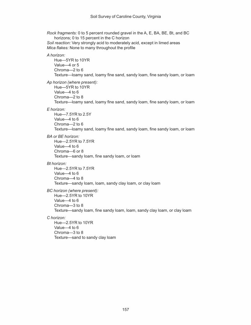
Soil Survey of Caroline County, Virginia
157
Rock fragments: 0 to 5 percent rounded gravel in the A, E, BA, BE, Bt, and BChorizons; 0 to 15 percent in the C horizon
Soil reaction: Very strongly acid to moderately acid, except in limed areasMica flakes: None to many throughout the profile
A horizon:Hue—5YR to 10YRValue—4 or 5Chroma—2 to 6Texture—loamy sand, loamy fine sand, sandy loam, fine sandy loam, or loam
Ap horizon (where present):Hue—5YR to 10YRValue—4 to 6Chroma—2 to 8Texture—loamy sand, loamy fine sand, sandy loam, fine sandy loam, or loam
E horizon:Hue—7.5YR to 2.5YValue—4 to 6Chroma—2 to 6Texture—loamy sand, loamy fine sand, sandy loam, fine sandy loam, or loam
BA or BE horizon:Hue—2.5YR to 7.5YRValue—4 to 6Chroma—6 or 8Texture—sandy loam, fine sandy loam, or loam
Bt horizon:Hue—2.5YR to 7.5YRValue—4 to 6Chroma—4 to 8Texture—sandy loam, loam, sandy clay loam, or clay loam
BC horizon (where present):Hue—2.5YR to 10YRValue—4 to 6Chroma—3 to 8Texture—sandy loam, fine sandy loam, loam, sandy clay loam, or clay loam
C horizon:Hue—2.5YR to 10YRValue—4 to 6Chroma—3 to 8Texture—sand to sandy clay loam

159
This section describes the factors of soil formation and relates them to the soils inthe survey area. It also explains the major processes of soil horizon development.
Factors of Soil FormationSoils are intimate mixtures of broken and partly or completely weathered rock,
minerals, organic matter, living plants and animals, water, and air. They occur as partof the natural landscape and differ from place to place. They differ in occurrence, indegree of development of various horizons, in mineral content, in depth over bedrock,and in texture, color, and slope. The characteristics of the soils in any given areadepend upon the interaction of the five factors of soil formation, which are parentmaterial, climate, living organisms, topography, and time. Topography over timemodifies the effect of climate and living organisms on parent material (Jenny, 1941).
Parent Material
Parent material is the unconsolidated material in which a soil forms. It is largelyresponsible for the chemical and mineral composition of soils. The three broadclasses of parent material in Caroline County are residual, fluviomarine, and alluvialmaterials.
Residual parent material has weathered in place from the underlying bedrock andforms the basis for the soils of the Piedmont. Fluviomarine material is transportedmaterial that has been reworked by stream and marine action and forms the basis forthe soils of the Coastal Plain. Alluvium is material transported by water and depositedas unconsolidated deposits of sand, silt, and clay and large fragments of rock. It formsthe basis for soils on terraces and bottomlands of both the Piedmont Plateau andCoastal Plain.
Residual material is generally west of the fall line in Caroline County. This materialformed primarily from granite and gneiss. These rocks weather into parent materialthat is commonly low in bases and strongly acid. Properties of the residual parentmaterial are directly related to the characteristics of the underlying bedrock. Appling,Cecil, and Wateree soils formed in residuum.
Fluviomarine material is along and east of the fall line in Caroline County. It consistsof tranported and reworked sands, silts, and clays that are gravelly to extremelygravelly in places. The material is layered, and texture changes abruptly in manyplaces in vertical or horizontal directions. Soil formed from fluviomarine material iscommonly strongly acid or very strongly acid and low in bases. The texture of the soilreflects the textures of the layers from which it was formed. Kempsville, Nevarc,Remlik, Slagle, and Suffolk soils formed in fluviomarine material.
Alluvial parent material is of local origin along the smaller streams anddrainageways and is of both local and general origin along the Rappahanock River.The material is on flood plains and terraces. The alluvium has a mixed lithologybecause of the wide variety of igneous and metamorphic rocks and fluviomarinedeposits found in the uplands. Total thickness of the alluvium ranges from several feetalong the drainageways and small streams to several tens of feet along the
Formation of the Soils
Soil Survey of Caroline County, Virginia
160
Rappahanock River. Alluvium along the drainageways and small streams is commonlymedium to coarse textured. Along the Rappahanock River, texture varies widely,ranging from fine textured slackwater deposits to coarse textured sand and graveldeposits. The soils that formed in alluvium are moderate in bases and are moderatelyacid to strongly acid. Chewacla, Riverview, Bibb, Chastain, and Wehadkee soilsformed in recent alluvium on flood plains. Wickham and Altavista soils formed inancient alluvium on terraces.
Topography
Topography, or relief, affects the formation of soils by influencing the rate ofinfiltration, the rate of surface runoff, soil drainage, geologic erosion, and soiltemperature. It can alter the effects of other soil-forming factors to the extent thatseveral different kinds of soil can form from the same parent material. Differences intopography can cause the same parent material to weather at different rates, thusaffecting the impact of plants and animals on soil formation.
Caroline County is in an area of rolling topography, moderately incised by the majordrainage patterns. A wide area of river terrace is present along the lower part of theRappahanock River. Elevations in the area range from 15 feet along the RappahanockRiver to about 350 feet in the western part of the city. Generally, the land surfaceslopes gently to the southeast, at an average rate of 20 feet to the mile.
Caroline County is drained by a number of short streams that empty into theRappahanock River. The drainage pattern is, in general, dendritic, but it is irregularlybranched. The general fluvial cycle is in a stage of late youth or early maturity.
The county generally consists of gently sloping to steep, intermediate to broadridges and rises with slopes ranging from 0 to 15 percent. The gently sloping areashave a medium rate of runoff and a good rate of water infiltration. Soils in these areasinclude Appling, Cecil, and Kempsville. The steep areas, where slopes range from 15to 50 percent, commonly have rapid rates of runoff and a poor rate of water infiltration.The steeper soils, such as Wateree, have thinner subsoils than the less sloping soils.
Soils on terraces range from well drained to poorly drained and commonly are onslopes of 0 to 6 percent. Drainage is commonly related to both the texture of thealluvium and its position on the landscape. Thus, soils that developed from finetextured slackwater deposits in low positions are often poorly drained. Roanoke andTomotley soils are examples. Deposits of fine materials on the gently sloping high riverterraces are typically moderately well drained or well drained. Wickham and Altavistasoils are examples. Layers of contrasting materials in the alluvium cause fluctuatingwater tables and often result in moderately well drained or somewhat poorly drainedsoils. Slagle and Altavista soils are examples.
Climate
Climate affects the physical, chemical, and biological relationships in soils, primarilythrough the influence of precipitation and temperature. Water dissolves minerals,supports biological activity, and transports mineral and organic residue through thesolum. Temperature determines the type of physical, chemical, and biological activitythat takes place and the rate at which it occurs.
Caroline County has the rather humid, temperate climate typical of most coastal ornear-coastal areas of the Middle Atlantic States. The average annual rainfall is about43 inches, and the average air temperature is between 50 and 60 degrees F. Rainfallis well distributed throughout the year, but normally July and August are the monthswith the highest amount of rainfall.
The climate is fairly uniform throughout the county, and there are no significantdifferences in elevation. Thus, there are no obstructions to the movement of winds,

Soil Survey of Caroline County, Virginia
161
clouds, and rainstorms. Masses of air generally move through the county from thenorthwest, but they are warmed by air that moves in periodically from the south andsouthwest.
Because precipitation exceeds evapotranspiration, this humid, rather uniformclimate has caused the soils to be strongly leached. Most of the soluble material thateither was originally present or was released through weathering has been removed.Therefore, most of the soils are strongly acid and generally are low in plant nutrients.
Precipitation is mainly responsible for the subsoil that characterizes most soils inthe county. In addition to leaching soluble material, water that percolates through thesoil moves clay from the surface layer to a subsoil layer. Except for soils that formed inrecent alluvium or sand, soils in the county have a subsoil that contains more clay thanthe surface layer.
Also influenced by climate is the formation of blocky structure in the subsoil of welldeveloped soils. The development of peds (aggregates) in the subsoil is caused bychanges in volume of the soil mass. These changes are primarily the result ofalternating wet and dry periods and of alternating freezing and thawing periods.
Weathering of minerals is at a rate proportional to temperature and amount ofmoisture. Soil weathers more rapidly in tropical regions than in temperate regions andhumid regions. In Caroline County, the soils are relatively low in weatherable minerals.They contain no free carbonates and most of the bases have been leached out.However, because many of the soils that formed in transported parent material hadpreviously undergone one or more cycles of erosion, these materials may have beenhighly weathered and leached at the time they were deposited.
Living Organisms
Plants and animals are the main source of organic matter in soils. Organic matterdecomposes and is incorporated into the soil by the action of microorganisms andearthworms and, to a lesser degree, by windthrown trees and burrowing animals.
Before settlement by humans, the native vegetation of the survey area was mostimportant in the complex of living organisms that affected soil development. The firstsettlers found a dense forest that consisted mainly of hardwoods. Oaks weredominant in most parts of the area. Yellow-poplar, sweetgum, blackgum, holly, hickory,maple, dogwood, loblolly pine, and Virginia pine were also important, but there wereprobably few pure stands of pine before the area was settled. The fairly pure stands ofpine that exist today are generally in areas that were once cleared and cultivated.
Most hardwoods use large amounts of calcium as well as other bases if they areavailable. Soils that are normally high in bases remain so under a cover of deciduoustrees because, in large part, these bases are returned to the soil each year. When theleaves fall and decompose, the bases reenter the soil and are again used by plants.
The soils in Caroline County, however, have never been very high in bases;consequently, they are acid even under a cover of hardwoods. Soils that are stronglyacid and low in fertility are better suited to pines than to most hardwoods. Pines do notrequire large amounts of calcium and other bases. Their needles do little to restorefertility to the soil.
As agriculture and urban growth developed in the survey area, humans became animportant factor in the development of the soils. The clearing of forests, cultivation insome areas, introduction of new kinds of crops and other plants, and improvements indrainage affected development of the soils and will continue to affect theirdevelopment in the future.
The most important changes brought about by humans include mixing of the upperhorizons of the soil to form a plow layer; tilling sloping soils, which resulted inaccelerated erosion; and liming and fertilizing that changed the content of plantnutrients, especially in the upper horizons.
Soil Survey of Caroline County, Virginia
162
Time
Time is needed for changes to take place in the parent material. Because of othersoil-forming factors, however, soils that formed in the same type of parent materialand for the same amount of time may be equally developed. Runoff and erosion,which hinder the development of well expressed soil horizons, are greater on thesteeper slopes. Thus, soils on the steeper slopes generally are less developed thansoils on the less steep slopes even though they formed in the same parent material.For example, the moderately deep Wateree soils on moderately steep and steep sideslopes are less developed than the very deep Cecil soils on gently sloping summitsand shoulders.
Soils that form in weather-resistant parent material do not develop as rapidly assoils that form in parent material that is less resistant to weathering. Soils on floodplains, such as Chewacla and Riverview soils, commonly have weakly defined layersbecause they are subject to the constant deposition of sediment.
Processes of Soil Horizon DifferentiationSeveral processes are involved in the formation of soil horizons. Among these are
the accumulation of organic matter, the leaching of soluble salts, the reduction andtransfer of iron, and the translocation of clay minerals. These processes occurcontinually and simultaneously. They have been taking place for thousands of years.
Organic matter accumulates as plant and animal material decomposes. It darkensthe surface layer and helps to form the A horizon. Once organic matter is lost, itnormally takes a long time to replace. The content of organic matter in the surfacelayer of the soils in Caroline County averages about 1.5 percent.
Soils that have distinct subsoil horizons were leached of some of the lime andsoluble salts before the clay minerals moved downward. Some of the factors thataffect this leaching are the kinds of salts originally present, the depth to which the soilsolution percolates, and the texture of the soil profile.
In Caroline County, well drained and moderately well drained soils have a red toyellowish brown subsoil. These colors are caused mainly by thin coatings of iron oxideon sand and silt grains, but in some soils the colors are inherited from the materials inwhich the soils formed. The structure in these soils is weak to strong subangularblocky, and the subsoil contains more clay than the surface layer.
The reduction and transfer of iron, called gleying, is associated mainly with wet,poorly drained soils. Moderately well drained and somewhat poorly drained soils havered, yellowish red, and yellowish brown iron and manganese accumulations and grayiron and manganese depletions. This indicates the segregation of iron or manganese,or both, due to a fluctuating water table. In poorly drained soils, such as Roanokesoils, the subsoil and underlying material are gray. This indicates the reduction andtransfer of iron or manganese, or both, in solution.
The translocation of clay minerals is an important process in the development ofmany soils in the survey area. As clay minerals are removed from the A horizon, theyaccumulate as clay films on the faces of peds, in pores, and in root channels in the Bhorizon.

163
American Association of State Highway and Transportation Officials (AASHTO).2004. Standard specifications for transportation materials and methods ofsampling and testing. 24th edition.
American Society for Testing and Materials (ASTM). 2005. Standardclassification of soils for engineering purposes. ASTM Standard D2487-00.
Caroline County, Virginia Website. Available at http://www.co.caroline.va.us/
Cowardin, L.M., V. Carter, F.C. Golet, and E.T. LaRoe. 1979. Classification ofwetlands and deep-water habitats of the United States. U.S. Fish and WildlifeService FWS/OBS-79/31.
Federal Register. July 13, 1994. Changes in hydric soils of the United States.
Federal Register. September 18, 2002. Hydric soils of the United States.
Hurt, G.W., P.M. Whited, and R.F. Pringle, editors. 2002. Field indicators ofhydric soils in the United States. Version 5.0.
Jenny, Hans. 1941. Factors of soil formation.
National Research Council. 1995. Wetlands: Characteristics and boundaries.
Tiner, R.W., Jr. 1985. Wetlands of Delaware. U.S. Fish and Wildlife Service andDelaware Department of Natural Resources and Environmental Control,Wetlands Section.
United States Army Corps of Engineers, Environmental Laboratory. 1987. Corpsof Engineers wetlands delineation manual. Waterways Experiment StationTechnical Report Y-87-1.
United States Department of Agriculture, National Agricultural Statistics Service.2002. County summary highlights. (Available athttp://www.nass.usda.gov/Census_of_Agriculture/)
United States Department of Agriculture, Natural Resources ConservationService. National forestry manual. (Available at http://soils.usda.gov/technical/)
United States Department of Agriculture, Natural Resources ConservationService. National soil survey handbook, title 430-VI. (Available athttp://soils.usda.gov/technical/)
References

Soil Survey of Caroline County, Virginia
164
United States Department of Agriculture, Natural Resources ConservationService. 1999. Soil taxonomy: A basic system of soil classification for makingand interpreting soil surveys. Soil Survey Staff. 2nd edition. U.S. Department ofAgriculture Handbook 436.
United States Department of Agriculture, Natural Resources ConservationService. 2002. Field book for describing and sampling soils. P.J.Schoeneberger, D.A. Wysocki, E.C. Benham, and W.D. Broderson, editors.Version 2.0.
United States Department of Agriculture, Natural Resources ConservationService. 2003. Keys to soil taxonomy. Soil Survey Staff. 9th edition.
United States Department of Agriculture, Soil Conservation Service. 1961. Landcapability classification. U.S. Department of Agriculture Handbook 210.
United States Department of Agriculture, Soil Conservation Service. 1993. Soilsurvey manual. Soil Survey Staff. U.S. Department of Agriculture Handbook 18.(Available at http://soils.usda.gov/technical/)
United States Department of Commerce, Census Bureau. 2000. Census 2000summary file 1. (Available at http://factfinder.census.gov)
Vepraskas, Michael J. 1992. Redoximorphic features for identifying aquicconditions. North Carolina State University, North Carolina AgriculturalResearch Service. Bulletin 301.
Virginia Polytechnic Institute and State University. 1994. VALUES—VirginiaAgronomic Land Use Evaluation System. In Soil Test Recommendations forVirginia (S.D. Donohue, editor). Virginia Cooperative Extension.
165
Many of the terms relating to landforms, geology, and geomorphology are defined inmore detail in the “National Soil Survey Handbook” (available in local offices of theNatural Resources Conservation Service or on the Internet).
ABC soil. A soil having an A, a B, and a C horizon.AC soil. A soil having only an A and a C horizon. Commonly, such soil formed in
recent alluvium or on steep, rocky slopes.Aeration, soil. The exchange of air in soil with air from the atmosphere. The air in a
well aerated soil is similar to that in the atmosphere; the air in a poorly aerated soilis considerably higher in carbon dioxide and lower in oxygen.
Aggregate, soil. Many fine particles held in a single mass or cluster. Natural soilaggregates, such as granules, blocks, or prisms, are called peds. Clods areaggregates produced by tillage or logging.
Alluvium. Unconsolidated material, such as gravel, sand, silt, clay, and variousmixtures of these, deposited on land by running water.
Alpha,alpha-dipyridyl. A compound that when dissolved in ammonium acetate isused to detect the presence of reduced iron (Fe II) in the soil. A positive reactionimplies reducing conditions and the likely presence of redoximorphic features.
Animal unit month (AUM). The amount of forage required by one mature cow ofapproximately 1,000 pounds weight, with or without a calf, for 1 month.
Aquic conditions. Current soil wetness characterized by saturation, reduction, andredoximorphic features.
Argillic horizon. A subsoil horizon characterized by an accumulation of illuvial clay.Aspect. The direction toward which a slope faces. Also called slope aspect.Association, soil. A group of soils or miscellaneous areas geographically associated
in a characteristic repeating pattern and defined and delineated as a single mapunit.
Available water capacity (available moisture capacity). The capacity of soils to holdwater available for use by most plants. It is commonly defined as the differencebetween the amount of soil water at field moisture capacity and the amount atwilting point. It is commonly expressed as inches of water per inch of soil. Thecapacity, in inches, in a 60-inch profile or to a limiting layer is expressed as:
Very low .............................................................. 0 to 3Low ...................................................................... 3 to 6Moderate ............................................................. 6 to 9High ................................................................... 9 to 12Very high ................................................ more than 12
Backslope. The position that forms the steepest and generally linear, middle portionof a hillslope. In profile, backslopes are commonly bounded by a convex shoulderabove and a concave footslope below.
Backswamp. A flood-plain landform. Extensive, marshy or swampy, depressed areasof flood plains between natural levees and valley sides or terraces.
Basal area. The area of a cross section of a tree, generally referring to the section at
Glossary
Soil Survey of Caroline County, Virginia
166
breast height and measured outside the bark. It is a measure of stand density,commonly expressed in square feet.
Base saturation. The degree to which material having cation-exchange properties issaturated with exchangeable bases (sum of Ca, Mg, Na, and K), expressed as apercentage of the total cation-exchange capacity.
Base slope (geomorphology). A geomorphic component of hills consisting of theconcave to linear (perpendicular to the contour) slope that, regardless of thelateral shape, forms an apron or wedge at the bottom of a hillside dominated bycolluvium and slope-wash sediments (for example, slope alluvium).
Bedding system. A drainage system made by plowing, grading, or otherwise shapingthe surface of a flat field. It consists of a series of low ridges separated by shallow,parallel dead furrows.
Bedrock. The solid rock that underlies the soil and other unconsolidated material orthat is exposed at the surface.
Bench terrace. A raised, level or nearly level strip of earth constructed on or nearly ona contour, supported by a barrier of rocks or similar material, and designed tomake the soil suitable for tillage and to prevent accelerated erosion.
Bisequum. Two sequences of soil horizons, each of which consists of an illuvialhorizon and the overlying eluvial horizons.
Bottom land. An informal term loosely applied to various portions of a flood plain.Breaks. A landscape or tract of steep, rough or broken land dissected by ravines and
gullies and marking a sudden change in topography.Breast height. An average height of 4.5 feet above the ground surface; the point on a
tree where diameter measurements are ordinarily taken.Brush management. Use of mechanical, chemical, or biological methods to make
conditions favorable for reseeding or to reduce or eliminate competition fromwoody vegetation and thus allow understory grasses and forbs to recover. Brushmanagement increases forage production and thus reduces the hazard of erosion.It can improve the habitat for some species of wildlife.
Canopy. The leafy crown of trees or shrubs. (See Crown.)Capillary water. Water held as a film around soil particles and in tiny spaces between
particles. Surface tension is the adhesive force that holds capillary water in thesoil.
Catena. A sequence, or “chain,” of soils on a landscape that formed in similar kinds ofparent material and under similar climatic conditions but that have differentcharacteristics as a result of differences in relief and drainage.
Cation. An ion carrying a positive charge of electricity. The common soil cations arecalcium, potassium, magnesium, sodium, and hydrogen.
Cation-exchange capacity. The total amount of exchangeable cations that can beheld by the soil, expressed in terms of milliequivalents per 100 grams of soil atneutrality (pH 7.0) or at some other stated pH value. The term, as applied to soils,is synonymous with base-exchange capacity but is more precise in meaning.
Chemical treatment. Control of unwanted vegetation through the use of chemicals.Chiseling. Tillage with an implement having one or more soil-penetrating points that
shatter or loosen hard, compacted layers to a depth below normal plow depth.Clay. As a soil separate, the mineral soil particles less than 0.002 millimeter in
diameter. As a soil textural class, soil material that is 40 percent or more clay, lessthan 45 percent sand, and less than 40 percent silt.
Clay depletions. See Redoximorphic features.Clay film. A thin coating of oriented clay on the surface of a soil aggregate or lining
pores or root channels. Synonyms: clay coating, clay skin.Claypan. A dense, compact, slowly permeable subsoil layer that contains much more
clay than the overlying materials, from which it is separated by a sharply definedboundary. A claypan is commonly hard when dry and plastic and sticky when wet.

Soil Survey of Caroline County, Virginia
167
Climax plant community. The stabilized plant community on a particular site. Theplant cover reproduces itself and does not change so long as the environmentremains the same.
Concretions. See Redoximorphic features.Coarse textured soil. Sand or loamy sand.Cobble (or cobblestone). A rounded or partly rounded fragment of rock 3 to 10
inches (7.6 to 25 centimeters) in diameter.Cobbly soil material. Material that has 15 to 35 percent, by volume, rounded or
partially rounded rock fragments 3 to 10 inches (7.6 to 25 centimeters) indiameter. Very cobbly soil material has 35 to 60 percent of these rock fragments,and extremely cobbly soil material has more than 60 percent.
COLE (coefficient of linear extensibility). See Linear extensibility.Colluvium. Unconsolidated, unsorted earth material being transported or deposited
on side slopes and/or at the base of slopes by mass movement (e.g., directgravitational action) and by local, unconcentrated runoff.
Complex slope. Irregular or variable slope. Planning or establishing terraces,diversions, and other water-control structures on a complex slope is difficult.
Complex, soil. A map unit of two or more kinds of soil or miscellaneous areas in suchan intricate pattern or so small in area that it is not practical to map themseparately at the selected scale of mapping. The pattern and proportion of thesoils or miscellaneous areas are somewhat similar in all areas.
Concretions. Cemented bodies with crude internal symmetry organized around apoint, a line, or a plane. They typically take the form of concentric layers visible tothe naked eye. Calcium carbonate, iron oxide, and manganese oxide are commoncompounds making up concretions. If formed in place, concretions of iron oxide ormanganese oxide are generally considered a type of redoximorphic concentration.
Conservation cropping system. Growing crops in combination with needed culturaland management practices. In a good conservation cropping system, the soil-improving crops and practices more than offset the effects of the soil-depletingcrops and practices. Cropping systems are needed on all tilled soils. Soil-improving practices in a conservation cropping system include the use of rotationsthat contain grasses and legumes and the return of crop residue to the soil. Otherpractices include the use of green manure crops of grasses and legumes, propertillage, adequate fertilization, and weed and pest control.
Conservation tillage. A tillage system that does not invert the soil and that leaves aprotective amount of crop residue on the surface throughout the year.
Consistence, soil. Refers to the degree of cohesion and adhesion of soil material andits resistance to deformation when ruptured. Consistence includes resistance ofsoil material to rupture and to penetration; plasticity, toughness, and stickiness ofpuddled soil material; and the manner in which the soil material behaves whensubject to compression. Terms describing consistence are defined in the “SoilSurvey Manual.”
Contour stripcropping. Growing crops in strips that follow the contour. Strips ofgrass or close-growing crops are alternated with strips of clean-tilled crops orsummer fallow.
Control section. The part of the soil on which classification is based. The thicknessvaries among different kinds of soil, but for many it is that part of the soil profilebetween depths of 10 inches and 40 or 80 inches.
Corrosion (geomorphology). A process of erosion whereby rocks and soil areremoved or worn away by natural chemical processes, especially by the solventaction of running water, but also by other reactions, such as hydrolysis, hydration,carbonation, and oxidation.
Corrosion (soil survey interpretations). Soil-induced electrochemical or chemicalaction that dissolves or weakens concrete or uncoated steel.
Soil Survey of Caroline County, Virginia
168
Cover crop. A close-growing crop grown primarily to improve and protect the soilbetween periods of regular crop production, or a crop grown between trees andvines in orchards and vineyards.
Crop residue management. Returning crop residue to the soil, which helps tomaintain soil structure, organic matter content, and fertility and helps to controlerosion.
Cropping system. Growing crops according to a planned system of rotation andmanagement practices.
Cross-slope farming. Deliberately conducting farming operations on sloping farmlandin such a way that tillage is across the general slope.
Crown. The upper part of a tree or shrub, including the living branches and theirfoliage.
Crusts, soil. Relatively thin, somewhat continuous layers of the soil surface that oftenrestrict water movement, air entry, and seedling emergence from the soil. Theygenerally are less than 2 inches thick and are massive.
Culmination of the mean annual increment (CMAI). The average annual increaseper acre in the volume of a stand. Computed by dividing the total volume of thestand by its age. As the stand increases in age, the mean annual incrementcontinues to increase until mortality begins to reduce the rate of increase. Thepoint where the stand reaches its maximum annual rate of growth is called theculmination of the mean annual increment.
Cutbanks cave (in tables). The walls of excavations tend to cave in or slough.Decreasers. The most heavily grazed climax range plants. Because they are the most
palatable, they are the first to be destroyed by overgrazing.Deferred grazing. Postponing grazing or resting grazing land for a prescribed period.Dense layer (in tables). A very firm, massive layer that has a bulk density of more than
1.8 grams per cubic centimeter. Such a layer affects the ease of digging and canaffect filling and compacting.
Depth, soil. Generally, the thickness of the soil over bedrock. Very deep soils aremore than 60 inches deep over bedrock; deep soils, 40 to 60 inches; moderatelydeep, 20 to 40 inches; shallow, 10 to 20 inches; and very shallow, less than 10inches.
Diversion (or diversion terrace). A ridge of earth, generally a terrace, built to protectdownslope areas by diverting runoff from its natural course.
Divided-slope farming. A form of field stripcropping in which crops are grown in asystematic arrangement of two strips, or bands, across the slope to reduce thehazard of water erosion. One strip is in a close-growing crop that providesprotection from erosion, and the other strip is in a crop that provides lessprotection from erosion. This practice is used where slopes are not long enough topermit a full stripcropping pattern to be used.
Drainage class (natural). Refers to the frequency and duration of wet periods underconditions similar to those under which the soil formed. Alterations of the waterregime by human activities, either through drainage or irrigation, are not aconsideration unless they have significantly changed the morphology of the soil.Seven classes of natural soil drainage are recognized—excessively drained,somewhat excessively drained, well drained, moderately well drained, somewhatpoorly drained, poorly drained, and very poorly drained. These classes are definedin the “Soil Survey Manual.”
Drainage, surface. Runoff, or surface flow of water, from an area.Drainageway. A general term for a course or channel along which water moves in
draining an area. A term restricted to relatively small, linear depressions that atsome time move concentrated water and either do not have a defined channel orhave only a small defined channel.
Draw. A small stream valley that generally is shallower and more open than a ravine or

Soil Survey of Caroline County, Virginia
169
gulch and that has a broader bottom. The present stream channel may appearinadequate to have cut the drainageway that it occupies.
Ecological site. An area where climate, soil, and relief are sufficiently uniform toproduce a distinct natural plant community. An ecological site is the product of allthe environmental factors responsible for its development. It is typified by anassociation of species that differ from those on other ecological sites in kindand/or proportion of species or in total production.
Eluviation. The movement of material in true solution or colloidal suspension fromone place to another within the soil. Soil horizons that have lost material througheluviation are eluvial; those that have received material are illuvial.
Endosaturation. A type of saturation of the soil in which all horizons between theupper boundary of saturation and a depth of 2 meters are saturated.
Ephemeral stream. A stream, or reach of a stream, that flows only in direct responseto precipitation. It receives no long-continued supply from melting snow or othersource, and its channel is above the water table at all times.
Episaturation. A type of saturation indicating a perched water table in a soil in whichsaturated layers are underlain by one or more unsaturated layers within 2 metersof the surface.
Erosion. The wearing away of the land surface by water, wind, ice, or other geologicagents and by such processes as gravitational creep.Erosion (geologic). Erosion caused by geologic processes acting over longgeologic periods and resulting in the wearing away of mountains and the buildingup of such landscape features as flood plains and coastal plains. Synonym:natural erosion.Erosion (accelerated). Erosion much more rapid than geologic erosion, mainly asa result of human or animal activities or of a catastrophe in nature, such as a fire,that exposes the surface.
Erosion pavement. A surficial lag concentration or layer of gravel and other rockfragments that remains on the soil surface after sheet or rill erosion or wind hasremoved the finer soil particles and that tends to protect the underlying soil fromfurther erosion.
Erosion surface. A land surface shaped by the action of erosion, especially byrunning water.
Escarpment. A relatively continuous and steep slope or cliff breaking the generalcontinuity of more gently sloping land surfaces and resulting from erosion orfaulting. Most commonly applied to cliffs produced by differential erosion.Synonym: scarp.
Fallow. Cropland left idle in order to restore productivity through accumulation ofmoisture. Summer fallow is common in regions of limited rainfall where cerealgrain is grown. The soil is tilled for at least one growing season for weed controland decomposition of plant residue.
Fertility, soil. The quality that enables a soil to provide plant nutrients, in adequateamounts and in proper balance, for the growth of specified plants when light,moisture, temperature, tilth, and other growth factors are favorable.
Fibric soil material (peat). The least decomposed of all organic soil material. Peatcontains a large amount of well preserved fiber that is readily identifiableaccording to botanical origin. Peat has the lowest bulk density and the highestwater content at saturation of all organic soil material.
Field moisture capacity. The moisture content of a soil, expressed as a percentageof the ovendry weight, after the gravitational, or free, water has drained away; thefield moisture content 2 or 3 days after a soaking rain; also called normal fieldcapacity, normal moisture capacity, or capillary capacity.
Fill slope. A sloping surface consisting of excavated soil material from a road cut. Itcommonly is on the downhill side of the road.
Soil Survey of Caroline County, Virginia
170
Fine textured soil. Sandy clay, silty clay, or clay.Firebreak. An area cleared of flammable material to stop or help control creeping or
running fires. It also serves as a line from which to work and to facilitate themovement of firefighters and equipment. Designated roads also serve asfirebreaks.
First bottom. An obsolete, informal term loosely applied to the lowest flood-plainsteps that are subject to regular flooding.
Flooding frequency class. The number of times flooding occurs over a period oftime. The classes of flooding are defined as follows:None.—There is no reasonable possibility of flooding; there is a near 0 percentchance of flooding in any year or flooding occurs less than 1 time in 500 years.Very rare.—Flooding is very unlikely but possible under extremely unusualweather conditions; there is less than 1 percent chance of flooding in any year orflooding occurs less than 1 time in 100 years but at least 1 time in 500 years.Rare.—Flooding is unlikely but possible under unusual weather conditions; thereis a 1 to 5 percent chance of flooding in any year or flooding occurs nearly 1 to 5times in 100 years.Occasional.—Flooding is expected infrequently under usual weather conditions;there is a 5 to 50 percent chance of flooding in any year or flooding occurs morethan 5 to 50 times in 100 years.Frequent.—Flooding is likely to occur often under usual weather conditions; thereis a more than a 50 percent chance of flooding in any year or flooding occurs morethan 50 times in 100 years, but there is a less than a 50 percent chance offlooding in all months in any year.Very frequent.—Flooding is likely to occur very often under usual weatherconditions; there is a more than a 50 percent chance of flooding in all months ofany year.
Flood plain. The nearly level plain that borders a stream and is subject to floodingunless protected artificially.
Flood-plain landforms. A variety of constructional and erosional features producedby stream channel migration and flooding. Examples include backswamps, flood-plain splays, meanders, meander belts, meander scrolls, oxbow lakes, and naturallevees.
Flood-plain splay. A fan-shaped deposit or other outspread deposit formed where anoverloaded stream breaks through a levee (natural or artificial) and deposits itsmaterial (commonly coarse grained) on the flood plain.
Flood-plain step. An essentially flat, terrace-like alluvial surface within a valley that isfrequently covered by floodwater from the present stream; any approximatelyhorizontal surface still actively modified by fluvial scour and/or deposition. Mayoccur individually or as a series of steps.
Fluvial. Of or pertaining to rivers or streams; produced by stream or river action.Footslope. The concave surface at the base of a hillslope. A footslope is a transition
zone between upslope sites of erosion and transport (shoulders and backslopes)and downslope sites of deposition (toeslopes).
Forb. Any herbaceous plant not a grass or a sedge.Forest cover. All trees and other woody plants (underbrush) covering the ground in a
forest.Forest type. A stand of trees similar in composition and development because of
given physical and biological factors by which it may be differentiated from otherstands.
Fragipan. A loamy, brittle subsurface horizon low in porosity and content of organicmatter and low or moderate in clay but high in silt or very fine sand. A fragipanappears cemented and restricts roots. When dry, it is hard or very hard and has a
Soil Survey of Caroline County, Virginia
171
higher bulk density than the horizon or horizons above. When moist, it tends torupture suddenly under pressure rather than to deform slowly.
Genesis, soil. The mode of origin of the soil. Refers especially to the processes orsoil-forming factors responsible for the formation of the solum, or true soil, fromthe unconsolidated parent material.
Gleyed soil. Soil that formed under poor drainage, resulting in the reduction of ironand other elements in the profile and in gray colors.
Graded stripcropping. Growing crops in strips that grade toward a protectedwaterway.
Grassed waterway. A natural or constructed waterway, typically broad and shallow,seeded to grass as protection against erosion. Conducts surface water away fromcropland.
Gravel. Rounded or angular fragments of rock as much as 3 inches (2 millimeters to7.6 centimeters) in diameter. An individual piece is a pebble.
Gravelly soil material. Material that has 15 to 35 percent, by volume, rounded orangular rock fragments, not prominently flattened, as much as 3 inches (7.6centimeters) in diameter.
Green manure crop (agronomy). A soil-improving crop grown to be plowed under inan early stage of maturity or soon after maturity.
Ground water. Water filling all the unblocked pores of the material below the watertable.
Gully. A small channel with steep sides caused by erosion and cut in unconsolidatedmaterials by concentrated but intermittent flow of water. The distinction between agully and a rill is one of depth. A gully generally is an obstacle to farm machineryand is too deep to be obliterated by ordinary tillage; a rill is of lesser depth and canbe smoothed over by ordinary tillage.
Hard bedrock. Bedrock that cannot be excavated except by blasting or by the use ofspecial equipment that is not commonly used in construction.
Hard to reclaim (in tables). Reclamation is difficult after the removal of soil forconstruction and other uses. Revegetation and erosion control are extremelydifficult.
Hardpan. A hardened or cemented soil horizon, or layer. The soil material is sandy,loamy, or clayey and is cemented by iron oxide, silica, calcium carbonate, or othersubstance.
Head slope (geomorphology). A geomorphic component of hills consisting of alaterally concave area of a hillside, especially at the head of a drainageway. Theoverland waterflow is converging.
Hemic soil material (mucky peat). Organic soil material intermediate in degree ofdecomposition between the less decomposed fibric material and the moredecomposed sapric material.
High-residue crops. Such crops as small grain and corn used for grain. If properlymanaged, residue from these crops can be used to control erosion until the nextcrop in the rotation is established. These crops return large amounts of organicmatter to the soil.
Hill. A generic term for an elevated area of the land surface, rising as much as 1,000feet above surrounding lowlands, commonly of limited summit area and having awell defined outline. Slopes are generally more than 15 percent. The distinctionbetween a hill and a mountain is arbitrary and may depend on local usage.
Hillslope. A generic term for the steeper part of a hill between its summit and thedrainage line, valley flat, or depression floor at the base of a hill.
Horizon, soil. A layer of soil, approximately parallel to the surface, having distinctcharacteristics produced by soil-forming processes. In the identification of soilhorizons, an uppercase letter represents the major horizons. Numbers orlowercase letters that follow represent subdivisions of the major horizons. An
Soil Survey of Caroline County, Virginia
172
explanation of the subdivisions is given in the “Soil Survey Manual.” The majorhorizons of mineral soil are as follows:O horizon.—An organic layer of fresh and decaying plant residue.A horizon.—The mineral horizon at or near the surface in which an accumulationof humified organic matter is mixed with the mineral material. Also, a plowedsurface horizon, most of which was originally part of a B horizon.E horizon.—The mineral horizon in which the main feature is loss of silicate clay,iron, aluminum, or some combination of these.B horizon.—The mineral horizon below an A horizon. The B horizon is in part alayer of transition from the overlying A to the underlying C horizon. The B horizonalso has distinctive characteristics, such as (1) accumulation of clay,sesquioxides, humus, or a combination of these; (2) prismatic or blocky structure;(3) redder or browner colors than those in the A horizon; or (4) a combination ofthese.C horizon.—The mineral horizon or layer, excluding indurated bedrock, that is littleaffected by soil-forming processes and does not have the properties typical of theoverlying soil material. The material of a C horizon may be either like or unlike thatin which the solum formed. If the material is known to differ from that in the solum,an Arabic numeral, commonly a 2, precedes the letter C.Cr horizon.—Soft, consolidated bedrock beneath the soil.R layer.—Consolidated bedrock beneath the soil. The bedrock commonlyunderlies a C horizon, but it can be directly below an A or a B horizon.
Humus. The well decomposed, more or less stable part of the organic matter inmineral soils.
Hydrologic soil groups. Refers to soils grouped according to their runoff potential.The soil properties that influence this potential are those that affect the minimumrate of water infiltration on a bare soil during periods after prolonged wetting whenthe soil is not frozen. These properties are depth to a seasonal high water table,the infiltration rate and permeability after prolonged wetting, and depth to a veryslowly permeable layer. The slope and the kind of plant cover are not consideredbut are separate factors in predicting runoff.
Igneous rock. Rock that was formed by cooling and solidification of magma and thathas not been changed appreciably by weathering since its formation. Majorvarieties include plutonic and volcanic rock (e.g., andesite, basalt, and granite).
Illuviation. The movement of soil material from one horizon to another in the soilprofile. Generally, material is removed from an upper horizon and deposited in alower horizon.
Impervious soil. A soil through which water, air, or roots penetrate slowly or not at all.No soil is absolutely impervious to air and water all the time.
Increasers. Species in the climax vegetation that increase in amount as the moredesirable plants are reduced by close grazing. Increasers commonly are theshorter plants and the less palatable to livestock.
Infiltration. The downward entry of water into the immediate surface of soil or othermaterial, as contrasted with percolation, which is movement of water through soillayers or material.
Infiltration capacity. The maximum rate at which water can infiltrate into a soil undera given set of conditions.
Infiltration rate. The rate at which water penetrates the surface of the soil at anygiven instant, usually expressed in inches per hour. The rate can be limited by theinfiltration capacity of the soil or the rate at which water is applied at the surface.
Intake rate. The average rate of water entering the soil under irrigation. Most soilshave a fast initial rate; the rate decreases with application time. Therefore, intakerate for design purposes is not a constant but is a variable depending on the net

Soil Survey of Caroline County, Virginia
173
irrigation application. The rate of water intake, in inches per hour, is expressed asfollows:
Less than 0.2 ................................................. very low0.2 to 0.4 ................................................................ low0.4 to 0.75 ........................................... moderately low0.75 to 1.25 .................................................. moderate1.25 to 1.75 ....................................... moderately high1.75 to 2.5 ............................................................. highMore than 2.5 ............................................... very high
Interfluve. A landform composed of the relatively undissected upland or ridgebetween two adjacent valleys containing streams flowing in the same generaldirection. An elevated area between two drainageways that sheds water to thosedrainageways.
Interfluve (geomorphology). A geomorphic component of hills consisting of theuppermost, comparatively level or gently sloping area of a hill; shoulders ofbackwearing hillslopes can narrow the upland or can merge, resulting in a stronglyconvex shape.
Intermittent stream. A stream, or reach of a stream, that does not flow year-round butthat is commonly dry for 3 or more months out of 12 and whose channel isgenerally below the local water table. It flows only during wet periods or when itreceives ground-water discharge or long, continued contributions from meltingsnow or other surface and shallow subsurface sources.
Invaders. On range, plants that encroach into an area and grow after the climaxvegetation has been reduced by grazing. Generally, plants invade followingdisturbance of the surface.
Iron depletions. See Redoximorphic features.Irrigation. Application of water to soils to assist in production of crops. Methods of
irrigation are:Basin.—Water is applied rapidly to nearly level plains surrounded by levees ordikes.Border.—Water is applied at the upper end of a strip in which the lateral flow ofwater is controlled by small earth ridges called border dikes, or borders.Controlled flooding.—Water is released at intervals from closely spaced fieldditches and distributed uniformly over the field.Corrugation.—Water is applied to small, closely spaced furrows or ditches in fieldsof close-growing crops or in orchards so that it flows in only one direction.Drip (or trickle).—Water is applied slowly and under low pressure to the surface ofthe soil or into the soil through such applicators as emitters, porous tubing, orperforated pipe.Furrow.—Water is applied in small ditches made by cultivation implements.Furrows are used for tree and row crops.Sprinkler.—Water is sprayed over the soil surface through pipes or nozzles from apressure system.Subirrigation.—Water is applied in open ditches or tile lines until the water table israised enough to wet the soil.Wild flooding.—Water, released at high points, is allowed to flow onto an areawithout controlled distribution.
Knoll. A small, low, rounded hill rising above adjacent landforms.Ksat. Saturated hydraulic conductivity. (See Permeability.)Landslide. A general, encompassing term for most types of mass movement
landforms and processes involving the downslope transport and outwarddeposition of soil and rock materials caused by gravitational forces; the movement

Soil Survey of Caroline County, Virginia
174
may or may not involve saturated materials. The speed and distance ofmovement, as well as the amount of soil and rock material, vary greatly.
Large stones (in tables). Rock fragments 3 inches (7.6 centimeters) or more across.Large stones adversely affect the specified use of the soil.
Leaching. The removal of soluble material from soil or other material by percolatingwater.
Linear extensibility. Refers to the change in length of an unconfined clod as moisturecontent is decreased from a moist to a dry state. Linear extensibility is used todetermine the shrink-swell potential of soils. It is an expression of the volumechange between the water content of the clod at 1/3- or 1/10-bar tension (33kPa or10kPa tension) and oven dryness. Volume change is influenced by the amountand type of clay minerals in the soil. The volume change is the percent change forthe whole soil. If it is expressed as a fraction, the resulting value is COLE,coefficient of linear extensibility.
Liquid limit. The moisture content at which the soil passes from a plastic to a liquidstate.
Loam. Soil material that is 7 to 27 percent clay particles, 28 to 50 percent silt particles,and less than 52 percent sand particles.
Low strength. The soil is not strong enough to support loads.Low-residue crops. Such crops as corn used for silage, peas, beans, and potatoes.
Residue from these crops is not adequate to control erosion until the next crop inthe rotation is established. These crops return little organic matter to the soil.
Mass movement. A generic term for the dislodgment and downslope transport of soiland rock material as a unit under direct gravitational stress.
Masses. See Redoximorphic features.Meander belt. The zone within which migration of a meandering channel occurs; the
flood-plain area included between two imaginary lines drawn tangential to theouter bends of active channel loops.
Meander scar. A crescent-shaped, concave or linear mark on the face of a bluff orvalley wall, produced by the lateral erosion of a meandering stream that impingedupon and undercut the bluff.
Meander scroll. One of a series of long, parallel, close-fitting, crescent-shaped ridgesand troughs formed along the inner bank of a stream meander as the channelmigrated laterally down-valley and toward the outer bank.
Mechanical treatment. Use of mechanical equipment for seeding, brushmanagement, and other management practices.
Medium textured soil. Very fine sandy loam, loam, silt loam, or silt.Metamorphic rock. Rock of any origin altered in mineralogical composition, chemical
composition, or structure by heat, pressure, and movement at depth in the earth’scrust. Nearly all such rocks are crystalline.
Mine spoil. An accumulation of displaced earthy material, rock, or other wastematerial removed during mining or excavation. Also called earthy fill.
Mineral soil. Soil that is mainly mineral material and low in organic material. Its bulkdensity is more than that of organic soil.
Minimum tillage. Only the tillage essential to crop production and prevention of soildamage.
Miscellaneous area. A kind of map unit that has little or no natural soil and supportslittle or no vegetation.
Moderately coarse textured soil. Coarse sandy loam, sandy loam, or fine sandyloam.
Moderately fine textured soil. Clay loam, sandy clay loam, or silty clay loam.Mollic epipedon. A thick, dark, humus-rich surface horizon (or horizons) that has high
base saturation and pedogenic soil structure. It may include the upper part of thesubsoil.
Soil Survey of Caroline County, Virginia
175
Morphology, soil. The physical makeup of the soil, including the texture, structure,porosity, consistence, color, and other physical, mineral, and biological propertiesof the various horizons, and the thickness and arrangement of those horizons inthe soil profile.
Mottling, soil. Irregular spots of different colors that vary in number and size.Descriptive terms are as follows: abundance—few, common, and many; size—fine, medium, and coarse; and contrast—faint, distinct, and prominent. The sizemeasurements are of the diameter along the greatest dimension. Fine indicatesless than 5 millimeters (about 0.2 inch); medium, from 5 to 15 millimeters (about0.2 to 0.6 inch); and coarse, more than 15 millimeters (about 0.6 inch).
Mountain. A generic term for an elevated area of the land surface, rising more than1,000 feet (300 meters) above surrounding lowlands, commonly of restrictedsummit area (relative to a plateau) and generally having steep sides. A mountaincan occur as a single, isolated mass or in a group forming a chain or range.Mountains are formed primarily by tectonic activity and/or volcanic action but canalso be formed by differential erosion.
Mudstone. A blocky or massive, fine-grained sedimentary rock in which theproportions of clay and silt are approximately equal. Also, a general term for suchmaterial as clay, silt, claystone, siltstone, shale, and argillite and that should beused only when the amounts of clay and silt are not known or cannot be preciselyidentified.
Munsell notation. A designation of color by degrees of three simple variables—hue,value, and chroma. For example, a notation of 10YR 6/4 is a color with hue of10YR, value of 6, and chroma of 4.
Neutral soil. A soil having a pH value of 6.6 to 7.3. (See Reaction, soil.)Nodules. See Redoximorphic features.Nose slope (geomorphology). A geomorphic component of hills consisting of the
projecting end (laterally convex area) of a hillside. The overland waterflow ispredominantly divergent. Nose slopes consist dominantly of colluvium and slope-wash sediments (for example, slope alluvium).
Nutrient, plant. Any element taken in by a plant essential to its growth. Plant nutrientsare mainly nitrogen, phosphorus, potassium, calcium, magnesium, sulfur, iron,manganese, copper, boron, and zinc obtained from the soil and carbon, hydrogen,and oxygen obtained from the air and water.
n-value. The relationship between the percentage of water under field conditions andthe percentages of inorganic clay and of humus.
Organic matter. Plant and animal residue in the soil in various stages ofdecomposition. The content of organic matter in the surface layer is described asfollows:
Very low .................................... less than 0.5 percentLow .................................................. 0.5 to 1.0 percentModerately low ............................... 1.0 to 2.0 percentModerate ......................................... 2.0 to 4.0 percentHigh ................................................. 4.0 to 8.0 percentVery high ................................. more than 8.0 percent
Paleoterrace. An erosional remnant of a terrace that retains the surface form andalluvial deposits of its origin but was not emplaced by, and commonly does notgrade to, a present-day stream or drainage network.
Pan. A compact, dense layer in a soil that impedes the movement of water and thegrowth of roots. For example, hardpan, fragipan, claypan, plowpan, and traffic pan.
Parent material. The unconsolidated organic and mineral material in which soil forms.Peat. Unconsolidated material, largely undecomposed organic matter, that has
accumulated under excess moisture. (See Fibric soil material.)
Soil Survey of Caroline County, Virginia
176
Ped. An individual natural soil aggregate, such as a granule, a prism, or a block.Pedisediment. A layer of sediment, eroded from the shoulder and backslope of an
erosional slope, that lies on and is being (or was) transported across a gentlysloping erosional surface at the foot of a receding hill or mountain slope.
Pedon. The smallest volume that can be called “a soil.” A pedon is three dimensionaland large enough to permit study of all horizons. Its area ranges from about 10 to100 square feet (1 square meter to 10 square meters), depending on thevariability of the soil.
Percolation. The movement of water through the soil.Permeability. The quality of the soil that enables water or air to move downward
through the profile. The rate at which a saturated soil transmits water is acceptedas a measure of this quality. In soil physics, the rate is referred to as “saturatedhydraulic conductivity,” which is defined in the “Soil Survey Manual.” In line withconventional usage in the engineering profession and with traditional usage inpublished soil surveys, this rate of flow continues to be expressed as“permeability.” Terms describing permeability, measured in inches per hour, are asfollows:
Impermeable ............................. less than 0.0015 inchVery slow...................................... 0.0015 to 0.06 inchSlow ................................................... 0.06 to 0.2 inchModerately slow ................................... 0.2 to 0.6 inchModerate .................................. 0.6 inch to 2.0 inchesModerately rapid .............................. 2.0 to 6.0 inchesRapid ................................................. 6.0 to 20 inchesVery rapid ................................... more than 20 inches
pH value. A numerical designation of acidity and alkalinity in soil. (See Reaction, soil.)Phase, soil. A subdivision of a soil series based on features that affect its use and
management, such as slope, stoniness, and flooding.Piping (in tables). Formation of subsurface tunnels or pipelike cavities by water
moving through the soil.Pitting (in tables). Pits caused by melting around ice. They form on the soil after plant
cover is removed.Plastic limit. The moisture content at which a soil changes from semisolid to plastic.Plasticity index. The numerical difference between the liquid limit and the plastic
limit; the range of moisture content within which the soil remains plastic.Plateau (geomorphology). A comparatively flat area of great extent and elevation;
specifically, an extensive land region that is considerably elevated (more than 100meters) above the adjacent lower-lying terrain, is commonly limited on at least oneside by an abrupt descent, and has a flat or nearly level surface. A comparativelylarge part of a plateau surface is near summit level.
Plowpan. A compacted layer formed in the soil directly below the plowed layer.Ponding. Standing water on soils in closed depressions. Unless the soils are
artificially drained, the water can be removed only by percolation orevapotranspiration.
Poorly graded. Refers to a coarse-grained soil or soil material consisting mainly ofparticles of nearly the same size. Because there is little difference in size of theparticles, density can be increased only slightly by compaction.
Pore linings. See Redoximorphic features.Potential native plant community. See Climax plant community.Potential rooting depth (effective rooting depth). Depth to which roots could
penetrate if the content of moisture in the soil were adequate. The soil has noproperties restricting the penetration of roots to this depth.
Prescribed burning. Deliberately burning an area for specific management purposes,
Soil Survey of Caroline County, Virginia
177
under the appropriate conditions of weather and soil moisture and at the propertime of day.
Productivity, soil. The capability of a soil for producing a specified plant or sequenceof plants under specific management.
Profile, soil. A vertical section of the soil extending through all its horizons and intothe parent material.
Proper grazing use. Grazing at an intensity that maintains enough cover to protectthe soil and maintain or improve the quantity and quality of the desirablevegetation. This practice increases the vigor and reproduction capacity of the keyplants and promotes the accumulation of litter and mulch necessary to conservesoil and water.
Rangeland. Land on which the potential natural vegetation is predominantly grasses,grasslike plants, forbs, or shrubs suitable for grazing or browsing. It includesnatural grasslands, savannas, many wetlands, some deserts, tundras, and areasthat support certain forb and shrub communities.
Reaction, soil. A measure of acidity or alkalinity of a soil, expressed as pH values. Asoil that tests to pH 7.0 is described as precisely neutral in reaction because it isneither acid nor alkaline. The degrees of acidity or alkalinity, expressed as pHvalues, are:
Ultra acid ................................................. less than 3.5Extremely acid ............................................. 3.5 to 4.4Very strongly acid ........................................ 4.5 to 5.0Strongly acid ................................................ 5.1 to 5.5Moderately acid ........................................... 5.6 to 6.0Slightly acid ................................................. 6.1 to 6.5Neutral ......................................................... 6.6 to 7.3Slightly alkaline ............................................ 7.4 to 7.8Moderately alkaline ..................................... 7.9 to 8.4Strongly alkaline .......................................... 8.5 to 9.0Very strongly alkaline .......................... 9.1 and higher
Red beds. Sedimentary strata that are mainly red and are made up largely ofsandstone and shale.
Redoximorphic concentrations. See Redoximorphic features.Redoximorphic depletions. See Redoximorphic features.Redoximorphic features. Redoximorphic features are associated with wetness and
result from alternating periods of reduction and oxidation of iron and manganesecompounds in the soil. Reduction occurs during saturation with water, andoxidation occurs when the soil is not saturated. Characteristic color patterns arecreated by these processes. The reduced iron and manganese ions may beremoved from a soil if vertical or lateral fluxes of water occur, in which case thereis no iron or manganese precipitation in that soil. Wherever the iron andmanganese are oxidized and precipitated, they form either soft masses or hardconcretions or nodules. Movement of iron and manganese as a result ofredoximorphic processes in a soil may result in redoximorphic features that aredefined as follows:1. Redoximorphic concentrations.—These are zones of apparent accumulation of
iron-manganese oxides, including:A. Nodules and concretions, which are cemented bodies that can be removed
from the soil intact. Concretions are distinguished from nodules on the basis ofinternal organization. A concretion typically has concentric layers that are visibleto the naked eye. Nodules do not have visible organized internal structure; and
B. Masses, which are noncemented concentrations of substances within thesoil matrix; and
Soil Survey of Caroline County, Virginia
178
C. Pore linings, i.e., zones of accumulation along pores that may be eithercoatings on pore surfaces or impregnations from the matrix adjacent to thepores.
2. Redoximorphic depletions.—These are zones of low chroma (chromas lessthan those in the matrix) where either iron-manganese oxides alone or bothiron-manganese oxides and clay have been stripped out, including:
A. Iron depletions, i.e., zones that contain low amounts of iron andmanganese oxides but have a clay content similar to that of the adjacentmatrix; and
B. Clay depletions, i.e., zones that contain low amounts of iron, manganese,and clay (often referred to as silt coatings or skeletans).
3. Reduced matrix.—This is a soil matrix that has low chroma in situ butundergoes a change in hue or chroma within 30 minutes after the soil materialhas been exposed to air.
Reduced matrix. See Redoximorphic features.Regolith. All unconsolidated earth materials above the solid bedrock. It includes
material weathered in place from all kinds of bedrock and alluvial, glacial, eolian,lacustrine, and pyroclastic deposits.
Relief. The relative difference in elevation between the upland summits and thelowlands or valleys of a given region.
Residuum (residual soil material). Unconsolidated, weathered or partly weatheredmineral material that accumulated as bedrock disintegrated in place.
Rill. A very small, steep-sided channel resulting from erosion and cut inunconsolidated materials by concentrated but intermittent flow of water. A rillgenerally is not an obstacle to wheeled vehicles and is shallow enough to besmoothed over by ordinary tillage.
Riser. The vertical or steep side slope (e.g., escarpment) of terraces, flood-plainsteps, or other stepped landforms; commonly a recurring part of a series ofnatural, steplike landforms, such as successive stream terraces.
Road cut. A sloping surface produced by mechanical means during road construction.It is commonly on the uphill side of the road.
Rock fragments. Rock or mineral fragments having a diameter of 2 millimeters ormore; for example, pebbles, cobbles, stones, and boulders.
Root zone. The part of the soil that can be penetrated by plant roots.Runoff. The precipitation discharged into stream channels from an area. The water
that flows off the surface of the land without sinking into the soil is called surfacerunoff. Water that enters the soil before reaching surface streams is calledground-water runoff or seepage flow from ground water.
Sand. As a soil separate, individual rock or mineral fragments from 0.05 millimeter to2.0 millimeters in diameter. Most sand grains consist of quartz. As a soil texturalclass, a soil that is 85 percent or more sand and not more than 10 percent clay.
Sandstone. Sedimentary rock containing dominantly sand-sized particles.Saturated hydraulic conductivity (Ksat). The amount of water that would move
vertically through a unit area of saturated soil in unit time under unit hydraulicgradient. Terms describing saturated hydraulic conductivity, measured in inchesper hour (micrometers per second), are as follows:
Very low ........................ 0.0 to 0.001417 (0.0 to 0.01)Low ....................... 0.001417 to 0.01417 (0.01 to 0.1)Moderately low ........... 0.01417 to 0.1417 (0.1 to 1.0)Moderately high ............... 0.1417 to 1.417 (1.0 to 10)High ..................................... 1.417 to 14.7 (10 to 100)Very high ................. more than 14.7 (more than 100)
Saturation. Wetness characterized by zero or positive pressure of the soil water.
Soil Survey of Caroline County, Virginia
179
Under conditions of saturation, the water will flow from the soil matrix into anunlined auger hole.
Scarification. The act of abrading, scratching, loosening, crushing, or modifying thesurface to increase water absorption or to provide a more tillable soil.
Sedimentary rock. A consolidated deposit of clastic particles, chemical precipitates,or organic remains accumulated at or near the surface of the earth under normallow temperature and pressure conditions. Sedimentary rocks include consolidatedequivalents of alluvium, colluvium, drift, and eolian, lacustrine, and marinedeposits. Examples are sandstone, siltstone, mudstone, claystone, shale,conglomerate, limestone, dolomite, and coal.
Sequum. A sequence consisting of an illuvial horizon and the overlying eluvial horizon.(See Eluviation.)
Series, soil. A group of soils that have profiles that are almost alike. All the soils of aseries have horizons that are similar in composition, thickness, and arrangement.
Shale. Sedimentary rock that formed by the hardening of a deposit of clay, silty clay, orsilty clay loam and that has a tendency to split into thin layers.
Sheet erosion. The removal of a fairly uniform layer of soil material from the landsurface by the action of rainfall and surface runoff.
Shoulder. The convex, erosional surface near the top of a hillslope. A shoulder is atransition from summit to backslope.
Shrink-swell (in tables). The shrinking of soil when dry and the swelling when wet.Shrinking and swelling can damage roads, dams, building foundations, and otherstructures. It can also damage plant roots.
Side slope (geomorphology). A geomorphic component of hills consisting of alaterally planar area of a hillside. The overland waterflow is predominantly parallel.Side slopes are dominantly colluvium and slope-wash sediments.
Silica. A combination of silicon and oxygen. The mineral form is called quartz.Silica-sesquioxide ratio. The ratio of the number of molecules of silica to the number
of molecules of alumina and iron oxide. The more highly weathered soils or theirclay fractions in warm-temperate, humid regions, and especially those in thetropics, generally have a low ratio.
Silt. As a soil separate, individual mineral particles that range in diameter from theupper limit of clay (0.002 millimeter) to the lower limit of very fine sand (0.05millimeter). As a soil textural class, soil that is 80 percent or more silt and lessthan 12 percent clay.
Siltstone. An indurated silt having the texture and composition of shale but lacking itsfine lamination or fissility; a massive mudstone in which silt predominates overclay.
Similar soils. Soils that share limits of diagnostic criteria, behave and perform in asimilar manner, and have similar conservation needs or managementrequirements for the major land uses in the survey area.
Sinkhole. A closed, circular or elliptical depression, commonly funnel shaped,characterized by subsurface drainage and formed either by dissolution of thesurface of underlying bedrock (e.g., limestone, gypsum, or salt) or by collapse ofunderlying caves within bedrock. Complexes of sinkholes in carbonate-rock terrainare the main components of karst topography.
Site index. A designation of the quality of a forest site based on the height of thedominant stand at an arbitrarily chosen age. For example, if the average heightattained by dominant and codominant trees in a fully stocked stand at the age of50 years is 75 feet, the site index is 75.
Slickensides (pedogenic). Grooved, striated, and/or glossy (shiny) slip faces onstructural peds, such as wedges; produced by shrink-swell processes, mostcommonly in soils that have a high content of expansive clays.
Slope. The inclination of the land surface from the horizontal. Percentage of slope is
Soil Survey of Caroline County, Virginia
180
the vertical distance divided by horizontal distance, then multiplied by 100. Thus, aslope of 20 percent is a drop of 20 feet in 100 feet of horizontal distance. In thissurvey, classes for slopes are as follows:
Nearly level ........................................... 0 to 2 percentGently sloping ....................................... 2 to 6 percentStrongly sloping .................................. 6 to 10 percentModerately steep .............................. 10 to 15 percentSteep ................................................. 15 to 25 percentVery steep ................................ 25 percent and higher
Slope alluvium. Sediment gradually transported down the slopes of mountains or hillsprimarily by nonchannel alluvial processes (i.e., slope-wash processes) andcharacterized by particle sorting. Lateral particle sorting is evident on long slopes.In a profile sequence, sediments may be distinguished by differences in sizeand/or specific gravity of rock fragments and may be separated by stone lines.Burnished peds and sorting of rounded or subrounded pebbles or cobblesdistinguish these materials from unsorted colluvial deposits.
Slow refill (in tables). The slow filling of ponds, resulting from restricted permeabilityin the soil.
Sodium adsorption ratio (SAR). A measure of the amount of sodium (Na) relative tocalcium (Ca) and magnesium (Mg) in the water extract from saturated soil paste.It is the ratio of the Na concentration divided by the square root of one-half of theCa + Mg concentration.
Soft bedrock. Bedrock that can be excavated with trenching machines, backhoes,small rippers, and other equipment commonly used in construction.
Soil. A natural, three-dimensional body at the earth’s surface. It is capable ofsupporting plants and has properties resulting from the integrated effect of climateand living matter acting on earthy parent material, as conditioned by relief and bythe passage of time.
Soil separates. Mineral particles less than 2 millimeters in equivalent diameter andranging between specified size limits. The names and sizes, in millimeters, ofseparates recognized in the United States are as follows:
Very coarse sand ......................................... 2.0 to 1.0Coarse sand ................................................ 1.0 to 0.5Medium sand ............................................. 0.5 to 0.25Fine sand ................................................. 0.25 to 0.10Very fine sand .......................................... 0.10 to 0.05Silt .......................................................... 0.05 to 0.002Clay ..................................................... less than 0.002
Solum. The upper part of a soil profile, above the C horizon, in which the processes ofsoil formation are active. The solum in soil consists of the A, E, and B horizons.Generally, the characteristics of the material in these horizons are unlike those ofthe material below the solum. The living roots and plant and animal activities arelargely confined to the solum.
Stone line. In a vertical cross section, a line formed by scattered fragments or adiscrete layer of angular and subangular rock fragments (commonly a gravel- orcobble-sized lag concentration) that formerly was draped across a topographicsurface and was later buried by additional sediments. A stone line generally capsmaterial that was subject to weathering, soil formation, and erosion before burial.Many stone lines seem to be buried erosion pavements, originally formed by sheetand rill erosion across the land surface.
Stones. Rock fragments 10 to 24 inches (25 to 60 centimeters) in diameter if roundedor 15 to 24 inches (38 to 60 centimeters) in length if flat.
Soil Survey of Caroline County, Virginia
181
Stony. Refers to a soil containing stones in numbers that interfere with or preventtillage.
Stream terrace. One of a series of platforms in a stream valley, flanking and more orless parallel to the stream channel, originally formed near the level of the stream;represents the remnants of an abandoned flood plain, stream bed, or valley floorproduced during a former state of fluvial erosion or deposition.
Stripcropping. Growing crops in a systematic arrangement of strips or bands thatprovide vegetative barriers to wind erosion and water erosion.
Structure, soil. The arrangement of primary soil particles into compound particles oraggregates. The principal forms of soil structure are—platy (laminated), prismatic(vertical axis of aggregates longer than horizontal), columnar (prisms with roundedtops), blocky (angular or subangular), and granular. Structureless soils are eithersingle grained (each grain by itself, as in dune sand) or massive (the particlesadhering without any regular cleavage, as in many hardpans).
Stubble mulch. Stubble or other crop residue left on the soil or partly worked into thesoil. It protects the soil from wind erosion and water erosion after harvest, duringpreparation of a seedbed for the next crop, and during the early growing period ofthe new crop.
Subsoil. Technically, the B horizon; roughly, the part of the solum below plow depth.Subsoiling. Tilling a soil below normal plow depth, ordinarily to shatter a hardpan or
claypan.Substratum. The part of the soil below the solum.Subsurface layer. Any surface soil horizon (A, E, AB, or EB) below the surface layer.Summer fallow. The tillage of uncropped land during the summer to control weeds
and allow storage of moisture in the soil for the growth of a later crop. A practicecommon in semiarid regions, where annual precipitation is not enough to producea crop every year. Summer fallow is frequently practiced before planting wintergrain.
Summit. The topographically highest position of a hillslope. It has a nearly level(planar or only slightly convex) surface.
Surface layer. The soil ordinarily moved in tillage, or its equivalent in uncultivated soil,ranging in depth from 4 to 10 inches (10 to 25 centimeters). Frequently designatedas the “plow layer,” or the “Ap horizon.”
Surface soil. The A, E, AB, and EB horizons, considered collectively. It includes allsubdivisions of these horizons.
Taxadjuncts. Soils that cannot be classified in a series recognized in the classificationsystem. Such soils are named for a series they strongly resemble and aredesignated as taxadjuncts to that series because they differ in ways too small tobe of consequence in interpreting their use and behavior. Soils are recognized astaxadjuncts only when one or more of their characteristics are slightly outside therange defined for the family of the series for which the soils are named.
Terrace (conservation). An embankment, or ridge, constructed across sloping soils onthe contour or at a slight angle to the contour. The terrace intercepts surfacerunoff so that water soaks into the soil or flows slowly to a prepared outlet. Aterrace in a field generally is built so that the field can be farmed. A terraceintended mainly for drainage has a deep channel that is maintained in permanentsod.
Terrace (geomorphology). A steplike surface, bordering a valley floor or shoreline, thatrepresents the former position of a flood plain, lake, or seashore. The term isusually applied both to the relatively flat summit surface (tread) that was cut orbuilt by stream or wave action and to the steeper descending slope (scarp or riser)that has graded to a lower base level of erosion. A terrace can be subdivided asfollows:

Soil Survey of Caroline County, Virginia
182
Low stream terrace. A terrace that is susceptible to flooding.High stream terrace. A terrace that is not susceptible to flooding.
Terracettes. Small, irregular steplike forms on steep hillslopes, especially in pasture,formed by creep or erosion of surficial materials that may be induced or enhancedby trampling of livestock, such as sheep or cattle.
Texture, soil. The relative proportions of sand, silt, and clay particles in a mass of soil.The basic textural classes, in order of increasing proportion of fine particles, aresand, loamy sand, sandy loam, loam, silt loam, silt, sandy clay loam, clay loam,silty clay loam, sandy clay, silty clay, and clay. The sand, loamy sand, and sandyloam classes may be further divided by specifying “coarse,” “fine,” or “very fine.”
Thin layer (in tables). Otherwise suitable soil material that is too thin for the specifieduse.
Tilth, soil. The physical condition of the soil as related to tillage, seedbed preparation,seedling emergence, and root penetration.
Toeslope. The gently inclined surface at the base of a hillslope. Toeslopes in profileare commonly gentle and linear and are constructional surfaces forming the lowerpart of a hillslope continuum that grades to valley or closed-depression floors.
Topsoil. The upper part of the soil, which is the most favorable material for plantgrowth. It is ordinarily rich in organic matter and is used to topdress roadbanks,lawns, and land affected by mining.
Trace elements. Chemical elements, for example, zinc, cobalt, manganese, copper,and iron, in soils in extremely small amounts. They are essential to plant growth.
Tread. The flat to gently sloping, topmost, laterally extensive slope of terraces, flood-plain steps, or other stepped landforms; commonly a recurring part of a series ofnatural steplike landforms, such as successive stream terraces.
Upland. An informal, general term for the higher ground of a region, in contrast with alow-lying adjacent area, such as a valley or plain, or for land at a higher elevationthan the flood plain or low stream terrace; land above the footslope zone of thehillslope continuum.
Variegation. Refers to patterns of contrasting colors assumed to be inherited from theparent material rather than to be the result of poor drainage.
Water bars. Smooth, shallow ditches or depressional areas that are excavated at anangle across a sloping road. They are used to reduce the downward velocity ofwater and divert it off and away from the road surface. Water bars can easily bedriven over if constructed properly.
Weathering. All physical disintegration, chemical decomposition, and biologicallyinduced changes in rocks or other deposits at or near the earth’s surface byatmospheric or biologic agents or by circulating surface waters but involvingessentially no transport of the altered material.
Well graded. Refers to soil material consisting of coarse-grained particles that arewell distributed over a wide range in size or diameter. Such soil normally can beeasily increased in density and bearing properties by compaction. Contrasts withpoorly graded soil.
Wilting point (or permanent wilting point). The moisture content of soil, on anovendry basis, at which a plant (specifically a sunflower) wilts so much that it doesnot recover when placed in a humid, dark chamber.
Windthrow. The uprooting and tipping over of trees by the wind.

183
Tables
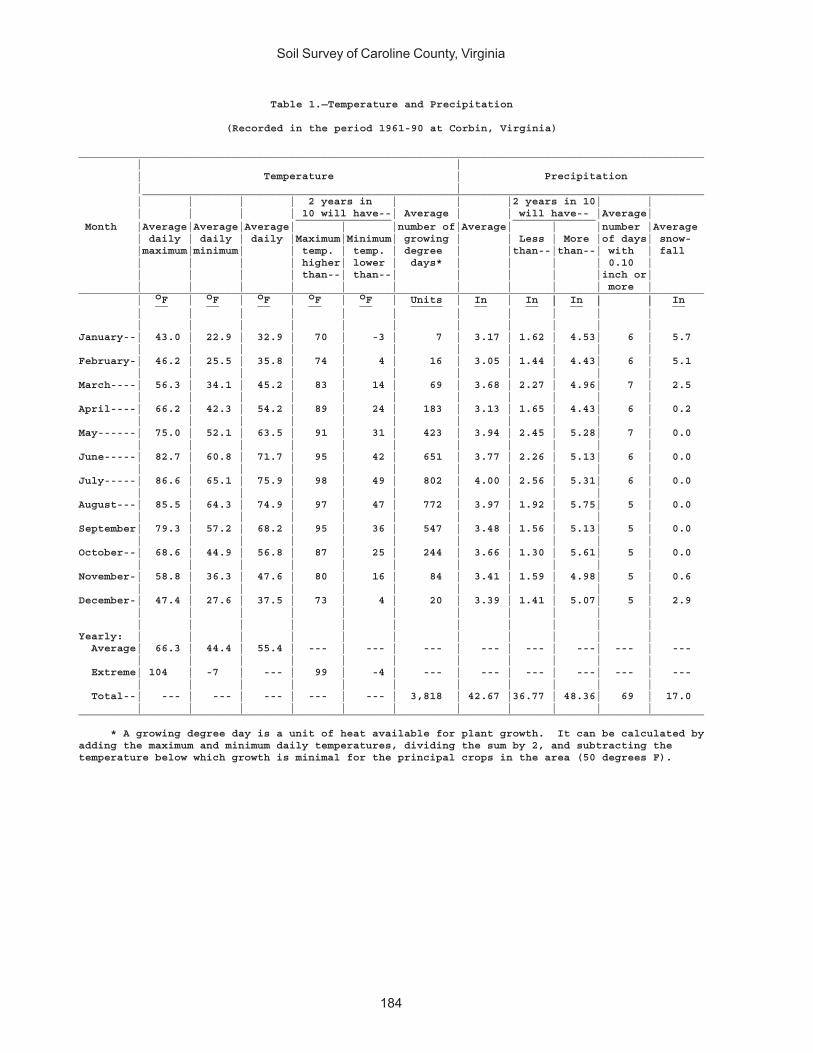
Soil Survey of Caroline County, Virginia
184
Table 1.—Temperature and Precipitation
(Recorded in the period 1961-90 at Corbin, Virginia)
__________________________________________________________________________________________________ | | | Temperature | Precipitation | | ________________________________________________________________________________________ | | | | 2 years in | | |2 years in 10| | | | | | 10 will have--| Average | | will have-- |Average| _______________ _____________ Month |Average|Average|Average| | |number of|Average| | |number |Average | daily | daily | daily |Maximum|Minimum| growing | | Less | More |of days| snow- |maximum|minimum| | temp. | temp. | degree | |than--|than--| with | fall | | | | higher| lower | days* | | | | 0.10 | | | | | than--| than--| | | | |inch or| | | | | | | | | | | more |__________________________________________________________________________________________________ | oF | oF | oF | oF | oF | Units | In | In | In | | In __ __ __ __ __ _____ __ __ | __ | | __ | | | | | | | | | | | | | | | | | | | | | |January--| 43.0 | 22.9 | 32.9 | 70 | -3 | 7 | 3.17 | 1.62 | 4.53| 6 | 5.7 | | | | | | | | | | |February-| 46.2 | 25.5 | 35.8 | 74 | 4 | 16 | 3.05 | 1.44 | 4.43| 6 | 5.1 | | | | | | | | | | |March----| 56.3 | 34.1 | 45.2 | 83 | 14 | 69 | 3.68 | 2.27 | 4.96| 7 | 2.5 | | | | | | | | | | |April----| 66.2 | 42.3 | 54.2 | 89 | 24 | 183 | 3.13 | 1.65 | 4.43| 6 | 0.2 | | | | | | | | | | |May------| 75.0 | 52.1 | 63.5 | 91 | 31 | 423 | 3.94 | 2.45 | 5.28| 7 | 0.0 | | | | | | | | | | |June-----| 82.7 | 60.8 | 71.7 | 95 | 42 | 651 | 3.77 | 2.26 | 5.13| 6 | 0.0 | | | | | | | | | | |July-----| 86.6 | 65.1 | 75.9 | 98 | 49 | 802 | 4.00 | 2.56 | 5.31| 6 | 0.0 | | | | | | | | | | |August---| 85.5 | 64.3 | 74.9 | 97 | 47 | 772 | 3.97 | 1.92 | 5.75| 5 | 0.0 | | | | | | | | | | |September| 79.3 | 57.2 | 68.2 | 95 | 36 | 547 | 3.48 | 1.56 | 5.13| 5 | 0.0 | | | | | | | | | | |October--| 68.6 | 44.9 | 56.8 | 87 | 25 | 244 | 3.66 | 1.30 | 5.61| 5 | 0.0 | | | | | | | | | | |November-| 58.8 | 36.3 | 47.6 | 80 | 16 | 84 | 3.41 | 1.59 | 4.98| 5 | 0.6 | | | | | | | | | | |December-| 47.4 | 27.6 | 37.5 | 73 | 4 | 20 | 3.39 | 1.41 | 5.07| 5 | 2.9 | | | | | | | | | | | | | | | | | | | | | |Yearly: | | | | | | | | | | | Average| 66.3 | 44.4 | 55.4 | --- | --- | --- | --- | --- | ---| --- | --- | | | | | | | | | | | Extreme| 104 | -7 | --- | 99 | -4 | --- | --- | --- | ---| --- | --- | | | | | | | | | | | Total--| --- | --- | --- | --- | --- | 3,818 | 42.67 |36.77 | 48.36| 69 | 17.0 | | | | | | | | | | |__________________________________________________________________________________________________
* A growing degree day is a unit of heat available for plant growth. It can be calculated byadding the maximum and minimum daily temperatures, dividing the sum by 2, and subtracting thetemperature below which growth is minimal for the principal crops in the area (50 degrees F).

Soil Survey of Caroline County, Virginia
185
Table 2.—Freeze Dates in Spring and Fall
(Recorded in the period 1961-90 at Corbin, Virginia)
____________________________________________________________ | | Temperature Probability | _________________________________________ | | | | 24 oF | 28 oF | 32 oF | or lower | or lower | or lower____________________________________________________________ | | |Last freezing | | | temperature | | | in spring: | | | | | | 1 year in 10 | | | later than-- | Apr. 7 | Apr. 21 | May 7 | | | 2 years in 10 | | | later than-- | Apr. 2 | Apr. 16 | May 2 | | | 5 years in 10 | | | later than-- | Mar. 24 | Apr. 7 | Apr. 23 | | |First freezing | | | temperature | | | in fall: | | | | | | 1 year in 10 | | | earlier than-- | Oct. 26 | Oct. 12 | Oct. 2 | | | 2 years in 10 | | | earlier than-- | Nov. 2 | Oct. 18 | Oct. 7 | | | 5 years in 10 | | | earlier than- | Nov. 14 | Oct. 31 | Oct. 17 | | |____________________________________________________________
Table 3.—Growing Season
(Recorded in the period 1961-90 at Corbin, Virginia)
____________________________________________________________ | Daily minimum temperature | during growing season __________________________________________ Probability | | | | Higher | Higher | Higher | than | than | than | 24 oF | 28 oF | 32 oF____________________________________________________________ | Days | Days | Days ____ ____ ____ | | |9 years in 10 | 209 | 179 | 155 | | |8 years in 10 | 218 | 188 | 162 | | |5 years in 10 | 234 | 206 | 176 | | |2 years in 10 | 251 | 223 | 190 | | |1 year in 10 | 260 | 233 | 197 | | |____________________________________________________________

Soil Survey of Caroline County, Virginia
186
Table 4.—Acreage and Proportionate Extent of the Soils_______________________________________________________________________________________________________ | | | Map | Soil name | Acres |Percentsymbol | | |_______________________________________________________________________________________________________ | | |1A |Altavista fine sandy loam, 0 to 2 percent slopes, very rarely flooded----| 7,733 | 2.21B |Altavista fine sandy loam, 2 to 6 percent slopes, very rarely flooded----| 8,488 | 2.52B |Appling sandy loam, 2 to 7 percent slopes--------------------------------| 5,078 | 1.52C |Appling sandy loam, 7 to 15 percent slopes-------------------------------| 6,107 | 1.83A |Bama sandy loam, 0 to 2 percent slopes-----------------------------------| 373 | 0.13B |Bama sandy loam, 2 to 6 percent slopes-----------------------------------| 2,073 | 0.64A |Bibb-Chastain complex, 0 to 2 percent slopes, frequently flooded---------| 12,466 | 3.65B |Bojac sandy loam, 0 to 6 percent slopes, very rarely flooded-------------| 6,282 | 1.86B |Cecil sandy loam, 2 to 7 percent slopes----------------------------------| 2,906 | 0.87A |Chastain loam, 0 to 2 percent slopes, ponded-----------------------------| 4,830 | 1.48A |Chewacla silt loam, 0 to 2 percent slopes, occasionally flooded----------| 4,553 | 1.39C |Helena-Appling complex, 2 to 15 percent slopes---------------------------| 2,947 | 0.910E |Kempsville-Emporia-Remlik complex, 15 to 50 percent slopes---------------| 63,374 | 18.411A |Kempsville-Emporia complex, 0 to 2 percent slopes------------------------| 3,757 | 1.111B |Kempsville-Emporia complex, 2 to 6 percent slopes------------------------| 74,462 | 21.611C |Kempsville-Emporia complex, 6 to 10 percent slopes-----------------------| 22,141 | 6.412A |Myatt-Slagle complex, 0 to 2 percent slopes------------------------------| 1,934 | 0.613E |Nevarc sandy loam, 15 to 50 percent slopes-------------------------------| 6,322 | 1.814 |Pits, gravel, 0 to 3 percent slopes--------------------------------------| 412 | 0.115A |Rappahannock muck, 0 to 1 percent slopes, frequently flooded-------------| 638 | 0.216B |Remlik loamy sand, 2 to 6 percent slopes---------------------------------| 347 | 0.116C |Remlik loamy sand, 6 to 15 percent slopes--------------------------------| 517 | 0.116E |Remlik loamy sand, 15 to 50 percent slopes-------------------------------| 1,426 | 0.417D |Rion sandy loam, 15 to 25 percent slopes---------------------------------| 1,157 | 0.318A |Riverview silt loam, 0 to 2 percent slopes, occasionally flooded---------| 799 | 0.219A |Roanoke loam, 0 to 2 percent slopes, ponded-----------------------------| 665 | 0.220B |Rumford loamy sand, 0 to 6 percent slopes--------------------------------| 2,443 | 0.720C |Rumford loamy sand, 6 to 10 percent slopes-------------------------------| 1,070 | 0.320D |Rumford loamy sand, 10 to 15 percent slopes------------------------------| 583 | 0.221C |Slagle-Kempsville complex, 2 to 15 percent slopes------------------------| 44,235 | 12.822A |Slagle fine sandy loam, 0 to 2 percent slopes----------------------------| 6,162 | 1.822B |Slagle fine sandy loam, 2 to 6 percent slopes----------------------------| 11,667 | 3.423A |State fine sandy loam, 0 to 2 percent slopes, very rarely flooded--------| 2,790 | 0.823B |State fine sandy loam, 2 to 6 percent slopes, very rarely flooded--------| 2,150 | 0.623C |State fine sandy loam, 6 to 10 percent slopes, very rarely flooded-------| 336 | *24A |Suffolk fine sandy loam, 0 to 2 percent slopes---------------------------| 329 | *24B |Suffolk fine sandy loam, 2 to 6 percent slopes---------------------------| 8,476 | 2.525B |Tarboro-Bojac complex, 0 to 6 percent slopes, very rarely flooded--------| 1,813 | 0.526A |Tomotley-Roanoke complex, 0 to 2 percent slopes, rarely flooded----------| 6,235 | 1.827C |Udorthents, loamy, 0 to 15 percent slopes--------------------------------| 1,593 | 0.528A |Wehadkee silt loam, 0 to 2 percent slopes, frequently flooded------------| 2,004 | 0.629A |Wickham fine sandy loam, 0 to 2 percent slopes, very rarely flooded------| 2,103 | 0.629B |Wickham fine sandy loam, 2 to 6 percent slopes, very rarely flooded------| 3,387 | 1.030E |Wateree-Rock outcrop complex, 25 to 70 percent slopes--------------------| 336 | *W |Water--------------------------------------------------------------------| 5,801 | 1.7 | |____________|________ | Total---------------------------------------------------------------| 345,300 | 100.0 | | |_______________________________________________________________________________________________________
* Less than 0.1 percent.
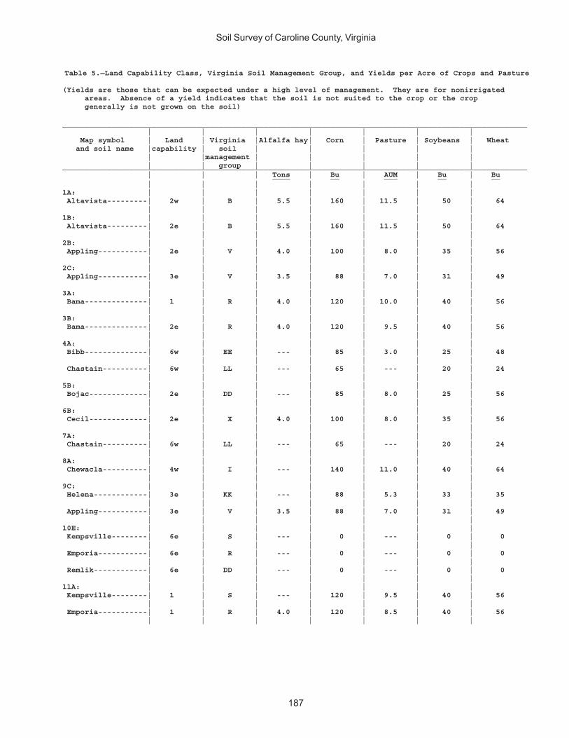
Soil Survey of Caroline County, Virginia
187
Table 5.—Land Capability Class, Virginia Soil Management Group, and Yields per Acre of Crops and Pasture
(Yields are those that can be expected under a high level of management. They are for nonirrigated areas. Absence of a yield indicates that the soil is not suited to the crop or the crop generally is not grown on the soil)
________________________________________________________________________________________________________ | | | | | | | Map symbol | Land | Virginia |Alfalfa hay| Corn | Pasture | Soybeans | Wheat and soil name |capability | soil | | | | | | |management | | | | | | | group | | | | |________________________________________________________________________________________________________ | | | Tons | Bu | AUM | Bu | Bu ____ __ ___ __ __ | | | | | | |1A: | | | | | | | Altavista---------| 2w | B | 5.5 | 160 | 11.5 | 50 | 64 | | | | | | |1B: | | | | | | | Altavista---------| 2e | B | 5.5 | 160 | 11.5 | 50 | 64 | | | | | | |2B: | | | | | | | Appling-----------| 2e | V | 4.0 | 100 | 8.0 | 35 | 56 | | | | | | |2C: | | | | | | | Appling-----------| 3e | V | 3.5 | 88 | 7.0 | 31 | 49 | | | | | | |3A: | | | | | | | Bama--------------| 1 | R | 4.0 | 120 | 10.0 | 40 | 56 | | | | | | |3B: | | | | | | | Bama--------------| 2e | R | 4.0 | 120 | 9.5 | 40 | 56 | | | | | | |4A: | | | | | | | Bibb--------------| 6w | EE | --- | 85 | 3.0 | 25 | 48 | | | | | | | Chastain----------| 6w | LL | --- | 65 | --- | 20 | 24 | | | | | | |5B: | | | | | | | Bojac-------------| 2e | DD | --- | 85 | 8.0 | 25 | 56 | | | | | | |6B: | | | | | | | Cecil-------------| 2e | X | 4.0 | 100 | 8.0 | 35 | 56 | | | | | | |7A: | | | | | | | Chastain----------| 6w | LL | --- | 65 | --- | 20 | 24 | | | | | | |8A: | | | | | | | Chewacla----------| 4w | I | --- | 140 | 11.0 | 40 | 64 | | | | | | |9C: | | | | | | | Helena------------| 3e | KK | --- | 88 | 5.3 | 33 | 35 | | | | | | | Appling-----------| 3e | V | 3.5 | 88 | 7.0 | 31 | 49 | | | | | | |10E: | | | | | | | Kempsville--------| 6e | S | --- | 0 | --- | 0 | 0 | | | | | | | Emporia-----------| 6e | R | --- | 0 | --- | 0 | 0 | | | | | | | Remlik------------| 6e | DD | --- | 0 | --- | 0 | 0 | | | | | | |11A: | | | | | | | Kempsville--------| 1 | S | --- | 120 | 9.5 | 40 | 56 | | | | | | | Emporia-----------| 1 | R | 4.0 | 120 | 8.5 | 40 | 56 | | | | | | |

Soil Survey of Caroline County, Virginia
188
Table 5.—Land Capability Class, Virginia Soil Management Group, andYields per Acre of Crops and Pasture—Continued
________________________________________________________________________________________________________ | | | | | | | Map symbol | Land | Virginia |Alfalfa hay| Corn | Pasture | Soybeans | Wheat and soil name |capability | soil | | | | | | |management | | | | | | | group | | | | |________________________________________________________________________________________________________ | | | Tons | Bu | AUM | Bu | Bu ____ __ ___ __ __ | | | | | | |11B: | | | | | | | Kempsville--------| 2e | S | --- | 120 | 9.5 | 40 | 56 | | | | | | | Emporia-----------| 2e | R | 4.0 | 120 | 8.5 | 40 | 56 | | | | | | |11C: | | | | | | | Kempsville--------| 3e | S | --- | 106 | 9.0 | 35 | 49 | | | | | | | Emporia-----------| 3e | R | 3.5 | 106 | 8.0 | 35 | 49 | | | | | | |12A: | | | | | | | Myatt-------------| 4w | OO | --- | 65 | 5.5 | 20 | 24 | | | | | | | Slagle------------| 2w | K | 4.0 | 130 | 8.0 | 40 | 64 | | | | | | |13E: | | | | | | | Nevarc------------| 6e | HH | --- | 0 | --- | 0 | 0 | | | | | | |14. | | | | | | | Pits, gravel | | | | | | | | | | | | | |15A: | | | | | | | Rappahannock------| 7w | PP | --- | 65 | --- | 20 | 24 | | | | | | |16B: | | | | | | | Remlik------------| 4s | DD | --- | 85 | 6.6 | 25 | 56 | | | | | | |16C: | | | | | | | Remlik------------| 4s | DD | --- | 75 | 6.6 | 22 | 49 | | | | | | |16E: | | | | | | | Remlik------------| 6e | DD | --- | 0 | --- | 0 | 0 | | | | | | |17D: | | | | | | | Rion--------------| 4e | X | 3.2 | 80 | 4.5 | 28 | 45 | | | | | | |18A: | | | | | | | Riverview---------| 1 | G | 5.5 | 140 | 10.0 | 40 | 64 | | | | | | |19A: | | | | | | | Roanoke-----------| 6w | NN | --- | --- | --- | --- | --- | | | | | | |20B: | | | | | | | Rumford-----------| 2e | DD | --- | 85 | 7.0 | 25 | 56 | | | | | | |20C: | | | | | | | Rumford-----------| 3e | DD | --- | 75 | 6.5 | 22 | 49 | | | | | | |20D: | | | | | | | Rumford-----------| 3e | DD | --- | 68 | 6.5 | 20 | 45 | | | | | | |21C: | | | | | | | Slagle------------| 3e | K | 3.5 | 114 | --- | 35 | 56 | | | | | | | Kempsville--------| 3e | S | --- | 106 | 9.0 | 35 | 49 | | | | | | |22A: | | | | | | | Slagle------------| 2w | K | 4.0 | 130 | 8.0 | 40 | 64 | | | | | | |
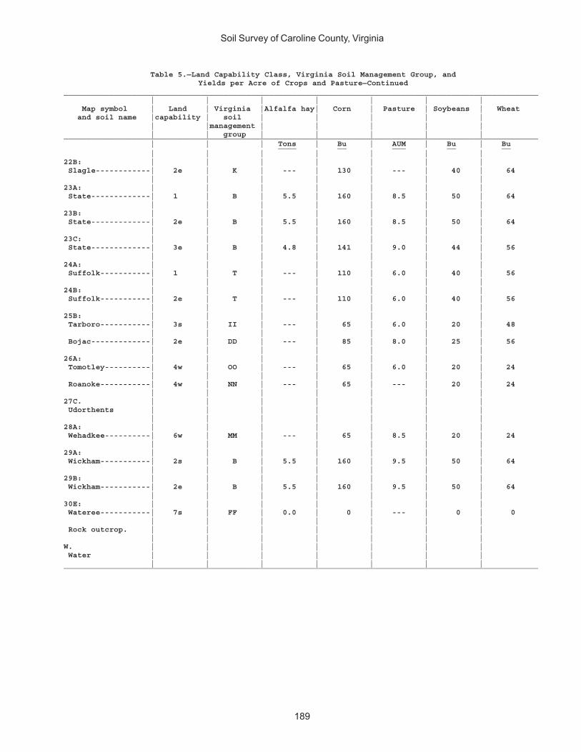
Soil Survey of Caroline County, Virginia
189
Table 5.—Land Capability Class, Virginia Soil Management Group, andYields per Acre of Crops and Pasture—Continued
________________________________________________________________________________________________________ | | | | | | | Map symbol | Land | Virginia |Alfalfa hay| Corn | Pasture | Soybeans | Wheat and soil name |capability | soil | | | | | | |management | | | | | | | group | | | | |________________________________________________________________________________________________________ | | | Tons | Bu | AUM | Bu | Bu ____ __ ___ __ __ | | | | | | |22B: | | | | | | | Slagle------------| 2e | K | --- | 130 | --- | 40 | 64 | | | | | | |23A: | | | | | | | State-------------| 1 | B | 5.5 | 160 | 8.5 | 50 | 64 | | | | | | |23B: | | | | | | | State-------------| 2e | B | 5.5 | 160 | 8.5 | 50 | 64 | | | | | | |23C: | | | | | | | State-------------| 3e | B | 4.8 | 141 | 9.0 | 44 | 56 | | | | | | |24A: | | | | | | | Suffolk-----------| 1 | T | --- | 110 | 6.0 | 40 | 56 | | | | | | |24B: | | | | | | | Suffolk-----------| 2e | T | --- | 110 | 6.0 | 40 | 56 | | | | | | |25B: | | | | | | | Tarboro-----------| 3s | II | --- | 65 | 6.0 | 20 | 48 | | | | | | | Bojac-------------| 2e | DD | --- | 85 | 8.0 | 25 | 56 | | | | | | |26A: | | | | | | | Tomotley----------| 4w | OO | --- | 65 | 6.0 | 20 | 24 | | | | | | | Roanoke-----------| 4w | NN | --- | 65 | --- | 20 | 24 | | | | | | |27C. | | | | | | | Udorthents | | | | | | | | | | | | | |28A: | | | | | | | Wehadkee----------| 6w | MM | --- | 65 | 8.5 | 20 | 24 | | | | | | |29A: | | | | | | | Wickham-----------| 2s | B | 5.5 | 160 | 9.5 | 50 | 64 | | | | | | |29B: | | | | | | | Wickham-----------| 2e | B | 5.5 | 160 | 9.5 | 50 | 64 | | | | | | |30E: | | | | | | | Wateree-----------| 7s | FF | 0.0 | 0 | --- | 0 | 0 | | | | | | | Rock outcrop. | | | | | | | | | | | | | |W. | | | | | | | Water | | | | | | | | | | | | | |________________________________________________________________________________________________________
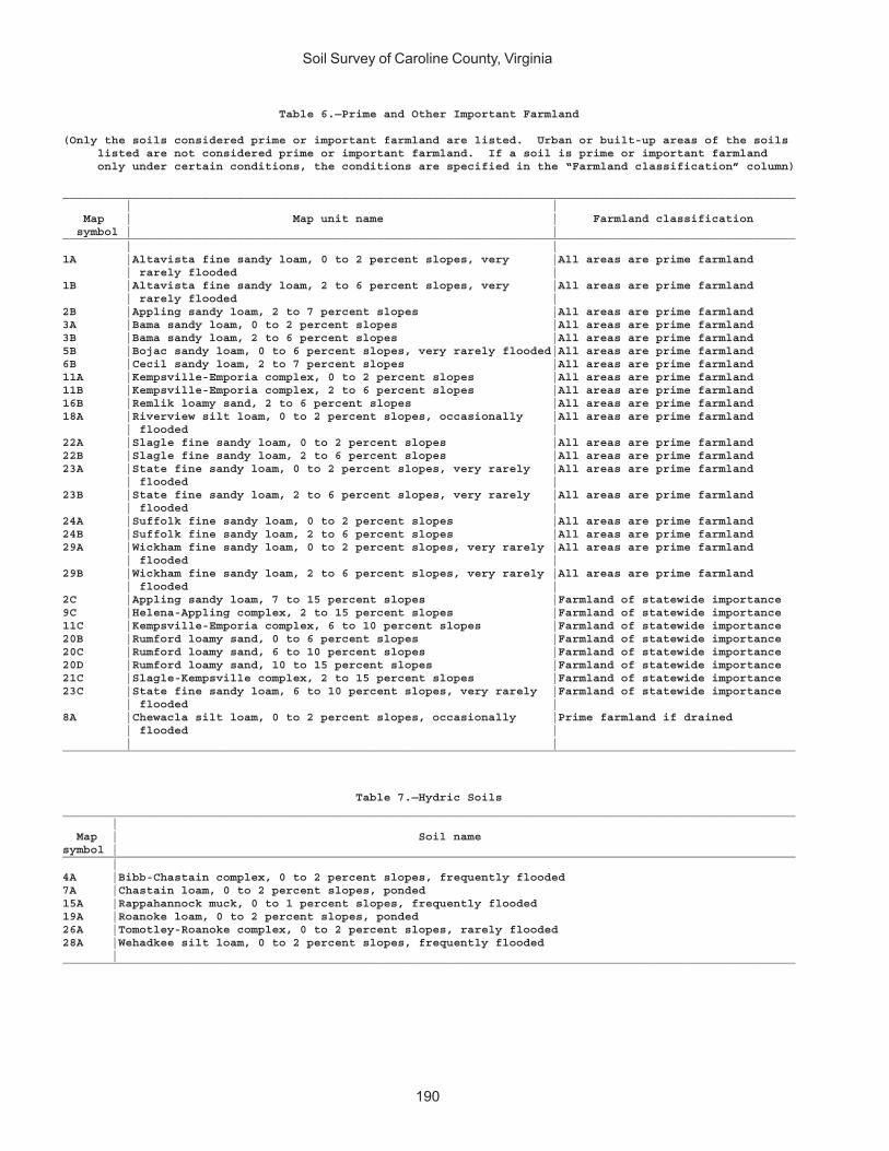
Soil Survey of Caroline County, Virginia
190
Table 6.—Prime and Other Important Farmland
(Only the soils considered prime or important farmland are listed. Urban or built-up areas of the soils listed are not considered prime or important farmland. If a soil is prime or important farmland only under certain conditions, the conditions are specified in the “Farmland classification” column)
_________________________________________________________________________________________________________ | | Map | Map unit name | Farmland classification symbol | |_________________________________________________________________________________________________________ | |1A |Altavista fine sandy loam, 0 to 2 percent slopes, very |All areas are prime farmland | rarely flooded |1B |Altavista fine sandy loam, 2 to 6 percent slopes, very |All areas are prime farmland | rarely flooded |2B |Appling sandy loam, 2 to 7 percent slopes |All areas are prime farmland3A |Bama sandy loam, 0 to 2 percent slopes |All areas are prime farmland3B |Bama sandy loam, 2 to 6 percent slopes |All areas are prime farmland5B |Bojac sandy loam, 0 to 6 percent slopes, very rarely flooded|All areas are prime farmland6B |Cecil sandy loam, 2 to 7 percent slopes |All areas are prime farmland11A |Kempsville-Emporia complex, 0 to 2 percent slopes |All areas are prime farmland11B |Kempsville-Emporia complex, 2 to 6 percent slopes |All areas are prime farmland16B |Remlik loamy sand, 2 to 6 percent slopes |All areas are prime farmland18A |Riverview silt loam, 0 to 2 percent slopes, occasionally |All areas are prime farmland | flooded |22A |Slagle fine sandy loam, 0 to 2 percent slopes |All areas are prime farmland22B |Slagle fine sandy loam, 2 to 6 percent slopes |All areas are prime farmland23A |State fine sandy loam, 0 to 2 percent slopes, very rarely |All areas are prime farmland | flooded |23B |State fine sandy loam, 2 to 6 percent slopes, very rarely |All areas are prime farmland | flooded |24A |Suffolk fine sandy loam, 0 to 2 percent slopes |All areas are prime farmland24B |Suffolk fine sandy loam, 2 to 6 percent slopes |All areas are prime farmland29A |Wickham fine sandy loam, 0 to 2 percent slopes, very rarely |All areas are prime farmland | flooded |29B |Wickham fine sandy loam, 2 to 6 percent slopes, very rarely |All areas are prime farmland | flooded |2C |Appling sandy loam, 7 to 15 percent slopes |Farmland of statewide importance9C |Helena-Appling complex, 2 to 15 percent slopes |Farmland of statewide importance11C |Kempsville-Emporia complex, 6 to 10 percent slopes |Farmland of statewide importance20B |Rumford loamy sand, 0 to 6 percent slopes |Farmland of statewide importance20C |Rumford loamy sand, 6 to 10 percent slopes |Farmland of statewide importance20D |Rumford loamy sand, 10 to 15 percent slopes |Farmland of statewide importance21C |Slagle-Kempsville complex, 2 to 15 percent slopes |Farmland of statewide importance23C |State fine sandy loam, 6 to 10 percent slopes, very rarely |Farmland of statewide importance | flooded |8A |Chewacla silt loam, 0 to 2 percent slopes, occasionally |Prime farmland if drained | flooded | | |_________________________________________________________________________________________________________
Table 7.—Hydric Soils_________________________________________________________________________________________________________ | Map | Soil namesymbol |_________________________________________________________________________________________________________ |4A |Bibb-Chastain complex, 0 to 2 percent slopes, frequently flooded7A |Chastain loam, 0 to 2 percent slopes, ponded15A |Rappahannock muck, 0 to 1 percent slopes, frequently flooded19A |Roanoke loam, 0 to 2 percent slopes, ponded26A |Tomotley-Roanoke complex, 0 to 2 percent slopes, rarely flooded28A |Wehadkee silt loam, 0 to 2 percent slopes, frequently flooded |_________________________________________________________________________________________________________
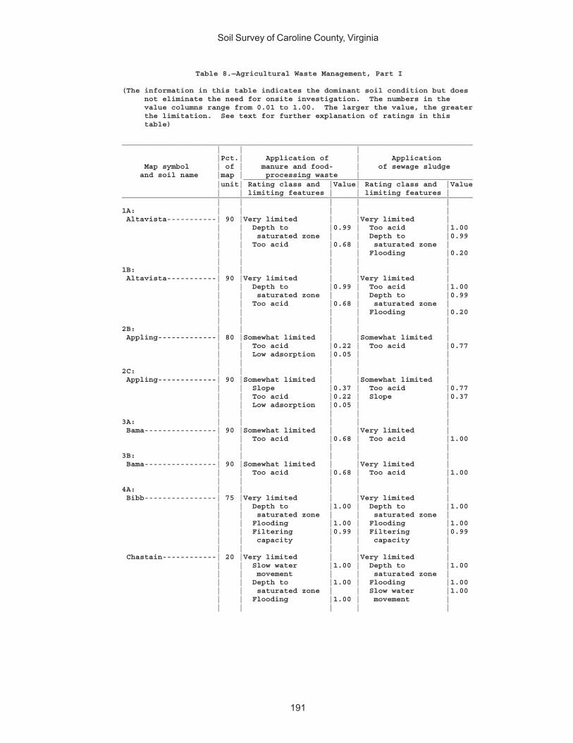
Soil Survey of Caroline County, Virginia
191
Table 8.—Agricultural Waste Management, Part I
(The information in this table indicates the dominant soil condition but does not eliminate the need for onsite investigation. The numbers in the value columns range from 0.01 to 1.00. The larger the value, the greater the limitation. See text for further explanation of ratings in this table)
______________________________________________________________________________ | | | |Pct.| Application of | Application Map symbol | of | manure and food- | of sewage sludge and soil name |map | processing waste | ___________________________________________________ |unit| Rating class and |Value| Rating class and |Value | | limiting features | | limiting features |______________________________________________________________________________ | | | | |1A: | | | | | Altavista-----------| 90 |Very limited | |Very limited | | | Depth to |0.99 | Too acid |1.00 | | saturated zone | | Depth to |0.99 | | Too acid |0.68 | saturated zone | | | | | Flooding |0.20 | | | | |1B: | | | | | Altavista-----------| 90 |Very limited | |Very limited | | | Depth to |0.99 | Too acid |1.00 | | saturated zone | | Depth to |0.99 | | Too acid |0.68 | saturated zone | | | | | Flooding |0.20 | | | | |2B: | | | | | Appling-------------| 80 |Somewhat limited | |Somewhat limited | | | Too acid |0.22 | Too acid |0.77 | | Low adsorption |0.05 | | | | | | |2C: | | | | | Appling-------------| 90 |Somewhat limited | |Somewhat limited | | | Slope |0.37 | Too acid |0.77 | | Too acid |0.22 | Slope |0.37 | | Low adsorption |0.05 | | | | | | |3A: | | | | | Bama----------------| 90 |Somewhat limited | |Very limited | | | Too acid |0.68 | Too acid |1.00 | | | | |3B: | | | | | Bama----------------| 90 |Somewhat limited | |Very limited | | | Too acid |0.68 | Too acid |1.00 | | | | |4A: | | | | | Bibb----------------| 75 |Very limited | |Very limited | | | Depth to |1.00 | Depth to |1.00 | | saturated zone | | saturated zone | | | Flooding |1.00 | Flooding |1.00 | | Filtering |0.99 | Filtering |0.99 | | capacity | | capacity | | | | | | Chastain------------| 20 |Very limited | |Very limited | | | Slow water |1.00 | Depth to |1.00 | | movement | | saturated zone | | | Depth to |1.00 | Flooding |1.00 | | saturated zone | | Slow water |1.00 | | Flooding |1.00 | movement | | | | | |

Soil Survey of Caroline County, Virginia
192
Table 8.—Agricultural Waste Management, Part I—Continued______________________________________________________________________________ | | | |Pct.| Application of | Application Map symbol | of | manure and food- | of sewage sludge and soil name |map | processing waste | ___________________________________________________ |unit| Rating class and |Value| Rating class and |Value | | limiting features | | limiting features |______________________________________________________________________________ | | | | |5B: | | | | | Bojac---------------| 85 |Very limited | |Very limited | | | Filtering |0.99 | Filtering |0.99 | | capacity | | capacity | | | Too acid |0.01 | Flooding |0.20 | | | | Too acid |0.03 | | | | |6B: | | | | | Cecil---------------| 90 |Somewhat limited | |Somewhat limited | | | Low adsorption |0.40 | Too acid |0.77 | | Too acid |0.22 | Low adsorption |0.11 | | | | |7A: | | | | | Chastain------------| 95 |Very limited | |Very limited | | | Slow water |1.00 | Ponding |1.00 | | movement | | Depth to |1.00 | | Ponding |1.00 | saturated zone | | | Depth to |1.00 | Flooding |1.00 | | saturated zone | | | | | | | |8A: | | | | | Chewacla------------| 75 |Very limited | |Very limited | | | Depth to |1.00 | Depth to |1.00 | | saturated zone | | saturated zone | | | Flooding |0.60 | Flooding |1.00 | | Too acid |0.22 | Too acid |0.77 | | | | |9C: | | | | | Helena--------------| 65 |Very limited | |Very limited | | | Slow water |1.00 | Slow water |1.00 | | movement | | movement | | | Depth to |0.99 | Depth to |0.99 | | saturated zone | | saturated zone | | | Slope |0.37 | Too acid |0.77 | | | | | Appling-------------| 20 |Somewhat limited | |Somewhat limited | | | Slope |0.37 | Too acid |0.77 | | Too acid |0.22 | Slope |0.37 | | Low adsorption |0.05 | | | | | | |10E: | | | | | Kempsville----------| 45 |Very limited | |Very limited | | | Slope |1.00 | Slope |1.00 | | Too acid |0.32 | Too acid |0.91 | | | | | Emporia-------------| 25 |Very limited | |Very limited | | | Slope |1.00 | Slope |1.00 | | Too acid |0.11 | Too acid |0.42 | | Depth to |0.02 | Depth to |0.02 | | saturated zone | | saturated zone | | | | | | Remlik--------------| 20 |Very limited | |Very limited | | | Slope |1.00 | Slope |1.00 | | Filtering |0.99 | Filtering |0.99 | | capacity | | capacity | | | Leaching |0.45 | Too acid |0.91 | | | | |
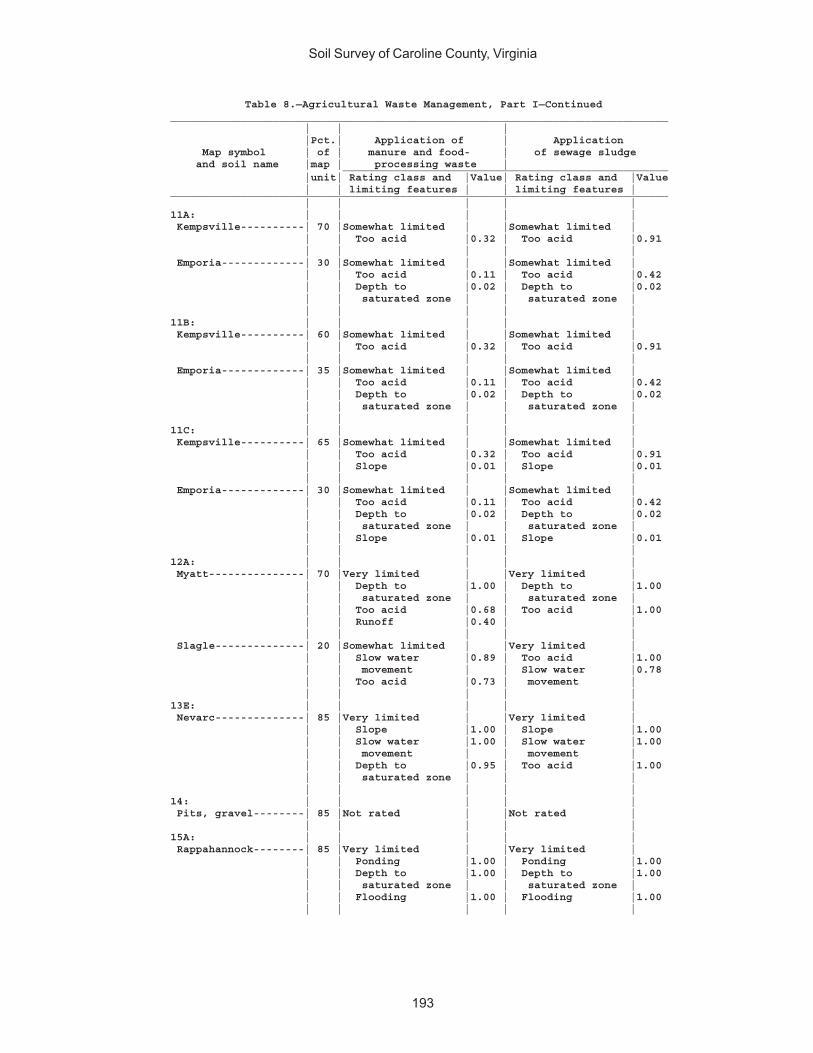
Soil Survey of Caroline County, Virginia
193
Table 8.—Agricultural Waste Management, Part I—Continued______________________________________________________________________________ | | | |Pct.| Application of | Application Map symbol | of | manure and food- | of sewage sludge and soil name |map | processing waste | ___________________________________________________ |unit| Rating class and |Value| Rating class and |Value | | limiting features | | limiting features |______________________________________________________________________________ | | | | |11A: | | | | | Kempsville----------| 70 |Somewhat limited | |Somewhat limited | | | Too acid |0.32 | Too acid |0.91 | | | | | Emporia-------------| 30 |Somewhat limited | |Somewhat limited | | | Too acid |0.11 | Too acid |0.42 | | Depth to |0.02 | Depth to |0.02 | | saturated zone | | saturated zone | | | | | |11B: | | | | | Kempsville----------| 60 |Somewhat limited | |Somewhat limited | | | Too acid |0.32 | Too acid |0.91 | | | | | Emporia-------------| 35 |Somewhat limited | |Somewhat limited | | | Too acid |0.11 | Too acid |0.42 | | Depth to |0.02 | Depth to |0.02 | | saturated zone | | saturated zone | | | | | |11C: | | | | | Kempsville----------| 65 |Somewhat limited | |Somewhat limited | | | Too acid |0.32 | Too acid |0.91 | | Slope |0.01 | Slope |0.01 | | | | | Emporia-------------| 30 |Somewhat limited | |Somewhat limited | | | Too acid |0.11 | Too acid |0.42 | | Depth to |0.02 | Depth to |0.02 | | saturated zone | | saturated zone | | | Slope |0.01 | Slope |0.01 | | | | |12A: | | | | | Myatt---------------| 70 |Very limited | |Very limited | | | Depth to |1.00 | Depth to |1.00 | | saturated zone | | saturated zone | | | Too acid |0.68 | Too acid |1.00 | | Runoff |0.40 | | | | | | | Slagle--------------| 20 |Somewhat limited | |Very limited | | | Slow water |0.89 | Too acid |1.00 | | movement | | Slow water |0.78 | | Too acid |0.73 | movement | | | | | |13E: | | | | | Nevarc--------------| 85 |Very limited | |Very limited | | | Slope |1.00 | Slope |1.00 | | Slow water |1.00 | Slow water |1.00 | | movement | | movement | | | Depth to |0.95 | Too acid |1.00 | | saturated zone | | | | | | | |14: | | | | | Pits, gravel--------| 85 |Not rated | |Not rated | | | | | |15A: | | | | | Rappahannock--------| 85 |Very limited | |Very limited | | | Ponding |1.00 | Ponding |1.00 | | Depth to |1.00 | Depth to |1.00 | | saturated zone | | saturated zone | | | Flooding |1.00 | Flooding |1.00 | | | | |
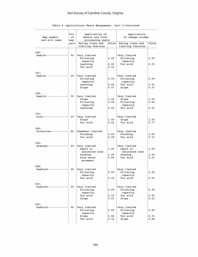
Soil Survey of Caroline County, Virginia
194
Table 8.—Agricultural Waste Management, Part I—Continued______________________________________________________________________________ | | | |Pct.| Application of | Application Map symbol | of | manure and food- | of sewage sludge and soil name |map | processing waste | ___________________________________________________ |unit| Rating class and |Value| Rating class and |Value | | limiting features | | limiting features |______________________________________________________________________________ | | | | |16B: | | | | | Remlik--------------| 95 |Very limited | |Very limited | | | Filtering |0.99 | Filtering |0.99 | | capacity | | capacity | | | Leaching |0.45 | Too acid |0.91 | | Too acid |0.32 | | | | | | |16C: | | | | | Remlik--------------| 95 |Very limited | |Very limited | | | Filtering |0.99 | Filtering |0.99 | | capacity | | capacity | | | Leaching |0.45 | Too acid |0.91 | | Slope |0.37 | Slope |0.37 | | | | |16E: | | | | | Remlik--------------| 90 |Very limited | |Very limited | | | Slope |1.00 | Slope |1.00 | | Filtering |0.99 | Filtering |0.99 | | capacity | | capacity | | | Leaching |0.45 | Too acid |0.91 | | | | |17D: | | | | | Rion----------------| 95 |Very limited | |Very limited | | | Slope |1.00 | Slope |1.00 | | Too acid |0.22 | Too acid |0.77 | | | | |18A: | | | | | Riverview-----------| 80 |Somewhat limited | |Very limited | | | Flooding |0.60 | Flooding |1.00 | | Too acid |0.08 | Too acid |0.31 | | | | |19A: | | | | | Roanoke-------------| 85 |Very limited | |Very limited | | | Depth to |1.00 | Depth to |1.00 | | saturated zone | | saturated zone | | | Ponding |1.00 | Ponding |1.00 | | Slow water |0.89 | Too acid |0.91 | | movement | | | | | | | |20B: | | | | | Rumford-------------| 95 |Very limited | |Very limited | | | Filtering |0.99 | Filtering |0.99 | | capacity | | capacity | | | Too acid |0.32 | Too acid |0.91 | | | | |20C: | | | | | Rumford-------------| 95 |Very limited | |Very limited | | | Filtering |0.99 | Filtering |0.99 | | capacity | | capacity | | | Too acid |0.32 | Too acid |0.91 | | Slope |0.01 | Slope |0.01 | | | | |20D: | | | | | Rumford-------------| 90 |Very limited | |Very limited | | | Filtering |0.99 | Filtering |0.99 | | capacity | | capacity | | | Slope |0.84 | Too acid |0.91 | | Too acid |0.32 | Slope |0.84 | | | | |
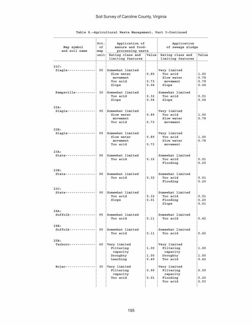
Soil Survey of Caroline County, Virginia
195
Table 8.—Agricultural Waste Management, Part I—Continued______________________________________________________________________________ | | | |Pct.| Application of | Application Map symbol | of | manure and food- | of sewage sludge and soil name |map | processing waste | ___________________________________________________ |unit| Rating class and |Value| Rating class and |Value | | limiting features | | limiting features |______________________________________________________________________________ | | | | |21C: | | | | | Slagle--------------| 55 |Somewhat limited | |Very limited | | | Slow water |0.89 | Too acid |1.00 | | movement | | Slow water |0.78 | | Too acid |0.73 | movement |0.78 | | Slope |0.04 | Slope |0.04 | | | | | Kempsville----------| 30 |Somewhat limited | |Somewhat limited | | | Too acid |0.32 | Too acid |0.91 | | Slope |0.04 | Slope |0.04 | | | | |22A: | | | | | Slagle--------------| 90 |Somewhat limited | |Very limited | | | Slow water |0.89 | Too acid |1.00 | | movement | | Slow water |0.78 | | Too acid |0.73 | movement | | | | | |22B: | | | | | Slagle--------------| 95 |Somewhat limited | |Very limited | | | Slow water |0.89 | Too acid |1.00 | | movement | | Slow water |0.78 | | Too acid |0.73 | movement | | | | | |23A: | | | | | State---------------| 90 |Somewhat limited | |Somewhat limited | | | Too acid |0.32 | Too acid |0.91 | | | | Flooding |0.20 | | | | |23B: | | | | | State---------------| 90 |Somewhat limited | |Somewhat limited | | | Too acid |0.32 | Too acid |0.91 | | | | Flooding |0.20 | | | | |23C: | | | | | State---------------| 90 |Somewhat limited | |Somewhat limited | | | Too acid |0.32 | Too acid |0.91 | | Slope |0.01 | Flooding |0.20 | | | | Slope |0.01 | | | | |24A: | | | | | Suffolk-------------| 95 |Somewhat limited | |Somewhat limited | | | Too acid |0.11 | Too acid |0.42 | | | | |24B: | | | | | Suffolk-------------| 95 |Somewhat limited | |Somewhat limited | | | Too acid |0.11 | Too acid |0.42 | | | | |25B: | | | | | Tarboro-------------| 60 |Very limited | |Very limited | | | Filtering |1.00 | Filtering |1.00 | | capacity | | capacity | | | Droughty |1.00 | Droughty |1.00 | | Leaching |0.45 | Too acid |0.42 | | | | | Bojac---------------| 35 |Very limited | |Very limited | | | Filtering |0.99 | Filtering |0.99 | | capacity | | capacity | | | Too acid |0.01 | Flooding |0.20 | | | | Too acid |0.03 | | | | |
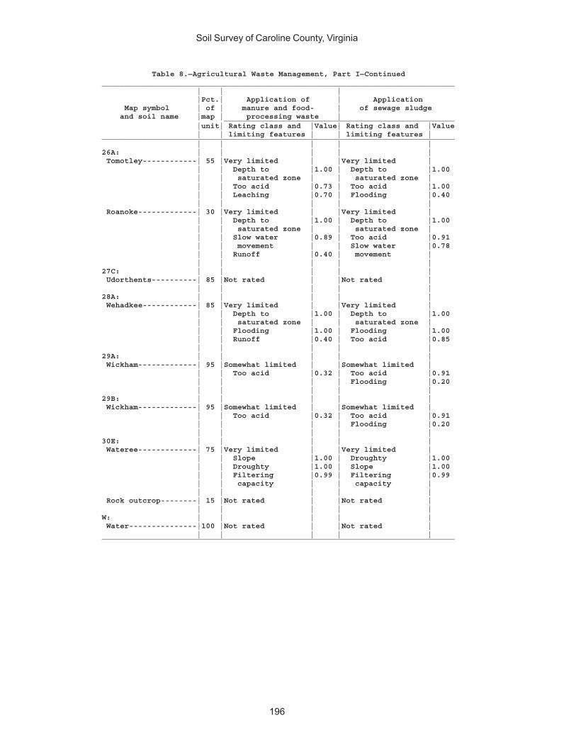
Soil Survey of Caroline County, Virginia
196
Table 8.—Agricultural Waste Management, Part I—Continued______________________________________________________________________________ | | | |Pct.| Application of | Application Map symbol | of | manure and food- | of sewage sludge and soil name |map | processing waste | ___________________________________________________ |unit| Rating class and |Value| Rating class and |Value | | limiting features | | limiting features |______________________________________________________________________________ | | | | |26A: | | | | | Tomotley------------| 55 |Very limited | |Very limited | | | Depth to |1.00 | Depth to |1.00 | | saturated zone | | saturated zone | | | Too acid |0.73 | Too acid |1.00 | | Leaching |0.70 | Flooding |0.40 | | | | | Roanoke-------------| 30 |Very limited | |Very limited | | | Depth to |1.00 | Depth to |1.00 | | saturated zone | | saturated zone | | | Slow water |0.89 | Too acid |0.91 | | movement | | Slow water |0.78 | | Runoff |0.40 | movement | | | | | |27C: | | | | | Udorthents----------| 85 |Not rated | |Not rated | | | | | |28A: | | | | | Wehadkee------------| 85 |Very limited | |Very limited | | | Depth to |1.00 | Depth to |1.00 | | saturated zone | | saturated zone | | | Flooding |1.00 | Flooding |1.00 | | Runoff |0.40 | Too acid |0.85 | | | | |29A: | | | | | Wickham-------------| 95 |Somewhat limited | |Somewhat limited | | | Too acid |0.32 | Too acid |0.91 | | | | Flooding |0.20 | | | | |29B: | | | | | Wickham-------------| 95 |Somewhat limited | |Somewhat limited | | | Too acid |0.32 | Too acid |0.91 | | | | Flooding |0.20 | | | | |30E: | | | | | Wateree-------------| 75 |Very limited | |Very limited | | | Slope |1.00 | Droughty |1.00 | | Droughty |1.00 | Slope |1.00 | | Filtering |0.99 | Filtering |0.99 | | capacity | | capacity | | | | | | Rock outcrop--------| 15 |Not rated | |Not rated | | | | | |W: | | | | | Water---------------|100 |Not rated | |Not rated | | | | | |______________________________________________________________________________
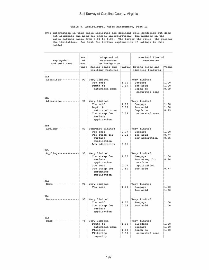
Soil Survey of Caroline County, Virginia
197
Table 8.—Agricultural Waste Management, Part II
(The information in this table indicates the dominant soil condition but does not eliminate the need for onsite investigation. The numbers in the value columns range from 0.01 to 1.00. The larger the value, the greater the limitation. See text for further explanation of ratings in this table)
______________________________________________________________________________ | | | |Pct.| Disposal of | Overland flow of Map symbol | of | wastewater | wastewater and soil name |map | by irrigation | ___________________________________________________ |unit| Rating class and |Value| Rating class and |Value | | limiting features | | limiting features |______________________________________________________________________________ | | | | |1A: | | | | | Altavista-----------| 90 |Very limited | |Very limited | | | Too acid |1.00 | Seepage |1.00 | | Depth to |0.99 | Too acid |1.00 | | saturated zone | | Depth to |0.99 | | | | saturated zone | | | | | |1B: | | | | | Altavista-----------| 90 |Very limited | |Very limited | | | Too acid |1.00 | Seepage |1.00 | | Depth to |0.99 | Too acid |1.00 | | saturated zone | | Depth to |0.99 | | Too steep for |0.08 | saturated zone | | | surface | | | | | application | | | | | | | |2B: | | | | | Appling-------------| 80 |Somewhat limited | |Very limited | | | Too acid |0.77 | Seepage |1.00 | | Too steep for |0.32 | Too acid |0.77 | | surface | | Low adsorption |0.05 | | application | | | | | Low adsorption |0.05 | | | | | | |2C: | | | | | Appling-------------| 90 |Very limited | |Very limited | | | Too steep for |1.00 | Seepage |1.00 | | surface | | Too steep for |0.94 | | application | | surface | | | Too acid |0.77 | application | | | Too steep for |0.60 | Too acid |0.77 | | sprinkler | | | | | application | | | | | | | |3A: | | | | | Bama----------------| 90 |Very limited | |Very limited | | | Too acid |1.00 | Seepage |1.00 | | | | Too acid |1.00 | | | | |3B: | | | | | Bama----------------| 90 |Very limited | |Very limited | | | Too acid |1.00 | Seepage |1.00 | | Too steep for |0.08 | Too acid |1.00 | | surface | | | | | application | | | | | | | |4A: | | | | | Bibb----------------| 75 |Very limited | |Very limited | | | Depth to |1.00 | Flooding |1.00 | | saturated zone | | Seepage |1.00 | | Flooding |1.00 | Depth to |1.00 | | Filtering |0.99 | saturated zone | | | capacity | | |
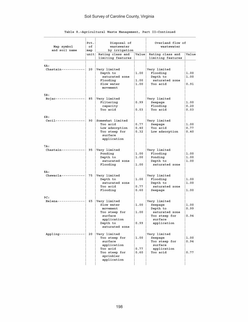
Soil Survey of Caroline County, Virginia
198
Table 8.—Agricultural Waste Management, Part II—Continued______________________________________________________________________________ | | | |Pct.| Disposal of | Overland flow of Map symbol | of | wastewater | wastewater and soil name |map | by irrigation | ___________________________________________________ |unit| Rating class and |Value| Rating class and |Value | | limiting features | | limiting features |______________________________________________________________________________ | | | | |4A: | | | | | Chastain------------| 20 |Very limited | |Very limited | | | Depth to |1.00 | Flooding |1.00 | | saturated zone | | Depth to |1.00 | | Flooding |1.00 | saturated zone | | | Slow water |1.00 | Too acid |0.91 | | movement | | | | | | | |5B: | | | | | Bojac---------------| 85 |Very limited | |Very limited | | | Filtering |0.99 | Seepage |1.00 | | capacity | | Flooding |0.20 | | Too acid |0.03 | Too acid |0.03 | | | | |6B: | | | | | Cecil---------------| 90 |Somewhat limited | |Very limited | | | Too acid |0.77 | Seepage |1.00 | | Low adsorption |0.40 | Too acid |0.77 | | Too steep for |0.32 | Low adsorption |0.40 | | surface | | | | | application | | | | | | | |7A: | | | | | Chastain------------| 95 |Very limited | |Very limited | | | Ponding |1.00 | Flooding |1.00 | | Depth to |1.00 | Ponding |1.00 | | saturated zone | | Depth to |1.00 | | Flooding |1.00 | saturated zone | | | | | |8A: | | | | | Chewacla------------| 75 |Very limited | |Very limited | | | Depth to |1.00 | Flooding |1.00 | | saturated zone | | Depth to |1.00 | | Too acid |0.77 | saturated zone | | | Flooding |0.60 | Seepage |1.00 | | | | |9C: | | | | | Helena--------------| 65 |Very limited | |Very limited | | | Slow water |1.00 | Seepage |1.00 | | movement | | Depth to |0.99 | | Too steep for |1.00 | saturated zone | | | surface | | Too steep for |0.94 | | application | | surface | | | Depth to |0.99 | application | | | saturated zone | | | | | | | | Appling-------------| 20 |Very limited | |Very limited | | | Too steep for |1.00 | Seepage |1.00 | | surface | | Too steep for |0.94 | | application | | surface | | | Too acid |0.77 | application | | | Too steep for |0.60 | Too acid |0.77 | | sprinkler | | | | | application | | | | | | | |
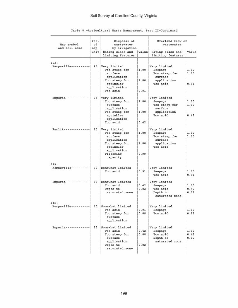
Soil Survey of Caroline County, Virginia
199
Table 8.—Agricultural Waste Management, Part II—Continued______________________________________________________________________________ | | | |Pct.| Disposal of | Overland flow of Map symbol | of | wastewater | wastewater and soil name |map | by irrigation | ___________________________________________________ |unit| Rating class and |Value| Rating class and |Value | | limiting features | | limiting features |______________________________________________________________________________ | | | | |10E: | | | | | Kempsville----------| 45 |Very limited | |Very limited | | | Too steep for |1.00 | Seepage |1.00 | | surface | | Too steep for |1.00 | | application | | surface | | | Too steep for |1.00 | application | | | sprinkler | | Too acid |0.91 | | application | | | | | Too acid |0.91 | | | | | | | Emporia-------------| 25 |Very limited | |Very limited | | | Too steep for |1.00 | Seepage |1.00 | | surface | | Too steep for |1.00 | | application | | surface | | | Too steep for |1.00 | application | | | sprinkler | | Too acid |0.42 | | application | | | | | Too acid |0.42 | | | | | | | Remlik--------------| 20 |Very limited | |Very limited | | | Too steep for |1.00 | Seepage |1.00 | | surface | | Too steep for |1.00 | | application | | surface | | | Too steep for |1.00 | application | | | sprinkler | | Too acid | | | application | | | | | Filtering |0.99 | | | | capacity | | | | | | | |11A: | | | | | Kempsville----------| 70 |Somewhat limited | |Very limited | | | Too acid |0.91 | Seepage |1.00 | | | | Too acid |0.91 | | | | | Emporia-------------| 30 |Somewhat limited | |Very limited | | | Too acid |0.42 | Seepage |1.00 | | Depth to |0.02 | Too acid |0.42 | | saturated zone | | Depth to |0.02 | | | | saturated zone | | | | | |11B: | | | | | Kempsville----------| 60 |Somewhat limited | |Very limited | | | Too acid |0.91 | Seepage |1.00 | | Too steep for |0.08 | Too acid |0.91 | | surface | | | | | application | | | | | | | | Emporia-------------| 35 |Somewhat limited | |Very limited | | | Too acid |0.42 | Seepage |1.00 | | Too steep for |0.08 | Too acid |0.42 | | surface | | Depth to |0.02 | | application | | saturated zone | | | Depth to |0.02 | | | | saturated zone | | | | | | | |
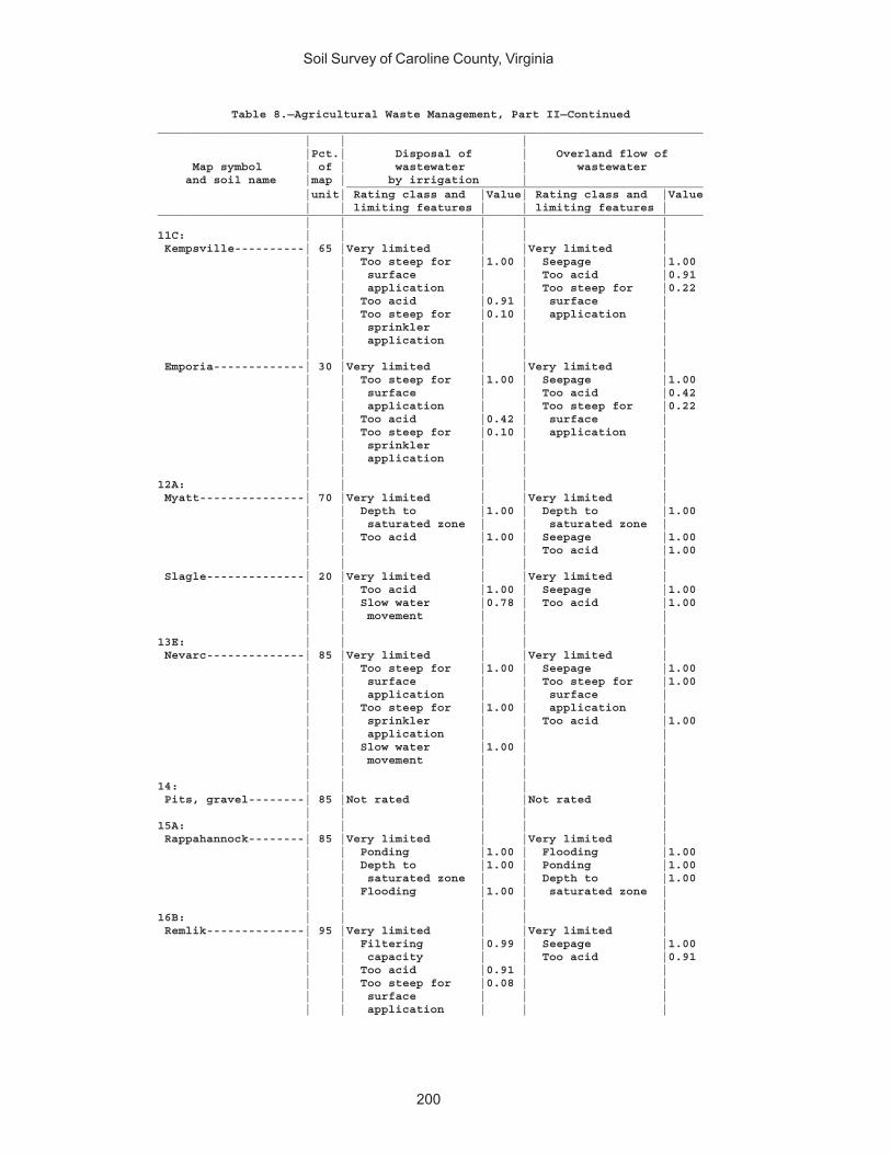
Soil Survey of Caroline County, Virginia
200
Table 8.—Agricultural Waste Management, Part II—Continued______________________________________________________________________________ | | | |Pct.| Disposal of | Overland flow of Map symbol | of | wastewater | wastewater and soil name |map | by irrigation | ___________________________________________________ |unit| Rating class and |Value| Rating class and |Value | | limiting features | | limiting features |______________________________________________________________________________ | | | | |11C: | | | | | Kempsville----------| 65 |Very limited | |Very limited | | | Too steep for |1.00 | Seepage |1.00 | | surface | | Too acid |0.91 | | application | | Too steep for |0.22 | | Too acid |0.91 | surface | | | Too steep for |0.10 | application | | | sprinkler | | | | | application | | | | | | | | Emporia-------------| 30 |Very limited | |Very limited | | | Too steep for |1.00 | Seepage |1.00 | | surface | | Too acid |0.42 | | application | | Too steep for |0.22 | | Too acid |0.42 | surface | | | Too steep for |0.10 | application | | | sprinkler | | | | | application | | | | | | | |12A: | | | | | Myatt---------------| 70 |Very limited | |Very limited | | | Depth to |1.00 | Depth to |1.00 | | saturated zone | | saturated zone | | | Too acid |1.00 | Seepage |1.00 | | | | Too acid |1.00 | | | | | Slagle--------------| 20 |Very limited | |Very limited | | | Too acid |1.00 | Seepage |1.00 | | Slow water |0.78 | Too acid |1.00 | | movement | | | | | | | |13E: | | | | | Nevarc--------------| 85 |Very limited | |Very limited | | | Too steep for |1.00 | Seepage |1.00 | | surface | | Too steep for |1.00 | | application | | surface | | | Too steep for |1.00 | application | | | sprinkler | | Too acid |1.00 | | application | | | | | Slow water |1.00 | | | | movement | | | | | | | |14: | | | | | Pits, gravel--------| 85 |Not rated | |Not rated | | | | | |15A: | | | | | Rappahannock--------| 85 |Very limited | |Very limited | | | Ponding |1.00 | Flooding |1.00 | | Depth to |1.00 | Ponding |1.00 | | saturated zone | | Depth to |1.00 | | Flooding |1.00 | saturated zone | | | | | |16B: | | | | | Remlik--------------| 95 |Very limited | |Very limited | | | Filtering |0.99 | Seepage |1.00 | | capacity | | Too acid |0.91 | | Too acid |0.91 | | | | Too steep for |0.08 | | | | surface | | | | | application | | |
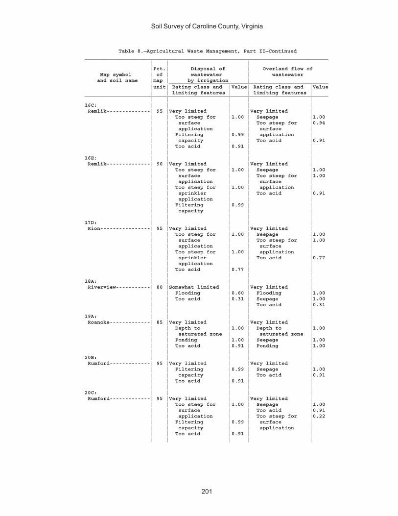
Soil Survey of Caroline County, Virginia
201
Table 8.—Agricultural Waste Management, Part II—Continued______________________________________________________________________________ | | | |Pct.| Disposal of | Overland flow of Map symbol | of | wastewater | wastewater and soil name |map | by irrigation | ___________________________________________________ |unit| Rating class and |Value| Rating class and |Value | | limiting features | | limiting features |______________________________________________________________________________ | | | | |16C: | | | | | Remlik--------------| 95 |Very limited | |Very limited | | | Too steep for |1.00 | Seepage |1.00 | | surface | | Too steep for |0.94 | | application | | surface | | | Filtering |0.99 | application | | | capacity | | Too acid |0.91 | | Too acid |0.91 | | | | | | |16E: | | | | | Remlik--------------| 90 |Very limited | |Very limited | | | Too steep for |1.00 | Seepage |1.00 | | surface | | Too steep for |1.00 | | application | | surface | | | Too steep for |1.00 | application | | | sprinkler | | Too acid |0.91 | | application | | | | | Filtering |0.99 | | | | capacity | | | | | | | |17D: | | | | | Rion----------------| 95 |Very limited | |Very limited | | | Too steep for |1.00 | Seepage |1.00 | | surface | | Too steep for |1.00 | | application | | surface | | | Too steep for |1.00 | application | | | sprinkler | | Too acid |0.77 | | application | | | | | Too acid |0.77 | | | | | | |18A: | | | | | Riverview-----------| 80 |Somewhat limited | |Very limited | | | Flooding |0.60 | Flooding |1.00 | | Too acid |0.31 | Seepage |1.00 | | | | Too acid |0.31 | | | | |19A: | | | | | Roanoke-------------| 85 |Very limited | |Very limited | | | Depth to |1.00 | Depth to |1.00 | | saturated zone | | saturated zone | | | Ponding |1.00 | Seepage |1.00 | | Too acid |0.91 | Ponding |1.00 | | | | |20B: | | | | | Rumford-------------| 95 |Very limited | |Very limited | | | Filtering |0.99 | Seepage |1.00 | | capacity | | Too acid |0.91 | | Too acid |0.91 | | | | | | |20C: | | | | | Rumford-------------| 95 |Very limited | |Very limited | | | Too steep for |1.00 | Seepage |1.00 | | surface | | Too acid |0.91 | | application | | Too steep for |0.22 | | Filtering |0.99 | surface | | | capacity | | application | | | Too acid |0.91 | | | | | | |
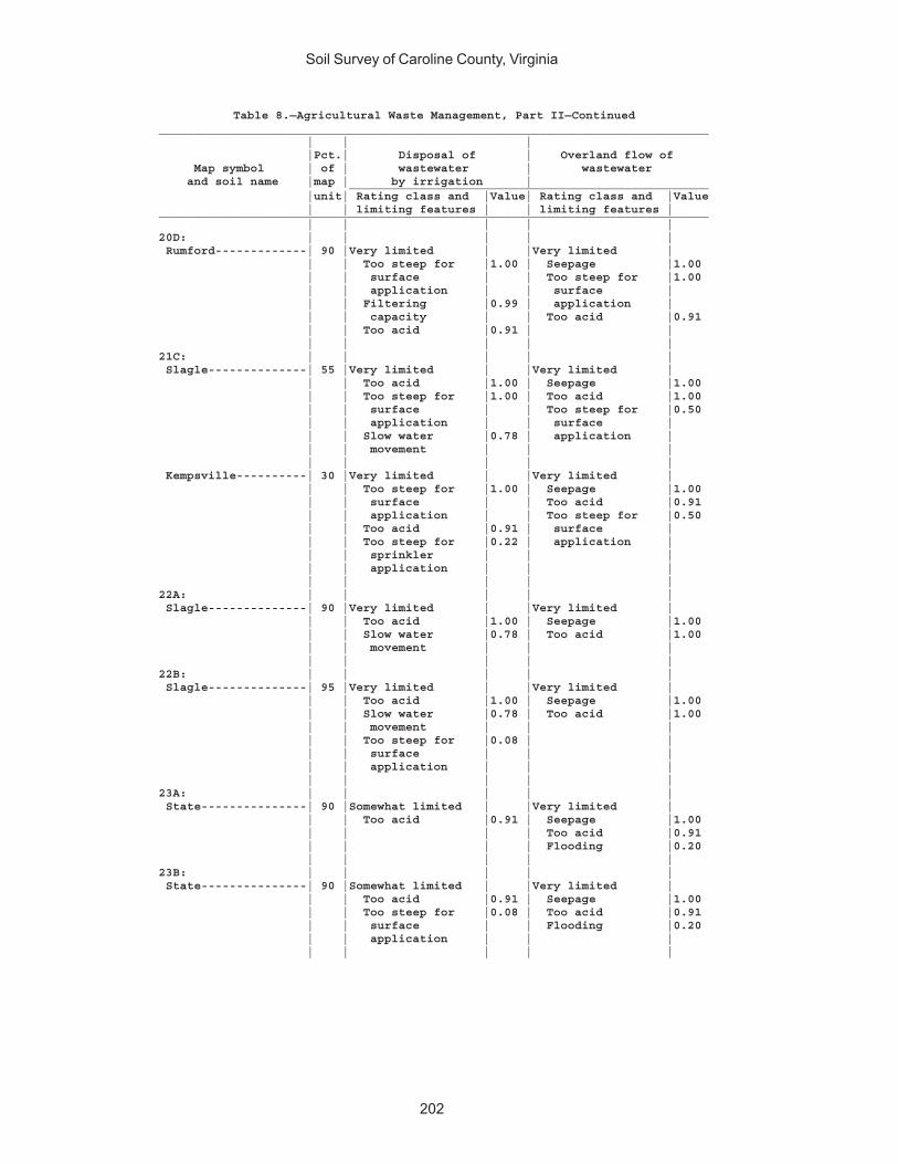
Soil Survey of Caroline County, Virginia
202
Table 8.—Agricultural Waste Management, Part II—Continued______________________________________________________________________________ | | | |Pct.| Disposal of | Overland flow of Map symbol | of | wastewater | wastewater and soil name |map | by irrigation | ___________________________________________________ |unit| Rating class and |Value| Rating class and |Value | | limiting features | | limiting features |______________________________________________________________________________ | | | | |20D: | | | | | Rumford-------------| 90 |Very limited | |Very limited | | | Too steep for |1.00 | Seepage |1.00 | | surface | | Too steep for |1.00 | | application | | surface | | | Filtering |0.99 | application | | | capacity | | Too acid |0.91 | | Too acid |0.91 | | | | | | |21C: | | | | | Slagle--------------| 55 |Very limited | |Very limited | | | Too acid |1.00 | Seepage |1.00 | | Too steep for |1.00 | Too acid |1.00 | | surface | | Too steep for |0.50 | | application | | surface | | | Slow water |0.78 | application | | | movement | | | | | | | | Kempsville----------| 30 |Very limited | |Very limited | | | Too steep for |1.00 | Seepage |1.00 | | surface | | Too acid |0.91 | | application | | Too steep for |0.50 | | Too acid |0.91 | surface | | | Too steep for |0.22 | application | | | sprinkler | | | | | application | | | | | | | |22A: | | | | | Slagle--------------| 90 |Very limited | |Very limited | | | Too acid |1.00 | Seepage |1.00 | | Slow water |0.78 | Too acid |1.00 | | movement | | | | | | | |22B: | | | | | Slagle--------------| 95 |Very limited | |Very limited | | | Too acid |1.00 | Seepage |1.00 | | Slow water |0.78 | Too acid |1.00 | | movement | | | | | Too steep for |0.08 | | | | surface | | | | | application | | | | | | | |23A: | | | | | State---------------| 90 |Somewhat limited | |Very limited | | | Too acid |0.91 | Seepage |1.00 | | | | Too acid |0.91 | | | | Flooding |0.20 | | | | |23B: | | | | | State---------------| 90 |Somewhat limited | |Very limited | | | Too acid |0.91 | Seepage |1.00 | | Too steep for |0.08 | Too acid |0.91 | | surface | | Flooding |0.20 | | application | | | | | | | |
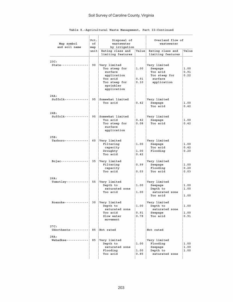
Soil Survey of Caroline County, Virginia
203
Table 8.—Agricultural Waste Management, Part II—Continued______________________________________________________________________________ | | | |Pct.| Disposal of | Overland flow of Map symbol | of | wastewater | wastewater and soil name |map | by irrigation | ___________________________________________________ |unit| Rating class and |Value| Rating class and |Value | | limiting features | | limiting features |______________________________________________________________________________ | | | | |23C: | | | | | State---------------| 90 |Very limited | |Very limited | | | Too steep for |1.00 | Seepage |1.00 | | surface | | Too acid |0.91 | | application | | Too steep for |0.22 | | Too acid |0.91 | surface | | | Too steep for |0.10 | application | | | sprinkler | | | | | application | | | | | | | |24A: | | | | | Suffolk-------------| 95 |Somewhat limited | |Very limited | | | Too acid |0.42 | Seepage |1.00 | | | | Too acid |0.42 | | | | |24B: | | | | | Suffolk-------------| 95 |Somewhat limited | |Very limited | | | Too acid |0.42 | Seepage |1.00 | | Too steep for |0.08 | Too acid |0.42 | | surface | | | | | application | | | | | | | |25B: | | | | | Tarboro-------------| 60 |Very limited | |Very limited | | | Filtering |1.00 | Seepage |1.00 | | capacity | | Too acid |0.42 | | Droughty |1.00 | Flooding |0.20 | | Too acid |0.42 | | | | | | | Bojac---------------| 35 |Very limited | |Very limited | | | Filtering |0.99 | Seepage |1.00 | | capacity | | Flooding |0.20 | | Too acid |0.03 | Too acid |0.03 | | | | |26A: | | | | | Tomotley------------| 55 |Very limited | |Very limited | | | Depth to |1.00 | Seepage |1.00 | | saturated zone | | Depth to |1.00 | | Too acid |1.00 | saturated zone | | | | | Too acid |1.00 | | | | | Roanoke-------------| 30 |Very limited | |Very limited | | | Depth to |1.00 | Depth to |1.00 | | saturated zone | | saturated zone | | | Too acid |0.91 | Seepage |1.00 | | Slow water |0.78 | Too acid |0.91 | | movement | | | | | | | |27C: | | | | | Udorthents----------| 85 |Not rated | |Not rated | | | | | |28A: | | | | | Wehadkee------------| 85 |Very limited | |Very limited | | | Depth to |1.00 | Flooding |1.00 | | saturated zone | | Seepage |1.00 | | Flooding |1.00 | Depth to |1.00 | | Too acid |0.85 | saturated zone | | | | | |

Soil Survey of Caroline County, Virginia
204
Table 8.—Agricultural Waste Management, Part II—Continued______________________________________________________________________________ | | | |Pct.| Disposal of | Overland flow of Map symbol | of | wastewater | wastewater and soil name |map | by irrigation | ___________________________________________________ |unit| Rating class and |Value| Rating class and |Value | | limiting features | | limiting features |______________________________________________________________________________ | | | | |29A: | | | | | Wickham-------------| 95 |Somewhat limited | |Very limited | | | Too acid |0.91 | Seepage |1.00 | | | | Too acid |0.91 | | | | Flooding |0.20 | | | | |29B: | | | | | Wickham-------------| 95 |Somewhat limited | |Very limited | | | Too acid |0.91 | Seepage |1.00 | | Too steep for |0.08 | Too acid |0.91 | | surface | | Flooding |0.20 | | application | | | | | | | |30E: | | | | | Wateree-------------| 75 |Very limited | |Very limited | | | Droughty |1.00 | Seepage |1.00 | | Too steep for |1.00 | Too steep for |1.00 | | surface | | surface | | | application | | application | | | Too steep for |1.00 | Depth to bedrock |1.00 | | sprinkler | | | | | application | | | | | | | | Rock outcrop--------| 15 |Not rated | |Not rated | | | | | |W: | | | | | Water---------------|100 |Not rated | |Not rated | | | | | |______________________________________________________________________________

Soil Survey of Caroline County, Virginia
205
Table 8.—Agricultural Waste Management, Part III
(The information in this table indicates the dominant soil condition but does not eliminate the need for onsite investigation. The numbers in the value columns range from 0.01 to 1.00. The larger the value, the greater the limitation. See text for further explanation of ratings in this table)
______________________________________________________________________________ | | | Map symbol |Pct.| Rapid infiltration | Slow rate treatment and soil name | of | of wastewater | of wastewater ___________________________________________________ |map | Rating class and |Value| Rating class and |Value |unit| limiting features | | limiting features |______________________________________________________________________________ | | | | |1A: | | | | | Altavista-----------| 90 |Very limited | |Very limited | | | Depth to |1.00 | Too acid |1.00 | | saturated zone | | Depth to |0.99 | | Slow water |1.00 | saturated zone | | | movement | | | | | Too acid |0.03 | | | | | | |1B: | | | | | Altavista-----------| 90 |Very limited | |Very limited | | | Depth to |1.00 | Too acid |1.00 | | saturated zone | | Depth to |0.99 | | Slow water |1.00 | saturated zone | | | movement | | Too steep for |0.08 | | Too acid |0.03 | surface | | | | | application | | | | | |2B: | | | | | Appling-------------| 80 |Very limited | |Somewhat limited | | | Slow water |1.00 | Too acid |0.77 | | movement | | Too steep for |0.32 | | Slope |0.12 | surface | | | Too acid |0.07 | application | | | | | Low adsorption |0.05 | | | | |2C: | | | | | Appling-------------| 90 |Very limited | |Very limited | | | Slow water |1.00 | Too steep for |1.00 | | movement | | surface | | | Slope |1.00 | application | | | Too acid |0.07 | Too steep for |0.94 | | | | sprinkler | | | | | irrigation | | | | | Too acid |0.77 | | | | |3A: | | | | | Bama----------------| 90 |Very limited | |Very limited | | | Slow water |1.00 | Too acid |1.00 | | movement | | | | | Too acid |0.07 | | | | | | |3B: | | | | | Bama----------------| 90 |Very limited | |Very limited | | | Slow water |1.00 | Too acid |1.00 | | movement | | Too steep for |0.08 | | Too acid |0.07 | surface | | | | | application | | | | | |
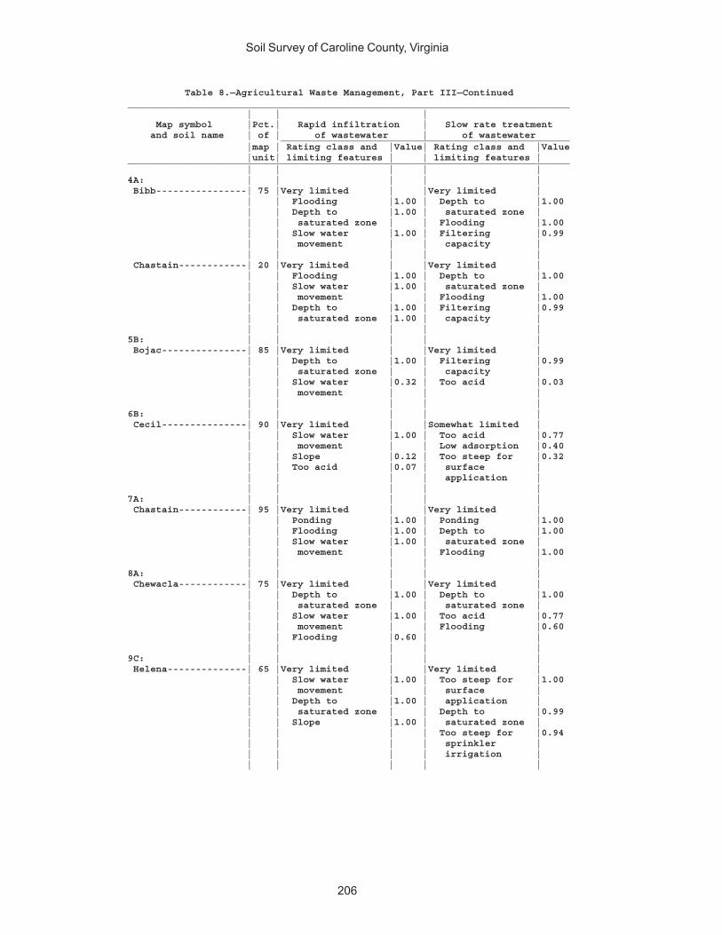
Soil Survey of Caroline County, Virginia
206
Table 8.—Agricultural Waste Management, Part III—Continued______________________________________________________________________________ | | | Map symbol |Pct.| Rapid infiltration | Slow rate treatment and soil name | of | of wastewater | of wastewater ___________________________________________________ |map | Rating class and |Value| Rating class and |Value |unit| limiting features | | limiting features |______________________________________________________________________________ | | | | |4A: | | | | | Bibb----------------| 75 |Very limited | |Very limited | | | Flooding |1.00 | Depth to |1.00 | | Depth to |1.00 | saturated zone | | | saturated zone | | Flooding |1.00 | | Slow water |1.00 | Filtering |0.99 | | movement | | capacity | | | | | | Chastain------------| 20 |Very limited | |Very limited | | | Flooding |1.00 | Depth to |1.00 | | Slow water |1.00 | saturated zone | | | movement | | Flooding |1.00 | | Depth to |1.00 | Filtering |0.99 | | saturated zone |1.00 | capacity | | | | | |5B: | | | | | Bojac---------------| 85 |Very limited | |Very limited | | | Depth to |1.00 | Filtering |0.99 | | saturated zone | | capacity | | | Slow water |0.32 | Too acid |0.03 | | movement | | | | | | | |6B: | | | | | Cecil---------------| 90 |Very limited | |Somewhat limited | | | Slow water |1.00 | Too acid |0.77 | | movement | | Low adsorption |0.40 | | Slope |0.12 | Too steep for |0.32 | | Too acid |0.07 | surface | | | | | application | | | | | |7A: | | | | | Chastain------------| 95 |Very limited | |Very limited | | | Ponding |1.00 | Ponding |1.00 | | Flooding |1.00 | Depth to |1.00 | | Slow water |1.00 | saturated zone | | | movement | | Flooding |1.00 | | | | |8A: | | | | | Chewacla------------| 75 |Very limited | |Very limited | | | Depth to |1.00 | Depth to |1.00 | | saturated zone | | saturated zone | | | Slow water |1.00 | Too acid |0.77 | | movement | | Flooding |0.60 | | Flooding |0.60 | | | | | | |9C: | | | | | Helena--------------| 65 |Very limited | |Very limited | | | Slow water |1.00 | Too steep for |1.00 | | movement | | surface | | | Depth to |1.00 | application | | | saturated zone | | Depth to |0.99 | | Slope |1.00 | saturated zone | | | | | Too steep for |0.94 | | | | sprinkler | | | | | irrigation | | | | | |

Soil Survey of Caroline County, Virginia
207
Table 8.—Agricultural Waste Management, Part III—Continued______________________________________________________________________________ | | | Map symbol |Pct.| Rapid infiltration | Slow rate treatment and soil name | of | of wastewater | of wastewater ___________________________________________________ |map | Rating class and |Value| Rating class and |Value |unit| limiting features | | limiting features |______________________________________________________________________________ | | | | |9C: | | | | | Appling-------------| 20 |Very limited | |Very limited | | | Slow water |1.00 | Too steep for |1.00 | | movement | | surface | | | Slope |1.00 | application | | | Too acid | | Too steep for |0.94 | | | | sprinkler | | | | | irrigation | | | | | Too acid |0.77 | | | | |10E: | | | | | Kempsville----------| 45 |Very limited | |Very limited | | | Slope |1.00 | Too steep for |1.00 | | Slow water |1.00 | surface | | | movement | | application | | | | | Too steep for |1.00 | | | | sprinkler | | | | | irrigation | | | | | Too acid |0.91 | | | | | Emporia-------------| 25 |Very limited | |Very limited | | | Slope |1.00 | Too steep for |1.00 | | Slow water |1.00 | surface | | | movement | | application | | | Too acid |0.07 | Too steep for |1.00 | | | | sprinkler | | | | | irrigation | | | | | Too acid |0.42 | | | | | Remlik--------------| 20 |Very limited | |Very limited | | | Slope |1.00 | Too steep for |1.00 | | Slow water |1.00 | surface | | | movement | | application | | | | | Too steep for |1.00 | | | | sprinkler | | | | | irrigation | | | | | Filtering |0.99 | | | | capacity | | | | | |11A: | | | | | Kempsville----------| 70 |Very limited | |Somewhat limited | | | Slow water |1.00 | Too acid |0.91 | | movement | | | | | | | | Emporia-------------| 30 |Very limited | |Somewhat limited | | | Slow water |1.00 | Too acid |0.42 | | movement | | Depth to |0.02 | | Too acid |0.07 | saturated zone | | | Depth to |0.02 | | | | saturated zone | | | | | | | |11B: | | | | | Kempsville----------| 60 |Very limited | |Somewhat limited | | | Slow water |1.00 | Too acid |0.91 | | movement | | Too steep for |0.08 | | | | surface | | | | | application | | | | | |
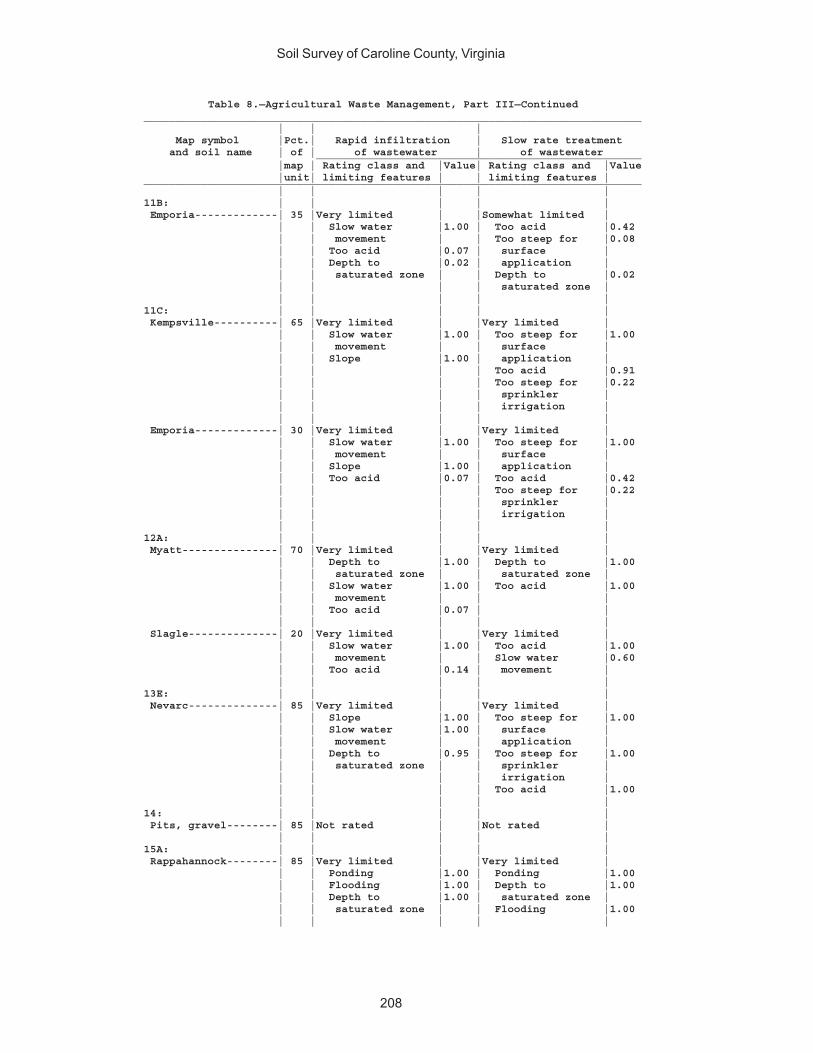
Soil Survey of Caroline County, Virginia
208
Table 8.—Agricultural Waste Management, Part III—Continued______________________________________________________________________________ | | | Map symbol |Pct.| Rapid infiltration | Slow rate treatment and soil name | of | of wastewater | of wastewater ___________________________________________________ |map | Rating class and |Value| Rating class and |Value |unit| limiting features | | limiting features |______________________________________________________________________________ | | | | |11B: | | | | | Emporia-------------| 35 |Very limited | |Somewhat limited | | | Slow water |1.00 | Too acid |0.42 | | movement | | Too steep for |0.08 | | Too acid |0.07 | surface | | | Depth to |0.02 | application | | | saturated zone | | Depth to |0.02 | | | | saturated zone | | | | | |11C: | | | | | Kempsville----------| 65 |Very limited | |Very limited | | | Slow water |1.00 | Too steep for |1.00 | | movement | | surface | | | Slope |1.00 | application | | | | | Too acid |0.91 | | | | Too steep for |0.22 | | | | sprinkler | | | | | irrigation | | | | | | Emporia-------------| 30 |Very limited | |Very limited | | | Slow water |1.00 | Too steep for |1.00 | | movement | | surface | | | Slope |1.00 | application | | | Too acid |0.07 | Too acid |0.42 | | | | Too steep for |0.22 | | | | sprinkler | | | | | irrigation | | | | | |12A: | | | | | Myatt---------------| 70 |Very limited | |Very limited | | | Depth to |1.00 | Depth to |1.00 | | saturated zone | | saturated zone | | | Slow water |1.00 | Too acid |1.00 | | movement | | | | | Too acid |0.07 | | | | | | | Slagle--------------| 20 |Very limited | |Very limited | | | Slow water |1.00 | Too acid |1.00 | | movement | | Slow water |0.60 | | Too acid |0.14 | movement | | | | | |13E: | | | | | Nevarc--------------| 85 |Very limited | |Very limited | | | Slope |1.00 | Too steep for |1.00 | | Slow water |1.00 | surface | | | movement | | application | | | Depth to |0.95 | Too steep for |1.00 | | saturated zone | | sprinkler | | | | | irrigation | | | | | Too acid |1.00 | | | | |14: | | | | | Pits, gravel--------| 85 |Not rated | |Not rated | | | | | |15A: | | | | | Rappahannock--------| 85 |Very limited | |Very limited | | | Ponding |1.00 | Ponding |1.00 | | Flooding |1.00 | Depth to |1.00 | | Depth to |1.00 | saturated zone | | | saturated zone | | Flooding |1.00 | | | | |
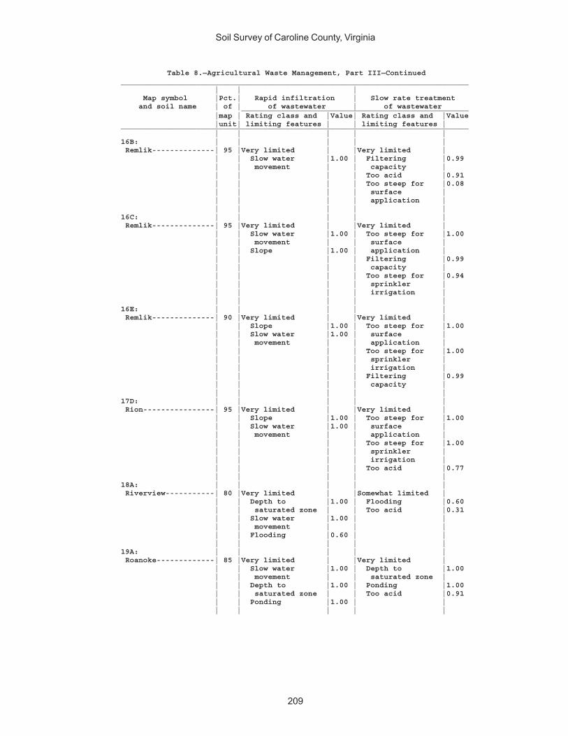
Soil Survey of Caroline County, Virginia
209
Table 8.—Agricultural Waste Management, Part III—Continued______________________________________________________________________________ | | | Map symbol |Pct.| Rapid infiltration | Slow rate treatment and soil name | of | of wastewater | of wastewater ___________________________________________________ |map | Rating class and |Value| Rating class and |Value |unit| limiting features | | limiting features |______________________________________________________________________________ | | | | |16B: | | | | | Remlik--------------| 95 |Very limited | |Very limited | | | Slow water |1.00 | Filtering |0.99 | | movement | | capacity | | | | | Too acid |0.91 | | | | Too steep for |0.08 | | | | surface | | | | | application | | | | | |16C: | | | | | Remlik--------------| 95 |Very limited | |Very limited | | | Slow water |1.00 | Too steep for |1.00 | | movement | | surface | | | Slope |1.00 | application | | | | | Filtering |0.99 | | | | capacity | | | | | Too steep for |0.94 | | | | sprinkler | | | | | irrigation | | | | | |16E: | | | | | Remlik--------------| 90 |Very limited | |Very limited | | | Slope |1.00 | Too steep for |1.00 | | Slow water |1.00 | surface | | | movement | | application | | | | | Too steep for |1.00 | | | | sprinkler | | | | | irrigation | | | | | Filtering |0.99 | | | | capacity | | | | | |17D: | | | | | Rion----------------| 95 |Very limited | |Very limited | | | Slope |1.00 | Too steep for |1.00 | | Slow water |1.00 | surface | | | movement | | application | | | | | Too steep for |1.00 | | | | sprinkler | | | | | irrigation | | | | | Too acid |0.77 | | | | |18A: | | | | | Riverview-----------| 80 |Very limited | |Somewhat limited | | | Depth to |1.00 | Flooding |0.60 | | saturated zone | | Too acid |0.31 | | Slow water |1.00 | | | | movement | | | | | Flooding |0.60 | | | | | | |19A: | | | | | Roanoke-------------| 85 |Very limited | |Very limited | | | Slow water |1.00 | Depth to |1.00 | | movement | | saturated zone | | | Depth to |1.00 | Ponding |1.00 | | saturated zone | | Too acid |0.91 | | Ponding |1.00 | | | | | | |
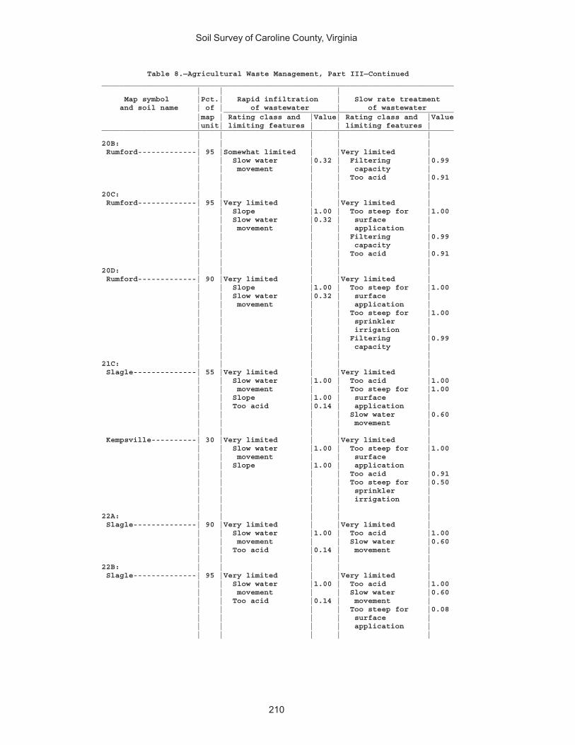
Soil Survey of Caroline County, Virginia
210
Table 8.—Agricultural Waste Management, Part III—Continued______________________________________________________________________________ | | | Map symbol |Pct.| Rapid infiltration | Slow rate treatment and soil name | of | of wastewater | of wastewater ___________________________________________________ |map | Rating class and |Value| Rating class and |Value |unit| limiting features | | limiting features |______________________________________________________________________________ | | | | |20B: | | | | | Rumford-------------| 95 |Somewhat limited | |Very limited | | | Slow water |0.32 | Filtering |0.99 | | movement | | capacity | | | | | Too acid |0.91 | | | | |20C: | | | | | Rumford-------------| 95 |Very limited | |Very limited | | | Slope |1.00 | Too steep for |1.00 | | Slow water |0.32 | surface | | | movement | | application | | | | | Filtering |0.99 | | | | capacity | | | | | Too acid |0.91 | | | | |20D: | | | | | Rumford-------------| 90 |Very limited | |Very limited | | | Slope |1.00 | Too steep for |1.00 | | Slow water |0.32 | surface | | | movement | | application | | | | | Too steep for |1.00 | | | | sprinkler | | | | | irrigation | | | | | Filtering |0.99 | | | | capacity | | | | | |21C: | | | | | Slagle--------------| 55 |Very limited | |Very limited | | | Slow water |1.00 | Too acid |1.00 | | movement | | Too steep for |1.00 | | Slope |1.00 | surface | | | Too acid |0.14 | application | | | | | Slow water |0.60 | | | | movement | | | | | | Kempsville----------| 30 |Very limited | |Very limited | | | Slow water |1.00 | Too steep for |1.00 | | movement | | surface | | | Slope |1.00 | application | | | | | Too acid |0.91 | | | | Too steep for |0.50 | | | | sprinkler | | | | | irrigation | | | | | |22A: | | | | | Slagle--------------| 90 |Very limited | |Very limited | | | Slow water |1.00 | Too acid |1.00 | | movement | | Slow water |0.60 | | Too acid |0.14 | movement | | | | | |22B: | | | | | Slagle--------------| 95 |Very limited | |Very limited | | | Slow water |1.00 | Too acid |1.00 | | movement | | Slow water |0.60 | | Too acid |0.14 | movement | | | | | Too steep for |0.08 | | | | surface | | | | | application | | | | | |
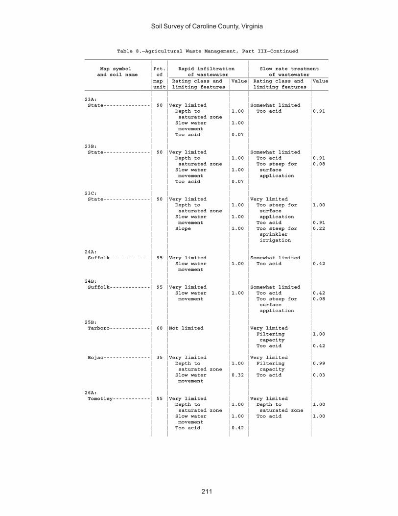
Soil Survey of Caroline County, Virginia
211
Table 8.—Agricultural Waste Management, Part III—Continued______________________________________________________________________________ | | | Map symbol |Pct.| Rapid infiltration | Slow rate treatment and soil name | of | of wastewater | of wastewater ___________________________________________________ |map | Rating class and |Value| Rating class and |Value |unit| limiting features | | limiting features |______________________________________________________________________________ | | | | |23A: | | | | | State---------------| 90 |Very limited | |Somewhat limited | | | Depth to |1.00 | Too acid |0.91 | | saturated zone | | | | | Slow water |1.00 | | | | movement | | | | | Too acid |0.07 | | | | | | |23B: | | | | | State---------------| 90 |Very limited | |Somewhat limited | | | Depth to |1.00 | Too acid |0.91 | | saturated zone | | Too steep for |0.08 | | Slow water |1.00 | surface | | | movement | | application | | | Too acid |0.07 | | | | | | |23C: | | | | | State---------------| 90 |Very limited | |Very limited | | | Depth to |1.00 | Too steep for |1.00 | | saturated zone | | surface | | | Slow water |1.00 | application | | | movement | | Too acid |0.91 | | Slope |1.00 | Too steep for |0.22 | | | | sprinkler | | | | | irrigation | | | | | |24A: | | | | | Suffolk-------------| 95 |Very limited | |Somewhat limited | | | Slow water |1.00 | Too acid |0.42 | | movement | | | | | | | |24B: | | | | | Suffolk-------------| 95 |Very limited | |Somewhat limited | | | Slow water |1.00 | Too acid |0.42 | | movement | | Too steep for |0.08 | | | | surface | | | | | application | | | | | |25B: | | | | | Tarboro-------------| 60 |Not limited | |Very limited | | | | | Filtering |1.00 | | | | capacity | | | | | Too acid |0.42 | | | | | Bojac---------------| 35 |Very limited | |Very limited | | | Depth to |1.00 | Filtering |0.99 | | saturated zone | | capacity | | | Slow water |0.32 | Too acid |0.03 | | movement | | | | | | | |26A: | | | | | Tomotley------------| 55 |Very limited | |Very limited | | | Depth to |1.00 | Depth to |1.00 | | saturated zone | | saturated zone | | | Slow water |1.00 | Too acid |1.00 | | movement | | | | | Too acid |0.42 | | | | | | |
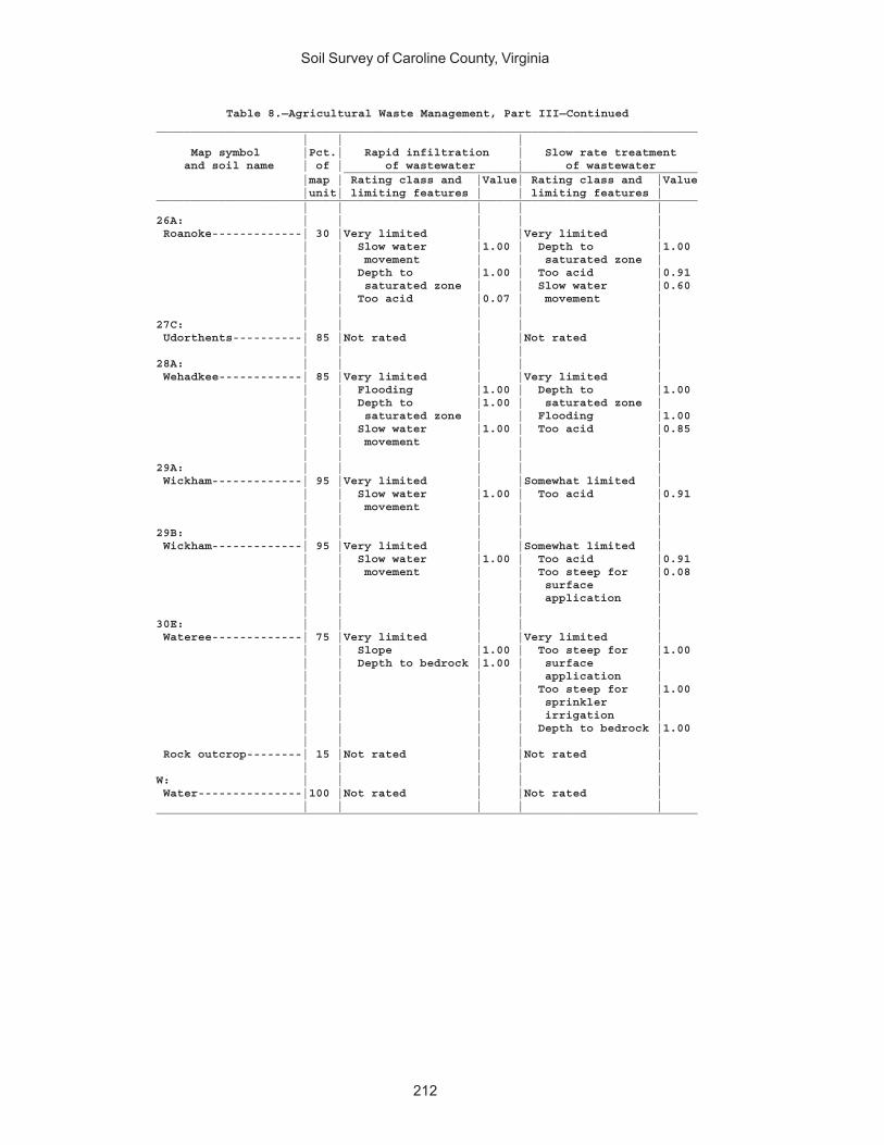
Soil Survey of Caroline County, Virginia
212
Table 8.—Agricultural Waste Management, Part III—Continued______________________________________________________________________________ | | | Map symbol |Pct.| Rapid infiltration | Slow rate treatment and soil name | of | of wastewater | of wastewater ___________________________________________________ |map | Rating class and |Value| Rating class and |Value |unit| limiting features | | limiting features |______________________________________________________________________________ | | | | |26A: | | | | | Roanoke-------------| 30 |Very limited | |Very limited | | | Slow water |1.00 | Depth to |1.00 | | movement | | saturated zone | | | Depth to |1.00 | Too acid |0.91 | | saturated zone | | Slow water |0.60 | | Too acid |0.07 | movement | | | | | |27C: | | | | | Udorthents----------| 85 |Not rated | |Not rated | | | | | |28A: | | | | | Wehadkee------------| 85 |Very limited | |Very limited | | | Flooding |1.00 | Depth to |1.00 | | Depth to |1.00 | saturated zone | | | saturated zone | | Flooding |1.00 | | Slow water |1.00 | Too acid |0.85 | | movement | | | | | | | |29A: | | | | | Wickham-------------| 95 |Very limited | |Somewhat limited | | | Slow water |1.00 | Too acid |0.91 | | movement | | | | | | | |29B: | | | | | Wickham-------------| 95 |Very limited | |Somewhat limited | | | Slow water |1.00 | Too acid |0.91 | | movement | | Too steep for |0.08 | | | | surface | | | | | application | | | | | |30E: | | | | | Wateree-------------| 75 |Very limited | |Very limited | | | Slope |1.00 | Too steep for |1.00 | | Depth to bedrock |1.00 | surface | | | | | application | | | | | Too steep for |1.00 | | | | sprinkler | | | | | irrigation | | | | | Depth to bedrock |1.00 | | | | | Rock outcrop--------| 15 |Not rated | |Not rated | | | | | |W: | | | | | Water---------------|100 |Not rated | |Not rated | | | | | |______________________________________________________________________________

Soil Survey of Caroline County, Virginia
213
Table 9.—Forestland Productivity_________________________________________________________________________________ | Potential productivity | ___________________________________ Map symbol and | |Site | Volume | Trees to manage soil name | Common trees |index|of wood | | | | fiber |_________________________________________________________________________________ | | |cu ft/ac| ________ | | | |1A: | | | | Altavista---------------|loblolly pine-------| 91 | 129 |loblolly pine |longleaf pine-------| 87 | 114 | |white oak-----------| 77 | 57 | | | | |1B: | | | | Altavista---------------|loblolly pine-------| 91 | 129 |loblolly pine |longleaf pine-------| 87 | 114 | |white oak-----------| 77 | 57 | | | | |2B: | | | | Appling-----------------|loblolly pine-------| 84 | 114 |loblolly pine, |scarlet oak---------| 74 | 57 | shortleaf pine |shortleaf pine------| 65 | 100 | |Virginia pine-------| 74 | 114 | |white oak-----------| 64 | 43 | |yellow-poplar-------| 88 | 86 | | | | |2C: | | | | Appling-----------------|loblolly pine-------| 84 | 114 |loblolly pine, |scarlet oak---------| 74 | 57 | shortleaf pine |shortleaf pine------| 65 | 100 | |Virginia pine-------| 74 | 114 | |white oak-----------| 64 | 43 | |yellow-poplar-------| 88 | 86 | | | | |3A: | | | | Bama--------------------|loblolly pine-------| 82 | 114 |loblolly pine |southern red oak----| 74 | 57 | |sweetgum------------| 80 | 86 | |Virginia pine-------| 74 | 114 | |yellow-poplar-------| 82 | 72 | | | | |3B: | | | | Bama--------------------|loblolly pine-------| 82 | 114 |loblolly pine |southern red oak----| 74 | 57 | |sweetgum------------| 80 | 86 | |Virginia pine-------| 74 | 114 | |yellow-poplar-------| 82 | 72 | | | | |4A: | | | | Bibb--------------------|loblolly pine-------| 100 | 157 |eastern cottonwood, |sweetgum------------| 90 | 100 | loblolly pine, |water oak-----------| 90 | 86 | sweetgum, yellow- | | | | poplar | | | | Chastain----------------|sweetgum------------| 95 | 114 |baldcypress, | | | | sweetgum | | | |5B: | | | | Bojac-------------------|loblolly pine-------| 80 | 114 |loblolly pine, |southern red oak----| 65 | 43 | sweetgum |sweetgum------------| 80 | 86 | | | | |
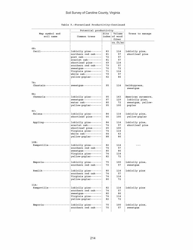
Soil Survey of Caroline County, Virginia
214
Table 9.—Forestland Productivity—Continued_________________________________________________________________________________ | Potential productivity | ___________________________________ Map symbol and | |Site | Volume | Trees to manage soil name | Common trees |index|of wood | | | | fiber |_________________________________________________________________________________ | | |cu ft/ac| ________ | | | |6B: | | | | Cecil-------------------|loblolly pine-------| 83 | 114 |loblolly pine, |northern red oak----| 81 | 57 | shortleaf pine |post oak------------| 72 | 57 | |scarlet oak---------| 81 | 57 | |shortleaf pine------| 69 | 114 | |southern red oak----| 79 | 57 | |sweetgum------------| 76 | 72 | |Virginia pine-------| 71 | 114 | |white oak-----------| 79 | 57 | |yellow-poplar-------| 92 | 86 | | | | |7A: | | | | Chastain----------------|sweetgum------------| 95 | 114 |baldcypress, | | | | sweetgum | | | |8A: | | | | Chewacla----------------|loblolly pine-------| 95 | 143 |American sycamore, |sweetgum------------| 97 | 129 | loblolly pine, |water oak-----------| 80 | 72 | sweetgum, yellow- |yellow-poplar-------| 95 | 100 | poplar | | | |9C: | | | | Helena------------------|loblolly pine-------| 84 | 114 |loblolly pine, |shortleaf pine------| 66 | 100 | yellow-poplar | | | | Appling-----------------|loblolly pine-------| 84 | 114 |loblolly pine, |scarlet oak---------| 74 | 57 | shortleaf pine |shortleaf pine------| 65 | 100 | |Virginia pine-------| 74 | 114 | |white oak-----------| 64 | 43 | |yellow-poplar-------| 88 | 86 | | | | |10E: | | | | Kempsville--------------|loblolly pine-------| 82 | 114 | --- |southern red oak----| 74 | 57 | |sweetgum------------| 80 | 86 | |Virginia pine-------| 74 | 114 | |yellow-poplar-------| 82 | 72 | | | | | Emporia-----------------|loblolly pine-------| 75 | 100 |loblolly pine, |southern red oak----| 70 | 57 | sweetgum | | | | Remlik------------------|loblolly pine-------| 80 | 114 |loblolly pine |southern red oak----| 74 | 57 | |Virginia pine-------| 74 | 114 | |yellow-poplar-------| 80 | 72 | | | | |11A: | | | | Kempsville--------------|loblolly pine-------| 82 | 114 |loblolly pine |southern red oak----| 74 | 57 | |sweetgum------------| 80 | 86 | |Virginia pine-------| 74 | 114 | |yellow-poplar-------| 82 | 72 | | | | | Emporia-----------------|loblolly pine-------| 75 | 100 |loblolly pine, |southern red oak----| 70 | 57 | sweetgum | | | |

Soil Survey of Caroline County, Virginia
215
Table 9.—Forestland Productivity—Continued_________________________________________________________________________________ | Potential productivity | ___________________________________ Map symbol and | |Site | Volume | Trees to manage soil name | Common trees |index|of wood | | | | fiber |_________________________________________________________________________________ | | |cu ft/ac| ________ | | | |11B: | | | | Kempsville--------------|loblolly pine-------| 82 | 114 |loblolly pine |southern red oak----| 74 | 57 | |sweetgum------------| 80 | 86 | |Virginia pine-------| 74 | 114 | |yellow-poplar-------| 82 | 72 | | | | | Emporia-----------------|loblolly pine-------| 75 | 100 |loblolly pine, |southern red oak----| 70 | 57 | sweetgum | | | |11C: | | | | Kempsville--------------|loblolly pine-------| 82 | 114 |loblolly pine |southern red oak----| 74 | 57 | |sweetgum------------| 80 | 86 | |Virginia pine-------| 74 | 114 | |yellow-poplar-------| 82 | 72 | | | | | Emporia-----------------|loblolly pine-------| 75 | 100 |loblolly pine, |southern red oak----| 70 | 57 | sweetgum | | | |12A: | | | | Myatt-------------------|loblolly pine-------| 88 | 129 |loblolly pine, |sweetgum------------| 92 | 114 | sweetgum |water oak-----------| 86 | 86 | | | | | Slagle------------------|loblolly pine-------| 86 | 129 |loblolly pine, |southern red oak----| 76 | 57 | sweetgum, yellow- |sweetgum------------| 86 | 100 | poplar |water oak-----------| 76 | 72 | |yellow-poplar-------| 90 | 86 | | | | |13E: | | | | Nevarc------------------|loblolly pine-------| 77 | 100 |loblolly pine |southern red oak----| 70 | 57 | |sweetgum------------| 76 | 72 | |white oak-----------| 70 | 57 | |yellow-poplar-------| 80 | 72 | | | | |14. | | | | Pits, gravel | | | | | | | |15A: | | | | Rappahannock------------| --- | --- | --- | --- | | | |16B: | | | | Remlik------------------|loblolly pine-------| 80 | 114 |loblolly pine |southern red oak----| 74 | 57 | |Virginia pine-------| 74 | 114 | |yellow-poplar-------| 80 | 72 | | | | |16C: | | | | Remlik------------------|loblolly pine-------| 80 | 114 |loblolly pine |southern red oak----| 74 | 57 | |Virginia pine-------| 74 | 114 | |yellow-poplar-------| 80 | 72 | | | | |

Soil Survey of Caroline County, Virginia
216
Table 9.—Forestland Productivity—Continued_________________________________________________________________________________ | Potential productivity | ___________________________________ Map symbol and | |Site | Volume | Trees to manage soil name | Common trees |index|of wood | | | | fiber |_________________________________________________________________________________ | | |cu ft/ac| ________ | | | |16E: | | | | Remlik------------------|loblolly pine-------| 80 | 114 |loblolly pine |southern red oak----| 74 | 57 | |Virginia pine-------| 74 | 114 | |yellow-poplar-------| 80 | 72 | | | | |17D: | | | | Rion--------------------|loblolly pine-------| 80 | 114 |loblolly pine, |post oak------------| 65 | 43 | shortleaf pine, |shortleaf pine------| 70 | 114 | yellow-poplar |southern red oak----| 80 | 57 | |sweetgum------------| 80 | 86 | |white oak-----------| 70 | 57 | |yellow-poplar-------| 90 | 86 | | | | |18A: | | | | Riverview---------------|loblolly pine-------| 100 | 157 |American sycamore, |sweetgum------------| 100 | 143 | eastern |yellow-poplar-------| 110 | 129 | cottonwood, | | | | loblolly pine, | | | | sweetgum, yellow- | | | | poplar | | | |19A: | | | | Roanoke-----------------|sweetgum------------| 94 | 114 |water tupelo | | | |20B: | | | | Rumford-----------------|loblolly pine-------| 80 | 114 |loblolly pine |southern red oak----| 65 | 43 | |Virginia pine-------| 70 | 114 | | | | |20C: | | | | Rumford-----------------|loblolly pine-------| 80 | 114 |loblolly pine |southern red oak----| 65 | 43 | |Virginia pine-------| 70 | 114 | | | | |20D: | | | | Rumford-----------------|loblolly pine-------| 80 | 114 |loblolly pine |southern red oak----| 65 | 43 | |Virginia pine-------| 70 | 114 | | | | |21C: | | | | Slagle------------------|loblolly pine-------| 86 | 129 |loblolly pine, |southern red oak----| 76 | 57 | sweetgum, yellow- |sweetgum------------| 86 | 100 | poplar |water oak-----------| 76 | 72 | |yellow-poplar-------| 90 | 86 | | | | | Kempsville--------------|loblolly pine-------| 82 | 114 |loblolly pine |southern red oak----| 74 | 57 | |sweetgum------------| 80 | 86 | |Virginia pine-------| 74 | 114 | |yellow-poplar-------| 82 | 72 | | | | |22A: | | | | Slagle------------------|loblolly pine-------| 86 | 129 |loblolly pine, |southern red oak----| 76 | 57 | sweetgum, yellow- |sweetgum------------| 86 | 100 | poplar |water oak-----------| 76 | 72 | |yellow-poplar-------| 90 | 86 |
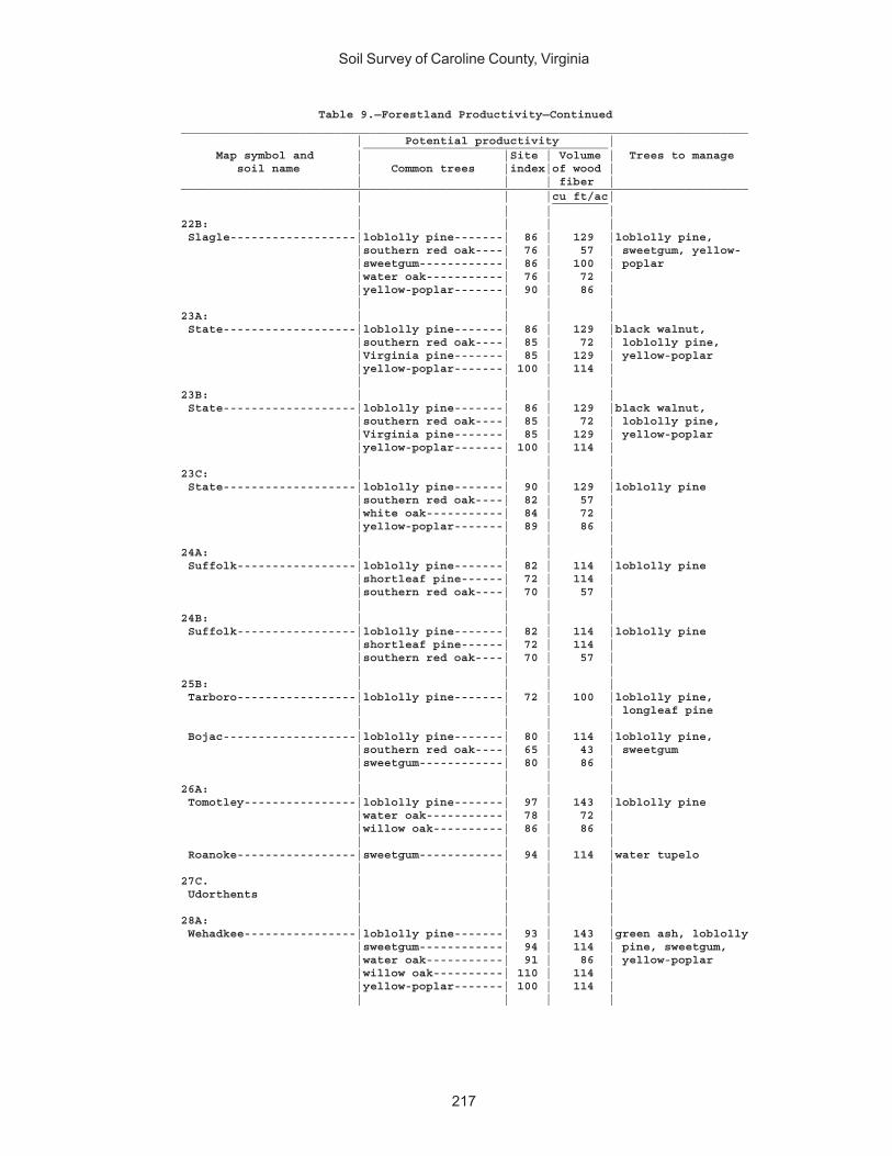
Soil Survey of Caroline County, Virginia
217
Table 9.—Forestland Productivity—Continued_________________________________________________________________________________ | Potential productivity | ___________________________________ Map symbol and | |Site | Volume | Trees to manage soil name | Common trees |index|of wood | | | | fiber |_________________________________________________________________________________ | | |cu ft/ac| ________ | | | |22B: | | | | Slagle------------------|loblolly pine-------| 86 | 129 |loblolly pine, |southern red oak----| 76 | 57 | sweetgum, yellow- |sweetgum------------| 86 | 100 | poplar |water oak-----------| 76 | 72 | |yellow-poplar-------| 90 | 86 | | | | |23A: | | | | State-------------------|loblolly pine-------| 86 | 129 |black walnut, |southern red oak----| 85 | 72 | loblolly pine, |Virginia pine-------| 85 | 129 | yellow-poplar |yellow-poplar-------| 100 | 114 | | | | |23B: | | | | State-------------------|loblolly pine-------| 86 | 129 |black walnut, |southern red oak----| 85 | 72 | loblolly pine, |Virginia pine-------| 85 | 129 | yellow-poplar |yellow-poplar-------| 100 | 114 | | | | |23C: | | | | State-------------------|loblolly pine-------| 90 | 129 |loblolly pine |southern red oak----| 82 | 57 | |white oak-----------| 84 | 72 | |yellow-poplar-------| 89 | 86 | | | | |24A: | | | | Suffolk-----------------|loblolly pine-------| 82 | 114 |loblolly pine |shortleaf pine------| 72 | 114 | |southern red oak----| 70 | 57 | | | | |24B: | | | | Suffolk-----------------|loblolly pine-------| 82 | 114 |loblolly pine |shortleaf pine------| 72 | 114 | |southern red oak----| 70 | 57 | | | | |25B: | | | | Tarboro-----------------|loblolly pine-------| 72 | 100 |loblolly pine, | | | | longleaf pine | | | | Bojac-------------------|loblolly pine-------| 80 | 114 |loblolly pine, |southern red oak----| 65 | 43 | sweetgum |sweetgum------------| 80 | 86 | | | | |26A: | | | | Tomotley----------------|loblolly pine-------| 97 | 143 |loblolly pine |water oak-----------| 78 | 72 | |willow oak----------| 86 | 86 | | | | | Roanoke-----------------|sweetgum------------| 94 | 114 |water tupelo | | | |27C. | | | | Udorthents | | | | | | | |28A: | | | | Wehadkee----------------|loblolly pine-------| 93 | 143 |green ash, loblolly |sweetgum------------| 94 | 114 | pine, sweetgum, |water oak-----------| 91 | 86 | yellow-poplar |willow oak----------| 110 | 114 | |yellow-poplar-------| 100 | 114 | | | | |
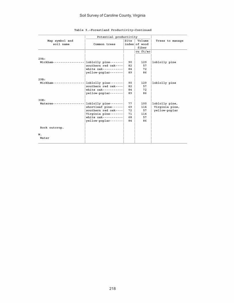
Soil Survey of Caroline County, Virginia
218
Table 9.—Forestland Productivity—Continued_________________________________________________________________________________ | Potential productivity | ___________________________________ Map symbol and | |Site | Volume | Trees to manage soil name | Common trees |index|of wood | | | | fiber |_________________________________________________________________________________ | | |cu ft/ac| ________ | | | |29A: | | | | Wickham-----------------|loblolly pine-------| 90 | 129 |loblolly pine |southern red oak----| 82 | 57 | |white oak-----------| 84 | 72 | |yellow-poplar-------| 89 | 86 | | | | |29B: | | | | Wickham-----------------|loblolly pine-------| 90 | 129 |loblolly pine |southern red oak----| 82 | 57 | |white oak-----------| 84 | 72 | |yellow-poplar-------| 89 | 86 | | | | |30E: | | | | Wateree-----------------|loblolly pine-------| 77 | 100 |loblolly pine, |shortleaf pine------| 69 | 114 | Virginia pine, |southern red oak----| 72 | 57 | yellow-poplar |Virginia pine-------| 71 | 114 | |white oak-----------| 68 | 57 | |yellow-poplar-------| 84 | 86 | | | | | Rock outcrop. | | | | | | | |W. | | | | Water | | | | | | | |_________________________________________________________________________________
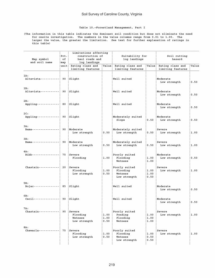
Soil Survey of Caroline County, Virginia
219
Table 10.—Forestland Management, Part I
(The information in this table indicates the dominant soil condition but does not eliminate the need for onsite investigation. The numbers in the value columns range from 0.01 to 1.00. The larger the value, the greater the limitation. See text for further explanation of ratings in this table)
________________________________________________________________________________________________________ | | Limitations affecting | | |Pct.| construction of | Suitability for | Soil rutting Map symbol | of | haul roads and | log landings | hazard and soil name |map | log landings | | _____________________________________________________________________________ |unit| Rating class and |Value| Rating class and |Value| Rating class and |Value | | limiting features | | limiting features | | limiting features |________________________________________________________________________________________________________ | | | | | | |1A: | | | | | | | Altavista-----------| 90 |Slight | |Well suited | |Moderate | | | | | | | Low strength |0.50 | | | | | | |1B: | | | | | | | Altavista-----------| 90 |Slight | |Well suited | |Moderate | | | | | | | Low strength |0.50 | | | | | | |2B: | | | | | | | Appling-------------| 80 |Slight | |Well suited | |Moderate | | | | | | | Low strength |0.50 | | | | | | |2C: | | | | | | | Appling-------------| 90 |Slight | |Moderately suited | |Moderate | | | | | Slope |0.50 | Low strength |0.50 | | | | | | |3A: | | | | | | | Bama----------------| 90 |Moderate | |Moderately suited | |Severe | | | Low strength |0.50 | Low strength |0.50 | Low strength |1.00 | | | | | | |3B: | | | | | | | Bama----------------| 90 |Moderate | |Moderately suited | |Severe | | | Low strength |0.50 | Low strength |0.50 | Low strength |1.00 | | | | | | |4A: | | | | | | | Bibb----------------| 75 |Severe | |Poorly suited | |Moderate | | | Flooding |1.00 | Flooding |1.00 | Low strength |0.50 | | | | Wetness |1.00 | | | | | | | | | Chastain------------| 20 |Severe | |Poorly suited | |Severe | | | Flooding |1.00 | Flooding |1.00 | Low strength |1.00 | | Low strength |0.50 | Wetness |1.00 | | | | | | Low strength |0.50 | | | | | | | | |5B: | | | | | | | Bojac---------------| 85 |Slight | |Well suited | |Moderate | | | | | | | Low strength |0.50 | | | | | | |6B: | | | | | | | Cecil---------------| 90 |Slight | |Well suited | |Moderate | | | | | | | Low strength |0.50 | | | | | | |7A: | | | | | | | Chastain------------| 95 |Severe | |Poorly suited | |Severe | | | Flooding |1.00 | Ponding |1.00 | Low strength |1.00 | | Wetness |1.00 | Flooding |1.00 | | | | Low strength |0.50 | Wetness |1.00 | | | | | | | | |8A: | | | | | | | Chewacla------------| 75 |Severe | |Poorly suited | |Severe | | | Flooding |1.00 | Flooding |1.00 | Low strength |1.00 | | Low strength |0.50 | Wetness |0.50 | | | | | | Low strength |0.50 | | | | | | | | |
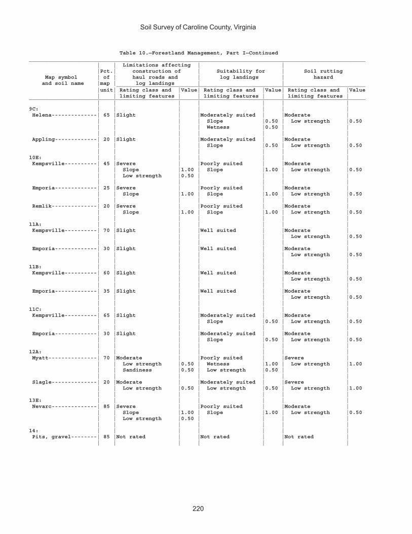
Soil Survey of Caroline County, Virginia
220
Table 10.—Forestland Management, Part I—Continued________________________________________________________________________________________________________ | | Limitations affecting | | |Pct.| construction of | Suitability for | Soil rutting Map symbol | of | haul roads and | log landings | hazard and soil name |map | log landings | | _____________________________________________________________________________ |unit| Rating class and |Value| Rating class and |Value| Rating class and |Value | | limiting features | | limiting features | | limiting features |________________________________________________________________________________________________________ | | | | | | |9C: | | | | | | | Helena--------------| 65 |Slight | |Moderately suited | |Moderate | | | | | Slope |0.50 | Low strength |0.50 | | | | Wetness |0.50 | | | | | | | | | Appling-------------| 20 |Slight | |Moderately suited | |Moderate | | | | | Slope |0.50 | Low strength |0.50 | | | | | | |10E: | | | | | | | Kempsville----------| 45 |Severe | |Poorly suited | |Moderate | | | Slope |1.00 | Slope |1.00 | Low strength |0.50 | | Low strength |0.50 | | | | | | | | | | | Emporia-------------| 25 |Severe | |Poorly suited | |Moderate | | | Slope |1.00 | Slope |1.00 | Low strength |0.50 | | | | | | | Remlik--------------| 20 |Severe | |Poorly suited | |Moderate | | | Slope |1.00 | Slope |1.00 | Low strength |0.50 | | | | | | |11A: | | | | | | | Kempsville----------| 70 |Slight | |Well suited | |Moderate | | | | | | | Low strength |0.50 | | | | | | | Emporia-------------| 30 |Slight | |Well suited | |Moderate | | | | | | | Low strength |0.50 | | | | | | |11B: | | | | | | | Kempsville----------| 60 |Slight | |Well suited | |Moderate | | | | | | | Low strength |0.50 | | | | | | | Emporia-------------| 35 |Slight | |Well suited | |Moderate | | | | | | | Low strength |0.50 | | | | | | |11C: | | | | | | | Kempsville----------| 65 |Slight | |Moderately suited | |Moderate | | | | | Slope |0.50 | Low strength |0.50 | | | | | | | Emporia-------------| 30 |Slight | |Moderately suited | |Moderate | | | | | Slope |0.50 | Low strength |0.50 | | | | | | |12A: | | | | | | | Myatt---------------| 70 |Moderate | |Poorly suited | |Severe | | | Low strength |0.50 | Wetness |1.00 | Low strength |1.00 | | Sandiness |0.50 | Low strength |0.50 | | | | | | | | | Slagle--------------| 20 |Moderate | |Moderately suited | |Severe | | | Low strength |0.50 | Low strength |0.50 | Low strength |1.00 | | | | | | |13E: | | | | | | | Nevarc--------------| 85 |Severe | |Poorly suited | |Moderate | | | Slope |1.00 | Slope |1.00 | Low strength |0.50 | | Low strength |0.50 | | | | | | | | | | |14: | | | | | | | Pits, gravel--------| 85 |Not rated | |Not rated | |Not rated | | | | | | | |
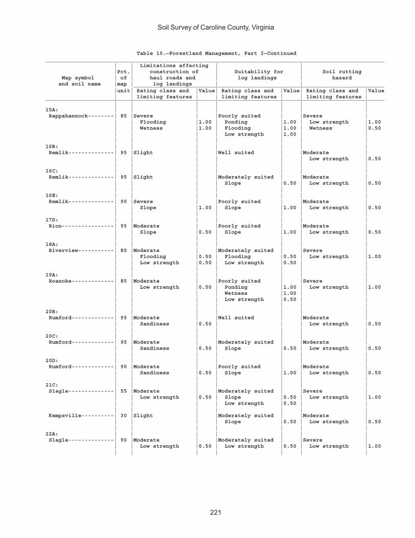
Soil Survey of Caroline County, Virginia
221
Table 10.—Forestland Management, Part I—Continued________________________________________________________________________________________________________ | | Limitations affecting | | |Pct.| construction of | Suitability for | Soil rutting Map symbol | of | haul roads and | log landings | hazard and soil name |map | log landings | | _____________________________________________________________________________ |unit| Rating class and |Value| Rating class and |Value| Rating class and |Value | | limiting features | | limiting features | | limiting features |________________________________________________________________________________________________________ | | | | | | |15A: | | | | | | | Rappahannock--------| 85 |Severe | |Poorly suited | |Severe | | | Flooding |1.00 | Ponding |1.00 | Low strength |1.00 | | Wetness |1.00 | Flooding |1.00 | Wetness |0.50 | | | | Low strength |1.00 | | | | | | | | |16B: | | | | | | | Remlik--------------| 95 |Slight | |Well suited | |Moderate | | | | | | | Low strength |0.50 | | | | | | |16C: | | | | | | | Remlik--------------| 95 |Slight | |Moderately suited | |Moderate | | | | | Slope |0.50 | Low strength |0.50 | | | | | | |16E: | | | | | | | Remlik--------------| 90 |Severe | |Poorly suited | |Moderate | | | Slope |1.00 | Slope |1.00 | Low strength |0.50 | | | | | | |17D: | | | | | | | Rion----------------| 95 |Moderate | |Poorly suited | |Moderate | | | Slope |0.50 | Slope |1.00 | Low strength |0.50 | | | | | | |18A: | | | | | | | Riverview-----------| 80 |Moderate | |Moderately suited | |Severe | | | Flooding |0.50 | Flooding |0.50 | Low strength |1.00 | | Low strength |0.50 | Low strength |0.50 | | | | | | | | |19A: | | | | | | | Roanoke-------------| 85 |Moderate | |Poorly suited | |Severe | | | Low strength |0.50 | Ponding |1.00 | Low strength |1.00 | | | | Wetness |1.00 | | | | | | Low strength |0.50 | | | | | | | | |20B: | | | | | | | Rumford-------------| 95 |Moderate | |Well suited | |Moderate | | | Sandiness |0.50 | | | Low strength |0.50 | | | | | | |20C: | | | | | | | Rumford-------------| 95 |Moderate | |Moderately suited | |Moderate | | | Sandiness |0.50 | Slope |0.50 | Low strength |0.50 | | | | | | |20D: | | | | | | | Rumford-------------| 90 |Moderate | |Poorly suited | |Moderate | | | Sandiness |0.50 | Slope |1.00 | Low strength |0.50 | | | | | | |21C: | | | | | | | Slagle--------------| 55 |Moderate | |Moderately suited | |Severe | | | Low strength |0.50 | Slope |0.50 | Low strength |1.00 | | | | Low strength |0.50 | | | | | | | | | Kempsville----------| 30 |Slight | |Moderately suited | |Moderate | | | | | Slope |0.50 | Low strength |0.50 | | | | | | |22A: | | | | | | | Slagle--------------| 90 |Moderate | |Moderately suited | |Severe | | | Low strength |0.50 | Low strength |0.50 | Low strength |1.00 | | | | | | |
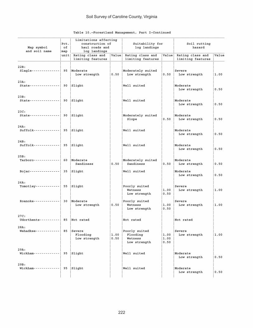
Soil Survey of Caroline County, Virginia
222
Table 10.—Forestland Management, Part I—Continued________________________________________________________________________________________________________ | | Limitations affecting | | |Pct.| construction of | Suitability for | Soil rutting Map symbol | of | haul roads and | log landings | hazard and soil name |map | log landings | | _____________________________________________________________________________ |unit| Rating class and |Value| Rating class and |Value| Rating class and |Value | | limiting features | | limiting features | | limiting features |________________________________________________________________________________________________________ | | | | | | |22B: | | | | | | | Slagle--------------| 95 |Moderate | |Moderately suited | |Severe | | | Low strength |0.50 | Low strength |0.50 | Low strength |1.00 | | | | | | |23A: | | | | | | | State---------------| 90 |Slight | |Well suited | |Moderate | | | | | | | Low strength |0.50 | | | | | | |23B: | | | | | | | State---------------| 90 |Slight | |Well suited | |Moderate | | | | | | | Low strength |0.50 | | | | | | |23C: | | | | | | | State---------------| 90 |Slight | |Moderately suited | |Moderate | | | | | Slope |0.50 | Low strength |0.50 | | | | | | |24A: | | | | | | | Suffolk-------------| 95 |Slight | |Well suited | |Moderate | | | | | | | Low strength |0.50 | | | | | | |24B: | | | | | | | Suffolk-------------| 95 |Slight | |Well suited | |Moderate | | | | | | | Low strength |0.50 | | | | | | |25B: | | | | | | | Tarboro-------------| 60 |Moderate | |Moderately suited | |Moderate | | | Sandiness |0.50 | Sandiness |0.50 | Low strength |0.50 | | | | | | | Bojac---------------| 35 |Slight | |Well suited | |Moderate | | | | | | | Low strength |0.50 | | | | | | |26A: | | | | | | | Tomotley------------| 55 |Slight | |Poorly suited | |Severe | | | | | Wetness |1.00 | Low strength |1.00 | | | | Low strength |0.50 | | | | | | | | | Roanoke-------------| 30 |Moderate | |Poorly suited | |Severe | | | Low strength |0.50 | Wetness |1.00 | Low strength |1.00 | | | | Low strength |0.50 | | | | | | | | |27C: | | | | | | | Udorthents----------| 85 |Not rated | |Not rated | |Not rated | | | | | | | |28A: | | | | | | | Wehadkee------------| 85 |Severe | |Poorly suited | |Severe | | | Flooding |1.00 | Flooding |1.00 | Low strength |1.00 | | Low strength |0.50 | Wetness |1.00 | | | | | | Low strength |0.50 | | | | | | | | |29A: | | | | | | | Wickham-------------| 95 |Slight | |Well suited | |Moderate | | | | | | | Low strength |0.50 | | | | | | |29B: | | | | | | | Wickham-------------| 95 |Slight | |Well suited | |Moderate | | | | | | | Low strength |0.50 | | | | | | |

Soil Survey of Caroline County, Virginia
223
Table 10.—Forestland Management, Part I—Continued________________________________________________________________________________________________________ | | Limitations affecting | | |Pct.| construction of | Suitability for | Soil rutting Map symbol | of | haul roads and | log landings | hazard and soil name |map | log landings | | _____________________________________________________________________________ |unit| Rating class and |Value| Rating class and |Value| Rating class and |Value | | limiting features | | limiting features | | limiting features |________________________________________________________________________________________________________ | | | | | | |30E: | | | | | | | Wateree-------------| 75 |Severe | |Poorly suited | |Moderate | | | Slope |1.00 | Slope |1.00 | Low strength |0.50 | | | | | | | Rock outcrop--------| 15 |Not rated | |Not rated | |Not rated | | | | | | | |W: | | | | | | | Water---------------|100 |Not rated | |Not rated | |Not rated | | | | | | | |________________________________________________________________________________________________________
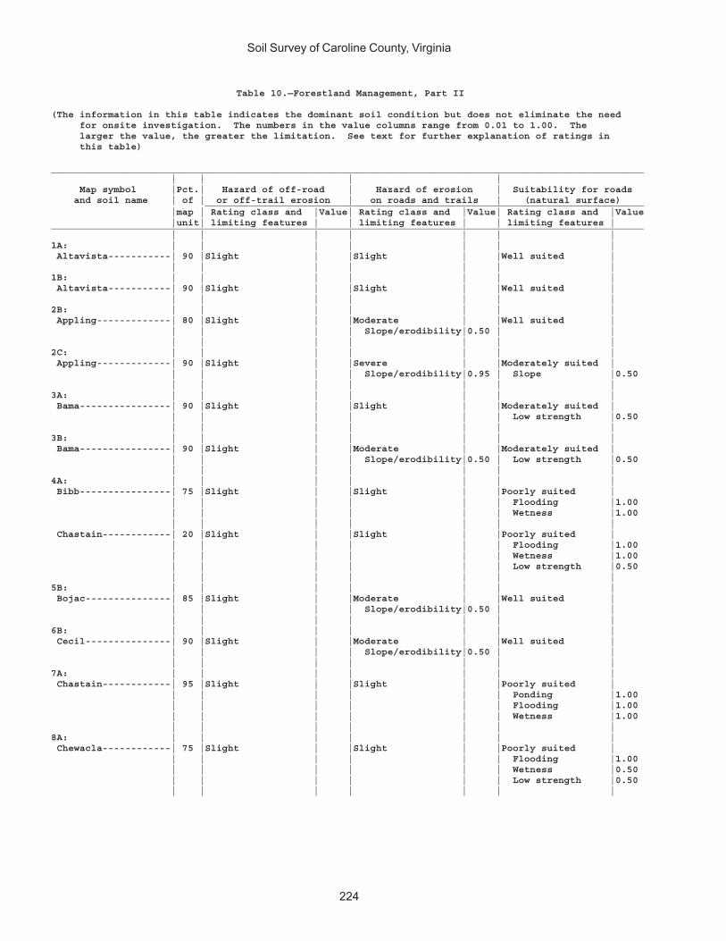
Soil Survey of Caroline County, Virginia
224
Table 10.—Forestland Management, Part II
(The information in this table indicates the dominant soil condition but does not eliminate the need for onsite investigation. The numbers in the value columns range from 0.01 to 1.00. The larger the value, the greater the limitation. See text for further explanation of ratings in this table)
________________________________________________________________________________________________________ | | | | Map symbol |Pct.| Hazard of off-road | Hazard of erosion | Suitability for roads and soil name | of | or off-trail erosion | on roads and trails | (natural surface) _____________________________________________________________________________ |map | Rating class and |Value| Rating class and |Value| Rating class and |Value |unit| limiting features | | limiting features | | limiting features |________________________________________________________________________________________________________ | | | | | | |1A: | | | | | | | Altavista-----------| 90 |Slight | |Slight | |Well suited | | | | | | | |1B: | | | | | | | Altavista-----------| 90 |Slight | |Slight | |Well suited | | | | | | | |2B: | | | | | | | Appling-------------| 80 |Slight | |Moderate | |Well suited | | | | | Slope/erodibility|0.50 | | | | | | | | |2C: | | | | | | | Appling-------------| 90 |Slight | |Severe | |Moderately suited | | | | | Slope/erodibility|0.95 | Slope |0.50 | | | | | | |3A: | | | | | | | Bama----------------| 90 |Slight | |Slight | |Moderately suited | | | | | | | Low strength |0.50 | | | | | | |3B: | | | | | | | Bama----------------| 90 |Slight | |Moderate | |Moderately suited | | | | | Slope/erodibility|0.50 | Low strength |0.50 | | | | | | |4A: | | | | | | | Bibb----------------| 75 |Slight | |Slight | |Poorly suited | | | | | | | Flooding |1.00 | | | | | | Wetness |1.00 | | | | | | | Chastain------------| 20 |Slight | |Slight | |Poorly suited | | | | | | | Flooding |1.00 | | | | | | Wetness |1.00 | | | | | | Low strength |0.50 | | | | | | |5B: | | | | | | | Bojac---------------| 85 |Slight | |Moderate | |Well suited | | | | | Slope/erodibility|0.50 | | | | | | | | |6B: | | | | | | | Cecil---------------| 90 |Slight | |Moderate | |Well suited | | | | | Slope/erodibility|0.50 | | | | | | | | |7A: | | | | | | | Chastain------------| 95 |Slight | |Slight | |Poorly suited | | | | | | | Ponding |1.00 | | | | | | Flooding |1.00 | | | | | | Wetness |1.00 | | | | | | |8A: | | | | | | | Chewacla------------| 75 |Slight | |Slight | |Poorly suited | | | | | | | Flooding |1.00 | | | | | | Wetness |0.50 | | | | | | Low strength |0.50 | | | | | | |
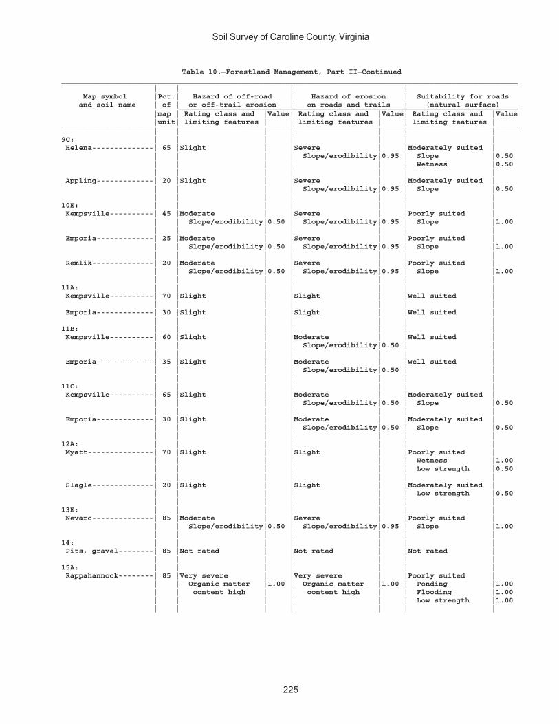
Soil Survey of Caroline County, Virginia
225
Table 10.—Forestland Management, Part II—Continued________________________________________________________________________________________________________ | | | | Map symbol |Pct.| Hazard of off-road | Hazard of erosion | Suitability for roads and soil name | of | or off-trail erosion | on roads and trails | (natural surface) _____________________________________________________________________________ |map | Rating class and |Value| Rating class and |Value| Rating class and |Value |unit| limiting features | | limiting features | | limiting features |________________________________________________________________________________________________________ | | | | | | |9C: | | | | | | | Helena--------------| 65 |Slight | |Severe | |Moderately suited | | | | | Slope/erodibility|0.95 | Slope |0.50 | | | | | | Wetness |0.50 | | | | | | | Appling-------------| 20 |Slight | |Severe | |Moderately suited | | | | | Slope/erodibility|0.95 | Slope |0.50 | | | | | | |10E: | | | | | | | Kempsville----------| 45 |Moderate | |Severe | |Poorly suited | | | Slope/erodibility|0.50 | Slope/erodibility|0.95 | Slope |1.00 | | | | | | | Emporia-------------| 25 |Moderate | |Severe | |Poorly suited | | | Slope/erodibility|0.50 | Slope/erodibility|0.95 | Slope |1.00 | | | | | | | Remlik--------------| 20 |Moderate | |Severe | |Poorly suited | | | Slope/erodibility|0.50 | Slope/erodibility|0.95 | Slope |1.00 | | | | | | |11A: | | | | | | | Kempsville----------| 70 |Slight | |Slight | |Well suited | | | | | | | | Emporia-------------| 30 |Slight | |Slight | |Well suited | | | | | | | |11B: | | | | | | | Kempsville----------| 60 |Slight | |Moderate | |Well suited | | | | | Slope/erodibility|0.50 | | | | | | | | | Emporia-------------| 35 |Slight | |Moderate | |Well suited | | | | | Slope/erodibility|0.50 | | | | | | | | |11C: | | | | | | | Kempsville----------| 65 |Slight | |Moderate | |Moderately suited | | | | | Slope/erodibility|0.50 | Slope |0.50 | | | | | | | Emporia-------------| 30 |Slight | |Moderate | |Moderately suited | | | | | Slope/erodibility|0.50 | Slope |0.50 | | | | | | |12A: | | | | | | | Myatt---------------| 70 |Slight | |Slight | |Poorly suited | | | | | | | Wetness |1.00 | | | | | | Low strength |0.50 | | | | | | | Slagle--------------| 20 |Slight | |Slight | |Moderately suited | | | | | | | Low strength |0.50 | | | | | | |13E: | | | | | | | Nevarc--------------| 85 |Moderate | |Severe | |Poorly suited | | | Slope/erodibility|0.50 | Slope/erodibility|0.95 | Slope |1.00 | | | | | | |14: | | | | | | | Pits, gravel--------| 85 |Not rated | |Not rated | |Not rated | | | | | | | |15A: | | | | | | | Rappahannock--------| 85 |Very severe | |Very severe | |Poorly suited | | | Organic matter |1.00 | Organic matter |1.00 | Ponding |1.00 | | content high | | content high | | Flooding |1.00 | | | | | | Low strength |1.00 | | | | | | |
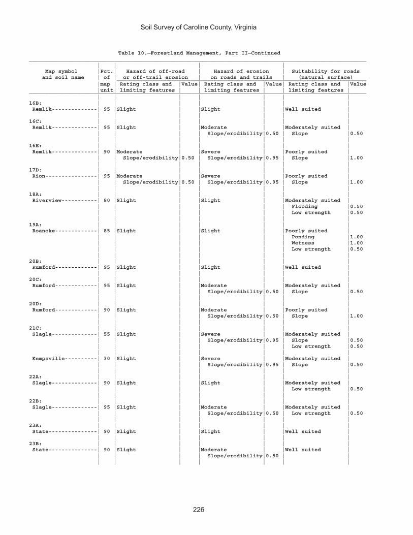
Soil Survey of Caroline County, Virginia
226
Table 10.—Forestland Management, Part II—Continued________________________________________________________________________________________________________ | | | | Map symbol |Pct.| Hazard of off-road | Hazard of erosion | Suitability for roads and soil name | of | or off-trail erosion | on roads and trails | (natural surface) _____________________________________________________________________________ |map | Rating class and |Value| Rating class and |Value| Rating class and |Value |unit| limiting features | | limiting features | | limiting features |________________________________________________________________________________________________________ | | | | | | |16B: | | | | | | | Remlik--------------| 95 |Slight | |Slight | |Well suited | | | | | | | |16C: | | | | | | | Remlik--------------| 95 |Slight | |Moderate | |Moderately suited | | | | | Slope/erodibility|0.50 | Slope |0.50 | | | | | | |16E: | | | | | | | Remlik--------------| 90 |Moderate | |Severe | |Poorly suited | | | Slope/erodibility|0.50 | Slope/erodibility|0.95 | Slope |1.00 | | | | | | |17D: | | | | | | | Rion----------------| 95 |Moderate | |Severe | |Poorly suited | | | Slope/erodibility|0.50 | Slope/erodibility|0.95 | Slope |1.00 | | | | | | |18A: | | | | | | | Riverview-----------| 80 |Slight | |Slight | |Moderately suited | | | | | | | Flooding |0.50 | | | | | | Low strength |0.50 | | | | | | |19A: | | | | | | | Roanoke-------------| 85 |Slight | |Slight | |Poorly suited | | | | | | | Ponding |1.00 | | | | | | Wetness |1.00 | | | | | | Low strength |0.50 | | | | | | |20B: | | | | | | | Rumford-------------| 95 |Slight | |Slight | |Well suited | | | | | | | |20C: | | | | | | | Rumford-------------| 95 |Slight | |Moderate | |Moderately suited | | | | | Slope/erodibility|0.50 | Slope |0.50 | | | | | | |20D: | | | | | | | Rumford-------------| 90 |Slight | |Moderate | |Poorly suited | | | | | Slope/erodibility|0.50 | Slope |1.00 | | | | | | |21C: | | | | | | | Slagle--------------| 55 |Slight | |Severe | |Moderately suited | | | | | Slope/erodibility|0.95 | Slope |0.50 | | | | | | Low strength |0.50 | | | | | | | Kempsville----------| 30 |Slight | |Severe | |Moderately suited | | | | | Slope/erodibility|0.95 | Slope |0.50 | | | | | | |22A: | | | | | | | Slagle--------------| 90 |Slight | |Slight | |Moderately suited | | | | | | | Low strength |0.50 | | | | | | |22B: | | | | | | | Slagle--------------| 95 |Slight | |Moderate | |Moderately suited | | | | | Slope/erodibility|0.50 | Low strength |0.50 | | | | | | |23A: | | | | | | | State---------------| 90 |Slight | |Slight | |Well suited | | | | | | | |23B: | | | | | | | State---------------| 90 |Slight | |Moderate | |Well suited | | | | | Slope/erodibility|0.50 | | | | | | | | |

Soil Survey of Caroline County, Virginia
227
Table 10.—Forestland Management, Part II—Continued________________________________________________________________________________________________________ | | | | Map symbol |Pct.| Hazard of off-road | Hazard of erosion | Suitability for roads and soil name | of | or off-trail erosion | on roads and trails | (natural surface) _____________________________________________________________________________ |map | Rating class and |Value| Rating class and |Value| Rating class and |Value |unit| limiting features | | limiting features | | limiting features |________________________________________________________________________________________________________ | | | | | | |23C: | | | | | | | State---------------| 90 |Slight | |Moderate | |Moderately suited | | | | | Slope/erodibility|0.50 | Slope |0.50 | | | | | | |24A: | | | | | | | Suffolk-------------| 95 |Slight | |Slight | |Well suited | | | | | | | |24B: | | | | | | | Suffolk-------------| 95 |Slight | |Slight | |Well suited | | | | | | | |25B: | | | | | | | Tarboro-------------| 60 |Slight | |Slight | |Moderately suited | | | | | | | Sandiness |0.50 | | | | | | | Bojac---------------| 35 |Slight | |Moderate | |Well suited | | | | | Slope/erodibility|0.50 | | | | | | | | |26A: | | | | | | | Tomotley------------| 55 |Slight | |Slight | |Poorly suited | | | | | | | Wetness |1.00 | | | | | | Low strength |0.50 | | | | | | | Roanoke-------------| 30 |Slight | |Slight | |Poorly suited | | | | | | | Wetness |1.00 | | | | | | Low strength |0.50 | | | | | | |27C: | | | | | | | Udorthents----------| 85 |Not rated | |Not rated | |Not rated | | | | | | | |28A: | | | | | | | Wehadkee------------| 85 |Slight | |Slight | |Poorly suited | | | | | | | Flooding |1.00 | | | | | | Wetness |1.00 | | | | | | Low strength |0.50 | | | | | | |29A: | | | | | | | Wickham-------------| 95 |Slight | |Slight | |Well suited | | | | | | | |29B: | | | | | | | Wickham-------------| 95 |Slight | |Moderate | |Well suited | | | | | Slope/erodibility|0.50 | | | | | | | | |30E: | | | | | | | Wateree-------------| 75 |Severe | |Severe | |Poorly suited | | | Slope/erodibility|0.75 | Slope/erodibility|0.95 | Slope |1.00 | | | | | | | Rock outcrop--------| 15 |Not rated | |Not rated | |Not rated | | | | | | | |W: | | | | | | | Water---------------|100 |Not rated | |Not rated | |Not rated | | | | | | | |________________________________________________________________________________________________________

Soil Survey of Caroline County, Virginia
228
Table 10.—Forestland Management, Part III
(The information in this table indicates the dominant soil condition but does not eliminate the need for onsite investigation. The numbers in the value columns range from 0.01 to 1.00. The larger the value, the greater the limitation. See text for further explanation of ratings in this table)
________________________________________________________________________________________________________ | | | | Map symbol |Pct.| Suitability for | Suitability for | Suitability for use of and soil name | of | hand planting | mechanical planting | harvesting equipment _____________________________________________________________________________ |map | Rating class and |Value| Rating class and |Value| Rating class and |Value |unit| limiting features | | limiting features | | limiting features |________________________________________________________________________________________________________ | | | | | | |1A: | | | | | | | Altavista-----------| 90 |Well suited | |Well suited | |Well suited | | | | | | | |1B: | | | | | | | Altavista-----------| 90 |Well suited | |Well suited | |Well suited | | | | | | | |2B: | | | | | | | Appling-------------| 80 |Well suited | |Moderately suited | |Well suited | | | | | Slope |0.50 | | | | | | | | |2C: | | | | | | | Appling-------------| 90 |Well suited | |Moderately suited | |Well suited | | | | | Slope |0.50 | | | | | | | | |3A: | | | | | | | Bama----------------| 90 |Well suited | |Well suited | |Moderately suited | | | | | | | Low strength |0.50 | | | | | | |3B: | | | | | | | Bama----------------| 90 |Well suited | |Well suited | |Moderately suited | | | | | | | Low strength |0.50 | | | | | | |4A: | | | | | | | Bibb----------------| 75 |Well suited | |Well suited | |Well suited | | | | | | | | Chastain------------| 20 |Well suited | |Well suited | |Moderately suited | | | | | | | Low strength |0.50 | | | | | | |5B: | | | | | | | Bojac---------------| 85 |Well suited | |Well suited | |Well suited | | | | | | | |6B: | | | | | | | Cecil---------------| 90 |Well suited | |Moderately suited | |Well suited | | | | | Slope |0.50 | | | | | | | | |7A: | | | | | | | Chastain------------| 95 |Poorly suited | |Poorly suited | |Poorly suited | | | Wetness |0.75 | Wetness |0.75 | Wetness |1.00 | | | | | | Low strength |0.50 | | | | | | |8A: | | | | | | | Chewacla------------| 75 |Well suited | |Well suited | |Moderately suited | | | | | | | Low strength |0.50 | | | | | | |9C: | | | | | | | Helena--------------| 65 |Well suited | |Moderately suited | |Well suited | | | | | Slope |0.50 | | | | | | | | | Appling-------------| 20 |Well suited | |Moderately suited | |Well suited | | | | | Slope |0.50 | | | | | | | | |
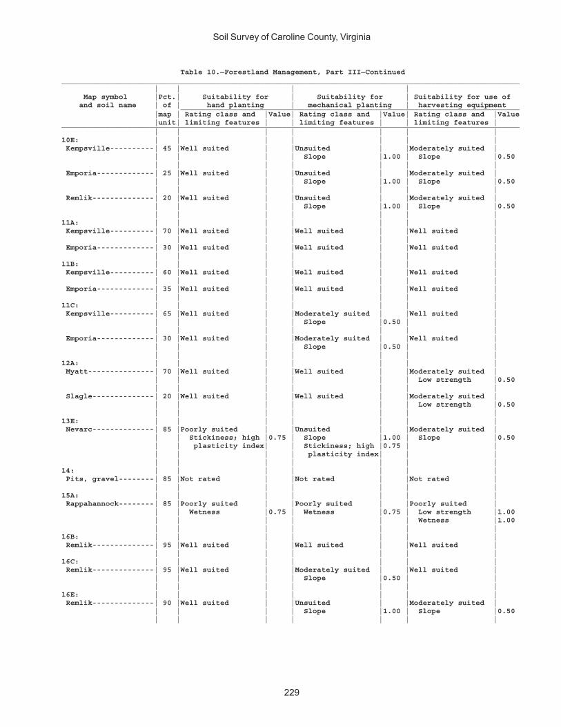
Soil Survey of Caroline County, Virginia
229
Table 10.—Forestland Management, Part III—Continued________________________________________________________________________________________________________ | | | | Map symbol |Pct.| Suitability for | Suitability for | Suitability for use of and soil name | of | hand planting | mechanical planting | harvesting equipment _____________________________________________________________________________ |map | Rating class and |Value| Rating class and |Value| Rating class and |Value |unit| limiting features | | limiting features | | limiting features |________________________________________________________________________________________________________ | | | | | | |10E: | | | | | | | Kempsville----------| 45 |Well suited | |Unsuited | |Moderately suited | | | | | Slope |1.00 | Slope |0.50 | | | | | | | Emporia-------------| 25 |Well suited | |Unsuited | |Moderately suited | | | | | Slope |1.00 | Slope |0.50 | | | | | | | Remlik--------------| 20 |Well suited | |Unsuited | |Moderately suited | | | | | Slope |1.00 | Slope |0.50 | | | | | | |11A: | | | | | | | Kempsville----------| 70 |Well suited | |Well suited | |Well suited | | | | | | | | Emporia-------------| 30 |Well suited | |Well suited | |Well suited | | | | | | | |11B: | | | | | | | Kempsville----------| 60 |Well suited | |Well suited | |Well suited | | | | | | | | Emporia-------------| 35 |Well suited | |Well suited | |Well suited | | | | | | | |11C: | | | | | | | Kempsville----------| 65 |Well suited | |Moderately suited | |Well suited | | | | | Slope |0.50 | | | | | | | | | Emporia-------------| 30 |Well suited | |Moderately suited | |Well suited | | | | | Slope |0.50 | | | | | | | | |12A: | | | | | | | Myatt---------------| 70 |Well suited | |Well suited | |Moderately suited | | | | | | | Low strength |0.50 | | | | | | | Slagle--------------| 20 |Well suited | |Well suited | |Moderately suited | | | | | | | Low strength |0.50 | | | | | | |13E: | | | | | | | Nevarc--------------| 85 |Poorly suited | |Unsuited | |Moderately suited | | | Stickiness; high |0.75 | Slope |1.00 | Slope |0.50 | | plasticity index| | Stickiness; high |0.75 | | | | | | plasticity index| | | | | | | | | |14: | | | | | | | Pits, gravel--------| 85 |Not rated | |Not rated | |Not rated | | | | | | | |15A: | | | | | | | Rappahannock--------| 85 |Poorly suited | |Poorly suited | |Poorly suited | | | Wetness |0.75 | Wetness |0.75 | Low strength |1.00 | | | | | | Wetness |1.00 | | | | | | |16B: | | | | | | | Remlik--------------| 95 |Well suited | |Well suited | |Well suited | | | | | | | |16C: | | | | | | | Remlik--------------| 95 |Well suited | |Moderately suited | |Well suited | | | | | Slope |0.50 | | | | | | | | |16E: | | | | | | | Remlik--------------| 90 |Well suited | |Unsuited | |Moderately suited | | | | | Slope |1.00 | Slope |0.50 | | | | | | |

Soil Survey of Caroline County, Virginia
230
Table 10.—Forestland Management, Part III—Continued________________________________________________________________________________________________________ | | | | Map symbol |Pct.| Suitability for | Suitability for | Suitability for use of and soil name | of | hand planting | mechanical planting | harvesting equipment _____________________________________________________________________________ |map | Rating class and |Value| Rating class and |Value| Rating class and |Value |unit| limiting features | | limiting features | | limiting features |________________________________________________________________________________________________________ | | | | | | |17D: | | | | | | | Rion----------------| 95 |Well suited | |Poorly suited | |Moderately suited | | | | | Slope |0.75 | Slope |0.50 | | | | | | |18A: | | | | | | | Riverview-----------| 80 |Well suited | |Well suited | |Moderately suited | | | | | | | Low strength |0.50 | | | | | | |19A: | | | | | | | Roanoke-------------| 85 |Poorly suited | |Poorly suited | |Moderately suited | | | Stickiness; high |0.75 | Stickiness; high |0.75 | Low strength |0.50 | | plasticity index| | plasticity index| | | | | | | | | |20B: | | | | | | | Rumford-------------| 95 |Well suited | |Well suited | |Well suited | | | | | | | |20C: | | | | | | | Rumford-------------| 95 |Well suited | |Moderately suited | |Well suited | | | | | Slope |0.50 | | | | | | | | |20D: | | | | | | | Rumford-------------| 90 |Well suited | |Moderately suited | |Well suited | | | | | Slope |0.50 | | | | | | | | |21C: | | | | | | | Slagle--------------| 55 |Well suited | |Moderately suited | |Moderately suited | | | | | Slope |0.50 | Low strength |0.50 | | | | | | | Kempsville----------| 30 |Well suited | |Moderately suited | |Well suited | | | | | Slope |0.50 | | | | | | | | |22A: | | | | | | | Slagle--------------| 90 |Well suited | |Well suited | |Moderately suited | | | | | | | Low strength |0.50 | | | | | | |22B: | | | | | | | Slagle--------------| 95 |Well suited | |Well suited | |Moderately suited | | | | | | | Low strength |0.50 | | | | | | |23A: | | | | | | | State---------------| 90 |Well suited | |Well suited | |Well suited | | | | | | | |23B: | | | | | | | State---------------| 90 |Well suited | |Well suited | |Well suited | | | | | | | |23C: | | | | | | | State---------------| 90 |Well suited | |Moderately suited | |Well suited | | | | | Slope |0.50 | | | | | | | | |24A: | | | | | | | Suffolk-------------| 95 |Well suited | |Well suited | |Well suited | | | | | | | |24B: | | | | | | | Suffolk-------------| 95 |Well suited | |Well suited | |Well suited | | | | | | | |25B: | | | | | | | Tarboro-------------| 60 |Moderately suited | |Moderately suited | |Moderately suited | | | Sandiness |0.50 | Sandiness |0.50 | Sandiness |0.50 | | | | | | | Bojac---------------| 35 |Well suited | |Well suited | |Well suited | | | | | | | |

Soil Survey of Caroline County, Virginia
231
Table 10.—Forestland Management, Part III—Continued________________________________________________________________________________________________________ | | | | Map symbol |Pct.| Suitability for | Suitability for | Suitability for use of and soil name | of | hand planting | mechanical planting | harvesting equipment _____________________________________________________________________________ |map | Rating class and |Value| Rating class and |Value| Rating class and |Value |unit| limiting features | | limiting features | | limiting features |________________________________________________________________________________________________________ | | | | | | |26A: | | | | | | | Tomotley------------| 55 |Well suited | |Well suited | |Moderately suited | | | | | | | Low strength |0.50 | | | | | | | Roanoke-------------| 30 |Poorly suited | |Poorly suited | |Moderately suited | | | Stickiness; high |0.75 | Stickiness; high |0.75 | Low strength |0.50 | | plasticity index| | plasticity index| | | | | | | | | |27C: | | | | | | | Udorthents----------| 85 |Not rated | |Not rated | |Not rated | | | | | | | |28A: | | | | | | | Wehadkee------------| 85 |Well suited | |Well suited | |Moderately suited | | | | | | | Low strength |0.50 | | | | | | |29A: | | | | | | | Wickham-------------| 95 |Well suited | |Well suited | |Well suited | | | | | | | |29B: | | | | | | | Wickham-------------| 95 |Well suited | |Well suited | |Well suited | | | | | | | |30E: | | | | | | | Wateree-------------| 75 |Moderately suited | |Unsuited | |Poorly suited | | | Slope |0.50 | Slope |1.00 | Slope |1.00 | | | | | | | Rock outcrop--------| 15 |Not rated | |Not rated | |Not rated | | | | | | | |W: | | | | | | | Water---------------|100 |Not rated | |Not rated | |Not rated | | | | | | | |________________________________________________________________________________________________________

Soil Survey of Caroline County, Virginia
232
Table 10.—Forestland Management, Part IV
(The information in this table indicates the dominant soil condition but does not eliminate the need for onsite investigation. The numbers in the value columns range from 0.01 to 1.00. The larger the value, the greater the limitation. See text for further explanation of ratings in this table)
______________________________________________________________________________ |Pct.| Suitability for | Suitability for Map symbol | of | mechanical site | mechanical site and soil name |map | preparation (surface) | preparation (deep) ___________________________________________________ |unit| Rating class and |Value| Rating class and |Value | | limiting features | | limiting features |______________________________________________________________________________ | | | | |1A: | | | | | Altavista-----------| 90 |Well suited | |Well suited | | | | | |1B: | | | | | Altavista-----------| 90 |Well suited | |Well suited | | | | | |2B: | | | | | Appling-------------| 80 |Well suited | |Well suited | | | | | |2C: | | | | | Appling-------------| 90 |Well suited | |Well suited | | | | | |3A: | | | | | Bama----------------| 90 |Well suited | |Well suited | | | | | |3B: | | | | | Bama----------------| 90 |Well suited | |Well suited | | | | | |4A: | | | | | Bibb----------------| 75 |Well suited | |Well suited | | | | | | Chastain------------| 20 |Well suited | |Well suited | | | | | |5B: | | | | | Bojac---------------| 85 |Well suited | |Well suited | | | | | |6B: | | | | | Cecil---------------| 90 |Well suited | |Well suited | | | | | |7A: | | | | | Chastain------------| 95 |Poorly suited | |Unsuited | | | Wetness |0.75 | Wetness |1.00 | | | | |8A: | | | | | Chewacla------------| 75 |Well suited | |Well suited | | | | | |9C: | | | | | Helena--------------| 65 |Well suited | |Well suited | | | | | | Appling-------------| 20 |Well suited | |Well suited | | | | | |10E: | | | | | Kempsville----------| 45 |Poorly suited | |Poorly suited | | | Slope |0.50 | Slope |0.50 | | | | | Emporia-------------| 25 |Poorly suited | |Poorly suited | | | Slope |0.50 | Slope |0.50 | | | | | Remlik--------------| 20 |Poorly suited | |Poorly suited | | | Slope |0.50 | Slope |0.50 | | | | |

Soil Survey of Caroline County, Virginia
233
Table 10.—Forestland Management, Part IV—Continued______________________________________________________________________________ |Pct.| Suitability for | Suitability for Map symbol | of | mechanical site | mechanical site and soil name |map | preparation (surface) | preparation (deep) ___________________________________________________ |unit| Rating class and |Value| Rating class and |Value | | limiting features | | limiting features |______________________________________________________________________________ | | | | |11A: | | | | | Kempsville----------| 70 |Well suited | |Well suited | | | | | | Emporia-------------| 30 |Well suited | |Well suited | | | | | |11B: | | | | | Kempsville----------| 60 |Well suited | |Well suited | | | | | | Emporia-------------| 35 |Well suited | |Well suited | | | | | |11C: | | | | | Kempsville----------| 65 |Well suited | |Well suited | | | | | | Emporia-------------| 30 |Well suited | |Well suited | | | | | |12A: | | | | | Myatt---------------| 70 |Well suited | |Well suited | | | | | | Slagle--------------| 20 |Well suited | |Well suited | | | | | |13E: | | | | | Nevarc--------------| 85 |Poorly suited | |Poorly suited | | | Slope |0.50 | Slope |0.50 | | Stickiness; high |0.50 | | | | plasticity index| | | | | | | |14: | | | | | Pits, gravel--------| 85 |Not rated | |Not rated | | | | | |15A: | | | | | Rappahannock--------| 85 |Poorly suited | |Unsuited | | | Wetness |0.75 | Wetness |1.00 | | | | |16B: | | | | | Remlik--------------| 95 |Well suited | |Well suited | | | | | |16C: | | | | | Remlik--------------| 95 |Well suited | |Well suited | | | | | |16E: | | | | | Remlik--------------| 90 |Poorly suited | |Poorly suited | | | Slope |0.50 | Slope |0.50 | | | | |17D: | | | | | Rion----------------| 95 |Poorly suited | |Poorly suited | | | Slope |0.50 | Slope |0.50 | | | | |18A: | | | | | Riverview-----------| 80 |Well suited | |Well suited | | | | | |19A: | | | | | Roanoke-------------| 85 |Poorly suited | |Well suited | | | Stickiness; high |0.50 | | | | plasticity index| | | | | | | |20B: | | | | | Rumford-------------| 95 |Well suited | |Well suited | | | | | |20C: | | | | | Rumford-------------| 95 |Well suited | |Well suited | | | | | |

Soil Survey of Caroline County, Virginia
234
Table 10.—Forestland Management, Part IV—Continued______________________________________________________________________________ |Pct.| Suitability for | Suitability for Map symbol | of | mechanical site | mechanical site and soil name |map | preparation (surface) | preparation (deep) ___________________________________________________ |unit| Rating class and |Value| Rating class and |Value | | limiting features | | limiting features |______________________________________________________________________________ | | | | |20D: | | | | | Rumford-------------| 90 |Well suited | |Well suited | | | | | |21C: | | | | | Slagle--------------| 55 |Well suited | |Well suited | | | | | | Kempsville----------| 30 |Well suited | |Well suited | | | | | |22A: | | | | | Slagle--------------| 90 |Well suited | |Well suited | | | | | |22B: | | | | | Slagle--------------| 95 |Well suited | |Well suited | | | | | |23A: | | | | | State---------------| 90 |Well suited | |Well suited | | | | | |23B: | | | | | State---------------| 90 |Well suited | |Well suited | | | | | |23C: | | | | | State---------------| 90 |Well suited | |Well suited | | | | | |24A: | | | | | Suffolk-------------| 95 |Well suited | |Well suited | | | | | |24B: | | | | | Suffolk-------------| 95 |Well suited | |Well suited | | | | | |25B: | | | | | Tarboro-------------| 60 |Well suited | |Well suited | | | | | | Bojac---------------| 35 |Well suited | |Well suited | | | | | |26A: | | | | | Tomotley------------| 55 |Well suited | |Well suited | | | | | | Roanoke-------------| 30 |Poorly suited | |Well suited | | | Stickiness; high |0.50 | | | | plasticity index| | | | | | | |27C: | | | | | Udorthents----------| 85 |Not rated | |Not rated | | | | | |28A: | | | | | Wehadkee------------| 85 |Well suited | |Well suited | | | | | |29A: | | | | | Wickham-------------| 95 |Well suited | |Well suited | | | | | |29B: | | | | | Wickham-------------| 95 |Well suited | |Well suited | | | | | |30E: | | | | | Wateree-------------| 75 |Unsuited | |Unsuited | | | Slope |1.00 | Slope |1.00 | | | | | Rock outcrop--------| 15 |Not rated | |Not rated | | | | | |W: | | | | | Water---------------|100 |Not rated | |Not rated | | | | | |______________________________________________________________________________
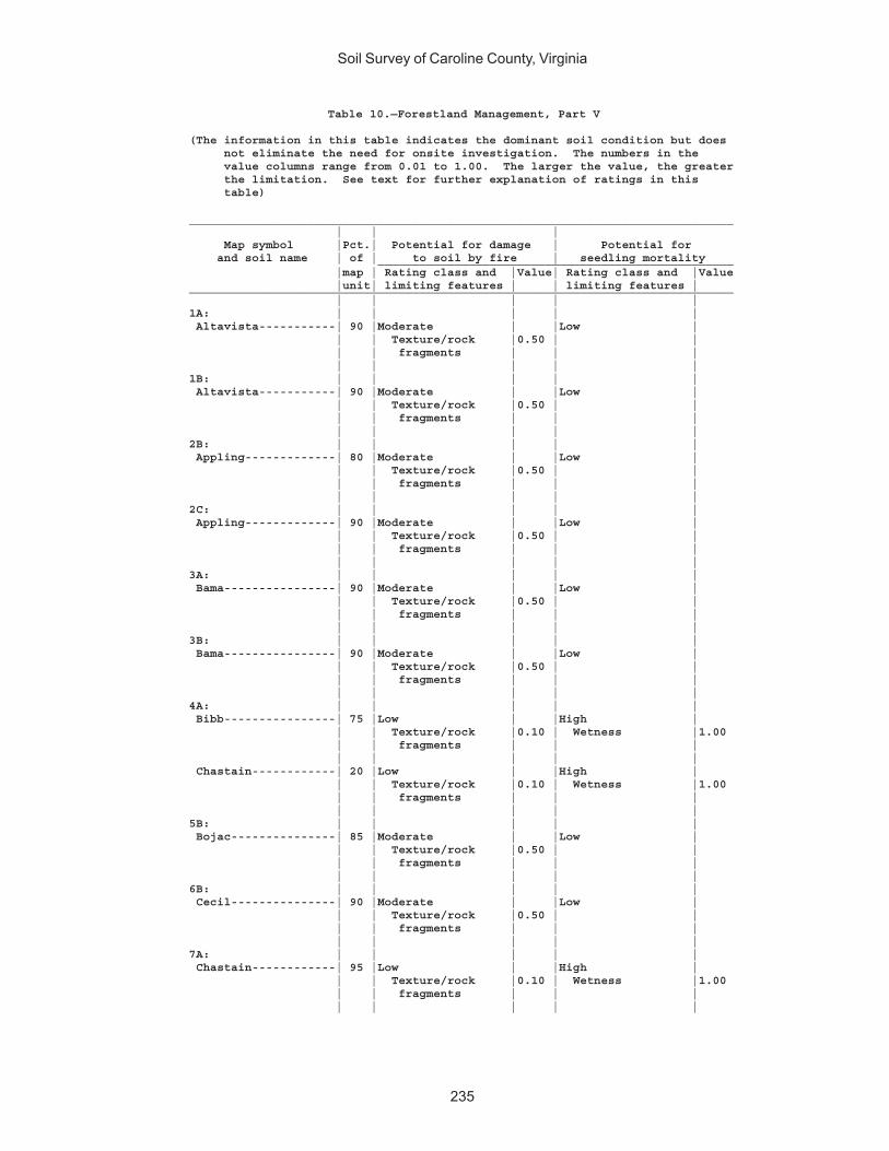
Soil Survey of Caroline County, Virginia
235
Table 10.—Forestland Management, Part V
(The information in this table indicates the dominant soil condition but does not eliminate the need for onsite investigation. The numbers in the value columns range from 0.01 to 1.00. The larger the value, the greater the limitation. See text for further explanation of ratings in this table)
______________________________________________________________________________ | | | Map symbol |Pct.| Potential for damage | Potential for and soil name | of | to soil by fire | seedling mortality ___________________________________________________ |map | Rating class and |Value| Rating class and |Value |unit| limiting features | | limiting features |______________________________________________________________________________ | | | | |1A: | | | | | Altavista-----------| 90 |Moderate | |Low | | | Texture/rock |0.50 | | | | fragments | | | | | | | |1B: | | | | | Altavista-----------| 90 |Moderate | |Low | | | Texture/rock |0.50 | | | | fragments | | | | | | | |2B: | | | | | Appling-------------| 80 |Moderate | |Low | | | Texture/rock |0.50 | | | | fragments | | | | | | | |2C: | | | | | Appling-------------| 90 |Moderate | |Low | | | Texture/rock |0.50 | | | | fragments | | | | | | | |3A: | | | | | Bama----------------| 90 |Moderate | |Low | | | Texture/rock |0.50 | | | | fragments | | | | | | | |3B: | | | | | Bama----------------| 90 |Moderate | |Low | | | Texture/rock |0.50 | | | | fragments | | | | | | | |4A: | | | | | Bibb----------------| 75 |Low | |High | | | Texture/rock |0.10 | Wetness |1.00 | | fragments | | | | | | | | Chastain------------| 20 |Low | |High | | | Texture/rock |0.10 | Wetness |1.00 | | fragments | | | | | | | |5B: | | | | | Bojac---------------| 85 |Moderate | |Low | | | Texture/rock |0.50 | | | | fragments | | | | | | | |6B: | | | | | Cecil---------------| 90 |Moderate | |Low | | | Texture/rock |0.50 | | | | fragments | | | | | | | |7A: | | | | | Chastain------------| 95 |Low | |High | | | Texture/rock |0.10 | Wetness |1.00 | | fragments | | | | | | | |

Soil Survey of Caroline County, Virginia
236
Table 10.—Forestland Management, Part V—Continued______________________________________________________________________________ | | | Map symbol |Pct.| Potential for damage | Potential for and soil name | of | to soil by fire | seedling mortality ___________________________________________________ |map | Rating class and |Value| Rating class and |Value |unit| limiting features | | limiting features |______________________________________________________________________________ | | | | |8A: | | | | | Chewacla------------| 75 |Low | |High | | | Texture/rock |0.10 | Wetness |1.00 | | fragments | | | | | | | |9C: | | | | | Helena--------------| 65 |Moderate | |Low | | | Texture/rock |0.50 | | | | fragments | | | | | | | | Appling-------------| 20 |Moderate | |Low | | | Texture/rock |0.50 | | | | fragments | | | | | | | |10E: | | | | | Kempsville----------| 45 |High | |Low | | | Texture/rock |1.00 | | | | fragments | | | | | | | | Emporia-------------| 25 |Moderate | |Low | | | Texture/rock |0.50 | | | | fragments | | | | | | | | Remlik--------------| 20 |High | |Low | | | Texture/rock |1.00 | | | | fragments | | | | | | | |11A: | | | | | Kempsville----------| 70 |High | |Low | | | Texture/rock |1.00 | | | | fragments | | | | | | | | Emporia-------------| 30 |Moderate | |Low | | | Texture/rock |0.50 | | | | fragments | | | | | | | |11B: | | | | | Kempsville----------| 60 |High | |Low | | | Texture/rock |1.00 | | | | fragments | | | | | | | | Emporia-------------| 35 |Moderate | |Low | | | Texture/rock |0.50 | | | | fragments | | | | | | | |11C: | | | | | Kempsville----------| 65 |High | |Low | | | Texture/rock |1.00 | | | | fragments | | | | | | | | Emporia-------------| 30 |Moderate | |Low | | | Texture/rock |0.50 | | | | fragments | | | | | | | |12A: | | | | | Myatt---------------| 70 |Low | |High | | | Texture/rock |0.10 | Wetness |1.00 | | fragments | | | | | | | |
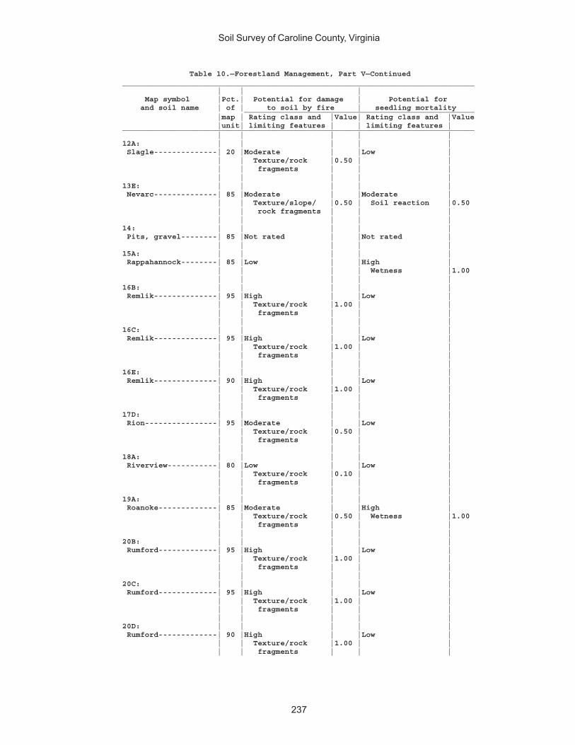
Soil Survey of Caroline County, Virginia
237
Table 10.—Forestland Management, Part V—Continued______________________________________________________________________________ | | | Map symbol |Pct.| Potential for damage | Potential for and soil name | of | to soil by fire | seedling mortality ___________________________________________________ |map | Rating class and |Value| Rating class and |Value |unit| limiting features | | limiting features |______________________________________________________________________________ | | | | |12A: | | | | | Slagle--------------| 20 |Moderate | |Low | | | Texture/rock |0.50 | | | | fragments | | | | | | | |13E: | | | | | Nevarc--------------| 85 |Moderate | |Moderate | | | Texture/slope/ |0.50 | Soil reaction |0.50 | | rock fragments | | | | | | | |14: | | | | | Pits, gravel--------| 85 |Not rated | |Not rated | | | | | |15A: | | | | | Rappahannock--------| 85 |Low | |High | | | | | Wetness |1.00 | | | | |16B: | | | | | Remlik--------------| 95 |High | |Low | | | Texture/rock |1.00 | | | | fragments | | | | | | | |16C: | | | | | Remlik--------------| 95 |High | |Low | | | Texture/rock |1.00 | | | | fragments | | | | | | | |16E: | | | | | Remlik--------------| 90 |High | |Low | | | Texture/rock |1.00 | | | | fragments | | | | | | | |17D: | | | | | Rion----------------| 95 |Moderate | |Low | | | Texture/rock |0.50 | | | | fragments | | | | | | | |18A: | | | | | Riverview-----------| 80 |Low | |Low | | | Texture/rock |0.10 | | | | fragments | | | | | | | |19A: | | | | | Roanoke-------------| 85 |Moderate | |High | | | Texture/rock |0.50 | Wetness |1.00 | | fragments | | | | | | | |20B: | | | | | Rumford-------------| 95 |High | |Low | | | Texture/rock |1.00 | | | | fragments | | | | | | | |20C: | | | | | Rumford-------------| 95 |High | |Low | | | Texture/rock |1.00 | | | | fragments | | | | | | | |20D: | | | | | Rumford-------------| 90 |High | |Low | | | Texture/rock |1.00 | | | | fragments | | |
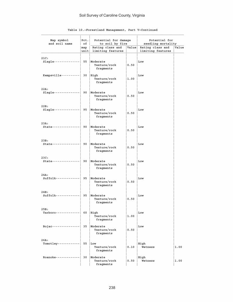
Soil Survey of Caroline County, Virginia
238
Table 10.—Forestland Management, Part V—Continued______________________________________________________________________________ | | | Map symbol |Pct.| Potential for damage | Potential for and soil name | of | to soil by fire | seedling mortality ___________________________________________________ |map | Rating class and |Value| Rating class and |Value |unit| limiting features | | limiting features |______________________________________________________________________________ | | | | |21C: | | | | | Slagle--------------| 55 |Moderate | |Low | | | Texture/rock |0.50 | | | | fragments | | | | | | | | Kempsville----------| 30 |High | |Low | | | Texture/rock |1.00 | | | | fragments | | | | | | | |22A: | | | | | Slagle--------------| 90 |Moderate | |Low | | | Texture/rock |0.50 | | | | fragments | | | | | | | |22B: | | | | | Slagle--------------| 95 |Moderate | |Low | | | Texture/rock |0.50 | | | | fragments | | | | | | | |23A: | | | | | State---------------| 90 |Moderate | |Low | | | Texture/rock |0.50 | | | | fragments | | | | | | | |23B: | | | | | State---------------| 90 |Moderate | |Low | | | Texture/rock |0.50 | | | | fragments | | | | | | | |23C: | | | | | State---------------| 90 |Moderate | |Low | | | Texture/rock |0.50 | | | | fragments | | | | | | | |24A: | | | | | Suffolk-------------| 95 |Moderate | |Low | | | Texture/rock |0.50 | | | | fragments | | | | | | | |24B: | | | | | Suffolk-------------| 95 |Moderate | |Low | | | Texture/rock |0.50 | | | | fragments | | | | | | | |25B: | | | | | Tarboro-------------| 60 |High | |Low | | | Texture/rock |1.00 | | | | fragments | | | | | | | | Bojac---------------| 35 |Moderate | |Low | | | Texture/rock |0.50 | | | | fragments | | | | | | | |26A: | | | | | Tomotley------------| 55 |Low | |High | | | Texture/rock |0.10 | Wetness |1.00 | | fragments | | | | | | | | Roanoke-------------| 30 |Moderate | |High | | | Texture/rock |0.50 | Wetness |1.00 | | fragments | | |

Soil Survey of Caroline County, Virginia
239
Table 10.—Forestland Management, Part V—Continued______________________________________________________________________________ | | | Map symbol |Pct.| Potential for damage | Potential for and soil name | of | to soil by fire | seedling mortality ___________________________________________________ |map | Rating class and |Value| Rating class and |Value |unit| limiting features | | limiting features |______________________________________________________________________________ | | | | |27C: | | | | | Udorthents----------| 85 |Not rated | |Not rated | | | | | |28A: | | | | | Wehadkee------------| 85 |Low | |High | | | Texture/rock |0.10 | Wetness |1.00 | | fragments | | | | | | | |29A: | | | | | Wickham-------------| 95 |High | |Low | | | Texture/rock |1.00 | | | | fragments | | | | | | | |29B: | | | | | Wickham-------------| 95 |High | |Low | | | Texture/rock |1.00 | | | | fragments | | | | | | | |30E: | | | | | Wateree-------------| 75 |Moderate | |Low | | | Texture/rock |0.50 | | | | fragments | | | | | | | | Rock outcrop--------| 15 |Not rated | |Not rated | | | | | |W: | | | | | Water---------------|100 |Not rated | |Not rated | | | | | |______________________________________________________________________________
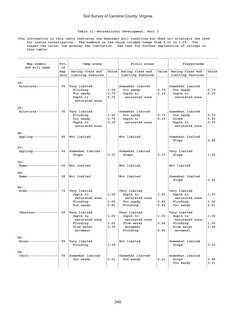
Soil Survey of Caroline County, Virginia
240
Table 11.—Recreational Development, Part I
(The information in this table indicates the dominant soil condition but does not eliminate the need for onsite investigation. The numbers in the value columns range from 0.01 to 1.00. The larger the value, the greater the limitation. See text for further explanation of ratings in this table)
________________________________________________________________________________________________________ | | | | Map symbol |Pct.| Camp areas | Picnic areas | Playgrounds and soil name | of | | | _____________________________________________________________________________ |map | Rating class and |Value| Rating class and |Value| Rating class and |Value |unit| limiting features | | limiting features | | limiting features |________________________________________________________________________________________________________ | | | | | | |1A: | | | | | | | Altavista-----------| 90 |Very limited | |Somewhat limited | |Somewhat limited | | | Flooding |1.00 | Too sandy |0.79 | Too sandy |0.79 | | Too sandy |0.79 | Depth to |0.19 | Depth to |0.39 | | Depth to |0.39 | saturated zone | | saturated zone | | | saturated zone | | | | | | | | | | | |1B: | | | | | | | Altavista-----------| 90 |Very limited | |Somewhat limited | |Somewhat limited | | | Flooding |1.00 | Too sandy |0.79 | Too sandy |0.79 | | Too sandy |0.79 | Depth to |0.19 | Slope |0.50 | | Depth to |0.39 | saturated zone | | Depth to |0.39 | | saturated zone | | | | saturated zone | | | | | | | |2B: | | | | | | | Appling-------------| 80 |Not limited | |Not limited | |Somewhat limited | | | | | | | Slope |0.88 | | | | | | |2C: | | | | | | | Appling-------------| 90 |Somewhat limited | |Somewhat limited | |Very limited | | | Slope |0.37 | Slope |0.37 | Slope |1.00 | | | | | | |3A: | | | | | | | Bama----------------| 90 |Not limited | |Not limited | |Not limited | | | | | | | |3B: | | | | | | | Bama----------------| 90 |Not limited | |Not limited | |Somewhat limited | | | | | | | Slope |0.50 | | | | | | |4A: | | | | | | | Bibb----------------| 75 |Very limited | |Very limited | |Very limited | | | Depth to |1.00 | Depth to |1.00 | Depth to |1.00 | | saturated zone | | saturated zone | | saturated zone | | | Flooding |1.00 | Too sandy |0.81 | Flooding |1.00 | | Too sandy |0.81 | Flooding |0.40 | Too sandy |0.81 | | | | | | | Chastain------------| 20 |Very limited | |Very limited | |Very limited | | | Depth to |1.00 | Depth to |1.00 | Depth to |1.00 | | saturated zone | | saturated zone | | saturated zone | | | Flooding |1.00 | Slow water |0.94 | Flooding |1.00 | | Slow water |0.94 | movement | | Slow water |0.94 | | movement | | Flooding |0.40 | movement | | | | | | | |5B: | | | | | | | Bojac---------------| 85 |Very limited | |Not limited | |Somewhat limited | | | Flooding |1.00 | | | Slope |0.12 | | | | | | |6B: | | | | | | | Cecil---------------| 90 |Somewhat limited | |Somewhat limited | |Somewhat limited | | | Too sandy |0.01 | Too sandy |0.01 | Slope |0.88 | | | | | | Too sandy |0.01 | | | | | | |
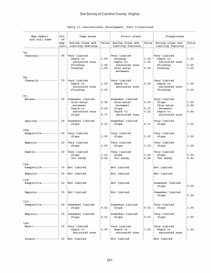
Soil Survey of Caroline County, Virginia
241
Table 11.—Recreational Development, Part I—Continued________________________________________________________________________________________________________ | | | | Map symbol |Pct.| Camp areas | Picnic areas | Playgrounds and soil name | of | | | _____________________________________________________________________________ |map | Rating class and |Value| Rating class and |Value| Rating class and |Value |unit| limiting features | | limiting features | | limiting features |________________________________________________________________________________________________________ | | | | | | |7A: | | | | | | | Chastain------------| 95 |Very limited | |Very limited | |Very limited | | | Depth to |1.00 | Ponding |1.00 | Depth to |1.00 | | saturated zone | | Depth to |1.00 | saturated zone | | | Flooding |1.00 | saturated zone | | Flooding |1.00 | | Ponding |1.00 | Slow water |0.94 | Ponding |1.00 | | | | movement | | | | | | | | | |8A: | | | | | | | Chewacla------------| 75 |Very limited | |Very limited | |Very limited | | | Depth to |1.00 | Depth to |0.99 | Depth to |1.00 | | saturated zone | | saturated zone | | saturated zone | | | Flooding |1.00 | | | Flooding |0.60 | | | | | | |9C: | | | | | | | Helena--------------| 65 |Somewhat limited | |Somewhat limited | |Very limited | | | Slow water |0.94 | Slow water |0.94 | Slope |1.00 | | movement | | movement | | Slow water |0.94 | | Depth to |0.44 | Slope |0.37 | movement | | | saturated zone | | Depth to |0.22 | Depth to |0.44 | | Slope |0.37 | saturated zone | | saturated zone | | | | | | | | Appling-------------| 20 |Somewhat limited | |Somewhat limited | |Very limited | | | Slope |0.37 | Slope |0.37 | Slope |1.00 | | | | | | |10E: | | | | | | | Kempsville----------| 45 |Very limited | |Very limited | |Very limited | | | Slope |1.00 | Slope |1.00 | Slope |1.00 | | | | | | | Emporia-------------| 25 |Very limited | |Very limited | |Very limited | | | Slope |1.00 | Slope |1.00 | Slope |1.00 | | | | | | | Remlik--------------| 20 |Very limited | |Very limited | |Very limited | | | Slope |1.00 | Slope |1.00 | Slope |1.00 | | Too sandy |0.42 | Too sandy |0.42 | Too sandy |0.42 | | | | | | |11A: | | | | | | | Kempsville----------| 70 |Not limited | |Not limited | |Not limited | | | | | | | | Emporia-------------| 30 |Not limited | |Not limited | |Not limited | | | | | | | |11B: | | | | | | | Kempsville----------| 60 |Not limited | |Not limited | |Somewhat limited | | | | | | | Slope |0.50 | | | | | | | Emporia-------------| 35 |Not limited | |Not limited | |Somewhat limited | | | | | | | Slope |0.50 | | | | | | |11C: | | | | | | | Kempsville----------| 65 |Somewhat limited | |Somewhat limited | |Very limited | | | Slope |0.01 | Slope |0.01 | Slope |1.00 | | | | | | | Emporia-------------| 30 |Somewhat limited | |Somewhat limited | |Very limited | | | Slope |0.01 | Slope |0.01 | Slope |1.00 | | | | | | |12A: | | | | | | | Myatt---------------| 70 |Very limited | |Very limited | |Very limited | | | Depth to |1.00 | Depth to |1.00 | Depth to |1.00 | | saturated zone | | saturated zone | | saturated zone | | | | | | | | Slagle--------------| 20 |Not limited | |Not limited | |Not limited |
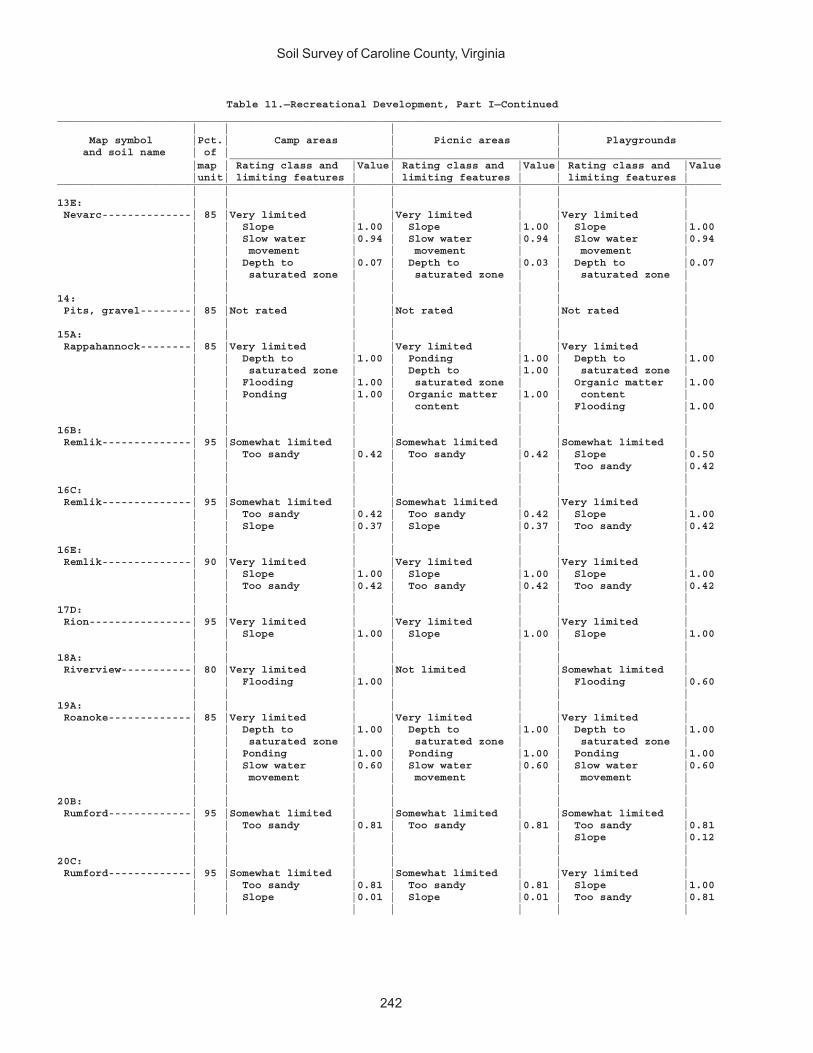
Soil Survey of Caroline County, Virginia
242
Table 11.—Recreational Development, Part I—Continued________________________________________________________________________________________________________ | | | | Map symbol |Pct.| Camp areas | Picnic areas | Playgrounds and soil name | of | | | _____________________________________________________________________________ |map | Rating class and |Value| Rating class and |Value| Rating class and |Value |unit| limiting features | | limiting features | | limiting features |________________________________________________________________________________________________________ | | | | | | |13E: | | | | | | | Nevarc--------------| 85 |Very limited | |Very limited | |Very limited | | | Slope |1.00 | Slope |1.00 | Slope |1.00 | | Slow water |0.94 | Slow water |0.94 | Slow water |0.94 | | movement | | movement | | movement | | | Depth to |0.07 | Depth to |0.03 | Depth to |0.07 | | saturated zone | | saturated zone | | saturated zone | | | | | | | |14: | | | | | | | Pits, gravel--------| 85 |Not rated | |Not rated | |Not rated | | | | | | | |15A: | | | | | | | Rappahannock--------| 85 |Very limited | |Very limited | |Very limited | | | Depth to |1.00 | Ponding |1.00 | Depth to |1.00 | | saturated zone | | Depth to |1.00 | saturated zone | | | Flooding |1.00 | saturated zone | | Organic matter |1.00 | | Ponding |1.00 | Organic matter |1.00 | content | | | | | content | | Flooding |1.00 | | | | | | |16B: | | | | | | | Remlik--------------| 95 |Somewhat limited | |Somewhat limited | |Somewhat limited | | | Too sandy |0.42 | Too sandy |0.42 | Slope |0.50 | | | | | | Too sandy |0.42 | | | | | | |16C: | | | | | | | Remlik--------------| 95 |Somewhat limited | |Somewhat limited | |Very limited | | | Too sandy |0.42 | Too sandy |0.42 | Slope |1.00 | | Slope |0.37 | Slope |0.37 | Too sandy |0.42 | | | | | | |16E: | | | | | | | Remlik--------------| 90 |Very limited | |Very limited | |Very limited | | | Slope |1.00 | Slope |1.00 | Slope |1.00 | | Too sandy |0.42 | Too sandy |0.42 | Too sandy |0.42 | | | | | | |17D: | | | | | | | Rion----------------| 95 |Very limited | |Very limited | |Very limited | | | Slope |1.00 | Slope |1.00 | Slope |1.00 | | | | | | |18A: | | | | | | | Riverview-----------| 80 |Very limited | |Not limited | |Somewhat limited | | | Flooding |1.00 | | | Flooding |0.60 | | | | | | |19A: | | | | | | | Roanoke-------------| 85 |Very limited | |Very limited | |Very limited | | | Depth to |1.00 | Depth to |1.00 | Depth to |1.00 | | saturated zone | | saturated zone | | saturated zone | | | Ponding |1.00 | Ponding |1.00 | Ponding |1.00 | | Slow water |0.60 | Slow water |0.60 | Slow water |0.60 | | movement | | movement | | movement | | | | | | | |20B: | | | | | | | Rumford-------------| 95 |Somewhat limited | |Somewhat limited | |Somewhat limited | | | Too sandy |0.81 | Too sandy |0.81 | Too sandy |0.81 | | | | | | Slope |0.12 | | | | | | |20C: | | | | | | | Rumford-------------| 95 |Somewhat limited | |Somewhat limited | |Very limited | | | Too sandy |0.81 | Too sandy |0.81 | Slope |1.00 | | Slope |0.01 | Slope |0.01 | Too sandy |0.81 | | | | | | |
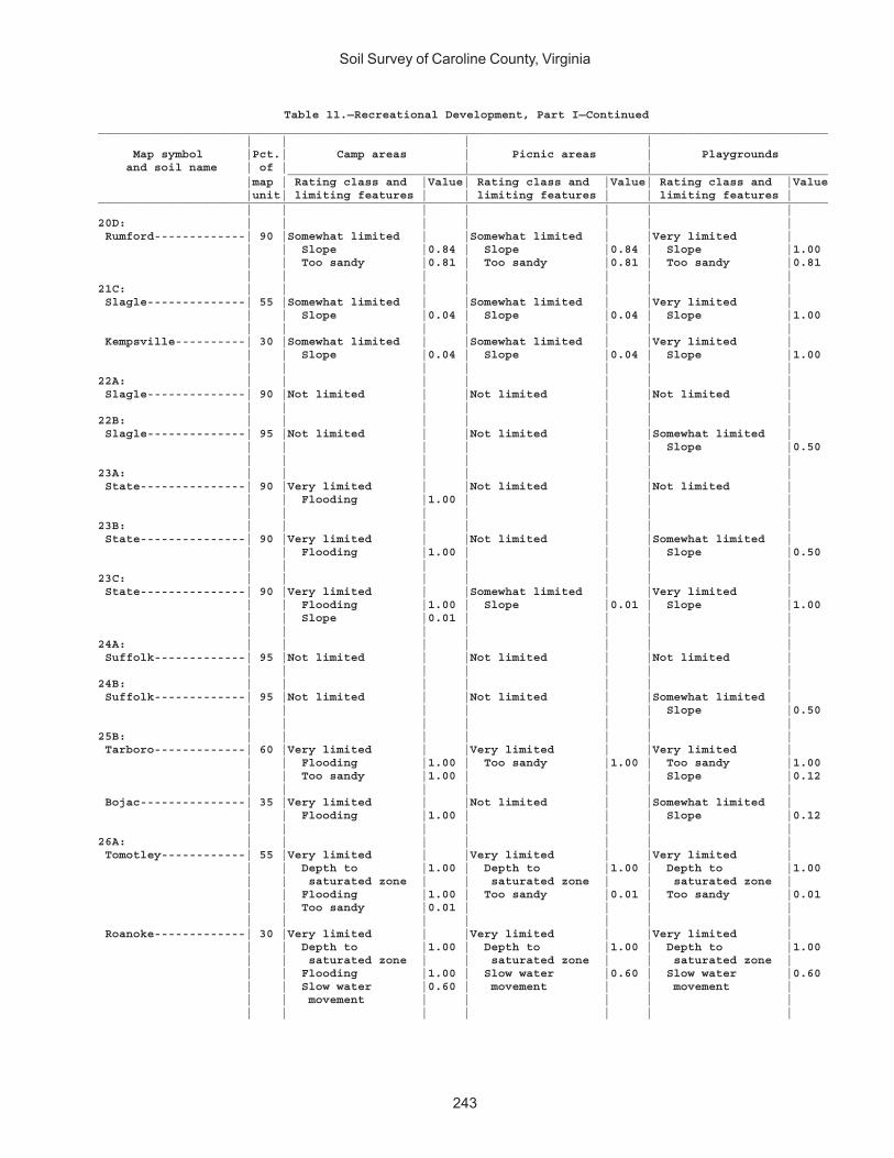
Soil Survey of Caroline County, Virginia
243
Table 11.—Recreational Development, Part I—Continued________________________________________________________________________________________________________ | | | | Map symbol |Pct.| Camp areas | Picnic areas | Playgrounds and soil name | of | | | _____________________________________________________________________________ |map | Rating class and |Value| Rating class and |Value| Rating class and |Value |unit| limiting features | | limiting features | | limiting features |________________________________________________________________________________________________________ | | | | | | |20D: | | | | | | | Rumford-------------| 90 |Somewhat limited | |Somewhat limited | |Very limited | | | Slope |0.84 | Slope |0.84 | Slope |1.00 | | Too sandy |0.81 | Too sandy |0.81 | Too sandy |0.81 | | | | | | |21C: | | | | | | | Slagle--------------| 55 |Somewhat limited | |Somewhat limited | |Very limited | | | Slope |0.04 | Slope |0.04 | Slope |1.00 | | | | | | | Kempsville----------| 30 |Somewhat limited | |Somewhat limited | |Very limited | | | Slope |0.04 | Slope |0.04 | Slope |1.00 | | | | | | |22A: | | | | | | | Slagle--------------| 90 |Not limited | |Not limited | |Not limited | | | | | | | |22B: | | | | | | | Slagle--------------| 95 |Not limited | |Not limited | |Somewhat limited | | | | | | | Slope |0.50 | | | | | | |23A: | | | | | | | State---------------| 90 |Very limited | |Not limited | |Not limited | | | Flooding |1.00 | | | | | | | | | | |23B: | | | | | | | State---------------| 90 |Very limited | |Not limited | |Somewhat limited | | | Flooding |1.00 | | | Slope |0.50 | | | | | | |23C: | | | | | | | State---------------| 90 |Very limited | |Somewhat limited | |Very limited | | | Flooding |1.00 | Slope |0.01 | Slope |1.00 | | Slope |0.01 | | | | | | | | | | |24A: | | | | | | | Suffolk-------------| 95 |Not limited | |Not limited | |Not limited | | | | | | | |24B: | | | | | | | Suffolk-------------| 95 |Not limited | |Not limited | |Somewhat limited | | | | | | | Slope |0.50 | | | | | | |25B: | | | | | | | Tarboro-------------| 60 |Very limited | |Very limited | |Very limited | | | Flooding |1.00 | Too sandy |1.00 | Too sandy |1.00 | | Too sandy |1.00 | | | Slope |0.12 | | | | | | | Bojac---------------| 35 |Very limited | |Not limited | |Somewhat limited | | | Flooding |1.00 | | | Slope |0.12 | | | | | | |26A: | | | | | | | Tomotley------------| 55 |Very limited | |Very limited | |Very limited | | | Depth to |1.00 | Depth to |1.00 | Depth to |1.00 | | saturated zone | | saturated zone | | saturated zone | | | Flooding |1.00 | Too sandy |0.01 | Too sandy |0.01 | | Too sandy |0.01 | | | | | | | | | | | Roanoke-------------| 30 |Very limited | |Very limited | |Very limited | | | Depth to |1.00 | Depth to |1.00 | Depth to |1.00 | | saturated zone | | saturated zone | | saturated zone | | | Flooding |1.00 | Slow water |0.60 | Slow water |0.60 | | Slow water |0.60 | movement | | movement | | | movement | | | | | | | | | | | |
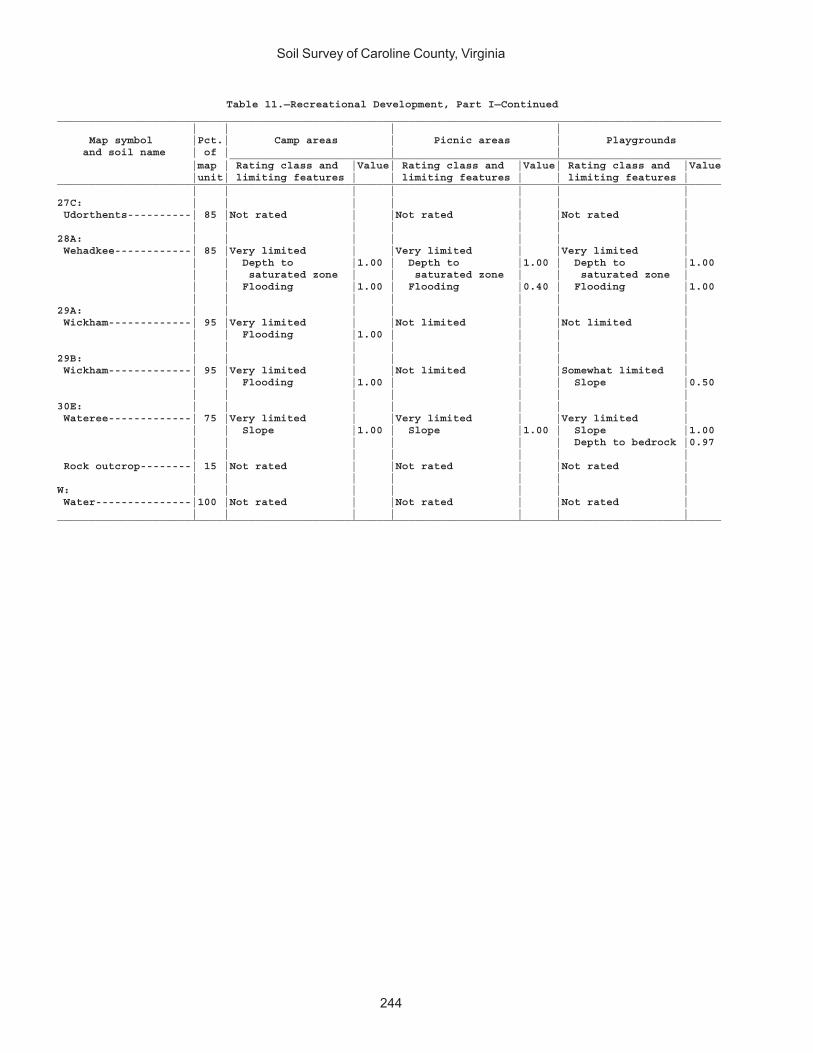
Soil Survey of Caroline County, Virginia
244
Table 11.—Recreational Development, Part I—Continued________________________________________________________________________________________________________ | | | | Map symbol |Pct.| Camp areas | Picnic areas | Playgrounds and soil name | of | | | _____________________________________________________________________________ |map | Rating class and |Value| Rating class and |Value| Rating class and |Value |unit| limiting features | | limiting features | | limiting features |________________________________________________________________________________________________________ | | | | | | |27C: | | | | | | | Udorthents----------| 85 |Not rated | |Not rated | |Not rated | | | | | | | |28A: | | | | | | | Wehadkee------------| 85 |Very limited | |Very limited | |Very limited | | | Depth to |1.00 | Depth to |1.00 | Depth to |1.00 | | saturated zone | | saturated zone | | saturated zone | | | Flooding |1.00 | Flooding |0.40 | Flooding |1.00 | | | | | | |29A: | | | | | | | Wickham-------------| 95 |Very limited | |Not limited | |Not limited | | | Flooding |1.00 | | | | | | | | | | |29B: | | | | | | | Wickham-------------| 95 |Very limited | |Not limited | |Somewhat limited | | | Flooding |1.00 | | | Slope |0.50 | | | | | | |30E: | | | | | | | Wateree-------------| 75 |Very limited | |Very limited | |Very limited | | | Slope |1.00 | Slope |1.00 | Slope |1.00 | | | | | | Depth to bedrock |0.97 | | | | | | | Rock outcrop--------| 15 |Not rated | |Not rated | |Not rated | | | | | | | |W: | | | | | | | Water---------------|100 |Not rated | |Not rated | |Not rated | | | | | | | |________________________________________________________________________________________________________
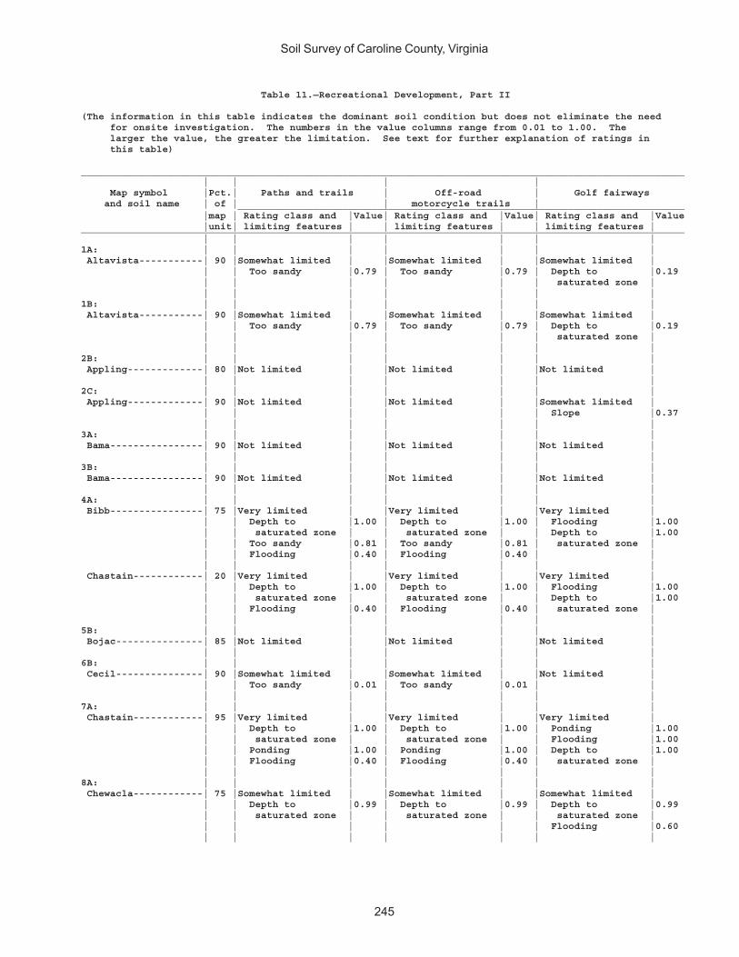
Soil Survey of Caroline County, Virginia
245
Table 11.—Recreational Development, Part II
(The information in this table indicates the dominant soil condition but does not eliminate the need for onsite investigation. The numbers in the value columns range from 0.01 to 1.00. The larger the value, the greater the limitation. See text for further explanation of ratings in this table)
________________________________________________________________________________________________________ | | | | Map symbol |Pct.| Paths and trails | Off-road | Golf fairways and soil name | of | | motorcycle trails | _____________________________________________________________________________ |map | Rating class and |Value| Rating class and |Value| Rating class and |Value |unit| limiting features | | limiting features | | limiting features |________________________________________________________________________________________________________ | | | | | | |1A: | | | | | | | Altavista-----------| 90 |Somewhat limited | |Somewhat limited | |Somewhat limited | | | Too sandy |0.79 | Too sandy |0.79 | Depth to |0.19 | | | | | | saturated zone | | | | | | | |1B: | | | | | | | Altavista-----------| 90 |Somewhat limited | |Somewhat limited | |Somewhat limited | | | Too sandy |0.79 | Too sandy |0.79 | Depth to |0.19 | | | | | | saturated zone | | | | | | | |2B: | | | | | | | Appling-------------| 80 |Not limited | |Not limited | |Not limited | | | | | | | |2C: | | | | | | | Appling-------------| 90 |Not limited | |Not limited | |Somewhat limited | | | | | | | Slope |0.37 | | | | | | |3A: | | | | | | | Bama----------------| 90 |Not limited | |Not limited | |Not limited | | | | | | | |3B: | | | | | | | Bama----------------| 90 |Not limited | |Not limited | |Not limited | | | | | | | |4A: | | | | | | | Bibb----------------| 75 |Very limited | |Very limited | |Very limited | | | Depth to |1.00 | Depth to |1.00 | Flooding |1.00 | | saturated zone | | saturated zone | | Depth to |1.00 | | Too sandy |0.81 | Too sandy |0.81 | saturated zone | | | Flooding |0.40 | Flooding |0.40 | | | | | | | | | Chastain------------| 20 |Very limited | |Very limited | |Very limited | | | Depth to |1.00 | Depth to |1.00 | Flooding |1.00 | | saturated zone | | saturated zone | | Depth to |1.00 | | Flooding |0.40 | Flooding |0.40 | saturated zone | | | | | | | |5B: | | | | | | | Bojac---------------| 85 |Not limited | |Not limited | |Not limited | | | | | | | |6B: | | | | | | | Cecil---------------| 90 |Somewhat limited | |Somewhat limited | |Not limited | | | Too sandy |0.01 | Too sandy |0.01 | | | | | | | | |7A: | | | | | | | Chastain------------| 95 |Very limited | |Very limited | |Very limited | | | Depth to |1.00 | Depth to |1.00 | Ponding |1.00 | | saturated zone | | saturated zone | | Flooding |1.00 | | Ponding |1.00 | Ponding |1.00 | Depth to |1.00 | | Flooding |0.40 | Flooding |0.40 | saturated zone | | | | | | | |8A: | | | | | | | Chewacla------------| 75 |Somewhat limited | |Somewhat limited | |Somewhat limited | | | Depth to |0.99 | Depth to |0.99 | Depth to |0.99 | | saturated zone | | saturated zone | | saturated zone | | | | | | | Flooding |0.60 | | | | | | |
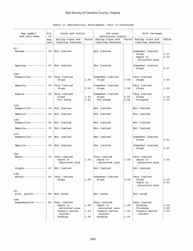
Soil Survey of Caroline County, Virginia
246
Table 11.—Recreational Development, Part II—Continued________________________________________________________________________________________________________ | | | | Map symbol |Pct.| Paths and trails | Off-road | Golf fairways and soil name | of | | motorcycle trails | _____________________________________________________________________________ |map | Rating class and |Value| Rating class and |Value| Rating class and |Value |unit| limiting features | | limiting features | | limiting features |________________________________________________________________________________________________________ | | | | | | |9C: | | | | | | | Helena--------------| 65 |Not limited | |Not limited | |Somewhat limited | | | | | | | Slope |0.37 | | | | | | Depth to |0.22 | | | | | | saturated zone | | | | | | | | Appling-------------| 20 |Not limited | |Not limited | |Somewhat limited | | | | | | | Slope |0.37 | | | | | | |10E: | | | | | | | Kempsville----------| 45 |Very limited | |Somewhat limited | |Very limited | | | Slope |1.00 | Slope |0.56 | Slope |1.00 | | | | | | | Emporia-------------| 25 |Very limited | |Somewhat limited | |Very limited | | | Slope |1.00 | Slope |0.56 | Slope |1.00 | | | | | | | Remlik--------------| 20 |Very limited | |Somewhat limited | |Very limited | | | Slope |1.00 | Slope |0.56 | Slope |1.00 | | Too sandy |0.42 | Too sandy |0.42 | Droughty |0.03 | | | | | | |11A: | | | | | | | Kempsville----------| 70 |Not limited | |Not limited | |Not limited | | | | | | | | Emporia-------------| 30 |Not limited | |Not limited | |Not limited | | | | | | | |11B: | | | | | | | Kempsville----------| 60 |Not limited | |Not limited | |Not limited | | | | | | | | Emporia-------------| 35 |Not limited | |Not limited | |Not limited | | | | | | | |11C: | | | | | | | Kempsville----------| 65 |Not limited | |Not limited | |Somewhat limited | | | | | | | Slope |0.01 | | | | | | | Emporia-------------| 30 |Not limited | |Not limited | |Somewhat limited | | | | | | | Slope |0.01 | | | | | | |12A: | | | | | | | Myatt---------------| 70 |Very limited | |Very limited | |Very limited | | | Depth to |1.00 | Depth to |1.00 | Depth to |1.00 | | saturated zone | | saturated zone | | saturated zone | | | | | | | | Slagle--------------| 20 |Not limited | |Not limited | |Not limited | | | | | | | |13E: | | | | | | | Nevarc--------------| 85 |Very limited | |Somewhat limited | |Very limited | | | Slope |1.00 | Slope |0.56 | Slope |1.00 | | | | | | Depth to |0.03 | | | | | | saturated zone | | | | | | | |14: | | | | | | | Pits, gravel--------| 85 |Not rated | |Not rated | |Not rated | | | | | | | |15A: | | | | | | | Rappahannock--------| 85 |Very limited | |Very limited | |Very limited | | | Depth to |1.00 | Depth to |1.00 | Ponding |1.00 | | saturated zone | | saturated zone | | Flooding |1.00 | | Organic matter |1.00 | Organic matter |1.00 | Organic matter |1.00 | | content | | content | | content | | | Ponding |1.00 | Ponding |1.00 | | | | | | | | |
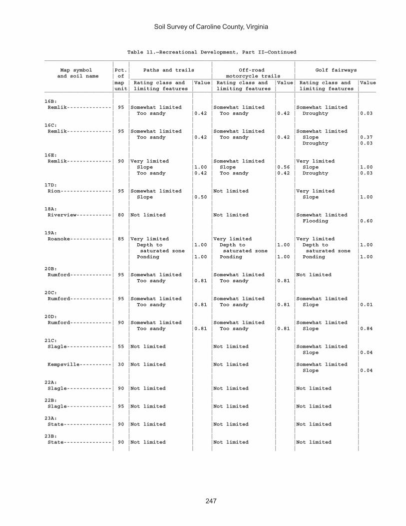
Soil Survey of Caroline County, Virginia
247
Table 11.—Recreational Development, Part II—Continued________________________________________________________________________________________________________ | | | | Map symbol |Pct.| Paths and trails | Off-road | Golf fairways and soil name | of | | motorcycle trails | _____________________________________________________________________________ |map | Rating class and |Value| Rating class and |Value| Rating class and |Value |unit| limiting features | | limiting features | | limiting features |________________________________________________________________________________________________________ | | | | | | |16B: | | | | | | | Remlik--------------| 95 |Somewhat limited | |Somewhat limited | |Somewhat limited | | | Too sandy |0.42 | Too sandy |0.42 | Droughty |0.03 | | | | | | |16C: | | | | | | | Remlik--------------| 95 |Somewhat limited | |Somewhat limited | |Somewhat limited | | | Too sandy |0.42 | Too sandy |0.42 | Slope |0.37 | | | | | | Droughty |0.03 | | | | | | |16E: | | | | | | | Remlik--------------| 90 |Very limited | |Somewhat limited | |Very limited | | | Slope |1.00 | Slope |0.56 | Slope |1.00 | | Too sandy |0.42 | Too sandy |0.42 | Droughty |0.03 | | | | | | |17D: | | | | | | | Rion----------------| 95 |Somewhat limited | |Not limited | |Very limited | | | Slope |0.50 | | | Slope |1.00 | | | | | | |18A: | | | | | | | Riverview-----------| 80 |Not limited | |Not limited | |Somewhat limited | | | | | | | Flooding |0.60 | | | | | | |19A: | | | | | | | Roanoke-------------| 85 |Very limited | |Very limited | |Very limited | | | Depth to |1.00 | Depth to |1.00 | Depth to |1.00 | | saturated zone | | saturated zone | | saturated zone | | | Ponding |1.00 | Ponding |1.00 | Ponding |1.00 | | | | | | |20B: | | | | | | | Rumford-------------| 95 |Somewhat limited | |Somewhat limited | |Not limited | | | Too sandy |0.81 | Too sandy |0.81 | | | | | | | | |20C: | | | | | | | Rumford-------------| 95 |Somewhat limited | |Somewhat limited | |Somewhat limited | | | Too sandy |0.81 | Too sandy |0.81 | Slope |0.01 | | | | | | |20D: | | | | | | | Rumford-------------| 90 |Somewhat limited | |Somewhat limited | |Somewhat limited | | | Too sandy |0.81 | Too sandy |0.81 | Slope |0.84 | | | | | | |21C: | | | | | | | Slagle--------------| 55 |Not limited | |Not limited | |Somewhat limited | | | | | | | Slope |0.04 | | | | | | | Kempsville----------| 30 |Not limited | |Not limited | |Somewhat limited | | | | | | | Slope |0.04 | | | | | | |22A: | | | | | | | Slagle--------------| 90 |Not limited | |Not limited | |Not limited | | | | | | | |22B: | | | | | | | Slagle--------------| 95 |Not limited | |Not limited | |Not limited | | | | | | | |23A: | | | | | | | State---------------| 90 |Not limited | |Not limited | |Not limited | | | | | | | |23B: | | | | | | | State---------------| 90 |Not limited | |Not limited | |Not limited | | | | | | | |
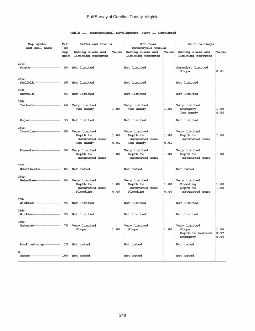
Soil Survey of Caroline County, Virginia
248
Table 11.—Recreational Development, Part II—Continued________________________________________________________________________________________________________ | | | | Map symbol |Pct.| Paths and trails | Off-road | Golf fairways and soil name | of | | motorcycle trails | _____________________________________________________________________________ |map | Rating class and |Value| Rating class and |Value| Rating class and |Value |unit| limiting features | | limiting features | | limiting features |________________________________________________________________________________________________________ | | | | | | |23C: | | | | | | | State---------------| 90 |Not limited | |Not limited | |Somewhat limited | | | | | | | Slope |0.01 | | | | | | |24A: | | | | | | | Suffolk-------------| 95 |Not limited | |Not limited | |Not limited | | | | | | | |24B: | | | | | | | Suffolk-------------| 95 |Not limited | |Not limited | |Not limited | | | | | | | |25B: | | | | | | | Tarboro-------------| 60 |Very limited | |Very limited | |Very limited | | | Too sandy |1.00 | Too sandy |1.00 | Droughty |1.00 | | | | | | Too sandy |0.50 | | | | | | | Bojac---------------| 35 |Not limited | |Not limited | |Not limited | | | | | | | |26A: | | | | | | | Tomotley------------| 55 |Very limited | |Very limited | |Very limited | | | Depth to |1.00 | Depth to |1.00 | Depth to |1.00 | | saturated zone | | saturated zone | | saturated zone | | | Too sandy |0.01 | Too sandy |0.01 | | | | | | | | | Roanoke-------------| 30 |Very limited | |Very limited | |Very limited | | | Depth to |1.00 | Depth to |1.00 | Depth to |1.00 | | saturated zone | | saturated zone | | saturated zone | | | | | | | |27C: | | | | | | | Udorthents----------| 85 |Not rated | |Not rated | |Not rated | | | | | | | |28A: | | | | | | | Wehadkee------------| 85 |Very limited | |Very limited | |Very limited | | | Depth to |1.00 | Depth to |1.00 | Flooding |1.00 | | saturated zone | | saturated zone | | Depth to |1.00 | | Flooding |0.40 | Flooding |0.40 | saturated zone | | | | | | | |29A: | | | | | | | Wickham-------------| 95 |Not limited | |Not limited | |Not limited | | | | | | | |29B: | | | | | | | Wickham-------------| 95 |Not limited | |Not limited | |Not limited | | | | | | | |30E: | | | | | | | Wateree-------------| 75 |Very limited | |Very limited | |Very limited | | | Slope |1.00 | Slope |1.00 | Slope |1.00 | | | | | | Depth to bedrock |0.97 | | | | | | Droughty |0.90 | | | | | | | Rock outcrop--------| 15 |Not rated | |Not rated | |Not rated | | | | | | | |W: | | | | | | | Water---------------|100 |Not rated | |Not rated | |Not rated | | | | | | | |________________________________________________________________________________________________________
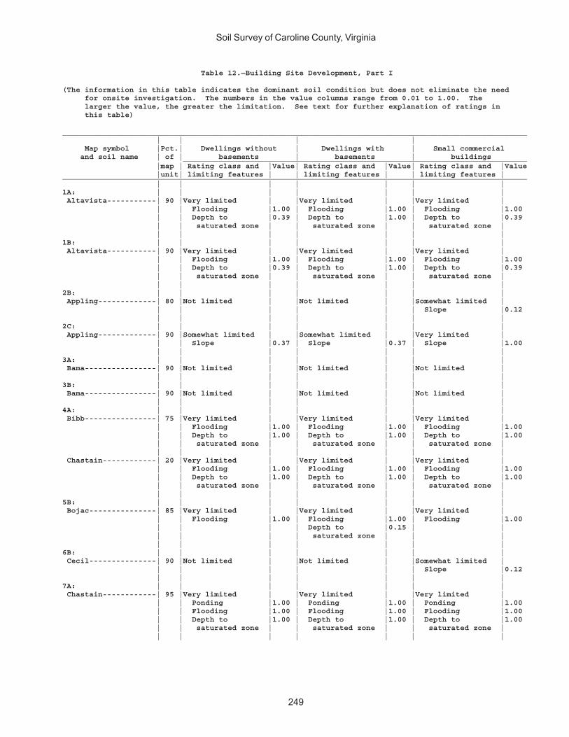
Soil Survey of Caroline County, Virginia
249
Table 12.—Building Site Development, Part I
(The information in this table indicates the dominant soil condition but does not eliminate the need for onsite investigation. The numbers in the value columns range from 0.01 to 1.00. The larger the value, the greater the limitation. See text for further explanation of ratings in this table)
________________________________________________________________________________________________________ | | | | Map symbol |Pct.| Dwellings without | Dwellings with | Small commercial and soil name | of | basements | basements | buildings _____________________________________________________________________________ |map | Rating class and |Value| Rating class and |Value| Rating class and |Value |unit| limiting features | | limiting features | | limiting features |________________________________________________________________________________________________________ | | | | | | |1A: | | | | | | | Altavista-----------| 90 |Very limited | |Very limited | |Very limited | | | Flooding |1.00 | Flooding |1.00 | Flooding |1.00 | | Depth to |0.39 | Depth to |1.00 | Depth to |0.39 | | saturated zone | | saturated zone | | saturated zone | | | | | | | |1B: | | | | | | | Altavista-----------| 90 |Very limited | |Very limited | |Very limited | | | Flooding |1.00 | Flooding |1.00 | Flooding |1.00 | | Depth to |0.39 | Depth to |1.00 | Depth to |0.39 | | saturated zone | | saturated zone | | saturated zone | | | | | | | |2B: | | | | | | | Appling-------------| 80 |Not limited | |Not limited | |Somewhat limited | | | | | | | Slope |0.12 | | | | | | |2C: | | | | | | | Appling-------------| 90 |Somewhat limited | |Somewhat limited | |Very limited | | | Slope |0.37 | Slope |0.37 | Slope |1.00 | | | | | | |3A: | | | | | | | Bama----------------| 90 |Not limited | |Not limited | |Not limited | | | | | | | |3B: | | | | | | | Bama----------------| 90 |Not limited | |Not limited | |Not limited | | | | | | | |4A: | | | | | | | Bibb----------------| 75 |Very limited | |Very limited | |Very limited | | | Flooding |1.00 | Flooding |1.00 | Flooding |1.00 | | Depth to |1.00 | Depth to |1.00 | Depth to |1.00 | | saturated zone | | saturated zone | | saturated zone | | | | | | | | Chastain------------| 20 |Very limited | |Very limited | |Very limited | | | Flooding |1.00 | Flooding |1.00 | Flooding |1.00 | | Depth to |1.00 | Depth to |1.00 | Depth to |1.00 | | saturated zone | | saturated zone | | saturated zone | | | | | | | |5B: | | | | | | | Bojac---------------| 85 |Very limited | |Very limited | |Very limited | | | Flooding |1.00 | Flooding |1.00 | Flooding |1.00 | | | | Depth to |0.15 | | | | | | saturated zone | | | | | | | | | |6B: | | | | | | | Cecil---------------| 90 |Not limited | |Not limited | |Somewhat limited | | | | | | | Slope |0.12 | | | | | | |7A: | | | | | | | Chastain------------| 95 |Very limited | |Very limited | |Very limited | | | Ponding |1.00 | Ponding |1.00 | Ponding |1.00 | | Flooding |1.00 | Flooding |1.00 | Flooding |1.00 | | Depth to |1.00 | Depth to |1.00 | Depth to |1.00 | | saturated zone | | saturated zone | | saturated zone | | | | | | | |

Soil Survey of Caroline County, Virginia
250
Table 12.—Building Site Development, Part I—Continued________________________________________________________________________________________________________ | | | | Map symbol |Pct.| Dwellings without | Dwellings with | Small commercial and soil name | of | basements | basements | buildings _____________________________________________________________________________ |map | Rating class and |Value| Rating class and |Value| Rating class and |Value |unit| limiting features | | limiting features | | limiting features |________________________________________________________________________________________________________ | | | | | | |8A: | | | | | | | Chewacla------------| 75 |Very limited | |Very limited | |Very limited | | | Flooding |1.00 | Flooding |1.00 | Flooding |1.00 | | Depth to |1.00 | Depth to |1.00 | Depth to |1.00 | | saturated zone | | saturated zone | | saturated zone | | | | | | | |9C: | | | | | | | Helena--------------| 65 |Very limited | |Very limited | |Very limited | | | Shrink-swell |1.00 | Depth to |1.00 | Shrink-swell |1.00 | | Depth to |0.44 | saturated zone | | Slope |1.00 | | saturated zone | | Shrink-swell |1.00 | Depth to |0.44 | | Slope |0.37 | Slope |0.37 | saturated zone | | | | | | | | Appling-------------| 20 |Somewhat limited | |Somewhat limited | |Very limited | | | Slope |0.37 | Slope |0.37 | Slope |1.00 | | | | | | |10E: | | | | | | | Kempsville----------| 45 |Very limited | |Very limited | |Very limited | | | Slope |1.00 | Slope |1.00 | Slope |1.00 | | | | | | | Emporia-------------| 25 |Very limited | |Very limited | |Very limited | | | Slope |1.00 | Slope |1.00 | Slope |1.00 | | | | Depth to |0.73 | | | | | | saturated zone | | | | | | | | | | Remlik--------------| 20 |Very limited | |Very limited | |Very limited | | | Slope |1.00 | Slope |1.00 | Slope |1.00 | | | | Depth to |0.15 | | | | | | saturated zone | | | | | | | | | |11A: | | | | | | | Kempsville----------| 70 |Not limited | |Not limited | |Not limited | | | | | | | | Emporia-------------| 30 |Not limited | |Somewhat limited | |Not limited | | | | | Depth to |0.73 | | | | | | saturated zone | | | | | | | | | |11B: | | | | | | | Kempsville----------| 60 |Not limited | |Not limited | |Not limited | | | | | | | | Emporia-------------| 35 |Not limited | |Somewhat limited | |Not limited | | | | | Depth to |0.73 | | | | | | saturated zone | | | | | | | | | |11C: | | | | | | | Kempsville----------| 65 |Somewhat limited | |Somewhat limited | |Very limited | | | Slope |0.01 | Slope |0.01 | Slope |1.00 | | | | | | | Emporia-------------| 30 |Somewhat limited | |Somewhat limited | |Very limited | | | Slope |0.01 | Depth to |0.73 | Slope |1.00 | | | | saturated zone | | | | | | | Slope |0.01 | | | | | | | | |12A: | | | | | | | Myatt---------------| 70 |Very limited | |Very limited | |Very limited | | | Depth to |1.00 | Depth to |1.00 | Depth to |1.00 | | saturated zone | | saturated zone | | saturated zone | | | | | | | | Slagle--------------| 20 |Not limited | |Somewhat limited | |Not limited | | | | | Depth to |0.15 | | | | | | saturated zone | | |

Soil Survey of Caroline County, Virginia
251
Table 12.—Building Site Development, Part I—Continued________________________________________________________________________________________________________ | | | | Map symbol |Pct.| Dwellings without | Dwellings with | Small commercial and soil name | of | basements | basements | buildings _____________________________________________________________________________ |map | Rating class and |Value| Rating class and |Value| Rating class and |Value |unit| limiting features | | limiting features | | limiting features |________________________________________________________________________________________________________ | | | | | | |13E: | | | | | | | Nevarc--------------| 85 |Very limited | |Very limited | |Very limited | | | Slope |1.00 | Slope |1.00 | Slope |1.00 | | Shrink-swell |0.50 | Depth to |1.00 | Shrink-swell |0.50 | | Depth to |0.07 | saturated zone | | Depth to |0.07 | | saturated zone | | Shrink-swell |0.50 | saturated zone | | | | | | | |14: | | | | | | | Pits, gravel--------| 85 |Not rated | |Not rated | |Not rated | | | | | | | |15A: | | | | | | | Rappahannock--------| 85 |Very limited | |Very limited | |Very limited | | | Ponding |1.00 | Ponding |1.00 | Ponding |1.00 | | Flooding |1.00 | Flooding |1.00 | Flooding |1.00 | | Depth to |1.00 | Depth to |1.00 | Depth to |1.00 | | saturated zone | | saturated zone | | saturated zone | | | | | | | |16B: | | | | | | | Remlik--------------| 95 |Not limited | |Somewhat limited | |Not limited | | | | | Depth to |0.15 | | | | | | saturated zone | | | | | | | | | |16C: | | | | | | | Remlik--------------| 95 |Somewhat limited | |Somewhat limited | |Very limited | | | Slope |0.37 | Slope |0.37 | Slope |1.00 | | | | Depth to |0.15 | | | | | | saturated zone | | | | | | | | | |16E: | | | | | | | Remlik--------------| 90 |Very limited | |Very limited | |Very limited | | | Slope |1.00 | Slope |1.00 | Slope |1.00 | | | | Depth to |0.15 | | | | | | saturated zone | | | | | | | | | |17D: | | | | | | | Rion----------------| 95 |Very limited | |Very limited | |Very limited | | | Slope |1.00 | Slope |1.00 | Slope |1.00 | | | | | | |18A: | | | | | | | Riverview-----------| 80 |Very limited | |Very limited | |Very limited | | | Flooding |1.00 | Flooding |1.00 | Flooding |1.00 | | | | Depth to |0.61 | | | | | | saturated zone | | | | | | | | | |19A: | | | | | | | Roanoke-------------| 85 |Very limited | |Very limited | |Very limited | | | Depth to |1.00 | Depth to |1.00 | Depth to |1.00 | | saturated zone | | saturated zone | | saturated zone | | | Ponding |1.00 | Ponding |1.00 | Ponding |1.00 | | Shrink-swell |0.50 | Shrink-swell |0.50 | Shrink-swell |0.50 | | | | | | |20B: | | | | | | | Rumford-------------| 95 |Not limited | |Not limited | |Not limited | | | | | | | |20C: | | | | | | | Rumford-------------| 95 |Somewhat limited | |Somewhat limited | |Very limited | | | Slope |0.01 | Slope |0.01 | Slope |1.00 | | | | | | |
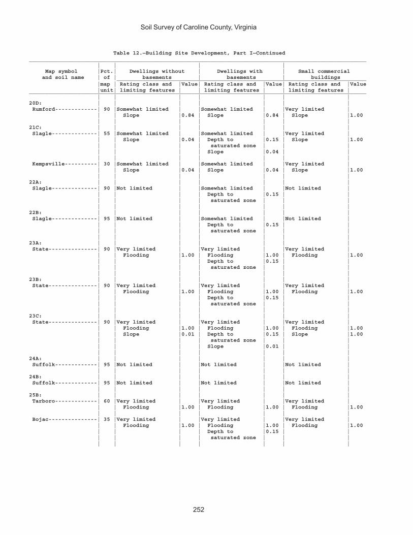
Soil Survey of Caroline County, Virginia
252
Table 12.—Building Site Development, Part I—Continued________________________________________________________________________________________________________ | | | | Map symbol |Pct.| Dwellings without | Dwellings with | Small commercial and soil name | of | basements | basements | buildings _____________________________________________________________________________ |map | Rating class and |Value| Rating class and |Value| Rating class and |Value |unit| limiting features | | limiting features | | limiting features |________________________________________________________________________________________________________ | | | | | | |20D: | | | | | | | Rumford-------------| 90 |Somewhat limited | |Somewhat limited | |Very limited | | | Slope |0.84 | Slope |0.84 | Slope |1.00 | | | | | | |21C: | | | | | | | Slagle--------------| 55 |Somewhat limited | |Somewhat limited | |Very limited | | | Slope |0.04 | Depth to |0.15 | Slope |1.00 | | | | saturated zone | | | | | | | Slope |0.04 | | | | | | | | | Kempsville----------| 30 |Somewhat limited | |Somewhat limited | |Very limited | | | Slope |0.04 | Slope |0.04 | Slope |1.00 | | | | | | |22A: | | | | | | | Slagle--------------| 90 |Not limited | |Somewhat limited | |Not limited | | | | | Depth to |0.15 | | | | | | saturated zone | | | | | | | | | |22B: | | | | | | | Slagle--------------| 95 |Not limited | |Somewhat limited | |Not limited | | | | | Depth to |0.15 | | | | | | saturated zone | | | | | | | | | |23A: | | | | | | | State---------------| 90 |Very limited | |Very limited | |Very limited | | | Flooding |1.00 | Flooding |1.00 | Flooding |1.00 | | | | Depth to |0.15 | | | | | | saturated zone | | | | | | | | | |23B: | | | | | | | State---------------| 90 |Very limited | |Very limited | |Very limited | | | Flooding |1.00 | Flooding |1.00 | Flooding |1.00 | | | | Depth to |0.15 | | | | | | saturated zone | | | | | | | | | |23C: | | | | | | | State---------------| 90 |Very limited | |Very limited | |Very limited | | | Flooding |1.00 | Flooding |1.00 | Flooding |1.00 | | Slope |0.01 | Depth to |0.15 | Slope |1.00 | | | | saturated zone | | | | | | | Slope |0.01 | | | | | | | | |24A: | | | | | | | Suffolk-------------| 95 |Not limited | |Not limited | |Not limited | | | | | | | |24B: | | | | | | | Suffolk-------------| 95 |Not limited | |Not limited | |Not limited | | | | | | | |25B: | | | | | | | Tarboro-------------| 60 |Very limited | |Very limited | |Very limited | | | Flooding |1.00 | Flooding |1.00 | Flooding |1.00 | | | | | | | Bojac---------------| 35 |Very limited | |Very limited | |Very limited | | | Flooding |1.00 | Flooding |1.00 | Flooding |1.00 | | | | Depth to |0.15 | | | | | | saturated zone | | | | | | | | | |
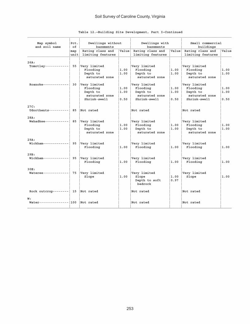
Soil Survey of Caroline County, Virginia
253
Table 12.—Building Site Development, Part I—Continued________________________________________________________________________________________________________ | | | | Map symbol |Pct.| Dwellings without | Dwellings with | Small commercial and soil name | of | basements | basements | buildings _____________________________________________________________________________ |map | Rating class and |Value| Rating class and |Value| Rating class and |Value |unit| limiting features | | limiting features | | limiting features |________________________________________________________________________________________________________ | | | | | | |26A: | | | | | | | Tomotley------------| 55 |Very limited | |Very limited | |Very limited | | | Flooding |1.00 | Flooding |1.00 | Flooding |1.00 | | Depth to |1.00 | Depth to |1.00 | Depth to |1.00 | | saturated zone | | saturated zone | | saturated zone | | | | | | | | Roanoke-------------| 30 |Very limited | |Very limited | |Very limited | | | Flooding |1.00 | Flooding |1.00 | Flooding |1.00 | | Depth to |1.00 | Depth to |1.00 | Depth to |1.00 | | saturated zone | | saturated zone | | saturated zone | | | Shrink-swell |0.50 | Shrink-swell |0.50 | Shrink-swell |0.50 | | | | | | |27C: | | | | | | | Udorthents----------| 85 |Not rated | |Not rated | |Not rated | | | | | | | |28A: | | | | | | | Wehadkee------------| 85 |Very limited | |Very limited | |Very limited | | | Flooding |1.00 | Flooding |1.00 | Flooding |1.00 | | Depth to |1.00 | Depth to |1.00 | Depth to |1.00 | | saturated zone | | saturated zone | | saturated zone | | | | | | | |29A: | | | | | | | Wickham-------------| 95 |Very limited | |Very limited | |Very limited | | | Flooding |1.00 | Flooding |1.00 | Flooding |1.00 | | | | | | |29B: | | | | | | | Wickham-------------| 95 |Very limited | |Very limited | |Very limited | | | Flooding |1.00 | Flooding |1.00 | Flooding |1.00 | | | | | | |30E: | | | | | | | Wateree-------------| 75 |Very limited | |Very limited | |Very limited | | | Slope |1.00 | Slope |1.00 | Slope |1.00 | | | | Depth to soft |0.97 | | | | | | bedrock | | | | | | | | | | Rock outcrop--------| 15 |Not rated | |Not rated | |Not rated | | | | | | | |W: | | | | | | | Water---------------|100 |Not rated | |Not rated | |Not rated | | | | | | | |________________________________________________________________________________________________________
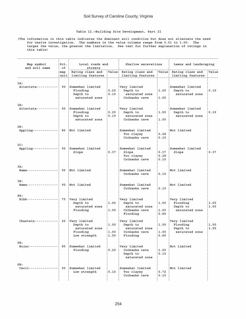
Soil Survey of Caroline County, Virginia
254
Table 12.—Building Site Development, Part II
(The information in this table indicates the dominant soil condition but does not eliminate the need for onsite investigation. The numbers in the value columns range from 0.01 to 1.00. The larger the value, the greater the limitation. See text for further explanation of ratings in this table)
________________________________________________________________________________________________________ | | | | Map symbol |Pct.| Local roads and | Shallow excavations | Lawns and landscaping and soil name | of | streets | | _____________________________________________________________________________ |map | Rating class and |Value| Rating class and |Value| Rating class and |Value |unit| limiting features | | limiting features | | limiting features |________________________________________________________________________________________________________ | | | | | | |1A: | | | | | | | Altavista-----------| 90 |Somewhat limited | |Very limited | |Somewhat limited | | | Flooding |0.20 | Depth to |1.00 | Depth to |0.19 | | Depth to |0.19 | saturated zone | | saturated zone | | | saturated zone | | Cutbanks cave |1.00 | | | | | | | | |1B: | | | | | | | Altavista-----------| 90 |Somewhat limited | |Very limited | |Somewhat limited | | | Flooding |0.20 | Depth to |1.00 | Depth to |0.19 | | Depth to |0.19 | saturated zone | | saturated zone | | | saturated zone | | Cutbanks cave |1.00 | | | | | | | | |2B: | | | | | | | Appling-------------| 80 |Not limited | |Somewhat limited | |Not limited | | | | | Too clayey |0.28 | | | | | | Cutbanks cave |0.10 | | | | | | | | |2C: | | | | | | | Appling-------------| 90 |Somewhat limited | |Somewhat limited | |Somewhat limited | | | Slope |0.37 | Slope |0.37 | Slope |0.37 | | | | Too clayey |0.28 | | | | | | Cutbanks cave |0.10 | | | | | | | | |3A: | | | | | | | Bama----------------| 90 |Not limited | |Somewhat limited | |Not limited | | | | | Cutbanks cave |0.10 | | | | | | | | |3B: | | | | | | | Bama----------------| 90 |Not limited | |Somewhat limited | |Not limited | | | | | Cutbanks cave |0.10 | | | | | | | | |4A: | | | | | | | Bibb----------------| 75 |Very limited | |Very limited | |Very limited | | | Depth to |1.00 | Depth to |1.00 | Flooding |1.00 | | saturated zone | | saturated zone | | Depth to |1.00 | | Flooding |1.00 | Cutbanks cave |1.00 | saturated zone | | | | | Flooding |0.80 | | | | | | | | | Chastain------------| 20 |Very limited | |Very limited | |Very limited | | | Depth to |1.00 | Depth to |1.00 | Flooding |1.00 | | saturated zone | | saturated zone | | Depth to |1.00 | | Flooding |1.00 | Cutbanks cave |1.00 | saturated zone | | | Low strength |1.00 | Flooding |0.80 | | | | | | | | |5B: | | | | | | | Bojac---------------| 85 |Somewhat limited | |Very limited | |Not limited | | | Flooding |0.20 | Cutbanks cave |1.00 | | | | | | Depth to |0.15 | | | | | | saturated zone | | | | | | | | | |6B: | | | | | | | Cecil---------------| 90 |Somewhat limited | |Somewhat limited | |Not limited | | | Low strength |0.10 | Too clayey |0.72 | | | | | | Cutbanks cave |0.10 | | | | | | | | |

Soil Survey of Caroline County, Virginia
255
Table 12.—Building Site Development, Part II—Continued________________________________________________________________________________________________________ | | | | Map symbol |Pct.| Local roads and | Shallow excavations | Lawns and landscaping and soil name | of | streets | | _____________________________________________________________________________ |map | Rating class and |Value| Rating class and |Value| Rating class and |Value |unit| limiting features | | limiting features | | limiting features |________________________________________________________________________________________________________ | | | | | | |7A: | | | | | | | Chastain------------| 95 |Very limited | |Very limited | |Very limited | | | Ponding |1.00 | Ponding |1.00 | Ponding |1.00 | | Depth to |1.00 | Depth to |1.00 | Flooding |1.00 | | saturated zone | | saturated zone | | Depth to |1.00 | | Flooding |1.00 | Cutbanks cave |1.00 | saturated zone | | | | | | | |8A: | | | | | | | Chewacla------------| 75 |Very limited | |Very limited | |Somewhat limited | | | Flooding |1.00 | Depth to |1.00 | Depth to |0.99 | | Depth to |0.99 | saturated zone | | saturated zone | | | saturated zone | | Cutbanks cave |1.00 | Flooding |0.60 | | | | Flooding |0.60 | | | | | | | | |9C: | | | | | | | Helena--------------| 65 |Very limited | |Very limited | |Somewhat limited | | | Shrink-swell |1.00 | Depth to |1.00 | Slope |0.37 | | Low strength |1.00 | saturated zone | | Depth to |0.22 | | Slope |0.37 | Slope |0.37 | saturated zone | | | | | Too clayey |0.28 | | | | | | | | | Appling-------------| 20 |Somewhat limited | |Somewhat limited | |Somewhat limited | | | Slope |0.37 | Slope |0.37 | Slope |0.37 | | | | Too clayey |0.28 | | | | | | Cutbanks cave |0.10 | | | | | | | | |10E: | | | | | | | Kempsville----------| 45 |Very limited | |Very limited | |Very limited | | | Slope |1.00 | Slope |1.00 | Slope |1.00 | | | | Cutbanks cave |0.10 | | | | | | | | | Emporia-------------| 25 |Very limited | |Very limited | |Very limited | | | Slope |1.00 | Slope |1.00 | Slope |1.00 | | Low strength |1.00 | Depth to |0.73 | | | | | | saturated zone | | | | | | | Cutbanks cave |0.10 | | | | | | | | | Remlik--------------| 20 |Very limited | |Very limited | |Very limited | | | Slope |1.00 | Slope |1.00 | Slope |1.00 | | | | Cutbanks cave |1.00 | Droughty |0.03 | | | | Depth to |0.15 | | | | | | saturated zone | | | | | | | | | |11A: | | | | | | | Kempsville----------| 70 |Not limited | |Somewhat limited | |Not limited | | | | | Cutbanks cave |0.10 | | | | | | | | | Emporia-------------| 30 |Very limited | |Somewhat limited | |Not limited | | | Low strength |1.00 | Depth to |0.73 | | | | | | saturated zone | | | | | | | Cutbanks cave |0.10 | | | | | | | | |11B: | | | | | | | Kempsville----------| 60 |Not limited | |Somewhat limited | |Not limited | | | | | Cutbanks cave |0.10 | | | | | | | | | Emporia-------------| 35 |Very limited | |Somewhat limited | |Not limited | | | Low strength |1.00 | Depth to |0.73 | | | | | | saturated zone | | | | | | | Cutbanks cave |0.10 | | | | | | | | |
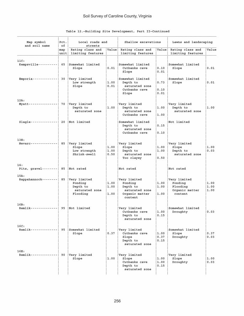
Soil Survey of Caroline County, Virginia
256
Table 12.—Building Site Development, Part II—Continued________________________________________________________________________________________________________ | | | | Map symbol |Pct.| Local roads and | Shallow excavations | Lawns and landscaping and soil name | of | streets | | _____________________________________________________________________________ |map | Rating class and |Value| Rating class and |Value| Rating class and |Value |unit| limiting features | | limiting features | | limiting features |________________________________________________________________________________________________________ | | | | | | |11C: | | | | | | | Kempsville----------| 65 |Somewhat limited | |Somewhat limited | |Somewhat limited | | | Slope |0.01 | Cutbanks cave |0.10 | Slope |0.01 | | | | Slope |0.01 | | | | | | | | | Emporia-------------| 30 |Very limited | |Somewhat limited | |Somewhat limited | | | Low strength |1.00 | Depth to |0.73 | Slope |0.01 | | Slope |0.01 | saturated zone | | | | | | | Cutbanks cave |0.10 | | | | | | Slope |0.01 | | | | | | | | |12A: | | | | | | | Myatt---------------| 70 |Very limited | |Very limited | |Very limited | | | Depth to |1.00 | Depth to |1.00 | Depth to |1.00 | | saturated zone | | saturated zone | | saturated zone | | | | | Cutbanks cave |1.00 | | | | | | | | | Slagle--------------| 20 |Not limited | |Somewhat limited | |Not limited | | | | | Depth to |0.15 | | | | | | saturated zone | | | | | | | Cutbanks cave |0.10 | | | | | | | | |13E: | | | | | | | Nevarc--------------| 85 |Very limited | |Very limited | |Very limited | | | Slope |1.00 | Slope |1.00 | Slope |1.00 | | Low strength |1.00 | Depth to |1.00 | Depth to |0.03 | | Shrink-swell |0.50 | saturated zone | | saturated zone | | | | | Too clayey |0.50 | | | | | | | | |14: | | | | | | | Pits, gravel--------| 85 |Not rated | |Not rated | |Not rated | | | | | | | |15A: | | | | | | | Rappahannock--------| 85 |Very limited | |Very limited | |Very limited | | | Ponding |1.00 | Ponding |1.00 | Ponding |1.00 | | Depth to |1.00 | Depth to |1.00 | Flooding |1.00 | | saturated zone | | saturated zone | | Organic matter |1.00 | | Flooding |1.00 | Organic matter |1.00 | content | | | | | content | | | | | | | | | |16B: | | | | | | | Remlik--------------| 95 |Not limited | |Very limited | |Somewhat limited | | | | | Cutbanks cave |1.00 | Droughty |0.03 | | | | Depth to |0.15 | | | | | | saturated zone | | | | | | | | | |16C: | | | | | | | Remlik--------------| 95 |Somewhat limited | |Very limited | |Somewhat limited | | | Slope |0.37 | Cutbanks cave |1.00 | Slope |0.37 | | | | Slope |0.37 | Droughty |0.03 | | | | Depth to |0.15 | | | | | | saturated zone | | | | | | | | | |16E: | | | | | | | Remlik--------------| 90 |Very limited | |Very limited | |Very limited | | | Slope |1.00 | Slope |1.00 | Slope |1.00 | | | | Cutbanks cave |1.00 | Droughty |0.03 | | | | Depth to |0.15 | | | | | | saturated zone | | | | | | | | | |
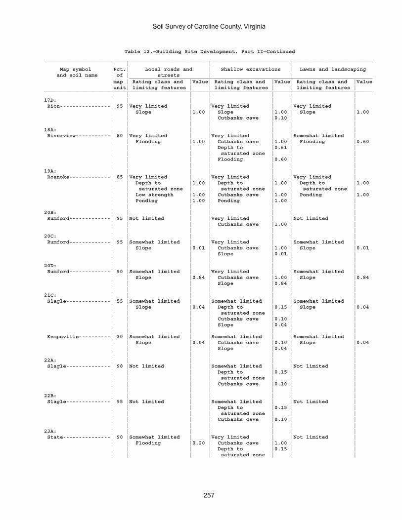
Soil Survey of Caroline County, Virginia
257
Table 12.—Building Site Development, Part II—Continued________________________________________________________________________________________________________ | | | | Map symbol |Pct.| Local roads and | Shallow excavations | Lawns and landscaping and soil name | of | streets | | _____________________________________________________________________________ |map | Rating class and |Value| Rating class and |Value| Rating class and |Value |unit| limiting features | | limiting features | | limiting features |________________________________________________________________________________________________________ | | | | | | |17D: | | | | | | | Rion----------------| 95 |Very limited | |Very limited | |Very limited | | | Slope |1.00 | Slope |1.00 | Slope |1.00 | | | | Cutbanks cave |0.10 | | | | | | | | |18A: | | | | | | | Riverview-----------| 80 |Very limited | |Very limited | |Somewhat limited | | | Flooding |1.00 | Cutbanks cave |1.00 | Flooding |0.60 | | | | Depth to |0.61 | | | | | | saturated zone | | | | | | | Flooding |0.60 | | | | | | | | |19A: | | | | | | | Roanoke-------------| 85 |Very limited | |Very limited | |Very limited | | | Depth to |1.00 | Depth to |1.00 | Depth to |1.00 | | saturated zone | | saturated zone | | saturated zone | | | Low strength |1.00 | Cutbanks cave |1.00 | Ponding |1.00 | | Ponding |1.00 | Ponding |1.00 | | | | | | | | |20B: | | | | | | | Rumford-------------| 95 |Not limited | |Very limited | |Not limited | | | | | Cutbanks cave |1.00 | | | | | | | | |20C: | | | | | | | Rumford-------------| 95 |Somewhat limited | |Very limited | |Somewhat limited | | | Slope |0.01 | Cutbanks cave |1.00 | Slope |0.01 | | | | Slope |0.01 | | | | | | | | |20D: | | | | | | | Rumford-------------| 90 |Somewhat limited | |Very limited | |Somewhat limited | | | Slope |0.84 | Cutbanks cave |1.00 | Slope |0.84 | | | | Slope |0.84 | | | | | | | | |21C: | | | | | | | Slagle--------------| 55 |Somewhat limited | |Somewhat limited | |Somewhat limited | | | Slope |0.04 | Depth to |0.15 | Slope |0.04 | | | | saturated zone | | | | | | | Cutbanks cave |0.10 | | | | | | Slope |0.04 | | | | | | | | | Kempsville----------| 30 |Somewhat limited | |Somewhat limited | |Somewhat limited | | | Slope |0.04 | Cutbanks cave |0.10 | Slope |0.04 | | | | Slope |0.04 | | | | | | | | |22A: | | | | | | | Slagle--------------| 90 |Not limited | |Somewhat limited | |Not limited | | | | | Depth to |0.15 | | | | | | saturated zone | | | | | | | Cutbanks cave |0.10 | | | | | | | | |22B: | | | | | | | Slagle--------------| 95 |Not limited | |Somewhat limited | |Not limited | | | | | Depth to |0.15 | | | | | | saturated zone | | | | | | | Cutbanks cave |0.10 | | | | | | | | |23A: | | | | | | | State---------------| 90 |Somewhat limited | |Very limited | |Not limited | | | Flooding |0.20 | Cutbanks cave |1.00 | | | | | | Depth to |0.15 | | | | | | saturated zone | | |

Soil Survey of Caroline County, Virginia
258
Table 12.—Building Site Development, Part II—Continued________________________________________________________________________________________________________ | | | | Map symbol |Pct.| Local roads and | Shallow excavations | Lawns and landscaping and soil name | of | streets | | _____________________________________________________________________________ |map | Rating class and |Value| Rating class and |Value| Rating class and |Value |unit| limiting features | | limiting features | | limiting features |________________________________________________________________________________________________________ | | | | | | |23B: | | | | | | | State---------------| 90 |Somewhat limited | |Very limited | |Not limited | | | Flooding |0.20 | Cutbanks cave |1.00 | | | | | | Depth to |0.15 | | | | | | saturated zone | | | | | | | | | |23C: | | | | | | | State---------------| 90 |Somewhat limited | |Very limited | |Somewhat limited | | | Flooding |0.20 | Cutbanks cave |1.00 | Slope |0.01 | | Slope |0.01 | Depth to |0.15 | | | | | | saturated zone | | | | | | | Slope |0.01 | | | | | | | | |24A: | | | | | | | Suffolk-------------| 95 |Not limited | |Very limited | |Not limited | | | | | Cutbanks cave |1.00 | | | | | | | | |24B: | | | | | | | Suffolk-------------| 95 |Not limited | |Very limited | |Not limited | | | | | Cutbanks cave |1.00 | | | | | | | | |25B: | | | | | | | Tarboro-------------| 60 |Somewhat limited | |Very limited | |Very limited | | | Flooding |0.20 | Cutbanks cave |1.00 | Droughty |1.00 | | | | | | Too sandy |0.50 | | | | | | | Bojac---------------| 35 |Somewhat limited | |Very limited | |Not limited | | | Flooding |0.20 | Cutbanks cave |1.00 | | | | | | Depth to |0.15 | | | | | | saturated zone | | | | | | | | | |26A: | | | | | | | Tomotley------------| 55 |Very limited | |Very limited | |Very limited | | | Depth to |1.00 | Depth to |1.00 | Depth to |1.00 | | saturated zone | | saturated zone | | saturated zone | | | Flooding |0.40 | Cutbanks cave |0.10 | | | | | | | | | Roanoke-------------| 30 |Very limited | |Very limited | |Very limited | | | Depth to |1.00 | Depth to |1.00 | Depth to |1.00 | | saturated zone | | saturated zone | | saturated zone | | | Low strength |1.00 | Cutbanks cave |1.00 | | | | Shrink-swell |0.50 | Too clayey |0.12 | | | | | | | | |27C: | | | | | | | Udorthents----------| 85 |Not rated | |Not rated | |Not rated | | | | | | | |28A: | | | | | | | Wehadkee------------| 85 |Very limited | |Very limited | |Very limited | | | Depth to |1.00 | Depth to |1.00 | Flooding |1.00 | | saturated zone | | saturated zone | | Depth to |1.00 | | Flooding |1.00 | Flooding |0.80 | saturated zone | | | Low strength |0.78 | Cutbanks cave |0.10 | | | | | | | | |29A: | | | | | | | Wickham-------------| 95 |Somewhat limited | |Very limited | |Not limited | | | Flooding |0.20 | Cutbanks cave |1.00 | | | | | | | | |29B: | | | | | | | Wickham-------------| 95 |Somewhat limited | |Very limited | |Not limited | | | Flooding |0.20 | Cutbanks cave |1.00 | | | | | | | | |

Soil Survey of Caroline County, Virginia
259
Table 12.—Building Site Development, Part II—Continued________________________________________________________________________________________________________ | | | | Map symbol |Pct.| Local roads and | Shallow excavations | Lawns and landscaping and soil name | of | streets | | _____________________________________________________________________________ |map | Rating class and |Value| Rating class and |Value| Rating class and |Value |unit| limiting features | | limiting features | | limiting features |________________________________________________________________________________________________________ | | | | | | |30E: | | | | | | | Wateree-------------| 75 |Very limited | |Very limited | |Very limited | | | Slope |1.00 | Slope |1.00 | Slope |1.00 | | | | Depth to soft |0.97 | Depth to bedrock |0.97 | | | | bedrock | | Droughty |0.90 | | | | Cutbanks cave |0.10 | | | | | | | | | Rock outcrop--------| 15 |Not rated | |Not rated | |Not rated | | | | | | | |W: | | | | | | | Water---------------|100 |Not rated | |Not rated | |Not rated | | | | | | | |________________________________________________________________________________________________________
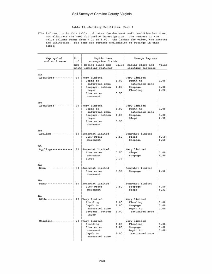
Soil Survey of Caroline County, Virginia
260
Table 13.—Sanitary Facilities, Part I
(The information in this table indicates the dominant soil condition but does not eliminate the need for onsite investigation. The numbers in the value columns range from 0.01 to 1.00. The larger the value, the greater the limitation. See text for further explanation of ratings in this table)
______________________________________________________________________________ | | | Map symbol |Pct.| Septic tank | Sewage lagoons and soil name | of | absorption fields | ___________________________________________________ |map | Rating class and |Value| Rating class and |Value |unit| limiting features | | limiting features |______________________________________________________________________________ | | | | |1A: | | | | | Altavista-----------| 90 |Very limited | |Very limited | | | Depth to |1.00 | Depth to |1.00 | | saturated zone | | saturated zone | | | Seepage, bottom |1.00 | Seepage |1.00 | | layer | | Flooding |0.20 | | Slow water |0.50 | | | | movement | | | | | | | |1B: | | | | | Altavista-----------| 90 |Very limited | |Very limited | | | Depth to |1.00 | Depth to |1.00 | | saturated zone | | saturated zone | | | Seepage, bottom |1.00 | Seepage |1.00 | | layer | | Slope |0.32 | | Slow water |0.50 | | | | movement | | | | | | | |2B: | | | | | Appling-------------| 80 |Somewhat limited | |Somewhat limited | | | Slow water |0.50 | Slope |0.68 | | movement | | Seepage |0.50 | | | | |2C: | | | | | Appling-------------| 90 |Somewhat limited | |Very limited | | | Slow water |0.50 | Slope |1.00 | | movement | | Seepage |0.50 | | Slope |0.37 | | | | | | |3A: | | | | | Bama----------------| 90 |Somewhat limited | |Somewhat limited | | | Slow water |0.50 | Seepage |0.50 | | movement | | | | | | | |3B: | | | | | Bama----------------| 90 |Somewhat limited | |Somewhat limited | | | Slow water |0.50 | Seepage |0.50 | | movement | | Slope |0.32 | | | | |4A: | | | | | Bibb----------------| 75 |Very limited | |Very limited | | | Flooding |1.00 | Flooding |1.00 | | Depth to |1.00 | Seepage |1.00 | | saturated zone | | Depth to |1.00 | | Seepage, bottom |1.00 | saturated zone | | | layer | | | | | | | | Chastain------------| 20 |Very limited | |Very limited | | | Flooding |1.00 | Flooding |1.00 | | Slow water |1.00 | Seepage |1.00 | | movement | | Depth to |1.00 | | Depth to |1.00 | saturated zone | | | saturated zone | | | | | | | |
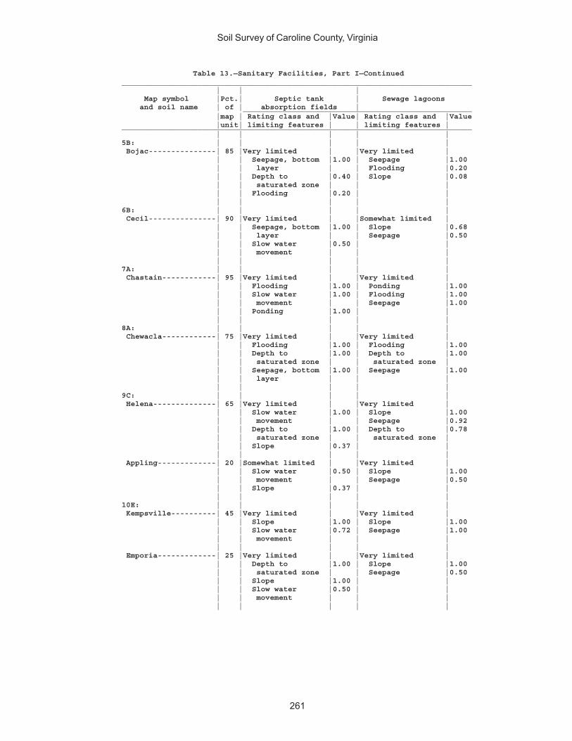
Soil Survey of Caroline County, Virginia
261
Table 13.—Sanitary Facilities, Part I—Continued______________________________________________________________________________ | | | Map symbol |Pct.| Septic tank | Sewage lagoons and soil name | of | absorption fields | ___________________________________________________ |map | Rating class and |Value| Rating class and |Value |unit| limiting features | | limiting features |______________________________________________________________________________ | | | | |5B: | | | | | Bojac---------------| 85 |Very limited | |Very limited | | | Seepage, bottom |1.00 | Seepage |1.00 | | layer | | Flooding |0.20 | | Depth to |0.40 | Slope |0.08 | | saturated zone | | | | | Flooding |0.20 | | | | | | |6B: | | | | | Cecil---------------| 90 |Very limited | |Somewhat limited | | | Seepage, bottom |1.00 | Slope |0.68 | | layer | | Seepage |0.50 | | Slow water |0.50 | | | | movement | | | | | | | |7A: | | | | | Chastain------------| 95 |Very limited | |Very limited | | | Flooding |1.00 | Ponding |1.00 | | Slow water |1.00 | Flooding |1.00 | | movement | | Seepage |1.00 | | Ponding |1.00 | | | | | | |8A: | | | | | Chewacla------------| 75 |Very limited | |Very limited | | | Flooding |1.00 | Flooding |1.00 | | Depth to |1.00 | Depth to |1.00 | | saturated zone | | saturated zone | | | Seepage, bottom |1.00 | Seepage |1.00 | | layer | | | | | | | |9C: | | | | | Helena--------------| 65 |Very limited | |Very limited | | | Slow water |1.00 | Slope |1.00 | | movement | | Seepage |0.92 | | Depth to |1.00 | Depth to |0.78 | | saturated zone | | saturated zone | | | Slope |0.37 | | | | | | | Appling-------------| 20 |Somewhat limited | |Very limited | | | Slow water |0.50 | Slope |1.00 | | movement | | Seepage |0.50 | | Slope |0.37 | | | | | | |10E: | | | | | Kempsville----------| 45 |Very limited | |Very limited | | | Slope |1.00 | Slope |1.00 | | Slow water |0.72 | Seepage |1.00 | | movement | | | | | | | | Emporia-------------| 25 |Very limited | |Very limited | | | Depth to |1.00 | Slope |1.00 | | saturated zone | | Seepage |0.50 | | Slope |1.00 | | | | Slow water |0.50 | | | | movement | | | | | | | |
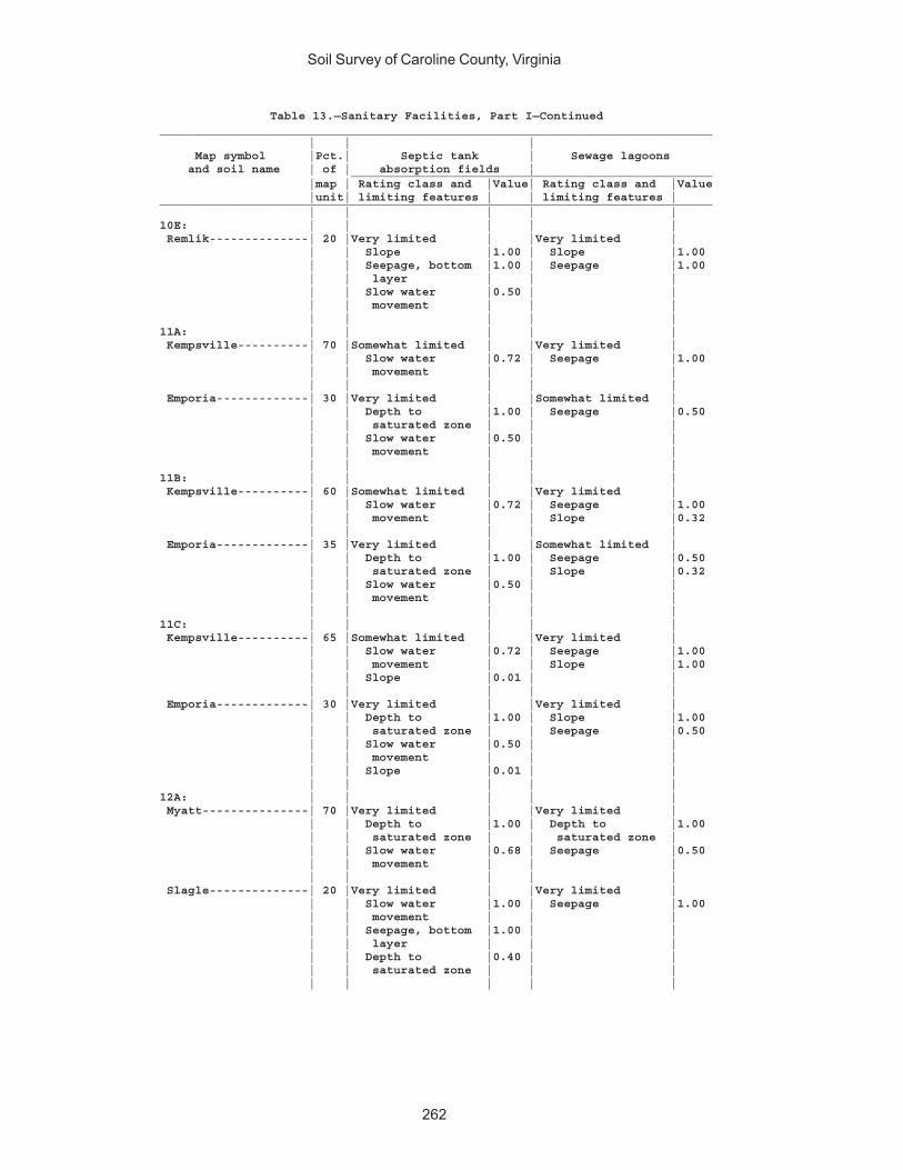
Soil Survey of Caroline County, Virginia
262
Table 13.—Sanitary Facilities, Part I—Continued______________________________________________________________________________ | | | Map symbol |Pct.| Septic tank | Sewage lagoons and soil name | of | absorption fields | ___________________________________________________ |map | Rating class and |Value| Rating class and |Value |unit| limiting features | | limiting features |______________________________________________________________________________ | | | | |10E: | | | | | Remlik--------------| 20 |Very limited | |Very limited | | | Slope |1.00 | Slope |1.00 | | Seepage, bottom |1.00 | Seepage |1.00 | | layer | | | | | Slow water |0.50 | | | | movement | | | | | | | |11A: | | | | | Kempsville----------| 70 |Somewhat limited | |Very limited | | | Slow water |0.72 | Seepage |1.00 | | movement | | | | | | | | Emporia-------------| 30 |Very limited | |Somewhat limited | | | Depth to |1.00 | Seepage |0.50 | | saturated zone | | | | | Slow water |0.50 | | | | movement | | | | | | | |11B: | | | | | Kempsville----------| 60 |Somewhat limited | |Very limited | | | Slow water |0.72 | Seepage |1.00 | | movement | | Slope |0.32 | | | | | Emporia-------------| 35 |Very limited | |Somewhat limited | | | Depth to |1.00 | Seepage |0.50 | | saturated zone | | Slope |0.32 | | Slow water |0.50 | | | | movement | | | | | | | |11C: | | | | | Kempsville----------| 65 |Somewhat limited | |Very limited | | | Slow water |0.72 | Seepage |1.00 | | movement | | Slope |1.00 | | Slope |0.01 | | | | | | | Emporia-------------| 30 |Very limited | |Very limited | | | Depth to |1.00 | Slope |1.00 | | saturated zone | | Seepage |0.50 | | Slow water |0.50 | | | | movement | | | | | Slope |0.01 | | | | | | |12A: | | | | | Myatt---------------| 70 |Very limited | |Very limited | | | Depth to |1.00 | Depth to |1.00 | | saturated zone | | saturated zone | | | Slow water |0.68 | Seepage |0.50 | | movement | | | | | | | | Slagle--------------| 20 |Very limited | |Very limited | | | Slow water |1.00 | Seepage |1.00 | | movement | | | | | Seepage, bottom |1.00 | | | | layer | | | | | Depth to |0.40 | | | | saturated zone | | | | | | | |

Soil Survey of Caroline County, Virginia
263
Table 13.—Sanitary Facilities, Part I—Continued______________________________________________________________________________ | | | Map symbol |Pct.| Septic tank | Sewage lagoons and soil name | of | absorption fields | ___________________________________________________ |map | Rating class and |Value| Rating class and |Value |unit| limiting features | | limiting features |______________________________________________________________________________ | | | | |13E: | | | | | Nevarc--------------| 85 |Very limited | |Very limited | | | Slow water |1.00 | Slope |1.00 | | movement | | Depth to |0.44 | | Depth to |1.00 | saturated zone | | | saturated zone | | | | | Slope |1.00 | | | | | | |14: | | | | | Pits, gravel--------| 85 |Not rated | |Not rated | | | | | |15A: | | | | | Rappahannock--------| 85 |Very limited | |Very limited | | | Flooding |1.00 | Ponding |1.00 | | Ponding |1.00 | Flooding |1.00 | | Depth to |1.00 | Depth to |1.00 | | saturated zone | | saturated zone | | | | | |16B: | | | | | Remlik--------------| 95 |Very limited | |Very limited | | | Seepage, bottom |1.00 | Seepage |1.00 | | layer | | Slope |0.32 | | Slow water |0.50 | | | | movement | | | | | Depth to |0.40 | | | | saturated zone | | | | | | | |16C: | | | | | Remlik--------------| 95 |Very limited | |Very limited | | | Seepage, bottom |1.00 | Seepage |1.00 | | layer | | Slope |1.00 | | Slow water |0.50 | | | | movement | | | | | Depth to |0.40 | | | | saturated zone | | | | | | | |16E: | | | | | Remlik--------------| 90 |Very limited | |Very limited | | | Slope |1.00 | Slope |1.00 | | Seepage, bottom |1.00 | Seepage |1.00 | | layer | | | | | Slow water |0.50 | | | | movement | | | | | | | |17D: | | | | | Rion----------------| 95 |Very limited | |Very limited | | | Slope |1.00 | Slope |1.00 | | Seepage, bottom |1.00 | Seepage |1.00 | | layer | | | | | Slow water |0.50 | | | | movement | | | | | | | |18A: | | | | | Riverview-----------| 80 |Very limited | |Very limited | | | Flooding |1.00 | Flooding |1.00 | | Seepage, bottom |1.00 | Seepage |1.00 | | layer | | Depth to |0.71 | | Depth to |0.99 | saturated zone | | | saturated zone | | | | | | | |
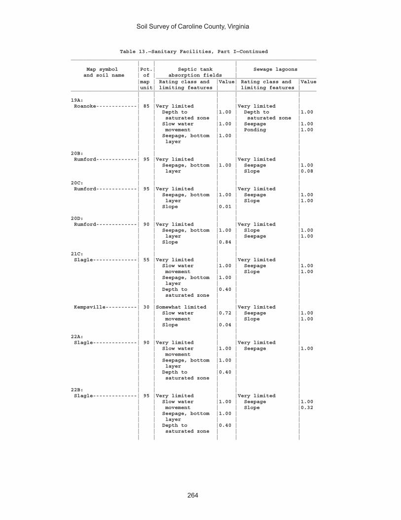
Soil Survey of Caroline County, Virginia
264
Table 13.—Sanitary Facilities, Part I—Continued______________________________________________________________________________ | | | Map symbol |Pct.| Septic tank | Sewage lagoons and soil name | of | absorption fields | ___________________________________________________ |map | Rating class and |Value| Rating class and |Value |unit| limiting features | | limiting features |______________________________________________________________________________ | | | | |19A: | | | | | Roanoke-------------| 85 |Very limited | |Very limited | | | Depth to |1.00 | Depth to |1.00 | | saturated zone | | saturated zone | | | Slow water |1.00 | Seepage |1.00 | | movement | | Ponding |1.00 | | Seepage, bottom |1.00 | | | | layer | | | | | | | |20B: | | | | | Rumford-------------| 95 |Very limited | |Very limited | | | Seepage, bottom |1.00 | Seepage |1.00 | | layer | | Slope |0.08 | | | | |20C: | | | | | Rumford-------------| 95 |Very limited | |Very limited | | | Seepage, bottom |1.00 | Seepage |1.00 | | layer | | Slope |1.00 | | Slope |0.01 | | | | | | |20D: | | | | | Rumford-------------| 90 |Very limited | |Very limited | | | Seepage, bottom |1.00 | Slope |1.00 | | layer | | Seepage |1.00 | | Slope |0.84 | | | | | | |21C: | | | | | Slagle--------------| 55 |Very limited | |Very limited | | | Slow water |1.00 | Seepage |1.00 | | movement | | Slope |1.00 | | Seepage, bottom |1.00 | | | | layer | | | | | Depth to |0.40 | | | | saturated zone | | | | | | | | Kempsville----------| 30 |Somewhat limited | |Very limited | | | Slow water |0.72 | Seepage |1.00 | | movement | | Slope |1.00 | | Slope |0.04 | | | | | | |22A: | | | | | Slagle--------------| 90 |Very limited | |Very limited | | | Slow water |1.00 | Seepage |1.00 | | movement | | | | | Seepage, bottom |1.00 | | | | layer | | | | | Depth to |0.40 | | | | saturated zone | | | | | | | |22B: | | | | | Slagle--------------| 95 |Very limited | |Very limited | | | Slow water |1.00 | Seepage |1.00 | | movement | | Slope |0.32 | | Seepage, bottom |1.00 | | | | layer | | | | | Depth to |0.40 | | | | saturated zone | | | | | | | |
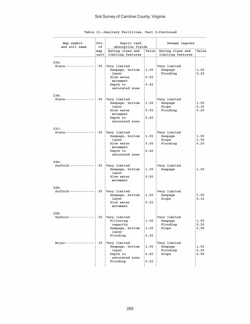
Soil Survey of Caroline County, Virginia
265
Table 13.—Sanitary Facilities, Part I—Continued______________________________________________________________________________ | | | Map symbol |Pct.| Septic tank | Sewage lagoons and soil name | of | absorption fields | ___________________________________________________ |map | Rating class and |Value| Rating class and |Value |unit| limiting features | | limiting features |______________________________________________________________________________ | | | | |23A: | | | | | State---------------| 90 |Very limited | |Very limited | | | Seepage, bottom |1.00 | Seepage |1.00 | | layer | | Flooding |0.20 | | Slow water |0.50 | | | | movement | | | | | Depth to |0.40 | | | | saturated zone | | | | | | | |23B: | | | | | State---------------| 90 |Very limited | |Very limited | | | Seepage, bottom |1.00 | Seepage |1.00 | | layer | | Slope |0.32 | | Slow water |0.50 | Flooding |0.20 | | movement | | | | | Depth to |0.40 | | | | saturated zone | | | | | | | |23C: | | | | | State---------------| 90 |Very limited | |Very limited | | | Seepage, bottom |1.00 | Seepage |1.00 | | layer | | Slope |1.00 | | Slow water |0.50 | Flooding |0.20 | | movement | | | | | Depth to |0.40 | | | | saturated zone | | | | | | | |24A: | | | | | Suffolk-------------| 95 |Very limited | |Very limited | | | Seepage, bottom |1.00 | Seepage |1.00 | | layer | | | | | Slow water |0.50 | | | | movement | | | | | | | |24B: | | | | | Suffolk-------------| 95 |Very limited | |Very limited | | | Seepage, bottom |1.00 | Seepage |1.00 | | layer | | Slope |0.32 | | Slow water |0.50 | | | | movement | | | | | | | |25B: | | | | | Tarboro-------------| 60 |Very limited | |Very limited | | | Filtering |1.00 | Seepage |1.00 | | capacity | | Flooding |0.20 | | Seepage, bottom |1.00 | Slope |0.08 | | layer | | | | | Flooding |0.20 | | | | | | | Bojac---------------| 35 |Very limited | |Very limited | | | Seepage, bottom |1.00 | Seepage |1.00 | | layer | | Flooding |0.20 | | Depth to |0.40 | Slope |0.08 | | saturated zone | | | | | Flooding |0.20 | | | | | | |
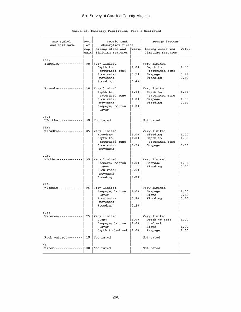
Soil Survey of Caroline County, Virginia
266
Table 13.—Sanitary Facilities, Part I—Continued______________________________________________________________________________ | | | Map symbol |Pct.| Septic tank | Sewage lagoons and soil name | of | absorption fields | ___________________________________________________ |map | Rating class and |Value| Rating class and |Value |unit| limiting features | | limiting features |______________________________________________________________________________ | | | | |26A: | | | | | Tomotley------------| 55 |Very limited | |Very limited | | | Depth to |1.00 | Depth to |1.00 | | saturated zone | | saturated zone | | | Slow water |0.50 | Seepage |0.99 | | movement | | Flooding |0.40 | | Flooding |0.40 | | | | | | | Roanoke-------------| 30 |Very limited | |Very limited | | | Depth to |1.00 | Depth to |1.00 | | saturated zone | | saturated zone | | | Slow water |1.00 | Seepage |1.00 | | movement | | Flooding |0.40 | | Seepage, bottom |1.00 | | | | layer | | | | | | | |27C: | | | | | Udorthents----------| 85 |Not rated | |Not rated | | | | | |28A: | | | | | Wehadkee------------| 85 |Very limited | |Very limited | | | Flooding |1.00 | Flooding |1.00 | | Depth to |1.00 | Depth to |1.00 | | saturated zone | | saturated zone | | | Slow water |0.50 | Seepage |0.50 | | movement | | | | | | | |29A: | | | | | Wickham-------------| 95 |Very limited | |Very limited | | | Seepage, bottom |1.00 | Seepage |1.00 | | layer | | Flooding |0.20 | | Slow water |0.50 | | | | movement | | | | | Flooding |0.20 | | | | | | |29B: | | | | | Wickham-------------| 95 |Very limited | |Very limited | | | Seepage, bottom |1.00 | Seepage |1.00 | | layer | | Slope |0.32 | | Slow water |0.50 | Flooding |0.20 | | movement | | | | | Flooding |0.20 | | | | | | |30E: | | | | | Wateree-------------| 75 |Very limited | |Very limited | | | Slope |1.00 | Depth to soft |1.00 | | Seepage, bottom |1.00 | bedrock | | | layer | | Slope |1.00 | | Depth to bedrock |1.00 | Seepage |1.00 | | | | | Rock outcrop--------| 15 |Not rated | |Not rated | | | | | |W: | | | | | Water---------------|100 |Not rated | |Not rated | | | | | |______________________________________________________________________________
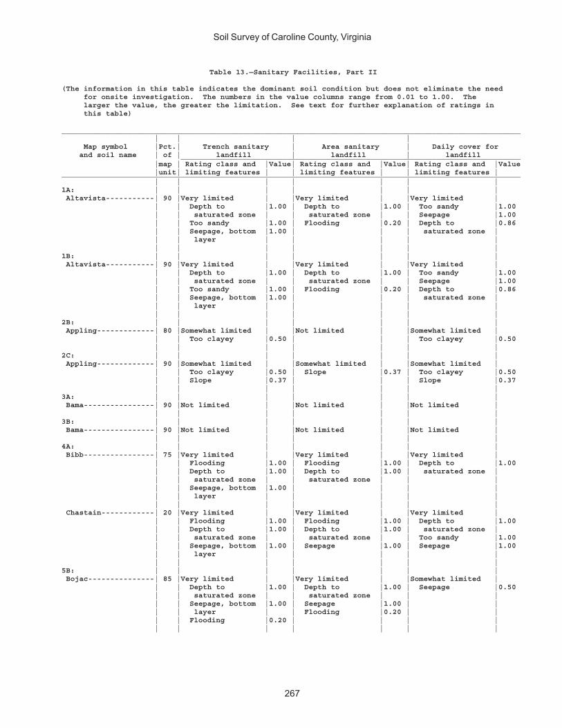
Soil Survey of Caroline County, Virginia
267
Table 13.—Sanitary Facilities, Part II
(The information in this table indicates the dominant soil condition but does not eliminate the need for onsite investigation. The numbers in the value columns range from 0.01 to 1.00. The larger the value, the greater the limitation. See text for further explanation of ratings in this table)
________________________________________________________________________________________________________ | | | | Map symbol |Pct.| Trench sanitary | Area sanitary | Daily cover for and soil name | of | landfill | landfill | landfill _____________________________________________________________________________ |map | Rating class and |Value| Rating class and |Value| Rating class and |Value |unit| limiting features | | limiting features | | limiting features |________________________________________________________________________________________________________ | | | | | | |1A: | | | | | | | Altavista-----------| 90 |Very limited | |Very limited | |Very limited | | | Depth to |1.00 | Depth to |1.00 | Too sandy |1.00 | | saturated zone | | saturated zone | | Seepage |1.00 | | Too sandy |1.00 | Flooding |0.20 | Depth to |0.86 | | Seepage, bottom |1.00 | | | saturated zone | | | layer | | | | | | | | | | | |1B: | | | | | | | Altavista-----------| 90 |Very limited | |Very limited | |Very limited | | | Depth to |1.00 | Depth to |1.00 | Too sandy |1.00 | | saturated zone | | saturated zone | | Seepage |1.00 | | Too sandy |1.00 | Flooding |0.20 | Depth to |0.86 | | Seepage, bottom |1.00 | | | saturated zone | | | layer | | | | | | | | | | | |2B: | | | | | | | Appling-------------| 80 |Somewhat limited | |Not limited | |Somewhat limited | | | Too clayey |0.50 | | | Too clayey |0.50 | | | | | | |2C: | | | | | | | Appling-------------| 90 |Somewhat limited | |Somewhat limited | |Somewhat limited | | | Too clayey |0.50 | Slope |0.37 | Too clayey |0.50 | | Slope |0.37 | | | Slope |0.37 | | | | | | |3A: | | | | | | | Bama----------------| 90 |Not limited | |Not limited | |Not limited | | | | | | | |3B: | | | | | | | Bama----------------| 90 |Not limited | |Not limited | |Not limited | | | | | | | |4A: | | | | | | | Bibb----------------| 75 |Very limited | |Very limited | |Very limited | | | Flooding |1.00 | Flooding |1.00 | Depth to |1.00 | | Depth to |1.00 | Depth to |1.00 | saturated zone | | | saturated zone | | saturated zone | | | | | Seepage, bottom |1.00 | | | | | | layer | | | | | | | | | | | | Chastain------------| 20 |Very limited | |Very limited | |Very limited | | | Flooding |1.00 | Flooding |1.00 | Depth to |1.00 | | Depth to |1.00 | Depth to |1.00 | saturated zone | | | saturated zone | | saturated zone | | Too sandy |1.00 | | Seepage, bottom |1.00 | Seepage |1.00 | Seepage |1.00 | | layer | | | | | | | | | | | |5B: | | | | | | | Bojac---------------| 85 |Very limited | |Very limited | |Somewhat limited | | | Depth to |1.00 | Depth to |1.00 | Seepage |0.50 | | saturated zone | | saturated zone | | | | | Seepage, bottom |1.00 | Seepage |1.00 | | | | layer | | Flooding |0.20 | | | | Flooding |0.20 | | | | | | | | | | |
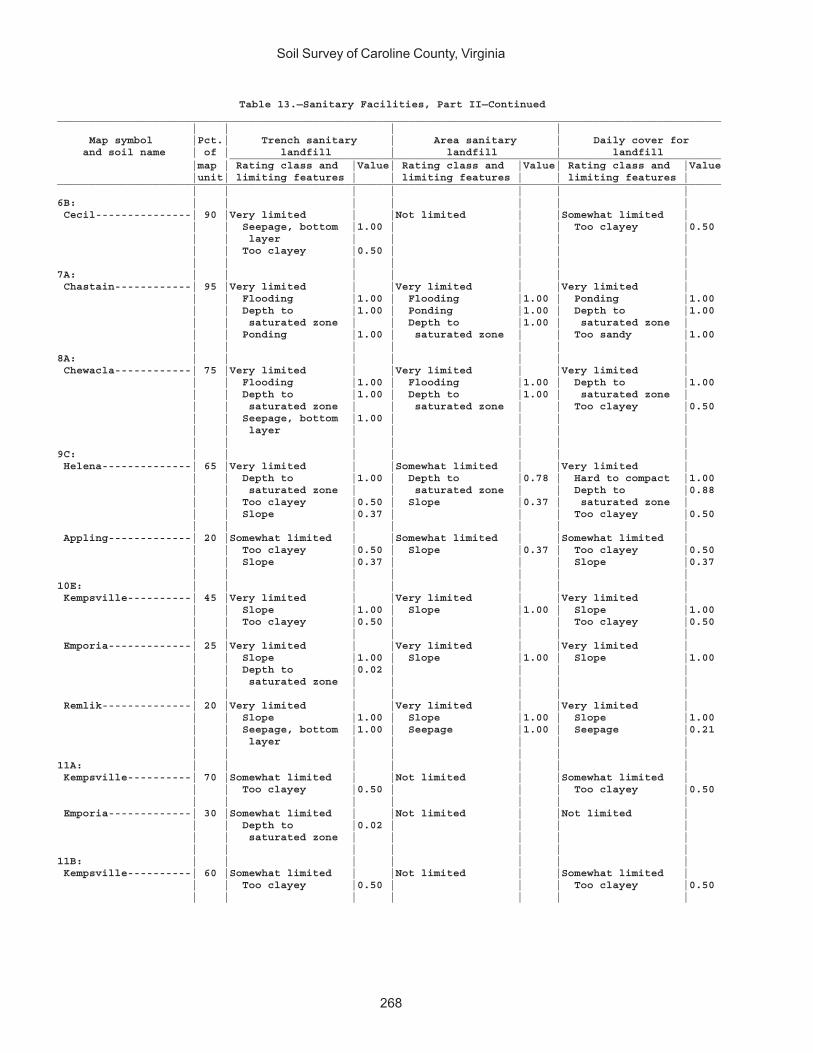
Soil Survey of Caroline County, Virginia
268
Table 13.—Sanitary Facilities, Part II—Continued________________________________________________________________________________________________________ | | | | Map symbol |Pct.| Trench sanitary | Area sanitary | Daily cover for and soil name | of | landfill | landfill | landfill _____________________________________________________________________________ |map | Rating class and |Value| Rating class and |Value| Rating class and |Value |unit| limiting features | | limiting features | | limiting features |________________________________________________________________________________________________________ | | | | | | |6B: | | | | | | | Cecil---------------| 90 |Very limited | |Not limited | |Somewhat limited | | | Seepage, bottom |1.00 | | | Too clayey |0.50 | | layer | | | | | | | Too clayey |0.50 | | | | | | | | | | |7A: | | | | | | | Chastain------------| 95 |Very limited | |Very limited | |Very limited | | | Flooding |1.00 | Flooding |1.00 | Ponding |1.00 | | Depth to |1.00 | Ponding |1.00 | Depth to |1.00 | | saturated zone | | Depth to |1.00 | saturated zone | | | Ponding |1.00 | saturated zone | | Too sandy |1.00 | | | | | | |8A: | | | | | | | Chewacla------------| 75 |Very limited | |Very limited | |Very limited | | | Flooding |1.00 | Flooding |1.00 | Depth to |1.00 | | Depth to |1.00 | Depth to |1.00 | saturated zone | | | saturated zone | | saturated zone | | Too clayey |0.50 | | Seepage, bottom |1.00 | | | | | | layer | | | | | | | | | | | |9C: | | | | | | | Helena--------------| 65 |Very limited | |Somewhat limited | |Very limited | | | Depth to |1.00 | Depth to |0.78 | Hard to compact |1.00 | | saturated zone | | saturated zone | | Depth to |0.88 | | Too clayey |0.50 | Slope |0.37 | saturated zone | | | Slope |0.37 | | | Too clayey |0.50 | | | | | | | Appling-------------| 20 |Somewhat limited | |Somewhat limited | |Somewhat limited | | | Too clayey |0.50 | Slope |0.37 | Too clayey |0.50 | | Slope |0.37 | | | Slope |0.37 | | | | | | |10E: | | | | | | | Kempsville----------| 45 |Very limited | |Very limited | |Very limited | | | Slope |1.00 | Slope |1.00 | Slope |1.00 | | Too clayey |0.50 | | | Too clayey |0.50 | | | | | | | Emporia-------------| 25 |Very limited | |Very limited | |Very limited | | | Slope |1.00 | Slope |1.00 | Slope |1.00 | | Depth to |0.02 | | | | | | saturated zone | | | | | | | | | | | | Remlik--------------| 20 |Very limited | |Very limited | |Very limited | | | Slope |1.00 | Slope |1.00 | Slope |1.00 | | Seepage, bottom |1.00 | Seepage |1.00 | Seepage |0.21 | | layer | | | | | | | | | | | |11A: | | | | | | | Kempsville----------| 70 |Somewhat limited | |Not limited | |Somewhat limited | | | Too clayey |0.50 | | | Too clayey |0.50 | | | | | | | Emporia-------------| 30 |Somewhat limited | |Not limited | |Not limited | | | Depth to |0.02 | | | | | | saturated zone | | | | | | | | | | | |11B: | | | | | | | Kempsville----------| 60 |Somewhat limited | |Not limited | |Somewhat limited | | | Too clayey |0.50 | | | Too clayey |0.50 | | | | | | |
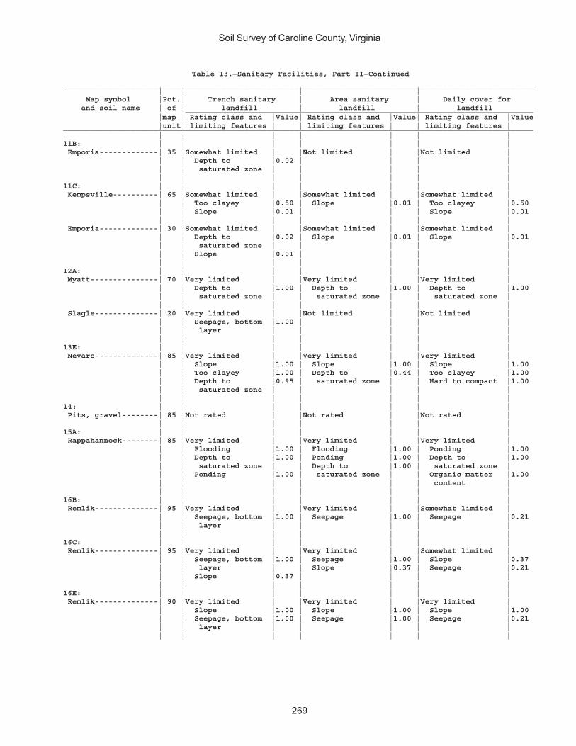
Soil Survey of Caroline County, Virginia
269
Table 13.—Sanitary Facilities, Part II—Continued________________________________________________________________________________________________________ | | | | Map symbol |Pct.| Trench sanitary | Area sanitary | Daily cover for and soil name | of | landfill | landfill | landfill _____________________________________________________________________________ |map | Rating class and |Value| Rating class and |Value| Rating class and |Value |unit| limiting features | | limiting features | | limiting features |________________________________________________________________________________________________________ | | | | | | |11B: | | | | | | | Emporia-------------| 35 |Somewhat limited | |Not limited | |Not limited | | | Depth to |0.02 | | | | | | saturated zone | | | | | | | | | | | |11C: | | | | | | | Kempsville----------| 65 |Somewhat limited | |Somewhat limited | |Somewhat limited | | | Too clayey |0.50 | Slope |0.01 | Too clayey |0.50 | | Slope |0.01 | | | Slope |0.01 | | | | | | | Emporia-------------| 30 |Somewhat limited | |Somewhat limited | |Somewhat limited | | | Depth to |0.02 | Slope |0.01 | Slope |0.01 | | saturated zone | | | | | | | Slope |0.01 | | | | | | | | | | |12A: | | | | | | | Myatt---------------| 70 |Very limited | |Very limited | |Very limited | | | Depth to |1.00 | Depth to |1.00 | Depth to |1.00 | | saturated zone | | saturated zone | | saturated zone | | | | | | | | Slagle--------------| 20 |Very limited | |Not limited | |Not limited | | | Seepage, bottom |1.00 | | | | | | layer | | | | | | | | | | | |13E: | | | | | | | Nevarc--------------| 85 |Very limited | |Very limited | |Very limited | | | Slope |1.00 | Slope |1.00 | Slope |1.00 | | Too clayey |1.00 | Depth to |0.44 | Too clayey |1.00 | | Depth to |0.95 | saturated zone | | Hard to compact |1.00 | | saturated zone | | | | | | | | | | | |14: | | | | | | | Pits, gravel--------| 85 |Not rated | |Not rated | |Not rated | | | | | | | |15A: | | | | | | | Rappahannock--------| 85 |Very limited | |Very limited | |Very limited | | | Flooding |1.00 | Flooding |1.00 | Ponding |1.00 | | Depth to |1.00 | Ponding |1.00 | Depth to |1.00 | | saturated zone | | Depth to |1.00 | saturated zone | | | Ponding |1.00 | saturated zone | | Organic matter |1.00 | | | | | | content | | | | | | | |16B: | | | | | | | Remlik--------------| 95 |Very limited | |Very limited | |Somewhat limited | | | Seepage, bottom |1.00 | Seepage |1.00 | Seepage |0.21 | | layer | | | | | | | | | | | |16C: | | | | | | | Remlik--------------| 95 |Very limited | |Very limited | |Somewhat limited | | | Seepage, bottom |1.00 | Seepage |1.00 | Slope |0.37 | | layer | | Slope |0.37 | Seepage |0.21 | | Slope |0.37 | | | | | | | | | | |16E: | | | | | | | Remlik--------------| 90 |Very limited | |Very limited | |Very limited | | | Slope |1.00 | Slope |1.00 | Slope |1.00 | | Seepage, bottom |1.00 | Seepage |1.00 | Seepage |0.21 | | layer | | | | | | | | | | | |

Soil Survey of Caroline County, Virginia
270
Table 13.—Sanitary Facilities, Part II—Continued________________________________________________________________________________________________________ | | | | Map symbol |Pct.| Trench sanitary | Area sanitary | Daily cover for and soil name | of | landfill | landfill | landfill _____________________________________________________________________________ |map | Rating class and |Value| Rating class and |Value| Rating class and |Value |unit| limiting features | | limiting features | | limiting features |________________________________________________________________________________________________________ | | | | | | |17D: | | | | | | | Rion----------------| 95 |Very limited | |Very limited | |Very limited | | | Slope |1.00 | Slope |1.00 | Slope |1.00 | | Seepage, bottom |1.00 | Seepage |1.00 | | | | layer | | | | | | | | | | | |18A: | | | | | | | Riverview-----------| 80 |Very limited | |Very limited | |Somewhat limited | | | Flooding |1.00 | Flooding |1.00 | Seepage |0.50 | | Depth to |1.00 | Depth to |1.00 | | | | saturated zone | | saturated zone | | | | | Seepage, bottom |1.00 | Seepage |1.00 | | | | layer | | | | | | | | | | | |19A: | | | | | | | Roanoke-------------| 85 |Very limited | |Very limited | |Very limited | | | Depth to |1.00 | Depth to |1.00 | Depth to |1.00 | | saturated zone | | saturated zone | | saturated zone | | | Too clayey |1.00 | Ponding |1.00 | Too clayey |1.00 | | Seepage, bottom |1.00 | | | Hard to compact |1.00 | | layer | | | | | | | | | | | |20B: | | | | | | | Rumford-------------| 95 |Very limited | |Very limited | |Very limited | | | Seepage, bottom |1.00 | Seepage |1.00 | Seepage |1.00 | | layer | | | | | | | | | | | |20C: | | | | | | | Rumford-------------| 95 |Very limited | |Very limited | |Very limited | | | Seepage, bottom |1.00 | Seepage |1.00 | Seepage |1.00 | | layer | | Slope |0.01 | Slope |0.01 | | Slope |0.01 | | | | | | | | | | |20D: | | | | | | | Rumford-------------| 90 |Very limited | |Very limited | |Very limited | | | Seepage, bottom |1.00 | Seepage |1.00 | Seepage |1.00 | | layer | | | | | | | Slope |0.84 | Slope |0.84 | Slope |0.84 | | | | | | |21C: | | | | | | | Slagle--------------| 55 |Very limited | |Somewhat limited | |Somewhat limited | | | Seepage, bottom |1.00 | Slope |0.04 | Slope |0.04 | | layer | | | | | | | Slope |0.04 | | | | | | | | | | | Kempsville----------| 30 |Somewhat limited | |Somewhat limited | |Somewhat limited | | | Too clayey |0.50 | Slope |0.04 | Too clayey |0.50 | | Slope |0.04 | | | Slope |0.04 | | | | | | |22A: | | | | | | | Slagle--------------| 90 |Very limited | |Not limited | |Not limited | | | Seepage, bottom |1.00 | | | | | | layer | | | | | | | | | | | |22B: | | | | | | | Slagle--------------| 95 |Very limited | |Not limited | |Not limited | | | Seepage, bottom |1.00 | | | | | | layer | | | | | | | | | | | |
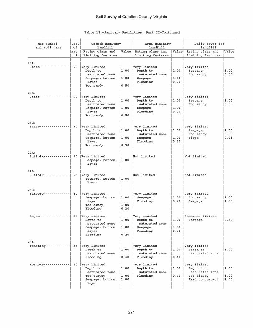
Soil Survey of Caroline County, Virginia
271
Table 13.—Sanitary Facilities, Part II—Continued________________________________________________________________________________________________________ | | | | Map symbol |Pct.| Trench sanitary | Area sanitary | Daily cover for and soil name | of | landfill | landfill | landfill _____________________________________________________________________________ |map | Rating class and |Value| Rating class and |Value| Rating class and |Value |unit| limiting features | | limiting features | | limiting features |________________________________________________________________________________________________________ | | | | | | |23A: | | | | | | | State---------------| 90 |Very limited | |Very limited | |Very limited | | | Depth to |1.00 | Depth to |1.00 | Seepage |1.00 | | saturated zone | | saturated zone | | Too sandy |0.50 | | Seepage, bottom |1.00 | Seepage |1.00 | | | | layer | | Flooding |0.20 | | | | Too sandy |0.50 | | | | | | | | | | |23B: | | | | | | | State---------------| 90 |Very limited | |Very limited | |Very limited | | | Depth to |1.00 | Depth to |1.00 | Seepage |1.00 | | saturated zone | | saturated zone | | Too sandy |0.50 | | Seepage, bottom |1.00 | Seepage |1.00 | | | | layer | | Flooding |0.20 | | | | Too sandy |0.50 | | | | | | | | | | |23C: | | | | | | | State---------------| 90 |Very limited | |Very limited | |Very limited | | | Depth to |1.00 | Depth to |1.00 | Seepage |1.00 | | saturated zone | | saturated zone | | Too sandy |0.50 | | Seepage, bottom |1.00 | Seepage |1.00 | Slope |0.01 | | layer | | Flooding |0.20 | | | | Too sandy |0.50 | | | | | | | | | | |24A: | | | | | | | Suffolk-------------| 95 |Very limited | |Not limited | |Not limited | | | Seepage, bottom |1.00 | | | | | | layer | | | | | | | | | | | |24B: | | | | | | | Suffolk-------------| 95 |Very limited | |Not limited | |Not limited | | | Seepage, bottom |1.00 | | | | | | layer | | | | | | | | | | | |25B: | | | | | | | Tarboro-------------| 60 |Very limited | |Very limited | |Very limited | | | Seepage, bottom |1.00 | Seepage |1.00 | Too sandy |1.00 | | layer | | Flooding |0.20 | Seepage |1.00 | | Too sandy |1.00 | | | | | | Flooding |0.20 | | | | | | | | | | | Bojac---------------| 35 |Very limited | |Very limited | |Somewhat limited | | | Depth to |1.00 | Depth to |1.00 | Seepage |0.50 | | saturated zone | | saturated zone | | | | | Seepage, bottom |1.00 | Seepage |1.00 | | | | layer | | Flooding |0.20 | | | | Flooding |0.20 | | | | | | | | | | |26A: | | | | | | | Tomotley------------| 55 |Very limited | |Very limited | |Very limited | | | Depth to |1.00 | Depth to |1.00 | Depth to |1.00 | | saturated zone | | saturated zone | | saturated zone | | | Flooding |0.40 | Flooding |0.40 | | | | | | | | | Roanoke-------------| 30 |Very limited | |Very limited | |Very limited | | | Depth to |1.00 | Depth to |1.00 | Depth to |1.00 | | saturated zone | | saturated zone | | saturated zone | | | Too clayey |1.00 | Flooding |0.40 | Too clayey |1.00 | | Seepage, bottom |1.00 | | | Hard to compact |1.00 | | layer | | | | | | | | | | | |
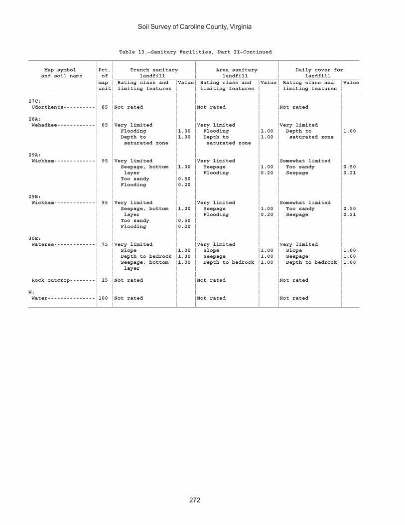
Soil Survey of Caroline County, Virginia
272
Table 13.—Sanitary Facilities, Part II—Continued________________________________________________________________________________________________________ | | | | Map symbol |Pct.| Trench sanitary | Area sanitary | Daily cover for and soil name | of | landfill | landfill | landfill _____________________________________________________________________________ |map | Rating class and |Value| Rating class and |Value| Rating class and |Value |unit| limiting features | | limiting features | | limiting features |________________________________________________________________________________________________________ | | | | | | |27C: | | | | | | | Udorthents----------| 85 |Not rated | |Not rated | |Not rated | | | | | | | |28A: | | | | | | | Wehadkee------------| 85 |Very limited | |Very limited | |Very limited | | | Flooding |1.00 | Flooding |1.00 | Depth to |1.00 | | Depth to |1.00 | Depth to |1.00 | saturated zone | | | saturated zone | | saturated zone | | | | | | | | | |29A: | | | | | | | Wickham-------------| 95 |Very limited | |Very limited | |Somewhat limited | | | Seepage, bottom |1.00 | Seepage |1.00 | Too sandy |0.50 | | layer | | Flooding |0.20 | Seepage |0.21 | | Too sandy |0.50 | | | | | | Flooding |0.20 | | | | | | | | | | |29B: | | | | | | | Wickham-------------| 95 |Very limited | |Very limited | |Somewhat limited | | | Seepage, bottom |1.00 | Seepage |1.00 | Too sandy |0.50 | | layer | | Flooding |0.20 | Seepage |0.21 | | Too sandy |0.50 | | | | | | Flooding |0.20 | | | | | | | | | | |30E: | | | | | | | Wateree-------------| 75 |Very limited | |Very limited | |Very limited | | | Slope |1.00 | Slope |1.00 | Slope |1.00 | | Depth to bedrock |1.00 | Seepage |1.00 | Seepage |1.00 | | Seepage, bottom |1.00 | Depth to bedrock |1.00 | Depth to bedrock |1.00 | | layer | | | | | | | | | | | | Rock outcrop--------| 15 |Not rated | |Not rated | |Not rated | | | | | | | |W: | | | | | | | Water---------------|100 |Not rated | |Not rated | |Not rated | | | | | | | |________________________________________________________________________________________________________
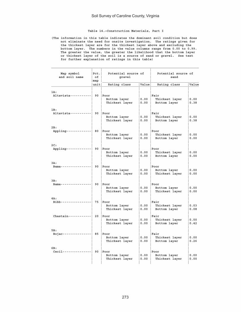
Soil Survey of Caroline County, Virginia
273
Table 14.—Construction Materials, Part I
(The information in this table indicates the dominant soil condition but does not eliminate the need for onsite investigation. The ratings given for the thickest layer are for the thickest layer above and excluding the bottom layer. The numbers in the value columns range from 0.00 to 0.99. The greater the value, the greater the likelihood that the bottom layer or thickest layer of the soil is a source of sand or gravel. See text for further explanation of ratings in this table)
______________________________________________________________________________ | | | Map symbol |Pct.| Potential source of | Potential source of and soil name | of | gravel | sand |map | | ___________________________________________________ |unit| Rating class |Value| Rating class |Value______________________________________________________________________________ | | | | |1A: | | | | | Altavista-----------| 90 |Poor | |Fair | | | Bottom layer |0.00 | Thickest layer |0.00 | | Thickest layer |0.00 | Bottom layer |0.38 | | | | |1B: | | | | | Altavista-----------| 90 |Poor | |Fair | | | Bottom layer |0.00 | Thickest layer |0.00 | | Thickest layer |0.00 | Bottom layer |0.38 | | | | |2B: | | | | | Appling-------------| 80 |Poor | |Poor | | | Bottom layer |0.00 | Thickest layer |0.00 | | Thickest layer |0.00 | Bottom layer |0.00 | | | | |2C: | | | | | Appling-------------| 90 |Poor | |Poor | | | Bottom layer |0.00 | Thickest layer |0.00 | | Thickest layer |0.00 | Bottom layer |0.00 | | | | |3A: | | | | | Bama----------------| 90 |Poor | |Poor | | | Bottom layer |0.00 | Bottom layer |0.00 | | Thickest layer |0.00 | Thickest layer |0.00 | | | | |3B: | | | | | Bama----------------| 90 |Poor | |Poor | | | Bottom layer |0.00 | Bottom layer |0.00 | | Thickest layer |0.00 | Thickest layer |0.00 | | | | |4A: | | | | | Bibb----------------| 75 |Poor | |Fair | | | Bottom layer |0.00 | Thickest layer |0.03 | | Thickest layer |0.00 | Bottom layer |0.08 | | | | | Chastain------------| 20 |Poor | |Fair | | | Bottom layer |0.00 | Thickest layer |0.00 | | Thickest layer |0.00 | Bottom layer |0.42 | | | | |5B: | | | | | Bojac---------------| 85 |Poor | |Fair | | | Bottom layer |0.00 | Thickest layer |0.00 | | Thickest layer |0.00 | Bottom layer |0.26 | | | | |6B: | | | | | Cecil---------------| 90 |Poor | |Poor | | | Bottom layer |0.00 | Bottom layer |0.00 | | Thickest layer |0.00 | Thickest layer |0.00 | | | | |
Soil Survey of Caroline County, Virginia
274
Table 14.—Construction Materials, Part I—Continued______________________________________________________________________________ | | | Map symbol |Pct.| Potential source of | Potential source of and soil name | of | gravel | sand |map | | ___________________________________________________ |unit| Rating class |Value| Rating class |Value______________________________________________________________________________ | | | | |7A: | | | | | Chastain------------| 95 |Poor | |Fair | | | Bottom layer |0.00 | Thickest layer |0.00 | | Thickest layer |0.00 | Bottom layer |0.42 | | | | |8A: | | | | | Chewacla------------| 75 |Poor | |Fair | | | Bottom layer |0.00 | Thickest layer |0.00 | | Thickest layer |0.00 | Bottom layer |0.38 | | | | |9C: | | | | | Helena--------------| 65 |Poor | |Poor | | | Bottom layer |0.00 | Bottom layer |0.00 | | Thickest layer |0.00 | Thickest layer |0.00 | | | | | Appling-------------| 20 |Poor | |Poor | | | Bottom layer |0.00 | Thickest layer |0.00 | | Thickest layer |0.00 | Bottom layer |0.00 | | | | |10E: | | | | | Kempsville----------| 45 |Poor | |Poor | | | Bottom layer |0.00 | Bottom layer |0.00 | | Thickest layer |0.00 | Thickest layer |0.00 | | | | | Emporia-------------| 25 |Poor | |Poor | | | Bottom layer |0.00 | Bottom layer |0.00 | | Thickest layer |0.00 | Thickest layer |0.00 | | | | | Remlik--------------| 20 |Poor | |Fair | | | Bottom layer |0.00 | Bottom layer |0.03 | | Thickest layer |0.00 | Thickest layer |0.08 | | | | |11A: | | | | | Kempsville----------| 70 |Poor | |Poor | | | Bottom layer |0.00 | Bottom layer |0.00 | | Thickest layer |0.00 | Thickest layer |0.00 | | | | | Emporia-------------| 30 |Poor | |Poor | | | Bottom layer |0.00 | Bottom layer |0.00 | | Thickest layer |0.00 | Thickest layer |0.00 | | | | |11B: | | | | | Kempsville----------| 60 |Poor | |Poor | | | Bottom layer |0.00 | Bottom layer |0.00 | | Thickest layer |0.00 | Thickest layer |0.00 | | | | | Emporia-------------| 35 |Poor | |Poor | | | Bottom layer |0.00 | Bottom layer |0.00 | | Thickest layer |0.00 | Thickest layer |0.00 | | | | |11C: | | | | | Kempsville----------| 65 |Poor | |Poor | | | Bottom layer |0.00 | Bottom layer |0.00 | | Thickest layer |0.00 | Thickest layer |0.00 | | | | | Emporia-------------| 30 |Poor | |Poor | | | Bottom layer |0.00 | Bottom layer |0.00 | | Thickest layer |0.00 | Thickest layer |0.00 | | | | |
Soil Survey of Caroline County, Virginia
275
Table 14.—Construction Materials, Part I—Continued______________________________________________________________________________ | | | Map symbol |Pct.| Potential source of | Potential source of and soil name | of | gravel | sand |map | | ___________________________________________________ |unit| Rating class |Value| Rating class |Value______________________________________________________________________________ | | | | |12A: | | | | | Myatt---------------| 70 |Poor | |Fair | | | Bottom layer |0.00 | Thickest layer |0.00 | | Thickest layer |0.00 | Bottom layer |0.74 | | | | | Slagle--------------| 20 |Poor | |Poor | | | Bottom layer |0.00 | Bottom layer |0.00 | | Thickest layer |0.00 | Thickest layer |0.00 | | | | |13E: | | | | | Nevarc--------------| 85 |Poor | |Poor | | | Bottom layer |0.00 | Bottom layer |0.00 | | Thickest layer |0.00 | Thickest layer |0.00 | | | | |14: | | | | | Pits, gravel--------| 85 |Not rated | |Not rated | | | | | |15A: | | | | | Rappahannock--------| 85 |Poor | |Fair | | | Bottom layer |0.00 | Thickest layer |0.00 | | Thickest layer |0.00 | Bottom layer |0.02 | | | | |16B: | | | | | Remlik--------------| 95 |Poor | |Fair | | | Bottom layer |0.00 | Bottom layer |0.03 | | Thickest layer |0.00 | Thickest layer |0.08 | | | | |16C: | | | | | Remlik--------------| 95 |Poor | |Fair | | | Bottom layer |0.00 | Bottom layer |0.03 | | Thickest layer |0.00 | Thickest layer |0.08 | | | | |16E: | | | | | Remlik--------------| 90 |Poor | |Fair | | | Bottom layer |0.00 | Bottom layer |0.03 | | Thickest layer |0.00 | Thickest layer |0.08 | | | | |17D: | | | | | Rion----------------| 95 |Poor | |Fair | | | Bottom layer |0.00 | Thickest layer |0.00 | | Thickest layer |0.00 | Bottom layer |0.02 | | | | |18A: | | | | | Riverview-----------| 80 |Poor | |Fair | | | Bottom layer |0.00 | Thickest layer |0.04 | | Thickest layer |0.00 | Bottom layer |0.13 | | | | |19A: | | | | | Roanoke-------------| 85 |Poor | |Poor | | | Bottom layer |0.00 | Thickest layer |0.00 | | Thickest layer |0.00 | Bottom layer |0.00 | | | | |20B: | | | | | Rumford-------------| 95 |Poor | |Fair | | | Bottom layer |0.00 | Thickest layer |0.05 | | Thickest layer |0.00 | Bottom layer |0.64 | | | | |20C: | | | | | Rumford-------------| 95 |Poor | |Fair | | | Bottom layer |0.00 | Thickest layer |0.05 | | Thickest layer |0.00 | Bottom layer |0.64
Soil Survey of Caroline County, Virginia
276
Table 14.—Construction Materials, Part I—Continued______________________________________________________________________________ | | | Map symbol |Pct.| Potential source of | Potential source of and soil name | of | gravel | sand |map | | ___________________________________________________ |unit| Rating class |Value| Rating class |Value______________________________________________________________________________ | | | | |20D: | | | | | Rumford-------------| 90 |Poor | |Fair | | | Bottom layer |0.00 | Thickest layer |0.05 | | Thickest layer |0.00 | Bottom layer |0.64 | | | | |21C: | | | | | Slagle--------------| 55 |Poor | |Poor | | | Bottom layer |0.00 | Bottom layer |0.00 | | Thickest layer |0.00 | Thickest layer |0.00 | | | | | Kempsville----------| 30 |Poor | |Poor | | | Bottom layer |0.00 | Bottom layer |0.00 | | Thickest layer |0.00 | Thickest layer |0.00 | | | | |22A: | | | | | Slagle--------------| 90 |Poor | |Poor | | | Bottom layer |0.00 | Bottom layer |0.00 | | Thickest layer |0.00 | Thickest layer |0.00 | | | | |22B: | | | | | Slagle--------------| 95 |Poor | |Poor | | | Bottom layer |0.00 | Bottom layer |0.00 | | Thickest layer |0.00 | Thickest layer |0.00 | | | | |23A: | | | | | State---------------| 90 |Poor | |Fair | | | Bottom layer |0.00 | Thickest layer |0.00 | | Thickest layer |0.00 | Bottom layer |0.03 | | | | |23B: | | | | | State---------------| 90 |Poor | |Fair | | | Bottom layer |0.00 | Thickest layer |0.00 | | Thickest layer |0.00 | Bottom layer |0.03 | | | | |23C: | | | | | State---------------| 90 |Poor | |Fair | | | Bottom layer |0.00 | Thickest layer |0.00 | | Thickest layer |0.00 | Bottom layer |0.03 | | | | |24A: | | | | | Suffolk-------------| 95 |Poor | |Fair | | | Bottom layer |0.00 | Thickest layer |0.00 | | Thickest layer |0.00 | Bottom layer |0.06 | | | | |24B: | | | | | Suffolk-------------| 95 |Poor | |Fair | | | Bottom layer |0.00 | Thickest layer |0.00 | | Thickest layer |0.00 | Bottom layer |0.06 | | | | |25B: | | | | | Tarboro-------------| 60 |Poor | |Fair | | | Bottom layer |0.00 | Thickest layer |0.34 | | Thickest layer |0.00 | Bottom layer |0.69 | | | | | Bojac---------------| 35 |Poor | |Fair | | | Bottom layer |0.00 | Thickest layer |0.00 | | Thickest layer |0.00 | Bottom layer |0.26 | | | | |
Soil Survey of Caroline County, Virginia
277
Table 14.—Construction Materials, Part I—Continued______________________________________________________________________________ | | | Map symbol |Pct.| Potential source of | Potential source of and soil name | of | gravel | sand |map | | ___________________________________________________ |unit| Rating class |Value| Rating class |Value______________________________________________________________________________ | | | | |26A: | | | | | Tomotley------------| 55 |Poor | |Fair | | | Bottom layer |0.00 | Thickest layer |0.00 | | Thickest layer |0.00 | Bottom layer |0.04 | | | | | Roanoke-------------| 30 |Poor | |Poor | | | Bottom layer |0.00 | Thickest layer |0.00 | | Thickest layer |0.00 | Bottom layer |0.00 | | | | |27C: | | | | | Udorthents----------| 85 |Not rated | |Not rated | | | | | |28A: | | | | | Wehadkee------------| 85 |Poor | |Poor | | | Bottom layer |0.00 | Bottom layer |0.00 | | Thickest layer |0.00 | Thickest layer |0.00 | | | | |29A: | | | | | Wickham-------------| 95 |Poor | |Fair | | | Bottom layer |0.00 | Thickest layer |0.00 | | Thickest layer |0.00 | Bottom layer |0.06 | | | | |29B: | | | | | Wickham-------------| 95 |Poor | |Fair | | | Bottom layer |0.00 | Thickest layer |0.00 | | Thickest layer |0.00 | Bottom layer |0.06 | | | | |30E: | | | | | Wateree-------------| 75 |Poor | |Fair | | | Bottom layer |0.00 | Bottom layer |0.04 | | Thickest layer |0.00 | Thickest layer |0.04 | | | | | Rock outcrop--------| 15 |Not rated | |Not rated | | | | | |W: | | | | | Water---------------|100 |Not rated | |Not rated | | | | | |______________________________________________________________________________

Soil Survey of Caroline County, Virginia
278
Table 14.—Construction Materials, Part II
(The information in this table indicates the dominant soil condition but does not eliminate the need for onsite investigation. The numbers in the value columns range from 0.00 to 0.99. The smaller the value, the greater the limitation. See text for further explanation of ratings in this table)
________________________________________________________________________________________________________ | | | | Map symbol |Pct.| Potential source of | Potential source of | Potential source of and soil name | of | reclamation material | roadfill | topsoil _____________________________________________________________________________ |map | Rating class and |Value| Rating class and |Value| Rating class and |Value |unit| limiting features | | limiting features | | limiting features |________________________________________________________________________________________________________ | | | | | | |1A: | | | | | | | Altavista-----------| 90 |Fair | |Fair | |Fair | | | Organic matter |0.02 | Wetness depth |0.53 | Wetness depth |0.53 | | content low | | | | Too acid |0.76 | | Too acid |0.16 | | | | | | | | | | |1B: | | | | | | | Altavista-----------| 90 |Fair | |Fair | |Fair | | | Organic matter |0.02 | Wetness depth |0.53 | Wetness depth |0.53 | | content low | | | | Too acid |0.76 | | Too acid |0.16 | | | | | | | | | | |2B: | | | | | | | Appling-------------| 80 |Poor | |Good | |Poor | | | Too clayey |0.00 | | | Too clayey |0.00 | | Organic matter |0.12 | | | Too acid |0.88 | | content low | | | | | | | Too acid |0.32 | | | | | | | | | | |2C: | | | | | | | Appling-------------| 90 |Poor | |Good | |Poor | | | Too clayey |0.00 | | | Too clayey |0.00 | | Organic matter |0.12 | | | Slope |0.63 | | content low | | | | Too acid |0.88 | | Too acid |0.32 | | | | | | | | | | |3A: | | | | | | | Bama----------------| 90 |Fair | |Good | |Fair | | | Organic matter |0.02 | | | Too acid |0.68 | | content low | | | | | | | Too acid |0.50 | | | | | | | | | | |3B: | | | | | | | Bama----------------| 90 |Fair | |Good | |Fair | | | Organic matter |0.02 | | | Too acid |0.68 | | content low | | | | | | | Too acid |0.50 | | | | | | | | | | |4A: | | | | | | | Bibb----------------| 75 |Fair | |Poor | |Poor | | | Too acid |0.54 | Wetness depth |0.00 | Wetness depth |0.00 | | | | | | Too acid |0.98 | | | | | | | Chastain------------| 20 |Fair | |Poor | |Poor | | | Too clayey |0.08 | Wetness depth |0.00 | Wetness depth |0.00 | | Too acid |0.54 | | | Too clayey |0.08 | | Water erosion |0.99 | | | Too acid |0.98 | | | | | | |5B: | | | | | | | Bojac---------------| 85 |Fair | |Good | |Good | | | Organic matter |0.12 | | | | | | content low | | | | | | | Too acid |0.99 | | | | | | | | | | |
Soil Survey of Caroline County, Virginia
279
Table 14.—Construction Materials, Part II—Continued________________________________________________________________________________________________________ | | | | Map symbol |Pct.| Potential source of | Potential source of | Potential source of and soil name | of | reclamation material | roadfill | topsoil _____________________________________________________________________________ |map | Rating class and |Value| Rating class and |Value| Rating class and |Value |unit| limiting features | | limiting features | | limiting features |________________________________________________________________________________________________________ | | | | | | |6B: | | | | | | | Cecil---------------| 90 |Poor | |Fair | |Poor | | | Too clayey |0.00 | Low strength |0.10 | Too clayey |0.00 | | Organic matter |0.12 | | | Too acid |0.88 | | content low | | | | | | | Too acid |0.32 | | | | | | | | | | |7A: | | | | | | | Chastain------------| 95 |Fair | |Poor | |Poor | | | Too clayey |0.08 | Wetness depth |0.00 | Wetness depth |0.00 | | Too acid |0.54 | | | Too clayey |0.08 | | Water erosion |0.99 | | | Too acid |0.98 | | | | | | |8A: | | | | | | | Chewacla------------| 75 |Fair | |Poor | |Poor | | | Too acid |0.68 | Wetness depth |0.00 | Wetness depth |0.00 | | Water erosion |0.99 | | | | | | | | | | |9C: | | | | | | | Helena--------------| 65 |Poor | |Poor | |Poor | | | Too clayey |0.00 | Low strength |0.00 | Too clayey |0.00 | | Too acid |0.08 | Wetness depth |0.50 | Wetness depth |0.50 | | Organic matter |0.12 | Shrink-swell |0.54 | Slope |0.63 | | content low | | | | | | | | | | | | Appling-------------| 20 |Poor | |Good | |Poor | | | Too clayey |0.00 | | | Too clayey |0.00 | | Organic matter |0.12 | | | Slope |0.63 | | content low | | | | Too acid |0.88 | | Too acid |0.32 | | | | | | | | | | |10E: | | | | | | | Kempsville----------| 45 |Fair | |Poor | |Poor | | | Organic matter |0.12 | Slope |0.00 | Slope |0.00 | | content low | | | | Too acid |0.98 | | Too acid |0.54 | | | | | | | | | | | Emporia-------------| 25 |Fair | |Poor | |Poor | | | Organic matter |0.12 | Slope |0.00 | Slope |0.00 | | content low | | Low strength |0.00 | Too acid |0.98 | | Too acid |0.54 | | | | | | | | | | | Remlik--------------| 20 |Poor | |Poor | |Poor | | | Wind erosion |0.00 | Slope |0.00 | Slope |0.00 | | Organic matter |0.02 | | | Too sandy |0.30 | | content low | | | | Too acid |0.98 | | Too sandy |0.30 | | | | | | | | | | |11A: | | | | | | | Kempsville----------| 70 |Fair | |Good | |Fair | | | Organic matter |0.12 | | | Too acid |0.98 | | content low | | | | | | | Too acid |0.54 | | | | | | | | | | | Emporia-------------| 30 |Fair | |Poor | |Fair | | | Organic matter |0.12 | Low strength |0.00 | Too acid |0.98 | | content low | | | | | | | Too acid |0.54 | | | | | | | | | | |

Soil Survey of Caroline County, Virginia
280
Table 14.—Construction Materials, Part II—Continued________________________________________________________________________________________________________ | | | | Map symbol |Pct.| Potential source of | Potential source of | Potential source of and soil name | of | reclamation material | roadfill | topsoil _____________________________________________________________________________ |map | Rating class and |Value| Rating class and |Value| Rating class and |Value |unit| limiting features | | limiting features | | limiting features |________________________________________________________________________________________________________ | | | | | | |11B: | | | | | | | Kempsville----------| 60 |Fair | |Good | |Fair | | | Organic matter |0.12 | | | Too acid |0.98 | | content low | | | | | | | Too acid |0.54 | | | | | | | | | | | Emporia-------------| 35 |Fair | |Poor | |Fair | | | Organic matter |0.12 | Low strength |0.00 | Too acid |0.98 | | content low | | | | | | | Too acid |0.54 | | | | | | | | | | |11C: | | | | | | | Kempsville----------| 65 |Fair | |Good | |Fair | | | Organic matter |0.12 | | | Too acid |0.98 | | content low | | | | | | | Too acid |0.54 | | | | | | | | | | | Emporia-------------| 30 |Fair | |Poor | |Fair | | | Organic matter |0.12 | Low strength |0.00 | Too acid |0.98 | | content low | | | | | | | Too acid |0.54 | | | | | | | | | | |12A: | | | | | | | Myatt---------------| 70 |Fair | |Poor | |Poor | | | Too acid |0.16 | Wetness depth |0.00 | Wetness depth |0.00 | | Organic matter |0.50 | | | Too acid |0.98 | | content low | | | | | | | | | | | | Slagle--------------| 20 |Fair | |Good | |Fair | | | Too acid |0.12 | | | Too acid |0.59 | | Organic matter |0.12 | | | | | | content low | | | | | | | | | | | |13E: | | | | | | | Nevarc--------------| 85 |Poor | |Poor | |Poor | | | Too clayey |0.00 | Slope |0.00 | Slope |0.00 | | Too acid |0.01 | Low strength |0.00 | Too clayey |0.00 | | Organic matter |0.12 | Wetness depth |0.76 | Too acid |0.68 | | content low | | | | | | | | | | | |14: | | | | | | | Pits, gravel--------| 85 |Not rated | |Not rated | |Not rated | | | | | | | |15A: | | | | | | | Rappahannock--------| 85 |Fair | |Poor | |Not rated | | | Salinity |0.97 | Wetness depth |0.00 | | | | | | | | |16B: | | | | | | | Remlik--------------| 95 |Poor | |Good | |Fair | | | Wind erosion |0.00 | | | Too sandy |0.30 | | Organic matter |0.02 | | | Too acid |0.98 | | content low | | | | | | | Too sandy |0.30 | | | | | | | | | | |16C: | | | | | | | Remlik--------------| 95 |Poor | |Good | |Fair | | | Wind erosion |0.00 | | | Too sandy |0.30 | | Organic matter |0.02 | | | Slope |0.63 | | content low | | | | Too acid |0.98 | | Too sandy |0.30 | | | | | | | | | | |
Soil Survey of Caroline County, Virginia
281
Table 14.—Construction Materials, Part II—Continued________________________________________________________________________________________________________ | | | | Map symbol |Pct.| Potential source of | Potential source of | Potential source of and soil name | of | reclamation material | roadfill | topsoil _____________________________________________________________________________ |map | Rating class and |Value| Rating class and |Value| Rating class and |Value |unit| limiting features | | limiting features | | limiting features |________________________________________________________________________________________________________ | | | | | | |16E: | | | | | | | Remlik--------------| 90 |Poor | |Poor | |Poor | | | Wind erosion |0.00 | Slope |0.00 | Slope |0.00 | | Organic matter |0.02 | | | Too sandy |0.30 | | content low | | | | Too acid |0.98 | | Too sandy |0.30 | | | | | | | | | | |17D: | | | | | | | Rion----------------| 95 |Fair | |Fair | |Poor | | | Organic matter |0.12 | Slope |0.50 | Slope |0.00 | | content low | | | | | | | Too acid |0.68 | | | | | | | | | | |18A: | | | | | | | Riverview-----------| 80 |Fair | |Good | |Good | | | Organic matter |0.50 | | | | | | content low | | | | | | | Too acid |0.68 | | | | | | | | | | |19A: | | | | | | | Roanoke-------------| 85 |Poor | |Poor | |Poor | | | Too clayey |0.00 | Wetness depth |0.00 | Wetness depth |0.00 | | Too acid |0.16 | Low strength |0.00 | Too clayey |0.00 | | Organic matter |0.50 | Shrink-swell |0.96 | Too acid |0.98 | | content low | | | | | | | | | | | |20B: | | | | | | | Rumford-------------| 95 |Poor | |Good | |Fair | | | Wind erosion |0.00 | | | Too acid |0.98 | | Organic matter |0.08 | | | Too sandy |0.99 | | content low | | | | | | | Too acid |0.54 | | | | | | | | | | |20C: | | | | | | | Rumford-------------| 95 |Poor | |Good | |Fair | | | Wind erosion |0.00 | | | Too acid |0.98 | | Organic matter |0.08 | | | Too sandy |0.99 | | content low | | | | | | | Too acid |0.54 | | | | | | | | | | |20D: | | | | | | | Rumford-------------| 90 |Poor | |Good | |Fair | | | Wind erosion |0.00 | | | Slope |0.16 | | Organic matter |0.08 | | | Too acid |0.98 | | content low | | | | Too sandy |0.99 | | Too acid |0.54 | | | | | | | | | | |21C: | | | | | | | Slagle--------------| 55 |Fair | |Good | |Fair | | | Too acid |0.12 | | | Too acid |0.59 | | Organic matter |0.12 | | | Slope |0.96 | | content low | | | | | | | | | | | | Kempsville----------| 30 |Fair | |Good | |Fair | | | Organic matter |0.12 | | | Slope |0.96 | | content low | | | | Too acid |0.98 | | Too acid |0.54 | | | | | | | | | | |
Soil Survey of Caroline County, Virginia
282
Table 14.—Construction Materials, Part II—Continued________________________________________________________________________________________________________ | | | | Map symbol |Pct.| Potential source of | Potential source of | Potential source of and soil name | of | reclamation material | roadfill | topsoil _____________________________________________________________________________ |map | Rating class and |Value| Rating class and |Value| Rating class and |Value |unit| limiting features | | limiting features | | limiting features |________________________________________________________________________________________________________ | | | | | | |22A: | | | | | | | Slagle--------------| 90 |Fair | |Good | |Fair | | | Too acid |0.12 | | | Too acid |0.59 | | Organic matter |0.12 | | | | | | content low | | | | | | | | | | | |22B: | | | | | | | Slagle--------------| 95 |Fair | |Good | |Fair | | | Too acid |0.12 | | | Too acid |0.59 | | Organic matter |0.12 | | | | | | content low | | | | | | | | | | | |23A: | | | | | | | State---------------| 90 |Fair | |Good | |Fair | | | Organic matter |0.02 | | | Too acid |0.68 | | content low | | | | | | | Too acid |0.50 | | | | | | | | | | |23B: | | | | | | | State---------------| 90 |Fair | |Good | |Fair | | | Organic matter |0.02 | | | Too acid |0.68 | | content low | | | | | | | Too acid |0.50 | | | | | | | | | | |23C: | | | | | | | State---------------| 90 |Fair | |Good | |Fair | | | Organic matter |0.02 | | | Too acid |0.68 | | content low | | | | | | | Too acid |0.50 | | | | | | | | | | |24A: | | | | | | | Suffolk-------------| 95 |Fair | |Good | |Good | | | Organic matter |0.12 | | | | | | content low | | | | | | | Too acid |0.84 | | | | | | | | | | |24B: | | | | | | | Suffolk-------------| 95 |Fair | |Good | |Good | | | Organic matter |0.12 | | | | | | content low | | | | | | | Too acid |0.84 | | | | | | | | | | |25B: | | | | | | | Tarboro-------------| 60 |Poor | |Good | |Poor | | | Too sandy |0.00 | | | Too sandy |0.00 | | Wind erosion |0.00 | | | | | | Droughty |0.00 | | | | | | | | | | | Bojac---------------| 35 |Fair | |Good | |Good | | | Organic matter |0.12 | | | | | | content low | | | | | | | Too acid |0.99 | | | | | | | | | | |26A: | | | | | | | Tomotley------------| 55 |Fair | |Poor | |Poor | | | Too acid |0.12 | Wetness depth |0.00 | Wetness depth |0.00 | | Organic matter |0.88 | | | Too acid |0.59 | | content low | | | | | | | | | | | |
Soil Survey of Caroline County, Virginia
283
Table 14.—Construction Materials, Part II—Continued________________________________________________________________________________________________________ | | | | Map symbol |Pct.| Potential source of | Potential source of | Potential source of and soil name | of | reclamation material | roadfill | topsoil _____________________________________________________________________________ |map | Rating class and |Value| Rating class and |Value| Rating class and |Value |unit| limiting features | | limiting features | | limiting features |________________________________________________________________________________________________________ | | | | | | |26A: | | | | | | | Roanoke-------------| 30 |Poor | |Poor | |Poor | | | Too clayey |0.00 | Wetness depth |0.00 | Wetness depth |0.00 | | Too acid |0.16 | Low strength |0.00 | Too clayey |0.00 | | Organic matter |0.50 | Shrink-swell |0.96 | Too acid |0.98 | | content low | | | | | | | | | | | |27C: | | | | | | | Udorthents----------| 85 |Not rated | |Not rated | |Not rated | | | | | | | |28A: | | | | | | | Wehadkee------------| 85 |Fair | |Poor | |Poor | | | Too acid |0.16 | Wetness depth |0.00 | Wetness depth |0.00 | | Organic matter |0.50 | Low strength |0.22 | Too acid |0.68 | | content low | | | | | | | | | | | |29A: | | | | | | | Wickham-------------| 95 |Fair | |Good | |Fair | | | Organic matter |0.02 | | | Too acid |0.98 | | content low | | | | | | | Too acid |0.54 | | | | | | | | | | |29B: | | | | | | | Wickham-------------| 95 |Fair | |Good | |Fair | | | Organic matter |0.02 | | | Too acid |0.98 | | content low | | | | | | | Too acid |0.54 | | | | | | | | | | |30E: | | | | | | | Wateree-------------| 75 |Poor | |Poor | |Poor | | | Droughty |0.00 | Slope |0.00 | Slope |0.00 | | Depth to bedrock |0.03 | Depth to bedrock |0.00 | Depth to bedrock |0.03 | | Organic matter |0.12 | | | Too acid |0.98 | | content low | | | | | | | | | | | | Rock outcrop--------| 15 |Not rated | |Not rated | |Not rated | | | | | | | |W: | | | | | | | Water---------------|100 |Not rated | |Not rated | |Not rated | | | | | | | |________________________________________________________________________________________________________
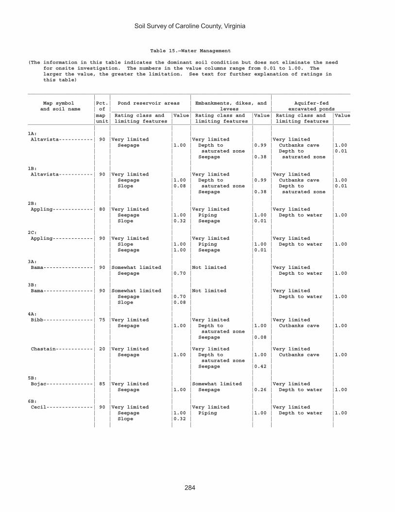
Soil Survey of Caroline County, Virginia
284
Table 15.—Water Management
(The information in this table indicates the dominant soil condition but does not eliminate the need for onsite investigation. The numbers in the value columns range from 0.01 to 1.00. The larger the value, the greater the limitation. See text for further explanation of ratings in this table)
________________________________________________________________________________________________________ | | | | Map symbol |Pct.| Pond reservoir areas | Embankments, dikes, and | Aquifer-fed and soil name | of | | levees | excavated ponds _____________________________________________________________________________ |map | Rating class and |Value| Rating class and |Value| Rating class and |Value |unit| limiting features | | limiting features | | limiting features |________________________________________________________________________________________________________ | | | | | | |1A: | | | | | | | Altavista-----------| 90 |Very limited | |Very limited | |Very limited | | | Seepage |1.00 | Depth to |0.99 | Cutbanks cave |1.00 | | | | saturated zone | | Depth to |0.01 | | | | Seepage |0.38 | saturated zone | | | | | | | |1B: | | | | | | | Altavista-----------| 90 |Very limited | |Very limited | |Very limited | | | Seepage |1.00 | Depth to |0.99 | Cutbanks cave |1.00 | | Slope |0.08 | saturated zone | | Depth to |0.01 | | | | Seepage |0.38 | saturated zone | | | | | | | |2B: | | | | | | | Appling-------------| 80 |Very limited | |Very limited | |Very limited | | | Seepage |1.00 | Piping |1.00 | Depth to water |1.00 | | Slope |0.32 | Seepage |0.01 | | | | | | | | |2C: | | | | | | | Appling-------------| 90 |Very limited | |Very limited | |Very limited | | | Slope |1.00 | Piping |1.00 | Depth to water |1.00 | | Seepage |1.00 | Seepage |0.01 | | | | | | | | |3A: | | | | | | | Bama----------------| 90 |Somewhat limited | |Not limited | |Very limited | | | Seepage |0.70 | | | Depth to water |1.00 | | | | | | |3B: | | | | | | | Bama----------------| 90 |Somewhat limited | |Not limited | |Very limited | | | Seepage |0.70 | | | Depth to water |1.00 | | Slope |0.08 | | | | | | | | | | |4A: | | | | | | | Bibb----------------| 75 |Very limited | |Very limited | |Very limited | | | Seepage |1.00 | Depth to |1.00 | Cutbanks cave |1.00 | | | | saturated zone | | | | | | | Seepage |0.08 | | | | | | | | | Chastain------------| 20 |Very limited | |Very limited | |Very limited | | | Seepage |1.00 | Depth to |1.00 | Cutbanks cave |1.00 | | | | saturated zone | | | | | | | Seepage |0.42 | | | | | | | | |5B: | | | | | | | Bojac---------------| 85 |Very limited | |Somewhat limited | |Very limited | | | Seepage |1.00 | Seepage |0.26 | Depth to water |1.00 | | | | | | |6B: | | | | | | | Cecil---------------| 90 |Very limited | |Very limited | |Very limited | | | Seepage |1.00 | Piping |1.00 | Depth to water |1.00 | | Slope |0.32 | | | | | | | | | | |

Soil Survey of Caroline County, Virginia
285
Table 15.—Water Management—Continued________________________________________________________________________________________________________ | | | | Map symbol |Pct.| Pond reservoir areas | Embankments, dikes, and | Aquifer-fed and soil name | of | | levees | excavated ponds _____________________________________________________________________________ |map | Rating class and |Value| Rating class and |Value| Rating class and |Value |unit| limiting features | | limiting features | | limiting features |________________________________________________________________________________________________________ | | | | | | |7A: | | | | | | | Chastain------------| 95 |Very limited | |Very limited | |Very limited | | | Seepage |1.00 | Ponding |1.00 | Cutbanks cave |1.00 | | | | Depth to |1.00 | | | | | | saturated zone | | | | | | | Seepage |0.42 | | | | | | | | |8A: | | | | | | | Chewacla------------| 75 |Very limited | |Very limited | |Very limited | | | Seepage |1.00 | Depth to |1.00 | Cutbanks cave |1.00 | | | | saturated zone | | | | | | | Seepage |0.38 | | | | | | | | |9C: | | | | | | | Helena--------------| 65 |Very limited | |Very limited | |Very limited | | | Slope |1.00 | Depth to |0.99 | Depth to water |1.00 | | Seepage |0.95 | saturated zone | | | | | | | Piping |0.21 | | | | | | | | | Appling-------------| 20 |Very limited | |Very limited | |Very limited | | | Slope |1.00 | Piping |1.00 | Depth to water |1.00 | | Seepage |1.00 | Seepage |0.01 | | | | | | | | |10E: | | | | | | | Kempsville----------| 45 |Very limited | |Not limited | |Very limited | | | Slope |1.00 | | | Depth to water |1.00 | | Seepage |0.70 | | | | | | | | | | | Emporia-------------| 25 |Very limited | |Somewhat limited | |Very limited | | | Slope |1.00 | Piping |0.57 | Depth to water |1.00 | | Seepage |0.70 | Depth to |0.02 | | | | | | saturated zone | | | | | | | | | | Remlik--------------| 20 |Very limited | |Somewhat limited | |Very limited | | | Seepage |1.00 | Seepage |0.08 | Depth to water |1.00 | | Slope |1.00 | | | | | | | | | | |11A: | | | | | | | Kempsville----------| 70 |Somewhat limited | |Not limited | |Very limited | | | Seepage |0.70 | | | Depth to water |1.00 | | | | | | | Emporia-------------| 30 |Somewhat limited | |Somewhat limited | |Very limited | | | Seepage |0.70 | Piping |0.57 | Depth to water |1.00 | | | | Depth to |0.02 | | | | | | saturated zone | | | | | | | | | |11B: | | | | | | | Kempsville----------| 60 |Somewhat limited | |Not limited | |Very limited | | | Seepage |0.70 | | | Depth to water |1.00 | | Slope |0.08 | | | | | | | | | | | Emporia-------------| 35 |Somewhat limited | |Somewhat limited | |Very limited | | | Seepage |0.70 | Piping |0.57 | Depth to water |1.00 | | Slope |0.08 | Depth to |0.02 | | | | | | saturated zone | | | | | | | | | |11C: | | | | | | | Kempsville----------| 65 |Very limited | |Not limited | |Very limited | | | Slope |1.00 | | | Depth to water |1.00 | | Seepage |0.70 | | | | | | | | | | |
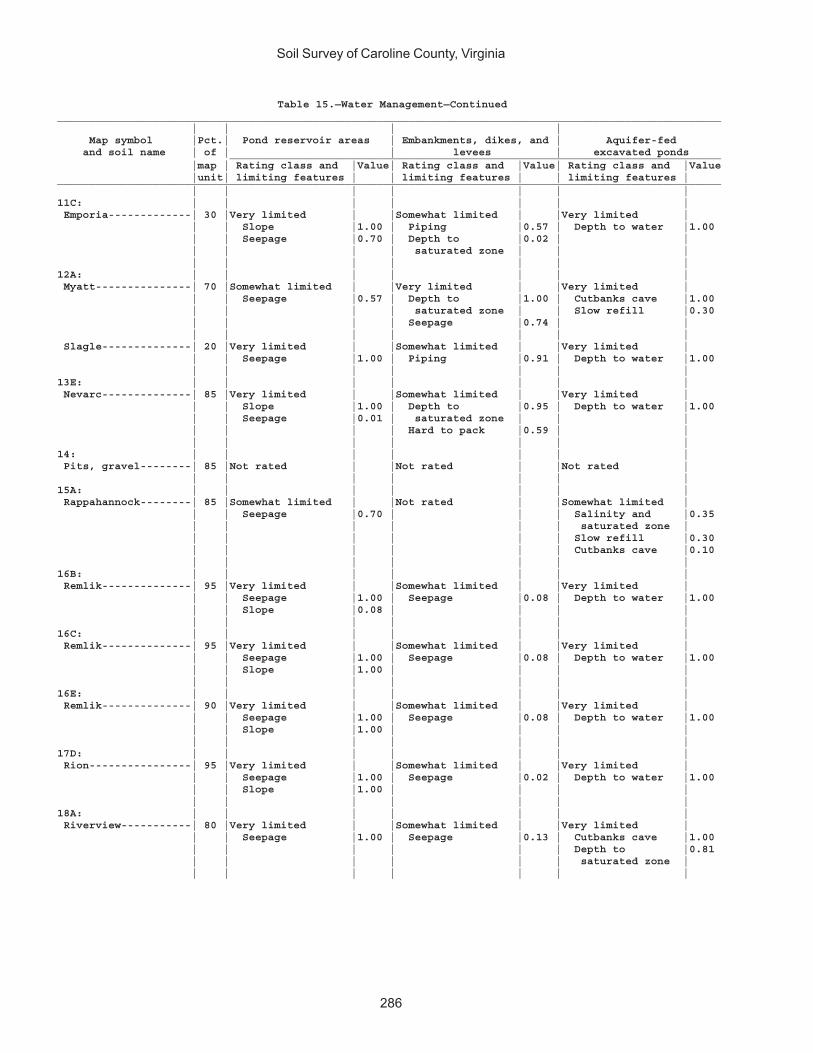
Soil Survey of Caroline County, Virginia
286
Table 15.—Water Management—Continued________________________________________________________________________________________________________ | | | | Map symbol |Pct.| Pond reservoir areas | Embankments, dikes, and | Aquifer-fed and soil name | of | | levees | excavated ponds _____________________________________________________________________________ |map | Rating class and |Value| Rating class and |Value| Rating class and |Value |unit| limiting features | | limiting features | | limiting features |________________________________________________________________________________________________________ | | | | | | |11C: | | | | | | | Emporia-------------| 30 |Very limited | |Somewhat limited | |Very limited | | | Slope |1.00 | Piping |0.57 | Depth to water |1.00 | | Seepage |0.70 | Depth to |0.02 | | | | | | saturated zone | | | | | | | | | |12A: | | | | | | | Myatt---------------| 70 |Somewhat limited | |Very limited | |Very limited | | | Seepage |0.57 | Depth to |1.00 | Cutbanks cave |1.00 | | | | saturated zone | | Slow refill |0.30 | | | | Seepage |0.74 | | | | | | | | | Slagle--------------| 20 |Very limited | |Somewhat limited | |Very limited | | | Seepage |1.00 | Piping |0.91 | Depth to water |1.00 | | | | | | |13E: | | | | | | | Nevarc--------------| 85 |Very limited | |Somewhat limited | |Very limited | | | Slope |1.00 | Depth to |0.95 | Depth to water |1.00 | | Seepage |0.01 | saturated zone | | | | | | | Hard to pack |0.59 | | | | | | | | |14: | | | | | | | Pits, gravel--------| 85 |Not rated | |Not rated | |Not rated | | | | | | | |15A: | | | | | | | Rappahannock--------| 85 |Somewhat limited | |Not rated | |Somewhat limited | | | Seepage |0.70 | | | Salinity and |0.35 | | | | | | saturated zone | | | | | | | Slow refill |0.30 | | | | | | Cutbanks cave |0.10 | | | | | | |16B: | | | | | | | Remlik--------------| 95 |Very limited | |Somewhat limited | |Very limited | | | Seepage |1.00 | Seepage |0.08 | Depth to water |1.00 | | Slope |0.08 | | | | | | | | | | |16C: | | | | | | | Remlik--------------| 95 |Very limited | |Somewhat limited | |Very limited | | | Seepage |1.00 | Seepage |0.08 | Depth to water |1.00 | | Slope |1.00 | | | | | | | | | | |16E: | | | | | | | Remlik--------------| 90 |Very limited | |Somewhat limited | |Very limited | | | Seepage |1.00 | Seepage |0.08 | Depth to water |1.00 | | Slope |1.00 | | | | | | | | | | |17D: | | | | | | | Rion----------------| 95 |Very limited | |Somewhat limited | |Very limited | | | Seepage |1.00 | Seepage |0.02 | Depth to water |1.00 | | Slope |1.00 | | | | | | | | | | |18A: | | | | | | | Riverview-----------| 80 |Very limited | |Somewhat limited | |Very limited | | | Seepage |1.00 | Seepage |0.13 | Cutbanks cave |1.00 | | | | | | Depth to |0.81 | | | | | | saturated zone | | | | | | | |
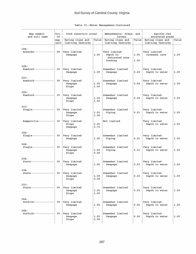
Soil Survey of Caroline County, Virginia
287
Table 15.—Water Management—Continued________________________________________________________________________________________________________ | | | | Map symbol |Pct.| Pond reservoir areas | Embankments, dikes, and | Aquifer-fed and soil name | of | | levees | excavated ponds _____________________________________________________________________________ |map | Rating class and |Value| Rating class and |Value| Rating class and |Value |unit| limiting features | | limiting features | | limiting features |________________________________________________________________________________________________________ | | | | | | |19A: | | | | | | | Roanoke-------------| 85 |Very limited | |Very limited | |Very limited | | | Seepage |1.00 | Depth to |1.00 | Cutbanks cave |1.00 | | | | saturated zone | | | | | | | Ponding |1.00 | | | | | | | | |20B: | | | | | | | Rumford-------------| 95 |Very limited | |Somewhat limited | |Very limited | | | Seepage |1.00 | Seepage |0.64 | Depth to water |1.00 | | | | | | |20C: | | | | | | | Rumford-------------| 95 |Very limited | |Somewhat limited | |Very limited | | | Seepage |1.00 | Seepage |0.64 | Depth to water |1.00 | | Slope |1.00 | | | | | | | | | | |20D: | | | | | | | Rumford-------------| 90 |Very limited | |Somewhat limited | |Very limited | | | Seepage |1.00 | Seepage |0.64 | Depth to water |1.00 | | Slope |1.00 | | | | | | | | | | |21C: | | | | | | | Slagle--------------| 55 |Very limited | |Somewhat limited | |Very limited | | | Seepage |1.00 | Piping |0.91 | Depth to water |1.00 | | Slope |1.00 | | | | | | | | | | | Kempsville----------| 30 |Very limited | |Not limited | |Very limited | | | Slope |1.00 | | | Depth to water |1.00 | | Seepage |0.70 | | | | | | | | | | |22A: | | | | | | | Slagle--------------| 90 |Very limited | |Somewhat limited | |Very limited | | | Seepage |1.00 | Piping |0.91 | Depth to water |1.00 | | | | | | |22B: | | | | | | | Slagle--------------| 95 |Very limited | |Somewhat limited | |Very limited | | | Seepage |1.00 | Piping |0.91 | Depth to water |1.00 | | Slope |0.08 | | | | | | | | | | |23A: | | | | | | | State---------------| 90 |Very limited | |Somewhat limited | |Very limited | | | Seepage |1.00 | Seepage |0.03 | Depth to water |1.00 | | | | | | |23B: | | | | | | | State---------------| 90 |Very limited | |Somewhat limited | |Very limited | | | Seepage |1.00 | Seepage |0.03 | Depth to water |1.00 | | Slope |0.08 | | | | | | | | | | |23C: | | | | | | | State---------------| 90 |Very limited | |Somewhat limited | |Very limited | | | Seepage |1.00 | Seepage |0.03 | Depth to water |1.00 | | Slope |1.00 | | | | | | | | | | |24A: | | | | | | | Suffolk-------------| 95 |Very limited | |Somewhat limited | |Very limited | | | Seepage |1.00 | Seepage |0.06 | Depth to water |1.00 | | | | | | |24B: | | | | | | | Suffolk-------------| 95 |Very limited | |Somewhat limited | |Very limited | | | Seepage |1.00 | Seepage |0.06 | Depth to water |1.00 | | Slope |0.08 | | | | | | | | | | |
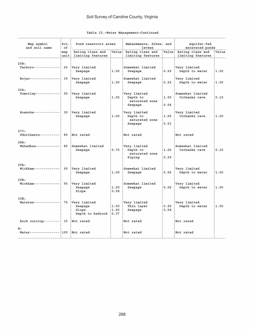
Soil Survey of Caroline County, Virginia
288
Table 15.—Water Management—Continued________________________________________________________________________________________________________ | | | | Map symbol |Pct.| Pond reservoir areas | Embankments, dikes, and | Aquifer-fed and soil name | of | | levees | excavated ponds _____________________________________________________________________________ |map | Rating class and |Value| Rating class and |Value| Rating class and |Value |unit| limiting features | | limiting features | | limiting features |________________________________________________________________________________________________________ | | | | | | |25B: | | | | | | | Tarboro-------------| 60 |Very limited | |Somewhat limited | |Very limited | | | Seepage |1.00 | Seepage |0.69 | Depth to water |1.00 | | | | | | | Bojac---------------| 35 |Very limited | |Somewhat limited | |Very limited | | | Seepage |1.00 | Seepage |0.26 | Depth to water |1.00 | | | | | | |26A: | | | | | | | Tomotley------------| 55 |Very limited | |Very limited | |Somewhat limited | | | Seepage |1.00 | Depth to |1.00 | Cutbanks cave |0.10 | | | | saturated zone | | | | | | | Seepage |0.04 | | | | | | | | | Roanoke-------------| 30 |Very limited | |Very limited | |Very limited | | | Seepage |1.00 | Depth to |1.00 | Cutbanks cave |1.00 | | | | saturated zone | | | | | | | Seepage |0.01 | | | | | | | | |27C: | | | | | | | Udorthents----------| 85 |Not rated | |Not rated | |Not rated | | | | | | | |28A: | | | | | | | Wehadkee------------| 85 |Somewhat limited | |Very limited | |Somewhat limited | | | Seepage |0.70 | Depth to |1.00 | Cutbanks cave |0.10 | | | | saturated zone | | | | | | | Piping |0.59 | | | | | | | | |29A: | | | | | | | Wickham-------------| 95 |Very limited | |Somewhat limited | |Very limited | | | Seepage |1.00 | Seepage |0.06 | Depth to water |1.00 | | | | | | |29B: | | | | | | | Wickham-------------| 95 |Very limited | |Somewhat limited | |Very limited | | | Seepage |1.00 | Seepage |0.06 | Depth to water |1.00 | | Slope |0.08 | | | | | | | | | | |30E: | | | | | | | Wateree-------------| 75 |Very limited | |Very limited | |Very limited | | | Seepage |1.00 | Thin layer |0.99 | Depth to water |1.00 | | Slope |1.00 | Seepage |0.04 | | | | Depth to bedrock |0.37 | | | | | | | | | | | Rock outcrop--------| 15 |Not rated | |Not rated | |Not rated | | | | | | | |W: | | | | | | | Water---------------|100 |Not rated | |Not rated | |Not rated | | | | | | | |________________________________________________________________________________________________________
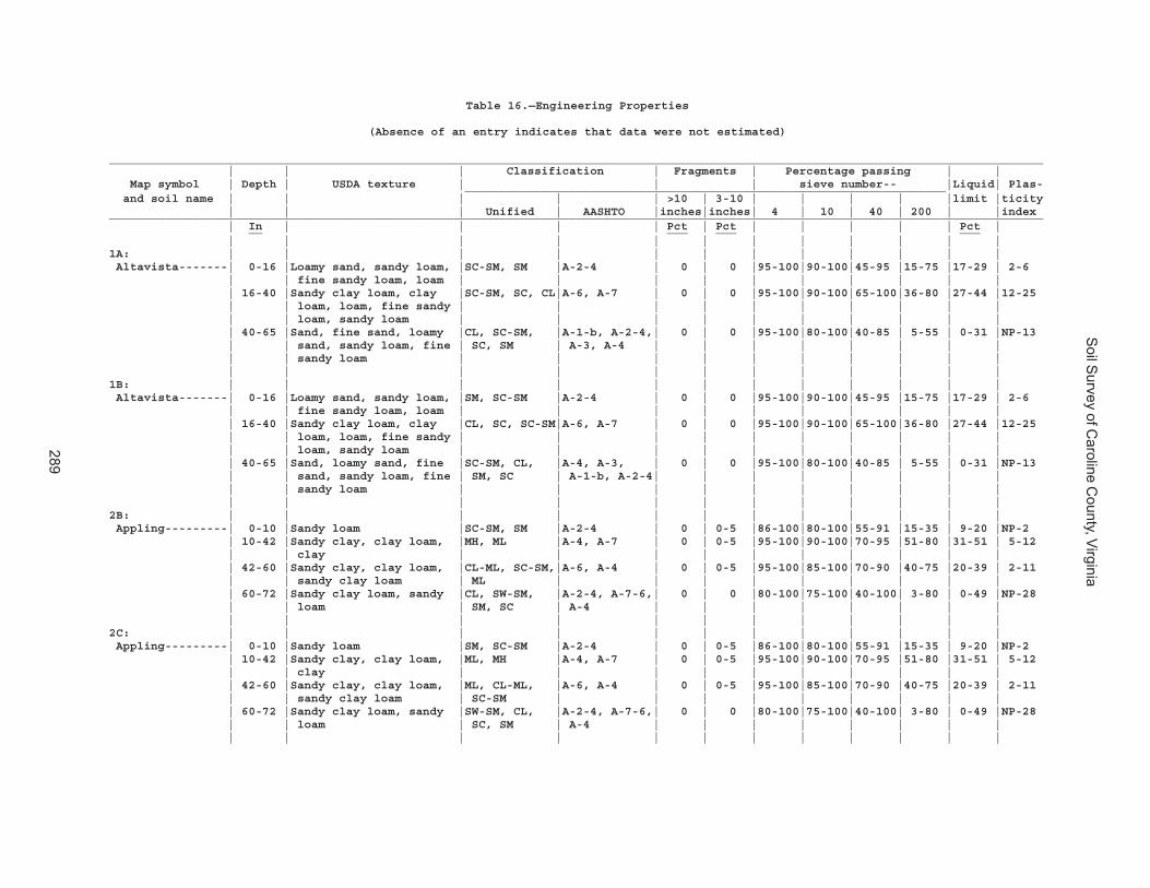
Soil S
urvey of Caroline C
ounty, Virginia
289
Table 16.—Engineering Properties
(Absence of an entry indicates that data were not estimated)
______________________________________________________________________________________________________________________________________ | | | Classification | Fragments | Percentage passing | | Map symbol | Depth | USDA texture | | | sieve number-- |Liquid| Plas- _____________________________________________________________________ and soil name | | | | | >10 | 3-10 | | | | |limit |ticity | | | Unified | AASHTO |inches|inches| 4 | 10 | 40 | 200 | |index______________________________________________________________________________________________________________________________________ | In | | | | Pct | Pct | | | | | Pct | __ ___ ___ ___ | | | | | | | | | | | |1A: | | | | | | | | | | | | Altavista-------| 0-16 |Loamy sand, sandy loam, |SC-SM, SM |A-2-4 | 0 | 0 |95-100|90-100|45-95 |15-75 |17-29 | 2-6 | | fine sandy loam, loam | | | | | | | | | | | 16-40 |Sandy clay loam, clay |SC-SM, SC, CL|A-6, A-7 | 0 | 0 |95-100|90-100|65-100|36-80 |27-44 |12-25 | | loam, loam, fine sandy | | | | | | | | | | | | loam, sandy loam | | | | | | | | | | | 40-65 |Sand, fine sand, loamy |CL, SC-SM, |A-1-b, A-2-4,| 0 | 0 |95-100|80-100|40-85 | 5-55 | 0-31 |NP-13 | | sand, sandy loam, fine | SC, SM | A-3, A-4 | | | | | | | | | | sandy loam | | | | | | | | | | | | | | | | | | | | | |1B: | | | | | | | | | | | | Altavista-------| 0-16 |Loamy sand, sandy loam, |SM, SC-SM |A-2-4 | 0 | 0 |95-100|90-100|45-95 |15-75 |17-29 | 2-6 | | fine sandy loam, loam | | | | | | | | | | | 16-40 |Sandy clay loam, clay |CL, SC, SC-SM|A-6, A-7 | 0 | 0 |95-100|90-100|65-100|36-80 |27-44 |12-25 | | loam, loam, fine sandy | | | | | | | | | | | | loam, sandy loam | | | | | | | | | | | 40-65 |Sand, loamy sand, fine |SC-SM, CL, |A-4, A-3, | 0 | 0 |95-100|80-100|40-85 | 5-55 | 0-31 |NP-13 | | sand, sandy loam, fine | SM, SC | A-1-b, A-2-4| | | | | | | | | | sandy loam | | | | | | | | | | | | | | | | | | | | | |2B: | | | | | | | | | | | | Appling---------| 0-10 |Sandy loam |SC-SM, SM |A-2-4 | 0 | 0-5 |86-100|80-100|55-91 |15-35 | 9-20 |NP-2 | 10-42 |Sandy clay, clay loam, |MH, ML |A-4, A-7 | 0 | 0-5 |95-100|90-100|70-95 |51-80 |31-51 | 5-12 | | clay | | | | | | | | | | | 42-60 |Sandy clay, clay loam, |CL-ML, SC-SM,|A-6, A-4 | 0 | 0-5 |95-100|85-100|70-90 |40-75 |20-39 | 2-11 | | sandy clay loam | ML | | | | | | | | | | 60-72 |Sandy clay loam, sandy |CL, SW-SM, |A-2-4, A-7-6,| 0 | 0 |80-100|75-100|40-100| 3-80 | 0-49 |NP-28 | | loam | SM, SC | A-4 | | | | | | | | | | | | | | | | | | | |2C: | | | | | | | | | | | | Appling---------| 0-10 |Sandy loam |SM, SC-SM |A-2-4 | 0 | 0-5 |86-100|80-100|55-91 |15-35 | 9-20 |NP-2 | 10-42 |Sandy clay, clay loam, |ML, MH |A-4, A-7 | 0 | 0-5 |95-100|90-100|70-95 |51-80 |31-51 | 5-12 | | clay | | | | | | | | | | | 42-60 |Sandy clay, clay loam, |ML, CL-ML, |A-6, A-4 | 0 | 0-5 |95-100|85-100|70-90 |40-75 |20-39 | 2-11 | | sandy clay loam | SC-SM | | | | | | | | | | 60-72 |Sandy clay loam, sandy |SW-SM, CL, |A-2-4, A-7-6,| 0 | 0 |80-100|75-100|40-100| 3-80 | 0-49 |NP-28 | | loam | SC, SM | A-4 | | | | | | | | | | | | | | | | | | | |
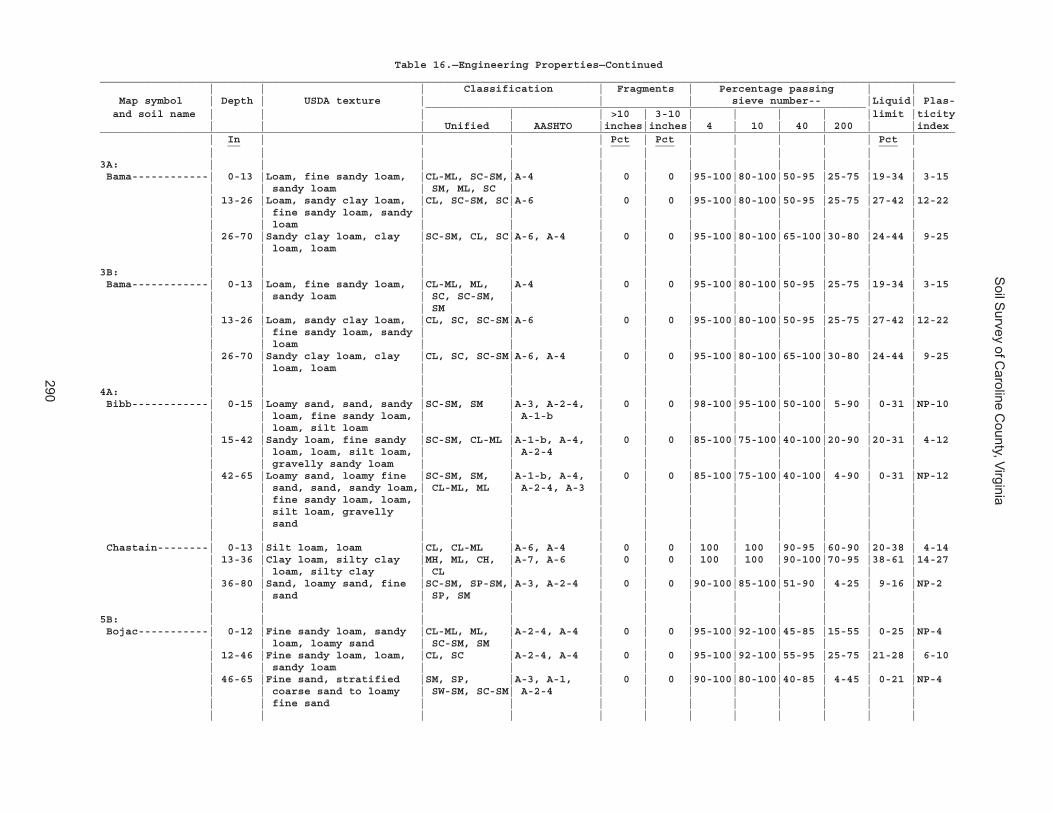
Soil S
urvey of Caroline C
ounty, Virginia
290
Table 16.—Engineering Properties—Continued______________________________________________________________________________________________________________________________________ | | | Classification | Fragments | Percentage passing | | Map symbol | Depth | USDA texture | | | sieve number-- |Liquid| Plas- _____________________________________________________________________ and soil name | | | | | >10 | 3-10 | | | | |limit |ticity | | | Unified | AASHTO |inches|inches| 4 | 10 | 40 | 200 | |index______________________________________________________________________________________________________________________________________ | In | | | | Pct | Pct | | | | | Pct | __ ___ ___ ___ | | | | | | | | | | | |3A: | | | | | | | | | | | | Bama------------| 0-13 |Loam, fine sandy loam, |CL-ML, SC-SM,|A-4 | 0 | 0 |95-100|80-100|50-95 |25-75 |19-34 | 3-15 | | sandy loam | SM, ML, SC | | | | | | | | | | 13-26 |Loam, sandy clay loam, |CL, SC-SM, SC|A-6 | 0 | 0 |95-100|80-100|50-95 |25-75 |27-42 |12-22 | | fine sandy loam, sandy | | | | | | | | | | | | loam | | | | | | | | | | | 26-70 |Sandy clay loam, clay |SC-SM, CL, SC|A-6, A-4 | 0 | 0 |95-100|80-100|65-100|30-80 |24-44 | 9-25 | | loam, loam | | | | | | | | | | | | | | | | | | | | | |3B: | | | | | | | | | | | | Bama------------| 0-13 |Loam, fine sandy loam, |CL-ML, ML, |A-4 | 0 | 0 |95-100|80-100|50-95 |25-75 |19-34 | 3-15 | | sandy loam | SC, SC-SM, | | | | | | | | | | | | SM | | | | | | | | | | 13-26 |Loam, sandy clay loam, |CL, SC, SC-SM|A-6 | 0 | 0 |95-100|80-100|50-95 |25-75 |27-42 |12-22 | | fine sandy loam, sandy | | | | | | | | | | | | loam | | | | | | | | | | | 26-70 |Sandy clay loam, clay |CL, SC, SC-SM|A-6, A-4 | 0 | 0 |95-100|80-100|65-100|30-80 |24-44 | 9-25 | | loam, loam | | | | | | | | | | | | | | | | | | | | | |4A: | | | | | | | | | | | | Bibb------------| 0-15 |Loamy sand, sand, sandy |SC-SM, SM |A-3, A-2-4, | 0 | 0 |98-100|95-100|50-100| 5-90 | 0-31 |NP-10 | | loam, fine sandy loam, | | A-1-b | | | | | | | | | | loam, silt loam | | | | | | | | | | | 15-42 |Sandy loam, fine sandy |SC-SM, CL-ML |A-1-b, A-4, | 0 | 0 |85-100|75-100|40-100|20-90 |20-31 | 4-12 | | loam, loam, silt loam, | | A-2-4 | | | | | | | | | | gravelly sandy loam | | | | | | | | | | | 42-65 |Loamy sand, loamy fine |SC-SM, SM, |A-1-b, A-4, | 0 | 0 |85-100|75-100|40-100| 4-90 | 0-31 |NP-12 | | sand, sand, sandy loam,| CL-ML, ML | A-2-4, A-3 | | | | | | | | | | fine sandy loam, loam, | | | | | | | | | | | | silt loam, gravelly | | | | | | | | | | | | sand | | | | | | | | | | | | | | | | | | | | | | Chastain--------| 0-13 |Silt loam, loam |CL, CL-ML |A-6, A-4 | 0 | 0 | 100 | 100 |90-95 |60-90 |20-38 | 4-14 | 13-36 |Clay loam, silty clay |MH, ML, CH, |A-7, A-6 | 0 | 0 | 100 | 100 |90-100|70-95 |38-61 |14-27 | | loam, silty clay | CL | | | | | | | | | | 36-80 |Sand, loamy sand, fine |SC-SM, SP-SM,|A-3, A-2-4 | 0 | 0 |90-100|85-100|51-90 | 4-25 | 9-16 |NP-2 | | sand | SP, SM | | | | | | | | | | | | | | | | | | | | |5B: | | | | | | | | | | | | Bojac-----------| 0-12 |Fine sandy loam, sandy |CL-ML, ML, |A-2-4, A-4 | 0 | 0 |95-100|92-100|45-85 |15-55 | 0-25 |NP-4 | | loam, loamy sand | SC-SM, SM | | | | | | | | | | 12-46 |Fine sandy loam, loam, |CL, SC |A-2-4, A-4 | 0 | 0 |95-100|92-100|55-95 |25-75 |21-28 | 6-10 | | sandy loam | | | | | | | | | | | 46-65 |Fine sand, stratified |SM, SP, |A-3, A-1, | 0 | 0 |90-100|80-100|40-85 | 4-45 | 0-21 |NP-4 | | coarse sand to loamy | SW-SM, SC-SM| A-2-4 | | | | | | | | | | fine sand | | | | | | | | | | | | | | | | | | | | | |
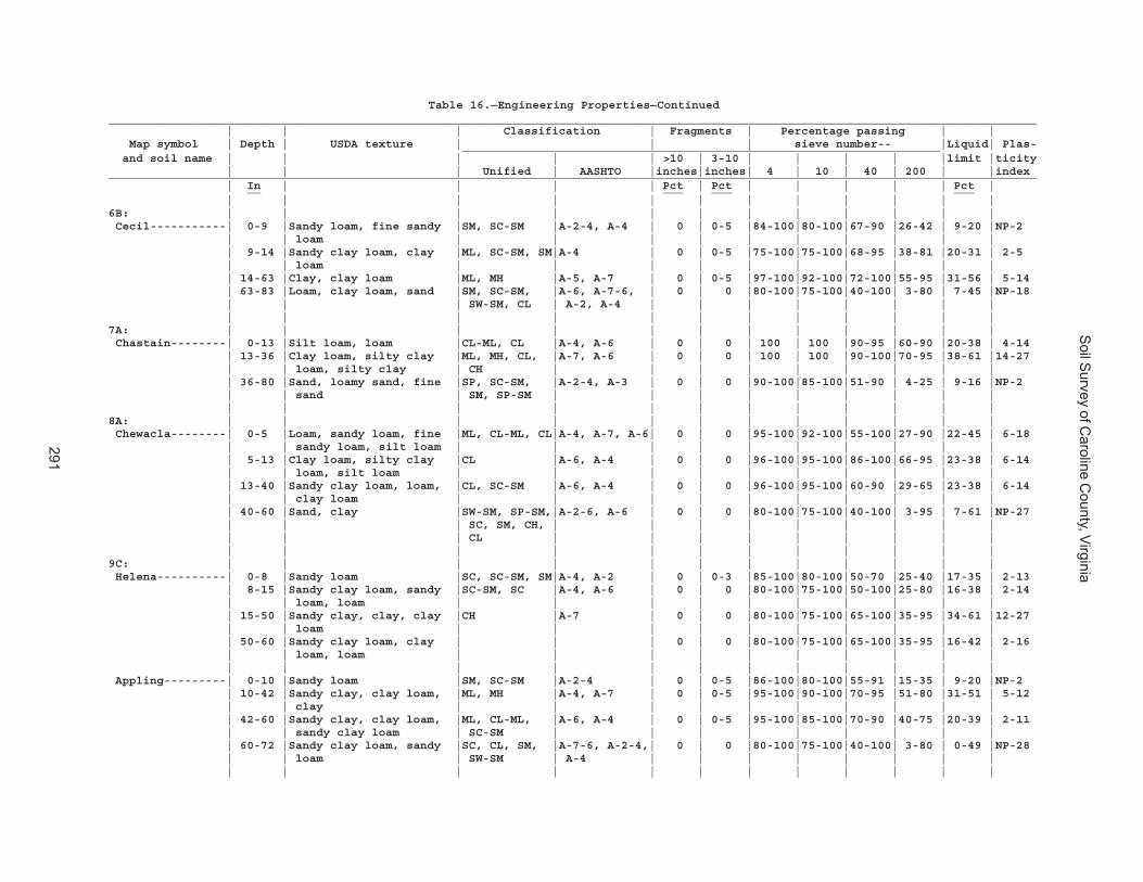
Soil S
urvey of Caroline C
ounty, Virginia
291
Table 16.—Engineering Properties—Continued______________________________________________________________________________________________________________________________________ | | | Classification | Fragments | Percentage passing | | Map symbol | Depth | USDA texture | | | sieve number-- |Liquid| Plas- _____________________________________________________________________ and soil name | | | | | >10 | 3-10 | | | | |limit |ticity | | | Unified | AASHTO |inches|inches| 4 | 10 | 40 | 200 | |index______________________________________________________________________________________________________________________________________ | In | | | | Pct | Pct | | | | | Pct | __ ___ ___ ___ | | | | | | | | | | | |6B: | | | | | | | | | | | | Cecil-----------| 0-9 |Sandy loam, fine sandy |SM, SC-SM |A-2-4, A-4 | 0 | 0-5 |84-100|80-100|67-90 |26-42 | 9-20 |NP-2 | | loam | | | | | | | | | | | 9-14 |Sandy clay loam, clay |ML, SC-SM, SM|A-4 | 0 | 0-5 |75-100|75-100|68-95 |38-81 |20-31 | 2-5 | | loam | | | | | | | | | | | 14-63 |Clay, clay loam |ML, MH |A-5, A-7 | 0 | 0-5 |97-100|92-100|72-100|55-95 |31-56 | 5-14 | 63-83 |Loam, clay loam, sand |SM, SC-SM, |A-6, A-7-6, | 0 | 0 |80-100|75-100|40-100| 3-80 | 7-45 |NP-18 | | | SW-SM, CL | A-2, A-4 | | | | | | | | | | | | | | | | | | | |7A: | | | | | | | | | | | | Chastain--------| 0-13 |Silt loam, loam |CL-ML, CL |A-4, A-6 | 0 | 0 | 100 | 100 |90-95 |60-90 |20-38 | 4-14 | 13-36 |Clay loam, silty clay |ML, MH, CL, |A-7, A-6 | 0 | 0 | 100 | 100 |90-100|70-95 |38-61 |14-27 | | loam, silty clay | CH | | | | | | | | | | 36-80 |Sand, loamy sand, fine |SP, SC-SM, |A-2-4, A-3 | 0 | 0 |90-100|85-100|51-90 | 4-25 | 9-16 |NP-2 | | sand | SM, SP-SM | | | | | | | | | | | | | | | | | | | | |8A: | | | | | | | | | | | | Chewacla--------| 0-5 |Loam, sandy loam, fine |ML, CL-ML, CL|A-4, A-7, A-6| 0 | 0 |95-100|92-100|55-100|27-90 |22-45 | 6-18 | | sandy loam, silt loam | | | | | | | | | | | 5-13 |Clay loam, silty clay |CL |A-6, A-4 | 0 | 0 |96-100|95-100|86-100|66-95 |23-38 | 6-14 | | loam, silt loam | | | | | | | | | | | 13-40 |Sandy clay loam, loam, |CL, SC-SM |A-6, A-4 | 0 | 0 |96-100|95-100|60-90 |29-65 |23-38 | 6-14 | | clay loam | | | | | | | | | | | 40-60 |Sand, clay |SW-SM, SP-SM,|A-2-6, A-6 | 0 | 0 |80-100|75-100|40-100| 3-95 | 7-61 |NP-27 | | | SC, SM, CH, | | | | | | | | | | | | CL | | | | | | | | | | | | | | | | | | | | |9C: | | | | | | | | | | | | Helena----------| 0-8 |Sandy loam |SC, SC-SM, SM|A-4, A-2 | 0 | 0-3 |85-100|80-100|50-70 |25-40 |17-35 | 2-13 | 8-15 |Sandy clay loam, sandy |SC-SM, SC |A-4, A-6 | 0 | 0 |80-100|75-100|50-100|25-80 |16-38 | 2-14 | | loam, loam | | | | | | | | | | | 15-50 |Sandy clay, clay, clay |CH |A-7 | 0 | 0 |80-100|75-100|65-100|35-95 |34-61 |12-27 | | loam | | | | | | | | | | | 50-60 |Sandy clay loam, clay | | | 0 | 0 |80-100|75-100|65-100|35-95 |16-42 | 2-16 | | loam, loam | | | | | | | | | | | | | | | | | | | | | | Appling---------| 0-10 |Sandy loam |SM, SC-SM |A-2-4 | 0 | 0-5 |86-100|80-100|55-91 |15-35 | 9-20 |NP-2 | 10-42 |Sandy clay, clay loam, |ML, MH |A-4, A-7 | 0 | 0-5 |95-100|90-100|70-95 |51-80 |31-51 | 5-12 | | clay | | | | | | | | | | | 42-60 |Sandy clay, clay loam, |ML, CL-ML, |A-6, A-4 | 0 | 0-5 |95-100|85-100|70-90 |40-75 |20-39 | 2-11 | | sandy clay loam | SC-SM | | | | | | | | | | 60-72 |Sandy clay loam, sandy |SC, CL, SM, |A-7-6, A-2-4,| 0 | 0 |80-100|75-100|40-100| 3-80 | 0-49 |NP-28 | | loam | SW-SM | A-4 | | | | | | | | | | | | | | | | | | | |
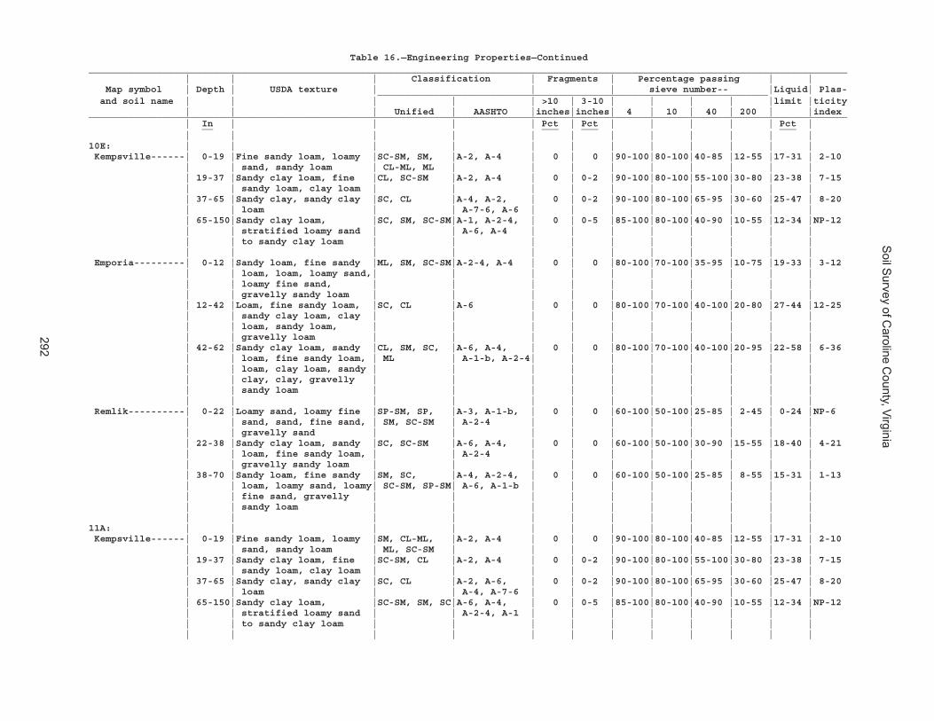
Soil S
urvey of Caroline C
ounty, Virginia
292
Table 16.—Engineering Properties—Continued______________________________________________________________________________________________________________________________________ | | | Classification | Fragments | Percentage passing | | Map symbol | Depth | USDA texture | | | sieve number-- |Liquid| Plas- _____________________________________________________________________ and soil name | | | | | >10 | 3-10 | | | | |limit |ticity | | | Unified | AASHTO |inches|inches| 4 | 10 | 40 | 200 | |index______________________________________________________________________________________________________________________________________ | In | | | | Pct | Pct | | | | | Pct | __ ___ ___ ___ | | | | | | | | | | | |10E: | | | | | | | | | | | | Kempsville------| 0-19 |Fine sandy loam, loamy |SC-SM, SM, |A-2, A-4 | 0 | 0 |90-100|80-100|40-85 |12-55 |17-31 | 2-10 | | sand, sandy loam | CL-ML, ML | | | | | | | | | | 19-37 |Sandy clay loam, fine |CL, SC-SM |A-2, A-4 | 0 | 0-2 |90-100|80-100|55-100|30-80 |23-38 | 7-15 | | sandy loam, clay loam | | | | | | | | | | | 37-65 |Sandy clay, sandy clay |SC, CL |A-4, A-2, | 0 | 0-2 |90-100|80-100|65-95 |30-60 |25-47 | 8-20 | | loam | | A-7-6, A-6 | | | | | | | | | 65-150|Sandy clay loam, |SC, SM, SC-SM|A-1, A-2-4, | 0 | 0-5 |85-100|80-100|40-90 |10-55 |12-34 |NP-12 | | stratified loamy sand | | A-6, A-4 | | | | | | | | | | to sandy clay loam | | | | | | | | | | | | | | | | | | | | | | Emporia---------| 0-12 |Sandy loam, fine sandy |ML, SM, SC-SM|A-2-4, A-4 | 0 | 0 |80-100|70-100|35-95 |10-75 |19-33 | 3-12 | | loam, loam, loamy sand,| | | | | | | | | | | | loamy fine sand, | | | | | | | | | | | | gravelly sandy loam | | | | | | | | | | | 12-42 |Loam, fine sandy loam, |SC, CL |A-6 | 0 | 0 |80-100|70-100|40-100|20-80 |27-44 |12-25 | | sandy clay loam, clay | | | | | | | | | | | | loam, sandy loam, | | | | | | | | | | | | gravelly loam | | | | | | | | | | | 42-62 |Sandy clay loam, sandy |CL, SM, SC, |A-6, A-4, | 0 | 0 |80-100|70-100|40-100|20-95 |22-58 | 6-36 | | loam, fine sandy loam, | ML | A-1-b, A-2-4| | | | | | | | | | loam, clay loam, sandy | | | | | | | | | | | | clay, clay, gravelly | | | | | | | | | | | | sandy loam | | | | | | | | | | | | | | | | | | | | | | Remlik----------| 0-22 |Loamy sand, loamy fine |SP-SM, SP, |A-3, A-1-b, | 0 | 0 |60-100|50-100|25-85 | 2-45 | 0-24 |NP-6 | | sand, sand, fine sand, | SM, SC-SM | A-2-4 | | | | | | | | | | gravelly sand | | | | | | | | | | | 22-38 |Sandy clay loam, sandy |SC, SC-SM |A-6, A-4, | 0 | 0 |60-100|50-100|30-90 |15-55 |18-40 | 4-21 | | loam, fine sandy loam, | | A-2-4 | | | | | | | | | | gravelly sandy loam | | | | | | | | | | | 38-70 |Sandy loam, fine sandy |SM, SC, |A-4, A-2-4, | 0 | 0 |60-100|50-100|25-85 | 8-55 |15-31 | 1-13 | | loam, loamy sand, loamy| SC-SM, SP-SM| A-6, A-1-b | | | | | | | | | | fine sand, gravelly | | | | | | | | | | | | sandy loam | | | | | | | | | | | | | | | | | | | | | |11A: | | | | | | | | | | | | Kempsville------| 0-19 |Fine sandy loam, loamy |SM, CL-ML, |A-2, A-4 | 0 | 0 |90-100|80-100|40-85 |12-55 |17-31 | 2-10 | | sand, sandy loam | ML, SC-SM | | | | | | | | | | 19-37 |Sandy clay loam, fine |SC-SM, CL |A-2, A-4 | 0 | 0-2 |90-100|80-100|55-100|30-80 |23-38 | 7-15 | | sandy loam, clay loam | | | | | | | | | | | 37-65 |Sandy clay, sandy clay |SC, CL |A-2, A-6, | 0 | 0-2 |90-100|80-100|65-95 |30-60 |25-47 | 8-20 | | loam | | A-4, A-7-6 | | | | | | | | | 65-150|Sandy clay loam, |SC-SM, SM, SC|A-6, A-4, | 0 | 0-5 |85-100|80-100|40-90 |10-55 |12-34 |NP-12 | | stratified loamy sand | | A-2-4, A-1 | | | | | | | | | | to sandy clay loam | | | | | | | | | | | | | | | | | | | | | |

Soil S
urvey of Caroline C
ounty, Virginia
293
Table 16.—Engineering Properties—Continued______________________________________________________________________________________________________________________________________ | | | Classification | Fragments | Percentage passing | | Map symbol | Depth | USDA texture | | | sieve number-- |Liquid| Plas- _____________________________________________________________________ and soil name | | | | | >10 | 3-10 | | | | |limit |ticity | | | Unified | AASHTO |inches|inches| 4 | 10 | 40 | 200 | |index______________________________________________________________________________________________________________________________________ | In | | | | Pct | Pct | | | | | Pct | __ ___ ___ ___ | | | | | | | | | | | |11A: | | | | | | | | | | | | Emporia---------| 0-12 |Sandy loam, fine sandy |ML, SM, SC-SM|A-2-4, A-4 | 0 | 0 |80-100|70-100|35-95 |10-75 |19-33 | 3-12 | | loam, loam, loamy sand,| | | | | | | | | | | | loamy fine sand, | | | | | | | | | | | | gravelly sandy loam | | | | | | | | | | | 12-42 |Loam, fine sandy loam, |CL, SC |A-6 | 0 | 0 |80-100|70-100|40-100|20-80 |27-44 |12-25 | | sandy clay loam, clay | | | | | | | | | | | | loam, sandy loam, | | | | | | | | | | | | gravelly loam | | | | | | | | | | | 42-62 |Sandy clay loam, sandy |SC, SM, CL, |A-1-b, A-2-4,| 0 | 0 |80-100|70-100|40-100|20-95 |22-58 | 6-36 | | loam, fine sandy loam, | ML | A-4, A-6 | | | | | | | | | | loam, clay loam, sandy | | | | | | | | | | | | clay, clay, gravelly | | | | | | | | | | | | sandy loam | | | | | | | | | | | | | | | | | | | | | |11B: | | | | | | | | | | | | Kempsville------| 0-19 |Fine sandy loam, loamy |SM, CL-ML, |A-4, A-2 | 0 | 0 |90-100|80-100|40-85 |12-55 |17-31 | 2-10 | | sand, sandy loam | ML, SC-SM | | | | | | | | | | 19-37 |Sandy clay loam, fine |CL, SC-SM |A-2, A-4 | 0 | 0-2 |90-100|80-100|55-100|30-80 |23-38 | 7-15 | | sandy loam, clay loam | | | | | | | | | | | 37-65 |Sandy clay, sandy clay |CL, SC |A-6, A-2, | 0 | 0-2 |90-100|80-100|65-95 |30-60 |25-47 | 8-20 | | loam | | A-4, A-7-6 | | | | | | | | | 65-150|Sandy clay loam, |SC, SC-SM, SM|A-1, A-2-4, | 0 | 0-5 |85-100|80-100|40-90 |10-55 |12-34 |NP-12 | | stratified loamy sand | | A-6, A-4 | | | | | | | | | | to sandy clay loam | | | | | | | | | | | | | | | | | | | | | | Emporia---------| 0-12 |Sandy loam, fine sandy |ML, SM, SC-SM|A-4, A-2-4 | 0 | 0 |80-100|70-100|35-95 |10-75 |19-33 | 3-12 | | loam, loam, loamy sand,| | | | | | | | | | | | loamy fine sand, | | | | | | | | | | | | gravelly sandy loam | | | | | | | | | | | 12-42 |Loam, fine sandy loam, |CL, SC |A-6 | 0 | 0 |80-100|70-100|40-100|20-80 |27-44 |12-25 | | sandy clay loam, clay | | | | | | | | | | | | loam, sandy loam, | | | | | | | | | | | | gravelly loam | | | | | | | | | | | 42-62 |Sandy clay loam, sandy |CL, ML, SC, |A-6, A-2-4, | 0 | 0 |80-100|70-100|40-100|20-95 |22-58 | 6-36 | | loam, fine sandy loam, | SM | A-1-b, A-4 | | | | | | | | | | loam, clay loam, sandy | | | | | | | | | | | | clay, clay, gravelly | | | | | | | | | | | | sandy loam | | | | | | | | | | | | | | | | | | | | | |
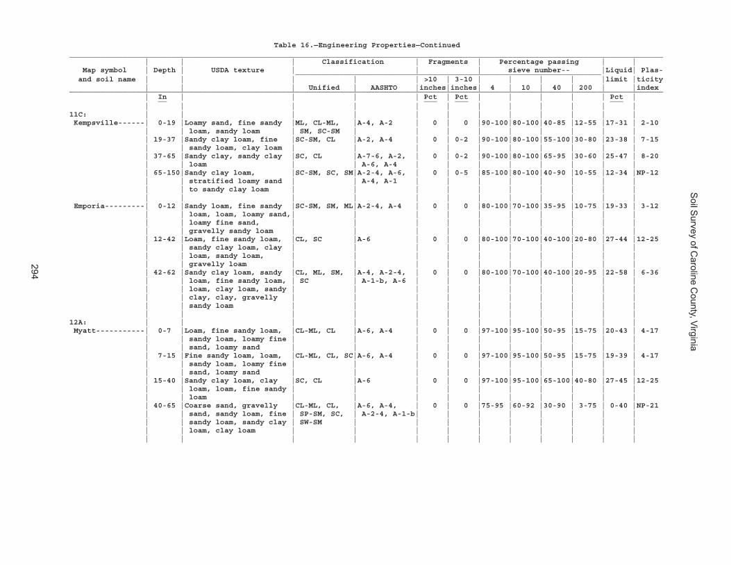
Soil S
urvey of Caroline C
ounty, Virginia
294
Table 16.—Engineering Properties—Continued______________________________________________________________________________________________________________________________________ | | | Classification | Fragments | Percentage passing | | Map symbol | Depth | USDA texture | | | sieve number-- |Liquid| Plas- _____________________________________________________________________ and soil name | | | | | >10 | 3-10 | | | | |limit |ticity | | | Unified | AASHTO |inches|inches| 4 | 10 | 40 | 200 | |index______________________________________________________________________________________________________________________________________ | In | | | | Pct | Pct | | | | | Pct | __ ___ ___ ___ | | | | | | | | | | | |11C: | | | | | | | | | | | | Kempsville------| 0-19 |Loamy sand, fine sandy |ML, CL-ML, |A-4, A-2 | 0 | 0 |90-100|80-100|40-85 |12-55 |17-31 | 2-10 | | loam, sandy loam | SM, SC-SM | | | | | | | | | | 19-37 |Sandy clay loam, fine |SC-SM, CL |A-2, A-4 | 0 | 0-2 |90-100|80-100|55-100|30-80 |23-38 | 7-15 | | sandy loam, clay loam | | | | | | | | | | | 37-65 |Sandy clay, sandy clay |SC, CL |A-7-6, A-2, | 0 | 0-2 |90-100|80-100|65-95 |30-60 |25-47 | 8-20 | | loam | | A-6, A-4 | | | | | | | | | 65-150|Sandy clay loam, |SC-SM, SC, SM|A-2-4, A-6, | 0 | 0-5 |85-100|80-100|40-90 |10-55 |12-34 |NP-12 | | stratified loamy sand | | A-4, A-1 | | | | | | | | | | to sandy clay loam | | | | | | | | | | | | | | | | | | | | | | Emporia---------| 0-12 |Sandy loam, fine sandy |SC-SM, SM, ML|A-2-4, A-4 | 0 | 0 |80-100|70-100|35-95 |10-75 |19-33 | 3-12 | | loam, loam, loamy sand,| | | | | | | | | | | | loamy fine sand, | | | | | | | | | | | | gravelly sandy loam | | | | | | | | | | | 12-42 |Loam, fine sandy loam, |CL, SC |A-6 | 0 | 0 |80-100|70-100|40-100|20-80 |27-44 |12-25 | | sandy clay loam, clay | | | | | | | | | | | | loam, sandy loam, | | | | | | | | | | | | gravelly loam | | | | | | | | | | | 42-62 |Sandy clay loam, sandy |CL, ML, SM, |A-4, A-2-4, | 0 | 0 |80-100|70-100|40-100|20-95 |22-58 | 6-36 | | loam, fine sandy loam, | SC | A-1-b, A-6 | | | | | | | | | | loam, clay loam, sandy | | | | | | | | | | | | clay, clay, gravelly | | | | | | | | | | | | sandy loam | | | | | | | | | | | | | | | | | | | | | |12A: | | | | | | | | | | | | Myatt-----------| 0-7 |Loam, fine sandy loam, |CL-ML, CL |A-6, A-4 | 0 | 0 |97-100|95-100|50-95 |15-75 |20-43 | 4-17 | | sandy loam, loamy fine | | | | | | | | | | | | sand, loamy sand | | | | | | | | | | | 7-15 |Fine sandy loam, loam, |CL-ML, CL, SC|A-6, A-4 | 0 | 0 |97-100|95-100|50-95 |15-75 |19-39 | 4-17 | | sandy loam, loamy fine | | | | | | | | | | | | sand, loamy sand | | | | | | | | | | | 15-40 |Sandy clay loam, clay |SC, CL |A-6 | 0 | 0 |97-100|95-100|65-100|40-80 |27-45 |12-25 | | loam, loam, fine sandy | | | | | | | | | | | | loam | | | | | | | | | | | 40-65 |Coarse sand, gravelly |CL-ML, CL, |A-6, A-4, | 0 | 0 |75-95 |60-92 |30-90 | 3-75 | 0-40 |NP-21 | | sand, sandy loam, fine | SP-SM, SC, | A-2-4, A-1-b| | | | | | | | | | sandy loam, sandy clay | SW-SM | | | | | | | | | | | loam, clay loam | | | | | | | | | | | | | | | | | | | | | |
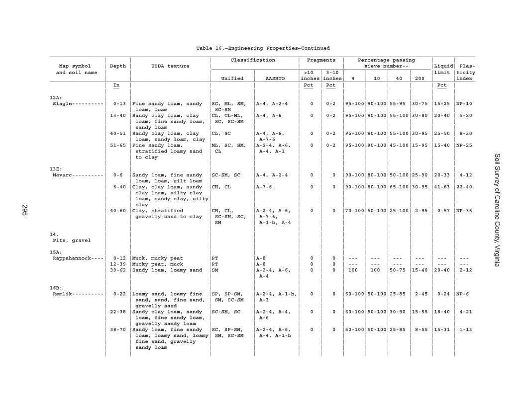
Soil S
urvey of Caroline C
ounty, Virginia
295
Table 16.—Engineering Properties—Continued______________________________________________________________________________________________________________________________________ | | | Classification | Fragments | Percentage passing | | Map symbol | Depth | USDA texture | | | sieve number-- |Liquid| Plas- _____________________________________________________________________ and soil name | | | | | >10 | 3-10 | | | | |limit |ticity | | | Unified | AASHTO |inches|inches| 4 | 10 | 40 | 200 | |index______________________________________________________________________________________________________________________________________ | In | | | | Pct | Pct | | | | | Pct | __ ___ ___ ___ | | | | | | | | | | | |12A: | | | | | | | | | | | | Slagle----------| 0-13 |Fine sandy loam, sandy |SC, ML, SM, |A-4, A-2-4 | 0 | 0-2 |95-100|90-100|55-95 |30-75 |15-25 |NP-10 | | loam, loam | SC-SM | | | | | | | | | | 13-40 |Sandy clay loam, clay |CL, CL-ML, |A-4, A-6 | 0 | 0-2 |95-100|90-100|55-100|30-80 |20-40 | 5-20 | | loam, fine sandy loam, | SC, SC-SM | | | | | | | | | | | sandy loam | | | | | | | | | | | 40-51 |Sandy clay loam, clay |CL, SC |A-4, A-6, | 0 | 0-2 |95-100|90-100|55-100|30-95 |25-50 | 8-30 | | loam, sandy loam, clay | | A-7-6 | | | | | | | | | 51-65 |Fine sandy loam, |ML, SC, SM, |A-2-4, A-6, | 0 | 0-2 |95-100|90-100|45-100|15-95 |15-40 |NP-25 | | stratified loamy sand | CL | A-4, A-1 | | | | | | | | | | to clay | | | | | | | | | | | | | | | | | | | | | |13E: | | | | | | | | | | | | Nevarc----------| 0-6 |Sandy loam, fine sandy |SC-SM, SC |A-4, A-2-4 | 0 | 0 |90-100|80-100|50-100|25-90 |20-33 | 4-12 | | loam, loam, silt loam | | | | | | | | | | | 6-40 |Clay, clay loam, sandy |CH, CL |A-7-6 | 0 | 0 |90-100|80-100|65-100|30-95 |41-63 |22-40 | | clay loam, silty clay | | | | | | | | | | | | loam, sandy clay, silty| | | | | | | | | | | | clay | | | | | | | | | | | 40-60 |Clay, stratified |CH, CL, |A-2-4, A-6, | 0 | 0 |70-100|50-100|25-100| 2-95 | 0-57 |NP-36 | | gravelly sand to clay | SC-SM, SC, | A-7-6, | | | | | | | | | | | SM | A-1-b, A-4 | | | | | | | | | | | | | | | | | | | |14. | | | | | | | | | | | | Pits, gravel | | | | | | | | | | | | | | | | | | | | | | | |15A: | | | | | | | | | | | | Rappahannock----| 0-12 |Muck, mucky peat |PT |A-8 | 0 | 0 | --- | --- | --- | --- | --- | --- | 12-39 |Mucky peat, muck |PT |A-8 | 0 | 0 | --- | --- | --- | --- | --- | --- | 39-62 |Sandy loam, loamy sand |SM |A-2-4, A-6, | 0 | 0 | 100 | 100 |50-75 |15-40 |20-40 | 2-12 | | | | A-4 | | | | | | | | | | | | | | | | | | | |16B: | | | | | | | | | | | | Remlik----------| 0-22 |Loamy sand, loamy fine |SP, SP-SM, |A-2-4, A-1-b,| 0 | 0 |60-100|50-100|25-85 | 2-45 | 0-24 |NP-6 | | sand, sand, fine sand, | SM, SC-SM | A-3 | | | | | | | | | | gravelly sand | | | | | | | | | | | 22-38 |Sandy clay loam, sandy |SC-SM, SC |A-2-4, A-4, | 0 | 0 |60-100|50-100|30-90 |15-55 |18-40 | 4-21 | | loam, fine sandy loam, | | A-6 | | | | | | | | | | gravelly sandy loam | | | | | | | | | | | 38-70 |Sandy loam, fine sandy |SC, SP-SM, |A-2-4, A-6, | 0 | 0 |60-100|50-100|25-85 | 8-55 |15-31 | 1-13 | | loam, loamy sand, loamy| SM, SC-SM | A-4, A-1-b | | | | | | | | | | fine sand, gravelly | | | | | | | | | | | | sandy loam | | | | | | | | | | | | | | | | | | | | | |
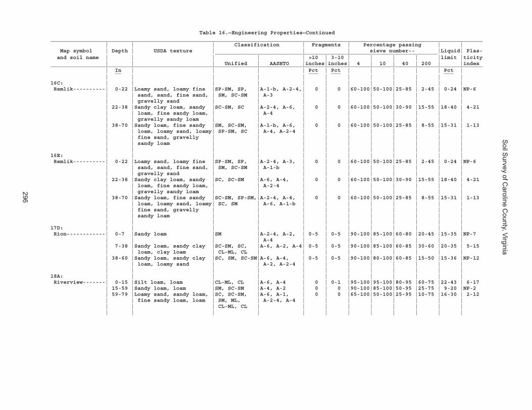
Soil S
urvey of Caroline C
ounty, Virginia
296
Table 16.—Engineering Properties—Continued______________________________________________________________________________________________________________________________________ | | | Classification | Fragments | Percentage passing | | Map symbol | Depth | USDA texture | | | sieve number-- |Liquid| Plas- _____________________________________________________________________ and soil name | | | | | >10 | 3-10 | | | | |limit |ticity | | | Unified | AASHTO |inches|inches| 4 | 10 | 40 | 200 | |index______________________________________________________________________________________________________________________________________ | In | | | | Pct | Pct | | | | | Pct | __ ___ ___ ___ | | | | | | | | | | | |16C: | | | | | | | | | | | | Remlik----------| 0-22 |Loamy sand, loamy fine |SP-SM, SP, |A-1-b, A-2-4,| 0 | 0 |60-100|50-100|25-85 | 2-45 | 0-24 |NP-6 | | sand, sand, fine sand, | SM, SC-SM | A-3 | | | | | | | | | | gravelly sand | | | | | | | | | | | 22-38 |Sandy clay loam, sandy |SC-SM, SC |A-2-4, A-6, | 0 | 0 |60-100|50-100|30-90 |15-55 |18-40 | 4-21 | | loam, fine sandy loam, | | A-4 | | | | | | | | | | gravelly sandy loam | | | | | | | | | | | 38-70 |Sandy loam, fine sandy |SM, SC-SM, |A-1-b, A-6, | 0 | 0 |60-100|50-100|25-85 | 8-55 |15-31 | 1-13 | | loam, loamy sand, loamy| SP-SM, SC | A-4, A-2-4 | | | | | | | | | | fine sand, gravelly | | | | | | | | | | | | sandy loam | | | | | | | | | | | | | | | | | | | | | |16E: | | | | | | | | | | | | Remlik----------| 0-22 |Loamy sand, loamy fine |SP-SM, SP, |A-2-4, A-3, | 0 | 0 |60-100|50-100|25-85 | 2-45 | 0-24 |NP-6 | | sand, sand, fine sand, | SM, SC-SM | A-1-b | | | | | | | | | | gravelly sand | | | | | | | | | | | 22-38 |Sandy clay loam, sandy |SC, SC-SM |A-6, A-4, | 0 | 0 |60-100|50-100|30-90 |15-55 |18-40 | 4-21 | | loam, fine sandy loam, | | A-2-4 | | | | | | | | | | gravelly sandy loam | | | | | | | | | | | 38-70 |Sandy loam, fine sandy |SC-SM, SP-SM,|A-2-4, A-4, | 0 | 0 |60-100|50-100|25-85 | 8-55 |15-31 | 1-13 | | loam, loamy sand, loamy| SC, SM | A-6, A-1-b | | | | | | | | | | fine sand, gravelly | | | | | | | | | | | | sandy loam | | | | | | | | | | | | | | | | | | | | | |17D: | | | | | | | | | | | | Rion------------| 0-7 |Sandy loam |SM |A-2-4, A-2, | 0-5 | 0-5 |90-100|85-100|60-80 |20-45 |15-35 |NP-7 | | | | A-4 | | | | | | | | | 7-38 |Sandy loam, sandy clay |SC-SM, SC, |A-6, A-2, A-4| 0-5 | 0-5 |90-100|85-100|60-85 |30-60 |20-35 | 5-15 | | loam, clay loam | CL-ML, CL | | | | | | | | | | 38-60 |Sandy loam, sandy clay |SC, SM, SC-SM|A-6, A-4, | 0-5 | 0-5 |90-100|80-100|60-85 |15-50 |15-36 |NP-12 | | loam, loamy sand | | A-2, A-2-4 | | | | | | | | | | | | | | | | | | | |18A: | | | | | | | | | | | | Riverview-------| 0-15 |Silt loam, loam |CL-ML, CL |A-6, A-4 | 0 | 0-1 |95-100|95-100|80-95 |60-75 |22-43 | 6-17 | 15-59 |Sandy loam, loam |SM, SC-SM |A-4, A-2 | 0 | 0 |90-100|85-100|50-95 |25-75 | 9-20 |NP-2 | 59-79 |Loamy sand, sandy loam, |SC, SC-SM, |A-6, A-1, | 0 | 0 |65-100|50-100|25-95 |10-75 |16-30 | 2-12 | | fine sandy loam, loam | SM, ML, | A-2-4, A-4 | | | | | | | | | | | CL-ML, CL | | | | | | | | | | | | | | | | | | | | |
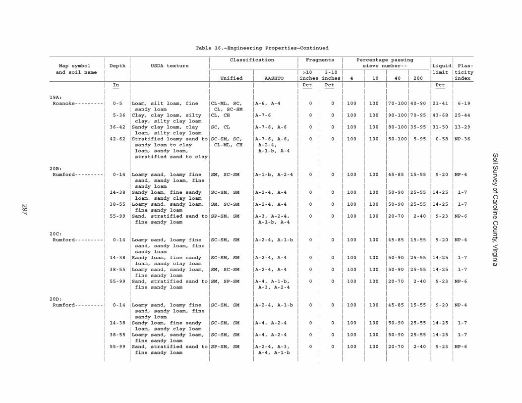
Soil S
urvey of Caroline C
ounty, Virginia
297
Table 16.—Engineering Properties—Continued______________________________________________________________________________________________________________________________________ | | | Classification | Fragments | Percentage passing | | Map symbol | Depth | USDA texture | | | sieve number-- |Liquid| Plas- _____________________________________________________________________ and soil name | | | | | >10 | 3-10 | | | | |limit |ticity | | | Unified | AASHTO |inches|inches| 4 | 10 | 40 | 200 | |index______________________________________________________________________________________________________________________________________ | In | | | | Pct | Pct | | | | | Pct | __ ___ ___ ___ | | | | | | | | | | | |19A: | | | | | | | | | | | | Roanoke---------| 0-5 |Loam, silt loam, fine |CL-ML, SC, |A-6, A-4 | 0 | 0 | 100 | 100 |70-100|40-90 |21-41 | 6-19 | | sandy loam | CL, SC-SM | | | | | | | | | | 5-36 |Clay, clay loam, silty |CL, CH |A-7-6 | 0 | 0 | 100 | 100 |90-100|70-95 |43-68 |25-44 | | clay, silty clay loam | | | | | | | | | | | 36-42 |Sandy clay loam, clay |SC, CL |A-7-6, A-6 | 0 | 0 | 100 | 100 |80-100|35-95 |31-50 |13-29 | | loam, silty clay loam | | | | | | | | | | | 42-62 |Stratified loamy sand to|SC-SM, SC, |A-7-6, A-6, | 0 | 0 | 100 | 100 |50-100| 5-95 | 0-58 |NP-36 | | sandy loam to clay | CL-ML, CH | A-2-4, | | | | | | | | | | loam, sandy loam, | | A-1-b, A-4 | | | | | | | | | | stratified sand to clay| | | | | | | | | | | | | | | | | | | | | |20B: | | | | | | | | | | | | Rumford---------| 0-14 |Loamy sand, loamy fine |SM, SC-SM |A-1-b, A-2-4 | 0 | 0 | 100 | 100 |45-85 |15-55 | 9-20 |NP-4 | | sand, sandy loam, fine | | | | | | | | | | | | sandy loam | | | | | | | | | | | 14-38 |Sandy loam, fine sandy |SC-SM, SM |A-2-4, A-4 | 0 | 0 | 100 | 100 |50-90 |25-55 |14-25 | 1-7 | | loam, sandy clay loam | | | | | | | | | | | 38-55 |Loamy sand, sandy loam, |SM, SC-SM |A-2-4, A-4 | 0 | 0 | 100 | 100 |50-90 |25-55 |14-25 | 1-7 | | fine sandy loam | | | | | | | | | | | 55-99 |Sand, stratified sand to|SP-SM, SM |A-3, A-2-4, | 0 | 0 | 100 | 100 |20-70 | 2-40 | 9-23 |NP-6 | | fine sandy loam | | A-1-b, A-4 | | | | | | | | | | | | | | | | | | | |20C: | | | | | | | | | | | | Rumford---------| 0-14 |Loamy sand, loamy fine |SC-SM, SM |A-2-4, A-1-b | 0 | 0 | 100 | 100 |45-85 |15-55 | 9-20 |NP-4 | | sand, sandy loam, fine | | | | | | | | | | | | sandy loam | | | | | | | | | | | 14-38 |Sandy loam, fine sandy |SC-SM, SM |A-2-4, A-4 | 0 | 0 | 100 | 100 |50-90 |25-55 |14-25 | 1-7 | | loam, sandy clay loam | | | | | | | | | | | 38-55 |Loamy sand, sandy loam, |SM, SC-SM |A-2-4, A-4 | 0 | 0 | 100 | 100 |50-90 |25-55 |14-25 | 1-7 | | fine sandy loam | | | | | | | | | | | 55-99 |Sand, stratified sand to|SM, SP-SM |A-4, A-1-b, | 0 | 0 | 100 | 100 |20-70 | 2-40 | 9-23 |NP-6 | | fine sandy loam | | A-3, A-2-4 | | | | | | | | | | | | | | | | | | | |20D: | | | | | | | | | | | | Rumford---------| 0-14 |Loamy sand, loamy fine |SC-SM, SM |A-2-4, A-1-b | 0 | 0 | 100 | 100 |45-85 |15-55 | 9-20 |NP-4 | | sand, sandy loam, fine | | | | | | | | | | | | sandy loam | | | | | | | | | | | 14-38 |Sandy loam, fine sandy |SC-SM, SM |A-4, A-2-4 | 0 | 0 | 100 | 100 |50-90 |25-55 |14-25 | 1-7 | | loam, sandy clay loam | | | | | | | | | | | 38-55 |Loamy sand, sandy loam, |SC-SM, SM |A-4, A-2-4 | 0 | 0 | 100 | 100 |50-90 |25-55 |14-25 | 1-7 | | fine sandy loam | | | | | | | | | | | 55-99 |Sand, stratified sand to|SP-SM, SM |A-2-4, A-3, | 0 | 0 | 100 | 100 |20-70 | 2-40 | 9-23 |NP-6 | | fine sandy loam | | A-4, A-1-b | | | | | | | | | | | | | | | | | | | |

Soil S
urvey of Caroline C
ounty, Virginia
298
Table 16.—Engineering Properties—Continued______________________________________________________________________________________________________________________________________ | | | Classification | Fragments | Percentage passing | | Map symbol | Depth | USDA texture | | | sieve number-- |Liquid| Plas- _____________________________________________________________________ and soil name | | | | | >10 | 3-10 | | | | |limit |ticity | | | Unified | AASHTO |inches|inches| 4 | 10 | 40 | 200 | |index______________________________________________________________________________________________________________________________________ | In | | | | Pct | Pct | | | | | Pct | __ ___ ___ ___ | | | | | | | | | | | |21C: | | | | | | | | | | | | Slagle----------| 0-13 |Fine sandy loam, sandy |SM, SC-SM, |A-4, A-2-4 | 0 | 0-2 |95-100|90-100|55-95 |30-75 |15-25 |NP-10 | | loam, loam | ML, SC | | | | | | | | | | 13-40 |Sandy clay loam, clay |SC, SC-SM, |A-6, A-4 | 0 | 0-2 |95-100|90-100|55-100|30-80 |20-40 | 5-20 | | loam, fine sandy loam, | CL-ML, CL | | | | | | | | | | | sandy loam | | | | | | | | | | | 40-51 |Sandy clay loam, clay |SC, CL |A-7-6, A-6, | 0 | 0-2 |95-100|90-100|55-100|30-95 |25-50 | 8-30 | | loam, sandy loam, clay | | A-4 | | | | | | | | | 51-65 |Fine sandy loam, |CL, SC, SM, |A-6, A-4, | 0 | 0-2 |95-100|90-100|45-100|15-95 |15-40 |NP-25 | | stratified loamy sand | ML | A-2-4, A-1 | | | | | | | | | | to clay | | | | | | | | | | | | | | | | | | | | | | Kempsville------| 0-19 |Loamy sand, fine sandy |CL-ML, ML, |A-4, A-2 | 0 | 0 |90-100|80-100|40-85 |12-55 |17-31 | 2-10 | | loam, sandy loam | SC-SM, SM | | | | | | | | | | 19-37 |Sandy clay loam, fine |SC-SM, CL |A-4, A-2 | 0 | 0-2 |90-100|80-100|55-100|30-80 |23-38 | 7-15 | | sandy loam, clay loam | | | | | | | | | | | 37-65 |Sandy clay, sandy clay |SC, CL |A-7-6, A-4, | 0 | 0-2 |90-100|80-100|65-95 |30-60 |25-47 | 8-20 | | loam | | A-6, A-2 | | | | | | | | | 65-150|Sandy clay loam, |SC, SC-SM, SM|A-1, A-2-4, | 0 | 0-5 |85-100|80-100|40-90 |10-55 |12-34 |NP-12 | | stratified loamy sand | | A-4, A-6 | | | | | | | | | | to sandy clay loam | | | | | | | | | | | | | | | | | | | | | |22A: | | | | | | | | | | | | Slagle----------| 0-13 |Fine sandy loam, sandy |SC-SM, ML, |A-2-4, A-4 | 0 | 0-2 |95-100|90-100|55-95 |30-75 |15-25 |NP-10 | | loam, loam | SC, SM | | | | | | | | | | 13-40 |Sandy clay loam, clay |SC-SM, SC, |A-4, A-6 | 0 | 0-2 |95-100|90-100|55-100|30-80 |20-40 | 5-20 | | loam, fine sandy loam, | CL, CL-ML | | | | | | | | | | | sandy loam | | | | | | | | | | | 40-51 |Sandy clay loam, clay |CL, SC |A-7-6, A-6, | 0 | 0-2 |95-100|90-100|55-100|30-95 |25-50 | 8-30 | | loam, sandy loam, clay | | A-4 | | | | | | | | | 51-65 |Fine sandy loam, |CL, SM, SC, |A-1, A-2-4, | 0 | 0-2 |95-100|90-100|45-100|15-95 |15-40 |NP-25 | | stratified loamy sand | ML | A-4, A-6 | | | | | | | | | | to clay | | | | | | | | | | | | | | | | | | | | | |22B: | | | | | | | | | | | | Slagle----------| 0-13 |Fine sandy loam, sandy |SM, SC-SM, |A-2-4, A-4 | 0 | 0-2 |95-100|90-100|55-95 |30-75 |15-25 |NP-10 | | loam, loam | ML, SC | | | | | | | | | | 13-40 |Sandy clay loam, clay |SC-SM, CL-ML,|A-4, A-6 | 0 | 0-2 |95-100|90-100|55-100|30-80 |20-40 | 5-20 | | loam, fine sandy loam, | CL, SC | | | | | | | | | | | sandy loam | | | | | | | | | | | 40-51 |Sandy clay loam, clay |SC, CL |A-7-6, A-4, | 0 | 0-2 |95-100|90-100|55-100|30-95 |25-50 | 8-30 | | loam, sandy loam, clay | | A-6 | | | | | | | | | 51-65 |Fine sandy loam, |ML, CL, SC, |A-6, A-1, | 0 | 0-2 |95-100|90-100|45-100|15-95 |15-40 |NP-25 | | stratified loamy sand | SM | A-2-4, A-4 | | | | | | | | | | to clay | | | | | | | | | | | | | | | | | | | | | |
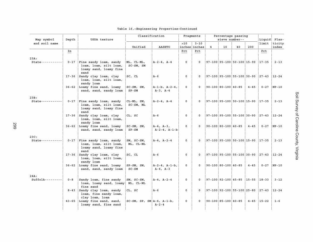
Soil S
urvey of Caroline C
ounty, Virginia
299
Table 16.—Engineering Properties—Continued______________________________________________________________________________________________________________________________________ | | | Classification | Fragments | Percentage passing | | Map symbol | Depth | USDA texture | | | sieve number-- |Liquid| Plas- _____________________________________________________________________ and soil name | | | | | >10 | 3-10 | | | | |limit |ticity | | | Unified | AASHTO |inches|inches| 4 | 10 | 40 | 200 | |index______________________________________________________________________________________________________________________________________ | In | | | | Pct | Pct | | | | | Pct | __ ___ ___ ___ | | | | | | | | | | | |23A: | | | | | | | | | | | | State-----------| 0-17 |Fine sandy loam, sandy |ML, CL-ML, |A-2-4, A-4 | 0 | 0 |97-100|95-100|50-100|15-90 |17-35 | 2-13 | | loam, loam, silt loam, | SC-SM, SM | | | | | | | | | | | loamy sand, loamy fine | | | | | | | | | | | | sand | | | | | | | | | | | 17-36 |Sandy clay loam, clay |SC, CL |A-6 | 0 | 0 |97-100|95-100|55-100|30-90 |27-43 |12-24 | | loam, loam, silt loam, | | | | | | | | | | | | sandy loam | | | | | | | | | | | 36-62 |Loamy fine sand, loamy |SC-SM, SM, |A-1-b, A-2-4,| 0 | 0 |90-100|80-100|40-85 | 4-45 | 0-27 |NP-10 | | sand, sand, sandy loam | SP-SM | A-3, A-4 | | | | | | | | | | | | | | | | | | | |23B: | | | | | | | | | | | | State-----------| 0-17 |Fine sandy loam, sandy |CL-ML, SM, |A-2-4, A-4 | 0 | 0 |97-100|95-100|50-100|15-90 |17-35 | 2-13 | | loam, loam, silt loam, | SC-SM, ML | | | | | | | | | | | loamy sand, loamy fine | | | | | | | | | | | | sand | | | | | | | | | | | 17-36 |Sandy clay loam, clay |CL, SC |A-6 | 0 | 0 |97-100|95-100|55-100|30-90 |27-43 |12-24 | | loam, loam, silt loam, | | | | | | | | | | | | sandy loam | | | | | | | | | | | 36-62 |Loamy fine sand, loamy |SC-SM, SM, |A-4, A-3, | 0 | 0 |90-100|80-100|40-85 | 4-45 | 0-27 |NP-10 | | sand, sand, sandy loam | SP-SM | A-2-4, A-1-b| | | | | | | | | | | | | | | | | | | |23C: | | | | | | | | | | | | State-----------| 0-17 |Fine sandy loam, sandy |SM, SC-SM, |A-4, A-2-4 | 0 | 0 |97-100|95-100|50-100|15-90 |17-35 | 2-13 | | loam, loam, silt loam, | ML, CL-ML | | | | | | | | | | | loamy sand, loamy fine | | | | | | | | | | | | sand | | | | | | | | | | | 17-36 |Sandy clay loam, clay |SC, CL |A-6 | 0 | 0 |97-100|95-100|55-100|30-90 |27-43 |12-24 | | loam, loam, silt loam, | | | | | | | | | | | | sandy loam | | | | | | | | | | | 36-62 |Loamy fine sand, loamy |SP-SM, SM, |A-2-4, A-1-b,| 0 | 0 |90-100|80-100|40-85 | 4-45 | 0-27 |NP-10 | | sand, sand, sandy loam | SC-SM | A-4, A-3 | | | | | | | | | | | | | | | | | | | |24A: | | | | | | | | | | | | Suffolk---------| 0-8 |Sandy loam, fine sandy |SM, SC-SM, |A-4, A-2-4 | 0 | 0 |97-100|92-100|45-85 |15-55 |18-33 | 3-12 | | loam, loamy sand, loamy| ML, CL-ML | | | | | | | | | | | fine sand | | | | | | | | | | | 8-43 |Sandy clay loam, sandy |CL, SC |A-6 | 0 | 0 |97-100|92-100|55-100|25-80 |27-43 |12-24 | | loam, fine sandy loam, | | | | | | | | | | | | clay loam, loam | | | | | | | | | | | 43-65 |Loamy fine sand, sand, |SC-SM, SP, SM|A-4, A-1-b, | 0 | 0 |90-100|85-100|40-85 | 4-45 |15-22 | 1-6 | | loamy sand, fine sand | | A-2-4 | | | | | | | | | | | | | | | | | | | |
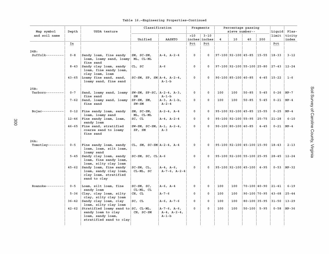
Soil S
urvey of Caroline C
ounty, Virginia
300
Table 16.—Engineering Properties—Continued______________________________________________________________________________________________________________________________________ | | | Classification | Fragments | Percentage passing | | Map symbol | Depth | USDA texture | | | sieve number-- |Liquid| Plas- _____________________________________________________________________ and soil name | | | | | >10 | 3-10 | | | | |limit |ticity | | | Unified | AASHTO |inches|inches| 4 | 10 | 40 | 200 | |index______________________________________________________________________________________________________________________________________ | In | | | | Pct | Pct | | | | | Pct | __ ___ ___ ___ | | | | | | | | | | | |24B: | | | | | | | | | | | | Suffolk---------| 0-8 |Sandy loam, fine sandy |SM, SC-SM, |A-4, A-2-4 | 0 | 0 |97-100|92-100|45-85 |15-55 |18-33 | 3-12 | | loam, loamy sand, loamy| ML, CL-ML | | | | | | | | | | | fine sand | | | | | | | | | | | 8-43 |Sandy clay loam, sandy |CL, SC |A-6 | 0 | 0 |97-100|92-100|55-100|25-80 |27-43 |12-24 | | loam, fine sandy loam, | | | | | | | | | | | | clay loam, loam | | | | | | | | | | | 43-65 |Loamy fine sand, sand, |SC-SM, SP, SM|A-4, A-2-4, | 0 | 0 |90-100|85-100|40-85 | 4-45 |15-22 | 1-6 | | loamy sand, fine sand | | A-1-b | | | | | | | | | | | | | | | | | | | |25B: | | | | | | | | | | | | Tarboro---------| 0-7 |Sand, loamy sand, loamy |SW-SM, SP-SC,|A-2-4, A-3, | 0 | 0 | 100 | 100 |50-85 | 5-45 | 0-26 |NP-7 | | fine sand | SM | A-1-b | | | | | | | | | 7-62 |Sand, loamy sand, loamy |SP-SM, SM, |A-3, A-1-b, | 0 | 0 | 100 | 100 |50-85 | 5-45 | 0-21 |NP-4 | | fine sand | SW-SM | A-2-4 | | | | | | | | | | | | | | | | | | | | Bojac-----------| 0-12 |Fine sandy loam, sandy |SM, SC-SM, |A-2-4, A-4 | 0 | 0 |95-100|92-100|45-85 |15-55 | 0-25 |NP-4 | | loam, loamy sand | ML, CL-ML | | | | | | | | | | 12-46 |Fine sandy loam, loam, |SC, CL |A-4, A-2-4 | 0 | 0 |95-100|92-100|55-95 |25-75 |21-28 | 6-10 | | sandy loam | | | | | | | | | | | 46-65 |Fine sand, stratified |SW-SM, SC-SM,|A-1, A-2-4, | 0 | 0 |90-100|80-100|40-85 | 4-45 | 0-21 |NP-4 | | coarse sand to loamy | SP, SM | A-3 | | | | | | | | | | fine sand | | | | | | | | | | | | | | | | | | | | | |26A: | | | | | | | | | | | | Tomotley--------| 0-5 |Fine sandy loam, sandy |CL, SM, SC-SM|A-2-4, A-4 | 0 | 0 |95-100|92-100|45-100|15-90 |18-43 | 2-13 | | loam, loam, silt loam, | | | | | | | | | | | | loamy sand | | | | | | | | | | | 5-45 |Sandy clay loam, sandy |SC-SM, SC, CL|A-6 | 0 | 0 |95-100|92-100|55-100|25-95 |28-45 |12-24 | | loam, fine sandy loam, | | | | | | | | | | | | loam, silty clay loam | | | | | | | | | | | 45-62 |Sandy loam, fine sandy |SC-SM, CL, |A-4, A-6, | 0 | 0 |95-100|92-100|45-100| 4-95 | 0-53 |NP-32 | | loam, sandy clay loam, | CL-ML, SC | A-7-6, A-2-4| | | | | | | | | | clay loam, stratified | | | | | | | | | | | | sand to clay | | | | | | | | | | | | | | | | | | | | | | Roanoke---------| 0-5 |Loam, silt loam, fine |SC-SM, SC, |A-6, A-4 | 0 | 0 | 100 | 100 |70-100|40-90 |21-41 | 6-19 | | sandy loam | CL-ML, CL | | | | | | | | | | 5-36 |Clay, clay loam, silty |CH, CL |A-7-6 | 0 | 0 | 100 | 100 |90-100|70-95 |43-68 |25-44 | | clay, silty clay loam | | | | | | | | | | | 36-42 |Sandy clay loam, clay |SC, CL |A-6, A-7-6 | 0 | 0 | 100 | 100 |80-100|35-95 |31-50 |13-29 | | loam, silty clay loam | | | | | | | | | | | 42-62 |Stratified loamy sand to|SC, CL-ML, |A-7-6, A-6, | 0 | 0 | 100 | 100 |50-100| 5-95 | 0-58 |NP-36 | | sandy loam to clay | CH, SC-SM | A-4, A-2-4, | | | | | | | | | | loam, sandy loam, | | A-1-b | | | | | | | | | | stratified sand to clay| | | | | | | | | | | | | | | | | | | | | |
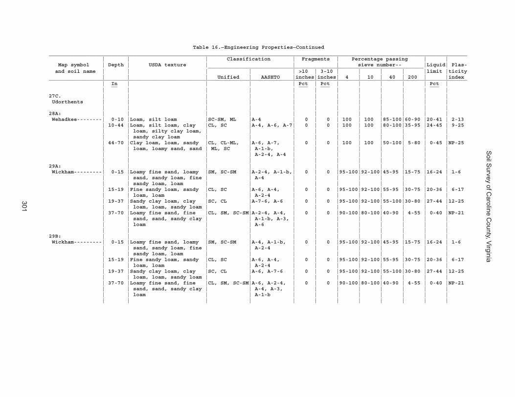
Soil S
urvey of Caroline C
ounty, Virginia
301
Table 16.—Engineering Properties—Continued______________________________________________________________________________________________________________________________________ | | | Classification | Fragments | Percentage passing | | Map symbol | Depth | USDA texture | | | sieve number-- |Liquid| Plas- _____________________________________________________________________ and soil name | | | | | >10 | 3-10 | | | | |limit |ticity | | | Unified | AASHTO |inches|inches| 4 | 10 | 40 | 200 | |index______________________________________________________________________________________________________________________________________ | In | | | | Pct | Pct | | | | | Pct | __ ___ ___ ___ | | | | | | | | | | | |27C. | | | | | | | | | | | | Udorthents | | | | | | | | | | | | | | | | | | | | | | | |28A: | | | | | | | | | | | | Wehadkee--------| 0-10 |Loam, silt loam |SC-SM, ML |A-4 | 0 | 0 | 100 | 100 |85-100|60-90 |20-41 | 2-13 | 10-44 |Loam, silt loam, clay |CL, SC |A-4, A-6, A-7| 0 | 0 | 100 | 100 |80-100|35-95 |24-45 | 9-25 | | loam, silty clay loam, | | | | | | | | | | | | sandy clay loam | | | | | | | | | | | 44-70 |Clay loam, loam, sandy |CL, CL-ML, |A-6, A-7, | 0 | 0 | 100 | 100 |50-100| 5-80 | 0-45 |NP-25 | | loam, loamy sand, sand | ML, SC | A-1-b, | | | | | | | | | | | | A-2-4, A-4 | | | | | | | | | | | | | | | | | | | |29A: | | | | | | | | | | | | Wickham---------| 0-15 |Loamy fine sand, loamy |SM, SC-SM |A-2-4, A-1-b,| 0 | 0 |95-100|92-100|45-95 |15-75 |16-24 | 1-6 | | sand, sandy loam, fine | | A-4 | | | | | | | | | | sandy loam, loam | | | | | | | | | | | 15-19 |Fine sandy loam, sandy |CL, SC |A-6, A-4, | 0 | 0 |95-100|92-100|55-95 |30-75 |20-36 | 6-17 | | loam, loam | | A-2-4 | | | | | | | | | 19-37 |Sandy clay loam, clay |SC, CL |A-7-6, A-6 | 0 | 0 |95-100|92-100|55-100|30-80 |27-44 |12-25 | | loam, loam, sandy loam | | | | | | | | | | | 37-70 |Loamy fine sand, fine |CL, SM, SC-SM|A-2-4, A-4, | 0 | 0 |90-100|80-100|40-90 | 4-55 | 0-40 |NP-21 | | sand, sand, sandy clay | | A-1-b, A-3, | | | | | | | | | | loam | | A-6 | | | | | | | | | | | | | | | | | | | |29B: | | | | | | | | | | | | Wickham---------| 0-15 |Loamy fine sand, loamy |SM, SC-SM |A-4, A-1-b, | 0 | 0 |95-100|92-100|45-95 |15-75 |16-24 | 1-6 | | sand, sandy loam, fine | | A-2-4 | | | | | | | | | | sandy loam, loam | | | | | | | | | | | 15-19 |Fine sandy loam, sandy |CL, SC |A-6, A-4, | 0 | 0 |95-100|92-100|55-95 |30-75 |20-36 | 6-17 | | loam, loam | | A-2-4 | | | | | | | | | 19-37 |Sandy clay loam, clay |SC, CL |A-6, A-7-6 | 0 | 0 |95-100|92-100|55-100|30-80 |27-44 |12-25 | | loam, loam, sandy loam | | | | | | | | | | | 37-70 |Loamy fine sand, fine |CL, SM, SC-SM|A-6, A-2-4, | 0 | 0 |90-100|80-100|40-90 | 4-55 | 0-40 |NP-21 | | sand, sand, sandy clay | | A-4, A-3, | | | | | | | | | | loam | | A-1-b | | | | | | | | | | | | | | | | | | | |
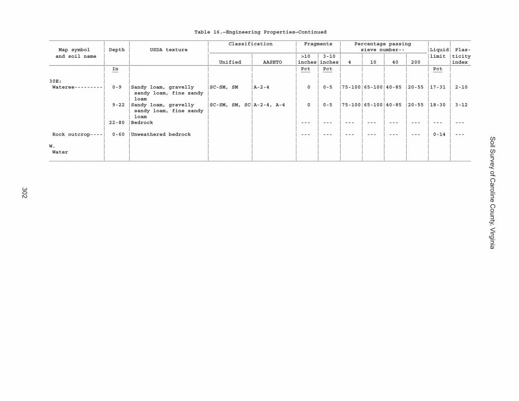
Soil S
urvey of Caroline C
ounty, Virginia
302
Table 16.—Engineering Properties—Continued______________________________________________________________________________________________________________________________________ | | | Classification | Fragments | Percentage passing | | Map symbol | Depth | USDA texture | | | sieve number-- |Liquid| Plas- _____________________________________________________________________ and soil name | | | | | >10 | 3-10 | | | | |limit |ticity | | | Unified | AASHTO |inches|inches| 4 | 10 | 40 | 200 | |index______________________________________________________________________________________________________________________________________ | In | | | | Pct | Pct | | | | | Pct | __ ___ ___ ___ | | | | | | | | | | | |30E: | | | | | | | | | | | | Wateree---------| 0-9 |Sandy loam, gravelly |SC-SM, SM |A-2-4 | 0 | 0-5 |75-100|65-100|40-85 |20-55 |17-31 | 2-10 | | sandy loam, fine sandy | | | | | | | | | | | | loam | | | | | | | | | | | 9-22 |Sandy loam, gravelly |SC-SM, SM, SC|A-2-4, A-4 | 0 | 0-5 |75-100|65-100|40-85 |20-55 |18-30 | 3-12 | | sandy loam, fine sandy | | | | | | | | | | | | loam | | | | | | | | | | | 22-80 |Bedrock | | | --- | --- | --- | --- | --- | --- | --- | --- | | | | | | | | | | | | Rock outcrop----| 0-60 |Unweathered bedrock | | | --- | --- | --- | --- | --- | --- | 0-14 | --- | | | | | | | | | | | |W. | | | | | | | | | | | | Water | | | | | | | | | | | | | | | | | | | | | | | |______________________________________________________________________________________________________________________________________

Soil S
urvey of Caroline C
ounty, Virginia
303
Table 17.—Physical Soil Properties
(Entries under "Erosion factors--T" apply to the entire profile. Entries under "Wind erodibility group" and "Wind erodibility index" apply only to the surface layer. Absence of an entry indicates that data were not estimated)
______________________________________________________________________________________________________________________________________ | | | | | | | | | |Erosion factors|Wind |Wind _______________ Map symbol | Depth | Sand | Silt | Clay | Moist | Saturated |Available| Linear | Organic | | | |erodi-|erodi- and soil name | | | | | bulk | hydraulic | water |extensi- | matter | Kw | Kf | T |bility|bility | | | | | density |conductivity|capacity | bility | | | | |group |index______________________________________________________________________________________________________________________________________ | In | Pct | Pct | Pct | g/cc | um/sec | In/in | Pct | Pct | | | | | __ ___ ___ ___ ____ ______ _____ ___ ___ | | | | | | | | | | | | | |1A: | | | | | | | | | | | | | | Altavista------------| 0-16 | 25-92| 1-45| 5-10|1.40-1.60|14.00-42.00 |0.07-0.12| 0.0-2.9 | 0.5-3.0 | .10 | .10 | 5 | 3 | 86 | 16-40 | 20-80| 5-45| 18-35|1.30-1.50| 4.00-14.00 |0.12-0.20| 0.0-2.9 | 0.0-0.5 | .15 | .15 | | | | 40-65 | 55-99| 0-30| 2-20|1.40-1.70| 4.00-141.00|0.05-0.15| 0.0-2.9 | 0.0-0.2 | .10 | .10 | | | | | | | | | | | | | | | | |1B: | | | | | | | | | | | | | | Altavista------------| 0-16 | 25-92| 1-45| 5-10|1.40-1.60|14.00-42.00 |0.07-0.12| 0.0-2.9 | 0.5-3.0 | .10 | .10 | 5 | 3 | 86 | 16-40 | 20-80| 5-45| 18-35|1.30-1.50| 4.00-14.00 |0.12-0.20| 0.0-2.9 | 0.0-0.5 | .15 | .15 | | | | 40-65 | 55-99| 0-30| 2-20|1.40-1.70| 4.00-141.00|0.05-0.15| 0.0-2.9 | 0.0-0.2 | .10 | .10 | | | | | | | | | | | | | | | | |2B: | | | | | | | | | | | | | | Appling--------------| 0-10 | 44-85| 5-49| 5-20|1.40-1.65| 4.00-42.00 |0.10-0.15| 0.0-2.9 | 0.5-2.0 | .24 | .28 | 4 | 3 | 86 | 10-42 | 5-65| 5-45| 35-60|1.25-1.45| 4.00-14.00 |0.15-0.17| 0.0-2.9 | 0.0-0.5 | .28 | .28 | | | | 42-60 | 20-80| 5-45| 20-50|1.25-1.45| 4.00-14.00 |0.12-0.16| 0.0-2.9 | 0.0-0.5 | .28 | .28 | | | | 60-72 | 44-90| 5-49| 0-40|1.30-1.60| 4.00-141.00|0.05-0.16| 0.0-2.9 | 0.0-0.5 | .10 | .24 | | | | | | | | | | | | | | | | |2C: | | | | | | | | | | | | | | Appling--------------| 0-10 | 44-85| 5-49| 5-20|1.40-1.65| 4.00-42.00 |0.10-0.15| 0.0-2.9 | 0.5-2.0 | .24 | .28 | 4 | 3 | 86 | 10-42 | 5-65| 5-45| 35-60|1.25-1.45| 4.00-14.00 |0.15-0.17| 0.0-2.9 | 0.0-0.5 | .28 | .28 | | | | 42-60 | 20-80| 5-45| 20-50|1.25-1.45| 4.00-14.00 |0.12-0.16| 0.0-2.9 | 0.0-0.5 | .28 | .28 | | | | 60-72 | 44-90| 5-49| 0-40|1.30-1.60| 4.00-141.00|0.05-0.16| 0.0-2.9 | 0.0-0.5 | .10 | .24 | | | | | | | | | | | | | | | | |3A: | | | | | | | | | | | | | | Bama-----------------| 0-13 | 30-80| 5-45| 7-22|1.30-1.60| 4.00-42.00 |0.08-0.15| 0.0-2.9 | 0.5-1.0 | .24 | .24 | 5 | 3 | 86 | 13-26 | 30-75| 5-45| 18-32|1.40-1.55| 4.00-14.00 |0.12-0.18| 0.0-2.9 | 0.0-0.5 | .32 | .32 | | | | 26-70 | 30-75| 5-45| 15-35|1.40-1.60| 4.00-14.00 |0.12-0.18| 0.0-2.9 | 0.0-0.2 | .15 | .15 | | | | | | | | | | | | | | | | |3B: | | | | | | | | | | | | | | Bama-----------------| 0-13 | 30-80| 5-45| 7-22|1.30-1.60| 4.00-42.00 |0.08-0.15| 0.0-2.9 | 0.5-1.0 | .24 | .24 | 5 | 3 | 86 | 13-26 | 30-75| 5-45| 18-32|1.40-1.55| 4.00-14.00 |0.12-0.18| 0.0-2.9 | 0.0-0.5 | .32 | .32 | | | | 26-70 | 30-75| 5-45| 15-35|1.40-1.60| 4.00-14.00 |0.12-0.18| 0.0-2.9 | 0.0-0.2 | .15 | .15 | | | | | | | | | | | | | | | | |4A: | | | | | | | | | | | | | | Bibb-----------------| 0-15 | 20-98| 1-75| 2-15|1.50-1.75|42.00-141.00|0.06-0.10| 0.0-2.9 | 0.5-4.0 | .10 | .10 | 5 | 3 | 86 | 15-42 | 20-98| 1-75| 8-18|1.45-1.70| 4.00-14.00 |0.10-0.20| 0.0-2.9 | 0.5-2.0 | .20 | .20 | | | | 42-65 | 20-98| 1-75| 2-18|1.45-1.75| 4.00-141.00|0.04-0.20| 0.0-2.9 | 0.5-3.0 | .10 | .10 | | | | | | | | | | | | | | | | | Chastain-------------| 0-13 | 24-52| 28-50| 15-35|1.20-1.40| 1.40-4.00 |0.12-0.18| 0.0-2.9 | 1.0-6.0 | .32 | .32 | 4 | 5 | 56 | 13-36 | 5-45| 15-65| 35-60|1.30-1.50| 0.42-1.40 |0.12-0.16| 0.0-2.9 | 1.0-3.0 | .37 | .37 | | | | 36-80 | 70-95| 0-29| 2-10|1.50-1.70|42.00-141.00|0.03-0.06| 0.0-2.9 | 1.0-3.0 | .10 | .10 | | | | | | | | | | | | | | | | |

Soil S
urvey of Caroline C
ounty, Virginia
304
Table 17.—Physical Soil Properties—Continued______________________________________________________________________________________________________________________________________ | | | | | | | | | |Erosion factors|Wind |Wind _______________ Map symbol | Depth | Sand | Silt | Clay | Moist | Saturated |Available| Linear | Organic | | | |erodi-|erodi- and soil name | | | | | bulk | hydraulic | water |extensi- | matter | Kw | Kf | T |bility|bility | | | | | density |conductivity|capacity | bility | | | | |group |index______________________________________________________________________________________________________________________________________ | In | Pct | Pct | Pct | g/cc | um/sec | In/in | Pct | Pct | | | | | __ ___ ___ ___ ____ ______ _____ ___ ___ | | | | | | | | | | | | | |5B: | | | | | | | | | | | | | | Bojac----------------| 0-12 | 50-88| 0-45| 3-8 |1.20-1.50|14.00-42.00 |0.08-0.16| 0.0-2.9 | 0.5-2.0 | .28 | .28 | 4 | 3 | 86 | 12-46 | 35-80| 5-45| 11-16|1.35-1.55|14.00-42.00 |0.08-0.16| 0.0-2.9 | 0.0-0.5 | .32 | .32 | | | | 46-65 | 75-99| 0-25| 1-8 |1.30-1.50|42.00-141.00|0.02-0.07| 0.0-2.9 | 0.0-0.2 | .20 | .20 | | | | | | | | | | | | | | | | |6B: | | | | | | | | | | | | | | Cecil----------------| 0-9 | 44-85| 5-49| 5-20|1.30-1.50|14.00-42.00 |0.12-0.14| 0.0-2.9 | 0.5-1.0 | .28 | .28 | 4 | 3 | 86 | 9-14 | 20-80| 5-45| 20-35|1.30-1.50| 4.00-14.00 |0.13-0.15| 0.0-2.9 | 0.0-0.5 | .28 | .28 | | | | 14-63 | 5-45| 5-45| 35-70|1.30-1.50| 4.00-14.00 |0.13-0.15| 0.0-2.9 | 0.0-0.5 | .28 | .28 | | | | 63-83 | 20-95| 5-50| 2-35|1.30-1.60| 4.00-141.00|0.05-0.16| 0.0-2.9 | 0.0-0.5 | .10 | .24 | | | | | | | | | | | | | | | | |7A: | | | | | | | | | | | | | | Chastain-------------| 0-13 | 24-52| 28-50| 15-35|1.20-1.40| 1.40-4.00 |0.12-0.18| 0.0-2.9 | 1.0-6.0 | .32 | .32 | 4 | 5 | 56 | 13-36 | 5-45| 15-65| 35-60|1.30-1.50| 0.42-1.40 |0.12-0.16| 0.0-2.9 | 1.0-3.0 | .37 | .37 | | | | 36-80 | 70-95| 0-29| 2-10|1.50-1.70|42.00-141.00|0.03-0.06| 0.0-2.9 | 1.0-3.0 | .10 | .10 | | | | | | | | | | | | | | | | |8A: | | | | | | | | | | | | | | Chewacla-------------| 0-5 | 5-85| 5-87| 10-27|1.30-1.60| 4.00-14.00 |0.15-0.24| 0.0-2.9 | 1.0-4.0 | .37 | .37 | 5 | 5 | 56 | 5-13 | 15-45| 15-80| 18-35|1.30-1.50| 4.00-14.00 |0.15-0.24| 0.0-2.9 | 0.5-2.0 | .32 | .32 | | | | 13-40 | 24-82| 5-50| 18-35|1.30-1.60| 4.00-14.00 |0.12-0.20| 0.0-2.9 | 0.5-2.0 | .28 | .28 | | | | 40-60 | 5-95| 5-39| 0-60|1.25-1.60| 1.40-141.00|0.05-0.20| 0.0-2.9 | 0.0-0.5 | .20 | .20 | | | | | | | | | | | | | | | | |9C: | | | | | | | | | | | | | | Helena---------------| 0-8 | 45-85| 5-50| 5-20|1.58-1.62|14.00-42.00 |0.10-0.12| 0.0-2.5 | 0.5-2.0 | .24 | .24 | 4 | 5 | 56 | 8-15 | 45-85| 5-50| 10-35|1.20-1.50| 4.00-14.00 |0.08-0.15| 0.0-2.9 | 0.0-0.2 | .28 | .28 | | | | 15-50 | 5-65| 5-52| 30-60|1.44-1.55| 0.42-1.40 |0.13-0.15| 6.0-8.9 | 0.0-0.5 | .28 | .28 | | | | 50-60 | 24-85| 5-52| 10-39|1.20-1.50| 4.00-14.00 |0.08-0.15| 0.0-2.9 | 0.0-0.5 | .28 | .28 | | | | | | | | | | | | | | | | | Appling--------------| 0-10 | 44-85| 5-49| 5-20|1.40-1.65| 4.00-42.00 |0.10-0.15| 0.0-2.9 | 0.5-2.0 | .24 | .28 | 4 | 3 | 86 | 10-42 | 5-65| 5-45| 35-60|1.25-1.45| 4.00-14.00 |0.15-0.17| 0.0-2.9 | 0.0-0.5 | .28 | .28 | | | | 42-60 | 20-80| 5-45| 20-50|1.25-1.45| 4.00-14.00 |0.12-0.16| 0.0-2.9 | 0.0-0.5 | .28 | .28 | | | | 60-72 | 44-90| 5-49| 0-40|1.30-1.60| 4.00-141.00|0.05-0.16| 0.0-2.9 | 0.0-0.5 | .10 | .24 | | | | | | | | | | | | | | | | |10E: | | | | | | | | | | | | | | Kempsville-----------| 0-19 | 45-90| 5-50| 5-15|1.30-1.40|14.00-42.00 |0.08-0.14| 0.0-2.9 | 0.5-2.0 | .24 | .24 | 5 | 3 | 86 | 19-37 | 20-82| 5-50| 18-34|1.30-1.45| 4.00-14.00 |0.12-0.18| 0.0-2.9 | 0.5-1.0 | .24 | .24 | | | | 37-65 | 45-80| 4-27| 20-45|1.35-1.65| 1.40-14.00 |0.12-0.18| 0.0-2.9 | 0.0-0.5 | .24 | .24 | | | | 65-150| 45-91| 5-29| 5-30|1.30-1.60| 4.00-142.00|0.08-0.15| 0.0-2.9 | 0.0-0.5 | .24 | .24 | | | | | | | | | | | | | | | | | Emporia--------------| 0-12 | 25-90| 0-45| 7-18|1.30-1.40|14.00-42.00 |0.10-0.17| 0.0-2.9 | 0.5-2.0 | .24 | .24 | 5 | 3 | 86 | 12-42 | 25-80| 5-45| 18-35|1.35-1.45| 4.00-14.00 |0.10-0.18| 0.0-2.9 | 0.0-0.5 | .32 | .32 | | | | 42-62 | 10-80| 5-45| 10-50|1.45-1.60| 0.10-14.00 |0.08-0.18| 3.0-5.9 | 0.0-0.2 | .15 | .15 | | | | | | | | | | | | | | | | | Remlik---------------| 0-22 | 72-99| 0-20| 0-10|1.20-1.50|42.00-141.00|0.04-0.08| 0.0-2.9 | 0.5-1.0 | .10 | .10 | 5 | 2 | 134 | 22-38 | 45-82| 5-30| 8-30|1.20-1.35| 4.00-14.00 |0.10-0.17| 0.0-2.9 | 0.0-0.5 | .15 | .15 | | | | 38-70 | 45-82| 5-30| 4-20|1.25-1.40| 4.00-42.00 |0.04-0.16| 0.0-2.9 | 0.0-0.2 | .24 | .24 | | | | | | | | | | | | | | | | |

Soil S
urvey of Caroline C
ounty, Virginia
305
Table 17.—Physical Soil Properties—Continued______________________________________________________________________________________________________________________________________ | | | | | | | | | |Erosion factors|Wind |Wind _______________ Map symbol | Depth | Sand | Silt | Clay | Moist | Saturated |Available| Linear | Organic | | | |erodi-|erodi- and soil name | | | | | bulk | hydraulic | water |extensi- | matter | Kw | Kf | T |bility|bility | | | | | density |conductivity|capacity | bility | | | | |group |index______________________________________________________________________________________________________________________________________ | In | Pct | Pct | Pct | g/cc | um/sec | In/in | Pct | Pct | | | | | __ ___ ___ ___ ____ ______ _____ ___ ___ | | | | | | | | | | | | | |11A: | | | | | | | | | | | | | | Kempsville-----------| 0-19 | 45-90| 5-50| 5-15|1.30-1.40|14.00-42.00 |0.08-0.14| 0.0-2.9 | 0.5-2.0 | .24 | .24 | 5 | 3 | 86 | 19-37 | 20-82| 5-50| 18-34|1.30-1.45| 4.00-14.00 |0.12-0.18| 0.0-2.9 | 0.5-1.0 | .24 | .24 | | | | 37-65 | 45-80| 4-27| 20-45|1.35-1.65| 1.40-14.00 |0.12-0.18| 0.0-2.9 | 0.0-0.5 | .24 | .24 | | | | 65-150| 45-91| 5-29| 5-30|1.30-1.60| 4.00-142.00|0.08-0.15| 0.0-2.9 | 0.0-0.5 | .24 | .24 | | | | | | | | | | | | | | | | | Emporia--------------| 0-12 | 25-90| 0-45| 7-18|1.30-1.40|14.00-42.00 |0.10-0.17| 0.0-2.9 | 0.5-2.0 | .24 | .24 | 5 | 3 | 86 | 12-42 | 25-80| 5-45| 18-35|1.35-1.45| 4.00-14.00 |0.10-0.18| 0.0-2.9 | 0.0-0.5 | .32 | .32 | | | | 42-62 | 10-80| 5-45| 10-50|1.45-1.60| 0.10-14.00 |0.08-0.18| 3.0-5.9 | 0.0-0.2 | .15 | .15 | | | | | | | | | | | | | | | | |11B: | | | | | | | | | | | | | | Kempsville-----------| 0-19 | 45-90| 5-50| 5-15|1.30-1.40|14.00-42.00 |0.08-0.14| 0.0-2.9 | 0.5-2.0 | .24 | .24 | 5 | 3 | 86 | 19-37 | 20-82| 5-50| 18-34|1.30-1.45| 4.00-14.00 |0.12-0.18| 0.0-2.9 | 0.5-1.0 | .24 | .24 | | | | 37-65 | 45-80| 4-27| 20-45|1.35-1.65| 1.40-14.00 |0.12-0.18| 0.0-2.9 | 0.0-0.5 | .24 | .24 | | | | 65-150| 45-91| 5-29| 5-30|1.30-1.60| 4.00-142.00|0.08-0.15| 0.0-2.9 | 0.0-0.5 | .24 | .24 | | | | | | | | | | | | | | | | | Emporia--------------| 0-12 | 25-90| 0-45| 7-18|1.30-1.40|14.00-42.00 |0.10-0.17| 0.0-2.9 | 0.5-2.0 | .24 | .24 | 5 | 3 | 86 | 12-42 | 25-80| 5-45| 18-35|1.35-1.45| 4.00-14.00 |0.10-0.18| 0.0-2.9 | 0.0-0.5 | .32 | .32 | | | | 42-62 | 10-80| 5-45| 10-50|1.45-1.60| 0.10-14.00 |0.08-0.18| 3.0-5.9 | 0.0-0.2 | .15 | .15 | | | | | | | | | | | | | | | | |11C: | | | | | | | | | | | | | | Kempsville-----------| 0-19 | 45-90| 5-50| 5-15|1.30-1.40|14.00-42.00 |0.08-0.14| 0.0-2.9 | 0.5-2.0 | .24 | .24 | 5 | 3 | 86 | 19-37 | 20-82| 5-50| 18-34|1.30-1.45| 4.00-14.00 |0.12-0.18| 0.0-2.9 | 0.5-1.0 | .24 | .24 | | | | 37-65 | 45-80| 4-27| 20-45|1.35-1.65| 1.40-14.00 |0.12-0.18| 0.0-2.9 | 0.0-0.5 | .24 | .24 | | | | 65-150| 45-91| 5-29| 5-30|1.30-1.60| 4.00-142.00|0.08-0.15| 0.0-2.9 | 0.0-0.5 | .24 | .24 | | | | | | | | | | | | | | | | | Emporia--------------| 0-12 | 25-90| 0-45| 7-18|1.30-1.40|14.00-42.00 |0.10-0.17| 0.0-2.9 | 0.5-2.0 | .24 | .24 | 5 | 3 | 86 | 12-42 | 25-80| 5-45| 18-35|1.35-1.45| 4.00-14.00 |0.10-0.18| 0.0-2.9 | 0.0-0.5 | .32 | .32 | | | | 42-62 | 10-80| 5-45| 10-50|1.45-1.60| 0.10-14.00 |0.08-0.18| 3.0-5.9 | 0.0-0.2 | .15 | .15 | | | | | | | | | | | | | | | | |12A: | | | | | | | | | | | | | | Myatt----------------| 0-7 | 30-88| 1-45| 8-25|1.30-1.60| 4.00-14.00 |0.16-0.24| 0.0-2.9 | 0.5-4.0 | .24 | .24 | 5 | 5 | 56 | 7-15 | 30-88| 1-45| 8-25|1.30-1.65| 4.00-14.00 |0.16-0.24| 0.0-2.9 | 0.2-2.0 | .28 | .28 | | | | 15-40 | 25-80| 20-45| 18-35|1.30-1.50| 1.40-14.00 |0.12-0.20| 0.0-2.9 | 0.0-1.0 | .15 | .15 | | | | 40-65 | 25-99| 0-45| 2-30|1.30-1.50| 1.40-14.00 |0.02-0.20| 0.0-2.9 | 0.0-0.5 | .05 | .10 | | | | | | | | | | | | | | | | | Slagle---------------| 0-13 | 24-82| 5-50| 8-18|1.30-1.45|14.00-42.00 |0.10-0.14| 0.0-2.9 | 0.5-2.0 | .28 | .28 | 5 | 3 | 86 | 13-40 | 20-82| 5-50| 12-35|1.30-1.45| 4.00-14.00 |0.10-0.18| 0.0-2.9 | 0.0-0.5 | .24 | .24 | | | | 40-51 | 5-82| 5-50| 18-40|1.35-1.60| 0.42-4.00 |0.12-0.18| 3.0-5.9 | 0.0-0.5 | .24 | .24 | | | | 51-65 | 5-91| 5-39| 5-40|1.35-1.50| 1.40-42.00 |0.08-0.15| 0.0-2.9 | 0.0-0.5 | .24 | .24 | | | | | | | | | | | | | | | | |13E: | | | | | | | | | | | | | | Nevarc---------------| 0-6 | 15-80| 5-75| 8-18|1.30-1.50|14.00-42.00 |0.08-0.18| 0.0-2.9 | 0.5-2.0 | .24 | .24 | 5 | 3 | 86 | 6-40 | 5-75| 15-65| 32-55|1.30-1.50| 0.42-1.40 |0.10-0.17| 3.0-5.9 | 0.0-0.5 | .20 | .20 | | | | 40-60 | 15-99| 0-35| 2-50|1.30-1.55| 0.42-141.00|0.04-0.12| 0.0-2.9 | 0.0-0.2 | .20 | .20 | | | | | | | | | | | | | | | | |
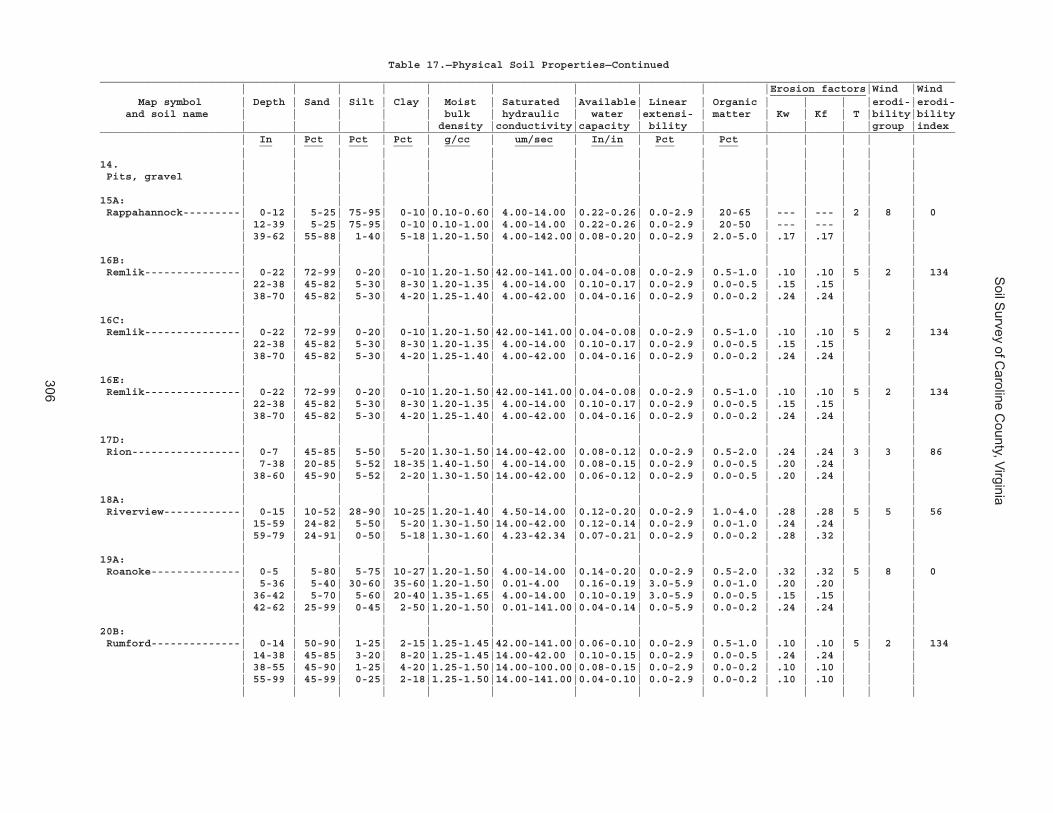
Soil S
urvey of Caroline C
ounty, Virginia
306
Table 17.—Physical Soil Properties—Continued______________________________________________________________________________________________________________________________________ | | | | | | | | | |Erosion factors|Wind |Wind _______________ Map symbol | Depth | Sand | Silt | Clay | Moist | Saturated |Available| Linear | Organic | | | |erodi-|erodi- and soil name | | | | | bulk | hydraulic | water |extensi- | matter | Kw | Kf | T |bility|bility | | | | | density |conductivity|capacity | bility | | | | |group |index______________________________________________________________________________________________________________________________________ | In | Pct | Pct | Pct | g/cc | um/sec | In/in | Pct | Pct | | | | | __ ___ ___ ___ ____ ______ _____ ___ ___ | | | | | | | | | | | | | |14. | | | | | | | | | | | | | | Pits, gravel | | | | | | | | | | | | | | | | | | | | | | | | | | | |15A: | | | | | | | | | | | | | | Rappahannock---------| 0-12 | 5-25| 75-95| 0-10|0.10-0.60| 4.00-14.00 |0.22-0.26| 0.0-2.9 | 20-65 | --- | --- | 2 | 8 | 0 | 12-39 | 5-25| 75-95| 0-10|0.10-1.00| 4.00-14.00 |0.22-0.26| 0.0-2.9 | 20-50 | --- | --- | | | | 39-62 | 55-88| 1-40| 5-18|1.20-1.50| 4.00-142.00|0.08-0.20| 0.0-2.9 | 2.0-5.0 | .17 | .17 | | | | | | | | | | | | | | | | |16B: | | | | | | | | | | | | | | Remlik---------------| 0-22 | 72-99| 0-20| 0-10|1.20-1.50|42.00-141.00|0.04-0.08| 0.0-2.9 | 0.5-1.0 | .10 | .10 | 5 | 2 | 134 | 22-38 | 45-82| 5-30| 8-30|1.20-1.35| 4.00-14.00 |0.10-0.17| 0.0-2.9 | 0.0-0.5 | .15 | .15 | | | | 38-70 | 45-82| 5-30| 4-20|1.25-1.40| 4.00-42.00 |0.04-0.16| 0.0-2.9 | 0.0-0.2 | .24 | .24 | | | | | | | | | | | | | | | | |16C: | | | | | | | | | | | | | | Remlik---------------| 0-22 | 72-99| 0-20| 0-10|1.20-1.50|42.00-141.00|0.04-0.08| 0.0-2.9 | 0.5-1.0 | .10 | .10 | 5 | 2 | 134 | 22-38 | 45-82| 5-30| 8-30|1.20-1.35| 4.00-14.00 |0.10-0.17| 0.0-2.9 | 0.0-0.5 | .15 | .15 | | | | 38-70 | 45-82| 5-30| 4-20|1.25-1.40| 4.00-42.00 |0.04-0.16| 0.0-2.9 | 0.0-0.2 | .24 | .24 | | | | | | | | | | | | | | | | |16E: | | | | | | | | | | | | | | Remlik---------------| 0-22 | 72-99| 0-20| 0-10|1.20-1.50|42.00-141.00|0.04-0.08| 0.0-2.9 | 0.5-1.0 | .10 | .10 | 5 | 2 | 134 | 22-38 | 45-82| 5-30| 8-30|1.20-1.35| 4.00-14.00 |0.10-0.17| 0.0-2.9 | 0.0-0.5 | .15 | .15 | | | | 38-70 | 45-82| 5-30| 4-20|1.25-1.40| 4.00-42.00 |0.04-0.16| 0.0-2.9 | 0.0-0.2 | .24 | .24 | | | | | | | | | | | | | | | | |17D: | | | | | | | | | | | | | | Rion-----------------| 0-7 | 45-85| 5-50| 5-20|1.30-1.50|14.00-42.00 |0.08-0.12| 0.0-2.9 | 0.5-2.0 | .24 | .24 | 3 | 3 | 86 | 7-38 | 20-85| 5-52| 18-35|1.40-1.50| 4.00-14.00 |0.08-0.15| 0.0-2.9 | 0.0-0.5 | .20 | .24 | | | | 38-60 | 45-90| 5-52| 2-20|1.30-1.50|14.00-42.00 |0.06-0.12| 0.0-2.9 | 0.0-0.5 | .20 | .24 | | | | | | | | | | | | | | | | |18A: | | | | | | | | | | | | | | Riverview------------| 0-15 | 10-52| 28-90| 10-25|1.20-1.40| 4.50-14.00 |0.12-0.20| 0.0-2.9 | 1.0-4.0 | .28 | .28 | 5 | 5 | 56 | 15-59 | 24-82| 5-50| 5-20|1.30-1.50|14.00-42.00 |0.12-0.14| 0.0-2.9 | 0.0-1.0 | .24 | .24 | | | | 59-79 | 24-91| 0-50| 5-18|1.30-1.60| 4.23-42.34 |0.07-0.21| 0.0-2.9 | 0.0-0.2 | .28 | .32 | | | | | | | | | | | | | | | | |19A: | | | | | | | | | | | | | | Roanoke--------------| 0-5 | 5-80| 5-75| 10-27|1.20-1.50| 4.00-14.00 |0.14-0.20| 0.0-2.9 | 0.5-2.0 | .32 | .32 | 5 | 8 | 0 | 5-36 | 5-40| 30-60| 35-60|1.20-1.50| 0.01-4.00 |0.16-0.19| 3.0-5.9 | 0.0-1.0 | .20 | .20 | | | | 36-42 | 5-70| 5-60| 20-40|1.35-1.65| 4.00-14.00 |0.10-0.19| 3.0-5.9 | 0.0-0.5 | .15 | .15 | | | | 42-62 | 25-99| 0-45| 2-50|1.20-1.50| 0.01-141.00|0.04-0.14| 0.0-5.9 | 0.0-0.2 | .24 | .24 | | | | | | | | | | | | | | | | |20B: | | | | | | | | | | | | | | Rumford--------------| 0-14 | 50-90| 1-25| 2-15|1.25-1.45|42.00-141.00|0.06-0.10| 0.0-2.9 | 0.5-1.0 | .10 | .10 | 5 | 2 | 134 | 14-38 | 45-85| 3-20| 8-20|1.25-1.45|14.00-42.00 |0.10-0.15| 0.0-2.9 | 0.0-0.5 | .24 | .24 | | | | 38-55 | 45-90| 1-25| 4-20|1.25-1.50|14.00-100.00|0.08-0.15| 0.0-2.9 | 0.0-0.2 | .10 | .10 | | | | 55-99 | 45-99| 0-25| 2-18|1.25-1.50|14.00-141.00|0.04-0.10| 0.0-2.9 | 0.0-0.2 | .10 | .10 | | | | | | | | | | | | | | | | |
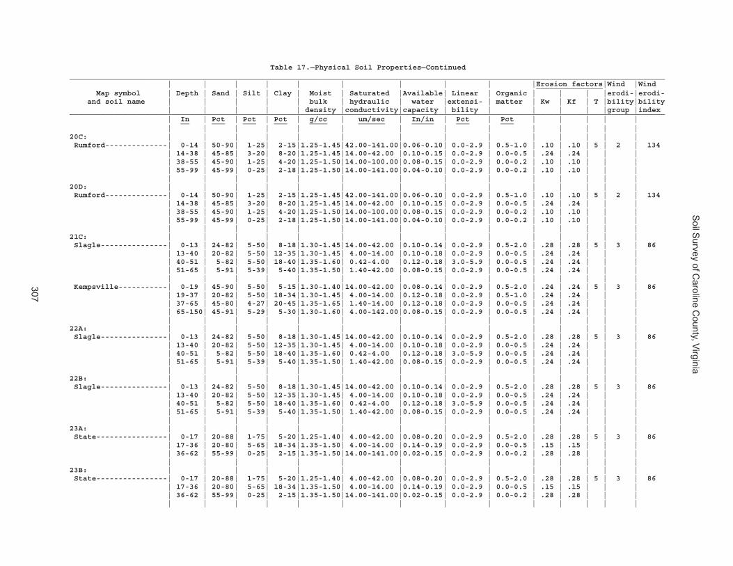
Soil S
urvey of Caroline C
ounty, Virginia
307
Table 17.—Physical Soil Properties—Continued______________________________________________________________________________________________________________________________________ | | | | | | | | | |Erosion factors|Wind |Wind _______________ Map symbol | Depth | Sand | Silt | Clay | Moist | Saturated |Available| Linear | Organic | | | |erodi-|erodi- and soil name | | | | | bulk | hydraulic | water |extensi- | matter | Kw | Kf | T |bility|bility | | | | | density |conductivity|capacity | bility | | | | |group |index______________________________________________________________________________________________________________________________________ | In | Pct | Pct | Pct | g/cc | um/sec | In/in | Pct | Pct | | | | | __ ___ ___ ___ ____ ______ _____ ___ ___ | | | | | | | | | | | | | |20C: | | | | | | | | | | | | | | Rumford--------------| 0-14 | 50-90| 1-25| 2-15|1.25-1.45|42.00-141.00|0.06-0.10| 0.0-2.9 | 0.5-1.0 | .10 | .10 | 5 | 2 | 134 | 14-38 | 45-85| 3-20| 8-20|1.25-1.45|14.00-42.00 |0.10-0.15| 0.0-2.9 | 0.0-0.5 | .24 | .24 | | | | 38-55 | 45-90| 1-25| 4-20|1.25-1.50|14.00-100.00|0.08-0.15| 0.0-2.9 | 0.0-0.2 | .10 | .10 | | | | 55-99 | 45-99| 0-25| 2-18|1.25-1.50|14.00-141.00|0.04-0.10| 0.0-2.9 | 0.0-0.2 | .10 | .10 | | | | | | | | | | | | | | | | |20D: | | | | | | | | | | | | | | Rumford--------------| 0-14 | 50-90| 1-25| 2-15|1.25-1.45|42.00-141.00|0.06-0.10| 0.0-2.9 | 0.5-1.0 | .10 | .10 | 5 | 2 | 134 | 14-38 | 45-85| 3-20| 8-20|1.25-1.45|14.00-42.00 |0.10-0.15| 0.0-2.9 | 0.0-0.5 | .24 | .24 | | | | 38-55 | 45-90| 1-25| 4-20|1.25-1.50|14.00-100.00|0.08-0.15| 0.0-2.9 | 0.0-0.2 | .10 | .10 | | | | 55-99 | 45-99| 0-25| 2-18|1.25-1.50|14.00-141.00|0.04-0.10| 0.0-2.9 | 0.0-0.2 | .10 | .10 | | | | | | | | | | | | | | | | |21C: | | | | | | | | | | | | | | Slagle---------------| 0-13 | 24-82| 5-50| 8-18|1.30-1.45|14.00-42.00 |0.10-0.14| 0.0-2.9 | 0.5-2.0 | .28 | .28 | 5 | 3 | 86 | 13-40 | 20-82| 5-50| 12-35|1.30-1.45| 4.00-14.00 |0.10-0.18| 0.0-2.9 | 0.0-0.5 | .24 | .24 | | | | 40-51 | 5-82| 5-50| 18-40|1.35-1.60| 0.42-4.00 |0.12-0.18| 3.0-5.9 | 0.0-0.5 | .24 | .24 | | | | 51-65 | 5-91| 5-39| 5-40|1.35-1.50| 1.40-42.00 |0.08-0.15| 0.0-2.9 | 0.0-0.5 | .24 | .24 | | | | | | | | | | | | | | | | | Kempsville-----------| 0-19 | 45-90| 5-50| 5-15|1.30-1.40|14.00-42.00 |0.08-0.14| 0.0-2.9 | 0.5-2.0 | .24 | .24 | 5 | 3 | 86 | 19-37 | 20-82| 5-50| 18-34|1.30-1.45| 4.00-14.00 |0.12-0.18| 0.0-2.9 | 0.5-1.0 | .24 | .24 | | | | 37-65 | 45-80| 4-27| 20-45|1.35-1.65| 1.40-14.00 |0.12-0.18| 0.0-2.9 | 0.0-0.5 | .24 | .24 | | | | 65-150| 45-91| 5-29| 5-30|1.30-1.60| 4.00-142.00|0.08-0.15| 0.0-2.9 | 0.0-0.5 | .24 | .24 | | | | | | | | | | | | | | | | |22A: | | | | | | | | | | | | | | Slagle---------------| 0-13 | 24-82| 5-50| 8-18|1.30-1.45|14.00-42.00 |0.10-0.14| 0.0-2.9 | 0.5-2.0 | .28 | .28 | 5 | 3 | 86 | 13-40 | 20-82| 5-50| 12-35|1.30-1.45| 4.00-14.00 |0.10-0.18| 0.0-2.9 | 0.0-0.5 | .24 | .24 | | | | 40-51 | 5-82| 5-50| 18-40|1.35-1.60| 0.42-4.00 |0.12-0.18| 3.0-5.9 | 0.0-0.5 | .24 | .24 | | | | 51-65 | 5-91| 5-39| 5-40|1.35-1.50| 1.40-42.00 |0.08-0.15| 0.0-2.9 | 0.0-0.5 | .24 | .24 | | | | | | | | | | | | | | | | |22B: | | | | | | | | | | | | | | Slagle---------------| 0-13 | 24-82| 5-50| 8-18|1.30-1.45|14.00-42.00 |0.10-0.14| 0.0-2.9 | 0.5-2.0 | .28 | .28 | 5 | 3 | 86 | 13-40 | 20-82| 5-50| 12-35|1.30-1.45| 4.00-14.00 |0.10-0.18| 0.0-2.9 | 0.0-0.5 | .24 | .24 | | | | 40-51 | 5-82| 5-50| 18-40|1.35-1.60| 0.42-4.00 |0.12-0.18| 3.0-5.9 | 0.0-0.5 | .24 | .24 | | | | 51-65 | 5-91| 5-39| 5-40|1.35-1.50| 1.40-42.00 |0.08-0.15| 0.0-2.9 | 0.0-0.5 | .24 | .24 | | | | | | | | | | | | | | | | |23A: | | | | | | | | | | | | | | State----------------| 0-17 | 20-88| 1-75| 5-20|1.25-1.40| 4.00-42.00 |0.08-0.20| 0.0-2.9 | 0.5-2.0 | .28 | .28 | 5 | 3 | 86 | 17-36 | 20-80| 5-65| 18-34|1.35-1.50| 4.00-14.00 |0.14-0.19| 0.0-2.9 | 0.0-0.5 | .15 | .15 | | | | 36-62 | 55-99| 0-25| 2-15|1.35-1.50|14.00-141.00|0.02-0.15| 0.0-2.9 | 0.0-0.2 | .28 | .28 | | | | | | | | | | | | | | | | |23B: | | | | | | | | | | | | | | State----------------| 0-17 | 20-88| 1-75| 5-20|1.25-1.40| 4.00-42.00 |0.08-0.20| 0.0-2.9 | 0.5-2.0 | .28 | .28 | 5 | 3 | 86 | 17-36 | 20-80| 5-65| 18-34|1.35-1.50| 4.00-14.00 |0.14-0.19| 0.0-2.9 | 0.0-0.5 | .15 | .15 | | | | 36-62 | 55-99| 0-25| 2-15|1.35-1.50|14.00-141.00|0.02-0.15| 0.0-2.9 | 0.0-0.2 | .28 | .28 | | | | | | | | | | | | | | | | |
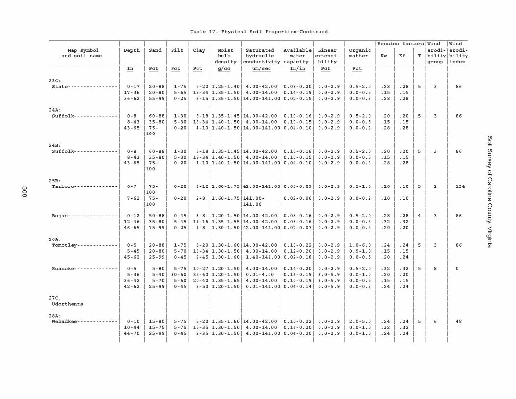
Soil S
urvey of Caroline C
ounty, Virginia
308
Table 17.—Physical Soil Properties—Continued______________________________________________________________________________________________________________________________________ | | | | | | | | | |Erosion factors|Wind |Wind _______________ Map symbol | Depth | Sand | Silt | Clay | Moist | Saturated |Available| Linear | Organic | | | |erodi-|erodi- and soil name | | | | | bulk | hydraulic | water |extensi- | matter | Kw | Kf | T |bility|bility | | | | | density |conductivity|capacity | bility | | | | |group |index______________________________________________________________________________________________________________________________________ | In | Pct | Pct | Pct | g/cc | um/sec | In/in | Pct | Pct | | | | | __ ___ ___ ___ ____ ______ _____ ___ ___ | | | | | | | | | | | | | |23C: | | | | | | | | | | | | | | State----------------| 0-17 | 20-88| 1-75| 5-20|1.25-1.40| 4.00-42.00 |0.08-0.20| 0.0-2.9 | 0.5-2.0 | .28 | .28 | 5 | 3 | 86 | 17-36 | 20-80| 5-65| 18-34|1.35-1.50| 4.00-14.00 |0.14-0.19| 0.0-2.9 | 0.0-0.5 | .15 | .15 | | | | 36-62 | 55-99| 0-25| 2-15|1.35-1.50|14.00-141.00|0.02-0.15| 0.0-2.9 | 0.0-0.2 | .28 | .28 | | | | | | | | | | | | | | | | |24A: | | | | | | | | | | | | | | Suffolk--------------| 0-8 | 60-88| 1-30| 6-18|1.35-1.45|14.00-42.00 |0.10-0.16| 0.0-2.9 | 0.5-2.0 | .20 | .20 | 5 | 3 | 86 | 8-43 | 35-80| 5-30| 18-34|1.40-1.50| 4.00-14.00 |0.10-0.15| 0.0-2.9 | 0.0-0.5 | .15 | .15 | | | | 43-65 | 75- | 0-20| 4-10|1.40-1.50|14.00-141.00|0.04-0.10| 0.0-2.9 | 0.0-0.2 | .28 | .28 | | | | |100 | | | | | | | | | | | | | | | | | | | | | | | | | |24B: | | | | | | | | | | | | | | Suffolk--------------| 0-8 | 60-88| 1-30| 6-18|1.35-1.45|14.00-42.00 |0.10-0.16| 0.0-2.9 | 0.5-2.0 | .20 | .20 | 5 | 3 | 86 | 8-43 | 35-80| 5-30| 18-34|1.40-1.50| 4.00-14.00 |0.10-0.15| 0.0-2.9 | 0.0-0.5 | .15 | .15 | | | | 43-65 | 75- | 0-20| 4-10|1.40-1.50|14.00-141.00|0.04-0.10| 0.0-2.9 | 0.0-0.2 | .28 | .28 | | | | |100 | | | | | | | | | | | | | | | | | | | | | | | | | |25B: | | | | | | | | | | | | | | Tarboro--------------| 0-7 | 75- | 0-20| 3-12|1.60-1.75|42.00-141.00|0.05-0.09| 0.0-2.9 | 0.5-1.0 | .10 | .10 | 5 | 2 | 134 | |100 | | | | | | | | | | | | | 7-62 | 75- | 0-20| 2-8 |1.60-1.75|141.00- |0.02-0.06| 0.0-2.9 | 0.0-0.2 | .10 | .10 | | | | |100 | | | |141.00 | | | | | | | | | | | | | | | | | | | | | | Bojac----------------| 0-12 | 50-88| 0-45| 3-8 |1.20-1.50|14.00-42.00 |0.08-0.16| 0.0-2.9 | 0.5-2.0 | .28 | .28 | 4 | 3 | 86 | 12-46 | 35-80| 5-45| 11-16|1.35-1.55|14.00-42.00 |0.08-0.16| 0.0-2.9 | 0.0-0.5 | .32 | .32 | | | | 46-65 | 75-99| 0-25| 1-8 |1.30-1.50|42.00-141.00|0.02-0.07| 0.0-2.9 | 0.0-0.2 | .20 | .20 | | | | | | | | | | | | | | | | |26A: | | | | | | | | | | | | | | Tomotley-------------| 0-5 | 20-88| 1-75| 5-20|1.30-1.60|14.00-42.00 |0.10-0.22| 0.0-2.9 | 1.0-6.0 | .24 | .24 | 5 | 3 | 86 | 5-45 | 20-80| 5-70| 18-34|1.30-1.50| 4.00-14.00 |0.12-0.20| 0.0-2.9 | 0.5-1.0 | .15 | .15 | | | | 45-62 | 25-99| 0-45| 2-45|1.30-1.60| 1.40-141.00|0.02-0.18| 0.0-2.9 | 0.0-0.5 | .20 | .24 | | | | | | | | | | | | | | | | | Roanoke--------------| 0-5 | 5-80| 5-75| 10-27|1.20-1.50| 4.00-14.00 |0.14-0.20| 0.0-2.9 | 0.5-2.0 | .32 | .32 | 5 | 8 | 0 | 5-36 | 5-40| 30-60| 35-60|1.20-1.50| 0.01-4.00 |0.16-0.19| 3.0-5.9 | 0.0-1.0 | .20 | .20 | | | | 36-42 | 5-70| 5-60| 20-40|1.35-1.65| 4.00-14.00 |0.10-0.19| 3.0-5.9 | 0.0-0.5 | .15 | .15 | | | | 42-62 | 25-99| 0-45| 2-50|1.20-1.50| 0.01-141.00|0.04-0.14| 0.0-5.9 | 0.0-0.2 | .24 | .24 | | | | | | | | | | | | | | | | |27C. | | | | | | | | | | | | | | Udorthents | | | | | | | | | | | | | | | | | | | | | | | | | | | |28A: | | | | | | | | | | | | | | Wehadkee-------------| 0-10 | 15-80| 5-75| 5-20|1.35-1.60|14.00-42.00 |0.10-0.22| 0.0-2.9 | 2.0-5.0 | .24 | .24 | 5 | 6 | 48 | 10-44 | 15-75| 5-75| 15-35|1.30-1.50| 4.00-14.00 |0.16-0.20| 0.0-2.9 | 0.0-1.0 | .32 | .32 | | | | 44-70 | 25-99| 0-45| 2-35|1.30-1.50| 4.00-141.00|0.04-0.20| 0.0-2.9 | 0.0-1.0 | .24 | .24 | | | | | | | | | | | | | | | | |

Soil S
urvey of Caroline C
ounty, Virginia
309
Table 17.—Physical Soil Properties—Continued______________________________________________________________________________________________________________________________________ | | | | | | | | | |Erosion factors|Wind |Wind _______________ Map symbol | Depth | Sand | Silt | Clay | Moist | Saturated |Available| Linear | Organic | | | |erodi-|erodi- and soil name | | | | | bulk | hydraulic | water |extensi- | matter | Kw | Kf | T |bility|bility | | | | | density |conductivity|capacity | bility | | | | |group |index______________________________________________________________________________________________________________________________________ | In | Pct | Pct | Pct | g/cc | um/sec | In/in | Pct | Pct | | | | | __ ___ ___ ___ ____ ______ _____ ___ ___ | | | | | | | | | | | | | |29A: | | | | | | | | | | | | | | Wickham--------------| 0-15 | 30-90| 1-45| 4-10|1.60-1.70|14.00-42.00 |0.05-0.08| 0.0-2.9 | 0.5-1.0 | .32 | .32 | 5 | 3 | 86 | 15-19 | 25-75| 5-45| 10-25|1.30-1.50| 4.00-14.00 |0.12-0.17| 0.0-2.9 | 0.0-0.5 | .24 | .24 | | | | 19-37 | 25-75| 5-45| 18-35|1.30-1.50| 4.00-14.00 |0.12-0.17| 0.0-2.9 | 0.0-0.5 | .15 | .15 | | | | 37-70 | 50-99| 0-25| 2-30|1.40-1.70| 4.00-141.00|0.05-0.15| 0.0-2.9 | 0.0-0.2 | .28 | .28 | | | | | | | | | | | | | | | | |29B: | | | | | | | | | | | | | | Wickham--------------| 0-15 | 30-90| 1-45| 4-10|1.60-1.70|14.00-42.00 |0.05-0.08| 0.0-2.9 | 0.5-1.0 | .32 | .32 | 5 | 3 | 86 | 15-19 | 25-75| 5-45| 10-25|1.30-1.50| 4.00-14.00 |0.12-0.17| 0.0-2.9 | 0.0-0.5 | .24 | .24 | | | | 19-37 | 25-75| 5-45| 18-35|1.30-1.50| 4.00-14.00 |0.12-0.17| 0.0-2.9 | 0.0-0.5 | .15 | .15 | | | | 37-70 | 50-99| 0-25| 2-30|1.40-1.70| 4.00-141.00|0.05-0.15| 0.0-2.9 | 0.0-0.2 | .28 | .28 | | | | | | | | | | | | | | | | |30E: | | | | | | | | | | | | | | Wateree--------------| 0-9 | 44-85| 5-49| 5-15|1.25-1.45|42.00-141.00|0.09-0.12| 0.0-2.9 | 0.5-2.0 | .24 | .24 | 3 | 3 | 86 | 9-22 | 44-85| 5-49| 7-18|1.30-1.50|42.00-141.00|0.10-0.12| 0.0-2.9 | 0.0-0.5 | .24 | .24 | | | | 22-80 | --- | --- | --- | --- | 0.00-0.42 | --- | --- | --- | --- | --- | | | | | | | | | | | | | | | | | Rock outcrop. | | | | | | | | | | | | | | | | | | | | | | | | | | | |W. | | | | | | | | | | | | | | Water | | | | | | | | | | | | | | | | | | | | | | | | | | | |______________________________________________________________________________________________________________________________________
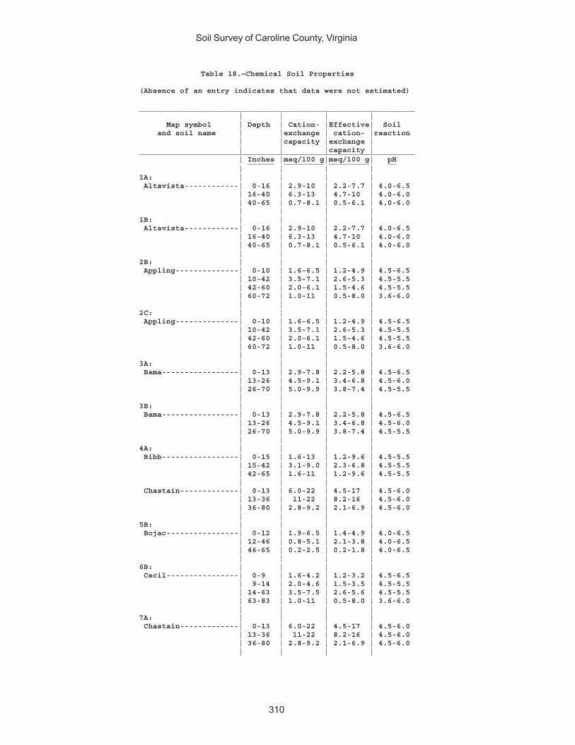
Soil Survey of Caroline County, Virginia
310
Table 18.—Chemical Soil Properties
(Absence of an entry indicates that data were not estimated)
_____________________________________________________________ | | | | Map symbol | Depth | Cation- |Effective| Soil and soil name | |exchange | cation- |reaction | |capacity |exchange | | | |capacity |_____________________________________________________________ | Inches |meq/100 g|meq/100 g| pH ______ _________ _________ __ | | | |1A: | | | | Altavista------------| 0-16 | 2.9-10 | 2.2-7.7 | 4.0-6.5 | 16-40 | 6.3-13 | 4.7-10 | 4.0-6.0 | 40-65 | 0.7-8.1 | 0.5-6.1 | 4.0-6.0 | | | |1B: | | | | Altavista------------| 0-16 | 2.9-10 | 2.2-7.7 | 4.0-6.5 | 16-40 | 6.3-13 | 4.7-10 | 4.0-6.0 | 40-65 | 0.7-8.1 | 0.5-6.1 | 4.0-6.0 | | | |2B: | | | | Appling--------------| 0-10 | 1.6-6.5 | 1.2-4.9 | 4.5-6.5 | 10-42 | 3.5-7.1 | 2.6-5.3 | 4.5-5.5 | 42-60 | 2.0-6.1 | 1.5-4.6 | 4.5-5.5 | 60-72 | 1.0-11 | 0.5-8.0 | 3.6-6.0 | | | |2C: | | | | Appling--------------| 0-10 | 1.6-6.5 | 1.2-4.9 | 4.5-6.5 | 10-42 | 3.5-7.1 | 2.6-5.3 | 4.5-5.5 | 42-60 | 2.0-6.1 | 1.5-4.6 | 4.5-5.5 | 60-72 | 1.0-11 | 0.5-8.0 | 3.6-6.0 | | | |3A: | | | | Bama-----------------| 0-13 | 2.9-7.8 | 2.2-5.8 | 4.5-6.5 | 13-26 | 4.5-9.1 | 3.4-6.8 | 4.5-6.0 | 26-70 | 5.0-9.9 | 3.8-7.4 | 4.5-5.5 | | | |3B: | | | | Bama-----------------| 0-13 | 2.9-7.8 | 2.2-5.8 | 4.5-6.5 | 13-26 | 4.5-9.1 | 3.4-6.8 | 4.5-6.0 | 26-70 | 5.0-9.9 | 3.8-7.4 | 4.5-5.5 | | | |4A: | | | | Bibb-----------------| 0-15 | 1.6-13 | 1.2-9.6 | 4.5-5.5 | 15-42 | 3.1-9.0 | 2.3-6.8 | 4.5-5.5 | 42-65 | 1.6-11 | 1.2-9.6 | 4.5-5.5 | | | | Chastain-------------| 0-13 | 6.0-22 | 4.5-17 | 4.5-6.0 | 13-36 | 11-22 | 8.2-16 | 4.5-6.0 | 36-80 | 2.8-9.2 | 2.1-6.9 | 4.5-6.0 | | | |5B: | | | | Bojac----------------| 0-12 | 1.9-6.5 | 1.4-4.9 | 4.0-6.5 | 12-46 | 0.8-5.1 | 2.1-3.8 | 4.0-6.5 | 46-65 | 0.2-2.5 | 0.2-1.8 | 4.0-6.5 | | | |6B: | | | | Cecil----------------| 0-9 | 1.6-4.2 | 1.2-3.2 | 4.5-6.5 | 9-14 | 2.0-4.6 | 1.5-3.5 | 4.5-5.5 | 14-63 | 3.5-7.5 | 2.6-5.6 | 4.5-5.5 | 63-83 | 1.0-11 | 0.5-8.0 | 3.6-6.0 | | | |7A: | | | | Chastain-------------| 0-13 | 6.0-22 | 4.5-17 | 4.5-6.0 | 13-36 | 11-22 | 8.2-16 | 4.5-6.0 | 36-80 | 2.8-9.2 | 2.1-6.9 | 4.5-6.0 | | | |
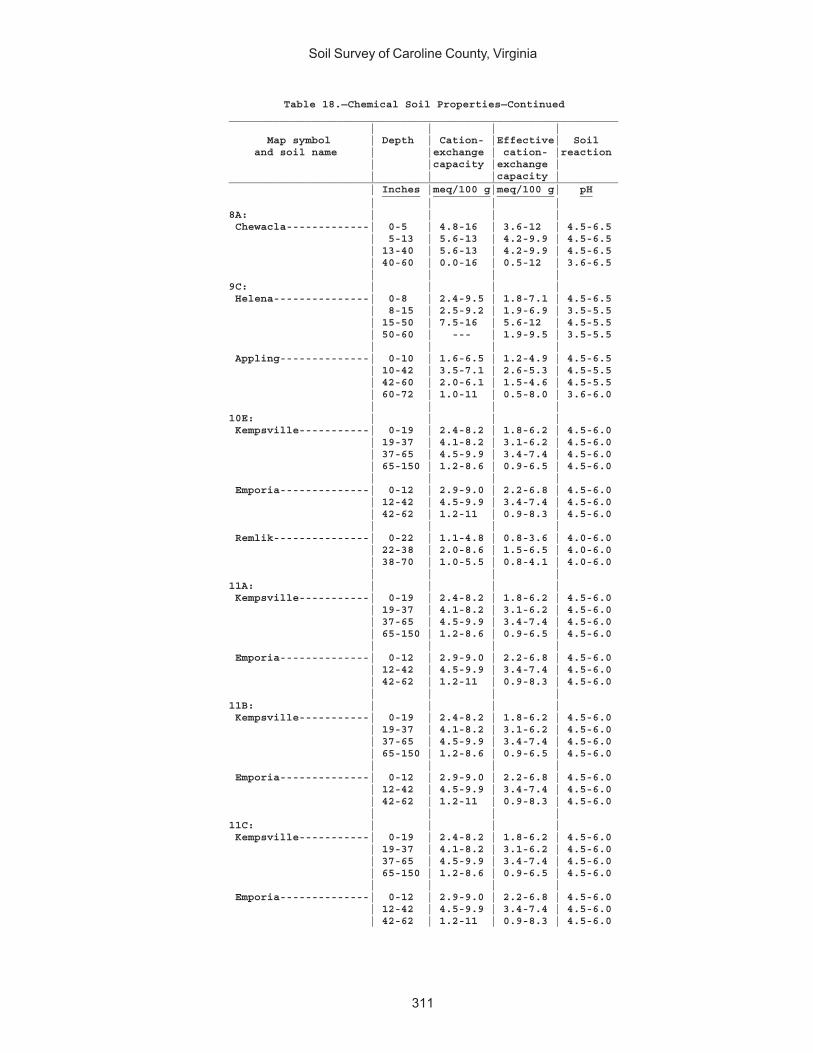
Soil Survey of Caroline County, Virginia
311
Table 18.—Chemical Soil Properties—Continued_____________________________________________________________ | | | | Map symbol | Depth | Cation- |Effective| Soil and soil name | |exchange | cation- |reaction | |capacity |exchange | | | |capacity |_____________________________________________________________ | Inches |meq/100 g|meq/100 g| pH ______ _________ _________ __ | | | |8A: | | | | Chewacla-------------| 0-5 | 4.8-16 | 3.6-12 | 4.5-6.5 | 5-13 | 5.6-13 | 4.2-9.9 | 4.5-6.5 | 13-40 | 5.6-13 | 4.2-9.9 | 4.5-6.5 | 40-60 | 0.0-16 | 0.5-12 | 3.6-6.5 | | | |9C: | | | | Helena---------------| 0-8 | 2.4-9.5 | 1.8-7.1 | 4.5-6.5 | 8-15 | 2.5-9.2 | 1.9-6.9 | 3.5-5.5 | 15-50 | 7.5-16 | 5.6-12 | 4.5-5.5 | 50-60 | --- | 1.9-9.5 | 3.5-5.5 | | | | Appling--------------| 0-10 | 1.6-6.5 | 1.2-4.9 | 4.5-6.5 | 10-42 | 3.5-7.1 | 2.6-5.3 | 4.5-5.5 | 42-60 | 2.0-6.1 | 1.5-4.6 | 4.5-5.5 | 60-72 | 1.0-11 | 0.5-8.0 | 3.6-6.0 | | | |10E: | | | | Kempsville-----------| 0-19 | 2.4-8.2 | 1.8-6.2 | 4.5-6.0 | 19-37 | 4.1-8.2 | 3.1-6.2 | 4.5-6.0 | 37-65 | 4.5-9.9 | 3.4-7.4 | 4.5-6.0 | 65-150 | 1.2-8.6 | 0.9-6.5 | 4.5-6.0 | | | | Emporia--------------| 0-12 | 2.9-9.0 | 2.2-6.8 | 4.5-6.0 | 12-42 | 4.5-9.9 | 3.4-7.4 | 4.5-6.0 | 42-62 | 1.2-11 | 0.9-8.3 | 4.5-6.0 | | | | Remlik---------------| 0-22 | 1.1-4.8 | 0.8-3.6 | 4.0-6.0 | 22-38 | 2.0-8.6 | 1.5-6.5 | 4.0-6.0 | 38-70 | 1.0-5.5 | 0.8-4.1 | 4.0-6.0 | | | |11A: | | | | Kempsville-----------| 0-19 | 2.4-8.2 | 1.8-6.2 | 4.5-6.0 | 19-37 | 4.1-8.2 | 3.1-6.2 | 4.5-6.0 | 37-65 | 4.5-9.9 | 3.4-7.4 | 4.5-6.0 | 65-150 | 1.2-8.6 | 0.9-6.5 | 4.5-6.0 | | | | Emporia--------------| 0-12 | 2.9-9.0 | 2.2-6.8 | 4.5-6.0 | 12-42 | 4.5-9.9 | 3.4-7.4 | 4.5-6.0 | 42-62 | 1.2-11 | 0.9-8.3 | 4.5-6.0 | | | |11B: | | | | Kempsville-----------| 0-19 | 2.4-8.2 | 1.8-6.2 | 4.5-6.0 | 19-37 | 4.1-8.2 | 3.1-6.2 | 4.5-6.0 | 37-65 | 4.5-9.9 | 3.4-7.4 | 4.5-6.0 | 65-150 | 1.2-8.6 | 0.9-6.5 | 4.5-6.0 | | | | Emporia--------------| 0-12 | 2.9-9.0 | 2.2-6.8 | 4.5-6.0 | 12-42 | 4.5-9.9 | 3.4-7.4 | 4.5-6.0 | 42-62 | 1.2-11 | 0.9-8.3 | 4.5-6.0 | | | |11C: | | | | Kempsville-----------| 0-19 | 2.4-8.2 | 1.8-6.2 | 4.5-6.0 | 19-37 | 4.1-8.2 | 3.1-6.2 | 4.5-6.0 | 37-65 | 4.5-9.9 | 3.4-7.4 | 4.5-6.0 | 65-150 | 1.2-8.6 | 0.9-6.5 | 4.5-6.0 | | | | Emporia--------------| 0-12 | 2.9-9.0 | 2.2-6.8 | 4.5-6.0 | 12-42 | 4.5-9.9 | 3.4-7.4 | 4.5-6.0 | 42-62 | 1.2-11 | 0.9-8.3 | 4.5-6.0
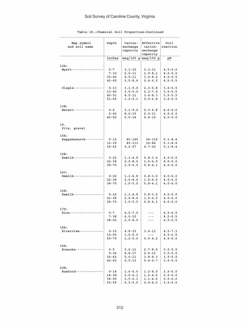
Soil Survey of Caroline County, Virginia
312
Table 18.—Chemical Soil Properties—Continued_____________________________________________________________ | | | | Map symbol | Depth | Cation- |Effective| Soil and soil name | |exchange | cation- |reaction | |capacity |exchange | | | |capacity |_____________________________________________________________ | Inches |meq/100 g|meq/100 g| pH ______ _________ _________ __ | | | |12A: | | | | Myatt----------------| 0-7 | 3.1-15 | 2.3-11 | 4.5-6.0 | 7-15 | 2.6-11 | 1.9-8.1 | 4.5-6.0 | 15-40 | 4.5-11 | 3.4-8.2 | 4.0-5.5 | 40-65 | 0.5-8.6 | 0.4-6.5 | 4.0-5.5 | | | | Slagle---------------| 0-13 | 3.1-9.0 | 2.3-6.8 | 3.6-5.5 | 13-40 | 3.0-9.9 | 2.2-7.4 | 3.6-5.5 | 40-51 | 4.5-11 | 3.4-8.3 | 3.6-5.5 | 51-65 | 1.2-9.1 | 0.9-6.8 | 3.6-5.5 | | | |13E: | | | | Nevarc---------------| 0-6 | 3.1-9.0 | 2.3-6.8 | 4.0-6.0 | 6-40 | 8.0-15 | 6.0-11 | 4.0-6.0 | 40-60 | 0.5-14 | 0.4-10 | 4.0-6.0 | | | |14. | | | | Pits, gravel | | | | | | | |15A: | | | | Rappahannock---------| 0-12 | 45-146 | 34-110 | 5.1-8.4 | 12-39 | 45-113 | 34-84 | 5.1-8.4 | 39-62 | 6.2-27 | 4.7-20 | 5.1-8.4 | | | |16B: | | | | Remlik---------------| 0-22 | 1.1-4.8 | 0.8-3.6 | 4.0-6.0 | 22-38 | 2.0-8.6 | 1.5-6.5 | 4.0-6.0 | 38-70 | 1.0-5.5 | 0.8-4.1 | 4.0-6.0 | | | |16C: | | | | Remlik---------------| 0-22 | 1.1-4.8 | 0.8-3.6 | 4.0-6.0 | 22-38 | 2.0-8.6 | 1.5-6.5 | 4.0-6.0 | 38-70 | 1.0-5.5 | 0.8-4.1 | 4.0-6.0 | | | |16E: | | | | Remlik---------------| 0-22 | 1.1-4.8 | 0.8-3.6 | 4.0-6.0 | 22-38 | 2.0-8.6 | 1.5-6.5 | 4.0-6.0 | 38-70 | 1.0-5.5 | 0.8-4.1 | 4.0-6.0 | | | |17D: | | | | Rion-----------------| 0-7 | 4.0-7.0 | --- | 4.5-6.5 | 7-38 | 4.0-10 | --- | 4.5-6.5 | 38-60 | 2.0-8.0 | --- | 4.5-6.5 | | | |18A: | | | | Riverview------------| 0-15 | 4.8-15 | 3.6-11 | 4.5-7.3 | 15-59 | 1.0-5.0 | --- | 4.5-6.5 | 59-79 | 1.2-5.6 | 0.9-4.2 | 4.5-6.0 | | | |19A: | | | | Roanoke--------------| 0-5 | 3.6-11 | 2.7-8.4 | 3.5-5.5 | 5-36 | 8.8-17 | 6.6-13 | 3.5-5.5 | 36-42 | 5.0-11 | 3.8-8.3 | 3.5-5.5 | 42-62 | 0.5-13 | 0.4-9.7 | 3.5-5.5 | | | |20B: | | | | Rumford--------------| 0-14 | 1.6-6.0 | 1.2-4.5 | 3.5-5.5 | 14-38 | 2.0-6.1 | 1.5-4.6 | 3.5-6.0 | 38-55 | 1.5-6.1 | 1.1-4.6 | 3.5-6.0 | 55-99 | 0.5-5.6 | 0.4-4.2 | 3.5-6.5
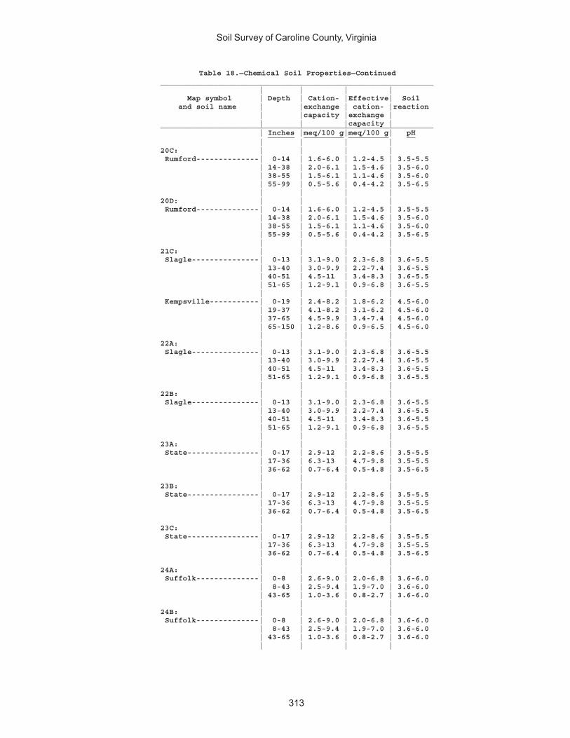
Soil Survey of Caroline County, Virginia
313
Table 18.—Chemical Soil Properties—Continued_____________________________________________________________ | | | | Map symbol | Depth | Cation- |Effective| Soil and soil name | |exchange | cation- |reaction | |capacity |exchange | | | |capacity |_____________________________________________________________ | Inches |meq/100 g|meq/100 g| pH ______ _________ _________ __ | | | |20C: | | | | Rumford--------------| 0-14 | 1.6-6.0 | 1.2-4.5 | 3.5-5.5 | 14-38 | 2.0-6.1 | 1.5-4.6 | 3.5-6.0 | 38-55 | 1.5-6.1 | 1.1-4.6 | 3.5-6.0 | 55-99 | 0.5-5.6 | 0.4-4.2 | 3.5-6.5 | | | |20D: | | | | Rumford--------------| 0-14 | 1.6-6.0 | 1.2-4.5 | 3.5-5.5 | 14-38 | 2.0-6.1 | 1.5-4.6 | 3.5-6.0 | 38-55 | 1.5-6.1 | 1.1-4.6 | 3.5-6.0 | 55-99 | 0.5-5.6 | 0.4-4.2 | 3.5-6.5 | | | |21C: | | | | Slagle---------------| 0-13 | 3.1-9.0 | 2.3-6.8 | 3.6-5.5 | 13-40 | 3.0-9.9 | 2.2-7.4 | 3.6-5.5 | 40-51 | 4.5-11 | 3.4-8.3 | 3.6-5.5 | 51-65 | 1.2-9.1 | 0.9-6.8 | 3.6-5.5 | | | | Kempsville-----------| 0-19 | 2.4-8.2 | 1.8-6.2 | 4.5-6.0 | 19-37 | 4.1-8.2 | 3.1-6.2 | 4.5-6.0 | 37-65 | 4.5-9.9 | 3.4-7.4 | 4.5-6.0 | 65-150 | 1.2-8.6 | 0.9-6.5 | 4.5-6.0 | | | |22A: | | | | Slagle---------------| 0-13 | 3.1-9.0 | 2.3-6.8 | 3.6-5.5 | 13-40 | 3.0-9.9 | 2.2-7.4 | 3.6-5.5 | 40-51 | 4.5-11 | 3.4-8.3 | 3.6-5.5 | 51-65 | 1.2-9.1 | 0.9-6.8 | 3.6-5.5 | | | |22B: | | | | Slagle---------------| 0-13 | 3.1-9.0 | 2.3-6.8 | 3.6-5.5 | 13-40 | 3.0-9.9 | 2.2-7.4 | 3.6-5.5 | 40-51 | 4.5-11 | 3.4-8.3 | 3.6-5.5 | 51-65 | 1.2-9.1 | 0.9-6.8 | 3.6-5.5 | | | |23A: | | | | State----------------| 0-17 | 2.9-12 | 2.2-8.6 | 3.5-5.5 | 17-36 | 6.3-13 | 4.7-9.8 | 3.5-5.5 | 36-62 | 0.7-6.4 | 0.5-4.8 | 3.5-6.5 | | | |23B: | | | | State----------------| 0-17 | 2.9-12 | 2.2-8.6 | 3.5-5.5 | 17-36 | 6.3-13 | 4.7-9.8 | 3.5-5.5 | 36-62 | 0.7-6.4 | 0.5-4.8 | 3.5-6.5 | | | |23C: | | | | State----------------| 0-17 | 2.9-12 | 2.2-8.6 | 3.5-5.5 | 17-36 | 6.3-13 | 4.7-9.8 | 3.5-5.5 | 36-62 | 0.7-6.4 | 0.5-4.8 | 3.5-6.5 | | | |24A: | | | | Suffolk--------------| 0-8 | 2.6-9.0 | 2.0-6.8 | 3.6-6.0 | 8-43 | 2.5-9.4 | 1.9-7.0 | 3.6-6.0 | 43-65 | 1.0-3.6 | 0.8-2.7 | 3.6-6.0 | | | |24B: | | | | Suffolk--------------| 0-8 | 2.6-9.0 | 2.0-6.8 | 3.6-6.0 | 8-43 | 2.5-9.4 | 1.9-7.0 | 3.6-6.0 | 43-65 | 1.0-3.6 | 0.8-2.7 | 3.6-6.0 | | | |
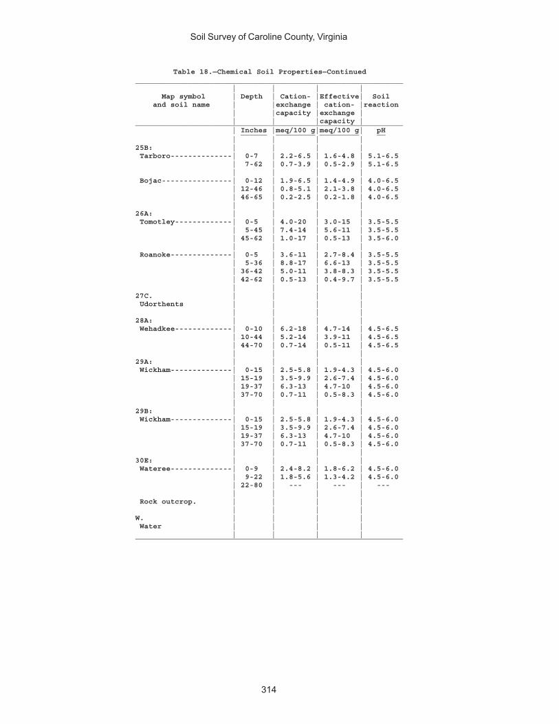
Soil Survey of Caroline County, Virginia
314
Table 18.—Chemical Soil Properties—Continued_____________________________________________________________ | | | | Map symbol | Depth | Cation- |Effective| Soil and soil name | |exchange | cation- |reaction | |capacity |exchange | | | |capacity |_____________________________________________________________ | Inches |meq/100 g|meq/100 g| pH ______ _________ _________ __ | | | |25B: | | | | Tarboro--------------| 0-7 | 2.2-6.5 | 1.6-4.8 | 5.1-6.5 | 7-62 | 0.7-3.9 | 0.5-2.9 | 5.1-6.5 | | | | Bojac----------------| 0-12 | 1.9-6.5 | 1.4-4.9 | 4.0-6.5 | 12-46 | 0.8-5.1 | 2.1-3.8 | 4.0-6.5 | 46-65 | 0.2-2.5 | 0.2-1.8 | 4.0-6.5 | | | |26A: | | | | Tomotley-------------| 0-5 | 4.0-20 | 3.0-15 | 3.5-5.5 | 5-45 | 7.4-14 | 5.6-11 | 3.5-5.5 | 45-62 | 1.0-17 | 0.5-13 | 3.5-6.0 | | | | Roanoke--------------| 0-5 | 3.6-11 | 2.7-8.4 | 3.5-5.5 | 5-36 | 8.8-17 | 6.6-13 | 3.5-5.5 | 36-42 | 5.0-11 | 3.8-8.3 | 3.5-5.5 | 42-62 | 0.5-13 | 0.4-9.7 | 3.5-5.5 | | | |27C. | | | | Udorthents | | | | | | | |28A: | | | | Wehadkee-------------| 0-10 | 6.2-18 | 4.7-14 | 4.5-6.5 | 10-44 | 5.2-14 | 3.9-11 | 4.5-6.5 | 44-70 | 0.7-14 | 0.5-11 | 4.5-6.5 | | | |29A: | | | | Wickham--------------| 0-15 | 2.5-5.8 | 1.9-4.3 | 4.5-6.0 | 15-19 | 3.5-9.9 | 2.6-7.4 | 4.5-6.0 | 19-37 | 6.3-13 | 4.7-10 | 4.5-6.0 | 37-70 | 0.7-11 | 0.5-8.3 | 4.5-6.0 | | | |29B: | | | | Wickham--------------| 0-15 | 2.5-5.8 | 1.9-4.3 | 4.5-6.0 | 15-19 | 3.5-9.9 | 2.6-7.4 | 4.5-6.0 | 19-37 | 6.3-13 | 4.7-10 | 4.5-6.0 | 37-70 | 0.7-11 | 0.5-8.3 | 4.5-6.0 | | | |30E: | | | | Wateree--------------| 0-9 | 2.4-8.2 | 1.8-6.2 | 4.5-6.0 | 9-22 | 1.8-5.6 | 1.3-4.2 | 4.5-6.0 | 22-80 | --- | --- | --- | | | | Rock outcrop. | | | | | | | |W. | | | | Water | | | | | | | |_____________________________________________________________
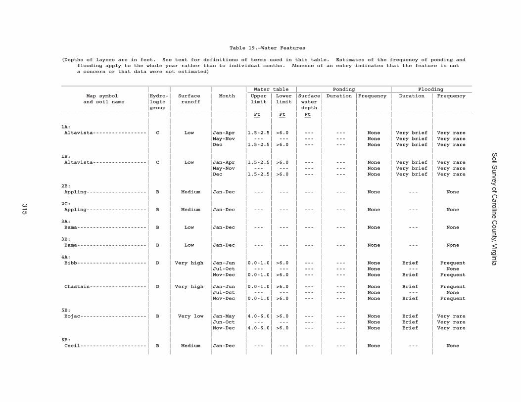
Soil S
urvey of Caroline C
ounty, Virginia
315
Table 19.—Water Features
(Depths of layers are in feet. See text for definitions of terms used in this table. Estimates of the frequency of ponding and flooding apply to the whole year rather than to individual months. Absence of an entry indicates that the feature is not a concern or that data were not estimated)
__________________________________________________________________________________________________________________________________ | | | | Water table | Ponding | Flooding _______________________________________________________________________ Map symbol |Hydro-| Surface | Month | Upper | Lower |Surface| Duration |Frequency | Duration | Frequency and soil name |logic | runoff | | limit | limit | water | | | | |group | | | | | depth | | | |__________________________________________________________________________________________________________________________________ | | | | Ft | Ft | Ft | | | | __ __ __ | | | | | | | | | |1A: | | | | | | | | | | Altavista-----------------| C | Low |Jan-Apr |1.5-2.5| >6.0 | --- | --- | None | Very brief | Very rare | | |May-Nov | --- | --- | --- | --- | None | Very brief | Very rare | | |Dec |1.5-2.5| >6.0 | --- | --- | None | Very brief | Very rare | | | | | | | | | |1B: | | | | | | | | | | Altavista-----------------| C | Low |Jan-Apr |1.5-2.5| >6.0 | --- | --- | None | Very brief | Very rare | | |May-Nov | --- | --- | --- | --- | None | Very brief | Very rare | | |Dec |1.5-2.5| >6.0 | --- | --- | None | Very brief | Very rare | | | | | | | | | |2B: | | | | | | | | | | Appling-------------------| B | Medium |Jan-Dec | --- | --- | --- | --- | None | --- | None | | | | | | | | | |2C: | | | | | | | | | | Appling-------------------| B | Medium |Jan-Dec | --- | --- | --- | --- | None | --- | None | | | | | | | | | |3A: | | | | | | | | | | Bama----------------------| B | Low |Jan-Dec | --- | --- | --- | --- | None | --- | None | | | | | | | | | |3B: | | | | | | | | | | Bama----------------------| B | Low |Jan-Dec | --- | --- | --- | --- | None | --- | None | | | | | | | | | |4A: | | | | | | | | | | Bibb----------------------| D | Very high |Jan-Jun |0.0-1.0| >6.0 | --- | --- | None | Brief | Frequent | | |Jul-Oct | --- | --- | --- | --- | None | --- | None | | |Nov-Dec |0.0-1.0| >6.0 | --- | --- | None | Brief | Frequent | | | | | | | | | | Chastain------------------| D | Very high |Jan-Jun |0.0-1.0| >6.0 | --- | --- | None | Brief | Frequent | | |Jul-Oct | --- | --- | --- | --- | None | --- | None | | |Nov-Dec |0.0-1.0| >6.0 | --- | --- | None | Brief | Frequent | | | | | | | | | |5B: | | | | | | | | | | Bojac---------------------| B | Very low |Jan-May |4.0-6.0| >6.0 | --- | --- | None | Brief | Very rare | | |Jun-Oct | --- | --- | --- | --- | None | Brief | Very rare | | |Nov-Dec |4.0-6.0| >6.0 | --- | --- | None | Brief | Very rare | | | | | | | | | |6B: | | | | | | | | | | Cecil---------------------| B | Medium |Jan-Dec | --- | --- | --- | --- | None | --- | None | | | | | | | | | |
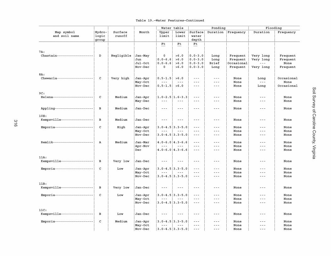
Soil S
urvey of Caroline C
ounty, Virginia
316
Table 19.—Water Features—Continued__________________________________________________________________________________________________________________________________ | | | | Water table | Ponding | Flooding _______________________________________________________________________ Map symbol |Hydro-| Surface | Month | Upper | Lower |Surface| Duration |Frequency | Duration | Frequency and soil name |logic | runoff | | limit | limit | water | | | | |group | | | | | depth | | | |__________________________________________________________________________________________________________________________________ | | | | Ft | Ft | Ft | | | | __ __ __ | | | | | | | | | |7A: | | | | | | | | | | Chastain------------------| D | Negligible |Jan-May | 0 | >6.0 |0.0-3.0| Long | Frequent | Very long | Frequent | | |Jun |0.0-6.6| >6.0 |0.0-3.0| Long | Frequent | Very long | Frequent | | |Jul-Oct |0.0-6.6| >6.0 |0.0-3.0| Brief |Occasional| --- | None | | |Nov-Dec | 0 | >6.0 |0.0-3.0| Long | Frequent | Very long | Frequent | | | | | | | | | |8A: | | | | | | | | | | Chewacla------------------| C | Very high |Jan-Apr |0.5-1.5| >6.0 | --- | --- | None | Long | Occasional | | |May-Oct | --- | --- | --- | --- | None | --- | None | | |Nov-Dec |0.5-1.5| >6.0 | --- | --- | None | Long | Occasional | | | | | | | | | |9C: | | | | | | | | | | Helena--------------------| C | Medium |Jan-Apr |1.0-2.5|1.6-3.3| --- | --- | None | --- | None | | |May-Dec | --- | --- | --- | --- | None | --- | None | | | | | | | | | | Appling-------------------| B | Medium |Jan-Dec | --- | --- | --- | --- | None | --- | None | | | | | | | | | |10E: | | | | | | | | | | Kempsville----------------| B | Medium |Jan-Dec | --- | --- | --- | --- | None | --- | None | | | | | | | | | | Emporia-------------------| C | High |Jan-Apr |3.0-4.5|3.3-5.0| --- | --- | None | --- | None | | |May-Oct | --- | --- | --- | --- | None | --- | None | | |Nov-Dec |3.0-4.5|3.3-5.0| --- | --- | None | --- | None | | | | | | | | | | Remlik--------------------| A | Medium |Jan-Mar |4.0-6.0|4.3-6.6| --- | --- | None | --- | None | | |Apr-Nov | --- | --- | --- | --- | None | --- | None | | |Dec |4.0-6.0|4.3-6.6| --- | --- | None | --- | None | | | | | | | | | |11A: | | | | | | | | | | Kempsville----------------| B | Very low |Jan-Dec | --- | --- | --- | --- | None | --- | None | | | | | | | | | | Emporia-------------------| C | Low |Jan-Apr |3.0-4.5|3.3-5.0| --- | --- | None | --- | None | | |May-Oct | --- | --- | --- | --- | None | --- | None | | |Nov-Dec |3.0-4.5|3.3-5.0| --- | --- | None | --- | None | | | | | | | | | |11B: | | | | | | | | | | Kempsville----------------| B | Very low |Jan-Dec | --- | --- | --- | --- | None | --- | None | | | | | | | | | | Emporia-------------------| C | Low |Jan-Apr |3.0-4.5|3.3-5.0| --- | --- | None | --- | None | | |May-Oct | --- | --- | --- | --- | None | --- | None | | |Nov-Dec |3.0-4.5|3.3-5.0| --- | --- | None | --- | None | | | | | | | | | |11C: | | | | | | | | | | Kempsville----------------| B | Low |Jan-Dec | --- | --- | --- | --- | None | --- | None | | | | | | | | | | Emporia-------------------| C | Medium |Jan-Apr |3.0-4.5|3.3-5.0| --- | --- | None | --- | None | | |May-Oct | --- | --- | --- | --- | None | --- | None | | |Nov-Dec |3.0-4.5|3.3-5.0| --- | --- | None | --- | None
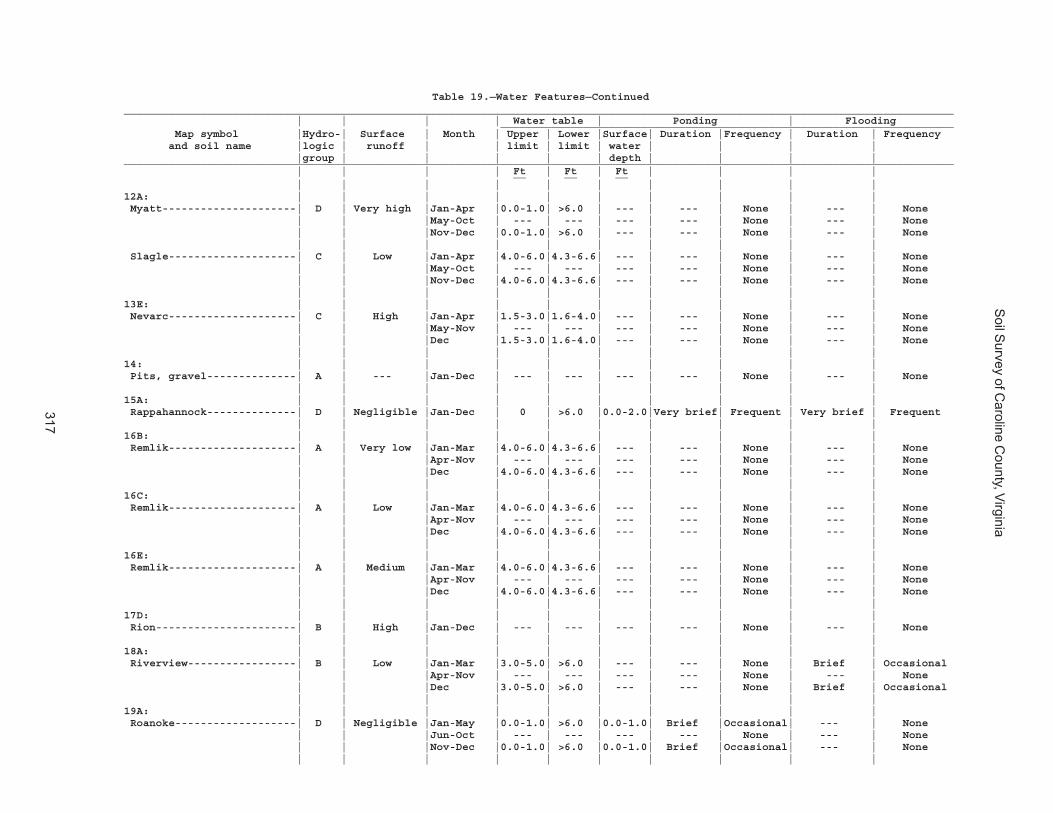
Soil S
urvey of Caroline C
ounty, Virginia
317
Table 19.—Water Features—Continued__________________________________________________________________________________________________________________________________ | | | | Water table | Ponding | Flooding _______________________________________________________________________ Map symbol |Hydro-| Surface | Month | Upper | Lower |Surface| Duration |Frequency | Duration | Frequency and soil name |logic | runoff | | limit | limit | water | | | | |group | | | | | depth | | | |__________________________________________________________________________________________________________________________________ | | | | Ft | Ft | Ft | | | | __ __ __ | | | | | | | | | |12A: | | | | | | | | | | Myatt---------------------| D | Very high |Jan-Apr |0.0-1.0| >6.0 | --- | --- | None | --- | None | | |May-Oct | --- | --- | --- | --- | None | --- | None | | |Nov-Dec |0.0-1.0| >6.0 | --- | --- | None | --- | None | | | | | | | | | | Slagle--------------------| C | Low |Jan-Apr |4.0-6.0|4.3-6.6| --- | --- | None | --- | None | | |May-Oct | --- | --- | --- | --- | None | --- | None | | |Nov-Dec |4.0-6.0|4.3-6.6| --- | --- | None | --- | None | | | | | | | | | |13E: | | | | | | | | | | Nevarc--------------------| C | High |Jan-Apr |1.5-3.0|1.6-4.0| --- | --- | None | --- | None | | |May-Nov | --- | --- | --- | --- | None | --- | None | | |Dec |1.5-3.0|1.6-4.0| --- | --- | None | --- | None | | | | | | | | | |14: | | | | | | | | | | Pits, gravel--------------| A | --- |Jan-Dec | --- | --- | --- | --- | None | --- | None | | | | | | | | | |15A: | | | | | | | | | | Rappahannock--------------| D | Negligible |Jan-Dec | 0 | >6.0 |0.0-2.0|Very brief| Frequent | Very brief | Frequent | | | | | | | | | |16B: | | | | | | | | | | Remlik--------------------| A | Very low |Jan-Mar |4.0-6.0|4.3-6.6| --- | --- | None | --- | None | | |Apr-Nov | --- | --- | --- | --- | None | --- | None | | |Dec |4.0-6.0|4.3-6.6| --- | --- | None | --- | None | | | | | | | | | |16C: | | | | | | | | | | Remlik--------------------| A | Low |Jan-Mar |4.0-6.0|4.3-6.6| --- | --- | None | --- | None | | |Apr-Nov | --- | --- | --- | --- | None | --- | None | | |Dec |4.0-6.0|4.3-6.6| --- | --- | None | --- | None | | | | | | | | | |16E: | | | | | | | | | | Remlik--------------------| A | Medium |Jan-Mar |4.0-6.0|4.3-6.6| --- | --- | None | --- | None | | |Apr-Nov | --- | --- | --- | --- | None | --- | None | | |Dec |4.0-6.0|4.3-6.6| --- | --- | None | --- | None | | | | | | | | | |17D: | | | | | | | | | | Rion----------------------| B | High |Jan-Dec | --- | --- | --- | --- | None | --- | None | | | | | | | | | |18A: | | | | | | | | | | Riverview-----------------| B | Low |Jan-Mar |3.0-5.0| >6.0 | --- | --- | None | Brief | Occasional | | |Apr-Nov | --- | --- | --- | --- | None | --- | None | | |Dec |3.0-5.0| >6.0 | --- | --- | None | Brief | Occasional | | | | | | | | | |19A: | | | | | | | | | | Roanoke-------------------| D | Negligible |Jan-May |0.0-1.0| >6.0 |0.0-1.0| Brief |Occasional| --- | None | | |Jun-Oct | --- | --- | --- | --- | None | --- | None | | |Nov-Dec |0.0-1.0| >6.0 |0.0-1.0| Brief |Occasional| --- | None | | | | | | | | | |

Soil S
urvey of Caroline C
ounty, Virginia
318
Table 19.—Water Features—Continued__________________________________________________________________________________________________________________________________ | | | | Water table | Ponding | Flooding _______________________________________________________________________ Map symbol |Hydro-| Surface | Month | Upper | Lower |Surface| Duration |Frequency | Duration | Frequency and soil name |logic | runoff | | limit | limit | water | | | | |group | | | | | depth | | | |__________________________________________________________________________________________________________________________________ | | | | Ft | Ft | Ft | | | | __ __ __ | | | | | | | | | |20B: | | | | | | | | | | Rumford-------------------| B | Very low |Jan-Dec | --- | --- | --- | --- | None | --- | None | | | | | | | | | |20C: | | | | | | | | | | Rumford-------------------| B | Low |Jan-Dec | --- | --- | --- | --- | None | --- | None | | | | | | | | | |20D: | | | | | | | | | | Rumford-------------------| B | Low |Jan-Dec | --- | --- | --- | --- | None | --- | None | | | | | | | | | |21C: | | | | | | | | | | Slagle--------------------| C | Medium |Jan-Apr |4.0-6.0|4.3-6.6| --- | --- | None | --- | None | | |May-Oct | --- | --- | --- | --- | None | --- | None | | |Nov-Dec |4.0-6.0|4.3-6.6| --- | --- | None | --- | None | | | | | | | | | | Kempsville----------------| B | Low |Jan-Dec | --- | --- | --- | --- | None | --- | None | | | | | | | | | |22A: | | | | | | | | | | Slagle--------------------| C | Low |Jan-Apr |4.0-6.0|4.3-6.6| --- | --- | None | --- | None | | |May-Oct | --- | --- | --- | --- | None | --- | None | | |Nov-Dec |4.0-6.0|4.3-6.6| --- | --- | None | --- | None | | | | | | | | | |22B: | | | | | | | | | | Slagle--------------------| C | Low |Jan-Apr |4.0-6.0|4.3-6.6| --- | --- | None | --- | None | | |May-Oct | --- | --- | --- | --- | None | --- | None | | |Nov-Dec |4.0-6.0|4.3-6.6| --- | --- | None | --- | None | | | | | | | | | |23A: | | | | | | | | | | State---------------------| B | Low |Jan-Jun |4.0-6.0| >6.0 | --- | --- | None | Brief | Very rare | | |Jul-Nov | --- | --- | --- | --- | None | Brief | Very rare | | |Dec |4.0-6.0| >6.0 | --- | --- | None | Brief | Very rare | | | | | | | | | |23B: | | | | | | | | | | State---------------------| B | Low |Jan-Jun |4.0-6.0| >6.0 | --- | --- | None | Brief | Very rare | | |Jul-Nov | --- | --- | --- | --- | None | Brief | Very rare | | |Dec |4.0-6.0| >6.0 | --- | --- | None | Brief | Very rare | | | | | | | | | |23C: | | | | | | | | | | State---------------------| B | Medium |Jan-Jun |4.0-6.0| >6.0 | --- | --- | None | Brief | Very rare | | |Jul-Nov | --- | --- | --- | --- | None | Brief | Very rare | | |Dec |4.0-6.0| >6.0 | --- | --- | None | Brief | Very rare | | | | | | | | | |24A: | | | | | | | | | | Suffolk-------------------| B | Low |Jan-Dec | --- | --- | --- | --- | None | --- | None | | | | | | | | | |24B: | | | | | | | | | | Suffolk-------------------| B | Low |Jan-Dec | --- | --- | --- | --- | None | --- | None | | | | | | | | | |
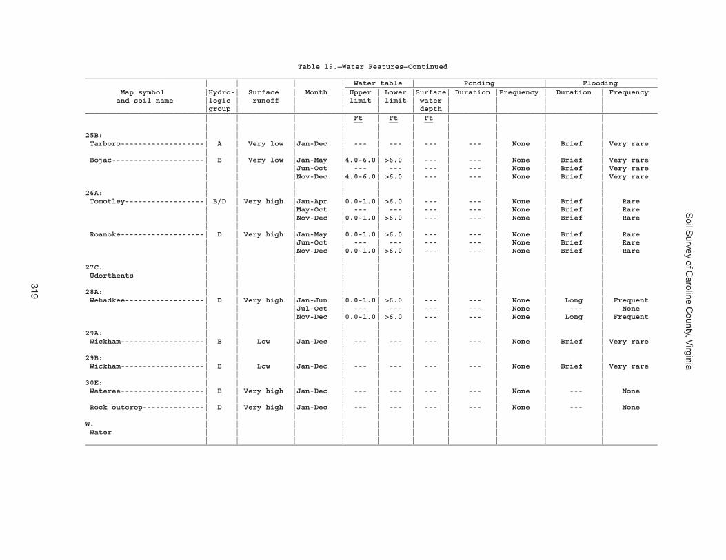
Soil S
urvey of Caroline C
ounty, Virginia
319
Table 19.—Water Features—Continued__________________________________________________________________________________________________________________________________ | | | | Water table | Ponding | Flooding _______________________________________________________________________ Map symbol |Hydro-| Surface | Month | Upper | Lower |Surface| Duration |Frequency | Duration | Frequency and soil name |logic | runoff | | limit | limit | water | | | | |group | | | | | depth | | | |__________________________________________________________________________________________________________________________________ | | | | Ft | Ft | Ft | | | | __ __ __ | | | | | | | | | |25B: | | | | | | | | | | Tarboro-------------------| A | Very low |Jan-Dec | --- | --- | --- | --- | None | Brief | Very rare | | | | | | | | | | Bojac---------------------| B | Very low |Jan-May |4.0-6.0| >6.0 | --- | --- | None | Brief | Very rare | | |Jun-Oct | --- | --- | --- | --- | None | Brief | Very rare | | |Nov-Dec |4.0-6.0| >6.0 | --- | --- | None | Brief | Very rare | | | | | | | | | |26A: | | | | | | | | | | Tomotley------------------| B/D | Very high |Jan-Apr |0.0-1.0| >6.0 | --- | --- | None | Brief | Rare | | |May-Oct | --- | --- | --- | --- | None | Brief | Rare | | |Nov-Dec |0.0-1.0| >6.0 | --- | --- | None | Brief | Rare | | | | | | | | | | Roanoke-------------------| D | Very high |Jan-May |0.0-1.0| >6.0 | --- | --- | None | Brief | Rare | | |Jun-Oct | --- | --- | --- | --- | None | Brief | Rare | | |Nov-Dec |0.0-1.0| >6.0 | --- | --- | None | Brief | Rare | | | | | | | | | |27C. | | | | | | | | | | Udorthents | | | | | | | | | | | | | | | | | | | |28A: | | | | | | | | | | Wehadkee------------------| D | Very high |Jan-Jun |0.0-1.0| >6.0 | --- | --- | None | Long | Frequent | | |Jul-Oct | --- | --- | --- | --- | None | --- | None | | |Nov-Dec |0.0-1.0| >6.0 | --- | --- | None | Long | Frequent | | | | | | | | | |29A: | | | | | | | | | | Wickham-------------------| B | Low |Jan-Dec | --- | --- | --- | --- | None | Brief | Very rare | | | | | | | | | |29B: | | | | | | | | | | Wickham-------------------| B | Low |Jan-Dec | --- | --- | --- | --- | None | Brief | Very rare | | | | | | | | | |30E: | | | | | | | | | | Wateree-------------------| B | Very high |Jan-Dec | --- | --- | --- | --- | None | --- | None | | | | | | | | | | Rock outcrop--------------| D | Very high |Jan-Dec | --- | --- | --- | --- | None | --- | None | | | | | | | | | |W. | | | | | | | | | | Water | | | | | | | | | | | | | | | | | | | |__________________________________________________________________________________________________________________________________
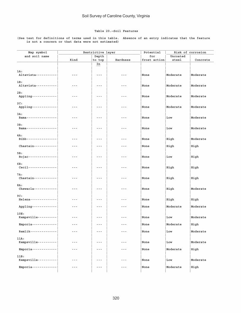
Soil Survey of Caroline County, Virginia
320
Table 20.—Soil Features
(See text for definitions of terms used in this table. Absence of an entry indicates that the feature is not a concern or that data were not estimated)
________________________________________________________________________________________________________ Map symbol | Restrictive layer | Potential | Risk of corrosion ___________________________________________ _________________________ and soil name | | Depth | | for | Uncoated | | Kind |to top | Hardness |frost action| steel | Concrete________________________________________________________________________________________________________ | | In | | | | __ | | | | | |1A: | | | | | | Altavista-----------| --- | --- | --- |None |Moderate |Moderate | | | | | |1B: | | | | | | Altavista-----------| --- | --- | --- |None |Moderate |Moderate | | | | | |2B: | | | | | | Appling-------------| --- | --- | --- |None |Moderate |Moderate | | | | | |2C: | | | | | | Appling-------------| --- | --- | --- |None |Moderate |Moderate | | | | | |3A: | | | | | | Bama----------------| --- | --- | --- |None |Low |Moderate | | | | | |3B: | | | | | | Bama----------------| --- | --- | --- |None |Low |Moderate | | | | | |4A: | | | | | | Bibb----------------| --- | --- | --- |None |High |Moderate | | | | | | Chastain------------| --- | --- | --- |None |High |High | | | | | |5B: | | | | | | Bojac---------------| --- | --- | --- |None |Low |High | | | | | |6B: | | | | | | Cecil---------------| --- | --- | --- |None |High |High | | | | | |7A: | | | | | | Chastain------------| --- | --- | --- |None |High |High | | | | | |8A: | | | | | | Chewacla------------| --- | --- | --- |None |High |Moderate | | | | | |9C: | | | | | | Helena--------------| --- | --- | --- |None |High |High | | | | | | Appling-------------| --- | --- | --- |None |Moderate |Moderate | | | | | |10E: | | | | | | Kempsville----------| --- | --- | --- |None |Low |Moderate | | | | | | Emporia-------------| --- | --- | --- |None |Moderate |High | | | | | | Remlik--------------| --- | --- | --- |None |Low |Moderate | | | | | |11A: | | | | | | Kempsville----------| --- | --- | --- |None |Low |Moderate | | | | | | Emporia-------------| --- | --- | --- |None |Moderate |High | | | | | |11B: | | | | | | Kempsville----------| --- | --- | --- |None |Low |Moderate | | | | | | Emporia-------------| --- | --- | --- |None |Moderate |High | | | | | |
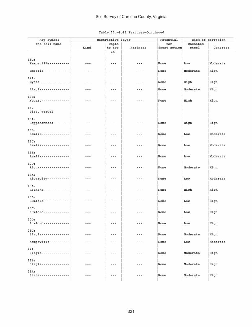
Soil Survey of Caroline County, Virginia
321
Table 20.—Soil Features—Continued________________________________________________________________________________________________________ Map symbol | Restrictive layer | Potential | Risk of corrosion ___________________________________________ _________________________ and soil name | | Depth | | for | Uncoated | | Kind |to top | Hardness |frost action| steel | Concrete________________________________________________________________________________________________________ | | In | | | | __ | | | | | |11C: | | | | | | Kempsville----------| --- | --- | --- |None |Low |Moderate | | | | | | Emporia-------------| --- | --- | --- |None |Moderate |High | | | | | |12A: | | | | | | Myatt---------------| --- | --- | --- |None |High |High | | | | | | Slagle--------------| --- | --- | --- |None |Moderate |High | | | | | |13E: | | | | | | Nevarc--------------| --- | --- | --- |None |High |High | | | | | |14. | | | | | | Pits, gravel | | | | | | | | | | | |15A: | | | | | | Rappahannock--------| --- | --- | --- |None |High |High | | | | | |16B: | | | | | | Remlik--------------| --- | --- | --- |None |Low |Moderate | | | | | |16C: | | | | | | Remlik--------------| --- | --- | --- |None |Low |Moderate | | | | | |16E: | | | | | | Remlik--------------| --- | --- | --- |None |Low |Moderate | | | | | |17D: | | | | | | Rion----------------| --- | --- | --- |None |Moderate |High | | | | | |18A: | | | | | | Riverview-----------| --- | --- | --- |None |Low |Moderate | | | | | |19A: | | | | | | Roanoke-------------| --- | --- | --- |None |High |High | | | | | |20B: | | | | | | Rumford-------------| --- | --- | --- |None |Low |High | | | | | |20C: | | | | | | Rumford-------------| --- | --- | --- |None |Low |High | | | | | |20D: | | | | | | Rumford-------------| --- | --- | --- |None |Low |High | | | | | |21C: | | | | | | Slagle--------------| --- | --- | --- |None |Moderate |High | | | | | | Kempsville----------| --- | --- | --- |None |Low |Moderate | | | | | |22A: | | | | | | Slagle--------------| --- | --- | --- |None |Moderate |High | | | | | |22B: | | | | | | Slagle--------------| --- | --- | --- |None |Moderate |High | | | | | |23A: | | | | | | State---------------| --- | --- | --- |None |Moderate |High | | | | | |
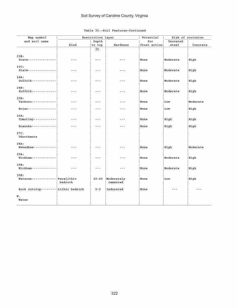
Soil Survey of Caroline County, Virginia
322
Table 20.—Soil Features—Continued________________________________________________________________________________________________________ Map symbol | Restrictive layer | Potential | Risk of corrosion ___________________________________________ _________________________ and soil name | | Depth | | for | Uncoated | | Kind |to top | Hardness |frost action| steel | Concrete________________________________________________________________________________________________________ | | In | | | | __ | | | | | |23B: | | | | | | State---------------| --- | --- | --- |None |Moderate |High | | | | | |23C: | | | | | | State---------------| --- | --- | --- |None |Moderate |High | | | | | |24A: | | | | | | Suffolk-------------| --- | --- | --- |None |Moderate |High | | | | | |24B: | | | | | | Suffolk-------------| --- | --- | --- |None |Moderate |High | | | | | |25B: | | | | | | Tarboro-------------| --- | --- | --- |None |Low |Moderate | | | | | | Bojac---------------| --- | --- | --- |None |Low |High | | | | | |26A: | | | | | | Tomotley------------| --- | --- | --- |None |High |High | | | | | | Roanoke-------------| --- | --- | --- |None |High |High | | | | | |27C. | | | | | | Udorthents | | | | | | | | | | | |28A: | | | | | | Wehadkee------------| --- | --- | --- |None |High |Moderate | | | | | |29A: | | | | | | Wickham-------------| --- | --- | --- |None |Moderate |High | | | | | |29B: | | | | | | Wickham-------------| --- | --- | --- |None |Moderate |High | | | | | |30E: | | | | | | Wateree-------------|Paralithic | 20-40 |Moderately |None |Low |High | bedrock | | cemented | | | | | | | | | Rock outcrop--------|Lithic bedrock | 0-0 |Indurated |None | --- | --- | | | | | |W. | | | | | | Water | | | | | | | | | | | |________________________________________________________________________________________________________
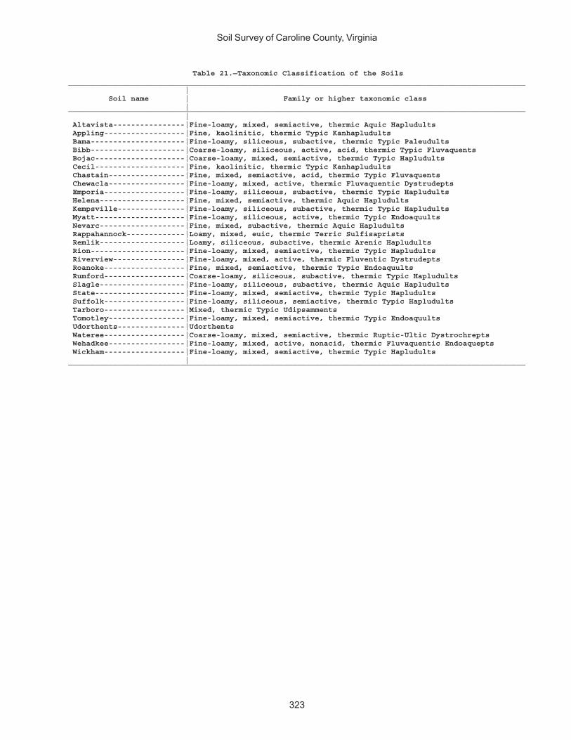
Soil Survey of Caroline County, Virginia
323
Table 21.—Taxonomic Classification of the Soils______________________________________________________________________________________________________ | Soil name | Family or higher taxonomic class |______________________________________________________________________________________________________ | Altavista----------------|Fine-loamy, mixed, semiactive, thermic Aquic Hapludults Appling------------------|Fine, kaolinitic, thermic Typic Kanhapludults Bama---------------------|Fine-loamy, siliceous, subactive, thermic Typic Paleudults Bibb---------------------|Coarse-loamy, siliceous, active, acid, thermic Typic Fluvaquents Bojac--------------------|Coarse-loamy, mixed, semiactive, thermic Typic Hapludults Cecil--------------------|Fine, kaolinitic, thermic Typic Kanhapludults Chastain-----------------|Fine, mixed, semiactive, acid, thermic Typic Fluvaquents Chewacla-----------------|Fine-loamy, mixed, active, thermic Fluvaquentic Dystrudepts Emporia------------------|Fine-loamy, siliceous, subactive, thermic Typic Hapludults Helena-------------------|Fine, mixed, semiactive, thermic Aquic Hapludults Kempsville---------------|Fine-loamy, siliceous, subactive, thermic Typic Hapludults Myatt--------------------|Fine-loamy, siliceous, active, thermic Typic Endoaquults Nevarc-------------------|Fine, mixed, subactive, thermic Aquic Hapludults Rappahannock-------------|Loamy, mixed, euic, thermic Terric Sulfisaprists Remlik-------------------|Loamy, siliceous, subactive, thermic Arenic Hapludults Rion---------------------|Fine-loamy, mixed, semiactive, thermic Typic Hapludults Riverview----------------|Fine-loamy, mixed, active, thermic Fluventic Dystrudepts Roanoke------------------|Fine, mixed, semiactive, thermic Typic Endoaquults Rumford------------------|Coarse-loamy, siliceous, subactive, thermic Typic Hapludults Slagle-------------------|Fine-loamy, siliceous, subactive, thermic Aquic Hapludults State--------------------|Fine-loamy, mixed, semiactive, thermic Typic Hapludults Suffolk------------------|Fine-loamy, siliceous, semiactive, thermic Typic Hapludults Tarboro------------------|Mixed, thermic Typic Udipsamments Tomotley-----------------|Fine-loamy, mixed, semiactive, thermic Typic Endoaquults Udorthents---------------|Udorthents Wateree------------------|Coarse-loamy, mixed, semiactive, thermic Ruptic-Ultic Dystrochrepts Wehadkee-----------------|Fine-loamy, mixed, active, nonacid, thermic Fluvaquentic Endoaquepts Wickham------------------|Fine-loamy, mixed, semiactive, thermic Typic Hapludults |______________________________________________________________________________________________________

NRCS Accessibility StatementThe Natural Resources Conservation Service (NRCS) is committed to making its
information accessible to all of its customers and employees. If you are experiencingaccessibility issues and need assistance, please contact our Helpdesk by phone at1-800-457-3642 or by e-mail at [email protected]. For assistance withpublications that include maps, graphs, or similar forms of information, you may alsowish to contact our State or local office. You can locate the correct office and phonenumber at http://offices.sc.egov.usda.gov/locator/app.