Embed Size (px)
Citation preview


SOIL SURVEY OF 7’HE
PRINCE GEORGE AREA BRITISH COLUMBIA
BT
C. C. KELLEY PROVINCIAL DEPARTMENT OF AGRICULTURE
L. FARSTAD DOMINION DEF’ARTMENT OF AGRICULTURE
REPORT No. 2
OF BRITISH COLUMBIA SOIL SURVEY KELOWNA, B.C., MARCH, 1946
The British Columbia Department of Agriculture in &operation with Experimental Farms Service, Dominion Department of Agriculture.
-9239. 5:46

Acknowledgment
The authors are grateful for the following assistance in the preparation of this report:
The soi1 survey was financed by the Dominion an’d Provincial Departments of Agri,culture. The Do!minion Departm,ent of Mines and Resources spervised the drawiag of the soi1 and lan:d ~clasa maps. Chemical analyses were made by the Division of Chemistry, Department of Agriculture, Ottawa.
R. H. Bpilsbury, Department of La&, Victoria, BC., classified 100,000 acres between Prince George and Woodpecker. E. W. Tisdale, Experimental Station,, Swift Current, Saskatchewan, prepared the section. on native vegetation, which was edited by R; D. Gregor, District Forester, Prince Geor)ge. R. B. Garter, Meteorologist .and E. Little, Prince George, supplied material and reviewed sections of the report.
Acknowledgement is made to officiais of the Provincial Departmed of Agriculture, who provided a,dvisory assistance and descriptive mater%.
Dr. A. Leahey, Dominion Department of Agriculture, inspected the survey work and reviewed the manuscript.


CONTENTS PAGE
Acknowledgment ................................................................
Map Showing the Location of the Surveyed Area ....................................
Introduction..............................................’......................
GENERAL DESCRIPTION OF THE AREA: LocationandExtent ......................................................... Topography ................................................................ Drainage ................................................................... SurfaceGeoIogy ............................................................. Climate .................................................................... NativeVegetation ........................................................... History and Development ....................................................
Population, Towns and Industries ......................................... Schools, Churches and Communications .................................... Transportation ..........................................................
Agriculture. ........................................ . .......................
SOILS: ‘SoilFormation ..............................................................
TheSoilPro~e .......................................................... SoilClassification ............................................................
FieIdMethods ..........................................................
DESCRIPTION OF Sor~s:
1. Soils derived from glacial till: ChiIakoStony SoilComplex ............................................
2. SoiIs derived from glacial river and lake deposits: GunnizaGravelly Sandy Loam .......................................... EenaSeries ........................................................... BednestiSiIt Loam .................................................... Pineview CIay Association ..............................................
3. SoiIs derived from post-glaciaI river and stream deposits: Giscome Gravelly Sandy Loam .......................................... SaxtonLoamy Sand ................................................... Fr~ersOilComplex ...................................................
4. Groundwater soils: Muskeg. .............................................................. Meadow ............................................................... ShaIlow Muck .........................................................
5. Miscellaneous Areas: Rough Mountainous Land and Rock Outcrop ............................. BIuffsandRavines...................................: .................
TheFarmWater SuppIy ......................................................... Lime Rock and Seepage Deposits .................................................. TheLandClassMrip ............................................................
Land Clearing ...................................................................
Appendix .......................................................................
,
5
2
3
7
7 7 8
.8 10 19 21 22 23 23 23
26 26 28 29
30
32 33 36 38
43 45 46
48 49 50
61 51 51 52
54
54
57

Introduction
This report is the se.cond of a series of soi1 survey publications describing important agricultural areas in British Columbia. Each report, complets in itself, is int.en,ded to be a brief descript.ion of the wrveyedj area. A description of the soils is the primary purpose but the report incIudes other data bearing on their nat,ure and utilization.
The parent materials from which th-e poils are derived were deposited during glacial and post-glacial time. The patt,ern of deposition forms part of thq system of soi1 classification and some of the deeper and older formations have importance as a source of enderground water. The surface geology plays a major role in determining the uses of the soils a.nd other resousces.
In British Columbia no two agricultural communities have exa&ly the same climate, and the distinctions of climate that oecur have a governing influence on the class of farming practiced in each area. In this pioneer district a detailed study of the climate Will play a part in dtirecting the course of agricul- turaI develgment.
Since the native vegetation is of unusal importan.ce from the agricultural point of view, a &udy has ,been made of the forest types in order to divide them ronghly into divisions .based on the cost of clearing land. The distribution of heavy and light f,orest caver on arable soils defin.es the areas in which agricultural develo.pment may take place with the best chan.ce of success.
The soi1 m*ap is published in one sheet on a, scaIe of 14 miles to an inch. It gives the location and extent of the classified soils, and the locat,ion of roads, rivers and streams. An added feat.ure is the land class map, which sugges%s the possibilities fur agricultural expansion in the surveyed area.
GENERAL DESCRIPTION OF THE AREA
Location and Extent
The mapped area consists of a rectangular block situated in t.he central interior of British Columbia on the eastern side of the Nechako Plateau. The southern limit is latitude KV-30’, located a mile south of Woodpecker, and the northern boundlary cuts through Summit Lake on 54”-17’ north. latitude. The east side of the area is on longitude 122”-30’ and the west boundary follows longitude 123°-OO’.
This area centres on Prince George and covers ap@oximately 714,597 acres. Of this amount there are about 690,869 acres of land and 23,728 acres of lakes and rivers.
Topography The Nechako Plateau is a region of mature relief. Surface features consist
of a rolling till plain, pierced here and there by a few rock knolls and carved into several parts by valleys of the Fkaser and Nechako Rivers and their trilbutaries.
The highest eievation is along the east side of the map-area? where Six Mile Mountain rises 4,125 feet above sea level. C%her high pomts include Pilot Mountain, 3,275 feet, which is located on the east side of Swamp Lake, and several rocky knolls of about the same elevation to the south of Nadsilnich Lake.
7 62822-3

8
The higher parts of the till plain range u~p to about 2,700 feet. above sea leve!. At elevatipns below 2,600 feet the rolling till has been .coverFd* by g$;;l lake depoats. In the laked area there are three topographxal dlstmc-
. The surface is mainly undulating, in part hilly and partly redu.ced to coulees antd stream channels by erosion.
The most striking topographie features are the great post-glacial channels vf the Fraser and Nechako Rivers and their tributaries. The treaches of the Yrnser and Nechako are from one to two miles wide, and in places they attain R depth of 370 feet or more below the surrounding plateau. These valleys are lined with a series of terraces, some of the ,lower ones being suitable for ?gri- culture. Where they join at Prince George, tl?e Fraser and Nechako Rlvers are at. 1,860 feet elevation. At Woodpecker t.he elevation of the Fraser is :a bout 1,700 f,eet above sea level.
Drainage
The main drainage outlet is the Fraser River an,d its chief tributary is the Keckako. The Willow and Salm,on Rivers enter the Fraser from east and west in the northern part of the district, and the Chilako River flows into the Nechako to the west of Prince George. A number of small creeks and streams oonnect the lakes and muskegs with the main drainage channels.
A limited area in the northeast corner of the district drains into Summit Lake. This comparatively small body of water at 2,315 feet elevation was reserved for a national park in 1942. It lies on the nortfi side of t.he Arctic- Pacifie Divide and drains nort,hward into the Parsnip River.
Originally’ the rivers were used as a means of entry into the country, and steamers on the Fraser transported most of the freight. They are still utilized by prospectons, trappes and by the lumbering industry. The Fraser and Kechako Rivers transport, large quantities of logs t.o doa-nstream mills, and ihe Chilako, Salmon and Willow Rivers cari be used for t,he same purpose when log jams are removed. ?%ne of these rivers ij important f,or sport fishing.
The classified district is noteworthy for numerous lakes of assorted sixes. In many of the smaller ones fish cannot s,urvive the winter season. T.his ia due to the absence of inflowing st,rea.ms, which limits the air supply to the amount in the water when the surface is frozen over. Some of the l.arger lakes conhain on,ly coarse &h, which in part may be replaced by sto.cking. The local Rodl and Game Club maintains a small hatchery for the annuel. distribution of %am?oops trout. Trapping Lake, Tabor Lake and Summit Lake are favourites for trout fishing, ancl Summit Lake also contains char. There are about 23,728 acres of water in the classifieci district, of which approximat,elg 11,250 acre8 comprise river water and 12,478 acres represent the ar,ea covered by lakes.
Soi1 rdrainage varies throughout the area. Imperfect drainage is common in the arable soila before cultivation, but the degree of wetness is small and amelior- ation is net ,difficult,. Owing to the density of the ntiural vegetatioru the spring runoff from melting snow is normal, but the dept,h of the main river chartnels helps gully formation on the plateau for some distance from the river banks. Measures of prevention against gully erosion Will be necessary when the land is cleared and cultivated.
Surf ace Geology
During the Pleistocene epoch the district was overridden by glacier ice. It is probable that more than one glaciation occurred, but the final ice movement was of such intensity as to demolish any subskantial evidience of an earlier gla,ciation.

9
There are still a few ill defined remàins pointing to a glaciation which hoUs $he same po&ion as t.he Admiralty TiB in the Lower Fraser Valley and on Vancouver Isl,and”. Faint markings with ,a northwest to southeast dùrection were observed ,on aerial Iphot.ographs, and two Imayers of till serarated by from 10 to 20 feet of stratified aands were seen on a few river bluffs. T,he onIy find whioh pointed to an interglaÇia,l epoch was a good specimen of lignified driftwood. This was locat,ed several feet beneath the upper til,l and lodged in stratified grave1 on the face of a grave1 pit.
The final glaciati.on is strongly outltined as a rolling plain in areas where the till is exposed, th,e djirection of flow being from th,e nort*heast t.o the southwest. As the ice vacated the lower elevations a temporary lake was form& in the depressed valley *areas. When at its greatest extent the lake water spread beyond the east, west and south limits of the map-sheet.
‘One of the ,chief contributors of la.custrine deposits was the Stuart River, whose abandoned channel now forms a remarkable topographie feature. During a stage of ice decay the Stuart excavated a charme1 about two miles wide down- stream to Mandalay Creek. From there the river turned eastward and emptied at the present junction of the Nechako and Fraser Rivers.
The abandoned river couirse is well iallustrated in the aerial photographs. Starting eastward with well defined banks at the mouth of Mandalay Creek, it bec,omes a maze of parallel ridges in the vicinity of Taginchil Lake, w*hich lies west of the present map-.area. T!he ridges are .broken and irregular. In places they become a vein=like network containing boat-shaped depressions. Mo& of these depressions are ,dry but many contain small lak,es.
Where it enters the classified area near the road junctioa to the south of . Nukko Lake the course narrows to less rth*an a mile and extends to the Necbako River north of ,Miworth. From this point ridged and hilly land turns east along the north bank of the Neohako to Prince George, nand northward along the west bank of the Fraser for about six mil.es.
The materiaIs, of the river course are partly washed gravels and sands from which ‘the Gunniaa series is derived, and in part sands. The outwash material near the river mouth is mainily sa& and silt. The sand .and silt were laid down in separate 11tmsse5 over ice and over glacial till. The decay of buried ice caused collapse of tbe surface and the formation of hilly land. Where the sands and tilts were deposited over $21 the rolling till topography w,as smoothed to an undulating surface. The sands of tbe river course and the outwash sands were named Eena series. Soils ,derived from the stratified river silt were designated B,edne&i series. T%e para&1 ridges of the abandoned river course and the hiliy land in the vicinity .of its mauth were grouped a.s a hilly phas,e on the soi1 map.
In the lower parts of the Fraser and Nechako River Vallleys the glacial lake was flrst bottomed with silt, and later on the silt was overlaid with a 10 to 25 foot otratum of varved clay. The lake attained its greatest size when the Upper limit of olay ,deposition was ab,out 2,450 feet above sea level.
While the bcustrine deposits of the Stuart River are important, the enor- mous volume and distribution of clay suggests &hat the Fraser, S&norû, Willow and Chilako Rivers were additional carriers of fine sediments. This clay forma- tion is the parent material of t*he Pineview Clay Association.
The temporary lake in. whieh the varved olay accun&atedl was formed by submer,gence of the lower parts of the till plain. Sections of the shoreline were com.posed of till and drumllin tops were exposed as is18ands. These features are illustrated at Summit Lake, which exists as a remnant of the old glacial lake.
‘Geology of the Fraser River Delta Ma,p Area, Memoir 135, Geological Survey, 1923, Ottawa.
62822-31

10
Gravelly beachlines were formed as hhe glacial till was sorted by wave action abng the lake margin and around the islands. Many of the lower lying islandts were reduced to grave18 by the sorting o-ut of fine materials. These grave1 deposits are now o,f great value for local use.
As the ice dams melted, the lake level was lowered and its clay bottom exposed. At this time the Fraser and Nechako Rivers began to excavate their post-glacis? ch.annels and to buil:d terraces along their banks. The stratified clay and silt were soon removed and the rivers tut deeply in,to the glacial tiU. The fine materials were oarried away and discharged into, the Fraser delta, but the gravels and sands washed from the till remaid to form the first terraces. These gravelly and sandy terraces are the parent rmateriab from which the Giscome and S;atin aeries are derived. When the rivers f&Jly ne,ached hheir pre-glacial beds the rate .of slow d.ecreased and the more recent bottoms are of finer textured material. These first and second terraces flrom present river level provided most of the materia.1 from which the soils of the Fraser Soi1 Complex are derivedl.
The glacial till is the parent material of the Chilako Stony Soi1 Complex. Where exposed on river sections the till is of mixed origin, without any signs of limey efflorescence. Along the Fraser and Nechako Rivers the thickness of the till is from 100 to 200 feet or more, and the texture varies from loam to clay with varying amounts of stones and gravel. The stones d.iffer in siee, but are mainly small. They are present in considerable variety, most of t.hem being from formations of great age.
On a river eut the stones in the compact till have from one to several inches of fine material between them. On the surface of the drumlins, however, this uni.formit.y does not exist. Part of the finer materials have eroded into the hollows and the soi1 becomes more sandy and gravelly with increased elevation. At the top of a hi11 boul,ders from onCe to two feet in diameter are often. encountered, and these lie in a mixture of washed sand and gravel. The materials are coarse at the top and fine at the bottom of the larger hi&.
The thickness of the tif1 on the drift covered Nechako Plateau is unknown, but the river valleys have exceptionally thick till underlaid by older stratified deposits. Near the Nechako River bridge are horizontally bedded sands and gravels which un,derlie the till. These sands are grey and they contain particles of lignite from upstream sources. The exposed sand above the sloughed material is unconsolidated and it appears to be somewhat younger than a similar deposit along the Fraser River to the east of South Fort George.
The deposit that outcrops on the bank of the Fraser River consists of yellowish brown sands and gravels, and it un,derlies the till with a thickness of about 140 feet. These materials are of inter-glacial or pre-glacial age, and some of the layers are consolidated to weak sandstone.
Beneath the sandy and gravelly materials a lacustrine deposit, assigned to the Middle Tertiary”, overlies bedrock. The lacustrine materials are recogniaed as greenish clay-grits. They outcrop on the side of an isolated hi11 at the north end of the Prince George muni,cipal airport and on both sides of the Fraser River near the mouth of Tabor Creek. The S:urface of this deposit is a probable source of farm water su,ppIy un.der the Pineview Iocality, to t,he southeast of Prince George.
Clitnate
The main climatic features correspond with those that prevail along the southern fringe of the northern forest or taiga. The Winters are cold and the summers mild! with rather abrupt seasonal changes, Lolcally t.his northern interior climatm regime is modified to correspond with conditions usuaIly found
*Lay, Douglas, Fr.aser River Tertiary Drainage History in Relation to Placer Gold Deposits. Bull. 11, 1941, Dept. of Mines, Victoria, B.C.

11
farther south. Summer and winter temperatures are increased by northeasterly air movements from the Pacifie O,cean and precipitation is great.er than in any other low level area along the eastern fringe of the Interior Plateaux. This important feature is probably due to the arrangement of the mountain systems to the east.
A striking feature of the local climate is its variability, the moist Pacifie. air from the southwest being in more or less continuons conflict with polar air from the north and northeast. The constant battle of air masses is chara,cterized by strong temperature contra&, cloud.iness, and a suc,cession of d,ry and wet weather.
The intermittant southward penetration of polar air brings from three .t,o six cold spells each winter. These last from a few days to two or three weeks, and extreme temperatures of from three to seven days duration are experienced during the larger ones. The low temperatures reached at such times range from 15 above to 50 below zero, and unprotected grouad may freeze to a depth of six feet or more. Between cold spells the warm fronts from the south.west Pa,cifi,c Ocean moderate the winter climate and day temperatures are from 32” to 60” F.
The beginning of winter is marked by a definite change during the last week of O(ctober, often with light snow w,hich melts away. Around November 10, t,here is generally a snowfall of from four to six inches, which remains on the ground.
Ice generall,y forms around Niovember 15, and the lakes a.re soon frozen over. In winter the ice lbuilds ‘up to a, thickness of about 24 inches on lakes and rivers, and in t.he riyers anchor ice m:ay form. SinIce records were kept the departure from this general out.line occurred in the winter of 1925-26, when zero was the loweet temperature.
Spring breakup cornes around April 9, when the ice be,gine to muve on the rivers. The breakup on the lakes is from a week to 10 d’ays or more lster. During most years April and May are cool months with low precipitation and hnmi.dity. The low humidity cuts away the snow and helps dry the land for seeding.
Summer precipitation and higher temperatures begin with frequent thunder showers in June. T,he thunder showers cominue to the midcl1.e of J’$y, after which there is a period of warm weather with *less raiafall until Septemlber, when precipitation is slight.ly greater and temperatures cooler. These conditions are more or less uniform within the whole m,a.p-area.
The climate is responslible for the species of plan& that flourish, for the volume of native ,growth and for the kind of soi1 developmerrt that occurs. The chief climatie f,actors are the moisture su;prply ancl the temperature, which shape the environment.
The amount of rain tha,t falls is of greatest importance in more southerly areas, where the season of growth is long and temperatures reasorrably high. In this district temperature plays the leacling role by virtue of its limiting effect, and the moisture supply takes second place.
A short growing seasoa with long warm days and cool nights bas a sel.ective effect on native flora and upon the rapidity ansd volume of ,grow-th. The natural requirement,s cal1 for a frost-resistant n.ative flora with a short growing season, and crape r-nu&, meet the same condétions.
The Grey Wooded Soils of the region developed in response to the cool temperature regime. For five months the soils are lfrozen antd ,during about three month#s they are cool and growth is limited. It is thus apparent that eight months of comparative rest in a cool and froeen. state is essential for, effective response in the .growing season. From about May 15 to Se@,ember 15 the soils >provide the substance for great ,biological activity.

Temperature
The only temaperature station in the map-area is Iocat.ed at Prince George, where comph?a records go back to 1916. Prince George is about 400 feet or more be1o.w ,plateaL. -evel, and the mean temperatures for this station may be from one to three degrees warmer than the average for the d.istrict. A summary of the average mean temperatures is shown in Table 1:
TABLE l-AVERAGE MEAN MONTHLY TEMPERATURES AT PRINCE GEORGE FOR THE YEARS 1916 TO 1943
R&nge of Mean Temperature
Month
gmmum~ ................................................................................
March ............................................ April .............................................. gll:.
......................................................................................................................................... August ............................................ September ........................................ October ........................................... November. ....................................... December.. . . . . _ . . . . . . . . . . _ . . . _ . . . . . . . . . . . . . . .
29 (1931) 29 (1930, 31) 37 (1926, 29, 41) 47 (1934, 41) 55 (1936) 59 (1923, 28) 64 (1920, 41,42) 62 (1927, 30) 57 (1938) 45 (1929) 42 (1917) 33 (1930)
Lowest Monthly
AveAyge F” . .
-12 (1916) - 9 (1936)
22 (1919) 33 (1935) 41 (1920) 53 (1919, 33) 57 (1917, 29, 32) 55 (1937) 45 (1926)
i5 I”; - 1 (1927)
For the 28 years on record the mean annual average temperature is 39“F. The difference between the average temperature of the ,coldeet month a& the warmest month ia wide, with a variation of 46”. The average for January, the coldest month, is 14” and the warmest month, July, is 60°F. The lowest mean for any month was in January, 1916, with an average of -12°F.
From 1916 to 1943 the record low temperatures is -57”, which occurred in January, 1928, the uwal winter extreme being around -40°F. The highest tenùperature on record is 102.4”F., reported in July, 1941. For most years the extreme high temperature varies between 83” and 95°F.
The district is noted fer cool nights with high relative humidity and heavy dew in sum.mer. During c%lear weather eold air drains into the depressions at night and there iw some front ,d,anger. Frowt is o:ften prevented, however, by frequent thunder showers, which increase humidity and cause a protecting blanket of ,fog to form in t:he depressecl areas.
The Growkg Season
Growing plants differ in their capacity to resist cold and their growth periods vary accordingly, but some ides, of the length of the growing season is necessary in a dewcription of ,climate. On the b,asis of 43” mean temperature in wpring and fall the growing season begine on April 23 and ends 168 days later on October 8. From year to year &ring this period the average tem- perature varies between 53.4” and 56.0” F., and, in the dormant season the average temperature lies between 23 ’ 1” ancl 29.3” F.
The season of growth, however, is longer than the number o,f days suggest, owing to the length of adaye in June, July anal Au.gust. If the growing season could be counted as hours of daylight instead of days, it would compare more favourably with growth periods m the southern garts of the province. On the

13
basis of days the gro’wing season varies from 270 to 228 on the southeast toast of Vancouver Island and in the Lower Fraser Valley. In the Okanagan Valley the growth period lies between 226 and 200 daya.
The growth peri0.d between the la& frost in spring and the first frost in fa11 is importa& to the group of crops with the least frost aresistance, but in the classi- fied area this period is obscured by the occurrance of ligbt frosts in summer. W.h,en conditions are favourable the summer frosts follow rapid radiation at nighrt. Night radiation is hel%ped by cool and extensive areas of forest, which fail to store heat in day time. At present there is no dependable period between spring and fa11 that is al,ways frost free.
In nppended Table 1 the summer frosts are differentiated from spring and fa11 frosts, and their number is given for the years in which they occur. It seems likely that frosts now occurring in June, July and August Will gradually disappear as Isrger areas are cultivated and the district passes from the pioneer stage to a mature agricultural community. Small and isolated clearings are dead air pockets cooled by the surrounding forest, and the ground does not store enough heat to offset the drop in air temperature. As the district becomes more extensively settled the cleared land is connected in long stretches which promote air drainage and greater heat storage in the soil. Such conditions in future should reduce the summer front hasard and lengthen the frost-free period.
Frost records taken since 1920 show that the last spring frost cornes between May 12 and June 3:, and t.he first killing fa11 frost occurs from August 22 to October 7, killing frosts in August appearing only twiee in the record. There are five years in 24 with no summer fronts, but 19 years have frosta averaging three degrees in June and/or July and August, the greatest frequency being in June. T.he.frost-free period ranges from 43 to 120 d.ays, the. average being 82 days.
PrecifGtation
There are two rain gauges in the classifiedl area. The more importam station, bcated at Prince George, has been in continuous operat.ion since 1917. At Woodpe.cker, in the southeast. c.orner of the surveyed area, is t.he second station, which began recording precipitation in 1935. From the limitsd d.ata, this 1,ocality has approximately the same precipitation pattern as the Prince George station, with slightly less precipitation for the same pe.riod of years. For the nine years on record the .annual .average precipitation is 24.52 inches compared with 25.26 inches at Prince George.
The precipitation pattern at Prince Georgeis shown in Figure 1. During the period on record February, March, Apri,l and May have averaged the driest months of the year. Low rainfall and humidity in April and May are of particu- lar value in drrying the heavy cl,ay land for pl;anting, but departures have occurred three times in April and four times in May during the 27-year period.
The average shows that the important growing month of June is well supplied with moisture, and in 27 years there are only three departures which give June less than an inch of rain. These departures did not bring trop failure, inasmuch as the reductions in hay yields were only 30 to 50 per cent and grain crops were rednced by about 30 per cent.
Previous to 1931 July was ,a comparatively dry month, .with nine years during which ;the rainf& averaged 1435 than one inch. nearly equals rainiaI in June.
Since 1931 July rainfall T,hi,s is due mainly to the overlap of June precipi-
tation into the first half of July, caused by more numerous t.hunder showers from the southwest. The extra rain in July is of little value to the hay trop, since haying begins .around July 1. When showers are frequent t.he quahty of t.he hay in thle cock ie Iowered, and there is added labour of turning and drying before it cari be stacked.

0 J. F. M. M. J. J. A. N. ‘ 0.
Fig. l.-Precipitation pattern at Prince George, January to Decemùer, showing low spring and heatier summer and autumn rainfall.
August and September are harvest months for grains, clover seed and mots. They are aIso months when precipitation is on t.he increase to a September peak. When a wet period begins in the baatter part ,of August and continues through September, damage is done to the gain and clover seed harvest. Probable loss oocurrd during six years between 1917 to 1943, when September precipitation was in exc~ of three inohes. In 1941 a record Sept.ember rainfall of 6.12 inches did major damage to the grain and clover seed ,crops. Crop losses at harvest are always distreseing, but damage to six crops in 27 at harvest is fairly Jow in a district where droughts causing trop losses are comparatively unimportant. Precipitation averages for the period on record are ‘given in Table 2.
Local experien’ce in respect to trop production ia still in the pioneer stage and adjustments are necessary before a definite production routine cari be estsjblished. The precipitation pattern, which features a dry slpring and a damp fall, favours hay, pasture and roots with grain as a sideline for feed.. Alsike clover seed hm been a pioneer cash cmp not always easy to harvest, and later .on it may be replaced by crops convertible to dairy prodncts and meat.
14

15
TABLE 2-MEAN MONTHLY PRECIPITATION AT PRINCE GEORGE FOR THE YEARS 1917 TO 1943
Months Mean
Mean Monthly Precipitation
M?n!hly Range in Different Yesrs
Pre;;~;$on Highest Lowest Average Mean Average Mean
-.
January............................................ February . . . . . . . . . . . . . . . . . . . . . . . . . March.. . . . . . . . . _ . , . . . . . . . . . . . . . . _ . . . . . April.. . . . . . . . . . . . . . . . . . . . , . _ _ . . . . . May.............. . . . . . . . . . . . . . . . . . . . . . . . . . . . . . . . . . June. . . . . . . . . . . . . . . . . . . . . . . . . . _ . . July . . . . . . . . . . . . . . . . . . . . . . . August . . . . . . , . . . . . . . . . . _ _ . . . . _ . September _ , . . . . . . . . . . . . . . . October _ . . . . . . . . . . November......................................... December.........................................
1.89 3-99 (1920) 1.28 3.35 (1939) 1.38 3.19 (1940) 0.90 2.96 (1940) 1.41 2-91 (1934) 2.25 4.06 (1933) l-82 5.08 (1932) 1.98 4.05 (1925) 2.21 6-12 (1941) 2.16 3.84 (1919) 2.11 6.00 (1919) 2.05 4.41(1942)
Yearl; &$~II Highest Year 31.32 (1941)
Lowest Year 14.45(1926)
with The period of snowfall extends from Octoher to April, as shown in Table 3, the heaviest fa11 in December and January. Periods of mild weather cause
shrinkage and reduction of depth, the average thickness of snow on the grounjd being from one to three feet. Since M6 the annu!al snowfall has varied between 22-40 and 141-75 inches, the average being 63.64 inches for the 27 years of continuous records.
Snow in the past has been of use to the farmer for sleighing, prevention of deep frost penetration and f,or saturating the soi1 in years of low frost penetration. In future it may have additional value as a source of water for cisterns and storage ponds in localities where well water is scarce.
TABLE 3.-MEAN MONTHLY SNOWFALL AT PRINCE GEORGE FOR THE WINTERS FROM 1916 TO 1943
MontlIs
October. . ..‘...............................,....... November December
.........................................
January.. ......... gea~c;my:
:‘:::::::::::::::::::::::::::::::::::: .........................................
April.::...:::::::::::::::::::::::::::::::::::::::::
Mean
SnooBi Inches
1.45 10.03 15.30 1642
?'E 0194
Range of Mean Monthly Snow- fali in Different Years
Highest Average Mean
17.40 (1919) 56.00 (1919) 40.50 (1917) 39-25 (1920) 30.50 (1925) 27.00 (1919)
9.00 (1939)
-
--
--
Highest Year Lowest Year 141.75 (1919-20) 22.40 (192930)
Lowest Average Mean
0.00 (13years) Trace (1916) 2-50 (1921) 4.00 (1942) 040 (1920) 0.00 0.00
(1941) (15yeal.s)
628224

16
Relative Hrcmidity
Relative humidity, obtained from wet and d,ry bulb readings, follows the precipitation curve, as shown in Fiagure 2 and Table 4. April is the driest mont.h of th.e year and also the month of lowest relative humi,dity. Low humidity in April promotes the drying of clay çoils, but it. also d,eIays the growing season by enabling fr0st.s to occux. These frosts continue through th,e comparatively d.ry month of May,, to be reduced to light frosts in June and succeecling summer months by increased relative hu~miclit,y and the rise of mean temperature
Throughout the summer months when nights are clear the t.emperature is deczeased and heavy dew is formed, which sometimes fogs depressed areas and serves as a protection against frost. During periods of low humidity and clear weather in summer, however, the cold air drains into the depressions at night and light frosts occur, while higher ground remains frost free. In the fa11 these coaditions are revers&, owing to heavy condensation and high relative humidity. The frosts occur on the urplands, while river channels and coulees often stay frost free for a considerable period under the protection of heavy fog at night. The frost occurrence from year to year varies with the changing relationships of relative humidity, clou’dineas and temperature.
J. F. M. A. M. J, J. A. S. 0. N. D.
Fig. 2.-Relative humidity nt Prince George, January to Deaember. Average for 13 years.

17
TABLE 4.-MEAN IMONTHLY RELATIVE HUMIDITY AT PRINCE GEORGE FOR THE YEARS 1930 TO 1942
Mean
Months
January ............................................ February .......................................... March. ............................................. April. .............................................. Ma&. :.::: :..:.:::.::::.::: ........................
July ......... ::.: ... . .... :...:::::::::::::::::::::::: August. ............................................ September ......................................... October ............................................ November ......................................... December .........................................
Yearly Mean Highest Year 72 78 (1941)
--
-
Mean Monthly Range of Relative Humidity in Different Years
Highest Lowest Average Mean Average Mean
88 (1931) 81 (1940, 80 (1931)
42)
73 (1937) 74 77
(1939) (1941,
77 (1936) 42)
82 (1937) 85 (1941) 85 (1938) 87 (1940) 89 (1930)
--
--
-
48 (1930) 48 (1933) 44 (1933) 38 (1933) 37 (1935) 46 (1936) 68 (19331 68 (1930) 68 (1937) 69 (1931) 59 (1931) 57 (1933)
Lowest Year 65 (1933)
Cloudiness and Bright Sunshine
November, December aad January are cloudy months with the fewest hours of sunshine. Clomliness in winter is asoociated with mild wea.ther, and during the coldest Winters the heurs of bright sunshine are increased. In comparison with 16 sunshine stations in British Columbia,, there are nine stations with more sunshine than Prince George. This is due to the frequency of broken clouds aad general cloudiness obscuring the suri.
In summer zbright sunshine reaches a peak in J~uly, with an average of 262 heurs, and in succeeding months it gradually ,dro~ps off to a low of 40 houx in December. The (distribution ocf sunshine by months throughout the year is shown in Figure 3, and average monthly figures are given in Table 5.
TABLE a.-HOURS OF BRIGHT SUNSHINE AT PRINCE GEORGE FOR THE YEARS 1930 TO 1943
Average Heurs of Sunshine
1930 to 1943
January ............................................ February .......................................... March. ............................................ April ............................................... May .................................. . ............ June .......................................... . .... July ................................................ August ............................................. September ......................................... Ootober ............................................ November ......................................... December .........................................
980 131
.183 232 235 262 246 159
97
4;
Yearly A=;ge
-
Upper and Lower Limits of Sun- shiue in Different Years
Highest Month Lowest Month
127 (1930) 138 (1934) 163 (1941) 237 (1934) 282 (1938) 272 (1932) 306 (1931) 306 (1933) 209 (1937) 129 (1940)
64 70
(1937,41) (1943)
Highest Year
1968 (1930)
19 (1941) 63 (1933) 71 (1940)
124 (1937) 196 (1943) 162 (1933) 206 (1932) 174 (1937)
85 (1941) 64 (1941) 34 (1940) 26 (1933, 35)
Lowcst Year
1664 (1933)

200 .
E
g x
100 -
O-
J. F. M. A. M. J. J. A. S. 0. N. D.
Fig. 3.4unahine pattern at Prince George, January to Dewmber.
Prevaiting Wind
The anemometer at Prince George, installed in 1937, gives prevailing win~ds as fullows: South southrwest to southwest 72 per cent, northerly 2fj per cent, westerly two ,per cent. The maximum velocity of souther$ winds is 30 miiles per heur, excepting thuacier storms from the southwest in summer, which a.ttain 35 m.p.h. for short periods. Higher velocities are prevented by the terrain and forest caver. Northern winds have a maximum velocity of 18 m.p,h., and east winds are negIig$ble. The maximum velocities of wind are attained during the equinoxes, and the yearly a~verage for the six years on record is 37,899 miles. During this period the variation is from 33,362 miles to 45,993 miles per annum. Cloud observations indicat.e that. win(ds, aloft swmg five to t,en ,degrees west per 1,000 feet elevation.

19
Native Vegetation
The present vegetation of the surveyed area consists of three main forest types resulting from recurring fires. These have been reco,gniaed as (1) aspen- willow, (2) lodge-pole pine and (3) white spruce.
The first type is a medium to medium-open ,forest dominated, by aspen (Populus tremzdoides). There are also a, nu~ber of willow species an’d a Iesser amount of aider and birch (Betula papyrifera). The shrub and herb layers are well developed!, while the moss Iayer is scanty. The ,main shrubs are hardhack (Spiraen Douglasii) , thimbleberry (Bubus parvifiorus) , twinberry (Lonicera involucrata) , red osier sdogwoo8d (Cornus stolonifera) and wild rose. Important herbs include giant fireweed (Epilobium angustifolium), two species of asters, twinflower (Linnuea borealis) , Canada bunchberry (Cornus canadensis), wild strawberry and lesser amounts of yarrow (Achillea millejolium), pea-vine (Lathyrus ochroleucw), American vetch (Vicia americana), paimed bush an,d common wintergreen (Pyrola secunda) . The scanty moss layer consists chiefly of spike moss (Polytkhum juniperum) a& a foliose lichen.
In the second type the dominant tree is lodge-pole pine (Pinus contorta), while aspen, birch and Young spruce are fairly common. The tree eover is denser than in the aspen-willow type and the shrub and herb layers a.re redsuced. The mass bas, mediium deveIopment.
The principle shrubs are wild rose, soopolallie (Shepardia canadensis) , twinberry, high-bush cranberry (Viburnum opulus) a.nd dwarf spira.,ea (Spiraea lucida), Important her,baceous species inchrde twinAoJwer, giant fire.weed, t.wo species of asters, Canada lbunchberry and wild straw.berry. The mass layer con- sists chiefly of two lichens--foliose and erect cu.p types, along with spike and semi-spike rnosses and the feather moss (Hylocomium splendens) .
When fully ,d:eveloped the third type is a, forest o:f medium to high density, dominated cby white spruce (Picea oanadensis) . Sub-alpine fir (Abies Zasiocarpa) is common and lod!ge-pale pine often. remains long a,ft,er it bas ceased to be domieant.
The shrub and herb dayers are sparse, while the mass stratum is. higbly developed. Common shrubs inclu,de high-,bush eranberry and twinflower on normal sites, while devil’s club (Echinopanuz horridum) occurs frequent.ly on poor18y dlrainsd areas. The herbaceous caver consists chiefly of such plants as Can)a:da bunchberry, two species of ferns, rat.tlesnake orchid’ (Goodyera Men- aiesii), wintergreen and queen’s cup (Clintonia uniflora). The mass layer is composed of feather and foliose masses and a. number of lichens.
It is evident that the above types represent the growth that ocûurs after fires and the srpruce forest develops over the longest period of time. The aspen- willow an’d Mge-pol,e pine types occur at an earlier stage, but not in a.ny regular successions. Where the original stand was spruce and the fire very severe, the seeds in the groundl litter were destroyed andl the first growth consists of species h.aving light windt-carried seed,. willow forest.
These conditions produce the aspen-
Where lodge-pole pine formed a part of the original stand it tant generally repr,ocluce after fire. This is particularly true on the gravel$ and sandy soils where it is most a:bundant. The seed is heat resistant and fire does not usually crown t-hrough the pine trees. In. some cases this a.llows the lo,dge-pale pine to prodnrce a trop of sesd after being kil,led at the base. Fires vary in their severity aad fîre may pasa over an a.rea leavin!g trees that survive. Where t-h% occurs there !Vi11 be reproduction of s.pruce or pine, according to t,he species left standing.

20
As the aspenrwilLow type reaches maturity on t.he finer testured soils it is gradual.ly replaced by spruce, which resches dominante with the decline of the shelter trop. Spruce Will .aIso gradually sh.ade out lodge-pole pine on fine- textured soils where it w,as once *dominant. The sppruce is usually considered to be the climax type, but it may deterioriate when over-mature to a spruce-balsam type and finaaly to the more rarely occurring stand of pure balsam.
The spruce forest is related to the cool, moder.at.ely humid ehmate of the Prince George district, wi,th annual precipitation around 21 inches and an aver- age of aboutit 1.93 inches of rain per month from May to September incbusive. The mean minimum temperature for this five-month periodi is 41” and the mean maximum 66.4” F. In th,e Fraser River Valley the southern edge of t,his, forest type ,appears to be around Quesne), uhere the climat,e is slightly d!rier an.d warmer.
West o,f Prince George there is a gradua1 change in the vegetation. The tree caver becomes slightly more o.pen and certain species confined to coarse dry soils around Prince George are more. comm,only found. Douglas fir (Pseudotszbga tazifolia) , b-earberry and the lich~en called reinde.er mass (Cladonia rangiferina) are prime examples of the new conditions. The records sho,w that this is probably due to a gradua1 drying off to the westward, whik temperatures remain the same or are sbghtly lower t,han t.h#ose at Prince George.
In any climatic zone the native veget.ation plays an important role in soi1 development, and in the surveyed area certain m.odrfications were observed in the eff&s of coniferous and decid;uo,us fore& types. The structure of the solum in the heavy soils begins in horizon A1 in t,he form of very small anguliar granules which become progressiveIy larger as the lower part of horizon B1 is approached. The b.est development of this struc,ture occurs under spruce forest, which mIai* tains a substantial caver of ground moss. The mass laver is low in bases and it contributes about t,n-o thirds of the decaying orga& matter of horizon Ao. Since t.he solum attains the ,highest acidity un,dsr theçe condtions, this type of caver is mainly responsible for the angular structure and the production of organic acids whieh ble,ach horizon Az. Under the coniferous forest the cost of clearing is consid,erable and the soi1 itself requires treatment before satisfaetory crops cari be harvested.
When the spruce forest. is destroyed by fire the granular A2 horizon is exposed. Until this surf.ace iss again pro.tected by vegetation it .has a tendency to erode in the freshet season. The amount of erosion depends on the SIope, and on the steeper ones the entire Az horizon may be lest at this time. Usually the soi1 . erodes from the knolls and accumulates in the hollows of the undulating surface.
Devel,opment of the <soi1 under ldeci,duous forest is far more f.avourab18e from th’e agri.cultural point of view. The f.all of ‘leaves land decay of annual plants prodluces a base-rich organic mat,ter on soi1 with previ.ously developed angular s&ructure and high acidity. The result is a modification of the structure and the soi1 reaotion.
The observed structural change is conversion of horizon A2 from granular to platy structure, while t,he angular structure in the remainder of the solum becomes less sharply defîned. At the same time the soi1 reaction is increased from pH 4.5 to pH 6 *0 or even 6 -5 in the eolum’. This reaction is approximately the same as the reaction of the C horizon un&r the conif,exous forest.
The effect of this conversi.on on the va,lue of the soi1 for agriculrture is ConsiderabIe. The land under deciduous forest is most ch,eaply cl,eared and the soi1 itself bas been ameliorateck On reclamation good crops are produced by settlers without applications of lime or other fertilization.

21
History and Development
Alexander MscKenzie was the first European t.o pass through the Rocky Mcnmtains into the district and the first overland traveller north of the Gulf of Mexico to arrive on the shores of the Pacifie Ocean. He came by way of the Crooked River anld Summit L?ake in 1733. _ From Summit Lake MacKensie portaged to the Salmon River and went downstream on the Fraser.
In 1806 Simon Fraaer followed MacKenzie’s route to Summit Lake an.d down the Fraser t.o the mouth of the Nechako. Turning west up the Nechako he ascended t.he Stu,art River to Stuart Lake, where he established Fort St. James. In 1807 he established F.ort George on his voyage down the Fraser River.
From this time onward the country became a fur trading territory and Fort George figured largely in f.urther explorations. Hopes for development of the district were -high cluring the C.P.R. surveys, which were made from 1871 to 1874. Some of these surveys were run through Fort George. After locat,ion of the route through the Selkirk Range, however! the central interior fell back from its railway expectations until 1907. At this time surveys were made preceding the construction of the Grand Trunk Pacifie Railway, which was completed by 1915.
The construction of the Pacifie Great Eastern Railway was planlned in 1912 as a line to connect Vancouver with the Peace River Block. By 1916 the steel was laid about 15 miles nort.h of Clinton, but at this .point work was stop@ following the collapse of financial arrangements. In 1918 the railway was taken over by the Provincial Government and on July 26, 1921, the track reached Quesnel. Although the grade was completed to Prince George and some track was laild the Cottonwood C%nyon was not bridged an.d Quessel remained the northern terminus. This left an 80-mile gap between Quesnel and Prince George which is served by a grave1 all-year road.
.Between 1910 and 1916 interest in the land was keen throughout the Province. Most of the land in the vicinity of Prince George was surveyed and mu.ch of it was pre-empted or purchased by in.dividuals and companies in antici- pation of great expansion when the railways were built.
Local settlement was stimulated by the market for produce in construction camps. Horses were used for grading and hay com*manded from $75.90 to $100.09 or more per ton. These high prices, induced workers to leave the railway and take 160-acre units with the intention of clearing a few acres and growing hay.
By 1914, however, the price of hay was already declining and settlers were joining the arrned foroes in considerable numbers. Those who remained im,ported a few cattle, but their interests in many caees cbd not lie in developing f~arms.
. Many settlers utilized the land as a means towards making a living by prospecting, logging, tie making and road building.
During t.he land boom most of the a,ccessible land with arable soi1 was sold. At this time about 299,476 acres of arable land wit,h heavy and light forest caver was privately owned and 74,989 acres in the m,ore outlying areas remamed as crown land. The public also a,cquired about 148,753 acres of sandy, gravelly and hilly soils which are classed in this report as forest land.
In 1916 the government began to take action designed to solve some of the problems w.hich followed the land boom. The objective was to make farm lands more easily available to sett,lers. Machinery was set up to get back desirable lands from absentee ‘owners and to acquire crown lands by applicati,on. Sett.lement areas wer.e established in t,he Prirme George district and about 31,000 acres came under the scheme.

22
These lands are situated on the Pineview and Fraser soils at reasonable d,istaaces from Prince George and Woodpecker. The bulk of the land had light forest caver and about 23,858 acres were sold to bona fide settlers. By 1942 cnly 7,142 acres remained in gove.rnment ownership.
Since the time of the land boom the reversions have amounted to about 106,676 acres of forest land, 48,108 acres of arable soils with heavy forest. and 63,470 acres of arable soils with light forest caver. In 1942 absentee owners were in possession of 14,972 acres of forest land, 13,707 acres of arable ~011s with heavy forest and 17,986 acres of arable soils with light forest caver. Local owners possessed 24,653 a,cres of forest land, 21,298 acres of arable soils with heavy forest and 40,062 acres of arable soils with light forest caver. Aside from the non-arable soils the government was in possession of 95,679 a,cres of arable eoils with heavy forest and 96,624 acres of arable soils with light. forest caver.
The history of the area indicates premature expansion of specdative land ownership which was not followed by real development. The general resu,lt has been a steady reversion of laads purchased during the boom period. Lands have reverted withuut regard to possibilities for agri,culture. Non-agricultural soils and arable soils with heavy and light forest cover have reverted in approxi- m,ately equal amounts. The present st.atu,s of land ownership leaves the govern- ment in possession of enough arable land with light forest caver for the develop- ment of a new settlement scheme.
POPULATION, TOWN~, AND INDUSTRIES
The numb,er of rurab people amounts to about 1,000, the m.ain nationalities being northern European, Canadian, American and English.
Prince Ge,orge is the only town in the district and its popullation in 1931 was 2,479. The population declined during the depression and th,e 1941 census totaled 1,989. Since 1941 there bas been a large tempor,ary influx due to military activity.
Prince George has an ideal location, on a large delta-shaped terrace forma- tion of pas&glacial origin, which hes at the mouth of t.he Nechako River. This area consists of about 6,000 acres of Giscome, Saxton and Fraser soils. With the exception of a few abandoned chs.nnels of the stream t,he whole area, lies above flood~ level., andl excellent, ,drainage makes it one of the best townsi& in the Province.
The town is served with electricty from a 300 h.p. municipal diesel plant. The water supply is mpumped into the town system from wells located near the Nechako River Primary .schools andl a high school serve local children and meet standard educational requirements.
Pl#acer gold mining a,long the Fraser River mas one of the earliest industries, but it never grew to large proportions. With the exception of one small company, most of the Pl:acer mining is donIe by individumal, prospectors w,ho work on t,he bars and terraces in summ,er. Other local industries are in the pioneer stage of development. They consist. of a number o.f small saw mills andi a creamery. Surveys have been made in the past concerning t,he possibility of establishing a pulp mil,1 :at Prince George, and this is sti’ll in prospect.
The cban,ces of industrial development are increased by at le.ast four hydro- electric power &tes within t\he economic limit of transmission. The nearest of these i,s at Ide Pierre on the Nechako R.iver, about 20 miles west of Prince Geo,rge, wh,ere 20,006 h.p. awaits develo~pment. ‘At greater distances are undeveloped sites on the Nechako Quesnel and Fraser Rivers, with a potential output of 436,000 h.p.

23
The town is a railway division point and a l’oca administrative centre fol the Provincial Governmen,t. Railway workers and government employees are important elements of support at the present stage of development. Other support for #local busin- .comes from trade with farmers, t.rappers, loggers and sawmibh in the outlying d&ricts.
SCHOOLS,CHURCHES AND COMMUNICATIONS
There are 12 smiall country schoob scatttered, throughout the district. These are situated in localities h.aving 10 or more schod-age ohildren. In addition to tbeir use for tea.ching, the echool buiWngs are ut,ilieed for community gatherings, farmers’ institute meetings aad ,church services. A high scho,ol,, primary school and various church #denominations are established ,at, Prince George.
In addition to t.he post office at Prince George, there are country po& offices at Woodpecker, Red Rock, SheUy, Beaveriey, Mud River, Chief Lake, Salmon Valley and Summit Lake.
There is a telephone system at Prince George with branch lines that extend to Chief Lake and along the Cariboo road to Ashcroft. Telephones are located at convenient farms along the line to provide a measure of service for the country dis,trict. Prince George is in .c.ontact wit,h t.he ou.tside world by telegraph and te18ephone, and a small radlio station has been established tbere by hhe Canadian Broadc.ast.ing Commis&on.
TRANSPORTATION
The only railway serving fhe ,district is the C.N.R. line between Redpase Junction and Prince Rupert. The railsvay enters the ma:pped area near the mouth of Willow River and fol,lows the Fraser to Prince George. From Prince George it was built we&vard in t.h,e Nechak.0 River Valley. Extreme n.orth and south ends of the diistrict .are about 24 and 28 miles from the railway line.
During t,h,e past few years air t.ransport t.o Alaska and the Yukon has become important and Prince George is now a main &pping point for the Pan Ameri,can Airways and the Yukon Southern Transport Ltd., the latter being a C.P.R. subsidiary. In 1941 t,he Department of Transport built a large airport a few miles southeast of Prince George to serve the needs of air t.ravel. By this route the district is only two or three houra from Vancouver, w’hieh is about 50414 miles by road and an even greater distance by railway.
The ‘local population, is well supplied with trunk roads and. laterals, which &ow annual improvement. The Cariboo road from Vancouver and Ashcroft en.ters ,t,he m,apped area on the east side of the Fraser River an& extends t.o Prince George. Improvemenk of this road to a first cl’ass highway woulrd stimu- late t.he expert of local vegetables to the large Vancouver mzzket by truck. There is an ail-year road westw.ard t,o Prince Rupert. TO the east a road ext.ends from Prince George to Sinclair Mi& and the un.finished Yecticm to Ja.sper Park is und.e.r construction. Other a’l,l-year graveliled roads link Prince George with Chief Lake., Nem Lake, Isle Pierre anfd Sun-mit Lake. Gravelle,d lateral roads have .ab reach’ed an important shage of developmen,t and many ungravelled trai.is may be used by cars and trucks in dry wea’ther. Taken as a whole thle situat.ion in regard to Iiocal roads is satisf.actory and much new development could take place without large expendlitures for road extensions.
Agricdture
Agricultural development in the d,i&rict has been slow and the acreage under cultiv.ation is comparatively amal.1. There are numerous scattered clearings of from 5 t,o 20 acres in area. T,he average achievement h,as been about 10 acres cleared and cultivated before further attempts to clear land, have ceased to be operative. In the mapped area t.he land that has been cleared .and cultivated
62822-5

24
amounts t,o about 10,053 acres, one t.hird of which bas been abandon&. A few farmstead8 have larger acreages cultivated and they prpve that a fa.mily cari maintain itself by fa.rming with 80 to 1001 acres in crops. The abandoned pro- perties generaJ1.y have small acreages clared. These imprbvements are seldom more than the requirements for a Crown Grant.
T.h,e dev&opmen& of agriculture in the distric.t haa b.een held in check by the attitude of the early ,settlers toJvards farming. Many of these were single men used to making a living by construction, tie making, logging, trapping and prospecting. Thley took up land but few int,endedk to become farmers. Some of the marri& settlers, h>ad the sa.me att.itude, and this confined the numbm of real farm<ers to a struggling minority.
Farming wasi &imulatedl by infiated prices durin,g railway cons+ruction, but after the railways. were built the farmers found themselves in competition with outside prodn&ion. Older d&ricts producing graded gooda cotild ship long distanoes and compete on the local market with small-scale and unsystematic farmers in a new country. ’ Shop keepers complained that local products were ungreded and deliveries unreliable. They shipped, in. the bulk of their goods and took a smaller smount of ~local produce in trade.
The farmeru were fa.ced wit.h the need of a profitable market for small quantit,ies of produce until the second workl war. BetTeen 1920 and 11930 the lhck of a market w.as in. part of&& by tie contracts, lumbering and road building. Tie making in tinter a& ro,ad, bui,lsd:mg in summer kept a number of settlers on their homesteads, while those employed in lumber Cam!ps either temporarily or compIete$ ab,andoned their hold,in.gs.
Durmg t.his period the government gave aid in co-operation wit,h farmers’ institutes. This was intended t.o bring deve.lo,pment and stability by promoting the kindr of products th.at could be shipped out. Sin!ce no proper outlet for cream existed in the cent.raI interior, a&tance was given to establiah B creamery at Vanderhoof in 1920. At this time there was a small group of dhiry farmem between Smithers an.d. Quick who sent their mXk to Prince Ruper.t, and a still sanaller number who furnishedl the domestic requirements of Prince George.
T.he creamery wa.s organized on. d co-operative basis and it operated with graduall,y increasing volume until 1924? when it became insolvent. Thereafter it was operated at a Ioss by the Provin’clal Department of Agri,cuI&ure for several yea,rs aad then, leased unkil 1934. After a period of SdIeness it was sold and reopened in 1940. Since 1934 a creamery has been operatin,g at Prince George, but the gen,eral increase of dairying has not been rapi,d.
Cash crops suitable for export, which paralleled the slow increase of cream production, were timothy and cIover seed. Timothy seed ,growing was a na.turaI outcome of construction da.ys, when the hay was highly valued. First estab- lished, it even8tualJy dieclined in favour of alsike clover seed and alsike-timothy mixtures. The dover added much needed organic matter to the soi1 and in good years produced up to 250 #lb. of seed per acre. Bein,g small in bulk the seed ,couI,d be shipped to distant markets, where it sold at a higher price than timothy.
mTinter killing when snow protection. is inadequate and d*anger of loss at harvest are the miner and m.ajor ,disadvanta,ges. Septembber rains often lower the quality of the seed and solmeti:mes cause partial or total 30s~ of the trop. C%her Ieguminous crops such as red cIover anld alfalfa have been pro’duced in a smalI way, but they have wt spread so widely as alsike.
The’onset of the world depression brought a reduction of tie making, public works and lumbering after 1931. Without these sources of cash income many settlers were fosced on relief. At t.he samIe time, interest in their fasma was increased and Iand clearing ,became a more cornunon practi,ce. Land cleared during the depression played an important part in ,builting up the agriculture of the district.

25
The main field trop is a mixture of timothy and alsike for paeture and hay. This trop, harvested from July 1, produces two tons per acre a& forms the basis of mixed farmin,g. While slight loss may occm at tim,es during harvest, the danger of loss is less than for alsike seed or grain. Substantial hay sheds built of poles, with open sides and shingle roofs are essential for housing the hay trop.
Spring wheat is sown when the land, is ready at the rate of two bushels per acre, Garnet being t.he leading variety. Medium early varieties of oats at the rate of three bushels per acre, and barley (O.A.C. 211, two bushels per acre, are sown aibout the same time. The average harvest time for wheat an,d oats is from Au,gust 15 to September 16, and good yields are 30 bu. whea-t, 75 bu. oats an,d 35 bu. barley per acre.
Fall wheat, usuahy Kharkov or Dawson’s Golden Chaff, is sown around August 1, and grows best in well drainecl fields. It stools bet,ter than spring wheat if pas~ured, in the fdl. On light soila it ripens about two, weeks earlier than spring whea.t., but on clay the harvest dates are about the same.
At hasvest the self binder with six-foot swath is most generally used and small bundles and stooks8 are preferred. Stook threshing cari be practised in average years andl this is generally preferred to stacking.
When a spell of rainy weather begins in the latter part of August an,d extends intto September the grain crops suffer dam,age. However, the grain is pro&ced for feed and t,he lo(wered quahty, when. it occurs, is to some extent discounted. Conttinuous grain is hard on the soi1 structure of the clay land and it should be ,produceadl in a rotation. About one trop of grain in four ia a satis- factory relationship with oxther crops.
Vegetajbles tha.t do well under cool clim)atic conditions give heavy yiel.ds. These are t.he very hardy vegeta$blee n,ot usually injured by freezing and those that survive moderate frost ,damage. T*he oery ha.rdy vegetables include cabbage, brussels sprouts, turnips, ruta:bagas, kohlrabi, horseradish, apinach: beets, mangel,s, parsnips; rhubarb, kale, swiss chard, radish and pa.rsley.
‘Crops that grow well in t.he ,dist.rict and survive varying clegrees of frost damage inlclude ,potatoes, ca,uliflower, lettuce, carrots, celery, onions an,d, peas. Commercial pea growing is a Ioc.al possi,bi,lity that requires careful investigation.
Crops with still less frost tolerance are grown in farm gardens and in favoured locations. These include many varieties of squas,h and beans, vegetable m.arrow, t,omatoes, cucumbers, pumpkin, citron and sweet corn.
Edlible wil,d fruits include huckleberries, blueberries, gooseberries, rasp- berries, ,strawberries, high-bush cranbberries and bog cranberries. Cultivated small fruits such as raspberries, goloseberries, black berries, black currents and strawberries are grown and the wi,ld high-,bush cranberry gives greatly jn- creased yidds when transplanted to gardens. Specimens of other fruits seen in favoured locations include pin cherries, sand cherries, Sapa plums, Opata plums and crabapples.
The n’eed of pollinatin,g .clover for seed production brought experimentnl work with bees, and the number of hives shows an annual increaee. A three- Pound paokage of ,bees with tested queen is placed in a 14frame brood chamber early in April and fed until the honey begine to flow. With ,good management a hive will yield 50 lb. or more of honey without impairing the store for winter use. Beekeeping is stil,l in its infançy and room exists for great expansion, particularly as more acreage is cleared anId sown to leguminous crops..
Insect peste consist of the native species and a fow importations just beginnting to sprea.d. The most important, pest at the present time is the mosquito, whi,ch is abundant in May, Junle and early July. In some years the horsefly is also abund*ant, The wireworm, root maggot and warble fly have been reported,
62822-53

26
but as yet they have caused no wi,despread damage. Periodically the tent catelpiUar puts in an appearanee and strips the foliage from many acres of aspen.
SOILS Soi1 Formation
Soils are the products of the environmental conditions under which they bave dereloped. These conditions are the minera1 parent materials plus topographie, cli,matic and biolo,gical factors. The climatic and biological factors are the major forces acting in soi1 development., but under some conditions other factors have a dominant influence. Soils with well developed character- istics t.hat reflect the native forces of soi1 genesis, climate and vegetation, are classified as zonal soils. In this report the soils with more or less well developed characteristics that reflect the influence of groundwater are grouiped as ground- wnter soils.
Glacial drift supplied the buIk of t.he soi1 parent materials. Glacial till, the main part of the d?-ift, is com.posed of an unsorted mixture of clay, silt, sand, grave1 and, stones. Next in importance are the glacio-lacustrine deposits of stratified clay, silt, sand and gravel. More recent sorting of the drift produced alluvial clay, silt, sand and grave1 which for.med the river terraces, floodplains and the fane of tributary streams.
The Chilako soils developed directly from the glacial till. The Gunniza series is derived from gravelly material sorted from the till by glacial waters. The Eena, Bednesti and Pineview soils are derived f#rom san,ds, silts and clays originally s.orted from till by the action of glacial water and deposit.ed in temporary lakes. The Giscome, Saxton and Raser s’oils are derived from gravels, sands and fine-textured materials that were Eorted and deposited by post-glacial streams and rivers. The rorganic soils are derived from post-glacial deposik of organ.ic matter, nihich accumulated under conditions of restricted drainage.
Tbe biological forces, including native vegetation, mi.cro-organisms and the rate and nature of their decomposition are subject t,o external control by th,e 0001 and moderately humid climate. The climate regulata soi1 temperature, substances in solution and the movement of water in the soil. The products of these conditions are moderately leached and a,cid soils which belong to t.he Grey Wooded Soils, a division of the Pod.sol Zone.
The Grey Wooded Soils occur along the northern limits of grassland in the west,ern provinces. They are a’ot uniform as to quality, however, and local distinctions of climate and parent material cari influence their agricultural s-alue t.o a marked degree.
In the classified area the soils are productive an’d adequate precipitation for crops is more or lers reliable. In these respects they rank with the beet soils on the southern or warm fringe of the Grey Wooded Soi1 region. When reclaimed from d.eciduous forest, these soils return good crops wifhout commercial fertilizera, but t,here is a general deficiency of organic matter. The need of liming may also appear when it becomes necessary to change the present cropping practi.ce.
THE Som PROFILE Soi1 classification is based on the characteristics of thc soi1 profile. This
is the cross-section of that part. of the soi1 mass that has been altered by biological activity and actively ursed as a feeding ground by plant roots. It consists of a natural sucoession of layers or horizons exten,ding downward into weathered or unweathered parent material. Its main divisions are called 4, B, and C horizons, beginning from the surface. Taken together t.he A and

27
B horizons form the solum, which ropresents the true soi1 formed by soil- building agencies. The C horizon is the weathered or unweathered parent material which lies in contact wit.h the soi1 above. If the profile is underlaid by geological material umelated to the parent material of the solum, but of significance to the soil, it is designated horizon D.
The seaeral divisions of the profile vary in response to the time period of weathering and; other differences such as climate, vegetation, drainage, chemical composition and texture. subdivisions of the main horizons
Theee variations are aceounted for by into AI, An, Br, Bs, etc., for more detailed
description. 0
e+- IN.
A00 Forest litter, pa.rtJy decom- pO6d
90 Fore& Bitte+ well decom- POSd
91 Bl,aok horizon of osganic natter mixed with mine& soil.
A2 Light coloured leached e&l. A3 Transitionna tu B.
Bl Brown compact horizon.
B2 Light brown to greyisb brown, stightly compact, gen- eral traansitiona.1 to C.
C The parent material from which horizons A and B develo,ped, larrgely unohsnged by soil-fomning process.
6 Any stmtmn anderl~ing bd unrel&ed. to horizon C whioh bras significance to the over- Iying soil. Usually a:bsent.
Fig. 4. Sd horizons of a well drained profile in the Prince George Area-.
The mat of organic matter added to the surface by trees, shrubs and mosses is designated horizon Ao. <‘Podsol” refers to soils with a leached and well developed As horizon under forest. F&use 4 shows the soi1 horizons of a me11

28
drained profile as found in the Prince George area. Gnder freld conditions the depth of horizons vary in different soi1 types and in some mstances one or more sub-horizons may be absent.
Each soi1 horizon has a distinctive colour, texture and structure. Soi1 col- ours range from white, through many shades of brown to black as organic matters increases. Organic staining, however, is found mainly in grassland soils and in soils with restricted drainage. Well drained podsols derive the bulk of their distinctive colours from the leaching of parent materials. *
The degree of maturity attained by the soils of the area varies with the length of time during which they have supported plant growth. The oldest soils are those derived from glacial till and glacio-lacustrine deposits. Those of intermediate age occur on the higher river terraces and the youngest soils are derived from first and second bottom materials.
The leached horizons of the oldest group are from four to six inches thick, whereas in the intermediate group the leaching has a depth of two and a half to three inches. In the second bottom soils the A2 horizon is only from one to two inches thick.
In the oldest group the B1 horizon is strongly developed, particularly in the Pineview Clay Association. On the higher river terraces, however, the B hor- izon is only slightly compacted, due in part to the coarse-textured soils that occupy these positions. On the second bottoms the fine-textured soils again occur, and in these the B horizons are defined mainly by colour.
Soi1 Classification
The natural effects of climate on similar parent materials under different conditions of topography, texture and drainage is the basis used for grouping soils into series units. The term “series” is used to designate a group of soils on similar parent material, with the same colour, depth and structure of horizons and similar conditions of drainage and topography.
Where several soi1 series on similar parent material form a natural patt,ern as a result of variable drainage or some other factor they may be grouped together as a “soi1 association.” When two or more soi1 associations are included in a mapping unit the term “complex” is used.
Soils may be excessively drained, well drained or poorly drained, depending on the topographie position and the texture of the whole soi1 profile. Those derived from sands and gravels have excessive drainage when above the level of runoff water and their profiles show different development from soils in the same positions with finer-textured profiles. Fine-textured soils on slopes or terraces that are free from the influence of groundwater are well drained soils. As a general rule they are more productive than excessively drained soils.
Poorly drained soils are those affected by groundwat.er. Their profile char- acters are usually fixed by fluctuation of groundwater in the soi1 or above it for short or long periods each year.
Within the soi1 series are soi1 types based on the texture of the surface soi1 or A horizon. The class name of the soi1 texture, such as clay loam or clay, is added to the series name to give the complete name of the soi1 type. Thus Eena l
loamy sand and Eena sandy loam are different soi1 types based on surface tex- tures found in the Eena series. With the exception of the surface texture the Eena profile has the same characters throughout.
External variations within the soi1 type that have importance from an agricultural point of view are known as phases. Phases are based on such char- acters as gravel, stoniness, topography and others.

Soi1 series, associations and complexes are given convenient geographic names taken from the localities in which they are found. These include the names of rivers, lakes and districts. Several land classes not included as soi1 series, associations or complexes form a group of miscellaneous areas.
In the Prince George area the classified soils represent the soi1 distinctions found within one climatic area. These distinctions are as follows:-
Zone: Podsol Sub-zone: Grey Wooded Soil.
1. Soils derived from glacial till: Chilako Stony Soi1 Complex. 2. Soils derived from glacial river and lake deposits:
Gunniza Gravelly Sandy Loam. Eena Loamy Sand. Eena Sandy Loam. Bednesti Silt Loam. Pineview Clay Association.
3. Soils derived from post-glacial river and stream deposits: Giscome Gravelly Sandy Loam. Saxton Loamy Sand. Fraser Soi1 Complex.
4. Groundwater Soils : Muskeg. Meadow. Shallow Muck.
5. Miscellaneous Areas : Rough Mountainous Land. Rock Outcrop. Bluffs and Ravines.
FIELD METHODS
This is a detailed reconnaissance soi1 survey, orginally planned to include a11 surveyed lands in the area. Lands suitable for settlement were given special attention, SO as to give a reasonably accurate soils report on every quarter section. Limitations of the base map did not permit the differentiation of waste land resulting from erosion, hence the amount of plough land on each quarter section is not indicated.
Roads and trails had to be located on the map, many slash lines and wooden corner posts were burned outand visibility was poor, owing to the thick vegetative caver. These conditions made extensive use of the band chain neces- sary in order to keep location.
Location points were established at mile intervals and boundaries were sketched between them according to the lay of the land. The aneroid barometer was useful for finding approximate elevations and extensive use was made of the surveying compass. When chaining, the soi1 was turned every 200 feet to test the texture and follow the type, and field notes describe every section sur- veyed. Bluffs, ravines and forest caver boundaries were established during the soi1 survey. At a later date this work was checked by the use of aerial photos that were subsequently available.
Parts of the area accessible by car were surveyed from a camp at Prince George. The more distant localities were surveyed from temporary camps reached by boat, pack trail and by car over trails in dry weather. Dry spells during the summer were selected for mhking trips into the least accessible places. Equipment for temporary camps included small tents with fly screens .and sleeping bags. Pack boards were used for carrying equipment to camp sites,

30
but it was desirable to hire the trapper whose trails were used to make any extra trips. Trappers hired for packin, 0 also made their equipment available and were able ta provide information as to the location of corner posts.
Variations of soi1 profiles were found by digging pits at selected locations, and numerous examinations were made of A and B horizons by digging shallower holes. Organic soi1 profiles were studied with the help of a Hiller t.ype peat borer.
Soi1 textures were determined by feel and the surveyor’s judgment was verified by samples taken for mechanical analysis. Soi1 reaction was det.ermined for each sample by colorimetrie methods. Representative virgin profiles are the basis of soi1 type descriptions and from them samples were secured for chemical analysis.
DESCRIPTION OF SOILS
1. Soils derived from glacial till
CHILAKO STONY SOIL COMPLEX Description
.
This complex consists of a group of undifferentiated soils derived from glacial till. The soils are distributed on a drumlinized till pla.in deposited by ice which moved from northeast to southwest. The highest hills rise to about 2,700 feet above sea level and the lowest elevations are bordered by glacio- lacustrine soils at about 2,450 feet.
Between these two elevations the Chilako stony soils caver approximately 264,719 acres. About 90 per cent of the area consists of hill-tops and slopes, the remainder being poorly drained hollows between drumlins. In these hollows, whieh are from 100 feet to half a mile wide, are lakes, muskegs, meadows, temporary stream channels or a layer of muck with forest caver. Al1 of these drainage conditions may be found in one hollow. The most numerous depres- sions are from a few hundred feet to a quarter mile in length, while the large& are more than a mile long. Only the larger muskegs and meadows in the complex were differentiated.
The Chilako stony soi% are distributed mainly on the Nechako Plateau above the great depressions formed by the Fraser and Nechako Rivers. Most of the area is covered by soils whose textures range from sandy loam to clay loam, with variable amounts of stones and gravel. The finer textures are found on the lower and more gentle slopes, the higher and more steeply rolling hills having large amounts of boulders, stones and gravel. The tops of most of these drumlins contain material that was water sorted to some extent during the decay of the ice sheet. The finer-textured soils at the lower elevations have been built up by sheet erosion. Observations indicate that such erosion occurs after fires, when the soi1 is exposed. At such times there is a tendency for the ash-like Ae horizon to erode down the slope during the spring runoff and when heavy thunder storms occur.
The underlying till is firmly compacted, its texture ranging from sandy loam to clay loam, with variable amounts of stones and gravel. Its nature and depth are described eIsewhere.1
The forest caver consists mainly of spruce and lodge-pole pine, together with a few birch, aspen, alder and scattere’cl large fir. In recently burned areas large fir stumps are encount.ered. In this district it would appear t.hat fir has not held its own in competition with other growth. Th.e only observed repro- duction of fir was along lake shores in well drained locations. 1 See Surface Geolo,Ry.

Aspen-willow light forest with scnttered Lodge Pale Pine
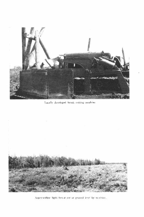
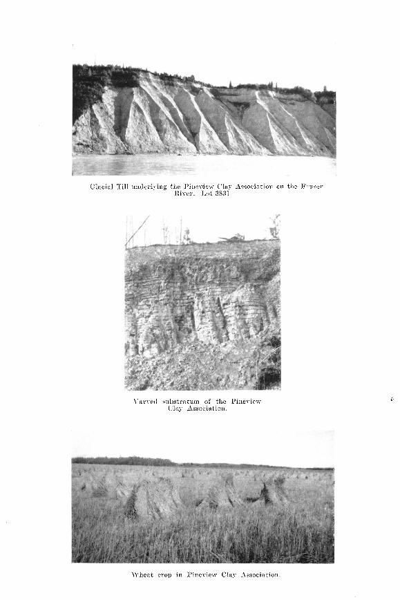

Black, il1 drnined and mer well drnined top soils, Pineview Clny -h3xiation.

/ 31
Burned areas are quickly covered by shrubs and pioneer .species of trees. The smaller burns are often seized by lodge-pole pine, which grows up in thick stands, but the Iarger ones are covered mainly by aspen, with pine in isolated groves. As the aspen matures it is gradually supplanted by pine and spruce.
Where the vegetative caver is spruce or lodge-pole pine there is a forest floor of living moss about two inches thick. This is chiefly feather moss in association with a minor flora of other mosses, lichens and fungi. Beneath the moss layer is the soi1 profile, described as follows:-
Horizon Aoo
Ao
Al
AP
A3
Bl
B2
C
Agriculture
Brown partly decomposed remains of mass, needles, twigs, wood, Ieaves, etc. Dark brown well decomposed remains of mass,. needleq twigs, wood, leaves, etc., with many small feedmg roots in the lower part. pH 5-O Dark grey sandy loam to loam, fine crumb structure, scattered grave1 and many smaI1 roots. Sometimes very thin or absent. pH 5.1 Ash grey to whitish and powdery when dry. Textures range from sandy loam to clay loam in different areas. Weak platy structure, with grave1 and stones. In places this horizon continues several inches downward in finger- like formations around roots. pH 5.2 Gravelly and stony sandy loam to clay loam. Coffee brown at the top, becoming lighter and more greyish with depth. Finely granular and friable but firm. pH 5.6 Brownish grey at the top, shading to greyish brown in the lower part. Stony and gravelly sandy loam to clay loam with fragmentary structure. pH 6-O Grey stony and gravelly sandy loam to clay loam. Fractured unweathered fragments of till mixed with .weathered material. Weathered material has frag- mentary structure. No line accumulation. pH 6.6 Blue-grey till firmly cemented. An unstratified mixture of a11 separates inchrding stones and grave1. Sandy loam to clay loam texture in different places. Angular fracture with general appearance of oompreasion. Impervious to downward movement of water. pH 7-O
The finer textured soils of the Chil,ako Stony Soi1 Complex are drought resistant and capable of producing crops, but a number of defects stand in the way of their utilisation under present conditions.
Depth 0 - 1”
1 - 2”
2 - 24”
2% 5”
5 -14”
14-22”
22-30”
Description
Small areas of fine textured soi1 contaiting variable amounts of stones and grave1 are spaced between Iarge rolhng hills with excessive amounts of stones and gravel. Where these small arable areas lie adjacent t.o glacio-lacustrine eoils they cari be cIeared as pasture additions to farms. Within the complex, however, areas of stone-free land large enough for development of homesteads are few and far between.
The clearing of land for agricultural use presents a problem of sufficient difficulty to hold back the development of the more. desirabIe glacio-lacustrine soils. In the Chilako soils there is the additional cost of removing stones and excessive wear on farm machinery. The impervious substratum beneath this type also has its disadvantages, inasmuch as it sets up variable drainage conditions where the till is close to the surface.
At the time of the soi1 survey the disadvantages of the Chilako stony soils were believed to be great enough to disregard their differentiation. They were regarded as a submarginal group with a minor inclusion of fine-textured stonv soils that cannot be economically developed at the present time. The whole complex could be used to the best-advantage for forestry until land is in great demand. The complex could then be differentiated for t,he purpose of more closely rating its agricultural possibilities.
agricultural by resurvey

32
In its natural state the complex is a valuable asset to the arable part of the district. Reseeding is quick and vigorous after fires or logging and there is a luxuriant reproduction of aspen and lodge-pole pine. With good manage- ment timber, ties and fuel cari be placed on a permanent yield basia. At present the aspen has no local use but in future it rn?y become a source of wood pulp. Birch is tut for fuel, but it has other possibihtles and it possibly could be used locally for the manufacture of furniture.
The complex is also a source of ‘grave1 for adjabent areas of clay, and the large vacant areas are of value for hun,ting an,d tra‘pping. Local hunters Will be assured of moose, .bear and grouse as long as the type is covered by forest.
Surface water is more abundant in the Chilako stony soils than in other types, beoause of the impervious substratum and the rolling terrain. Temporary streams and ,sprinsgs are much in evidknc,e in the early part of the growing season, but later on they dry up. The permanent streams, .ponds and lakes provide am,ple wat,er for game.
Present development con&& of a few small scattered ,cIearings of not more than 10 acres each on lower slopes and bottoms. These clearings pro,cluce from fair to good crops of timothy hay and alsike clover: but the arable acreage availarble at the clearing sites is insticient to maintam or Ndevelop farms.
2. Soils derived front glacial river and lake de$osits
Description: GUNNIZA GRAVDLLY SANDY LOAM
The Gunniza series is d,erived from gravels and sande that were sorted from the till during the decay stage o,f glaciation. The elevation varies from 2450 ~8$501crf& above sea level and the ~differen~tiated area covers approximately
, A hilly and a raIling phase were mapped. The hilly phase is formed of
steep, irregular hills, knolls! an.d long winding ridges with undrained basins between them, some of whlch ,may contaia small lakes, muskegs or grasc-y meadfows. The parent material is water worn sand and grave1 with the &ratificat.ion showing frequent ohange in the character of the lsayers of which they are composed. The hilly phase occurs with the Een,a series in glacial river formations.
The rolling phase is generally found in the vicinity of glacio-Iacustrine soils. These areas suggest beaoh and &and form.ations. The beachline areas overlie the till bordering the Pineview Clay Association and the islands cons& of knolls that were former drumljins. Some of the island and Qeach formations had their entire surfaces reduced to grave1 by wa,ve action, and the till remains from two to six feet or more tbeneath the surface.
Most areas of the type have been burned over in recent years and the sub- sequent stand of aspen, and lo,dge-pole pine is scanty. In burned areas the soi1 is exposed anid excessively drained.
After examination o,f the scanty vegetation a& exposed soi1 of burned areas, the most striking feature in mature forest on the type is th,e abundance of growth. While more open than on fine-textured soils there is a comparatively heavy forest of pine and spruce. OH, rotted fir Iogs and a few surviving trees are s,een, and the fir shows a tendency to reseed.
The gradua1 development of coniferous forest after fire is accompanied. by shading down of aspen and plants of the und,er.cover. This enables masses to caver the ground ancl to contrifbute largely to the thickness of the Ao horizon. The moist.ure-holding capacity of the moss covered organic mat is great enough t.o alt.er the moisture relationship of t.he whole profile, an& under the$e conditions an exutremely porous soi1 cari support a hea.vy forest.

38
The followiltg Profi:le was examtined in, mature forest about two miles south of Summit Lake. Living mass was about one inch thick on the surface:-
Horizon Depth Description
A00 o- 1” Brown partly decomposed moss, needles, twigs and wood.
Ao l- 2” Dark brown shad.ing to Waok well decomposed pro- ducts from above. Many small feeding roots in bhe lower part. pH 4.8
& 2-7” Whitish grey ashaike gravelly sandy loam. Porous, with weak platy structure. pH 5.3
BI 7-17” Rusty brown sandy IoBm, with fine granular structure. Gravelly and stonp; porous and well drained. Small amounts of iron stam on stones. pH 6.4
Bz 17-41” Greyish browa loamy sand. Structure&, with many stones, grit and gravel. J?orous and well drained, with no showing of lime. pH 6.8.
c Light grey sands, grave’1 and stones in a mixture. Washed and stratified~. Glaoial gravels underlaid at depth by ceanented still. pH 7.0.
Agriculture
Owing to its very gravelly and stony nature the Gunniza gravelly sandy loam is definitely submarginal as trop or pasture land. Where conveniently loc,ated, however, it woubd make ‘dry sites for farm buildings.
It is of value as a so,urce of farm water supply alcmg boundaries between the ,graveIly sand’y loam and the Pineview Clay Association. Idands of gra.vel, underlaid by cemented till and surrounded by clay, act to some extent as reservoirs which store precipitation water. Springs are often found along the contact zone, and groundwater may be tapped by digging shallow Wells.
In buwed. over areas where plan& of the undercover form the second growth, the gravelly sandy loam has value as a source of wil,d huckldberries and blue- berries. Where abundant these berries are pilcked for Jocal. use. With manage- ment this prod:uctioa could be iacreased and the type may assume Iocal i,mport- ance as a source of certain smsll fruits.
During short ,&y spelb in summ,er, the fire, hasard is greater in second- growth areas thon on other eoils. Even with a high fire hazard, however, the type may produce Iodge-pale pine for poles and fuel.
In a district where the area, of heavy clay is extensive, lange supplies of grave1 Will be required con,tinuously for road building and general constru8ction. At the time of the soi1 survey the greater part of the type was in public owner- shi[p, an’d it would! lbest serve the bcal nèsds if it remjained 8s part, of the public domain. Under the managem,ent of the Public Works Department, supplies of gra..vel could ,be mad.e available from the Gunniza series that would fil1 local requirementi for manty years to corne.
The Eena series is derived from sands transported and deposited by glacial rivers. In the classified area the series lies between 2100 and 2600 feet elevation.
The topography consists of hilly, rolling and undulating phases. The hilly phase, which covers about 14,283 acres, is remarkable for two unusual topographie forms. There are areas of pyramid-shaped hills separated by coulee depressions that have no general direction. These were probably formed by collapse of the surface following the decay of buried ice. The other type is the ridged topography found in gIacia1 river channels. Two small areas of the rolling phase are in the vicinity of Nukko Lake, and the undulating phase lies in one area between Pilot Mountain and the Summit Lake road.

34
The caver of unburned parts of the series consists of ta11 spruce and Iodge- pale pine, with occasional large cottonwood, poplar and birch. PIants of the undercover are well shaded down. The soi1 is covered by a layer of living moss and an A,, Iayer of plant remains. IE areas swept by fire the forest is mainly aspen, with a minor content of birch and lodge-pole pine.
Beneath the layer of organic litter the soi1 is leached to whitish brown, with brown to light brown subsoila. The parent material is greyish bromn medium sand containing finely divided mica. Over most of the area it is soft, loose, clean and free from gravel, but in some places there are Iayers of fine grave1 and bands of silt between layers of Sand. In parts of the area beds of silt are known to exist beneath the sands, and in the hilly phase silt caps some of the knolls. Glacial till underlies the sands at shallow depth near the boundary of the Chilako soils, and at greater depth elsewhere. In the undulating phase stratification cari be seen in the parent material, but it was not observed in the hilly phase.
Two soi1 types were mapped in the Eena series, covering a total of about 20,431 acres, These are loamy sand 9,304 acres, and sandy loam 11,127 acres.
Description EENA LOAMY SAND
The loamy sand occurs along the north bank of the Nechako River, between Miworth and Prince George. From Miworth it strikes northwest to the Chief Lake road. It is aIl a hilly phase, covering about 9,304 acres.
On southern exposures. the second growt.h of deciduous trees, shrubs and lodge-pole pine is scanty for a long time after fires and the sandy soi1 is expoeed. Under the same conditions the growth is more abundant on the northern slopes. Along the Nechako River .a few of the hills a.re capped with stratified silt.
Expos~es along the Nechako River from Prince George to Miworth and west of the Nechako River bridge show about 30 feet of sandy parent material overlying gIacia1 tiI1. TO the east of the bridge several silt capped knolls Iie upon horizontally stratified sands about 200 feet thick. These sands are Nechako River deposits t,hat were Ieft undisturbed by glaciation.
The abundant growth in mature forest as compared with t.he scanty second gr0.wt.h in burned areas, is a striking example showing the importance of the Ao layer to the moisture economy of the soi1 profile. Apparently the Ao layer does not become fully developed until the d,eciduous growth has been shaded ,down and mass covers t,he surface. When~ this has been accom.plished the productivity of the loamy sand as a forest soi1 is alm.ost the same as the finer-textured types.
A .profile was examin.ed in an area of m!ature spruce, with occasiona large cottonwood, aspen and birch. The undercover plants were well shaded down and living moss on. the surface was two inches thick. The location was on a knoll with a gemle dope on top. Thie .profile is described as follows:-
Ho1izon Depth Description Ao o- 2" Dark brown partly decomposed and well decomppsed
mass, needles, twigs, wood, etc. Many small feeding roots in the Iower part. pB 51-O
Az 2- 4” Whitish brown ashilike fine to medium single-grained loamy Sand. Porous; no stones or gravel. pH 5-S
A3 4 8” Light brown single-grained loamy Sand, porous, loose ands soft. pH 6.4 :
Bl 8-W’ Brown single-grained loamy Sand. Loose and porous. pH 6.4
B3 15-69” Greyi,sh brown loamy Sand, single-grained, laose and porous. Soft concretions in the lower part coloured the same as the horizon. pH 6.6
C Greyish brown medium Sand containing finelp divided ,mica. Soft, loose and clean, wi6h no etones or grave8. No stratification observed. ,pH 6.8

35
Agriculture
A few pre-emptions were ta.ken up in the burned part. of this type. These are located in a narrow valley to the northwest of Prince George, and, small areas were cleared and cultivated,. The pre-emptions never progressed beyond, the initial stage, aed the sod rem(aining on the small clearings is very light.
Bottom lands with slopes gen,tle enough for cultivation amount to only a few acres on each quarter section, and even in bottons the soi1 lac)& S&cient drought resistance for farm crops. The hilly nature of the land and the light texture of the soi1 both indicate that the Een,a loamy sand is best suited for forestry.
Description EENA SANDY LOAM
The Eena sandy Ioam occurs dong the Summit a& Chief Lake roads t,o the north of Prince George. The hilly phase covers about 4,901 acres, and the rolling and undulating phases occupy approximat,ely 821 an8d8 5,4Q5 a,cres.
The main distinctions between this, type and t.he Mena loamy sand are greater in.clusion of silt in the surfatie soi1 and stratified silt here and there in the parent material.
A profile Was examin,ed in the undulating phase, in Young spruce and lodge- pole pine fores-t, with about two inc,hes of living moss covering the s.urface. The description is as foX1lows:
Horizon -40
A2
2
BS
Depth Desmiption o- 1” l$k5 pown wdl decomposed mass, twigs, wood, etc.
I- 5” Wtitish brown ash-like and platy sandy loam. Finger- like pockets extend downward for several inehes around roots. pH 5-S
5-14” Brown sandy loam, firm and single-grained. pH 6.2 1423” Light brown anedium to coarse loaany sand, witln
a-38” scattered smala gravel. Firm and StructureJess. pH 6.5 Greyish cbrown strwtureleas loamy sand. Small amounts of silt due to thin &y bande in the uarent material.
C pH 6.4 Grey stratified sand with brownish colour inclusions. pH 6.8
Aguiculf ure
The hiliy phase of this type consists mostly of steep slopes that are definitely of no agricultural value and narrow, crooked, peaty hollows between hi&. These hollows, which are productive, amount to from 5 to 20 acres in each quart.er section.
Some of the hiIIy phase has been pre-empted for the timber and when this was taken off or burned a few of the hollows were cleared and farmed. However, there is insufficient arable land for a farm on any quarter section and attempts to develop farms have not been successful.
In an area of the type along the east shore of Nukko Lake the t,opography is rolling, and a few gentle slopes have been cleared for gardens and fields. This area is underlaid by glacial till near the surface, which improves moisture relations, and good garden crops are produced near the Iake shore.
In t.he undulating phase the texture of the solum baries from fine to coarse, the fine-textured areas being near the boundaries of the heavier soils:. Adjacent to the boundary of the Chilako soils the type is underlaid by cemented till and near other boundaries there is admixture of silt and clay. These fine- textured areas, where convenientIy Iocated, cou1.d be utilized as additions to farms on other soi1 types.

36
At the time of the soi1 survey only about 1,063 acres of light clearing was found in the undulating phase, the remainder of 4,342 acres being spruce and lodge-pole pine forest. A few attempts have been made to develop farms in the area of light caver, but with one or two exceptions the clearings are smal! and most of them have been abandoned.
The hilly phase of the Eena sandy loam is submarginal for agriculture, owing’ to th.e rough topography, and best suited for forestry. The proper utilization of the rolling and undulating phases for settlement would require a more detailed soi1 survey to differentiate the most desirable parcels. This is not warranted at present, owing to the mature forest on most of the area and the availabiIity of arable land in the areas of Pineview soils.
Deswiption BEUNESTI SILT LOAM
The Bednesti series is derivea from stratified intermediate-textured deposits laid down in temporary glacial Iakes near the entry points of glacial rivers. In the map-area the elevation of t.he type ranges from 2,450 feet to 2,600 feet. above sea Ievel.
The topography consists of a hilly and an undulating phase. The hilly phase occurs near the mouth of Willow River and along the boundaries of the Eena series, covering about 5,778 acres. The undulating phase lies to the west and south of Swamp Lake, where it occupies about 10,919 acres. Thc total mapped area of silt loam amounts to approximately 16,697 acres.
The parent material is stone-free silt stratified in t.hin layers. The silt has considerable thickness, overlying cemented till. Along the boundaries of the type, and particularly in the area between Swamp Lake and Nukko Lake, the silt is underlaid by t.he sands from which the Eena series is derived. The more or less porous nature of the silt provides good subsurface drainage.
Where unburned the Bednesti silt Ioam supports a heavy mixed forest of spruce and lodge-pole pine, the plants of the undercover being well shaded down. Beneath a layer of living moss and partly decayed organic matter the surface soi1 is leached to ash-grey, becoming yellowish brown to greyish brown with depth. The soi1 texture over the greater part of the area ie silt loam, but there are smalI included areas of Ioam and cIay Ioam that were not differentiated. Here and there smaI1 iron concretions and grave1 were observed in the surface soil.
A profile was examined in a stand of spruce and lodge-pole pin.e about 60 years ald? the ground. being covered with masses about two inches thick. The description of tlnis profile is as follows:
HO?PZO% Depth -400 o- 4”
90 j- 1”
-43 l- 4”
93 4-11”
Bl 11-20”
Bz 20-31”
Description Dark brown partly decomposed needles, twigs, moss wood, etc. Dark brown well decomposed organic matter. Many small feeding roots. A4sh grey silt loa.m, fine granu1a.r structure in weak platy arrangement. Thickne.=s of horizon varies with tangues extending downward for several inches around roots. Friable and porous. pH 4-65 Yellowish brown ailt loam wit.h soft fragmentary structure breaking easily into granules. Porous and leached, with a few scattered iron concretions. pI3 5.45 Greyish brown silty clay loam with easily broken fragmentary structure. Compact but fairly porous. pH 5.82 Brown silty &y loam with large fragmentary structure, less easily brokan and heavier t;han horizon above. Compact but wcll drained. pH 6.00 Buff coloured stratified silt in compact layers about one eighth inch thick. No stones, grit or gravel. pH 6.65

37
The hilly phase is non-arable, owing to its rough tapography. In the total hilly area of 5,778 acres there are about 1,983 acres of aspen second gromth and 3,795 acres of coniferous forest. This phaa,e is best suited to forestry. It produces a heavy growth of sprace and lo,dge-pole pine, the area nea,r Willow R.iver being featured by the inclusion of Douglas fir.
The u’ndulating phase has several features favouaing ih use for farming. It dxies more rapisdly and is warmer in epring than the clays. It is also- more easùly handled, bas good drainage and is moisture retentive.
The main physical defect consists of higher elevalion than the clays. Elevations around 2,600 feet may shorten the growing season and the frost-free period in relation to these periolds on the Pineview clay a,t 2,000 to 2,450 feet elevation, and on river terraces at 1,800 to 2,000 feet above sea level.
Between Swamp and Nukko Lakes is a mixed phase which was not differ- entiated. In this area there are about 1,200 acres underlaid by Eena sands which occur close to the surface. The micro-topography consists of small knolls and ,depressions, the knolls being sandy and the bottoms filledq with silt. This area is potentially arable, but spotty and less desirable for agriculture than the silt areas.
At t.he ti,me of the soi1 survey the chief disadvantage in t.he way of develop- ing the undulating phase was the forest caver. Only about 1,744 acres have aspen second growth as a result of fire. The remaining 9,175 a,cres are covered with spruce and lodgepole pine timber that eannot be cleared economically for cultivation of the land.
There are a few settlers in this type along the Chief Lake road. Their clearings are small, but yields of timothy hay, alsike clover, grain and vegetables are satisfactory where the land has been properly cultivated.
Most of t.he settlers have located near supplies of surface wat,er, hence the status of u.nderground water is somewhat obscure. Water should be obtainable on top of the glacial till w’hich un’derlies the strat,ified silt. The conditions beneat,h the till and the depth to plateau bedrock are unknown.
In the Bednesti series there is a greater tendcency among settlers to cxperi- ment with f,ertilizers than in the clay areas, and this may indicate soi1 deficiency. Deficiency of oTganic mstter is 0bviou.s and good results are obtained from applications of barnyard manure. Light applications of gy\psum have been tried by settlers an;d are said to give increases in the yield of alsike clover.
Chemical analysis of the Bedneati silt loam profile described in the preceding section is given in a.ppended Table No. 3, an*d this shows lower organic matter a.nd nit.rogen content than in clay profile E sampled under th.e same conditions. Exchangeable lime, magnesium an,d pot.ash are also low comrpared with the amounts available in the clay profiles. In this profile the exchangeable’ lime and potash border on deficiency. Exchangeable phosphoric a.cid, however, is higher than in the clay types. The content of cobalt, necessary in anima.1 nutrition, is above t.he 6 p:p.m. minimulm requirement.
i Generally the settlers select’ areas of deciduous growth for clearing and cultivation. In this type their findings point to the need of adding avzilable plant food. There is need of plot tests to ascertain the growth response to barnyard manure, gypsum, lime, potash and phosphorus. It would appear that the Bednesti series hacr less qrganic matter a.nd less available minerals in the soi1 on cultivation than the clays and it may require the regular use of certain soi1 amendments from the beginning of cultivation.

35
Description PINEVIEW CLAY ASSOCIATION
This association consists of a group of soils derived from heavy stratified clay originally deposited in temporary glacial lakes. Its elevations range between 2,000 and 2,450 feet and it,s area amour& to about ‘252,740 acres. It occurs throughout the mapped area and extends beyond the map on the east, west and south.
The topography consists of hilly, rolling and undulating phases. The hilly phase occupies about 1,178 acres in one area to the north of Prince George. The rolling phase covers about 18,640 acres in a number of variable, scat.tered areas. Most of these are too rough and broken for agriculture, but there is one area to the north of Woodpecker covering about 5,258 acres which has agricultural value. In this locality the topography is rolling with included gentle slopes and flats of variable size. In many quarter seet.ions 100 acres cari be cleared in several separated fields, but each quarter section has some waste land.
The undulating phase is the most extensive agricultural soi1 type in the mapped area. Throughout an extent of about 232,924 acres the t.opography consists of gentle rolls and slopes, with included areas that are almost flat. This topography favours the development of a well drained soi1 type on slopes and an il1 drained type in the numerous and irregular depressed areas.
Gnly a few places were encountered where the clay was covered by a mat.ure stand of trees. In these localities the trees. were mainly lodge-pole pine, with scatt,ered spruce and birch. Although the large pine trees were 8 feet or more apart the undercover plants were well shaded. Even in areas of the most mature forest the Ao horizon contained charcoal from long past fires.
Where small burns had occurred the second growth is generally a thick stand of lodge-pole pine. Where fires consumed the forest over large areaa within the past 30 or 40 years, aspen about two inches in diameter is the principal tree, together with a minor growth of willow, birch, shrubs and herbs, and scattered groves of lodge-pale pine. Under these conditions alder, about two inches in diameter, is abundant in depressed or flat areas.
One fire Will often kil1 a forest of lodge-pole pine and spruce, but many trees remain standing and the ground is littered thickly with fallen logs. One or more subsequent fires are sometimes necessary to clear off the land. In burned areas remarkably few stumps remain in the ground. This is because the trees uproot as they fa11 and the legs and roots are consumed.
In burned areas the amount of litter remaining on the ground varies from place to place. Over about 75 per cent of the clay area there are very few stumps and the amount of litter ranges from less than 5 per cent to about 15 per cent of the original stand. Near the boundaries of pine and spruce forest and in some of the smaller burned areas from 25 t.o 50 per cent of the original stand lit.ters the ground.
In coniferous forest the s.urface is covered by a two-inch layer of feather mass and allied species, beneath which is horizon Ao. Under well drained conditions the Ao horizon consists of a two-inch layer of litter, dark brown in the Upper part and black in the lower part. The dark brown Upper section consists of freshly added material partly decomposed, and the black lower part repreeents finely divided organic matter in a more advanced stage of decomposi- tien. Under good drainage theee divisions of horizon Ao bave about the same thickness.

39
Where drainage is restricted to a minor degree, because of very gentle slopes, flats or shallow depressions, the black lower part of horizon A,, slowly accumulat,es well decomposed organic matter. Under different degrees of restricted drainage the thickness of the lower part of this horizon ranges from two to twelve inches or more.
The thickness of the black minera1 soi!, designated horizon Al, is related to the drainage conditions that vary the thlckness of horizon A,,. Under well drained conditions horizon A1 is seldom more than one inch thick, but under some conditions of restricted drainage its thickness is increased to four inches or more.
Horizon As, the light grey leached layer, also varies in thickness under different drainage conditions. In the well drained associate it sometimes attains a depth of seven inches, whereas it may be only one or two inches thick under the conditions of restricted drainage that develops a deep Al horizon.
When the ground is bared by fire the A2 horizon is subject to erosion. The effects of erosion cari be seen in profiles covered by heavy a.nd light forest in many parts of the clay area.
In coniferous forest under moss ground caver the structure consists of granules. These are about half the siee of wheat kernels at the top of horizon A1 and by adhereme to one another they grow to the sise of corn in the lower part of horizon AP. After fires, when sufficient time has elapsed to produce an average growth of aspen, the granular structure appears to degenerate t.o a granular-platy form.
Horizon As is the lower part of the A horizon and the structure is fragmentary. The fragments increase in size from about $:inch in diameter at the top to -$-inch diameter at. the bot,tom of the horizon,. Each fragment cari be divided into a number of smaller ones similar in size and appearance to t,he structure of horizons A2 and Al, and similar in shape to the large fragment of which, they form a part. Horizon A3 is heavier than horizon As, and where exposed on roadsides it attains a light grey leached appearance.
Horizon B1 is a very dense, heavy horizon, where the units of the fragmen- tary structure have now attained an inch or more in t,hickness. There is a marked accumulation of colloids, and with average drainage the colour is coffee brown.
In several parts of the clay association, part.icularly in the vicinity of Johnson Ranch, Salmon Valley, near the junction of the Summit Lake and Wright Creek roads, the B1 horizon is brownish yellow. Small iron concretions in the horizon have brown cores and yellowish fringes on a mottled grey back- ‘ground. Both hematite and limonite have been formed. This condition cannot be assigned to drainage because it does not occur under similar drainage conditions ‘elsewhere. It is regarded as a variation of the parent mat.erial that could not be differentiated during the present survey.
Under average conditions horizon B s of the clay association is essentially the horizon of transition between B1 and the unweathered parent material. Its most characteristic features are light,er colour and texture than B1 and a mixture of weathered and unweathered parent material. Where the parent material is varied the light and dark colours of the annual layers cari still be id.entified among the undecomposed fragments. The lower part of the B2 horizon does not contain free lime. The only observed lime accumulation was a small amount on cemented till underlying the clay parent material at a depth of 8 or 16 feet, and also in stratified silt underlying the clay at a.bout the same dept.h.
Horizon C is the parent. mat.erial of the A and B horizons. It lies from 20 to 36 inches from the surface and consists of heavy clay in horizontal layers t-inch or less in t.hickness. The stratified clay ranges from 4 to about 25 feet in, depth. It overlies cemented till or stratified silt and till. The glacial till is the parent material of the Chilako soils, and beneath the clay it has the

40
same drumlinized topography. This feature is the cause of topographical variation in the clay areas. The surfa.ce relief depends upon the thickness of the lacustrine deposit that overlies the till.
Throughout the mapped area the clay surrounds areas of outcropping till that were formerly islands in a temporary Lake. Some of the islands only reached the Upper limit of clay deposition and grave1 occurs on low, rounded hills in the &y area. These are small areas of Chilako soils, too bmited for differentiation with the present map-scale.
In the clay association near the channels of the Nechako and Fraser Rivers a layer of stratified silt occurs between the clay and the underlying till. The silt. is a light buff colour on dry ‘river exposures and its thickness varies between 10 and 25 feet. Where the silt occurs the topography has undergone its greatest. modification and may be described as gent,ly undulating.
The following Profile No. 1 represents the well drained associate with the brown B horizon. This type covers the major part of the clay area. The profile was examined in spruce and lodge-pole pine forest about 60 years old, in the S.W. a of Lot 951, to the east of Prince George. It describes the soi1 beneat,h two inches of livmg feather moss, club mosses and lichens:-
Horizon -400
Ao
Al
A2
-43
B1
Bc
c
Depth 0 - 1 PI
12 2 *
2-3”
3 - 7 *
7 -10 H
10 -18 n
18 -22 fl
PROFILE No. 1 Description
Dark brown partly decomposed needles, twigs, mass, dead wood, etc. Black me11 decomposed organic matter. Numerous small feeding roots. Black friable mixture of organic matter and minera1 soi]. Smtill granular structure. pH 4.61 Light grey clay. Wheat, sized granules which get larger with depth ,by adjherence to one another. pH 5.10 Light grey clay. Fragmentary structure +-inch dia- ‘meter at top, increasing to a-inch diameter in lower part. Heavier than As, wit.h the appearance of being leached. DH 5.12 Brown heavy clay, with &ghtly reddish tinge. Large fragmentary structure and heaviest texture of any horizon. Cracks vertically on drying. pH 5-19 Heavy clay but not as heavy as BI. Light grey broken laminations alternating with dark ones. No evidence of accumulated lime. ipH 6-25 Heavy varved clay, titi thin horizontal cleavage. Alternation of jlight and dark layers with range of colour from light grey to greyiish brown. pH 7.56
Profile No. 1 is ind’icative of the soi1 conditions un,der coniferous forest. These are Iess favourabIe for trop production than the soi1 conditions beneath decidnous grolwth. The chemtical analysis, of this profile, given in appended Table 3, shows a high percentage of organic matter and nitrogen in the shallow A, horizon. While these constituer& decrease rapidly in horizons Ae and Ae, the amounts are satisfactory for trop production. Settlers have little difficulty in producing oro,ps on land which was under deciduous growth at the t.ime the land was cleared an,d oultivatedi.
In this profile the silica, alumina, iron and lim’e have a relationship not usually found in a soi1 subject to the leeching process over a long peri0.d off time. Loss of the original A horizon is suggested as a result of ero&on after some long past fire, followed by the development of a n,ew A horizon from the heavy B horizon materid. Since :most of the clay area has been subject to recurring fires, this condition is com,mon at the top of well drained slopes.

41
It wonld appear that excharrgeable lime is low in areas of coniferous forest, and this is su,pported by the pH values. In d’eoiduous growth, however, the reaction at the surface is generally close to th-e pH of the lower part of the profile, and the content of exchangeable lime is probably higher.
Ma.gnesia an*d potash are high as to tofals and availability, Ibut total sodium is less t.han in other olassifmd British Columbia soils. Total phosphoric acid compares favourably with other classified soils in, the Province, but easily available phosphoric aci,d is SIow.. The content of cobalt is well above the require- mente for animal nutrition.
Profile No. 2 represents the well ,drained associate with the brownish yellow B horizon. This type covers a minor part of the clay area. The profile pit was dug on a gentle slope in a spruce and lodge-pole pine forest about 75 years oled, located in the N.W.4 of Lot 1518, near the Summit Lake road. It describes the soi1 beneath a two-inch covering of living mass:-
.
HOriZO?l Depth Aoo O-f”
A2 s-11 e
A3 11 -14 ”
Bl 14 -16p
BZ 16$-21f”
B, 21+-w
C
PRJOFILE No. 2 Description
Dark brown partly decomposed needles, twigs, moss, dead wood, etc. Dark brown well de,eomposed organic matter, n-i,t.h a large number of smalll feeding roots. Black friaible ‘mixture of organic matter and minera1 soil. Small granular structure, some of the granules having a soft tore of concretionary iron. pH 4.55 Ashy grey ulay with small granular structure at t.he top, becoming piat.y in the centre of horizon and platy-granu1a.r combination in the lower part. The granules increase in size with depth, some having a tore of concretionary iron. pH 5.31 Li&t grey clay witih slight yeJlowish tinge when damp. Small fragmentary structure. More compact and heavier than horizon above. pH 501 Brownish yellow clay, the colour being from concre- tionary iron particles with brownish centres and yel- lowish fringes on a grey baokground. Fragmentary structure and vertical cracking, the fragments being one inch in dia.meter and capa;bIe of breaking down into smaller ones of the same sharpe. pH 5.52 Greyish brown cilay with iron accumulation and frag- mentary structure 14 inches in diameter. and hea.viest horizon in profile. pH 5.80
,Compact
Clay n-ith horizont.al Iayering and some evidence of broken lamination. Alternating bromn and light grey lavers about &inch thiek. PartIy weathered parent .materid, compact and heavy. pH 6.40 Heavy varved clay, with alternation of grey and dark brown layers. Main horizontal cleavage is about &-inch apart. pH 6.55
Profile No. 2 has the same soi1 environment as Profile No. 1, and its chemical analysis is shown in appended Table 3. In comparison with Profile No. 1, the Al horizon has a low percentage of organic matter snd nitrogen. The relationship of silica, alumina, iron and lime is indicative of greater maturity than in the profile previously examined.
As in the case of the first profile the exchangeable lime is Iow and the exchangeable magnesia and potash are satisfactory. On the other hand, easily soluble phosphoric acid is high in a11 A sub-horizons. The quantity of cobalt differs from Profile No. 1, but is sufficient for animal nutrition.
Three kinds of structure in horizon Az postulates the addition of soi1 to the horizon during periods of erosion after fires, a condition opposite to that in Profile No. 1.

42
The structure of the lower part of horizon A2 is platy-granular, the centre is platy and top part is granular. In this district granular structure appears to be associated with coniferous forest and a moss ground caver, whereas platv structure is related to deciduous forest. The structure of the lower part is obscured by combination, possibly related, to both deciduous and coniferous fore& which succeeded one another in the remote past. After t.he bottom layer was established the forest was destroyed and erosion from upslope covered the surface with new soil. This was followed by deciduous forest and the develop- ment of the platy horizon. In turn the deciduous forest was destroyed and erosion from upslope again covered the surface. In this case lodge-pole pine came in directly, and the top layer developed granular structure.
The details of soi1 erosion expressed in these two profiles are common to fine textured poils in a district characterized by recurring fires. An ideal profile without subtraction or addition of surface material would be difficult to find. In undulating topography at least part of the A horizon at the top of each gentle slope has been washed downward when the ground is bare after fires, and the soi1 lower down has been built up.
Agriculture
Along with other fine textured soils the Pineview clay association has been divided into two land use divisions based on the density of forest caver. Areas covered by heavy forest are designated “temporarily non-arable land”, and areas covered by light fore& are called “arable land”.
In the undulating phase the temporarily non-arable division consists of about 128,829 acres occupied by spruce and lodge-pole pine forest. Cnder presenk conditions this category may be regarded as temporarily unsuitable for agricultural development, owing to the prohibitive cost of preparing the land for cultivation.
The arable land covers about 109,353 acres occupied chiefly by aspen- willow growth, with a minor inclusion of birch, alder and scattered trees and groves of lodge-pole pine. This division is the most. suitable for agricultural development at the present time.
Where clearings have been made in thick stands of ,lodge-pole pine, the soi1 does not grow good crops for several years. Locally this is thought to be due to undesirable substances in litt.er shed by the trees, but t.he soi1 reaction and available minerals may be low under these conditions.
On the other hand, destruction of the coniferous forest by fire and its rep!acement by aspen, willow, birch and alder second growt,h appears to be an ameliorating factor. The ashes from,the burned forest and the annual fa11 of leaves from trees, shrubs and herbs has increased the amount of available minerais in the surface soil. At the same time this process has reduced acidity and contributed organic matter of better quality.
Owing to its extent, accessibilitg ‘and desirability as farm land, the clay associaCon has t.he most settlers and the largest percent,age of cleared and cultivated land. This acreage was less than five per cent of the arable division at the time of the soi1 survey, but the lack of development. is not relat.ed to the quality or productive power of the soi1 itself.
The natural fertility of the clay association is comparatively high. This is demonst.rat.ed by t.he good yields of grain and hay taken over many years without liming or the application of commercial fertilizers. Land with a deep Al horizon produces little after the first breaking, but when well drained and aerated this type is quite productive.

43
In addition to the use of manure, local experience indicates that the use ,of inoculated aluike clover is a good method of overcoming the natural deficiency of organic matter in the soil. Following the first trop the organic matter should be continuously built up by means of clover and other sod crops.
The use of superphosphate mixed with ma.nuse in one test restilt~ed in slightly inoreased yield and earlier maturity. In another test a.n increased yield o’f alsike clover seed was obtained with ammonium phosphate. These tests were made by farmers and the results were determined by observation. While there in some evidence that chemical fertilizers Will increace yields, t,he pioneer settlers have not used them as a regular practice..
In spruce aad lodgeYpole pine forest the soi1 reaction of the clay association ranges from pH 4.5 at the surface to a’bout pH 7.0 in the lower part of the profile, as shown in Table 3. Under deciduous caver the reaction would appear to bmld up until the surface soi1 has the highest reaction shown in these profiles. Many tests by colorimetric methoda reveal that the average reaction of surface soils rmder deciduous growth and in cultivate,d fields is from pH 6-O t,o pH 7-O.
This reaction is optimum for certain crops, such as alsike clover anal timothy, and both of these plants show remarkable vigour. They compete successfully for many years with deci,duous growth in burned areas, along paths and on roadsi,des where the seeds are spread by animal droppings. These plants give to aspen covered areas a certain value as su.m,mer range for cattle.
well, Alfalfa, however, has not been an outstanding succesç. The plants germinate
but the resulting crops have not been good enough to add alfalfa to t.he local cropping practice. Part of the dffficulties with alfalfa have been att,ributed to heaving of the grormd in winter.
Whiie the clay association has many natusal advantages, it also has defects due to its fine texture. These drawbacks includo coldness in spring, a dense B horizon, the need of greater power for cultivation and difficulty of handling wh.en wet. It is noteworthy that excessively maddy conditions preva,il around farm buil,dings during wet periods, and that all-year roads mlust be gravelled. Most of these pioneer d’rawbacks, however, cari be modified and in some cases overcome as the district is built up.
Coldness in spring cari be ameliorated to some extent with improved air drainage as clearings are enlarged, and soi1 organic matter is increased. Increased organic matter Will improve handling qualities and modify the dense B h,orizon as the fields grow ol’der. The abundaece of grave1 in nearby Gunniza anal Chilako spils is a great boon where &y is farmed. Barnyards will eventually be stabilized with grave& and concrete Will be used more extensively for barn floors and house basements.
Where spruce or pine forest occurs on part of a pre-emption it cari often be maintained as a woodlot. This Will ensure a continuous supply of farm fuel, together with Iogs and poles for construction. At present a woodlot. does net seem imiportant, owing to’ t.he abuadaace of supplies from vacant land, but this condition. Will not always exist. The settler should take tare of his assets in order to avoid long haulage and’extra expense in the future.
3. Soils derkwd from Post-Glacial River and Stream Deposits
Description GISCOME GRAVELLY SANDY LOAM
The Giscome series is derived from the gravelly post-glacial terraces of rivers. In the classified area these terraces have elevations between 1,800 and 2,000 feet above sea level, and the total ares of the type amounts to about 28,442 acres.

44
The topography is undulatin, 0 on terraces that vary in length and widt.h. Here and there aband.oned arms of the stream have left their mark and occasional tributaries have eut ravines at right a.ngles to their length.
On t’he higher terraces the forest caver consists of fir, spruce and lodge- pole pine, the growing conditions bein, 0‘ similar to those on the Gunniza series. On second bottoms near river level therc is more moisture and the terraces su,pport a heavy stand of spruce and a few large cottonwood. After burning the growth consists of a thin stand of loclge-pole pine and aspen, and a scanty undercover of blueberries, huckleberries and similar plants. 34any years pass before the type regains its maximum producing pomer.
Before abarrdomnent by the river a venecr of alluvium wa.s spread over the gravels during exceptional freshets. This material consists of silts and fine sands, and its thickness varies on each terrace. Originally the soi1 was derived from the layer of alluvium on the surface, but in time this fine textured material partly lost its identity by mixing with the Upper part of the gravelly substratum. Nevertheless the fine alluvial layer isl recognized as the parent ma.t,erial of the soil. The undisturbed grave1 beneath the mixed layer is of significance ta the soi1 because it affords excessive drainage, and for this reason it is designated horizon D.
The gravels that lie beneath the solum have considerable thickness, particularly on older and higher terraces. These gravels were originally washed from glacial till to form bars in the stream channels. To-day the till is seen in great abundance on deep cuts where the rivers are widening their channels. Where this type of erosion occurs the fine materials are carried away, leaving the grave1 and atones to accumulate in the riverbed.
The soi1 profile on an old terrace is described as follows:-
Horizon Depth Description Aoo 0 - 1” Brown partly decomposed mass, needles, leaves, twigs,
etc. Ao 1 - 2” Dark brown well decomposed organic matter. pH 5-O A!i! 2 - 5” Whitish grey ashy gravelly sandy loam, with weak
platy structure. pH 6-O Bl 5 -10” Brown sandy loam, single-grained, gravelly and some-
times stony. pH 6.4 B-D 10-18” Light brawn gravelly to stony loamy sand; structureless.
D Greyish brown stratified sand, grave1 and stones. pH 6.8 pH 6.7
Agrz’culture
The gravelly terraces along the Fraser River between Giscome Port.age and Woodpecker are al! of the older type, which have lost most of their soi!. The gravelly and stony soIum is seldom more than 18 inches thick, beneath which there is clean stratified gravel. In some of these terraces fine gold occurs throughout the gravels. It alao occurs beneath them on bedrock or upon the old lacustrine clay-grits. These terraces have no agricultural value.
The gravelly terraces on the Nechako River and on the delta-like area at its mouth are more patchy than the Fraser terraces. Here and there are parts of terraces where the Upper layer of silt and sand is still intact. However, these areas are not large enough for farm units, and attempts to develop them for agiculture have ended in failure.
The Salmon River valley is lined with second bottoms eut into compa.ratively small areas by the meandering stream and its abandoned channels. Many of these turns and oxbows are not shown on the soi1 map. The whole bottom of t.his valley is covered with grave1 derived from glacial till. Some parts of the area are still receiving the fine textured products an annual flooding, and most of the valley has a rather streaky surface covering of silt and sand.

45
Throughout t,he length of the Salmon River valley, from the west boundary of the soi1 map to the Fraser River, there are few second bottoms where the soi1 covering is aufficiently deep and the acreage large enough to support a farm unit. This valley, however, produces a heavy stand of big spruce in areas that have not been burned.
Taken as a whole the Giscome Gravelly Sandy Loam is a submarginal soi1 type, best suited to forestry. The higher gravelly terraces in burned areas are a source of wild blueberriea and huckleberries in season, and where conveniently located the type has great value as a source of grave1 for the clay areas.
SAXTON LOAMY SAND
Saxton loamy sand is derived from sandy terraces formed by rivers during post-glacial time. The type occurs at elevations between 1,800 and 2,000 feet in the classified area and the total acreage amounts to about 11,486 a.cres.
The topography is undulating ta gently rolling on terraees that vary in length and width. Includedl in the type is a post-glacial channel of the Fraser, floored with loamy Sand. This area extend,s from L1ot 871 to Lot 872 on the west side of the river, to the south of Fort George C:anyon.
The mature forest consists of fir, spru*ce and lodge-pole pine in compari- tively heavy stands. Undercover plants are well sha,ded, masses caver the ground and there is a well developed A, horizon. After fires lodge-pole pine and aspen are the main second growth trees. The second growth is somewhat heavier than in the Mena loamy Sand, owing to more gentle topo.graJphy and slightly better moisture relations, but ground litter is often scanty and in many places the san,d is exposed. Bluebercies are a prominent feature in the thin stan,d of undercover plants.
T%e aandy terraces are small and scattered along t.he Salmon, Chilako and Nechako Eivers. They are equally unimportant in the Fraser River Valley to the north of Prince George. Between, Prince George and Woodpecker, however, most of the terraces ar,e coposed of sandy materials.
In the vicinity of Prince George there are thick beds of stratified sands of pre-glacial or interglacial ozigin, which underlie the glacial till. These san.ds are exposed on the west side of the river opp0sit.e South Fort George. Vast quantities were moved downstream to form sandy terraces while the Fraser mas carving out its post-glacial channel.
The Saxton loamy Sand’ occupies the same elevations in the river valleys as the Giseome series, but a stratum of finer textured material does not overlie the surface. Beneath the solum the sands ,are stratified in thick beds overlying gravel, glacial till or bedrock. A profile with mass gr.ound caver, examined in young spruce and lodge-pole pine forest, is d>escribed as follows:
Ho?-izon Depth Ao o- 2”
A2 2, 5”
5- 9”
9-29”
29-35”
Description Dark brawa partly decomposed and well decomposed orgatic matter. Many small feeding roots in the lower part. pH 5.6 ‘khiti& grey single-grained loamy Sand. Tangues from this horizon extend as much as 4 inchee downward around roots. pH 6.2 YellovGh, brown loamy sand. S,ingIe-grained, no stones or gnavel; porous but firm. pH 6.5. Light brown medium Ioamy sand, scattered rusty spots becoming more numerous with depth and a fem rus@ veins. Structureleas and compact. pH 6.5 Brown slightly compact loamy- Sand, kuctureless, with a feti soft aoncretions of iron-bound Sand. pH 6.7 Stratified greyish brown sand. ;c\To stones or grave]. Porous and me11 drained. pH 6.8

46
Agriculture In the past a few pre-em.ptions were taken up in the burned part of this
type to the souuth of Prince George, and small areae were cleared and cultivated. These homesteads n!ver progressed beyond t.he in,itial stage before being aban,d.oned.
Sandy t,erraces to the south and west of Prince George are of small import- ance, owing to their widely scattered locations and limited size, but to the s0ut.h of Prin.ce George these terraces occn~py a cons,iderable area m the FraEer River Valley. In this locality they are of value to adiacent areas of clay as a source of sand, wood and blu,eberries. T-rolm the standpoint of general utility, the dry sandy nature of the soi1 indicates that the type chould be ret,ained in the natural state.
Description FKASER SO~L Coh1~I.m
This complex is derived from the fine tetiured post-,gla.cial deposits of rivers ansd streams in the classified district. These ,deposits occur on first, second and third terra.ces.from river level, and on the small floodplains of tributary streams. They range between 1,750 and 2,450 feet in elevation nnd caver about 32,729 acres. The topography is undrulating, except where ,broken by abandoned arms of rivers or streams. The scattered areas vary greatly as to length, width and drainage position. The t.extura.1 cIasee.s, which range from s#andy loamt to clay, were not differentiated.
A more ‘detailed survey woubd ma.p the many distinctions found along each river or grou,p of triibutary strea.ma and offer a prolfile ,description. of each soi1 associate. This survey, ho,wever, treats them only m a group olf soils with two outstaeding featurea These are a common mode of formation and surfa,ce textures sufficiently fine for agricultural use.
The Fraser River trench is noteworthy for extensive floodplains between Prin,ce George and the S’almon and Willow Rivers. These are low first, second an,d t.hird bottoms with soile ranging from fine san’dy loam to silt loam. The terraced topography has undulating slurfaces, the second1 bottoms being scarred here anjd there by albanldoned arms of the river which fillt with water during the freshet. Sta<ge.
Originatiy this area, supported a heavy stand of ta11 spruoe, with many trees’ two feet. or more in diameter at the trunk, and some large cottonwood and birch. To-d’ay most of the area has been burned over and the l’and supports a variable but generally heavy growth of deciduous trees, with scaktered groves of spruce which escaped d,estruction.
TO t.he sou,th of Prince George the river trench is deeper and the fine textured terraces are smaller, more s’cattered and less important. These have been burned over and the clearing is generally light.
The Fraser is a ,mud.dy river which carries si.lt the year axound. The freshet stage is rea.ched albout June 5, but the height attained by the river from year to year $depend.s on the weather d,uring the month of May. If May is a hot month the volume of drainmage water from meltin,g snow in the upstream mountains is increased and d.angerous flood st,ages cari occur from Prince George to the delta at t.he toast. During less im.port.ant freshets some of the lower bott,oms are flood#ed a& a veneer of silt or fine sand is spread over the organic mould on the Surfa:ce. In snch pliaces it is possible to find several layers of silt or fine sand separated ,by layers of well decomposed organic matter.
The terraces incl.uded in the Fraser soi1 eo.mplex were probably built up by silts and fine sands deposited d’uring the greater freshets. These materials were eroded from upskream supplies of till and glacio-Jacustrine cIa,ys. when freshly deposit.ed the grey material is glittering with finely divided mica. The presence

47
of mica is of interest, inasomuch as it does not occur abundantly in the glacio- lacustrine soils. Mica-schists are known to occur near Averil Creek, a, few miles n,orth of Giscome Portage, and there are probably other upstream sources.
A soi1 profile was examined on a Fraser River second bottom above t.he flood line. The location is in Lot 817 in the area locally called Fraser Fhts. The forest w-as a mixture of spruce and deciduous trees and the ground was covered with living mass. This profile is described as follows:-
Horizon ûepth Aoo 0 - 4”
Ao 4 - 5"
-41 5 -64"
A? 6& 8"
BI 8 -18"
B2 18 -24"
c v
D
Desctiption Dar-k brown partly decomposed moss, needles, leaves, wood, etc. Black well decomposed plant remains. Many small feeding roots. pH 7.0. Dark brown granular silt loam and organic .matter. Many small roots. pH 7-O Li$“t6 Qrr>wnish grey silt loam. Weak platy structure.
Light greyish brown silt loam. Weak fragmentary structure. Slightly compact; much finely divided mica. pH 6.9 Greyish brown silt loam, broken stratification; slightly compact; muoh finely divided mica. pH 6-9
Greyish Brown silt loam. Soft, stratified with very little compaction. Much tinely dlvided mi,ca. pH 7-Z Stratified sands and gravels, grey in colour, present at variable depths or absent.
On other rivers and streams the profile has the same general characters as on the Fraser Flats, but its texture and the nature and position o’f the D horizon are more variable.
Along the Nechako River in the classified area the fine textured terraces are n,arrow and relatively unimportant. They are mostly second and third bot,toms, st.and,ing from 10 to 40 feet above the river, and few of them are large enongh to support a farm unit. The topography is un,dulating and the soils are silt and clay loams underlaid at sbout two feet by gravel. Most of the area along the Nechako River has tbeen ,burned aad the clearing is light.
In the cl,assified area the Nechako is a fa& flowing clear river which carries very little silt, even in the freshet stage. but generally thin overlay of silt.
Its terraces are gravelly, with a variable On a few of these terraces the fine textured
eovering is thick enough for eultivation, and these areas have been incmded in the Fraser soi1 complex.
In its lower part ‘th,e Chilako River trench is about a mile wide, with steep bluffs on each side. IJpstream above Lot 4211 the trench gradually narrows, with a loss of depth. The valley floor is uadulating and divided’ into small areas, rarely larger than 30 acres, by the river and its abandoned. channeb. The unburned portions support heavy st.ands of apruce and lodge-pale pine. The burned sections are covered with willow, aspen and a minor growth of cottonwoo.d.. The soils are deep, fertile silt an,dl clay loams, underlaid by stratified sand and gravel. The floodplains have been formed by the rearrange- men,t of glacial till and glaeio-lacustrine deposits. In a., general way the fine textured profile resernbles the soils on the Fraser Flats..
Other soils included in the Fraser soi1 complex are the fine textured flood- plains and fans of small tributary streams. streams draining the Pineview clay association.
They occur in small areas along These soils vary in texture from
sandy loam to cIay, and the D horizon is glacio-lacustrine clay. In the clay areas the lighter textured floodplains and fans of t*he smaller streams are highly prized by settlers for vegetable growing.

48
Agriculture
The greatest drawback to farm development in the Fraser soi1 complex is the difficulty of clearing land. Located near drainage level where moisture relations are good, these soils support a heavier and more vigorous growth of trees and shrubs after the coniferous forest has been burned than any others in the classified district.
Where this difficulty has been overcome the land is productive, particularly for timothy hay, alsike clover, grain, vegetables and small fruits,
Cultural practice offers the minimum difficulty. There is no strongly developed B1 horizon to contend with, as in the heavy clay soils, and the As horizon is not strongly leached. Soi1 moisture conditions guarantee a trop every year.
When clearing the land a belt of brush should be left along the river to protect the bank during th,e freshet stage. Where this is not done the river may eut the bank away a little each year and gradually deetroy the field. Building sites should be confined to the highest ground, owing to the possibility of exceptional flood stages on the rivers. This precaution is of particular importance on terraces along the Fraser River.
A farm water supply cari be obtained in second bottom soils more easily than in any other soi1 types in the classified district. The depth of the well depends mainly on the height of the building site above river level. Usually a grave1 stratum cari be found near river level that Will provide a good water SUPPlY.
The main settlements in the Fraser soi1 complex at the time of the soi1 survey were situated along the Fraser River to the n0rt.h of Prince George and in the Chilako River valley. Once cleared and cultivated the land Will produce crops without the use of commercial fertilizers, but settlers are faced with the need of building up organic matter by means of manure, legumes and other sod crops.
4. Groundwetater Sot%
Description MUSKEX
The type of peat formation locally called muskeg is moss bog with a partial cover of several other plant species. This bog type is remarkably different from the peat formations in the Lower Fraser and Okanagan Valleys. Its develop- ment appears to require a region that is dotted with numerous lakes and ponds. The muskegs occur throughout the district in areas ranging from a few acres to a section or more, the total area being about 12,050 acres.
Mo& of the peat has been formed in depressions formerly occupied by ponds, small lakes and at the ends of large lakes. The first stage of basin peat formation takes place under lacustrine conditions. Water lilies and similar Plants become established near the edge of the pond and their residues accumulate on the bottom. This association gradually moves towards t,he centre, followed by sedges, masses and a scanty growth .of bog cranberry, Labrador tea, etc. Farther back these are followed by bog birch, willow and finally by black spruce (P. muriana) and lodge-pole pine. Many of the muskegs still have open water in the deepest part of the pond. In a few tests this proved to be about 30 feet deep, with a two-foot layer of spongy, finely divided organic matter lying on the bottom.
The largest number of muskegs are in the above stage of formation. There are a few, however, that have progressed into other stages based mainly on changes in the water level. Where the water level has been lowered there is a more or less complete invasion of black spruce, and the bog passes into a Woody peat stage of development. Areas of bog in this stage are small and were not differentiated. Another bog type is produced where the outlet is temporarily

49
dammed and the water level is raised. Under these conditions the trees and shrubs are forced to retreat and sedges become the dominant plants. This type was of sticient importance for differentiation.
Muskegs were cross-sectioned with a special peat sampling tool, and were found to be from two to twenty feet or more in depth. Over any depth the profile appears to bave the same general charact,ers. The material is strongly acid and there is no evidence of accumulated lime or other minerals. In central ponds the reaction is pH 6.8, or about the same as local rainwater. of an undisturbed muskeg is described as follows:-
The profile
/ Horizon 1.
2.
3.
4.
Depth Description o- 2” Surface caver of living mass with bog cranberry,
Labrador tea, sedges, etc. 2-10” Light brown partly decomposed mass, twigs, roots, etc.,
the moss forming the bulk of the material. 1045” Dark brown well decomposed muck residue from water
plants, mass, etc. Decomposition increases with depth. Blue sandy loam underlaid by cemented till.
Agriculture Aside from a scanty yield of wild bog cranb,erries the muskegs have no
present value for agriculture.
Description MEADOW
Natural meadows occur throughout the district in small to comparatively , large areas, ranging from 5 to 200 acres or more. Some of the smaller meadows were bypassed during the soi1 survey, but a total of about 2,696 acres was mapped.
Most of the meadows developed from muskegs. Meadows often occur around the edge or at one end of a living muskeg and their origin is probably due to flooding in the early part of the season. The flooding is accomplished by the work of beavers, who dam the small streams by which the muskegs are drained.
The beavers raise the water level for the purpose of making a pond behind the dam for storing food. Under these conditions the whole or part of a muskeg is flooded and in the flooded area the mosses, shrubs and trees are killed. The beavers maintain the dam as long as a supply of aspen and willow are available within easy reach. When the supply runs short they abandon the dam and ^ move elsewhere. Without maintenance a channel soon erodes through the dam and the flooded area is partly drained. After the flood stage the sedges get a good start and for many years thereafter they compete successfully with trees and shrubs, particularly if the water level remains close to the surface. The result is a meadow with a strong stand of sedges, usually dotted with widely scattered lodge-pale pine and Stunted willow.
The profile varies with local conditions of formation. Where formed by temporary fiooding along stream channels, there is a mixture of mass, sedge, tree and shrub remains and blue minera1 SOI~ beneath. Where muskegs developed into meadows the profile is as follows:-
Horizon
a:
Depth k 1” l- 3”
Descrizdion
3. 3-13”
4. 13-40”
Partly decomposed remains of 6arex plants. Dark brown to black well decomposed remains of sedges mixed with remains of masses. - Dark brown partly decompoeed and highIy fibrous mixture of sedges and mass. Many kve roots. Dark brown well decomposed muck derived from morses and water plants.

50
Agriculture Meadows developed on organic remains are the only soils of the region
which produce native grasses, and from the beginning of settlement they have been a source of swamp hay. In many cases trails have been eut through the woods for miles to the various natural meadows, and each year some settler harvests the hay trop.
At the present time most of the meadows are located some distance from settlements and there are few opportunities to observe their possibilities as trop land. However, the dry edges of a few meadows have been cultivated and planted to kimothy and alsike clover, which produced fair crops. It is probable that. parts of these meadows cari be reclaimed for a variety of crops if properly drained, cultivated and fertilized. Certain garden vegetables cari be produced in addition to hay, but the locations are too frosty for potatoes.
Description SHALLOW MUCR
About 2,776 acres of shallow muck soils were mapped in different parts of the classified area. The muck soils occur in depressed areas with restricted drainage, where forest litter accumulates at a rate slight.ly faster t.han decay. The arrested rate of decay permits the building up of the A,-, layer until a foot or more of black muck covers the ground.
In such areas Ithere is a heavy spruce forest, with a minor inclusion of large birch and cottonwood. The undercover plants are well shaded and there is a rich ground caver of living moss. After the coniferous forest has been destroyed by fire, the second growth is generally a thick stand of willow and alder, which is difficult to clear off for farming purposes.
Beneath the living moss ground caver the profile is as follows:-
Horizon Depth Description Aoo cl- 4” Dark brown partly decomposed mos, needles, twigs,
wood. etc. Ao 4-24” Black well decomposed organic remains derived from
horizon above.
c 24-28” Yellowish iron stained clay.
Blue clay.
The character of the soi1 horizons vary with the thickness of the muck layer. Where the organic layer is t.hin there is a well developed A1 horizon.
The above profile was examined in the deeper part of a muck area. Except where the muck layer is thin, the minera1 soi1 is not penetrated by the roots of trop plants.
Shallow muck soils, when properly drained and cultivated are among the best for hay in the district. The valley of MacMillan Creek, to the north of Prince George, is floored with muck, which in some places attains a depth of several feet. This narrow valley is well developed for farming and it produces exceptionally heavy crops of timothy and alsike clover hay.
Elsewhere only small areas of muck have been cleared and cultivated, but wherever utilized the crops are heavy. However, the cost of clearing this type of soi1 is much higher than on well drained types with aspen-willow caver, and this has reacted against development.

51
5. Màscellaneous Areas
ROUGH MOUNTAINOUS LAND AND ROCK OUTCROP
Rough mountainous land covers about 15,220 acres in two widely separated areas. The topography is steep and there are many acres of exposed bedrock and large boulders. of Pilot Mountain.
The area includes part of Six Mile Mountain and the whole
On the Nechako Plateau the bedrock is almost eompletely covered by a mantle of glacial till. Rock outcroppings are infrequent and in small exposures.
Scattered outcroppings along the rivers occur on eroded banks and in the river beds. Rock outcroppings are located on the soi1 map with a symbol, but since they are small and widely scattered the acreage was not estimated.
BLUFFS AND RAVINES
Bluffs and ravines fringe the post-glacial channels of the Fraser, Nechako, Salmon, Willow and Chilako Rivers. In places the land is rough and broken for some* distance back from embankments, and often it is deeply tut by tributary stream channels.
The soils of the eroded areas consist of the bordering types d the higher elevations, together with a mixture of glacial till on the cuts. This type of land, which covers about 23,025 acres, is too rough for any .agricultural use, but it has some value for forestry.
The Farm Water Sbpply
The problem of securing a farm water supply in’ the classified district varies with the different soils. The Fraser soi1 complex is mostly on second bottoms near drainage level and water ean be secured from shallow Wells. Near the great river trenches the glacio-lacustrine soils occupy drier positions and water is more diffi&rlt to fin&
The first settlers on the glacio-lacustrine soils solwed their water problem by locating near springs and flawing wtreams. In some cases an opportunity to take up the best .land was sacrificed in order toi locate near surface water. Subsequent settlers could net have surface .water on their land,. They ha-d to haud their supply or dig Wells.
In the Pineview locality results havc varied at depths reached by hand digging. Some farmers have secured a good supply of water, sometimes after more than, one a.ttempt, but others have dry holes.
The findings during the soi1 survey in,dtic.ate several sources of water in the glacio-lacustrine soils. The first of these is .between drumlins on top of the buried glacial till. The cernentad till has a rolling surface an’d a certain amount of’ water accumulates in the buried depressions. Often tbe surface in,dications determine the location of these buried hollows, which lie from 25 to 40 feet or more deep. This is within reach of the hand dug well, .but the water shoukl be located before dngging.
A small hde from two to four inches in diameter cari be drilled through stoneless clay and silt with a posthole auger or home-made hydraulic outfit. Additional pipe Will serve for the shaft and remaining equipment con&s,ts of block and tack,le a& a tripod of poles. The sides of the hol,e wiM not cave, and when the till is reached it is recogniaed. ,by hardness, stones and gravel. A layer o,f water-saturated grave1 may occur in some depresslions overlying the till. These deposits mark former drainage outlets and they are often a good source of water. After determining the amount of water in the ,hole, a well cari be hand dug and crilbbedr.

52
This’ method .has the advantage of locating water rbefore a well is dug. If the .drilI hob is dry when the till is reached, little time has been lest ami anotiner site cari be selected. The d,isadvantages are that water may net be found near the farm buildings or near a desirable building site, and a knowledge of the underlying till topography is essential.
Another source of water is alon,g or near the boundary between the Gunniza or Eena series an’d the Pineview or Bednesti soils. The gravels and sanckz rest on eemented till. The coarse soi1 types restrict surface runoff and promde absorption of rain and snow water. At the lower elevations an underground reservoir is produced whi~h seeks an outlet under the si!t or clay soils. Springs occur under these conditions and water may be obtained on top of the till.
A third source of water is at greater depth on Tertiary formations beneafh the deposits of the glacial epoch. Knowledge of these formations is confined at gresent to the rock valleys of the Fraser and Neehako, Rivers. The rivers occupy only a small part of their rock valleys and the remainder is fil,led t.o plateau level with glacial drift and, older deposits. The rock valley of the Fraser is comparatively wide from Prince George to Tabor Lake and south to Rsd Rock. Considerable rock valley width is also evident between Miworth and the Salmton River.
Beneath overlying sands and gravels a lacustrine ,deposit of Tertiary age is known to overlie bedrook at from 250 to 300 feet from the surface in the Pineview locality. This is a semi-impervious, greenish clay-grit, on top of which is a waterdbearing stratum in at leaet part of the rock valley area.
On the Nechako Plateau above the rock valleys of the Fraaer and Nechako Rivers the terrain is completely covered by *glacial ,debris. No test welb have been drilded in this area, an’d. the possibilities of finding water beneath the till are unknown.
Under the present conditions expIoration for water reqmres time and capital, but a supply for the settler is an immediate need. A temporary source on the farm may be preferable to haulage aed for this purpow a cistern for collection of surface water cari be of value.
The cllay soils have a tight substratum which Will hol,d water with minimum seepage. Cisterns cari be built in t,hese soi.ls and filled with snow water in the
Small coulees or ,dxainage depressions could be dammjed for the use of ??giek. The cistern is capaible of a variety of forms, which cari be adjusted to the lay of the land and the requirements on each farm.
From spring until freeze-up the roofs of farm buikltings are a goocl source of water snppl,y, owing to frequent showers. Rain water cari be collected in barrels or wooden tanks for household use.
Lime Rock and Seepage Deposits
Lime has not been utilized to any extent for soil treatment in the Prince George area, and, no conchrsive experiments have been undertaken. Most settlers agree., however, t.hat limte is of proba.ble value as a soil amendment, and several deposits have been reserved for agricultural use.
An outcropping of limestone, located on the S.W.$ of the N.E.Q of Lot 1893, was reserved by the Department of Agriculture on October 24, 1933. This is the most imiportant known deposit of lime rock in, th,e ‘district. It is approached by a t,rail that leaves the gra>ded road at Beaverley Creek near the S.W. corner of Lot 613.
Two outcroppings oocur about 600 feet apart in the Chilako stony soi1 complex. The liarger one has approximately 12,800 square feet of bs,re rock exposed. The south face stands abruptly a,bout 18 feet above ground and the north slope is covered by glacial till. The dip is 58” and the strike is N. 80” W. About, 10 tons have been removed by Masting and ab,out 4 tons were burned.
53
The second outcropping covers about 3,700 sq. ft. It is lagely covered by glacial till a& would require the removal of consideralble overburden before working. The area in w.hich the outcroppings occur was burned over and the second growth is a light stan,d of aspen rock are abundrant.
Fallen legs suitable for roasting the
The rock in this deposit is a hard, grey, fine .grained and finely banded limeatone 0.f great age. Swing to its hardness it could be handled most economically by burning. The chemical analysis is as follows:-
Lime (CaC03). . Percent
Insoluble.. . . . . . . . . . . . . . . . . . . . . . . . . . . . . . . . . . . . . . . . . . . . . . . . . 96-29 . ‘~..~..“..............................................
Iron and alumlmum 3.32
Undetermined. . . . . . . . . . . . . . . . . . . . . . . . . . . . . . . . . . . . . . . . . . . . . . . . . -30
. . . . . . . . . . . . . . . . . . . . . . . . . . . . . . . . . . . . . . . . . . . . . . . . . -09
100~00
A small deposit of marl located in the N. 3 of the S.E. $ of Lot 4222 was reserved on May 14, 1934, by the Department of Agriculture. It is crossed by a road which follows an unnamed creek valley northwest of Miworth ferry. Apparently the source of the marl is from limestone which lies buried in the rim of the Nechako rock valley. are unknown.
This deposit has not been worked and its possibilities The chemical analysis of the marl is as follows:-
Lime (CaC03). . . , . . . . . . . . . . . . . . . . . . . . . . . . . . Percent
Magnesium Carbonate . . . . . . . . . . . . . . . . . . . .
(MgC03). . . . . . . . . . . . . . . . . . . . . . . . . . . . . . . . . . 75.45
Iron and Aluminium 1.21
. . ..~..............“...........‘............. Sand, etc., insoluble in acld
5.76 . . . . . . . . . . . . ..*.........................
Moisture, etc., undetermined.. . . . . . . . G-46
. . . . . . . . . . . . . . . . . . . . ..*....<. 11-12
100-00
There is a small deposit of precipitated lime around the outlet of a spring in the N.F. corner of Lot 7711. This lot includes the bridge across Salmon River and t,he deposit is on the side of the trench one-quarter mile from t,he Summit Lake Road. The seepage is about 50 feet square and has not been worked. The lime probably cornes from lime rock buried in the rim of the Salmon River Valley. Analysis of a sample taken near the spring is as follows:-
Lime (CaC03). . _ Perce@
. . . . . . . . . ..*................................... Iron and Aluminium
76.50 . . . .
Magnesium Carbonate. . . . . . . . . . . . . . . . . . . . . . . . . . . . . . . . . . . . . . . . . . . . 2.14
Insoluble..............:.‘.::::::::::::::::::::::::::::::::::::::: .li:& Undetermined. . . . . . . . . . . . . . . . . . . . . . . . . . . . . . . . . . . . . . . . . . . . . . . . . . . 9.50
A deposit of precipitated lime covering an acre or more outcrops at the edge of a gravelly terrace in the W. =$ of Lot 4595, near Fort George Canyon, It is served by a graded road connecting with the main highway. The lime is in coarse granules and lumps The source is probably limestone buried nearby in the rim of the Fraser River rock valley.
At this point bedrock cornes close to the surface and further investigation may disclose a limestone outcropping. The deposit could be developed to serve the locality between Redrock and Woodpecker. Chemical analysis of a sampIe from this denosit is as follows:-
Lime (CaC03). Percent
................................................. Iron and Aluminium
93.50 . Inso*uble ................................ O-81 .... ......::::::::::::::
Organic matter, etc ,.,.............................. 3.29
................................ . .............. 2-50

54
A small area of seepage lime occurs in the S.W. $ of Lot 1954 at the edge of a terrace. It is served by a road which conneots the main highway with thr mouth of Tabor Creek. Where exposed the lime is cemented in hard lumps and slabs. When developed, this deposit may serve the needs of the Pineview locality.
A small marl seepage outcrops in Lot 482, at the edge of Moore’s Meadow. This is located on the delta-like area at the mouth of the Nechako River where Prince George is situated. It could be developed for garden use in Prince George.
A glance at the soi1 map Will show that lime deposits are located close to the main areas of arable soil. None of the sources have been worked and the depth and value of most of them is unknown.
The Land Class Map
Included in this report is a suggested Iand class map which divides the classified area into Forest Land, Temporarily Non-arable Land and Arable Land. Taken together the Temporarily Non-arable and Arable categories are classed as Potentially Arable Land. The soi1 types and miscellaneous areas grouped into the several land classes are shown in appended Table 2.
Forest Land is characterieed by physical features that reduce the value of the land for agriculture. These include sandy, gravelly and stony soils, muskeg, bluffs and ravines, hilly and mountainous land. In some of these types a few acres here and there could be cultivated, but at the present stage of development a type cannot be classed as arable because 5 or 10 acres on each quarter section is capable of producing crops.
As the district passes from the pioneer stage to a fully developed community, some of these small and scattered areas may have increased value. Under these conditions a more detailed survey could separate the small arable areas from the mass of non-,arable land.
The Temporarily Non-arable Land amounts to about 153,935 acres. The group of soils in this category are fine textured and potentially arable, but the density of forest caver makes the cost of clearing prohibitive at the present time. These soils are mainly covered by comparatively heavy stands of spruce and lodge-pole pine. Until this caver is destroyed by logging and fire, the soils should be regarded as temporarily non-arable.
Small burns exist in this category and in some of them a few settlers are established. Where timber must be removed progress with land clearing is. very slow and the soi1 is more acid than the same soi1 type under deciduous growth.
The arable land class covers about 133,367 acres. It consists of fine textured soils, and the forest caver is mainly deciduous. There is considerable variation in the density of forest caver and in the amount of ground litter, but stumps are almost entirely absent. Most of the area could be cleared off with brush cutting machinery, but its use in a settlement scheme requires a more detailed: survey to Select the best quarter sections for the purpose and the parts of them most easily cleared.
The main purpose of the Land Glass Map is to show the location and extent. of the most desirable areas in the Prince George district, SO that the future development of these areas cari be planned. -
Land Clearing
The method used in the past for clearing light forest land consists of slashing the small aspen, willow, birch, pine and alder treee with an axe after the leaf is off in fa11 or winter. In spring or summer the slash is piled and burned.
55
A team or tractor is used for pulling the larger aspen and pine stumps after the roots have been eut, and the land is broken in June or early July. A+, this &ime there is a substantlal growth of herbs which add humus to the soil.
A 15-30 h.p. tractor handles an 18- or 20-inch brush breaker at the rate of about 4 acres per 8-hour day. Land in the clay association is ploughed from 5 to 6 inches deep at the start. In subsequent ploughings the depth is increased.
The next step is to clear off the roots. Since this job must be well done, cultivation is often delayed until the following year. When ready for cultivation the land requires about three double diskings. The best equipment for this purpose is an 8-foot t,andem tractor disk without added weight. Floats and fixed-peg harrows are the most commonly used implements for breaking lumps, levelling and preparing the seed-bed.
The first sowing consists of alsike clover, 10 to 12 lb. per acre, with a nurse trop of oats sown at the rate of 3 to 34 bushels per acre. The clover seed, sown by separate attachment, is inoculated with special alsike culture when used on new land, and the resulting nodules are generally healthy and abundant.
With this pr0cedur.e the amount of land cleared annually is very limited, and the possibility of developing 80 to 100 acres of farm land during the active life of the settler is small. However, if twof steps of this procedure were accelerated the results would meet requirements. Slashing is a job for machinery after which the land could be ploughed or disked and sown to rough pasture with minimum removal of roots. During the rough pasture stage the bulk of the smaller roots Will decay and lessen the task of root removal.
The light forest caver cari be slashed and bunched by machinery. In a small way this has been done by an enterprising local inventor. A large crawler type tractor .pushes an implement which cuts off the aspen, willow and small lodge-pole pine at ground level. This machine has a boat-shaped prow which also deals with old logs on the ground. A second device, pushed by the tract.or. bunches the brush for burning. With proper machinery it has been demonstrated that the light forest caver and ground litter cari be handled in much the same way as methods in use for cutting and raking hay.

57
APPENDIX
TABLE l.-FROST DATA, PRINCE GEORGE. (Degrees F.)
1 Date
1920 .............. Mav 31 1921.. ............ M 1922... . . . . . . . . . . 1923... _. . . . . _ 1924... . . . . . . . .
May 23
1925.. . . . . May 24 May 31
[ay 30 1926.. . . . . . _ . . . 1 M .^^_ lwl.. . . . . . . . . 1928.. . . . . _. . .
htay 30 Mav 13
1929... . . . . . . . . 1930... . . . . . . . . . .
Ma$ i May 1
1931... . . . . . . . . . 1932.. . . . _ . , . . .
May 2
1933... . . . . . . . . . May
1934... . ._. . . . . May 2 Mav2
1935.. . . . . . . . Ma> 2 1936... _. . . _. . . 1937... . . . . . . . .
May 1
1938. May 2
. . , . . . . . . . 1939... . . . . . __.
May 2 Mav 1
1940 .............. 1941...
Maci ...........
1942 May 2
.............. 1943
May lc .......................
Average .......... May 24
r
- -
. . , - -
-
Date
Sep. 25 Aug. 31
Sep. 13 Oct. 2 Sep. 18 Oct. 7 Sep. 14
sep. 13
Summer Frosts
June July Aug. .- --
.............. 1 .......
.............. 1 .......
.......
....... :
....... 4
.............. ....... 1 ..............
1 2 .............. .............. ....... 1 .............. ....... 4 .............. ............... ....... 2 .............. .............. .............. ....... 2 .............. -- ..............
Nov. 6
c% ;1 oct: 23 oct. 31
oN”o”; ‘i Nov: 12
Nov. 9
oN”,v 3 oct.’ 28
Et: 3;
Nov. 2
TABLE 2.-APPROXIMATE AREAS OF DIFFERENT SOILS
Chilako Stony Soil Complex .......
Guxmiza Gravelly Sandy Loam ..... Eena Loamy Sand ................. Eena Sandy Loam .................. Bednesti Silt Loam ................. Pineview Clay Association. ........
Giscome Gravelly Sandy Loam. .... Saxton Loamy Sand ................. Fraser Soil Complex ................
Muskeg ............................. Meadow ............................ Shallow Muck. .....................
Rou h Mountainous Land ........... Blu d s and Ravines ..................
Water ...............................
Total. ..................
Acres Acres
264,719 . . . . . . . . . . , .
7,858 . . . . . . . . . . . . . 9,304 < <........<..
‘y; . . . . . . . * . . .
14: 558 9,175
128,829
Acres l Acres /
Acres
. . . . . . . . . . . .<..........<. . ..<....... ,<.....,...... . . . . . . . . . . . .,........<... 1,744
109,323 10,919
238,182
“:% ........................................ 28,442 ........................................ ........... 14,592 18,137 32,729
11,486 32,729
12,050 ........................................ ......................... ........... 1,339 , xi! ;: 776
%s” 2: 776
15,220 23,025 I ::::::::::::::I::::::::::::l::::::::::::::~ ;g!

TABLE 3.-CHEMICAL ANALYSIS OF SOIL PROFILES - -
ca0 -
P.C.
=
-.
.
=
MgO - P.C.
. . 3.31 3.80 3.46 2.77 2.28 2.07
EP 2145 2.80
3:!3
7::: 9.02 9.85
‘ZZ . .
=
_-
-
. . . . . 2.69 2.37
;:g; 2.75 a.10 . . . . .
. . . . .
;::;
‘8% 9.57
. . . . . 2.58 2.93 3.06
3::3
=
KZO - P.C.
. . . . 1.61
=
_.
-
. . . .
. . . . ;:g 1.82 2.11 2.00
NaO Cobalt P0s --- P.C. p.p.m. P.C.
2.11
. 0194 :‘:i
41 0.27
25 0.28 0.20 0.71 ..,,,... 0.15 0.88 ..___._< 0.18 0.82 . . . . .._ 0.20
ZZ
- .
-
. . . . 1.37 1.65 1.82 2.08 1.98
1:”
. . .
:~:o 1:30 1.07 !*OS
p.p.m.
. .
3;
35 1,585 1,616
. . 4.61 5.10 6.12 6.19 6.25 7.50
. . ...< 127 308
ai:
" 1.189
. . . . . 4.55 82 .E: 5:52 5.80
2:
. . . . . . 157 609 933 903
1,435
,....<
= I
“Ma:; N -- $er cent) P.C.
=
- -
.
.
-
Si02
P.C.
. . . 2:;; :‘:;
1.13 0:07 0.65 0.06 0.65 0.06 0.63 0.05
,.<...... . . ...<
,..... g:;;
SO'"64 58:94 68.49
,.....
. . . . . . . . . . 1.82 0.07 2.25 0.07 0.35 0.03 0.35 0.03
- :1 0.02
. . . . . .
iE 69:31 07.22 67.50
Al203
P.C.
.<.... 16.7C 21.11
“‘ii 21:sr 22.1i
=
-_
l , I
L
.
.
-
. . . . 13.78 16.65 16.12 20.43 20.06 20.16
. . . . . .
,..... 12.18 15.11 13.40 16.21 14.45
ZZZ
- -
,
l
1 1
,
.
-
SoiU Exc - Fez03
P.C.
8.47 11.71 11.86 10.54
9:::
rgI&tip or3rb$ 8
-- per cent) (per cent
; y ; . . . . i 3 . 8 5 .
3% 0.66 1.33
4.17 0.38 4.16
::g <........< 0'37 .
, Ï
.
. I
.
-
8;';;
4121
.....i:i>l,
1.31 1.98
1% “0’” 0:12
1
-- (
Ch0
P.C.
,.... 0.21
2
$z,e 0.22
MiO P.C. .,...
0.081
. 0.31 0.12 0.11 0.32 0,42
0:::
,
l
,
l t l , , , ,
-
. . . . 0.07 0.11 0.18 0.23 0.25
KzO
p.0. <...., ;:;s; 0::: ;:g;; . . . . . 0.045 0.020
0'031 $0";;
0:094
. . . . . 0.011
00% ;:;Cl;
Pineview Clay Association.. . . . . .
Profile No. l,.,.. . . . .
1 (inches)
. 2 2’
A: 3-7 . . . . , .
B 1E C: 18-22
$4; . < , . 17.08 . '8:Z 23 EJ 0.32 1:29
3.89 0.22
Pineview Clay Assooistion . . . . . . . . . ..<. . . . ...< . . . .
2 21 0.31 0.30 1.03 :4 0.27 0.85 .._..... 0.12 0.91 . . . . . . . . 0.11 0.86 ..,..... o-13 0.95 . . . . . 0.15
. . . . . . . . . . . . 1.08 7 0.22
0.98 1.04 . ..!3... 0.:: 1.09 . . . ..I.. 0.16 1.03 . . . . . 0.u)
Profile No. 2 . . . . . . . . . .
Bedneati Silt Laun.. . . . . . . . . g 121”
As 4-11
FE: CP
Moisture free 80%