Embed Size (px)
Citation preview
Natural Resources Conservation Service
Soil Suitability for Closed-Loop Horizontal Residential Geothermal Heat Pumps
State of Connecticut
Natural Resources Conservation Service
The Natural Resources Conservation Service (NRCS) helps people help the land through scientifically based, locally led voluntary conservation efforts. Created during the Dust Bowl days of the 1930s as the Soil Conservation Service, NRCS has expanded beyond preventing soil erosion to conserving and improving all natural resources on private lands.
Contact: Debbie Surabian State Soil Scientist NRCS Connecticut (860) 871-4042
In cooperation with
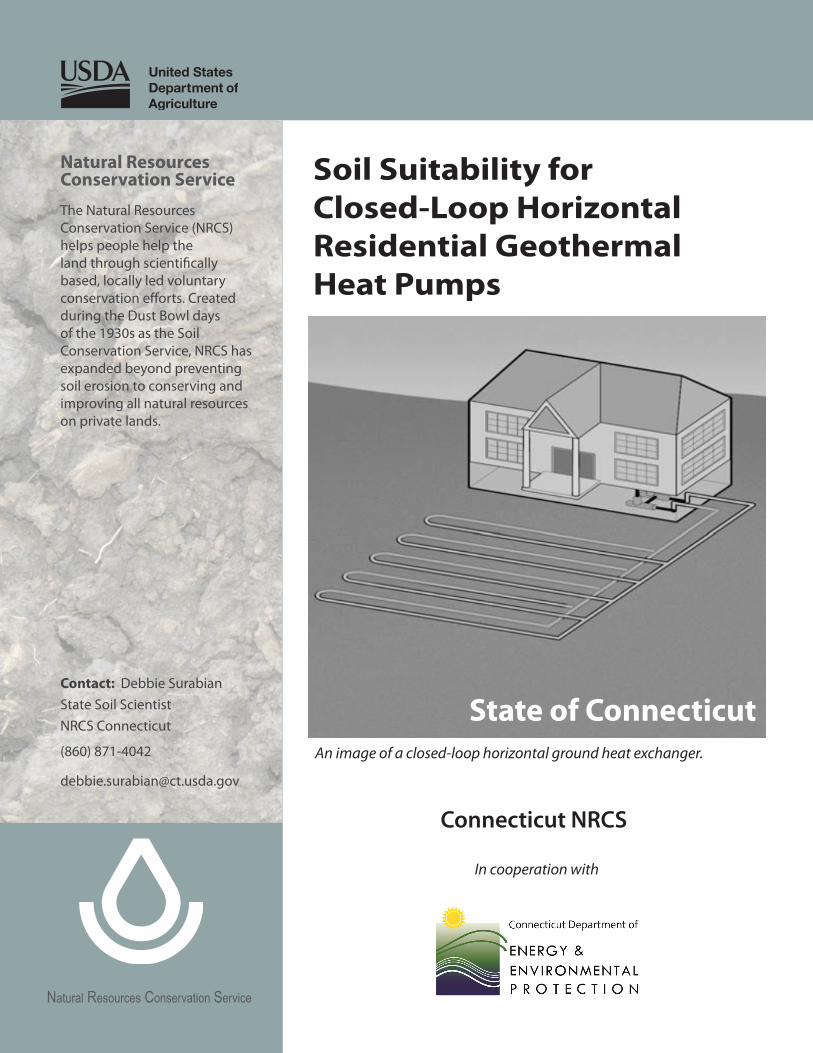
An image of a closed-loop horizontal ground heat exchanger.
Connecticut NRCS

This page intentionally left blank.
Table of Contents
Introduction ...............................................................................................................................................1
Use and Explanation of Soil Interpretations ..............................................................................2
Web Soil Survey ........................................................................................................................................3
Accessing Web Soil Survey ......................................................................................................................3
Evaluation Criteria ...................................................................................................................................3
Soil Suitability Ratings ..............................................................................................................................6
Soil Suitability Ratings by Soil Map Unit ............................................................................................6
References ...................................................................................................................................................6
Other Resources .......................................................................................................................................7
Appendices .................................................................................................................................................8
Appendix A.—Soil Suitability for Closed-Loop Horizontal Residential Geothermal Heat Pumps by Soil Map Unit Component in Connecticut ................................9
Appendix B.—Soil Suitability Map for Closed-Loop Horizontal Residential Geothermal Heat Pumps in Connecticut .........................................................................................21
May 2016

This page intentionally left blank.

1
Introduction
Ground source heat pump systems provide a viable alternative to conventional heating and cooling systems in the move towards sustainable building solutions (Banks, 2008). No single factor is more important to the successful operation of a ground loop heat pump system than the rate of heat transfer between the ground-coupling device and the surrounding soil. It is the rate of heat transfer that determines how closely the circulating fluid, returning to the heat pump, can approach the field ground temperature (Bose et al., 1985).
Thermal conductivity is a measure of the capacity of a material to conduct heat. It is the thermal conductivity of the soil and rock that determines the length of the pipe required and installation cost of the heat exchanger. A larger soil thermal conductivity allows heat to be exchanged with the soil at a faster rate for a given ground loop geometry and size. Knowing the type of soil is of extreme importance in designing ground loop heat pump systems.
Purpose—This interpretation rates the suitability of soils for closed-loop horizontal residential geothermal heat pumps. Soils that are good conductors (high thermal conductivity and low resistivity) are preferable in that they increase the heat loss from the geothermal heat exchanger plastic piping that is installed in the soil profile.
Thermal conductivity is defined as the amount of heat transferred through a unit area, in unit time, under a unit temperature gradient measured as a British thermal unit foot per hour per square foot per degree Fahrenheit (Btu ·ft·h⁻¹·ft⁻²·°F⁻¹). Thermal resistivity is the ability of a material like soil to resist flow of heat. Thermal resistivity is the reciprocal of thermal conductivity.
A soil is made of a matrix of minerals, organic matter, water or ice, and air. Soils vary widely in their thermal conductivities as shown in the following table:
What is a geothermal heat pump system?
A geothermal heat pump system set up inside the Connecticut NRCS State Office in Tolland.
A geothermal heat pump system consists of two primary components, a heat pump and a loop field (GHPLF, 2015). A closed-loop system means that the same water and antifreeze mixture is continually circulated throughout the loop system.
A horizontal loop is piping laid underground parallel to the ground. Horizontal loops are typically installed in more rural areas or yards with a lot of space as installation requires a great deal of land because of the long trenches. The long trenches are only a few feet deep, but below the frost line, and are used to lay the necessary amount of piping used to make the closed-loop system. In some cases, horizontal loop fields can be less costly to install than a vertical loop because there is no drilling (GHPLF, 2015).
Constituent (Btu ·ft·h⁻¹·ft⁻²·°F⁻¹) Quartz 5.8 (good conductor)
Other minerals 1.68 Ice 1.27
Water 0.33
Organic Matter 0.14
Air 0.01 (poor conductor)
2
The relative thermal conductivity of a soil depends on its mineral composition and organic matter content, as well as on the volume fractions of water and air (Hillel, 1980). Soils with a high water content and high bulk density are the best conductors and therefore are the most suitable for geothermal heat pumps.
Use and Explanation of Soil Interpretations
Soil survey interpretations are predictions of soil behavior for specified land uses and management practices. They are based on the soil properties that directly influence the specified use of the soil. Soil survey interpretations allow users of soil surveys to plan reasonable alternatives for the use and management of soils. They are used to plan both broad categories of land use such as cropland, pastureland, woodland, or urban development, as well as specific elements of those land uses (for example, irrigation of cropland, equipment use in woodland management, or septic tank absorption fields).
When soil interpretations are used in connection with delineated areas on soil maps, the information pertains to the soil for which the soil area is named. This is called the major soil component of the soil map unit. Other soils too small to map but observed within the delineated area are called minor soil components or inclusions. This soil interpretation does not include the minor soil components or inclusions. For example, a soil delineation bearing the name Agawam fine sandy loam, 0 to 3 percent slopes, may also include small, unmappable areas of other soils, such as Hinckley and Walpole. The interpretation applies to the Agawam part of the delineated soil area and not to the included soils. More detailed studies are required if small, specific sites are to be developed or used within a given soil delineation.
No consideration was given in this interpretation to the size and shape of soil delineations or to the pattern formed with other soils on the landscape. For example, some very desirable soil areas are too small, too irregular in shape, or occur with less desirable soils in a pattern too complex for the intended use. Although not considered in the interpretations, these items may influence the final selection of a site.
Soil interpretations do not eliminate the need for onsite study and testing of specific sites for the design and construction for specific uses. Interpretations should be used as a guide to planning more detailed investigations and for avoiding undesirable sites for an intended use. The soil map and interpretations can be used to select sites that have the least limitations for an intended use.
Disclaimer: In obtaining this data from the Connecticut Department of Energy and Environmental Protection and the U.S. Department of Agriculture’s Natural Resources Conservation Service (NRCS), it is understood that you and your organization have the right to use it for any internal purpose. This data is not designed for use as a primary tool, but may be used as a reference source. This data is not suitable for site-specific studies or litigation.

3
Accessing Web Soil Survey
To locate the closed-loop horizontal geothermal heat pump soil interpretation on Web Soil Survey, follow these steps:
Open the Web Soil Survey site at: http://websoilsurvey.nrcs.usda.gov and click “Start WSS.”
Define your Area of Interest (AOI)
y From the “Quick Navigation” menu, select Soil Survey Area, Connecticut, State of Connecticut, Set AOI.
y From the top menu, select Soil Data Explorer followed by Soil Reports.
y The “Soil Reports” menu will appear on the left side of the screen. Click AOI Inventory.
y Click Selected Soil Interpretations.
y From the “Options” menu, select ENG–Closed-Loop Horizontal Geothermal Heat Pumps (CT).
y Click View Soil Report tab. The report will appear on the bottom of your screen.
Web Soil Survey
Web Soil Survey provides soil data and information produced by the National Cooperative Soil Survey. It is operated by the U.S. Department of Agriculture’s Natural Resources Conservation Service (NRCS) and provides access to the largest natural resource information system in the world. The site is updated and maintained online as the single authoritative source of soil survey information.
Evaluation Criteria The variations of soil properties and characteristics imply absorption or release of heat energy, thus contributing to heat transfer effects (Farouki, 1981). The evaluation criteria are soil properties that influence thermal conductivity and therefore the suitability for a horizontal closed-loop geothermal heat pump. These soil properties correspond to criteria identified and deemed significant by the U.S. Department of Agriculture’s Natural Resources Conservation Service and the Connecticut Geothermal Association. The evaluation criteria are:
Miscellaneous Areas, Subaqueous, and Histosols—Miscellaneous areas have essentially no soil and support little or no vegetation. Miscellaneous areas that are not suitable for geothermal heat pumps are beaches, dumps, pits, rock outcrop, and urban land.
Histosols are soils that have a high content of organic matter and no permafrost. They are commonly called bogs, peats, or mucks. Histosols are not suitable for geothermal heat pumps.
Subaqueous soils have, by definition, a positive water potential at the soil surface for more than 21 hours of each day. Subaqueous soils are not suitable for geothermal heat pumps.
Depth to Bedrock—Depth to bedrock is the depth from the soil surface to the contact with coherent (continuous) bedrock. Shallow depth to bedrock limits the depth at which a geothermal heat pump can be installed and may pose construction limitations which would elevate the cost of installation. For this interpretation, soils that have bedrock closer to the soil surface are less suitable for geothermal heat pumps.
4
Depth to Densic Material—The depth to densic material refers to a root-limiting layer at a specific depth from the soil surface. Densic materials are formed from dense glacial till and have very high bulk densities that impede or restrict the movement of water vertically through the soil profile. These materials can directly impact where you may easily construct a geothermal heat pump; however, the substantial increase in thermal conductivity which makes the system operate more efficiently outweighs the installation costs.
Not only does the densic material have a higher conductivity, but when dug and loosened to lay pipe, more water will be channeled into the trench increasing the soil moisture around the pipes and improving the conductivity. For this interpretation, soils that are most suitable for geothermal heat pumps have densic materials in the soil profile.
Depth to Water Table—Water table refers to a saturated zone in the soil. Estimates of the average highest water table for a soil are based mainly on observations of the water table at selected sites or on physical characteristics of the soil that are considered to be evidence of a saturated zone (typically, gray redoximorphic depletions).
The presence of water in the area where the geothermal heat pumps exchanger piping is constructed causes the loss of heat from the pipes to the surrounding soil water which is how a geothermal exchanger works. For this interpretation, soils that are most suitable for geothermal heat pumps have a water table within the soil profile. If the water table is very high in the soil profile or if the soil is a floodplain or alluvial soil, it may be considered a Connecticut inland wetland soil and there may be permitting issues.
Flooding Frequency Class—Flooding is the temporary covering of the soil surface by flowing water from any source, such as streams overflowing their banks, runoff from adjacent or surrounding slopes, inflow from high tides, or any combination of sources. Shallow water standing or flowing that is not concentrated as local runoff during or shortly after rain or snow melt is excluded from the definition of flooding.
Estimates of flooding class are based on the interpretation of soil properties and other evidence gathered during soil survey fieldwork. Soils with a flooding frequency of rare, occasional, frequent, or very frequent are not suitable for geothermal heat pumps. Soils with a very rare flooding frequency or none are suitable for geothermal heat pumps.
Soil Moisture Content—Another major influence on thermal behavior is the soil moisture content (Salomone et al, 1989). The soil moisture content indicates the amount of water present in the soil. Field capacity is the amount of soil moisture or water content held in the soil after excess water has drained away and the rate of downward movement has decreased. The physical definition of field capacity is the bulk water content retained in soil at −33 J/kg (or −0.33 bar) of hydraulic head or suction pressure.
5
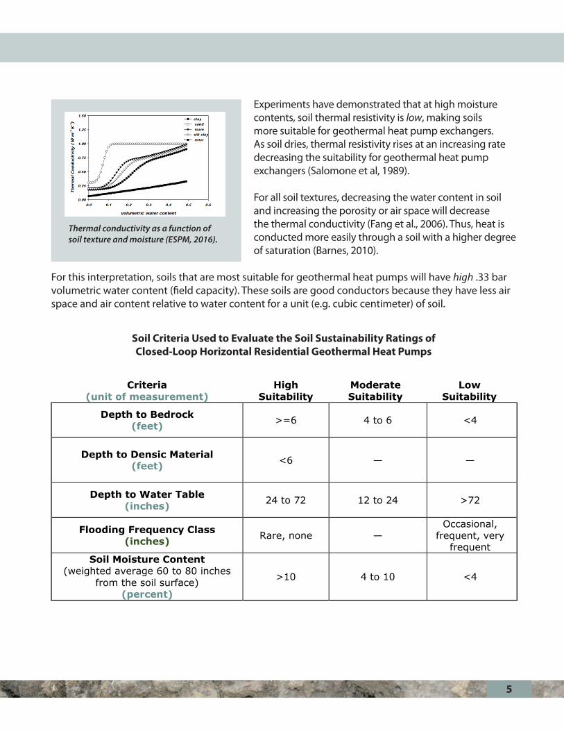
Experiments have demonstrated that at high moisture contents, soil thermal resistivity is low, making soils more suitable for geothermal heat pump exchangers. As soil dries, thermal resistivity rises at an increasing rate decreasing the suitability for geothermal heat pump exchangers (Salomone et al, 1989).
For all soil textures, decreasing the water content in soil and increasing the porosity or air space will decrease the thermal conductivity (Fang et al., 2006). Thus, heat is conducted more easily through a soil with a higher degree of saturation (Barnes, 2010).
For this interpretation, soils that are most suitable for geothermal heat pumps will have high .33 bar volumetric water content (field capacity). These soils are good conductors because they have less air space and air content relative to water content for a unit (e.g. cubic centimeter) of soil.
Thermal conductivity as a function of soil texture and moisture (ESPM, 2016).
1 | P a g e
Soil Criteria Used to Evaluate the Soil Sustainability Ratings of Closed-Loop Horizontal Residential Geothermal Heat Pumps
Criteria(unit of measurement)
High Suitability
Moderate Suitability
LowSuitability
Depth to Bedrock(feet) >=6 4 to 6 <4
Depth to Densic Material(feet) <6 — —
Depth to Water Table(inches) 24 to 72 12 to 24 >72
Flooding Frequency Class(inches) Rare, none —
Occasional,frequent, very
frequentSoil Moisture Content
(weighted average 60 to 80 inches from the soil surface)
(percent)
>10 4 to 10 <4
Soil Criteria Used to Evaluate the Soil Sustainability Ratings of Closed-Loop Horizontal Residential Geothermal Heat Pumps
6
Soil Suitability Ratings
High Suitability—Soils have little or no soil limitations for horizontal closed-loop geothermal heat pumps. Moderate Suitability—Soils have one or more moderate soil limitations that need to be mitigated for successful horizontal closed-loop geothermal heat pump installation and operation.
Low Suitability—Soils have one or more severe limitations that need to be mitigated for successful geothermal heat pump installation and operation. Limitations may be too costly to overcome, or compromise the system’s efficiency. Not Suitable—Some soils and miscellaneous areas may not be a suitable location for installation of a horizontal closed-loop geothermal heat pump. For example, if the water table is very high in the soil profile or the soil is a floodplain or alluvial, it may be considered a Connecticut inland wetland soil and there may be permitting issues. There also may not be enough soils information to make a recommendation.
Soil Suitability Ratings by Soil Map Unit Connecticut’s statewide soil survey identifies and displays the dominant soils in the state. The symbols on the maps identify soil map units, each map unit representing a unique combination of soils. Areas within the same symbol have similar composition.
The soils were mapped at a scale of 1:12,000 with a minimum size delineation of approximately 3 acres. Maps enlarged from the soil survey report do not provide more detailed soils information. More detailed information can only be obtained through onsite investigations. The soil survey is not a replacement for onsite investigation. The survey identifies the probability of finding a particular soil or combination of soils.
ReferencesBanks, D. 2008. An introduction to thermogeology: Ground source heating and cooling. Blackwell Publishing Ltd. Oxford.
Barnes, G.E. 2010. Soil mechanics: Principles and practice. Third edition. Palgrave MacMillan.
Bose, J.E., J.D. Parker, and F.C. McQuiston. 1985. Design and data manual for closed-loop ground coupled heat pump systems. Oklahoma State University. Atlanta American Society of Heating, Refrigeration, and Air-Conditioning Engineers, Inc.
7
University of California, Berkeley. Accessed March 2016. Environmental Science, Policy and Management 129 Biometeorology. http://nature.berkeley.edu/biometlab/espm129/overheads/Lecture%2033%20ESPM%20129%20soil%20physics%20part%201overheads.pdf
Fang, Hsai-Yang and John L. Daniels. 2006. Introductory geotechnical engineering an environmental perspective. Taylor and Francis Group.
Geothermal Genius. Accessed January 2016. Geothermal Heat Pump Loop Fields. http://www.geothermalgenius.org/how-it-works/geothermal-ground-loop-fields/
Hillel, Daniel. 1980. Fundamentals of soil physics. Academic Press Inc. p. 295-312.
Salomone, L.A. and J.I. Marlowe. 1989. Soil and rock classification according to thermal conductivity design of ground-coupled heat pump systems. CU-6482. Research Project 2892-3. Electric Power Research Institute, Palo Alto, California.
Other Resources Farouki, Omar T. 1981. Thermal properties of soils. United States Army Corps of Engineers. Cold Regions Research and Engineering Laboratory (CRREL) Monograph: 81-1.
Hopmans, J. W., J. H. Dane. 1986. Thermal conductivity of two porous media as a function of water content, temperature, and density. Soil Science. Vol. 142: 187-195.
Lund, John W. 2002. Design of closed-loop geothermal heat exchangers in the U.S. International Course on Geothermal Heat Pumps. p. 135-146.
Nidal, H. Abu-Hamdeh., R. C. Reeder. 2000. Soil thermal conductivity-effect of density, moisture, salt concentration, and organic matter. Soil Science Society of America. Journal 64: 1285-1290.
Rafferty, Kevin. 2001. Small geothermal systems: A guide for the do-it-yourselfer. U.S. Department of Energy, Office of Geothermal Technologies. p. 1-30.
Rafferty, Kevin. 2001. An information survival kit for the prospective geothermal heat pump owner. U.S. Department of Energy, Office of Geothermal Technologies. p. 1-28.
U.S. Department of Energy. 1999. Geothermal heat pumps. National Renewable Energy Laboratory: DOE/GO-10099-727.
U.S. Department of Energy. 2011. Guide to geothermal heat pumps. Energy Efficiency and Renewable Energy. DOE/EE-0385.
8
Appendices
Appendix A.—Soil Suitability for Closed-Loop Horizontal Residential Geothermal Heat Pumps by Soil Map Unit Component in Connecticut, Soil Survey of the State of Connecticut
Appendix B.—Soil Suitability Map for Closed-Loop Horizontal Residential Geothermal Heat Pumps in Connecticut, Soil Survey of the State of Connecticut
Appendix A data was obtained from Web Soil Survey, January 2016.

Appendix A Soil Suitability for Geothermal Heat Pumps by Soil Map Unit Component
Soil Survey of the State of Connecticut—Accessed January 2016
9
Soil Map Unit
Symbol Component Component
Percent Rating Value Rating Class
2 Ridgebury 80 0 Not suitable 3 Whitman 20 0 Not suitable 3 Leicester 35 0 Not suitable 3 Ridgebury 40 0 Not suitable 4 Leicester 80 0 Not suitable 5 Wilbraham 80 0 Not suitable 6 Menlo 25 0 Not suitable 6 Wilbraham 60 0 Not suitable 7 Mudgepond 85 0 Not suitable 8 Alden 35 0 Not suitable 8 Mudgepond 45 0 Not suitable 9 Maybid 15 0 Not suitable 9 Shaker 30 0 Not suitable 9 Scitico 40 0 Not suitable
10 Raynham 80 0 Not suitable 12 Raypol 80 0 Not suitable 13 Walpole 80 0 Not suitable 14 Fredon 85 0 Not suitable 15 Scarboro 80 0 Not suitable 16 Halsey 80 0 Not suitable 17 Natchaug 40 0 Not suitable 17 Timakwa 45 0 Not suitable 18 Catden 40 0 Not suitable 18 Freetown 40 0 Not suitable
20A Ellington 80 0.244 Moderate Suitability 21A Tisbury 25 0.135 Low Suitability 21A Ninigret 60 0.265 Moderate Suitability 22A Hero 85 0.365 Moderate Suitability 22B Hero 85 0.365 Moderate Suitability 23A Sudbury 80 0.245 Moderate Suitability 24A Deerfield 80 0.35 Moderate Suitability 25A Brancroft 80 0.968 High Suitability 25B Brancroft 80 0.968 High Suitability 25C Brancroft 80 0.968 High Suitability 26A Berlin 80 0.968 High Suitability 26B Berlin 80 0.968 High Suitability 27A Belgrade 80 0.842 High Suitability 28A Elmridge 80 1 High Suitability 28B Elmridge 80 1 High Suitability
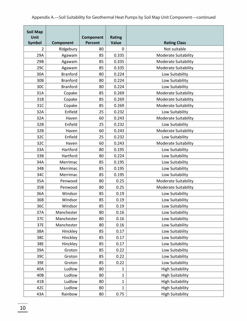
Appendix A.—Soil Suitability for Geothermal Heat Pumps by Soil Map Unit Component—continued
10
Soil Map Unit
Symbol Component Component
Percent Rating Value Rating Class
2 Ridgebury 80 0 Not suitable 29A Agawam 85 0.335 Moderate Suitability 29B Agawam 85 0.335 Moderate Suitability 29C Agawam 85 0.335 Moderate Suitability 30A Branford 80 0.224 Low Suitability 30B Branford 80 0.224 Low Suitability 30C Branford 80 0.224 Low Suitability 31A Copake 85 0.269 Moderate Suitability 31B Copake 85 0.269 Moderate Suitability 31C Copake 85 0.269 Moderate Suitability 32A Enfield 25 0.232 Low Suitability 32A Haven 60 0.243 Moderate Suitability 32B Enfield 25 0.232 Low Suitability 32B Haven 60 0.243 Moderate Suitability 32C Enfield 25 0.232 Low Suitability 32C Haven 60 0.243 Moderate Suitability 33A Hartford 80 0.195 Low Suitability 33B Hartford 80 0.224 Low Suitability 34A Merrimac 85 0.195 Low Suitability 34B Merrimac 85 0.195 Low Suitability 34C Merrimac 85 0.195 Low Suitability 35A Penwood 80 0.25 Moderate Suitability 35B Penwood 80 0.25 Moderate Suitability 36A Windsor 85 0.19 Low Suitability 36B Windsor 85 0.19 Low Suitability 36C Windsor 85 0.19 Low Suitability 37A Manchester 80 0.16 Low Suitability 37C Manchester 80 0.16 Low Suitability 37E Manchester 80 0.16 Low Suitability 38A Hinckley 85 0.17 Low Suitability 38C Hinckley 85 0.17 Low Suitability 38E Hinckley 85 0.17 Low Suitability 39A Groton 85 0.22 Low Suitability 39C Groton 85 0.22 Low Suitability 39E Groton 85 0.22 Low Suitability 40A Ludlow 80 1 High Suitability 40B Ludlow 80 1 High Suitability 41B Ludlow 80 1 High Suitability 42C Ludlow 80 1 High Suitability 43A Rainbow 80 0.75 High Suitability
Appendix A.—Soil Suitability for Geothermal Heat Pumps by Soil Map Unit Component—continued
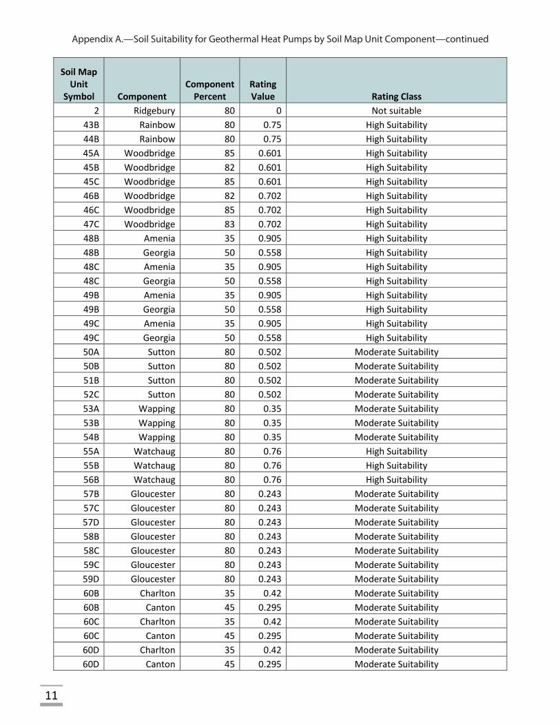
11
Soil Map Unit
Symbol Component Component
Percent Rating Value Rating Class
2 Ridgebury 80 0 Not suitable 43B Rainbow 80 0.75 High Suitability 44B Rainbow 80 0.75 High Suitability 45A Woodbridge 85 0.601 High Suitability 45B Woodbridge 82 0.601 High Suitability 45C Woodbridge 85 0.601 High Suitability 46B Woodbridge 82 0.702 High Suitability 46C Woodbridge 85 0.702 High Suitability 47C Woodbridge 83 0.702 High Suitability 48B Amenia 35 0.905 High Suitability 48B Georgia 50 0.558 High Suitability 48C Amenia 35 0.905 High Suitability 48C Georgia 50 0.558 High Suitability 49B Amenia 35 0.905 High Suitability 49B Georgia 50 0.558 High Suitability 49C Amenia 35 0.905 High Suitability 49C Georgia 50 0.558 High Suitability 50A Sutton 80 0.502 Moderate Suitability 50B Sutton 80 0.502 Moderate Suitability 51B Sutton 80 0.502 Moderate Suitability 52C Sutton 80 0.502 Moderate Suitability 53A Wapping 80 0.35 Moderate Suitability 53B Wapping 80 0.35 Moderate Suitability 54B Wapping 80 0.35 Moderate Suitability 55A Watchaug 80 0.76 High Suitability 55B Watchaug 80 0.76 High Suitability 56B Watchaug 80 0.76 High Suitability 57B Gloucester 80 0.243 Moderate Suitability 57C Gloucester 80 0.243 Moderate Suitability 57D Gloucester 80 0.243 Moderate Suitability 58B Gloucester 80 0.243 Moderate Suitability 58C Gloucester 80 0.243 Moderate Suitability 59C Gloucester 80 0.243 Moderate Suitability 59D Gloucester 80 0.243 Moderate Suitability 60B Charlton 35 0.42 Moderate Suitability 60B Canton 45 0.295 Moderate Suitability 60C Charlton 35 0.42 Moderate Suitability 60C Canton 45 0.295 Moderate Suitability 60D Charlton 35 0.42 Moderate Suitability 60D Canton 45 0.295 Moderate Suitability
Appendix A.—Soil Suitability for Geothermal Heat Pumps by Soil Map Unit Component—continued
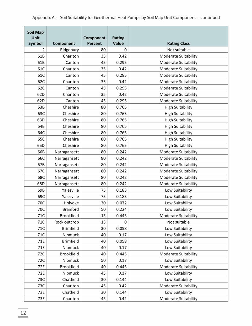
12
Soil Map Unit
Symbol Component Component
Percent Rating Value Rating Class
2 Ridgebury 80 0 Not suitable 61B Charlton 35 0.42 Moderate Suitability 61B Canton 45 0.295 Moderate Suitability 61C Charlton 35 0.42 Moderate Suitability 61C Canton 45 0.295 Moderate Suitability 62C Charlton 35 0.42 Moderate Suitability 62C Canton 45 0.295 Moderate Suitability 62D Charlton 35 0.42 Moderate Suitability 62D Canton 45 0.295 Moderate Suitability 63B Cheshire 80 0.765 High Suitability 63C Cheshire 80 0.765 High Suitability 63D Cheshire 80 0.765 High Suitability 64B Cheshire 80 0.765 High Suitability 64C Cheshire 80 0.765 High Suitability 65C Cheshire 80 0.765 High Suitability 65D Cheshire 80 0.765 High Suitability 66B Narragansett 80 0.242 Moderate Suitability 66C Narragansett 80 0.242 Moderate Suitability 67B Narragansett 80 0.242 Moderate Suitability 67C Narragansett 80 0.242 Moderate Suitability 68C Narragansett 80 0.242 Moderate Suitability 68D Narragansett 80 0.242 Moderate Suitability 69B Yalesville 75 0.183 Low Suitability 69C Yalesville 75 0.183 Low Suitability 70C Holyoke 30 0.072 Low Suitability 70C Branford 50 0.224 Low Suitability 71C Brookfield 15 0.445 Moderate Suitability 71C Rock outcrop 15 0 Not suitable 71C Brimfield 30 0.058 Low Suitability 71C Nipmuck 40 0.17 Low Suitability 71E Brimfield 40 0.058 Low Suitability 71E Nipmuck 40 0.17 Low Suitability 72C Brookfield 40 0.445 Moderate Suitability 72C Nipmuck 50 0.17 Low Suitability 72E Brookfield 40 0.445 Moderate Suitability 72E Nipmuck 45 0.17 Low Suitability 73C Chatfield 30 0.144 Low Suitability 73C Charlton 45 0.42 Moderate Suitability 73E Chatfield 30 0.144 Low Suitability 73E Charlton 45 0.42 Moderate Suitability
Appendix A.—Soil Suitability for Geothermal Heat Pumps by Soil Map Unit Component—continued
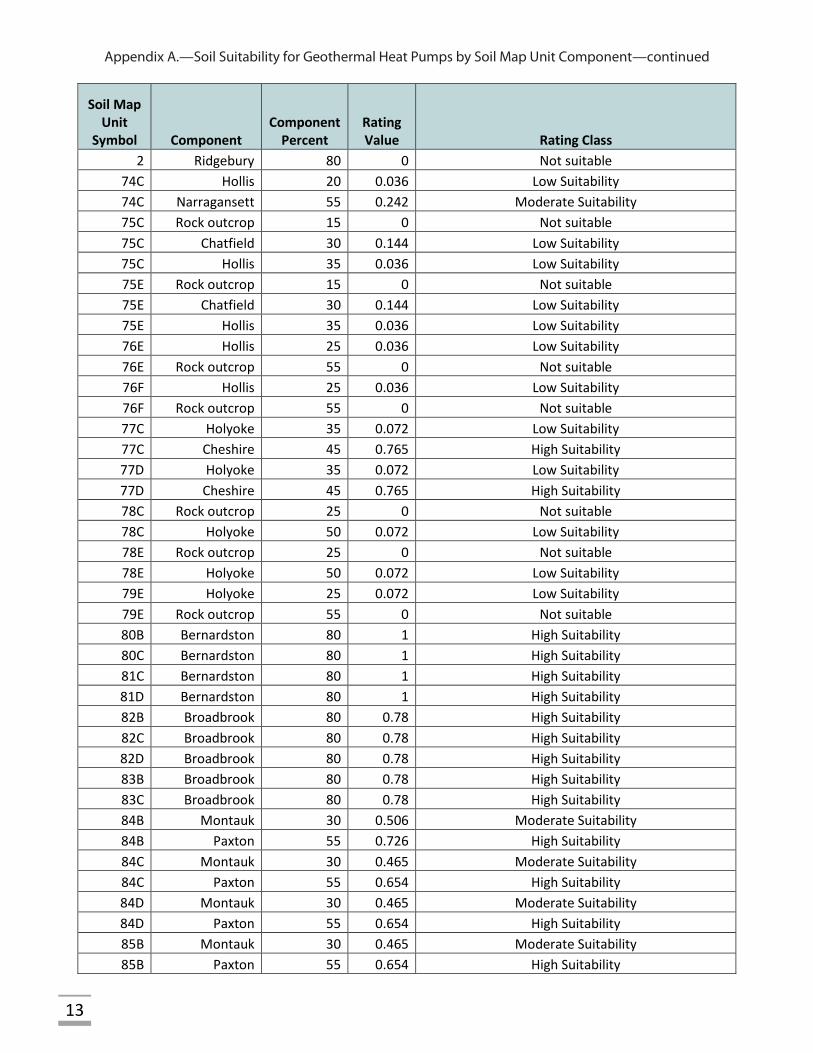
13
Soil Map Unit
Symbol Component Component
Percent Rating Value Rating Class
2 Ridgebury 80 0 Not suitable 74C Hollis 20 0.036 Low Suitability 74C Narragansett 55 0.242 Moderate Suitability 75C Rock outcrop 15 0 Not suitable 75C Chatfield 30 0.144 Low Suitability 75C Hollis 35 0.036 Low Suitability 75E Rock outcrop 15 0 Not suitable 75E Chatfield 30 0.144 Low Suitability 75E Hollis 35 0.036 Low Suitability 76E Hollis 25 0.036 Low Suitability 76E Rock outcrop 55 0 Not suitable 76F Hollis 25 0.036 Low Suitability 76F Rock outcrop 55 0 Not suitable 77C Holyoke 35 0.072 Low Suitability 77C Cheshire 45 0.765 High Suitability 77D Holyoke 35 0.072 Low Suitability 77D Cheshire 45 0.765 High Suitability 78C Rock outcrop 25 0 Not suitable 78C Holyoke 50 0.072 Low Suitability 78E Rock outcrop 25 0 Not suitable 78E Holyoke 50 0.072 Low Suitability 79E Holyoke 25 0.072 Low Suitability 79E Rock outcrop 55 0 Not suitable 80B Bernardston 80 1 High Suitability 80C Bernardston 80 1 High Suitability 81C Bernardston 80 1 High Suitability 81D Bernardston 80 1 High Suitability 82B Broadbrook 80 0.78 High Suitability 82C Broadbrook 80 0.78 High Suitability 82D Broadbrook 80 0.78 High Suitability 83B Broadbrook 80 0.78 High Suitability 83C Broadbrook 80 0.78 High Suitability 84B Montauk 30 0.506 Moderate Suitability 84B Paxton 55 0.726 High Suitability 84C Montauk 30 0.465 Moderate Suitability 84C Paxton 55 0.654 High Suitability 84D Montauk 30 0.465 Moderate Suitability 84D Paxton 55 0.654 High Suitability 85B Montauk 30 0.465 Moderate Suitability 85B Paxton 55 0.654 High Suitability
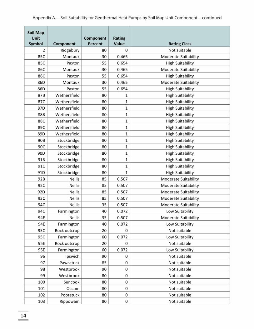
Appendix A.—Soil Suitability for Geothermal Heat Pumps by Soil Map Unit Component—continued
14
Soil Map Unit
Symbol Component Component
Percent Rating Value Rating Class
2 Ridgebury 80 0 Not suitable 85C Montauk 30 0.465 Moderate Suitability 85C Paxton 55 0.654 High Suitability 86C Montauk 30 0.465 Moderate Suitability 86C Paxton 55 0.654 High Suitability 86D Montauk 30 0.465 Moderate Suitability 86D Paxton 55 0.654 High Suitability 87B Wethersfield 80 1 High Suitability 87C Wethersfield 80 1 High Suitability 87D Wethersfield 80 1 High Suitability 88B Wethersfield 80 1 High Suitability 88C Wethersfield 80 1 High Suitability 89C Wethersfield 80 1 High Suitability 89D Wethersfield 80 1 High Suitability 90B Stockbridge 80 1 High Suitability 90C Stockbridge 80 1 High Suitability 90D Stockbridge 80 1 High Suitability 91B Stockbridge 80 1 High Suitability 91C Stockbridge 80 1 High Suitability 91D Stockbridge 80 1 High Suitability 92B Nellis 85 0.507 Moderate Suitability 92C Nellis 85 0.507 Moderate Suitability 92D Nellis 85 0.507 Moderate Suitability 93C Nellis 85 0.507 Moderate Suitability 94C Nellis 35 0.507 Moderate Suitability 94C Farmington 40 0.072 Low Suitability 94E Nellis 35 0.507 Moderate Suitability 94E Farmington 40 0.072 Low Suitability 95C Rock outcrop 20 0 Not suitable 95C Farmington 60 0.072 Low Suitability 95E Rock outcrop 20 0 Not suitable 95E Farmington 60 0.072 Low Suitability
96 Ipswich 90 0 Not suitable 97 Pawcatuck 85 0 Not suitable 98 Westbrook 90 0 Not suitable 99 Westbrook 80 0 Not suitable
100 Suncook 80 0 Not suitable 101 Occum 80 0 Not suitable 102 Pootatuck 80 0 Not suitable 103 Rippowam 80 0 Not suitable
Appendix A.—Soil Suitability for Geothermal Heat Pumps by Soil Map Unit Component—continued
15
Soil Map Unit
Symbol Component Component
Percent Rating Value Rating Class
2 Ridgebury 80 0 Not suitable 104 Bash 80 0 Not suitable 105 Hadley 80 0 Not suitable 106 Winooski 80 0 Not suitable 107 Lim 30 0 Not suitable 107 Limerick 50 0 Not suitable 108 Saco 80 0 Not suitable 109 Udifluvents 35 0 Not suitable 109 Fluvaquents 50 0 Not suitable
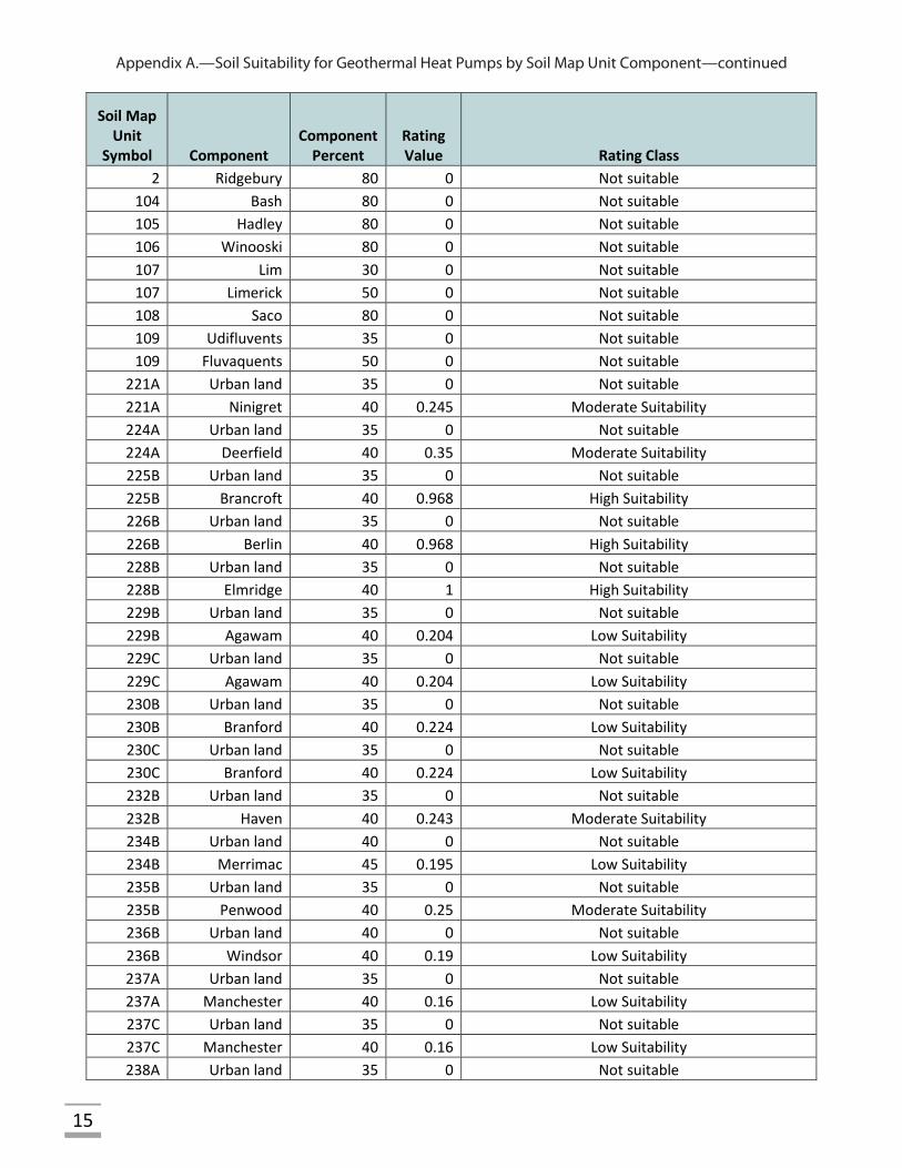
221A Urban land 35 0 Not suitable 221A Ninigret 40 0.245 Moderate Suitability 224A Urban land 35 0 Not suitable 224A Deerfield 40 0.35 Moderate Suitability 225B Urban land 35 0 Not suitable 225B Brancroft 40 0.968 High Suitability 226B Urban land 35 0 Not suitable 226B Berlin 40 0.968 High Suitability 228B Urban land 35 0 Not suitable 228B Elmridge 40 1 High Suitability 229B Urban land 35 0 Not suitable 229B Agawam 40 0.204 Low Suitability 229C Urban land 35 0 Not suitable 229C Agawam 40 0.204 Low Suitability 230B Urban land 35 0 Not suitable 230B Branford 40 0.224 Low Suitability 230C Urban land 35 0 Not suitable 230C Branford 40 0.224 Low Suitability 232B Urban land 35 0 Not suitable 232B Haven 40 0.243 Moderate Suitability 234B Urban land 40 0 Not suitable 234B Merrimac 45 0.195 Low Suitability 235B Urban land 35 0 Not suitable 235B Penwood 40 0.25 Moderate Suitability 236B Urban land 40 0 Not suitable 236B Windsor 40 0.19 Low Suitability 237A Urban land 35 0 Not suitable 237A Manchester 40 0.16 Low Suitability 237C Urban land 35 0 Not suitable 237C Manchester 40 0.16 Low Suitability 238A Urban land 35 0 Not suitable
Appendix A.—Soil Suitability for Geothermal Heat Pumps by Soil Map Unit Component—continued
16
Soil Map Unit
Symbol Component Component
Percent Rating Value Rating Class
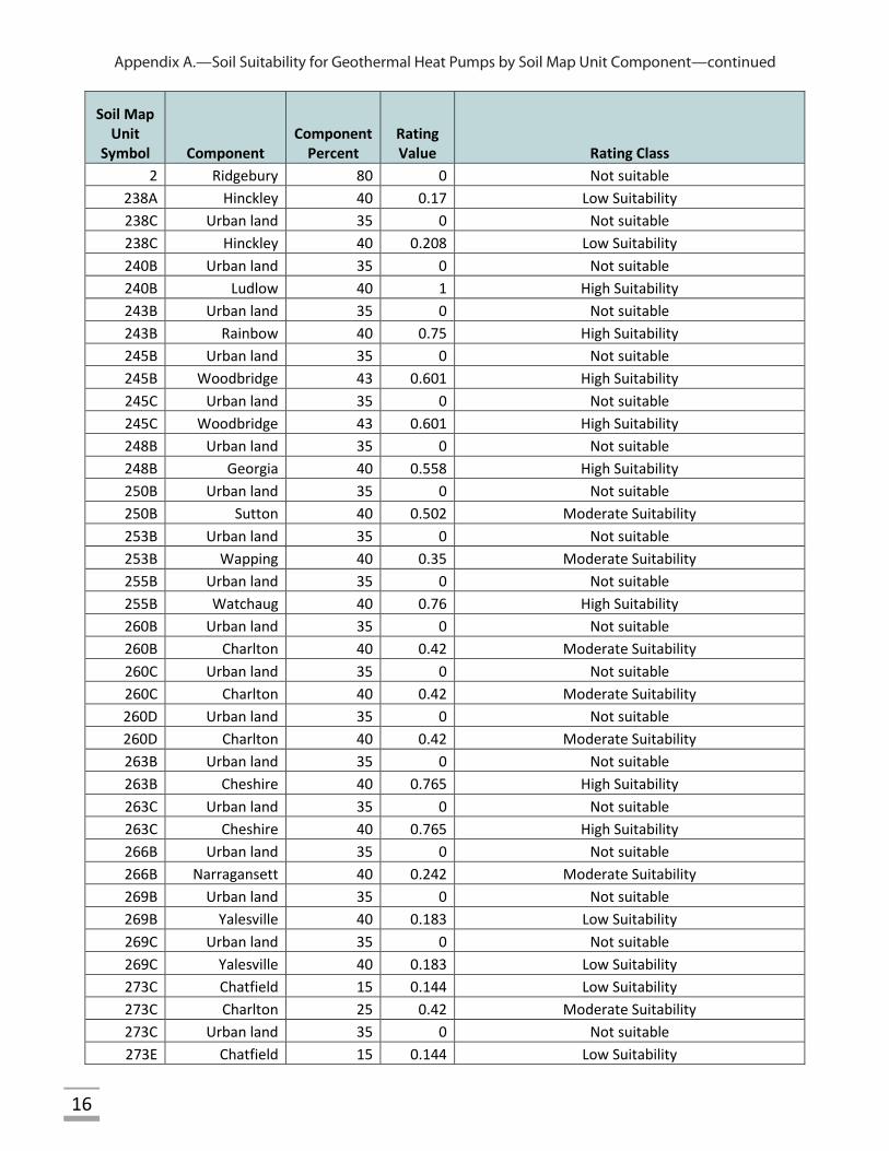
2 Ridgebury 80 0 Not suitable 238A Hinckley 40 0.17 Low Suitability 238C Urban land 35 0 Not suitable 238C Hinckley 40 0.208 Low Suitability 240B Urban land 35 0 Not suitable 240B Ludlow 40 1 High Suitability 243B Urban land 35 0 Not suitable 243B Rainbow 40 0.75 High Suitability 245B Urban land 35 0 Not suitable 245B Woodbridge 43 0.601 High Suitability 245C Urban land 35 0 Not suitable 245C Woodbridge 43 0.601 High Suitability 248B Urban land 35 0 Not suitable 248B Georgia 40 0.558 High Suitability 250B Urban land 35 0 Not suitable 250B Sutton 40 0.502 Moderate Suitability 253B Urban land 35 0 Not suitable 253B Wapping 40 0.35 Moderate Suitability 255B Urban land 35 0 Not suitable 255B Watchaug 40 0.76 High Suitability 260B Urban land 35 0 Not suitable 260B Charlton 40 0.42 Moderate Suitability 260C Urban land 35 0 Not suitable 260C Charlton 40 0.42 Moderate Suitability 260D Urban land 35 0 Not suitable 260D Charlton 40 0.42 Moderate Suitability 263B Urban land 35 0 Not suitable 263B Cheshire 40 0.765 High Suitability 263C Urban land 35 0 Not suitable 263C Cheshire 40 0.765 High Suitability 266B Urban land 35 0 Not suitable 266B Narragansett 40 0.242 Moderate Suitability 269B Urban land 35 0 Not suitable 269B Yalesville 40 0.183 Low Suitability 269C Urban land 35 0 Not suitable 269C Yalesville 40 0.183 Low Suitability 273C Chatfield 15 0.144 Low Suitability 273C Charlton 25 0.42 Moderate Suitability 273C Urban land 35 0 Not suitable 273E Chatfield 15 0.144 Low Suitability
Appendix A.—Soil Suitability for Geothermal Heat Pumps by Soil Map Unit Component—continued
17
Soil Map Unit
Symbol Component Component
Percent Rating Value Rating Class
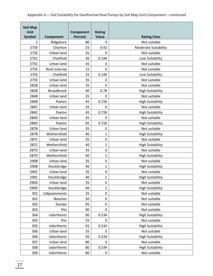
2 Ridgebury 80 0 Not suitable 273E Charlton 25 0.42 Moderate Suitability 273E Urban land 35 0 Not suitable 275C Chatfield 30 0.144 Low Suitability 275C Urban land 45 0 Not suitable 275E Rock outcrop 15 0 Not suitable 275E Chatfield 25 0.144 Low Suitability 275E Urban land 35 0 Not suitable 282B Urban land 35 0 Not suitable 282B Broadbrook 40 0.78 High Suitability 284B Urban land 35 0 Not suitable 284B Paxton 45 0.726 High Suitability 284C Urban land 35 0 Not suitable 284C Paxton 45 0.726 High Suitability 284D Urban land 35 0 Not suitable 284D Paxton 45 0.726 High Suitability 287B Urban land 35 0 Not suitable 287B Wethersfield 40 1 High Suitability 287C Urban land 35 0 Not suitable 287C Wethersfield 40 1 High Suitability 287D Urban land 35 0 Not suitable 287D Wethersfield 40 1 High Suitability 290B Urban land 35 0 Not suitable 290B Stockbridge 40 1 High Suitability 290C Urban land 35 0 Not suitable 290C Stockbridge 40 1 High Suitability 290D Urban land 35 0 Not suitable 290D Stockbridge 40 1 High Suitability
301 Udipsamments 35 0 Not suitable 301 Beaches 50 0 Not suitable 302 Dumps 95 0 Not suitable 303 Pits 90 0 Not suitable 304 Udorthents 90 0.534 High Suitability 305 Pits 25 0 Not suitable 305 Udorthents 65 0.534 High Suitability 306 Urban land 35 0 Not suitable 306 Udorthents 50 0.534 High Suitability 307 Urban land 80 0 Not suitable 308 Udorthents 80 0.534 High Suitability 309 Udorthents 80 0 Not suitable
Appendix A.—Soil Suitability for Geothermal Heat Pumps by Soil Map Unit Component—continued
18
Soil Map Unit
Symbol Component Component
Percent Rating Value Rating Class
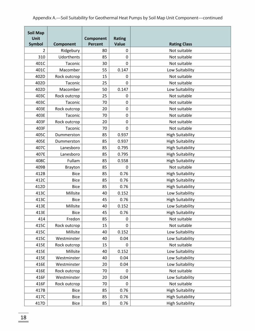
2 Ridgebury 80 0 Not suitable 310 Udorthents 85 0 Not suitable
401C Taconic 30 0 Not suitable 401C Macomber 55 0.147 Low Suitability 402D Rock outcrop 15 0 Not suitable 402D Taconic 25 0 Not suitable 402D Macomber 50 0.147 Low Suitability 403C Rock outcrop 25 0 Not suitable 403C Taconic 70 0 Not suitable 403E Rock outcrop 20 0 Not suitable 403E Taconic 70 0 Not suitable 403F Rock outcrop 20 0 Not suitable 403F Taconic 70 0 Not suitable 405C Dummerston 85 0.937 High Suitability 405E Dummerston 85 0.937 High Suitability 407C Lanesboro 85 0.795 High Suitability 407E Lanesboro 85 0.795 High Suitability 408C Fullam 85 0.558 High Suitability 409B Brayton 85 0 Not suitable 412B Bice 85 0.76 High Suitability 412C Bice 85 0.76 High Suitability 412D Bice 85 0.76 High Suitability 413C Millsite 40 0.152 Low Suitability 413C Bice 45 0.76 High Suitability 413E Millsite 40 0.152 Low Suitability 413E Bice 45 0.76 High Suitability
414 Fredon 85 0 Not suitable 415C Rock outcrop 15 0 Not suitable 415C Millsite 40 0.152 Low Suitability 415C Westminster 40 0.04 Low Suitability 415E Rock outcrop 15 0 Not suitable 415E Millsite 40 0.152 Low Suitability 415E Westminster 40 0.04 Low Suitability 416E Westminster 20 0.04 Low Suitability 416E Rock outcrop 70 0 Not suitable 416F Westminster 20 0.04 Low Suitability 416F Rock outcrop 70 0 Not suitable 417B Bice 85 0.76 High Suitability 417C Bice 85 0.76 High Suitability 417D Bice 85 0.76 High Suitability
Appendix A.—Soil Suitability for Geothermal Heat Pumps by Soil Map Unit Component—continued
19
Soil Map Unit
Symbol Component Component
Percent Rating Value Rating Class
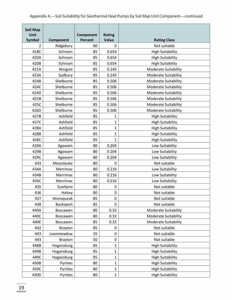
2 Ridgebury 80 0 Not suitable 418C Schroon 85 0.654 High Suitability 420A Schroon 85 0.654 High Suitability 420B Schroon 85 0.654 High Suitability 421A Ninigret 85 0.245 Moderate Suitability 423A Sudbury 85 0.245 Moderate Suitability 424B Shelburne 85 0.506 Moderate Suitability 424C Shelburne 85 0.506 Moderate Suitability 424D Shelburne 85 0.506 Moderate Suitability 425B Shelburne 85 0.506 Moderate Suitability 425C Shelburne 85 0.506 Moderate Suitability 426D Shelburne 85 0.506 Moderate Suitability 427B Ashfield 85 1 High Suitability 427C Ashfield 85 1 High Suitability 428A Ashfield 85 1 High Suitability 428B Ashfield 85 1 High Suitability 428C Ashfield 85 1 High Suitability 429A Agawam 80 0.204 Low Suitability 429B Agawam 80 0.204 Low Suitability 429C Agawam 80 0.204 Low Suitability
433 Moosilauke 80 0 Not suitable 434A Merrimac 80 0.216 Low Suitability 434B Merrimac 80 0.216 Low Suitability 434C Merrimac 80 0.216 Low Suitability
435 Scarboro 80 0 Not suitable 436 Halsey 80 0 Not suitable 437 Wonsqueak 85 0 Not suitable 438 Bucksport 85 0 Not suitable
440A Boscawen 80 0.32 Moderate Suitability 440C Boscawen 80 0.32 Moderate Suitability 440E Boscawen 85 0.32 Moderate Suitability
442 Brayton 85 0 Not suitable 443 Loonmeadow 35 0 Not suitable 443 Brayton 50 0 Not suitable
448B Hogansburg 85 1 High Suitability 449B Hogansburg 85 1 High Suitability 449C Hogansburg 85 1 High Suitability 450B Pyrities 80 1 High Suitability 450C Pyrities 80 1 High Suitability 450D Pyrities 80 1 High Suitability
Appendix A.—Soil Suitability for Geothermal Heat Pumps by Soil Map Unit Component—continued
20
Soil Map Unit
Symbol Component Component
Percent Rating Value Rating Class
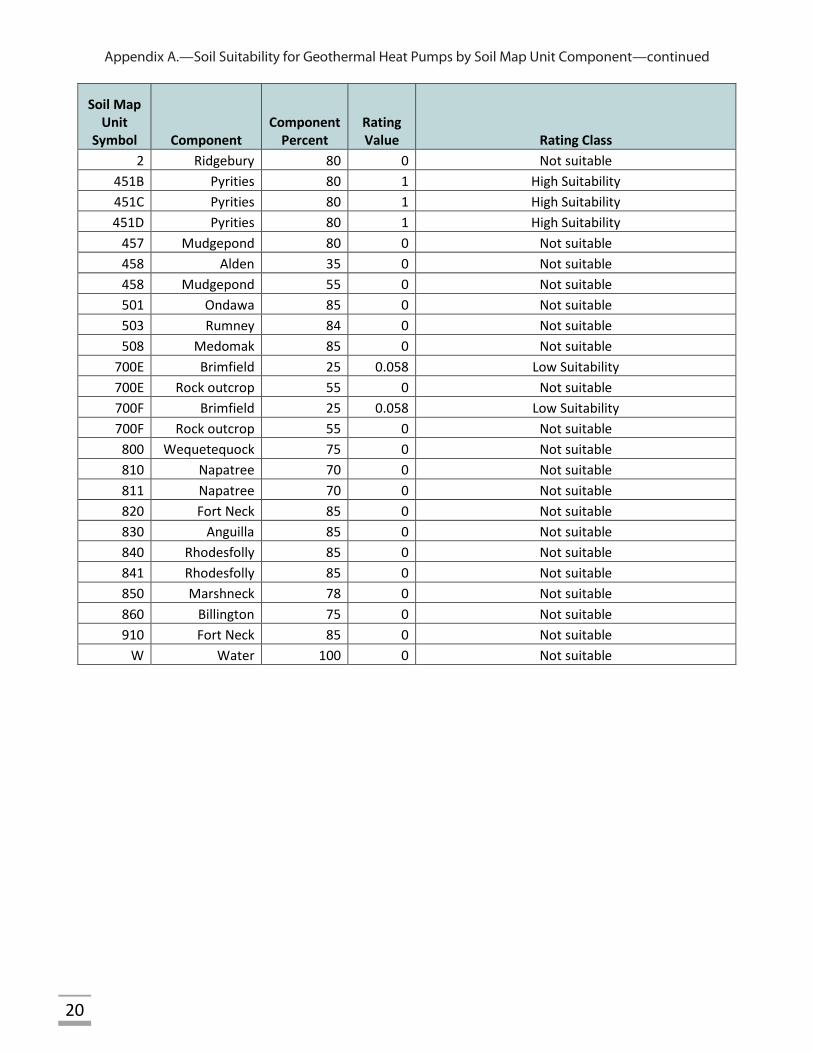
2 Ridgebury 80 0 Not suitable 451B Pyrities 80 1 High Suitability 451C Pyrities 80 1 High Suitability 451D Pyrities 80 1 High Suitability
457 Mudgepond 80 0 Not suitable 458 Alden 35 0 Not suitable 458 Mudgepond 55 0 Not suitable 501 Ondawa 85 0 Not suitable 503 Rumney 84 0 Not suitable 508 Medomak 85 0 Not suitable
700E Brimfield 25 0.058 Low Suitability 700E Rock outcrop 55 0 Not suitable 700F Brimfield 25 0.058 Low Suitability 700F Rock outcrop 55 0 Not suitable
800 Wequetequock 75 0 Not suitable 810 Napatree 70 0 Not suitable 811 Napatree 70 0 Not suitable 820 Fort Neck 85 0 Not suitable 830 Anguilla 85 0 Not suitable 840 Rhodesfolly 85 0 Not suitable 841 Rhodesfolly 85 0 Not suitable 850 Marshneck 78 0 Not suitable 860 Billington 75 0 Not suitable 910 Fort Neck 85 0 Not suitable
W Water 100 0 Not suitable
21
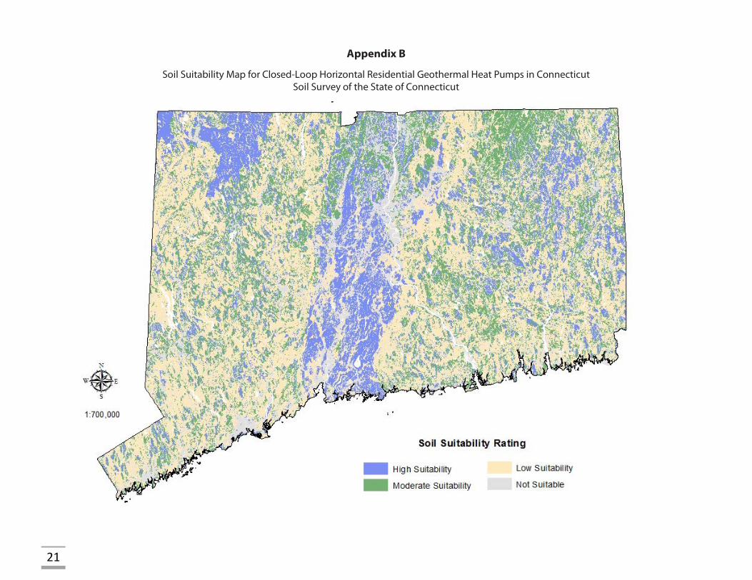
Appendix B
Soil Suitability Map for Closed-Loop Horizontal Residential Geothermal Heat Pumps in Connecticut Soil Survey of the State of Connecticut

This page intentionally left blank.

USDA’s Nondiscrimination Statement
In accordance with Federal civil rights law and U.S. Department of Agriculture (USDA) civil rights regulations and policies, the USDA, its Agencies, offices, and employees, and institutions participating in or administering USDA programs are prohibited from discriminating based on race, color, national origin, religion, sex, gender identity (including gender expression), sexual orientation, disability, age, marital status, family/parental status, income derived from a public assistance program, political beliefs, or reprisal or retaliation for prior civil rights activity, in any program or activity conducted or funded by USDA (not all bases apply to all programs). Remedies and complaint filing deadlines vary by program or incident.
Persons with disabilities who require alternative means of communication for program information (e.g., Braille, large print, audiotape, American Sign Language, etc.) should contact the responsible Agency or USDA’s TARGET Center at (202) 720-2600 (voice and TTY) or contact USDA through the Federal Relay Service at (800) 877-8339. Additionally, program information may be made available in languages other than English.
To file a program discrimination complaint, complete the USDA Program Discrimination Complaint Form, AD-3027, found online at http://www.ascr.usda.gov/complaint_filing_cust.html and at any USDA office or write a letter addressed to USDA and provide in the letter all of the information requested in the form.
To request a copy of the complaint form, call (866) 632-9992.
Submit your completed form or letter to USDA by:1. mail: U.S. Department of Agriculture
Office of the Assistant Secretary for Civil Rights 1400 Independence Avenue, SW Washington, D.C. 20250-9410;2. fax: (202) 690-7442; or3. email: [email protected].
USDA is an equal opportunity provider, employer, and lender.


![CSP Sites Suitability Analysis in the Eastern Region of ... · 2010) data for global horizontal and direct normal irradiance for the whole Mediterranean region [22]. The international](https://img.pdfslide.us/doc/110x75/5f5eb5176c33843ce4069db2/csp-sites-suitability-analysis-in-the-eastern-region-of-2010-data-for-global.jpg)