Embed Size (px)
Citation preview
Soil Classification
Bryant Scharenbroch
Introduction to Soil ScienceACCA & The Morton Arboretum
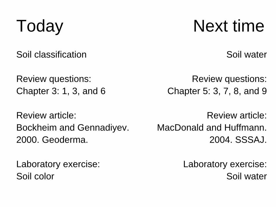
Today Next timeSoil classification
Review questions: Chapter 3: 1, 3, and 6
Review article: Bockheim and Gennadiyev. 2000. Geoderma.
Laboratory exercise: Soil color
Soil water
Review questions: Chapter 5: 3, 7, 8, and 9
Review article:MacDonald and Huffmann.
2004. SSSAJ.
Laboratory exercise: Soil water
What is soil classification?
Why do we classify soils?
Soil classification around the world
US Soil Taxonomy
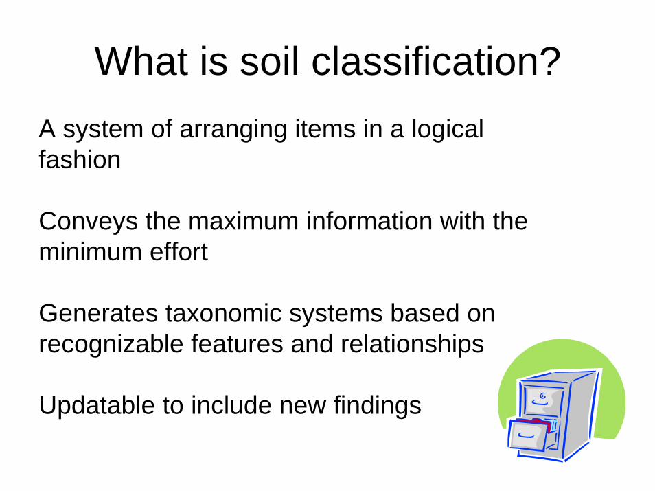
What is soil classification?A system of arranging items in a logical fashion
Conveys the maximum information with the minimum effort
Generates taxonomic systems based on recognizable features and relationships
Updatable to include new findings
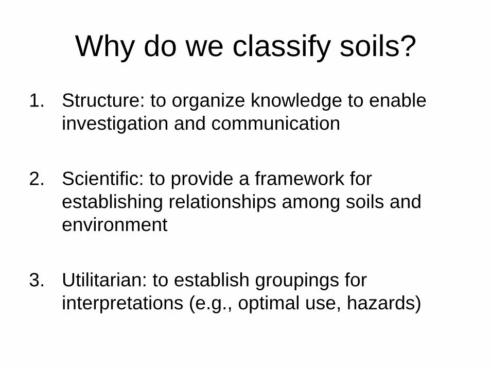
Why do we classify soils?
1. Structure: to organize knowledge to enable investigation and communication
2. Scientific: to provide a framework for establishing relationships among soils and environment
3. Utilitarian: to establish groupings for interpretations (e.g., optimal use, hazards)
History of soil classification
BCOne of the earliest land evaluation systems that incorporated a soil classification was established during the Yao dynasty in China
Soils were graded into nine classes, based on their productivity (yellow, soft soils (loess) and red, rich clay soils (limestone), etc.
It has been suggested (Lee 1921) that property taxes were based on the size of the individual land holding and soil productivity
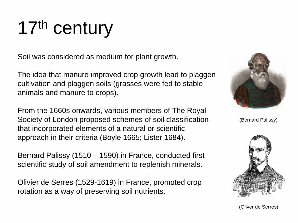
17th centurySoil was considered as medium for plant growth.
The idea that manure improved crop growth lead to plaggencultivation and plaggen soils (grasses were fed to stable animals and manure to crops).
From the 1660s onwards, various members of The Royal Society of London proposed schemes of soil classification that incorporated elements of a natural or scientific approach in their criteria (Boyle 1665; Lister 1684).
Bernard Palissy (1510 – 1590) in France, conducted first scientific study of soil amendment to replenish minerals.
Olivier de Serres (1529-1619) in France, promoted crop rotation as a way of preserving soil nutrients.
(Oliver de Serres)
(Bernard Palissy)
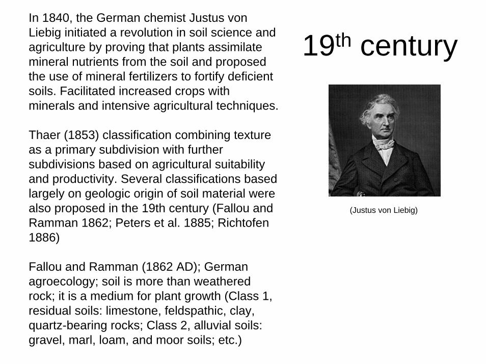
19th centuryIn 1840, the German chemist Justus von Liebig initiated a revolution in soil science and agriculture by proving that plants assimilate mineral nutrients from the soil and proposed the use of mineral fertilizers to fortify deficient soils. Facilitated increased crops with minerals and intensive agricultural techniques.
Thaer (1853) classification combining texture as a primary subdivision with further subdivisions based on agricultural suitability and productivity. Several classifications based largely on geologic origin of soil material were also proposed in the 19th century (Fallou and Ramman 1862; Peters et al. 1885; Richtofen1886)
Fallou and Ramman (1862 AD); German agroecology; soil is more than weathered rock; it is a medium for plant growth (Class 1, residual soils: limestone, feldspathic, clay, quartz-bearing rocks; Class 2, alluvial soils: gravel, marl, loam, and moor soils; etc.)
(Justus von Liebig)
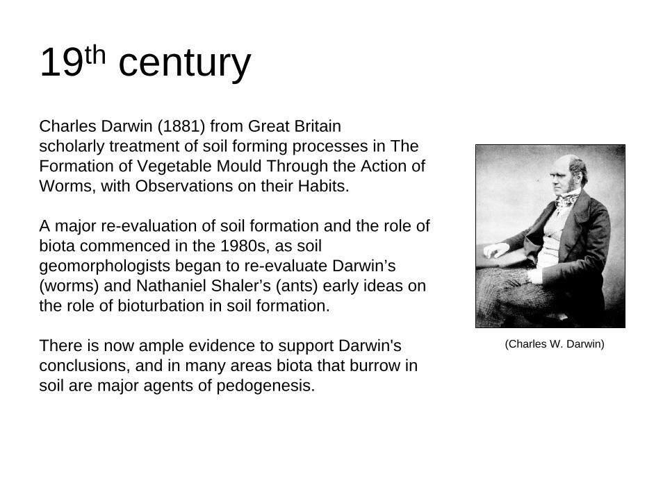
19th centuryCharles Darwin (1881) from Great Britain scholarly treatment of soil forming processes in The Formation of Vegetable Mould Through the Action of Worms, with Observations on their Habits.
A major re-evaluation of soil formation and the role of biota commenced in the 1980s, as soil geomorphologists began to re-evaluate Darwin’s (worms) and Nathaniel Shaler’s (ants) early ideas on the role of bioturbation in soil formation.
There is now ample evidence to support Darwin's conclusions, and in many areas biota that burrow in soil are major agents of pedogenesis.
(Charles W. Darwin)
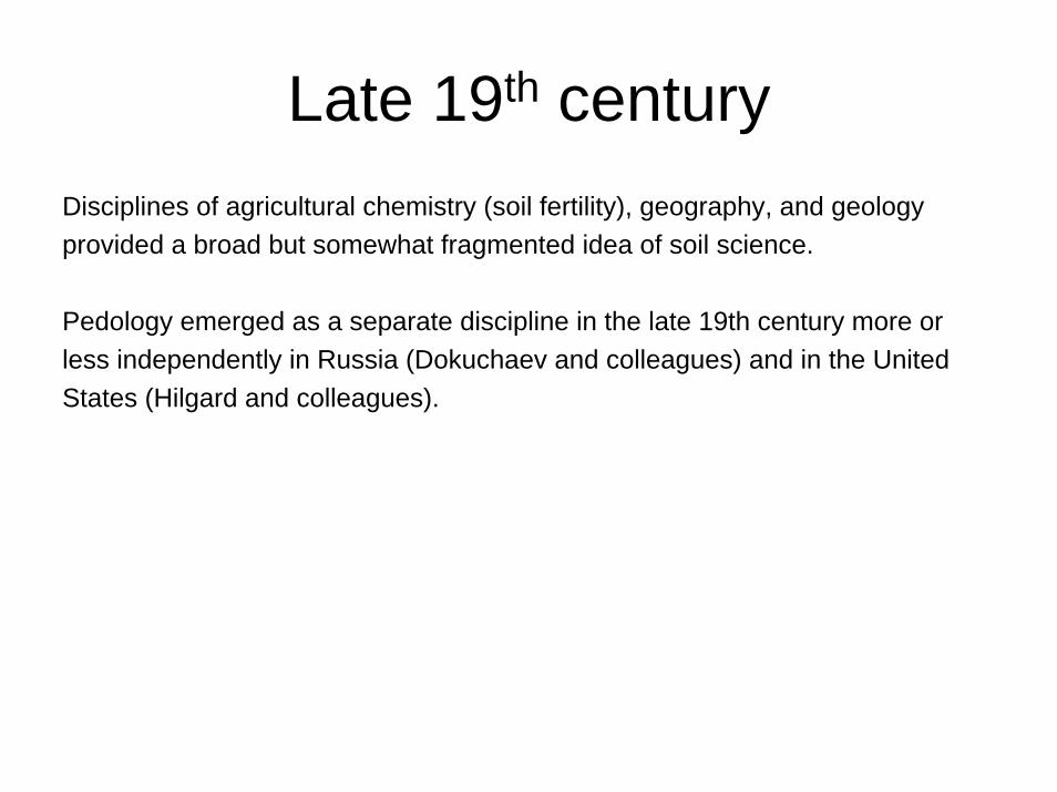
Late 19th centuryDisciplines of agricultural chemistry (soil fertility), geography, and geology provided a broad but somewhat fragmented idea of soil science.
Pedology emerged as a separate discipline in the late 19th century more or less independently in Russia (Dokuchaev and colleagues) and in the United States (Hilgard and colleagues).
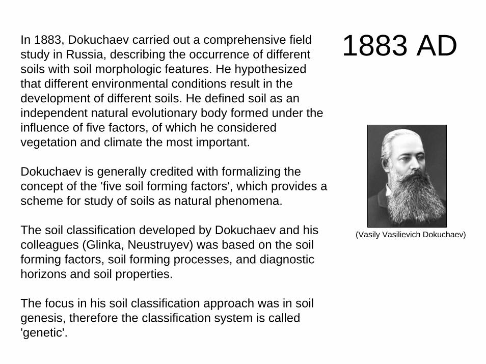
1883 ADIn 1883, Dokuchaev carried out a comprehensive field study in Russia, describing the occurrence of different soils with soil morphologic features. He hypothesized that different environmental conditions result in the development of different soils. He defined soil as an independent natural evolutionary body formed under the influence of five factors, of which he considered vegetation and climate the most important.
Dokuchaev is generally credited with formalizing the concept of the 'five soil forming factors', which provides a scheme for study of soils as natural phenomena.
The soil classification developed by Dokuchaev and his colleagues (Glinka, Neustruyev) was based on the soil forming factors, soil forming processes, and diagnostic horizons and soil properties.
The focus in his soil classification approach was in soil genesis, therefore the classification system is called 'genetic'.
(Vasily Vasilievich Dokuchaev)
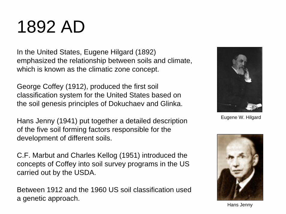
1892 ADIn the United States, Eugene Hilgard (1892) emphasized the relationship between soils and climate, which is known as the climatic zone concept.
George Coffey (1912), produced the first soil classification system for the United States based on the soil genesis principles of Dokuchaev and Glinka.
Hans Jenny (1941) put together a detailed description of the five soil forming factors responsible for the development of different soils.
C.F. Marbut and Charles Kellog (1951) introduced the concepts of Coffey into soil survey programs in the US carried out by the USDA.
Between 1912 and the 1960 US soil classification used a genetic approach.
Eugene W. Hilgard
Hans Jenny
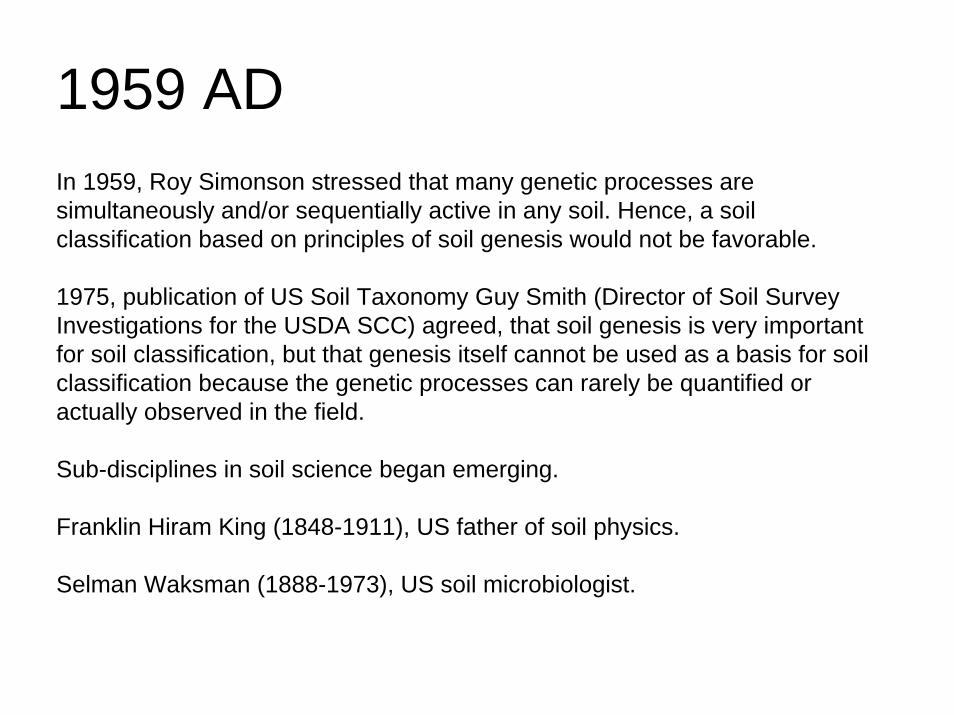
1959 ADIn 1959, Roy Simonson stressed that many genetic processes are simultaneously and/or sequentially active in any soil. Hence, a soil classification based on principles of soil genesis would not be favorable.
1975, publication of US Soil Taxonomy Guy Smith (Director of Soil Survey Investigations for the USDA SCC) agreed, that soil genesis is very important for soil classification, but that genesis itself cannot be used as a basis for soil classification because the genetic processes can rarely be quantified or actually observed in the field.
Sub-disciplines in soil science began emerging.
Franklin Hiram King (1848-1911), US father of soil physics.
Selman Waksman (1888-1973), US soil microbiologist.
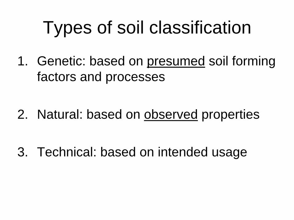
Types of soil classification
1. Genetic: based on presumed soil forming factors and processes
2. Natural: based on observed properties
3. Technical: based on intended usage
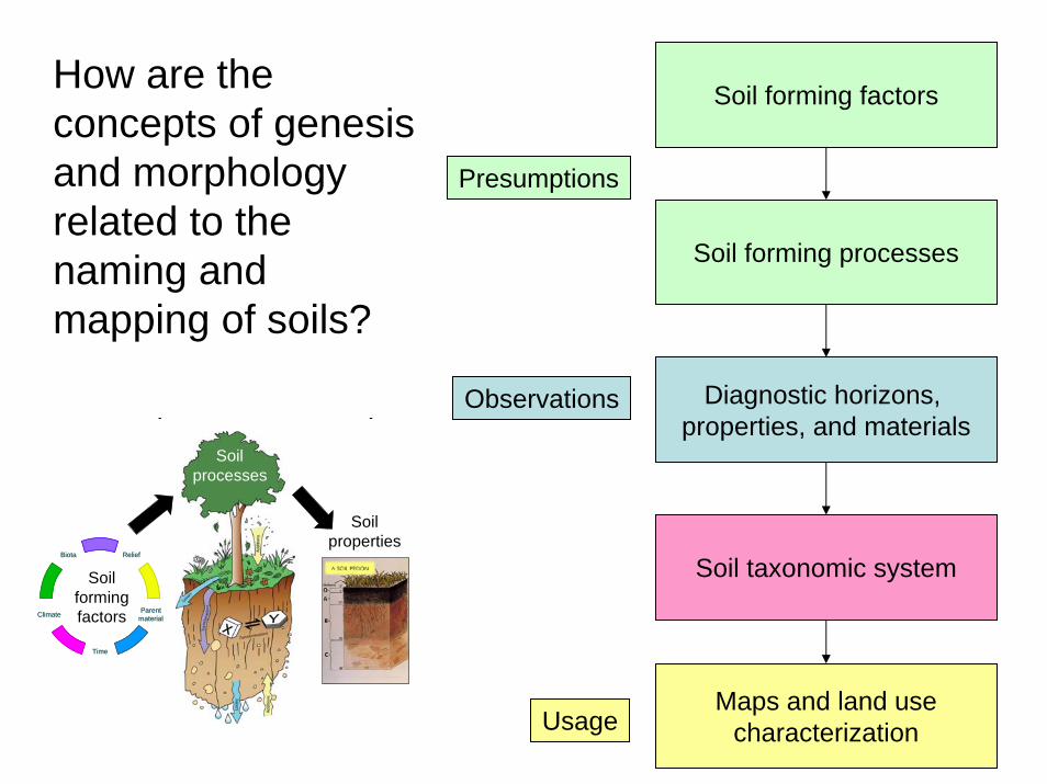
Soil forming factors
Soil forming processes
Diagnostic horizons, properties, and materials
Soil taxonomic system
Maps and land usecharacterization
How are the concepts of genesis and morphology related to the naming and mapping of soils?
Presumptions
Observations
Biota
Climate
Time
Parentmaterial
ReliefBiota
Climate
Time
Parentmaterial
Relief
p p
Soilproperties
Soilformingfactors
Soilprocesses
Usage
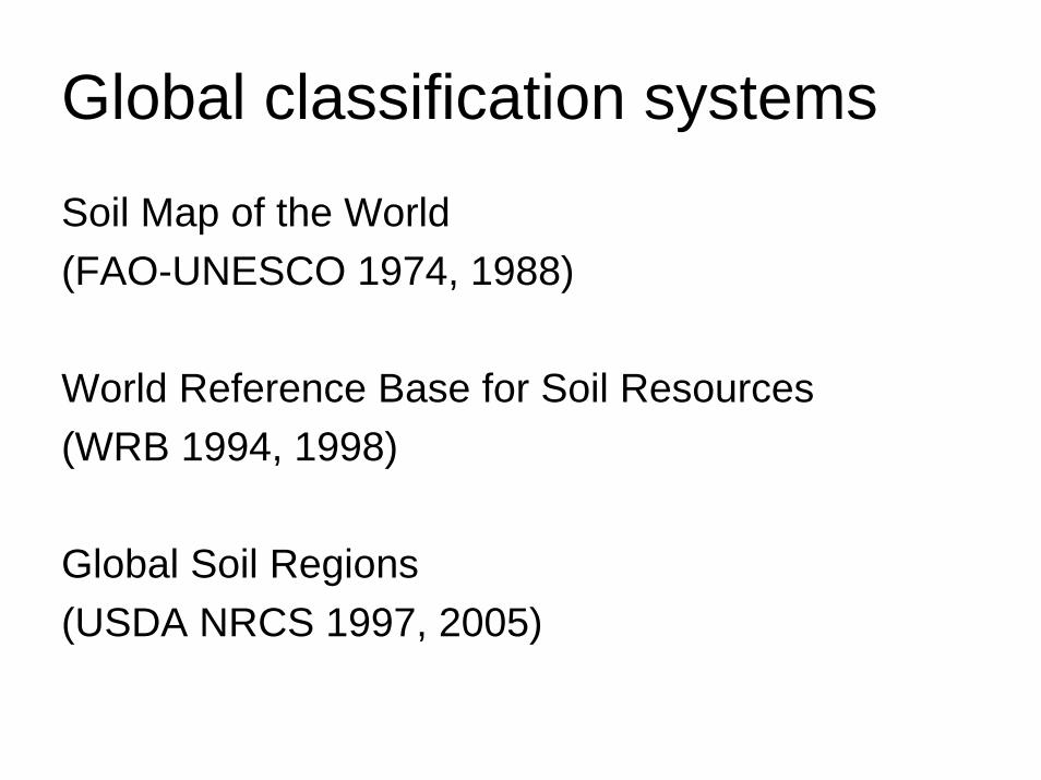
Global classification systems
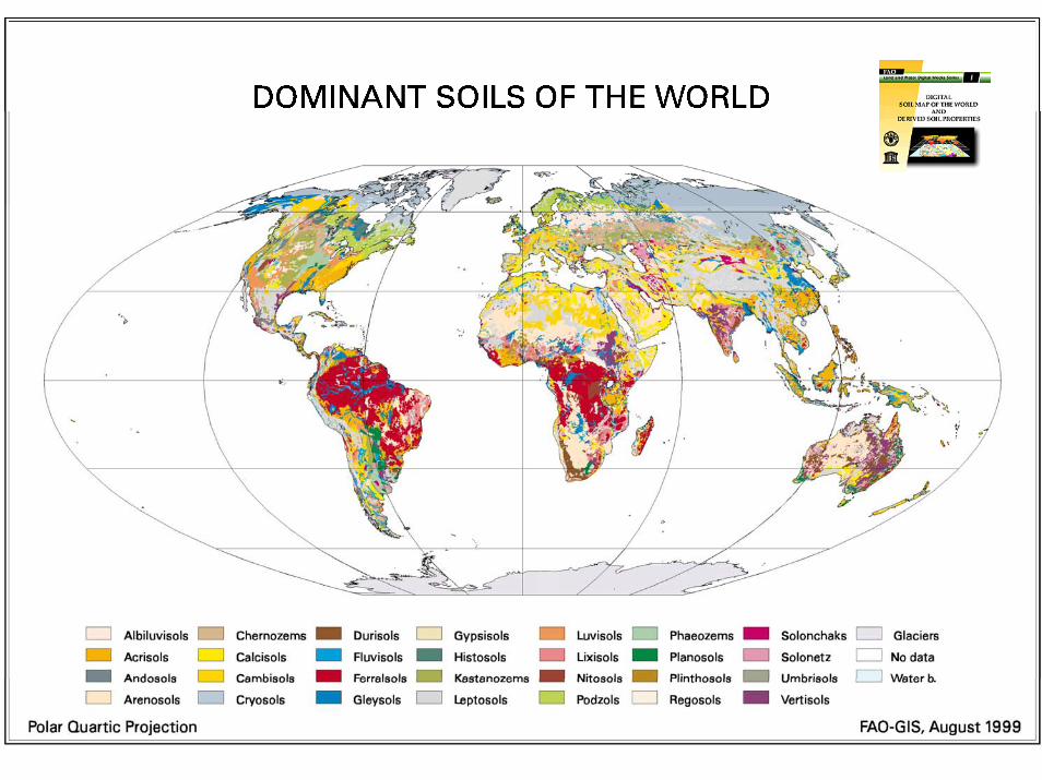
Soil Map of the World (FAO-UNESCO 1974, 1988)
World Reference Base for Soil Resources(WRB 1994, 1998)
Global Soil Regions(USDA NRCS 1997, 2005)
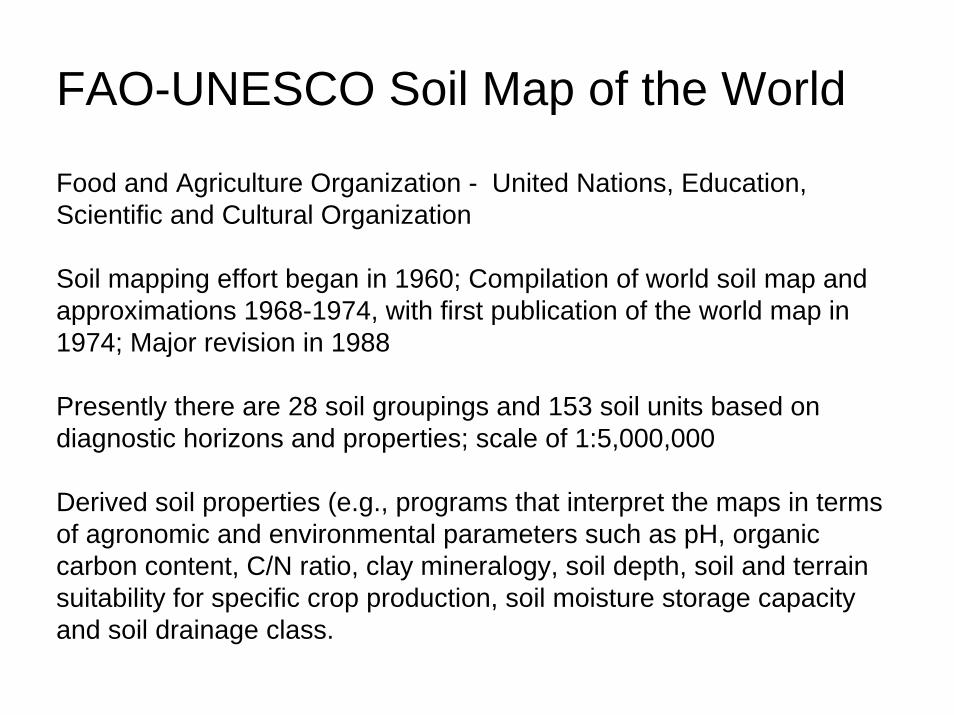
FAO-UNESCO Soil Map of the World
Food and Agriculture Organization - United Nations, Education, Scientific and Cultural Organization
Soil mapping effort began in 1960; Compilation of world soil map and approximations 1968-1974, with first publication of the world map in 1974; Major revision in 1988
Presently there are 28 soil groupings and 153 soil units based on diagnostic horizons and properties; scale of 1:5,000,000
Derived soil properties (e.g., programs that interpret the maps in terms of agronomic and environmental parameters such as pH, organic carbon content, C/N ratio, clay mineralogy, soil depth, soil and terrain suitability for specific crop production, soil moisture storage capacity and soil drainage class.
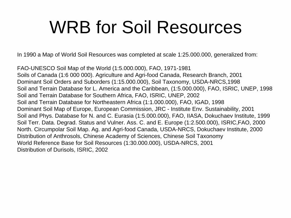
In 1990 a Map of World Soil Resources was completed at scale 1:25.000.000, generalized from:
FAO-UNESCO Soil Map of the World (1:5.000.000), FAO, 1971-1981Soils of Canada (1:6 000 000). Agriculture and Agri-food Canada, Research Branch, 2001Dominant Soil Orders and Suborders (1:15.000.000), Soil Taxonomy, USDA-NRCS,1998Soil and Terrain Database for L. America and the Caribbean, (1:5.000.000), FAO, ISRIC, UNEP, 1998Soil and Terrain Database for Southern Africa, FAO, ISRIC, UNEP, 2002 Soil and Terrain Database for Northeastern Africa (1:1.000.000), FAO, IGAD, 1998Dominant Soil Map of Europe, European Commission, JRC - Institute Env. Sustainability, 2001Soil and Phys. Database for N. and C. Eurasia (1:5.000.000), FAO, IIASA, Dokuchaev Institute, 1999Soil Terr. Data. Degrad. Status and Vulner. Ass. C. and E. Europe (1:2.500.000), ISRIC,FAO, 2000North. Circumpolar Soil Map. Ag. and Agri-food Canada, USDA-NRCS, Dokuchaev Institute, 2000Distribution of Anthrosols, Chinese Academy of Sciences, Chinese Soil Taxonomy World Reference Base for Soil Resources (1:30.000.000), USDA-NRCS, 2001Distribution of Durisols, ISRIC, 2002
WRB for Soil Resources
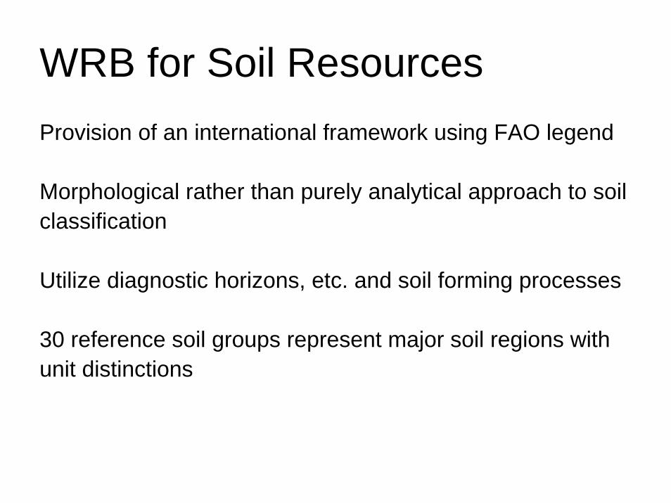
WRB for Soil ResourcesProvision of an international framework using FAO legend
Morphological rather than purely analytical approach to soil classification
Utilize diagnostic horizons, etc. and soil forming processes
30 reference soil groups represent major soil regions with unit distinctions
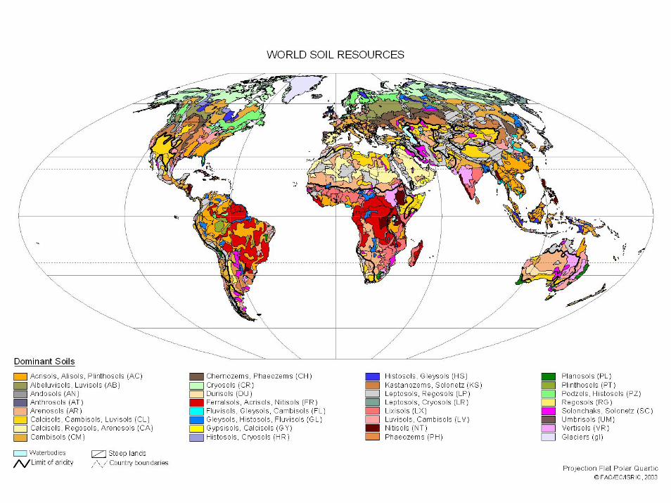
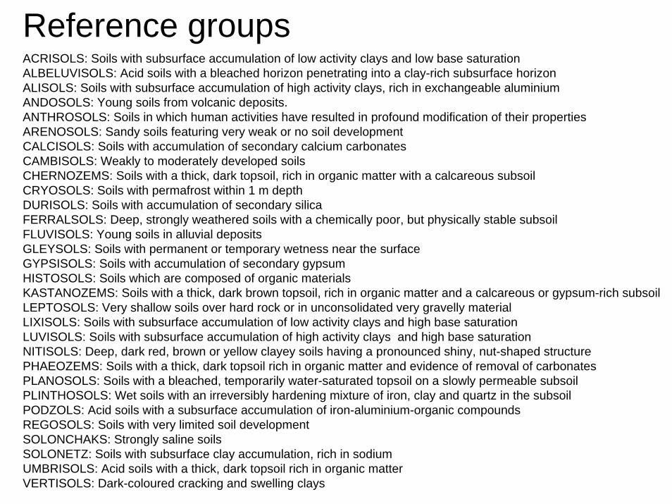
Reference groupsACRISOLS: Soils with subsurface accumulation of low activity clays and low base saturationALBELUVISOLS: Acid soils with a bleached horizon penetrating into a clay-rich subsurface horizonALISOLS: Soils with subsurface accumulation of high activity clays, rich in exchangeable aluminiumANDOSOLS: Young soils from volcanic deposits.ANTHROSOLS: Soils in which human activities have resulted in profound modification of their propertiesARENOSOLS: Sandy soils featuring very weak or no soil developmentCALCISOLS: Soils with accumulation of secondary calcium carbonatesCAMBISOLS: Weakly to moderately developed soilsCHERNOZEMS: Soils with a thick, dark topsoil, rich in organic matter with a calcareous subsoilCRYOSOLS: Soils with permafrost within 1 m depthDURISOLS: Soils with accumulation of secondary silicaFERRALSOLS: Deep, strongly weathered soils with a chemically poor, but physically stable subsoilFLUVISOLS: Young soils in alluvial depositsGLEYSOLS: Soils with permanent or temporary wetness near the surfaceGYPSISOLS: Soils with accumulation of secondary gypsumHISTOSOLS: Soils which are composed of organic materialsKASTANOZEMS: Soils with a thick, dark brown topsoil, rich in organic matter and a calcareous or gypsum-rich subsoilLEPTOSOLS: Very shallow soils over hard rock or in unconsolidated very gravelly materialLIXISOLS: Soils with subsurface accumulation of low activity clays and high base saturationLUVISOLS: Soils with subsurface accumulation of high activity clays and high base saturationNITISOLS: Deep, dark red, brown or yellow clayey soils having a pronounced shiny, nut-shaped structurePHAEOZEMS: Soils with a thick, dark topsoil rich in organic matter and evidence of removal of carbonatesPLANOSOLS: Soils with a bleached, temporarily water-saturated topsoil on a slowly permeable subsoilPLINTHOSOLS: Wet soils with an irreversibly hardening mixture of iron, clay and quartz in the subsoilPODZOLS: Acid soils with a subsurface accumulation of iron-aluminium-organic compoundsREGOSOLS: Soils with very limited soil developmentSOLONCHAKS: Strongly saline soilsSOLONETZ: Soils with subsurface clay accumulation, rich in sodiumUMBRISOLS: Acid soils with a thick, dark topsoil rich in organic matterVERTISOLS: Dark-coloured cracking and swelling clays
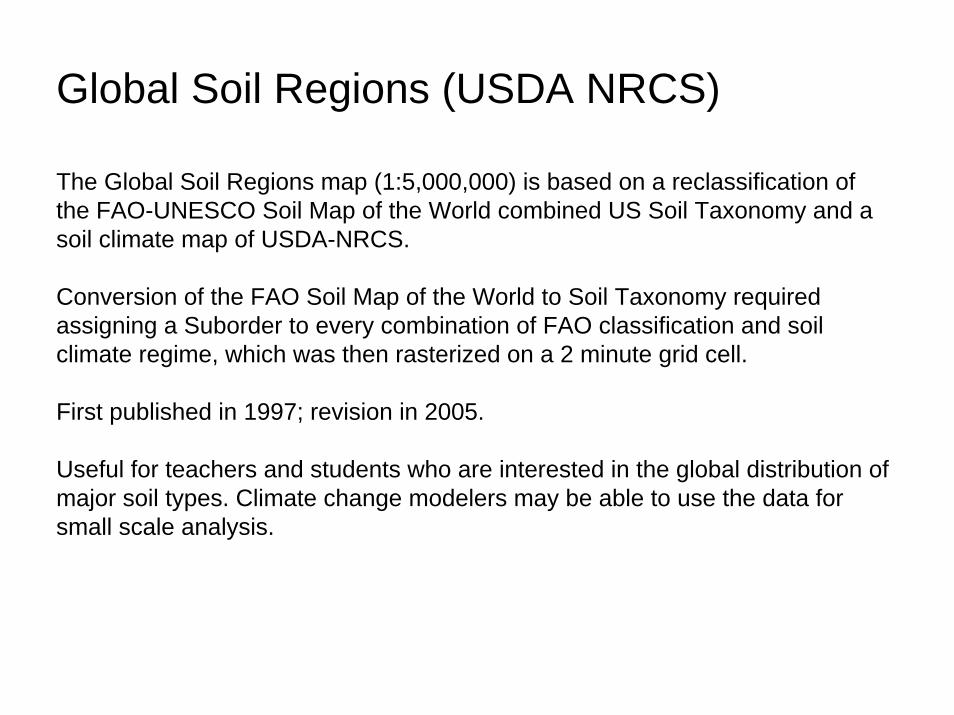
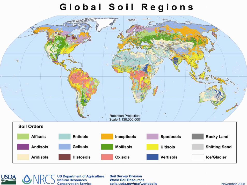
Global Soil Regions (USDA NRCS)
The Global Soil Regions map (1:5,000,000) is based on a reclassification of the FAO-UNESCO Soil Map of the World combined US Soil Taxonomy and a soil climate map of USDA-NRCS.
Conversion of the FAO Soil Map of the World to Soil Taxonomy required assigning a Suborder to every combination of FAO classification and soil climate regime, which was then rasterized on a 2 minute grid cell.
First published in 1997; revision in 2005.
Useful for teachers and students who are interested in the global distribution of major soil types. Climate change modelers may be able to use the data for small scale analysis.
Individual classification systems
Chinese taxonomy
Global hierarchal system, similar to US Soil Taxonomy
Natural: uses diagnostic horizons and characteristics
13 orders, 33 suborders, 78 groups, 301 subgroups, ?? genus, ?? species, ?? varieties
European taxonomy
Pedological reference base (PRB)
French soil classification system
Global reference rather than hierarchical; similar to World Reference Base
Genetic-natural system: emphasizes composition of soil mantle, soil structure, and soil evolution
40 major groupings and 90 references
Russian taxonomy
Classification system published in 1977
Genetic system: strong emphasis on knowledge of soil forming processes
Technical system: emphasis on multiple land use
No hierarchical structure
Four categories (71 types, 194 subtypes, genera, species)
Australian taxonomy
Genetic system
For Australia only with unusual terminology
14 orders with similar levels as US Soil Taxonomy
Canadian taxonomy
Published in 1978; revised in 1987
Natural system
Applicable to all of Canada
Hierarchical: 10 orders, 31 great groups, ?? subgroups, ?? families, and ?? series

USA taxonomy
Started as a genetic, but now natural system
Global hierarchical system
Soil Taxonomy 1975 and 1999. 1st and 2nd editions
Keys to Soil Taxonomy 2006. 10th edition
Why Soil Taxonomy?
A system is needed to accommodate all soils of the world and needs to be widely used
The system should be natural and based on soil properties, not inferred genesis
Information for categorization should utilize field and laboratory data
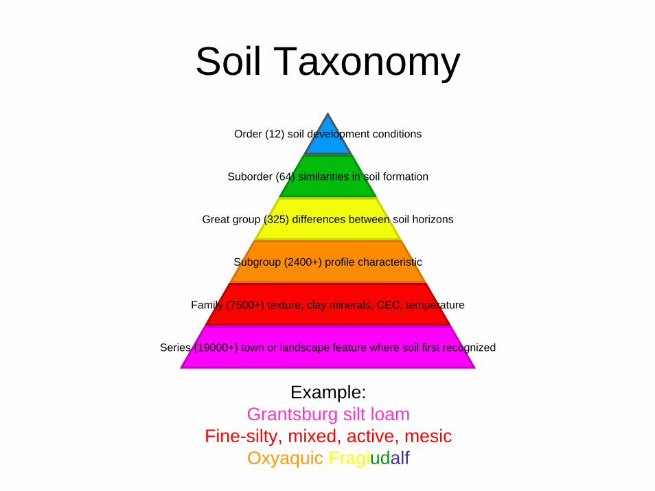
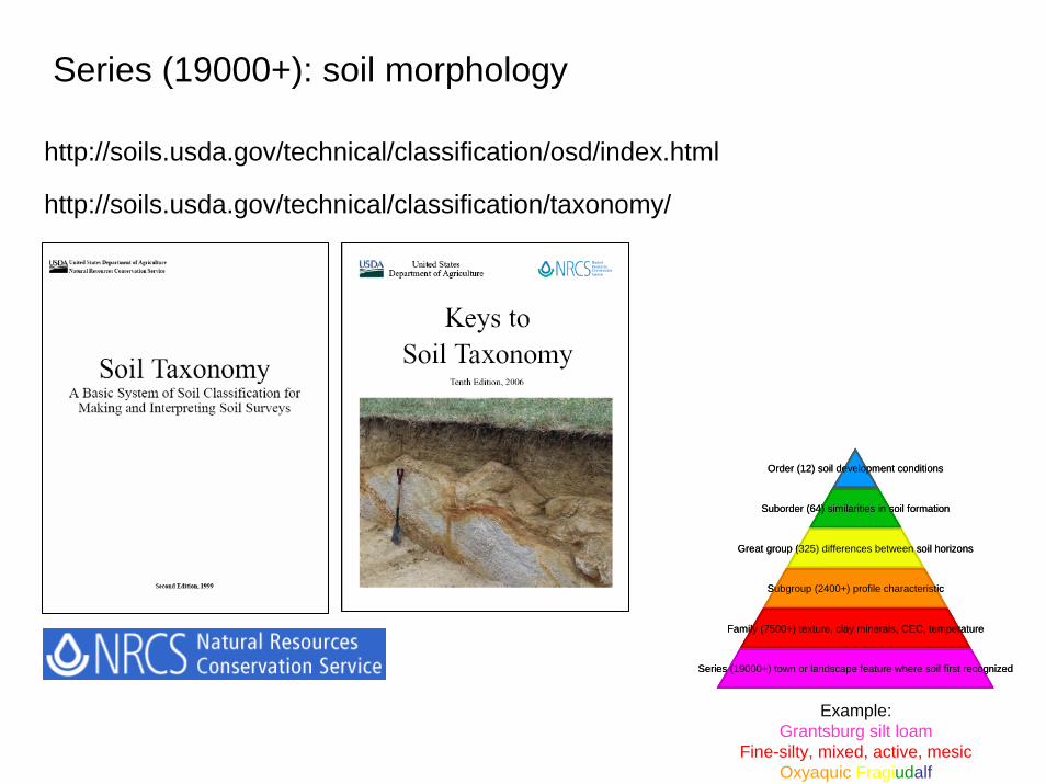
Soil TaxonomyOrder (12) soil development conditions
Suborder (64) similarities in soil formation
Great group (325) differences between soil horizons
Subgroup (2400+) profile characteristic
Family (7500+) texture, clay minerals, CEC, temperature
Series (19000+) town or landscape feature where soil first recognized
Example:Grantsburg silt loam
Fine-silty, mixed, active, mesicOxyaquic Fragiudalf
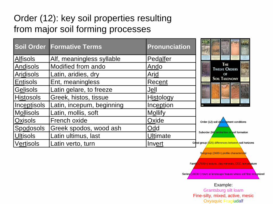
Order (12): key soil properties resulting from major soil forming processes
Soil Order Formative Terms Pronunciation
Alfisols Alf, meaningless syllable PedalferAndisols Modified from ando AndoAridisols Latin, aridies, dry AridEntisols Ent, meaningless RecentGelisols Latin gelare, to freeze JellHistosols Greek, histos, tissue HistologyInceptisols Latin, incepum, beginning InceptionMollisols Latin, mollis, soft MollifyOxisols French oxide OxideSpodosols Greek spodos, wood ash OddUltisols Latin ultimus, last UltimateVertisols Latin verto, turn Invert
Order (12) soil development conditions
Suborder (64) similarities in soil formation
Great group (325) differences between soil horizons
Subgroup (2400+) profile characteristic
Family (7500+) texture, clay minerals, CEC, temperature
Series (19000+) town or landscape feature where soil first recognized
Example:Grantsburg silt loam
Fine-silty, mixed, active, mesicOxyaquic Fragiudalf
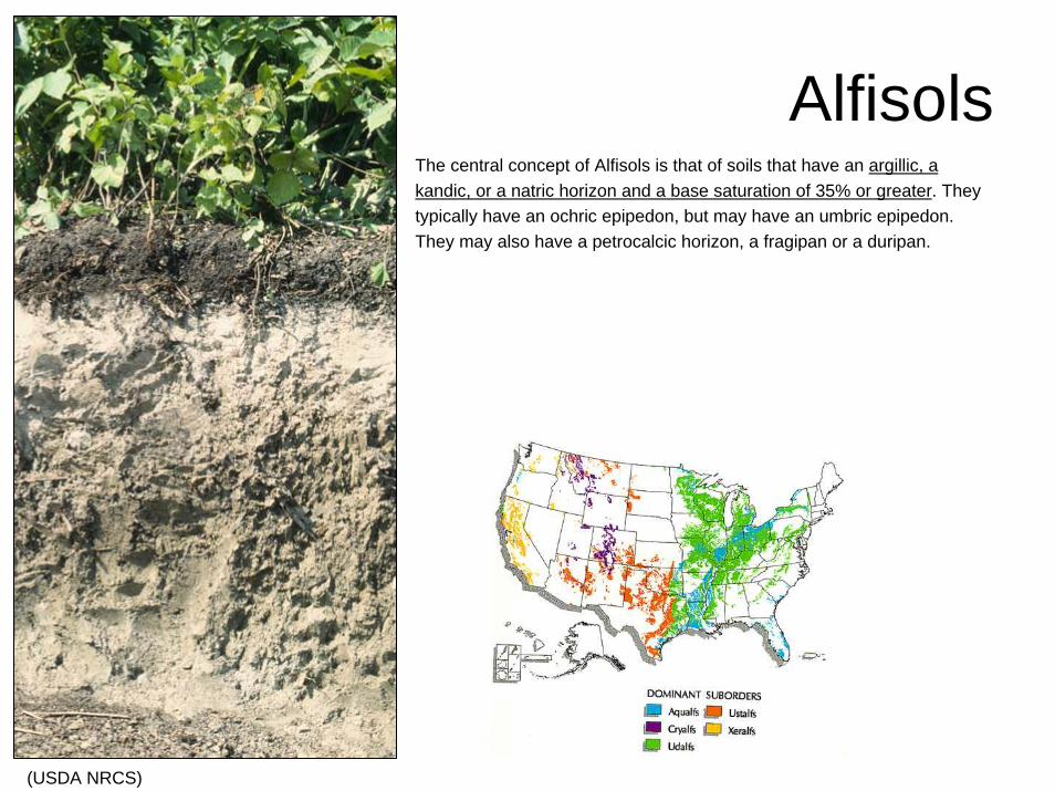
AlfisolsThe central concept of Alfisols is that of soils that have an argillic, a kandic, or a natric horizon and a base saturation of 35% or greater. They typically have an ochric epipedon, but may have an umbric epipedon. They may also have a petrocalcic horizon, a fragipan or a duripan.
(USDA NRCS)
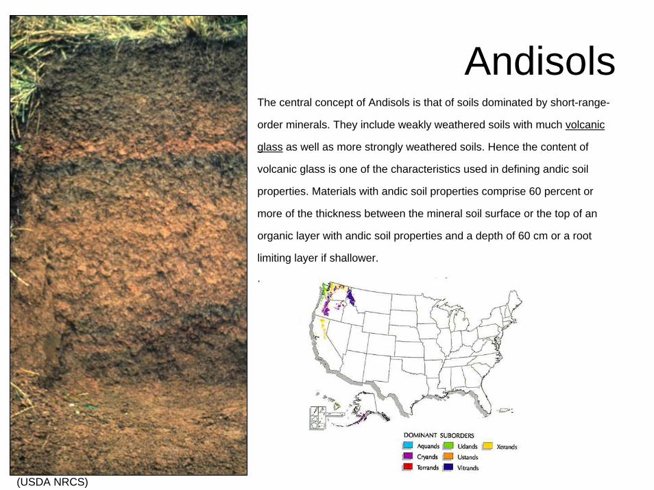
The central concept of Andisols is that of soils dominated by short-range-
order minerals. They include weakly weathered soils with much volcanic
glass as well as more strongly weathered soils. Hence the content of
volcanic glass is one of the characteristics used in defining andic soil
properties. Materials with andic soil properties comprise 60 percent or
more of the thickness between the mineral soil surface or the top of an
organic layer with andic soil properties and a depth of 60 cm or a root
limiting layer if shallower.
.
Andisols
(USDA NRCS)
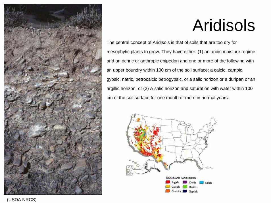
The central concept of Aridisols is that of soils that are too dry for
mesophytic plants to grow. They have either: (1) an aridic moisture regime
and an ochric or anthropic epipedon and one or more of the following with
an upper boundry within 100 cm of the soil surface: a calcic, cambic,
gypsic, natric, petrocalcic petrogypsic, or a salic horizon or a duripan or an
argillic horizon, or (2) A salic horizon and saturation with water within 100
cm of the soil surface for one month or more in normal years.
Aridisols
(USDA NRCS)
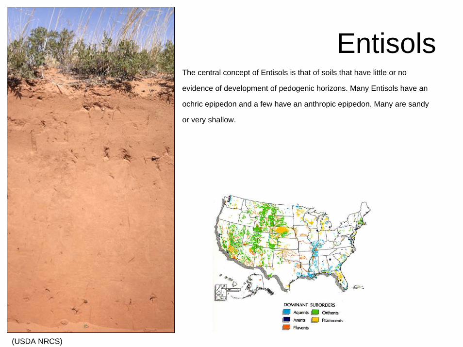
EntisolsThe central concept of Entisols is that of soils that have little or no
evidence of development of pedogenic horizons. Many Entisols have an
ochric epipedon and a few have an anthropic epipedon. Many are sandy
or very shallow.
(USDA NRCS)
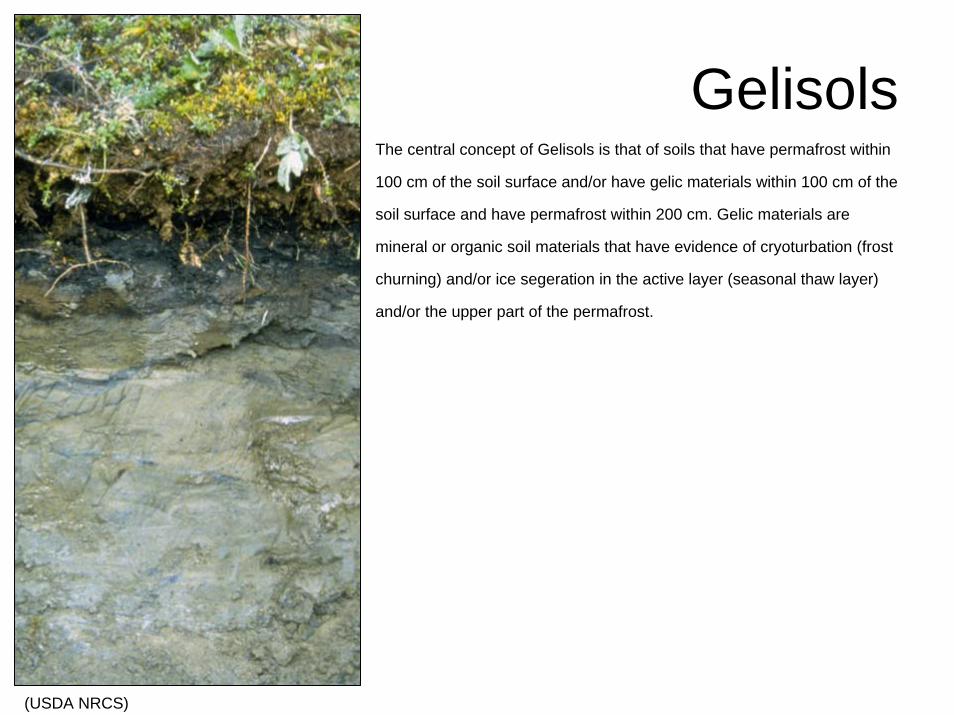
GelisolsThe central concept of Gelisols is that of soils that have permafrost within
100 cm of the soil surface and/or have gelic materials within 100 cm of the
soil surface and have permafrost within 200 cm. Gelic materials are
mineral or organic soil materials that have evidence of cryoturbation (frost
churning) and/or ice segeration in the active layer (seasonal thaw layer)
and/or the upper part of the permafrost.
(USDA NRCS)
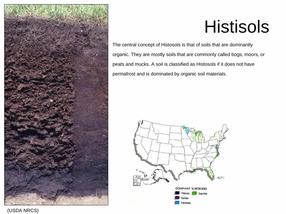
HistisolsThe central concept of Histosols is that of soils that are dominantly
organic. They are mostly soils that are commonly called bogs, moors, or
peats and mucks. A soil is classified as Histosols if it does not have
permafrost and is dominated by organic soil materials.
(USDA NRCS)
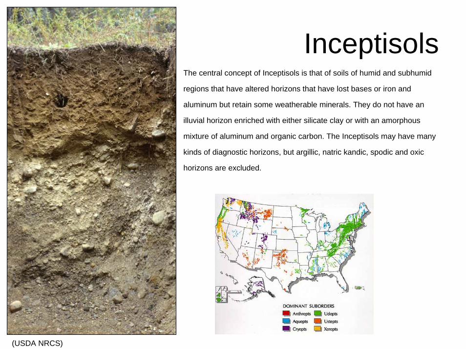
InceptisolsThe central concept of Inceptisols is that of soils of humid and subhumid
regions that have altered horizons that have lost bases or iron and
aluminum but retain some weatherable minerals. They do not have an
illuvial horizon enriched with either silicate clay or with an amorphous
mixture of aluminum and organic carbon. The Inceptisols may have many
kinds of diagnostic horizons, but argillic, natric kandic, spodic and oxic
horizons are excluded.
(USDA NRCS)
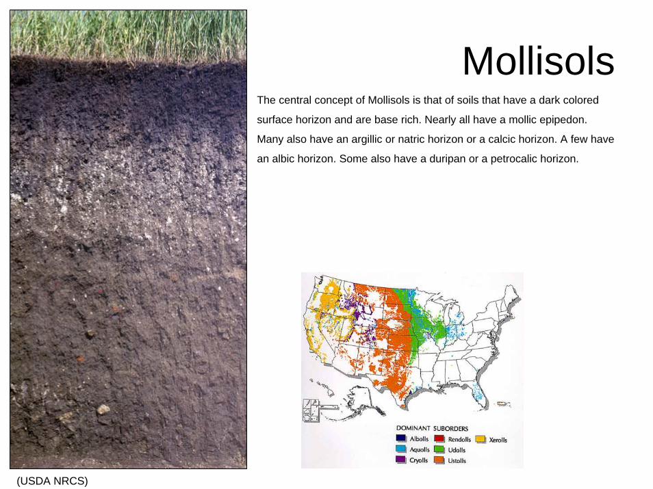
MollisolsThe central concept of Mollisols is that of soils that have a dark colored
surface horizon and are base rich. Nearly all have a mollic epipedon.
Many also have an argillic or natric horizon or a calcic horizon. A few have
an albic horizon. Some also have a duripan or a petrocalic horizon.
(USDA NRCS)
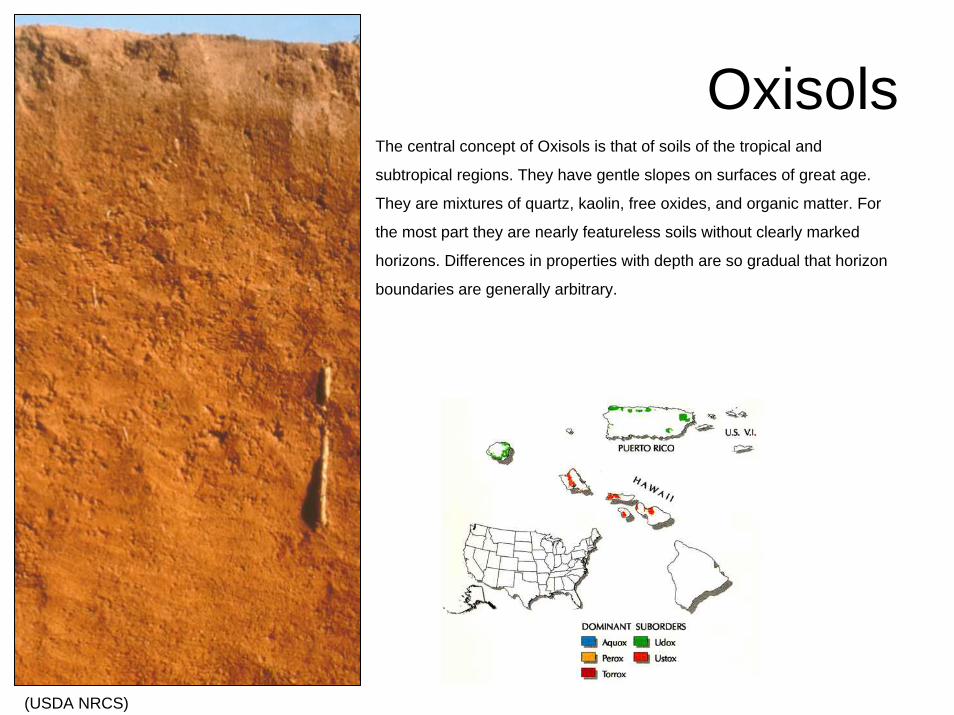
OxisolsThe central concept of Oxisols is that of soils of the tropical and
subtropical regions. They have gentle slopes on surfaces of great age.
They are mixtures of quartz, kaolin, free oxides, and organic matter. For
the most part they are nearly featureless soils without clearly marked
horizons. Differences in properties with depth are so gradual that horizon
boundaries are generally arbitrary.
(USDA NRCS)
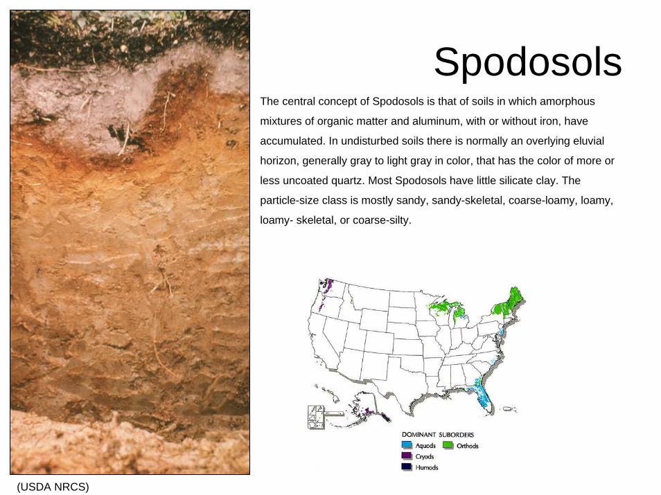
SpodosolsThe central concept of Spodosols is that of soils in which amorphous
mixtures of organic matter and aluminum, with or without iron, have
accumulated. In undisturbed soils there is normally an overlying eluvial
horizon, generally gray to light gray in color, that has the color of more or
less uncoated quartz. Most Spodosols have little silicate clay. The
particle-size class is mostly sandy, sandy-skeletal, coarse-loamy, loamy,
loamy- skeletal, or coarse-silty.
(USDA NRCS)
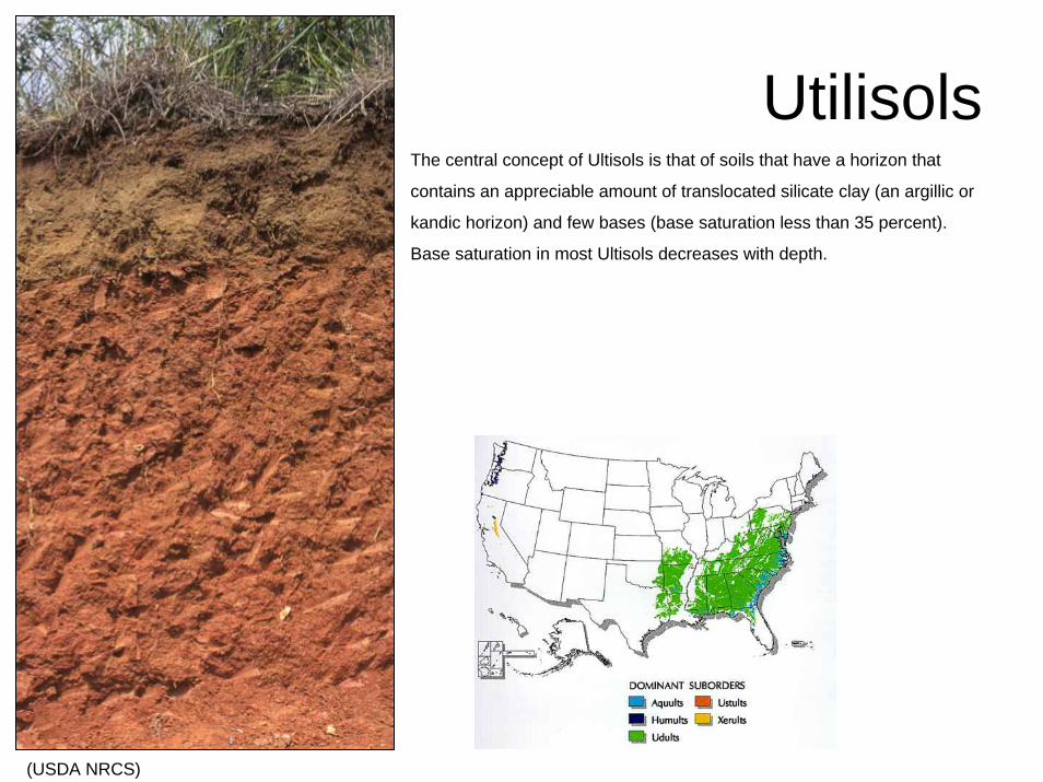
UtilisolsThe central concept of Ultisols is that of soils that have a horizon that
contains an appreciable amount of translocated silicate clay (an argillic or
kandic horizon) and few bases (base saturation less than 35 percent).
Base saturation in most Ultisols decreases with depth.
(USDA NRCS)
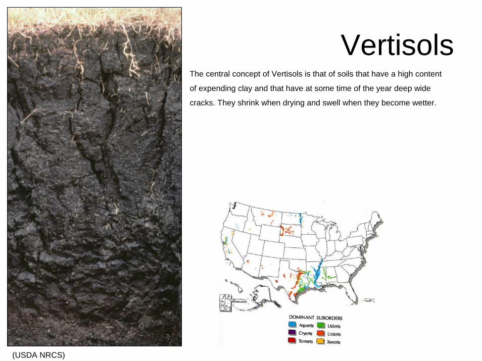
VertisolsThe central concept of Vertisols is that of soils that have a high content
of expending clay and that have at some time of the year deep wide
cracks. They shrink when drying and swell when they become wetter.
(USDA NRCS)
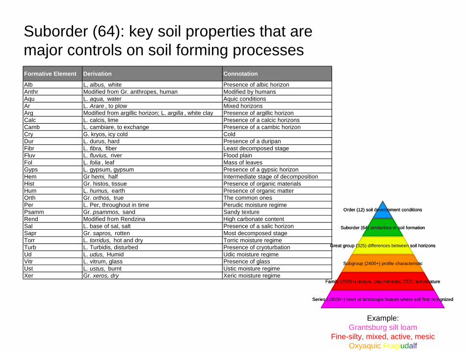
Formative Element Derivation Connotation
Alb L, albus, white Presence of albic horizonAnthr Modified from Gr. anthropes, human Modified by humansAqu L. aqua, water Aquic conditionsAr L. Arare , to plow Mixed horizonsArg Modified from argillic horizon; L. argilla , white clay Presence of argillic horizonCalc L. calcis, lime Presence of a calcic horizonsCamb L. cambiare, to exchange Presence of a cambic horizonCry G. kryos, icy cold ColdDur L. durus, hard Presence of a duripanFibr L. fibra, fiber Least decomposed stageFluv L. fluvius, river Flood plainFol L. folia , leaf Mass of leavesGyps L. gypsum, gypsum Presence of a gypsic horizonHem Gr hemi, half Intermediate stage of decompositionHist Gr. histos, tissue Presence of organic materialsHum L. humus, earth Presence of organic matterOrth Gr. orthos, true The common onesPer L. Per, throughout in time Perudic moisture regimePsamm Gr. psammos, sand Sandy textureRend Modified from Rendzina High carbonate contentSal L. base of sal, salt Presence of a salic horizonSapr Gr. sapros, rotten Most decomposed stageTorr L. torridus, hot and dry Torric moisture regimeTurb L. Turbidis, disturbed Presence of cryoturbationUd L. udus, Humid Udic moisture regimeVitr L. vitrum, glass Presence of glassUst L. ustus, burnt Ustic moisture regimeXer Gr. xeros, dry Xeric moisture regime
Suborder (64): key soil properties that are major controls on soil forming processes
Order (12) soil development conditions
Suborder (64) similarities in soil formation
Great group (325) differences between soil horizons
Subgroup (2400+) profile characteristic
Family (7500+) texture, clay minerals, CEC, temperature
Series (19000+) town or landscape feature where soil first recognized
Example:Grantsburg silt loam
Fine-silty, mixed, active, mesicOxyaquic Fragiudalf
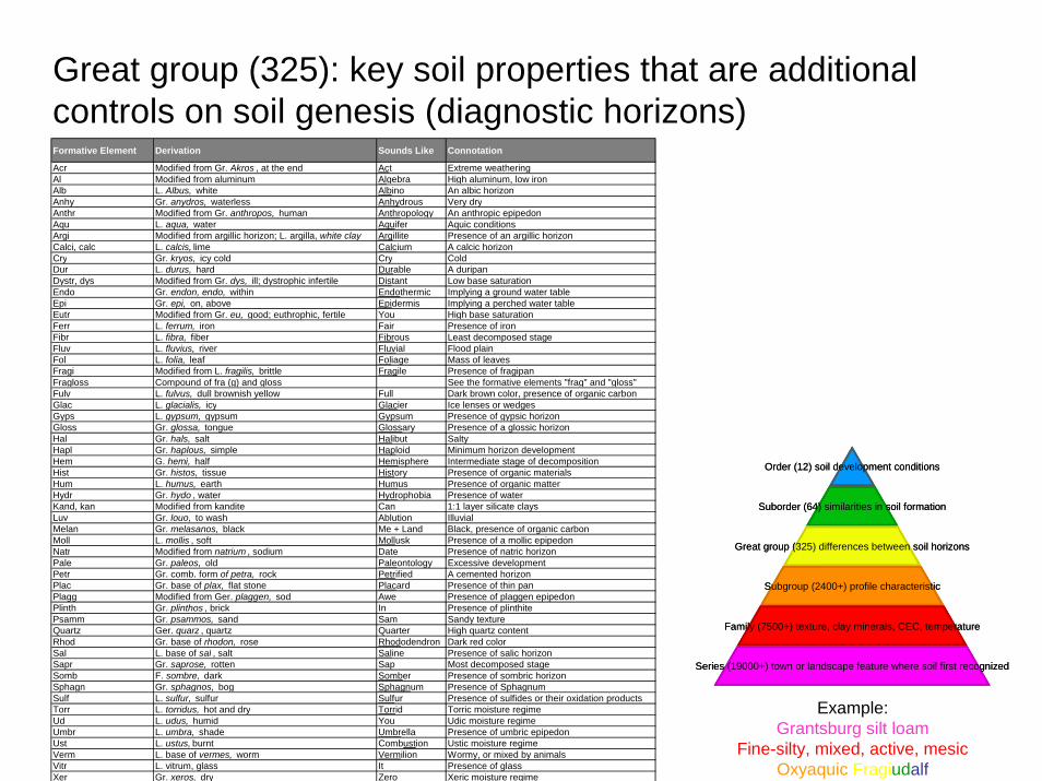
Great group (325): key soil properties that are additional controls on soil genesis (diagnostic horizons)Formative Element Derivation Sounds Like Connotation
Acr Modified from Gr. Akros , at the end Act Extreme weatheringAl Modified from aluminum Algebra High aluminum, low ironAlb L. Albus, white Albino An albic horizonAnhy Gr. anydros, waterless Anhydrous Very dryAnthr Modified from Gr. anthropos, human Anthropology An anthropic epipedonAqu L. aqua, water Aquifer Aquic conditionsArgi Modified from argillic horizon; L. argilla, white clay Argillite Presence of an argillic horizonCalci, calc L. calcis, lime Calcium A calcic horizonCry Gr. kryos, icy cold Cry ColdDur L. durus, hard Durable A duripanDystr, dys Modified from Gr. dys, ill; dystrophic infertile Distant Low base saturationEndo Gr. endon, endo, within Endothermic Implying a ground water tableEpi Gr. epi, on, above Epidermis Implying a perched water tableEutr Modified from Gr. eu, good; euthrophic, fertile You High base saturationFerr L. ferrum, iron Fair Presence of ironFibr L. fibra, fiber Fibrous Least decomposed stageFluv L. fluvius, river Fluvial Flood plainFol L. folia, leaf Foliage Mass of leavesFragi Modified from L. fragilis, brittle Fragile Presence of fragipanFragloss Compound of fra (g) and gloss See the formative elements "frag" and "gloss"Fulv L. fulvus, dull brownish yellow Full Dark brown color, presence of organic carbonGlac L. glacialis, icy Glacier Ice lenses or wedgesGyps L. gypsum, gypsum Gypsum Presence of gypsic horizonGloss Gr. glossa, tongue Glossary Presence of a glossic horizonHal Gr. hals, salt Halibut SaltyHapl Gr. haplous, simple Haploid Minimum horizon developmentHem G. hemi, half Hemisphere Intermediate stage of decompositionHist Gr. histos, tissue History Presence of organic materialsHum L. humus, earth Humus Presence of organic matterHydr Gr. hydo , water Hydrophobia Presence of waterKand, kan Modified from kandite Can 1:1 layer silicate claysLuv Gr. louo, to wash Ablution IlluvialMelan Gr. melasanos, black Me + Land Black, presence of organic carbonMoll L. mollis , soft Mollusk Presence of a mollic epipedonNatr Modified from natrium , sodium Date Presence of natric horizonPale Gr. paleos, old Paleontology Excessive developmentPetr Gr. comb. form of petra, rock Petrified A cemented horizonPlac Gr. base of plax, flat stone Placard Presence of thin panPlagg Modified from Ger. plaggen, sod Awe Presence of plaggen epipedonPlinth Gr. plinthos , brick In Presence of plinthitePsamm Gr. psammos, sand Sam Sandy textureQuartz Ger. quarz , quartz Quarter High quartz contentRhod Gr. base of rhodon, rose Rhododendron Dark red colorSal L. base of sal , salt Saline Presence of salic horizonSapr Gr. saprose, rotten Sap Most decomposed stageSomb F. sombre, dark Somber Presence of sombric horizonSphagn Gr. sphagnos, bog Sphagnum Presence of SphagnumSulf L. sulfur, sulfur Sulfur Presence of sulfides or their oxidation productsTorr L. torridus, hot and dry Torrid Torric moisture regimeUd L. udus, humid You Udic moisture regimeUmbr L. umbra, shade Umbrella Presence of umbric epipedonUst L. ustus, burnt Combustion Ustic moisture regimeVerm L. base of vermes, worm Vermilion Wormy, or mixed by animalsVitr L. vitrum, glass It Presence of glassXer Gr. xeros, dry Zero Xeric moisture regime
Order (12) soil development conditions
Suborder (64) similarities in soil formation
Great group (325) differences between soil horizons
Subgroup (2400+) profile characteristic
Family (7500+) texture, clay minerals, CEC, temperature
Series (19000+) town or landscape feature where soil first recognized
Example:Grantsburg silt loam
Fine-silty, mixed, active, mesicOxyaquic Fragiudalf
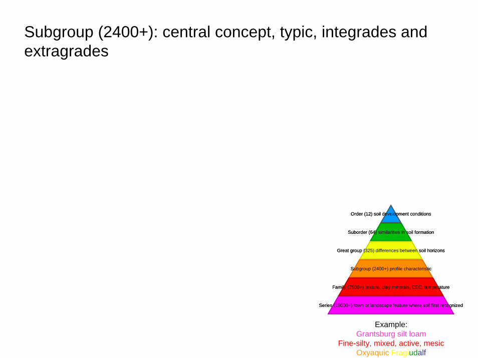
Subgroup (2400+): central concept, typic, integrades and extragrades
Order (12) soil development conditions
Suborder (64) similarities in soil formation
Great group (325) differences between soil horizons
Subgroup (2400+) profile characteristic
Family (7500+) texture, clay minerals, CEC, temperature
Series (19000+) town or landscape feature where soil first recognized
Example:Grantsburg silt loam
Fine-silty, mixed, active, mesicOxyaquic Fragiudalf
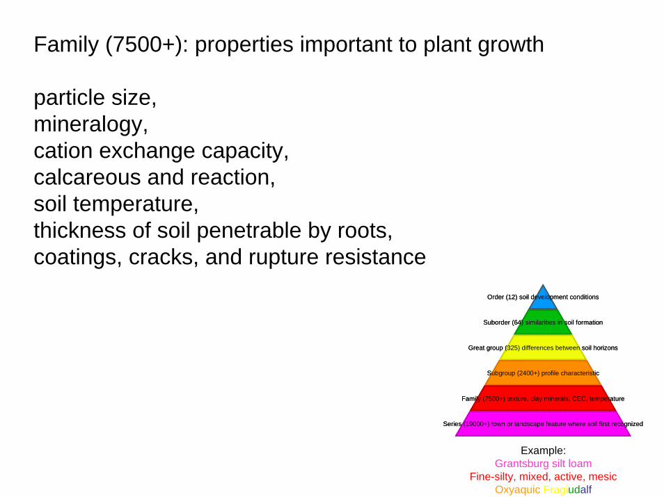
Family (7500+): properties important to plant growth
particle size, mineralogy, cation exchange capacity, calcareous and reaction, soil temperature, thickness of soil penetrable by roots,coatings, cracks, and rupture resistance
Order (12) soil development conditions
Suborder (64) similarities in soil formation
Great group (325) differences between soil horizons
Subgroup (2400+) profile characteristic
Family (7500+) texture, clay minerals, CEC, temperature
Series (19000+) town or landscape feature where soil first recognized
Example:Grantsburg silt loam
Fine-silty, mixed, active, mesicOxyaquic Fragiudalf
Series (19000+): soil morphology
Order (12) soil development conditions
Suborder (64) similarities in soil formation
Great group (325) differences between soil horizons
Subgroup (2400+) profile characteristic
Family (7500+) texture, clay minerals, CEC, temperature
Series (19000+) town or landscape feature where soil first recognized
Example:Grantsburg silt loam
Fine-silty, mixed, active, mesicOxyaquic Fragiudalf
http://soils.usda.gov/technical/classification/taxonomy/
http://soils.usda.gov/technical/classification/osd/index.html
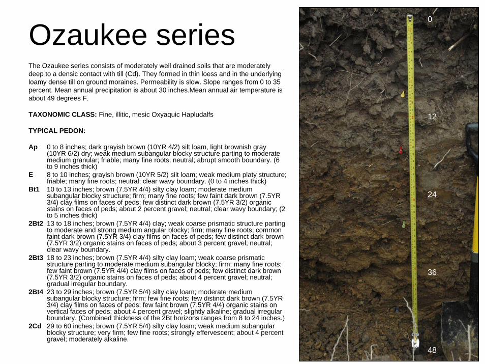
Ozaukee seriesThe Ozaukee series consists of moderately well drained soils that are moderately deep to a densic contact with till (Cd). They formed in thin loess and in the underlying loamy dense till on ground moraines. Permeability is slow. Slope ranges from 0 to 35 percent. Mean annual precipitation is about 30 inches.Mean annual air temperature is about 49 degrees F.
TAXONOMIC CLASS: Fine, illitic, mesic Oxyaquic Hapludalfs
TYPICAL PEDON:
Ap 0 to 8 inches; dark grayish brown (10YR 4/2) silt loam, light brownish gray (10YR 6/2) dry; weak medium subangular blocky structure parting to moderate medium granular; friable; many fine roots; neutral; abrupt smooth boundary. (6 to 9 inches thick)
E 8 to 10 inches; grayish brown (10YR 5/2) silt loam; weak medium platy structure; friable; many fine roots; neutral; clear wavy boundary. (0 to 4 inches thick)
Bt1 10 to 13 inches; brown (7.5YR 4/4) silty clay loam; moderate medium subangular blocky structure; firm; many fine roots; few faint dark brown (7.5YR 3/4) clay films on faces of peds; few distinct dark brown (7.5YR 3/2) organic stains on faces of peds; about 2 percent gravel; neutral; clear wavy boundary; (2 to 5 inches thick)
2Bt2 13 to 18 inches; brown (7.5YR 4/4) clay; weak coarse prismatic structure parting to moderate and strong medium angular blocky; firm; many fine roots; common faint dark brown (7.5YR 3/4) clay films on faces of peds; few distinct dark brown (7.5YR 3/2) organic stains on faces of peds; about 3 percent gravel; neutral; clear wavy boundary.
2Bt3 18 to 23 inches; brown (7.5YR 4/4) silty clay loam; weak coarse prismatic structure parting to moderate medium subangular blocky; firm; many fine roots; few faint brown (7.5YR 4/4) clay films on faces of peds; few distinct dark brown (7.5YR 3/2) organic stains on faces of peds; about 4 percent gravel; neutral; gradual irregular boundary.
2Bt4 23 to 29 inches; brown (7.5YR 5/4) silty clay loam; moderate medium subangular blocky structure; firm; few fine roots; few distinct dark brown (7.5YR 3/4) clay films on faces of peds; few faint brown (7.5YR 4/4) organic stains on vertical faces of peds; about 4 percent gravel; slightly alkaline; gradual irregular boundary. (Combined thickness of the 2Bt horizons ranges from 8 to 24 inches.)
2Cd 29 to 60 inches; brown (7.5YR 5/4) silty clay loam; weak medium subangularblocky structure; very firm; few fine roots; strongly effervescent; about 4 percent gravel; moderately alkaline.
0
12
24
36
48
Review question 1
Explain the difference between a genetic horizon and a diagnostic horizon, including field examples.
Review question 3
Arrange the soil orders from least to most highly weathered.
Review question 6
List the most influential soil forming factorsfor each order?
Review article
Bockheim, J.G. and Gennadiyev, A.N. 2000. The role of soil-forming process in the definition of taxa in Soil Taxonomy and the World Soil Reference Base. 95:53-72.
Review article
For next time, please read:
Watson, G.W. and Kelsey, P. 2006. The impact of soil compaction on soil aeration and fine root density of Quercus palustris. Urban Forestry & Urban Greening. 4:69-74.
Laboratory
Soil bulk density and porosity