Embed Size (px)
Citation preview
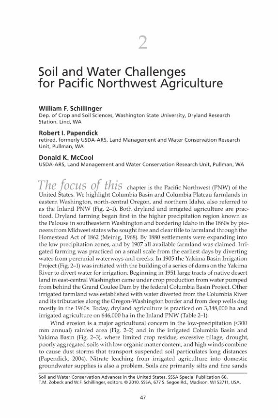
47
Soil and Water Conservation Advances in the United States. SSSA Special Publication 60. T.M. Zobeck and W.F. Schillinger, editors. © 2010. SSSA, 677 S. Segoe Rd., Madison, WI 53711, USA.
2Soil and Water Challenges for Pacific Northwest Agriculture
William F. SchillingerDep. of Crop and Soil Sciences, Washington State University, Dryland Research Station, Lind, WA
Robert I. Papendickretired, formerly USDA-ARS, Land Management and Water Conservation Research Unit, Pullman, WA
Donald K. McCoolUSDA-ARS, Land Management and Water Conservation Research Unit, Pullman, WA
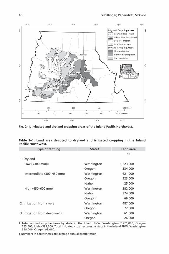
The focus of this chapter is the Pacific Northwest (PNW) of the United States. We highlight Columbia Basin and Columbia Plateau farmlands in eastern Washington, north-central Oregon, and northern Idaho, also referred to as the Inland PNW (Fig. 2–1). Both dryland and irrigated agriculture are prac-ticed. Dryland farming began first in the higher precipitation region known as the Palouse in southeastern Washington and bordering Idaho in the 1860s by pio-neers from Midwest states who sought free and clear title to farmland through the Homestead Act of 1862 (Meinig, 1968). By 1880 settlements were expanding into the low precipitation zones, and by 1907 all available farmland was claimed. Irri-gated farming was practiced on a small scale from the earliest days by diverting water from perennial waterways and creeks. In 1905 the Yakima Basin Irrigation Project (Fig. 2–1) was initiated with the building of a series of dams on the Yakima River to divert water for irrigation. Beginning in 1951 large tracts of native desert land in east-central Washington came under crop production from water pumped from behind the Grand Coulee Dam by the federal Columbia Basin Project. Other irrigated farmland was established with water diverted from the Columbia River and its tributaries along the Oregon-Washington border and from deep wells dug mostly in the 1960s. Today, dryland agriculture is practiced on 3,348,000 ha and irrigated agriculture on 646,000 ha in the Inland PNW (Table 2–1).
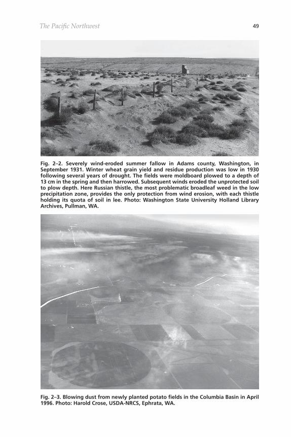
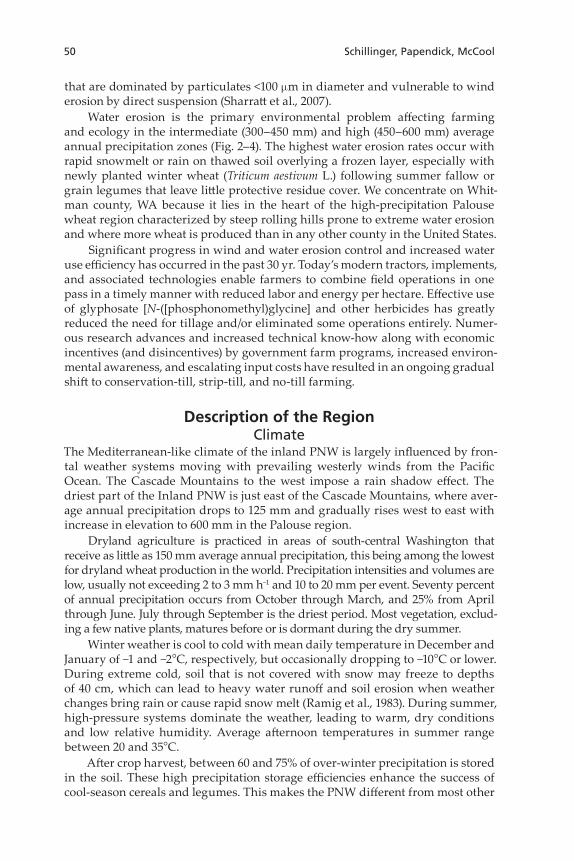
Wind erosion is a major agricultural concern in the low-precipitation (<300 mm annual) rainfed area (Fig. 2–2) and in the irrigated Columbia Basin and Yakima Basin (Fig. 2–3), where limited crop residue, excessive tillage, drought, poorly aggregated soils with low organic matter content, and high winds combine to cause dust storms that transport suspended soil particulates long distances (Papendick, 2004). Nitrate leaching from irrigated agriculture into domestic groundwater supplies is also a problem. Soils are primarily silts and fine sands
48 Schillinger, Papendick, McCool
Fig. 2–1. Irrigated and dryland cropping areas of the Inland Pacific Northwest.
Table 2–1. Land area devoted to dryland and irrigated cropping in the Inland Pacific Northwest.
Type of farming State† Land area
ha
1. Dryland
Low (<300 mm)‡ Washington 1,223,000
Oregon 334,000
Intermediate (300–450 mm) Washington 621,000
Oregon 323,000
Idaho 25,000
High (450–600 mm) Washington 382,000
Idaho 374,000
Oregon 66,000
2. Irrigation from rivers Washington 487,000
Oregon 72,000
3. Irrigation from deep wells Washington 61,000
Oregon 26,000
† Total rainfed crop hectares by state in the Inland PNW: Washington 2,226,000; Oregon 723,000; Idaho 399,000. Total irrigated crop hectares by state in the Inland PNW: Washington 548,000; Oregon 98,000.
‡ Numbers in parentheses are average annual precipitation.
The Pacific Northwest 49
Fig. 2–2. Severely wind-eroded summer fallow in Adams county, Washington, in September 1931. Winter wheat grain yield and residue production was low in 1930 following several years of drought. The fields were moldboard plowed to a depth of 13 cm in the spring and then harrowed. Subsequent winds eroded the unprotected soil to plow depth. Here Russian thistle, the most problematic broadleaf weed in the low precipitation zone, provides the only protection from wind erosion, with each thistle holding its quota of soil in lee. Photo: Washington State University Holland Library Archives, Pullman, WA.
Fig. 2–3. Blowing dust from newly planted potato fields in the Columbia Basin in April 1996. Photo: Harold Crose, USDA-NRCS, Ephrata, WA.
50 Schillinger, Papendick, McCool
that are dominated by particulates <100 mm in diameter and vulnerable to wind erosion by direct suspension (Sharratt et al., 2007).
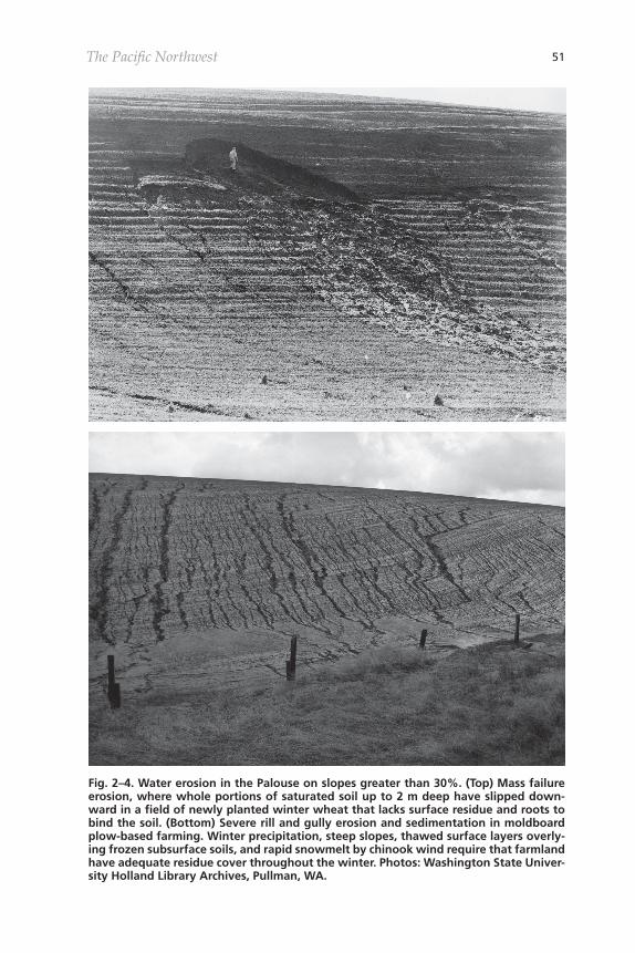
Water erosion is the primary environmental problem affecting farming and ecology in the intermediate (300–450 mm) and high (450–600 mm) average annual precipitation zones (Fig. 2–4). The highest water erosion rates occur with rapid snowmelt or rain on thawed soil overlying a frozen layer, especially with newly planted winter wheat (Triticum aestivum L.) following summer fallow or grain legumes that leave little protective residue cover. We concentrate on Whit-man county, WA because it lies in the heart of the high-precipitation Palouse wheat region characterized by steep rolling hills prone to extreme water erosion and where more wheat is produced than in any other county in the United States.
Significant progress in wind and water erosion control and increased water use efficiency has occurred in the past 30 yr. Today’s modern tractors, implements, and associated technologies enable farmers to combine field operations in one pass in a timely manner with reduced labor and energy per hectare. Effective use of glyphosate [N-([phosphonomethyl)glycine] and other herbicides has greatly reduced the need for tillage and/or eliminated some operations entirely. Numer-ous research advances and increased technical know-how along with economic incentives (and disincentives) by government farm programs, increased environ-mental awareness, and escalating input costs have resulted in an ongoing gradual shift to conservation-till, strip-till, and no-till farming.
Description of the RegionClimate
The Mediterranean-like climate of the inland PNW is largely influenced by fron-tal weather systems moving with prevailing westerly winds from the Pacific Ocean. The Cascade Mountains to the west impose a rain shadow effect. The driest part of the Inland PNW is just east of the Cascade Mountains, where aver-age annual precipitation drops to 125 mm and gradually rises west to east with increase in elevation to 600 mm in the Palouse region.
Dryland agriculture is practiced in areas of south-central Washington that receive as little as 150 mm average annual precipitation, this being among the lowest for dryland wheat production in the world. Precipitation intensities and volumes are low, usually not exceeding 2 to 3 mm h−1 and 10 to 20 mm per event. Seventy percent of annual precipitation occurs from October through March, and 25% from April through June. July through September is the driest period. Most vegetation, exclud-ing a few native plants, matures before or is dormant during the dry summer.
Winter weather is cool to cold with mean daily temperature in December and January of −1 and −2°C, respectively, but occasionally dropping to −10°C or lower. During extreme cold, soil that is not covered with snow may freeze to depths of 40 cm, which can lead to heavy water runoff and soil erosion when weather changes bring rain or cause rapid snow melt (Ramig et al., 1983). During summer, high-pressure systems dominate the weather, leading to warm, dry conditions and low relative humidity. Average afternoon temperatures in summer range between 20 and 35°C.
After crop harvest, between 60 and 75% of over-winter precipitation is stored in the soil. These high precipitation storage efficiencies enhance the success of cool-season cereals and legumes. This makes the PNW different from most other
The Pacific Northwest 51
Fig. 2–4. Water erosion in the Palouse on slopes greater than 30%. (Top) Mass failure erosion, where whole portions of saturated soil up to 2 m deep have slipped down-ward in a field of newly planted winter wheat that lacks surface residue and roots to bind the soil. (Bottom) Severe rill and gully erosion and sedimentation in moldboard plow-based farming. Winter precipitation, steep slopes, thawed surface layers overly-ing frozen subsurface soils, and rapid snowmelt by chinook wind require that farmland have adequate residue cover throughout the winter. Photos: Washington State Univer-sity Holland Library Archives, Pullman, WA.
52 Schillinger, Papendick, McCool
locations with similar annual precipitation, where most precipitation comes as summer rainfall.
Average wind speeds are low throughout the year. However, high winds last-ing 24 to 36 h with sustained speeds of 60 to 70 km h−1 and gusts up to 125 km h−1 that occur with occasional storms when the soil surface is dry are the main cause of wind erosion. These events are relatively isolated and mostly associated with the change of seasons in the fall and spring, but sometimes in the winter. The dust storms can result in annual soil losses of hundreds of megagrams per hect-are from susceptible fields and carry dust particulates thousands of kilometers, extending well beyond the boundaries of the PNW.
SoilsMost of the dry farmed soils of the Columbia Plateau are derived from loess deposits, much coming in the last 15,000 years from silty glacial materials carried by cataclysmic outburst floods from Glacial Lake Missoula and released in the path of prevailing westerly winds (McDonald and Busacca, 1988; Busacca, 1989). Many soils have been modified by volcanic depositions and contain, on average, 12% volcanic glass (Busacca et al., 2001). These authors describe the PNW soils as “ash influenced or volcanic influenced” but not volcanic. Farmed soils range in depth from <1 to >7 m in the dry zone and up to 75 m to bedrock where pre-cipitation is higher. Soils are permeable and well drained and in most areas have adequate depth to store winter precipitation. Some that are shallow limit pro-ductivity due to low water storage capacity. Where average annual precipitation is >230 mm the soils are primarily Mollisols that originally contained 1.5 to 3.5% soil organic matter. In the drier areas the soils are Aridisols and some Entisols having native organic matter contents of ≤1%. Today after more than 125 years of intensive farming, organic matter contents of most soils have decreased 50 to 60% from original levels (Rasmussen and Parton, 1994).
Soils throughout the Columbia Plateau are predominantly silt loams. How-ever, they grade in sand, clay, and organic matter content in line with the prevailing westerly winds. The soils in the southwestern fringes have the highest sand and lowest organic matter contents and gradually increase in clay and organic matter in the northeasterly direction in trend with prevailing winds and increasing pre-cipitation. Soil textures of the loess soils are generally relatively uniform to the underlying bedrock.
Most soils of the irrigated Columbia Basin are derived from sediments depos-ited by the same floods 15,000 years ago. These sediments in the presence of an arid climate were winnowed by southwesterly winds and ultimately contributed to the loess deposits in areas of the Columbia Plateau to the north and east (Swee-ney et al., 2007). The process resulted in fine sandy soils with very low organic matter content throughout much of the Columbia Basin. The depth, stratification, and permeability of Columbia Basin soils are ideal for irrigated production of grains, vegetables, and fruits adaptable to the Basin’s long growing season.
Crops and Cropping SystemsIrrigated Areas
There are two major irrigation projects in the Inland PNW located in cen-tral Washington. This land was considered too dry for rainfed agriculture and
The Pacific Northwest 53
mostly remained in native bluebunch wheatgrass [Pseudoroegneria spicata (Pursh) Á. Löve], basin wildrye [Leymus cinereus (Scribn. & Merr.) Á. Löve], needle and thread [Hesperostipa comata (Trin. & Rupr.) Barkworth], and other perennial grasses intermixed with shrubs such as big sagebrush (Artemisia tridentata Nutt.), gray rabbitbrush [Ericameria nauseosa (Pall. ex Pursh) G.L. Nesom & G.I. Baird], and western yarrow (Achillea millefolium L.), until broken out for irrigated farming.
The Yakima River Basin Project (Fig. 2–1) was initiated in 1905 by building a series of dams along the Yakima River to capture water from the eastern water-shed of the Cascade Mountains that drains an area of 15,940 km−2. The Yakima Basin is one of the most intensively irrigated areas in the United States. Main canals and laterals deliver water to 206,000 ha of cropland along 280 km on both sides of the Yakima River.
The Columbia Basin Project began in 1951 following construction of the Grand Coulee Dam on the Columbia River in 1942. About 3% of the Columbia Riv-er’s flow is lifted from behind the dam at an average rate of 450 m3 water s−1. Water is distributed throughout the project via main canals, feeder canals, siphons, and tunnels. The original plan was to irrigate 420,000 ha, but only 263,000 ha has been completed to date (Fig. 2–1) as the second half of the project was postponed due to lack of federal funding. The annual value of crops produced with water from the Yakima River Basin and Columbia Basin Projects exceeds $1 billion (NASS, 2008).
Irrigation water is applied through furrows, high-volume impact sprinklers, low-volume drop nozzle sprinklers, micro-irrigation systems, and drip lines, and there is a corresponding increase in water use efficiency, respectively, with these delivery systems (Howell, 2001). Approximately 20% of cropland in the Columbia Basin and Yakima River Basin Projects is still in furrow irrigation. Furrow irri-gation is used exclusively on some high-value seed crops where water droplets on the leaf surface from sprinkler irrigation can elevate fungal diseases of some crops (Troy Peters, Washington State University, personal communication, 2008) and also occasionally interfere with crop pollination.
About 60,000 ha in the uncompleted second half of the Columbia Basin Proj-ect is irrigated from deep wells (Fig. 2–1). Most wells were drilled in the 1960s with the intention they would be needed for only 10 to 15 yr until the second half of the Columbia Basin Project was completed. Now, nearly 50 yr later, farmers are still irrigating from deep wells, and the status of the second phase of the Colum-bia Basin Project remains uncertain. The water table in underground aquifers has declined dramatically since the 1960s, mostly due to this deep well irriga-tion. Wells for irrigation in the 1960s were drilled to an average depth of 100 m compared to more than 200 m today. The cost of electricity to pump water from 200 m is presently $6 cm−1 ha−1 (Jeff Schibel, personal communication, 2008). One farmer near Ritzville, WA recently deepened a well to a depth of 880 m at a cost of $650,000. Basalt aquifers in the Columbia Basin are subdivided by a variety of geologic features that limit or block both vertical and lateral groundwater move-ment. A recent report (Lindsey et al., 2009) showed that no significant recharge of the deeper basalt aquifer system in the Columbia Basin has occurred in more than 10,000 years. Therefore, water pumped from the deep aquifer system is essentially nonrenewable.
About 120,000 ha of irrigated cropland is concentrated in Umatilla and Mor-row counties in north-central Oregon and in Benton and Walla Walla counties in Washington (Fig. 2–1). Most of the irrigation water is obtained directly from the
54 Schillinger, Papendick, McCool
Columbia River or its tributaries, with the remaining 25% pumped from deep wells (Donald Horneck, Oregon State University, personal communication, 2008).
Apple (Malus domestica Borkh.), sweet cherry [Prunus avium (L.) L.], and pear (Pyrus communis L.) are major tree crops. Wine grape production has increased to 12,000 ha in recent years, and many wines produced in the region have an international reputation for high quality. Hops (Humulus lupulus L.) are produced on 9000 ha in the Yakima River Basin. Hybrid poplar trees (Populus deltoides W. Bartram ex Marshall ´ P. nigra L.) are grown for pulpwood and lumber under drip irrigation on 10,000 ha in north-central Oregon. With their permanent cover, wind and water erosion are not serious concerns with irrigated perennial trees and vines.
Field crops include potatoes (Solanum tuberosum L.), corn (Zea mays L.), wheat, barley (Hordeum vulgare L.), oat (Avena sativa L.), alfalfa (Medicago sativa L.), and dry bean (Phaseolus vulgaris L.). In Washington, average potato tuber yield was 69,400 kg ha−1 and corn grain yield 13,200 kg ha−1 in 2007 (NASS, 2008). Irrigated wheat grain yields average more than 6700 kg ha−1.
Many vegetable crops such as onion (Allium cepa L.) and carrot (Daucus carota L.) are grown for direct consumption as well as seed. Several perennial grass spe-cies are produced for seed. Due to many available crop options, there are no “set” cropping systems. Farmers rotate crops to reduce pests and diseases, optimize water use, and take advantage of current market opportunities. Wind erosion is a major problem for late-harvested root crops due to lack of residue cover after harvest. This is especially true for potato production that involves a high level of soil disturbance (see Wind Erosion and Air Quality section).
Dryland AreasLow Precipitation ZoneAfter a decade of experimenting with annual cropping in the 1880s, pioneer farm-ers in the low precipitation zone learned that the most stable and economically viable grain yields could be achieved by growing winter wheat with a year of fallow between crops. The 2-yr winter wheat–summer fallow (WW–SF) rotation soon became the dominant crop rotation and has remained so since 1890 because it is less risky and more profitable than other systems tested to date. Average win-ter wheat (one crop every other year) yields range from 1200 to 3700 kg ha−1 with 150 and 300 mm of annual precipitation, respectively. About 1.7 kg of residue is produced for every kg of grain.
Spring wheat and spring barley are planted in lieu of summer fallow on 10% or less of dryland hectares, mostly in years when storage of over-winter precipitation in the soil is ample, for example, when the wetting front extends more than 1 m deep. Grain yield of recrop spring cereals is highly variable, and even with ample over-winter soil moisture storage, timely May and early June rainfall is prerequisite for profitable grain yield. Experience and research have not yet identified any alternative crops or cropping systems that can com-pete agronomically or economically with winter wheat after summer fallow. However, this situation could change rapidly—in 2008 many farmers accepted contracts that paid $870 Mg−1 for yellow mustard (Brassica hirta Moench) where earlier the price was $270 Mg−1 or less.
The Pacific Northwest 55
Intermediate Precipitation ZoneThe standard crop rotations in the intermediate precipitation zone are WW–SF in the dryer portions and a 3-yr winter wheat–spring cereal (either wheat or bar-ley)–summer fallow rotation, where annual precipitation exceeds 350 mm. Some annual cropping is practiced where precipitation is more plentiful or in years when over-winter soil water storage is favorable. There are several crop options other than cool-season cereals, such as yellow mustard, winter and spring canola (Brassica napus L. and B. Campestris L.), safflower (Carthamus tinctorious L.), and dry pea (Pisum sativum L.), but currently most farmers plant only winter wheat, spring wheat, and spring barley. Average grain yields range from 3700 to 5400 kg ha −1 for winter wheat after summer fallow and 1680 to 3300 kg ha−1 for recrop spring wheat and spring barley.
High Precipitation ZoneAnnual cropping (i.e., no summer fallow) is generally practiced in this zone. Most farmers have a 3-yr rotation of winter wheat–spring cereal–spring legume, while some others pursue a cereal-only rotation of winter wheat–spring barley–spring wheat (or two spring wheat crops in a row instead of spring barley). Grain yields in the high end (i.e., 600 mm) of this precipitation zone average 6200 kg ha−1 for winter wheat, 4100 kg ha−1 for spring wheat and spring barley, and 2000 kg ha−1 for the spring legume crops lentil (Lens culinaris Medik.), dry pea, and chickpea (Cicer arietinum L.).
Grain yield of winter wheat is greater following a spring legume crop than after a spring cereal because legumes extract less water from the soil and also pro-vide other presumed positive rotation effects (Paulitz et al., 2002). Some farmers practice a 2-yr winter wheat–spring legume rotation, but control of downy brome (Bromus tectorum L.) and jointed goatgrass (Aegilops cylindrical Host.), major grass weeds with growth habit similar to winter wheat, are more difficult to control because of the high prevalence of winter wheat compared to 3-yr rotations. Win-ter wheat effectively extracts soil water to a depth of 1.7 m, but little below this depth. Some innovative farmers grow corn and other deep-rooted crops to make use of deep available soil water (John and Cory Aeschliman, personal communi-cation, 2008).
Wheat is KingWinter wheat has historically been the most stable and profitable dryland crop in all precipitation zones (Papendick, 1996). The price of soft white wheat reached record highs of more than $550 Mg−1 (>$15 bushel−1) in 2008 driven by low supply due to global-scale drought and by the increased demand for wheat, barley, corn, and other cereals for human consumption, animal feed, and ethanol production. Despite unprecedented wind and water erosion, wheat grain yields have contin-ued to increase in a linear fashion because of technological advances that include new cultivars with high yield potential and resistance to diseases, the availability of nitrogen fertilizer and herbicides beginning in the 1950s, modern farm equip-ment, and other agronomic improvements that today allow one farmer to manage 1000 ha or more cropland.
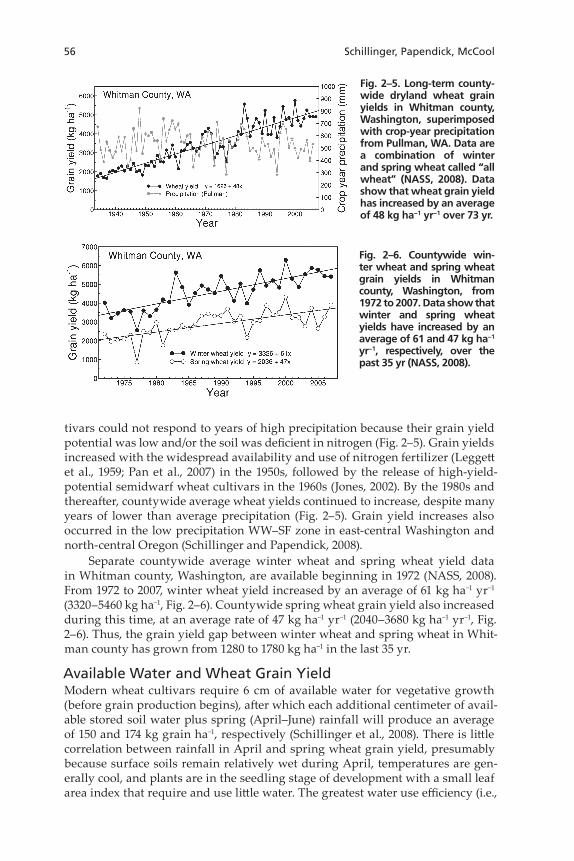
Since 1934, countywide average wheat grain yield in Whitman county, Washington, in the high-precipitation Palouse region has increased from 1630 to 5130 kg ha−1 (Fig. 2–5). Grain yield data clearly show that before 1960 wheat cul-
56 Schillinger, Papendick, McCool
tivars could not respond to years of high precipitation because their grain yield potential was low and/or the soil was deficient in nitrogen (Fig. 2–5). Grain yields increased with the widespread availability and use of nitrogen fertilizer (Leggett et al., 1959; Pan et al., 2007) in the 1950s, followed by the release of high-yield-potential semidwarf wheat cultivars in the 1960s (Jones, 2002). By the 1980s and thereafter, countywide average wheat yields continued to increase, despite many years of lower than average precipitation (Fig. 2–5). Grain yield increases also occurred in the low precipitation WW–SF zone in east-central Washington and north-central Oregon (Schillinger and Papendick, 2008).
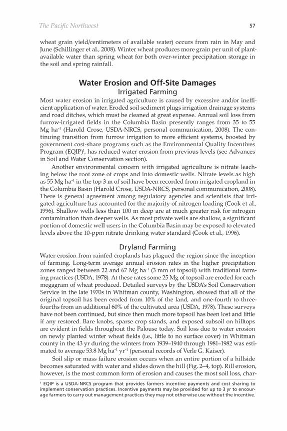
Separate countywide average winter wheat and spring wheat yield data in Whitman county, Washington, are available beginning in 1972 (NASS, 2008). From 1972 to 2007, winter wheat yield increased by an average of 61 kg ha−1 yr−1 (3320–5460 kg ha−1, Fig. 2–6). Countywide spring wheat grain yield also increased during this time, at an average rate of 47 kg ha−1 yr−1 (2040–3680 kg ha−1 yr−1, Fig. 2–6). Thus, the grain yield gap between winter wheat and spring wheat in Whit-man county has grown from 1280 to 1780 kg ha−1 in the last 35 yr.
Available Water and Wheat Grain YieldModern wheat cultivars require 6 cm of available water for vegetative growth (before grain production begins), after which each additional centimeter of avail-able stored soil water plus spring (April–June) rainfall will produce an average of 150 and 174 kg grain ha−1, respectively (Schillinger et al., 2008). There is little correlation between rainfall in April and spring wheat grain yield, presumably because surface soils remain relatively wet during April, temperatures are gen-erally cool, and plants are in the seedling stage of development with a small leaf area index that require and use little water. The greatest water use efficiency (i.e.,
Fig. 2–5. Long-term county-wide dryland wheat grain yields in Whitman county, Washington, superimposed with crop-year precipitation from Pullman, WA. Data are a combination of winter and spring wheat called “all wheat” (NASS, 2008). Data show that wheat grain yield has increased by an average of 48 kg ha−1 yr−1 over 73 yr.
Fig. 2–6. Countywide win-ter wheat and spring wheat grain yields in Whitman county, Washington, from 1972 to 2007. Data show that winter and spring wheat yields have increased by an average of 61 and 47 kg ha−1 yr−1, respectively, over the past 35 yr (NASS, 2008).
The Pacific Northwest 57
wheat grain yield/centimeters of available water) occurs from rain in May and June (Schillinger et al., 2008). Winter wheat produces more grain per unit of plant-available water than spring wheat for both over-winter precipitation storage in the soil and spring rainfall.
Water Erosion and Off-Site DamagesIrrigated Farming
Most water erosion in irrigated agriculture is caused by excessive and/or ineffi-cient application of water. Eroded soil sediment plugs irrigation drainage systems and road ditches, which must be cleaned at great expense. Annual soil loss from furrow-irrigated fields in the Columbia Basin presently ranges from 35 to 55 Mg ha−1 (Harold Crose, USDA-NRCS, personal communication, 2008). The con-tinuing transition from furrow irrigation to more efficient systems, boosted by government cost-share programs such as the Environmental Quality Incentives Program (EQIP)1, has reduced water erosion from previous levels (see Advances in Soil and Water Conservation section).
Another environmental concern with irrigated agriculture is nitrate leach-ing below the root zone of crops and into domestic wells. Nitrate levels as high as 55 Mg ha−1 in the top 3 m of soil have been recorded from irrigated cropland in the Columbia Basin (Harold Crose, USDA-NRCS, personal communication, 2008). There is general agreement among regulatory agencies and scientists that irri-gated agriculture has accounted for the majority of nitrogen loading (Cook et al., 1996). Shallow wells less than 100 m deep are at much greater risk for nitrogen contamination than deeper wells. As most private wells are shallow, a significant portion of domestic well users in the Columbia Basin may be exposed to elevated levels above the 10-ppm nitrate drinking water standard (Cook et al., 1996).
Dryland FarmingWater erosion from rainfed croplands has plagued the region since the inception of farming. Long-term average annual erosion rates in the higher precipitation zones ranged between 22 and 67 Mg ha−1 (3 mm of topsoil) with traditional farm-ing practices (USDA, 1978). At these rates some 25 Mg of topsoil are eroded for each megagram of wheat produced. Detailed surveys by the USDA’s Soil Conservation Service in the late 1970s in Whitman county, Washington, showed that all of the original topsoil has been eroded from 10% of the land, and one-fourth to three-fourths from an additional 60% of the cultivated area (USDA, 1978). These surveys have not been continued, but since then much more topsoil has been lost and little if any restored. Bare knobs, sparse crop stands, and exposed subsoil on hilltops are evident in fields throughout the Palouse today. Soil loss due to water erosion on newly planted winter wheat fields (i.e., little to no surface cover) in Whitman county in the 43 yr during the winters from 1939–1940 through 1981–1982 was esti-mated to average 53.8 Mg ha−1 yr−1 (personal records of Verle G. Kaiser).
Soil slip or mass failure erosion occurs when an entire portion of a hillside becomes saturated with water and slides down the hill (Fig. 2–4, top). Rill erosion, however, is the most common form of erosion and causes the most soil loss, char-1 EQIP is a USDA-NRCS program that provides farmers incentive payments and cost sharing to implement conservation practices. Incentive payments may be provided for up to 3 yr to encour-age farmers to carry out management practices they may not otherwise use without the incentive.
58 Schillinger, Papendick, McCool
acterized by numerous rivulets along the slope (Fig. 2–4, bottom). Several rills will often concentrate in a low area at the bottom of a hill to form gullies in one season that can be so deep that they must be mechanically filled before they can be crossed by farm implements.
Water erosion is less problematic in the drier zones with its lower precipita-tion and more gentle slopes; however, it too is accelerated by traditional tillage wheat farming. Annual water erosion rates historically average about 10 Mg ha−1 under traditional practices in a mostly WW–SF rotation (USDA, 1978).
Approximately one-third of the eroded sediments are washed by runoff into the region’s water bodies, causing incalculable environmental damage in addi-tion to the lost soil resource from millions of hectares (Kok et al., 2009). Eroded sediments are not only a water pollutant; they constitute irreplaceable topsoil from once prime croplands. Lost topsoil reduces the production capacity of crop-lands, and therefore with time results in reduced water-holding capacity and requires increased levels of costly technological inputs (e.g., nutrients, improved genetics) to sustain grain yields. However, ignoring the cost, these inputs can-not replace the inherent properties of the lost original soil that are crucial to the land’s potential productive capacity.
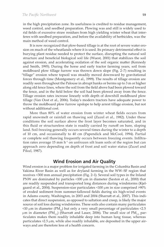
The causes of severe water erosion from tilled soils in the PNW are: (i) win-ter precipitation climate with high potential for frozen soil runoff, (ii) steep and irregular topography that cannot be easily modified to control erosion, and (iii) lack of surface cover and roughness over winter due to plow-based tillage prac-tices. With traditional plow-based farming two-thirds of the erosion occurs from fall-seeded winter wheat fields that lack protection over winter. The moldboard plow (Fig. 2–7) has historically been the primary tillage tool for grain farming
Fig. 2–7. Inversion of soil to bury heavy winter wheat stubble with a six-bottom mold-board plow in the Palouse circa 1950. Large quantities of winter wheat residue remains a problem for farmers today in the high precipitation region where moldboard plowing is still commonly practiced. However, the trend is toward conservation- and no-till prac-tices. Photo: Washington State University Holland Library Archives, Pullman, WA.
The Pacific Northwest 59
in the high precipitation zone. Its usefulness is credited to residue management, weed control, and seedbed preparation. Plowing was and still is widely used to rid fields of excessive straw residues from high yielding winter wheat that inter-feres with seedbed preparation, and before the availability of herbicides, was the main method of weed control.
It is now recognized that plow-based tillage is at the root of severe water ero-sion on much of the wheatlands where it is used. Its primary detrimental effect is burying plant residue needed to protect the surface, disrupting the natural soil structure and beneficial biological soil life (Wuest, 2001) that stabilizes the soil against erosion, and accelerating oxidation of the soil organic matter (Kennedy and Smith, 1995). During the horse and early tractor farming years, soil from moldboard plow tillage furrow was thrown down slope (Fig. 2–7) resulting in
“tillage” erosion where topsoil was steadily moved downward by gravitational forces through time (Montgomery et al., 1999). The results of tillage erosion are readily seen throughout the Palouse in abrupt banks or berms up to 3 m or higher along old fence lines, where the soil from the field above had been plowed toward the fence, and in the field below the soil had been plowed away from the fence. Tillage erosion rates increase linearly with depth of downhill moldboard plow tillage (Van Oost et al., 2006). Today’s modern tractors have adequate power to throw the moldboard plow furrow upslope to help arrest tillage erosion, but not without additional cost.
More than 80% of water erosion from winter wheat fields occurs from rapid snowmelt or rainfall on thawing soil (Zuzel et al., 1982). Under these conditions the soil surface above the frost layer becomes saturated, and in this fluid or structureless state is readily carried by runoff on bare, sloping land. Soil freezing generally occurs several times during the winter to a depth of 10 cm, and occasionally to 40 cm (Papendick and McCool, 1994). Partial or complete soil thawing frequently occurs between freezing events. Infiltra-tion rates average 15 mm h−1 on unfrozen silt loam soils of the region but can approach zero depending on depth of frost and soil water status (Zuzel and Pikul, 1987).
Wind Erosion and Air QualityWind erosion is a major problem for irrigated farming in the Columbia Basin and Yakima River Basin as well as for dryland farming in the WW–SF region that receives <300 mm annual precipitation (Fig. 2–1). Several soil types in the Inland PNW are dominated by particles <100 mm in diameter (Saxton et al., 2000) that are readily suspended and transported long distances during windstorms (Kjel-gaard et al., 2004). Suspension-size particulates <100 mm in size comprised >90% of eroded sediment from summer-fallowed fields during six high-wind events in Adams county, Washington, in 2003 and 2004 (Sharratt et al., 2007). This indi-cates that direct suspension, as opposed to saltation and creep, is likely the major source of soil loss during windstorms. These soils also contain many particulates <10 mm in diameter (PM10) but only a very small percentage of particulates <2.5 mm in diameter (PM2.5) (Sharratt and Lauer, 2006). The small size of PM2.5 par-ticulates makes them readily inhalable deep into human lung tissue, whereas particulates >2.5 mm, while also readily inhalable, are deposited in the upper air-ways and are therefore less of a health concern.
60 Schillinger, Papendick, McCool
The earliest travelers passing through the low-precipitation region in the days before farming (before the 1880s) wrote of high winds and annoying dust kicked up by horses’ hooves (Meinig, 1968), but made no mention of massive dust storms such as those that were frequent after the onset of farming. During the horse farming years (1880–1935), the moldboard plow was used to completely invert the surface soil during primary tillage. Following the plow, a spiked-tooth harrow was used to smooth the soil, control weeds, and to form a “dust mulch” to retain soil moisture during the dry summer (McCall, 1925). This practice cre-ated fallow fields devoid of surface residue and roughness and set the stage for recurrent and massive dust storms (Fig. 2–2), as recorded in numerous diaries and local newspaper accounts. Schillinger and Papendick (2008) estimated that 180 Mg ha−1 or more of suspended soil was lost in each of such individual 1-d dust storms, 16 times or more the annual tolerable (T value) erosion rate established by the USDA-NRCS. They further speculated that ongoing continual suspended soil emissions during wind storms, along with biological oxidation (Rasmussen and Parton, 1994), is the major reason why soil organic matter has declined by 50% or more in WW–SF systems in the past 125 yr.
When farming converted from horses to tractors in the 1930s, there was a concomitant shift from use of plows to disks or sweep implements that retained more of the crop residue on the surface. The rodweeder with a ground-driven rotating bar replaced the spiked-tooth harrow and became the most widely used secondary tillage implement for controlling weeds in summer fallow. Although the rodweeder with its undercutting action helps to retain residues on the sur-face, the one to four passes with it during the summer to control Russian thistle (Salsola iberica auct.) and spring-germinated downy brome tends to pulverize the soil and make it more susceptible to blowing. Russian thistle weed persists and can root rapidly in the very dry climate after occasional small showers during the spring and summer (Fig. 2–2) and extensively deplete water from the soil.
Water conservation and wind erosion control go hand in hand in some cases and in others they do not. In contrast to other wheat-producing areas, water con-servation in the Inland PNW low precipitation zone amounts to more than just maximizing water in the profile from precipitation. Retention of water in the seed zone during the dry summer months for late summer establishment of winter wheat increases crop yields by 30% compared with late-planted wheat that is dependent on fall rains for emergence (Donaldson et al., 2001). Wind erosion is readily controlled with chemical (i.e., no-till) summer fallow where herbicides are used to control weeds, but it is not commonly practiced in the low precipitation zone due to drying of the seed zone. Instead, tillage is widely practiced during fallow to disrupt capillary continuity to retain soil water near the surface (e.g., 10–15 cm) that is adequate for planting winter wheat with deep-furrow drills in late August or early September (Papendick et al., 1973). Without tillage most soils dry out too deeply for early planting to be successful (Hammel et al., 1981).
Air Quality Standards for Agricultural DustIn 1990, the USEPA mandated provisions in the National Ambient Air Quality Standard (NAAQS) to regulate airborne particles with an aerodynamic diameter of 10 mm or less, commonly referred to as PM10. This was of particular concern in the Inland PNW, where high PM10 concentrations at monitoring stations are always strongly correlated with major wind erosion and blowing dust from
The Pacific Northwest 61
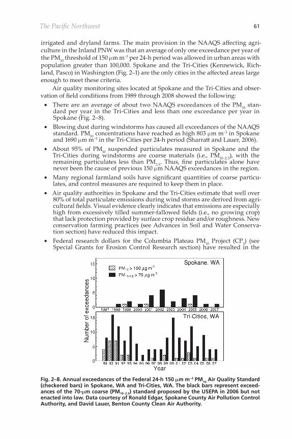
irrigated and dryland farms. The main provision in the NAAQS affecting agri-culture in the Inland PNW was that an average of only one exceedance per year of the PM10 threshold of 150 mm m−3 per 24-h period was allowed in urban areas with population greater than 100,000. Spokane and the Tri-Cities (Kennewick, Rich-land, Pasco) in Washington (Fig. 2–1) are the only cities in the affected areas large enough to meet these criteria.
Air quality monitoring sites located at Spokane and the Tri-Cities and obser-vation of field conditions from 1989 through 2008 showed the following:• There are an average of about two NAAQS exceedances of the PM10 stan-
dard per year in the Tri-Cities and less than one exceedance per year in Spokane (Fig. 2–8).
• Blowing dust during windstorms has caused all exceedances of the NAAQS standard. PM10 concentrations have reached as high 803 mm m−3 in Spokane and 1690 mm m−3 in the Tri-Cities per 24-h period (Sharratt and Lauer, 2006).
• About 95% of PM10 suspended particulates measured in Spokane and the Tri-Cities during windstorms are coarse materials (i.e., PM10–2.5), with the remaining particulates less than PM2.5. Thus, fine particulates alone have never been the cause of previous 150 mm NAAQS exceedances in the region.
• Many regional farmland soils have significant quantities of coarse particu-lates, and control measures are required to keep them in place.
• Air quality authorities in Spokane and the Tri-Cities estimate that well over 80% of total particulate emissions during wind storms are derived from agri-cultural fields. Visual evidence clearly indicates that emissions are especially high from excessively tilled summer-fallowed fields (i.e., no growing crop) that lack protection provided by surface crop residue and/or roughness. New conservation farming practices (see Advances in Soil and Water Conserva-tion section) have reduced this impact.
• Federal research dollars for the Columbia Plateau PM10 Project (CP3) (see Special Grants for Erosion Control Research section) have resulted in the
Fig. 2–8. Annual exceedances of the Federal 24-h 150 mm m−3 PM10 Air Quality Standard (checkered bars) in Spokane, WA and Tri-Cities, WA. The black bars represent exceed-ances of the 70-mm coarse (PM10–2.5) standard proposed by the USEPA in 2006 but not enacted into law. Data courtesy of Ronald Edgar, Spokane County Air Pollution Control Authority, and David Lauer, Benton County Clean Air Authority.
62 Schillinger, Papendick, McCool
development of several best management practices for improved wind ero-sion control on farm fields (Papendick, 2004).
• Federal funds have provided incentives for farmers to implement effective wind erosion control measures targeted at meeting the 150 mm m−3 standard.
• Because of the high frequency of PM10 NAAQS exceedances, eastern Wash-ington is very dependent on the Natural Events Policy (NEP)2 to avoid urban noncompliance penalties. The NEP excludes airborne particulate matter violations due to natural events provided that best management practices are implemented.
• Urban sources of dust, such as construction sites, are relatively minor. Dust emissions from such sites can be controlled by application of water or cover.
In 2006, the EPA proposed reducing the NAAQS coarse particulate thresh-old from 150 to 70 mm m−3 per 24-h time period and exempting agricultural dust sources (U.S. OFR, 2006). While many farmers readily accepted the proposed exemption, other farmers and scientists argued that dust emissions from farms should be monitored and that farmers should be held accountable for emissions of coarse particulates and given assistance to reduce emissions. If passed into law, the proposed 70 mm m−3 standard would have resulted in an average of eight exceedances per year in the Tri-Cities, and more than two in Spokane (Fig. 2–8), largely due to blowing dust from agricultural fields. If exempted, government payments to farmers for wind erosion abatement practices through the EQIP and other programs would have been reduced or eliminated. These programs are very important to the USDA-NRCS who “reward the best” farmers to “motivate the rest.” In addition, federal funding for research to develop best management practices for wind erosion control would also have been reduced or eliminated, while recent progress in this area shows a great need for these efforts to be con-tinued and enhanced.
Farmers and scientists further argued that even if emissions from urban sources (e.g., construction sites) were reduced to near zero, numerous and recurrent exceedances of the proposed 70 mm m−3 would still occur (Fig. 2–8). These would overwhelm the NEP effectiveness and become unmanageable for state regulatory agencies. The USEPA was urged to realize and account for the fact that agriculture is the major source of urban coarse particulates in the Inland PNW and much of the western United States and that they must provide
“workable” thresholds now, not later after facts become more evident, and after ongoing programs targeting dust reduction had been dismantled and could only be restarted with loss of time and at great cost. While USEPA proposed that wind-blown dust from agricultural fields be an exemption, future research may well show it to have associated health risks beyond the “nuisance and epi-sodic” level now acknowledged.
Farmers and scientists had worked together for more than a decade to develop and implement conservation methods for dryland and irrigated farms with the target goal of achieving the 150 mm m−3 24-h clean air standard. These efforts resulted in major reductions of the 150 mm m−3 exceedances compared with the late 1980s and early 1990s period (Fig. 2–8). They argued that agriculture must
2 The NEP is an EPA policy wherein high winds are considered natural events if they occur over areas with controls in place for particulate matter. High winds are not considered natural events if they occur over areas where human activities contribute to particulate matter and no controls or best management practices are in place.
The Pacific Northwest 63
continue to be held accountable, not exempted, for dust emissions, and that the NAAQS for these events remain at the existing PM10 concentration of 150 mm m−3. The result would be protecting major populations from unnecessary health and nuisance risks, maintaining monitoring and reporting an acceptable level, and continued improvement of farming practices and policies.
It is difficult to determine with certainty how effective the strong opposition from the Inland PNW was to USEPA’s proposal (U.S. OFR, 2006) to reduce the NAAQS coarse particulate threshold from 150 to 70 mm m−3 and to exempt agri-cultural dust sources. However, the end result was that USEPA abandoned the proposed change and kept the original standard that holds agriculture account-able for dust emissions.
Modeling Water and Wind Erosion in the Pacific NorthwestWater Erosion
In the early 1930s, Congress provided funding to the USDA to establish a national program on soil erosion research with a mandate to investigate the causes of ero-sion and determine management practices that would mitigate soil and water losses from agricultural lands. Of the 10 erosion research stations originally established, only the Palouse Conservation Experiment Station, now named the Palouse Conservation Field Station at Pullman, WA was located west of the Rocky Mountains. At each station, standard erosion/runoff plots for various manage-ment practices were established. Results from the first 10 yr were published in technical bulletins specific to each station. Results from Pullman were reported by Horner et al. (1944).
There was no developed erosion prediction technology through which the data from the measured sites could be extended to apply to climate, soils, topog-raphy, and crop conditions at other locations. The runoff and erosion data from the various studies were collected and analyzed, and in 1965, the empirical Uni-versal Soil Loss Equation (USLE), weighed heavily with data from east of the Rocky Mountains, was developed (Wischmeier and Smith, 1965). The USLE is written as the product of six assumed-to-be independent factors: A = RKLSCP, where A is predicted soil loss per unit area, and the six factors are R, rainfall erosivity; K, soil erodibility; L, slope length; S, slope gradient; C, cropping man-agement; and P, erosion-control practice.
Soon after the USLE was developed, it was tested in the Inland PNW with data from the Pullman plots (Horner et al., 1944). It quickly became apparent that the predicted erosion rates were very low compared with observed rates, and the effect of degree of slope seemed quite large for the steep slopes of the region. Also, annual distribution of the rainfall erosivity factor R, based on rainfall kinetic energy and intensity, did not properly account for erosive forces during the win-ter when surface runoff from low-intensity rainfall and snowmelt dominated the erosion process and accounted for most of the erosion during the year.
In 1972, research was begun to develop regional relationships for the fac-tors in the USLE to enable its use on an interim basis. The original plan was to use data collected during the 1930–1943 period at the Palouse Conservation Field Station to develop regionalized relationships for various USLE factors. The effort was to concentrate on four factors: R, L, S, and C. Soil erodibility, K, relationships from east of the Rocky Mountains (Wischmeier et al., 1971) were accepted on
64 Schillinger, Papendick, McCool
a temporary basis. The support practice, P, relationships for the eastern United States were also tentatively accepted. A major problem quickly developed when, in spite of many searches, the original Palouse Conservation Field Station plot event data could not be found, and to this day are still missing.
The effort shifted to an analysis of end-of-erosion season measurements and visual observations collected over several years from a limited number of fields in Whitman county, Washington,, by the USDA-Soil Conservation Service (SCS) (Verle G. Kaiser, personal communication, 1973). Tentative R, L, and S factor rela-tionships were developed from these data. The first adaptation of the USLE to the Inland PNW was developed in 1973, and field and plot research was initiated to collect the information necessary to develop regionalized relationships for all fac-tors in the USLE. Between 1973 and 1999, sufficient information was collected to regionalize all factors for the USLE. A complete history of this research and many of the results can be found in McCool and Busacca (1999).
In 1985, a group consisting primarily of USDA-ARS researchers and SCS per-sonnel assembled to plan an update, modification, and computerization of the USLE to include results of research data collected since publication of Agriculture Handbook 537 (Wischmeier and Smith, 1978). The Revised Universal Soil Loss Equation (RUSLE1) was the result (Renard et al., 1997). The original USLE form was retained in RUSLE1, but the technology was altered and new data were intro-duced to evaluate terms for specific conditions. The rainfall-runoff factor R maps were expanded to the western United States, the topographic factors were revised, and the effect of rill to interrill erosion ratio was reflected in the L and S factors. The cover management factor C was altered from seasonal values to a continu-ous function that is a product of four factors, prior land use, surface cover, crop canopy, surface roughness, and for cropland in the Inland PNW, a fifth factor, the soil moisture factor. For the Inland PNW, the relationships for erodibility K from east of the Rocky Mountains were retained, and all effect of the K and R interac-tion was placed in the Equivalent R (Req) factor. Essentially, all the regionalization of factors in the USLE for the Inland PNW was retained in RUSLE1 and accessed through the Equivalent R (Req) option in the operating program.
The Revised Universal Soil Loss Equation, Version 2 (RUSLE2) (Toy et al., 2002) is more robust and powerful than RUSLE1 and has replaced RUSLE1 for USDA-NRCS conservation planning activities. RUSLE2 is more mathemati-cally based, estimates rill and interrill erosion by solving a set of mathematical equations, and uses site-specific databases for climate, soils, and crops. RUSLE2 retains the regionalized relationships for all factors contained in the USLE ver-sion adapted to the Inland PNW. Eastern U.S. erodibility K factors are retained, and all effect of climate and erodibility interaction is placed in the Req factor. Recent results from analysis of plot data collected at the Palouse Conservation Field Station and elsewhere under natural rainfall conditions indicate very high winter values of soil erodibility. Data collected from winter rainfall events when soil is not snow covered or affected by soil frost indicate erodibility is about eight times the value of standard eastern U.S. K values.
The Water Erosion Prediction Project (WEPP), a project to develop a pro-cess-based, continuous simulation hydrologic and erosion model was conceived in 1985 (Flanagan et al., 1995). A complete and validated WEPP hill slope and watershed model was released in 1995 (Flanagan and Nearing, 1995); updates
The Pacific Northwest 65
are currently made to the model, interfaces, and databases on an approximately annual basis via the WEPP website.
The WEPP is a process-based, continuous simulation model that predicts erosion by overland water flow due to rainfall excess, snowmelt, or irrigation (Fla-nagan et al., 1995). The model can simulate soil detachment by raindrops (interrill erosion) and by flowing water in rills (rill erosion), as well as sediment trans-port and sediment deposition in rills (Foster et al., 1995). Additionally, erosion in larger channels (e.g., ephemeral gullies, earthen channels, grass waterways) can be modeled (Ascough et al., 1995). The WEPP is to be applied to areas where the dominant erosion processes are sheet, rill, and small channel detachment due to overland flow.
Evaluation of the WEPP indicated the winter routines in early versions of this model significantly underpredicted runoff and soil loss when compared with runoff plot data from the Palouse Conservation Field Station (McCool et al., 1998). The WEPP was unable to properly simulate the soil-freezing phenomenon in the Inland PNW. In particular, the simulated freezing duration was much longer than from observed records (Lin et al., 2001). Considerable effort has been invested in modifying the WEPP winter routines to better model snow accumulation and melt, as well as soil frost formation and thaw (Lin and McCool, 2006; Williams et al., 2010). Winter soil erodibility relationships are still under development.
Wind ErosionThe Wind Erosion Equation (WEQ) (Woodruff and Siddoway, 1965) was pub-lished the same year as the USLE. Similarly to the USLE, WEQ is an empirical model. It was most successful under Great Plains soil and climate conditions. When applied to the wind erosion–prone areas of the Inland PNW, success was limited due to the silt of soils in the Inland PNW as compared with the soils con-taining more sand and clay used in the development of WEQ and also due to the influx of fine airborne particulates from upwind sources into fields of the Inland PNW (Stetler and Saxton, 1996). The WEQ used long-term average wind speeds for erosivity, not the event-type high wind speeds that cause most of the erosion. Thus, wind gets averaged out to low values. No sustained attempts were made to regionalize WEQ to the Inland PNW.
The Wind Erosion Prediction System (WEPS) was developed by the USDA-ARS to replace the empirical WEQ. The WEPS is a process-based, daily time-step, continuous simulation computer model that predicts soil erosion through simu-lation of the physical processes that control wind erosion (Hagen, 1991); wind erosion in WEPS is initiated when wind speed exceeds the threshold velocity for a given soil and biomass condition. After initiation, the duration and intensity of the erosion event depends on the wind speed distribution and the evolution of the surface condition.
Before 2003, WEPS had not been adequately tested in the low-precipitation dryland and irrigated area of the Inland PNW, where direct suspension as opposed to saltation is the dominant process by which particulates are eroded from the soil surface (Kjelgaard et al., 2004). Soil loss associated with suspension, saltation, and creep and PM10 emissions were used to validate the WEPS erosion submodel. Ero-sion from fields managed in a traditional WW–SF rotation was monitored for 2 yr during summer fallow near Washtucna, WA (Feng and Sharratt, 2007). The erosion submodel predicted no erosion for three of six high-wind events. For the remaining
66 Schillinger, Papendick, McCool
three high-wind events, the model overpredicted soil loss (as a result of overesti-mating creep and saltation) and either overpredicted or underpredicted PM10 loss. While the performance of WEPS appears marginal, improvements in modeling efficiency may require better specification of the static threshold friction velocity or additional parameterization of various coefficients that govern emissions, abra-sion, and breakage of silt loams on the Columbia Plateau. Indeed, soil and biomass conditions do not necessarily equally govern creep, saltation, and suspension pro-cesses. Feng and Sharratt (2005), for example, found that while flat biomass cover and ridge height were the two most important factors affecting creep and salta-tion, flat biomass cover and soil water content were the two most important factors affecting suspension of particulates and PM10 in the PNW.
Plans for a Common Process-Based Wind and Water Erosion ModelIn 2004, the USDA-NRCS identified the development of a common physical pro-cess-based wind and water erosion model as one of their top priority requests of the USDA-ARS during the next 10 years. The tentatively selected approach is to disintegrate the WEPP and WEPS models into unique stand-alone compo-nents (i.e., hill slope water erosion, wind erosion, infiltration, runoff routing) and then incorporate these modules into a model archiving, maintenance, and devel-opment tool, the Object Modeling System (OMS) (Ahuja et al., 2004). Additional components from WEPP, WEPS, and other USDA-ARS models will be incorpo-rated within OMS, and the necessary temporal and spatial looping descriptions will be developed to allow for satisfactory water and/or wind erosion simulations. Work on common cropping and management databases and new graphical user interfaces will also be required for the new model. In addition to allowing simu-lation of either erosion by water or erosion by wind separately, the new model may also have the potential to simultaneously predict combined wind and water detachment, transport, and deposition of soil.
In order for the combined water and wind erosion model to be successful in the PNW, improvements must be made in the predictive capability of WEPP for winter conditions. Modeling the movement of water in the soil in response to freezing action should be improved; modeling of surface effects on infiltration under winter conditions needs additional attention, as currently only crusting is considered. The transient nature of erodibility parameters in response to freez-ing, thawing, and water tension changes must be addressed. The WEPS will need additional research and modification if dust emissions are to be successfully modeled. Improvements in modeling efficiency may require better specification of the static threshold friction velocity or additional parameterization of various coefficients that govern emissions, abrasion, and breakage of silt loam soils on the Columbia Plateau.
Advances in Soil and Water ConservationIrrigated Cropland
Conservation strategies for irrigated cropland have focused on residue and cover crop management, making efficient use of water, and eliminating field burn-ing. Conventional farming practices generally involve use of tillage implements, such as the moldboard plow, heavy tandem disk, rotary tiller, and packer, which destroy soil structure and leave the soil smooth, bare, and pulverized.
The Pacific Northwest 67
Land under furrow irrigation is declining each year in the Columbia Basin and Yakima River Basin and across the United States as farmers convert to the more efficient systems (Howell, 2001). Both electric utility companies and the USDA-NRCS offer incentives and cost-share programs to help farmers transition into more efficient methods such as low-pressure drop nozzle sprinklers and drip irrigation systems.
Irrigation methods clearly affect water runoff and erosion in the PNW. Ebbert and Kim (1998) reported that average suspended sediment from nine sam-pled watersheds in the Columbia Basin ranged from 0.4 kg ha−1 d−1 in a watershed where sprinklers and drip systems were used (with no furrow irrigation) to 19 kg ha−1 d−1 in a watershed where the majority of cropland was in furrow irriga-tion. Water erosion in furrow irrigation systems can be reduced by 90% or more by adding dilute quantities of anionic polyacrylamide (PAM) to irrigation water (Lentz and Sojka, 2000). PAM has been available since 1995 in both dry granules and stock solution to apply to furrow irrigation water at concentrations of 2 kg ha−1 (10 ppm) for the initial irrigation and 1 kg ha−1 (5 ppm) for subsequent irrigations (Sojka et al., 2007). About 30% of farmers in the Columbia Basin use PAM on their furrow-irrigated land, often with cost-share from EQIP.
Winter cover crops have been shown to improve nitrogen cycling and reduce soil nitrate levels in potato-based crop rotations. In a 2-yr study in the Colum-bia Basin, cereal and Brassica cover crops planted in late August after harvest of corn accumulated between 112 and 142 kg N ha−1 (Weinert et al., 2002), but less than 50% of this quantity of nitrogen was accumulated when planting of cover crops was delayed until late September. Over-wintering cover crops sig-nificantly reduced soil nitrate levels compared to the bare fallow treatment. The cover crops reduced the potential for nitrate leaching by absorbing and storing nitrogen in plant tissue during the wet winter months and by transpiring water, thus reducing water percolation and nitrate leaching, and also provided signifi-cant amounts of available nitrogen to the subsequent potato crop.
Cover crops are a practical means to control wind erosion after harvest of high soil disturbance crops such as potatoes or other crops like dry beans that leave very little surface residue. Winter wheat makes a good cover crop because seed costs are reasonable, it emerges quickly and produces rapid ground cover, is not killed by low temperatures, and withstands sand blasting during wind-storms. As a followup on research conducted by Kunch (2001), Kok et al. (2008) created temperature indexes for locations across the Columbia and Yakima River Basins to predict the number of days required to achieve 30% ground cover for winter wheat planted between 1 September and 10 October. Adequate surface cover (i.e., 30%) is not expected at any location for winter wheat planted after 20 October due to insufficient heat units. This guide (Kok et al., 2008) provides valuable information to farmers wanting to implement relatively inexpensive and effective wind erosion control.
Historically, winter cover crops have been incorporated into the soil before planting the spring crop, with the disadvantage being that soil is left vulnera-ble to wind erosion between spring tillage and crop establishment. Strip-till is a relatively new conservation farming technique where the tillage is confined to narrow strips where seed will be planted. Strip-till is gaining in popularity with farmers using irrigations and is practiced in several crop-rotation scenarios (Andrew McGuire, Washington State University Extension, personal commu-
68 Schillinger, Papendick, McCool
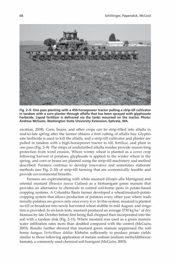
nication, 2008). Corn, beans, and other crops can be strip-tilled into alfalfa in mid-to-late spring after the farmer obtains a first cutting of alfalfa hay. Glypho-sate herbicide is used to kill the alfalfa, and a strip-till cultivator and planter are pulled in tandem with a high-horsepower tractor to till, fertilize, and plant in one pass (Fig. 2–9). The strips of undisturbed alfalfa residue provide season-long protection from wind erosion. Where winter wheat is planted as a cover crop following harvest of potatoes, glyphosate is applied to the winter wheat in the spring, and corn or beans are planted using the strip-till machinery and method described. Farmers continue to develop innovative and sometimes elaborate methods (see Fig. 2–10) of strip-till farming that are economically feasible and provide environmental benefits.
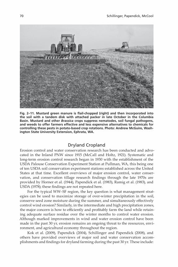
Farmers are experimenting with white mustard (Sinapis alba Martigena) and oriental mustard (Brassica juncea Cutlass) as a biofumigant green manure that provides an alternative to chemicals to control soil-borne pests in potato-based cropping systems. A Columbia Basin farmer developed a wheat/mustard–potato cropping system that allows production of potatoes every other year where tradi-tionally potatoes are grown only once every 4 yr. In this system, mustard is planted no-till or broadcast into newly harvested wheat stubble in mid August, and irriga-tion is provided. In on-farm tests, mustard produced an average 5730 kg ha−1 of dry biomass by late October before first being flail chopped then incorporated into the soil with a tandem disk (Fig. 2–11). Where mustard was used as a green manure water infiltration rates more than doubled compared with the control (McGuire, 2003). Results further showed that mustard green manure suppressed the soil-borne fungus Verticillium dahliae Klebahn sufficiently to produce potato yields similar to those following application of metam sodium (sodium methyldithiocar-bamate), a commonly used chemical soil fumigant (McGuire, 2003).
Fig. 2–9. One pass planting with a 450-horsepower tractor pulling a strip-till cultivator in tandem with a corn planter through alfalfa that has been sprayed with glyphosate herbicide. Liquid fertilizer is delivered via the tanks mounted on the tractor. Photo: Andrew McGuire, Washington State University Extension, Ephrata, WA.
The Pacific Northwest 69
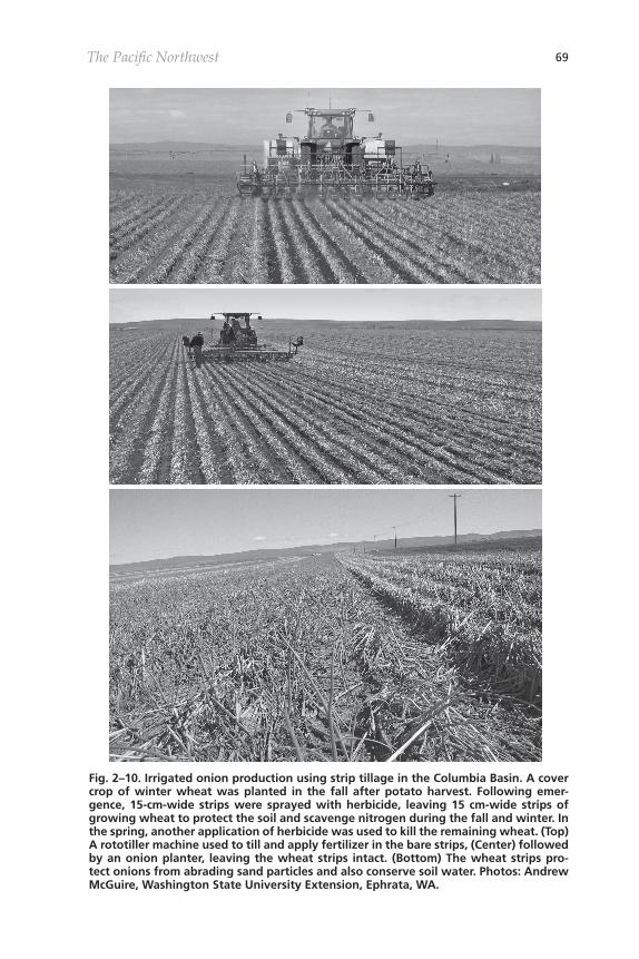
Fig. 2–10. Irrigated onion production using strip tillage in the Columbia Basin. A cover crop of winter wheat was planted in the fall after potato harvest. Following emer-gence, 15-cm-wide strips were sprayed with herbicide, leaving 15 cm-wide strips of growing wheat to protect the soil and scavenge nitrogen during the fall and winter. In the spring, another application of herbicide was used to kill the remaining wheat. (Top) A rototiller machine used to till and apply fertilizer in the bare strips, (Center) followed by an onion planter, leaving the wheat strips intact. (Bottom) The wheat strips pro-tect onions from abrading sand particles and also conserve soil water. Photos: Andrew McGuire, Washington State University Extension, Ephrata, WA.
70 Schillinger, Papendick, McCool
Dryland CroplandErosion control and water conservation research has been conducted and advo-cated in the Inland PNW since 1915 (McCall and Holtz, 1921). Systematic and long-term erosion control research began in 1930 with the establishment of the USDA Palouse Conservation Experiment Station at Pullman, WA, this being one of ten USDA soil conservation experiment stations established across the United States at that time. Excellent overviews of major erosion control, water conser-vation, and conservation tillage research findings through the late 1970s are provided by Horner et al. (1944), Papendick et al. (1983), Ramig et al. (1983), and USDA (1978); these findings are not repeated here.
For the typical WW–SF region, the key question is what management strat-egies can be used to maximize storage of over-winter precipitation in the soil, conserve seed zone moisture during the summer, and simultaneously effectively control wind erosion? Similarly, in the intermediate and high precipitation zones, the major concern is how to efficiently and profitably farm the land while retain-ing adequate surface residue over the winter months to control water erosion. Although marked improvements in wind and water erosion control have been made in the past 30 yr, erosion remains an ongoing threat to the resources, envi-ronment, and agricultural economy throughout the region.
Kok et al. (2009), Papendick (2004), Schillinger and Papendick (2008), and others have provided overviews of major soil and water conservation accom-plishments and findings for dryland farming during the past 30 yr. These include:
Fig. 2–11. Mustard green manure is flail-chopped (right) and then incorporated into the soil with a tandem disk with attached packer in late October in the Columbia Basin. Mustard and other Brassica crops suppress nematodes, soil fungal pathogens, and weeds to offer farmers effective and less expensive alternatives to chemicals for controlling these pests in potato-based crop rotations. Photo: Andrew McGuire, Wash-ington State University Extension, Ephrata, WA.
The Pacific Northwest 71
• Availability of affordable and effective nonselective herbicides such a glypho-sate to control weeds without tillage have made conservation-till and no-till practices possible and practical.
• Volunteer cereals and weeds serve as a disease “green bridge” for newly planted crops and therefore should be completely controlled before planting (Smiley et al., 1992).
• Integrated pest management research in the high-precipitation Palouse dem-onstrated that diverse 3-yr rotations of winter wheat–spring pea–spring cereal using conservation-till and no-till had less risk and were more profit-able than limited rotations using traditional tillage (D.L. Young et al., 1994; F.L. Young et al., 1994).
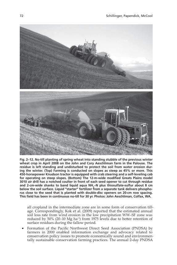
• Rapid advancement since the mid 1990s in development of no-till grain drills by several implement manufacturers allows precise seed and fertilizer place-ment in one pass through the field (Fig. 2–12) (Baker and Saxton, 2007). The land area under no-till increases each year in the intermediate and high pre-cipitation zones as farmers gain experience and confidence with this system, being yet further motivated by fuel savings and government farm programs that promote this practice.
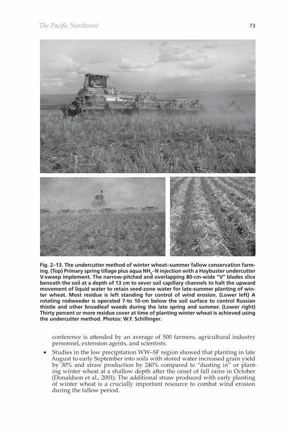
• Development of the undercutter method of WW–SF farming is a “win–win” for farmers and the environment. This method uses wide V-blade sweeps that cut beneath soil with minimum surface lifting or disturbance and simultaneously deliver nitrogen during primary spring tillage in April or May (Fig. 2–13, top), followed by as few as one noninversion rodweeding operation (Fig. 2–13, center) during the summer to control Russian thistle and other weeds. With the undercutter method, ample surface residue is retained during the 13-mo fallow period and after planting of winter wheat (Fig. 2–13, bottom) to reduce blowing dust emissions by up to 65% compared to traditional tillage fallow (Sharratt and Feng, 2009). There are no adverse effects on seed-zone water content or winter wheat grain yield (Schillinger, 2001) with the undercutter system, and it is more profitable (Zaikin et al., 2007) than traditional tillage. In 2006, the USDA-NRCS awarded the Wash-ington Association of Wheat Growers a $905,000 Conservation Incentive Grant to cover 50% of the cost of new undercutter implements to farmers wanting to practice this method of WW–SF farming. The undercutter sys-tem of WW–SF farming represents the future of wheat farming in the low precipitation zone.
• Long-term cropping systems research in the low-precipitation region showed that spring cereals—wheat, barley, oat, spring oilseeds (canola, yellow mus-tard, safflower), and recrop winter wheat (i.e., no fallow)—had highly variable grain yields, contained more weeds, and were generally less profitable than WW–SF (Schillinger et al., 2007; Bewick et al., 2008). Grain yield of spring-sown crops ranged from near failure to low when May and June rainfall was not ample, whereas winter wheat after summer fallow better tolerated or oth-erwise buffered drought during these two critical months (Schillinger et al., 2008). These factors notwithstanding, spring cropping, especially using no-till, provides excellent wind erosion control.
• The Revised Universal Soil Loss Equation (RUSLE2) developed with PNW parameters has become a basic tool for planning conservation farming prac-tices (McCool and Busacca, 1999).
• Runs of the RUSLE2 model by Kok et al. (2009) estimated that annual aver-age water erosion rates from 1975 to 2005 have been reduced by 50% (27–13 Mg ha−1) in the intermediate precipitation zone and by 75% (45–11 Mg ha−1) in the high precipitation zone. Traditional tillage dominated in 1975, but today more than half of the cropland in the high precipitation zone and essentially
72 Schillinger, Papendick, McCool
all cropland in the intermediate zone are in some form of conservation till-age. Correspondingly, Kok et al. (2009) reported that the estimated annual soil loss rate from wind erosion in the low precipitation WW–SF zone was reduced by 50% (20–10 Mg ha−1) from 1975 levels due to better retention of surface residues during the fallow period.
• Formation of the Pacific Northwest Direct Seed Association (PNDSA) by farmers in 2000 enabled information exchange and advocacy related to conservation policy issues to promote economically sound and environmen-tally sustainable conservation farming practices. The annual 2-day PNDSA
Fig. 2–12. No-till planting of spring wheat into standing stubble of the previous winter wheat crop in April 2008 on the John and Cory Aeschliman farm in the Palouse. The residue is left standing and undisturbed to protect the soil from water erosion dur-ing the winter. (Top) Farming is conducted on slopes as steep as 45% or more. This 450-horsepower Knudson tractor is equipped with crab steering and a self-leveling cab for operating on steep slopes. (Bottom) The 12-m-wide modified Greats Plains model 3010 air drill has a notched coulter in front of each seed opener to cut through residue and 2-cm-wide shanks to band liquid aqua NH3–N plus thiosulfate-sulfur about 8 cm below the soil surface. Liquid “starter” fertilizer from a separate tank delivers phospho-rus close to the seed that is planted with double-disc openers on 20-cm row spacing. This field has been in continuous no-till for 30 yr. Photos: John Aeschliman, Colfax, WA.
The Pacific Northwest 73
conference is attended by an average of 500 farmers, agricultural industry personnel, extension agents, and scientists.
• Studies in the low precipitation WW–SF region showed that planting in late August to early September into soils with stored water increased grain yield by 30% and straw production by 240% compared to “dusting in” or plant-ing winter wheat at a shallow depth after the onset of fall rains in October (Donaldson et al., 2001). The additional straw produced with early planting of winter wheat is a crucially important resource to combat wind erosion during the fallow period.
Fig. 2–13. The undercutter method of winter wheat–summer fallow conservation farm-ing. (Top) Primary spring tillage plus aqua NH3–N injection with a Haybuster undercutter V-sweep implement. The narrow-pitched and overlapping 80-cm-wide “V” blades slice beneath the soil at a depth of 13 cm to sever soil capillary channels to halt the upward movement of liquid water to retain seed-zone water for late-summer planting of win-ter wheat. Most residue is left standing for control of wind erosion. (Lower left) A rotating rodweeder is operated 7-to 10-cm below the soil surface to control Russian thistle and other broadleaf weeds during the late spring and summer. (Lower right) Thirty percent or more residue cover at time of planting winter wheat is achieved using the undercutter method. Photos: W.F. Schillinger.
74 Schillinger, Papendick, McCool
• Detailed soil and land use databases are presently being compiled on a grid basis that are compatible with the USDA-ARS Wind Erosion Prediction Sys-tem (WEPS) dust module for a regional modeling system that will greatly assist in the continuing effort to develop prediction technology for suspen-sion-dominated wind erosion.
• Global positioning satellites, auto-steering tractor systems, infrared remote sensing weed detectors, and related technology have provided a wealth of instrumentation to farmers. These instruments help to eliminate over-lap and skips with farm implements, reduce soil compaction by controlling traffic, allow variable rate application of fertilizer and “spot” treatment of individual weeds with herbicides, and other applications that increase farm efficiency and soil conservation.
Special Grants for Erosion Control ResearchExtensive research on water and wind erosion in the Inland PNW continues to be conducted by scientists from the University of Idaho, Oregon State University, Washington State University, and the USDA-ARS. Much of this research is made possible by long-term Special Grants authorized by Congress and administered by the USDA–Cooperative States Research and Extension Service.
Solutions to Environmental and Economic Problems (STEEP) is an interdisci-plinary research and education program for developing technology for profitable conservation cropping systems, controlling cropland soil erosion, and environ-mental protection. STEEP was initiated in 1975 with a major focus on controlling water erosion in the Palouse region. A team of innovative farmers and university and USDA-ARS scientists from the three states guide the effort. The main strat-egy is to shift away from moldboard plow-based tillage toward conservation-till and no-till methods. Numerous research and extension publications from STEEP are available online at http://pnwsteep.wsu.edu (verified 20 Oct. 2009) . Since its inception, funding for STEEP has averaged approximately $500,000 per year. Kok et al. (2009) estimated that the benefits of STEEP had extended over at least 2 mil-lion ha since 1975, at a cost of just $15 ha−1, or $0.5 ha−1 yr−1.
The Columbia Plateau PM10 Project (CP3) was initiated in 1992 by USDA-ARS and Washington State University scientists to develop practical and economically viable solutions for reducing wind erosion and dust emissions from irrigated and rainfed cropland and to assist farmers to implement control practices. Other goals were to research the mechanics of wind erosion and PM10 emissions and to develop prediction methods to quantify topsoil loss and effects on downwind air quality. Startup of the CP3 was driven by federal air quality mandates (see Air Quality Standards for Agricultural Dust section) that regulate airborne particu-lates 10 mm and smaller. More than 100 referred journal articles, plus extension bulletins and videos, have been published by CP3 scientists and extension per-sonnel; these are available online at http://pnw-winderosion.wsu.edu (verified 20 Oct. 2009). Major accomplishments of the CP3 are reported by Papendick (2004).
Needs for ResearchEconomics, risk reduction, and environmental concerns will likely continue to be the major factors driving policy, research, and farmers’ decisions in the future (Upadhyay et al., 2003). The increasing cost of fuel and other inputs in recent
The Pacific Northwest 75
years and the availability of environment-related income support by government farm programs such as EQIP favor the ongoing adoption of conservation-till, no-till, and precision farming methods. Priority research needs for soil and water conservation in Inland Northwest agriculture are:• Develop winter wheat cultivars for late planting (i.e., mid October or later) in
chemical summer fallow that can compete economically with early-planted wheat on conservation-till summer fallow in the low precipitation zone.
• Develop winter wheat cultivars with the ability to emerge in 7 to 10 d from deep planting depths of 15 cm or more in dry summer-fallowed soils. These soils often have very low water potential in the seed zone. Successful win-ter wheat plant establishment from late August to early September planting is presently a prerequisite for achieving the highest potential grain and straw production.
• Develop perennial wheat cultivars that can produce grain for several years before replanting is needed. Perennial wheat will be especially useful in soils with low crop production potential due to rockiness, shallow soil depth, or other limiting characteristics. Many such soils are presently enrolled in the Conservation Reserve Program, and perennial wheat would be a logical
“next step” for these lands.• Determine why wheat straw from different cultivars decomposes at differ-
ent rates and ultimately breed genotypes with high straw decomposition rates for the intermediate and high precipitation and irrigated regions and slow decomposition rates for the low precipitation zone. It has been known for years that wheat cultivars vary widely in straw decomposition rate. The rate of straw decomposition appears to involve the interaction of several fac-tors and compounds, including the content of hemicellulose, cellulose, lignin, tannins, and nitrogen, as well as the carbon/nitrogen ratio (Stubbs et al., 2009; A.C. Kennedy, personal communication, 2008).
• Develop precision agriculture technologies to allow farmers to make the most efficient use of fuel, fertilizer, herbicides, seed, and other inputs and to deliver inputs at controlled rates on steep topography.
• Maintain strong collaborative relations among research scientists, extension specialists and innovative farmers to develop and evaluate new conserva-tion-till, no-till, and precision agriculture technologies. Provide agency support for farmer-run conservation organizations such as the PNDSA and ensure continued active farmer membership on special research grant steer-ing committees such as STEEP and CP3.
• Develop a “soil conservation related” research effort for irrigated agriculture. The USDA-ARS and/or concerned land-grant universities should devote more resources for research on high residue farming in diverse irrigated cropping systems.
• Make sure that potential biofuel crops to produce ethanol, biodiesel, and combustible dry biomass can fit into cropping systems in an environmen-tally sustainable manner.
• Validate the RUSLE2 water and WEPS wind erosion models for Inland PNW conditions to improve prediction of water and wind erosion on the region’s diverse cropping systems, soils, and topography. Refine these models under different levels of residue cover, surface roughness, steepness of slopes, and soil types.
• Develop options for flexible and profitable cropping systems that maximize year-round surface cover and take advantage of special climatic conditions such as: (i) late-summer rains that may allow timely planting of alternative
76 Schillinger, Papendick, McCool
crops such as winter canola soon after cereal grain harvest in the intermedi-ate and high precipitation zones or (ii) greater than average over-winter soil water storage that will increase the likelihood of successful spring cropping in typical WW–SF areas.
ReferencesAhuja, L.R., O. David, and J.C. Ascough II. 2004. Developing natural resource models using the
object modeling system: Feasibility and challenges. Trans. 2nd Bienn. Meeting Int. Environ. Modelling and Software Soc., iEMSs. 14–17 June 2004. Osnabrück, Germany.
Ascough, J.C., II, C. Baffaut, M.A. Nearing, and D.C. Flanagan. 1995. Watershed model channel hydrology and erosion processes. p. 13.1–13.20. In D.C. Flanagan and M.A. Nearing (ed.) USDA Water Erosion Prediction Project: Hillslope profile and watershed model documenta-tion. USDA-ARS NSERL Rep. 10. USDA-ARS, West Lafayette, IN.
Baker, C.J., and K.E. Saxton. 2007. No-tillage seeding in conservation agriculture. 2nd ed. UN-FAO, CABI, Cambridge, MA.
Bewick, L.S., F.L. Young, J.R. Alldredge, and D.L. Young. 2008. Agronomics and economics of no-till facultative wheat in the Pacific Northwest, USA. Crop Prot. 27:932–942.
Busacca, A.J. 1989. Long Quaternary record in eastern Washington, U.S.A. interpreted from mul-tiple buried paleosols in loess. Geoderma 45:105–122.
Busacca, A.J., H.M. Marks, and R. Rossi. 2001. Volcanic glass in soils of the Columbia Plateau, Pacific Northwest, USA. Soil Sci. Soc. Am. J. 65:161–168.
Cook, K.V., L. Faulconer, and D.G. Jennings. 1996. A report on nitrate contamination of ground water in the mid-Columbia Basin. Wash. St. Interagency Ground Water Committee Publ. 96-17.
Donaldson, E., W.F. Schillinger, and S.M. Dofing. 2001. Straw production and grain yield relation-ships in winter wheat. Crop Sci. 41:100–106.
Ebbert, J.C., and M.H. Kim. 1998. Relation between irrigation method, sediment yields, and losses of pesticides and nitrogen. J. Environ. Qual. 27:372–380.
Feng, G., and B.S. Sharratt. 2005. Sensitivity analysis of soil and PM10 loss in WEPS using the LHS-OAT method. Trans. ASAE 48:1409–1420.
Feng, G., and B.S. Sharratt. 2007. Validation of WEPS for soil and PM10 loss from agricultural fields on the Columbia Plateau of the United States. Earth Surf. Processes Landforms 32:743–753.
Flanagan, D.C., J.C. Ascough, II, A.D. Nicks, M.A. Nearing, and J.M. Laflen. 1995. Overview of the WEPP erosion prediction model. p. 1.1–1.12. In D.C. Flanagan and M.A. Nearing (ed.) USDA Water Erosion Prediction Project: Hillslope profile and watershed model documentation. USDA-ARS NSERL Rep. 10. USDA-ARS, West Lafayette, IN.
Flanagan, D.C., and M.A. Nearing. 1995. USDA Water Erosion Prediction Project: Hillslope profile and watershed model documentation. USDA-ARS NSERL Rep. 10. USDA-ARS, West Lafay-ette, IN.
Foster, G.R., D.C. Flanagan, M.A. Nearing, L.J. Lane, L.M. Risse, and S.C. Finkner. 1995. Hillslope erosion component. p. 11.1–11.12. In D.C. Flanagan and M.A. Nearing (ed.) USDA Water Ero-sion Prediction Project: Hillslope profile and watershed model documentation. USDA-ARS NSERL Rep. 10. USDA-ARS, West Lafayette, IN.
Hagen, L.J. 1991. A wind erosion prediction system to meet user needs. J. Soil Water Conserv. 46(2):106–111.
Hammel, J.E., R.I. Papendick, and G.S. Campbell. 1981. Fallow tillage effects on evaporation and seed-zone water content in a dry summer climate. Soil Sci. Soc. Am. J. 45:1016–1022.
Horner, G.M., A.G. McCall, and F.G. Bell. 1944. Investigations in erosion control and reclamation of eroded land at the Palouse Conservation Experiment Station, Pullman, Wash., 1931–42. Tech. Bull. 860. USDA, Washington, DC.
Howell, T.A. 2001. Enhancing water use efficiency in irrigated agriculture. Agron. J. 93:281–289.
Jones, S.S. 2002. Wheat in the west. J. West 41:44–46.
Kennedy, A.C., and K.L. Smith. 1995. Soil microbial diversity and the sustainability of agricultural soils. Plant Soil 170:75–86.
Kjelgaard, J., D. Chandler, and K. Saxton. 2004. Evidence for direct suspension of loessial soils on the Columbia Plateau. Earth Surf. Processes Landforms 29:221–236.
Kok, H., R.I. Papendick, and K.E. Saxton. 2009. STEEP: Impact of long-term conservation farming research and education in Pacific Northwest wheatlands. J. Soil Water Conserv. 64:253–264 .
The Pacific Northwest 77
Kok, H., R. Papendick, K. Saxton, W. Pan, and R. Bolton. 2008. Planting date guide for win-ter wheat cover crops to control wind erosion in the Columbia Basin. Wash. St. Univ. Ext. Bull EB2030E.
Kunch, T.K. 2001. Radar assessment and GIS decision support of cover cropping in the Columbia Basin. M.S. thesis, Wash. State Univ., Pullman.
Leggett, G.E., H.M. Reisenauer, and W.L. Nelson. 1959. Fertilization of dry land wheat in eastern Washington. Wash. St. Agric. Exp. Stn. Bull. 602.
Lentz, R.D., and R.E. Sojka. 2000. Applying polymers to irrigation water: Evaluating strategies for furrow erosion control. Trans. ASAE 43:1561–1568.
Lin, C., and D.K. McCool. 2006. Simulating snowmelt and frost depth by an energy budget approach. Trans. ASABE 49:1383–1394.
Lin, C., D.K. McCool, D.C. Flanagan, and B.S. Sharratt. 2001. An energy budget approach to simu-late snowmelt and soil frost depth. p. 611–614. In J.C. Ascough and D.C. Flanagan (ed.) Proc. of the Int. Symp. on Soil Erosion Res. for the 21st Century, Honolulu, HI. 3–5 Jan. 2001. ASAE, St. Joseph, MI.
Lindsey, K., W. Burt, J. Porcello, D. Vlassopoulos, M. Karanovic, M. Nielson, and S. Loper. 2009. Basalt aquifer recharge, age, and water level in the Columbia Basin ground water manage-ment area of Adams, Franklin, Grant and Lincoln Counties, Washington. Columbia Basin Ground Water Management Area. A summary report to the Washington State Legislature.
McCall, M.A. 1925. The soil mulch in the absorption and retention of moisture. J. Agric. Res. 30:819–831.
McCall, M.A., and H.F. Holtz. 1921. Investigations in dry farm tillage. Bull. 164. Agric. Exp. Stn., State College of Washington, Pullman.
McCool, D.K., and A.J. Busacca. 1999. Measuring and modeling soil erosion and erosion damages. p. 23–56. In E.L. Michalson et al. (ed.) Conservation farming in the United States—The meth-ods and accomplishments of the STEEP Program. CRC Press, Boca Raton, FL.
McCool, D.K., C.D. Pannkuk, C.H. Lin, and J.M. Laflen. 1998. Evaluation of WEPP for temporally frozen soil. Paper 982048. 1998 Annual International Meeting ASAE. Orlando, FL. 12–16 July 1998. ASAE, St. Joseph, MI.
McDonald, E.V., and A.J. Busacca. 1988. Record of pre-late Wisconsin giant floods in the chan-neled scabland interpreted from loess deposits. Geology 16:728–731.
McGuire, A.M. 2003. Mustard green manures replace fumigant and improve infiltration in potato cropping system. Online. Crop Manage. doi:10:1094/CM-2003-0822-01-RS.
Meinig, D.W. 1968. The Great Columbia Plain: A historical geography, 1805–1910. Library of Con-gress catalog card 68-11044. University of Washington Press, Seattle.
Montgomery, J.A., D.K. McCool, A.J. Busacca, and B.E. Frazier. 1999. Quantifying tillage translo-cation and deposition rates due to moldboard plowing in the Palouse region of the Pacific Northwest, USA. Soil Tillage Res. 51:175–187.
NASS. 2008. Idaho, Oregon, and Washington statistics. National Agricultural Statistics Service, USDA, Washington, DC.
Pan, W., W. Schillinger, D. Huggins, R. Koenig, and J. Burns. 2007. Fifty years of predicting wheat nitrogen requirements in the Pacific Northwest USA. p. 10.1–10.6. In T. Bruulsema (ed.) Man-aging crop nitrogen for weather. International Plant Nutrition Inst., Norcross, GA.
Papendick, R.I. 1996. Farming systems and conservation needs in the northwest wheat region. Am. J. Alternative Agric. 11:52–57.
Papendick, R.I. 2004. Farming with the wind II: Wind erosion and air quality control on the Colum-bia Plateau and Columbia Basin. Special Rep. XB 1042 by the Columbia Plateau PM10 Project. Washington Agric. Exp. Stn., Pullman.
Papendick, R.I., M.J. Lindstrom, and V.L. Cochran. 1973. Soil mulch effects on seedbed tempera-ture and water during fallow in Eastern Washington. Soil Sci. Soc. Am. Proc. 37:307–314.
Papendick, R.I., and D.K. McCool. 1994. Residue management strategies—Pacific Northwest. p. 1–14. In J.L. Hatfield and B.A. Stewart (ed.) Crop residue management. Lewis Publishers. Boca Raton, FL.
Papendick, R.I., D.K. McCool, and H.A. Krauss. 1983. Soil conservation: Pacific Northwest. p. 273–290. In H.E. Dregne and W.O. Willis (ed.) Dryland agriculture. Agron. Monogr. 23. ASA, CSSA, and SSSA, Madison, WI
Paulitz, T.C., R.W. Smiley, and R.J. Cook. 2002. Insights into the prevalence and management of soilborne cereal pathogens under direct seeding in the Pacific Northwest, USA. Can. J. Plant Path. 24:416–428.
78 Schillinger, Papendick, McCool
Ramig, R.E., R.R. Allmaras, and R.I. Papendick. 1983. Water conservation: Pacific Northwest. p. 105–124. In H.E. Dregne and W.O. Willis (ed.) Dryland Agriculture. Agron. Monogr. 23. ASA, CSSA, and SSSA, Madison, WI
Rasmussen, P.E., and W.J. Parton. 1994. Long-term effects of residue management in wheat–fal-low: I. Inputs, yield, and soil organic matter. Soil Sci. Soc. Am. J. 58:523–530.
Renard, K.G., G.R. Foster, G.A. Weesies, D.K. McCool, and D.C. Yoder. 1997. Predicting soil erosion by water: A guide to conservation planning with the revised Universal Soil Loss Equation (RUSLE). Agric. Handb. 703. USDA, Washington, DC.
Saxton, K., D. Chandler, L. Stetler, B. Lamb, C. Claiborn, and B.-H. Lee. 2000. Wind erosion and fugitive dust fluxes on agricultural lands in the Pacific Northwest. Trans. ASAE 43:623–630.
Schillinger, W.F. 2001. Minimum and delayed conservation tillage for wheat–fallow farming. Soil Sci. Soc. Am. J. 65:1203–1209.
Schillinger, W.F., A.C. Kennedy, and D.L. Young. 2007. Eight years of annual no-till cropping in Washington’s winter wheat-summer fallow region. Agric. Ecosyst. Environ. 120:345–358.
Schillinger, W.F., and R.I. Papendick. 2008. Then and now: 125 years of dryland wheat farming in the Inland Pacific Northwest. Agron. J. 100(Suppl.):S166–S182.
Schillinger, W.F., S.E. Schofstoll, and J.R. Alldredge. 2008. Available water and wheat grain yield relations in a Mediterranean climate. Field Crops Res. 109:45–49.
Sharratt, B.S., and G. Feng. 2009. Windblown dust influenced by conventional and undercutter tillage within the Columbia Plateau, USA. Earth Surf. Processes Landforms 34:1323–1332.
Sharratt, B., G. Feng, and L. Wendling. 2007. Loss of soil and PM10 from agricultural fields associ-ated with high winds on the Columbia Plateau. Earth Surf. Processes Landforms 32:621–630.
Sharratt, B.S., and D. Lauer. 2006. Particulate matter concentration and air quality affected by windblown dust in the Columbia Plateau. J. Environ. Qual. 35:2011–2016.
Smiley, R.W., A.G. Ogg, Jr., and R.J. Cook. 1992. Influence of glyphosate on severity of rhizoctonia root rot and growth and yield of barley. Plant Dis. 76:937–942.
Sojka, R.E., D.L. Bjorneberg, J.A. Entry, R.D. Lentz, and W.J. Orts. 2007. Polyacrylamide in agricul-ture and environmental land management. Adv. Agron. 92:75–162.
Stetler, L.D., and K.E. Saxton. 1996. Wind erosion and PM10 emissions from agricultural fields on the Columbia Plateau. Earth Surf. Processes Landforms 21:673–685.
Stubbs, T.L., A.C. Kennedy, P.E. Reisenauer, and J.W. Burns. 2009. Chemical composition of residue from cereal crops and cultivars in dryland ecosystems. Agron. J. 101:538–545.
Sweeney, M.R., D.R. Gaylord, and A.J. Busacca. 2007. Evolution of Eureka Flat: A dust-producing engine of the Palouse loess, USA. Quaternary Int. 162:76–96.
Toy, T.J., G.R. Foster, and K.G. Renard. 2002. Soil erosion: Processes, prediction, measurement, and control. John Wiley and Sons, New York.
Upadhyay, B.M., D.L. Young, H.H. Wang, and P. Wandschneider. 2003. How do farmers who adopt multiple conservation practices differ from their neighbors? Am. J. Alternative Agric. 18:27–36.
USDA. 1978. Palouse cooperative river basin study. SCS; Forest Serv.; and Economics, Statistics, and Coop. Serv. USDA. U.S. Gov. Print. Office, Washington, DC.
U.S. OFR. 2006. National ambient air quality standards for particulate matter; proposed rule. Fed-eral Register (17 Jan.) 71:2619–2708. US Gov. Print. Office, Washington, DC.
Van Oost, K., G. Govers, S. de Alba, and T.A. Quine. 2006. Tillage erosion: A review of controlling factors and implications for soil quality. Prog. Phys. Geogr. 30:443–466.
Weinert, T.L., W.L. Pan, M.R. Moneymaker, G.S. Santo, and R.G. Stevens. 2002. Nitrogen recy-cling by non-leguminous winter cover crops to reduce leaching in potato rotations. Agron. J. 94:365–372.
Williams, J.D., S. Dun, D.S. Robertson, J.Q. Wu, E. Brooks, D.C. Flanagan, and D.K. McCool. 2010. WEPP simulations of runoff events from small drainages in Northeastern Oregon. J. Soil Water Conserv. (in press).
Wischmeier, W.H., C.B. Johnson, and B.V. Cross. 1971. A soil erodibility nomograph for farmland and construction sites. J. Soil Water Conserv. 26:189–193.
Wischmeier, W.H., and D.D. Smith. 1965. Predicting rainfall erosion losses from cropland east of the Rocky Mountains—A guide for selection of practices for soil and water conservation. Agric. Handb. 282. U.S. Gov. Printing Office, Washington, DC.
Wischmeier, W.H., and D.D. Smith. 1978. Predicting rainfall erosion losses—A guide to conserva-tion planning. Agric. Handb. 537. U.S. Gov. Printing Office, Washington, DC.

The Pacific Northwest 79
Woodruff, N.P., and F.H. Siddoway. 1965. A wind erosion equation. Soil Sci. Soc. Am. Proc. 29:602–608.
Wuest, S.B. 2001. Earthworm, infiltration, and tillage relationships in a dryland pea–wheat rota-tion. Appl. Soil Ecol. 18:187–192.
Young, D.L., T.J. Kwon, and F.L. Young. 1994. Profit and risk for integrated conservation farming systems in the Palouse. J. Soil Water Conserv. 49:601–606.
Young, F.L., A.G. Ogg, R.I. Papendick, D.C. Thill, and J.R. Alldredge. 1994. Tillage and weed man-agement affects winter wheat yield in an integrated pest management system. Agron. J. 86:147–154.
Zaikin, A.A., D.L. Young, and W.F. Schillinger. 2007. Economic comparison of undercutter and traditional tillage systems for winter wheat–summer fallow farming. Ext. Bull. EB2022E. Washington State Univ., Pullman.
Zuzel, J.F., R.R. Allmaras, and R.N. Greenwalt. 1982. Runoff and soil erosion on frozen soil in northeastern Oregon. J. Soil Water Conserv. 37:351–354.
Zuzel, J.F., and J.L. Pikul, Jr. 1987. Infiltration into a seasonally frozen agricultural soil. J. Soil Water Conserv. 42:447–450.