Embed Size (px)
Citation preview

SOEST Contribution to PacIOOSModeling Subgroup
Oceanography:
Paulo Calil
Glen Carter
Tommy Jensen
Yanli Jia
Doug Luther
Jim Potemra
Kelvin Richards
Meterology:
Steve Businger
Dave Chen
Ocean & Res Eng:
Kwok Fai Cheung

Nowcast estimates of upper ocean circulation
Nowcast and forecast estimates of wave/water
level
Forecast estimates of upper ocean circulation
Forecast estimates of atmospheric conditions
Synthesis of ocean observations via data
assimilation
Model-based productsUsers
• Search and rescue
• Ocean recreation
• Travel/transportation
• Wave/run-up/tracer models
• Weather forecasters
• Policy/planning
• Research community
Ocean circulation
Wave/water level
Atmosphere
Model Systems

1. Product Development: initial effortconstruction of regional nowcast maps of ocean circulation
based on daily downloads of operational models run by/at NRL Stennis– NLOM (3.4 km, 100m upper layer, 200m isobath, assimilates
SSH)– NCOM (14 km, 40-levels, 5m isobath, assimilates T/s from
NLOM/MODAS)
• Notes:– These models will be replaced by HYCOM (9 km) at the end of
2007 (mandate is end of FY08)– Will require DM/web work rather than modeling expertise– Can be done quickly and inexpensively– IPRC/APDRC activity leverage– Frees SOEST from operational responsibilities– Not ideal for tracer/trajectories nor research– ¼ FTE for technical support

Integration of three locally-run modeling subsystems: atmosphere (MET), ocean circulation (IPRC), wave/water level (ORE)
• Wave model up and running; already operational
• Atmospheric model up and running; already operation; not ideal model
• Ocean model(s) under development
2. Product Development: local model

Wave model system
Wave Watch 3
Global, 1x1 degree
Wave Watch 3
Regional, 10x10 km
SWAN
Island-region, 100x100 m
Upper-ocean currentsAtmospheric forcing
Wave and water levels
RSM/MSMIsland-domain 1x1 km
(Chen/Businger)
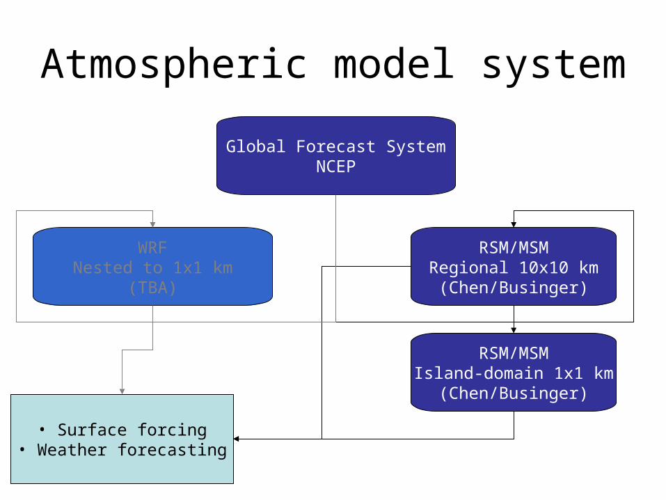
Atmospheric model system
Global Forecast SystemNCEP
RSM/MSMRegional 10x10 km
(Chen/Businger)
• Surface forcing• Weather forecasting
WRFNested to 1x1 km
(TBA)
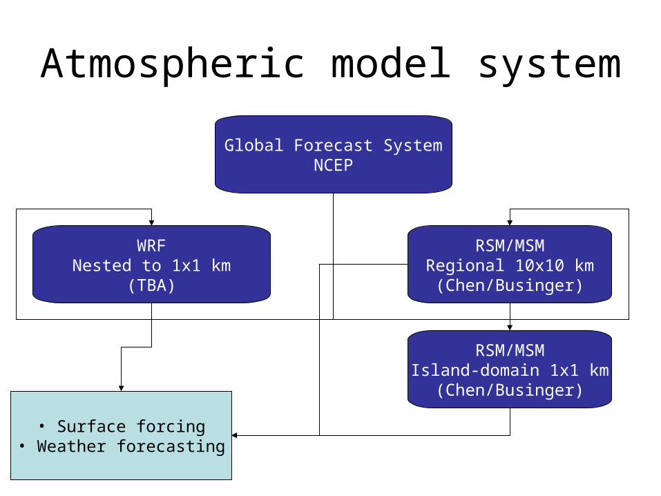
RSM/MSMIsland-domain 1x1 km
(Chen/Businger)
Atmospheric model system
Global Forecast SystemNCEP
RSM/MSMRegional 10x10 km
(Chen/Businger)
• Surface forcing• Weather forecasting
WRFNested to 1x1 km
(TBA)

Regional (125x125 m) POMIPRC (Jensen)
Ocean model systemGlobal HYCOM
NRL
Regional (5x5 km) HYCOMIPRC (Jia)
• Ocean currents• Sea level• Transports• Synthesized observations• Research activities
Surface forcingMET
ObservationsPacIOOS/DMAC
Regional (variable) ROMSIPRC (TBA)

Regional (125x125 m) POMIPRC (Jensen)
Ocean model systemGlobal HYCOM
NRL
Regional (5x5 km) HYCOMIPRC (Jia)
• Ocean currents• Sea level• Transports• Synthesized observations• Research activities
Surface forcingMET
ObservationsPacIOOS/DMAC
Regional (variable) ROMSIPRC (TBA)
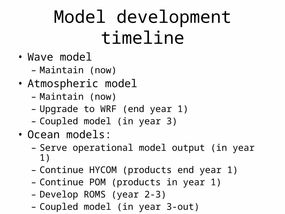
Model development timeline
• Wave model– Maintain (now)
• Atmospheric model– Maintain (now)– Upgrade to WRF (end year 1)– Coupled model (in year 3)
• Ocean models:– Serve operational model output (in year 1)– Continue HYCOM (products end year 1)– Continue POM (products in year 1)– Develop ROMS (year 2-3)– Coupled model (in year 3-out)

Ocean models
• Serving operational model– Immediate -- Insufficient resolution– Run elsewhere
• Continue regional models– Experience -- Need resources– Underway -- Not yet operational– Experiments -- Rely on atm and global model– Research capable– Tracer/trajectories– Configurable

Ocean models, cont’d• HYCOM
– Fits global model -- Expensive– Experience -- Rely on NRL– Advanced physics -- Small user base
• POM– Experience -- Few modules– Large user base -- BC’s– Efficient -- Very small
domain• ROMS
– Large user base -- Not yet tested here– Many modules -- BC’s– Easy to configure– Used in other regions

Model Personnel Months/year $K/year
Atm model programmer/tech/pdoc 12/12/12 90/90/90
TOTAL 90/90/90
Wave model programmer/tech/pdoc 12/12/12 90/90/90
TOTAL 90/90/90
Ocean model
HYCOM Jia (model devel) 03/02/02 45/30/30
Yaremchuk (data assim) 02/02/01 30/30/15
Potemra (man/eval) 01/01/01 15/15/15
POM Jensen (model devel) 03/02/02 45/30/30
Potemra (man/eval) 01/01/01 15/15/15
ROMS prog/tech/pdoc (model devel) 12/07/05 60/35/25
Yaremchuk (data assim) 01/02/01 15/30/15
Potemra (man/eval) 01/01/01 15/15/15
TOTAL 240/200/160

Resources, cont.’d
Year 1 Year 2 Year3Ocean model240 200 160Atm model 90 90 90Wave model 90 90 90Equipment1,2 120 0 40
1. LOI listed equipment under Ocean model2. Cluster/disks in yr1, upgrade to disks yr2

Miscellaneous Concerns
• Rely critically on DM component for data storage and transport
• Rely on linkages for product development (DM group?)
• Model evaluation• Integrate research activities• Determine necessary and sufficient grid
spacing, domain boundary (balance with runtime)


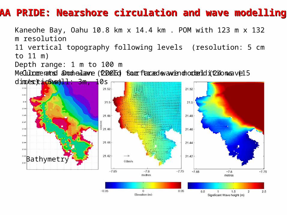
NOAA PRIDE: Nearshore circulation and wave modellingNOAA PRIDE: Nearshore circulation and wave modelling Kaneohe Bay, Oahu 10.8 km x 14.4 km . POM with 123 m x 132 m resolution11 vertical topography following levels (resolution: 5 cm to 11 m)Depth range: 1 m to 100 m Mellor and Donelan (2006) surface wave model (24 wave directions)
Currents and wave field for trade wind conditions (15 m/s). Swell: 3m, 10s
Bathymetry

Comparison with tidal data
HYCOM dx=0.08o
OfES (Qscat) dx=0.10o
HYCOM dx=0.04o
OfES (ECMWF)dx=0.10o
NLOM (NCEP)dx=0.06o

Comparison with T/P data
HYCOMdx=0.08o
OfES (ECMWF) dx=0.10o
OfES (Qscat) dx=0.10o
HYCOMdx=0.04o
rms SSH variance(2o horizontal smoothing)
T/P data
HYCOM.04

Comparison with CTD data (HOT2 station)

Cross-validation of the models using SSH
MIT GCM, ‘93-’97, [Lee et al., 2002]
Model-data correlations


![Cardiff University Financial Statements · Corporate Governance Statement 7 Public Benefit Statement 8 ... Mr G Clarke [resigned 31 July 2016, replaced by Judge Ray Singh] Mr R Calil](https://img.pdfslide.us/doc/110x75/5f3d4781f122b343181ae1cc/cardiff-university-financial-statements-corporate-governance-statement-7-public.jpg)