Embed Size (px)
Citation preview

Social Assessment of Landin Cambodia
A Field Study
Working Paper 20
CAMBODIA DEVELOPMENT RESOURCE INSTITUTEWorkingPaperNo. 20
So Sovannarith, Real Sopheap, Uch Utey, Sy RathmonyBrett Ballard and Sarthi Acharya
ISSN 1560-9197


Social Assessment of Land in CambodiaA Field Study
Working Paper 20
So Sovannarith, Real Sopheap, Uch Utey, Sy RathmonyBrett Ballard and Sarthi Acharya
Cambodia Development Resource InstitutePhnom Penh, November 2001
Copyright © 2001 Cambodia Development Resource Institute
All rights reserved. No part of this publication may be reproduced, stored in a retrieval system ortransmitted in any form or by any means—electronic, mechanical, photocopying, recording, orotherwise—without the written permission of the Cambodia Development Resource Institute.
ISSN 1560-9197
Social Assessment of Land in Cambodia: A Field Study — Working Paper 20
November 2001
So Sovannarith, Real Sopheap, Uch Utey, Sy Rathmony, Brett Ballard, Sarthi Acharya
Responsibility for the ideas, facts and opinions presented in this research paper rests solely with theauthors. Their opinions and interpretations do not necessarily reflect the views of the CambodiaDevelopment Resource Institute.
Cambodia Development Resource Institute
56 Street 315, Tuol Kork, Phnom Penh (Postal address: PO Box 622, Phnom Penh, Cambodia)
Tel: (855-23) 881-701/881-916/883-603 Tel/Fax: (855-23) 880-734
e-mail: [email protected] website: http://www.cdri.org.kh
Layout: Oum Chantha and Em Sorany
Printed and bound in Cambodia by Japan Printing House, #74, Street 99, Phnom Penh

Contents
Acknowledgements ................................................................................................... iAcronyms and Abbreviations.................................................................................... iiiExecutive Summary. .................................................................................................1
Chapter One. Introduction..................................................................................................51.1. The Intent..........................................................................................................51.2. The Background and Need for This Study ...........................................................51.3. The Objectives...................................................................................................61.4. Methodology......................................................................................................71.5. Layout of the Paper ...........................................................................................8
Chapter Two. The Land Situation in Cambodia ..................................................................92.1. Theoretically Locating the Land Situation.............................................................92.2. A Brief History of Land in Cambodia ................................................................ 102.3. Some Critical Concerns in the Present Land Situation......................................... 112.4. Summing Up.................................................................................................... 14
Chapter Three. The Land Situation ................................................................................. 153.1. Land Use Patterns ........................................................................................... 153.2. Land Transfers/Acquisition .............................................................................. 163.3. Land Titling/Certificates .................................................................................. 183.4. Gender Aspects in Land Use and Ownership .................................................... 203.5. A Word About Population and Resource Balance .............................................. 203.6. Summing Up ................................................................................................... 21
Chapter Four. The Governance Structure of Land .......................................................... 234.1. Introduction ..................................................................................................... 234.2. The Titling System .......................................................................................... 234.3. What Is a Title? .............................................................................................. 254.4. Problems Faced by the Authorities in Land Titling and Registration .................... 274.5. Capacities ....................................................................................................... 304.6. Summing Up ................................................................................................... 30

Chapter Five. Conflicts and Conflict Resolution Mechanisms ........................................ 335.1. Introduction ..................................................................................................... 335.2. Land Conflicts ................................................................................................ 335.3. Land Dispute Resolution .................................................................................. 365.4. Observations ................................................................................................... 385.5. Summing Up .................................................................................................. 41
Chapter Six. Policy and Recommendations ....................................................................... 436.1. Introduction ..................................................................................................... 436.2. Titling Land According to the Law and Sequencing the Activities........................ 436.3. Strengthening and Decentralising Land Governance Authorities ......................... 456.4. Resolving Disputes.......................................................................................... 466.5. Framing a New Relocation and Habitation Policy............................................... 476.6. Recognising Indigenous People’s Rights ........................................................... 486.7. Recognising Women's Rights ............................................................................ 496.8. Following Best Practices .................................................................................. 506.9. Financing the Land Titling Process .................................................................... 516.10. Generating Data and Information and Spreading Education on Land Issues ........ 52
Chapter Seven. Concluding Observations ....................................................................... 53
Case studies ....................................................................................................... 551. A Case Study of Kampong Pring Village in Kandal Province................................ 552. A Case Study of Kampong Thnoat Village in Kampot Province ........................... 583. A Case Study of Baboang Village in Prey Veng Province .................................... 624. A Case Study of Village 4 in Kampong Speu Province ......................................... 655. A Case Study of Phum Psak and Ta-orng villages in Rattanakiri Province ............. 696. A Case Study of a Squatter Settlement in Sangkat Tonle Bassac in
Khan Chamkar Mon, Phnom Penh...................................................................... 727. Synopsis of the Proceedings of the Stakeholders’ Seminar:
Urban Land Settlements .................................................................................... 75
A Guide to Conducting Qualitative Interviews .................................................. 79
References ......................................................................................................... 89
CDRI Working Papers ...................................................................................... 91

i
Acknowledgements
The Cambodia Development Research Institute thanks the Ministry of Land Management,Urban Planning and Construction, Royal Government of Cambodia, for the invaluableopportunity it provided to conduct this study. The study was funded by the World Bank'sPolicy and Human Resource Development project preparation facility with a grant from theJapanese Government.
This study was conducted primarily with the co-operation of the ordinary people ofCambodia, including: farmers, labourers, migrant workers, indigenous peoples, women, the so-called illegal occupants of land, and many other groups who we met in villages, roadsides andlow income urban settlements. Without their enthusiasm and eagerness to provide us theirtime, most information would not have been possible to collect. We thank them first. At thevillage level, the chiefs were most helpful, and at the communes, the respective chiefs andtheir staff members were very obliging.
The district level, which provided us the otherwise missing meso level information, wascritical to the study. Staff members of the Ministry Land Management, Urban Planning andConstruction offices and members of land dispute settlement processes, including the districtchiefs and deputy chiefs, were most helpful in providing replies to our queries. They alsoprovided us with critical details of each area in their district, which was beneficial for finalisingour sample villages. Provincial officials of the ministries of land management, agriculture, andrural development, departments of tax, and chief/deputy chiefs of courts, were enthusiastic inproviding us with answers to all the questions that we asked. Finally, members of the landdispute settlement commissions, including at times, the deputy governors, found time to sharetheir experiences and difficulties with us.
Officials in the Municipality of Phnom Penh, districts and communes, not only helped uswith information about the city, they also spent a full day in a Stakeholders’ Workshop to sharetheir observations on the land issue in urban areas. Special thanks are to H.E. Chev KimHeng, Deputy Governor of Phnom Penh, who participated in the seminar.
Thanks are due to the Ministry of Land Management, Urban Planning and Constructionfor also having lent the services of two of their staff members, Uch Utey and Sy Rathmony,who worked as a part of the team. Ms. Mary Judd of the World Bank provided comments onthe interim and first drafts of the paper. Dr. Ou Vuddy of the Ministry of Land Management,Urban Planning and Construction was helpful all along. The Chief of the Central CadastralOffice, H.E. Sek Setha introduced us to technical details of titling. H.E. Ty Yao and Mr. SarSovan charted the broader course of the study, without which it would not have been possibleto proceed beyond the first chapter. H.E. Im Chhun Lim provided the initial direction that theMinistry of Land Management, Urban Planning and Construction aimed to pursue for titling all

Social Assessment of Land in Cambodia Working Paper 20
ii
land in the Kingdom. The team also acknowledges the representatives of GTZ and FinnMapfor sharing their insights in regard to systematic titling.
This study would not have been possible to conduct without the constant direction thatthe team received from Ms. Eva Mysliwiec, Director CDRI, in the initial design stage,fieldwork as well in the drafting of this document. Her experience and insights, and hercomments on earlier as well as later drafts, permitted us to complete the study in as few aseight weeks.
Phnom Penh, October, 2001So Sovannarith, Uch Utey, Sy Rathmony,
Brett Ballard and Sarthi AcharyaCambodia Development Resource Institute

iii
Acronyms and Abbreviations
AcronymsACLEDA Association of Cambodian Local Economic Development AgenciesCDRI Cambodia Development Resource InstituteDLMUPCC Department of Land Management, Urban Planning,
Construction and CadastreFinnMap Finnish agency in CambodiaGTZ German Agency for Technical Co-operationILO International Labour OrganisationLDSC Land Dispute Settlement CommissionMLMUPC Ministry of Land Management, Urban Planning and ConstructionMRC Mekong River CommissionNGO Non-Governmental OrganisationNTFP Non-Timber Forest ProductsOLMUPCL Office of Land Management, Urban Planning, Construction and LandPET Protracted Emergency TargetingRCG Royal Cambodian GovernmentSES Socio-economic SurveySida Swedish International Development AgencyUNICEF United Nations Children’s FundUNTAC United Nations Transitional Authority in CambodiaVDC Village Development CommitteeWFP World Food Programme
Non-English WordsSangkat : an administrative territorial subdivision equivalent to a commune.
Sangkat is used in provincial town or city, eg. Sangkat Tenle BassacKhan : an administrative territorial subdivision equivalent to a district.
Khan is used in provincial town or city, eg. Khan Chamkar MonChamkar : Land which is used for growing crops other than rice.Krom Samaki : ‘Solidarity groups’ formed during the 1980s as a form of collective farming.


1
Executive Summary
The Royal Government of Cambodia has embarked upon a reform agenda designed topromote sustainable economic and social development, poverty alleviation, and peace. As aprelude to the titling project, the government decided to first conduct a social assessment ofland in order to obtain a report on the ground situation concerning, land control, conflicts, andthe capacity of different authorities to effectively and efficiently govern land rights. The mainobjectives of this social assessment are to (1) identify the different stakeholders of land andthe project, (2) examine the social and institutional capacity at the local level for governing landrights, (3) forecast possible negative impacts of the project, and (4) make relevant policyrecommendations.
The study is qualitative in nature and has relied primarily on five case studies conductedin five villages, each from the Kandal, Prey Veng, Kampot, Kompong Speu, and Rattanakiriprovinces, as well as one urban case study in Phnom Penh. Each of the village studiesrepresents a different agro-ecological zone, while the Phnom Penh study focuses on squattersettlements. However, the study may not be representative of the whole country. Variousqualitative methods such as small group discussions and individual interviews with farmers,migrants, demobilised soldiers, women’s groups, and local officials were used to develop thesecases. The research team also interviewed personnel from the land management departmentsat the provincial and district levels, the provincial land dispute settlement commissions, chiefjudges at provincial courts, tax department officials, as well as village, commune, and districtchiefs. In Phnom Penh, a daylong seminar involving municipal officials and NGOs wasorganised to elicit information on land issues in the city. Interviews were also held withofficials in the Central Cadastral Office. All observations are based on responses from fieldinterviews.
Cambodia privatised lands in 1989 and it is widely believed that there was a fairdistribution of both agricultural and residential lands at that time. All those whose mainoccupation was agriculture received land according to household size. However, due toinadequate financial and human resources, a complete mapping and titling of land could nottake place at that time. People therefore continued to rely on local traditions and customs togovern land rights according to the productive use of land. In the last decade, there have beensignificant socio-economic changes (e.g. refugee repatriation, the advent of markets andurbanisation, increased population growth) that have placed varied demands on land. As aresult, the composition of stakeholders in land has emerged rather unevenly. Following the lawof the market, maximum demands have been placed on commercial lands, roadside lands,productive lands, urban lands, and the like. People who have not been able to adapt to suchchanges have not benefited from this process, and in many cases have actually been adverselyaffected. These people include the most vulnerable segments of the population (e.g. the rural

Social Assessment of Land in Cambodia Working Paper 20
2
poor, women heads-of-households). There are at least five major problems that requireattention: (1) inequality in land holdings, (2) landlessness, (3) insecure tenancy, (4) landconflicts, and (5) encroachment on urban lands by squatters.
Land use patterns have changed dramatically, particularly in locales characterised byhigh commercialisation. Such changes have been linked to increasing demand by more diversegroups of interests, including private companies and state institutions, as well as individuals inpositions of authority, such as government officials and military personnel. The demand forland has also increased among the peasantry because of accelerated land atomisation andrestrictions placed on their access to forest and fishing resources. Such changes in land usepatterns have also been accompanied by a corresponding shift in people’s perceptions of landrights. Two practices of ownership and control are now rapidly emerging as more and moreland is acquired by people and institutions from outside the local community for purposes otherthan subsistence farming. Land use rights are recognised locally by people within the peasantcommunity according to traditions and customs, while ownership rights are recognised bypeople from outside the community according to the formal law and procedures laid-down bythe state. More than one mode of land ownership and control is not harmonious because thereis a frequent interface between the two modes in which more powerful parties are able to takeadvantage of those who are more vulnerable. In this sense, people routinely seek venues andemploy procedures that promote their own self-interests.
Land markets are most active in areas situated along roads and near urban or marketcentres. In such areas, the demand for formal land claims (i.e. titling deeds) is high in order tofacilitate transfers, clarify land boundaries, and avoid disputes. However, due to the high costsof land titles – mainly in the form of unofficial payments – many land transactions are routinelyfacilitated at the lower levels of the administration through an exchange of application receiptsor written contracts between buyers and sellers, which are not necessarily tenable in law.Only people with adequate financial resources and/or political access are able and willing toobtain proper land certificates. In areas characterised by subsistence farming systems awayfrom roads and urban/market centres, people either rely on receipts or local/community basedsocial institutions for validating use rights to certain areas of land. However the demand forwritten documentation in these areas is also increasing because people wish to ensure asmooth process of succession and land transfer to their offspring.
A complex hierarchy of government officials and elected representatives governs land.An application for making certificates goes through at least 8-10 offices, spread across thevillage, commune, district, province and the national capital. Inquiries and land measurementstake enormous time, a process also lengthened for want of proper (human and physical)resources. For one, most rural people, farmers and non-farmers alike, are not well versed withthis governance system. They would prefer to avoid the system in favour of local traditionsand customs and deal only with local institutions. There are, however, some people who avoidthe formal system in order to avoid paying genuine taxes as well. Next, the duality of systemsof land control not only co-exists, actors within the government itself, particularly at the lowerlevels (e.g. village and commune chiefs) are party to perpetuating it. Different stakeholdersunderstand land titles differently, and even the guardians of the law themselves, the courts anddispute settlement mechanisms, do not have a clear and consistent understanding of the lawand rules. The de facto sanction extended to different practices of governance of land hasensured that the actual law is never fully implemented. The ambiguity in rules and multiplicityof practices in land transactions has also contributed to increasing corruption, which isexacerbated by the unrealistic remuneration structure provided to government staff. In manyareas, a proper certificate may cost up to US$300-400, almost all in the form of unofficialpayments to officials and representatives spread across different departments. Predictably, thepoor rarely, if ever, obtain the right papers because they have neither the support of the lawnor the resources to by-pass the law. Women are especially vulnerable in this regard sincethey tend to have less access to and control over resources with which to advocate for theirown rights.
Cambodia Development Resource Institute Executive Summary
3
The frequency and nature of land disputes is also increasing as more diverse interestscompete for land resources. More land disputes now involve village people and people fromoutside the local peasant community, including private companies and state institutions, andincreasingly require more formal institutions for resolution. Any new land titling effort willgenerate more demand for dispute resolution, involving both formal and traditional community-based governance mechanisms at all levels. Such an increase would, in all likelihood,overwhelm a state-machinery that is already falling behind on its caseload. The mostsignificant constraints in terms of the capacity to handle an increased volume of cases arerelated to inadequate financial and human resources, including technical training in the law andprocedures. At the same time, the land dispute settlement commissions and provincial courtsare currently perceived by many people, particularly those in rural communities, to beinherently unfair in terms of a structural bias that favours those with more resources andaccess to power, while precluding the full and equal participation of disadvantaged groups (e.g.the poor, women, and indigenous people). Part of the problem regarding people’s faith in thesystem is related to inadequate information about and understanding of the laws andprocedures governing property rights. The crisis of confidence in the dispute resolutionprocess, as it is currently structured and practised, represents a significant problem of goodgovernance.
Some of the principal recommendations are listed below:
Titling land by the law and sequencing of activities: Irregularities in land controlshould be settled in accordance with the new law before titling takes place. The same rulesshould apply to individuals, companies and other entities as well as government authorities. Thenew titling programme should also sequence the titling process. A suggestive approach is:residential land first, followed by agricultural land (rice) land, then chamkar (non-rice crop,cash crop) land, and thereafter public land such as beaches, forests, pathways, and roads. Thelogic of such sequencing follows the principle that the shelter and livelihoods of the poor shouldbe the first priority.
Strengthening decentralised land governance: The law should be unambiguous andimplemented at a decentralised level, with a view to ensuring that all procedures aretransparent, speedy, and affordable for all people. The current system of land titling andregistration should be decentralised. If possible, the district should be the terminal point ofregistration given its close proximity to the local level. Strengthening the capacity of localauthorities and creating village/commune level committees, perhaps with NGO participation, isa necessary component of such a decentralisation exercise. In order for the titling programmeto proceed, all previous transactions should be validated and upheld as long they have notimpinged on the rights and interests of the weaker segments of society.
Resolving disputes: All land dispute cases should be resolved in a way that isconsistent with the spirit and intent of the relevant laws governing land rights. The disputeresolution process should be decentralised so that it corresponds with the land titling process.Maximum effort should be made to settle cases with local/community-based mechanisms,including those cases that involve government authorities and companies. The authority of thevillage/commune leaders should be upheld to the utmost. Cases that cannot be resolved at thelocal level should follow clear paths of appeal. The membership of the dispute settlementcommittees should be non-partisan and entirely civilian. More financial and human resources,including training, must also be allocated at the local level.
Framing a new relocation and habitation policy: An effort to settle internallydisplaced people, landless, and urban migrants can help strengthen peace and stability as wellas alleviate poverty. There are enough land resources in rural areas to meet the needs of thelandless. There is also urgent need to relocate and/or regularise the present illegal settlementsin Phnom Penh. A more innovative relocation and habitation policy must be put in place, whichstrikes a reasonable and fair balance between the needs and interests of these people and thelong-term development objectives of the city.

Social Assessment of Land in Cambodia Working Paper 20
4
Recognising indigenous people’s rights: A reasonable approach must be devisedthat protects indigenous people’s traditional access to, and control over, communal land, whilemeeting the broader development objectives of the state that are designed to promote betterstandards of living in such areas. Communal land titling procedures will require the activecollaboration of both the public and private sector, including NGOs that have relevantexperience in these areas.
Recognising women's rights: Special efforts must be directed at strengtheningwomen's access to land ownership and dispute resolution. Legal codes are urgently requiredthat ensure women's rights to a fair and equitable division of land in the event of divorce andinheritance. Women must also have some legal guarantees that ensure their access to fair andimpartial dispute resolution. There is a need for active collaboration between the governmentand civil society organisations to provide women with information about their rights in thecontext of the new land law, as well as provide support to enable women to advocate for theirrights.
Following best practices: There are successful titling experiences from outside andwithin the country, which offer lessons for the new titling programme. The government’ssystematic titling programme, assisted by GTZ and the Finnish government, uses aerialmapping to produce exact pictures of demarcated land. Not only is this approach moreefficient, it is cheaper as well. The project has used approaches like holding village meetings toresolve boundary disputes, in addition to other consultations. It would be useful to evaluate theextent to which this approach can be replicated on a larger scale.
Financing land titling processes: The operational budgets for all levels of theadministration involved with land titling should be strengthened through inter-governmentaltransfers and supplemented with revenue collected from user-fees. The fees should beuniform for all people and should be published. A tax on land sales and transfers of ownershipshould be paid before any transaction is approved. Companies and individuals who haveacquired more than five hectares of land should pay a tax based on a higher percentage of thesale value of land.
Generating data and disseminating information on land rights: The creation of abureau of statistics to serve all ministries and departments is a useful step in strengthening thedatabase of the economy. This bureau can also collate and reconcile data produced bydifferent ministries, in addition to collecting its own data. People must know and understandthe law and the different rules, procedures, sub-decrees and clauses that are enacted fromtime to time. The use of television and radio can be especially useful since these media areoften found in even the most remote corners of the country.

5
Chapter One
Introduction
1.1. The Intent
The Royal Government of Cambodia has embarked upon a reform agenda designed toachieve sustainable economic and social development, poverty alleviation and peace. TheLand Policy Framework is one of the most important policy initiatives in this agenda, whichincludes accelerated land titling, establishing a legal framework to enforce property rights,and setting up territorial master plans and zoning rules. A new land law that will supersedethe earlier one of 1992 has been drawn up and approved by the National Assembly.1 Acomprehensive project for titling and registration of land is being undertaken as a part of theland policy. This paper makes a social assessment of the land situation, with the purpose ofinforming the project.
1.2. The Background and Need for This Study
Cambodia’s agricultural sector is among the least developed in Asia, and its land and labourproductivity is perhaps the lowest in Southeast Asia. With a yield in the range 1.3-1.5 tonnesof rice per hectare that has remained unchanged for decades,2 it is becoming increasinglydifficult to maintain secure livelihoods in the countryside where over three-fourths ofCambodians dwell. The natural population growth rate is over 2.5 percent per annum andthere has been virtually no occupational diversification away from agriculture occurring, evenin recent years when the economy has shown some buoyancy.3 The pressures on the primarysector to yield more and broaden its activity base are thus very high. 4 Cambodia was once arice-self-sufficient and food-exporting country; it is now a net food importer. Many people, inas many as 350 communes out of about 1,600, are dependent on multilateral food-aidprogrammes. The problems described here lend credence to the need for a land programme topromote food security, in addition to creating an administrative and legal framework forachieving peace and justice.
1 A concise statement of recent events and intents on land policy can be seen in Sida (2000). The
word ‘land’ is used here to cover all types of land, including agricultural and residential.2 While there was some positive trend observed in the 1990s, a long-period comparison shows that similar
levels of productivity existed as early as in the 1960s.3 There are some 130,000 workers engaged in the garment industry, which began to develop in the mid-
1990s. According to CDRI studies, the impact of this industry on the structure of the labour force hasbeen minimal.
4 This problem is best illustrated by the fact that despite rapid growth in the economy for several years inthe 1990s, its impact on poverty was, at best, minimal. For elaboration, see Acharya (2001) and Godfreyet al (2001).

Social Assessment of Land in Cambodia Working Paper 20
6
A sketch of the contemporary land situation is a useful starting point. Cambodia’soverall land area is estimated at 18 million hectares, including about 8 million hectares givenout in the form of land concessions, about 3.3 million under protected forests, and about 2.7million under cultivation (mainly rice)5. The rest of the land is comprised of scrubland, waterbodies, undulating terrains, unused land, urban areas and mine-affected land. Demarcation ofland by ownership and use, at the broad, country level as well as at individual plot level, ismore usufructory than formal, particularly in rural areas. There is neither a large-scalearticulation of private property guaranteed by the state and law, nor do cadastral maps anddemarcation details exist, other than for very small areas. The system of use rights workedwell when the population of the country was about 4-5 million and living in relative isolation.Most other countries having a history of land systems similar to Cambodia’s developed asystem of formal property rights during the later half of the 20th century. This came aboutthrough modernisation and gradual adaptation of the market economy. Cambodia, however,missed this process because the country was at war for almost three decades. In the early1990s, the country was suddenly exposed to the market economy and the global economicenvironment without being adequately prepared6. As a result, there are few regulatory andcontrol mechanisms in place, which are a prerequisite for a market economy to functionefficiently. In fact, their absence has been a significant obstacle for both the private sector andfor the populace at large. This is a potential source of social strife, which most peopledesperately want to relegate to the past. The need to bring land under a comprehensiveadministrative-cum-legal framework is thus a very high priority.
As of now, several types of land control systems co-exist. Many people, after theirdisplacement in the earlier decades, are still looking for land. Also, new families are beingformed due to the rapid population growth in the 1980s. Keeping these factors in mind, it isimperative for the authorities to make a comprehensive land measurement, titling andregistration process a priority, while taking all stakeholders of land as partners. Since propertargeting of land title and registration activities, ensuring a fair deal to vulnerable sections ofthe society, and being socio-culturally appropriate, institutionally feasible, and gendersensitive, are some of the inalienable components of the project, the government considered itappropriate to first conduct a social assessment for collecting some data that would help inreaching these objectives. This paper, which is a revised version of the report prepared byCDRI for the government, presents the findings of such an assessment made after visitingselected field settings and interviewing people, authorities and concerned donor agencies.
1.3. The Objectives
The social assessment was conducted with the following specific objectives:
1. To classify who are the different stakeholders of land and of the project, their levelof awareness and knowledge, experience, interest, need, problems, constraints andlimitations faced with regard to acquisition of, or the application for, ownership andpossession rights and the subsequent registration of land transactions;
2. To determine the level of social organisation and capacity at the village andcommunity levels to participate in organised systematic adjudication and landregistration activities;
3. To identify the traditional and current land dispute resolution mechanisms at thevillage, commune, district and provincial levels and, people’s perceptions of theireffectiveness;
5 The area given out for forest concessions is highly contested. The figures given here are taken from
Williams (1999). A fuller statement on this can be seen in Chan et al (2001).6 In most countries market forces have gradually evolved so that the absorption of their different aspects is
ensured. In Cambodia it was virtually a shock.

Cambodia Development Resource Institute Introduction
7
4. To recognise equality and inequalities between men and women in regard toownership rights and use of real property;
5. To predict possible negative impacts of the project on specific individuals andgroups, and how these can be mitigated;
6. To suggest what needs to be done to enable villages, communes and localgovernment units to participate substantially during project design andimplementation, and what should their participation be;
7. To caution against possible social risks, that can possibly affect the success of theproject.
1.4. Methodology
As the objectives mention, the main aims of the social assessment are to: (1) identify differentcritical stakeholders in the project and land, (2) judge capacities of the local administrations toaddress different aspects related to the titling programme, and (3) forecast possible negativeimpacts of the programme and suggest mitigation measures. Following a brief literaturesurvey, a stakeholder analysis was done based on existing knowledge and field studiesconducted in six provinces. Representatives of different organisations associated with titlingwere interviewed, and in some cases even brought together for discussion. The officialsincluded were personnel from the Ministry of Land Management, Urban Planning, andConstruction (MLMUPC), the provincial Departments of Land Management, Urban Planning,Construction and Cadastre (DLMUPCC), and the District Offices of Land Management,Urban Planning, Construction and Land (OLMUPCL). Personnel from the Central CadastralOffice, representatives of the Provincial Land Dispute Settlement Commissions (LDSC),officials from the Provincial Departments of Agriculture and Forestry, Provincial ChiefJudges, and Provincial Tax Departments, as well as District Chiefs/Deputy Chiefs, andCommune Chiefs were also interviewed. In some cases, the team was also able to meetProvincial Deputy Governors. In order to understand urban issues from the point of view ofthe stakeholders in the project, a seminar was organised with representatives from Sangkats,Khans, Phnom Penh Municipality, urban development authorities, and NGOs.
Table 1.1. The Sample AreaTarget province Criterion for village /area selection Selected village/area, commune and
district (name)Kandal Commercial activities in addition to
cultivation, resettled populationsKampong Pring village, in Sethabocommune, Sa-ang district
Kampot Rice and chamkar cultivation andfishing activities
Kampong Thnoat village in Konsatcommune, Kampot district
Prey Veng Predominantly paddy (surplus) plusfishing activities, sedentary populations
Babaong village in Babaong commune,Piem Ro district
Kampong Speu Resettlement areas, large concessionactivities
Village 4, Treng Traying commune,Phnom Chruot district
Rattanakiri Indigenous people’s groups Phum Psak village in Ta-org commune,Konmum district
Phnom Penh Low income settlement, illegal landoccupation
Villages 14 & 15, Sangkat Tonle Bassac,Khan Chamkar Mon
Five case studies from five villages, each from the provinces of Kandal, Prey Veng,Kampot, Kampong Speu and Rattanakiri representing different agro-ecological zones,concentration of returnee populations, demobilised soldiers and indigenous peoples, inaddition to one urban case study (in Khan Chamkar Mon, Phnom Penh), form the core of thefield inquiry. Farmers’ groups, women’s groups, returnees, displaced persons, demobilisedsoldiers and migrant populations were some of the constituents who were interviewed. Detailsof the sample can be seen in Table 1.1 below. Some of the methods employed in preparing

Social Assessment of Land in Cambodia Working Paper 20
8
these case studies were qualitative, such as focus group discussions, small group discussions,and individual discussions with farmers, families, women’s groups and village levelofficials/representatives as well as more in-depth probes into individual cases of concern.
Useful information from GTZ and the Finnish Government (FinnMap)-assisted landregistration programmes has also been gathered in order to learn lessons on relevant “do’s anddon’ts” with regard to community participation in the systematic titling programme.
Like others, this study also has its limitations. For one, it is a small, purposivelysampled study; as a result, it cannot claim to represent the entire land situation in Cambodia.Next, the urban situation in smaller towns is not addressed in the paper. Lastly, being a studybased on ‘rapid’ qualitative methods, it perhaps lacks some perspectives that detailedanthropological studies would capture. In this regard, the research has not been able togenerate enough firm, quantitative parameters.
1.5. Layout of the Paper
This paper is written in seven chapters. Following this Introduction, Chapter 2 sketches thesocio-economic and political contexts of Cambodia in regard to the land situation. Chapter 3details the land situation in the country as seen from the field studies in both rural and urbanareas and interviews with different stakeholders and authorities, with specific reference toregional differences. The principal purpose of this chapter is to identify the differentstakeholders in land. Chapter 4 discusses the administrative mechanisms presently in place fortitling and registration, and their strengths and weaknesses. It then identifies the stakeholdersin the project and their capacities and constraints. Chapter 5 examines the different types ofland conflicts, the different conflict resolution mechanisms (created by the state andcommunity) and their efficacy in conflict resolution. Chapter 6 then articulates policyrecommendations and suggestions designed to promote a smooth titling process, and tosubsequently reap benefits from it. Chapter 7 concludes the paper. Short summaries of each ofthe villages and urban settings studied and the urban policy implementers’ seminar append thepaper. Interview guides and tools of interview are annexed as well.

9
Chapter Two
The Land Situation in Cambodia1
2.1. Theoretically Locating the Land Situation
Property rights are being transformed (in the recent years) in several countries throughout theworld – in parts of Asia, Africa, former socialist countries in Europe, and in countries wherethere is rapid change from agriculture to industry. Such transformations are also occurring inplaces where there are large indigenous populations involved. In many instances the change istoo quick and it affects large numbers. One of the approaches adopted by governments is toprivatise lands, under the assumption that markets will efficiently allocate them to the highestwelfare of the society. This, however, may not be true all the time, particularly when themarkets are imperfect or underdeveloped, when there are few resources and opportunities forsubsistence farmers to change in other activities, or finally, when the affected groups lackinformation about the legal and administrative systems. The effective management oftransitions in which there is protection of interests for different groups, particularly theweaker sections, therefore becomes central to achieving success in land reforms.
Not long ago, Asian farming-systems could have been categorised into two majortypes: intensive farming systems and extensive farming systems. The former existed inrelatively more populated areas where resources were mobilised to undertake intensive workon less available lands. The management system was hierarchic and regimented. Propertyrights were relatively well defined, and were supported by drawings of land boundaries. Therewere also codified rights to forestlands and other common property resources. Such systems,among other places, were found in South Asia. In contrast, many parts of Southeast Asia,Cambodia included, had extensive farming systems where there was an abundance of landcompared to population size. Forests could be cleared to bring more land under cultivationwith virtually no ecological implications. In these farming systems, peasants did not possessmany means of production, and they also invested little in land. When land fertility wouldbegin to decline, people had the option to shift to other plots and areas. Shifting cultivationthus is a part of the extensive farming systems. Land was not a traded commodity; instead itwas considered to be a gift of nature. Extensive farming systems had relatively feeble socialhierarchies and loose and un-codified systems of land rights (Boserup 1965).2 Also, theconcepts of ownership, control and use of land had their own connotations. For example, theuse of land was the most important in the sense s/he who used the land defined its control andownership. This is a fundamental difference between the commonly held notions in today’sprivate property regimes and those understood in extensive farming systems (Hanks 1972).Stakeholders of land were the relatively undifferentiated peasantry, whose demand for land 1 This chapter is largely based on the existing literature and data.2 See also, Jose (1986) and Bray (1986) for further details on the Southeast Asian situation. For
Cambodia, useful references can be seen in earlier French colonial writings summarised inChandler (1993) and Meijers (1994) and also Thion (1993: 20-41)

Social Assessment of Land in Cambodia Working Paper 20
10
was met by the bounties of nature. With the advent of modernisation and population growth,extensive farming systems have been seriously disrupted, and people dependent on it havefaced impoverishment.
While Cambodia has experienced one of the most turbulent histories in the last 100years, the basic livelihood strategy never effectively changed from subsistence-orientedfarming to any other form. The peasants have remained illiterate and poor and have not hadthe opportunity to modernise or improve upon their survival strategy. There is no denying thatproduct markets have developed to some extent in many areas as farmers have begun toproduce for the market and profit, especially chamkar crops (non-rice, commercial crops).But the same cannot be said about land markets.3 Thus, large numbers of the populace stilllive in the shadow of the land systems of previous years. This aspect is further highlightedbelow.
2.2. A Brief History of Land in Cambodia
In the pre-colonial period, land belonged to the sovereign, but people could freely cultivate asmuch land as they wished. Limited means of cultivation, however, restricted individual landholdings to no more than 1-3 hectares. Since the population was small and there was as suchno land market, farmers could freely move from one area to another and acquire ownership ofland. Owners had exclusive right to possess, use or inherit agricultural land without having tofulfil any formalities other than a token feudal tribute (Thion 1993). Through the late 1800s to1930s, the French colonists tried to introduce the system of private property and formalownership of land, but were not entirely successful. They were able to make some progress inthe rice growing plains, but vast areas outside the plains (e.g. forests and swidden lands) wereleft out. Post-colonial Cambodia (1953-1975) utilised the same land system as the one put inplace by the French, but again , the success in land codification, privatisation andcommercialisation was rather limited. The Khmer Rouge (1975-79) collectivised all land.Privatisation was resumed in the mid-late 1980s, and was formalised in 1989. Since then,farmers and non-farmers have been able to possess private lands as long as they use them.Land unused for more than three years reverts back to the state.
As stated above, through the last 100 years or so, evolution of land markets andcommoditisation of land have been slow and uneven. In some parts of the country (e.g. themajor rice fields around the Tonle Sap) sedentary farming has firmly taken root. However,even there many customary habits regarding land holding and control have continued toprevail. Also, in the new areas that have been recently cultivated in the past few years, the oldcustom of claiming land by felling trees still prevails. These lands are claimed first andapplications to authorities for legitimising those claims are then made later. In manyinstances, though, such applications are never made. Shifting cultivation, which is principally,though not exclusively, practiced by indigenous populations, occurs mainly in the northeast.In such areas, the notion of property is community oriented and not private. Forests, whichstill cover more than half the country, are now under sovereign ownership, even though largeconcessions have been granted to private companies. Within the forests, there are still villageswhere people continue to practice swidden or other forms of cultivation, as well as gatherwood and non-timber forest products.4
As land is increasingly privatised – in term of ownership as well as control – co-existence of multiple modes of control of land is emerging. First, there is the subsistence
3 In the recent years people have lost land because of excessive indebtedness or for meeting expenses
towards illness. This should not be mistaken with evolution of a land market or transformation ofthe land use mode. An evolved land market is one in which people are able to use the marketmechanism for optimal resource/land allocation and use.
4 Villagers though are now increasingly being stopped from their traditional access to the forest by theconcession holders.

Cambodia Development Resource Institute The Land Situation in Cambodia
11
mode that a large majority of the population follows. Second, there is the communal controlof land found in the shifting cultivation areas. Third, there is the market mode that hasengulfed all urban areas and spread to rural areas through speculative interests, commercialfarmers as well as land and forest concessionaries. There is often a conflict between peopleusing different modes of control. The market-oriented interests invariably gain since theyhave the state, law and information on their side, in contrast to peasants who are more oftenilliterate and have modest means. This has led to dispossession of land and distress to many,which is a situation that may not be politically desirable if it continues. The transitionmentioned earlier thus needs to be carefully managed so that there is a check on landalienation and disruption in people’s capacity to earn secured livelihoods.
2.3. Some Critical Concerns in the Present Land Situation
When land was privatised in 1989, it is widely believed that there was a fair degree of equityin the distribution of land and that almost all who were eligible, actually received land.Ownership rights were given for residential plots of sizes not exceeding 2,000 square metres.Possession rights were given for cultivated land of plots not exceeding five hectares, andconcession rights were given in plantation plots greater than five hectares. In addition,ownership rights were given to citizens who occupied houses and dwellings in Phnom Penh(Williams 1999). After a decade, however, there has been widespread discontent at the locallevel about landlessness and inequality. Evidence of such discontent can amply be found in anumber of newspapers as well as scholastic writings (Kato 1999). The direct impact of landdistribution between 1989 and 1998 on poverty reduction has been difficult to discern thoughit is well accepted by all that thorough land reforms must be carried out.5
There are at least five issues about which there is widespread concern. These are: (1)rising land inequality, (2) landlessness, (3) lack of secure tenure, (4) increasing conflictrelated to land, and (5) growth of illegal squatter settlements in urban areas, particularly inPhnom Penh. These are discussed in turn here.
2.3.1. Land inequality
While systematic data on land inequality are far from adequate, existing sources suggest thatland inequality has risen significantly in the recent years. The Socio-economic Survey (SES)of 1997, which is representative of the whole country, except for some small areas left out dueto the prevailing conflict at that time, shows a Gini coefficient of inequality of the value of0.66 for rural areas.6 This is high in absolute terms. The Mekong River Commission (MRC)survey of 1995-96, conducted in eight provinces, mainly covered a large number of fishingcommunities. The sample size is large, covering over 5000 households, and is hence quiterepresentative of the populations it surveyed. It shows a Gini coefficient of land inequality of0.61. Other surveys showing unequal distribution of land include a joint survey by the WorldFood Programme (WFP) and UNICEF (in 1998, known as the Baseline Survey) and anotherby the WFP (also in 1998, known as the Protracted Emergency Targeting (PET) survey).Although smaller in scale and targeted towards the poorer sections of society such asdisplaced persons and similar groups, these still show Gini coefficient values of 0.50 and0.47, respectively.
There are many possible reasons identified for such inequality in land holdings. Thefirst is demographic pressure. For example, population in the 1980s rose at a very rapid paceand it is estimated that between 1990 and 1998, it rose by about 30 percent (Williams 1999;NIS 1999). A very large number of new families have emerged, many of whom are landless(Biddulph 2000). The area of land under cultivation increased at a slower rate, however, andthe total cultivated area under paddy has yet to reach that of the 1960s, as seen from data for
5 See RGC (1999) for poverty trends in the 1990s.6 A Gini coefficient of inequality ranges between zero (total equality) and unity (total inequality).
Social Assessment of Land in Cambodia Working Paper 20
12
late 1990s. Since only modest occupational diversification has occurred – the populationdependent on agriculture has increased significantly – many more people have to beaccommodated on the same areas of agricultural land. Since family structures, land quality,morbidity patterns, and associated expenditures all differ across households and regions, thesocio-economic and political dynamics of land control also vary (Kato 1999; Biddulph 2000).As a result, some households have had to sub-divide land, while others have had to sell partsor all of it. Inequalities have thus come about. The second reason relates to the large unsettledpopulations that have emerged during the 1990s. For example, many of the refugees returningfrom the Thai border in 1992-93 did not receive land. One major reason was that land in theirpreferred resettlement areas was already claimed, was mined or was contested by differentfractions. Many in this population group were thus not able to reap the benefits of the landdistribution scheme of 1989, and had to be accommodated on holdings owned by their familymembers. This in turn resulted in a family sub-division of holdings (and increasinginequalities). Third, formal credit markets are weak , particularly in rural areas. This meansthat farmers must depend on credit at very high interest rates for buying/hiring inputs such asfertilisers, draught animals and labour. In the event of a bad harvest (e.g. floods, droughts orpest attacks), some small or less resourceful farmers are forced to sell part or all of their landsto more resourceful people for repaying their debts. This, in effect, means that some landholdings become larger, while others, smaller. In the same vein, it has been observed that apoor public health system forces people to use private health services when they fall ill. Theseare expensive, and many people have to dispose of part or all of their land and other resourcesto meet health care expenses (Biddulph 2000).
Lastly, speculative purchases of large areas of land by a few people have contributed tothe rise in inequality. The dynamics are somewhat as follows. It is now widely accepted thatthe benefits of development in the last decade have gone, to a very large extent, to those wholive in Phnom Penh or other large urban centres.7 But unlike elsewhere (e.g. Thailand, China)where there are many opportunities for investment such as industries, stocks, bonds or thelike, Cambodia has very limited avenues for investment. After exhausting investmentpossibilities in hotels/restaurants, people have invested in land because there are no otherchoices. Land transfer in favour of the city-based rich at the expense of the rural, often poor,has thus become an inevitable process.
2.3.2. Landlessness
It is a major cause of concern that farmers involuntarily lose land and become landless.Estimates based on SES 1997 data show that up to 12 percent of all rural households arelandless. The MRC survey shows that within fishing communities, the figure could be as highas 24 percent. The Baseline survey shows landlessness to be about 11 percent, and the PETstudy places it at 17 percent. Landlessness is higher among female-headed households thanamong male-headed ones. The more urbanised and commercial regions (e.g. Kandal,Kampong Cham) and some western provinces (Battambang, Koh Kong) have higher rates oflandlessness than others have. The reasons for landlessness are just about the same as thosefor the inequality in land distribution: high demographic pressure, low occupationaldiversification, unsettled populations (including returnee refugees) high costs of borrowing,poor quality social/health services which force people to use high-priced services, andspeculative land acquisitions by a few. Some additional reasons for landlessness are shortageof labour power (particularly in the female-headed households), persistent fighting in someareas and slow progress in demining land. The Baseline survey also shows that a smallpercentage of people had to sell residential lands to meet food expenses. These were morelikely to be female-headed households than male-headed ones. Since land plots are in anycase small – average holding per household is in the range 1-2 hectares – a land sale in many
7 This urban bias is a well-recognised fact now. See for example, Curtis (1998: 80-84).

Cambodia Development Resource Institute The Land Situation in Cambodia
13
cases results in total landlessness. Observations indicate that very small landholders are theones who most easily become landless.8
2.3.3. Lack of land tenure
After lands were privatised in 1989, a very large number of farmers and urban dwellers weregiven receipts to support their claims. However, according to the Department of Cadastre andGeography, not more than 13-14 percent of the estimated 4-5 million applicants have receivedformal certificates of ownership. Equally important, after the receipts for the initial claimswere made lands have been subject to transfers and sub-divisions. Such transactions have notnecessarily been reported to the appropriate authorities. Unreported agricultural land transfersare more likely in rural areas compared to residential lands and lands in urban areas. The SES1997 also suggests that there is some confusion among the respondents, as most do not seemto know what appropriate land papers are.
Historically, the land tenure system in Cambodia, as mentioned earlier, has been of the‘extensive’ type in which there were no firm land rights awarded to people. In recent timeswith the advent of the market system, this legacy has created problems of insecure tenure. Thegreater the extent of commercialisation, the more insecurity is felt by those not effectivelyintegrated into the market. For example, the PET survey shows that up to 3 percent of thehouseholds reported land loss due to forced takeover by others.
Experience suggests that "land tenure is critical if farmers are going to invest insustainable agricultural practices. Farmers in Cambodia have no legal titles to the land theycultivate and this has led to land disputes and created an unstable environment for landimprovements" (RGC 1998). This is a quote from the government’s own documents, whichacknowledges the consequences of insecure tenure. The situation worsens when bureaucratsare tempted to oblige those who can afford to pay for manipulating papers (Williams 1999).
Not only do landholders and farmers lose; the state also loses because no land tax ispaid on most transactions. Also at stake is the legitimacy of the system when it ischaracterised by inaction.
2.3.4. Land conflicts
Systematic statistics on the status of conflicts are not available, but it is believed that these areon the rise, as seen from the records of the provincial land disputes settlement commissionsand the judicial system. Conflicts are also observable in media reports of farmers coming tothe National Assembly to complain about loss of their land. The large surveys referred toearlier also show that some farmers have been forced off their lands. The potential for conflictis high in such situations.
The Oxfam project on land reports the existence of unsolved cases of conflict on landbetween farmers and authorities in the five provinces it studied in the western parts of thecountry (Williams 2000). There are conflicts arising out of unsettled boundaries and contestedclaims on land in other parts of the country as well. Land conflicts are not unique toCambodia, as they exist in all parts of the world. Problems arise when: (1) there is a weakbasis of settlement (e.g. no documentation); (2) there is an ambiguous legal system (whichalso includes complicated and expensive procedures); and/or (3) there is a lack of impartialand efficient conflict resolution mechanism. This is typically the case in Cambodia.
Lastly, in some countries there is a well-defined relocation and habitation policy, and incase land has to be acquired for larger public use (including use for security purposes), theaggrieved parties are relocated under this provision. Cambodia’s relocation policy does notaddress such issues.
8 For a detailed compilation of statistics on land inequality and landlessness, see Sik (2000).

Social Assessment of Land in Cambodia Working Paper 20
14
2.3.5. Urban shanty settlements
Phnom Penh has been receiving migrant populations in search of livelihood ever since the1980s. They not only come from other provinces, but from neighbouring countries as well.Many have illegally occupied land and set up shantytowns on land owned by the city. Thishas occurred along the riverside, in some areas of the south and in portions of the Khan TuolKork. Municipal authorities have removed some of these populations, but their livelihoodneeds have brought them back. It is estimated that squatter populations number more than175,000, spread across 20 slums and low-income settlements. The tension between the zoningand beautification of the city on the one hand, and efforts by these groups to earn a livelihoodon the other, is a cause of concern.
The new land policy framework, of which the titling programme is an integralcomponent, is expected to help redress the issues mentioned here, as well as others. If not, theframework may remain as ineffective as the previous land law was. The social assessmenttries to shed light on each of these issues, and highlights the implications for the titlingprogramme.
2.4. Summing Up
Market relations are increasingly affecting the subsistence sector, which has its historicalorigins in extensive farming systems. The country, however, has remained at a very low levelof occupational diversification. Added to this problem is the large number of displaced peoplewho are still searching for a place to settle. This has raised the demand for land. With theemergent commoditisation of land, there appears to be tension arising at the borders betweenthe different modes of land use. A titling programme can definitely help to ease and resolvesuch tensions.

15
Chapter Three
The Land Situation1
3.1. Land Use Patterns
During the 1980s, individual households primarily directed land use at maintainingsubsistence levels of agricultural production for self-use and minimal exchange, but not forthe larger commercial markets. It is estimated that the average land size was never more than1.0-1.5 hectares and that productivity was in the range 1.2-1.5 tonnes per hectare. Both perunit land holding and productivity were often insufficient to meet the household’s annual foodrequirements. Also, a large part of potentially arable land was not cultivated because of socialupheaval. During the 1980s, the country was a net food importer. In many areas, particularlythose located near water resources and/or forest areas, people compensated for seasonaldeficits in rice production with home gardens, foraging in the forest, and fishing. 2 Landvalues remained generally low in the absence of a demand for land from outside thesubsistence sector, limits on population movement, and lack of cash to buy land. Otherdeterants to the development of a land market were low levels of rural development servicesand infrastructure, lack of other forms of investment, very low levels of human capitalformation, and relatively high economic isolation. In such circumstances, land ownership andcontrol were more or less synonymously linked to the productive use of land, and recognisedaccording to custom by neighbours and local authorities at the local level. Indeed, theprivatisation of land in 1989 reflected this fundamental linkage between use rights andcontrol/ownership rights, as each household was eligible for formal land titling based onhousehold size and the productive use of a given area of land (up to five hectares).
From the beginning of late-1980s, when controls over population movements wererelaxed and with the advent of a more open market economy and international exposure, landuse patterns have changed dramatically in areas situated along major roads and near urbanmarket centres. For example, in Sa-ang district (Kandal Province) and Phnom Srouch district(Kampong Speu Province), local farmers have been moving out of subsistence rice farming inorder to enter urban labour markets or to engage in chamkar (cash) cropping for sales toPhnom Penh markets. At the time of the survey, a considerable surplus of horticultural andanimal-based food products (pork, chicken) could be seen in markets, along with modernagricultural input supplies. In Piem Ro district (Prey Veng Province), farmers have intensifiedwet-rice production for sale in urban markets through the use of inputs such as fertilisers.However, in many parts of Kampot district (Kampot province), and Rattanakiri, whereindigenous people who have traditionally practised swidden forms of cultivation, people havemore or less maintained traditional land use patterns. It is believed that this uneven spread of
1 This chapter is entirely based on the fieldwork conducted in the six settlements.2 Statistics show that up to 75 percent protein input in the Cambodian diet comes from fish (Murshid
1997).

Social Assessment of Land in Cambodia Working Paper 20
16
market-oriented production is a countrywide phenomenon, as only a few areas haveexperienced external exposure, while the vast majority has not.
The changes in land use by local residents have been accompanied (and, in fact, causedby) increasing demands on land resources from origins outside the community, includingindividuals, private companies and state institutions. For example, in Sa-ang and PhnomSrouch, many local farmers have sold both residential and agricultural lands to people withcommercial interests from Phnom Penh, or other urban-based buyers frequently referred to as‘people from Phnom Penh’. In Phnom Srouch, local farmers have sold land to largecommercial farmers, commercial interests and private companies. In Rattanakiri, indigenouspeople have sold land to migrants from other provinces who in turn have begun to use theland more intensively, in contrast to swidden cultivation. In Phnom Srouch, privatecompanies have acquired agricultural land from the military through concessions granted tothem. Thus, another source of demand for land are the concessions given to plantations, forlogging or for commercial agricultural production. In nearly all cases – other than forestsgiven out on concessions – the supply of land has emerged from the subsistence sectors.
In Phnom Penh too, land use patterns have distinctly altered. Considered once as one ofthe most beautiful cities of Southeast Asia, the city now accommodates more than twice thepopulation for which it was planned. A large proportion of this increased population has cometo occupy land on riversides, lakesides, public places, pavements, and on the periphery of thecity. These demands for urban land have been met mostly through encroachment, illegal salesand purchases, and transfer of land use from agriculture to residential purposes.
Such shifts in land use patterns have been accompanied by a corresponding shift inpeople’s perceptions of land rights. Generally speaking, under conditions of subsistencecultivation, where land values were/are relatively low, control over land was/is basedprimarily on the actual productive use of land, that was/is recognised and enforced accordingto local traditions and customs. However, as land assumes increasing value and becomes anobject of commercial exchange, control-rights increasingly tend to be based on the legalmeans recognised and enforced by the state. A dual system of control and ownership israpidly emerging in areas where land is being acquired by people and institutions fromoutside the community for purposes other than mere subsistence farming. Land use rights arerecognised locally by people within the community, while formal legal rights are recognisedby people from outside the community. The system is not quite divided into these two clearcategories, however. Those people who recognise the importance of obtaining some papers tosupport their claim on land, but are not able to ‘buy’ the rights papers, try to generate forms ofevidence that are more than just traditional, but yet not quite correct in law. There are, thus,several types of unauthenticated contracts signed and kept by the landholders.
3.2. Land Transfers/Acquisition
In four of the five rural areas studied, the primary means of land acquisition, other thaninheritance, have involved sales and “land grabbing”. Only in Kampot (the fifth area) werethere few, if any, land sales or transfers; only inheritance was reported. The team wasinformed, however, that land grabbing has occurred in the neighbouring districts of Kampot.
3.2.1. Land sales
In Sa-ang and Phnom Srouch, land sales primarily involve smallholder farmers selling land topeople from Phnom Penh who buy residential plots and/or agricultural areas for chamkarproduction or land for speculative investment. In the case of non-agricultural plots, thepurpose has been for the construction of a factory, business, or a residence. In Rattanakiri,land sales have involved locals who sell land to people from Banlung town or from othermarket centres (e.g. merchants, government and military officials). Land has also been sold tomigrants from areas such as Kampong Cham and Takeo. In the majority of these cases, the
Cambodia Development Resource Institute The Land Situation
17
primary motivation for selling land is the need for short-term cash, which cannot be met fromsubsistence activities. In the case of distress sales, people cited the need for cash to pay forfamily health care (Kampot) and/or pay off outstanding high-cost loans (Piem Ro). In othercases, people sold land in order to finance the purchase of consumer goods and/or make homeimprovements. In a few cases, people reported selling land in order to buy land elsewhereand/or invest in more productive forms of production, such as motorcycles for commercialuse (reported in Sa-ang and Kampot.)
One variation on land sales was reported in Rattanakiri where people reported sellingland after being threatened by outside buyers or their agents. In such cases, people indicatedthey agreed to sell land along the road after they were told that the land would otherwise betaken by the state. People reasoned that they might as well get something for the land if it wasgoing to be taken anyway.
3.2.2. Land grabbing
In Phnom Srouch and Rattanakiri, instances of land grabbing were reported. While somefamilies surely were affected, the quantities of land grabbed were however not large enoughto affect the entire village. These cases generally involved people or companies from outsidethe community or the military, who had access to more resources and power. In both of theseareas, land grabbing took place in one of two circumstances. First, land grabbing occurred inareas where swidden agriculture was the primary mode of cultivation. These lands were lyingfallow, but were locally recognised as being under the domain of subsistence farmers andtheir communities. However, to outsiders such lands appeared, at the moment of acquisition,not to be under productive cultivation and were therefore available to take. In the second case,land grabbing involved land that was actually being used by people, but for which they didnot have an official title. Probably the best example of this mode of land grabbing involved aKorean company that had obtained land from the military in Phnom Srouch. The companyexpanded its area of control to include land that was actually being productively farmed by108 families, including the village chief.
Land grabbing has taken a unique route in Sa-ang, where at least one person, whoalready controlled a piece of land, by-passed the regular route of going through the villageand communes chiefs in order to obtain a certificate. He is said to have succeeded in‘influencing’ officials at the higher levels to declare his land plot to be larger than what itactually was so he could take over a neighbour’s plot. This larger plot was then registered as asingle parcel, thereby depriving the unsuspecting neighbour of part or all of his/her land.
3.2.3. Encroachment
Land is sometimes obtained through encroachment. This generally involves smaller/landlessfarmers, who encroach upon property formally belonging to either the state or to a largecommercial enterprise. The state, private individuals, and companies reported severalinstances of encroachment in which people occupied land that they claimed was theirs. In Sa-ang, a group of 1992-93 refugee returnees occupied lands along a canal that was supposedlystate property. The local police eventually evicted this group. In Phnom Srouch, migrantsoccupied unused land that buyers from Phnom Penh had acquired from local residents. Otherinstances of encroachment reported in these areas included people who establish agriculturalplots in state-controlled forests. Cases of returnees encroaching on company land in Kampotwere also mentioned. Probably the most well known instances of encroachment, however,occur in Phnom Penh. Here migrants from rural areas ex-post facto acquire use rights on stateland, and set up large-scale shantytowns and businesses. This encroachment has assumedsemi-permanent status, with land plots and houses being constantly bought and sold.

Social Assessment of Land in Cambodia Working Paper 20
18
3.3. Land Titling/Certificates
The total number of applications for land certificates exceeds four million. However, theactual number of certificates issued since 1989 is only about 540,000. This figure seems to bereflected in the study areas as well.
Government officials in the provincial Departments of Land Management, UrbanPlanning, Construction and Cadastre (DLMUPCC), as well as the District Offices of LandManagement, Urban Planning, Construction and Land (OLMUPCL) routinely attributed thelow number of certificates issued to the fact that people did not value land certificates and/orthat they did not understand how to obtain them. Conversely, people in the study areasroutinely cited five reasons for wanting land titles, despite the fact that many of them had notmade efforts to obtain them. First, people observed that land titles would help facilitate landsales (Kandal). Second, they cited that land titles were useful for obtaining credit (Piem Ro).Third, land titles would help clarify boundaries of land and thus help reduce land disputes(Phnom Srouch). Fourth, titles would protect their claims to certain areas of land (PhnomSrouch). Last, land titles would help families pass on their land to children in the future(everywhere). However, people cited the high transaction costs (long delays and largeunofficial fees) as the primary reason why they did not obtain certificates. In fact, thearguments of both government officials and landholders are partially correct, though fordifferent reasons. The explanation is much more complex than what either governmentofficials or people, have elaborated.
In the mid-to-late 1980s, many people initially applied for land certificates at a timewhen land was used primarily for subsistence levels of agricultural production or residence inthe village. At that time, land values were essentially quite low and there was no land marketof significance. In such circumstances, land use rights were more or less recognised andenforced according to local traditions and customs. In this sense one’s claim to land dependedmore on the informal agreement of neighbours and local authorities than it did on the formalrecognition of the state. In the absence of a land market where land had little or no value as acommodity for exchange, land certificates did not appear to have much value. Thosecircumstances continue to prevail in large tracts in the hinterland of the country, and thereforeaccounts, in part, for why many people do not pursue land certificates. In this regard,government officials are at least partly correct when they suggest that people do not valueland certificates. However, it would be more accurate to say that people may not value landcertificates under certain specific conditions; namely, in areas where subsistence farmingcontinues and where there is little or no perceived demographic pressure on land, or fewpressures to purchase land.
Moreover, the ability of the provincial DLMUPCC and district OLMUPCL cadastralteams to conduct land surveys and issue certificates has also been severely limited byconstraints associated with lack of technical, human and financial resources. To make up for alack of financial resources, applicants are asked to pay ‘unofficial fees’. As costs haveincreased over time, people have decided not to pursue the land-titling process through to itsculmination in the granting of land certificates.3 This set of circumstances largely accounts forwhy many small-hold farmers in areas clearly characterised by newly emerging land marketsdo not obtain certificates, despite the fact that they may have originally applied for them.
However, it is important to note that in the four rural study areas where land marketsare emerging, the demand for formally recognised land claims is nevertheless changing inorder to facilitate various kinds of land transactions. In Phnom Penh City, the demand for landhas rapidly risen in recent years, but no such transition is occurring, since the whole area has
3 It is interesting to note that the demand for certificates did rise earlier to peak in 1995. Excessive
costs are part of the reason for the decline in demand thereafter. There are other reasons as well,which are not elaborated here.

Cambodia Development Resource Institute The Land Situation
19
long had officially-recognised land titles. The demand for recognition of illegal occupancy isnevertheless taking place as slum-dwelling people put up permanent structures, thus makingeviction much more difficult.
In the four rural study areas, where there is some degree of market penetration, therelationships between increased demand for land and the associated diversification of land usepatterns is also accompanied by changes in people’s perceptions of land rights. It is notsurprising, therefore, to observe that as the value of land increases, people also demand moreformal institutions for recognising and enforcing their respective claims to land. Thus as landuse patterns change and become more diversified, traditional means of land control are beingreplaced by a growing demand for more formal institutions of land rights governance. Forexample, in Sa-ang and Phnom Srouch, where land sales involve local smallholders sellingland to outsiders, the demand for land titles is related to the need to reduce the transactioncosts associated with the sale. Buyers primarily want some kind of documentation thatestablishes and affirms their claim to land. Buyers also want land certificates, which establishclear boundaries that will not be disputed in the future. The demand for land titles in Kampot,however, is till so far mainly to facilitate sub-division of property at the time of inheritance. InPhnom Penh City, the authorities have regularised encroachments by entering into temporary‘use-right’ agreements with residents.
In Rattanakiri and Kampong Speu, where problems associated with land grabbing arewell known, people expressed a desire for land titles as a means of safeguarding their claimsto land. People understand that in the context of an emerging land market associated with theincreasing value of land, local traditions and customs are not sufficient for protecting theirclaims. They also expressed an interest in acquiring land titles as a means of facilitating landsales, and stated that land that was already titled had more value than land that was not yettitled.
However, the supply of formal institutional mechanisms in the form of land certificateshas not yet kept pace with the demand. As a result, parallel mechanisms are being employedto meet this demand. For example, land sales are currently facilitated through twomechanisms. First, in areas such as Sa-ang and Phnom Srouch, transactions are primarilyfacilitated through the exchange of receipts for land title applications. Second, in Rattanakiri,land sales are facilitated by written contracts between buyers and sellers. In each of thesecases, the village chief, and on occasion, the commune chief, authenticates the contracts for afee paid by the buyer, which validates the land transaction. In both instances, the courts andthe Land Dispute Settlement Commissions also recognise the transaction as representing avalid legal claim to the land, even though a sales tax may not have been paid for thetransaction. Such procedures are grossly different from that laid out in the law. Buyers fromoutside the community may also further substantiate their claim to a specific parcel of landfollowing such transactions by either building fences (e.g. in Sa-ang, Piem Ro and PhnomSrouch) and/or planting trees (e.g. in Rattanakiri). Even in Phnom Penh City, transactionsbased on letters authenticated by witnesses are not uncommon. Only in a few cases do buyersthen apply for a formal land title according to established procedures. The fact that so fewcertificates are being issued relative to the apparent number of transactions suggests that thehigh cost of obtaining certificates is an inhibiting factor for many buyers, even in casesinvolving coerced sales, such as in Rattanakiri.
In the case of Kampot, where land use patterns have remained unchanged in support ofsubsistence agriculture, most people continue to rely on traditional village-based institutionsfor validating claims based on use. Indeed, many if not all, households were issued receiptsfor land certificate applications for their house plots in the early 1990s. However, thesereceipts were lost in a fire and there has been no follow up or demand for certificates bypeople since then. People indicated that they would welcome land titles but do not want topay more than 2,000-3,000 riels for them. This suggests that there is no active land market

Social Assessment of Land in Cambodia Working Paper 20
20
where land values are relatively low. In such situations, there are few if any, disputesregarding land and consequently little demand for land certificates.
3.4. Gender Aspects in Land Use and Ownership
The gender situation is far from benign in the Cambodian land scenario. Inequalities betweenmales and females in access to land and land ownership have been growing in the villagesstudied. In this study, the gender gap was most clearly seen in the differences between maleand female-headed households. Female-headed households control smaller-sized plots offarmland than do households headed by males, despite the fact that households headed byboth sexes initially received lands of similar size from the state. After the land distribution inlate 1980s, female-headed households could not enlarge their farmland as the male-headedhouseholds could due to shortages of labour and draft animals. In general, female-headedhouseholds have also been more vulnerable to becoming landless.
Regarding land titles, women have less knowledge of the importance of the receipts,certificates and papers than men have. Most female spouses – except female heads-of-households – do not know the sizes of their family plots. Low education plays a prominentrole here. The study revealed that although most inherited plots are still under the name ofparents, it is the males and not the females who hold the receipts or certificates among theinheritors (Piem Ro, Sa-ang, Kampot and Phnom Srouch). Women especially seem to haveless authority in protecting ownership rights over inherited lands, as well as lands that areunder shared ownership. Very often female spouses are forced to give up their inheritance inorder to repay their husbands’ debts (Piem Ro).
This survey found that the court system is expensive and that female-headedhouseholds are not able to afford court fees and other expenses. Hence these households arenot able to take advantage of formal settlement systems. In addition, since women are usuallyless educated than men, they depend more on male relatives and friends when negotiatingwith state authorities. This costs extra money and is not always affordable.4 Consequently,women give up formal fights and fall back upon traditional faith and beliefs to overcome theirloss. Since credit and other markets are undeveloped, farming households very often facedesperate situations caused by large debts at high interest rates, natural disasters, andunpredictable fluctuations in rice prices. Such circumstances force distress sales of land.Female-headed households are particularly vulnerable to the loss of their lands because theircredit burden is often higher. Many lack labour, draft animals and capital for buyingfertilisers; hence everything must be purchased on credit.
3.5. A Word About Population and Resource Balance
It is widely believed that Cambodia has enough land; hence unlike many countries, thestrategy of livelihoods needs to be defined differently. Village visits revealed that farmlandsper household were small (0.50-1.0 hectares in Kampot; 0.75-1.25 in Sa-ang, 1.50-2.0 inPiem Ro, etc.), and yet farmers were not able to fully utilise the land for want of inputs suchas draught animals and credit for other inputs. Household economic security is furtheraffected by reduced access to common property resources such as forests and fisheries. Infact, such access will be further restricted with the formalisation of forestland boundaries.
The efforts by some people to sell land to buy motorcycles or boats for commercialpurposes, or to migrate to urban areas, represent desperate attempts to break out of the‘agrarian trap’. In this sense, the titling programme, by itself, is not going to effectively 4 In the case of land grabbing by a Korean company from 108 households in Phnom Srouch, the
female heads-of-households interviewed admitted that they would have dropped their complaintsafter reaching the district if it had not been a problem of the whole community. In Kandal, a womanhead-of-household whose chamkar land plot was invaded by her neighbour, a government officialof the province, decided to drop the case because she had no money to pursue it at higher levels.

Cambodia Development Resource Institute The Land Situation
21
contribute to better livelihoods of rural people unless agricultural intensification createschannels for input supply at competitive prices and creates stable markets for outputs. Anexpansion in rural infrastructure that would permit more productive private investments inland and diversify the occupational base is thus important.
3.6. Summing Up
Land markets are most active in areas situated along roads and near urban or market centres.In such areas, the demand for formal land documents is the highest, for facilitating landtransfers, clarifying boundaries and avoiding disputes with would-be claimants. However, dueto the high cost of titles, many land transactions are routinely facilitated at lower levels of theadministration through a transfer of application receipts or written contracts between buyersand sellers. Only people with adequate financial resources and/or access are able and willingto obtain land certificates. In the absence of land markets, particularly in areas characterisedby subsistence farming systems away from roads and urban/market centres, people rely onreceipts and/or local social institutions for validating use rights.
In terms of stakeholders in land, the above analysis suggests a very dynamic and variedpicture across the country. Historically, the original stakeholders have been peasant farmerswho followed their own traditions until forced to change. New stakeholders have emergedover time, and there is no reason to believe that their types and numbers will remain the sameas today. In the broadest sense, commercial and industrial interests represented bybusinesspersons are one group. A second group is made up of military officials as well ascivilian authorities. This group has financial and political power and its interests are toaccumulate wealth through speculation, as well as commercial use of land. The third groupconsists of migrants, returnees and rootless populations who have moved around the countryto seek a home and livelihood. This group has little financial or political clout, but it hasnevertheless made its presence felt.5
5 This paper does not present any discussion on mined areas since there were none in the regions
where the fieldwork was conducted. This however is a major issue in Cambodia. According toCambodian Mines Action Centre, about 1.7 percent of the country is affectedly mines and much ofit is productive land. De-mining is continuously going on. Once de-mined, a field suddenlybecomes much in demand because of its high productivity, and attracts many stakeholders.Redistribution of de-mined areas has not been free of problems. Reports from Halo Trust and MinesAwareness Group, two NGOs involved in clearing mines, stand witness to this.


23
Chapter Four
The Governance Structure of Land1
4.1. Introduction
Before discussing the administration of land and the titling system in detail, a point about theland distribution of 1989 requires mention. Land distribution in the late 1980s was partly a defacto recognition of lands that people already controlled under the Krom Samaki system,though fresh lands were also distributed. The country had just emerged from a decade and ahalf of experiencing different forms of collective and co-operative agriculture, and theconcept of private property was not uniformly recognised or practised by either the populaceor the administration. Thus, while lands were distributed and private ownership of plots wasrecognised, no clear demarcation of each plot was actually made. The authorities were plainlynot equipped to do this 2; and the populace was unaware of the need for it since they wereilliterate and unexposed to legal issues. As seen later in Chapter 5, such ambiguities regardingland boundaries eventually became a source of contention.
4.2.The Titling System
The system of land registration and titling in Cambodia is somewhat different from that foundin many other countries. For example, the same authorities are in charge of registrations forboth agricultural lands and residential lands in rural as well as urban areas. From 1989 to1994, the Department of Cadastre was located within the Ministry of Agriculture. Theprovincial and district offices of the Department of Cadastre carried out the work and theProvincial Governor was the final authority for issuing certificates for both agricultural andresidential lands. From 1995 to 1998, the Department of Cadastre was shifted to the Councilof Ministers. The final authority also shifted from the Provincial Governor to the Director ofthe Department of Cadastre. In 1998, the Department of Cadastre (now referred to as theGeneral Department of Cadastre and Geography) was again relocated to the newly establishedMinistry of Land Management, Urban Planning and Construction (MLMUPC). One of themain tasks of this Ministry is to undertake a comprehensive survey, mapping and registrationof all land in the country.
The formal mechanism of land titling and registration according to the current policy, isas follows:
1 This chapter relies on field interviews with village groups, village and commune officials, officials
in-charge of titling at various levels, and provincial authorities.2 The Central Cadastral Office confirmed this statement.

Social Assessment of Land in Cambodia Working Paper 20
24
Box 4.1. The Sporadic Land-Titling Process in Cambodia3
1. An applicant has to make application to his/her commune chief in a standard form.Completed application forms are certified by the commune chief and forwarded to thedistrict OLMUPCL. The owner receives a receipt for his/her application.
2. A sub-committee is formed consisting of the commune chief as its chair, the villagechief (of the applicant’s village), one or two officials of the staff of the OLMUPCL(district cadastral office), and one elderly person from the community whose knowledgeand authority in the village is respected.
3. The sub-committee, in consultation with the applicant, fixes a date for site inspection.Owners of neighbouring lands to the applicant’s land parcel are also called to ensurecorrect and mutually acceptable boundary demarcation during the measurement process.
4. Prior to the visit, an announcement is made (by the district chief) about the intent of theapplicant to title his/her land. A notice of 10-15 days is given for any party to raiseobjections or contest the claim. This notice is displayed on/near the site (e.g. theconcerned village, commune office, district office).
5. During the visit, the applicant must erect signposts at appropriate places in order todemarcate his/her land and also identify the shape of the land. The neighbours can raiseobjections, if they have any, at this stage. The land survey is completed uponsatisfactory completion of the boundary demarcation. A standard form is then filled inand duly authenticated by neighbours and others in the sub-committee. The backgroundof the applicant, his/her family details and the mode of acquisition (e.g. inheritance,purchase), are noted. Any plantations or construction on the land is also recorded. In theevent that one or more of the neighbours is a state authority, their representative(s) arecalled for the boundary inspection.
6. In the event of a dispute concerning the applicant’s claim, the matter is not processedfurther until it is settled. Otherwise, the form is signed by the commune chief in his/hercapacity of chairperson, and forwarded to the district OLMUPCL cadastral office with arecommendation to issue a certificate. The relevant documents are then forwarded to thedistrict chief.
7. In the case of agricultural land, the district chief can approve issuing the certificate ifs/he is satisfied. S/he can call for clearance from other concerned parties if s/he deems itnecessary. In the case of residential land, the chief of the district cadastral officerecommends the matter to the district for verification, who in turn refers the case to theprovincial DLMUPCC. This department then submits the papers to the provincialgovernor for final approval and issuing of a certificate.
8. The process, however, does not end here. In the case of agricultural land, the districtOLMUPCL routinely refers the matter to the provincial DLMUPCC, which in turnrefers the case to the central authorities (Cadastral Office, MLMUPC) to verify thelegalities, and whether the laid out procedures have been properly followed. In the caseof residential lands, the provincial authorities refer the case to the central authorities(Cadastral Office, MLMUPC), again for checking on the procedures and legalities. Inboth cases, certificates are issued after the Central Cadastral Office has verified theprocedures and legalities and entered the case details in the immovable propertyregister. A file is created at the Central Cadastral Office for each land parcel for which acertificate is issued.
Source: Interviews with officials and van Acker (1999)
3 As against sporadic registration, systematic registration follows a different path. See for details,
RGC (2000).

Cambodia Development Resource Institute The Governance Structure of Land
25
Box 4.1 shows that the sporadic titling process, though comprehensive, can beextremely lengthy and time-consuming. It also involves officials from the local to nationallevels.4 In the case of transfers, the tax department is also involved though otherwise theprocess is the same. Many in the field maintained that the titling and registration process takestoo much time to complete, and is also prone to corruption by officials at all levels. This isbecause low-paid government officials are tempted to accept favours in exchange for givingout other favours. They are able to do so more easily when the procedures are multiple andcomplicated. The emergence of middlemen offering to help for a fee is also not uncommon.This was a typical complaint at Sa-ang and Piem Ro.
The official cost of undertaking a complete registration process should be about 15,000- 20,000 riels (about $4-5). In reality, the research team was informed that individual titlescould cost up to $300-400, mostly paid in the form of unofficial fees and favours. In the cityof Phnom Penh costs are even higher. Part of the reason is that the state provides no financialsupport for operational costs. As a result, costs of travel for verification and other expensesare borne by the concerned parties. It is not surprising, therefore, that only about 13-14percent of the land parcels are titled out of an estimated 4-5 million applications made in theearly 1990s.
The other major complaint heard was about the change in the procedures. Everyonerealises that lands in Cambodia are not mapped and that there are genuine difficulties inundertaking proper registration in the absence of maps. But what bothers everyone - people,public representatives and officials at the lower rungs - is the repeated change in procedures(Sa-ang, Kampot, Phnom Srouch, Piem Ro, Phnom Penh). Until about 1992, the registrationprocedures ended at the provincial level. The concerned authority in the case of agriculturalland was the Ministry of Agriculture, Forestry and Fisheries and in the case of residentialland, the district authorities and the provincial governor’s office. Then the managementtransferred to the Council of Ministers, until the new Ministry of Land Management, UrbanPlanning, and Construction (MLMUPC) was established in late-1990s. The certificates issuedearlier looked different and were authenticated differently from the ones issued now. Theproposed systematic titling programme is the third change, and the majority of people, as wellas officials outside the MLMUPC, are not clear whether the existing certificates will bereplaced or will continue to be valid. The procedure is another matter that is not clear. Forexample, will all those people already possessing certificates have to make fresh applications?If yes, how and where? Finally, will more money have to be paid?
4.3. What Is a Title?
As repeatedly stated earlier, for a great number of people, the common belief andunderstanding is that as long as they control their land and that fellow villagers andneighbours know each other’s land, this is sufficient proof of their ownership and control. Theuse rights mentioned earlier in the text hold true even today, particularly in rural areas foragricultural lands. This is particularly true for those populations who do not live nearcommercial centres, highways or regions identified with high levels of commercial activities.This practice though, is increasingly being threatened as commercial interests enter the area(e.g. villages on Highway 4).
Then, there are application receipts obtained by households and farmers for the claimsthat they had made earlier for their lands. As mentioned previously, this number is large at 4-5
4 Box 4.1 refers specifically to the land titling process within the MLMUPC. It should be noted that
the Departments of Forestry and Fisheries are also involved with land titling in areas under theirjurisdiction. It is also important to note that current land registration practices have beendecentralised in Kandal Province and Phnom Penh Municipality, which locates the final authorityfor approving and issuing certificates at the provincial level rather than referring the matter toPhnom Penh.
Social Assessment of Land in Cambodia Working Paper 20
26
million for the country. However, the proportion of receipts to total land parcels is notknown.5 It was learned from village interviews that there are many more receipts forresidential lands than for agricultural lands. The reason is simple: in more than one locale theteam was informed that officials from the district had come to provide them with ‘somepapers’ for their land (Kampot, Phnom Srouch, Piem Ro). These officials did not go to therice fields because in some cases there was lack of adequate security (in the early 1990s),while in other cases the officials simply did not care to travel far distances. Some people havelost their receipts. Many receipts are misplaced or left with one party during transfer ordivision of property. In the case of division of land, the receipt becomes superfluous becauseit pertains to the undivided property. But people hold on to the receipts nonetheless (Kampot,female-headed households in Phnom Srouch, Piem Ro). The fact that these people have notcared to obtain titles supports the argument that use rights prevail among many people and inmany parts of the country.
A large number of people consider the receipts to be the titles. Some in the moreremote/backward areas (e.g. villages in Kampot and Rattanakiri) said that they did not knowand did not need to have more than their present papers – though many cared about the papersthey possessed. In the more market-exposed locales, however, people said that the receipt wasnot only an insurance against land grabbing, but was also useful in terms of land sale andproperty inheritance. These latter responses are from villages that are at the crossroads ofmarket/speculative development and their lands are increasingly being targeted by externalagencies. Areas in Sa-ang, Kep6 and Phnom Srouch provided evidence of this. Receipts arefreely traded when transactions occur. For an unofficial fee, village or commune chiefschange the names on the receipts as the lands change hands. While this is an unacceptabledeed in law, it is widely accepted in transactions involving land that would be used forsubsistence farming. In the context of stakeholder participation for the project, this could posea major contradiction, since the upholders of law have encouraged this practice.
Certificates have been issued in fewer numbers – the cadastral office states that thereare 518,258 in all. A province-specific distribution can be seen in Table 4.1. In manyinstances these have been issued on the volition of the authorities, rather than on insistence ofthe certificate holders. Women-headed households in Phnom Srouch informed the researchteam that earlier in the 1990s, district officials had come to the village to complete formalitiesand then to deliver papers. In the case of Kampong Thnoat village in Kampot province,duplicate homestead land certificates were issued when the earlier application papers andrecords were destroyed in a fire at the commune and district offices. But these, until today,have lain unclaimed with the erstwhile village chief for several years. In appearance, thecertificates look old and moth-eaten, which shows their age. Residents have not taken themsince they are not willing to pay the chief sums as little as 5,000-6,000 riels for eachcertificate (an expense which he claims he incurred in making the duplicates). Those whohave certificates and/or have insisted on getting them are the ones who either have acquiredland for commercial farming where title deeds are necessary for further sale, or for obtainingformal credit, or for construction, or for putting land to any use that brings the owners intocontact with state authorities.
As mentioned, cases of people trading lands and property by scratching-out old namesand re-writing new ones on certificates and having village and commune chiefs toauthenticate them – for an unofficial fee – have been found. This practice cuts down on bothofficial and unofficial costs, and reduces long and painful ordeals with bothersome officials.The fact that this is widely accepted by the local populace is evidence that the control and
5 It is vitally important to know how many land-parcels there are in the country – by use, for example
in agriculture, homestead, public places, etc. but such statistics are not accurately available.6 While Kep was not one of the study areas, a brief visit was made to Kep on the suggestion of
officials in Kampot.

Cambodia Development Resource Institute The Governance Structure of Land
27
authority of the sovereign and the official rules are of little consequence locally. However,trouble may arise when there is interface with external agents and the unwritten laws areswept away by written rules, however inconsistent and unfair they may be. This has been, andwill be, much to the disadvantage of the peasants.
Table 4.1. Progress in Land Registration (From 1989 to December 31, 2000)Province / Municipalities A. Certificate of
Possession (1989-95)B. Certificate of Possession
(1995 until 2000-end)Total of A
and BKandal 109,749 9,675 119,424Sihanoukville 11,659 5,779 17,438Siem Reap 28,098 5,041 33,139Kampong Cham 16,618 6,505 23,123Kratie 3,064 1,261 4,325Pursat 10,857 4,140 14,997Koh Kong 6,490 2,756 9,246Prey Veng 36,884 2,061 38,945Svay Rieng 38,530 1,808 40,338Kampong Chhnang 25,981 3,291 29,272Battambang 19,432 6,683 26,115Bantey Meanchey 13,641 3,745 17,386Kampong Speu 22,469 4,204 26,673Takeo 43,336 2,770 46,106Kampot 54,462 1,668 56,130Kampong Thom 4,973 2,152 7,125Kep 570 783 1,353Rattanakiri 436 1,056 1,492Mondolkiri 00 00 00Stung Treng 00 128 128Preah Vihear 00 104 104Pailin 00 31 31Oddar Meanchey 00 95 95Phnom Penh 1,028 4,621 5,649Total 448,277 70,357 518,258Source: MLMUPC
Finally then, what is a title, how is it transferred, and who are the agencies involved? Inurban areas, most legal landowners have proper certificates and none of the encroachers isable to obtain anything more than a temporary lease paper. For the rural populace, differentapproaches serve the purpose of a title. These could include word-of-mouth, receipts, writtencontracts, and proper certificates. The transfer process is also ambiguous. Authorities atdifferent levels put a final seal on transfer papers, depending upon who the clients are, and thesocial acceptability of the authority. Likewise, the agencies involved too can be different,from the local ones to those in Phnom Penh; some are actually authorised, while others areself-styled authorities.
4.4. Problems Faced by the Authorities in Titling and Registration
The official machinery also has its own difficulties. At the broad macro level, the basicproblem arises with the definition of land use and jurisdiction of individual authorities. Thegovernment owns the bulk of the land. One estimate places it at near 80 percent, includingforests, common lands, water bodies, unused lands and scrublands. There are severalministries and other authorities that actually exercise control (e.g. the Ministry of Agriculture,Forestry and Fisheries controls forests and water bodies; the military owns lands acquired forstrategic purposes). However, it is not clear whose boundary finishes where, and whose

Social Assessment of Land in Cambodia Working Paper 20
28
begins where. Also, up to 25 percent of the communes have no defined boundaries.7
Likewise, there is no clear definition of an urban area – the census definition is not a legaldefinition. A lack of dialogue between different government ministries and departments orbetween communes and districts only worsens matters. It is not unheard of that twogovernment departments contest the same land. The lack of an over-riding authority toadjudicate matters between ministries has permitted each major ministry/department tocontrol its own lands in ways that are quite independent of any central rule of governance.Under these circumstances, line department officials, particularly at the lower levels, facesignificant confusion. 8
More serious problems arise when there are larger numbers of people involved. It isuseful to mention a case from a forest area in one of the villages in Kampot. The country hasvast forest areas but within forests there are a number of small habitations. Villagers growpaddy by carving out small plots within the forests and collect non-timber forest products.When the forest is ‘privatised’ by the government to be given out for concessions, both riceproduction and the forest produce of these farmers are affected to different degrees. Theofficials do not know what policy to follow, as there is neither a clear law mentioning therights of these populations, nor is there a functional and well-funded rehabilitation andresettlement policy in place. To complicate matters further, the number of people affected andtheir means of livelihood are also not known. The 1998 census provides some information,but it is not enough for action.
At times, the methods used by some government agencies to acquire land become asource of contention between different stakeholders of land, which in turn confuses officialsin the line departments. The example most quoted concerns land acquisition by the military inthe early/mid-1990s in Phnom Srouch and other districts in Kampong Speu. While no onewill contest the security related reasons for which land was acquired, there are two points tonote. First, the military did not pay for the lands it took, nor were the displaced farmers andvillagers settled elsewhere. In such cases, after the emergency blew over, the lands shouldhave reverted back to their original owners. This clearly has not happened so far. Instead, themilitary, in the cases observed, has developed these lands either for settling their retiringsoldiers or leasing out these lands to private companies. Second, is land disposition aftersecurity related operations are completed, the job of the military? Should not the Ministry ofLand Management, Urban Planning Construction, Ministry of Agriculture and Forestry, orother ministries or even decentralised authorities, such as commune councils, be involved indeciding whose jurisdiction these lands should fall under? What should be their final use? Isthere no requirement for a law governing these matters, now that peace has returned?
Dealing with water bodies represents another case of ambiguity. In Cambodia watersrise in monsoons to inundate large areas. These become fertile breeding grounds for fish, andfishing-contractors lease-in these lands from the fisheries department for a price. When thewaters recede, the lands are sown for crops. One view is that if these lands should be titled tothe landowners, fishing rights should technically go to these owners as well. But this is notacceptable to all, as it is argued that the case is that of a resource, which for part of the yearremains common, and for part of the year, private. Hence for fishing, the common propertyresource rules should apply. But even here, the question of who should receive the royalty forfish is not yet settled. While these issues have been debated and a range of solutions offered inseminars, there are no guidelines available to officials at the operational level.
The country has large tracts of unused land. There is often a complaint heard at thedistrict and commune levels that people who own such lands evade paying taxes because oftheir political clout, and at the same time, the nation loses because the land lies unused. But 7 Data were provided in the office that does systematic registration.8 Discussions with officials of MLMUPC and the Central Cadastre Office provided the basis of these
conclusions.

Cambodia Development Resource Institute The Governance Structure of Land
29
another fact is that government lands are lying unused as well, and in much larger areas.There is, however, no government ministry or department paying taxes to keep these landsunused. Not only does this create different standards for the private and public sectors, it alsocontributes to the national loss mentioned above.
There are other ambiguities as well in the law that makes the task of officials difficult.One example concerns construction alongside highways and rivers. This is not permitted upto a certain distance from either side of the highway, as per Sub-decree No. 06 (Declarationon Eliminating and Solving Anarchical Land Grabbing, July 1997). In fact, Cambodia as acountry has large concentrations of population along roads and rivers, partly due to reasonspertaining to security. People would probably move away if some infrastructure were createdfor them further from the road. In the absence of infrastructure, however, it is impossible tofollow the law, since it is physically impossible to move such large numbers away from theroadsides and riversides.
Table 4.2 Estimates of the Number of Staff Working in the Ministry of LandManagement, (Provinces, Municipalities and Centre)
Provinces Professional Staff* Technicians** Skilled Workers General Total1 Pailin 2 7 23 322 Bantey Meanchey 6 14 30 503 Battambang 4 24 1 66 954 Siem Reap 5 15 79 995 Kampong Thom 5 14 0 28 476 Pursat 2 9 2 32 457 Kampong Chhnang 3 24 56 838 Stung Treng 1 4 0 9 149 Kratie 3 9 17 29
10 Kampong Cham 5 47 4 59 11511 Prey Veng 2 24 3 71 10012 Svay Rieng 2 16 0 23 4113 Takeo 2 35 6 52 9514 Kep 1 13 4 1815 Kampot 2 27 3 52 8416 Kampong Speu 4 23 2 39 6817 Sihanoukville 10 17 2 38 6718 Koh Kong 2 25 19 4619 Preah Vihear 1 5 620 Rattanakiri 2 6 6 1421 Kandal 17 84 2 94 19722 Phnom Penh 141 98 5 243 48623 Oddar Meanchey 1 2 6 924 Mondolkiri 0 0 4 4
Total A 223 542 30 1,050 1,844(Ministry of Land Management, Phnom Penh)
GeneralDepartmentAdministration 15 12 1 106 134 Urban 89 18 9 116 Construction 94 28 3 125 Cadastre 19 90 4 123 236Total A + B 440 690 35 1,291 2,455
* Professionals include Ph.D.s, Mining and Hydrological Engineers, and Architects
** Technicians include Construction and Cadastral Personnel

Social Assessment of Land in Cambodia Working Paper 20
30
Lastly is the problem of costs. Government personnel do not have sufficient officialexpenses available for any of their legitimate work. Travel, subsistence expenses, and suchcosts are usually met out of personal pockets since reimbursements, even when they are made,are far from sufficient. This is clearly not affordable and therefore, favours are routinelysought from clients. This is also not sustainable. Not only does their non-partisan role comeunder question, their efficiency is also restricted by the amounts provided by their clients. Inthis regard, it should be mentioned that many people at the lower levels, publicrepresentatives as well as the bureaucracy are so poorly paid that it is impossible for them tosubsist on their salaries. Said one official, that if the minimum wage act, which for thegarment industry workers guarantees $45 per month, is extended to all sectors, thegovernment would be found to be the biggest defaulter.
4.5. Capacities
The staff at the provincial DLMUPCC and district OLMUPCL also face problems in theirwork arising from their lack of human resource capacities. In each of the five provincesvisited the field staff strength varied, but there was no association found between the staff sizeand the area they covered, or the population they served. The staff size ranged from 14-100persons per province (Table 4.2). While in Kandal the authorities said that the staff had theskills but not the equipment, elsewhere they complained of the need to provide training. Inthis regard the training provided by GTZ was highly praised. In terms of equipment, theprovincial DLMUPCCs and district OLMUPCLs were found to be less equipped compared totheir counterparts in agriculture and planning. There were no computers, no maps, notransport, and at least in one case, not even enough chairs in a room for 10-12 people to hold ameeting. Lastly, in some cases there still are problems of spatial jurisdiction. In TrengTraying commune (Phnom Srouch) for instance, some ex-Khmer Rouge people have settled,and unilaterally declared their area to be an independent commune. The government has sofar not agreed to this division. The commune chief of Treng Traying maintains that he isapprehensive to venture out in that part of the commune for official work because he is notregarded as chief there.
4.6. Summing Up
In the context of the questions raised by the objectives put forward in the first chapter, thestakeholders in the project can be extended to the different officials and representatives atvillage, district, province and Phnom Penh levels. But the matter is more complicated thanjust a count. For one, poor peasants know and trust little beyond their own surroundings. Forthem, the village and commune chiefs, whether good or bad, are the real authorities. Indeed,these representatives also define the laws for themselves. For example, they approve transfersof properties at their own levels. There is a little more uniformity of operation at the higherlevels, though evidence from Rattanakiri reveals that alternative procedures to the establishedrules are widely prevalent at higher levels as well.
One is forced to conclude that each locational typology defines its own sub-set ofstakeholders in the project, though the universal set is the one mentioned earlier in Chapter 3.It also should be mentioned that different stakeholders are likely to have difficulties inreconciling their past activities because each has violated the law in the past, and now theywill be pledged to uphold the law in the titling programme. There is also the problem thatsome stakeholders in land are also stakeholders in the project. This dual role can, at times, bedifficult to reconcile. For example, if the village chief in Village 4 at Phnom Srouch has lostland, he cannot be expected to be totally non-partisan in carrying out his responsibility as alocal chief in the titling programme. In such situations, some village communities suggestedparticipation by NGOs since they are perceived to be non-partisan (Kampot, Kampong Speu).
The legitimacy and capacities of different authorities are sometimes questioned. Whilethe local people trust their own surroundings, the larger commercial interests patronise and

Cambodia Development Resource Institute The Governance Structure of Land
31
trust the bureaucracy at the higher levels. This works fine as long as there is no interfacebetween different interests, but one can expect frictions when interests clash. Regardingcapacities, the section on ‘Capacities’ above summarises the situation. It needs mention thatmany people preferred NGO staff to facilitate matters since their non-partisan credentials are,for the most part, perceived untarnished.


33
Chapter Five
Conflicts and Conflict Resolution Mechanisms 1
5.1. Introduction
The frequency and nature of land conflicts have changed as land use patterns have evolvedfrom subsistence to commercial farming systems. Under subsistence modes of cultivation,land rights have largely been governed at the local level by institutions following localcustoms and traditions. As the demand for land increases, more formal institutions of thestate, as a third party for enforcement, have been employed to govern land rights. Thetransition from informal to formal institutions governing land rights has been problematic fora variety of reasons. First, formal mechanisms of governance are inadequately funded interms of personnel and financial capacity. Second, there is widespread misunderstanding ofthe law and procedures by all parties concerned. Third, formal institutions have lost the trustof people due to corruption. This chapter identifies the main types of land conflicts observedin the study areas and then discusses the means of dispute resolution.
5.2. Land Conflicts
Conflicts over land were observed in all the study areas, though the nature of the dispute andthe parties involved varied from place to place. The most frequently reported conflictinvolved boundary disputes between neighbours. Many such disputes occurred in the early1990s because proper measurements were not made when land was distributed in 1989.Indeed, the titling process itself could not go forward until such disputes were resolved.
In the early phases of land titling, when land values were relatively low and there wasless demand for land, most of these disputes could be resolved according to traditions andcustoms that governed land use rights at the local level. However, in the mid-1990, the natureof the conflicts as well as the parties involved began to change as land values increased.Perhaps the most significant aspect of such changes is that in a growing number of casesinvolving land grabbing, agricultural concessions, or disputes involving collateral for loans,local people actually have begun to lose their land to other people or institutions from outsidethe community. It follows that land conflicts now represent an increasingly serious socialproblem that undermines both the faith of people in the system and their ability to achievesustainable livelihoods.
5.2.1. Conflict between neighbours
Rudimentary markers and/or fencing traditionally establish land claims. These have beenenforced according to local customs that are commonly understood by people in thecommunity. In other instances, boundaries may be more or less invisible, yet known toneighbours. Thus, one may say that land use rights for a particular parcel of land are 1 This chapter relies on both interviews at the village/local levels and discussions with officials.

Social Assessment of Land in Cambodia Working Paper 20
34
ambiguously defined, yet clearly understood. Any disputes over use and control are routinelyresolved through direct negotiation between neighbours according to community-basedcustoms and rules that involve compromise and/or some degree of compensation that isagreed upon by the parties concerned. In some cases, village leaders may help facilitate suchagreements when the parties themselves cannot reach agreement. In Rattanakiri, village eldershave traditionally played a major role in governing land usage and associated disputes. Incases of disputes over adjoining agricultural lands involving people from different villages,parties to the conflict could appeal to their respective village chiefs or village elders, whomight help facilitate negotiation.
The nature of such disputes between neighbours over boundaries has changed as landvalues, and hence the frequency of land sales, has increased. There are several elements tosuch conflicts. First, as land values increase, some people try to claim increasing areas ofland. One method that people have used to assert an expanded claim is to encroach onneighbours’ lands by extending fences. Second, there are many instances of overlappingclaims in which different people submit applications for certificates for the same parcel ofland. Problems associated with overlapping claims are especially problematic in the contextof land sales. The third, and perhaps most significant change in the nature of such disputes,involves the increasing number of land sales to people from outside the community. Whereasearlier, neighbours of the same village or locale relied on traditional methods of resolution,disputes now often involve both local people and people from outside the community. Manysuch disputes occur when people from outside the community buy land and then build fencesto reinforce their claim to a specific parcel. These disputes may involve a conflict over actualboundaries and/or public access for paths. For example, in Sa-ang, one villager reported that aperson from outside the village built a fence that blocked access to a path that was used byvillagers for animals. A conflict ensued when the villagers took down part of the fence. In thiscontext, fencing strategies as a means to establish and enforce one’s claim to a particularparcel of land can be both a cause of conflict and a means of resolving or avoiding conflicts inthe future.
5.2.2. Conflicts within families
Another common form of land dispute involves inherited land that is contested by siblingsand/or other family members. A common kind of dispute also involves land that is controlledby one relative, but used by other relatives. For example, in Sa-ang local officials reportedthat family members who came from outside the village asked relatives to use land. Afterfarming the land for several years, these family members then filed a claim for the land basedon their productive use of the land. Women may be especially vulnerable in land conflictswithin families, especially when they are not formally included on land certificateapplications or the certificate itself. They are also vulnerable in such disputes because theyfrequently lack control over other resources with which they could maintain use rights and/oraccess to decision-making.
5.2.3. Conflicts with creditors
In Piem Ro (Baboang village), there were three reported cases of land disputes that occurredwhen land-owners used land as collateral for loans to finance agricultural inputs. When theborrowers were not able to repay the loan due to poor yields and/or falling prices, thecreditors demanded that they transfer ownership of all or some part of the land to them.Again, women heads-of-household appear to be acutely vulnerable in such conflicts sincethey rely more on credit to finance inputs than do others. Two of these cases were resolvedthrough the intervention of local authorities.

Cambodia Development Resource Institute Conflicts and Conflict Resolution Mechanisms
35
5.2.4. Conflict between villagers and local authorities
Conflicts over land that involved villagers and local authorities have taken several forms.First, conflicts were reported in some areas when village and/or commune chiefs sold villageland to outside companies or individuals. For example, in Kampot, there were cases reportedin which commune and village chiefs sold village land without consultation with villagers orcompensation. In such instances, the local authorities benefited personally from the sale andvillagers were denied access to, or use of, the land. In other instances, conflicts occurred whenpeople encroached on public land claimed by local or district authorities. Such a disputeinvolving a group of 1992-93 returnee refugees occurred in Sa-ang when they occupied landalong a canal that was considered public land by authorities. In this particular situation, thedistrict officials called upon the local police to evict the returnees, who were considered tohave illegally occupied the land in question. Such problems are exacerbated when boundariesbetween villages, and the governance of public land within the community, are ambiguouslydefined.
5.2.5. Conflict between local jurisdictions
In Phnom Srouch, there have been instances in which the chief from one village affirmed landcertificate applications in another village. Also in Phnom Srouch, Khmer Rouge defectorshave established a separate commune that is not officially recognised by the civilianauthorities. Within this commune, former Khmer Rouge leaders validate land claims that arenot endorsed by the DLMUPCC. However, the commune chief indicated that even though heis not directly involved in land certificate-related activities in that area, he is sometimes calledupon to help resolve disputes involving such claims. In Rattanakiri, people from Phum Ta-ong 1 claimed land that was currently being used by villagers from Rabong 1 in anotherdistrict. The Ta-ong villagers based their claim on the fact that they had used this land duringthe Pol Pot years. The Ta-ong villagers filed their claim with the district authorities, while theRabong villagers appealed to provincial authorities. Such cases suggest that ambiguity in thedelineation of administrative jurisdiction is both a source of potential conflict regardingadjudication of claims, as well as an impediment to the resolution of such conflicts.
5.2.6. Conflicts involving state institutions
Probably the most significant cases of this sort involve the military, which acquired controlover certain lands during the conflict with the Khmer Rouge. Despite the Khmer Rougedefections in 1997 and the advent of peace and greater security, the military has maintainedcontrol over such areas. Land conflict cases involving local people and the military werereported in Kampot over unused land that people began to cultivate. One case involves 10hectares of land that 40 households claim. This has been unused by the military since 1995. InVillage 4 (Kompong Speu), local villagers claimed land that was being used by the militaryfor artillery training. In this particular case, the provincial Land Dispute SettlementCommission (LDSC) decided in favour of the military. Another type of conflict involvessoldiers who claim land controlled by the military. In these particular cases, the military hasinformed soldiers that they and their families will eventually have to give up the land wherethey have been quartered. The soldiers indicated they are prepared to take the case to the localcivil authorities, but civil authorities at the provincial level indicated that they might lackjurisdiction over land controlled by the military.
5.2.7. Conflict between villagers and private individuals and companies
Such cases involve instances of land grabbing and concessions. For example, in PhnomSrouch, a group of 108 households reported that they had lost land that was given out by themilitary to a Korean company for a large agricultural plantation. This group, which includedthe village leader, made a complaint to the district land authorities, which in turn referred thecase to the provincial LDSC. The case was eventually referred to the national LDSC.

Social Assessment of Land in Cambodia Working Paper 20
36
Villagers in Village 4 indicated that they have not heard anything about the outcome of thecase and expressed a desire to appeal to the highest authorities. They suggested that theywould accept compensation in the form of land in the area, but were not prepared to acceptland compensation outside the area. In Rattanakiri, people from three villages in Borkeodistrict filed a complaint with the LDSC alleging that an agent acting on behalf of anindividual acquired their land through fraudulent means. Though the court favoured the agentand his client, it also stipulated that some compensation should be paid to the aggrievedparties. This case will reportedly be appealed to the National Supreme Court. Also inRattanakiri, people from Phum Ta-ong 1 reported land grabbing by government officials fromBanlung. Many of these cases involved land along the road that local people initially allowedthese officials to use upon request. In some cases local people accepted cash compensation inorder to resolve the dispute, while in others people simply lost their land.
5.3. Land Dispute Resolution
There are generally two types of institutional mechanisms that are employed to govern landuse dispute resolution: local community-based mechanisms2 and formal mechanisms.Community-based mechanisms are employed at the local level to resolve land use issues andassociated disputes that primarily involve neighbours and/or relatives. These mechanismshave been discussed above. Formal mechanisms involve intervention by third partyinstitutions of the state. There are primarily three types of formal mechanisms governingconflict resolution. The land dispute resolution process in Cambodia often involves bothinformal and formal mechanisms being employed at the same time.
5.3.1. Local Authorities
In some respects, the village and commune chiefs represent a bridge between informalmechanisms of social enforcement and the more formalised state structure. These leadersgenerally employ local customs and traditions to solve disputes between neighbours or withina family, while at the same time representing the legal authority of the government. It is atthis level that decisions and actions of local leaders in their capacity as government authoritiesacquire the legitimacy of legal force, even though the procedures they may employ might notbe technically legal. This, then, is one source of confusion about the law governing land rightsand the point at which distrust of the system is initiated. At the same time, villagers oftenexpressed greater distrust of officials at the provincial level, who, they maintained, did notunderstand the local situation. People at the local level also expressed concern that personsfrom outside the community who appeal to legal procedures, enjoy greater access to formallegal processes, much to villagers’ or local people’s disadvantage.
5.3.2. Provincial courts
Since the early 1990s, and the advent of more land disputes in the wake of the 1989 landdistribution, the provincial courts have been increasingly used by disputants to resolve landconflicts. Most of these conflicts have involved boundary disputes, overlapping claims, andinheritance. In essence, cases that could not be resolved between neighbours, with or withoutthe intervention by local authorities, ended up in provincial courts. For example, courtofficials reported that most cases they hear involve disputes between individuals. The courtsare expected to decide cases based on the relevant laws governing use. In this sense, thecourts will make judgements about who is wrong and who is right.
The courts face significant constraints in terms of staffing and finance relative to thenumber of cases they are expected to hear. In all provinces, the courts reported that they werenot able to hear all the land dispute cases brought before them. In many instances, landdispute cases competed with other types of civil cases (e.g. divorce) as well as criminal cases
2 For want of a better phrase, these are also referred to as ‘informal mechanism’ in the text.
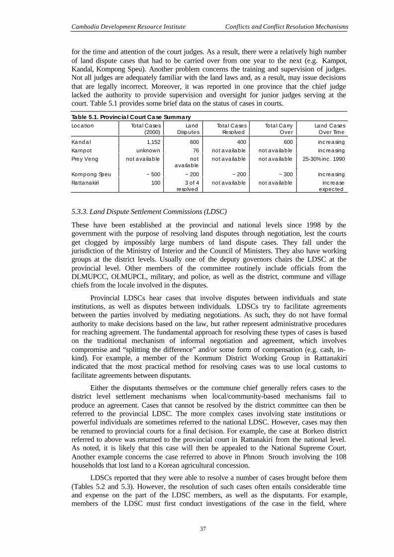
Cambodia Development Resource Institute Conflicts and Conflict Resolution Mechanisms
37
for the time and attention of the court judges. As a result, there were a relatively high numberof land dispute cases that had to be carried over from one year to the next (e.g. Kampot,Kandal, Kompong Speu). Another problem concerns the training and supervision of judges.Not all judges are adequately familiar with the land laws and, as a result, may issue decisionsthat are legally incorrect. Moreover, it was reported in one province that the chief judgelacked the authority to provide supervision and oversight for junior judges serving at thecourt. Table 5.1 provides some brief data on the status of cases in courts.
Table 5.1. Provincial Court Case SummaryLocation Total Cases
(2000)Land
DisputesTotal Cases
ResolvedTotal Carry
OverLand Cases
Over TimeKandal 1,152 600 400 600 increasingKampot unknown 76 not available not available increasingPrey Veng not available not
availablenot available not available 25-30% inc. 1990
Kompong Speu ~ 500 ~ 200 ~ 200 ~ 300 increasingRattanakiri 100 3 of 4
resolvednot available not available increase
expected
5.3.3. Land Dispute Settlement Commissions (LDSC)
These have been established at the provincial and national levels since 1998 by thegovernment with the purpose of resolving land disputes through negotiation, lest the courtsget clogged by impossibly large numbers of land dispute cases. They fall under thejurisdiction of the Ministry of Interior and the Council of Ministers. They also have workinggroups at the district levels. Usually one of the deputy governors chairs the LDSC at theprovincial level. Other members of the committee routinely include officials from theDLMUPCC, OLMUPCL, military, and police, as well as the district, commune and villagechiefs from the locale involved in the disputes.
Provincial LDSCs hear cases that involve disputes between individuals and stateinstitutions, as well as disputes between individuals. LDSCs try to facilitate agreementsbetween the parties involved by mediating negotiations. As such, they do not have formalauthority to make decisions based on the law, but rather represent administrative proceduresfor reaching agreement. The fundamental approach for resolving these types of cases is basedon the traditional mechanism of informal negotiation and agreement, which involvescompromise and “splitting the difference” and/or some form of compensation (e.g. cash, in-kind). For example, a member of the Konmum District Working Group in Rattanakiriindicated that the most practical method for resolving cases was to use local customs tofacilitate agreements between disputants.
Either the disputants themselves or the commune chief generally refers cases to thedistrict level settlement mechanisms when local/community-based mechanisms fail toproduce an agreement. Cases that cannot be resolved by the district committee can then bereferred to the provincial LDSC. The more complex cases involving state institutions orpowerful individuals are sometimes referred to the national LDSC. However, cases may thenbe returned to provincial courts for a final decision. For example, the case at Borkeo districtreferred to above was returned to the provincial court in Rattanakiri from the national level.As noted, it is likely that this case will then be appealed to the National Supreme Court.Another example concerns the case referred to above in Phnom Srouch involving the 108households that lost land to a Korean agricultural concession.
LDSCs reported that they were able to resolve a number of cases brought before them(Tables 5.2 and 5.3). However, the resolution of such cases often entails considerable timeand expense on the part of the LDSC members, as well as the disputants. For example,members of the LDSC must first conduct investigations of the case in the field, where

Social Assessment of Land in Cambodia Working Paper 20
38
negotiations between the disputants are then frequently facilitated. Some LDSCs indicatedthat they might try to resolve a case three times before referring it to the next level. Despitetheir success in resolving a number of cases, the LDSCs at both the district and provinciallevel reported that they were not able to complete work on all the cases that were broughtbefore them, and that there were varying degrees of carryover from one year to the next. As aresult, an increasing backlog of cases appears to be accumulating in many areas.
The LDSCs face several constraints in terms of staffing, training, and finance at boththe district and provincial levels. First, there are no permanent staff members on thecommittees, as members are drawn from other departments and institutions. In most cases,LDSC members have neither received formal training in conflict resolution and negotiation,nor instruction regarding the relevant land laws. Second, the LDSCs do not have anoperational budget with which to conduct their investigations and facilitate negotiations.Members must either self-finance their activities and/or accept unofficial contributions fromdisputants for transportation, meals, material, and other costs. As a result of such constraints,the time and resources available for working on land dispute cases is extremely limited.Indeed, such unofficial financing arrangements can undermine the impartiality of LDSCs iftheir activities are funded by one of the contesting parties.
Table 5.2. Land Dispute Settlement Commission (LDSC) – Provincial SummaryLocation Total cases 1999 2000 Resolved/Pending CommentKompong Speu 48 22 26 15/34 pending 19 not yet investigatedKandal not known 32 16/10 6 referred elsewhereKampot 12Prey Veng non
available99% cases referred to
courtRattanakiri ~ 20 n/a 20 4/4 5 referred elsewhere,
others unknown
Table 5.3. District SummaryLocation Total cases 1999 2000 Resolved/Pending CommentPhnom Srouch not availableSa-ang 22 9/7 6 referred elsewhereKampot not availablePiem Ro non availableKonmum 5 n/a 5 4/0 1 case not solved
5.4. Observations
Both the courts and LDSCs reported that a significant problem they face is that many peopleinvolved in dispute resolution do not understand the relevant laws and/or proceduresinvolved. Part of this problem may be related to the fact that people at the local level whohave traditionally relied on local customs to resolve conflicts may expect similar rules toapply to the formal legal system. When a decision is made against them based on law, theymay feel that they have been cheated. In this sense, many of the conflicts over land thatinvolve local people and individuals or institutions from outside the community, represent aclash between formal and local/community-based institutions of land rights governance.
Another set of problems occurs with regard to the enforcement of decisions. Forexample, the court in Kompong Speu indicated that they were unable to impose fines or makearrests in cases in which one party failed to appear in court or simply disregarded courtorders. The court also indicated that enforcement was particularly difficult when it involvedpowerful individuals and/or institutions. In terms of enforcement, the courts tend to prefer towork through social networks in which family members or employers are appealed to for
Cambodia Development Resource Institute Conflicts and Conflict Resolution Mechanisms
39
help. This represents yet another example in which the formal system of dispute resolutionrelies on informal mechanisms to govern land rights issues.
Next, the provincial courts have larger caseloads than do the various LDSCs at theprovincial level and the district committees. One reason for this is that LDSCs have only beenrecently established and, as a result, many people may not be aware of their function. Asecond reason is that courts are obligated to hear all cases brought to them, while LDSCsenjoy some degree of discretion in terms of accepting cases or referring them elsewhere. Athird, perhaps more important reason, may relate to the composition of LDSCs, in the sensethat they are comprised of individuals representing powerful institutions (e.g. the police andmilitary). For many people, particularly those at the local level, the difference in the socialstatus may be intimidating. Moreover, people may believe that in cases involving stateinstitutions, they will not receive a fair judgement simply because the case is being facilitatedby individuals representing those same institutions. It follows that the potential conflict ofinterests that is embodied in the LDSCs may represent a structural impediment to effectivedispute resolution. As a result, those who seek third party intervention may decide that thecourts represent a better option in terms of dispute resolution. However, this does not suggestthat people necessarily have more faith in the specific objectivity of the courts. Indeed, one ofthe most consistent themes that emerged from the interviews is that people lacked confidencein the objectivity and impartiality of the formal institutions, and generally had more faith inlocal/community based institutions.
Fourth, the distribution of cases between the courts and the LDSCs according to type ofconflict appears to be somewhat random in the sense that there is considerable overlapbetween the two concerning the types of cases that they hear. This suggests that there is noclear delineation between the jurisdiction concerning the type of case that each hears. As aresult, both institutions report hearing cases involving household disputes and conflictsbetween households and local authorities, as well as conflicts between households and stateinstitutions. One area in which there appears to be some distinction, however, is that theLDSCs appear to hear more cases involving groups of people versus local authorities orcompanies, while the courts tend to hear more cases involving conflicts between individuals.Nevertheless, instead of acting to complement each other in dispute resolution, theseinstitutions at times end up de facto competing against each other.
Fifth, the points at which cases are initiated appear to be somewhat random in thatsimilar types of cases are frequently initiated at different points and levels within the disputeresolution system. For example, certain parties may take a case directly to either the district orprovincial LDSC, thus by-passing the local dispute resolution process (e.g. village andcommune chiefs). In this regard, it appears that people or institutions from outside thecommunity tend to by-pass local institutions of dispute resolution and go directly to higherauthorities. This can be dis-empowering to the local people. At the same time, there is someevidence (e.g. Piem Ro) to suggest that local people with social connections may refer theirproblem to a relative or friend who has a high position in Phnom Penh or the province. Thelatter then refers the case back to the court or LDSC through informal channels. These factors,taken together, suggest that the point at which cases are initiated is sometimes based on thestrategic assessment of people with influential connections who seek a venue that offers themost favourable outcome to their interests. Such processes, especially when coupled with thestructural composition of the LDSCs referred to above, may further erode people’s faith in theimpartiality of the system and may be one reason why people appear to opt out of the system.
Sixth, the dispute resolution process is expensive in terms of time and financialresources. Part of the problem associated with costs concerns the fact that both the LDSCsand the courts lack adequate resources for conducting their work. Another fact concerningcosts – particularly with regard to the provincial courts – relates to the physical distancebetween the village and the provincial centre. People who lack financial resources and/or the

Social Assessment of Land in Cambodia Working Paper 20
40
time to travel to the court will opt out of the process, especially if they feel that the decisionsmay already be biased against them beforehand. In this sense, lack of resources represents asignificant structural impediment that excludes the more disadvantaged elements of societyfrom justice, such as poor farmers at the village level. This type of structural exclusion isespecially overwhelming for women – especially single heads of household – who have lesstime and financial resources compared to males.
Seventh, both the courts and LDSCs appear to be seriously over-loaded in terms oftheir capacity to address all the land dispute cases. The most compelling evidence in thisregard – in addition to the statements by court judges and LDSC members – are the figurescited above. In nearly every instance, there is at least some degree of carry over from one yearto the next. It is not surprising that such gaps – especially with respect to the courts – appearwidest in the most densely-populated areas (e.g. Kandal) where land dispute cases from bothrural and urban areas compete for time and resources with other civil and criminal cases. Evenin cases from rural areas, which LDSCs tend to accept in fewer numbers, there are casescarried over from one year to the next or referred to elsewhere. In nearly all interviews withLDSC members and district level committees, members indicated that under the currentcircumstances (e.g. inadequate financial resources and staffing), they are working atmaximum capacity and could not take on additional cases. Another reason for the potentialoverload in the LDSC system may have to do with the methodology employed. As notedabove, LDSCs do not render legal judgements based on the law; rather they try to facilitateagreements through negotiation between disputants. Such processes can be especially timeconsuming when parties cannot agree, and, as a result, one case may require considerabletime and effort before it is referred elsewhere for further attention.
One way, therefore, to look at the problems associated with the ability of the formalinstitutions to resolve cases, is to consider dispute resolution as a limited resource that mustsomehow be allocated among competing sources of demand. This suggests that decisionsmust be made about how to allocate scarce time and resources to resolve cases. For example,when asked about how they prioritised cases, the Kandal court indicated that they gavepriority to criminal cases. One member of the LDSC in Kompong Speu indicated that prioritywas given to cases that had potential political ramifications. It was also suggested inKompong Speu that cases that received attention were sometimes determined by the ability ofdisputants to finance the investigations. This factor, when coupled with the strategic searchfor friendly venues by certain individuals or institutions referred to above, is probably themost serious shortcoming resulting from the lack of funds, as well as inadequate staffing andtraining for staff.
It is not surprising that people at the local level routinely expressed more faith andconfidence in local traditional institutions of conflict resolution than with more distant formalinstitutions. Part of the problem is that local people feel officials at higher levels may not careto understand the situation at the local level. At another level, this problem is associated withthe belief that justice is available only for people who have wealth and access to power. Thereis a general crisis of governance in that the formal institutions for dispute resolution are notperceived to be fair and impartial.
Indeed, many villagers – particularly those who experienced conflict with people orinstitutions from outside the community – complained that they simply could not afford thehigh cost of dispute resolution. One villager from Sa-ang explained the problem regarding theLDSCs in this way: people with more resources and/or access to power could simply ‘dragthem through the system’ until they achieve a desired result. Thus, it appears that anunspecified number of conflicts actually go unresolved as people with fewer resources (e.g.finances, time) opt out of the process. Such problems are especially problematic with womenheads-of-households, who often lack time and resources compared to male disputants.

Cambodia Development Resource Institute Conflicts and Conflict Resolution Mechanisms
41
5.5. Summing Up
The frequency and nature of land disputes is now increasing as more diverse interestscompete for land resources. Many more land disputes now occur between village people andpeople from outside the community, including companies and organisations. Disputantsincreasingly rely on more distant formal institutions for resolution in addition to localauthorities. This suggests, then, that the demand for dispute resolution involving formal andinformal mechanisms of governance at all levels will also increase – perhaps dramatically.Such an increase would in all likelihood overwhelm a system that is already falling behind onits caseload. The most significant constraints in terms of the capacity to handle an increasedvolume of complex cases for the formal system are related to inadequate financial and humanresources, including technical training in the law and procedures. The informal system, beinga vestige of the older order, presently has begun to lack legitimacy, transparency andsynchronisation with the formal system and law.
Even though the formal mechanisms for dispute resolution are in place, they arecurrently perceived by many as inherently unfair in terms of a structural bias that favoursthose with more resources and access to power, while precluding the full and equalparticipation of disadvantaged people (e.g. the poor, women, and indigenous peoples). Itappears as if there is a crisis of confidence in the dispute resolution process as it is currentlystructured and practiced.
Part of the problem regarding people's faith in the system is also related to inadequateunderstanding of the laws and procedures governing property rights. On the one hand, thismay be a function of a lack of education. On the other, it is related to a lack of informationabout the laws and procedures. Such problems are, in turn, exacerbated by the lack oftransparency and adherence to established procedures by all parties concerned. With theinformal system not getting rejuvenated and the newer one being perceived to be what it is,this crisis of confidence is inevitable. As in other countries that face a similar set of problems,it is perhaps inevitable that people will employ extra-legal strategies to turn decisions in theirfavour. This, for all intents and purposes, represents a question of good governance.
There are underlying ‘factors of success’ that warrant more attention. The primaryfactors that promote successful conflict resolution are: (a) commonly-understood and sharedrules; (b) faith in the impartiality and fairness of procedures; and (c) effective enforcement ofdecisions. For example, one reason why boundary disputes between farmers are oftenresolved at the local level is that people share a common sense of traditions and rules abouthow such disputes should be handled.


43
Chapter Six
Policy and Recommendations
6.1. Introduction
As this social assessment aims to create an understanding of the realities on the ground, it isexpected to help in developing a policy package that the government is drawing up for landtitling. The paper offers numerous cases and evidence that have policy implications. Thischapter puts them together with the explicit purpose of their selective or full incorporation ina policy package. The basic premise upon which this chapter rests is the need to promotepeace, bring justice to all, particularly the weaker sections, and help clear a backlog ofpending issues with regard to land. Surely one cannot expect larger development objectives tobe met by titling alone, since a titling programme is not a development plan. But a successfultitling programme can certainly pave the way for implementing development plans moreeffectively.
6.2. Titling Land According to the Law and Sequencing the Activities
The titling process should not be a mechanistic provision of papers to those who control landas of today, or on a specific date. In the absence of mapped boundaries between lands held bydifferent stakeholders, including government departments and ministries, and in the presenceof conflicts described in the text above, any titling exercise on an ‘as is where is’ basis islikely to run into a great deal of arbitrariness, which might eventually undermine the verylegitimacy of the exercise. In this context, a judicious interpretation and application of the(new) land law that underlies the titling process holds the key to the success of the titlingprogramme. Thus, first, a word about the law itself is essential. The text so far makes itabundantly clear that both clients and officials are confused about the existing law. Theprocedures and the requirements intimidate the former, while the latter have much confusionabout interpretations and uncovered areas. Hence, clarity, simplicity and wider disseminationof the law underlying the titling process, in this case the new law that has recently beenadopted, are key to success.
A few sample questions encountered in the survey suggest the need to make the law asunambiguous as possible. The present Cambodian land law specifies ceilings on the size ofland holdings; although many people hold more land than is allowed in the law. Should therebe a legal ceiling that specifies limits to individual holdings? Should all legal stipulationsregarding land size be fulfilled before titling commences? What should the exceptions be, ifany? These questions require attention, since different actors interpret the present lawdifferently. For example, one interpretation says that the ceiling applies to only the initialallotments and not to subsequent acquisitions.1 Then there is the issue of settling illegaloccupations and encroachments, irrespective of whether they are on private or public lands.
1 Source: Court judgement, Rattanakiri.

Social Assessment of Land in Cambodia Working Paper 20
44
Does illegal occupation of land, which goes unchallenged for several years, imply the de factoright of the occupier to it? What should the legal position on this issue be? Finally, is it (not)essential to explicitly mention the jurisdictions of each ministry, to use, rent, sell or lease landthe way each deems appropriate?2 There are many more questions that call for attention, andunless the interpretation of rules and procedures is clear, new questions will continue toemerge. In short, the new land law should be interpreted unambiguously and be the guidingprinciple for titling.
The sequencing of titling work can be important, as is illustrated by the following case.There could be serious dislocation of people in forest villages if all the forests are titled in thename of the Ministry of Agriculture, Forestry and Fisheries without taking account of thesepeople’s existence. Disputes may also emerge at the periphery of forestlands where a fewfarmers may claim lands at the borders. The settlement of disputes would become verydifficult in the event that lands are titled without regard to such issues, as parties who obtaintitle papers will in all likelihood, dig in their heels for a protracted struggle to retain theirownership. Procedures will become more complicated as well, because the matter moves toanother authority. There is, then, the question of changing the land use by type (from forest tofarming in this case). Lastly, a newly issued title will have to be altered, questioning the verylegitimacy of the whole process.3 In almost all cases, villagers, local representatives, as wellas government officials suggested that the titling work should protect the basic livelihood ofall. In this regard, it was suggested that the new titling programme should sequence the titlingas follows: residential land first, followed by agricultural (rice) land, then chamkar land, andthereafter, public lands such as beaches, forests, pathways and roads.4 Forests andwaterlogged/inundated areas require separate attention, in which the use rights to forestproduce are ensured and the traditional fishing rights of communities are restored.5 It is worththe mention that the concept of community forest management or joint management of forestsby the government and community are still alien to people in areas where this study wasconducted. However, the concept is not alien to the country and it could be introducedgradually but definitively. 6
2 This paper has tried to provide answers to these questions raised above, as obtained from responses
from the field. These answers should provide a basis for how the issues hitherto, un-addressed inthe present law, can be incorporated in the new one. Ceilings on individual land holdings areimportant to maintain from the point of view of making land available to a maximum number ofpeople. It needs no mention, that all require residences and most need agricultural lands sinceoccupational diversification is very low. In addition, there is all the reason to believe that smallfarms are likely to be more efficient in the Cambodian context since resources such as workingcapital, draught animal power, etc., are rather limited. Input as well as output markets, and alsoinfrastructure, are far from developed at this stage, and do not permit economies of scale to bereaped. Field observations also suggest that larger pieces of land are, to an extent, held forspeculation, and are not productively used. Only in cases where there are proposals to develop largeorchards or to do commercial farming for larger markets, can exceptions be made. Before titling,authorities should satisfy themselves regarding all legal requirements of ceilings since ex-post factosettlements are impractical. On encroachments, if there is a disputed situation, the matter needsclearance from dispute settlement authorities. Undisputed occupation, if it has been for a while, sayfive years, should be regularised in favour of the present occupant(s). Lastly, the land law shouldspecify the jurisdiction of each ministry and department.
3 Of course there is the reverse possibility of farmers claiming and grabbing lands not belonging tothem; but in the Cambodian situation, justice to small farmers outweighs such considerations.
4 This sequencing is a suggestion arising out of the concern people expressed without knowingwhether the new titling programme will be of a systematic or a sporadic type. In a systematicregistration process, the sequencing is geographic and not by land-use pattern. But even in this,some consideration of the concerns expressed in the field is critical.
5 The government has already introduced localised fishing rights. All those who knew about itwelcomed the step.
6 Some NGOs have introduced this concept in Cambodia in a limited way.

Cambodia Development Resource Institute Policy and Recommendations
45
6.3. Strengthening and Decentralising Land Governance Authorities
There are several issues that must be addressed in the context of land titling administration.Some that emerged in the course of the inquiry are discussed below.
• There is a great deal of confusion and discomfort, experienced by both the clienteleand authorities in managing the procedures and the excessive centralisation intitling. The less affluent people must spend a lot of time and money, and also facefrustration. As mentioned earlier, of the reasons people did not seek titling, are thecost and the extra effort. In this regard, the centralisation of authority in PhnomPenh did not find much favour among a significant number who chose to speak onthis subject. Inferences from many village-level interviews suggested that the finalauthority should not be very close or personalised (for the sake of legitimacy), but itmust not be too far away. It is believed that the district can be a useful level atwhich the operations can effectively stop. The higher authorities (at the provinceand the national capital, respectively), for purposes of records, need be providedonly with data in tabulated form, while the original records could be maintained atthe district level. This decentralisation may, however, imply a great deal of capacitybuilding at the district level, meaning extra costs to be incurred. Hence this papersuggests that, in principle, decentralisation is the direction to take; though the levelsat which different operations take place will have to depend on administrativefeasibility.
• The authority of the local bodies (village and commune) should not be violated byanyone. It should be mandatory that all land acquisitions, transactions or transfers bemade through the established channels, unlike at present where the more powerfulelements begin the process at the top, and only in the end inform the localauthorities7. Following of procedures by everyone is important, both to maintain thesanctity of the law and procedures and to build confidence in the system.
• Transparency in administration is central to achieving good governance. The presentproblem of too many unofficial payments discourages people from trying to obtaintitles for their lands and also undermines the legitimacy of the system. Many peoplesuggested that committees similar to Village Development Committees (VDCs)could be set up for consultation and monitoring the titling process. Thesecommittees could be composed of village elders, demobilised soldiers, the villageteacher and women representatives, in addition to the village chief. Otherssuggested that a commune committee might be more appropriate, since thecommunes are likely to be important organs in the new decentralised system afterthe proposed commune elections in early 2002. In short, a representative committeeto monitor operations at the local level is desirable.
• There have been a number of agreements and transactions in the form of exchangeof receipts, certificates and written agreements, which have been authenticated byseveral personnel in authority, but they are not necessarily correct in law. It is,however, impossible to retrieve all the past records and correct them. Instead it isproposed here that all cases in which there is no conflict between the concernedparties should be regularised ex-post facto . Only in the case of disputed lands shoulda case be referred to conflict resolution authorities for settlement before titling isdone. This is the principle followed in the systematic registration scheme.
The inevitable question of having too few staff members at lower levels and too manyat higher levels will have to be addressed by a more realistic personnel policy.
7 Members of the provincial authorities in at least two provinces stated this.

Social Assessment of Land in Cambodia Working Paper 20
46
6.4. Resolving Disputes
6.4.1. The traditional system
Large sections of the population, particularly in rural areas, place more trust in local-community-based institutions of dispute settlement than the formal mechanisms. It is,therefore, important that such institutions are strengthened and synchronised with the laws ofthe land. The best method may be to empower commune level institutions, since this levelwill soon have elected representatives. Commune councils should, in addition, take up thetask of disseminating the land law through both formal and non-formal means that reach tothe largest number of people most effectively.
Maximum effort should be made to settle cases locally, even in cases wheregovernment authorities and companies are involved. For this purpose, local institutions willhave to be strengthened, both in terms of jurisdiction and implementation. Cases should bereferred to higher authorities only when they cannot be solved locally.
As regards the existing pending cases, it is imperative to have all of them settled on aone-off basis through extra sessions of commune councils or such authorities, if necessary,before titling is undertaken. One major gain of this exercise will be that, post-titling, therewould be no burden of the past to carry into the future.
6.4.2. The formal system
The formal land dispute resolution system currently lacks the financial and human resourcesto manage the current caseload in a way that is consistently fair for all people. Any increase inthe volume of cases will, in all likelihood, overload the current mechanisms and furtherundermine people’s faith in the system. In order to strengthen the formal system, theprocedures for initiating cases and the paths for appeals should be simplified and clarified.Considerable attention must be devoted to strengthening the institutional capacity of theLDSCs, both at the district and provincial levels. In this regard, the LDSCs will require theirown budgets and staff training.
Clarifying procedures: All cases should be resolved in a way that is consistent with thespirit and intent of the relevant laws governing land rights. The dispute resolution processshould be decentralised in a way that corresponds with the land titling process. In principle,all land dispute cases should be initiated at the local level. As a first step, therefore, priorityattention should be given to resolving conflicts at the local level before they are referred to theformal system. A useful approach is to study the procedures followed by the systematic landtitling projects (i.e. of GTZ and FinnMap) that involve public meetings at the village level inwhich boundaries are clarified. Cases that cannot be resolved at the local level should thenfollow a clear path of appeal from one jurisdiction to another. For example, the path shouldgo first to the district, then the LDSC, and so on. Both the provincial and national courtsshould be granted the power to refuse admission of cases. The courts should be charged withdeciding cases that represent conflicts over constitutional points of law, as well as conflictsbetween jurisdictions. A special land dispute resolution unit should be established in eachcourt under the direct supervision of the chief justice who is responsible for overseeing thatall decisions are rendered in strict accordance with the laws governing land rights. The judgeresponsible for the land dispute unit should possess legal expertise in the area of land laws.
Institutional capacity building: In order to strengthen the institutional capacity of adecentralised dispute resolution system, more financial and human resources must beallocated at the local level (e.g. village and commune chiefs, relevant members of thecommune councils). Three points in this regard are noted below:
• Training: Local-level officials, LDSC members, and provincial court judgesfrequently lack a clear understanding of the relevant laws and procedures governing

Cambodia Development Resource Institute Policy and Recommendations
47
land rights and dispute resolution. Training activities should be provided to therelevant officials concerned at three different levels: (1) local authorities (i.e. villageand commune chiefs, commune council staff); (2) members of the provincial anddistrict land authorities, including LDSC members; and (3) provincial and nationalcourts (e.g. chief judges and other justices hearing land case). The training shouldconcern the relevant laws governing land rights as well as conflict resolution andnegotiating techniques.
• LDSC membership : The current membership of the LDSCs is drawn from variousdepartments at either the provincial or district levels, some of which representpotential conflicts of interest. It is proposed that, as far as possible, membership ofLDSCs should be non-partisan and entirely civilian. LDSCs should have permanentstaff members who are responsible only for working on land disputes and other landcases – including investigation and recommendations.
• Financing: None of the conflict resolution authorities currently has budgets forinvestigating and negotiating land dispute cases. LDSCs should be provided withadequate budgets in order to investigate and facilitate cases. This should includetransportation, meals, supplies and other expenses. Official budgets should besupplemented with modest published fees that are paid equally by the parties to thedispute.
6.5. Framing a New Relocation and Habitation Policy
Cambodia has had a policy to help settle people who were displaced during the civil war. Thispolicy needs to be extended to cover those who are involuntarily displaced from theiragricultural and residential lands in rural areas, as well as those who are likely to be affectedby squatter clearance in urban areas.8 In many respects, the two problems of involuntarydisplacement and rural-urban migration are closely linked. The phenomenon of such migrantsoccupying land in urban areas is not unique to Cambodia, though the problem here isaggravated by the fact that there is only one large city. What can be done to stop excessive in-migration when most modern development is concentrated in Phnom Penh? The eventualsolution is to promote a multi-nodal model of development and occupational diversification.But in the short term, the current system will have to be better managed to achieve the bestinterests of all.
There is the immediate problem of relocating about 35,000 families (175,000 persons)in slums,9 which is about 15 percent of the population of the city of Phnom Penh. It is notclear whether all of these people who are spread across an estimated 20 settlements occupylands illegally, but some surely are. This is particularly so of those who have occupied landson the riverbanks, as Case Study 6, presently later in this paper, illustrates. That study alsoshows that many who have been relocated have returned, since their livelihood in the newlocations is insecure.
One way to address this problem is to pursue a more comprehensive relocation andhabitation policy, as has been done in several cities of Latin America and Asia. There aremany variants of these models, depending upon the finances available, the geography of thecity, and the socio-economic profile of the populace. The success of such policies alsodepends upon complementary development policies that will strengthen the employmentopportunities and income levels of the working populations.10 A word of caution should be
8 While it is true that not many relocation schemes around the world have been successful, there are
some successful stories, for instance in China and Malaysia. The general lack of success should notbecome a reason for not adopting or relying on relocation strategies.
9 The Municipality of Phnom Penh has provided these numbers.10 More details on these can be seen in ILO (1999).

Social Assessment of Land in Cambodia Working Paper 20
48
mentioned: cash compensation is of little use because the money given out is ofteninsufficient; it is spent too fast; and is frequently used for unintended purposes.
Most policy makers and implementing agencies believe that the city requires properzoning, and that the relocation of people should follow a definitive plan. They believe thatPhnom Penh will expand and that more people will come in the future. To meet thischallenge, a demand-led and partially self-funded settlement plan would probably work betterthan other approaches. A westward expansion of the city is deemed more feasible, keeping inview the fact that the eastern parts are prone to floods.
Relocation of urban squatters, however, is not easy for a variety of reasons includingthe high costs and political sensitivities involved, as well as the fact that neither land nor jobsare readily available at new locations.11 The most radical solution is to regularise unauthorisedsettlements, reclassify them into regular low-income localities and provide them with all thefacilities that the city offers to other residents. This may, however, not be possible carteblanche because the costs could be prohibitive and the competing demands for the land couldbe very high. This may also attract additional migrants. Hence, a selective policy is moredesirable. In many countries, unauthorised settlements are regularised and reclassified, buteach dweller is authorised to stay there only if that family has resided for a minimum numberof years in the city and/or has occupied that land for a stipulated number of years. Otherconditions may include possession of a family card or some other document to establish one’sidentity and proof of holding a legal business, profession or service.12 There are also otherradical solutions offered in some situations, such as setting up entirely new colonies for suchpopulations on the periphery of cities. Efforts are then made to create new jobs for them, aswell as offer them credit, create marketing facilities for them, and train them in alternativeskills. However, such alternatives are not inexpensive.
In the rural sector, it is estimated that unused land, which is not under forest cover, isabout 1.7 million hectares.13 While all of this land may not be fit for agriculture or humanhabitat, surely much of it can be used, as the topology of the country suggests. The Oxfamland study estimates that up to 3 percent of families in the country have some land-relateddisputes.14 Translated into numbers, families dependent upon agriculture should be about 1.5million, and 3 percent of these would be 45,000. Even if all of these families were to beresettled, a very unlikely possibility, the total agricultural land required would be less than100,000 hectares; i.e. less than seven percent of the unused land. Hence it is possible andfeasible to implement a rural relocation policy, even if the ‘land for land’ principle isfollowed.
6.6. Recognising Indigenous People’s Rights
In areas such as Rattanakiri that were originally inhabited by indigenous people whose landuse patterns and life styles differ substantively from the majority Khmer population, people’straditional access to land is increasingly being constrained by land transfers to people andinstitutions from outside the tribal communities. Sales, land grabbing, and the granting ofconcessions by the state characterise such transfers.
A reasonable balance must be devised that protects indigenous people’s traditionalaccess to and control over communal land while meeting the broader development objectivesof the state that are designed to promote better standards of living in these areas. In the long
11 It must be recalled that migrants settle on certain locales because there are jobs available in the
vicinity. If they are settled in places far away from their job locations, they are not able to meet thetransport costs.
12 This does not mean that unemployed person have no place in the society. The purpose in thisstipulation is to exclude persons engaged in illegal or immoral activities.
13 Williams (1999) has calculated these figures based on several data sources.14 See Biddulph (2000: 7)

Cambodia Development Resource Institute Policy and Recommendations
49
term, the objective of better standards of living with more secure incomes requires a moreproductive use of land resources. For many people, this will involve adopting moreproductive agricultural practices and/or developing additional sources of income fromtraditional access to forest resources. For others, this may involve additional opportunities forsecure and gainful employment.
Such long-term objectives are, however, undermined by current patterns of landtransfers to people and institutions from outside the indigenous communities. Such transfersthreaten to deprive people of access to land, which has been traditionally governed by thetribal communities. In the short term, therefore, land procedures must be designed inaccordance with a law that safeguards indigenous people’s traditional patterns of land control,as longer-term development objectives are implemented.
One approach to protecting indigenous land rights involves the concept of communalland titles in which a particular community is granted ownership over land that it currentlycontrols. There are currently several models which demonstrate that the concept of communalland rights is feasible. However, it appears that such efforts are both expensive and timeconsuming to implement. For example, lands must be surveyed and mapped in order toestablish clear boundaries between various communities. Then the methods for implementingsuch procedures must be worked out in advance by the provincial DLMUPCC so thatcommunal land titling can be replicated in more communities in an efficient and effectivemanner.
The community, in accordance with locally established rules and regulations, and inconjunction with government’s laws concerning land rights, would govern such areas. Rulesand methods for governing land allocation and disputes between individuals of differentcommunities, as well as between communities, must therefore be devised. Of special concernare mechanisms that can be employed to ensure that village leaders act according to thepreferences of community members. Moreover, the effective implementation of communalland governance must be developed in a way that recognises an individual’s rights to specificparcels of land, including the right to sell and/or otherwise transfer ownership rights to otherparties, both from within, and from outside the community. These and other complex mattersmust be worked out in detail before communal land titling processes can be implemented.
It is appropriate for the government to collaborate with civil society organisations toundertake such measures, rather than working on its own. Hence, a communal land titlingprocess must include the active collaboration of both the public and private sector, includingNGOs that have experience in these matters. More attention must therefore be devoted tolearning about the precedents that have already been established.
Special efforts must be made to inform all parties concerned in the indigenous areasabout the relevant laws governing land use and ownership. Also, special efforts must be madeto inform people about land conflict resolution procedures. This is particularly important withregard to indigenous people who do not speak or read Khmer as a first language. Again, suchpublic awareness campaigns must involve the active collaboration of both the public andprivate sectors.
6.7. Recognising Women's Rights
The situation with regard to women, including female heads-of-households, requires specialconsideration. Women face many economic and social obstacles that undermine their abilityto establish and maintain control over land. For example, women are especially vulnerable insituations concerning the division of household land in the event of divorce or inheritance.One problem concerns the fact that they are frequently not listed on land documents. Anotherproblem is that women - even more so than men - often lack sufficient information about theirrights with respect to land and, as a consequence, are not able to protect their ownership rightswhen disputes arise. Female heads of households often lack adequate resources to invest in

Social Assessment of Land in Cambodia Working Paper 20
50
household production (e.g. draft animals) and/or meet daily household needs. In situationswhere they may actually have land, they must often use land as collateral or must sell it inorder to obtain cash for food purchases, household emergencies (e.g. health care), oragricultural inputs.
In the context of implementing the new land law, special efforts must be directed atstrengthening women's access to land ownership and dispute resolution. 15 Legal codes areurgently required that ensure women's rights to a fair and equitable division of land in theevent of divorce and inheritance. Women must also have some legal guarantees that ensuretheir access to fair and impartial dispute resolution. One important step in this regard concernsthe need for active collaboration between the government and civil society organisations toprovide women with information about their rights in the context of the new land law, as wellas provide support to enable women to advocate for their rights. In terms of promotingwomen's access to land titling, consideration should be given to affecting preferential rates forland titling fees. This may be especially relevant in cases involving female heads ofhouseholds. Authorities at all levels of the land-management and dispute-resolutionadministration should also receive training and instruction about the rights of women withrespect to the new land titling laws.
It should be noted that the long-term success of such policies also depends uponcomplementary development policies that address both the practical (e.g. education, healthcare, income) and strategic (e.g. active participation in decisions affecting household andcommunity) needs of women in society. At the same time, those efforts that ensure moresecure rights over land can make a valuable contribution to promoting the overall situation ofwomen in particular, as well as society in general.
6.8. Following Best Practices
There are many successful land-titling practices in different parts of the world. Theexperiences of Thailand and Indonesia could be especially instructive. Even within thecountry, the MLMUPC, with technical assistance from GTZ and FinnMap, has been doingsystematic titling in selected areas (Takeo, Kampong Thom, Kampot, and Kompong Som) onan experimental basis. They use aerial photographs available with the Mekong RiverCommission to demark each agricultural plot. Since these are digitised and mapped exactly toscale, there can be no mistake in the boundaries. Consensus is reached in village meetings ondemarcation of boundaries before certificates are issued with the map of the plot and itssurroundings drawn on the certificate itself. The experience so far shows that ministry staff isquick to learn the technology of interpretation. The cost, it was stated, turns out at $15-20 percertificate, compared to more than twice this figure in the case of sporadic mapping.16 Thetime taken is also much lesser.
Systematic titling, though, is no substitute for human agreements.17 For residentialplots, there is no substitute for local consultation and settlement of boundaries as such areasdo not come out clearly on photographs due to their smaller sizes and thick vegetationcovering the villages. For agricultural plots, aerial maps can help to establish an objectivebasis for bifurcation of land, but are no replacement for enforcement or conflict resolution.
15 A statistic, recently calculated by the Central Cadastral Office, based on a sample of about 45,000
titles, shows that an overwhelmingly large number of titles were joint, in the name of both the manand the woman. Titles only in the man’s name were few and less than those only in the woman’sname. These data suggest that having names on titles alone will not bring about gender equity; thepolicy will have to address the whole sociology of gender.
16 In the calculation it could not be ascertained whether foreign experts’ costs, which are presentlyborne by the German and Finnish governments respectively, are included or excluded.
17 The Sub-decree on the Procedure of Establishing Cadastral Index Map and Land Register (RGC2000) is very clear: that the procedure of human consultation cannot be short-circuited.

Cambodia Development Resource Institute Policy and Recommendations
51
The one lesson that systematic titling teaches is that technology facilitates, but is not analternative to a rule of law and good governance.
There are NGOs (e.g. Non-Timber Forest Products in Rattanakiri province) that havehelped establish precedents for communal land titling, land settlement, and joint forestmanagement. Intervention by Buddhist monks in dispute settlement has also been foundsuccessful. While this paper will not go into many details not observed in the fieldwork, amention of other institutions and practices in regard to governance of land and disputesettlement surely is warranted.
6.9. Financing the Land Titling Process
The MLMUPC, provincial DLMUPCCs, and district OLMUPCLs do not have sufficientfunds to finance the cost of land titling. The operational costs associated with land titlinginclude cadastral survey equipment, administrative equipment (e.g. computers) and supplies,transportation, and staffing (e.g. training and salaries). People currently pay a modest fee tothe local authorities to obtain an application for a land certificate. People must also payunofficial fees to government staff at the district and provincial levels in order to finance thecosts of measuring the land and issuing land titles. These unofficial fees are currently too highfor most people to afford, and as a result, many people decide not to acquire land titles.Rather, they routinely rely on the receipt for the land certificate application to substantiatetheir claim to a particular parcel of land. In the process, the state also loses considerablerevenues. The guiding principle ought to be that land titling should be affordable for allpeople.
The recommendations in the following paragraphs should be implemented in thecontext of the objectives governing the public finance reform, currently being considered bythe government. These reforms envision a more decentralised system of public finance inwhich public services are financed by both, inter-governmental transfers from tax revenuesand/or donor assistance, as well as user-fees for the services. In the case of user-fees, the basicprinciple is to make cost recovery more efficient, transparent, and accountable in the sensethat the supply of a specific service reasonably approximates demand.
First and foremost, the operational budgets for all levels of the administration involvedwith land titling should be strengthened through inter-governmental transfers. These budgetsshould be supplemented with revenue collected from the fees that people pay for the landcertificate application and the titling process itself. The modest fees currently charged for landcertificate applications should be continued, perhaps increased a little more for a certificate,and should be progressive in the sense that larger areas would require proportionally higherfees. The revenue from such fees should remain with the authorities issuing the applications.The payments of all other fees associated with the titling process should be formalised.Moreover, the fees should be uniform for all people and should be published according to arate established by the MLMUPC. The revenue from fees associated with cadastral surveysand issuing land titles should be divided between the provincial and district departments tohelp defray costs associated with the land titling process. Such a decentralised approach topartial cost recovery will promote the long-term sustainability of the land titling process.
The tax on land sales and transfers represents an important source of potential revenuefor the state. The current practice is that four percent of the land sale value should be paid tothe Provincial Tax Department before a land title is issued. However, in most cases, peopleundervalue the sale price. Also in most cases, transfers take place outside the formal processesand no tax is paid. In both cases, the state loses considerable amounts of potential revenueunder the current practices. Of equal importance is the fact that such procedures result inconsiderable confusion and misunderstanding among all parties regarding the criteria for alegally valid land claim. A tax on land sale and transfer of ownership should be paid beforeonly the transaction is approved. No land claim should be recognised in any form by the

Social Assessment of Land in Cambodia Working Paper 20
52
LDSC or courts unless the required tax has been paid according to established procedures. Inorder to substantiate a person’s or an institution’s (e.g. private company) claims to a particularparcel of land, the courts should require documented proof that the tax has been paid.
In the interests of a more equitable and progressive tax system, companies andindividuals who have acquired more than five hectares of land should pay a tax based on ahigher percentage of the sale value. In order to check the tendency of people to understate thevalue of the land sales, local authorities who sign off on land sales must verify that sale pricesreasonably approximate the market value of such land. Such procedures should becomplimented by special efforts to strengthen the system of land valuation at the appropriatelevels. One approach that is practised in some countries is to standardise the rates for differentzones (separately in rural and urban areas and by land use), depending upon the currentvaluation of land. These standards are reviewed every few years.
6.10. Generating Data and Information and Spreading Education on Land Issues
Presently there is too little data on almost every aspect of the economy and society. There iseven less information available at the local levels. Also, data that are available (e.g.information on land transfers at the village and commune levels) are not efficiently collatedand presented. A strategy to establish decentralised databases is important for both titling anddevelopment purposes. One way that can be cost effective is that village and commune-levelsurveillance centres record information on select key variables and changes therein at theirlevels, which can then be compiled at the district and higher levels. The existing functionariescan do this job and no fresh recruitment need be made. These databases should regularly beup-dated, and widely disseminated among the users, while delays in their compilation andavailability should be minimised. These data, however, are no substitute for large surveys,which in any case should be conducted from time to time.
As of today, different ministries and departments maintain their own databases. Theyare not necessarily synchronised with each other, and as a result, different ministries makepolicies and strategies based on different figures for the same items. The need to establish acentral bureau of statistics – which would collect, collate and reconcile already collected data– is paramount. In other countries such a bureau serves all government and concernedorganisations, and even publishes and markets the data. A similar model is proposed forCambodia as well.
Literacy in Cambodia is not very high and is particularly low in rural areas. This isespecially true among older persons and women. Most people in villages do not know the lawand are not conversant with the procedures of land registration, transfer, succession andinheritance. In one village in Kampot district, people said that salient features of the land law,including procedures, user fees for different services, and the grievance redressal procedures,should be written on posters and placed at appropriate locations in villages. Also, there couldbe special village meetings for explaining the relevant elements of the law and the proceduresinvolved in titling and other related matters. NGOs and other elements of the civil societyshould be involved in public education. Perhaps some of the most effective tools fordisseminating such information are radio and television, as even the most remote areas oftenhave them.

53
Chapter Seven
Concluding Observations
Cambodia is a late beginner on land reforms and therefore has the advantage of learning fromthe experiences of other countries. There have been mistakes committed elsewhere, whichhave cost those countries basic food security (e.g. Africa). Such mistakes can be avoided here.Unlike in the 1950s and 1960s, detailed experiences, including elaborate manuals on differentfacets of land reforms, are now available. It is important that the concerned planners andofficials become acquainted with the relevant literature.
Cambodia has multiple modes of land use. The subsistence mode predominates, thoughmarket forces are rapidly gaining ground. Due to a rather sudden exposure to the marketeconomy, the peasantry – which is also burdened by illiteracy and isolation – is suddenlyfaced with multiple demands on their only means of subsistence. As a result, many have lostlands or are struggling to maintain control over them. The ensuing conflicts are also beingsettled in a multiplicity of ways that are not necessarily consistent with each other, or with thelaw. In this regard, the administrative system, which is largely a top-down bureaucracy, is notable to fully grapple with the situations prevailing at the local level. They are also ill equippedto do their jobs in terms of a lack of financial and human resources. Many in theadministration, for want of a better compensation received from the government, are alsotempted to accept unofficial favours. Those who cannot pay (i.e. the poor) almost always loseout.
A distinction should be made between stakeholders in land and stakeholders in theproject. The different stakeholders in land, in addition to the peasantry, include moderncommercial and speculative interests, government officials, the military and variousconcessionaires. The heaviest demand for land is in urban areas, along developed roadsides, atriversides, and in commercially developed centres. The stakeholders in the project aregovernment officials and politicians who at times may also have interests in land. Such ablurring of the distinction between common and private interests may at times compromisethe neutrality of the bureaucracy, and create potential areas of conflict. Dispute settlementmechanisms are in place, but not all of them are impartial and transparent. Moreover, they arealso overworked and under-funded. In addition, unequal resources and insufficient access toinformation by different stakeholders of land and in the project presently make the system notso fair for all, especially when there are clashes of interest. The peasantry is inevitably theloser.
As in other developing countries, women’s position in Cambodia is typically lowerthan that of men. They do not own land unless they head the household. They are also lesseducated and not conversant with the law. As a result they are more dis-empowered comparedto their male counterparts. However, their labour participation is rather high when seen in theinternational context, which places them differently in the labour market. To ensure a better
Social Assessment of Land in Cambodia Working Paper 20
54
gender balance in land ownership, land titling must address specifically the feasibility ofregistering lands jointly in the name of men and women.
To address the problems raised above, this paper has placed heavy emphasis ondecentralising the programme including the dispute-settlement mechanisms. This wouldintroduce more transparency and local control over the programme, as well as create moreconfidence among farmers. The paper also strongly recommends that the commune councilsare strengthened, and entrusted with the responsibility of conflict management and all otherlocal investigations. The titling itself can have the district as its nodal centre. Localconventions and customs are still widely prevalent in rural areas. Effort to harmonise theformal legal system with local administration can reap rich dividends.
The need for capacity building at all levels has been strongly identified. The demandvaries at different levels. Locally, training in law and dissemination of rules and regulations,as well as in reconciliation of disputes, are essential. At higher levels, skills in communitydevelopment and conflict management can be useful. Technical training in land surveytechniques and interpretation of digitised images can be useful at all levels. Lastly, financesfor equipment and transport as well as operational expenses, are required for the successfuland sustainable implementation of the programme.
55
Case Studies and StakeholdersSeminar Proceedings
Case Studies of Five Villages and One Low-Income Urban Settlement, and Report of aStakeholders' Seminar on Urban Settlements:
1. Village Kampong Pring, Kandal
2. Village Kampong Thnoat, Kampot
3. Village Baboang, Prey Veng
4. Village 4, Kampong Speu
5. Villages Phum Psak and Ta-orng, Rattanakiri
6. Squatter settlements in Sangkat Tonle Bassac, Khan Chamkar Mon, Phnom Penh
7. Synopsis of the Proceedings of the Stakeholders’ Seminar: Urban Land Settlements
1. A Case Study of Kampong Pring Village in Kandal Province
Introduction
Kandal is among the more commercialised and urbanised provinces in Cambodia. It has thesecond highest population after Kampong Cham according to the Census of 1998. Theprovince has 206,189 households comprising 1,075,125 people.
Sa-ang district, where this study was conducted, has 32,457 households. It is among themore developed districts in the province. Since this district is close to the provincial capital(Takmao) and the city of Phnom Penh, there are commercial activities here, as well, inaddition to primary sector activities of growing rice and cash crops, and fishing. Landtransactions are changing the livelihoods of local people, while at the same time contributingto transforming occupational patterns away from subsistence agriculture to secondary andtertiary jobs. Among the 16 communes in this district, three – Roka Khpos, Sethabo and SvayRolum – are relatively more developed where garment factories have substantiallytransformed local economic activities. Thousands of women are shifting their jobs fromunpaid family labour to wage work in these factories.
Being commercially well developed in parts, a multiplicity of stakeholders, and henceconflict on land, has emerged. Land disputes have occurred in this province since the adventof the free market economy. Among the 32 cases received by the Provincial Land Disputes

Social Assessment of Land in Cambodia Working Paper 20
56
Resolution Commission in 2000, only 16 were solved at the province level and 10 had to besubmitted to the Ministry of Interior for decision.
Village of Kampong Pring
The village of Kampong Pring, where the social assessment was conducted, stretches for 2.5kilometres along the Tonle Bassac River, south of Takmao. It is situated in Sethabo communeof Sa-ang district. It is one of the more commercialised and urbanised villages in the threemost advanced communes of Sa-ang district. The village has 336 households with a totalpopulation of 2,492. The number of households in the village increased from 220 in mid-1980s to 336 in 2001. This increase is reportedly due mainly to new-married families andreturnees.1 There are more than 30 female-headed households, who reportedly own smallerfarmland plots, compared to the male-headed ones.
The village area is estimated to be around 590 hectares, of which about 100 hectaresare under residential land and 160 hectares are farmland, including 40 hectares under dry-season rice, 107 under wet-season rice, and 12 hectares under chamkar crops. Public landsand water bodies have reportedly been privatised by the local authorities over time. The priceof land varies according to its location and economic potential. The land price increaseddramatically in 1996: a plot (15mx100m) was priced at $5,000-10,000 compared to just(around) $350-720 in the early 1990s. Chamkar land costs $1-2 per square metre. Farmland ingeneral costs $0.3 per square metre.
Livelihood
Land speculation since the early 1990s and the construction of a garment factory in 1996 haveboth transformed the economic wellbeing of the village community and land use-pattern inthe entire area. Only 45 percent of households now rely on agriculture (e.g. growing rice, cashcrops and fishing), compared to an estimated 99 percent in the mid-1980s. Many farmlandshave been sold to companies and/or speculators during the last decade. The non-agriculturaljobs are more secure and are better paying. The garment factory in the village employs aboutfive thousand workers, each earning an average of $50 monthly wage. The factory has alsoattracted migrant labour from other provinces. Since these in-migrants need accommodation,the villagers have found an opportunity to earn extra-income by renting their houses for $10-15 a month per person, with food optionally provided. Many house owners have reportedabandoning farming because they have opted for preparing food for their house-renters.Consequently, many farmlands are now available for leasing to the farming households atmore competitive prices compared to earlier. Although there is a 50 percent decrease in thedemand for labour in agriculture, agricultural workers are able to command a higher price fortheir labour (5,000-6,000 riels of wage a day now compared to 3,000 riels in the early-1990s)because quite a few have switched to non-agricultural occupations.2
Land holdings and landlessness
All households received land for both residential and agriculture in late 1980s. Each familywas given 15mx100m of residential land. There was a variation in the sizes of farmlandsdistributed according to the number of adults, elderly and children in the family. The averagewas 0.5 hectares per family. After the initial land distribution, families with male labour anddraft animals cleared up more lands and expanded their farm sizes.
While the average farmland size is small, a few households are reported to have largerplots of farmland – up to three hectares. Up to 40 percent households reported that they own
1 It was informed that that there were 18 returnee families in 1990.2 It is though not certain whether this is an increase, given the fact that riel has depreciated against the
dollar. No one seems very sure whether this depreciation has affected local food prices.

Cambodia Development Resource Institute Case Studies
57
no farmland. Landlessness is not a main concern though, because villagers view off-farm jobsto be more profitable than working on farms. The prices of land offered by speculators areencouraging individual households to sell their lands. Land speculators, mainly from PhnomPenh and some overseas Khmer people, have also bought lands here, sometimes in the nameof their kith and kin. Out-migration from this area in the recent years has not been reported tobe high despite significant landlessness.
Receipt and registration
About 95 percent individual households in this village possess certificates of their residentiallands distributed in 1992 (of size 15mx100m). For farmlands though, only receipts weredistributed, and there was no follow-up for giving certificates. One plot (15mx100m) ofresidential land on the roadside, with proper papers is priced in the range $5,000-10,000.
The wealthy, mostly from Phnom Penh, have recognised the importance of a certificatemore than the local residents have. To secure legal ownership, they have opted for obtaining aproper certificate. Many though, have by-passed the village and commune level routes andhave gone to higher authorities directly. In contrast, the local people have relied exclusivelyon village and commune authorities for land papers and transactions. They do not go to higherlevels and avoid paying high taxes and unofficial fees ($200-500) at different levels. Awritten agreement, though not correct in law, is drawn up between the sellers and buyers andsigned in the presence of a witness. This unofficial transfer reportedly costs only about 40,00-50,000 riels (about $10).
In a similar vein, illiterate parents verbally transfer particular parcels of land to theirheirs, or at times make hand-written statements signed in the presence of neighbours. In thesecases lands continue in the name of parents even after they die. This practice is reported tohave resulted in a few land disputes among relatives after the death of parents.
Another problem likely to be faced in the forthcoming registration scheme is theunclear size of land occupied by individuals. Two issues that are likely to be problematic arecited here. First, the sizes of occupied farmlands are not properly recorded on the receipts(issued in the early 1990s) because owners have been avoiding paying high taxes. Second,many households have cleared up more lands behind their house plots, which makes theirpresent holdings larger than what they were earlier given. Again, these have not beenofficially recorded.
Land disputes and settlement mechanisms
Conflicts occur within communities on boundaries, between communities and localauthorities on access to public lands, inundated lands, etc., and between local and ethnicminority people, on land control.
The titling programme has been affected by local boundary disputes. It was stated thatup to 5 percent of landowners were not issued certificates earlier because of such boundaryproblems. Most residents believe, though, that local authorities can easily address boundaryconflicts.
Land concentration in the hands of outsiders, who often fence their boundaries withconcrete walls or fences, has brought a new dimension in the articulation of property rights. Incontrast, most locals have not put impermeable fences around their residential lands. In manycases, the fences have blocked the right of way to other lands (including private), watersources and forests. This has been a source of conflict.
It was reported that the village leader, in conjunction with the commune leader, hadsold the Krom Samki (community controlled) land to private individuals in the late 1980swithout informing the community or sharing the proceeds with them. Many returnees were, inthe process, deprived of lands. They are now living in illegal settlements. There was also a
Social Assessment of Land in Cambodia Working Paper 20
58
public demonstration staged by the local people against this act. The legitimacy of localleaders has been tarnished, and at the same time, there is some tension between the returneesand local authorities.
Although both the court system and Land Dispute Settlement Commission (LDSC) areofficial organs of the government, the local residents were aware of only the court. At thegrass-root level, people approach the village and commune leaders to help in conflictresolution. Most local people maintain that disputes can be settled in a congenial and friendlyenvironment only at the local level. They find the formal and upper levels in the governmentto be too expensive and intimidating. In many cases, the poor do not even put up a fight. Theydrop their complaints and rely on providence – ‘those who commit crimes will repay for theirsins in the next life’. The village has so far witnessed at least three cases of lands belonging topoor women-headed households, being appropriated by others. The women interviewedindicated that contesting cases at the upper levels not only requires a lot of money, but it alsodraws them away from their jobs, meaning that they lose livelihood for the period that theyare away.
The incapacity of courts to enforce their judgements in some cases further erodespeople’s faith in the formal system. For example, in one case the court had ordered restorationof land taken from one ethnic group by another, but the court order was not followed. Suchcases were quoted when people stated that they believed that fairness could only be ensuredwithin the community and not outside it.
Stakeholders' observations on land titling
Any official recognition of ownership right on land was viewed as essential. Respondentsvalued the certificate as:
1. "Gold" that can be used to obtain cash or facilitate sale of land at a better price;
2. Indicating a proper ownership of their land, which can help them protect theirproperty from predators. Land papers also improve the capacities of local people,make transactions more transparent, and prevent mismanagement of common lands;and
3. Help decrease land disputes.
Local respondents were not aware of the systematic registration system, which canoffer certificates without any fee. The peasant households are willing to pay 5,000-10,000riels for a certificate. The commercial interests who did not have the papers were willing topay more.
2. A Case Study of Kampong Thnoat Village in Kampot Province
Introduction
Kampot province is situated in the southern part of Cambodia and, along with Kep andKompong Som, is defined as a separate coastal agro-climatic zone of the country. People’soccupations here are partly dependent on the forest and partly on the sea, since historicallythere has been some significant forest cover and the Gulf of Thailand lies on the south-west.There are eight districts, 90 communes and 460 villages in the province. The total populationis 528,405 persons (104,993 households), as per the Census of 1998. Agricultural activitiesare composed of both rice cultivation and other non-rice crops (chamkar). Large areas arealso given out in land concessions. Many feel that this is a reason for the contested claims onland. A typical contention arose when the military occupied large tracts of land in the early-mid 1990s, and after the hostilities were over, sold or leased the lands to commercial
Cambodia Development Resource Institute Case Studies
59
companies. Local farming communities traditionally have claimed use rights over these landseven if they may not have cultivated these lands for quite a while.
Kampot district, where this study was conducted, is among the more backward areas onthe province. There are few if any, commercial activities here. Since this district is near thecoast and located on a river mouth, many people have taken up sea as well as fresh waterfishing. The area of the district is 111,691 hectares, out of which 15,150 hectares are underrice cultivation, 4,600 hectares under salt fields, 43,750 hectares under forests, and 27,191hectares under land concessions. This district has large tracts of unused land, which could beput in use with an active land policy. In fact unused land owned by both private parties andgovernment, has been a source of contention in this district.
Both at the province and the district levels, there are land disputes and problemsrelating to the operations of state organs. For instance, there are disputes involving themilitary, companies, and communities regarding unused lands. There are also disputesbetween communities and authorities regarding unused lands. There are at least 10 casespending before the provincial LDSC and about 100 cases before the provincial courtregarding land. Officials feel that the number of disputes is increasing in the province. Thiscase study, however, outlines only those issues that pertain to the village studied.
The village of Kampong Thnoat
The village of Kampong Thnoat, situated in Konsat commune (the commune has six villages),is rather backward, even though the area appears agriculturally and climatically rich with afairly good vegetation cover. It has virtually no commercialised activities. Land costs are lowat $100-150 per hectare, and agriculture is all under the subsistence mode. Land is notcommercialised and is rarely transferred. There have been few if any, transactions in the pastdecade (i.e. as far as memory goes). Besides agriculture, people take up fishing and wagework on salt fields. This village, unlike the district as a whole, has no unused land. The mainoccupation here is paddy cultivation, chamkar (vegetables, fruit) and sea-cum-river fishing.There is some homelessness, and in a few cases more than one family shares the same house.
Geographically, this is a very widely dispersed village with over 400 households spreadalong 2-3 kilometres of the road. There are 18 sub-groups of households formed in the villageto ensure administrative co-ordination. Each has a chief, though only one is a woman. Thevillage chief, who has recently taken over, is illiterate, and he has entrusted mostresponsibilities to his grown-up son who can read and write. There are many female-headedhouseholds – 120 as estimated – because of widowhood and desertion. Most women-headedhouseholds own very small plots of lands if at all. The primary school is two kilometres away,and the hospital is located in the district town.
Livelihood
There has been little in-migration in recent years and as this is a poor area, some peoplemigrate out for work. Most people feel that with the growing population, the future lies inactivities related to sea and salt and not land, which is becoming increasingly atomised.
People hire labour and labour reciprocation is also quite common. Older people,particularly women, hire labour to cultivate their lands. Landless people, who rent land, alsohire labour. The use of others’ bullocks for tilling is not uncommon since there is a shortageof drought animals. In fact land is not used to its potential for want of complementary inputslike draught animals.
Most farmers cannot use surface irrigation since water is on the other side of the road,and they cannot dig a canal to bring water to their side, as the road would be damaged. The

Social Assessment of Land in Cambodia Working Paper 20
60
average size of rice land is 20 kongs.3 There is a lot of chamkar land and chamkar crops arealso grown on house plots extensively. Given the location of the village close to the sea, thesoil is somewhat brackish, and as a result, the rice crop tends to be adversely affected. A lackof credit shows up in the low application of agricultural inputs. There is no ACLEDA4 creditprovided in this village. Some private credit is available at 4-5 percent interest per month. Inorder to obtain credit though, lands need not be registered. It only requires two persons tovouch for the loan and/or the borrower should possess a family card.
Land holdings and landlessness
The village folks are generally poor, as the average holding does not exceeding 0.5 hectareper household among the majority. Only a few households own larger plots of land. There area number of new families that have come to occupy lands here since the early 1990s. Theywere provided lands by opening up new areas. This practice, though, has now ceased.
The village has no returnees of recent origin. People were ‘shifted around’ in nearbyvillages in the late 1970s and then moved back soon after. Up to 30 percent of households arelandless, and they work on salt fields and fish. A few families who are landless are therelatives who came later to join the earlier dwellers. These late entrants could not obtain landin the distribution of late 1980s. Also, salt workers were not given land under the pretext thattheir principal occupation was not agriculture. Landlessness also occurs because parentsdivide their (small) holdings among to their 1st or 2nd offspring, while the rest remain landless.Hence, fishing has emerged as a major activity in the village. It is also quite common forpeople to engage in multiple occupations for survival.
When land was distributed through the decade of the 1980s, plots were given out insuch a way that each adult was given 10 kongs and each teenager seven kongs of land foragriculture. The average land holding per household added up to around 0.5 hectares perhousehold. Receipts for all lands were made in early, mid- and late 1980s.
Today the average land size, if a few larger holdings are left out, has been reduced to10-15 kongs per household. The landless are the salt workers, some late/newcomers (mainlyrelatives of residents), and families formed by new marriages. Sometimes people sell land tobuy non-agricultural assets, like motorcycles and boats and voluntarily become landless.There are no cases of land grabbing reported in this village. In fact, nobody has lost land hereby any means that they would resist. Demographic forces are the main reason forlandlessness. In 1984-85 people received land for both residence and agriculture. Roughcalculations show that most of the 30 percent landless today, other than the salt workers, lostland because of demographic forces.
There was only one case of a land dispute that reached the court. It involved a womanwho owned land in the village before 1979. This was an unnecessary dispute sinceownerships of origin prior to 1979 are not tenable under the present law. The villagechief/elders settle any smaller disputes that may occur concerning boundaries or succession.
There are virtually no formal or informal transactions of land in this village, only sub-divisions. The use of land as collateral for loans, though, is common.
Illness is common, though only the very small holders have been reported to sell land,as they have few other means to raise cash to meet health expenses. Selling land for meetinghealth expenses was reported only in rare cases. Instead mortgaging of land, as stated earlier,is more common. Often such transactions are informal and village based, and land is retrievedas soon as the loan is paid back.
3 A kong in Kampot is about 1/100 th of a hectare in this area.4 ACLEDA was an NGO that later converted to a micro-credit bank. It is one of the few institutional
credit outlets available to farmers.
Cambodia Development Resource Institute Case Studies
61
Receipts and registration
Fires broke out in the early 1990s in the commune and district offices, in which all papersrelating to land in the area were burned.5 Since then, farmers have not made attempts toobtain duplicates. Each tiller/dweller, they say, knows the other’s lands, and hence there is nocontest over land. There were no major boundary conflicts reported, and the few that arise aresettled in the village itself. There are no court cases in this village regarding land, other thanthe one stated earlier.
The story of the papers being burned in the fire goes even deeper. It was reported thatseven years ago (i.e. in the early 1990s), the then village chief took all the land receipts fromvillagers along with 1,500 riel each, with the promise to get them certificates. The fire thenoccurred, destroying the records. District authorities mention that duplicates in many caseswere issued, including for Kampong Thnoat village. Duplicate certificates have been in thepossession of the ex-village chief for several years now, and the research team saw these inhis possession. Most of them are moth/white ant-eaten, and if not preserved immediately, theywill be completely destroyed. The ex-chief maintains that the villagers owe him ‘expenses’for reissuing these certificates, while the villagers do not want to pay ‘unofficial monies’.Hence the stalemate. This situation essentially suggests that the demand for land papers isvery low. Land is only a means of subsistence and not necessarily a tradable commodity,except in time of distress.
There have been no reported cases of sporadic registration here, which furtherstrengthens the argument related to the lack of demand for land tittles.
People say they know what titling is, though in reality most may not. Many of themhave mistaken a receipt for a title. They welcome the titling exercise nevertheless, becausethey can then legitimately transfer land to their children. But they do not want to pay morethan a token amount, say 1,000 riels per plot, for it. Only a small group offered to pay a littlemore – 5,000 to 10,000 riels. In the case of further sub-division of property (among theoffspring), there is also reluctance to pay for the transfer costs. People said that they trust theexisting agencies for doing this job, but they prefer higher authorities at the district, comparedto local authorities. Also, the local authorities’ skills are questioned. The highest level as faithis placed in NGOs, despite having no experience with them as there are none located in theregion.
The MLMUPC, with technical assistance from GTZ, has initiated a titling programmein Sri Chaing commune. It is not there in Konsat commune.
People do not know about land laws, but they would like to know more. It would bemost useful if information about the land law is disseminated in the village. The 18 groupleaders could be the focal point for this. Bulletin boards/posters in the village, listing the lawin very simple words, was proposed as a way to disseminate the salient features of the law.
Problems and disputes
There were cases reported of the commune and village chiefs having sold land of the KromSamaki without permission of members or paying them. This was in the late 1980s or early1990s. This incident has caused some mistrust towards local leaders.
Conflicts have also occurred because migrants who came to stay with relatives thenstaked claims on property. These residents in-migrated seeking security initially, and thenstayed on. In agriculture, conflicts originate also from unused land. In fact, there wasscramble for unused land, which has all been used up now. Conflicts in this village occurmainly between households, as there are no outside parties here, unlike other parts of the
5 The Khmer Rouge, it was alleged, lighted these fires.

Social Assessment of Land in Cambodia Working Paper 20
62
district and province. In some cases when land is divided into very small portions, landboundaries are often contested, and this too becomes a cause of conflict among small farmers.
There is some forestland near the sea (belonging to the state) and farmers collectfirewood from there. In an odd case there has been a skirmish between villagers and forestauthorities, and in a few cases the concessionaires.
People insist that all dispute settlements should be made at the district level, whichmeans it is not local and, yet, not too far geographically.
It is suggested that the new titling programme should follow the following order:
1. Residential land;
2. Agricultural (rice) land;
3. Chamkar land.
Villagers said that there is seldom a visit by a government official here, other than thevisits by the commune chief. They have seen people on some occasions coming to measurelands, but they do not know why.
A word on titling
In the situation described here, it is evident that while land titling is perceived to be useful, itmay not find many takers in the subsistence sectors. To induce people into paying will beeven more difficult. People not picking up titles due to quarrels on amounts not exceeding afew thousand riels is evidence to this. This is true for both housing and agricultural plots. Theinevitable answer is that titling alone is not an answer to these people’s problems relating topoverty and subsistence: agricultural modernisation must accompany the titling process.
This case study, unlike some others that reflect many dynamics of land in the form ofland transfer and associated conflicts, paints the extant picture in a large number of villagesand farmers in the main rice-growing plains of the country in different zones. It points out thatconflict alone is not the impediment to titling. There are other, equally important issues likepoverty and agrarian backwardness, which also call for attention.
3. A Case Study of Baboang Village in Prey Veng Province
Introduction
Prey Veng, like most other provinces along riversides, is an agriculturally predominant area.According to the Census of 1998, agriculture is the main occupation of 83 percent of the workforce. There are 310,000 hectares of farmland including 238,000 hectares of wet-season rice,60,000 hectares of dry-season rice, and 12,000 hectares under other crops. Irrigatedagriculture consists of 30 percent of the total. There are 5,600 hectares of conservation forest.The conserved forest decreased from 40,000 hectares in pre-1970 and to 5,600 hectares in2000 because of anarchical encroachment of land by military and pressures created by theincreased population. There are 217,487 hectares of fishing area, of which 134,099 hectaresare fishing lots and 83,388 hectares are for public fishing. During the fishing season fromOctober to June, most of the lands are used for growing receding rice and other crops. Thesize of fishing lots will be reduced to 50,711 hectares in the next fishing season according togovernment’s new fishery reforms.
Piem Ro district, where the study was undertaken, has the highest population density,and is relatively more advanced among the 12 districts in this province. Since this district issituated along the Mekong, it is regarded to be rich in fish and rice as well as cash crops. Inthe district, there is a total of 12,000 hectares of farmland: 7,928 hectares under dry-season

Cambodia Development Resource Institute Case Studies
63
rice, 2,754 hectares under wet-season rice, and 1,318 hectares under chamkar crops. There are3,287 hectares under water bodies. The district consists of 12,069 households – a total of66,362 people.
There have been land disputes here since the early 1990s. These disputes are now aleading concern in the area, though the team was informed that there are serious land disputesoccurring in other districts as well. For example, in Preah Sdach district there were conflictsbetween military, police and local authorities/community on newly cleared lands, though asolution has now been reached. In Ba Phnom district, two more cases were reported. The firstinvolved the military, Prey Veng Department of Forestry, and the local farming community.The Department of Forest grew trees on 630 hectares of land near Chhoeu Kach Mountain inthe mid-1980s. In 1989 the Council of Ministers decided to give more than 300 hectares ofthis conserved forestland to the military. The military in turn occupied more land than this,much to the dismay of the local community. Another dispute involves a company, which withsupport from the military, forced farmers to sell their farms to the company that is repairingRoad No. 1. The company has dug at 16 places for sand and has occupied 50 hectares offarmland not belonging to it.
The village of Baboang
The village of Baboang has 2,542 people: 536 households (38 of minority origin whose mainoccupation is fishing). The number of households in the village increased from 434 to 536between the mid-1980s and 2001. This increase is mainly due to newly married families,though there are a few returnees as well.
The village has about 742 hectares of land: 24 hectares are residential land, 23 hectaresare under water bodies and 695 hectares are under dry-season rice, of which 190 hectares areirrigated. The soil here is fertile with rich soils from floodwaters coming from the Mekong.Chemical fertilisers for sowing high yielding variety rice have commonly been used since thelate 1980s. Yields averaging 3-4 tonnes per hectare of rice have been recorded here. Withoutfertiliser application, the rice yields are as low as two tonnes. The increase in population hasplaced excessive demand on land, and there is now no more common land or inundated forest.More than 20 hectares of inundated forest has been cleared for farming since the late 1980s.
Livelihood
Rice farming is the main source of income for about 480 households in the village. It providesseasonal earnings not only for the poor in the village (about 20 percent agricultural labourers),but also to an estimated 400 migrant labourers from neighbouring districts and provincesbetween February and April each year. A labourer can earn a daily wage of 5,000 riels forharvesting activities. Tractor owners from in and outside the village can earn between 80,000-100,000 riels for harrowing and ploughing one hectare of land. The average cost of farmingone hectare for rice production is around 750,000 riels, excluding seeds and family labour.Many farmers do not have working capital and they normally borrow money at high interestrates of 10-30 percent for a season.
Farmers also fish in addition growing rice. The fishing lots cover most dry-season ricein the wet season. These have been privatised since the mid-1980. Farmers have beenpermitted to fish only in a small area located at 100-105 metres away from the village. Due topoverty, many villagers go fishing further away. When caught, they have been arrested andfined 5,000-50,000 riels by the fish lot-owners, or have had their fishing nets confiscated. Inthe recent fishery reform announcement by the government, the fishing lot covering thisvillage will be given back to the village community in June 2001. 6 Farmers appreciate thisreform very much and believe that they will be able to improve their livelihood.
6 This was told to the team during the fieldwork in March 2000.

Social Assessment of Land in Cambodia Working Paper 20
64
Land holding and landlessness
Although the village produces surplus rice, a majority of the villagers is poor. Each farminghousehold owns on average 1-1.5 hectares of land. The lands are concentrated in a fewhouseholds as a result of distress sales, mortgaging of lands and gambling. Also, the morevulnerable farmers (i.e. those without farming equipment and/or means for buyingagricultural inputs) have lost productive lands, since the rice price has been fluctuating in thelast few years. A few households own more than 10 hectares of land, while at least 40households have no farmlands other than those under pledge.
In the late 1980s each household received 1-2 hectare(s) of farmland according to thesize of family and the ability to clear up land. Each family member received from the stateland equivalent to 0.12 hectare for those possessing low and medium labour, and 0.16 hectarefor those possessing sufficient labour. At that time the village households took back theirinherited residential lands that they owned before 1979. Ethnic minority people as well cameto live on boats by the river in late 1980s. They own(ed) no land. Due to the fact that no moreland was available, very few returnees from the Thai-border camps who came in the early1990s received land. Many of them though have bought residential lands in the village.
Registration and receipt
Officials of the district cadastral office along with the commune leaders, in 1991 encouragedvillagers to apply for ownership certificates for both residential and farmlands. Althoughalmost all individual households applied for certificates at the office of Baboang commune,only about 85 percent of households received certificates for their residences. For farmlands,few if any certificates have been issued, and people mainly have application receipts only.
About 10 percent of households, all better off, applied for and received certificates inthe late 1990s. These buyers wanted certificates quickly so as to articulate their ownership aspart of the lands were bought in distressed sales caused by prohibitive expenses for illness andagricultural credit at high interest rates (10-30 percent per month or season, depending uponthe situation). In a few cases, obtaining certificates caused boundary disputes. One certificatecosts about $100-200. It costs 50,000-100,000 riels ($13-26) to make a receipt for a newlycleared farmland plot, mainly in the form of unofficial fees, at the district cadastral office.
Most land transfers have so far been informally transacted in the village. To makeformal transfers, a 10 percent tax is charged on the total value of the land. For an informalagreement letter with thumbprints of the sellers (husband and wife) and buyers (husband andwife), and witness from the village chief, only 10,000-30,000 riels are needed. In effect, thereceipt is transferred from the seller(s) to the new owner(s).
Many illiterate parents or elderly relatives verbally transfer their land plots to theirchildren or relatives in the presence of witnesses, such as relatives or neighbours. At timesthey have informal inheritance letters prepared and imprinted with thumbprints. These aremade in order to avoid cost. It is also believed that such papers can buy peace for futuregenerations. It was found that these people do not know the rules. It is no wonder that allinherited lands are still officially recorded in parents’ names.
Both land receipts and certificates are used as collateral to obtain credit. For obtainingcredit, an informal letter is written to this effect, often in the presence of a witness. Poorfarmers were forced to pledge their lands for as long as 2-3 years for credit equivalent toabout $175. The amount of credit of course depends upon the size of the land. Many farmershave borrowed money at interest rates of 10-30 percent per month for family foodconsumption, illness and buying farm inputs. Shortfalls in household incomes, caused byeither the unpredictable price of rice or poor harvests, or the accumulation of the principal andinterest on existing loans, were reported to be the main causes of loss of productive land.

Cambodia Development Resource Institute Case Studies
65
Land disputes and resolution mechanisms
Land disputes have occurred since the early 1990s and have been increasing overtime. Mostdisputes were/are boundary conflicts, problems arising out of distress sales and mortgages,inheritance, and land grabbing by rich relatives. Boundary disputes peaked during the land-titling programme in 1991. As of now, the main cause is distress sales, being forced bycreditors. Disputes occur when loans due are not paid, or there is need to divide the land forpaying a creditor. Almost all such disputes and those related to inherited land have reportedlybeen solved at the village level. The village chief, elders and witnesses play an important rolein resolution of such conflicts. It may be stated though, that the resolution is not necessarilyfair to all, at all time. The poor at times get a raw deal.
So far there have been eight significant disputes reported, including three boundarydisputes, three collateral-related disputes, and two of land grabbing by rich relatives. Thevillage chief has so far helped solve all the debt-related disputes by converting short-termloans into long-term ones. District authorities have helped settle boundary disputes. Theothers are being contested in the courts. In short, local based mechanisms, to quite an extent,appear functional.
In one case, a younger sister cleared a plot of inundated land in the 1980s, and had areceipt for this land. She gave this land to her younger brother to farm after a few years. Afterthe national elections of 1993, her elder brother claimed this land when the younger onedecided to give the plot back to his sister for one Chi of gold (about $34) and 200 kilogramsof milled rice. Although there were witnesses to the earlier transfer in the village, communeand district, who affirmed the land belonged to her, the court, after delaying the case for fouryears, reportedly favoured the older brother. The brother was warned that if he were cheatinghis sister he would suffer consequences in the next life! Community leaders in other caseshave reported similar unfairness as well. This has affected people’s faith in arbitrationauthorities at the higher levels.
People’s views on benefits of land registration
Land certificates have been reported to be essential for the community. First, it can establishclear ownership of the individual's land, which can prevent land disputes and grabbing. Thiswould provide people moral and economic benefits as well. Going through the court processwas reported to be disruptive to earnings and expensive. Second, a land certificate is viewedas "gold", which can be used as collateral to obtain credit or be sold for money to meet theemergency needs of households.
Despite these benefits people have not demonstrated much keenness to obtaincertificates because it is expensive relative to their present earnings. Villagers interviewedwere willing to pay 4,000-5,000 riels for a land certificate. There was another concern:households believe that the new land registration programme will recognise the size of landfor which each household holds receipts. Many households have cleared up more land afterthey obtained receipts in 1991 and as a result, the size recorded on their land receipts issmaller than the land plots they actually occupy. They feel they will lose out because of theregistration. Also, they are afraid they will have to pay more taxes. Many fear that boundarydisputes will again emerge with registration, as in 1991.
4. A Case Study of Village 4 in Kampong Speu Province
Introduction
Kampong Speu province is located in the central region of Cambodia. Its total population is598,882. There are eight districts in the province. Much of the population is located alongRoute 4, which connects Phnom Penh and Kompong Som, on which the provincial centre is

Social Assessment of Land in Cambodia Working Paper 20
66
also located. Some areas in the northern part of the province along Route 4 have attractedconsiderable industrial development. Further away, development investments are more alongthe lines of agricultural plantation concessions. At the same time, these areas are alsoattracting many investors from Phnom Penh, who are consolidating land for speculativeinvestment and chamkar production. The proliferation of concrete fencing around unusedareas of land along the main road is visible evidence of land consolidation and the increasingvalue of land in these emerging land markets. Former smallholders have either migratedelsewhere in the province or the country to farm, or to Phnom Penh to sell labour in theservice and industrial sector. The areas further away from Route 4 are underdeveloped and arecharacterised by subsistence farming. Land located near the Aural Mountains is forested andquite rugged with relatively fewer inhabitants. Land values in these areas are quite low, andthe development of active land markets has not yet occurred.
Following the issuance of Sub-decree 03 in 1989, which provided for the privatecontrol of land, only about 10-15 percent of eligible people applied for land certificates. Sincethen, only about 5 percent of the land in the province has been titled. The low number ofapplications and actual certificates has been attributed in part to the security situation. During1989-97, government personnel were not able to conduct cadastral surveys, and as a resultland titling was done only in those communes where security was stable. However, during theperiod 1993-97, the number of applications in the province increased along with theimprovement in security climate following the UNTAC period. Since 1997, though, thenumber of applications decreased because people believed that they had used the land for solong that there is no need to file a formal claim. Also, the number of investments by outsidersdecreased following the events of July 1997. In this sense, the land market in this area hasbeen acutely sensitive to fluctuations in the political situation. Perhaps, more importantly, theunofficial price for a land certificate may vary between $300–500, depending on location andcircumstances, which deters the demand for titling.
Village 4
Village 4 is located in Phnom Srouch district, which is approximately 1.5 hours drive south-west of Phnom Penh along Route 4. The village is one of six closely linked hamlets locatednear the juncture of the main road and the road leading to Kirirom National Park. In 1982, 53families returned to this area after having been relocated elsewhere by the Khmer Rouge.Until 1997, when Khmer Rouge units defected to the government, the area was a hotlycontested zone. During this time, the military’s Regional Force 44 acquired control over aconsiderable area of land in the region, much of it along Route 4. This land was used formilitary bases, training facilities, and quartering troops and their families. Since then, themilitary has maintained control over this land while setting some aside under MilitaryDevelopment Areas for various uses, including potential settlement sites for demobilisedsoldiers.
There are currently 446 households in the community. In addition to the originalhouseholds, many of the current inhabitants are government soldiers and their families whohave been based in the area since the 1980s, and migrants (e.g. farmers, petty-traders) fromelsewhere in Kampong Speu and other provinces. The impetus for rapid large-scalepopulation growth occurred in 1997 when local forces of the Khmer Rouge defected to thegovernment, thus dramatically improving the security situation in the area. There are nowapproximately 1,033 former Khmer Rouge households in Treng Traying commune, whichrepresent a third of the total population. Also, the area’s easy access to both Phnom Penh andKompong Som, and its close proximity to Kirirom National Park, has made it an attractivelocation for a variety of investors from Phnom Penh.

Cambodia Development Resource Institute Case Studies
67
Land use patterns
The evolution of land use patterns, and hence the development of land markets, is closelylinked to the security situation in the area over the past two decades. Since the early 1980s,the original residents reported that they were engaged in subsistence swidden farming whilerelying on the forest for other means livelihoods. People adapted their farming practices toaccommodate the security situation. For example, some villagers indicated that they had beenunable to develop wet rice cultivation because the area was insecure. The security factor alsoaccounts for the fact that there was no land market and land values were very low during thattime. Since the Khmer Rouge defections in 1997, however, the demand for land, and thusland value, has increased dramatically.
The emergence of a more competitive land market is characterised by a transition fromswidden production to wet rice farming and small-scale commercial cropping, as well aslarger scale investments by outside speculators and plantation concessions. In the long run,those subsistence swidden farmers who are not able to make the transition to commercial orwet-rice farming must supplement swidden production with off-farm employment or abandonthe agricultural sector altogether and join the urban migration streams. According to thevillage chief, people in the village cannot expand the area under cultivation because theformer Khmer Rouge, government, military, companies and powerful people, control allarable lands.
According to this narrative, the land market in Village 4, as in the rest of Khum TrengTraying commune, is characterised by competition among the original inhabitants and newarrivals, as well as buyers from Phnom Penh, companies with agricultural concessions, andthe military and its soldiers, and former Khmer Rouge soldiers and their families.
Land certificates and titling
In Treng Traying commune, 60 percent of residences have receipts of applications, thoughonly 2-3 percent people have received certificates. In the case of farmland, again aconsiderable percent have received receipts, but no certificates have been issued. In Village 4,about 10 percent of the farmland is receipted (i.e. application for certificate). It was stated that53 percent of the residential plots in the village have certificates. This figure probably mayinvolve mostly longer-term residences (who applied earlier when the price was much lower),as only about 10 percent of recent migrants have a receipt for an application. The village chiefexplained that it was very expensive to apply for a land certificate. The cost of an applicationreceipt was about $30-40, while the certificate itself might cost $350-400. Translated intolivelihood terms, this means that a subsistence (rice) farmer would have to spend about threeyears of production. For cash crops, though, it might require about two years of production,but then this too is prohibitively high. Generally then, only people who can afford the highcosts apply for certificates. This usually involves wealthier people from urban areas who buyland from local farmers. They might also put up fences in order to reinforce their claim on theland.
Land Disputes
Under subsistence swidden conditions with a relatively small population, land disputes wereminimal. Overlapping claims on the same area of land could be managed through directnegotiation, perhaps with the assistance of a local third party, such as the village or communechief. More boundary disputes are now occurring, as local people who are selling their landmust clarify boundaries as a condition of the sale. In some cases, land grabbing by largerplantations or wet rice farmers against small swidden farmers may initially take place in thefallow areas that are not currently productive and then claims are expanded following theinitial entry. Another kind of encroachment occurs on unused land owned by outsiders whenmigrant or local people occupy land for either residence or farming, or both. Outsiders base

Social Assessment of Land in Cambodia Working Paper 20
68
their claims on the fact that they paid for the land, and may even have a certificate for theland, while those actually occupying the land base their claims on productive use of land. Theact of owning land while not actually using it, may represent a new phenomenon for the ruralpeople whose traditional perceptions of land rights are largely non-contractual and based onuse.
Other land disputes involve land that is controlled by the military. One particular caseinvolving the Land Dispute Settlement Committee concerned a case in which 108 villagehouseholds asserted that their land had been taken over by a Korean company, which operatesas an agricultural concessionaire. It appears that the land transfer involved the military aswell. The villagers claimed that their efforts to get their land back had failed so far despitehaving to go to Phnom Penh, including demonstrating before the National Assembly. Theysuggested that a fair resolution of the matter would involve either the return of their land orcompensation of an equivalent amount of land in the same area.
Another case involves a type of dispute that apparently has also occurred elsewhere. Itwas reported that in the past some commanders allowed people to farm on land that wascontrolled by the military in the region. When the old commander was transferred and a newcommander took over, he revoked people’s ability to use that land for whatever the reason. Insuch situations where families have farmed a particular piece of land for a period of time, theymay feel that they have acquired a legitimate claim on that land. This conflicts with themilitary’s control over the same land.
Another type of dispute involves soldiers who have been quartered on land undermilitary control since the early 1990s. A few households believed their claim on theresidential plot and some adjacent land is valid, based on their long-term residence andproductive use of the land (e.g. trees, farming). However, their own military unit has toldthem they will have to give up this land sometime in the near future. They feel this is not fairand that they are prepared to appeal to the Land Dispute Settlement Commission if they areforced to move.
A last type of dispute observed has involved a group of villagers who claimed land thatwas being used by the military for artillery training. The Land Dispute SettlementCommission heard the case and upheld the military’s prerogative to continue using the area inquestion for their purposes. The claimants say that they will continue to struggle, though theycould not specify how.
Dispute Resolution
Just as the evolution of land use patterns determines the nature of land disputes, so does theevolution of land disputes condition the dispute resolution process. For example, the chiefjudge of the provincial court indicated that the preferred method of resolving cases isessentially by negotiation, as the court or the LDSC have no real power of enforcement. Incases involving disputes between households, such as boundary disputes or overlappingclaims, the disputes can usually be managed through negotiation. However, the chief judgeobserved that it is difficult for the provincial court to enforce its decisions when cases involvepowerful people or institutions. Generally speaking, courts tend to handle cases involvingdisputes between households, while the commission tends to handle large disputes involvingcompanies or organs of the state, as such disputes have the potential to become political. Oneof the objectives of the commission, therefore, is to diffuse cases that may entail politicalconsequences. For example, a member of the commission suggested that some groups mightencourage a few disputes with some kind of political motive.
Provincial and district authorities indicated that they are often unable to regulate landissues and conflicts, in part because they lack clear jurisdiction in certain areas. For example,civil authorities said that they are not aware of the military’s plans regarding land use andrequirements. It appears that decisions concerning land use and acquisition are made at higher

Cambodia Development Resource Institute Case Studies
69
levels of the government in Phnom Penh, while decisions regarding transfers can be madelocally. In cases involving transfers of military controlled land to private companies, localauthorities report that they are not able to intervene in situations in which land disputes mayoccur because they lack authority in such cases. In this regard, then, there appears to be nooverriding consistent authority that is responsible for governing land rights issues.
Another example of ambiguous or conflicting jurisdiction concerns Khmer Rougedefectors located in one particular area of Khum Treng Traying (near the boarder withKampot province) who have established their own commune in which they govern their ownaffairs, including issuing land certificates. While this land is under de jure control of thecommune chief, he is de facto not in control of it. Only when certain specific types of landdisputes occur, he may be expected to intervene.
Observations
While it is difficult to comment on legal issues concerning such conflicting claims, it isimportant to note that they represent potentially difficult cases with conflicts of interests,particularly when the military is a member of the settlement commission.
Such disputes also highlight a problem associated with the fact that different ministrieswith varied sets of interests share the jurisdiction for land use planning and management. Thesettlement of disputes in these areas may be difficult for various existing dispute resolutionchannels to manage.
An important source of demand for land arises from military institutions and individualsoldiers since they established a base in the area to combat Khmer Rouge forces operating inthe Kirirom region. With the demobilisation process on the cards, retiring soldiers willincreasingly demand lands to settle down, and their demand may be centred in this area only,since many of them have been posted here for several years. Therefore, many issues involvingland are directly tied up with the issue of security and the onset of peace following thedefection of Khmer Rouge forces in the area in 1997.
5. A Case Study of Phum Psak and Ta-orng Villages in Rattanakiri Province
The province of Rattanakiri is located in the northeastern corner of Cambodia, bordering Laosto the north and Vietnam to the east. The total land area of the province is approximately 1.16million hectares and is classified into four agro-ecological zones. Its population isapproximately 94,000, of which approximately 75 percent are people from eight differentindigenous groups, who have traditionally practised subsistence swidden cultivation,supplemented by hunting, fishing, and gathering forest products. There is a 6-7 year cycle ofrotation between production and fallow, along with hunting and gathering in the forest.Historically, Rattanakiri has always been the destination of migrants seeking farming andbusiness opportunities. More recently, with the liberalisation of the economy and socialopportunities the province has experienced a considerable degree of growth that is exertingincreasing demand on land resources. Most of the increased demand for land comes frommigrant farmers from other provinces, city people, as well as natural population increasesamong the local people. The most desirable land sought by migrants and investors from theprovincial centre of Banlung and other market centres is situated along main roads, which hasuntil recently been controlled by local people. Further, demand for land resources comes fromland speculation, timber and agricultural concessions, and hydroelectric power installations. Itfollows therefore, that the dynamics of the land market in Rattanakiri are characterised byincreasing competition between socio-economic development driven by outsiders anddemands for land by indigenous people. The evolution of the land markets reflects afundamental difference in perspective regarding the role and use of land in socio-economicdevelopment of the province, and has considerable implications regarding different groupsperspectives on land use, land rights, and the way land disputes are resolved.
Social Assessment of Land in Cambodia Working Paper 20
70
The provincial Department of Land Management, Urban Planning, Construction andCadastre reports that a total of 44 land titles were issued in 2000. They observed that onereason for the low number of certificates relative to the actual number of land transactions isdue to the high costs associated with forwarding applications to Phnom Penh for approval.Meanwhile, the Tax Department reported collecting only 6.9 million riels in revenue fromland transactions since 1997. Given the high number of land sales that appear to take placethroughout the province, this represents a tremendous amount of lost potential revenue for thegovernment. A Land Dispute Settlement Commission was established in 1998 and beganwork in 2000. In its first year, this commission heard approximately 20 cases in addition to 13“old” cases. Meanwhile, the provincial court heard about 50 civil cases in 2000, some ofwhich involved land disputes. A recent case involving land sales by 247 people from threevillages in Borkeo district to an agent working on behalf of a Phnom Penh resident illustratesthat the formal legal system does not necessarily serve the interests of the peasantry. The casecould not be resolved by the commission through negotiation and was subsequently referredto Phnom Penh where also it could not be settled. The case was then returned to the provincialcourt, which decided in favour of the buyer despite assertions that the sales transactionsinvolved fraudulent means.
Phum Psak
The village of Phum Psak is situated in Khum Ta-ong commune. The district of SrokKonmum is approximately 10 kilometres west, along the road route from the provincial centreof Banlung. The people of the village are ethnic Kreung. The village has about 78 households(400 individuals), including three returnee households from Anlong Veng.
As in the rest of Rattanakiri, the predominant mode of agricultural production in thevillage is subsistence swidden farming. In this sense, the household is the primary social unitof production. Ecological conditions (soil fertility) and the availability of household labourlargely determine the amount of production a household is able to reap for itself. Eachhousehold generally plants dry rice and maintains some perennial chamkar crops. To make upseasonal deficits in food production, households gather from surrounding lands as well. Thisway they also meet their demands for disposable cash for other household needs. As soilfertility decreases, farmers rotate to new land. The fallow cycle is generally 6-7 years for newareas. One’s right to use land is generally recognised by other members of the communityaccording to traditional customs. Community elders enforce any disputes over land use rights.More recently, the village chief has assumed the power of enforcement in his capacity as arepresentative of the government. The village chief also has the authority to regulate the useof common properties within the domain of the village. According to the chief, the villagecontrols approximately one thousand hectares and each family is allocated about five hectaresof land.
It appears that many, if not all, people in the village have sold land at one time oranother to people from outside the community, primarily people from Banlung or migrantfarmers from other provinces. Indeed, people from outside the village now control all the landalong Route 19 that was once claimed by the Kreung from Phum Psak. Many of thetransactions appear to have been facilitated by written contracts on plain paper between thebuyers and sellers. While most such transactions appear to have been voluntary, there wereseveral cases reported in which land grabbing took place and/or sales and transfers were madebased on fears that land along the road would be taken by the state if it was not sold to theprospective buyer. People have also been motivated to sell land because they need cash for avariety of reasons, including for health care, house construction, and purchasing consumergoods such as motorcycles and clothes. A few families appear to have used some of theproceeds from such transactions to invest in wet rice farming (on their remaining lands)through the purchase of cattle, buffaloes and ox-carts.

Cambodia Development Resource Institute Case Studies
71
The village and commune chiefs have validated many of the written contracts on landtransfer, which is a clear deviation from the established procedure. One migrant fromKampong Cham said that in the year 2000, he paid 15 Chis of gold (about $510) for threeland plots and that he paid unofficial fees to the village and commune chief as well as a high-ranking member of the district administration. Both the LDSC and the provincial courtindicated that such contracts represented a valid claim to the land as the village and communechiefs were government authorities. As a result, such contracts would be upheld in any landdispute, even though there appears to be no criteria governing the validity of an actualcontract. Despite the apparent high number of land sales in the community, the village chiefreported that no land certificates have been issued in the village. In fact, the commune chiefreported that no land titles have ever been issued in the entire commune.
As a result of such transactions, people from the village have relocated their farmingland to areas further away from the road. Most families continue to practise traditionalswidden farming in an area called O'Cheng. However, some families have developed wet ricefarming areas in another area called O’Kwes, perhaps with proceeds from land sales. Itappears that land may become increasingly scarce within the community, based on reportsfrom two of three returning refugee families. They report that they are currently farming onland controlled by family members and that the village chief has not yet allowed them to openup new lands. However, these people have only recently returned and may also face labourconstraints in terms of opening up new land.
Phum Ta-orng 1
In the nearby community of Ta-orng 1 (48 households), village leaders presented a somewhatdifferent situation in terms of the methods of land transactions and their consequences. Theyreported that in 1998, some 17 families lost their land along the road to outside people whoclaimed this land was not being used at that time. In a few cases, these outside people askedthe villager's permission to use the land to plant cashew trees. Once they got control of theland, they then appropriated it. In three cases, people voluntarily sold land along the road.One villager stated that his family was able to maintain a sufficient livelihood before suchland grabbing, but after it, his family has faced difficult circumstances as they have beenforced to use land further away that is not too productive. Twelve other families have soldland over the past several years, while three families have been able to retain land along theroad because they had previously planted cashew trees on them.
In 1999, several families from the village claimed land in Labaing 1 based on the factthat they had farmed this land during the Pol Pot years, but had abandoned it in 1981 due to alack of draft animals and returned to their original locations. They presented their claim todistrict authorities while people in Labaing 1 appealed to the provincial level. In the end, theprovincial authorities determined that the claim of Ta-orng 1 was not valid. In the meantime,some people from Labaing 1 offered to sell land to families in Ta-orng 1, but the latterdeclined to buy it on the ground that it was theirs anyway. It is not possible, based on theavailable evidence, to offer an opinion concerning the fairness or legality of such a decision.However, it is important to note that the loss of land along the road to outsiders appears tohave had a spill over effect in terms of leading people to assert a land claim against anothergroup. It appears that the government may be called upon to provide third party enforcementin a dispute between two villages. Without commenting on the specifics of the actual case,such a role appears imminently valid and appropriate. It is likely that the government will becalled upon to facilitate additional such disputes in the future, given the current rate ofpopulation growth and consequent demands on arable land resources.
Case for communal land titling
Provisions in the new draft land law concerning communal land titling warrant commentconcerning land management and the governance of indigenous people’s land rights. A
Social Assessment of Land in Cambodia Working Paper 20
72
successful model for this approach has been piloted by the NGO Non-Timber Forest Produce(NTFP). The model suggests that community land titling can be a feasible and appropriatealternative to individual land titling in terms of protecting village access to communal lands aswell as preserving natural ecosystems. However, the process appears to be both time andlabour consuming, and requires a considerable degree of mentoring from an outsideorganisation working in co-operation with the relevant government authorities. It follows thatthe process will be difficult to replicate on a wide scale unless there are more resourcesavailable to the government and communities complimented by positive collaborationbetween the private and public sector (e.g. civil society organisations and the government).
6. A Case Study of a Squatter Settlement in Sangkat Tonle Bassac in Khan ChamkarMon, Phnom Penh
Background
Slum populations in Phnom Penh began to emerge in late 1980s. Initially it was the riversidearea that received migrants from other provinces and from neighbouring countries. Then therewas indigenous growth of this population over time. As of today, the authorities recognise theexistence of at least 20 squatter settlements. This case study is drawn up for a squattersettlement in the Khan Chamkar Mon, near the Tonle Bassac River.
This temporary settlement consists of two locales, identified as Village 14 and Village15 (despite the fact that they are in an urban area). Administratively, these are under SangkatTonle Bassac in Khan Chamkar Mon. This is reported to be the biggest squatter settlementamong the 20 identified in Phnom Penh.
Village 14 has 2,024 households, including more than 400 households of minorityorigin, and a total of 9,853 persons, officially documented in 2000. Village 15 has 1,455households (6,640 persons), including 95 of minority origin (459 people). These two villagesaccommodate another group of temporary rural-urban migrants, who rent a house or a roomfor stay in the village. This group is estimated to be about half the total population of theTonle Bassac Slum, though they have so far escaped enumeration.
In the mid-1980s, there were only about 74 households who cultivated corn and somevegetables along the riverside. This is the present site of village 14. In the late 1980s, thenumber of households increased to about 300 due to natural growth and people moving-infrom other areas. In the early 1990s, demobilised soldiers and local police encroached onthese lands, sub-divided them into plots, and then sold them to people for $70-80 each.During the UNTAC period, illegal houses were constructed by migrants from variousprovinces, minorities from elsewhere, and anti-social elements. In-migration peaked in 1995-96. Poverty, landlessness, food-insecurity and limited income opportunities in native villagescaused this in-migration. In addition, there are a few poor people who originated from otherplaces of Phnom Penh City. They sold their houses and moved to resettle in this area.
Livelihoods
The occupations of these urban dwellers are as follows: 1) daily-wage workers: construction,garments, cyclo drivers; 2) traders; 3) sex workers; and also, 4) government officials: civilservants, police and soldiers. Almost all working-age family members work, and each one'searnings range between 3,000-8,000 riels per day, except probably government officials andsex workers, whose earnings could have wide variation. It is believed that about 40 percent ofhouseholds have extra incomes derived from renting houses (room sizes 3x6m) at 20,000–30,000 riels per month, or even higher if the houses/rooms are close to main roads and/orhave high economic potential.

Cambodia Development Resource Institute Case Studies
73
Ownership and housing
Almost all households in the village including households of Vietnamese origin possessfamily books issued by the Khan Chamkar Mon authorities. People know that they do nothave the right to own any piece of land that they occupy here. The land belongs to the PhnomPenh Municipality and is officially maintained as an ‘open space’ in the city. However, thesepeople have been allowed to build houses and live temporarily in the village since 1992-93. Itwas stated that each political party wanted more votes, so the illegality of these settlementshas time and again been ignored.
Only wooden houses were permitted from 1993-94 to early 1999 by the localauthorities. As of now, building any new house, wooden or concrete, or even extending anexisting one is not permitted. Renovations, however, are allowed. Timber is now expensive,so people have begun to construct concrete houses on the sly. Authorities say they do notknow what to do with them, and they maintain that they keep reminding the owners about theprevious written agreements when the houses were built. Most houses were made out ofcorrugated tin and wooden/thatch walls. The average size of a house is 15 metre square andhouses about five persons.
Each household had to apply for permission from the village and Tonle Bassaccommune for building a house in pre-2000 period. A written agreement, costing 10,000-20,000 riels, was drawn up between the local authority and owner, indicating clearly thatconstruction of a wooden house was allowed. No ownership right on land on which the housewas built was allowed.
To renovate the house, the dweller had only to verbally ask permission from the villagechief. Normally, each owner who was willing to contribute 5,000-6,000 riels and a packet ofcigarettes to the village chief was granted this permission. Actually, this provided the ownerwith a chance to put up a concrete floor or wall.
Price of land and transferring ownership
Soldiers sub-divided the land into plots and sold these to poor migrants from variousprovinces for about $70-80 each. The first buyers obtained written agreements withthumbprints of sellers and buyers. Almost all land plots have already changed hands severaltimes. In the year 2000, the price of a plot with a wooden cottage/thatch ranged from $200-3,500, depending on the size, and location (the distance from the main road), or itscommercial potential.
A Family Book, issued by Khan Chamkar Mon, is used for transferring ownership of ahouse. The village chief changes the names of the former owner(s) to the new owner(s), and asimultaneous agreement of the commune and district chiefs is obtained. Usually, it costs $20-25 per transaction in unofficial fees. Although people have learned that they will soon bemoved out, land transactions continue. Often, such transaction takes place when people areforced to give up land in order to pay for outstanding loans.
Moving dweller-households from this slum areas
The Phnom Penh Municipality plans to move all temporary settlers by 2003. A total of 344households (294 households in Village 14, and 50 in Village 15) were moved for resettlementto Veal Rinh, Mong Rithy's Oil Plantation and Tuol Sombo Village, in Phnom Penh duringStep I of re-zoning in October 1999. There is some relaxation in moving the temporarysettlers in Village 15 as of now, because priority is being given to resettle the residents ofVillage 14. It is planned that in Step II, 153 households and in Step III, 133 households willbe move for resettled, in Prey Sor commune, Khan Dongko, among other places.

Social Assessment of Land in Cambodia Working Paper 20
74
In the resettlement areas, each household has received a plot of land (8x15m), a latrine,one big water jar, some corrugated tins, a tent, and some milled rice. They also receivedtransportation expenses.
After resettlement in the new areas, many households returned and rented rooms at20,000-30,000 riels per month. Livelihood was the principal reason quoted. Only male-headed households have come back. The returned households/migrants complain that movingto new resettlement areas has not helped improve their living standards and they have becomemore vulnerable than before, especially women and children, for want of jobs, food security,health status/care and schooling access for children. Although wells were drilled in Prey Sorresettlement areas, the water could not be used because it is sour and unclean. As a result, twotanks of clean water are brought to supply to residents every day. This surely cannot be apermanent situation.
The intervention of the Phnom Penh Municipality seems like dragging duckweed.Almost all people are poor. One earner is hardly able to feed another member of the family,so each family member needs a job for survival. In addition, the returned migrants said thatrenting a room is increasing the cost of their living, while their earnings are not rising – insome cases, incomes are even declining.
Land disputes and settlement mechanism
So far, disputes between households have not been a problem because households are awareof having no ownership rights of any land here. There are four main problems in these areas.First, disposing household waste is a problem, but it is mostly addressed locally. Second,protecting the place from fire is a problem since all construction is of wood. So far they haveno measures to protect against fire other than advising the neighbourhood to take care ofcooking stoves and other inflammables. In fact small fires often break out. Three occurredrecently, and each burned down at least 10 houses. Third, checking the behaviour of anti-social elements who try to use these villages for hiding after committing crimes elsewhere.The locals say that they work closely with the district authorities and police to keep track ofsuch people. Photographs of tenants have also been maintained since 1999. As a result, bettercontrol of criminal activities has been maintained. Last, there is the issue of encouraginghouseholds to move from this area. Residents of Village 15 are presently not very tense – atleast for a while – since the immediate aim of the authorities is to relocate residents fromVillage 14. This has, however, raised the anxiety of dwellers in Village 14.
Almost all disputes, except the criminal cases in the village, are solved at the locallevel. Since people know they are regarded as ‘legally temporary’ and have no ownershiprights, there is no land dispute of any serious nature. The Tonle Bassac commune authoritieshave solved some disputes and nothing has so far reached courts. There is, though, acommunity claim for fair compensation from the Phnom Penh Municipality.
People’s views on resettlement
None of these households has any objection to the government's plan, but they need faircompensation. They prefer new resettlements in areas around the Veng Sreng Road or inareas not to far from Phnom Penh. Close proximity to work places is an important criterion tochoose a location. Economic and food insecurity induced them earlier to move out from theirnative villages. They are not willing to go back as they see no possibility to earn a livelihoodthere. People have learned that resettlement in Veal Rinh/Chamkar Mong Rithy area will notbe viable. The livelihoods of women and children there have even deteriorated, according tosome.
Cambodia Development Resource Institute Case Studies
75
7. Synopsis of the Proceedings of the Stakeholders’ Seminar: Urban Land Settlements7
1. Introduction
The area of Phnom Penh City is 375 square kilometres. It is administratively divided intoseven districts (Khans), and consists of 76 smaller administrative units (Sangkats). There arefour districts that constitute the city centre, consisting of only 28 square kilometres. The cityhas a population of 165,191 permanent households, which is about one million people,excluding those who have illegally occupied lands.
Only 25 percent of the owners of houses and lands have formally been issuedpossession certificates. Registration of lands and houses was identified to be important forprivate as well as public ownership of lands, as it will help in designing land use plan, solvingland disputes and improving control over public lands. Land registration was also viewed asan essential tool to improve good governance for sustainable social, economic andenvironmental development.
The seminar discussed four major issues, namely zoning and land use in the city, in-migration of people and the associated growth of urban slums, expansion of the geographiclimits of the city, and the capacities of the existing staff to manage land titling and otheraspects of urban development.
2. Urban Zoning
A rehabilitation plan for Phnom Penh was first developed in the mid-1980s. This was aformidable task since all the valuable documents were destroyed during the Pol Pot regime.After the city was emptied during the late 1970s, the returning people were encouraged toresettle here from 1979 till the early 1980s. About 70 percent of city dwellers at that time hadoriginated from other provinces. The physical structure of the city was restored with technicalassistance from Vietnam. As a result, the city was able to accommodate a population of abouthalf million by the mid-late 1980s. Today, the population has risen to more than one million.
Participants reported that they had no knowledge of any zoning or land use plan thathas been prepared for the city of Phnom Penh in the recent years. If there are any plans, theyare not public for reasons not known to them. However, participants observed that the absenceof a proper zoning and urban development plan has encouraged civic mismanagement in thecity. According to the views expressed by participants, many public lands and buildings havebeen sold illegally and as a result, there are few structures and lands remaining for thedevelopment of infrastructure and utilities. Also for several years, many lands occupied forcommercial purposes have not been productively used and are being held for speculation. Taxrevenue accrued from such land is very low because the tax rate is low and the non-paymentrate is very high. This has resulted in a considerable loss of revenue to the government. Highunofficial fees for land titling and transfers were cited as the main reasons for discouragingpeople to obtain formal ownership of their lands or houses. It has also encouraged illegaloccupations and the production of fake certificates. The beauty and environment of the cityare also being undermined by an excessive concentration of commercial activities in smallareas, as well as illegal constructions.
Every city requires plans and implementation mechanisms to ensure the growth of thecity in an orderly and efficient manner. In their absence, both, infrastructure and private sectorinvestment lag behind. The participants agreed that there should be proper zoning and map-based planning to sustain economic and social development and maintain law and order. Landmanagement, registration, and titling were viewed to be essential prerequisites for achieving
7 This seminar was attended by about 40 participants drawn from the Municipality, Khan, Sangkat,
Urban Development Authorities in Phnom Penh, and NGOs engaged in urban issues in PhnomPenh.

Social Assessment of Land in Cambodia Working Paper 20
76
these goals. In this regard, a feasibility study of the social and environmental impacts ofenforcing a zoning plan in the context of changing land use pattern in the city is urgentlyneeded so that mitigation measures can be undertaken. A study of the relocation of illegalconstructions and slums also needs to be incorporated into the short- and long-term land useplans.
Until now, the commune and district leaders have been blamed for the mismanagementof city land, promotion of illegal construction, and slum growth. However, most participantsworking in communes and districts complained that they have never had the opportunity todesign plans for their own areas: planning the whole city is a far cry. In fact, given theirlimited and at times undefined jurisdictions, they find it difficult to effectively control landuse and prevent unauthorised construction activities in their areas.
It was observed that participatory processes and transparency in zoning developmentplans would help in developing local leadership, provide efficient management and eliminateanarchy. This, however, is easier said than done. The evidence of a lack of will orcommitment, for instance, can be found when many open spaces are sold or encroached uponby illegal settlers and migrants and no corrective steps are taken to address such problems.Also, evolving a zoning plan for Phnom Penh City alone will not help to solve the increasingpopulation in the city. There is a need to develop settlement plans along with providingmeaningful job opportunities for the whole country. For this purpose, the registration ofimmovable private and public properties would represent an invaluable beginning.
3. Population growth and in-migration
The imbalanced development between urban and rural areas is stimulating the inflow of rural-urban migrants in the city. People migrate to cities, in this case Phnom Penh, to seek betterearnings and livelihoods due to worsening rural poverty as there are no jobs in their nativevillages. This represents a transfer of poverty from rural areas into Phnom Penh. In order toaccommodate these migrants, the Phnom Penh Municipality is being heavily burdened. Thereare an estimated 472 illegal settlements, consisting of an estimated 35,165 households and175,825 people (excluding homeless households and seasonal rural-urban migrants). Thesepopulations live on riversides, in open spaces, around lakes and on pavements. These peoplecome from other provinces as well as neighbouring countries. The present capacity of thephysical infrastructure, such as roads, water supply and sewage system, and productive jobcreation, are much less than the needs created by these migratory inflows.
The illegal settlements are partly a result of weak governance and management bydistrict and commune leaders (though this blame was contested by both district and communerepresentatives), and in some cases, a result of political pressures. It was reported, forexample, that no political party cared to check the anarchical encroachment of public lands orbuildings during the last national election campaigns.
The Phnom Penh Municipality is now implementing a relocation plan for people livingin illegal settlements in order to improve the aesthetics and address social problems in thecity. However, this programme as designed is expensive and does not seem to be verysuccessful. Hundreds of illegal households were relocated to Veal Rinh/Mong Rithy Oil-Plantation, Tuol Samba, Kors Romdoul and Poun Phnom, but many among the resettledpopulations have returned for economic and livelihood reasons. The participants believed thatthe relocated areas need to be well equipped with good infrastructure, including water supply,roads, schools and hospitals and more importantly, economic opportunities for the relocatedpopulations. In this regard, the non-availability of adequate funds is a major problem.
The inhabitants of squatter settlements and homeless/street people are perceived bymany as anti-social elements as they are believed to participate in thievery and other crimes,as well as immoral activities. Until now, the municipality, with assistance from NGOs, hastried to accommodate street children in orphanages. However, the effort has not met with

Cambodia Development Resource Institute Case Studies
77
much success, as most commune and district participants observed that many street childrenreturn to streets after being hosted in orphanages. The main reason cited is the poormanagement of orphanages and insufficient care of the children. The government so far hasno plan or place for relocating homeless city dwellers. Since funds are limited and land isshort supply, most participants from communes and districts argued that enforcing strictadministrative measures, such as forced repatriation of migrants, could be a heartless, butnevertheless feasible solution.
Despite the limited administrative and financial capacities of the communes anddistricts, participants reported that they still keep records of and report about illegal dwellingsin their districts to higher authorities. However, there is unlikely to be a lasting solution tosuch a problem, since migration is a national issue and Phnom Penh Municipality alonecannot improve the situation. There is a need for inter-provincial co-operation, especially forbridging the social and economic gap between rural and urban areas. In this context, whilerural development is viewed as important for narrowing down this gap, spatial development(i.e. development of smaller towns throughout the length and breadth of the country) can beequally important.
4. Geography of the expanding city
Phnom Penh City is facing a rapid increase in population. There is new construction and a risein commercial concentration, which are placing excessive demands on accommodation,public utilities and services. These expansions are having adverse impacts on trafficcongestion, drainage system, aesthetics, environment and social security.
The city’s expansion plan is being developed. The development of the city is beingplanned toward the west because that area is not seasonally flooded during the rainy season orwhen the river waters rise. Regarding city expansion, three development alternatives, withtheir related social and economic potentials and risks, were indicated. First, Phnom Penh stillhas potential growth areas, especially 347 square kilometres in the three suburban districts.Khan Dangkor is among these three districts, which is now being developed under therelocation programme, though as of today it is not much of a success. This could be moreclosely followed. Second, the establishment of more satellite townships could be anotheralternative for solving the present problems. Most seminar participants agreed that motivatingpeople to move to other cities is not a problem if there are good infrastructure facilities andjobs in those places. Third, if commercialisation and industrialisation are fairly evenlydistributed between different provincial capitals, this alone would balance the urbandevelopment needs.
Most participants however argued that the master plan documents should be publicisedand transparently debated in order to:
1. Promote good governance and to avoid mismanagement of land use at all levels,
2. Ensure participation of local residents so as to protect local interests and benefitsfor them, and
3. Minimise politicisation by political parties
5. Capacities of the present administration
Titling and registration of lands were perceived as the fundamental prerequisites and tools fora development plan of the city. The number of staff members available to do the job was notfound to be a constraining issue. However, technical capacities are lacking, especially at thedistrict and commune levels. Most of the personnel are inexperienced in urban planning. In

Social Assessment of Land in Cambodia Working Paper 20
78
addition, it was agreed that people at all levels in government institutions are poorly equippedin terms of materials and finance.
There is first the need for developing a master plan for zoning/land use and expansionof the city. Next comes the technical training to implement such a plan as well as monitor andevaluate its performance. Co-operation between different ministries, NGOs and private sectorshould be promoted in order to ensure sustainability as well as administrative acceptability.
A number of NGOs and international organisations, such UNCHS, Action Nord-Sudand USG, have been actively engaged with the slum communities in terms of providingassistance in the relocation programme of the Phnom Penh Municipality. These efforts couldbe streamlined with the government’s activities to promote synergy.
While Phnom Penh, like other provinces, has encountered many kinds of land disputes,here they have taken a strong political undertone. Conflicting interests between illegalsettlements and infrastructure rehabilitation programmes also are a cause for concern. Forexample, many infrastructure projects are being delayed because there are illegal settlementsin the way. The present legal system has not been able to solve these problems. Though a landdispute commission has been established to facilitate depute settlement, most conflicts arepoliticised and often referred to higher government authorities. The commission or similarbodies are not given the chance to solve problems.
More seriously, all lands around Phnom Penh are already occupied and are veryexpensive. Neither the Phnom Penh Municipality nor the government has enough resources toimplement a relocation programme. A lack of finances was identified as a problem at otherlevels, as well. Participants in the workshop appeared to prefer external financial assistancerather than raising government revenues.

79
A Guide to ConductingQualitative Interviews
1. Rural Issues
(1) Secondary data to be collected for social assessment: information to be collected from thegovernment and other offices and knowledgeable persons
Province District Commune Village1. Population2. # Households3. Agriculturally dependent population (%)4. Literacy (%)5. Landless (%)6. New (in-migrating) population (last 1 year) (nos.) X X7. Who are they? (in (6) above) X X8. Out-migration (nos.): who are they? X X9. % farm area10 % forest area11 % water surface/fish12 % concessions13 % state lands14 % private lands15 % Common land16 Irrigation coverage (%)17 Rice land yield (kg/ha) X X18 Average plot size (ha) X X19 Extent of farm mechanisation X X20 Land price ($/ha) X X21 Road coverage X22 Land distributed (year)23 Many disputes (yes/no)24 Settlement mechanisms25 % disputes settled26 Approximate house-less households X X X

Social Assessment of Land in Cambodia Working Paper 20
80
(2) Information to be collected from talks with higher authorities (district /commune chiefs andothers and get selected answers from governors/deputy governors. Questions with asteriskscould be aimed at governors/deputy governors as well)
Note: All information pertains to both, agricultural and residential land. Please note theresponses according to which land the respondent refers to.
General1. To what extent does land provide principal livelihood in this area?
2. What different uses, has land has been put to other than residence?
a. Forest; b. Grass lands; c. Agriculture; d. Water bodies; e. Plantations; f. Concessions
Please give a quantitative judgement
3. What are the different uses that land is put to in the area? a. Agriculture; b. forest; c.forest concessions; d. water bodies (fish concessions); e. others (explain)
*4. Who are the principal stakeholders of land in the area? Discuss this in detail to obtaindirectly and indirectly interested parties on land.
5. In there the phenomenon of big landlords rising in your area? Explain this landconsolidation.
6. Is there insurgency in the area? What is the extent? What is the protection against it?Who holds the arms?
*7. What are your opinions on land consolidation for agricultural modernisation?
*8. Can more land be brought under the plough? Explain.
9. Have there been changes in landlessness and land transfers in the recent past?
*10. What is the incidence of unauthorised sales by local officials in your area?
Specific*11. Should the registration of land in your area follow any sequence or should it be broad-
based? Explain.
*12. Please state the specific responsibilities, according to you, of different agencies in thedecentralisation of work (MLMUPC, MAFF, Province, Commune etc.)
*13. Can NGOs help? How?
*14. Do you know of FinnMap or GTZ experiences? Any comments?
*15. How does one handle the newly de-mobilised soldiers?
*16. What are the guidelines you would suggest for bringing-in gender concerns indocumenting land ownership? In collecting information, and in executing theprogramme?
*17. What changes in the law you would like to see in the laws so that gender concernsreceive sufficient address? (Joint-ownership, rights to proceeds on sale, use of propertyas collateral, division of property of marriage break)
*18. How should the issue of transfers of public lands to private, be handled? Conditionswhen it should be done, accountability, prices, transparency, and methods of transfer?
*19. How should legal information be spread?
20. How many duplicate transfers have you come across? How can they be handled?
*21. How are the poor encroachers to be compensated?

Cambodia Development Resource Institute A Guide to Conducting Qualitative Interviews
81
22. Is there a need to monitor the titling process? How?
*23. On grievance redressal mechanisms: what are your suggestions? How should it beformed/strengthened?
24. At what level is this ideal, and how should it be strengthened to make it effective,efficient and fair?
*25. Do you feel that the existing titling machinery have sufficient skills to handle the job?
*26. What should be done to raise the capacities of provincial, district and commune staff tohandle the titling issue? Training, better transparency, NGO involvement, betterfarmer/stakeholder consultation, settlement in village meetings, any other?
27. What, according to you can be negative fall-outs of the titling exercise, and what can bedone to minimise this effect?
On solutions*28. What should be the priority in titling? State land, private land, agricultural land,
residential land, forestland, common land, estates, etc.
*29. What institutional initiatives should be carried out at the MLMUPC, MAPP, and otherministries, for maximum efficiency?
*30. How can the project meet the expectations of groups like de-mobilised soldiers?
*31. Do you think that the MLMUPC has the potential for this job? Who has the potentialand how many agencies should work together?
*32. What should be done to raise the capacities of provincial, district and commune staff?
*33. How can poor encroachers be compensated?
*34. Is there a need to monitor the titling process? How?
*35. What is your suggestion for the houseless households? Should they be given houseplots?
On indigenous people’s concern (Rattanakiri)*36. What are the customary and legal rights of women in property? Are joint titles
permitted? Are women protected in the event of divorce, abandonment or death ofspouse?
*37. What is the present practice in decision making about land and real estate? Is it joint,individual, or any other? Are women included in it?
*38. Do individuals (including women) have equal rights on operational decisions regardingland?
*39. Is there a clash between customary land laws and the law of the land?
*40. Are there provisions in the customary law for exercising rights, which also exist inmarital property law, while these rights are not reflected in title deeds or registrationdocuments?

Social Assessment of Land in Cambodia Working Paper 20
82
(3) Questions for group discussions at village and small groups(Collect information on the composition of the group, by gender, socio-economiccomposition, age-composition, education, location at the village by number of years, etc. Aminimum size should be 9-10 persons and a maximum 20-25. Please ensure women’s andsmall farmer’s representation in the group. In the event a larger group is available, structurethe discussion differently—more as a PRA than FGD).
Note: All information pertains to both, agricultural and residential land. Please note theresponses according to which land the respondent refers to.
General1. Have there been changes in landlessness and land transfers in the recent past?
Reasons: a. Demographic/new marriage; b. Over-allocation made; c. Wrong allocation;d. Land grabbing (because of a price rise due to new road, irrigation or modernisation)
2. To what extent are people forced to sell land? Give reasons.
3. What are the main causes of indebtedness? Who are the creditors? What are the termsof reference of borrowing?
4. Who are the principal stakeholders of land here? Discuss this in detail to obtain directlyand indirectly interested parties on land.
5. What is the incidence of land grabbing? By whom and how much? Where?
6. What is the nature and extent of dispute in farm boundary areas?
7. What is the extent of dispute by causes of dispute?
8. What is the average size if land in agriculture? Is it good for normal agriculturaloperations?
9. Opinion on agricultural modernisation on productivity growth: Is land consolidationessential? Is it going to make some landless? What to do?
10. How can unused land be distributed, in larger people’s interests, within the presentlegal framework?
11. Can more land be brought under the plough?
a. Cutting forest, b. clearing shrubs, c. privatising common land, d.
12. How can erring local government officers be made more accountable?
13. What should be done to make titling more ‘poor-friendly’?
14. How can the court system be made more accessible to the common folk?
15. Is the phenomenon of domination of large landlords high and rising in your area?
16. Are there people without house plots? Who are they, why do they not have houses, andwhat can be done for them?
Legalities17. How to spread legal information?
18. Trials of erring officials
19. How to make courts more efficient, professional and low cost?
20. What are the main mechanisms of land dispute settlement in the area?
21. How efficient are they?

Cambodia Development Resource Institute A Guide to Conducting Qualitative Interviews
83
22. Are they neutral or partisan? In whose favour are they partisan? Can you giveexamples?
23. How many issues of duplicate land allocation have been detected?
Ownership and registration24. What is the status of customary land in your area? (Talk of the rights and
responsibilities)
25. How are these inherited and maintained? What is the role of government in these?
26. What is the proof of ownership of the land that you presently hold? Agriculture/house
27. How secure do you feel about your present occupancy of the land? If there areinsecurities despite papers, please explain the reasons.
28. How did you acquire the ‘proof’ of your ownership?
29. For those who acquired their certificates through sporadic registration system of thegovernment, how did they know about this? How much time and money did it take?What are the difficulties and problems encountered?
30. For those who have not applied for registration of their lands, how what keeps youfrom applying for it?
Landlessness and disputes31. Is there a lot of out-migration due to lack of land availability?
32. Is the population rising too fast and placing overt demands on land causinglandlessness?
33. Who are the landless? How did they become landless?
34. Are they renting private land, using government land or are they farming illegally?
35. For those paying rent or sharecropping, to whom do they pay? What is the term ofreference? And what is the periodicity of payment?
36. What is the tenure security of any of the arrangements?
37. Is the payment a legitimising of their stay/farming of the land?
38. How many people have lost land? How, and to whom?
39. Are there lands under dispute? Please explain the dispute by type, partie s involved,possible causes and consequences.
40. What are the dispute settlement mechanisms and their efficacy, efficiency and fairness?
41. If disputes continue, why is it so? Please explain.
42. Do you suggest mechanisms at local/commune level, district or at higher levels? Whoshould be in-charge?
Titling programme43. Are they aware of the government’s titling programme? How did they learn about it?
What is the programme?
44. How, if at all, do you see any benefit of this programme in your land security andquality of life? a. For agricultural lands, b. for house plots, c. for others
45. Are there any negative fall-outs in each of the three as in (44)? Explain.

Social Assessment of Land in Cambodia Working Paper 20
84
46. How can communities and the village help in the titling programme? Agriculture /residential?
47. How much are they willing to pay for receiving titles for their parcels? a. agriculture, b.house plots
48. Have the communities been able to organise themselves to improve access to land andproclaim ownership/rights?
49. If yes, which government agencies have been helpful to them?
50. In any case which agency do you feel has the capacity and their faith to carry out thisprogramme successfully?
51. What are the difficulties that you foresee in furthering this programme?
52. How do you suggest that the programme of titling be strengthened?
a. Training, b. transparency, c. NGO involvement, d. settlement in village meetings
53. What should be policy towards residential land? Should all be provided with residentialland on a one-time basis?
2. Urban Issues
(Collect information on the composition of the group, by gender, socio-economiccomposition, age-composition, education, location at the locale by number of years, etc. Aminimum size should be 9-10 persons and a maximum 20-25. Please ensure women’s andpoorer people’s representation in the group. In the event a larger group is available,structure the discussion differently—more as a PRA than FGD).
General1. Have they lived in Phnom Penh all along or have they come here lately? Can they tell us
the number of year(s) they have been here?
2. What are the reasons for coming here?
3. Do they own land here? If no, who owns the land that they have constructed their houseon?
4. What are the kinds of houses that exist here? (see and mention the material, withfacilities like electricity, water and toilets)
5. If they do not own the land, who owns it? How do they live there? a. rented, b. relative /friend, c. occupied government/other land
6. Have they invested more money in rented premises?
7. Do you consider their stay legal or illegal? Explain what is legal or illegal.
8. Have they ever faced eviction or threat of eviction? If yes, by whom and how often dothey feel it?
9. How secure do they feel in the present abode? Do they feel they can be evicted soon?Please note the reaction of people with and without titles / other documents
10. If given option to move elsewhere, with proper papers, will those without papers moveout? If yes, what are the minimum conditions you will pose for moving out?
11. Are they willing to pay extra for legalising the land and security of tenure?
Community organisation experience and interface with other organisations12. Do they have a community association?

Cambodia Development Resource Institute A Guide to Conducting Qualitative Interviews
85
13. Does it address questions regarding access to land, housing and other amenities?
14. What is their membership coverage? How often do you meet?
15. What are the other activities of the association?
16. How effective has the effort at organising people helped?
17. What are the problems that they face in organisation of people?
If there is no association18. Do they feel that they should be organised?
19. Do they feel organisations can provide you better security?
Titling programme20. Are they aware of the government’s titling programme? How did they learn about it?
What is the programme?
21. How, if at all, do they see any benefit of this programme in your land security andquality of life?
22. Are there any negative fall-outs in each of the three as in (22)? Explain
23. How can communities help in the titling programme?
24. How much are they willing to pay for receiving titles for their house plots?
25. Have the communities been able to organise themselves to improve access to land andproclaim ownership/rights?
26. If yes, which government agencies have been helpful to them?
27. In any case which agency do you feel has the capacity and their faith to carry out thisprogramme successfully?
28. What are the difficulties that you foresee in furthering this programme?
29. How do they suggest that the programme of titling be strengthened?
a. Training, b. transparency, c. NGO involvement, d. settlement in community meetings
30. What should be policy towards residential land? Should all be provided with residentialland on a one-time basis?
3. Background Note on the Stakeholders’ Seminar on Land Issues in Phnom Penh City
The Royal Government of Cambodia is undertaking major reforms to achieve sustainablesocial and economic development. Within these reforms, a new Land Policy Framework isone of the most important items. There is sufficient evidence to suggest that makingproductive assets accessible to the poor is central to alleviating poverty. Since land is the mostvaluable asset in the Cambodian context, a rational land policy that would reduce landlessnessand ensure security of land tenure could go a long way towards stabilising and raisingpeople’s incomes. In this regard, the government expects to undertake map-based land titlingand registration as a part of its new land policy.
The land question is usually referred to in the agricultural context, and rightly so, butwith a rising urban economy and population, urban land issues loom large as well. Increasingin-migration and a rapidly growing shantytown population are evidence of this. The urbancontext is also important because land in urban areas is used for diverse purposes – housing,social infrastructure, industries, commercial activities, and government facilities, to name afew. It is thus necessary to ensure a land-use pattern that is both optimal and just, so that it

Social Assessment of Land in Cambodia Working Paper 20
86
will remain sustainable. The Ministry of Land Management, Urban Planning andConstruction (MLMUPC), with technical assistance from Cambodia Development ResourceInstitute (CDRI), is making a social assessment of the land situation in urban areas, using theexample of Phnom Penh, so that the experiences and views to different stake-holders can beobtained regarding the land titling and registration process.
The social assessment has a number of important objectives: to identify the differentstakeholders, their uses for urban land, the methods and approaches stakeholders use inconflict resolution, the capacities of administrations to adjudicate and enforce laws, and thecapacities which civic authorities and communities need to develop. These objectives will beachieved through some limited field based studies in low-income communities and a seminarin which the views of different stakeholders will be obtained. This note provides abackground for this seminar.
The key issues to be discussed in the seminar are as follows:
A. Land use patterns and zoning of land in urban as well as sub-urban areas: Herethe principal issue will be to understand the present land-use pattern and problemsassociated with it, particularly in regard to the needs of different populationgroups. This would be helpful in zoning of land, since zoning necessitatesdetermining population densities, and estimates of lands required for publicutilities such as electricity, water and sewerage, in addition to lands required foropen spaces. The effects of zoning on the present populations will thus form a partof the debate. Misuse of rights, like illegal constructions and unauthorised landcontrols, will also form a part of the discussion1.
B. Population growth and in-migration: Both men and women from other provincesare continuously moving into the city of Phnom Penh. This adds to the naturalgrowth in the existing population, which is estimated to be in the range of 2.5 percent annually. Given the fact that large numbers of rural-to-urban migrants are notfrom privileged sections of the society, homelessness and insecure tenancy are notuncommon. For quite a while now, people have been making homes on boats onthe river and on pavements. These homeless populations may increase as theattraction of city jobs pulls more and more people into the city. Phnom Penh’ssituation may deteriorate rapidly because the country has only one large city. Thecity second in size is only a tenth of the size of Phnom Penh. What should be thepopulation and migration policies, habitat policies, or decentralised urbanisationpolicies that may be most suitable? What should be the policies towards theexisting urban slum and pavement dwellers? These are some questions that wouldform a part of the discussion.
C. The geography of expanding city: Some important questions are, which directionis the city expanding in, is this controlled or uncontrolled expansion, and whatland is being brought into the urban milieu? The questions are important not onlyin regards to zoning, but also in regards to developing roads and transportation aswell.
D. Capacities of the present administration: Is the present administration adequatelyequipped to handle the whole titling programme? Are the current mechanisms,used for conflict resolution by communities and the administration, adequate andsustainable? Are the numbers of personnel adequate and is their training andequipment sufficient? What are the gaps in skills and knowledge and at whichlevel?
1 It is important to distinguish between land-law violations made for reaping extra profits, from
encroachments made by the poor for survival (discussed in the following paragraph).
Cambodia Development Resource Institute A Guide to Conducting Qualitative Interviews
87
In the course of this seminar, effort will be made to elicit information and views of thedifferent participants. It is hoped that participants will present the experiences of theirorganisations, including personal experiences, on specific as well broad issues, and also offersuggestions.
4. Points for Discussion at the Urban Seminar
Group 1 – On zoning
1. When was zoning done the last time for the city? How much of the city has changedsince then?
2. Reconciliation between a city plan (proposed or approved) and the actual physicalstructures already in place (here the specific reference is to encroachments on publiclands and unauthorised constructions), and implications thereof.
3. The question of regularisation of old and more recent slum settlements, andimplications thereof – more specifically, will all or most of the unauthorised structureand residents be vacated?
4. The issue of transfer of land use pattern from one purpose to another (e.g. transfer ofagricultural lands to housing plots, or dwelling spaces to commercial spaces), andimplications thereof
5. The issue of open spaces, location of schools, hospitals, public utilities, roads, transport
6. Determination of population and housing densities in the city (density of construction)– what are the factors to be considered?
7. Issue of recognition of illegal constructions and extensions
Group 2 – Population Growth and In-Migration
1. The extent of in-migration and implications for physical spaces in the city – history ofpopulation movements in the city
2. The issue of homelessness among the poor and migrants, and the dynamics thereof
3. Pavement dwellers in the city – their status regarding abode, and the dynamics of thispopulation
4. Workspaces for those who are engaged in businesses located in unauthorised structures– implications for recognition of these activities and therefore land allocation for them
5. Issues relating to tenancy of lands and spaces
6. Issue of mis-match between earnings patterns in the city and land prices
7. Issue of social spaces for the weaker sections of the society (roads, education, health,welfare)
Group 3 – Geography of the Expanding City
1. What is the pace and direction of expansion of the city?
2. Implications of a ‘one-big city’ model of development, on congestion, electricity,water, sewerage, drainage, transport, etc.
3. Is it feasible to increase the size of Phnom Penh much beyond its present limits? Or is itmore desirable to promote satellite townships, as has been do in many other countries,for absorbing the population?

Social Assessment of Land in Cambodia Working Paper 20
88
4. Implication of the expanding city on land-use – for factories, commerce and residence(prices, availability, sustainability) – away from agriculture. Would this mean thatlands obtained from farmers (at modest rates) would be transferred for non-agriculturaluse at high prices? Would there be implications for income/asset distribution?
5. Possibilities and need of a multi-nodal urbanisation design – is the present design ofhaving four nodes, namely Phnom Penh, Sihanoukville, Pailin and Kep, be enough ormore centres be needed?
6. Financing expansion of the city
Group 4 – Capacities of the Present Administration
1. Is the staff available in sufficient numbers to take up the titling work? Do they possesssufficient qualifications?
2. Need for tools, equipment and financial support
3. Staff in other towns and cities
4. Logistic problems – issues that effect/involve inter-departmental or inter-ministerialcollaboration as well as local authorities and community co-operation
5. Mechanisms for conflict resolution and reconciliation between different households /parties and between households and the authorities
6. Relocation and habitation plan
7. Collaboration between the government and NGOs in actual implementation of titling.

89
References
Acharya, S. (2001), “Poverty Reduction in Cambodia – Some Reflections,” Cambodia DevelopmentReview, Volume 5, Issue 2
Biddulph, R. (2000), Making the Poor Visible (Phnom Penh: Cambodia Land Project, Oxfam GB)
Boserup, E. (1965), The Conditions for Agricultural Growth (Chicago: Aldine)
Bray, F. (1986), The Rice Economy (London: Basil Blackwell)
Chan S, S Tep and S Acharya (2001), Land Tenure in Cambodia: A Data Update, Working Paper 19,Phnom Penh: Cambodia Development Resource Institute
Chandler, D. (1993), A History of Cambodia (Chaing Mai: Silkworm Books)
Curtis, G. (1998), Cambodia Reborn? (Washington: Brookings Institution Press, and Geneva: UnitedNations Research Institute for Social Development)
Godfrey M, S So, S. Tep, C Katz and D. Pon 2001, S Acharya, SD Chanto and H Thoraxy (2001), AStudy of the Cambodian Labour Market: Reference to Poverty Reduction, Growth and Adjustment toCrisis, in Development Analysis Network (DAN) (Ed.) Labour Market in Transitional Economiesand Southeast Asia and Thailand, Phnom Penh
Hanks L 1972, Rice and Man: Agricultural Ecology in Southeast Asia, Honolulu: University of HawaiiPress
ILO (International Labour Organisation) 1999, Reconstruction and Employment-Intensive Investment:From Crisis to Development, Geneva
Jose A.V 1986, Agrarian Class Formation in Asia, Research Paper, The Hague: Indo-DutchProgramme on Alternatives in Development
Kato E 1999, Where Has All the Land Gone? Land Rights and Access in Cambodia, Phnom Penh:Cambodia Land Project, Oxfam (GB)
Meijers H 1994, Land Tenure and Agriculture in Cambodia, Bangkok: Asian Institute of Technology
Ministry of Environment (1998), Cambodia: National Environment and Action Plan , Phnom Penh:Ministry of Environment
Murshid KAS (1997), Food Security in an Asian Transitional Economy: The Cambodian Experience,Working Paper 6, Phnom Penh: Cambodia Development Research Institute
NIS (National Institute of Statistics) 1999, General Population of Cambodia , Phnom Penh
RGC (Royal Government of Cambodia) 1999, Cambodia Poverty Assessment, Phnom Penh: Ministryof Planning
RGC (Royal Government of Cambodia) 2000, Sub-Decree on the Procedure of Establishing CadastralIndex Map and Land Register, Phnom Penh: Ministry of Land Management, Urban Planning andConstruction, The General Department of Cadastre and Geography
Sida (Swedish International Development Agency) 2000, Cambodia: An Overview of the Land Sector,Phnom Penh

Social Assessment of Land in Cambodia Working Paper 20
90
Sik Boreak (2000), Land Ownership, Sales and Concentration in Cambodia, Working Paper 16,Phnom Penh: Cambodia Development Research Institute
Thion S 1993, Watching Cambodia , Bangkok: White Lotus
van Acker F 1999, Hitting a Stone with an Egg? Cambodia’s Rural Economy and Land Tenure inTransition, Discussion Paper, Antwerp: Centre for Asian Studies, University of Antwerp
Williams S 1999, Review of Secondary Sources Relating to Land Tenure and Access Issues’ , PhnomPenh: Cambodia Land Project, Oxfam (GB)
Williams S 2000, A Study of the Capacity of Five Provinces to Resolve Conflicts over Land, PhnomPenh: Cambodia Land Project, Oxfam (GB)

91
CDRI Working Papers
1) Kannan, K. P. (November 1995), Construction of a Consumer Price Index for Cambodia: AReview of Current Practices and Suggestions for Improvement (Working Paper No. 1) $5.00
2) McAndrew, John P. (January 1996), Aid Infusions, Aid Illusions: Bilateral and MultilateralEmergency and Development Assistance in Cambodia, 1992–1995 (Working Paper No. 2) $5.00
3) Kannan, K. P. (January 1997), Economic Reform, Structural Adjustment and Development inCambodia (Working Paper No. 3) $5.00
4) Chim Charya, Srun Pithou, So Sovannarith, John McAndrew, Nguon Sokunthea, Pon Dorina& Robin Biddulph (June 1998), Learning from Rural Development Programmes in Cambodia(Working Paper No. 4) $7.50
5) Kato, Toshiyasu, Chan Sophal & Long Vou Piseth (September 1998), Regional EconomicIntegration for Sustainable Development in Cambodia (Working Paper No. 5) $6.00
6) Murshid, K. A. S. (December 1998), Food Security in an Asian Transitional Economy: TheCambodian Experience (Working Paper No. 6) $9.00
7) McAndrew, John P. (December 1998), Interdependence in Household Livelihood Strategies in TwoCambodian Villages (Working Paper No. 7) $9.00
8) Chan Sophal, Martin Godfrey, Toshiyasu Kato, Long Vou Piseth, Nina Orlova, Per Ronnås & TiaSavora (January 1999), Cambodia: The Challenge of Productive Employment Creation (WorkingPaper No. 8) $9.00
9) Teng You Ky, Pon Dorina, So Sovannarith & John McAndrew (April 1999), The UNICEF/Community Action for Social Development Experience—Learning from Rural DevelopmentProgrammes in Cambodia (Working Paper No. 9) $4.50
10) Gorman, Siobhan, with Pon Dorina & Sok Kheng (June 1999), Gender and Development inCambodia: An Overview (Working Paper No. 10) $6.00
11) Chan Sophal & So Sovannarith (June 1999), Cambodian Labour Migration to Thailand: APreliminary Assessment (Working Paper No. 11) $3.00
12) Chan Sophal, Toshiyasu Kato, Long Vou Piseth, So Sovannarith, Tia Savora, Hang Chuon Naron,Kao Kim Hourn & Chea Vuthna (September 1999), Impact of the Asian Financial Crisis on theSEATEs: The Cambodian Perspective (Working Paper No. 12) $4.50
13) Ung Bunleng, (January 2000), Seasonality in the Cambodian Consumer Price Index (WorkingPaper No. 13) $3.00
14) Toshiyasu Kato, Jeffrey A. Kaplan, Chan Sophal and Real Sopheap (May 2000), EnhancingGovernance for Sustainable Development (Working Paper No. 14) $6.00
15) Martin Godfrey, Chan Sophal, Toshiyasu Kato, Long Vou Piseth, Pon Dorina, Tep Saravy, TiaSavara and So Sovannarith (August 2000), Technical Assistance and Capacity Development in anAid-dependent Economy: the Experience of Cambodia (Working Paper No. 15) $10.00
16) Sik Boreak, (September 2000), Land Ownership, Sales and Concentration in Cambodia (WorkingPaper No. 16) $7.00

Social Assessment of Land in Cambodia Working Paper 20
92
17) Chan Sophal, and So Sovannarith, with Pon Dorina (December 2000), Technical Assistance andCapacity Development at the School of Agriculture Prek Leap (Working Paper No. 17) $8.00
18) Martin Godfrey, So Sovannarith, Tep Saravy, Pon Dorina, Claude Katz, Sarthi Acharya, Sisowath D.Chanto and Hing Thoraxy (August 2001), A Study of the Cambodian Labour Market: Reference toPoverty Reduction, Growth and Adjustment to Crisis (Working Paper No. 18) $7.00
19) Chan Sophal, Tep Saravy and Sarthi Acharya (October 2001), Land Tenure in Cambodia: a DataUpdate (Working Paper No. 19) $10.00


56 Street 315, Tuol Kork, Phnom Penh, Cambodia(Postal address: PO Box 622, Phnom Penh, Cambodia)
Tel: (855-23) 881-701 / 881-916 / 881-384 Fax: (855-23) 880-734e-mail: [email protected] website: http://www.cdri.org.kh
$ 10.00
Social Assessment of Land in Cambodia: A Field StudySeveral types of land control systems co-exist in Cambodia today. Manypeople after their displacement in the earlier decades, are still looking forland. Also, new families are being formed due to the rapid population growthin the 1980s. Keeping these factors in mind, it is imperative for Cambodianauthorities to make a comprehensive land measurement, titling andregistration process a priority, while taking all stakeholders of land aspartners. In preparation for such an undertaking, the Ministry of LandManagement, Urban Planning and Construction considered it appropriateto first conduct a social assessment to collect data which would facilitateproper targeting of land titles and registration activities; ensure a fair dealto vulnerable sectors of society; highlight socio-cultural and gender factorsrequiring special consideration; and assess the institutional feasibility of aland titling and registration project. This paper, which is a revised versionof the report prepared by CDRI for the government, presents the findingsof such an assessment made after visiting selected field settings andinterviewing people, authorities and concerned donor agencies.
________________________
Sarthi Achariya is a Research Director of CDRI. So Sovannarith and RealSopheap are CDRI researchers; Brett Ballard is a consultant to CDRI;and Uch Utey and Sy Rathmony are officials from Ministry of LandManagement, Urban Planning and construction, seconded for this study.