Embed Size (px)
Citation preview

8/20/2019 Soapstone Watershed Quarry Gladwyne
http://slidepdf.com/reader/full/soapstone-watershed-quarry-gladwyne 1/67
WATERSHED ASSESSMENTSOAPSTONE WATER
Lower Mer
Montgome
Lower Merion75 East Lan
Ardmore, P
Office of the TownshPennoni AO
30Philade

8/20/2019 Soapstone Watershed Quarry Gladwyne
http://slidepdf.com/reader/full/soapstone-watershed-quarry-gladwyne 2/67
Table of ContentsSECTION
1. EXECUTIVE SUMMARY .......................................................................................
2. INTRODUCTION AND BACKGROUND ...........................................................
2.1. WATERSHED DESCRIPTION ...................................................................................
2.2. HISTORY OF DEVELOPMENT IN THE WATERSHED .........................................
2.3. SOILS ............................................................................................................................
2.4. GEOLOGY ....................................................................................................................
3. FACTORS INFLUENCING ACCELLERATED CHANNEL EROSION ..
3.1. RAINFALL ....................................................................................................................
3.2. WATERSHED PHYSICAL CHARACTERISTICS ....................................................
3.3. SUMMARY CONCLUSIONS RELATED TO FACTORS INFLUENCING EROSI
4. FIELD ASSESMENT AND STRATEGIES FOR EROSION MITIGATIO
4.1. PIPED SECTION – SCHUYLKILL EXPRESSWAY TO 200 RIVER ROAD ..........
4.1.1. EXISTING CONDITIONS ...................................................................................
4.1.2. SUGGESTED MITIGATION ACTIONS ...........................................................
4.2. 1600 MONK ROAD AND 1619, 1621, AND 1624 WINSTON ROAD ........................
4.2.1. EXISTING CONDITIONS ...................................................................................
4.2.2. EROSION MITIGATION APPROACH .............................................................
4.2.3. ESTIMATE OF PROBABLE COST FOR EROSION MITIGATION ...........
4.3. 1600 SOAPSTONE ROAD ............................................................................................
4.3.1. EXISTING CONDITIONS ...................................................................................
4.3.2. EROSION MITIGATION APPROACH .............................................................
4.3.3. ESTIMATE OF PROBABLE COST FOR EROSION MITIGATION ...........
4.4. 1450 SOAPSTONE ROAD ............................................................................................

8/20/2019 Soapstone Watershed Quarry Gladwyne
http://slidepdf.com/reader/full/soapstone-watershed-quarry-gladwyne 3/67
4.5.3. ESTIMATE OF PROBABLE COST FOR EROSION MITIGATION ...........
4.6. 1435 ABBEY LANE ......................................................................................................
4.6.1. EXISTING CONDITIONS ...................................................................................
4.6.2. EROSION MITIGATION APPROACH .............................................................
4.6.3. ESTIMATE OF PROBABLE COST FOR EROSION MITIGATION ...........
4.7. 1418 MONK ROAD ......................................................................................................
4.8. 1410 AND 1400 MONK ROAD .....................................................................................
4.8.1. EXISTING CONDITIONS ...................................................................................
4.8.2. EROSION MITIGATION APPROACH .............................................................
4.8.3. ESTIMATE OF PROBABLE COST FOR EROSION MITIGATION ...........
4.9. DRAINAGE AT THE INTERSECTION OF MONK ROAD AND ABBEY LANE ..
5. COST SUMMARY .....................................................................................................
6. GRANT AND OTHER FUNDING OPPORTUNITIES ...................................
7. SUMMARY ..................................................................................................................
8. CONCLUSIONS AND FUTURE DIRECTIONS ...............................................

8/20/2019 Soapstone Watershed Quarry Gladwyne
http://slidepdf.com/reader/full/soapstone-watershed-quarry-gladwyne 4/67
Figures
FIGURE 1 – Location Map
FIGURE 2 – Soapstone Watershed Aerial with Contours
FIGURE 3 – Historic Aerial Photographs of the Soapstone Watershed
FIGURE 4 – Soil Survey of the Soapstone Watershed
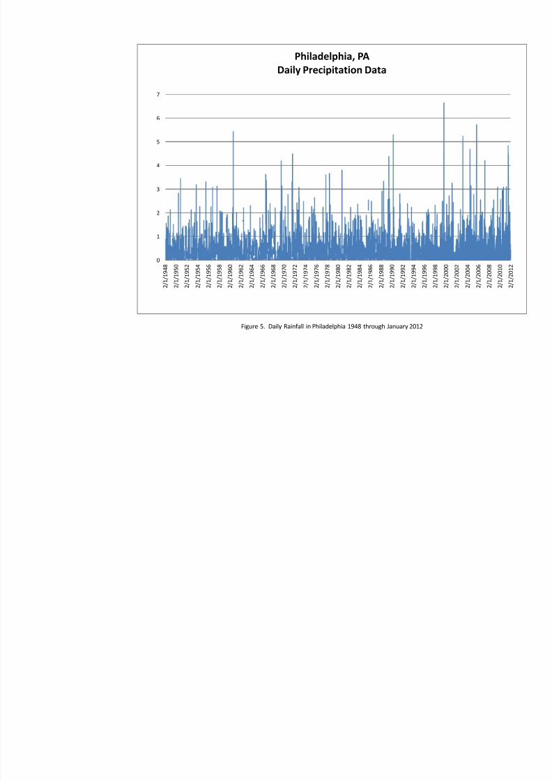
FIGURE 5 – Daily Rainfall in Philadelphia 1948 through January 2012
Appendices
APPENDIX A – KEY MAP AND PHOTOGRAPHS
APPENDIX B – EXHIBITS ILLUSTRATING RESTORATION APPROACHES
8/20/2019 Soapstone Watershed Quarry Gladwyne
http://slidepdf.com/reader/full/soapstone-watershed-quarry-gladwyne 5/67
Lower Merion Township, PALOWM093814
Soapstone WatersheSep
1.
EXECUTIVE SUMMARY
The purpose of this study is to identify the probable cause of observed accelerated eros
watershed, and to develop mitigation strategies or approaches to control erosion and
deposition of sediment and debris. Order of magnitude cost estimates for the proposed ero
strategies and potential funding sources (Grant programs, etc.) for projects of this nature are
Factors influencing accelerated erosion within the watershed are the erodible nature of
increase in frequency and magnitude or rainfall and runoff over the past 13 years, an
activities within the watershed prior to the enactment of stormwater ordinances. The domthe significant increase in rainfall frequency and magnitude over the past 13 years.
This assessment has identified stream restoration strategies that can be applied within the
the eastern or lower portions of the watershed, strategies included the use of a sediment/de
the Schuylkill Expressway, toe stabilization using local materials, bank grading, and c
floodplain benches. In the upper or western portions of the watershed, the dominant str
bank grading and the creation of vegetated floodplain benches to stabilize the channel. Ba
a bend, installation of cross vane drop structures, and other energy dissipation strategies a
address localized problem areas.
Conceptual design level order of magnitude estimates of probable cost for mitigation measu
developed and are summarized as follows:
Upper Watershed $ 350,000
Lower WatershedAlternative 1a - Erosion Mitigation $ 415,000
Alternative 1b - Sediment/Debris Trap Alternativei. Access from Schuylkill Expressway $ 370,000ii. Access from Soapstone Road $ 460,000
Alternative 2 – Conveyance Improvements
Schuylkill Expressway to River $ 455,000
Grant and other funding opportunities applicable to the watershed restoration and erosion midentified include:
Schuylkill River Restoration Fund
Emergency Watershed Protection Assistance Program
Growing Greener Program

8/20/2019 Soapstone Watershed Quarry Gladwyne
http://slidepdf.com/reader/full/soapstone-watershed-quarry-gladwyne 6/67
Lower Merion Township, PALOWM093814
Soapstone WatersheSep
2.
INTRODUCTION AND BACKGROUND
The purpose of this investigation was to identify the cause or causes of the stream instabili
occurring along the Soapstone Watershed stream valley and to develop schematic des
restore the stream valley to a more stable condition. In addition, order of magnitude cost
been developed for the recommended stream stabilization measures along with poten
funding.
The Soapstone watershed is located in the north eastern portion of Lower Merion Townshi
in Figure 1. The watershed is generally bounded by the Schuylkill River to the east, Mo
south, Youngsford Road to the west, and Waverly Road to the north. The watershed gets i
historic soapstone quarry, the remnants of which are located near the middle of the w
stream within this watershed is an unnamed tributary to the Schuylkill River. Phot
throughout the stream valley are provided in Appendix A.
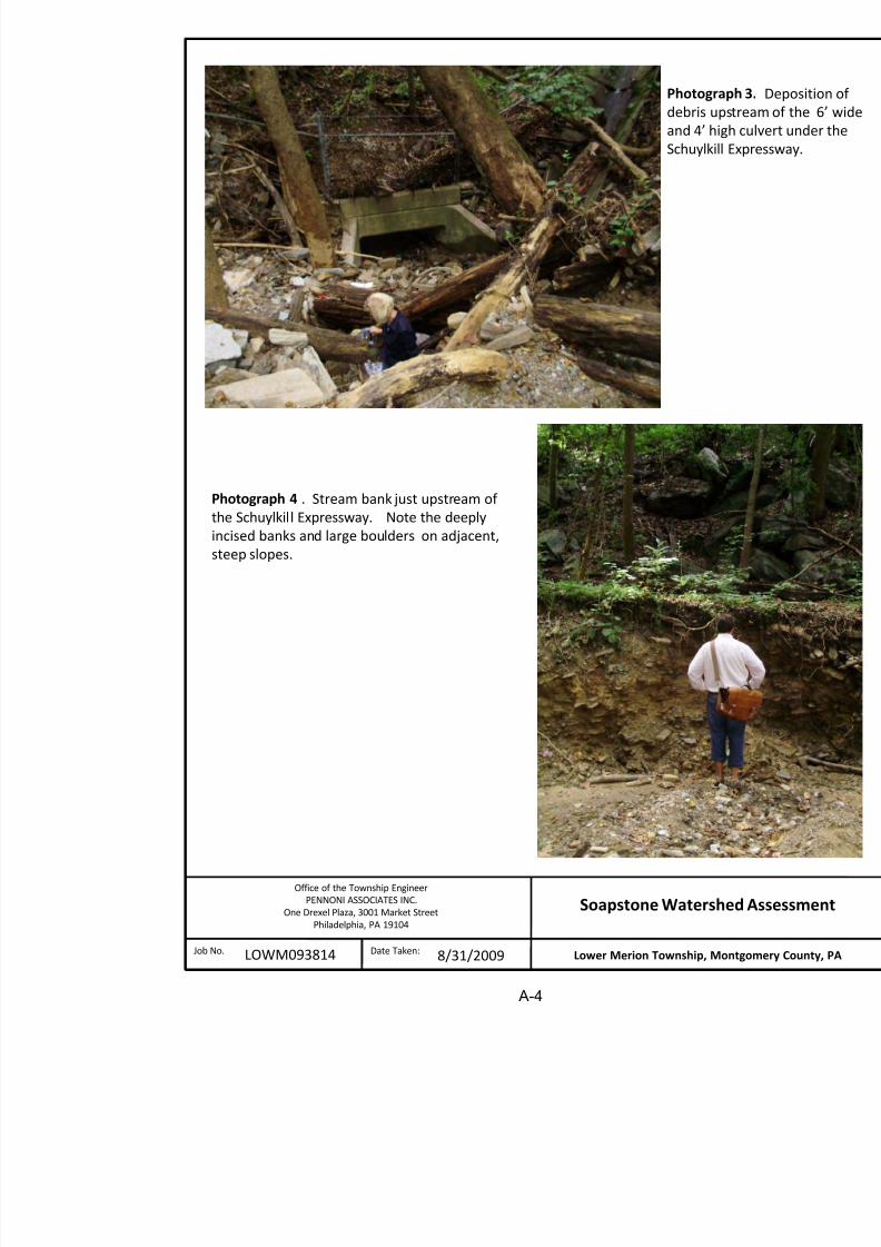
On August 1, 2004 a localized high intensity, short duration storm caused flooding and
along the stream corridor, above the Schuylkill Expressway. With erodible soils and steep
volume of stony sediment and debris was washed downstream, partially clogging Expressway culvert and clogging the culverts under the Norfolk Southern railroad and Riv
result of the culvert clogging stormwater overflowed the railroad, eroding its embankment
onto River Road. Along with the embankment debris, sediment and debris were forc
Expressway and railroad culverts and onto River Road creating a five foot tall debris pile (s
1 in Appendix A). In addition to this initial event, similar events occurred in April 2005 an
and on a number of other occasions.
In addition, it has been reported that erosion and sedimentation in the upper watershed significant sediment deposition in the pond located at 1450 Soapstone Road. If this po
completely filled or damaged, sediment from upstream would be transported to downstr
segments and ultimately to River Road aggravating the situation there.
The erosion and sedimentation problems in the watershed have resulted in significant costs
Township and its residents. It is reported that river road clean-up after these events costs th
approximately $4,000 per event. The cost in flood damage repair to residents along river ro
throughout the watershed is estimated to be significantly greater. In addition these events p
significant threat to public safety, rail and vehicular traffic, and emergency vehicle access in
of River Road. Erosion of this railroad bed could result in a derailment on this active freig
only causing damage to the railroad and River Road but to residents and the environment.
River is a source of drinking water for the City of Philadelphia, which could be contaminate

8/20/2019 Soapstone Watershed Quarry Gladwyne
http://slidepdf.com/reader/full/soapstone-watershed-quarry-gladwyne 7/67
Lower Merion Township, PALOWM093814
Soapstone WatersheSep
corridor. These issues are keyed to the eight (8) individual properties which the stream
outcome of this study is a set of recommendations to mitigate the observed erosion and deb
the watershed.
2.1.
WATERSHED DESCRIPTION
The Soapstone Watershed encompasses 176-acres in the north eastern portion of
Township (See Figure 1). As illustrated in Figure 2, the current land use within th
mostly large lot (2 acres or greater) suburban residential. The stream draining the water
an ephemeral (intermittent) channel at a storm sewer pipe discharge at Abbey Lane.
pipe collects runoff from watershed areas upstream of Abbey lane and from a portion
From the stormwater outlet the channel flows through residential yards. The stream
flow from a spring located on or near 1438 and 1439 Abby Lane. The perennial flow c
pond located on the property at 1450 Soapstone Road. From the pond outfall the str
across 1600 Soapstone Road and then through a steep undeveloped ravine on 160
Flow within the stream remains perennial and gains water from two additional springs
reach. Just upstream of the Schuylkill Expressway, the stream enters a 6 foot by 4
culvert which conveys the discharge under the Expressway. Just downstream of the E
discharge enters a 36 inch diameter culvert under the Norfolk Southern Corporatio
Line, and then under River Road and across 200 River Road in a second 36” diamete
which discharges into the Schuylkill River.
2.2.
HISTORY OF DEVELOPMENT IN THE WATERSHED
Historic aerial photographs from 1942, 1958, 1971, and 2010, and information fro
Merion Historical Society was evaluated to determine the development sequen
Soapstone watershed. The aerial photographs reviewed are illustrated in Figure 3.
In the early 20th Century the majority of the watershed was occupied by the Soapstone
Farm, and the Shipley School Farm. In 1948 there were approximately 10 homes in
(see Figure 3). By 1958, one and two acre lots had been subdivided along the edges o
and the number of residences had increased to approximately 38. By 1971 the total nu
in the watershed had increased to approximately 60. Today, there are approximately 6the watershed. In addition, since 1971 a number of homes in the watershed have be
enlarged, and surface amenities have been added (pools, tennis courts, enlarged drivew
2.3.
SOILS

8/20/2019 Soapstone Watershed Quarry Gladwyne
http://slidepdf.com/reader/full/soapstone-watershed-quarry-gladwyne 8/67
Lower Merion Township, PALOWM093814
Soapstone WatersheSep
The soils in the stream valley below the pond are in the Manor very stony silt loam. T
and highly erodible. A typical Manor soil profile has a sandy loam texture that extend
and Bw horizon to a depth of approximately 2 feet. Below the Bw horizon are a serie
with increasing sand content. Depth to bedrock in the Manor series is typically at 6
and channery rock fragments are commonly 20 to 50% of the soil profile. Thes
typically have a seasonal high water table as they drain rapidly.
Closer to the Schuylkill River, soils within the stream corridor are classified as Sto
Montgomery County Soil Survey (1967) classifies the Stony Land soils in associat
series, in the case of this location, with Manor soils. The distinction between association and Manor soils is that the soils are generally shallower. The surface runo
drainage of Stony Land is rapid. These soils are not suitable for development or agricu
Survey recommends that these soils be used for watershed protection or recreatio
Keeping these soils planted with trees and shrubs will minimize erosion.
The soils in the upper parts of the watershed are in the also mapped as being in the Ma
Compared to the Manor soils mapped in the stream corridor, the Manor soils in the upp
watershed are less stony.
2.4.
GEOLOGY
The digital geology map of Pennsylvania produced by the Department of Conservatio
Resources maps two geological formations within the Soapstone watershed. The cen
the watershed, corresponding to the stream corridor is mapped as being ultramafic
rock). The upper portions of the watershed are mapped as being in the Wissahickon Fo
consists primarily of schist, gneiss and quartzite.
3.
FACTORS INFLUENCING ACCELLERATED CHANNEL EROSION
Erosion within a watershed is dependent upon rainfall amounts and physical characteristic
geology, land slope, and land cover conditions (surface characteristics). Physical charac
the watershed are important because they define how much storm runoff is generated b
amount or rainfall.
3.1. RAINFALL
Regional rainfall data was evaluated for trends that might be influencing observed ero
watershed. Daily data for a 64 year period was available from the National Oceanic an
Ad i i t ti f t ti t th Phil d l hi Ai t Thi d t i l tt d i Fi

8/20/2019 Soapstone Watershed Quarry Gladwyne
http://slidepdf.com/reader/full/soapstone-watershed-quarry-gladwyne 9/67
Lower Merion Township, PALOWM093814
Soapstone WatersheSep
observations are made from the data for this period as they relate to the entire data
through 2011:
Of the 32 daily rainfall events greater than 3 inches, 13 occurred during the last
Of the 12 daily rainfall events greater than 4 inches , 7 occurred during the last
Of the 5 daily rainfall events greater than 5 inches, 3 occurred during the last 1
The single largest daily rainfall event, 6.6 inches, occurred in September of 199
While the data from the rainfall reporting station at the Philadelphia Airport provides
annual trend analysis, localized high intensity storms of short duration occurring in
like Lower Merion Township may not be reflected in the data. For example, On Au
high intensity storm dropping over 6 inches of rain in 90 minutes occurred locally
flooding and damage in the Township. This localized storm was not reflected in the da
the Airport rain gage which reported 1.7 inches for that date. It is noted that some rese
that the heat island affect in the vicinity of large cities influences local weather pattern
higher intensity storms to the surrounding suburbs. Therefore, during wet years, L
Township may receive more frequent higher intensity rain events than are recorded at th
Erosion is a natural process in all watersheds. It is also known that natural erosi
accelerate or increase during flow events equal to or greater than about the 1-year fre
event. The PennDOT Drainage Manual reports that the 1-year frequency 24-hour rai
area is about 2.6 inches. As illustrated in Figure 5, the rainfall data for the region docum
has been a larger than normal number of rainfall events equal to or greater than 2.6 i
during the period from 1999 through 2011. It would be expected that this recent signi
in the frequency of large rainfall events would produce an equally significant incre
within the watershed.
3.2. WATERSHED PHYSICAL CHARACTERISTICS
Watershed physical characteristics include soils, geology, land slope, and cover con
condition characterizes the land surface as it relates to runoff generation. Typical
include imperious areas (building roofs, pavement and other hardscape that typical
runoff), lawn, meadow, forest, etc. These later classifications represent different pe
conditions. Land slope is important because water will run off of steeper slopes faster
mild slopes. It is also noted that changes to any of the items described above will res
in the rainfall-runoff relationship within the watershed.

8/20/2019 Soapstone Watershed Quarry Gladwyne
http://slidepdf.com/reader/full/soapstone-watershed-quarry-gladwyne 10/67
Lower Merion Township, PALOWM093814
Soapstone WatersheSep
the annual rainfall in upper portions of the watershed would have infiltrated into surfac
why there is no evidence of a surface channel in the upper and middle watershe
photograph in Figure 2.
It is noted that even in the watershed’s relatively undeveloped condition in 1942, the
been erosion occurring in the watershed during larger rainfall events. This is particul
lower portions of the watershed due to the steepness of the valley slope and the susce
local soils to erosion. The existence of the valley itself is the strongest evidence of past
As the watershed developed through the 1950’s and 1960’s, additional impervious arethe watershed as a result of road improvements and the development of residential pro
driveways, etc.). It is estimated that the impervious area in the watershed increased, f
percent pre-1942 to approximately 10% in 1971.
In addition to the increase in impervious area, some drainage patterns in the watershed
a result of the development of roads and driveways. For example road co
improvements during this period along Abby Lane and Monk Road resulted in inconcentration of runoff from upslope areas that previously discharged in a dispersed
concentrated runoff is discharged through the culvert under Abbey Lane. The d
roadside ditches along Soapstone Road has also contributed to the concentration of run
the stream channel.
The impact of the development activities in the 1950’s and 1960’s was to increase the
magnitude of runoff reaching the stream corridor. The natural response to this incr
would be an acceleration of naturally occurring erosion within the watershed.
As indicated previously, from the early 1970’s to today there has been some additiona
within the watershed. A few new homes have been built, and a number of homes have
or enlarged, and amenities such as tennis courts and pools have been added. T
development is estimated to have created less than 3 percent additional impervious a
watershed.
Stormwater and erosion controls were implemented through new Township Ordinan
regulating development of the land beginning in the mid 1970’s. Therefore, runoff from
activities since the mid 1970’s has been controlled through the installation of seepage
on-lot stormwater controls.

8/20/2019 Soapstone Watershed Quarry Gladwyne
http://slidepdf.com/reader/full/soapstone-watershed-quarry-gladwyne 11/67
Lower Merion Township, PALOWM093814
Soapstone WatersheSep
been determined that none of the maintenance or compliance issues identified have h
impact on erosion or storm runoff in the watershed.
In the discussion above, impervious area is used as the measure of development
quantity of runoff. It is noted that site grading and other construction activities w
natural soils also have an impact on runoff rates and volumes. However, the re-es
vegetation on these surfaces causes the resultant increase in runoff to be much less s
the impact from impervious surfaces.
3.3.
SUMMARY CONCLUSIONS RELATED TO FACTORS INFLUENCING E
As mentioned previously, erosion is a natural process in all watersheds and these na
processes accelerate or increase during flow events equal to or greater than ab
frequency runoff event. The 1-year runoff event corresponds with a 24 hour rain e
more than 2 inches. As discussed above, the rainfall data for the region demonstrate
been a significant increase in rainfall events over about 2 inches per day during the pe
through 2011.
As discussed above, development in the watershed before implementation of storm
resulted in an estimated 10% increase of impervious surface area in the watershed. H
from most of this impervious area is tributary to pervious landscape (lawns and oth
where some of the runoff can be absorbed. Therefore the increase in runoff is less pron
cases where the runoff from impervious surfaces is piped directly to waterc
acknowledged that the runoff from a small portion of Monk Road and Abby La
connected to the waterway by storm drains and roadside drainage swales.
While development activities in the watershed may have resulted in a minor increase
evidence was uncovered during this study that would suggest that the imperviousness a
development in the watershed caused erosion comparable to what has been evidenced i
It is concluded then, that the increased frequency of large rainfall events and associated
the past 13 years, has been the primary contributor to the acceleration of natural erosi
the watershed.
4.
FIELD ASSESMENT AND STRATEGIES FOR EROSION MITIGATION
As discussed above, the stream channel through the watershed begins as an ephemera
downstream of a storm sewer pipe discharge east of Abbey Lane. From this point, the chan

8/20/2019 Soapstone Watershed Quarry Gladwyne
http://slidepdf.com/reader/full/soapstone-watershed-quarry-gladwyne 12/67
Lower Merion Township, PALOWM093814
Soapstone WatersheSep
conveyance and erosion characteristics are presented followed by a description of the
mitigation measures. Conceptual design level order of magnitude estimates of probabl
presented.
4.1.
PIPED SECTION – SCHUYLKILL EXPRESSWAY TO 200 RIVER ROAD
The piped section represents the downstream limit of the study reach and inclu
conveyance systems under the Schuylkill Expressway, Norfolk Southern Corporation
of-way, River Road, and the side yard of 200 River Road.
4.1.1.
EXISTING CONDITIONS
The existing condition for this reach is illustrated in Exhibit 12 (Appendix B) and
foot by 6 foot box culvert under the Schuylkill Expressway, a 48 inch circular reinf
pipe (RCP) under the Norfolk Southern Corporation railroad, and a 36 inch oval pi
Road and through the property at 200 River Road. Photo a on Exhibit 12 illustrate
Junction Box along the west side of River Road. Photo b and c illustrat
configuration between the PennDOT culvert under the Schuylkill Expressway and
culvert under the Norfolk Southern Corporation railroad.
Discharges from the culvert under the Schuylkill Expressway are controlled by a
flow opening at the bottom of the box, and a grate covering its top. The inlet end
RCP under the railroad right-of-way is screened with a vertical mesh screen an
steel grate (See Photo c on Exhibit 12.). It is noted that the mesh or wire screen w
replace a vertical steel screen (similar to the top grate) sometime after November Township requested that the steel screen be removed. This request was i
information received from the Pennsylvania Department of Environmental Protec
and debris restrictions such as this were a violation of State Code.
The discharge end of the culvert under the railroad connects to the culvert under Ri
Township installed junction box. When this junction box was initially constru
steel grate was installed at its outlet side to trap debris and facilitate maintenan
under river road. This grate was removed in November of 2011 when the Tow
aware that the obstruction caused by the grate was a violation of State Code.
Both the discharge configuration of the PennDOT culvert and the inflow config
railroad culvert, as well as the grate in the junction box along River Road restr

8/20/2019 Soapstone Watershed Quarry Gladwyne
http://slidepdf.com/reader/full/soapstone-watershed-quarry-gladwyne 13/67
Lower Merion Township, PALOWM093814
Soapstone WatersheSep
4.1.2.
SUGGESTED MITIGATION ACTIONS
Mitigation actions to reduce the risk of flooding, erosion, and debris deposition in
River Road would involve trapping or otherwise removing the sediment an
(Alternative 1) and/or improving the conveyance capacity of the piped dis
(Alternative 2). Alternatives for removing or reducing the transported sediment a
include stabilizing the upstream stream reach (Alternative 1a) or constructing a s
trap just upstream of the Expressway (Alternative 1b). Alternative 1a, stabilizin
channel is considered in Section 4.2 below.
4.1.2.1.
ALTERNATIVE 1B - SEDIMENT/DEBRIS TRAP
This alternative involves the construction of a debris trap upstream of
Expressway. During large storm events eroded material from the watershed
into and through the culvert system as described previously. Some of t
deposited in the various pipe segments and at the junction of the pipe segmen
fully blocking the portions of the pipes causing flood waters and debris to flow
the discharge box at the downstream end of the expressway culvert and the jRiver Road, and flood across the railroad tracks causing flooding, erosion,
debris deposition. The result has been property damage and economic los
significant safety hazards for rail traffic.
One alternative to reduce or eliminate clogging of these culverts would be
sediment and debris trap just upstream of the Expressway to capture transporte
debris before it enters the system. This alternative, investigated by the
2010/2011, involves construction of a riser pipe on the upstream end of the Pen
under the Expressway and excavation of debris basin immediately upstream (
in Appendix B). In addition, an access road and staging area for maintenanc
basin would need to be constructed.
Construction of the access road will be the most significant challenge for t
There are two options for providing access to the area adjacent to th
embankment. The first is to construct the access road from the Expressway (wcontrolled access). The second would be to construct the access from Soapsto
options pose challenges but warrant further investigation.
A concept level order of magnitude estimate of probable cost for both access a
provided below. It is noted that these costs reflect initial construction and do n

8/20/2019 Soapstone Watershed Quarry Gladwyne
http://slidepdf.com/reader/full/soapstone-watershed-quarry-gladwyne 14/67
Lower Merion Township, PALOWM093814
Soapstone WatersheSep
4.1.2.2.
ALTERNATIVE 2 - CONVEYANCE SYSTEM IMPROVEMEN
Actions that would improve flow and sediment/debris movement through the include:
a.
Construction of a more efficient transition between the PennDOT c
culvert under the Norfolk Southern railroad. This would involve som
following items:
Completely remove the wire screen and grate at the upstream
inch culvert under the railroad right-of way and replace it w
headwall with wingwalls;
enlarging the opening in the side of the PennDOT culvert outle
improving the flow transition between the PennDOT box c
Norfolk Southern culvert through installation of a junction bo
culverts.
b.
Installation of a larger pipe under the Norfolk Southern railroad.
c.
Installation of a larger pipe under River Road and across the propert
Road.
d.
Removing the pipe under the property at 200 River Road and replac
open drainage channel.
As indicated above, the Pennsylvania Department of Environmental Protection
that any screen or conveyance element which might hinder free flow of water a
sediment and debris through the piped conveyance system is a violation
Therefore, the wire screen at the upstream end of the culvert under the railroad
be removed immediately by Norfolk Southern Corporation. In addition, S
requires that clear conveyance be maintained through closed conveyance syste
to carry waters of the Commonwealth. Therefore, PennDOT, Norfolk Sou
Township have an obligation to inspect and if necessary clean any debris d
subject culverts following all significant flow events.
An order of magnitude estimate of probable cost for the construction of th
elements identified above is as follows:
Improved transition structure – PennDOT
to Norfolk Southern Corporation culverts $ 85,000
Install larger pipe under Norfolk Southern
Corporation railroad $ 250,000

8/20/2019 Soapstone Watershed Quarry Gladwyne
http://slidepdf.com/reader/full/soapstone-watershed-quarry-gladwyne 15/67
Lower Merion Township, PALOWM093814
Soapstone WatersheSep
4.2.
1600 MONK ROAD AND 1619, 1621, AND 1624 WINSTON ROAD
These properties are located just upstream of the Schuylkill Expressway and just downSoapstone Road. It includes the portion of the channel which flows through 1600 M
also a small section of channel that flows through 1621 and 1619 Winston Road. T
Winston Road is included as its southern property line is immediately adjacent to the st
4.2.1. EXISTING CONDITIONS
This section of the stream valley is steep and the channel is deeply incised. A
Photographs 4 and 5, the stream banks are steep cut, near vertical and incised 8
many locations the stream banks, composed of erodible soils and stony material, ar
susceptible to erosion as a result of past erosion. A significant number of large t
undermined by the erosion and many have fallen across the stream channel. The v
steep with 25% to 50% slopes. Though the stream flow is tranquil on sunny days,
forceful nature of rainy day flows are evidenced by the loose boulders, rocks, and d
channel length (Photograph 5). In many locations the stream has eroded to the u
bedrock (Photograph 6). The stream reach through 1600 Monk Road dischargesunder the Schuylkill Expressway. As shown in Photograph 3, the channel area ju
the Expressway functions as a sediment and debris trap. A significant volum
stones, large rocks, downed trees and branches, and other debris have accumulated
4.2.2.
EROSION MITIGATION APPROACH
The inaccessibility of this reach, coupled with the deeply incised nature of th
significant challenges to stabilizing this reach. Access can be achieved via Soapfrom the Schuylkill Expressway. It is acknowledged that gaining the permission
access this reach via the Expressway will be challenging since it is a Federally reg
access highway. Therefore, access from Soapstone Road has been assumed.
The recommended mitigation approach for stabilizing actively eroding portions o
illustrated in Appendix B, Exhibits 1 and 2. The approach involves stabilizing the
the stream bank, and, where possible, grading the bank to create a small flo
immediately adjacent to the channel. When used, the floodplain bench would be
side or both sides of the channel depending on site specific field conditions. Wh
would permit, the floodplain bench would be vegetated with woody or brushy veg
reduce the velocity of flood flows and overall erosion potential.
T th t t ibl t i ld b li h d b i

8/20/2019 Soapstone Watershed Quarry Gladwyne
http://slidepdf.com/reader/full/soapstone-watershed-quarry-gladwyne 16/67
Lower Merion Township, PALOWM093814
Soapstone WatersheSep
The steepness of the watershed and erosive power of flood flows coupled with the h
nature of the soils in this reach imposes a degree of uncertainty relative to the
erosion mitigation strategy. In addition, the erosion mitigation approach suggested
itself result in short term disturbance which could result in an increased susceptibi
Access for equipment will require grading activities and removal of trees and
vegetation, and vegetation planted as part of the erosion mitigation strategy, will r
become established. Also, there are no homes or other infrastructure that would be
erosion in this reach. For these reasons, consideration of an alternative approac
Normally the construction of a sediment/debris basin is just upstream of the Exp
alternative is presented in Section 4.1.4 below.
4.2.3.
ESTIMATE OF PROBABLE COST FOR EROSION MITIGATION
The cost of implementing the erosion mitigation approach suggested in the prev
influenced by the limited site access for equipment and ruggedness of the terrain
magnitude estimate of probable cost to implement the described erosion mitiga
described is $270,000. This estimated cost is based on the following assumptions:
Stabilization of approximately 700 LF of stream using the restoration meth
Access is via Soapstone Road;
Soapstone Road will require significant restoration as a result of
construction traffic.
4.3.
1600 SOAPSTONE ROAD
This property is located just upstream of 1600 Monk Road at the end of Soapstone Roa
4.3.1.
EXISTING CONDITIONS
Approximately two-thirds of the stream reach through this property is deeply inc
the conditions described for the upper portions of the stream reach through 160
However, as the stream flows through the home site near the center of the prope
banks fall away as though they may have been cut to provide a more suitable build
Photographs 7 through 11 illustrate the stream condition in the vicinity of t
Although steeply cut, the stream banks here are relatively shallow (0.5 to 3 feet). A
home spans the stream (Photograph 7), and the yard area upstream of the add
terraced forming a stepped floodplain area (Photograph 8). The stream banks
evidencing past erosion. An erosion control blanket installed to stabilize the stre

8/20/2019 Soapstone Watershed Quarry Gladwyne
http://slidepdf.com/reader/full/soapstone-watershed-quarry-gladwyne 17/67
Lower Merion Township, PALOWM093814
Soapstone WatersheSep
Upstream of the home site, the stream banks are continuously exposed, evidencin
activity (Photograph 10). Cut banks in this area range from about 5 feet, to more
height, west of the barn. The channel becomes very deeply incised at the weste
property.
4.3.2.
EROSION MITIGATION APPROACH
In the forested sections of the stream reach upstream and downstream of t
restoration techniques similar to those described for 1600 Monk road would be ap
approach is illustrated in Exhibit 4, in Appendix B. To mitigate the erosion wi
segment crossing the home site, armoring the stream banks with riprap or some ot
the suggested restoration technique. This technique is illustrated in Exhibit 3
proximity of the house, any installed bank armor will require inspection following
prompt maintenance, as needed, between storms. The Township was recently n
damages on this property are eligible and have been selected for funding th
Department of Agriculture’s (USDA) emergency watershed protection program (se
a description of this program). Mitigation measures have been designed by PA D
The Township is assisting as the sponsor and contracting agency will full reimbuconstruction costs.
4.3.3.
ESTIMATE OF PROBABLE COST FOR EROSION MITIGATION
The order of magnitude estimate of probable cost to implement the described eros
measures in the upstream and downstream incised channel areas on this property is
riprap bank protection proposed for the center portion of the property is being fun
USDA grant and, therefore is not included. The estimated cost is based onassumptions:
Stabilization of approximately 100 LF of the stream valley downstream of
using techniques as described for the stream segment through 1600 Monk R
Stabilization of approximately 200 LF of stream valley upstream of the ho
techniques described above.
4.4.
1450 SOAPSTONE ROAD
This property sits at the transition from the steeply sloped stream channel in the lower
watershed and the more mildly sloping upper channel reaches. Remnants of the for
quarry are visible near the center of the property and the quarry pond occupies a large

8/20/2019 Soapstone Watershed Quarry Gladwyne
http://slidepdf.com/reader/full/soapstone-watershed-quarry-gladwyne 18/67
Lower Merion Township, PALOWM093814
Soapstone WatersheSep
the pond outlet channel (refer to the photograph on Exhibit 4 in Appendix B) exte
property at 1600 Soapstone Road.
The steeply sloped pond outlet channel was previously stabilized by the propert
gabion basket retaining wall topped with a segmented block retaining wall, was
along the north side of the channel (Photograph 12 and Exhibit 5 in Appendix B).
in Exhibit 5, there is active erosion at the downstream end of the stabilized outlet
erosion is a result of the abrupt flow transition between the outfall channel and the
channel below.
The pond on this property is in-line with the stream. Therefore, any sediment tra
upstream areas as a result of natural or accelerated erosion is captured in the p
evidence of deposited sediment at the point where the upstream channel enters
Photo 14). The pond serves as a sediment trap for all material eroded and transp
upstream stream segments. It this pond were to fill it would no longer prevent th
this material to downstream reaches and ultimately to River Road.
The short stream segment on the property just upstream of the pond has steep cut 3
vertical channel bank slopes as illustrated in Figure 14 and the top left photo in Ex
stony alluvial deposits along this reach provide evidence of sediment transport thro
Photograph 14 illustrates an exposed pipe located in this section of the stream w
that there has been historic erosion within the reach that resulted in a general lo
channel bed.
4.4.2.
EROSION MITIGATION APPROACH
As indicted above, the property owner has already made a substantial investmen
the pond outlet channel. However, where the stabilized channel and adjacent g
wall end, there is an area of significant scour. A photograph documenting the sco
and a cross section documenting the mitigation approach are illustrated in Append
The mitigation approach involves the construction of a large rock energy di
extending for an appropriate length into the milder downstream channel.
The cut stream banks in the segment of channel upstream of the pond should be
bank toe and installation of an adjacent floodplain bench as illustrated in Exh
downstream channel segment on 1434 Soapstone Road.
4 4 3 ESTIMATE OF PROBABLE COST FOR EROSION MITIGATION

8/20/2019 Soapstone Watershed Quarry Gladwyne
http://slidepdf.com/reader/full/soapstone-watershed-quarry-gladwyne 19/67
Lower Merion Township, PALOWM093814
Soapstone WatersheSep
4.5.
1434 SOAPSTONE ROAD
The property at 1434 Soapstone is the geometric center of the watershed. Perenni
begins here as a result of spring flows from 1449 and 1439 Abby Lane. Upstream of th
streamflow is ephemeral/ intermittent.
4.5.1.
EXISTING CONDITIONS
There are three distinctly unique stream segments on this property. The downs
flows parallel to the properties driveway in a linear fashion and then curves sharplnear the north eastern corner of the house. Photographs 15 through 21 illu
conditions in this reach. The channel is moderately to deeply incised in this reach
ranging from 3 to 6 feet high. The deepest channel cut is near the sharp bend j
The linear stream channel in the lower portion of this reach is located approximate
from the driveway. The pipe illustrated in Photograph 15 is approximately 1.5
bottom of the stream channel. This provides evidence that the stream has eroded
time.
The center channel section, which flows mostly along the northern property line, ap
illustrated in Photographs 22 and 23. Along this portion of the channel the p
graded the streambanks to create a gentle connection with the floodplain in a fas
the mitigation measures illustrated in Appendix B Exhibit 6.
Upstream of the stable channel reach (near the darn and property boundary wit
Lane) there is an area that exhibits significant erosion at and just downstream of anheadcut (sudden drop in stream elevation). This headcut section is currently bein
the roots of large trees that extend across the channel from both sides. Immediatel
of the headcut the channel is approximately 10 feet deep (Photograph 27). Just u
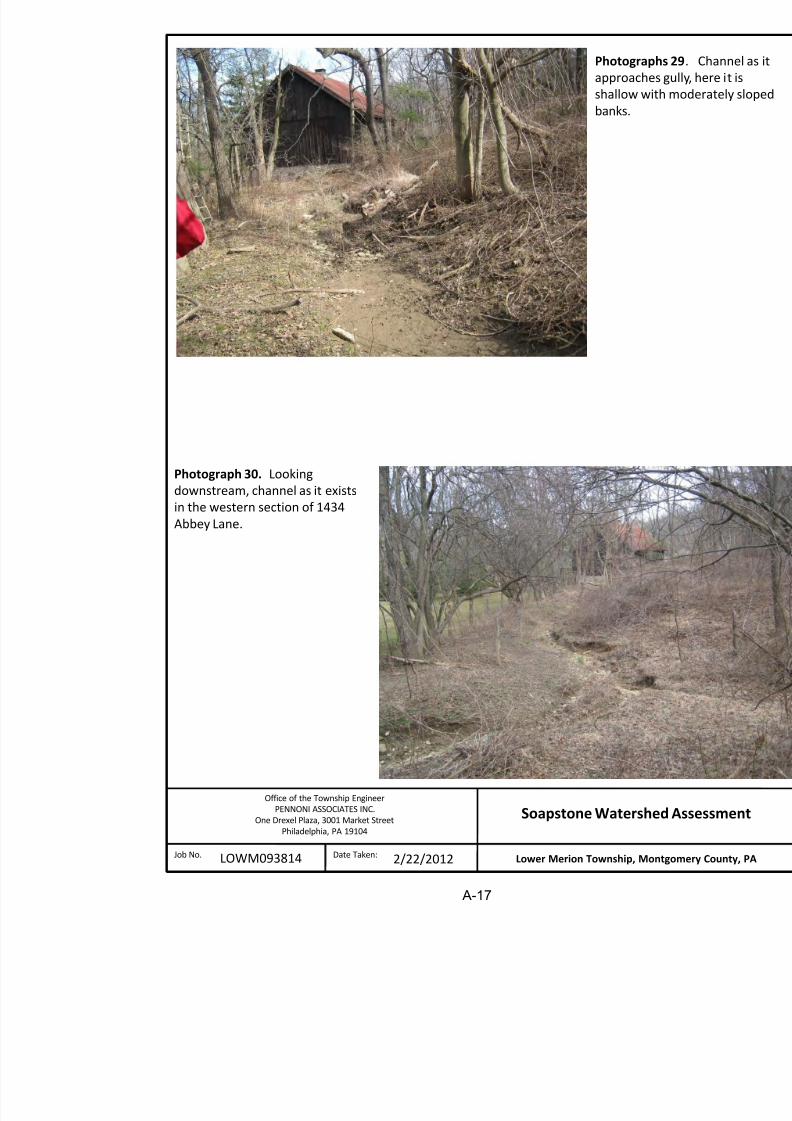
headcut the channel depth is less than 2 feet deep with gently sloping stable banks a
Photograph 29.
4.5.2. EROSION MITIGATION APPROACH
Restoration options are presented for the downstream channel reach and headcut ar
The restoration option for the downstream channel reach is illustrated in Appendi
The solution consists of grading the bank to a more stable angle and constructin
floodplain bench on one or both sides of the channel depending on specific site

8/20/2019 Soapstone Watershed Quarry Gladwyne
http://slidepdf.com/reader/full/soapstone-watershed-quarry-gladwyne 20/67
Lower Merion Township, PALOWM093814
Soapstone WatersheSep
The recommended solution for mitigation of erosion at that headcut is illustrated
Exhibit 8. The solution includes installation of eight cross vane drop structures
apart. In addition, the channel banks should be laid back and stabilized with
vegetation.
4.5.3.
ESTIMATE OF PROBABLE COST FOR EROSION MITIGATION
The order of magnitude estimate of probable cost to implement the described eros
measures is $122,000. This estimated cost is based on the following assumptions:
Installation of 375 LF of stream restoration using techniques in Appendix B Installation of rock filled gabion bank protection as illustrated in Appendix
Construction of 8 cross vane stabilization structures illustrated in Appendix
4.6.
1435 ABBEY LANE
4.6.1.
EXISTING CONDITIONS
Photographs 30 through 32 illustrate channel characteristics on the property at 143
Natural erosion on this property has created an eroded stream channel with an av
about 2.5 feet and an average depth of about 2 feet. This channel appears to be g
although some erosion probably does occur during high flows.
A sizable scour hole exists just downstream of the upstream property line (Photog
scour hole has been formed in response to energy dissipation as flow transitions
lined channel on the upstream property to the natural condition on this property.
4.6.2.
EROSION MITIGATION APPROACH
Improving the channels erosion resistance would involve minor grading alon
channel to improve floodplain connectivity and create a broader distribution of f
property during high flows. Exhibit 9 in Appendix B illustrates this concept.
In addition, some form of energy dissipation should be implemented at the upstreamto eliminate the accelerated erosion at that location. This could be accomm
property or on 1418 Monk Road.
4.6.3. ESTIMATE OF PROBABLE COST FOR EROSION MITIGATION

8/20/2019 Soapstone Watershed Quarry Gladwyne
http://slidepdf.com/reader/full/soapstone-watershed-quarry-gladwyne 21/67
Lower Merion Township, PALOWM093814
Soapstone WatersheSep
4.7.
1418 MONK ROAD
As shown in Photograph 33, the stream corridor at 1418 Monk Road is entirely linedthis time, no restoration is proposed at this location.
However as discussed previously, a scour hole has formed at the point where the stre
from the 1418 Monk Road property to the property at 1435 Abbey Road. The alternati
an energy dissipation apron at 1435 Abbey Road would be to install a stilling basin o
energy dissipation on this property.
4.8.
1410 AND 1400 MONK ROAD
Since the channel section and observed erosion are similar on the properties at both
1400 Monk Road, these properties will be considered together.
4.8.1.
EXISTING CONDITIONS
Existing channel conditions on these properties are illustrated in Photographs 34, 3
channel through both of these properties is cut through very erodible soils. Streamvertical with an average height of approximately four feet. The top of bank wid
reach varies from about 5 feet to 15 feet. Large section of undermined turfgrass c
on these properties (Photograph 34). Photograph 37 illustrates the beginnings
stream channel just downstream of the culvert under Abbey Lane. As time p
headcut will continue to advance until it reaches the culvert outfall. Photograph
flow entering the culvert on the upstream side of Abbey Lane. This culvert also
from the inlets on Monk Road at its intersection with Abbey Lane (photographs 39
4.8.2. EROSION MITIGATION APPROACH
The preferred mitigation approach across these properties would be to grade the st
more appropriate slope and create vegetated floodplain benches where possible an
It is acknowledged that the large trees along the stream will make creation of
floodplain bench difficult. Bank Toe armor should also be installed in locations w
undermining is occurring. These mitigation techniques are illustrated in Appendix B
4.8.3.
ESTIMATE OF PROBABLE COST FOR EROSION MITIGATION
The order of magnitude estimate of probable cost to implement the described erosio
measures described is $120 000 This cost is about evenly split between the two pr
8/20/2019 Soapstone Watershed Quarry Gladwyne
http://slidepdf.com/reader/full/soapstone-watershed-quarry-gladwyne 22/67
Lower Merion Township, PALOWM093814
Soapstone WatersheSep
4.9.
DRAINAGE AT THE INTERSECTION OF MONK ROAD AND ABBEY LA
Drainage conditions at the intersection of Monk Rod and Abbey Lane are illustrated 39 and 40. The water illustrated in the photographs is runoff from a curbed portion
extending both east and west of Abbey Lane. As illustrated in Photograph 39, some
tributary to this location runs down the west side of Abbey Lane (see also P
contributing to erosion adjacent to this private driveway. This condition could b
modifying the driveway apron/roadway transition to create a positive flow line to
suggested that the Township Public Works Department work with the land owner to
modification.
5. COST SUMMARY
Costs associated with mitigation strategies were presented in the last section for each prope
channel traverses across. Costs are summarized below as they relate to erosion and deposit
processes in the upper and lower watershed. The upper watershed includes all properties up
pond at 1450 Soapstone Road, and the lower watershed is everything to the east of the pond
traps all sediment generated from the upper watershed. The lower watershed is the source o
and debris that gets transported to the culverts under the Schuylkill Expressway, Norfolk So
Railroad, and River Road.
Upper Watershed $ 350,000
Lower Watershed
Alternative 1a - Erosion Mitigation $ 415,000
Alternative 1b - Sediment/Debris Trap Alternativei. Access from Schuylkill Expressway $ 370,000ii. Access from Soapstone Road $ 460,000
Alternative 2 – Conveyance Improvements
Schuylkill Expressway to River $ 455,000
It is noted that the lower watershed alternatives are intended as either/or alternatives. Also
represents an estimate of the cost to stabilize the channel in the lower watershed and
presented for mitigation of erosion from 1600 Soapstone Road to the Expressway. additional costs associated with operation and maintenance of the sediment/debris trap
considered here.
As identified in Section 4.2.2, the steepness of the watershed and erosive power of flood
with the highly erodible nature of the soils in the lower reach imposes a degree of uncerta

8/20/2019 Soapstone Watershed Quarry Gladwyne
http://slidepdf.com/reader/full/soapstone-watershed-quarry-gladwyne 23/67
Lower Merion Township, PALOWM093814
Soapstone WatersheSep
6.
GRANT AND OTHER FUNDING OPPORTUNITIES
Grant and other funding opportunities applicable to watershed restoration and erosion mitthe Soapstone Watershed are described below:
Schuylkill River Restoration Fund: The Schuylkill River National and State Herit
designated by the United States Congress as an area where historic and recreational re
together to define a distinctive landscape. The Heritage Area is managed by the Sc
Greenway Association. In cooperation with Exelon Nuclear and the Philadelphia Water D
Heritage Area administers the Schuylkill River Restoration Fund. Available to non-profi
and municipal governments, the grant finances projects that mitigate water quality prob
from acid mine drainage, agricultural runoff, and stormwater issues. Grant applications ar
after a Letter of Interest is submitted and reviewed. A letter of interest was submitted for
but an invitation has not been extended at the time of this writing. Grant allocations rang
and $100,000 and a 25% match is required.
Emergency Watershed Protection Assistance Program: The United States Department
(USDA) Emergency Watershed Protection (EWP) program in cooperation with PennsylvanManagement Association is currently offering technical and financial assistance to stabiliz
became damaged following the hurricane Irene and Tropical Storm Lee. To qualify for t
unstable stream reach must be within 50 feet of improved property. The program stabili
armoring the stream with rock. One property owner in the Soapstone Watershed ha
funding under this program.
Growing Greener Program: The Growing Greener Program began in 1999. One of
missions is to restore and protect Pennsylvania’s rivers and streams. To fulfill this misGreen offers Watershed Protection Grants. Projects that improve waters quality of impai
polluted by urban runoff qualify for funding under this program. At this time, Growing
accepting applications. In 2011 the program accepted applications in August. The
applications for Growing Greener Funding is expected after the 2012-2013 budget is appro
The National Fish and Wildlife Foundation’s Five Star Restoration Program: This pro
competitive funding for community-based restoration project. The program is focused on b
and community partnerships. The average grant award is $25,000. A one-to-one in-kind m
and services is required to qualify for this program. Grant applicants must address ho
achieves on-the-ground restoration, environmental education, and measurable results.
must also demonstrate that the project will engage multiple partners within a community.
not accepting applications at this time, but is expected to reopen in 2012.

8/20/2019 Soapstone Watershed Quarry Gladwyne
http://slidepdf.com/reader/full/soapstone-watershed-quarry-gladwyne 24/67
Lower Merion Township, PALOWM093814
Soapstone WatersheSep
PennVEST: The Pennsylvania Infrastructure and Investment Authority (PennVEST)
interest loans to finance design, engineering, and construction for municipal stormwater p
the Clean Water State Revolving Fund. The interest rates range from 1 to 4%. Examples
projects that PennVest has financed in the past include infiltration system, swales, and
Penn Vest Board meetings are currently scheduled for May 16, 2012 and August 22, 2012.
Urban Waters Small Grants Program: The Urban Waters Small Grants Program is admi
Environmental Protection Agency. It finances projects that contribute to improved wa
community revitalization. Funded projects must demonstrate community-led efforts
economic, environmental, and social benefits. Local watershed planning, water quality m
public education are examples of projects funded in the past. The 2012 application deadli
23, 2012. It is expected that applications for 2013 will also be accepted in January.
US Army Corps of Engineers Snagging and Clearing for Flood Control Program: The
Clearing for Flood Control program is administered by the Army Corps of Engineers (AC
this program the ACOE designs and constructs projects that provide flood control. Remov
debris in a waterway in the interest of flood control is the focus of this program. The max
amount is $500,000. The project sponsor is required to contribute a minimum of 5% of tin cash. Obtaining this funding requires the applicant to request the Army Corps of Engin
a planning and design analysis (PDA) study. If the study concludes that the project is acce
engineering feasibility, environmental acceptability, or economic basis, it will be funded.
Other Sources of Funding: Key project stakeholders will also need to play a role in projec
This includes PennDOT, Norfolk Southern Corporation, the Township, and affected proper
Both PennDOT and Norfolk Southern Corporation have operations, maintenance, and safet
responsibilities related to the erosion and sediment/debris transport issues in the eastern endwatershed. Therefore, they should participate as responsible partners in helping to fund ero
mitigation projects in the eastern end of the watershed.
7.
SUMMARY
This watershed assessment has identified the probable causes of observed accelerated eros
watershed, and has advanced mitigation strategies, or approaches to control the erosio
erosion and the resulting deposition of sediment and debris. Preliminary order of mestimates for the proposed erosion mitigation strategies were also developed. In addition
conducted to identify grant and other funding sources available for projects of this nature.
The two factors influencing accelerated erosion within the watershed are the increase in
magnitude or rainfall and runoff over the past 13 years and development activities within

8/20/2019 Soapstone Watershed Quarry Gladwyne
http://slidepdf.com/reader/full/soapstone-watershed-quarry-gladwyne 25/67
Lower Merion Township, PALOWM093814
Soapstone WatersheSep
vegetated floodplain benches to stabilize the channel. Bank armoring at a bend, installatio
drop structures, and other energy dissipation strategies are also used to address localized pro
Conceptual design level estimates of probable cost for implementation of the erosion mitig
were also developed and were summarized above.
8. CONCLUSIONS AND FUTURE DIRECTIONS
In conclusion, this study has identified erosion and sedimentation/debris mitigation strateg
applied within the watershed to mitigate the physical, financial, and safety impacts caused
erosion within the watershed. This study serves as a foundation for implementation of th
strategies. Future efforts should include involving the property owners and key stakehold
and Norfolk Southern Corporation) in a dialogue related to advancing this project. Key di
should include project prioritization and phasing, and funding. It is critical that PennDO
Southern Railroad be brought into these discussions at the earliest possible opportuni
advancing solutions particularly in the western watershed areas.

8/20/2019 Soapstone Watershed Quarry Gladwyne
http://slidepdf.com/reader/full/soapstone-watershed-quarry-gladwyne 26/67
Lower Merion Township, PALOWM093814
Soapstone WatersheSep
APPENDIX A
KEY MAP AND PHOTOGRAPHS
i i A S

8/20/2019 Soapstone Watershed Quarry Gladwyne
http://slidepdf.com/reader/full/soapstone-watershed-quarry-gladwyne 27/67
Lower Merion Township, PALOWM093814
Soapstone WatersheSep
APPENDIX B
EXHIBITS ILLUSTRATING RESTORATION APPROACHES

8/20/2019 Soapstone Watershed Quarry Gladwyne
http://slidepdf.com/reader/full/soapstone-watershed-quarry-gladwyne 28/67
202 RIVER RD
200 RIVER RD 2 5 0
55
2 7 5 2 9
0
1 5 0
2 7 5 2 8 0
2 8 5 2 9 0
2 9 5
300
2 3 5 2 4 0
245 2 4 0
2 4 53 2 0

8/20/2019 Soapstone Watershed Quarry Gladwyne
http://slidepdf.com/reader/full/soapstone-watershed-quarry-gladwyne 29/67
1520MONKRD
1400WAVERLYRD
1622WINSTON RD1552BRIAR HILLRD
1548BRIAR HILLRD 1557BRIAR HILLRD
1601WINSTON RD
198 RIVER RD
1540BRIAR HILLRD
1551BRIAR HILLRD
194 RIVER RD
1534BRIAR HILLRD
1607WINSTON RD
1624WINSTON RD
1545BRIAR HILLRD
1611WINSTON RD
1615WINSTON RD
1530BRIAR HILLRD 1619WINSTON RD
1621WINSTON RD
1539BRIAR HILLRD
1600MONKRD
1501WAVERLYRD1600SOAPSTONE RD
1533BRIAR HILLRD
1520BRIAR HILLRD
1525BRIAR HILLRD
1550MONKRD
1450SOAPSTONE RD
1455ABBEYLN
1530MONKRD
1447WAVERLYRD
1441WAVERLYRD1449ABBEYLN
1433WAVERLYRD
1439ABBEYLN
1434SOAPSTONE RD
1421WAVERLYRD
1415WAVERLYRD
1435ABBEYLN
1510MONKRD
1500MONKRD1411WAVERLYRD
1407WAVERLYRD
1543MONKRD
1401WAVERLYRD
1356MONKRD
MONK RD
1432MONKRD1347WAVERLYRD
1418MONKRD
1345WAVERLYRD1426MONKRD
1509MONKRD
1325WAVERLYRD1410MONKRD
1501MONKRD
1499MONKRD
1343WAVERLYRD
1435MONKRD
1400MONKRD
1429MONKRD
1225YOUNGSFORD RD1335WAVERLYRD
1423MONKRD
1350MONKRD
1415MONKRD
1342MONKRD1407MONKRD1326MONKRD
1401MONKRD
1336MONKRD
1351MONKRD1348BEAUMONTDR
1316MONKRD
1332MONKRD1341MONKRD
MONK RD 1344BEAUMONTDR
1331MONKRD
1211YOUNGSFORD RD 1317MONKRD1328BEAUMONTDR
1334BEAUMONTDR
1320BEAUMONTDR1310MONKRD
1311MONK RD
1321BEAUMONTDR 1 2 5
140
1 4 5
170
1 7 5
1 8 5
1 9 0
2 4 0
2 4 5
2 5 5
2 6 0
2 6 5
2 7 0
2 8 0
2 8 5
2 9 5
3 0 0
1 1 0
1 1 5
1 3 0
140
1 4 5
2 4 0
2 3 5 230
2 2 5 2 20
2 1 5 210
2 0 5
2 0 0
3 5 5
3 3 5
3 3 0
3 2 5
3 2 0
3 1 5
3 1 0
3 0 5
3 0 0
2 9 5
2 9 0
2 8 5
280
2 7 5
2
7 0
3 8 0
3 75 3 7 0
3 6 5
3 6 0
3 5 5
3 5 0
300
2 0 0
2 3 0
2 3 5
2 4 0
2 4 5
1 0 0
1 01 1 0
9 0 9 5
2 1 0
2
2 2 0
2 2 5
3 4 5
3 4 0
3 7 5
3 7 0 3
6 5
3 5 5 3 5
0
355
3 6 0
7 5
8 0
195
190
1 8 5
9 0
9 5
1 0 5
3 5 0
3 5 0
3 2 0
3 4 5
2 5 0
255
2 6 0
2 6 5
6 5
1 9
2 5 5
2 6 0
8 5
1 0 0
1 5 0
3 4 5
3 5 0
3 4 5
3 4 5
3 6 0
1942 1958

8/20/2019 Soapstone Watershed Quarry Gladwyne
http://slidepdf.com/reader/full/soapstone-watershed-quarry-gladwyne 30/67
1942 1958
1971 2010
Mb

8/20/2019 Soapstone Watershed Quarry Gladwyne
http://slidepdf.com/reader/full/soapstone-watershed-quarry-gladwyne 31/67
W
MhC2
GnB2
MdD
MhE2
G
MdD
StE
StEHa
Ch
MhE2
MdB
MnD
Ru
StE
MhC2
Ha
Ch
MnD
GsB2
GsB2
MdB
CgB2
StE
GnC2
GnC2
MhC2
StE
GsB2
MhC2
MhE2
MhB2
MhC2
GsB2
Mh
MdB
MhE2
MdD
MdB
MdB
MhE2
MdB
GnC2
Mb
MhB2
MnD
Bo
MhE2
MhE2Symbol Soi l Type
StE Stony Land
MhE2 Manor channery silt loam, 15 to 35 percent slopes, moderately erode
MnD Manor very stony silt loam, 8 to 25 percent slopes
MhC2 Manor channery silt loam, 8 to 15 percent slopes, moderately eroded
MdD Made land, schist and gneiss materials, strongly slopingGsB2 Glenville silt loam, 3 to 8 percent slopes, moderately eroded
GnB2 Glenelg silt loam, 3 to 8 percent slopes, moderately eroded
8/20/2019 Soapstone Watershed Quarry Gladwyne
http://slidepdf.com/reader/full/soapstone-watershed-quarry-gladwyne 32/67
Figure 5. Daily Rainfall in Philadelphia 1948 through January 2012
0
1
2
3
4
5
6
7
2 / 1 / 1 9 4 8
2 / 1 / 1 9 5 0
2 / 1 / 1 9 5 2
2 / 1 / 1 9 5 4
2 / 1 / 1 9 5 6
2 / 1 / 1 9 5 8
2 / 1 / 1 9 6 0
2 / 1 / 1 9 6 2
2 / 1 / 1 9 6 4
2 / 1 / 1 9 6 6
2 / 1 / 1 9 6 8
2 / 1 / 1 9 7 0
2 / 1 / 1 9 7 2
2 / 1 / 1 9 7 4
2 / 1 / 1 9 7 6
2 / 1 / 1 9 7 8
2 / 1 / 1 9 8 0
2 / 1 / 1 9 8 2
2 / 1 / 1 9 8 4
2 / 1 / 1 9 8 6
2 / 1 / 1 9 8 8
2 / 1 / 1 9 9 0
2 / 1 / 1 9 9 2
2 / 1 / 1 9 9 4
2 / 1 / 1 9 9 6
2 / 1 / 1 9 9 8
2 / 1 / 2 0 0 0
2 / 1 / 2 0 0 2
2 / 1 / 2 0 0 4
Philadelphia, PA
Daily Precipitation Data
Lower Merion Township, PA Soapstone Watershe

8/20/2019 Soapstone Watershed Quarry Gladwyne
http://slidepdf.com/reader/full/soapstone-watershed-quarry-gladwyne 33/67
p,LOWM093814
pSep
APPENDIX A
KEY MAP AND PHOTOGRAPHS

8/20/2019 Soapstone Watershed Quarry Gladwyne
http://slidepdf.com/reader/full/soapstone-watershed-quarry-gladwyne 34/67

8/20/2019 Soapstone Watershed Quarry Gladwyne
http://slidepdf.com/reader/full/soapstone-watershed-quarry-gladwyne 35/67
Photograp
and sedim
River Road
event in 20
Photograph 2. Same location on
River Road as Photo 1. Center
foreground is the junction boxconnecting the 48” RCP culvert
under the Norfolk Southern
Railroad to the Township’s 36”
oval culvert under River Road.
(11/03/2011)
8/20/2019 Soapstone Watershed Quarry Gladwyne
http://slidepdf.com/reader/full/soapstone-watershed-quarry-gladwyne 36/67
Photograph 4 . Stream bank just upstream of
the Schuylkill Expressway. Note the deeply
incised banks and large boulders on adjacent,
steep slopes.
Photograph
debris upstre
and 4’ high c
Schuylkill Exp

8/20/2019 Soapstone Watershed Quarry Gladwyne
http://slidepdf.com/reader/full/soapstone-watershed-quarry-gladwyne 37/67
Photograph 5. Representative
1600 Monk Road. Vertical bank
of trees is noted. Rock similar t
on the roadway in Photograph 1
transported down the stream ch
Photographs 6 . There are
several locations within 1600Monk Road where the stream
has incised to bedrock.

8/20/2019 Soapstone Watershed Quarry Gladwyne
http://slidepdf.com/reader/full/soapstone-watershed-quarry-gladwyne 38/67
Photograph 7.
upstream to th
where the strea
under the hom
Photographs 8. Channel looking upstream
of where the stream is routed under the
home. Side-slopes are terraced downward
at approximately 1:1, using landscape rock.
Erosion evident along stream banks.

8/20/2019 Soapstone Watershed Quarry Gladwyne
http://slidepdf.com/reader/full/soapstone-watershed-quarry-gladwyne 39/67
Photographs 10. Bank
sloughing evident as fine
sediment in the channel.
Photogra
depositio
under ho

8/20/2019 Soapstone Watershed Quarry Gladwyne
http://slidepdf.com/reader/full/soapstone-watershed-quarry-gladwyne 40/67
Photograph 11. Attempts to stab
landscaping material. Photograp
upstream of Photograph 10.
Photographs 12. Gabion basket
installed to stabilize stream bank
downstream of the pond.

8/20/2019 Soapstone Watershed Quarry Gladwyne
http://slidepdf.com/reader/full/soapstone-watershed-quarry-gladwyne 41/67
Photog
remain
operatline wi
Ph t h

8/20/2019 Soapstone Watershed Quarry Gladwyne
http://slidepdf.com/reader/full/soapstone-watershed-quarry-gladwyne 42/67
Photograph 16. View of stream where it parallels the
1434 Soapstone Road driveway, looking upstream.
The channel is approximately 3.5 feet deep on one
side and 7.5 feet deep on the other.
Photograph
parallel to t
Soapstone R
1.5 feet belo
pipe.

8/20/2019 Soapstone Watershed Quarry Gladwyne
http://slidepdf.com/reader/full/soapstone-watershed-quarry-gladwyne 43/67
Photograph 18. View from
within the channel, looking
downstream. Road is located
at the right edge of thephotograph.
Photogra
where it
the north
Road.
Photograph

8/20/2019 Soapstone Watershed Quarry Gladwyne
http://slidepdf.com/reader/full/soapstone-watershed-quarry-gladwyne 44/67
Photograph 20. Looking
upstream of stream bend.
Photograph
within the c
upstream w
curves to th
Photograp

8/20/2019 Soapstone Watershed Quarry Gladwyne
http://slidepdf.com/reader/full/soapstone-watershed-quarry-gladwyne 45/67
Photograph 22. Stream just
downstream of where it
gains perennial flow from a
spring.
downstrea
banks show
sloughing.
Photographs

8/20/2019 Soapstone Watershed Quarry Gladwyne
http://slidepdf.com/reader/full/soapstone-watershed-quarry-gladwyne 46/67
Photograph 24. Upstream of
restored channel section is an area
of extreme erosion and head-cutting.
homeowner
connect it to
photograph w
upstream of gains perenn
spring.
Photogra
former a
th t

8/20/2019 Soapstone Watershed Quarry Gladwyne
http://slidepdf.com/reader/full/soapstone-watershed-quarry-gladwyne 47/67
Photograph 26. Looking
downstream across the property
at 1434 Soapstone Road.
the strea
Photographs
8 f t h t

8/20/2019 Soapstone Watershed Quarry Gladwyne
http://slidepdf.com/reader/full/soapstone-watershed-quarry-gladwyne 48/67
Photograph 28. Photograph
taken just upstream of
Photograph 27 looking downinto gully.
8 feet, photog
immediately u
Photograph 2
Photographs
approaches g
8/20/2019 Soapstone Watershed Quarry Gladwyne
http://slidepdf.com/reader/full/soapstone-watershed-quarry-gladwyne 49/67
Photograph 30. Looking
downstream, channel as it exists
in the western section of 1434Abbey Lane.
pp g
shallow with
banks.
Photograph
downstream

8/20/2019 Soapstone Watershed Quarry Gladwyne
http://slidepdf.com/reader/full/soapstone-watershed-quarry-gladwyne 50/67
Photograph 32. Looking
upstream at the property linebetween 1435 Abbey Lane and
1418 Monk Road.
in the easte
Abbey Lane

8/20/2019 Soapstone Watershed Quarry Gladwyne
http://slidepdf.com/reader/full/soapstone-watershed-quarry-gladwyne 51/67
Photograph 34. Sloughed banks at 1410
Monk Road.
Photographs 33. Stream looking
as it exists at 1418 Monk Road.
Photographs 35. Stream approxi

8/20/2019 Soapstone Watershed Quarry Gladwyne
http://slidepdf.com/reader/full/soapstone-watershed-quarry-gladwyne 52/67
Photograph 36. Storm water
outfall at the stream headwaters
on Abbey Road.
1400 Monk Road looking downst
towards 1410 Monk Road.
Photographs 37. Looking do
across 1400 Monk Road
t t di h i t

8/20/2019 Soapstone Watershed Quarry Gladwyne
http://slidepdf.com/reader/full/soapstone-watershed-quarry-gladwyne 53/67
Photograph 38. Stormwater
runoff at 1350 Monk Road.
Upstream of the Abbey Roadoutfall.
stormwater discharge point.
Photogr
inlet at t

8/20/2019 Soapstone Watershed Quarry Gladwyne
http://slidepdf.com/reader/full/soapstone-watershed-quarry-gladwyne 54/67
Photograph 40. Stormwater
along Monk Road.
Monk an
Lower Merion Township, PALOWM093814
Soapstone WatersheSep

8/20/2019 Soapstone Watershed Quarry Gladwyne
http://slidepdf.com/reader/full/soapstone-watershed-quarry-gladwyne 55/67
APPENDIX B
EXHIBITS ILLUSTRATING RESTORATION APPROACHES

8/20/2019 Soapstone Watershed Quarry Gladwyne
http://slidepdf.com/reader/full/soapstone-watershed-quarry-gladwyne 56/67

8/20/2019 Soapstone Watershed Quarry Gladwyne
http://slidepdf.com/reader/full/soapstone-watershed-quarry-gladwyne 57/67

8/20/2019 Soapstone Watershed Quarry Gladwyne
http://slidepdf.com/reader/full/soapstone-watershed-quarry-gladwyne 58/67

8/20/2019 Soapstone Watershed Quarry Gladwyne
http://slidepdf.com/reader/full/soapstone-watershed-quarry-gladwyne 59/67

8/20/2019 Soapstone Watershed Quarry Gladwyne
http://slidepdf.com/reader/full/soapstone-watershed-quarry-gladwyne 60/67

8/20/2019 Soapstone Watershed Quarry Gladwyne
http://slidepdf.com/reader/full/soapstone-watershed-quarry-gladwyne 61/67

8/20/2019 Soapstone Watershed Quarry Gladwyne
http://slidepdf.com/reader/full/soapstone-watershed-quarry-gladwyne 62/67

8/20/2019 Soapstone Watershed Quarry Gladwyne
http://slidepdf.com/reader/full/soapstone-watershed-quarry-gladwyne 63/67
B-9

8/20/2019 Soapstone Watershed Quarry Gladwyne
http://slidepdf.com/reader/full/soapstone-watershed-quarry-gladwyne 64/67

8/20/2019 Soapstone Watershed Quarry Gladwyne
http://slidepdf.com/reader/full/soapstone-watershed-quarry-gladwyne 65/67

8/20/2019 Soapstone Watershed Quarry Gladwyne
http://slidepdf.com/reader/full/soapstone-watershed-quarry-gladwyne 66/67
B-12

8/20/2019 Soapstone Watershed Quarry Gladwyne
http://slidepdf.com/reader/full/soapstone-watershed-quarry-gladwyne 67/67
B-13