Embed Size (px)
Citation preview
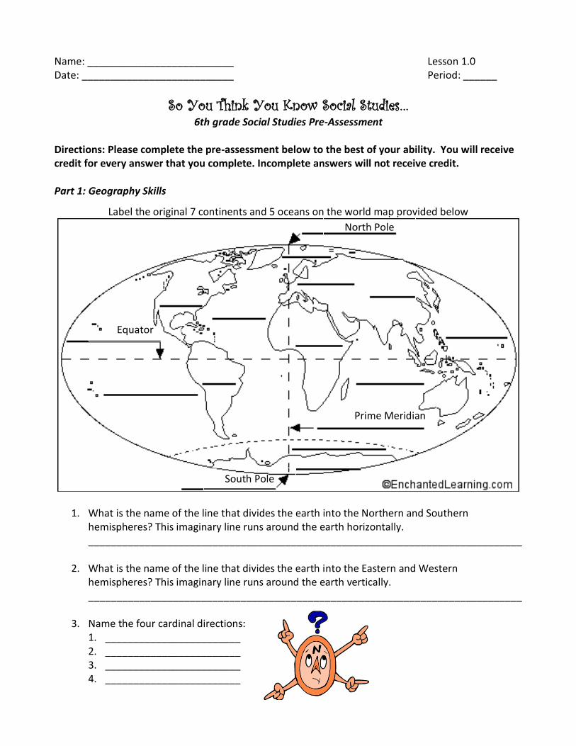
Name: __________________________ Lesson 1.0 Date: ___________________________ Period: ______
So You Think You Know Social Studies… 6th grade Social Studies Pre-Assessment
Directions: Please complete the pre-assessment below to the best of your ability. You will receive credit for every answer that you complete. Incomplete answers will not receive credit. Part 1: Geography Skills
Label the original 7 continents and 5 oceans on the world map provided below
1. What is the name of the line that divides the earth into the Northern and Southern hemispheres? This imaginary line runs around the earth horizontally. _____________________________________________________________________________
2. What is the name of the line that divides the earth into the Eastern and Western hemispheres? This imaginary line runs around the earth vertically. _____________________________________________________________________________
3. Name the four cardinal directions: 1. ________________________ 2. ________________________ 3. ________________________ 4. ________________________
North Pole
South Pole
Equator
Prime Meridian
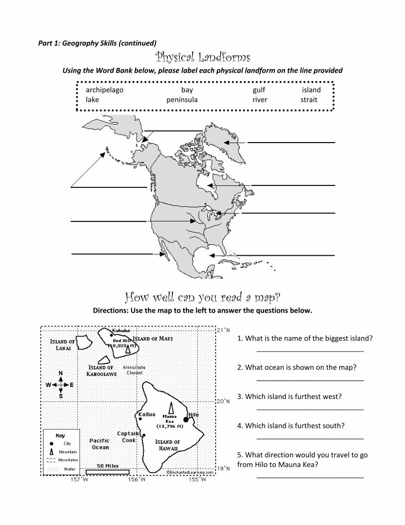
Part 1: Geography Skills (continued)
Physical Landforms Using the Word Bank below, please label each physical landform on the line provided
archipelago bay gulf island lake peninsula river strait
How well can you read a map? Directions: Use the map to the left to answer the questions below.
1. What is the name of the biggest island? ___________________________
2. What ocean is shown on the map?
___________________________ 3. Which island is furthest west?
___________________________ 4. Which island is furthest south?
___________________________ 5. What direction would you travel to go from Hilo to Mauna Kea?
___________________________
Name: ______________________ Period: ________
Date: _______________________ Writing Pre-Assessment
Just Write! Before we can start traveling through time together, it is important for me to not only assess what you
may already know about Social Studies, but your ability to read non-fiction and write for information.
This activity will help me to assess your writing ability. In this 20 minute free-write activity, I would
like you to write about the story of your life. What is your personal history> Use the questions in the
box below to get you thinking and started. Please try and include an introduction and conclusion. This
will not count negatively against your grade in any way; just try your best!
Where were you born? What do you like to do? What is your best/most
Who is in your family? Where have you lived? important memory?
__________________________________________________________________
__________________________________________________________________
__________________________________________________________________
__________________________________________________________________
__________________________________________________________________
__________________________________________________________________
__________________________________________________________________
__________________________________________________________________
__________________________________________________________________
__________________________________________________________________
__________________________________________________________________
Continue on the back of this page if you need more space…

__________________________________________________________________
__________________________________________________________________
__________________________________________________________________
__________________________________________________________________
__________________________________________________________________
__________________________________________________________________
__________________________________________________________________
__________________________________________________________________
__________________________________________________________________
__________________________________________________________________
__________________________________________________________________
__________________________________________________________________
__________________________________________________________________
__________________________________________________________________
__________________________________________________________________
__________________________________________________________________
__________________________________________________________________
__________________________________________________________________
__________________________________________________________________
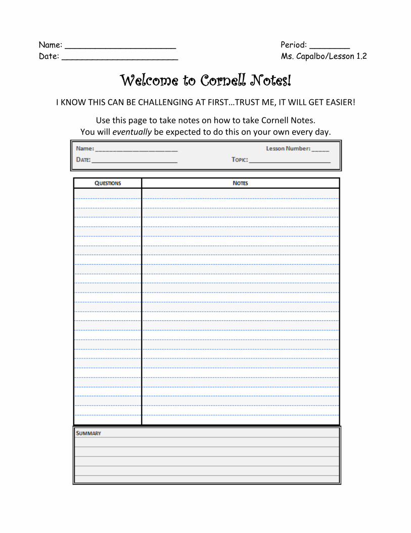
Name: ______________________ Period: ________
Date: _______________________ Ms. Capalbo/Lesson 1.2
Welcome to Cornell Notes!
I KNOW THIS CAN BE CHALLENGING AT FIRST…TRUST ME, IT WILL GET EASIER!
Use this page to take notes on how to take Cornell Notes. You will eventually be expected to do this on your own every day.
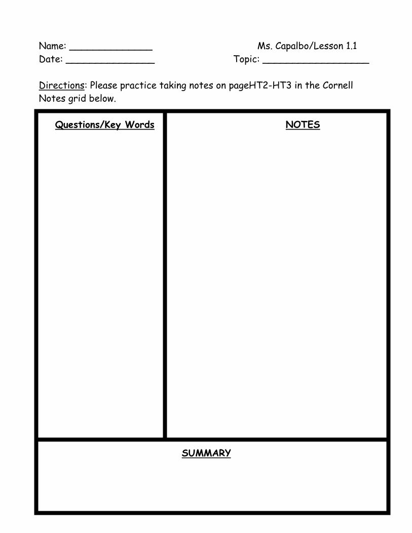
Name: ______________ Ms. Capalbo/Lesson 1.1
Date: _______________ Topic: __________________
Directions: Please practice taking notes on pageHT2-HT3 in the Cornell
Notes grid below.
Questions/Key Words NOTES
SUMMARY
Name: ______________________ Period: ________
Date: _______________________ Ms. Capalbo/Lesson 1.3
What’s Your Timeline? SWBAT: Create a timeline of at least 15 important events that took place
in your life with at least 5 images to enhance your timeline
This mini-project is worth 50 points
We started this project on:_________________
This project will be due on: _________________
You have a very important and impressive life story to tell! Over the course of the next
few days, we are going to work together to create a timeline of your life. Before we get
started, let’s explore the essential piece of a timeline…
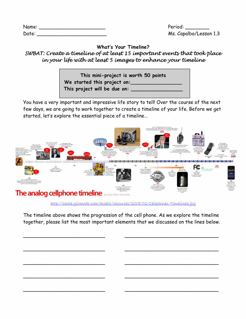
http://cache.gizmodo.com/assets/resources/2008/02/Cellphones-Timeline3.jpg
The timeline above shows the progression of the cell phone. As we explore the timeline
together, please list the most important elements that we discussed on the lines below.
___________________________ _______________________________
___________________________ _______________________________
___________________________ _______________________________
___________________________ _______________________________
___________________________ _______________________________
Name: __________________ Period: _________ (What’s Your Timeline) continued...
Step-By-Step Instructions and Checklist
1. Create a list of 15 important events in your life (in your notebook)
2. Write a one to two sentence description for each event
3. Find at least five photographs to accompany your events and descriptions
*Please ask permission before taking photos!*
4. Layout your timeline on the timeline paper. Begin by creating a scale.
* This means that each year will equal ______ cm *
5. Write each year, from the year of your birth to the present on your timeline.
6. Now you are ready to write the date of your event and description on your
timeline. You may type these if you prefer.
7. Add your images AND A TITLE, along with any elements of design and color
8. Review and edit your work if needed
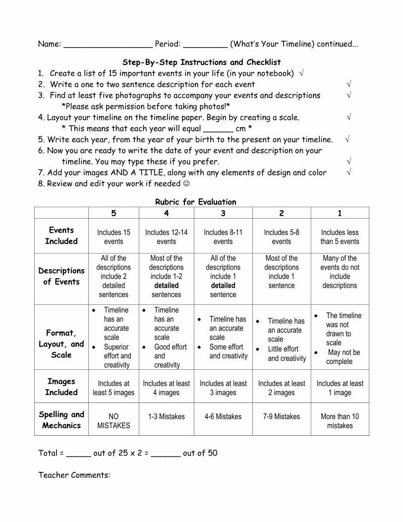
Rubric for Evaluation
5 4 3 2 1
Events
Included
Includes 15
events
Includes 12-14
events
Includes 8-11
events
Includes 5-8
events
Includes less than 5 events
Descriptions
of Events
All of the descriptions
include 2 detailed
sentences
Most of the descriptions include 1-2
detailed sentences
All of the descriptions
include 1 detailed sentence
Most of the descriptions
include 1 sentence
Many of the events do not
include descriptions
Format,
Layout, and
Scale
Timeline has an accurate scale
Superior effort and creativity
Timeline has an accurate scale
Good effort and creativity
Timeline has an accurate scale
Some effort and creativity
Timeline has
an accurate scale
Little effort
and creativity
The timeline was not drawn to scale
May not be complete
Images
Included
Includes at
least 5 images
Includes at least
4 images
Includes at least
3 images
Includes at least
2 images
Includes at least
1 image
Spelling and
Mechanics
NO
MISTAKES
1-3 Mistakes
4-6 Mistakes
7-9 Mistakes
More than 10
mistakes
Total = _____ out of 25 x 2 = ______ out of 50
Teacher Comments:
Name: ______________________ Period: ________
Date: _______________________ Ms. Capalbo/Lesson 1.6
Which Landform Is It? SWBAT: Upon completion of this activity, you will be able to create a graphic
organizer to help you identify, define, and illustrate physical landforms
This assignment has two parts:
We will paint (and label) our clay 3D mold on Tuesday and Wednesday
You will work on the flashcards as homework
The flashcards are due on Thursday 9/23/10
On each flashcard, please…
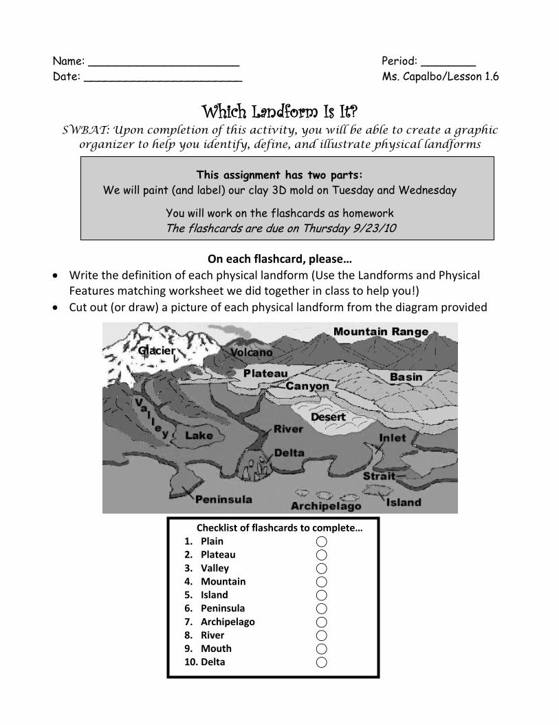
Write the definition of each physical landform (Use the Landforms and Physical Features matching worksheet we did together in class to help you!)
Cut out (or draw) a picture of each physical landform from the diagram provided
Checklist of flashcards to complete… 1. Plain ⃝ 2. Plateau ⃝ 3. Valley ⃝ 4. Mountain ⃝ 5. Island ⃝ 6. Peninsula ⃝ 7. Archipelago ⃝ 8. River ⃝ 9. Mouth ⃝ 10. Delta ⃝
Name: _______________ Period:_____ Ms. Capalbo/Lesson 1.4
Lesson 1.4: What are the 5 themes of geography?
Key Words NOTES
Geography… List the FIVE themes of geography
below:
SUMMARY
How does geography affect you on a daily basis?
Name: ________________ Period:_____ Ms. Capalbo/Lesson 1.4
Lesson 1.4: What are the 5 themes of geography?
Key Words NOTES
Geography… List the FIVE themes of geography
below:
SUMMARY
How does geography affect you on a daily basis?

Name: _______________ Period:_____ Ms. Capalbo/Lesson 1.4
Lesson 1.4: What are the 5 themes of geography?
Summary Activity
Name: ______________ Period:_____ Ms. Capalbo/Lesson 1.4
Lesson 1.4: What are the 5 themes of geography?
Summary Activity
Name: ______________________ Period: ________
Date: _______________________ Ms. Capalbo/Lesson 1.7
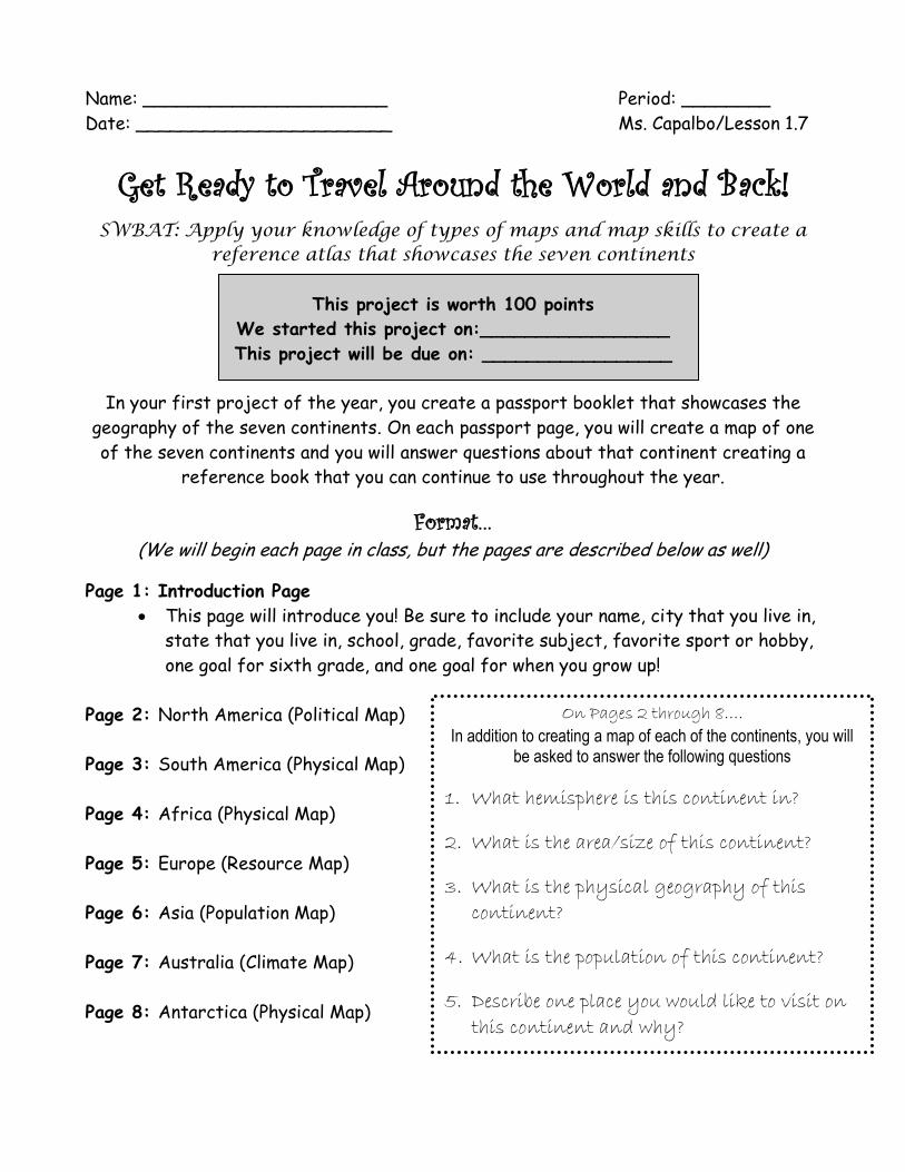
Get Ready to Travel Around the World and Back!
SWBAT: Apply your knowledge of types of maps and map skills to create a reference atlas that showcases the seven continents
This project is worth 100 points
We started this project on:_________________
This project will be due on: _________________
In your first project of the year, you create a passport booklet that showcases the
geography of the seven continents. On each passport page, you will create a map of one
of the seven continents and you will answer questions about that continent creating a
reference book that you can continue to use throughout the year.
Format… (We will begin each page in class, but the pages are described below as well)
Page 1: Introduction Page
This page will introduce you! Be sure to include your name, city that you live in,
state that you live in, school, grade, favorite subject, favorite sport or hobby,
one goal for sixth grade, and one goal for when you grow up!
Page 2: North America (Political Map)
Page 3: South America (Physical Map)
Page 4: Africa (Physical Map)
Page 5: Europe (Resource Map)
Page 6: Asia (Population Map)
Page 7: Australia (Climate Map)
Page 8: Antarctica (Physical Map)
On Pages 2 through 8….
In addition to creating a map of each of the continents, you will be asked to answer the following questions
1. What hemisphere is this continent in?
2. What is the area/size of this continent?
3. What is the physical geography of this
continent?
4. What is the population of this continent?
5. Describe one place you would like to visit on
this continent and why?
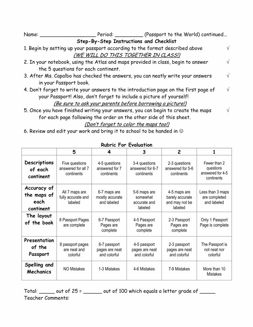
Name: __________________ Period: _________ (Passport to the World) continued...
Step-By-Step Instructions and Checklist
1. Begin by setting up your passport according to the format described above
(WE WILL DO THIS TOGETHER IN CLASS!) 2. In your notebook, using the Atlas and maps provided in class, begin to answer
the 5 questions for each continent.
3. After Ms. Capalbo has checked the answers, you can neatly write your answers
in your Passport book.
4. Don’t forget to write your answers to the introduction page on the first page of
your Passport! Also, don’t forget to include a picture of yourself!
(Be sure to ask your parents before borrowing a picture!) 5. Once you have finished writing your answers, you can begin to create the maps
for each page following the order on the other side of this sheet.
(Don’t forget to color the maps too!) 6. Review and edit your work and bring it to school to be handed in
Rubric For Evaluation
5 4 3 2 1
Descriptions
of each
continent
Five questions
answered for all 7 continents
4-5 questions
answered for 7 continents
3-4 questions
answered for 6-7 continents
2-3 questions
answered for 5-6 continents
Fewer than 2
questions answered for 4-5
continents
Accuracy of
the maps of
each
continent
All 7 maps are
fully accurate and labeled
6-7 maps are
mostly accurate and labeled
5-6 maps are
somewhat accurate and
labeled
4-5 maps are
barely accurate and may not be
labeled
Less than 3 maps
are completed and labeled
The layout
of the book
8 Passport Pages
are complete
6-7 Passport Pages are complete
4-5 Passport Pages are complete
2-3 Passport Pages are complete
Only 1 Passport
Page is complete
Presentation
of the
Passport
8 passport pages
are neat and colorful
6-7 passport
pages are neat and colorful
4-5 passport
pages are neat and colorful
2-3 passport
pages are neat and colorful
The Passport is
not neat nor colorful
Spelling and
Mechanics
NO Mistakes
1-3 Mistakes
4-6 Mistakes
7-9 Mistakes
More than 10
Mistakes
Total: _____ out of 25 = ______ out of 100 which equals a letter grade of _____
Teacher Comments:

Name: ______________________ Period: ________
Date: _______________________ Ms. Capalbo/Lesson 1.7
Creating a Passport…
Directions for folding your Passport…
1. Hold a piece of Construction Paper the tall way
(vertical) and fold it in half like a hamburger
2. Repeat this process with three other pieces of
Construction paper to create 8 total boxes
3. Cut a slit up the middle of one half of each of the
four folded pieces of construction paper to create
eight tabs.
4. Glue all four pieces of construction paper together
to create a book with eight pages.
5. Label each page. Then, cut out each continent map and glue one map onto each of the
eight tabs. Be sure to leave the first tab blank for your photo!
6. Begin answering your questions, labeling and coloring your maps, and completing your
Passport!
Name: _____________________ Period: _____ Date: ___________
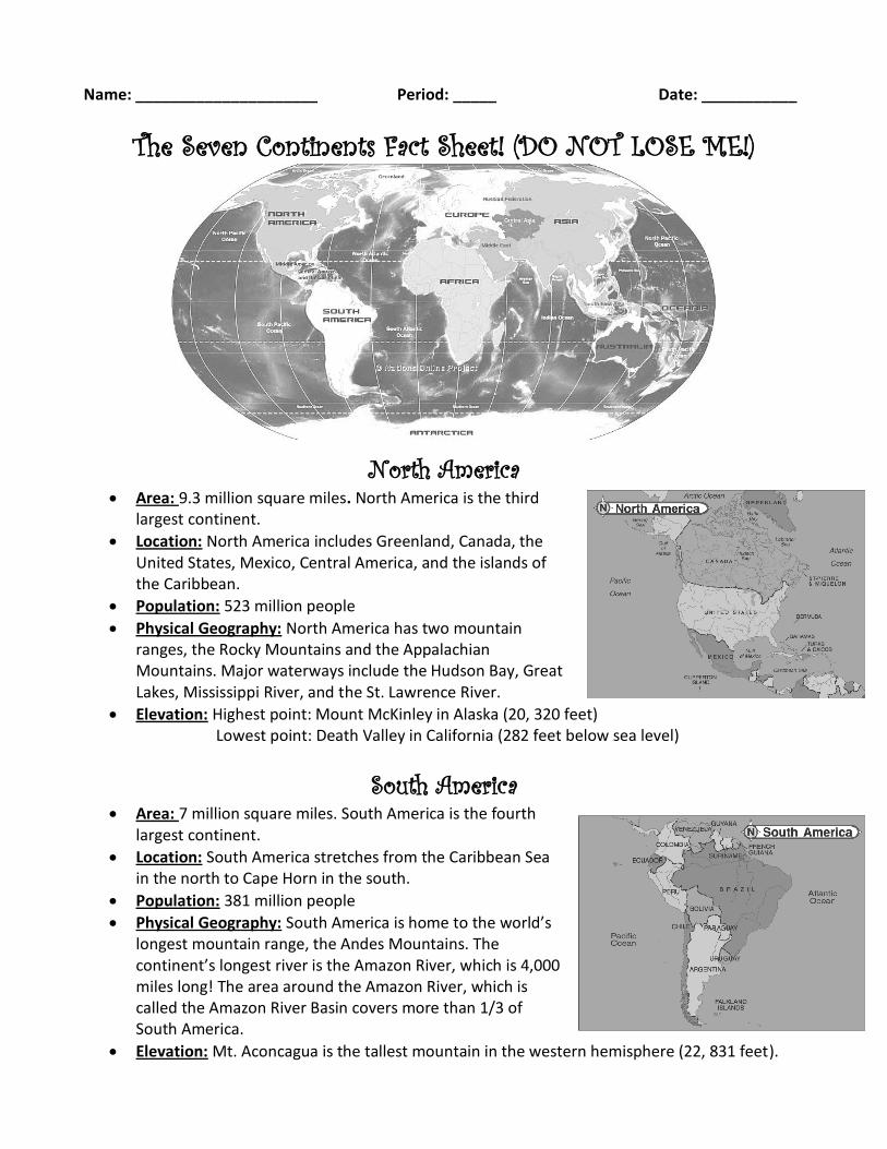
The Seven Continents Fact Sheet! (DO NOT LOSE ME!)
North America Area: 9.3 million square miles. North America is the third
largest continent.
Location: North America includes Greenland, Canada, the United States, Mexico, Central America, and the islands of the Caribbean.
Population: 523 million people
Physical Geography: North America has two mountain ranges, the Rocky Mountains and the Appalachian Mountains. Major waterways include the Hudson Bay, Great Lakes, Mississippi River, and the St. Lawrence River.
Elevation: Highest point: Mount McKinley in Alaska (20, 320 feet) Lowest point: Death Valley in California (282 feet below sea level)
South America Area: 7 million square miles. South America is the fourth
largest continent.
Location: South America stretches from the Caribbean Sea in the north to Cape Horn in the south.
Population: 381 million people
Physical Geography: South America is home to the world’s longest mountain range, the Andes Mountains. The continent’s longest river is the Amazon River, which is 4,000 miles long! The area around the Amazon River, which is called the Amazon River Basin covers more than 1/3 of South America.
Elevation: Mt. Aconcagua is the tallest mountain in the western hemisphere (22, 831 feet).
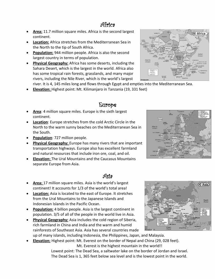
Africa Area: 11.7 million square miles. Africa is the second largest
continent.
Location: Africa stretches from the Mediterranean Sea in the North to the tip of South Africa.
Population: 944 million people. Africa is also the second largest country in terms of population.
Physical Geography: Africa has some deserts, including the Sahara Desert, which is the largest in the world. Africa also has some tropical rain forests, grasslands, and many major rivers, including the Nile River, which is the world’s largest river. It is 4, 145 miles long and flows through Egypt and empties into the Mediterranean Sea.
Elevation: Highest point: Mt. Kilimanjaro in Tanzania (19, 331 feet)
Europe Area: 4 million square miles. Europe is the sixth largest
continent.
Location: Europe stretches from the cold Arctic Circle in the North to the warm sunny beaches on the Mediterranean Sea in the South.
Population: 727 million people.
Physical Geography: Europe has many rivers that are important transportation highways. Europe also has excellent farmland and natural resources that include iron ore, coal, and oil.
Elevation: The Ural Mountains and the Caucasus Mountains separate Europe from Asia.
Asia Area: 17 million square miles. Asia is the world’s largest
continent! It accounts for 1/3 of the world’s total area!
Location: Asia is located to the east of Europe. It stretches from the Ural Mountains to the Japanese Islands and Indonesian Islands in the Pacific Ocean.
Population: 4 billion people. Asia is the largest continent in population. 3/5 of all of the people in the world live in Asia.
Physical Geography: Asia includes the cold region of Siberia, rich farmland in China and India and the warm and humid rainforests of Southeast Asia. Asia has several countries made up of many islands, including Indonesia, the Philippines, Japan, and Malaysia.
Elevation: Highest point: Mt. Everest on the border of Nepal and China (29, 028 feet). Mt. Everest is the highest mountain in the world!!
Lowest point: The Dead Sea, a saltwater lake on the border of Jordan and Israel. The Dead Sea is 1, 365 feet below sea level and is the lowest point in the world.
Name: _____________________ Period: _____ Date: ___________
The Seven Continents Fact Sheet! (continued)
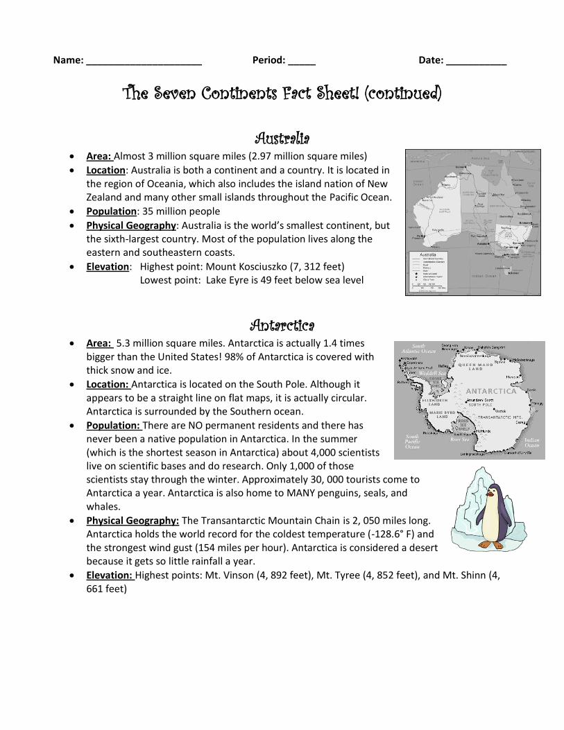
Australia
Area: Almost 3 million square miles (2.97 million square miles)
Location: Australia is both a continent and a country. It is located in the region of Oceania, which also includes the island nation of New Zealand and many other small islands throughout the Pacific Ocean.
Population: 35 million people
Physical Geography: Australia is the world’s smallest continent, but the sixth-largest country. Most of the population lives along the eastern and southeastern coasts.
Elevation: Highest point: Mount Kosciuszko (7, 312 feet) Lowest point: Lake Eyre is 49 feet below sea level
Antarctica Area: 5.3 million square miles. Antarctica is actually 1.4 times
bigger than the United States! 98% of Antarctica is covered with thick snow and ice.
Location: Antarctica is located on the South Pole. Although it appears to be a straight line on flat maps, it is actually circular. Antarctica is surrounded by the Southern ocean.
Population: There are NO permanent residents and there has never been a native population in Antarctica. In the summer (which is the shortest season in Antarctica) about 4,000 scientists live on scientific bases and do research. Only 1,000 of those scientists stay through the winter. Approximately 30, 000 tourists come to Antarctica a year. Antarctica is also home to MANY penguins, seals, and whales.
Physical Geography: The Transantarctic Mountain Chain is 2, 050 miles long. Antarctica holds the world record for the coldest temperature (-128.6° F) and the strongest wind gust (154 miles per hour). Antarctica is considered a desert because it gets so little rainfall a year.
Elevation: Highest points: Mt. Vinson (4, 892 feet), Mt. Tyree (4, 852 feet), and Mt. Shinn (4, 661 feet)