Embed Size (px)
Citation preview
1
Snohomish County * City of Monroe * City of Sultan
Multi-Jurisdictional Program for
Public Information
2013
Prepared by:
Snohomish County Public Works Surface Water Management
January 2013
2
Table of Contents
page
I. Background 3
II. Goals 4
III. Multi-Jurisdictional PPI Committee 5
IV. The Communities and Highlights of their CRS Self-Assessment
Snohomish County 6
The City of Monroe 8
The City of Sultan 10
V. Target Audiences 11
VI. Other Public Information Efforts 13
VII. Communication Strategy, Projects and Initiatives 15
VIII. Annual Evaluation 16
IX. Plan Adoption 16
Tables
Table 1: Other Public Information Efforts 14
Appendices
Appendix 1: Insurance Pre/Post FIRM as of 9/30/2012: Snohomish County 17
Appendix 2: Insurance Pre/Post FIRM as of 9/30/2012: City of Monroe 18
Appendix 3: Insurance Pre/Post FIRM as of 9/30/2012: City of Sultan 19
Appendix 4: Snohomish County, City of Monroe, City of Sultan MJ-PPI Worksheet Projects 20
3
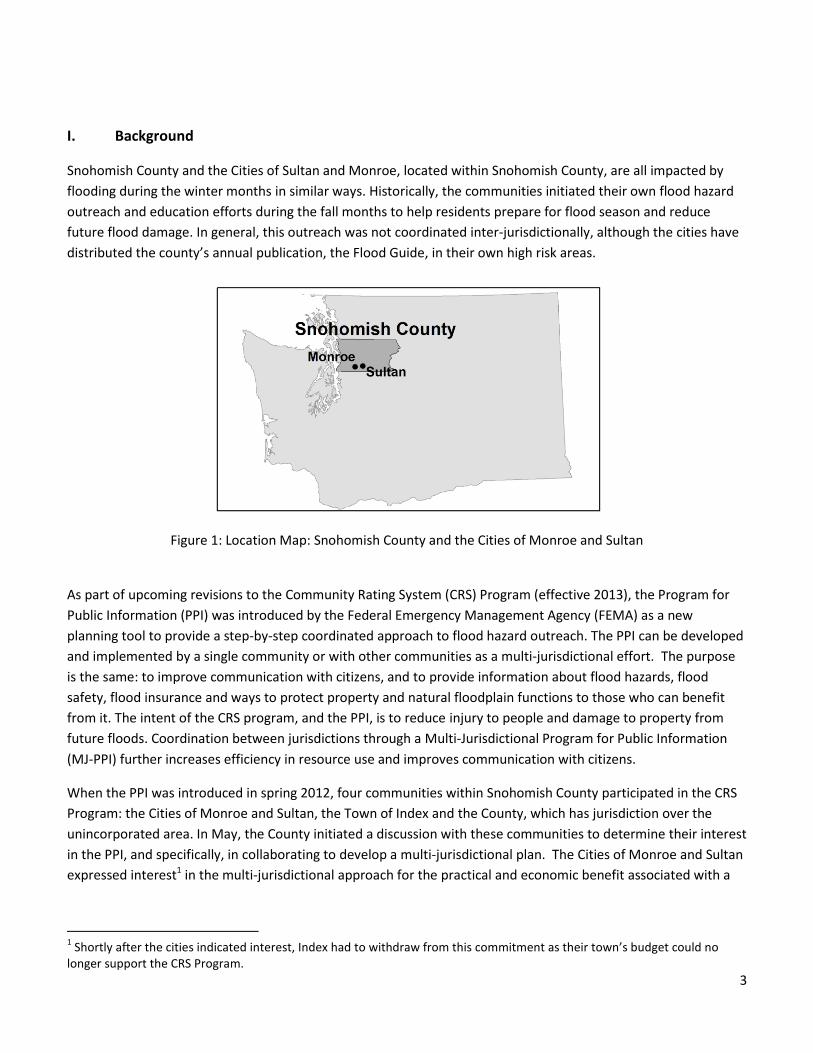
I. Background
Snohomish County and the Cities of Sultan and Monroe, located within Snohomish County, are all impacted by
flooding during the winter months in similar ways. Historically, the communities initiated their own flood hazard
outreach and education efforts during the fall months to help residents prepare for flood season and reduce
future flood damage. In general, this outreach was not coordinated inter-jurisdictionally, although the cities have
distributed the county’s annual publication, the Flood Guide, in their own high risk areas.
Figure 1: Location Map: Snohomish County and the Cities of Monroe and Sultan
As part of upcoming revisions to the Community Rating System (CRS) Program (effective 2013), the Program for
Public Information (PPI) was introduced by the Federal Emergency Management Agency (FEMA) as a new
planning tool to provide a step-by-step coordinated approach to flood hazard outreach. The PPI can be developed
and implemented by a single community or with other communities as a multi-jurisdictional effort. The purpose
is the same: to improve communication with citizens, and to provide information about flood hazards, flood
safety, flood insurance and ways to protect property and natural floodplain functions to those who can benefit
from it. The intent of the CRS program, and the PPI, is to reduce injury to people and damage to property from
future floods. Coordination between jurisdictions through a Multi-Jurisdictional Program for Public Information
(MJ-PPI) further increases efficiency in resource use and improves communication with citizens.
When the PPI was introduced in spring 2012, four communities within Snohomish County participated in the CRS
Program: the Cities of Monroe and Sultan, the Town of Index and the County, which has jurisdiction over the
unincorporated area. In May, the County initiated a discussion with these communities to determine their interest
in the PPI, and specifically, in collaborating to develop a multi-jurisdictional plan. The Cities of Monroe and Sultan
expressed interest1 in the multi-jurisdictional approach for the practical and economic benefit associated with a
1 Shortly after the cities indicated interest, Index had to withdraw from this commitment as their town’s budget could no
longer support the CRS Program.
4
comprehensive approach to coordinating messages and resources. The County assumed a lead role in developing
and facilitating the Multi-Jurisdictional PPI Committee.
For the County and the Cities of Sultan and Monroe, a number of factors supported the need to develop an
overall, coordinated flood hazard outreach plan. First, the jurisdictions are generally not in a position to address
flooding problems through structural means as often as in the past. New practices in urban stormwater
management and floodplain management, which typically address flooding in rural settings, are moving away
from approaches that require more infrastructure to channel water. A common objective of both fields is finding
cost effective methods of addressing flooding primarily through avoidance or reduction measures, which often
have less long-term costs associated with them. Second, the recent economic downturn left the County and the
cities with fewer resources (staff, budget, and grant availability) to address future flooding.
However, for the communities, the importance of public safety and the need to reduce future flood damage has
not diminished. Reducing future flood damage requires a partnership with the public, and an educated public is an
important component for success. Households that have a plan in place for flooding reduction, response and
recovery will be more likely to maintain personal safety. Willing homeowners can make modifications to their
homes and property that will improve flood resiliency. For homeowners to make those choices, they need access
to clear, relevant facts - and in some cases, financial assistance – to take the necessary actions.
A MJ-PPI Plan can offer participating communities the benefits of clear, coordinated messages and a more
comprehensive approach in getting information out in a consistent, cost-effective manner. The six priority topics
of the revised CRS program are essentially best management practices (BMPs) for households – actions that can
be taken by homeowners or renters to avoid or reduce flood damage. Snohomish County, Monroe, and Sultan
believe that if floodplain residents have access to the facts on the flood hazard and how to minimize impacts, they
will be more equipped to take actions that will, over the long run, reduce costs and better maintain safety and the
economic value of their homes.
II. Goals of the Snohomish County/Monroe/Sultan Multi-Jurisdictional PPI Plan
The plan participants share a common vision for a better informed citizenry that is knowledgeable about the flood
risks, what they can do to decrease future flood damage, and the benefits of flood insurance. The Multi-
Jurisdictional PPI Plan is the tool to achieve that vision. Staff from Snohomish County and the Cities of Monroe
and Sultan are recommending two goals and supporting objectives.
1. Coordinate and synchronize the preparedness messaging of Snohomish County and the Cities of Monroe
and Sultan for a more comprehensive approach to building community resilience to flooding.
Cross-jurisdictionally identify the most at-risk groups and how best to reach out to them.
Integrate annual messaging with existing regional preparedness campaigns where feasible.
2. Through the outreach materials and methods, encourage residents to adopt behaviors that improve flood
hazard preparedness and decrease future flood damage.
Provide relevant information annually to residents of the unincorporated County areas and the
cities of Sultan and Monroe; particularly focusing on residents in flood prone areas.
5
Provide relevant information to residents after they have been flooded.
Provide more detailed information to inquirers through websites and publications.
III. Multi-Jurisdictional PPI Committee
After the Cities and the County agreed to work together to develop and implement the PPI plan, staff from each
jurisdiction recruited active members of their communities - including representatives of the insurance and real
estate industries and floodplain residents - to serve on the MJ-PPI Committee.
The County developed a fact sheet to help communicate the role and expectations of committee members and
the benefits of the effort. The committee recruitment was successful and led to a committee of 12 stakeholders,
with representation as follows:
Mary Hurner, CRS Coordinator, Surface Water Management, Public Works, Snohomish County
Dara Salmon, Emergency Program Manager, Emergency Management, Snohomish County
Roxanne Pilkenton, CFM, Floodplain Manager, Planning and Development Services, Snohomish County
Christopher Schwarzen, Public Information Officer, Executive Office, Snohomish County
Brad Feilberg, Floodplain Manager, Public Works Director, City of Monroe
Tom Cunningham, Tye City Insurance, Monroe
Cyd Donk, Floodplain Administrator, City of Sultan
Lucy Hitchcock, Planning Board Member, City of Sultan
Merlin Halverson, Fire Chief, Snohomish County Fire District 5
Kevin Plemel, Environmental Health Manager, Snohomish Health District
Chuck Hazelton, Stillaguamish River Flood Control District Chair
Frank Linth, Skykomish Valley Real Estate Agent
The role of committee members was to assist in developing the MJ-PPI plan by providing feedback, from their
perspective, on areas of their larger community that should be targeted for outreach, what type of message
should be delivered and how often. Committee members were also asked to share information on any efforts
related to this work that have occurred or are occurring within their communities.
County staff developed the agendas and facilitated the committee meetings. Prior to setting each meeting date,
the County surveyed committee members for their availability to ensure that the committee’s efforts met the
attendance requirements outlined in the new CRS manual.
The process of developing the Multi-Jurisdictional PPI Plan began with representatives from participating
jurisdictions completing their respective CRS Community Self-Assessments, and bringing the results to the first
Multi-Jurisdictional PPI Committee meeting. That initial meeting was held on July 24, 2012, at the County
Administration Building in Everett. The agenda followed steps one and two of the seven step plan outlined in the
Draft 2012 CRS Manual, pages 330-11 through 330-18, corresponding to the “information gathering” work on
which the PPI would be based. During this meeting, the three communities reviewed the results of their CRS
Community Self Assessment, an exercise which highlighted the flood hazard in each community, problem areas,
challenges and ways that might be possible to reduce flood risk. Information from the Community Self
6
Assessment and the product of the meeting - agreement on the five target audiences the PPI plan would focus on
– is presented in sections below.
The second meeting was held on September 13, 2012, at Monroe City Hall. The agenda followed steps three
through five of the seven step plan, referenced above, corresponding to the “program development” phase.
During this meeting, members reviewed the six messages of the newly revised CRS program and matched the
topics to the five target audiences, developing specific messages. This work is detailed under the “Target
Audiences” section below. The Committee informally inventoried related efforts that were already taking place in
the community, and noted where they would fit in the PPI Plan as they existed, or how they could be modified to
serve the overall effort in a better way. The discussion shifted to program development. Representatives from the
jurisdictions and organizations discussed what actions they could take to deliver specific messages to the target
audiences. The outcome of this work is presented in Appendix 2: PPI Worksheet.
Based on the discussion during the second meeting, County staff assembled the first draft of the Snohomish
County, City of Monroe and City of Sultan Multi-Jurisdictional Program for Public Information. The draft was first
circulated to the cities to confirm and complete some facts. A revised copy was sent out to the entire committee
for review and approval. The Committee finalized the draft at a meeting on January 14, 2013.
The final draft of the Multi-Jurisdictional Program for Public Information, recommended by the entire Committee,
was then brought to the decision-making bodies of each jurisdiction for approval. Council approval dates were as
follows:
Snohomish County Council: 4/1/2013 (Motion #13-119)
Monroe City Council: 3/12/2013
Sultan City Council: 2/14/2013
IV. The Communities, and Highlights of their CRS Community Self Assessment
The CRS Community Self Assessment is a new online tool posing a series of questions that reveal how the flood
hazards affect a community and which groups of residents could benefit most from outreach efforts. The sections
below provide an overview of the participating communities and the highlights of their Community Self
Assessments related to the flood hazard, flood insurance coverage and repetitive loss properties. The Self
Assessment results paralleled information on the flood hazard presented in the Snohomish County Natural Hazard
Mitigation Plan (2010).
Snohomish County
Snohomish County is located in Western Washington on Puget Sound, between Skagit County to the north and
King County (and Seattle) to the south. Covering 2,090 square miles, it is the 13th largest county in total land area
in Washington. Snohomish County’s varied topography ranges from saltwater beaches, rolling hills and rich river
bottom farmlands in the west to dense forest and alpine wilderness in the mountainous east. Sixty-eight percent
of the county land area is forest land, 18% is rural, 9% is urban/city and 5% is agricultural. (Source:
http://www1.co.snohomish.wa.us/County_Information/) The total population of Snohomish County was
estimated to be 717,000 as of April 1, 2011, according to the Washington State Office of Financial Management.
7
This includes a total unincorporated population estimate of 304,435 (42% of total county population) and a total
incorporated (city) population estimate of 412,565 (58% of total county population).
Snohomish County as a whole typically experiences flooding between November and February, during and after
periods of heavy rain and rain following snow. Weather patterns and land uses are the primary factors affecting
flooding. The smaller urban streams of the western Snohomish County lowlands flood almost exclusively due to
rainfall only. Development and associated impervious surfaces have increased stormwater runoff, resulting in
increases in the frequency and severity of flooding.
In contrast, the big rivers in Snohomish County flood primarily due to precipitation in the mountains. The county’s
largest floods occur along these rivers and are often caused by a combination of intense rainfall and melting
snowpack. Because flows generated in the forested mountains dwarf what is produced by the more developed
lowland areas, development is not a major contributor to the flood flows on these big rivers. Forestry is the
dominant land use in the mountainous headwaters, and its effects on flooding can be an important factor in large
river watersheds.
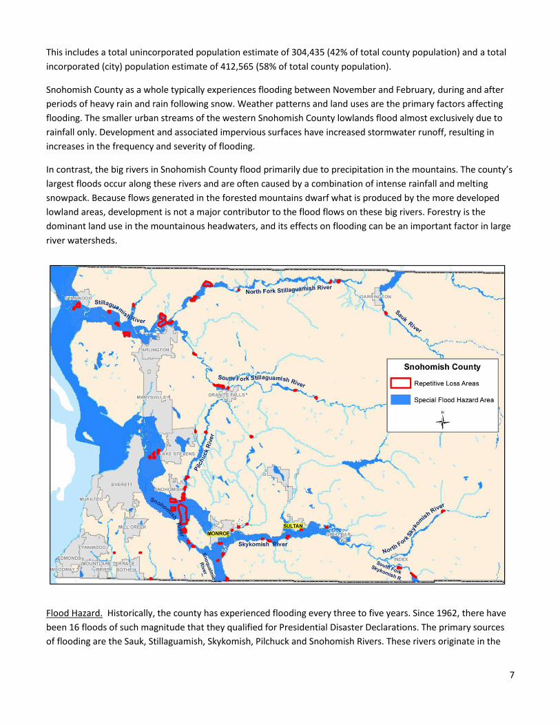
Flood Hazard. Historically, the county has experienced flooding every three to five years. Since 1962, there have
been 16 floods of such magnitude that they qualified for Presidential Disaster Declarations. The primary sources
of flooding are the Sauk, Stillaguamish, Skykomish, Pilchuck and Snohomish Rivers. These rivers originate in the
8
mountainous east side of the county, and make their way down thorough the floodplain/agricultural areas
draining into Puget Sound.
In unincorporated Snohomish County, under the current Flood Insurance Rate Maps (FIRMs), there are 5505
properties with structures in the special flood hazard areas (SFHA). Of these, 72 percent are zoned as single family
(1-4 unit), and the remainder are commercial. Under the Preliminary Digital Flood Insurance Rate Maps (DFIRMs)2,
there are 5,287 properties in the SFHA. Of these, 69 percent are single family and the others are commercial.
The areas that flood in the county are numerous. They are largely adjacent to the five main rivers as well as a
number of smaller rivers (such as Sultan and Wallace), and creeks (such as Canyon, French, North, Quilceda,
Swamp, Scriber, and Woods).
Flood Insurance Data. In unincorporated Snohomish County, the numbers of households with flood insurance
policies are low relative to the number of structures in the Special Flood Hazard Areas, 1,936 out of 5,505 (35%).
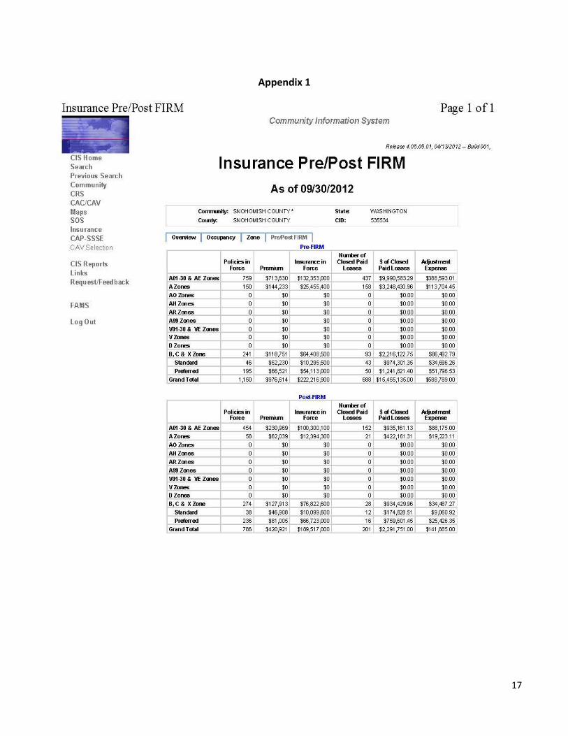
(See Appendix 1, FEMA Community Information System Report for Snohomish County, 9/30/2012)
Repetitive Loss Properties. FEMA keeps a list of repetitive loss3 and severe repetitive loss4 properties for each
jurisdiction in a national database. The County has the largest area within its jurisdiction and more flood prone
areas. There are 62 areas which have experienced repetitive flood damage. There are 694 structures within those
areas. Of those, approximately 150 meet the definition of repetitive loss properties and 12 of the repetitive loss
properties qualify as severe repetitive loss properties. During the last two years, the County partnered with willing
homeowners and successfully competed for FEMA grants to complete four home elevations, and one acquisition,
of repetitive loss properties.
The City of Monroe
The City of Monroe is located in southeastern Snohomish County, approximately 15 miles southeast of Everett
along U.S. Highway 2, and 30 miles northeast of Seattle along State Route 522. Monroe is located in both the
Skykomish River and Snohomish River valleys at the western fringe of the Cascade Mountain foothills. The
Skykomish River borders the City on the south. Woods Creek essentially forms the eastern border of the City;
although, a small section of the City lies south and east of the creek. The majority of the city’s businesses are
located along the US Highway 2 (US-2) commercial corridor, in the Monroe Valley industrial complex, and in the
developing areas north of US-2. The City limits encompass 3,944 acres, and the Urban Growth Area consists of an
2 Adoption of the DFIRMs is on hold, pending FEMA’s completion of a revised levee analysis and mapping
approach used to analyze areas on the landward side of non-accredited levees on FIRMs.
3 FEMA defines a Repetitive Loss property as any insurable building for which two or more claims of more than
$1,000 were paid by the National Flood Insurance Program (NFIP) within any rolling ten-year period, since 1978.
4 FEMA defines a Severe Repetitive Loss property as a residential property that is covered under an NFIP flood
insurance policy and (a) has at least four NFIP claim payments (including building and contents) over $5,000 each,
and the cumulative amount of such claims payments exceeds $20,000; or for which at least two separate claims
payments (building payments only) have been made with the cumulative amount of the building portion of such
claims exceeding the market value of the building.
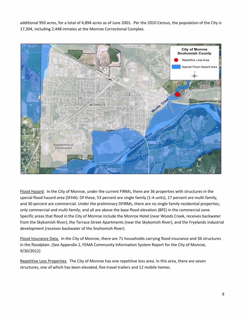
9
additional 950 acres, for a total of 4,894 acres as of June 2001. Per the 2010 Census, the population of the City is
17,304, including 2,448 inmates at the Monroe Correctional Complex.
Flood Hazard. In the City of Monroe, under the current FIRMs, there are 36 properties with structures in the
special flood hazard area (SFHA). Of these, 53 percent are single family (1-4 units), 17 percent are multi-family,
and 30 percent are commercial. Under the preliminary DFIRMs, there are no single family residential properties,
only commercial and multi-family; and all are above the base flood elevation (BFE) in the commercial zone.
Specific areas that flood in the City of Monroe include the Monroe Hotel (near Woods Creek, receives backwater
from the Skykomish River), the Terrace Street Apartments (near the Skykomish River), and the Fryelands industrial
development (receives backwater of the Snohomish River).
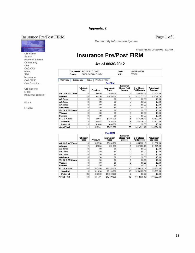
Flood Insurance Data. In the City of Monroe, there are 71 households carrying flood insurance and 36 structures
in the floodplain. (See Appendix 2, FEMA Community Information System Report for the City of Monroe,
9/30/2012)
Repetitive Loss Properties. The City of Monroe has one repetitive loss area. In this area, there are seven
structures, one of which has been elevated, five travel trailers and 12 mobile homes.
10
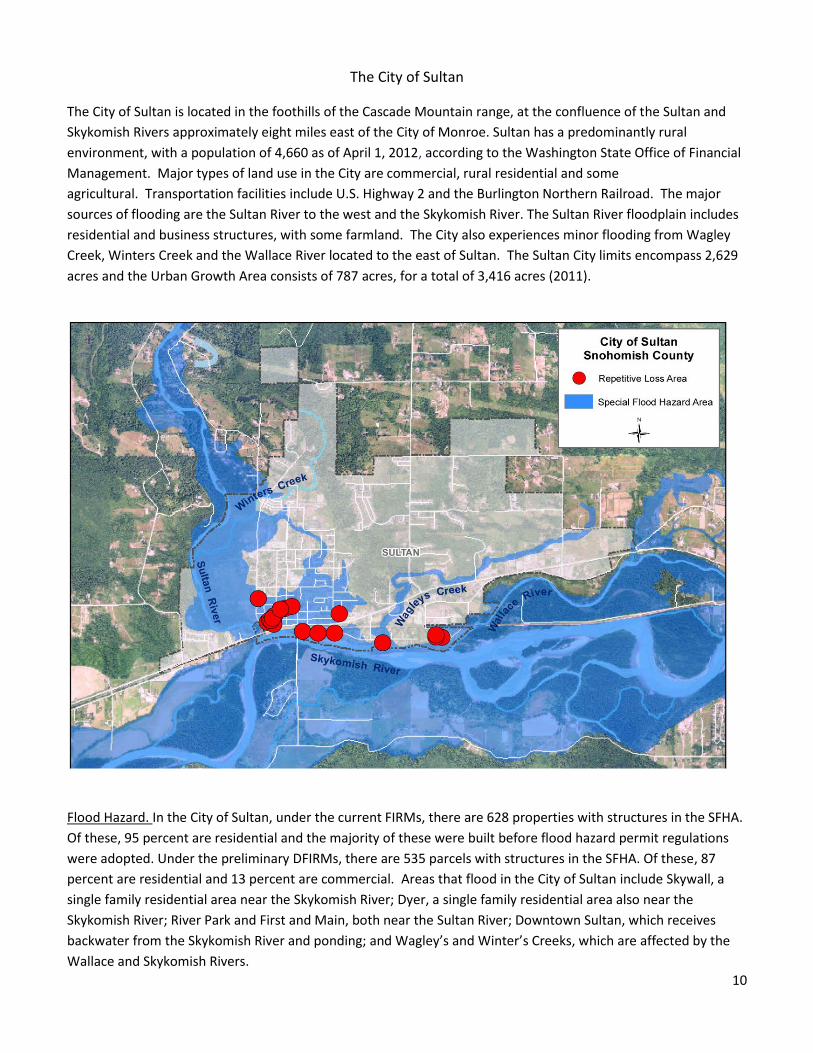
The City of Sultan
The City of Sultan is located in the foothills of the Cascade Mountain range, at the confluence of the Sultan and
Skykomish Rivers approximately eight miles east of the City of Monroe. Sultan has a predominantly rural
environment, with a population of 4,660 as of April 1, 2012, according to the Washington State Office of Financial
Management. Major types of land use in the City are commercial, rural residential and some
agricultural. Transportation facilities include U.S. Highway 2 and the Burlington Northern Railroad. The major
sources of flooding are the Sultan River to the west and the Skykomish River. The Sultan River floodplain includes
residential and business structures, with some farmland. The City also experiences minor flooding from Wagley
Creek, Winters Creek and the Wallace River located to the east of Sultan. The Sultan City limits encompass 2,629
acres and the Urban Growth Area consists of 787 acres, for a total of 3,416 acres (2011).
Flood Hazard. In the City of Sultan, under the current FIRMs, there are 628 properties with structures in the SFHA.
Of these, 95 percent are residential and the majority of these were built before flood hazard permit regulations
were adopted. Under the preliminary DFIRMs, there are 535 parcels with structures in the SFHA. Of these, 87
percent are residential and 13 percent are commercial. Areas that flood in the City of Sultan include Skywall, a
single family residential area near the Skykomish River; Dyer, a single family residential area also near the
Skykomish River; River Park and First and Main, both near the Sultan River; Downtown Sultan, which receives
backwater from the Skykomish River and ponding; and Wagley’s and Winter’s Creeks, which are affected by the
Wallace and Skykomish Rivers.
11
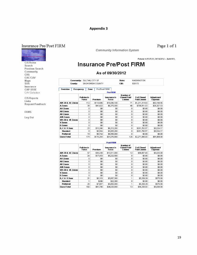
Flood Insurance Data. In Sultan, the number of flood insurance policies is 276, which is low for the 628 structures
in the SFHA. (See Appendix 3, FEMA Community Information System Report for the City of Sultan, 9/30/2012)
Repetitive Loss Properties. The City of Sultan has 24 repetitive loss properties that are clustered into 3 areas. Of
these 24 properties, 19 are not mitigated and five have been mitigated through home elevations. Within the three
flood prone areas, there are 225 structures.
V. Target Audiences
After consideration of the Community Assessment results, the Committee agreed upon five key target audiences
that would benefit most from public information outreach:
1. Prospective Buyers. Committee members agreed that people interested in purchasing properties inside
flood hazard zones need to have accurate information about the flood risk up front, so they can
incorporate it into their decision-making process. This information is not consistently passed along by a
real estate agent. Purchasers with federally-backed mortgages are required to purchase flood insurance,
so the flood hazard designation of a property will be known at that time, but by that time, buyers may feel
it is too late for them to change course. Flood insurance is not required for homes purchased with cash.
Through calls received by the planning departments, jurisdictions become aware of floodplain area
homeowners who were surprised to learn that stricter development regulations applied on their
property. It is the buyers’ responsibility to research land use designations and development regulations
for parcels they are interested in buying. The Committee agreed that if a PPI project or projects increased
the ease of obtaining this information, potential buyers may be more informed in the future and better
prepared to make a decision they will be happy with. As a side benefit, the interest in living in floodplain
areas may be reduced, which would also reduce the flood risk.
2. Repetitive Loss Area Residents. Buyers and owners of Pre-FIRM5 (built before Flood Insurance Rate Maps
were effective) structures are often unaware of what they can and can’t do when they are ready to
improve their property. They express feelings of being “blindsided” by the information, which leads to
some very difficult discussions at the permitting counter. During the first meeting, the PPI Committee
agreed that owners of Pre-FIRM structures might be the second subgroup to focus on, but when this idea
was examined through discussion in the second meeting, the focus was adjusted to include owners of
repetitive loss properties. The majority of repetitive loss structures were also built before the FIRMs were
adopted.
The CRS Program requires participating communities to complete an analysis of repetitive loss areas and
contact repetitive loss property owners on an annual basis, identifying options for long-term mitigation.
Whenever possible, staff from the county and the cities work with homeowners to reduce future flood
damage to these properties using long-term methods, such as a home elevation. When a jurisdiction
5 Pre-FIRM structures are structures built before FIRMs were in effect and before the adoption of National Flood Insurance
Program development regulations, which are designed to minimize future flood damage. The FIRMs identify the location and
extent of special flood hazard areas (SFHAs).
12
sends in documentation that verifies acceptable mitigation6 of a repetitive loss property, the list is
modified. Some examples of acceptable long-term mitigation actions are a home elevation or an
acquisition and demolition by a jurisdiction. Other acceptable long-term actions that are not as costly
include re-grading the property, to guide water away from the house. The County and the Cities of Sultan
and Monroe work with willing homeowners and available FEMA grant funds to reduce these lists of
repetitive loss properties, but this is a “work in progress” since the lists often grow after flood events and
the corresponding flood insurance claims.
The County and the cities of Monroe and Sultan have between 210-220 repetitive loss properties. In each
community, staff contacts these property owners by letter on an annual basis and these efforts have met
with limited success. Committee members agreed that a more targeted approach, coordinated through
the PPI Plan, might yield some better results.
3. Potential Flood Insurance Policy Holders. The PPI Committee chose potential flood insurance policy
holders as the third target audience. In general, the county as a whole (incorporated and unincorporated
areas) appears to be undersubscribed relative to the numbers of structures located in the floodplain.
Since flood insurance covers damage from flooding not covered by other types of policies, the
reimbursement for flood damage claims provides homeowners a means of recovering – to rebuild or
replace damaged items. Federal disaster aid for flood relief is a loan that must be paid back, which will
have a longer term impact on the recipient’s budget.
The advantage of having a flood insurance policy is seen in the tables in Appendices 1 – 3: over 1,000
claims have been paid for nearly $21,000,000 in the three communities. Committee members agreed that
flood insurance provides important benefits for the community at large - by helping speed recovery,
maintain property values and support public health and safety – and it would be a worthwhile activity to
publicize its availability.
4. Floodplain residents. A fourth audience that deserves attention is the residents in the mapped
floodplains, the Special Flood Hazard Area shown on FEMA’s Flood Insurance Rate Maps. This group is
more susceptible to flooding than other residents. They must comply with special construction
regulations to ensure that new buildings and substantial improvements to existing buildings meet flood
protection standards and that any project they do to their property does not increase flooding for their
neighbors.
5. The community at large. The Committee concluded that the community at large should also be
considered a target audience, since flooding can occur anywhere for a variety of reasons. Flooding can
occur in urban areas, through an undersized culvert or blocked drain, and also in areas not shown on
flood maps. Citizens may travel through flooded areas and not know the proper safety precautions, or
they may consider purchasing or moving to a flood prone property.
6 Mitigation is defined by FEMA as "...sustained action that reduces or eliminates long term risk to people and property from
natural hazards and their effects."
13
VI. Other Public Information Efforts
As noted above, the purpose of the Program for Public Information is to build community resilience to flooding by
influencing residents to adopt behaviors to improve flood hazard preparedness and decrease future flood
damage.
The Committee developed the Multi-Jurisdictional PPI Plan beginning by inventorying initiatives in place that
supported the goal and CRS messages. These would supplement the project list, which would also incorporate
new approaches to delivering priority messages.
14
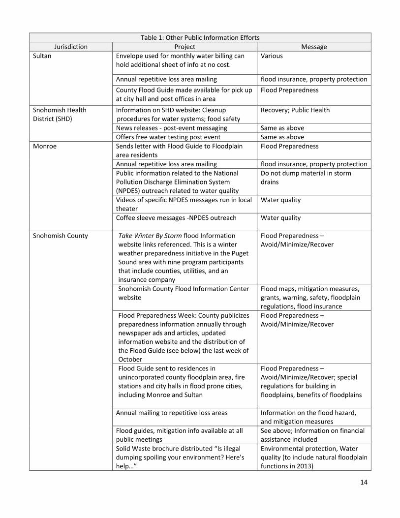
Table 1: Other Public Information Efforts
Jurisdiction Project Message
Sultan Envelope used for monthly water billing can hold additional sheet of info at no cost.
Various
Annual repetitive loss area mailing flood insurance, property protection
County Flood Guide made available for pick up at city hall and post offices in area
Flood Preparedness
Snohomish Health District (SHD)
Information on SHD website: Cleanup procedures for water systems; food safety
Recovery; Public Health
News releases - post-event messaging Same as above
Offers free water testing post event Same as above
Monroe Sends letter with Flood Guide to Floodplain area residents
Flood Preparedness
Annual repetitive loss area mailing flood insurance, property protection
Public information related to the National Pollution Discharge Elimination System (NPDES) outreach related to water quality
Do not dump material in storm drains
Videos of specific NPDES messages run in local theater
Water quality
Coffee sleeve messages -NPDES outreach
Water quality
Snohomish County Take Winter By Storm flood Information website links referenced. This is a winter weather preparedness initiative in the Puget Sound area with nine program participants that include counties, utilities, and an insurance company
Flood Preparedness – Avoid/Minimize/Recover
Snohomish County Flood Information Center website
Flood maps, mitigation measures, grants, warning, safety, floodplain regulations, flood insurance
Flood Preparedness Week: County publicizes preparedness information annually through newspaper ads and articles, updated information website and the distribution of the Flood Guide (see below) the last week of October
Flood Preparedness – Avoid/Minimize/Recover
Flood Guide sent to residences in unincorporated county floodplain area, fire stations and city halls in flood prone cities, including Monroe and Sultan
Flood Preparedness – Avoid/Minimize/Recover; special regulations for building in floodplains, benefits of floodplains
Annual mailing to repetitive loss areas Information on the flood hazard, and mitigation measures
Flood guides, mitigation info available at all public meetings
See above; Information on financial assistance included
Solid Waste brochure distributed “Is illegal dumping spoiling your environment? Here’s help…”
Environmental protection, Water quality (to include natural floodplain functions in 2013)
15
VII. Communication Strategy, Projects and Initiatives
The focus of the MJ-PPI Plan is to encourage flood preparedness best practices for the following key audiences:
Prospective buyers
Repetitive Loss area residents
Potential flood insurance policy holders
Floodplain residents
The community at large
The Committee selected seven key messages that need to be disseminated to the audiences. The first six are the
same as the six priority messages for the CRS. Two more were added by the Committee.
1. Know your flood hazard
2. Insure your property for your flood hazard
3. Protect people from the flood hazard
4. Protect your property from the flood hazard
5. Build responsibly
6. Protect natural floodplain functions
7. Know your flood hazard before you buy
8. Know your channel migration hazard
The overall strategy is to make information more readily available to the target audiences in a manner that will
equip and encourage these audiences to adopt behaviors to improve preparedness and decrease future flood
damage. The PPI Worksheet (Appendix 4) provides a comprehensive list of the program elements, which include
various public information pieces, an information package covering all aspects of flood recovery, website
enhancements, videos, and neighborhood meetings.
Some new proposed projects, developed through discussions at the Committee Meetings, are highlighted below:
The County CRS Coordinator would work with the Assessor’s Office to include a link to the Permit,
Planning and Zoning Map on the Assessor’s online parcel information. This would make it easier for
prospective buyers researching properties on the county’s website to see whether or not a property is
near or inside a mapped flood hazard area.
The Real Estate representative, Frank Linth, would work within his professional community to offer a
continuing education opportunity for realtors that would communicate the impacts of buying a house in a
floodplain or wildfire area and encourage them to better prepare the homeowner.
County staff would hold a neighborhood meeting in one or more repetitive loss areas with large numbers
of affected properties to let homeowners know what measures can be taken to reduce their damage, and
to attract homeowners willing to participate in FEMA grant-assisted home elevation project.
Snohomish Health District would look into making a short video and posting it on their website, to provide
information on flood cleanup. Ideally the video would be available in Spanish as well as English, and
possibly Russian and Vietnamese as well, the other more common ethnicities in the county.
The County CRS Coordinator would work to publicize the National Flood Insurance Program’s (NFIP) Flood
Smart website, www.floodsmart.gov, which is a collection of information to help people decide if flood
16
insurance is right for them. The website illustrates how different levels of flood water can damage a
home, and estimates the costs of restoring to original condition.
The County CRS Coordinator would complete a Flood Insurance Coverage Assessment, a Geographic
Information Systems (GIS) exercise showing the structures in the floodplain and their flood insurance
coverage (none, structure only, contents only, both structure and contents.) This research would help the
Committee to refine the recommended public information projects that promote flood insurance, which
are eligible for more credit under the Community Rating System.
The County CRS Coordinator would print a supply of business cards that list key flood-related websites.
The cards would be made available at offices, such as the Planning Department’s permit counter, and
handed out at meetings, etc.
As projects are reviewed and revised, we would be adding information about channel migration to the
sections about the flood hazard. Channel migration is related to flooding, but can cause more damage as
the stream banks are undercut and structures can fall over. It can affect properties outside the mapped
floodplain. Most residents are not aware of the hazard, but now we have maps for some rivers.
The County CRS Coordinator would coordinate development of messages to be released during or after a
flood. These are listed separately as “Flood Response Preparation Projects” at the end of Appendix 4. One
example is a door hanger package of information for properties impacted by flooding. This package would
contain contacts and information on rebuilding, recovery, disposing of waste, health and safety. These
door hanger packages would be distributed to County personnel who go out in the field to estimate flood
damage during or after a flood event. The County staff person can hang the information on the door of an
affected structure, allowing the owner to have complete information to assist in recovery brought to his
door. A version of this could be prepared for the Cities of Monroe and Sultan, for the same purpose.
VIII. Annual Evaluation
The Multi-Jurisdictional PPI Committee will meet at least once a year, to evaluate the Plan and incorporate any
needed revisions. The evaluation will cover:
A review of the projects that were completed
Progress toward the desired outcomes
Recommendations regarding projects not completed
Changes in the target audiences
The jurisdictions should refresh their CRS Community Self Assessment at least once every two years, and bring the
results to the Annual Evaluation. The County will coordinate and facilitate this meeting, and afterward, provide a
summary and updated PPI worksheet (see Appendix 4) reflecting the Committee’s decisions. The outcomes and
revisions will be submitted as part of the annual CRS recertification package for the County and for the Cities of
Monroe and Sultan.
IX. Plan Adoption
This document will not become effective until it is approved by the Snohomish County Council, the Monroe City
Council, and the Sultan City Council.
17
Appendix 1
18
Appendix 2
19
Appendix 3
20
Appendix 4
Snohomish County, City of Monroe, City of Sultan
Multi-Jurisdictional PPI Worksheet
2013 Projects
21
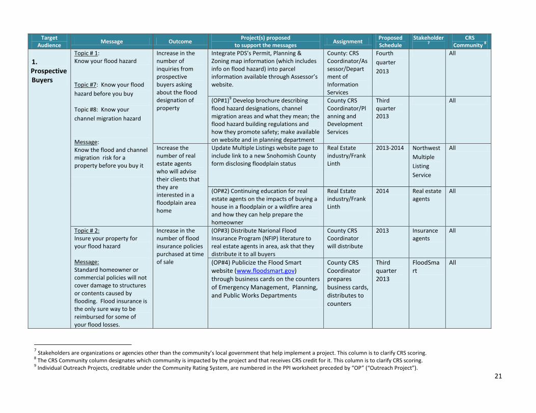
Target Audience
Message Outcome Project(s) proposed
to support the messages Assignment
Proposed Schedule
Stakeholder7
CRS Community
8
1. Prospective Buyers
Topic # 1: Know your flood hazard
Topic #7: Know your flood
hazard before you buy
Topic #8: Know your
channel migration hazard
Message: Know the flood and channel migration risk for a property before you buy it
Increase in the number of inquiries from prospective buyers asking about the flood designation of property
Integrate PDS’s Permit, Planning & Zoning map information (which includes info on flood hazard) into parcel information available through Assessor’s website.
County: CRS Coordinator/Assessor/Department of Information Services
Fourth
quarter
2013
All
(OP#1)9 Develop brochure describing flood hazard designations, channel migration areas and what they mean; the flood hazard building regulations and how they promote safety; make available on website and in planning department
County CRS Coordinator/Planning and Development Services
Third quarter 2013
All
Increase the number of real estate agents who will advise their clients that they are interested in a floodplain area home
Update Multiple Listings website page to include link to a new Snohomish County form disclosing floodplain status
Real Estate industry/Frank Linth
2013-2014 Northwest
Multiple
Listing
Service
All
(OP#2) Continuing education for real estate agents on the impacts of buying a house in a floodplain or a wildfire area and how they can help prepare the homeowner
Real Estate industry/Frank Linth
2014 Real estate agents
All
Topic # 2: Insure your property for your flood hazard Message: Standard homeowner or commercial policies will not cover damage to structures or contents caused by flooding. Flood insurance is the only sure way to be reimbursed for some of your flood losses.
Increase in the number of flood insurance policies purchased at time of sale
(OP#3) Distribute Narional Flood Insurance Program (NFIP) literature to real estate agents in area, ask that they distribute it to all buyers
County CRS Coordinator will distribute
2013 Insurance agents
All
(OP#4) Publicize the Flood Smart website (www.floodsmart.gov) through business cards on the counters of Emergency Management, Planning, and Public Works Departments
County CRS Coordinator prepares business cards, distributes to counters
Third quarter 2013
FloodSmart
All
7 Stakeholders are organizations or agencies other than the community’s local government that help implement a project. This column is to clarify CRS scoring.
8 The CRS Community column designates which community is impacted by the project and that receives CRS credit for it. This column is to clarify CRS scoring.
9 Individual Outreach Projects, creditable under the Community Rating System, are numbered in the PPI worksheet preceded by “OP” (“Outreach Project”).
22
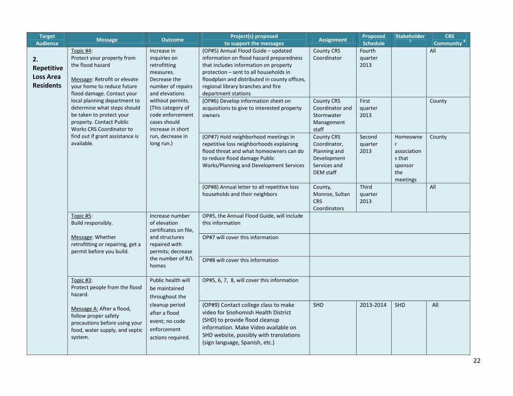
Target Audience
Message Outcome Project(s) proposed
to support the messages Assignment
Proposed Schedule
Stakeholder7
CRS Community
8
2. Repetitive Loss Area Residents
Topic #4: Protect your property from the flood hazard Message: Retrofit or elevate your home to reduce future flood damage. Contact your local planning department to determine what steps should be taken to protect your property. Contact Public Works CRS Coordinator to find out if grant assistance is available.
Increase in inquiries on retrofitting measures. Decrease the number of repairs and elevations without permits. (This category of code enforcement cases should increase in short run, decrease in long run.)
(OP#5) Annual Flood Guide – updated information on flood hazard preparedness that includes information on property protection – sent to all households in floodplain and distributed in county offices, regional library branches and fire department stations
County CRS Coordinator
Fourth quarter 2013
All
(OP#6) Develop information sheet on acquisitions to give to interested property owners
County CRS Coordinator and Stormwater Management staff
First quarter 2013
County
(OP#7) Hold neighborhood meetings in repetitive loss neighborhoods explaining flood threat and what homeowners can do to reduce flood damage Public Works/Planning and Development Services
County CRS Coordinator, Planning and Development Services and DEM staff
Second quarter 2013
Homeowner associations that sponsor the meetings
County
(OP#8) Annual letter to all repetitive loss households and their neighbors
County, Monroe, Sultan CRS Coordinators
Third quarter 2013
All
Topic #5: Build responsibly. Message: Whether retrofitting or repairing, get a permit before you build.
Increase number of elevation certificates on file, and structures repaired with permits; decrease the number of R/L homes
OP#5, the Annual Flood Guide, will include this information
OP#7 will cover this information
OP#8 will cover this information
Topic #3: Protect people from the flood hazard. Message A: After a flood, follow proper safety precautions before using your food, water supply, and septic system.
Public health will
be maintained
throughout the
cleanup period
after a flood
event; no code
enforcement
actions required.
OP#5, 6, 7, 8, will cover this information
(OP#9) Contact college class to make video for Snohomish Health District (SHD) to provide flood cleanup information. Make Video available on SHD website, possibly with translations (sign language, Spanish, etc.)
SHD 2013-2014 SHD
All
23
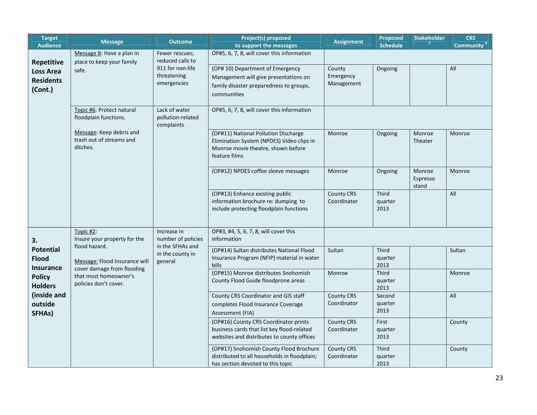
Target Audience
Message Outcome Project(s) proposed
to support the messages Assignment
Proposed Schedule
Stakeholder7
CRS Community
8
Repetitive Loss Area Residents (Cont.)
Message B: Have a plan in
place to keep your family
safe.
Fewer rescues; reduced calls to 911 for non-life threatening emergencies
OP#5, 6, 7, 8, will cover this information
(OP# 10) Department of Emergency
Management will give presentations on
family disaster preparedness to groups,
communities
County Emergency Management
Ongoing All
Topic #6: Protect natural floodplain functions. Message: Keep debris and trash out of streams and ditches.
Lack of water pollution-related complaints
OP#5, 6, 7, 8, will cover this information
(OP#11) National Pollution Discharge Elimination System (NPDES) Video clips in Monroe movie theatre, shown before feature films
Monroe Ongoing Monroe Theater
Monroe
(OP#12) NPDES coffee sleeve messages
Monroe Ongoing Monroe Espresso stand
Monroe
(OP#13) Enhance existing public information brochure re: dumping to include protecting floodplain functions
County CRS Coordinator
Third quarter 2013
All
3. Potential Flood Insurance Policy Holders (inside and outside SFHAs)
Topic #2: Insure your property for the flood hazard. Message: Flood Insurance will cover damage from flooding that most homeowner’s policies don’t cover.
Increase in number of policies in the SFHAs and in the county in general
OP#3, #4, 5, 6, 7, 8, will cover this information
(OP#14) Sultan distributes National Flood Insurance Program (NFIP) material in water bills
Sultan Third quarter 2013
Sultan
(OP#15) Monroe distributes Snohomish County Flood Guide floodprone areas
Monroe
Third quarter 2013
Monroe
County CRS Coordinator and GIS staff
completes Flood Insurance Coverage
Assessment (FIA)
County CRS Coordinator
Second quarter 2013
All
(OP#16) County CRS Coordinator prints business cards that list key flood-related websites and distributes to county offices
County CRS Coordinator
First quarter 2013
County
(OP#17) Snohomish County Flood Brochure distributed to all households in floodplain; has section devoted to this topic
County CRS Coordinator
Third quarter 2013
County
24
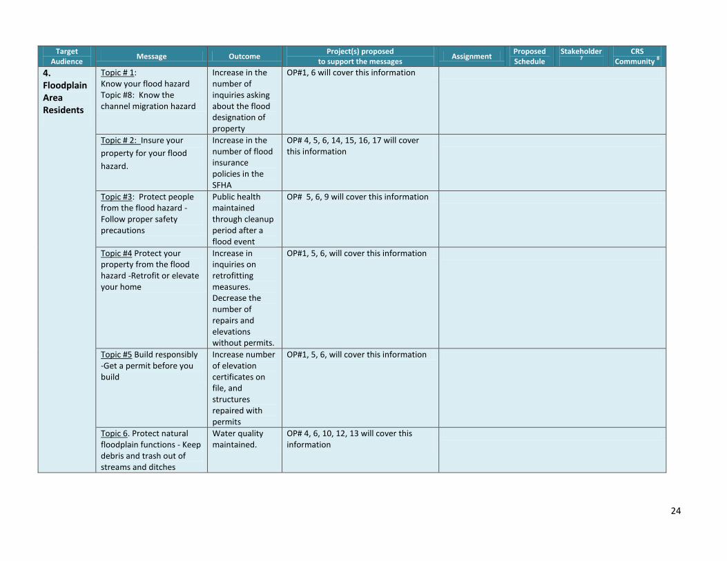
Target Audience
Message Outcome Project(s) proposed
to support the messages Assignment
Proposed Schedule
Stakeholder7
CRS Community
8
4. Floodplain Area Residents
Topic # 1: Know your flood hazard Topic #8: Know the channel migration hazard
Increase in the number of inquiries asking about the flood designation of property
OP#1, 6 will cover this information
Topic # 2: Insure your
property for your flood
hazard.
Increase in the number of flood insurance policies in the SFHA
OP# 4, 5, 6, 14, 15, 16, 17 will cover this information
Topic #3: Protect people from the flood hazard -Follow proper safety precautions
Public health maintained through cleanup period after a flood event
OP# 5, 6, 9 will cover this information
Topic #4 Protect your property from the flood hazard -Retrofit or elevate your home
Increase in inquiries on retrofitting measures. Decrease the number of repairs and elevations without permits.
OP#1, 5, 6, will cover this information
Topic #5 Build responsibly -Get a permit before you build
Increase number of elevation certificates on file, and structures repaired with permits
OP#1, 5, 6, will cover this information
Topic 6. Protect natural floodplain functions - Keep debris and trash out of streams and ditches
Water quality maintained.
OP# 4, 6, 10, 12, 13 will cover this information
25
Target Audience
Message Outcome Project(s) proposed
to support the messages Assignment
Proposed Schedule
Stakeholder7
CRS Community
8
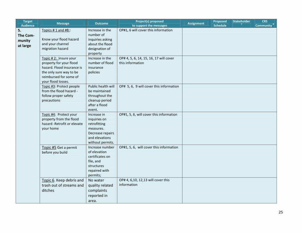
5. The Com-munity at large
Topics # 1 and #8::
Know your flood hazard and your channel migration hazard
Increase in the number of inquiries asking about the flood designation of property
OP#1, 6 will cover this information
Topic # 2: Insure your property for your flood hazard. Flood insurance is the only sure way to be reimbursed for some of your flood losses.
Increase in the number of flood insurance policies
OP# 4, 5, 6, 14, 15, 16, 17 will cover this information
Topic #3: Protect people from the flood hazard - follow proper safety precautions
Public health will be maintained throughout the cleanup period after a flood event.
OP# 5, 6, 9 will cover this information
Topic #4: Protect your property from the flood hazard -Retrofit or elevate your home
Increase in inquiries on retrofitting measures. Decrease repairs and elevations without permits.
OP#1, 5, 6, will cover this information
Topic #5 Get a permit
before you build Increase number of elevation certificates on file, and structures repaired with permits;
OP#1, 5, 6, will cover this information
Topic 6. Keep debris and trash out of streams and ditches
No water quality related complaints reported in area.
OP# 4, 6,10, 12,13 will cover this information
26
Target Audience
Message Outcome Project(s) proposed
to support the messages Assignment
Proposed Schedule
Stakeholder7
CRS Community
8
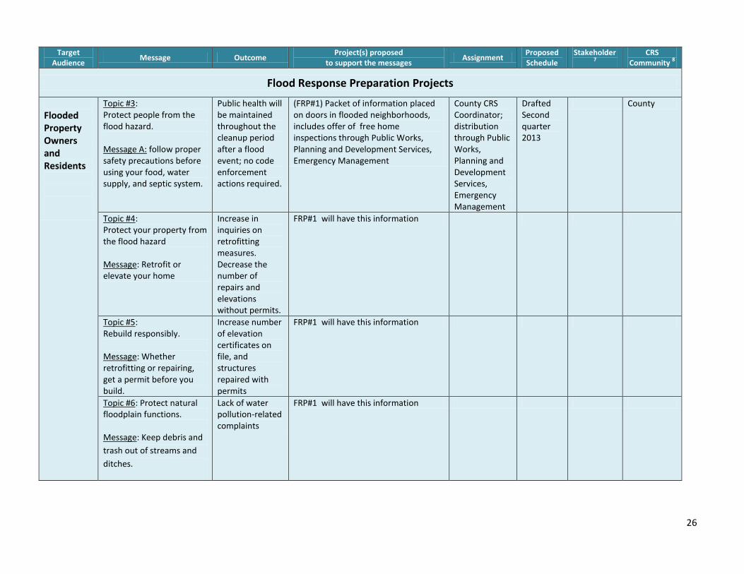
Flood Response Preparation Projects
Flooded Property Owners and Residents
Topic #3: Protect people from the flood hazard. Message A: follow proper safety precautions before using your food, water supply, and septic system.
Public health will be maintained throughout the cleanup period after a flood event; no code enforcement actions required.
(FRP#1) Packet of information placed on doors in flooded neighborhoods, includes offer of free home inspections through Public Works, Planning and Development Services, Emergency Management
County CRS Coordinator; distribution through Public Works, Planning and Development Services, Emergency Management
Drafted Second quarter 2013
County
Topic #4: Protect your property from the flood hazard Message: Retrofit or elevate your home
Increase in inquiries on retrofitting measures. Decrease the number of repairs and elevations without permits.
FRP#1 will have this information
Topic #5: Rebuild responsibly. Message: Whether retrofitting or repairing, get a permit before you build.
Increase number of elevation certificates on file, and structures repaired with permits
FRP#1 will have this information
Topic #6: Protect natural floodplain functions. Message: Keep debris and
trash out of streams and
ditches.
Lack of water pollution-related complaints
FRP#1 will have this information
27
Target Audience
Message Outcome Project(s) proposed
to support the messages Assignment
Proposed Schedule
Stakeholder7
CRS Community
8
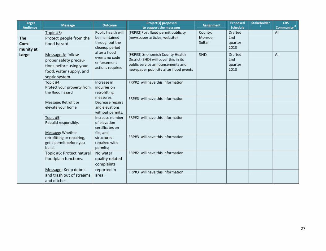
The Com- munity at Large
Topic #3: Protect people from the flood hazard. Message A: follow proper safety precau-tions before using your food, water supply, and septic system.
Public health will be maintained throughout the cleanup period after a flood event; no code enforcement actions required.
(FRP#2)Post flood permit publicity (newspaper articles, website)
County, Monroe, Sultan
Drafted 2nd quarter 2013
All
(FRP#3) Snohomish County Health District (SHD) will cover this in its public service announcements and newspaper publicity after flood events
SHD Drafted 2nd quarter 2013
All
Topic #4: Protect your property from the flood hazard Message: Retrofit or elevate your home
Increase in inquiries on retrofitting measures. Decrease repairs and elevations without permits.
FRP#2 will have this information
FRP#3 will have this information
Topic #5: Rebuild responsibly. Message: Whether retrofitting or repairing, get a permit before you build.
Increase number of elevation certificates on file, and structures repaired with permits;
FRP#2 will have this information
FRP#3 will have this information
Topic #6: Protect natural floodplain functions. Message: Keep debris and trash out of streams and ditches.
No water quality related complaints reported in area.
FRP#2 will have this information
FRP#3 will have this information