Embed Size (px)
Citation preview

SLAUGHTER LANE
DRAFT SURVEY REPORT
September 2017

How do you use the Slaughter Ln. corridor (select all that apply)? Answered: 234 (231 English, 3 Spanish)
Several respondents selected more than one answer. Percentages reflect the percentage of respondents that chose that answer.
0% 10% 20% 30% 40% 50% 60% 70% 80%
23, 9.8%
138, 59.0%
125, 53.4%
37, 15.8%
53, 22.6%
21, 9.0%
I work along the corridor
I live along the corridor
I commute through the corridor
I or my children attend school along the corridor
I don’t live or work on the corridor, but I shop, eat, use recreational
facilities on the corridor
Other (please specify)
Other (please specify) Do not currently live on corridor/ moving to corridor in a few months Take my son to work Family lives nearby Recreational Cyclist I want to walk along this corridor in complete safety, which is impossible right now Eat & Shop- Southpark Meadows Live close to corridor and use for many reasons Cycling Make it safe and pleasant for people on foot and on bike Cars use West Gate as a short cut to William Cannon Recreational biking Use it move around parts of town I patronize businesses along the corridor Children live and work in corridor Drive corridor to visit family I ride my bike through the corridor My mother lives in this corridor I live near the corridor in Onion Creek subdivision I ingress and egress from my home. I don't live or work on the corridor, but generally travel in Austin. I shop at multiple merchants on Slaughter Lane
DRAFT
1

In what zip code do you live? Answered: 234 (231 English, 3 Spanish)
76
23
36
49 15
Zip Codes Not Mapped No. of Responses 78744, 78737 6
78735 4 78704 3
78759, 78757, 78736, 78727, 78702, 78652 2
78754, 78746, 78740, 78610 1
Zip Codes Mapped No. of Responses 78748 76 78749 49 78739 36 78747 23 78745 15
DRAFT
2
In what zip code do you work or attend school? Answered: 213 (210 English, 3 Spanish)
3811
19
1117
2411
Zip Codes Not Mapped No. of Responses 78705, 78735 9
78744 7 78703 6 78741 5
78702, 78759 4 78722, 78731, 78736, 78747 3
78610, 78666, 78713, 78723, 78737, 78753, 78754
2
78612, 78640, 78652, 78711, 78712, 78750, 78752, 78756, 78757, 78767, 78778, 79701
1
Zip Codes Mapped No. of Responses 78701 38 78748 24 78704 19 78749 17 78739 11
DRAFT
3

What mode of transportation do you use in this corridor? How many times per week?
Answered: 232 (228 English, 4 Spanish)
121 14 42 14 14 11 9 225 5.64
4 3 8 6 5 8 8 42 3.55
0 2 4 0 3 3 2 14 3.50
1 1 2 4 11 11 16 46 2.39
0 0 2 0 0 1 6 9 2.00
0 0 0 0 0 1 2 3 1.33
Walk
Carpool/rideshare
Bicycle
Transit Rider
Other
0 1 2 3 4 5 6 7
5.6
3.6
3.5
2.4
2.0
1.3
7 days perweek
6 days perweek
5 days perweek
4 days perweek
3 days perweek
2 days perweek
1 day perweek
Total WeightedAverage
Drive a personalvehicle
Walk
Carpool/rideshare
Bicycle
Transit Rider
Other
Drive a personal vehicle
Days per week
DRAFT
4

The Slaughter Ln. Mobility Plan will consider several topics, some of which are listed below. Please rank these, according to importance to you, with 1 being the
most important:Answered: 232 (230 English, 2 Spanish)
118 24 24 14 15 9 19 223 5.29
23 64 47 23 17 18 12 204 4.19
22 28 43 37 23 32 21 206 3.62
21 28 24 32 40 43 14 202 3.38
12 37 29 35 22 28 42 205 3.25
26 24 15 31 23 37 44 200 3.07
7 9 28 30 54 25 46 199 2.68
0 1 2 3 4 5 6 7
1 2 3 4 5 6 7 Total WeightedAverage
Managing congestion
Improving accessibility to and from destinations andneighborhoods surrounding the corridor
Calming traffic in residential neighborhoods
Creating a safer and more supportive environment forwalking
Improving transit service
Creating a safer and more supportive environment forcycling
Creating attractive public spaces in strategic locationsalong the corridor
Managing congestion
Improving accessibility to and from destinations and neighborhoods
surrounding the corridor
Calming traffic in residential neighborhoods
Creating a safer and more supportive environment for walking
Improving transit service
Creating a safer and more supportive environment for cycling
Creating attractive public spaces in strategic locations along the corridor
Rank
DRAFT
5

Which of the following improvements are most important for people who walk along Slaughter Ln.? Please rank these, according to importance to you,
with 1 being the most important:Answered: 223 (221 English, 2 Spanish)
77 27 21 18 11 6 2 1 163 4.88
24 48 34 18 23 8 3 3 161 4.25
27 32 20 23 16 10 12 5 145 3.58
13 29 18 22 20 28 15 7 152 3.26
10 15 34 29 14 30 13 6 151 3.19
0 1 2 3 9
1 2 3 4 5 6 7 8 Total WeightedAverage
Continuous sidewalks
Safer pedestrian crossings
Sidewalks with separation from traffic
Sidewalk maintenance
More pedestrian crossings
I am not interested in improvements related to walking
Continuous sidewalks
Safer pedestrian crossings
Sidewalks with separation from traffic
Sidewalk maintenance
More pedestrian crossings
Wider sidewalks
Opportunities for sitting and shade
ADA rehabilitation
8 5 9 18 16 19 35 26 136 2.06
6 11 21 18 26 26 25 16 149 1.53
ADA rehabilitation
Wider sidewalks
4 Rank
37 0 0 2 0 6 1 25 71 1.57I am not interested in improvements relatedto walking
9 5 9 15 25 16 30 35 144 2.15Opportunities for sitting and shade
DRAFT
6

Which of the following improvements are most important for people who ride a bike along Slaughter Ln.? Please rank these, according to importance to you, with
1 being the most important:Answered: 225 (223 English, 2 Spanish)
66 0 1 16 83 2.29
94 33 16 9 152 1.78
29 53 54 17 153 1.56
20 55 42 22 139 1.25
2 10 26 78 116 .75
0 1 2
1 2 3 4 Total Weighted Average
I am not interested in improvements related to biking
Separated and/or protected bike lanes
Intersection and signal enhancements
Wider bike lanes
Bike parking
Separated and/or protected bike lanes
Intersection and signal enhancements
Wider bike lanes
Bike parking
I am not interested in improvements related to biking
Rank
DRAFT
7

Which of the following improvements are most important for people who ride transit along Slaughter Ln.? Please rank these, according to importance
to you, with 1 being the most important:Answered: 224 (222 English, 2 Spanish)
58 3 0 18 79 1.16
61 30 27 17 135 1.81
44 46 40 9 139 1.80
16 34 41 39 130 1.28
27 26 26 60 139 1.33
0 1 2
1 2 3 4 Total Weighted Average
I am not interested in improvements related to transit
More transit options
More frequent bus service
Additional bus stops
Upgraded bus stops (shelters, benches, better signage, safer)
More transit options
More frequent bus service
Additional bus stops
Upgraded bus stops (shelters, benches, better signage, safer)
I am not interested in improvements related to transit
Rank
DRAFT
8

Which of the following improvements are most important for people whodrive along Slaughter Ln.? Please rank these, according to importance to
you, with 1 being the most important:Answered: 231 (229 English, 2 Spanish)
91 53 34 17 12 207 3.64
59 40 64 35 3 201 3.21
5 1 0 0 3 9 0.14
35 89 46 21 14 205 3.24
13 11 39 82 28 173 1.87
23 11 11 25 103 173 1.54
0 1 2 3
1 2 3 4 5 Total Weighted Average
Improved signal timing
Safer intersections
I am not interested in improvements related to driving
Improved turning options
Fewer driveways or consolidated driveways
Slower speed limits
Improved signal timing
Safer intersections
I am not interested in improvements related to driving
Improved turning options
Fewer driveways or consolidated driveways
Slower speed limits
Rank
DRAFT
9

110 general comments were shared in the survey. Below is a brief summary of common themes identified in the comments. Full responses are included below.
Is there anything else you think we should know about the Slaughter Ln. Corridor? Answered: 110 (110 English, 0 Spanish)
Slaughter Lane Comment Themes No. of Comments Traffic and Congestion 24 Safety 22 Speed Limits and Speed Calming 16 Bicycle Accommodations 15 Signal Timing 13 Pedestrian Accommodations 12 Transit 12 Turn Lanes 11 Traffic Lights 9 Additional Lanes/Widening 8 Against Bicycle Accommodations 8 Intersections 8 Slaughter at MoPac Intersection 6 Pedestrian Crossing 4 Noise and Sound 4 Connectivity 3 Green Space 1 Public Amenities 1 Shoulders 1 Parking 1 Bike Storage 1
DRAFT
10

The first light west of I-35 on Slaughter is a heavily congested area. Are there opportunities to adjust the lighttiming to allow a quicker flow.It should be widened to 3 lanes in each direction wherever possible. Buses should have Pull Out Lanes sothey do not block traffic. More dedicated right turn lanes and busy intersections.There is no sidewalk across Goresky high school to the Stor place even though lots of walkers, runners, andcyclist need one.A pedestrian crossing signal is needed at Vineland to cross into the park.Want to reemphasize transit options and slower speeds.Mopac overpass needs to be done yesterdayThis road is sadly, aptly named. I live in Sendera, and I hear crashes near my neighborhood regularly. My carwas totalled by a driver running a red light right by my neighborhood. I'm hoping for the underpass at theMopac/Slaughter intersection, and I'm hoping that when TX 45 connects areas south of Austin to Mopac, fewercars will travel Slaughter/cut through the neighborhoods. But I'm sure that's naive thinking, given theunrelenting growth everywhere. My hope now is that if Slaughter Lane turns into yet another ugly, congested,multi-lane wide corridor road, that my neighborhood is protected from noise, cars and lower property values, bythe installation of some noise-calming walls. We've staved off the once proposed Super Walmart at theSlaughter/Mopac intersection. The environment is very important to people who chose to move to this area. Ihope the green spaces (even the one in the middle of Mopac, just north of Slaughter Lane) can be preserved.It's important for the aquifer recharge zone and the Wildflower Center, and the mental health of residents whoface long commutes to and from downtown every day.any possibility of creating a right-turn only lane from Slaughter eastbound onto onto S. 1st St.? It would reducecongestion considerably.Intersection at Slaughter and Manchaca is dangerous. Need better turn lanes.Difficult to turn left off of S. 1st. I don't understand the flashing yellow lights- people are confused by them.the light going up just north of slaughter/manchaca is horrible, and you should feel bad for putting a light there.Develop better transportation options east of 35, particularly putting a bus stop or light rail at Brandt Rd. &Slaughter.Improvements to the signal timing and lanes around Slaughter at Southpark Meadows (especially adjacent toWalmart/Congress intersection) and I35.Protect existing trees especially protected and heritage trees, including protecting their critical root zone andcanopy. Reduce traffic speed thru residential neighborhoods. Increasing traffic volume in corridors will increasenoise and air polution in adjacent residential areas and decrease quality of life.Consistent turning lanes; and land WARNING ahead of the arrival.MUST add special bus only entrance and driveway on east Slaughter by Bowie High to reduce massive AMcongestion (since the busses can't turn right on red at main entrance.There are several sections that have no bike lanes. From MOPAC to Brodie and from the South bound frontageroad for IH35 onward down East Slaughter.Safer and better intersection work. PLEASESlaughter Ln especially east of IH-35 is like a raceway. People drive 60 mph. There large lots with no publicsidewalks, huge blind spots on the hills, and unprotected public sidewalks (where they actually have them). Iwork for the city and was hoping that this area would be walkable and it absolutely is not, despite being locatedless than a mile from Southpark Meadows. I have no public transit options, the BRT transit stop at SouthparkMeadows has only 20 spots dedicated to park and ride (which is wholly inadequate to support BRT!) and thereare NO public amenities anywhere on this side of Slaughter Ln. The Onion Creek Regional Park will still beover 2 miles away from my neighborhood and even if there are bike lanes installed along Slaughter on the eastside of IH-35. I also think there would be a high probability of being struck by a car if bike lanes were installed.We need public transit stops, complete the sidewalk infrastructure on this VERY busy major road and install apublic amenity this area (even a pocket park), and slow the traffic. I've seen people pushing baby strollers inthe road on Slaughter Lane several times bc there is no public sidewalks to Southpark Meadows. The trafficlight is wholly inadequate at the IH-35 intersection and Slaughter Ln. People in cars do no pause to allowpedestrians to cross the road on both sides (Home Depot, Walmart, HEB lot, and UHaul corners.) This entireportion of the city is completely devoted to cars, and getting the cars through the intersection at SouthparkMeadow and IH-35 as quickly as possible while deny little if any in the way of safe pedestrian access oradequate public transit service. The city should have analyzed this area b4 Southpark Meadows became thebeast that it is. I'd love to see a pedestrian walkway that would go over IH-35.
Full Responses
DRAFT
11

Concerned about the traffic - vehicles, bikes, and large # of high school kids walking - in such a tight spot nearBowie HS in both directions (towards Brodie and also towards Mopac/Circle C)This comment relates to the William Cannon Survey as well. Suburbs around Vertex/Slaughter Ln, MckinneyFalls Parkway and William Cannon (within Austin City limits) are booming. And it seems like City Managementis refusing to acknowledge the growth on the edges of Austin. Tons of families rapidly moving into theseneighborhoods, and new desirable single family houses being built in the dozens. From the traffic up-tic overthe 6 months - a good portion of these families work or have children that go to school downtown (I do, on bothaccounts). And are all forced to use the same couple of transit corridors that are either unfinished, or unable tohandle the large number of cars and buses. Early morning commutes are a nightmare in this area (all the wayfrom 6:45am until 8:30am every morning during the school year). With only 4 ways out of this area. It is safetyhazard to have dozens of cars attempting to turn onto unfinished Slaughter Road - and more over hundreds ofcars trying to turn through cross traffic onto William Cannon (speed limit 45 mph) from residential roadsWITHOUT traffic lights. It's the same scenario on Mckinney Falls, and leaves commuters and drivers boxed in.Discussion here about walking or ride bikes is just laughable. There are children at Blazer Elementary thatcannot walk or ride their bikes 3-6 blocks because there are no sidewalks - and no money for them. They haveto be driven or ride the bus to a school that is literally right next to their homes; further congesting the roads.The City needs to take immediate steps to acknowledge the travel/traffic/transit needs of these suburbs beforepeople get hurt. Summer is not terrible to bus or drive, but I'm afraid for September as these neighborhoodcontinue to grow at staggering rates. Austin pricing has pushed middle working class families out to the SouthEast neighborhoods, and now they they are full of families (with more houses built each day - and promises ofa new High School, businesses, and shopping centers). If you expect professionals to continue to workdowntown, afford Austin pricing, and provide transportation so their children can attend the underpopulatedschools downtown (which AISD is all but begging us to do), the City needs to work on planning to allow peopleaccess.It's designed as a highway. It's an urban street. The improvements needed should be pretty intuitive to figureout. :-) And remember - design dictates the speed people drive, not the speed limit.Update traffic studies at intersections to provide better signaling and shorter wait times.There needs to be an overpass at Slaughter and MoPac I spend way too much time sitting at this light trying togo north on MoPac .... EVEN on the WEEKENDS!!!It's impossible for a car to pull over for emergency and remain safe. I always fear hitting cyclists or getting hitfrom behind while slowing down.Get traffic moving more smoothly at peak timesCycling support is horrible and very dangerous throughout the corridor. It is not rideable at all betweenEscarpment and Brodie, and very unsafe between Brodie and I-35.Get it done!Add speed limit postings and barriers. to help prevent wrong turns like the posts that were finally placed atMANCHACA and Slaughter. Make the observations to determine where dangerous shortcuts are or can betaken, and redesign.I'd like to see three lanes both ways between Mopac and IH-35, as well as the median-separated cycle tracks.Congestion at Slaughter Brodie intersection needs to be improved. Brodie south of Slaughter needs to bewidened to accommodate number of cars turningThe REAL (and ignored) problems in our zone are our N-S routes, Manchaca, S 1st, Brodie, Congress andWestgate in that order. How can you not complete the grid?? CapMetro has several upcoming projects...youhave got to be able to connect people on foot and on bike to those hubs, not only safely, but PLEASANTLY.So, so much bang for the buck if you include Manchaca from (the Hays County line to S. Lamar) and S 1st from1826 to Barton Springs. One change, biggest impact: Lower speed limit to 20mph. 20isplenty.org grassrootscampaign. Then people WILL walk and ride bikes and our coordinated efforts will create lasting change for theentire zone. Let's move us in that direction for the future of South Austin. Why? Because then it becomes aplace people could imagine aging in place. We have to Slow Down Austin. And "Improving accessibility to andfrom destinations and neighborhoods surrounding the corridor" - only if it's for people on foot and on bike,separate from auto traffic.Please stop pushing an agenda based on the belief that everyone will be walking, biking, and taking the bus.This is not reality! Please concentrate on fixing the roads. Give us back the car lanes taken for the weekendbikers or turn them into bus lanes. Require off road parking. Synchronize signal lights and reduce the cost ofriding the bus.
DRAFT
12

Reduce the volume of cars that access West Gate Blvd..Cars travel too fast between Manassas and WilliamCannon. Need to install traffic light at Manassas and other intersections o calming devices from Manassas toWm. Cannon. According to the January 2017 traffic study conducted by Austin Transportation Department, thevolume of traffic at 7300 West gate increased by 30.4%(16,293cars per day) and car speeds exceed by 10miles the posted speed limit of 35mph. Also, reduce the speed limit to 30mph.Slower speed limits, safer intersections, quality and separate bicycle/pedestrian facilities, smart and sync'edtraffic signals, police presence and enforcement of speed limits, traffic light violations, blocking the box, schoolzone speed limits enforced as well as 1.5 mile radius surrounding neighborhood schools, lower neighborhoodspeed limits, provide bicycle and pedestrian connectivity through surrounding residential areas to access thecorridor, not more auto access through the neighborhoods from the corridor. Include Manchaca Rd and S 1stSt in this study !!!!Spend money creating bike lanes that are separate from roadways like those in Europe. Walkers and bikeriders should not be on roads with such heavy traffic - they need other options.Need safe N-S connections to all of these E-W improvements also CapMetro needs to redo routes to betterserve commuters from Hays County and SW Hill country area.Narrow the streets to 10' or 11' on bus routes. Make them safer for all users.Please improve the full length of Davis/Dittmar to make it a viable alternative for cyclists and pets. Urgentattention is needed to the hilly section directly east of Brodie: No sidewalks, no bike lanes, extremely poorlighting. And, yes, I do see cyclists and peds trying to use that section at considerable risk to themselves.Thanks.The biggest problem is Mopac and Slaughter. That intersection is a congestion nightmare for drivers. Weneed to develop an underpass or alternative rather than forcing all Mopac to stop at that light. We also need toprovide a safe passage for pedestrians and cyclists through that intersection. I won't let my teenage son walkor ride through it as it is way too dangerous.The biggest impacts one could make for this corridor is improving the timing of the signals, adding turning lanesand keeping the medians.Do not add bike lanes. Tgey slow traffic down and we lose car lanes. Let tgem use tge sidewalks, they're wideenough!I avoid driving on Slaughter, especially near my neighborhood close to Mopac, because it's such a congestednightmare and the traffic signals are not timed properly so that you can drive the speed limit and not have tostop at every single stoplight. I live on Hoffman Drive in Deer Haven, and people use my corner to cut fromDavis to Slaughter to avoid the backups at Brodie/Slaughter and Mopac/Slaughter. I'd also like to seeimprovements so that we could bike and walk more safely over to the restaurants and shopping at Mopac andSlaughter. Lastly, many kids who live in our neighborhood and Sendera walk to Bowie High School. Anotherpedestrian crosswalk closer to Sendera and Slaughter would be nice.Slaughter Lane at Vinemont. The exit from our neighborhood and Circle C Community Park. I have witnessedmany close calls 8n this area.Traffic congestion has gotten really bad, especially near larger intersection. It might be time for more lanes.Traffic has so dramatically increased that many of the side streets which need to access Slaughter facedangerous conditions due to lack of traffic calming solutions and different rates of speed/congestion betweeninside and outside lanes of traffic on Slaughter. I would suggest analysis be performed primarily during AM andPM drive time to judge safety of 'left turn' onto Slaughter along this cooridor for intersections with out lights.Add guard rails, increase separation between pedestrians and traffic, and reduce the speed limit. The accessin and out of Vintage Place and the Metro Park is in dire need of a light and is a fatal accident waiting tohappen.Make improvements to South Austin a priority for a change!Simply improving the traffic signal timing would make a HUGE difference. It is just comical right now.During soccer seasons, traffic into out and of Slaughter Metropolitan Park makes it a very dangerousintersection and difficult for Vintage Place residents to exit there neighborhood.I would like more lanes, South Park Meadows needs better ways to get into the shopping center. slaughter atIH 35 is to congested.Given the construction of new homes in the area consideration should be made regarding projected trafficcounts.There needs to be a pedestrian crossing installed at the intersection of slaughter lane and vinemont drive, asmany residents of the neighborhood cross slaughter ln here to enter the circle c metropolitan park and it's avery dangerous divided highway to cross.
DRAFT
13

Slaughter and Manchaca is very dangerous so the intersection needs to be improved a lot! The traffic to turnEast onto Slaughter from Manchaca is usually backed up. It's also hard to turn into our neighborhood,Tanglewood Forest, when traveling North from Slaughter Lane on Manchaca since there are so many cars inthe turning lanes that are leaving businesses along Manchaca and they block us from being able to turn left intoour neighborhood.There needs to be a pedestrian bridge or signal for crossing at the Circle C Metropolitan Park. Otherwise it isabout a half mile to the nearest crossing so I always see people running across four lanes of traffic. Thereshould also be pedestrian access into the park, I.e sidewalk or walking trail - not just walking along the sameroad as cars use.Let's get real. The bike lanes result in a reduction of the space available to separate cars. 40,000 cars a daydriving Slaughter and every car endangered because the unsend bondoggle of bike lanes.The bike lanes that were added between Manchaca and South First are rarely used, and they have caused themain traffic lanes to be narrower - dangerously narrower.The speed limit along most of Slaughter Lane is 45 miles per hour. Nine times out of 10, vehicles are speedingon Slaughter at 55 mph or faster, very dangerous to other drivers.I live near the intersection of Slaughter and Manchaca. Something MUST be done about the people crossingthrough oncoming traffic to turn into Walgreen's, HEB, etc. I myself have been in a terrible wreck due to this.Something must be done to lower speed limits and improve awareness for Slaughter Lane near theneighborhoods across from the Circle C Metro park. It is crazy our kids are not safe in that area at all. Thespeed limit is ridiculous and sidewalks are pretty much in the road!! Thank you for looking into new options,I live on Palace Parkway and it has become very busy -- I am assuming some is due to the increase of condos,but also as it is used as a thruway. People tend to race down it and even pass slower moving cars.All bus stops need to be offset so as not to interrupt the flow of traffic by stopping in the lane.the intersection of slaughter and manchaca is a nightmare. please consider allowing two left turn lanes fromsouthbound manchaca to eastbound slaughter.We need a light or pedestrian crossing at Vinemont and Slaughter across from the Metro Park. It's a dangerousintersection for residents, park users and commuters that pass through the intersection.Concerned about intersection on Vinemont and Slaughter--which is across from the park entrance. Lots oftraffic congestion, coupled with a 50 mph speed limit and sidewalks without protection is just another accidentwaiting to happen. A jogger from our neighborhood has already died after being hit by a speeding car thatcame up onto the sidewalk. Thank you for this survey and your attention to this area.Light or speed bumps at slaughter and vinemont. Entrance to park and exiting Vintage place dangerous.Bus service should go east of 35 all the way to vertex. Parking at sp meadows to ride the bus is not very safeor practical. Also. Cyclists on Slaughter (and Old Lockhart) are a huge safety concern.We need a signal light at Slaughter and Vinemont, which is the entrance to Slaughter Metropolitan Park with allof the ciry soccer fields, and also the entrance to the Circle C Vintage Place neighborhood. It is dangerous tocross Slaughter there because of the slight curve and the high speed of cars along Slaughter Lane.Extreme congestion at slaughter and bluff springs/ old Lockhart. Intersection improvements are not keeping upwith the growth of residential areaA signal at Slaughter and Old Bradshaw. The traffic there between 7-8 weekday mornings is awful. There arezero bus stops east of the 35 on Slaughter.The north bound Old Lockhart traffic that intersects with Slaughter gets incredibly congested in the morning.Some days the wait to turn onto Slaughter in either direction is 20 + minutes. Widening the intersection on OldLockhart would greatly assist with the backup. With neighborhoods growing on all sides of that intersection, itwould be ideal to head off the eve increasing congestion there.Slaughter at IH35 is overloaded with cars making crossing IH35 awful via car. It's also pretty much impossibleto navigate that area/entire road via bicycle. Some areas of slaughter do have a bike lane but it is too narrowfor such a busy/fast street.Residential neighborhoods (especially Palace Parkway between Slaughter and Dittmar) need better trafficcontrol. Turning right onto Palace Parkway from Dittmar is also dangerous.There are several schools along slaughter (including Gorzycki Middle, where my daughter is in 6th grade) thatare not accessible by bike.Don't waste space on bikes, they need alternative routes off the roadway. Mix use sidewalk/bike. Maximizeroadway for motor vehicle use.Improve the Slaughter/Mopac intersection congestion.
DRAFT
14

Manchaca and Slaughter is deadly because of limited options turning in and out of businesses and frommanchaca to slaughter in general. Please prevent more deaths by fixing these issues. TOP PRIORITYSeparated movements at intersections, right-turn deceleration lanes for major driveway and intersectionsThere is a dedicated right turn lane that takes cars from westbound Slaughter to northbound MoPac. This turnlane regularly and needlessly backs up because cars stop and yield unnecessarily to northbound traffic onMoPac. There is a long, dedicated merge lane and no yield sign. But, cars stop and yield anyway. There needsto be a "keep moving" sign and/or pylons separating the merge lane from MoPac traffic so that people will feelsafe making the turn without stopping. This would eliminate a lot of congestion on westbound Slaughter.From Slaughter/West Gate, it is a 1/2 mile to major shopping centers in both directions, but dangerous to walkor ride a bike. Families should be able to ride their bikes to both of these centers (Brodie & Manchaca)needs continuous bike lanesThe speed limit on this road needs to be reduced or the road needs to be right sized to discourage speeding.While the actual speed limit is 45MPH for most of the corridor, most motor vehicles drive much faster and theopenness of the road lends itself to cars weaving in and out of lanes at high rates of speed. Additionally thetraffic signals tend to cause significant back ups.What needs to be addressed is automobile congestion. Adding bike and/or pedestrian access isn't going tohelp that. No one is Texas, much less in the remote parts of Austin, are going to bike and/or walk instead ofdriving when they have to go more than a mile. So, wasting valuable land on bikes lanes and/or sidewalks is afool's game that won't address the problem.Would really prefer to reduce traffic and speeds on Slaughter west of Mopac due to high walking and bikingusage. Road noise is definitely an issue as well.The biggest issue I see, like many corridors in Austin, is that the city has not upgraded the intersections toaccount for the growth. In particular, the left turn lanes have both permissive and protected turns which shouldnot be the case. Traffic is about 50 mph with 3 lanes each direction, and you can't even see oncoming trafficdue to the left turners on the other side. So if you are upgrading the corridor, need to incorporate protectedlefts only.All bus stops need pull over spaces to not block traffic.The intersection at Slaughter and Congress is a nightmare to navigate in the pm rush hour. Buses have anextreme problem with turning east from Congress. The timing of the lights at the I35 frontage roads seem tonot allow for enough traffic to go that would allow for cars/buses to turn eastbound. One suggestion is to makeno right turn on red during rush hour to control cars jamming the intersection.Timing of lights, longer turn lane from slaughter going east to turn south on brodie, if had designated turn lanethat was longer it would help congestion for tjose not turning. Similar issue on slaughter coming west to gosouth mopac, need longer turn laneWay too much congestion around peak hours.There are few bus routes into the neighborhoods on the West end of William Cannon, nearer Escarpment andConvict Hill Roads. I work downtown and it makes getting to work or living there difficult. I've had to turn downplaces to live in that area because the transit is so difficult & minimal via biking and busing.Add traffic light at Norman Trail/BremnerThere should be room to write comments and you are not addressing some basic issues. How about park andrides? Having bike lanes WITHOUT LOSING any car lanes? Survey is rigged to get answers you want, not toreally find out what we want/need.Need faster auto transit not more bike lanes or sidewalksI live in the Parkside at Slaughter Creek neighborhood and there is no way to safely walk or ride my bike to anySouthpark Meadows business because there are no sidewalks or bikelanes leading out of my neighborhood toslaughter lane. If I did ride my bike, where do I safely store it while shopping?The speed limit on Slaughter Ln is too fast between Escarpment and Mopac. Traffic exiting the HEB to go easton Slaughter must "beat" westbound traffic that is going 50mph.More density in some locations allowing for mixed use. Structures along roadway with parking in rear.I would like to see more options, transit, bus lanes, signals, on the areas of Slaughter that are east of IH 35.Yes, build 45 like we asked to be done at least 25 years ago. We have enough ways for bicycling and walk ifyou want to do it. WE NEED ROADS TO MOVE TRAFFIC! IF YOU WANT THE TO ECONOMY TO STAYHEALTHY THEY NEED TO KEEP COMING. BUILD ROADS!We need an over/underpass at the Slaughter/Mopac intersection. Offering this will tremendously decreasegridlock.
DRAFT
15
Uninterrupted safe speed traffic flow during AM & PM work surge commutes on Slaughter Ln. will decrease theback up "accordian effect" of start/stop traffic patterns. Used in combination with smart technology traffic signalcontrols, commute surges pass through quicker.There should be a bike lane, safer sidewalks, and a pedestrian signal/light at Slaughter and Vinemont by thepark and neighborhood. Lost of pedestrians are on the sidewalks in this area as well as bikers because theyare afraid to bike in Slaughter as it currently is laid out. Additionally it is not safe to get from one side to theother, particularly from the neighborhood side to the park. Access to the park for walkers and bikers should behigh importance as well as controller vehicle traffic on busy soccer days.There is a lot of congestion on Slaughter starting at about South First and continuing eastward until I-35 duringpeak rush hour times, including on the weekend. Sometimes I have to sit through a few light cycles becausethe traffic is too congested. Something needs to be done to improve the merging onto I-35 from Slaughter asthis seems to be the cause of the backed up traffic.Fix the intersections at S 1st and at Brodie. More turning lanes. Put up barriers to stop cars cutting over.The "Slaughter Corridor" covers a lot of ground, both physically and socio-economically. I expect the people inCircle C and Bluff Springs have very different needs and expectations for transit options. Please considerdividing your survey and plans into west, central, and eastern portions.Safe design speed of the roadway is the most important aspect for all modes of travel. Should be designed foroperating speeds of 20 or 25 mph.Good God if we could actually get lights synchronized, and stay that way, it would be a miracle. There are acouple of lights that are red way too long along the corridor, as the cross traffic only leads into neighborhoodswhich are not major thoroughfares. In addition, the lights at Southpark Meadows are ridiculous. I would like tosee the one at Congress not lead into the shopping center and have that blocked off in order for traffic flow -and have entrances and exits to the shopping center in the remaining places. That would help facilitate trafficflow better there.MAJOR issues @ Manchaca & Slaughter intersection with multiple wrecks every week. The congestion aroundBowie HS area is extremely frustrating and dangerous.The lack of intelligent timing / sensor control is the most obvious issue I encounter. Timing is horrible at theSlaughter and Mopac intersection. When trying to drive east on Slaughter, the lights are not synced, so trafficbottlenecks the closer one gets to I-35Expand roadway to minimum of 4 lanes in both directionsPlease make it safer. Need a light on the other side of Riddle and Slaughter. Intersection at Slaughter andManchaca needs to be safer.
DRAFT
16

What is your age? (optional) Answered: 225 ( 221 English, 4 Spanish)
What is your gender? (optional) Answered: 223 (220 English, 3 Spanish)
Female
120, 53.8%
Male 94, 42.2%
Prefer not to answer9, 4.0%
What is your race/ethnicity? (optional)Answered: 219 (215 English, 4 Spanish)
0% 10% 20% 30% 40% 50% 60% 70% 80% 90% 100%
156, 71.2%
3, 1.4%
3, 1.4%
4, 1.8%
24, 11.0%
8, 3.7%
21, 9.6%
Caucasian/White
African American or Black
American Indian
Asian/Pacific Islander
Hispanic, Latino or Spanish ancestry
Other
Prefer not to answer
Provide your email address if you would like to receive updates about the Mobility Plan as new information becomes available or be notified of
other opportunities to participate. (optional) Answered: 86 (86 English)
DRAFT
17

What City Council District do you live in? Click here to see a district map. (optional) Answered: 211 (209 English, 2 Spanish)
District No. of Responses
Percentage of Total
District 1 - Ora Houston 2 0.9% District 2 - Delia Garza 21 10.0%
District 2 - Sabino "Pio" Renteria 5 2.4% District 4 - Gregorio "Greg"
Casar 0 0.0%
District 5 - Ann Kitchen 66 31.3% District 6 - Jimmy Flannigan 0 0.0%
District 7 - Leslie Pool District 8 - Ellen Troxclair 5 2.4% District 9 - Kathie Tovo 1 0.5%
District 10 - Alliston Alter 1 0.5% I don't know 18 8.5%
I prefer not to answer 12 5.7%
DRAFT
18

DRAFT
WIKIMAP REPORT
An online WikiMapping page was created to allow stakeholders to give location-specific input and feedback on the corridors. This interactive tool provided a legend of icons and color-coded lines to indicate input categories, such as: Public Transit, Driving Conditions (Congested Areas, and Safety and Road Conditions), Bicycle Accommodations, Pedestrian Accommodations, and Miscellaneous including "What I Like" and "What I Need". Users had the opportunity to mark routes or points on and around the corridors, add written comments, as well as see and respond to input from other users.
OVERVIEW OF SLAUGHTER LANE WIKIMAP COMMENTS
Comment Category No. of Comments
Driving Conditions - Congested Area 50
Driving Conditions - Safety and Road Conditions 40
Miscellaneous, What I like, What I need 39
Bicycle Accommodations 39
Pedestrian Accommodations 12
Public Transit 10
Total 190
1

DRAFT
WIKIMAP RESPONSE SUMMARY Users were provided a set of questions related to the category of their choosing. Responses are summarized here.
Driving Conditions
Bicycle Accommodations
Which of the following driving improvements would you like to see here? (Select all that apply) (Answer Choices: Slower speed limits, Safer intersections, Fewer driveways or consolidated driveways, Improved turning options, Other)
No. of Responses
Improved turning options 51
Other 8
Uncategorized/unanswered 25
Themes in 'Other' and Uncategorized Driving Conditions Comments
• Traffic calming in neighborhoods• Congestion and need for expanded/additional lanes• Need for smart infrastructure and synchronized signal timing• Roadway maintenance needed• Safer pedestrian crossings needed near busy roadway• Better traffic flow plan needed to accommodate school pickup traffic
Which of the following biking accommodations would you like to see here? (Select all that apply) (Answer Choices: Wider bike lanes, Separated and/or protected bike lanes, Bike parking, Intersection and signal enhancement, Other)
No. of Responses
Separate and/or protected bike lanes 32
Bike parking 1
Other 8
Uncategorized/unanswered 7
Themes in 'Other' and Uncategorized Bicycle Accommodations Comments
• Additional bike lanes and trails needed• Biking facilities separate from roadway preferred• Desire for access to Violet Crown Trail from roadway• Additional turning and crossing signals at intersections needed for cyclists’ safety• Opposition to added bike facilities
2
DRAFT
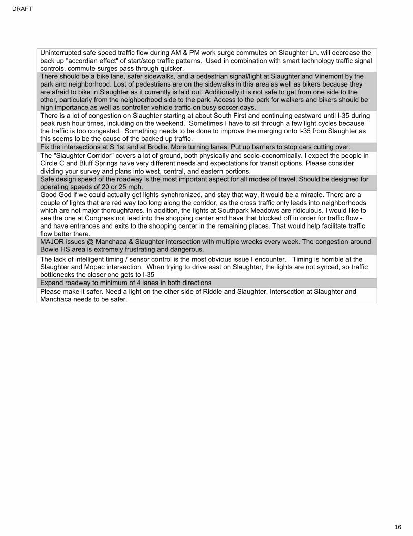
Pedestrian Accommodations
Public Transit
Additional Comment Categories
Which of the following pedestrian accommodations would you like to see here? (Select all that apply) (Answer Choices: Continuous sidewalks, Sidewalk maintenance, Sidewalks with separation, Safer pedestrian crossings, More pedestrian crossings, ADA rehabilitation, Opportunities for sitting and shade, Other)
No. of Responses
Wider sidewalks 3
Continuous sidewalks 6
Sidewalk maintenance 1
Other 4
Uncategorized/unanswered 2
Themes in 'Other' and Uncategorized Pedestrian Accommodations Comments
• Need for crosswalks and continuous, connected pedestrian facilities• Safe pedestrian routes to and from schools needed• Pedestrian facilities separate from roadway preferred
Which of the following transit improvements would you like to see here? (Select all that apply) (Answer Choices: More transit options, More frequent bus service, Upgraded bus stops (shelters, benches, better signage, safer), Other)
No. of Responses
Other 2
Uncategorized/unanswered 7
Themes in ‘Other’ and Uncategorized Public Transit Comments
• Need for park-and-ride stations• Preference for bus stops located near pedestrian crossings and intersections• Need for additional service routes
Additional Comment Categories No. of Responses
Miscellaneous, What I like, What I need 39
Themes
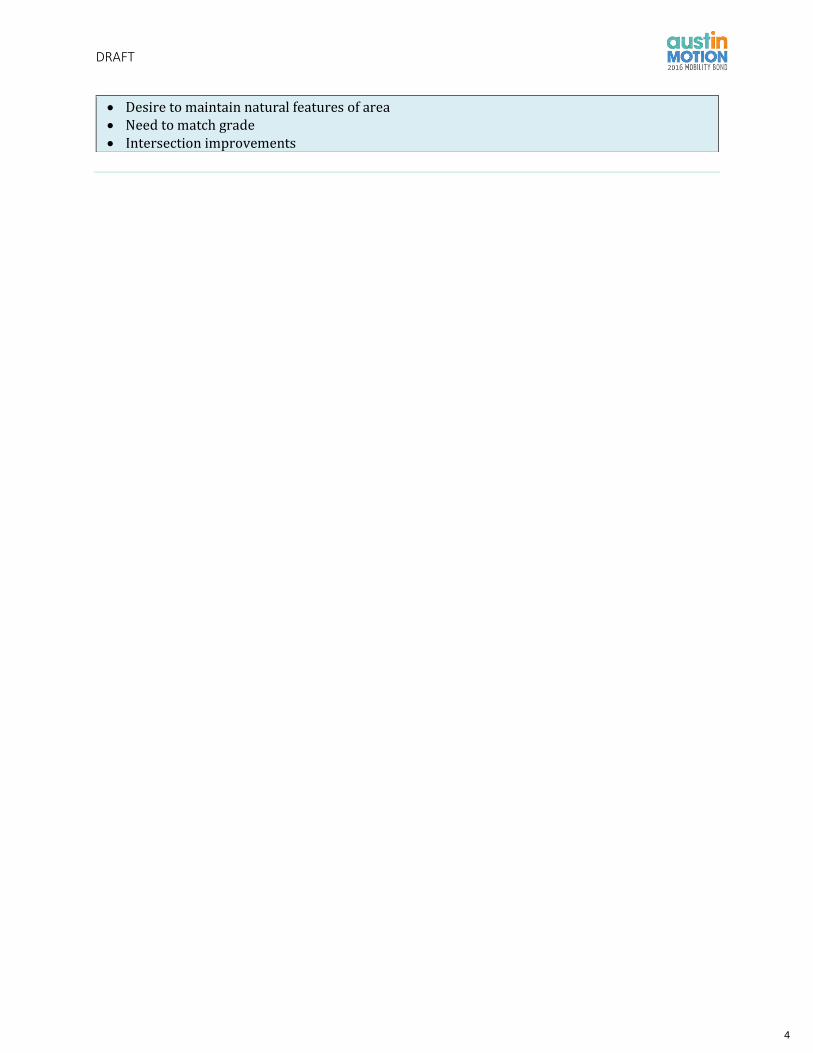
• Need mitigation for increased traffic volume on side streets• Need for signals and traffic calming devices• Improved turning options needed• Congestion and need for expanded/additional lanes• Safety concerns• Concern for flooding in the area• Improved pedestrian facilities near schools needed• Need for bike lockers• Improved access to driveways and recreational locations needed for drivers
3
DRAFT
• Desire to maintain natural features of area• Need to match grade• Intersection improvements
4

DRAFT
SLAUGHTER LANE WIKIMAP - DRIVING CONDITIONS
Latitude Longitude Feature Type
Which of the following driving improvements would you like
to see here? (Answer Choices: Slower speed
limits, Safer intersections, Fewer driveways
or consolidated driveways)
If you selected 'Other' please describe here
Do you have any additional comments about this location you would like to share?
Secondary Comments (from separate author)
30.184606 -
97.792482 point
Adding road bumps or some sort of barrier to the bike lane. The bike lane
is constantly used as an additional lane by cars.
30.200871 -
97.871082 point Improved turning options Allow permissive lefts onto Beckett
30.15882 -
97.775788 point Blind intersection @ cut through on Brandt
30.206973 -
97.815399 point Improved turning options; Other
West Gate Blvd., from Manassas to
William Cannon
Cars from Slaughter, Brodie, Davis and Manassas use West Gate Blvd. as a
short cut to MoPac, down town, and William Cannon. There no traffic
lights, stop signs, or calming devices from Manassas to Wm. Cannon. The
volume of traffic has increased bby 30% since 2013 when West Gate was
extended to Slaughter. Car speeds exceed the posted speed limit of
35mph by almost 10 mph. Need to limit access to West Gate and install
traffic lights and calming devices. Need to install bike lanes. West gate
was originally built as a one lane in each direction with a bike lane.
30.205179 -
97.818719 point Improved turning options
Cars speed 10 miles above posted speed of 35mph on West Gate between
Manassas and Wm. Cannon. Cars the car volume increased by 30% (16,
293 per day) since 2012 when West Gate was extended south of
Cameron Loop. There are no lights, stop signs, or calming devices on
West Gate,from Cameron loop to Wm. Cannon. There no protected turn
lanes southbound from Wm. Cannon to Manassas. Need to reduce speed
limit, install lights, stop signs and calming devices from Manassas to Wm.
Cannon. Driveways of homes on the east side of West Gate face the street
and is very dangerous . Also, people living on the alphabet streets
(westside of West Gate face danger in trying to cross unprotected turns
5

DRAFT
SLAUGHTER LANE WIKIMAP - DRIVING CONDITIONS
Latitude Longitude Feature Type
Which of the following driving improvements would you like
to see here? (Answer Choices: Slower speed
limits, Safer intersections, Fewer driveways
or consolidated driveways)
If you selected 'Other' please describe here
Do you have any additional comments about this location you would like to share?
Secondary Comments (from separate author)
and dodge speeding cars to go north on West Gate. Need to reduce speed
limit and install lights, stop signs, and calming devices.
30.182862 -
97.847983 point Improved turning options
Cars turning into this area tend to cause accidents since it is very
congested. Signage about left lane turning into a turn only lane causes a
lot of congestion. Initiating a right lane turn only lane would help with
congestion. Consolidating the lanes that come from the shopping center
to one that is further from the interestion could help with dangerous
driving conditions.
30.190667 -97.82523 point
Cars use Leo as a short cut to Cameron Loop , Seminary Ridge, Manassas
and West Gate. Speeding cars and increase volume of traffic create a
dangerous environment for the neighborhoods.
30.190511 -
97.825293 point
close the round about and install a light. People get confused. Danger of
collisions.
30.173847 -
97.817116 point Congestion at this intersection as area continues to develop
30.167113 -
97.786024 point
Congress and Slaughter need more spacing for west bound Slaughter
traffic to turn N bound on Congress. Get caught in I-35 traffic flow
30.167132 -
97.787901 point Coordinate stop lights @ I-35 with lights @ S. Congress
6

DRAFT
SLAUGHTER LANE WIKIMAP - DRIVING CONDITIONS
Latitude Longitude Feature Type
Which of the following driving improvements would you like
to see here? (Answer Choices: Slower speed
limits, Safer intersections, Fewer driveways
or consolidated driveways)
If you selected 'Other' please describe here
Do you have any additional comments about this location you would like to share?
Secondary Comments (from separate author)
30.200222 -
97.865546 point Coordinate timing of light at MoPac with the light at Sendera Mesa.
30.202093 -
97.819765 point Improved turning options
Dangerous intersection at Harleyhill and West Gate. No protected turn
lane or protected pedestrian crossing. Speeding cars and high volume
during commute hours make it impossible for people living on the west
side of West Gate to cross and go north on West Gate. Need a stop sign or
traffic calming devices. Cars from Manchaca, Brodie, Manassas,
Slaughter, and Wm. Cannon use West south of Wm. cannon as s short cut
. There are no lights, stop signs, or calming devices from Cameron Loop
to Wm. Cannon.
30.200222 -
97.865546 point Improved turning options
Divergent diamond or similar would greatly improve traffic backup on
Slaughter at Loop 1
30.200222 -
97.865546 point Other
The light for traffice heading
north on Highway 1 is far too
short.
Drivers have to sit through several light changes to be able to pass
through this intersection, because the green light for those driving north
Loop 1 is so very short.
30.172456 -
97.799327 point Improved turning options Eastbound signal from Southbound S 1st would clear alot of congestion
30.182547 -
97.847688 point Improved turning options Exiting at Whataburger left turn dangerous
I Agree by on 06/01/2017 Left turn from Brodie west to slaughter is a
nightmare during rush hour. Also drivers making a u-turn to get to the
Valero from west Brodie is very unsafe. by on 06/01/2017
30.167419 -
97.791833 point Improved turning options
exiting to go west on slaughter from this business complex has poor
visibility because of the shrubs
7
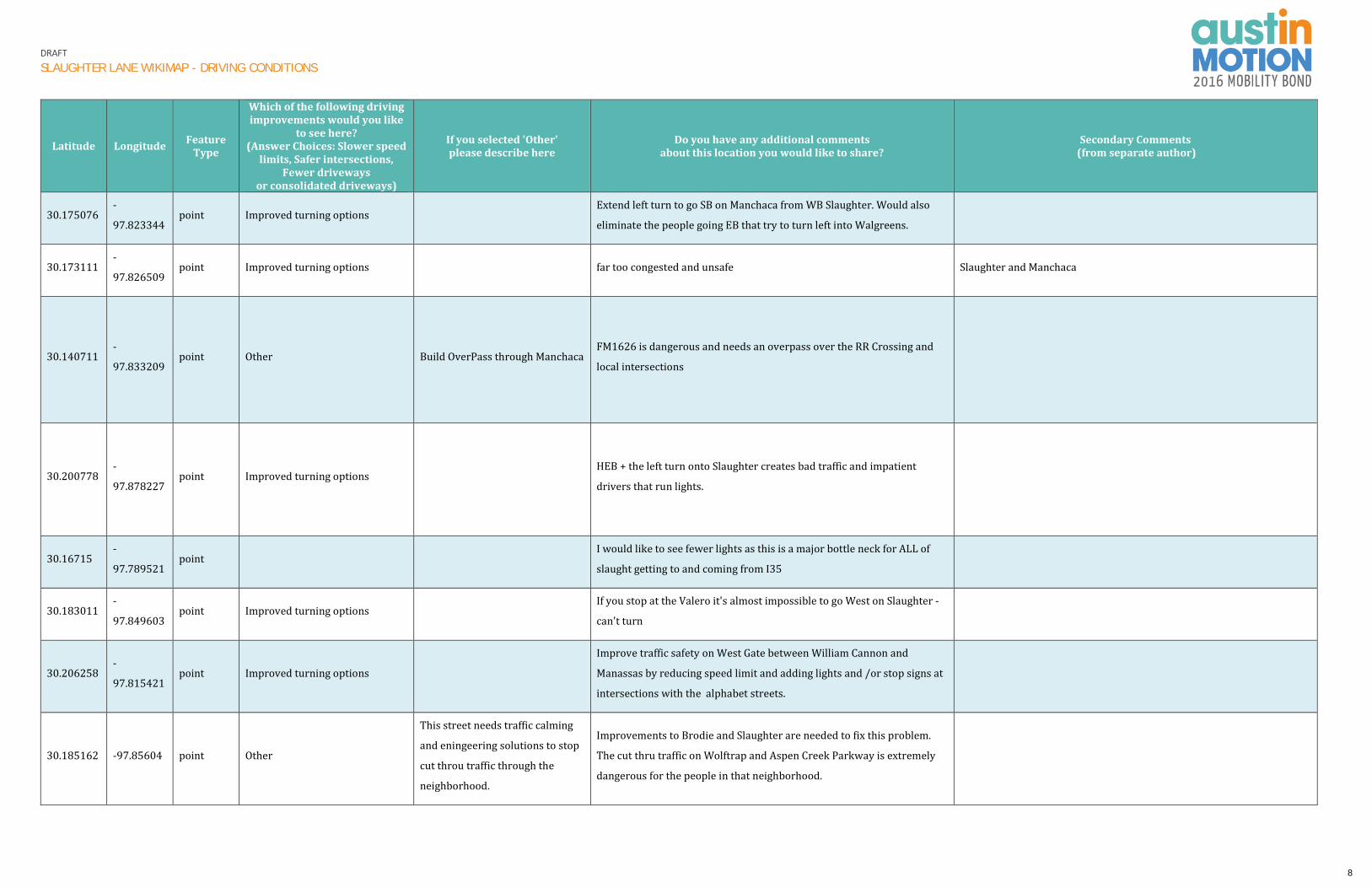
DRAFT
SLAUGHTER LANE WIKIMAP - DRIVING CONDITIONS
Latitude Longitude Feature Type
Which of the following driving improvements would you like
to see here? (Answer Choices: Slower speed
limits, Safer intersections, Fewer driveways
or consolidated driveways)
If you selected 'Other' please describe here
Do you have any additional comments about this location you would like to share?
Secondary Comments (from separate author)
30.175076 -
97.823344 point Improved turning options
Extend left turn to go SB on Manchaca from WB Slaughter. Would also
eliminate the people going EB that try to turn left into Walgreens.
30.173111 -
97.826509 point Improved turning options far too congested and unsafe Slaughter and Manchaca
30.140711 -
97.833209 point Other Build OverPass through Manchaca
FM1626 is dangerous and needs an overpass over the RR Crossing and
local intersections
30.200778 -
97.878227 point Improved turning options
HEB + the left turn onto Slaughter creates bad traffic and impatient
drivers that run lights.
30.16715 -
97.789521 point
I would like to see fewer lights as this is a major bottle neck for ALL of
slaught getting to and coming from I35
30.183011 -
97.849603 point Improved turning options
If you stop at the Valero it's almost impossible to go West on Slaughter -
can't turn
30.206258 -
97.815421 point Improved turning options
Improve traffic safety on West Gate between William Cannon and
Manassas by reducing speed limit and adding lights and /or stop signs at
intersections with the alphabet streets.
30.185162 -97.85604 point Other
This street needs traffic calming
and eningeering solutions to stop
cut throu traffic through the
neighborhood.
Improvements to Brodie and Slaughter are needed to fix this problem.
The cut thru traffic on Wolftrap and Aspen Creek Parkway is extremely
dangerous for the people in that neighborhood.
8

DRAFT
SLAUGHTER LANE WIKIMAP - DRIVING CONDITIONS
Latitude Longitude Feature Type
Which of the following driving improvements would you like
to see here? (Answer Choices: Slower speed
limits, Safer intersections, Fewer driveways
or consolidated driveways)
If you selected 'Other' please describe here
Do you have any additional comments about this location you would like to share?
Secondary Comments (from separate author)
30.200958 -97.81959 point Improved turning options
Install light or stop sign. Dangerous intersection at Inridge and West Gate
Blvd. Blind corner at this point makes it very dangerous to enter West
Gate since cars go too fast and there are no lights or stop signs from
Cameron Loop to Wm. Cannon. Also, need to install calming devices
.Volume of traffic is high since cars use West Gate as a short cut from
Slaughter, Manchaca, and Brodie. We had colissions in the past , cars run
into mail boxes and homes. A child died when a car hit a tree in the
median.
30.203001 -
97.818961 point Improved turning options Install light, stop sign, and traffic calming devices. reduce speed limit
I Agree by Anonymous on 06/14/2017 Dangerous intersection at
Fentonridge and West Gate. No protected southbound turn lane for
people living on the east side of West Gate. Similarly, people living on
west side of West Gate ( alphabet streets) have difficulty crossing to go
northbound. Speeding cars and high volume , especially during commute
hours. Need to install light or stop sign, and calming devices. Also need to
have pedestrian crossing signal installed. by Anonymous on 06/14/2017
30.199839 -
97.820593 point Improved turning options
Install light. Many cars use Manassas as a short cut from Manchaca and
other streets to enter West Gate. Also, reduce speed limit.
I Agree by on 06/16/2017 add calming devices from Manassas to Wm.
Cannon. Install stop signs at Inridge and Fentonridge. by Anonymous on
06/18/2017
30.202093 -
97.819765 point Improved turning options install lights and calming devices between Manassas and WM. Cannon
30.205179 -
97.818719 point Improved turning options; Other
High volume of traffic and
speeding cars over vbthe posted
limit of 35mph.West Gate Blvd.
has became a short cut fer cars
froem Slaughter, Brodie, Mnchaca,
and Davis Lane.
Install traffic light at Manassas and West Gate and calming devices to
slow down cars and and improve safety for people living along West gate.
Reduce speed limit to 30mph and install calming devices between Wm.
Cannon and Manassas. Install traffic signal at Manassas and West Gate
and Fentonridge and West Gate. by Anonymous on 05/16/2017 reduce
West Gate blvd between Manassas and William Cannon from two lanes to
one lane in each direction and add a bicycle lane. by Anonymous on
05/16/2017 I Disagree, this is a main cooridor by Anonymous on
05/17/2017
9
DRAFT
SLAUGHTER LANE WIKIMAP - DRIVING CONDITIONS
Latitude Longitude Feature Type
Which of the following driving improvements would you like
to see here? (Answer Choices: Slower speed
limits, Safer intersections, Fewer driveways
or consolidated driveways)
If you selected 'Other' please describe here
Do you have any additional comments about this location you would like to share?
Secondary Comments (from separate author)
30.202093 -
97.819765 point Improved turning options
Install traffic lighy or stop signs. Install calming devices and lights from
Manassas to Wm. Cannon. Install turn lanes.
30.214158 -
97.830473 point
Intelligent traffic controllers are needed throughout. Emphasis on
intelligent. Enough that they are able to detect when a vehicle is there or
not. When a vehicle has proceeded already and a light change is no longer
needed and can be ignored. Enough that a group of 10-15 vehicles isn't
stopped on a major road just for one or two on a side road. Let the group
pass first, THEN change the light.
Smart traffic management must begin with smarter traffic controllers.
30.191293 -
97.833277 point Improved turning options
Intersection of Cameron Loop and Davis is dangerous. Also, cars from
Brodie and Wm. Cannon use Cameron Loop as a short cut. Close Cameron
Loop.
30.191251 -
97.813063 point Improved turning options
Intersection of Shiloh and Manchaca is dangerous . Cars use Shiloh as a
short cut from Manchaca to access West Gate through Manassas.
30.209346 -
97.903569 point Other Need a Bridge / None Exists
Low Water Crossing should be replaced with MAD4 bridge with bike /
ped protected crossing. TXDOT says technically there is no bridge here
over Slaughter Creek.
30.17675 -
97.835559 point Maintain road surface by school please
30.183567 -
97.850182 point Improved turning options Need congestion right at Brodie and Slaughter and Brodie Southbend
30.183595 -
97.849603 point Improved turning options Need longer right turn lane @ Brodie/Slaughter heading east
10

DRAFT
SLAUGHTER LANE WIKIMAP - DRIVING CONDITIONS
Latitude Longitude Feature Type
Which of the following driving improvements would you like
to see here? (Answer Choices: Slower speed
limits, Safer intersections, Fewer driveways
or consolidated driveways)
If you selected 'Other' please describe here
Do you have any additional comments about this location you would like to share?
Secondary Comments (from separate author)
30.207862 -
97.818253 point Improved turning options NO bike lanes
30.207362 -
97.815785 point Improved turning options NO bike lanes for the limited number of bike riders.
30.185162 -97.85604 point Other You have to expand lanes. NOT
BIKE LANES.
NOBODY RIDES THEIR BIKE. You need to expand to more car lanes on
Brodie. This is the main location of traffic back up. Cars are backed up
for miles down Brodie in the morning and evening.
30.185793 -
97.804585 point Improved turning options; Other
Need a stop sign or traffic light
here; no one drives 35 and while
trying to turn from Dittmar to
Palace Parkway, I have almost
been rear-ended several times.
Once, there was a bicycle in the bicycle lane at the Dittmar / Palace
Parkway intersection when I was trying to turn. The bicycle wouldn't
slow down so I could turn, while the person behind me wouldn't slow
down either. If I had gotten rear-ended, the bicyclist might have gotten
injured also.
I Agree by on 05/23/2017; Dittmar and Palace Parkway
30.206258 -
97.815421 point Improved turning options
Reduce speed limit and add protected turn lanes on West Gate Blvd.,
from William Cannon to Manassas.
30.206258 -
97.815421 point Improved turning options
Reduse speed limit ; Install calming devices and traffic lights from
Manassas to Wm. Cannon.
30.191768 -
97.824861 point Improved turning options
Restrict access to Cameron Loop . Reduce to one lane and install a bike
lane. Cars use Cameron Loop as a short cut to access West Gate Blvd.
Speeding cars and high volume create unsafe conditions. Also, there is
no sidewalk.
30.167308 -
97.790954 point
Sight line issues on Cullen at Slaughter make the intersection very
dangerousThanks
30.167127 -
97.790873 point
Signal timing at Cullen and Slaughter is very bad. Few cars can make the
turn. Always backed up
11

DRAFT
SLAUGHTER LANE WIKIMAP - DRIVING CONDITIONS
Latitude Longitude Feature Type
Which of the following driving improvements would you like
to see here? (Answer Choices: Slower speed
limits, Safer intersections, Fewer driveways
or consolidated driveways)
If you selected 'Other' please describe here
Do you have any additional comments about this location you would like to share?
Secondary Comments (from separate author)
30.167113 -
97.786024 point Signal timing I-35 @ Slaughter
30.173787 -
97.824352 point
Signal timing is awful Slaughter & Manchaca
Delineators tors have helped eliminate people going /leaving HEB but
has not stopped all the drivers from stopping that maneuver
30.157151 -
97.833424 point Improved turning options
The turning lane should be two
lanes
Slaughter going from 3 down to two lanes at Manchaca is not good for the
flow of traffic. There should be 3 lanes all the way to Mopac.
30.18563 -
97.849354 point Need more lanes
South Austin is growing too fast and ATX is not keeping up with the
growth. We need more lanes...
30.18563 -
97.849354 point Improved turning options
THe congestion at this intersection is causing dangerous cut thru traffic
through the Oak Parke neighborhood.
30.172289 -
97.799698 point Improved turning options
the left turn lane turning west on slaughter from the 1st on the south,
always has too many cars. the turn lane backs up into the left lane
causing congestion and causing people to go into the right lane, which
backs up the right lane
30.190511 -
97.825293 point Improved turning options
The round about at Leo and Davis confuses drivers. Install stop sign or
light.
30.190511 -
97.825293 point Improved turning options
The runabout at Leo and Davis confuses drivers. Cars enter Seminary
Ridge or Cameron Loop as shortcut to West Gate, Install light or stop sign
30.200222 -
97.865546 point Improved turning options
There shold be two lanes to turn left from westbound Slaughter to
northbound MoPac
30.173801 -
97.823617 point
This intersection is a terrible intersection for pedestrians and vehicles. I
would like to see a BIG traffic circle here.
I Agree. The left turn lane, going south, has too many cars by on
06/16/2017
12

DRAFT
SLAUGHTER LANE WIKIMAP - DRIVING CONDITIONS
Latitude Longitude Feature Type
Which of the following driving improvements would you like
to see here? (Answer Choices: Slower speed
limits, Safer intersections, Fewer driveways
or consolidated driveways)
If you selected 'Other' please describe here
Do you have any additional comments about this location you would like to share?
Secondary Comments (from separate author)
30.173439 -
97.820377 point
this is the only pedestrian access across the railroad. I would love to see
more pedestrian crossings other than Slaughter lane due to the size of
traffic that slaughter handles. If more pedestrian access points are not
possible, I would like to see large improvements to encourage pedestrian
traffic.
30.189196 -
97.857038 point
This is where Bowie High School students walk from Sendera
neighborhoods to the school. Their parents are forced to park alongside
the neighborhood curbs, in order to pick the kids up from school in the
afternoon. Perhaps there could be a better process of getting the parents
up to the school and on their way, instead of congesting the
neighborhood roads and Slaughter Lane.
30.182681 -
97.847865 point Improved turning options
this is where the left lane turns into a left turn only lane. this intersection
has two left turn lanes. is that needed? this forces a bunch of traffic to
change lanes if you are still going west.
30.202093 -
97.819765 point Improved turning options
Too many cars from Manchaca, Slaughter, and Brodie use West Gate as a
short cut, since there are no lights, stop signs, or calming devices from
Cameron Loop to Wm. Cannon. Need to add lights, stop signs, and
calming devices to slow down cars that on the average travel 10 miles
faster than the posted speed of 35mph. Need to protected turn lanes
southbound from WM. Cannon to Manassas.
30.18563 -
97.849354 point Improved turning options
Too many people block this intersection during high traffic times. Make
safe and bigger as well as install red light cameras that strictly enforce
running of red lights and blocking of the intersection.
unsafe, need more lanes, people run red lights, people block intersection
30.167526 -
97.793217 point Traffic signals at Alice Mae/Slaughter
30.172678 -
97.799392 point
turning east from the north, not enough left turn signal for all cars to
proceed, causes congestion around rush hour
13

DRAFT
SLAUGHTER LANE WIKIMAP - DRIVING CONDITIONS
Latitude Longitude Feature Type
Which of the following driving improvements would you like
to see here? (Answer Choices: Slower speed
limits, Safer intersections, Fewer driveways
or consolidated driveways)
If you selected 'Other' please describe here
Do you have any additional comments about this location you would like to share?
Secondary Comments (from separate author)
30.176685 -
97.834003 point Improved turning options
Turning left is hair-raising... too hard to see the light is at Curlew. Riddle
is the thru-road... why direct traffic through neighborhood?
30.176008 -97.82262 point Improved turning options
Vehicles headed north on Manchaca wanting to turn left onto Monarch
risk head-on collisions in the "suicide lane" with vehicles headed
southbound on Manchaca that intend to turn left onto Slaughter.
30.156407 -
97.785641 point very congested w/ cars
30.190511 -
97.825293 point Improved turning options Widen street to two lanes in each direction.
30.152327 -97.76639 point With all the new development @ this intersection please put in a traffic
light @ Bluff Springs & Slaughter & Old Lockhart
30.200222 -
97.865546 point Improved turning options
30.203544 -97.81836 point Improved turning options
Dangerous intersection with no protected turn lane or stop sign to allow
safe crossing from the west site of West Gate to go north. High volume of
cars and cars speeding need to addressed. by Anonymous on
06/14/2017 dangerous intersection at Deeringhill and West Gate Blvd.
No protected turn for cars to go north on West Gate. High volume and
speeding cars create a hazardous environment. Need to install lights ,
stop signs, and calming devices at Manassas, Inridge, and Fentonridge to
slow down traffic, Also , lower the speed limit.
by Anonymous on 06/17/2017
14

DRAFT
SLAUGHTER LANE WIKIMAP - DRIVING CONDITIONS
Latitude Longitude Feature Type
Which of the following driving improvements would you like
to see here? (Answer Choices: Slower speed
limits, Safer intersections, Fewer driveways
or consolidated driveways)
If you selected 'Other' please describe here
Do you have any additional comments about this location you would like to share?
Secondary Comments (from separate author)
30.173111 -
97.826509 point Improved turning options Slaughter and Manchaca
30.173111 -
97.826509 point Improved turning options Slaughter and Manchaca
30.173111 -
97.826509 point Improved turning options Slaughter and Manchaca
30.157151 -
97.833424 point Improved turning options
30.18563 -
97.849354 point Improved turning options unsafe, need more lanes, people run red lights, people block intersection
30.18563 -
97.849354 point Improved turning options
30.200445 -
97.874215 point Maintain roads surface here
30.15882 -
97.775788 point Improved turning options
15

DRAFT
SLAUGHTER LANE WIKIMAP – BIKING ACCOMMODATIONS
Latitude Longitude Feature
Type
Which of the following biking
accommodations would you
like to see here?
(Answer Choices: Wider bike
lanes, Separated and/or
protected bike lanes, Bike
parking, Intersection and
signal enhancement, Other)
If you selected 'Other'
please describe here
Do you have any additional comments
about this location you would like to share?
Secondary Comments
(from separate author)
line Separated and/or protected bike
lanes
Add bike lane on West Gate from Manassas to Wm. Cannon. Reduce West
Gate to one lane in each direction and a protected bike lane. Also install
lights, stop signs and calming devices reduce speeding cars.
I Agree. The left turn lane, going south, has too many cars by on
06/16/2017
30.196865 -
97.860707 point
Separated and/or protected bike
lanes
30.179514 -
97.852467 point Other
more traffic lanes. NOT BIKE
LANES.
stop adding bike lanes and bike improvements! we need more lanes. Not
bike lanes. Nobody rides there bike to go to work.
line Walking add bike lanes.
There no bike lanes from Cameron Loop to Wm. Cannon. West Gate was
originally built as one lane in each direction with a bike lane. The City
converted the bike lane into another car lane in late 1990s. Cyclists are in
danger because of the speeding cars and the heavy volume of cars. Need
to add lights and stop signs from Manassas to Wm. Cannon. Another
option is to make this section of West Gate into one lane with a bike lane
in each direction.
Install bike lane from Manassas to Wm. Cannon.
30.195252 -
97.842264 point
Expand to two lanes in each direction from West Gate to Brodie.
Construct side walks.
30.170026 -
97.859216 point
Install bike lanes from Cameron loop to Wm. Cannon. Install light at
Manassas and Fenton ridge.Reduce speed limit.
line install light at bCohoba and West
Gate.
16

DRAFT
SLAUGHTER LANE WIKIMAP – BIKING ACCOMMODATIONS
Latitude Longitude Feature
Type
Which of the following biking
accommodations would you
like to see here?
(Answer Choices: Wider bike
lanes, Separated and/or
protected bike lanes, Bike
parking, Intersection and
signal enhancement, Other)
If you selected 'Other'
please describe here
Do you have any additional comments
about this location you would like to share?
Secondary Comments
(from separate author)
line Separated and/or protected bike
lanes; Other
Bike / Ped Trail parallel to
SH45SW Build an Urban Trail along SH45SW between 1626 and RM1826
line Separated and/or protected bike
lanes
Complete bike lanes from Brodie to Mopac
-Bowie teacher and bike commuter
line Separated and/or protected bike
lanes
Complete bike lanes from Brodie to Mopac
-Bowie teacher and bike commuter
line Separated and/or protected bike
lanes
Complete bike lanes from Brodie to Mopac
-Bowie teacher and bike commuter
line Separated and/or protected bike
lanes
Complete bike lanes from Brodie to Mopac
-Bowie teacher and bike commuter
line Separated and/or protected bike
lanes
Pleasant Valley bike lanes stop at St. Elmo (more or less) making further
N/S travel to/from William Cannon very dangerous.
line Separated and/or protected bike
lanes this area nearly impossible to access via bicycle
line Separated and/or protected bike
lanes Add bike lanes on Slaughter from 1826 to Brodie
17

DRAFT
SLAUGHTER LANE WIKIMAP – BIKING ACCOMMODATIONS
Latitude Longitude Feature
Type
Which of the following biking
accommodations would you
like to see here?
(Answer Choices: Wider bike
lanes, Separated and/or
protected bike lanes, Bike
parking, Intersection and
signal enhancement, Other)
If you selected 'Other'
please describe here
Do you have any additional comments
about this location you would like to share?
Secondary Comments
(from separate author)
30.20618 -
97.887513 point
Separated and/or protected bike
lanes
Add protected bike lanes for students and people on bikes – Bowie HS
alum
line Separated and/or protected bike
lanes
Install protected bike lanes entire length of Slaughter on both north &
south sides. Thanks
30.196865 -
97.860707 point
Separated and/or protected bike
lanes
30.196865 -
97.860707 point
Separated and/or protected bike
lanes
Bike lane needed! or repurpose for mixed use ped/bike use. Not many
peds in this area
30.186627 -
97.855171 point
Separated and/or protected bike
lanes
Need bike lanes or separate path so students can bike to Bowie-it is
growing and it will not be able to handle anymore traffic
30.189196 -
97.857038 point
Separated and/or protected bike
lanes
ADD protected bike lanes for students and people on bikes
-Brodie High School alumni/native Austinite
30.173801 -
97.823617 point
Separated and/or protected bike
lanes Suicidal intersections for bikes. Please add safe/protected passage
30.174144 -97.81527 point Separated and/or protected bike
lanes Protected bike lanes
30.173866 -
97.814219 point
Separated and/or protected bike
lanes
Consider ways to separate bike & ped infrastructure from center travel
way - make student travel from apts to elem @ Tx Oaks
18

DRAFT
SLAUGHTER LANE WIKIMAP – BIKING ACCOMMODATIONS
Latitude Longitude Feature
Type
Which of the following biking
accommodations would you
like to see here?
(Answer Choices: Wider bike
lanes, Separated and/or
protected bike lanes, Bike
parking, Intersection and
signal enhancement, Other)
If you selected 'Other'
please describe here
Do you have any additional comments
about this location you would like to share?
Secondary Comments
(from separate author)
line Separated and/or protected bike
lanes
No safe passage for bikes through this whole area! Please add protected
passage
30.167113 -
97.786024 point
Separated and/or protected bike
lanes Protected bike lanes for people on bikes!
30.167637 -
97.793528 point
Separated and/or protected bike
lanes
30.173866 -
97.814219 point
Separated and/or protected bike
lanes
30.180117 -
97.843294 point
Separated and/or protected bike
lanes
line Bike parking Install bike lanes or repurpose side lanes for peds and bikes
30.208808 -
97.889299 point Other
No fence! Mtn bikers use that trail to access Slaughter Creek Trail on
1826
30.180117 -
97.843294 point Other Lets get real. Remove bike lanes. They are rarely used vs 40,000 cars
19

DRAFT
SLAUGHTER LANE WIKIMAP – BIKING ACCOMMODATIONS
Latitude Longitude Feature
Type
Which of the following biking
accommodations would you
like to see here?
(Answer Choices: Wider bike
lanes, Separated and/or
protected bike lanes, Bike
parking, Intersection and
signal enhancement, Other)
If you selected 'Other'
please describe here
Do you have any additional comments
about this location you would like to share?
Secondary Comments
(from separate author)
30.200222 -
97.865546 point Other
This is such a busy intersection,
and now the Violet Crown Trail
runs parallel. People on bikes
have to navigate this horrible
intersection to get to the
Veloway. It would be safer to
have some kind of elevated bike
bridge to get people to all points
south, instead of having to risk
this dangerous intersection on a
bike. Picture the kids on bikes at
this major intersection...
30.200222 -
97.865546 point Critical shortage of safe transit for bikes
30.173921 -
97.811322 point
Please add bike lanes fall length by Slaughter -especially to
provide/create access to the Veloway Thombs
30.180117 -
97.843294 point
The left turn lane into the Gymnastics center is often confused for the left
hand turn lane onto Westgate. This section here can be a mess whenever
a gymnastics class lets out.
20

DRAFT
SLAUGHTER LANE WIKIMAP – BIKING ACCOMMODATIONS
Latitude Longitude Feature
Type
Which of the following biking
accommodations would you
like to see here?
(Answer Choices: Wider bike
lanes, Separated and/or
protected bike lanes, Bike
parking, Intersection and
signal enhancement, Other)
If you selected 'Other'
please describe here
Do you have any additional comments
about this location you would like to share?
Secondary Comments
(from separate author)
30.189196 -
97.857038 point
It would be GREAT if there was a way to cut through here to the Veloway
and the Violet Crown Trail, instead of having to risk your life, and go
through the Slaughter/Mopac intersection. Back in the day, there was a
path behind Bowie HS that people used for just this purpose. The area is
fenced now.
30.208122 -
97.821214 point
Wider sidewalks; Continuous
sidewalks
30.141277 -
97.846867 point
Wider sidewalks; Continuous
sidewalks Terrible intersection for bikes and pedestrians.
30.205804 -
97.828542 point Continuous sidewalks
This is a popular stretch for walker and bikers because of people
entering and exiting the nature preserve and travelling to the park, but
there are no sidewalks at all, the street is narrow, visibility is limited
because of the trees, and cars are traveling on high speed. Help!
21

DRAFT
SLAUGHTER LANE WIKIMAP – PEDESTRIAN ACCOMMODATIONS
Latitude Longitude Feature
Type
Which of the following pedestrian
accommodations would you like to see here?
(Answer Choices: Contninuous sidewalks,
Sidewalk maintenance, Sidewalks with
separation, Safer pedestrian crossings, More
pedestrian crossings, ADA rehabilitation,
Opportunities for sitting and shade, Other)
If you selected 'Other'
please describe here
Do you have any additional comments
about this location you would like to share?
Secondary Comments
(from separate author)
30.208122 -97.821214 point Wider sidewalks; Continuous sidewalks
line Wider sidewalks; Continuous sidewalks; Sidewalk maintenance
It takes 20 minutes to walk from the gas station at SE corner of Slaughter/Manchaca to the HEB at the NW corner, because of terrible sidewalks and not enough pedestrian crossings.
line Wider sidewalks Sidewalks are back of curb and outdated/unsafe.
30.173782 -97.824368 point Continuous sidewalks; Other Continuous connections to
various neighborhoods nearby.
30.156407 -97.785641 point Continuous sidewalks
This road has no sidewalks and it is the safest route from the parkside at slaughter creek comminty to slaughter lane. It wohld be great to see sidewalks added
30.16305 -97.814069 point Continuous sidewalks
30.166278 -97.817717 point Continuous sidewalks
30.208808 -97.889299 point Other Fence? Pushes people to Slaughter and off the trail
line Other More connections to major hubs off street.
This connection would provide off street access to South Park Meadows without the use of a vehicle. Helps Promote walkability/park and "ride" or bike.
line Other More connections to major hubs off street.
This connection would provide off street access to South Park Meadows without the use of a vehicle. Helps Promote walkability/park and "ride" or bike.
30.218061 -97.894707 point Build a trail with abandoned Davis Ln ROW connects to/from
middle school
30.173866 -97.814219 point Consider ways to separate bike & ped infrastructure from center
travel way - make student travel from apts to elem @ Tx Oaks
22

DRAFT
SLAUGHTER LANE WIKIMAP – PUBLIC TRANSIT
Latitude Longitude Feature
Type
Which of the following transit
improvements would you like
to see here?
(Answer Choices: More transit
options, More frequent bus
service, Upgraded bus stops
(shelters, benches, better
signage, safer), Other)
If you selected 'Other'
please describe here
Do you have any additional comments
about this location you would like to share?
Secondary Comments
(from separate author)
30.185162 -
97.853336 point
*Consider A
Joint use park and ride with church to provide direct transit to CBD
30.178276 -97.83756 point Park-and-ride Consider community Park & Ride with Church witih direct Transit to CBD Yes! Consider Park & Ride with Direct Transit - light rail maybe? Thanks
30.173782 -97.824368 point Other Move bus stop Bus stop not at intersection move so aligns with signalized intersection x-
walk.
30.173968 -
97.802052 point Bus stop not at intersection. Move to protected crosswalk location
30.171909 -
97.799081 point Midblock bus move to intersection
30.167637 -
97.793528 point Bus stop location. So a pair exists E-W at protected sidewalk
30.161826 -
97.792482 point Other
I would like to see this as a park and ride location and a nice bus stop
with todays amenities/technologies.
line A line to connect to the BRT stop at Southpark Meadows for growing
Goodnight community and surrounding communities.
30.153366 -
97.753172 point Public transit stop
23
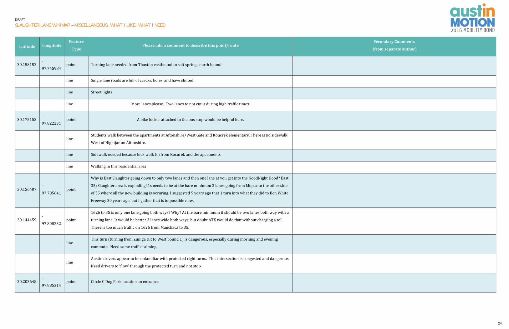
DRAFT
SLAUGHTER LANE WIKIMAP – MISCELLANEOUS, WHAT I LIKE, WHAT I NEED
Latitude Longitude Feature
Type Please add a comment to describe this point/route
Secondary Comments
(from separate author)
30.158152 -
97.745984 point Turning lane needed from Thaxton eastbound to salt springs north bound
line Single lane roads are full of cracks, holes, and have shifted
line Street lights
line More lanes please. Two lanes to not cut it during high traffic times.
30.175153 -
97.822231 point A bike locker attached to the bus stop would be helpful here.
line Students walk between the apartments at Aftonshire/West Gate and Koucrek elementary. There is no sidewalk
West of Nightjar on Aftonshire.
line Sidewalk needed because kids walk to/from Kocurek and the apartments
line Walking in this residential area
30.156407 -
97.785641 point
Why is East Slaughter going down to only two lanes and then one lane at you get into the GoodNight Hood? East
35/Slaughter area is exploding! 1s needs to be at the bare minimum 3 lanes going from Mopac to the other side
of 35 where all the new building is occuring. I suggested 5 years ago that 1 turn into what they did to Ben White
Freeway 30 years ago, but I gather that is impossible now.
30.144459 -
97.808232 point
1626 to 35 is only one lane going both ways? Why? At the bare minimum it should be two lanes both way with a
turning lane. It would be better 3 lanes wide both ways, but doubt ATX would do that without charging a toll.
There is too much traffic on 1626 from Manchaca to 35.
line This turn (turning from Zuniga DR to West bound 1) is dangerous, especially during morning and evening
commute. Need some traffic calming.
line Austin drivers appear to be unfamiliar with protected right turns. This intersection is congested and dangerous.
Need drivers to 'flow' through the protected turn and not stop
30.203648 -
97.885314 point Circle C Dog Park location an entrance
24

DRAFT
SLAUGHTER LANE WIKIMAP – MISCELLANEOUS, WHAT I LIKE, WHAT I NEED
Latitude Longitude Feature
Type Please add a comment to describe this point/route
Secondary Comments
(from separate author)
30.202503 -
97.884305 point Recreation Pickleball Courts, volleyball courts, dog bark! Swimming pool for area
30.208159 -
97.860847 point Please work with TcDOT to fix EB Davis @ Mopac. No SB access from Davis to Mopac. Thanks
30.200018 -
97.866517 point Save these ancient oak trees please
line Lanes between Manchaca and Brodie are not equal. Seem as if 3 lanes could fit almost or provide at turn lanes
for EB Slaughter
30.173111 -
97.826509 point Changing the lane designations has helped Slaughter @Riddle
30.173111 -
97.826509 point Come to grade about here
30.173111 -
97.826509 point OMG - this exit from the shopping center is not good
30.173111 -
97.826509 point Come to grade about here
30.174311 -
97.825752 point Work with HEB and other businesses to redesign traffic flow in parking lot -- flow to Riddle Rd
30.174441 -
97.824095 point Grade separation Slaughter Traffic will overpass
30.173782 -
97.824368 point
Corner of Slaughter and Manchaca – This is one of the most deadly intersections in Austin for
walkers/bikers/drivers. Tell us why this cant be fixed!?
30.17374 -
97.822834 point Main lanes/local/local
25

DRAFT
SLAUGHTER LANE WIKIMAP – MISCELLANEOUS, WHAT I LIKE, WHAT I NEED
Latitude Longitude Feature
Type Please add a comment to describe this point/route
Secondary Comments
(from separate author)
line Traffic on Slaughter westbound backs up from Manchaca to the Union Pacific Bridge - cars don't know what lane
they are in. Add better signage/road markings
30.17394 -
97.805443 point Switch bike lanes into auto self driving shuttle routes electric cars
line Slaughter between I-35 & Onion Creek bridge - EB routes in # of lanes and speed limit. Please harmonize the
lanes & speed. Thanks
line Slaughter between I-35 & Onion Creek bridge - EB routes in # of lanes and speed limit. Please harmonize the
lanes & speed. Thanks
30.151826 -
97.764373 point intersection to allow both lanes to head west from east on slaughter not just dedicated left turn
line Double lane
30.166779 -
97.785085 point Dedicated right turn from frontage 35 to east slaughter
30.167215 -
97.788534 point Dedicated right turn from south congress to east slaughter
line I love how undeveloped this area is. There is a tremendous amount of nature in this area and I hope it stays that
way.
line
Reduce the volume of cars using West Gate as a short cut. The volume of cars at 7300 West Gate has increased
30.4 % since 2013 when West Gate was extended to Slaughter. Over 16,000 cars were counted on January 16,
2017 at 7300 West Gate. Car speeds are almost 10 mph above the posted limit of 35 mph.
line West Gate Blvd. has be come a short cut for cars from Slaughter. Manchaca, Davis Lane, since there are no traffic
lights , stop signs, or calming devices from Cameron Loop tp Wm. Cannon.Brodie
26

DRAFT
SLAUGHTER LANE WIKIMAP – MISCELLANEOUS, WHAT I LIKE, WHAT I NEED
Latitude Longitude Feature
Type Please add a comment to describe this point/route
Secondary Comments
(from separate author)
line
According to the January 16, 2017 traffic counts at 7300 West Gate Blvd., car volumes have increased by 30%
since 2013, and cars are speeding at about 10mph above the posted limit of 35mph. Especially dangerous
conditions exist between Manassas and Wm. Cannon because the driveways of homes on the east side of West
Gate face West Gate and there no protected turn lanes. Need to install traffic lights and calming devices between
Manassas and Wm. Cannon. Also , need to discourage access to West Gate Gate as a short cut from Slaughter,
Brodie, Manchaca, and Wm. Cannon.
line No bike lanes and narrow one lane between Manchaca and Brodie. Need to expand street to two lanes each way
with a bike lane.
line Cars use West gate as a short cut from Manchaca, Brodie and Davis Lane. Northbound traffic, from Manassas to
1, has increased 30.4% to 16,293 cars per day.
27