Embed Size (px)
Citation preview
SLAPTON FIELD CLASS GEO1306: 13 - 17 April 2009
1
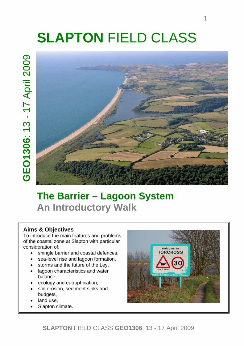
SLAPTON FIELD CLASS The Barrier – Lagoon System An Introductory Walk
Aims & Objectives To introduce the main features and problems of the coastal zone at Slapton with particular consideration of:
• shingle barrier and coastal defences, • sea-level rise and lagoon formation, • storms and the future of the Ley, • lagoon characteristics and water
balance, • ecology and eutrophication, • soil erosion, sediment sinks and
budgets, • land use, • Slapton climate.
GEO
1306
: 13
- 17
Apr
il 20
09
SLAPTON FIELD CLASS GEO1306: 13 - 17 April 2009
2
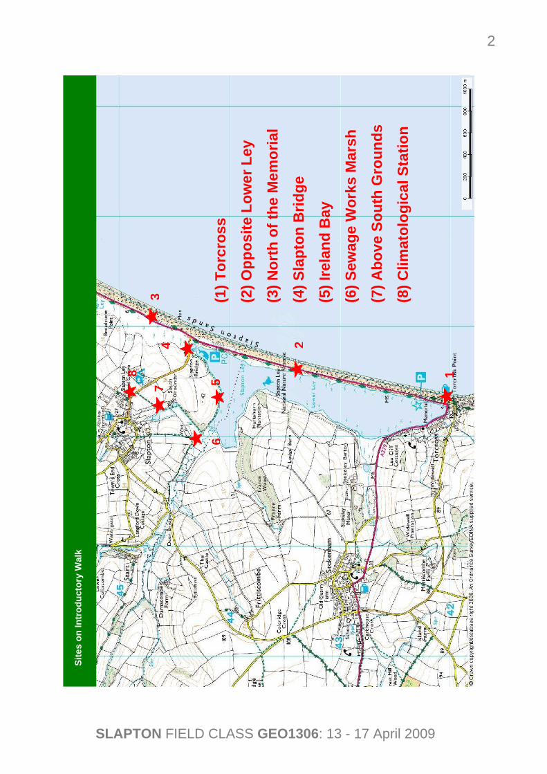
1.
Site
s on
Intr
oduc
tory
Wal
k
1
2
3
5
4
6
7
8
(1) T
orcr
oss
(2) O
ppos
ite L
ower
Ley
(3) N
orth
of t
he M
emor
ial
(4) S
lapt
on B
ridge
(5) I
rela
nd B
ay
(6) S
ewag
e W
orks
Mar
sh
(7) A
bove
Sou
th G
roun
ds
(8) C
limat
olog
ical
Sta
tion
SLAPTON FIELD CLASS GEO1306: 13 - 17 April 2009
3
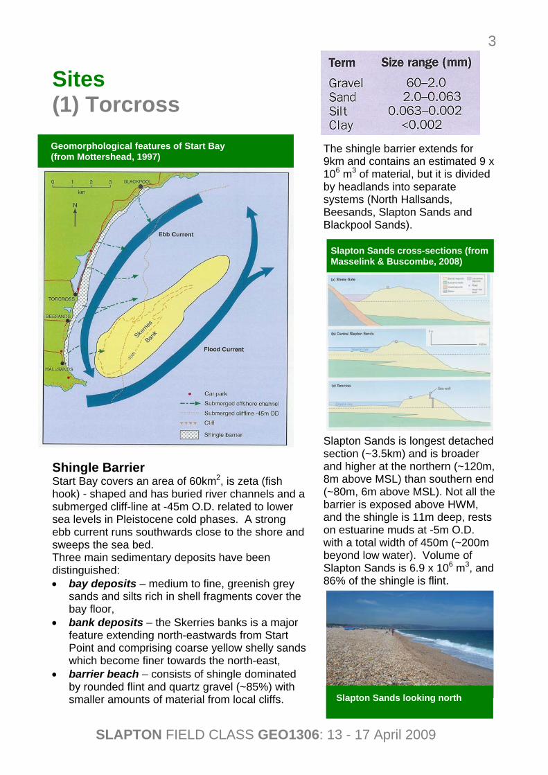
Sites
(1) Torcross Shingle Barrier Start Bay covers an area of 60km2, is zeta (fish hook) - shaped and has buried river channels and a submerged cliff-line at -45m O.D. related to lower sea levels in Pleistocene cold phases. A strong ebb current runs southwards close to the shore and sweeps the sea bed. Three main sedimentary deposits have been distinguished: • bay deposits – medium to fine, greenish grey
sands and silts rich in shell fragments cover the bay floor,
• bank deposits – the Skerries banks is a major feature extending north-eastwards from Start Point and comprising coarse yellow shelly sands which become finer towards the north-east,
• barrier beach – consists of shingle dominated by rounded flint and quartz gravel (~85%) with smaller amounts of material from local cliffs.
The shingle barrier extends for 9km and contains an estimated 9 x 10⁶ m3 of material, but it is divided by headlands into separate systems (North Hallsands, Beesands, Slapton Sands and Blackpool Sands). Slapton Sands is longest detached section (~3.5km) and is broader and higher at the northern (~120m, 8m above MSL) than southern end (~80m, 6m above MSL). Not all the barrier is exposed above HWM, and the shingle is 11m deep, rests on estuarine muds at -5m O.D. with a total width of 450m (~200m beyond low water). Volume of Slapton Sands is 6.9 x 10⁶ m3, and 86% of the shingle is flint.
Geomorphological features of Start Bay (from Mottershead, 1997)
Slapton Sands cross-sections (from Masselink & Buscombe, 2008)
Slapton Sands looking north
SLAPTON FIELD CLASS GEO1306: 13 - 17 April 2009
4
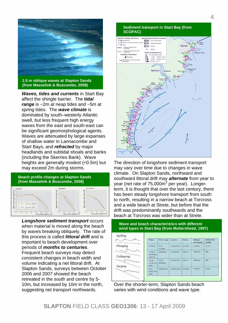
Waves, tides and currents in Start Bay affect the shingle barrier. The tidal range is ~2m at neap tides and ~5m at spring tides. The wave climate is dominated by south–westerly Atlantic swell, but less frequent high energy waves from the east and south-east can be significant geomorphological agents. Waves are attenuated by large expanses of shallow water in Lannacombe and Start Bays, and refracted by major headlands and subtidal shoals and banks (including the Skerries Bank). Wave heights are generally modest (<0.5m) but may exceed 2m during storms. Longshore sediment transport occurs when material is moved along the beach by waves breaking obliquely. The rate of this process is called littoral drift and is important to beach development over periods of months to centuries. Frequent beach surveys may detect consistent changes in beach width and volume indicating a net littoral drift. At Slapton Sands, surveys between October 2006 and 2007 showed the beach retreated in the south and centre by 5-10m, but increased by 10m in the north, suggesting net transport northwards.
The direction of longshore sediment transport may vary over time due to changes in wave climate. On Slapton Sands, northward and southward littoral drift may alternate from year to year (net rate of 75,000m3 per year). Longer-term, it is thought that over the last century, there has been steady longshore transport from south to north, resulting in a narrow beach at Torcross and a wide beach at Strete, but before that the drift was predominantly southwards and the beach at Torcross was wider than at Strete. Over the shorter-term, Slapton Sands beach varies with wind conditions and wave type.
1.5 m oblique waves at Slapton Sands (from Masselink & Buscombe, 2008)
Wave and beach characteristics with different wind types in Start Bay (from Mottershead, 1997)
Beach profile changes at Slapton Sands (from Masselink & Buscombe, 2008)
Spilling
Plunging
Collapsing
Surging
Sediment transport in Start Bay (from SCOPAC)
SLAPTON FIELD CLASS GEO1306: 13 - 17 April 2009
5
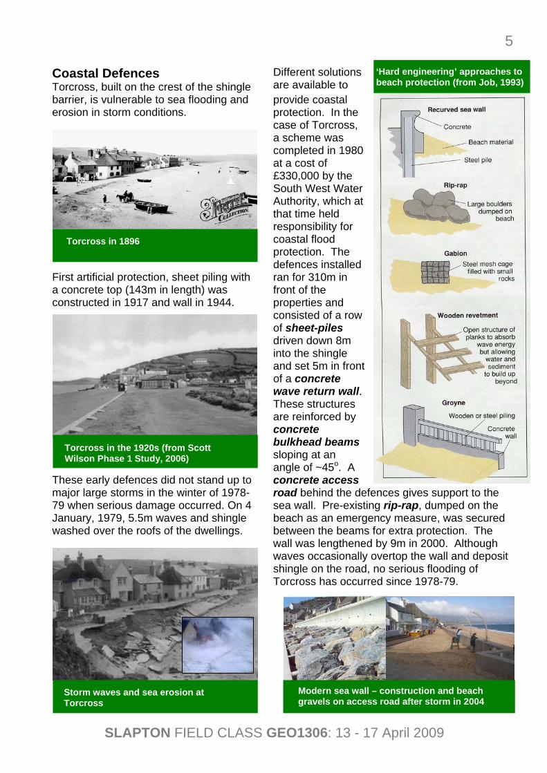
Coastal Defences Torcross, built on the crest of the shingle barrier, is vulnerable to sea flooding and erosion in storm conditions. First artificial protection, sheet piling with a concrete top (143m in length) was constructed in 1917 and wall in 1944. These early defences did not stand up to major large storms in the winter of 1978-79 when serious damage occurred. On 4 January, 1979, 5.5m waves and shingle washed over the roofs of the dwellings.
Different solutions are available to provide coastal protection. In the case of Torcross, a scheme was completed in 1980 at a cost of £330,000 by the South West Water Authority, which at that time held responsibility for coastal flood protection. The defences installed ran for 310m in front of the properties and consisted of a row of sheet-piles driven down 8m into the shingle and set 5m in front of a concrete wave return wall. These structures are reinforced by concrete bulkhead beams sloping at an angle of ~45o. A concrete access road behind the defences gives support to the sea wall. Pre-existing rip-rap, dumped on the beach as an emergency measure, was secured between the beams for extra protection. The wall was lengthened by 9m in 2000. Although waves occasionally overtop the wall and deposit shingle on the road, no serious flooding of Torcross has occurred since 1978-79.
Torcross in 1896
Torcross in the 1920s (from Scott Wilson Phase 1 Study, 2006)
Storm waves and sea erosion at Torcross
‘Hard engineering’ approaches to beach protection (from Job, 1993)
Modern sea wall – construction and beach gravels on access road after storm in 2004
SLAPTON FIELD CLASS GEO1306: 13 - 17 April 2009
6
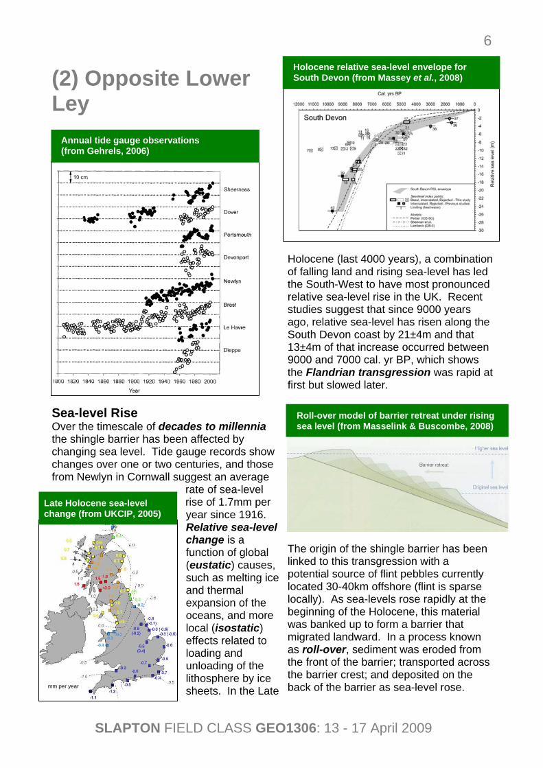
(2) Opposite Lower Ley Sea-level Rise Over the timescale of decades to millennia the shingle barrier has been affected by changing sea level. Tide gauge records show changes over one or two centuries, and those from Newlyn in Cornwall suggest an average
rate of sea-level rise of 1.7mm per year since 1916. Relative sea-level change is a function of global (eustatic) causes, such as melting ice and thermal expansion of the oceans, and more local (isostatic) effects related to loading and unloading of the lithosphere by ice sheets. In the Late
Holocene (last 4000 years), a combination of falling land and rising sea-level has led the South-West to have most pronounced relative sea-level rise in the UK. Recent studies suggest that since 9000 years ago, relative sea-level has risen along the South Devon coast by 21±4m and that 13±4m of that increase occurred between 9000 and 7000 cal. yr BP, which shows the Flandrian transgression was rapid at first but slowed later. The origin of the shingle barrier has been linked to this transgression with a potential source of flint pebbles currently located 30-40km offshore (flint is sparse locally). As sea-levels rose rapidly at the beginning of the Holocene, this material was banked up to form a barrier that migrated landward. In a process known as roll-over, sediment was eroded from the front of the barrier; transported across the barrier crest; and deposited on the back of the barrier as sea-level rose.
Annual tide gauge observations (from Gehrels, 2006)
Late Holocene sea-level change (from UKCIP, 2005)
Holocene relative sea-level envelope for South Devon (from Massey et al., 2008)
mm per year
Roll-over model of barrier retreat under rising sea level (from Masselink & Buscombe, 2008)
SLAPTON FIELD CLASS GEO1306: 13 - 17 April 2009
7
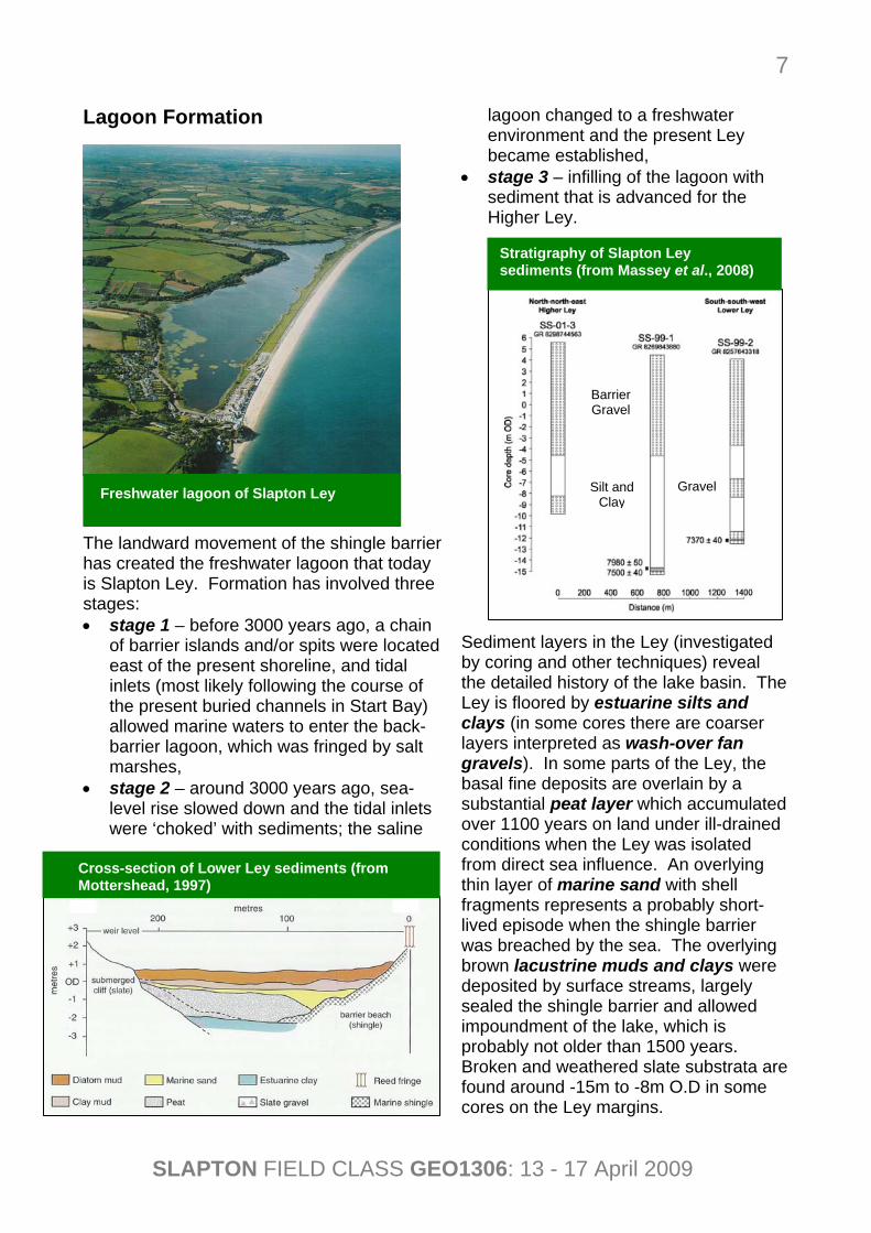
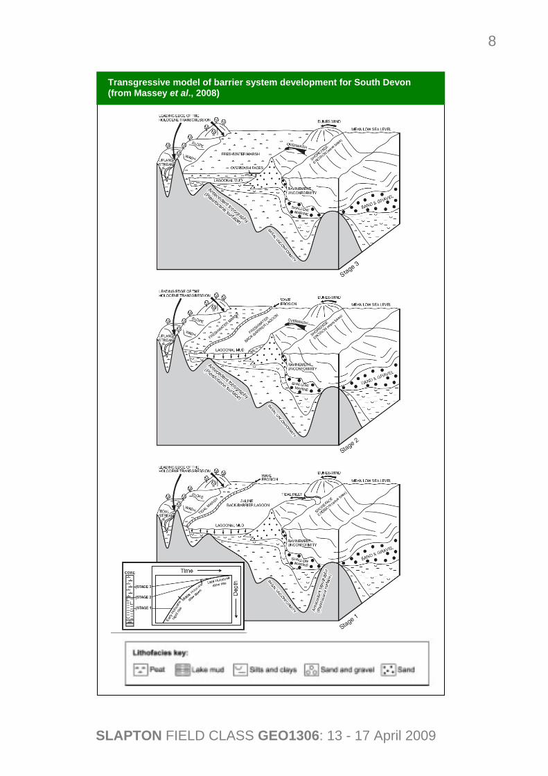
Lagoon Formation The landward movement of the shingle barrier has created the freshwater lagoon that today is Slapton Ley. Formation has involved three stages: • stage 1 – before 3000 years ago, a chain
of barrier islands and/or spits were located east of the present shoreline, and tidal inlets (most likely following the course of the present buried channels in Start Bay) allowed marine waters to enter the back-barrier lagoon, which was fringed by salt marshes,
• stage 2 – around 3000 years ago, sea-level rise slowed down and the tidal inlets were ‘choked’ with sediments; the saline
lagoon changed to a freshwater environment and the present Ley became established,
• stage 3 – infilling of the lagoon with sediment that is advanced for the Higher Ley.
Sediment layers in the Ley (investigated by coring and other techniques) reveal the detailed history of the lake basin. The Ley is floored by estuarine silts and clays (in some cores there are coarser layers interpreted as wash-over fan gravels). In some parts of the Ley, the basal fine deposits are overlain by a substantial peat layer which accumulated over 1100 years on land under ill-drained conditions when the Ley was isolated from direct sea influence. An overlying thin layer of marine sand with shell fragments represents a probably short-lived episode when the shingle barrier was breached by the sea. The overlying brown lacustrine muds and clays were deposited by surface streams, largely sealed the shingle barrier and allowed impoundment of the lake, which is probably not older than 1500 years. Broken and weathered slate substrata are found around -15m to -8m O.D in some cores on the Ley margins.
Freshwater lagoon of Slapton Ley
Cross-section of Lower Ley sediments (from Mottershead, 1997)
Barrier Gravel
Silt and Clay
Gravel
Stratigraphy of Slapton Ley sediments (from Massey et al., 2008)
SLAPTON FIELD CLASS GEO1306: 13 - 17 April 2009
8
Transgressive model of barrier system development for South Devon (from Massey et al., 2008)
SLAPTON FIELD CLASS GEO1306: 13 - 17 April 2009
9
(3) North of the Memorial
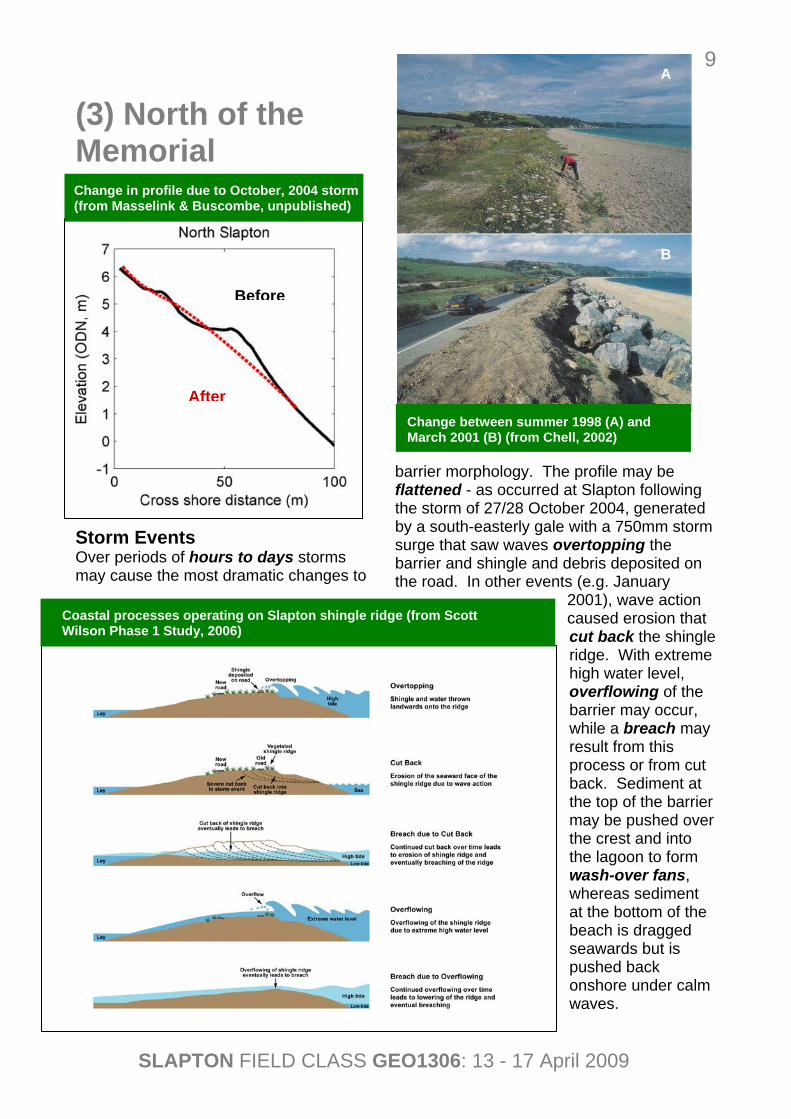
Storm Events Over periods of hours to days storms may cause the most dramatic changes to
barrier morphology. The profile may be flattened - as occurred at Slapton following the storm of 27/28 October 2004, generated by a south-easterly gale with a 750mm storm surge that saw waves overtopping the barrier and shingle and debris deposited on the road. In other events (e.g. January
2001), wave action caused erosion that cut back the shingle ridge. With extreme high water level, overflowing of the barrier may occur, while a breach may result from this process or from cut back. Sediment at the top of the barrier may be pushed over the crest and into the lagoon to form wash-over fans, whereas sediment at the bottom of the beach is dragged seawards but is pushed back onshore under calm waves.
Change in profile due to October, 2004 storm (from Masselink & Buscombe, unpublished)
Change between summer 1998 (A) and March 2001 (B) (from Chell, 2002)
Coastal processes operating on Slapton shingle ridge (from Scott Wilson Phase 1 Study, 2006)
Before
After
A
B
SLAPTON FIELD CLASS GEO1306: 13 - 17 April 2009
10
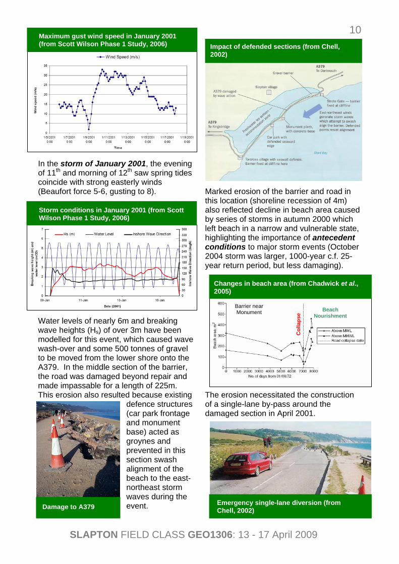
In the storm of January 2001, the evening of 11th and morning of 12th saw spring tides coincide with strong easterly winds (Beaufort force 5-6, gusting to 8). Water levels of nearly 6m and breaking wave heights (Hs) of over 3m have been modelled for this event, which caused wave wash-over and some 500 tonnes of gravel to be moved from the lower shore onto the A379. In the middle section of the barrier, the road was damaged beyond repair and made impassable for a length of 225m. This erosion also resulted because existing
defence structures (car park frontage and monument base) acted as groynes and prevented in this section swash alignment of the beach to the east-northeast storm waves during the event.
Marked erosion of the barrier and road in this location (shoreline recession of 4m) also reflected decline in beach area caused by series of storms in autumn 2000 which left beach in a narrow and vulnerable state, highlighting the importance of antecedent conditions to major storm events (October 2004 storm was larger, 1000-year c.f. 25-year return period, but less damaging). The erosion necessitated the construction of a single-lane by-pass around the damaged section in April 2001.
Damage to A379 Emergency single-lane diversion (from Chell, 2002)
Storm conditions in January 2001 (from Scott Wilson Phase 1 Study, 2006)
Maximum gust wind speed in January 2001 (from Scott Wilson Phase 1 Study, 2006)
Changes in beach area (from Chadwick et al., 2005)
Barrier near Monument
Col
laps
e
Beach Nourishment
Impact of defended sections (from Chell, 2002)
SLAPTON FIELD CLASS GEO1306: 13 - 17 April 2009
11
Torcross in the 1900s (from Scott Wilson Phase 1 Study, 2006)
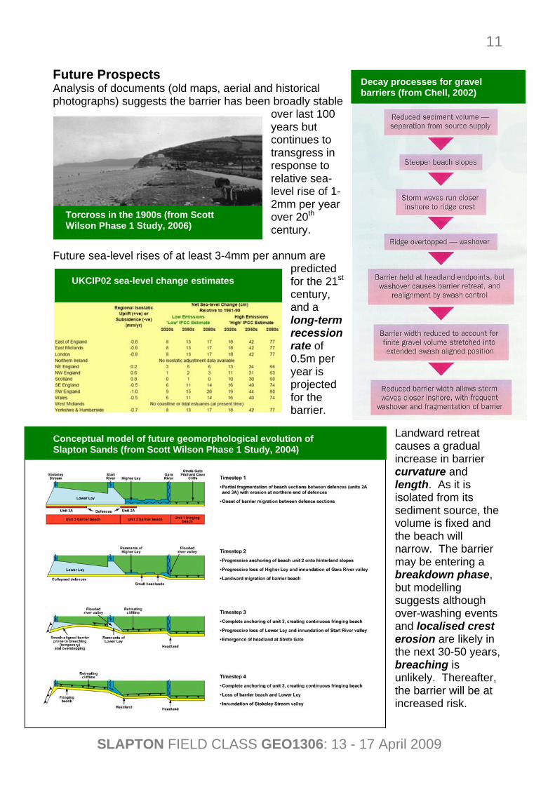
Future Prospects Analysis of documents (old maps, aerial and historical photographs) suggests the barrier has been broadly stable
over last 100 years but continues to transgress in response to relative sea-level rise of 1-2mm per year over 20th century.
Future sea-level rises of at least 3-4mm per annum are predicted for the 21st century, and a long-term recession rate of 0.5m per year is projected for the barrier.
Landward retreat causes a gradual increase in barrier curvature and length. As it is isolated from its sediment source, the volume is fixed and the beach will narrow. The barrier may be entering a breakdown phase, but modelling suggests although over-washing events and localised crest erosion are likely in the next 30-50 years, breaching is unlikely. Thereafter, the barrier will be at increased risk.
UKCIP02 sea-level change estimates
Decay processes for gravel barriers (from Chell, 2002)
Conceptual model of future geomorphological evolution of Slapton Sands (from Scott Wilson Phase 1 Study, 2004)
SLAPTON FIELD CLASS GEO1306: 13 - 17 April 2009
12
Human Response Closure of the damaged A379 for three months in early 2001 caused much local concern with some traders in the South Hams claiming loss of up to half their business. The road originated as a turnpike route in the mid-19th century and became the principal routeway into the Dartmouth-Kingsbridge coastal corridor, providing important access for larger delivery vehicles, public transport buses and coaches. It is a recognized emergency-vehicle route and provides the main tourist access to the Start Bay area (tourism in the South Hams generated £123 million in 1999 and 64% of the working population is employed in the service sector).
The Slapton Line Partnership was formed in 2001, and exists to: • maintain the coast
road for as long as reasonably possible,
• support the community as it adapts to live and work with the changing coast,
• manage the future road closures to the benefit of the community.
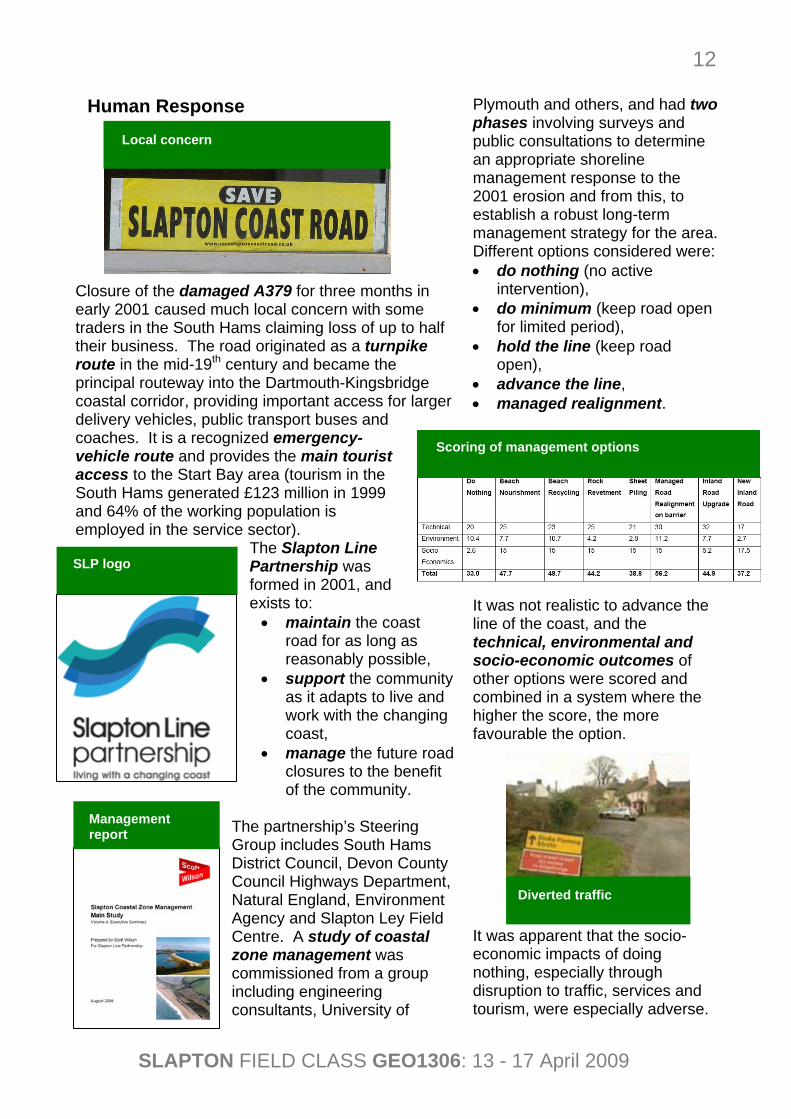
The partnership’s Steering Group includes South Hams District Council, Devon County Council Highways Department, Natural England, Environment Agency and Slapton Ley Field Centre. A study of coastal zone management was commissioned from a group including engineering consultants, University of
Plymouth and others, and had two phases involving surveys and public consultations to determine an appropriate shoreline management response to the 2001 erosion and from this, to establish a robust long-term management strategy for the area. Different options considered were: • do nothing (no active
intervention), • do minimum (keep road open
for limited period), • hold the line (keep road
open), • advance the line, • managed realignment.
It was not realistic to advance the line of the coast, and the technical, environmental and socio-economic outcomes of other options were scored and combined in a system where the higher the score, the more favourable the option. It was apparent that the socio-economic impacts of doing nothing, especially through disruption to traffic, services and tourism, were especially adverse.
Diverted traffic
Management report
SLP logo
Local concern
Scoring of management options

SLAPTON FIELD CLASS GEO1306: 13 - 17 April 2009
13
Suggested alternative routes when coast road is closed
Recommended that the A379 should be maintained by a combination of options:
• pro-active realignment of a 500m section of road at most sensitive part of the barrier,
• reactive realignment of road at other locations, when damage is believed to be imminent or has already occurred,
• localised movement of shingle to provide temporary protection to short lengths of road or to allow reinstatement of short length of the road following damage (in form of shingle bastions, renewed in November 2008).
Costs involved were £300,000 for the pro-active realignment and £50,000 per year for the reactive measures. Recognized in the future, the effects of climate change and sea-level rise will
make the localised managed realignment of the road unsustainable and the A379 may have to be permanently closed and alternative routes found, although this is unlikely within the next 30-50 years.
Road realignment (A) and shingle bastion (B)
A
B
SLAPTON FIELD CLASS GEO1306: 13 - 17 April 2009
14
(4) Slapton Bridge Lagoon Characteristics Slapton Ley, which is the largest natural freshwater lake in South-West England, is a sluiced lagoon as its outflow is a culvert at Torcross initially constructed in 1856 and raised at least once since, so that water is maintained at an artificially high level (+2.65m O.D.). It also has characteristics of a percolation lagoon since a shingle barrier separates it from the sea.
The Slapton wetland system covers 116ha and is divided into two basins. The Higher Ley occupies 39ha but has become terrestrialised
by sediment accumulation (e.g. 22.2 and 15mm per year in periods 1954-63 and 1963-93, respectively) and is dominated by reeds with little open water.
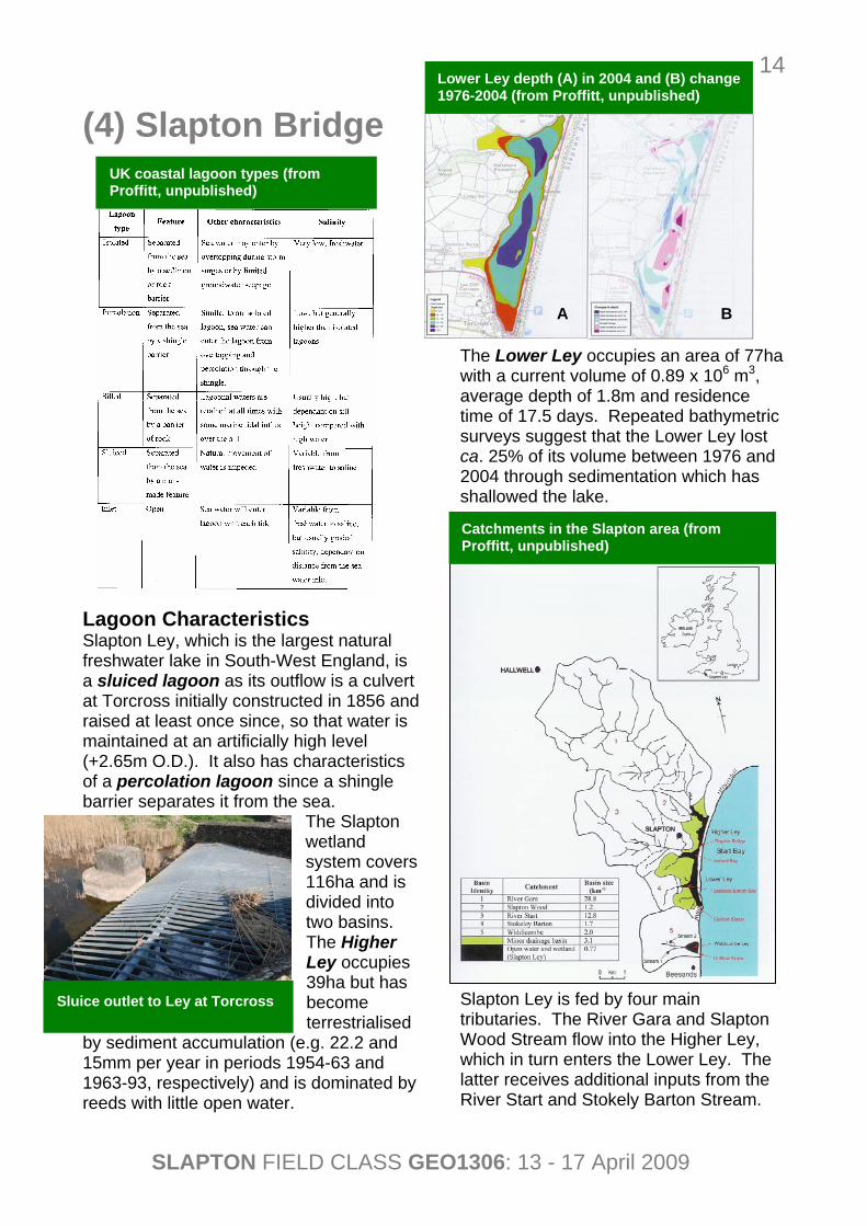
The Lower Ley occupies an area of 77ha with a current volume of 0.89 x 10⁶ m3, average depth of 1.8m and residence time of 17.5 days. Repeated bathymetric surveys suggest that the Lower Ley lost ca. 25% of its volume between 1976 and 2004 through sedimentation which has shallowed the lake.
Slapton Ley is fed by four main tributaries. The River Gara and Slapton Wood Stream flow into the Higher Ley, which in turn enters the Lower Ley. The latter receives additional inputs from the River Start and Stokely Barton Stream.
UK coastal lagoon types (from Proffitt, unpublished)
Lower Ley depth (A) in 2004 and (B) change 1976-2004 (from Proffitt, unpublished)
Catchments in the Slapton area (from Proffitt, unpublished)
B A
Sluice outlet to Ley at Torcross
SLAPTON FIELD CLASS GEO1306: 13 - 17 April 2009
15
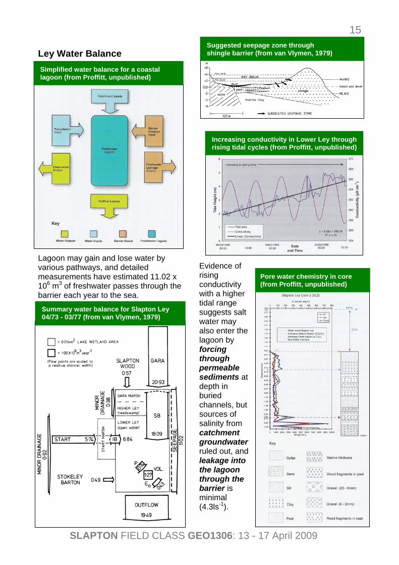
Ley Water Balance Lagoon may gain and lose water by various pathways, and detailed measurements have estimated 11.02 x 10⁶ m3 of freshwater passes through the barrier each year to the sea.
Evidence of rising conductivity with a higher tidal range suggests salt water may also enter the lagoon by forcing through permeable sediments at depth in buried channels, but sources of salinity from catchment groundwater ruled out, and leakage into the lagoon through the barrier is minimal (4.3ls-1).
Simplified water balance for a coastal lagoon (from Proffitt, unpublished)
Summary water balance for Slapton Ley 04/73 - 03/77 (from van Vlymen, 1979)
Suggested seepage zone through shingle barrier (from van Vlymen, 1979)
Increasing conductivity in Lower Ley through rising tidal cycles (from Proffitt, unpublished)
Pore water chemistry in core (from Proffitt, unpublished)
SLAPTON FIELD CLASS GEO1306: 13 - 17 April 2009
16
Cetti’s warbler (Cettia cetti)
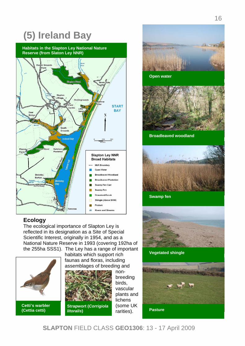
(5) Ireland Bay Ecology The ecological importance of Slapton Ley is reflected in its designation as a Site of Special Scientific Interest, originally in 1954, and as a National Nature Reserve in 1993 (covering 192ha of the 255ha SSS1). The Ley has a range of important
habitats which support rich faunas and floras, including assemblages of breeding and
non-breeding birds, vascular plants and lichens (some UK rarities).
Strapwort (Corrigiola litoralis)
Open water
Broadleaved woodland
Swamp fen
Vegetated shingle
Pasture
Habitats in the Slapton Ley National Nature Reserve (from Slaton Ley NNR)
SLAPTON FIELD CLASS GEO1306: 13 - 17 April 2009
17
Sheep Cattle
Permanent
Temporary
Cereals
Roots
Grassland
Arable
Livestock
Stocking Density
0
10
20
30
40
50
60
70
1971 1972 1973 1974 1975 1976 1977 1978 1979 1980 1981 1982 1983 1984 1985 1986 1987 1988 1989 1990
NO
3-N Y
ield
(kgh
a-1)
1971 19900
70Slapton Wood Stream N03-N (kgha-1)
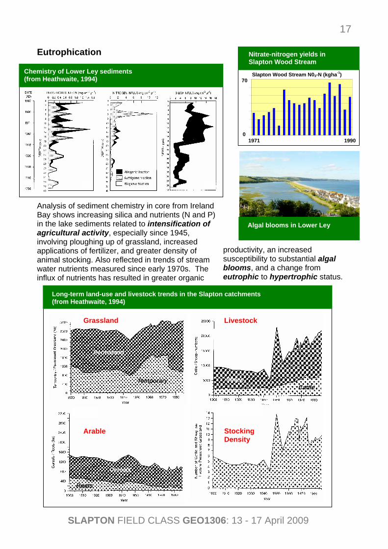
Eutrophication Analysis of sediment chemistry in core from Ireland Bay shows increasing silica and nutrients (N and P) in the lake sediments related to intensification of agricultural activity, especially since 1945, involving ploughing up of grassland, increased applications of fertilizer, and greater density of animal stocking. Also reflected in trends of stream water nutrients measured since early 1970s. The influx of nutrients has resulted in greater organic
productivity, an increased susceptibility to substantial algal blooms, and a change from eutrophic to hypertrophic status.
Long-term land-use and livestock trends in the Slapton catchments (from Heathwaite, 1994)
Algal blooms in Lower Ley
Nitrate-nitrogen yields in Slapton Wood Stream
Chemistry of Lower Ley sediments (from Heathwaite, 1994)
SLAPTON FIELD CLASS GEO1306: 13 - 17 April 2009
18
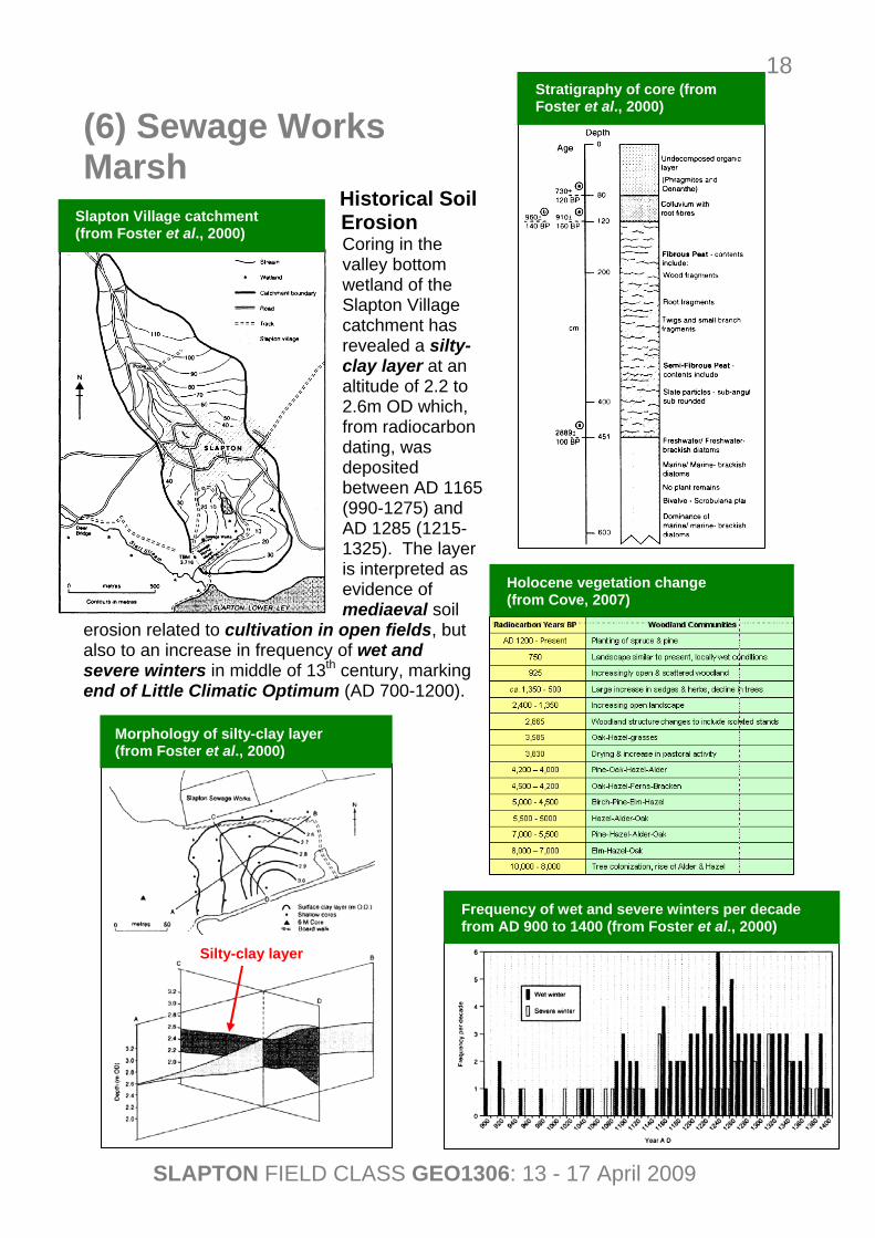
(6) Sewage Works Marsh
Historical Soil Erosion Coring in the valley bottom wetland of the Slapton Village catchment has revealed a silty-clay layer at an altitude of 2.2 to 2.6m OD which, from radiocarbon dating, was deposited between AD 1165 (990-1275) and AD 1285 (1215-1325). The layer is interpreted as evidence of mediaeval soil
erosion related to cultivation in open fields, but also to an increase in frequency of wet and severe winters in middle of 13th century, marking end of Little Climatic Optimum (AD 700-1200).
Slapton Village catchment (from Foster et al., 2000)
Morphology of silty-clay layer (from Foster et al., 2000)
Stratigraphy of core (from Foster et al., 2000)
Holocene vegetation change (from Cove, 2007)
Frequency of wet and severe winters per decade from AD 900 to 1400 (from Foster et al., 2000)
Silty-clay layer
SLAPTON FIELD CLASS GEO1306: 13 - 17 April 2009
19
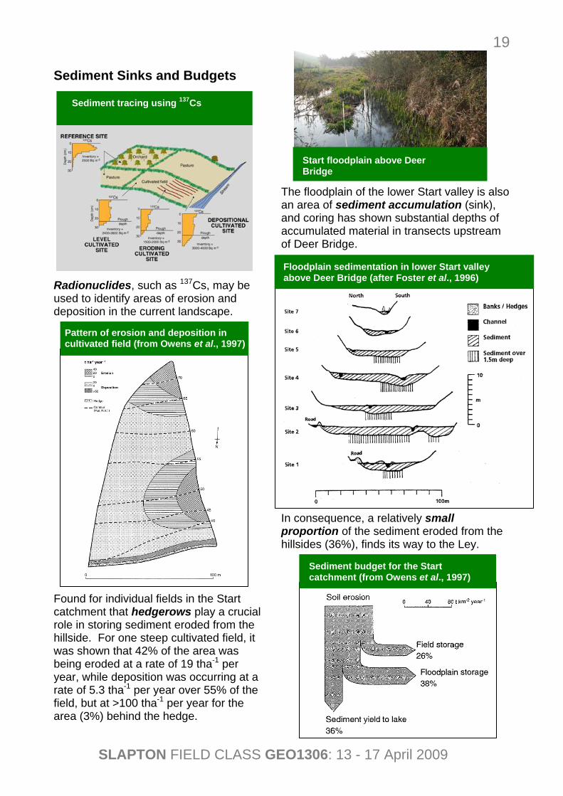
Sediment Sinks and Budgets Radionuclides, such as 137Cs, may be used to identify areas of erosion and deposition in the current landscape. Found for individual fields in the Start catchment that hedgerows play a crucial role in storing sediment eroded from the hillside. For one steep cultivated field, it was shown that 42% of the area was being eroded at a rate of 19 tha-1 per year, while deposition was occurring at a rate of 5.3 tha-1 per year over 55% of the field, but at >100 tha-1 per year for the area (3%) behind the hedge.
The floodplain of the lower Start valley is also an area of sediment accumulation (sink), and coring has shown substantial depths of accumulated material in transects upstream of Deer Bridge. In consequence, a relatively small proportion of the sediment eroded from the hillsides (36%), finds its way to the Ley.
Start floodplain above Deer Bridge
Floodplain sedimentation in lower Start valley above Deer Bridge (after Foster et al., 1996)
Pattern of erosion and deposition in cultivated field (from Owens et al., 1997)
Sediment budget for the Start catchment (from Owens et al., 1997)
Sediment tracing using 137Cs
SLAPTON FIELD CLASS GEO1306: 13 - 17 April 2009
20
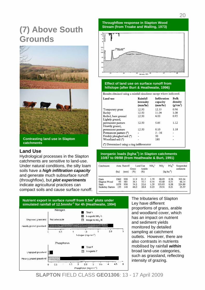
(7) Above South Grounds Land Use Hydrological processes in the Slapton catchments are sensitive to land-use. Under natural conditions, the silty loam soils have a high infiltration capacity and generate much subsurface runoff (throughflow), but plot experiments indicate agricultural practices can compact soils and cause surface runoff.
The tributaries of Slapton Ley have different proportions of grass, arable and woodland cover, which has an impact on nutrient and sediment yields monitored by detailed sampling at catchment outlets. However, there are also contrasts in nutrients mobilised by rainfall within broad land-use categories, such as grassland, reflecting intensity of grazing.
Contrasting land use in Slapton catchments
Throughflow response in Slapton Wood Stream (from Troake and Walling, 1973)
Inorganic loads (kgha-1) in Slapton catchments 10/87 to 09/88 (from Heathwaite & Burt, 1991)
Effect of land use on surface runoff from hillslope (after Burt & Heathwaite, 1996)
Nutrient export in surface runoff from 0.5m2 plots under simulated rainfall of 12.5mmhr-1 for 4h (Heathwaite, 1994)
SLAPTON FIELD CLASS GEO1306: 13 - 17 April 2009
21
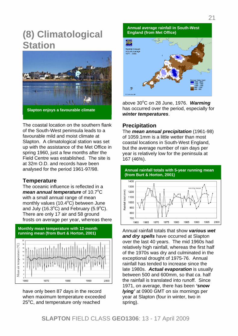
(8) Climatological Station The coastal location on the southern flank of the South-West peninsula leads to a favourable mild and moist climate at Slapton. A climatological station was set up with the assistance of the Met Office in spring 1960, just a few months after the Field Centre was established. The site is at 32m O.D. and records have been analysed for the period 1961-97/98. Temperature The oceanic influence is reflected in a mean annual temperature of 10.7oC with a small annual range of mean monthly values (10.4oC) between June and July (16.3oC) and February (5.9oC). There are only 17 air and 58 ground frosts on average per year, whereas there
have only been 87 days in the record when maximum temperature exceeded 25oC, and temperature only reached
above 30oC on 28 June, 1976. Warming has occurred over the period, especially for winter temperatures. Precipitation The mean annual precipitation (1961-98) of 1059.1mm is a little wetter than most coastal locations in South-West England, but the average number of rain days per year is relatively low for the peninsula at 167 (46%). Annual rainfall totals that show various wet and dry spells have occurred at Slapton over the last 40 years. The mid 1960s had relatively high rainfall, whereas the first half of the 1970s was dry and culminated in the exceptional drought of 1975-76. Annual rainfall has tended to increase since the late 1980s. Actual evaporation is usually between 500 and 600mm, so that ca. half the rainfall is translated into runoff. Since 1971, on average, there has been ‘snow lying’ at 0900 GMT on six mornings per year at Slapton (four in winter, two in spring).
Slapton enjoys a favourable climate
Monthly mean temperature with 12-month running mean (from Burt & Horton, 2001)
Annual rainfall totals with 5-year running mean (from Burt & Horton, 2001)
Annual average rainfall in South-West England (from Met Office)
SLAPTON FIELD CLASS GEO1306: 13 - 17 April 2009
22
Wind Speed and Direction Estimated wind speed at 0900 GMT using the Beaufort Scale suggests a mean annual value of 9 knots with relatively low contrasts between winter (9.5 knots) and summer (8.5 knots). Compared with many coastal locations in South-West England, the speeds are lower and the annual contrast more subdued, which probably reflects the sheltered location of Slapton and on the east-facing Start Bay. Westerly winds occur most often, especially at lower speeds, but strong winds are common from the east as well as west and south west. Wind speeds were high in the early 1970s but have declined since, and were especially low in the early 1990s.
Sunshine and Visibility The duration of bright sunshine been measured since August 1986, and in the period to January 1998 (excluding June 1995), the average total hours per year was 1641.7 (4.5 per day). Days with excellent visibility are more common in summer than in winter, and there are more fogs than at
Plymouth but less than on Scilly. About 61% of days have a high degree of cloud cover at Slapton. Relationship with NAO Index Temperature has increased with strength of North Atlantic westerly circulation over last 40 years, but not rainfall (possibly due to more northerly storm tracks).
Wind direction frequency in six classes (from Burt & Horton, 2001)
Monthly mean wind speed with 12-month running mean (from Burt & Horton, 2001)
Seasonal and annual visibility (from Burt & Horton, 2001)
NAO index with 5-year running means of NAO index, temperature and rainfall (from Burt & Horton, 2001)
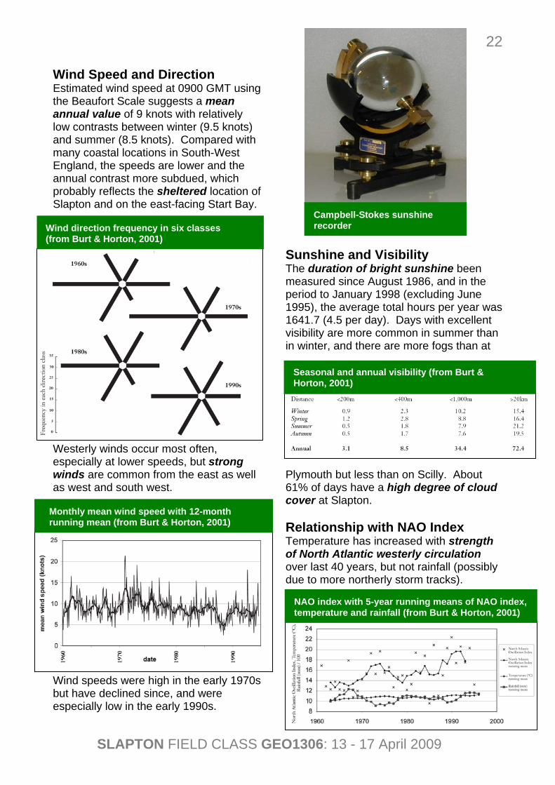
Campbell-Stokes sunshine recorder
SLAPTON FIELD CLASS GEO1306: 13 - 17 April 2009
23
References Papers and Booklets Burt, T.P. & Heathwaite, A.L. (1996) The
hydrology of the Slapton catchments. Field Studies 8, 543-557.
Burt, T.P. & Horton, B.P. (2001) The
natural history of Slapton Ley National Nature Reserve XXIII: The climate of Slapton Ley. Field Studies 10, 93-114.
Chadwick, A.J., Karunarathna, H., Gehrels,
W. R., Massey, A. C., O’Brien, D. & Dales, D. (2005) A new analysis of the Slapton barrier beach system, UK. Maritime Engineering 158 (Issue MA4), 147–161.
Chell, K. (2002) Coastline in decay.
Geography Review 15(3), 32-36. Cove, M. (2007) Ancient Forests of the
South Devon Coast: 8,000 years of changing vegetation determined by pollen analysis. Report and Transactions of the Devonshire Association for the Advancement of Science Literature and the Arts 139, 293-331.
Foster, I.D.L, Mighall, T.M., Wotton, C.,
P.N. Owens, P.N. & D.E. Walling (2000) Evidence for Mediaeval soil erosion in the South Hams region of Devon, UK. The Holocene 10(2), 261-271.
Foster, I.D.L, Owens, P.N. & Walling, D.E.
(1996) Sediment yields and sediment delivery in the catchments of Slapton Lower Ley, South Devon, UK. Field Studies 8, 629-661.
Gehrels, R. (2006) Sea-level rise and
coastal subsidence in Southwest England. Report and Transactions of the Devonshire Association for the
Advancement of Science, Literature and the Arts 138, 25-42.
Heathwaite, A.L. (1994) Chemical
fractionation of lake sediments to determine the effects of land-use change on nutrient loading. Journal of Hydrology 159, 395-421.
Heathwaite, A.L. & Burt, T.P. (1991)
Predicting the effect of land use on stream water quality in the UK. In: Sediment and Stream Water Quality in a Changing Environment: Trends and Explanation (Proceedings of the Vienna Symposium, August 1991) IAHS Publ. no. 203, 209-218.
Job, D. (1993) Coastal management:
Start Bay, south Devon. Geography Review 7(2), 13-17.
Masselink, G. & Buscombe, D. (2008)
Shifting gravel: a case study of Slapton Sands. Geography Review 22(1), 27-31.
Massey, A.C., Gehrels, W.R., Charman,
D.J., Milne, G.A., Lambeck, K. & Selby, K.A. (2008) Relative sea-level change and postglacial isostatic adjustment along the coast of south Devon, United Kingdom. Journal of Quaternary Science 23(5), 415-433.
Mottershead, D. (1997) Classic
Landforms of the South Devon Coast. The Geographical Association, 51pp.
Owens, P.N., Walling, D.E., Qingping,
H., Shanahan, J. & Foster, I.D.L. (1997) The use of caesium-137 measurements to establish a sediment budget for the Start catchment, Devon, UK. Hydrological Sciences Journal 42(3), 405-423.
Troake, R.P. & Walling, D.E. (1973) The
natural history of Slapton Ley
SLAPTON FIELD CLASS GEO1306: 13 - 17 April 2009
24
National Nature Reserve VII: The hydrology of the Slapton Wood Stream. A preliminary report. Field Studies 3, 719-740.
Van Vlymen, C.D. (1979) The natural
history of Slapton Ley National Nature Reserve XIII: The water balance of Slapton Ley. Field Studies 5, 59-84.
Websites Field Studies Journal - downloadable publications about Slapton (http://www.field-studies-council.org/fieldstudies/centre/slapton.htm) Slapton Ley National Nature Reserve (http://www.slnnr.org.uk/) Slapton Line partnership (including Scott Wilson Reports) (http://www.slaptonline.org/index.php) Standing Conference on Problems Associated with the Coastline (SCOPAC) – Lyme Bay and South Devon Coastal Group (http://www.scopac.org.uk/scopac%20sediment%20db/index.htm) UKCIP (2005) Update to UKCIP02 sea-level change estimates, December 2005 (http://www.ukcip.org.uk/index.php?option=com_content&task=view&id=87)