1
CO PILOT LEDGE MOUNTAIN MOUNT HABRICH SKY PILOT ADMIN BUILDING/ WASHROOMS BASECAMP CAFÉ BASECAMP RETAIL STORE Sky Pilot Suspension Bridge Summit Lodge Trails Backcountry Access TO SUMMIT PLAZA PARKING PARKING GONDOLA BASE Guest Services Ticket Window Washrooms Basecamp Store Basecamp Café Kids’ Play Area ADMINISTRATION BUILDING PARKING ENTRANCE/EXIT • Always bring a friend along and tell someone where you are going and when you expect to be back. • Weather can change quickly so always dress appropriately and bring extra layers. Visit: SEATOSKYGONDOLA.COM/ CURRENTCONDITIONS for more info. • Stay on the marked trails and NEVER climb over railings or leave designated trails or walkways as there are dangerous cliffs in the area. • Always bring some form of communica- tion equipment (cell phone, satellite radio, etc.) in case of an emergency. Cell phone coverage may be intermittent. • Never leave someone who is injured or needs medical attention behind. Send someone else to get help or call for help. • Stay hydrated. Always carry water. If venturing out for longer periods carry food and extra water. • If you are heading into the backcoun- try, know the associated risks and make sure your skill level is suited to them. You are solely responsible for your own safety at all times. VISIT: SEATOSKYGONDOLA.COM/ BACKCOUNTRY for more information on backcountry safety. SKY PILOT VALLEY TRAIL SKY PILOT VALLEY TRAIL SKYLINE RIDGE TRAIL SKYLINE RIDGE TRAIL SHANNON BASIN LOOP SHANNON BASIN LOOP SEA TO SUMMIT UPPER SHANNON FALLS TRAIL SEA TO SUMMIT UPPER SHANNON FALLS TRAIL 916 m gain 474 m gain 700 m gain 380 m gain 954 m gain CONNECTOR TRAIL CONNECTOR TRAIL HWY 99 BASECAMP BASECAMP SHANNON FALLS SHANNON FALLS PARKING SHANNON FALLS OVERFLOW PARKING / DARRELL BAY BACKSIDE CHIEF TRAIL SEA TO SUMMIT TRAIL BACKSIDE CHIEF TRAIL SEA TO SUMMIT TRAIL BACKSIDE CHIEF TRAIL CONTINUES BACKSIDE CHIEF TRAIL CONTINUES SHANNON BASIN LOOP SHANNON BASIN LOOP PANORAMA TRAIL PANORAMA TRAIL UPPER SEA TO SUMMIT TRAIL UPPER SEA TO SUMMIT TRAIL HUMMINGBIRD LOOKOUT HUMMINGBIRD LOOKOUT SUMMIT PLAZA SUMMIT PLAZA UPPER SEA TO SUMMIT UPPER SEA TO SUMMIT OLESEN CREEK OLESEN CREEK TRAIL TO SHANNON FALLS SEA TO SUMMIT TRAIL TRAIL TO SHANNON FALLS SEA TO SUMMIT TRAIL AL’S HABRICH TRAIL AL’S HABRICH TRAIL The following safety tips apply to everyone who visits the Sea to Sky Gondola: ALWAYS CHECK THE HOURS OF OPERATION BEFORE VENTURING AWAY FROM THE SUMMIT STATION. YOU DO NOT WANT TO MISS THE LAST GONDOLA RIDE DOWN. DAILY GUIDED TOURS BACKCOUNTRY ACCESS ROUTES BASECAMP YOUR SAFETY IS IMPORTANT TO US SHANNON FALLSAILL SHANNON FALLS LOOKOUT LOOKOUT WHISTLE PUNK WHISTLE PUNK WE RESPECT THE NATURAL ENVIRONMENT 1. 2. 3. 4. 5. 6. 7. Take time to read the signs so you can learn about the environment you are in. We walk only on the designated trails to ensure surrounding vegetation remains healthy. We leave the rocks in place. They support the trails and control erosion. We take only pictures of the flowers, plants, and trees so others may enjoy them too. Look carefully, however, do not wade into or throw anything in the ponds so as not to disturb the wildlife. Animals feed on plants, insects, and other animals found in the natural environment. Help them stay healthy and wild by not feeding them. Pack out what you pack in. Return garbage to bins at Summit Plaza area. SEATOSKYGONDOLA.COM SEATOSKYGONDOLA / @ # Thank You to our Partner: BACKCOUNTRY EMERGENCY CALL 9-1-1 604.892.2551 GENERAL INFORMATION i DAILY: 10 AM - 6 PM last ride down from summit at 7 PM anywhere on Gondola property. HOURS OF OPERATION: [email protected] Free information tours depart from the Summit Plaza Map. Please visit Guest Services for times. Tours are 30 - 45 minutes long and take place on easy terrain. For additional guided hiking options, please visit: seatoskygondola.com/guides or call (604) 892-2551. Open late with last download at 9:00 pm on Fridays and Saturdays from May 20, 2016 - September 10, 2016. Backcountry upload and Sea to Summit hikers download available daily at 9:30 a.m. HOURS SUBJECT TO CHANGE BASECAMP PARKING: 3 HR LIMIT LONG TERM PARKING: +3 HRS AT DARRELL BAY 600m scenic walk to the Gondola via Shannon Falls Connector. Please do not walk on highway. Shuttle Bus available at peak times. NO OVERNIGHT PARKING. NO SMOKING VISIT GUEST SERVICES FOR A MORE DETAILED BACKCOUNTRY MAP. SEA TO SUMMIT ASCENT TRAIL Trail markers from 1-400 SHANNON BASIN LOOP Trail markers from 1 - 200 SKY PILOT VALLEY TRAIL This trail is marked for 3.9 km / 7.8 km return LEVEL OF DIFFICULTY: Intermediate / Backcountry DISTANCE: 3.9 km one-way / 7.8 km return ESTIMATED TIME: 3-4 hours return ELEVATION GAIN: 380 m River crossing may be required. LEVEL OF DIFFICULTY: Advanced / Backcountry DISTANCE: 4.2 km one-way / 8.4 km return ESTIMATED TIME: 3-6 hours return ELEVATION GAIN: 354 m SKYLINE TRAIL LEVEL OF DIFFICULTY: Advanced / Backcountry DISTANCE: 12 km one-way ESTIMATED TIME: 6-8 hours return ELEVATION GAIN: 700 m Follow green numbered Sea to Summit markers from #1 (Base) to #400 (Top). From the base, follow the trail (and markers) to Chief Lower Backside Trail. Climb stairs and trail - 300 m of elevation gain. Look for the intersection with Upper Shannon Falls Trail at Marker #68 and turn right Follow markers to the top. LEVEL OF DIFFICULTY: Advanced with steep and challenging sections requiring fixed ropes to assist you. DISTANCE: 7.5 km one way ESTIMATED TIME: 3-5 hours one way ELEVATION GAIN: 918 m A long winding loop that can be linked with Upper Sea to Summit LEVEL OF DIFFICULTY: Intermediate DISTANCE: 9.7 km loop ESTIMATED TIME: 2-3 hours ELEVATION GAIN: 474 m gain, 292 m loss 900 800 700 600 500 400 300 200 100 0 0 1 2 3 4 5 6 900 800 700 600 0 1 2 3 4 5 6 7 8 9 1200 1100 1000 900 0 1 2 3 4 5 6 7 8 9 1200 1100 1000 900 0 1 2 3 4 5 1200 1100 1000 900 0 1 2 3 4 5 6 7 8 9 10 11 12 NEVERLAND FALLS Trail markers from 1 - 23 AL’S HABRICH TRAIL & Trail markers from 1 - 44 5 kms 68 MARKER MARKER To download our Trailmap app visit seatoskygondola.com/app or go straight to the App Store and search Sea to Sky Gondola. SUMMER TRAIL MAP

SKY PILOT VISIT GUEST SERVICES DAILY ... - Sea to Sky Gondola · The following safety tips apply to everyone who visits the Sea to Sky Gondola: ALWAYS CHECK THE HOURS OF OPERATION

  • Upload
    lyliem

  • View
    215

  • Download
    0

Embed Size (px)

Citation preview

CO PILOTLEDGE MOUNTAINMOUNT HABRICHSKY PILOT

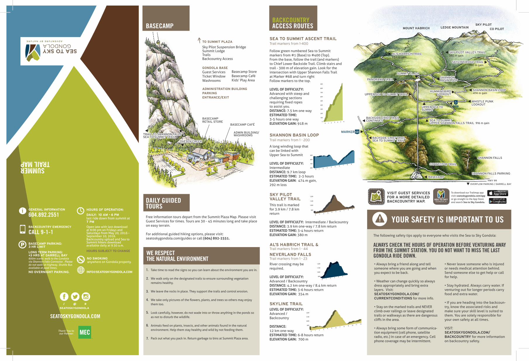
ADMIN BUILDING/WASHROOMS

BASECAMP CAFÉ

BASECAMPRETAIL STORE

Sky Pilot Suspension BridgeSummit LodgeTrailsBackcountry Access

TO SUMMIT PLAZA

PARKING

PARKING

GONDOLA BASEGuest ServicesTicket WindowWashrooms

Basecamp StoreBasecamp CaféKids’ Play Area

ADMINISTRATION BUILDINGPARKING ENTRANCE/EXIT

• Always bring a friend along and tell someone where you are going and when you expect to be back.

• Weather can change quickly so always dress appropriately and bring extra layers. Visit:SEATOSKYGONDOLA.COM/CURRENTCONDITIONS for more info.

• Stay on the marked trails and NEVER climb over railings or leave designated trails or walkways as there are dangerous cliffs in the area.

• Always bring some form of communica-tion equipment (cell phone, satellite radio, etc.) in case of an emergency. Cell phone coverage may be intermittent.

• Never leave someone who is injured or needs medical attention behind. Send someone else to get help or call for help.

• Stay hydrated. Always carry water. If venturing out for longer periods carry food and extra water.

• If you are heading into the backcoun-try, know the associated risks and make sure your skill level is suited to them. You are solely responsible for your own safety at all times.

VISIT: SEATOSKYGONDOLA.COM/BACKCOUNTRY for more information on backcountry safety.

SKY PILOT VALLEY TRAILSKY PILOT VALLEY TRAIL

SKYLINE RIDGE TRAILSKYLINE RIDGE TRAIL

SHANNON BASIN LOOPSHANNON BASIN LOOP

SEA TO SUMMITUPPER SHANNON FALLS TRAILSEA TO SUMMITUPPER SHANNON FALLS TRAIL 916 m gain

474 m gain

700 m gain

380 m gain954 m gain

CONNECTOR TRAILCONNECTOR TRAIL

HWY 99

BASECAMPBASECAMPSHANNON FALLS SHANNON FALLS PARKING

SHANNON FALLS OVERFLOW PARKING / DARRELL BAY

BACKSIDE CHIEF TRAILSEA TO SUMMIT TRAILBACKSIDE CHIEF TRAILSEA TO SUMMIT TRAIL

BACKSIDE CHIEF TRAILCONTINUESBACKSIDE CHIEF TRAILCONTINUES

SHANNONBASIN LOOPSHANNONBASIN LOOPPANORAMA TRAILPANORAMA TRAIL

UPPER SEA TO SUMMIT TRAILUPPER SEA TO SUMMIT TRAILHUMMINGBIRD

LOOKOUTHUMMINGBIRD

LOOKOUT

SUMMIT PLAZASUMMIT PLAZA

UPPER SEA TO SUMMIT UPPER SEA TO SUMMIT

OLESEN CREEKOLESEN CREEK

TRAIL TO SHANNON FALLSSEA TO SUMMIT TRAILTRAIL TO SHANNON FALLSSEA TO SUMMIT TRAIL

AL’S HABRICH TRAILAL’S HABRICH TRAIL

The following safety tips apply to everyone who visits the Sea to Sky Gondola:

ALWAYS CHECK THE HOURS OF OPERATION BEFORE VENTURING AWAY FROM THE SUMMIT STATION. YOU DO NOT WANT TO MISS THE LAST GONDOLA RIDE DOWN.

DAILY GUIDEDTOURS

BACKCOUNTRYACCESS ROUTESBASECAMP

YOUR SAFETY IS IMPORTANT TO US

SHANNON FALLSAILLSHANNON FALLS

LOOKOUTLOOKOUTWHISTLE PUNKWHISTLE PUNK

WE RESPECTTHE NATURAL ENVIRONMENT

1.

2.

3.

4.

5.

6.

7.

Take time to read the signs so you can learn about the environment you are in.

We walk only on the designated trails to ensure surrounding vegetation remains healthy.

We leave the rocks in place. They support the trails and control erosion.

We take only pictures of the flowers, plants, and trees so others may enjoy them too.

Look carefully, however, do not wade into or throw anything in the ponds so as not to disturb the wildlife.

Animals feed on plants, insects, and other animals found in the natural environment. Help them stay healthy and wild by not feeding them.

Pack out what you pack in. Return garbage to bins at Summit Plaza area.

SEATOSKYGONDOLA.COM

SEATOSKYGONDOLA

/ @ #

Thank You to our Partner:

BACKCOUNTRY EMERGENCY

CALL 9-1-1

604.892.2551GENERAL INFORMATIONi

DAILY: 10 AM - 6 PM last ride down from summit at 7 PM

anywhere on Gondola property.

HOURS OF OPERATION:

[email protected]

Free information tours depart from the Summit Plaza Map. Please visit Guest Services for times. Tours are 30 - 45 minutes long and take place on easy terrain.

For additional guided hiking options, please visit: seatoskygondola.com/guides or call (604) 892-2551.

Open late with last download at 9:00 pm on Fridays and Saturdays from May 20, 2016 - September 10, 2016. Backcountry upload and Sea to Summit hikers download available daily at 9:30 a.m.

HOURS SUBJECT TO CHANGE

BASECAMP PARKING: 3 HR LIMIT

LONG TERM PARKING: +3 HRS AT DARRELL BAY 600m scenic walk to the Gondola via Shannon Falls Connector. Please do not walk on highway. Shuttle Bus available at peak times.

NO OVERNIGHT PARKING.

NO SMOKING

VISIT GUEST SERVICESFOR A MORE DETAILED BACKCOUNTRY MAP.

SEA TO SUMMIT ASCENT TRAILTrail markers from 1-400

SHANNON BASIN LOOPTrail markers from 1 - 200

SKY PILOT VALLEY TRAILThis trail is marked for 3.9 km / 7.8 km return

LEVEL OF DIFFICULTY: Intermediate / BackcountryDISTANCE: 3.9 km one-way / 7.8 km returnESTIMATED TIME: 3-4 hours returnELEVATION GAIN: 380 m

River crossing may berequired.

LEVEL OF DIFFICULTY: Advanced / BackcountryDISTANCE: 4.2 km one-way / 8.4 km returnESTIMATED TIME: 3-6 hours returnELEVATION GAIN: 354 m

SKYLINE TRAILLEVEL OF DIFFICULTY: Advanced /Backcountry

DISTANCE: 12 km one-wayESTIMATED TIME: 6-8 hours returnELEVATION GAIN: 700 m

Follow green numbered Sea to Summit markers from #1 (Base) to #400 (Top). From the base, follow the trail (and markers) to Chief Lower Backside Trail. Climb stairs and trail - 300 m of elevation gain. Look for the intersection with Upper Shannon Falls Trail at Marker #68 and turn rightFollow markers to the top.

LEVEL OF DIFFICULTY: Advanced with steep and challenging sections requiring fixed ropes to assist you.DISTANCE: 7.5 km one wayESTIMATED TIME: 3-5 hours one way ELEVATION GAIN: 918 m

A long winding loop that can be linked with Upper Sea to Summit

LEVEL OF DIFFICULTY: IntermediateDISTANCE: 9.7 km loop ESTIMATED TIME: 2-3 hours ELEVATION GAIN: 474 m gain, 292 m loss

900

800

700

600

500

400

300

200

100

00 1 2 3 4 5 6

900

800

700

6000 1 2 3 4 5 6 7 8 9

1200

1100

1000

900

0 1 2 3 4 5 6 7 8 9

1200

1100

1000

900

0 1 2 3 4 5

1200

1100

1000

900

0 1 2 3 4 5 6 7 8 9 10 11 12

NEVERLAND FALLSTrail markers from 1 - 23

AL’S HABRICH TRAIL &Trail markers from 1 - 44

5kms

68MARKERMARKER

To download our Trailmap appvisit seatoskygondola.com/app or go straight to the App Store and search Sea to Sky Gondola.

SUMMERTRAIL MAP