Embed Size (px)
Citation preview
DOCKETED Docket Number: 19-SPPE-04
Project Title: SJ2
TN #: 240112
Document Title: SJC Information Data #2
Description: N/A
Filer: Jerry Salamy
Organization: Jacobs
Submitter Role: Applicant Consultant
Submission Date: 10/20/2021 1:57:25 PM
Docketed Date: 10/20/2021
1
Salamy, Jerry/SAC
From: Salamy, Jerry/SACSent: Thursday, September 30, 2021 11:32 AMTo: Worrall, Lisa@EnergyCc: Maurath, Garry@Energy; Khoshmashrab, Shahab@EnergySubject: RE: SJDC- Need updates to Figures 3.7-1 and 3.7-1 to include natural gas linesAttachments: Fig3_07-2R_Geologic.pdf; Fig3_07-1R_Soil.pdf
Hi Lisa,
Attached are the two updated figures.
Jerry Salamy | Jacobs | Project ManagerM:+916.769.8919 | [email protected] Natomas Park Drive, Suite 600 | Sacramento, CA 95833 | USA
From: Worrall, Lisa@Energy <[email protected]>Sent: Thursday, September 30, 2021 10:44 AMTo: Salamy, Jerry/SAC <[email protected]>Cc: Maurath, Garry@Energy <[email protected]>; Khoshmashrab, Shahab@Energy<[email protected]>Subject: [EXTERNAL] SJDC- Need updates to Figures 3.7-1 and 3.7-1 to include natural gas lines
Hi Jerry,
I just discovered that we need two Geology and Soils figures updated to include the natural gas lines. Figures 3.7-1 and3.7-2 need to be updated.
It would be great if you could docket them so that we can create a reference for our document.
Thanks so much,
Note new address
Lisa WorrallSenior Environmental PlannerCalifornia Energy CommissionSiting, Transmission and Environmental Protection Division715 P Street, MS-40, Sacramento, CA 95814Direct: (916) 661-8367Email: [email protected]
UV237
ZANKER RD
166
169
160
112
165
168
168
171
102
151
161
151
165
160
151
101
101
168
166
161
169
169
Coyote Creek
Source: Esri, Maxar, GeoEye,Earthstar Geographics,
\\DC1VS01\GISPROJ\L\LIGHTSPEED\SJDC\MAPS\REPORT\2021\FIG3_07-1R_SOIL.MXD 8/10/2021 12:07:56 PM
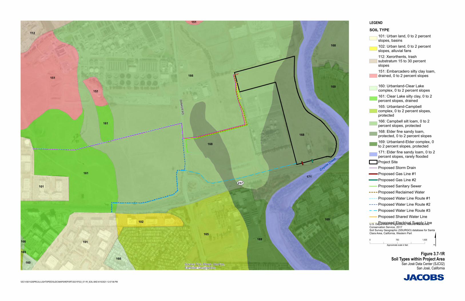
Figure 3.7-1RSoil Types within Project Area
San José Data Center (SJC02)San José, California
$0 750 1,500Approximate scale in feet
LEGENDSOIL TYPE
101: Urban land, 0 to 2 percentslopes, basins102: Urban land, 0 to 2 percentslopes, alluvial fans112: Xerorthents, trashsubstratum 15 to 30 percentslopes151: Embarcadero silty clay loam,drained, 0 to 2 percent slopes
160: Urbanland-Clear Lakecomplex, 0 to 2 percent slopes161: Clear Lake silty clay, 0 to 2percent slopes, drained165: Urbanland-Campbellcomplex, 0 to 2 percent slopes,protected166: Campbell silt loam, 0 to 2percent slopes, protected168: Elder fine sandy loam,protected, 0 to 2 percent slopes169: Urbanland-Elder complex, 0to 2 percent slopes, protected171: Elder fine sandy loam, 0 to 2percent slopes, rarely floodedProject SiteProposed Storm DrainProposed Gas Line #1Proposed Gas Line #2Proposed Sanitary SewerProposed Reclaimed WaterProposed Water Line Route #1Proposed Water Line Route #2Proposed Water Line Route #3Proposed Shared Water LineProposed Electrical Supply LineU.S. Department of Agriculture, Natural Resources
Conservation Service, 2017Soil Survey Geographic (SSURGO) database for SantaClara Area, California, Western Part
Los EsterosCritical Energy
Facility
UV237
§̈¦880
Coyote CreekGuadalupe River
TAYLOR ST
RAILROADCT
ESCU
ELA
PKWY
RESE
ARCH
PL
MAIN ST
OAKLANDRD
MILPITASBLVD
MONTAGUE EXPY
JACKLIN RD
GOLDST
MCCA
RTHY
BLVD
TASMAN DR
GREAT MALL PKWY
ABEL ST
MCCA
RTHY
BLVD
GREA
T AME
RICA
PKWY
TASMAN DR MONTAGUE EXPY
MILPITAS BLVD
CALAVERAS BLVD
RIVER OAKS PKWY
ABEL ST
LAFAYETTE ST
ZANKER RD
MAIN ST
MC CARTHY BLVDTASMAN DR
1ST ST
SOUTHBAY FWY
NIMITZ FWY
Guadalupe
River
Coyote Creek
Guadalupe River
Guadalupe River
Qhb
Qhb
QhfpQhl
Qhl
Qhsc
Qhfp
Qhbm
QhbsQhbm
QhbsQhbs
Qhbm
Qhl
Qhl
Qhl
Qhbm
Qhb
QhbsQhbm
Qhsc
Qhb
Qhsc
Source: Esri, Maxar, GeoEye,Earthstar Geographics,
\\DC1VS01\GISPROJ\L\LIGHTSPEED\SJDC\MAPS\REPORT\2021\FIG3_07-2R_GEOLOGIC.MXD 8/10/2021 12:07:44 PM
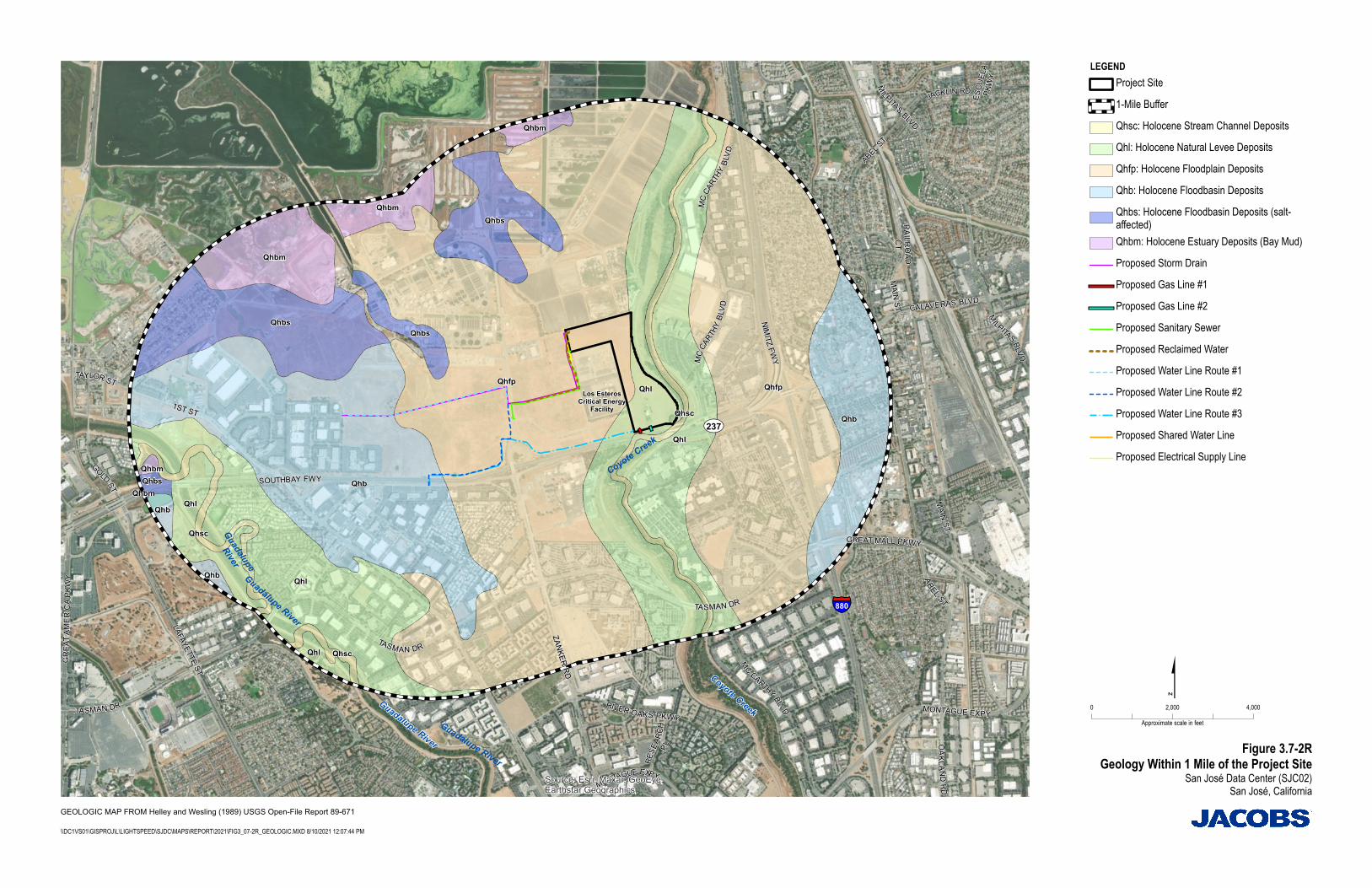
Figure 3.7-2RGeology Within 1 Mile of the Project Site
San José Data Center (SJC02)San José, California
$0 2,000 4,000
Approximate scale in feet
LEGENDProject Site1-Mile BufferQhsc: Holocene Stream Channel DepositsQhl: Holocene Natural Levee DepositsQhfp: Holocene Floodplain DepositsQhb: Holocene Floodbasin DepositsQhbs: Holocene Floodbasin Deposits (salt-affected)Qhbm: Holocene Estuary Deposits (Bay Mud)Proposed Storm DrainProposed Gas Line #1Proposed Gas Line #2Proposed Sanitary SewerProposed Reclaimed WaterProposed Water Line Route #1Proposed Water Line Route #2Proposed Water Line Route #3Proposed Shared Water LineProposed Electrical Supply Line
GEOLOGIC MAP FROM Helley and Wesling (1989) USGS Open-File Report 89-671