Embed Size (px)
Citation preview
II
Capturing Coral Reef and Related Ecosystem Services Site Report Selayar, Indonesia
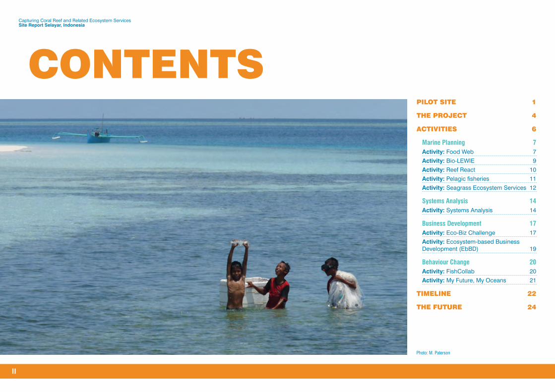
PILOT SITE 1
THE PROJECT 4
ACTIVITIES 6
Marine Planning 7Activity: Food Web 7
Activity: Bio-LEWIE 9
Activity: Reef React 10
Activity: Pelagic fisheries 11
Activity: Seagrass Ecosystem Services 12
Systems Analysis 14Activity: Systems Analysis 14
Business Development 17Activity: Eco-Biz Challenge 17
Activity: Ecosystem-based Business Development (EbBD) 19
Behaviour Change 20Activity: FishCollab 20
Activity: My Future, My Oceans 21
TIMELINE 22
THE FUTURE 24
CONTENTS
Photo: M. Paterson

1
Capturing Coral Reef and Related Ecosystem Services Site Report Selayar, Indonesia
SELAYAR
PILOT SITE
SELAYAR: OUR PILOT SITE IN INDONESIA
Selayar is as an archipelago of 130 islands (26 are inhabited), so the services provided by coastal ecosystems are vital for the food security, livelihoods and welfare of people in local communities.
The waters of Selayar are a meeting place for currents from the Indian and Pacific oceans and border deep ocean waters. This geography gives rise to rich and fertile pelagic fishery resources with high economic value, such as tuna and skipjack, and fish exports to Bali and Hong Kong.
Coral reef-related ecosystems provide coastal communities across Indonesia with essential services, including fish to eat and sell, eco-tourism, water filtration and shoreline protection from storms.
Yet fisheries, coral reefs, mangroves and seagrass beds in Indonesia and across the East-Asia Pacific region are under threat from pollution, overfishing, unsustainable development and climate change.
Selayar was chosen as the pilot site for the Capturing Coral Reef and Related Ecosystem Services (CCRES) project in Indonesia, following consultation with national, provincial and local stakeholders, during August 2014.
As well as the potential of its fisheries, Selayar’s coastlines have potential for development of responsible marine tourism, supported by the white sand, and the many coral reefs and turtle nesting sites.
Bungaiya Village
Barat Lambongan Village
Buki Village
Barugaiya Village
Parak Village
Benteng North
Bontosunggu Village
Bontoborusu Village
Patikarya Village
0 2.5 5 7.5 10 12.5 15km
Pamatata Village
Tanete Village
Kayu Bauk Village
Bontonasaluk Village
Bontolebang Village
Kahu-kahu Village

Capturing Coral Reef and Related Ecosystem Services Site Report Selayar, Indonesia
2
Yet like other coastal areas of Indonesia Selayar faces obstacles and challenges to sustainable development because of the over-exploitation of reef fish using destructive fishing methods and extensive coral mining, as well as the limited infrastructure for marine fisheries.
The keen interest of the head of DINAS Marine and Fisheries (and now Secretary of the Regency of Selayar), Dr Ir H Marjani Sultan, in the CCRES project supported selection of Selayar as the pilot site.
1 Culture and ceremony were features of the CCRES welcome to Selayar.Photo: P. Bradley
LOCAL WISDOM, NETWORKS, EXPERTISE
The experience, networks and perspectives of our in-country partners are critical to ensuring the tools developed by the CCRES project are used at and beyond the pilot sites.
We would like to thank our Indonesian partners for their contribution to our work in Selayar.
• Ministry for Marine Affairs and Fisheries
– Secretary General of Ministry for Marine Affair and Fisheries
– Directorate General of Management for Marine Spatial Planning
– BPSPL Makassar
– Directorate for Marine Conservation and Biodiversity
• Indonesian Institute of Sciences (LIPI)
– Economic Research Centre, Deputy of Social Science and Humanities
– Population Research Centre, Deputy of Social Science and Humanities
– Society and Culture Research Centre, Deputy of Social Science and Humanities
• Bogor Agricultural University
– Center for Coastal and Marine Resources Studies
• Hasanuddin University
– Faculty of Marine Science and Fisheries for Post Graduate and Undergraduate Program
• DINAS Marine and Fisheries, Selayar
1 Dr Ir. H Marjani Sultan (far right), Secretary, Regency of Selayar, and the photographic exhibition, Capture the beauty, welcome CCRES to the pilot site.Photos: P. Bradley
Culture and ceremony were features of the welcome of the CCRES project to Selayar during February 2015. The photographic exhibition, Capture the beauty islands, was unveiled as part of the official welcome. The CCRES project was officially launched in Selayar by the Vice Bupati, H Saiful Arif.
During this visit CCRES researchers attended consultative meetings with local fishermen, farmers, business cooperatives, religious leaders, school teachers, media and government officials.
PILOT SITE (cont.)
Capturing Coral Reef and Related Ecosystem Services Site Report Selayar, Indonesia
3
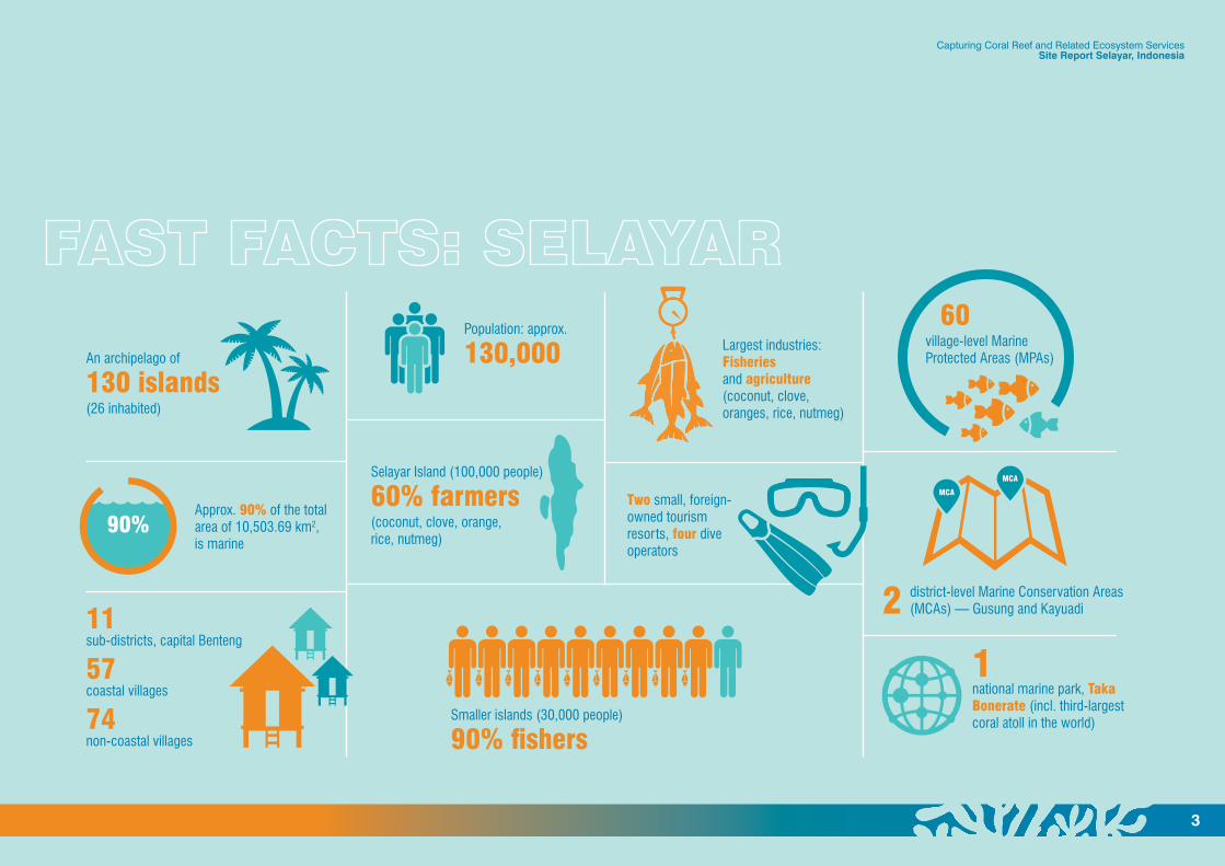
90%
MCA
MCA
An archipelago of
130 islands(26 inhabited)
Approx. 90% of the total area of 10,503.69 km2, is marine
Population: approx.
130,000
Two small, foreign-owned tourism resorts, four dive operators
2 district-level Marine Conservation Areas (MCAs) — Gusung and Kayuadi
Smaller islands (30,000 people)
90% fishers
Largest industries: Fisheries and agriculture (coconut, clove, oranges, rice, nutmeg)
11sub-districts, capital Benteng
57coastal villages
74non-coastal villages
60 village-level Marine Protected Areas (MPAs)
1national marine park, Taka Bonerate (incl. third-largest coral atoll in the world)
Selayar Island (100,000 people)
60% farmers(coconut, clove, orange, rice, nutmeg)

4
Capturing Coral Reef and Related Ecosystem Services Site Report Selayar, Indonesia
THE PROJECT RESEARCH, TOOLS FOR STRENGTHENING COASTAL MANAGEMENT
The CCRES project is a technical assistance project that seeks to support coastal management across the East Asia-Pacific.
The key question the CCRES project sought to answer is:
How do we assist decision-makers improve the welfare of people who depend upon coral reef-related ecosystems for their food, protection and livelihoods?
The multidisciplinary activities undertaken at Selayar involved leading centres of science, learning and engagement from the United States, Australia, Indonesia and the Philippines.
Based on this research CCRES has developed tools (models, processes and
frameworks) for use in systems modelling, marine planning, business development and behaviour change projects.
The tools assist coastal planners, managers and policymakers to make informed decisions that enhance livelihoods and food security, improve community welfare and sustain coastal ecosystems.
The CCRES project is funded by the Global Environment Facility (GEF), The World Bank and The University of Queensland (UQ). These organisations, together with another 15 international, regional, national and local CCRES partners, have provided world-class expertise in marine planning, systems thinking, business innovation, behaviour change and stakeholder engagement.
Pilot sitesSelayar, Indonesia; El Nido, Philippines
TimingJuly 2014 to December 2018
Partners18 international, regional, national and local institutions
People100+ researchers and advisors
FundersGlobal Environment Facility, World Bank and The University of Queensland
SELAYAR
EL NIDO
Photo: V. Horigue

5
COLLABORATION, PARTICIPATION KEY TO COMMUNITY MPA DESIGN, COASTAL REGULATIONS
When CCRES researchers from the marine planning and behaviour change teams got the chance to work together, in partnership with the villagers of Bungaiya, in July 2017 they were excited.
Together, the scientists, including a Marine Protected Area (MPA) design expert, and the villagers set out to confirm the best location, size and number of an existing MPA and three planned MPAs.
Community-declared MPAs are an important part of a Selayar community’s management arrangements for its respective waters, alongside customary rules about fishing gear and access times.
The community had established one village MPA but it was not officially registered with the government. Villagers decided to check whether quantitative assessments based on CCRES tools would support their proposed MPAs, to see if the science agreed with their local wisdom.
By using the CCRES marine planning tools the Bungaiya community found that there were very few degraded areas along the coastal reef that seemed unworthy of protecting. As a result, villagers were encouraged by CCRES scientists to strictly enforce their first candidate MPA.
The CCRES tools highlighted that larger than initially planned MPAs are likely to benefit fish population recovery. The villagers were encouraged to prioritise at least one MPA in northern community waters given that dominant ocean currents flow southwards. This is because MPAs in northern areas are more likely to spread fish larvae in support of fish population recovery and potential catch increases in community waters that remain open to fishing. Although villagers considered the likely value of a northern MPA highlighted by the CCRES models, most fishers did not support this because the northern waters are their main fishing site and, as a result, the main source of their fish catch/income.
One of the key factors that influenced the Bungaiya community’s choice of locations for MPAs in the southern part of village waters was the ability to see them from the village so that they could easily enforce their protection.
The activity at Bungiaya — and a similar initiative to develop coastal regulations with the Parak community — are examples of CCRES scientists collaborating across their core areas of expertise, and with local users, in order to increase the uptake and impact of their research.
1 Selayar communities, including Bungaiya (top), residents, village leaders and coastal officials met with CCRES researchers throughout the project.
Capturing Coral Reef and Related Ecosystem Services Site Report Selayar, Indonesia

6
Capturing Coral Reef and Related Ecosystem Services Site Report Selayar, Indonesia
ACTIVITIESRESEARCH SHOWS LINK BETWEEN CORAL REEFS AND PROSPERITY
Twelve research activities were undertaken at Selayar and in South Sulawesi, Indonesia, by local, national and international researchers for the CCRES project between 2014 and 2018. These were:
Marine Planning• Food Web
• Bio-LEWIE
• Reef React
• Seagrass Ecosystem Services
• Pelagic fisheries
Systems Analysis• SESAMME
• Simulation model
• SYSTORY
Business Development• Eco-Biz Challenge
• EbBD approach
Behaviour Change• FishCollab
• My Future, My Oceans
The findings from these activities demonstrate a strong link between the condition of coral reefs, fisheries, mangrove forests and seagrass beds and the livelihoods and welfare of local people.
3 A healthy coral reef. Tourism, food and coastal protection are examples of services provided by this coastal ecosystem.Photo: P. Mumby
Capturing Coral Reef and Related Ecosystem Services Site Report Selayar, Indonesia
7
Marine Planning
Activity: Food Web
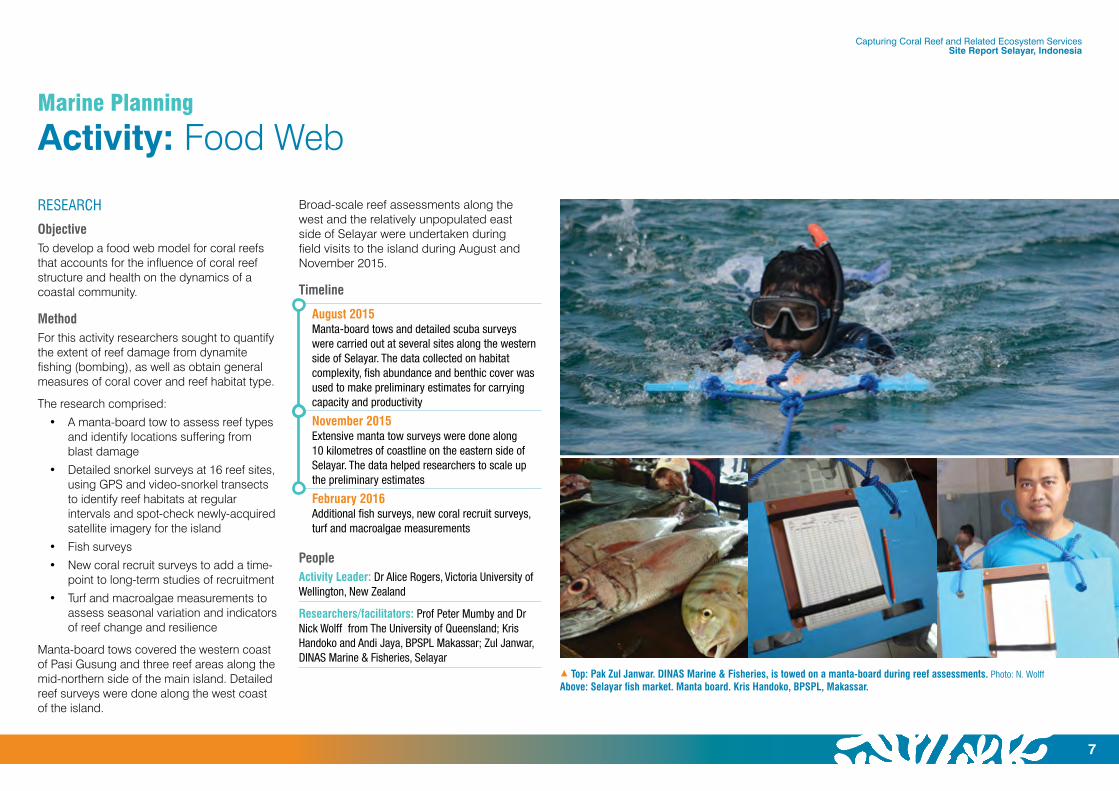
1 Top: Pak Zul Janwar. DINAS Marine & Fisheries, is towed on a manta-board during reef assessments. Photo: N. WolffAbove: Selayar fish market. Manta board. Kris Handoko, BPSPL, Makassar.
RESEARCH
ObjectiveTo develop a food web model for coral reefs that accounts for the influence of coral reef structure and health on the dynamics of a coastal community.
MethodFor this activity researchers sought to quantify the extent of reef damage from dynamite fishing (bombing), as well as obtain general measures of coral cover and reef habitat type.
The research comprised:
• A manta-board tow to assess reef types and identify locations suffering from blast damage
• Detailed snorkel surveys at 16 reef sites, using GPS and video-snorkel transects to identify reef habitats at regular intervals and spot-check newly-acquired satellite imagery for the island
• Fish surveys
• New coral recruit surveys to add a time-point to long-term studies of recruitment
• Turf and macroalgae measurements to assess seasonal variation and indicators of reef change and resilience
Manta-board tows covered the western coast of Pasi Gusung and three reef areas along the mid-northern side of the main island. Detailed reef surveys were done along the west coast of the island.
Broad-scale reef assessments along the west and the relatively unpopulated east side of Selayar were undertaken during field visits to the island during August and November 2015.
Timeline
August 2015Manta-board tows and detailed scuba surveys were carried out at several sites along the western side of Selayar. The data collected on habitat complexity, fish abundance and benthic cover was used to make preliminary estimates for carrying capacity and productivity
November 2015Extensive manta tow surveys were done along 10 kilometres of coastline on the eastern side of Selayar. The data helped researchers to scale up the preliminary estimates
February 2016Additional fish surveys, new coral recruit surveys, turf and macroalgae measurements
PeopleActivity Leader: Dr Alice Rogers, Victoria University of Wellington, New Zealand
Researchers/facilitators: Prof Peter Mumby and Dr Nick Wolff from The University of Queensland; Kris Handoko and Andi Jaya, BPSPL Makassar; Zul Janwar, DINAS Marine & Fisheries, Selayar

Capturing Coral Reef and Related Ecosystem Services Site Report Selayar, Indonesia
8
1 A policy brief for coastal planners is one of the outputs from the Food Web activity.
As a result of this activity detailed models to examine the effects of habitat complexity on the consumption of prey by reef fish have been developed. Smaller fish have more hiding places in a complex reef which can affect the growth rate of predators. When fish can hide effectively, it is harder for predators to access food. The model predictions were tested against known fish assemblages and once validated have been used to create a series of scenarios.
OUTPUTSThe data collected was used to produce coral reef habitat maps for Selayar and scale-up model predictions for potential fisheries productivity on coral reefs of varying habitat quality.
The outputs from the research were:
• A policy brief that outlines how policy-makers and leaders can support the long-term health of marine fisheries by quickly and easily determining which reefs could be used for general fishing and which ones are best reserved for biodiversity and fisheries replenishment.
• Two science publications:
– Rogers A, Blanchard JL, Newman SP, Dryden CS, Mumby PJ (2018) High refuge availability on coral reefs increases the vulnerability of reef-associated predators to overexploitation. Ecology (in press).
– Rogers A, Blanchard JL, Mumby PJ (2018) Fisheries productivity under progressive coral reef degradation. Journal of Applied Ecology (in press).
Coastal managers and policy makers can use this tool and the predictive model, Reef React, to assess how reefs of different states should be prioritised for management actions. This work highlights which reefs are ideally suited for use as no-take reserves either for biodiversity or fisheries management.
The policy brief, Priority reefs for conservation and fisheries replenishment, can be downloaded as a PDF file (viewed in Acrobat Reader) from http://ccres.net/resources/ccres-tool/policy-guide-priority-reefs-for-conservation-and-fisheries-replenishment
THE DATAThe research data is owned and kept by CCRES. Inquiries about the raw data can be made to the Marine Planning Component Leader Prof Peter Mumby: [email protected]
For inquiries about the research, findings, outputs, data or technical support, contact Dr Alice Rogers, of Victoria University of Wellington T +64 22 417 7949 E: [email protected]
POLICY BRIEF POLICY BRIEF POLICY BRIEF
EVIDENCEThe CCRES researchers developed detailed models to examine the effects of habitat complexity on the consumption of prey by reef fi sh. Smaller fi sh have more hiding places in a complex reef which can affect the growth rate of predators.
When fi sh can hide effectively, it is harder for predators to access food. The model predictions were tested against known fi sh assemblages and once validated it was used to create a series of predictions.
SCIENTIFIC REFERENCESRogers A, Blanchard JL, Newman SP, Dryden CS, Mumby PJ (2018) High refuge availability on coral reefs increases the vulnerability of reef-associated predators to overexploitation. Ecology (in press).
Rogers A, Blanchard JL, Mumby PJ (2018) Fisheries productivity under progressive coral reef degradation. Journal of Applied Ecology (in press).
20
0
40
60
Fish
erie
s pr
oduc
tivity
gm-2
yr-1
b
Healthy coral Standing dead coral Dead coral and branching rubble
Dead coral andno complexity
40
0
80
120
20
60
100
Fish
bio
mas
s gm
-2 a
Prioritise reef management based on reef coverage and complexity.
TYPE OF REEF WHAT IT’S IDEALLY SUITED TO REASONING
High or medium coral cover
+ High complexity
Marine reserve for biodiversity or sustaining
fi sheries*.
1. Tend to have highest biodiversity.
2. High complexity reduces the productivity of predatory fi shes (they cannot fi nd as much prey).
3. Predatory fi shes are more vulnerable to over-exploitation where their food supply is limited.
Low coral cover +
Medium complexity (recently dead)^
Fishing (general use). 1. Highest fi sheries productivity as the recently-dead coral is loaded with invertebrates that feed fi sh.
2. Access to productive food is high at medium complexity (low complexity supports too few prey and high complexity allows prey to hide effi ciently).
Low complexity (but not blasted)
Fishing (general use). Low complexity reduces its biodiversity potential and value in supporting high fi sheries productivity or brood stock for replenishing fi shing grounds.
Low complexity (blast fi shing)
Fishing (general use) but productivity will be low.
Fine rubble appears to take decades to stabilise. Restoration required if fi nancially feasible.
* Assuming it is located in an area that can supply larvae to important fi shing locations.^ In time, the reef will likely lose its complexity unless the system is resilient.
Fish biomass and productivity based on different reef states.
www.ccres.net
CAPTURING CORAL REEF AND RELATED ECOSYSTEM SERVICES
The Capturing Coral Reef and Related Ecosystem Services (CCRES) Project is a regional technical support project that seeks to unlock new, sustainable income streams for coastal communities in the East Asia-Pacifi c region. CCRES is developing knowledge products to inform the design of global, regional and national projects, plans and policies, and technical models and planning tools to help with the preparation of community-based coastal resource management plans.
Priority reefs for conservation and fi sheries replenishment
CONNECT WITH US
Dr Alice RogersCCRES Project Leader – Food Web Model
Victoria University of Wellington T: +64 22 417 7949E: [email protected]
Prof Peter MumbyCCRES Chief Scientist
The University of QueenslandT: +61 7 3365 1686E: [email protected]
POLICY BRIEF
Reefs vary hugely in their state, particularly in the cover of living coral and structural complexity, often termed ‘rugosity’. Some of these differences are natural and others refl ect damage infl icted by people.
Natural differences occur when some reefs are less exposed to damaging conditions such as where cooler or well-mixed water reduces the effects of coral bleaching. In contrast, activities like blast fi shing can reduce a reef to rubble for decades.
The present state of reefs can be quantifi ed through fi eld survey and the future or long-term state of reefs can be compared using predictive models, such as Reef React (see www.ccres.uq.edu.au).
To help coastal managers and policy makers match different reefs with appropriate management, researchers from the Capturing Coral Reef & Related Ecosystem Services (CCRES) project have developed a process to assess how reefs of different states should be prioritised for management actions. The work highlights which reefs are ideally suited for use as no-take reserves either for biodiversity or fi sheries management.
KEY GUIDELINES
1 Prioritise reef management based on reef coverage and complexity.
2 High coverage, high complexity reefs are best for marine conservation and fi sheries replenishment, while other states of reefs are suitable for general fi shing.
Priority reefs for conservation and fi sheries replenishmentThis policy brief outlines how policy makers and leaders can support the long-term health of marine fi sheries by quickly and easily determining which reefs could be used for general fi shing and which ones are best reserved for biodiversity and fi sheries replenishment.
January 2018January 2018
The data reveals that Selayar’s eastern side has experienced significant damage from bombing, much of which appears to be older. Some locations are showing encouraging signs of recovery but many do not. There are patches of better habitat, and these tend to be in the southern part of the area surveyed. There are extensive seagrass beds and often narrow expanses of reef.
Marine Planning
Activity: Food Web (cont.)
FINDINGSThe data collected were:
1 Percent live coral cover
2 Proportional coverage of branching massive and plating corals
3 Percent soft coral cover
4 Percent/occurrence of bomb damage
5 Percent of available settlement habitat composed of rubble
6 GPS coordinates of reef extent, start of seagrass etc during snorkel transects from reef crest to shore
7 Multiple depth measurement from reef crest to shore, including measures on sand to allow upscaling for bathymetry maps
Capturing Coral Reef and Related Ecosystem Services Site Report Selayar, Indonesia
9
Marine Planning
Activity: Bio-LEWIE
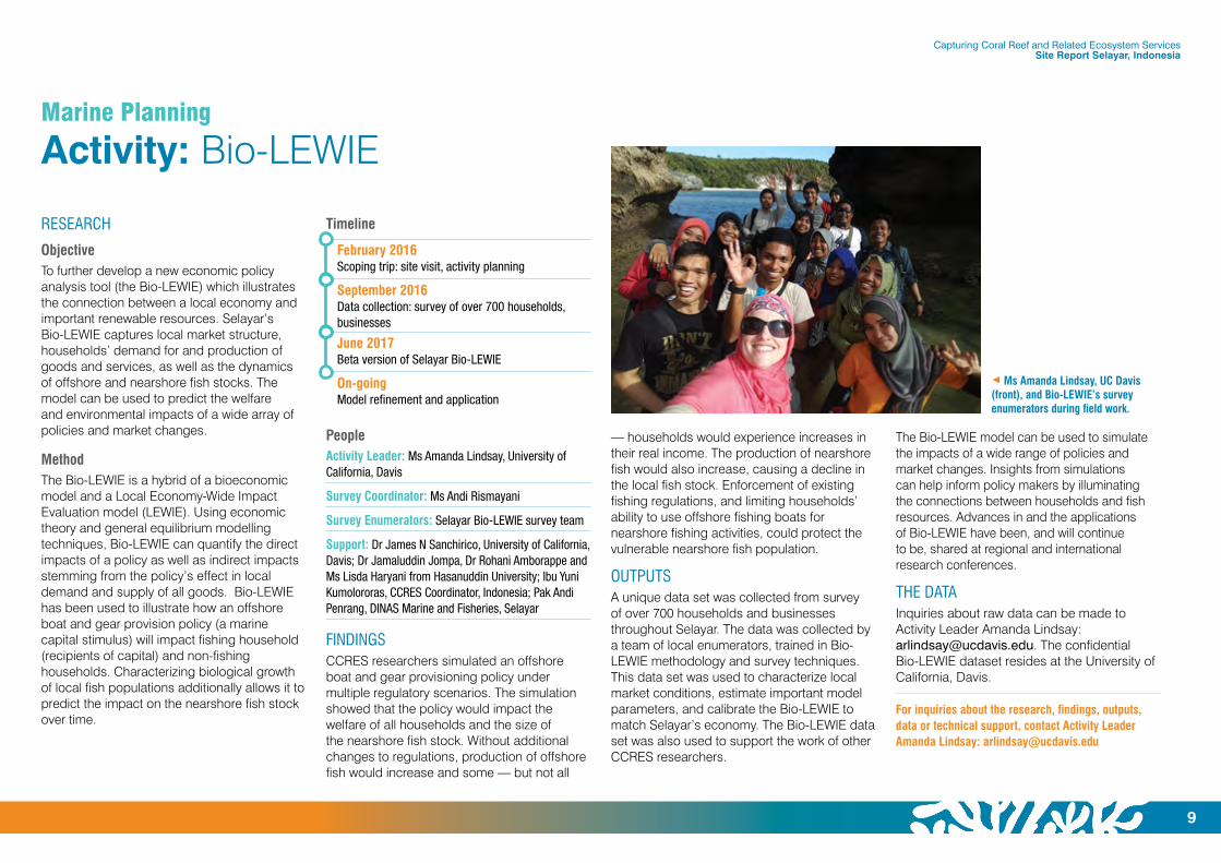
7 Ms Amanda Lindsay, UC Davis (front), and Bio-LEWIE’s survey enumerators during field work.
RESEARCH
ObjectiveTo further develop a new economic policy analysis tool (the Bio-LEWIE) which illustrates the connection between a local economy and important renewable resources. Selayar’s Bio-LEWIE captures local market structure, households’ demand for and production of goods and services, as well as the dynamics of offshore and nearshore fish stocks. The model can be used to predict the welfare and environmental impacts of a wide array of policies and market changes.
MethodThe Bio-LEWIE is a hybrid of a bioeconomic model and a Local Economy-Wide Impact Evaluation model (LEWIE). Using economic theory and general equilibrium modelling techniques, Bio-LEWIE can quantify the direct impacts of a policy as well as indirect impacts stemming from the policy’s effect in local demand and supply of all goods. Bio-LEWIE has been used to illustrate how an offshore boat and gear provision policy (a marine capital stimulus) will impact fishing household (recipients of capital) and non-fishing households. Characterizing biological growth of local fish populations additionally allows it to predict the impact on the nearshore fish stock over time.
Timeline
February 2016Scoping trip: site visit, activity planning
September 2016Data collection: survey of over 700 households, businesses
June 2017Beta version of Selayar Bio-LEWIE
On-goingModel refinement and application
PeopleActivity Leader: Ms Amanda Lindsay, University of California, Davis
Survey Coordinator: Ms Andi Rismayani
Survey Enumerators: Selayar Bio-LEWIE survey team
Support: Dr James N Sanchirico, University of California, Davis; Dr Jamaluddin Jompa, Dr Rohani Amborappe and Ms Lisda Haryani from Hasanuddin University; Ibu Yuni Kumolororas, CCRES Coordinator, Indonesia; Pak Andi Penrang, DINAS Marine and Fisheries, Selayar
FINDINGSCCRES researchers simulated an offshore boat and gear provisioning policy under multiple regulatory scenarios. The simulation showed that the policy would impact the welfare of all households and the size of the nearshore fish stock. Without additional changes to regulations, production of offshore fish would increase and some — but not all
The Bio-LEWIE model can be used to simulate the impacts of a wide range of policies and market changes. Insights from simulations can help inform policy makers by illuminating the connections between households and fish resources. Advances in and the applications of Bio-LEWIE have been, and will continue to be, shared at regional and international research conferences.
THE DATAInquiries about raw data can be made to Activity Leader Amanda Lindsay: [email protected]. The confidential Bio-LEWIE dataset resides at the University of California, Davis.
For inquiries about the research, findings, outputs, data or technical support, contact Activity Leader Amanda Lindsay: [email protected]
— households would experience increases in their real income. The production of nearshore fish would also increase, causing a decline in the local fish stock. Enforcement of existing fishing regulations, and limiting households’ ability to use offshore fishing boats for nearshore fishing activities, could protect the vulnerable nearshore fish population.
OUTPUTSA unique data set was collected from survey of over 700 households and businesses throughout Selayar. The data was collected by a team of local enumerators, trained in Bio-LEWIE methodology and survey techniques. This data set was used to characterize local market conditions, estimate important model parameters, and calibrate the Bio-LEWIE to match Selayar’s economy. The Bio-LEWIE data set was also used to support the work of other CCRES researchers.

Capturing Coral Reef and Related Ecosystem Services Site Report Selayar, Indonesia
10
Marine Planning
Activity: Reef React
RESEARCH
ObjectiveTo understand coral reefs’ vulnerability under various climate and human use scenarios, to understand the effects of reefs’ vulnerability on ecosystem services in order to improve their preferences in ecosystem services prioritization and to develop a model for predicting the impacts of the different scenarios and interventions for addressing them.
MethodQuestionnaire surveys, interviews with managers and focus group discussions (FGDs) to improve local stakeholders’ understanding on the effects of reefs’
vulnerability on coral reef ecosystem services and to assess stakeholders’ preferences to support integrating coral reef ecosystem services into marine planning were conducted.
Timeline
July to September 2017Questionnaire surveys, interviews with managers, focus group discussions
September 2017 to December 2018Ongoing work
PeopleActivity Leader: Abdi Tunggal Priyanto, The University of Queensland
FINDINGSThis activity continues at Selayar until December 2018. The findings will be published in 2019.
OUTPUTSThe data collected is being used to develop Reef React. This tool assists users to predict alternate futures for coral reef ecosystems under various climate and human use scenarios.
It enables coastal planners and managers to model the impacts on coral reef ecosystems of proposed management interventions for managing threats to coral reefs before any action is taken.
It is designed for use by:
• Government planners undertaking marine spatial planning who wish to identify the most vulnerable reefs and those with the greatest current resilience;
• NGOs involved in marine spatial planning, conservation planning, or coral reef research; and
• Scientists undertaking monitoring or assessments of coral reefs and/or interested in coral reef futures and ecology.
Reef React models the dynamics of coral reefs under various pressures, including climate change, over-fishing, high nutrient levels, sedimentation and crown-of-thorns outbreaks.
The different parts to Reef React are:
• Free Netica software to build a network and capture different drivers influencing coral reef dynamics
• A model to predict probability of coral reef cover in each percentage category and measure mean of coral reef cover in given years for different climate scenarios
• A user guide
These are available at http://ccres.net/resources/ccres-tool/reef-react Start using Reef React by downloading Netica www.norsys.com/download.html A user guide shows how to set up Reef React.
THE DATAThe research data is owned and kept by the CCRES project. Inquiries about the data can be made to the Marine Planning Component Leader Prof Peter Mumby [email protected]
For inquiries about the research, findings, outputs or technical support, contact Abdi Tunggal Priyanto [email protected] or Prof Peter Mumby [email protected] Coral reefs will react to different climate and human
use pressures.Photo: P. Mumby
INSET: Activity Leader: Abdi Tunggal Priyanto

11
Marine Planning
Activity: Pelagic fisheries
7 Lisda Haryani with Jamaluddin Fitrah Alam and a coral reef fisher at Kahu-kahu village in Selayar.Photo: L. Haryani
RESEARCH
ObjectiveTo understand the pressures felt by reef fishers and gauge their perceptions of challenges associated with shifting their fishing techniques and grounds, particularly to pelagic fishing.
MethodOne-on-one hour-long interviews with 92 respondents (reef fishers, village staff, and local business people involved in coral reefs fishing, selling, trade and management), aged 15 to 85 years old.
Timeline
January 2016Surveys at six locations — Bontosunggu, Parak, Bontoborusu, Barugaia, Benteng and Kahu-Kahu
PeopleMs Lisda Haryani, Hasanuddin University, Makassar, Indonesia
FINDINGSHeavy fishing of coral reefs has had a serious effect on coral reefs, Smaller villages which rely on fishing for their livelihood find themselves facing increasing levels of poverty in light of declining reef ecosystems.
Some of the findings show that the estimated annual catch by weight per family for coral reef fishers have moderately decreased (based on questions about annual catches for 2010–15).
Most of the reef fishers in the six villages fall into the lower income category, meaning that most of them could not afford their daily needs and their children’s education needs. All of the reef fishers in the surveyed villages have some alternative livelihood, besides fishing. Based on three different levels of monetary incentives and catch scenarios, most of the fishermen would be willing to shift to pelagic fishing.
RESULTSThe diminished value of the coral reef fisheries is affecting local fishermen. Families in the villages advised they were catching moderately less fish by weight than they were catching five years ago.
Consequently, local communities are facing deepening economic stress with many families having difficulty affording basic needs. All coral reef fishers found themselves relying on alternative means of livelihood to make ends meet.
It was observed that when profits are relatively low, fishers are more likely to retreat towards port and reduce fuel costs. It appears that such moves have improved relative profits overall.
Hypotheses included:
• Fishers are less likely to move when profits are high
• Fishers are more likely to venture farther afield when profits are high (because they can afford to)
Indeed, many of the most remote fishing grounds have experienced historical blast fishing, which reduces the chance that even large forays offshore will be successful as blasted reefs have little fisheries productivity.
THE DATAThe research data is owned by the CCRES project. Inquiries about the raw data can be made to the Marine Planning Component Leader Prof Peter Mumby [email protected]
For inquiries about the research, findings, outputs, data or technical support, contact Ms Lisda Haryani, Hasanuddin University, Makassar, Indonesia [email protected]
• Fishers retreat (move closer to port) when profits are low because higher fuel costs preclude venturing farther afield
DISCUSSIONThe emerging picture of fisher behaviour is that a decision to move farther afield in search of better fishing grounds is taken when relative profits are intermediate or if financial incentives are available. Without financial support such a move tends to be relatively unsuccessful and lead to net reductions in profits.
Although it is perhaps expected that fishers will travel even farther to explore the potential for new, even higher profits, such behaviours are less likely in this mature and heavily exploited fishery.
Capturing Coral Reef and Related Ecosystem Services Site Report Selayar, Indonesia

Capturing Coral Reef and Related Ecosystem Services Site Report Selayar, Indonesia
12
Marine Planning
Activity: Seagrass Ecosystem Services
RESEARCH
ObjectiveTo investigate and model the ecosystem service value of seagrasses filtration to human, coral reef and seaweed health in coastal Indonesia.
MethodsSurveys of seaweed farms were performed at 17 sites — nine sites cultivating seaweed without seagrass meadows and eight cultivating seaweed within seagrass meadows — in southwest Sulawesi.
Researchers used field and lab-based studies. Water samples were collected at eight sites on four islands and analysed using the latest next-generation sequencing technology — more than 1200 different bacteria were sequenced.
Timeline
April to May 2014At each of four replicate islands, environmental parameters, seagrass cover and diversity measurements, and water samples were collected within intact seagrass meadow and outside of seagrass meadows along three transects radiating from shore to the reef
October 2015Seagrass data collection and water quality of seaweed farms at 17 sites
PeopleActivity Leaders: Dr Joleah Lamb, Prof Drew Harvell and Dr Joleah Lamb, Department of Ecology and Evolutionary Biology, Cornell University, Ithaca, USA
Researchers: Dr Nur Abu and Prof Jamaluddin Jompa, Hasanuddin University; Prof Drew Harvell, Cornell University; Prof Peter Mumby, The University of Queensland
FINDINGSThe research found the presence of the bacteria Enterococcus exceeded recommended human health levels by 10-fold. However, levels of the bacteria were reduced three-fold in the presence of seagrass.
Further studies revealed that the abundance of marine fish and invertebrate pathogens was 50 per cent lower when seagrass was present. And, field surveys of over 8,000 reef-building corals adjacent to seagrass meadows showed two-fold reductions in disease compared to corals without seagrass neighbours.
The findings highlight the importance of seagrass ecosystems to the health of people and marine organisms, including coral reefs, fisheries (wild and farmed) and seaweed in coastal areas. They reveal why allocating more seagrass ecosystems as “no take areas” could be considered by government as an integral part of coastal ecosystem management in most coastal areas of Indonesia, especially those adjacent to Marine Protected Areas (MPAs) or tourism areas.
All the communities visited in South Sulawesi were concerned with disease at their seaweed farms. There was uncertainty within these communities about whether seagrass meadows influenced diseases of seaweeds. The prevalence of seaweed disease ranged from 1% to 79%, with an average of 15% of farmed seaweeds surveyed affected by disease (n = 8,876 individuals).
OUTPUTSThe data collected was used to produce:
• A policy brief that helps policy makers and leaders make informed decisions about managing seagrasses. The policy brief, Reduced pathogenic bacteria through seagrass protection, can be downloaded as a PDF file (viewed in Acrobat Reader) from http://ccres.net/resources/ccres-tool/policy-brief-reduced-pathogenic-bacteria-through-seagrass-protection
• A science publication Seagrass ecosystems reduce exposure to bacterial pathogens of humans, fishes and invertebrates; Science magazine Volume 355, Issue 6326, February 2017, Pages 731–733 Joleah B. Lamb, Jeroen A. J. M. van de Water, David G. Bourne, Craig Altier, Margaux Y. Hein, Evan A. Fiorenza, Nur Abu, Jamaluddin Jompa, C. Drew Harvell
The data collected during this activity will be used to inform scenarios and develop a valuation model using the InVEST (Integrated
Valuation of Ecosystem Services and Tradeoffs) toolkit (a tool for mapping and valuing ecosystem services developed by the Natural Capital Project at Stanford University). This work is necessary because filtration services are poorly quantified at the level needed for model projections. The results of this analysis will be incorporated into models that value the filtration service of seagrasses.
THE DATAThe research data is owned by Cornell University. Inquiries about this data can be made to Prof Drew Harvell, Department of Ecology and Evolutionary Biology, Cornell University [email protected]
LOOKING AHEADRemoving human pathogens from water is essential for human health. Plants, with their natural biocides, play a vital role – one that can offer significant economic benefits.
Although seagrasses are known to produce natural antibiotics, they have not been evaluated for their ability to remove pathogens from the ocean, or for their ability to mitigate disease there.
Not only can seagrasses help with improving water quality in even more populated coastal zones (it is estimated that one billion people will inhabit low-lying coastal zones by 2060), they can also play a key role in sustaining the rapid increase of aquaculture in the face of global food shortages.

Capturing Coral Reef and Related Ecosystem Services Site Report Selayar, Indonesia
13
For inquiries about the research, findings, outputs, data or technical support, contact Dr Joleah Lamb, Research Associate, Department of Ecology and Evolutionary Biology, Cornell University [email protected] Twitter: @JoleahLamb
1 Top: A mother and daughter rinsing dishes in the seagrass.Photo: J. Lamb
Above: Nur Abu, Hasanuddin University master’s student, surveys seaweed for signs of disease.Photo: J. Lamb
3 Dr Joleah Lamb, Cornell University, and Dr Syafyuddin Yusuf, Hasanuddin University, survey corals for signs of disease. Photo: C. Couch
Capturing Coral Reef and Related Ecosystem Services Site Report Selayar, Indonesia
14
Systems Analysis
Activity: Systems Analysis
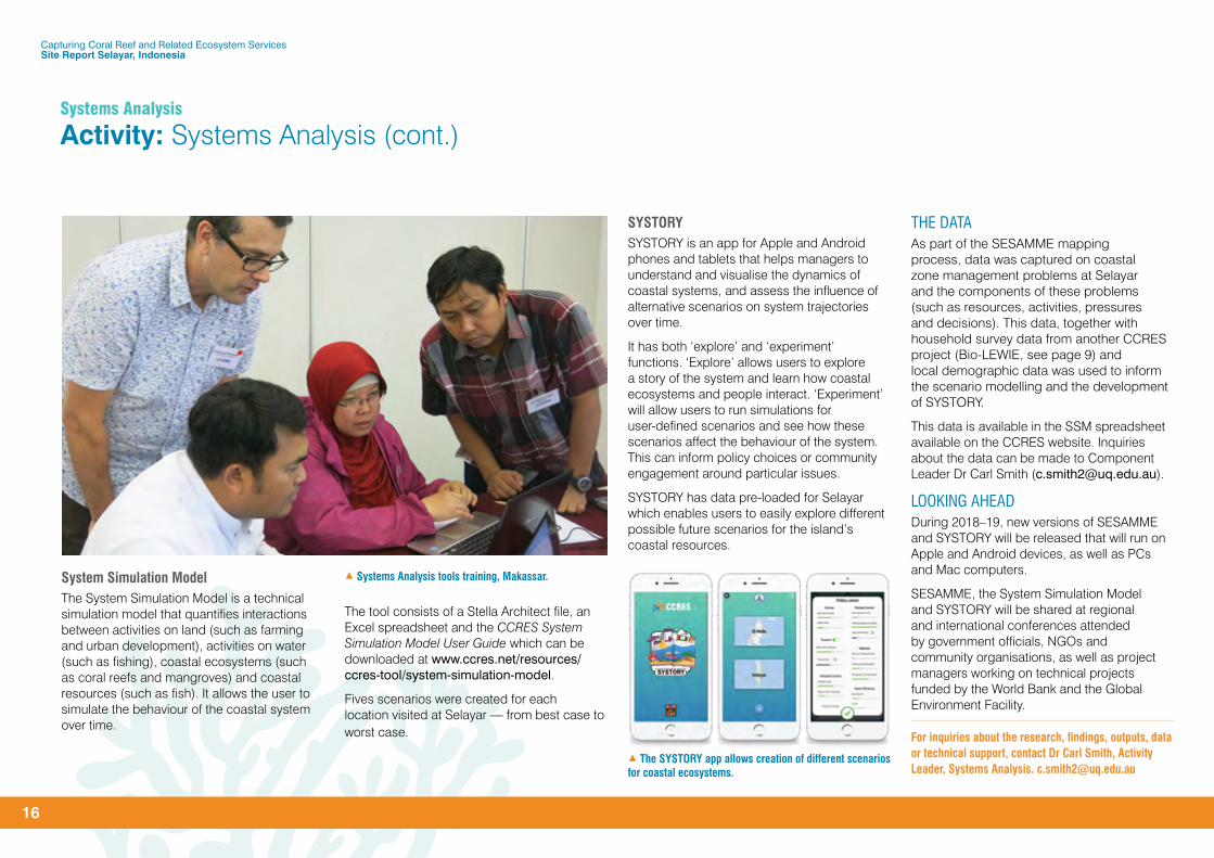
THE RESEARCH
ObjectiveTo use systems thinking to engage coastal communities and assist them to identify coastal resource management problems, preferred future scenarios, and intervention points that will help them achieve desirable outcomes.
MethodThe CCRES project has created three tools using systems thinking and simulation modelling to address coastal resource management problems.
The first of these is SESAMME (Socio-Ecological Systems App for Mental Model Elicitation), a group model building tool used in focus group discussions according to a script that outlines the discussion procedure.
SESAMME, and its associated scripts, were designed to assist group discussions about coastal zone management problems; to capture information about components of these problems (such as resources, activities, pressures and decisions) from participants; and to help visualise how these components interact.
Initially, village maps were used at Selayar to determine the high priority socio-ecological problems faced by villages; where these problems were located; and who CCRES researchers needed to talk to in order to understand these problems.
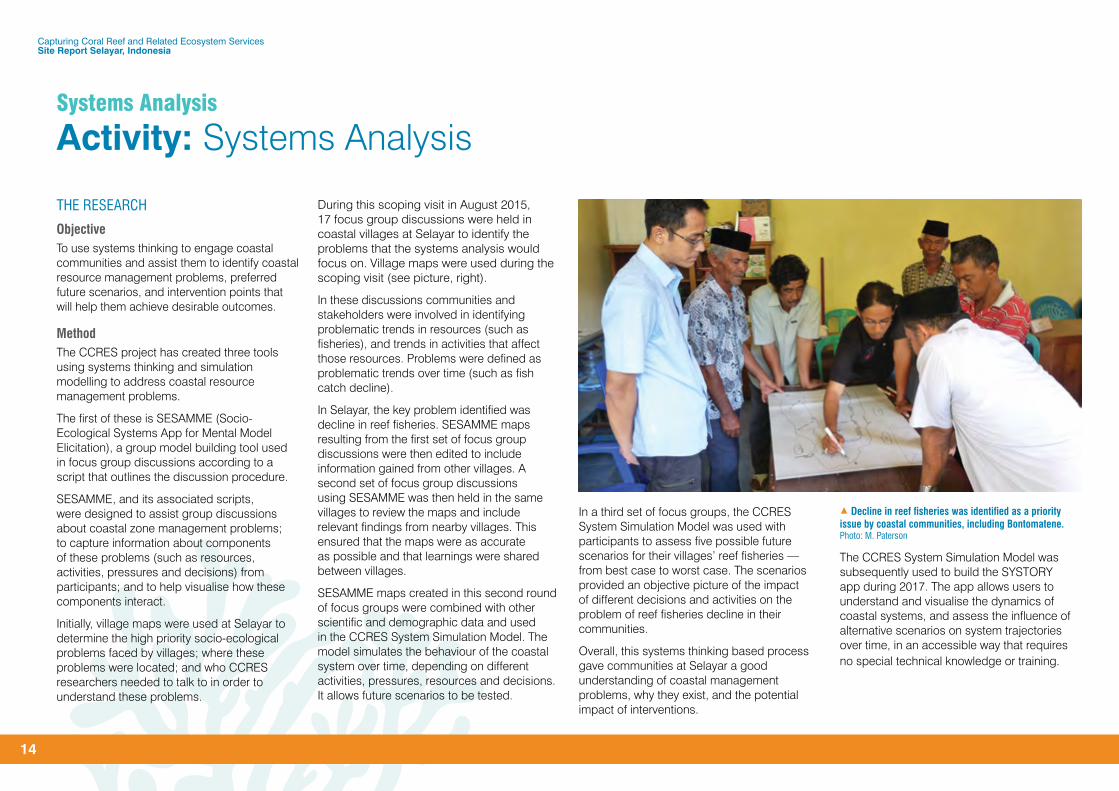
During this scoping visit in August 2015, 17 focus group discussions were held in coastal villages at Selayar to identify the problems that the systems analysis would focus on. Village maps were used during the scoping visit (see picture, right).
In these discussions communities and stakeholders were involved in identifying problematic trends in resources (such as fisheries), and trends in activities that affect those resources. Problems were defined as problematic trends over time (such as fish catch decline).
In Selayar, the key problem identified was decline in reef fisheries. SESAMME maps resulting from the first set of focus group discussions were then edited to include information gained from other villages. A second set of focus group discussions using SESAMME was then held in the same villages to review the maps and include relevant findings from nearby villages. This ensured that the maps were as accurate as possible and that learnings were shared between villages.
SESAMME maps created in this second round of focus groups were combined with other scientific and demographic data and used in the CCRES System Simulation Model. The model simulates the behaviour of the coastal system over time, depending on different activities, pressures, resources and decisions. It allows future scenarios to be tested.
In a third set of focus groups, the CCRES System Simulation Model was used with participants to assess five possible future scenarios for their villages’ reef fisheries — from best case to worst case. The scenarios provided an objective picture of the impact of different decisions and activities on the problem of reef fisheries decline in their communities.
Overall, this systems thinking based process gave communities at Selayar a good understanding of coastal management problems, why they exist, and the potential impact of interventions.
The CCRES System Simulation Model was subsequently used to build the SYSTORY app during 2017. The app allows users to understand and visualise the dynamics of coastal systems, and assess the influence of alternative scenarios on system trajectories over time, in an accessible way that requires no special technical knowledge or training.
1 Decline in reef fisheries was identified as a priority issue by coastal communities, including Bontomatene.Photo: M. Paterson

Socio-ecological Systems Appfor Mental Model Elicitation
More information
SESAMME
Capturing Coral Reef and Related Ecosystem Services Site Report Selayar, Indonesia
15
Timeline
August 2015Scoping visit: Focus group discussions in 12 villages; Bungaiya, Barat Lambongan, Barugaiya, Parak, Bontolebang, Kahu-kahu, Bontoborusu, Bontosunggu, Harapan, Patikarya, Benteng Utara, Mekar Indah
September to October 2015SESAMME map development; FGDs #1 (focus group discussions), 300 participants; Bungaiya, Barat Lambongan, Barugaiya, Kahu-kahu, Bontoborusu, Bontosunggu, Patikarya, Benteng Utara, Benteng Selatan
January to February 2016SESAMME Map review; FGDs #2
September 2016 and February 2017Data gathering for System Simulation Model from local government and villages
July 2017Scenario analysis using System Simulation Model; FGDs #3 for presentation of best/worst-case scenarios for villages’ fisheries
PeopleComponent Leader: Dr Carl Smith, The University of Queensland
Activity Leader: Dr Russell Richards, The University of Queensland
Researchers/facilitators: Dr Luky Adrianto, Dr Novie Setianto and Dr Suryo Kusumo, Bogor Agricultural University; Siham Afatta, The University of Queensland
1 Before (left) and after, resources, activities, pressures and decisions are mapped by local communities in Indonesia (right) and the Philippines with SESAMME.
Participants: 300 participants attended SESAMME focus groups in Indonesia during 2015
Support: Ibu Yuni Kumolororas, CCRES Coordinator, Indonesia
THE OUTPUTS
SESAMMESESAMME is an iPad app designed for use within focus group discussions to assist in the capture of information about activities, resources, pressures and their interactions. It is a practical resource for governments and NGOs involved in community engagement, and educational institutions teaching courses in systems thinking.
SESAMME is available for use on Apple devices and will be available for download from the Apple App Store. The app is accompanied
by a manual Using the SESAMME app: Scripts for guiding focus group discussions which can be downloaded at www.ccres.net/resources/ccres-tool/sesamme
System maps have been developed for reef fisheries decline in 17 villages at Selayar.
For the past three years SESAMME has been used as a tool for teaching Community-Based System Dynamics to Masters students at Bogor Agricultural University (IPB-Bogor), Indonesia.
1 Suryo Kusumo (standing), Center for Coastal and Marine Resources Studies, facilitates talks with the Bontomatene community at Selayar.Photo: M. King
Capturing Coral Reef and Related Ecosystem Services Site Report Selayar, Indonesia
16
System Simulation ModelThe System Simulation Model is a technical simulation model that quantifies interactions between activities on land (such as farming and urban development), activities on water (such as fishing), coastal ecosystems (such as coral reefs and mangroves) and coastal resources (such as fish). It allows the user to simulate the behaviour of the coastal system over time.
The tool consists of a Stella Architect file, an Excel spreadsheet and the CCRES System Simulation Model User Guide which can be downloaded at www.ccres.net/resources/ccres-tool/system-simulation-model.
Fives scenarios were created for each location visited at Selayar — from best case to worst case.
SYSTORY SYSTORY is an app for Apple and Android phones and tablets that helps managers to understand and visualise the dynamics of coastal systems, and assess the influence of alternative scenarios on system trajectories over time.
It has both ‘explore’ and ‘experiment’ functions. ‘Explore’ allows users to explore a story of the system and learn how coastal ecosystems and people interact. ‘Experiment’ will allow users to run simulations for user-defined scenarios and see how these scenarios affect the behaviour of the system. This can inform policy choices or community engagement around particular issues.
SYSTORY has data pre-loaded for Selayar which enables users to easily explore different possible future scenarios for the island’s coastal resources.
THE DATAAs part of the SESAMME mapping process, data was captured on coastal zone management problems at Selayar and the components of these problems (such as resources, activities, pressures and decisions). This data, together with household survey data from another CCRES project (Bio-LEWIE, see page 9) and local demographic data was used to inform the scenario modelling and the development of SYSTORY.
This data is available in the SSM spreadsheet available on the CCRES website. Inquiries about the data can be made to Component Leader Dr Carl Smith ([email protected]).
LOOKING AHEADDuring 2018–19, new versions of SESAMME and SYSTORY will be released that will run on Apple and Android devices, as well as PCs and Mac computers.
SESAMME, the System Simulation Model and SYSTORY will be shared at regional and international conferences attended by government officials, NGOs and community organisations, as well as project managers working on technical projects funded by the World Bank and the Global Environment Facility.
For inquiries about the research, findings, outputs, data or technical support, contact Dr Carl Smith, Activity Leader, Systems Analysis. [email protected]
1 Systems Analysis tools training, Makassar.
Systems Analysis
Activity: Systems Analysis (cont.)
1 The SYSTORY app allows creation of different scenarios for coastal ecosystems.
Capturing Coral Reef and Related Ecosystem Services Site Report Selayar, Indonesia
17
Business Development
Activity: Eco-Biz Challenge
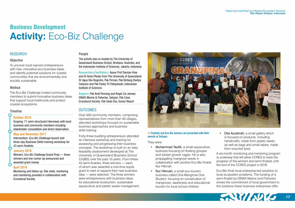
1 Finalists and Eco-Biz winners are presented with their awards at Selayar.
RESEARCH
ObjectiveTo uncover local nascent entrepreneurs with new, innovative eco-business ideas and identify potential solutions for coastal communities that are environmentally and socially sustainable.
MethodThe Eco-Biz Challenge invited community members to submit innovative business ideas that support local livelihoods and protect coastal ecosystems.
Timeline
October 2016Scoping: 71 semi-structured interviews with local business and community members including stakeholder consultation and direct observation
May and November 2017Intervention: Eco-Biz Challenge launch and three-day Business Skills training workshop for 43 semi-finalists
January 2018Winners: Eco-Biz Challenge Grand Final — three winners and one runner-up announced and awarded grant money
April 2018Monitoring and follow up: Site visits, mentoring and monitoring provided in collaboration with Econatural Society
PeopleThe activity was co-hosted by The University of Queensland Business School, Brisbane, Australia, and the Indonesian Institute of Sciences, Jakarta, Indonesia
Researchers/facilitators: Assoc Prof Damian Hine and Dr Anna Phelan from The University of Queensland; Dr Agus Eko Nugroho, Pak Firman, Pak Bintang Dwitya Cahyono and Pak Panky Tri Febiyansah, Indonesian Institute of Sciences
Support: Pak Andi Penrang and Regal Zul Janwar, DINAS Marine & Fisheries, Selayar; Pak Cawi, Econatural Society; Pak Gede Eka, Sunari Resort
OUTCOMESOver 500 community members, comprising representatives from more than 40 villages, attended workshops focused on sustainable business approaches and business skills training.
Forty-three budding entrepreneurs attended an intensive workshop and training for assessing and progressing their business concepts. The workshop is built on an idea feasibility assessment developed at The University of Queensland Business School (UQBS) over the past 10 years. From these 43 semi-finalists, three winners — each of whom was awarded a one-time equity grant to start or expand their new business idea — were selected. The three winners were entrepreneurs with business ideas for educational ecotourism, sustainable aquaculture and plastic waste management.
They were:
• Muhammad Taufik; a small aquaculture business focusing on floating grouper and lobster grower cages. He is also propagating mangrove seeds in collaboration with another Eco-Biz finalist Nur Hikmah
• Nur Hikmah; a small eco-tourism business called One Mangrove One Student, focusing on conservation of mangroves, awareness and educational tourism for local school children
• Dita Azzahrah; a small gallery which is focused on products, including handicrafts, made from plastic waste, as well as bags and small tables, made from recycled tyres.
A six-month monitoring and mentoring program is underway that will allow CCRES to track the progress of the winners and semi-finalists until the end of the CCRES project in 2018.
Eco-Biz finds local enterprise-led solutions to local ecosystem problems. The funding of a semi-finalist by DINAS Marine and Fisheries shows the commitment of local government to the solutions these business enterprises offer.

Capturing Coral Reef and Related Ecosystem Services Site Report Selayar, Indonesia
18
1 Forty-three semi-finalists attended the four-day Eco-Biz Challenge business skills training workshop at Selayar, Indonesia.
7 The three Eco-Biz winners, Muhammad Taufik, Nur Hikmah and Dita Azzahrah.Photos: A. Phelan
THE OUTPUTSThe output from this activity is a business plan competition, including business skills training to encourage businesses that are environmentally and socially sustainable.
This output comprises:
• A business plan competition
• Business skills training
• A Facilitators’ Kit that contains all materials needed to deliver the competition plan and the business skills training (background, logistics, training and participants’ materials)
The tool can be used anywhere where communities need to expand the pool of local talent, knowledge and creativity, in order to find and incubate eco-friendly business ideas, and boost enterprise development.
Resources for the Eco-Biz Challenge can be downloaded as PowerPoint and PDF files (viewed in Acrobat Reader) from http://ccres.net/resources/ccres-tool/eco-biz-challenge
For inquiries about the research, findings, outputs, data or technical support, contact Prof Damian Hine [email protected] or Dr Anna Phelan [email protected]
Business Development
Activity: Eco-Biz Challenge (cont.)
Capturing Coral Reef and Related Ecosystem Services Site Report Selayar, Indonesia
19
RESEARCH
ObjectiveTo develop a process that facilitates the sourcing, matching and implementing of business enterprise solutions for a particular site using successful national or global examples from other sites.
MethodThe Ecosystem-based Business Development (EbBD) workshop showcased successful examples of small-scale fisheries, sustainable tourism, and value-added products. The strategy sessions focused on value creation across the supply chain; small business enterprise skills; linking ecosystem services to a strong sense of place and destination image; innovative, sustainable, ‘out-of-the-box’ ideas; and successful case studies. Participants were
encouraged to participate in discussions and share different views and perspectives.
Timeline
October 2016Scoping: Semi-structured interviews with local business and community members, including stakeholder consultation and direct observation
May 2017Intervention: Four-day Ecosystem-based Business Development workshop; attended by local, regional and international guest speakers and more than 400 community members and stakeholders
April 2018Monitoring and follow up: Site visits, mentoring and monitoring, in collaboration with Econatural Society
PeopleThe activity was co-hosted by The University of Queensland Business School and the Indonesian Institute of Sciences
Researchers/facilitators: Assoc Prof Damian Hine and Dr Anna Phelan, The University of Queensland; Dr Agus Eko Nugroho, Pak Firman, Pak Bintang Dwitya Cahyono and Pak Panky Tri Febiyansah, Economic Research Centre at Indonesian Institute of Sciences
Support: Pak Andi Penrang and Regal Zul Janwar, DINAS Marine & Fisheries, Selayar; Pak Cawi, Econatural Society; Pak Gede Eka, Sunari Resort
OUTCOMESEbBD is an innovative approach to business development that uses ecosystem services and biodiversity as part of an overall sustainable development strategy.
THE OUTPUTSThe output from this research is a thinking process designed to help identify enterprise-led solutions that share value along the supply chain and do not cause damage to the environment.
This output comprises an:
• Ecosystem-based business development workshop; and an
• Ecosystem-based business development approach workbook.
The EbBD approach for coastal communities is used when there is a need to increase the local capacity for knowledge and business skills to help address local economic and environmental challenges. Resources for the EbBD approach can be downloaded as PowerPoint and PDF files (viewed in Acrobat Reader) from http://ccres.net/resources/ccres-tool/ebbd.
THE DATAThe research data is stored by CCRES. Inquiries about the raw data can be made to the Business Development Component Leader Prof Damian Hine [email protected]
LOOKING AHEADThe content and approach of the EbBD workshop aligns with the Indonesian Government’s policy direction on linking local economies and improving supply chains across the archipelago.
The business development team is monitoring the uptake of this more integrated approach to small-scale fisheries management, shortening the supply chains of value-added products and promoting the role of women in artisanal fisheries, and, if required, will provide assistance with the development of the Selayar Destination Management Plan.
For inquiries about the research, findings, outputs, data or technical support, contact Prof Damian Hine [email protected] or Dr Anna Phelan [email protected]
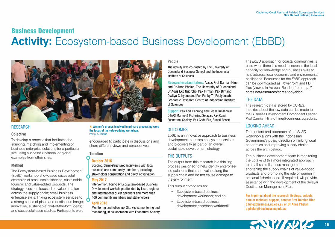
1 Women’s groups involved in primary processing were the focus of the value-adding workshop.Photo: A. Phelan
Business Development
Activity: Ecosystem-based Business Development (EbBD)
Capturing Coral Reef and Related Ecosystem Services Site Report Selayar, Indonesia
20
Behaviour Change
Activity: FishCollab
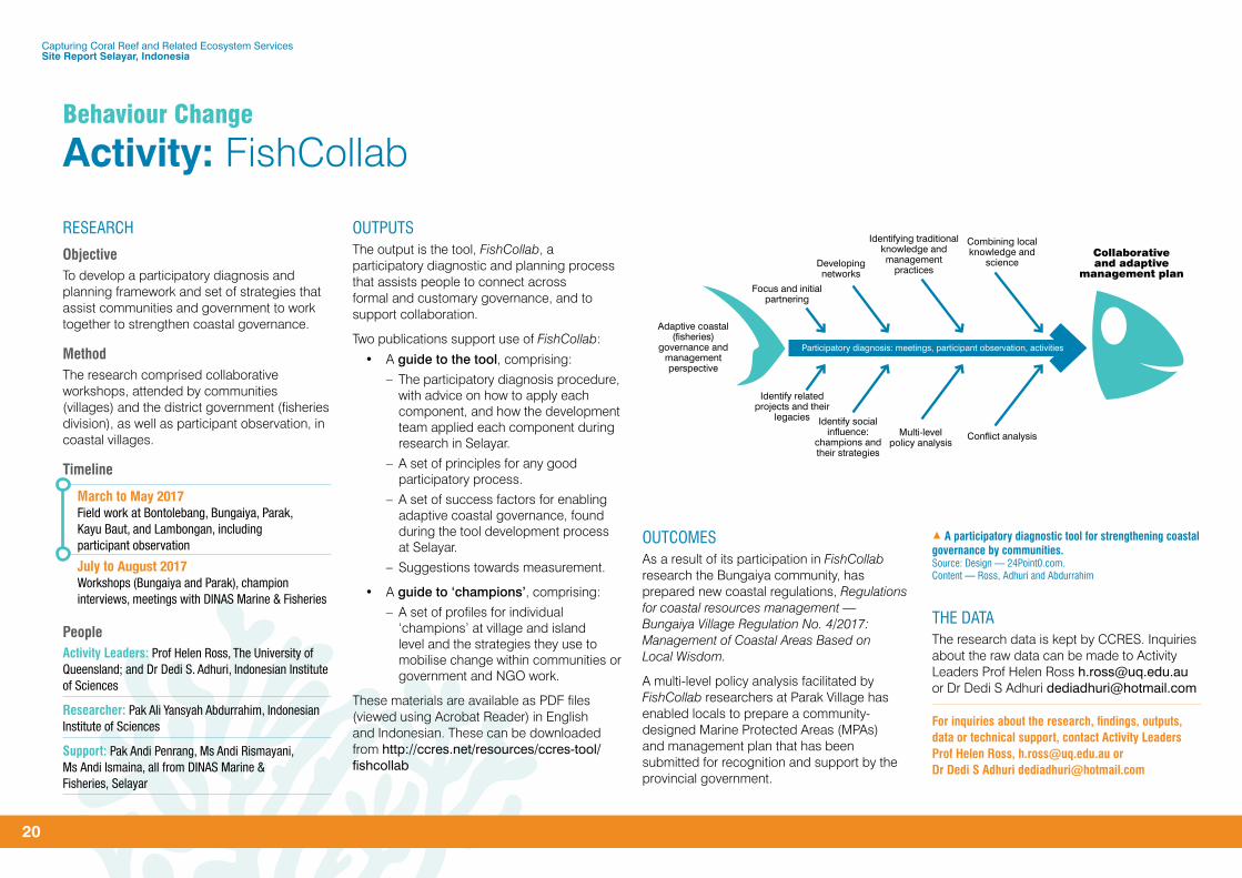
Developing networks
Focus and initial partnering
Identifying traditional knowledge and management
practices
Collaborative and adaptive
management plan
Participatory diagnosis: meetings, participant observation, activities
Adaptive coastal (fisheries)
governance and management perspective
Participatory Diagnostic Tool
Combining local knowledge and
science
Identify social influence:
champions and their strategies
Identify related projects and their
legacies
Multi-level policy analysis
Conflict analysis
OUTPUTSThe output is the tool, FishCollab, a participatory diagnostic and planning process that assists people to connect across formal and customary governance, and to support collaboration.
Two publications support use of FishCollab:
• A guide to the tool, comprising:
– The participatory diagnosis procedure, with advice on how to apply each component, and how the development team applied each component during research in Selayar.
– A set of principles for any good participatory process.
– A set of success factors for enabling adaptive coastal governance, found during the tool development process at Selayar.
– Suggestions towards measurement.
• A guide to ‘champions’, comprising:
– A set of profiles for individual ‘champions’ at village and island level and the strategies they use to mobilise change within communities or government and NGO work.
These materials are available as PDF files (viewed using Acrobat Reader) in English and Indonesian. These can be downloaded from http://ccres.net/resources/ccres-tool/fishcollab
OUTCOMESAs a result of its participation in FishCollab research the Bungaiya community, has prepared new coastal regulations, Regulations for coastal resources management — Bungaiya Village Regulation No. 4/2017: Management of Coastal Areas Based on Local Wisdom.
A multi-level policy analysis facilitated by FishCollab researchers at Parak Village has enabled locals to prepare a community-designed Marine Protected Areas (MPAs) and management plan that has been submitted for recognition and support by the provincial government.
THE DATAThe research data is kept by CCRES. Inquiries about the raw data can be made to Activity Leaders Prof Helen Ross [email protected] or Dr Dedi S Adhuri [email protected]
For inquiries about the research, findings, outputs, data or technical support, contact Activity Leaders Prof Helen Ross, [email protected] or Dr Dedi S Adhuri [email protected]
RESEARCH
ObjectiveTo develop a participatory diagnosis and planning framework and set of strategies that assist communities and government to work together to strengthen coastal governance.
MethodThe research comprised collaborative workshops, attended by communities (villages) and the district government (fisheries division), as well as participant observation, in coastal villages.
Timeline
March to May 2017Field work at Bontolebang, Bungaiya, Parak, Kayu Baut, and Lambongan, including participant observation
July to August 2017Workshops (Bungaiya and Parak), champion interviews, meetings with DINAS Marine & Fisheries
PeopleActivity Leaders: Prof Helen Ross, The University of Queensland; and Dr Dedi S. Adhuri, Indonesian Institute of Sciences
Researcher: Pak Ali Yansyah Abdurrahim, Indonesian Institute of Sciences
Support: Pak Andi Penrang, Ms Andi Rismayani, Ms Andi Ismaina, all from DINAS Marine & Fisheries, Selayar
1 A participatory diagnostic tool for strengthening coastal governance by communities.Source: Design — 24Point0.com.Content — Ross, Adhuri and Abdurrahim
– Rog

Capturing Coral Reef and Related Ecosystem Services Site Report Selayar, Indonesia
21
Behaviour Change
Activity: My Future, My Oceans
THE RESEARCH
ObjectiveTo analyse the needs, values, levers and drivers for fostering sustainable behaviours among individuals and households and to develop a program for promoting a positive environmental behaviour.
MethodMy Future, My Oceans was designed using proven evidence-based behavioural strategies, together with input from local stakeholders and beneficiaries in tailoring the program specifically to their needs. The activity comprised five steps: 1. Behavioural diagnosis (surveys and focus groups, 2. Program design (strategies and tools), 3. Capacity-enhancing (training of local facilitators), 4. Implementation (participant workshop), and 5. Evaluation (surveys).
Timeline
November 2016Scoping: 105 surveys, nine focus groups at three villages — Bontolebang, Tile-Tile and Bungaiya
May 2017Intervention: Workshop facilitation, capacity-enhancing with 48 adult women (village heroes); Bontolebang on the island of Pasi Gusung
September 2017Evaluation: Surveys at two villages Bontolebang (pilot) and Patilereng (control)
PeopleActivity Leader: Erik Simmons, The University of Queensland
Trainer: Paula Bradley, PJ Bradley Consulting, Australia
Facilitators: Ibu Andi Eti, Ibu Gita, Ibu Jumniaty and S Ibu Sunarty, Bontolebang
Participants: 48 adult women from the village of Bontolebang
Support: Ibu Yuni Kumolororas CCRES Coordinator, Indonesia; Pak Andi Penrang, Pak Zul Janwar, Ms Andi Rismayani, Ms Andi Ismaina, all from DINAS Marine & Fisheries, Selayar
THE FINDINGSParticipants improved on the six core psychological competencies and behaviours targeted by the pilot program: perceived plastic collection; problem solving skills; checking whether the fish participants consumed were caught safely or by destructive methods; perceived responsibility for the state of the environment; life satisfaction; and perceived impact of actions on the environment.
THE OUTPUTSThe data collected was used to develop the tool, My Future, My Oceans, a low-cost process of behavioural diagnosis and capacity enhancing for promoting behaviour change.
1 My Future, My Oceans local and international team members with village heroes at Bontolebang, Selayar, Indonesia.Photo: L. Izquierdo
The tool will be used at two more villages — Parak and Padang — at Selayar, during July 2018.
The My Future, My Oceans tool comprises:
• Participant workbook
• Facilitator guidebook
• Project management guidebook (English only)
Materials are available as PDF files in English and Indonesian. These can be downloaded from www.ccres.net/resources/ccres-tool/my-future-my-oceans
THE DATAThe research data is kept at The University of Queensland. Inquiries about the raw data can be made to Activity Leader Erik Simmons, My Future, My Oceans. [email protected]
LOOKING AHEADFrom July to October 2018 Mr Erik Simmons is collaborating with Dr Anna Phelan on a pilot program at Selayar that runs the My Future, My Oceans program in conjunction with the Waste2Enterprise workshop developed by the Ecosystem-based Business Development activity.
The findings from this work will be shared at regional and international conferences attended by government officials, community organisations and behavioural scientists, as well as project managers working on technical projects funded by The World Bank and the Global Environment Facility.
For inquiries about the research, findings, outputs, data or technical support, contact Erik Simmons, Activity Leader, My Future, My Oceans [email protected]
Capturing Coral Reef and Related Ecosystem Services Site Report Selayar, Indonesia
22
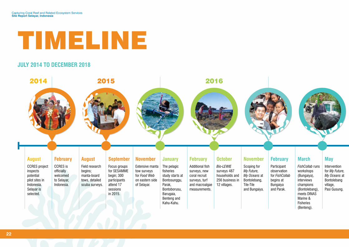
2014 2015 2016 2017 2018
AugustCCRES project inspects potential pilot sites in Indonesia. Selayar is selected.
FebruaryCCRES is officially welcomed to Selayar, Indonesia.
AugustField research begins; manta-board tows, detailed scuba surveys.
SeptemberFocus groups for SESAMME begin; 300 participants attend 17 sessions in 2015.
NovemberExtensive manta tow surveys for Food Web on eastern side of Selayar.
JanuaryThe pelagic fisheries study starts at Bontosunggu, Parak, Bontoborusu, Barugaia, Benteng and Kahu-Kahu.
February Additional fish surveys, new coral recruit surveys, turf and macroalgae measurements.
October Bio-LEWIE surveys 487 households and 256 business in 12 villages.
NovemberScoping for My Future, My Oceans at Bontolebang, Tile-Tile and Bungaiya.
FebruaryParticipant observation for FishCollab begins at Bungaiya and Parak.
MarchFishCollab runs workshops (Bungaiya), interviews champions (Bontolebang), meets DINAS Marine & Fisheries (Benteng).
May Intervention for My Future, My Oceans at Bontolebang village, Pasi Gusung.
MayThe Eco-Biz Challenge is launched; representatives from more than 40 villages attend.
JuneA five-day interactive Ecosystem-based Business Development (EbBD) workshop is held.
JulyCCRES showcases, test tools at the Tools Forum, Benteng, Selayar.
July Surveys, interviews, focus group discussions (FGDs) for Reef React start.
July Parak and Bungaiya communities work with FishCollab and a marine planning expert on MPAs and coastal regulations.
SeptemberEvaluation for My Future, My Oceans at two villages Bontolebang (pilot) and Patilereng (control).
OctoberA business skills workshop for Eco-Biz Challenge semi-finalists is held at Benteng.
JanuaryEco-Biz Challenge Grand Final – three winners and one runner-up are announced.
January The first Waste to Enterprise (W2E) plastics workshop is held at Selayar.
February Selayar officials attend training workshops for CCRES tools at Makassar.
April CCRES runs waste management clinic at Tinabo Island, Taka Bonerate.
JulyLocal decision-makers, community leaders attend CCRES Closing Event.
TIMELINEJULY 2014 TO DECEMBER 2018

Capturing Coral Reef and Related Ecosystem Services Site Report Selayar, Indonesia
23
2014 2015 2016 2017 2018
AugustCCRES project inspects potential pilot sites in Indonesia. Selayar is selected.
FebruaryCCRES is officially welcomed to Selayar, Indonesia.
AugustField research begins; manta-board tows, detailed scuba surveys.
SeptemberFocus groups for SESAMME begin; 300 participants attend 17 sessions in 2015.
NovemberExtensive manta tow surveys for Food Web on eastern side of Selayar.
JanuaryThe pelagic fisheries study starts at Bontosunggu, Parak, Bontoborusu, Barugaia, Benteng and Kahu-Kahu.
February Additional fish surveys, new coral recruit surveys, turf and macroalgae measurements.
October Bio-LEWIE surveys 487 households and 256 business in 12 villages.
NovemberScoping for My Future, My Oceans at Bontolebang, Tile-Tile and Bungaiya.
FebruaryParticipant observation for FishCollab begins at Bungaiya and Parak.
MarchFishCollab runs workshops (Bungaiya), interviews champions (Bontolebang), meets DINAS Marine & Fisheries (Benteng).
May Intervention for My Future, My Oceans at Bontolebang village, Pasi Gusung.
MayThe Eco-Biz Challenge is launched; representatives from more than 40 villages attend.
JuneA five-day interactive Ecosystem-based Business Development (EbBD) workshop is held.
JulyCCRES showcases, test tools at the Tools Forum, Benteng, Selayar.
July Surveys, interviews, focus group discussions (FGDs) for Reef React start.
July Parak and Bungaiya communities work with FishCollab and a marine planning expert on MPAs and coastal regulations.
SeptemberEvaluation for My Future, My Oceans at two villages Bontolebang (pilot) and Patilereng (control).
OctoberA business skills workshop for Eco-Biz Challenge semi-finalists is held at Benteng.
JanuaryEco-Biz Challenge Grand Final – three winners and one runner-up are announced.
January The first Waste to Enterprise (W2E) plastics workshop is held at Selayar.
February Selayar officials attend training workshops for CCRES tools at Makassar.
April CCRES runs waste management clinic at Tinabo Island, Taka Bonerate.
JulyLocal decision-makers, community leaders attend CCRES Closing Event.

Capturing Coral Reef and Related Ecosystem Services Site Report Selayar, Indonesia
24
THE FUTURE SELAYAR TODAY, THE WORLD TOMORROW
The goal of the CCRES project is to assist communities and government sustain the services provided by coral reefs, fisheries, mangrove forests and seagrass beds.
This assistance for coastal policy-makers, planners and managers is in the form of a set of technical tools for:
1 Engaging communities in the decision-making process and improved governance
2 Identifying desirable trajectories for communities and potential obstacles and opportunities
3 Designing marine plans explicitly to improve reef fisheries productivity and biomass
4 Factoring in the role of coral reefs in protecting coastal infrastructure into decision-making
5 Fostering entrepreneurship in marine-related, sustainable business enterprises
6 Raising awareness of the value of coastal ecosystems to livelihoods and human welfare
7 Promoting and empowering positive changes in community behaviour
The tools assist users to sustain coastal ecosystem services (such as food security, tourism, water filtration and coastal protection) that are essential for the health of oceans, people and economies.
In the future it is envisaged the CCRES tools will be used beyond Selayar and Indonesia. Already, they are being used for coastal resource management training and planning across Indonesia (see map, next page).
CCRES is talking with prospective partners in East Asia, the Middle East and the Pacific, and planning for a global rollout of the tools in developing countries post-2018 is underway.
The results from the activities at Selayar demonstrate that the tools can be used individually to address a specific challenge in coastal development or collectively to build a system-wide solution.
Based on work at Bungaiya and Parak, it is now clear that when different CCRES tools are used collectively to solve a coastal management problem, better outcomes can be achieved.
It is this conclusion from the work at Selayar that inspires the CCRES project’s mission to drive high-impact, community-driven coastal development in low-resource settings worldwide.
The selection of Selayar as the pilot site in Indonesia, together with the support of the local community and in-country partners, leaves a legacy for future generations of which the Regency of Selayar, the Selayarese people and the CCRES project can be proud.
1 The decisions made using CCRES tools promise to improve the lives of future generations of the Selayarese people.Photo: A. Hooten

25
Capturing Coral Reef and Related Ecosystem Services Site Report Selayar, Indonesia
3 The CCRES tools are already being used for coastal resource management training and planning across Indonesia.
TOOLS FORUMS & WORKSHOPS
TOOLS UPTAKE AND APPLICATION
TRAINING WORKSHOPS
El Nido
Makassar South Sulawesi
Dramaga, West Java
Jakarta
SINGAPORE
Mindanao
Da Nang
Manila
Puerto Princesa, Palawan
BaliBogor
Ambon
Kupang
INDONESIA
PHILIPPINES
SRI LANKA
VIET NAM
Maluku Barat Daya (Forgotten Island)
KKP3k Kabupaten Maluku Tenggara Barat (Tanimbar)
Banggai
Konawe KepulauanBombana
Buton
Buton Selatan
MunaKolaka
Kolaka UtaraSawai Bay
Kur Tam Tayando
Sulawesi Tengah
Nusa Tenggara Barat Nusa Tenggara Timur
Sulawesi Selatan
Sulawesi Tenggara MalukuKendari
Buton Tengah
Selayar
The Capturing Coral Reef and Related Ecosystem Services (CCRES) project is a regional technical support project that unlocks new, sustainable income streams for coastal communities in the East Asia-Pacific region. CCRES has developed knowledge products — which inform the design of global, regional and national projects, plans and policies — and technical models and planning tools which assist users to strengthen community-based coastal resource management.
CONNECT WITH US
CAPTURING CORAL REEF AND RELATED ECOSYSTEM SERVICES
Join our community @CCRESnet
ccresnet
Contact Dr Liz Izquierdo Project Manager T: +61 7 3443 3144 E: [email protected] www.ccres.net
Photo: M. Paterson