Embed Size (px)
Citation preview

USHERENKO RESIDENCE POOL9 WINKLER FARM ROAD
TOWN OF NORTH CASTLEWESTCHESTER COUNTY
NEW YORK
AERIAL IMAGESCALE: 1" = 100'
113 SMITH AVENUE MOUNT KISCO, NEW YORK 10549T: (914) 241-2235 F: (914) 241-6787
WWW.KCGENGINEERS.COM
*SITE

PO
OL
N
7
5
°
4
0
'0
0
"
W
2
2
7
.0
5
F
T
S
7
5
°
4
0
'0
0
"
E
2
6
9
.6
7
F
T
N
5
7
°
0
0
'
0
0
"
E
3
3
6
.
2
0
F
T
4
4
.5
3
F
T
S
2
7
°
0
0
'
0
0
"
W
6
1
5
.
1
1
F
T
3
3
0
.0
0
F
T
106771 SqFt
2.451 Acres
1
5
"
C
.
M
.
P
.
1
2
3
7
8
9
P
O
S
T
&
R
A
IL
F
E
N
C
E
S
T
O
C
K
A
D
E
F
E
N
C
E
S
T
O
C
K
A
D
E
F
E
N
C
E
ST
ON
E W
ALL
C
O
N
C
W
A
L
K
A
S
P
H
A
L
T
D
R
I
V
E
GRANITE
CURB
3
4
19
1
4
N/F TROTTA
20
C.B.
LAMP
LAMP
LAMP
LAMP
LAMP
LAMP
LAMP
LAMP
LAMP
LAMP
M
.S
. P
IE
R
POND
A
S
P
H
A
L
T
D
R
IV
E
W
A
Y
R=55.00 FT
D = 30°52'11"
L = 29.63 FT
R=25.00 FT
D=17°42'08"
L=7.72 FT
W
E
T
L
A
N
D
S
F
L
A
G
S
18
10
PROPOSED 18' x 36' POOL WITH14" COPING AND AUTOMATIC POOL COVER
50'
RADIUS
30.0'
50'
REAR YARD SETBACK
30'
SID
E Y
AR
DSE
TB
AC
K
30'SIDE YARDSETBACK
100'
REGULATED SETBACK
CF
CF
CF
CF
CF
CF
CF
CF
CF
SFCF
CF
CF
CF
CF
CF
CF
35'
SETBACK
S.S.
PROPOSED POOL EQUIPMENT PAD
SF
SF
SF
+378.0
+377.0
+375.0
378.0 +
+378.0
378.0 +
PROPOSED POOL DRAWDOWN SYSTEM
PROVIDE 4 CULTEC RECHARGERMODEL 150XLD, PLACE ON 6" BED OF
3/4" - 1" WASHED GRAVELD
r
T
P
1
CONTRACTOR TO EXPOSE EXISTING SEPTIC TANK, PUMP CHAMBERAND EMERGENCY OVERFLOW TANK PRIOR TO CONSTRUCTION
TANKS SHALL BE PROTECTED WITH MULCH AND MATTINGAT ACCESS CROSSING OF EFFLUENT PIPING
EXISTING SEPTIC SYSTEMAS PER WCDOH FILE
INSTALL ORANGE MESH CONSTRUCTION FENCEALONG EDGE OF DRIVEWAY TO CORDON OFF
REGULATED AREA FROM CONSTRUCTION ACTIVITY
NO PARKING OF VEHICLES OR STORAGE OF MATERIALSHALL OCCUR BEYOND FENCING DURING CONSTRUCTION
PROPOSED LIMIT OF DISTURBANCEASSOCIATED WITH CONSTRUCTION OF
POOL AND TERRACE.
AREA = 9,300 SF
PROPOSED 10' WIDE CONSTRCTUION ACCESSINSTALL GRAVEL ANTI-TRACKING PAD
AT ENTRANCE DURING CONSTRUCTION
CONTRACTOR STAGING AND MATERIALSTORAGE AREA OUTSIDE OF REGULATED AREA
EXISTING WELL
WELL TO BE PROTECTED DURING CONSTRUCTIONCONTRACTOR TO VERIFY LOCATION OF WELL LINE AND
UTILITY CONNECTION PRIOR TO START OF CONSTRUCTION
PROPOSED WETLAND BUFFER MITIGATION AREALAWN AREA TO BE REMOVED AND
REPLACED WITH BUFFER PLANTINGSREFER TO PLANTING PLAN PREPARED BY
LANDSCAPE ARCHITECT
EXISTING DECKTO BE REMOVED
PROVIDE SILT FENCE DOWNHILL TOCORDON OFF EXISTING SEPTIC AREA
PROPOSED 3'-0" HIGH STONEWALLT.O.W. = 377.0B.O.W. = 375.0
PROPOSED 4'-0" HIGH, NON CLIMBABLEPOOL FENCE
MAINTAIN 35' SEPARATION DISTANCETO FUTURE SYSTEM EXPANSION AREAAS PER WCDOH FILE NO. 94 NC-01DATED 1/10 /94
PROPOSED TERRACE
TEMPORARY SOIL STOCK PILE AREA
PORTION OF DECKTO REMAIN
ALL DISTURBED AREAS SHALL BERESTORED WITH TOPSOIL AND SEED
UPON COMPLETION OF POOL CONSTRUCTION
EXISTING SEPTIC SYSTEM SHALL BE CORDONED OFFWITH ORANGE MESH CONSTRUCTION FENCE
TO PROTECT SYSTEM DURING CONSTRUCTION OF POOL
Gate
Gate
POOL DRAWDOWN VOLUME TO BE PUMPED TO SYSTEM
PROPOSED 2" PVC FORCE MAIN FOR POOLDRAWDOWN TO MITIGATION SYSTEM
TOWN REGULATED WETLAND LIMIT LINE
SITE PLAN
USHERENKO RESIDENCE POOL9 WINKLER FARM ROAD
TOWN OF NORTH CASTLEWESTCHESTER COUNTY, NEW YORK
REVISIONS
NO. DATE
1
BY DESCRIPTION
PLAN SCALE: 1"= 40' PETER J. GREGORY, P.E. LIC. # 071226
1/7/2016
MAG CHECKED BY:
DATE: SHEET:
DRAWN BY:
113 SMITH AVENUE MOUNT KISCO, NEW YORK 10549T: (914) 241-2235 F: (914) 241-6787
WWW.KCGENGINEERS.COM
2
3
4
5
PJG
LOCATION MAPNOT TO SCALE
"UNAUTHORIZED ALTERATIONS OR ADDITIONS TO THIS DRAWING IS AVIOLATION OF SECTION 7209 (2) OF THE NEW YORK STATE EDUCATION LAW"
ZONING DATA
TAX MAP DESIGNATION
ZONING DISTRICT
LOT AREA
WIDTH
DEPTH
FRONT YARD
SIDE YARD
REAR YARD
ACRES
FT.
FT.
FT.
FT.
FT.
MINIMUM
REQUIREMENTSEXISTING
2.00
150
150
50
30
50
SECTION 95.01 BLOCK 2 LOT 77
R-2A ONE FAMILY RESIDENCE DISTRICT (2 ACRES)
185.67
FRONTAGE FT. 150
HEIGHT FT. 30
ACCESSORY
540.25
29.63
2.451
-
120.35'
30.0'*52.50'
42.25'
276.85'
PROJECT NOTES
1. OWNER/APPLICANT:BORIS USHERENKO9 WINKLER FARM ROADBEDFORD, NEW YORK 10506
2. PROJECT SITE ADDRESS:
9 WINKLER FARM ROADNORTH CASTLE (T)
3. SURVEY INFORMATION FROM:
MATTHEW A. NOVIELLO, P.E. L.S.CONSULTING ENGINEERING AND LAND SURVEYING77 HUGHSON ROADCARMEL, NEW YORK 10512(845) 225-4004
4. TOWN OF NORTH CASTLE TAX MAP INFORMATION:
SECTION: 95.01 BLOCK: 2 LOT: 77
TOTAL AREA OF PARCEL = 2.451 ACRES
TOWN OF NORTH CASTLE ZONING DISTRICT: R-2A
FIRE DISTRICT - BANKSVILLE FIRE SCHOOL DISTRICT - BYRAM HILLS
5. WATERSHED BASIN: LONG ISLAND SOUND - MIANUS RIVER BASIN
MAX EXTERIOR WALL HT. FT. 38
(POOL)(DWELLING)
TOTAL LOT AREA MAX PERMITTED
106,771 SF 16,244 SF
GROSS LAND COVERAGE CALCULATIONS
GROSS LANDCOVERAGE
13,942 SF
CONSTRUCTION NOTES
1. THE TOTAL AREA OF DISTURBANCE ASSOCIATED WITH THE CONSTRUCTION OF THE SWIMMING POOL, POOL TERRACE, TEMPORARY CONSTRUCTION ACCESS AND POOL DRAWDOWN SYSTEM IS 9,300 S.F.
2. THE CONSTRUCTION OF THE PROPOSED POOL AND TERRACE WILL NOT REQUIRE THE REMOVAL OF ANY TREES. TWO (2) TREES WILL BE REMOVED AS A RESULT OF THE LANDSCAPE SCREENING.
3. THE CONSTRUCTION OF THE PROPOSED POOL, TERRACE AND STORMWATER SYSTEM WILL NOT DISTURB ANY TOWN DESIGNATED STEEP SLOPE AREAS.
4. THE CONSTRUCTION OF THE PROPOSED POOL, TERRACE AND STORMWATER SYSTEM WILL DISTURB 1,300 SF OF REGULATED WETLAND BUFFER AREA.
TOWN OF NORTH CASTLE NOTES
1. INSPECTION OF EROSION CONTROLS BY THE TOWN ENGINEER ISREQUIRED PRIOR TO ANY EXCAVATION.
2. ALL SUBSURFACE DRAINAGE FACILITIES SHALL BE INSPECTED PRIORTO BACKFILLING BY THE TOWN ENGINEER.
3. PUBLIC ROADWAYS AND COMMON DRIVEWAY SHALL BE PROTECTEDFROM MACHINERY AND DEBRIS.
4. ANY CHANGES, ALTERATIONS, AND/OR MODIFICATIONS SHALL BEREVIEWED AND APPROVED BY THE BUILDING INSPECTOR AND/ORTOWN ENGINEER, PRIOR TO PERFORMING SUCH WORK.
* VARIANCE REQUIRED
SITE
*
2/16/16 MAG RPRC
2/17/16 PJG ZBA APPLICATION
3/31/16 PJG TERRACE & DECK
4/11/16 MAG PLANNING BOARD

CONSTRUCTION DETAILS
USHERENKO RESIDENCE POOL9 WINKLER FARM ROAD
TOWN OF NORTH CASTLEWESTCHESTER COUNTY, NEW YORK
REVISIONS
NO. DATE
1
BY DESCRIPTION
PETER J. GREGORY, P.E. LIC. # 071226
3/31/2016
MAG CHECKED BY:
DATE: SHEET:
DRAWN BY:
113 SMITH AVENUE MOUNT KISCO, NEW YORK 10549T: (914) 241-2235 F: (914) 241-6787
WWW.KCGENGINEERS.COM
2
3
4
5
PJG
"UNAUTHORIZED ALTERATIONS OR ADDITIONS TO THIS DRAWING IS AVIOLATION OF SECTION 7209 (2) OF THE NEW YORK STATE EDUCATION LAW"
4/11/16 MAG PLANNING BOARD
7"MIN.
4" 3"
18.5"
6"
39"36"12"CULTEC RECHARGER 150HDHEAVY DUTY CHAMBER
4 OZ. NON-WOVEN FILTER FABRICAROUND STONE. TOP AND SIDESMANDATORY.
95% COMPACTED FILL
1-2 INCH DIA. WASHED,CRUSHED STONE
FINISHED GRADE
6" DIA. INSPECTION PORT
33"
LARGE RIB
INSTALLED LENGTH = 90.2
102"
23"
9.6"18.5"
TOP VIEWSIDE VIEW
END VIEW
SCALE: NTS
CULTEC RECHARGER 150HD INFILTRATION CHAMBER
HVLV SFCx2 FEED CONNECTOR
HVLV SFCx2 FEED CONNECTOR
SMALL RIB
HVLV SFCx2 FEED CONNECTOR
PROVIDE 6" DIA. PVC PIPE WITHEND CAP FOR INSPECTION PORT
WHERE INDICATED ON SITE PLAN
INLET PIPE
Construction Joint: Butyl Rubber Sealant
SCALE: NTS
DRAIN INLET DETAIL (TYP.)
24" SUMP
30"
40-3/4"
5-3/8"5-3/8"
6"
CAMPBELL FOUNDRY HEAVY DUTYSTRAIGHT TYPE FRAME,FLAT GRATEMODEL 2813 OR APPROVED EQUAL
REFER TO SITE PLAN FORSIZES & INVERTS OF PIPES.ALL PIPES SHALL BE CUTFLUSH WITH THE INTERIORWALLS OF CATCH BASIN
TO SYSTEM
FINISHED GRADE
PROVIDE 2% MIN PITCH
FINISHED GRADEPROVIDE 2% MIN. PITCH
REINFORCED PRECASTCONCRETE 30" X 30" (I.D.)CATCH BASIN RATED FORH20 LOADING
ALL JOINTS SHALL BESEALED WATERTIGHT
MORTAR EDGE
BRICK LEVELINGCOURSE - 4" MAX
SPECIFICATIONS
Concrete Min. Strength: 4,000 psi at 28 daysReinforcement: #4 Rebar / ASTM A615Air Entrainment: 5%
Load Rating: H20 / ASTM C857
PLACE 6" FOUNDATIONOF 3/4" WASHEDCRUSHED STONE
SIDE VIEW
TOP VIEW
CAMPBELL FOUNDRY HEAVY DUTYSTRAIGHT TYPE FRAME,FLAT GRATEMODEL 2816 OR APPROVED EQUAL
30"
30"40-3/4"
40-3/4"
PLAN VIEW
PROFILE VIEW
CROSS SECTION A-A
A
ORIGINAL GRADE
21
21
6"MIN
.
4"
9"
1'
MIN
.
TOE WALL
1'
6" CRUSHEDSTONE (D50=4")
GRADED AGGREGATE FILTER OR FILTER
EXISTING STABILIZED
FILTER CLOTH ORGRADED AGGREGATE
6" CRUSHEDSTONE (D50=4")
6" CRUSHEDSTONE (D50=4")
W1
L
A
W2
FILTER
CLOTH
CHANNEL
RIP RAP DISSIPATOR AT BOXSCALE: NTS
RIP RAP DISSIPATOR SIZE SCHEDULE
TYPELENGTH (L) WIDTH 1 (W1)
INCHESFEETWIDTH 2 (W2)
INCHES
24"6' 48"BOX OVERFLOW
JOINING SECTIONS OF FENCING
TOE-IN METHOD
SECTION A SECTION B
B A
TOP VIEWBackfill
FLOW
SECTION A
SECTION B
OR EQUAL SUBJECT TO APPROVAL
USE AMCO FABRICS SILT SCREEN
GRADE
NOTE:
BY ENGINEER
TOE-IN-FLAP ONFABRIC 4" TO 6"BELOW GRADEALONGINTENDEDFENCE LINE
HARDWOOD ORMETAL POSTSPACED 10' O.C.MAX. ONDOWNHILL SIDEOF TRENCH
COUPLER
POSTS
SILT FENCE DETAILSCALE: NTS
SURROUNDED WITH SILT FENCING, THEN STABILIZED
3. UPON COMPLETION OF SOIL STOCKPILE, EACH PILE SHALL BE
4. SEE SPECIFICATIONS FOR INSTALLATION OF SILT FENCE
1. AREA CHOSEN FOR STOCKPILING SHALL BE DRY AND STABLE.
2. MAXIMUM SLOPE OF STOCKPILE SHALL BE 1:2.
SLO
PE
INSTALLATION NOTES
WITH VEGETATION OR COVERED.
PILE WITH VEGETATIONOR COVER
SLOPE
1
2 SILT FENCE
STABILIZE ENTIRE
DOWN SLOPE OF WORK AREA SHALL BE IN PLACE AS INDICATED ON
10. PRIOR TO THE COMMENCEMENT OF ANY CONSTRUCTION, ALL SILT FENCING
THE SITE PLAN.
1. THE STANDARD SILT FENCE CONFIGURATION IS RECOMMENDED FOR MOST
APPLICATIONS IN WESTCHESTER COUNTY. EXTRA STRENGTH SYNTHETIC FILTER
FABRIC, OR STANDARD STRENGTH FILTER FABRIC WITH WIRE MESH FENCE
2. THE HEIGHT OF A SILT FENCE SHALL NOT EXCEED 36 INCHES (HIGHER FENCES MAY
IMPOUND VOLUMES OF WATER SUFFICIENT TO CAUSE FAILURE).
3. CONTINUOUS LENGTHS OF FILTER FABRIC SHOULD BE USED TO MINIMIZE THE
SHALL BE SPLICED TOGETHER AT A SUPPORT POST ONLY, WITH A MINIMUM 6-INCH
OVERLAP, AND SEALED SECURELY.
4. POSTS SHALL BE INSTALLED NO LESS THAN SIX FEET APART, AND DRIVEN TO A
MINIMUM DEPTH OF 12 INCHES. POSTS MAY BE SPACED 10 FEET APART IF THE
FILTER FABRIC IS SUPPORTED BY WIRE MESH.
5. WIRE MESH SUPPORT, WHEN USED, SHOULD BE SECURED TO THE POSTS WITH
EXTEND INTO THE TRENCH A MINIMUM OF 2 INCHES.
6. FILTER FABRIC SHALL BE STAPLED OR WIRED TO THE POSTS. STAPLES SHOULD BE
7. FILTER FABRIC SHOULD EXTEND 6 INCHES INTO A TRENCH 4 INCHES WIDE AND 4
INCHES DEEP. THE TRENCH SHALL BE BACK FILLED AND THE SOIL COMPACTED
8. WHEN SILT FENCE LENGTHS EXCEED 100 FEET, EACH 100-FOOT SECTION SHOULD
TERMINATE IN AN END SEGMENT THAT CURVES UP SLOPE TO INTERCEPT
CONCENTRATED RUNOFF. THE "HOOK" SHOULD JOIN AT THE LINEAR PORTION OF
THE NEXT SILT FENCE SEGMENT. THIS DESIGN MAXIMIZES SEDIMENT CAPTURE
AND PREVENTS THE ACCUMULATION OF RUNOFF ALONG THE UP SLOPE SIDE OF
THE SILT FENCE.
9. SILT FENCES SHALL BE MAINTAINED UNTIL ALL UP SLOPE AREAS ARE PERMANENTLY
THE SILT FENCE SHOULD REMAIN IN PLACE UNTIL THE UPLAND CONTRIBUTING AREA IS PERMANENTLY STABILIZED. THE EFFECTIVE LIFE OF A SYNTHETIC FABRIC
RAINFALL, AND AT LEAST DAILY DURING PROLONGED RAINFALL. ALL NECESSARY REPAIRS SHOULD BE MADE IMMEDIATELY. INSPECTIONS FOR PHYSICAL DAMAGE (WHICH MAY RESULT FROM FALLEN BRANCHES, ANIMAL ACTIVITY, VANDALISM, ETC.) SHOULD OCCUR WEEKLY. IF THE FILTER FABRIC DECOMPOSES OR IS
DAMAGED, IT MUST BE REPLACED PROMPTLY. SEDIMENT DEPOSITS SHOULD BE REMOVED AFTER EACH SIGNIFICANT STORM EVENT, OR WHENEVER THE DEPOSITS EXCEED 1/3 THE HEIGHT OF THE BARRIER.
ALL SEDIMENT DEPOSITS REMAINING AFTER REMOVAL OF THE SILT FENCE SHALL BE GRADED AND SEEDED. CONTAMINATED SEDIMENTS SHALL BE DISPOSED OF IN
EXISTING STONE WALLS ARE NOT A SATISFACTORY SUBSTITUTE FOR SILT FENCE IF THERE ARE HOLES OR BREAKS IN THE WALL, OR IF THE WALLS ARE IN DISREPAIR.
ACCORDANCE WITH APPLICABLE REGULATIONS.
HEAVY DUTY 1-INCH WIRE STAPLES, TIE WIRES, OR HOG RINGS; THE WIRE SHALL
SILT FENCE SPECIFICATIONS
SUPPORT MAY BE USED. SILT FENCES SHOULD BE USED ONLY WHERE SHEET
OR OVERLAND FLOWS ARE EXPECTED.
NUMBER OF JOINTS NEEDED. WHEN JOINTS ARE NECESSARY, FILTER FABRIC
PLACED A MINIMUM OF 2 INCHES APART.
OVER THE FILTER FABRIC.
STABILIZED.
TIMING
SILT FENCES SHOULD BE INSTALLED PRIOR TO LAND CLEARING ACTIVITIES ON-SITE.
SILT FENCE IS APPROXIMATELY 6 MONTHS.
MAINTENANCE
SILT FENCES SHOULD BE INSPECTED IMMEDIATELY AFTER EACH SIGNIFICANT
TREE PROTECTION DETAILSCALE: NTS
DRIPLINE
CONSTRUCTIONFENCE
BE PROVIDED AFTER EACH RAIN.
9. PERIODIC INSPECTION AND NEEDED MAINTENANCE SHALL
INTO AN APPROVED SEDIMENT TRAPPING DEVICE.
ON AN AREA STABILIZED WITH STONE AND WHICH DRAINS
WAY. WHEN WASHING IS REQUIRED, IT SHALL BE DONE
SEDIMENT PRIOR TO ENTRANCE ONTO PUBLIC RIGHT OF
8. WASHING - WHEELS SHALL BE CLEANED TO REMOVE
PUBLIC RIGHT OF WAY MUST BE REMOVED THOROUGHLY.
SEDIMENT SPILLED, DROPPED, WASHED OR TRACKED ONTO
OF ANY MEASURES USED TO TRAP SEDIMENT. ALL
AS CONDITIONS DEMAND AND REPAIR AND/OR CLEANOUT
REQUIRE PERIODIC TOP DRESSING WITH ADDITIONAL STONE
OF SEDIMENT ONTO PUBLIC RIGHT OF WAY. THIS MAY
A CONDITION WHICH WILL PREVENT TRACKING OR FLOWING7. MAINTENANCE - THE ENTRANCE SHALL BE MAINTAINED IN
A MOUNTABLE BERM WITH 5:1 SLOPES WILL BE
PIPED ACROSS THE ENTRANCE. IF PIPING IS IMPRACTIBLE,
DIVERTED TOWARD CONSTRUCTION ENTRANCES SHALL BE
6. SURFACE WATER - ALL SURFACE WATER FLOWING OR
NOT BE REQUIRED ON A SINGLE FAMILY RESIDENCE LOT.
AREA PRIOR TO PLACING OF STONE. FILTER CLOTH WILL
5. FILTER CLOTH - WILL BE PLACED OVER THE ENTIRE
FULL WIDTH AT POINTS WHERE INGRESS OR EGRESS
4. WIDTH - 24 FOOT MINIMUM, BUT NOT LESS THAN THE
3. THICKNESS - NOT LESS THAN SIX (6) INCHES.
MINIMUM LENTH WOULD APPLY).
(EXCEPT ON A SINGLE RESIDENCE LOT WHERE A 30 FOOT
2. LENGTH - AS REQUIRED, BUT NOT LESS THAN 50 FEET
CONCRETE EQUIVALENT
1. STONE SIZE - USE 3" STONE OR RECLAIMED OR RECYCLED
INSTALLATION NOTES
PLAN
SECTION A-A
FILTER FABRICSUBGRADE
CLEAN STONE, 3 INCH CRUSHED STONE
FINISH GRADE
BEGIN STABILIZEDENTRANCE ATEXISTING ROADWAY
12' TYP.
30' TYP.
COMPACTED
OCCUR.
PERMITTED.
6" 3/4" GRAVEL STONE
1 1/2" THICK BLUESTONE
SUB BASE
FINISHED GRADE
SUBGRADECOMPACTED
2"
6"
SCALE: NTS
BLUESTONE TERRACE SECTION
WETTED BEDDING 2" 10:1 SAND CEMENT MIX
PITCH 1/4" PER FOOT
6" TOPSOIL
W/ SEED
CLEAN BACKFILL
BOULDERS
4'-0" MAX HEIGHT
12"
BASE COURSE TO BE KEYED12" INTO EXISTING GRADE
GRADEFINISHED
2" PVC FORCE MAINFROM EQUIPMENT PAD

113 SMITH AVENUE MOUNT KISCO, NY 10549
T:(914) 241-2235 F:(914) 241-6787
WWW.KCGENGINEERS.COM Page 1 of 3 7/17/14
Regarding: Usherenko Residence Pool 9 Winkler Farm Road Tax ID : 95.01-2-77 Dear Mr. Kaufman: Attached please find a complete Site Development Plan Application for the construction of a swimming pool at the above referenced property. Based upon the determination of the Residential Project Review Committee meeting held on March 3, 2016, given the environmental constraints of the property and the amount of disturbance associated with the project, this application warrants a review by the Planning Board. Included with this submission please find the following:
1. 8 copies of a Plan Set including Site Plan & Construction Details
2. 8 copies of Landscape Plan providing Screening and Buffer mitigation
3. 8 copies of an Aerial Photograph
4. 8 copies complete Site Development Plan Application including Gross Land Coverage Calculations and a Short Environmental Assessment Form.
5. One copy, reduced size plan set, 11 x 17 format
Plans have been revised to address the comments in RPRC Determination Letter as follows: 1) Construction Details for the proposed pool terrace and pool fence have been
provided. Deck details will be provided by architect.
2) The location of the proposed pool fence has been indicated on the Site Plan.
3) The Site Plan has been revised to indicate the proposed amount of Town-regulated wetland buffer disturbance. The total area of wetland buffer
April 11, 2016
Mr. Adam Kaufman Director of Planning
Town of North Castle 17 Bedford Road
Armonk, New York 10504

WWW.KCGENGINEERS.COM Page 2 of 3 7/21/14
disturbance associated with the construction of the pool, terrace and retaining wall is 1,300 sf.
4) The Site Plan has been revised to indicate the number of trees to be
removed. Two dead trees located along the easterly property line are to be removed as a result of the landscape screening proposed in that location. No trees are being removed as a result of the construction of the proposed pool or terrace.
5) A pool fence detail has been provided on the plan.
6) Construction details have been provided as part of the plan set.
7) The applicant acknowledges that a variance will be required. An application
has been submitted to the Town of North Castle Zoning Board of Appeals and is now awaiting referral from the Planning Board to be considered. As a result of a pre-application meeting it was determined that the property line in question is a rear property line and as such will require a variance for the proposed pool and terrace.
8) While current Westchester County Health Department rules and regulations
require in-ground pools downgrade of septic systems to maintain 50’ separation distance, a construction permit for the installation of the septic system was issued with a future pool respecting a 35’ separation distance to the system. The proposed site plan is consistent with the WCDOH file.
9) Deep hole and percolation tests will be performed with the Town Engineer
observing.
10) Due to the location of the proposed pool, the plan considers offsetting the new impervious surface with existing driveway runoff. A stormwater rain garden is proposed as a mitigation practice for the existing driveway at a comparable area to the proposed impervious surface. A separate pool drawdown system is proposed and is indicated on the plan.
11) Pool drawdown volume is proposed to be pumped from the equipment pad
to the drawdown system. A 2” pvc force main is proposed to convey pool water to the system. The connection between the pool equipment and the drawdown mitigation practice has been provided on the plan.
12) The construction of the proposed pool, terrace and wall will create
disturbance with the locally regulated 100 foot wetland buffer. A wetland permit application has been prepared and submitted to the Town, included with the previously submitted RPRC application. The wetland boundary and regulated 100 foot buffer have been illustrated on the plan. The Town Wetland Consultant will be notified once the boundary has been established in the field.
WWW.KCGENGINEERS.COM Page 3 of 3 7/21/14
13) Mitigation of the buffer disturbance has been provided at a ratio of 2:1. The mitigation totals an area of 2600 sf, two times the area of the buffer disturbance. Mitigation will involve the removal of lawn along the edge of the existing pond on the property and be replaced with native wetland plantings. A planting plan is being provided as part of this application.
The owner respectfully requests to be included on the April 25, 2016 Planning Board agenda for review and consideration to be referred to Zoning Board of Appeals for a request of a rear yard variance. Should you have any questions or require additional information, please do not hesitate to contact me. Very truly yours,
Peter J. Gregory, P.E.

Application for Site Development Plan Approval
Application Name
_______________________________________________________
TOWN OF NORTH CASTLE
WESTCHESTER COUNTY 17 Bedford Road
Armonk, New York 10504-1898
PLANNING DEPARTMENT Adam R. Kaufman, AICP
Director of Planning
Telephone: (914) 273-3542 Fax: (914) 273-3554 www.northcastleny.com

TOWN OF NORTH CASTLE
WESTCHESTER COUNTY 17 Bedford Road
Armonk, New York 10504-1898
PLANNING DEPARTMENT Adam R. Kaufman, AICP
Director of Planning
Telephone: (914) 273-3542 Fax: (914) 273-3554 www.northcastleny.com
Important General Information
Prior to submitting an application, the "Notice to Applicants" should be reviewed.
To appear before the Planning Board, all required application materials shall be submitted not later than 12:00 P.M., Monday, fourteen (14) days prior to the date of the Planning Board meeting at which the application is scheduled to be heard or as otherwise noted by the Planning Board Secretary. Continuing Business can be submitted 12 days prior to the Next Planning Board meeting by the close of business. Except where noted.
If all required application materials, including the pertinent application fee and escrow monies are not submitted by that deadline, the application shall be automatically removed from the agenda.
At the discretion of the Planning Board Chairman, the application may be rescheduled, if appropriate, for the next available Planning Board meeting or the application may be removed from future agendas altogether. Without prior authorization from the Planning Board, application submissions shall not be accepted at Planning Board meetings.
At the time of submission, all required application materials shall be submitted. Piecemeal
submissions shall not be accepted. Substitution of previously submitted materials shall not be permitted.
All submissions shall be dated, with revision dates identified on new submissions.
All submissions shall be accompanied by a cover letter describing the project and/or any
changes as compared to previous submissions.
For distribution purposes and mailing to the Planning Board Members and others (as required), multiple copies of application materials shall be collated into separate sets, each containing one copy of every submitted document. All application materials shall be submitted in a form that fits into a 12" x 17" envelope. Plans shall be folded and rubber banded as necessary.
To be considered complete for Planning Board hearing purposes, an application package shall
contain the information identified in Parts IV and V of this application form.
For purposes of completing this application form, all responses provided shall be printed, except as otherwise specified.

TOWN OF NORTH CASTLE
WESTCHESTER COUNTY 17 Bedford Road
Armonk, New York 10504-1898
PLANNING DEPARTMENT Adam R. Kaufman, AICP
Director of Planning
Telephone: (914) 273-3542 Fax: (914) 273-3554 www.northcastleny.com
x
NOTICE TO APPLICANTS In the Town of North Castle, the Planning Board is responsible for the review and approval of all applications concerning site plans, subdivisions and lot line changes; some applications concerning special use permits, wetlands permits and tree removal permits; and the environmental review of those applications over which it has jurisdiction. The Planning Board may also have an advisory role in connection with some applications before the Town Board, such as those involving other categories of special use permits and zoning amendments. The Planning Board is composed of five volunteer members – all residents of North Castle – who are appointed by the Town Board for five-year terms. As part of the review of some applications, the Planning Board is assisted on an as-needed basis by other lay boards of the Town, such as the Conservation Board (CB), the Zoning Board of Appeals (ZBA), the Open Space Committee and the Architectural Review Board (ARB). As part of the review of most applications, the Planning Board is also assisted by the Director of Planning, the Town Engineer, the Town Attorney and other special consultants when required. FEES: If you submit an application for Planning Board review, you will be required to reimburse the Town for the cost of professional review services, including legal and engineering services, incurred in connection with the review of your application. The charges for professional planning review services have been $120/hour. If other types of professional consultant review services are required, those charges will be in accord with fees usually charged for such services and pursuant to a contractual agreement between the Town and such professional. At the time of submission of an application, the Planning Board will require the establishment of an escrow account from which withdrawals shall be made to reimburse the Town for the cost of consultant fees and professional staff services. ESCROW ACCOUNT: Escrow Accounts are established for each application. Monies will be deducted from the account for professional review services rendered. Monthly escrow disbursement summaries will be mailed for your reference regarding your project. When the balance in such escrow account is reduced to one-third (1/3) of its initial amount, a letter will be mailed to the applicant and the applicant shall deposit additional funds into such account to restore its balance to the amount of the initial deposit. Additional information on these requirements is provided in the North Castle Town Code (see Sections 355-79B and 275-36.C).

TOWN OF NORTH CASTLE
WESTCHESTER COUNTY 17 Bedford Road
Armonk, New York 10504-1898
PLANNING DEPARTMENT Adam R. Kaufman, AICP
Director of Planning
Telephone: (914) 273-3542 Fax: (914) 273-3554 www.northcastleny.com
PROCEDURE: Prior to submitting an application to the Planning Board for review and approval, prospective applicants should schedule an appointment with the Planning Board Secretary at (914) 273-3542 for a consultation with the Town Planner and the Town Engineer. When the appointment is made, a verbal description of the proposal should be provided to the Planning Board Secretary. The Town of North Castle is providing the services of the Director of Planning and the Town Engineer for initial consultation at no cost to the applicant so that it is possible to conduct the application review as efficiently as possible for the benefit of the applicant as well as the Planning Board. After meeting with the Town Planner and Town Engineer, prospective applicants should prepare one complete set of application documents and plans. This set will be reviewed for completeness by the Town Planner. If determined to be incomplete, the Planning Department will submit a checklist indicating which items have not been adequately addressed. If determined to be complete, the checklist will be initialed and the Applicant should submit the remainder of the required application packages.
Once the checklist has been initialed and all application packages have been submitted, the Planning Board Secretary will schedule the application for the first available opening on the Planning Board's meeting agenda. However, if the required application material packages, including the pertinent application fee are not received at the Planning Board office by 12:00 PM, Monday, 14 days prior to the date of the Planning Board meeting at which you are scheduled to appear (or otherwise scheduled by the Planning Board Secretary), your application will be automatically removed from the agenda. At the discretion of the Planning Board Chairman, your application may be rescheduled, if appropriate, for the next available Planning Board meeting or the application may be removed from future agendas altogether. Additional requirements pertinent to each type of application are provided on the individual application forms, which you should carefully review prior to submitting your application.
When an application is deemed complete and submitted for review, it will be forwarded to the Planning Board Members and its professional advisors in advance of the meeting to allow adequate time for review, preparation of written reports and site inspections as necessary. Your application may also be forwarded to other boards and staff of the Town as well as to agencies outside of the Town, if required. Compliance with State Environmental Quality Review (SEQR) procedures is also required as part of the processing of all applications.
At your first appearance before the Planning Board, the Applicant will describe the project and the Planning Board will discuss any preliminary issues. The Planning Board discussion may be continued at future meetings, or if the Planning Board review has progressed sufficiently, the Application may be scheduled for a public hearing (if one is required) The public hearing may occur at a single Planning Board meeting, or it may be adjourned and continued at another Planning Board meeting. Because the nature and complexity of each application varies
TOWN OF NORTH CASTLE
WESTCHESTER COUNTY 17 Bedford Road
Armonk, New York 10504-1898
PLANNING DEPARTMENT Adam R. Kaufman, AICP
Director of Planning
Telephone: (914) 273-3542 Fax: (914) 273-3554 www.northcastleny.com
considerably, it is not possible to predict in advance the length of time needed to secure Planning Board approval. There are certain steps that you can take, however, to expedite the review process. These include, but are not limited to, the following: Be thoroughly familiar with the requirements pertinent to your application. Carefully
review relevant provisions of the North Castle Town Code and the application form for your particular type of application. Be sure to check on what other types of approvals may be required in addition to that of the Planning Board. Approvals by other Town boards or departments as well as agencies outside of the Town may be required before you will be allowed to proceed with your project.
Make sure that your application materials are accurately prepared and contain all required
information. The information that we initially request is required, so make sure that your submission is complete. If supplementary information is requested as the review process continues, make sure that it is submitted in a timely fashion so the Planning Board can continue to move your application along.
Follow up to make sure that your application materials are being submitted on time, or
deliver them to the Planning office yourself.
Attend the Planning Board meeting at which your application will be discussed and be on time for the meeting. If you cannot appear personally, make sure that your representative will be there and is thoroughly familiar with your application.
If the Application is approved by the Planning Board, a resolution of approval will be
adopted by the Planning Board. It is the Applicant’s responsibility to address any and all conditions of approval. Permits from the Building Department cannot be issued until all conditions have been addressed and the plans have been signed by the Planning Board Chair and the Town Engineer.
ON LINE AGENDAS & PLANNING DEPARTMENT MEMORANDA CAN BE REVIEWED AT
WWW.NORTHCASTLENY.COM

TOWN OF NORTH CASTLE
WESTCHESTER COUNTY 17 Bedford Road
Armonk, New York 10504-1898
PLANNING DEPARTMENT Adam R. Kaufman, AICP
Director of Planning
Telephone: (914) 273-3542 Fax: (914) 273-3554 www.northcastleny.com
INFORMATION REGARDING PUBLIC HEARINGS
1. The North Castle Assessor’s Office shall prepare a list of neighbors to be notified for the
neighbor notifications and public hearings - A minimum of one week’s notice is required . The fee is $50.00 which includes the list of neighbors and two sets of labels for mailing. The Assessor’s Office may be reached Monday – Friday from 8:30 a.m.– 4:30 p.m. at 273-3324. You may also e-mail your request to [email protected] When requesting your list please reference the list of application types below so that you can tell the Assessor’s office how many feet on all sides of the property to create the list for.
Subdivisions - All lots zoned R-10, R-5 and R-2F shall notice all neighbors within 200 feet from all sides of their property. All other zoning districts shall notice neighbors within 500 feet from all sides of their property. Public hearing notice must be published in the newspaper. Special Use Permit for Structures over 800 sq ft. & Accessory Apartment - All Zoning Districts shall notice all neighbors within 250 feet from all sides of their property. Public hearing notice must be published in the newspaper. Site Plan, Non Residential - All Zoning Districts shall notice all neighbors within 250 feet from all sides of their property. Public hearing notice must be published in the newspaper. Site Plan, Residential/ Neighbor Notification – All zoning districts R-3/4A or smaller shall notice all neighbors within 250’ from all sides of their property. All zoning districts zoned R-1A or larger shall notice all neighbors within 500’ from all sides of the property. No public hearing required, no publication in the newspaper required. Wetlands Permit - All Zoning Districts shall notice all abutting property owners. Public hearing notice must be published in the newspaper.
2. The Director of Planning will prepare a Public Notice. The applicant and or professional will review, sign, date and return to the Planning Department Secretary. If there are any changes necessary, please edit and return for corrections. The corrections will be made and emailed back to the applicant who will forward it to the Journal Newspaper, when applicable.
If notification to the newspaper is not required, please continue to #3.

TOWN OF NORTH CASTLE
WESTCHESTER COUNTY 17 Bedford Road
Armonk, New York 10504-1898
PLANNING DEPARTMENT Adam R. Kaufman, AICP
Director of Planning
Telephone: (914) 273-3542 Fax: (914) 273-3554 www.northcastleny.com
You may email your public notice to [email protected]. Please request an affidavit of publication which must be submitted to the Planning Board secretary prior to the public hearing. The Journal News requires three days prior notice before 12 noon, not counting weekends and holidays, for ad placement. Make sure the notice placement of the ad in the Greater Westchester Area. This notice cannot be published any sooner than 20 days prior to the meeting and must be published no less than 10 days prior to the meeting.
If you have any questions regarding your publication you may call 888-516-9220: Email Address: [email protected] It is suggested that you purchase the newspaper for your records the day the notice is published.
3. Send out the Public Hearing Notice/ Neighbor Notification by First Class Mail. Notice
shall be mailed by the applicant in official envelopes provided by the North Castle Planning Department; the list of noticed neighbors will be prepared by the Assessor’s Office. This must be sent out no less than 10 days prior to the meeting and no more than 20 days prior to the meeting date. A Certificate of Mailing (PS Form 3817 or 3877) shall be filled out and post marked by the Post Office on the day of mailing. Neighbor Notifications – no publication in the newspaper required.
4. The Friday before the meeting or no later than 12:00 p.m. the day of the meeting the
following must be submitted.
- List of Neighbors prepared by the Assessor’s Office - Certificate of Mailing – PS form 3817 or 3877 post marked by the US Post Office - Affidavit of publication from the Newspaper (only if published in the newspaper)
Name and Address of Sender Check type of mail or service
Affix Stamp Here(if issued as an international certificate of mailing or for additional copies of this receipt).Postmark with Date of Receipt.
£ Adult Signature Required £ Priority Mail Express
£ Adult Signature Restricted Delivery £ Registered Mail
£ Certified Mail £ Return Receipt for Merchandise£ Certified Mail Restricted Delivery
£ Collect on Delivery (COD) £ Signature Confirmation
£ Insured Mail £ Priority Mail
£ Signature Confirmation Restricted Delivery
USPS Tracking/Article Number Addressee (Name, Street, City, State, & ZIP Code™) Postage (Extra Service)
Fee
Handling Charge
Actual Value if Registered
Insured Value
Due Sender if
COD
ASR Fee
ASRD Fee
RD Fee
RR Fee
SC Fee
SCRD Fee
SH Fee
1.
2.
3.
4.
5.
6.
7.
8.
Total Number of Pieces Listed by Sender
Total Number of Pieces Received at Post Office
Postmaster, Per (Name of receiving employee)
PS Form 3877, April 2015 (Page 1 of 2) PSN 7530-02-000-9098
Complete in Ink Privacy Notice: For more information on USPS privacy policies, visit usps.com/privacypolicy.
Firm Mailing Book For Accountable Mail
Adu
lt Si
gnat
ure
Req
uire
d
Adu
lt Si
gnat
ure
Res
tric
ted
Del
iver
y
Res
tric
ted
Del
iver
yR
etur
n R
ecei
pt
Han
dlin
g C
harg
e -
if R
egis
tere
d an
d ov
er $
50,0
00 in
val
ue
Sign
atur
e C
onfir
mat
ion
Res
tric
ted
Del
iver
y
Spec
ial H
andl
ing
Sign
atur
e C
onfir
mat
ion
TOWN OF NORTH CASTLE
WESTCHESTER COUNTY 17 Bedford Road
Armonk, New York 10504-1898
PLANNING DEPARTMENT Adam R. Kaufman, AICP
Director of Planning
Telephone: (914) 273-3542 Fax: (914) 273-3554 www.northcastleny.com
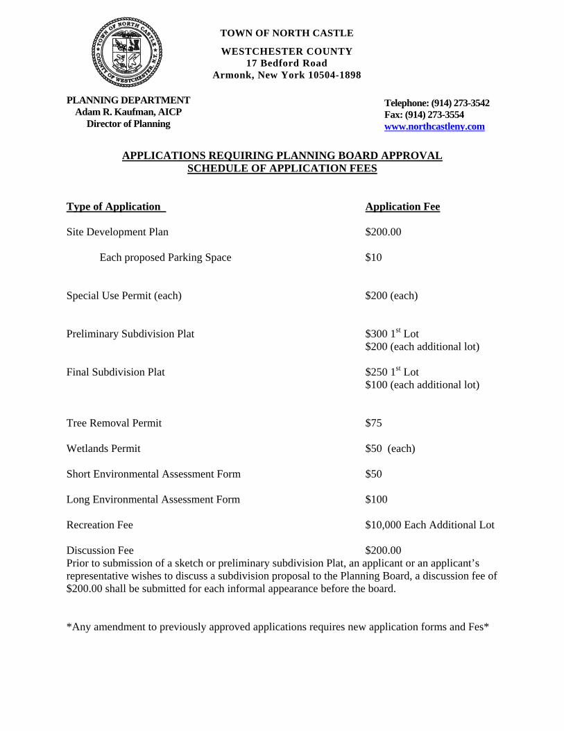
APPLICATIONS REQUIRING PLANNING BOARD APPROVAL
SCHEDULE OF APPLICATION FEES
Type of Application Application Fee Site Development Plan $200.00 Each proposed Parking Space $10 Special Use Permit (each) $200 (each) Preliminary Subdivision Plat $300 1st Lot $200 (each additional lot) Final Subdivision Plat $250 1st Lot $100 (each additional lot) Tree Removal Permit $75 Wetlands Permit $50 (each) Short Environmental Assessment Form $50 Long Environmental Assessment Form $100 Recreation Fee $10,000 Each Additional Lot Discussion Fee $200.00 Prior to submission of a sketch or preliminary subdivision Plat, an applicant or an applicant’s representative wishes to discuss a subdivision proposal to the Planning Board, a discussion fee of $200.00 shall be submitted for each informal appearance before the board. *Any amendment to previously approved applications requires new application forms and Fes*

TOWN OF NORTH CASTLE
WESTCHESTER COUNTY 17 Bedford Road
Armonk, New York 10504-1898
PLANNING DEPARTMENT Adam R. Kaufman, AICP
Director of Planning
Telephone: (914) 273-3542 Fax: (914) 273-3554 www.northcastleny.com
PLANNING BOARD SCHEDULE OF ESCROW ACCOUNT DEPOSITS
Type of Application Amount of Initial Escrow Account Deposit* Concept Study $500.00 Site Plan Waiver for Change of Use $500.00 Site Development Plan for:
Multifamily Developments $3,000.00 plus $100.00 per proposed dwelling unit
Commercial Developments $3,000.00 plus $50.00 for each required parking space
1 or 2 Family Projects $2,000.00
Special Use Permit $2,000.00 plus $50.00 for each required parking space
Subdivision: Lot Line Change resulting in no new lots $1,500.00
All Others $3,000.00 plus $200.00 per proposed new lot in excess of two (2)
Preparation or Review of Environmental Impact $15,000.00 Statement * If a proposed action involves multiple approvals, a single escrow account will be
established. The total amount of the initial deposit shall be the sum of the individual amounts indicated. When the balance in such escrow account is reduced to one-third (1/3) of its initial amount, the applicant shall deposit additional funds into such account to restore its balance to the amount of the initial deposit.
______________________________________________________________________________ Applicant Signature Date:

2
I. IDENTIFICATION OF PROPERTY OWNER, APPLICANT AND PROFESSIONAL REPRESENTATIVES Name of Property Owner: ___________________________________________ Mailing Address: __________________________________________________________ Telephone: ___________________ Fax: __________________________ e-mail _________________________ Name of Applicant (if different): ____________________________ Address of Applicant: ________________________________________ Telephone: ____________________ Fax: __________________________ e-mail _________________________ Interest of Applicant, if other than Property Owner: ________________________________________________________________ Name of Professional Preparing Site Plan: _________________________________________________________________ Address: ________________________________________________________ Telephone: ______________________ Fax: ___________________________ e-mail _____________________ Name of Other Professional: __________________________________________ Address: _____________________________________________________________ Telephone: _______________________ Fax: ________________________ e-mail _______________________ Name of Other Professional: __________________________________________ Address: _____________________________________________________________ Telephone: ________________________ Fax: ___________________________ e-mail ___________________ Name of Attorney (if any): _________________________________________ Address: ___________________________________________________________ Telephone: ________________________ Fax: __________________________ e-mail _____________________

3
Applicant Acknowledgement By making this application, the undersigned Applicant agrees to permit Town officials and their designated representatives to conduct on-site inspections in connection with the review of this application.
The Applicant also agrees to pay all expenses for the cost of professional review services required for this application.
It is further acknowledged by the Applicant that all bills for the professional review services shall be mailed to the Applicant, unless the Town is notified in writing by the Applicant at the time of initial submission of the application that such mailings should be sent to a designated representative instead. Signature of Applicant: ________ ________________ Date: _________ Signature of Property Owner: _______ ____ ________ Date: _________
MUST HAVE BOTH SIGNATURES

4
II. IDENTIFICATION OF SUBJECT PROPERTY
Street Address: ________________________________________________
Location (in relation to nearest intersecting street):
________ feet (north, south, east or west) of ____________________
Abutting Street(s): ______________________________________________
Tax Map Designation (NEW): Section________________Block________________Lot_____________
Tax Map Designation (OLD): Section________________Block________________Lot_____________
Zoning District: ______________ Total Land Area __________________
Land Area in North Castle Only (if different) _______________________
Fire District(s)________________ School District(s)_________________
Is any portion of subject property abutting or located within five hundred (500) feet of the following: The boundary of any city, town or village?
No ____ Yes (adjacent) _____ Yes (within 500 feet) ______ If yes, please identify name(s): ________________________
The boundary of any existing or proposed County or State park or any other recreation area? No ____ Yes (adjacent) _____ Yes (within 500 feet) ______ The right-of-way of any existing or proposed County or State parkway, thruway, expressway, road or highway? No ____ Yes (adjacent) _____ Yes (within 500 feet) _______ The existing or proposed right-of-way of any stream or drainage channel owned by the County or for which the County has established channel lines? No _____ Yes (adjacent) _____ Yes (within 500 feet) ______ The existing or proposed boundary of any county or State owned land on which a public building or institution is situated? No _____ Yes (adjacent) ______ Yes (within 500 feet) ______ The boundary of a farm operation located in an agricultural district? No _____ Yes (adjacent) _______ Yes (within 500 feet) ______
Does the Property Owner or Applicant have an interest in any abutting property? No _____ Yes ______ If yes, please identify the tax map designation of that property: _______________________________________________________________________

5
III. DESCRIPTION OF PROPOSED DEVELOPMENT Proposed Use: _______________________________________________________ Gross Floor Area: Existing __________ S.F. Proposed __________ S.F.
Proposed Floor Area Breakdown:
Retail _____________________S.F.; Office ______________S.F.;
Industrial __________________ S.F.; Institutional __________S.F.;
Other Nonresidential __________S.F.; Residential __________ S.F.;
Number of Dwelling Units: _____________ Number of Parking Spaces: Existing ________ Required __________ Proposed _________ Number of Loading Spaces: Existing ________ Required ___________ Proposed _________ Earthwork Balance: Cut _______ C.Y. Fill ________ C.Y. Will Development on the subject property involve any of the following:
Areas of special flood hazard? No ______ Yes ______ (If yes, application for a Development Permit pursuant to Chapter 177 of the North Castle Town Code may also be required)
Trees with a diameter at breast height (DBH) of 8" or greater?
No _____ Yes _____ (If yes, application for a Tree Removal Permit pursuant to Chapter 308 of the North Castle Town Code may also be required.) Town-regulated wetlands? No _____ Yes _____ (If yes, application for a Town Wetlands Permit pursuant to Chapter 340 of the North Castle Town Code may also be required.) State-regulated wetlands? No _____ Yes _____ (If yes, application for a State Wetlands Permit may also be required.)

6
IV. SUBMISSION REQUIREMENTS The site development plan application package shall include all materials submitted in support of the application, including but not limited to the application form, plans, reports, letters and SEQR Environmental Assessment Form. Submission of the following shall be required:
One (1) set of the site development plan application package (for distribution to the Town Planner
for preliminary review purposes). Once a completed preliminary site plan checklist has been received from the Planning Department,
eight (8) additional sets of the site development plan application package (for distribution to Planning Board, Town Engineer, Town Attorney, Town Planner, Planning Board Secretary, police, fire department and ambulance corps).
One (1) additional reduced sized set (11” x 17”) of the site development plan application package
if any portion of the subject property abuts or is located within five hundred (500) feet of the features identified in Section II of this application form (for distribution to Westchester County Planning Board).
A check for the required application fee and a check for the required Escrow Account, both made
payable to "Town of North Castle" in the amount specified on the "Schedule of Application Fees." (continued next page)

7
V. INFORMATION TO BE INCLUDED ON SITE DEVELOPMENT PLAN The following checklist is provided to enable the Applicant to determine if he/she has provided enough information on the site development plan for the Planning Board to review his/her proposal. Applicants are advised to review ARTICLE VIII, Site Development Plan of the North Castle Town Code for a complete enumeration of pertinent requirements and standards prior to making application for site development plan approval. The application for site development plan approval will not be accepted for Planning Board review unless all items identified below are supplied and so indicated with a check mark in the blank line provided. If a particular item is not relevant to the subject property or the development proposal, the letters "NA" should be entered instead. In addition, the project will not be scheduled on a Planning Board agenda until the Applicant receives an initialed “site plan checklist” from the Planning Department. The information to be included on a site development plan shall include: Legal Data: _____ Name of the application or other identifying title.
_____ Name and address of the Property Owner and the Applicant, (if different).
_____ Name, address and telephone number of the architect, engineer or other legally qualified professional who prepared the plan.
_____ Names and locations of all owners of record of properties abutting and directly across any and all adjoining streets from the subject property, including the tax map designation of the subject property and abutting and adjoining properties, as shown on the latest tax records.
_____ Existing zoning, fire, school, special district and municipal boundaries.
_____ Size of the property to be developed, as well as property boundaries showing dimensions and bearings as determined by a current survey; dimensions of yards along all property lines; name and width of existing streets; and lines of existing lots, reservations, easements and areas dedicated to public use.
_____ Reference to the location and conditions of any covenants, easements or deed restrictions that
cover all or any part of the property, as well as identification of the document where such covenants, easements or deed restrictions are legally established.
_____ Schedule of minimum zoning requirements, as well as the plan's proposed compliance with those
requirements, including lot area, frontage, lot width, lot depth, lot coverage, yards, off-street parking, off-street loading and other pertinent requirements.
______Locator map, at a convenient scale, showing the Applicant's entire property in relation to surrounding properties, streets, etc., within five hundred (500) feet of the site.
______North arrow, written and graphic scales, and the date of the original plan and all revisions, with notation identifying the revisions.
_____ A signature block for Planning Board endorsement of approval.

8
Existing Conditions Data:
_____ Location of existing use and design of buildings, identifying first floor elevation, and other
structures. _____ Location of existing parking and truck loading areas, with access and egress drives thereto.
_____ Location of existing facilities for water supply, sanitary sewage disposal, storm water drainage, and gas and electric service, with pipe sizes, grades, rim and inverts, direction of flow, etc. indicated.
_____ Location of all other existing site improvements, including pavement, walks, curbing, retaining walls and fences.
_____ Location, size and design of existing signs. _____ Location, type, direction, power and time of use of existing outdoor lighting.
_____ Location of existing outdoor storage, if any.
_____ Existing topographical contours with a vertical interval of two (2) feet or less.
_____ Location of existing floodplains, wetlands, slopes of 15% or greater, wooded areas, landscaped areas, single trees with a DBH of 8" or greater, rock outcrops, stone walls and any other significant existing natural or cultural features.
Proposed Development Data: _____ Proposed location of lots, streets, and public areas, and property to be affected by proposed
easements, deed restrictions and covenants. _____ Proposed location, use and architectural design of all buildings, including proposed floor
elevations and the proposed division of buildings into units of separate occupancy. _____ Proposed means of vehicular and pedestrian access to and egress from the site onto adjacent
streets. _____ Proposed sight distance at all points of vehicular access. _____ Proposed number of employees for which buildings are designed _____ Proposed streets, with profiles indicating grading and cross-sections showing the width of the
roadway; the location and width of sidewalks; and the location and size of utility lines. _____ Proposed location and design of any pedestrian circulation on the site and off-street parking and
loading areas, including handicapped parking and ramps, and including details of construction, surface materials, pavement markings and directional signage.
_____ Proposed location and design of facilities for water supply, sanitary sewage disposal, storm water
drainage, and gas and electric service, with pipe sizes, grades, rim and inverts, direction of flow, etc. indicated.
9
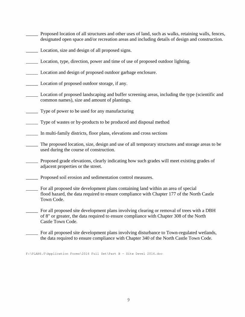
_____ Proposed location of all structures and other uses of land, such as walks, retaining walls, fences,
designated open space and/or recreation areas and including details of design and construction. _____ Location, size and design of all proposed signs. _____ Location, type, direction, power and time of use of proposed outdoor lighting. _____ Location and design of proposed outdoor garbage enclosure. _____ Location of proposed outdoor storage, if any. _____ Location of proposed landscaping and buffer screening areas, including the type (scientific and
common names), size and amount of plantings. _____ Type of power to be used for any manufacturing _____ Type of wastes or by-products to be produced and disposal method _____ In multi-family districts, floor plans, elevations and cross sections _____ The proposed location, size, design and use of all temporary structures and storage areas to be
used during the course of construction. _____ Proposed grade elevations, clearly indicating how such grades will meet existing grades of
adjacent properties or the street. _____ Proposed soil erosion and sedimentation control measures. _____ For all proposed site development plans containing land within an area of special
flood hazard, the data required to ensure compliance with Chapter 177 of the North Castle Town Code.
_____ For all proposed site development plans involving clearing or removal of trees with a DBH
of 8" or greater, the data required to ensure compliance with Chapter 308 of the North Castle Town Code.
_____ For all proposed site development plans involving disturbance to Town-regulated wetlands,
the data required to ensure compliance with Chapter 340 of the North Castle Town Code. F:\PLAN6.0\Application Forms\2016 Full Set\Part B - Site Devel 2016.doc

Short Environmental Assessment Form
Part 1 - Project Information
Instructions for Completing
Part 1 - Project Information. The applicant or project sponsor is responsible for the completion of Part 1. Responses become part of the application for approval or funding, are subject to public review, and may be subject to further verification. Complete Part 1 based on information currently available. If additional research or investigation would be needed to fully respond to any item, please answer as thoroughly as possible based on current information.
Complete all items in Part 1. You may also provide any additional information which you believe will be needed by or useful to the lead agency; attach additional pages as necessary to supplement any item.
Part 1 - Project and Sponsor Information
Name of Action or Project:
Project Location (describe, and attach a location map):
Brief Description of Proposed Action:
Name of Applicant or Sponsor: Telephone:
E-Mail:
Address:
City/PO: State: Zip Code:
1. Does the proposed action only involve the legislative adoption of a plan, local law, ordinance,administrative rule, or regulation?
If Yes, attach a narrative description of the intent of the proposed action and the environmental resources that may be affected in the municipality and proceed to Part 2. If no, continue to question 2.
NO YES
2. Does the proposed action require a permit, approval or funding from any other governmental Agency?If Yes, list agency(s) name and permit or approval:
NO YES
3.a. Total acreage of the site of the proposed action? ___________ acres b. Total acreage to be physically disturbed? ___________ acres c. Total acreage (project site and any contiguous properties) owned
or controlled by the applicant or project sponsor? ___________acres
4. Check all land uses that occur on, adjoining and near the proposed action. 9 Urban 9 Rural (non-agriculture) 9 Industrial 9 Commercial 9 Residential (suburban) 9 Forest 9 Agriculture 9 Aquatic 9 Other (specify): _________________________
9 Parkland
Page 1 of 3

Page 2 of 3
5. Is the proposed action,a. A permitted use under the zoning regulations?
b. Consistent with the adopted comprehensive plan?
NO YES N/A
6. Is the proposed action consistent with the predominant character of the existing built or naturallandscape?
NO YES
7. Is the site of the proposed action located in, or does it adjoin, a state listed Critical Environmental Area?If Yes, identify: __________________________________________________________________________ _______________________________________________________________________________________
NO YES
8. a. Will the proposed action result in a substantial increase in traffic above present levels?
b. Are public transportation service(s) available at or near the site of the proposed action?
c. Are any pedestrian accommodations or bicycle routes available on or near site of the proposed action?
NO YES
9. Does the proposed action meet or exceed the state energy code requirements?If the proposed action will exceed requirements, describe design features and technologies: ______________________________________________________________________________________________________________________________________________________________________________
NO YES
10. Will the proposed action connect to an existing public/private water supply?
If No, describe method for providing potable water: ______________________________________ _______________________________________________________________________________________
NO YES
11. Will the proposed action connect to existing wastewater utilities?
If No, describe method for providing wastewater treatment: ________________________________ _______________________________________________________________________________________
NO YES
12. a. Does the site contain a structure that is listed on either the State or National Register of Historic Places?
b. Is the proposed action located in an archeological sensitive area?
NO YES
13. a. Does any portion of the site of the proposed action, or lands adjoining the proposed action, contain wetlands or other waterbodies regulated by a federal, state or local agency?
b. Would the proposed action physically alter, or encroach into, any existing wetland or waterbody?If Yes, identify the wetland or waterbody and extent of alterations in square feet or acres: _______________ _______________________________________________________________________________________ _______________________________________________________________________________________
NO YES
14. Identify the typical habitat types that occur on, or are likely to be found on the project site. Check all that apply: Shoreline Forest Agricultural/grasslands Early mid-successional
Wetland Urban Suburban
15. Does the site of the proposed action contain any species of animal, or associated habitats, listed by the State or Federal government as threatened or endangered?
NO YES
16. Is the project site located in the 100 year flood plain? NO YES
17. Will the proposed action create storm water discharge, either from point or non-point sources?If Yes,
a. Will storm water discharges flow to adjacent properties? NO YES
b. Will storm water discharges be directed to established conveyance systems (runoff and storm drains)?If Yes, briefly describe: NO YES _______________________________________________________________________________________ _______________________________________________________________________________________
NO YES

18. Does the proposed action include construction or other activities that result in the impoundment of water or other liquids (e.g. retention pond, waste lagoon, dam)?
If Yes, explain purpose and size: ____________________________________________________________ _______________________________________________________________________________________ _______________________________________________________________________________________
NO YES
19. Has the site of the proposed action or an adjoining property been the location of an active or closedsolid waste management facility?
If Yes, describe: _________________________________________________________________________ _______________________________________________________________________________________ _______________________________________________________________________________________
NO YES
20. Has the site of the proposed action or an adjoining property been the subject of remediation (ongoing orcompleted) for hazardous waste?
If Yes, describe: __________________________________________________________________________ ______________________________________________________________________________________________________________________________________________________________________________
NO YES
I AFFIRM THAT THE INFORMATION PROVIDED ABOVE IS TRUE AND ACCURATE TO THE BEST OF MY KNOWLEDGE
Applicant/sponsor name: ___________________________________________ Date: ___________________________ Signature: _______________________________________________________
Page 3 of 3

GROSS LAND COVERAGE CALCULATIONS WORKSHEET
Application Name or Identifying Title: _____________________________________ Date: _________ Tax Map Designation or Proposed Lot No.: __________________________________ Gross Lot Coverage 1. Total lot Area (Net Lot Area for Lots Created After 12/13/06): _____________ 2. Maximum permitted gross land coverage (per Section 355-26.C(1)(a)): _____________ 3. BONUS maximum gross land cover (per Section 355-26.C(1)(b)): Distance principal home is beyond minimum front yard setback _______ x 10 = _____________ 4. TOTAL Maximum Permitted gross land coverage = Sum of lines 2 and 3 _____________ 5. Amount of lot area covered by principal building: __________ existing + __________ proposed = _____________ 6. Amount of lot area covered by accessory buildings: __________ existing + __________ proposed = _____________ 7. Amount of lot area covered by decks: __________ existing + __________ proposed = _____________ 8. Amount of lot area covered by porches: __________ existing + __________ proposed = _____________ 9. Amount of lot area covered by driveway, parking areas and walkways: __________ existing + __________ proposed = _____________ 10. Amount of lot area covered by terraces: __________ existing + __________ proposed = _____________ 11. Amount of lot area covered by tennis court, pool and mechanical equip: __________ existing + __________ proposed = _____________ 12. Amount of lot area covered by all other structures: __________ existing + __________ proposed = _____________ 13. Proposed gross land coverage: Total of Lines 5 – 12 = _____________ If Line 13 is less than or equal to Line 4, your proposal complies with the Town’s maximum gross land coverage regulations and the project may proceed to the Residential Project Review Committee for review. If Line 13 is greater than Line 4 your proposal does not comply with the Town’s regulations. __________________________________________________________ _____________ Signature and Seal of Professional Preparing Worksheet Date
TOWN OF NORTH CASTLE
WESTCHESTER COUNTY 17 Bedford Road
Armonk, New York 10504-1898
PLANNING DEPARTMENT Adam R. Kaufman, AICP
Director of Planning
Telephone: (914) 273-3542 Fax: (914) 273-3554 www.northcastleny.com

GROSS LAND COVERAGE WORKSHEET
The following format is to be used for all applications for the purpose of demonstrating the gross land coverage of a property as necessary to show compliance with gross land coverage limitations of the Town Code. 1. Scaled worksheets are to be prepared based upon a site plan which represents existing or
proposed conditions as applicable to the particular circumstances of the approval being sought. All site plans and worksheets are required to be prepared by a licensed or registered professional in the State of New York.
2. Each component of the gross land coverage is to be divided into simple polygons
(squares, rectangles, etc.) each being drawn on the plan. The area of each polygon is to be shown by providing the dimensions and resulting area measurement. Each polygon is to be assigned an identifying label for reference purposes.
3. A summary table for each component is to be completed. The area of each polygon is
to be listed by reference label then added, resulting in the gross land coverage for the entire site.
4. Any exception of land coverage from the gross land coverage must be identified on the
floor plans and summary tables. The rationale for any exception must accompany the floor area worksheets.
5. A schematic illustration of the format is shown below (or a schematic illustration with
areas computed by CAD) a b a x b = 1A 1A House 1A= House 2A 2A= Drive ____________________ cxd GROSS LAND COVERAGE 2A c d r i v e d
TOWN OF NORTH CASTLE
WESTCHESTER COUNTY 17 Bedford Road
Armonk, New York 10504-1898
PLANNING DEPARTMENT Adam R. Kaufman, AICP
Director of Planning
Telephone: (914) 273-3542 Fax: (914) 273-3554 www.northcastleny.com

LOT AREA, NET – Lot area minus seventy five (75) percent of the area of any wetlands, waterbodies and, watercourses, but excluding any adjacent areas, all as defined in Chapter 340 Wetlands and Drainage, of the Town Code, and the area of any steep slopes, as defined Chapter 355, except that in the case of one-family lots, the deduction for steep slopes shall be only fifty (50) percent.
Lot Size Maximum Permitted Gross Land Coverage for One-Family Dwelling Lots1 (square feet)
Less than 5,000 square feet
50% of the lot area
5,000 to 9,999 square feet 2,500 plus 30% of the lot area in excess of 5,000 square feet
10,000 to 14,999 square feet
4,000 plus 24% of the lot area in excess of 10,000 square feet
15,000 square feet to 0.499 acres
5,200 plus 18% of the lot area in excess of 15,000 square feet
0.5 to 0.749 acres 6,420 plus 15% of the lot area in excess of 0.5 acres
0.75 to 0.999 acres 8,050 plus 12% of the lot area in excess of 0.75 acres
1.0 to 1.999 acres 9,350 plus 9% of the lot area in excess of 1.0 acres
2.0 acres or more 13,270 plus 7.5% of the lot area in excess of 2.0 acres
*Permitted gross land coverage limitations for two-family dwelling lots in the R-2F District shall be twenty five (25) percent greater than that permitted for one-family dwelling lots. NOTWITHSTANDING ABOVE LIMITATIONS, AN ADDITIONAL 10 SQUARE FEET OF GROSS LAND COVERAGE SHALL BE PERMITTED FOR EACH ONE FOOT OF FRONT YARD SETBACK OF THE PRINCIPAL DWELLING IN EXCESS OF THE MINIMUM FRONT YARD SETBACK REQUIRED. F:\PLAN6.0\Application Forms\2016 Full Set\GROSS LAND COVERAGE CALCULATIONS WORKSHEET 2016.doc

FLOOR AREA CALCULATIONS WORKSHEET
Application Name or Identifying Title: _____________________________________ Date: _________ Tax Map Designation or Proposed Lot No.: __________________________________ Floor Area 1. Total Lot Area (Net Lot Area for Lots Created After 12/13/06): _____________ 2. Maximum permitted floor area (per Section 355-26.B(4)): _____________ 3. Amount of floor area contained within first floor: __________ existing + __________ proposed = _____________ 4. Amount of floor area contained within second floor: __________ existing + __________ proposed = _____________ 5. Amount of floor area contained within garage: __________ existing + __________ proposed = _____________ 6. Amount of floor area contained within porches capable of being enclosed: __________ existing + __________ proposed = _____________ 7. Amount of floor area contained within basement (if applicable – see definition): __________ existing + __________ proposed = _____________ 8. Amount of floor area contained within attic (if applicable – see definition): __________ existing + __________ proposed = _____________ 9. Amount of floor area contained within all accessory buildings: __________ existing + __________ proposed = _____________ 10. Proposed floor area: Total of Lines 3 – 9 = _____________ If Line 10 is less than or equal to Line 2, your proposal complies with the Town’s maximum floor area regulations and the project may proceed to the Residential Project Review Committee for review. If Line 10 is greater than Line 2 your proposal does not comply with the Town’s regulations. __________________________________________________________ _____________ Signature and Seal of Professional Preparing Worksheet Date
TOWN OF NORTH CASTLE
WESTCHESTER COUNTY 17 Bedford Road
Armonk, New York 10504-1898
PLANNING DEPARTMENT Adam R. Kaufman, AICP
Director of Planning
Telephone: (914) 273-3542 Fax: (914) 273-3554 www.northcastleny.com
TOWN OF NORTH CASTLE
WESTCHESTER COUNTY 17 Bedford Road
Armonk, New York 10504-1898
PLANNING DEPARTMENT Adam R. Kaufman, AICP
Director of Planning
Telephone: (914) 273-3542 Fax: (914) 273-3554 www.northcastleny.com

GROSS FLOOR AREA WORKSHEET
The following format is to be used for all applications for the purpose of demonstrating the gross floor area of a building or group of buildings as necessary to show compliance with a building or group of buildings as necessary to show compliance with floor area limitations of the Town Code or as otherwise necessary to illustrate the intended or potential use of a structure. 1. Scaled worksheets are to be prepared based upon floor plans which represent
existing or proposed conditions as applicable to the particular circumstances of the approval being sought. All floor plans and worksheets are required to be prepared by a licensed or registered professional in the State of New York.
2. The floor area of each floor is to be divided into simple polygons (squares,
rectangles, etc.) each being drawn on the plan. The area of each polygon is to be shown by providing the dimensions and resulting area measurement. Each polygon is to be assigned an identifying label for reference purposes.
3. A summary table for each floor is to be completed. The area of each polygon is to
be listed by reference label then added, resulting in the floor area for the entire floor.
4. A similar summary table is to be provided listing the total floor are of each floor
within the resulting floor area of each building. 5. Any exception of floor area from the gross floor area must be identified on the
floor plans and summary tables. The rationale for any exception must accompany the floor area worksheets.
6. A schematic illustration of the format is shown below (or schematic illustration
with areas calculated with CAD) . a b a x b = 1A BASEMENT = 1A= 1st FLOOR = 1B= 2nd FLOOR = c c x d = 1B d ---------- _________________ 1st Floor Total= GROSS FLOOR AREA 1st Floor
TOWN OF NORTH CASTLE
WESTCHESTER COUNTY 17 Bedford Road
Armonk, New York 10504-1898
PLANNING DEPARTMENT Adam R. Kaufman, AICP
Director of Planning
Telephone: (914) 273-3542 Fax: (914) 273-3554 www.northcastleny.com

LOT AREA, NET – Lot area minus seventy five (75) percent of the area of any wetlands, waterbodies and, watercourses, but excluding any adjacent areas, all as defined in Chapter 209 Wetlands and Drainage, of the Town Code, and the area of any steep slopes, as defined Chapter 340, except that in the case of one-family lots, the deduction for steep slopes shall be only fifty (50) percent. FLOOR AREA, GROSS -- The sum of the horizontal areas of the several stories of the building or buildings, excluding any floor area used for off-street parking or loading purposes (except for one- and two-family residences), measured from the exterior walls or, in the case of a common wall separating two buildings, from the center line of such a common wall, and including any two-story or any enclosed porch, or one having a roof and capable of being enclosed. See the definition of "basement" for exclusion of basement/mechanical areas in nonresidential buildings from "floor area, gross." For one- and two-family residences, any attic space with a floor to ceiling height of 7.5 feet or greater shall be included as part of gross floor area, as shall those portions of any basement with a floor to ceiling height of 7.5 feet or greater if the basement is considered a "story" in accordance with one of the following three alternative measurements: A. Where the finished surface of the floor above the basement is more than six feet
above average grade. B. Where the finished surface of the floor above the basement is more than six feet
above the finished ground level for more than 50% of the total building perimeter. C. Where the finished surface of the floor above the basement is more than 12 feet
above the finished ground level at any point along the building perimeter.

Lot Size Maximum Permitted Gross Floor
Area for One-Family Dwellings and Accessory Buildings 1 (square feet)
Less than 5,000 square feet 1,875 or 50% of the lot area, whichever is greater
5,000 to 9,999 square feet 2,500 plus 25% of the lot area in excess of 5,000 square feet
10,000 to 14,999 square feet 3,750 plus 20% of the lot area in excess of 10,000 square feet
15,000 square feet to 0.499 acres
4,750 plus 15% of the lot area in excess of 15,000 square feet
0.5 to 0.749 acres 5,768 plus 10% of the lot area in excess of 0.5 acres
0.75 to 0.999 acres 6,856 plus 8% of the lot area in excess of 0.75 acres
1.0 to 1.499 acres 7,727 plus 6% of the lot area in excess of 1.0 acres
1.5 to 1.999 acres 9,034 plus 5% of the lot area in excess of 1.5 acres
2.0 to 3.999 acres 10,122 plus 4% of the lot area in excess of 2.0 acres
4.0 acres or more 13,607 plus 3% of the lot area in excess of 4.0 acres
*Permitted gross floor area for two-family dwellings in the R-2F District shall be one-third (1/3) greater than that permitted for one-family dwellings.
F:\PLAN6.0\Application Forms\2016 Full Set\FLOOR AREA CALCULATIONS WORKSHEET 2016.doc


113 SMITH AVENUE MOUNT KISCO, NEW YORK 10549T: (914) 241-2235 F: (914) 241-6787
WWW.KCGENGINEERS.COM
USHERENKO RESIDENCE POOL9 WINKLER FARM ROAD
TOWN OF NORTH CASTLEWESTCHESTER COUNTY
NEW YORK
GROSS LAND COVERAGE CALCULATION PLAN
12/14/15

GROSS LAND COVERAGE CALCULATION PLAN
113 SMITH AVENUE MOUNT KISCO, NEW YORK 10549T: (914) 241-2235 F: (914) 241-6787
WWW.KCGENGINEERS.COM
12/14/15
USHERENKO RESIDENCE POOL9 WINKLER FARM ROAD
TOWN OF NORTH CASTLEWESTCHESTER COUNTY
NEW YORK
12/14/15
REV 4/11/16