Embed Size (px)
Citation preview

Site Compatibility Certificate for Serviced
Self-Contained Dwellings
Bankstown Golf Club
70 Ashford Avenue, Milperra
23 September 2019
PREPARED BY
HAMPTONS PROPERTY SERVICES Pty Ltd
Head Office: Suite 404 | Level 4 | 203-233 New South Head Road | Edgecliff NSW 2027
Parramatta Office: Suite 04 | Level 1 | 130 George Street | Parramatta NSW 2150
Tel (02) 9386 7000 | Fax (02) 9386 7001
www.hamptonspropertyservices.com.au

2
Site
Co
mp
atib
ility
Cer
tifi
cate
– 7
0 |
Ash
ford
Ave
nu
e| M
ilper
ra
COPYRIGHT
Hamptons Property Services is the owner of the copyright contained in this publication. Other than as
permitted by the Copyright Act and as outlined in our terms of engagement, this report may not be reprinted,
reproduced or used in any other form, transmitted or copied, by electronic, material or other means, without
the prior written permission of Hamptons. Legal action will be taken against breach of copyright.
This report may only be used for the purpose commissioned and unauthorised use is prohibited. Hamptons
assumes no responsibility if the document is used for purposes other than those directly associated with its
commission.
PROJECT PARTICULARS
Project No.
2018136
Client
Bankstown Golf Club
Site Address
70 Ashford Avenue, Milperra
Date Document Name Authorisation
Name/Position Signature
1 September 2019 Report001_SCC_V1 Kristy Hodgkinson
Director
23 September 2019 Report001_SCC_V2 Kristy Hodgkinson
Director
In the event that this document is not signed, this is not representative of a final version of the document,
suitable for assessment purposes.
RELIANCE ON CONSULTANT INFORMATION
As part of undertaking this project, Hamptons has relied on the professional advice provided by third party
consultants. No responsibility is taken for the accuracy of the information relied upon by these consultants
assisting the project. It is assumed that each of the consultants has made their own enquiries in relation to
technical matters forming part of their expertise.

3
Site
Co
mp
atib
ility
Cer
tifi
cate
– 7
0 |
Ash
ford
Ave
nu
e| M
ilper
ra
CONTENTS
1. INTRODUCTION .............................................................................................................................. 6
Objectives of the SCC ................................................................................................................................................. 6
Project Team .............................................................................................................................................................. 6
2. SITE AND CONTEXT ANALYSIS ......................................................................................................... 7
Site Particulars ........................................................................................................................................................... 7
Context Surrounding the Site .................................................................................................................................. 11
Heritage ................................................................................................................................................................... 12
Proximity to Facilities & Services ............................................................................................................................. 14
Site Constraints ........................................................................................................................................................ 16
3. THE PROPOSAL ............................................................................................................................. 18
4. STRATEGIC PLANNING CONTEXT & JUSTIFICATION ........................................................................ 19
Greater Sydney Region Plan .................................................................................................................................... 19
South District Plan ................................................................................................................................................... 22
Local Area Plan......................................................................................................................................................... 23
5. THE REQUIREMENTS OF THE SENIORS SEPP ................................................................................... 24
6. SITE RELATED REQUIREMENTS ...................................................................................................... 28
7. DESIGN REQUIREMENTS FOR DEVELOPMENT ................................................................................ 33
8. STATUTORY PLANNING CONSIDERATIONS ..................................................................................... 52
State Environmental Planning Policy 65 – Design Quality of Residential Apartment Development ....................... 52
Bankstown Local Environmental Plan 2015 ............................................................................................................. 52
9. CONSULTATION ............................................................................................................................ 57
10. COMPATIBILITY OF THE SITE ...................................................................................................... 59
11. THE PUBLIC INTEREST ................................................................................................................ 70
12. CONCLUSIONS .......................................................................................................................... 71
4
Site
Co
mp
atib
ility
Cer
tifi
cate
– 7
0 |
Ash
ford
Ave
nu
e| M
ilper
ra
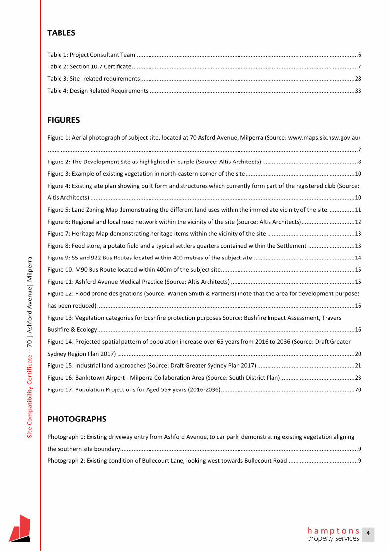
TABLES
Table 1: Project Consultant Team ...................................................................................................................................... 6
Table 2: Section 10.7 Certificate ......................................................................................................................................... 7
Table 3: Site -related requirements .................................................................................................................................. 28
Table 4: Design Related Requirements ............................................................................................................................ 33
FIGURES
Figure 1: Aerial photograph of subject site, located at 70 Asford Avenue, Milperra (Source: www.maps.six.nsw.gov.au)
............................................................................................................................................................................................ 7
Figure 2: The Development Site as highlighted in purple (Source: Altis Architects) .......................................................... 8
Figure 3: Example of existing vegetation in north-eastern corner of the site .................................................................. 10
Figure 4: Existing site plan showing built form and structures which currently form part of the registered club (Source:
Altis Architects) ................................................................................................................................................................ 10
Figure 5: Land Zoning Map demonstrating the different land uses within the immediate vicinity of the site ................ 11
Figure 6: Regional and local road network within the vicinity of the site (Source: Altis Architects) ................................ 12
Figure 7: Heritage Map demonstrating heritage items within the vicinity of the site ..................................................... 13
Figure 8: Feed store, a potato field and a typical settlers quarters contained within the Settlement ............................ 13
Figure 9: S5 and 922 Bus Routes located within 400 metres of the subject site.............................................................. 14
Figure 10: M90 Bus Route located within 400m of the subject site................................................................................. 15
Figure 11: Ashford Avenue Medical Practice (Source: Altis Architects) ........................................................................... 15
Figure 12: Flood prone designations (Source: Warren Smith & Partners) (note that the area for development purposes
has been reduced) ............................................................................................................................................................ 16
Figure 13: Vegetation categories for bushfire protection purposes Source: Bushfire Impact Assessment, Travers
Bushfire & Ecology ............................................................................................................................................................ 16
Figure 14: Projected spatial pattern of population increase over 65 years from 2016 to 2036 (Source: Draft Greater
Sydney Region Plan 2017) ................................................................................................................................................ 20
Figure 15: Industrial land approaches (Source: Draft Greater Sydney Plan 2017) ........................................................... 21
Figure 16: Bankstown Airport - Milperra Collaboration Area (Source: South District Plan) ............................................. 23
Figure 17: Population Projections for Aged 55+ years (2016-2036) ................................................................................. 70
PHOTOGRAPHS
Photograph 1: Existing driveway entry from Ashford Avenue, to car park, demonstrating existing vegetation aligning
the southern site boundary ................................................................................................................................................ 9
Photograph 2: Existing condition of Bullecourt Lane, looking west towards Bullecourt Road .......................................... 9

5
Site
Co
mp
atib
ility
Cer
tifi
cate
– 7
0 |
Ash
ford
Ave
nu
e| M
ilper
ra
APPENDICES
Appendix 1 Title Certificates
Appendix 2 Site Survey
Appendix 3 Urban Design Report
Appendix 4 Arboriculture Impact Assessment
Appendix 5 Traffic Impact Assessment
Appendix 6 Bushfire Impact Assessment
Appendix 7 Stormwater Impact Assessment
Appendix 8 Bus timetables

6
Site
Co
mp
atib
ility
Cer
tifi
cate
– 7
0 |
Ash
ford
Ave
nu
e| M
ilper
ra
1. INTRODUCTION
Hamptons Property Services (Hamptons) has been retained by the property owner, Bankstown Golf Club (the
Applicant), in relation to the land known as 70 Ashford Avenue, Milperra (the site). The purpose of this
application is to seek a Site Compatibility Certificate (SCC) on land that contains an existing registered club,
in accordance with State Environmental Planning Policy (Housing for Seniors & People with a Disability) 2004
(the Seniors SEPP).
This SCC application is made to the NSW Department of Planning, Industry and Environment (DPIE) and will
be determined by the Sydney South Planning Panel (SSPP). The site is, however, located in the Canterbury-
Bankstown Local Government Area.
The purpose of the SCC is to establish the suitability of the land for the intended purpose, in this case, a
serviced self-care housing, comprising independent living units (ILUs), which would be provided with access
to meals, cleaning services, personal care, nursing care on site. Detailed design of each of the ILU’s would
occur at the development application stage; however, the purpose of the SCC is to establish that, based on
general principles pertaining to character, compatibility and overall design principles, the subject site is
suitable for the intended purpose.
Objectives of the SCC
The objective of SCC for the site as a whole is to provide an integrated land use outcome which includes
retention of the existing 18-hole golf course, establishment of a new clubhouse and associated member
facilities; a new swimming centre (recreational facility (indoor)) for general public use and approximately
149 independent living units (ILUs) availed of on-site services. It will also include basement car parking to
service all aspects of the development, as well as expansive common open space areas and landscaping to
service the development.
Project Team
This SCC application has been prepared in conjunction with the consultant team as set out below.
Table 1: Project Consultant Team
Discipline Consultant
Urban Design PTW Architects
Architecture Altis Architects
Survey LTS Lockley Surveyors
Flooding Warren Smith & Partners
Bushfire Travers Bushfire & Ecology
Traffic Varga Traffic Planning

7
Site
Co
mp
atib
ility
Cer
tifi
cate
– 7
0 |
Ash
ford
Ave
nu
e| M
ilper
ra
2. SITE AND CONTEXT ANALYSIS
Details of the site and its surrounding context are provided below.
Site Particulars
The site is located at 70 Ashford Avenue and is legally described as Lot 13 in Deposited Plan 584447 and Lot
612 Deposited Plan 837981 (the golf course site).
Figure 1: Aerial photograph of subject site, located at 70 Asford Avenue, Milperra (Source: www.maps.six.nsw.gov.au)
The golf course site has a total area of 46.844 hectares.
The Section 10.7 Certificate for the golf course site highlights the key technical matters which are set out
below.
Table 2: Section 10.7 Certificate
Zoning RE2 Private Recreation
Heritage Item No
Conservation Area No
Coastal Protection No
Mine Subsidence No
Road Widening or Realignment No
Hazard Risk Restriction No
Flood Planning Yes
Threatened Species Acacia Pubescens – Schedule 2 of the Threatened Species
Conservation Act.
Consultation with NPWS required where activity will result in the Pick
of threatened plant species.
Note that the site does not contain any such species as identified in
the Arborist Report.
Acquisition No
Biodiversity Certified Land No
Bushfire Prone Land No
Property Vegetation Plan No

8
Site
Co
mp
atib
ility
Cer
tifi
cate
– 7
0 |
Ash
ford
Ave
nu
e| M
ilper
ra
Contamination No
ANEF Affected by aircraft noise between the 20 and 25 ANEF levels
For the purpose of this SCC application, the portion of the golf course site to be redeveloped is generally
limited to the eastern section of the land, which generally comprises Lot 612 Deposited Plan 837981; there
is, however, a minor encroachment over Lot 13. This is identified as the development site in the below figure
and herein referred to as the site for the remainder of this report for ease of reference.
Figure 2: The Development Site as highlighted in purple (Source: Altis Architects)
In terms of Lot 612, entry to the allotment (and the site as a whole) is from Ashford Avenue, via an existing
driveway which is 12.07 m wide. This has a general fall of approximately 1.5 m into the car parking area, ,
which is located on the eastern side of the allotment.
An existing stormwater pipe aligns the eastern property boundary which is 87.33 m. The pipe then turns on
a 900 angle and aligns the northern boundary of the development site, which is 103.91 m in length. An
existing steel post fence aligns this boundary.
An existing gravel, unformed road, is also located adjacent the southern site boundary, providing access to
the site from Bullecourt Lane, which extends from Bullecourt Road. The length of the southern boundary
from Ashford Avenue to this point with Bullecourt Lane is 199.86 m.

9
Site
Co
mp
atib
ility
Cer
tifi
cate
– 7
0 |
Ash
ford
Ave
nu
e| M
ilper
ra
Photograph 1: Existing driveway entry from Ashford Avenue, to car park, demonstrating existing vegetation aligning the southern
site boundary
Photograph 2: Existing condition of Bullecourt Lane, looking west towards Bullecourt Road

10
Site
Co
mp
atib
ility
Cer
tifi
cate
– 7
0 |
Ash
ford
Ave
nu
e| M
ilper
ra
There is a large quantum of existing mature trees located around the northern, eastern and southern
property boundaries which have been assessed for their safe useful like expectancy (SULE) and impact on
the development outcomes.
Figure 3: Example of existing vegetation in north-
eastern corner of the site
In terms of built structures, the site is occupied by an existing club house, located towards the western side
of Lot 612, where the club house is generally accessible from the car parking area and opens to the golf
course. To the south-west of the club house are two sheds, either side of the driveway entrance. Both of the
structures are constructed of metal, with the one on the western side of the driveway accommodating the
principal maintenance facility for the site.
Figure 4: Existing site plan showing built form and structures which currently form part of the registered club (Source: Altis Architects)

11
Site
Co
mp
atib
ility
Cer
tifi
cate
– 7
0 |
Ash
ford
Ave
nu
e| M
ilper
ra
The golf course proper is located to the north and west of the club house and maintenance facilities and
includes a practice bunker, a practice green, practice nets and the 18-hole course itself.
The car parking area is located to the east of the clubhouse and contains approximately 180 informal car
parking spaces. On the southern side of the car parking area is also a ‘Return and Earn’ station.
The club house is the oldest building on the site, with the maintenance facilities having been constructed in
more recent times.
There is an array of easements which traverse Lot 13 for drainage purposes, as well as an easement for batter
in the south-western corner of the golf course. There is also a right of way from Henry Lawson Drive which
enables access to the western side of the site and a Right of Carriageway which burdens lot 612 and benefits
Lot 13. The title certificates may be found at Appendix 1 and the Site Survey at Appendix 2.
Context Surrounding the Site
The extract of the Bankstown Local Environmental Plan 2011 (the LEP) demonstrates the extent of varying
uses that are within the vicinity of the site.
Figure 5: Land Zoning Map demonstrating the different land uses within the immediate vicinity of the site
As evidenced above, land directly north of the site is zoned for public recreation purposes, before interfacing
with Hume Highway; beyond this is the Bankstown Aerodrome. Directly east of the site, on the same side of

12
Site
Co
mp
atib
ility
Cer
tifi
cate
– 7
0 |
Ash
ford
Ave
nu
e| M
ilper
ra
Ashford Avenue as the site, the land is zoned IN2 and generally for light industrial purposes, whereas the
eastern side of Ashford Avenue transitions to heavier industrial land (General Industrial).
To the south-west of the site is the intersection of Bullecourt Road and Ashford Avenue, where the
intersecting uses including heavy industrial, recreational, educational and low scale retail uses.
To the south of the site the land is zoned R2 Low Density Residential Use, with the block immediately
adjoining the southern boundary currently vacant. This is currently subject to a development application
which is under assessment for independent living units and a residential care facility.
To the west of the site is land zoned for public recreational purposes, before adjoining Henry Lawson Drive,
which provides access to the arterial road network, including the M5 Motorway. This connects with the M7
motorway approximately 15 kilometres from the subject site and provides regional access to Sydney’s
primary vehicular transport corridor.
Figure 6: Regional and local road network within the vicinity of the site (Source: Altis Architects)
Heritage
The site is located in the vicinity of a heritage item, known as I29 on the accompanying map and is known as
the former Milperra Soldier Settlement. The boundary of the item is defined by Ashford Avenue, Bullecourt
Avenue and Fleurbaix Avenue.

13
Site
Co
mp
atib
ility
Cer
tifi
cate
– 7
0 |
Ash
ford
Ave
nu
e| M
ilper
ra
Figure 7: Heritage Map demonstrating heritage items within the vicinity of the site
The heritage item, as the former settlement, is now only recognizable in terms of the road system. The
proposed development will have no adverse consequence in that regard.
What is relevant is the social significance of the item as it relates to it reflecting a period in time where a
specific social group was drawn together. The area was:
part of a national scheme that was intended to repatriate returning servicemen during and after World
War I. It reflects then-current attitudes towards the appropriate ways to develop the country and ensure
its growth and prosperity.
Figure 8: Feed store, a potato field and a typical settlers quarters contained within the Settlement
Source: https://www.environment.nsw.gov.au/heritageapp/ViewHeritageItemDetails.aspx?ID=1060223

14
Site
Co
mp
atib
ility
Cer
tifi
cate
– 7
0 |
Ash
ford
Ave
nu
e| M
ilper
ra
The intended use of the land provided for collective living arrangements for people in similar circumstances;
the proposed use of this site will reinstate a similar ethos as previously attributable to the site.
The site is also located within the vicinity of the heritage item known as Bankstown Aerodrome.
Proximity to Facilities & Services
One of the fundamental aspects to an SCC application is its accessibility to facilities and services. These are
available within the vicinity of the site to ensure adequate access for future residents.
Basic retail facilities are located 250 m south of the site at the Milperra Shopping Village and Ashford Village,
which include a pharmacy, mixed business which provides general and convenience grocery items and
newsagent, as well as take away food outlets.
Further afield, such services are available at Milperra and Bankstown Centre which are accessible by bus.
A bus stop is located to the
south of the site, just east of
the intersection of
Bullecourt Lane with
Bullecourt Avenue, being
just over 200 m from the site
boundary. This is known as
the S5 route and travels
from Milperra Town Centre
to Panania, Revesby and
Padstow Railway Stations. A
second route (922) travels
from Milperra to Bankstown
Central, located to the north
east of the site.
Figure 9: S5 and 922 Bus Routes
located within 400 metres of the
subject site
There is also a bus stop located on Ashford Avenue, to the north of the driveway entry, being not less than
50m from the driveway entrance. This is serviced by the M90 bus route which goes from Burwood to
Liverpool, and traverses Bankstown Centre.

15
Site
Co
mp
atib
ility
Cer
tifi
cate
– 7
0 |
Ash
ford
Ave
nu
e| M
ilper
ra
Figure 10: M90 Bus Route located within 400m of the subject site
Ashford Avenue Medical
Practice is located less
than 400 m from the
site, being located
directly south of Ashford
Village.
The bus stops in direct
proximity also provide
access to medical
services further afield at
Milperra and Bankstown
Central and Liverpool.
Figure 11: Ashford Avenue Medical Practice (Source: Altis Architects)

16
Site
Co
mp
atib
ility
Cer
tifi
cate
– 7
0 |
Ash
ford
Ave
nu
e| M
ilper
ra
Site Constraints
Flooding
Matters pertaining to flooding have been considered, determining that the site is not subject to the 1% AEP
flooding level.
The western and southern perimeter of the site are partially affected (less than 250mm) by the PMF level.
Further, the PMF construction level is likely the result of minor drainage and not flooding; as such, addressing
the PMF level is considered unnecessary.
Most importantly, the site is not located in a high hazard flood area.
Figure 12: Flood prone designations (Source: Warren
Smith & Partners) (note that the area for
development purposes has been reduced)
Threatened Species
The Arborist Report demonstrates that the threatened species known as Acacia Pubescens is not located
within that part of the site where works will take place; as such, this species will not be affected in association
with this development.
Bushfire
The northern and western side of the golf course site is classified as Vegetation Category 1 and Vegetation
Buffer; however, these are located some 400 m distance from that portion of the site to be developed.
Figure 13: Vegetation categories for bushfire protection purposes Source: Bushfire Impact Assessment, Travers Bushfire & Ecology

17
Site
Co
mp
atib
ility
Cer
tifi
cate
– 7
0 |
Ash
ford
Ave
nu
e| M
ilper
ra
Adequate asset protection zones must therefore be applied to the site to ensure adequate protection to
future development.
Contamination
A detailed contamination assessment has not been prepared as part of the SCC. However, given the long
term use of the land as a golf course, it is highly likely that there may be contaminants affecting the site, as
a result of pesticide spraying and upkeep of the golf course.
A full assessment of soil quality would be undertaken as part of the development application stage to ensure
that the land may be made suitable for the development purpose.
Water & Sewer
Water and sewer services are available to the site. Augmentation required as part of any future application
would be undertaken in accordance with relevant conditions of development consent.

18
Site
Co
mp
atib
ility
Cer
tifi
cate
– 7
0 |
Ash
ford
Ave
nu
e| M
ilper
ra
3. THE PROPOSAL
The SCC seeks to achieve building forms that are expressed between three and six storeys across the site,
with an estimated yield of 149 ILUs, based on the current analysis and documentation. The number of ILUs
is indicative only at this stage and the end sequence would be predicated on consideration of this application.
Of the 149 ILUs currently shown, it is proposed that there would be 16 x 1-Bed; 96 x 2-Bed and 37 x 3-Bed
dwellings. The buildings will be divided into four separate forms, with 16 ILUs in Building A; 44 ILUs in Building
B; 33 ILUs in Building C; and 56 ILUs in Building D.
In addition to the ILUs, the site would also accommodate the following:
o Replacement of the existing clubhouse with a new clubhouse facility, which would include a pro shop,
amenities and storage areas for necessary equipment and maintenance facilities. This will also likely
contain the residents services in accordance with the requirements for serviced self-contained housing
o A new learn to swim centre, located on the ground floor of the northern side of the site, to be available
to the community, with an independent operator
o Basement car parking for each of the uses proposed on the site
o Designated drop off and pick up areas for the individual uses associated with the site
o Extensive landscaping and common open space works surrounding the built form.
The existing 18-hole golf course would be retained.
To improve the site’s relationship with its broader context, it is intended that day-to-day access to and from
the site will be via a new entry from Bullecourt Lane, to the west of the site, to provide a better level of
presentation to the development, than the existing interface from the adjoining industrial area. This will then
enable service vehicles to enter and leave the site through the existing Ashford Avenue egress point and
ensure that service vehicles continue to dominant that frontage, with more localised traffic coming through
Bullecourt Lane.
The built form would result in a floor space ratio of 1.25:1, based on a nominal site area of 17,045m2, where
the development will take place. The FSR when the whole of the golf course site is taken into consideration
is 0.045:1.
The maximum building height is between three (3) and six (6) storeys; an approximate height of between
15.5 m and 21 m, including building services and lift overruns. The three-storey form is represented by
Building A, adjacent the south-western corner of the site, with the highest forms behind this, through the
eastern section of the site.

19
Site
Co
mp
atib
ility
Cer
tifi
cate
– 7
0 |
Ash
ford
Ave
nu
e| M
ilper
ra
4. STRATEGIC PLANNING CONTEXT & JUSTIFICATION
Greater Sydney Region Plan
The site is subject to the strategic planning foundations which are sought to be delivered by the Greater
Sydney Plan, designed to set a 40-year planning framework to manage growth and change in terms of
economic, social and environmental matters. It is also designed to inform district and local planning
provisions, as well as guide infrastructure agencies on how to deliver for growth and change.
The plan is based on several key principles which relate to:
o Infrastructure and collaboration
o Liveability
o Productivity
o Sustainability
The future use of the land as intended, aligns with these principles and objectives is addressed below, as it
relates to this SCC application.
Infrastructure and collaboration
Changes in technology mean that car parking within the development can be accommodated that allows for
electric vehicle recharging.
The site is also highly accessible to public transport which will enable continued use of existing infrastructure
assets that service the site.
It is also relevant to note that the Priority Collaboration Areas include Bankstown Airport/Milperra industrial
and urban services precinct is likely to include the subject site. While this has not progressed at this stage,
the SCC process does not derogate from the intentions of the landholding, that would otherwise impact upon
industrial land supply, nor employment.
Liveability
The below figure demonstrates the projected spatial pattern of population increase that will be over the age
of 65 years between 2016 and 2036. In the case of the Canterbury/Bankstown LGA, this growth is anticipated
to increase by between 60-80%. The areas of both Strathfield and Liverpool, which adjoin the
Canterbury/Bankstown LGA have an even higher projected rate of 80-100%. With this concentration in
growth occurring, there will be an increasing demand for health, social and aged care services than currently
exists. The benefits of this development will ensure that demand for accommodation is aided with the
additional provision of residential dwellings on this site in an area where the residential population aged
over 65 is likely to increase over the next 20 years.

20
Site
Co
mp
atib
ility
Cer
tifi
cate
– 7
0 |
Ash
ford
Ave
nu
e| M
ilper
ra
Further, the nature of development will aid the diversity of housing choice that is offered to the community.
Figure 14: Projected spatial pattern of population
increase over 65 years from 2016 to 2036 (Source:
Draft Greater Sydney Region Plan 2017)
The nature of the development will also accord with Objective 7 which seeks to ensure that communities are
healthy, resilient and socially connected. The nature of the development allows for a strong social network
to be established, not only by virtue of the community living within the development, but also as a result of
the facilities offered on the site which again assist to establish and continue strong social networks.
The demand assessment prepared for this application demonstrates that there is a strong need for housing
of this type, design and co-location of facilities due to the increase in the ageing population, consistent with
servicing housing needs under the policy. This type of housing is also generally more affordable and allows
for availability of more disposable income upon the sale of a primary residence.
Productivity
The productivity objectives are generally centred around the need to live and work within a 30-minute radius.
The age cohort within developments such as this proposed is generally one where people are no longer
working. However, the proposed development will not place pressure on existing infrastructure or services

21
Site
Co
mp
atib
ility
Cer
tifi
cate
– 7
0 |
Ash
ford
Ave
nu
e| M
ilper
ra
that would compromise accessibility, nor will it impede the priority role of the road network servicing the
industrial area.
Most importantly, additional development on this site will not deplete industrial landholdings which are
deemed as important from both an industry and employment perspective, where industrial land is to be
protected and managed. As the existing landholding is not used for such purpose, there will be no nett
change as a result of this development.
Figure 15: Industrial land approaches (Source: Draft
Greater Sydney Plan 2017)
Implementation of the development will also
result in local employment opportunities in
association with all of the proposed uses
within the development.
Sustainability
The principles of sustainability will be explored in more detail as part of the development application stage.
However, fundamental to this will be:
o Compliance with BASIX requirements
o Water reuse strategies
o Implementation of solar panels
o Orientation of development to ensure that reliance on mechanical ventilation is reduced
o Provision of electric car charging points within the basement to embrace improved vehicle technology.

22
Site
Co
mp
atib
ility
Cer
tifi
cate
– 7
0 |
Ash
ford
Ave
nu
e| M
ilper
ra
There will also be significant opportunities for additional planting across the site, not only to compensate for
the extent of tree removal, but also to replace the extent of hard stand areas that currently comprise the
site.
South District Plan
There are four objectives for Liveability under the South District Plan, which are:
o Providing services and social infrastructure to meet people’s changing needs
o Fostering healthy, creative, culturally rich and socially connected communities
o Providing housing supply, choice and affordability with access to jobs and services
o Creating and renewing great places and local centres, and respecting the District’s heritage
The proposed development will respond to changing needs of the intended community, as well as
diversifying housing choice and affordability for incoming residents, with a range of one, two and three
bedroom dwellings. It will also allow for people of similar ages to form their own social connections and
activities in association with the development.
For Productivity, the main priority is S8 which is Growing and investing in health and education precincts and
Bankstown Airport trade gateway as economic catalysts for the District. The site is located, in part, in the
Bankstown Airport – Milperra Industrial Collaboration Area as shown below. The area is described as:
The airport site occupies 313 hectares and adjoins the Milperra industrial area, one of the most important
centres of economic activity in the South District. Approximately 15,700 people work in the Milperra
industrial area, with a third of jobs in manufacturing, including advanced manufacturing operations12.
Sectors of specialisation include aviation/aerospace and electronics. Advanced manufacturing is
identified in Jobs for the Future as a priority globally tradeable segment which offers strong prospects for
high-value and accelerated jobs growth and to develop globally competitive capability in skills and
technology.
The Bankstown Airport Masterplan 2014 sets aside 130 hectares of land adjacent to Milperra for future
development for non-aviation uses, with the aim of developing an industrial economic and employment
hub. Together with the established Milperra industrial area, this area is well located with access to air
transport, the road and rail freight network; the proposed Moorebank intermodal terminal; Liverpool;
Bankstown; and the Liverpool health and education precinct. Public transport for workers could improve
with the potential expansion of the Sydney Metro City & Southwest from Bankstown to Liverpool. Given
the strategic opportunities associated with Bankstown Airport and Milperra industrial area, it has been
identified as a Collaboration Area (refer to Figure 18). The Commission will work with Canterbury-
Bankstown Council, the NSW Government, the Australian Government, Bankstown Airport Limited,
industry and the community to develop a long-term economic strategy. This will: • improve transport
connections to the broader District • integrate planning for the airport with planning of surrounding lands

23
Site
Co
mp
atib
ility
Cer
tifi
cate
– 7
0 |
Ash
ford
Ave
nu
e| M
ilper
ra
• coordinate infrastructure delivery • facilitate advanced manufacturing and innovation • expand
opportunities stemming from Western Sydney University Bankstown Campus and the University of NSW
Aviation School
Figure 16: Bankstown Airport - Milperra Collaboration Area (Source: South District Plan)
Development on the subject site will not impede the growth of this area, nor will it deplete existing land
supply for that purpose. Further, the focus for growth is on advanced manufacturing and innovation
industries which will be less environmentally intrusive than more traditional industrial operations that are
decreasing with technological improvements. Further, the design of the development ensures that potential
impacts may be mitigated, particularly with the position and extent of screening through design elements
that is proposed.
The proposal will not compromise the quantum of land that is available for economic and employment
purposes in accordance with the Principles for managing industrial and urban land services and local
employment opportunities will be increased through the proposed development’s various activities.
With regard to Sustainability, opportunities will be available to enhance the existing site conditions, with
further attributes to respond to the natural landscape.
Local Area Plan
The Local Area Plan for the Specialised Centre of Bankstown Airport – Milperra is yet to be prepared by the
Council.

24
Site
Co
mp
atib
ility
Cer
tifi
cate
– 7
0 |
Ash
ford
Ave
nu
e| M
ilper
ra
5. THE REQUIREMENTS OF THE SENIORS SEPP
Aims of the Policy
Clause 2 of the Seniors SEPP addresses the Aims of the Policy and requires the provision of housing that will:
(a) increase the supply and diversity of residences that meets the needs of seniors or people with a
disability
(b) make efficient use of existing infrastructure and services
(c) be of good design.
The purpose of this SCC application is to ensure the provision of ILUs (approximately 149) of a diverse size
and scale to meet the needs of seniors or people with a disability, in a location that is accessible in terms of
infrastructure and services. The architectural design and urban form of the development will be of a high-
quality architectural design outcome that is enhanced by the natural features of the site and capitalises on
these through style, configuration, orientation and urban form.
Land to which the Policy applies
Clause 4 deals with Land to which this Policy applies. In accordance with clause 4(1), the site is land that is
land that adjoins land zoned primarily for urban purposes and is land being used for the purposes of an
existing registered club.
Does the land join land primarily zoned for urban purposes?
Yes. By reference to the zoning map attaching to the LEP (Figure 5), the subject site is zoned RE2 Private
Recreation. To the immediate east of the site, the land is zoned IN2 Light Industrial and to the immediate
south is zoned R2 Low Density Residential pursuant to the LEP. As such, the land adjoins land zoned for urban
purposes.
Are dwelling houses, residential flat buildings, hospitals or special uses permitted in the adjoining urban
purposes zone?
Yes. Dwelling houses and hospitals are permitted in the R2 zone.
Directly south of the site, aligning the boundary, but for a small portion towards the eastern end thereof, the
land is zoned R2 Low Density Residential. As dwelling houses are permitted in the R2 Low Density Residential
zone, in accordance with Clause 4(1)(a)(i), the land is evidently land adjoining land zoned for urban purposes.
Does the land contain an existing registered club?
Yes. A registered club is defined at clause 3, as a club in respect of which a certificate of registration under
the Registered Clubs Act 1976 is in force. Pursuant to the Registered Clubs Act, a certificate of registration is
no longer issued. Instead, the Registered Clubs Act provides that:

25
Site
Co
mp
atib
ility
Cer
tifi
cate
– 7
0 |
Ash
ford
Ave
nu
e| M
ilper
ra
o ‘Registered club’ means a ‘club that holds a club licence’ and
o ‘Club licence’ means a club licence granted under the Liquor Act 2007.
The subject site holds a club licence under the Liquor Act 2007 which applies to the whole of the golf course
site.
Therefore, as the Club holds a club licence that has been granted pursuant to the Liquor Act 2007 and it
applies to the whole of the land known as 70 Ashford Avenue, Milperra, the site satisfies that part of clause
4 which requires that there is a registered club on the land.
Is the registered club an existing club?
An existing registered club is defined at clause 3, as a registered club in existence on land immediately before
the date on which State Environmental Planning Policy (Seniors Living 2004) (Amendment No. 2) commenced.
The Club commenced trading more than 90 years ago and again meets the criteria of this clause.
Therefore, the site is used as an existing registered club, on land adjoining land zoned for urban purposes and
on which dwelling houses and hospitals are permitted with development consent. Therefore, the site is Land
to which the policy applies.
Is the land classified as being environmentally sensitive?
No. The site does not fall within the classification as being environmentally sensitive. In particular, the site is
not located in a high flooding hazard, is not in a flood way and is not identified for conservation.
The land is not shown as cross-hatched on the bush fire evacuation risk map.
Therefore, the site is not environmentally sensitive and development for seniors housing under this Policy is
permitted.
What is Seniors Housing?
Seniors housing is residential accommodation that is, or is intended to be, used permanently for seniors
people with a disability consisting of:
(a) a residential care facility, or
(b) a hostel, or
(c) a group of self contained dwellings, or
(d) a combination of these,
but does not include a hospital.
In this case, it is proposed to provide a group of self-contained dwellings, which are defined as:

26
Site
Co
mp
atib
ility
Cer
tifi
cate
– 7
0 |
Ash
ford
Ave
nu
e| M
ilper
ra
a dwelling or part of a building (other than a hostel), whether attached to another dwelling or not,
housing seniors or people with a disability, where private facilities for significant cooking, sleeping and
washing are included in the dwelling or part of the building, but where clothes washing or other facilities
for use in connection with the dwelling or part of the building may be provided on a shared basis.
As the site is classified as land adjoining land zoned for urban purposes, for the development to be
permissible, it must be serviced self-care housing, which is defined as:
Seniors housing that consists of self-contained dwellings where the following services are available on
the site: meals, cleaning services, personal care, nursing care.
Such development must be provided in conjunction with accommodation for people with a disability, in
combination with a residential care facility, or as a retirement village. It is anticipated that the third aspect
would apply. The detailed design stage, as part of the development application process would detail access
to meals, cleaning services, personal and nursing care.
Development on land used for the purpose of an existing registered club
It is proposed that the existing registered club would operate in a new facility on the site and the existing
golf course would be retained. For this to occur, at the development application stage, the consent authority
must be satisfied that:
a) the proposed development provides for appropriate measures to separate the club from the
residential areas of the proposed development in order to avoid land use conflicts, and
b) an appropriate protocol will be in place for managing the relationship between the proposed
development and the gambling facilities on the site of the club in order to minimise harm associated
with the misuse and abuse of gambling activities by residents of the proposed development.
The Applicant will be able to demonstrate these aspects as part of the development application process. The
concept plans accompanying this application demonstrate that there are separate access points into the club
facility to the residential component of the development.
Site Compatibility Certificates
What is an SCC?
A SCC is a certificate that is issued under the Seniors SEPP in accordance with clause 25.
When is an SCC required?
An SCC is required when development is proposed on land that adjoins land zoned for urban purposes or is
used for an existing registered club. Both circumstances apply to this site.
Who issues an SCC?

27
Site
Co
mp
atib
ility
Cer
tifi
cate
– 7
0 |
Ash
ford
Ave
nu
e| M
ilper
ra
An SCC is issued by the relevant Sydney district or regional planning panel.
When can an SCC be issued?
An SCC may only be issued where the relevant panel is satisfied that:
(a) the site of the proposed development is suitable for more intensive development, and
(b) development for the purposes of seniors housing of the kind proposed in the development application
is compatible with the surrounding environment having regard to (at least) the criteria specified in
clause 25(5)(b).
How is an application for an SCC made?
In this case, the application for an SCC is made by Hamptons Property Services Pty Ltd on behalf of the owner
of the land.
This application is made in writing.
There are no previous SCCs pertaining to the site.
There are no known SCC applications issued, or applications made, but not determined, on proximate site
land that the Applicant is aware of.
In the event that a cumulative impact study is required by the relevant panel, this would be supplied upon
request.
What are the timeframes for an SCC?
Within 7 days of lodging an SCC application, the Planning Secretary must refer the application to Canterbury-
Bankstown Council, whom have 21 days to provide comments. In addition, the SCC must be referred to the
relevant Panel within 35 days of lodgement with the Planning Secretary.

28
Site
Co
mp
atib
ility
Cer
tifi
cate
– 7
0 |
Ash
ford
Ave
nu
e| M
ilper
ra
6. SITE RELATED REQUIREMENTS
Clause 26-28 of the SEPP addresses those matters which must be considered to ensure that the site is suitably
accessible, safe and can benefit from infrastructure services. These requirements and the proposal’s
response to these is set out below.
Table 3: Site -related requirements
Control Comment Compliance
26 Location and access to facilities
1) A consent authority must not consent
to a development application made
pursuant to this Chapter unless the
consent authority is satisfied, by
written evidence, that residents of the
proposed development will have
access that complies with subclause
(2) to:
This clause does not apply at the SCC
stage. However, for the benefit of
demonstrating site suitability, it has
been considered accordingly as part
of the SCC application.
✓
(a) shops, bank service providers and
other retail and commercial
services that residents may
reasonably require, and
Services requirements are suitably
available within the vicinity of the site
to ensure adequate access for future
residents.
Basic retail facilities are located 250m
south of the site at the Milperra
Shopping Village and Ashford Village,
which include a pharmacy, mixed
business which provides general and
convenience grocery items and
newsagent, as well as take away food
outlets.
Vehicular access to the site can be
obtained from Bullecourt Lane, onto
Bullecourt Avenue.
Access and egress is also provided to
the site from Ashford Avenue.
Further afield, such services are
available at Milperra and Bankstown
Central which are accessible by bus.
A bus stop is located to the south of
the site, just east of the intersection
of Bullecourt Lane with Bullecourt
Avenue, being just over 200m from
the site boundary. This is known as
the S5 route and travels from
Milperra Town Centre to Panania,
✓

29
Site
Co
mp
atib
ility
Cer
tifi
cate
– 7
0 |
Ash
ford
Ave
nu
e| M
ilper
ra
Revesby and Padstow Railway
Stations.
A second route (922) travels from
Milperra to Bankstown Central,
located to the north east of the site.
There is also a bus stop located on
Ashford Avenue, to the north of the
driveway entry, being not less than
50m from the driveway entrance.
This is serviced by the M90 bus route
which goes from Burwood to
Liverpool, and traverses Bankstown
Central.
(b) community services and
recreation facilities, and
Community services and recreation
facilities will be provided on-site. This
will be provided in the form of the
new club house facilities in
association with the golf club that
residents can avail of and utilize,
along with the proposed swimming
pool. In addition, on-site facilities
such as a gym and recreational rooms
will provided for the exclusive use of
residents.
✓
(c) the practice of a general medical
practitioner.
Ashford Avenue Medical Practice is
located less than 400 m from the site,
being located directly south of
Ashford Village.
The bus stops in direct proximity
provide access to medical services
further afield at Milperra and
Bankstown Central.
✓
(2) Access complies with this clause if:
(a) the facilities and services referred
to in subclause (1) are located at a
distance of not more than 400
metres from the site of the
proposed development that is a
distance accessible by means of a
suitable access pathway and the
overall average gradient for the
pathway is no more than 1:14,
although the following gradients
along the pathway are also
acceptable:
It is anticipated that any application
would require upgrade works be
undertaken to the footpaths within
the vicinity of the site that lead to the
most proximate bus stops. Given that
these services are already generally
flat, these gradients would be
achievable.
Such matters may be detailed on any
future conditions of development
consent.
✓

30
Site
Co
mp
atib
ility
Cer
tifi
cate
– 7
0 |
Ash
ford
Ave
nu
e| M
ilper
ra
(i) a gradient of no more than
1:12 for slopes for a maximum
of 15 metres at a time,
✓
(ii) a gradient of no more than
1:10 for a maximum length of
5 metres at a time,
✓
(iii) a gradient of no more than 1:8
for distances of no more than
1.5 metres at a time, or
✓
(b) in the case of a proposed
development on land in a local
government area within the
Greater Sydney (Greater Capital
City Statistical Area)—there is a
public transport service available
to the residents who will occupy
the proposed development:
The site is located in the Greater
Sydney region.
✓
(i) that is located at a distance of
not more than 400 metres
from the site of the proposed
development and the distance
is accessible by means of a
suitable access pathway, and
✓
(ii) that will take those residents
to a place that is located at a
distance of not more than 400
metres from the facilities and
services referred to in
subclause (1), and
✓
(iii) that is available both to and
from the proposed
development at least once
between 8am and 12pm per
day and at least once between
12pm and 6pm each day from
Monday to Friday (both days
inclusive),
✓
(iv) and the gradient along the
pathway from the site to the
public transport services (and
from the public transport
services to the facilities and
services referred to in
subclause (1)) complies with
subclause (3), or
✓
3) For the purposes of subclause (2) (b)
and (c), the overall average gradient
Addressed above. ✓

31
Site
Co
mp
atib
ility
Cer
tifi
cate
– 7
0 |
Ash
ford
Ave
nu
e| M
ilper
ra
along a pathway from the site of the
proposed development to the public
transport services (and from the
transport services to the facilities and
services referred to in subclause (1)) is
to be no more than 1:14, although the
following gradients along the pathway
are also acceptable:
(i) a gradient of no more than 1:12 for
slopes for a maximum of 15
metres at a time,
(ii) a gradient of no more than 1:10 for
a maximum length of 5 metres at a
time,
✓
(iii) a gradient of no more than 1:8 for
distances of no more than 1.5
metres at a time.
✓
(4) For the purposes of subclause (2):
(a) a suitable access pathway is a path
of travel by means of a sealed
footpath or other similar and safe
means that is suitable for access by
means of an electric wheelchair,
motorised cart or the like, and
Addressed above. ✓
(b) distances that are specified for the
purposes of that subclause are to
be measured by reference to the
length of any such pathway.
Addressed above. ✓
27 Bush fire prone land
1) A consent authority must not consent
to a development application made
pursuant to this Chapter to carry out
development on land identified on a
bush fire prone land map certified
under section 10.3 of the Act as “Bush
fire prone land—vegetation category
1”, “Bush fire prone land—vegetation
category 2” or “Bush fire prone land—
vegetation buffer” unless the consent
authority is satisfied that the
development complies with the
requirements of the document titled
Planning for Bush Fire Protection, ISBN
0 9751033 2 6, prepared by the NSW
Rural Fire Service in co-operation with
the Department of Planning, dated
December 2006.
The northern and western side of the
site is classified as Vegetation
Category 1 and Vegetation Buffer.
The Bushfire Impact Assessment
accompanying this application
demonstrates that Planning for
Bushfire Protection and the more
recent 2018 version, can be complied
with.
Adequate asset protection zones are
comfortably achieved.
✓

32
Site
Co
mp
atib
ility
Cer
tifi
cate
– 7
0 |
Ash
ford
Ave
nu
e| M
ilper
ra
28 Water and sewer
1) A consent authority must not consent
to a development application made
pursuant to this Chapter unless the
consent authority is satisfied, by
written evidence, that the housing will
be connected to a reticulated water
system and have adequate facilities for
the removal or disposal of sewage.
These aspects will be achieved.
✓
2) If the water and sewerage services
referred to in subclause (1) will be
provided by a person other than the
consent authority, the consent
authority must consider the suitability
of the site with regard to the
availability of reticulated water and
sewerage infrastructure. In locations
where reticulated services cannot be
made available, the consent authority
must satisfy all relevant regulators that
the provision of water and sewerage
infrastructure, including
environmental and operational
considerations, are satisfactory for the
proposed development.
Reticulated services access is
available.
✓

33
Site
Co
mp
atib
ility
Cer
tifi
cate
– 7
0 |
Ash
ford
Ave
nu
e| M
ilper
ra
7. DESIGN REQUIREMENTS FOR DEVELOPMENT
Part 3 of the Seniors SEPP provides detailed requirements that must be considered when designing such
development. This includes a detailed site analysis to demonstrate the site constraints and opportunities, as
well as design principles. These matters are set out below ad addressed accordingly.
Table 4: Design Related Requirements
30 Site analysis
1) A consent authority must not consent
to a development application made
pursuant to this Chapter unless the
consent authority is satisfied that the
applicant has taken into account a site
analysis prepared by the applicant in
accordance with this clause.
A Site Analysis has been prepared by
Altis Architects and PTW.
✓
2) A site analysis must:
(a) contain information about the site
and its surrounds as described in
subclauses (3) and (4), and
Refer to Site Analysis, prepared by
Altis Architects and PTW.
✓
(b) be accompanied by a written
statement (supported by plans
including drawings of sections and
elevations and, in the case of
proposed development on land
adjoining land zoned primarily for
urban purposes, an aerial
photograph of the site):
Refer to Site Analysis, prepared by
Altis Architects and PTW.
✓
(i) explaining how the design of
the proposed development
has regard to the site analysis,
and
The fundamental physical constraints
that derive the design of the built
form are rendered in the following:
o Asset protection zones required
for bushfire protection purposes
o Retention of existing trees
o Location of stormwater drainage
systems, tanks and pits
o Site access
o Surrounding land uses of an
industrial nature
o Ensuring cohesive relationships
between the intended land uses
on the site.
✓
(ii) explaining how the design of
the proposed development
has regard to the design
principles set out in Division 2.
These matters are addressed below.
✓
3) The following information about a site
is to be identified in a site analysis:

34
Site
Co
mp
atib
ility
Cer
tifi
cate
– 7
0 |
Ash
ford
Ave
nu
e| M
ilper
ra
(a) Site dimensions:
o length
o width
Refer to Site Analysis, prepared by
Altis Architects and PTW.
✓
(b) Topography:
o spot levels and/or contour
o north point
o natural drainage
o any contaminated soils or
filled areas
Refer to Site Survey
Detailed matters pertaining to
contamination would be addressed at
the development application stage. It
is, however, acknowledged that a
contamination assessment would be
required in association with any
future application. Remediation
works may be required given the use
of the land which has involved
chemical spraying etc., in association
with the upkeep of the gold course, as
well as the adjoining land uses, for
industrial purposes, where
contamination issues may have
derived over time from the adjoining
land uses.
✓
(c) Services:
o easements
o connections for drainage and
utility services
Details regarding the location of
services are annotated on the
stormwater plans.
Easements affecting the properties
are also provided on the title
certificate and deposited plan. These
generally relate to drainage; rights of
carriageway; batters and supports.
✓
(d) Existing vegetation:
o location
o height
o spread of established trees
o species
Refer to Arborist Report
✓
(e) Micro climates:
o orientation
o prevailing winds
Refer to Site Analysis, prepared by
Altis Architects and PTW.
✓
(f) Location of:
o buildings and other structures
o heritage features and items
including archaeology
o fences
o property boundaries
o pedestrian and vehicle access
Refer to Site Analysis, prepared by
Altis Architects and PTW.
✓

35
Site
Co
mp
atib
ility
Cer
tifi
cate
– 7
0 |
Ash
ford
Ave
nu
e| M
ilper
ra
(g) Views to and from the site Refer to Site Analysis, prepared by
Altis Architects and PTW, as well as
the visual analysis at Section 6 of the
Urban Design Report which also
provide numerous angles of the
context of surrounding development.
✓
(h) Overshadowing by neighbouring
structures
Refer to Section 7 of the Urban Design
Report
✓
4) The following information about the
surrounds of a site is to be identified in
a site analysis:
(a) Neighbouring buildings:
o location
o height
o use
o balconies on adjacent
properties
o pedestrian and vehicle access
to adjacent properties
Buildings surrounding the subject site
are industrial to the north, east and
directly south.
The land to the south is also
underutilized in part, but is currently
subject to a development application
in accordance with the Seniors SEPP.
Development further to the south-
west interfaces with the golf course
but not with the intended
development. This is of a low-density
residential context.
✓
(b) Privacy:
o adjoining private open spaces
o living room windows
overlooking site
o location of any facing doors
and/or windows
There are no interfaces from
adjoining buildings that directly
overlook that section of the site
where the development will take
place.
The only immediate interface is the
open car parking area which is
adjacent the Ashford Avenue
driveway. The proposed built form
instead, turns its back to this interface
such that the privacy of dwellings may
be maintained, or screened
accordingly.
✓
(c) Walls built to the site’s boundary:
o location
o height
o materials
No walls are proposed to be built to
the boundary.
The built form relies on setbacks to
ensure that there is adequate
separation, given that residential
development is proposed on the
subject site, which is a more sensitive
land use than those adjoining.
The height of neighbouring buildings
are generally two storeys in height;
✓

36
Site
Co
mp
atib
ility
Cer
tifi
cate
– 7
0 |
Ash
ford
Ave
nu
e| M
ilper
ra
however, as industrial premises, the
height and scale of these is in the
order of 10+ metres, instead
providing what appears as a
three/four storey interface with the
subject site. Particularly to the north
and east of the site, the buildings are
proximate to, if not on, the boundary
with the subject site and provide a
high degree of visual dominance to
the subject site, even in its current
form, as heavy brick, unarticulated
structures.
In identifying this as a constraint to
positioning built form on the subject
site, the appropriate opportunity
exists for development on the subject
site to turn its back on this interface
and maximise the benefits of the
orientation towards the open space
that is provided by the golf course, as
well as the north and western
orientation to maximise amenity into
the development.
(d) Difference in levels between the
site and adjacent properties at
their boundaries
Refer to Site Survey. ✓
(e) Views and solar access enjoyed by
neighbouring properties
Matters of solar access are addressed
in Section 5 of the UDR.
There are no significant view
corridors within the vicinity of the site
that would be impeded by the built
form as sought.
Further, the design of the built form
ensures that views towards the golf
course are capitalized on.
✓
(f) Major trees on adjacent properties There are no major trees on adjoining
properties that would be impacted by
this proposal.
✓
(g) Street frontage features:
o poles
o trees
o kerb crossovers
o bus stops
o other services
Refer to Site Survey ✓

37
Site
Co
mp
atib
ility
Cer
tifi
cate
– 7
0 |
Ash
ford
Ave
nu
e| M
ilper
ra
(h) The built form and character of
adjacent development (including
buildings opposite on both sides of
the street(s) fronted):
o architectural character
o front fencing
o garden styles
Refer to Site Survey and photographs
at Section 2 of the UDR.
Yes
(i) Heritage features of surrounding
locality and landscape
The site is located in the vicinity of a
heritage item, known as I29 on the
accompanying map. This is known as
the former Milperra Soldier
Settlement and is defined by Ashford
Avenue, Bullecourt Avenue and
Fleurbaix Avenue.
The heritage item, as the former
settlement, is now only recognizable
in terms of the road system. The
proposed development will have no
adverse consequence in that regard.
What is relevant is the social
significance of the item as it relates to
it reflecting a period in time where a
specific social group was drawn
together. The area was part of a
national scheme that was intended to
repatriate returning servicemen
during and after World War I. It
reflects then-current attitudes
towards the appropriate ways to
develop the country and ensure its
growth and prosperity.
The intended use of the land provided
for collective living arrangements for
people in similar circumstances; the
proposed use of this site will reinstate
a similar ethos as previously
attributable to the site.
Yes
(j) Direction and distance to local
facilities:
o local shops
o schools
o public transport
o recreation and community
facilities
This is addressed above. ✓
(k) Public open space:
o location
o use
✓

38
Site
Co
mp
atib
ility
Cer
tifi
cate
– 7
0 |
Ash
ford
Ave
nu
e| M
ilper
ra
(l) Adjoining bushland or
environmentally sensitive land
Refer to Site Analysis, prepared by
Altis Architects and PTW.
✓
(m) Sources of nuisance:
o flight paths
o noisy roads or significant noise
sources
o polluting operations
The site is within the flight path of
Bankstown Airport. Adequate noise
mitigation measures would be
factored into the design at the
development application stage.
The height of the proposed buildings
will not impinge airspace utilized in
association with Bankstown Airport.
With respect to roads, the proposed
development is set away from
classified road within the vicinity of
the site that may otherwise impact
noise conditions.
With respect to polluting operations
within 300 m of the site, there is land
zoned for both IN1 General Industrial
and IN2 Light Industrial uses. The
portion of the site where the
development is located will
immediately interface with lighter
industrial operations which are
inherently of a less polluting nature
than land located in an IN1 General
Industrial zone. While there is the
potential for impact from heavier
industrial uses further east of the site,
the land to be developed is tucked
within other broader land uses, which
effectively assist to screen potential
impacts.
A similar co-hort of land uses
interaction exists to the south of the
site along Bullecourt Avenue, where
heavier industrial land interfaces
directly with residential
development, as well as directly
interfacing with light industrial
development. The subject site will
have a greater degree of screening
and separation than other residential
locations within the immediate
vicinity.
✓

39
Site
Co
mp
atib
ility
Cer
tifi
cate
– 7
0 |
Ash
ford
Ave
nu
e| M
ilper
ra
(n) Adjoining land uses and activities
(such as agricultural activities)
✓
32 Design of residential development
A consent authority must not consent to a
development application made pursuant
to this Chapter unless the consent
authority is satisfied that the proposed
development demonstrates that adequate
regard has been given to the principles set
out in Division 2.
Noted. ✓
33 Neighbourhood amenity and
streetscape
The proposed development should:
(a) recognise the desirable elements of
the location’s current character (or, in
the case of precincts undergoing a
transition, where described in local
planning controls, the desired future
character) so that new buildings
contribute to the quality and identity
of the area, and
The desirable elements of the
location’s current character include:
o the ability to integrate a
variety of land uses including
retail/commercial, industrial
and lower density residential
development without
adverse impact
✓

40
Site
Co
mp
atib
ility
Cer
tifi
cate
– 7
0 |
Ash
ford
Ave
nu
e| M
ilper
ra
o the role that the natural
landscape must play through
existing vegetation, as well as
the availability of private and
public open space in the
vicinity of the site
o to capitalize on the proximity
to public transport services
by improving related
infrastructure such as
pedestrian pathways to
enhance the experience of
the locality.
The proposed use and associated
design of the development will
continue to ensure that the private
open space areas derived on the site
are maintained and enhanced in this
location where there is a myriad of
land uses. The golf course proper will
continue to act as a separator to the
industrial uses, both in a physical and
visual sense to ensure that this
desirable landscape element remains
a key feature of this locality.
(b) retain, complement and sensitively
harmonise with any heritage
conservation areas in the vicinity and
any relevant heritage items that are
identified in a local environmental
plan, and
As detailed above, the site is located
in a heritage conservation area, being
the former Milperra Soldier
Settlement. The proposed
development will not have any
impact in terms of retaining the
elements of this, which is largely
derived by the street composition.
However, the settlement was
reflective of post-war living
arrangements in a community
network; the proposal will derive a
similar outcome by establishing a
community for the aged and/or
disabled, creating a social linkage to
the historical composition of this
location. As such, the proposal will
not compromise the physical
characteristics and layout derived by
✓

41
Site
Co
mp
atib
ility
Cer
tifi
cate
– 7
0 |
Ash
ford
Ave
nu
e| M
ilper
ra
the former settlement and will also
provide a social linkage returning to
the historical composition of living
arrangements.
(c) maintain reasonable neighbourhood
amenity and appropriate residential
character by:
(i) providing building setbacks to
reduce bulk and overshadowing,
and
Bulk
The proposed development has taken
the approach of utilising the ADG for
the purpose of establishing
appropriate building setbacks to site
boundaries. Particularly in terms of
the industrial land holdings to the
north and east, while these building
are intended for industrial use for the
foreseeable future, the setbacks
recognize a future opportunity for
commercial or residential
development, having had particular
regard for these setback distances to
enable adequate separation to avoid
unnecessary visual bulk in the event
of future redevelopment of these
properties.
Overshadowing
With regard to overshadowing from
the proposed development, and
taking account of the future
development of the Anglicare site,
the proposed development will not
adversely impact upon the proposed
Building A on that site, which is at the
direct interface. There would be a
minor reduction in solar enjoyment
caused by the Club building between
9am and 10am at the winter solstice;
however, access to sunlight to this
rear boundary is available from 11am,
such that a greater quantum of solar
access than that generally required in
an urban context, is achieved despite
the proposed development. This is
achieved with the building setback of
12 m to the property boundary, which
is consistent with the ADG
✓

42
Site
Co
mp
atib
ility
Cer
tifi
cate
– 7
0 |
Ash
ford
Ave
nu
e| M
ilper
ra
requirements for built form up to four
storeys in height.
(ii) using building form and siting that
relates to the site’s land form, and
The evolution of the urban design
analysis for this project is
demonstrated in Section 2 Urban
Design Philosophy of the UDR.
The site is relatively flat, as are the
properties within the vicinity of the
site.
This has enabled a courtyard style
approach that is consistent with
building forms within the vicinity of
the site, including those of an
industrial nature.
In utilising the courtyard opportunity
that is presented from the flat land
form has enabled the composition of
buildings to maximise the
opportunities towards both sunlight
and view.
This has also enabled the building
forms to be separated within the
development itself, by using the
courtyard space to maximise the
opening between buildings within the
development and create a strong
sense of landscape that overrides any
dominant presence of built form. This
internalized courtyard area then
blends directly into the golf course
proper, such that there is an overall
visual linkage that is not obstructed
by built form and siting.
The siting of the buildings also
ensures that the high value frontage,
on the northern and western axis of
the building is maximised as is the
view, without compromising the
vantage of neighbouring properties.
The curvilinear building form is also
sited to create a sense of flow in built
form that is similar to the softness
derived by the landscape character
and principle use of the site as a golf
course.
✓

43
Site
Co
mp
atib
ility
Cer
tifi
cate
– 7
0 |
Ash
ford
Ave
nu
e| M
ilper
ra
Therefore, the form and siting of the
buildings is highly responsive to the
land form of the site.
(iii) adopting building heights at the
street frontage that are
compatible in scale with adjacent
development, and
The subject site has a very limited
composition with street frontages,
with the development area being set
well into the site, away from Ashford
Avenue.
Its main interface, in terms of street
frontage is the site entrance on the
southern side, from Bullecourt Lane.
While the adjoining site to the south
is currently vacant, it is the subject of
a development application for a
seniors living development. Not yet
determined, the proximate building
to the site is known as Building A. This
is setback from the northern site
boundary, at its closest point, by
approximately 6 m and a building
height of 7.35 m.
The closet building composition
within the site is the club house, and
two storey composition of ILU’s
above which is located at that
interface with the Anglicare’s Building
A. The built form is set back 12 m from
the site boundary; in conjunction with
the minimum setback of balconies on
Building A of the adjoining site, an
overall separation distance of 18 m is
achieved.
The separation distance between the
two forms and the rounded
composition of the building form, as
proposed on the subject site,
provides a sympathetic relationship
in terms of scale and design that is not
visually intrusive in the landscape, nor
out of scale when viewed from
surrounding vantage points.
When entering the site from
Bullecourt Lane, given the extent of
future development along the
western side of the Lane, and the
inverted curve of the Club building,
that form will not be visually
✓

44
Site
Co
mp
atib
ility
Cer
tifi
cate
– 7
0 |
Ash
ford
Ave
nu
e| M
ilper
ra
dominant when one traverses this
street frontage, with the
development form only becoming
visible as one gets closer to, and then
moves into the site. The scale of the
buildings moves along Bullecourt
Lane and the height of Building A does
not become prevalent until quite late
in the visual experience from this
street frontage.
(iv) considering where buildings are
located on the boundary, the
impact of the boundary walls on
neighbours, and
The composition of built form on the
subject site is directly responsive to
the context of built form on the
neighbouring industrial land, where
buildings are proximate, if not almost
on, the property boundary, such that
these force built form on the subject
site to be set back from these and
turn their back to those neighbouring
properties, due to the bland and
unarticulated facades that present to
the site. This is the composition of the
northern and eastern boundaries.
As such, the built form has been
designed to orientate itself away
from these less desirable interfaces.
At the ground floor, the swimming
pool is setback 1.5m from the
property boundary; above the ground
floor, the upper levels are set back 9
m from the boundary to ensure
adequate built form separation,
particularly in the event of future
redevelopment.
Similarly, to the eastern and southern
interfaces, the building form is set
back 12 m, again to ensure adequate
separation.
Aside from four apartments, located
on the southern side, all ILUs are
designed as cross-through
apartments such that service areas
and less habitable spaces can derive a
position on the interface with
industrial buildings and the habitable
spaces within dwelling can appreciate
✓

45
Site
Co
mp
atib
ility
Cer
tifi
cate
– 7
0 |
Ash
ford
Ave
nu
e| M
ilper
ra
the more pleasant visual aspect of the
site.
The utilisation of the U-shaped design
ensures that the industrial interface is
limited through building orientation
and design, such that the proposed
development is not inhibited or
impeded by the poor design
outcomes of the surrounding
industrial buildings as they interface
with the subject site.
(d) be designed so that the front building
of the development is set back in
sympathy with, but not necessarily the
same as, the existing building line, and
As detailed previously, the site has a
limited interface with the street
frontage of Ashford Avenue, such
that there is no prescriptive building
line to the street frontage that
warrants dictation of an informed
building line where development on
the subject site should positioned.
The ILUs are confined to that section
of the site that aligns with the
boundaries of the industrial land to
the north and south and does not
impede upon the private recreation
area of the golf course. This is aside
from the golf club building (Building
A) which interfaces with the Anglicare
site to the south and in particular,
their proposed Building A.
✓
(e) embody planting that is in sympathy
with, but not necessarily the same as,
other planting in the streetscape, and
Detailed landscape design will be
provided at the development
application stage. Tree removal will
be required due to basement
structures; however, all planting will
be complementary to the extensive
landscape experience that is currently
derived from the existing golf course.
✓
(f) retain, wherever reasonable, major
existing trees, and
This matter is addressed in the
Arborist Report. While tree removal
will be required due to basement
structures, suitable replacement
planting will be achieved that is
complementary to the landscape
characteristics of the site and its
overall composition.
This will be addressed at the
development application stage.
✓

46
Site
Co
mp
atib
ility
Cer
tifi
cate
– 7
0 |
Ash
ford
Ave
nu
e| M
ilper
ra
(g) be designed so that no building is
constructed in a riparian zone.
Not
Applicable.
34 Visual and acoustic privacy
The proposed development should
consider the visual and acoustic privacy of
neighbours in the vicinity and residents by:
(a) appropriate site planning, the location
and design of windows and balconies,
the use of screening devices and
landscaping, and
Given the interface of the site to the
north, east and south, careful site
planning has been fundamental to a
sound development outcome for this
site.
The orientation for all bar four
dwellings is to the northern and
western aspects of the site, such that
they do not interface with outcomes
that may otherwise compromise the
visual or acoustic privacy of the
proposed dwellings. Instead, by
turning their back to these adjoining
land uses, this provides an automatic
design feature for screening
purposes, which will be further
enhanced with landscaping
treatment to ensure that maximum
privacy is achieved.
Window openings and glazing
treatment will be designed to further
reinforce such aspects.
✓
(b) ensuring acceptable noise levels in
bedrooms of new dwellings by locating
them away from driveways, parking
areas and paths.
The layout of individual dwellings will
be addressed at the development
application stage; however, such
constraints may be managed
accordingly.
✓
35 Solar access and design for climate
The proposed development should:
(a) ensure adequate daylight to the main
living areas of neighbours in the
vicinity and residents and adequate
sunlight to substantial areas of private
open space, and
This is achieved to neighbouring
properties as set out previously.
Within the development itself, the
sun eye diagrams at Section 7
demonstrate that more than
sufficient solar access is achieved
within the development itself.
✓
(b) involve site planning, dwelling design
and landscaping that reduces energy
use and makes the best practicable use
of natural ventilation solar heating and
lighting by locating the windows of
This will be achieved as part of the
detailed design at the development
application stage.
✓
47
Site
Co
mp
atib
ility
Cer
tifi
cate
– 7
0 |
Ash
ford
Ave
nu
e| M
ilper
ra
living and dining areas in a northerly
direction.
36 Stormwater
The proposed development should:
(a) control and minimise the disturbance
and impacts of stormwater runoff on
adjoining properties and receiving
waters by, for example, finishing
driveway surfaces with semi-pervious
material, minimising the width of
paths and minimising paved areas, and
Refer to Stormwater Concept Plan ✓
(b) include, where practical, on-site
stormwater detention or re-use for
second quality water uses.
Refer to Stormwater Concept Plan ✓
37 Crime prevention
The proposed development should
provide personal property security for
residents and visitors and encourage crime
prevention by:
(a) site planning that allows observation
of the approaches to a dwelling entry
from inside each dwelling and general
observation of public areas, driveways
and streets from a dwelling that
adjoins any such area, driveway or
street, and
This will be provide as part of the
development application stage, in
conjunction with a CPTED
assessment.
However, the evident configuration
of building forms demonstrate that
there is sound opportunities for
observation of public areas
associated with the development.
✓
(b) where shared entries are required,
providing shared entries that serve a
small number of dwellings and that are
able to be locked, and
The building forms have been
designed into small segments with
individual entries to a small number
of dwellings and are lockable.
✓
(c) providing dwellings designed to allow
residents to see who approaches their
dwellings without the need to open
the front door.
This will be achieved as part of the
detailed design at the development
application stage.
✓
38 Accessibility
The proposed development should:
(a) have obvious and safe pedestrian links
from the site that provide access to
public transport services or local
facilities, and
The pedestrian links to and from the
site, particularly to local facilities,
services and transport will be clearly
discernable.
✓
(b) provide attractive, yet safe,
environments for pedestrians and
motorists with convenient access and
parking for residents and visitors.
New pedestrian connections will be
established as well as clearly
designated car parking areas for
residents, the golfing community and
visitors to the site.
✓

48
Site
Co
mp
atib
ility
Cer
tifi
cate
– 7
0 |
Ash
ford
Ave
nu
e| M
ilper
ra
39 Waste management
The proposed development should be
provided with waste facilities that
maximise recycling by the provision of
appropriate facilities.
To be resolved at the development
application stage.
✓
40 Development standards—minimum
sizes and building height
1) General
A consent authority must not consent
to a development application made
pursuant to this Chapter unless the
proposed development complies with
the standards specified in this clause.
Noted.
2) Site size
The size of the site must be at least
1,000 square metres.
✓
3) Site frontage
The site frontage must be at least 20
metres wide measured at the building
line.
✓
4) Height in zones where residential flat
buildings are not permitted
If the development is proposed in a
residential zone where residential flat
buildings are not permitted:
The site is located in the RE2
Recreation zone.
Not
Applicable
(a) the height of all buildings in the
proposed development must be 8
metres or less, and
Not
Applicable
(b) a building that is adjacent to a
boundary of the site (being the
site, not only of that particular
development, but also of any
other associated development to
which this Policy applies) must be
not more than 2 storeys in height,
and
Not
Applicable
(c) a building located in the rear 25%
area of the site must not exceed 1
storey in height.
Not
Applicable
5) Development applications to which
clause does not apply
Subclauses (2), (3) and (4) (c) do not
apply to a development application
made by any of the following:
Not
Applicable
(a) the Department of Housing,
(b) any other social housing provider.

49
Site
Co
mp
atib
ility
Cer
tifi
cate
– 7
0 |
Ash
ford
Ave
nu
e| M
ilper
ra
41 Standards for hostels and self-
contained dwellings
1) A consent authority must not consent
to a development application made
pursuant to this Chapter to carry out
development for the purpose of a
hostel or self-contained dwelling
unless the proposed development
complies with the standards specified
in Schedule 3 for such development.
Refer to Schedule 3 assessment. ✓
46 Inter-relationship of Part with design
principles in Part 3
1) Nothing in this Part permits the
granting of consent to a development
application made pursuant to this
Chapter if the consent authority is
satisfied that the proposed
development does not demonstrate
that adequate regard has been given
to the principles set out in Division 2 of
Part 3.
Adequate regard has been given to
the principles set out in Division 2 of
Part 3.
✓
2) For the avoidance of doubt, nothing in
this Part limits the matters to which
the relevant panel may have regard in
refusing to issue a site compatibility
certificate.
Noted
50 Standards that cannot be used to
refuse development consent for self-
contained dwellings
A consent authority must not refuse
consent to a development application
made pursuant to this Chapter for the
carrying out of development for the
purpose of a self-contained dwelling
(including in-fill self-care housing and
serviced self-care housing) on any of the
following grounds:
(a) building height: if all proposed
buildings are 8 metres or less in
height (and regardless of any other
standard specified by another
environmental planning
instrument limiting development
to 2 storeys),
The proposed buildings exceed 8 m in
height.
X
(b) density and scale: if the density
and scale of the buildings when
The proposed density exceeds 0.5:1. X

50
Site
Co
mp
atib
ility
Cer
tifi
cate
– 7
0 |
Ash
ford
Ave
nu
e| M
ilper
ra
expressed as a floor space ratio is
0.5:1 or less,
(c) landscaped area: if:
(i) in the case of a development
application made by a social
housing provider—a minimum
35 square metres of
landscaped area per dwelling
is provided, or
Not
Applicable.
(ii) in any other case—a minimum
of 30% of the area of the site is
to be landscaped,
If one limits the site area to the
development site, 46% of the site is
provided with landscaped area.
✓
(d) Deep soil zones: if, in relation to
that part of the site (being the site,
not only of that particular
development, but also of any
other associated development to
which this Policy applies) that is
not built on, paved or otherwise
sealed, there is soil of a sufficient
depth to support the growth of
trees and shrubs on an area of not
less than 15% of the area of the
site (the deep soil zone). Two-
thirds of the deep soil zone should
preferably be located at the rear of
the site and each area forming part
of the zone should have a
minimum dimension of 3 metres,
If one limits the site area to the
development site, 15% of the site is
provided with deep soil planting.
✓
(e) solar access: if living rooms and
private open spaces for a
minimum of 70% of the dwellings
of the development receive a
minimum of 3 hours direct
sunlight between 9am and 3pm in
mid-winter,
The sun access diagrams and
orientation of built form demonstrate
that this will be achievable. Further
information would be provided at the
development application stage.
✓
(f) private open space for in-fill self-
care housing: if:
(i) in the case of a single storey
dwelling or a dwelling that is
located, wholly or in part, on
the ground floor of a multi-
storey building, not less than
15 square metres of private
open space per dwelling is
provided and, of this open
space, one area is not less than
Not
Applicable

51
Site
Co
mp
atib
ility
Cer
tifi
cate
– 7
0 |
Ash
ford
Ave
nu
e| M
ilper
ra
3 metres wide and 3 metres
long and is accessible from a
living area located on the
ground floor, and
(ii) in the case of any other
dwelling, there is a balcony
with an area of not less than
10 square metres (or 6 square
metres for a 1 bedroom
dwelling), that is not less than
2 metres in either length or
depth and that is accessible
from a living area,
This will be achieved and
demonstrated at the development
application stage.
✓
(h) parking: if at least the following is
provided:
(i) 0.5 car spaces for each
bedroom where the
development application is
made by a person other than a
social housing provider, or
Sufficient car parking will be provided
in alignment with the number of
bedrooms proposed. An indicative
layout has bene provided
demonstrating that this is achievable.
✓
(ii) 1 car space for each 5
dwellings where the
development application is
made by, or is made by a
person jointly with, a social
housing provider.
Not
Applicable.
Therefore, the design the subject of the SCC achieves, or is capable of achieving, the design requirements
associated with the Seniors SEPP.

52
Site
Co
mp
atib
ility
Cer
tifi
cate
– 7
0 |
Ash
ford
Ave
nu
e| M
ilper
ra
8. STATUTORY PLANNING CONSIDERATIONS
State Environmental Planning Policy 65 – Design Quality of Residential Apartment
Development
SEPP 65 applies to seniors housing developments. While further details will be provided at the development
application stage, the following provides a summary of the proposed development having regard to the key
design principles.
Building Depth
The depth of individual ILUs will be capable of achieving the maximum apartment depths of between 12 m
and 18 m.
Building Separation
Within the site, the built form will exceed the minimum separation distances required.
To the site boundaries, the plans reflect that suitable building separation distances can be achieved having
regard to the land uses on adjoining properties which have a non-habitable interface to the north, east and
south. On the Anglicare land, the proposed setback distance of 12m complies with this requirement and is
complemented by a 6 m setback on the Anglicare site, in total exceeding the minimum shared requirement
of 12m for buildings up to four storeys.
Siting the Development
Matters relating to site analysis, orientation, communal open space, deep soil zones, visual privacy, and
pedestrian and vehicle access have all been addressed under the Seniors SEPP requirements.
Designing the Building
These matters will be considered in detail at the development application stage. However, the apartment
sizes are able to accommodate the necessary requirements in accordance with this clause.
Bankstown Local Environmental Plan 2015
By virtue of the development proposed, the SEPP Seniors Housing is the prevailing instrument. However, the
provisions as relevantly contained in the BLEP are addressed below.
Aims of the LEP
The proposed seniors housing development is consistent with the relevant aims as set out below (Clause 2).
(a) to manage growth in a way that contributes to the sustainability of Bankstown, and recognises the
needs and aspirations of the community,

53
Site
Co
mp
atib
ility
Cer
tifi
cate
– 7
0 |
Ash
ford
Ave
nu
e| M
ilper
ra
The proposed development provides a structured form of residential development, enabling the
creation of a community for older or disabled persons, consistent with local needs and aspirations
(b) to protect and enhance the landform and vegetation, especially foreshores and bushland, in a way
that maintains the biodiversity values and landscape amenity of Bankstown,
As demonstrated previously, the proposal will retain existing vegetation wherever possible and
reinforce this with new landscaping and natural elements that maintains the biodiversity values and
landscape amenity of this site.
(c) to protect the natural, cultural and built heritage of Bankstown,
The site is located in the heritage conservation area, known as Milperra Solider Settlement and will
contribute to this by retaining the street pattern that reflects this area, while providing a positive
return to the social heritage of the site, being for a communal living arrangement that was
traditionally employed in this location.
(d) to provide development opportunities that are compatible with the prevailing suburban character
and amenity of residential areas of Bankstown,
The Seniors SEPP provides the opportunity for residential development to be located on sites where
there are existing registered clubs. As demonstrated by this report, the site has two predominant
interfaces – one to residential development and one to industrial development, the latter of which
is to be retained based on strategic planning goals. This being the case, the design outcome
presented is responsive to this diversity in urban character and is positioned and sited such that
amenity within the development and to neighbouring residential properties is suitably maintained.
(e) to minimise risk to the community in areas subject to environmental hazards by restricting
development in sensitive areas,
There are no environmental hazards pertaining to the developable portion of the site that require
risk minimisation. These aspects have been suitably considered, particularly as they relate to flooding
and bushfire, with the land being deemed fit for purpose.
(f) to provide a range of housing opportunities to cater for changing demographics and population
needs,
The proposal seeks to provide a diversity in accommodation for seniors and people with a disability.
This responds to changing demographics as an ageing population becomes increasingly present. The
varied design in apartment configuration will ensure that a diversity of needs are satisfied in this
regard.

54
Site
Co
mp
atib
ility
Cer
tifi
cate
– 7
0 |
Ash
ford
Ave
nu
e| M
ilper
ra
(g) to provide a range of business and industrial opportunities to encourage local employment and
economic growth,
The retention of this site for the purpose of a registered club, including the golf course, will continue
to reinforce and expand upon opportunities for local employment and economic growth. The in situ
population associated with the development, along with the inclusion of learn to swim will reinforce
these aspects.
(h) to provide a range of recreational and community service opportunities to meet the needs of
residents of and visitors to Bankstown,
The proposed use of the site will retain its existing recreational use as a golf course and registered
club, to be complemented by learn to swim facilities. This ensures that the needs of residents and
visitors to the site are retained and enhanced in association with this application.
(i) to achieve good urban design in terms of site layouts, building form, streetscape, architectural roof
features and public and private safety,
These matters are addressed as a requirement of the Seniors SEPP.
(j) to concentrate intensive trip-generating activities in locations most accessible to rail transport to
reduce car dependence and to limit the potential for additional traffic on the road network,
The Traffic Impact Assessment associated with this applications demonstrates that the site does not
derive intensive trip-generating activities and is well serviced by public transport opportunities.
(k) to consider the cumulative impact of development on the natural environment and waterways and
on the capacity of infrastructure and the road network,
The technical reports demonstrate that the proposed use of the land will not result in an adverse
cumulative impact on the natural environment nor local infrastructure.
(l) to enhance the quality of life and the social well-being and amenity of the community.
This proposal provides a significant opportunity to enhance the quality of life and social well-being
of the local community. It allows for the provision of housing to service the needs of an ageing
population, where people are able to move from larger homes into a smaller domestic arrangement
and form part of a localised community that is age and need specific. This attracts like for like and
derives a community that will form a strong social network, where people are able to help each
other, particularly where there are like-minded needs. The proposal is representative of a strong
community being able to be established on the site.
As such the proposed development is consistent with the Aims of the LEP.

55
Site
Co
mp
atib
ility
Cer
tifi
cate
– 7
0 |
Ash
ford
Ave
nu
e| M
ilper
ra
Zoning
The site is located in the RE2 Private Recreation zone. The proposal complies with the objectives of the zone
as follows:
o To enable land to be used for private open space or recreational purposes.
The proposed development will retain the existing use of the land for a golf course and will increase
recreational opportunities through a learn to swim facilities.
o To provide a range of recreational settings and activities and compatible land uses.
By virtue of the provisions contained within the Seniors SEPP, the recreational uses will be
complemented by the proposed self care residential accommodation on the site.
o To protect and enhance the natural environment for recreational purposes.
The proposed development will protect, retain and enhance the natural environment attributable
to the site.
The proposal is therefore consistent with the zone objective.
The indoor recreation facility, outdoor recreation facility and registered club are permitted uses, with
development consent.
Height of Buildings
Clause 4.3 of the BLEP stipulates that there is no permitted building height on the land.
Floor Space Ratio
Clause 4.4 of the BLEP stipulates that there is no floor space ratio on the land.
Heritage
Clause 5.10 addresses Heritage. As identified previously, the subject site is located in a heritage conservation
area known as the Milperra Soldier Settlement. The proposed development will have no adverse impact on
the conservation area.
Acid Sulphate Soils
That part of the site to be developed is located on Class 5 Acid Sulphate Soils; the proposed works are not
likely to result in a lowering of the water table.

56
Site
Co
mp
atib
ility
Cer
tifi
cate
– 7
0 |
Ash
ford
Ave
nu
e| M
ilper
ra
Earthworks
As part of the development application process, consent will be sought for the necessary earthworks to
accommodate the development.
Flood Planning
As stated previously, the site is not subject to the 1% AEP flooding level.
The western and southern perimeter of the site are partially affected (less than 250mm) by the PMF level.
Further, the PMF construction level is likely the result of minor drainage and not flooding; as such, addressing
the PMF level is considered unnecessary.
Most importantly, the site is not located in a high hazard flood area.
Biodiversity
The subject site is not located on the Terrestrial Biodiversity Map; as such, clause 6.4 does not apply to this
proposal.
Development in areas subject to aircraft noise
The subject site is located in the vicinity of Bankstown Airport, located to the north of the site. At the
development application stage, detailed information will be required in terms of acoustic treatment to
ensure that the amenity of residential dwellings within the development is not compromised.

57
Site
Co
mp
atib
ility
Cer
tifi
cate
– 7
0 |
Ash
ford
Ave
nu
e| M
ilper
ra
9. CONSULTATION
As part of preparing this SCC, Hamptons provided a presentation to the members of the Club to explain to
them the intentions of the SCC and how this would integrate with the continued use of the registered club
and the golf course moving forward.
This was well-received by the majority of members.
A pre-development application meeting was also held with Canterbury-Bankstown Council (CBC). Having
regard to Clause 25(2) of the SEPP, the Council raised concerns in relation to the compatibility of the
development with surrounding land uses in terms of the natural environment; existing and approved uses;
services and infrastructure; bulk, scale, built form and character; and native vegetation. The Council
specifically raised concern with the following:
o Suitability of the development with respect to flood prone land
o Impact on existing trees, including potentially threatened species on Lot 13, DP 584447
o Compatibility with the existing industrial and low density residential development surrounding the site
o Compatibility with the bulk, scale, built form and character of the surrounding land uses, particularly due
to the proposed building height and number of storeys.
In addition to the above, the Council indicated that the site forms part of the Bankstown Collaboration Area
project, which will result in a strategy for future land uses, including industrial land. The Council also advised
that this land will remain for industrial purposes on an indefinite basis.
The Council also raised concern that the proposed development has the potential to significantly limit or
restrict future industrial land uses, given that seniors living is a highly sensitive land use. Further, any change
to industrial activities would require an assessment on the potential impacts on the seniors housing
development on that portion of the industrial zoning to the north, south and east.
The application was not considered supportable by the Council.
In response to the Council’s concerns, the following comments are made:
o The evidence accompanying this application addresses the matters of flooding and confirms that there
are no limitations in this regard.
o The impact on existing trees is also limited and the proposal seeks to limit the extent to which there is
any interference with existing vegetation. The proposal also provides a significant opportunity to reduce
the extent of hard surfaces, such as that derived by the extent of the existing car park, and provide
material improvements to landscape and planting that is consistent with the balance of the subject site
and would improve the overall appearance of the precinct, which has a heavy built form to landscape
ratio given the extent of industrial development occupy nearby sites

58
Site
Co
mp
atib
ility
Cer
tifi
cate
– 7
0 |
Ash
ford
Ave
nu
e| M
ilper
ra
o With respect to threatened species, there is no evidence of these being located within the site to which
is to be developed.
o Matters of compatibility are addressed in this report.
While we accept the Council’s concerns in relation to the use of this site for a residential purpose, which may
potentially conflict with the industrial land uses within the vicinity of the site, residential land use is not
precluded on the subject site by virtue of the Seniors SEPP. It instead provides a direct opportunity for
registered clubs to create a cohesive form of development which can underpin the ongoing use of land for a
recreational purpose in association with a registered club while complementing this with an in situ
population that can utilise these elements, as well as the broader community being able to do so. Therefore,
it is essential to recognise that while industrial land uses may seek to expand, the opportunity for land
containing a residential club also has the opportunity to expand into a residential land use and is considered
available to do so through a higher order planning instrument. While the compatibility test must still be
achieved, it is inherent to recognise that private recreational land has the express provision to accommodate
residential development and this is just as worthy of consideration in strategic planning terms as is the
preservation of industrial land. As such, a balanced approach to ensure that the two uses are compatible is
what should be considered by the consent authority and not one dominating over the other.
To some extent this is a question of compatibility, but it also one of buyer-be-ware and can be addressed
through titling.
Consultation with government agencies has not occurred at this stage and would be undertaken as required
during the development application process.
Contact was made with the DPIE to set up a meeting to discuss the proposal with them. Preference was
instead indicated for the application to be lodged and the DPIE would contact the applicant during the
assessment of the SCC.

59
Site
Co
mp
atib
ility
Cer
tifi
cate
– 7
0 |
Ash
ford
Ave
nu
e| M
ilper
ra
10. COMPATIBILITY OF THE SITE
For an SCC application to proceed, it must satisfy the matters contained in clause 25(5)(b) of the Seniors
SEPP. This requires the Panel to be of the opinion that the proposed development is compatible with
surrounding land uses, having regard to the matters below.
The Natural Environment
Matters pertaining to the natural environment relate to its physical condition and potential constraints that
may inhibit development on the land.
As detailed above, there are potential, identified constraints, which include bushfire, threatened species and
flooding. However, the reports accompanying this application demonstrate that the site is fit for purpose
and will not compromise the suitability of the land for the intended use, both from an occupant perspective,
nor from the perspective of impeding the natural environment.
With respect to existing uses within the vicinity of the site, these are detailed below.
To the north and east of the site, the land is zoned for both light and industrial land use purposes, which is
evident when one traverses north-south along Ashford Avenue and further afield to the east.
The types of business range from trucking sales businesses, through to container storage. In terms of urban
form, these generally comprise car parking areas towards the street, with built form set beyond this,
generally of single or two storeys in height. The building forms are, however, of substantial height, such that
the general appearance is of three and four storey building forms.
Vegetation to the street is relatively limited, with planting along the street frontage and rear sections of the
site, which result in a substantial presence of concreted forms to the street frontage, presented on larger
landholdings. The outcome is a harsh presentation of building form to the streetscape, with limited
opportunities for passive surveillance or visibility to the frontages, particularly given that there is fencing to
the street frontage for security purposes.

60
Site
Co
mp
atib
ility
Cer
tifi
cate
– 7
0 |
Ash
ford
Ave
nu
e| M
ilper
ra
Pedestrian pathways are limited, and it is not an attractive or inviting streetscape, as one heads back towards
the Hume Highway.
Directly south of the site are two separate land uses, divided by Bullecourt Lane.
Existing & Approved Uses
Within the vicinity of the site, as identified by the zoning map and previous descriptions, land within
proximity to the site is generally zoned for residential or industrial purposes.
Research of current development applications within the vicinity of the site indicates only one major
development that would bear relationship with the subject site. That application is at 27 Bullecourt Avenue,
Milperra, which is the large vacant landholding, directly south-west of the site. The land is owned by
Anglicare Retirement Villages.
The development application lodged in December 2017 has been significantly modified, and now seeks
development consent for 81 independent living units and 107 residential care facility beds, as per amended
plans, lodged with the Council in January 2019. The development application contains four buildings, with
an overall floor space ratio of 0.6:1 (16,887m2) and buildings up to three storeys in height.
The application does not provide for extensive communal resident facilities on site but does satisfy the
locational requirements for access to facilities and services within the vicinity of the site.
Aside from this application, there are no other substantial matters that would change the land use
composition within the vicinity of the site.
Is the proposed development compatible with the surrounding land uses (existing and approved)?
Inherent in the SEPP (Seniors Living) is the ability for a seniors living development to be located on land
where there is an existing registered club. This is the circumstances of this case. Therefore, as the higher
order instrument over a local environmental plan, and given the recency of the LEP, it is reasonable to
suggest that, in strategic planning terms, the Council has turned its mind, in preparing the LEP, to the fact
that a seniors living development is permissible on the land and contemplated that such use is a possibility
that may be derived in terms of not only its location, but also potential impacts.
The benefit of the subject site, in its physical composition, is that the landholding is set back from the
industrial interface beyond Ashford Avenue. One is led down the driveway, which takes you away from the
industrial interface and, due to the composition of surrounding built form on neighbouring sites, sends you
into an isolated enclave of private recreational land that has limited physical or visual interaction with
neighbouring sites which have turned their back to the subject site. This has had the benefit of internalising
the golf club site, such that it externalises impacts that may otherwise derive from neighbouring industrial
use.
61
Site
Co
mp
atib
ility
Cer
tifi
cate
– 7
0 |
Ash
ford
Ave
nu
e| M
ilper
ra
Given the northern and western orientation of the allotment, the development of the subject site is able to
turn its back to the adjoining industrial interface and similarly limit its interactive facades to the boundaries
with industrial development, instead taking significant advantage of the golf course as a natural landform
which derives a highly significant and positive outlook for the development that is without perceived impact
or land use conflict.
The interface of the site with the proposed Anglicare development is extremely positive given that a similar
type of development is proposed on that landholding such that there is the opportunity for a holistic aged
care community to develop in this location, that is proximate to facilities and services. Further, the benefit
of the golf course and Club facilities will foster social interaction and provide broader spaces for establishing
a sense of community as a result of the development on these two sites. Therefore, there is no potential for
conflict between these two land uses, being entirely compatible with each other.
On the southern side of Bullecourt Lane, where industrial uses remain and extend to Bullecourt Road, it is
acknowledged that careful traffic management will be required having regard to the users of the subject site.
Carefully designed pedestrian priority spaces along this interface will be important in ensuring the safety of
residents of the development (and those of the Anglicare site), but will only result in an improved urban
outcome, over what is currently an ad hoc stretch of road that is left unkept due to its lack of visibility. This
will result in a nett improvement for residential properties within the vicinity of the site which are currently
affected by the unsightliness of this laneway, particularly when viewed from the western side of Bullecourt
Road.
To the west of the site, the proposed area of development is distant from the residential land holdings that
align the southern boundary of the golf course, beyond the Anglicare land. This area is dominated by single
and two storey dwellings and dual occupancy development. Given the physical distance, the proposal will
not have any impact on these land uses that would otherwise affect the compatibility between the two. The
existing recreational use will remain at the direct interface and the nature of the residential use is a softer
use, entirely compatible with the existing residential character and use of that land to the west.
Therefore, the proposal satisfies criteria (b)(i).
Impact on Future Uses
Our discussions and investigations with the Council indicate that the land to the north and east will remain
as industrial land uses for the foreseeable future as the demand for industrial land in this location is
significantly high, being strategically positioned convenient to the arterial road network that is availed by the
Milperra Road (A34) to the north and the M5 motorway to the south-west, off Henry Lawson Drive, the
entrance of which is approximately five minutes’ drive.

62
Site
Co
mp
atib
ility
Cer
tifi
cate
– 7
0 |
Ash
ford
Ave
nu
e| M
ilper
ra
This then begs the question of potential land use conflict between the subject site and neighbouring
industrial uses to the north, east and south, that may cause residents of any future development on the land
to be concerned, or raise complaint associated with these uses.
As detailed above, the subject site has the benefit of turning its back to the directly adjoining industrial land
uses, particularly to the north and east which have blank facades at the interface. Similarly, the composition
of the built form on the subject site seeks to do the same, so that there is no direct visual relationship, nor
opportunity for conflict at this lower level.
To the site directly south, the separation distances that are afforded between the boundary and the position
of dwellings, as well as the general orientation of dwellings facing in the opposite direction to these, ensures
that the potential or perceived adverse impacts are mitigated.
Further, the enclave of the landholding in which the proposed development will be positioned ensures that
it is set well back from Ashford Avenue, and away from vehicular movements and, in turn, potential adverse
noise conditions, that are associated with the industrial use of land. As detailed above, once entering the
current arrangement into the site from Ashford Avenue, enables a high degree of separation, both visually
and in terms of potential or perceived impacts associated with the industrial use of land that does not affect
the proposed development’s compatibility in this context.
In terms of the industrial use’s south of the site on Bullecourt Lane, similar to the Anglicare landholding, this
too will have an interface and, in some respects a more direct interface with that industrial land, than the
proposed development. The designation of that land for residential purposes, through the LEP, reflects that
an acceptable relationship is considered achievable in land use planning and potential conflict terms, without
compromising the operation and amenity of either land uses.
Will the proposed development impact on the future use of surrounding land?
No. The proposed development is located on land that contemplates interaction with a private recreational
facility, in this case a golf club. In a strategic planning sense, the potential use of this land must have been
contemplated by the Council as a possible future use when the LEP was developed.
The on-going demand for industrial land is clearly evident in the LGA, with the Council’s strategic direction
seeking to ensure that the quantum of industrial land is not depleted. This, however, has not stopped the
designation of industrially zoned land at the interface with residentially zoned land, such as that presented
at the interface with both Bullecourt Road and Bullecourt Lane. In both circumstances, the likely future uses,
being for industrial and residential uses have been contemplated in terms of their interaction with each other
and considered acceptable. By introducing a residential use on the subject site, as a future use, will retain
use of that land that is similar to the composition of land use that is directly south of the site. that

63
Site
Co
mp
atib
ility
Cer
tifi
cate
– 7
0 |
Ash
ford
Ave
nu
e| M
ilper
ra
relationship, by virtue of zoning, has been considered acceptable and the use of the land, in this case, for a
residential purpose, has the same outcome.
In many ways, the future use of this land for residential purposes has greater opportunity to turn its back on,
and screen itself from the adjoining industrial uses given the composition of building forms on those
adjoining sites and the ability for the proposed residential development to turn its back to those uses, given
the size of the landholding and the visual and spatial opportunity that the golf course presents, as a key
lifestyle feature in association with this development.
That being the case, the proposal is compatible with the surrounding future uses in accordance with (b)(ii).
Services & Infrastructure
An indicative stormwater concept plan accompanies this SCC, including on site detention and rainwater tank
location, as well as connecting locations to the existing stormwater system.
With respect to electricity supply, should there be a need for substation works, these would be advised upon
at the development application stage. There is, however, sufficient space on the site, to accommodate a new
substation should this be required.
Water and sewer services are available to the property and augmentation will be undertaken as necessary
to accommodate the density as sought.
The Traffic Impact Assessment accompanying this SCC demonstrates that the vehicle movements entering
and leaving the site, and the associated effect on the road network in the vicinity of the site will not decrease
below a level of service ‘A’.
It is acknowledged that works would be required to Bullecourt Lane, not only to formalise the roadway, but
also to provide sufficient pedestrian access through to Bullecourt Road and on to the local shopping centres
at the corner with Ashford Avenue to ensure compliance with the relevant gradients as stipulated at Clause
26. Further, the bus service timetables provided at Annexure 7 demonstrating that the service provision
achieves the requirements of Clause 25(2)(b)(iii).
Access to facilities and services has been addressed at Chapter 2 of this report with these achieved both
within 400 m of the site and within 400 m of a public transport stop nearby to the site to provide access the
facilities and services, as set out at Clause 26(1). Further location maps are prepared in the SCC Report
prepared by Altis Architects, which also assist to demonstrate the achievement of this criteria.
Therefore, the proposal is compatible having regard to clause (b)(iii).
Provision of Open Space

64
Site
Co
mp
atib
ility
Cer
tifi
cate
– 7
0 |
Ash
ford
Ave
nu
e| M
ilper
ra
The use of the golf course site is for private recreational purposes. This principal purpose of the land as a golf
course will remain, despite the proposed ILUs.
Therefore, there will be no reduction in private open space to service the local community as a result of this
SCC.
Further, the new club facilities that would be incorporated into the development will assist to increase the
offering that the site provides to ensure a greater opportunity to a broader number of user groups.
The introduction of a learn to swim centre within the development will also add to the provision of private
recreational facilities that are availed to the immediate locality. The position of this has no depletion of open
space area of the golf course proper, but instead reinforces the role of the site as part of the private open
space network servicing the locality.
Will the proposed development impact on the provision of open space, thereby reducing the site’s
compatibility with surrounding land uses?
No. The proposed development will retain the existing open space network and result in better facilities that
will open this up to a broader range of demographic and user groups.
Impacts of Built Form
The SCC assessment requires consideration of the effect of the bulk, scale, built form and character of the
proposed development on the existing uses, approved uses and future uses of land in the vicinity of the
development.
As detailed above, the site is proximate to industrial and residential uses and, particularly to the west of the
site, residential development interfaces with industrial land. Strategic planning policy indicates that this
interface will remain for some time.
Therefore, the effects of the bulk, scale, built form and character must be considered in a static context.
The bulk and scale of the development warrants consideration in terms of the immediate context as well as
further afield.
Views further afield
Views 2-8 in the Urban Design Report are taken from a larger context and show the visibility of the
development from various locations.
View 2 from Henry Lawson Drive, looking north-east, provides a view across the low-density residential
environment, with the golf course behind this. The post development outcome shows that there would be a

65
Site
Co
mp
atib
ility
Cer
tifi
cate
– 7
0 |
Ash
ford
Ave
nu
e| M
ilper
ra
minor level of visibility as one passes east along Henry Lawson Drive, behind the existing dwellings which
dominate the foreground of this view. Given distance from the site, this would not be visually dominant.
View 3, west of the site, again along Henry Lawson Drive, demonstrates that the vista of the golf course and
the vegetation thereon will dominate the visual context and presentation of the proposed built form will be
of no consequence, when looking east across the site. Therefore, the bulk and scale, when viewed from this
location, is of no consequence.
For View 4, taken from a west-north-west location, while there may be some level of visibility, this will be
limited in scale, through a slotted view that is dominated by existing vegetation both off site and across the
golf course. The effect of the bulk and scale will therefore be very limited given the extent of vegetation
which will impede the visual context of the development, such that the bulk and scale has very limited
discernibility from this location.
View 5, to the north-west of the site, at the intersection of Henry Lawson Drive and Milperra Road indicates
that there is no visibility from this vantage, given the extent of vegetation that avails this intersection.
However, even if this were removed, the distance towards the subject site would not result in the built form
being a dominant visual element, nor aggressive in terms of bulk and scale. The distance from this
intersection, as well as the scaled built form in a westerly direction across the site, sees the alignment of that
form intersect with the residential land uses further south and east of the site, such that the bulk and scale
is acceptable in this context.
View 6, which is almost directly north of the site, is considered from Milperra Road, to the south of
Bankstown Airport. This view encapsulates a southerly view across the golf course and will include a view of
the scale of development, as proposed within this SCC application. This view captures the industrial context
in which the site is located and again shows that the built form will, by and large, be screened by existing
vegetation on the golf course. However, even if this view was not availed of vegetation, similar to View 5,
the distance from this viewing location, as well as the scaled built form, as one considers the western view
of the site, as it moves towards residential development, which includes both the future redevelopment of
27 Bullecourt Road, as well as the residential environment further west of that, demonstrates that the bulk
and scale of the development reduces such that there is a scale and composition that is not obtrusive to the
industrial forms that prevail to the east of the site. Instead, there is an appropriate transition to the west to
ensure that the pattern of development is responsive to this diverse context, where built form is contrived
of solid walls with limited articulation or openings on the industrial land, to a softer and smaller composition
of form for the existing residential context. This is refined by the significant lowering of Building A, which
decreases in scale and prominence as it arrives closer to its residential context.
66
Site
Co
mp
atib
ility
Cer
tifi
cate
– 7
0 |
Ash
ford
Ave
nu
e| M
ilper
ra
View 7, from the intersection of Milperra Road and Ashford Avenue, demonstrates that the existing industrial
built form will dominate the view towards the subject site, long before the proposed form, despite being
larger in scale.
While it would be taller in a built form context, the dominance of solid industrial buildings will dominate the
visual catchment, before the residential context is experienced. Further, the degree of articulation to the
proposed building form, will assist to reduce the perceived massing providing a balanced backdrop to the
more dominant industrial buildings, before one’s eye is drawn to the proposed form.
View 8, north-east of the site demonstrates that the bulk and scale would have no visual presence from this
location.
Therefore, of these more distant views, it is evident that the bulk and scale of the development will have
limited, if any, discernibility, from various locations within the broader vicinity of the site. This is prevented
by the existing landscape character, both across the golf course site, but in the general locality, as well as the
dominance of existing built form, generally of an industrial nature which, due to its solidity, dominates the
visual landscape, long before the proposed development would. Further, the extent of articulation that
would be provided to the proposed development will ensure that there is a much softer built form presence,
with suitable transition to adjoining residential developments to the south and east, such that the form is
not out of context in this landscape.
In this context, the impact of the bulk and scale of the proposed buildings is limited and acceptable.
Localised Views
Views 1, 9 and 10 also provide vantage of the proposed development, but from locations closer to the subject
site. View 1 is from the intersection of Bullecourt Avenue, with Bullecourt Lane, directly south of the site.
The view has not transposed the built form that is proposed on 27 Bullecourt Avenue as the development
has not been approved. However, inspection of the current plans before the Council indicates that there will
be a general scale of development in the order of two storeys, which would impose upon the left-hand side
of this montage.
In appreciating that the left-hand side of the photograph may have two storey forms, it is apparent that
Building A on the subject site will be slotted comfortably within the building form on the adjoining land.
However, even if this development were to never eventuate, the tree-lined aspect along the boundary of
the subject site does a large proportion of the work to screen the development. Even if this were, however,
depleted, the form of the building rests comfortably within the height of vegetation along this boundary,
which sets the appropriate scale. While there is no other residential development immediately adjacent, the
scale of Building A will fit comfortably within the context of the industrial buildings to the east of the site and

67
Site
Co
mp
atib
ility
Cer
tifi
cate
– 7
0 |
Ash
ford
Ave
nu
e| M
ilper
ra
have a visible sense of being lower in scale, and less dominant, with a high degree of articulation, that is
softer in the landscape that the existing industrial forms.
The remaining buildings as they present to Bullecourt Lane will be more prevalent in this context. However,
the impact of this form is not negative, instead providing a structured form to the end of the lane, that
appears consistent with those properties on the eastern side of the street. The articulation of these forms
will break down the building bulk such that there is a balanced composition of overall building form that is
delineated with recesses, along with variation in materials that will reduce the perceived composition of the
building when viewed from this vantage.
Further, assuming that 27 Bullecourt Avenue is redeveloped, the view towards the subject site will have a
lesser prevalence with the visual form being dominated by a stronger presence on this neighbouring site,
such that the proposed form is even less reduced. However, even if this development did not proceed, the
scale of development which appears no greater in height than the industrial buildings that are closer to the
view line, on the southern side of the lane, would remain acceptable.
View 9 is taken from the site entry, looking down the existing driveway, and into the site. Vegetation, by and
large, will frame this view, along with the industrial buildings that are located closer to the street frontage
than the proposed building form. It is these closer buildings that remain the prevalent feature to the street
and there is limited bulk and scale perceptible, from the vantage that would cause any offence, given the
setback distance into the site.
View 10 is taken from the intersection of Ashford Avenue and Bullecourt Road. This demonstrates that the
bulk and scale of the development would have no visibility from this vantage point due to the scale of the
existing buildings, which include a petrol station and industrial buildings adjacent. These existing building
effectively screen any view of the development from this location. This is reinforced with Building A being
stepped down to the west which further limits is perception from this vantage point.
Therefore, of the more localised views, View 1 is the likely vantage where the proposed bulk and scale would
be more evident than other locations within the immediate vicinity of the site. The existing landscape
character, transitional built form and scale of existing industrial buildings surrounding the site all contribute
to assisting a relatively screened built form as proposed on the subject site. In its own right, the higher
building form is tucked into an envelope of land that is not visually prevalent and behind existing industrial
forms, meaning that there is a lesser degree of visibility and the otherwise perceived bulk and scale of the
building form is reduced.
The consideration of this will be even less if 27 Bullecourt Avenue is developed, as it is this form which will
dominate the visual catchment as opposed to the subject site. This SCC does not, however, stand or fall on
that site being developed, it simply goes to the question of future character.

68
Site
Co
mp
atib
ility
Cer
tifi
cate
– 7
0 |
Ash
ford
Ave
nu
e| M
ilper
ra
That being the case, it is considered that the bulk and scale of the SCC proposal is limited, not offensive when
viewed on a short or long term range, and suitably positioned on the site so as not to dominate the adjoining
landholdings, or the golf course itself, being tucked into a section of the site that enables it to comfortably
fit, while retaining a strong landscape linkage and courtyard experience that is a derivative of other sites
within the vicinity.
Leading then to appropriate built form and character, strategic policy, as stated above, dictates that the
industrial character is likely to remain for some time to come. Accepting that there are two distinct interfaces
with the subject site, being of residential and industrial composition, the built form outcomes have been
carefully and skilfully designed to ensure that the interaction of the proposed development with these faces
does not result in adverse outcomes.
The size of the land where the proposed development will occur enables the residential composition of the
development to turn its back to the existing industrial land uses to avoid adverse amenity impacts, but also
to capitalise on the vantage that is available to the west and north of the site, which provides a significantly
strong visual landscape afforded by the golf course, which benefits from existing vegetation. Further, the
width of this area further assists to enable development to be spread out and blend into this broader
landscaping outcome without resulting in a cramped form.
The stepped form of Building A, being lower in scale than the other proposed buildings, along with its semi-
circular nature, that enables it to connect with the property to the west of the site, provides a suitable visual
transition to the two storey form that is proposed of Building A on the adjoining site (subject to the
development proceeding). However, even if the current development proposal did not occur, the scale of
the building form as proposed will comfortably fit with the context of proposed Building A, such that the
built form will not compromise the residential character of this adjoining parcel of land.
The proposal is therefore acceptable in terms of built form and character having regard to the existing and
proposed context of the site.
Impact on Native Vegetation
As detailed previously, while the Section 10.7 certificate pertaining to the land indicates the presence of
threatened species on the subject site, the location in which the development is positioned will not have any
impact on potentially threatened species.
Matters of tree removal are addressed in the Arborist Report and appropriate replanting would be identified
as part of the development application stage.
Will the proposed development impact on native vegetation, thereby reducing the site’s compatibility with
surrounding land uses?

69
Site
Co
mp
atib
ility
Cer
tifi
cate
– 7
0 |
Ash
ford
Ave
nu
e| M
ilper
ra
No. The proposed development will not affect native vegetation that would otherwise compromise the site
relationship in this context.
Impacts identified by a cumulative impact study
A cumulative impact study is not required as part of this application. Should this be requested by the Panel
then this would be supplied accordingly.

70
Site
Co
mp
atib
ility
Cer
tifi
cate
– 7
0 |
Ash
ford
Ave
nu
e| M
ilper
ra
11. THE PUBLIC INTEREST
The proposal for a Seniors Living development on the subject site is in much needed supply within the
Canterbury Bankstown Area and is well documented, including in the relevant district plans. The then
Department of Planning and Environment, in 2016, released population projection data on a local
government area basis, the extract for the Canterbury Bankstown area being provided below. This
demonstrates the increase in the ageing population that is projected through to 2036, with a steady increase
evident in the older age cohorts, particularly in the 55-64, 75-79 and 85+ age groups.
Figure 17: Population Projections for Aged 55+ years (2016-2036)
(Source: https://www.planning.nsw.gov.au/Research-and-Demography/Demography/Population-projections)
The proposal will therefore provide a form of housing that will be in high demand in the coming years,
particularly as the ageing population grow. By providing housing in locations where seniors are seeking to
‘downsize’ will allow them to stay close to their existing communities, which is important from a social
interest perspective; as such, provision of accommodation on the site for this purpose is considered to be in
the public interest.
By enabling development for this purpose will also support the on-going viability of Bankstown Golf Club,
ensuring that it continues to provide a valuable private recreational activity to the local community and the
broader area.
As such, the development as sought is well within the public interest.
0
5,000
10,000
15,000
20,000
25,000
30,000
55-59 60-64 65-69 70-74 75-79 80-84 85+
2016 2021 2026 2031 2036

71
Site
Co
mp
atib
ility
Cer
tifi
cate
– 7
0 |
Ash
ford
Ave
nu
e| M
ilper
ra
12. CONCLUSIONS
Hamptons has been retained by the property owner, Bankstown Golf Club, in relation to the land known as
70 Ashford Avenue, Milperra. The purpose of this application is to obtain a SCC on land that contains an
existing registered club, in accordance with the Seniors SEPP.
The purpose of the SCC is to establish the suitability of the land for the intended purpose, in this case, a
serviced self-contained senior’s living development, comprising ILUs. Detailed design of each of the ILU’s
would occur at the development application stage; however, this application establishes that, based on
general principles pertaining to character, compatibility and overall design principles, the subject site is
suitable for the intended purpose. Most importantly, this SCC application:
o is consistent with the strategic planning considerations that are relevant to this location and, by virtue
of site layout, allow a seniors living development on the land that will not compromise adjoining land
uses, nor create adverse land use conflict
o is capable of achieving both the site and design related requirements to enable the implementation of
the development, including on-site services
o is consistent with the compatibility criteria, having regard to the existing and future uses within the
vicinity of the site, the consideration of natural site features which do not impede the proposed use, and
provides a bulk and scale of building form that is consistent with the future character of the area that
does not impede the visual catchment
o is in the public interest, having regard to the site’s proximity to facilities and services, as well as demand
for accommodating given the population projections for the local government area which demonstrate
that over the next 20 years there will be a significant and material increase in the ageing population
within the vicinity of the site.
This being the case, this SCC application should be supported and enabled to proceed to a development
application.