Embed Size (px)
Citation preview
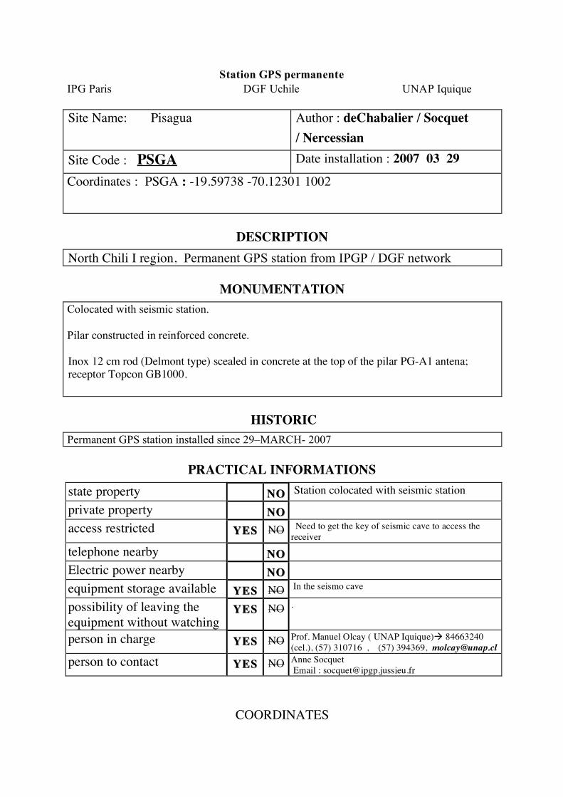
Station GPS permanente
IPG Paris DGF Uchile UNAP Iquique
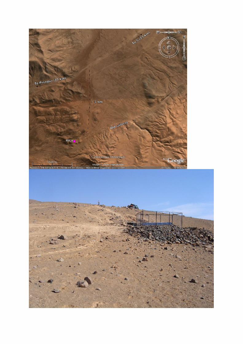
Site Name: Pisagua
Author : deChabalier / Socquet
/ Nercessian
Site Code : PSGA Date installation : 2007 03 29
Coordinates : PSGA : -19.59738 -70.12301 1002
DESCRIPTION
North Chili I region, Permanent GPS station from IPGP / DGF network
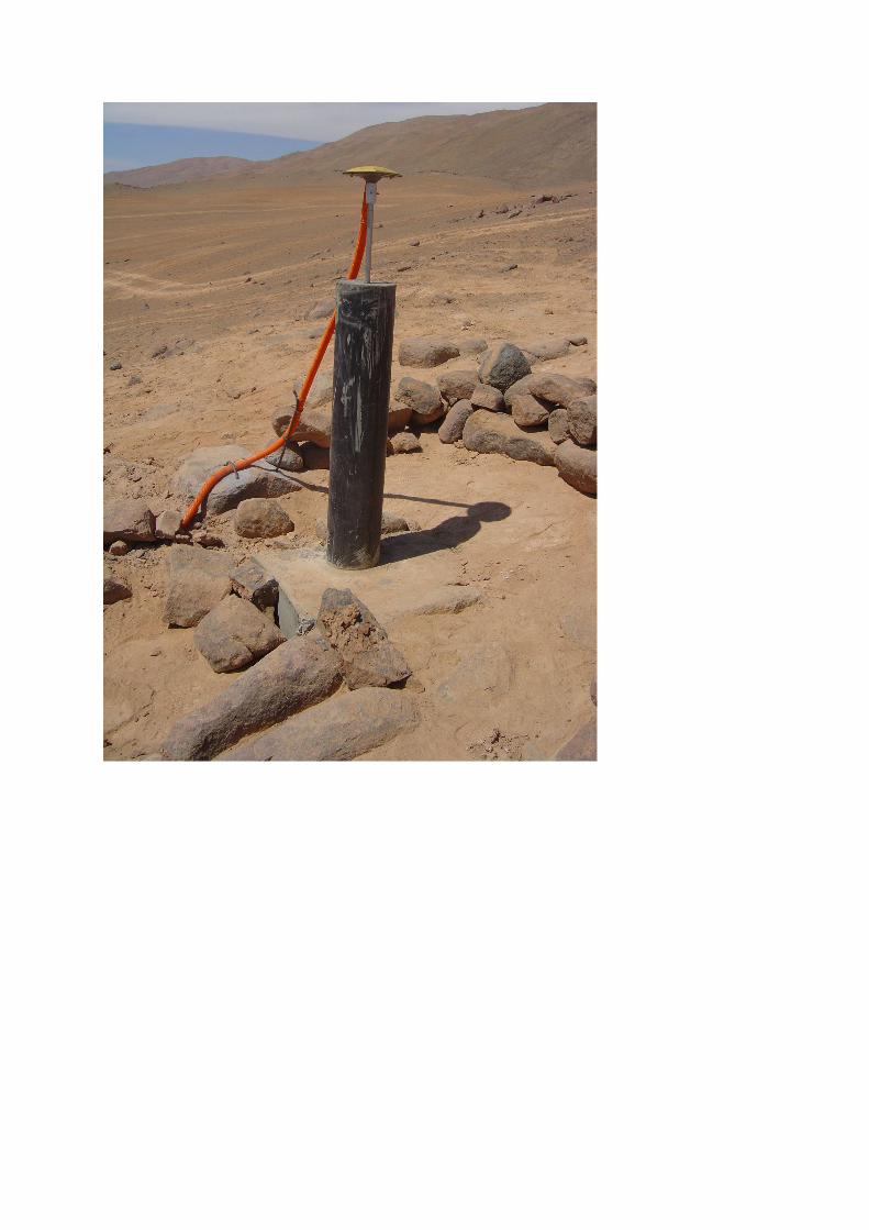
MONUMENTATION
Colocated with seismic station.
Pilar constructed in reinforced concrete.
Inox 12 cm rod (Delmont type) scealed in concrete at the top of the pilar PG-A1 antena;
receptor Topcon GB1000.
HISTORIC
Permanent GPS station installed since 29–MARCH- 2007
PRACTICAL INFORMATIONS
state property NONO Station colocated with seismic station
private property NONO
access restricted YESYES NO Need to get the key of seismic cave to access the
receiver
telephone nearby NONO
Electric power nearby NONO
equipment storage available YESYES NO In the seismo cave
possibility of leaving the
equipment without watching YESYES NO .
person in charge YESYES NO Prof. Manuel Olcay ( UNAP Iquique)! 84663240
(cel.), (57) 310716 , (57) 394369, [email protected]
person to contact YESYES NO Anne Socquet
Email : [email protected]
COORDINATES
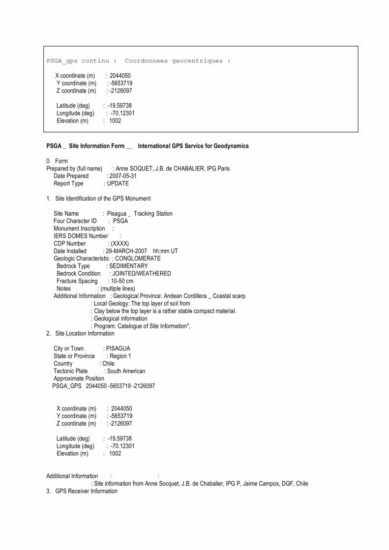
PSGA_gps continu : Coordonnees geocentriques :
X coordinate (m) : 2044050 Y coordinate (m) : -5653719 Z coordinate (m) : -2126097 Latitude (deg) : -19.59738 Longitude (deg) : -70.12301 Elevation (m) : 1002
PSGA _ Site Information Form __ International GPS Service for Geodynamics 0. Form Prepared by (full name) : Anne SOQUET, J.B. de CHABALIER, IPG Paris Date Prepared : 2007-05-31 Report Type : UPDATE 1. Site Identification of the GPS Monument Site Name : Pisagua _ Tracking Station Four Character ID : PSGA Monument Inscription : IERS DOMES Number : CDP Number : (XXXX) Date Installed : 29-MARCH-2007 hh:mm UT Geologic Characteristic : CONGLOMERATE Bedrock Type : SEDIMENTARY Bedrock Condition : JOINTED/WEATHERED Fracture Spacing : 10-50 cm Notes : (multiple lines) Additional Information : Geological Province: Andean Cordillera _ Coastal scarp : Local Geology: The top layer of soil from : Clay below the top layer is a rather stable compact material. : Geological information : Program: Catalogue of Site Information", 2. Site Location Information City or Town : PISAGUA State or Province : Region 1 Country : Chile Tectonic Plate : South American Approximate Position PSGA_GPS 2044050 -5653719 -2126097 X coordinate (m) : 2044050 Y coordinate (m) : -5653719 Z coordinate (m) : -2126097 Latitude (deg) : -19.59738 Longitude (deg) : -70.12301 Elevation (m) : 1002 Additional Information : : : Site information from Anne Socquet, J.B. de Chabalier, IPG P, Jaime Campos, DGF, Chile 3. GPS Receiver Information
3.1 Receiver Type : Topcon GB1000 Serial Number : s/n T224400 Firmware Version : xxx Date Installed : 29-MARCH-2007 Date Removed : Additional Information : (multiple lines) 3.2 Receiver Type : Serial Number : Firmware Version : xxx Date Installed : Date Removed : Note : Note 2 : : Date Installed : Date Removed : (dd-MMM-yyyy hh:mm UT) 4. GPS Antenna Information 4.1 Antenna Type : Topcon PGA1 Serial Number : S/N 310-0461 Antenna Height (m) : 0.01 Antenna Reference Point : DHPAB Degree Offset from North : Antenna Radome Type : Date Installed : 29-MARCH-2007 hh:mm UT Date Removed : station. info : 4.2 Antenna Type : Serial Number : Antenna Height (m) : Antenna Reference Point : Degree Offset from North : Antenna Radome Type : Date Installed : Date Removed : 5. Local Site Ties 5.1 Monument Name : Site Ref CDP Number : Site Ref Domes Number : dx (m) : dy (m) : dz (m) : Accuracy (mm) : (mm) Date Measured : (dd-MMM-yyyy hh:mm UT) Additional Information : Mark 5.2 Monument Name : Site Ref CDP Number : Site Ref Domes Number : Differential Components from GPS Mark to Site Reference (ITRS) dx (m) : dy (m) : dz (m) : Accuracy (mm) : (mm)
Date Measured : (dd-MMM-yyyy hh:mm UT) Additional Information : 5.3 Monument Name : Site Ref CDP Number : Site Ref Domes Number : Differential Components from GPS Mark to Site Reference (ITRS) dx (m) : dy (m) : dz (m) : Accuracy (mm) : (mm) Date Measured : (dd-MMM-yyyy hh:mm UT) Additional Information : 6. Frequency Standard 6.1 Standard Type : Frequency : Effective Dates : 6.2 Standard Type : INTERNAL Frequency : Effective Dates : - dd-MMM-yyyy 7. Collocation Information 7.x Instrumentation Type : Status : (PERMANENT/MOBILE) Effective Dates : (dd-MMM-yyyy - dd-MMM-yyyy) 8. Meteorological Instrumentation 8.1 Humidity Sensor Model : Manufacturer : Data Frequency : Accuracy (% rel h) : (% rel h) Effective Dates : (dd-MMM-yyyy - dd-MMM-yyyy) 8.2 Pressure Sensor Model : Manufacturer : Data Frequency : Accuracy (mbar) : (mbar) Height Diff to GPS (m) : (m) Effective Dates : (dd-MMM-yyyy - dd-MMM-yyyy) 8.3 Temperature Sensor Model : Manufacturer : Data Frequency : Accuracy (deg C) : (deg C) Effective Dates : (dd-MMM-yyyy - dd-MMM-yyyy) 8.4 Water Vapor Radiometer : Manufacturer : Distance to GPS (m) : (m) Elev Diff to GPS (m) : (m) Effective Dates : (dd-MMM-yyyy - dd-MMM-yyyy) 8.5 Other Instrumentation : (multiple lines) pm 9. On-Site, Point of Contact Agency Information Agency : Department of Physics_ Universidad Arturo Prat, Iquique, Chile Mailing Address : Primary Contact : Contact Name : Manuel Olcay Telephone (primary) : 447070 Fax : E-mail : [email protected] Secondary Contact : 10. Responsible Agency (if different from 9.)
Contact Name : Socquet Anne Telephone (primary) : +33 1 44 27 48 93 Telephone (secondary) : Fax : +33 1 44 27 24 40 E-mail : [email protected], [email protected], [email protected] 11. More Information URL for More Information : Hardcopy on File Site Map : Site Diagram : Horizon Mask Monument Description : Site Pictures : Additional Information : (multiple lines)
ADDITIONAL INFORMATION
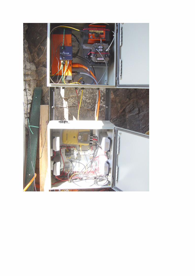
power : Solar panel + solar regulator
Battery : dry battery
Antenna cable : 30m of low loss cable + 5m of thin cable with topcon plug
Internet connection : satellite connection with fix IP adress installed in NOV 07
----------------------------------------------------------------------------------------------------------
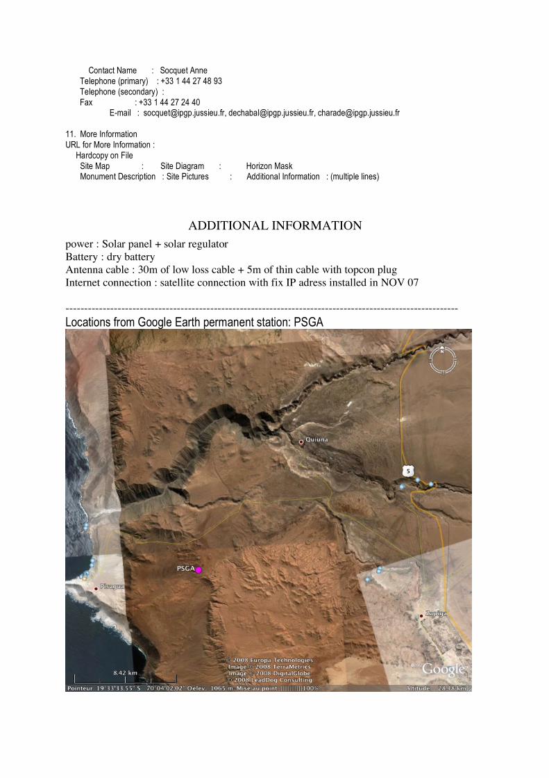
Locations from Google Earth permanent station: PSGA