Embed Size (px)
Citation preview

Site Characterization
GUJRATPakistan
Global Change Impact Studies Centre (GCISC), Islamabad, Pakistan
GECAFS Indo-Gangetic Plains BFP Grant Meeting 13-15 December, 2005, Kathmandu, NEPAL.
Kashif Majeed Salik

Reasons of Selection District Gujrat has both irrigated and rainfed cultivated
areas thus impact of GEC on food and water can be assessed on both areas.
Being less productive, as compared to other districts of Punjab, food security in Gujrat would be more vulnerable to GEC.
Variety of cropping systems like sugarcane-wheat, rice-wheat and mixed cropping due to irrigated and rainfed agriculture.
Topography in Gujrat varies from plain to sub-mountainous range.

Gujrat
Mandi Bahawaldin

Gujrat at a Gujrat at a GlanceGlance
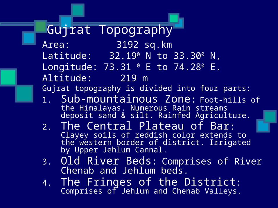
Area: 3192 sq.kmLatitude: 32.190 N to 33.300 N,Longitude: 73.31 0 E to 74.280 E.Altitude: 219 mGujrat topography is divided into four parts:
1. Sub-mountainous Zone: Foot-hills of the Himalayas. Numerous Rain streams deposit sand & silt. Rainfed Agriculture.
2. The Central Plateau of Bar: Clayey soils of reddish color extends to the western border of district. Irrigated by Upper Jehlum Cannal.
3. Old River Beds: Comprises of River Chenab and Jehlum beds.
4. The Fringes of the District: Comprises of Jehlum and Chenab Valleys.
Gujrat Topography
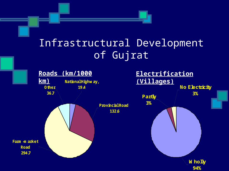
National Highway, 19.4
Farm-market Road 294.7
Provincial Road 132.6
Other 36.7
Infrastructural Development of Gujrat
No Electricity3%
Partly3%
Wholly94%
Electrification (Villages)Roads (km/1000 km)

Other3%
Tube Well5%
Piped Supply8%
Hand Pump84%
Not Available1%
Brakish3%
Sweet96%
Infrastructure Development of Gujrat
Drinking Water Supply Sub-Soil Water Qualilty
Continue…

Gujrat Demography
TehsilArea (Sq.km)
Pop. Density/Sq.km
Urban Pop. (%)
Rural Pop. (%)
Av. Household Size
Tot.Pop (millions)
Gujrat 1463 747.2 33.2 66.8 6.8 1.09
Kharian
1154 675.6 21.5 78.5 6.4 0.78
Sarai Alamgir
575 304.8 21.2 78.8 6.3 0.18
Total 3192 641.6 27.7 72.3 6.6 2.05

Av. Household Income and Expenditure, and % of
Expenditure on Food Items
Area
Average H.H Income (Rs.)
Av. Household Expenditure (Rs.)
% of Expenses on Food & Beverage
Punjab 6846.6 6233 47.87
Punjab Urban
9206.5 8040 39.07
Punjab Rural
5909.4 5515 52.96

Percentage of Employed Population by Sectors in Gujrat
SectorsAll Areas
Rural
Urban
Agriculture, Forestry, & Fishing
29.5 40.7 6.3
Wholesale &Retail Trade, Resturant & Hotels.
10.1 6.3 18.0
Others* 60.4 53.0 75.7
* Others Includes: Services, Construction, Transport, Manufacturing, Mining and Quarrying.
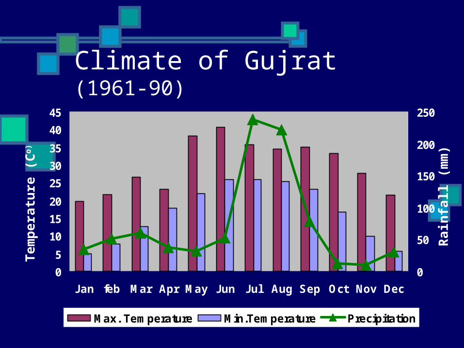
Climate of Gujrat (1961-90)
0
5
10
15
20
25
30
35
40
45
Jan feb Mar Apr May Jun Jul Aug Sep Oct Nov Dec
0
50
100
150
200
250
Max. Temperature Min.Temperature Precipitation
Te
mp
era
ture
(C
o)
Ra
infa
ll (m
m)
Agriculture in Gujrat
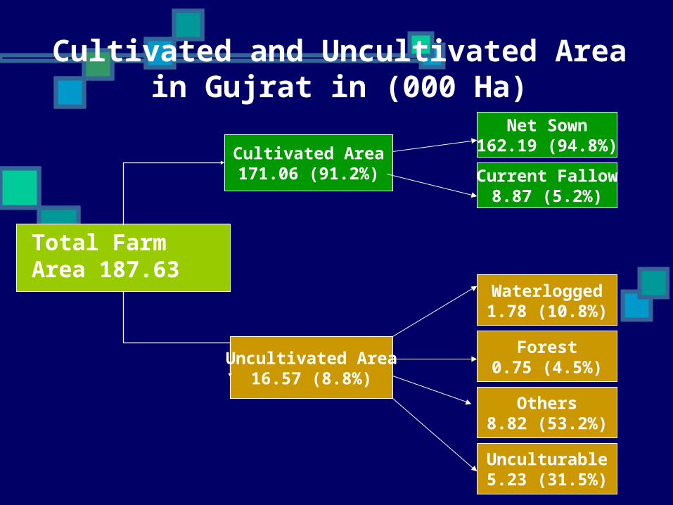
Total Farm Area 187.63
Cultivated Area171.06 (91.2%)
Net Sown162.19 (94.8%)
Current Fallow8.87 (5.2%)
Uncultivated Area16.57 (8.8%)
Waterlogged1.78 (10.8%)
Forest0.75 (4.5%)
Others8.82 (53.2%)
Unculturable5.23 (31.5%)
Cultivated and Uncultivated Area in Gujrat in (000 Ha)

Canal 12.19 (13.9%)
Total Cultivated Area171.06
Total Cultivated with
Irrigation Facilities87.51(51.6%)
Canal & T,W14.66 (16.8%)
T.Well59.73 (68.3%)
Other0.93 (1.2%)
Not Irrigated1.25 (1.4%)
Cultivated Area with no
Irrigation Facility82.30 (48.1%)
Flooded3.25 (3.9%)
Rainfed79.05 (96.1%)
* Other Include: Tank/Bandat, Spring/Rodkohi, Unspecified source
Cultivated Area Classified by Mode of Irrigation in (000 ha)

Number and Area of Farms in Gujrat(by Size of Farms)
Medium51%
Large7%
Small42%
Large1%
Medium20%
Small79%
Total Farm Area: 187.36 (000 ha)
Total Number of Farms: 57118

Land Use Intensity and Cropping Intensity in Gujrat
Size of Farm
Total Farm Area (000 ha)
Land Use Intensity (%)
Cropping Intensity (%)
Small 78.58 95 155
Medium 95.41 89 140
Large 13.37 84 109
Total 187.36 91 146

Percentage distribution of Tenure Classification of farms in Gujrat
Size of Farm
Total OwnerOwner-Cum Tenant
Tenant
Small 100 95 3 2
Medium
100 87 10 3
Large 100 96 4 -
Total 100 94 4 2

Share of Different Crops in Total Cropped Area (%) in Gujrat
Rice15%
Wheat49%
Jawar15%
Orchads1%
Vegetables1%
Fodders14%Pulses
2%
Sugarcane1%
Tobacco1%
Oilseed1%
Total Cropped Area249.4 (000ha)
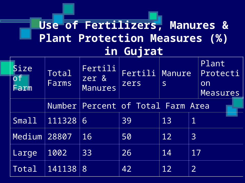
Use of Fertilizers, Manures & Plant Protection Measures (%)
in Gujrat
Size of Farm
Total Farms
Fertilizer & Manures
Fertilizers
Manures
Plant Protection Measures
Number
Percent of Total Farm Area
Small111328
6 39 13 1
Medium
28807 16 50 12 3
Large 1002 33 26 14 17
Total141138
8 42 12 2

Livestock Population in Gujrat Type Number of Livestock (Heads in thousands)
TotalFarm Household
Non-Farm Household
Livestock Holders
others
Cattle 91.73 78.50 13.23 -
Buffaloes
333.51 268.49 65.02 -
Goats 121.14 83.41 25.37 12.36
Sheep 9.07 5.87 2.91 0.283
Camels 0.88 0.71 0.14 0.025
Horses 6.34 4.56 0.93 0.859
Mules 1.05 0.27 0.49 0.286
Donkeys
53.04 40.52 9.24 3.29

Farm Reporting Use of Important Owned Agri. Machinery in Gujrat
Size of Farm
Tot.Farms
Tractor
T.Well/ Pump
Thresher
Drill Other
Numbers
Small111328
2140 8293 1107 564 197
Medium
28807 3480 8279 2126 1117 343
Large 1003 318 328 224 114 100
Total141138
5938 16900 3457 1795 640
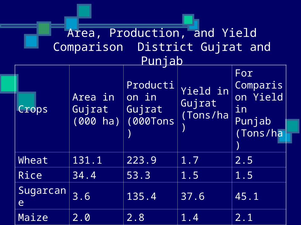
Area, Production, and Yield Comparison District Gujrat and
Punjab
CropsArea in Gujrat (000 ha)
Production in Gujrat (000Tons)
Yield in Gujrat (Tons/ha)
For Comparison Yield in Punjab (Tons/ha)
Wheat 131.1 223.9 1.7 2.5
Rice 34.4 53.3 1.5 1.5
Sugarcane
3.6 135.4 37.6 45.1
Maize 2.0 2.8 1.4 2.1
Pulses 7.4 3.3 0.4 0.5
Tabacoo 0.3 0.4 1.5 1.2