Embed Size (px)
Citation preview

Site Allocations Plan:
Sustainability Appraisal
Main Report
March 2016

2

Contents Non-Technical Summary 4 1. Introduction 8 Scoping Report 8 Aims of this SA Report 8 Habitats Regulations Assessment (HRA) 9 Equality Impact Assessment (EqIA) 9 2. The Sustainability Appraisal Framework 10 3. Summary of the Site Allocations Plan 12 Plan objectives 12 Strategic context 12 Distribution of residential development 13 4. Appraisal of the proposed site allocations 15
Reasonable alternatives 15 (a) Identification of potential residential site allocations 16 (b) Identification of potential employment site allocations 19 (c) Identification of potential Local Green Space allocations 21
Appendix 1 Residential site assessments (excel document) Appendix 2 Employment site assessments 24 Appendix 3 Local Green Space assessments 27 Appendix 4 Compliance with SEA requirements 30

4
Non-Technical Summary
Introduction
i. The Site Allocations Plan will form part of the Local Plan for North Somerset. Part 1 of this Plan – Development Management Policies is anticipated to be adopted in late spring 2016. Part 2 of this plan, dealing with site allocations is at the consultation draft stage and, consequently, this is a Sustainability Appraisal (SA) of the consultation version of the Draft Site Allocations Plan.
ii. The purpose of the Site Allocations Plan is to identify the detailed allocations required to deliver the North Somerset Core Strategy, consistent with government policy and guidance. This will include a review of existing and the identification of new allocations covering residential and employment uses, as well as designations to safeguard particular areas of Local Green Space and strategic gaps.
iii. Sustainability Appraisal of Local Plan documents is required by UK legislation
and helps ensure that plans meet the statutory objective of contributing to the achievement of sustainable development. This extends beyond the Strategic Environmental Assessment that EU legislation requires for Local Plans. Both of these requirements are combined in this report.
iv. The aim of Sustainability Appraisal is to promote sustainable development
through the integration of environmental, social and economic considerations into the preparation of planning documents. The Sustainability Assessment report has been produced alongside the emerging Site Allocations Plan in order to provide sustainability guidance during its development
v. Preparation of the SA of the Site Allocations Plan involves two key stages:
a. Production of a Scoping Report. This has involved updating and building upon
the version produced for the Core Strategy published in 2007 and the scoping report produced for Part 1: Development Management Policies of the plan. This identifies the key sustainability issues facing North Somerset and the sustainability objectives which will be used to appraise likely significant effects of the Sites and Policies Plan.
b. Production of a Main SA Report, which demonstrates that the process of Sustainability Appraisal (incorporating the requirements of the EU Directive on Strategic Environmental Assessment) has been carried out properly, and highlights the findings of this process.
vi. The methodology for the Site Allocations Plan will differ from that used for other plans because of the nature of the plan. The methodology will most closely resemble that of the Joint Strategic Plan for the West of England, which also evaluates spatial options. Spatial options have been assessed by using the Sustainability Appraisal objectives to assess the sustainability of site options. The Site Allocations Plan is structured in three parts:

5
(a) The assessment of residential housing site allocations (b) The assessment of the employment allocations and (c) The assessment for Local Green Space allocations.
viii. The SA framework for the Site Allocations Plan has been developed in a way that fully integrates it into the evaluation of residential sites and employment and Local Green Space options. It helps to determine whether sites should be allocated for their intended use or whether an alternative options should be considered. The SA objectives identified in the scoping report (with amendments) have been used in the assessment, this shows which are the preferred sites in terms of delivering sustainable development. An assessment is made of the reasonable alternative, which in the case for employment and Local Green Space sites is of not allocating any sites. The reasonable alternative options have also been subject to SA in line with legal requirements, and the findings are summarised alongside those relating to the preferred options.
ix. The Site Allocations Plan fits into a hierarchy of planning documents, and is
therefore influenced by Government policy. In addition, the adopted Core Strategy sets out the principles which guide this document, and has itself been subject to Sustainability Appraisal. The Site Allocations Plan needs to be consistent with national policy, as well as the Core Strategy, and therefore there are some constraints placed upon the Site Allocations Plan.
x. The main findings of the assessment is that sustainability objectives are more
compatible to the proposed Site Allocation Plan alternative than the reasonable alternative options of either keeping the existing Local Plan allocations of the North Somerset Replacement Local Plan (NS RLP) or of not having any allocations or plan in place. This is largely due to the technical assessment procedure, which has identified the preferred allocations, including sustainability criteria within these assessments. This is more clearly identifiable within the employment and Local Green Space allocations, whereas other considerations can in some instances play a more significant role for residential site allocations. For this reason, it is not proposed that any of the site allocations require any alteration, as adverse effects are in fact likely be minimised through the adoption of the SAP plan.
xi. The residential sites that have been assessed can be viewed at:
www.n-somerset.gov.uk/sitesandpolicies
Next Steps
xii. This Sustainability Appraisal Report accompanies the formal consultation on
the Consultation Version of the draft Site Allocations Plan. This Main Report is accompanied by the Scoping Report, which sets out the policy context, baseline information and other background. These two documents together form the SA Report. Comments may be made on any aspect of the SA Report during the consultation period.
6
How to Comment on the Sustainability Appraisal Report
xiii. The council welcomes representations on any aspects of this report. Representations should be made in writing and ideally should be submitted via the council’s e-consult system, which can be accessed from here: www.n-somerset.gov.uk/sitesandpolicies
xiv. Representations can also be made by email or post, addresses below: Email: [email protected]; or Post: Planning Policy and Research, Post Point 15, Town Hall, Walliscote Grove Road, Weston-super-Mare, BS23 1UJ.
All representations must be received by received by midnight, 28 April 2016.
Where to view material:
All documents can be viewed or downloaded via the council’s website at: www.n-somerset.gov.uk/sitesandpolicies
7
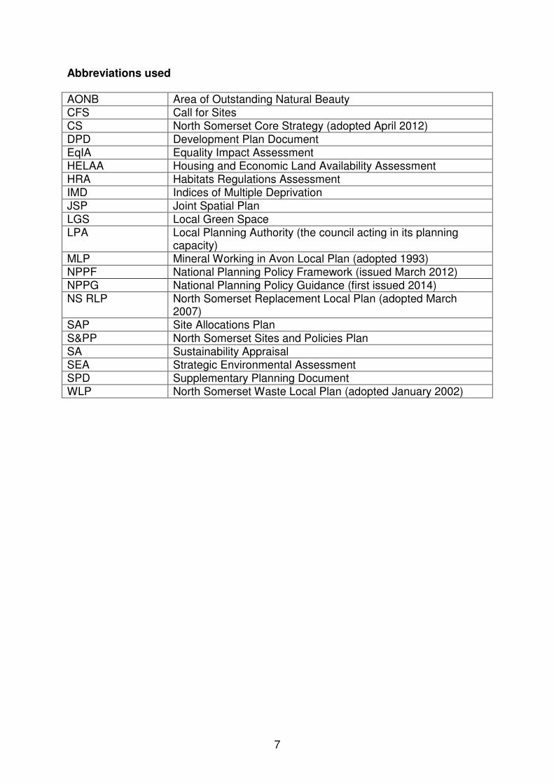
Abbreviations used AONB Area of Outstanding Natural Beauty CFS Call for Sites CS North Somerset Core Strategy (adopted April 2012)
DPD Development Plan Document EqIA Equality Impact Assessment HELAA Housing and Economic Land Availability Assessment HRA Habitats Regulations Assessment IMD Indices of Multiple Deprivation JSP Joint Spatial Plan
LGS Local Green Space LPA Local Planning Authority (the council acting in its planning
capacity) MLP Mineral Working in Avon Local Plan (adopted 1993) NPPF National Planning Policy Framework (issued March 2012) NPPG National Planning Policy Guidance (first issued 2014) NS RLP North Somerset Replacement Local Plan (adopted March
2007) SAP Site Allocations Plan
S&PP North Somerset Sites and Policies Plan SA Sustainability Appraisal SEA Strategic Environmental Assessment SPD Supplementary Planning Document WLP North Somerset Waste Local Plan (adopted January 2002)

8
1. Introduction 1.1 In accordance with the NPPF all councils are required to maintain an up-to-
date Local Plan. The preparation of the Sites and Policies Plan (S&PP) is provided for in the council’s current 2014-17 Local Development Scheme and will contribute towards the aim of an up-to-date Local Plan.
1.2 The Sites and Policies Plan will be presented in two parts. Part 1: Development Management Policies contains the detailed planning policies used to manage new development in North Somerset. This has been progressed ahead of Part 2, which will provide the place-specific policies and site allocations for various types of development, housing, employment and Local Green Space. The preparation of Part 1 is at Publication stage, which includes main modifications following public examination. The preparation of Part 2 - Site Allocations Plan (SAP) is at Consultation draft stage consequently, this is a Sustainability Appraisal (SA) of the Consultation Version of the Draft Plan.
1.3 The residential site allocations within this plan are largely identified through Call for Sites exercises, conducted in 2014 and 2015. The allocations of employment and Local Green Space have been identified through internal assessment processes conducted by planning officers. The site allocations identified within this plan will sit alongside the policies of the Core Strategy (adopted 2012) and the Joint Waste Core Strategy (adopted 2011) and form the Local Plan for North Somerset which will be used by decision-makers when assessing planning applications.
Scoping Report 1.4 Through consideration of the baseline conditions and requirements of other
plans, programmes and strategies, a Scoping Report which accompanies this Main Report describes the context for sustainability and begins to identify the key issues to be addressed.
1.5 Targeted consultation with the three specified national environmental bodies on the SA Scoping Report for the Site Allocations Plan was carried out from December 2015 to January 2016. Responses were received from Historic England, Environment Agency and Natural England. These responses, together with other updates, are incorporated into the revised Scoping Report now being published.
Aims of this SA Report 1.6 This report constitutes a Main SA Report for the Site Allocations Plan, which
is being issued for formal consultation from 10 March to 28 April 2016. It is being published for consultation to provide the public, statutory bodies and other organisations with an opportunity to express their views on it.
1.7 This SA meets the requirements of both the Planning and Compulsory Purchase Act 2004 and the SEA Regulations. Together with the Scoping Report, this SA Main Report includes the required elements of an
9
‘Environmental Report.’ The requirements of the SEA directive, set out in Appendix 4 shows how they’ve been met within the Sustainability Appraisal.
Habitats Regulations Assessment (HRA) 1.8 The UK is bound by the terms of the Habitats Directive, the Birds Directive,
and the Ramsar Convention. The aim of the Habitats Directive is to conserve natural habitats and wild species across Europe by establishing a network of sites known as Natura 2000 sites. There are four European sites within North Somerset.
1.9 The protection given by the Habitats Directive is transposed into UK legislation through the Habitats Regulations, which require competent authorities (in this case the council) to carry out an appropriate assessment (Habitats Regulations Assessment) of local development documents (in this case the S&PP) before being adopted.
1.10 Although not part of Sustainability Appraisal itself, the council needs to undertake an assessment under the terms of the Habitats Directive.
Equality Impact Assessment (EqIA) 1.11 An Equality Impact Assessment (EqIA) is the process of analysing a proposed
or existing policy or strategy to identify what effect, or likely effect will follow from the implementation of the policy for different groups in the community. The Equality Impact Assessment will be published when the plan is submitted to the Secretary of State.
10
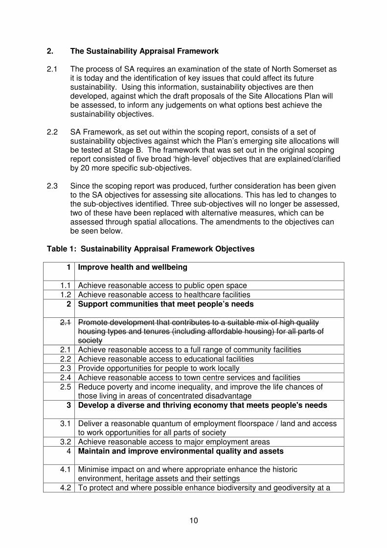
2. The Sustainability Appraisal Framework 2.1 The process of SA requires an examination of the state of North Somerset as
it is today and the identification of key issues that could affect its future sustainability. Using this information, sustainability objectives are then developed, against which the draft proposals of the Site Allocations Plan will be assessed, to inform any judgements on what options best achieve the sustainability objectives.
2.2 SA Framework, as set out within the scoping report, consists of a set of sustainability objectives against which the Plan’s emerging site allocations will be tested at Stage B. The framework that was set out in the original scoping report consisted of five broad ‘high-level’ objectives that are explained/clarified by 20 more specific sub-objectives.
2.3 Since the scoping report was produced, further consideration has been given to the SA objectives for assessing site allocations. This has led to changes to the sub-objectives identified. Three sub-objectives will no longer be assessed, two of these have been replaced with alternative measures, which can be assessed through spatial allocations. The amendments to the objectives can be seen below.
Table 1: Sustainability Appraisal Framework Objectives
1 Improve health and wellbeing
1.1 Achieve reasonable access to public open space 1.2 Achieve reasonable access to healthcare facilities
2 Support communities that meet people’s needs
2.1
Promote development that contributes to a suitable mix of high quality housing types and tenures (including affordable housing) for all parts of society
2.1 Achieve reasonable access to a full range of community facilities 2.2 Achieve reasonable access to educational facilities 2.3 Provide opportunities for people to work locally 2.4 Achieve reasonable access to town centre services and facilities 2.5 Reduce poverty and income inequality, and improve the life chances of
those living in areas of concentrated disadvantage 3 Develop a diverse and thriving economy that meets people's needs
3.1 Deliver a reasonable quantum of employment floorspace / land and access to work opportunities for all parts of society
3.2 Achieve reasonable access to major employment areas 4 Maintain and improve environmental quality and assets
4.1 Minimise impact on and where appropriate enhance the historic
environment, heritage assets and their settings 4.2 To protect and where possible enhance biodiversity and geodiversity at a

11
landscape scale, particularly with respect to protected habitats and species 4.3 Minimise impact on and where appropriate enhance valued landscapes,
recognising its wider purposes (natural beauty, enjoyment and cultural heritage) whilst having regard for its economic and social well-being. Including that within or close to the Mendip Hills AONB
4.4 Promote the conservation and wise use of land, maximising the re-use of previously developed land
4.5 Minimise the loss of productive land, especially best and most versatile agricultural land
4.6 Minimise vulnerability to tidal & fluvial flooding, without increasing flood risk elsewhere
4.7 Minimise vulnerability to surface water flooding and other sources of flooding, without increasing flood risk elsewhere
4.8
Minimise harm to, and where possible improve, water quality and availability Replace with: Minimise impacts on air quality through locating development in locations least likely to contribute to traffic congestion
5 Minimise consumption of natural resources
5.1 Achieve reasonable access to sustainable transportation 5.2
5.2
Reduce non-renewable energy consumption and greenhouse gas emissions, and provide opportunities to link into existing heat networks Replace with: Minimise harm to the countryside by containing development within existing defined settlement boundaries
12
3. Summary of the Site Allocations Plan Plan objectives 3.1 The purpose of the Site Allocations Plan is to identify the detailed allocations
required to deliver the North Somerset Core Strategy, consistent with government policy and guidance. This will include a review of existing and the identification of new allocations covering residential and employment uses, as well as designations to safeguard or protect particular areas of Local Green Space and strategic gaps. It is important for the objectives of the Plan to be in accordance with sustainability principles. The objectives of the Site Allocations Plan flow from those in the Core Strategy and, as the Site Allocations Plan is subordinate to the Core Strategy, it is not considered necessary to re-appraise them.
Strategic context 3.2 The strategic context for the Site Allocations Plan is provided through the
Core Strategy, which sets out the council’s approach to meeting development needs in North Somerset to 2026. The Core Strategy has also been subject to SA. The Monitoring Framework adopted for the Core Strategy will also underpin monitoring of the Site Allocations Plan.
3.3 The Core Strategy contains ten priority objectives and four of these priority objectives are most relevant to the Site Allocations Plan. These are: 1) Deliver sustainable housing development across North Somerset to
meet housing needs, through the provision of a minimum of 20,985 new homes by 2026. (*updated figure – see para. 3.5)
3) Prioritise employment growth throughout North Somerset to support greater self-containment, in particular by ensuring that in Weston-super-Mare housing development is delivered in step with employment growth, brownfield opportunities in Clevedon, Nailsea and Portishead are maximised, and that small and medium enterprises are supported. Support and promote major employers in North Somerset, such as Bristol Airport and Royal Portbury Dock, to ensure continued employment security and economic prosperity.
5) Focus strategic development at Weston-super-Mare as part of an employment-led strategy to deliver improved self-containment, stimulate investment, regenerate and revitalise the town centre to create a thriving and vibrant retail, leisure, and tourist, cultural and commercial centre. To support regeneration within communities elsewhere in the town, particularly in the South and Central Wards.
7) Continue to support North Somerset’s existing Green Belt in order to prevent the sprawl of Bristol and its encroachment into valued countryside and to preserve the character of existing settlements;
13
elsewhere, valued strategic gaps between settlements and characteristic green spaces and areas will be protected.
3.4 It is important to note that this is a separate process to that of the West of England Joint Spatial Plan. This is being prepared jointly by the West of England authorities to consider any additional development required for the roll-forward of the 20 year period from 2016-2036. This will in turn feed into a review of the North Somerset Core Strategy or a new replacement Local Plan.
Distribution of Residential Development
3.5 On 18 September 2015 the Secretary of State approved Core Strategy Policy
CS13 and the housing requirement of 20,985 dwellings over the plan period
(2006-2026). As at April 2015, current capacity over the plan period
(commitments and windfall allowance) totalled 19,270 dwellings, leaving a
shortfall of a minimum of 1,715 dwellings to find.
3.6 Core Strategy policy CS14 (housing distribution) sets out a broad indication of where it is anticipated that the dwelling requirement will be located over the plan period. This provides a steer for the detailed allocations coming forward through the Site Allocations Plan. The updated table below sets out the proposed broad spatial locations for completions, commitments and windfall. For Core Strategy purposes this is simply an indication as to where it is anticipated new residential development will be delivered, but the detailed figures will vary as sites are assessed. The shortfall is such that there is no requirement to allocate or examine sites within the Green Belt. The NPPF (para 83) makes it clear that ‘Green Belt boundaries should only be altered in exceptional circumstances.’
Area Completions,
commitments and windfall
Location of shortfall
Net additional dwellings 2006-
2026 Weston urban area (excluding Weston Villages)
5,809 650 6,459
Weston Villages 6,250 250 6,250
Clevedon, Nailsea and Portishead
4,626 350 4,976
Service Villages, other settlements and countryside
2,585 465 3,050
Total 19,270 1,715 20,985 Source: Report to NSC Executive Committee, 20 October 2015
3.7 The North Somerset Core Strategy has a clear hierarchy of settlements
primarily based on the level of social, economic and community facilities that
are available. Weston-super-Mare (Policy CS28-30) is a designated sub-
regional centre and is considered to be the most sustainable location within
the district. This is followed by the towns of Nailsea, Clevedon and Portishead

14
(Policy CS31), the service villages (Policy CS32) and finally infill villages
(Policy CS33).
3.8 The Core Strategy approach focuses development at the principal settlement
of Weston-super-Mare as part of an employment-led strategy to improve self-
containment, address out-commuting and tackle regeneration issues. This
includes the strategic allocation at Weston Villages. Elsewhere the other
main opportunities will be found at the towns of Clevedon, Nailsea and
Portishead although there will be constraints particularly in respect of flood
zones and Green Belt. Within the rural areas the service villages will be the
focus for any new development albeit at an appropriate scale on smaller sites,
and within settlement boundaries of the infill villages. Elsewhere in the
countryside, including in the Green Belt there is not anticipated to be
significant opportunity for development.
3.9 The search for suitable development sites to meet the housing need therefore
needs to be based on a sequential approach with sites in or on the edge of
towns favoured over those in the villages. However this simple approach
needs to be balanced against the need to ensure that:
• the housing market in one location is not saturated with new housing
allocations to the extent that required building rates cannot be met and
a 5 year supply of housing is not achieved;
• priority is given to previously developed land rather than greenfield;
• sites are environmentally suitable and will not have an adverse impact
on such matters as landscape, heritage etc;
• sites that are located in or adjacent to a settlement have safe and
convenient access to local facilities;
• sites have suitable highway access and will not individually or
cumulatively have an adverse impact on the strategic highway network;
• sites can be considered deliverable and developable.
15
4. Appraisal of the proposed site allocations 4.1 In this section all options contained in the Site Allocations Plan are appraised
against the amended SA objectives as set out in Section 2, alongside the reasonable alternative of not implementing the proposed option.
4.2 It has been recognised that not all of the SA objectives and sub-objectives will
be relevant to assessing all of the various site allocations. Different objectives and sub-objectives will be most suitable for assessing the residential, employment or Local Green Space allocation options. As a result, only those sub-objectives relevant to each proposed allocation type will be used within the separate assessments.
4.3 A large number of alternative sites for the development of new housing,
employment and open green spaces have been considered during preparation of the Site Allocations Plan. There have been a number of stages in developing and refining options and these will be described for each of the site allocation type.
4.4 We do not propose to assess the permanence of effects of each proposed
allocation against the SA objectives allocations, as all are assumed to be permanent. We do not either propose to assess the timescale of effects, as all are assumed to be short to medium term, where long term is understood as extending beyond the plan period.
4.5 The methodology for assessing each allocation type will be set out in separate
sections below. a) Identification of potential residential development sites b) Identification of potential employment allocations c) Identification of potential Local Green Space allocations Reasonable alternatives
4.6 The SEA Directive requires an assessment of the likely significant
environmental effects of implementing the plan, compared with “reasonable alternatives taking into account the objectives and the geographical scope of the plan”. The table below considers whether reasonable alternatives exist in relation to the various site allocation types.
Site allocations type:
Option A: Proposal (preferred option)
Option B: Reasonable alternative 1
Option C: Reasonable alternative 2
Residential sites
Select those which match most selected SA objectives
Allocate ‘call for sites’ proposed sites, which are outside of the green belt and flood zone 3a
Select sites for other reasons
Employment Select sites ‘Business as usual’ - No Plan - Do

16
allocations proposed through planning officer (technical) assessment as part of the SAP process
retain allocations from policy EC/5 of the NS RLP and allocate no further sites
not allocate sites
Local Green Space
Allocate sites as proposed through planning officer (technical) assessment as part of the SAP process
‘Business as usual’ - protection of Amenity Areas only, as per policy ECH/1 of the NS RLP
No Plan - do not allocate sites
a) Identification of potential residential development sites Initial assessment of sites
4.7 In 2014 the council undertook a ‘call for sites’ (CFS) exercise which requested landowners, developers, local councils and organisations to suggest sites that would be suitable for residential and/or employment development to meet the districts needs up to 2026. This exercise was supplemented in 2015 by a further ‘call for sites’ exercise for the West of England Joint Strategic Plan which is looking ahead to 2036.
4.8 The long list of 331 initial sites put forward from the call for sites exercises
alongside other identified sites, underwent an initial sift to reduce the number of sites requiring further assessment. This initial sift was based on significant identified constraints, these were:
• Non previously developed Green Belt sites
• Sites in Flood Zone 3b
• Sites within the Mendip Hills Area of Outstanding Natural Beauty 4.9 In addition to the discounting of these sites, as part of a further process of site
assessment, those which had existing alternative uses or allocations, or other constraints making them unsuitable for potential development were discounted leaving a range of sites considered to have potential for further consideration. The Core Strategy had established in-principle that open spaces and existing employment areas should be protected in their current use, in order to meet the green infrastructure and employment needs although such sites would be subject to review as part of the site allocations process. The Site Allocations Plan will therefore be used to confirm these protections – which are in themselves key sustainability criteria.
4.10 Following the process of discounting those sites as above, 188 sites remained
as having potential for development for residential use. It is these sites that have been subject to more detailed appraisal using selected SA framework criteria.
17
4.11 The sustainability appraisal for these proposed development sites has
included assessing each proposed remaining site of the remaining 188,
against selected SA framework objectives. The assessment is primarily
conducted through GIS mapping searches, but where necessary, site visits
have been conducted to enable the assessment to be accurate. Other
information sources, such as ‘Pupil projections for North Somerset schools’
have been used to allow the assessment to be made for certain objectives, in
this case for access to primary and secondary schools places.
4.12 The information gathered, allows an assessment to be made regarding the
likely effect that development of that site would have on each SA objective. It
should be noted that only those SA objectives relevant to the assessment of
residential housing sites have been assessed. This has meant that Sub-
objective: 2.5 ‘Reduce poverty and income inequality, and improve the life
chances of those living in areas of concentrated disadvantage’ and Objective
3. ‘Develop a diverse and thriving economy that meets people’s needs’, with
sub-objectives 3.1 ‘Deliver a reasonable quantum of employment floorspace /
land and access to work opportunities for all parts of society’ and 3.2 ‘Achieve
reasonable access to major employment areas’ are not used in this
assessment. As these (sub) objectives relate to meeting employment
objectives, these are assessed within the SA of the employment site
allocations. It should be noted however that sub-objective 2.4 ‘Provide
opportunities for people to work locally’ will be assessed.
4.13 The assessment of to what degree each site matches the selected SA
objectives is reflected through using the Red, Amber and Green (RAG) rating
system. The criteria for the RAG rating for each SA sub-objective is detailed in
Appendix 1: Residential Site Assessment, which can be viewed in a
separate Excel document accompanying this main report. The assessment
completed for each town, village and countryside site location and is ordered
alphabetically in separate sheets. The results of the assessment process will
be detailed below.
Other considerations 4.14 The National Planning Practice Guidance states that ‘assessing the suitability,
availability and achievability of a site will provide the information on which the
judgement can be made in the plan making context as to whether a site can
be considered deliverable, developable or not currently developable for
housing development.’
4.15 Other factors are therefore considered to provide an overview of each site include:
• compatibility with policy,
• physical limitations: where sites are currently occupied by buildings or
where there is current development,

18
• barriers to delivery: where there are overriding factors such as legal or
ownership problems, multiple ownerships, ransom strips, tenancies or
operational requirements of landowners which would remove the realistic
prospect of the site coming forward.
4.16 Other constraints whilst important considerations, may not necessarily rule a site out, but the cumulative impact of them alongside other constraints might. These do not contribute to the site scoring, but are useful aspects to inform any consideration of site deliverability and/ or longer term potential.
4.17 It should be noted that although a particular site may have no ‘site specific’
objections to development other considerations may come into play, including
the need not to greatly exceed the Core Strategy housing requirement.
Regard must also be given to the sustainability of a particular settlement in
which a site is located. We have recently reviewed our assessment of service
villages and some of the infill villages in: ‘Assessing the Sustainability and
settlement hierarchy of rural settlements in North Somerset’, which can be
viewed at: www.n-somerset.gov.uk/sitesandpolicies. From this assessment, it
can be identified which settlements display the most and the least
sustainability characteristics.
Results of the assessment process
4.18 The assessment of each site to the selected sub-objectives are presented in
the matrix at Appendix 1: Residential Site Assessments. The matrix first
outlines the assessment criteria and then shows the assessment of the
various sites put forward by developers, landowners and others in the towns,
service villages and infill villages. There are separate sheets for each
settlement, which are listed alphabetically.
4.19 The sites that have been assessed are identified on a map which can be
viewed here: www.n-somerset.gov.uk/sitesandpolicies
4.20 In an ideal world, sites with red or amber scores, would be removed from the pool of possible allocation sites, as these scores highlight concerns over the possibility of sustainable development on the site. However, given the quantum of housing required to meet the Core Strategy target, this was not a suitable way forward. It was clear, therefore that sites with less favourable sustainability scores would need to be considered, in order to meet the development strategy. Therefore, instead of using the assessment to discount sites immediately, the sustainability appraisal has to be used to note potentially difficult sites and ensure that the possible issues are investigated further, and wherever possible avoided, reduced or mitigated.
4.21 A review of the sustainability appraisal matrix shows that those sub-objectives
which are least often matched vary according to the settlement being assessed. For example, the majority of sites within the principal town, Weston-super-Mare are previously developed sites, so score green on the sub-objective (4.4) relating to maximising the re-use of previously developed

19
land. However, the converse is true in many of the other settlements, where the majority of sites are Greenfield sites.
4.22 The general assessment of residential sites put forward by developers and
landowners has revealed that there are sufficient sites available that can be developed and help meet the Core Strategy housing requirement without compromising sustainable objectives. Although some of the sites allocated for development are Greenfield this is due to the lack of suitably located ‘previously developed land.’ All of the chosen allocated sites are either within or adjacent to a settlement boundary and have good access to local community facilities. Wherever possible ‘previously developed land’ has been identified but many of these sites are remote from settlements.
4.23 As a general rule sites located in the four major towns are preferred due to the
range of social, economic and community facilities that are available. However this does not override the importance attached to ensuring that any development sites must not have a significant adverse impact on the landscape, ecology and other important factors. In addition regard must be had to the need not to saturate the market with housing land, for example at Weston-super-Mare resulting in building rates that are not sustainable in one location
4.24 The cumulative impact of development is also critical. For example one of the
reasons why sites at Banwell and surrounding villages have been resisted is the impact more development will have on the traffic levels in Banwell village. These sites score red under the sub-objective (4.8) which assesses air quality, through the identification of known existing issues with highway capacity.
4.25 Further information on the detailed assessment for each site is available on
request at: [email protected] b) Identification of potential employment allocations
4.26 The adopted Core Strategy Policy CS20 ‘Supporting a successful economy’ sets out an employment target of at least 10,100 jobs growth between 2006 and 2026. This is in addition to including a strategy to roll forward (subject to review) the existing extant employment land allocations from the North Somerset Replacement Local Plan (NS RLP) (2007). Policy E/5 Safeguarded Employment Areas of the NS RLP provides the existing suite of B Class employment allocations. It is proposed that the emerging Site Allocations Plan will supersede this policy and set out an updated range of employment allocations.
4.27 Potential new sites have been identified through the Housing and Economic
Land Availability Assessment (HELAA 2014). In addition, the call for sites exercise in 2015, sought further sites suitable for employment development to meet the district’s employment needs to 2026.

20
4.28 The assessment of potential sites and information on vacant premises and planning permissions has been used to indicate whether there is sufficient land set aside to deliver the employment target and business needs for North Somerset. This will include whether the loss of certain sites has an adverse impact on land supply for B Class employment purposes. The assessment identifies whether additional sites need to be allocated.
4.29 The methodology used for the technical assessment of employment sites can
be viewed here: www.n-somerset.gov.uk/sitesandpolicies 4.30 The assessment of extant NS RLP B Class employment allocations, as set
out in Policy E/5 ‘Safeguarded Employment Areas’ has been carried out in order to help determine a realistic supply of potential employment land from this source and to inform decisions regarding their future allocation in the Site Allocations Plan. Some sites have partially been developed (based on the original allocation) and so the remaining supply has been identified and further detail provided.
4.31 The Sustainability Appraisal (SA) for the employment site allocations in this
plan has been conducted largely on the basis of comparing the Consultation draft SAP allocations against the ‘business as usual’ option (retaining the allocations within the adopted policy E/5 of the NS RLP2007) and the ‘no plan’ option (relying on national policy). In order to assess the employment site options and compatibility with the SA objectives these reasonable alternatives are all assessed to identify which is the most sustainable option.
4.32 The options appraised are therefore as follows:
• Option A = Allocating employment sites in the SAP, superseding the NS
RLP with an updated range of employment allocations.
• Option B = ‘Business as usual,’ retaining the site allocations from the NS
RLP (2007) i.e. some of sites will have been delivered and won’t include
sites from recent call for sites.
• Option C = ‘No plan’ alternative, relying on national policy.
4.33 It is recognised that the some of the SA objectives and sub-objectives will not
be relevant when assessing employment site allocations. For this reason, only those sub-objectives deemed to be relevant to the location of employment sites have been assessed. Those SA Sub-objectives assessed are:
2.3 Provide opportunities for people to work locally 2.4 Achieve reasonable access to town centre services and facilities 2.5
Reduce poverty and income inequality, and improve the life chances of those living in areas of concentrated disadvantage
3.1
Deliver a reasonable quantum of employment floorspace/land and increase access to work opportunities for all parts of society
3.2 Achieve reasonable access to major employment areas 5.1 Achieve reasonable access to sustainable transportation

21
The SA for employment allocations can be viewed at Appendix 2. Results of the SA assessment process 4.34 The assessment of the proposed SAP employment allocations at Appendix 2
clearly shows that the proposed allocations in the draft plan, are more compatible with the relevant SA framework objectives than either of the reasonable alternative options.
4.35 Simply relying on the existing allocations identified in Policy E/5 of the NS
RLP is compatible to some of the SA sub-objectives, but do not score as highly as, or are as compatible to those proposed within the draft SAP.
4.36 The assessment shows that if there were no employment allocations,
therefore relying on a market-led/ no plan (Option C) position, this would be detrimental to meeting the SA sub-objectives and therefore to addressing identified issues of sustainability within North Somerset.
4.37 The reason that the proposed SAP employment allocations score most
favourably is largely because the sustainability of sites has been a key consideration within the technical assessment procedure of the proposed employment SAP allocations. In a market-led situation, there will be other considerations which take precedence over those of sustainability. This is likely to include the cost and availability of sites at any given point of time. A ‘no plan’ option will therefore be potentially detrimental to meeting identified sustainability needs as identified within the SA process.
c) Identification of potential Local Green Space allocations 4.36 Guidance on Local Green Space is set out in the NPPF at paragraphs 76-78:
76. “Local communities through local and neighbourhood plans should be able to identify for special protection green areas of particular importance to them. By designating land as Local Green Space local communities will be able to rule out new development other than in very special circumstances. Identifying land as Local Green Space should therefore be consistent with the local planning of sustainable development and complement investment in sufficient homes, jobs and other essential services. Local Green Spaces should only be designated when a plan is prepared or reviewed, and be capable of enduring beyond the end of the plan period”.
77. “The Local Green Space designation will not be appropriate for most green areas or open space. The designation should only be used:
• where the green space is in reasonably close proximity to the community it serves
• where the green area is demonstrably special to a local community and holds a particular local significance, for example because of its beauty,

22
historic importance, recreational value (including as a playing field), tranquility or richness of its wildlife; and
• where the green area concerned is local in character and is not an extensive tract of land”
78. “Local policy for managing development within a Local Green Space should be consistent with policy for Green Belts”.
4.37 National Planning Practice Guidance (NPPG) (2014) includes a section on the
Local Green Space designation. The guidance (para 13) states that green areas to be identified as LGS will need to meet the criteria in NPPF paragraph 77 above, but “whether to designate is a matter for local discretion”. The council regards this as support for its ability to decide whether a site is designated as LGS.
4.38 The NPPG (para 7) also states that “designating any Local Green Space will need to be consistent with local planning for sustainable development in the area. In particular, plans must identify sufficient land in suitable locations to meet identified development needs, and the Local Green Space designation should not be used in a way that undermines this aim of plan making”.
4.39 NPPG (para 20) states that “designating a green area as LGS would give it
protection consistent with that in respect of Green Belt”. Assessment of sites considered for LGS designation 4.40 The local approach to LGS and the methodology used to assess whether a
site is appropriate under LGS designation can be viewed at: www.n-somerset.gov.uk/sitesandpolicies
4.41 It is recognised that some of the SA sub-objectives will not be relevant when
assessing Local Green Space site designations. For this reason, only those deemed to be relevant to the location of Local Green Space sites have been assessed. Those SA Sub-objectives assessed are:
1.1 Achieve reasonable access to public open space 4.1 Minimise impact on and where appropriate enhance the historic
environment, heritage assets and their settings 4.2 To protect and where possible enhance biodiversity and geodiversity
at a landscape scale, particularly with respect to protected habitats and species
4.3 Minimise impact on and where appropriate enhance valued landscapes, recognising its wider purposes (natural beauty, enjoyment and cultural heritage) whilst having regard for its economic and social well-being. Including that within or close to the Mendip Hills AONB
4.6 Minimise vulnerability to tidal/fluvial flooding, without increasing flood risk elsewhere
4.7 Minimise vulnerability to surface water flooding and other sources of flooding, without increasing flood risk elsewhere

23
4.42 The Sustainability Appraisal (SA) for the Local Green Space site allocations in this plan has been conducted largely on the basis of comparing the Consultation draft SAP options against the ‘business as usual’ option (retaining the Amenity Area allocations in policy ECH/1 of the adopted NS RLP (2007) and the ‘no plan’ option, which assumes no local plans. In order to assess the Local Green Space site options and compatibility with the SA objectives these reasonable alternatives are all assessed to identify which is the most sustainable option.
4.43 The options appraised are therefore as follows:
• Option A: Local Green Space allocated through the Site Allocations Plan
• Option B: Business as usual, LGS (Amenity Areas) retained as identified in the North Somerset Replacement Local Plan.
• Option C: No Plan (no Local Plan, so no LGS or Amenity Areas etc allocated).
The SA for employment allocations can be viewed at Appendix 3. Results of the SA assessment
4.44 As the appraisals indicate, the implication of allocating Local Green Space is positive on the SA objectives assessed and therefore to contributing to achieving sustainable development at the local scale. LGS protection is in compliance with the NPPF objectives. According to the NPPF, the Local Green Space designation should be in reasonably close proximity to the community it serves, therefore meeting sub-objective 1.1 ‘Achieve Reasonable Access to public open space’.
4.45 In line with the NPPF, assessment of sites considered for possible LGS
designation has included consideration of historic significant of the site, richness of wildlife and beauty (the latter relating to visual attractiveness, townscape and/or landscape). This shows compatibility with the SA sub-objectives 4.1 ‘Minimise impact on and where appropriate enhance the historic environment, heritage assets and their settings’; 4.2 ‘To protect and where possible enhance biodiversity and geodiversity at a landscape scale, particularly with respect to protected habitats and species’ and 4.3 ‘Minimise impact on and where appropriate enhance valued landscapes, recognising its wider purposes (natural beauty, enjoyment and cultural heritage) whilst having regard for its economic and social well-being. Including that within or close to the Mendip Hills AONB.’
4.46 Regarding the No Plan option, if there were no areas protected as Local
Green Space or Amenity Areas in local plans, this would have likely negative implications regarding SA sub-objectives 4.6 ‘Minimise vulnerability to tidal/fluvial flooding, without increasing flood risk elsewhere’ and 4.7 ‘Minimise vulnerability to surface water flooding and other sources of flooding, without increasing flood risk elsewhere’, because protection of green spaces helps to reduce the vulnerability to flooding. Also LGS is based on consideration of important sustainability criteria such as biodiversity.

Appendix 2 Appraisal compatibility of employment allocations to SA objectives
Overall compatibility
++ Very positive impact
+ Positive impact
- Neutral
xx Very negative impact
x Negative impact
? Uncertain effects
Appraisal table for employment allocations
SA Objectives Measurable Targets Option
Effects
Compa
tibility Comments/ explanation Adjustments
required
2.3 Provide
opportunities for people
to work locally
Self-containment figures Option A:
SAP
allocations
+ The SAP site technical assessment identifies
priority allocations within the main towns
No
Option B:
Business as
Usual
+ The NS RLP allocations identifies some sites
within the towns.
Option C:
No Plan
? Uncertain effects without local policy
2.4 Achieve reasonable
access to town centre
Development located at Option A:
SAP
++ Both the proposed technical SAP allocations
and the NS RLP allocations prioritise the
No
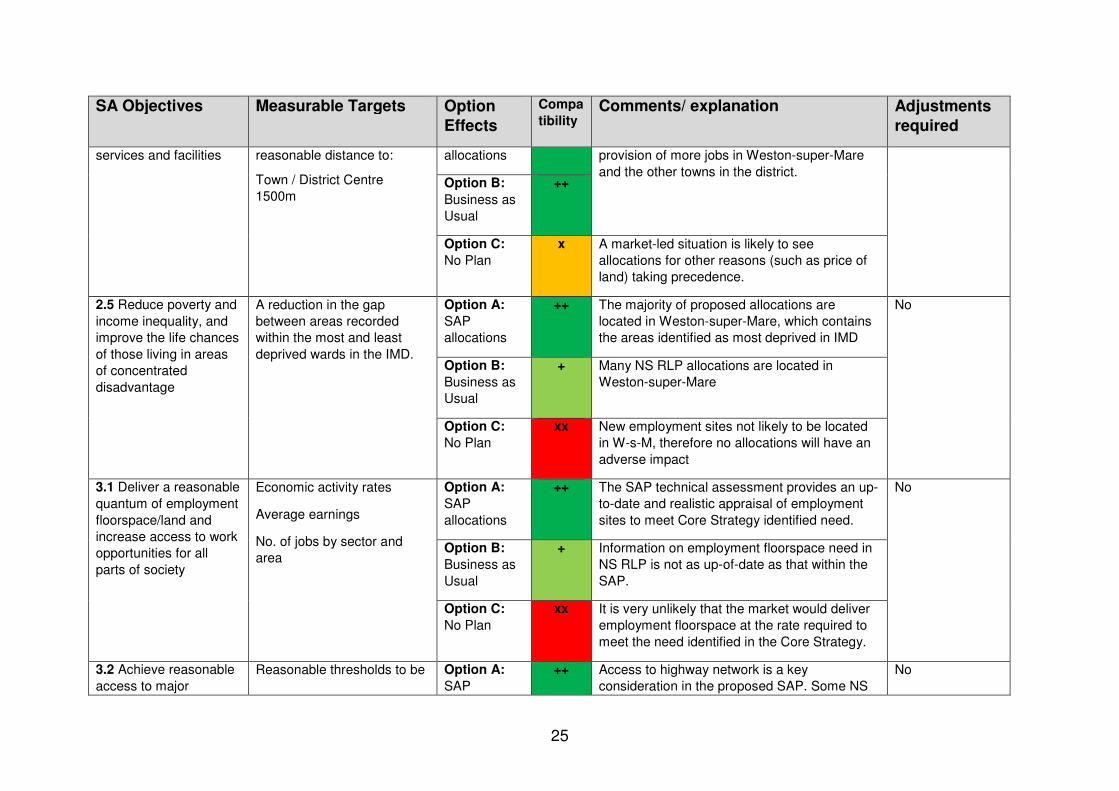
25
SA Objectives Measurable Targets Option
Effects
Compa
tibility Comments/ explanation Adjustments
required
services and facilities reasonable distance to:
Town / District Centre
1500m
allocations provision of more jobs in Weston-super-Mare
and the other towns in the district. Option B:
Business as
Usual
++
Option C:
No Plan
x A market-led situation is likely to see
allocations for other reasons (such as price of
land) taking precedence.
2.5 Reduce poverty and
income inequality, and
improve the life chances
of those living in areas
of concentrated
disadvantage
A reduction in the gap
between areas recorded
within the most and least
deprived wards in the IMD.
Option A:
SAP
allocations
++ The majority of proposed allocations are
located in Weston-super-Mare, which contains
the areas identified as most deprived in IMD
No
Option B:
Business as
Usual
+ Many NS RLP allocations are located in
Weston-super-Mare
Option C:
No Plan
xx New employment sites not likely to be located
in W-s-M, therefore no allocations will have an
adverse impact
3.1 Deliver a reasonable
quantum of employment
floorspace/land and
increase access to work
opportunities for all
parts of society
Economic activity rates
Average earnings
No. of jobs by sector and
area
Option A:
SAP
allocations
++ The SAP technical assessment provides an up-
to-date and realistic appraisal of employment
sites to meet Core Strategy identified need.
No
Option B:
Business as
Usual
+ Information on employment floorspace need in
NS RLP is not as up-of-date as that within the
SAP.
Option C:
No Plan
xx It is very unlikely that the market would deliver
employment floorspace at the rate required to
meet the need identified in the Core Strategy.
3.2 Achieve reasonable
access to major
Reasonable thresholds to be Option A:
SAP
++ Access to highway network is a key
consideration in the proposed SAP. Some NS
No
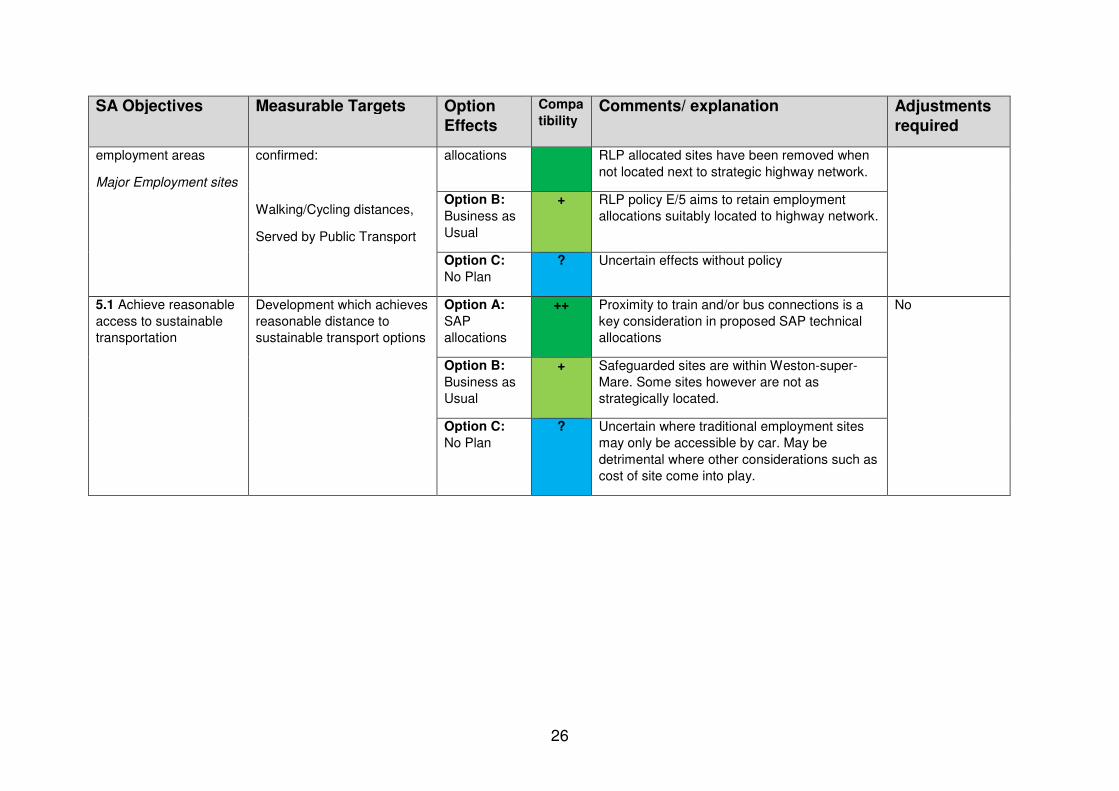
26
SA Objectives Measurable Targets Option
Effects
Compa
tibility Comments/ explanation Adjustments
required
employment areas
Major Employment sites
confirmed:
Walking/Cycling distances,
Served by Public Transport
allocations RLP allocated sites have been removed when
not located next to strategic highway network.
Option B:
Business as
Usual
+ RLP policy E/5 aims to retain employment
allocations suitably located to highway network.
Option C:
No Plan
? Uncertain effects without policy
5.1 Achieve reasonable
access to sustainable
transportation
Development which achieves
reasonable distance to
sustainable transport options
Option A:
SAP
allocations
++ Proximity to train and/or bus connections is a
key consideration in proposed SAP technical
allocations
No
Option B:
Business as
Usual
+ Safeguarded sites are within Weston-super-
Mare. Some sites however are not as
strategically located.
Option C:
No Plan
?
Uncertain where traditional employment sites
may only be accessible by car. May be
detrimental where other considerations such as
cost of site come into play.

27
Appendix 3 Appraisal compatibility of Local Green Space allocations to SA objectives
Overall compatibility
++ Very positive impact
+ Positive impact
- Neutral
xx Very negative impact
x Negative impact
? Uncertain effects
Appraisal table for Local Green Space Allocations
SA Objectives Measurable Targets Option Effects
Compatibility
Comments/ justification Adjustments required
1.1 Achieve reasonable access to public open space
Development located within a reasonable distance of open Space (800m)
Option A: SAP allocations
++ Allocation of proposed LGS in the SAP will provide increased likelihood of this.
No
Option B: Business as Usual
+ Amenity areas are protected in policy ECH/1, but potentially these are less likely to be so relevant to helping achieve reasonable access to public open space because they do not have designation criteria/guidance which specifically refer to recreation and reasonably close proximity to the community served.
Option C: No Plan
xx No protection of/ detailed policies in a Local Plan regarding access to green space, including public open space.
4.1 Minimise impact on and where appropriate enhance the historic environment, heritage assets and their settings
No. of and % of conservation areas/ listed buildings/ historic parks and gardens/ scheduled ancient monuments
Option A: SAP allocations
++ The SAP assessment of sites for possible LGS allocation takes into account the historical significance of the site. LGS designation would potentially help to reinforce protection provided to any heritage

28
SA Objectives Measurable Targets Option Effects
Compatibility
Comments/ justification Adjustments required
assets located within the proposed LGS.
Option B: Business as Usual
- Amenity Areas do not have designation criteria which specifically include historical importance.
Option C: No Plan
xx No detailed policies in a Local Plan regarding protection of historic assets.
4.2 To protect and where possible enhance biodiversity and geodiversity at a landscape scale, particularly with respect to protected habitats and species
No. of application approvals that generate significant biodiversity impacts
Option A: SAP allocations
++ The SAP assessment of sites for possible LGS allocation takes account of the richness of wildlife criterion. LGS designation would potentially help to reinforce protection of biodiversity within any wildlife designations located within the proposed LGS, such as local wildlife sites.
No
Option B: Business as Usual
- Amenity Areas do not have designation criteria which specifically include richness of wildlife or biodiversity.
Option C: No Plan
xx No detailed policies in a Local Plan regarding protection of biodiversity.
4.3 Minimise impact on and where appropriate enhance valued landscapes
Number of planning applications in the Mendip Hills AONB with commentary on anticipated impacts.
Option A: SAP allocations
++ Beauty is one of the criteria to be considered in assessing a site for possible LGS allocation, which is likely to include consideration of landscape.
No
Option B: Business as Usual
++ It is likely that visual attractiveness, to which landscape is relevant, was considered in assessing sites for possible allocation as Amenity Areas.
Option C: No Plan
xx No detailed policies in a Local Plan regarding protection of landscape.
4.6 Minimise vulnerability to tidal/fluvial flooding without increasing flood risk elsewhere
Development which mitigates existing flood risk from tidal or fluvial sources
Option A: SAP allocations
+ LGS allocations may contribute to reducing fluvial flood risk, by helping to protect green spaces, including ones with trees etc.
No
Option B: Business
+ Amenity Area protection may contribute to reducing fluvial flood risk, regarding green

29
SA Objectives Measurable Targets Option Effects
Compatibility
Comments/ justification Adjustments required
as Usual spaces.
Option C: No Plan
xx No detailed policies in a Local Plan on addressing risk of flooding.
4.7 Minimise vulnerability to surface water flooding and other sources of flooding, without increasing flood risk elsewhere
Development which mitigates existing flood risk from surface water sources
Option A: SAP allocations
++ LGS allocations may well contribute to addressing flood risk, by helping to protect green spaces, including ones with trees etc.
No
Option B: Business as Usual
++ Amenity Area protection may contribute to addressing flood risk, regarding green spaces.
Option C: No Plan
xx No detailed policies in a Local Plan regarding addressing risk of flooding.

Appendix 4: Compliance with SEA requirements References to ‘Annex 1’ are to Annex 1 of the SEA Directive Source Requirements Compliance Notes Annex 1 (a) Provide an outline of the
contents, main objectives of the plan or programme and relationship with other relevant plans and programmes
Scoping report paras.1.1 to 1.8 and Main Report, paras. 1.1 to 1.7
Annex 1 (b) Provide information on the relevant aspects of the current state of the environment and the likely evolution thereof without implementation of the plan or programme
Scoping Report, sections 3 and 4
Annex 1 (c) Provide information on the environmental characteristics of areas likely to be significantly affected
Scoping Report, section 3
Annex 1 (d) Provide information on any existing environmental problems which are relevant to the plan or programme including, in particular, those relating to any areas of a particular environmental importance
Scoping Report, section 4
Annex 1 (e) Provide information on the environmental protection objectives, established at international, Community or Member State level, which are relevant to the plan or programme and the way those objectives and any environmental considerations have been taken into account during its preparation
Scoping Report, Appendix A
Annex 1 (f) Provide information on the likely significant effects (see below), including on issues listed (see below)
Main Report, Appendices 1 to 3 (Appraisal Tables)
Annex 1 (f) (footnote 1): likely
Provide information on secondary effects
Secondary effects will be identified where possible but

31
significant effects to include
this is rare, given the high degree of uncertainty associated with some outcomes
Provide information on cumulative effects
Cumulative effects will be identified where possible but this is rare, given the high degree of uncertainty associated with some outcomes. The main cumulative effect is on climate change, where development in principle increases carbon emissions. Infrastructure capacity constraints can also arise as a result of incremental growth in demand but the Core Strategy seeks developer contributions to address these. Particularly sensitive receptors include protected habitats: the effects of the SAP on the most important of these have been assessed under the Habitats Regulations.
Provide information on synergistic effects
Synergistic effects will be identified where possible but this is rare, given the high degree of uncertainty associated with some outcomes
Provide information on All effects are

32
short-term effects assumed to be short to medium term unless there is evidence to the contrary. ‘Short-term’ is to be understood as in the early years of the period being planned for. 2016-2020
Provide information on medium-term effects
All effects are assumed to be short to medium term unless there is evidence to the contrary. ‘Medium-term’ is to be understood as in the later years of the period being planned for. 2021-2026
Provide information on long-term effects
All effects are assumed to be short to medium term unless there is evidence to the contrary. ‘Long-term’ is to be understood as extending beyond the period being planned for. National policy is assumed to endure for the long-term. It is also appropriate to consider Green Belt policy as long-term. Some climate change effects will also be long-term.
Provide information on permanent effects
All effects are assumed to be permanent unless there is evidence that they are temporary.

33
Provide information on temporary effects
All effects are assumed to be permanent unless there is evidence that they are temporary.
Provide information on positive effects
These are indicated by listing the objectives to which the policy contributes directly and positively.
Provide information on negative effects
These are indicated under the Reason / Justification heading.
Annex 1 (f): issues to include
Provide information on the likely significant effects on biodiversity, fauna and flora
Sub-objective 4.2
Provide information on the likely significant effects on population and human health
Objectives 1, 2, 3, 4
Provide information on the likely significant effects on soil
Sub-objectives 4.3, 4.4 and 4.5
Provide information on the likely significant effects on water
Sub-objectives 4.6, 4.7
Provide information on the likely significant effects on air
Sub-objective 4.8
Provide information on the likely significant effects on climatic factors
Objective 4
Provide information on the likely significant effects on material assets
Objective 3
Provide information on the likely significant effects on cultural heritage including architectural and archaeological heritage
Sub-objectives 4.1
Provide information on the likely significant effects on landscape
Sub-objective 4.3
Provide information on the likely significant effects on the interrelationship
The Appraisal detailed in the appendices, in

34
between the above factors appraising each proposed allocation, refer to cross-cutting issues where relevant
Annex 1 (g) Provide information on the measures envisaged to prevent, reduce, and as fully as possible offset any significant adverse effects on the environment of implementing the plan or programme
The Appraisal Tables, in appraising proposed allocations, make judgements on the extent to which it seeks to minimise negative effects. Where possible, they also suggest improvements to the Consultation Draft wording that would avoid or mitigate the effect identified.
Annex 1 (h) Provide an outline of the reasons for selecting the alternatives dealt with
Scoping Report, paras. 7.2, 7.3
Provide a description of how the assessment was undertaken including any difficulties encountered in compiling the required information
Main Report, paras. 4.1, 4.5
Annex 1 (i) Provide a description of the measures envisaged concerning monitoring in accordance with Article 10
Scoping Report, paras. 7.12, 7.13 Main Report, para. 3.2
Annex 1 (j) Provide a non-technical summary of the information provided under the above headings
Non-technical summaries (Scoping Report page 5)and Main Report page 4)