Embed Size (px)
Citation preview

S i te Al loc a t ion s — Is sue s a nd Opt ion s Co ns u lta t ion S ta te me n t M a y 2 0 1 5
1
“Allerdale – a great place to live, work and visit”
S i t e A l l o c a t i o n s I s s u e s a n d O p t i o n s
C o n s u l t a t i o n S t a t e m e n t
M a y 2 0 1 5

S i te Al loc a t ion s — Is sue s a nd O pt ion s C ons u lta t ion S ta te me n t Ma y 2 0 1 5
2 D i s c u s s i o n P a p e r : J a n u a r y 2 0 1 3 2
S i te Al loc a t ion s — Is sue s a nd Opt ion s Co ns u lta t ion S ta te me n t M a y 2 0 1 5
3
Contents
1 Introduction
2 Consultation Process
3 Representations Summary
4 Responses to the first Issues and Options consultation
5 Responses to the second Issues and Options (Additional Sites) consultation
6 Next Steps

S i te Al loc a t ion s — Is sue s a nd O pt ion s C ons u lta t ion S ta te me n t Ma y 2 0 1 5
4 D i s c u s s i o n P a p e r : J a n u a r y 2 0 1 3 4

S i te Al loc a t ion s — Is sue s a nd Opt ion s Co ns u lta t ion S ta te me n t M a y 2 0 1 5
5
1.1 The Local Plan (Part 1) contains the Strategic and Development Management Policies and was adopted in July 2014. This document sets out a clear vision of the development requirements of the district between the plan period of 2011-2029. As part of this, it sets out a minimum target of new dwellings (5,471 houses) and employment land (54 hectares) that the district needs to provide by 2029.
1.2 The Local Plan (Part 2) is the Site Allocations document. This document will seek to
identify the most appropriate sites in Allerdale in order to meet the development targets identified in the Local Plan (Part 1).
1.3 The first stage of the Local Plan (Part 2) process was for Allerdale Borough Council to
issue a ‘Call for Sites’. This stage allowed members of the public, parish councils, landowners, agents, developers and other interested parties the opportunity to put forward sites for development that could be allocated through the Site Allocations DPD.
1.4 Following an initial light touch assessment of all the sites, the majority of the sites received
by the Council as part of the Call for Sites were included in an ‘Issues and Options’ document; consultation on this document ended on 30 September 2014.
1.5 As a result of this consultation, a further 35 sites were put forward for consideration. In
order to ensure that all stakeholders, consultees and members of the public were able to comment on these new sites, another consultation was held. This was entitled ‘Issues and Options – Additional Sites Submitted’ and ran from 9 January to 27 February 2015.
1.6 This report summarises all of the responses received to both rounds of consultation.
These comments will inform the next stage of the Local Plan (Part 2) document preparation which is where the Council will assess sites in line with the published Site Assessment Methodology to identify the best sites capable of delivering the identified need; this is known as the Preferred Options stage.
1.7 When the Council has carried out its assessment and identified what it believes to be the best sites, there will be a further round of consultation to allow for comments on these preferred options. It is anticipated that this round of consultation will occur in summer 2015.
1 Introduction
S i te Al loc a t ion s — Is sue s a nd O pt ion s C ons u lta t ion S ta te me n t Ma y 2 0 1 5
6 D i s c u s s i o n P a p e r : J a n u a r y 2 0 1 3 6
Scope of the consultation 2.1 When the sites were put forward to the Council for consideration as part of the Call for
Sites, those putting the site forward were required to identify what type of development they wanted to happen on the sites.
2.2 The Council received a total of 351 suggestions for potential development sites which
were to be considered for a wide range of uses including: housing; employment; retail; open space; burial grounds; community facilities; leisure; local geological sites; local wildlife site; mixed; utilities infrastructure; village green protection. The Council also identified 14 suggested areas for growth.
2.3 In addition to consulting on the suggested development sites in the first Issues and
Options consultation, the document also included a number of questions on how respondents thought the Council should identify sites and allocate land in order to meet the future development needs of Allerdale. In addition, there were two documents that were issued with this consultation that respondents were encouraged to read alongside the Issues and Options document. These were the Site Assessment Methodology (set out the approach to assessing sites, reviewing settlement boundaries and de-allocating employment land) and the Sustainability Appraisal Scoping Report (set out the sustainability objectives and assessment framework for the Sustainability Appraisal).
Methods of consultation 2.4 Both Issues and Options consultations were carried out in line with the Council’s adopted
Statement of Community Involvement. The Statement of Community Involvement sets out how the Council will involve the community as part of the preparation of planning policy documents. Whilst national regulations have changed since the adoption of the Statement of Community Involvement with regards to how planning policy documents are prepared, the process of community engagement remains the same.
2.5 The Council contacted all those on its consultation database about the two Issues and
Options consultation either through email or letter. The Council made copies of the consultations documents available to view at the following locations:
• Aspatria Library
2 Consultation Process
S i te Al loc a t ion s — Is sue s a nd Opt ion s Co ns u lta t ion S ta te me n t M a y 2 0 1 5
7
• Cockermouth Customer Service Centre • Cockermouth Library • Maryport Town Hall • Maryport Library • Silloth Library • Wigton Customer Service Centre • Wigton Library • Workington Council Offices (Allerdale House) • Workington Library 2.6 In addition, a consultation pack was sent to all of the Parish and Town Councils in the
district and the documents were also available to view online at http://www.allerdale.gov.uk/planning-and-buildings/planning/planning-policy/site-allocations.aspx
2.7 For the first Issues and Options consultation, a number of drop in sessions were held
across the district, attended by members of the Planning Policy team. The dates and venues of the drop in sessions were:
• Aspatria Library – Wednesday 30th July 2014 – 2pm-6pm • Maryport Library – Thursday 7th August 2014 – 2pm-6pm • Cockermouth Town Hall – Tuesday 12th August 2014 - 2pm-7pm • Silloth Library – Wednesday 20th August 2014 – 2pm-5pm • Wigton Local Links Centre – Wednesday 3rd September 2014 – 2pm-7pm • Workington Library – Saturday 6th September 2014 – 10am-1pm
2 Consultation Process
S i te Al loc a t ion s — Is sue s a nd O pt ion s C ons u lta t ion S ta te me n t Ma y 2 0 1 5
8 D i s c u s s i o n P a p e r : J a n u a r y 2 0 1 3 8
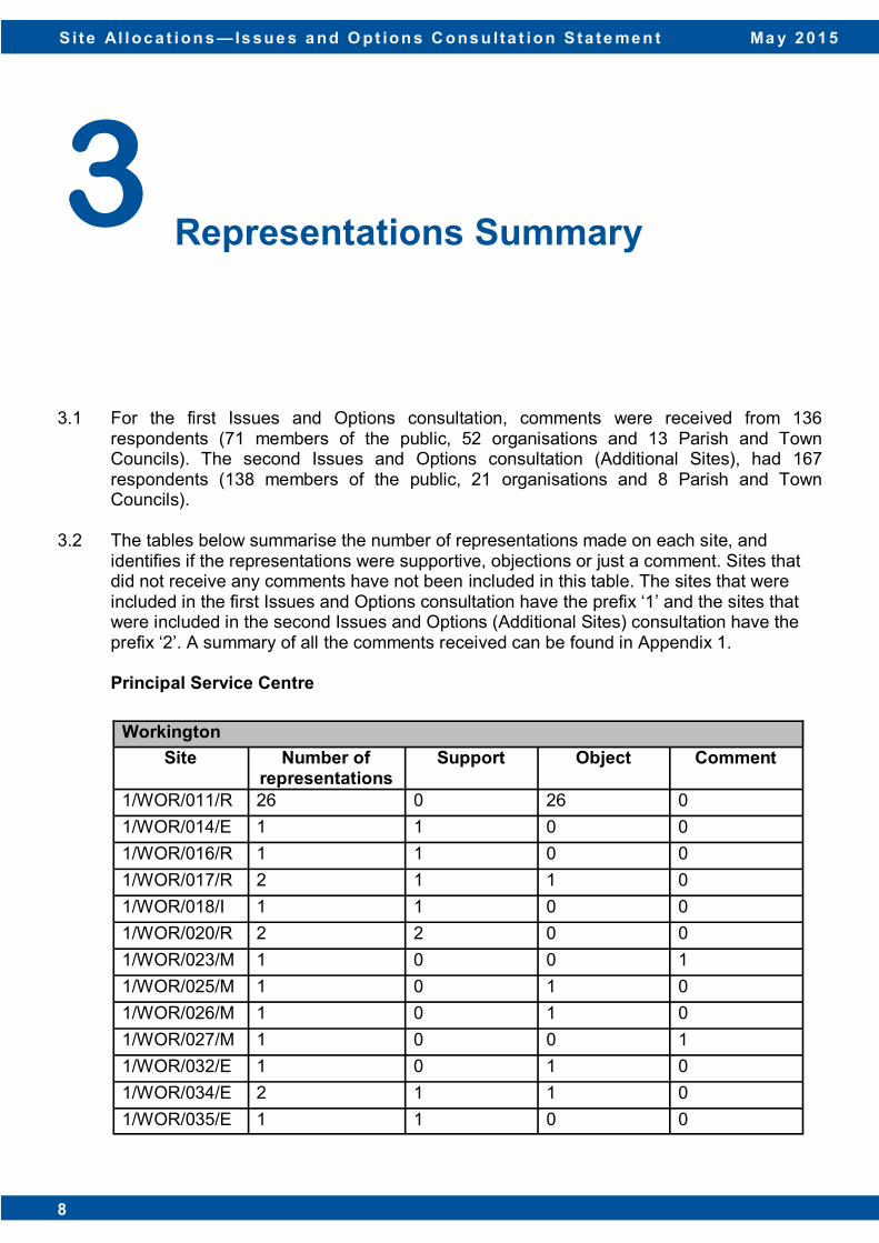
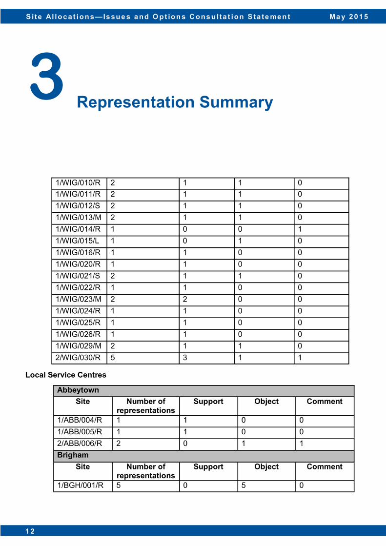
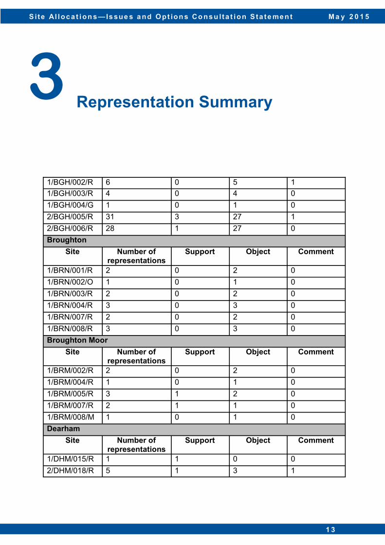
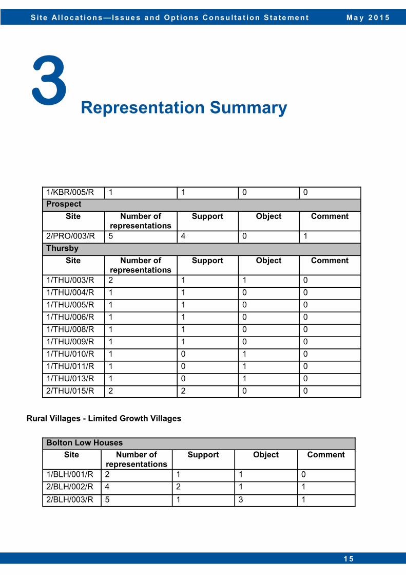
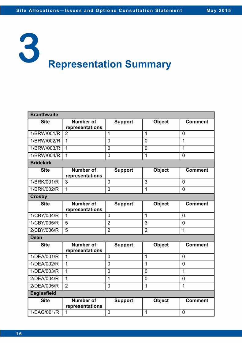
3.1 For the first Issues and Options consultation, comments were received from 136 respondents (71 members of the public, 52 organisations and 13 Parish and Town Councils). The second Issues and Options consultation (Additional Sites), had 167 respondents (138 members of the public, 21 organisations and 8 Parish and Town Councils).
3.2 The tables below summarise the number of representations made on each site, and
identifies if the representations were supportive, objections or just a comment. Sites that did not receive any comments have not been included in this table. The sites that were included in the first Issues and Options consultation have the prefix ‘1’ and the sites that were included in the second Issues and Options (Additional Sites) consultation have the prefix ‘2’. A summary of all the comments received can be found in Appendix 1.
Principal Service Centre
3 Representations Summary
Workington
Site Number of representations
Support Object Comment
1/WOR/011/R 26 0 26 0
1/WOR/014/E 1 1 0 0
1/WOR/016/R 1 1 0 0
1/WOR/017/R 2 1 1 0
1/WOR/018/I 1 1 0 0
1/WOR/020/R 2 2 0 0
1/WOR/023/M 1 0 0 1
1/WOR/025/M 1 0 1 0
1/WOR/026/M 1 0 1 0
1/WOR/027/M 1 0 0 1
1/WOR/032/E 1 0 1 0
1/WOR/034/E 2 1 1 0
1/WOR/035/E 1 1 0 0
S i te Al loc a t ion s — Is sue s a nd Opt ion s Co ns u lta t ion S ta te me n t M a y 2 0 1 5
9
Key Service Centres
3 Representations Summary
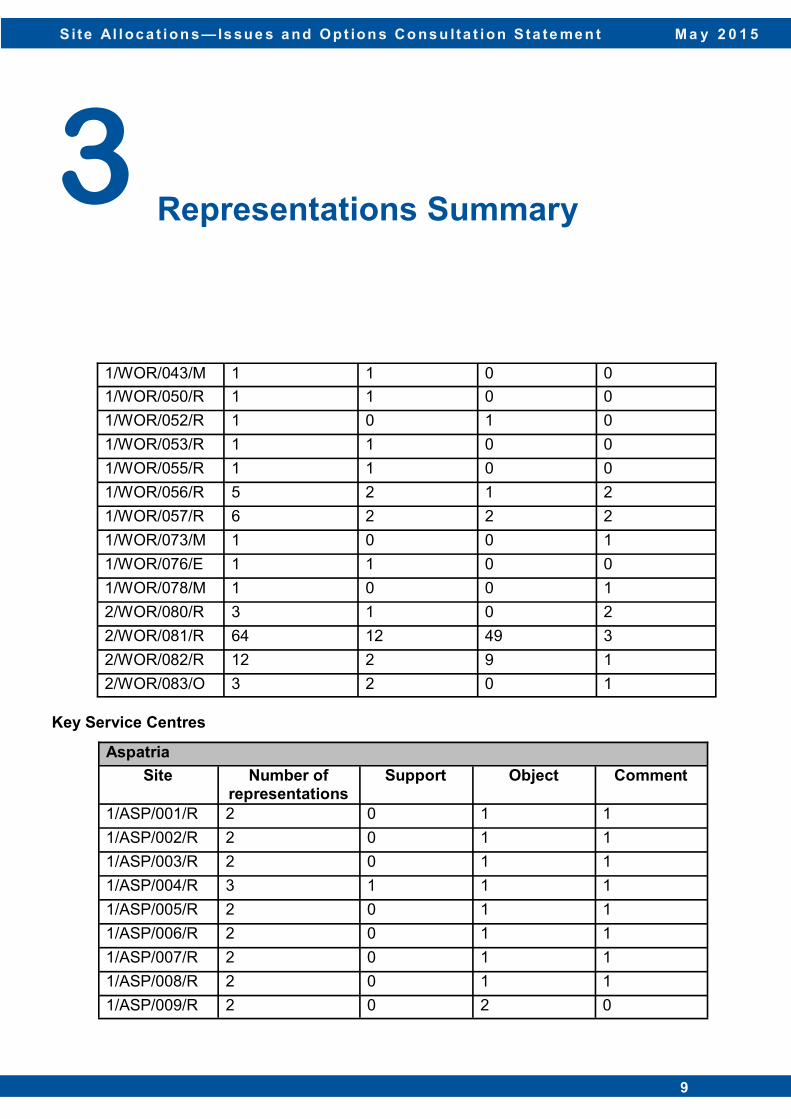
1/WOR/043/M 1 1 0 0
1/WOR/050/R 1 1 0 0
1/WOR/052/R 1 0 1 0
1/WOR/053/R 1 1 0 0
1/WOR/055/R 1 1 0 0
1/WOR/056/R 5 2 1 2
1/WOR/057/R 6 2 2 2
1/WOR/073/M 1 0 0 1
1/WOR/076/E 1 1 0 0
1/WOR/078/M 1 0 0 1
2/WOR/080/R 3 1 0 2
2/WOR/081/R 64 12 49 3
2/WOR/082/R 12 2 9 1
2/WOR/083/O 3 2 0 1
Aspatria
Site Number of representations
Support Object Comment
1/ASP/001/R 2 0 1 1
1/ASP/002/R 2 0 1 1
1/ASP/003/R 2 0 1 1
1/ASP/004/R 3 1 1 1
1/ASP/005/R 2 0 1 1
1/ASP/006/R 2 0 1 1
1/ASP/007/R 2 0 1 1
1/ASP/008/R 2 0 1 1
1/ASP/009/R 2 0 2 0
S i te Al loc a t ion s — Is sue s a nd O pt ion s C ons u lta t ion S ta te me n t Ma y 2 0 1 5
1 0 D i s c u s s i o n P a p e r : J a n u a r y 2 0 1 3 1 0
3 Representations Summary
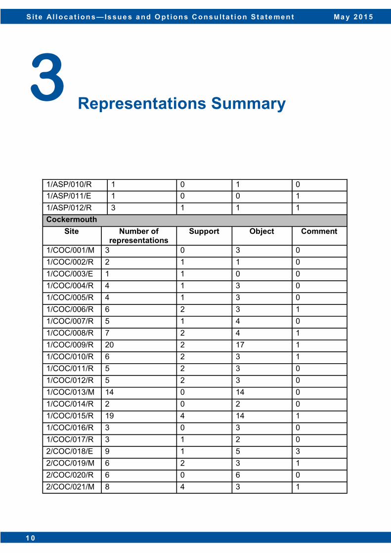
1/ASP/010/R 1 0 1 0
1/ASP/011/E 1 0 0 1
1/ASP/012/R 3 1 1 1
Cockermouth
Site Number of representations
Support Object Comment
1/COC/001/M 3 0 3 0
1/COC/002/R 2 1 1 0
1/COC/003/E 1 1 0 0
1/COC/004/R 4 1 3 0
1/COC/005/R 4 1 3 0
1/COC/006/R 6 2 3 1
1/COC/007/R 5 1 4 0
1/COC/008/R 7 2 4 1
1/COC/009/R 20 2 17 1
1/COC/010/R 6 2 3 1
1/COC/011/R 5 2 3 0
1/COC/012/R 5 2 3 0
1/COC/013/M 14 0 14 0
1/COC/014/R 2 0 2 0
1/COC/015/R 19 4 14 1
1/COC/016/R 3 0 3 0
1/COC/017/R 3 1 2 0
2/COC/018/E 9 1 5 3
2/COC/019/M 6 2 3 1
2/COC/020/R 6 0 6 0
2/COC/021/M 8 4 3 1

S i te Al loc a t ion s — Is sue s a nd Opt ion s Co ns u lta t ion S ta te me n t M a y 2 0 1 5
1 1
3 Representation Summary
Maryport
Site Number of representations
Support Object Comment
1/MAR/003/R 2 0 1 1
1/MAR/008/R 1 1 0 0
1/MAR/009/E 2 1 1 0
1/MAR/010/R 1 1 0 0
1/MAR/011/S 1 1 0 0
1/MAR/012/R 1 1 0 0
1/MAR/013/R 1 1 0 0
1/MAR/018/M 2 0 1 1
1/MAR/025/C 1 0 1 0
2/MAR/033/R 3 0 2 1
2/MAR/034/M 6 1 1 4
2/MAR/035/R 3 0 2 1
Silloth
Site Number of representations
Support Object Comment
1/SIL/003/R 1 1 0 0
Wigton
Site Number of representations
Support Object Comment
1/WIG/001/R 1 1 0 0
1/WIG/003/R 2 1 1 0
1/WIG/004/M 3 3 0 0
1/WIG/005/R 2 1 1 0
1/WIG/006/R 2 1 1 0
1/WIG/007/R 2 1 1 0
1/WIG/009/M 2 1 1 0
S i te Al loc a t ion s — Is sue s a nd O pt ion s C ons u lta t ion S ta te me n t Ma y 2 0 1 5
1 2 D i s c u s s i o n P a p e r : J a n u a r y 2 0 1 3 1 2
Local Service Centres
3 Representation Summary
1/WIG/010/R 2 1 1 0
1/WIG/011/R 2 1 1 0
1/WIG/012/S 2 1 1 0
1/WIG/013/M 2 1 1 0
1/WIG/014/R 1 0 0 1
1/WIG/015/L 1 0 1 0
1/WIG/016/R 1 1 0 0
1/WIG/020/R 1 1 0 0
1/WIG/021/S 2 1 1 0
1/WIG/022/R 1 1 0 0
1/WIG/023/M 2 2 0 0
1/WIG/024/R 1 1 0 0
1/WIG/025/R 1 1 0 0
1/WIG/026/R 1 1 0 0
1/WIG/029/M 2 1 1 0
2/WIG/030/R 5 3 1 1
Abbeytown
Site Number of representations
Support Object Comment
1/ABB/004/R 1 1 0 0
1/ABB/005/R 1 1 0 0
2/ABB/006/R 2 0 1 1
Brigham
Site Number of representations
Support Object Comment
1/BGH/001/R 5 0 5 0
S i te Al loc a t ion s — Is sue s a nd Opt ion s Co ns u lta t ion S ta te me n t M a y 2 0 1 5
1 3
3 Representation Summary
1/BGH/002/R 6 0 5 1
1/BGH/003/R 4 0 4 0
1/BGH/004/G 1 0 1 0
2/BGH/005/R 31 3 27 1
2/BGH/006/R 28 1 27 0
Broughton
Site Number of representations
Support Object Comment
1/BRN/001/R 2 0 2 0
1/BRN/002/O 1 0 1 0
1/BRN/003/R 2 0 2 0
1/BRN/004/R 3 0 3 0
1/BRN/007/R 2 0 2 0
1/BRN/008/R 3 0 3 0
Broughton Moor
Site Number of representations
Support Object Comment
1/BRM/002/R 2 0 2 0
1/BRM/004/R 1 0 1 0
1/BRM/005/R 3 1 2 0
1/BRM/007/R 2 1 1 0
1/BRM/008/M 1 0 1 0
Dearham
Site Number of representations
Support Object Comment
1/DHM/015/R 1 1 0 0
2/DHM/018/R 5 1 3 1

S i te Al loc a t ion s — Is sue s a nd O pt ion s C ons u lta t ion S ta te me n t Ma y 2 0 1 5
1 4 D i s c u s s i o n P a p e r : J a n u a r y 2 0 1 3 1 4
3 Representation Summary
Flimby
Site Number of representations
Support Object Comment
1/FLI/006/M 1 1 0 0
Great Clifton
Site Number of representations
Support Object Comment
1/GRC/001/R 2 0 2 0
1/GRC/002/R 5 0 5 0
1/GRC/003/R 3 0 3 0
1/GRC/004/O 3 0 3 0
1/GRC/005/R 2 0 2 0
1/GRC/006/R 2 0 1 1
1/GRC/007/R 2 0 1 1
1/GRC/008/R 1 0 1 0
1/GRC/009/R 2 0 2 0
1/GRC/010/R 2 0 1 1
1/GRC/011/R 2 0 1 1
1/GRC/012/R 5 0 5 0
1/GRC/013/R 2 0 1 1
2/GRC/014/R 3 2 0 1
2/GRC/015/R 6 3 0 3
2/GRC/016/R 4 1 1 2
Kirkbride
Site Number of representations
Support Object Comment
1/KBR/002/R 1 1 0 0
1/KBR/003/R 1 1 0 0
1/KBR/004/R 1 1 0 0
S i te Al loc a t ion s — Is sue s a nd Opt ion s Co ns u lta t ion S ta te me n t M a y 2 0 1 5
1 5
Rural Villages - Limited Growth Villages
3 Representation Summary
1/KBR/005/R 1 1 0 0
Prospect Site Number of
representations Support Object Comment
2/PRO/003/R 5 4 0 1
Thursby
Site Number of representations
Support Object Comment
1/THU/003/R 2 1 1 0
1/THU/004/R 1 1 0 0
1/THU/005/R 1 1 0 0
1/THU/006/R 1 1 0 0
1/THU/008/R 1 1 0 0
1/THU/009/R 1 1 0 0
1/THU/010/R 1 0 1 0
1/THU/011/R 1 0 1 0
1/THU/013/R 1 0 1 0
2/THU/015/R 2 2 0 0
Bolton Low Houses
Site Number of representations
Support Object Comment
1/BLH/001/R 2 1 1 0
2/BLH/002/R 4 2 1 1
2/BLH/003/R 5 1 3 1
S i te Al loc a t ion s — Is sue s a nd O pt ion s C ons u lta t ion S ta te me n t Ma y 2 0 1 5
1 6 D i s c u s s i o n P a p e r : J a n u a r y 2 0 1 3 1 6
3 Representation Summary
Branthwaite
Site Number of representations
Support Object Comment
1/BRW/001/R 2 1 1 0
1/BRW/002/R 1 0 0 1
1/BRW/003/R 1 0 0 1
1/BRW/004/R 1 0 1 0
Bridekirk
Site Number of representations
Support Object Comment
1/BRK/001/R 3 0 3 0
1/BRK/002/R 1 0 1 0
Crosby
Site Number of representations
Support Object Comment
1/CBY/004/R 1 0 1 0
1/CBY/005/R 5 2 3 0
2/CBY/006/R 5 2 2 1
Dean
Site Number of representations
Support Object Comment
1/DEA/001/R 1 0 1 0
1/DEA/002/R 1 0 1 0
1/DEA/003/R 1 0 0 1
2/DEA/004/R 1 1 0 0
2/DEA/005/R 2 0 1 1
Eaglesfield
Site Number of representations
Support Object Comment
1/EAG/001/R 1 0 1 0
S i te Al loc a t ion s — Is sue s a nd Opt ion s Co ns u lta t ion S ta te me n t M a y 2 0 1 5
1 7
3 Representation Summary
1/EAG/002/R 1 0 0 1
1/EAG/003/R 1 1 0 0
1/EAG/004/R 1 1 0 0
Fletchertown
Site Number of representations
Support Object Comment
1/FLE/001/R 2 1 1 0
Gilcrux
Site Number of representations
Support Object Comment
1/GIL/004/R 1 0 1 0
1/GIL/005/R 1 0 1 0
1/GIL/006/R 1 0 1 0
Greysouthen
Site Number of representations
Support Object Comment
1/GRE/001/R 1 0 1 0
1/GRE/002/R 1 0 1 0
1/GRE/003/R 1 0 1 0
1/GRE/004/R 1 0 1 0
1/GRE/005/R 1 1 0 0
1/GRE/006/R 1 0 1 0
Ireby
Site Number of representations
Support Object Comment
1/IRE/002/R 4 1 1 2
2/IRE/006/R 2 0 1 1
S i te Al loc a t ion s — Is sue s a nd O pt ion s C ons u lta t ion S ta te me n t Ma y 2 0 1 5
1 8 D i s c u s s i o n P a p e r : J a n u a r y 2 0 1 3 1 8
Rural Villages - Infill and Rounding Off Villages
3 Representation Summary
Kirkbampton
Site Number of representations
Support Object Comment
1/KBA/001/R 1 1 0 0
1/KBA/002/R 2 0 2 0
1/KBA/003/R 1 1 0 0
Little Clifton/Bridgefoot Site Number of
representations Support Object Comment
1/LCB/003/R 1 1 0 0
Plumbland
Site Number of representations
Support Object Comment
2/PLU/002/R 24 1 22 1
Broughton Cross
Site Number of representations
Support Object Comment
1/BRC/001/R 4 0 4 0
Crosby Villa
Site Number of representations
Support Object Comment
1/CRV/001/R 3 0 2 1
1/CRV/002/R 3 0 2 1
Dovenby
Site Number of representations
Support Object Comment
1/DOV/001/R 11 0 11 0
1/DOV/002/R 1 0 1 0
S i te Al loc a t ion s — Is sue s a nd Opt ion s Co ns u lta t ion S ta te me n t M a y 2 0 1 5
1 9
3 Representation Summary
1/DOV/003/R 1 0 1 0
Little Bampton
Site Number of representations
Support Object Comment
1/LBA/003/R 1 0 0 1
1/LBA/004/R 1 0 0 1
Oughterside
Site Number of representations
Support Object Comment
1/OGH/001/R 2 2 0 0
Oulton
Site Number of representations
Support Object Comment
2/OLT/001/R 3 0 2 1
Papcastle
Site Number of representations
Support Object Comment
1/PAP/001/R 5 0 5 0
1/PAP/002/R 2 0 1 1
1/PAP/003/R 2 1 0 1
1/PAP/004/R 15 0 15 0
1/PAP/005/R 2 1 0 1
2/PAP/006/R 4 2 0 2
Pardshaw
Site Number of representations
Support Object Comment
2/PRW/001/R 3 0 2 1
S i te Al loc a t ion s — Is sue s a nd O pt ion s C ons u lta t ion S ta te me n t Ma y 2 0 1 5
2 0 D i s c u s s i o n P a p e r : J a n u a r y 2 0 1 3 2 0
Suggested Areas for Growth
3 Representation Summary
Parsonby
Site Number of representations
Support Object Comment
1/PAR/001/R 1 0 1 0
Ullock
Site Number of representations
Support Object Comment
1/ULL/001/R 1 1 0 0
1/ULL/004/R 1 0 1 0
Bolton Low Houses
Site Number of rep-resentations
Support Object Comment
BLH01 1 1 0 0
Branthwaite
Site Number of rep-resentations
Support Object Comment
BRA10 2 1 1 0
BRA11 2 0 1 1
Greysouthen
Site Number of rep-resentations
Support Object Comment
GRE01 1 0 1 0
GREY02 1 0 1 0

S i te Al loc a t ion s — Is sue s a nd Opt ion s Co ns u lta t ion S ta te me n t M a y 2 0 1 5
2 1
4.1 Within the consultation document, Allerdale Borough Council included 12 questions in order to receive comments/opinions on how the Council should identify sites and allocate land for a variety of uses in order to meet the development need in the district until 2029. The responses to these questions are summarised below; a more detailed summary of all of the responses is included in Appendix 1.
Question 1 Do you agree or disagree that the starting point for the distribution of growth between the settlements in the Local Service Centre tier should be the size of the settlement, based on the number of dwellings?
Number of responses 33
Agree 20 (61%) Disagree 8 (24%) Comment 5 (15%)
4.2 The majority of respondents considered that the size of the settlement should be a starting
point for the distribution of growth in Local Service Centres in order to ensure that the distribution is sustainable and proportionate in social, environmental and economic terms. Whilst the size of the settlement is generally considered to be the starting point, respondents felt that other factors that need to be taken into consideration include:
• infrastructure capacity; • the reuse of brownfield sites; • the nature and character of the settlements; • access to services and facilities; • the sustainability of the settlements; • using evidence bases to understand the market and identify localised housing need; • the availability, viability and suitability of sites; • the need to avoid urban sprawl; • the need to protect the countryside; • the need to protect habitats; • the housing level commitment set out in the Local Plan (Part 1); and • the housing completions that have already occurred in the settlements.
4 Response to first Issues and Options consultation

S i te Al loc a t ion s — Is sue s a nd O pt ion s C ons u lta t ion S ta te me n t Ma y 2 0 1 5
2 2 D i s c u s s i o n P a p e r : J a n u a r y 2 0 1 3 2 2
4.3 A number of respondents stated that the infrastructure capacity of settlements should be considered a priority in any distribution assessment. The growth of a settlement should be related to the ability of that settlement to be able to support the increase in population. It was considered that the infrastructure to support any identified growth in settlements should be in place before the development takes place and before the population increases. In order to determine the infrastructure need, an analysis should be carried out of the present infrastructure and amenities within the settlement and include a projection of what will be required in the future and any associated costs.
4.4 There was a lot of support for prioritising brownfield land for new housing development. By
focussing housing development in the larger settlements, it was considered that such settlements would have more potential to support development on brownfield land, as well as minimising the need to travel. There was also support for development not to occur outside the existing settlement boundaries.
4.5 There was also a comment made that the Council seek to plan positively in line with
national guidance. The Council should not see the housing target as the minimum level to provide for; it should use it as a base and plan in excess of this.
4.6 There were a number of settlement specific comments made in response to this question. A number of respondents made reference to the fact that Brigham has already met its growth targets for the Local Plan period and that it should not be allowed to expand too rapidly as it would change the character of the village. Respondents also questioned why Brigham was classified as a Local Service Centre when the services and facilities that it currently has are more appropriate for classification as a Rural Village. 4.7 Some respondents stated that the size of the settlement of Broughton is not representative
and serves to remove the individual identity of the separate settlements of Great Broughton and Little Broughton. One respondent raised concern about the amount of sites, and their size, in the two settlements. Development of these sites would build more than the identified need for Little Broughton and Great Broughton whilst putting pressure on local infrastructure and amenities. When looking at the growth figures for Broughton, the Council should take into account the level of housing allocated to Derwent Forest as the impact of development here would affect the infrastructure capacity of Great Broughton and Little Broughton.
4 Response to first Issues and Options consultation
S i te Al loc a t ion s — Is sue s a nd Opt ion s Co ns u lta t ion S ta te me n t M a y 2 0 1 5
2 3
Question 2 If a Local Service Centre cannot accommodate the levels of growth indicated in Table 2 due to issues in relation to deliverability and environmental constraints, should the housing numbers be allocated to other Local Service Centres or to the nearest Principal/Key Service Centre (i.e. town)?
Number of responses 33
Other Local Service Centres 9 (27%) Nearest Principal/Key Service Centre 19 (58%) Comment 5 (15%)
4.8 The majority of respondents (58%) felt that any underprovision in Local Service Centres
should be redistributed to the nearest Principal/Key Service Centres in order to maintain the distribution of development across Allerdale as intended in the Local Plan (Part 1).
4.9 The respondents suggested that Principal/Key Service Centres have the capacity, services and facilities to absorb additional development of this scale without affecting their nature. Principal/Key Service Centres are considered to have a number of benefits over Local Service Centres including: access to areas of unused brownfield land; access to employment opportunities; better public transport; and better infrastructure capacity. 4.10 If the underprovision was redistributed to other Local Service Centres, it would negatively
affect the character of Local Service Centre settlements, create unsustainable development and lead to the suburbanisation of settlements. Local Service Centres are already struggling to meet present housing requirements and could not manage additional allocations from other Local Service Centres.
4.11 One respondent said that if services and amenities are to become more centralised in the
future, it seems logical to concentrate the population in areas with easy transport links to these facilities, especially as the district has an ageing population.
4.12 There was a specific request for any underprovision to be redistributed to Silloth as it is felt
that the future level of growth in Silloth should be increased to a level closer to the other Key Service Centres.
4 Response to first Issues and Options consultation
S i te Al loc a t ion s — Is sue s a nd O pt ion s C ons u lta t ion S ta te me n t Ma y 2 0 1 5
2 4 D i s c u s s i o n P a p e r : J a n u a r y 2 0 1 3 2 4
4.13 27% of respondents would prefer for housing underprovision to be redistributed to other Local Service Centres as the Local Plan (Part 1) states that 20% of the housing requirement for Allerdale will be provided across Local Service Centres. However, respondents acknowledged that the redistribution to other Local Service Centres should only occur as long as there is no detrimental effect on the settlements.
4.14 One stated that resources should not be concentrated in one area of the district to the detriment of others. Others said that there may be other Local Service Centres who would want the additional housing that another settlement cannot provide for. By redistributing the underprovision to other Local Service Centres, it will ensure the sustainability of the Local Service Centres is maintained and will ensure sufficient additional homes are provided to serve existing and future residents, thereby sufficiently addressing local need. 4.15 The remaining 15% of respondents felt that this approach is theoretical and that any
underprovision should be redistributed to the next sustainable settlement that has capacity, whether it is a Principal/Key Service Centre or a Local Service Centre. It is considered that this will help to ensure that housing which is delivered is well related to the community it would otherwise be serving. Any redistribution would need to be assessed to ensure that potential alternative settlements had the infrastructure capacity to accept additional housing.
4.16 Another respondent agreed that the underprovision redistribution could be split between
the nearest Principal/Key Service Centres and other Local Service Centres but went on to say that any redistributed housing should be affordable and for local occupancy only.
4.17 Any approach should recognise that the requirements of each settlement are different and
that the approach should be designed to address specific housing need requirements in a locality.
4 Response to first Issues and Options consultation
S i te Al loc a t ion s — Is sue s a nd Opt ion s Co ns u lta t ion S ta te me n t M a y 2 0 1 5
2 5
Question 3 Do you agree or disagree that the Local Services Centres in the north of the Borough should have greater levels of housing growth than indicated in Table 2 to enable them to continue to perform their important role in terms of meeting local housing, employment and service needs?
Number of responses 29
Agree 17 (59%) Disagree 9 (31%) Comment 3 (10%)
4.18 59% of respondents to this question agreed that the Local Service Centres in the north of
the Borough should have greater levels of growth if that is what the residents of these settlements want and only if it is needed.
4.19 However, the Council should avoid the application of a standard percentage so as to avoid
under/over development in certain areas. The local context of settlements should be taken into account when determining the levels of development appropriate for an area. It is important for the Council to determine the necessary levels of housing growth so that development is not developer led. Any decision to alter the housing growth levels for these Local Service Centres should be supported by a review of the current housing needs information for all the affected and surrounding parishes.
4.20 Some respondents stated that an increase in housing growth will help with the
sustainability of the larger settlements in the north of the Borough. When determining the appropriate levels of growth, proportionality is considered important so as to retain the character of settlements and to ensure that the required services and infrastructure should be in place to support such development. Any increase in the levels of housing growth should ensure that there is no adverse impact on the natural environment and landscape.
4 Response to first Issues and Options consultation
S i te Al loc a t ion s — Is sue s a nd O pt ion s C ons u lta t ion S ta te me n t Ma y 2 0 1 5
2 6 D i s c u s s i o n P a p e r : J a n u a r y 2 0 1 3 2 6
4.21 It is recognised that the special circumstances of Local Service Centres in the north of Allerdale should be acknowledged and catered for, with any increase in housing growth levels complemented by an increase in employment opportunities. The north of the borough is more rural, has fewer employment opportunities and consequently less need to provide employment related housing. To increase growth in the north of the borough would encourage greater travel distances on rural roads to reach existing employment centres.
4.22 The Local Service Centres in the north of Allerdale have fewer completions and
commitments than have been achieved in the south of the district. The northern Local Service Centres should firstly achieve the Indicative Future Housing Needs outlined in Table 2; the Housing Needs numbers may then need to be further increased. However, should housing growth levels in the northern Local Service Centres be increased, it should not be prejudicial to the housing delivery for other settlements as Policy S3 of the Local Plan (Part 1) does not set a housing requirement ceiling – it is a minimum requirement.
4.23 One respondent said that there is no need for more housing given the number of empty
houses currently available; this is with the exception of housing for the elderly whose needs are currently badly served.
4.24 Another respondent said that any increase in housing growth in the north of the district
should be directed to Silloth rather than the Local Service Centres as Silloth requires a higher level of growth to allow the town to continue to play an important role in meeting local housing, employment and service needs. The Port of Silloth offers the potential to attract additional investment and development to Silloth. Silloth has the services and facilities to support additional sustainable housing development.
Question 4 Are there any other comments or suggestions you would like to make in relation to the distribution of housing growth between the Local Service Centres? 4.25 This question attracted 12 varied responses; some were settlement specific, whilst other
comments were more generic in terms of the distribution of housing growth across Allerdale.
4 Response to first Issues and Options consultation
S i te Al loc a t ion s — Is sue s a nd Opt ion s Co ns u lta t ion S ta te me n t M a y 2 0 1 5
2 7
4.26 The Local Plan (Part 2) should distribute high quality housing away from Cockermouth; other Local Service Centres and Key Service Centres need to have the full housing ladder option in order to address local housing needs.
4.27 The distribution of growth between Local Service Centres should take into account the
size of the settlement, facilities and services available and the sustainability of each of the settlements. The character of settlements, its open space and landscape must be preserved. More housing should be planned preferably in brownfield areas and have the scope for large enough developments which in turn have the financial mix to provide for the maximum proportion of affordable homes
4.28 Housing needs to be allocated to the centres who actively want it and for whom it would
improve their circumstances, not just proportional to their current size. It must be allocated to those places where it is most viable in terms of all practical aspects. One major area for development should be the Workington-Carlisle route as there are good transport links.
4.29 Given the level of housing need identified in the Local Plan (Part 1) and recent
underdelivery, the Council needs to be proactive in its approach to settlement growth, particularly to bring forward development that improves the economic, social and environmental considerations of the Borough. Larger urban settlements, the main employment and service centres, should be targeted to meet housing requirements, associated affordable housing, social cohesion and sustainable development.
4.30 The impact of development within each settlement and the subsequent growth of the
settlements upon other nearby settlements must also be considered. For example, Broughton Moor is located within a relatively central location of the Borough and therefore development here will benefit a number of nearby settlements, including Maryport,. Cockermouth and Workington are also within relatively close proximity and therefore housing here will support the economies and populations of these towns.
4.31 The impact of development within each settlement and the subsequent growth of the
settlements upon other nearby settlements must also be considered. For example, Broughton Moor is located within a relatively central location of the Borough and therefore development here will benefit a number of nearby settlements, including Maryport, Cockermouth and Workington are also within relatively close proximity and therefore housing here will support the economies and populations of these towns.
4 Response to first Issues and Options consultation
S i te Al loc a t ion s — Is sue s a nd O pt ion s C ons u lta t ion S ta te me n t Ma y 2 0 1 5
2 8 D i s c u s s i o n P a p e r : J a n u a r y 2 0 1 3 2 8
4.32 The impact of development within each settlement and the subsequent growth of the settlements upon other nearby settlements must also be considered. For example, Broughton Moor is located within a relatively central location of the Borough and therefore development here will benefit a number of nearby settlements, including Maryport, Cockermouth and Workington are also within relatively close proximity and therefore housing here will support the economies and populations of these towns.
4.33 There is concern about the amount of land identified for development in Cockermouth as it
is anticipated that only 5% of the land identified will be developed; this is not a planned approach and does not seek to achieve NPPF requirements of sustainable development. The 20% buffer should not be applied to Cockermouth as there has not been persistent under-delivery here.
4.34 One respondent requested that some of the growth proposed for the Local Service
Centres is redistributed to Silloth. 4.35 The housing numbers allocated to 'Broughton' (actually Great Broughton and Little
Broughton) is far too high. The identity of the two villages was decreased by the Church Meadows development. Additional development with further remove the separate identities of the two villages, especially if 1/BRN/004/R is allowed.
4.36 The delivery of housing for Broughton and Thursby is supported, although it is considered
that the level of housing distribution for each, in particular Thursby, should be increased to enable a critical mass of sites for delivery that will support the Local Service Centres and meet housing need.
Question 5 Which site(s) would you prefer the Council to take forward? 4.37 29 responses were received to the question regarding 30 specific sites and seven
settlements. 4.38 One respondent stated that any sites located in Aspatria, Wigton and Maryport should be taken forward as the settlements have good public transport.
4 Response to first Issues and Options consultation

S i te Al loc a t ion s — Is sue s a nd Opt ion s Co ns u lta t ion S ta te me n t M a y 2 0 1 5
2 9
4.39 Another respondent supported the submitted sites in Workington due to its good access to transport and facilities. The respondent stated that housing in Workington would support a new nuclear power station as it will allow the workforce to live close to sustainable modes of transport for travel to work.
4.40 A number of respondents stated that they did not want to see any sites taken forward in
Brigham, Cockermouth or Great Clifton as these settlements have already met/exceeded their Local Plan Indicative Future Needs targets.
4.41 Respondents from Brigham feel that the settlement should be classified as a rural infill/
rounding off village as it is not a sustainable village given the fact that there are no school places, the current limited bus service will soon be lost and cycling will become more dangerous as traffic levels increase. However, affordable housing for young, local working people would be acceptable if located on a small, brownfield site.
4.42 The respondents from Cockermouth also raised concerns about how the existing
infrastructure will be able to cope with additional housing, especially with the location of new employment opportunities being elsewhere in West Cumbria.
4.43 Other respondents identified specific sites in Aspatria, Broughton Moor, Cockermouth, Greysouthen, Silloth, Thursby, Wigton and Workington that wanted to be taken forward. Question 6 Would you prefer development to be located on a number of sites or concentrated on one site to deliver your village/town’s allocation?
Number of responses 25
Number of sites 8 (32%) Concentrated on one site 3 (12%) Neither option 7 (28%) Comment 7 (28%)
4 Response to first Issues and Options consultation

S i te Al loc a t ion s — Is sue s a nd O pt ion s C ons u lta t ion S ta te me n t Ma y 2 0 1 5
3 0 D i s c u s s i o n P a p e r : J a n u a r y 2 0 1 3 3 0
4.44 The majority of the responses to this question were settlement specific, although two respondents provided general comments about how development should be distributed within settlements. One respondent stated that the Council should take into consideration the state of the infrastructure in the settlement when deciding which sites to take forward.
4.45 Another respondent supported the possibility of some large urban extensions, particularly
in Cockermouth, Workington and Maryport. in order to provide the necessary open market housing to support and achieve affordable housing delivery. However, in order to provide housing choice within the market, smaller sites should also be delivered. The assessment which will take place for the Preferred Options should be used to determine the most effective approach on a settlement basis.
4.46 Respondents from Great Clifton, Brigham and Broughton Cross stated that neither option
was suitable for these settlements as the Indicated Future Needs have already been met. One respondent said that any future development in Brigham and Broughton Cross should be infill and should not lead to the joining of the two settlements.
4.47 There was a mixed response about the distribution of any future development in Cockermouth. One respondent said that Cockermouth (and the surrounding villages) have almost reached their limit and the current infrastructure cannot accommodate any further development. Two respondents said that any future development in Cockermouth should be spread over a number of sites in order to round off the settlement in a manner which is sensitive to the townscape and landscape, whilst making the most appropriate use of services and infrastructure. 4.48 One respondent said that if the site 1/COC/015/R is large enough to take all the future
housing need in Cockermouth then it would be acceptable for the development to be concentrated on this one site.
4.49 For Broughton, there was support for infilling within the settlement rather than having
significant new housing estates on the edge of the settlement; this will help to protect the identity and amenity of the settlement. Developing a number of smaller sites will gradually raise the number of dwellings to meet identified needs without putting a strain on amenities and services.
4 Response to first Issues and Options consultation
S i te Al loc a t ion s — Is sue s a nd Opt ion s Co ns u lta t ion S ta te me n t M a y 2 0 1 5
3 1
4.50 There was also support for utilising the former Royal Naval Armaments Depot to provide the housing need for the area; it is one of the largest brownfield sites in the UK.
4.51 Respondents from Broughton Moor would prefer developments to be located on a number
of sites, although site 1/BRM/007/R should be identified as the main site for residential development. The use of a number of sites for development will allow the new development to properly integrate into the settlement and there would be less disruption whilst the development is occurring.
4.52 A respondent from Dean said that there should be fewer but slightly larger concentrated
developments within settlements in order to ensure a proportion of affordable housing, rather than scattered individual or small-scale developments.
4.53 A respondent from Greysouthen also supported the use of multiple infill sites (one or two
houses) in order to minimise the visual impact on the village. 4.54 A respondent supported the use of numerous sites in Thursby in order to round off the
settlement in a comprehensive and sensitive manner. 4.55 A respondent from Bridekirk stated that if development was to be concentrated on one
site, then the overall effect on the character and appearance of the village would be less than if it was spread out over a number of sites.
Question 7 Do you consider that any of the sites are not suitable for allocation? What changes would you like to be made (alternative use; change to the site boundary; or discard/reject the site)?
Number of responses: 133
Site should have an alternative use: 18 (13.5%) Changes should be made to the site boundary: 0 (0%) The site should be discarded/rejected: 113 (85%) Comment: 2 (1.5%)
4 Response to first Issues and Options consultation
S i te Al loc a t ion s — Is sue s a nd O pt ion s C ons u lta t ion S ta te me n t Ma y 2 0 1 5
3 2 D i s c u s s i o n P a p e r : J a n u a r y 2 0 1 3 3 2
4.56 A number of different reasons were provided for supporting the rejection of certain sites. The reasons included: access issues; loss of greenfield land; Local Plan commitments in settlements have already been met; site is outside the settlement boundary; flooding issues; site is of archaeological interest; existing infrastructure cannot cope; pedestrian safety would be compromised; and the site is located on old open cast coal mines. This is not a comprehensive list of reasons for site rejection but is a summary of the key issues raised (see Appendix 1 for full list).
4.57 For a number of sites, respondents also provided ideas for alternative land use. These
ideas included: car parking; local wildlife sites; a satellite business park; village greens; play areas; nature reserve and agricultural uses. Again, this summary is not a comprehensive list of ideas received. A detailed breakdown can be found in Appendix 1.
Question 8 Do you feel any existing employment sites are not fit for purpose and should not be protected and retained? If yes, can you suggest an alternative use? 4.58 Seven representations were made to this question, focussing on the settlements of
Cockermouth, Great Clifton and Brigham. 4.59 Two of the respondents supported the removal of the existing employment allocation in
Great Clifton (1/GRC/002/R). This site was allocated in the 1999 Allerdale Local Plan for industrial use to address unemployment levels at that time. As no industrial use has been introduced on this site in the last 15 years, it is felt that the site should be de-allocated and remain as agricultural land.
4.60 There was support for site 1/COC/003/E as it is adjacent to other industrial uses and it is
accessible to local services. Two other responses supported the retention of all employment sites in Cockermouth.
4.61 The respondents in Brigham supported the retention of existing employment sites in the
settlement. One respondent said that road surfacing, car parking and signage should all be improved in order to protect, enhance and safeguard the businesses for the future.
4 Response to first Issues and Options consultation
S i te Al loc a t ion s — Is sue s a nd Opt ion s Co ns u lta t ion S ta te me n t M a y 2 0 1 5
3 3
Question 9 Are there any particular issues the Council should know about any of the sites? 4.62 72 responses were received to this question, with 15 responses referring to specific sites
and 57 responses referring to settlements. 4.63 For the site specific responses, a number of issues were raised which have all been noted
by the Council and will be included in the site assessment. These issues included: highway safety; highway capacity; ageing foul and surface water drainage systems; flooding; capacity of local schools; historic mine workings present on the site; and archaeological interest.
4.64 Cumbria County Council provided an overview for each settlement about the capacity in
local schools and the general levels of growth the local schools could accommodate in the future. There could be a need to increase capacity in a number of primary and secondary schools across the district.
4.65 The settlement wide comments relate to: proximity to designations (e.g. Areas of
Outstanding Natural Beauty, Special Area of Conservation, Ramsar sites, Site of Special Scientific Interest); proximity to the Lake District National Park; the presence of priority habitats; the potential effect on Best and Most Versatile (BMV) land; the importance of supporting local businesses; and any development should be sensitively handled to protect the character of settlements. One respondent stated that the database for the Business Park at Park Road, Aspatria is out of date as other premises have been erected in addition to those shown.
Question 10 Do you have any comments about the areas of open space – are they appropriate? 4.66 There were 53 responses to this question. Respondents provided a mix of comments
either commenting on the proposed areas of open space, the potential loss of open space should certain sites be allocated or suggesting other sites for consideration for open space protection.
4 Response to first Issues and Options consultation

S i te Al loc a t ion s — Is sue s a nd O pt ion s C ons u lta t ion S ta te me n t Ma y 2 0 1 5
3 4 D i s c u s s i o n P a p e r : J a n u a r y 2 0 1 3 3 4
4.67 There was concern from respondents that the following settlements would lose valued open space, greenfield areas and existing playing fields should certain sites be taken forward for allocation:
• Brigham (1/BGH/001/R, 1/BGH/002/R, 1/BGH/003/R); • Broughton Cross (1/BRC/001/R); • Broughton (1/BRN/001/R, 1/BRN/003/R, 1/BRN/004/R, 1/BRN/007/R, 1/BRN/008/R); • Cockermouth (1/COC/005/R, 1/COC/006/R, 1/COC/007/R, 1/COC/008/R, 1/COC/009/R,
1/COC/010/R, 1/COC/011/R, 1/COC/012/R, 1/COC/015/R); • Dean (1/DEA/001/R); • Maryport (1/MAR/018/M); and • Papcastle (1/PAP/004/R). 4.68 One respondent suggested that site 1/PAR/001/R would be better designated as green
space, possibly as a Village Green, for use by the school, which does not have a field of its own, and the Parish as a whole.
4.69 A number of responses supported certain areas identified for open space protection as
they are registered Village Greens. 4.70 Some concerns were raised about the maps included in the consultation document. One
respondent said that site 1/THU/009/R was shown on the map as ‘Open Space Protection’ whereas Appendix 2 of the consultation document identified the site as having been put forward for residential development.
4.71 Two respondents stated that the colour coding on the maps used two/three very similar
shades of green that were indistinguishable. Another resident asked for the next consultation document to provide a definition of certain terms (Open Space, Open Space Protection and Village Green Protection) contained in the map legend. They also requested that the Council confirms that the Village Green Protection referred to in the maps relates to the protection granted to the areas of land included on Cumbria County Council’s register of town or village greens.
4 Response to first Issues and Options consultation
S i te Al loc a t ion s — Is sue s a nd Opt ion s Co ns u lta t ion S ta te me n t M a y 2 0 1 5
3 5
4.72 A respondent from Cockermouth stated that the next consultation document should show the Green at Limetree Crescent’s status as a registered green. In addition, another respondent stated that the Village Jubilee/Memorial Garden in Greysouthen has village green status but it was not shown on the consultation map. The land on the north-west bank of Black Beck in Ullock is a registered Village Green which should be safeguarded.
4.73 There was general support to protect existing open spaces in Brigham, Broughton,
Cockermouth, Dean, Deanscales, Pardshaw, Branthwaite, Eaglesfield and Ullock. 4.74 Additional sites were suggested for consideration. One suggestion was that there could be
additional provision made in the St. Helens Road/Castlegate Drive area of Cockermouth. Two additional sites were suggested in Dean as the community lacks a village green but historically existing open areas within the village have been used for community events and should be preserved. One was the site opposite the houses Dewmela, Fell View and Field Side as it contributes to the character of the village and the other site was the field between the school and the church as it includes important features. A respondent from Branthwaite stated that the community wishes to obtain a Village Green (or equivalent) and a children’s play area. There was also a request for the Village Green at Ellerbeck in Brigham to be identified for protection, as well as the playground area at Broughton Cross.
4.75 A respondent from Wigton commented that the current open space provision close to the
town centre is inadequate. The respondent suggested that the site off West Road, which is currently subject to a planning application for residential development, would be the best site to provide open space as it is close to local recreational amenities such as allotments, a park, playing fields, a cycle path and a river.
Question 11 Do you have any comments on the suggested areas for growth in the Limited Growth Villages? Are there any areas that you would like to suggest? 4.76 Eight responses were received to this question, but only one response directly related to
the question. This response was in relation to the suggested areas for growth in Greysouthen (GRE01 and GREY02) which said that the two suggested areas would have poor access and visibility issues; 1/GRE/002/R was previously discarded in the SHLAA.
4 Response to first Issues and Options consultation

S i te Al loc a t ion s — Is sue s a nd O pt ion s C ons u lta t ion S ta te me n t Ma y 2 0 1 5
3 6 D i s c u s s i o n P a p e r : J a n u a r y 2 0 1 3 3 6
4.77 A general comment was received which stated that residential development should be in the most sustainable places. These are often located in already established urban areas, therefore the focus for development should be the larger urban areas which have the infrastructure and services to support a greater population base.
4.78 The other responses received related to development in: Broughton Cross (development
should not merge Broughton Cross with Brigham, any new development will need to provide major sewage works and site 1/BRC/001/R is too big – development on this site should be smaller), Brigham (there is a site behind Hill Crescent owned by Home Housing which could be suitable to provide affordable housing) and Great Broughton (the armed dump could be used to provide all the housing Allerdale needs until 2029).
Question 12 Any other comments? 4.79 In total, 89 responses were received for Question 12. The majority of responses were
settlement specific and have been summarised in the table below. Comments that were submitted in response to Question 12 that have already been considered as responses to other questions have not been included in the table.
4 Response to first Issues and Options consultation
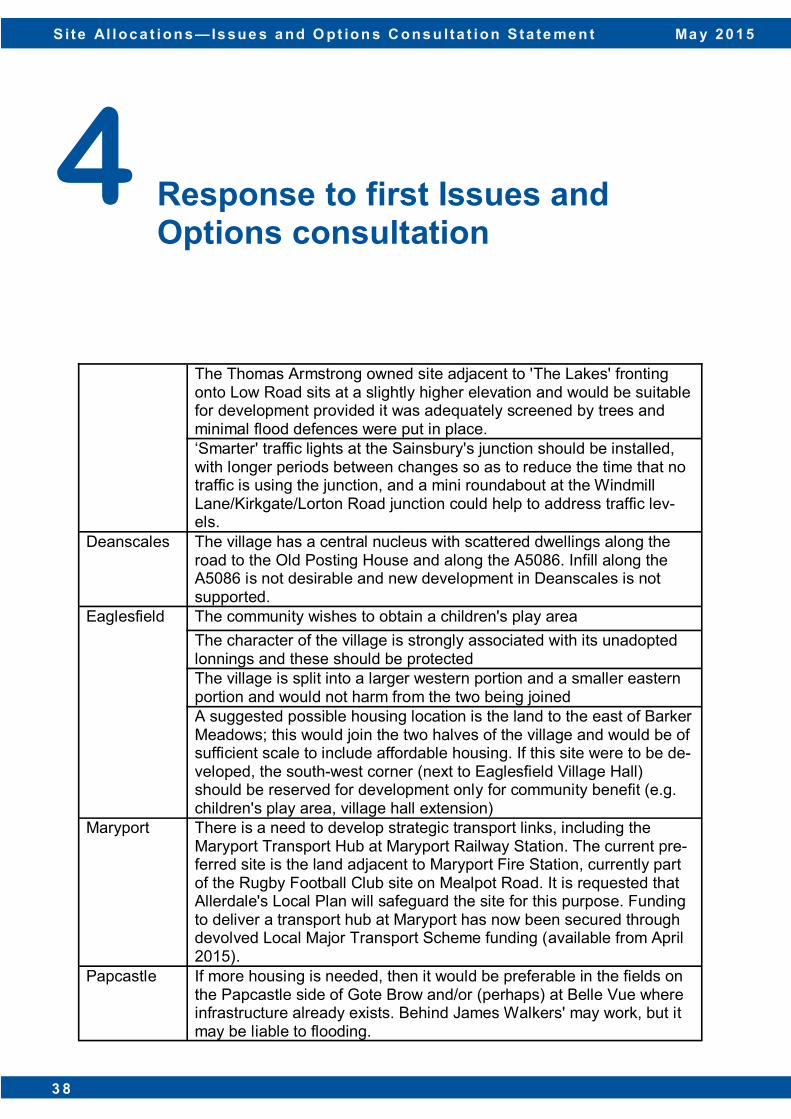
Settlement Comments
Aspatria The settlement boundary to the north of West Street should be looked at where three large agricultural buildings are located as the settlement boundary currently runs through these buildings. West Street Surgery is shown to be outside the settlement boundary – this is no longer the case.
Broughton Broughton villages seem to unfairly have a big percentage of sur-rounding land identified when compared to other settlements.
Cockermouth Allerdale Borough Council needs to adopt a policy for Cockermouth that positively encourages town centre usage and discourages fur-ther out of town development.

S i te Al loc a t ion s — Is sue s a nd Opt ion s Co ns u lta t ion S ta te me n t M a y 2 0 1 5
3 7
4 Response to first Issues and Options consultation
The requirement for development in Cockermouth should be carefully balanced with the need to protect its outstanding natural beauty. The former Fire HQ in Cockermouth should be considered to deliver the remaining 5% housing need in Cockermouth. This site is adjacent to the town centre and is ideally suited for high density affordable housing. Retail development on this site should be resisted as it would adversely affect the vitality and viability of the town centre. There is a lack of parking in the central areas of town, especially when tourists arrive. In its designation as a Key Service Centre, Cockermouth has the ability to serve day-to-day needs of local and surrounding residents and offer a varied range of employment land to meet the needs of local and regional businesses. The immediate surroundings of Cockermouth Castle are excessively covered with trees. Some removal and management is required. The Castle is a historic building and one of the reasons for Cockermouth's existence. Views of it are a feature of historic documents about Cockermouth and also existing tourist literature about the town. It is a greatly neglected asset. The determination of the final allocations in Cockermouth should wait until the planning application at Strawberry How has been determined to see if there is a need for further housing. Allerdale Borough Council should consider the provision of the type of housing in Cockermouth. There is a need for suitable private, as well as low cost homes for the elderly, particularly appropriate sheltered accommodation. There is also a need for bungalows. Any development to the east of the town would have a very negative effect on the road network. It would be sensible to build homes to the north and west of the town, near the proposed industrial development and the major road links to Penrith, Carlisle and the coast Any expansion of Cockermouth should be by the way of 'rounding off' within, or on the south side of, the town as far as possible. Existing housing developments should be extended rather than developing completely new and greenfield areas.
S i te Al loc a t ion s — Is sue s a nd O pt ion s C ons u lta t ion S ta te me n t Ma y 2 0 1 5
3 8 D i s c u s s i o n P a p e r : J a n u a r y 2 0 1 3 3 8
4 Response to first Issues and Options consultation
The Thomas Armstrong owned site adjacent to 'The Lakes' fronting onto Low Road sits at a slightly higher elevation and would be suitable for development provided it was adequately screened by trees and minimal flood defences were put in place. ‘Smarter' traffic lights at the Sainsbury's junction should be installed, with longer periods between changes so as to reduce the time that no traffic is using the junction, and a mini roundabout at the Windmill Lane/Kirkgate/Lorton Road junction could help to address traffic lev-els.
Deanscales The village has a central nucleus with scattered dwellings along the road to the Old Posting House and along the A5086. Infill along the A5086 is not desirable and new development in Deanscales is not supported.
Eaglesfield The community wishes to obtain a children's play area
The character of the village is strongly associated with its unadopted lonnings and these should be protected The village is split into a larger western portion and a smaller eastern portion and would not harm from the two being joined A suggested possible housing location is the land to the east of Barker Meadows; this would join the two halves of the village and would be of sufficient scale to include affordable housing. If this site were to be de-veloped, the south-west corner (next to Eaglesfield Village Hall) should be reserved for development only for community benefit (e.g. children's play area, village hall extension)
Maryport There is a need to develop strategic transport links, including the Maryport Transport Hub at Maryport Railway Station. The current pre-ferred site is the land adjacent to Maryport Fire Station, currently part of the Rugby Football Club site on Mealpot Road. It is requested that Allerdale's Local Plan will safeguard the site for this purpose. Funding to deliver a transport hub at Maryport has now been secured through devolved Local Major Transport Scheme funding (available from April 2015).
Papcastle If more housing is needed, then it would be preferable in the fields on the Papcastle side of Gote Brow and/or (perhaps) at Belle Vue where infrastructure already exists. Behind James Walkers' may work, but it may be liable to flooding.
S i te Al loc a t ion s — Is sue s a nd Opt ion s Co ns u lta t ion S ta te me n t M a y 2 0 1 5
3 9
4 Response to first Issues and Options consultation
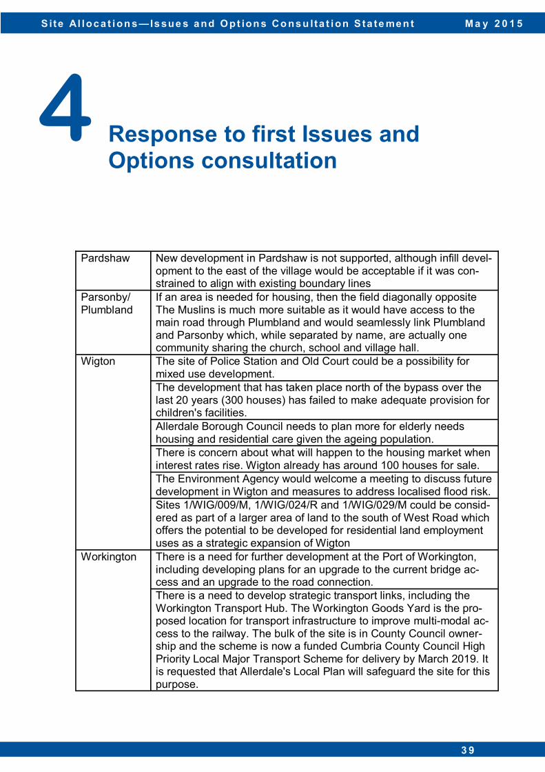
Pardshaw New development in Pardshaw is not supported, although infill devel-opment to the east of the village would be acceptable if it was con-strained to align with existing boundary lines
Parsonby/ Plumbland
If an area is needed for housing, then the field diagonally opposite The Muslins is much more suitable as it would have access to the main road through Plumbland and would seamlessly link Plumbland and Parsonby which, while separated by name, are actually one community sharing the church, school and village hall.
Wigton The site of Police Station and Old Court could be a possibility for mixed use development. The development that has taken place north of the bypass over the last 20 years (300 houses) has failed to make adequate provision for children's facilities. Allerdale Borough Council needs to plan more for elderly needs housing and residential care given the ageing population. There is concern about what will happen to the housing market when interest rates rise. Wigton already has around 100 houses for sale. The Environment Agency would welcome a meeting to discuss future development in Wigton and measures to address localised flood risk. Sites 1/WIG/009/M, 1/WIG/024/R and 1/WIG/029/M could be consid-ered as part of a larger area of land to the south of West Road which offers the potential to be developed for residential land employment uses as a strategic expansion of Wigton
Workington There is a need for further development at the Port of Workington, including developing plans for an upgrade to the current bridge ac-cess and an upgrade to the road connection. There is a need to develop strategic transport links, including the Workington Transport Hub. The Workington Goods Yard is the pro-posed location for transport infrastructure to improve multi-modal ac-cess to the railway. The bulk of the site is in County Council owner-ship and the scheme is now a funded Cumbria County Council High Priority Local Major Transport Scheme for delivery by March 2019. It is requested that Allerdale's Local Plan will safeguard the site for this purpose.
S i te Al loc a t ion s — Is sue s a nd O pt ion s C ons u lta t ion S ta te me n t Ma y 2 0 1 5
4 0 D i s c u s s i o n P a p e r : J a n u a r y 2 0 1 3 4 0
4 Response to first Issues and Options consultation
There is a need to deliver a new secondary school in Workington. There was an opportunity to improve the A66 Ramsay Brow/A596 Washington Street as land was for sale to facilitate this. This land is no longer for sale and the opportunity has presently receded, but there may be future opportunities to assemble this site to secure im-provements. The County Council wishes to see the continued safeguarding of the route for the Workington Southern Link Road. In the most recent SHLAA document, Eastland Farm in Harrington was considered suitable for development (reference EXWK22), but it does not appear in the Issues and Options consultation paper and it is unclear as to why this is the case. It is well related to Harrington and it is not within Flood Zones 2 or 3.
General comments
The Council’s ability to develop Local Service Centres in the north of the district may be affected by the eventual route of the North West Coastal Connections project led by National Grid. Development of brownfield land should always be a priority over building on greenfield land. The Port of Silloth is well placed for trade with Western Europe, Ire-land and Isle of Man with good road connections to the M6, southern Scotland and North East England. The specialism of the Port plays an integral role in the Cumbrian and regional economy as a catalyst for trade and commerce. Allerdale Local Plan should support the continued future use and development of the Port of Silloth for port related uses. The Council claims to have a 6.25 year supply, but at recent appeals, Inspectors have shown less than a 5 year supply. The Council must ensure that the housing needs over the plan period are deliverable on the sites identified. The Council should review all sites with planning permission as it ap-pears to be assuming they are all deliverable, thereby reducing the need to allocate land. This may negatively affect the levels of growth needed in areas to support the Council's economic regeneration strategies.
S i te Al loc a t ion s — Is sue s a nd Opt ion s Co ns u lta t ion S ta te me n t M a y 2 0 1 5
4 1
4 Response to first Issues and Options consultation
The Plan needs to avoid concentrating sites too closely together as developers will be less willing to build out at the same time and com-peting sites will impact upon sales values. Generally a focus on smaller sites, like Allerdale, struggle to deliver a Plan - a number of larger allocations are needed to ensure its deliv-erability. Cumbria County Council has a commitment to "working with others to support the enjoyment of our countryside and green spaces while protecting and enhancing its natural, wildlife and historic qualities" and to "support Cumbria Woodlands to help manage and conserve forests and woodlands across the county". Whilst this is the County Council, it is expected that Allerdale Borough Council's values are aligned with them. The Council should be bringing back into use empty buildings in or-der to meet housing needs. At present, there is no Extra Care Housing in Allerdale, but the Coun-ty Council will be giving further consideration to where demand can be met. Between 2009 and 2019, 380 places are required across Al-lerdale. The County Council hope that an element of this housing can be provided on housing sites, as part of the overall affordable hous-ing contribution, in addition to public sector and Registered Provider owned land. The Cumbria LEPs' Strategic Economic Plan needs to be an im-portant consideration. This amplifies the important role of West Cum-bria in delivering Cumbria's role as a centre for nuclear and energy excellence, especially the Port of Workington and Lillyhall. The Al-lerdale Local Plan should be consistent with the aspirations ex-pressed in this document. As sites are filtered, and Preferred Options emerge, the County Council will work with Allerdale Borough Council to assess infrastruc-ture requirements, to assess the potential for CIL and assist with any masterplanning exercises. Homes should be delivered close to schools which have available places in order to facilitate development and to help maintain the sustainability of schools.
S i te Al loc a t ion s — Is sue s a nd O pt ion s C ons u lta t ion S ta te me n t Ma y 2 0 1 5
4 2 D i s c u s s i o n P a p e r : J a n u a r y 2 0 1 3 4 2
4 Response to first Issues and Options consultation
Where land is earmarked/suggested for employment, leisure or housing use in the plan, there will be situations where it will be equal-ly suitable (possibly as part of a mixed development) for housing/tourism use and would generate the economic and employment ben-efits associated with B1, B2 or B8 uses. In this instance, the develop-ment should be consistent with Policy S17 of the Local Plan (Part 1). Dean Parish has a rural character throughout and this should be maintained. Any new developments should be in keeping with and appropriate to this context. Pockets of agricultural land within the vil-lages are important to retain their rural character. The settlements in Dean Parish are now dormitory villages for Cock-ermouth and the Cumbrian West Coast, with an important continuing agricultural element which defines their character. Large scale new industrial/commercial developments are not appropriate to the Par-ish, however home working should be encouraged along with small scale businesses such as artisan/professional developments to re-duce commuting out of the Parish. New residential developments in Dean Parish should take place with-in village boundaries, with the exception of those supporting the ru-ral/agricultural community. Where developments larger than single-dwelling infilling take place, the Parish would like to see a significant proportion of affordable housing included and/or other associated benefits provided to the community. A lower threshold for requiring affordable housing than Allerdale Borough Council's threshold is supported. When affordable homes are built, they should be managed through a Housing Associ-ation scheme to ensure continuity of their low-cost status. Where villages are bounded and/or screened by natural features (e.g. woodland, ridges, streams) the village should not expand be-yond these features. Where proposed allocations are located within/partly Flood Zones 2 and 3, a Level 2 Strategic Flood Risk Assessment will need to be submitted.
S i te Al loc a t ion s — Is sue s a nd Opt ion s Co ns u lta t ion S ta te me n t M a y 2 0 1 5
4 3
4 Response to first Issues and Options consultation
If any site borders a watercourse designated a Main River, then prior consent of the Environment Agency would be required for any works within the top of the bank of a Main River watercourse and new structures and private garden spaces that would permanently obstruct access would not be permitted. Risks from land contamination to controlled waters should be considered as part of any development and remedial measures put in place if required. Given the important contribution the historic environment makes to the district, the Local Plan should include a proper description, identification and assessment of the historic environment and the supporting evidence base should include heritage information. The Plan should conserve and enhance the historic environment of the area and guide how the presumption of sustainable development should be applied locally. The selection of sites needs to be informed by the evidence base and the Plan should avoid allocating sites for development which are likely to result in harm to the significance of heritage assets. When adverse impacts are unavoidable, the Plan should consider appropriate mitigation methods. Impacts on designated conservation sites within and close to the boundary of the Borough will need to be fully tested through the SA and HRA. This should include impacts on the Solway Coast AONB, Upper Solway Flats and Marshes Special Protection Area/Ramsar/SSSI, Solway Firth SAC, River Derwent and Bassenthwaite SAC and River Derwent and Tributaries SSSI. The Local Plan should safeguard the long-term capability of Best and Most Versatile (BMV) land and make clear that areas of lower quality agricultural land should be used for development in preference to the BMV land. Retaining BMV land enhances future options for sustainable food production and helps secure other important eco-system services. Natural England can provide free digital maps which show Agricultural Land Classification information.

S i te Al loc a t ion s — Is sue s a nd O pt ion s C ons u lta t ion S ta te me n t Ma y 2 0 1 5
4 4 D i s c u s s i o n P a p e r : J a n u a r y 2 0 1 3 4 4
4 Response to first Issues and Options consultation
The Local Plan (Part 2) should include a policy requiring the payment of developer contributions where development pressure on the rail-way occurs as a result of the proposed site allocations. The density of development should be looked at to avoid 'cramming homes' into villages. Developments should have garages that can actually fit cars into them to address parking issues associated with housing develop-ments. The evidence used to inform the Local Plan (Part 1) should be re-freshed and utilised. The NPPF sets out the need for Authorities to use Strategic Housing Market Assessment to ensure that Authorities have a full understanding of housing need in their area; this includes the need to address all types of housing. Authorities should respond to market signals including considerations such as improving afforda-bility and also the need to meet housing need within the plan. Concern about how small the stand was at the drop-in session at Wigton Local Links centre. It was difficult to hold a conversation with the planning officer in attendance and it was difficult to read and use the information provided given the busy environment the session was held in.
S i te Al loc a t ion s — Is sue s a nd Opt ion s Co ns u lta t ion S ta te me n t M a y 2 0 1 5
4 5
5.1 The text below summarises the responses that were received as part of the second Issues and Options (Additional Sites) consultation. The summarised list of all the site specific comments received is included in Appendix 1.
Question 1 Which site(s) would you prefer the Council to take forward? 5.2 70 people provided 172 comments to support the allocation of 35 sites. There was support
for the allocation of sites 2/PRO/003/R (Prospect Garage) and 2/COC/021/M (Former Fire and Rescue Centre, Cockermouth) to enable the development of brownfield sites. There was also support for the protection of open space at Harrington Marina (1/WOR/083/O) given its key role as part of green infrastructure.
5.3 The site at Bow Flatts in Great Clifton (2/GRC/015/R) was supported by three written
submissions and a petition signed by 52 residents (on behalf of 125 people) as development would provide a new road with footpaths connecting both sides of the village. 12 people wrote in to support the allocation of land at Low Seaton (2/WOR/081/R) as there is a need for larger, family homes in Seaton.
5.4 Other respondents identified specific sites in Bolton Low Houses, Cockermouth, Crosby,
Dean, Dearham, Fletchertown, Great Clifton, Ireby, Maryport, Oughterside, Papcastle, Plumbland, Thursby, Wigton and Workington that they felt should be taken forward. Some of the key supporting reasons included: location in Flood Zone 1; accessibility to services and facilities from sites; infrastructure enhancements are unlikely to be required; there are nearby employment opportunities; and there is easy access from the site to road and rail. The full list of supporting comments can be found in Appendix 1.
5.5 In addition to 172 site specific comments, the Council also received 50 settlement wide
comments to Question 1. 5.6 23 of these comments related to the settlement of Brigham, where respondents stated that
as Brigham has met the identified Local Plan need. A similar comment was received from one respondent about Great Clifton. In total, 24 respondents stated that no new sites should be taken forward in Brigham and Great Clifton as part of this plan period.
5
Response to second Issues and Options (Additional Sites) consultation
S i te Al loc a t ion s — Is sue s a nd O pt ion s C ons u lta t ion S ta te me n t Ma y 2 0 1 5
4 6 D i s c u s s i o n P a p e r : J a n u a r y 2 0 1 3 4 6
5.7 A respondent from Plumbland stated that they would support infill and brownfield sites which would be more in line with the desired development of the parish rather than the designation and use of greenfield sites.
5.8 25 respondents from Workington want all available brownfield sites to be taken forward
rather than greenfield sites. It is considered that the regeneration/redevelopment of derelict/neglected brownfield sites within existing communities would be more beneficial and in line with Government policy.
Question 2 Do you consider that any of the sites are not suitable for allocation? What changes would you like to be made? 5.9 135 people provided 1,295 comments against the allocation of 45 sites. All of the
comments can be found in Appendix 1. The text below summarises the key issues raised on the sites that were commented on the most.
5.10 There were five sites included in the Issues and Options (Additional Sites) consultation
that generated the most objections: • Low Seaton (2/WOR/081/R); • Land at Camerton Road, Seaton (2/WOR/082/R); • Ellerbeck Brow, Brigham (2/BGH/005/R); • Spring Croft (2/BGH/006/R); and • Linton Garth, Plumbland (2/PLU/002/R). 5.11 The site at Low Seaton attracted a total of 63 responses; 49 were objecting to the site progressing further in the Site Allocations process. There were a number of issues raised about this site but the main issue raised was the fact that the existing highway capacity is poor and already struggles to cope with existing development; the road infrastructure cannot cope with any further development. Other highway related issues included concern about emergency vehicle access, the limited parking available and the lack of footpaths in the area. There were other issues raised including: loss of residential amenity; the local schools are at capacity; and the loss of important wildlife habitats.
5
Response to second Issues and Options (Additional Sites) consultation
S i te Al loc a t ion s — Is sue s a nd Opt ion s Co ns u lta t ion S ta te me n t M a y 2 0 1 5
4 7
5.12 Another site in Seaton (Land at Camerton Road) received nine letters of objection. Most of the reasons provided were similar to the issues raised about the Low Seaton site relating to concerns about the capacity of the existing highway and education infrastructure and the impacts on the local wildlife. Other concerns included: the loss of a natural water store if the site was developed which would lead to an increase in flooding in the surrounding areas; part of the site has a covenant on it restricting it to agricultural use only; and the fact that employment opportunities for the new residents of these houses would be south of the river Derwent in the nuclear industry which would put additional strain on the two bridges and would increase traffic congestion through Workington.
5.13 The majority of the 25 objections to the site at Ellerbeck Brow in Brigham referred to the
number of planning applications made for development on this site which have been refused and the subsequent dismissed appeals. The site has poor accessibility as it only has a single point of access which has an inadequate visibility splay which is a hazard for pedestrian and vehicular access/egress. A large number of other objection reasons were provided which included: development on this site would be backland development outside the settlement boundary; the level of development would not be sympathetic to the scale of the village and its narrow roads; the existing infrastructure, facilities and services cannot support development of this level; and there is no need for this housing numbers have been met.
5.14 The site at Spring Croft in Brigham also received 25 objections. The main concern about
development on this site was that, in conjunction with the recently approved Lawsons Garth development, there would be pressure on the road junction at Hotchberry Road. However, the majority of respondents said that low level density development could be supported in the next Plan period, after 2029.
5.15 22 responses were received in objection to the site at Linton Garth, Plumbland. A wide range of issues were covered which have all been listed in Appendix 1. Some of the main concerns included: development on the site would result in the loss of Grade I and Grade II agricultural land; there are no services/facilities in the settlement to support development on this scale; the roads to and from the village regularly flood, making them impassable for emergency services and healthcare professionals; access to the site is dangerous as the gateway is directly opposite other driveways and there is poor visibility due to parked vehicles on the road; and existing residents would prefer housing need to be meet through infill development within the settlement boundary.
5
Response to second Issues and Options (Additional Sites) consultation
S i te Al loc a t ion s — Is sue s a nd O pt ion s C ons u lta t ion S ta te me n t Ma y 2 0 1 5
4 8 D i s c u s s i o n P a p e r : J a n u a r y 2 0 1 3 4 8
5.16 Consultation responses were also received against the allocation of sites in: Bolton Low Houses; Cockermouth; Crosby; Crosby Villa; Dean; Dearham; Dovenby; Great Clifton; Ireby; Maryport; Oulton; Pardshaw; Wigton; and Workington. The comments for all of these sites can be found in Appendix 1.
5.17 As part of Question 2, respondents were also asked what changes they would like to be
made to the sites that had been put forward. Respondents were able to: suggest an alternative use for a site; identify changes to the site boundary; and suggest discarding/rejection.
5.18 The majority of respondents to this question stated that they wanted the sites they
identified to be discarded from the allocations process. 5.19 Two respondents suggested that the site beside the Tennis Courts in Cockermouth (2/
COC/020/R) should be allocated for recreational purposes rather than residential. 5.20 Two comments were received in respect of the Former Fire and Rescue Centre in
Cockermouth (2/COC/0021/M) due to the location of a footpath through the site. One respondent requested a change in the site boundary as the site includes several footpaths, including a footpath on the old railway, and a cycleway. This change in the site boundary will allow these features to be preserved. There was also an alternative use suggested for this site. Rather than mixed use on the site, a respondent suggested that the site may be appropriate for housing for older people.
5.21 One respondent stated that the site at Netherhall Estate, Maryport (2/MAR/034/M) should
only be allocated for community green space and non-built leisure uses. 5.22 Another respondent felt that the Site Allocations document should protect the woodland
and parkland at Dovenby Hall as a Local Wildlife Site in recognition of the Ancient Woodland and UK BAP (Biodiversity Action Plan) habitats that can be found on the site.
5
Response to second Issues and Options (Additional Sites) consultation
S i te Al loc a t ion s — Is sue s a nd Opt ion s Co ns u lta t ion S ta te me n t M a y 2 0 1 5
4 9
Question 3 Are there any particular issues the Council should know about any of the sites? 5.23 81 comments on 30 sites were provided in response to this question. The majority of the
comments provided as part of these responses were site specific and so have been summarised in Appendix 1 under the relevant site reference.
5.24 The Environment Agency provided a comprehensive assessment of all the sites included
in the second Issues and Options (Additional Sites) consultation. The response identified sites which were: within the vicinity of a sewer network; within 8 metres of a watercourse; in Flood Zone 2 or 3; affected by a culvert through the site; and within 25m of a historic landfill.
5.25 Other stakeholder comments identified potential constraints to development on sites given
their proximity to a number of designations including: Ancient Semi Natural Woodland; the River Derwent and Bassenthwaite Lake SAC; and the River Derwent and Tributaries SSSI.
Question 4 Any other comments? 5.26 Four comments were made on the consultation document itself; two people stated that the
plans were difficult to read as the colours on the map do not match the colour in the key and one person pointed out that page 6 of the document referred to Appendix 2, even though the document did not have an Appendix 2. One respondent questioned the need to produce a Site Allocations document given the recent planning permission that was granted at Strawberry How in Cockermouth. Another resident raised the point that the Council does not appear to take account of the responses submitted by members of the public.
5.27 Some respondents suggested that the Council should look at the possibility of developing
Derwent Forest to meet the housing targets. One respondent considered that this site would be suitable for use as a retirement village.
5
Response to second Issues and Options (Additional Sites) consultation
S i te Al loc a t ion s — Is sue s a nd O pt ion s C ons u lta t ion S ta te me n t Ma y 2 0 1 5
5 0 D i s c u s s i o n P a p e r : J a n u a r y 2 0 1 3 5 0
5.28 There was general support for the Site Allocations document to protect existing woodlands, habitats and open space, as well as those sites of archaeological interest.
5.29 One respondent encouraged the Council to make more of s106 Agreements to secure
community benefits associated with development in the district. 5.30 One respondent stated that for all mixed, retail and employment sites, the Council should
consider adopting a policy of pocket Park and Ride areas. Each relevant site would be required to provide an agreed amount of free car parking spaces for Park and Ride where the site is close to a bus route. Road signage should be included in the development to identify the car parking spaces available. This will help to reduce car journeys in an affordable and sustainable manner where no revenue support costs are required post introduction. This should all be secured through s106 agreements
5.31 17 respondents provided comments that any future development in Brigham should be
plan led given that the Council has an adopted plan and a five year supply. This will help to protect against unsustainable development in the settlement as Brigham does not have the services/facilities/infrastructure to sustain any more new dwellings.
5.32 One comment was made that developer led projects should follow the adopted Local Plan
which states that the allocation of growth between settlements should take into account current housing commitments and completions since the beginning of the Plan Period, and the ability of the settlement to accommodate growth without harming its character, setting or the surrounding landscape. Another respondent supported proportionate development across settlements as disproportionate growth in any settlement, particularly smaller settlements, has the potential to place a strain on existing water and wastewater infrastructure
5.33 Concern was raised about the fact that there appears to have been little thought given to the type of housing development required in this area – a greater a variety of sheltered accommodation is needed across the district. By making provision for older people, other accommodation for families will then be made available. 5.34 Concern was also raised about the settlements that will soon lose their bus service and
how this will impact on the accessibility of some of the sites that have been put forward for consideration.
5
Response to second Issues and Options (Additional Sites) consultation
S i te Al loc a t ion s — Is sue s a nd Opt ion s Co ns u lta t ion S ta te me n t M a y 2 0 1 5
5 1
5.35 In total, ten comments were received from five respondents about evidence base documents. With regard to the Site Assessment Methodology, the Coal Authority stated that they were pleased to see that the Site Sustainability Assessment Criteria identifies that sites should be considered against the Coal Authority defined Development High Risk Area and the Surface Coal Resource plans provided to the Local Planning Authority. This identification shows that the Council recognises the importance of coal mining legacy and coal resources within the district.
5.36 Sport England encourages the Council to use the recently completed Playing Pitch
Strategy to identify whether specific sites have been identified in the document as surplus to requirement to meet an existing or predicted future need. Any lapsed sites which are required to be brought back into use should be an allocation in its own right. Any site allocation containing a sports facility which is not deemed to be surplus to requirements will need to be replaced to an equivalent or better quality and quantity within the locality.
5.37 A number of stakeholders offered support to the Council in the ongoing preparation of the
Local Plan (Part 2). Natural England offered their support to the Council in the preparation of the Sustainability Assessment and the Habitat Regulations Assessment given the key role these documents will have in informing the Preferred Options process. United Utilities will work closely with the Council to develop a coordinated approach to delivering sustainable growth in sustainable locations. Cumbria County Council will liaise with the Council to give robust consideration to both the site specific and broader infrastructure effects of development, and subsequently the mitigation measures that may be needed to ensure development is sustainable.
5
Response to second Issues and Options (Additional Sites) consultation

S i te Al loc a t ion s — Is sue s a nd O pt ion s C ons u lta t ion S ta te me n t Ma y 2 0 1 5
5 2 D i s c u s s i o n P a p e r : J a n u a r y 2 0 1 3 5 2
6.1 The responses provided to both of the Issues and Options consultation will be used, alongside site assessment tools and liaisons with key stakeholders, to help Planning Officers to determine which sites to take forward to the next round of consultation (Preferred Options).
6.2 Once the preferred sites have been identified, they will be released for consultation; it is
anticipated that this will occur in summer 2015. The Preferred Options consultation document will identify the preferred sites, but it will also explain why the other sites have not been taken forward. The Council will also be working on supporting documents such as the Habitats Regulations Assessment and Sustainability Appraisal.
6.3 The next round of consultation will be published on our website and those who are registered on our consultation database will be notified of the start of the consultation. If you would like to be added to our consultation database, please email [email protected] or call 01900 702610.
6 Next Steps
Appendix 1: Consultation response summary by site
S i te Al loc a t ion s — Is sue s a nd O pt ion s C ons u lta t ion S ta te me n t Ma y 2 0 1 5
5 3
Site Issue/comment Number of representations
1/WOR/011/R There is already flooding issues from Eller Beck; any development in this area will have an adverse effect on an area already struggling to cope with the volumes of flood water. Due to the topography of the site, development on this site is highly likely to increase the risk of flooding to the local area as the Eller Beck/River Wyre already suffers from downstream flood events. Any increase to the natural flow would also have an impact on the nature reserve at Harrington Reservoir which is home to many forms of wildlife (e.g. Mallards, Moorhen, Sticklebacks etc.)
26
The site is located in Flood Zones 1 and 3B - development should be located in areas with the lowest probability of flooding.
25
Allowing residential development in this area could have safety implications for residents due to the flood risk
1
Given that Workington only needs 8% of the land that has been put forward, there are brownfield sites that should be developed first
26
The site lies outside the settlement boundary 25
It's location at one of the high points in Workington (64m above sea level) makes inaccessible for a high percentage of possible users (e.g. elderly, disabled, those reliant on having a means of transport at their disposal)
25
The site is not sustainable. The closest amenities are all approximately 1 mile away (Moorclose shops, Harrington Road Co-Op and the town centre), with Derwent Park Retail Park approximately 2 miles away. Leisure facilities (e.g. football ground, cinema and bowling) are approximately 2-3 miles away. These will all be difficult to access on foot and via public transport as the nearest train station is 1.5 miles away and the bus station 1 mile away.
25
The topography of the land renders it unsuitable for development 25
Currently the utility capacity on this site is classified as a public sewer flooding risk 25
Development on this site will have an impact on the A596. Cumbria County Council has identified that the High Street/Newlands Lane junction is operating above capacity. Development of this site would further impact on this junction and those at Ashfield Road, Ellerbeck Lane, Ashfield Gar-dens, James Duffield Close and Stanbeck Meadows
25
Two accesses to the site would be needed. As the site is land-locked, two new junctions onto the A596 would need to be created which would put stress on the local highway network, affect all junctions on the A596 at High Street and generate severe highway infrastructure problems. This development, together with the new secondary school at Stainburn and the Ashfield Road South site, will result in an increased number of vehicles on the A596, especially at peak times, thus af-fecting highway safety for vehicles and pedestrians.
25
Principal Service Centre
S i te Al loc a t ion s — Is sue s a nd O pt ion s C ons u lta t ion S ta te me n t Ma y 2 0 1 5
5 4
1/WOR/011/R Between June 2008 and September 2014, there have been 19 recorded accidents around the High Street/Guard Street junction and at Castle Gardens
25
Given its elevated position, any development on this site would have an unacceptable effect on the local residential amenity in terms of loss of privacy due to overlooking or an increased sense of enclosure as a result of an overbearing development
25
Development on this greenfield site would lead to a detrimental effect on local visual amenity due to the loss of open space, trees and impact on the historic character of the area
25
The site provides habitats for a variety of wildlife, including Red Squirrels, blue butterflies, pheasants and bats
25
Schoose Farm is opposite the site and contains a number of Grade II listed buildings 25
The site is not in a location that would benefit affordable housing due to the distance from services and facilities
25
1/WOR/014/E Support allocation for proposed use 1
1/WOR/016/R Support allocation for proposed use 1
1/WOR/017/R Support allocation for proposed use 1 The site is adjacent to Eller Beck which already has issues with flooding 1
1/WOR/018/I Support allocation for proposed use 1
1/WOR/020/R Support allocation for proposed use 1
Site is within settlement boundary 1
Site is within reasonable proximity to wide range of community facilities 1
The land uses in the vicinity of the site are primarily residential and passive recreation 1
Part of the site is brownfield 1
Access can be gained to the site 1
Site is in Flood Zone 1 1
Site is not constrained by environmental, ecological or archaeological issues 1
1/WOR/023/M Any loss of playing fields should be replaced or proven to be surplus to requirements 1
1/WOR/025/M Flooding issues 1
1/WOR/026/M Site includes the Scheduled Monument that protects Jane Pit 1
1/WOR/027/M Any loss of playing fields should be replaced or proven to be surplus to requirements 1
1/WOR/032/E Habitat for the small blue butterfly which is sensitive to disturbance 1
S i te Al loc a t ion s — Is sue s a nd O pt ion s C ons u lta t ion S ta te me n t Ma y 2 0 1 5
5 5
1/WOR/034/E Support allocation for proposed use 1
Habitat for the small blue butterfly which is sensitive to disturbance 1
1/WOR/035/E Support allocation for proposed use 1
1/WOR/043/M Site is in a prominent location and well related to the strategic Lillyhall Estate 1
The site is extremely accessible from the highway network 1
Site has close links to services and public transport links 1
The site is previously developed land 1
The proposed use would complement the existing uses in the locality 1
1/WOR/050/R The site has good access from the main road 1
The site has good access to services and facilities 1
The site is in Flood Zone 1 1
Open space can be provided either within the site or on adjoining land 1
There is no impediment to excellent design on this site 1
Power and water connections exist on the site. Sewage treatment can be provided 1
Development on the site can manage the blind corners 1
There is no known ecological or archaeological impediments on the site 1
There are no known factors to indicate that this site is not a positive addition to the sustainability of Allerdale's Land Allocation Document
1
Affordable housing can be provided as per the relevant policy 1
The site is achievable, available and suitable for development 1
1/WOR/052/R Access is not possible to the site via St. Andrew’s Road 1
The proposed site is the only open space for local children to play on 1
Moor Road frequently floods after heavy rain; drainage systems cannot cope 1
1/WOR/053/R The site has good access from the main road 1
The site has good access to services and facilities 1
The site is in Flood Zone 1 1
Open space can be provided either within the site or on adjoining land 1
There is no impediment to excellent design on this site 1
Power and water connections exist on the site. Sewage treatment can be provided 1
S i te Al loc a t ion s — Is sue s a nd O pt ion s C ons u lta t ion S ta te me n t Ma y 2 0 1 5
5 6
1/WOR/053/R Development on the site can manage the blind corners 1
There is no known ecological or archaeological impediments on the site 1
There are no known factors to indicate that this site is not a positive addition to the sustainability of Allerdale's Land Allocation Document
1
Affordable housing can be provided as per the relevant policy 1
The site is achievable, available and suitable for development 1
1/WOR/055/R An access to the site could be created using other land under the owner’s control 1
There is no flood risk impediment to the site 1
1/WOR/056/R The site is supported 1
This site should only be brought forward if modified. The site boundary should exclude westernmost section - the site is too large otherwise
1
The developer is committed to the delivery of this site for housing and continues to support the inclusion of this site for housing allocation
1
The revised site boundary is consistent with the current proposals which the developer is preparing in order to support a planning application in the near future
1
This site will deliver housing and will assist the Council with achieving its targets 1
The high demand for properties at Whins Farm demonstrates that there is a desire for high quality housing in this area of Workington
1
The site is not easily accessible to services and facilities 1
The site is within the vicinity of the sewer network 1
Development on this site is likely to generate additional car traffic and congestion/air pollution, with require-ments for enhanced local highway infrastructure
1
1/WOR/057/R The site is supported 1
Development on this site is likely to generate additional car traffic and congestion/air pollution, with require-ments for enhanced local highway infrastructure
1
The site is not easily accessible to services and facilities 1
Development on this site is likely to generate additional car traffic and congestion/air pollution, with require-ments for enhanced local highway infrastructure
1
This site is too disconnected from the rest of the settlement 1
The site is within the vicinity of the sewer network 1
This site is not designated as Ancient Semi Natural Woodland. However, it is recorded as woodland on the National Forest Inventory. This site should be treated as Ancient Semi Natural Woodland and reference should be made to standing advice
2
S i te Al loc a t ion s — Is sue s a nd O pt ion s C ons u lta t ion S ta te me n t Ma y 2 0 1 5
5 7

1/WOR/073/M Any loss of playing fields should be replaced or proven to be surplus to requirements 1
1/WOR/076/E Support allocation for proposed use 1
1/WOR/078/M Any loss of playing fields should be replaced or proven to be surplus to requirements 1
2/WOR/080/R This site is suitable for allocation 1
This site is adjacent to Workington Railway Station and a developer contribution may be required if the proposal were to increase footfall at the station
1
The site is within the vicinity of the sewer network 1
2/WOR/081/R Site is located close to accessible services and facilities, including existing road passenger transport services. 1
Infrastructure enhancements (e.g. road junctions) and national policy (e.g. air pollution) are unlikely to be adversely affected by development on this site
1
There is a desperate need for larger family houses in the village – a lot of families are moving out of the area due to the lack of supply
9
Access via Branthwaite Lane and Low Seaton would be fine. Traffic was redirected about 18 months ago and over 100 cars per day used the re-direction route so access has proved to be more than OK
2
The site is a beautiful place to build new homes and would let residents have a house that overlooks the river and Mill Field. The site would be a very desirable location for housing
2
If the right type of houses were provided, it would attract a lot of people to Seaton 2
Access could be improved down Branthwaite Lane that would be of benefit to all of Seaton 2
The development might include a park/other facilities for young people 1
There is sufficient room in the local schools 1
The site contains dog faeces which means that children cannot play in the field 7
Access to the site would be OK if some of the local residents who run a business did not park 7-8 vehicles on the street overnight and have heavy goods delivery vehicles coming to Branthwaite Lane
3
If new developments are not supported, then Seaton will be an ageing village and no new families will move to the area
3
Could the current parking issues on Low Seaton road be addressed using double yellow lines? 1
A small development will blend in nicely - it should be a low density development including some affordable family homes. Would support development of around 40 units of the site
3
It would put the field to good use and benefit the local community 1
Development on this site would provide work for local tradesmen 1
Provision of access is important and would need to be commensurate with the number of houses 1
S i te Al loc a t ion s — Is sue s a nd O pt ion s C ons u lta t ion S ta te me n t Ma y 2 0 1 5
5 8
2/WOR/081/R The road that development would use is not capable of taking any increase in traffic volume, as it is currently at capacity and is of sub-standard conditions. The access road down Low Seaton is narrow with a single lane in some parts and no pavement. Cars are parked most of the way down the road making access very difficult. The volume of traffic using the road has increased over the last few years. Development of this site would lead to more traffic which will increase the risk of accidents in an area with families with young children.
45
Emergency vehicle /delivery vehicle/construction vehicle access is a concern at present based on the amount of traffic/parking restrictions
19
Planning permission on this site has been refused in the past, and a subsequent appeal was dismissed 9
This area is used for recreational purposes by walkers, horse riders and dog walkers 14
The site is adjacent to significant areas of woodland and home to several species of indigenous wildlife (e.g. red squirrels, deer, pheasant, owls, bats and woodpeckers). Development on this site would undoubtedly dis-rupt the habitat of this wildlife, potentially damage the woodland and affect the water courses that run through the area
24
Ancient Semi Natural Woodland is adjacent to this site. This site allocation should not be taken forward. How-ever, if the sites are allocated, a buffer of at least 50m between the site and the woodland should be imple-mented
3
Development on this site would lead to further destruction of an unspoilt, historic area and would be detri-mental to the character of the area as it would lead to a loss of amenity space
19
The proposed development will affect existing house values 5
The village schools are at maximum capacity and they do not have the potential to expand 11
There is no need for this level of housing in Seaton. There are houses currently on the market that are not sell-ing. There are enough planning permissions for housing in the area (Maryport, Cockermouth, Workington, Derwent Forest) and so this is not needed.
9
The generation of heavy construction traffic could affect the foundations of nearby houses 3
The site is greenfield land in open countryside 2
The units built would not be for affordable housing 1
This would be a very inappropriate urban extension into open countryside as the site is isolated and uncon-nected from the rest of the settlement.
1
The drainage system is already struggling – heavy rain causes flooding at Branthwaite Lane. Development on this site would remove a natural water storage area and exacerbate the existing problem
3
It is likely that the houses built on this site would not have garages attached to them, meaning that the cars will be parked on the road
1
The land levels are unsuitable for development 1
There is concern that there will not be safe playing areas for children 5
S i te Al loc a t ion s — Is sue s a nd O pt ion s C ons u lta t ion S ta te me n t Ma y 2 0 1 5
5 9

2/WOR/081/R There is plenty of land in the Derwent Forest and surrounding area that can be used instead of the centre of Seaton
1
If the development goes ahead, a balcony at an existing neighbouring property would overlook the new hous-es
1
The site is within the vicinity of the sewer network 1
The site is in Flood Zone 3 1
The site is within 8 metres of a Main River 1
If the site was to be developed, the new residents could use Branthwaite Lane/Derwent Bank as a short cut which would be unacceptable as it is a public bridleway and it is regularly used by children
4
Development on the site would create noise pollution from the construction phase and from the new resi-dents, affecting residential amenity
3
2/WOR/082/R Site is located close to accessible services and facilities, including existing road passenger transport services. 1
Infrastructure enhancements (e.g. road junctions) and national policy (e.g. air pollution) are unlikely to be ad-versely affected by development on this site
1
Supportive of the inclusion of this land as a potential site for housing 1
The scale of development would be much too large for the settlement and involve the loss of a very large greenfield, agricultural site.
2
The site bounds a County Wildlife Site to the north 1
Vehicle access to this site (as well as in conjunction with 2/WOR/081/R) would put great strain on the access routes via Church Road and Causeway Road which already suffer from congestion. Apart from Camerton Road (which is very narrow and can also have weather related problems) these two roads are the only exist-ing roads in and out of this area. Both of these roads allow parking on two sides (particularly with visitors to the church and pubs) which is a hazard to drivers and pedestrians. Any additional traffic would make this much worse. There is already concern for pedestrians, cyclists, car drivers, horses, delivery vehicles, refuse collections and emergency vehicles due to parked cars on both sides of the road.
8
Emergency vehicle /delivery vehicle/construction vehicle access is a concern at present based on the amount of traffic/parking restrictions
1
The village schools are at maximum capacity and they do not have the potential to expand 6
There is plenty of land in the Derwent Forest and surrounding area that can be used instead of the centre of Seaton
1
Water drains off this site to the lowest point near the British Legion and floods the road. Development of this site would cause more water run-off and cause flooding of houses in this area
2
Employment opportunities for the new residents of these houses would be south of the river Derwent in the nuclear industry. This would put additional strain on the two bridges and would increase traffic congestion through Workington
1
S i te Al loc a t ion s — Is sue s a nd O pt ion s C ons u lta t ion S ta te me n t Ma y 2 0 1 5
6 0

2/WOR/082/R There is currently already insufficient parking for access to local facilities (e.g. shops, library, post office, pharmacy)
1
Development on this site would put pressure on local biodiversity and their habitats (e.g. red squirrels, pheasants, ducks and birds)
2
The site is on the limits of the parish boundary and the green space should be protected 1
Development on this site would have a negative effect on the surrounding footpaths, cycle tracks and public rights of way. It would also have a negative impact for those utilising community facilities including the Village Hall and the Scout Hut
1
The site is within the vicinity of the sewer network 1
Part of this site has a covenant on it restricting it to agricultural use only 1
2/WOR/083/O This site should be brought forward as public open space as it is important green infrastructure within south Workington. Management plan should be put in place to enhance the wildlife at the site
1
Support this Open Space designation, although it should continue further north on open land between the railway line and the coast, reaching as far north as the former steelworks site
1
The site is within the vicinity of the sewer network 1
The site is within 8 metres of a Main River 1
Consider the ordinary watercourse on the site 1
The site is within Flood Zone 3 1
This site appears to be open space adjacent to the operational railway. In this case, Network Rail would wish to see a trespass proof fence erected adjacent to the railway boundary to ensure that users of the open space could not gain unauthorised access to the operational railway.
1
Aspatria
1/ASP/001/R There is no requirement for additional housing in the area in view of the number of empty properties currently available
1
This site makes sense in terms of a rounding off development 1
1/ASP/002/R There is no requirement for additional housing in the area in view of the number of empty properties currently available
1
Combined with sites 1/ASP/005/R and 1/ASP/006/R would imply a significant extension of the town 1
The distance of the site from the railway station is not sustainable 1
If this site progresses as an allocation, it should be limited to a natural extension of the existing settlement boundaries (the east and west of northern portion of the site)
1
Key Service Centres
S i te Al loc a t ion s — Is sue s a nd O pt ion s C ons u lta t ion S ta te me n t Ma y 2 0 1 5
6 1
1/ASP/003/R There is no requirement for additional housing in the area in view of the number of empty properties currently available
1
This site relates well to the adjoining residential properties on the south side and as such it could be considered a logical extension to the settlement
1
Development of this site could exacerbate the disjunction created by the absence of facing settlement to the north - a 'half a ribbon development' in effect
1
1/ASP/004/R There is no requirement for additional housing in the area in view of the number of empty properties currently available
1
This site should be considered for commercial/retail mixed use in order to support the town centre and to reduce travel pressures on Aspatria residents to access services
1
The site should also build upon its proximity to the Rugby Club to develop leisure facilities 1
Access via the Pringle would be impossible, but a masterplan for the site (including the area to the north of the site) could be done to relieve some of the access and frontage issues
1
The site is accessible by a range of means of transport including bus and rail 1
The site is not visually intrusive 1
The site is well related to the existing built form of the settlement 1
The site is within walking distance to numerous services and facilities 1
1/ASP/005/R There is no requirement for additional housing in the area in view of the number of empty properties currently available
1
Combined with sites 1/ASP/002/R and 1/ASP/006/R would imply a significant extension of the town 1
The distance of the site from the railway station is not sustainable 1
If this site progresses as an allocation, it should be limited to a natural extension of the existing settlement boundaries (the east and west of northern portion of the site)
1
1/ASP/006/R There is no requirement for additional housing in the area in view of the number of empty properties currently available
1
Combined with sites 1/ASP/002/R and 1/ASP/005/R would imply a significant extension of the town 1
The distance of the site from the railway station is not sustainable 1
If this site progresses as an allocation, it should be limited to a natural extension of the existing settlement boundaries (the east and west of northern portion of the site)
1
1/ASP/007/R There is no requirement for additional housing in the area in view of the number of empty properties currently available
1
This site makes sense in terms of a rounding off development 1
The Business Park to the NE of the site is now beginning to attract investors. This site might benefit from being considered as a satellite Business Park if the present one becomes full (although there could be access issues)
1
S i te Al loc a t ion s — Is sue s a nd O pt ion s C ons u lta t ion S ta te me n t Ma y 2 0 1 5
6 2
1/ASP/008/R There is no requirement for additional housing in the area in view of the number of empty properties currently available
1
This site looks like a sensible rounding off site 1
Even a limited increase in vehicular movements would lead to problems at the Station Road junction. 1
1/ASP/009/R The village is sometimes cut-off by flooding near Blennerhasset Bridge at one end and Baggrow Farm at the other. Any further development could increase the risk of that flooding
1
The village has no local services (apart from a public house) and would not be sustainable for the site to be developed
1
There is no requirement for additional housing in the area in view of the number of empty properties currently available
1
1/ASP/010/R There is no requirement for additional housing in the area in view of the number of empty properties currently available
1
1/ASP/011/E This seems a logical location for to extend the Commercial Park 1
The junction will need to be looked at as vehicles leave the national limit zone on a relatively blind bend. 1
The residential amenity of the facing dwelling, and the wider environmental amenity of the area, might be better maintained by ensuring a setback and screening to prevent any building coming too close to Arkleby Road
1
1/ASP/012/R There is no requirement for additional housing in the area in view of the number of empty properties currently available
1
This site should be examined as a potential allocation for the relocation of Aspatria station with associated car parking.
1
The site is well related 1
It is in a Key Service Centre where new development is supported 1
It is a brownfield site 1
It lies entirely out of Flood Zones 2 and 3 1
The site will soon be available 1
Cockermouth
1/COC/001/M Development on this site would lead to the loss of an essential car park in Cockermouth. If it is built on, the car park should be relocated
3
1/COC/002/R Poor accessibility 1
Lack of services 1
Flooding issues 1
This site is accessible to the town centre and would have minimum impact on current traffic bottlenecks 1
S i te Al loc a t ion s — Is sue s a nd O pt ion s C ons u lta t ion S ta te me n t Ma y 2 0 1 5
6 3

1/COC/002/R It is within a landscape envelope of the town, respecting Cockermouth's status as a gem town and its proximity to the National Park
1
Services are already adjacent to this site 1
It is capable of providing affordable housing 1 This site needs to be confined to land immediately accessible from Towers Lane 1
1/COC/003/E More employment is needed in Cockermouth 1
1/COC/004/R Need to retain existing play provision and protect against loss of open space 3
This site is accessible to the town centre and would have minimum impact on current traffic bottlenecks 1
It is within a landscape envelope of the town, respecting Cockermouth’s status as a gem town and its proximity to the National Park
1
Services are already adjacent to this site 1
It is capable of providing affordable housing 1
It is a key access area for the railway cyclepath into and out of town 1
1/COC/005/R Poor accessibility. There is no suitable access to the A66 from the east side of town. 2
Lack of services 1
Flooding issues 1
When combined with 1/COC/006/R, 1/COC/011/R and 1/COC/012/R, this allocation is excessive. 1
It is beyond the landscape envelope of town and access is less satisfactory than selected sites 1
There would be increased pressure on Strawberry How as a short cut, which is used by walkers, runners, horse riders and cyclists (it is a national cycle route). There will be an increased risk of accidents along this road and at the junction with the A66
1
The town does not have suitable road infrastructure capacity to accommodate further development due to physical limitations and already under strain. Increased traffic in the town centre will lead to increased risk of collisions
2
This site is supported 1
1/COC/006/R There is no suitable access to the A66 from the east side of town. 2
Lack of services 1
Flooding issues 1
Development of this site would allow for a natural expansion of the town with the least visual impact on the character of the townscape due to the topography of the town
1
Development on this site would extend relatively recent developments 1
S i te Al loc a t ion s — Is sue s a nd O pt ion s C ons u lta t ion S ta te me n t Ma y 2 0 1 5
6 4
1/COC/006/R Development on this site would ultimately allow vehicles to enter the town in a managed approach via traffic lights at the junction of Lorton Road and Station Road
1
Part of this site is within a Flood Risk area (albeit not in Zone 3b) and this part of the site could be used to accommodate public open space or a SUDs system. It would not be used to accommodate housing or other vulnerable end uses.
1
When combined with 1/COC/005/R, 1/COC/011/R and 1/COC/012/R, this allocation is excessive 1
It is beyond the landscape envelope of town and access is less satisfactory than selected sites 1
Major service infrastructure is required 1
There would be increased pressure on Strawberry How as a short cut, which is used by walkers, runners, horse riders and cyclists (it is a national cycle route). There will be an increased risk of accidents along this road and at the junction with the A66
1
The town does not have suitable road infrastructure capacity to accommodate further development due to physical limitations and already under strain. Increased traffic in the town centre will lead to increased risk of collisions
1
This site is supported 1
1/COC/007/R There is no suitable access to the A66 from the east side of town. 3
Lack of services 2
Flooding issues 1
Traffic levels on Castlegate already cause a problem and levels are likely to increase once the hospital is fully operational. Cars do not obey the priority rules and they mount the pavement, putting pedestrians at risk. Any increase in traffic levels on Castlegate Drive/Castlegate/St Helen's Street will present a greater risk to school children
1
The loss of open space will be detrimental to the character of the landscape/townscape. This site acts as part of a gateway into Cockermouth
2
Housing developments already approved already meet the demand for housing in Cockermouth. Any further development could destroy the character of Cockermouth
1
This site should be promoted for residential allocation. It is accessible, close to existing services and facilities, not subject to flood risk, would not lead to a loss of public open space, would be subject to high quality design, is connected by good quality existing infrastructure, would not have an adverse impact on the landscape or townscape, would not have an adverse impact on archaeology or ecology and would help to provide affordable housing in Cockermouth
1
The site is beyond the townscape of Cockermouth 1
There would be increased pressure on Strawberry How as a short cut, which is used by walkers, runners, horse riders and cyclists (it is a national cycle route). There will be an increased risk of accidents along this road and at the junction with the A66
1
S i te Al loc a t ion s — Is sue s a nd O pt ion s C ons u lta t ion S ta te me n t Ma y 2 0 1 5
6 5
1/COC/007/R The town does not have suitable road infrastructure capacity to accommodate further development due to physical limitations and already under strain. Increased traffic in the town centre will lead to increased risk of collisions
1
1/COC/008/R Poor accessibility 1
Any further housing needs in Cockermouth should best be considered an infill development on this site. 1
Development on this site would add to the traffic problems on Castlegate Drive which can then cause traffic movement problems in Market Place and the eastern end of Main Street, particularly at peak periods and Cockermouth School traffic. Peak traffic levels already cause serious concern for pedestrian safety.
3
The development of this site would give the eastern side of Cockermouth a more urban appearance, detracting from its character as a distinctive market town.
1
There are other sites available (e.g. the former fire station) which is better placed to avoid the listed issues with this site
1
The loss of open space will be detrimental to the character of the landscape/townscape. This site acts as part of a gateway into Cockermouth
1
Housing developments already approved already meet the demand for housing in Cockermouth. Any further development could destroy the character of Cockermouth
1
This site should be promoted for residential allocation. It is accessible, close to existing services and facilities, not subject to flood risk, would not lead to a loss of public open space, would be subject to high quality design, is connected by good quality existing infrastructure, would not have an adverse impact on the landscape or townscape, would not have an adverse impact on archaeology or ecology and would help to provide affordable housing in Cockermouth
1
This site is accessible to the town centre and would have minimum impact on current traffic bottlenecks 1
It is within a landscape envelope of the town, respecting Cockermouth's status as a gem town and its proximity to the National Park
1
Services are already adjacent to this site 1
It is capable of providing affordable housing 1
1/COC/009/R Additional traffic on Castlegate Drive would make this road even more hazardous. There are problems with school pick-ups/drop-offs and the extra hospital traffic. Any new development can only lead to further serious traffic problems either on Castlegate Drive or St. Helen’s Street.
16
Access from St. Helen’s Street would not be possible as it is very narrow 1
The narrow part of Castlegate has pavements unable to cope with the numbers of school children using them. Combined with the traffic levels, this is dangerous
6
Development on this site would be detrimental to the character of Cockermouth. It would give the eastern side of Cockermouth a more urban appearance, detracting from its character as a distinctive market town.
3
S i te Al loc a t ion s — Is sue s a nd O pt ion s C ons u lta t ion S ta te me n t Ma y 2 0 1 5
6 6
1/COC/009/R At present, there is probably not the need for more housing in Cockermouth 3
If a site needs to be developed in Cockermouth, there are more suitable sites 3
If these houses were to be developed, serious infrastructure improvements would be needed to shops, schools, leisure facilities and utilities. New large housing developments should be resisted until a full study has been car-ried out assessing Cockermouth’s infrastructure capacity
6
Development on this site would lead to a loss of a well-used open space/local amenity to both the local commu-nity and local farmers which would have an overwhelmingly negative effect on the surrounding properties and the economy
6
Local knowledge suggests that this site could be an ancient burial ground 1
Development on this site would have a serious visual and landscape impact on the character if the surrounding area and the Lake District National Park
7
The site has links to the Castle 1
Focus should be on developing brownfield sites not greenfield sites 1
There is concern about flooding on this site and the surrounding area. The development of this site will exacer-bate the risk of flooding as excessive rainfall will not be so well absorbed in the absence of the existing open space.
2
The field itself, the central copse and the surrounding mature hedgerows form an excellent natural habitat to many birds, insects and small animals
1
Any further housing needs in Cockermouth should best be considered an infill development on this site. 1
This site should be promoted for residential allocation. It is accessible, close to existing services and facilities, not subject to flood risk, would not lead to a loss of public open space, would be subject to high quality design, is connected by good quality existing infrastructure, would not have an adverse impact on the landscape or townscape, would not have an adverse impact on archaeology or ecology and would help to provide affordable housing in Cockermouth
1
This site is accessible to the town centre and would have minimum impact on current traffic bottlenecks 1
It is within a landscape envelope of the town, respecting Cockermouth's status as a gem town and its proximity to the National Park
1
Services are already adjacent to this site 1
It is capable of providing affordable housing 1
Development on this site would lead to a loss of natural flood storage. In turn, this could lead to localised flood-ing in neighbouring streets
1
The current sewer system is at capacity - further development would worsen this situation. 1
Development of this site would be seriously detrimental to the town and its heritage setting 1
S i te Al loc a t ion s — Is sue s a nd O pt ion s C ons u lta t ion S ta te me n t Ma y 2 0 1 5
6 7
1/COC/010/R Poor accessibility 1
Any further housing needs in Cockermouth should best be considered an infill development on this site. 1
Development on this site would add to the traffic problems on Castlegate Drive which can then cause traffic movement problems in Market Place and the eastern end of Main Street, particularly at peak periods and Cockermouth School traffic. Peak traffic levels already cause serious concern for pedestrian safety.
2
The development of this site would give the eastern side of Cockermouth a more urban appearance, detracting from its character as a distinctive market town.
1
There are other sites available (e.g. the former fire station) which is better placed to avoid the listed issues with this site
1
The loss of open space will be detrimental to the character of the landscape/townscape. This site acts as part of a gateway into Cockermouth
1
Housing developments already approved already meet the demand for housing in Cockermouth. Any further development could destroy the character of Cockermouth
1
This site should be promoted for residential allocation. It is accessible, close to existing services and facilities, not subject to flood risk, would not lead to a loss of public open space, would be subject to high quality design, is connected by good quality existing infrastructure, would not have an adverse impact on the landscape or townscape, would not have an adverse impact on archaeology or ecology and would help to provide affordable housing in Cockermouth
1
This site is accessible to the town centre and would have minimum impact on current traffic bottlenecks 1
It is within a landscape envelope of the town, respecting Cockermouth's status as a gem town and its proximity to the National Park
1
Services are already adjacent to this site 1
It is capable of providing affordable housing 1
1/COC/011/R There is no suitable access to the A66 from the east side of town. 2
Lack of services 1
Flooding issues 1
This site should be promoted for residential allocation. It is accessible, close to existing services and facilities, not subject to flood risk, would not lead to a loss of public open space, would be subject to high quality design, is connected by good quality existing infrastructure, would not have an adverse impact on the landscape or townscape, would not have an adverse impact on archaeology or ecology and would help to provide affordable housing in Cockermouth
1
When combined with 1/COC/005/R, 1/COC/006/R and 1/COC/012/R, this allocation is excessive 1
It is beyond the landscape envelope of town and access is less satisfactory than selected sites 1
Major service infrastructure is required 1
S i te Al loc a t ion s — Is sue s a nd O pt ion s C ons u lta t ion S ta te me n t Ma y 2 0 1 5
6 8

1/COC/011/R There would be increased pressure on Strawberry How as a short cut. This road is used by walkers, runners, horse riders and cyclists (it is an official national cycle route). The road has numerous blind binds and the risk of accidents will increase. The road joins the A66 at a currently uncontrolled junction; development of this site will lead to an increased risk of high speed incidents.
1
The town does not have suitable road infrastructure capacity to accommodate further development due to physical limitations and already under strain. Increased traffic in the town centre will lead to increased risk of collisions
1
This site is supported 1
1/COC/012/R There is no suitable access to the A66 from the east side of town. 2
Lack of services 1
Flooding issues 1
This site should be promoted for residential allocation. It is accessible, close to existing services and facilities, not subject to flood risk, would not lead to a loss of public open space, would be subject to high quality design, is connected by good quality existing infrastructure, would not have an adverse impact on the landscape or townscape, would not have an adverse impact on archaeology or ecology and would help to provide affordable housing in Cockermouth
1
When combined with 1/COC/005/R, 1/COC/006/R and 1/COC/011/R, this allocation is excessive 1
It is beyond the landscape envelope of town and access is less satisfactory than selected sites 1
Major service infrastructure is required 1
There would be increased pressure on Strawberry How as a short cut. This road is used by walkers, runners, horse riders and cyclists (it is an official national cycle route). The road has numerous blind binds and the risk of accidents will increase. The road joins the A66 at a currently uncontrolled junction; development of this site will lead to an increased risk of high speed incidents.
1
The town does not have suitable road infrastructure capacity to accommodate further development due to physical limitations and already under strain. Increased traffic in the town centre will lead to increased risk of collisions
1
This site is supported 1
1/COC/013/M Site is on the floodplain which bore the full brunt of the 2009 flood. The effect of all the recent flood prevention measures probably enhances the likelihood of floodwaters spilling over at Broomlands. Development on this site will diminish the natural effectiveness of the flood plain
12
Development on this site would need flood defences built. However, such flood defences would compromise the area from the Goat to Derwent Gardens and the Industrial Estate
1
The allocation is excessive 1
Development on this site would create an intrusion in the landscape 3
S i te Al loc a t ion s — Is sue s a nd O pt ion s C ons u lta t ion S ta te me n t Ma y 2 0 1 5
6 9
1/COC/013/M Archaeological investigations in this site have revealed extensive buried Roman remains that are considered to be demonstrably of equivalent significance to a designated heritage asset. Therefore, any development on this site should avoid causing harm to the significance of these remains unless, in wholly exceptional circumstances, it can be demonstrated that the harm is necessary to achieve public benefits that outweigh the harm.
11
Development on this site would affect the view from Papcastle, the coast-to-coast cycle route and from the footpaths along the banks of the River Derwent
3
Development would change the character of the area and would lead to a loss of amenity for the community 1
Development here would be out of keeping with the existing historic, sensitive riverside development 1
Any design would have to be carefully monitored as the site is highly visible from the higher land on the other side of the river
1
This particular area of Cockermouth is already being overdeveloped by housing and the siting of more buildings here will spoil the approach to the town. Development should be concentrated in areas of the town currently abandoned/vacated
1
1/COC/014/R Poor accessibility 1
Poor infrastructure 1
Flooding issues 1
When combined with 1/COC/016/R and 1/COC/017/R, this allocation is excessive 1
The site is beyond the landscape envelope of town and if development occurred on this site, there would be major landscape effects beyond the summit of the hill crest south-east of the town
1
There would be major traffic implications if this site is developed 1
1/COC/015/R It is debateable about whether or not further large areas need to be designated for Cockermouth when 79% of the need is already provided for - and if Strawberry How gets approved, this would meet the need for Cockermouth
6
The site is in open countryside, too far out of Cockermouth, not contiguous with the existing housing and is separated from other areas of housing by an industrial area
4
Concern as to how the existing infrastructure, especially traffic, will cope with the existing permitted development without contemplating additional housing here
4
The site is well located for access and development on this site would not create traffic congestion in the town centre if low level development was phased over a number of years. There is access to local bus services
3
The development of this site would be beneficial to the local economy and the viability of the town centre. 1
Development on this site is excessive and would represent over-development 3
This site is preferential for housing development in Cockermouth and even a small portion of the site would be big enough for all the required build.
3
S i te Al loc a t ion s — Is sue s a nd O pt ion s C ons u lta t ion S ta te me n t Ma y 2 0 1 5
7 0

1/COC/015/R This is closer to the town centre (than most of the sites to the South East), increasing the likelihood of people walking/cycling rather than driving to the shops
3
The site has excellent accessibility to the A66 and A595 3
The site has no flooding issues 1
Development on this site would not have an impact on landscape or townscape 2
Development on this site would spoil the green area and lead to the loss of countryside 2
Development on this site will ruin the northern approach to the town and change the nature of Cockermouth as a whole
2
It is inappropriate due to the relative closeness to the Maryport roundabout and would lead to a large amount of traffic on a very steep hill.
1
Development here would lead to an expansion of Cockermouth towards the main arterial routes 1
This would result in a massive housing estate and any access from near the Belle Vue junction would cause significant problems to an already dangerous junction
2
Development here would impact on the setting of Hames Hall, a historic building 1
This is a very large area which is in an elevated position relative to, and visible from, Cockermouth and the approach roads to town. Development in this location would completely alter the character of Cockermouth and substantially detract from visual amenity to the site from the A5086 and Lorton Road
2
Any development of the proposed site would be better restricted to the area adjacent James Walker’s Ltd. At the bottom of Gote Brow and not isolated from the town. This area is now protected by the town’s new flood defences
4
This site is not the most appropriate place to locate the extra housing 1
Development on this site would have a minimum effect on the town 1
1/COC/016/R Poor accessibility 1
Poor infrastructure 1
Development of this site would allow for a natural expansion of the town with the least visual impact on the character of the townscape due to the topography of the town
1
Development on this site would extend relatively recent developments 1
It would ultimately allow vehicles to enter the town in a managed approach via traffic lights at the junction of Lorton Road and Station Road
1
When combined with 1/COC/014/R and 1/COC/017/R, this allocation is excessive 1
The site is beyond the landscape envelope of town and if development occurred on this site, there would be major landscape effects beyond the summit of the hill crest south-east of the town
1
There would be major traffic implications if this site is developed 1
S i te Al loc a t ion s — Is sue s a nd O pt ion s C ons u lta t ion S ta te me n t Ma y 2 0 1 5
7 1

1/COC/017/R Poor accessibility 1
Poor infrastructure 1
Flooding issues 1
When combined with 1/COC/014/R and 1/COC/016/R, this allocation is excessive 1
The site is beyond the landscape envelope of town and if development occurred on this site, there would be major landscape effects beyond the summit of the hill crest south-east of the town
1
There would be major traffic implications if this site is developed 1
If this site were to be developed, it would provide a planning benefit as a slip road on/off the A66 at Lorton Road (in the Workington direction) would be funded. This would seek to ease congestion in the west of Cockermouth. An eastern slip road would not be funded as to do so would encourage vehicles to run through town.
1
2/COC/018/E Employment site is acceptable adjacent to sewage treatment works 1
The site is served by the existing B5292 road 1
However, the site is well-removed from Cockermouth and is prominent in views across the valley from the north, including Papcastle
1
The site is not easily accessible to services and facilities 1
Development on this site is likely to generate additional car traffic and congestion/air pollution, with requirements for enhanced local highway infrastructure
1
This site is of archaeological interest. The proposed site lies in the vicinity of scheduled remains relating to an Iron Age Settlement
2
The site has possible flooding issues as it is within a floodplain 2
The site is in Flood Zone 2 1
The site is within the vicinity of the sewer network 1
The site is poorly related to the rest of Cockermouth for transport/pedestrians 1
The site is in the open countryside 1
The site is a greenfield site 1
This site is located immediately adjacent to the Wastewater Treatment Works. New development should be more appropriately located away from sources of odour.
1
Development on this site could infringe on the route of a public right of way between Brigham and Cockermouth. If development occurs on this site, a planning condition will be needed to protect this footpath
1
As part of planning application 2/2010/0542 (217 dwellings), a 50m landscaped buffer was put in place between the Wastewater Treatment Works and the dwellings in order to protect residential amenity and to screen the visual appearance of the treatment works. In order to protect this buffer zone, it should remain undeveloped and therefore the Council should not allocate it for development
2
S i te Al loc a t ion s — Is sue s a nd O pt ion s C ons u lta t ion S ta te me n t Ma y 2 0 1 5
7 2
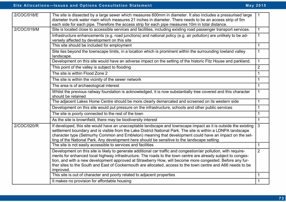
2/COC/018/E The site is dissected by a large sewer which measures 600mm in diameter. It also includes a pressurised large diameter trunk water main which measures 21 inches in diameter. There needs to be an access strip of 5m each side for each pipe. Therefore the access strip for each pipe measures 10m in total distance.
1
2/COC/019/M Site is located close to accessible services and facilities, including existing road passenger transport services. 1
Infrastructure enhancements (e.g. road junctions) and national policy (e.g. air pollution) are unlikely to be ad-versely affected by development on this site
1
This site should be included for employment 1
Site lies beyond the townscape limits, in a location which is prominent within the surrounding lowland valley landscape.
1
Development on this site would have an adverse impact on the setting of the historic Fitz House and parkland. 1
This point of the valley is subject to flooding 2
The site is within Flood Zone 2 1
The site is within the vicinity of the sewer network 1
The area is of archaeological interest 1
Whilst the previous railway foundation is acknowledged, it is now substantially tree covered and this character should be retained
1
The adjacent Lakes Home Centre should be more clearly demarcated and screened on its western side 1
Development on this site would put pressure on the infrastructure, schools and other public services 1
The site is poorly connected to the rest of the town 1
As the site is brownfield, there may be biodiversity interest 1
2/COC/020/R If developed, this site would have an unacceptable landscape and townscape impact as it is outside the existing settlement boundary and is visible from the Lake District National Park. The site is within a LDNPA landscape character type (Setmurhy Common and Embleton) meaning that development could have an impact on the set-ting of the National Park. Any development here should be sensitive to the landscape setting
3
The site is not easily accessible to services and facilities 1
Development on this site is likely to generate additional car traffic and congestion/air pollution, with require-ments for enhanced local highway infrastructure. The roads to the town centre are already subject to conges-tion, and with a new development approved at Strawberry How, will become more congested. Before any fur-ther sites to the South and East of Cockermouth are allocated, access to the town centre and A66 needs to be improved.
2
This site is out of character and poorly related to adjacent properties 1
It makes no provision for affordable housing 1
S i te Al loc a t ion s — Is sue s a nd O pt ion s C ons u lta t ion S ta te me n t Ma y 2 0 1 5
7 3
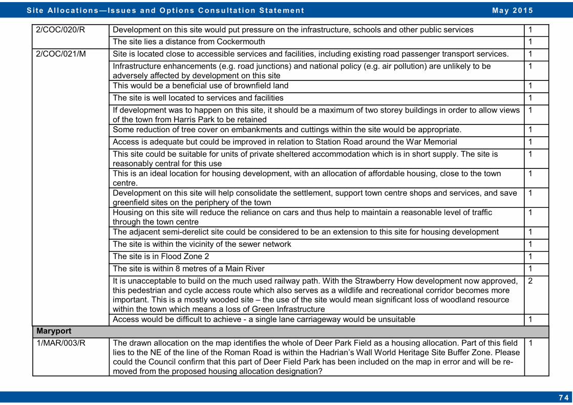
2/COC/020/R Development on this site would put pressure on the infrastructure, schools and other public services 1
The site lies a distance from Cockermouth 1
2/COC/021/M Site is located close to accessible services and facilities, including existing road passenger transport services. 1
Infrastructure enhancements (e.g. road junctions) and national policy (e.g. air pollution) are unlikely to be adversely affected by development on this site
1
This would be a beneficial use of brownfield land 1
The site is well located to services and facilities 1
If development was to happen on this site, it should be a maximum of two storey buildings in order to allow views of the town from Harris Park to be retained
1
Some reduction of tree cover on embankments and cuttings within the site would be appropriate. 1
Access is adequate but could be improved in relation to Station Road around the War Memorial 1
This site could be suitable for units of private sheltered accommodation which is in short supply. The site is reasonably central for this use
1
This is an ideal location for housing development, with an allocation of affordable housing, close to the town centre.
1
Development on this site will help consolidate the settlement, support town centre shops and services, and save greenfield sites on the periphery of the town
1
Housing on this site will reduce the reliance on cars and thus help to maintain a reasonable level of traffic through the town centre
1
The adjacent semi-derelict site could be considered to be an extension to this site for housing development 1
The site is within the vicinity of the sewer network 1
The site is in Flood Zone 2 1
The site is within 8 metres of a Main River 1
It is unacceptable to build on the much used railway path. With the Strawberry How development now approved, this pedestrian and cycle access route which also serves as a wildlife and recreational corridor becomes more important. This is a mostly wooded site – the use of the site would mean significant loss of woodland resource within the town which means a loss of Green Infrastructure
2
Access would be difficult to achieve - a single lane carriageway would be unsuitable 1
Maryport
1/MAR/003/R The drawn allocation on the map identifies the whole of Deer Park Field as a housing allocation. Part of this field lies to the NE of the line of the Roman Road is within the Hadrian’s Wall World Heritage Site Buffer Zone. Please could the Council confirm that this part of Deer Field Park has been included on the map in error and will be re-moved from the proposed housing allocation designation?
1
S i te Al loc a t ion s — Is sue s a nd O pt ion s C ons u lta t ion S ta te me n t Ma y 2 0 1 5
7 4
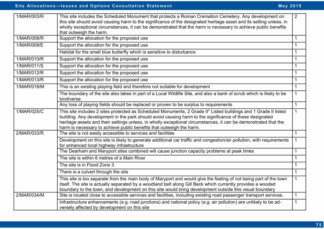
1/MAR/003/R This site includes the Scheduled Monument that protects a Roman Cremation Cemetery. Any development on this site should avoid causing harm to the significance of the designated heritage asset and its setting unless, in wholly exceptional circumstances, it can be demonstrated that the harm is necessary to achieve public benefits that outweigh the harm.
2
1/MAR/008/R Support the allocation for the proposed use 1
1/MAR/009/E Support the allocation for the proposed use 1
Habitat for the small blue butterfly which is sensitive to disturbance 1
1/MAR/010/R Support the allocation for the proposed use 1
1/MAR/011/S Support the allocation for the proposed use 1
1/MAR/012/R Support the allocation for the proposed use 1
1/MAR/013/R Support the allocation for the proposed use 1
1/MAR/018/M This is an existing playing field and therefore not suitable for development 1
The boundary of the site also takes in part of a Local Wildlife Site, and also a bank of scrub which is likely to be biodiverse.
1
Any loss of playing fields should be replaced or proven to be surplus to requirements 1
1/MAR/025/C This site includes 2 sites protected as Scheduled Monuments, 2 Grade II* Listed buildings and 1 Grade II listed building. Any development in the park should avoid causing harm to the significance of these designated heritage assets and their settings unless, in wholly exceptional circumstances, it can be demonstrated that the harm is necessary to achieve public benefits that outweigh the harm.
1
2/MAR/033/R The site is not easily accessible to services and facilities 1
Development on this site is likely to generate additional car traffic and congestion/air pollution, with requirements for enhanced local highway infrastructure
1
The Dearham and Maryport sites combined will cause junction capacity problems at peak times 1
The site is within 8 metres of a Main River 1
The site is in Flood Zone 3 1
There is a culvert through the site 1
This site is too separate from the main body of Maryport and would give the feeling of not being part of the town itself. The site is actually separated by a woodland belt along Gill Beck which currently provides a wooded boundary to the town, and development on this site would bring development outside this visual boundary
1
2/MAR/034/M Site is located close to accessible services and facilities, including existing road passenger transport services. 1
Infrastructure enhancements (e.g. road junctions) and national policy (e.g. air pollution) are unlikely to be ad-versely affected by development on this site
1
S i te Al loc a t ion s — Is sue s a nd O pt ion s C ons u lta t ion S ta te me n t Ma y 2 0 1 5
7 5
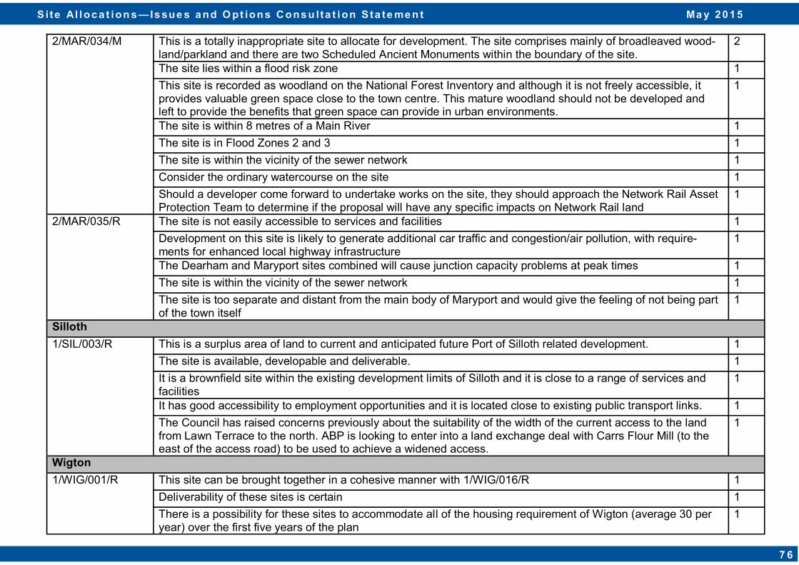
2/MAR/034/M This is a totally inappropriate site to allocate for development. The site comprises mainly of broadleaved wood-land/parkland and there are two Scheduled Ancient Monuments within the boundary of the site.
2
The site lies within a flood risk zone 1
This site is recorded as woodland on the National Forest Inventory and although it is not freely accessible, it provides valuable green space close to the town centre. This mature woodland should not be developed and left to provide the benefits that green space can provide in urban environments.
1
The site is within 8 metres of a Main River 1
The site is in Flood Zones 2 and 3 1
The site is within the vicinity of the sewer network 1
Consider the ordinary watercourse on the site 1
Should a developer come forward to undertake works on the site, they should approach the Network Rail Asset Protection Team to determine if the proposal will have any specific impacts on Network Rail land
1
2/MAR/035/R The site is not easily accessible to services and facilities 1
Development on this site is likely to generate additional car traffic and congestion/air pollution, with require-ments for enhanced local highway infrastructure
1
The Dearham and Maryport sites combined will cause junction capacity problems at peak times 1
The site is within the vicinity of the sewer network 1
The site is too separate and distant from the main body of Maryport and would give the feeling of not being part of the town itself
1
Silloth
1/SIL/003/R This is a surplus area of land to current and anticipated future Port of Silloth related development. 1
The site is available, developable and deliverable. 1
It is a brownfield site within the existing development limits of Silloth and it is close to a range of services and facilities
1
It has good accessibility to employment opportunities and it is located close to existing public transport links. 1
The Council has raised concerns previously about the suitability of the width of the current access to the land from Lawn Terrace to the north. ABP is looking to enter into a land exchange deal with Carrs Flour Mill (to the east of the access road) to be used to achieve a widened access.
1
Wigton
1/WIG/001/R This site can be brought together in a cohesive manner with 1/WIG/016/R 1
Deliverability of these sites is certain 1
There is a possibility for these sites to accommodate all of the housing requirement of Wigton (average 30 per year) over the first five years of the plan
1
S i te Al loc a t ion s — Is sue s a nd O pt ion s C ons u lta t ion S ta te me n t Ma y 2 0 1 5
7 6
1/WIG/001/R Whilst the sites are outside the settlement boundary, there are surrounded on four sides by housing develop-ment meaning that development on these sites would not have as large an impact on the open green space amenity as opposed to the other sites that have been put forward in Wigton
1
The sites can be accessed from Lowmoor Road 1
The sites have strong accessibility to the services in Wigton 1
Habitat mitigation and enhancement can be included as part of the development 1
1/WIG/003/R Station Hill has seen major development in recent years - further development would spoil its character 1
The bypass isolates it from the rest of Wigton 1
It has no services except for the hospital and cemetery 1
Support this allocation for this proposed use 1
1/WIG/004/M The site is sustainable as it is physically well related to the existing developed form of the settlement 1
The site is visually constrained by existing development to the north, west and east and the topography and landscape features of the surrounding landscape to the south
1
The site benefits from close linkages to the existing range of services and public transportation services within the settlement. This reduces the carbon footprint
3
There are no known ecological or environmental constraints on the site 1
A suitable vehicular access to the site can be provided 1
There is sufficient capacity in the surrounding highway network to accommodate the development 1
This site should be looked at in conjunction with 1/WIG/005/R 1
The site could be developed without adversely affecting or being adversely affected by the existing surrounding land uses
1
The site is close to employment opportunities 2
There is easy access for the Care Agencies to allow people to live independently 1
There is demand for affordable housing 1
No flooding issues 1
1/WIG/005/R This site adjoins Fell View which is next to the bypass 1
There is a history of subsidence 1
The site is well related to the existing built form of Wigton 1
The site is closely located to community facilities and employment opportunities 1
This site should be looked at in conjunction with 1/WIG/004/M 1
S i te Al loc a t ion s — Is sue s a nd O pt ion s C ons u lta t ion S ta te me n t Ma y 2 0 1 5
7 7
1/WIG/005/R The site is within easy access of essential local services including the town hall, shops, health and community services, schools and public transport connections
1
1/WIG/006/R Too near new factory development and railway 1
The site is within walking distance to essential local services including town hall, shops and leisure facilities, health and community services, schools and public transport connections
1
The site has footpath connections to the railway station and employment opportunities 1
The site was identified in the SHLAA (ref. AAWG23) as developable 1
Access to the site would be achieved from the north via Cross Lane 1
1/WIG/007/R Too near new factory development and railway 1
The site is well related to existing development and adjacent site which are also included in the Site Allocations process as being suitable for residential development
1
The site is not visually prominent 1
The site is within walking distance of a range of means of transport including bus and rail 1
The site is within walking distance to essential local services including town hall, shops and leisure facilities, health and community services, schools and public transport connections
1
The site has footpath connections to the railway station and employment opportunities 1
The site was identified in the 2012 SHLAA are being deliverable 1
1/WIG/009/M Access to this site is poor. 1
Development on this site would be detrimental to existing higher value properties - something which Wigton is short of
1
Should be left as green space 1
The site is sustainable, being physically well related to the existing developed form of the settlement 1
The site is visually constrained by existing development to the north and west and the topography and land-scape features of the surrounding landscape to the south
1
The site benefits from close linkages to the existing range of services and public transportation services within the settlement
1
There are no known ecological or environmental constraints on the site 1
A suitable vehicular access to the site can be provided 1
There is sufficient capacity in the surrounding highway network to accommodate the development 1
The site could be developed without adversely affecting or being adversely affected by the existing surrounding land uses
1
S i te Al loc a t ion s — Is sue s a nd O pt ion s C ons u lta t ion S ta te me n t Ma y 2 0 1 5
7 8
1/WIG/010/R Too near new factory development and railway 1 The site has a good relationship to the existing built form 1
The site is well related to existing residential developments within Wigton 1
The site is closely located to community facilities and employment opportunities 1
The site is within easy access of essential local services including the town hall, shops, health and community services, schools and public transport connections
1
Adjacent sites are also included in the Site Allocations process 1
The site is not visually prominent 1
1/WIG/011/R Too near new factory development and railway 1
The site is sustainable, being physically well related to the existing developed form of the settlement 1
The site is not visually prominent 1
The site benefits from close linkages to services and public transportation within the settlement 1
The site could be developed without adversely affecting the living conditions of the occupiers of any adjacent properties
1
The site was identified in the SHLAA (ref. AAWN04) as developable 1
1/WIG/012/S This site would be better as an allocation for housing rather than retail 1
Existing shops are already struggling and do not need more competition 1
An application for retail development on this site has previously been recommended for approval (2/2009/0500)
1
Retail on this site would meet an identified need for additional convenience floorspace as highlighted in the West Cumbria Retail Study and would reduce the significant level of retail and leisure trade leakage to other centres such as Carlisle, Cockermouth and Workington
1
The site is not visually prominent 1
The site is well related to the built form 1
The site is previously developed land 1
The site is within easy access of essential local services including the town hall, shops, health and community services, schools and public transport connections
1
The site is adjacent to a Public Right of Way with opportunities to connect into the footpath network 1
The site can be accessed from the highway network 1
The site does not have any environmental or ecological constraints 1
The site is wholly suitable for redevelopment for (a) new use(s) 1
S i te Al loc a t ion s — Is sue s a nd O pt ion s C ons u lta t ion S ta te me n t Ma y 2 0 1 5
7 9
1/WIG/013/M This site might be needed by the school if it needs to expand 1
The site is in a sustainable location 1
The site is well related to the built form of Wigton - it is physically and visually well related to the existing form of the settlement
1
The site is visually contained by existing development to the south, west and east and, to the north, the land form
1
The site is within easy access of essential local services including the town hall, shops, health and community services, schools and public transport connections
1
The site is adjacent to a Public Right of Way with opportunities to connect into the footpath network 1
The site can be accessed from the highway network 1
The site is not within an area subject to flood risk 1
The site is not in an area known to have ecological interest 1
There are no known ecological or environmental constraints on the site 1
The site can be developed without adversely affecting or being adversely affected by the existing surrounding uses
1
1/WIG/014/R Any loss of playing fields should be replaced or proven to be surplus to requirements 1
1/WIG/015/L This site is too far out of town 1
Development on this site would spoil it as parkland 1
1/WIG/016/R This site can be brought together in a cohesive manner with 1/WIG/001/R 1
Deliverability of these sites is certain 1
There is a possibility for these sites to accommodate all of the housing requirement of Wigton (average 30 per year) over the first five years of the plan
1
Whilst the sites are outside the settlement boundary, there are surrounded on four sides by housing develop-ment meaning that development on these sites would not have as large an impact on the open green space amenity as opposed to the other sites that have been put forward in Wigton
1
The sites can be accessed from Lowmoor Road 1
The sites have strong accessibility to the services in Wigton 1
Habitat mitigation and enhancement can be included as part of the development 1
1/WIG/020/R The site is close to residential properties and represents a natural 'rounding off' of the existing built up area. 1
The site lies on a bus route and has easy access to the A596. 1
It is not in a flood risk zone 1
There is roadside access 1
S i te Al loc a t ion s — Is sue s a nd O pt ion s C ons u lta t ion S ta te me n t Ma y 2 0 1 5
8 0
1/WIG/021/S This site is too close to existing housing development 1
Development on this site would affect green space 1
This is the preferred site in Wigton for retail as the other site has major highway constraints 1
Whilst the site is detached from the town centre, it is well located to serve Wigton's wider hinterland. 1
The site has the space to provide substantial parking, suitable for bulky goods retailers 1
Allocating this site would provide variety in Wigton's retail offer 1
1/WIG/022/R The site is sustainable as it is physically well related to the existing developed form of the settlement 1
The site is visually contained by existing development and the topography of the surrounding landscape 1
The site benefits from direct linkages to the existing range of services and public transportation links existing within the settlement via the connecting network of highways and Public Right of Way
1
The site could be development without adversely affecting or being adversely affected by the existing surround-ing uses
1
The bulk of the site is within Flood Zone 1, with limited areas adjacent to the watercourse to the west and south of the site located within Flood Zones 2 and 3a. Given the scale, location and containment of these areas, this is not considered a limiting constraint on the development capacity of the site. An access/egress route is achievable in the form of a bridged or culverted structure over the watercourse, connecting either to Laurel Ter-race, the former Auction Mart or the existing highway to the south-east of the site
1
1/WIG/023/M This site (and the area behind) is suitable as it is already used for this purpose. 1
The site is located on an arterial road into the town centre 1
The site is sustainable, being physically well related to the existing development form of the settlement and the existing development on Station Road
1
The site is visually contained by existing development 1
The site benefits from close and easy access to the existing range of services and public transportation services 1
There is sufficient capacity in the surrounding highway network to accommodate the development 1 The site could be developed without adversely affecting or being adversely affected by the existing surrounding land uses
1
1/WIG/024/R The site is located on an arterial road into the town centre 1
The site is sustainable, being physically well related to the existing development form of the settlement and the existing development on Station Road
1
The site is visually contained by existing development 1
The site benefits from close and easy access to the existing range of services and public transportation services 1
There is sufficient capacity in the surrounding highway network to accommodate the development 1
S i te Al loc a t ion s — Is sue s a nd O pt ion s C ons u lta t ion S ta te me n t Ma y 2 0 1 5
8 1
1/WIG/024/R The site could be developed without adversely affecting or being adversely affected by the existing surrounding land uses
1
1/WIG/025/R The site is sustainable, being physically well related to the existing development form of the settlement 1
The site is located close to the existing services and public transportation links within the settlement via the connecting network of highways and Public Rights of Way
1
The site has no known flood risk, ecological or environmental constraints 1
A suitable vehicular access to the site can be provided 1
Sufficient capacity exists in the surrounding highway network to accommodate the proposed development 1
The site could be developed without adversely affecting or being adversely affected by the existing surrounding land uses
1
1/WIG/026/R The site is sustainable, being physically well related to the existing development form of the settlement 1
The site represents a logical extension of 'The Hawthorns' residential development to the north 1
The site is both physically and visually contained by the existing development to the east and west and landscape features to the south
1
The site is located close to the existing services and public transportation links within the settlement via the connecting network of highways and Public Rights of Way
1
No known flood risk, ecological or environmental constraints exist on the site 1
A suitable vehicular access to the site can be provided. Whilst the site was discounted from the SHLAA as there was no obvious means of access, it is considered that access could be taken from the existing housing estate to the north. The landowner has the legal right and ownership of the land required to provide the access which is required.
1
Sufficient capacity exists in the surrounding highway network to accommodate the proposed development 1
The site could be developed without adversely affecting or being adversely affected by the existing surrounding land uses
1
1/WIG/029/M Access to this site is poor. 1
Development on this site would be detrimental to existing higher value properties - something which Wigton is short of
1
Should be left as green space 1
The site is sustainable, being physically well related to the existing developed form of the settlement 1
The site is usually contained by existing development to the north, west and east and the topography and landscape features of the surrounding landscape to the south
1
The site benefits from close linkages to the existing range of services and public transportation services within the settlement
1
S i te Al loc a t ion s — Is sue s a nd O pt ion s C ons u lta t ion S ta te me n t Ma y 2 0 1 5
8 2

1/WIG/029/M No known ecological or environmental constraints exist on the site 1
A suitable vehicular access to the site can be provided 1
There is sufficient capacity in the surrounding highway network to accommodate the development
1
The site could be developed without adversely affecting or being adversely affected by the existing surrounding land uses
1
2/WIG/030/R Site is located close to accessible services and facilities, including existing road passenger transport services.
2
Infrastructure enhancements (e.g. road junctions) and national policy (e.g. air pollution) are unlikely to be adversely affected by development on this site
1
Good employment opportunities in Wigton 1
No flooding risk 1
This is a site which is surrounded by existing dwellings on three sides 1
Site boundary should be revised to be considerably smaller than at present if the site is to come forward for allocation. 1
The site is a greenfield site 1
The site is poorly related to the rest of the settlement 1
The site is within the vicinity of the sewer network 1
The site expands development across the road to where there is little to no development at the moment 1
Local Service Centres
Abbeytown
1/ABB/004/R The site is sustainable, being physically well related to the existing form of the settlement 1
The site represents a logical extension of the existing Friars Garth residential development to the north and is physically contained by the existing development to the east and west
1
The site is of a scale appropriate to the growth aspirations for the settlement and holding potential to deliver affordable housing to meet local need
1
The site is accessible from three possible points subject to agreement with the Highway Authority/landowner 1
The site is located close to the existing services and public transportation links within the settlement via the connecting network of highways and Public Rights of Way
1
The site could be developed without adversely affecting the living conditions of the occupiers of any adjacent residential properties or being affected by the existing development
1
S i te Al loc a t ion s — Is sue s a nd O pt ion s C ons u lta t ion S ta te me n t Ma y 2 0 1 5
8 3
1/ABB/005/R The site is sustainable being located close to the existing services and public transportation links within the settlement via the connecting network of highways and Public Rights of Way
1
Development of the site will naturally round off development in this area of the settlement, with the existing delineating hedgerow to the west of the site forming a natural terminus to development
1
The site is of a scale appropriate to the growth aspirations for the settlement 1
The site is accessible from the highway frontage subject to agreement with the Highway Authority 1
The site could be developed without adversely affecting the living conditions of the occupiers of any adjacent residential properties
1
2/ABB/006/R This is very disconnected from the rest of the settlement 1
The site is within the vicinity of the sewer network 1
The site is within Flood Zone 3 1
Brigham
1/BGH/001/R The levels of development required in Brigham have already been met. It is not a sustainable village for further development
3
This is the least worst site proposed in Brigham but leads onto a very narrow lane and would need to be on a very small scale
1
This site will be affected by the loss of a local bus service 1
This is a greenfield site, outside the settlement limit. 3
There is a rich and diverse range of flora and fauna on the site which would be affected if development occurred on this site.
2
The site has a narrow access lane 2
The site has amenity value 1 The site is a poor shape which is very narrow and of small scale 1
1/BGH/002/R The levels of development required in Brigham have already been met. It is not a sustainable village for further development
2
This site is virtually inaccessible via a narrow lane 4
This site will be affected by the loss of a local bus service 1
This is a greenfield site, outside the settlement limit. 4
This site attracts wildlife (including red squirrels) which would be affected if development occurred on this site. 1
The existing Mancroft Cottages are not on the public sewer 1
Development on this site would have a landscape impact 1
S i te Al loc a t ion s — Is sue s a nd O pt ion s C ons u lta t ion S ta te me n t Ma y 2 0 1 5
8 4
1/BGH/003/R The levels of development required in Brigham have already been met. It is not a sustainable village for further development
1
Development on this site will consume valued open space 1
This site has had previous planning appeals dismissed due to the risk of potential highways accidents. The access remains too narrow and is poorly aligned.
3
The site has a sense of back-land, a lack of character and a poor relationship with the settlement. 2
It is contrary to Policy HS9 and it is outside the settlement limit. 2
This site will be affected by the loss of a local bus service 1
Would need to ensure that development here would not shed floodwater onto existing housing or overfill local watercourses.
1
This is a greenfield site, outside the settlement limit. 2
This site attracts wildlife (including red squirrels) which would be affected if development occurred on this site. 1
Poor infrastructure 1
The site is too close to existing properties 1
1/BGH/004/G The levels of development required in Brigham have already been met. It is not a sustainable village for further development
1
2/BGH/005/R Site is located close to accessible services and facilities, including existing road passenger transport services. 2
Infrastructure enhancements (e.g. road junctions) and national policy (e.g. air pollution) are unlikely to be adversely affected by development on this site
1
Site should be brought forward as it is well connected to the rest of the settlement 1
The site is deliverable and developable 1
Cumbria County Council has confirmed that access to the site is satisfactory 1
An Inspector on appeal confirmed that the land was appropriate in landscape terms and development would not result in harm to the character of the rural area
1
The living conditions of the neighbouring properties would be adequately protected from the main body of the site. There has been a tree planting scheme on the land which reinforces the separation between the rear gardens of existing properties and the site
1
There are no nature conservation issues to be addressed 1
There is no flood risk on the site 1
There is adequate land available to provide any open space required 1
There are no archaeological or ecological issues 1
S i te Al loc a t ion s — Is sue s a nd O pt ion s C ons u lta t ion S ta te me n t Ma y 2 0 1 5
8 5
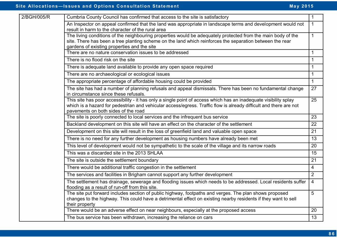
2/BGH/005/R Cumbria County Council has confirmed that access to the site is satisfactory 1
An Inspector on appeal confirmed that the land was appropriate in landscape terms and development would not result in harm to the character of the rural area
1
The living conditions of the neighbouring properties would be adequately protected from the main body of the site. There has been a tree planting scheme on the land which reinforces the separation between the rear gardens of existing properties and the site
1
There are no nature conservation issues to be addressed 1
There is no flood risk on the site 1
There is adequate land available to provide any open space required 1
There are no archaeological or ecological issues 1
The appropriate percentage of affordable housing could be provided 1
The site has had a number of planning refusals and appeal dismissals. There has been no fundamental change in circumstance since these refusals.
27
This site has poor accessibility - it has only a single point of access which has an inadequate visibility splay which is a hazard for pedestrian and vehicular access/egress. Traffic flow is already difficult and there are not pavements on both sides of the road
25
The site is poorly connected to local services and the infrequent bus service 23
Backland development on this site will have an effect on the character of the settlement 22
Development on this site will result in the loss of greenfield land and valuable open space 21
There is no need for any further development as housing numbers have already been met 13
This level of development would not be sympathetic to the scale of the village and its narrow roads 20
This was a discarded site in the 2013 SHLAA 15
The site is outside the settlement boundary 21
There would be additional traffic congestion in the settlement 4
The services and facilities in Brigham cannot support any further development 2
The settlement has drainage, sewerage and flooding issues which needs to be addressed. Local residents suffer flooding as a result of run-off from this site.
4
The site put forward includes section of public highway, footpaths and verges. The plan shows proposed changes to the highway. This could have a detrimental effect on existing nearby residents if they want to sell their property
5
There would be an adverse effect on near neighbours, especially at the proposed access 20
The bus service has been withdrawn, increasing the reliance on cars 13
S i te Al loc a t ion s — Is sue s a nd O pt ion s C ons u lta t ion S ta te me n t Ma y 2 0 1 5
8 6
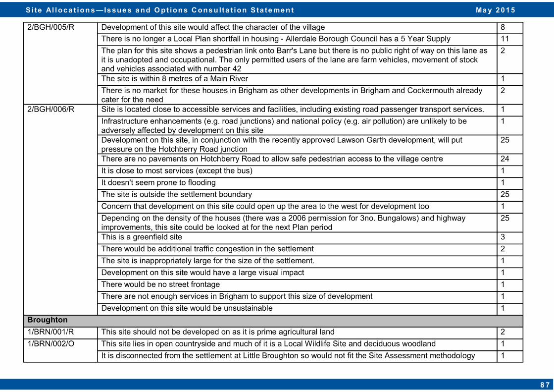
2/BGH/005/R Development of this site would affect the character of the village 8
There is no longer a Local Plan shortfall in housing - Allerdale Borough Council has a 5 Year Supply 11
The plan for this site shows a pedestrian link onto Barr's Lane but there is no public right of way on this lane as it is unadopted and occupational. The only permitted users of the lane are farm vehicles, movement of stock and vehicles associated with number 42
2
The site is within 8 metres of a Main River 1
There is no market for these houses in Brigham as other developments in Brigham and Cockermouth already cater for the need
2
2/BGH/006/R Site is located close to accessible services and facilities, including existing road passenger transport services. 1
Infrastructure enhancements (e.g. road junctions) and national policy (e.g. air pollution) are unlikely to be adversely affected by development on this site
1
Development on this site, in conjunction with the recently approved Lawson Garth development, will put pressure on the Hotchberry Road junction
25
There are no pavements on Hotchberry Road to allow safe pedestrian access to the village centre 24
It is close to most services (except the bus) 1
It doesn't seem prone to flooding 1
The site is outside the settlement boundary 25
Concern that development on this site could open up the area to the west for development too 1
Depending on the density of the houses (there was a 2006 permission for 3no. Bungalows) and highway improvements, this site could be looked at for the next Plan period
25
This is a greenfield site 3
There would be additional traffic congestion in the settlement 2
The site is inappropriately large for the size of the settlement. 1
Development on this site would have a large visual impact 1
There would be no street frontage 1
There are not enough services in Brigham to support this size of development 1
Development on this site would be unsustainable 1
Broughton
1/BRN/001/R This site should not be developed on as it is prime agricultural land 2
1/BRN/002/O This site lies in open countryside and much of it is a Local Wildlife Site and deciduous woodland 1
It is disconnected from the settlement at Little Broughton so would not fit the Site Assessment methodology 1
S i te Al loc a t ion s — Is sue s a nd O pt ion s C ons u lta t ion S ta te me n t Ma y 2 0 1 5
8 7
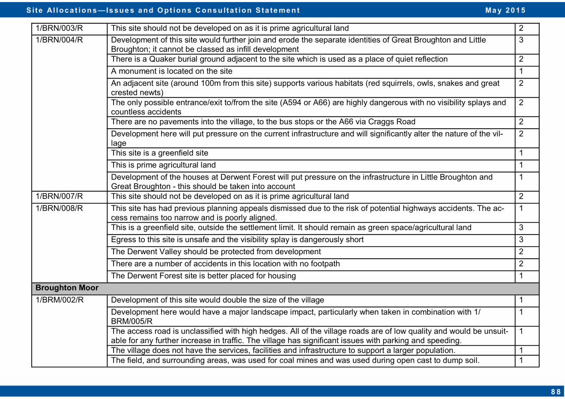
1/BRN/003/R This site should not be developed on as it is prime agricultural land 2
1/BRN/004/R Development of this site would further join and erode the separate identities of Great Broughton and Little Broughton; it cannot be classed as infill development
3
There is a Quaker burial ground adjacent to the site which is used as a place of quiet reflection 2
A monument is located on the site 1
An adjacent site (around 100m from this site) supports various habitats (red squirrels, owls, snakes and great crested newts)
2
The only possible entrance/exit to/from the site (A594 or A66) are highly dangerous with no visibility splays and countless accidents
2
There are no pavements into the village, to the bus stops or the A66 via Craggs Road 2
Development here will put pressure on the current infrastructure and will significantly alter the nature of the vil-lage
2
This site is a greenfield site 1
This is prime agricultural land 1
Development of the houses at Derwent Forest will put pressure on the infrastructure in Little Broughton and Great Broughton - this should be taken into account
1
1/BRN/007/R This site should not be developed on as it is prime agricultural land 2
1/BRN/008/R This site has had previous planning appeals dismissed due to the risk of potential highways accidents. The ac-cess remains too narrow and is poorly aligned.
1
This is a greenfield site, outside the settlement limit. It should remain as green space/agricultural land 3
Egress to this site is unsafe and the visibility splay is dangerously short 3
The Derwent Valley should be protected from development 2
There are a number of accidents in this location with no footpath 2
The Derwent Forest site is better placed for housing 1
Broughton Moor
1/BRM/002/R Development of this site would double the size of the village 1
Development here would have a major landscape impact, particularly when taken in combination with 1/BRM/005/R
1
The access road is unclassified with high hedges. All of the village roads are of low quality and would be unsuit-able for any further increase in traffic. The village has significant issues with parking and speeding.
1
The village does not have the services, facilities and infrastructure to support a larger population. 1 The field, and surrounding areas, was used for coal mines and was used during open cast to dump soil. 1
S i te Al loc a t ion s — Is sue s a nd O pt ion s C ons u lta t ion S ta te me n t Ma y 2 0 1 5
8 8

1/BRM/004/R The access road is unclassified with high hedges. All of the village roads are of low quality and would be unsuit-able for any further increase in traffic. The village has significant issues with parking and speeding.
1
The village does not have the services, facilities and infrastructure to support a larger population. 1
Any housing built on this site would overlook existing housing due to its topography. 1
The field, and surrounding areas, was used for coal mines and was used during open cast to dump soil. 1
The land contains pylons that carry high voltage electrical cables. 1
1/BRM/005/R Development of this site would double the size of the village 1
Development here would have a major landscape impact, particularly when taken in combination with 1/BRM/005/R
1
The access road is unclassified with high hedges. All of the village roads are of low quality and would be unsuit-able for any further increase in traffic. The village has significant issues with parking and speeding.
1
The land has issues with flooding risk. 1
The village does not have the services, facilities and infrastructure to support a larger population. 1
The field and the surrounding area is undermined by coal mines. 1
The land contains pylons that carry high voltage electrical cables. 1
Development of this site would represent a rounding off of the northern edge of the settlement and would mirror development on the western side of Church Road
1
If the totality of the site was not required, then the owner might consider the development of part of the site 1
Extending the settlement any further north might be restricted by the presence of high voltage power lines, but the suggested site would be unaffected
1
There is no flood risk impediment to the site 1
1/BRM/007/R The access road is unclassified with high hedges. All of the village roads are of low quality and would be unsuit-able for any further increase in traffic. The village has significant issues with parking and speeding.
1
The village does not have the services, facilities and infrastructure to support a larger population. 1
Any housing built on this site would overlook existing housing due to its topography. 1
The field, and surrounding areas, was used for coal mines and was used during open cast to dump soil. 1
The land contains pylons that carry high voltage electrical cables. 1
This site is available, suitable and achievable 1
It would provide a natural extension to the settlement 1
The scale of development is in keeping with the settlement 1
It is in a sustainable location with access to facilities, services and public transport 1
S i te Al loc a t ion s — Is sue s a nd O pt ion s C ons u lta t ion S ta te me n t Ma y 2 0 1 5
8 9
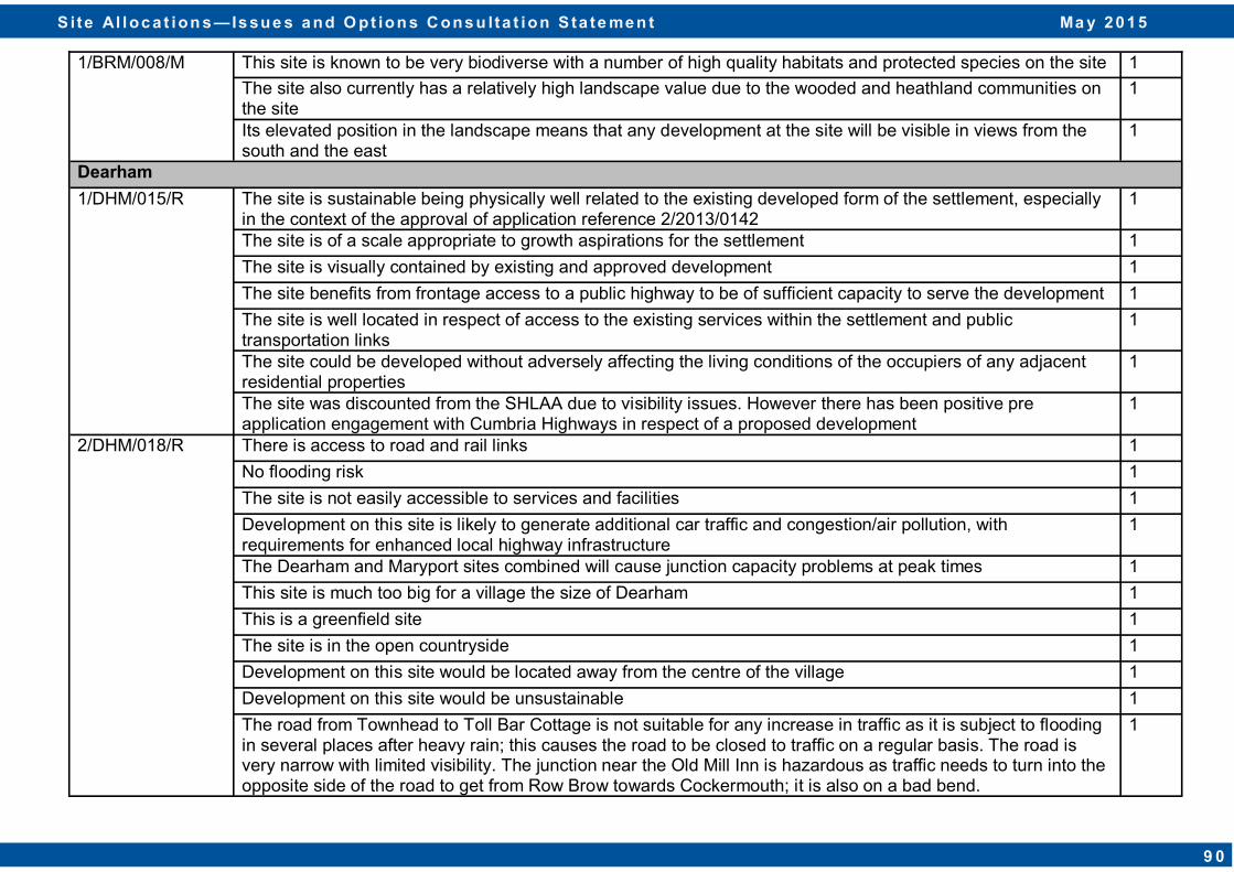
1/BRM/008/M This site is known to be very biodiverse with a number of high quality habitats and protected species on the site 1
The site also currently has a relatively high landscape value due to the wooded and heathland communities on the site
1
Its elevated position in the landscape means that any development at the site will be visible in views from the south and the east
1
Dearham
1/DHM/015/R The site is sustainable being physically well related to the existing developed form of the settlement, especially in the context of the approval of application reference 2/2013/0142
1
The site is of a scale appropriate to growth aspirations for the settlement 1
The site is visually contained by existing and approved development 1
The site benefits from frontage access to a public highway to be of sufficient capacity to serve the development 1
The site is well located in respect of access to the existing services within the settlement and public transportation links
1
The site could be developed without adversely affecting the living conditions of the occupiers of any adjacent residential properties
1
The site was discounted from the SHLAA due to visibility issues. However there has been positive pre application engagement with Cumbria Highways in respect of a proposed development
1
2/DHM/018/R There is access to road and rail links 1
No flooding risk 1
The site is not easily accessible to services and facilities 1
Development on this site is likely to generate additional car traffic and congestion/air pollution, with requirements for enhanced local highway infrastructure
1
The Dearham and Maryport sites combined will cause junction capacity problems at peak times 1
This site is much too big for a village the size of Dearham 1
This is a greenfield site 1
The site is in the open countryside 1
Development on this site would be located away from the centre of the village 1
Development on this site would be unsustainable 1
The road from Townhead to Toll Bar Cottage is not suitable for any increase in traffic as it is subject to flooding in several places after heavy rain; this causes the road to be closed to traffic on a regular basis. The road is very narrow with limited visibility. The junction near the Old Mill Inn is hazardous as traffic needs to turn into the opposite side of the road to get from Row Brow towards Cockermouth; it is also on a bad bend.
1
S i te Al loc a t ion s — Is sue s a nd O pt ion s C ons u lta t ion S ta te me n t Ma y 2 0 1 5
9 0
Flimby
1/FLI/006/M The site comprises previously developed land that is sustainable and it is physically well related to the existing developed form of the settlement
1
Development on this site will significantly improve the visual appearance of this currently vacant site within Flimby, which at present detracts from the character of the settlement
1
The site is visually contained by existing residential development and landscape features 1
The site is of a scale appropriate to the growth aspirations for the settlement 1
The site is accessible via the existing highway frontage to the A596 and will secure improvements to the existing highway layout and safety. This has been agreed with Cumbria Highways
1
The site benefits from close links to the services and public transport links existing within the settlement via the network of highways
1
The site could be developed without adversely affecting or being adversely affected by the existing surrounding land uses
1
Great Clifton
1/GRC/001/R Great Clifton already has more commitments for housing than is required. 1
This site is subject to flooding as sewerage tanks are in the area 1
1/GRC/002/R Great Clifton already has more commitments for housing than is required. 1
In the 1999 Allerdale Local Plan, this site was identified for industrial use. As no industrial use has come about since 1999, this site should be de-allocated and it should remain as agricultural land
1
This site is unsuitable for housing due to the constraints caused by its former use for open cast mining workings, as identified in the 1999 Allerdale Local Plan
4
The settlement boundary of Great Clifton should be redrawn to exclude this site 2
Moor Road requires considerable improvements before further housing development should be allowed 2
The Council has an adopted policy not to allow windfarms within 0.4 mile of any housing. In order to remain consistent, housing development must not be allowed within 0.4 mile of any windfarms. In this case, this site is within 0.4 mile of windfarms.
2
The allocation of this site would fail the NPPF request that Local Planning Authorities should "ensure a good standard of amenity for all existing and future occupants of land and buildings".
1
This site is in the Open Countryside. The road serving Mabel Wood Close is a clear and robust edge of the village and anything outside this is in Open Countryside. Development should not occur in the Open Countryside
2
Development on this site would place unacceptable strain on local infrastructure (e.g. schools, roads, transport) 1
Development on this site would detract from the type of settlement Clifton is 1
The field and nearby woodland supports a wide variety of wildlife (red squirrels, bats and birds) 1
S i te Al loc a t ion s — Is sue s a nd O pt ion s C ons u lta t ion S ta te me n t Ma y 2 0 1 5
9 1
1/GRC/003/R Great Clifton already has more commitments for housing than is required 1
Any development here would be overly dominant to the surrounding area 2
The Council has an adopted policy not to allow windfarms within 0.4 mile of any housing. In order to remain consistent, housing development must not be allowed within 0.4 mile of any windfarms. In this case, this site is within 0.4 mile of windfarms
3
The site is extremely close to the A66 and many residents of houses on this site would suffer disturbance 2
The allocation of this site would fail the NPPF request that Local Planning Authorities should "ensure a good standard of amenity for all existing and future occupants of land and buildings"
1
Moor Road requires considerable improvements before further housing development should be allowed 3
This site is in the Open Countryside; development should not take place in the Open Countryside. It does not physically connect to the nearest non-agricultural development in Great Clifton. Its narrowest point emphasises the lack of a link with the village
2
1/GRC/004/O The site is a field adjacent to the A66 – due to the raised levels of the A66 compared to the site, there are no obvious access points.
3
The site should be rejected as it is in Open Countryside 2
Accessibility for commercial vehicles from Moor Road would be problematic due to poor visibility caused by the A66 flyover and due to the uneven road levels
2
Due to its location, development on this site could create adverse visual impacts 2
The site is unsuitable due to the proximity to the wind farm 1
The proposed use for this site is unclear 1
1/GRC/005/R Great Clifton already has more commitments for housing than is required 1
This site is subject to flooding as sewerage tanks are in the area 1
1/GRC/006/R Great Clifton already has more commitments for housing than is required 1
No objection to this site but it is on a steep incline with housing at the top and side of the site 1
1/GRC/007/R Great Clifton already has more commitments for housing than is required 1
No objection to this site 1
1/GRC/008/R Great Clifton already has more commitments for housing than is required 1
1/GRC/009/R Great Clifton already has more commitments for housing than is required 1
There is a public footpath on the site 1
A drainage stream for the south and west of the village, including Mabel Wood Close, crosses the site. A drain-age pipe under A66 discharges into stream.
1
S i te Al loc a t ion s — Is sue s a nd O pt ion s C ons u lta t ion S ta te me n t Ma y 2 0 1 5
9 2
1/GRC/010/R Great Clifton already has more commitments for housing than is required 1
No objection to this site 1
1/GRC/011/R Great Clifton already has more commitments for housing than is required 1
No objection to this site but it is on a steep incline with housing at the top and side of the site 1
1/GRC/012/R Great Clifton already has more commitments for housing than is required. At 12.19 hectares, it is estimated that this site could accommodate around 300 houses.
1
It is understood that this site has been used in the past for open cast coal mining. The cost of any remediation works on this site would be unsustainable. There is possible cancerous water from this site which does seep through to the surface after heavy rainfall
4
The obliteration of the wood behind Abbott Wood and 7 and 8 Mabel Wood Close would be unacceptable. 2
The Council has an adopted policy not to allow windfarms within 0.4 mile of any housing. In order to remain con-sistent, housing development must not be allowed within 0.4 mile of any windfarms. In this case, this site is within 0.4 mile of windfarms.
2
The site is at a considerably higher level than 1-8 Mabel Wood Close and would dominate those properties un-reasonably.
2
The allocation of this site would fail the NPPF request that Local Planning Authorities should "ensure a good standard of amenity for all existing and future occupants of land and buildings".
1
In view of the proposed development there would need to be an access road from this site not only onto Stain-burn Road but also onto Moor Road. Moor Road requires considerable improvements before further housing de-velopment should be allowed.
2
This site is in the Open Countryside. The road serving Mabel Wood Close is a clear and robust edge of the vil-lage and anything outside this is in Open Countryside. Development should not take place in Open Countryside
2
Development on this site would place unacceptable strain on local infrastructure (e.g. schools, roads, transport) 1
Development on this site would detract from the type of settlement Clifton is 1
The site is outside the Parish boundary 1
The field and nearby woodland supports a wide variety of wildlife (red squirrels, bats and birds) 1
1/GRC/013/R Great Clifton already has more commitments for housing than is required 1
No objection to this site 1
2/GRC/014/R Site is located close to accessible services and facilities, including existing road passenger transport services. 1
Infrastructure enhancements (e.g. road junctions) and national policy (e.g. air pollution) are unlikely to be ad-versely affected by development on this site
1
The site is within the vicinity of the sewer network 1
This is a site which is surrounded by existing dwellings on three sides 1
S i te Al loc a t ion s — Is sue s a nd O pt ion s C ons u lta t ion S ta te me n t Ma y 2 0 1 5
9 3
2/GRC/015/R Site is located close to accessible services and facilities, including existing road passenger transport services. 1
Infrastructure enhancements (e.g. road junctions) and national policy (e.g. air pollution) are unlikely to be adversely affected by development on this site
1
This is a site which is surrounded by existing dwellings on three sides 1
The road at the end of Riverside is currently not fit for purpose 1
There is a lot of local support for a new road with footpaths which would connect both sides of the village. A petition was signed by 52 residents on behalf of 125 people in support of this
1
The site is within the vicinity of the sewer network 1
Planted Ancient Woodland is adjacent to this site. This site allocation should not be taken forward. However, if the site is allocated, a buffer of at least 50m between the site and the woodland should be implemented
2
2/GRC/016/R Site is located close to accessible services and facilities, including existing road passenger transport services. 1
Infrastructure enhancements (e.g. road junctions) and national policy (e.g. air pollution) are unlikely to be adversely affected by development on this site
1
The site is within the vicinity of the sewer network 1
This site should be discarded as it does not relate well to the rest of the settlement 1
Kirkbride
1/KBR/002/R The site is sustainable being physically well related to the existing developed form of the settlement 1
The site is of a scale appropriate to growth aspirations for the settlement 1
The site benefits from frontage access 1
The site is located close to the existing services and public transportation links within the settlement via the connecting network of highways and Public Rights of Way
1
The site could be developed without adversely affecting the living conditions of the occupiers of any adjacent residential properties
1
1/KBR/003/R The site is sustainable being physically well related to the existing developed form of the settlement 1
The site is of a scale appropriate to growth aspirations for the settlement 1
The site is visually contained by existing development 1
The site was discounted from the SHLAA on the basis of the lack of adequate access. However, it is considered that access to the site is achievable via the existing access subject to agreement with the Highway Authority/owner
1
The site is located close to the existing services and public transportation links within the settlement via the connecting network of highways and Public Rights of Way
1
The site could be developed without adversely affecting the living conditions of the occupiers of any adjacent residential properties
1
S i te Al loc a t ion s — Is sue s a nd O pt ion s C ons u lta t ion S ta te me n t Ma y 2 0 1 5
9 4

1/KBR/004/R The site is sustainable being physically well related to the existing developed form of the settlement 1
The site is of a scale appropriate to growth aspirations for the settlement 1
The site is visually contained by existing development 1
There are two possible points of access (via the north of the site or via Chestnut Grove to the south) subject to agreement by the Highway Authority/landowner
1
The site is located close to the existing services and public transportation links within the settlement via the connecting network of highways and Public Rights of Way
1
The site could be developed without adversely affecting the living conditions of the occupiers of any adjacent residential properties
1
1/KBR/005/R The site is of a scale appropriate to growth aspirations for the settlement 1
The site was discounted from the SHLAA on the basis of the lack of adequate access. However, it is considered that access to the site is achievable via the existing access subject to agreement with the Highway Authority/landowner
1
The site is located close to the existing services and public transportation links within the settlement via the connecting network of highways and Public Rights of Way
1
The site could be developed without adversely affecting the living conditions of the occupiers of any adjacent residential properties
1
Prospect 2/PRO/003/R Site is located close to accessible services and facilities, including existing road passenger transport services. 2
Infrastructure enhancements (e.g. road junctions) and national policy (e.g. air pollution) are unlikely to be adversely affected by development on this site
1
No flooding risk 1
Whilst this proposed site extends the ribbon development of the settlement, it is in proportion with the size of the village
1
The site is within the vicinity of the sewer network 1
This is a brownfield site which is surrounded by existing dwellings on three sides 1
Thursby
1/THU/003/R This site is located immediately south of an identified beck/drain and could have potential drainage and flooding issues if the site was to be developed
1
The site represents a logical extension to the west of Thursby 1
The site is sustainable as it is physically well related to the existing developed form of the settlement 1
The site is of a scale appropriate to growth aspirations for the settlement 1
S i te Al loc a t ion s — Is sue s a nd O pt ion s C ons u lta t ion S ta te me n t Ma y 2 0 1 5
9 5
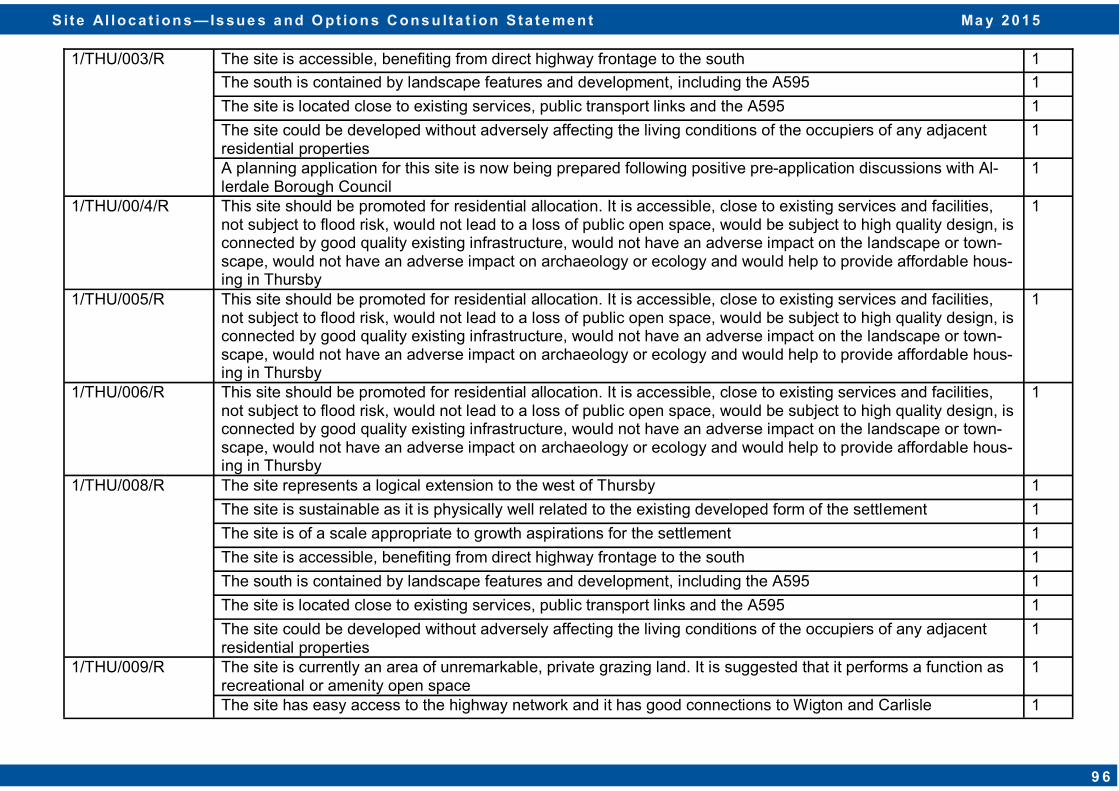
1/THU/003/R The site is accessible, benefiting from direct highway frontage to the south 1
The south is contained by landscape features and development, including the A595 1
The site is located close to existing services, public transport links and the A595 1
The site could be developed without adversely affecting the living conditions of the occupiers of any adjacent residential properties
1
A planning application for this site is now being prepared following positive pre-application discussions with Al-lerdale Borough Council
1
1/THU/00/4/R This site should be promoted for residential allocation. It is accessible, close to existing services and facilities, not subject to flood risk, would not lead to a loss of public open space, would be subject to high quality design, is connected by good quality existing infrastructure, would not have an adverse impact on the landscape or town-scape, would not have an adverse impact on archaeology or ecology and would help to provide affordable hous-ing in Thursby
1
1/THU/005/R This site should be promoted for residential allocation. It is accessible, close to existing services and facilities, not subject to flood risk, would not lead to a loss of public open space, would be subject to high quality design, is connected by good quality existing infrastructure, would not have an adverse impact on the landscape or town-scape, would not have an adverse impact on archaeology or ecology and would help to provide affordable hous-ing in Thursby
1
1/THU/006/R This site should be promoted for residential allocation. It is accessible, close to existing services and facilities, not subject to flood risk, would not lead to a loss of public open space, would be subject to high quality design, is connected by good quality existing infrastructure, would not have an adverse impact on the landscape or town-scape, would not have an adverse impact on archaeology or ecology and would help to provide affordable hous-ing in Thursby
1
1/THU/008/R The site represents a logical extension to the west of Thursby 1
The site is sustainable as it is physically well related to the existing developed form of the settlement 1
The site is of a scale appropriate to growth aspirations for the settlement 1
The site is accessible, benefiting from direct highway frontage to the south 1
The south is contained by landscape features and development, including the A595 1
The site is located close to existing services, public transport links and the A595 1
The site could be developed without adversely affecting the living conditions of the occupiers of any adjacent residential properties
1
1/THU/009/R The site is currently an area of unremarkable, private grazing land. It is suggested that it performs a function as recreational or amenity open space
1
The site has easy access to the highway network and it has good connections to Wigton and Carlisle 1
S i te Al loc a t ion s — Is sue s a nd O pt ion s C ons u lta t ion S ta te me n t Ma y 2 0 1 5
9 6

1/THU/009/R Development on this site would fit in well with the existing built environment and would have minimal landscape impact
1
It would not result in the extension of the settlement 1
There is no flood risk impediment to the site 1
1/THU/010/R This site is in a comparatively isolated location. It is considered that sequentially there are more appropriate sites located on the immediate edge of Thursby which is more suitable and sustainable for residential development.
1
1/THU/011/R This site is in a comparatively isolated location. It is considered that sequentially there are more appropriate sites located on the immediate edge of Thursby which is more suitable and sustainable for residential development.
1
1/THU/013/R This site is in a comparatively isolated location. It is considered that sequentially there are more appropriate sites located on the immediate edge of Thursby which is more suitable and sustainable for residential development.
1
2/THU/015/R Site is located close to accessible services and facilities, including existing road passenger transport services. 1
Infrastructure enhancements (e.g. road junctions) and national policy (e.g. air pollution) are unlikely to be adversely affected by development on this site
1
The site sits well within the settlement 1
Hedgerows should be retained 1
Rural Villages - Limited Growth Villages
Bolton Low Houses
1/BLH/001/R Bad access to this site 1
The settlement boundary should be revised to include this site as: the site is available in the plan period 0-5 years; it is well related to existing built form of the village; it is of a scale appropriate to the growth aspirations for the settlement; it is not visually prominent; and it is within close proximity to village services.
1
Positive pre-application responses have been received from both Allerdale Borough Council and Cumbria High-ways in respect of proposals for the erection of 4no. residential dwellings on this site
1
2/BLH/002/R The site is within the vicinity of the sewer network 1
2/BLH/003/R The site is within the vicinity of the sewer network 1
Branthwaite
1/BRW/001/R Whilst acceptable in principle, the recent Environment Agency advice is that this location is at risk from flash flooding and therefore is not able to endorse it.
1
Whilst the site is located in Flood Zone 3a, this Environment Agency classification is only indicative. A report has shown that the flood risk is contained to the west of the site and evidence shows that the site was not affected during a significant event. Therefore it is considered that flood risk does not present a barrier to the development of the site for residential purposes
1
S i te Al loc a t ion s — Is sue s a nd O pt ion s C ons u lta t ion S ta te me n t Ma y 2 0 1 5
9 7
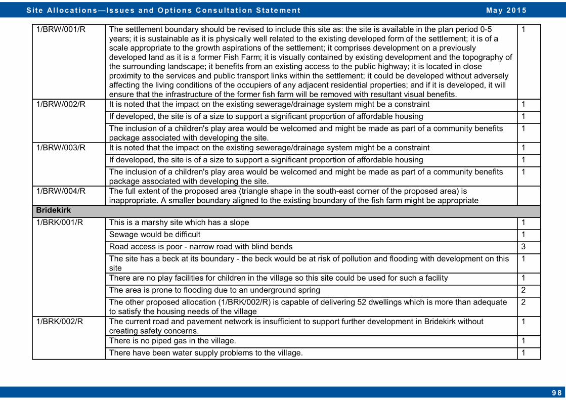
1/BRW/001/R The settlement boundary should be revised to include this site as: the site is available in the plan period 0-5 years; it is sustainable as it is physically well related to the existing developed form of the settlement; it is of a scale appropriate to the growth aspirations of the settlement; it comprises development on a previously developed land as it is a former Fish Farm; it is visually contained by existing development and the topography of the surrounding landscape; it benefits from an existing access to the public highway; it is located in close proximity to the services and public transport links within the settlement; it could be developed without adversely affecting the living conditions of the occupiers of any adjacent residential properties; and if it is developed, it will ensure that the infrastructure of the former fish farm will be removed with resultant visual benefits.
1
1/BRW/002/R It is noted that the impact on the existing sewerage/drainage system might be a constraint 1
If developed, the site is of a size to support a significant proportion of affordable housing 1
The inclusion of a children's play area would be welcomed and might be made as part of a community benefits package associated with developing the site.
1
1/BRW/003/R It is noted that the impact on the existing sewerage/drainage system might be a constraint 1
If developed, the site is of a size to support a significant proportion of affordable housing 1
The inclusion of a children's play area would be welcomed and might be made as part of a community benefits package associated with developing the site.
1
1/BRW/004/R The full extent of the proposed area (triangle shape in the south-east corner of the proposed area) is inappropriate. A smaller boundary aligned to the existing boundary of the fish farm might be appropriate
Bridekirk
1/BRK/001/R This is a marshy site which has a slope 1
Sewage would be difficult 1
Road access is poor - narrow road with blind bends 3
The site has a beck at its boundary - the beck would be at risk of pollution and flooding with development on this site
1
There are no play facilities for children in the village so this site could be used for such a facility 1
The area is prone to flooding due to an underground spring 2
The other proposed allocation (1/BRK/002/R) is capable of delivering 52 dwellings which is more than adequate to satisfy the housing needs of the village
2
1/BRK/002/R The current road and pavement network is insufficient to support further development in Bridekirk without creating safety concerns.
1
There is no piped gas in the village. 1
There have been water supply problems to the village. 1
S i te Al loc a t ion s — Is sue s a nd O pt ion s C ons u lta t ion S ta te me n t Ma y 2 0 1 5
9 8
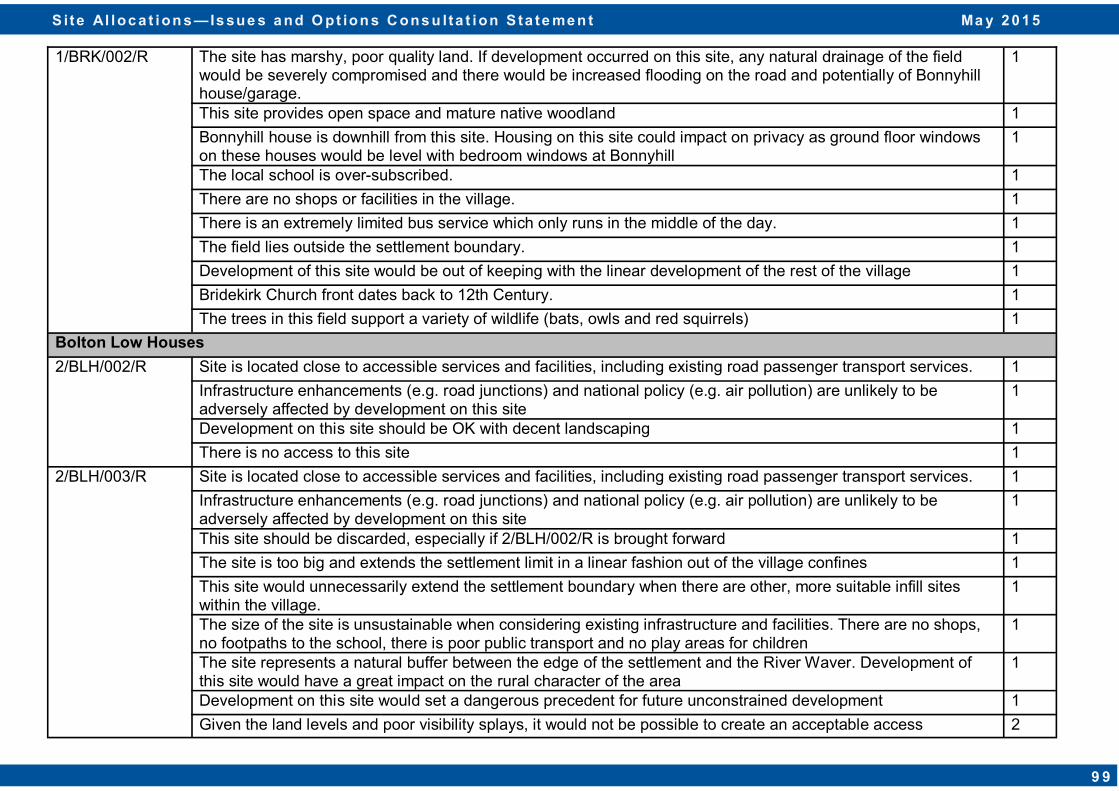
1/BRK/002/R The site has marshy, poor quality land. If development occurred on this site, any natural drainage of the field would be severely compromised and there would be increased flooding on the road and potentially of Bonnyhill house/garage.
1
This site provides open space and mature native woodland 1
Bonnyhill house is downhill from this site. Housing on this site could impact on privacy as ground floor windows on these houses would be level with bedroom windows at Bonnyhill
1
The local school is over-subscribed. 1
There are no shops or facilities in the village. 1
There is an extremely limited bus service which only runs in the middle of the day. 1
The field lies outside the settlement boundary. 1
Development of this site would be out of keeping with the linear development of the rest of the village 1
Bridekirk Church front dates back to 12th Century. 1
The trees in this field support a variety of wildlife (bats, owls and red squirrels) 1
Bolton Low Houses
2/BLH/002/R Site is located close to accessible services and facilities, including existing road passenger transport services. 1
Infrastructure enhancements (e.g. road junctions) and national policy (e.g. air pollution) are unlikely to be adversely affected by development on this site
1
Development on this site should be OK with decent landscaping 1
There is no access to this site 1
2/BLH/003/R Site is located close to accessible services and facilities, including existing road passenger transport services. 1
Infrastructure enhancements (e.g. road junctions) and national policy (e.g. air pollution) are unlikely to be adversely affected by development on this site
1
This site should be discarded, especially if 2/BLH/002/R is brought forward 1
The site is too big and extends the settlement limit in a linear fashion out of the village confines 1
This site would unnecessarily extend the settlement boundary when there are other, more suitable infill sites within the village.
1
The size of the site is unsustainable when considering existing infrastructure and facilities. There are no shops, no footpaths to the school, there is poor public transport and no play areas for children
1
The site represents a natural buffer between the edge of the settlement and the River Waver. Development of this site would have a great impact on the rural character of the area
1
Development on this site would set a dangerous precedent for future unconstrained development 1
Given the land levels and poor visibility splays, it would not be possible to create an acceptable access 2
S i te Al loc a t ion s — Is sue s a nd O pt ion s C ons u lta t ion S ta te me n t Ma y 2 0 1 5
9 9

2/BLH/003/R The levels close to the River Waver would mean that it would be impossible to connect to any of the mains foul drains
1
Crosby
1/CBY/004/R Whilst this is a brownfield site within the settlement limit, access is via a private road which is already heavily used by traffic from existing development.
1
1/CBY/005/R This is a greenfield site, outside the settlement limit. 2
It is agricultural land 1
The site sits on the boundary of the Solway Coast AONB, therefore there may be setting issues. 3
Crosscanonby Road which has limited access over a site which has already had planning permission refused by both Allerdale Borough Council and at an appeal by the Planning Inspectorate. The reasons for refusal on the adjacent site should apply to this site as it is even less suitable for development than the parcel of land which was refused permission
2
Development on the site has already been refused by the Council and on appeal by the Inspector 1
The development of this site would create infill between the villages of Crosby and Crosscanonby to the detriment of both
3
Additional access onto Crosscanonby Road is potentially dangerous 2
Site is located close to accessible services and facilities, including existing road passenger transport services. 1
Infrastructure enhancements (e.g. road junctions) and national policy (e.g. air pollution) are unlikely to be adversely affected by development on this site
1
The site does extend the settlement boundary north in a linear fashion with no development on the other side of the road, so may be inappropriate on this basis
1
This is a site which is surrounded by existing dwellings on three sides 1
The site crosses an area associated with Roman heritage linked to the area behind Moor Park 1
The site is within the vicinity of the sewer network 1
Development of this scale would be well in excess of that which is required to deliver the needs and aspirations of Allerdale
1
2/CBY/006/R Site is located close to accessible services and facilities, including existing road passenger transport services. 1
Infrastructure enhancements (e.g. road junctions) and national policy (e.g. air pollution) are unlikely to be adversely affected by development on this site
1
This is a site which is surrounded by existing dwellings on three sides 1
Crosby is a limited growth village which has, very recently, had three areas approved for development 1
This is a greenfield site 1
S i te Al loc a t ion s — Is sue s a nd O pt ion s C ons u lta t ion S ta te me n t Ma y 2 0 1 5
1 0 0
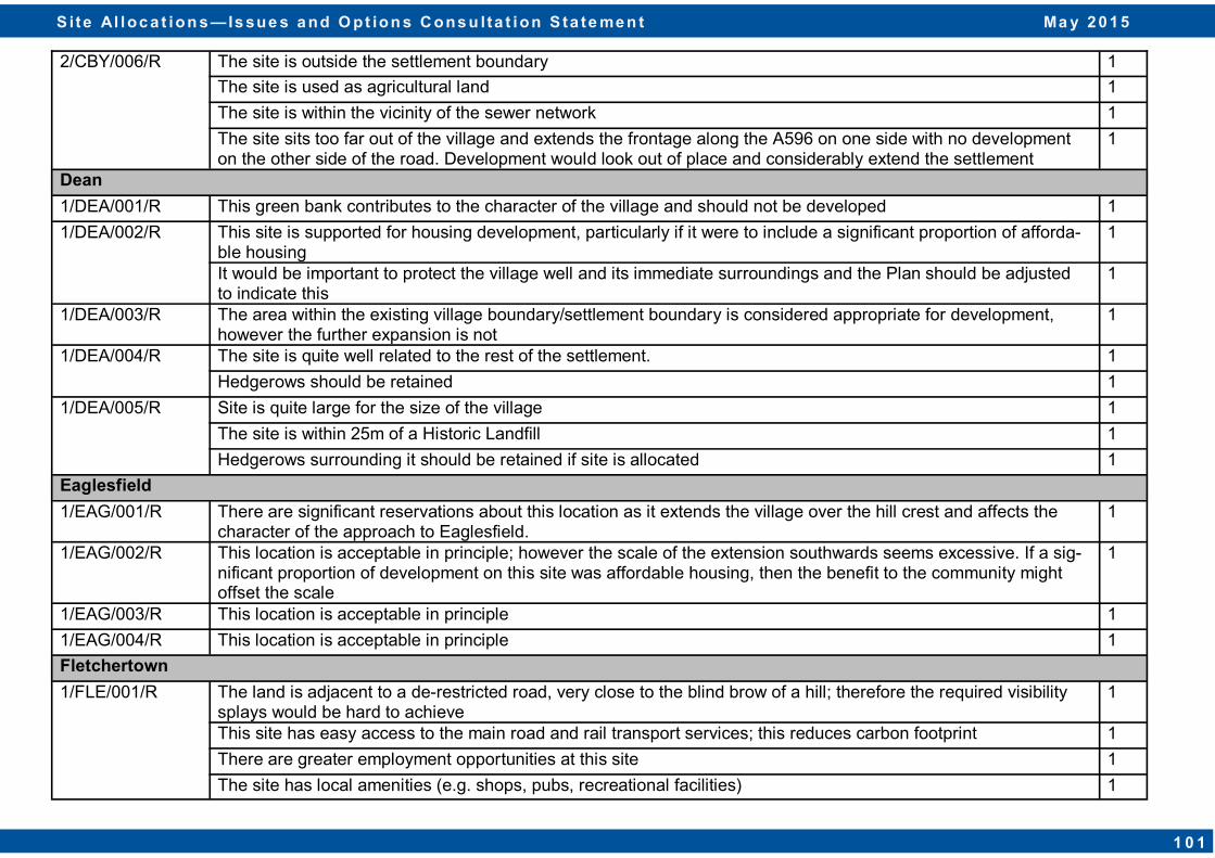
2/CBY/006/R The site is outside the settlement boundary 1
The site is used as agricultural land 1
The site is within the vicinity of the sewer network 1
The site sits too far out of the village and extends the frontage along the A596 on one side with no development on the other side of the road. Development would look out of place and considerably extend the settlement
1
Dean
1/DEA/001/R This green bank contributes to the character of the village and should not be developed 1
1/DEA/002/R This site is supported for housing development, particularly if it were to include a significant proportion of afforda-ble housing
1
It would be important to protect the village well and its immediate surroundings and the Plan should be adjusted to indicate this
1
1/DEA/003/R The area within the existing village boundary/settlement boundary is considered appropriate for development, however the further expansion is not
1
1/DEA/004/R The site is quite well related to the rest of the settlement. 1
Hedgerows should be retained 1
1/DEA/005/R Site is quite large for the size of the village 1
The site is within 25m of a Historic Landfill 1
Hedgerows surrounding it should be retained if site is allocated 1
Eaglesfield
1/EAG/001/R There are significant reservations about this location as it extends the village over the hill crest and affects the character of the approach to Eaglesfield.
1
1/EAG/002/R This location is acceptable in principle; however the scale of the extension southwards seems excessive. If a sig-nificant proportion of development on this site was affordable housing, then the benefit to the community might offset the scale
1
1/EAG/003/R This location is acceptable in principle 1
1/EAG/004/R This location is acceptable in principle 1
Fletchertown
1/FLE/001/R The land is adjacent to a de-restricted road, very close to the blind brow of a hill; therefore the required visibility splays would be hard to achieve
1
This site has easy access to the main road and rail transport services; this reduces carbon footprint 1
There are greater employment opportunities at this site 1
The site has local amenities (e.g. shops, pubs, recreational facilities) 1
S i te Al loc a t ion s — Is sue s a nd O pt ion s C ons u lta t ion S ta te me n t Ma y 2 0 1 5
1 0 1
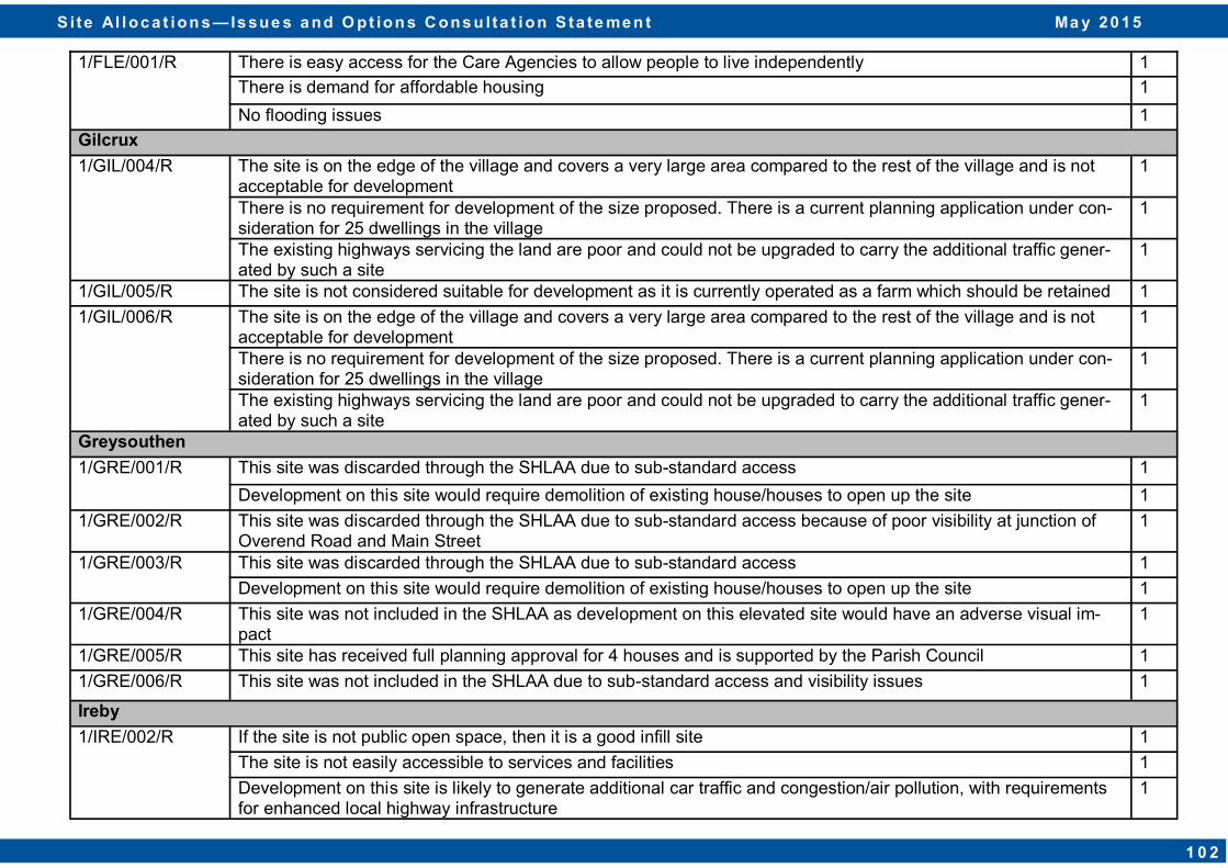
1/FLE/001/R There is easy access for the Care Agencies to allow people to live independently 1
There is demand for affordable housing 1
No flooding issues 1
Gilcrux
1/GIL/004/R The site is on the edge of the village and covers a very large area compared to the rest of the village and is not acceptable for development
1
There is no requirement for development of the size proposed. There is a current planning application under con-sideration for 25 dwellings in the village
1
The existing highways servicing the land are poor and could not be upgraded to carry the additional traffic gener-ated by such a site
1
1/GIL/005/R The site is not considered suitable for development as it is currently operated as a farm which should be retained 1
1/GIL/006/R The site is on the edge of the village and covers a very large area compared to the rest of the village and is not acceptable for development
1
There is no requirement for development of the size proposed. There is a current planning application under con-sideration for 25 dwellings in the village
1
The existing highways servicing the land are poor and could not be upgraded to carry the additional traffic gener-ated by such a site
1
Greysouthen
1/GRE/001/R This site was discarded through the SHLAA due to sub-standard access 1
Development on this site would require demolition of existing house/houses to open up the site 1
1/GRE/002/R This site was discarded through the SHLAA due to sub-standard access because of poor visibility at junction of Overend Road and Main Street
1
1/GRE/003/R This site was discarded through the SHLAA due to sub-standard access 1
Development on this site would require demolition of existing house/houses to open up the site 1
1/GRE/004/R This site was not included in the SHLAA as development on this elevated site would have an adverse visual im-pact
1
1/GRE/005/R This site has received full planning approval for 4 houses and is supported by the Parish Council 1
1/GRE/006/R This site was not included in the SHLAA due to sub-standard access and visibility issues 1
Ireby
1/IRE/002/R If the site is not public open space, then it is a good infill site 1
The site is not easily accessible to services and facilities 1
Development on this site is likely to generate additional car traffic and congestion/air pollution, with requirements for enhanced local highway infrastructure
1
S i te Al loc a t ion s — Is sue s a nd O pt ion s C ons u lta t ion S ta te me n t Ma y 2 0 1 5
1 0 2
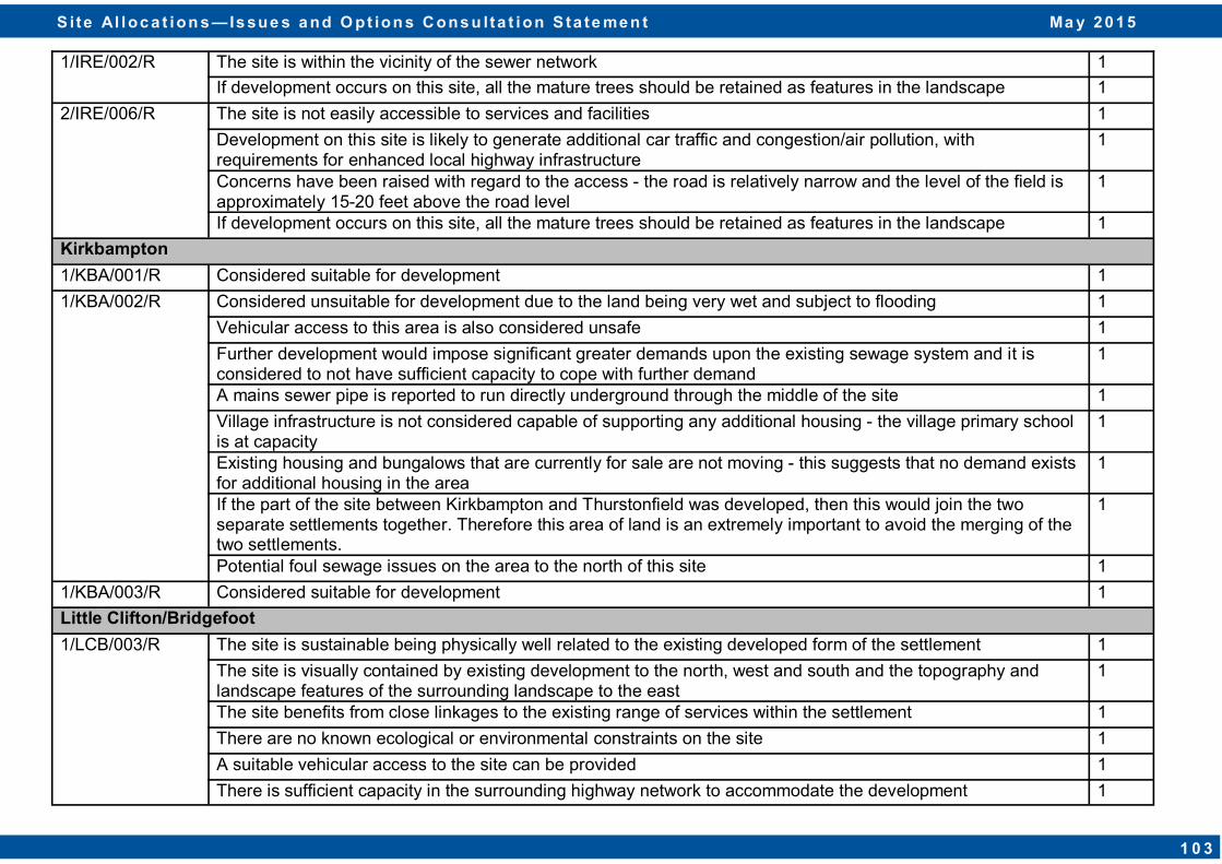
1/IRE/002/R The site is within the vicinity of the sewer network 1
If development occurs on this site, all the mature trees should be retained as features in the landscape 1
2/IRE/006/R The site is not easily accessible to services and facilities 1
Development on this site is likely to generate additional car traffic and congestion/air pollution, with requirements for enhanced local highway infrastructure
1
Concerns have been raised with regard to the access - the road is relatively narrow and the level of the field is approximately 15-20 feet above the road level
1
If development occurs on this site, all the mature trees should be retained as features in the landscape 1
Kirkbampton
1/KBA/001/R Considered suitable for development 1
1/KBA/002/R Considered unsuitable for development due to the land being very wet and subject to flooding 1
Vehicular access to this area is also considered unsafe 1
Further development would impose significant greater demands upon the existing sewage system and it is considered to not have sufficient capacity to cope with further demand
1
A mains sewer pipe is reported to run directly underground through the middle of the site 1
Village infrastructure is not considered capable of supporting any additional housing - the village primary school is at capacity
1
Existing housing and bungalows that are currently for sale are not moving - this suggests that no demand exists for additional housing in the area
1
If the part of the site between Kirkbampton and Thurstonfield was developed, then this would join the two separate settlements together. Therefore this area of land is an extremely important to avoid the merging of the two settlements.
1
Potential foul sewage issues on the area to the north of this site 1
1/KBA/003/R Considered suitable for development 1
Little Clifton/Bridgefoot 1/LCB/003/R The site is sustainable being physically well related to the existing developed form of the settlement 1
The site is visually contained by existing development to the north, west and south and the topography and landscape features of the surrounding landscape to the east
1
The site benefits from close linkages to the existing range of services within the settlement 1
There are no known ecological or environmental constraints on the site 1
A suitable vehicular access to the site can be provided 1
There is sufficient capacity in the surrounding highway network to accommodate the development 1
S i te Al loc a t ion s — Is sue s a nd O pt ion s C ons u lta t ion S ta te me n t Ma y 2 0 1 5
1 0 3
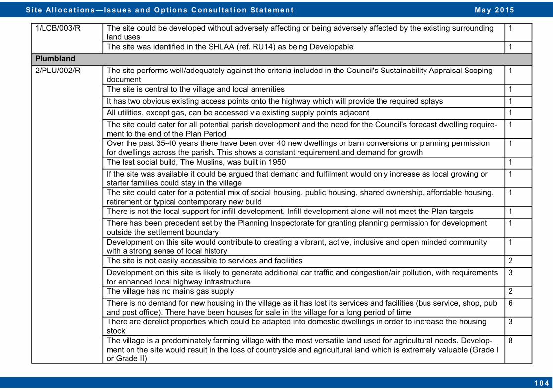
1/LCB/003/R The site could be developed without adversely affecting or being adversely affected by the existing surrounding land uses
1
The site was identified in the SHLAA (ref. RU14) as being Developable 1
Plumbland
2/PLU/002/R The site performs well/adequately against the criteria included in the Council's Sustainability Appraisal Scoping document
1
The site is central to the village and local amenities 1
It has two obvious existing access points onto the highway which will provide the required splays 1
All utilities, except gas, can be accessed via existing supply points adjacent 1
The site could cater for all potential parish development and the need for the Council's forecast dwelling require-ment to the end of the Plan Period
1
Over the past 35-40 years there have been over 40 new dwellings or barn conversions or planning permission for dwellings across the parish. This shows a constant requirement and demand for growth
1
The last social build, The Muslins, was built in 1950 1
If the site was available it could be argued that demand and fulfilment would only increase as local growing or starter families could stay in the village
1
The site could cater for a potential mix of social housing, public housing, shared ownership, affordable housing, retirement or typical contemporary new build
1
There is not the local support for infill development. Infill development alone will not meet the Plan targets 1
There has been precedent set by the Planning Inspectorate for granting planning permission for development outside the settlement boundary
1
Development on this site would contribute to creating a vibrant, active, inclusive and open minded community with a strong sense of local history
1
The site is not easily accessible to services and facilities 2
Development on this site is likely to generate additional car traffic and congestion/air pollution, with requirements for enhanced local highway infrastructure
3
The village has no mains gas supply 2
There is no demand for new housing in the village as it has lost its services and facilities (bus service, shop, pub and post office). There have been houses for sale in the village for a long period of time
6
There are derelict properties which could be adapted into domestic dwellings in order to increase the housing stock
3
The village is a predominately farming village with the most versatile land used for agricultural needs. Develop-ment on the site would result in the loss of countryside and agricultural land which is extremely valuable (Grade I or Grade II)
8
S i te Al loc a t ion s — Is sue s a nd O pt ion s C ons u lta t ion S ta te me n t Ma y 2 0 1 5
1 0 4
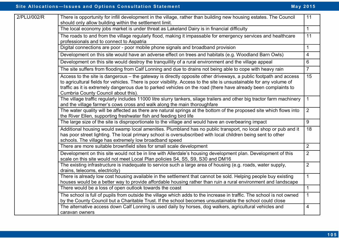
2/PLU/002/R There is opportunity for infill development in the village, rather than building new housing estates. The Council should only allow building within the settlement limit.
11
The local economy jobs market is under threat as Lakeland Dairy is in financial difficulty 1
The roads to and from the village regularly flood, making it impassable for emergency services and healthcare professionals and to connect to Aspatria
11
Digital connections are poor - poor mobile phone signals and broadband provision 1
Development on this site would have an adverse effect on trees and habitats (e.g. Woodland Barn Owls) 4
Development on this site would destroy the tranquillity of a rural environment and the village appeal 6
The site suffers from flooding from Calf Lonning and due to drains not being able to cope with heavy rain 7
Access to the site is dangerous – the gateway is directly opposite other driveways, a public footpath and access to agricultural fields for vehicles. There is poor visibility. Access to the site is unsustainable for any volume of traffic as it is extremely dangerous due to parked vehicles on the road (there have already been complaints to Cumbria County Council about this).
15
The village traffic regularly includes 11000 litre slurry tankers, silage trailers and other big tractor farm machinery and the village farmer’s cows cross and walk along the main thoroughfare
1
The water quality will be affected as there are natural springs at the bottom of the proposed site which flows into the River Ellen, supporting freshwater fish and feeding bird life
2
The large size of the site is disproportionate to the village and would have an overbearing impact 9
Additional housing would swamp local amenities. Plumbland has no public transport, no local shop or pub and it has poor street lighting. The local primary school is oversubscribed with local children being sent to other schools. The village has extremely low broadband speed
18
There are more suitable brownfield sites for small scale development 2
Development on this site would not be in line with Allerdale’s housing development plan. Development of this scale on this site would not meet Local Plan policies S4, S5, S9, S30 and DM16
2
The existing infrastructure is inadequate to service such a large area of housing (e.g. roads, water supply, drains, telecoms, electricity)
2
There is already low cost housing available in the settlement that cannot be sold. Helping people buy existing houses would be a better way to provide affordable housing rather than ruin a rural environment and landscape
1
There would be a loss of open outlook towards the coast 1
The school is full of pupils from outside the village which adds to the increase in traffic. The school is not owned by the County Council but a Charitable Trust. If the school becomes unsustainable the school could close
1
The alternative access down Calf Lonning is used daily by horses, dog walkers, agricultural vehicles and caravan owners
4
S i te Al loc a t ion s — Is sue s a nd O pt ion s C ons u lta t ion S ta te me n t Ma y 2 0 1 5
1 0 5

2/PLU/002/R Development of this site would drastically destroy the environment by increasing the carbon footprint as there are no local transport services easily accessible to the village
3
If access were to be between Linton Garth and Firth View, it would preclude infill of one dwelling between the existing houses. If access were to be from opposite the Caravan Park on Calf Lonning, road improvements would be required
1
Farmers neighbouring this field have licenses to spread human waste and the protein milk wastings from the Aspatria Creamery.
3
There are no employment opportunities or services in the village. To access these facilities creates a high cost of living
3
If a significant number of houses were to be built this would no doubt cause much increased light pollution 1
There are no economic benefits associated with the development 2
Public footpaths would be greatly affected 1
The local road network is already sub-standard; any further traffic would worsen the current situation 1
There is no demand for affordable housing 1
The site is within the vicinity of the sewer network 1
Other planning applications by local residents for dwellings have been refused as the development would be outside the settlement boundary.
1
Rural Villages - Infill and Rounding Off Villages
Broughton Cross
1/BRC/001/R There are existing highway safety issues which will need to be addressed (restricted visibility when exiting Old Greysouthen Road junction, speeding through the village). There is also concern about the safety of school children from St. Bridget's School as school pick up/drop off is hazardous now. Increased traffic from this site would create issues in the already congested Brigham village and the A66/Brigham junction which has already had fatal road traffic accidents.
1
Concern about the ageing foul and surface water drainage system 1
The natural water stream in the NE corner of the site has been known to flood on several occasions 1
The capacity of local schools will need to be assessed to cope with this level of development 1
Brownfield sites should be given priority over greenfield sites such as this location 1
Development on this site will consume valued open space 1
S i te Al loc a t ion s — Is sue s a nd O pt ion s C ons u lta t ion S ta te me n t Ma y 2 0 1 5
1 0 6
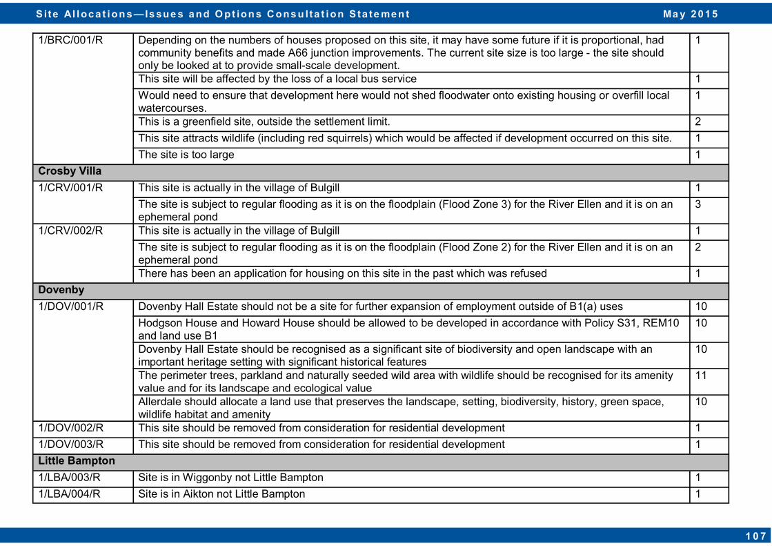
1/BRC/001/R Depending on the numbers of houses proposed on this site, it may have some future if it is proportional, had community benefits and made A66 junction improvements. The current site size is too large - the site should only be looked at to provide small-scale development.
1
This site will be affected by the loss of a local bus service 1
Would need to ensure that development here would not shed floodwater onto existing housing or overfill local watercourses.
1
This is a greenfield site, outside the settlement limit. 2
This site attracts wildlife (including red squirrels) which would be affected if development occurred on this site. 1
The site is too large 1
Crosby Villa
1/CRV/001/R This site is actually in the village of Bulgill 1
The site is subject to regular flooding as it is on the floodplain (Flood Zone 3) for the River Ellen and it is on an ephemeral pond
3
1/CRV/002/R This site is actually in the village of Bulgill 1
The site is subject to regular flooding as it is on the floodplain (Flood Zone 2) for the River Ellen and it is on an ephemeral pond
2
There has been an application for housing on this site in the past which was refused 1
Dovenby
1/DOV/001/R Dovenby Hall Estate should not be a site for further expansion of employment outside of B1(a) uses 10
Hodgson House and Howard House should be allowed to be developed in accordance with Policy S31, REM10 and land use B1
10
Dovenby Hall Estate should be recognised as a significant site of biodiversity and open landscape with an important heritage setting with significant historical features
10
The perimeter trees, parkland and naturally seeded wild area with wildlife should be recognised for its amenity value and for its landscape and ecological value
11
Allerdale should allocate a land use that preserves the landscape, setting, biodiversity, history, green space, wildlife habitat and amenity
10
1/DOV/002/R This site should be removed from consideration for residential development 1
1/DOV/003/R This site should be removed from consideration for residential development 1
Little Bampton
1/LBA/003/R Site is in Wiggonby not Little Bampton 1
1/LBA/004/R Site is in Aikton not Little Bampton 1
S i te Al loc a t ion s — Is sue s a nd O pt ion s C ons u lta t ion S ta te me n t Ma y 2 0 1 5
1 0 7
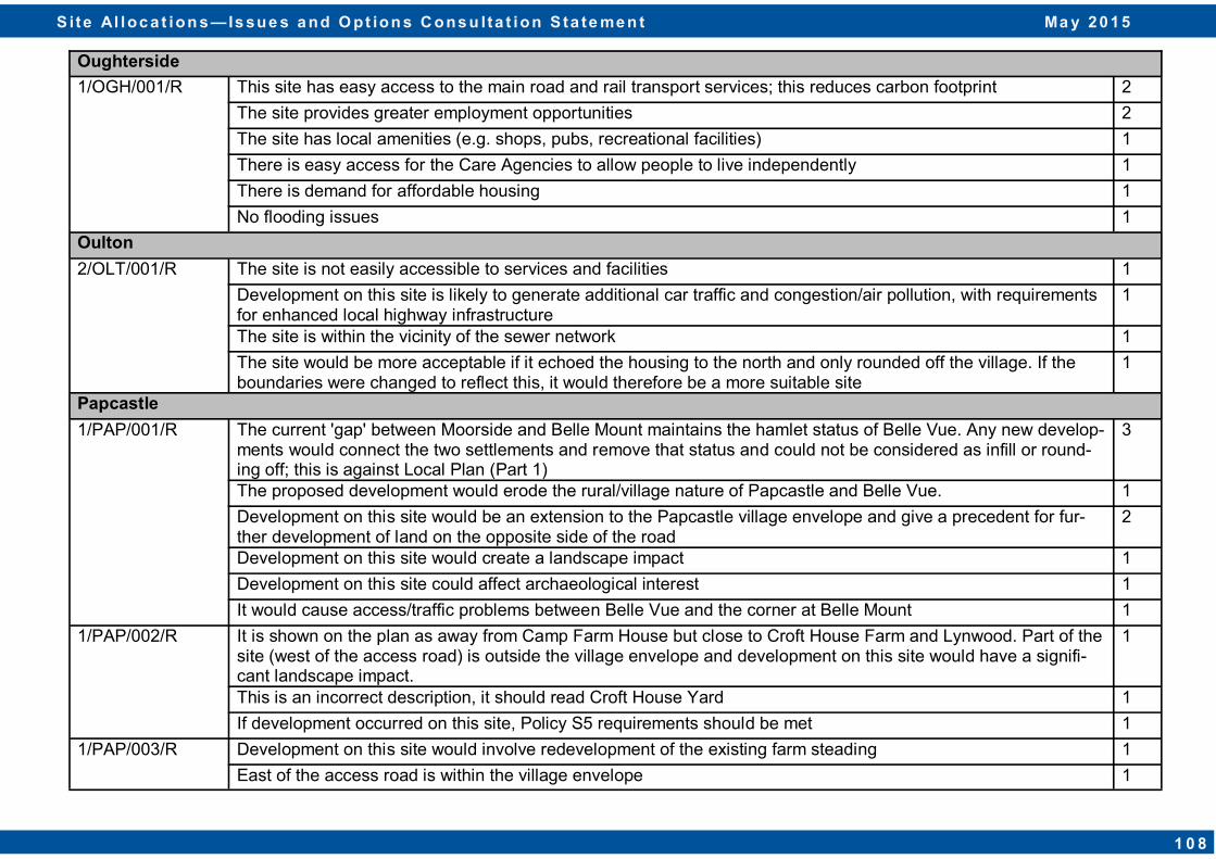
Oughterside
1/OGH/001/R This site has easy access to the main road and rail transport services; this reduces carbon footprint 2
The site provides greater employment opportunities 2
The site has local amenities (e.g. shops, pubs, recreational facilities) 1
There is easy access for the Care Agencies to allow people to live independently 1
There is demand for affordable housing 1
No flooding issues 1
Oulton
2/OLT/001/R The site is not easily accessible to services and facilities 1
Development on this site is likely to generate additional car traffic and congestion/air pollution, with requirements for enhanced local highway infrastructure
1
The site is within the vicinity of the sewer network 1
The site would be more acceptable if it echoed the housing to the north and only rounded off the village. If the boundaries were changed to reflect this, it would therefore be a more suitable site
1
Papcastle
1/PAP/001/R The current 'gap' between Moorside and Belle Mount maintains the hamlet status of Belle Vue. Any new develop-ments would connect the two settlements and remove that status and could not be considered as infill or round-ing off; this is against Local Plan (Part 1)
3
The proposed development would erode the rural/village nature of Papcastle and Belle Vue. 1
Development on this site would be an extension to the Papcastle village envelope and give a precedent for fur-ther development of land on the opposite side of the road
2
Development on this site would create a landscape impact 1
Development on this site could affect archaeological interest 1
It would cause access/traffic problems between Belle Vue and the corner at Belle Mount 1
1/PAP/002/R It is shown on the plan as away from Camp Farm House but close to Croft House Farm and Lynwood. Part of the site (west of the access road) is outside the village envelope and development on this site would have a signifi-cant landscape impact.
1
This is an incorrect description, it should read Croft House Yard 1
If development occurred on this site, Policy S5 requirements should be met 1
1/PAP/003/R Development on this site would involve redevelopment of the existing farm steading 1
East of the access road is within the village envelope 1
S i te Al loc a t ion s — Is sue s a nd O pt ion s C ons u lta t ion S ta te me n t Ma y 2 0 1 5
1 0 8
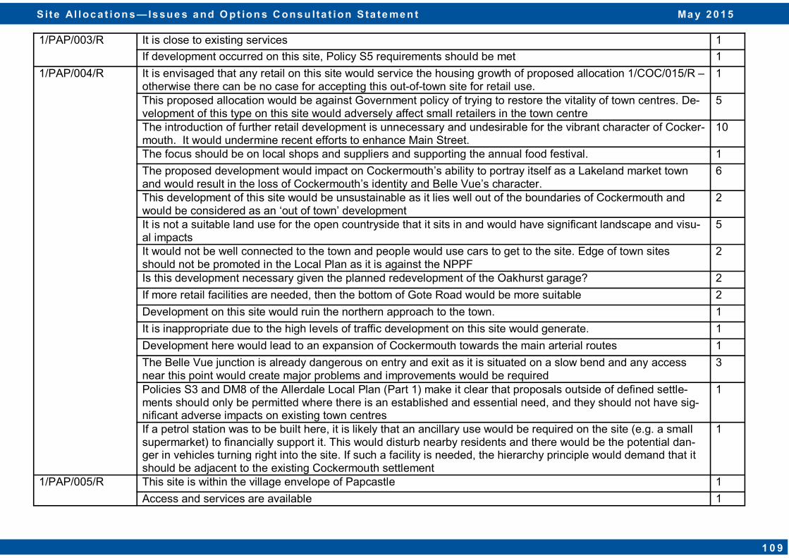
1/PAP/003/R It is close to existing services 1
If development occurred on this site, Policy S5 requirements should be met 1
1/PAP/004/R It is envisaged that any retail on this site would service the housing growth of proposed allocation 1/COC/015/R – otherwise there can be no case for accepting this out-of-town site for retail use.
1
This proposed allocation would be against Government policy of trying to restore the vitality of town centres. De-velopment of this type on this site would adversely affect small retailers in the town centre
5
The introduction of further retail development is unnecessary and undesirable for the vibrant character of Cocker-mouth. It would undermine recent efforts to enhance Main Street.
10
The focus should be on local shops and suppliers and supporting the annual food festival. 1
The proposed development would impact on Cockermouth’s ability to portray itself as a Lakeland market town and would result in the loss of Cockermouth’s identity and Belle Vue’s character.
6
This development of this site would be unsustainable as it lies well out of the boundaries of Cockermouth and would be considered as an ‘out of town’ development
2
It is not a suitable land use for the open countryside that it sits in and would have significant landscape and visu-al impacts
5
It would not be well connected to the town and people would use cars to get to the site. Edge of town sites should not be promoted in the Local Plan as it is against the NPPF
2
Is this development necessary given the planned redevelopment of the Oakhurst garage? 2
If more retail facilities are needed, then the bottom of Gote Road would be more suitable 2
Development on this site would ruin the northern approach to the town. 1
It is inappropriate due to the high levels of traffic development on this site would generate. 1
Development here would lead to an expansion of Cockermouth towards the main arterial routes 1
The Belle Vue junction is already dangerous on entry and exit as it is situated on a slow bend and any access near this point would create major problems and improvements would be required
3
Policies S3 and DM8 of the Allerdale Local Plan (Part 1) make it clear that proposals outside of defined settle-ments should only be permitted where there is an established and essential need, and they should not have sig-nificant adverse impacts on existing town centres
1
If a petrol station was to be built here, it is likely that an ancillary use would be required on the site (e.g. a small supermarket) to financially support it. This would disturb nearby residents and there would be the potential dan-ger in vehicles turning right into the site. If such a facility is needed, the hierarchy principle would demand that it should be adjacent to the existing Cockermouth settlement
1
1/PAP/005/R This site is within the village envelope of Papcastle 1
Access and services are available 1
S i te Al loc a t ion s — Is sue s a nd O pt ion s C ons u lta t ion S ta te me n t Ma y 2 0 1 5
1 0 9
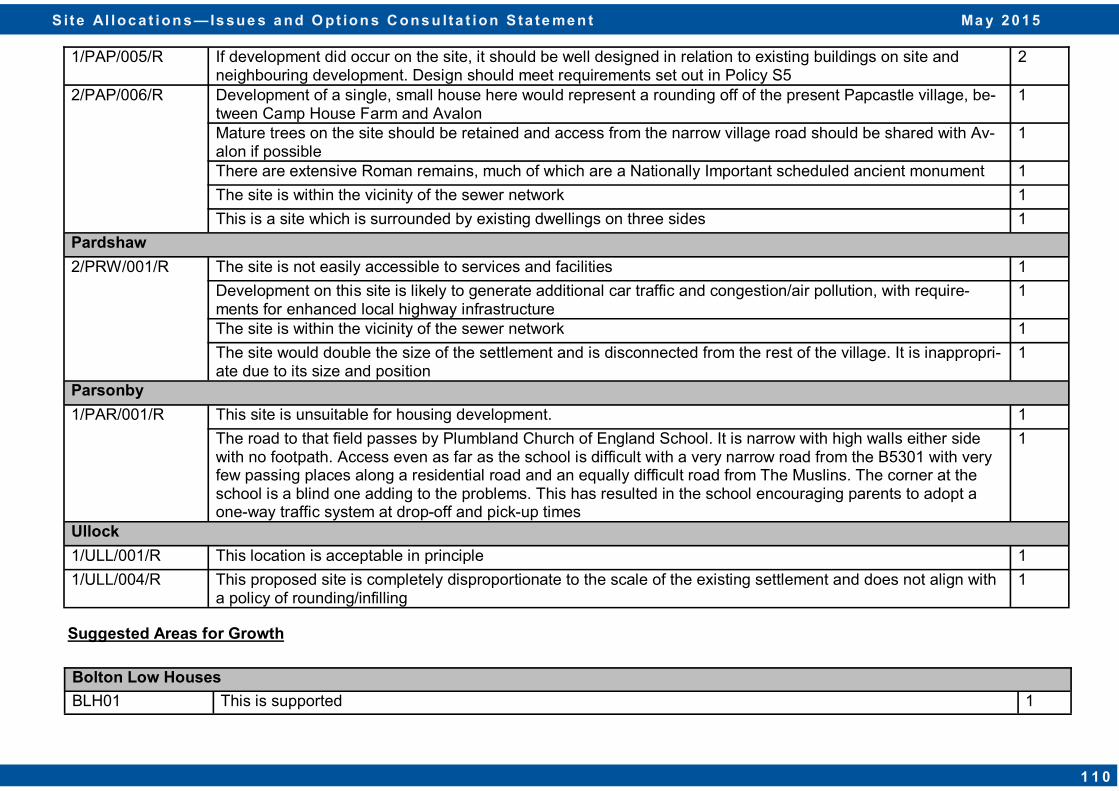
1/PAP/005/R If development did occur on the site, it should be well designed in relation to existing buildings on site and neighbouring development. Design should meet requirements set out in Policy S5
2
2/PAP/006/R Development of a single, small house here would represent a rounding off of the present Papcastle village, be-tween Camp House Farm and Avalon
1
Mature trees on the site should be retained and access from the narrow village road should be shared with Av-alon if possible
1
There are extensive Roman remains, much of which are a Nationally Important scheduled ancient monument 1
The site is within the vicinity of the sewer network 1
This is a site which is surrounded by existing dwellings on three sides 1
Pardshaw
2/PRW/001/R The site is not easily accessible to services and facilities 1
Development on this site is likely to generate additional car traffic and congestion/air pollution, with require-ments for enhanced local highway infrastructure
1
The site is within the vicinity of the sewer network 1
The site would double the size of the settlement and is disconnected from the rest of the village. It is inappropri-ate due to its size and position
1
Parsonby
1/PAR/001/R This site is unsuitable for housing development. 1
The road to that field passes by Plumbland Church of England School. It is narrow with high walls either side with no footpath. Access even as far as the school is difficult with a very narrow road from the B5301 with very few passing places along a residential road and an equally difficult road from The Muslins. The corner at the school is a blind one adding to the problems. This has resulted in the school encouraging parents to adopt a one-way traffic system at drop-off and pick-up times
1
Ullock
1/ULL/001/R This location is acceptable in principle 1
1/ULL/004/R This proposed site is completely disproportionate to the scale of the existing settlement and does not align with a policy of rounding/infilling
1
Suggested Areas for Growth
Bolton Low Houses
BLH01 This is supported 1
S i te Al loc a t ion s — Is sue s a nd O pt ion s C ons u lta t ion S ta te me n t Ma y 2 0 1 5
1 1 0

Branthwaite
BRA10 If extended to align with the housing estate boundary to the north-east, it would be of a scale that would support a significant proportion of affordable housing.
1
It is probably a better location than 1/BRW/002/R and 1/BRW/003/R. 1
If developed, the inclusion of a children's play area would be welcomed and might be made as part of a community benefits package associated with developing the site.
1
The area is greenfield and located in a visually prominent location at an important entrance to the settlement 1
Development in this area would result in developed projections into the open countryside 1
The area will not deliver a scale of development appropriate to the growth aspirations for the settlement outlined in Policy S3 without significant landscape and settlement character impacts
1
The deliverability of the area is questioned as the sites have not been promoted for development to date by the respective landowners through the Site Allocations process
1
The area is distant to the services and public transport links located centrally within the settlement 1
BRA11 No strong views on this suggested location 1
The area is greenfield and located in a visually prominent location at an important entrance to the settlement 1
Development in this area would result in developed projections into the open countryside 1
The area will not deliver a scale of development appropriate to the growth aspirations for the settlement outlined in Policy S3 without significant landscape and settlement character impacts
1
The area is distant to the services and public transport links located centrally within the settlement 1
The area is constrained by its topography as it slopes north from the adjacent public highway 1
The deliverability of the area is questioned as the sites have not been promoted for development to date by the respective landowners through the Site Allocations process
1
The area is constrained by the capacity and alignment of the adjacent public highway, which may limit the potential to deliver a satisfactory access arrangement
1
Greysouthen
GRE01 This site would have the same poor access/visibility issues as proposed allocation 1/GRE/002/R which was previously discarded by the SHLAA
1
GREY02 This site would have the same poor access/visibility issues as proposed allocation 1/GRE/002/R which was previously discarded by the SHLAA
1
S i te Al loc a t ion s — Is sue s a nd O pt ion s C ons u lta t ion S ta te me n t Ma y 2 0 1 5
1 1 1

S i te Al loc a t ion s — Is sue s a nd Opt ion s Co ns u lta t ion S ta te me n t M a y 2 0 1 5
1
“Allerdale – a great place to live, work and visit”